chapter 4 affected environment/environmental consequences...
TRANSCRIPT
Final Environmental Impact Statement/Final Environment Impact Report 4.0 - Affected Environment/Environmental Consequences of the
Alignment and Stations
C R E N S H A W / L A X T R A N S I T C O R R I D O R P R O J E C T August 2011
CHAPTER 4
AFFECTED ENVIRONMENT/ENVIRONMENTAL CONSEQUENCES OF THE ALIGNMENT
AND STATIONS

C R E N S H A W / L A X T R A N S I T C O R R I D O R P R O J E C T
Final Environmental Impact Statement/ Final Environmental Impact Report 4.0 – Affected Environment/Environmental Consequences of the Alignment and Stations
August 2011
THIS PAGE INTENTIONALLY BLANK
Final Environmental Impact Statement/Final Environment Impact Report 4.0 - Affected Environment/Environmental Consequences of the
Alignment and Stations
C R E N S H A W / L A X T R A N S I T C O R R I D O R P R O J E C T Page 4-1 August 2011
4.0 AFFECTED ENVIRONMENT/ENVIRONMENTAL CONSEQUENCES OF THE ALIGNMENT AND STATIONS
This chapter of the Final Environmental Impact Statement/Final Environmental Impact Report (FEIS/FEIR) analyzes the environmental impacts and consequences associated with the implementation of the proposed project. This section has been updated from the Draft Environmental Impact Statement/Draft Environmental Impact Report (DEIS/DEIR) to focus on the analysis of the effects of the Locally Preferred Alternative (LPA). The revised analysis has not resulted in any new significant impacts from the DEIS/DEIR. The analysis of all the Build and Transportation Systems Management (TSM) Alternatives in the DEIS/DEIR is incorporated here by reference. Detailed technical information and regulatory requirements used to evaluate the impacts of the proposed project are included in the appendices of this document. Discussion of each environmental topic is generally organized by the following structural headings:
Affected Environment/Existing Conditions. This discussion describes the existing physical environment and baseline setting wherein the proposed project would occur.
Environmental Impacts/Environmental Consequences. This section describes the anticipated changes that would result from implementation of the proposed project and a federal determination of significance is made based on the relative change from the baseline conditions (No-Build Alternative).
Mitigation Measures. For significant or adverse impacts identified, mitigation measures that would reduce or eliminate the impacts are provided.
CEQA Determination. The anticipated changes that would result from implementation of the proposed project are then evaluated against California Environmental Quality Act (CEQA) thresholds and a State determination of significance is made based on the relative change from the existing conditions.
Significant Impacts Remaining After Mitigation. This discussion states the effectiveness of mitigation measures in reducing the impacts identified. A final determination is made to whether an identified impact can be reduced to a less-than-significant level, or remains significant and unavoidable after mitigation. While CEQA requires that only effects that have a “significant impact” be identified in an Environmental Impact Report, the National Environmental Policy Act (NEPA) requires that all adverse impacts of a proposed project be analyzed. Accordingly, in this joint federal and state environmental document, reference to “significant impacts” is made to fulfill this requirement under CEQA, pursuant to standards of California law. However, regardless of level of significance, all potentially adverse environmental impacts have been analyzed and mitigation measures were proposed where feasible to reduce identified adverse effects.
Discussions of the regulatory environment and methodologies associated with each environmental resource are presented in Appendix F.
The FEIS/FEIR evaluates the LPA with the inclusion Design Option 6 (below-grade approach to the Exposition Line) as part of the project definition, contingent upon project costs being

C R E N S H A W / L A X T R A N S I T C O R R I D O R P R O J E C T August 2011
Final Environmental Impact Statement/ Final Environmental Impact Report 4.0 – Affected Environment/Environmental Consequences of the Alignment and Stations
Page 4-2
aligned with the project budget. In the event that the project costs ultimately exceed the project budget, the FEIS/FEIR also considers two Minimum Operable Segments (MOS) alternatives that would be consistent with the Los Angeles County Metropolitan Transportation Authority (Metro) financial plan for the project. Design options, which are not part of the LPA, are also discussed in this document. These include a Manchester/Aviation Station, a Centinela below-grade Crossing, a Crenshaw/Vernon Station, an alternate southwest portal at the Crenshaw/King Station, and an alternate partially-covered trench configuration in front of the Los Angeles International Airport (LAX) south runways. These design options are described in Chapter 2.0 of this document.
4.1 Land Use and Development
This section examines the affected environment related to land use and development. Local policies for land use and development regulate the types of uses allowed, as well as the intensity of development permitted on public and private property. A full discussion of applicable land use policies is located in Appendix F, Regulatory Framework. As new development results in changes to land use patterns, the character of an area can be affected and adverse physical effects to the environment may potentially occur.
4.1.1 Affected Environment/Existing Conditions
4.1.1.1 Existing Land Uses – Study Area Figure 4-1 illustrates current land use designations for the study area. The study area begins in the north at Wilshire Boulevard where medium- to high-density commercial buildings line Wilshire Boulevard. Continuing south from Wilshire Boulevard, primary land uses include single-family residential, as well as low-density multi-family residential land uses. Commercial and multi-family residential land uses increase southbound along Crenshaw Boulevard, past the Interstate 10 (I-10) Freeway. Storefront retail land uses line Crenshaw Boulevard to the south along Exposition Boulevard, ending near the West Angeles Church of God in Christ.
Beginning at Exposition Boulevard, medium-density commercial land uses line Crenshaw Boulevard with single-family residential land uses extending both east and west of the commercial frontage. The Crenshaw-Baldwin Hills Plaza, a regional retail center, sits at the center of the study area, and Leimert Park, a cultural center in the community, is located to the south on the eastern side of Crenshaw Boulevard. An additional community shopping center at Slauson Avenue, as well as schools and churches, are identifiable land uses as the study area extends to the Harbor Subdivision Railroad right-of-way (Harbor Subdivision).
Beginning at the Harbor Subdivision, light industrial and manufacturing land uses align the railroad right-of-way and Florence Avenue. Additional land uses in the area include Edward Vincent Park, Inglewood Cemetery, downtown Inglewood, the Forum, Hollywood Park Race Track and Casino, and residential land uses. As the study area extends southwest, land uses transition to hotels and higher-density industrial and manufacturing aerospace buildings near LAX. The southeastern portion of the study area consists of primarily single- and multi-family residential and commercial land uses.
Table 4-1 shows the land distribution within the study area. More than half of the land area (59 percent) is developed with residential land uses, with low-density residential uses

Final Environmental Impact Statement/Final Environment Impact Report 4.0 - Affected Environment/Environmental Consequences of the
Alignment and Stations
C R E N S H A W / L A X T R A N S I T C O R R I D O R P R O J E C T Page 4-3 August 2011
Figure 4-1. Land Use Designations
Source: Environmental Systems Research Institute (ESRI) and TAHA, 2008.

C R E N S H A W / L A X T R A N S I T C O R R I D O R P R O J E C T August 2011
Final Environmental Impact Statement/ Final Environmental Impact Report 4.0 – Affected Environment/Environmental Consequences of the Alignment and Stations
Page 4-4
accounting for 44 percent of the total study area acreage. Commercial land uses occupy 11 percent of the study area, while transportation and utility land uses occupy 16 percent of the study area acreage.
Table 4-1. Land Use Distribution within the Study Area
Type of Land Use Acreage Percentage of Total Area Low-Density Residential 12,238 44% Medium- to High-Density Residential 4,123 15% Commercial 3,046 11% Industrial 1,744 6% Public Facilities and Institutions 1,017 4% Open Space and Recreation 853 3% Transportation and Utilities 4,494 16% Vacant 303 1% Agriculture 23 0% Total Acres 27,841 100%
Source: TAHA, 2008 and Southern California Association of Governments, 2000.
4.1.1.2 Existing Land Uses – Station Areas Land use characteristics within 0.50 mile of proposed station locations are shown in Table 4-2 and Figure 4-2 through Figure 4-9.
Table 4-2. Existing Land Uses and Potential Station Locations
Potential Station
Location Adjacent Land Uses Surrounding Land Uses
Aviation/ Century
Medium- to high-density commercial and industrial, (parking, aerospace, and hotels)
Medium- to high-density commercial and industrial
Florence/ La Brea
Medium-density commercial (Market Street) and municipal (downtown Inglewood)
Commercial, industrial, and residential
Florence/ West
Industrial and low to medium-density residential Inglewood Cemetery is located approximately 200 feet to the south of the station.
Low- to medium-density residential, Inglewood Cemetery, Edward Vincent Park
Crenshaw/ Slauson
Community retail strip center, storefront commercial, and View Park Middle School
Low- to medium-density residential
Crenshaw/King
Regional retail center (Baldwin Hills-Crenshaw Plaza) and storefront commercial
Low- to medium-density residential
Crenshaw/Exposition
Industrial (light manufacturing buildings) and commercial (storefront retail)
Low- to medium-density residential
Optional Stations
Crenshaw/Vernon
Leimert Park, Leimert Park Village, storefront commercial
Low- to medium-density residential, and commercial
Aviation/ Manchester
Industrial along Florence Ave, commercial along Manchester Blvd
Low- and medium-density residential
Source: TAHA, 2011

Final Environmental Impact Statement/Final Environment Impact Report 4.0 - Affected Environment/Environmental Consequences of the
Alignment and Stations
C R E N S H A W / L A X T R A N S I T C O R R I D O R P R O J E C T Page 4-5 August 2011
Figure 4-2. Aviation/Century Station Area Land Uses
C R E N S H A W / L A X T R A N S I T C O R R I D O R P R O J E C T August 2011
Final Environmental Impact Statement/ Final Environmental Impact Report 4.0 – Affected Environment/Environmental Consequences of the Alignment and Stations
Page 4-6
Figure 4-3. Florence/La Brea Station Area Land Uses

Final Environmental Impact Statement/Final Environment Impact Report 4.0 - Affected Environment/Environmental Consequences of the
Alignment and Stations
C R E N S H A W / L A X T R A N S I T C O R R I D O R P R O J E C T Page 4-7 August 2011
Figure 4-4. Florence/West Station Area Land Uses

C R E N S H A W / L A X T R A N S I T C O R R I D O R P R O J E C T August 2011
Final Environmental Impact Statement/ Final Environmental Impact Report 4.0 – Affected Environment/Environmental Consequences of the Alignment and Stations
Page 4-8
Figure 4-5. Crenshaw/Slauson Station Area Land Uses
Final Environmental Impact Statement/Final Environment Impact Report 4.0 - Affected Environment/Environmental Consequences of the
Alignment and Stations
C R E N S H A W / L A X T R A N S I T C O R R I D O R P R O J E C T Page 4-9 August 2011
Figure 4-6. Crenshaw/King Station Area Land Uses

C R E N S H A W / L A X T R A N S I T C O R R I D O R P R O J E C T August 2011
Final Environmental Impact Statement/ Final Environmental Impact Report 4.0 – Affected Environment/Environmental Consequences of the Alignment and Stations
Page 4-10
Figure 4-7. Crenshaw/Exposition Station Area Land Uses
Final Environmental Impact Statement/Final Environment Impact Report 4.0 - Affected Environment/Environmental Consequences of the
Alignment and Stations
C R E N S H A W / L A X T R A N S I T C O R R I D O R P R O J E C T Page 4-11 August 2011
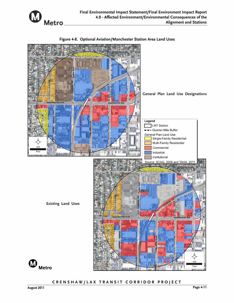
Figure 4-8. Optional Aviation/Manchester Station Area Land Uses

C R E N S H A W / L A X T R A N S I T C O R R I D O R P R O J E C T August 2011
Final Environmental Impact Statement/ Final Environmental Impact Report 4.0 – Affected Environment/Environmental Consequences of the Alignment and Stations
Page 4-12
Figure 4-9. Optional Crenshaw/Vernon Station Area Land Uses

Final Environmental Impact Statement/Final Environment Impact Report 4.0 - Affected Environment/Environmental Consequences of the
Alignment and Stations
C R E N S H A W / L A X T R A N S I T C O R R I D O R P R O J E C T Page 4-13 August 2011
4.1.1.3 Sensitive Land Uses Sensitive land uses located within 0.25-mile of proposed station locations are shown in Figure 4-56 through Figure 4-59 in Section 4.12 Parklands and Community Facilities.
4.1.2 Environmental Impacts/Environmental Consequences
4.1.2.1 Regional Land Use and Development The Southern California Association of Governments (SCAG) region is expected to grow in population by 24.6 percent (or 5.4 million people) between 2005 and 2035 (SCAG, Regional Transportation Plan, 2008). Likewise, employment in the region is expected to grow by 24.3 percent during the same time period. The proposed project would be consistent with the growth management policies of the 2001 Regional Comprehensive Plan and Guide (RCPG) to improving the standard of living, improve the regional quality of life, and maintain social, political, and cultural equity. The proposed project would also be consistent with the air quality and open space policies of the 2008 Regional Transportation Plan (RTP).
No-Build Alternative
The No-Build Alternative includes planned transportation services, facilities, and infrastructure that would be implemented by 2035, which would utilize the existing rights-of-way and transportation corridors in the communities of the Crenshaw/LAX Transit Corridor and would involve similar work to the typical roadway and utility work currently occurring within the SCAG region. No substantial physical change to the environment would occur under the No-Build Alternative. As such, no adverse effects associated with regional land use are anticipated.
LPA
The LPA is not likely to significantly change land use and development patterns at a regional scale. The creation of an urban rail transit system rarely creates new growth, but may redistribute growth that would have taken place elsewhere (National Research Council, Cervero and Seskin, 1995). In addition, transit investments generally require the leveraging effect of supportive public policies along with the pressure of an expanding regional economy to bring about significant changes in land use and urban form at the regional level (National Research Council, Cervero and Seskin, 1995). The project would be consistent with SCAG regional land use policies of improving mobility for residents and promoting sustainability for future generations. The LPA, when considered as part of Metro’s Long Range Transportation Plan (LRTP), would play an important role in expanding regional transportation choices and in improving regional quality of life, image, and overall mobility. The extent to which the LPA attracts new growth or results in a redistribution of projected regional growth would depend on favorable market conditions and supportive public policies. Therefore, no adverse effects associated with regional land use are anticipated.
The MOS-King alternative would begin at the Metro Green Line Aviation Station and end at the Crenshaw/King Station.

C R E N S H A W / L A X T R A N S I T C O R R I D O R P R O J E C T August 2011
Final Environmental Impact Statement/ Final Environmental Impact Report 4.0 – Affected Environment/Environmental Consequences of the Alignment and Stations
Page 4-14
The MOS-Century alternative would begin at the Metro Exposition and end at the Aviation/Century Station.
Both MOS-King and MOS-Century, would result in a shorter alignment segments and thus would not result in substantial changes to regional land use and development. Therefore, no adverse effects associated with regional land use are anticipated with the MOSs.
Design Options
The LPA may include the following design options:
Partially-Covered LAX Trench Option. The Partially-Covered LAX Trench Option would occur near the eastern limit of LAX Runways 7L/25R and 7R/25L. The trench would be below-grade, covered directly in front of the runways and have a system of a cable barrier net over the open section between the runways and the addition of a 42-inch high concrete parapet wall around the open area. This configuration would satisfy Federal Aviation Administration (FAA) and Los Angeles World Airports (LAWA) concerns regarding both the potential for interference with airport navigational equipment, as well as for those conditions when planes using these runways would take off or land in a west to east direction (which typically occurs only during the late night time hours or during adverse weather conditions) and could potentially overshoot the runway. The FAA requires that eventually the entire 1,600 feet of the below-grade trench be covered through the central portion of the runway protection zone (RPZ). As such, the design of a partially covered trench (as a modification to the base project) will not preclude future provisions to allow covering of the remaining open sections up to a total covered length of 1,600 feet.
Below-Grade Crossing at Centinela Option. The Below-Grade Crossing at Centinela Option includes a below-grade crossing instead of an at-grade crossing at Centinela Avenue.
Optional Aviation/Manchester Station. The optional Aviation/Manchester Station would either be located in an aerial configuration across Manchester Avenue or to the north where the alignment returns to grade after crossing Manchester Avenue.
Optional Below-Grade Crenshaw/Vernon Station. The Below-Grade Crenshaw/Vernon Station Option involves a below-grade station south of Vernon Avenue in the Leimert Park triangle.
Alternate Southwest Portal at Crenshaw/King Station Option. The alternate southwest portal at the Crenshaw/King Station would be located in front of the Broadway (WalMart) building at the Baldwin Hills Crenshaw Plaza. It would involve a surface portal or an underground connection to the basement floor of the Broadway building.
These design options are minor modifications to the LPA and would not result in substantial changes in regional land use and development. Therefore, no adverse effects associated with regional land use are anticipated.

Final Environmental Impact Statement/Final Environment Impact Report 4.0 - Affected Environment/Environmental Consequences of the
Alignment and Stations
C R E N S H A W / L A X T R A N S I T C O R R I D O R P R O J E C T Page 4-15 August 2011
4.1.2.2 Local Land Use and Development Existing land uses within the study area are varied and include a combination of residential, commercial, transportation and utilities, industrial, and public/institutional uses. As shown in Figure 4-1 and Table 4-2, the primary land uses in the study area are residential (59 percent), the majority of which are single-family residential (44 percent). Commercial uses comprise 15 percent of the study area and are concentrated along major roadways, such as Crenshaw Boulevard and La Brea Avenue.
No-Build Alternative
The No-Build Alternative would result in a continuation of current development patterns and trends. Land use patterns that exist today in several sections of the corridor, especially those not in redevelopment areas, would be slow to change. The No-Build Alternative would limit the opportunity to intensify land uses at potential station areas, offer an alternative mode of travel, and develop mixed uses and infill development throughout the corridor. With the No-Build Alternative, development and redevelopment would result in increased traffic congestion, particularly along Crenshaw Boulevard, with the planned expansion of the Baldwin Hills Crenshaw Plaza and the District Square development project. The increased traffic congestion would have both a short- and long-term negative effect on the businesses within the Crenshaw/LAX Transit Corridor. As such, potential adverse effects associated with land use and development within the Crenshaw/LAX Transit Corridor are anticipated.
Division of an Established Community Under the No-Build Alternative, planned development and redevelopment would adhere to local zoning ordinances and would be unlikely to alter or divide the existing community. Therefore, no adverse effects related to the division of an established community are anticipated for the No-Build Alternative.
Applicable Land Use Policies The No-Build Alternative would be inconsistent with the following land use policies:
City of Los Angeles Transportation Policy
City of Los Angeles General Plan.
County of Los Angeles General Plan
City of Inglewood General Plan
City of El Segundo General Plan
City of Los Angeles Municipal Code
Community Plans
► West Adams-Baldwin Hills-Leimert Park Community Plan
► Westchester Playa Del Rey Community Plan
► Wilshire Community Plan

C R E N S H A W / L A X T R A N S I T C O R R I D O R P R O J E C T August 2011
Final Environmental Impact Statement/ Final Environmental Impact Report 4.0 – Affected Environment/Environmental Consequences of the Alignment and Stations
Page 4-16
Specific Plans
► Crenshaw Corridor Specific Plan
► Park Mile Specific Plan
Redevelopment Project Areas
► Mid-City Corridors Redevelopment Project
► Crenshaw Redevelopment Project
► Crenshaw/Slauson Redevelopment Project
LAX Master Plan
LAX Plan
LAX Specific Plan Amendment Study
The No-Build Alternative would not be consistent with these policies because it would not establish transit centers and station areas as focal points for future growth or integrate major transportation facilities with land use planning. The No-Build Alternative would not promote mixed-use development near transit nodes and modes of transportation other than the automobile. It would also not expand transportation service to enhance accessibility to neighborhoods and community and regional centers.
Adjacent or Surrounding Land Uses The No-Build Alternative represents the status quo and some other transit improvements, but there would be no station vicinity land use impacts along Crenshaw Boulevard. Development patterns would continue to reflect current trends. Without improved transit connections to downtown Los Angeles and the Metro Green Line, this area would experience difficulty attracting transit-supportive and pedestrian-oriented development and would likely become increasingly auto-dependent.
LPA
Division of an Established Community With the LPA, planned development and redevelopment would be centered around station areas and this increased intensity of development would unite the community. While operating along the Harbor Subdivision, the LPA would be traveling along an existing transportation corridor where freight trains operate and pedestrian and vehicle crossings are permitted only at designated crossings. The majority of the area along the Harbor Subdivision contains industrial land uses which do not support a large number of pedestrian crossings. Much of the Harbor Subdivision acts as a boundary for political jurisdictions, separating the cities of Los Angeles, and Inglewood. Fencing would be located along the at-grade Harbor Subdivision portion of the alignment and the at-grade section along Crenshaw Boulevard. Because crossing the Harbor Subdivision and Crenshaw Boulevard at places other than designated crossings is illegal, this fencing would not introduce a new barrier that would divide a community. The LPA would travel along the median of Crenshaw Boulevard between 48th and 59th Streets in a grade-level configuration. Today, pedestrians are required to wait at signalized crosswalks along Crenshaw Boulevard to cross Crenshaw Boulevard. These signalized intersections would

Final Environmental Impact Statement/Final Environment Impact Report 4.0 - Affected Environment/Environmental Consequences of the
Alignment and Stations
C R E N S H A W / L A X T R A N S I T C O R R I D O R P R O J E C T Page 4-17 August 2011
remain under the LPA and pedestrians and motor vehicles would still be able to cross Crenshaw Boulevard. Therefore, the LPA would not alter or divide the existing community, would comply with local zoning ordinances and not alter or restrict land uses. Thus, no adverse effects related to the division of an established community are anticipated for the LPA.
Applicable Land Use Policies City of Los Angeles Transportation Policy. This policy seeks to establish transit centers and station areas as focal points for future growth in the City of Los Angeles. Levels of station area development are to preserve lower-density neighborhoods from encroachment. The LPA would develop station areas to transition into the surrounding land uses. Stations would not encroach on surrounding neighborhoods, while at the same time creating the potential for increased density of redevelopment along Crenshaw Boulevard. Therefore, the LPA would be consistent with this policy.
General Plans
City of Los Angeles General Plan. Policies related to transportation and land use are addressed in the Framework, Transportation Element, and Land Use Element of the City of Los Angeles General Plan. The LPA would be consistent with the Framework’s policy of expanding transportation service to enhance accessibility to neighborhoods and community and regional centers. The LPA would provide increased accessibility by improving the transit linkages along Crenshaw Boulevard, as well as a southern connection to the Metro Green Line. Policy 2.12b of the Transportation Element establishes a need for high capacity transit service. In addition, Policy P16h actively supports alternative rail technology to extend transit service along priority corridors. The LPA would include rail technology that would provide high capacity transit with regional connectivity and would be consistent with this policy. The LPA would also be consistent with the Land Use Element’s policy of developing a public transit system that improves mobility with convenient alternatives to automobile travel.
County of Los Angeles General Plan. The County of Los Angeles General Plan promotes policies that initiate transit-oriented development along bus and rail transit corridors, and inter-jurisdictional coordination of land use and transportation policy matters. The LPA would be under multiple jurisdictions and provides service along the Crenshaw/LAX Transit Corridor that could stimulate transit-oriented development. Therefore, the LPA would be consistent with the County of Los Angeles General Plan.
City of Inglewood General Plan. A guiding principle of the City of Inglewood General Plan is to enhance the transportation system of the community. The LPA would provide a connection from downtown Inglewood and surrounding areas to the Metro Green Line, and Crenshaw Boulevard, with potential transfers to the South Bay communities, LAX, and downtown Los Angeles. As such, the LPA would be consistent with the City of Inglewood General Plan.
City of El Segundo General Plan. The City of El Segundo General Plan contains policies that are transit supportive, as demonstrated by the creation of the Metro Green Line. Specific policies include encouraging development projects that integrate major
C R E N S H A W / L A X T R A N S I T C O R R I D O R P R O J E C T August 2011
Final Environmental Impact Statement/ Final Environmental Impact Report 4.0 – Affected Environment/Environmental Consequences of the Alignment and Stations
Page 4-18
transportation facilities with land use planning and the surrounding environment and promote mixed-use development near transit nodes and modes of transportation other than the automobile. The LPA would provide additional opportunities for regional connectivity at the Metro Green Line Aviation/LAX Station and surrounding areas. Therefore, the LPA would be consistent with the City of El Segundo General Plan.
City of Los Angeles Municipal Code. The Residential/Accessory Services (RAS) Zones established in Article 2, Section 12 of the City of Los Angeles Municipal Code (LAMC), provide a mechanism to increase housing opportunities, enhance neighborhoods, and revitalize older commercial corridors. The Density Bonus Ordinance allows density bonuses for residential development projects that are located near transit stops leading to the increased development potential of transit corridors. The LPA would provide the foundation for increased intensity of commercial redevelopment and residential development along the Crenshaw Boulevard corridor and, thus would be consistent with the LAMC.
Community Plans. The City of Los Angeles West Adams-Baldwin Hills-Leimert Park and Westchester Playa Del Rey Community Plans all support the intensification of land uses in conjunction with improved mass transit. The plans promote inter-connectivity between residential uses and transit systems, and set as a goal the development of new housing close to transit lines so as to reduce vehicle trips while promoting growth. The proximity of the project alignment and stations to residences along Crenshaw Boulevard and Harbor Subdivision helps to accomplish this goal. Primary goals in each plan include measures to reduce vehicle trips, traffic congestion, and air pollution while enhancing the job opportunities and quality of life in the area. The LPA would reduce vehicle trips, traffic congestion, and air pollution, while creating additional adjacent job opportunities through intensification of existing commercial uses. Therefore, the LPA would be consistent with the applicable community plans.
Specific Plans. The Crenshaw Corridor Specific Plan seeks to ensure that the land uses and development improve the functional and aesthetic quality of the corridor, while enhancing and complimenting the surrounding community. The LPA would enhance the surrounding community through increased mobility of the community. Therefore, the LPA would be consistent with the Crenshaw Corridor Specific Plan.
Redevelopment Project Areas. The Community Redevelopment Agency of the City of Los Angeles (CRA/LA) Mid-City Corridors, Crenshaw, and Crenshaw/Slauson Redevelopment Projects all encourage a circulation system that will improve the quality of life through pedestrian, automobile, parking, and mass transit improvements. The plans promote inter-connectivity between residential and commercial uses and transit systems, and sets as a goal, the redevelopment of existing commercial uses to include mixed-use development. The Mid City Crenshaw Vision Plan is a funded project to economically and physically revitalize Crenshaw Boulevard from the I-10 Freeway to Martin Luther King Jr. Boulevard. The LPA would be consistent with the redevelopment policies because it would enhance connectivity and pedestrian access. Primary goals in each plan include measures to implement land use recommendations, design guidelines, and streetscape concepts that promote economic development, quality jobs, and revitalization of the area. Improvements in streetscape concepts involve creation of a green street which relocates

Final Environmental Impact Statement/Final Environment Impact Report 4.0 - Affected Environment/Environmental Consequences of the
Alignment and Stations
C R E N S H A W / L A X T R A N S I T C O R R I D O R P R O J E C T Page 4-19 August 2011
utilities, replaces and adds trees, landscape setbacks, infiltration planters, and redevelopment of the frontage roads. Since the at-grade portion of the alignment from 39th Street to Exposition Boulevard was determined to be infeasible and no longer included as part of the LPA, the project would no longer alter streetscape improvements planned or already made by the Vision Plan along Crenshaw Boulevard. Therefore, the LPA would be consistent with redevelopment policies and promote the redevelopment projects’ primary goals.
LAX Master Plan. The LAX Plan contains policies that seek to develop a connection point from the airport to the Metro Green Line and other mass transportation facilities and provide facilities that encourage transit ridership, including a ground transportation center, an intermodal transportation center, and an automated people mover. The LAX Specific Plan Amendment Study seeks to maximize the flow of goods and passengers through the airport system through airport infrastructure enhancements. The LPA would provide a rail connection which could facilitate the flow of goods and passengers through the airport system, and would be consistent with this specific plan. The LPA would be consistent because it would allow the connection point to LAX to be placed in a location that could facilitate connections with passengers from transit services other than light rail traveling along the Harbor Subdivision. This would include, but not be limited to, bus passengers, automobile passenger drop-offs, as well as pedestrians. An aerial station would be located closer to Century Boulevard where the majority of pedestrian activity in the area occurs. This center of pedestrian activity would make a more desirable location for connecting passengers to LAX. The LPA provides an option to serve these policies and, therefore, would be consistent with the LAX Master Plan and the LAX Specific Plan Amendment Study.
Adjacent or Surrounding Land Uses The LPA would include six stations. The LPA would be constructed within an existing transportation right-of-way (Harbor Subdivision) alongside existing land uses, as well as along Crenshaw Boulevard, which also previously had a mass transit system. The LPA is part of a designated transit corridor along Crenshaw Boulevard. The existing Harbor Subdivision was built years ago, prior to the construction of current adjacent land uses.
This section considers the potential land use impacts in proximity to stations. Typically, effects from transit investment are realized within walking distance of stations, generally about 0.25-mile. The primary effect is likely to be felt immediately adjacent to stations, diminishing with increasing distance from the station. Potential station area conflicts including, but not limited to noise, security, lighting, traffic are addressed individually in the relevant sections that analyze traffic, visual quality, and noise.
Aviation/Century Station - This elevated station would be located on the Harbor Subdivision spanning the intersection over Century Boulevard and Aviation Boulevard. The proposed station is on an elevated station platform and would be located adjacent to an existing parking structure. Property acquisition would be required outside the Harbor Subdivision right-of-way on the northwest corner of Aviation/Century Boulevards for a bus transfer facility. Such use of this property would be compatible with surrounding land uses and would be consistent with local plans and policies which seek to facilitate the travel of passengers in the airport area. The proximity of LAX may potentially lead to development supporting those land

C R E N S H A W / L A X T R A N S I T C O R R I D O R P R O J E C T August 2011
Final Environmental Impact Statement/ Final Environmental Impact Report 4.0 – Affected Environment/Environmental Consequences of the Alignment and Stations
Page 4-20
uses and patrons, such as restaurants, hotels, and other commercial development. No adverse effects associated with land uses around the Aviation/Century Station area are anticipated.
Florence/La Brea Station - This at-grade station would be located in the Harbor Subdivision east of Market Street. This proposed station’s location is sited further to the east because of an existing north-south fault near La Brea Avenue. Property acquisition would be required outside the Harbor Subdivision right-of-way on the south to provide a park-and-ride facility and to facilitate a pedestrian connection to Florence Avenue. Additional property could be acquired for parking on the northwest corner of the La Brea Avenue/Florence Avenue intersection. Such use of these properties would be compatible with the surrounding industrial land uses. This station area could likely undergo substantial land use change because of its proximity to downtown Inglewood and the emerging trend of development and redevelopment in the area. With an appropriate plaza and crossing, the station could become a focal point at the northern end of Market Street and facilitate/support developments along Florence Avenue, Market Street, and La Brea Avenue. This development would be consistent with the City of Inglewood’s land use goals and policies. No adverse effects associated with land uses around the Florence/La Brea Station area are anticipated.
Florence/West Station - This at-grade station would be located in the Harbor Subdivision west of the West Boulevard and Florence Avenue intersection. Property acquisition would be required outside the Harbor Subdivision right-of-way on the north to provide a park-and-ride facility and traction power substation (TPSS) site. The use of this property would be compatible with the surrounding industrial and commercial land uses that are located on both sides of the proposed station adjacent to single- and multi-family residential land uses extending beyond the Harbor Subdivision. This development would be consistent with the City of Inglewood and Los Angeles land use goals and policies which seek to revitalize the West Boulevard corridor. No adverse effects associated with land uses around the Florence Station area are anticipated.
Crenshaw/Slauson Station – This at-grade station would be located on the south side of Slauson Avenue at Crenshaw Boulevard. No additional property acquisition outside the Crenshaw Boulevard right-of-way would be required for the station. The use of the station would be consistent with plans and policies of providing alternate modes of transportation. The proposed station could lead to further development of street-level pedestrian-oriented uses in existing buildings, south of Slauson Avenue, adding to the vibrancy of the area. The Hyde Park community uses north of Slauson Avenue could see increased access and further development. No adverse effects associated with land uses around the Crenshaw/Slauson Station area are anticipated.
Crenshaw/King Station - This station would be located below grade under the Martin Luther King Jr. Boulevard and Crenshaw Boulevard intersection. The station portal would be located either on the southeast or southwest corner of the intersection. This station would provide a linkage to Leimert Park and Baldwin Hills Crenshaw Plaza in a neighborhood-oriented commercial and residential environment. The proximity of the Baldwin Hills Crenshaw Plaza, which has plans for redevelopment, could lead to

Final Environmental Impact Statement/Final Environment Impact Report 4.0 - Affected Environment/Environmental Consequences of the
Alignment and Stations
C R E N S H A W / L A X T R A N S I T C O R R I D O R P R O J E C T Page 4-21 August 2011
further development oriented towards supporting that land use and its patrons, such as restaurants, hotels, or additional commercial development. The station portal would require the acquisition of buildings on the east side of Crenshaw Boulevard, south of King Boulevard which could also stimulate development of the existing strip commercial uses. Metro encourages and participates in joint development opportunities with private partners to redevelop underutilized land near station portals with transit-oriented development. This development is typically initiated outside the timeframe of this document after final design and station area plans have been developed. Transit-oriented development at this station area could occur above, adjacent, or near the station portal and would be compatible with the retail serving areas near these stations along Crenshaw Boulevard. As land use intensifies and surface parking lots are redeveloped, parking garages with street-level uses may be constructed to fill gaps in parking supply. No adverse effects associated with land uses around the Crenshaw/King Station area are anticipated.
Crenshaw/Exposition Station – This below-grade station would become an important junction for residents, employees, and visitors from across the region using various modes of transportation, including LRT, bus, and automobile. Property acquisition would be required outside the Crenshaw Boulevard right-of-way on the east to provide a station portal and park-and-ride facility. The use of this property would be compatible with the surrounding land uses and would be consistent with local plans and policies. Development opportunities could be created by the combined effect of the Exposition Line Station, the Crenshaw/Exposition Station, and the new proposed development at Rodeo Road and Crenshaw Boulevard. This could stimulate development on the west side of Crenshaw Boulevard from Rodeo Place to Jefferson Boulevard. No adverse effects associated with land uses around the Crenshaw/Exposition Station area are anticipated.
MOS-King or MOS-Century would result in a shorter alignment segments that would substantially reduce the connectivity of the area when compared to the LPA. Therefore, these MOSs would be less supportive of transit-oriented policies which seek to develop connectivity and access for the community to regional employment and educational centers. As MOS-King or MOS-Century would not divide a community, or conflict with surrounding land uses, no adverse effects associated with local land use are anticipated for the MOSs.
Design Options
Division of an Established Community The alternate portal location at the Crenshaw/King Station would result in increased access to the Baldwin Hills Crenshaw Plaza, a regional commercial destination. A below-grade station at Vernon would also increase access to the Leimert Park area. None of the proposed design options would block access between communities and would not result in adverse effects related to the division of an established community.
Applicable Land Use Policies All the design options would be as consistent with or more supportive of the applicable plans and policies as described with the LPA due to the provision of increased mobility
C R E N S H A W / L A X T R A N S I T C O R R I D O R P R O J E C T August 2011
Final Environmental Impact Statement/ Final Environmental Impact Report 4.0 – Affected Environment/Environmental Consequences of the Alignment and Stations
Page 4-22
and access. Therefore, no adverse effects to consistency with land use policies would occur for the proposed design options.
Adjacent or Surrounding Land Uses The Below-Grade Crossing at Centinela Option and Partially-Covered LAX Trench Option would have the same effects on surrounding station area land uses as the LPA and no adverse effects are anticipated.
Optional Aviation/Manchester Station - This station could either be aerial across Manchester Avenue or at grade to the east of the Aviation Boulevard/Manchester Avenue intersection. This station would be located in the Harbor Subdivision and would be compatible with the primarily industrial area with commercial development centered along Manchester Avenue. Property acquisition outside the Harbor Subdivision would be required if the station is located to the east of the Aviation Boulevard/Manchester Avenue intersection. This would be a partial property acquisition that would not affect any existing land uses. The station would be consistent with local land use policies. No adverse effects associated with land uses around the Aviation/Manchester Station area are anticipated.
Crenshaw/Vernon Station - This station would be located at Vernon Avenue on Crenshaw Boulevard. The proposed station is a below-grade station in the Leimert Triangle which is surrounded by Crenshaw Boulevard, Leimert Boulevard and Vernon Avenue. This station location would require full acquisition of properties within the Leimert Triangle and permanent underground easements under Leimert Park and adjacent businesses in the Leimert Park Village as the alignment returns to the median of Crenshaw Boulevard. The intensification of land uses surrounding the station that is typical of station area transit development would be restricted by the current zoning and land use regulations that ensure the preservation of character surrounding Leimert Park neighborhood. This station could provide a gateway through Leimert Park onto Degnan Boulevard into Leimert Park Village. No adverse effects associated with land uses around the Leimert Park Station area are anticipated.
4.1.3 Mitigation Measures No mitigation measures are required.
4.1.4 CEQA Determination According to CEQA, land use impacts would be considered significant if the Crenshaw/LAX Transit Corridor Project have the potential to result in:
Physical division of an established community;
Inconsistency with any applicable land use plan, policy, or regulation of an agency with jurisdiction over the project; or,
Incompatibility with adjacent and surrounding land uses caused by degradation or disturbances that diminish the quality of a particular land use.
The CEQA determination compares the effects of the proposed project, design options and MOSs with the existing conditions described in the affected environment/existing conditions

Final Environmental Impact Statement/Final Environment Impact Report 4.0 - Affected Environment/Environmental Consequences of the
Alignment and Stations
C R E N S H A W / L A X T R A N S I T C O R R I D O R P R O J E C T Page 4-23 August 2011
section. The proposed project, design options, and MOSs would not cause a physical division of an established community, because pedestrian and vehicle crossings would be maintained at designated intersections. Therefore, a less-than-significant impact would occur related to the physical division of an established community.
General plans, community plans and specific land use policies for the project alternatives are described in detail in Appendix F, Regulatory Framework. For the reasons described above with respect to the NEPA determination, the project would not result in inconsistency with any applicable land use plan, policy or regulation of an agency with jurisdiction over the project.
No impact related to regional and local land use policies would occur for the LPA and design options. The MOSs would result in lower connectivity and would not be as consistent with land use policies which seek to enhance connectivity as the LPA.
The locations of the six included stations and two optional stations maximize the potential for access to activity centers and transit connections and no land use incompatibility would result from the LPA, design options, and MOSs. These stations are all located in areas that are compatible with the surrounding existing land uses. The operation of a Light Rail Transit Line within the Crenshaw Boulevard and Harbor Subdivision would be compatible with the existing surrounding commercial, industrial, and residential uses along the alignment. Therefore, no potentially significant impacts related to land use incompatibility would occur.
C R E N S H A W / L A X T R A N S I T C O R R I D O R P R O J E C T August 2011
Final Environmental Impact Statement/ Final Environmental Impact Report 4.0 – Affected Environment/Environmental Consequences of the Alignment and Stations
Page 4-24
4.2 Displacement and Relocation of Existing Uses
This section addresses the land ownership and leasing agreements that will change due to the proposed project. The focus of this analysis is on the alignment and stations. For a discussion of displacement and relocation of existing uses resulting from the proposed maintenance facility component of the project, please refer to Chapter 5.0, Affected Environment and Environmental Consequences of the Maintenance Facility. Although the Crenshaw/LAX Transit Corridor Project maximizes the use of publicly-owned rights-of-way, this analysis discusses the proposed project’s impacts to persons and businesses with leases of Metro-owned property along the corridor and to privately owned properties.
4.2.1 Affected Environment/Existing Conditions
Background
In the early 1990s, Metro acquired railroad right-of-way throughout the Los Angeles area from the Atchison, Topeka, and Santa Fe Railway Company and Southern Pacific. As part of this process, Metro inherited lease agreements entered into by the railroad. A portion of this railroad right-of-way, called the Harbor Subdivision, is located within the southern portion of Crenshaw/LAX corridor. The Harbor Subdivision provides the right-of-way for the southern part of the LPA alignment as it travels under the Metro Green Line and Imperial Highway, where the LPA would begin in the south, and in a northeaster direction, to the west of Aviation Boulevard/Florence Avenue, until Crenshaw Boulevard, where the LPA would transition into the median of Crenshaw Boulevard. Since acquiring the right-of-way, Metro has entered into additional land leases of varying terms and has granted temporary and permanent easements. For purposes of the discussion of potential land acquisition impacts, the affected environment is limited to the areas within and directly adjacent to the proposed alignment. Property acquisition may be phased over time, depending on project funding and schedule.
4.2.2 Environmental Impacts/Environmental Consequences
This section presents and evaluates the No-Build, and LPA, design options and MOSs. To assess the potential acquisition of private property, advanced conceptual engineering drawings identifying the detailed location of the proposed alignments, stations, and TPSS sites were reviewed to identify properties not located on public rights-of-way that would be needed for the project.
To estimate the effect of non-renewal of Metro leases within the Harbor Subdivision right-of-way, the lease database maintained by the Metro Real Estate Department was reviewed (Table 4-3).
The termination or non-renewal of an existing lease within the Harbor Subdivision for the purposes of implementing the project is not considered property acquisition. However, business displacements may result at those locations where all or a majority of business operations occur on the leased property. Business displacements may also occur at those locations where the leased property is used for ancillary or support operations, such as access, parking and/or storage, and the loss of such property would have a substantial impact on the associated business operation. In addition, the

Final Environmental Impact Statement/Final Environment Impact Report 4.0 - Affected Environment/Environmental Consequences of the
Alignment and Stations
C R E N S H A W / L A X T R A N S I T C O R R I D O R P R O J E C T Page 4-25 August 2011
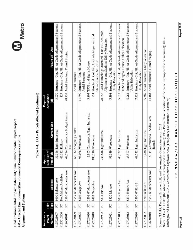
Table 4-3. Harbor Subdivision Right-of-Way Lease Summary1
Type of Right-of Way Use Total
Pre-Acquisition of Right-of Way (Before 1993)
Post-Acquisition of Right-of Way (After 1993)
Lease Terms
Month-to-Month2
Annual or Longer-term
Signs & Billboards 29 5 24 6 23
Ground Leases 84 62 22 83 1
Licenses & Easements 179 151 28 101 79
TOTAL 292 218 74 190 103
PERCENT 100 75 25 65 35
Source: Metro Real Estate Department and TAHA, 2008 1 In some cases, the exact location of a particular lease was unclear. Therefore, this table represents a
conservative estimate of the number of leases within the Harbor Subdivision. 2 Where no lease term information was available, a month-to month lease term was assumed.
termination or non-renewal of all commercial outdoor advertising leases may result in displacements and require removal or relocation of the advertising structure.
For properties located outside the Harbor Subdivision, partial property acquisitions would occur if the project requires a limited portion of the property. The business, residence, or other land use may not be affected by the acquisition. Such acquisitions typically affect only unimproved or landscaped areas or areas used for limited parking. Full property acquisitions would occur for those properties on which the project would physically encroach on existing structures or remove a substantial portion of the available customer or employee parking such that business operations would be substantially affected. In addition, full acquisitions would result when the majority of a vacant parcel would be acquired, leaving the remaining property an uneconomical remnant. Full acquisitions or partial acquisitions involving a substantial portion of the property may result in the displacement of either businesses or residences. Where acquisition and relocation are unavoidable, owners of private property have federal constitutional guarantees that their property would not be taken or damaged for public use unless they first receive just compensation. Failure to receive just compensation would result in an adverse effect.
4.2.2.1 Acquisition of Property
No-Build Alternative
The No-Build Alternative would include all existing highway and transit services and facilities, as well as committed highway and transit projects. As such, the corridor would not be affected by acquisition from existing or planned transit improvements. Therefore, the No-Build Alternative would not result in land acquisition impacts.
LPA
The LPA would require the acquisition of up to 97 total parcels, including 59 parcels that would be acquired in full, 31 parcels would be acquired in part, four parcels that would require permanent underground easements, and three parcels that would be used as temporary construction laydown areas (for staging equipment and materials). The amount of

C R E N S H A W / L A X T R A N S I T C O R R I D O R P R O J E C T August 2011
Final Environmental Impact Statement/ Final Environmental Impact Report 4.0 – Affected Environment/Environmental Consequences of the Alignment and Stations
Page 4-26
acquisition identified increased from what was initially identified with the development of a higher level of design, which took into account specific engineering requirements and design constraints. Full takes would be required for TPSS site locations, retained fill, below grade tunneling, station locations, columns, as well as right-of-way widening to accommodate the aerial and at-grade segments of the alignment. Two single-family residential properties would be acquired in full to accommodate the at-grade LRT guideway. The acquisitions range from 130 square feet to over 74,000 square feet. Along the Harbor Subdivision from Imperial Highway to Century Boulevard, there would be 0.96 acres of land that would be required from LAX for a permanent easement. See Table 4-4, Assessor’s Parcel Number 4129028900. Table 4-4 lists the parcel number, location, and the current and intended use of the properties required to construct the LPA. These parcels are shown in Figure 4-10 through Figure 4-23. Approximately 15 commercial properties of the 59 parcels to be acquired in full would be acquired at the Crenshaw/King and Crenshaw/Exposition Stations. Crenshaw Boulevard is a major commercial street within the Corridor. A windshield survey conducted on June 23, 2011 revealed that there were approximately 30 available commercial properties along Crenshaw Boulevard from Adams Boulevard to Slauson Avenue. The Corridor contains other intersecting arterials, such as Jefferson and Adams, Vernon, and Slauson which are zoned for commercial uses. These areas offer dispersed opportunities of built space and underutilized land within the corridor that is commercially zoned and would be adequate to accommodate these uses should they desire to stay in the corridor. In addition, joint development opportunities near these station areas that may occur in the future would provide additional commercial space.
Where acquisition and relocation are unavoidable with the LPA, Metro would follow the provisions of the Uniform Relocation Assistance and Real Property Acquisition Policies Act of 1970 (Uniform Act), as amended, and implemented pursuant to the Uniform Relocation Assistance and Real Property Acquisition Regulations for Federal and Federally Assisted Programs adopted by the U.S. Department of Transportation (USDOT), dated February 3, 2005. Metro would apply acquisition and relocation policies to assure compliance with the Uniform Relocation Act and Amendments. All real property acquired by Metro would be appraised to determine its fair market value. Just compensation, which shall not be less than the approved appraisal made to each property owner, would be offered by Metro. Each homeowner, renter, business, or nonprofit organization displaced as a result of the project would be given advanced written notice and would be informed of the eligibility requirements for relocation assistance and payments. Therefore, no adverse effects related to displacement and relocation would occur.
MOS-King and MOS-Century, with shorter alignment segments, would result in less acquisition of property. Therefore, similar to the LPA, no adverse effects associated the MOSs would occur with application of the acquisition and relocation policies in compliance with the law.
In addition, Metro is in discussions with the Burlington Northern Santa Fe Railway (BNSF) Railway about the potential abandonment by BNSF of its operations along the Harbor Subdivision between Imperial Highway and Crenshaw Boulevard. If such discussions result in a decision by BNSF to file for abandonment, this may create the potential to reduce right-of-way requirements along the Harbor Subdivision due to reduced or removed clearance and infrastructure requirements.

Fina
l Env
iron
men
tal I
mpa
ct S
tate
men
t/Fi
nal E
nvir
onm
ent I
mpa
ct R
epor
t 4.
0 - A
ffec
ted
Envi
ronm
ent/
Envi
ronm
enta
l Con
sequ
ence
s of
the
A
lignm
ent a
nd S
tatio
ns
Sou
rce:
TA
HA
, Par
son
s B
rin
cker
hof
f, a
nd
Los
An
gele
s C
oun
ty A
sses
sor,
201
1 N
otes
: F
T =
Fu
ll T
ake
(th
e w
hol
e pa
rcel
is p
ropo
sed
to b
e ac
quir
ed);
PT
= P
arti
al T
ake
(a p
orti
on o
f th
e pa
rcel
is p
ropo
sed
to b
e ac
quir
ed);
UE
=
Un
derg
rou
nd
Eas
emen
t; C
LA =
Con
stru
ctio
n L
aydo
wn
Are
a (T
empo
rary
Con
stru
ctio
n E
asem
ent)
CR
EN
SH
AW
/L
AX
TR
AN
SI
T C
OR
RI
DO
R P
RO
JE
CT
Pa
ge 4
-27
Aug
ust 2
011
Tabl
e 4-
4. L
PA –
Par
cels
Aff
ecte
d
Ass
esso
r’s
Parc
el
Num
ber
Take
Ty
pe
Add
ress
App
rox.
To
tal S
ize
of
Parc
el (s
f) C
urre
nt U
se
Requ
ired
Acq
uisi
tion
(sf)
Futu
re L
RT U
se
4138
0019
03
FT
No
Add
ress
Ava
ilabl
e 3,
994
Par
king
Lot
7,
525
Aer
ial S
truc
ture
; Con
stru
ctio
n La
y D
own
4138
0019
08
FT
No
Add
ress
Ava
ilabl
e 35
,484
Par
king
Lot
12
,418
Aer
ial S
truc
ture
; TP
SS a
nd S
igna
l Hou
se;
Con
stru
ctio
n La
y D
own
4129
0379
13
CLA
N
o A
ddre
ss A
vaila
ble
81,0
23H
eavy
Ind
ustr
ial -
LA
X
77,3
53 T
empo
rary
Use
-Tun
nel S
tagi
ng
4129
0289
00
PT
10
011
Air
port
Blv
d 26
,861
,746
Pub
lic F
acili
ties
- LA
X
42,0
00 P
erm
anen
t Eas
emen
t-Str
uctu
re -
Cut
, Fill
, At-G
rade
A
lignm
ent a
nd S
tatio
ns; A
eria
l Str
uctu
re; T
unne
l V
entil
atio
n; U
tility
Rel
ocat
ion;
TP
SS a
nd S
igna
l H
ouse
4125
0260
10
FT
5625
W C
entu
ry B
lvd
57,7
83C
omm
erci
al -
Car
l's Jr
. 57
,560
Sta
tion
Faci
litie
s
4125
0260
07
FT
5601
W C
entu
ry B
lvd
83,7
53C
omm
erci
al L
ot
82,4
67 A
eria
l Str
uctu
re; S
tatio
n Fa
cilit
ies
4125
0260
09
FT
9830
Bel
lanc
a A
ve
47,3
19C
omm
erci
al -
VIP
Tou
rs
46,5
86 S
tatio
n Fa
cilit
ies
4125
0268
02
FT
No
Add
ress
Ava
ilabl
e 10
,082
Rai
lway
9,
658
Stru
ctur
e - C
ut, F
ill, A
t-Gra
de A
lignm
ent a
nd S
tatio
ns;
Aer
ial S
truc
ture
; Sta
tion
Faci
litie
s
4125
0260
14
PT
97
90 B
ella
nca
Ave
8,
451
Par
king
Lot
3,
637
Stat
ion
Faci
litie
s
4125
0260
13
PT
97
80 B
ella
nca
Ave
29
,946
Par
king
Lot
5,
897
Stru
ctur
e - C
ut, F
ill, A
t-Gra
de a
nd S
tatio
ns; A
eria
l St
ruct
ure;
Sta
tion
Faci
litie
s
4125
0260
12
PT
97
84 B
ella
nca
Ave
39
,535
Com
mer
cial
Lot
2,
289
Stru
ctur
e - C
ut, F
ill, A
t-Gra
de A
lignm
ent a
nd S
tatio
ns
4125
0260
11
PT
97
00 B
ella
nca
Ave
39
,617
Com
mer
cial
Lot
1,
690
Stru
ctur
e - C
ut, F
ill, A
t-Gra
de A
lignm
ent a
nd S
tatio
ns
4125
0210
27
PT
97
00 B
ella
nca
Ave
6,
273
Par
king
Lot
- Wal
ly P
ark
788
Stru
ctur
e - C
ut, F
ill, A
t-Gra
de A
lignm
ent a
nd S
tatio
ns
4125
0210
23
PT
N
o A
ddre
ss A
vaila
ble
11,9
71P
arki
ng L
ot
713
Stru
ctur
e - C
ut, F
ill, A
t-Gra
de A
lignm
ent a
nd S
tatio
ns
4125
0200
07
PT
94
32 B
ella
nca
Ave
70
,095
Com
mer
cial
Lot
20
Str
uctu
re -
Cut
, Fill
, At-G
rade
Alig
nmen
t and
Sta
tions
4125
0200
08
PT
94
30 B
ella
nca
Ave
26
,591
Par
king
Lot
35
1 St
ruct
ure
- Cut
, Fill
, At-G
rade
Alig
nmen
t and
Sta
tions
Sou
rce:
TA
HA
, Par
son
s B
rin
cker
hof
f, a
nd
Los
An
gele
s C
oun
ty A
sses
sor,
201
1 N
otes
: F
T =
Fu
ll T
ake
(th
e w
hol
e pa
rcel
is p
ropo
sed
to b
e ac
quir
ed);
PT
= P
arti
al T
ake
(a p
orti
on o
f th
e pa
rcel
is p
ropo
sed
to b
e ac
quir
ed);
UE
=
Un
derg
rou
nd
Eas
emen
t; C
LA =
Con
stru
ctio
n L
aydo
wn
Are
a (T
empo
rary
Con
stru
ctio
n E
asem
ent)
CR
EN
SH
AW
/L
AX
TR
AN
SI
T C
OR
RI
DO
R P
RO
JE
CT
A
ugus
t 201
1
Fina
l Env
iron
men
tal I
mpa
ct S
tate
men
t/ F
inal
Env
iron
men
tal I
mpa
ct R
epor
t 4.
0 –
Aff
ecte
d En
viro
nmen
t/En
viro
nmen
tal C
onse
quen
ces
of th
e
Alig
nmen
t and
Sta
tions
Page
4-2
8
Tabl
e 4-
4. L
PA –
Par
cels
Aff
ecte
d (c
ontin
ued)
Ass
esso
r’s
Parc
el
Num
ber
Take
Ty
pe
Add
ress
App
rox.
To
tal S
ize
of
Parc
el (s
f)
Cur
rent
Use
Req
uire
d A
cqui
sitio
n (s
f)
Futu
re L
RT
Use
4125
0210
07
PT
94
00 B
ella
nca
Ave
36
,366
Ligh
t Ind
ustr
ial
3,07
0St
ruct
ure
- Cut
, Fill
, At-G
rade
Alig
nmen
t and
Sta
tions
4125
0108
00
FT
No
Add
ress
Ava
ilabl
e 42
,332
Rai
lway
12
7St
ruct
ure
- Cut
, Fill
, At-G
rade
Alig
nmen
t and
Sta
tions
4126
0010
11
FT
5560
W M
anch
este
r A
ve
48,7
54C
omm
erci
al -
Bud
get R
ent-a
-C
ar
48,7
37A
eria
l Str
uctu
re; T
unne
l Sta
ging
4127
0240
29
PT
55
55 W
Man
ches
ter
Ave
65
,132
Shop
ping
Cen
ter
Aer
ial S
truc
ture
4127
0240
25
PT
85
06 O
sage
Ave
93
,076
War
ehou
se
11,7
90St
ruct
ure
- Cut
, Fill
, At-G
rade
Alig
nmen
t and
Sta
tions
, A
eria
l Str
uctu
re
4127
0240
20
FT
1201
W M
anch
este
r A
ve
3,80
5C
omm
erci
al/L
ight
Ind
ustr
ial
3,80
5T
PSS
and
Sig
nal H
ouse
4127
0240
18
PT
84
92 O
sage
Ave
18
3,71
0W
areh
ouse
51
4St
ruct
ural
- C
ut, F
ill, A
t-Gra
de A
lignm
ent a
nd
Stat
ions
; Aer
ial S
truc
ture
4127
0249
02
PT
83
31 I
sis
Ave
23
5,84
6Li
ght I
ndus
tria
l 28
,858
Bor
ed T
unne
ling;
Str
uctu
ral -
Cut
, Fill
, At-G
rade
A
lignm
ent a
nd S
tatio
ns; U
tility
Rel
ocat
ion
4127
0250
21
PT
83
20 I
sis
Ave
91
,339
War
ehou
se
5,39
8St
ruct
ure
- Cut
, Fill
, At-G
rade
Alig
nmen
t and
Sta
tions
; U
tility
Rel
ocat
ion
4127
0250
13
FT
8335
Hin
dry
Ave
40
,732
Ligh
t Ind
ustr
ial
5,61
2St
ruct
ure
- Cut
, Fill
, At-G
rade
Alig
nmen
t and
Sta
tions
; T
PSS
and
Sig
nal H
ouse
; Util
ity R
eloc
atio
n
4127
0250
12
FT
8330
Hin
dry
Ave
33
,507
War
ehou
se
5,96
1St
ruct
ure
- Cut
, Fill
, At-G
rade
Alig
nmen
t and
Sta
tions
; U
tility
Rel
ocat
ion
4127
0250
20
FT
5300
W 8
3rd
St
48,5
32Li
ght I
ndus
tria
l 7,
528
Stru
ctur
e - C
ut, F
ill, A
t-Gra
de A
lignm
ent a
nd S
tatio
ns;
Util
ity R
eloc
atio
n
4127
0250
02
FT
5200
W 8
3rd
St
13,4
38Li
ght I
ndus
tria
l 5,
385
Aer
ial S
truc
ture
; Util
ity R
eloc
atio
n
4126
0010
10
FT
5550
W M
anch
este
r A
ve
14,1
44C
omm
erci
al -
Add
co P
arty
R
enta
ls
14,1
83A
eria
l Str
uctu
re; T
unne
l Sta
ging

Fina
l Env
iron
men
tal I
mpa
ct S
tate
men
t/Fi
nal E
nvir
onm
ent I
mpa
ct R
epor
t 4.
0 - A
ffec
ted
Envi
ronm
ent/
Envi
ronm
enta
l Con
sequ
ence
s of
the
A
lignm
ent a
nd S
tatio
ns
Sou
rce:
TA
HA
, Par
son
s B
rin
cker
hof
f, a
nd
Los
An
gele
s C
oun
ty A
sses
sor,
201
1 N
otes
: F
T =
Fu
ll T
ake
(th
e w
hol
e pa
rcel
is p
ropo
sed
to b
e ac
quir
ed);
PT
= P
arti
al T
ake
(a p
orti
on o
f th
e pa
rcel
is p
ropo
sed
to b
e ac
quir
ed);
UE
=
Un
derg
rou
nd
Eas
emen
t; C
LA =
Con
stru
ctio
n L
aydo
wn
Are
a (T
empo
rary
Con
stru
ctio
n E
asem
ent)
CR
EN
SH
AW
/L
AX
TR
AN
SI
T C
OR
RI
DO
R P
RO
JE
CT
Pa
ge 4
-29
Aug
ust 2
011
Tabl
e 4-
4. L
PA –
Par
cels
Aff
ecte
d (c
ontin
ued)
Ass
esso
r’s
Parc
el
Num
ber
Take
Ty
pe
Add
ress
App
rox.
To
tal S
ize
of
Parc
el (s
f)
Cur
rent
Use
Req
uire
d A
cqui
sitio
n (s
f)
Futu
re L
RT
Use
4127
0250
01
FT
No
Add
ress
Ava
ilabl
e
1,11
9In
dust
rial
Lot
1,
117
Aer
ial S
truc
ture
; Util
ity R
eloc
atio
n
4018
0020
51
PT
70
1 A
ugus
ta S
t.
10,7
56Li
ght I
ndus
tria
l 62
4A
eria
l Str
uctu
re
4018
0050
19
PT
30
1 S.
Oak
St
115,
766
War
ehou
se
12,4
05St
ruct
ural
- C
ut, F
ill, A
t-Gra
de A
lignm
ent a
nd
Stat
ions
, Util
ity R
eloc
atio
n
4018
0050
26
FT
300
N. O
ak S
t 67
,275
War
ehou
se
8,67
6St
ruct
ural
- C
ut, F
ill, A
t-Gra
de A
lignm
ent a
nd
Stat
ions
, TP
SS a
nd S
igna
l Hou
se; U
tility
Rel
ocat
ion
4018
0050
07
PT
44
1 R
ailr
oad
Pl
27,5
27M
ine/
Qua
rry
754
Util
ity R
eloc
atio
n
4018
0050
35
PT
44
1 W
. Flo
renc
e A
ve
49,6
00P
arki
ng L
ot
2,32
0St
ruct
ure
- Cut
, Fill
, At-G
rade
Alig
nmen
t an
d St
atio
ns
4020
0050
15
PT
N
o A
ddre
ss A
vaila
ble
237,
906
Ligh
t Ind
ustr
ial
7,35
2St
ruct
ure
- Cut
, Fill
, At-G
rade
Alig
nmen
t and
Sta
tions
4020
0050
06
PT
31
9 N
. Euc
alyp
tus
Ave
13
1,91
9C
hurc
h
8,65
1St
ruct
ure
- Cut
, Fill
, At-G
rade
Alig
nmen
t and
Sta
tions
, T
PSS
and
Sig
nal H
ouse
4020
0210
03
PT
32
0 Eu
caly
ptus
Ave
23
,827
War
ehou
se
1,30
6St
ruct
ure
- Cut
, Fill
, At-G
rade
Alig
nmen
t and
Sta
tions
4020
0219
02
PT
N
o A
ddre
ss A
vaila
ble
23,5
48P
ublic
RO
W
3,56
2St
ruct
ure
- Cut
, Fill
, At-G
rade
Alig
nmen
t and
Sta
tions
4020
0210
11
FT
No
Add
ress
Ava
ilabl
e 18
,160
Par
king
Lot
4,
758
Stru
ctur
e - C
ut, F
ill, A
t-Gra
de A
lignm
ent a
nd S
tatio
ns
4016
0239
11
PT
N
o A
ddre
ss A
vaila
ble
390,
788
Ligh
t Ind
ustr
ial
285
Stru
ctur
e - C
ut, F
ill, A
t-Gra
de A
lignm
ent a
nd S
tatio
ns
4016
0300
01
PT
25
0 W
. Ivy
Ave
90
,896
War
ehou
se
10,8
69T
PSS
Sig
nal H
ouse
, Str
uctu
re -
Cut
, Fill
, At-G
rade
A
lignm
ent a
nd S
tatio
ns
4016
0300
14
FT
225
N. L
a B
rea
Ave
67
,790
Res
taur
ant -
Aco
stas
Tac
os
65,5
88St
ruct
ure
- Cut
, Fill
, At-G
rade
Alig
nmen
t and
Sta
tions
4015
0180
07
PT
23
0 N
. La
Bre
a A
ve
143,
002
Com
mer
cial
- St
ore
Bui
ldin
g 38
,786
Stru
ctur
e - C
ut, F
ill, A
t-Gra
de A
lignm
ent a
nd S
tatio
ns
4015
0190
01
FT
317
E. F
lore
nce
Ave
4,
029
Com
mer
cial
- St
ore
Bui
ldin
g 4,
251
TP
SS a
nd S
igna
l Hou
se
4015
0190
02
FT
319
E. F
lore
nce
Ave
4,
279
Com
mer
cial
- St
ore
Bui
ldin
g 4,
513
TP
SS a
nd S
igna
l Hou
se
4015
0190
03
FT
325
E. F
lore
nce
Ave
3,
704
Com
mer
cial
/Lig
ht I
ndus
tria
l -
Gre
ates
t Lov
e FF
A
3,70
4St
atio
n Fa
cilit
ies

Sou
rce:
TA
HA
, Par
son
s B
rin
cker
hof
f, a
nd
Los
An
gele
s C
oun
ty A
sses
sor,
201
1 N
otes
: F
T =
Fu
ll T
ake
(th
e w
hol
e pa
rcel
is p
ropo
sed
to b
e ac
quir
ed);
PT
= P
arti
al T
ake
(a p
orti
on o
f th
e pa
rcel
is p
ropo
sed
to b
e ac
quir
ed);
UE
=
Un
derg
rou
nd
Eas
emen
t; C
LA =
Con
stru
ctio
n L
aydo
wn
Are
a (T
empo
rary
Con
stru
ctio
n E
asem
ent)
CR
EN
SH
AW
/L
AX
TR
AN
SI
T C
OR
RI
DO
R P
RO
JE
CT
A
ugus
t 201
1
Fina
l Env
iron
men
tal I
mpa
ct S
tate
men
t/ F
inal
Env
iron
men
tal I
mpa
ct R
epor
t 4.
0 –
Aff
ecte
d En
viro
nmen
t/En
viro
nmen
tal C
onse
quen
ces
of th
e
Alig
nmen
t and
Sta
tions
Page
4-3
0
Tabl
e 4-
4. L
PA –
Par
cels
Aff
ecte
d (c
ontin
ued)
Ass
esso
r’s
Parc
el
Num
ber
Take
Ty
pe
Add
ress
App
rox.
To
tal S
ize
of
Parc
el (s
f)
Cur
rent
Use
Req
uire
d A
cqui
sitio
n (s
f)
Futu
re L
RT
Use
4015
0190
04
FT
327
E. F
lore
nce
Ave
4,
525
Com
mer
cial
/Lig
ht I
ndus
tria
l 4,
525
Stat
ion
Faci
litie
s
4015
0190
05
FT
333
E. F
lore
nce
Ave
6,
913
Com
mer
cial
/Lig
ht I
ndus
tria
l -
A-1
Cyc
le S
peci
altie
s
6,91
3St
atio
n Fa
cilit
ies
4015
0190
06
FT
335
E. F
lore
nce
Ave
11
,242
Com
mer
cial
/Lig
ht I
ndus
tria
l -
Vet
eran
s of
For
eign
War
s 11
,242
Stat
ion
Faci
litie
s
4015
0190
07
FT
349
E. F
lore
nce
Ave
15
,323
Com
mer
cial
/Lig
ht I
ndus
tria
l -
Ber
-Mar
Pet
Hos
pita
l 15
,323
Stat
ion
Faci
litie
s
4015
0190
21
FT
403
E. F
lore
nce
Ave
2,
911
Com
mer
cial
/Lig
ht I
ndus
tria
l -
Min
i Van
s A
uto
Uph
olst
ery
2,
911
Stat
ion
Faci
litie
s
4015
0190
22
FT
405
E. F
lore
nce
Ave
7,
932
Sing
le-F
amily
Res
iden
ce
7,93
2St
atio
n Fa
cilit
ies
4015
0190
17
FT
407
E. F
lore
nce
Ave
5,
114
Com
mer
cial
- P
heno
men
al
Rea
lty S
ervi
ces
5,11
4St
atio
n Fa
cilit
ies
4015
0190
24
FT
445
E. F
lore
nce
Ave
33
,770
Com
mer
cial
/Lig
ht I
ndus
tria
l -
Aut
o M
all
33,7
70St
atio
n Fa
cilit
ies
4013
0270
08
PT
82
7 E.
Red
ondo
Blv
d 73
,045
Ligh
t Man
ufac
turi
ng -
Ende
rle
Vau
lt C
o.
25,1
51St
ruct
ure
- Cut
, Fill
, At-G
rade
Alig
nmen
t and
Sta
tions
4013
0089
01
FT
No
Add
ress
Ava
ilabl
e 34
,570
Pub
lic -
Par
king
Lot
10
,128
Stru
ctur
e - C
ut, F
ill, A
t-Gra
de a
nd S
tatio
ns; S
tatio
n Fa
cilit
ies;
TP
SS a
nd S
igna
l Hou
se
4013
0080
08
FT
No
Add
ress
Ava
ilabl
e 24
,186
Pub
lic -
Par
king
Lot
8,
294
Stru
ctur
e - C
ut, F
ill, A
t-Gra
de A
lignm
ent
and
Stat
ions
; Sta
tion
Faci
litie
s
4013
0080
11
FT
1125
E. F
lore
nce
Ave
11
,482
Ligh
t Ind
ustr
ial
9,47
9St
atio
n Fa
cilit
ies
4013
0080
05
FT
1131
E. F
lore
nce
Ave
14
,104
Ligh
t Ind
ustr
ial
13,9
96St
atio
n Fa
cilit
ies
4013
0080
03
FT
1135
E. F
lore
nce
Ave
42
,169
War
ehou
se
7,04
3T
PSS
and
Sig
nal H
ouse
; Sta
tion
Faci
litie
s

Fina
l Env
iron
men
tal I
mpa
ct S
tate
men
t/Fi
nal E
nvir
onm
ent I
mpa
ct R
epor
t 4.
0 - A
ffec
ted
Envi
ronm
ent/
Envi
ronm
enta
l Con
sequ
ence
s of
the
A
lignm
ent a
nd S
tatio
ns
Sou
rce:
TA
HA
, Par
son
s B
rin
cker
hof
f, a
nd
Los
An
gele
s C
oun
ty A
sses
sor,
201
1 N
otes
: F
T =
Fu
ll T
ake
(th
e w
hol
e pa
rcel
is p
ropo
sed
to b
e ac
quir
ed);
PT
= P
arti
al T
ake
(a p
orti
on o
f th
e pa
rcel
is p
ropo
sed
to b
e ac
quir
ed);
UE
=
Un
derg
rou
nd
Eas
emen
t; C
LA =
Con
stru
ctio
n L
aydo
wn
Are
a (T
empo
rary
Con
stru
ctio
n E
asem
ent)
CR
EN
SH
AW
/L
AX
TR
AN
SI
T C
OR
RI
DO
R P
RO
JE
CT
Pa
ge 4
-31
Aug
ust 2
011
Tabl
e 4-
4. L
PA –
Par
cels
Aff
ecte
d (c
ontin
ued)
Ass
esso
r’s
Parc
el
Num
ber
Take
Ty
pe
Add
ress
App
rox.
To
tal S
ize
of
Parc
el (s
f)
Cur
rent
Use
Req
uire
d A
cqui
sitio
n (s
f)
Futu
re L
RT
Use
4006
0350
01
PT
71
00 W
est B
lvd
7,28
8M
ulti-
Fam
ily R
es
1,82
2U
tility
Rel
ocat
ion
4006
0210
32
FT
3525
W 7
1st S
t 1,
715
Sing
le-F
amily
Res
iden
ce
1,71
5U
tility
Rel
ocat
ion
4006
0210
33
FT
6848
Wes
t Blv
d 7,
690
Ligh
t Ind
ustr
ial
1,46
8St
ruct
ure
- Cut
, Fill
, At-G
rade
Alig
nmen
t and
Sta
tions
4006
0210
38
FT
6810
Wes
t Blv
d 12
,019
Serv
ice
Stat
ion/
Mar
ket
841
Stru
ctur
e - C
ut, F
ill, A
t-Gra
de A
lignm
ent a
nd S
tatio
ns
4006
0210
36
PT
N
o A
ddre
ss A
vaila
ble
9,22
2P
arki
ng L
ot
333
Stru
ctur
e - C
ut, F
ill, A
t-Gra
de A
lignm
ent a
nd S
tatio
ns
4006
0230
21
FT
No
Add
ress
Ava
ilabl
e 11
,557
Par
king
Lot
1,
251
Stru
ctur
e - C
ut, F
ill, A
t-Gra
de A
lignm
ent a
nd S
tatio
ns
4006
0230
20
FT
6745
S. V
icto
ria
Ave
10
,153
Ligh
t Ind
ustr
ial
1,32
5St
ruct
ure
- Cut
, Fill
, At-G
rade
Alig
nmen
t and
Sta
tions
; T
unne
l Sta
ging
4006
0240
26
PT
67
20 S
. Vic
tori
a A
ve
14,2
83C
omm
erci
al
14,4
62T
unne
l Sta
ging
4006
0240
24
FT
6705
Cre
nsha
w B
lvd
4,16
8C
omm
erci
al-R
amir
ez C
usto
m
Fini
shes
4,
268
Bor
ed T
unne
ling;
Tun
nel V
entil
atio
n; C
onst
ruct
ion
Lay
Dow
n
4006
0240
29
FT
3410
W. 6
7th
St
46,3
83Li
ght I
ndus
tria
l- R
&N
R
efin
ishi
ngs
29,0
24B
ored
Tun
nelin
g; S
truc
tura
l - C
ut, F
ill, A
t-Gra
de
Alig
nmen
t and
Sta
tions
; Tun
nel V
entil
atio
n; T
unne
l St
agin
g
4005
0070
26
FT
3331
W. 6
0th
St
7,98
7C
omm
erci
al L
ot
7,79
6T
PSS
and
Sig
nal H
ouse
5006
0090
21
FT
5759
11t
h A
ve
5,11
0Si
ngle
-Fam
ily R
esid
ence
5,
110
Stru
ctur
e - C
ut, F
ill, A
t-Gra
de A
lignm
ent a
nd S
tatio
ns
5006
0090
22
FT
3309
W. S
laus
on A
ve
7,50
0C
omm
erci
al
7,50
0St
ruct
ure
- Cut
, Fill
, At-G
rade
Alig
nmen
t and
Sta
tions
5006
0090
23
PT
57
60 C
rens
haw
Blv
d 8,
937
Com
mer
cial
- U
S B
ank
890
Stru
ctur
e - C
ut, F
ill, A
t-Gra
de A
lignm
ent a
nd S
tatio
ns
5006
0040
22
PT
34
10 W
. Sla
uson
Ave
10
,688
Com
mer
cial
- P
ayda
y A
dvan
ce
Che
ck C
ashi
ng s
ervi
ce,
Loui
sian
a Fr
ied
Chi
cken
1,06
0St
ruct
ure
- Cut
, Fill
, At-G
rade
Alig
nmen
t and
Sta
tions
5006
0040
09
FT
3417
W. S
laus
on A
ve
6,98
3C
omm
erci
al -
Hi-T
ech
Dry
C
lean
ers,
LA
Sm
oke
Shop
6,
983
Stru
ctur
e - C
ut, F
ill, A
t-Gra
de A
lignm
ent a
nd S
tatio
ns
5006
0090
08
FT
5710
Cre
nsha
w B
lvd
19,0
03C
omm
erci
al
18,9
49St
atio
n Fa
cilit
ies
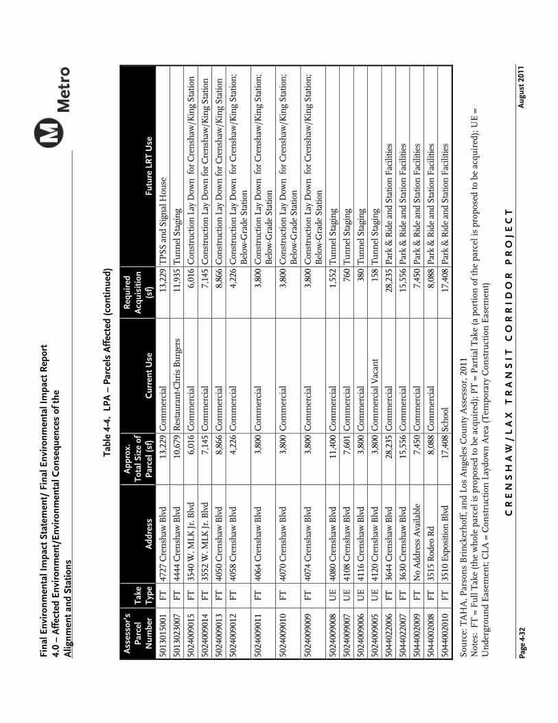
Sou
rce:
TA
HA
, Par
son
s B
rin
cker
hof
f, a
nd
Los
An
gele
s C
oun
ty A
sses
sor,
201
1 N
otes
: F
T =
Fu
ll T
ake
(th
e w
hol
e pa
rcel
is p
ropo
sed
to b
e ac
quir
ed);
PT
= P
arti
al T
ake
(a p
orti
on o
f th
e pa
rcel
is p
ropo
sed
to b
e ac
quir
ed);
UE
=
Un
derg
rou
nd
Eas
emen
t; C
LA =
Con
stru
ctio
n L
aydo
wn
Are
a (T
empo
rary
Con
stru
ctio
n E
asem
ent)
CR
EN
SH
AW
/L
AX
TR
AN
SI
T C
OR
RI
DO
R P
RO
JE
CT
A
ugus
t 201
1
Fina
l Env
iron
men
tal I
mpa
ct S
tate
men
t/ F
inal
Env
iron
men
tal I
mpa
ct R
epor
t 4.
0 –
Aff
ecte
d En
viro
nmen
t/En
viro
nmen
tal C
onse
quen
ces
of th
e
Alig
nmen
t and
Sta
tions
Page
4-3
2
Tabl
e 4-
4. L
PA –
Par
cels
Aff
ecte
d (c
ontin
ued)
Ass
esso
r’s
Parc
el
Num
ber
Take
Ty
pe
Add
ress
App
rox.
To
tal S
ize
of
Parc
el (s
f)
Cur
rent
Use
Req
uire
d A
cqui
sitio
n (s
f)
Futu
re L
RT
Use
5013
0150
01
FT
4727
Cre
nsha
w B
lvd
13,2
29C
omm
erci
al
13,2
29T
PSS
and
Sig
nal H
ouse
5013
0230
07
FT
4444
Cre
nsha
w B
lvd
10,6
79R
esta
uran
t-Chr
is B
urge
rs
11,9
35T
unne
l Sta
ging
5024
0090
15
FT
3540
W. M
LK J
r. B
lvd
6,01
6C
omm
erci
al
6,01
6C
onst
ruct
ion
Lay
Dow
n fo
r C
rens
haw
/Kin
g St
atio
n
5024
0090
14
FT
3552
W. M
LK J
r. B
lvd
7,14
5C
omm
erci
al
7,14
5C
onst
ruct
ion
Lay
Dow
n fo
r C
rens
haw
/Kin
g St
atio
n
5024
0090
13
FT
4050
Cre
nsha
w B
lvd
8,86
6C
omm
erci
al
8,86
6C
onst
ruct
ion
Lay
Dow
n fo
r C
rens
haw
/Kin
g St
atio
n
5024
0090
12
FT
4058
Cre
nsha
w B
lvd
4,22
6C
omm
erci
al
4,22
6C
onst
ruct
ion
Lay
Dow
n fo
r C
rens
haw
/Kin
g St
atio
n;
Bel
ow-G
rade
Sta
tion
5024
0090
11
FT
4064
Cre
nsha
w B
lvd
3,80
0C
omm
erci
al
3,80
0C
onst
ruct
ion
Lay
Dow
n fo
r C
rens
haw
/Kin
g St
atio
n;
Bel
ow-G
rade
Sta
tion
5024
0090
10
FT
4070
Cre
nsha
w B
lvd
3,80
0C
omm
erci
al
3,80
0C
onst
ruct
ion
Lay
Dow
n fo
r C
rens
haw
/Kin
g St
atio
n;
Bel
ow-G
rade
Sta
tion
5024
0090
09
FT
4074
Cre
nsha
w B
lvd
3,80
0C
omm
erci
al
3,80
0C
onst
ruct
ion
Lay
Dow
n fo
r C
rens
haw
/Kin
g St
atio
n;
Bel
ow-G
rade
Sta
tion
5024
0090
08
UE
4080
Cre
nsha
w B
lvd
11,4
00C
omm
erci
al
1,55
2T
unne
l Sta
ging
5024
0090
07
UE
4108
Cre
nsha
w B
lvd
7,60
1C
omm
erci
al
760
Tun
nel S
tagi
ng
5024
0090
06
UE
4116
Cre
nsha
w B
lvd
3,80
0C
omm
erci
al
380
Tun
nel S
tagi
ng
5024
0090
05
UE
4120
Cre
nsha
w B
lvd
3,80
0C
omm
erci
al V
acan
t 15
8T
unne
l Sta
ging
5044
0220
06
FT
3644
Cre
nsha
w B
lvd
28,2
35C
omm
erci
al
28,2
35P
ark
& R
ide
and
Stat
ion
Faci
litie
s
5044
0220
07
FT
3630
Cre
nsha
w B
lvd
15,5
56C
omm
erci
al
15,5
56P
ark
& R
ide
and
Stat
ion
Faci
litie
s
5044
0020
09
FT
No
Add
ress
Ava
ilabl
e 7,
450
Com
mer
cial
7,
450
Par
k &
Rid
e an
d St
atio
n Fa
cilit
ies
5044
0020
08
FT
3515
Rod
eo R
d 8,
088
Com
mer
cial
8,
088
Par
k &
Rid
e an
d St
atio
n Fa
cilit
ies
5044
0020
10
FT
3510
Exp
ositi
on B
lvd
17,4
08Sc
hool
17
,408
Par
k &
Rid
e an
d St
atio
n Fa
cilit
ies
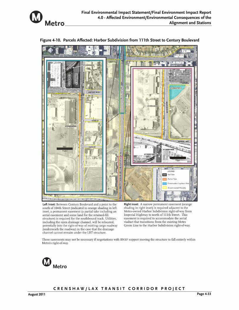
Final Environmental Impact Statement/Final Environment Impact Report 4.0 - Affected Environment/Environmental Consequences of the
Alignment and Stations
C R E N S H A W / L A X T R A N S I T C O R R I D O R P R O J E C T Page 4-33 August 2011
Figure 4-10. Parcels Affected: Harbor Subdivision from 111th Street to Century Boulevard

C R E N S H A W / L A X T R A N S I T C O R R I D O R P R O J E C T August 2011
Final Environmental Impact Statement/ Final Environmental Impact Report 4.0 – Affected Environment/Environmental Consequences of the Alignment and Stations
Page 4-34
Figure 4-10 (Continued). Parcels Affected: Harbor Subdivision from Ivy Avenue to Hillcrest Boulevard
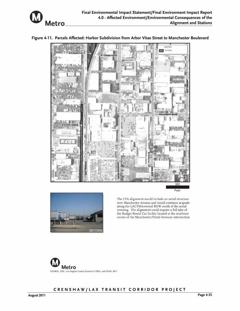
Final Environmental Impact Statement/Final Environment Impact Report 4.0 - Affected Environment/Environmental Consequences of the
Alignment and Stations
C R E N S H A W / L A X T R A N S I T C O R R I D O R P R O J E C T Page 4-35 August 2011
Figure 4-11. Parcels Affected: Harbor Subdivision from Arbor Vitae Street to Manchester Boulevard

C R E N S H A W / L A X T R A N S I T C O R R I D O R P R O J E C T August 2011
Final Environmental Impact Statement/ Final Environmental Impact Report 4.0 – Affected Environment/Environmental Consequences of the Alignment and Stations
Page 4-36
Figure 4-12. Parcels Affected: Harbor Subdivision from Manchester Boulevard to the I-405 Freeway

Final Environmental Impact Statement/Final Environment Impact Report 4.0 - Affected Environment/Environmental Consequences of the
Alignment and Stations
C R E N S H A W / L A X T R A N S I T C O R R I D O R P R O J E C T Page 4-37 August 2011
Figure 4-13. Parcels Affected: Harbor Subdivision from the I-405 Freeway to Railroad Place

C R E N S H A W / L A X T R A N S I T C O R R I D O R P R O J E C T August 2011
Final Environmental Impact Statement/ Final Environmental Impact Report 4.0 – Affected Environment/Environmental Consequences of the Alignment and Stations
Page 4-38
Figure 4-14. Parcels Affected: Harbor Subdivision from Railroad Place to Ivy Avenue

Final Environmental Impact Statement/Final Environment Impact Report 4.0 - Affected Environment/Environmental Consequences of the
Alignment and Stations
C R E N S H A W / L A X T R A N S I T C O R R I D O R P R O J E C T Page 4-39 August 2011
Figure 4-15. Parcels Affected: Harbor Subdivision from Ivy Avenue to Hillcrest Boulevard

C R E N S H A W / L A X T R A N S I T C O R R I D O R P R O J E C T August 2011
Final Environmental Impact Statement/ Final Environmental Impact Report 4.0 – Affected Environment/Environmental Consequences of the Alignment and Stations
Page 4-40
Figure 4-15 (Continued). Parcels Affected: Harbor Subdivision from Ivy Avenue to Hillcrest Boulevard

Final Environmental Impact Statement/Final Environment Impact Report 4.0 - Affected Environment/Environmental Consequences of the
Alignment and Stations
C R E N S H A W / L A X T R A N S I T C O R R I D O R P R O J E C T Page 4-41 August 2011
Figure 4-16. Parcels Affected: Harbor Subdivision from Hillcrest Boulevard to Redondo Boulevard

C R E N S H A W / L A X T R A N S I T C O R R I D O R P R O J E C T August 2011
Final Environmental Impact Statement/ Final Environmental Impact Report 4.0 – Affected Environment/Environmental Consequences of the Alignment and Stations
Page 4-42
Figure 4-17. Parcels Affected: Harbor Subdivision from Redondo Boulevard to Crenshaw Boulevard