chapter 4: earthquake risks - geoscience · pdf fileearthquakes occur when stresses in the...
TRANSCRIPT

46
CHAPTER 4: EARTHQUAKE RISKS Trevor Jones The Earthquake Threat Earthquakes occur when stresses in the Earth exceed the rock’s strength to resist, thus causing the sudden rupture of rocks and displacement along a surface called a fault. The fault may already have existed or may be newly created by the earthquake rupture. Energy from the fault rupture is transmitted as seismic waves that cause nearly all damaging earthquake effects. The size of an earthquake is often expressed in terms of Richter (or local) magnitude, denoted by ML. Richter magnitude is determined by measuring seismic wave amplitude instrumentally and was developed by Charles Richter for California in 1935. The energy released by earthquakes varies enormously and so the Richter scale is logarithmic. An increase in magnitude of one unit is equivalent to an increase in energy released of about 33 times. For example, an earthquake with Richter magnitude 6 releases about 33 times the energy of an earthquake with Richter magnitude 5, and about 1000 times the energy of an earthquake with Richter magnitude 4. The Richter magnitude scale has been adapted to Australian conditions and is a suitable measure of Australian earthquakes except for the very largest. The largest earthquakes are measured by the Moment Magnitude scale or the Surface Wave magnitude scale. Descriptions of the severity of an earthquake at any place may be given using intensity scales such as the Modified Mercalli Intensity scale. The Modified Mercalli (MM) scale describes the strength of shaking by categorising the effects of an earthquake through damage to buildings, the disruption of ground conditions, and the reactions of people and animals. A full description of the Modified Mercalli Intensity scale is provided in Appendix E. The Modified Mercalli Intensity scale is useful because it is easily applied and understood, and because it can be used to extend our knowledge of earthquakes not recorded by instruments (e.g., 19th Century earthquakes). However, Modified Mercalli intensity is a coarse measure of ground shaking. It does not correlate well with instrumental recordings of strong earthquake ground shaking. Instrumental recordings usually have not been available for Australian earthquakes, although they are much preferred. Furthermore, estimations of MM intensity can be seen as part of a circular argument that omits reference to the actual ground shaking. This is because the MM intensities in the scale have been defined in part from observations of damage to different types of buildings. In turn, estimates of Modified Mercalli intensity are made by comparing field observations of building damage to the scale. The Australian continent is distant from the narrow band of earthquake activity passing through Papua New Guinea, the South West Pacific countries and New Zealand, which delineates the boundary between the Australian and Pacific plates. Mackay is situated more than 1500 km from this plate boundary. Nonetheless, strong earthquakes have occurred in Australia, and more will occur. The most damaging earthquakes in Australia during the period 1950-2000 are listed in Table 4.1. Although damaging earthquakes are relatively rare in Australia, the high impact of individual events on the community ranks has made them a costly natural hazard. Recent figures put the historical cost of earthquakes in context. The Bureau of Transport Economics (2000) has estimated that the direct cost of natural disasters to the Australian community in the period 1967-1999 was about $37.3 billion, or an average of $1.13 billion per year. Of this total, floods contributed about 28%, severe storms about 25%, tropical cyclones about 24%, and earthquakes about 13%. With increasing urbanisation and reliance on power, water and telecommunications lifelines, Australian communities are becoming increasingly vulnerable to the impact of earthquakes.

47
Table 4.1: Most-damaging Australian earthquakes, 1950-2000
Date Location Magnitude Damage Contemporary 1995
03-01-1954 Adelaide SA 5.4 $8.8 M $91 M 22-05-1961 Robertson/Bowral NSW 5.6 $0.5 M $4.2 M 14-10-1968 Meckering WA 6.9 $5 M $35 M 10-03-1973 Picton NSW 5.5 $0.5 M $2.9 M 02-06-1979 Cadoux WA 6.2 $3.7 M $10 M 22-01-1988 Tennant Creek NT (3 events) 6.2, 6.3, 6.5 $1.1 M $1.5 M 28-12-1989 Newcastle NSW 5.6 13 killed, $862
M insured damage, est.
$1500 M total damage
$1800 M
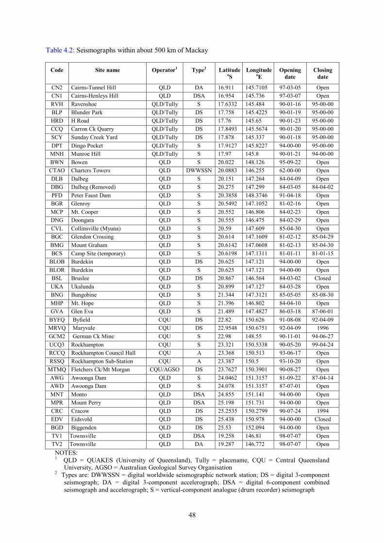
06-08-1994 Ellalong NSW 5.4 $34 M $35 M The recorded history of earthquake activity in Queensland is brief in comparison to the time-scale of geological processes - too brief for us to obtain an accurate estimate of the true rate of earthquake activity in the area. According to Rynn (1987) the first earthquake report for Queensland was from Cape York Peninsula in 1866. Recent research, however, has brought to our attention a significant earthquake (possibly of magnitude slightly less than ML 6) felt in the Noosa area of southeast Queensland in 1862. This recent discovery reinforces Rynn’s observation that a significant proportion of the available earthquake data for Queensland has come from reports of felt earthquakes because of the paucity of seismograph stations. No permanent seismographs were installed in Central Queensland before the Charters Towers seismograph, operated by the University of Queensland, was installed in 1957. This seismograph is some 300 km northwest of Mackay and, although it will detect earthquakes at this distance with magnitudes larger than about Richter magnitude 3.0, such earthquakes cannot be located accurately using the Charters Towers seismograph data alone (Russell Cuthbertson, written communication, 1998). Three seismographs, optimally placed, are usually considered the minimum number required to determine the location of earthquakes. Apart from the Charters Towers seismograph, no other seismographs were installed in Central Queensland before 1981, except for a seismograph operating at Townsville from 1956 to 1965 that was used for detecting tropical cyclones (Rynn, 1987)! This long period instrument was unsuitable for detecting local, moderate magnitude earthquake activity. In 1981 the first seismograph of the Burdekin network was installed. This network monitors the safety of dams along the Burdekin River. In 1984 the first of a similar network was installed to monitor seismicity near Awoonga dam. Table 4.2 lists the seismographs within about 500 km of Mackay and their dates of operation. Their locations are shown on Figure 4.1. Although the Burdekin and Awoonga seismographic networks have improved the capability to locate Central Queensland earthquakes, their main purpose is to locate earthquakes immediately near the dam sites, and their clustered locations gives them a poor capability to locate earthquakes further afield. Seismographic operation in Central Queensland has had a fragmented history. At the time of writing, the Queensland government is reviewing the state's seismic monitoring and we are uncertain of how many of the seismographs shown ‘Open’ in Table 4.2 are operational.
48
Table 4.2: Seismographs within about 500 km of Mackay
Code Site name Operator1 Type2 Latitude oS
Longitude oE
Opening date
Closing date
CN2 Cairns-Tunnel Hill QLD DA 16.911 145.7105 97-03-05 Open CN1 Cairns-Henleys Hill QLD DSA 16.954 145.736 97-03-07 Open RVH Ravenshoe QLD/Tully S 17.6332 145.484 90-01-16 95-00-00 BLP Blunder Park QLD/Tully DS 17.758 145.4225 90-01-19 95-00-00 HRD H Road QLD/Tully DS 17.76 145.65 90-01-23 95-00-00 CCQ Carron Ck Quarry QLD/Tully DS 17.8493 145.5674 90-01-20 95-00-00 SCY Sunday Creek Yard QLD/Tully DS 17.878 145.337 90-01-18 95-00-00 DPT Dingo Pocket QLD/Tully S 17.9127 145.8227 94-00-00 95-00-00 MNH Munroe Hill QLD/Tully S 17.97 145.8 90-01-21 94-00-00 BWN Bowen QLD S 20.022 148.126 95-09-22 Open CTAO Charters Towers QLD DWWSSN 20.0883 146.255 62-00-00 Open DLB Dalbeg QLD S 20.151 147.264 84-04-09 Open DBG Dalbeg (Removed) QLD S 20.275 147.299 84-03-05 84-04-02 PFD Peter Faust Dam QLD S 20.3858 148.3746 91-04-18 Open BGR Glenroy QLD S 20.5492 147.1052 81-02-16 Open MCP Mt. Cooper QLD S 20.552 146.806 84-02-23 Open DNG Doongara QLD S 20.555 146.475 84-02-29 Open CVL Collinsville (Myuna) QLD S 20.59 147.609 85-04-30 Open BGC Glendon Crossing QLD S 20.614 147.1609 81-02-12 85-04-29 BMG Mount Graham QLD S 20.6142 147.0608 81-02-13 85-04-30 BCS Camp Site (temporary) QLD S 20.6198 147.1311 81-01-11 81-01-15
BLOB Burdekin QLD DS 20.625 147.121 94-00-00 Open BLOR Burdekin QLD S 20.625 147.121 94-00-00 Open BSL Bruslee QLD DS 20.867 146.564 84-03-02 Closed UKA Ukalunda QLD S 20.899 147.127 84-03-28 Open BNG Bungobine QLD S 21.344 147.3121 85-05-05 85-08-30 MHP Mt. Hope QLD S 21.396 146.802 84-04-10 Open GVA Glen Eva QLD S 21.489 147.4827 86-03-18 87-06-01
BYFQ Byfield CQU DS 22.82 150.626 91-08-08 92-04-09 MRVQ Maryvale CQU DS 22.9548 150.6751 92-04-09 1996 GCM2 German Ck Mine CQU S 22.98 148.55 90-11-01 94-06-27 UCQ3 Rockhampton CQU S 23.321 150.5338 90-05-20 99-04-24 RCCQ Rockhampton Council Hall CQU A 23.368 150.513 93-06-17 Open RSSQ Rockhampton Sub-Station CQU A 23.387 150.5 93-10-20 Open
MTMQ Fletchers Ck/Mt Morgan CQU/AGSO DS 23.7627 150.3901 90-08-27 Open AWG Awoonga Dam QLD S 24.0462 151.3157 81-09-22 87-04-14 AWD Awoonga Dam QLD S 24.078 151.3157 87-07-01 Open MNT Monto QLD DSA 24.855 151.141 94-00-00 Open MPR Mount Perry QLD DSA 25.198 151.731 94-00-00 Open CRC Cracow QLD DS 25.2535 150.2799 90-07-24 1994 EDV Eidsvold QLD DS 25.438 150.978 94-00-00 Closed BGD Biggenden QLD DS 25.53 152.094 94-00-00 Open TV1 Townsville QLD DSA 19.258 146.81 98-07-07 Open TV2 Townsville QLD DA 19.287 146.772 98-07-07 Open
NOTES:
1 QLD = QUAKES (University of Queensland), Tully = placename, CQU = Central Queensland University, AGSO = Australian Geological Survey Organisation
2 Types are: DWWSSN = digital worldwide seismographic network station; DS = digital 3-component seismograph; DA = digital 3-component accelerograph; DSA = digital 6-component combined seismograph and accelerograph; S = vertical-component analogue (drum recorder) seismograph

49
Given the instrumental coverage and low population densities of the region, many small (ML ~ 3 or less) and moderate (ML up to ~ 4½) earthquakes will almost certainly have gone undetected and consequently the earthquake catalogues for Central Queensland are incomplete. Small to moderate earthquakes (e.g. with Richter magnitudes 3½ to 4½) occurring after the installation of the Charters Towers seismograph and before the mid-1980s would have been detected by that seismograph but it may not have been possible to locate all earthquakes. Some of these pre-1980s events, however, have been documented from press and other historic records (see especially Rynn, 1987, and Rynn and others, 1987). Since the mid-1980s, by contrast, moderate and large earthquakes occurring in Central Queensland should have been located using the Australian national network of seismographs (operated by AGSO). Further, any large Central Queensland earthquakes (~ magnitude 6 or larger) should have been located by the global network of seismographs for the past 90 years or more. The Mackay region earthquake catalogue should be complete for earthquakes of these minimum magnitudes from the onset of the times mentioned. Gaull and others (1990) stated that the catalogue was complete for their northeast Queensland Zone 30, northwest of Mackay, from 1981 for earthquakes of Richter magnitude 2 to 3 and larger, and from 1945 for earthquakes of magnitudes 4 to 5 and larger. In light of the low population densities and very sparse seismographic coverage mentioned above, we consider it to be unlikely that the earthquake catalogue was complete from these dates for these magnitudes. The significant recorded earthquakes within 200 km of Mackay are listed in Table 4.3, and the complete listing of all recorded earthquakes in the Mackay region is listed in Appendix F. This list of approximately 70 events with Richter magnitudes greater than two was compiled from the Australian Earthquake Database, maintained by AGSO, and the database of the Queensland University Advanced Centre for Earthquake Studies (QUAKES). Large open-cut coal mine blasts from collieries in the Bowen Basin to the west of Mackay have caused problems with the earthquake catalogue for the Mackay region because they are recorded by seismographs and sometimes mistakenly included in the earthquake catalogues. Our compilation from two agencies (Appendix F) has eliminated most if not all blasts. Most historic earthquakes in Queensland have occurred within about 200 km of the coast, either onshore or offshore. There is, however, a considerable degree of uncertainty regarding the locations of Central Queensland earthquakes that occurred up to the time of installation of the Burdekin and Awoonga seismographic networks - some epicentres may be several tens of kilometres from the true locations of the earthquakes (Figure 4.1). The proximity to the coast of historic earthquake activity is reflected in the earthquake hazard contours paralleling the coast in the Queensland earthquake hazard map published as Figure 2.3(g) in Australian Standard AS1170.4-1993 Minimum design loads on structures, Part 4: Earthquake loads (Standards Australia, 1993), referred to by the Australian Building Code. These contours map the expected severity of earthquake ground motion across the state, expressed as an ‘acceleration coefficient’. The Mackay Earthquake Experience Earthquakes have occurred near Mackay but so far none has caused significant damage. Six earthquakes are known to have been felt in Mackay with a maximum intensity of MM V (Appendix E), with minor or no resultant damage. The epicentre of the 1875 earthquake is thought to have been about 100 km southwest of Mackay. Rynn and others (1987) reported that this event was the ‘first known widely felt earthquake to be reported in Queensland', although their statement precedes recent research on the 1862 event near Noosa. The 1950 ‘Mackay’ earthquake produced the highest known ground shaking intensities in Mackay, MM V. The QUAKES database reports 'minor damage' for this event but Rynn and others (1987) reported 'no damage'. They placed its epicentre in the suburb of Mackay Harbour. The 1960 ‘Mackay’ earthquake produced ground shaking intensities in Mackay of
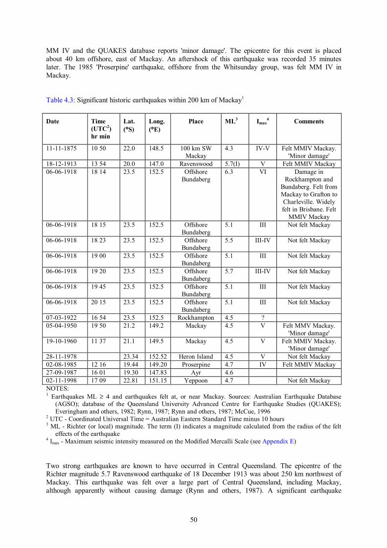
50
MM IV and the QUAKES database reports 'minor damage'. The epicentre for this event is placed about 40 km offshore, east of Mackay. An aftershock of this earthquake was recorded 35 minutes later. The 1985 'Proserpine' earthquake, offshore from the Whitsunday group, was felt MM IV in Mackay. Table 4.3: Significant historic earthquakes within 200 km of Mackay1 Date
Time (UTC2) hr min
Lat. (°°°°S)
Long. (°°°°E)
Place ML3 Imax4 Comments
11-11-1875 10 50 22.0 148.5 100 km SW Mackay
4.3 IV-V Felt MMIV Mackay. 'Minor damage'
18-12-1913 13 54 20.0 147.0 Ravenswood 5.7(I) V Felt MMIV Mackay 06-06-1918 18 14 23.5 152.5 Offshore
Bundaberg 6.3 VI Damage in
Rockhampton and Bundaberg. Felt from Mackay to Grafton to Charleville. Widely felt in Brisbane. Felt
MMIV Mackay 06-06-1918 18 15 23.5 152.5 Offshore
Bundaberg 5.1 III Not felt Mackay
06-06-1918 18 23 23.5 152.5 Offshore Bundaberg
5.5 III-IV Not felt Mackay
06-06-1918 19 00 23.5 152.5 Offshore Bundaberg
5.1 III Not felt Mackay
06-06-1918 19 20 23.5 152.5 Offshore Bundaberg
5.7 III-IV Not felt Mackay
06-06-1918 19 45 23.5 152.5 Offshore Bundaberg
5.1 III Not felt Mackay
06-06-1918 20 15 23.5 152.5 Offshore Bundaberg
5.1 III Not felt Mackay
07-03-1922 16 54 23.5 152.5 Rockhampton 4.5 ? 05-04-1950 19 50 21.2 149.2 Mackay 4.5 V Felt MMV Mackay.
'Minor damage' 19-10-1960 11 37 21.1 149.5 Mackay 4.5 V Felt MMIV Mackay.
'Minor damage' 28-11-1978 23.34 152.52 Heron Island 4.5 V Not felt Mackay 02-08-1985 12 16 19.44 149.20 Proserpine 4.7 IV Felt MMIV Mackay 27-09-1987 16 01 19.30 147.83 Ayr 4.6 02-11-1998 17 09 22.81 151.15 Yeppoon 4.7 Not felt Mackay NOTES: 1 Earthquakes ML ≥ 4 and earthquakes felt at, or near Mackay. Sources: Australian Earthquake Database
(AGSO); database of the Queensland University Advanced Centre for Earthquake Studies (QUAKES); Everingham and others, 1982; Rynn, 1987; Rynn and others, 1987; McCue, 1996
2 UTC - Coordinated Universal Time = Australian Eastern Standard Time minus 10 hours 3 ML - Richter (or local) magnitude. The term (I) indicates a magnitude calculated from the radius of the felt
effects of the earthquake 4 Imax - Maximum seismic intensity measured on the Modified Mercalli Scale (see Appendix E) Two strong earthquakes are known to have occurred in Central Queensland. The epicentre of the Richter magnitude 5.7 Ravenswood earthquake of 18 December 1913 was about 250 km northwest of Mackay. This earthquake was felt over a large part of Central Queensland, including Mackay, although apparently without causing damage (Rynn and others, 1987). A significant earthquake

51
sequence occurred offshore from Bundaberg on 6 June 1918. The mainshock had a Richter magnitude of 6.3 and although the event was about 700 km from Mackay it was felt in Mackay. Six aftershocks larger than Richter magnitude 5 occurred on the same day. The 1913 and 1918 earthquakes demonstrate that potentially damaging earthquakes do occur in Queensland and their occurrence near Mackay should not be discounted. Isoseismal maps showing the distribution of seismic intensities recorded from the 1875, 1913, 1918, 1950, 1960, 1978 and 1985 earthquakes have been published (Everingham and others, 1982; Rynn and others, 1987; McCue, 1996). Earthquake hazard in Mackay Earthquake hazard in the Mackay region Three estimates of earthquake hazard have been published for the region that includes Mackay. All estimates relate to a 10% probability of exceedence in 50 years at ‘rock’ or ‘firm’ sites. This probability corresponds to an Annual Exceedence Probability (AEP) of approximately 1/475, or an average recurrence interval (ARI) of 475 years. We have taken the 475-year ARI to be equivalent to a 500-year ARI for the purposes of comparison with flood and wind hazards in Chapter 5, Chapter 6 and Chapter 7. The first estimate of hazard is found in AS1170.4-1993 and is the one we have adopted. An ‘acceleration coefficient’ of 0.075 for the Mackay area was estimated from Figure 2.3 (g) of the standard. This value is equivalent to a peak horizontal ground acceleration (PGA) of 0.075 g, where ‘g’ is the acceleration experienced at the earth’s surface under gravity. The second estimate of hazard originates from QUAKES (e.g., Cuthbertson and Jaume, 1996). They estimated a significantly higher PGA of around 0.15 g on rock, in line with their estimates of PGA for Queensland two to three times higher than previous estimates. The third estimate is found in the work of Gaull and others (1990). The earthquake hazard maps in AS1170.4-1993 were derived from this work. It is worth noting that Gaull and others (1990) treated the Mackay area as part of the eastern Australian area of ‘background’ seismicity because the area had ‘sparse or no known seismic activity’, although about 15 years of extra data have now become available since their analysis. A comparison of the three results is given in Appendix G. The magnitude of the maximum probable earthquake has a moderate effect on earthquake hazard estimates. Gaull and others (1990) estimated maximum magnitude for the Mackay area to be magnitude 5.5. This value is too low and the estimate of Cuthbertson and Jaume (1996), magnitude 7, is more appropriate. The earthquake hazard for Mackay is low to moderate by global standards (Giardini and others, 1999). More than half the area of Australia in the earthquake hazard maps in AS1170.4-1993 has an acceleration coefficient in the range 0.05 - 0.1. The coefficient values across Australia range from a minimum 0.03 (‘low’ globally) to highs of up to 0.22 (‘moderate’ globally) in ‘bullseye’ areas. Urban earthquake hazard in Mackay In addition to the regional earthquake hazard represented by, for instance, the state-wide hazard maps in AS1170.4-1993, earthquake hazard can vary considerably across a city, primarily because of local site geology. This effect has been responsible for the concentration of damage in many earthquakes, including the 1989 Newcastle earthquake, the 1989 Loma Prieta (California) earthquake and the 1995 Kobe (Japan) earthquake. In Kobe the focussing of seismic waves at the edge of a geological basin may also have had a significant role in producing the strongest shaking. Ground shaking recorded from these earthquakes and others indicates that the localised earthquake hazard can vary by a factor
52
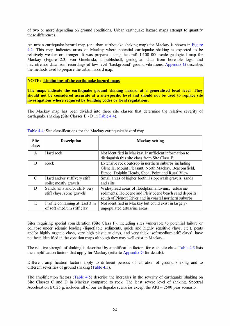
of two or more depending on ground conditions. Urban earthquake hazard maps attempt to quantify these differences. An urban earthquake hazard map (or urban earthquake shaking map) for Mackay is shown in Figure 4.2. This map indicates areas of Mackay where potential earthquake shaking is expected to be relatively weaker or stronger. It was prepared using the draft 1:100 000 scale geological map for Mackay (Figure 2.3; von Gnielinski, unpublished), geological data from borehole logs, and microtremor data from recordings of low level ‘background’ ground vibrations. Appendix G describes the methods used to prepare the urban hazard map. NOTE: Limitations of the earthquake hazard maps The maps indicate the earthquake ground shaking hazard at a generalised local level. They should not be considered accurate at a site-specific level and should not be used to replace site investigations where required by building codes or local regulations. The Mackay map has been divided into three site classes that determine the relative severity of earthquake shaking (Site Classes B - D in Table 4.4). Table 4.4: Site classifications for the Mackay earthquake hazard map
Site class
Description Mackay setting
A Hard rock Not identified in Mackay. Insufficient information to distinguish this site class from Site Class B
B Rock Extensive rock outcrop in northern suburbs including Glenella, Mount Pleasant, North Mackay, Beaconsfield, Eimeo, Dolphin Heads, Shoal Point and Rural View
C Hard and/or stiff/very stiff soils; mostly gravels
Small areas of higher foothill slopewash gravels, sands and silts
D Sands, silts and/or stiff/ very stiff clays, some gravels
Widespread areas of floodplain alluvium, estuarine sediments, Holocene and Pleistocene beach sand deposits south of Pioneer River and in coastal northern suburbs
E Profile containing at least 3 m of soft /medium stiff clay
Not identified in Mackay but could exist in largely- unpopulated estuarine areas
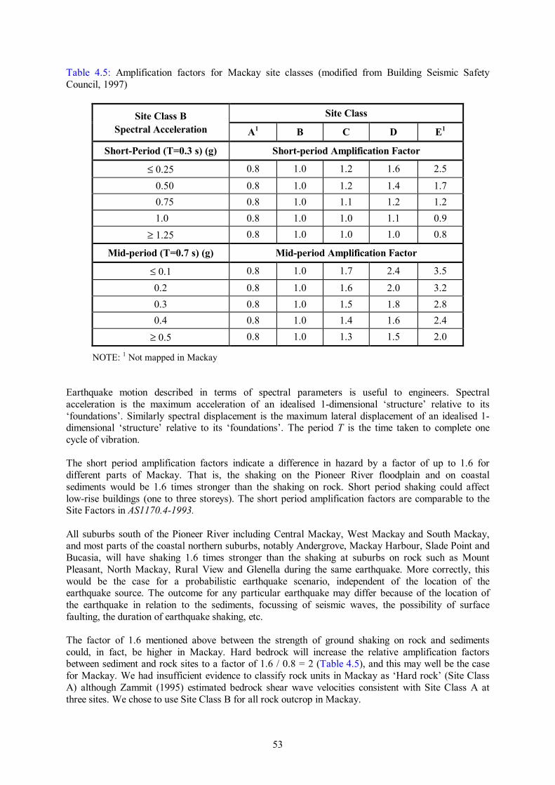
Sites requiring special consideration (Site Class F), including sites vulnerable to potential failure or collapse under seismic loading (liquefiable sediments, quick and highly sensitive clays, etc.), peats and/or highly organic clays, very high plasticity clays, and very thick ‘soft/medium stiff clays’, have not been identified in the zonation maps although they may well exist in Mackay. The relative strength of shaking is described by amplification factors for each site class. Table 4.5 lists the amplification factors that apply for Mackay (refer to Appendix G for details). Different amplification factors apply to different periods of vibration of ground shaking and to different severities of ground shaking (Table 4.5). The amplification factors (Table 4.5) describe the increases in the severity of earthquake shaking on Site Classes C and D in Mackay compared to rock. The least severe level of shaking, Spectral Acceleration ≤ 0.25 g, includes all of our earthquake scenarios except the ARI = 2500 year scenario.
53
Table 4.5: Amplification factors for Mackay site classes (modified from Building Seismic Safety Council, 1997)
Site Class B Site Class Spectral Acceleration A1 B C D E1
Short-Period (T=0.3 s) (g) Short-period Amplification Factor
≤ 0.25 0.8 1.0 1.2 1.6 2.5
0.50 0.8 1.0 1.2 1.4 1.7 0.75 0.8 1.0 1.1 1.2 1.2 1.0 0.8 1.0 1.0 1.1 0.9
≥ 1.25 0.8 1.0 1.0 1.0 0.8
Mid-period (T=0.7 s) (g) Mid-period Amplification Factor
≤ 0.1 0.8 1.0 1.7 2.4 3.5
0.2 0.8 1.0 1.6 2.0 3.2 0.3 0.8 1.0 1.5 1.8 2.8 0.4 0.8 1.0 1.4 1.6 2.4
≥ 0.5 0.8 1.0 1.3 1.5 2.0
NOTE: 1 Not mapped in Mackay Earthquake motion described in terms of spectral parameters is useful to engineers. Spectral acceleration is the maximum acceleration of an idealised 1-dimensional ‘structure’ relative to its ‘foundations’. Similarly spectral displacement is the maximum lateral displacement of an idealised 1-dimensional ‘structure’ relative to its ‘foundations’. The period T is the time taken to complete one cycle of vibration. The short period amplification factors indicate a difference in hazard by a factor of up to 1.6 for different parts of Mackay. That is, the shaking on the Pioneer River floodplain and on coastal sediments would be 1.6 times stronger than the shaking on rock. Short period shaking could affect low-rise buildings (one to three storeys). The short period amplification factors are comparable to the Site Factors in AS1170.4-1993. All suburbs south of the Pioneer River including Central Mackay, West Mackay and South Mackay, and most parts of the coastal northern suburbs, notably Andergrove, Mackay Harbour, Slade Point and Bucasia, will have shaking 1.6 times stronger than the shaking at suburbs on rock such as Mount Pleasant, North Mackay, Rural View and Glenella during the same earthquake. More correctly, this would be the case for a probabilistic earthquake scenario, independent of the location of the earthquake source. The outcome for any particular earthquake may differ because of the location of the earthquake in relation to the sediments, focussing of seismic waves, the possibility of surface faulting, the duration of earthquake shaking, etc. The factor of 1.6 mentioned above between the strength of ground shaking on rock and sediments could, in fact, be higher in Mackay. Hard bedrock will increase the relative amplification factors between sediment and rock sites to a factor of 1.6 / 0.8 = 2 (Table 4.5), and this may well be the case for Mackay. We had insufficient evidence to classify rock units in Mackay as ‘Hard rock’ (Site Class A) although Zammit (1995) estimated bedrock shear wave velocities consistent with Site Class A at three sites. We chose to use Site Class B for all rock outcrop in Mackay.

54
Earthquake hazard scenarios for Mackay We generated six probabilistic, ground shaking scenarios, with average recurrence intervals (ARI) of 100, 200, 475 (notionally 500), 1000, 2000 and 2500 years. The multipliers that we used to generate the ground shaking scenario with an ARI of 500 years to ground shaking for other average recurrence intervals are shown in Table 4.6. These multipliers are provisional values used in the revision of AS1170.4-1993 (Kevin McCue, verbal communication, 2000). Table 4.6: Provisional multiplying factors for Australian regional earthquake hazard
ARI (yr) 100 200 500 1000 2000 2500
Multiplier 0.2 0.6 1 1.4 1.75 2
The spectral values for each scenario are shown in Table 4.7. The method of preparing the earthquake hazard scenarios is described in Appendix G. Table 4.7: Earthquake hazard scenarios for Mackay
ARI (yr)
Site Class B Site Class C Site Class D
T=0.3 s T=0.7 s T=0.3 s T=0.9 s T=0.3 s T=1.0 s
PGA (g)
SA (g)
SD (cm)
SA (g)
SD (cm)
PGA (g)
SA (g)
SD (cm)
SA (g)
SD (cm)
PGA (g)
SA (g)
SD (cm)
SA (g)
SD (cm)
100 0.02 0.03 0.06 0.01 0.15 0.02 0.03 0.08 0.01 0.25 0.02 0.05 0.10 0.01 0.35200 0.05 0.09 0.19 0.04 0.44 0.05 0.10 0.23 0.04 0.75 0.07 0.14 0.31 0.04 1.06475 0.08 0.14 0.32 0.06 0.73 0.09 0.17 0.39 0.06 1.25 0.12 0.23 0.52 0.07 1.761000 0.11 0.20 0.45 0.08 1.03 0.13 0.24 0.54 0.09 1.75 0.17 0.32 0.72 0.10 2.472000 0.13 0.25 0.56 0.11 1.29 0.16 0.30 0.68 0.11 2.19 0.21 0.40 0.90 0.12 3.092500 0.15 0.29 0.65 0.12 1.47 0.18 0.35 0.77 0.12 2.50 0.23 0.43 0.97 0.13 3.23
NOTE: ARI = average recurrence interval; T = Period of vibration of ground shaking in seconds; PGA = Peak Horizontal Ground Acceleration as a proportion of g, the acceleration due to gravity; SA = Spectral Acceleration; SD = Spectral Displacement. Resonant ground shaking in Mackay sediments The alluvial, estuarine and marine sediments underlying most of Mackay have thicknesses up to about 40 m. We are grateful to Queensland Department of Natural Resources (DNR) whose database of more than 2000 groundwater boreholes in the Mackay City area provided comprehensive information on the sediments and their thicknesses (Figure 4.3). Their database was very useful in preparing the urban earthquake hazard map for Mackay (Figure 4.2). The earthquake response of these sediments may strongly influence building damage caused by any future earthquake, especially damage to low rise and medium rise buildings. In the simplest case, these sediments may resonate with characteristic periods of vibration when excited by seismic waves.

55
Underlying the Mackay sediments is geological basement with very strongly contrasting seismic properties. In general terms, the sediments form a fairly uniform veneer over basement rock. This set of conditions is strongly conducive to set the sediments resonating at their fundamental and harmonic frequencies. Amplification factors could be higher than those in Table 4.5. Structures on top of the sediments and ‘in tune’ with them, i.e., vibrating with a period close to the period of a mode of vibration of the ground, can transfer significant amounts of seismic energy from the ground into larger and larger displacements of their own motions with consequent increased damage. The map of natural resonant period of ground vibration for Mackay (Figure 4.4) supplements the urban earthquake hazard map. It provides information on the fundamental period of vibration of the ground during earthquake shaking. It also provides information on the potential for increased damage to buildings due to the increased possibility of resonance between the ground and the buildings on it during earthquakes. The natural period of vibration of the ground was measured by recording microtremors (very weak motion of the ground caused by ‘background’ noise from traffic, wind, surf, etc.) with portable seismographs in an AGSO field survey in 1997. About 230 point values of natural ground period recorded at nominal 500 m intervals in Mackay were contoured to produce the map. The natural period of vibration of sediments in Mackay is remarkably uniform (T ~ 0.3 seconds) across large areas both north and south of the Pioneer River (Figure 4.4). Low rise buildings are likely to be affected by resonant vibrations of T ~ 0.1-0.3 seconds. The single value of T = 2 seconds recorded at Mackay airport seems high, even though the sediments there are probably the thickest in Mackay. Further measurements would give a better indication of natural period near the airport (Figure 4.3). Mackay exposure to earthquakes The greatest threat that earthquakes pose comes from damage to buildings. Our earthquake risk for the Mackay community is based very largely on scenario analysis of building damage in Mackay. The risk is a function of the building types, their damage states, building usage and the potential for community disruption and business interruption through building damage. The methods of HAZUS® (FEMA, 1999) were used to derive building damage scenarios for Mackay. HAZUS® is a comprehensive earthquake loss assessment software package that can be used to estimate the probabilities of economic and social losses from earthquake. The building damage assessment method comprises three steps, as follows.
• A building database was developed that categorises buildings into types based on their load bearing elements. This revised Mackay building database is described below.
• The response of building types to the earthquake demand loads placed on them was determined by the earthquake scenarios we set. The procedures used are based on the HAZUS® (FEMA, 1999) methods and are described in Appendix H.
• The probability of buildings being in damage states nil, slight, moderate, extensive and complete was determined when subjected to earthquake demand loads by the earthquake scenarios that we set.
Mackay building database We used the Mackay building database (Appendix B) in our assessment. However, to assess building vulnerability to earthquakes, information is needed on the type of load-bearing structural frames or walls and this information is not explicit in the Mackay database. Instead, the Mackay building database, being compiled from field observations of building exteriors, provides details of wall cladding material rather than construction type.

56
The importance of assessing building damage using the types of load bearing elements of a building rather than simply the wall cladding is seen in the following example. In the 1989 Newcastle earthquake, cavity brick houses performed about twice as poorly as brick veneer, in terms of percentage losses of their total insured value. Houses with timber frames (brick veneer, fibro and timber cladding) all performed similarly (Blong, 1998). There is, nevertheless, a reasonably good agreement between the type of wall cladding and construction type in Mackay. We grouped Mackay buildings into building categories based on load-bearing frames or walls. The building categories found in Mackay are described below. Light timber frame buildings: Most Mackay buildings are of this type. These low rise buildings have timber, brick, fibro or metal exterior cladding. Most are residential buildings, or ex-residential buildings used for other purposes such as businesses. In Mackay the great majority have corrugated steel roofs. Buildings with light timber frames behave in a ductile manner in earthquakes and can undergo relatively large displacements because of their non-rigid construction. The high-set buildings on stumps are of special interest because they are found in tropical Australia but not elsewhere in Australia or in many other countries. Many older (pre-war) ‘Queenslander’ timber houses (Plate 3.1 and Plate 3.2) are found in Mackay. Most of these are in older suburbs such as North Mackay, South Mackay, Central Mackay, West Mackay, East Mackay, and Slade Point. Another distinct house type is found mainly in the older parts of suburbs such as Andergrove and Beaconsfield. This type is high set, with fibro walls and low pitched metal clad gable roof and small windows (Plate 3.5). Together these two building types comprise about 13.7% of the Mackay stock. Their performance in strong earthquake shaking has not been tested. If they are in good condition they will have vertical joints connected, will be tied down from piers to roof and may be less vulnerable to earthquakes than houses built in the 1960s and 1970s (John Ginger, verbal communication, 1999). It has been argued that these houses have demonstrated their resistance to cyclones, if not earthquakes, through having survived many events. Many old ‘Queenslanders’ are not in optimum condition, however, and their performance could be poor, particularly if they are not tied to the stumps or if the stumps are not cross-braced. The wall type ‘brick’ in the Mackay building database could include both cavity brick and brick veneer construction types. We made the assumption that all ‘brick’ houses and low-rise flats are brick veneer because residential buildings with brick walls are most common in suburbs that developed since the 1960s. Brick veneer became an accepted construction method in Queensland in the late 1950s and has been the predominant brick form since then. Metal wall cladding is found on timber frame houses, both new and old, and also covers light steel frames on low-rise factories, small businesses, warehouses, etc. We assumed that residential buildings (houses or blocks of flats) with metal cladding have timber frames and that all other metal-clad buildings have light steel frames. Reinforced masonry buildings with reinforced concrete floors (concrete block buildings with concrete slab floor): Reinforced concrete block is the second most common type of construction in Mackay (Plate 4.1), although the total of approximately 1180 buildings is far outnumbered by buildings with timber frames. About 60% of these concrete block buildings are residential. We consider that concrete block buildings complying with modern wind loading standards will probably perform well under moderate seismic loadings. However, older concrete block buildings not built to either a wind or earthquake loading standard will be less earthquake-resistant than equivalent modern buildings

57
complying with the standards. About 340 non-residential concrete block buildings were built before 1986 and some of these will not comply with wind loading provisions of the Queensland Building Act. Light steel portal frame buildings: These buildings are used primarily for business, industry, storage and transport and logistics purposes. They are largely prefabricated and have a repetitive, moment resisting, portal frame with bracing at right angles. The rear wall is often braced. Cladding is usually steel sheet. Reinforced concrete frame with unreinforced masonry infill panels: This type of construction has been popular for public works-related buildings such as hospitals and schools (Plate 4.2). Infill panels are often brick, and brick or other cladding may conceal the frame. Masonry infill panels provide lateral resistance, unintentionally in some cases. Upon cracking of the masonry, increased lateral loads are transferred to the concrete frame. Collapse can occur upon disintegration of the masonry infill or through shear failure of the frame. However, in the 1989 Newcastle earthquake these buildings did not suffer structural collapse although there was significant damage to masonry infills and cladding (Institution of Engineers, 1990). Only one precode concrete building has suffered collapse in any New Zealand earthquake, and this building had a ‘soft storey’. Dowrick and Rhoades (2000) attributed this excellent performance to structural walls of concrete, concrete blocks or brick infill. Unreinforced masonry: These usually older buildings often have cavity brick construction with the inner leaf and outer leaf attached by ties. One leaf acts as the load bearing element. Interior walls may also be unreinforced masonry and load-bearing. Floors may be of any material but in the oldest buildings are usually timber. Unreinforced masonry is brittle and historically has performed poorly in many earthquakes around the world although its strength may be improved by the presence of cross walls (John Wilson, verbal communication, 1999). Most unreinforced masonry buildings in Mackay are used as commercial premises. Old unreinforced masonry buildings, both domestic and non-domestic, were the most extensively damaged buildings in the 1989 Newcastle earthquake (Institution of Engineers, Australia, 1990). Corroded wall ties and weak lime mortar were two major contributors to masonry damage in the Newcastle earthquake and they could contribute to building vulnerability in the marine Mackay climate. In the Newcastle earthquake, extensive cracking, loss or tilting of exterior walls, and fallen parapets, awnings and gable ends were widespread and in some cases caused deaths. Tilt-up concrete shear wall construction: This type of construction is becoming increasingly popular for low rise commercial and industrial facilities. Walls are massive but thin and are prefabricated to improve quality control and ease of manufacture. We have not identified any such buildings in our Mackay database but that is almost certainly a fault of our database rather than due to the fact that these buildings do not exist in Mackay. Reinforced concrete shear walls: These structures have massive shear walls poured in situ and in Mackay have special purposes such as water reservoirs and silos at Mackay Harbour. We expect them to perform well in the non-extreme earthquake loading scenarios included in this study, and, because of their low numbers, special uses and low vulnerability, we have not included them in our damage scenarios. The revised building database for Mackay (Table 4.8) shows that the most common construction types of buildings in Mackay are:
• timber frame buildings, domestic and non domestic (89%); • concrete block masonry (5.8%); • light steel frame buildings used for small business and factories, etc. (2.5%); and • a undifferentiated group of unreinforced masonry buildings and buildings with reinforced
concrete frames with unreinforced masonry infills (1.5%).

58
Table 4.8: Mackay building inventory by site class. See Table 4.4 for an explanation of the site classes. See text for definitions of Post-code and Precode.
Construction type and usage Site Class Total B C D
Post wind standard (Post-code), after 1985, residential and non residential light timber frame with fibro, timber or metal cladding
277 5 591 873
Post-code, after 1985, residential and non residential light timber frame with brick cladding (brick veneer)
2379 26 3009 5414
Pre wind standard (Precode), before 1986, residential and non residential light timber frame, fibro, timber, brick or metal cladding
2429 39 9748 12216
Light steel frame, non-residential; mostly commercial, logistic and industrial
19 - 501 520
Reinforced concrete frame & unreinforced masonry infill; mostly hospital and educational
- ~40 ~40
Post-code reinforced masonry (concrete block) after 1985
141 10 281 432
Precode reinforced masonry (concrete block) before 1986
127 5 631 763
Unreinforced masonry (estimated) - - ~270 ~270 Other 206 Total 20734
The remainder, comprising only 1% of the total Mackay building stock, is:
• low and medium rise concrete shear walled buildings; • low rise concrete tilt-up buildings; and • other types.
Building age and seismic resistance In 1975, as a consequence of Cyclone Tracy, wind loading provisions were included in the Queensland Building Act. The cyclone resistance of some classes of buildings was significantly upgraded in 1982 with the introduction of Appendix 4 of the Queensland Building Act on 1 July. Improvements were made to the cyclone resistance of non-domestic buildings with light timber frames (George Walker, verbal communication, 1999). Importantly, for the first time, domestic buildings were described by the act. The Mackay building database generally classifies buildings constructed prior to 1986 as ‘Age = C’ with no further definition. In our assessments we have considered buildings constructed prior to 1986 as Precode and vulnerable to earthquake shaking. This is not strictly accurate because non residential buildings constructed prior to 1986 would have been constructed in accordance with contemporary wind loading provisions of the Queensland Building Act. However, their numbers are small and we do not have specific age data for these buildings. Buildings constructed after 1985 were considered Post-code and more earthquake resistant than buildings constructed earlier. Post-code brick veneer buildings were modelled as slightly more vulnerable than other timber frame buildings because of their massive, brittle, brick cladding.

59
Reinforced masonry (concrete block) buildings were all classified as Post-code. Again, we did not have building age data to distinguish between those built to comply with the Queensland Building Act and those not. Buildings with light steel frames were considered as Post-code in that they have been ‘engineered’. Unreinforced masonry buildings were considered Precode. Buildings with reinforced concrete frames were considered to have some seismic resistance in that most were probably designed to resist wind loadings. Consequence of earthquakes in Mackay A summary of the building damage generated by earthquake shaking scenarios with likelihoods ranging from ARI = 100 years to ARI = 2500 years is shown in Figure 4.5 and Table 4.9.
Figure 4.5: Mackay building damage scenarios with average recurrence intervals in the range 100
years to 2500 years. Damage states are (a) slight; (b) moderate; (c) extensive; (d) complete. The curves refer to the numbers of buildings in a particular damage state or a more severe state.
Earthquake scenario ARI = 100 years: The earthquake scenario in Mackay with an ARI = 100 years is mild. About 200 buildings, comprising about 1% of the building stock, are expected to sustain damage, about 90% of which will be minor. Most damaged buildings will be residential and most will be located in South Mackay, West Mackay, Central Mackay and Andergrove. Only about 22 buildings are expected to suffer moderate damage or more severe damage. Earthquake scenario ARI = 200 years: In this earthquake scenario about 1600 buildings, comprising about 8% of the building stock, are expected to sustain damage, about 80% of which will be minor. Most damaged buildings will be residential and most will be located in South Mackay, West Mackay, Central Mackay and Andergrove. About 270 buildings, or about 1.3% of the building stock, are expected to suffer moderate damage or more severe damage.
1
10
100
1000
10000
100 1000 10000
Average Recurrence Interval (yr)
Cum
ulat
ive
num
ber o
f bui
ldin
gs
(d)
(c)
(b)(a)

60
Table 4.9: Earthquake damage scenarios for buildings in Mackay. For damaged buildings, counts refer to the numbers of buildings in the damage state or a more severe damage state.
ARI Nil damage Slight damage Moderate damage
Extensive damage
Complete damage
No. Bldg.
% of total
No. Bldg.
% of total
No. Bldg.
% of total
No. Bldg.
% of total
No. Bldg.
% of total
100 20 321 97.9% 197 1.0% 22 0.1% 1 0.0% 0 0.0% 200 18 882 91.1% 1636 7.9% 270 1.3% 19 0.1% 1 0.0% 475 17 235 83.1% 3282 15.8% 752 3.6% 62 0.3% 4 0.0%
1000 16 159 77.0% 4359 21.0% 1153 5.5% 119 0.6% 9 0.0% 2000 14 424 69.6% 6095 29.4% 1939 9.2% 243 1.2% 23 0.1% 2500 13 875 66.9% 6645 32.1% 2127 10.1% 282 1.4% 28 0.1%
Earthquake scenario ARI = 475 years: This earthquake scenario, with an ARI = 475 years or a 10% probability of exceedence in 50 years, is the ‘building code’ scenario. About 3280 buildings, comprising about 16% of the building stock, are expected to sustain damage, about three quarters of which will be minor. About 750 buildings, comprising about 3.6% of Mackay building stock, will sustain moderate or more severe damage. Most damaged buildings will be residential and more than 100 buildings will be damaged in South Mackay, West Mackay, Central Mackay, North Mackay, Andergrove, Slade Point, Beaconsfield, Bucasia, Mount Pleasant and Ooralea. Earthquake scenario ARI = 1000 years: In this earthquake scenario about 4360 buildings, comprising about 21% of the building stock, are expected to sustain damage, about three quarters of which will be minor. About 1150 buildings, comprising about 5.5% of Mackay building stock, will sustain moderate or more severe damage. Most damaged buildings will be residential. More than 100 buildings will suffer moderate or more severe damage in South Mackay, West Mackay, Central Mackay, Andergrove and North Mackay. More than 100 buildings will be extensively damaged. About half of these will be located in Central Mackay, West Mackay and South Mackay. In Central Mackay these buildings are most likely to be business premises, constructed before 1985 of unreinforced masonry. In West Mackay and South Mackay these buildings most likely will be residential, constructed before 1985 with timber frames. Earthquake scenario ARI = 2000 years: In this earthquake scenario about 6100 buildings, comprising about 29.4% of the building stock, are expected to sustain damage, about two thirds of which will be minor. About 1940 buildings, comprising about 9.2% of Mackay building stock, will sustain moderate or worse damage. Most damaged buildings will be residential. More than 200 buildings will suffer moderate or more severe damage in South Mackay, West Mackay, Central Mackay, Andergrove, North Mackay and Slade Point. More than 200 buildings will be extensively damaged. About half of these will be located in Central Mackay, West Mackay and South Mackay. In Central Mackay these buildings most likely will be business premises, constructed before 1985 of unreinforced masonry. In West Mackay and South Mackay these buildings most likely will be residential, constructed before 1985 with timber frames. Earthquake scenario ARI = 2500 years: In this earthquake scenario about 6650 buildings, comprising about 32.1% of the building stock, are expected to sustain damage, about two thirds of which will be minor. About 2130 buildings, comprising about 10.1% of Mackay building stock, will sustain moderate or more severe damage. Most damaged buildings will be residential. More than 100 buildings will suffer moderate or more severe damage in South Mackay, West Mackay, Central Mackay, Andergrove, North Mackay, Slade Point and East Mackay.
61
More than 250 buildings will be extensively damaged. More than half of these will be located in Central Mackay, West Mackay, South Mackay, Andergrove and North Mackay. In Central Mackay these buildings most likely will be residential, constructed before 1985 with timber frames, or business premises constructed before 1985 of unreinforced masonry. In West Mackay, South Mackay Andergrove and North Mackay these buildings most likely will be residential, constructed before 1985 with timber frames. About 30 buildings are expected to be completely damaged. More than two thirds of these buildings are likely to be pre-1985 timber framed residential buildings, located in West Mackay, South Mackay, Andergrove and North Mackay, or unreinforced masonry business premises in Central Mackay. More extreme scenarios: The consequence of earthquakes in Mackay continues to increase with increasing rarity of occurrence beyond the ARI = 2500 year scenario. For example, the ARI = 10 000 year earthquake scenario produces at least slight damage to an estimated 9500 buildings (about 45% of the building stock; see Figure 4.5). A 'deterministic', or one-off, earthquake scenario could be generated that would also cause more damage than the ARI = 10 000 year probabilistic scenario. The scenario for a Richter magnitude 7 earthquake occurring within about 15 km of Mackay would be one such case. Exposure of individual Mackay suburbs to earthquake Our estimates of building damage were aggregated to suburban level for four scenarios: ARI = 100, 475, 1000 and 2500 years. The consequence is measured in terms of the numbers of buildings that will be moderately or more severely damaged (Figure 4.6). This measure may be an appropriate guide to the numbers of buildings that could need inspection by qualified personnel with regard to their safety following an earthquake. Many more buildings will suffer slight damage (generally minor cracking) in any given scenario but buildings in this damage state will not threaten the safety of occupants and they can continue to be occupied following the event. The ranking of suburbs by their exposure to earthquake (Table 4.10) is entirely dependent on building numbers, building types and localised ground conditions, and is especially sensitive to the age of buildings (and in turn related to the introduction of wind and earthquake loading requirements). There is a very strong contrast in exposure to earthquake between the most exposed quartile of suburbs (South Mackay, West Mackay, Central Mackay, Andergrove, North Mackay, Slade Point, East Mackay) and the lowest quartile of suburbs, the latter because of their low populations. The exposure ranking of suburbs is stable across scenarios with ARIs of 475 years to 2500 years; that is, regardless of the degree of resultant damage. With increasingly extreme scenarios (beyond those we have modelled), the rank of Central Mackay would rise because of the concentration of unreinforced masonry buildings and concrete block buildings in it. This is because our modelling indicates that unreinforced masonry and concrete block buildings will suffer disproportionately heavier damage, compared with other building types, in increasingly severe earthquake shaking scenarios. Scenario Mean Damage Ratio estimate for Mackay timber frame residences We calculated the Scenario Mean Damage Ratio (MDR) for timber frame residential buildings in Mackay (houses and blocks of flats). These buildings comprise 87% of all buildings in Mackay. The Scenario MDR is defined as:
Scenario MDR = cost of repair or replacement / total value (total replacement cost). The cost of repair comprises costs to repair both structural damage and non-structural damage to buildings. Structural repairs relate to the load-bearing elements of the building. Non-structural elements can be sensitive to acceleration (e.g., ceilings, pipes and ducts) or to displacement (e.g.,

62
Table 4.10: Ranking of Mackay suburbs for exposure to earthquake through building damage. Numbers of buildings estimated to be in damage state moderate or more severe are shown for scenarios with ARIs 100 to 2500 years
Suburb ARI (yr) Rank
100 475 1000 2500
Andergrove 2 85 130 243 4 Bakers Creek 0 14 21 37 13 Beaconsfield 0 19 24 55 11 Blacks Beach 0 9 15 28 15 Bucasia 0 29 45 85 8 Central Mackay 4 91 151 262 3 Cremorne 0 1 2 4 21 Dolphin Heads 0 1 1 3 23 East Mackay 1 51 76 136 7 Eimeo 0 10 14 30 14 Erakala 0 0 0 0 26 Foulden 0 0 0 0 27 Glenella 0 7 11 25 16 Mackay Harbour 0 6 13 24 17 Mount Pleasant 0 22 27 60 10 Nindaroo 0 0 1 2 24 North Mackay 2 73 107 203 5 Ooralea 0 23 36 66 9 Paget 0 12 25 46 12 Racecourse 0 2 3 6 20 Richmond 0 0 0 1 25 Rural View 0 3 4 11 19 Shoal Point 0 4 7 14 18 Slade Point 0 56 86 156 6 South Mackay 4 120 179 323 1 Te Kowai 0 1 2 4 22 West Mackay 3 114 174 312 2
interior non-structural walls, exterior wall cladding, glass). Our calculations do not include building contents. The Scenario Mean Damage Ratio is derived from the damage states of the buildings. For both structural and non-structural damage, repair costs that contribute to the total costs were calculated as follows.
Slight damage 2% of total repair cost
Moderate damage 10% of total repair cost
Extensive damage 50% of total repair cost
Complete damage 100% of total repair cost Repair costs are apportioned as follows.

63
Structural damage 15/64 of total cost to repair buildings
Non-structural acceleration-sensitive damage
17/64 of total cost to repair buildings
Non-structural displacement-sensitive damage
32/64 of total cost to repair buildings
These repair cost ratios are taken from HAZUS® (FEMA, 1999). The Scenario Mean Damage Ratio estimates for scenarios with ARI = 100, 475, 1000 and 2500 years are shown in Figure 4.7.
Figure 4.7: Scenario Mean Damage Ratio for timber frame residential buildings in Mackay The estimates of Scenario Mean Damage Ratio can be converted very easily to expected direct losses by inserting replacement costs appropriate to Mackay. A surcharge for demolition, debris removal and administrative costs could be applied. We estimate Scenario Mean Damage Ratios of 1.6% for the ARI = 475 year scenario and 4.4% for the ARI = 2500 year scenario. These values are higher than the values calculated for timber frame buildings damaged by the 1987 Edgecumbe, New Zealand, earthquake (Dowrick and Rhoades, 1990). For example, Dowrick and Rhoades (1990) calculated a Mean Damage Ratio of about 1% for Modified Mercalli Intensity VIII shaking. Intensity MM VIII approximates the Peak Ground Acceleration of 0.23 g that drives the Mackay ARI = 2500 years scenario on Site Class D. Our Scenario Mean Damage Ratios estimates are considerably lower than the calculation of Blong (1998). He estimated a Mean Damage Ratio of about 9% for timber framed domestic buildings subject to shaking of intensity MM VIII in the 1989 Newcastle earthquake. The Newcastle repair costs may
0.1%
1.0%
10.0%
100.0%
10 100 1000Average Recurrence Interval (yr)
Scen
ario
Mea
n D
amag
e R
atio

64
have been extraordinarily high, aggravated by poor building condition and repairs to damage not caused by the earthquake. Earthquake risk based on building usage Damage will occur mostly to buildings located on the sediments in Mackay. This is because the sediments increase the ground shaking severity and most of Mackay's vulnerable buildings (those predating wind and earthquake loading provisions) are built on them. Two factors, building vulnerability and location increase the risk to people occupying these buildings. An overwhelming 96% of critical facilities including electric power substations, bulk food and fuel distributors and transport-related features are located on sediments in Mackay, compared to 73% of all Mackay buildings (Figure 4.8).
Figure 4.8: Building usage and earthquake site class relationships Some community functions in Mackay are particularly at risk from earthquake because the structures that house them are vulnerable and the buildings are predominantly located on sediments. Usage groups predominantly housed in these structures will have a higher risk than the average for Mackay. The Mackay community may depend strongly on some of these usage groups in the event of an emergency. All electric power distribution facilities are located on sediments including substations at West Mackay, Central Mackay, Port Mackay and Andergrove, the Mackay Electricity Board building in Central Mackay and the Ergon depot in West Mackay. Transformers, ceramic insulators and switchgear are at increased risk through the location of the facilities. About half of the buildings also may be vulnerable unreinforced masonry and Precode concrete block (we cannot be certain using the information in the Mackay database). Many other user groups depend on electric power to maintain their daily functions. The capability to provide medical treatment in an emergency also may be threatened. Ninety percent of hospitals, pharmacies, old people's homes and surgeries are located on sediments. An estimated two-thirds of medical buildings predate wind and earthquake loading provisions. The seismic and wind resistance of the Mackay Base Hospital, a concrete-framed building with unreinforced masonry
0%
20%
40%
60%
80%
100%
Acc
omm
odat
ion
Bu s
ine s
s
C om
mu n
ity
Me d
i ca l
E duc
atio
nal
Res
iden
ti al
Go v
e rn m
e nt
Indu
s try
L og i
s ti c
P ubl
i c s
a fe t
y
Rec
reat
iona
l
S to r
a ge
a nd
tran s
p or t
E le c
t ri c
po w
er
Wa t
e r
Site class D
Site class C
Site class B

65
panels (Plate 4.2) may need to be investigated. Emergency electric power generating plant may not have seismically resistant mountings. Business function in Mackay may be particularly at risk following a strong earthquake. About 97% of businesses are located on sediments. At least 51% of the buildings housing them are Precode, and about 60% of all unreinforced masonry buildings in Mackay have a business function (many of them in Central Mackay). Direct economic and social losses through business interruption following earthquake could add substantially to the total risk facing the community. A number of key buildings with a public safety function are constructed of unreinforced masonry and are located on sediments. They include the SES headquarters, the Mackay Police Station, the Mackay Fire Station, and the Mackay Ambulance Station (all in Central Mackay). The structural integrity of these buildings, and the continued functioning of their fittings, is critical for emergency response. All buildings with a 'government' function are located on sediments. They include local, state and federal buildings housing administrative, judiciary, port and maintenance functions. At least one third of these buildings are thought to be Precode. Damage to government buildings is likely to impair community recovery more than community response. Probability of casualties The probability of death is low from any of the scenarios we considered. Dowrick (1998) published data on damage and casualties from New Zealand earthquakes. He estimated that the probability of death in, or beside (Precode) unreinforced masonry or soft storey reinforced concrete buildings was about 3 in 10,000 for earthquake shaking of MM VIII. Dowrick (1998) also found that nearly all building-related deaths from New Zealand earthquakes occurred in, or near unreinforced masonry buildings, and that more than 90% of all earthquake related deaths in New Zealand occurred at a much higher intensity of ground shaking (MM IX) than our most extreme scenario (ARI = 2500 years). The probability of injury that is immediately life-threatening if treatment is not available may be about the same as the probability of death. The probability of non life-threatening injury is about 100 to 1000 times more likely, depending on the damage state of the building (FEMA, 1999). We cannot exclude the possibility of casualties or deaths in Mackay from earthquakes. The 1989 Newcastle earthquake caused deaths through collapse of non structural elements such as awnings and through partial structural collapse. Our scenarios indicate that small numbers of buildings will suffer complete structural damage, some with structural collapse, under the more extreme scenarios. What is the earthquake risk to Mackay? In this chapter we have assessed the earthquake risk to Mackay. The risk is the outcome of the interaction of the earthquake hazard, the vulnerability of the buildings, and the numbers and locations of these buildings. As described in Chapter 1:
Risk (Total) = Hazard x Elements at Risk x Vulnerability In summary, Mackay faces a moderate risk from earthquakes. The level of earthquake risk in Mackay is certainly significant and earthquakes should be considered in risk management strategies for the city. The earthquake hazard in the Mackay region (Table 4.7) is low to moderate by global standards (Giardini and others, 1999). The relatively minor historical seismicity, and its correspondingly minor

66
impact on human activity in the Mackay region, are testimony to this. However, we need to be aware of the short historical record and the consequences of a rare, damaging earthquake. Although overall hazard is low to moderate, it is higher in the many parts of Mackay that are built on unconsolidated sediments. These sediments are expected to amplify the ground shaking from future earthquakes. We rate the vulnerability of Mackay buildings to earthquake as moderate. We have assumed that buildings that post-date the introduction of the wind provisions of the Queensland Building Act and the earthquake provisions of AS1170 were constructed to those standards and that their condition has not deteriorated significantly. About two thirds of the buildings were constructed before the enforcement of wind or earthquake loading standards and the performance of these buildings in earthquakes will be non-optimal. We consider Precode timber framed buildings are at least twice as likely to suffer moderate or more severe damage as their Post-code equivalents on the same type of ground. Unfavourable ground conditions (Site Class D) increase the likelihood that buildings will suffer moderate or more severe damage by a factor of about 2½ compared to ‘rock’ foundation. In addition, about 81% of the Precode buildings are located on the most unfavourable ground conditions in Mackay, compared to about 73% of all Mackay buildings. The great majority of buildings in Mackay (about 89%) have a light timber frame construction. Timber frame buildings perform well in earthquake and this is a positive factor in the earthquake risk that Mackay faces. About three quarters of all the buildings constructed since 1985 have brick veneer cladding. This massive wall cladding will increase seismic vulnerability of buildings compared to lighter claddings such as timber or fibro, especially if combined with heavy tile roofs. However, 89% of the Post-code brick veneer buildings have steel roofs and only 10% have tile roofs. Brick veneer performed relatively well in the 1989 Newcastle earthquake (Institution of Engineers, 1990) and in the 1994 magnitude 5.4 Ellalong, New South Wales, earthquake (Jones and others, 1994). Reinforced masonry (concrete block) buildings, built to resist wind in Australia, are considered the equal of any in the world (Greg Reardon, verbal communication, 2000). However, earthquake and wind loadings are different from each other, especially for massive buildings, and tropical Australian concrete block buildings have not been tested by strong earthquake shaking. In our scenario models, Post-code reinforced masonry buildings were about twice as likely to be in an extensive damage state as Post-code timber framed buildings although they were about equally likely to be in a moderate damage state. Reinforced masonry buildings not specifically built to comply with earthquake or wind loading provisions (Precode) are presumed to be more vulnerable. About 420 residential buildings (houses and blocks of flats) built before 1986 are probably Precode. They are mostly located in West Mackay, North Mackay, Mount Pleasant, Ooralea, Slade Point and Bucasia. Some or all of the estimated 340 non residential concrete block buildings constructed before 1986 will also be Precode. These buildings are predominantly in Central Mackay with significant numbers also in North Mackay. Our understanding of how reinforced masonry (concrete block) buildings in tropical Australia will perform in future earthquakes is incomplete and further research to improve this understanding would be valuable. There is an estimated total of about 315 unreinforced masonry buildings and buildings constructed with a reinforced concrete frame and unreinforced masonry infill panels in Mackay. These are located predominantly in Central Mackay with smaller numbers in West Mackay, South Mackay and North

67
Mackay. These buildings are typically decades old and probably have not been designed or constructed specifically to withstand lateral seismic forces. They are mainly non-residential and have the potential to contain large numbers of people at some times of the day. The Mackay Base Hospital is an example of a concrete framed building with unreinforced masonry infill (Plate 4.2). Educational buildings may also feature either of these types of construction. Unreinforced masonry buildings are the most vulnerable buildings to earthquake shaking in Mackay. Historically and in our scenario modelling they have performed poorly. We found that they are twice as likely to suffer extensive damage as any other building in Mackay. Buildings with a reinforced concrete frame and unreinforced masonry infill panels are more likely to be damaged than Post-code buildings or Precode timber frame buildings in our modelling, especially so in scenarios with more severe shaking. Nearly all unreinforced masonry buildings and buildings with a reinforced concrete frame and unreinforced masonry infill panels are located on the most hazardous ground conditions, Site Class D. The building database for Mackay does not have the resolution to distinguish between these two types of buildings, nor to separate them from other ‘brick’ buildings. Community vulnerability is also linked to building usage. Critical facilities in Mackay are more vulnerable than residential buildings because of their building types. Electric power distribution, business activity, medical treatment, and public safety activities are particularly at risk. Suggested options for earthquake mitigation Mackay City Council and Queensland government authorities could consider the following suggestions to mitigate earthquake risk. Continue to use earthquake and wind loading provisions provided by relevant Australian Standards and the Queensland Building Act We believe that wind loading standards and earthquake loading standards are highly effective mitigation tools. Adopt the Mackay earthquake hazard map as an aid to urban planning The Mackay City Council could use the earthquake hazard map for Mackay (Figure 4.2) as a planning resource. The map contains better information on localised earthquake site classes than the relevant standard, AS1170.4-1993. The City Council could refer builders and designers to the map so that appropriate earthquake loadings will be applied to new building design and construction. Enforce appropriate ground amplification factors for domestic buildings The appropriate amplification factor for low rise, new domestic buildings on sediments in Mackay (Site Class D) is 1.6. In Table 2.4 (b) of AS1170.4-1993, the Site Factor for residential buildings is either unity (‘normal soil’) or 2.0 (‘soft soil’). However, AS1170.4-1993, p.24, stated that (our bold emphasis):
‘6. In locations where the soil profiles are not known, a site factor (S) equal to 1.5 should be used for general structures and 1.0 for domestic structures.’
A site factor of 1.0 is not appropriate for domestic structures in sediment areas in Mackay. The earthquake hazard map (Figure 4.2) provides a locality guide to apply more appropriate amplification factors.

68
In areas of Mackay where sediments are less than about 10 m thick, the ground could be considered as Site Class C and an amplification factor of 1.2 would apply for most low rise structures. However, we have taken the conservative decision of classifying all areas in Mackay underlain by Quaternary sediments as Site Class D. The appropriate site factor for most structures is 1.6. We suggest that the Site Class D classification is used in all areas of Quaternary sediments. However, optionally, the Mackay City Council could place the onus of proof on the individual intending to build on sediments to prove that the mean shear wave velocity in the top 30 m of the ground is more than 360 metres per second at the site, or that the depth to moderately weathered or less weathered rock is less than 10 m, if he or she wanted to reduce the amplification factor below 1.6. Adopt the Mackay map of natural period as an aid to urban planning The Mackay City Council could adopt the Mackay map of natural period of ground vibration (Figure 4.4) as an aid to engineering design of new structures. The sediments beneath Mackay have thicknesses up to 40 m. The seismic properties of geological ‘basement’ contrast strongly with those of the sediments above. This set of conditions is strongly conducive to cause the sediments to resonate in an earthquake at their fundamental and harmonic periods of vibration. Amplification factors at resonance could be higher than the amplification factors proposed in this report. Designers of new buildings with important functions could take these conditions into account in designing buildings to be non resonant with their foundations. The Mackay City Council could, for example, refer structural engineers to the map of natural period in relation to building applications for General Structures of Importance II or III (AS1170.4-1993, Appendix A1). Prepare a database of buildings in Mackay vulnerable to earthquake (and wind) We estimate that about 310 older, unreinforced masonry buildings and buildings with reinforced concrete frames and unreinforced masonry infill panels are located in Mackay. They are located predominantly in Central Mackay, West Mackay and South Mackay. The current Mackay building database does not identify the location, condition, vulnerability and usage of these high-vulnerability buildings. Many of these buildings have unreinforced masonry construction and are located in Central Mackay, occupied by retail businesses. People inside and outside these buildings are at increased risk. The Mackay City Council could compile an inventory of these buildings with the aim of assessing their function and vulnerability and, if necessary, taking mitigating action to reduce public risk. Mitigate public risk from buildings in Mackay vulnerable to earthquake (and wind) The Mackay City Council may want to implement schemes to improve the earthquake (and wind) resistance of seismically vulnerable buildings. Such schemes could include elements of:
• special consideration given to ‘important’ buildings such as those housing post disaster functions and schools;
• regulations that make seismic upgrade mandatory when any major renovation, alteration, addition or change of use is undertaken by the owner. AS3826-1998, Strengthening existing buildings for earthquake (Standards Australia, 1998) contains recommendations for retrofit of buildings;
• incentives through rating reductions for buildings that have undergone retrofitting; • alternatively, disincentives through rating rises that increase with the time in which no
mitigating action is taken; • incentives to rebuild rather than renovate, alter or add; • a broader state or national mitigation scheme that includes the insurance industry.
69
Limitations and Uncertainty We consider the urban earthquake hazard map for Mackay, the map of natural period for Mackay and the Mackay building database to be in the most part well developed and appropriate for their usage. We have made an earthquake risk assessment based on building damage and the study reflects the state of our methodology at present. Other aspects of risk assessment not covered in this study include assessments of:
• direct monetary losses such as the cost of repairing damage and the cost of business interruptions;
• direct social losses such as the cost of recovery from physical injuries and trauma, and the costs of relocating displaced persons;
• indirect economic and social losses which impact on the external community through damage in Mackay; and
• the impact of secondary hazards including fire, hazardous material spills and debris. Uncertainties in our results include the following: Uncertainties in estimates of regional earthquake hazard There is a fundamental problem with estimating hazard for ARIs longer than the complete historic record. The specific sources contributing to uncertainties in estimates of the hazard are many. Probably the most important are uncertainties in:
• the attenuation of ground shaking from earthquakes in the region - that is, the way in which the strength of earthquake shaking decays with distance from the earthquake, and the scatter of the data used to measure this attenuation;
• the definition of earthquake source zones; and • the level of earthquake activity within these source zones.
These uncertainties are manifest in the differences of the hazard estimates made by various authors. Uncertainties in estimates of urban earthquake hazard:
• The appropriateness of using Californian data for Australian conditions needs to be investigated further.
• The Mackay urban earthquake hazard maps were prepared by a medium-level process which included the use of limited geotechnical and geophysical data but did not employ computer waveform modelling or local recordings of earthquakes. Earthquake strong motion data were not available (there are no instruments in Mackay). The inclusion of these data and techniques would improve the results.
Uncertainties in the assessment of building performance:
• The performance of different construction types of buildings in earthquakes needs to be investigated further. This work has national significance.
• In the methodology we used, buildings are aggregated into categories and the seismic performance of these categories is generalised. Associated uncertainties in building performance are taken into account in the building damage state calculations.
• Beyond this inclusion of uncertainty, there are additional uncertainties in the appropriateness of building categories that were developed for the US being used for Australia. A specific example is the question of how the compliance of Queensland buildings to the wind loading standards of the Queensland Building Act affects seismic performance.
• A particular building category in question is the category of light steel-framed industrial and commercial buildings. There are about 520 of these in Mackay. Their modelled seismic

70
performance in this study was poorer than we would have expected from their low-mass, ductile, response characteristics. We expect that post-standard buildings of this type in tropical Australia have been designed at least for wind loadings.
• We did not assess the effect of ‘soft storeys’ or asymmetries in building configuration although the Mackay building database contains information that could be used for this purpose. Dowrick and Rhoades (2000) found the effects of asymmetry or corner location to be factors of secondary importance. Buildings with a ‘soft storey’, which could include those with a ground floor carpark, have partially or totally collapsed in New Zealand and Australian earthquakes (Dowrick and Rhoades, 2000; Institution of Engineers, 1990).
• There are uncertainties in the ages of buildings in Mackay. About two thirds of Mackay buildings have ages pre-1986 but no breakdown of pre-1986 age was available in most cases.
• There are uncertainties in how building condition will affect seismic performance. We have not taken into account building condition into our modelling, beyond using building age as an indicator of seismic vulnerability, and that was largely concerned with the onset of wind and seismic loading provisions. Building condition could play a major role in damage scenarios, as was indicated by heavy nonstructural damage to buildings in Newcastle from shaking in the 1989 earthquake (Institution of Engineers, 1990).