chapter 5: open space - feis - home3.nyc.gov
TRANSCRIPT

5-1
Chapter 5: Open Space
A. INTRODUCTION This chapter assesses the potential impacts of the Proposed Action on open space resources. Open space is defined by the 2012 City Environmental Quality Review (CEQR) Technical Manual as publicly accessible, publicly or privately owned land that operates or is available for leisure, play, or sport, or serves to protect or enhance the natural environment. According to the CEQR Technical Manual, an open space assessment should be conducted if a project would have a direct effect on open space, such as eliminating or altering a public open space, or an indirect effect, such as when new population overburdens available open space. The Proposed Action would not directly displace any existing public open space and would include open space in the Rezoning Area. However, the Proposed Action would also introduce substantial new resident and worker populations to the study area that would create new demands for open space. Therefore, an open space assessment was conducted to determine whether the Proposed Action would result in any significant adverse impacts to open space resources.
PRINCIPAL CONCLUSIONS
DIRECT EFFECTS
The Proposed Action would not remove or alter any existing publicly accessible open spaces, nor would it result in any significant adverse impacts on any open spaces due to noise or air quality. As described in Chapter 6, “Shadows,” Projected Development Site 2 would result in up to approximately 2 to 4 hours of new shadows on Trump SoHo Plaza and SoHo Square in the Rezoning Area, which would result in significant adverse shadow impacts to these open spaces. However, the significant adverse shadow impacts on these open spaces would not result in a significant adverse open space impact because both Trump SoHo Plaza and SoHo Square would remain usable open spaces. Neither of these open space resources includes sunlight-dependent amenities (i.e., spray showers, sunbathing lawns), and it is expected that they would continue to be utilized by local residents and workers in the With-Action condition. Users would be able to continue to utilize the passive open space features in each park as intended. Therefore, the significant adverse shadow impacts on Trump SoHo Plaza and SoHo Square would not constitute a significant adverse open space impact.
INDIRECT EFFECTS
According to the CEQR Technical Manual, because the Proposed Action would introduce over 200 residents and over 500 employees to the area, there is the potential for these populations to noticeably diminish the ability of open spaces in the area to serve the total future population. Because the Proposed Action is anticipated to introduce more than 200 residents and nearly 500 employees to the area, a detailed analysis was conducted to determine whether there would be significant adverse impacts to open space due to the Proposed Action. The detailed analysis determined that the Proposed
Hudson Square Rezoning FEIS
5-2
Action would result in a significant adverse impact to open space in the residential study area as a result of the decrease in the total open space ratio and active open space ratio.
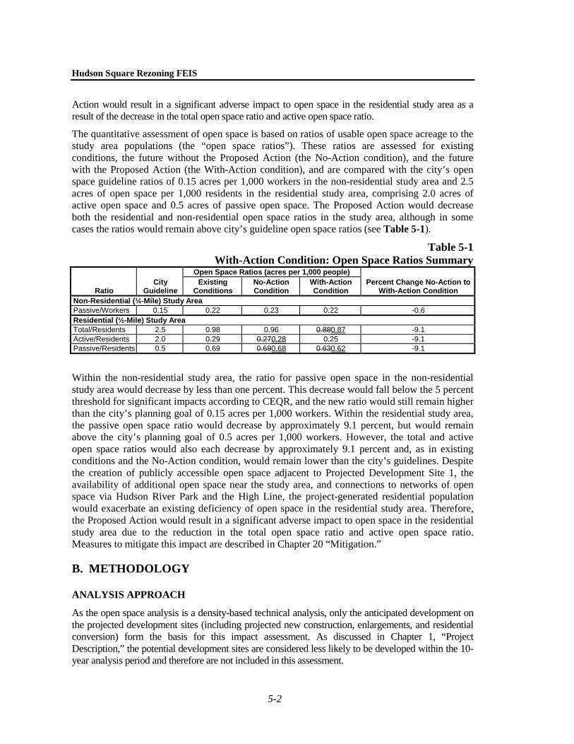
The quantitative assessment of open space is based on ratios of usable open space acreage to the study area populations (the “open space ratios”). These ratios are assessed for existing conditions, the future without the Proposed Action (the No-Action condition), and the future with the Proposed Action (the With-Action condition), and are compared with the city’s open space guideline ratios of 0.15 acres per 1,000 workers in the non-residential study area and 2.5 acres of open space per 1,000 residents in the residential study area, comprising 2.0 acres of active open space and 0.5 acres of passive open space. The Proposed Action would decrease both the residential and non-residential open space ratios in the study area, although in some cases the ratios would remain above city’s guideline open space ratios (see Table 5-1).
Table 5-1 With-Action Condition: Open Space Ratios Summary
Ratio City
Guideline
Open Space Ratios (acres per 1,000 people) Percent Change No-Action to
With-Action Condition Existing
Conditions No-Action Condition
With-Action Condition
Non-Residential (¼-Mile) Study Area Passive/Workers 0.15 0.22 0.23 0.22 -0.6 Residential (½-Mile) Study Area Total/Residents 2.5 0.98 0.96 0.880.87 -9.1 Active/Residents 2.0 0.29 0.270.28 0.25 -9.1 Passive/Residents 0.5 0.69 0.690.68 0.630.62 -9.1
Within the non-residential study area, the ratio for passive open space in the non-residential study area would decrease by less than one percent. This decrease would fall below the 5 percent threshold for significant impacts according to CEQR, and the new ratio would still remain higher than the city’s planning goal of 0.15 acres per 1,000 workers. Within the residential study area, the passive open space ratio would decrease by approximately 9.1 percent, but would remain above the city’s planning goal of 0.5 acres per 1,000 workers. However, the total and active open space ratios would also each decrease by approximately 9.1 percent and, as in existing conditions and the No-Action condition, would remain lower than the city’s guidelines. Despite the creation of publicly accessible open space adjacent to Projected Development Site 1, the availability of additional open space near the study area, and connections to networks of open space via Hudson River Park and the High Line, the project-generated residential population would exacerbate an existing deficiency of open space in the residential study area. Therefore, the Proposed Action would result in a significant adverse impact to open space in the residential study area due to the reduction in the total open space ratio and active open space ratio. Measures to mitigate this impact are described in Chapter 20 “Mitigation.”
B. METHODOLOGY
ANALYSIS APPROACH
As the open space analysis is a density-based technical analysis, only the anticipated development on the projected development sites (including projected new construction, enlargements, and residential conversion) form the basis for this impact assessment. As discussed in Chapter 1, “Project Description,” the potential development sites are considered less likely to be developed within the 10-year analysis period and therefore are not included in this assessment.

Chapter 5: Open Space
5-3
As discussed in Chapter 1, two reasonable worst-case development scenarios (RWCDS) have been developed to represent potential development scenarios that could result from the Proposed Action. Under RWCDS 1, it is assumed that the maximum permitted residential development would occur on each of the development sites. Under RWCDS 2, it is assumed that community facility uses with sleeping accommodations (i.e., dormitories), rather than residential buildings, would be developed on two of the projected development sites. Because dormitory uses would introduce more residents and more workers on their respective sites, RWCDS 2 would introduce a greater overall number of residents and workers than RWCDS 1. Therefore, RWCDS 2 provides the basis for the open space impact assessment. The analysis also assumes that new publicly accessible open space would be developed adjacent to Projected Development Site 1 in the No-Action condition based on commitments from a prior approval and in the With-Action condition as part of the Proposed Action.
DIRECT EFFECTS ANALYSIS
According to the CEQR Technical Manual, a proposed project would directly affect open space conditions if it causes the loss of public open space, changes the use of an open space so that it no longer serves the same user population, limits public access to an open space, or results in increased noise or air pollutant emissions, odor, or shadows that would temporarily or permanently affect the usefulness of a public open space. This chapter uses information from Chapter 6, “Shadows,” Chapter 14, “Air Quality,” and Chapter 16, “Noise,” to determine whether the Proposed Action would directly affect any open spaces near the project site. A proposed project can also directly affect an open space by enhancing its design or increasing its accessibility to the public. The direct effects analysis is included below in “The Future With the Proposed Action.”
INDIRECT EFFECTS ANALYSIS
As described in the CEQR Technical Manual, open space can be indirectly affected by a proposed action if the project would add enough population, either residents or non-residents, to noticeably diminish the capacity of open space in an area to serve the future population. Typically, an assessment of indirect effects is conducted when a project would introduce 200 or more residents or 500 or more workers to an area; however, the thresholds for assessment are slightly different for areas of the city that have been identified as either underserved or well-served by open space. Because the Rezoning Area is not located within an area that has been identified as either underserved or well-served, the 200 resident and 500 worker thresholds were applied in this analysis.
Under RWCDS 2, the Proposed Action would introduce approximately 2,977 new residential units and 773 dormitory beds, which would introduce an estimated 6,249 residents and students to the Rezoning Area compared with the No-Action condition. The Proposed Action would also introduce approximately 438 new workers to the Rezoning Area. Because the Proposed Action would generate more than 200 residents an open space assessment is warranted. In addition, because the number of new workers would approach the CEQR threshold of 500 workers, an assessment of the effects of new workers on open space resources is also provided.
The CEQR Technical Manual suggests that a detailed open space analysis is necessary if a project displaces a highly utilized open space or introduces a large population in an area with low existing open space ratios. Based on a preliminary analysis, the Proposed Action would introduce a large population to an area with low open space ratios and would result in a decrease in those ratios of more than 5 percent. Therefore, a detailed open space analysis was conducted, as described below.

Hudson Square Rezoning FEIS
5-4
STUDY AREAS
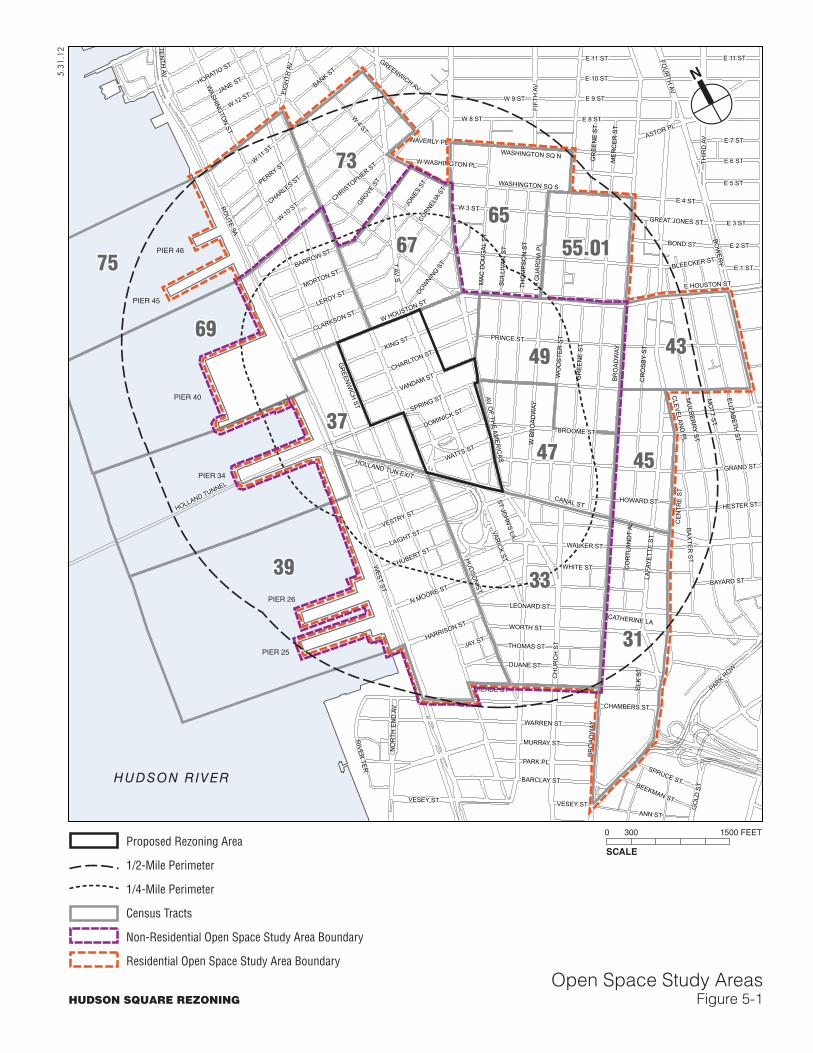
The CEQR Technical Manual recommends establishing a study area or areas as the first step in an open space assessment. The study areas are based on the distance that the respective users—residents and workers—are likely to walk to an open space. According to the CEQR Technical Manual, workers are assumed to walk approximately 10 minutes, or ¼ mile from their place of work to an open space, while residents are assumed to walk approximately 20 minutes, or ½ mile to an open space.
Because the Proposed Action would introduce new residential and worker populations to the area, the adequacy of open space resources was assessed for both the ¼-mile (non-residential) and ½-mile (residential) study areas. These two study areas were adjusted to include all census tracts with at least 50 percent of their area within the ¼- or ½-mile boundary. In this way, the study area allows analysis of both the open spaces in the area as well as population data. As shown in Figure 5-1, the ¼-mile non-residential study area is generally bounded by Christopher Street, West 4th Street, and West Houston Street to the north; Broadway to the east; Reade Street and Chambers Street to the south; and West Street to the west. The non-residential study area includes Census Tracts 33, 37, 39, 47, 49, 67, and 69.
The residential study area is generally bounded by Bank Street, Waverly Place, and Washington Square North on the north; Broadway, Bowery, and Centre Street on the east; Reade Street and Chambers Street on the south; and West Street on the west. The residential study area includes all the Census Tracts identified within the non-residential study area as well as Census Tracts 31, 43, 45, 55.01, 65, 73, and 75.
STUDY AREA POPULATIONS
EXISTING CONDITIONS
The residential population in the study areas was estimated using 2010 Census data. The non-residential worker population was estimated using 2010 employment data from ESRI, Inc., a commercial data provider.
THE FUTURE WITHOUT THE PROPOSED ACTION
As described in detail in Chapter 2, “Land Use, Zoning, and Public Policy,” there are several developments expected to be completed in the ¼- and ½-mile study areas by 2022 in the No-Action condition. The residential population in the No-Action condition was estimated by applying the average household size (1.84 people) for Community District 1 and 2 to the number of dwelling units added by the expected developments in the study areas. The number of workers added in the No-Action condition was estimated using standard employment density ratios.
THE FUTURE WITH THE PROPOSED ACTION
The population introduced by the Proposed Action was estimated by applying the average household size for Community District 2 (1.84 people) to the number of dwelling units introduced by the Proposed Action and combining this estimate with the number of dormitory beds, assuming one resident per bed. The number of workers introduced by the Proposed Action was estimated using standard employment density ratios.
39
37
69
75
33
49
31
6567
47
73
43
45
55.01
WEST ST
ROUTE 9A
BRO
ADW
AY
HU
DSO
N ST
GR
EENW
ICH
ST
W 11 ST
MO
TT ST
W 10 ST
LAFA
YETT
E ST
SPRING ST
7 AV S
CANAL ST
W 4 ST
MER
CER
ST
E 10 ST
BROOME ST
GRAND ST
BOW
ERY
CE
NTR
E S
T
HOLLAND TUNNEL
MU
LBERR
Y ST
W 3 ST
WASHING
TON ST
AV OF TH
E AMER
ICAS
WORTH ST
CH
UR
CH
ST
PRINCE ST
FIFT
H A
V
E 8 ST
ELIZABETH ST
W HOUSTON ST
PERRY ST
W 12 ST
E 4 ST
CR
OSB
Y ST
CHAMBERS ST
THO
MP
SO
N S
T
WARREN ST
SULL
IVAN
ST
BLEECKER ST
READE ST
DUANE ST
FOU
RTH
AV
PARK ROW
GR
EEN
E ST
CHARLES ST
MURRAY ST
KING ST
WHITE ST
W B
RO
ADW
AY
THIR
D A
V
E 9 STJANE ST
BARROW ST
WALKER ST
EIG
HTH
AV
WO
OST
ER S
T
LEONARD ST
E 11 ST
MORTON ST
ANN ST
BA
XTE
R S
T
W 9 ST
GROVE S
T
W 8 ST
PARK PL
VESEY ST
E 7 ST
N MOORE ST
BARCLAY ST
CHRISTOPHER ST
TENTH
AV
WATTS ST
VANDAM ST
VESTRY ST
WAVERLY PL
BOND ST
CHARLTON ST
HOLLAND TUN EXIT
E 5 ST
E 6 ST
E HOUSTON ST
THOMAS ST
MAC
DO
UG
AL S
T
CLARKSON ST
HORATIO ST
HESTER ST
LAIGHT ST
RIVER
TER
E 3 ST
GREENWICH AV
LA G
UAR
DIA
PL E 2 ST
ASTOR PL
GO
LD S
T
HUBERT ST
E 1 ST
HOWARD ST
LEROY ST
BAYARD ST
BEEKMAN ST
SPRUCE ST
HARRISON ST
DOWNIN
G ST
DOMINICK ST
JAY ST
W WASHINGTON PL
GREAT JONES ST
WASHINGTON SQ N
WASHINGTON SQ S
JONES
ST
NO
RTH
EN
D A
V
CORNELIA
ST
ST JOH
N'S LA
CLEVELAN
D PL
CO
RTL
AND
T AL
CATHERINE LA
ELK
ST
GR
EEN
E ST
BR
OA
DW
AY
VARIC
K ST
VESEY ST
E 11 ST
BANK ST
HUDSON RIVER
PIER 46
PIER 45
PIER 40
PIER 34
PIER 26
PIER 25
N
HUDSON SQUARE REZONING
5.31
.12
Open Space Study AreasFigure 5-1
SCALE
0 300 1500 FEETProposed Rezoning Area
1/2-Mile Perimeter
1/4-Mile Perimeter
Census Tracts
Non-Residential Open Space Study Area Boundary
Residential Open Space Study Area Boundary
Chapter 5: Open Space
5-5
INVENTORY OF OPEN SPACE RESOURCES
The CEQR Technical Manual defines public open space as open space that is publicly or privately owned and is accessible to the public on a regular basis, either constantly or for designated daily periods of time. Open spaces that are only available for limited users or are not available to the public on a regular or constant basis are not considered public open space, but are considered in a qualitative assessment of open space impacts.
All publicly accessible open space resources in the non-residential (¼-mile) and residential (½-mile) study areas were inventoried through field visits conducted in October and November 2011. Additional data were obtained from the New York City Department of Parks and Recreation (DPR), Hudson River Park Trust, the National Parks Service, SHoP Architects, and published environmental impact statements for projects in or near the study area.
Information was gathered about the types of facilities, levels of utilization, accessibility, and condition of each of the open space resources. According to CEQR guidelines, open spaces were also described in terms of the amount of active and passive facilities present. Active open space is used for exercise, sports, or active play, and is usually part of a recreational facility. Examples of active open space include playground equipment, athletic fields or courts, pools, and greenways. Passive open spaces encourage activities such as strolling, reading, sunbathing, people watching, and other forms of relaxation. Examples of passive open space include plazas, paths, gardens, and certain lawns with restricted uses. Open space may be characterized as passive, active, or a mixture of active and passive. Esplanades are an example of open space that may be used for active uses like running or passive dog walking.
According to CEQR Technical Manual guidelines, Greenstreets are not considered publicly accessible open spaces as they do not provide usable recreational areas and access is restricted. Greenstreets were therefore not included in the quantitative assessment.
In addition to the open spaces located in the study areas, open spaces located just outside of the study areas were considered in the qualitative analysis as they may be used by the worker or resident populations.
New open space that would be created in the No-Action and With-Action conditions was accounted for in the analysis, including new open space adjacent to Projected Development Site 1.
ADEQUACY OF OPEN SPACE RESOURCES
COMPARISON TO CITY GUIDELINES
The adequacy of open space in the study area was quantitatively and qualitatively assessed for existing conditions, the Future No-Action condition, and the With-Action condition. According to CEQR guidelines, the quantitative assessment is based on ratios of usable open space acreage to the study area populations (the “open space ratios”). These ratios were then compared with the city’s open space guidelines for residential and non-residential populations. The following guidelines are used in this type of analysis:
• For non-residential populations, 0.15 acres of passive open space per 1,000 non-residents is typically considered adequate.
• For residential populations, there is a citywide median open space ratio of 1.5 acres per 1,000 residents, which is used as a guideline. In addition to this median ratio, the city has set
Hudson Square Rezoning FEIS
5-6
an open space ratio planning goal of 2.5 acres per 1,000 residents. This second ratio includes 0.50 acres of passive space and 2.0 acres of active space, and serves as an ideal benchmark.
Because these ratios may not be attainable for all areas of the city, they are considered benchmarks for comparison rather than policy or thresholds for determining impacts.
IMPACT ASSESSMENT
Impacts are based on how a project would change the open space ratios in the study area. According to the CEQR Technical Manual, a project may result in significant adverse impacts to open space if there would be direct displacement or alteration of an open space that would significantly impact the existing users; or, if the project would reduce open space ratios by more than 5 percent in an area that is currently below the city’s median open space ratio. In areas that are extremely lacking in open space, a reduction as small as 1 percent may be considered significant, depending on the area of the city. Furthermore, in areas that are well-served by open space, a greater change in the open space ratio may be tolerated.
The CEQR Technical Manual recommends that the quantitative open space analysis described above be supplemented by an examination of qualitative factors, as the significance of any changes to open space depends on the context of the Proposed Action, including the location, quality and quantity of open space in the With-Action condition. These qualitative considerations include the availability of nearby destination resources, the connectivity of open space, the effects of new open space provided by the project, and the comparison of projected open space ratios with established city guidelines. It is recognized that the open space ratios of the city guidelines described above are not feasible for many areas of the city, and they are not considered impact thresholds on their own. Rather, they are benchmarks that indicate how well an area is served by open space.
C. EXISTING CONDITIONS
STUDY AREA POPULATION
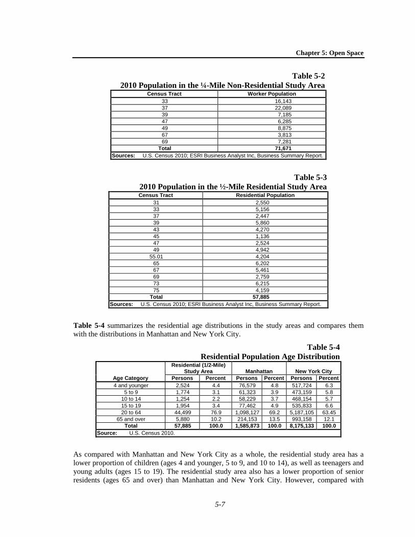
Based on 2010 employment data obtained from ESRI, Inc., the non-residential study area has a worker population of 71,671 people (See Table 5-2).
Based on 2010 Census data, the residential study area has a population of 57,885 residents (see Table 5-3).
AGE DISTRIBUTION
The age distribution of a residential population has open space implications in terms of the types of facilities that are in highest demand and how open spaces are used. As described in the CEQR Technical Manual, children 4 years or younger typically use traditional playgrounds with play equipment for toddlers and preschool children. Children ages 5 through 9 tend to use traditional playgrounds with play equipment suitable for school-age children, as well as open spaces with grass or hard surfaces for active play. Children ages 10 through 14 also tend to use playground equipment, as well as courts and ball fields. Teenagers and young adults between the ages of 15 and 19 typically use courts and active fields. Adults use facilities for sports and active fields as well as individualized recreation that utilizes paths. Senior citizens tend to utilize facilities for active recreation like handball, tennis, and swimming, as well as passive recreational facilities.
Chapter 5: Open Space
5-7
Table 5-2 2010 Population in the ¼-Mile Non-Residential Study Area
Census Tract Worker Population 33 16,143 37 22,089 39 7,185 47 6,285 49 8,875 67 3,813 69 7,281
Total 71,671 Sources: U.S. Census 2010; ESRI Business Analyst Inc, Business Summary Report.
Table 5-3 2010 Population in the ½-Mile Residential Study Area Census Tract Residential Population
31 2,550 33 5,156 37 2,447 39 5,860 43 4,270 45 1,136 47 2,524 49 4,942
55.01 4,204 65 6,202 67 5,461 69 2,759 73 6,215 75 4,159
Total 57,885 Sources: U.S. Census 2010; ESRI Business Analyst Inc, Business Summary Report.
Table 5-4 summarizes the residential age distributions in the study areas and compares them with the distributions in Manhattan and New York City.
Table 5-4 Residential Population Age Distribution
Age Category
Residential (1/2-Mile) Study Area Manhattan New York City
Persons Percent Persons Percent Persons Percent 4 and younger 2,524 4.4 76,579 4.8 517,724 6.3
5 to 9 1,774 3.1 61,323 3.9 473,159 5.8 10 to 14 1,254 2.2 58,229 3.7 468,154 5.7 15 to 19 1,954 3.4 77,462 4.9 535,833 6.6 20 to 64 44,499 76.9 1,098,127 69.2 5,187,105 63.45
65 and over 5,880 10.2 214,153 13.5 993,158 12.1 Total 57,885 100.0 1,585,873 100.0 8,175,133 100.0
Source: U.S. Census 2010.
As compared with Manhattan and New York City as a whole, the residential study area has a lower proportion of children (ages 4 and younger, 5 to 9, and 10 to 14), as well as teenagers and young adults (ages 15 to 19). The residential study area also has a lower proportion of senior residents (ages 65 and over) than Manhattan and New York City. However, compared with

Hudson Square Rezoning FEIS
5-8
Manhattan and New York City, the residential study area has a higher proportion of working-age population (ages 20 to 64).
STUDY AREA OPEN SPACES
REZONING AREA
The Rezoning Area contains three publicly accessible open spaces. These open spaces include one privately owned publicly accessible open space—the Trump Organization’s Trump SoHo Plaza—and two public open spaces—Soho Square and Duarte Square (see map numbers 1, 2, and 3 in Table 5-5 below and in Figure 5-2). Trump SoHo Plaza is a recently opened, 0.16-acre passive public space that includes landscaping, trees, and benches. Soho Square and Duarte Square are both managed by DPR, and include statues, benches and trees. The existing Duarte Square Park is approximately 0.26 acres. Overall, there is a total of one acre of open space in the Rezoning Area. This space is accounted for in both the non-residential and residential study area open space inventory.
There are two other open spaces in the study area that do not offer useable recreation areas and therefore are not included in the open space inventory. LentSpace, located on the lots adjacent to Duarte Square to the west, is a private space owned by Trinity Wall Street and currently licensed for use to the Lower Manhattan Cultural Council for a temporary art installation known as “Lent Space” that is open on a seasonal basis during daylight hours. As this space is not available to the public on a regular or constant basis, it is not considered a public open space under CEQR and was not included in the quantitative analysis. Freeman Plaza, owned by the Port Authority of New York and New Jersey, is a landscaped traffic plaza located between the entrance ramps to the Holland Tunnel between Watts Street and Broome Street. It consists of three separate spaces that are fenced off from the street and not accessible to the public. As this space is not publicly accessible, it was not included in the quantitative analysis.
NON-RESIDENTIAL (1/4-MILE) STUDY AREA
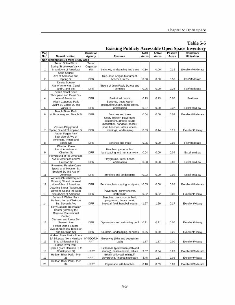
There are 29 publicly and privately owned, publicly accessible open spaces in the non-residential ¼-mile study area (including the three located within the Rezoning Area, described above). These open space resources are inventoried in Table 5-5 and their locations are shown in Figure 5-2. Overall, there are approximately 27.53 acres of open space in the non-residential study area, of which 11.94 acres provide facilities for active recreation, and 15.59 acres are passive open space.

39
37
69
75
33
49
31
6567
47
73
43
45
55.01PIER 46
PIER 45
PIER 40
PIER 34
PIER 26
PIER 25
WEST ST
ROUTE 9A
BRO
ADW
AY
HU
DSO
N ST
GR
EENW
ICH
ST
W 11 ST
MO
TT ST
W 10 ST
LAFA
YETT
E ST
SPRING ST
7 AV S
CANAL ST
W 4 ST
MER
CER
ST
E 10 ST
BROOME ST
GRAND ST
BOW
ERY
CE
NTR
E S
T
HOLLAND TUNNEL
MU
LBERR
Y ST
W 3 ST
WASHING
TON ST
AV OF TH
E AMER
ICAS
WORTH ST
CH
UR
CH
ST
PRINCE ST
FIFT
H A
V
E 8 ST
ELIZABETH ST
W HOUSTON ST
PERRY ST
W 12 ST
E 4 ST
CR
OSB
Y ST
CHAMBERS ST
THO
MP
SO
N S
T
WARREN ST
SULL
IVAN
ST
BLEECKER ST
READE ST
DUANE ST
FOU
RTH
AV
PARK ROW
GR
EEN
E ST
CHARLES ST
MURRAY ST
KING ST
WHITE ST
W B
RO
ADW
AY
THIR
D A
V
E 9 STJANE ST
BARROW ST
WALKER ST
EIG
HTH
AV
WO
OST
ER S
T
LEONARD ST
E 11 ST
MORTON ST
ANN ST
BA
XTE
R S
T
W 9 ST
GROVE S
T
W 8 ST
PARK PL
VESEY ST
E 7 ST
N MOORE ST
BARCLAY ST
CHRISTOPHER ST
TENTH
AV
WATTS ST
VANDAM ST
VESTRY ST
WAVERLY PL
BOND ST
CHARLTON ST
HOLLAND TUN EXIT
E 5 ST
E 6 ST
E HOUSTON ST
THOMAS ST
MAC
DO
UG
AL S
T
CLARKSON ST
HORATIO ST
HESTER ST
LAIGHT ST
RIVER
TER
E 3 ST
GREENWICH AV
LA G
UAR
DIA
PL E 2 ST
ASTOR PL
GO
LD S
T
HUBERT ST
E 1 ST
HOWARD ST
LEROY ST
BAYARD ST
BEEKMAN ST
SPRUCE ST
HARRISON ST
DOWNIN
G ST
DOMINICK ST
JAY ST
W WASHINGTON PL
GREAT JONES ST
WASHINGTON SQ N
WASHINGTON SQ S
JONES
ST
NO
RTH
EN
D A
V
CORNELIA
ST
ST JOH
N'S LA
CLEVELAN
D PL
CO
RTL
AND
T AL
CATHERINE LA
ELK
ST
GR
EEN
E ST
BR
OA
DW
AY
VARIC
K ST
VESEY ST
E 11 ST
BANK ST
HUDSON RIVER
1
11
21
31
41
2
12
22
32
42
3
13
23
33
43
4
14
24
34
44
5
15
25
35
45
6
16
26
36
46
7
17
17
17
27
37
47
8
18
18
28
38
48
9
19
29
39
10
20
30
40
N
HUDSON SQUARE REZONING
5.31
.12
Open Space ResourcesFigure 5-2
SCALE
0 300 1500 FEETProposed Rezoning Area
Non-Residential Open Space Study Area Boundary
Residential Open Space Study Area Boundary
Census Tracts
*NOTE: Additional open space adjacentto Projected Development Site 1 in No-Action and With-Action Conditions
Open Space
Open Space Under Construction
Chapter 5: Open Space
5-9
Table 5-5 Existing Publicly Accessible Open Space Inventory
Map No.1 Name/Location
Owner or Agency Features
Total Acres
Active Acres
Passive Acres
Condition/ Utilization
Non-residential (1/4-Mile) Study Area
1
Trump SoHo Plaza Spring St between Varick St and Ave of Americas
Trump Organiza-
tion Benches, landscaping and trees 0.16 0.00 0.16 Excellent/Moderate
2
Soho Square Ave of Americas and
Spring St DPR Gen. Jose Artigas Monument,
benches, trees 0.58 0.00 0.58 Fair/Moderate
3
Duarte Square Ave of Americas, Canal
and Grand Sts DPR Statue of Juan Pablo Duarte and
benches 0.26 0.00 0.26 Fair/Moderate
4
Grand Canal Court Thompson and Canal Sts,
Ave of Americas DPR Basketball courts 0.13 0.13 0.00 Fair/Low
5
Albert Capsouto Park Laight St, Canal St, and
Varick St DPR
Benches, trees, water sculpture/fountain, game tables,
landscaping 0.37 0.00 0.37 Excellent/Low
6 Beach Street Park
W Broadway and Beach St DPR Benches and trees 0.04 0.00 0.04 Excellent/Moderate
7 Vesuvio Playground
Spring St and Thompson St DPR
Spray shower, playground equipment, athletic courts
(basketball, handball, bocce), pool, benches, tables, chess,
plantings, landscaping 0.63 0.44 0.19 Excellent/Heavy
8
Father Fagan Park East side of Ave of
Americas, Prince and Spring Sts DPR Benches and trees 0.05 0.00 0.05 Fair/Moderate
9
Charlton Plaza Ave of Americas at
Charlton St DPR Benches, game tables,
landscaping and mural artwork 0.04 0.00 0.04 Excellent/Low
10
Playground of the Americas Ave of Americas and W
Houston St DPR Playground, trees, bench,
landscaping 0.08 0.08 0.00 Excellent/Low
11
Un-named Passive Open Space at W Houston St, Bedford St, and Ave of
Americas DPR Benches and landscaping 0.02 0.00 0.02 Excellent/Low
12
Winston Churchill Square Downing St and the west side of Ave of Americas DPR Benches, landscaping, sculpture 0.05 0.00 0.05 Excellent/Moderate
13
Downing Street Playground Downing St and the west side of Ave of Americas DPR
Playground, spray shower, bathrooms 0.22 0.22 0.00 Excellent/Heavy
14
James J. Walker Park Hudson, Leroy, Clarkson
Sts, Seventh Ave DPR
Benches, trees, soccer field, playground, bocce court,
baseball field, handball courts 1.67 1.50 0.17 Excellent/Heavy
15
Tony Dapolito Recreation Center (formerly the
Carmine Recreational Center)
Clarkson and Leroy Sts, Seventh Ave DPR Gymnasium and swimming pool 0.21 0.21 0.00 Excellent/Heavy
16
Father Demo Square Ave of Americas, Bleecker
and Carmine Sts DPR Fountain, landscaping, benches 0.25 0.00 0.25 Excellent/Heavy
17
Hudson River Park - Route 9A Bikeway (from Harrison
St to Christopher St) NYSDOT/H
RPT Greenway (bike and pedestrian
path) 1.57 1.57 0.00 Excellent/Heavy
18
Hudson River Park - Upland (from Harrison St to
Christopher St) HRPT Esplanade (pedestrian path and seating), passive lawns, tables 9.07 0.84 8.23 Excellent/Moderate
19 Hudson River Park - Pier
25 HRPT Beach volleyball, minigolf,
playground, Tribeca skatepark 3.45 1.37 2.08 Excellent/Heavy
20 Hudson River Park - Pier
34 HRPT Esplanade with benches 0.18 0.09 0.09 Excellent/Moderate
Hudson Square Rezoning FEIS
5-10
Table 5-5 (cont’d) Existing Publicly Accessible Open Space Inventory
Map No. Name/Location
Owner or Agency Features
Total Acres
Active Acres
Passive Acres
Condition/ Utilization
Non-residential (1/4-Mile) Study Area (continued)
21
Hudson River Park - Tennis Courts
Between Canal and W Houston Sts HRPT Tennis Courts 0.18 0.18 0.00 Excellent/Moderate
22 Hudson River Park - Pier
40 HRPT Dog Run, fishing, kayaking, rowing, four athletic fields 4.34 3.60 0.74 Excellent/Moderate
23
Un-named Passive Open Space at Broome and
Thompson Sts DPR Benches and landscaping 0.04 0.00 0.04 Excellent/Low
24
Salomon Smith Barney Plaza
388 Greenwich St Citigroup Benches, trees, tables, shade
structures 0.47 0.00 0.47 Excellent/Moderate
25
Washington Market Park Chambers St between
Greenwich and West Sts DPR
Playground, garden, benches, grass field, gazebo, basketball
courts, and tennis courts 2.15 1.72 0.43 Excellent/Heavy
26
Duane Park Hudson St, Duane St, and
Thomas St DPR Benches and trees 0.12 0.00 0.12 Excellent/Low
27 Tribeca Tower Plaza
Duane St and Trimble Pl Tribeca Tower Seating, landscaping 0.18 0.00 0.18 Excellent/Moderate
28
Canal Park Canal St between West St
and Washington St DPR Benches, trees, and landscaping 0.67 0.00 0.67 Excellent/Low
29
Saint John's Park Varick St, Hudson St,
Ericsson Pl, W Broadway PANY Benches and trees 0.362 0.00 0.36 Excellent/Low Total Existing Open Space, Non-Residential Study Area 27.53 11.94 15.59
Residential (1/2-Mile) Study Area3
30
City Hall Park Broadway, Park Row and
Chambers St DPR Landscaping, benches, fountain 8.80 0.00 8.80 Excellent/Moderate
31
African Burial Ground National Monument Duane St and Elk St NPS Memorial, seating 0.35 0.00 0.35 Excellent/low
32
Thomas Paine Park and Foley Square
County Court House, Worth St, Pearl St, Centre St DPR Benches, fountain, trees 1.88 0.00 1.88 Excellent/Moderate
33
Coles Plaza Mercer St between
Bleecker St and Houston St NYCDOT Benches and landscaping 0.09 0.00 0.09 Good/Moderate
34
Mercer Street Playground Mercer St between
Bleecker St and W 3rd St NYCDOT Benches, fountain, playground,
active paths 0.33 0.33 0.00 Poor/Low
35
Mercer Plaza Mercer St between W 3rd
and W 4th St NYCDOT Tables, benches, planters, trees 0.18 0.00 0.18 Excellent/Moderate
36
Schwartz Plaza W 3rd St to W 4th St,
between Laguardia Pl and Mercer St NYU Benches, sculpture, landscaping 0.32 0.00 0.32 Excellent/Moderate
37
Washington Square Park 5th Ave, Waverly Pl, W 4th
St, and MacDougal St DPR Fountain, dog parks, playground, paved area, picnic, landscaping 9.75 2.44 7.31 Excellent/Heavy
38
West 4th Street Courts Avenue of Americas, W 3rd
St and W 4th St DPR
Basketball courts, handball courts, playground and Golden
Swan Garden 0.42 0.27 0.15 Excellent/Heavy
39
Minetta Green SE corner of Minetta Ln
and Ave of Americas DPR Landscaping, path, garden 0.06 0.00 0.06 Excellent/Low
40
Minetta Triangle NE corner Ave of Americas
and Bleecker St DPR Benches and landscaping 0.07 0.00 0.07 Excellent/Low
41
Little Red Square NE corner Ave of Americas
and Bleecker St DPR Benches and trees 0.04 0.00 0.04 Good/Moderate

Chapter 5: Open Space
5-11
Table 5-5 (cont’d) Existing Publicly Accessible Open Space Inventory
Map No. Name/Location
Owner or Agency Features
Total Acres
Active Acres
Passive Acres
Condition/ Utilization
Residential (1/2-Mile) Study Area (continued)
42
Passannante Ballfield W Houston St, Ave of
Americas, MacDougal St DPR
Athletic fields (baseball, softball), athletic courts (basketball),
drinking fountain 0.61 0.61 0.00 Excellent/Moderate
43
Lt. Joseph Petrosino Square
Spring St, Cleveland Pl, and Lafayette St DPR
Seating, drinking, fountain, and landscaping 0.03 0.00 0.03 Excellent/Heavy
44
McCarthy Square 7th Ave, Charles St, and
Waverly Pl DPR Flagpole, landscaping, benches 0.04 0.00 0.04 Excellent/Low
45
Hudson River Park - Route 9A Bikeway (from
Christopher St to Bank St) NYSDOT/H
RPT Greenway (bike and pedestrian
path) 0.43 0.43 0.00 Excellent/Heavy
46
Hudson River Park - Upland (from Christopher
Street to Bank Street) HRPT Esplanade (pedestrian path and seating), passive lawns, tables 2.77 0.23 2.53 Excellent/Moderate
47 Hudson River Park - Pier
46 HRPT Synthetic active turf lawn, fishing, benches and paths 0.73 0.29 0.43 Excellent/Moderate
48 Hudson River Park – Pier
45 HRPT Shade structures, seating, wood decking and passive grass lawns 2.03 0.00 2.03 Excellent/Moderate
Total Existing Open Space, Residential Study Area 56.45 16.54 39.90 Notes: 1. See Figure 5-2 for open space resources.
2. The portion of the park in the middle of the entrance to the Holland Tunnel was not included as it is not accessible to the public. The acreage presented includes only the surrounding open spaces. 3. The residential study area includes all of the open spaces contained within the non-residential study area. DPR= New York City Department of Parks and Recreation NYSDOT=New York State Department of Transportation NYCDOT=New York City Department of Transportation HRPT= Hudson River Park Trust PANY=Port Authority of New York NPS=National Parks Service
Sources: AKRF field visits conducted in October and November 2011; DPR; Hudson River Park Trust; National Parks Service; SHoP Architects.
The largest open space in the non-residential study area is Hudson River Park, which accounts for over two thirds of the open space in this area. Approximately 18.78 acres of Hudson River Park fall within the non-residential study area. These areas consist of distinct components that include active and passive open space. The Hudson River Greenway, which includes an active pedestrian path and the adjacent Route 9A bikeway, extends for slightly less than a mile along the waterfront in the non-residential study area. The Hudson River Park upland areas account for approximately 9.07 acres of active and passive lawn and esplanade between the Greenway and the piers. Piers 25, 34, and 40 are also included in the non-residential study area. Pier 25 includes both active and passive facilities, containing beach volleyball courts, minigolf, a playground, and a skatepark, as well as connecting to the Hudson River Park esplanade with paths and seating. Pier 34 consists of a finger pier with paths and benches. Pier 40, the largest pier in Hudson River Park, houses offices for Hudson River Park Trust as well as providers of public and private recreational programming. The public facilities on Pier 40 include a dog run, fishing areas, kayaking, rowing, and athletic fields. Pier 26 is currently under construction; the pier and the upland areas affected by construction were not included in the quantitative inventory. Beyond the study area, several other components of the park are under construction or in the planning stages. Once completed, Hudson River Park will extend for five miles between Battery Place and West 59th Street, and include a total of 550 acres of open space.

Hudson Square Rezoning FEIS
5-12
Along with Duarte Square and Soho Square, there are several other open spaces located along the Avenue of the Americas, north of the Rezoning Area. These parks are clustered between East 4th Street and Vandam Street within the non-residential study area. These include five passive spaces—Charlton Plaza, Winston Churchill Square, Father Demo Square, Father Fagan Park, and an un-named space located at West Houston Street, Bedford Street, and Avenue of the Americas. Collectively, these spaces provide approximately 0.41 acres of passive open space. Downing Street Playground and Playground of the Americas provide a total of approximately 0.30 acres of active open space facilities along this strip.
Another notable open space in the non-residential study area is Washington Market Park, located on Chambers Street between Greenwich Street and West Street. This approximately 2.15-acre park includes a playground, basketball courts, and tennis courts, and well as a community garden with 50 plots, benches, a large grass field, and a gazebo. This park is well maintained and heavily utilized by local families.
RESIDENTIAL (1/2-MILE) STUDY AREA
Within the residential study area, a total of 48 open spaces serve the study area population (including the open spaces located within the non-residential study area). The residential study area contains a total of approximately 56.45 acres of public open space, of which approximately 16.54 acres are active open space and approximately 39.90 acres are passive open space.
Along with Hudson River Park, which is described above, the two largest open spaces in the study area are Washington Square Park in the north and City Hall Park in the south. Washington Square Park includes approximately 9.75 acres of active and passive space and features the Washington Arch. The approximately 7.31 acres of passive space include lawns that were improved from 2007 to 2009. This reconstruction included the improvements to the fountain and the large central plaza of the park, landscaping, and dog runs. The park also includes a playground, petanque courts, and other active spaces totaling approximately 2.44 acres. City Hall Park consists of approximately 8.80 acres of passive open space. Surrounded by historic government buildings and including New York City Hall and Tweed Courthouse on the grounds themselves, the park offers approximately 8.80 acres of passive lawns for workers and residents in the area.
As described above, there are several open spaces clustered along Avenue of the Americas, several of which fall within the residential study area. These spaces include the small passive spaces at Minetta Green, Minetta Triangle, and Little Red Square, which range from 0.04 to 0.07 acres each. Also in this area are active spaces at Passannante Ball Field and the West 4th Street Courts. The West 4th Street Courts include basketball courts, handball courts, and a playground for active recreation, as well as the Golden Swan Garden for passive use. The approximately 0.61-acre active space at Passannante Ball Field includes basketball courts and a baseball field.
Several of the open spaces in the residential study area are within and around the New York University (NYU) campus. These include three passive plazas—Coles Plaza, Mercer Plaza, and Schwartz Plaza— and one active open space at Mercer Street Playground. Coles Plaza, Mercer Plaza, and Mercer Street Playground are managed by the New York State Department of Transportation, while Schwartz Plaza is managed by NYU.
Several open spaces in the residential study area were not included because they are not currently accessible to the public. Collect Pond Park, an approximately 0.99-acre open space at Leonard Street between Centre Street and Lafayette Street, is under construction until summer
Chapter 5: Open Space
5-13
2012. As it is currently closed to the public, it was not included in the calculations of existing open space resources. In addition, Minetta Playground is currently closed for renovations. Both of these spaces are addressed below in “The Future Without the Proposed Action.”
ADEQUACY OF OPEN SPACES
QUANTIFIED ASSESSMENT
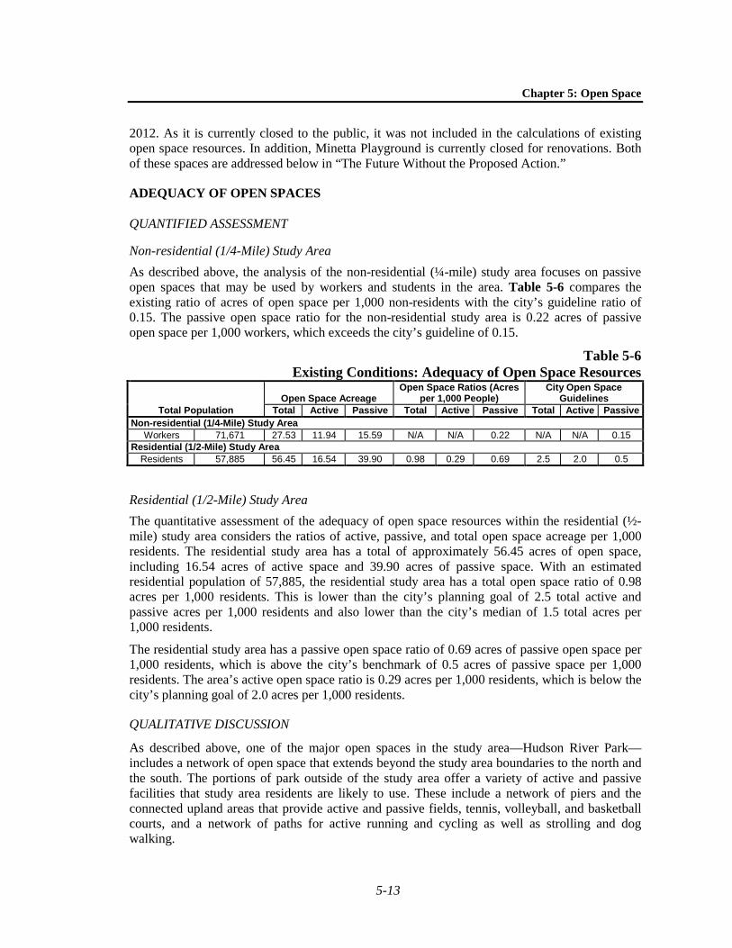
Non-residential (1/4-Mile) Study Area As described above, the analysis of the non-residential (¼-mile) study area focuses on passive open spaces that may be used by workers and students in the area. Table 5-6 compares the existing ratio of acres of open space per 1,000 non-residents with the city’s guideline ratio of 0.15. The passive open space ratio for the non-residential study area is 0.22 acres of passive open space per 1,000 workers, which exceeds the city’s guideline of 0.15.
Table 5-6 Existing Conditions: Adequacy of Open Space Resources
Total Population Open Space Acreage
Open Space Ratios (Acres per 1,000 People)
City Open Space Guidelines
Total Active Passive Total Active Passive Total Active Passive Non-residential (1/4-Mile) Study Area
Workers 71,671 27.53 11.94 15.59 N/A N/A 0.22 N/A N/A 0.15 Residential (1/2-Mile) Study Area
Residents 57,885 56.45 16.54 39.90 0.98 0.29 0.69 2.5 2.0 0.5
Residential (1/2-Mile) Study Area The quantitative assessment of the adequacy of open space resources within the residential (½-mile) study area considers the ratios of active, passive, and total open space acreage per 1,000 residents. The residential study area has a total of approximately 56.45 acres of open space, including 16.54 acres of active space and 39.90 acres of passive space. With an estimated residential population of 57,885, the residential study area has a total open space ratio of 0.98 acres per 1,000 residents. This is lower than the city’s planning goal of 2.5 total active and passive acres per 1,000 residents and also lower than the city’s median of 1.5 total acres per 1,000 residents.
The residential study area has a passive open space ratio of 0.69 acres of passive open space per 1,000 residents, which is above the city’s benchmark of 0.5 acres of passive space per 1,000 residents. The area’s active open space ratio is 0.29 acres per 1,000 residents, which is below the city’s planning goal of 2.0 acres per 1,000 residents.
QUALITATIVE DISCUSSION
As described above, one of the major open spaces in the study area—Hudson River Park—includes a network of open space that extends beyond the study area boundaries to the north and the south. The portions of park outside of the study area offer a variety of active and passive facilities that study area residents are likely to use. These include a network of piers and the connected upland areas that provide active and passive fields, tennis, volleyball, and basketball courts, and a network of paths for active running and cycling as well as strolling and dog walking.

Hudson Square Rezoning FEIS
5-14
Battery Park, an extensive 21.88-acre park on the southern tip of Manhattan, is also connected to the study area via the Hudson River Park greenway and esplanade. This park is considered a “destination park,” and residents would typically travel farther than the ½-mile extent of the residential study area to utilize the space.
The Battery Park City neighborhood also contains a network of parks, all of which are accessible from the Hudson River Greenway and the Battery Park City Esplanade. Within this area, the Battery Park City Ballfields, Governor Nelson A. Rockefeller Park, and Teardrop Park are closest to the study area and therefore most likely to be used by workers and residents in the study area. The Battery Park City Ballfields are located just south of the study area on the west side of West Street and include fields for baseball, softball, and soccer. Governor Nelson A. Rockefeller Park and Teardrop Park are located south and west of the study area. Governor Nelson A. Rockefeller Park includes wide lawns, a playground, plantings and gardens, public art, and a sheltered pavilion. Teardrop Park includes a children’s play area, seating, and places for active rock climbing. These two spaces provide approximately 10 acres of active and passive space. South of these two parks are two passive open spaces: the Irish Hunger Memorial at Vesey Street and North End Avenue and the World Financial Center Plaza south of Vesey Street. South of the World Financial Center Plaza is North Cove, which includes a public marina between Liberty Street and Vesey Street. Esplanade Plaza, Monsignor John J. Kowsky Plaza, and West Thames Park all contain active play areas as well as seating. South Cove and Rector Park provide passive open space, and Robert F. Wagner Jr. Park contains open lawns, gardens, and paths, just north of Battery Park. Although these connected public open spaces are not accounted for in the quantitative analysis, they enhance the capacity of open space in the study area to serve the population.
The High Line is also accessible from the study area. Developed on an elevated former freight line, the High Line stretches from Gansevoort Street to West 30th Street and includes 6.73 acres of passive landscaped grasses, shrubs, and trees. Like Hudson River Park and Battery Park, the High Line draws visitors from outside the immediate area.
In addition, there are several other open spaces that fall just outside of the study area boundaries that are likely to be utilized by residents and workers in the study area. Bleecker Playground, a 0.36-acre playground, is located just north of the study area at Bank Street and Bleecker Street. To the south, Columbus Park provides an additional 4.14 acres of passive open space that is easily accessible from Thomas Paine Park and Foley Square within the study area.
As shown in Table 5-4, children ages 4 and younger in the residential study area comprise approximately 4.4 percent of the residential population. This proportion is less than that of Manhattan (4.8 percent) and New York City (6.3 percent). Children in this cohort typically use traditional playgrounds that have play equipment for toddlers and preschool-aged children. Facilities in the study area offering such amenities include Vesuvio Playground, Pier 25 of Hudson River Park, Washington Market Park, and Washington Square Park.
Children between the ages of 5 and 9 account for approximately 3.1 percent of the residential population in the residential study area (see Table 5-4). This percentage is less than the percentage for this age cohort in Manhattan (3.9 percent) and New York City (5.8 percent). Children ages 5 to 9 use traditional playgrounds with play equipment suitable for school-aged children, as well as grassy and hard-surfaced open spaces which are important for ball playing, running, skipping rope, and other active play. Within the study area, various playgrounds such as Vesuvio Playground, Downing Street Playground, Pier 25 and Pier 46 of Hudson River Park,

Chapter 5: Open Space
5-15
James J. Walker Park, and Washington Market Park include amenities appropriate for this age cohort.
Approximately 2.2 percent of residents in the residential study area are children between the ages 10 and 14 (see Table 5-4). This proportion is less than the percentage represented by this age cohort in Manhattan (3.7 percent) and New York City (5.7 percent). Children between the ages of 10 and 14 tend to use playground equipment, court spaces, little league fields, and ball fields. Facilities in the study area offering such amenities include Vesuvio Playground, Pier 25 and Pier 46 of Hudson River Park, James J. Walker Park, Washington Market Park, Mercer Street Playground, Washington Square Park, Grand Canal Court, and Passannante Ballfield.
Teenagers and young adults between the ages of 15 and 19 account for approximately 3.4 percent of the residential study area population—again, a proportion lower than that in Manhattan (4.9 percent) and New York City (6.6 percent). Teenagers and young adults tend to utilize court facilities and active fields. Within the study area, Grand Canal Court, Vesuvio Playground, James J. Walker Park, Pier 25, Pier 40, and Pier 46 of Hudson River Park, and Washington Market Park serve this age cohort.
The working-age population (ages 20 to 64) accounts for the largest percentage of the population in the residential study area (approximately 76.9 percent). This is a higher proportion than that for this age cohort in Manhattan (69.2 percent) and New York City (63.5 percent). This age cohort tends to use facilities for sports and active fields, as well as paths and other facilities that encourage individualized recreation. Other than the courts mentioned above for teenagers and young adults, the tennis courts at Hudson River Park and the Tony Dapolito Recreation Center provide amenities that serve the working-age population.
The senior population (ages 65 and above) comprises approximately 10.2 percent of the residential study area’s population. This is a lower percentage than that of Manhattan (13.5 percent) and New York City (12.1 percent). Senior citizens tend to utilize facilities for active recreation like handball, tennis, gardening, and swimming, as well as passive recreational facilities. Within the study area, the senior population is served by various facilities for active recreation such as the Tony Dapolito Recreation Center, the tennis courts at Hudson River Park, and Washington Market Park.
D. THE FUTURE WITHOUT THE PROPOSED ACTION The assessment of the No-Action condition examines conditions that are expected to occur in the study area by the 2022 build year, absent the Proposed Action. The capacity of open space resources to serve future populations in the study area is examined using quantitative and qualitative factors.
STUDY AREA POPULATION
NON-RESIDENTIAL (1/4-MILE) STUDY AREA
Absent the Proposed Action, the non-residential study area will continue to experience residential, commercial, and institutional development. As described in detail in Chapter 2, “Land Use, Zoning, and Public Policy,” by 2022, several No-Action projects will be built in the Rezoning Area and a number of additional projects will be completed within the ¼-mile study area. These include the NYU Core expansion plan; which will introduce new faculty housing, dormitory, retail, hotel, and academic uses on the University Village superblock by 2021; and
Hudson Square Rezoning FEIS
5-16
projected development resulting from the North Tribeca Rezoning. These No-Action projects are listed in Table 2-2 and their locations are shown in Figure 2-3.
The known development projects will result in an estimated total of 4,0694,159 new workers in the non-residential study area.1 Based on these projects and the existing populations, the non-residential study area would have an estimated 75,74075,830 workers.
RESIDENTIAL (1/2-MILE) STUDY AREA
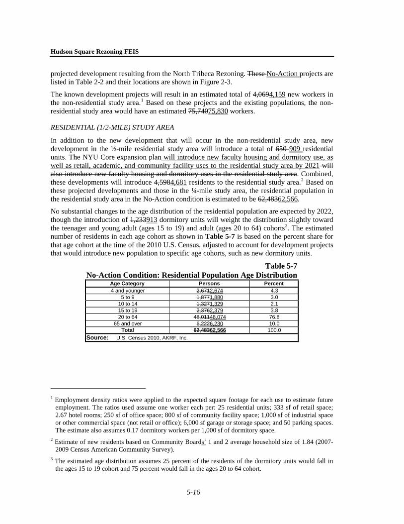
In addition to the new development that will occur in the non-residential study area, new development in the ½-mile residential study area will introduce a total of 650 909 residential units. The NYU Core expansion plan will introduce new faculty housing and dormitory use, as well as retail, academic, and community facility uses to the residential study area by 2021 will also introduce new faculty housing and dormitory uses in the residential study area. Combined, these developments will introduce 4,5984,681 residents to the residential study area.2 Based on these projected developments and those in the ¼-mile study area, the residential population in the residential study area in the No-Action condition is estimated to be 62,48362,566.
No substantial changes to the age distribution of the residential population are expected by 2022, though the introduction of 1,233913 dormitory units will weight the distribution slightly toward the teenager and young adult (ages 15 to 19) and adult (ages 20 to 64) cohorts3. The estimated number of residents in each age cohort as shown in Table 5-7 is based on the percent share for that age cohort at the time of the 2010 U.S. Census, adjusted to account for development projects that would introduce new population to specific age cohorts, such as new dormitory units.
Table 5-7 No-Action Condition: Residential Population Age Distribution
Age Category Persons Percent 4 and younger 2,6712,674 4.3
5 to 9 1,8771,880 3.0 10 to 14 1,3271,329 2.1 15 to 19 2,3762,379 3.8 20 to 64 48,01148,074 76.8
65 and over 6,2226,230 10.0 Total 62,48362,566 100.0
Source: U.S. Census 2010, AKRF, Inc.
1 Employment density ratios were applied to the expected square footage for each use to estimate future
employment. The ratios used assume one worker each per: 25 residential units; 333 sf of retail space; 2.67 hotel rooms; 250 sf of office space; 800 sf of community facility space; 1,000 sf of industrial space or other commercial space (not retail or office); 6,000 sf garage or storage space; and 50 parking spaces. The estimate also assumes 0.17 dormitory workers per 1,000 sf of dormitory space.
2 Estimate of new residents based on Community Boards’ 1 and 2 average household size of 1.84 (2007-2009 Census American Community Survey).
3 The estimated age distribution assumes 25 percent of the residents of the dormitory units would fall in the ages 15 to 19 cohort and 75 percent would fall in the ages 20 to 64 cohort.
Chapter 5: Open Space
5-17
STUDY AREA OPEN SPACES
NON-RESIDENTIAL (1/4-MILE) STUDY AREA
In the No-Action condition, two open spaces would be improved in the ¼-mile study area, making them usable as public open space. Within the Rezoning Area, the No-Action condition development of Projected Development Site 1 would result in the improvement of Duarte Square Park and the open space easement located adjacent to the site based on commitments from a prior approval. In 2002, pursuant to a proposal by the Applicant and DPR, the City Planning Commission (CPC) approved an amendment to the city map involving the demapping and disposition to the Applicant of a 9,945 square foot segment of the former Sullivan Street between Grand and Canal Streets, together with the mapping as public park an existing open space of 11,272 square feet at Duarte Square, a triangular-shaped area located at the northwest corner of Canal Street and Avenue of the Americas. Within the demapped street, an open space easement of approximately 4,508 square feet was established along the western edge of Duarte Square Park, expanding the existing area dedicated to open space, and a sewer easement was established covering the remainder of the demapped street. The CPC report with respect to the 2002 approval references a planned 432-foot tall office building to be constructed on property owned by the Applicant that is identified as Projected Development Site 1 in the current RWCDS. The CPC report also noted that the Applicant would finance certain enhancements to Duarte Square Park and the adjacent easement area.
Pursuant to a Mapping Agreement dated May 15, 2006 between the Applicant and the City of New York, the Applicant agreed to provide for the design and construction of improvements to Duarte Square Park and the adjacent easement area by November 21, 2016. At the time of the 2002 City Planning Commission approval, a conceptual plan for the redesign of the park and the adjacent easement areas had been established, including increased seating, additional trees, a water feature, and a kiosk for the sale of food and drinks. The improvement and opening to the public of the easement areas adjacent to Duarte Square Park in the No-Action condition would result in an additional 0.23 acres of passive open space in the study area.1
In addition, tThere are also plans to redevelop Pier 26, just north of Pier 25 in Hudson River Park with various open space components, including an estuarium, lawns, seating areas, overlooks, a boathouse and a variety of active and passive recreation opportunities. Currently, the estuarium is unfunded and the completion date is unknown and plans for the pier itself include a restaurant and boathouse that would not qualify as public open space. Therefore, only the upland area consisting of passive lawn space and a dog run was included in the quantitative analysis. The upland portion of Pier 26 will add a total of approximately 1.29 acres of public passive open space to the non-residential study area and reconnect this portion of the park. Together, these spaces will provide a total of approximately 1.52 acres of open space to the study area.
In addition, the Hudson Square Connection, the Business Improvement District (BID) serving the Hudson Square neighborhood, has proposed several measures to enhance the pedestrian streetscape and retail environment as well as expand available open space amenities in the area. 1 The development of Projected Development Site 5 in the No-Action would utilize the plaza bonus with
the creation of 3,500 square foot public plaza. However, Department of Buildings-approved plans indicate that this space would not provide amenities such as seating and therefore it is not included in the analysis.
Hudson Square Rezoning FEIS
5-18
These measures could include additional street trees and lighting at various locations in the area, renovation of SoHo Square, adding landscaping and seating to a small portion of Freeman Plaza, creation of a planted median along Varick Street, and pedestrian and cyclist improvements along Hudson Street, among others. Because these measures would be subject to further study and coordination with the community and the New York City Department of Transportation (NYCDOT), they have not been assumed as part of the quantitative open space analysis in the No-Action condition.
RESIDENTIAL (1/2-MILE) STUDY AREA
In addition to the improvements within the non-residential study area, several open spaces would be improved or added within the residential study area. Coles Playground, adjacent to Coles Plaza, will be reopened, adding approximately 0.16 acres of active open space to the study area. Collect Pond Park, located at Leonard Street between Centre Street and Lafayette Street, would be reopened, adding approximately 0.99 acres of passive open space. In addition, Minetta Playground would be reopened, adding 0.14 acres of active open space and 0.06 acres of passive open space to the study area. An approximately 4,500-sf playground called Adrienne’s Place will be built as part of the NYCDOT-owned LaGuardia Landscape on LaGuardia Place between Bleecker Street and West Third Street. In addition, the NYU Core expansion will introduce a net gain of 0.720.57 acres of public open space, including 0.090.30 acres of passive space and 0.260.27 acres of active space, across several separate sites. Along with the open spaces added in the non-residential study area, there will be a total of approximately 3.713.55 acres of open spaces added to the residential study area in the No-Action condition, of which approximately 0.630.67 acres would be active and 3.072.87 acres would be passive open space.
ADEQUACY OF OPEN SPACES
QUANTITATIVE ASSESSMENT
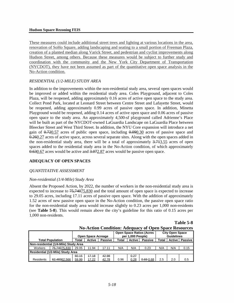
Non-residential (1/4-Mile) Study Area Absent the Proposed Action, by 2022, the number of workers in the non-residential study area is expected to increase to 75,74075,830 and the total amount of open space is expected to increase to 29.05 acres, including 17.11 acres of passive open space. With the addition of approximately 1.52 acres of new passive open space in the No-Action condition, the passive open space ratio for the non-residential study area would increase slightly to 0.23 acres per 1,000 non-residents (see Table 5-8). This would remain above the city’s guideline for this ratio of 0.15 acres per 1,000 non-residents.
Table 5-8 No-Action Condition: Adequacy of Open Space Resources
Total Population Open Space Acreage
Open Space Ratios (Acres per 1,000 People)
City Open Space Guidelines
Total Active Passive Total Active Passive Total Active Passive Non-residential (1/4-Mile) Study Area
Workers 75,74075,830 29.05 11.94 17.11 N/A N/A 0.23 N/A N/A 0.15 Residential (1/2-Mile) Study Area
Residents 62,48362,566 60.15 59.99
17.18 17.22
42.98 42.78 0.96
0.27 0.28 0.69 0.68 2.5 2.0 0.5

Chapter 5: Open Space
5-19
Residential (1/2-Mile) Study Area In the No-Action condition, the increase in residents would slightly decrease the active open space ratio to 0.270.28 acres per 1,000 residents. The added residents would be balanced with additional passive open space, and also slightly decrease the ratio for passive open space in the residential study area would remain substantially the same, at 0.69to 0.68 acres per 1,000 residents. The total open space ratio would decrease slightly to 0.96 acres of open space per 1,000 residents, and would still fall below the city’s goal of 2.5 total acres per 1,000 residents and the citywide median of 1.5 acres per 1,000 residents. Overall, the passive open space ratio would continue to exceed the city’s benchmark of 0.5 acres, but the active open space and total open space ratios for the residential study area would fall below the city guidelines.
QUALITATIVE ASSESSMENT
As discussed above, the BID serving the Hudson Square neighborhood has proposed a number of measures to enhance the pedestrian streetscape and retail environment as well as expand available open space amenities in the area. Although these measures would be subject to further study and coordination with the community and NYCDOT, if implemented, they would improve and expand the open space resources available within the Rezoning Area.
The completion of Pier 26 at Hudson River Park will be a notable improvement in the study area. As described above, Hudson River Park is the largest open space in the study area. The addition of new open space at Pier 26 will activate this Pier and also serve the purpose of completing the continuous waterfront green space intended by Hudson River Park.
As in existing conditions, Hudson River Park would continue to connect residents in the study area to green space throughout Lower Manhattan and along the Hudson River waterfront. Study area residents would also continue to have access to open spaces just outside the study area, such as Columbus Park.
E. THE FUTURE WITH THE PROPOSED ACTION The assessment of the With-Action condition examines conditions that are expected to occur as a result of the Proposed Action. The capacity of open space resources to serve future populations in the study area is examined using quantitative and qualitative factors. The potential for direct effects on open space is also considered.
DIRECT EFFECTS
As described above in the discussion of methodology, direct adverse effects on an open space occur when a proposed action would cause the physical loss of public open space; change the use of an open space so that it no longer serves the same user population; limit public access to an open space; or cause increased noise or air pollutant emissions, odors, or shadows that would affect its usefulness, whether on a permanent or temporary basis. The Proposed Action would not directly displace any public open spaces, nor would it have any adverse impacts on existing open space in terms of air quality, noise, or odors (see Chapters 14, “Air Quality,” and 16, “Noise” for additional information). However, as described in Chapter 6, “Shadows,” Projected Development Site 2 would result in up to approximately 2 to 4 hours of new shadows on Trump SoHo Plaza and SoHo Square in the Rezoning Area, which would result in significant adverse shadow impacts to these open spaces.
Hudson Square Rezoning FEIS
5-20
INDIRECT EFFECTS
STUDY AREA POPULATION
As noted above, the future project-generated populations for the non-residential and residential study area are based on RWCDS 2, which maximizes both the number of workers and residents (including students in dormitory units) that would be introduced by the Proposed Action.
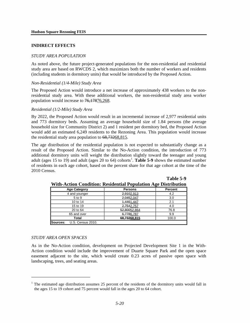
Non-Residential (1/4-Mile) Study Area The Proposed Action would introduce a net increase of approximately 438 workers to the non-residential study area. With these additional workers, the non-residential study area worker population would increase to 76,17876,268.
Residential (1/2-Mile) Study Area By 2022, the Proposed Action would result in an incremental increase of 2,977 residential units and 773 dormitory beds. Assuming an average household size of 1.84 persons (the average household size for Community District 2) and 1 resident per dormitory bed, the Proposed Action would add an estimated 6,249 residents to the Rezoning Area. This population would increase the residential study area population to 68,73268,815.
The age distribution of the residential population is not expected to substantially change as a result of the Proposed Action. Similar to the No-Action condition, the introduction of 773 additional dormitory units will weight the distribution slightly toward the teenager and young adult (ages 15 to 19) and adult (ages 20 to 64) cohorts1. Table 5-9 shows the estimated number of residents in each age cohort, based on the percent share for that age cohort at the time of the 2010 Census.
Table 5-9 With-Action Condition: Residential Population Age Distribution
Age Category Persons Percent 4 and younger 2,9102,913 4.2
5 to 9 2,0452,047 3.0 10 to 14 1,4461,447 2.1 15 to 19 2,7542,757 4.0 20 to 64 52,80052,864 76.8
65 and over 6,7786,787 9.9 Total 68,73268,815 100.0
Sources: U.S. Census 2010.
STUDY AREA OPEN SPACES
As in the No-Action condition, development on Projected Development Site 1 in the With-Action condition would include the improvement of Duarte Square Park and the open space easement adjacent to the site, which would create 0.23 acres of passive open space with landscaping, trees, and seating areas.
1 The estimated age distribution assumes 25 percent of the residents of the dormitory units would fall in
the ages 15 to 19 cohort and 75 percent would fall in the ages 20 to 64 cohort.
Chapter 5: Open Space
5-21
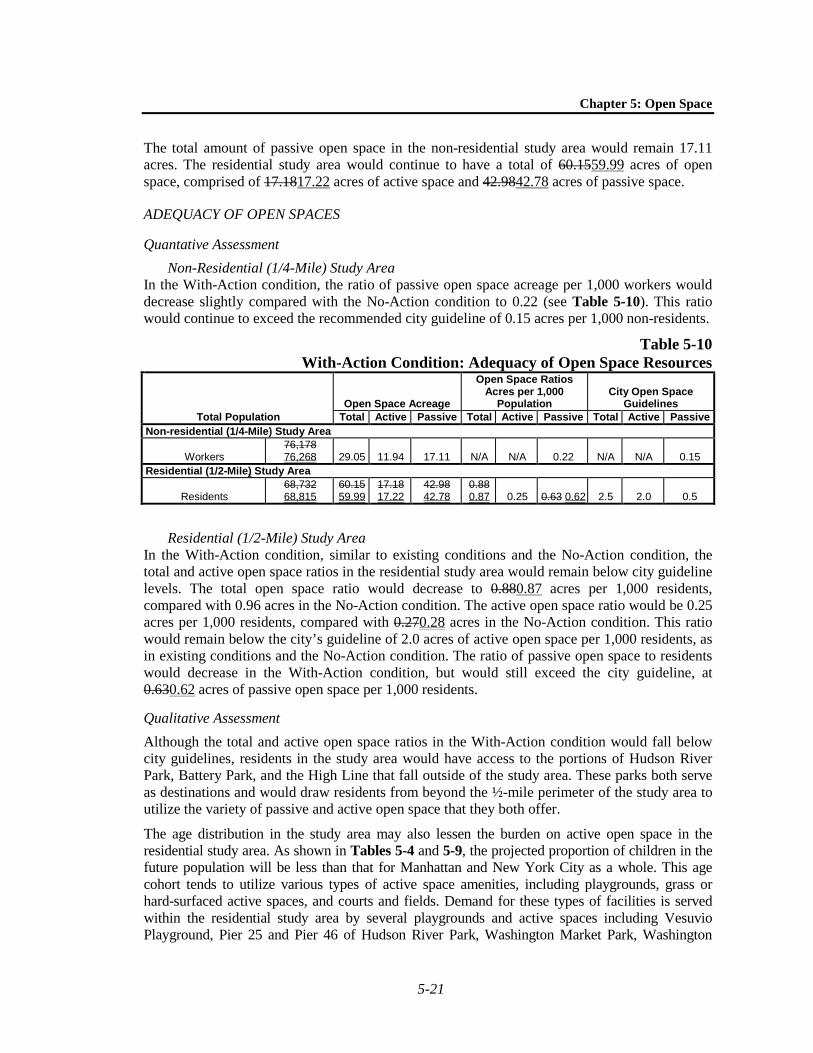
The total amount of passive open space in the non-residential study area would remain 17.11 acres. The residential study area would continue to have a total of 60.1559.99 acres of open space, comprised of 17.1817.22 acres of active space and 42.9842.78 acres of passive space.
ADEQUACY OF OPEN SPACES
Quantative Assessment Non-Residential (1/4-Mile) Study Area
In the With-Action condition, the ratio of passive open space acreage per 1,000 workers would decrease slightly compared with the No-Action condition to 0.22 (see Table 5-10). This ratio would continue to exceed the recommended city guideline of 0.15 acres per 1,000 non-residents.
Table 5-10 With-Action Condition: Adequacy of Open Space Resources
Total Population Open Space Acreage
Open Space Ratios Acres per 1,000
Population City Open Space
Guidelines Total Active Passive Total Active Passive Total Active Passive
Non-residential (1/4-Mile) Study Area
Workers 76,178 76,268 29.05 11.94 17.11 N/A N/A 0.22 N/A N/A 0.15
Residential (1/2-Mile) Study Area
Residents 68,732 68,815
60.15 59.99
17.18 17.22
42.98 42.78
0.88 0.87 0.25 0.63 0.62 2.5 2.0 0.5
Residential (1/2-Mile) Study Area In the With-Action condition, similar to existing conditions and the No-Action condition, the total and active open space ratios in the residential study area would remain below city guideline levels. The total open space ratio would decrease to 0.880.87 acres per 1,000 residents, compared with 0.96 acres in the No-Action condition. The active open space ratio would be 0.25 acres per 1,000 residents, compared with 0.270.28 acres in the No-Action condition. This ratio would remain below the city’s guideline of 2.0 acres of active open space per 1,000 residents, as in existing conditions and the No-Action condition. The ratio of passive open space to residents would decrease in the With-Action condition, but would still exceed the city guideline, at 0.630.62 acres of passive open space per 1,000 residents.
Qualitative Assessment Although the total and active open space ratios in the With-Action condition would fall below city guidelines, residents in the study area would have access to the portions of Hudson River Park, Battery Park, and the High Line that fall outside of the study area. These parks both serve as destinations and would draw residents from beyond the ½-mile perimeter of the study area to utilize the variety of passive and active open space that they both offer.
The age distribution in the study area may also lessen the burden on active open space in the residential study area. As shown in Tables 5-4 and 5-9, the projected proportion of children in the future population will be less than that for Manhattan and New York City as a whole. This age cohort tends to utilize various types of active space amenities, including playgrounds, grass or hard-surfaced active spaces, and courts and fields. Demand for these types of facilities is served within the residential study area by several playgrounds and active spaces including Vesuvio Playground, Pier 25 and Pier 46 of Hudson River Park, Washington Market Park, Washington

Hudson Square Rezoning FEIS
5-22
Square Park, Grand Canal Court, and Passannante Ballfield. The renovation of Coles Playground and Minetta Playground would also serve the future population of young children.
When compared with Manhattan and New York City, the age distribution of residents in the study area is more heavily weighted toward working-aged adults (ages 20 to 64). This age group tends to utilize court facilities for active open space, of which there are many in the study area. Active spaces at Grand Canal Court, Vesuvio Playground, James J. Walker Park, Pier 25, Pier 40, and Pier 46 of Hudson River Park, and Washington Market Park, the tennis courts at Hudson River Park, and the Tony Dapolito Recreation Center would serve the demand of this future adult population.
IMPACT SIGNIFICANCE
According to the CEQR Technical Manual, the significance of a project’s effects on open space is assessed using both qualitative and quantitative factors. These effects are compared with those that would occur in the No-Action condition to determine the effects attributable to the Proposed Action.
According to the CEQR Technical Manual, if the decrease in the open space ratio approaches or exceeds 5 percent, it is generally considered a substantial change warranting a more detailed analysis. However, the change in the open space ratio should be balanced against how well-served an area is by open space. If the study area exhibits a low open space ratio, even a small decrease may warrant a detailed analysis. Likewise, if the study area exhibits an open space ratio that approaches or exceeds the planning goal of 2.5 acres, a greater percentage of change in the ratio may be acceptable.
DIRECT EFFECTS
The significant adverse shadow impacts to Trump SoHo Plaza and SoHo Square would not result in a significant adverse open space impact because these resources would remain usable open spaces. Neither of these open space resources includes sunlight-dependent amenities (i.e., spray showers, sunbathing lawns), and it is expected that they would continue to be utilized by local residents and workers in the With-Action condition. Users would be able to continue to utilize the passive open space features in each park as intended. Therefore, the significant adverse shadow impacts on Trump SoHo Plaza and SoHo Square would not constitute a significant adverse open space impact.
NON-RESIDENTIAL (1/4-MILE) STUDY AREA
As shown in Table 5-11, in the With-Action condition, the passive open space ratio would decrease by less than 1 percent as compared to the No-Action condition, to 0.22 acres per 1,000 workers. The passive open space ratio would continue to exceed the city’s recommended guidelines of 0.15 acres of passive open space per 1,000 workers. Therefore, the proposed project would not result in any significant adverse impacts to open space resources in the non-residential study area.
Chapter 5: Open Space
5-23
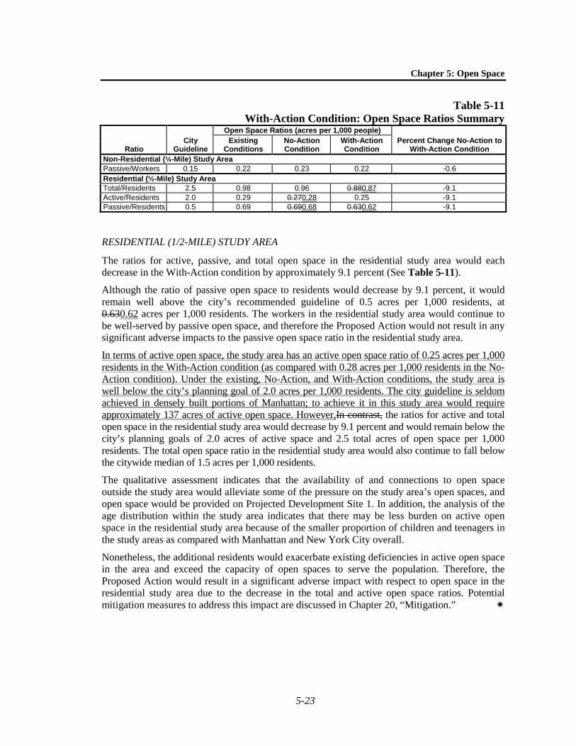
Table 5-11 With-Action Condition: Open Space Ratios Summary
Ratio City
Guideline
Open Space Ratios (acres per 1,000 people) Percent Change No-Action to
With-Action Condition Existing
Conditions No-Action Condition
With-Action Condition
Non-Residential (¼-Mile) Study Area Passive/Workers 0.15 0.22 0.23 0.22 -0.6 Residential (½-Mile) Study Area Total/Residents 2.5 0.98 0.96 0.880.87 -9.1 Active/Residents 2.0 0.29 0.270.28 0.25 -9.1 Passive/Residents 0.5 0.69 0.690.68 0.630.62 -9.1
RESIDENTIAL (1/2-MILE) STUDY AREA
The ratios for active, passive, and total open space in the residential study area would each decrease in the With-Action condition by approximately 9.1 percent (See Table 5-11).
Although the ratio of passive open space to residents would decrease by 9.1 percent, it would remain well above the city’s recommended guideline of 0.5 acres per 1,000 residents, at 0.630.62 acres per 1,000 residents. The workers in the residential study area would continue to be well-served by passive open space, and therefore the Proposed Action would not result in any significant adverse impacts to the passive open space ratio in the residential study area.
In terms of active open space, the study area has an active open space ratio of 0.25 acres per 1,000 residents in the With-Action condition (as compared with 0.28 acres per 1,000 residents in the No-Action condition). Under the existing, No-Action, and With-Action conditions, the study area is well below the city’s planning goal of 2.0 acres per 1,000 residents. The city guideline is seldom achieved in densely built portions of Manhattan; to achieve it in this study area would require approximately 137 acres of active open space. However,In contrast, the ratios for active and total open space in the residential study area would decrease by 9.1 percent and would remain below the city’s planning goals of 2.0 acres of active space and 2.5 total acres of open space per 1,000 residents. The total open space ratio in the residential study area would also continue to fall below the citywide median of 1.5 acres per 1,000 residents.
The qualitative assessment indicates that the availability of and connections to open space outside the study area would alleviate some of the pressure on the study area’s open spaces, and open space would be provided on Projected Development Site 1. In addition, the analysis of the age distribution within the study area indicates that there may be less burden on active open space in the residential study area because of the smaller proportion of children and teenagers in the study areas as compared with Manhattan and New York City overall.
Nonetheless, the additional residents would exacerbate existing deficiencies in active open space in the area and exceed the capacity of open spaces to serve the population. Therefore, the Proposed Action would result in a significant adverse impact with respect to open space in the residential study area due to the decrease in the total and active open space ratios. Potential mitigation measures to address this impact are discussed in Chapter 20, “Mitigation.”