chapter 5 volcanoes and volcanism -...
TRANSCRIPT

Volcanoes and VolcanismChapter 5
11487_05_ch05_p132-167.qxd 2/16/06 5:05 PM Page 132
Essential Questions to Ask5.1 Introduction
� How can volcanism be both constructive and destructive?
5.2 Volcanism and Volcanoes� What gases do volcanoes commonly emit?
� How and why do aa and pahoehoe lava flows differ?
� What are pyroclastic materials, and how are they dangerous to air traffic?
5.3 Types of Volcanoes� What are calderas and how do they form?
� What are cinder cones and what are they composed of?
� What are lava domes and why are they so dangerous?
5.4 Other Volcanic Landforms� How do basalt plateaus form?
� What are pyroclastic sheet deposits?
5.5 The Distribution of Volcanoes � Where are the three zones or belts with most of Earth’s volcanoes?
5.6 North America’s Active Volcanoes� Where is the Cascade Range and what types of volcanoes are found there?
5.7 Plate Tectonics, Volcanoes, and Plutons� What kinds of igneous rocks make up the oceanic crust?
� How do plate tectonics and volcanism account for the origin of the HawaiianIslands?
5.8 Volcanic Hazards, Volcano Monitoring, and ForecastingEruptions� What are the most dangerous manifestations of volcanoes?
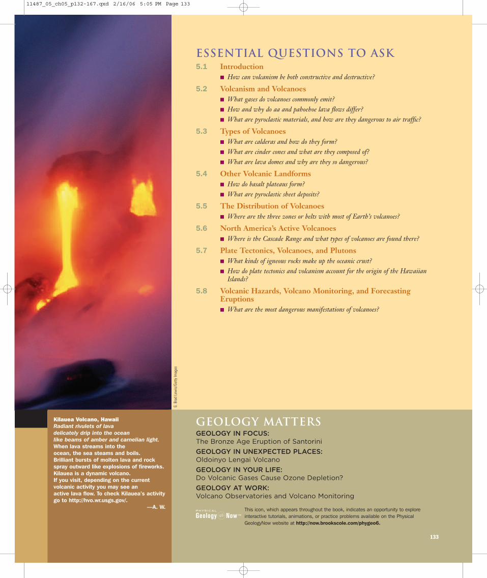
Kilauea Volcano, HawaiiRadiant rivulets of lava delicately drip into the ocean like beams of amber and carnelian light.When lava streams into the ocean, the sea steams and boils. Brilliant bursts of molten lava and rock spray outward like explosions of fireworks. Kilauea is a dynamic volcano. If you visit, depending on the current volcanic activity you may see an active lava flow. To check Kilauea’s activity go to http://hvo.wr.usgs.gov/.
—A. W.
133
This icon, which appears throughout the book, indicates an opportunity to exploreinteractive tutorials, animations, or practice problems available on the PhysicalGeologyNow website at http://now.brookscole.com/phygeo6.
Geology MattersGEOLOGY IN FOCUS:The Bronze Age Eruption of Santorini
GEOLOGY IN UNEXPECTED PLACES:Oldoinyo Lengai Volcano
GEOLOGY IN YOUR LIFE:Do Volcanic Gases Cause Ozone Depletion?
GEOLOGY AT WORK:Volcano Observatories and Volcano Monitoring
G. B
rad
Lew
is/G
etty
Imag
es
11487_05_ch05_p132-167.qxd 2/16/06 5:05 PM Page 133
5.1 IntroductionNo other geologic phenomenon has captured the publicimagination more than erupting volcanoes, especially lavaissuing forth in fiery streams or blasted into the atmospherein sensational pyrotechnic displays. What better subject fora disaster movie? Several such movies of varying quality
and scientific accuracy have appeared in recent years. Oneof the best was Dante’s Peak in 1997. Certainly the writersand director exaggerated some aspects of volcanism, butthe movie depicted rather accurately the phenomenalpower of an explosive eruption. Incidentally, the volcanocalled Dante’s Peak was a 10-m-high model built of woodand steel.
134 Chapter 5 Volcanoes and Volcanism
Nola
N
0 105
km
Naples
B a y o f N a p l e s
Misenum
CAPEMISENO
CAPRI
PROCIDAISCHIA
Pompeii
Sarno River
VESUVIUS
Herculaneum
Pliny’s voyage
Stabiae
CAMPI PHLEGRAEI
SORRENTO PENINSULA
Pozzuoli
ITALY
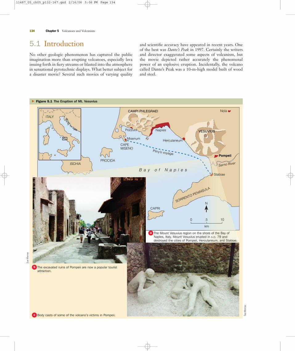
� Figure 5.1 The Eruption of Mt. Vesuvius
Sue
Mon
roe
Sue
Mon
roe
The Mount Vesuvius region on the shore of the Bay ofNaples, Italy. Mount Vesuvius erupted in A.D. 79 anddestroyed the cities of Pompeii, Herculaneum, and Stabiae.
a
The excavated ruins of Pompeii are now a popular touristattraction.
b
Body casts of some of the volcano’s victims in Pompeii.c
11487_05_ch05_p132-167.qxd 2/16/06 5:06 PM Page 134
Incandescent streams of molten rock are commonly por-trayed in movies as posing a great danger to humans, and, infact, on a few occasions lava flows have caused fatalities. Ofcourse, lava flows may destroy homes, roadways, and crop-lands, but they are the least dangerous manifestation of vol-canism. Explosive eruptions accompanied by little or no lavaflow activity are quite dangerous, especially if they occurnear populated areas. In this respect, Dante’s Peak was accu-rate, although it would be most unusual for a volcano toboth erupt explosively and produce fluid lava flows at thesame time as depicted in the movie.
One of the best-known catastrophic eruptions was theA.D. 79 outburst of Mount Vesuvius, which destroyed thethriving Roman cities of Pompeii, Herculaneum, andStabiae in what is now Italy (� Figure 5.1). Fortunately forus, Pliny the Younger recorded the event in great detail; hisuncle, Pliny the Elder, died while trying to investigate theeruption. Pompeii, a city of about 20,000 people and only 9 km from Mount Vesuvius, was buried in nearly 3 m ofpyroclastic materials that covered all but the tallest build-ings. At least 2000 victims have been found in the city, butcertainly far more were killed. Pyroclastic materials coveredPompeii rather gradually, but surges of incandescent vol-canic materials in glowing avalanches swept though Hercu-laneum, quickly covering the city to a depth of 20 m. SinceA.D. 79, Mount Vesuvius has erupted 80 times, most vio-lently in 1631 and 1906; it last erupted in 1944. Volcaniceruptions and earthquakes in this area pose a continuingthreat to the many cities and towns along the shores of theBay of Naples (� Figure 5.1).
� How can volcanism be both constructive and destructive?
The fact that lava flows and explosive eruptions cause propertydamage, injuries, and fatalities (Table 5.1) and at least short-term climate changes indicates that eruptions are destructiveevents, at least from the human perspective. Ironically,though, volcanism is actually a constructive process in thecontext of Earth history. Earth’s atmosphere and surfacewaters most likely resulted from the emission of volcanic gasesduring the early history of the planet, and oceanic crust is con-tinuously produced by volcanism at spreading ridges. Manyoceanic islands such as Iceland, the Hawaiian Islands, theAzores, and the Galápagos Islands owe their existence to vol-canic eruptions. In tropical areas, weathering converts lava,pyroclastic materials, and volcanic mudflows into fertile soils.
One reason to study volcanic activity is that volcanoes pro-vide us with an excellent opportunity to see how Earth’s sys-tems interact. The emission of gases and pyroclastic materialshas an immediate and profound impact on the atmosphere,hydrosphere, and biosphere, at least in the vicinity of an erup-tion. And in some cases, the effects are worldwide, as theywere following the eruptions of Tambora in 1815, Krakatau in1883, and Mount Pinatubo in 1991.
Section 5.1 Summary● Interactions among systems are demonstrated by largevolcanic eruptions because they have an impact on thehydrosphere, atmosphere, and biosphere.
5.1 Introduction 135
T A B L E 5 . 1
Some Notable Volcanic EruptionsDate Volcano Deaths
Apr. 10, 1815 Tambora, Indonesia 92,000; includes deaths from eruption and famine and disease
Oct. 8, 1822 Galunggung, Java Pyroclastic flows and mudflows killed 4011
Mar. 2, 1856 Awu, Indonesia 2806 died in pyroclastic flows
Aug. 27, 1883 Krakatau, Indonesia More than 36,000 died; most killed by tsunami
June 7, 1892 Awu, Indonesia 1532 died in pyroclastic flows
May 8, 1902 Mount Pelée, Martinique Nuée ardente engulfed St. Pierre and killed 28,000
Oct. 24, 1902 Santa Maria, Guatemala 5000 died during eruption
May 19, 1919 Kelut, Java Mudflows devastated 104 villages and killed 5110
Jan. 21, 1951 Lamington, New Guinea Pyroclastic flows killed 2942
Mar. 17, 1963 Agung, Indonesia 1148 perished during eruption
May 18, 1980 Mount St. Helens, Washington 63 killed; 600 km2 of forest devastated
Mar. 28, 1982 El Chichón, Mexico Pyroclastic flows killed 1877
Nov. 13, 1985 Nevado del Ruiz, Colombia Minor eruption triggered mudflows that killed 23,000
Aug. 21, 1986 Oku volcanic field, Cameroon Cloud of CO2 released from Lake Nyos killed 1746
June 15, 1991 Mount Pinatubo, Philippines � 281 killed during eruption; 83 died in later mudflows; 358 died of illness
July 1999 Soufrière Hills, Montserrat 19 killed; 12,000 evacuated
Jan. 17, 2002 Nyiragongo, Zaire Lava flow killed 147 in Goma
11487_05_ch05_p132-167.qxd 2/16/06 5:06 PM Page 135
5.2 Volcanism and VolcanoesWhat do we mean by the terms volcanism and volcano? Thelatter is a landform—that is, a feature on Earth’s surface—whereas volcanism is the process in which magma risesthrough Earth’s crust and issues forth at the surface as lavaflows and/or pyroclastic materials and gases. We will discussthe origin and nature of volcanoes and other volcanic land-forms in later sections, but here we point out that volcanismis also responsible for the origin of all extrusive igneous (vol-canic) rocks, such as basalt, tuff, and obsidian (see Chapter 4).
Volcanism is a common phenomenon. About 550 volca-noes are active; that is, they are erupting or have erupted dur-ing historic time. Only about a dozen are erupting at any onetime. Most of this activity is minor and goes unreported inthe popular press unless an eruption, even a small one, takesplace near a populated area or has tragic consequences.However, large eruptions that cause extensive property dam-age, injuries, and fatalities are not uncommon (Table 5.1).Indeed, a great amount of effort is devoted to better under-standing and more effectively anticipating large eruptions.
In addition to active volcanoes, Earth has numerous dor-mant volcanoes that could erupt in the future. The distinc-tion between active and dormant is not precise. Prior to itseruption in A.D. 79, Mount Vesuvius had not been active inhuman memory. The largest volcanic outburst since 1912took place in 1991, when Mount Pinatubo in the Philippineserupted after lying dormant for 600 years. Some volcanoeshave not erupted during historic time and show no evidenceof erupting again; thousands of these extinct or inactive volca-noes are known.
All terrestrial planets and Earth’s moon were volcanicallyactive during their early histories, but now only Earth and afew other bodies in the solar system have active volcanoes. Atleast one active volcano is likely present on Venus, and Triton,a moon of Neptune, and Titan, a moon of Saturn, probablyhave active volcanoes. But Jupiter’s moon Io is by far the mostvolcanically active body in the solar system. Many of its morethan 100 volcanoes are erupting at any given time.
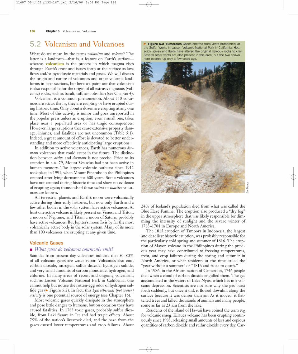
Volcanic Gases� What gases do volcanoes commonly emit?Samples from present-day volcanoes indicate that 50–80%of all volcanic gases are water vapor. Volcanoes also emitcarbon dioxide, nitrogen, sulfur dioxide, hydrogen sulfide,and very small amounts of carbon monoxide, hydrogen, andchlorine. In many areas of recent and ongoing volcanism,such as Lassen Volcanic National Park in California, onecannot help but notice the rotten-egg odor of hydrogen sul-fide gas (� Figure 5.2). In fact, this hydrothermal (hot water)activity is one potential source of energy (see Chapter 16).
Most volcanic gases quickly dissipate in the atmosphereand pose little danger to humans, but on occasion they havecaused fatalities. In 1783 toxic gases, probably sulfur diox-ide, from Laki fissure in Iceland had tragic effects. About75% of the nation’s livestock died, and the haze from thegases caused lower temperatures and crop failures. About
24% of Iceland’s population died from what was called theBlue Haze Famine. The eruption also produced a “dry fog”in the upper atmosphere that was likely responsible for dim-ming the intensity of sunlight and the severe winter of1783–1784 in Europe and North America.
The 1815 eruption of Tambora in Indonesia, the largestand deadliest historic eruption, was probably responsible forthe particularly cold spring and summer of 1816. The erup-tion of Mayon volcano in the Philippines during the previ-ous year may have contributed to freezing temperatures,frost, and crop failures during the spring and summer inNorth America, or what residents at the time called the“year without a summer” or “1816 and froze to death.”
In 1986, in the African nation of Cameroon, 1746 peopledied when a cloud of carbon dioxide engulfed them. The gasaccumulated in the waters of Lake Nyos, which lies in a vol-canic depression. Scientists are not sure why the gas burstforth suddenly, but once it did, it flowed downhill along thesurface because it was denser than air. As it moved, it flat-tened trees and killed thousands of animals and many people,some as far as 23 km from the lake.
Residents of the island of Hawaii have coined the term vogfor volcanic smog. Kilauea volcano has been erupting contin-uously since 1983, releasing small amounts of lava and copiousquantities of carbon dioxide and sulfur dioxide every day. Car-
136 Chapter 5 Volcanoes and Volcanism
� Figure 5.2 Fumeroles Gases emitted from vents (fumeroles) atthe Sulfur Works in Lassen Volcanic National Park in California. Hot,acidic gases and fluids have altered the original igneous rocks to clay.Several other vents are also present in this area, but the two shownhere opened up only a few years ago.
Sue
Mon
roe
11487_05_ch05_p132-167.qxd 2/16/06 5:06 PM Page 136

bon dioxide has been no problem, but sulfur dioxide producesa haze and the unpleasant odor of sulfur. Vog probably posesno risk for tourists, but a long-term threat exists for people liv-ing on the west side of the island where vog is most common.
Lava FlowsAlthough lava flows are portrayed in movies and on televisionas a great danger to humans, they only rarely cause fatalities.The reason is that most lava flows do not move very fast, andbecause they are fluid, they follow low areas. Thus, once a lavaflow erupts from a volcano, determining the path it will take iseasy, and anyone in areas likely to be affected can be evacuated.
Even low-viscosity (fluid) lava flows usually do not moverapidly, but they flow much faster when their margins andupper surfaces cool and solidify to form a lava tube—that is,a tunnel-like structure insulated on all sides. Thus confined,lava may flow at speeds up to 50 km/hr; if part of a lavatube’s roof collapses, forming a skylight, the active flow canbe observed (� Figure 5.3a). When an eruption ceases, thetube drains, leaving an empty tube (� Figure 5.3b). In
Hawaii, lava moves through lava tubes for many kilometersand some discharges into the sea.
� How and why do aa and pahoehoe lava flows differ?Geologists define two types of lava flows, both named forlava flows in Hawaii. The type of flow called pahoehoe(pronounced pah-hoy-hoy) has a smooth, ropy surface muchlike taffy (� Figure 5.4a). An aa (pronounced ah-ah) flow, in
5.2 Volcanism and Volcanoes 137
J. B
. Jud
d/US
GS
� Figure 5.3 Lava Tubes Lava tubes consisting of hollow spacesbeneath the surfaces of lava flows are common in many areas.
Haw
aii V
olca
noes
Nat
iona
l Par
k, U
SGS
� Figure 5.4 Pahoehoe and aa Lava Flows Pahoehoe and aawere named for lava flows in Hawaii, but the same kinds of flows arefound in many other areas.
J. D
. Grig
gs/U
SGS
Robe
rt Ti
lling
/USG
S
An active lava tube in Hawaii. Part of the tube’s roof has collapsed,forming a skylight.
a
A lava tube in Hawaii after the lava has drained out.b
An excellent example of the taffylike appearance of pahoehoe.a
An aa lava flow advances over an older pahoehoe flow. Notice the rubbly nature of the aa flow.
b
11487_05_ch05_p132-167.qxd 2/16/06 5:06 PM Page 137
contrast, is made up of jagged, angular blocks and fragments(� Figure 5.4b). Pahoehoe flows are less viscous than aaflows; indeed, aa flows are viscous enough to break up intoblocks and move forward as a wall of rubble. A pahoehoeflow may change to aa along its length, but aa flows do notchange to pahoehoe.
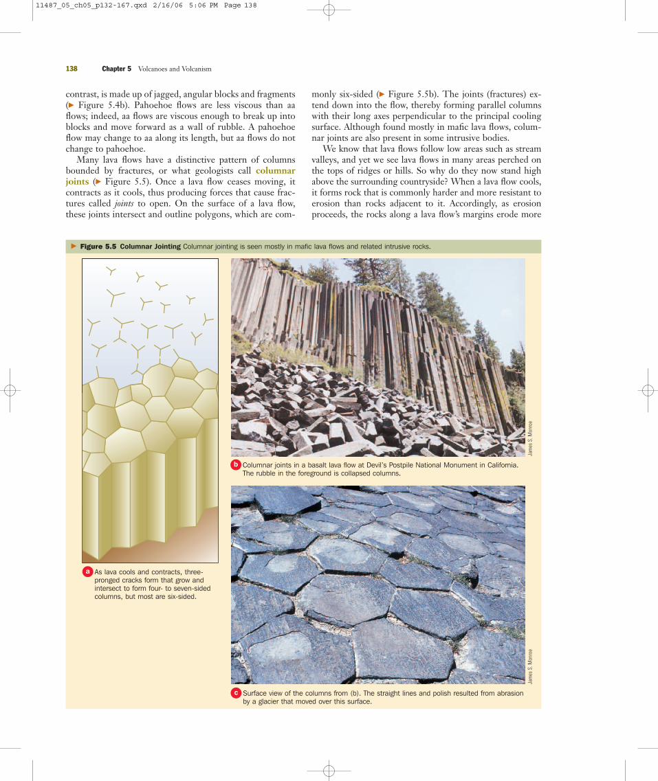
Many lava flows have a distinctive pattern of columnsbounded by fractures, or what geologists call columnarjoints (� Figure 5.5). Once a lava flow ceases moving, itcontracts as it cools, thus producing forces that cause frac-tures called joints to open. On the surface of a lava flow,these joints intersect and outline polygons, which are com-
monly six-sided (� Figure 5.5b). The joints (fractures) ex-tend down into the flow, thereby forming parallel columnswith their long axes perpendicular to the principal coolingsurface. Although found mostly in mafic lava flows, colum-nar joints are also present in some intrusive bodies.
We know that lava flows follow low areas such as streamvalleys, and yet we see lava flows in many areas perched onthe tops of ridges or hills. So why do they now stand highabove the surrounding countryside? When a lava flow cools,it forms rock that is commonly harder and more resistant toerosion than rocks adjacent to it. Accordingly, as erosionproceeds, the rocks along a lava flow’s margins erode more
138 Chapter 5 Volcanoes and Volcanism
� Figure 5.5 Columnar Jointing Columnar jointing is seen mostly in mafic lava flows and related intrusive rocks.
Jam
es S
. Mon
roe
Jam
es S
. Mon
roe
As lava cools and contracts, three-pronged cracks form that grow andintersect to form four- to seven-sidedcolumns, but most are six-sided.
a
Columnar joints in a basalt lava flow at Devil’s Postpile National Monument in California.The rubble in the foreground is collapsed columns.
b
Surface view of the columns from (b). The straight lines and polish resulted from abrasionby a glacier that moved over this surface.
c
11487_05_ch05_p132-167.qxd 2/16/06 5:06 PM Page 138

rapidly and what was a valley becomes aridge or hilltop (� Figure 5.6). In short,what was a low area becomes a high areain what geologists call an inversion oftopography.
Much of the upper oceanic crust ismade up of bulbous masses of basaltthat resemble pillows—hence the namepillow lava (� Figure 5.7). Geologistsknew long ago that pillow lava formswhen lava is rapidly chilled underwater,but its formation was not observed un-til 1971. Divers near Hawaii saw pil-lows form when a blob of lava brokethrough the crust of an underwater lavaflow and cooled quickly, forming a pil-low-shaped mass with a glassy exterior.Fluid lava then broke through the crustof the pillow just formed and formedanother pillow, repeating the processand resulting in an interconnected ac-cumulation of pillows (� Figure 5.7).
Pyroclastic MaterialsAs magma rises toward the surface, pres-sure decreases and the contained gasesbegin to expand. In highly viscous felsicmagma, expansion is inhibited; gas pres-sure increases and may eventually causean explosion and produce particulatematter known as pyroclastic materials.In contrast, low-viscosity mafic magmaallows gases to expand and escape easily.Accordingly, mafic magma usually eruptsrather quietly as fluid lava flows.
Ash is the name for pyroclastic ma-terials that measure less than 2.0 mm(� Figure 5.8). In some eruptions, ashis ejected into the atmosphere and set-tles as an ash fall. In 1947 ash eruptedfrom Mount Hekla in Iceland fell 3800 km away on Helsinki, Finland. Incontrast to an ash fall, an ash flow is acloud of ash and gas that flows along orclose to the surface. Some ash flowsmove faster than 100 km/hr, and theymay cover vast areas.
� What are pyroclastic materials,and how are they dangerous to air traffic?
In populated areas adjacent to volcanoes,ash falls and ash flows pose serious prob-lems, and volcanic ash in the atmosphereis a hazard to aviation. Since 1980, about80 aircraft have been damaged when
5.2 Volcanism and Volcanoes 139
� Figure 5.6 Inversion of Topography In some places we see lava flows on ridges orhilltops, yet when the flow occurred it must have followed a valley.
Jam
es S
. Mon
roe
Lava flows into a valley, where it cools and crystallizes, forming volcanic rock.a
The areas adjacent to the flow erode more easily than the flow, producing an inversion oftopography.
b
The basalt that caps this small hill near Orland, California, was originally a lava flow thatfollowed a valley from its source far to the east.
c
11487_05_ch05_p132-167.qxd 2/16/06 5:06 PM Page 139

they encountered clouds of volcanic ash, some so diffuse thatpilots cannot see them. The most serious incident took placein 1989, when ash from Redoubt Volcano in Alaska causedall four jet engines to fail on KLM Flight 867. The plane carrying 231 passengers nearly crashed when it fell morethan 3 km before the crew could restart the engines. Theplane landed safely in Anchorage, Alaska, but it required $80 million in repairs.
In addition to ash, volcanoes erupt lapilli, consisting ofpyroclastic materials that measure 2–64 mm, and blocks andbombs, both of which are larger than 64 mm (� Figure 5.8).Bombs have a twisted, streamlined shape, indicating theywere erupted as globs of magma that cooled and solidifiedduring their flight through the air. Blocks are angular piecesof rock ripped from a volcanic conduit or pieces of a solidifiedcrust of a lava flow. Because of their size, lapilli, bombs, andblocks are confined to the immediate area of an eruption.
Section 5.2 Summary● A volcano is a landform, whereas volcanism is theprocess whereby magma and its contained gases rise tothe surface.
● Water vapor is the most common volcanic gas, but sev-eral others, including carbon dioxide and sulfur gases, arealso emitted.
● Aa lava flows are made up of jagged, angular blocks,whereas pahoehoe flows have a taffy-like texture. Lavatubes, pillow lava, and columnar joints are found in somelava flows.
● Pyroclastic materials are particulate matter ejectedfrom volcanoes during explosive eruptions.
140 Chapter 5 Volcanoes and Volcanism
� Figure 5.7 Pillow Lava Much of the upper part of the oceanic crustis made up of pillow lava that formed when lava erupted underwater.
NOA
AJa
mes
S. M
onro
e
Lapilli
Ash
Volcanicbomb
0 10 cm
� Figure 5.8 Pyroclastic Materials Pyroclastic materials are all particles ejected from volcanoes, especially during explosive eruptions.
C. H
elik
er/U
SGS
Sue
Mon
roe
Pillow lava on the seafloor in the Pacific Ocean about 150 mileswest of Oregon that formed about 5 years before the photo wastaken.
a
Ancient pillow lava now on land in Marin County, California. Thelargest pillow measures about 0.6 m across.
b
The volcanic bomb is elongate because it was molten when it descendedthrough the air. The lapilli was collected at a small volcano in Oregon, whereasthe ash came from the 1980 eruption of Mount St. Helens in Washington.
a This volcanic block in Hawaii formed when partiallysolidified lava collapsed into the sea, resulting in asteam explosion.
b
11487_05_ch05_p132-167.qxd 2/16/06 5:06 PM Page 140
5.3 Types of VolcanoesSimply put, a volcano is a hill or mountain that formsaround a vent where lava, pyroclastic materials, and gaseserupt. Although volcanoes vary in size and shape, all have aconduit or conduits leading to a magma chamber beneaththe surface. Vulcan, the Roman deity of fire, was the inspi-ration for calling these mountains volcanoes, and because oftheir danger and obvious connection to Earth’s interior,they have been held in awe by many cultures.
In Hawaiian legends, the volcano goddess Pele resides inthe crater of Kilauea on Hawaii. During one of her fre-quent rages, Pele causes earthquakes and lava flows, and shemay hurl flaming boulders at those who offend her. NativeAmericans in the Pacific Northwest tell of a titanic battlebetween the volcano gods Skel and Llao to account forhuge eruptions that took place about 7700 years ago inOregon and California. Pliny the Elder (A.D. 23–79), men-tioned in Section 5.1, believed that before eruptions “theair is extremely calm and the sea quiet, because the windshave already plunged into the earth and are preparing toreemerge.”*
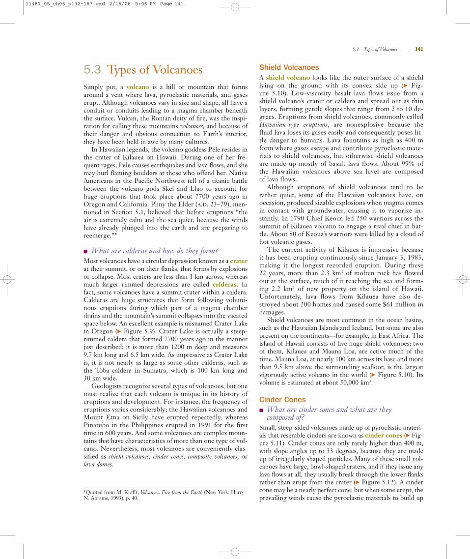
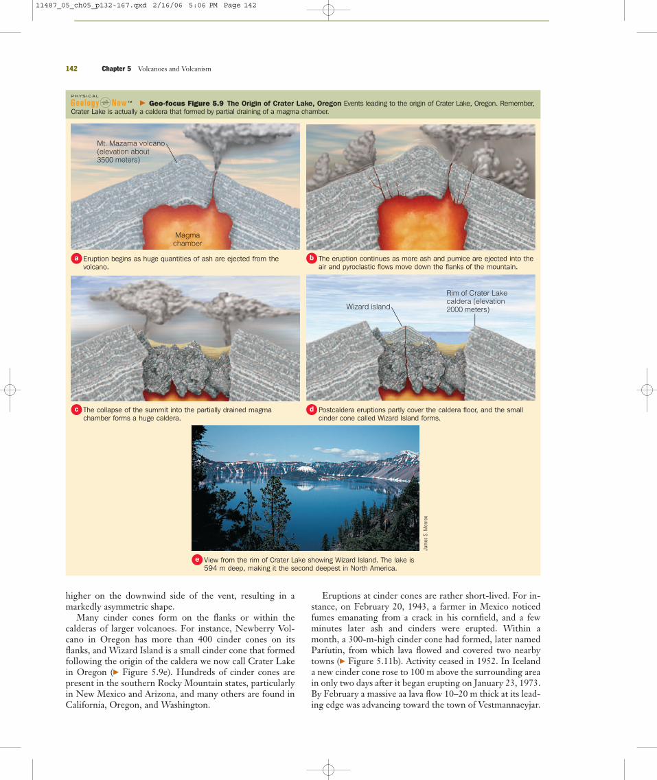
� What are calderas and how do they form?Most volcanoes have a circular depression known as a craterat their summit, or on their flanks, that forms by explosionsor collapse. Most craters are less than 1 km across, whereasmuch larger rimmed depressions are called calderas. Infact, some volcanoes have a summit crater within a caldera.Calderas are huge structures that form following volumi-nous eruptions during which part of a magma chamberdrains and the mountain’s summit collapses into the vacatedspace below. An excellent example is misnamed Crater Lakein Oregon (� Figure 5.9). Crater Lake is actually a steep-rimmed caldera that formed 7700 years ago in the mannerjust described; it is more than 1200 m deep and measures 9.7 km long and 6.5 km wide. As impressive as Crater Lakeis, it is not nearly as large as some other calderas, such as the Toba caldera in Sumatra, which is 100 km long and 30 km wide.
Geologists recognize several types of volcanoes, but onemust realize that each volcano is unique in its history oferuptions and development. For instance, the frequency oferuptions varies considerably; the Hawaiian volcanoes andMount Etna on Sicily have erupted repeatedly, whereasPinatubo in the Philippines erupted in 1991 for the firsttime in 600 years. And some volcanoes are complex moun-tains that have characteristics of more than one type of vol-cano. Nevertheless, most volcanoes are conveniently clas-sified as shield volcanoes, cinder cones, composite volcanoes, orlava domes.
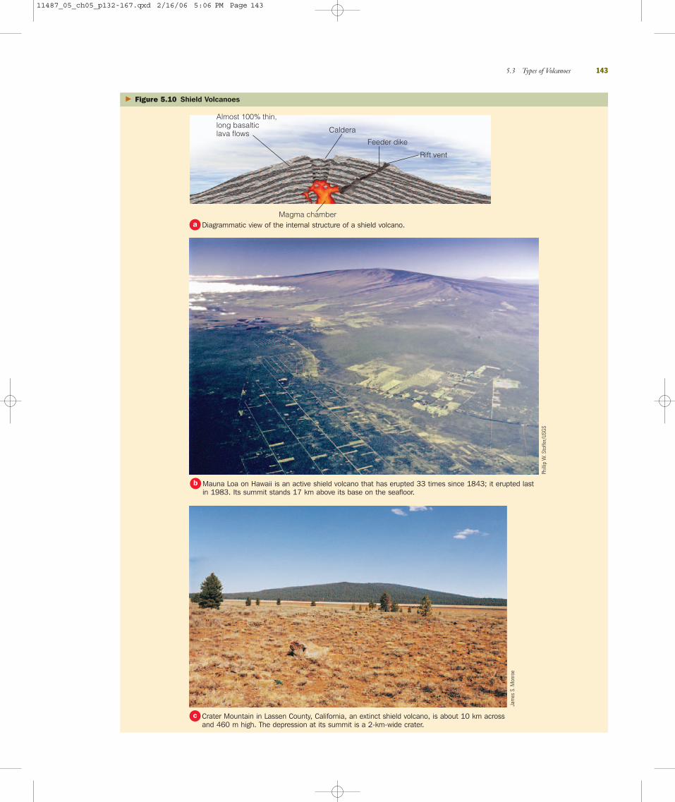
Shield VolcanoesA shield volcano looks like the outer surface of a shieldlying on the ground with its convex side up (� Fig-ure 5.10). Low-viscosity basalt lava flows issue from ashield volcano’s crater or caldera and spread out as thinlayers, forming gentle slopes that range from 2 to 10 de-grees. Eruptions from shield volcanoes, commonly calledHawaiian-type eruptions, are nonexplosive because thefluid lava loses its gases easily and consequently poses lit-tle danger to humans. Lava fountains as high as 400 mform where gases escape and contribute pyroclastic mate-rials to shield volcanoes, but otherwise shield volcanoesare made up mostly of basalt lava flows. About 99% of the Hawaiian volcanoes above sea level are composed of lava flows.
Although eruptions of shield volcanoes tend to berather quiet, some of the Hawaiian volcanoes have, onoccasion, produced sizable explosions when magma comesin contact with groundwater, causing it to vaporize in-stantly. In 1790 Chief Keoua led 250 warriors across thesummit of Kilauea volcano to engage a rival chief in bat-tle. About 80 of Keoua’s warriors were killed by a cloud ofhot volcanic gases.
The current activity of Kilauea is impressive because it has been erupting continuously since January 3, 1983,making it the longest recorded eruption. During these 22 years, more than 2.3 km3 of molten rock has flowed out at the surface, much of it reaching the sea and form-ing 2.2 km2 of new property on the island of Hawaii.Unfortunately, lava flows from Kilauea have also de-stroyed about 200 homes and caused some $61 million indamages.
Shield volcanoes are most common in the ocean basins,such as the Hawaiian Islands and Iceland, but some are alsopresent on the continents—for example, in East Africa. Theisland of Hawaii consists of five huge shield volcanoes; twoof them, Kilauea and Mauna Loa, are active much of thetime. Mauna Loa, at nearly 100 km across its base and morethan 9.5 km above the surrounding seafloor, is the largestvigorously active volcano in the world (� Figure 5.10). Itsvolume is estimated at about 50,000 km3.
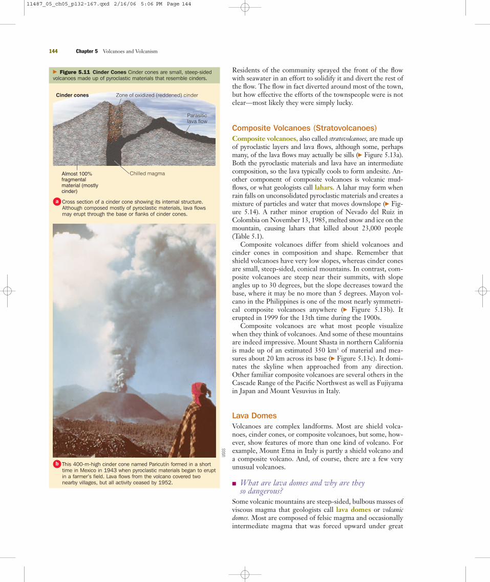
Cinder Cones� What are cinder cones and what are they
composed of?Small, steep-sided volcanoes made up of pyroclastic materi-als that resemble cinders are known as cinder cones (� Fig-ure 5.11). Cinder cones are only rarely higher than 400 m,with slope angles up to 33 degrees, because they are madeup of irregularly shaped particles. Many of these small vol-canoes have large, bowl-shaped craters, and if they issue anylava flows at all, they usually break through the lower flanksrather than erupt from the crater (� Figure 5.12). A cindercone may be a nearly perfect cone, but when some erupt, theprevailing winds cause the pyroclastic materials to build up
5.3 Types of Volcanoes 141
*Quoted from M. Krafft, Volcanoes: Fire from the Earth (New York: HarryN. Abrams, 1993), p. 40.
11487_05_ch05_p132-167.qxd 2/16/06 5:06 PM Page 141
higher on the downwind side of the vent, resulting in amarkedly asymmetric shape.
Many cinder cones form on the flanks or within thecalderas of larger volcanoes. For instance, Newberry Vol-cano in Oregon has more than 400 cinder cones on itsflanks, and Wizard Island is a small cinder cone that formedfollowing the origin of the caldera we now call Crater Lakein Oregon (� Figure 5.9e). Hundreds of cinder cones arepresent in the southern Rocky Mountain states, particularlyin New Mexico and Arizona, and many others are found inCalifornia, Oregon, and Washington.
Eruptions at cinder cones are rather short-lived. For in-stance, on February 20, 1943, a farmer in Mexico noticedfumes emanating from a crack in his cornfield, and a fewminutes later ash and cinders were erupted. Within amonth, a 300-m-high cinder cone had formed, later namedParíutin, from which lava flowed and covered two nearbytowns (� Figure 5.11b). Activity ceased in 1952. In Icelanda new cinder cone rose to 100 m above the surrounding areain only two days after it began erupting on January 23, 1973.By February a massive aa lava flow 10–20 m thick at its lead-ing edge was advancing toward the town of Vestmannaeyjar.
142 Chapter 5 Volcanoes and Volcanism
Magmachamber
Mt. Mazama volcano(elevation about3500 meters)
Wizard island
Rim of Crater Lakecaldera (elevation2000 meters)
Jam
es S
. Mon
roe
� Geo-focus Figure 5.9 The Origin of Crater Lake, Oregon Events leading to the origin of Crater Lake, Oregon. Remember,Crater Lake is actually a caldera that formed by partial draining of a magma chamber.
Eruption begins as huge quantities of ash are ejected from thevolcano.
a The eruption continues as more ash and pumice are ejected into theair and pyroclastic flows move down the flanks of the mountain.
b
The collapse of the summit into the partially drained magmachamber forms a huge caldera.
c Postcaldera eruptions partly cover the caldera floor, and the smallcinder cone called Wizard Island forms.
d
View from the rim of Crater Lake showing Wizard Island. The lake is594 m deep, making it the second deepest in North America.
e
11487_05_ch05_p132-167.qxd 2/16/06 5:06 PM Page 142
5.3 Types of Volcanoes 143
Almost 100% thin,long basalticlava flows Caldera
Feeder dike
Rift vent
Magma chamber
� Figure 5.10 Shield Volcanoes
Phill
ip W
. Sto
ffer/
USGS
Jam
es S
. Mon
roe
Diagrammatic view of the internal structure of a shield volcano.a
Mauna Loa on Hawaii is an active shield volcano that has erupted 33 times since 1843; it erupted lastin 1983. Its summit stands 17 km above its base on the seafloor.
b
Crater Mountain in Lassen County, California, an extinct shield volcano, is about 10 km acrossand 460 m high. The depression at its summit is a 2-km-wide crater.
c
11487_05_ch05_p132-167.qxd 2/16/06 5:06 PM Page 143
Residents of the community sprayed the front of the flowwith seawater in an effort to solidify it and divert the rest ofthe flow. The flow in fact diverted around most of the town,but how effective the efforts of the townspeople were is notclear—most likely they were simply lucky.
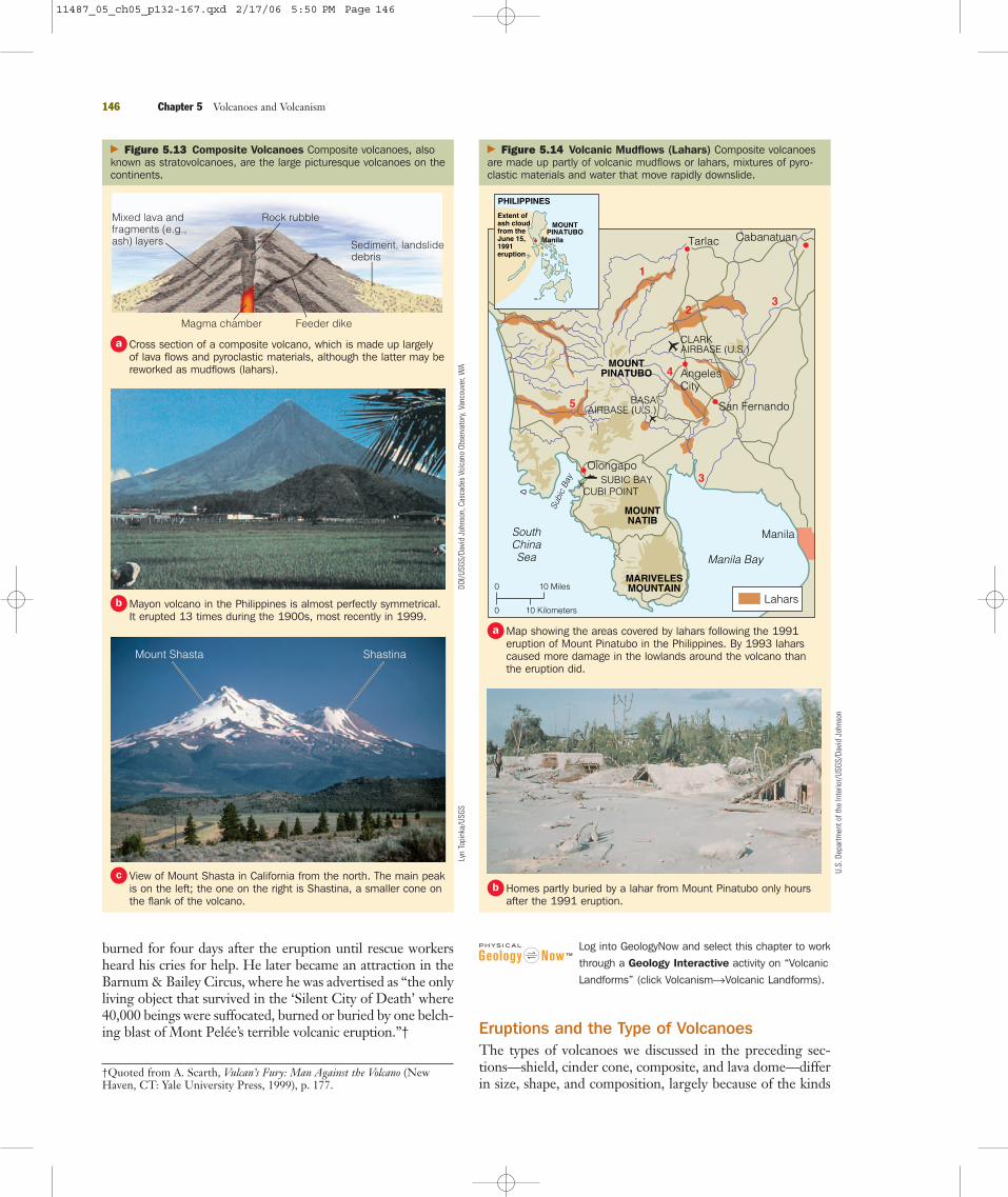
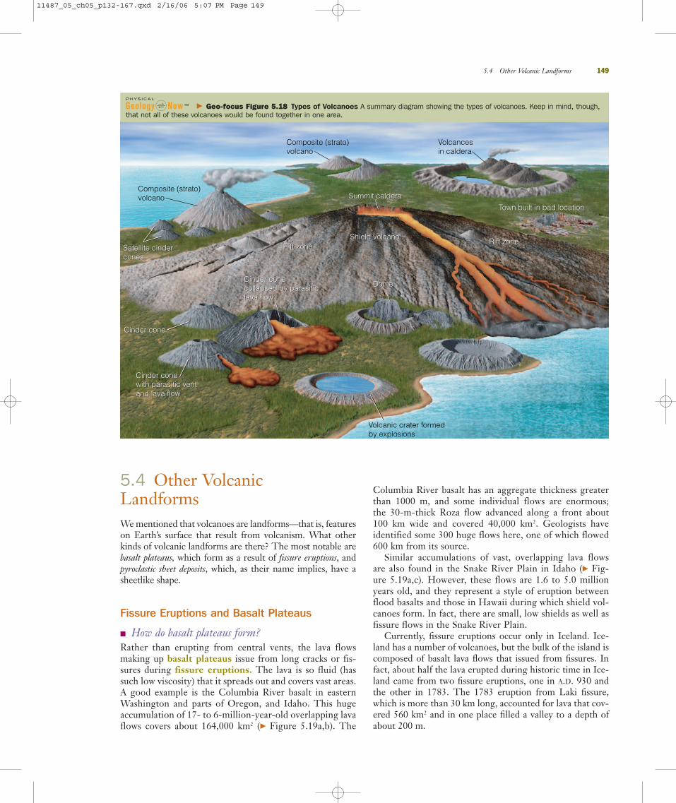
Composite Volcanoes (Stratovolcanoes)Composite volcanoes, also called stratovolcanoes, are made upof pyroclastic layers and lava flows, although some, perhapsmany, of the lava flows may actually be sills (� Figure 5.13a).Both the pyroclastic materials and lava have an intermediatecomposition, so the lava typically cools to form andesite. An-other component of composite volcanoes is volcanic mud-flows, or what geologists call lahars. A lahar may form whenrain falls on unconsolidated pyroclastic materials and creates amixture of particles and water that moves downslope (� Fig-ure 5.14). A rather minor eruption of Nevado del Ruiz inColombia on November 13, 1985, melted snow and ice on themountain, causing lahars that killed about 23,000 people(Table 5.1).
Composite volcanoes differ from shield volcanoes andcinder cones in composition and shape. Remember thatshield volcanoes have very low slopes, whereas cinder conesare small, steep-sided, conical mountains. In contrast, com-posite volcanoes are steep near their summits, with slopeangles up to 30 degrees, but the slope decreases toward thebase, where it may be no more than 5 degrees. Mayon vol-cano in the Philippines is one of the most nearly symmetri-cal composite volcanoes anywhere (� Figure 5.13b). Iterupted in 1999 for the 13th time during the 1900s.
Composite volcanoes are what most people visualizewhen they think of volcanoes. And some of these mountainsare indeed impressive. Mount Shasta in northern Californiais made up of an estimated 350 km3 of material and mea-sures about 20 km across its base (� Figure 5.13c). It domi-nates the skyline when approached from any direction.Other familiar composite volcanoes are several others in theCascade Range of the Pacific Northwest as well as Fujiyamain Japan and Mount Vesuvius in Italy.
Lava DomesVolcanoes are complex landforms. Most are shield volca-noes, cinder cones, or composite volcanoes, but some, how-ever, show features of more than one kind of volcano. Forexample, Mount Etna in Italy is partly a shield volcano anda composite volcano. And, of course, there are a few veryunusual volcanoes.
� What are lava domes and why are they so dangerous?
Some volcanic mountains are steep-sided, bulbous masses ofviscous magma that geologists call lava domes or volcanicdomes. Most are composed of felsic magma and occasionallyintermediate magma that was forced upward under great
144 Chapter 5 Volcanoes and Volcanism
Cinder cones Zone of oxidized (reddened) cinder
Almost 100%fragmentalmaterial (mostlycinder)
Parasiticlava flow
Chilled magma
� Figure 5.11 Cinder Cones Cinder cones are small, steep-sidedvolcanoes made up of pyroclastic materials that resemble cinders.
USGS
Cross section of a cinder cone showing its internal structure.Although composed mostly of pyroclastic materials, lava flowsmay erupt through the base or flanks of cinder cones.
a
This 400-m-high cinder cone named Paricutı́n formed in a shorttime in Mexico in 1943 when pyroclastic materials began to eruptin a farmer’s field. Lava flows from the volcano covered twonearby villages, but all activity ceased by 1952.
b
11487_05_ch05_p132-167.qxd 2/16/06 5:06 PM Page 144

pressure but was too viscous to flow. Lava domes may standas small, isolated volcanic mountains, or they may rise intothe craters of composite volcanoes (� Figure 5.15). Unfor-tunately, lava domes are quite unstable and commonly col-lapse under their own weight, resulting in huge flows of de-bris. In June 1991, a lava dome in Japan’s Unzen volcanocollapsed and the hot debris and ash killed 43 people in anearby town. During both the 1980 and 2004 eruptions ofMount St. Helens in Washington, lava domes formed andwere subsequently destroyed (� Figure 5.15a).
Lava domes may be particularly dangerous. In 1902 vis-cous magma accumulated beneath the summit of MountPelée on the island of Martinique in the Caribbean Sea. Thegas pressure increased until the side of the mountain blew outin a tremendous explosion, ejecting a mobile, dense cloud ofpyroclastic materials and a cloud of gases and ash called anuée ardente, a French term for “glowing cloud.” The lowerpart of this mass, the pyroclastic flow, followed a valley to thesea, but the upper part, the nuée ardente, jumped a ridge andengulfed the city of St. Pierre (� Figure 5.16).
A tremendous blast hit St. Pierre and leveled buildings;hurled boulders, trees, and pieces of masonry down thestreets; and moved a 3-ton statue 16 m. Accompanying theblast was a swirling cloud of incandescent ash and gases withan internal temperature of 700°C that incinerated everythingin its path. The nuée ardente passed through St. Pierre in 2 or3 minutes, only to be followed by a firestorm as combustiblematerials burned and casks of rum exploded. But by then mostof the 28,000 residents of the city were already dead. In fact,in the area covered by the nuée ardente, only 2 survived!* Onesurvivor was on the outer edge of the nuée ardente, but eventhere he was terribly burned and his family and neighborswere all killed. The other survivor, a stevedore incarceratedthe night before for disorderly conduct, was in a windowlesscell partly below ground level. He remained in his cell badly
5.3 Types of Volcanoes 145
� Figure 5.12 Cinder Cone, Lassen Volcanic National Park, California This aerial view of Cinder Cone in Lassen Volcanic National Park in California shows an area about 6.5 km long, with north toward the right.
Jam
es S
. Mon
roe
Jam
es S
. Mon
roe
Jam
es S
. Mon
roe
USGS
Jam
es S
. Mon
roe
*Although it is commonly reported that only 2 people survived the erup-tion, at least 69 and possibly as many as 111 people survived beyond theextreme margins of the nuée ardente and on ships in the harbor. Many,however, were badly injured.
View of 230-m-high Cinder Conefrom the ground.
a Large, bowl-shapedcrater at the summitof Cinder Cone.
b
View from the top of Cinder Cone showing the PaintedDunes, which is volcanic ash that fell on still-hot lava.
c The Fantastic Lava Beds are aa lava flows that brokethrough the base of Cinder Cone during the 1650s.
d
11487_05_ch05_p132-167.qxd 2/16/06 5:06 PM Page 145
burned for four days after the eruption until rescue workersheard his cries for help. He later became an attraction in theBarnum & Bailey Circus, where he was advertised as “the onlyliving object that survived in the ‘Silent City of Death’ where40,000 beings were suffocated, burned or buried by one belch-ing blast of Mont Pelée’s terrible volcanic eruption.”†
Log into GeologyNow and select this chapter to work
through a Geology Interactive activity on “Volcanic
Landforms” (click Volcanism0Volcanic Landforms).
Eruptions and the Type of VolcanoesThe types of volcanoes we discussed in the preceding sec-tions—shield, cinder cone, composite, and lava dome—differin size, shape, and composition, largely because of the kinds
†Quoted from A. Scarth, Vulcan’s Fury: Man Against the Volcano (NewHaven, CT: Yale University Press, 1999), p. 177.
146 Chapter 5 Volcanoes and Volcanism
Mixed lava andfragments (e.g.,ash) layers
Rock rubble
Sediment, landslidedebris
Feeder dikeMagma chamber
ShastinaMount Shasta
� Figure 5.13 Composite Volcanoes Composite volcanoes, alsoknown as stratovolcanoes, are the large picturesque volcanoes on thecontinents.
DOI/U
SGS/
Davi
d Jo
hnso
n, C
asca
des
Volc
ano
Obse
rvat
ory,
Vanc
ouve
r, W
ALy
n To
pink
a/US
GS
Manila
PHILIPPINES
Extent ofash cloudfrom theJune 15,1991eruption
MOUNTPINATUBO
32
3
4
1
5
Tarlac
San Fernando
Manila
AngelesCity
Olongapo
SouthChinaSea Manila Bay
Subi
c B
ay
CLARKAIRBASE (U.S.)
BASAAIRBASE (U.S.)
SUBIC BAYCUBI POINT
10 Miles0
0 10 Kilometers
MOUNTPINATUBO
MOUNTNATIB
MARIVELESMOUNTAIN
Cabanatuan
Lahars
� Figure 5.14 Volcanic Mudflows (Lahars) Composite volcanoesare made up partly of volcanic mudflows or lahars, mixtures of pyro-clastic materials and water that move rapidly downslide.
U.S.
Dep
artm
ent o
f the
Inte
rior/
USGS
/Dav
id J
ohns
on
Cross section of a composite volcano, which is made up largelyof lava flows and pyroclastic materials, although the latter may bereworked as mudflows (lahars).
a
Mayon volcano in the Philippines is almost perfectly symmetrical.It erupted 13 times during the 1900s, most recently in 1999.
b
View of Mount Shasta in California from the north. The main peakis on the left; the one on the right is Shastina, a smaller cone onthe flank of the volcano.
c
Map showing the areas covered by lahars following the 1991eruption of Mount Pinatubo in the Philippines. By 1993 laharscaused more damage in the lowlands around the volcano thanthe eruption did.
a
Homes partly buried by a lahar from Mount Pinatubo only hoursafter the 1991 eruption.
b
11487_05_ch05_p132-167.qxd 2/17/06 5:50 PM Page 146

5.3 Types of Volcanoes 147
Domes
Fragmental material(ash, pumice)
Glassy rhyolite
Rock rubble
Volcanic pipe
� Figure 5.15 Lava Domes Lava domes are bulbous masses ofmagma that are emplaced in craters of composite volcanoes or standalone as irregularly shaped mountains flanked by debris shed fromthe dome.
Jam
es S
. Mon
roe
Lyn
Topi
nka/
USGS
� Figure 5.16 Nuée Ardente
Reut
ers/
Corb
isUS
GS
This image shows a lava dome in the crater of Mount St. Helensin 1984.
a
Diagram of a mass of viscous magma forming a lava dome.b
Chaos Crags in the distance are made up of at least four lavadomes that formed less than 1200 years ago in Lassen VolcanicNational Park in California. The debris in the foreground is ChaosJumbles, which resulted from the partial collapse of some of thedomes.
c
St. Pierre, Martinique, after it was destroyed by a nuée ardentefrom Mount Pelée in 1902. Only 2 of the city’s 28,000 inhabi-tants survived.
a
An April 1986 pyroclastic flow rushing down Augustine volcano inAlaska. This flow is similar to the one that wiped out St. Pierre.
b
11487_05_ch05_p132-167.qxd 2/16/06 5:07 PM Page 147

of materials erupted—gases, liquid (lava), and solids (we in-clude very viscous lava here) (� Figure 5.17). How a volcanoerupts and the type of volcano formed depends on the rela-tive mix of these ingredients. Keep in mind, though, that avolcano’s eruptive style may change through time. For exam-ple, Mount Etna in Italy is a shield volcano up to an elevationof about 2900 m, but the top 400 m is a composite volcano.
Notice in Figure 5.17 that geologists characterize erup-tions as Hawaiian, Strombolian, Vulcanian, and Pliniandepending on the mix of solids, liquids, and gases. These aresimply names derived from active volcanoes that show the
features within the diagram, except for Plinian, which comesfrom Pliny the Younger, who described the A.D. 79 eruptionof Mount Vesuvius (see Section 5.1). For example, Hawaiiantype eruptions involve mostly fluid lava, but not much gasesor pyroclastic materials, whereas during Plinian eruptionslarge volumes of gases are discharged along with hugeamounts of pumice and ash. We conclude this section with asummary diagram showing the four types of volcanoes wehave discussed (� Figure 5.18).
Section 5.3 Summary● All volcanoes, regardless of size or shape, form wherelava and pyroclastic materials are erupted. Most have oneor more craters or a caldera, a large oval to circular struc-ture formed when a volcanic peak collapses into a par-tially drained magma chamber.
● Shield volcanoes have low, rounded profiles and aremade mostly of fluid lava flows; cinder cones are small,steep-sided volcanoes composed of pyroclastic materials;and composite volcanoes consist of lava flows, pyroclasticlayers, and lahars.
● Viscous bulbous masses of lava, generally of felsic com-position, are lava domes, which are dangerous becausethey erupt explosively.
148 Chapter 5 Volcanoes and Volcanism
GAS
EXPLOSIVE ERUPTIONS(e.g. - plinian; ash and pumice)
MIXED ERUPTIONS(strombolian, vulcanian;
local ash, bombs, blocks)
EXTRUSIVE ERUPTIONS(domes)
EFFUSIVE ERUPTIONS(e.g. - Hawaiian; lots of lava)
SOLID LIQUID
� Figure 5.17 Volcanic Eruptions The corners of the triangle show the three kinds of materials ejected from volcanic vents. How a volcanoerupts and the type of volcano that results depends on the relative mix of these ingredients.
You are a natural history enthusiast and would like toshare your interests with your family. Accordingly,
you plan a vacation that will take you to several of ournational parks and monuments in Wyoming, Idaho,Washington, Oregon, and California. What specific areasmight you visit, and what kinds of volcanic features wouldyou see in these areas? Are there any other areas in theUnited States that you might visit in the future to seeevidence of past volcanism or ongoing eruptions? If so,where would you go and what would you see?
What Would You Do?What Would You Do?
11487_05_ch05_p132-167.qxd 2/16/06 5:07 PM Page 148
5.4 Other Volcanic LandformsWe mentioned that volcanoes are landforms—that is, featureson Earth’s surface that result from volcanism. What otherkinds of volcanic landforms are there? The most notable arebasalt plateaus, which form as a result of fissure eruptions, andpyroclastic sheet deposits, which, as their name implies, have asheetlike shape.
Fissure Eruptions and Basalt Plateaus
� How do basalt plateaus form?Rather than erupting from central vents, the lava flowsmaking up basalt plateaus issue from long cracks or fis-sures during fissure eruptions. The lava is so fluid (hassuch low viscosity) that it spreads out and covers vast areas.A good example is the Columbia River basalt in easternWashington and parts of Oregon, and Idaho. This hugeaccumulation of 17- to 6-million-year-old overlapping lavaflows covers about 164,000 km2 (� Figure 5.19a,b). The
Columbia River basalt has an aggregate thickness greaterthan 1000 m, and some individual flows are enormous; the 30-m-thick Roza flow advanced along a front about100 km wide and covered 40,000 km2. Geologists haveidentified some 300 huge flows here, one of which flowed600 km from its source.
Similar accumulations of vast, overlapping lava flowsare also found in the Snake River Plain in Idaho (� Fig-ure 5.19a,c). However, these flows are 1.6 to 5.0 millionyears old, and they represent a style of eruption betweenflood basalts and those in Hawaii during which shield vol-canoes form. In fact, there are small, low shields as well asfissure flows in the Snake River Plain.
Currently, fissure eruptions occur only in Iceland. Ice-land has a number of volcanoes, but the bulk of the island iscomposed of basalt lava flows that issued from fissures. Infact, about half the lava erupted during historic time in Ice-land came from two fissure eruptions, one in A.D. 930 andthe other in 1783. The 1783 eruption from Laki fissure,which is more than 30 km long, accounted for lava that cov-ered 560 km2 and in one place filled a valley to a depth ofabout 200 m.
5.4 Other Volcanic Landforms 149
Satellite cindercones
Summit caldera
Shield volcano
Dome
Cinder conewith parasitic ventand lava flow
Cinder cone
Town built in bad location
Rift zoneSatellite cindercones
Summit caldera
Shield volcano
Dome
Cinder conewith parasitic ventand lava flow
Cinder conecollapsed by parasiticlava flow
Cinder conecollapsed by parasiticlava flow
Cinder cone
Town built in bad location
Rift zoneRift zoneRift zone
Composite (strato)volcano
Composite (strato)volcano
Volcancesin caldera
Volcanic crater formedby explosions
� Geo-focus Figure 5.18 Types of Volcanoes A summary diagram showing the types of volcanoes. Keep in mind, though,that not all of these volcanoes would be found together in one area.
11487_05_ch05_p132-167.qxd 2/16/06 5:07 PM Page 149

Pyroclastic Sheet Deposits
� What are pyroclastic sheet deposits? Geologists think that vast areas covered by pyroclastic ma-terials a few meters to hundreds of meters thick originatedas pyroclastic sheet deposits. That is, deposits of pyro-clastic materials with a sheetlike geometry. These depositswere known to geologists more than a century ago, andbased on observations of present-day pyroclastic flows,such as the one erupted from Mount Pelée in 1902, ledthem to conclude that they formed in a similar manner.They cover much larger areas than any observed duringhistoric time and evidently erupted from long fissuresrather than from central vents. Remember that lithified ashis the volcanic rock known as tuff (see Chapter 4), but theash in many of these flows was so hot that the particlesfused to form welded tuff.
Some of these vast pyroclastic sheet deposits formed dur-ing the voluminous eruptions that were followed by the originof calderas. For instance, pyroclastic flows were erupted dur-ing the formation of Crater Lake in Oregon (� Figure 5.9).Similarly, the Bishop Tuff of eastern California was erupted
shortly before the origin of the Long Valley caldera. It isinteresting that earthquakes in the Long Valley caldera andnearby areas beginning in 1978 and the escape of volcanicgases may indicate that magma is moving up beneath part ofthe caldera.
Log into GeologyNow and select this chapter to work
through a Geology Interactive activity on “Magma
Chemistry and Explosivity” (click Volcanism0Magma
Chemistry and Explosivity) and on “Volcano Watch,
USA” (click Volcanism0Volcano Watch, USA).
Section 5.4 Summary● Fluid mafic lava erupted from fissures spreads overlarge areas to form a basalt plateau.
● Pyroclastic sheet deposits result when huge eruptionsof ash and other pyroclastic materials take place, espe-cially when calderas form.
150 Chapter 5 Volcanoes and Volcanism
WASHINGTON
OREGON
IDAHO
� Figure 5.19 Basalt Plateaus Basalt plateaus are vast areas of overlapping lava flows that issued from long fissures. Fissure eruptions takeplace today in Iceland, but in the past they formed basalt plateaus in several areas.
Sue
Mon
roe
Fran
k Ku
jaw
a, U
nive
rsity
of C
entra
l Flo
rida/
GeoP
hoto
USGS
/NPS
Relief map of the northwestern United States showing the locationsof the Columbia River basalt and the Snake River Plain.
a
About 20 lava flows of the Columbia River basalt are exposed inthe canyon of the Grand Ronde River in Washington.
b
Basalt lava flows of the Snake River Plain near Twin Falls, Idaho.c
11487_05_ch05_p132-167.qxd 2/17/06 7:02 PM Page 150
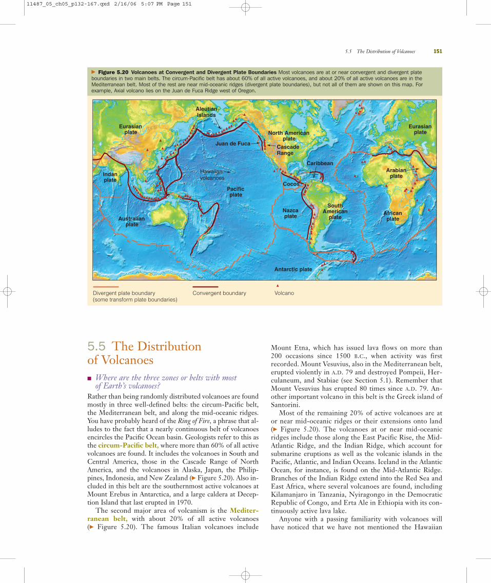
5.5 The Distribution of Volcanoes � Where are the three zones or belts with most
of Earth’s volcanoes?Rather than being randomly distributed volcanoes are foundmostly in three well-defined belts: the circum-Pacific belt,the Mediterranean belt, and along the mid-oceanic ridges.You have probably heard of the Ring of Fire, a phrase that al-ludes to the fact that a nearly continuous belt of volcanoesencircles the Pacific Ocean basin. Geologists refer to this asthe circum-Pacific belt, where more than 60% of all activevolcanoes are found. It includes the volcanoes in South andCentral America, those in the Cascade Range of NorthAmerica, and the volcanoes in Alaska, Japan, the Philip-pines, Indonesia, and New Zealand (� Figure 5.20). Also in-cluded in this belt are the southernmost active volcanoes atMount Erebus in Antarctica, and a large caldera at Decep-tion Island that last erupted in 1970.
The second major area of volcanism is the Mediter-ranean belt, with about 20% of all active volcanoes (� Figure 5.20). The famous Italian volcanoes include
Mount Etna, which has issued lava flows on more than200 occasions since 1500 B.C., when activity was firstrecorded. Mount Vesuvius, also in the Mediterranean belt,erupted violently in A.D. 79 and destroyed Pompeii, Her-culaneum, and Stabiae (see Section 5.1). Remember thatMount Vesuvius has erupted 80 times since A.D. 79. An-other important volcano in this belt is the Greek island ofSantorini.
Most of the remaining 20% of active volcanoes are ator near mid-oceanic ridges or their extensions onto land(� Figure 5.20). The volcanoes at or near mid-oceanicridges include those along the East Pacific Rise, the Mid-Atlantic Ridge, and the Indian Ridge, which account forsubmarine eruptions as well as the volcanic islands in thePacific, Atlantic, and Indian Oceans. Iceland in the AtlanticOcean, for instance, is found on the Mid-Atlantic Ridge.Branches of the Indian Ridge extend into the Red Sea andEast Africa, where several volcanoes are found, includingKilamanjaro in Tanzania, Nyiragongo in the DemocraticRepublic of Congo, and Erta Ale in Ethiopia with its con-tinuously active lava lake.
Anyone with a passing familiarity with volcanoes willhave noticed that we have not mentioned the Hawaiian
5.5 The Distribution of Volcanoes 151
Eurasianplate
Arabianplate
Eurasianplate
Indanplate
Africanplate
Juan de Fuca
Caribbean
Cocos
North Americanplate
CascadeRange
AleutianIslands
Nazcaplate
SouthAmerican
plate
Hawaiianvolcanoes
Pacificplate
Antarctic plate
Australianplate
Convergent boundary VolcanoDivergent plate boundary(some transform plate boundaries)
� Figure 5.20 Volcanoes at Convergent and Divergent Plate Boundaries Most volcanoes are at or near convergent and divergent plateboundaries in two main belts. The circum-Pacific belt has about 60% of all active volcanoes, and about 20% of all active volcanoes are in theMediterranean belt. Most of the rest are near mid-oceanic ridges (divergent plate boundaries), but not all of them are shown on this map. Forexample, Axial volcano lies on the Juan de Fuca Ridge west of Oregon.
11487_05_ch05_p132-167.qxd 2/16/06 5:07 PM Page 151

volcanoes. This is not an oversight; they are the notableexceptions to the distribution of active volcanoes in well-defined belts. We discuss their location and significance inSection 5.7, Plate Tectonics, Volcanoes, and Plutons.
Log into GeologyNow and select this chapter to
work through a Geology Interactive activity on
“Distribution of Volcanism” (click Volcanism0Distribution of Volcanism).
Section 5.5 Summary● About 60% of all active volcanoes are in the circum-Pacific belt, another 20% are in the Mediterranean belt,and the remaining 20% are mostly at or near mid-oceanic ridges or their extensions onto land.
5.6 North America’s ActiveVolcanoesWe mentioned in the previous section that part of the circum-Pacific belt includes volcanoes in the Pacific Northwest as well as those in Alaska. Both of these areas of volcanism are at convergent plate boundaries. Of the 80 or so potentiallyactive volcanoes in Alaska, at least half have erupted since1760. Indeed, as of this writing, three Alaskan volcanoes wereerupting—Mount Spurr, Veniaminof volcano, and Shishaldinvolcano.
The other active North American volcanoes are in theCascade Range in the Pacific Northwest where the Juande Fuca plate is subducted beneath North America. Manyof these volcanoes have been historically active, althoughduring the 1900s only Lassen Peak in California andMount St. Helens in Washington erupted. And of courseMount St. Helens began erupting again during late Sep-tember 2004.
Alaska’s VolcanoesMany of the volcanoes in mainland Alaska and in theAleutian Islands are composite volcanoes, some with hugecalderas (� Figure 5.20). Mount Spurr has erupted explo-sively at least 35 times during the last 5000 years, but itseruptions pale by comparison with that of Novarupta in1912. Novarupta Volcano now lies in Katmai NationalPark and Preserve, which has a total of 15 active volca-noes. Its defining event was the June 1912 eruption, thelargest in the world since the late 1800s. At least 15 km3
and perhaps as much as 23 km3 of volcanic materials,mostly pyroclastic materials, erupted during about 60 hours.“The expulsion of such a large volume of magma exca-vated a funnel-shaped vent 2 kilometers wide and trig-
gered the collapse of Mount Katmai volcano 10 kilome-ters away.”*
When the eruption was over, 120 km2 of land was buriedbeneath pyroclastic deposits as deep as 213 m. In fact, thedeposits filled the Valley of Ten Thousand Smokes—sonamed because of the hundreds of fumaroles where gasesvented through the hot deposits for as long as 15 years fol-lowing the eruption. Fortunately, the eruption took place ina remote area so there were no injuries or fatalities, butenough ash, gases, and pumice were ejected that for severaldays the sky was darkened over much of the NorthernHemisphere.
By the time you read this chapter, several more volcanoesin Alaska will have erupted as the Pacific Plate moves re-lentlessly northward only to be subducted at the AleutianTrench. The Alaska Volcanoes Observatory in Anchorage,Alaska, continues to monitor these volcanoes and issuewarnings about potential eruptions.
The Cascade Range
� Where is the Cascade Range and what types of volcanoes are found there?
The Cascade Range stretches from Lassen Peak in north-ern California north through Oregon and Washington toMeager Mountain in British Columbia, Canada, whicherupted 2350 years ago (see “Cascade Range Volcanoes”on pp. 154–155). Most of the large volcanoes in the rangeare composite volcanoes, such as Mount Shasta in Califor-nia (� Figure 5.13c), Mount Hood in Oregon, and MountSt. Helens in Washington, but Lassen Peak in California isthe world’s largest lava dome. Actually it is a rather smallvolcano that developed 27,000 years ago on the flank of amuch larger, deeply eroded composite volcano. It eruptedfrom 1914 to 1917 but has since been quiet except for on-going hydrothermal activity.
Two large shield volcanoes lie just to the east of the mainCascade Range volcanoes—Medicine Lake Volcano in Cal-ifornia and Newberry Volcano in Oregon. Distinctive fea-tures at Newberry Volcano are a 1600-year-old obsidianflow and casts of trees that formed when lava flowed aroundthem and solidified. Cinder cones are common throughoutthe range, such as Wizard Island in Crater Lake, Oregon (� Figure 5.9e), and Cinder Cone in Lassen Volcanic Na-tional Park, California (� Figure 5.12).
What was once a nearly symmetrical composite vol-cano changed markedly on May 6, 1980, when Mount St. Helens in Washington erupted explosively, killing 63 people and thousands of animals and leveling some 600 km2 of forest (see “Cascade Range Volcanoes” on pp. 154–155). Geologists, citing Mount St. Helens’s pastexplosive eruptions, warned that it was the most likely
152 Chapter 5 Volcanoes and Volcanism
*From Brantley, 1994. Volcanoes in the United States. USGS GeneralInterest Publication, p. 30.
11487_05_ch05_p132-167.qxd 2/16/06 5:07 PM Page 152
Cascade Range volcano to erupt violently. In fact, a hugelateral blast caused much of the damage and fatalities, butsnow and ice on the volcano melted and pyroclastic mate-rials displaced water in lakes and rivers, causing lahars andextensive flooding.
Mount St. Helens’s renewed activity beginning in lateSeptember 2004 has resulted in dome growth and smallsteam and ash explosions. At the time of this writing (Feb-ruary 2005), scientists at the Cascades Volcano Observatoryin Vancouver, Washington, have issued a low-level alert foran eruption, but they think that if one takes place it will bemuch less violent than the one in 1980.
Several of the Cascade Range volcanoes will almostcertainly erupt again, but the most dangerous is probablyMount Rainier in Washington. Rather than lava flows or even a colossal explosion, the greatest danger fromMount Rainier is volcanic mudflows or huge debris flows.Of the 60 large flows that have occurred during the last100,000 years, the largest, consisting of 4 km3 of debris,covered an area now occupied by more than 120,000 peo-ple. Indeed, in August 2001 a sizable debris flow tookplace on the south side of the mountain, but it caused noinjuries or fatalities. No one knows when the next flowwill take place, but at least one community has taken thethreat seriously enough to formulate an emergency evac-uation plan. Unfortunately, the residents would have only1 or 2 hours to carry out the plan.
Section 5.6 Summary● Since 1760 more than 40 volcanoes have erupted inAlaska, including the Aleutian Islands, some of themmany times. The largest volcanic outburst since the late1800s took place at Novarupta in Alaska in 1912.
● The Cascade Range includes volcanoes in northernCalifornia, Oregon, Washington, and British Columbia,Canada. Only three eruptions have occurred since 1914,one at Lassen Peak in California (1914–1917) and two atMount St. Helens in Washington (1980 and 2004–2006).
● The large volcanoes in Alaska and the Cascade Rangeare mostly composite volcanoes, although some shieldvolcanoes are present and both areas have many cindercones.
5.7 Plate Tectonics, Volcanoes,and PlutonsIn Chapter 2 we noted that plate tectonic theory is a unify-ing theory in geology that explains many seemingly unre-lated geologic phenomena. So how do we relate the erup-tion of volcanoes and the emplacement of plutons to plate
tectonics? You already know from Chapter 4 that (1) maficmagma is generated beneath spreading ridges and (2) inter-mediate magma and felsic magma form where an oceanicplate is subducted beneath another oceanic plate or wherean oceanic plate is subducted beneath a continental plate.Accordingly, most of Earth’s volcanism and emplacement ofplutons take place at or near divergent and convergent plateboundaries.
Divergent Plate Boundaries and Igneous Activity
� What kinds of igneous rocks make up the oceaniccrust?
Much of the mafic magma that forms beneath spreadingridges is emplaced at depth as vertical dikes and gabbroplutons. But some rises to the surface, where it forms sub-marine lava flows and pillow lava (� Figure 5.7). Indeed,the oceanic crust is composed largely of gabbro and basalt.Much of this submarine volcanism goes undetected, butresearchers in submersible craft have observed the resultsof these eruptions.
Pyroclastic materials are not common in this environ-ment because mafic lava is very fluid, allowing gases toescape easily, and at great depth, water pressure preventsgases from expanding. Accordingly, the explosive erup-tions that yield pyroclastic materials are not common. If an eruptive center along a ridge builds above sea level,however, pyroclastic materials may be erupted at lavafountains, but most of the magma issues forth as fluid lavaflows that form shield volcanoes.
Excellent examples of divergent plate boundary volcan-ism are found along the Mid-Atlantic Ridge, particularlywhere it is above sea level as in Iceland (� Figure 5.20). InNovember 1963 a new volcanic island, later named Surtsey,rose from the sea just south of Iceland. The East Pacific Riseand the Indian Ridge are areas of similar volcanism. Not alldivergent plate boundaries are beneath sea level as in theprevious examples. For instance, divergence and igneousactivity are taking place in Africa at the East African Riftsystem (� Figure 5.20).
Igneous Activity at Convergent Plate BoundariesNearly all of the large active volcanoes in both the circum-Pacific and Mediterranean belts are composite volcanoesnear the leading edges of overriding plates at convergentplate boundaries (� Figure 5.20). The overriding plate, withits chain of volcanoes, may be oceanic as in the case of theAleutian Islands, or it may be continental as is, for instance,the South American plate with its chain of volcanoes alongits western edge.
As we have noted, these volcanoes at convergent plateboundaries consist largely of lava flows and pyroclasticmaterials of intermediate to felsic composition. Remember
5.7 Plate Tectonics, Volcanoes, and Plutons 153
11487_05_ch05_p132-167.qxd 2/16/06 5:07 PM Page 153

Cascade Range VolcanoesSeveral large volcanoes and hundreds of smaller volcanicvents are in the Cascade Range, which stretches fromnorthern California into southern British Columbia,
Canada. Medicine Lake Volcano and Newberry Volcanoare shield volcanoes that lie just east of the main trend ofthe Cascade Range.
PacificPlate
Juan de FucaPlate
NorthAmerican
Plate
Mount Adams
Mount Adams
Lassen Peak
SubductionZone
SpreadingRidge
Juan de FucaRidge
NorthAmerican
Plate
B
A
A B
Juande Fuca
Plate
PacificPlate
Cascade Range
Mount St. Helens
Mount St. HelensJuan de Fuca Ridge
Brokeoff Mountain 2815 m
Sulphur Works 2164 m
Lassen Peak 3187 m
SW NE
Eagle Peak 2810 m
Presumed original form of Mount Tehama
3397 mSki Heil 2713 m
km
0 1
3154
2790
2426
1915 dacite from Lassen Peak
Talus
Dacite domes
Pre-Lassen Peak dacites from the Lassen Peak vent
Breccia (vent filling) of Mount Tehama
Decomposed andesites
Andesites of Mount Tehama
� 1. Plate tectonic setting for the PacificNorthwest. Subduction of the Juan de Fuca plate beneath North Americaaccounts for the continuing volcanismin this region.
� 2. Lassen Peak is adacite lava dome thatformed 27,000 yearsago on the flank ofan eroded compositevolcano called MountTehama. Dacite has acomposition betweenandesite and rhyolite.
USGS
Sue
Mon
roe
� 4. A huge steam explosion called the Great Hot Blast leveled the areain the foreground in 1915. In the 89 years since the eruption, trees arebecoming reestablished in this area, known as the Devastated Area.
Sue Monroe
� 3. Lassen Peak today. Thismost southerly peak in theCascade Range is made up of2 km3 of material, includingthe bulbous masses of rockvisible in this image.
11487_05_ch05_p132-167.qxd 2/16/06 5:07 PM Page 154

� 7. Mount St. Helens. The lateral blast on May 18, 1980,took place when a bulge on the volcano’s north facecollapsed, reducing the pressure on gas-chargedmagma. The lateral blast killed 63 people and leveled600 km2 of forest.
� 9. Shortly after thelateral blast, this19-km-high ashand steam clouderupted fromMount St. Helens.
� 5. Lassen Peakerupted numeroustimes from 1914to 1917. Thiseruption tookplace in 1915.
D. R. Crandel/USGS
Cour
tesy
of K
eith
Ron
nhol
m
Phot
oDis
c/Ge
tty Im
ages
Steve Schilling/USGS
� 6. Mount St. Helens,a composite volcano,as it appeared fromthe east in 1978.
� 8. Mount St. Helensin Washington beganerupting during lateSeptember 2004.Earthquakes beneaththe peak as well aseruptions of gasesand ash continueinto 2006, butgeologists at theCascade VolcanoObservatory inVancouver,Washington, do not expect anoutburst asdevastating as the one on May 18, 1980.
11487_05_ch05_p132-167.qxd 2/17/06 8:33 AM Page 155

that when mafic oceanic crust partially melts, some of themagma generated is emplaced near plate boundaries asplutons and some is erupted to build up composite volca-noes. More viscous magmas, usually of felsic composition,are emplaced as lava domes, thus accounting for the explo-sive eruptions that typically occur at convergent plateboundaries.
In previous sections, we mentioned several eruptions atconvergent plate boundaries. Good examples are the explo-sive eruptions of Mount Pinatubo and Mayon volcano inthe Philippines, both of which are situated near a plateboundary beneath which an oceanic plate is subducted.Mount St. Helens in Washington is similarly situated, butit is on a continental rather than an oceanic plate (see “Cas-cade Range Volcanoes” on pp. 154–155). Mount Vesuviusin Italy, one of several active volcanoes in that region, lieson a plate that the northern margin of the African plate issubducted beneath.
Intraplate Volcanism
� How do plate tectonics and volcanism account for the origin of the Hawaiian Islands?
Mauna Loa and Kilauea on the island of Hawaii and Loihijust 32 km to the south are within the interior of a rigidplate far from any divergent or convergent plate boundary(� Figure 5.20). The magma is derived from the upper man-tle, as it is at spreading ridges, and accordingly is mafic so itbuilds up shield volcanoes. Loihi is particularly interestingbecause it represents an early stage in the origin of a newHawaiian island. It is a submarine volcano that rises higherthan 3000 m above the seafloor, but its summit is still about940 m below sea level.
Even though the Hawaiian volcanoes are not at a spread-ing ridge near a subduction zone, their evolution is relatedto plate movements. Notice in Figure 2.22 that the ages ofthe rocks that make up the various Hawaiian Islands in-crease toward the northwest; Kauai formed 3.8 to 5.6 mil-lion years ago, whereas Hawaii began forming less than 1 million years ago, and Loihi began to form even morerecently. Continuous movement of the Pacific plate overthe hot spot, now beneath Hawaii and Loihi, has formedthe islands in succession.
Section 5.7 Summary● Most of the magma that is emplaced as plutons or thatrises to the surface as lava at divergent plate boundaries ismafic, even where divergence takes place on land, as inEast Africa.
● Igneous activity at convergent plate boundaries in-volves mostly intermediate and felsic magma and lava.Huge plutons such as batholiths as well as composite vol-canoes are common in this geologic setting.
5.8 Volcanic Hazards, VolcanoMonitoring, and ForecastingEruptions You no doubt suspect that living near an active volcanoposes some risk, and of course this is a correct assessment.But what exactly are volcanic hazards, is there any way toanticipate eruptions, and what can we do to minimize thedangers from eruptions? We already mentioned that lavaflows pose little danger to humans, but there are exceptions.In 1977 a lava lake in the crater of Nyiragongo volcano in the Democratic Republic of Congo (formerly Zaire)suddenly drained through a fracture and killed 70 people(300 in some reports) and a herd of elephants. More re-cently, on January 17, 2002, a lava flow from Nyiragongosliced through the city of Goma, 19 km south, destroyingeverything in a 60-m-wide path (� Figure 5.21a). The lavaignited fires and huge explosions where it came into contactwith gasoline storage tanks, killing 147 people. Never-theless, lava flows are low on the list of direct dangers tohumans, although they may destroy croplands, houses,roadways, and other structures.
� What are the most dangerous manifestations of volcanoes?
Of much greater concern than lava flows are nuée ardentes,volcanic gases, lahars, and landslides (� Figure 5.21). Indeed,the latter two phenomena may take place even when no erup-tion has occurred for a long time. And remember that vol-canic gases caused many fatalities in Cameroon and Iceland.
The areas most vulnerable to volcanic hazards in theUnited States are Alaska, Hawaii, California, Oregon, andWashington, but some other parts of the western statesmight also experience renewed volcanism. Canada’s mostrecent eruption took place in northern British Columbiaabout 150 years ago, but there is the potential for futureeruptions from volcanoes in the northern Cascade Range.The greatest threat may be from Mount Baker in Washing-ton, which lies about 24 km south of the U.S.–Canadianborder. It last erupted in 1870.
The Size and Duration of EruptionsThe most widely used indication of the size of a volcanic erup-tion is the volcanic explosivity index (VEI) (� Figure 5.22).The VEI has numerical values corresponding to eruptionscharacterized as gentle, explosive, and cataclysmic. It is basedon several aspects of an eruption, particularly the volume ofmaterial explosively ejected and the height of the eruptioncloud; the volume of lava, fatalities, and property damage arenot considered. The 1985 eruption of Nevado del Ruiz inColombia killed 23,000 people yet had a VEI value of only 3,whereas the huge eruption (VEI � 6) of Novarupta in Alaskain 1912 caused no fatalities or injuries. Since A.D. 1500, onlythe 1815 eruption of Tambora in Indonesia has had a VEI
156 Chapter 5 Volcanoes and Volcanism
11487_05_ch05_p132-167.qxd 2/16/06 5:07 PM Page 156

value of 7; it was both large and deadly (Table 5.1). Geologistshave assigned VEI values to nearly 5700 eruptions that tookplace during the last 10,000 years, but none has exceeded 7and most (62%) have a value of 2.
The duration of eruptions varies considerably. Fully42% of about 3300 historic eruptions lasted less than onemonth. About 33% erupted for one to six months, butsome 16 volcanoes have been active more or less continu-ously for longer than 20 years. Stromboli and Mount Etnain Italy and Erta Ale in Ethiopia are good examples. Insome explosive volcanoes, the time from the onset of theireruptions to the climactic event is weeks or months. A casein point is the explosive eruption of Mount St. Helens onMay 18, 1980, which occurred two months after eruptiveactivity began. Unfortunately, many volcanoes give little orno warning of large-scale eruptions; of 252 explosive erup-tions, 42% erupted most violently during their first day of
activity. As one might imagine, predicting eruptions iscomplicated by those volcanoes that give so little warningof impending activity.
Forecasting EruptionsOnly a few of Earth’s potentially dangerous volcanoes aremonitored, including some in Japan, Italy, Russia, NewZealand, and the United States. Many of the methods nowused to monitor volcanoes were developed at the HawaiianVolcano Observatory.
Volcano monitoring involves recording and analyzingphysical and chemical changes at volcanoes. Geologists mayuse various instruments to detect ground deformation—thatis, changes in a volcano’s slopes as it inflates when magmarises beneath it. Using some instruments requires that geolo-gists actually visit a potentially dangerous volcano, but now
5.8 Volcanic Hazards, Volcano Monitoring, and Forecasting Eruptions 157
� Figure 5.21 Volcanic Hazards A volcanic hazard is any manifestation of volcanism that poses a threat, including lava flows and, more importantly,volcanic gas, ash, and lahars.
Reut
ers/
Corb
is
Sue
Mon
roe
AFP/
Getty
Imag
es
This 2002 lava flow in Goma, Democratic Republic of Congo, killed147 people, mostly by causing gasoline storage tanks to explode.
a
This sign at Mammoth Mountain volcano in California warns of thepotential danger of CO2 gas, which has killed 170 acres of trees.
b
When Mount Pinatubo in the Philippines erupted on June 15,1991, this huge cloud of ash and steam formed over the volcano.
c
11487_05_ch05_p132-167.qxd 2/17/06 5:51 PM Page 157

global positioning system (GPS) technology allows them tomonitor a volcano from a safe distance (� Figure 5.23). Dur-ing the renewed activity at Mount St. Helens beginning inSeptember 2004, helicopters placed GPS instruments on thelava dome in the volcano’s crater. Geologists also monitor gasemissions, changes in groundwater level and temperature,hot springs activity, and changes in local magnetic and elec-trical fields. Even the accumulating snow and ice, if any, areevaluated to anticipate hazards from floods should an erup-tion take place.
Of critical importance in volcano monitoring and warn-ing of an imminent eruption is the detection of volcanictremor, the continuous ground motion lasting for minutesto hours as opposed to the sudden, sharp jolts produced bymost earthquakes. Volcanic tremor, also known as harmonictremor, indicates that magma is moving beneath the surface.
Geologists study the record of past eruptions preservedin rocks to better anticipate the future activity of a volcano.Detailed studies before 1980 indicated that Mount St. He-lens had erupted explosively 14 or 15 times during the last4500 years, so geologists concluded that it was one of themost likely Cascade Range volcanoes to erupt again. In fact,the maps they prepared showing areas in which damagefrom an eruption could be expected were helpful in deter-mining which areas should have restricted access and evac-uations once an eruption did take place.
Geologists successfully gave timely warnings of impend-ing eruptions of Mount St. Helens in Washington andMount Pinatubo in the Philippines, but in both cases theclimactic eruptions were preceded by eruptive activity oflesser intensity. In some cases, however, the warning signsare much more subtle and difficult to interpret. Numeroussmall earthquakes and other warning signs indicated to ge-ologists of the U.S. Geological Survey (USGS) that magmawas moving beneath the surface of the Long Valley calderain eastern California, so in 1987 they issued a low-levelwarning and then nothing happened.
Volcanic activity in the Long Valley caldera occurred as re-cently as 250 years ago, and there is every reason to think itwill occur again, but when it will take place is an unansweredquestion. Unfortunately, the local populace was largely un-aware of the geologic history of the region, the USGS did apoor job in communicating its concerns, and premature newsreleases caused more concern than was justified. In any case,local residents where outraged because the warnings caused adecrease in tourism (Mammoth Mountain on the margins ofthe caldera is the second largest ski area in the country) andproperty values plummeted. Monitoring continues in theLong Valley caldera, and the signs of renewed volcanism, in-cluding earthquake swarms, trees being killed by carbon diox-ide gas apparently emanating from magma (� Figure 5.21b),and hot spring activity, cannot be ignored.
158 Chapter 5 Volcanoes and Volcanism
1
2
3
4
5
6
7
8V
olca
nic
expl
osiv
ity in
dex
Vol
ume
of te
phra
Cloud height, kmHistoric eruptions
0<0.1 0.1–1 1–5 3–15 10–25 >25487 623 3176 733 119 19 5
GENTLE
EXPLOSIVE
CATACLY
SMIC
1 0
Small
Moderate
Large
Very large
VEI 1–3
VEI 3–5
VEI 4–7
10,000 m3
1,000,000 m3
0.01 km3
0.1 km3
1 km3
10 km3
100 km3
1000 km3
1000 m3
� Figure 5.22 The Volcanic Explosivity Index The volcanic explosivity index (VEI). In this example, an eruption with a VEI value of 5 has aneruption cloud up to 25 km high and ejects about 1 km3 of tephra, a collective term for all pyroclastic materials.
11487_05_ch05_p132-167.qxd 2/16/06 5:07 PM Page 158

For the better-monitored volcanoes, it is now possible tomake accurate short-term predictions of eruptions. But formany volcanoes, little or no information is available.
Section 5.8 Summary● Geologists have devised a volcanic explosivity index (VEI)to indicate the size of an eruption. VEI values depend on thevolume of material erupted and the height of an eruptionplume; fatalities and property damage are not considered.
● Although lava flows and lava fountains are impressive,the most dangerous manifestations of volcanoes are erup-tions of pyroclastic materials, especially nuée ardentes, aswell as mudflows and debris flows, which may take placeeven when a volcano is not erupting.
● Volcano monitoring involves evaluating physical andchemical aspects of volcanoes. Especially important foranticipating eruptions is detecting volcanic tremor anddetermining the eruptive history of a volcano.
5.8 Volcanic Hazards, Volcano Monitoring, and Forecasting Eruptions 159
Satellite remote sensing
Remote sensingof gases
Direct gassampling
Temperaturemeasurements Study of past
volcanic deposits
Gravity and magneticfield studies
Lava samplecollection
Ground deformation studies
GPS measurements
Seismic measurements
� Figure 5.23 Volcanic Monitoring Some important techniques used to monitor volcanoes.
No one doubts that some of the Cascade Range vol-canoes will erupt again (actually Mount St. Helens
in Washington was erupting when this was written inFebruary 2005). But no one knows when future erup-tions will take place or how large they will be. A jobtransfer takes you to a community in Oregon with sev-eral nearby volcanoes, and you have some concernsabout future eruptions. What kinds of information aboutspecific threats would you seek out before buying a homein this area? Also, as a concerned citizen, could you makeany suggestions about what members of your communityshould do in case of an eruption?
What Would You Do?What Would You Do?
11487_05_ch05_p132-167.qxd 2/16/06 5:07 PM Page 159

Review Workbook
ESSENTIAL QUESTIONS SUMMARY5.1 Introduction � How can volcanism be both constructive and destructive?Volcanism may destroy houses and farmland and cause injuriesand fatalities so it is destructive, but it is also constructive becauseit is responsible for the origin of many oceanic islands as well asthe oceanic crust.
5.2 Volcanism and Volcanoes� What gases do volcanoes commonly emit?Most volcanic gases are water vapor, with lesser amounts of car-bon dioxide, nitrogen, sulfur dioxide, and hydrogen sulfide, andvery small amounts of carbon monoxide, hydrogen, and chlorine.
� How and why do aa and pahoehoe lava flows differ?Aa is made up of angular blocks and fragments, whereas pahoehoehas a smooth surface much like taffy. The flows differ mostlybecause aa is viscous enough to fragment.
� What are pyroclastic materials, and how are they dangerous to airtraffic?
Pyroclastic materials are solids, including ash, lapilli, blocks, andbombs, that are explosively ejected by volcanoes. Ash is danger-ous to aircraft because it fouls jet engines.
5.3 Types of Volcanoes � What are calderas and how do they form?A caldera is a large oval to circular volcanic depression that formswhen the summit of a volcano collapses into its magma chamberfollowing voluminous eruptions.
� What are cinder cones and what are they composed of?Cinder cones are small, steep-sided volcanoes made up of pyro-clastic materials that resemble cinders.
� What are lava domes and why are they so dangerous?Lava domes are bulbous masses of viscous magma that commonlyerupt explosively.
5.4 Other Volcanic Landforms� How do basalt plateaus form?Basalt plateaus are made up of numerous overlapping basalt lavaflows that erupt from fissures rather than from a central vent.
� What are pyroclastic sheet deposits?Huge eruptions of pyroclastic materials, especially ash, from fis-sures that form during the origin of calderas are responsible forpyroclastic sheet deposits.
5.5 The Distribution of Volcanoes � Where are the three zones or belts with most of Earth’s volcanoes?About 60% of all active volcanoes are in the circum-Pacific belt,another 20% are in the Mediterranean belt, and most of theremaining 20% are at or near mid-oceanic ridges or their exten-sions onto land.
5.6 North America’s Active Volcanoes � Where is the Cascade Range and what types of volcanoes are found
there?The Cascade Range stretches from Lassen Peak in Californianorth through Oregon and Washington to Meager Mountain inBritish Columbia, Canada. Most of the large volcanoes in therange are composite volcanoes, but there are also two huge shieldvolcanoes and numerous cinder cones.
5.7 Plate Tectonics, Volcanoes, and Plutons � What kinds of igneous rocks make up the oceanic crust?The oceanic crust is made up of mafic igneous rocks. Gabbro isfound in the lower part of the oceanic crust, whereas verticaldikes and pillow lava, both composed of basalt, make up theupper part.
160 Chapter 5 Volcanoes and Volcanism
11487_05_ch05_p132-167.qxd 2/16/06 5:07 PM Page 160
� How do plate tectonics and volcanism account for the origin of theHawaiian Islands?
As the Pacific plate moved over a hot spot, a chain of volcanoesformed in succession, so the oldest in the chain is far to thenorthwest and active volcanism now occurs only on the island of Hawaii and at Loihi.
5.8 Volcanic Hazards, Volcano Monitoring, and ForecastingEruptions� What are the most dangerous manifestations of volcanoes?Lava dome eruptions during which huge amounts of pyroclasticmaterials and gases are ejected are the most dangerous volcaniceruptions. Lahars are also dangerous and they may take placelong after an eruption.
Review Workbook 161
ESSENTIAL TERMS TO KNOWaa (p. 137)
ash (p. 139)
basalt plateau (p. 149)
caldera (p. 141)
Cascade Range (p. 152)
cinder cone (p. 141)
circum-Pacific belt (p. 151)
columnar joint (p. 138)
composite volcano (stratovolcano) (p. 144)
crater (p. 141)
fissure eruption (p. 149)
lahar (p. 144)
lava dome (p. 144)
lava tube (p. 137)
Mediterranean belt (p. 151)
nuée ardente (p. 145)
pahoehoe (p. 137)
pillow lava (p. 139)
pyroclastic materials (p. 139)
pyroclastic sheet deposits (p. 150)
shield volcano (p. 141)
volcanic explosivity index (VEI) (p. 156)
volcanic tremor (p. 158)
volcanism (p. 136)
volcano (p. 141)
REVIEW QUESTIONS1. Suppose you find rocks on land that consist of layers of pillow
lava overlain by deep-sea sedimentary rocks. Where and howdid the pillow lava form, and what type of rock would youexpect to find beneath the pillow lava?
2. How do columnar joints and lava tubes form? Where are goodplaces to see each?
3. What geologic events would have to take place for a chain ofcomposite volcanoes to form along the east coasts of theUnited States and Canada?
4. Explain why eruptions of mafic lava are nonexplosive but erup-tions of felsic magma are commonly explosive.
5. What does volcanic tremor indicate, and how does it differfrom the shaking caused by most earthquakes?
6. Describe a nuée ardente and explain why they are so dangerous.
7. Why do shield volcanoes have such gentle slopes whereascinder cones have very steep slopes?
APPLY YOUR KNOWLEDGE1. Considering what you know about the origin of magma and
about igneous activity, why is the magma (lava) at divergentplate boundaries mostly mafic, whereas at convergent plateboundaries it is mostly intermediate and felsic?
2. What criteria are used to assign a volcanic explosivity index(VEI) value to an eruption? Why do you think the number of fatalities and property damage are not considered whenassigning a value?
11487_05_ch05_p132-167.qxd 2/16/06 5:07 PM Page 161

162 Chapter 5 Volcanoes and Volcanism
FIELD QUESTIONS1. The Mona Schist at Marquette, Michigan
(see the image), is basalt that has beenchanged slightly by metamorphism. Howdo you think the elliptical features in thisancient lava formed?
2. The accompanying image shows part of the Giant’s Causewayin Northern Ireland. How did these vertical columns form?
� Geo-focus Figure
Jam
es S
. Mon
roe
Jam
es S
. Mon
roe
11487_05_ch05_p132-167.qxd 2/16/06 5:07 PM Page 162

3. Identify the types of volcanoes shown in the diagram. Whichof these do you think would erupt mostly violently? Why?
4. The accompanying image shows a basaltlava flow (black) overlying a layer of pyro-clastic materials (light colored) in Colorado.Why is the upper part of the pyroclasticlayer discolored?
Review Workbook 163
10
2
4 Parícutin (Mexico)(cinder cone)
Mount Rainier(stratovolcano)
Fujiyama(stratovolcano)
Mount Wrangell(shield volcano)
5 km
km
3
� Geo-focus Figure
Jam
es S
. Mon
roe
11487_05_ch05_p132-167.qxd 2/16/06 5:07 PM Page 163
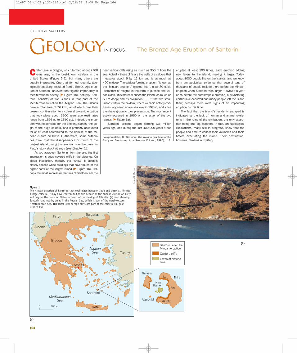
164
GEOLOGY MATTERS
Crater Lake in Oregon, which formed about 7700years ago, is the best-known caldera in the
United States (Figure 5.9), but many others areequally impressive. One that formed recently, geo-logically speaking, resulted from a Bronze Age erup-tion of Santorini, an event that figured importantly inMediterranean history (� Figure 1a). Actually, San-torini consists of five islands in that part of theMediterranean called the Aegean Sea. The islandshave a total area of 76 km2, all of which owe theirpresent configuration to a colossal volcanic eruptionthat took place about 3600 years ago (estimatesrange from 1596 BC to 1650 BC). Indeed, the erup-tion was responsible for the present islands, the ori-gin of the huge caldera, and it probably accountedfor or at least contributed to the demise of the Mi-noan culture on Crete. Furthermore, some authori-ties think that the disappearance of much of theoriginal island during this eruption was the basis forPlato’s story about Atlantis (see Chapter 12).
As you approach Santorini from the sea, the firstimpression is snow-covered cliffs in the distance. Oncloser inspection, though, the “snow” is actuallyclosely spaced white buildings that cover much of thehigher parts of the largest island (� Figure 1b). Per-haps the most impressive features of Santorini are the
near vertical cliffs rising as much as 350 m from thesea. Actually, these cliffs are the walls of a caldera thatmeasures about 6 by 12 km and is as much as 400 m deep. The caldera-forming eruption, “known asthe ‘Minoan eruption,’ ejected into the air 30 cubickilometers of magma in the form of pumice and vol-canic ash. This material buried the island [as much as50 m deep] and its civilization. . . .”1 The two smallislands within the caldera, where volcanic activity con-tinues, appeared above sea level in 197 BC, and sincethen have grown to their present size. The most recentactivity occurred in 1950 on the larger of the twoislands (� Figure 1a).
Santorini volcano began forming two millionyears ago, and during the last 400,000 years it has
erupted at least 100 times, each eruption addingnew layers to the island, making it larger. Today,about 8000 people live on the islands, and we knowfrom archaeological evidence that several tens ofthousand of people resided there before the Minoaneruption when Santorini was larger. However, a yearor so before the catastrophic eruption, a devastatingearthquake occurred and many people left the islandthen; perhaps there were signs of an impendingeruption by this time.
The fact that the island’s residents escaped isindicated by the lack of human and animal skele-tons in the ruins of the civilization, the only excep-tion being one pig skeleton. In fact, archaeologicalexcavations, many still in progress, show that thepeople had time to collect their valuables and toolsbefore evacuating the island. Their destination,however, remains a mystery.
1Vougioukalakis, G., Santorini: The Volcano (Institute for theStudy and Monitoring of the Santorini Volcano, 1995), p. 7.
The Bronze Age Eruption of SantoriniGeologyIN FOCUS
100 km0
Albania
Bulgaria
Greece
Crete
Santorini
Fyrom
Turkey
Thira
Fira
La
Akrotiri
NeaKameni
Aspronisi
Thirasia
Athens
AegeanSea
MediterraneanSea
Santorini after theMinoan eruption
Caldera cliffs
Lavas of historictime
Figure 1 The Minoan eruption of Santorini that took place between 1596 and 1650 B.C. formeda large caldera. It may have contributed to the demise of the Minoan culture on Creteand may be the basis for Plato’s account of the sinking of Atlantis. (a) Map showingSantorini and nearby areas in the Aegean Sea, which is part of the northwesternMediterranean Sea. (b) These 350-m-high cliffs are part of the caldera wall just west of Fira.
Jam
es S
. Mon
roe
(a)
(b)
11487_05_ch05_p132-167.qxd 2/16/06 5:08 PM Page 164

165
Figure 1 Of the hundreds of volcanoes in the world, Oldoinyo Lengai in Tanzania is one of themost unusual because it erupts lava that cools to form igneous rock rich in carbonateminerals. (a) Lava spattering from a small cone in the crater of Oldoinyo Lengai in 1990.(b) In 1994 this black lava from Oldoinyo Lengai flowed over a lava flow only a fewmonths old that had already turned gray.
Cour
tesy
of F
rede
rick
A. B
elto
n
Celia
Nya
mw
eru
The East African Rift is not an unexpected place forvolcanoes, but the one known as Oldoinyo Lengai
(or Ol Doinyo Lengai) in Tanzania is certainly amongEarth’s most peculiar volcanoes. Oldoinyo Lengai,which means “Mountain of God” in the Masai lan-guage, is an active composite volcano standing about2890 m high (� Figure 1a). It is one of 20 or so vol-canoes in an east-west belt near the southern part ofthe East African Rift, a divergent plate boundary (seeFigure 2.16a). Oldoinyo Lengai is peculiar because itis the world’s only volcano that erupts carbonatitelava rather than lava with abundant silica. Carbonatite
refers to an igneous rock with at least 50% car-bonatite minerals, that is, minerals with the (CO3)�2
radical. In fact, carbonatite looks much like the meta-morphic rock marble (see Chapter 8).
Why is the carbonatite lava at Oldoinyo Lengaiunique? Remember that based on silica contentmost magma ranges from mafic to felsic, or even ul-tramafic; only rarely does magma have the elementsnecessary to form carbonatite-rich rocks. Carbon-atite is found at about 330 localities worldwide, butmost of it is in small plutons and thus intrusive. Sothe carbonatite lava that erupts at Oldoinyo Lengai
makes it unusual because it is extrusive. Anotherfeature of the Oldoinyo Lengai carbonatite is that itcontains significant amounts of sodium and potas-sium, whereas most carbonatites are made up ofcalcite (CaCO3) and dolomite [CaMg(CO3)2].
The carbonatite lava at Oldoinyo Lengai hassome surprising characteristics. For one thing it isfluid at temperatures of only 540°C and 595°C, andbecause it has so little silica it has very low viscosityand flows quickly. Indeed, the temperature is so lowthat the lava is not incandescent, so we do not seethe red glow we expect in lava flows. In fact, it looksmore like black mud. And because the minerals incarbonatite are unstable, they react with water inthe atmosphere and their color quickly changes topale gray (� Figure 1b).
Until the 1960s, there was disagreement amonggeologists about the origin of carbonatite. Somethought that the carbonatite plutons noted abovewere made up of marble that was altered from lime-stone by heat and as a result looked like igneous
rock. Observations at Oldoinyo Lengai, however, pro-vided compelling evidence that carbonatite is foundin lava flows as well as in plutons.
We now know that carbonatite is found in smallplutons and erupts as lava, but geologists continueto debate the origin of carbonatite magma. Somethink that it forms by partial melting of carbonatiterocks in Earth’s crust, but others think it is not a pri-mary magma at all but rather forms by alteration ofsodium-rich carbonatite from which hydrothermalfluids removed the sodium.
Although the rocks at Oldoinyo Lengai have noeconomic importance, carbonatites elsewhere aremined because they have higher percentages of rareearth elements1 that any other type of igneous rock.They are also sources of niobium, phosphates, andfluorite.
Rare earth elements are 17 chemical elements that havesimilar atomic structures, atomic radii, and 3� or 4� elec-trical charges.
GEOLOGY MATTERS
Oldoinyo Lengai VolcanoGeologyIN UNEXPECTED PLACES
(a) (b)
11487_05_ch05_p132-167.qxd 2/16/06 5:08 PM Page 165

166
GEOLOGY MATTERS
Earth supports life because of its distance fromthe Sun, and the fact that it has abundant liq-
uid water and an oxygen-rich atmosphere. An ozonelayer (O3) in the stratosphere (10 to 48 km abovethe surface) protects Earth because it blocks outmost of the harmful ultraviolet radiation that bom-bards our planet. During the early 1980s, scientistsdiscovered an ozone hole over Antarctica that hascontinued to grow. In fact, depletion of the ozonelayer is now also recognized over the Arctic regionand elsewhere. Any depletion in ozone levels isviewed with alarm because it would allow more dan-gerous radiation to reach the surface, increasing therisk of skin cancer, among other effects.
This discovery unleashed a public debate aboutthe primary cause of ozone depletion, and how bestto combat the problem. Scientists proposed that onecause of ozone depletion is chlorofluorocarbons(CFCs), which are used in various consumer prod-ucts; for instance, in aerosol cans. According to thistheory, CFCs rise into the upper atmosphere wherereactions with ultraviolet radiation liberate chlorine,which in turn reacts with and depletes ozone (� Fig-ure 1). As a result of this view, an internationalagreement called the Montreal Protocol was reachedin 1983, limiting the production of CFCs, along withother ozone-depleting substances.
However, during the 1990s this view was chal-lenged by some radio talk show hosts as well as afew government officials. They proposed an alterna-tive idea that ozone depletion was because of nat-ural causes rather than commercial products suchas CFCs. They pointed out that volcanoes releasecopious quantities of hydrogen chloride (HCl) gasthat rises into the stratosphere and which could beresponsible for ozone depletion. Furthermore, theyclaimed that because CFCs are heavier than air theywould not rise into the stratosphere.
It is true that volcanoes release HCl gas as wellas several other gases, some of which are quite dan-gerous—recall the cloud of CO2 gas in Cameroonthat killed 1746 people and the Blue Haze Famine inIceland. However, most eruptions are too weak to in-ject gases of any kind high into the stratosphere.Even when it is released, HCl gas from volcanoes isvery soluble and quickly removed from the atmos-phere by rain and even by steam (water vapor) fromthe same eruption that released HCl gas in the firstplace. Measurements of chlorine concentrations inthe stratosphere show that only temporary increasesoccur following huge eruptions. For example, thelargest volcanic outburst since 1912, the eruption ofMount Pinatubo in 1991, caused little increase inupper atmosphere chlorine. The impact of volcanic
eruptions is certainly not enough to cause the aver-age rate of ozone depletion taking place each year.
Although it is true that CFCs are heavier than air,this does not mean that they cannot rise into thestratosphere. Earth’s surface heats differentially,meaning that more heat may be absorbed in onearea than in an adjacent one. The heated air above awarmer area becomes less dense, rises by convec-tion, and carries with it CFCs and other substancesthat are actually denser than air. Once in the strato-sphere, ultraviolet radiation, which is usually absorbedby ozone, breaks up CFC molecules and releaseschlorine that reacts with ozone. Indeed, a single chlo-rine atom can destroy 100,000 ozone molecules (� Figure 1). In contrast to the HCl gas produced byvolcanoes, CFCs are absolutely insoluble; it is the factthat they are inert that made them so desirable forvarious uses. Because a CFC molecule can last fordecades, any increase in CFCs is a long-term threatto the ozone layer.
Another indication that CFCs are responsiblefor the Antarctic ozone hole is that the rate ofozone depletion has slowed since the implementa-tion of the Montreal Protocol. A sound under-standing of the science behind these atmosphericprocesses helped world leaders act quickly to ad-dress this issue. Now scientists hope that withcontinued compliance with the Protocol, the ozonelayer will recover by the middle of this century.
Do Volcanic GasesCause Ozone Depletion?GEOLOGYIN YOUR LIFE
Cl
O
O
F
Cl
Cl
Cl
Cl
Cl
Cl
O
O
OO
OO
O
O
C
Sun
UV radiation
Ultraviolet light hits a chlorofluorocarbon (CFC) molecule, such as CFCl3, breakingoff a chlorine atom and leaving CFCl2.
The chlorine atom attacksan ozone (O3) molecule, pullingan oxygen atom off it and leaving an oxygen molecule (O2).
Once free, the chlorine atom is off to attack another ozone moleculeand begin the cycle again.
A free oxygen atom pulls the oxygen atom off the chlorine monoxide molecule to form O2.
The chlorine atom and the oxygen atom join to form a chlorine monoxide molecule (ClO).
Cl
Figure 1 Ozone is destroyed by chlorofluorocarbons (CFCs). Chlorine atoms are continuously regenerated, so one chlorine atomcan destroy many ozone molecules.
11487_05_ch05_p132-167.qxd 2/16/06 5:08 PM Page 166

167
The United States Geological Survey maintainsseveral volcano observatories around the country,
each with the goal of monitoring local volcanic activ-ity to add to our scientific understanding of volcanoesas well as to ensure public safety. Geologists at theHawaii Volcano Observatory developed many of themethods now used to monitor volcanoes elsewhere,
although other observatories have also contributed.The Alaska Volcano Observatory in Fairbanks moni-tors active volcanoes in that state, and issues warn-ings of imminent eruptions, particularly to aircraft.The David A. Johnston Cascades Volcano Observa-tory in Vancouver, Washington, was established fol-lowing the 1980 eruption of Mount St. Helens and
named for a geologist who was killed in the erup-tion. And the Long Valley Observatory at Menlo Park,California, monitors activity at Long Valley Caldera ineastern California. Personnel at the US GeologicalSurvey operate the Yellowstone Volcano Observatoryin cooperation with the University of Utah and theNational Park Service. Their function is to monitorand assess possible hazards, and to conduct re-search at Yellowstone National Park in Wyoming,Montana, and Idaho.
The Yellowstone region has had a history of hugevolcanic eruptions, although the most recent onewas about 70,000 years ago. Why monitor an areaso closely given that no volcanic outbursts havetaken place for thousands of years? Continuingearthquake activity, 80 cm of uplift of the groundsurface since 1923, and the hydrothermal activity(see Chapter 16) for which the park is famous, indi-cate that future eruptions are possible. And judgingfrom the geologic record, renewed eruptions may becatastrophic.
Geologist have no formal definition for supervol-
cano, but we can take it to mean a volcano thaterupts explosively, ejecting hundreds of cubic kilo-meters of pyroclastic materials followed by the ori-gin of a vast caldera. No supervolcano eruption hasoccurred in recorded history, but geologists know ofseveral that occurred during the past two millionyears—Long Valley in eastern California, Toba inIndonesia, and Taupo in New Zealand, for example.The origin of the Yellowstone caldera in YellowstoneNational Park in Wyoming is a good example of acaldera formed by a supervolcano eruption.
On three separate occasions, supervolcano erup-tions followed the accumulation of rhyolitic magmabeneath the Yellowstone region, each yielding a wide-spread blanket of volcanic ash and pumice. In eachinstance, collapse of the magma chamber led to theformation of a huge caldera (� Figure 1a). We cansummarize Yellowstone’s volcanic history by notingthat supervolcano eruptions took place 2 millionyears ago when 2500 km3 of pyroclastic materialswere ejected, 1.3 million years ago (280 km3), and600,000 years ago (1000 km3). It was during thislast eruption that the present-day Yellowstone calderaformed, which is actually part of a larger compositecaldera that resulted from the three cataclysmic erup-tions. Between 150,000 and 75,000 years ago, anadditional 1000 km3 of pyroclastic materials wereerupted within the caldera (� Figure 1b).
What caused such voluminous eruptions in theYellowstone area? Many geologists are convincedthat a mantle plume, a cylindrical mass of magma ris-ing from the mantle, underlies the area. As this risingmass of magma nears the surface, it triggers volcaniceruptions, and because the magma is rhyolitic, andthus viscous, the eruptions are particularly explosive.Thanks to the personnel at Yellowstone Volcano Ob-servatory, who continue to collect data and assessthe possibility of renewed eruptions, we should haveample warning before another supervolcano eruption.
GEOLOGY MATTERS
Volcano Observatories and Volcano Monitoring
GeologyAT WORK
30'
HebgenLake
JacksonLake
Dam
EarthquakeLake
MadisonRiver
YellowstoneLake
4430' 111
45
IDA
HO
WY
OM
ING
MT
0 20 kilometers
Caldera rim
Teto
n M
ount
ains
Yellowstonecaldera
MONTANA
Yellowstone National Park
WestYellowstone
WYOMING
IDAHO
ID WY
MallardLake Dome
SourCreekDome
IslandPark
CalderaHenrysFork
Caldera
Yellowstone River
Figure 1 (a) The Yellowstone caldera (shown in yellow) has been partly filled with younger volcanic rocks. (b) The walls of theGrand Canyon of the Yellowstone River are made up of the hydrothermally altered Yellowstone Tuff that partly fills theYellowstone caldera.
Sue
Mon
roe
(a)
(b)
11487_05_ch05_p132-167.qxd 2/16/06 5:08 PM Page 167