chapter 6: social and economic conditions a....
TRANSCRIPT
6-1
Chapter 6: Social and Economic Conditions
A. INTRODUCTION Social and economic conditions are defined for purposes of this document as those components of a community that influence its character. These conditions include its population, economic base, land uses and the public policies that support those land uses, important community and municipal facilities and parks, urban design, street grid and other structural features, and those elements, examined in other chapters in this FEIS, such as traffic, pedestrian conditions, and noise, which also contribute to neighborhood conditions. The introduction of a major new transit line will affect many of these components of neighborhood character, either temporarily (during construction) or permanently (during operation). This chapter assesses existing social and economic conditions in the study area, focusing on the characteristics of distinct neighborhoods. Future conditions common to both the No Build Alternative and Second Avenue Subway are presented. These are followed by a discussion of potential impacts during construction and during subway operations and a description of mitigation measures to ameliorate those potential significant adverse impacts. Please also see Appendix E for supporting details on social and economic conditions, including more information on existing conditions, photos and maps of the various station and activity areas, a zoning background, and methodologies for the various impact analyses.
STUDY AREAS
The project’s overall study area encompasses the portion of Manhattan east of Fifth Avenue from the Harlem River to 10th Street, east of Lafayette Street from 10th Street south to the Brooklyn Bridge, and all of Lower Manhattan south of Murray/Dover Streets from the East River to the Hudson River (see Figure 6-1). The overall study area’s boundaries were drawn to include those areas most likely to be affected in terms of land use and economic development as a result of construction and operation of a new Second Avenue Subway service, including the area that would be served by the new service that would operate on the Broadway Line. Within this larger area are six “neighborhood zones,” each with particular land use and socioeconomic characteristics. Within these zones the areas surrounding stations or likely construction sites were also examined in the impact analysis; the detailed descriptions of these neighborhood zones can be found in Appendix E.
Also assessed is a “secondary” study area, the West Side neighborhood zone, located in the immediate vicinity of the Broadway alignment. (The shape of this secondary study area is dictated by the fact that the Broadway Line travels beneath Broadway, which generally extends on a diagonal across Manhattan south of 59th Street.) Some minor construction will be needed on the Broadway Line, to allow express service to be extended to the Upper East Side and East Harlem. The existing Broadway Line would see an increase in service as well. In addition, the analysis examines the areas around train storage yards for which changes have been proposed.

Second Avenue Subway FEIS
6-2
B. EXISTING CONDITIONS
OVERVIEW OF LAND USE AND EMPLOYMENT IN MANHATTAN
The overall study area, the most densely developed urban core in the United States, contains the nation’s first and third-largest Central Business Districts (CBD), world-class medical institutions and museums, and a number of lively residential neighborhoods, from East Harlem in the north to Battery Park City in the south, as described in more detail, below.
As one of the largest cities in the world, New York City is a major employment center and hosts the headquarters of many national and international corporations. Manhattan, the principal engine for the city’s economy, is home to many of the world’s leading financial, cultural, medical, and communications employers, and includes the nation’s largest CBD in Midtown Manhattan. Both the Lower Manhattan CBD, (the nation’s third-largest CBD) and the Midtown CBD are within the area that would be served by the Second Avenue Subway. As the destination point for most of the city’s 38 million annual visitors, Manhattan also boasts a large tourism industry.1 In terms of overall economic output, the city as a whole produced $348.1 billion in 2001, representing over 3.4 percent of the nation’s gross domestic product ($10,208.1 billion) during that year.2 In contrast, New York City represents only 0.01 percent of the nation’s land area.
Over the last four decades, Manhattan has generally retained a fairly constant level of private sector employment (close to 2 million jobs), but its industrial composition has changed dramatically. Following a broader trend that has been experienced in cities across the nation, Manhattan’s manufacturing base began to decline steadily after World War II. These losses were compensated by a corresponding growth in the finance, insurance, and real estate (FIRE) and service sectors. Service sector employment grew by 129 percent between 1960 and 2000. Among the reasons for this growth are that within the service sector, vertical expansion is not a deterrent to business (as it is with manufacturing jobs), and Manhattan and the rest of New York City offer excellent access to mass transit.
EAST HARLEM
EAST HARLEM NEIGHBORHOOD CHARACTERISTICS
East Harlem is a moderate-density, largely residential area with some industrial uses concentrated at its northern end and a growing commercial area concentrated on 125th Street (see Figure 6-2). The housing structures vary from four- to six-story tenements and row houses built on narrow lots to high-rise public housing developments built on superblocks surrounded by open areas. The spaces throughout the superblocks and the predominance of lower-height buildings elsewhere give a general feeling of openness with substantial views of the sky and promote a high level of activity. Neighborhood commercial uses and ground-floor retail space line the north-south avenues and the major crosstown streets at 125th, 116th, 106th, and 96th Streets as well. East 125th Street has seen a major retail revitalization in recent years, with the addition of several large retail stores, forming a more regional retail spine.
1 http://www.nycvisit.com/content, May 20, 2002. 2 New York City Comptroller’s Office, May 20, 2002.

Chapter 6: Social and Economic Conditions
: 6-3
Although there are some derelict buildings, vacant ground-floor retail spaces, and empty lots in East Harlem, there are also signs of new residential and commercial investment, consistent with the area’s public policies. The southern portion of East Harlem, focused on 106th Street, is considered Spanish Harlem. Many retail stores in the area cater to this ethnic community. In contrast, the northeastern corner of East Harlem contains mostly transportation and industrial uses, including bus facilities and surface parking lots, with little pedestrian traffic. This corner of East Harlem has several transportation arterials, including approaches to the Willis and Third Avenue Bridges, numerous approaches to the Triborough Bridge, the Harlem River Drive, and the FDR Drive along the riverfront.
The viaduct for Metro-North trains runs down the center of Park Avenue. The structure forms a barrier in East Harlem, particularly below 106th Street, where streets must tunnel under its low, stone base. The change in character on either side of the viaduct is clear. The area to the east is part of East Harlem. To the west, south of 110th Street, large luxury apartment buildings that line Fifth Avenue are interspersed with mansions from an earlier era. This section contains many of the neighborhood’s regional community facilities, such as the Museo del Barrio, the Museum of the City of New York, and the Mount Sinai Medical Center. To the east is Metropolitan Hospital Center, at Second Avenue and 97th Street. Neighborhood amenities include Central Park on the west and several well-kept community gardens and various historic structures to the east. There are numerous community facilities1 along the Second Avenue corridor itself, many of which cater to the nearby residents (see Figures 6-3). Most are schools and religious institutions or organizations providing social services, such as educational assistance and legal aid.2
EAST HARLEM POPULATION AND EMPLOYMENT
As shown in Table 6-1, approximately 116,400 people live in the East Harlem neighborhood zone, according to the 2000 Census. This population of East Harlem is overwhelmingly minority (93 percent). East Harlem is also a low-income community, with 36 percent of its households living in poverty. (For more information, see Chapter 18, “Environmental Justice.”)
East Harlem contained approximately 23,200 private sector jobs in 2000. About 80 percent were service jobs, namely health and social services, followed by education and automotive services. Notable employers include Mount Sinai Medical Center and Metropolitan Hospital Center. (Metropolitan Hospital Center is a public hospital operated by the City’s Health and Hospitals Corporation. Therefore, employment by this organization is not reflected in the table. However, hospital representatives indicate that the hospital currently employs 2,471 workers. 3) Between 1990 and 2000, the area’s total private sector employment grew substantially by 4,171 jobs, or about 22 percent. This growth was primarily fueled by the retail trade and service sectors. Retail
1 For purposes of this analysis, community facilities are defined as schools, City parks under the
jurisdiction of the New York City Parks Department, fire stations, police stations, hospitals, and libraries.
2 While religious institutions, privately owned public spaces, and community gardens are not indicated on the community facility figures, they are considered in the subsequent analysis. If any such facility would be directly affected by the proposed project, the impacts are discussed in the text.
3 Metropolitan Hospital Employment Office, May 16, 2002.
Second Avenue Subway FEIS
6-4
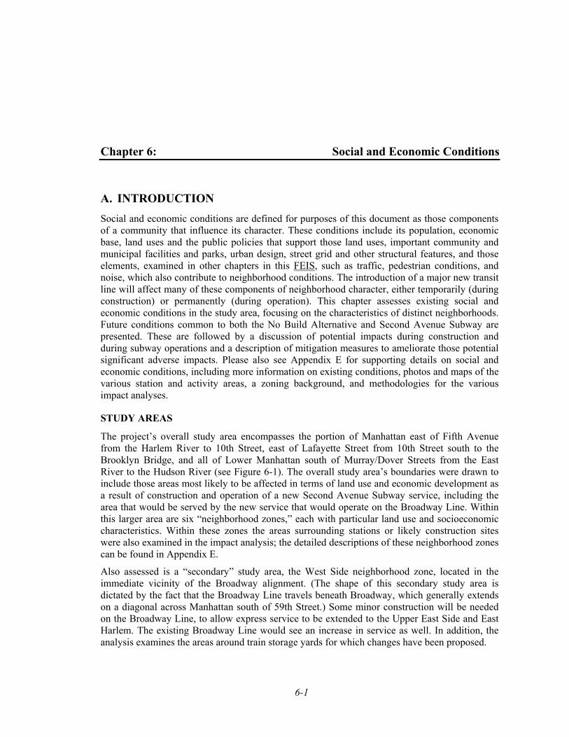
Table 6-1Population and Income Characteristics
in the Corridor Study Area1
Population Income Profile Race and Ethnicity (Percent)
Study Area Total
Non-Hispanic
and Hispanic White2
Non-Hispanic
and Hispanic Black2
Non-Hispanic
and HispanicAsian2
Non-Hispanic
and Hispanic Other2,3 Hispanic4
Total Minority5
Number of House-
holds
Median House-
hold Income ($1999)6
House-holds Below
Poverty (Percent)7
East Harlem 116,357 25.3 40.9 2.8 31.0 52.4 92.8 43,525 $22,391 35.5 Upper East
Side 207,543 94.5 2.3 6.1 3.2 5.6 15.6 121,276 $81,445 6.3
East Midtown 66,062 83.7 2.0 11.1 3.2 5.1 20.2 42,896 $78,264 6.1 Gramercy
Park/Union Square
118,826 75.3 6.3 10.8 7.6 11.1 30.2 66,847 $61,590 10.4
East Village/ Chinatown/ Lower East
Side
181,312 41.2 7.8 36.3 14.8 22.9 68.0 76,212 $37,082 23.9
Lower Manhattan 22,732 72.7 4.6 16.8 5.9 6.1 31.0 11,486 $87,975 7.6
Total, Study Area 712,832 62.9 10.7 14.8 11.5 18.5 44.9 362,242 $61,182 14.2
Manhattan 1,537,195 54.4 17.4 9.4 18.9 27.2 54.2 739,167 $47,030 16.6
New York City 8,008,278 44.7 26.6 9.8 18.9 27.0 65.0 3,022,477 $38,293 19.7
Notes: 1 This table has been updated since issuance of the SDEIS to reflect minor adjustments to boundaries and similar
corrections. 2 White, Black, Asian, and Other population may also be Hispanic (see note 3). 3 “Other” includes residents of American Indian, Alaska Native, Native Hawaiian and Other Pacific Islander descent,
as well as those respondents who did not identify with any listed racial groups (white, black, Asian), or who indicated that they are of more than one race than the census defines.
4 The Hispanic category consists of those respondents who classified themselves in one of the several Hispanic Origin categories in the Census questionnaire. People of this ethnic group may be any race.
5 The total minority population includes all those who are not non-Hispanic White. 6 The median income was calculated by taking the weighted average of the median incomes of all the census tracts
in a given study area. 7 Percent of households with incomes below established poverty level. The U.S. Census Bureau using its
established income thresholds for poverty levels defines poverty levels. Source: U.S. Department of Commerce, Bureau of Census, U.S. Census of Population and Housing, 2000.
trade grew with the opening of such stores as Pathmark on 125th Street. Most of the employment (about 70 percent) is located in the southern half of the East Harlem study area in the 10029 zip code, where the hospitals are located.
EAST HARLEM POLICIES AND PLANS
Public policy initiatives from the mid-20th century on have been important in shaping development patterns in East Harlem. Public housing projects were developed on superblocks from the 1940s into the 1960s followed later by urban renewal efforts that cleared large parcels of land for redevelopment, but produced little housing. More recently, the New York City Department of Housing Preservation and Development (NYCHPD), along with other agencies,

Chapter 6: Social and Economic Conditions
: 6-5
such as the U.S. Department of Housing and Urban Development (HUD) and non-profit housing organizations like New York City Partnership, have completed and continue to produce thousands of rehabilitated and new housing units in East Harlem for various low- and moderate-income and special needs populations. In particular, residential development in East Harlem has expanded under such NYCHPD programs as New Homes, Neighborhood Entrepreneurs Program, and Cornerstones.
Recent public initiatives are also focused on increasing the commercial uses in the area, since East Harlem currently has a far less visible retail and commercial presence here than in the rest of Manhattan’s East Side. The most ambitious of these efforts was the creation in 1996 of the Upper Manhattan Empowerment Zone (UMEZ), a federal economic development initiative which uses public funds and tax incentives to encourage private investment in a neighborhood and offers new and expanding financial and technical assistance through the Business Resource and Investment Service Center. One of UMEZ’s major development initiatives is Harlem USA, a large retail and entertainment complex located on West 125th Street, outside of the East Harlem study area. Within the East Harlem study area, UMEZ works with the East Harlem Chamber of Commerce, Union Settlement Association (one of the largest and oldest settlement houses in New York City), East Harlem Council for Community Improvement/El Faro JHS 45, East Harlem Neighborhood Based Alliance Corporation, Baked in the ‘Hood, Local Development Corporation Del Barrio, Julia de Burgos Latino Cultural Center, and the Harbor Conservatory for the Performing Arts. 1
The New York City Economic Development Corporation (NYCEDC) is also active in expanding commercial development, as is the 125th Street Business Improvement District (BID). As described later in the chapter, plans are underway for both a shopping mall and auto center in this area. Additionally, the state and city are also facilitating the development of approximately 475,000 gross square feet of retail space at East River Plaza on the Franklin D. Roosevelt Drive between 116th and 119th Streets. Finally, NYCEDC has development plans for commercial uses with a regional market at four parcels between 128th and 125th Streets between Second and Third Avenues.
In June 2003, a rezoning of 57 blocks between 122nd and 99th Streets east of Lexington Avenue, instituted by the City Planning Commission, was approved by the New York City Council. The rezoning is intended to balance growth and preservation in East Harlem, and to expand the number of small businesses in East Harlem by providing greater flexibility for ground-floor retail use along avenues and major crosstown streets. Other goals of this zoning change are to promote residential development by changing some manufacturing districts to residential districts, and to use “contextual” zoning districts to ensure that future development is consistent with neighborhood character and to preserve the scale of midblocks.
The local community has also sought to achieve a greater mix of uses in East Harlem, as demonstrated by Manhattan Community Board 11’s 1996 local “197-a” Plan to guide future growth and development. While not yet adopted by the City, the plan aims to increase housing opportunities for all income groups; strengthen existing retail and business corridors; rehabilitate all vacant residential buildings by 2004; bolster educational and employment opportunities; upgrade cultural resources and recreational space; and improve the quality of life in the area. In 2000, Community Board 11, with CIVITAS, a non-profit organization, developed a plan for the
1 www.umez.org, April 5, 2002.
Second Avenue Subway FEIS
6-6
area between 125th and 127th Streets, from Second Avenue to the Harlem River. This plan aims to enhance the visual character of the 125th Street corridor east of Second Avenue, provide easy and direct access to the waterfront, and improve pedestrian conditions along 125th Street. The East Harlem waterfront is also subject to the 197-a plan produced by the Manhattan Borough President and adopted by the City that aims to enhance public access to Manhattan’s 32-mile shoreline by creating a continuous esplanade, and redeveloping the waterfront for water-related commercial, educational, and transportation uses.
UPPER EAST SIDE
UPPER EAST SIDE NEIGHBORHOOD CHARACTERISTICS
The Upper East Side is a very densely developed area, including many high-rise apartment buildings, commercial retail establishments, and concentrations of large museums and medical institutions (see Figure 6-4). The area contains approximately 6.7 million square feet of commercial office and retail space. 1 The neighborhood character is predominately residential with an active retail presence along its avenues. High-rise (generally 20- to 35-story) apartment buildings line most of the north-south avenues and the major crosstown streets where the subway stations would be located, while most side streets include brownstone and other smaller buildings of up to six stories. Much of the high-density development occurred after demolition of the Third Avenue el in 1955 and the Second Avenue el in 1942. Some older, low-rise buildings are interspersed among the larger, more recently built avenue apartments. North of 72nd Street, most of the shops are neighborhood-oriented. South of 72nd Street along Madison Avenue is a world-famous high-end shopping corridor. Lexington and Third Avenues offer regional shopping in the areas near Bloomingdale’s department store.
The neighborhood is laid out in a regular grid, with most buildings maintaining the streetwall, and broad avenues running north-south and narrow streets running east-west. Though there is overall very little green space in the interior of the neighborhood, a number of newer buildings provide landscaped public plazas or flowerbeds that offer visual relief from the surrounding density. The large parks are located on the edges of the area: Central Park to the west, and Carl Schurz Park and John Jay Park along the East River. Many historic resources are found on the Upper East Side and are discussed in Chapter 9.
As in East Harlem, the majority of vehicular traffic is located on the avenues and on major crosstown streets that provide access to the FDR Drive or the Queensboro Bridge. Pedestrian activity within the area is typically quite busy because of both the high-residential density and the active retail presence along the major thoroughfares. Because of the heavy traffic volumes, noise levels in the project area are generally relatively high and reflect the high traffic volumes along the avenues.
The Upper East Side is home to many of New York City’s most famous cultural and medical institutions, with museums concentrated along Fifth and Madison Avenues (Solomon R. Guggenheim Museum, Metropolitan Museum, Whitney Museum), and major health institutions farther east (Lenox Hill Hospital, New York Hospital Cornell Medical Center, Memorial Sloan-Kettering Cancer Center, Hospital for Special Surgery, Beth Israel, and Rockefeller University).
1 New York City Department of Finance, Real Property Assessment Data (RPAD), 2000.
Chapter 6: Social and Economic Conditions
: 6-7
Hunter College, which is part of the City University of New York system, is also located on the Upper East Side, as are many prestigious private schools (see Figure 6-5).
UPPER EAST SIDE POPULATION AND EMPLOYMENT
The Upper East Side neighborhood zone contains an estimated 207,500 people. The neighborhood is known as an affluent area, with an estimated 1999 median household income substantially higher than in Manhattan or the city as a whole, and only 6 percent of the area’s households living in poverty in 1999 (see Table 6-1, above). Approximately 84 percent of the residents are non-minority.
In the year 2000, there were approximately 118,000 private sector jobs in the Upper East Side. The service sector employs the greatest number of people in this study area; this sector includes major services such as health, education, and engineering and management. Real estate accounts for most of the FIRE sector’s employment. Between 1990 and 2000, total private sector employment rose substantially by 26,943 jobs, or about 30 percent. During this period, the distribution of employment generally remained the same.
Most of the employment (about 74 percent) is concentrated in the southern portion of the Upper East Side study area, between 80th and 61st Streets—where the hospitals are—and gradually declines to the north. However, between 1990 and 2000, employment in the northernmost segment of the study area (zip code 10128) more than doubled.
UPPER EAST SIDE POLICIES AND PLANS
For decades, the Upper East Side has been one of the most densely developed residential areas in New York City. The city’s highest-density residential zoning districts are mapped here, particularly along the avenues and major crosstown streets, including those where new stations would be located. In 1985, faced with strong development and zoning districts that permitted midblock tower development, the City Planning Commission instituted contextual zoning to preserve the prevailing row-house character of the midblock areas of the Upper East Side. The City also created contextual districts on the major side streets, 96th, 86th, 79th, and 72nd Streets, and on East End Avenue to maintain the context of the existing building form on these major streets.
Within the Upper East Side study area, the Madison Avenue BID promotes the local economy of Madison Avenue, from 60th Street to 86th Street. In addition to providing traditional BID services, such as sanitation and security, the BID hosts charity events and implements some capital improvements on local streets, including installing lighting, and tree wells. 1
EAST MIDTOWN
EAST MIDTOWN CHARACTERISTICS
The East Midtown neighborhood zone (area east of Fifth Avenue from 60th Street to 21st Street) comprises sections of several distinct neighborhoods, including a portion of the larger Midtown
1 Telephone interview with Matthew Bauer, Director of the Madison Avenue Business Improvement
District, April 10, 2002.
Second Avenue Subway FEIS
6-8
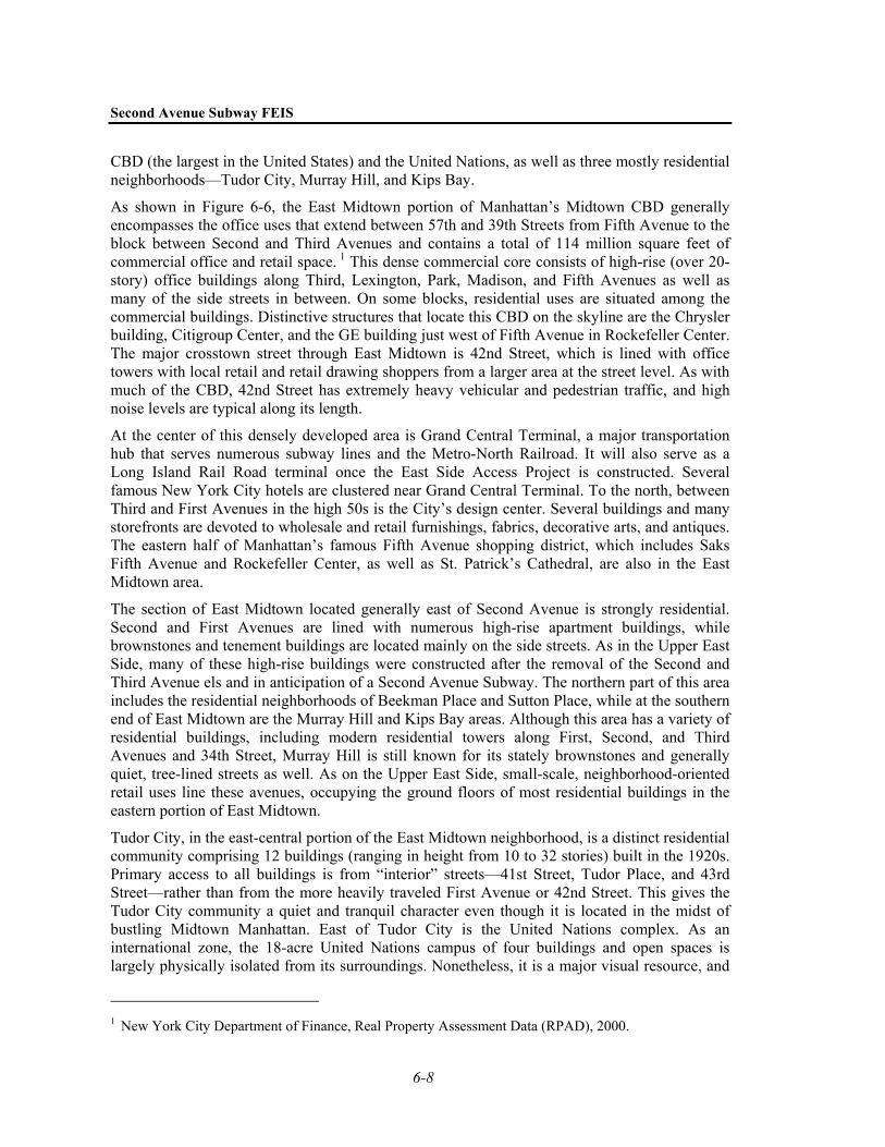
CBD (the largest in the United States) and the United Nations, as well as three mostly residential neighborhoods—Tudor City, Murray Hill, and Kips Bay.
As shown in Figure 6-6, the East Midtown portion of Manhattan’s Midtown CBD generally encompasses the office uses that extend between 57th and 39th Streets from Fifth Avenue to the block between Second and Third Avenues and contains a total of 114 million square feet of commercial office and retail space. 1 This dense commercial core consists of high-rise (over 20-story) office buildings along Third, Lexington, Park, Madison, and Fifth Avenues as well as many of the side streets in between. On some blocks, residential uses are situated among the commercial buildings. Distinctive structures that locate this CBD on the skyline are the Chrysler building, Citigroup Center, and the GE building just west of Fifth Avenue in Rockefeller Center. The major crosstown street through East Midtown is 42nd Street, which is lined with office towers with local retail and retail drawing shoppers from a larger area at the street level. As with much of the CBD, 42nd Street has extremely heavy vehicular and pedestrian traffic, and high noise levels are typical along its length.
At the center of this densely developed area is Grand Central Terminal, a major transportation hub that serves numerous subway lines and the Metro-North Railroad. It will also serve as a Long Island Rail Road terminal once the East Side Access Project is constructed. Several famous New York City hotels are clustered near Grand Central Terminal. To the north, between Third and First Avenues in the high 50s is the City’s design center. Several buildings and many storefronts are devoted to wholesale and retail furnishings, fabrics, decorative arts, and antiques. The eastern half of Manhattan’s famous Fifth Avenue shopping district, which includes Saks Fifth Avenue and Rockefeller Center, as well as St. Patrick’s Cathedral, are also in the East Midtown area.
The section of East Midtown located generally east of Second Avenue is strongly residential. Second and First Avenues are lined with numerous high-rise apartment buildings, while brownstones and tenement buildings are located mainly on the side streets. As in the Upper East Side, many of these high-rise buildings were constructed after the removal of the Second and Third Avenue els and in anticipation of a Second Avenue Subway. The northern part of this area includes the residential neighborhoods of Beekman Place and Sutton Place, while at the southern end of East Midtown are the Murray Hill and Kips Bay areas. Although this area has a variety of residential buildings, including modern residential towers along First, Second, and Third Avenues and 34th Street, Murray Hill is still known for its stately brownstones and generally quiet, tree-lined streets as well. As on the Upper East Side, small-scale, neighborhood-oriented retail uses line these avenues, occupying the ground floors of most residential buildings in the eastern portion of East Midtown.
Tudor City, in the east-central portion of the East Midtown neighborhood, is a distinct residential community comprising 12 buildings (ranging in height from 10 to 32 stories) built in the 1920s. Primary access to all buildings is from “interior” streets—41st Street, Tudor Place, and 43rd Street—rather than from the more heavily traveled First Avenue or 42nd Street. This gives the Tudor City community a quiet and tranquil character even though it is located in the midst of bustling Midtown Manhattan. East of Tudor City is the United Nations complex. As an international zone, the 18-acre United Nations campus of four buildings and open spaces is largely physically isolated from its surroundings. Nonetheless, it is a major visual resource, and
1 New York City Department of Finance, Real Property Assessment Data (RPAD), 2000.
Chapter 6: Social and Economic Conditions
: 6-9
its presence influences surrounding neighborhoods, as many countries have chosen to locate consulates and other diplomatic offices in the mixed office, residential, and institutional neighborhood nearby.
This neighborhood contains the approaches and entrance ramps to two major East River crossings: the Queensboro Bridge at 59th Street and the Queens-Midtown Tunnel at 36th Street. Overall, the neighborhood has moderately heavy to very heavy vehicular traffic. Traffic is particularly heavy at the river crossing entrances and exits. The heavy traffic contributes to high noise levels in the area. Noise levels, primarily from vehicular traffic, tend to be much higher around the Midtown Tunnel than in other sections of the neighborhood.
Given that much of the East Midtown neighborhood zone is largely commercial, there are fewer resident-oriented community facilities here than in mostly residential neighborhoods like East Harlem and the Upper East Side, as shown on Figure 6-7.
EAST MIDTOWN POPULATION AND EMPLOYMENT
Like the Upper East Side, the East Midtown neighborhood’s 66,000 residents are generally affluent (see Table 6-1). A smaller percentage (10 percent) of the households in the East Midtown neighborhood zone were living below the poverty threshold than in the borough or city as a whole. Similarly, the estimated 1999 median household income for this area was much higher than the boroughwide or citywide median household incomes (see Table 6-1). Approximately 80 percent of the population was non-minority.
The East Midtown study area contained almost 500,000 jobs in 2000, an increase of about 35,000 jobs from 1990. These jobs (about 65 percent) are primarily located in the northern part of the study area in zip codes 10017 and 10022, where certain zip codes representing individual buildings are also located. Employment gradually decreases to the south in zip codes 10016 and 10010. The financial, insurance, and real estate (FIRE) and service sectors account for most of the area’s private sector employment. Within the service sector, business, engineering and management, and legal service jobs make up a large portion of the employment. The area’s health care jobs are primarily located in zip code 10016, where there are many hospitals and research facilities. Manufacturing jobs are primarily associated with the printing and publishing industry, which also has an established presence in East Midtown. The United Nations, one of East Midtown’s major employers, is estimated to employ about 4,600 workers, although as international, public-sector jobs, their numbers are not included in the study area total.
EAST MIDTOWN POLICIES AND PLANS
Public land use policy in East Midtown is defined primarily by the area’s underlying zoning, which signals clear distinctions within the framework of dense urban development. In the past 20 years the City has remapped large portions of First and Second Avenues north of 34th Street from medium-density manufacturing and from CBD-type commercial districts to high density residential use with neighborhood retail and high-density (non-CBD) commercial use. North of 39th Street from Third Avenue west, zoning districts support CBD uses, and largely are those of the highest commercial densities. Zoning for the Murray Hill area south of Grand Central reflects City policy to maintain this urban residential district and its low-rise midblocks. South of 34th Street and east of Park Avenue, zoning is for more moderate densities, reflecting a policy to maintain the medium density urban character of the area.
Second Avenue Subway FEIS
6-10
Several special purpose districts also promote area-specific land use policies. The East Midtown zone contains all or part of three special use districts and one distinct subdistrict, mapped by the City to promote specific development and urban design objectives oriented to the character and planning goals of the area: the Special United Nations Development District, the Special Midtown District, and the Special Transit Land Use District. (See Appendix E for details.)
In the East Midtown study area, there are two principal organizations that promote economic activity: the Grand Central BID (Grand Central Partnership) and the East Mid-Manhattan BID. Founded in 1988, the Grand Central BID encompasses 76 million square feet of commercial space in a 68-block area whose borders reach from 54th Street to 35th Street and from Second Avenue to Fifth Avenue. Through the Grand Central Partnership, the Grand Central BID operates a privately managed sanitation, maintenance, and security operation, as well as a social services component providing outreach services, and has designed and installed street furniture, new streetlights and traffic signals, and a variety of other street amenities. The Partnership works directly with district retailers to develop incentive programs to promote local and national neighborhood retailers. The East Mid-Manhattan BID established in 2001 covers the area between 63rd and 49th Streets from Madison to Second Avenues. The district was formed to promote a clean, safe, and attractive commercial environment for 397 property owners and 545 merchants. 1
GRAMERCY PARK/UNION SQUARE
GRAMERCY PARK/UNION SQUARE CHARACTERISTICS
South of East Midtown are the Gramercy Park and Union Square neighborhoods, encompassing the area between 34th and 10th Streets, from Fifth Avenue to the East River. This part of Manhattan is predominantly residential and notable for such large developments as Stuyvesant Town (with 8,755 units) and Peter Cooper Village (see Figure 6-8). The study area’s northeastern portion is within the Kips Bay neighborhood, which comprises a mix of high-density residential development and institutional uses. Many modern high-rise residential towers are here, particularly between Second and Third Avenues. Some of this development disrupts Manhattan’s traditional rectangular street grid pattern, such as Kips Bay Plaza.
From Park Avenue westward for the length of the study area is the Midtown South/Flatiron business district. The buildings here date from the first decades of the 20th century; they are not as tall as the prevailing East Midtown buildings, and since many were built originally for manufacturing use, their form, primarily masonry with larger windows and bays, is different as well. The Flatiron, New York Life, and Metropolitan Life buildings, all facing Madison Square Park, are visual landmarks for the Midtown South/Flatiron district.
In the center of this study area is the Gramercy Park neighborhood, a quiet enclave that surrounds a full-block-square park for the use of its residents. Buildings here are brownstones, several 19th century mansions, and older apartment buildings. Also located in this study area is Union Square, one of Manhattan’s principal shopping districts, housed primarily in 19th and early 20th century buildings surrounding the three-block Union Square Park, with its busy farmers’ market. More recent buildings can be found at the southern end of Union Square, one of
1 www.nyc.gov/html/om/html/2001b/pr281-01.html, April 5, 2002.
Chapter 6: Social and Economic Conditions
: 6-11
which presents a sculptured façade to the park. The distinctive Con Edison tower marks the southerly portion of the neighborhood in the skyline.
Throughout the area there are clusters of medical institutions, including NYU Medical Center/Tisch Hospital, Bellevue Hospital, Veterans Hospital, Cabrini Medical Center, the Hospital for Joint Diseases Orthopedic Institute (Mount Sinai NYU Health), the New York Eye and Ear Infirmary, and Beth Israel Medical Center. The Gramercy Park/Union Square area also includes some of Manhattan’s notable public parks, including Union Square, Stuyvesant Square, and Madison Square Parks (see Figure 6-9).
GRAMERCY PARK/UNION SQUARE POPULATION AND EMPLOYMENT
The Gramercy Park/Union Square neighborhood zone is home to 118,800 residents, based on the 2000 Census. As shown in Table 6-1, the 1999 median household income was higher than the borough’s or city’s, and a smaller proportion of the households in this neighborhood zone were living below the poverty line. Some 71 percent the residents of this area are non-minority.
Approximately 80,000 jobs are located in the Gramercy Park/Union Square/East Village study area. Between 1990 and 2000, private sector employment grew by 161 jobs, or 0.2 percent.
GRAMERCY PARK/UNION SQUARE PUBLIC POLICIES AND PLANS
Rezonings over the past 20 years in the Gramercy Park area indicate that the City intends to maintain the moderate density of the area south of 34th Street. Changes here, with rare exceptions, have not introduced any high-density residential zones. Modifications have primarily consisted of mapping contextual zones of the same or equivalent density as the former non-contextual zones, but have also included reducing the permissible density (“downzoning”) in midblocks to prohibit towers. Other zoning actions have reduced the permissible density of commercial and community facility uses in the Gramercy Park area.
In contrast, zoning changes in the Union Square area have generally permitted more commercial uses and higher-density residential development. The Special Union Square District, enacted in the 1980s to promote a mixed-use area around Union Square, has led to substantial rehabilitation and development. The large mixed-use Zeckendorf Towers, built in 1987, is one example. East of the special district, many developments were publicly subsidized, concentrating on residential development. More recently, the area east of Third Avenue on 14th Street was rezoned with a mix of commercial districts designed to strengthen 14th Street’s retail character and provide new opportunities for residential development.
In 1997, Community Board 6 created a 197-a plan for its waterfront; the City Council subsequently adopted the plan. Stuyvesant Cove Park, a waterfront park between 23rd and 18th Streets, opened in 2002.
In the Union Square portion of the study area, the 14th Street-Union Square BID and Local Development Corporation (LDC) strive to improve economic conditions in the Union Square neighborhood. The BID operates on 14th Street from First Avenue to Sixth Avenue and within the area surrounding Union Square Park. The BID provides supplemental sanitation, graffiti removal, public safety, and promotional services to improve the neighborhood’s quality of life and foster the best possible conditions for local businesses and residents. The BID and LDC also provide assistance for private businesses, property owners, and developers in their interaction with state and local government agencies.
Second Avenue Subway FEIS
6-12
EAST VILLAGE/LOWER EAST SIDE/CHINATOWN
EAST VILLAGE/LOWER EAST SIDE/CHINATOWN CHARACTERISTICS
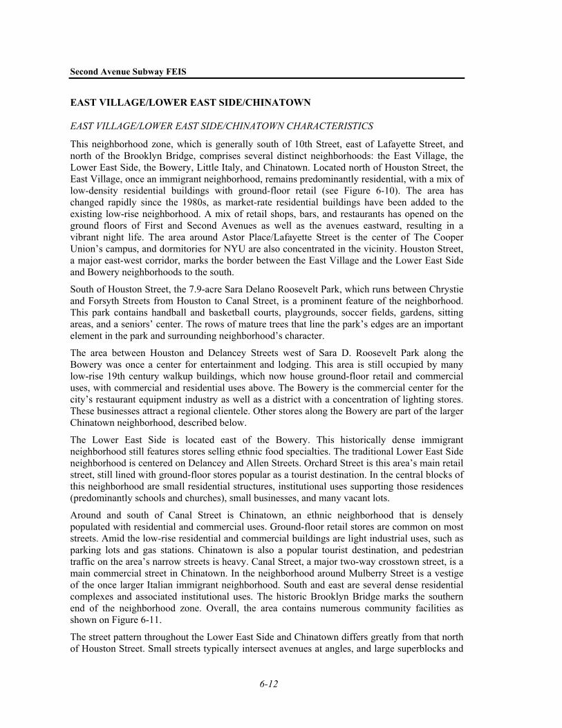
This neighborhood zone, which is generally south of 10th Street, east of Lafayette Street, and north of the Brooklyn Bridge, comprises several distinct neighborhoods: the East Village, the Lower East Side, the Bowery, Little Italy, and Chinatown. Located north of Houston Street, the East Village, once an immigrant neighborhood, remains predominantly residential, with a mix of low-density residential buildings with ground-floor retail (see Figure 6-10). The area has changed rapidly since the 1980s, as market-rate residential buildings have been added to the existing low-rise neighborhood. A mix of retail shops, bars, and restaurants has opened on the ground floors of First and Second Avenues as well as the avenues eastward, resulting in a vibrant night life. The area around Astor Place/Lafayette Street is the center of The Cooper Union’s campus, and dormitories for NYU are also concentrated in the vicinity. Houston Street, a major east-west corridor, marks the border between the East Village and the Lower East Side and Bowery neighborhoods to the south.
South of Houston Street, the 7.9-acre Sara Delano Roosevelt Park, which runs between Chrystie and Forsyth Streets from Houston to Canal Street, is a prominent feature of the neighborhood. This park contains handball and basketball courts, playgrounds, soccer fields, gardens, sitting areas, and a seniors’ center. The rows of mature trees that line the park’s edges are an important element in the park and surrounding neighborhood’s character.
The area between Houston and Delancey Streets west of Sara D. Roosevelt Park along the Bowery was once a center for entertainment and lodging. This area is still occupied by many low-rise 19th century walkup buildings, which now house ground-floor retail and commercial uses, with commercial and residential uses above. The Bowery is the commercial center for the city’s restaurant equipment industry as well as a district with a concentration of lighting stores. These businesses attract a regional clientele. Other stores along the Bowery are part of the larger Chinatown neighborhood, described below.
The Lower East Side is located east of the Bowery. This historically dense immigrant neighborhood still features stores selling ethnic food specialties. The traditional Lower East Side neighborhood is centered on Delancey and Allen Streets. Orchard Street is this area’s main retail street, still lined with ground-floor stores popular as a tourist destination. In the central blocks of this neighborhood are small residential structures, institutional uses supporting those residences (predominantly schools and churches), small businesses, and many vacant lots.
Around and south of Canal Street is Chinatown, an ethnic neighborhood that is densely populated with residential and commercial uses. Ground-floor retail stores are common on most streets. Amid the low-rise residential and commercial buildings are light industrial uses, such as parking lots and gas stations. Chinatown is also a popular tourist destination, and pedestrian traffic on the area’s narrow streets is heavy. Canal Street, a major two-way crosstown street, is a main commercial street in Chinatown. In the neighborhood around Mulberry Street is a vestige of the once larger Italian immigrant neighborhood. South and east are several dense residential complexes and associated institutional uses. The historic Brooklyn Bridge marks the southern end of the neighborhood zone. Overall, the area contains numerous community facilities as shown on Figure 6-11.
The street pattern throughout the Lower East Side and Chinatown differs greatly from that north of Houston Street. Small streets typically intersect avenues at angles, and large superblocks and
Chapter 6: Social and Economic Conditions
: 6-13
approaches to the Manhattan and Brooklyn Bridges also disrupt the street grid, which all combine to cause high traffic congestion. The area also has considerable pedestrian traffic.
EAST VILLAGE/LOWER EAST SIDE/CHINATOWN POPULATION AND EMPLOYMENT
The East Village/Lower East Side/Chinatown neighborhood zone contains 181,300 residents, and it can be characterized as both a minority and a low-income community. As shown in Table 6-1, approximately 68 percent of the residents are minority population. A large number of residents in this neighborhood (36 percent) are Asian, and 23 percent are Hispanic. Approximately 24 percent of the households reported in the 2000 Census were living in poverty. The estimated 1999 median household income for this neighborhood was also below the borough’s or city’s (see Table 6-1).
The East Village/Lower East Side/Chinatown study area contained a total of 14,611 private sector jobs in 2000.1 The three dominant sectors are manufacturing, services, and retail trade. Unlike other study areas in the Second Avenue Subway corridor, this study area lost employment during the 1990s. The East Village/Lower East Side/Chinatown study area has been associated with the garment manufacturing industry for 150 years, first with European and then Chinese immigrants providing labor. However, following a more recent citywide trend, garment industry jobs and manufacturing jobs in general are gradually being replaced by service sector jobs. This trend is particularly noticeable in the East Village/Lower East Side/Chinatown study area because manufacturing has traditionally made up a large proportion of the area’s employment base, in contrast to other study areas. Garment industry jobs, like the entire manufacturing sector, have also been relocated overseas in recent years.
The local economy of the East Village/Lower East Side/Chinatown study area is also known for its wholesale trade businesses, which accounted for approximately 1,100 jobs in 2000. The Bowery, in particular, contains a cluster of wholesale businesses that sell restaurant equipment and lighting fixtures. Stores selling imported Chinese furniture, gifts, and specialty foods are also common in the study area.
EAST VILLAGE/LOWER EAST SIDE/CHINATOWN PUBLIC POLICIES AND PLANS
Public policy has supported the expansion of residential uses in all three neighborhoods. In 1970, the Cooper Square Urban Renewal Area (URA) was created to facilitate development of new and rehabilitated housing. The URA includes some land between 5th and Stanton Streets and Second Avenue/Chrystie Street and the Bowery. Several vacant sites in this area have recently been awarded to developers for a combination of market-rate and low-income housing, as well as commercial and community facility space (this is discussed in more detail below under “Future Conditions Common to All Alternatives”). In June 2000, the Cooper Square Community Development Committee drafted a 197-a plan with the goal of providing affordable housing and
1 Since the employment data prepared by the New York State Department of Labor (NYSDOL)
summarized in this chapter do not include jobs associated with the public and non-profit sectors, small businesses (with four employees or fewer), home employment, part-time and seasonal employment, or employment that is “off the books” (i.e., jobs that are not reported to the state), in the East Village/Lower East Side/Chinatown study area, actual employment is likely much higher than the roughly 15,000 jobs reported by NYSDOL. However, the actual number could not be identified given available data.

Second Avenue Subway FEIS
6-14
recreational and community facilities in new developments while maintaining the neighborhood’s distinct characteristics.
New housing is also a prominent trend on the Lower East Side, with a strong public component. NYCHPD is active in operating housing programs that emphasize owner occupancy and infill policies. Another URA project at the Seward Park Extension includes five parcels of land south of Delancey Street near the Williamsburg Bridge that are currently being offered by the City for residential, retail, and entertainment development. A Request for Proposals was issued in 2000 for development of those parcels. Most zoning policies and programs support the expansion of housing.
Economic initiatives in the area come from two BIDs: the Village Alliance and the Lower East Side BID. The Village Alliance operates within a 12-block area along the 8th Street corridor, from St. Marks Place and Second Avenue on the east to Sixth Avenue on the west, and represents many small, owner-operated shops that outnumber the more regional and national chain-store operations and offers services similar to other BIDs. The Lower East Side BID is dedicated to revitalizing the Orchard Street Shopping District while preserving its unique and diverse character. The BID offers walking tours, shopping directories, dining discounts, and free parking. One of the BID’s highlights is a pedestrian mall on Orchard Street.
LOWER MANHATTAN
LOWER MANHATTAN CHARACTERISTICS
The Lower Manhattan neighborhood zone, which is the area south of Murray Street and the Brooklyn Bridge, encompasses the southern edge of Chinatown and the Lower East Side, as well as a large portion of the Financial District (see Figure 6-12). The Financial District, like Midtown, is one of the nation’s principal CBDs. Together, Lower Manhattan and Midtown make New York City a business and financial capital. In 2000, “greater” Lower Manhattan (south of Canal and Catherine Streets) contained approximately 118 million square feet of commercial office and retail space. 1
Visually, two distinct areas define the neighborhood zone. One is an uneven terrain with narrow, winding streets that reflect the original colonial street configuration and are typically lined with low-rise, mid- to late-19th century buildings and turn-of-the-century and Art Deco skyscrapers. The other area is composed of primarily tall, bulky, modern, brick and metal-and-glass skyscrapers.
In addition to the office towers for which Lower Manhattan is known, the area is also home to a growing number of residential buildings, including those in converted former office buildings and those at the 92-acre Battery Park City, on the west side of Lower Manhattan. Battery Park City includes a large office component as well as apartment buildings, a high school, a marina, and a waterfront park. New York City’s Civic Center, a hub of governmental offices and state and federal courthouses centered on City Hall Park, is located at the base of the Brooklyn Bridge. The area also contains several parks and plazas, including the Chase Manhattan Plaza, Vietnam Veterans Plaza, Bowling Green, Peter Minuit Plaza, and the 23-acre Battery Park.
1 New York City Department of Finance, Real Property Assessment Data (RPAD), 2000. The total area of
office space has been reduced to approximately 98 million square feet, primarily as a result of the destruction of the World Trade Center on September 11, 2001.
Chapter 6: Social and Economic Conditions
: 6-15
Among the prominent institutional uses in the area are the National Museum of the American Indian, Federal Hall, Trinity Church, and St. Paul’s Chapel (see Figure 6-13).
The South Street Seaport is a historic market area that includes a retail enclave centered on Fulton and South Streets. The retail area has many shops and restaurants; the South Street Seaport Museum also occupies several buildings in this area. A cobblestone street leads to the shopping thoroughfare and river piers and is accessible only by foot.
Traffic conditions are often congested due to the narrow streets and irregular street layout. Several streets are closed to vehicular traffic, allowing only pedestrians. Generally, pedestrian volumes are extremely heavy on weekdays because of the area’s worker population, and lighter on weekends. The high traffic volumes create relatively high noise levels in the study area.
LOWER MANHATTAN POPULATION AND EMPLOYMENT
Lower Manhattan’s small but growing residential population1 (which increased 64 percent between 1990 and 2000) is not a minority or low-income population and its income characteristics are higher than the borough’s or city’s. As shown in Table 6-1, approximately 31 percent of the 22,700 residents in this neighborhood are minority population. In 1999, the estimated median household income for the Lower Manhattan neighborhood zone was higher than the borough’s or city’s.
The Lower Manhattan study area contained approximately 322,000 jobs in 2000; of this amount, approximately 263,600 were employed in the private sector2. New York City’s civic center—located in Lower Manhattan—employs much of the balance. While overall employment remained relatively stable during the 1990s, the distribution of employment changed significantly during this period. The FIRE sector decreased, as part of a decentralization trend in the financial services industry, while service employment grew by an equivalent amount, led by strong growth in the business services employment (e.g., sales, advertising, news media, photocopying, pest control, equipment rental, computer programming, and private security). Due to the events of September 11, 2001, many offices were destroyed or displaced; as a result, many jobs were lost and surviving businesses relocated elsewhere in Manhattan or out-of-state, such as in northern New Jersey. As the rebuilding effort has begun, many businesses, such as the tenants in the World Financial Center, have moved back into Lower Manhattan.
The Lower Manhattan study area contains a relatively large number of transportation and utilities jobs, particularly in the communications sub-sector. Unlike other study areas in the Second Avenue Subway corridor, manufacturing employment actually grew between 1990 and 2000, as a result of growth in the printing and publishing industry. Employment growth in Lower Manhattan has also been fueled by increases in construction and wholesale trade (durable goods) jobs. Lastly, unlike the other study areas described above, the Lower Manhattan study area experienced a decline in retail trade employment between 1990 and 2000.
1 The events of September 11, 2001, did not result in the destruction of a substantial amount of residential
property and government policies continue to support increased residential development in Lower Manhattan.
2 Employment data for 2000 were not available for two of the 17 zip codes in the Lower Manhattan study area. As a result of the destruction of the World Trade Center on September 11, 2001, the total amount of employment in Lower Manhattan has since declined but state and city policies support rebuilding 10 million square feet of office space in this area.

Second Avenue Subway FEIS
6-16
LOWER MANHATTAN PUBLIC POLICIES AND PLANS
Like East Midtown, much of Lower Manhattan is an extremely dense area that includes Manhattan’s original CBD. In the last decade, new construction in Lower Manhattan has focused almost entirely on the West Side, in the Battery Park City neighborhood and the areas south of Canal Street known as Tribeca (for “Triangle Below Canal”). On the East Side, there has been relatively little new construction, but substantial conversions of commercial office buildings to residential use beginning in the 1990s—thousands of units have already been converted.
In the 1960s and 1970s, development in Lower Manhattan was planned in accordance with the “Plan for Lower Manhattan,” issued by the New York City Department of City Planning (NYCDCP) in 1966. A principal element of the plan was to create high-density development along the waterfront; these projects were to include a series of mandatory amenities, such as elevated retail and pedestrian corridors and visual and physical links between the waterfront development and upland areas. An “offshore landfill development,” known as Manhattan Landing, was also proposed for the East River waterfront. Though the plan was adopted as part of the City’s Zoning Resolution in 1973, most development pursuant to the Manhattan Landing District plan never took place, and the waterfront policies of the Lower Manhattan Plan and the Manhattan Landing Special District are no longer City policy.
Recent public policy initiatives have aimed to convert the traditionally office-oriented CBD in Lower Manhattan into a 24-hour mixed-use neighborhood, including residential uses and their associated services. One such initiative was the creation of the Special Lower Manhattan District in 1998. The entire study area falls within that special zoning district, the purpose of which is to simplify and consolidate the overlapping complex regulations previously governing Lower Manhattan, foster the reuse of existing underused commercial buildings, allow the area to grow while reinforcing its historic character, promote the orderly growth of the waterfront area, and facilitate the change to a mixed-use community. The Lower Manhattan District also established a historic and commercial core area coterminous with the area’s historic street grid (which is a designated New York City Landmark District). Within this core area, special height and setback controls were created to control development. The Lower Manhattan District incorporates several subdistricts, aimed to reflect local conditions. These include the South Street Seaport Subdistrict, which was originally created in 1972 as the South Street Seaport District, with the intent of ensuring that the Seaport area remains a neighborhood of small historic buildings. While not yet enacted, Community Board 1 has also developed a 197-a plan to establish contextual zoning for the Seaport District to maintain the character of the district.
Most of the Lower Manhattan area is zoned for high-density commercial uses, but a less dense commercial zone is mapped along the waterfront at the South Street Seaport. In April 2003, the City Council approved a zoning change for the South Street Seaport historic district that will limit the size of future development through the institution of a 120-foot height limit. Lower Manhattan’s western edge is Battery Park City, which is zoned for high-density commercial, residential, and institutional uses. This area also includes a portion of Tribeca, which is mapped with medium-density commercial and manufacturing districts. Although no Special Transit Land Use District exists in Lower Manhattan, two easements were acquired under the former Manhattan Landing District in anticipation of the Second Avenue Subway and are described above.
Another plan that guides development in Lower Manhattan is the Comprehensive Manhattan Waterfront Plan of 1997, which has an overall aim of increasing access to the waterfront. To
Chapter 6: Social and Economic Conditions
: 6-17
serve its growing residential population, Community Board 1’s 197-a plan endorses the creation of more indoor and outdoor recreational facilities.
The public sector has also created economic incentive programs to promote economic redevelopment in Lower Manhattan. In 1995, the City of New York initiated the Lower Manhattan Economic Revitalization Plan, which includes real estate tax abatements and energy cost incentives as a means of attracting commercial and residential investment. Eligible commercial tenants are those who are relocating, expanding, or renewing leases in Lower Manhattan. The federal government’s Liberty Zone Tax Package provides incentives to the area on or south of Canal Street. The package of incentives includes tax-exempt bonds for private development, accelerated depreciation for leasehold, 30 percent bonus depreciation for office equipment used in the zone, and a $2,400 per employee work opportunity tax credit. The incentive package also includes deferring taxes on insurance proceeds for property destroyed on September 11, 2001, in Lower Manhattan, and advanced refunding for certain municipal bonds for facilities located in New York City.
More recently, due to the events of September 11, 2001, the Action Plan for New York Business Recovery and Economic Revitalization was initiated by the New York State Empire State Development Corporation and the NYCEDC. The project’s goals are to help affected businesses survive the physical damage and economic dislocation, ensure that New York City does not lose substantial employment as a result of corporate relocations, and rebuild the area of Manhattan that was destroyed or damaged in September 2001. The plan outlines how federal funding will be used to assist businesses affected by the terrorist events and to revitalize the area as a whole. Grant programs are directed toward business recovery, business attraction and retention, technical assistance, and marketing. Energy incentives and loans are also available. In November 2001, the City and State established the Lower Manhattan Development Corporation to assist the Port Authority of New York and New Jersey (Port Authority) in revitalizing and rebuilding the World Trade Center site, as well as the Lower Manhattan area south of Houston Street. 1
Promoting the economy of Lower Manhattan, the Downtown Alliance (the Downtown-Lower Manhattan BID) provides numerous services to businesses, residents, and visitors in the downtown area from City Hall to the Battery. These include traditional BID services, such as supplemental sanitation and security, economic development assistance, streetscape and transportation improvements, marketing, and enhanced tourist services. The Alliance also sponsors a summer concert series, walking tours, an internship program for high school students, free electric bus service, etc. One of the central goals of the Downtown Alliance is to foster high-technology businesses in the area. To this end, it has developed a Technology/Business Exchange, which offers real estate and business development services to over 400 high-tech companies. The Alliance has also drafted a residential incentive program designed to retain and expand Downtown’s residential population.2
WEST SIDE (BROADWAY LINE) NEIGHBORHOOD ZONE
The West Side neighborhood zone runs along the proposed Broadway alignment of the new subway. Because this area would not see new construction as a result of the project, it is analyzed in less detail than other Manhattan neighborhood zones. There is little potential for
1 www.empire.state.ny.us/press/11-29-01lowman2final.htm, April 10, 2002. 2 www.downtownny.com, April 3, 2002.
Second Avenue Subway FEIS
6-18
adverse impacts to land use and neighborhood character in this zone from the additional service on the Broadway Line.
Land uses and neighborhood character at stations along the Broadway Line are as varied as those along the East Side. Before heading into Brooklyn or Lower Manhattan, the Broadway Line traverses portions of such neighborhoods as West Midtown, Times Square, Herald Square, Chelsea, Greenwich Village, SoHo, and Chinatown. Though commercial and residential uses can be found along the entire length of the Broadway Line in Manhattan, as a general rule major shopping and entertainment districts, tourist attractions, and dense residential and commercial buildings are concentrated on the blocks north of 34th Street; light manufacturing and wholesale distribution uses are located in the high 20s and 30s; a mix of high- and mid-rise office buildings and substantial retail are in the low 20s; a mix of residential, commercial, and institutional uses in predominantly low- and mid-rise buildings exists south to Houston Street; and a combination of light manufacturing, retail, residential, and commercial loft spaces is found south to Canal Street. From Canal Street, the Broadway Line express tracks turn east to cross the Manhattan Bridge into Brooklyn and the local tracks continue south into Lower Manhattan.
Of particular importance along the Broadway Line is the Times Square Station, a major transportation hub. The subway complex at Times Square extends from 42nd Street to 40th Street along Seventh Avenue and Broadway, and along 41st Street between Broadway and Seventh Avenues. A pedestrian tunnel provides access to the Eighth Avenue Line and to the Port Authority Bus Terminal, on Eighth Avenue between 42nd and 40th Streets; the bus terminal is both a regional and national transportation facility. Within the Times Square Station, underground passageways allow passengers to transfer to several subway lines, as is described in Chapter 2.
Another important transit hub is the 34th Street-Herald Square Station, a major transfer point among several subway lines and the Port Authority Trans-Hudson (PATH) trains, giving access to trains serving Hoboken, Jersey City, and Newark. This transit complex extends from 35th Street to 30th Street, along Sixth Avenue and Broadway. One block west is Pennsylvania Station, another transit hub containing termini for the Long Island Rail Road and New Jersey Transit and an Amtrak station.
Two other stations along the Broadway Line, the 14th Street-Union Square Station and the Canal Street Station, also serve passengers from several subway lines, as described in Chapter 2.
STORAGE YARDS
The Second Avenue Subway is evaluating changes at three existing train storage and maintenance facilities to accommodate increased needs for storage and maintenance of the new line’s subway cars. These yards are located away from the project’s main alignment and are therefore described separately below. The project may also include underground storage tracks beneath Second Avenue north of 125th Street, beneath 125th Street west of the new 125th Street Station, beneath Second Avenue between 21st and 9th Streets, and on tail tracks south of the new Hanover Square Station. The study areas for those storage tracks are the same as those already described for East Harlem, Gramercy Park/Union Square, and Lower Manhattan above.
36TH-38TH STREET YARD
The 36th-38th Street Yard is located in the Sunset Park neighborhood of Brooklyn, running along the south side of 37th Street, across from the historic Greenwood Cemetery. The yard is
Chapter 6: Social and Economic Conditions
: 6-19
long and relatively narrow, extending approximately six blocks to the east and west (from 5th to 10th Avenues) but generally two to three blocks to the north and south. The yard is used predominantly for NYCT work and refuse trains, with some storage for passenger trains. NYCT’s West End Line (currently served by the MW) passes through the yard complex, rising from tunnels to elevated tracks as it heads east and south. The line’s 9th Avenue Station is within the yard boundaries, as is a former historic 9th Avenue lower level station that is no longer in use for passenger service.
The neighborhood that abuts the yard to the west, south, and east has a mix of residential and industrial uses. Immediately west of the yard is a large NYCT bus depot that serves as a barrier between the yard and other uses across 5th Avenue. To the south, in most locations the surrounding properties are elevated above the yard complex. The back facades of numerous residential buildings abut the yard. The area’s residential uses include a mix of low-rise walk-up apartments and one- and two-family dwellings. The yard is zoned for manufacturing use, while the surrounding area is zoned for low- to medium-density residential development.
207TH STREET YARD
The 207th Street Yard is located at the tip of northern Manhattan between 207th and 215th Streets; it is bounded to the east by the Harlem River and to the west by Tenth Avenue. Two- to three-story yard buildings along the western boundary of the site form a barrier between this large yard complex and the surrounding residential neighborhood; other yard buildings and tracks are generally not visible from outside the complex. An elevated rail line carries 19 trains up adjacent Tenth Avenue. Immediately north and south of the site, along the riverfront, are similarly industrial uses, including a large New York City Department of Sanitation facility (with a former incinerator) to the north and a scrap yard to the south. The site is zoned for light industrial use.
CONCOURSE YARD
Concourse Yard is located east of the Jerome Park Reservoir in the Bronx. It extends generally from 198th Street on the south to Mosholu Parkway on the north, between Jerome and Paul Avenues. The yard is approximately 18 feet below the surrounding street level, bounded on all sides by retaining walls. Along the eastern and southern boundaries of the yard, elevated 4 subway service operates on Jerome Avenue. Those subway trains also enter the yard via an elevated ramp from Jerome Avenue at the southern end of the yard. Vehicular access to the yard is via a driveway from Jerome Avenue; pedestrian access can be made at that point and from the 205th Street Bridge.
To the east of Jerome Avenue (on the east and south sides of the yard), the neighborhood consists predominantly of low- and mid-rise residential buildings, including Art Deco-style apartment buildings for which the Grand Concourse is known. A large parking lot and low-rise industrial building face Jerome Avenue near Bedford Park Boulevard. North of 205th Street, the yard, a housing complex and parking area are built on a platform above the yard.
Two bridges carry vehicular traffic across Concourse Yard on Bedford Park Boulevard and 205th Street to Paul Avenue. West of Paul Avenue, a series of institutional uses form a combined campus between Paul Avenue and the Jerome Park Reservoir one block farther west. These include the City University of New York’s Herbert H. Lehman College, the ballfields and courts of Harris Park, Bronx High School of Science, and Dewitt Clinton High School. South of
Second Avenue Subway FEIS
6-20
the 205th Street Bridge, Paul Avenue runs within the Lehman College campus and does not permit through traffic.
The area is zoned for low- to medium-density residential use. The train yard was established prior to the zoning, and thus is a preexisting use.
C. FUTURE CONDITIONS COMMON TO ALL ALTERNATIVES The Second Avenue Subway study area is a dense, dynamic urban center. As described above, waves of economic development have shaped the East Side’s neighborhoods and are expected to continue to do so in the future. According to projections by the New York Metropolitan Transportation Council (NYMTC), between 2000 and 2025, residential and worker populations in Manhattan are expected to increase by about 120,600 and 327,400, respectively.
These changes will support a demand for additional office and retail space, housing, and other land uses throughout the study area, regardless of whether the Second Avenue Subway is constructed. For the Second Avenue Subway project, projections of future conditions for the study area were made using NYMTC’s overall projections for Manhattan.
In developing its Regional Transportation Plan, NYMTC prepared forecasts of the expected population, employment, and labor force growth for each of the 31 counties in the region between 2000 and 2025 (the Regional Transportation Plan is discussed in more detail in Chapter 1, “Project Purpose and Need”). NYMTC’s projections were prepared for the entire borough of Manhattan, but did not specify the particular neighborhoods in Manhattan where the growth might occur. Therefore, for the Second Avenue Subway study, more detailed projections were made for the different study area neighborhoods.
Because changes in population and employment often correspond to changes in land use, the first step in the forecasting effort was to project land use changes expected in the Second Avenue Subway study area by 2025 without the construction of the Second Avenue Subway. This assessment of development and changes in land use was made by reviewing future development cited for other recent environmental studies for projects within the study area, reports prepared by NYCDCP, consultations with NYCHPD, and review of various periodicals. The study assumed that while specific development proposals identified today might not actually be built in the future, they demonstrate the attractiveness of particular neighborhoods for future develop-ments of that type and scale. The developments were described in terms of their size (i.e., dwelling units, floor area for retail, office, institutional and manufacturing uses, etc.) and then converted to population (residential or worker). The resulting inventory of future developments was then used to determine where NYMTC’s projected growth would occur in Manhattan: the total growth projected by NYMTC was allocated proportionally throughout Manhattan following the proportions developed with the project inventory.
The expected future conditions in the study area are described below.
PROJECTED FUTURE CONDITIONS
OVERVIEW
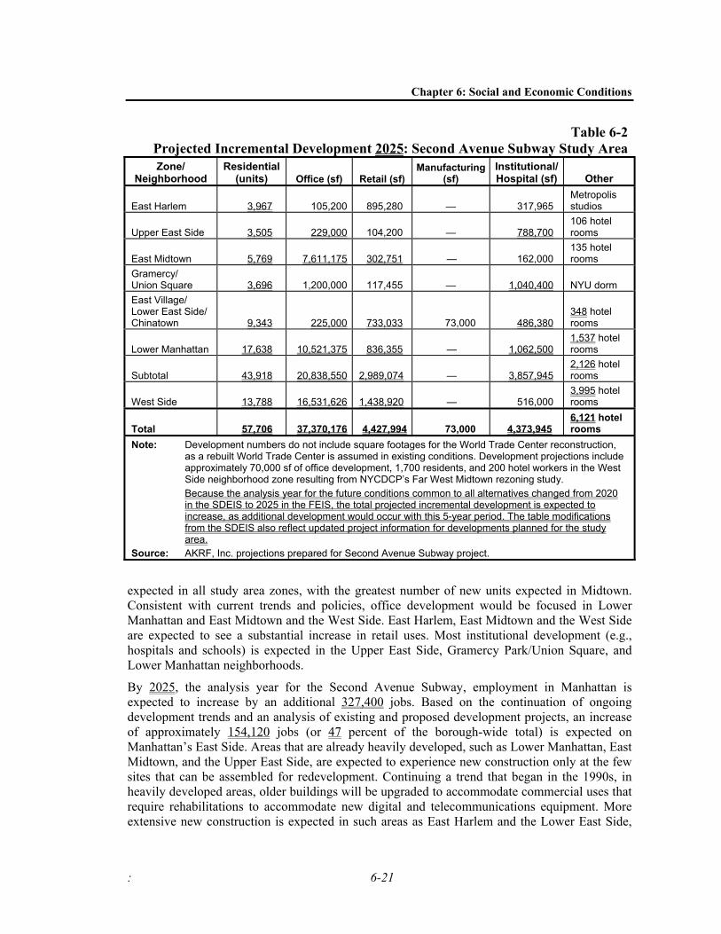
Most of the projected growth in the study area, as shown on Table 6-2, is consistent with existing neighborhood trends and public policies. For example, residential development is
Chapter 6: Social and Economic Conditions
: 6-21
Table 6-2Projected Incremental Development 2025: Second Avenue Subway Study Area Zone/
Neighborhood Residential
(units) Office (sf) Retail (sf) Manufacturing
(sf) Institutional/Hospital (sf) Other
East Harlem 3,967 105,200 895,280 — 317,965 Metropolis studios
Upper East Side 3,505 229,000 104,200 — 788,700 106 hotel rooms
East Midtown 5,769 7,611,175 302,751 — 162,000 135 hotel rooms
Gramercy/ Union Square 3,696 1,200,000 117,455 — 1,040,400 NYU dorm East Village/ Lower East Side/ Chinatown 9,343 225,000 733,033 73,000 486,380
348 hotel rooms
Lower Manhattan 17,638 10,521,375 836,355 — 1,062,500 1,537 hotel rooms
Subtotal 43,918 20,838,550 2,989,074 — 3,857,945 2,126 hotel rooms
West Side 13,788 16,531,626 1,438,920 — 516,000 3,995 hotel rooms
Total 57,706 37,370,176 4,427,994 73,000 4,373,945 6,121 hotel rooms
Note: Development numbers do not include square footages for the World Trade Center reconstruction, as a rebuilt World Trade Center is assumed in existing conditions. Development projections include approximately 70,000 sf of office development, 1,700 residents, and 200 hotel workers in the West Side neighborhood zone resulting from NYCDCP’s Far West Midtown rezoning study.
Because the analysis year for the future conditions common to all alternatives changed from 2020 in the SDEIS to 2025 in the FEIS, the total projected incremental development is expected to increase, as additional development would occur with this 5-year period. The table modifications from the SDEIS also reflect updated project information for developments planned for the study area.
Source: AKRF, Inc. projections prepared for Second Avenue Subway project.
expected in all study area zones, with the greatest number of new units expected in Midtown. Consistent with current trends and policies, office development would be focused in Lower Manhattan and East Midtown and the West Side. East Harlem, East Midtown and the West Side are expected to see a substantial increase in retail uses. Most institutional development (e.g., hospitals and schools) is expected in the Upper East Side, Gramercy Park/Union Square, and Lower Manhattan neighborhoods.
By 2025, the analysis year for the Second Avenue Subway, employment in Manhattan is expected to increase by an additional 327,400 jobs. Based on the continuation of ongoing development trends and an analysis of existing and proposed development projects, an increase of approximately 154,120 jobs (or 47 percent of the borough-wide total) is expected on Manhattan’s East Side. Areas that are already heavily developed, such as Lower Manhattan, East Midtown, and the Upper East Side, are expected to experience new construction only at the few sites that can be assembled for redevelopment. Continuing a trend that began in the 1990s, in heavily developed areas, older buildings will be upgraded to accommodate commercial uses that require rehabilitations to accommodate new digital and telecommunications equipment. More extensive new construction is expected in such areas as East Harlem and the Lower East Side,
Second Avenue Subway FEIS
6-22
which still contain a sizeable number of vacant and/or developable sites. Public policy and zoning will continue to guide the location and density of new or “revised” development.
As described below, some major development projects are proposed for the East Side of Manhattan. Although these projects may not all be built in the form in which they are currently proposed, they provide a good indication of the amount of interest in and attractiveness of the various study areas for future development.
EAST HARLEM FUTURE CONDITIONS
In the coming years, East Harlem will continue to be the focus of residential and commercial development through both private investment and publicly supported projects (see Table 6-2). This area is projected to see a large increase in retail space, including the large commercial development being planned by NYCEDC north of 125th Street between Second and Third Avenues, the East River Plaza shopping center project between 119th and 116th Streets off the FDR Drive, and the large retail project to be located between Second and Third Avenues and East 128th and 127th Streets. The latter project is expected to accommodate four car dealerships in a 70,000-square-foot space. These developments are expected to attract regional users as well as local residents. NYCHPD is also likely to remain active throughout East Harlem in overseeing and funding the construction or rehabilitation of new housing units. Additional private commercial and residential development will also likely result from the recent zoning change described above. For example, the change is expected to generate higher density residential development along portions of First and Third Avenues, neighborhood commercial development along East 116th Street, and conversion of manufacturing to residential uses between 111th and 109th Streets and First and Second Avenues.
Several new institutional uses are planned for the East Harlem area as well. The Church of Scientology is creating a church center on 125th Street between Second and Third Avenues, and the Association to Benefit Children recently opened a new center at 126th Street and Park Avenue. A new waterfront park is planned for the area between 142nd and 125th Streets. The section of Harlem River Drive Park between 139th and 135th Streets was recently completed, and the stretch of park between 142nd and 139th Streets has received construction funding. The portion of the park to the south is expected to be constructed after reconstruction of several New York City Department of Transportation (NYCDOT) bridge projects in the vicinity. The park will eventually connect with the East River Esplanade, which terminates at East 125th Street. In addition, the transportation-oriented uses along the corridor north of 125th Street along Second Avenue will likely remain and could expand, since the sites on the west side of Second Avenue in this area are under consideration by NYCT for new enclosed bus parking.
UPPER EAST SIDE FUTURE CONDITIONS
The Upper East Side will continue to be a strong residential neighborhood. Table 6-2 summarizes the projected development in this area to 2025. Construction of a number of luxury high-rise apartment buildings is projected, with the area near the Queensboro Bridge experiencing some of the growth. High-end retail districts, hospitals, and existing commercial uses are expected to continue to thrive, and Memorial Sloan-Kettering Cancer Center is planning expansions of its East Side campus. This expansion will add additional academic, research, and medical facilities to the area.
Chapter 6: Social and Economic Conditions
: 6-23
EAST MIDTOWN FUTURE CONDITIONS
The demonstrated strength of East Midtown as an office district will likely lead developers to continue to search aggressively for development sites in the future. As noted in the table, a large increase in the amount of office space is projected. This includes development of the former Alexander’s department store site on a full block at Lexington Avenue and 59th Street, with up to 1 million square feet of commercial space. Dense office development in the Grand Central Terminal area will continue to occur, following the recent development of a new headquarters building for Bear Stearns at 383 Madison Avenue (between 46th and 47th Street), which had been fully developed with a mid-rise office building before the new building was constructed. A new building under construction at 300 Madison Avenue, between 41st and 42nd Streets (also a previously developed site), will bring over 1 million square feet of commercial and residential space to the area, and the United Nations has recently proposed a new 800,000-square-foot office building on 42nd Street and First Avenue. In addition to these projects, the MTA LIRR East Side Access Project will introduce new passenger service from Long Island into Grand Central Terminal, further strengthening the commercial office and retail markets in East Midtown.
The residential neighborhoods in East Midtown should also remain vibrant. Murray Hill, in the southern section of East Midtown, will continue as a strong residential neighborhood. One of the more significant land use and neighborhood character changes expected to occur in Manhattan over the next 20 years is the proposed redevelopment of Con Edison’s properties along First Avenue between 35th and 41st Streets with up to 5 million square feet of residential space or a mix of residential and commercial office uses.
GRAMERCY PARK/UNION SQUARE FUTURE CONDITIONS
As shown in Table 6-2, the intensification of residential and retail uses in Gramercy Park and Union Square are projected to continue in the future. A number of sizable apartment buildings are currently under construction between 20th and 39th Streets, as are smaller residential and retail projects in the Union Square area. A large increase in institutional space is also anticipated. NYU Medical Center and the NYU School of Medicine Bellevue Hospital are planning substantial expansions of their campuses, which will increase the presence of these institutional facilities on the East Side and the need for associated supporting uses in the area such as offices, labs, and residences. NYU School of Medicine has been approved to build the East River Science Park, a 1.2 million-square-foot campus with biotechnology space as well as medical office space and hospital housing on the northern portion of the Bellevue Hospital campus. Bellevue Hospital is developing a new ambulatory care facility and DNA lab on its existing campus.
EAST VILLAGE/LOWER EAST SIDE/CHINATOWN FUTURE CONDITIONS
In general, the trends today in the East Village, the Lower East Side, and Chinatown are expected to continue in the future (see Table 6-2). The Cooper Union is planning to redevelop portions of its campus at Astor Place. Residential development will continue, through limited new construction, rehabilitation of existing structures, and conversions of loft spaces. The area should experience an upgrading of its existing housing stock, as the current strong demand for housing in the area will likely continue. Public policy is important here as well, particularly in the Cooper Square and Seward Park Extension Urban Renewal Areas, where additional housing and retail uses can be anticipated. NYCHPD has formulated a plan and designated a developer
Second Avenue Subway FEIS
6-24
for four sites between the Bowery and Second Avenue from 2nd to Stanton Streets. The plan includes up to 713 new housing units and up to 240,000 square feet of retail, commercial, and community facility space. There may also be future expansions of the community facility and retail uses. Development within the Seward Park Expansion URA will likely provide more than 1,400 housing units as well as retail space. Other organizations such New York City Partnership are also active in the area.
LOWER MANHATTAN FUTURE CONDITIONS
In Lower Manhattan, the trend toward a mixed-use, 24-hour community, which is strongly supported by public policy, can be expected to continue. Lower Manhattan is the city’s fastest growing area, with 13,000 units of new residential housing built since 2000 in Community Board 1 alone, and thousands more units pending in such neighborhoods as Battery Park City, the Financial District, and the South Street Seaport. The Bloomberg administration has set a goal of creating at least 10,000 new apartments over the next 10 years in Lower Manhattan. The availability of Liberty Bond financing supports the residential development trend. Several large projects planned for the area include a new 650-unit residential building at 2 Gold Street, a 481,000-square-foot mixed-use building at 250 Water Street between Peck Slip and Beekman Streets, and a 288-unit residential development at 10 Liberty Street.
New office development will also reinforce the area’s existing character as the nation’s third-largest CBD (see Table 6-2). Among the largest projects reflected in Table 6-2 for this area is the proposed construction of a new office/trading facility at 55 Water Street, which will help retain Lower Manhattan’s core financial district to 2025.
Much of the development occurring in Lower Manhattan is being sponsored or supported by the Lower Manhattan Development Corporation (LMDC), which was established in 2001 to coordinate the rebuilding and redevelopment of Lower Manhattan. The LMDC’s major project is planning and administering funding for the World Trade Center Memorial and the Lower Manhattan Redevelopment Plan. The former World Trade Center site and surrounding area are expected to be fully redeveloped before 2025 (those numbers are not included in Table 6-2). The Studio Daniel Libeskind design for the Redevelopment Plan and World Trade Center Memorial, which was selected in February 2003, involves the construction of a World Trade Center Memorial and related improvements, and up to 10 million square feet of commercial office space, up to 1 million square feet of retail space, up to 1 million square feet of conference center and hotel facilities, as well as new open space areas, museum and cultural facilities, and various infrastructure improvements.
Several changes are planned for the South Street Seaport Area. The Fulton Fish Market is expected to be relocated to the Bronx. LMDC is undertaking a Fulton Corridor Retail and Arts/Entertainment District study to explore the possibilities for developing Fulton Street into a premier retail, arts, and entertainment corridor from river to river. In addition, South Street Seaport Museum is renovating the upper floors of historic buildings on Schermerhorn Row between Front and South Streets into a new museum.
Several transportation infrastructure projects to support Lower Manhattan's economic recovery are planned as well as part of an effort to create a Lower Manhattan transit complex, upgrade the transportation network, and connect downtown with the surrounding area.
The new permanent World Trade Center PATH terminal (which will replace the existing temporary facility) will provide pedestrian access to the new World Trade Center development

Chapter 6: Social and Economic Conditions
: 6-25
and connect to the 19ACERW routes. An initial section of the station is scheduled to open by 2006, and the project is expected to be completed in 2009.
The Fulton Street transit center will serve as a central transit hub for Lower Manhattan, and will incorporate six Lower Manhattan subway stations serving 12 subway routes (2345ACE JMRWZ), with connections to the World Trade Center site and the permanent PATH station. This project, which is expected to be completed in 2007, will facilitate the commutes of hundreds of thousands of commuters and residents to Lower Manhattan.
At the South Ferry Station, service on the 19 routes will be rebuilt under Peter Minuit Plaza adjacent to the new Whitehall Ferry Terminal and Battery Park. This project will increase train capacity (the new station will accommodate two 10-car trains), improve service reliability, provide ADA accessibility, and offer customers a free transfer to the NW routes at Whitehall Street. In an effort to transform Lower Manhattan into a 24-hour neighborhood, the city is planning several new open space and community facility projects that would serve a growing residential population. Millennium High School at 75 Broad Street opened in the fall of 2003. The largest of the open space projects planned for downtown is the East River Waterfront development, which will feature approximately 35 acres of open space along the East River waterfront. New open space is also expected to be constructed at West Street (Route 9A). The space will be a tree-lined promenade with various streetscape and pedestrian access improvements. Streetscape improvements, such as tree plantings and sidewalk widening, are also planned for Water Street between Brooklyn Bridge and the Battery. A grant from LMDC will be used to create three permanent park spaces in Lower Manhattan—at Wall Street Triangle, near Wall Street and the South Street viaduct; Coenties Slip; and Canal/Laight Park at Canal, Varick, and Laight Streets. In addition, grant monies will be used to improve several Lower Manhattan parks, such as Old Slip and Bowling Green. There are also plans to create an English-style “British Memorial Garden” within Hanover Square.
WEST SIDE FUTURE CONDITIONS
Substantial growth is predicted in the West Side neighborhood zone by 2025. This includes numerous residential, retail, and office uses expected along Sixth and Seventh Avenues south of 34th Street, and development of substantial office, residential, and theater-related uses near Times Square and along Eighth Avenue north of Times Square. NYCT and NYCDCP are also proposing an extension of the 7 line to spur commercial development in the Hudson Yards area of Far West Midtown.
D. CONSTRUCTION IMPACTS OF THE PROJECT ALTERNATIVES
NO BUILD ALTERNATIVE
Under the No Build Alternative, the Second Avenue Subway would not be built. Thus, there would be no construction and no interim impacts. The economic benefits of the major construction effort to build the subway would not accrue under the No Build Alternative.

Second Avenue Subway FEIS
6-26
SECOND AVENUE SUBWAY
OVERVIEW OF CONSTRUCTION EFFECTS COMMON TO ALL CONSTRUCTION PHASES
As described in greater detail in Chapter 3, “Description of Construction Methods and Activities,” since issuing the SDEIS, NYCT has identified a phasing plan for the project that would allow the new Second Avenue Subway to be built incrementally, in four phases, as follows:
• Phase 1: 105th Street to 62nd Streets, including a tunnel connection to the 63rd Street/Broadway Line;
• Phase 2: 125th Street to 105th Street; • Phase 3: 62nd Street to Houston Street, including the 63rd Street tunnel connection to
Queens for non-passenger service; and • Phase 4: Houston Street to Hanover Square tail tracks.
During the construction period, the only time at which impacts to social conditions would occur is during construction of the phase in which a given property or zone is experiencing construction. For example, the area around the planned 116th Street Station would only experience adverse social conditions impacts during Phase 2’s construction, since Phase 2 extends from 125th Street to 105th Street.
Regardless of the construction phase, three methods are likely to be used, as appropriate, in constructing the Second Avenue Subway: cut-and-cover, deep tunneling with access through shaft sites, or mining with access through shaft sites. All three would require, to a greater or lesser extent, disruption of the streetbed, sidewalks, and some adjacent areas where stations would be constructed or where workers, materials, and excavated rock and soils would enter or exit the tunnels through the shaft sites. These activities have the potential to affect social and economic conditions during each phase’s construction period. (See Chapter 3 for more details on the construction methods and activities discussed in this chapter.)
Construction would also take place beneath the ground, but this activity (vibration from a tunnel boring machine (TBM) moving beneath a block could last up to a week in one location) does not have the potential to materially adversely affect social and economic conditions, and so the effects of below-ground construction are only included in the economic benefits of construction expenditures section in this chapter. (See Chapter 12 for the discussion of noise and vibration effects.) This section first considers the economic benefits of construction. Then the section discusses the likely kinds of activities and associated impacts that could occur in areas where above-ground construction could take place. It then assesses those construction impacts specific to both neighborhood zones and the areas surrounding proposed stations or potential shaft or other construction sites.
ECONOMIC BENEFITS OF SUBWAY CONSTRUCTION FOR ALL CONSTRUCTION PHASES
The public expenditure required to build the full-length Second Avenue Subway would translate directly into jobs for construction labor itself and for the production of necessary services and materials. In addition to these jobs, the project’s construction would also result in indirect or secondary economic activity generated from the direct expenditures throughout the regional economy (often referred to as the “ripple” or “multiplier” effect). With an estimated construction cost of $13.0 billion in 2003 dollars, the Second Avenue Subway would generate significant

Chapter 6: Social and Economic Conditions
: 6-27
economic benefits. As a result of direct expenditures, the direct employment from construction activities would be an estimated 22,500 person-years of employment.1 In addition to employment directly attributable to construction of the proposed project, construction expenditures would generate indirect employment, including jobs in business establishments providing goods and services to the contractors, as well as in businesses that would provide goods and services to construction workers.
IMPACT CHARACTERISTICS COMMON TO ALL ABOVE-GROUND CONSTRUCTION, REGARDLESS OF THE CONSTRUCTION PHASE
Because many of the necessary construction activities would occur in all four phases, the types of impacts that would occur would be similar, regardless of the phase. The section that follows describes the types of impacts that would be common to the entire alignment. The following section, “Impacts Specific to Neighborhood Zones and Smaller Study Areas,” identifies those impacts that would be specific to a particular place.
In all phases, above-ground construction activities would include delivery and storage of materials, hauling away soil and rock from tunneling and other construction activities, construction and maintenance of tunnel access shaft sites, possible limited underpinning or other building reinforcement techniques, ground improvements, and cut-and-cover construction necessary for a portion of the subway tunnel and for all or portions of all stations. Areas on Second Avenue at station sites and TBM launch and spoils removal sites, and some off-street properties, would be used to stage construction activities, as described in Chapter 3 of this FEIS. These activities would require use of land on or near Second Avenue and the streets along the alignment (125th Street, Chrystie Street, the Bowery, St. James Place, and Water Street), and significant temporary adverse impacts would result. Up to half the width of Second Avenue and portions of nearby side streets would have to be reserved for construction operations on segments of Second Avenue during these construction phases. Sidewalk sheds would be required in certain areas, and at a number of locations the construction itself might intrude into the sidewalk area. In addition, construction would occur at each station at off-street properties, where new station entrances and ancillary facilities would be built in new structures or as part of existing ones. Construction areas would typically be separated from the remaining street and sidewalk by temporary, moveable barriers with construction fencing. The Second Avenue Subway would also involve increases in noise, vibration, and dust both at the construction sites and along the truck access routes. At a number of locations, these impacts would occur for several years.
Generally, construction effects on social and economic conditions would stem from disruption of access (closure of some street crossings and sidewalks, lack of convenient loading and pick-up areas, temporary blockage of entrances to stores and other buildings, removal of awnings, termination of subsurface commercial vault space under city sidewalks and streets, relocation of bus stops and areas for taxi pick-up and drop-off) as well as increases in noise, vibration, and dust, and the visual effects of sidewalk sheds and other construction equipment and activities. It is possible that development of new buildings in an area under construction would be stalled until after construction was completed, thus delaying or perhaps altering a development or economic trend.
1 A person-year is the equivalent of one employee working full-time for 1 year.

Second Avenue Subway FEIS
6-28
In some locations, construction activities particularly close to buildings could require access restrictions for several hours or days at a time over a period of several weeks. This could occur if underpinning work is required to support a building’s foundation in advance of construction, for example, or when slurry walls for a station are being constructed in the sidewalk in front of buildings. In very limited locations where structures must be reinforced (such as at the corner of Second Avenue and 125th Street, where the new tunnel would be built in soft soils directly beneath several buildings), the buildings may need to be evacuated for up to a year. In addition, properties would need to be acquired for off-street shaft sites and staging areas. For more information, see Chapter 8, “Displacement and Relocation.”
Where properties would be acquired and businesses or residences displaced, public sector revenues previously generated by those properties (e.g., real estate taxes, water and sewer payments, etc.) would decrease. This would be a temporary fiscal effect, however, because after the subway has been constructed, these properties are likely to be reoccupied by revenue-generating businesses. In fact, the areas are likely to become more desirable locations for business due to the presence of the subway and the resulting improvements in transit service.
In most cases, access to street-level businesses would be maintained during the construction period, regardless of whether the construction activity is associated with a station, tunnel segment, or shaft site and staging area. However, pedestrian and vehicular access would be modified or restricted by the construction of sidewalk sheds, removal of awnings and some signage, and removal of parking and travel lanes. For buildings where access to basements is provided through doors in the sidewalk, such access would also be restricted at times. Despite temporary signage, sidewalk sheds and construction fencing would reduce the overall visibility of businesses. Customers could be discouraged from visiting certain kinds of businesses as a result of the changes in pedestrian and vehicular patterns, reduced store visibility and accessibility, and raised levels of noise, vibrations, and dust. Construction sites can also be perceived as difficult to navigate, further discouraging some customers from walking through the area. Since Manhattan retailers depend heavily on pedestrian traffic, construction-related activities could potentially affect the businesses’ revenue streams. In some cases, mitigation (see Section F below) could potentially minimize such effects. In other cases, businesses might not be affected substantially, as construction workers purchasing goods might compensate for other reductions in some businesses. Overall, street-level businesses that are predominantly retail-oriented are most likely to be affected.
In operating their businesses during construction, owners may have to invest in more promotional activities (e.g., advertisements) to compensate for the reduced visibility and street frontage. Restrictions on parking and loading areas, along with reduced sidewalk access, could raise costs as well, because the delivery and pickup of goods and services may be slowed down considerably. For example, many retailers customarily receive deliveries from the sidewalk area through doors leading to the basement. Trucks typically park in front of the stores, and goods are carried to the doors by hand or delivered through a temporary roller or conveyer-belt system. With removal of parking and loading lanes, and the construction of sidewalk sheds, business owners would have to employ other, less convenient methods, such as deliveries/pickups from the side streets and the use of hand trucks (instead of direct conveyor-belt systems). Similarly, garbage collection and mail delivery could be hampered by the narrower sidewalks. Ultimately, the project’s construction period, though temporary, could have adverse effects on existing businesses’ profit margins and could also make the area a less desirable location for new businesses. In the worst-case scenario, if a substantial number of businesses were to close as a
Chapter 6: Social and Economic Conditions
: 6-29
result of construction in a given area, leaving street-level retail space vacant for a relatively long time, the character of the neighborhood could also be altered.
In general, construction of the Second Avenue Subway would be visually intrusive, as it would introduce incongruous visual elements, which, though temporary, would become part of the streetscape for long periods of time in all the study areas. The visual character of the study areas would therefore be diminished during construction. The intensity of the impacts would be compounded by the length of construction. Aside from the potential yards and maintenance areas, as well as the underground tunnel areas, most of the construction work required for the Second Avenue Subway would occur in areas currently accessible, and visible, to the public. Construction activities would be visible both at street level and from windows facing construction sites. In some cases, once the open excavation areas are covered by decking panels, construction would be less visible at street level. However, there would still be numerous visible construction activities throughout the alignment.
The different types of construction activities would require different kinds of machinery. Many of the types of machinery that would be used are typically found at construction sites throughout New York City; these include cranes, bulldozers, backhoes, construction trailers, etc. However, as described in Chapter 3, certain Second Avenue Subway construction activities would require either more specialized or more intensive construction equipment than that required by routine building or road construction projects. Special machinery would be required at all stations, spoils removal areas, shaft sites, barge sites, and ground improvement areas. Lighting to allow for overnight construction would also be required.
Sidewalk sheds and fences would reduce the visibility of the construction sites from surrounding buildings, particularly at the pedestrian level. Nonetheless, any construction elements or equipment of a height greater than that of the construction fences (i.e. cranes or hydraulic drill rigs) would remain visible from both the street level and from buildings with windows facing these sites. Since the Second Avenue Subway alignment is lined with buildings of five or more stories for most of its length, residents and/or workers in these buildings would have views of the construction areas from above. Trucks entering and leaving the sites would also be visible, not only at the actual construction sites but also on the larger street network. Such effects would be visually intrusive, as would the storage and transportation of construction equipment and spoils. Street trees would need to be removed from sidewalks in some areas, resulting in visual changes to the streetscape.
In addition to the street-level activities, the project’s construction would also involve physical and visual changes to existing buildings along the route. This would include the limited locations where buildings could have to be reinforced or supported during construction. More noticeably, it would include some locations at each of the 16 new subway stations and one modified station (at 63rd Street and Third Avenue) where existing structures would be altered or demolished and replaced by new station entrances and ancillary structures.
As mitigation for construction impacts, NYCT would make every reasonable effort to maintain access to residential and commercial buildings; control noise, vibration, and dust; and keep disruption to the minimum amount of time. In areas where temporary displacement would be required for residents during portions of the construction period, residents would typically be offered nearby hotel accommodations or some equivalent measure of compensation. Work at station locations could take between three and five years. At shaft sites that provide access to tunneling operations below, as well as spoils removal and staging areas, some of these above-ground construction areas could operate for up to 10 years. Mitigation measures would be
Second Avenue Subway FEIS
6-30
employed to minimize noise and other disturbances at such locations as described below in Section F and in other chapters of this FEIS. After construction, the street and sidewalk would be rebuilt and street trees would be replaced.
As described in Chapter 12, barriers would be used to reduce noise from particularly noisy activities where practicable. At three of the parks where construction activities would occupy parkland—Playground 96, St. Vartan Park, and Sara D. Roosevelt Park—walls would be erected around the construction areas to reduce noise in the adjacent park. These walls would be approximately 12 feet tall (rather than 20 to 30 feet tall as described in the SDEIS)1, and constructed of timber, steel, or concrete. While the walls would block noise from and limit views into the construction sites where they are employed, they would themselves be visually intrusive. Barriers located near parks would block views into those parks; any barriers near buildings could limit views from windows on the lower floors. Also, because of their proximity to building facades and windows, enclosures would block some light for those windows. Thus, the use of tall barriers or enclosures in close proximity to windows would result in a significant adverse visual impact. In areas other than the three parks mentioned above, the decision as to whether such walls should be used will eventually be made after considering the advantages and disadvantages of the various types of significant adverse impacts that would occur during construction with and without such barriers.
Construction would not affect overall land use, economic patterns, or underlying zoning in the study area, but its disruption of the functioning of a neighborhood and related visual effects could create adverse impacts on neighborhood character and the local economy. Where the construction period is extended (as at shaft sites), this effect would last for a substantial amount of time. The specific impacts of the subway construction on social and economic conditions in each neighborhood zone and area surrounding a station or shaft site are described below, as are proposed mitigation measures.
In addition, Chapter 19, “Indirect and Cumulative Effects,” discusses the combined potential cumulative impacts to social and economic conditions that could occur if other projects that were constructed at the same time and in the same vicinity as the Second Avenue Subway.
CONSTRUCTION IMPACTS SPECIFIC TO NEIGHBORHOOD ZONES AND SMALLER STUDY AREAS
As described above and throughout this document, the Second Avenue Subway would be constructed in four phases, which are divided into geographic zones:
• Phase 1 includes the southern portion of the East Harlem Neighborhood Zone and all but the southernmost two blocks of the Upper East Side Neighborhood Zone. Work in this area would include construction of the tunnels, tracks, and systems from 105th Street to 62nd
1 As described in Chapter 12, “Noise and Vibration,” further engineering studies completed since the
SDEIS have resulted in a determination that building walls as tall as 30 feet is not practicable, because the construction of such walls would require significant piles, bracing, and foundation systems to support the walls. Further, installing such structures would also create noise. Chapter 12 also describes the decision to eliminate full enclosures around Playground 96 and St. Vartan Park. In addition to the reasons cited above for the 30-foot walls, another reason for their withdrawal from further consideration is that tall construction equipment—most notably, the cranes that would be required at all stations and at other locations—could not operate within the confines of these walls.

Chapter 6: Social and Economic Conditions
: 6-31
Streets, the 63rd Street Subway connection to the Broadway Line, including a new entrance to the Lexington Avenue/63rd Street Station at Third Avenue, and the 96th, 86th, and 72nd Street Stations.
• Phase 2 consists of the remainder of the East Harlem neighborhood. The tunnels, tracks, and systems from 125th Street to 105th Street would be constructed, as would the 125th, 116th and 106th Street Stations. The 125th Street Tails Tracks and potentially, the 129th Street Storage Tracks would be built as part of this phase. Alterations to the 36th-38th Street Yard and to the Concourse Shop would also be made during this phase.
• In Phase 3, construction within the two southernmost blocks of the Upper East Side Neighborhood Zone would occur, along with construction of the entire Gramercy Park/Union Square Neighborhood Zone. In addition, the northern portion of the East Village/Lower East Side/Chinatown Neighborhood Zone would also take place. The tunnels, tracks, and systems between 62nd Street and 4th Street would be constructed in this phase, as would the 55th Street, 42nd Street, 34th Street, 23rd Street, 14th Street, and Houston Street Stations. The underground storage tracks from approximately 21st to 9th Streets and the 63rd Street connection to Queens for non-passenger service would also be built during Phase 3.
• Finally, in Stage 4, construction of the remainder of the East Village/Lower East Side/Chinatown Neighborhood Zone would take place, as would the entire Lower Manhattan Neighborhood Zone. Work in this phase would consist of constructing the tunnels, tracks, and systems from Houston Street to Hanover Square, the Grand Street, Chatham Square, Seaport, and Hanover Square Stations, the barge facility at Pier 6, and potentially, the Hanover Tail Tracks.
This section presents the potential impacts to social and economic conditions that would occur during project construction in each neighborhood zone and around each station site during the relevant construction phase. See Appendix E.1 for details on study area boundaries, including Figures E.1-1 to E.1-16, which also depict uses in each neighborhood zone.
As a result of engineering refinements since the publication of the SDEIS, minor shifts— generally within one block north or south of the station locations identified in the SDEIS— in some station locations have occurred in several instances. In addition, the location of the TBM launch site on the Upper East Side has shifted one block south, from 92nd Street to 91st Street. None of these adjustments would result in new or different significant adverse impacts on social conditions from those described in the SDEIS.
East Harlem Neighborhood Zone. As described above, construction in the East Harlem neighborhood zone would take place during Phases 1 (for the area south of 105th Street) and 2 (the remainder of East Harlem). The new tunnel and stations north of 91st Street to approximately 120th Street would be constructed using cut-and-cover technology, as described in Chapter 3. This is because the rock is quite deep in this area, because shallow tunnel segments built in the 1970s are available for use between 120th and 110th Streets and 105th and 99th Streets, and because construction of the 125th, 116th, 106th, and 96th Street Stations in soil would require cut and cover. Use of a TBM to construct the few blocks between cut-and-cover segments and existing tunnel segments would not be practical in most cases. However, a TBM would be used along 125th Street, excluding the new 125th Street Station (between Third and Park Avenues), where

Second Avenue Subway FEIS
6-32
cut-and-cover construction would be required. The project’s potential construction impacts on overall neighborhood character in East Harlem would depend on the speed at which the subway is to be built. If many areas were under excavation at the same time, the cumulative effect would be for an areawide deterioration of conditions (i.e., access, congestion, truck travel, noise, vibration, and visual effects, as described above) and the potential to adversely affect neighborhood character throughout the eastern portion of the neighborhood zone. With a slower construction period, fewer locations in East Harlem would be affected at any one time, so the land use and neighborhood character impacts would be more geographically limited but the overall duration during which construction was occurring in East Harlem would be longer. As discussed below, the large cut-and-cover operation that would extend from approximately 99th to 91st Streets and described in Chapter 3 would result in significant adverse impacts to the area during Phase 1. Impacts on neighborhood character would occur from the relatively long-term duration of activities (approximately 8 years) over this seven-block stretch; the duration of this impact has been reduced since the SDEIS was issued.
In addition to effects of construction taking place in this neighborhood zone, East Harlem could also experience increased truck traffic from construction activities occurring on the Upper East Side, if trucks head to the Triborough, Willis Avenue, or Third Avenue Bridges. This would most likely occur at a different period than the activities related to construction of subway system elements in East Harlem. (As noted above, Chapter 19 describes the potential for cumulative impacts stemming from simultaneous construction of the Second Avenue Subway with other projects planned nearby.)
As discussed above, East Harlem is a neighborhood currently undergoing an expansion of its commercial uses and upgrading and construction of new housing. To the extent that some developers would be dissuaded from initiating projects in the area, slowing commercial redevelopment, Second Avenue Subway construction would temporarily affect neighborhood character. The construction would be less likely to impinge on NYCHPD housing development, since these developments are not market driven. Construction of the subway in East Harlem may also slow some of the ongoing economic revitalization efforts of organizations such as the 125th Street BID and the UMEZ development corporation. These groups provide important services to existing businesses and actively recruit new commercial development. Although the end product of construction—a full-length Second Avenue Subway—would strengthen the area’s attractiveness for business, some retailers may experience some temporary declines in business activity during the construction period, particularly those that depend heavily on continuous pedestrian and vehicular traffic flows and high visibility. Neighborhood service businesses are less likely to be affected. Although East Harlem would also contain a spoils removal site at 96th Street, this operation would not be in close proximity to most businesses.
At the same time, construction would also produce local economic benefits with the introduction of a large construction worker population into the area, particularly at areas such as shaft sites and staging areas where construction activity would occur for the longest durations. These workers would bring new spending or expenditure potential to the area, which could result in additional sales for local businesses. Businesses most likely to benefit from construction include convenience stores, neighborhood services, and eating and drinking establishments.
125th Street Station Study Area. Cut-and-cover construction in this study area would take place along portions of 125th Street near the 125th Street Station from Park Avenue to Third Avenue for a period of up to five years during Phase 2. A TBM would be used along portions of 125th Street, reducing the cut-and-cover construction area on 125th Street from that described in the

Chapter 6: Social and Economic Conditions
: 6-33
SDEIS, which extended from Fifth to Second Avenues. In this study area, community facilities are of special concern, particularly if FDNY Engine 36 were to reopen again.1 In that case, a traffic maintenance plan would be developed in close coordination with FDNY, detailing mitigation measures and stipulating construction methods and sequencing to maintain access. If FDNY Engine 35 or any other essential municipal service along the alignment has to temporarily relocate during a portion of the construction period—i.e., if the traffic maintenance plan were to show that access could not be maintained on a 24-hour, 7-day-a-week basis—this would be a significant adverse impact. In the event of a station closing, a relocation plan would be devised.
1 FDNY Engine 36, between Park and Lexington Avenues, has recently been closed. Should the station
reopen prior to Second Avenue Subway construction, a similar access and relocation plan as that devised for Engine 35 would be devised.
Access to the nursing home on 125th Street and Park Avenue and the Manhattan Eye, Ear, and Throat Hospital on 125th Street between Park and Madison Avenues would also have to be maintained. NYCT would work with each facility to develop access plans to meet the users’ needs. Access to the Metro-North Railroad Station and to the Lexington Avenue Line (456) would be maintained as well. Vehicular access to retail uses on 125th Street would be limited, and arrangements would have to be made for deliveries from side streets.
Near 125th Street, Triboro Plaza—a public park—could be affected by construction, as a TBM would be used along Second Avenue between 125th Street and 121st Street, and would tunnel beneath this park. The park could settle slightly from tunneling beneath, but since this space does not offer public amenities, and adjacent or below-ground construction would not likely affect the park’s trees, the effect would not be significant for neighborhood character.
Close to Second Avenue on 125th Street, tunneling activities would be below ground, but construction would nevertheless be visible and disruptive because it may be necessary to reinforce several buildings to ensure their stability during construction of the curved portion of the tunnel at the corner of 125th Street and Second Avenue. As described in Chapter 3 and Chapter 8, this could involve demolition of one structure and temporary evacuation of others. In addition, underpinning or other reinforcement measures could also be necessary along other portions of 125th Street because the subway construction would occur in soil near some buildings’ foundations. This could result in some temporary displacement of residents or businesses. (See Chapter 8, “Displacement and Relocation,” for a fuller description of impacts, including mitigation.) This underpinning and other stabilization measures would reduce sidewalk width and, in some cases, access to stores, and would be disruptive to local businesses and residents.
125th Street is a busy crosstown corridor with high pedestrian and vehicular traffic volumes; typically, retail businesses benefit from such high levels of pedestrian activity. Pedestrian activity is particularly high between Lexington Avenue and Park Avenue, between the 125th Street Station at Lexington Avenue serving the 456 lines and the Metro-North Railroad station at Park Avenue. Pathmark, a major shopping destination at Lexington Avenue, also contributes to the pedestrian activity. Some of this activity may be curtailed during the

Second Avenue Subway FEIS
6-34
underpinning, building stabilization, and cut-and-cover processes, which would narrow sidewalks and make access to some street-level businesses along 125th Street more difficult. Generally, pedestrian access to these businesses would be maintained, but these construction activities might limit deliveries to certain times of the day or days of the week. On occasion, access to certain establishments might be restricted for short periods of time (several hours), but NYCT, through its contractors, would provide advance notice of such disruptions to businesses. Although retail sales may be affected as a result of this activity, this effect would be temporary, and businesses would likely remain economically viable.
116th and 106th Street Station Study Areas. Both the 116th and 106th Street Stations would be built during Phase 2, although the tracks from 105th Street to 99th Street would be installed as part of Phase 1. Building the 116th Street Station would require some cut-and-cover construction from 119th to 115th Street on Second Avenue, but the duration of such construction could be relatively short, because much of this area was excavated to build the existing length of tunnel already present below Second Avenue in this area. The largely low-rise residential uses on and near the avenue would experience the temporary land use and neighborhood character impacts described previously as typical for cut-and-cover construction. NYCT, through its contractors, would develop access plans to allow people to enter and exit their homes and commercial and ground-floor retail uses during construction. Consideration would also have to be provided to maintain access to 116th Street, a major transportation corridor.
Temporary land use and neighborhood character impacts would also result from the cut-and-cover construction between approximately 110th and 105th Streets. That area contains a mix of low-rise and superblock residential projects. The low-rise buildings would be more directly affected because they would be closer to the construction activities (since they are not set back in large plazas, as are the taller buildings in this area). As at 116th Street, access plans to permit residents to enter and exit their homes and businesses during construction would be needed. Consideration would also have to be provided to maintain access to 106th Street, a major transportation corridor.
In addition, some construction will also be required to install the tracks from 105th Street to 99th Street during Phase 1, but this activity would be far less intense than that required for the cut-and-cover activities described north and south of this area.
In these areas, street-level businesses primarily serve the nearby residential populations. The 116th Street area contains a greater concentration of retail stores, but both areas have the same general distribution with about 30 percent of the stores dedicated to neighborhood services (e.g., hair salons, dry cleaning), followed by convenience goods (groceries), and eating and drinking establishments (restaurants). The 106th Street area also contains a noticeable amount of retail vacancy. Although construction activities may interfere with pedestrian flows on a temporary basis, the neighborhood/convenience orientation of most of the retailers in this area would minimize potential adverse economic effects. Location and access are the primary factors in the purchasing decisions of customers when they are seeking neighborhood and convenience goods and services, so that customers would not likely comparison shop or walk long distances to purchase such basic items as groceries and such services as dry cleaning to avoid the construction from the Second Avenue Subway.
96th Street Station and Shaft Site/Staging Activities Study Area. This area would be affected during Phase 1. As described in Chapter 3, excavation for a short length of tunnel from 99th to 97th Street, and then for the 96th Street Station (which would extend from approximately 97th to 93rd Street) would be accomplished by cut-and-cover construction. This method would also be
Chapter 6: Social and Economic Conditions
: 6-35
needed to construct the shaft site for tunnel boring machine insertion in the area between 93rd Street and the vicinity of 91st Street. Portions of the excavated area along Second Avenue and at the adjacent park (Playground 96) between 97th and 96th Streets would also be used to stage construction activities and to remove spoils; see Chapter 3 for a detailed description of the operations in this area. For analysis purposes, the activity areas have been combined as one study area.
All of these activities would result in significant temporary land use and neighborhood character impacts. Second Avenue from 99th Street to the vicinity of 91st Street is a dense area composed largely of low-rise and high-rise apartment buildings. Neighborhood character impacts are likely to be more intense for the smaller buildings, since they are virtually all built to their lot lines, and would be closest to the construction activities. Several of the larger buildings are set well back from the sidewalk. Traffic is particularly congested in the area south of 96th Street, and the temporary neighborhood character impacts related to traffic congestion created by cut-and-cover construction throughout the project corridor would be intensified in this area. Also, 96th Street is an important access corridor to the FDR Drive.
The proximity of Metropolitan Hospital between 98th and 97th Streets between First and Second Avenues would be an additional concern. NYCT would work with the City’s Health and Hospitals Corporation (HHC), which manages this hospital, to devise a transportation management plan so that ambulances and other emergency vehicles, as well as doctors and patients, could get to and from the hospital without delays. Similar plans might be needed for some other buildings, including institutional, commercial, and residential buildings in the area, such as the Young Adult Leadership Academy on 95th Street between Second and First Avenues, and the School for Cooperative Technical Education on 96th Street, also between Second and First Avenues.
A fundamental challenge to any major construction project in Manhattan is the provision of required support areas for specialized equipment, materials, and project management activities. As a result, during station and tunnel construction, the western portion of Playground 96 at 96th Street would be used as a staging area; this would require closing the westernmost portion of the park for up to 8 years. The use of this park for this extended period would constitute a significant temporary open space impact on the community; however, by using the park to house some of the most disruptive machinery and activities (instead of siting them adjacent to occupied residential buildings), certain other impacts—such as noise and visual character—can be somewhat mitigated. NYCT will work with the New York City Department of Parks and Recreation (NYCDPR) to identify a temporary replacement park space or develop a mitigation plan most compatible with the neighborhood’s parks and open spaces. Following subway construction, NYCT would fund and reconstruct the park in consultation with NYCDPR. For further analysis of park issues, see Chapter 7, “Public Open Space.”
The construction activities in the park and related noise and dust would be disruptive to surrounding uses, which include the hospital, the rest of the park to the east, two schools close to the site, and numerous residences slightly farther away. Mitigation for these effects is described at the end of this chapter.
Because of the concentration of construction activities that would occur between approximately 99th and 91st Streets, temporary construction impacts in this vicinity could last for up to 8 years. (While construction of Phase 1 is anticipated to last for up to 7 years, an additional year of construction might be necessary before Playground 96 can be fully restored and reopened. Hence, the significant adverse construction impact in this vicinity is conservatively characterized
Second Avenue Subway FEIS
6-36
as taking place for up to 8 years.) This neighborhood contains a very dense residential population, particularly south of 96th Street, and a lot of street activity associated with traffic going to/from the FDR Drive and Metropolitan Hospital. Commercial retail activity is primarily located south of 96th Street, where almost 80 percent of the storefronts are dedicated to neighborhood services, convenience goods, and restaurants. North of 96th Street, the street level is dominated by the hospital, a park, lumberyard, and several housing projects. One of the larger retailers in the area is Key Food supermarket, located on the northwest corner of 92nd Street and Second Avenue. Because more businesses that would be affected by construction are located south of 96th Street than north of this block, more impacts to businesses would occur during the period when the TBM shaft site at approximately 92nd Street was active than during the subsequent station and northern tunnel construction periods. Access to the parking garage on the east side of Second Avenue between 95th and 94th Streets would also be affected—see Chapter 5, “Transportation.”
129th Street Yard Study Area. As described in Chapter 3, since issuing the SDEIS, the barge operation and associated shafts sites identified for spoils removal in the SDEIS are no longer under consideration and thus would not affect social and economic conditions. In addition, the width of the potential storage yard at 129th Street has been substantially reduced, so that it would now be entirely beneath Second Avenue. Consequently, easements would no longer be required from the two businesses located along Second Avenue north of 125th Street, and impacts to Crack is Wack Playground and Triboro Plaza would be reduced from those previously identified.
During Phase 2, Second Avenue north of 125th Street may be developed with a tunnel used for storage of trains. Such a tunnel would be constructed using cut-and-cover technology from approximately 121st Street northward. Like construction of other cut-and-cover elements, this work would occur largely within the Second Avenue roadbed. After initial excavation, most work could be conducted underground beneath a temporary deck, but some above-ground activities would also be necessary. These could be placed in closed portions of Second Avenue, or if adjacent properties are available, these could be used instead. Crack is Wack Playground, Triboro Plaza, Wagner Pools, and Wagner House Recreation Area are community facilities that could experience increased noise and dust during construction of the storage tracks, but they would remain fully accessible to the public. In addition, a spoils removal staging area could also operate in the vicinity.
Construction activities for the new yard north of 125th Street would also create temporary land use and neighborhood character impacts. This would involve cut-and-cover construction from 128th Street to 121st Street. In addition, a NYCT bus storage facility at East 128th Street could be used for construction staging for these tracks. However, because this neighborhood has very few residents or businesses, these temporary impacts would pose less of a concern here than in the other East Harlem study areas. Those businesses in the area are primarily industrial and automotive. The types of businesses would be less sensitive to the project’s construction because they do not depend on pedestrian activity for the generation of sales. Their primary requirement is convenient access to major highways, such as the FDR Drive. However, the few residences on 126th Street between First and Second Avenues would face similar temporary neighborhood character impacts from construction activities to residences in the other study areas. Nevertheless, these residences are already located among industrial uses that raise some similar issues. Also, because the residential properties do not front directly on Second Avenue, land use or neighborhood character impacts would be less severe than in places where buildings face the construction sites.

Chapter 6: Social and Economic Conditions
: 6-37
NYCEDC’s planned commercial development of lots in the area could abut cut-and-cover construction for the storage tracks north of 125th Street to their east. Construction would occur adjacent to a large retail project planned for 127th Street. Adjacent construction could affect both retail sites. NYCT is working to secure an easement on the retail development site, prior to its development, to reserve space for ancillary facilities in association with the storage yard.
There are few community facilities in this area that could be affected by construction activities, since most are located along or west of Third Avenue. Some construction would be required adjacent to the southeastern corner of Crack is Wack Playground; however, construction would no longer be required within the western edge of the park, as was described in the SDEIS. The park would be separated from construction activities by construction fencing. Also, although construction noise and activity would affect the park, the park is used largely for active recreation, which does not require quiet surroundings. Access to the playground from Second Avenue could be impeded during construction. NYCT would work with NYCDPR to provide alternate access to the site should this occur. Staging activities and spoils removal could occur adjacent to Harlem River Drive Park. As with Crack is Wack Playground, the construction noise and activity could affect the active recreational facilities at the park.
Because the 129th Street barge site is no longer under consideration, the potential impacts to the future riverfront park along the Harlem River identified in the SDEIS would not occur. Chapter 7, “Public Open Space” and “Section 4(f) and Section 6(f) Evaluation,” provide more information on public parks.
Upper East Side The Upper East Side neighborhood zone could experience cumulative neighborhood character impacts from simultaneous station construction and/or shaft site operations. Except for a two-block area at its southern border, the entire Upper East Side area is within Phase 1 of the construction plan. The 96th Street Station and Shaft Site/Staging Activities analysis is discussed above in the East Harlem neighborhood zone.
86th and 72nd Street Station, and 66th Street Shaft Site Study Areas. Within this study area, limited cut-and-cover construction could occur between approximately 87th and 82nd Streets and between 73rd and 69th Streets, resulting in temporary neighborhood character impacts on the large- and small-scale residential uses and associated retail uses in the surrounding area during Phase 1. Because these stations would be constructed predominantly by mining, cut-and-cover construction would most likely be limited to the ends of the station area, where shafts would be built to provide access to the construction site below. These shafts could later become the permanent access points for the completed stations where practicable. Spoils would be removed and materials and supplies would be brought using trucks. These activities would result in the temporary neighborhood character impacts described previously for cut-and-cover construction. Also, as in the 96th Street Station study area, access plans for residential and commercial uses would have to be devised, and a plan for minimizing traffic and maintaining closures along the busy 86th and 72nd Street corridors would be needed. Access to a Memorial Sloan-Kettering Cancer Center facility on Second Avenue at 65th Street, the New York Blood Center on 67th Street, or Manhattan Eye, Ear, and Throat Hospital on 64th Street would not be materially impeded by spoils removal or station construction activities, because these facilities do not front on Second Avenue. NYCT would work with these institutions to devise transportation management plans and ensure that operations are not disrupted.

Second Avenue Subway FEIS
6-38
A spoils removal shaft site could be located on 66th Street just west of Second Avenue and an entrance and vent facility for the Lexington Avenue/63rd Street Station would be constructed at Third Avenue and 63rd Street, also resulting in temporary neighborhood character impacts in Phase 1. The shaft would be used to remove spoils during construction of the curved tunnel and caverns connecting Second Avenue to 63rd Street. The 66th Street location was chosen as a potential shaft site because of additional street and median area provided on this two-way street. This area contains a mix of low- and high-rise residential, commercial, and institutional uses. While shaft site-related construction activities in this area are expected to last up to 4 years (compared to the approximately 2 years described in the SDEIS), the temporary impacts would still be approximately half as long as those at other shaft sites and staging areas, where the duration would last for up to 8 years. The duration of activity at this shaft site is more limited because the shaft would be used for a shorter tunnel segment than other shafts. However, traffic conditions are very congested in this area because of its proximity to the Queensboro Bridge, and traffic-related neighborhood character impacts would be exacerbated by construction activity in the vicinity. The construction required for the new station entrance and vent facility would be limited to a small geographic area and thus would have very minor neighborhood character impacts.
Retail establishments with outdoor activities on the sidewalk are most likely to be adversely affected by construction activities on the Upper East Side. These stretches of Second Avenue contain many restaurants and bars that offer outdoor dining, as well as many grocers that display food, flowers, and even large Christmas trees on the sidewalk. In the 86th Street study area, restaurants, many of which have outdoor seating, account for the largest proportion of storefronts, at about 34 percent. These types of businesses would have to remove their sidewalk facilities when their side of the street is under construction. Though temporary, this effect could result in lower sales, and could last for a relatively long duration. It would also make them less visible and attractive to customers. Although many existing restaurants and grocers on Second Avenue have a stable customer base, the relative abundance of such businesses on the Upper East Side may encourage customers to take their business elsewhere during periods when construction is most intense, and when access and visibility are reduced. The net effect on the Upper East Side economy as a whole would be negligible, but local economic conditions within the Second Avenue corridor could decline temporarily.
Other businesses would fare better, however. For example, supermarkets like Food Emporium on 86th Street serve some of the basic household needs of local residents and typically attract customers on the basis of location, convenience, and proximity to home. Shoppers are not likely to travel greater distances to purchase food and convenience goods just to avoid construction activity. Furthermore, such businesses as fitness clubs and supermarkets generally do not depend on the attractiveness of the shopping environment or streetscape.
East Midtown The East Midtown neighborhood zone could experience temporary neighborhood character impacts from Second Avenue Subway construction during Phase 3. However, because the East Midtown area includes a substantial high-rise commercial corridor along Second Avenue from about 46th Street to 40th Street (which is part of the larger CBD extending from approximately 59th to 34th Street), impacts would not be as intrusive as those on residential areas, which are more sensitive to disruptions (particularly those at night).
The East Midtown neighborhood zone could experience some cumulative impacts if station construction occurs during shaft site and staging area operation. As described in Chapter 3, a

Chapter 6: Social and Economic Conditions
: 6-39
shaft site and staging area for spoils removal at St. Vartan Park and adjacent to the Kips Bay Plaza at 33rd Street and Second Avenue would be needed. These sites could operate for up to 8 years. Mitigation is addressed at the end of this chapter.
In addition to effects of construction taking place in this neighborhood zone, East Midtown could also experience increased truck traffic from construction activities occurring to the north or south if trucks head to the Queens-Midtown Tunnel.
55th and 42nd Street Station Study Areas. Between 56th and 52nd Streets and from 45th to 40th Street, cut-and-cover construction needed to build the 55th and 42nd Street Stations could create temporary neighborhood character impacts in these mixed residential and commercial areas in Phase 3. As with the 86th Street Station, the 42nd Street Station would be constructed through mining and would have limited cut-and-cover construction occurring in this vicinity, most likely at the station ends where spoils removal shafts would be located. Because 57th and 42nd Streets are major crosstown streets, one close to the Queensboro Bridge at 59th Street, the other close to the Queens-Midtown Tunnel and FDR Drive access ramps, cut-and-cover construction here would be especially disruptive to traffic. Among the community facilities in these areas are the Arts and Design High School, on the west side of Second Avenue between 57th and 56th Streets and FDNY’s Engine 21, just south of the study area on 40th Street. If access to the school would be affected by construction, an access plan would be developed and maintained by NYCT through its contractors. Such a plan would have to ensure access for any special-needs students and visitors. Similarly, a plan to maintain access to other uses in the area would have to be devised. NYCT will develop a transportation management plan to ensure that exit and entry from the fire station is not hindered. If traffic or other mitigation cannot ensure adequate response times, this would be a significant adverse impact. NYCT would work with FDNY to find a nearby temporary relocation site for this facility during the construction period.
The local economy of East Midtown may experience relatively few effects from the project’s construction for several reasons. Although there are many restaurants along Second Avenue in East Midtown, particularly in the 55th and 42nd Street study areas where they make up the largest proportion of storefronts, sidewalk dining areas are less common in this neighborhood than on the Upper East Side. This is probably due to the larger lunchtime clientele and the higher volumes of vehicular traffic near major crosstown thoroughfares, as well as the more crowded sidewalk conditions. The presence of large office buildings in East Midtown may also reduce the likelihood of adverse effects on retail activity, because large retailers are set back from the street and have multiple entrances on both the avenue and side street. The same is true for commercial office tenants located above the ground floor. Although the width of the sidewalk would be temporarily reduced as a result of construction, several of the office buildings have arcades or plazas that separate the ground-floor entrance from the sidewalk and street (e.g., WB11-WPIX and Nigerian Consulate buildings). Furthermore, office buildings typically provide multiple entrances and like some of the larger retailers, alternative entrances to the office buildings are often located on the side street.
Within the 42nd Street study area, there is a concentration of national clothing retailers. Although consumers typically travel longer distances to comparison shop for such shopping goods, the 42nd Street corridor contains flagship stores of many national retailers (e.g., Casual Corner), which are large and very popular, and generally experience higher sales volumes. In addition, some of these large stores, including their signage, may remain visible even when sidewalk sheds and construction fences are erected in front because they are taller than a typical street-level retail space. Overall, businesses that are most likely to be affected along Second

Second Avenue Subway FEIS
6-40
Avenue in East Midtown are generally limited to smaller grocers and convenience stores that use the sidewalk to display their merchandise.
34th Street Station and Shaft Site/Spoils Removal Study Area. The proposed station in this area would be constructed using the cut-and-cover method between 36th and 32nd Streets in Phase 3. As noted in the discussion about the 96th Street area, the need for staging areas and other support space during the construction period is critical; consequently, two potential shaft sites and staging areas have been identified in this vicinity. These activities would occupy both the western portion of St. Vartan Park and the service road in front of Kips Bay Plaza1 between 33rd and 32nd Streets for up to 8 years (including the station construction period). Part of the sidewalk adjacent to Kips Bay Plaza, as well as part of the 33rd Street roadbed, would be used. Both shaft site/staging area operations and the proposed station construction would result in temporary neighborhood character impacts in the surrounding residential area, because the activities would not be compatible with the existing, largely residential neighborhood. These would last for the duration of Phase 3’s construction period. The 34th Street area already has very high traffic volumes because of the Queens-Midtown Tunnel; therefore, the introduction of more vehicles in this area during station construction could exacerbate existing congestion problems. However, by using the Queens-Midtown Tunnel to remove spoils, traffic volumes on local streets could be minimized. During construction, special consideration would be needed to ensure that access to 34th Street, an important crosstown corridor (with access to the FDR Drive), and service roads for the Queens-Midtown Tunnel would be maintained. Traffic impacts and mitigation are discussed further in Chapter 5.
The western portion of St. Vartan Park, between Second Avenue and Tunnel Entrance Road, would be directly affected by the park’s use as a shaft site or staging area throughout Phase 3’s construction period. The handball and basketball courts would have to be demolished, and this portion of the park would be closed to public access. This would constitute a significant temporary open space impact on the community. To mitigate this impact, NYCT would work with NYCDPR to relocate these active recreation facilities before construction on the site began. With relocation of the courts prior to construction, there would be no significant adverse impacts on park users from the long-term but still temporary loss of this park. The eastern portion of the park would be separated from the activities by barriers designed to reduce noise and by Tunnel Entrance Road, and would remain fully accessible to the public. While there would be an increase in noise from adjacent construction activities, this is not expected to affect use of the park.
Because, in the past, improvements within St. Vartan Park were made with funding received through the Land and Water Conservation Fund Act (LWCFA)—commonly referred to as “Section 6(f)”—this park is subject to the requirements of that Act. The Act requires that once LWCFA funds are utilized for a particular recreation project, conversion of that park facility for any non-recreational purpose is prohibited unless no practicable alternatives exist and steps are taken to identify, evaluate, and supply replacement parkland. To comply with the parkland replacement requirement, MTA/NYCT proposes to provide some of the replacement facilities at a property owned by MTA Bridges and Tunnels near the mouth of the Queens-Midtown Tunnel on First Avenue, directly across the street from the eastern portion of St. Vartan Park. The
1 The Kips Bay Plaza site falls within the Gramercy Park/Union Square Study area, but is discussed here
because of its proximity to the 34th Street Station and potential St. Vartan Park shaft site. It would be affected during Phase 3 of the construction process.

Chapter 6: Social and Economic Conditions
: 6-41
potential replacement site is a relatively flat area with mature trees, which may need to be removed to accommodate the replacement handball and basketball courts. Please see the “Section 4(f) Evaluation and Section 6(f) Evaluation” provided in this FEIS for more detailed information on how the Second Avenue Subway project would comply with the various requirements of Section 6(f).
At the Kips Bay Plaza shaft/staging site, large construction equipment would operate in close proximity to residents of the residential building, and access to the building and its parking area could be impeded. Patrons of the plaza’s stores and movie theater could also be deterred from using the Kips Bay Plaza retail strip. However, the shaft site would be limited to the north end of the service road. The service road itself (which would be maintained with a temporary entrance just south of the existing one) and a change in grade would help separate the retail stores from the shaft site. Unlike other stretches of Second Avenue subject to construction activities, where access would have to be temporarily relocated, at Kips Bay the presence of the service road means that vehicular access for retailers would not be as affected by construction at the retail strip. Nevertheless, NYCT, through its contractors, would have to maintain access plans for both the commercial and residential uses. Access to the hospitals along First Avenue is not expected to be significantly affected by the construction on Second Avenue.
As described in detail in Chapter 19, there are several large projects planned in the East Midtown area, including redevelopment of the Con Edison sites and work by the Department of Environmental Protection on Water Tunnel No. 3, that could present the potential for significant adverse cumulative impacts if construction were to occur in the same vicinity and at the same time as the Second Avenue Subway. However, because all of the Second Avenue Subway’s construction activities in this vicinity would occur as part of Phase 3, it is expected that all or most of these other projects would be completed prior to any subway construction in this area.
Gramercy Park/Union Square As noted above, the Kips Bay Plaza shaft site on Second Avenue at 33rd Street is located within the Gramercy Park/Union Square area. Its impacts are discussed above in the East Midtown neighborhood zone description because of its proximity to the 34th Street Station. Aside from this site, two stations would be constructed within the Gramercy Park/Union Square neighborhood zone; though these two stations would likely not be constructed at the same time, it is possible that their construction could occur simultaneously with construction activities at the Kips Bay Plaza shaft site/staging area, since they are also part of Phase 3. The Midline storage tracks planned for the area between approximately 21st and 9th Streets would not entail additional surface construction beyond that needed in any case for the 23rd and 14th Street stations, except that the ancillary facility at the south end of the 23rd Street Station would need to be enlarged. Similar to most of the alignment, construction activities related to station construction would be incompatible with the residential and commercial uses in this area, and, therefore, temporary neighborhood character impacts could result. Mitigation for the impacts on the adjacent residences is described at the end of this chapter.
23rd Street Station Study Area. The area surrounding the 23rd Street Station (approximately 27th to 22nd Street) is characterized by a mix of residential towers and small-scale apartment buildings. As in other mined stations, surface construction of this station—which would take place during Phase 3—would likely occur only at the station ends, but could occur anywhere in the station vicinity depending on where the spoils removal shafts are located. Temporary neighborhood character impacts, such as noise, dirt, and increased traffic, would result from the introduction of construction activities to this area. Although access to the hospitals along First

Second Avenue Subway FEIS
6-42
Avenue would not be significantly affected by construction on Second Avenue, access to JHS 47 School for the Deaf would be affected by adjacent construction. Access to the school would have to be maintained, and NYCT would work with the facility to ensure that access is provided to meet the school’s special needs. Consideration would also have to be provided to maintain access to 23rd Street, a major transportation corridor and access route to the FDR Drive.
In the 23rd Street Station study area, small grocers and convenience stores, such as those located on the west side of Second Avenue between 24th and 23rd Streets, would be most likely to experience adverse economic effects during the project’s construction period. However, these types of retailers are fairly limited in number as the study area is occupied predominantly by restaurants (none of which appear to use the sidewalk for outdoor seating), a large supermarket, and neighborhood services such as nail salons and dry cleaners. As would occur at all station construction areas, awnings and some signage might need to be temporarily removed.
Several of the retailers in the study area would be buffered from construction by virtue of being set back from the street. These include the Duane Reade pharmacy at 26th Street and Associated Supermarket at 23rd Street. Also, in some cases, the number of retail entrances along Second Avenue is limited, and therefore access problems would be minimized. For example, Banco Popular occupies half the block between 25th and 26th Street on the west side of Second Avenue and it provides only one access point at the corner. In the 23rd Street Station study area, where there are many residential buildings with ground-floor retail stores, the residential buildings are either accessed from the side streets or their entrances on Second Avenue are set back from the street. Therefore, their orientation would minimize the effects of the project’s construction.
14th Street Station Study Area. The 14th Street Station is another component of Phase 3. Most of this station would be constructed by mining. However, some cut-and-cover construction would also occur between 14th and 11th Streets for the station, extending approximately 40 feet west of Second Avenue on 14th Street for construction of a connection to the L line. This construction activity would result in temporary neighborhood character impacts in this residential, retail, and institutional area, for the same reasons described above. Access to all the residential, commercial, and institutional buildings would be maintained. In addition, access to 14th Street—a major transportation corridor and access route to FDR Drive—would be maintained.
NYCT would make an extensive effort to minimize the effects to Stuyvesant Square, which is located on Second Avenue just north of the construction area. This park is a passive open space, located in an historic area. While no construction would occur in the park, it could nevertheless be indirectly affected by noise and other disruptive construction activity that would occur south of 15th Street.
Several other community facilities could experience access problems related to the construction. Manhattan Comprehensive Night and Day High School on the east side of the avenue between 15th and 14th Streets would be adjacent to Second Avenue Subway construction activities. Several hospitals are also located nearby; these include the Hospital for Joint Diseases on 17th Street, Beth Israel Medical Center on 16th Street, and the New York Eye and Ear Infirmary on 14th Street. Appropriate access plans to and from all of these facilities would be developed. Tunneling related to the Midline storage tracks could also occur beneath New York Eye and Ear Infirmary. Chapter 12, “Noise and Vibration,” describes how the project would coordinate construction activities with such sensitive uses.
Chapter 6: Social and Economic Conditions
: 6-43
Restaurants represent the largest proportion of storefronts in the 14th Street study area. Like the Upper East Side, these restaurants depend heavily on the local residential population; many provide sidewalk dining. Therefore, they may experience adverse effects from lower sales during the project’s construction period when sidewalk use is curtailed. However, in the 14th Street study area, there are also several large institutions located along the avenue, and many of the sidewalks are approximately double the width (20 to 25 feet) of sidewalks to the north and south. This is particularly true at 14th Street on the east side near the New York Eye and Ear Infirmary and at 12th Street on the western side, where there is a movie theater and several restaurants.
East Village/Lower East Side/Chinatown The East Village/Lower East Side/Chinatown neighborhood zone is located in both Phases 3 and 4. This zone would also experience significant neighborhood character impacts during subway construction, because of the intensity and duration of construction activities in this mixed residential, commercial, and institutional area. As in the other areas, neighborhood character would be affected by the noise, dirt, and traffic impacts associated with construction activities. Cut-and-cover construction would be required to build the Grand Street Station between Delancey and Hester Streets and along Grand Street between Chrystie and Forsyth Streets. In addition, a spoils removal site is also being contemplated near Houston Street, within the station envelope.
As described above under “Existing Conditions,” the East Village/Lower East Side/Chinatown neighborhood zone—like East Harlem—is one of the two areas along the alignment with significant remaining development potential. While it is possible that some developers would begin construction activities foreseeing the benefits of a future Second Avenue Subway, it is also possible that some developers would be temporarily dissuaded from initiating projects in the area until construction is complete because of the disruptiveness of construction operations. If the latter were to be the case, this could adversely affect neighborhood character.
Houston Street Station Study Area. Because of the transition from rock to soil near 6th Street, a change from rock tunneling to mining would be required. Cut-and-cover construction would be needed to insert and remove machinery and to construct the Houston Street Station and a track crossover from approximately 6th Street to the south side of Houston Street. All of the work associated with the Houston Street Station would be undertaken as part of Phase 3. Stabilization of buildings in this area could also be required. As stated above, this same area could also be used for spoils removal. These activities would result in temporary neighborhood character impacts in this largely residential area characterized by walk-up residential structures.
A gas station at 1st Street and Second Avenue could potentially be displaced during construction (see Chapter 8 for proposed mitigation). If the open cut near Houston Street is used to remove spoils from tunnels being constructed to the north, neighborhood character impacts in the Houston Street study area would be prolonged for 3 to 5 years beyond the period required for station construction. Because the Houston Street area is highly congested with traffic, the additional traffic generated by shaft site activities could be particularly problematic, similar to the congestion issues in the East Midtown areas near the Queensboro Bridge and the Queens-Midtown Tunnel.
Access to the private La Salle Academy, which would be adjacent to the construction activities on the east side of Second Avenue between 3rd and 2nd Streets, would have to be maintained, and an access plan would be developed to meet the school’s needs. In addition, the school could

Second Avenue Subway FEIS
6-44
experience noise impacts as a result of the adjacent construction. Mitigation efforts that would be employed to alleviate such impacts are described below.
Near Houston Street, retail activity appears to be less vibrant than the areas to the north, as there are numerous vacant stores in the study area, with almost 16 percent of the total storefronts in the area vacant. While the parking lot at the southwest corner of Houston Street and Chrystie Street is expected to be redeveloped with housing, and new retail businesses may have filled vacancies as a result of increased demand and new investment in the area, this analysis assumes that during construction this development will not yet have taken place. The few existing businesses surrounding this site do not appear to be particularly sensitive to construction activity. On the northwest corner next to the FV station, there is a fast-food restaurant, and on the northeast corner there is a fenced-in display area for Irreplaceable Artifacts, an architectural salvage business that formerly occupied a building on this lot that collapsed and has been removed. Business disturbance here may be less than farther north since it is near the edge of the construction area. In fact, the fast-food operation may benefit from proximity to the construction workers.
Some of the buildings between 6th Street and Houston Street may need to be underpinned or otherwise reinforced. As discussed above, this process could result in sidewalk closings. Therefore, some businesses may be displaced (see Chapter 8).
Grand Street Station Study Area. The Grand Street Station would be the northernmost station in Stage 4. As described in Chapter 2, three alignment options, each with various benefits and drawbacks, were analyzed for the area south of Houston Street. With the selected option, the Deep Chrystie Option, a TBM would be used to build the new subway tunnel beneath the existing station, and some cut-and-cover would also be needed alongside the existing Grand Street Station along Chrystie Street from Delancey to Hester Street. Construction activities would also occur on Grand Street. In addition, building underpinning or other stabilization measures would be required near the Grand Street Station, and south to Canal Street. Neighborhood character impacts in these areas would result from construction activities.
The construction activity would also affect Sara D. Roosevelt Park, a defining element of the area’s neighborhood character, by removing trees and closing sections of the park to public access so that excavation could occur in those park areas. A detailed description of how construction would affect the park is provided in Chapter 7.
Neighborhood character impacts related to impacts on buildings from long-term construction activities in a low-rise but dense residential and commercial neighborhood would occur. Such intrusions would be very disruptive to the warehouses and other businesses located along the west side of Chrystie Street between Delancey and Hester Streets, but long-term displacement is not anticipated. Along this stretch, construction activity would occur very close (within 5 feet) to buildings. Most of the businesses receive and make deliveries directly from their front entrances on Chrystie Street, and Second Avenue Subway construction would adversely affect such deliveries. Plans would be devised to provide for deliveries to remaining businesses, such as staging construction to avoid certain times of day when deliveries could be made. However, impacts from reduced ease of access by both suppliers and customers would nevertheless affect these businesses (for more information, see Chapter 8).
Chatham Square Station Study Area. The Chatham Square Station would be constructed using cut-and-cover technology during Phase 4. The area between roughly Pell and James Streets would be disturbed by cut-and-cover construction. Considering the complicated and confusing
Chapter 6: Social and Economic Conditions
: 6-45
arrangement of streets and pedestrian crossings in this area, excavation work would cause considerable disruption. Temporary neighborhood character impacts would be created in this mixed-use area of low-rise residential, commercial, and institutional buildings.
In this study area, neighborhood service establishments account for the largest proportion of storefronts. Due to their local neighborhood orientation, construction would not be expected to adversely affect their business. However, costs for the delivery of services and supplies may increase due to reduced street and sidewalk access. For example, florists may have more difficulty receiving supplies and delivering floral arrangements in an efficient manner. Among the neighborhood services available in Chatham Square, retail banking services, such as HSBC and Citibank, probably would not be affected by construction. Banks are generally not sensitive to street conditions except for their ATMs with sidewalk access.
While FDNY’s Fire Engine 9, Ladder Company 6 (on Canal Street east of Eldridge Street) is not located directly along the alignment, it could be affected by nearby cut-and-cover construction. If traffic or other mitigation cannot ensure adequate response time, this would be a significant adverse impact. As described above for the other fire stations near the alignment, if such mitigation measures are not sufficient to alleviate any reduction in station access or impacts to travel routes, the fire station would have to be temporarily relocated and NYCT would work with FDNY to devise such a plan. Access to the private St. James School at St. James Place and Madison Street would have to be maintained during construction through implementation of an appropriate access plan.
Station construction would also affect Chatham Square itself; users of the open space at Kimlau Square would be displaced during the construction period. This would constitute a significant temporary open space impact on the community (see Chapter 7). The park area would have to be reconstructed following station construction in consultation with the NYCDPR. Construction would also occur adjacent to St. James Triangle and James Madison Plaza (see Chapter 7).
Lower Manhattan Although the subway tunnel would be built with a TBM in most of this neighborhood zone, which is part of Manhattan’s second-largest CBD, cut-and-cover construction would be required for the Seaport and Hanover Square Stations, affecting residents and business people in the area, and resulting in street-level disturbance. These and all other impacts that would occur in Lower Manhattan would take place during Phase 4 of the subway’s construction period.
In addition to the disturbance from construction of the stations, a shaft site and spoils removal area is under consideration for an area near the Hanover Square Station at Water Street near Coenties Slip. Spoils from tunnel construction would be trucked along Gouverneur Lane or Old Slip to Pier 6, where barges could be used to remove spoils and deliver materials. The spoils removal area on Pier 6 could operate for up to 7 years (the overall duration of Phase 4), creating temporary but long-term neighborhood character impacts in the area. This is a shorter duration than that identified in the SDEIS.
In Lower Manhattan near the station sites, retail businesses are generally larger, including such national chains as Staples, Abercrombie & Fitch, Bolton’s, etc. Similar to East Midtown, some of the spaces in which these retailers are located are very tall, and, therefore, construction fencing and sidewalk sheds may not alter their overall visibility. Also like East Midtown, the restaurants in this part of Lower Manhattan generally cater to the lunchtime worker population, and they rarely have sidewalk dining. Smaller grocers with sidewalk displays are also uncommon here.
Second Avenue Subway FEIS
6-46
This neighborhood zone also contains large commercial office buildings. Similar to East Midtown, construction of the subway is not expected to have adverse impacts on their commercial tenants because many of the buildings in the construction areas are set back from the sidewalk with plazas and arcades, and others would be significantly above the construction activities. For example, the office building at 88 Pine Street (Wall Street Plaza) shares a common plaza on its southern side with the neighboring 100 Wall Street. Furthermore, office buildings typically provide multiple entrances and their lobbies are large enough to accommodate rush-hour pedestrian flows. In addition, alternative entrances to the office buildings are often located on the side streets.
Seaport Station Study Area. During Phase 4, the Seaport Station would be excavated using cut-and-cover construction, extending along Pearl Street/Water Street between the Brooklyn Bridge (Dover Street) and Fulton Street. The South Street Seaport area, with its historic buildings and cobblestone streets, could be particularly sensitive to the nearby construction activities. Construction would occur adjacent to or in close proximity to Fishbridge Garden, a City park, and within Pearl Street Playground (currently being mapped as City parkland), and Fulton Street Plaza (City property that functions as open space). (See Chapter 7 and Section 4(f) Evaluation.)
In the Seaport Station study area, where there are many shopping goods stores that cater to tourists, retailers near the proposed construction area (Pearl and Water Streets) would not be adversely affected by the subway’s construction because they are located on the edge of a very well established shopping destination—South Street Seaport. The presence of the Seaport Museum on Pearl Street further reinforces their connection to the Seaport.
Hanover Square Station Study Area. The Hanover Square Station would be constructed by mining. In the area between Maiden Lane and Coenties Slip, limited areas of cut-and-cover excavation would be necessary during Phase 4. Temporary neighborhood character impacts on a smaller portion of the surrounding high-rise commercial area would result. Construction would be required within Coenties Slip to create an entrance for the Hanover Square Station. Construction would also occur adjacent to Vietnam Veterans Plaza. Chapter 7 describes the effects of construction on these open spaces.
As noted above, the Hanover Square study area contains the types of businesses and retail establishments that are less sensitive to construction disruption. In this station study area in particular, many retail businesses are also recessed within office buildings and set back from the street. Therefore, they would be less likely to experience adverse effects from construction.
A spoils removal site or sites could also be located within this study area on Water Street near Coenties Slip. Spoils from this shaft would be loaded onto trucks and transported to Pier 6 down Gouverneur Lane or Old Slip, or trucked directly to the Brooklyn-Battery Tunnel (see Chapter 3, “Description of Construction Methods and Activities”). Materials would also be brought to the tunnel through this shaft. Additionally, a shaft would be created on Water Street near Whitehall Street to support a vent structure needed for the Hanover Tail Tracks.
Because of the narrow width of Gouverneur Lane, spoils conveyance at this location would be more disruptive to occupants of the nearby commercial offices than they would be with conveyance at Old Slip. However, conveyance on Gouverneur Lane has less potential to affect historic resources than on Old Slip, where the historic Police Museum building is located in the center of the street. Vehicles seldom use Gouverneur Lane, and fewer traffic impacts would therefore result from use of this roadway for spoils transport than on Old Slip. Traffic issues on Gouverneur Lane would have to be coordinated with FDNY to avoid disrupting the fire station
Chapter 6: Social and Economic Conditions
: 6-47
located at the southwest corner of South Street and Gouverneur Lane. Overall, while each of the shaft site options could minimize certain neighborhood character impacts while exacerbating others, both shaft site options would result in significant, temporary neighborhood character and land use impacts.
As described above, Engine Company 4 and Ladder Company 15, located at South Street and Gouverneur Lane, would be affected by any disruption of traffic on Gouverneur Lane or South Street in the vicinity of Gouverneur Lane, any disruption of the Gouverneur Lane streetbed, and possibly from construction on nearby Old Slip and Water Street. A transportation management plan similar to those described previously for other fire stations along the construction path would be required. NYCT would work with the FDNY and NYCDOT to devise this plan.
WEST SIDE NEIGHBORHOOD ZONE There would be no significant construction-related social and economic impacts in the West Side neighborhood zone because the only new construction required to provide the Second Avenue Subway’s Broadway Line service would be at the existing 63rd Street Line F station at Lexington Avenue and 63rd Street. As described in Chapter 3, during Phase 1, work would be required to complete the Third Avenue end of the station and create access to the station at Third Avenue. This would involve creating new entrance points to this station and vent facilities at 63rd Street and Third Avenue. MTA/NYCT would acquire off-street properties for these entrances and vent facilities. Because the construction would be limited to a small geographic area, the effects of this construction activity on neighborhood character impacts would be relatively minor. There would be no impacts on land use, zoning, public policy, or community facilities during construction.
STORAGE YARDS Construction impacts from potential underground storage tracks north of 125th Street on Second Avenue, between 21st and 9th Streets, and at the 125th Street and Hanover Square terminal stations are described above. Construction activities to add additional tracks or expand maintenance facilities in the 36th-38th Street, 207th Street, and Concourse Yards would occur within existing and operating rail yards, and would take place during Phase 2. The alterations to these existing yards would not result in land use changes and would occur on already active industrial sites. Thus, no adverse impacts on neighborhood character or land use would result from this construction.
E. PERMANENT IMPACTS OF THE PROJECT ALTERNATIVES The following discussion considers the potential permanent impacts, either positive or negative, related to land use, public policy, and neighborhood character that may result from operation of the project alternatives. Once construction is completed, both the No Build Alternative and the Second Avenue Subway would be compatible with Manhattan’s transit-supportive land use patterns because they propose improvements to the transit system. This benefit would be much greater with the Second Avenue Subway than with the No Build Alternative, as described below.
NO BUILD ALTERNATIVE
With the No Build Alternative, no Second Avenue Subway would operate along Second Avenue south to Water Street or along the Broadway alignment south of 63rd Street. As development continues on the far eastern side of Manhattan, the rising population, some of which will use the
Second Avenue Subway FEIS
6-48
Lexington Avenue Line, will exacerbate conditions on this currently overcrowded line as well as add to vehicular congestion on the East Side’s major north-south thoroughfares. In some locations distant from existing subway stations, growth might occur less quickly without new subway service. Since no new construction would occur, nor would significant new transit service be introduced to the project area, the No Build Alternative would not change the study area’s land use patterns or trends, nor would it affect neighborhood character or community facilities.
SECOND AVENUE SUBWAY
OVERALL EFFECTS
Once construction is complete, the new subway would bring significant benefits to every neighborhood it serves. The phasing plan permits portions of the project to operate prior to completion of the entire line, thereby providing many passengers with new subway service sooner, while also relieving some of the severe overcrowding on the Lexington Avenue Line. Overall, the effects of the new subway once operational would be positive.
The Second Avenue Subway would relieve congestion on the Lexington Avenue Line, making transportation more convenient for those travelers in the Bronx, Manhattan, and Brooklyn who use that service. The Second Avenue Subway would also greatly improve transit access for communities on the far East Side, connecting them from East Harlem to Lower Manhattan, and would create for the first time a one-seat ride from East Harlem and the Upper East Side to West Midtown. In addition, the new subway would create a direct connection from the Metro-North 125th Street Station down the East Side to the Midtown and Lower Manhattan CBDs, and the neighborhoods in between. All of these improvements would greatly support study area neighborhoods by adding travel options for residents, workers, and visitors in these communities; by improving access to important land uses, such as hospitals, museums, schools, parks and other regional institutions; and by helping to relieve traffic congestion.
The ability of transportation systems to conveniently serve major residential and employment centers also contributes to economic growth and productivity. The new subway would play a key role in helping the city sustain and improve its economic vitality, facilitating retention of jobs, expansion of existing businesses, and development of new businesses. It would also induce new investment in residential areas, such as East Harlem and the East Village/Lower East Side/ Chinatown and facilitate the revitalization of Lower Manhattan by increasing access to the area. Existing congestion and access problems within the subway network would be substantially reduced, and new capacity would be provided to support future economic growth. By improving the transportation infrastructure, the proposed Second Avenue Subway would help maintain the city’s competitive edge and its ability to increase its economic output. New transit connections to and from other parts of the city and region would also extend the project’s economic benefits outside of Manhattan. Furthermore, since the city contributes greatly to the economy of the tri-state metropolitan region and New York State as a whole, these areas would also benefit from the project.
In addition to the increased accessibility that the new subway would bring to the entire East Side of Manhattan, the Second Avenue Subway would also create another significant benefit in terms of accessibility. All of the new subway stations, as well as the reconstructed Grand Street Station, would be accessible to the physically challenged and would comply with the
Chapter 6: Social and Economic Conditions
: 6-49
requirements of the Americans with Disabilities Act (ADA). This would be a substantial benefit to the disabled community, who currently have only limited access to the subway system.
The subway’s visible elements, including station entrances and above-ground ventilation and cooling structures, are all common features of Manhattan streetscapes and would not be incongruous to the visual environment. Moreover, the design of the station entrances would be sensitive to the surrounding architectural context; they would not disturb views in the study area, nor would they change the study area’s urban design. Therefore, no neighborhood character impacts would result from the placement of such facilities.
As described in further detail in Chapters 2 and 8, at each station it may be necessary to acquire generally eight properties (but up to 11 properties in a few locations) for station entrances and/or ancillary facilities.1 Ventilation systems would be required at each station for under-platform exhaust, over-track exhaust, tunnel ventilation, and station ventilation. Each of these would require an above-ground structure for intake and exhaust, which would be three to four stories high and between 20 by 70 feet and 40 by 80 feet, depending on whether additional ancillary facilities or entrances are located in the same space. Above-ground structures for ventilation and cooling would be located at each end of each station and would be located at least 10 feet above ground level. These ancillary facilities would be designed to be consistent with neighborhood character. For example, ventilation facilities and emergency egress stairs planned for locations off the sidewalk in neighborhood buildings or plazas would be designed to blend into the urban fabric. Such facilities could, in some cases, be designed to appear like a neighborhood row house in height, scale, materials, and colors. In some instances, the existing building facade may be preserved while the interior of the building is reconstructed to serve its intended use. Community input on the design of ventilation facilities would be solicited. Ventilation, entrances, and ancillary facilities would be dispersed along a three- to four-block area in each case and would generally not result in land use or neighborhood character impacts.
Land use, public policy, neighborhood character, and community facility impacts specific to each neighborhood zone are described below.
IMPACTS ON NEIGHBORHOOD ZONES This section describes the effects the Second Avenue Subway would have on social and economic conditions in each neighborhood zone when it is operational. As detailed below, overall the project would have substantial positive impacts. Overall, improvement to Manhattan’s transit services would increase accessibility through the study area as well as to locations at the study area’s periphery. The subway would make Lower Manhattan more accessible to workers and residents of the East Harlem, the Upper East Side, and East Midtown, and would therefore augment the revitalization efforts underway in the Financial District upon completion of Phase 4. It would also make West Midtown more accessible to residents of the Upper East Side, East Harlem, and the Bronx at the end of Phases 1 and 2, respectively. This would benefit the revitalization occurring in Times Square and West Midtown in general. Improved accessibility would also benefit neighborhoods in Brooklyn with the completion of Phases 3 and 4.
In addition, upon the completion of each phase, the new subway stations would make underutilized sites in the vicinity of the new stations more attractive for residential and
1 As described in Chapter 8, property acquisitions would occur during all construction phases.

Second Avenue Subway FEIS
6-50
commercial development, and particularly ground-floor retail businesses. Such growth would benefit neighborhood character by removing unsafe and unsightly vacant and underutilized lots. The subway could also result in increases in real estate values in close proximity to the new stations. These effects on real estate values are most likely to occur in residential properties, where improved convenience and accessibility to subways might increase demand for apartments, with a subsequent increase in rents or sales prices. Pedestrian traffic near subway stations is likely to increase, subsequently increasing the potential of nearby retail stores to capture new sales. In addition, the character of the retail uses might change in some instances to those serving commuters. There could also be some beneficial impacts on employment in the vicinity of the new stations, resulting from improved access to major employers. Proximity to the subway would likely increase accessibility for employees, slightly expanding the pool of potential workers from which to hire.
As described above, up to 10 properties at each station may be acquired for entrances and/or ancillary facilities. The residential or commercial uses on such sites would be displaced, and the property owners would be compensated for their property. The entrances and ancillary facilities would be designed to be compatible with neighborhood character. It is not expected that the displacement of these properties would adversely affect neighborhood character, and the elimination of individual businesses would not be expected to result in significant adverse economic impacts or significant effects to any particular industry. Chapter 8 describes the locations currently being considered for permanent subway facilities and provides additional information on the compensation that displaced residents and businesses would receive. If the locations of any of these facilities were to shift, the nature and extent of impacts would be similar.
There would be, however, significant long-term open space and resulting neighborhood character impacts at Sara D. Roosevelt Park in the East Village/Lower East Side/Chinatown study area beginning in Phase 4, because of the loss of approximately 90 existing mature trees in the park. This is many more trees than would be removed in any other public open space. It also represents an increase from the number of trees to be removed with the Deep Chrystie Option described in the SDEIS (60 trees on the western side of the park between Delancey and Hester Streets and numerous additional trees where construction extends into the eastern and interior portions of the park). The increase is related to project modifications resulting from ongoing engineering. For example, in order to remove steel piles that were left behind after construction of the subway lines in the area, 13 trees in the M’finda Kalunga Community Garden on the east side of the park south of Rivington Street would require removal. In addition, ongoing engineering has indicated the need to remove additional trees along Grand Street for the rebuilding of the existing Grand Street Station, along with the trees to be removed on the east side of the park between Delancey and Hester Streets.
As described earlier, one of the defining elements to the character of this park is its two parallel rows of trees planted along each side of the park. The loss of these defining rows of trees would constitute a significant adverse impact to neighborhood character. Following construction, new trees would be planted in consultation with NYCDPR, but these would be substantially smaller than the remaining trees surrounding the rest of the park.
East Harlem The introduction of the Second Avenue Subway into this neighborhood zone would support an existing trend toward increased development, and public efforts to promote more commercial uses and provide more housing in the area. With improved access to the area, it is more likely

Chapter 6: Social and Economic Conditions
: 6-51
that vacant or underutilized lots in the area—particularly those near the 116th Street Station and along 125th Street east of Third Avenue—would be redeveloped consistent with local zoning. Thus, the potential land use impact in East Harlem would be beneficial.
New residential and commercial development would also create a positive impact on neighborhood character if vacant lots are developed into productive spaces. Neighborhood character would also be enhanced by improved access to public transit, and the quality-of-life benefits resulting from faster and more efficient commutes and additional travel options. Community facilities along the route and in the neighborhood, such as Metropolitan Hospital, would also benefit from enhanced access to their facilities. In addition, local stores would benefit from the introduction of approximately 240 daily transit workers at the 125th Street Station.
The below-ground storage tracks under consideration beneath Second Avenue north of 125th Street would not be visible to neighborhood residents or workers, and would be consistent with the industrial nature of the existing transportation facilities in the area. These storage tracks would bring new workers into the area, which could support new or existing commercial developments in the neighborhood.
Upper East Side The Upper East Side is a very densely developed area. The far east portion, however, has nonetheless been undergoing development in the past two decades. The Second Avenue Subway would support these existing land uses and trends by adding an additional amenity for existing and prospective residents—proximity to the subway. As in East Harlem, neighborhood character would be enhanced by improved transit and the benefits resulting from faster and more efficient commutes. Community facilities in the far east part of this neighborhood, such as Cornell New York Hospital and Rockefeller University, would also benefit from enhanced access. A station entrance within Playground 96 is no longer under consideration, so no adverse impacts to the park would result during the subway’s operational period.
East Midtown Because the Second Avenue Subway would supply a new subway route and offer convenient service from the Metro-North Harlem-125th Street Station, it would strongly support the East Midtown CBD. Relief of congestion on the Lexington Avenue Line and at the Grand Central subway station would benefit quality of life in the neighborhood as well. The subway would also provide better service to existing residential neighborhoods east of Third Avenue and to the burgeoning neighborhood south of 42nd Street, as well as to the United Nations. Given the highly developed state of East Midtown in general, the subway would not create new development trends in this neighborhood, but would support existing and planned development, such as the major development planned at the Consolidated Edison site in the East 30s.
Gramercy Park/Union Square Like its immediate neighbors to the north and south, Gramercy Park/Union Square is already developed with land use trends in place. These include upgrading of uses, expansion of the hospitals on First Avenue, and new residential construction, where possible, under current zoning/public policy, which fosters a moderate urban density. Adding convenient subway access could possibly accelerate these trends, but would be unlikely to change them. The Second Avenue Subway would have a strong beneficial impact on the quality of life and neighborhood character by providing much greater ease of access to and from the communities and facilities east of Third Avenue.
Second Avenue Subway FEIS
6-52
East Village/Lower East Side/Chinatown The East Village, Lower East Side, and Chinatown have substantial remaining development potential similar to East Harlem. They are also vibrant existing communities in need of improved transit services. As described above under “Existing Conditions,” new and renovated market-rate residential development projects have been and will continue to be developed in these areas over the coming years, consistent with existing zoning and public policies. The Second Avenue Subway would support and reinforce such development trends by greatly improving transit access in the area.
At Sara D. Roosevelt Park, the removal of trees would permanently alter the park’s character and would thus constitute significant permanent open space and neighborhood character impacts. While new trees could be planted, the loss of the original, larger trees would still be noticeable. It is also possible that a new station entrance could be placed adjacent to Sara D. Roosevelt Park, This could require relocation of an existing entrance to the park, but would not create permanent open space and neighborhood character impacts. NYCT would work with NYCDPR to create entrances compatible with the park. No entrances would be created in Kimlau Square, unlike the project assessed in the SDEIS. For additional description of effects on parks, see Chapter 7 and the Section 4(f) Evaluation.
Lower Manhattan Lower Manhattan, with the financial district, civic center, and other strong commercial uses, has long been the city’s second major CBD. In recent years, City policy and developer interest have supported conversion of some older Financial District office buildings with smaller floorplates into apartment buildings, helping to foster a 24-hour community here, along with Battery Park City and Tribeca. At the same time, access has been an issue for office users. By adding new access, particularly with a direct connection from Metro-North, the Second Avenue Subway would support existing commercial uses, help to make the area more attractive for prospective residential and retail uses, and facilitate the revitalization of Lower Manhattan by increasing accessibility and mobility in the area. The subway would also support the South Street Seaport, as well as the many tourist attractions in this historic area (Battery Park, Fraunces Tavern, ferries to Ellis and Liberty Islands, etc.). The project’s impact on land use and neighborhood character would be distinctly beneficial.
New entrances to Seaport and Hanover Square Stations may need to be placed within open spaces. Specifically, new entrances to the Seaport Station may have to be located within Pearl Street Playground and Fulton Street Plaza, and at Hanover Square, an entrance may be needed in Coenties Slip. NYCT would work with NYCDPR and other relevant agencies to create entrances compatible with these open spaces. See Chapter 7 for a description of potential impacts to these open spaces.
West Side Neighborhood Zone By providing greatly improved access between East Harlem/Upper East Side and West Midtown, the Second Avenue Subway would support the vast array of uses and activities available at Columbus Circle, in Times Square and the Theater District, and in the Clinton and east Chelsea neighborhoods, creating a beneficial impact on land use and neighborhood character.
Chapter 6: Social and Economic Conditions
: 6-53
Storage Yards 36th-38th Street Yard. This yard currently operates as a work equipment yard and is also used to store four W trains at night. All new storage tracks would be located within the yard itself and thus would be consistent with existing land use. As the yard already exists and the use would not expand beyond its current boundary, there would be no land use or neighborhood character impacts.
207th Street Yard. As at the 36th-38th Street Yard, this yard currently operates as a train storage yard, and the expanded maintenance facilities would be located within the yard itself. No land use or neighborhood character impacts would result from the potential expansion here.
Concourse Yard. The expanded maintenance facilities would again be located within the yard itself and thus would be consistent with the land use. Neighborhood character would not be affected by this expansion.
F. SUMMARY OF SIGNIFICANT ADVERSE IMPACTS AND MITIGATION MEASURES
SIGNIFICANT ADVERSE IMPACTS
In almost all cases, the only adverse impacts on land use, economic conditions, or neighborhood or visual character that would be created would occur during the construction period. Most impacts would be felt for only part of this time.
CONSTRUCTION IMPACTS
• Construction activities would result in temporary unavoidable impacts on neighborhood character, economic conditions, and visual character during construction of all four phases. These would include disruptions to access and travel patterns as well as the increases in noise, vibration, and dust.
• During the four construction phases, temporary visual effects from barriers and construction equipment (including nighttime lighting) would adversely affect the neighborhood character and visual environment of the surrounding area during construction.
• In most cases, safe access to buildings, including street-level businesses, would be maintained throughout the construction period, although pedestrian and vehicular access would be altered or restricted by the construction of sidewalk sheds and the removal of parking and travel lanes, and the visibility of some businesses would be reduced. Retail establishments with outdoor activities on the sidewalk could be particularly affected during construction of all phases.
• If access would be affected in the vicinity of any essential emergency services, these facilities might have to temporarily relocate during a portion of the relevant construction phase, resulting in a significant adverse impact. In the worst-case scenario, if a substantial number of businesses in a given area were to close as a result of construction, leaving street-level retail space vacant for a relatively long time, the character of the neighborhood could also be altered.
• In East Harlem (Phases 1 and 2) and the East Village/Chinatown/Lower East Side (Phases 3 and 4), which are currently undergoing an expansion of their commercial and residential
Second Avenue Subway FEIS
6-54
uses, Second Avenue Subway construction may temporarily affect neighborhood character and economic development to the extent that some developers could be dissuaded from initiating projects in the area because of the disruptiveness of subway construction operations.
• If many areas were under excavation at the same time, there is greater potential for there to be a cumulative effect for an area-wide deterioration of conditions, and impacts would occur throughout the neighborhood zone. However, slowing construction could increase the overall cost of the project, elongate the overall construction disruption to the East Side, and delay the ultimate benefit of having a new subway in place.
• In several locations, longer term construction activities would be required to stage and manage the construction of the project’s below-ground tunnels. These locations are as follows:
- Second Avenue north of 125th Street to the Harlem River (Phase 2); - 125th Street between Park and Third Avenues (Phase 2); - Second Avenue between 97th and 91st Streets (Phase 1); - 66th Street between Second and Third Avenues (Phase 1); - Second Avenue between 36th and 32nd Streets (Phase 3); - Second Avenue from 4th to Houston Street (Phase 3); and - Water Street north of Coenties Slip (Phase 4).
Significant adverse impacts to land use and neighborhood character, economic conditions, and the visual environment could result from the construction activities at these sites.
• Because of the presence of numerous existing subway tunnels in the soft ground immediately south of Houston Street (the BDJMZ lines), constructing the portion of the Second Avenue Subway alignment between Houston and Canal Streets while maintaining nearby subway service would be particularly difficult and would result in neighborhood character, economic, and visual impacts in the area around Sara D. Roosevelt Park. These impacts would be created during Phase 4.
• The temporary loss of parkland at Playground 96 (during Phase 1), St. Vartan Park (during Phase 3), and Sara D. Roosevelt Park and Pearl Street Playground (during Phase 4) would be a significant adverse impact.
OPERATIONAL IMPACTS
• Portions of the project would operate prior to completion of the entire line, thereby providing many passengers with new subway service sooner, and relieving some of the overcrowding on the Lexington Avenue Line.
• The removal of mature trees that line the Sara D. Roosevelt Park’s edges would constitute significant permanent open space and neighborhood character impacts. While new trees would be planted, the loss of the original, larger trees would still be noticeable for some time.
• If any entrances or other subway features are located in a park, resulting in a loss of usable park area, this could constitute a significant adverse impact (see Chapter 7).

Chapter 6: Social and Economic Conditions
: 6-55
MITIGATION MEASURES
A variety of measures would be employed during construction to mitigate the adverse effects on social and economic conditions associated with the project’s construction activities.
• Throughout construction of all phases, NYCT will employ an extensive community outreach program to keep the affected neighborhoods informed about construction activities taking place. This program will include meetings, newsletters, and a web site. In addition, a project office will be established at one or more locations along the alignment with a 24-hour telephone hotline, to allow people to ask questions and register complaints. Through the outreach program, NYCT will work closely with Business Improvement Districts and other related business organizations, as well as other community groups, schools, houses of worship, etc., to spread information about construction activities. NYCT will also help organize community task forces to provide citizen input on construction effects and how they could be mitigated and will solicit community input on the appearance of ancillary facilities, where practicable.
• NYCT will post subway construction information, possibly including detailed maps showing locations where pedestrian, bicycle, or wheelchair access might be difficult during construction of the relevant phase.
• NYCT will promote high-quality design of sidewalk sheds, such as the addition of windows, better lighting, and good store signage at the subway’s construction sites in all phases.
• NYCT will coordinate with businesses in each phase to address access/delivery issues and provide special loading and unloading areas on nearby side streets to locations where access would be curtailed in front of buildings during construction. In those designated side street areas, parking could be prohibited to allow more reliable deliveries and pick-ups.
• Mitigation in the form of compensation and relocation services for any businesses and residents who must be directly displaced by the project is discussed in Chapter 8.
• In each phase, to minimize to the greatest extent possible the unavoidable disruptions to surrounding uses from construction activities, certain particularly disruptive activities, such as vertical blasting, will not occur late at night. Screens will be erected to limit lighting emitted from construction areas. Trucking activities at construction sites will be managed to avoid unnecessary queues. This would involve, for example, use of radio dispatches to arriving trucks to limit truck access should construction activities be disrupted.
• As detailed in Chapter 5, traffic maintenance plans will be employed in each phase to manage the flow of traffic in construction zones as efficiently as possible, and to minimize disruptions to emergency vehicles and sensitive uses. Wherever practicable, trucks would also be routed away from residential streets to minimize disturbance to these areas. As described in Chapter 11, a dust suppression program would be used to control dust at the construction sites. In addition, construction areas would be secured to maintain the safety of pedestrians and vehicles.
• As described in Chapter 7, NYCT will work with NYCDPR and other relevant agencies prior to construction to seek to identify appropriate temporary relocation spaces for the displaced park activities, or other appropriate mitigation for open spaces affected by subway construction including St. Vartan Park in Phase 3, and potentially Playground 96 (Phase 1), and Pearl Street Playground, Fulton Street Plaza, Wall Street Triangle, and Coenties Slip in

Second Avenue Subway FEIS
6-56
Phase 4. NYCT will work with the community to design reconfigured recreational facilities in the portions of Sara D. Roosevelt Park that remain publicly accessible during construction of that portion of Phase 4. In all cases where a park would be used for construction staging activities, the park would be fully restored, in consultation with NYCDPR and the affected community, once construction is complete. In areas where trees would be removed, some trees would be replaced prior to tree removal.
• Following construction, NYCT will replant any street trees in consultation with NYCDPR or otherwise restore properties, streets, and sidewalks affected during construction to the degree practicable.