chapter 7: total maximum daily loads (tmdls)
TRANSCRIPT

BASIN PLAN – MAY 6, 2019 7-1 TOTAL MAXIMUM DAILY LOADS
Chapter 7: Total Maximum Daily Loads (TMDLs)
Table of Contents
Introduction ...............................................................................................................................11
Legal Basis and Authority ......................................................................................................11
TMDL Components ...............................................................................................................12
Organization of Chapter ........................................................................................................12
7-1 San Gabriel River East Fork Trash TMDL ...........................................................................13
7-2 Los Angeles River Watershed Trash TMDL ........................................................................15
7-3 Ballona Creek Trash TMDL ................................................................................................31
7-4 Santa Monica Bay Beaches Bacteria TMDL ........................................................................45
7-5 Marina del Rey Harbor Mothers’ Beach and Back Basins Bacteria TMDL ..........................59
7-6 Upper Santa Clara River Chloride TMDL ...........................................................................69
7-7 Calleguas Creek Nitrogen Compounds and Related Effects TMDL ....................................79
7-8 Los Angeles River Nitrogen Compounds and Related Effects TMDL ..................................85
7-9 Santa Clara River Nitrogen Compounds TMDL ...................................................................97
7-10 Malibu Creek and Lagoon Bacteria TMDL ...................................................................... 105
7-11 Los Angeles Harbor Bacteria TMDL - Inner Cabrillo Beach and Main Ship Channel ........ 113
7-12 Ballona Creek Metals TMDL ........................................................................................... 123
7-13 Los Angeles River and Tributaries Metals TMDL ............................................................. 139
7-14 Ballona Creek Estuary Toxic Pollutants TMDL ................................................................ 165
7-16 Calleguas Creek Watershed Toxicity TMDL ..................................................................... 181
7-17 Calleguas Creek Organochlorine Pesticides, Polychlorinated Biphenyls, and Siltation TMDL ...................................................................................................................................... 191
7-18 Marina del Rey Harbor Toxic Pollutants TMDL ................................................................ 205

BASIN PLAN – MAY 6, 2019 7-2 TOTAL MAXIMUM DAILY LOADS
7-19 Calleguas Creek Watershed Metals and Selenium TMDL ............................................... 223
7-20 Implementation Plan for the San Gabriel River Watershed Metals and Selenium TMDL . 245
7-21 Ballona Creek, Ballona Estuary, and Sepulveda Channel Bacteria TMDL ....................... 253
7-22 Calleguas Creek Watershed Salts TMDL ........................................................................ 267
7-23 Lake Elizabeth, Munz Lake, and Lake Hughes Trash TMDL ........................................... 289
7-24 Revolon Slough and Beardsley Wash Trash TMDL ......................................................... 299
7-25 Ventura River Estuary Trash TMDL ................................................................................ 309
7-26 Machado Lake Trash TMDL ............................................................................................ 319
7-27 Legg Lake Trash TMDL ................................................................................................... 327
7-28 Harbor Beaches of Ventura County Bacteria TMDL ........................................................ 335
7-29 Machado Lake Eutrophic, Algae, Ammonia, and Odors (Nutrient) TMDL ........................ 347
7-30 Colorado Lagoon OC Pesticides, PCBs, Sediment Toxicity, PAHs, and Metals TMDL .... 361
7-31 Malibu Creek Watershed Trash TMDL ............................................................................. 375
7-32 Implementation Plan for the Los Cerritos Channel Metals TMDL .................................... 387
7-34 Santa Monica Bay Nearshore Debris TMDL .................................................................... 395
7-35 Ventura River and Tributaries Algae, Eutrophic Conditions, and Nutrients TMDL ........... 415
7-36 Santa Clara River Estuary and Reaches 3, 5, 6 and 7 Indicator Bacteria TMDL ............. 431
7-37 McGrath Lake PCBs, Pesticides and Sediment Toxicity TMDL ....................................... 443
7-38 Machado Lake Pesticides and PCBs TMDL .................................................................... 453
7-39 Los Angeles River Bacteria TMDL .................................................................................. 467
7-40 Dominguez Channel and Greater Los Angeles and Long Beach Harbor Waters Toxic Pollutants TMDL ..................................................................................................................... 489
7-41 San Gabriel River, Estuary and Tributaries Indicator Bacteria TMDL .............................. 527
7-42 Implementation Plan for the Malibu Creek Nutrients TMDL and the Malibu Creek and Lagoon Sedimentation and Nutrients TMDL to Address Benthic Community Impairments ...... 539
7-43 Santa Clara River Lakes Nutrient TMDL ......................................................................... 559

BASIN PLAN – MAY 6, 2019 7-3 TOTAL MAXIMUM DAILY LOADS
List of Figures, Tables and Inserts
7-1 San Gabriel River (East Fork) Trash TMDL Summaries
7-2 Los Angeles River Watershed Trash TMDL
7-2.1 Trash TMDL for the Los Angeles River Watershed: Elements
7-2.2 Los Angeles River Watershed Trash TMDL Baseline Waste Load
Allocations
7-2.3 Los Angeles River Watershed Trash TMDL Implementation Schedule
7-2.4 Los Angeles River Watershed Trash TMDL Baseline Load Allocations
7-2.5 Los Angeles River Trash TMDL Nonpoint Source Implementation Schedule
7-3 Ballona Creek Trash TMDL
7-3.1 Trash TMDL Ballona Creek: Elements
7-3.2 Ballona Creek Watershed Trash TMDL: Implementation Schedule
7-3.3 Ballona Creek Watershed Trash TMDL Baseline Waste Load Allocations
7-3.4 Ballona Creek Trash TMDL: Nonpoint Source Implementation Schedule
7-4 Santa Monica Bay Beaches Bacteria TMDLs
7-4.1 Santa Monica Bay Beaches Bacteria TMDL: Elements
7-4.2 Final Allowable Wet-Weather Exceedance Days by Beach Location
7-4.3 Santa Monica Bay Beaches Bacteria TMDL: Significant Dates
7-5 Marina del Rey Harbor Mothers’ Beach and Back Basins Bacteria TMDL
7-5.1 Marina del Rey Harbor Mothers’ Beach and Back Basins Bacteria TMDL: Elements
7-5.2 Marina del Rey Harbor Mothers’ Beach and Back Basins Bacteria TMDL: Final Allowable Exceedance Days by Sampling Location
7-5.3 Marina del Rey Harbor Mothers’ Beach and Back Basins Bacteria TMDL: Significant Dates
7-6 Upper Santa Clara River Chloride TMDL
7-6.1 Upper Santa Clara River Chloride TMDL: Elements
7-6.2 Upper Santa Clara River Chloride TMDL; Implementation Schedule
BASIN PLAN – MAY 6, 2019 7-4 TOTAL MAXIMUM DAILY LOADS
7-7 Calleguas Creek Nitrogen Compounds and Related Effects TMDL
7-7.1 Calleguas Creek Nitrogen Compounds and Related Effects TMDL: Elements
7-7.2 Calleguas Creek Nitrogen Compounds and Related Effects TMDL: Implementation Schedule
7-8 Los Angeles River Nitrogen Compounds and Related Effects TMDL
7-8.1 Los Angeles River Nitrogen Compounds and Related Effects TMDL: Elements
7-8.2 Los Angeles River Nitrogen Compounds and Related Effects TMDL: Implementation Schedule
7-9 Santa Clara River Nitrogen Compounds TMDL
7-9.1 Santa Clara River Nitrogen Compounds TMDL: Elements
7-9.2 Santa Clara River Nitrogen Compounds TMDL: Implementation Schedule
7-10 Malibu Creek and Lagoon Bacteria TMDL
7-10.1 Malibu Creek and Lagoon Bacteria TMDL: Elements
7-10.2 Malibu Creek and Lagoon Bacteria TMDL: Final Annual Allowable Exceedance Days by Sampling Location
7-10.3 Malibu Creek and Lagoon bacteria TMDL: Significant Dates
7-11 Los Angeles Harbor Bacteria TMDL (Inner Cabrillo Beach and Main Ship Channel)
7-11.1 Los Angeles Harbor Bacteria TMDL (Inner Cabrillo Beach and Main Ship Channel): Elements
7-11.2 Los Angeles Harbor Bacteria TMDL (Inner Cabrillo Beach and Main Ship Channel): Final Allowable Exceedance Days by Sampling Location
7-11.3 Los Angeles Harbor Bacteria TMDL (Inner Cabrillo Beach and Main Ship Channel) Significant Dates
7-12 Ballona Creek Metals TMDL
7-12.1 Ballona Creek Metals TMDL: Elements
7-12-2 Ballona Creek Metals TMDL: Implementation Schedule
7-13 Los Angeles River and Tributaries Metals TMDL
7-13.1 Los Angeles River and Tributaries Metals TMDL: Elements
7-13.2 Los Angeles River and Tributaries Metals TMDL: Implementation Schedule
7-13.3 Los Angeles River and Tributaries Metals TMDL: Jurisdictional Groups
BASIN PLAN – MAY 6, 2019 7-5 TOTAL MAXIMUM DAILY LOADS
7-14 Ballona Creek Estuary Toxic Pollutants TMDL
7-14.1 Ballona Creek Estuary Toxic Pollutants TMDL: Elements
7-14.2 Ballona Creek Estuary Toxic Pollutants TMDL: Implementation Schedule
7-16 Calleguas Creek Watershed Toxicity TMDL
7-16.1 Calleguas Creek Watershed Toxicity TMDL: Elements
7-16.2 Overall Implementation Schedule for Calleguas Creek Watershed Toxicity TMDL
7-17 Calleguas Creek Organochlorine Pesticides, Polychlorinated Biphenyls, and Siltation TMDL
7-17.1 Calleguas Creek OC Pesticides, PCBs and Siltation TMDL: Elements
7-17.2 Calleguas Creek OC Pesticides, PCBs, and Siltation TMDL: Implementation Schedule
7-18 Marina del Rey Harbor Toxic Pollutants TMDL
7.18.1 Marina del Rey Harbor Toxic Pollutants TMDL: Elements
7.18.2 Marina del Rey Harbor Toxic Pollutants TMDL: Implementation Schedule
7-19 Calleguas Creek Watershed Metals and Selenium TMDL
7-19.1 Calleguas Creek Watershed Metals and Selenium TMDL: Elements
7-19.2 Calleguas Creek Watershed Metals and Selenium TMDL: Implementation Schedule
7-20 Implementation Plan for the San Gabriel River Watershed Metals and Selenium TMDL
7-20.1 San Gabriel River and Impaired Tributaries Metals and Selenium TMDL: Implementation
7-20.2 San Gabriel River Metals TMDL: Implementation Schedule
7-21 Ballona Creek, Ballona Estuary and Sepulveda Channel Bacteria TMDL
7-21.1 Ballona Creek, Estuary, and Tributaries Bacteria TMDL: Elements
7-21.2a Ballona Creek, Ballona Estuary and Sepulveda Channel Bacteria TMDL: Final Allowable Exceedance Days by Reach
7.21.2b Ballona Creek, Ballona Estuary and Sepulveda Channel Bacteria TMDL: WLAs and LAs for tributaries to the Impaired Reaches, if daily sampling is applied.
7-21.3 Ballona Creek, Ballona Estuary and Sepulveda Channel Bacteria TMDL: Significant Dates

BASIN PLAN – MAY 6, 2019 7-6 TOTAL MAXIMUM DAILY LOADS
7-22 Calleguas Creek Watershed Salts TMDL
7-22.1 Calleguas Creek Watershed Salts TMDL: Elements
7-22.2 Calleguas Creek Watershed Salts TMDL: Implementation Schedule
7-23 Lake Elizabeth, Munz Lake, and Lake Hughes Trash TMDL
7-23.1 Lake Elizabeth, Munz Lake, and Lake Hughes Trash TMDL: Elements
7-23.2a Lake Elizabeth, Munz Lake, and Lake Hughes Trash TMDL:
Implementation Schedule – Point Sources
7-23.2b Lake Elizabeth, Munz Lake, and Lake Hughes Trash TMDL: Implementation Schedule – Minimum Frequency of Assessment and Collection Program
7-24 Revolon Slough and Beardsley Wash Trash TMDL
7-24.1 Revolon Slough and Beardsley Wash Trash TMDL: Elements
7-24.2a Revolon Slough and Beardsley Wash Trash TMDL: Implementation Schedule – Point Sources
7-24.2b Revolon Slough and Beardsley Wash Trash TMDL: Implementation Schedule – Minimum Frequency of Assessment and Collection Program
7-25 Ventura River Estuary Trash TMDL
7-25.1 Ventura River Estuary Trash TMDL: Elements
7-25.2a Ventura River Estuary Trash TMDL: Implementation Schedule – Point Sources
7-25.2b Ventura River Estuary Trash TMDL: Implementation Schedule – Minimum Frequency of Assessment and Collection Program
7-26 Machado Lake Trash TMDL
7-26.1 Machado Lake Trash TMDL: Elements
7-26.2a Machado Lake Trash TMDL: Implementation Schedule – Point Sources
7-26.2b Machado Lake Trash TMDL: Implementation Schedule – Minimum Frequency of Assessment and Collection Program
7-27 Legg Lake Trash TMDL
7-27.1 Lake Trash TMDL: Implementation Schedule – Point Sources7-27.1. Legg Lake Trash TMDL: Elements
7-27.2a Legg Lake Trash TMDL: Implementation Schedule – Point Sources
7-27.2b Legg Lake Trash TMDL: Implementation Schedule – Minimum Frequency of Assessment and Collection Program

BASIN PLAN – MAY 6, 2019 7-7 TOTAL MAXIMUM DAILY LOADS
7-28 Harbor Beaches of Ventura County Bacteria TMDL
7-28.1 Harbor Beaches of Ventura County Bacteria TMDL: Elements
7-28.2 Harbor Beaches of Ventura County Bacteria TMDL: Final Allowable Exceedance Days by Location
7-28.3 Harbor Beaches of Ventura County Bacteria TMDL: Implementation Table
7-29 Machado Lake Eutrophic, Algae, Ammonia, and Odors (Nutrient) TMDL
7-29.1 Machado Lake Eutrophic, Algae, Ammonia, and Odors (Nutrient) TMDL: Elements
7-29.2 Machado Lake Eutrophic, Algae, Ammonia, and Odors (Nutrient) TMDL: Implementation Schedule
7-30 Colorado Lagoon OC Pesticides, PCBs, Sediment Toxicity, PAHs, and Metals TMDL
7-30.1 Colorado Lagoon OC Pesticides, PCBs, Sediment Toxicity, PAHs, and Metals TMDL: Elements
7-30.2 Colorado Lagoon OC Pesticides, PCBs, Sediment Toxicity, PAHs, and Metals TMDL: Implementation Schedule
7-31 Malibu Creek Watershed Trash TMDL
7-31.1 Malibu Creek Watershed Trash TMDL: Elements
7-31.2a Malibu Creek Watershed Trash TMDL – Implementation Schedule – Point Sources
7-31.2b Malibu Creek Watershed Trash TMDL – Implementation Schedule – Minimum Frequency of Assessment Non-Point Sources
7-32 Implementation Plan for Los Cerritos Channel Metals TMDL
7-31.1 Los Cerritos Channel Metals TMDL: Implementation
7-31.2 Los Cerritos Channel Metals TMDL: Implementation Schedule
7-34 Santa Monica Bay Nearshore Debris TMDL
7-34.1 Santa Monica Bay Nearshore and Offshore Debris TMDL: Elements
7-34.2 Santa Monica Bay Neashore and Offshore Debris TMDL: Implementation Schedule – Trash and Plastic Pellets from Point Sources
7-34.3 Santa Monica Bay Neashore and Offshore Debris TMDL – Implementation Schedule – Minimum Frequency of Assessment and Collection Program – Trash from Nonpoint Sources

BASIN PLAN – MAY 6, 2019 7-8 TOTAL MAXIMUM DAILY LOADS
7-35 Ventura River and Tributaries Algae, Eutrophic Conditions, and Nutrients TMDL
7-35.1 Ventura River and Tributaries Algae, Eutrophic Conditions and Nutrients TMDL: Elements
7-35.2 Ventura River, Ventura River Estuary and Tributaries Algae, Eutrophic Conditions and Nutrients TMDL: Implementation Schedule
7-36 Santa Clara River Bacteria TMDL
7-36.1 Santa Clara River Estuary and Reaches 3,5,6 and 7 Indicator Bacteria TMDL: Elements
7-36.2 Santa Clara River Estuary and Reaches 3,5,6, and 7 Indicator Bacteria DL Allowable Exceedance Days
7-36.3 Santa Clara River Estuary and Reaches 3,5,6, and 7 Indicator Bacteria TMDL Interim Allowable Exceedance Days
7-36.4 Santa Clara River Estuary and Reaches 3,5,6, and 7 Indicator Bacteria TMDL Implementation Schedule
7-37 McGrath Lake PCBs, Pesticides and Sediment Toxicity TMDL
7-37.1 McGrath Lake PCBs, Pesticides and Sediment Toxicity TMDL: Elements
7-37.2 McGrath Lake PCBs, Pesticides and Sediment Toxicity TMDL: Implementation Schedule
7-38 Machado Lake Pesticides and PCBs TMDL
7-38.1 Machado Lake Pesticides and PCBs TMDL Elements
7-38.2 Machado Lake Pesticides and PCBs TMDL Implementation Schedule
7-39 Los Angeles River Bacteria TMDL
7-39.1 Los Angeles River Watershed Bacteria TMDL Elements
7-39.2 Los Angeles River Watershed Bacteria TMDL Responsible Parties for Waste Load or Load Allocations
7-39.3 Los Angeles River Watershed Bacteria TMDL Implementation Schedule
7-40 Dominguez Channel and Greater Los Angeles and Long Beach Harbor Waters Toxic Pollutants TMDL
7-40.1 Dominguez Channel and Greater Los Angeles and Long Beach Harbor Water Toxic Pollutants TMDL Elements
7-40.2 Dominguez Channel and Greater Los Angeles and Long Beach Harbor Water Toxic TMDL Implementation Schedule

BASIN PLAN – MAY 6, 2019 7-9 TOTAL MAXIMUM DAILY LOADS
7-41 McGrath Lake PCBs, Pesticides and Sediment Toxicity TMDL
7-41.1 San Gabriel River, Estuary and Tributaries Indicator Bacteria TMDL Elements
7-41.2 San Gabriel River, Estuary and Tributaries Indicator Bacteria TMDL Allowable Exceedance Days
7-41.3 San Gabriel River, Estuary and Tributaries Indicator Bacteria TMDL Implementation Schedule
7-42 Implementation Plan for the Malibu Creek Nutrients TMDL and the Malibu Creek and Lagoon Sedimentation and Nutrients TMDL to Address Benthic Community Impairments
7-42.1 Malibu Creek Nutrients TMDL and Malibu Creek and Lagoon Sedimentation and Nutrients TMDL to Address Benthic Community Impairments: Implementation
7-42.2 Malibu Creek Nutrients TMDL and Malibu Creek and Lagoon Sedimentation and Nutrients TMDL to Address Benthic Community Impairments: Implementation Schedule
7-43 Santa Clara River Lakes Nutrient TMDL
7-43.1. Santa Clara River Lakes Nutrient TMDL: Elements
7-43.2. Santa Clara River Lakes Nutrient TMDL: Implementation Schedule

BASIN PLAN – MAY 6, 2019 7-10 TOTAL MAXIMUM DAILY LOADS
This page intentionally left blank

BASIN PLAN – MAY 6, 2019 7-11 TOTAL MAXIMUM DAILY LOADS
Introduction
Legal Basis and Authority Section 303(d)(1)(a) of the Clean Water Act (CWA) requires that “each state shall identify those waters within its boundaries for which the effluent limitations … are not stringent enough to implement any water quality standard applicable to such waters.” The CWA also requires states to establish a priority ranking for these waters. This list of prioritized impaired waterbodies is known as the 303(d) list. The CWA then requires that Total Maximum Daily Loads (TMDLs) be established for waters on the 303(d) list. On California’s 1998 303(d) list, the Los Angeles Regional Water Quality Control Board (RWQCB) identified 832 waterbody reaches as water quality impaired. Since this listing, these impaired reaches have been consolidated into 92 “TMDL Analytical Units” in order to better manage and prioritize impaired watersheds for TMDL development.
A consent decree between the U.S. Environmental Protection Agency (USEPA), Heal the Bay, Inc. and BayKeeper, Inc. was approved on March 22, 1999. This court order directs the USEPA to complete TMDLs for all impaired waters within 12 years. A schedule was established in the consent decree for the completion of the first 29 TMDLs within 7 years. The remaining TMDLs will be scheduled by Regional Board staff within the 12-year period.
The elements of a TMDL are described in 40 CFR 130.2 and 130.7 and Section 303(d) of the CWA, as well as in USEPA guidance documents (e.g., USEPA, 1991). A TMDL is defined as “the sum of the individual waste load allocations for point sources and load allocations for nonpoint sources and natural background” (40 CFR 130.2). Regulations further stipulate that TMDLs must be set at “levels necessary to attain and maintain the applicable narrative and numeric water quality standards with seasonal variations and a margin of safety that takes into account any lack of knowledge concerning the relationship between effluent limitations and water quality” (40 CFR 130.7(c)(1)). The regulations in 40 CFR 130.7 also state that TMDLs shall take into account critical conditions for stream flow, loading and water quality parameters.
Upon establishment of TMDLs by the State or USEPA, the State is required to incorporate the TMDLs along with appropriate implementation measures into the State Water Quality Management Plan (40 CFR 130.6(c)(1), 130.7). This Water Quality Control Plan for the Los Angeles Region (Basin Plan), and applicable statewide plans, serve as the State Water Quality Management Plans governing the watersheds under the jurisdiction of the RWQCB.
Before approval by USEPA or incorporation into the Basin Plan, TMDLs must be subject to public review (40 CFR 130.7). Public review requirements for Basin Plan Amendments are described in Chapter 1 of this document.

BASIN PLAN – MAY 6, 2019 7-12 TOTAL MAXIMUM DAILY LOADS
TMDL Components
TMDLs include the following technical components, which provide the analytical basis for the TMDLs.
• Problem Statement: A description of the waterbody/watershed setting, beneficial use impairments, and pollutants or stressors causing the impairment.
• Numeric Targets: For each stressor addressed in the TMDL, appropriate measurable indicators and associated numeric targets based on numeric or narrative water quality standards, which express the target or desired condition for the existing or potential beneficial uses.
• Source Analysis: An assessment of relative contributions of pollutant or stressor sources to the waterbody and the extent of needed discharge reductions or controls.
• Loading Capacity/Seasonal Variations and Critical Conditions/Linkage Analysis: The loading capacity is an estimate of the assimilative capacity of the waterbody for the pollutant of concern taking into account seasonal variations and critical conditions. The linkage analysis describes the analytical basis for concluding that the load allocations along with the margin of safety will not exceed the loading capacity of the waterbody.
• Load Allocations/Margin of Safety: The allocation of allowable loads or load reductions among different sources, providing an adequate margin of safety. These allocations are usually expressed as waste load allocations for point sources, load allocations for nonpoint sources, and contributions from natural sources. The margin of safety takes into account any lack of knowledge concerning the relationship between effluent limitations and water quality. Allocations can be expressed in terms of mass loads or other appropriate measures. The TMDL equals the sum of the above allocations and the margin of safety and cannot exceed the loading capacity for the waterbody.
In addition to these technical components, TMDLs must include a public participation component, an implementation plan, and a monitoring plan. Before approval by USEPA or incorporation into the Basin Plan, TMDLs must be subject to public review (40 CFR 130.7). Public review requirements for Basin Plan Amendments are described in Chapter 1 of this document. The implementation plan should include a description of best management practices, point source controls or other actions necessary to implement the TMDL as well as how and when the necessary controls will be accomplished and who is responsible for each measure. The monitoring plan is required to evaluate the effectiveness of the TMDL and should include a schedule for reviewing and revising, if necessary, the TMDL and associated implementation measures.
Organization of Chapter As TMDLs are developed, this chapter (Chapter 7) of the Basin Plan will be amended to include
summaries of each TMDL in chronological order of Board approval.

BASIN PLAN – MAY 6, 2019 7-13 TOTAL MAXIMUM DAILY LOADS
7-1 San Gabriel River East Fork Trash TMDL This TMDL was adopted by:
The Regional Water Quality Control Board on October 28, 1999.
This TMDL was amended and adopted by:
The Regional Water Quality Control Board on May 25, 2000.
This TMDL was approved by:
The State Water Resources Control Board on June 15, 2000. The Office of Administrative Law on September 8, 2000. The U.S. Environmental Protection Agency on December 14, 2000.
The effective date of this TMDL is: April 17, 2001.
The following table includes all the elements of this TMDL.
Table 7-1 TMDL Summaries Watershed Reach Pollutant San Gabriel River East Fork Trash
Element Derivation of Numbers Problem Statement High recreational use of the river results in trash being deposited in and
along the stream, posing a threat to water quality.
Water Quality Objective Waters shall not contain floating materials, including solids, liquids, foams, and scum, in concentrations that cause nuisance or adversely affect beneficial uses.
Water shall not contain suspended or settable material in concentrations that cause nuisance or adversely affect beneficial uses.
Numeric Target No trash in the river
Source Analysis Picnicking and camping are the primary sources of trash.
Responsible Party U.S. Forest Service
BASIN PLAN – MAY 6, 2019 7-14 TOTAL MAXIMUM DAILY LOADS
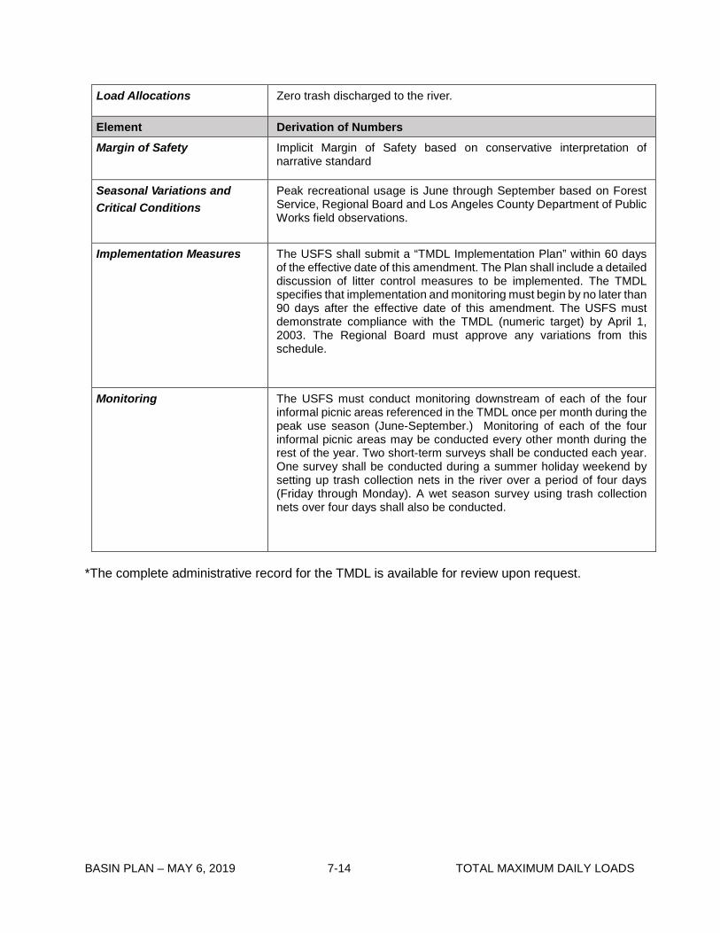
Load Allocations Zero trash discharged to the river.
Element Derivation of Numbers Margin of Safety Implicit Margin of Safety based on conservative interpretation of
narrative standard
Seasonal Variations and Critical Conditions
Peak recreational usage is June through September based on Forest Service, Regional Board and Los Angeles County Department of Public Works field observations.
Implementation Measures The USFS shall submit a “TMDL Implementation Plan” within 60 days of the effective date of this amendment. The Plan shall include a detailed discussion of litter control measures to be implemented. The TMDL specifies that implementation and monitoring must begin by no later than 90 days after the effective date of this amendment. The USFS must demonstrate compliance with the TMDL (numeric target) by April 1, 2003. The Regional Board must approve any variations from this schedule.
Monitoring The USFS must conduct monitoring downstream of each of the four informal picnic areas referenced in the TMDL once per month during the peak use season (June-September.) Monitoring of each of the four informal picnic areas may be conducted every other month during the rest of the year. Two short-term surveys shall be conducted each year. One survey shall be conducted during a summer holiday weekend by setting up trash collection nets in the river over a period of four days (Friday through Monday). A wet season survey using trash collection nets over four days shall also be conducted.
*The complete administrative record for the TMDL is available for review upon request.
BASIN PLAN – MAY 6, 2019 7-15 TOTAL MAXIMUM DAILY LOADS
7-2 Los Angeles River Watershed Trash TMDL This TMDL was adopted by:
The Regional Water Quality Control Board on September 19, 2001.
This TMDL was approved by:
The State Water Resources Control Board on February 19, 2002. The Office of Administrative Law on July 16, 2002 The U.S. Environmental Protection Agency on August 1, 2002.
This TMDL was set aside by:
The Regional Water Quality Control Board on June 8, 2006.
This TMDL was remanded by:
The State Water Resources Control Board on July 19, 2006.
This TMDL was adopted by:
The Regional Water Quality Control Board on August 9, 2007.
This TMDL was approved by:
The State Water Resources Control Board on April 15, 2008. The Office of Administrative Law on July 1, 2008. The U.S. Environmental Protection Agency on July 24, 2008.
The effective date of this TMDL is: September 23, 2008.
This TMDL was revised by:
The Regional Water Quality Control Board on June 11, 2015.
This revised TMDL was approved by:
The State Water Resources Control Board on November 17, 2015. The Office of Administrative Law on May 4, 2016. If applicable, the U.S. Environmental Protection Agency on June 30, 2016.
The following table includes all the elements of this TMDL.

BASIN PLAN – MAY 6, 2019 7-16 TOTAL MAXIMUM DAILY LOADS
Table 7-2.1 Trash TMDL for the Los Angeles River and Its Tributaries: Elements Element Key Findings and Regulatory Provisions
Problem Statement Los Angeles River Reach 5, Reach 4, Reach 3, Reach 2, Reach 1, Los Angeles River Estuary, Tujunga Wash, Burbank Western Channel, Verdugo Wash Reaches 1 and 2, Arroyo Seco Reaches 1 and 2, Compton Creek, and Rio Hondo Reach 1 are included on the Clean Water Act Section 303(d) list of impaired waterbodies due to trash. These impairments were identified through an assessment of the waterbodies relative to the water quality objectives applicable to trash, which include “Floating Material” and “Solid, Suspended, or Settleable Materials” in Chapter 3 of this Water Quality Control Plan for the Los Angeles Region.
Trash in the Los Angeles River, including its estuary, and its tributaries is causing impairment of beneficial uses. The following designated beneficial uses are impacted by trash: water contact recreation (REC1); non-contact water recreation (REC2); warm freshwater habitat (WARM); wildlife habitat (WILD), estuarine habitat (EST); marine habitat (MAR); rare and threatened or endangered species (RARE); migration of aquatic organisms (MIGR); spawning, reproduction and early development of fish (SPWN); commercial and sport fishing (COMM); shellfish harvesting (SHELL); wetland habitat (WET); and cold freshwater habitat (COLD).
Numeric Target (Interpretation of the numeric water quality objective, used to calculate the waste load allocations and load allocations)
Zero trash in all waterbodies1.
Source Analysis Stormwater discharges are the major source of trash in the river. Nonpoint sources (i.e., direct deposition of trash by people or wind into the water body) are also sources of trash loading to the Los Angeles River and its tributaries.
Loading Capacity Zero
Waste Load Allocations Baseline Waste Load Allocations (WLAs) for Phase I MS4 Permittees, including Caltrans, in the Los Angeles River Watershed are provided in Table 7-2.2. The TMDL requires phased reductions over a period of 9 years, from existing baseline loads to zero trash. Current and future enrollees in Phase II MS4 permits (including educational institutions) also have a final WLA of zero.2
1 The numeric target of zero was established in 2001. 2 Phase II MS4 facilities designated in the Statewide Phase II Small MS4 General Permit within the Los Angeles River Watershed at the time of the 2015 revisions to this TMDL include California State University, Los Angeles; California State University, Northridge; and University of California, Los Angeles (various offsite facilities).

BASIN PLAN – MAY 6, 2019 7-17 TOTAL MAXIMUM DAILY LOADS
Element Key Findings and Regulatory Provisions
Load Allocations The Load Allocations (LAs) for nonpoint source trash discharges to the Los Angeles River, including the estuary, and its tributaries are zero. For nonpoint sources, zero trash is defined as no trash in the waters or parks, open space, or recreational facilities adjacent to the Los Angeles River, including its estuary, and its tributaries, immediately following each assessment and collection event consistent with an established Minimum Frequency of Assessment and Collection Program (MFAC Program), described below in “Implementation”. MFAC Programs shall be established at intervals that prevent trash from accumulating in deleterious amounts that cause nuisance or adversely affect beneficial uses between collections.
LAs are assigned to entities that own and/or operate parks, open space, or recreational facilities adjacent to or discharging to the Los Angeles River or a tributary to the river, which include the County of Los Angeles; the Cities of Arcadia, Bell Gardens, Burbank, Compton, Cudahy, Downey, Long Beach, Los Angeles, Maywood, Montebello, Pasadena, Pico Rivera, and Rosemead; and the Los Angeles Equestrian Center, Mountains Recreation and Conversation Authority, San Gabriel Country Club, and the Arcadia Golf Course. LAs may be assigned to additional entities that own and/or operate parks, open space, or recreational facilities adjacent to or discharging trash to the Los Angeles River or a tributary to the river in the future under appropriate regulatory programs.
Implementation Point Sources
TMDL Waste Load Allocations (WLAs) assigned to responsible agencies listed in Table 7-2.2 shall be implemented through the Los Angeles County Municipal Separate Storm Sewer System (MS4) National Pollutant Discharge Elimination System (NPDES) Permit, the City of Long Beach MS4 Permit, the Ventura County MS4 Permit, and the State of California Department of Transportation (Caltrans) MS4 Permit. WLAs assigned to Phase II MS4 permittees shall be implemented through the Statewide Phase II Small MS4s General Permit or other regional MS4 permit issued to the Phase II MS4 dischargers. WLAs shall also be implemented via the authority vested in the Los Angeles Regional Water Board by sections 13267 and 13383 of the Porter-Cologne Water Quality Control Act (Water Code section 13000 et seq.).
(1) Compliance with the interim and final WLAs may be achieved through a full capture system. A full capture system (FCS) is any device or series of devices that traps all particles retained by a 5 mm mesh screen and has a design treatment capacity of not less than the peak flow rate (Q) resulting from a one-year, one-hour, storm in the subdrainage area. The Rational Equation is used to compute the peak flow rate: Q = C × I × A, where Q = design flow rate (cubic feet per second, cfs); C = runoff coefficient (dimensionless); I = design rainfall intensity (inches per hour, as determined per the rainfall isohyetal map in Figure 7-2.A), and A= subdrainage area (acres).

BASIN PLAN – MAY 6, 2019 7-18 TOTAL MAXIMUM DAILY LOADS
Element Key Findings and Regulatory Provisions Implementation (con’t) The isohyetal map may be updated annually by the Los Angeles County
hydrologist to reflect additional rain data gathered during the previous year. Annual updates published by the Los Angeles County Department of Public Works are prospectively incorporated by reference into this TMDL.
The Executive Officer has authority to certify, as full-capture, any trash reduction system that meets the operating and performance requirements as described above.3
Permittees that choose to comply using full capture systems must demonstrate a phased implementation of full capture systems over a 9-year period until the final WLA of zero is attained. The WLA of zero trash discharged shall be deemed achieved if FCS have been installed on all conveyances discharging to the waterbodies or installed to address all the drainage within the Permittee’s drainage area to the Los Angeles River Watershed and the FCS are properly sized, operated, and maintained.
Alternatively, in drainage areas where the vast majority of catch basins are retrofitted with FCS, the FCS are properly sized, operated, and maintained, and retrofit of the remaining catch basins is technically infeasible, responsible agencies may request that the Executive Officer make a determination that the agency is in full compliance with its final WLA if all of the following criteria are met:
1) 98% of all catch basins within the agency’s jurisdictional land area in the watershed are retrofitted with FCS (or, alternatively, 98% of the jurisdiction’s drainage area is addressed by FCS) and at least 97% of the catch basins (or, alternatively, drainage area) within the agency’s jurisdiction in the subwatershed (the smaller of the HUC-12 equivalent area or tributary subwatershed) are retrofitted with FCS.
2) The agency submits to the Regional Board a report for Executive Officer concurrence, detailing the technical infeasibility of FCS retrofits in the remaining catch basins and evaluating the feasibility of partial capture devices, and the potential to install FCS or partial capture devices along the storm drain or at the MS4 outfall down gradient from the catch basin.
3) The agency submits to the Regional Board a report for Executive Officer approval, detailing the partial capture devices and/or institutional controls that are currently and will continue to be implemented in the affected
3 The Regional Water Board currently recognizes nine full capture systems. These are: Vortex Separation Systems (VSS) and eight other Executive Officer-certified full capture systems, including specific types or designs of trash nets; two gross solids removal devices (GSRDs); catch basin brush inserts and mesh screens; vertical and horizontal trash capture screen inserts; a connector pipe screen device; and the nutrient separating baffle box. See August 3, 2004 Los Angeles Regional Water Quality Control Board Memorandum titled “Procedures and Requirements for Certification of a Best Management Practice for Trash Control as a Full Capture System.

BASIN PLAN – MAY 6, 2019 7-19 TOTAL MAXIMUM DAILY LOADS
Element Key Findings and Regulatory Provisions Implementation (con’t) subwatershed(s), including an assessment of the
effectiveness of the partial capture devices and/or institutional controls using existing data and studies representative of the subwatershed or jurisdictional area. If, based on Regional Board evaluation, existing data and studies are determined non-representative, responsible jurisdictions may also be required to conduct a special study of institutional controls and partial capture devices in the particular subwatershed(s) where the non-retrofitted catch basins are located.
In addition, responsible jurisdictions shall re-evaluate the effectiveness of institutional controls and partial capture devices and report the findings to the Regional Board for confirmation or change to the determination, if significant land use changes occur in the affected subwatershed (based on permits for new and significant re-development) or if there is a significant change in the suite of implemented partial capture devices and/or institutional controls (e.g., reduced frequency of implementation, reduced spatial coverage of implementation, change in technology employed). Such re-evaluation shall occur within one year of the identification of the significant changes.
(2) Compliance with interim and final effluent limitations through the installation of partial capture devices and the application of institutional controls. Responsible jurisdictions employing partial capture devices or institutional controls shall use a mass balance approach based on the trash daily generation rate (DGR)4, to demonstrate compliance.
The DGR shall be reassessed annually. Responsible jurisdictions may request a less frequent assessment of its DGR when the final WLA has been met (as described below) and the responsible jurisdiction continues to implement at the same level of effort partial capture devices and institutional controls for Executive Officer approval. A return to annual DGR calculation shall be required for a period of years to be determined by the Executive Officer after significant land use changes.
Responsible jurisdictions employing institutional controls or a combination of full capture systems, partial capture devices, and institutional controls shall be deemed in compliance with the final WLAs when the reduction of trash from the jurisdiction’s baseline load, in Table 7-2.2, is between 99% and 100% as calculated using a mass balance approach, and the FCS and partial capture devices are properly sized, operated, and maintained.
Alternatively, responsible jurisdictions may request that the Executive Officer make a determination that a 97% to 98% reduction of the baseline load as calculated using a mass balance approach, constitutes full compliance with the final WLA if all of the following criteria are met:
4 The DGR is the average amount of trash deposited during a 24-hour period, as measured in a specified drainage area.

BASIN PLAN – MAY 6, 2019 7-20 TOTAL MAXIMUM DAILY LOADS
Element Key Findings and Regulatory Provisions Implementation (con’t) • The agency submits to the Regional Board a report for
Executive Officer approval, including, two or more consecutive years of data showing that the Permittee’s compliance was at or above a 97% reduction in its baseline trash load; an evaluation of institutional controls in the jurisdiction demonstrating continued effectiveness and any potential enhancements; and demonstration that opportunities to implement partial capture devices have been fully exploited.
(3) Compliance with the interim and final WLAs through a scientifically based alternative compliance approach as approved by the Regional Board or Executive Officer.
Responsible jurisdictions employing an alternative compliance approach shall conduct studies of institutional controls and partial capture devices for their particular subwatershed(s) or demonstrate that existing studies are representative and transferable to the implementing area for Executive Officer approval. Responsible jurisdictions shall also provide a schedule for periodic, compliance effectiveness demonstration and evaluation. FCS and partial capture devices shall be properly sized, operated, and maintained consistent with sizing, operation, and maintenance schedules used to determine their effectiveness.
The Los Angeles County MS4, City of Long Beach MS4,Ventura County MS4, and Caltrans MS4 Permittees employing alternative compliance options for FCS, partial capture devices, and the application of institutional controls, or employing a scientifically based alternative compliance approach shall submit a revised Watershed Management Program or Enhanced Watershed Management Program, or separate TMDL implementation plan, for Executive Officer approval prior to use of these alternative compliance options.
An implementation schedule for Phase II MS4 permittees will be established during the issuance, reissuance, or reopening of their respective permit(s) to incorporate provisions consistent with the assumptions and requirements of these WLAs or upon designation by the State or Regional Water Board as a Phase II MS4 permittee and enrollment in the Statewide Phase II Small MS4s General NPDES Permit.
Flood control districts, such as the Los Angeles County Flood Control District or Ventura County Watershed Protection District, are not assigned Waste Load Allocations, since Waste Load Allocations are based on jurisdictional area. However, flood control districts are responsible for performing storm drain operation and maintenance, including but not limited to: catch basin labeling, catch basin label inspections, and open channel signage; open channel maintenance that includes removal of trash and debris; and implementation of activity specific BMPs, including those related to litter/debris/graffiti in compliance with their respective MS4 permit. A flood control district may be held responsible with a jurisdiction and/or agency for non-compliance with Waste Load Allocations where it has either:

BASIN PLAN – MAY 6, 2019 7-21 TOTAL MAXIMUM DAILY LOADS
Element Key Findings and Regulatory Provisions Implementation (con’t)
(i) without good cause denied entitlements or other necessary authority to a responsible jurisdiction or agency for the timely installation and/or maintenance of full and/or partial capture trash control devices for purposes of TMDL compliance in parts of the MS4 physical infrastructure that are under its authority, or
(ii) not fulfilled its obligations regarding proper BMP installation, operation, and maintenance for purposes of TMDL compliance within the MS4 physical infrastructure under its authority,
thereby causing or contributing to a responsible jurisdiction and/or agency to be out of compliance with its interim or final Waste Load Allocations.
Under these circumstances, the flood control district’s responsibility shall be limited to non-compliance related to the drainage area(s) within the jurisdiction where the flood control district has authority over the relevant portions of the MS4 physical infrastructure.
Nonpoint Sources Load Allocations (LAs) shall be implemented consistent with the Statewide Policy for Implementation and Enforcement of the Nonpoint Source Pollution Control Program through a general waiver of waste discharge requirements (WDRs), individual waivers of WDRs, general WDRs, individual WDRs, a memorandum of understanding (MOU), a cleanup and abatement order, or any other appropriate regulatory order(s). LAs may be achieved through a program of minimum frequency of assessment and collection (MFAC). Responsible agencies assigned LAs shall be deemed in compliance with the LAs if an MFAC/BMP program, approved by the Executive Officer, demonstrates that there is no accumulation of trash, as defined in “Load Allocations” above. Responsible entities assigned LAs shall also comply with the implementation schedule listed in Table 7-2. 5.
An MFAC/BMP Program shall include the following criteria:
• The MFAC/BMP Program shall include an initial minimum frequency of trash assessment and collection and a suite of structural and/or nonstructural BMPs. The MFAC/BMP program shall include collection and disposal of all trash found in the source areas and along the Los Angeles River and its tributaries. Responsible entities shall implement an initial suite of BMPs based on current trash management practices in land areas that are found to be nonpoint sources of trash to the Los Angeles River and its tributaries.
The initial minimum frequency shall be as follows: a) Trash in open space and parks managed by responsible
jurisdictions and agencies identified in the LA section of this table shall be 100% removed at each assessment and collection event as specified in the Trash Monitoring and
BASIN PLAN – MAY 6, 2019 7-22 TOTAL MAXIMUM DAILY LOADS
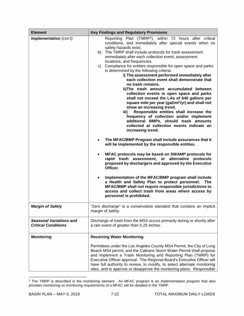
Element Key Findings and Regulatory Provisions Implementation (con’t) Reporting Plan (TMRP5), within 72 hours after critical
conditions, and immediately after special events when no safety hazards exist.
b) The TMRP shall include protocols for trash assessment immediately after each collection event, assessment locations, and frequencies.
c) Compliance for entities responsible for open space and parks is determined by the following criteria:
i) The assessment performed immediately after each collection event shall demonstrate that no trash remains.
ii) The trash amount accumulated between collection events in open space and parks shall not exceed the LAs of 640 gallons per square mile per year (gal/mi2/yr) and shall not show an increasing trend.
iii) Responsible entities shall increase the frequency of collection and/or implement additional BMPs, should trash amounts collected at collection events indicate an increasing trend.
• The MFAC/BMP Program shall include assurances that it will be implemented by the responsible entities.
• MFAC protocols may be based on SWAMP protocols for rapid trash assessment, or alternative protocols proposed by dischargers and approved by the Executive Officer.
• Implementation of the MFAC/BMP program shall include a Health and Safety Plan to protect personnel. The MFAC/BMP shall not require responsible jurisdictions to access and collect trash from areas where access by personnel is prohibited.
Margin of Safety “Zero discharge” is a conservative standard that contains an implicit margin of safety.
Seasonal Variations and Critical Conditions
Discharge of trash from the MS4 occurs primarily during or shortly after a rain event of greater than 0.25 inches.
Monitoring Receiving Water Monitoring
Permittees under the Los Angeles County MS4 Permit, the City of Long Beach MS4 permit, and the Caltrans Storm Water Permit shall propose and implement a Trash Monitoring and Reporting Plan (TMRP) for Executive Officer approval. The Regional Board's Executive Officer will have full authority to review, to modify, to select alternate monitoring sites, and to approve or disapprove the monitoring plans. Responsible
5 The TMRP is described in the monitoring element. An MFAC program is an implementation program that also provides monitoring so monitoring requirements of a MFAC will be detailed in the TMRP.

BASIN PLAN – MAY 6, 2019 7-23 TOTAL MAXIMUM DAILY LOADS
Element Key Findings and Regulatory Provisions Monitoring (con’t) entities can report receiving water monitoring through a separate TMRP
annual report, if approved by the Executive Officer, or in conjunction with annual reporting under MS4 permits.
Receiving water monitoring shall be consistent with prescribed elements listed in the Surface Water Ambient Monitoring Program’s Rapid Trash Assessment or shall be an alternative protocol proposed by the responsible agencies and approved by the Executive Officer.
Monitoring Plan: Responsible entities will submit a TMRP with the proposed receiving monitoring sites and at least two additional alternate monitoring locations. The TMRP must include maps of the proposed monitoring locations and rationale for their selection. Trash monitoring shall focus on visible trash at representative and critical locations.
Sampling Site and Frequency: The TMRP shall detail the monitoring frequency and number and location of sites, including at least one monitoring station per reach and tributary. Each sampling evaluation should consider trash levels over time and under different seasonal conditions. Sampling assessment shall be repeated at the same site where trash was collected during previous assessment.
Los Angeles County, City of Long Beach and Caltrans MS4 Permittees shall either submit a revised Integrated Monitoring Program or Coordinated Integrated Monitoring Program incorporating the TMRP requirements or a stand-alone TMRP for Executive Officer approval six months after the effective date of the TMDL.
Plastic Pellet Monitoring
Los Angeles County and City of Long Beach MS4 Permittees shall prepare a Plastic Pellet Monitoring and Reporting Plan (PMRP) to (i) monitor the amount of plastic pellets being discharged from the MS4; (ii) establish triggers for increased industrial facility inspections and enforcement of SWPPP requirements for industrial facilities identified as responsible for the plastic pellet WLA herein; and (iii) address possible plastic pellet spills. The PMRP shall include protocols for a timely and appropriate response to possible plastic pellets spills within their jurisdictional area, including notification to the Regional Board, and a comprehensive plan to ensure that plastic pellets are contained.
MS4 Permittees will fall into one of the following three categories for requirements of a PMRP:
1. MS4 Permittees that have industrial facilities or activities related to the manufacturing, handling, or transportation of plastic pellets within their jurisdiction must prepare a PMRP.
2. Responsible jurisdictions that have no industrial facilities or activities related to the manufacturing, handling, or transportation of plastic pellets may not be required to conduct monitoring at MS4 outfalls, but must have a response plan in place to address plastic pellet

BASIN PLAN – MAY 6, 2019 7-24 TOTAL MAXIMUM DAILY LOADS
Element Key Findings and Regulatory Provisions Monitoring (con’t) spills. If satisfactory documentation is provided that
shows there are no industrial facilities or activities related to plastic pellets within the jurisdiction, the responsible jurisdiction may be excused of the requirement to monitor MS4 outfalls. LACFCD will be in this category.
3. Responsible jurisdictions that only have residential areas within their respective jurisdictions, and have limited commercial or industrial transportation corridors (including railways and roadways), may be exempted from the requirements of preparing a PMRP. In order for a responsible jurisdiction to be exempted from this requirement, sufficient documentation including municipal zoning plans must be submitted to the Regional Board and approved by the Executive Officer.
MFAC Monitoring
Responsible entities listed in Table 7-2.4, shall prepare a TMRP for the MFAC/BMP Program, and responsible entities shall self-report any non-compliance with its provisions. The results of the MFAC/BMP Program including, but not limited to, frequency of trash collections, amount of trash collected, trash assessments, and calculation of reduction from baseline load allocations shall be submitted to the Regional Board on an annual basis.

BASIN PLAN – MAY 6, 2019 7-25 TOTAL MAXIMUM DAILY LOADS
Figure 7-2.A
Isohyethal Map of Rainfall Intensities in Portions of Los Angeles County
BASIN PLAN – MAY 6, 2019 7-26 TOTAL MAXIMUM DAILY LOADS
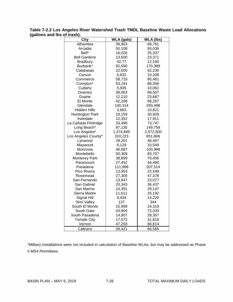
Table 7-2.2 Los Angeles River Watershed Trash TMDL Baseline Waste Load Allocations (gallons and lbs of trash).
City WLA (gals) WLA (lbs) Alhambra 39,903 68,761 Arcadia 50,108 93,036
Bell* 16,026 25,337 Bell Gardens 13,500 23,371
Bradbury 42,77 12,160 Burbank* 92,590 170,389
Calabasas 22,505 52,230 Carson 6,832 10,208
Commerce 58,733 85,481 Compton* 53,191 86,356 Cudahy 5,935 10,061 Downey 39,063 68,507 Duarte 12,210 23,687
El Monte 42,208 68,267 Glendale 140,314 293,498
Hidden Hills 3,663 10,821 Huntington Park 19,159 30,929
Irwindale 12,352 17,911 La Cañada Flintridge 33,496 73,747
Long Beach* 87,135 149,759 Los Angeles* 1,374,845 2,572,500
Los Angeles County* 310,223 651,806 Lynwood 28,201 46,467 Maywood 6,129 10,549 Monrovia 46,687 100,988
Montebello 50,369 83,707 Monterey Park 38,899 70,456
Paramount 27,452 44,490 Pasadena 111,998 207,514
Pico Rivera 13,953 22,549 Rosemead 27,305 47,378
San Fernando 13,947 23,077 San Gabriel 20,343 36,437 San Marino 14,391 29,147
Sierra Madre 11,611 25,192 Signal Hill 9,434 14,220 Simi Valley 137 344
South El Monte 15,999 24,319 South Gate 43,904 72,333
South Pasadena 14,907 28,357 Temple City 17,572 31,819
Vernon 47,203 66,814 Caltrans 59,421 66,566
*Military Installations were not included in calculation of Baseline WLAs, but may be addressed as Phase
II MS4 Permittees.
BASIN PLAN – MAY 6, 2019 7-27 TOTAL MAXIMUM DAILY LOADS
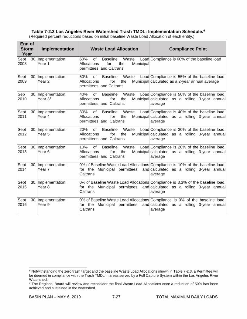
Table 7-2.3 Los Angeles River Watershed Trash TMDL: Implementation Schedule.6 (Required percent reductions based on initial baseline Waste Load Allocation of each entity.)
End of Storm Year
Implementation Waste Load Allocation Compliance Point
Sept 30, 2008
Implementation: Year 1
60% of Baseline Waste Load Allocations for the Municipal permittees; and Caltrans
Compliance is 60% of the baseline load
Sept 30, 2009
Implementation: Year 2
50% of Baseline Waste Load Allocations for the Municipal permittees; and Caltrans
Compliance is 55% of the baseline load, calculated as a 2-year annual average
Sep 30, 2010
Implementation: Year 37
40% of Baseline Waste Load Allocations for the Municipal permittees; and Caltrans
Compliance is 50% of the baseline load, calculated as a rolling 3-year annual average
Sept 30, 2011
Implementation: Year 4
30% of Baseline Waste Load Allocations for the Municipal permittees; and Caltrans
Compliance is 40% of the baseline load, calculated as a rolling 3-year annual average
Sept 30, 2012
Implementation: Year 5
20% of Baseline Waste Load Allocations for the Municipal permittees; and Caltrans
Compliance is 30% of the baseline load, calculated as a rolling 3-year annual average
Sept 30, 2013
Implementation: Year 6
10% of Baseline Waste Load Allocations for the Municipal permittees; and Caltrans
Compliance is 20% of the baseline load, calculated as a rolling 3-year annual average
Sept 30, 2014
Implementation: Year 7
0% of Baseline Waste Load Allocations for the Municipal permittees; and Caltrans
Compliance is 10% of the baseline load, calculated as a rolling 3-year annual average
Sept 30, 2015
Implementation: Year 8
0% of Baseline Waste Load Allocations for the Municipal permittees; and Caltrans
Compliance is 3.3% of the baseline load, calculated as a rolling 3-year annual average
Sept 30, 2016
Implementation: Year 9
0% of Baseline Waste Load Allocations for the Municipal permittees; and Caltrans
Compliance is 0% of the baseline load, calculated as a rolling 3-year annual average
6 Notwithstanding the zero trash target and the baseline Waste Load Allocations shown in Table 7-2.3, a Permittee will be deemed in compliance with the Trash TMDL in areas served by a Full Capture System within the Los Angeles River Watershed. 7 The Regional Board will review and reconsider the final Waste Load Allocations once a reduction of 50% has been achieved and sustained in the watershed.

BASIN PLAN – MAY 6, 2019 7-28 TOTAL MAXIMUM DAILY LOADS
Table 7-2.4 Los Angeles River Watershed Trash TMDL Baseline Load Allocations Responsible entity Monitoring site City of Long Beach
City of Compton City of Long Beach
City of Cudahy City of Maywood
City of Bell Gardens City of Downey
City of Montebello City of Pico Rivera
County of Los Angeles City of Rosemead
San Gabriel Country Club City of Pasadena City of Pasadena
County of Los Angeles Arcadia Golf Course
City of Arcadia County of Los Angeles
City of Los Angeles City of Los Angeles City of Pasadena
City of Los Angeles City of Los Angeles/MRCA
City of Los Angeles City of Los Angeles
City of Glendale County of Los Angeles
City of Glendale County of Los Angeles
LA Equestrian Center/City of Los Angeles
City of Burbank City of Burbank
City of Los Angeles City of Los Angeles City of Los Angeles
MRCA City of Los Angeles City of Los Angeles City of Los Angeles City of Los Angeles City of Los Angeles City of Los Angeles City of Los Angeles City of Los Angeles City of Los Angeles
Wrigley Green belt Raymond Street Park
DeForest Park Cudahy Park
Maywood Riverfront Park Ford Park
Treasure Island Park Grant Rea Park Rio Hondo Park
Whittier Narrows County Golf Course Sally Tanner Park
San Gabriel Country Club Eaton Blanche Park
Gwinn Park Santa Anita County Golf Course
Arcadia Golf Course Eisenhower Park
Pamela County Park Montecito Rec Center
Hermon Park Lower Arroyo Park
Elysian Park Marsh Street Park
Griffith Park Soccer Field Los Feliz Golf Course
Glorietta Park Crescenta Valley Park
Dunsmore Park Crescenta Valley Park LA Equestrian Center
Compass Tree Park Buena Vista Park (Johnny Carson Park)
Valleyheart Greenway/ LA River Greenway Park
Moorpark Park Tujunga Greenway Hansen Dam Park
Sepulveda Rec Center Paxton Park (Richie Valens Park) Sepulveda Basin Recreation Area
Reseda Park & Rec Center Vanalden Park
Northridge Rec Center Mae Boyer Rec Center West Hills Rec Center
Baseline LA = recreational area in square miles • 640 gallons trash

BASIN PLAN – MAY 6, 2019 7-29 TOTAL MAXIMUM DAILY LOADS
Table 7-2.5 Los Angeles River Trash TMDL: Nonpoint Source Implementation Schedule Task No.
Task Date
1 Baseline Load Allocations in Effect
Effective date of the reconsideration of the Los Angeles River Trash TMDL
2 Submit Minimum Frequency Assessment and Collection (MFAC) Program Plan
Upon enrollment in Conditional Waiver of WDR for trash, or no later than two years from the effective date of the TMDL
3 Achieve final load allocations by fully implementing an Executive Officer approved MFAC program or 100% reduction of trash from baseline load allocations
Three years from effective date of the reconsideration of the Los Angeles River Trash TMDL

This page intentionally left blank
BASIN PLAN – MAY 6, 2019 7-30 TOTAL MAXIMUM DAILY LOADS

BASIN PLAN – MAY 6, 2019 7-31 TOTAL MAXIMUM DAILY LOADS
7-3 Ballona Creek Trash TMDL This TMDL was adopted by:
The Regional Water Quality Control Board on September 19, 2001.
This TMDL was approved by:
The State Water Resources Control Board on February 19, 2002. The Office of Administrative Law on July 18, 2002. The U.S. Environmental Protection Agency on August 1, 2002.
The effective date of this TMDL is: August 28, 2002.
This TMDL was revised by:
The Regional Water Quality Control Board on March 4, 2004.
This revised TMDL was approved by:
The State Water Resources Control Board on September 30, 2004. The Office of Administrative Law on February 8, 2005. [U.S. Environmental Protection Agency approval not required for amendment to implementation plan.]
This TMDL was again revised by:
The Regional Water Quality Control Board on June 11, 2015.
This revised TMDL was approved by:
The State Water Resources Control Board on November 17, 2015. The Office of Administrative Law on May 4, 2016. If applicable, the U.S. Environmental Protection Agency on June 30, 2016.
The following table includes all of the elements of this TMDL.
BASIN PLAN – MAY 6, 2019 7-32 TOTAL MAXIMUM DAILY LOADS
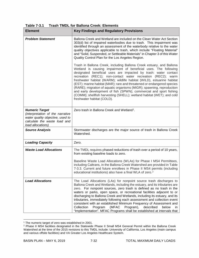
Table 7-3.1 Trash TMDL for Ballona Creek: Elements Element Key Findings and Regulatory Provisions
Problem Statement Ballona Creek and Wetland are included on the Clean Water Act Section 303(d) list of impaired waterbodies due to trash. This impairment was identified through an assessment of the waterbody relative to the water quality objectives applicable to trash, which include “Floating Material” and “Solid, Suspended, or Settleable Materials” in Chapter 3 of this Water Quality Control Plan for the Los Angeles Region.
Trash in Ballona Creek, including Ballona Creek estuary, and Ballona Wetland is causing impairment of beneficial uses. The following designated beneficial uses are impacted by trash: water contact recreation (REC1); non-contact water recreation (REC2); warm freshwater habitat (WARM); wildlife habitat (WILD), estuarine habitat (EST); marine habitat (MAR); rare and threatened or endangered species (RARE); migration of aquatic organisms (MIGR); spawning, reproduction and early development of fish (SPWN); commercial and sport fishing (COMM); shellfish harvesting (SHELL); wetland habitat (WET); and cold freshwater habitat (COLD).
Numeric Target (interpretation of the narrative water quality objective, used to calculate the waste load and load allocations)
Zero trash in Ballona Creek and Wetland1.
Source Analysis Stormwater discharges are the major source of trash in Ballona Creek Watershed.
Loading Capacity Zero.
Waste Load Allocations The TMDL requires phased reductions of trash over a period of 10 years,from existing baseline loads to zero.
Baseline Waste Load Allocations (WLAs) for Phase I MS4 Permittees, including Caltrans, in the Ballona Creek Watershed are provided in Table 7-3.3. Current and future enrollees in Phase II MS4 permits (including educational institutions) also have a final WLA of zero.2
Load Allocations The Load Allocations (LAs) for nonpoint source trash discharges to Ballona Creek and Wetlands, including the estuary, and its tributaries are zero. For nonpoint sources, zero trash is defined as no trash in the waters or parks, open space, or recreational facilities adjacent to or discharging to Ballona Creek and Wetlands, including its estuary, and its tributaries, immediately following each assessment and collection event consistent with an established Minimum Frequency of Assessment and Collection Program (MFAC Program), described below in “Implementation”. MFAC Programs shall be established at intervals that
1 The numeric target of zero was established in 2001. 2 Phase II MS4 facilities designated in the Statewide Phase II Small MS4 General Permit within the Ballona Creek Watershed at the time of the 2015 revisions to this TMDL include: University of California, Los Angeles (main campus and various offsite facilities) and VA Greater Los Angeles Healthcare System.

BASIN PLAN – MAY 6, 2019 7-33 TOTAL MAXIMUM DAILY LOADS
Element Key Findings and Regulatory Provisions
Load Allocations (con’t) prevent trash from accumulating in deleterious amounts that cause nuisance or adversely affect beneficial uses between collections.
LAs are assigned to the California Department of Fish and Wildlife for the Ballona Creek Wetlands. LAs may be assigned to additional entities that own and/or operate parks, open space, or recreational facilities adjacent to or discharging trash to Ballona Creek, its estuary, or a tributary to the creek in the future under appropriate regulatory programs.
Implementation Point Sources
TMDL Waste Load Allocations (WLAs) assigned to responsible agencies listed in Table 7-3.3 shall be implemented through the Los Angeles County Municipal Separate Storm Sewer System (MS4) National Pollutant Discharge Elimination System (NPDES) Permit and the State of California Department of Transportation (Caltrans) MS4 Permit. WLAs assigned to Phase II MS4 permittees shall be implemented through the Statewide Phase II Small MS4s General Permit or other regional MS4 permit issued to the Phase II MS4 dischargers. WLAs shall also be implemented via the authority vested in the Los Angeles Regional Water Board by sections 13267 and 13383 of the Porter-Cologne Water Quality Control Act (Water Code section 13000 et seq.).
(1) Compliance with the interim and final WLAs may be achieved through a full capture system. A full capture system (FCS) is any device or series of devices that traps all particles retained by a 5 mm mesh screen and has a design treatment capacity of not less than the peak flow rate (Q) resulting from a one-year, one-hour, storm in the subdrainage area. The Rational Equation is used to compute the peak flow rate:
Q = C × I × A, where Q = design flow rate (cubic feet per second, cfs); C = runoff coefficient (dimensionless); I = design rainfall intensity (inches per hour, as determined per the rainfall isohyetal map in Figure 7-3.A), and A= subdrainage area (acres).
The isohyetal map may be updated annually by the Los Angeles County hydrologist to reflect additional rain data gathered during the previous year. Annual updates published by the Los Angeles County Department of Public Works are prospectively incorporated by reference into this TMDL
The Executive Officer has authority to certify, as full-capture, any trash reduction system that meets the operating and performance requirements as described above.3
3 The Regional Water Board currently recognizes nine full capture systems. These are: Vortex Separation Systems (VSS) and eight other Executive Officer-certified full capture systems, including specific types or designs of trash nets; two gross solids removal devices (GSRDs); catch basin brush inserts and mesh screens; vertical and horizontal trash capture screen inserts; a connector pipe screen device; and the nutrient separating baffle box. See August 3, 2004 Los Angeles Regional Water Quality Control Board Memorandum titled “Procedures and Requirements for Certification of a Best Management Practice for Trash Control as a Full Capture System.

BASIN PLAN – MAY 6, 2019 7-34 TOTAL MAXIMUM DAILY LOADS
Element Key Findings and Regulatory Provisions
Implementation (con’t) Permittees that choose to comply using full capture systems must demonstrate a phased implementation of full capture systems over a 10-year period until the final WLA of zero is attained. The WLA of zero trash discharged shall be deemed achieved if FCS have been installed on all conveyances discharging to the waterbodies or installed to address all the drainage within the Permittee’s drainage area to the Ballona Creek Watershed and the FCS are properly sized, operated, and maintained.
Alternatively, in drainage areas where the vast majority of catch basins are retrofitted with FCS, the FCS are properly sized, operated, and maintained, and retrofit of the remaining catch basins is technically infeasible, responsible agencies may request that the Executive Officer make a determination that the agency is in full compliance with its final WLA if all of the following criteria are met:
• 98% of all catch basins within the agency’s jurisdictional land area in the watershed are retrofitted with FCS (or, alternatively, 98% of the jurisdiction’s drainage area is addressed by FCS) and at least 97% of the catch basins (or, alternatively, drainage area) within the agency’s jurisdiction in the subwatershed (the smaller of the HUC-12 equivalent area or tributary subwatershed) are retrofitted with FCS.
• The agency submits to the Regional Board a report for Executive Officer concurrence, detailing the technical infeasibility of FCS retrofits in the remaining catch basins and evaluating the feasibility of partial capture devices, and the potential to install FCS or partial capture devices along the storm drain or at the MS4 outfall down gradient from the catch basin.
• The agency submits to the Regional Board a report for Executive Officer approval, detailing the partial capture devices and/or institutional controls that are currently and will continue to be implemented in the affected subwatershed(s), including an assessment of the effectiveness of the partial capture devices and/or institutional controls using existing data and studies representative of the subwatershed or jurisdictional area. If, based on Regional Board evaluation, existing data and studies are determined non-representative, responsible jurisdictions may also be required to conduct a special study of institutional controls and partial capture devices in the particular subwatershed(s) where the non-retrofitted catch basins are located.
In addition, responsible jurisdictions shall re-evaluate the effectiveness of institutional controls and partial capture devices and report the findings to the Regional Board for confirmation or change to the determination, if significant land use changes occur in the affected subwatershed (based on permits for new and significant re-development) or if there is a significant change in the suite of implemented partial capture devices

BASIN PLAN – MAY 6, 2019 7-35 TOTAL MAXIMUM DAILY LOADS
Element Key Findings and Regulatory Provisions
Implementation (con’t) and/or institutional controls (e.g., reduced frequency of implementation, reduced spatial coverage of implementation, change in technology employed). Such re-evaluation shall occur within one year of the identification of the significant changes.
(2) Compliance with interim and final effluent limitations through the installation of partial capture devices and the application of institutional controls. Responsible jurisdictions employing partial capture devices or institutional controls shall use a mass balance approach based on the trash daily generation rate (DGR)4, to demonstrate compliance.
The DGR shall be reassessed annually. Responsible jurisdictions may request a less frequent assessment of its DGR when the final WLA has been met (as described below) and the responsible jurisdiction continues to implement at the same level of effort partial capture devices and institutional controls for Executive Officer approval. A return to annual DGR calculation shall be required for a period of years to be determined by the Executive Officer after significant land use changes.
Responsible jurisdictions employing institutional controls or a combination of full capture systems, partial capture devices, and institutional controls shall be deemed in compliance with the final WLAs when the reduction of trash from the jurisdiction’s baseline load, in Table 7-3.3, is between 99% and 100% as calculated using a mass balance approach, and the FCS and partial capture devices are properly sized, operated, and maintained.
Alternatively, responsible jurisdictions may request that the Executive Officer make a determination that a 97% to 98% reduction of the baseline load as calculated using a mass balance approach, constitutes full compliance with the final WLA if all of the following criteria are met:
• The agency submits to the Regional Board a report for Executive Officer approval, including, two or more consecutive years of data showing that the Permittee’s compliance was at or above a 97% reduction in its baseline trash load; an evaluation of institutional controls in the jurisdiction demonstrating continued effectiveness and any potential enhancements; and demonstration that opportunities to implement partial capture devices have been fully exploited.
(3) Compliance with the interim and final WLAs through a scientifically based alternative compliance approach approved by the Regional Board.
Responsible jurisdictions employing an alternative compliance approach shall conduct studies of institutional controls and partial capture devices for their particular subwatershed(s) or demonstrate that existing studies are representative and transferable to the implementing area for
4 The DGR is the average amount of trash deposited during a 24-hour period, as measured in a specified drainage area.

BASIN PLAN – MAY 6, 2019 7-36 TOTAL MAXIMUM DAILY LOADS
Element Key Findings and Regulatory Provisions
Implementation (con’t) Executive Officer approval. Responsible jurisdictions shall also provide a schedule for periodic, compliance effectiveness demonstration and evaluation. FCS and partial capture devices shall be properly sized, operated, and maintained consistent with sizing, operation, and maintenance schedules used to determine their effectiveness.
The Los Angeles County MS4 and Caltrans MS4 Permittees employing alternative compliance options for FCS, partial capture devices, and the application of institutional controls, or employing a scientifically based alternative compliance approach shall submit a revised Watershed Management Program or Enhanced Watershed Management Program, or separate TMDL implementation plan, for Executive Officer approval prior to use of these alternative compliance options.
An implementation schedule for Phase II MS4 permittees will be established during the issuance, reissuance, or reopening of their respective permit(s) to incorporate provisions consistent with the assumptions and requirements of these WLAs or upon designation by the State or Regional Water Board as a Phase II MS4 permittee and enrollment in the Statewide Phase II Small MS4s General NPDES Permit.
The Los Angeles County Flood Control District (LACFCD) is not assigned a Waste Load Allocation, since Waste Load Allocations are based on jurisdictional area. However, the LACFCD is responsible for performing storm drain operation and maintenance, including but not limited to: catch basin labeling, catch basin label inspections, and open channel signage; open channel maintenance that includes removal of trash and debris; and implementation of activity specific BMPs, including those related to litter/debris/graffiti in compliance with its MS4 permit. The LACFCD may be held responsible with a jurisdiction and/or agency for non-compliance with Waste Load Allocations where it has either:
(i) without good cause denied entitlements or other necessary authority to a responsible jurisdiction or agency for the timely installation and/or maintenance of full and/or partial capture trash control devices for purposes of TMDL compliance in parts of the MS4 physical infrastructure that are under its authority, or
(ii) not fulfilled its obligations regarding proper BMP installation, operation, and maintenance for purposes of TMDL compliance within the MS4 physical infrastructure under its authority,
thereby causing or contributing to a responsible jurisdiction and/or agency to be out of compliance with its interim or final Waste Load Allocations.
Under these circumstances, the LACFCD’s responsibility shall be limited to non-compliance related to the drainage area(s) within the jurisdiction where the LACFCD has authority over the relevant portions of the MS4 physical infrastructure.
Nonpoint Sources

BASIN PLAN – MAY 6, 2019 7-37 TOTAL MAXIMUM DAILY LOADS
Element Key Findings and Regulatory Provisions
Implementation (con’t) Load Allocations (LAs) shall be implemented consistent with the Statewide Policy for Implementation and Enforcement of the Nonpoint Source Pollution Control Program through a general waiver of waste discharge requirements (WDRs), individual waivers of WDRs, general WDRs, individual WDRs, a memorandum of understanding (MOU), a cleanup and abatement order, or any other appropriate regulatory order(s). LAs may be achieved through a program of minimum frequency of assessment and collection (MFAC). Responsible agencies assigned LAs shall be deemed in compliance with the LAs if an MFAC/BMP program, approved by the Executive Officer, demonstrates that there is no accumulation of trash, as defined in “Load Allocations” above. Responsible entities assigned LAs shall also comply with the implementation schedule listed in Table 7-3.4.
An MFAC/BMP Program shall include the following criteria:
1.) The MFAC/BMP Program shall include an initial minimum frequency of trash assessment and collection and a suite of structural and/or nonstructural BMPs. The MFAC/BMP program shall include collection and disposal of all trash found in the source areas and along Ballona Creek and its tributaries. Responsible entities shall implement an initial suite of BMPs based on current trash management practices in land areas that are found to be nonpoint sources of trash to the Ballona Creek and its tributaries.
The initial minimum frequency shall be as follows: a) Trash in open space and parks managed by responsible
jurisdictions and agencies identified in the LA section of this table shall be 100% removed at each assessment and collection event as specified in the Trash Monitoring and Reporting Plan (TMRP5), within 72 hours after critical conditions, and immediately after special events when no safety hazards exist.
b) The TMRP shall include protocols for trash assessment immediately after each collection event, assessment locations, and frequencies.
c) Compliance for entities responsible for open space and parks is determined by the following criteria:
i) The assessment performed immediately after each collection event shall demonstrate that no trash remains.
ii) The trash amount accumulated between collection events in open space and parks shall not exceed the LAs of 640 gallons per square mile per year (gal/mi2/yr) and shall not show an increasing trend.
iii) Responsible entities shall increase the frequency of collection and/or implement additional BMPs, should
5 The TMRP is described in the monitoring element. An MFAC program is an implementation program that also provides monitoring so monitoring requirements of a MFAC will be detailed in the TMRP.
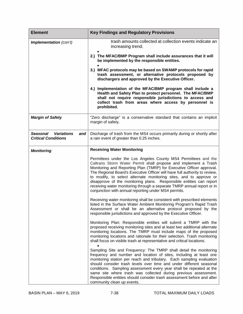
BASIN PLAN – MAY 6, 2019 7-38 TOTAL MAXIMUM DAILY LOADS
Element Key Findings and Regulatory Provisions
Implementation (con’t) trash amounts collected at collection events indicate an increasing trend.
•2.) The MFAC/BMP Program shall include assurances that it will
be implemented by the responsible entities. •
3.) MFAC protocols may be based on SWAMP protocols for rapid trash assessment, or alternative protocols proposed by dischargers and approved by the Executive Officer.
4.) Implementation of the MFAC/BMP program shall include a Health and Safety Plan to protect personnel. The MFAC/BMP shall not require responsible jurisdictions to access and collect trash from areas where access by personnel is prohibited.
Margin of Safety “Zero discharge” is a conservative standard that contains an implicit margin of safety.
Seasonal Variations and Critical Conditions
Discharge of trash from the MS4 occurs primarily during or shortly after a rain event of greater than 0.25 inches.
Monitoring Receiving Water Monitoring
Permittees under the Los Angeles County MS4 Permittees and the Caltrans Storm Water Permit shall propose and implement a Trash Monitoring and Reporting Plan (TMRP) for Executive Officer approval. The Regional Board's Executive Officer will have full authority to review, to modify, to select alternate monitoring sites, and to approve or disapprove of the monitoring plans. Responsible entities can report receiving water monitoring through a separate TMRP annual report or in conjunction with annual reporting under MS4 permits.
Receiving water monitoring shall be consistent with prescribed elements listed in the Surface Water Ambient Monitoring Program’s Rapid Trash Assessment or shall be an alternative protocol proposed by the responsible jurisdictions and approved by the Executive Officer.
Monitoring Plan: Responsible entities will submit a TMRP with the proposed receiving monitoring sites and at least two additional alternate monitoring locations. The TMRP must include maps of the proposed monitoring locations and rationale for their selection. Trash monitoring shall focus on visible trash at representative and critical locations.
• Sampling Site and Frequency: The TMRP shall detail the monitoring frequency and number and location of sites, including at least one monitoring station per reach and tributary. Each sampling evaluation should consider trash levels over time and under different seasonal conditions. Sampling assessment every year shall be repeated at the same site where trash was collected during previous assessment. Responsible entities should consider trash assessment before and after community clean up events.

BASIN PLAN – MAY 6, 2019 7-39 TOTAL MAXIMUM DAILY LOADS
Element Key Findings and Regulatory Provisions
Monitoring (con’t) Los Angeles County MS4 Permittees and Caltrans shall submit a revised Integrated Monitoring Program or Coordinated Integrated Monitoring Program incorporating the TMRP requirements or a stand-alone TMRP for Executive Officer approval six months after the effective date of the TMDL.
MFAC Monitoring
Responsible entities assigned LAs, shall prepare a TMRP for the MFAC/BMP Program, and responsible entities shall self-report any non-compliance with its provisions. The results of the MFAC/BMP Program including, but not limited to, frequency of trash collections, amount of trash collected, trash assessments, and calculation of reduction from baseline load allocations shall be submitted to the Regional Board on an annual basis.

BASIN PLAN – MAY 6, 2019 7-40 TOTAL MAXIMUM DAILY LOADS
Figure 7-3.A Isohyethal Map of Rainfall Intensities in Portions of Los Angeles County

BASIN PLAN – MAY 6, 2019 7-41 TOTAL MAXIMUM DAILY LOADS
Table 7-3.2 Ballona Creek Watershed Trash TMDL: Implementation Schedule.13 (Baseline Waste Load Allocations expressed as cubic feet of uncompressed trash and % reduction.)
Year Baseline Monitoring/
Implementation
Waste Load Allocation Compliance Point
1
10/1/01--9/30/02
Baseline Monitoring No allocation specified. Trash will be reduced by levels collected during the baseline monitoring program.
Achieved through timely compliance with baseline monitoring program.
2
10/1/02--9/30/03
Baseline Monitoring No allocation specified. Trash will be reduced by levels collected during the baseline monitoring program.
Achieved through timely compliance with baseline monitoring program.
3
10/1/03--9/30/04
Baseline Monitoring (optional)/
Implementation: Year 1
90% (9,985 for the Municipal permittees;1,472 for Caltrans)
No compliance point (target of 90%)
4
10/1/04--9/30/05
Baseline Monitoring (optional)/
Implementation: Year 2
80% (8,875 for the Municipal permittees; 1,308 for Caltrans)
No compliance point (target of 80%)
5
10/1/05--9/30/06
Implementation:
Year 3
70% (7,776 for the Municipal permittees; 1,146 for Caltrans)
80% of the baseline load, calculated as a rolling 3-year annual average (8,875 for the Municipal permittees; 1,308 for Caltrans).
6
10/1/06--9/30/07
Implementation:
Year 4
60% (6,656 for the Municipal permittees; 981 for Caltrans)
70% of the baseline load, calculated as a rolling 3-year annual average (7,776 for the Municipal permittees; 1,146 for Caltrans).
7
10/1/07--9/30/08
Implementation:
Year 514
50% (5,547 for the Municipal permittees; 818 for Caltrans)
60% of the baseline load, calculated as a rolling 3-year annual average (6,656 for the Municipal permittees; 981 for Caltrans)
8
10/1/08--9/30/09
Implementation:
Year 6
40% (4,438 for the Municipal permittees; 654 for Caltrans)
50% of the baseline load, calculated as a rolling 3-year annual average (5,547 for the Municipal permittees; 818 for Caltrans).
9
10/1/09--9/30/10
Implementation:
Year 7
30% (3,328 for the Municipal permittees; 491 for Caltrans)
40% of the baseline load, calculated as a rolling 3-year annual average (4,438 for the Municipal permittees; 654 for Caltrans).
13 Notwithstanding the zero trash target and the baseline Waste Load Allocations shown in Table 7-3.2, a Permittee will be deemed in compliance with the Trash TMDL in areas served by a Full Capture System within the Ballona Creek Watershed. 14 The Regional Board will review and reconsider the final Waste Load Allocations once a reduction of 50% has been achieved and sustained.

BASIN PLAN – MAY 6, 2019 7-42 TOTAL MAXIMUM DAILY LOADS
10
10/1/10--9/30/11
Implementation:
Year 8
20% (2,218 for the Municipal permittees; 327 for Caltrans).
30% of the baseline load, calculated as a rolling 3-year annual average (3,328 for the Municipal permittees; 491 for Caltrans).
11
10/1/11--9/30/12
Implementation:
Year 9
10% (1,110 for the Municipal permittees; 164 for Caltrans).
20% of the baseline load, calculated as a rolling 3-year annual average (2,220 for the Municipal permittees; 327 for Caltrans).
12
10/1/12--9/30/13
Implementation:
Year 10
0 or 0 % of the baseline load. 10% of the baseline load, calculated as a rolling 3-year annual average (1,110 for the Municipal permittees; 164 for Caltrans.
13
10/1/13--9/30/14
Implementation:
Year 11
0 or 0 % of the baseline load. 3.3% of the baseline load, calculated as a rolling 3-year annual average (366 for the Municipal permittees, 54 for Caltrans).
14
10/1/14--9/30/15
Implementation:
Year 12
0 or 0 % of the baseline. 0 or 0 % of the baseline load.
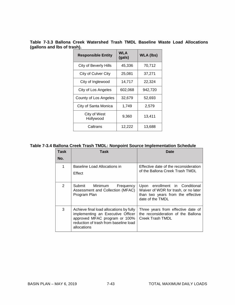
BASIN PLAN – MAY 6, 2019 7-43 TOTAL MAXIMUM DAILY LOADS
Table 7-3.3 Ballona Creek Watershed Trash TMDL Baseline Waste Load Allocations (gallons and lbs of trash).
Responsible Entity WLA (gals) WLA (lbs)
City of Beverly Hills 45,336 70,712
City of Culver City 25,081 37,271
City of Inglewood 14,717 22,324
City of Los Angeles 602,068 942,720
County of Los Angeles 32,679 52,693
City of Santa Monica 1,749 2,579
City of West Hollywood 9,360 13,411
Caltrans 12,222 13,688
Table 7-3.4 Ballona Creek Trash TMDL: Nonpoint Source Implementation Schedule Task No.
Task Date
1 Baseline Load Allocations in
Effect
Effective date of the reconsideration of the Ballona Creek Trash TMDL
2 Submit Minimum Frequency Assessment and Collection (MFAC) Program Plan
Upon enrollment in Conditional Waiver of WDR for trash, or no later than two years from the effective date of the TMDL
3 Achieve final load allocations by fully implementing an Executive Officer approved MFAC program or 100% reduction of trash from baseline load allocations
Three years from effective date of the reconsideration of the Ballona Creek Trash TMDL

BASIN PLAN – MAY 6, 2019 7-44 TOTAL MAXIMUM DAILY LOADS
This page intentionally left blank

BASIN PLAN – MAY 6, 2019 7-45 TOTAL MAXIMUM DAILY LOADS
7-4 Santa Monica Bay Beaches Bacteria TMDL This TMDL was adopted by:
The Regional Water Quality Control Board on January 24, 2002 (Dry Weather elements)
and December 12, 2002 (Wet Weather elements).
This TMDL was approved by:
The State Water Resources Control Board on September 19, 2002 (Dry Weather elements) and March 19, 2003 (Wet Weather elements). The Office of Administrative Law on December 9, 2002 (Dry Weather elements) and May 20, 2003 (Wet Weather elements). The U.S. Environmental Protection Agency on June 19, 2003.
This TMDL was revised by:
The Regional Water Quality Control Board on June 7, 2012.
This revised TMDL was approved by:
The State Water Resources Control Board on May 19, 2013. The Office of Administrative Law on November 7, 2013. The U.S. Environmental Protection Agency on July 2, 2014.
The following table includes the elements of this TMDL.

BASIN PLAN – MAY 6, 2019 7-46 TOTAL MAXIMUM DAILY LOADS
Table 7-4.1 Santa Monica Bay Beaches Bacteria TMDL: Elements Element Key Findings and Regulatory Provisions
Problem Statement Elevated bacterial indicator densities are causing impairment of the water contact recreation (REC-1) beneficial use at many Santa Monica Bay (SMB) beaches. Swimming in waters with elevated bacterial indicator densities has long been associated with adverse health effects. Specifically, local and national epidemiological studies compel the conclusion that there is a causal relationship between adverse health effects and recreational water quality, as measured by bacterial indicator densities.
Numeric Target (Interpretation of the numeric water quality objective, used to calculate the waste load allocations)
The TMDL has a multi-part numeric target based on the bacteriological water quality objectives for marine water to protect the water contact recreation use. These targets are the most appropriate indicators of public health risk in recreational waters.
These bacteriological objectives are set forth in Chapter 3 of the Basin Plan, as amended by the Regional Board on October 25, 2001. The objectives are based on four bacterial indicators and include both geometric mean limits and single sample limits. The Basin Plan objectives that serve as numeric targets for this TMDL are:
1. Geometric Mean Limits a. Total coliform density shall not exceed 1,000/100 ml. b. Fecal coliform density shall not exceed 200/100 ml. c. Enterococcus density shall not exceed 35/100 ml.
2. Single Sample Limits a. Total coliform density shall not exceed 10,000/100 ml. b. Fecal coliform density shall not exceed 400/100 ml. c. Enterococcus density shall not exceed 104/100 ml. d. Total coliform density shall not exceed 1,000/100 ml, if the
ratio of fecal-to-total coliform exceeds 0.1.
These objectives are generally based on an acceptable health risk for marine recreational waters of 19 illnesses per 1,000 exposed individuals as set by the US EPA (US EPA, 1986). The targets apply throughout the year. The compliance point for the targets is the wave wash1, where there is a freshwater outlet (i.e., municipal separate storm sewer system outfall or creek) to the beach, or at ankle depth at beaches without a freshwater outlet.
In this TMDL, implementation of the above bacteriological objectives and the associated TMDL numeric targets is achieved using a ‘reference system/anti-degradation approach’ as set forth in Chapter 3. As required by the CWA and Cal. Water Code, Basin Plans include beneficial uses of waters, water quality objectives to protect those uses, an anti-degradation policy, collectively referred to as water quality standards, and a program of implementation for water quality objectives. This TMDL and its associated waste load allocations, which shall be incorporated
1 The wave wash is defined as the point at which the storm drain or creek empties and the effluent from the storm drain initially mixes with the receiving ocean water.

BASIN PLAN – MAY 6, 2019 7-47 TOTAL MAXIMUM DAILY LOADS
Numeric Target (con’t) into relevant permits, is a program of implementation for the Region’s bacteriological objectives at Santa Monica Bay beaches.
The geometric mean targets may not be exceeded at any time. For purposes of this TMDL, the geometric means shall be calculated weekly as a rolling geometric mean using 5 or more samples, for six week periods starting all calculation weeks on Sunday. For the single sample targets, each existing shoreline monitoring site is assigned an allowable number of exceedance days for three time periods as defined in Table 7-4.2a (summer dry weather, winter dry weather, and wet weather [defined as days with 0.1 inch of rain or greater and the three days following the rain event]).
Source Analysis With the exception of isolated sewage spills, dry weather urban runoff and stormwater runoff conveyed by storm drains and creeks is the primary source of elevated bacterial indicator densities to SMB beaches. Limited natural runoff and groundwater may also potentially contribute to elevated bacterial indicator densities during winter dry weather. Because the bacterial indicators used as targets in the TMDL are not specific to human sewage, stormwater runoff from undeveloped areas may also be a source of elevated bacterial indicator densities. For example, stormwater runoff from natural areas may convey fecal matter from wildlife and birds or bacteria from soil. This is supported by the finding that, at the reference beach, the probability of exceedance of the single sample targets during wet weather is 0.22.
Loading Capacity Studies show that bacterial degradation and dilution during transport from the watershed to the beach do not significantly affect bacterial indicator densities at SMB beaches. Therefore, the loading capacity is defined in terms of bacterial indicator densities, which is the most appropriate for addressing public health risk, and is equivalent to the numeric targets, listed above. As the numeric targets must be met in the wave wash and throughout the day, no degradation allowance is provided.
Waste Load Allocations Waste load allocations assigned to municipal separate storm sewer system discharges are expressed as the number of sample days at a shoreline monitoring site that may exceed the single sample targets identified under “Numeric Target.” Waste load allocations are expressed as allowable exceedance days because the bacterial density and frequency of single sample exceedances are the most relevant to public health protection.
For each shoreline monitoring site and corresponding subwatershed, the allowable number of exceedance days is set for three time periods. These three periods are: 1. summer dry weather (April 1 to October 31), 2. winter dry weather (November 1 to March 31), and 3. wet weather (year-round).
The allowable number of exceedance days for a shoreline monitoring site for each time period is based on the lesser of two criteria (1) exceedance days in the designated reference system and (2) exceedance days based on historical bacteriological data at the monitoring site. This ensures that shoreline bacteriological water quality is at least as good as that of a
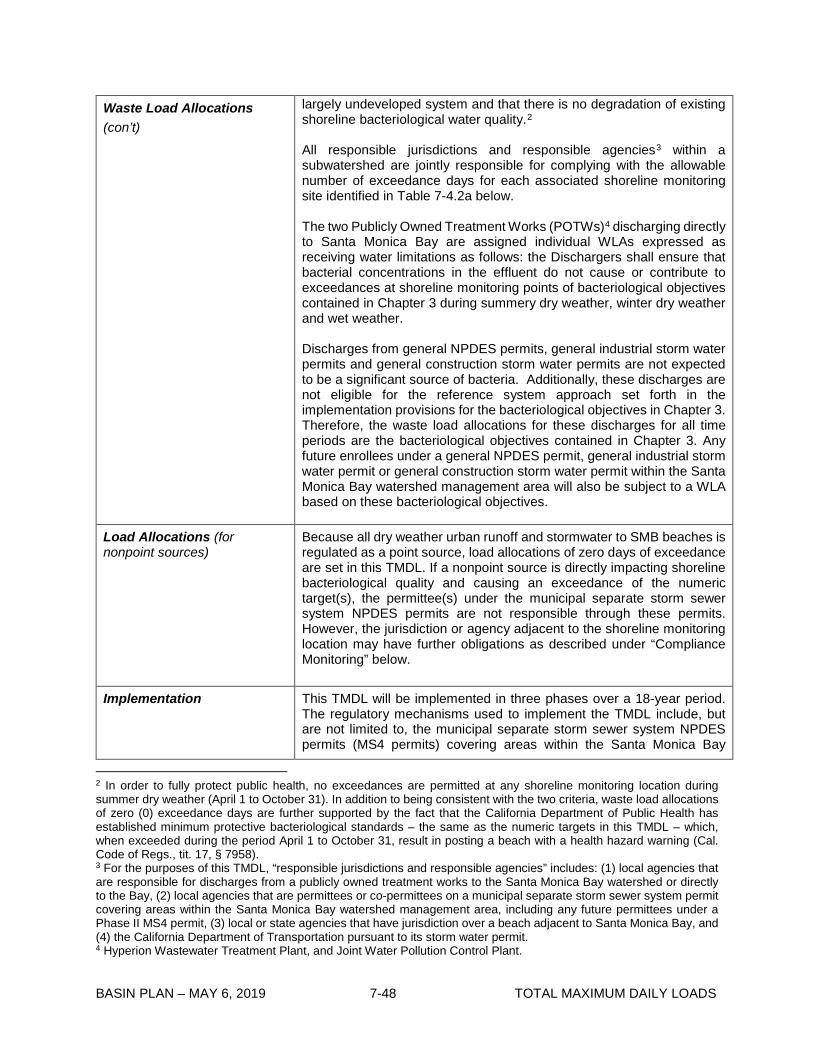
BASIN PLAN – MAY 6, 2019 7-48 TOTAL MAXIMUM DAILY LOADS
Waste Load Allocations (con’t)
largely undeveloped system and that there is no degradation of existing shoreline bacteriological water quality.2
All responsible jurisdictions and responsible agencies3 within a subwatershed are jointly responsible for complying with the allowable number of exceedance days for each associated shoreline monitoring site identified in Table 7-4.2a below.
The two Publicly Owned Treatment Works (POTWs)4 discharging directly to Santa Monica Bay are assigned individual WLAs expressed as receiving water limitations as follows: the Dischargers shall ensure that bacterial concentrations in the effluent do not cause or contribute to exceedances at shoreline monitoring points of bacteriological objectives contained in Chapter 3 during summery dry weather, winter dry weather and wet weather.
Discharges from general NPDES permits, general industrial storm water permits and general construction storm water permits are not expected to be a significant source of bacteria. Additionally, these discharges are not eligible for the reference system approach set forth in the implementation provisions for the bacteriological objectives in Chapter 3. Therefore, the waste load allocations for these discharges for all time periods are the bacteriological objectives contained in Chapter 3. Any future enrollees under a general NPDES permit, general industrial storm water permit or general construction storm water permit within the Santa Monica Bay watershed management area will also be subject to a WLA based on these bacteriological objectives.
Load Allocations (for nonpoint sources)
Because all dry weather urban runoff and stormwater to SMB beaches is regulated as a point source, load allocations of zero days of exceedance are set in this TMDL. If a nonpoint source is directly impacting shoreline bacteriological quality and causing an exceedance of the numeric target(s), the permittee(s) under the municipal separate storm sewer system NPDES permits are not responsible through these permits. However, the jurisdiction or agency adjacent to the shoreline monitoring location may have further obligations as described under “Compliance Monitoring” below.
Implementation This TMDL will be implemented in three phases over a 18-year period. The regulatory mechanisms used to implement the TMDL include, but are not limited to, the municipal separate storm sewer system NPDES permits (MS4 permits) covering areas within the Santa Monica Bay
2 In order to fully protect public health, no exceedances are permitted at any shoreline monitoring location during summer dry weather (April 1 to October 31). In addition to being consistent with the two criteria, waste load allocations of zero (0) exceedance days are further supported by the fact that the California Department of Public Health has established minimum protective bacteriological standards – the same as the numeric targets in this TMDL – which, when exceeded during the period April 1 to October 31, result in posting a beach with a health hazard warning (Cal. Code of Regs., tit. 17, § 7958). 3 For the purposes of this TMDL, “responsible jurisdictions and responsible agencies” includes: (1) local agencies that are responsible for discharges from a publicly owned treatment works to the Santa Monica Bay watershed or directly to the Bay, (2) local agencies that are permittees or co-permittees on a municipal separate storm sewer system permit covering areas within the Santa Monica Bay watershed management area, including any future permittees under a Phase II MS4 permit, (3) local or state agencies that have jurisdiction over a beach adjacent to Santa Monica Bay, and (4) the California Department of Transportation pursuant to its storm water permit. 4 Hyperion Wastewater Treatment Plant, and Joint Water Pollution Control Plant.

BASIN PLAN – MAY 6, 2019 7-49 TOTAL MAXIMUM DAILY LOADS
Implementation (con’t) watershed management area, including any future Phase II MS4 permits, the General Industrial Storwater Permit, the General Construction Stormwater Permit, the Caltrans Stormwater Permit, the three NPDES permits for the POTWs, the authority contained in sections 13263, 13267 and 13383 of the Water Code, and regulations to be adopted pursuant to section 13291 of the Water Code. Each NPDES permit assigned a waste load allocation shall be reopened or amended at reissuance, in accordance with applicable laws, to incorporate the applicable waste load allocation(s) as a permit requirement.
By July 15, 2006, summer dry-weather allowable exceedance days must be achieved. By November 1, 2009, winter dry-weather allowable exceedance days must be achieved.
For those beach monitoring locations subject to the antidegradation provision, there shall be no increase in exceedance days during the implementation period above that estimated for the beach monitoring location in the critical year as identified in Table 7-4.2a.
The implementation schedule for achieving the wet weather allocations shall be determined on the basis of the implementation plan(s), which must be submitted to the Regional Board by responsible jurisdictions and agencies by July 15, 2005 (see Table 7-4.3). Responsible jurisdictions and agencies must clearly demonstrate in the above-mentioned plan whether they intend to pursue an integrated water resources approach.5
The subwatersheds associated with each beach monitoring location may include multiple responsible jurisdictions and responsible agencies. Therefore, a “primary jurisdiction,” defined as the jurisdiction comprising greater than fifty percent of the subwatershed land area, is identified for each subwatershed (see Table 7-4.2b). Nine primary jurisdictions are identified within the Santa Monica Bay watershed management area, each with a group of associated subwatersheds and beach monitoring locations. These are identified as “jurisdictional groups” (see Table 7-4.2b). The primary jurisdiction of each “jurisdictional group” shall be responsible for submitting the implementation plan described above, which will determine the implementation timeframe to achieve the wet weather allocations for the subwatershed. A jurisdictional group may change its primary jurisdiction by submitting a joint, written request, submitted by the current primary jurisdiction and the proposed primary jurisdiction, to the Executive Officer requesting a reassignment of primary responsibility. Two jurisdictional groups may also choose to change the assignment of monitoring locations between the two groups by submitting a joint, written request, submitted by the current primary jurisdiction and
5 An integrated water resources approach is one that takes a holistic view of regional water resources management by integrating planning for future wastewater, storm water, recycled water, and potable water needs and systems; focuses on beneficial re-use of storm water, including groundwater infiltration, at multiple points throughout a watershed; and addresses multiple pollutants for which Santa Monica Bay or its watershed are listed on the CWA section 303(d) List as impaired. Because an integrated water resources approach will address multiple pollutants, responsible jurisdictions can recognize cost-savings because capital expenses for the integrated approach will implement several TMDLs that address pollutants in storm water. An integrated water resources approach shall not only provide water quality benefits to the people of the Los Angeles Region, but it is also anticipated that an integrated approach will incorporate and enhance other public goals. These may include, but are not limited to, water supply, recycling and storage; environmental justice; parks, greenways and open space; and active and passive recreational and environmental education opportunities.

BASIN PLAN – MAY 6, 2019 7-50 TOTAL MAXIMUM DAILY LOADS
Implementation (con’t) the proposed primary jurisdiction, to the Executive Officer requesting a reassignment of the monitoring location.
Jurisdictional group(s) must achieve a 10% cumulative percentage reduction from the total wet weather exceedance-day reduction required for the group of beach monitoring locations by July 15, 2009, a 25% reduction July 15, 2013, and a 50% reduction by July 15, 2018.6
The final implementation targets in terms of allowable wet-weather exceedance days must be achieved at each individual beach location no later than July 15, 2021. In addition, the geometric mean targets must be achieved for each individual beach location no later than July 15, 2021.
Margin of Safety The TMDL is set at levels that are exactly equivalent to the applicable water quality standards along with the proposed reference system/antidegradation implementation provisions set forth in Chapter 3.
An implicit margin of safety is included in the supporting water quality model by assuming no dilution between the storm drain and the wave wash, the point of compliance. This is a conservative assumption since studies have shown that there is a high degree of variability in the amount of dilution between the storm drain and wave wash temporally, spatially and among indicators, ranging from 100% to 0%.
Seasonal Variations and Critical Conditions
Seasonal variations are addressed by developing separate waste load allocations for three time periods (summer dry weather, winter dry weather and wet weather,) based on public health concerns and observed natural background levels of exceedance of bacterial indicators.
The critical condition for this bacteria TMDL is wet weather generally, when historic shoreline monitoring data for the reference beach indicate that the single sample bacteria objectives are exceeded on 22% of the wet-weather days sampled. To more specifically identify a critical condition within wet weather in order to set the allowable exceedance days shown in Tables 7-4.2a and 7-4.2b, the 90th percentile ‘storm year’7 in terms of wet days is used as the reference year. Selecting the 90th percentile year avoids a situation where the reference beach is frequently out of compliance.
Compliance Monitoring Responsible jurisdictions and agencies as defined in Footnote 2 shall conduct daily or systematic weekly sampling in the wave wash at all major drains8 and creeks or at existing monitoring stations at beaches
6 The interim allowable number of exceedance days for a jurisdictional group shall be calculated as follows: (the difference of [the sum of the estimated number of wet weather exceedance days in the critical year for the sites within the jurisdictional group] and [the sum of the allowable number of wet weather exceedance days for the sites within the jurisdictional group]) x 90% = 10% interim milestone (x 75% = 25% interim milestone; and x 50% = 50% interim milestone), where the estimated number of wet weather exceedance days is based on the exceedance rate from the November 2004-October 2010 shoreline monitoring dataset for each compliance monitoring site. 7 For purposes of this TMDL, a ‘storm year’ means November 1 to October 31. The 90th percentile storm year was 1993 with 75 wet days at the LAX meteorological station. 8 Major drains are major municipal separate storm sewer system outfalls as defined in 40 CFR 122.26(b)(5) that have measurable flow to the beach during dry weather.

BASIN PLAN – MAY 6, 2019 7-51 TOTAL MAXIMUM DAILY LOADS
Compliance Monitoring (con’t)
without storm drains or freshwater outlets to determine compliance.9 At all locations, samples shall be taken at ankle depth and on an incoming wave. At locations where there is a freshwater outlet, during wet weather, samples should be taken as close as possible to the wave wash, and no further away than 10 meters down current of the major drain or outlet.10 At locations where there is a freshwater outlet, samples shall be taken when the freshwater outlet is flowing into the surf zone.
If the number of exceedance days exceeds the allowable number of exceedance days for a target beach at the final implementation deadline, the responsible jurisdictions and agencies within the contributing subwatershed shall be considered out-of-compliance with the TMDL. Responsible jurisdictions or agencies shall not be deemed out of compliance with the TMDL if the investigation described in the paragraph below demonstrates that bacterial sources originating within the jurisdiction of the responsible agency have not caused or contributed to the exceedance.
If a single sample shows the discharge or contributing area to be out of compliance, the Regional Board may require, through permit requirements or the authority contained in Water Code section 13267, daily sampling in the wave wash or at the existing open shoreline monitoring location (if it is not already) until all single sample events meet bacteria water quality objectives. Furthermore, if a beach location is out-of-compliance as determined in the previous paragraph, responsible agencies shall initiate an investigation, which at a minimum shall include daily sampling in the wave wash or at the existing open shoreline monitoring location until all single sample events meet bacteria water quality objectives. If bacteriological water quality objectives are exceeded in any three weeks of a four-week period when weekly sampling is performed, or, for areas where testing is done more than once a week, 75% of testing days produce an exceedance of bacteria water quality objectives, the responsible agencies shall conduct a source investigation of the subwatershed(s) pursuant to protocols established under Water Code 13178. If a beach location without a freshwater outlet is out-of-compliance or if the outlet is diverted or being treated, the adjacent municipality, County agency(s), or State or federal agency(s) shall be responsible for conducting the investigation and shall submit its findings to the Regional Board to facilitate the Regional Board exercising further authority to regulate the source of the exceedance in conformance with the Cal. Water Code and Statewide Policy for Implementation and Enforcement of the Nonpoint Source Control Program.
9 The frequency of sampling (i.e., daily versus weekly) shall be determined in the monitoring and reporting programs of the permits through which the waste load allocations are implemented. However, the number of sample days that may exceed the objectives will be scaled accordingly. 10 Safety considerations during wet weather may preclude taking a sample in the wave wash.

BASIN PLAN—May 6, 2019 7-52 TOTAL MAXIMUM DAILY LOADS
Table 7-4.2a: Santa Monica Bay Beaches Bacteria TMDL Implementation Schedule: Allowable Number of Days that May Exceed Any Single Sample Bacterial Indicator Target for Existing Shoreline Monitoring Stations
Compliance Deadline 15-Jul-06 1-Nov-09 15-Jul-21
Station ID
Location Name
Subwatershed
Summer Dry Weather^ Winter Dry Weather^ Wet Weather Apr. 1-Oct. 31 Nov. 1-Mar. 31 Year-round
Daily sampling
(No. days)
Weekly sampling
(No. days)
Daily sampling
(No. days)
Weekly sampling
(No. days)
Daily sampling
(No. days)
Weekly sampling
(No. days) SMB 1-1 Leo Carillo Beach (REFERENCE BEACH) Arroyo Sequit Canyon 0 0 9 2 17 3 SMB 1-2 El Pescador State Beach Los Alisos Canyon 0 0 1 1 5 1 SMB 1-3 El Matador State Beach Encinal Canyon 0 0 1 1 3 1 SMB 1-4 Trancas Creek Trancas Canyon 0 0 9 2 17 3 SMB 1-5 Zuma Creek Zuma Canyon 0 0 9 2 17 3 SMB 1-6 Walnut Creek Ramirez Canyon 0 0 9 2 17 3 SMB 1-7 Ramirez Creek Ramirez Canyon 0 0 9 2 17 3 SMB 1-8 Escondido Creek Escondido Canyon 0 0 9 2 17 3 SMB 1-9 Latigo Canyon Creek Latigo Canyon 0 0 9 2 17 3 SMB 1-10 Solstice Creek Solstice Canyon 0 0 5 1 17 3 SMB 1-11 Wave wash of unnamed creek on Puerco Beach Corral Canyon 0 0 9 2 17 3 SMB 1-12 Marie Canyon Storm Drain on Puerco Beach Corral Canyon 0 0 9 2 17 3 SMB 1-13 Sweetwater Creek on Carbon Beach Carbon Canyon 0 0 9 2 17 3 SMB 1-14 Las Flores Creek Las Flores Canyon 0 0 6 1 17 3 SMB 1-15 Big Rock Beach at 19948 Pacific Coast Hwy Piedra Gorda Canyon 0 0 9 2 17 3 SMB 1-16 Pena Creek Pena Canyon 0 0 3 1 14 2 SMB 1-17 Tuna Canyon Creek Tuna Canyon 0 0 7 1 12 2 SMB 1-18 Topanga Creek Topanga Canyon 0 0 9 2 17 3 SMB 4-1 San Nicholas Canyon Creek Nicholas Canyon 0 0 4 1 14 2 SMB 2-1 Castlerock (Parker Mesa) Storm Drain Castlerock Canyon 0 0 9 2 17 3 SMB 2-2 Santa Ynez Storm Drain Santa Ynez Canyon 0 0 9 2 17 3 SMB 2-3 Will Rogers State Beach at 17200 Pacific Coast Hwy. Santa Ynez Canyon 0 0 9 2 17 3 SMB 2-4 Pulga Canyon storm drain Pulga Canyon 0 0 9 2 17 3 SMB 2-5 Temescal Storm Drain Pulga Canyon 0 0 9 2 17 3 SMB 2-6 Bay Club Storm Drain Santa Ynez Canyon 0 0 9 2 17 3 SMB 2-7 Santa Monica Canyon, Will Rogers State Beach Santa Monica Canyon 0 0 9 2 17 3 SMB 2-8 Venice Pier, Venice Ballona 0 0 9 2 17 3 SMB 2-9 Topsail Street extended Ballona 0 0 9 2 17 3 SMB 2-10 Dockweiler State Beach at Culver Bl. Storm Drain Dockweiler 0 0 9 2 17 3 SMB 2-11 North Westchester Storm Drain Dockweiler 0 0 0 0 17 3 SMB 2-12 World Way extended Dockweiler 0 0 9 2 17 3 SMB 2-13 Imperial Highway storm drain (Dockweiler) Dockweiler 0 0 4 1 17 3 SMB 2-14 Opposite Hyperion Plant, 1 mile Dockweiler 0 0 9 2 17 3 SMB 2-15 Grand Avenue Storm Drain Dockweiler 0 0 9 2 17 3 SMB 3-1 Montana Ave. Storm Drain Santa Monica 0 0 9 2 17 3 SMB 3-2 Wilshire Blvd., Santa Monica Santa Monica 0 0 9 2 17 3 SMB 3-3 Santa Monica Municipal Pier at storm drain Santa Monica 0 0 9 2 17 3 SMB 3-4 Santa Monica Beach at Pico/Kenter storm drain Santa Monica 0 0 9 2 17 3 SMB 3-5 Ashland Av. storm drain (Venice) Santa Monica 0 0 9 2 17 3 SMB 3-6 Rose Ave. Storm Drain on Venice Beach Santa Monica 0 0 6 1 17 3 SMB 3-7 Venice City Beach at Brooks Storm Drain (projection of Brooks Ave.) Ballona 0 0 9 2 17 3 SMB 3-8 Venice Pavilion at projection of Windward Av. Ballona 0 0 9 2 17 3 SMB 3-9 Strand Street extended Santa Monica 0 0 9 2 17 3
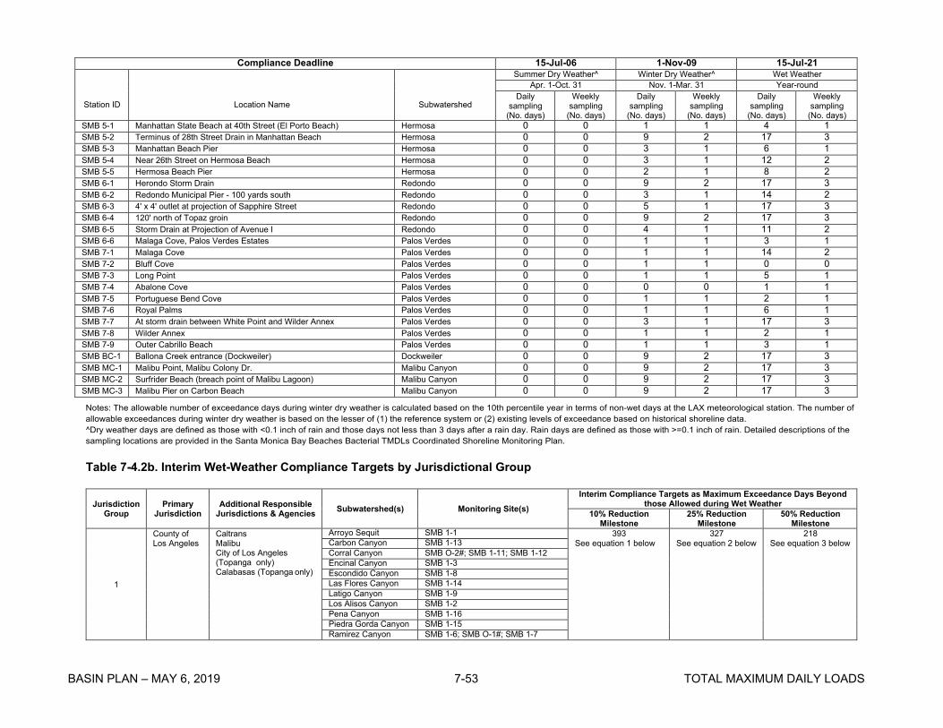
BASIN PLAN – MAY 6, 2019 7-53 TOTAL MAXIMUM DAILY LOADS
Compliance Deadline 15-Jul-06 1-Nov-09 15-Jul-21
Station ID
Location Name
Subwatershed
Summer Dry Weather^ Winter Dry Weather^ Wet Weather Apr. 1-Oct. 31 Nov. 1-Mar. 31 Year-round
Daily sampling
(No. days)
Weekly sampling
(No. days)
Daily sampling
(No. days)
Weekly sampling
(No. days)
Daily sampling
(No. days)
Weekly sampling
(No. days) SMB 5-1 Manhattan State Beach at 40th Street (El Porto Beach) Hermosa 0 0 1 1 4 1 SMB 5-2 Terminus of 28th Street Drain in Manhattan Beach Hermosa 0 0 9 2 17 3 SMB 5-3 Manhattan Beach Pier Hermosa 0 0 3 1 6 1 SMB 5-4 Near 26th Street on Hermosa Beach Hermosa 0 0 3 1 12 2 SMB 5-5 Hermosa Beach Pier Hermosa 0 0 2 1 8 2 SMB 6-1 Herondo Storm Drain Redondo 0 0 9 2 17 3 SMB 6-2 Redondo Municipal Pier - 100 yards south Redondo 0 0 3 1 14 2 SMB 6-3 4' x 4' outlet at projection of Sapphire Street Redondo 0 0 5 1 17 3 SMB 6-4 120' north of Topaz groin Redondo 0 0 9 2 17 3 SMB 6-5 Storm Drain at Projection of Avenue I Redondo 0 0 4 1 11 2 SMB 6-6 Malaga Cove, Palos Verdes Estates Palos Verdes 0 0 1 1 3 1 SMB 7-1 Malaga Cove Palos Verdes 0 0 1 1 14 2 SMB 7-2 Bluff Cove Palos Verdes 0 0 1 1 0 0 SMB 7-3 Long Point Palos Verdes 0 0 1 1 5 1 SMB 7-4 Abalone Cove Palos Verdes 0 0 0 0 1 1 SMB 7-5 Portuguese Bend Cove Palos Verdes 0 0 1 1 2 1 SMB 7-6 Royal Palms Palos Verdes 0 0 1 1 6 1 SMB 7-7 At storm drain between White Point and Wilder Annex Palos Verdes 0 0 3 1 17 3 SMB 7-8 Wilder Annex Palos Verdes 0 0 1 1 2 1 SMB 7-9 Outer Cabrillo Beach Palos Verdes 0 0 1 1 3 1 SMB BC-1 Ballona Creek entrance (Dockweiler) Dockweiler 0 0 9 2 17 3 SMB MC-1 Malibu Point, Malibu Colony Dr. Malibu Canyon 0 0 9 2 17 3 SMB MC-2 Surfrider Beach (breach point of Malibu Lagoon) Malibu Canyon 0 0 9 2 17 3 SMB MC-3 Malibu Pier on Carbon Beach Malibu Canyon 0 0 9 2 17 3
Notes: The allowable number of exceedance days during winter dry weather is calculated based on the 10th percentile year in terms of non-wet days at the LAX meteorological station. The number of allowable exceedances during winter dry weather is based on the lesser of (1) the reference system or (2) existing levels of exceedance based on historical shoreline data. ^Dry weather days are defined as those with <0.1 inch of rain and those days not less than 3 days after a rain day. Rain days are defined as those with >=0.1 inch of rain. Detailed descriptions of the sampling locations are provided in the Santa Monica Bay Beaches Bacterial TMDLs Coordinated Shoreline Monitoring Plan.
Table 7-4.2b. Interim Wet-Weather Compliance Targets by Jurisdictional Group
Jurisdiction Group
Primary
Jurisdiction
Additional Responsible
Jurisdictions & Agencies
Subwatershed(s)
Monitoring Site(s)
Interim Compliance Targets as Maximum Exceedance Days Beyond those Allowed during Wet Weather
10% Reduction Milestone
25% Reduction Milestone
50% Reduction Milestone
1
County of Los Angeles
Caltrans Malibu City of Los Angeles (Topanga only) Calabasas (Topanga only)
Arroyo Sequit SMB 1-1 393 See equation 1 below
327 See equation 2 below
218 See equation 3 below Carbon Canyon SMB 1-13
Corral Canyon SMB O-2#; SMB 1-11; SMB 1-12 Encinal Canyon SMB 1-3 Escondido Canyon SMB 1-8 Las Flores Canyon SMB 1-14 Latigo Canyon SMB 1-9 Los Alisos Canyon SMB 1-2 Pena Canyon SMB 1-16 Piedra Gorda Canyon SMB 1-15 Ramirez Canyon SMB 1-6; SMB O-1#; SMB 1-7

BASIN PLAN – MAY 6, 2019 7-54 TOTAL MAXIMUM DAILY LOADS
Jurisdiction Group
Primary Jurisdiction
Additional Responsible Jurisdictions & Agencies Subwatershed(s) Monitoring Site(s)
Interim Compliance Targets as Maximum Exceedance Days Beyond those Allowed during Wet Weather
10% Reduction Milestone
25% Reduction Milestone
50% Reduction Milestone
1 (con’t)
County of Los Angeles
Caltrans Malibu City of Los Angeles (Topanga only) Calabasas (Topanga only)
Solstice Canyon SMB 1-10 393 See equation 1 below
327 See equation 2 below
218 See equation 3 below Topanga Canyon SMB 1-18
Trancas Canyon SMB 1-4 Tuna Canyon SMB 1-17 Zuma Canyon SMB 1-5
2
City of Los Angeles
Caltrans County of Los Angeles El Segundo (DW only) Santa Monica
Castlerock SMB 2-1 382 Also see equation 1 below
318 Also see equation 2
below
212 Also see equation 3
below Dockweiler SMB 2-10; SMB 2-11; SMB 2-12; SMB
2-13; SMB 2-14; SMB 2-15 Venice Beach SMB 2-8; SMB 2-9 Pulga Canyon SMB 2-4; SMB 2-5 Santa Monica Canyon SMB 2-7 Santa Ynez Canyon SMB 2-2; SMB 2-3; SMB 2-6
3 Santa Monica Caltrans
City of Los Angeles County of Los Angeles
Santa Monica SMB 3-1; SMB 3-2; SMB 3-3; SMB 3-4; SMB 3-5; SMB 3-6; SMB 3-7; SMB 3-8; SMB 3-9
219 Also see equation 1 below
183 Also see equation 2
below
122 Also see equation 3
below
4 Malibu Caltrans County of Los Angeles
Nicholas Canyon SMB 4-1 15 12 8
5
Manhattan Beach Caltrans El Segundo Hermosa Beach Redondo Beach County of Los Angeles
Hermosa SMB 5-1; SMB 5-2; SMB 5-3; SMB 5-4; SMB 5-5
63 Also see equation 1 below
52 Also see equation 2
below
35 Also see equation 3
below
6
Redondo Beach Caltrans Hermosa Beach Manhattan Beach Torrance County of Los Angeles
Redondo SMB 6-1; SMB 6-2; SMB 6-3; SMB 6-4; SMB 6-5; SMB 6-6
62 Also see equation 1 below
51 Also see equation 2
below
34 Also see equation 3
below
7
Rancho Palos Verdes
City of Los Angeles Palos Verdes Estates Rolling Hills Rolling Hills Estates County of Los Angeles
Palos Verdes Peninsula SMB 7-1; SMB 7-2; SMB 7-3; SMB 7-4; SMB 7-5; SMB 7-6; SMB 7-8; SMB 7-9
88 Also see equation 1 below
73 Also see equation 2
below
49 Also see equation 3
below
9
County of Los Angeles
County of Ventura Thousand Oaks Agoura Hills Calabasas Westlake Village Malibu Caltrans Hidden Hills
Malibu SMB MC-1 SMB MC-2 SMB MC-3
N/A N/A N/A
#Monitoring began in 2010 and data was examined from April 2010 to November 2011 Notes: Monitoring sites are those established in the Santa Monica Bay Beaches Bacterial TMDLs Coordinated Shoreline Monitoring Plan (April 2004). For those beach monitoring locations subject to the antidegradation provision, there shall be no increase in exceedance days during the implementation period above that estimated for the beach monitoring location in the critical year as identified in Table 7-4.2a. Interim compliance targets expressed as the maximum allowable wet weather exceedance days by Jurisdictional Group shall be calculated as follows:
Equation 1: 10% Reduction Milestone = [Σ (estimated number of wet weather exceedance days in the critical year for each site within the jurisdictional group) – Σ (allowable number of wet weather exceedance days for each site within the jurisdictional group)] x 0.9
Equation 2: 25% Reduction Milestone = [Σ (estimated number of wet weather exceedance days in the critical year for each site within the jurisdictional group) – Σ (allowable number of wet weather exceedance days for each site within the jurisdictional group)] x 0.75
Equation 3: 50% Reduction Milestone = [Σ (estimated number of wet weather exceedance days in the critical year for each site within the jurisdictional group) – Σ (allowable number of wet weather exceedance days for each site within the jurisdictional group)] x 0.5
Where the estimated number of wet weather exceedance days in the critical year for each compliance monitoring site is calculated as the product of the exceedance rate from the November 2004-October 2005 shoreline monitoring dataset and the number of wet days in the reference year (75 wet weather days)

BASIN PLAN – MAY 6, 2019 7-55 TOTAL MAXIMUM DAILY LOADS
Date Action
November 12, 2003 Pursuant to a request from the Regional Board,
responsible jurisdictions and responsible agencies
must submit coordinated shoreline monitoring plan(s)
to be approved by the Executive Officer, including a
list of new sites* or sites relocated to the wave wash.
November 12, 2003 Responsible jurisdictions and responsible agencies
must identify and provide documentation on 342
potential discharges to Santa Monica Bay beaches
listed in Appendix C of the TMDL Staff Report dated
January 11, 2002. Documentation must include a
Report of Waste Discharge (ROWD) where
necessary.
Responsible jurisdictions and responsible agencies
must identify and provide documentation on potential
discharges to the Area of Special Biological
Significance (ASBS) in northern Santa Monica Bay
from Latigo Point to the County line.
Cessation of the discharges into the ASBS shall be
required in conformance with the California Ocean
Plan.
March 15, 2005 Responsible jurisdictions and agencies shall provide
a draft written report to the Regional Board outlining
how each intends to cooperatively (through
Jurisdictional Groups) achieve compliance with the
wet weather allocations. The report shall include
implementation methods, an implementation
schedule, and proposed milestones.
July 15, 2005 Responsible jurisdictions and agencies shall provide
a written report to the Regional Board outlining how
Table 7-4.3 Santa Monica Bay Beaches Bacteria TMDL: Significant Dates

BASIN PLAN – MAY 6, 2019 7-56 TOTAL MAXIMUM DAILY LOADS
each intends to cooperatively (through Jurisdictional
Groups) achieve compliance with the wet weather
allocations. The report shall include implementation
methods, an implementation schedule, and proposed
milestones. Under no circumstances shall final
compliance dates to achieve wet weather allocations
exceed 10 years for non-integrated approaches or 18
years for integrated water resources approaches.
Regional Board staff shall bring to the Regional Board
the aforementioned plans as soon as possible for
consideration.
July 15, 2006 Achieve compliance with allowable exceedance days
as set forth in Table 7-4.2a during summer dry
weather (April 1 to October 31).
November 1, 2009 Achieve compliance with allowable exceedance days
as set forth in Table 7-4.2a during winter dry weather
(November 1 to March 31).
Six months from effective date of
TMDL revised by Resolution No.
R12-007
Responsible jurisdictions and agencies shall submit a
revised bacteria water quality monitoring plan to
address changes in the calculation and reporting of
attainment of the geometric mean targets.
July 15, 2009 Each defined jurisdictional group must achieve a 10%
cumulative percentage reduction from the total wet
weather exceedance-day reductions required for that
jurisdictional group as identified in Table 7-4.2b.
July 15, 2013 Each defined jurisdictional group must achieve a 25%
cumulative percentage reduction from the total wet
weather exceedance-day reductions required for that
jurisdictional group as identified in Table 7-4.2b.

BASIN PLAN – MAY 6, 2019 7-57 TOTAL MAXIMUM DAILY LOADS
July 15, 2018 Each defined jurisdictional group must achieve a 50%
cumulative percentage reduction from the total wet
weather exceedance-day reductions required for that
jurisdictional group as identified in Table 7-4.2b.
July 15, 2018 The Regional Board shall reconsider the TMDL.
July 15, 2021 Final implementation targets in terms of allowable
wet-weather exceedance days must be achieved at
each individual beach as identified in Table 7-4.2a. In
addition, the geometric mean targets must be
achieved for each individual beach location.
Notes: *For those subwatersheds without an existing shoreline monitoring site, responsible jurisdictions and agencies must establish a shoreline monitoring site if there is measurable flow from a creek or major drain to the beach during dry weather.

BASIN PLAN – MAY 6, 2019 7-58 TOTAL MAXIMUM DAILY LOADS
This page intentionally left blank

BASIN PLAN – MAY 6, 2019 7-59 TOTAL MAXIMUM DAILY LOADS
7-5 Marina del Rey Harbor Mothers’ Beach and Back Basins Bacteria TMDL This TMDL was adopted by the Regional Board on August 7, 2003.
This TMDL was approved by:
The State Water Resources Control Board on November 19, 2003. The Office of Administrative Law on January 30, 2004. The U.S. Environmental Protection Agency on March 8, 2004.
This TMDL was revised by:
The Regional Board on June 7, 2012.
This revised TMDL was approved by:
The State Water Resources Control Board on May 19, 2013. The Office of Administrative Law on November 7, 2013. The U.S. Environmental Protection Agency on July 2, 2014.
The following table includes the elements of this TMDL.

BASIN PLAN – MAY 6, 2019 7-60 TOTAL MAXIMUM DAILY LOADS
Table 7-5.1 Marina del Rey Harbor Mothers’ Beach and Back Basins Bacteria TMDL: Elements Element Key Findings and Regulatory Provisions
Problem Statement Elevated bacterial indicator densities are causing impairment of the water contact recreation (REC-1) beneficial use at Marina del Rey Harbor (MdRH) Mothers’ Beach and back basins. Swimming in marine waters with elevated bacterial indicator densities has long been associated with adverse health effects. Specifically, local and national epidemiological studies compel the conclusion that there is a causal relationship between adverse health effects and recreational water quality, as measured by bacterial indicator densities.
Numeric Target The TMDL has a multi-part numeric target based on the bacteriological water quality objectives for marine water to protect the water contact recreation use. These targets are the most appropriate indicators of public health risk in recreational waters.
These bacteriological objectives are set forth in Chapter 3 of the Basin Plan.1 The objectives are based on four bacterial indicators and include both geometric mean limits and single sample limits. The Basin Plan objectives that serve as the numeric targets for this TMDL are:
1. Geometric Mean Limits a. Total coliform density shall not exceed 1,000/100 ml. b. Fecal coliform density shall not exceed 200/100 ml. c. Enterococcus density shall not exceed 35/100 ml.
3. Single Sample Limits e. Total coliform density shall not exceed 10,000/100 ml. f. Fecal coliform density shall not exceed 400/100 ml. g. Enterococcus density shall not exceed 104/100 ml. h. Total coliform density shall not exceed 1,000/100 ml, if
the ratio of fecal-to-total coliform exceeds 0.1.
These objectives are generally based on an acceptable health risk for marine recreational waters of 19 illnesses per 1,000 exposed individuals as set by the United States Environmental Protection Agency (US EPA) (US EPA, 1986). The targets apply throughout the year. The final compliance point for the targets is the point at which the effluent from a storm drain initially mixes with the receiving water where there is a freshwater outlet (i.e., publicly-owned storm drain) to the beach, or at ankle depth at beaches without a freshwater outlet, and at surface and depth throughout the Harbor. For Mothers’ Beach, the targets will apply at existing or new monitoring sites, with samples taken at ankle depth. For Basins D, E, and F, the targets will also apply at existing or new monitoring sites with samples collected at surface and at depth.
1 The bacteriological objectives were revised by a Basin Plan amendment adopted by the Regional Board on October 25, 2001, and subsequently approved by the State Water Resources Control Board, the Office of Administrative Law and finally by U.S. EPA on September 25, 2002.
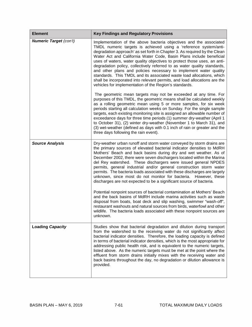
BASIN PLAN – MAY 6, 2019 7-61 TOTAL MAXIMUM DAILY LOADS
Element Key Findings and Regulatory Provisions Numeric Target (con’t) Implementation of the above bacteria objectives and the associated
TMDL numeric targets is achieved using a ‘reference system/anti-degradation approach’ as set forth in Chapter 3. As required by the Clean Water Act and California Water Code, Basin Plans include beneficial uses of waters, water quality objectives to protect those uses, an anti-degradation policy, collectively referred to as water quality standards, and other plans and policies necessary to implement water quality standards. This TMDL and its associated waste load allocations, which shall be incorporated into relevant permits, and load allocations are the vehicles for implementation of the Region’s standards.
The geometric mean targets may not be exceeded at any time. For purposes of this TMDL, the geometric means shall be calculated weekly as a rolling geometric mean using 5 or more samples, for six week periods starting all calculation weeks on Sunday. For the single sample targets, each existing monitoring site is assigned an allowable number of exceedance days for three time periods (1) summer dry-weather (April 1 to October 31), (2) winter dry-weather (November 1 to March 31), and (3) wet-weather (defined as days with 0.1 inch of rain or greater and the three days following the rain event).
Source Analysis Dry-weather urban runoff and storm water conveyed by storm drains are the primary sources of elevated bacterial indicator densities to MdRH Mothers’ Beach and back basins during dry and wet weather. As of December 2002, there were seven dischargers located within the Marina del Rey watershed. These dischargers were issued general NPDES permits, general industrial and/or general construction storm water permits. The bacteria loads associated with these discharges are largely unknown, since most do not monitor for bacteria. However, these discharges are not expected to be a significant source of bacteria.
Potential nonpoint sources of bacterial contamination at Mothers’ Beach and the back basins of MdRH include marina activities such as waste disposal from boats, boat deck and slip washing, swimmer “wash-off”, restaurant washouts and natural sources from birds, waterfowl and other wildlife. The bacteria loads associated with these nonpoint sources are unknown.
Loading Capacity Studies show that bacterial degradation and dilution during transport from the watershed to the receiving water do not significantly affect bacterial indicator densities. Therefore, the loading capacity is defined in terms of bacterial indicator densities, which is the most appropriate for addressing public health risk, and is equivalent to the numeric targets, listed above. As the numeric targets must be met at the point where the effluent from storm drains initially mixes with the receiving water and back basins throughout the day, no degradation or dilution allowance is provided.
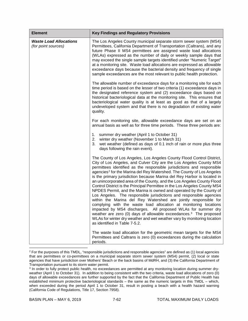
BASIN PLAN – MAY 6, 2019 7-62 TOTAL MAXIMUM DAILY LOADS
Element Key Findings and Regulatory Provisions
Waste Load Allocations (for point sources)
The Los Angeles County municipal separate storm sewer system (MS4) Permittees, California Department of Transportation (Caltrans), and any future Phase II MS4 permittees are assigned waste load allocations (WLAs) expressed as the number of daily or weekly sample days that may exceed the single sample targets identified under “Numeric Target” at a monitoring site. Waste load allocations are expressed as allowable exceedance days because the bacterial density and frequency of single sample exceedances are the most relevant to public health protection.
The allowable number of exceedance days for a monitoring site for each time period is based on the lesser of two criteria (1) exceedance days in the designated reference system and (2) exceedance days based on historical bacteriological data at the monitoring site. This ensures that bacteriological water quality is at least as good as that of a largely undeveloped system and that there is no degradation of existing water quality.
For each monitoring site, allowable exceedance days are set on an annual basis as well as for three time periods. These three periods are:
1. summer dry weather (April 1 to October 31) 2. winter dry weather (November 1 to March 31) 3. wet weather (defined as days of 0.1 inch of rain or more plus three
days following the rain event).
The County of Los Angeles, Los Angeles County Flood Control District, City of Los Angeles, and Culver City are the Los Angeles County MS4 permittees identified as the responsible jurisdictions and responsible agencies2 for the Marina del Rey Watershed. The County of Los Angeles is the primary jurisdiction because Marina del Rey Harbor is located in an unincorporated area of the County, and the Los Angeles County Flood Control District is the Principal Permittee in the Los Angeles County MS4 NPDES Permit, and the Marina is owned and operated by the County of Los Angeles. The responsible jurisdictions and responsible agencies within the Marina del Rey Watershed are jointly responsible for complying with the waste load allocation at monitoring locations impacted by MS4 discharges. All proposed WLAs for summer dry weather are zero (0) days of allowable exceedances.3 The proposed WLAs for winter dry weather and wet weather vary by monitoring location as identified in Table 7-5.2.
The waste load allocation for the geometric mean targets for the MS4 Permittees and Caltrans is zero (0) exceedances during the calculation periods.
2 For the purposes of this TMDL, “responsible jurisdictions and responsible agencies” are defined as (1) local agencies that are permittees or co-permittees on a municipal separate storm sewer system (MS4) permit, (2) local or state agencies that have jurisdiction over Mothers’ Beach or the back basins of MdRH, and (3) the California Department of Transportation pursuant to its storm water permit. 3 In order to fully protect public health, no exceedances are permitted at any monitoring location during summer dry-weather (April 1 to October 31). In addition to being consistent with the two criteria, waste load allocations of zero (0) days of allowable exceedances are further supported by the fact that the California Department of Public Health has established minimum protective bacteriological standards – the same as the numeric targets in this TMDL – which, when exceeded during the period April 1 to October 31, result in posting a beach with a health hazard warning (California Code of Regulations, Title 17, Section 7958).
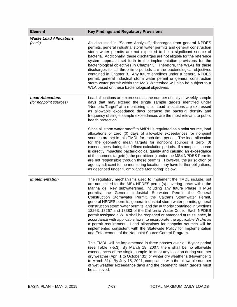
BASIN PLAN – MAY 6, 2019 7-63 TOTAL MAXIMUM DAILY LOADS
Element Key Findings and Regulatory Provisions Waste Load Allocations (con’t) As discussed in “Source Analysis”, discharges from general NPDES
permits, general industrial storm water permits and general construction storm water permits are not expected to be a significant source of bacteria. Additionally, these discharges are not eligible for the reference system approach set forth in the implementation provisions for the bacteriological objectives in Chapter 3. Therefore, the WLAs for these discharges for all three time periods are the bacteriological objectives contained in Chapter 3. Any future enrollees under a general NPDES permit, general industrial storm water permit or general construction storm water permit within the MdR Watershed will also be subject to a WLA based on these bacteriological objectives.
Load Allocations (for nonpoint sources)
Load allocations are expressed as the number of daily or weekly sample days that may exceed the single sample targets identified under “Numeric Target” at a monitoring site. Load allocations are expressed as allowable exceedance days because the bacterial density and frequency of single sample exceedances are the most relevant to public health protection.
Since all storm water runoff to MdRH is regulated as a point source, load allocations of zero (0) days of allowable exceedances for nonpoint sources are set in this TMDL for each time period. The load allocation for the geometric mean targets for nonpoint sources is zero (0) exceedances during the defined calculation periods. If a nonpoint source is directly impacting bacteriological quality and causing an exceedance of the numeric target(s), the permittee(s) under the MS4 NPDES Permits are not responsible through these permits. However, the jurisdiction or agency adjacent to the monitoring location may have further obligations, as described under “Compliance Monitoring” below.
Implementation The regulatory mechanisms used to implement the TMDL include, but are not limited to, the MS4 NPDES permit(s) covering areas within the Marina del Rey subwatershed, including any future Phase II MS4 permits, the General Industrial Storwater Permit, the General Construction Stormwater Permit, the Caltrans Stormwater Permit, general NPDES permits, general industrial storm water permits, general construction storm water permits, and the authority contained in Sections 13263, 13267 and 13383 of the California Water Code. Each NPDES permit assigned a WLA shall be reopened or amended at reissuance, in accordance with applicable laws, to incorporate the applicable WLAs as a permit requirement. Load allocations for nonpoint sources will be implemented consistent with the Statewide Policy for Implementation and Enforcement of the Nonpoint Source Control Program.
This TMDL will be implemented in three phases over a 18-year period (see Table 7-5.3). By March 18, 2007, there shall be no allowable exceedances of the single sample limits at any location during summer dry weather (April 1 to October 31) or winter dry weather s (November 1 to March 31). By July 15, 2021, compliance with the allowable number of wet weather exceedance days and the geometric mean targets must be achieved.

BASIN PLAN – MAY 6, 2019 7-64 TOTAL MAXIMUM DAILY LOADS
Element Key Findings and Regulatory Provisions Implementation (con’t) For those monitoring locations subject to the antidegradation provision,
there shall be no increase in exceedance days during the implementation period above the estimated days for the monitoring location in the critical year as identified in Table 7-5.2.
The responsible jurisdictions and the responsible agencies must submit a report to the Executive Officer by July 30, 2005 (see Table 7-5.3) describing how they intend to comply with the dry-weather and wet-weather WLAs. As the primary jurisdiction, the County of Los Angeles is responsible for submitting the implementation plan report described above. In addition, the County of Los Angeles Department of Beaches and Harbor must submit a report detailing its efforts to prohibit discharges from boats in the Harbor (see Table 7-5.3).
The Marina del Rey Harbor jurisdictional unit may change its primary jurisdiction by submitting a joint, written request, submitted by the current primary jurisdiction and the proposed primary jurisdiction, to the Executive Officer requesting reassignment of primary responsibility.
Margin of Safety The TMDL is set at levels that are exactly equivalent to the applicable water quality standards along with the proposed reference system/antidegradation implementation provisions set forth in Chapter 3.
A margin of safety has been implicitly included through several conservative assumptions, such as the assumption that no dilution takes place between the storm drain and where the effluent initially mixes with the receiving water, and that bacterial degradation rates are not fast enough to affect bacteria densities in the receiving water.
Seasonal Variations and Critical Conditions
Seasonal variations are addressed by developing separate waste load allocations for three time periods (summer dry weather, winter dry weather and wet weather) based on public health concerns and observed natural background levels of exceedance of bacterial indicators.
The critical condition for bacteria loading is during wet weather, when historic monitoring data for MdRH and the reference beach indicate greater exceedance probabilities of the single sample bacteria objectives then during dry weather. To more specifically identify a critical condition within wet weather, in order to set the allowable exceedance days shown in Table 7-5.2, the 90th percentile ‘storm year’4 in terms of wet days5 is used as the reference year. Selecting the 90th percentile year avoids a situation where the reference system is frequently out of compliance. Further, it is expected that because responsible jurisdictions and agencies will be planning for this ‘worst-case’ scenario, there will be fewer exceedance days than the maximum allowed in drier years.
4 For purposes of this TMDL, a ‘storm year’ means November 1 to October 31. The 90th percentile storm year was 1993 with 75 wet days at the LAX meteorological station. 5 A wet day is defined as a day with rainfall of 0.1 inch or more plus the 3 days following the rain event.

BASIN PLAN – MAY 6, 2019 7-65 TOTAL MAXIMUM DAILY LOADS
Element Key Findings and Regulatory Provisions
Compliance Monitoring Responsible jurisdictions and agencies shall conduct daily or systematic weekly sampling at the initial point of mixing with the receiving water at all major drains6, at existing monitoring stations and at other designated monitoring stations to determine compliance.7 For Mothers’ Beach the targets will also apply at existing or new monitoring sites, with samples taken at ankle depth. For Basins D, E, and F the targets will also apply at existing or new monitoring sites with samples collected at surface and at depth. Samples collected at ankle depth shall be taken on an incoming wave. At locations where there is a freshwater outlet, during wet weather, samples should be taken as close as possible to the initial point of mixing with the receiving water, and no further away than 10 meters down current of the storm drain or outlet.8 At locations where there is a freshwater outlet, samples shall be taken when the freshwater outlet is flowing into the surf zone.9
If the number of exceedance days is greater than the allowable number of exceedance days, the responsible jurisdictions and agencies shall be considered out of compliance with the TMDL. Responsible jurisdictions or agencies shall not be deemed out of compliance with the TMDL if the investigation described in the paragraph below demonstrates that bacterial sources originating within the jurisdiction of the responsible agency have not caused or contributed to the exceedance.
If a single sample shows the discharge or contributing area to be out of compliance, the Regional Board may require, through permit requirements or the authority contained in California Water Code sections 13267 and 13383, daily sampling where the effluent from the storm drain initially mixes with the receiving water or at the existing monitoring location (if it is not already) until all single sample events meet bacteria water quality objectives. Furthermore, if a location is out-of-compliance as determined in the previous paragraph, responsible agencies shall initiate an investigation, which at a minimum shall include daily sampling where the effluent from the storm drain initially mixes with the receiving water or at the existing monitoring location until all single sample events meet bacteria water quality objectives. If bacteriological water quality objectives are exceeded in any three weeks of a four-week period when weekly sampling is performed, or, for areas where testing is done more than once a week, 75% of testing days produce an exceedance of bacteria water quality objectives, the responsible
6 Major drains are major municipal separate storm sewer system outfalls as defined in 40 CFR section 122.26(b)(5) that have measurable flow to the beach during dry weather. 7 The frequency of sampling (i.e., daily versus weekly) shall be determined in the monitoring and reporting programs of the permits through which the waste load allocations are implemented. However, the number of sample days that may exceed the objectives will be scaled by solving for the variable “x” in the following equation: (Number of wet-weather days or dry-weather days in 1993 / 365 days = x / 52 weeks), where the number of wet-weather days and dry-weather days are based on the historical rainfall record at the Los Angeles International Airport also known as “LAX”. 8 Safety considerations during wet weather may preclude taking a sample at the initial point of mixing with the receiving water. 9 At some freshwater outlets and storm drains, during high tide conditions, the tide pushes the freshwater discharge back into the drain. As a result, sampling under these conditions is not representative of water quality conditions when the drain is flowing into the surf zone. The tide height at which this situation occurs will vary with the size, slope and configuration of the drain and the beach. Responsible agencies must ensure that samples are collected only when drains are flowing into the surf zone, not when the discharge is pushed back into the drain. Responsible agencies must submit a coordinated monitoring plan by July 16, 2004, in which this assurance should be included.

BASIN PLAN – MAY 6, 2019 7-66 TOTAL MAXIMUM DAILY LOADS
Element Key Findings and Regulatory Provisions
Compliance Monitoring (con’t)
agencies shall conduct a source investigation of the subwatershed(s) pursuant to protocols established under California Water Code section 13178. Responsible jurisdictions may wish to conduct compliance monitoring at key jurisdictional boundaries as part of this effort. If a location without a freshwater outlet is out-of-compliance or if the outlet is diverted or being treated, the adjacent municipality, County agency(s), or State or federal agency(s) shall be responsible for conducting the investigation and shall submit its findings to the Regional Board to facilitate the Regional Board exercising further authority to regulate the source of the exceedance in conformance with the California Water Code and Statewide Policy for Implementation and Enforcement of the Nonpoint Source Control Program.
In addition, the MdR responsible jurisdictions and responsible agencies are required to conduct a study to determine the relative bacterial loading from sources including but not limited to storm drains, boats, birds, and other nonpoint sources.

BASIN PLAN – APRIL 2, 2019 7-69 TOTAL MAXIMUM DAILY LOADS
Table 7-5.2 Marina del Rey Harbor Mothers’ Beach and Back Basins Bacteria TMDL: Final Allowable Exceedance Days by Sampling Location
Compliance Deadline March 18, 2007 March 18, 2007 July 15, 2021
Summer Dry Weather ^ Winter Dry Weather ^ Wet Weather ^
April 1 - October 31 November 1 – March 31 November 1 - October 31
Station ID Location Name Daily sampling (No. days)
Weekly sampling (No.
days)
Daily sampling
(No. days)
Weekly sampling (No.
days)
Daily sampling
(No. days)
Weekly sampling (No.
days)
MdRH-1 Mothers’ (Marina) Beach, at playground area 0 0 9 2 17 3
MdRH-2 Mothers’ (Marina) Beach, at lifeguard tower 0 0 9 2 17 3
MdRH-3 Mothers’ (Marina) Beach, between lifeguard tower and boat dock 0 0 9 2 17 3
MdRH-4 Basin D, near first slips outside swim area 0 0 9 2 17 3
MdRH-5 Basin E, in front of tide-gate from Oxford Basin 0 0 9 2 17 3
MdRH-6 Basin E, center of basin 0 0 9 2 17 3
MdRH-7 Basin E, in front of Boone-Olive Pump Outlet 0 0 9 2 17 3
MdRH-8 Back of Main Channel 0 0 9 2 17 3
MdRH-9 Basin F, center of basin 0 0 9 2 8 1
Notes: The number of allowable exceedances is based on the lesser of (1) the reference system or (2) existing levels of exceedance based on historical monitoring data. The allowable number of exceedance days during winter dry-weather is calculated based on the 10th percentile storm year in terms of dry days at the LAX meteorological station. The allowable number of exceedance days during wet-weather is calculated based on the 90th percentile storm year in terms of wet days at the LAX meteorological station. ^ A dry day is defined as a non-wet day. A wet day is defined as a day with a 0.1 inch or more of rain and the three days following the rain event.

BASIN PLAN – MAY 6, 2019 7-68 TOTAL MAXIMUM DAILY LOADS
Table 7-5.3 Marina del Rey Harbor Mothers’ Beach and Back Basins Bacteria TMDL: Significant Dates Date Action
July 16, 2004 Responsible jurisdictions and responsible agencies shall submit coordinated monitoring plan(s) to be approved by the Executive Officer. The monitoring plans shall including a list of new sites2 and/or sites relocated to include the point where the effluent from the storm drain initially mixes with the receiving water, at least three locations off of Mothers’ Beach, and at least one location in each of the other Marina del Rey Basins (i.e., Basins A, B, C, E, F, G, and H). The plan shall include the responsible jurisdictions’ and responsible agencies’ recommended sampling frequency at each location.
The Los Angeles County Department of Beaches and Harbors shall provide a written report to the Regional Board detailing efforts to control discharges from boats, including but not limited to the number of live-aboards and the number of pump-outs per month.
The responsible jurisdictions and the responsible agencies must identify and provide documentation on small drains discharging to Mothers’ Beach and the Marina del Rey Harbor. Documentation must include a report of waste discharge where necessary.
March 30, 2005 (Draft Report) July 30, 2005 (Final Report)
Responsible jurisdictions and responsible agencies shall provide a written report to the Regional Board outlining how each intends to cooperatively achieve compliance with the dry-weather and wet-weather TMDL Waste Load Allocations. The report shall include implementation methods, an implementation schedule, and proposed milestones.
March 18, 2007 Responsible jurisdictions and responsible agencies shall provide to the Regional Board results of the study conducted to determine the relative bacterial loading from sources including but not limited to storm drains, boats, birds and other nonpoint sources at the Oxford Flood Control Basin, Mothers’ Beach, and the Harbor.
March 18, 2007 Achieve compliance with the allowable exceedance days as set forth in Table 7-5.2 during summer dry weather (April 1 to October 31) and winter dry weather (November 1 to March 31).
Six months from effective date
of TMDL revised by Resolution
No. R12-007
Responsible jurisdictions and agencies shall submit a revised bacteria water quality monitoring plan to address changes in the calculation and reporting of attainment of the geometric mean targets.
July 15, 2018 The Regional Board shall reconsider the TMDL.
July 15, 2021 Achieve compliance with the allowable wet weather exceedance days as set forth in Table 7-5.2 and the geometric mean targets.
2 For those areas of the marina without an existing monitoring site, responsible jurisdictions and responsible agencies must establish a monitoring site if there is measurable flow from a publicly owned storm drain to the basin during dry weather.

BASIN PLAN – MAY 6, 2019 7-69 TOTAL MAXIMUM DAILY LOADS
7-6 Upper Santa Clara River Chloride TMDL This TMDL was adopted by:
The Regional Water Quality Control Board on October 24, 2002.
This TMDL was remanded by:
The State Water Resources Control Board on February 19, 2003
This TMDL was adopted by:
The Regional Water Quality Control Board on July 10, 2003.
This TMDL was revised and adopted by:
The Regional Water Quality Control Board on May 6, 2004.
This TMDL was approved by:
The State Water Resource Control Board on July 22, 2004 The Office of Administrative Law on November 15, 2004 The U.S. Environmental Protection Agency on April 28, 2005
This TMDL was revised and adopted by:
The Regional Water Quality Control Board on August 3, 2006.
This TMDL revision was approved by:
The State Water Resource Control Board on May 22, 2007. The Office of Administrative Law on July 3, 2007.
This TMDL was revised and adopted by:
The Regional Water Quality Control Board on December 11, 2008.
This TMDL revision was approved by:
The State Water Resource Control Board on October 20, 2009. The Office of Administrative Law on January 26, 2010. The U.S. Environmental Protection Agency on April 6, 2010.
This TMDL was revised and adopted by:
The Regional Water Quality Control Board on October 9, 2014.

BASIN PLAN – MAY 6, 2019 7-70 TOTAL MAXIMUM DAILY LOADS
This TMDL revision was approved by:
The State Water Resource Control Board on December 16, 2014. The Office of Administrative Law on March 18, 2015. The U.S. Environmental Protection Agency on April 28, 2015.
Table 7-6.1 Upper Santa Clara River Chloride TMDL: Elements Element Regulatory Provisions
Problem Statement
Elevated chloride concentrations are causing exceedances of the water quality objectives in Reach 5 and Reach 6 of the Santa Clara River (SCR). These reaches have been on the Clean Water Act (CWA) section 303(d) lists of impaired water bodies as impaired due to chloride since 1998. The objectives for these reaches were set to protect all beneficial uses; the agricultural supply beneficial use has been determined to be the most sensitive in the Upper Santa Clara River (USCR). Irrigation of salt sensitive crops such as avocados, strawberries, and nursery crops with water containing elevated levels of chloride results in reduced crop yields. Chloride levels in groundwater are also rising in Piru Basin, which underlies the reach downstream of Reach 5.
Numeric Target (Interpretation of the numeric water quality objective, used to calculate the allocations)
For Reach 4B and Reach 5 downstream of the Valencia Water Reclamation Plant (WRP) outfall 001, the numeric target for chloride in the surface water is 100 mg/L, measured as a 3-month rolling average, which is required to attain the water quality objective and protect the agricultural supply beneficial use.
For Reach 6 and Reach 5 upstream of the Valencia WRP outfall 001, the numeric target for chloride in the surface water is equivalent to site specific objectives (SSOs) of 150 mg/L, measured as a 3-month rolling average, contingent upon the Santa Clarita Valley Sanitation District’s (SCVSD) operation of flow-weighting projects. As described in the waste load allocation (WLA) section of this table, the Valencia WRP is assigned a variable WLA less than 100 mg/L as a 3-month rolling average, which allows the Saugus WRP to discharge up to 150 mg/L as a 3-month rolling average, while still meeting the numeric target of 100 mg/L as a three-month rolling average immediately downstream of the Valencia WRP outfall 001.
Surface water quality objectives for Reaches 4B, 5, and 6 of the Santa Clara River are as follows:
Reach Surface Water Quality Objective for Chloride
(mg/L)
Rolling Averaging
Period 6 150* 3-month 5 (upstream of Valencia WRP outfall 001)
150* 3-month
5 (downstream of Valencia WRP outfall 001)
100 3-month
4B 100 3-month
* The SSO for chloride in the surface water of Reach 6 and Reach 5 upstream of the Valencia WRP outfall 001 shall apply and supersede the existing water quality objectives of 100 mg/L as a 3-month rolling average only when flow weighting projects are in operation by the SCVSD according to the implementation section below. As described in the WLA section of this table, the Valencia WRP is assigned a variable WLA less than 100 mg/L as a 3-month rolling average, which allows the

BASIN PLAN – MAY 6, 2019 7-71 TOTAL MAXIMUM DAILY LOADS
Element Regulatory Provisions
Numeric Target (con’t)
Saugus WRP to discharge up to 150 mg/L as a 3-month rolling average, while still meeting the numeric target of 100 mg/L as a 3-month rolling average immediately downstream of the Valencia WRP outfall 001. The interim milestones listed in the implementation schedule in Table 7-6.2 ensure that the facilities needed to attain flow-weighted WLAs are constructed in time for the Saugus and Valencia WRPs to attain the final WLAs.
Source Analysis
The principal source of chloride into Reaches 5 and 6 of the Santa Clara River is discharges from the Saugus WRP and Valencia WRP, which are estimated to contribute 70% of the chloride load in Reaches 5 and 6. These sources of chloride accumulate and degrade groundwater in the lower area east of Piru Creek in the basin.
Linkage Analysis
A groundwater-surface water interaction (GSWI) model was developed to assess the linkage between chloride sources and in-stream water quality and to quantify the assimilative capacity of Reaches 4A, 4B, 5, and 6 and the groundwater basins underlying those reaches. GSWI was then used to predict the effects of WRP discharges on chloride loading to surface water and groundwater under a variety of future hydrology, land use, and water use assumptions, including future discharges from the Newhall Ranch WRP, in order to determine appropriate wasteload allocations (WLAs) and load allocations (LAs) and evaluate the effect of using WLAs expressed as a flow-weighted average between the Saugus and Valencia WRPs.
The linkage analysis demonstrates that beneficial uses can be protected through a combination of SSOs for surface water and reduction of chloride levels from the Valencia WRP effluent through advanced treatment.
Waste Load Allocations (for point sources)
Conditional WLAs for Saugus and Valencia WRPs
The final conditional WLAs for chloride for the Saugus and Valencia WRPs shall apply only when flow-weighting projects are in operation by the SCVSD according to the implementation section below. If these flow-weighting conditions are not met, WLAs for each plant shall be based on water quality objectives for chloride of 100 mg/L as a 3-month rolling average.
The Saugus and Valencia WRPs will have final concentration-based conditional WLAs for chloride expressed as a flow-weighted average of the combined effluent of the Saugus and Valencia WRPs as follows:
WRP Concentration-based Conditional WLA for Chloride
(mg/L)
Saugus 150 (3-month Rolling Average) 230 (Daily Maximum)
Valencia CVAL, 3mo.av (3-month Rolling Average)
230 (Daily Maximum)

BASIN PLAN – MAY 6, 2019 7-72 TOTAL MAXIMUM DAILY LOADS
Element Regulatory Provisions Waste Load Allocations (con’t)
Where: 3𝑄𝑄𝑆𝑆𝑉𝑉𝑆𝑆,𝑚𝑚 𝐶𝐶𝑆𝑆𝑉𝑉𝑆𝑆,𝑚𝑚 𝐶𝐶 𝑖𝑖 100 − 𝑖𝑖
𝑉𝑉𝑉𝑉𝑉𝑉,3𝑚𝑚𝑚𝑚.𝑎𝑎𝑎𝑎 = 1/3 + 100 𝑄𝑄𝑉𝑉𝑉𝑉𝑉𝑉,𝑚𝑚𝑚𝑚 𝑖𝑖
𝑖𝑖=1
𝑄𝑄𝑆𝑆𝑉𝑉𝑆𝑆,𝑚𝑚𝑖𝑖= Saugus WRP monthly effluent flow in million gallons per day (MGD) 𝑄𝑄𝑉𝑉𝑉𝑉𝑉𝑉,𝑚𝑚𝑖𝑖= Valencia WRP monthly effluent flow in MGD 𝐶𝐶𝑆𝑆𝑉𝑉𝑆𝑆,𝑚𝑚𝑖𝑖= Saugus WRP monthly effluent chloride level in mg/L 𝐶𝐶𝑉𝑉𝑉𝑉𝑉𝑉,𝑚𝑚𝑖𝑖= Valencia WRP monthly effluent chloride level in mg/L
𝑄𝑄𝑆𝑆𝑉𝑉𝑆𝑆,𝑚𝑚𝑖𝑖and 𝑄𝑄𝑉𝑉𝑉𝑉𝑉𝑉,𝑚𝑚𝑖𝑖 shall not exceed the design flow during dry-weather periods
WLAs for other NPDES discharges
Other NPDES discharges receive WLAs equal to 100 mg/L as a 3-month rolling average.
Load Allocation (for non point sources)
The source analysis indicates nonpoint sources are not a major source of chloride.
LAs are based on water quality objectives of 100 mg/L as a 3-month rolling average.

BASIN PLAN – MAY 6, 2019 7-73 TOTAL MAXIMUM DAILY LOADS
Implementation Refer to Table 7-6.2.
Implementation of Upper Santa Clara River Site Specific Objectives and WLAs for Chloride
The SSOs and WLAs for chloride will be implemented through effluent and receiving water limits, monitoring requirement and other conditions in NPDES permits for the Valencia and Saugus WRPs. The SSOs for chloride in the surface water of the USCR watershed shall apply and supersede the existing water quality objectives in Table 3-10 of the Basin Plan only when flow-weighting projects are in operation by SCVSD as described in the WLA section of this table and listed in Table 7-6.2. In addition, permit conditions will include participation by SCVSD in the Salt and Nutrient Management Plan (SNMP) stakeholder-led group or other efforts to reduce the effects of the SSOs and WLAs on the quality of the underlying groundwater basins, including the alluvial basins underlying Reaches 5 and 6 and the Saugus Formation.
Prior to the deadline for achieving the final conditional WLAs, compliance shall be evaluated relative to the interim WLAs, below.
The interim WLAs for chloride for the Saugus and Valencia WRPs are equal to the interim effluent limits for chloride specified in Resolution No. R4-2004-004. However, prior to the issuance/reissuance of the Saugus and Valencia NPDES permits, SCVSD shall, for each WRP, submit recent potable water chloride concentration data, final effluent chloride data, and the change between the two. These data shall be used to recalculate the interim effluent limits during the NPDES permit renewal/reissuance process to reflect current water quality conditions.
Other Major NPDES Permits (including Newhall Ranch WRP):
WLAs for other NPDES discharges will be implemented through effluent limits, monitoring requirements, and other permit conditions in NPDES permits.
Monitoring NPDES monitoring: NPDES Permittees will conduct chloride effluent and receiving water monitoring to ensure that chloride water quality objectives and waste load allocations are being met.
Trend monitoring: The SCVSD will submit to the Regional Board and implement upon approval a monitoring plan to conduct chloride trend monitoring to ensure that water quality objectives and waste load allocations are being met, downstream surface water quality is not degraded, and groundwater underlying Reach 5 upstream of the Valencia WRP outfall 001 and Reach 6 is not degraded due to implementation of compliance measures by SCVSD. The monitoring plan shall include a plan to collect water samples and analyze them for chloride in surface water for Reaches 4B, 5, and 6 at a minimum of once per month, and in groundwater in the alluvial basins underlying Reaches 5 and 6 and the Saugus Aquifer at a minimum of twice per year. At a minimum, the monitoring plan should include a network of three groundwater wells with multiple screens to evaluate impacts to groundwater. The plan should include a monitoring schedule that extends beyond the final implementation deadline of this TMDL to support continual evaluation of impacts of compliance measures to surface water and groundwater quality. This TMDL shall be reconsidered if chloride trend monitoring indicates degradation of groundwater or surface water due to implementation of compliance measures.
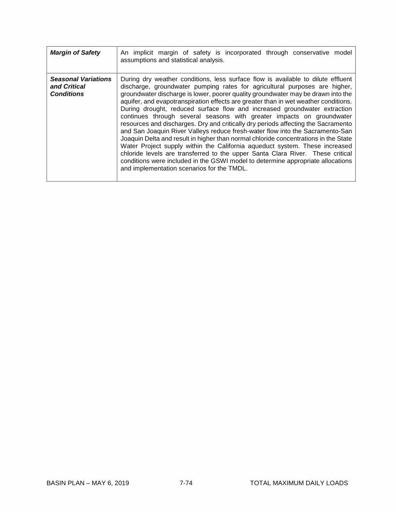
BASIN PLAN – MAY 6, 2019 7-74 TOTAL MAXIMUM DAILY LOADS
Margin of Safety An implicit margin of safety is incorporated through conservative model assumptions and statistical analysis.
Seasonal Variations and Critical Conditions
During dry weather conditions, less surface flow is available to dilute effluent discharge, groundwater pumping rates for agricultural purposes are higher, groundwater discharge is lower, poorer quality groundwater may be drawn into the aquifer, and evapotranspiration effects are greater than in wet weather conditions. During drought, reduced surface flow and increased groundwater extraction continues through several seasons with greater impacts on groundwater resources and discharges. Dry and critically dry periods affecting the Sacramento and San Joaquin River Valleys reduce fresh-water flow into the Sacramento-San Joaquin Delta and result in higher than normal chloride concentrations in the State Water Project supply within the California aqueduct system. These increased chloride levels are transferred to the upper Santa Clara River. These critical conditions were included in the GSWI model to determine appropriate allocations and implementation scenarios for the TMDL.

BASIN PLAN – MAY 6, 2019 7-75 TOTAL MAXIMUM DAILY LOADS
Table 7-6.2 Upper Santa Clara River Chloride TMDL: Implementation Schedule Implementation Tasks Completion
Date 1. Alternate Water Supply a) Should (1) the in-river concentration at Blue Cut, the Reach 4B boundary,
exceed the water quality objective of 100 mg/L, measured for the purposes of this TMDL as a three-month rolling average, (2) each agricultural diverter provide records of the diversion dates and amounts to the Regional Board and Santa Clarita Valley County Sanitation Districts of Los Angeles County (SCVSD) for at least 2 years after the effective date of the TMDL and (3) each agricultural diverter provides photographic evidence that diverted water is applied to avocado, strawberry or other chloride sensitive crop and evidence of a water right to divert, then the SCVSD will be responsible for providing an alternative water supply, negotiating the delivery of alternative water by a third party, or providing fiscal remediation to be quantified in negotiations between the SCVSD and the agricultural diverter at the direction of the Regional Board until such time as the in-river chloride concentrations do not exceed the SSO.
b) Should the instream concentration exceed 230 mg/L more than two times in the three year period, the discharger identified by the Regional Board Executive Officer shall be required to submit, within ninety days of a request by the Regional Board Executive Officer, a workplan for an accelerated schedule to reduce chloride discharges.
05/04/2005 (Does not apply upon completion of Task 4)
2. Trend monitoring: The SCVSD will submit to the Regional Board and upon approval implement a revised monitoring plan to conduct chloride trend monitoring to ensure that water quality objectives and waste load allocations are being met, downstream surface water quality is not degraded, and groundwater underlying Reach 5 upstream of the Valencia WRP outfall 001 and Reach 6 is not degraded due to implementation of compliance measures by SCVSD. The monitoring plan shall include a plan to collect water samples and analyze them for chloride in surface water for Reaches 4B, 5, and 6 at a minimum of once per month. The monitoring plan shall also include a plan for chloride trend monitoring in the alluvial groundwater basins underlying Reaches 5 and 6 and in the Saugus Aquifer at a minimum of twice a year. At a minimum, the monitoring plan should include a network of three groundwater wells with multiple screens to evaluate impacts to groundwater. The plan will include a monitoring schedule that extends beyond the final implementation deadline of this TMDL to support continual evaluation of impacts of compliance measures to surface water and groundwater quality. This TMDL shall be reconsidered if chloride trend monitoring indicates degradation of groundwater or surface water due to implementation of compliance measures.
9/30/2015
3. Begin monitoring per approved SCVSD revised monitoring plan completed in Task 2.
Six months after Executive Officer approval of Task 2 revised monitoring plan for SCVSD

BASIN PLAN – MAY 6, 2019 7-76 TOTAL MAXIMUM DAILY LOADS
Implementation Tasks Completion Date
4. Implementation of Compliance Measures by SCVSD
a) Deep Well Injection Test Well
i.Complete design for deep well test well
ii.Award contract for deep well injection test well
iii.Construction and testing of test well
b) UV Disinfection Facilities at Valencia and Saugus WRPs
i.Complete design of UV disinfection facilities
ii.Award contract for UV disinfection facilities
iii.Start onsite construction of UV disinfection facilities
iv.Start-up of UV disinfection facilities
c) Microfiltration/Reverse Osmosis (MF/RO) and Brine Minimization Facilities
i.Complete design of MF/RO and brine minimization facilities
ii.Award contract for MF/RO and brine minimization facilities
iii.Start onsite construction of MF/RO and brine minimization facilities
iv.Start-up of MF/RO and brine minimization facilities
d) Final Deep Well Injection Production Wells
i.Complete design for the final deep well injection production wells
ii.Start onsite construction
iii.Start-up of the deep well injection production wells
e) Brine Force Main and Pump Station
i.Complete 50% design of brine force main and pump station
ii.Complete design of brine force main and pump station
iii.Start-up of the brine force main and pump station The Regional Board may consider extending some of the completion dates of this task as necessary to account for events beyond the control of the SCVSD.
09/30/15 01/20/16 11/08/16 4/12/2017 7/10/2017 3/10/2018 7/1/2019 4/12/2017 7/10/2017 3/10/2018 7/1/2019 6/6/2017 12/29/2018 7/1/2019 11/6/2017 5/6/2018 7/1/2019
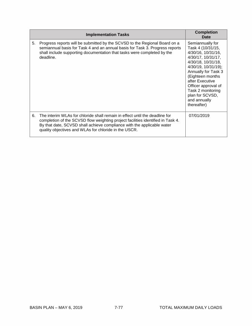
BASIN PLAN – MAY 6, 2019 7-77 TOTAL MAXIMUM DAILY LOADS
Implementation Tasks Completion Date
5. Progress reports will be submitted by the SCVSD to the Regional Board on a semiannual basis for Task 4 and an annual basis for Task 3. Progress reports shall include supporting documentation that tasks were completed by the deadline.
Semiannually for Task 4 (10/31/15, 4/30/16, 10/31/16, 4/30/17, 10/31/17, 4/30/18, 10/31/18, 4/30/19, 10/31/19); Annually for Task 3 (Eighteen months after Executive Officer approval of Task 2 monitoring plan for SCVSD, and annually thereafter)
6. The interim WLAs for chloride shall remain in effect until the deadline for completion of the SCVSD flow weighting project facilities identified in Task 4. By that date, SCVSD shall achieve compliance with the applicable water quality objectives and WLAs for chloride in the USCR.
07/01/2019

BASIN PLAN – MAY 6, 2019 7-78 TOTAL MAXIMUM DAILY LOADS
This page intentionally left blank

BASIN PLAN – MAY 6, 2019 7-79 TOTAL MAXIMUM DAILY LOADS
7-7 Calleguas Creek Nitrogen Compounds and Related Effects TMDL This TMDL was adopted by:
The Regional Water Quality Control Board on October 24, 2002.
This TMDL was approved by:
The State Water Resources Control Board on March 19, 2003. The Office of Administrative Law on June 5, 2003. The U.S. Environmental Protection Agency on June 20, 2003.
This TMDL was revised and adopted by:
The Regional Water Quality Control Board on September 11, 2008.
This TMDL was re-approved by:
The State Water Resources Control Board on June 16, 2009. The Office of Administrative Law on October 5, 2009. The U.S. Environmental Protection Agency on October 15, 2009.
The effective date of this TMDL is: October 15, 2009.
The elements of the TMDL are presented in Table 7-7.1 and the Implementation Plan in Table 7-7.2
Table 7-7.1 Calleguas Creek Nitrogen Compounds and Related Effects TMDL: Elements
Element Calleguas Creek Nitrogen Compound and Related Effects
Problem Statement
Elevated nitrogen concentrations (ammonia, nitrite and nitrate) are causing impairments of the warm water fish and wildlife habitat, and groundwater recharge beneficial uses of Calleguas Creek. Nitrite and nitrate contribute to eutrophic effects such as low dissolved oxygen and algae growth. Ammonia contributes to toxicity.

BASIN PLAN – MAY 6, 2019 7-80 TOTAL MAXIMUM DAILY LOADS
Element Calleguas Creek Nitrogen Compound and Related Effects
Numeric Target (Interpretation of the numeric water quality objective, used to calculate the load allocations)
Numeric targets for this TMDL are listed as follows: 1. Total Ammonia as Nitrogen (NH3 -N)
NH3 -N concentration (mg/L) One-hour Thirty-day
Reach average average • Mugu Lagoon 8.1 2.9 • Calleguas Creek, South 5.5 2.4 • Calleguas Creek, North 8.4 3.0 • Revlon Slough 5.7 2.9 • Beardsley Channel 5.7 2.9 • Arroyo Las Posas 8.1 2.6 • Arroyo Simi 4.7 2.4 • Tapo Canyon 3.9 1.9 • Conejo Creek 9.5 3.5
(Confluence with Calleguas Creek to Santa Rosa Rd.) • Conejo Creek 8.4 3.4
(Santa Rosa Road to Thousand Oaks City Limit) • Conejo Creek, Hill Canyon Reach 8.4 3.1 • Conejo Creek, North Fork 3.2 1.7 • Arroyo Conejo 5.1 3.4
(South Fork Conejo Creek) • Arroyo Santa Rosa 5.7 2.4
2. Nitrate and nitrite as nitrogen (NO3 -N and NO2 -N)
Constituent Concentration (mg/L) • NO3 -N 10 • NO2 -N 1 • NO3 -N + NO2 -N 10
Numeric targets to address narrative objectives required to protect warm freshwater and wildlife habitat are intended to implement the narrative objectives and may be revised based on the results of monitoring and special studies conducted pursuant to the implementation plan.
Source Analysis The principal sources of nitrogen into Calleguas Creek are discharges from the POTWs in the watershed and runoff from agricultural activities in the watershed.
Linkage Analysis Linkage between nitrogen sources and the in-stream water quality was established through a mass continuity model based on an evaluation of recent hydrodynamic and water quality data.

BASIN PLAN – MAY 6, 2019 7-81 TOTAL MAXIMUM DAILY LOADS
Element Calleguas Creek Nitrogen Compound and Related Effects
Waste Load Allocations (for point sources)
The waste load allocations (WLAs) are as follows:
Load Allocation (for non point sources)
The source analysis indicates that agricultural discharge is the major non-point source of oxidized nitrogen to Calleguas Creek and its tributaries. This source is particularly significant in Revolon Slough and other agricultural drains in the lower Calleguas watershed where there are no point sources of ammonia and oxidized nitrogen. Load allocations for non-point sources are:
NO3 -N + NO2 -N
Nonpoint Source (mg/L)
Agriculture 9.0 Other Nonpoint Source 9.0
Implementation 1. Refer to Table 7-7.2 2. Several of the POTWs in the Calleguas Creek watershed will require additional time
to meet the nitrogen (NO3 -N, NO2 -N, and NO3 -N + NO2 -N) waste load allocations. To allow time to meet the nitrogen waste load allocations, interim limits will be allowed for a period of four years from July 16, 2003 during which the POTWs will be required to meet the effluent limit for NO3 -N + NO2 -N only. Effluent limits for the individual compounds NO3 -N and NO2 -N are not required during the interim period.
POTWs NH3 -N NO3 - N (mg/L)
NO2 - N (mg/L)
NO3 - N + NO2 -N
(mg/L) MDEL1 (mg/L)
AMEL2 (mg/L)
Daily WLA3 (lbs/day)
Hill Canyon WTP4
5.6 3.1 5.1xQ 9.0 0.9 9.0
Simi Valley WQCF5
3.3 2.4 2.9xQ 9.0 0.9 9.0
Moorpark WTP
6.4 2.6 5.7xQ 9.0 0.9 9.0
Camarillo WRP6
7.8 3.5 7.0xQ 9.0 0.9 9.0
Camrosa WRF7
7.2 3.0 6.5xQ 9.0 0.9 9.0

BASIN PLAN – MAY 6, 2019 7-82 TOTAL MAXIMUM DAILY LOADS
Element Calleguas Creek Nitrogen Compound and Related Effects
Implementation (continued)
Interim Limits* for NO3 -N + NO2 -N
Monthly Average Daily Maximum POTWs (mg/L) (mg/L)
• Hill Canyon WTP 36.03 38.32 • Simi Valley WQCF 31.60 32.17 • Moorpark WTP 31.5 32.01 • Camarillo WRP 36.23 37.75
*The monthly average and daily maximum interim limits are based on the 95th and 99th percentiles of effluent performance data reported in the Calleguas Creek Characterization Study
3. The waste load allocations for ammonia will be applicable on July 16, 2003. Interim
limits for ammonia will be applicable for no more than 2 years starting from October 24, 2002 for POTWs that are not able to achieve immediate compliance with the assigned waste load allocations. The interim limits for ammonia may be established at the discretion of the Regional Board when a POTW’s NPDES permit is reissued.
Margin of Safety An implicit margin of safety is incorporated through conservative model assumptions and statistical analysis. In addition, an explicit margin of safety is incorporated by reserving 10% of the load, calculated on a concentration basis, from allocation to POTW effluent sources.
Seasonal Variations and Critical Conditions
A low flow critical condition is identified for this TMDL based on a review of flow data for the past twenty years. This flow condition was identified because less assimilative capacity is available to dilute effluent discharge.
1 Maximum daily effluent limitation 2 Average monthly effluent limitation 3 Q represents the POTW effluent flow at the time the water quality measurement is collected and a conversion factor to lb/day based on the units of measurement for the effluent flow. 4 Wastewater Treatment Plant 5 Water Quality Control Facility 6 Water Reclamation Plant 7 Water Reclamation Facility

BASIN PLAN – MAY 6, 2019 7-83 TOTAL MAXIMUM DAILY LOADS
Table 7-7.2 Calleguas Creek Nitrogen Compounds and Related Effects TMDL Implementation Schedule
IMPLEMENTATION TASKS, MILESTONES AND PROVISIONS*
COMPLETION DATE
1. 2. 3.
WLA for ammonia apply to POTWs. Interim Limits for NO3 -N + NO2 -N apply to POTWs. Formation of Nonpoint Source BMP Evaluation Committee.
July 16, 2003
4. 5.
Submittal of Non point Source Monitoring Workplan by Calleguas Creek Watershed Management Plan – Water Resources/Water Quality (CCWMP) Subcommittee. This monitoring is to evaluate nutrient loadings associated with agricultural drainage and other nonpoint sources. The monitoring program will include both dry and wet weather discharges from agricultural, urban and open space sources. In addition, groundwater discharge to Calleguas Creek will also be analyzed for nutrients to determine the magnitude of these loading and the need for load allocations. A key objective of these special studies will be to determine the effectiveness of agricultural BMPs in reducing nutrient loadings. Consequently, flow and analytical data for nutrients will be required to estimate loadings from nonpoint sources.
Submittal of Watershed Monitoring Workplan by CCWMP Subcommittee. In addition to the analytical parameters and flow data requirements, the watershed monitoring program will establish sampling locations from which representative samples can be obtained, including all listed tributaries. Monitoring results will be compared to the numeric instream targets identified in this TMDL to determine the effectiveness of the TMDL. Data on the extent and distribution of algal mats, scum and odors will be included in the watershed monitoring program. The data will be used to provide further verification of the model and refine the TMDL to address nutrient effects as appropriate.
July 16, 2004

BASIN PLAN – MAY 6, 2019 7-84 TOTAL MAXIMUM DAILY LOADS
IMPLEMENTATION TASKS, MILESTONES AND PROVISIONS*
COMPLETION DATE
6. 7.
8.
9.
Submittal of Special Studies Workplan by CCWMP Subcommittee. These special studies include: Monitoring of minor point sources for nutrients to confirm assumptions that the loadings from these sources are minor;
Monitoring of greenhouse discharges and runoff to assess loadings from these sources;
Monitoring of groundwater extraction and discharges in the Arroyo Santa Rosa subwatershed and other areas that may add significant nutrient loadings to Calleguas Creek; and
Additional studies of the type and extent of algae impairment in Calleguas Creek and Mugu Lagoon.
Complete Special Studies for minor sources, greenhouses, and groundwater loadings.
Completion of ammonia Water Effect Ratio (WER) studies.
Complete planning and preparation for construction of TMDL remedies to reduce non-point source nitrogen loads.
July 16, 2004
July 16, 2006
10. Interim Limits for NO3 -N + NO2 -N expire and WLAs for NO3 –N, NO2 -N, NO3 -N + NO2 -N apply to POTWs.
July 16, 2007
11. Complete Special Studies for algae impairments of Calleguas Creek, its tributaries and Mugu Lagoon.
July 16, 2008
12. Regional Board consideration of revised water quality objectives for nitrogen compounds based on monitoring data, special studies, and ammonia WER, if appropriate.
July 16, 2009
13. Final achievement of ammonia and oxidized nitrogen standards.
July 16, 2010
∗ The CCWMP Subcommittee has offered to complete tasks 4 through 9 and 11. In the event the CCWMP Subcommittee fails to timely complete these tasks, the Regional Board will consider whether to amend this Implementation Plan to assign tasks to responsible dischargers in the regulatory approach. The Regional Board also reserves its right to take any other appropriate actions including, but not limited to, exercising its authorities under Water Code section 13267.

BASIN PLAN – MAY 6, 2019 7-85 TOTAL MAXIMUM DAILY LOADS
7-8 Los Angeles River Nitrogen Compounds and Related Effects TMDL This TMDL was adopted as Resolution No. R03-009 by:
The Regional Water Quality Control Board on July 10, 2003.
This TMDL was approved by:
The State Water Resources Control Board on November 19, 2003. The Office of Administrative Law on February 27, 2004. The U.S. Environmental Protection Agency on March 18, 2004.
This TMDL was amended and adopted as Resolution No. R03-016 by:
The Regional Water Quality Control Board on December 4, 2003.
This amended TMDL was approved by:
The State Water Resources Control Board on March 24, 2004. The Office of Administrative Law on September 27, 2004. [U.S. Environmental Protection Agency approval not required for amendment to Implementation Plan].
This TMDL was amended and adopted as Resolution No. R12-010 by:
The Regional Water Quality Control Board on December 6, 2012.
This amended TMDL was approved by:
The State Water Resources Control Board on June 4, 2013. The Office of Administrative Law on June 9, 2014. The U.S. Environmental Protection Agency on August 7, 2014.
The effective date of this TMDL is: August 7, 2014.
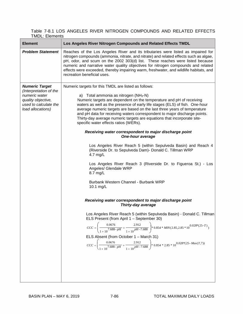
BASIN PLAN – MAY 6, 2019 7-86 TOTAL MAXIMUM DAILY LOADS
Table 7-8.1 LOS ANGELES RIVER NITROGEN COMPOUNDS AND RELATED EFFECTS TMDL: Elements
Element Los Angeles River Nitrogen Compounds and Related Effects TMDL
Problem Statement Reaches of the Los Angeles River and its tributaries were listed as impaired for nitrogen compounds (ammonia, nitrate, and nitrate) and related effects such as algae, pH, odor, and scum on the 2002 303(d) list. These reaches were listed because numeric and narrative water quality objectives for nitrogen compounds and related effects were exceeded, thereby impairing warm, freshwater, and wildlife habitats, and recreation beneficial uses.
Numeric Target (Interpretation of the numeric water quality objective, used to calculate the load allocations)
Numeric targets for this TMDL are listed as follows:
a) Total ammonia as nitrogen (NH3-N) Numeric targets are dependent on the temperature and pH of receiving waters as well as the presence of early life stages (ELS) of fish. One-hour average numeric targets are based on the last three years of temperature and pH data for receiving waters correspondent to major discharge points. Thirty-day average numeric targets are equations that incorporate site-specific water effects ratios (WERs).
Receiving water correspondent to major discharge point
One-hour average Los Angeles River Reach 5 (within Sepulveda Basin) and Reach 4 (Riverside Dr. to Sepulveda Dam)- Donald C. Tillman WRP 4.7 mg/L Los Angeles River Reach 3 (Riverside Dr. to Figueroa St.) - Los Angeles/ Glendale WRP 8.7 mg/L Burbank Western Channel - Burbank WRP 10.1 mg/L
Receiving water correspondent to major discharge point Thirty-day average
Los Angeles River Reach 5 (within Sepulveda Basin) - Donald C. Tillman ELS Present (from April 1 – September 30)
))25(*028.0
10*85.2,85.2(*854.0*688.7101
912.2688.7
101
0676.0 TMINpHpHCCC
−−
++−
+=
ELS Absent (from October 1 – March 31)
CCC =0.0676
1 + 107.688− pH +
2.912
1 + 10pH −7.688
* 0.854 * 2.85 * 10
0.028*(25−Max(T,7))

BASIN PLAN – MAY 6, 2019 7-87 TOTAL MAXIMUM DAILY LOADS
Element Los Angeles River Nitrogen Compounds and Related Effects TMDL
Numeric Target (con’t)
Los Angeles River Reach 4 (Sepulveda Dam to Riverside Dr.) - Donald C. Tillman WRP ELS Absent (year round)
CCC =0.0676
1 + 107.688− pH +
2.912
1 + 10pH −7.688
* 0.854 * 2.85 * 10
0.028*(25−Max(T,7))
Los Angeles River Reach 3 (Riverside Dr. to Figueroa St.) - Los Angeles/ Glendale WRP ELS Present (from April 1 – September 30)
CCC =0.0676
1 + 107.688− pH +
2.912
1 + 10pH −7.688
* 0.854 * MIN (2.85,2.85 * 10
0.028*(25−T ))
ELS Absent (from October 1 – March 31)
CCC =0.0676
1 + 107.688− pH +
2.912
1 + 10pH −7.688
* 0.854 * 2.85 * 10
0.028*(25−Max(T,7))
Burbank Western Channel - Burbank WRP ELS Absent (year round)
CCC =0.0676
1 + 107.688− pH +
2.912
1 + 10pH −7.688
* 0.92 * 2.03 * 10
0.028*(25−Max(T,7))
In addition, the highest four-day average within the 30-day period shall not exceed 2.5 times the 30-day average numeric target.
b) Nitrate-nitrogen and nitrite-nitrogen
Constituent
Thirty-day average All reaches and tributaries
Nitrate-nitrogen (NO3-N) 8 mg/L Nitrite-nitrogen (NO2-N) 1 mg/L Nitrate-nitrogen plus nitrite-nitrogen (NO3-N + NO2-N) 8 mg/L
Numeric targets to address narrative objectives required to protect warm freshwater and wildlife habitats are intended to implement the narrative objectives and may be revised based on the results of monitoring and studies conducted pursuant to the implementation plan.
Source Analysis The principal source of nitrogen compounds to the Los Angeles River is discharges from the Donald C. Tillman Water Reclamation Plant (WRP), the Los Angeles-Glendale WRP, and the Burbank WRP. During dry weather period, the major POTWs contribute 84.1% of the total dry weather nitrogen load. Urban runoff, stormwater, and groundwater discharge may also contribute nitrate loads. Further evaluation of these sources is set forth in the Implementation Plan.
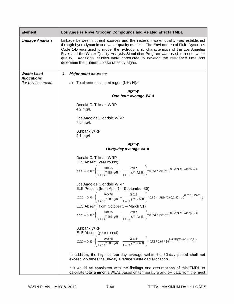
BASIN PLAN – MAY 6, 2019 7-88 TOTAL MAXIMUM DAILY LOADS
Element Los Angeles River Nitrogen Compounds and Related Effects TMDL
Linkage Analysis
Linkage between nutrient sources and the instream water quality was established through hydrodynamic and water quality models. The Environmental Fluid Dynamics Code 1-D was used to model the hydrodynamic characteristics of the Los Angeles River and the Water Quality Analysis Simulation Program was used to model water quality. Additional studies were conducted to develop the residence time and determine the nutrient uptake rates by algae.
Waste Load Allocations (for point sources)
1. Major point sources:
a) Total ammonia as nitrogen (NH3-N):*
POTW One-hour average WLA
Donald C. Tillman WRP 4.2 mg/L Los Angeles-Glendale WRP 7.8 mg/L Burbank WRP 9.1 mg/L
POTW
Thirty-day average WLA
Donald C. Tillman WRP ELS Absent (year round)
))7,(25(*028.010*85.2*854.0*688.7
101
912.2688.7
101
0676.0*90.0
TMaxpHpHCCC
−−
++−
+=
Los Angeles-Glendale WRP ELS Present (from April 1 – September 30)
))25(*028.0
10*85.2,85.2(*854.0*688.7101
912.2688.7
101
0676.0*90.0
TMINpHpHCCC
−−
++−
+=
ELS Absent (from October 1 – March 31) ))7,(25(*028.0
10*85.2*854.0*688.7101
912.2688.7
101
0676.0*90.0
TMaxpHpHCCC
−−
++−
+=
Burbank WRP ELS Absent (year round)
))7,(25(*028.010*03.2*92.0*688.7
101
912.2688.7
101
0676.0*90.0
TMaxpHpHCCC
−−
++−
+=
In addition, the highest four-day average within the 30-day period shall not exceed 2.5 times the 30-day average wasteload allocation. * It would be consistent with the findings and assumptions of this TMDL to calculate total ammonia WLAs based on temperature and pH data from the most
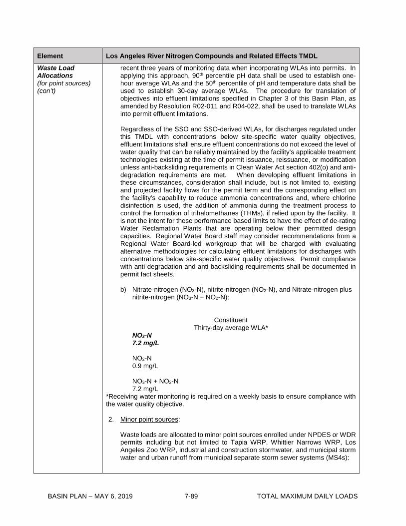
BASIN PLAN – MAY 6, 2019 7-89 TOTAL MAXIMUM DAILY LOADS
Element Los Angeles River Nitrogen Compounds and Related Effects TMDL
Waste Load Allocations (for point sources) (con’t)
recent three years of monitoring data when incorporating WLAs into permits. In applying this approach, 90th percentile pH data shall be used to establish one-hour average WLAs and the 50th percentile of pH and temperature data shall be used to establish 30-day average WLAs. The procedure for translation of objectives into effluent limitations specified in Chapter 3 of this Basin Plan, as amended by Resolution R02-011 and R04-022, shall be used to translate WLAs into permit effluent limitations. Regardless of the SSO and SSO-derived WLAs, for discharges regulated under this TMDL with concentrations below site-specific water quality objectives, effluent limitations shall ensure effluent concentrations do not exceed the level of water quality that can be reliably maintained by the facility’s applicable treatment technologies existing at the time of permit issuance, reissuance, or modification unless anti-backsliding requirements in Clean Water Act section 402(o) and anti-degradation requirements are met. When developing effluent limitations in these circumstances, consideration shall include, but is not limited to, existing and projected facility flows for the permit term and the corresponding effect on the facility’s capability to reduce ammonia concentrations and, where chlorine disinfection is used, the addition of ammonia during the treatment process to control the formation of trihalomethanes (THMs), if relied upon by the facility. It is not the intent for these performance based limits to have the effect of de-rating Water Reclamation Plants that are operating below their permitted design capacities. Regional Water Board staff may consider recommendations from a Regional Water Board-led workgroup that will be charged with evaluating alternative methodologies for calculating effluent limitations for discharges with concentrations below site-specific water quality objectives. Permit compliance with anti-degradation and anti-backsliding requirements shall be documented in permit fact sheets. b) Nitrate-nitrogen (NO3-N), nitrite-nitrogen (NO2-N), and Nitrate-nitrogen plus
nitrite-nitrogen (NO3-N + NO2-N):
Constituent
Thirty-day average WLA* NO3-N 7.2 mg/L NO2-N 0.9 mg/L NO3-N + NO2-N 7.2 mg/L
*Receiving water monitoring is required on a weekly basis to ensure compliance with the water quality objective. 2. Minor point sources:
Waste loads are allocated to minor point sources enrolled under NPDES or WDR permits including but not limited to Tapia WRP, Whittier Narrows WRP, Los Angeles Zoo WRP, industrial and construction stormwater, and municipal storm water and urban runoff from municipal separate storm sewer systems (MS4s):
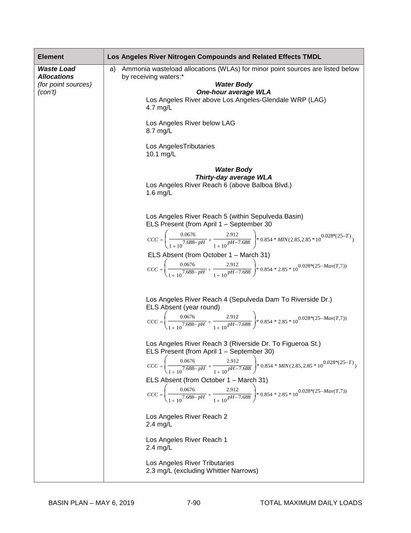
BASIN PLAN – MAY 6, 2019 7-90 TOTAL MAXIMUM DAILY LOADS
Element Los Angeles River Nitrogen Compounds and Related Effects TMDL
Waste Load Allocations (for point sources) (con’t)
a) Ammonia wasteload allocations (WLAs) for minor point sources are listed below by receiving waters:*
Water Body One-hour average WLA
Los Angeles River above Los Angeles-Glendale WRP (LAG) 4.7 mg/L Los Angeles River below LAG 8.7 mg/L Los AngelesTributaries 10.1 mg/L
Water Body
Thirty-day average WLA Los Angeles River Reach 6 (above Balboa Blvd.) 1.6 mg/L
Los Angeles River Reach 5 (within Sepulveda Basin) ELS Present (from April 1 – September 30
))25(*028.0
10*85.2,85.2(*854.0*688.7101
912.2688.7
101
0676.0 TMINpHpHCCC
−−
++−
+=
ELS Absent (from October 1 – March 31)
CCC =0.0676
1 + 107.688− pH +
2.912
1 + 10pH −7.688
* 0.854 * 2.85 * 10
0.028*(25−Max(T,7))
Los Angeles River Reach 4 (Sepulveda Dam To Riverside Dr.) ELS Absent (year round)
CCC =0.0676
1 + 107.688− pH +
2.912
1 + 10pH −7.688
* 0.854 * 2.85 * 10
0.028*(25−Max(T,7))
Los Angeles River Reach 3 (Riverside Dr. To Figueroa St.) ELS Present (from April 1 – September 30)
CCC =0.0676
1 + 107.688− pH +
2.912
1 + 10pH −7.688
* 0.854 * MIN (2.85,2.85 * 10
0.028*(25−T ))
ELS Absent (from October 1 – March 31)
CCC =0.0676
1 + 107.688− pH +
2.912
1 + 10pH −7.688
* 0.854 * 2.85 * 10
0.028*(25−Max(T,7))
Los Angeles River Reach 2 2.4 mg/L Los Angeles River Reach 1 2.4 mg/L Los Angeles River Tributaries 2.3 mg/L (excluding Whittier Narrows)

BASIN PLAN – MAY 6, 2019 7-91 TOTAL MAXIMUM DAILY LOADS
Element Los Angeles River Nitrogen Compounds and Related Effects TMDL
Waste Load Allocations (for point sources) (con’t)
Whittier Narrows Thirty-Dave Average WLA ELS Present (from April 1 – September 30)
CCC =0.0676
1 + 107.688− pH +
2.912
1 + 10pH −7.688
* 0.854 * MIN (2.85,3.04 * 10
0.028*(25−T ))
ELS Absent (from October 1 – March 31) ))7,(25(*028.0
10*04.3*854.0*688.7101
912.2688.7
101
0676.0 TMaxpHpHCCC
−−
++−
+=
In addition, the highest four-day average within the 30-day period shall not exceed 2.5 times the 30-day average wasteload allocation. * It would be consistent with the findings and assumptions of this TMDL to calculate total ammonia WLAs based on temperature and pH data from the most recent three years of monitoring data when incorporating WLAs into permits. In applying this approach, 90th percentile pH data shall be used to establish one-hour average WLAs and the 50th percentile of pH and temperature data shall be used to establish 30-day average WLAs. The procedure for translation of objectives into effluent limits specified in Chapter 3 of this Basin Plan, as amended by Resolution R02-011 and R04-022, shall be used to translate WLAs into effluent limitations. Regardless of the SSO and SSO-derived WLAs, for discharges regulated under this TMDL with concentrations below site-specific water quality objectives, effluent limitations shall ensure effluent concentrations do not exceed the level of water quality that can be reliably maintained by the facility’s applicable treatment technologies existing at the time of permit issuance, reissuance, or modification unless anti-backsliding requirements in Clean Water Act section 402(o) and anti-degradation requirements are met. When developing effluent limitations in these circumstances, consideration shall include, but is not limited to, existing and projected facility flows for the permit term and the corresponding effect on the facility’s capability to reduce ammonia concentrations and, where chlorine disinfection is used, the addition of ammonia during the treatment process to control the formation of trihalomethanes (THMs), if relied upon by the facility. It is not the intent for these performance based limits to have the effect of de-rating Water Reclamation Plants that are operating below their permitted design capacities. Regional Water Board staff may consider recommendations from a Regional Water Board-led workgroup that will be charged with evaluating alternative methodologies for calculating effluent limitations for discharges with concentrations below site-specific water quality objectives. Permit compliance with anti-degradation and anti-backsliding requirements shall be documented in permit fact sheets.

BASIN PLAN – MAY 6, 2019 7-92 TOTAL MAXIMUM DAILY LOADS
Element Los Angeles River Nitrogen Compounds and Related Effects TMDL
Waste Load Allocations (for point sources) (con’t)
b) WLAs for nitrate-nitrogen, nitrite-nitrogen, and nitrate-nitrogen plus nitrite-nitrogen for minor discharges are listed below:
Constituent Thirty-day average WLA
NO3-N 8.0 mg/L NO2-N 1.0 mg/L NO3-N + NO2-N 8.0 mg/L
Load Allocation (for nonpoint sources)
The Source Assessment indicates that nitrogen loads from nonpoint sources are negligible compared to loading from point sources and their contribution is adequately accounted for in the margin of safety. Consequently, load allocations will not be developed unless it is determined they are necessary after load reductions are effected through implementation of the wasteload allocations. Additional monitoring is included in the implementation plan to verify the nitrogen nonpoint source contributions.
Implementation
1. Refer to Table 7-8.2 2. The Implementation Plan includes upgrades to the WRPs discharging to Los
Angeles River for removal of ammonia, nitrate, and nitrite. At the discretion of the Regional Board, the following interim limits for ammonia, and nitrate plus nitrite will be allowed for major point sources for a period not to exceed 3.5 years from the effective date of this TMDL. Effluent limits for the individual compounds NO3-N, and NO2-N are not required during the interim period.
Interim Limits for NH3-N
Total ammonia as Nitrogen POTW
Daily Maximum* Monthly Average*
Donald C. Tillman WRP 21.7 mg/L 21.0 mg/L
Los Angeles-Glendale WRP 19.4 mg/L 16.5 mg/L
Burbank WRP 24.1 mg/L 22.7 mg/L
*The monthly average and daily maximum interim limits are based on the 95th and 99th percentiles of effluent performance data reported by dischargers.

BASIN PLAN – MAY 6, 2019 7-93 TOTAL MAXIMUM DAILY LOADS
Element Los Angeles River Nitrogen Compounds and Related Effects TMDL
Implementation
(con’t)
Nitrite-nitrogen + Nitrate-nitrogen
Monthly Average 8.0 mg/L
The Implementation Plan also includes additional studies to evaluate the effectiveness of nitrogen reductions on related effects such as algae growth, odors and scum. Ammonia and nitrate reductions will be regulated through effluent limits prescribed in NPDES permits.
Margin of Safety An explicit margin of safety of 10% of the ammonia, nitrate, nitrite and nitrate + nitrite loads is allocated to address uncertainty in the sources and linkage analyses. In addition, an implicit margin of safety is incorporated through conservative model assumptions and statistical analysis.
Seasonal Variations and Critical Conditions
The critical condition identified for this TMDL is based on low flow condition. The driest six months of the year are the most critical condition for nutrients because less surface flow is available to dilute effluent discharge.
Monitoring Tillman, LA-Glendale, Burbank, and Whittier Narrows POTWs must conduct confirmatory receiving water monitoring to verify that water quality conditions are similar to those of the 2003 ammonia WER study period. Confirmatory monitoring will include concurrent chemistry* and toxicity receiving water monitoring. Confirmatory monitoring will be supplemental to three species toxicity testing required in the NPDES permits and must utilize Hyallela azteca as the test organism. Temperature, pH, and ammonia receiving water data will be collected at the time and location of collection of the toxicity samples. Monitoring of chemistry and toxicity testing should include a minimum of three sample events per year for three years. Monitoring sites should be representative of those investigated in the Los Angeles River during the SSO study, as well as one location in the reach immediately downstream of where the SSO is applied. Two of the three sample events should be conducted during dry weather. Following the first three-year monitoring cycle, if there is no increase in toxicity attributable to ammonia, monitoring may be reduced to once every year at each site, as appropriate. The number and type of events during the year should be as described above. If confirmatory monitoring indicates toxicity due to ammonia or a change in the waterbody that could impact the calculation or application of the SSOs, including either its chemical characteristics or the aquatic species present, including early life stages of fish, the POTW shall develop and submit a plan for reevaluating the SSOs to the Executive Officer. *Chemistry monitoring to include all nitrogen species, including total ammonia, as well as pH, hardness, temperature, sodium, potassium, calcium, BOD, sulfate, total dissolved solids, and chloride. In the event that ammonia concentrations at Tillman, LA-Glendale, Burbank, or Whittier Narrows POTW are consistently at levels below effluent limitations that would be set without use of the SSO, monitoring to confirm the SSOs is not necessary.

Table 7-8.2. IMPLEMENTATION SCHEDULE Implementation Tasks
Completion Date
1. Apply interim limits for NH3-N and NO3-N + NO2-N to major Publicly Owned Treatment Works (POTWs).
2. Apply Waste Load Allocations (WLAs) to minor point source dischargers and MS4 permittees.
3. Begin to include monitoring for nitrogen compounds in NPDES permits for minor NPDES dischargers above 0.1 mgd as permits are renewed.
March 23, 2004
4. Submittal of a Monitoring Work Plan by MS4 permittees to estimate nitrogen loadings associated with runoff loads from the storm drain system for approval by the Executive Officer of the Regional Board. The Work Plan will include monitoring for ammonia, nitrate, and nitrite. The Work Plan may include a phased approach wherein the first phase is based on monitoring from the existing mass emission station in the Los Angeles River. The results will be used to calibrate the linkage analysis.
The Work Plan will also contain protocol and a schedule for implementing additional monitoring if necessary. The Work Plan will also propose triggers for conducting source identification and implementing BMPs, if necessary. Source identification and BMPs will be in accordance with the requirements of MS4 permits.
March 23, 2005
5. Submittal of a Workplan by major NPDES permittees to evaluate the effectiveness of nitrogen reductions on removing impairments from algae odors, scums, and pH for approval by the Executive Officer of the Regional Board. The monitoring program will include instream monitoring of algae, foam, scum, pH, and odors in the Los Angeles River. In addition, groundwater discharge to Los Angeles River will also be analyzed for nutrients to determine the magnitude of these loadings and the need for load allocations. The Workplan will include protocol and schedule for refining numeric targets for nitrogen compounds and related effects such as excessive algae in the Los Angeles River. The Workplan will also contain protocol and a schedule for identification of limiting nutrients.
March 23, 2005
6. Submission of a special studies Workplan by the City of Los Angeles to evaluate site-specific objectives for ammonia, nitrate, and nitrite, including the following issues: pH and temperature distribution downstream of the D.C. Tillman WRP to determine the point of compliance for ammonia, establishment of ammonia WLAs based on seasonality.
March 23, 2005
7. Submission of all results from Task 6, and results from water effects ratio study for ammonia which has been performed by the City of Los Angeles.
No later than September 23, 2006
BASIN PLAN – MAY 6, 2019 7-94 TOTAL MAXIMUM DAILY LOADS

BASIN PLAN – MAY 6, 2019 7-95 TOTAL MAXIMUM DAILY LOADS
Table 7-8.2. IMPLEMENTATION SCHEDULE Implementation Tasks
Completion Date
8. Regional Board considers site-specific objectives for ammonia, nitrate, nitrite andnitrite + nitrate and revision of wasteload allocations based on results from Tasks6 and 7. The Regional Board will consider factors such as seasonal variation,averaging periods, and water effects ratios when determining whether it isappropriate to adopt site-specific objectives for ammonia. If a site specific objectiveis adopted by the Regional Board, and approved by relevant approving agencies,this TMDL will need to be revised, readopted, and reapproved to reflect the revisedwater quality objectives.
No later than September 23, 2007
9. Interim limits for ammonia and nitrate + nitrite expire and WLAs for ammonia,nitrate, nitrite, and nitrate + nitrite apply to major point sources.
September 23, 2007
10. Complete evaluation of monitoring for nutrient effects and determine need forrevising wasteload allocations, including but not limited to establishing new WLAsfor other nutrient and related effects such as algal growth
March 23, 2008
11. Regional Board considers results of Tasks 5 and 10 and revises or establishesWLAs as appropriate.
March 23, 2009

BASIN PLAN – MAY 6, 2019 7-96 TOTAL MAXIMUM DAILY LOADS
This page intentionally left blank

BASIN PLAN – MAY 6, 2019 7-97 TOTAL MAXIMUM DAILY LOADS
7-9 Santa Clara River Nitrogen Compounds TMDL This TMDL was adopted by:
The Regional Water Quality Control Board on August 7, 2003.
This TMDL was approved by:
The State Water Resources Control Board on November 19, 2003. The Office of Administrative Law on Febmruy 27,2004. The U.S. Environmental Protection Agency on March 18,2004.
The effective date of this TMDL is: March 23,2004.
The following table describes the key elements of this TMDL.
Table 7-9.1 Santa Clara River Nitrogen Compounds TMDL: Elements
Element Santa Clara River Nitrogen Compounds TMDL Problem Statement Discharge of wastes containing nitrite, nitrate and ammonia to the Santa Clara
River causes exceedances of water quality objectives for ammonia, nitrate and nitrite established in the Basin Plan. The Santa Clara River is listed as impaired by ammonia in Reach 3 and by nitrate plus nitrite in Reach 7 on the 2002 303(d) list of impaired water bodies. Reach 8 of the Santa Clara River is included on the State Monitoring List for organic enrichment/dissolved oxygen, which may be caused by excessive nitrogen. Nitrate and nitrate are biostimulatory substances that can cause eutrophic effects such as low dissolved oxygen and algae growth. Excessive ammonia can cause aquatic life toxicity.
Numeric Target (Interpretation of the numeric water quality objective, used to calculate the load allocations)
• Total ammonia as nitrogen (NH3-N)
One-hour Average Thirty-day Average Reach (mg/L) (mg/L) Reach 8 14.8 3.2 Reach 7 above Valencia 4.8 2.0 Reach 7 below Valencia 5.5 2.0 Reach 7 at County Line 3.4 1.2 Reach 3 above Santa Paula 2.4 1.9 Reach 3 at Santa Paula 2.4 1.9 Reach 3 below Santa Paula 2.2 1.7
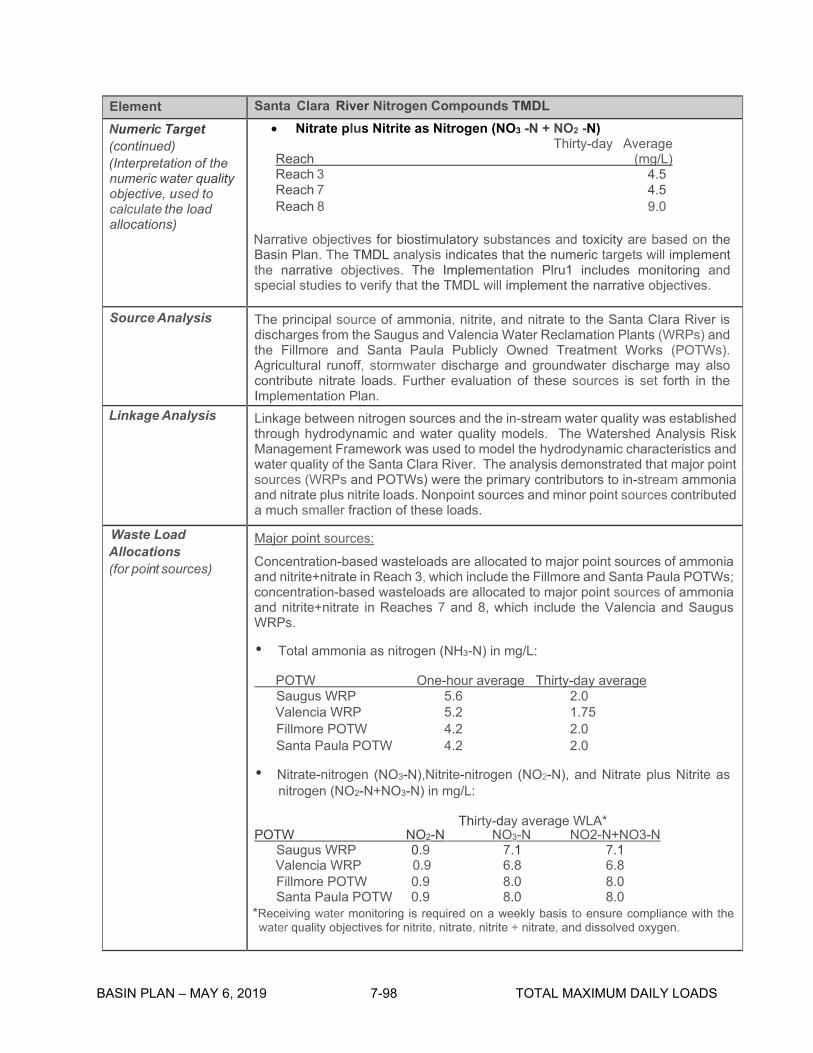
Element Santa Clara River Nitrogen Compounds TMDL Numeric Target • Nitrate plus Nitrite as Nitrogen (NO3 -N + NO2 -N)(continued) Thirty-day Average (Interpretation of the Reach (mg/L) numeric water quality Reach 3 4.5 objective, used to Reach 7 4.5 calculate the load Reach 8 9.0 allocations)
Narrative objectives for biostimulatory substances and toxicity are based on the Basin Plan. The TMDL analysis indicates that the numeric targets will implement the narrative objectives. The Implementation Plru1 includes monitoring and special studies to verify that the TMDL will implement the narrative objectives.
Source Analysis The principal source of ammonia, nitrite, and nitrate to the Santa Clara River is discharges from the Saugus and Valencia Water Reclamation Plants (WRPs) and the Fillmore and Santa Paula Publicly Owned Treatment Works (POTWs). Agricultural runoff, stormwater discharge and groundwater discharge may also contribute nitrate loads. Further evaluation of these sources is set forth in the Implementation Plan.
Linkage Analysis Linkage between nitrogen sources and the in-stream water quality was established through hydrodynamic and water quality models. The Watershed Analysis Risk Management Framework was used to model the hydrodynamic characteristics and water quality of the Santa Clara River. The analysis demonstrated that major point sources (WRPs and POTWs) were the primary contributors to in-stream ammonia and nitrate plus nitrite loads. Nonpoint sources and minor point sources contributed a much smaller fraction of these loads.
Waste Load Major point sources: Allocations (for point sources) Concentration-based wasteloads are allocated to major point sources of ammonia
and nitrite+nitrate in Reach 3, which include the Fillmore and Santa Paula POTWs; concentration-based wasteloads are allocated to major point sources of ammonia and nitrite+nitrate in Reaches 7 and 8, which include the Valencia and Saugus WRPs.
• Total ammonia as nitrogen (NH3-N) in mg/L:
POTW One-hour average Thirty-day average Saugus WRP 5.6 2.0 Valencia WRP 5.2 1.75 Fillmore POTW 4.2 2.0 Santa Paula POTW 4.2 2.0
• Nitrate-nitrogen (NO3-N),Nitrite-nitrogen (NO2-N), and Nitrate plus Nitrite as nitrogen (NO2-N+NO3-N) in mg/L:
Thirty-day average WLA* POTW NO2-N NO3-N NO2-N+NO3-N
Saugus WRP 0.9 7.1 7.1 Valencia WRP 0.9 6.8 6.8 Fillmore POTW 0.9 8.0 8.0 Santa Paula POTW 0.9 8.0 8.0
*Receiving water monitoring is required on a weekly basis to ensure compliance with the water quality objectives for nitrite, nitrate, nitrite + nitrate, and dissolved oxygen.
BASIN PLAN – MAY 6, 2019 7-98 TOTAL MAXIMUM DAILY LOADS

BASIN PLAN – MAY 6, 2019 7-99 TOTAL MAXIMUM DAILY LOADS
Element Santa Clara River Nitrogen Compounds TMDL Waste Load Allocations (continued) (for point sources)
Minor Point Sources:
Concentration-based wasteloads are allocated to minor discharges emolled under NPDES or WDR permits. The allocations for minor point sources are based on the water quality objectives for ammonia, nitrite, nitrate and nitrite plus nitrate. For minor dischargers discharging into Reach 7, the thirty-day average WLA for ammonia as nitrogen is 1.75 mg/L, the one-hour WLA for ammonia as nitrogen is 5.2 mg/L, and the thirty-day average WLA for nitrate plus nitrite as nitrogen is 6.8 mg/L. For minor dischargers discharging into Reach 3, the thirty-day average WLA for ammonia as nitrogen is 2.0 mg/L and the one hour average WLA for ammonia as nitrogen is 4.2 mg/L, and the thirty-day average WLA for nitrate plus nitrite as nitrogen is 8.1 mg/L.
MS4 and Stormwater Sources:
Concentration-based wasteloads are allocated to municipal, industrial and construction stormwater sources regulated under NPDES permits. For stormwater permittees discharging into Reach 7, the thirty-day WLA for ammonia as nitr·ogen is 1.75 mg/L and the one-hour WLA for ammonia as nitrogen is 5.2 mg/L; the thirty-day average WLA for nitrate plus nitrite as nitrogen is 6.8 mg/L. For stormwater permittees dischargir1g into Reach 3, the thirty-day WLA for ammonia as nitrogen is 2.0 mg/L and the one-hour WLA for ammonia as nitrogen is 4.2 mg/L; the thirty-day average WLA for nitrate plus nitrite nitrogen is 8.1 mg/L.
Load Allocation (for nonpoint sources)
Concentration-based loads for nitrogen compounds are allocated for nonpoint sources. For nonpoint sources discharging to Reach 7, the combined ammonia, nitrate, nitrite (NH3 -N + NO2 -N + NO3 -N) load as nitrogen is 8.5 mg/L. For non-point sources discharging into other reaches of the Santa Clara River, Mint Canyon Reach 1, Wheeler Canyon/Todd Bananca, and Brown Bananca/Long Canyon, the combined ammonia, nitrate, nitrite (NH3 -N + NO2 -N + NO3 -N) loads as nitrogen is 10 mg/L. Monitoring is established in the TMDL Implementation Plan to verify the nitrogen nonpoint source contributions from agricultural and urban runoff and groundwater discharge.
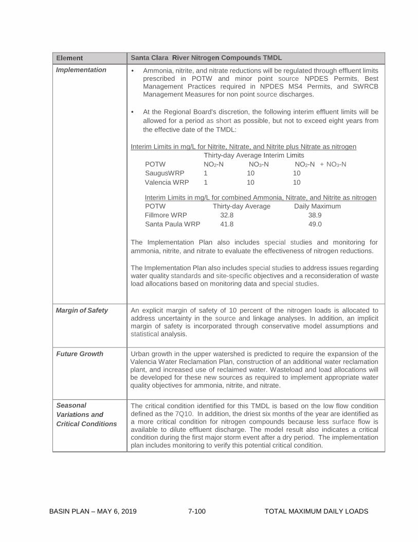
BASIN PLAN – MAY 6, 2019 7-100 TOTAL MAXIMUM DAILY LOADS
Element Santa Clara River Nitrogen Compounds TMDL Implementation • Ammonia, nitrite, and nitrate reductions will be regulated through effluent limits
prescribed in POTW and minor point source NPDES Permits, Best Management Practices required in NPDES MS4 Permits, and SWRCB Management Measures for non point source discharges.
• At the Regional Board's discretion, the following interim effluent limits will be
allowed for a period as short as possible, but not to exceed eight years from the effective date of the TMDL:
Interim Limits in mg/L for Nitrite, Nitrate, and Nitrite plus Nitrate as nitrogen
Thirty-day Average Interim Limits POTW NO2-N NO3-N NO2-N + NO3-N SaugusWRP 1 10 10 Valencia WRP 1 10 10
Interim Limits in mg/L for combined Ammonia, Nitrate, and Nitrite as nitrogen POTW Thirty-day Average Daily Maximum Fillmore WRP 32.8 38.9 Santa Paula WRP 41.8 49.0
The Implementation Plan also includes special studies and monitoring for ammonia, nitrite, and nitrate to evaluate the effectiveness of nitrogen reductions.
The Implementation Plan also includes special studies to address issues regarding water quality standards and site-specific objectives and a reconsideration of waste load allocations based on monitoring data and special studies.
Margin of Safety An explicit margin of safety of 10 percent of the nitrogen loads is allocated to address uncertainty in the source and linkage analyses. In addition, an implicit margin of safety is incorporated through conservative model assumptions and statistical analysis.
Future Growth Urban growth in the upper watershed is predicted to require the expansion of the Valencia Water Reclamation Plan, construction of an additional water reclamation plant, and increased use of reclaimed water. Wasteload and load allocations will be developed for these new sources as required to implement appropriate water quality objectives for ammonia, nitrite, and nitrate.
Seasonal Variations and Critical Conditions
The critical condition identified for this TMDL is based on the low flow condition defined as the 7Q10. In addition, the driest six months of the year are identified as a more critical condition for nitrogen compounds because less surface flow is available to dilute effluent discharge. The model result also indicates a critical condition during the first major storm event after a dry period. The implementation plan includes monitoring to verify this potential critical condition.

Table 7-9.2 Santa Clara River Nitrogen Compounds TMDL: Implementation Schedule Implementation Tasks, Milestones and Provisions Responsible Party Completion Date 1. Apply interim limits for ammonia, nitrite, and nitrate to Fillmore and Santa Paula POTWs.
2. Apply interim limits for Nitrate to Saugus and Valencia WRPs.
3. Apply WLAs to minor point source dischargers and MS4 permittees.
4. Include monitoring for nitrogen compounds in NPDES and WDR permits for minor dischargers as permits are renewed.
Fillmore and Santa Paula POTWs;
NPDES and WDR permittees
Effective Date of TMDL
Submittal of a Work Plan by Los Angeles County and Ventura County MS4 permittees to estimate ammonia and nitrogen loadings associated with runoff loads from the storm drain system for approval by the Executive Officer of the Regional Board. The Work Plan will include monitoring for ammonia, nitrate, and nitrite. The Work Plan may include a phased approach wherein the first phase is based on monitoring from the existing mass emission station in the Santa Clara River. If the monitoring studies reflect a higher average concentration in stormwater than originally considered, then the linkage analysis would be refined to consider the increased loading.
5. Los Angeles and Ventura Counties MS4 Permittees
1 year after Effective Date of TMDL
The Work Plan will also contain protocol and a schedule for implementing additional monitoring if necessary. The Work Plan will also propose triggers for conducting source identification and implementing BMPs, if necessary. Source identification and BMPs will be in accordance with the requirements of MS4 permits.
6. Submittal of Work Plan by major NPDES permittees to asses and monitor the surface water quality, including, without limitation, monthly measurement of dissolved oxygen on an hourly basis, pH and instream denitrification processes, and groundwater where appropriate, for aquatic life impacts, macroinvertebrate diversity, algal mass, and nutrient species in the Santa Clara River for approval by the Regional Board's Executive Officer. The Work Plan will include evaluation of the effectiveness of the POTW in meeting WLAs. Submittal of a work plan that demonstrates compliance with final wasteload allocations or demonstrates a schedule for compliance with final wasteload allocations is as short as possible.
Cities of Fillmore and Santa Paula, and County Sanitation Districts of Los Angeles County
1 year after Effective Date of TMDL
7. Submittal of special studies Work Pla n by County Sanitation Districts of Los Angeles County to evaluate site specific objectives SSOs for nitrate for approval by the Regional Board's Executive Officer.
County Sanitation 1 year after Effective Districts of Los Date of TMDL Angeles County
BASIN PLAN – MAY 6, 2019 7-101 TOTAL MAXIMUM DAILY LOADS
- ( )
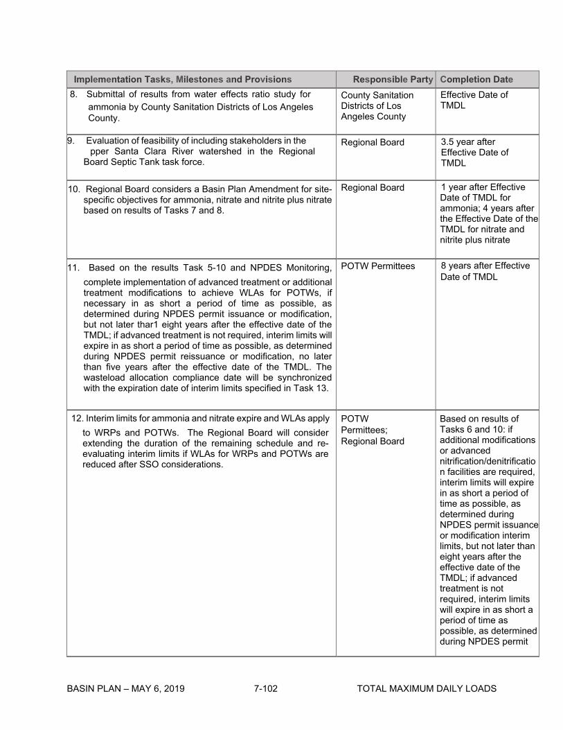
Implementation Tasks, Milestones and Provisions Responsible Party Completion Date 8. Submittal of results from water effects ratio study for
ammonia by County Sanitation Districts of Los Angeles County.
County Sanitation Districts of Los Angeles County
Effective Date of TMDL
9. Evaluation of feasibility of including stakeholders in the Upper Santa Clara River watershed in the Regional Board Septic Tank task force.
Regional Board 3.5 year after Effective Date of TMDL
10. Regional Board considers a Basin Plan Amendment for site- Regional Board 1 year after Effective specific objectives for ammonia, nitrate and nitrite plus nitrate Date of TMDL for based on results of Tasks 7 and 8. ammonia; 4 years after
the Effective Date of the TMDL for nitrate and nitrite plus nitrate
11. Based on the results Task 5-10 and NPDES Monitoring, POTW Permittees 8 years after Effective
complete implementation of advanced treatment or additional Date of TMDL
treatment modifications to achieve WLAs for POTWs, if necessary in as short a period of time as possible, as determined during NPDES permit issuance or modification, but not later thar1 eight years after the effective date of the TMDL; if advanced treatment is not required, interim limits will expire in as short a period of time as possible, as determined during NPDES permit reissuance or modification, no later than five years after the effective date of the TMDL. The wasteload allocation compliance date will be synchronized with the expiration date of interim limits specified in Task 13.
12. Interim limits for ammonia and nitrate expire and WLAs apply POTW Based on results of to WRPs and POTWs. The Regional Board will consider extending the duration of the remaining schedule and re- evaluating interim limits if WLAs for WRPs and POTWs are reduced after SSO considerations.
Permittees; Regional Board
Tasks 6 and 10: if additional modifications or advanced nitrification/denitrificatio n facilities are required, interim limits will expire in as short a period of time as possible, as determined during NPDES permit issuance or modification interim limits, but not later than eight years after the effective date of the TMDL; if advanced treatment is not required, interim limits will expire in as short a period of time as possible, as determined during NPDES permit
BASIN PLAN – MAY 6, 2019 7-102 TOTAL MAXIMUM DAILY LOADS

BASIN PLAN – MAY 6, 2019 7-103 TOTAL MAXIMUM DAILY LOADS
Implementation Tasks, Milestones and Provisions Responsible Party Completion Date 13. Annual progress reports on the Implementation Plan shall
be provided to the Regional Board by the responsible parties or their representatives.
•NPDES permitees, •Board staff •MS-4 permittees. •Newhall Land and Farming •United Water Conservation District •Friends of the Santa Clara River • Ventura Coast Keeper and Heal the Bay.
Annually after Effective Date of TMDL.

BASIN PLAN – MAY 6, 2019 7-104 TOTAL MAXIMUM DAILY LOADS
This page intentionally left blank
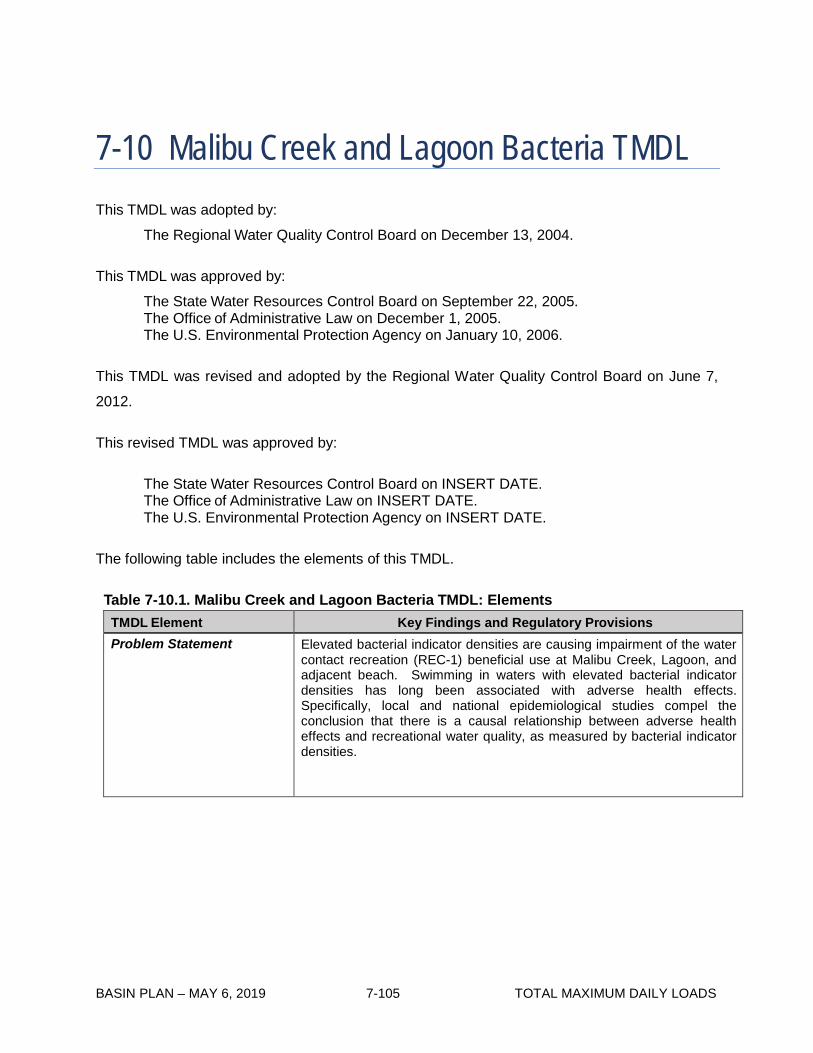
BASIN PLAN – MAY 6, 2019 7-105 TOTAL MAXIMUM DAILY LOADS
7-10 Malibu Creek and Lagoon Bacteria TMDL This TMDL was adopted by:
The Regional Water Quality Control Board on December 13, 2004.
This TMDL was approved by:
The State Water Resources Control Board on September 22, 2005. The Office of Administrative Law on December 1, 2005. The U.S. Environmental Protection Agency on January 10, 2006.
This TMDL was revised and adopted by the Regional Water Quality Control Board on June 7,
2012.
This revised TMDL was approved by:
The State Water Resources Control Board on INSERT DATE. The Office of Administrative Law on INSERT DATE. The U.S. Environmental Protection Agency on INSERT DATE.
The following table includes the elements of this TMDL.
Table 7-10.1. Malibu Creek and Lagoon Bacteria TMDL: Elements
TMDL Element Key Findings and Regulatory Provisions Problem Statement Elevated bacterial indicator densities are causing impairment of the water
contact recreation (REC-1) beneficial use at Malibu Creek, Lagoon, and adjacent beach. Swimming in waters with elevated bacterial indicator densities has long been associated with adverse health effects. Specifically, local and national epidemiological studies compel the conclusion that there is a causal relationship between adverse health effects and recreational water quality, as measured by bacterial indicator densities.
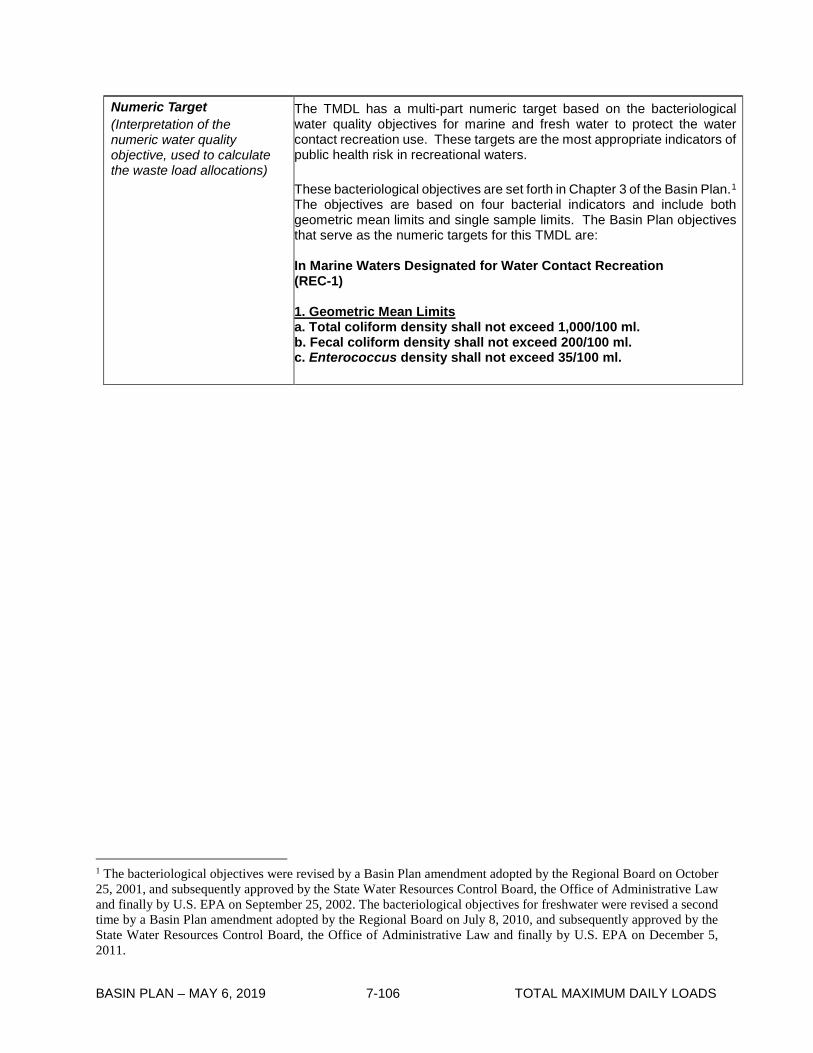
BASIN PLAN – MAY 6, 2019 7-106 TOTAL MAXIMUM DAILY LOADS
Numeric Target (Interpretation of the numeric water quality objective, used to calculate the waste load allocations)
The TMDL has a multi-part numeric target based on the bacteriological water quality objectives for marine and fresh water to protect the water contact recreation use. These targets are the most appropriate indicators of public health risk in recreational waters. These bacteriological objectives are set forth in Chapter 3 of the Basin Plan.1 The objectives are based on four bacterial indicators and include both geometric mean limits and single sample limits. The Basin Plan objectives that serve as the numeric targets for this TMDL are: In Marine Waters Designated for Water Contact Recreation (REC-1) 1. Geometric Mean Limits a. Total coliform density shall not exceed 1,000/100 ml. b. Fecal coliform density shall not exceed 200/100 ml. c. Enterococcus density shall not exceed 35/100 ml.
1 The bacteriological objectives were revised by a Basin Plan amendment adopted by the Regional Board on October 25, 2001, and subsequently approved by the State Water Resources Control Board, the Office of Administrative Law and finally by U.S. EPA on September 25, 2002. The bacteriological objectives for freshwater were revised a second time by a Basin Plan amendment adopted by the Regional Board on July 8, 2010, and subsequently approved by the State Water Resources Control Board, the Office of Administrative Law and finally by U.S. EPA on December 5, 2011.

BASIN PLAN – MAY 6, 2019 7-107 TOTAL MAXIMUM DAILY LOADS
TMDL Element Key Findings and Regulatory Provisions Numeric Target (Interpretation of the numeric water quality objective, used to calculate the waste load allocations) (continued)
2. Single Sample Limits a. Total coliform density shall not exceed 10,000/100 ml. b. Fecal coliform density shall not exceed 400/100 ml. c. Enterococcus density shall not exceed 104/100 ml. d. Total coliform density shall not exceed 1,000/100 ml, if the
ratio of fecal-to-total coliform exceeds 0.1. In Fresh Waters Designated for Water Contact Recreation (REC-1) 1. Geometric Mean Limits a. E. coli density shall not exceed 126/100 ml. 2. Single Sample Limits a. E. coli density shall not exceed 235/100 ml. These objectives are generally based on an acceptable health risk for marine recreational waters of 19 illnesses per 1,000 exposed individuals as set by the US EPA (US EPA, 1986). The targets apply throughout the year. The final compliance point for the targets is the point at which the effluent from a discharge initially mixes with the receiving water. In this TMDL, implementation of the above bacteria objectives and the associated TMDL numeric targets is achieved using a ‘reference system/anti-degradation approach’ rather than the alternative ‘natural sources exclusion approach’ or strict application of the single sample objectives. As required by the federal Clean Water Act and California Water Code, Basin Plans include beneficial uses of waters, water quality objectives to protect those uses, an anti-degradation policy, collectively referred to as water quality standards, and other plans and policies necessary to implement water quality standards. This TMDL uses a “reference system/anti-degradation approach” to implement the water quality objectives per the implementation provisions in Chapter 3. On the basis of the historical exceedance frequency at Southern California reference reaches, a certain number of daily exceedances of the single sample bacteria objectives are permitted. The geometric mean targets may not be exceeded at any time. For the purposes of this TMDL, the geometric means shall be calculated weekly as a rolling geometric mean using 5 or more samples, for six week periods starting all calculation weeks on Sunday. For the single sample targets, each existing monitoring site in Malibu Creek and its tributaries is assigned an allowable number of exceedance days for two time periods (1) dry-weather, and (2) wet-weather (defined as days with 0.1 inch of rain or greater and the three days following the rain event.) Each monitoring site in Malibu Lagoon is assigned an allowable number of exceedance days for three time periods (1) summer dry-weather (April 1 to October 31), (2) winter dry-weather (November 1 to March 31), and (3) wet-weather (defined as days with 0.1 inch of rain or greater and the three days following the rain event.)

BASIN PLAN – MAY 6, 2019 7-108 TOTAL MAXIMUM DAILY LOADS
TMDL Element Key Findings and Regulatory Provisions
Source Analysis Fecal coliform bacteria may be introduced from a variety of sources including storm water runoff, dry-weather runoff, onsite wastewater treatment systems, and animal wastes. An inventory of possible point and nonpoint sources of fecal coliform bacteria to the waterbody was compiled, and both simple methods and computer modeling were used to estimate bacteria loads for those sources. Source inventories were used in the analysis to identify all potential sources within the Malibu Creek watershed, modeling was used to identify the potential delivery of pathogens into the creeks and the lagoon.
Loading Capacity The loading capacity is defined in terms of bacterial indicator densities, which is the most appropriate for addressing public health risk, and is equivalent to the numeric targets, listed above. As the numeric targets must be met at the point where the effluent from storm drains or other discharge initially mixes with the receiving water throughout the day, no degradation or dilution allowance is provided.
Waste Load Allocations (for point sources)
Waste Load Allocations (WLAs) assigned to municipal separate storm sewer system discharges are expressed as the number of daily or weekly sample days that may exceed the single sample limits or geometric mean limits as identified under “Numeric Target.” WLAs are expressed as allowable exceedance days because the bacterial density and frequency of single sample exceedances are the most relevant to public health protection. No exceedances are allowed for the geometric mean limits. The allowable days of exceedance for the single sample limits differ depending on season, dry weather or wet-weather, and by sampling locations as described in Table 7-10.2. For each monitoring site in Malibu Creek and its tributaries, allowable exceedance days are set on an annual basis as well as for two time periods. These two periods are: 1. dry-weather 2. wet-weather (defined as days of 0.1 inch of rain or more plus three days following the rain event). For each monitoring site in Malibu Lagoon, allowable exceedance days are set on an annual basis as well as for three time periods. These three periods are: 1. summer dry-weather (April 1 to October 31) 2. winter dry-weather (November 1 to March 31) 3. wet-weather (defined as days of 0.1 inch of rain or more plus three days following the rain event).

BASIN PLAN – MAY 6, 2019 7-109 TOTAL MAXIMUM DAILY LOADS
TMDL Element Key Findings and Regulatory Provisions Waste Load Allocations (for point sources) (continued)
The responsible jurisdictions and responsible agencies are the permittees and co-permittees regulated under municipal separate storm sewer system (MS4) permits including the County of Los Angeles, Los Angeles County Flood Control District, County of Ventura, Ventura County Watershed Protection District, the cities of Malibu, Calabasas, Agoura Hills, Hidden Hills, Westlake Village, and Thousand Oaks; Caltrans, and the California Department of Parks and Recreation. The responsible jurisdictions and responsible agencies include the permittees and co-permittees of the MS4 permits for Los Angeles County and Ventura County, and Caltrans and any future Phase II MS4 permits. The storm water permittees are individually responsible for the discharges from their municipal separate storm sewer systems to Malibu Creek, Malibu Lagoon or tributaries thereto. The California Department of Parks and Recreation (State Parks), as the owner of the Malibu Lagoon and Malibu Creek State Park, is the responsible agency for these properties. However, since the reference watershed approach used in developing this TMDL is intended to make allowances for natural sources, State Parks is only responsible for: conducting a study of bacteria loadings from birds in the Malibu Lagoon, water quality monitoring, and compliance with load allocations applicable to anthropogenic sources on State Park property (e.g., onsite wastewater treatment systems). The Santa Monica Mountains Conservancy and the National Park Service as the owner of natural parkland also are responsible for water quality monitoring and compliance with load allocations resulting from anthropogenic sources (e.g., onsite wastewater treatment systems) from lands under their jurisdiction. The Tapia Water Reclamation Facility (TWRF) discharging to Malibu Creek is given individual WLAs equal to the bacteriological objectives contained in Chapter 3 during dry weather and wet weather. Discharges from general NPDES permits, general industrial storm water permits and general construction storm water permits are not expected to be a significant source of bacteria. Additionally, these discharges are not eligible for the reference system approach set forth in the implementation provisions for the bacteriological objectives in Chapter 3. Therefore, the waste load allocations for these discharges for all time periods are the bacteriological objectives contained in Chapter 3. Any future enrollees under a general NPDES permit, general industrial storm water permit or general construction storm water permit within the Malibu Creek watershed management area will also be subject to a WLA based on these bacteriological objectives.
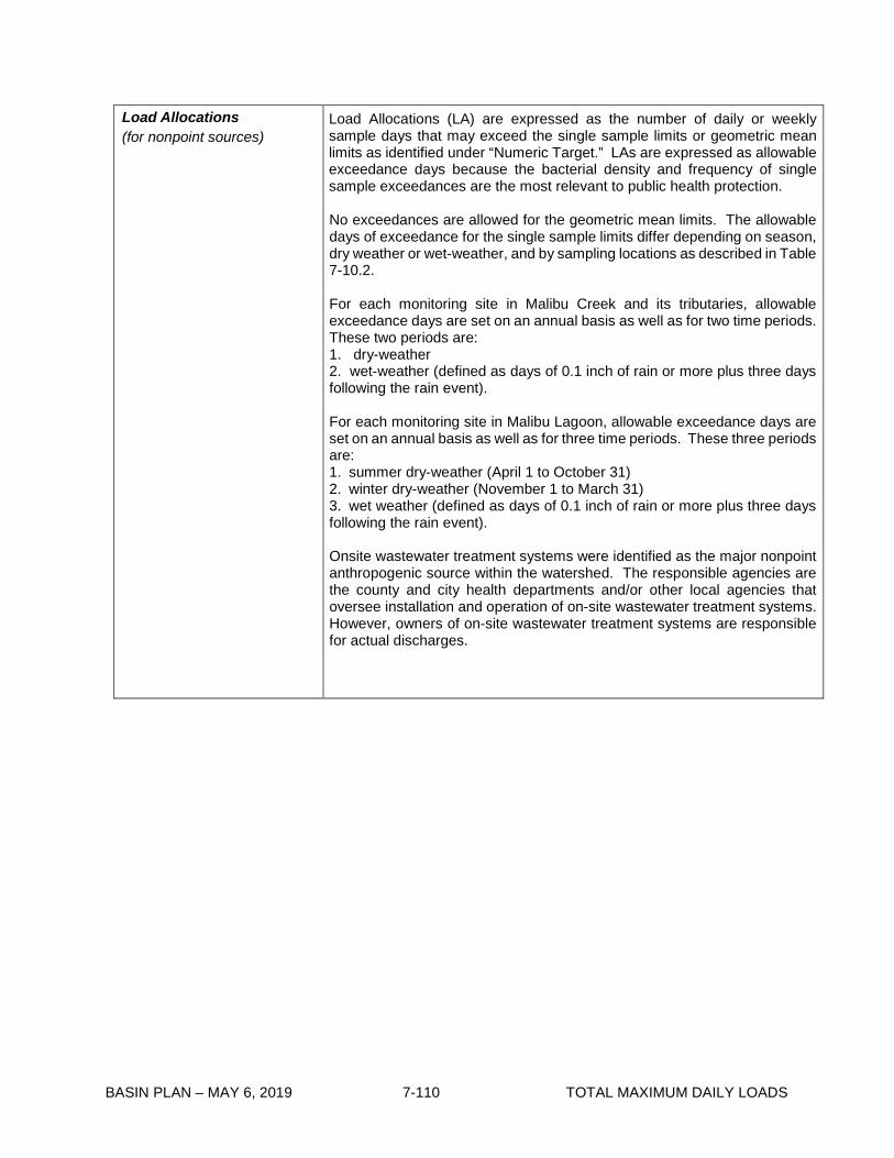
BASIN PLAN – MAY 6, 2019 7-110 TOTAL MAXIMUM DAILY LOADS
Load Allocations (for nonpoint sources)
Load Allocations (LA) are expressed as the number of daily or weekly sample days that may exceed the single sample limits or geometric mean limits as identified under “Numeric Target.” LAs are expressed as allowable exceedance days because the bacterial density and frequency of single sample exceedances are the most relevant to public health protection. No exceedances are allowed for the geometric mean limits. The allowable days of exceedance for the single sample limits differ depending on season, dry weather or wet-weather, and by sampling locations as described in Table 7-10.2. For each monitoring site in Malibu Creek and its tributaries, allowable exceedance days are set on an annual basis as well as for two time periods. These two periods are: 1. dry-weather 2. wet-weather (defined as days of 0.1 inch of rain or more plus three days following the rain event). For each monitoring site in Malibu Lagoon, allowable exceedance days are set on an annual basis as well as for three time periods. These three periods are: 1. summer dry-weather (April 1 to October 31) 2. winter dry-weather (November 1 to March 31) 3. wet weather (defined as days of 0.1 inch of rain or more plus three days following the rain event). Onsite wastewater treatment systems were identified as the major nonpoint anthropogenic source within the watershed. The responsible agencies are the county and city health departments and/or other local agencies that oversee installation and operation of on-site wastewater treatment systems. However, owners of on-site wastewater treatment systems are responsible for actual discharges.

BASIN PLAN – MAY 6, 2019 7-111 TOTAL MAXIMUM DAILY LOADS
TMDL Element Key Findings and Regulatory Provisions
Implementation The regulatory mechanisms to implement the TMDL may include, but are not limited to the Los Angeles County MS4 NPDES Permit, Ventura County MS4 NPDES Permit, the Caltrans Storm Water Permit, any future Phase II MS4 permits, waste discharge requirements (WDRs), Memorandum of Understandings (MOUs), revised MOUs, or other appropriate mechanisms consistent with the Nonpoint Source Implementation and Enforcement Policy, general NPDES permits, general industrial storm water permits, general construction storm water permits, the authority contained in Sections 13225, 13263, 13267, and 13383 of the California Water Code, and other appropriate regulatory mechanisms. Each NPDES permit assigned a WLA shall be reopened or amended at reissuance, in accordance with applicable laws, to incorporate the applicable WLAs as a permit requirement. This TMDL will be implemented in two phases as outlined in Table 7-10.3. By January 24, 2012, compliance with the allowable number of dry-weather exceedance days must be achieved. By July 15, 2021, compliance with the allowable number of wet-weather exceedance days and the geometric mean targets must be achieved.
Margin of Safety A margin of safety has been implicitly included through the following conservative assumptions.
• The watershed loadings were based on the 90th percentile year for rain (1993) based on the number of wet weather days. This should provide conservatively high runoff from different land uses for sources of storm water loads
• The watershed loadings were also based on a very dry rain year (1994). This ensures compliance with the numeric target during low flows when septic systems and dry urban runoff loads are the major bacterial sources.
• The TMDL was based on meeting the fecal coliform 30-day
geometric mean target of 200 MPN/ 100 ml, which for these watersheds was estimated to be more stringent level than the allowable exceedance of the single sample standard. This approach also provides assurance that the E. coli single sample standard will not be exceeded.
• The load reductions established in this TMDL were based on
reduction required during the two different critical year conditions. A wet year when storm loads are high, and a more typical dry year when base flows and assimilative capacity is low. This adds a margin of safety for more typical years.
In addition, an explicit margin of safety has been incorporated, as the load allocations will allow exceedances of the single sample targets no more than 5% of the time on an annual basis, based on the cumulative allocations proposed for dry and wet weather. Currently, the Regional Board concludes that there is water quality impairment if more than 10% of samples at a site exceed the single sample bacteria objectives annually.

BASIN PLAN – MAY 6, 2019 7-112 TOTAL MAXIMUM DAILY LOADS
TMDL Element Key Findings and Regulatory Provisions
Seasonal Variations and Critical Conditions
Seasonal variations are addressed by developing separate waste load allocations for two time periods (dry-weather, and wet-weather) in Malibu Creek and its tributaries, and three time periods (summer dry-weather, winter dry-weather, and wet weather) in Malibu Lagoon based on public health concerns and observed natural background levels of exceedance of bacterial indicators. The critical condition for this bacteria TMDL is wet weather generally, when data for the reference system indicate that the single sample bacteria objectives are exceeded on 19% of the wet-weather days sampled in Malibu Creek and its tributaries and on 22% of the wet-weather days sampled in Malibu Lagoon. To more specifically identify a critical condition within wet weather in order to set the allowable exceedance days, the 90th percentile ‘storm year’35 in terms of wet days is used as the reference year. The number of wet-weather days in the 1993 reference year was 75 days, and the number of dry-weather days was 290 days (210 summer dry-weather days and 80 winter dry-weather days).
Compliance Monitoring Responsible jurisdictions and agencies shall submit a compliance monitoring plan to the Executive Officer of the Regional Board for approval. The compliance monitoring plan shall specify sampling frequency (daily or weekly) and sampling locations and that will serve as compliance points. Responsible jurisdictions and agencies shall submit an outfall monitoring plan within 6 months of the effective date of the TMDL revised by Resolution R12-009. The outfall monitoring plan shall propose an adequate number of representative outfalls to be sampled, a sampling frequency, and protocol for enhanced outfall monitoring as a result of an in-stream exceedance. Responsible jurisdictions and agencies can use existing outfall monitoring stations in the MS4 permit, where appropriate for both the permit and TMDL objectives. If the number of exceedance days is greater than the allowable number of exceedance days the water body segment shall be considered out-of-compliance with the TMDL. Responsible jurisdictions or agencies shall not be deemed non-attaining if the outfall monitoring described in the paragraph above demonstrates that bacterial sources originating within the jurisdiction of the responsible agency have not caused or contributed to the exceedance. The County of Los Angeles, Los Angeles County Flood Control District, County of Ventura, Ventura County Watershed Protection District, and municipalities within the Malibu Creek watershed, Caltrans, and the California Department of Parks and Recreation are strongly encouraged to pool efforts and coordinate with other appropriate monitoring agencies in order to meet the challenges posed by this TMDL by developing cooperative compliance monitoring programs.
35 For purposes of this TMDL, a ‘storm year’ means November 1 to October 31. The 90th percentile storm year was 1993 with 75 wet days at the LAX meteorological station.

BASIN PLAN – MAY 6, 2019 7-110 TOTAL MAXIMUM DAILY LOADS
Table 7-10.2. Malibu Creek and Lagoon Bacteria TMDL: Final Annual Allowable Exceedance Days for Single Sample Limits by Sampling
Location
Compliance Deadline
January 24, 2012
July 15, 2021
Dry Weather ^ Wet Weather ^ Station ID Location Name Daily
sampling (No. days)
Weekly sampling (No.
days)
Daily sampling
(No. days)
Weekly sampling (No.
days) LA RWQCB Triunfo Creek 5 1 15 2
LA RWQCB Lower Las Virgenes Creek 5 1 15 2
LA RWQCB Lower Medea Creek 5 1 15 2
LVMWD (R-9) Upper Malibu Creek, above Las Virgenes Creek 5 1 15 2
LVMWD (R-2) Middle Malibu Creek, below Tapia discharge 001 5 1 15 2
LVMWD (R-3) Lower Malibu Creek, 3 mi below Tapia 5 1 15 2
LVMWD (R-4) Malibu Lagoon, above PCH 5 1 15 2
LVMWD (R-11) Malibu Lagoon, below PCH 9* 2* 17 3
------ Other sampling stations as identified in the Compliance Monitoring Plan as approved by the Executive Officer including at least one sampling station in each subwatershed, and areas where frequent REC-1 use is known to occur.
5 1 15 2
Notes: The number of allowable exceedances is based on the lesser of (1) the reference system or (2) existing levels of exceedance based on historical monitoring data. The allowable number of exceedance days is calculated based on the 90th percentile storm year in terms of wet days at the LAX meteorological station. ^ A dry day is defined as a non-wet day. A wet day is defined as a day with a 0.1 inch or more of rain and the three days following the rain event. *The number of allowable exceedance days is for the winter dry-weather period. No exceedance days are allowed for the summer dry-weather period.
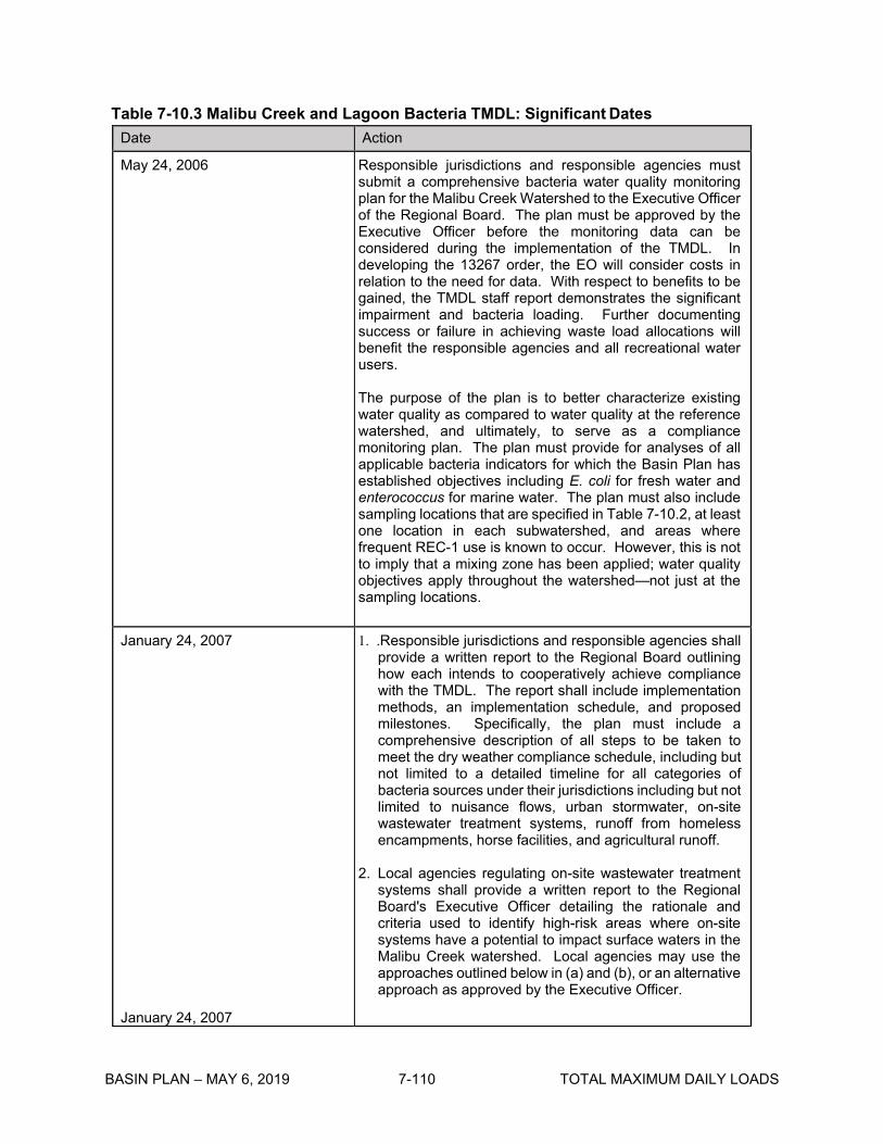
BASIN PLAN – MAY 6, 2019 7-110 TOTAL MAXIMUM DAILY LOADS
Table 7-10.3 Malibu Creek and Lagoon Bacteria TMDL: Significant Dates
Date Action
May 24, 2006 Responsible jurisdictions and responsible agencies must submit a comprehensive bacteria water quality monitoring plan for the Malibu Creek Watershed to the Executive Officer of the Regional Board. The plan must be approved by the Executive Officer before the monitoring data can be considered during the implementation of the TMDL. In developing the 13267 order, the EO will consider costs in relation to the need for data. With respect to benefits to be gained, the TMDL staff report demonstrates the significant impairment and bacteria loading. Further documenting success or failure in achieving waste load allocations will benefit the responsible agencies and all recreational water users. The purpose of the plan is to better characterize existing water quality as compared to water quality at the reference watershed, and ultimately, to serve as a compliance monitoring plan. The plan must provide for analyses of all applicable bacteria indicators for which the Basin Plan has established objectives including E. coli for fresh water and enterococcus for marine water. The plan must also include sampling locations that are specified in Table 7-10.2, at least one location in each subwatershed, and areas where frequent REC-1 use is known to occur. However, this is not to imply that a mixing zone has been applied; water quality objectives apply throughout the watershed—not just at the sampling locations.
January 24, 2007 January 24, 2007
1. .Responsible jurisdictions and responsible agencies shall provide a written report to the Regional Board outlining how each intends to cooperatively achieve compliance with the TMDL. The report shall include implementation methods, an implementation schedule, and proposed milestones. Specifically, the plan must include a comprehensive description of all steps to be taken to meet the dry weather compliance schedule, including but not limited to a detailed timeline for all categories of bacteria sources under their jurisdictions including but not limited to nuisance flows, urban stormwater, on-site wastewater treatment systems, runoff from homeless encampments, horse facilities, and agricultural runoff.
2. Local agencies regulating on-site wastewater treatment
systems shall provide a written report to the Regional Board's Executive Officer detailing the rationale and criteria used to identify high-risk areas where on-site systems have a potential to impact surface waters in the Malibu Creek watershed. Local agencies may use the approaches outlined below in (a) and (b), or an alternative approach as approved by the Executive Officer.

BASIN PLAN – MAY 6, 2019 7-111 TOTAL MAXIMUM DAILY LOADS
Date Action
(continued) (a) Responsible agencies may screen for high-risk areas by establishing a monitoring program to determine if discharges from OWTS have impacted or are impacting water quality in Malibu Creek and/or its tributaries. A surface water monitoring program demonstration must include monitoring locations upstream and downstream of the discharge, as well as a location at mid-stream (or at the approximate point of discharge to the surface water) of single or clustered OWTS. Surface water sampling frequency will be weekly for bacteria indicators and monthly for nutrients. A successful demonstration will show no statistically significant increase in bacteria levels in the downstream sampling location(s).
(b) Responsible agencies may define the boundaries of
high-risk or contributing areas or identify individual OWTS that are contributing to bacteria water quality impairments through groundwater monitoring or through hydrogeologic modeling as described below:
(1) Groundwater monitoring must include monitoring in
a well no greater than 50-feet hydraulically downgradient from the furthermost extent of the disposal area, or property line of the discharger, whichever is less. At a minimum, sampling frequency for groundwater monitoring will be quarterly. The number, location and construction details of all monitoring wells are subject to approval of the Executive Officer.
(2) Responsible agencies may use a risk assessment approach, which uses hydrogeologic modeling to define the boundaries of the high-risk and contributing areas. A workplan for the risk assessment study must be approved by the Executive Officer of the Regional Board.
3. OWTS located in high-risk areas are subject to system upgrades as necessary to demonstrate compliance with applicable effluent limits and/or receiving water objectives.

BASIN PLAN – MAY 6, 2019 7-112 TOTAL MAXIMUM DAILY LOADS
Date Action
January 24, 2008 The California Department of Parks and Recreation shall provide the Regional Board Executive Officer, a report quantifying the bacteria loading from birds to the Malibu Lagoon. The Regional Board's Executive Officer shall require the responsible jurisdictions and responsible agencies to provide the Regional Board with a reference watershed study. The study shall be designed to collect sufficient information to establish a defensible reference condition for the Malibu Creek and Lagoon watershed.
January 24, 2012 Achieve compliance with the applicable Load Allocations
and Waste Load Allocations, expressed as allowable exceedance days during dry weather.
July 15, 2018 The Regional Board shall reconsider the TMDL.
July 15, 2021 Achieve compliance with the wet-weather Load Allocations and Waste Load Allocations (expressed as allowable exceedance days for wet weather) and compliance with the geometric mean limit.

BASIN PLAN – MAY 6, 2019 7-113 TOTAL MAXIMUM DAILY LOADS
7-11 Los Angeles Harbor Bacteria TMDL - Inner Cabrillo Beach and Main Ship Channel This TMDL was adopted by the Regional Board on July 1, 2004.
This TMDL was approved by:
The State Water Resources Control Board on October 21, 2004. The Office of Administrative Law on January 5, 2005. The U.S. Environmental Protection Agency on March 1, 2005.
This TMDL was revised by:
The Regional Board on June 7, 2012.
This TMDL was approved by:
The State Water Resources Control Board on May 19, 2013. The Office of Administrative Law on November 7, 2013. The U.S. Environmental Protection Agency on July 2, 2014.
The following table contains the elements of this TMDL.
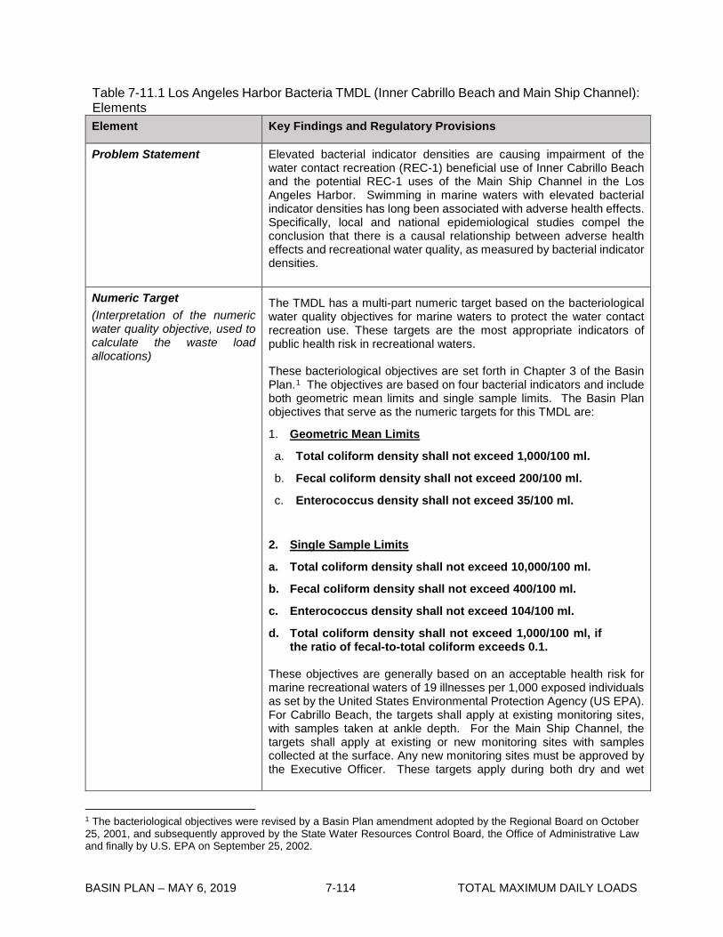
BASIN PLAN – MAY 6, 2019 7-114 TOTAL MAXIMUM DAILY LOADS
Table 7-11.1 Los Angeles Harbor Bacteria TMDL (Inner Cabrillo Beach and Main Ship Channel): Elements Element Key Findings and Regulatory Provisions
Problem Statement Elevated bacterial indicator densities are causing impairment of the water contact recreation (REC-1) beneficial use of Inner Cabrillo Beach and the potential REC-1 uses of the Main Ship Channel in the Los Angeles Harbor. Swimming in marine waters with elevated bacterial indicator densities has long been associated with adverse health effects. Specifically, local and national epidemiological studies compel the conclusion that there is a causal relationship between adverse health effects and recreational water quality, as measured by bacterial indicator densities.
Numeric Target (Interpretation of the numeric water quality objective, used to calculate the waste load allocations)
The TMDL has a multi-part numeric target based on the bacteriological water quality objectives for marine waters to protect the water contact recreation use. These targets are the most appropriate indicators of public health risk in recreational waters. These bacteriological objectives are set forth in Chapter 3 of the Basin Plan.1 The objectives are based on four bacterial indicators and include both geometric mean limits and single sample limits. The Basin Plan objectives that serve as the numeric targets for this TMDL are:
1. Geometric Mean Limits
a. Total coliform density shall not exceed 1,000/100 ml.
b. Fecal coliform density shall not exceed 200/100 ml.
c. Enterococcus density shall not exceed 35/100 ml.
2. Single Sample Limits
a. Total coliform density shall not exceed 10,000/100 ml.
b. Fecal coliform density shall not exceed 400/100 ml.
c. Enterococcus density shall not exceed 104/100 ml.
d. Total coliform density shall not exceed 1,000/100 ml, if the ratio of fecal-to-total coliform exceeds 0.1.
These objectives are generally based on an acceptable health risk for marine recreational waters of 19 illnesses per 1,000 exposed individuals as set by the United States Environmental Protection Agency (US EPA). For Cabrillo Beach, the targets shall apply at existing monitoring sites, with samples taken at ankle depth. For the Main Ship Channel, the targets shall apply at existing or new monitoring sites with samples collected at the surface. Any new monitoring sites must be approved by the Executive Officer. These targets apply during both dry and wet
1 The bacteriological objectives were revised by a Basin Plan amendment adopted by the Regional Board on October 25, 2001, and subsequently approved by the State Water Resources Control Board, the Office of Administrative Law and finally by U.S. EPA on September 25, 2002.

BASIN PLAN – MAY 6, 2019 7-115 TOTAL MAXIMUM DAILY LOADS
Element Key Findings and Regulatory Provisions
Numeric Target (con’t)
weather, since there is water contact recreation throughout the year, including during wet weather. Implementation of the above bacteria objectives and the associated TMDL numeric targets is achieved using a ‘reference system/anti-degradation approach’ as set forth in Chapter 3. As required by the federal Clean Water Act and California Water Code, Basin Plans include beneficial uses of waters, water quality objectives to protect those uses, and an anti-degradation policy, collectively referred to as water quality standards, and other plans and policies necessary to implement water quality standards. This TMDL and its associated waste load allocations, which shall be incorporated into relevant permits, and load allocations are the vehicles for implementation of the Region’s standards. The geometric mean targets may not be exceeded at any time. For purposes of this TMDL, the geometric means shall be calculated weekly as a rolling geometric mean using 5 or more samples, for six week periods starting all calculation weeks on Sunday. For the single sample targets, each existing monitoring site is assigned an allowable number of exceedance days for three time periods (1) summer dry weather (April 1 to October 31), (2) winter dry weather (November 1 to March 31), and (3) wet weather (defined as days with 0.1 inch of rain or greater and the three days following the rain event).
Source Analysis Dry-weather urban runoff and storm water conveyed by storm drains are
major sources of elevated bacterial indicator densities to Inner Cabrillo Beach and the Main Ship Channel during dry and wet weather. As of March 2004, there are 15 active individual and 15 active general NPDES permits for discharges to the Inner or Outer Los Angeles Harbor including the Terminal Island Water Reclamation Plant. While the fecal coliform counts in the wastewater field indicate a contribution of bacteria to the Harbor by the Terminal Island Water Reclamation Plant, the wastewater field is sufficiently diluted and the bacterial densities are so much lower in the Harbor than the high bacterial densities and exceedances at the sites at Cabrillo Beach and in the Main Ship Channel that it appears that the Water Reclamation Plant is not a significant source of bacteria to the Beach or to the Ship Channel. Potential nonpoint sources of bacterial contamination at Inner Cabrillo Beach and Main Ship Channel include marina activities such as waste disposal from boats, boat deck and slip washing, swimmer “wash-off”, restaurant washouts and natural sources from birds, waterfowl and other wildlife. The bacteria loads associated with these nonpoint sources are not well quantified. However, bacterial contamination at the beach is concentrated in the shallow (ankle depth) waters more than even waters a few feet away (at knee or chest depth). This supports the contention that high bacterial densities may be largely from the beach, itself.
Loading Capacity
Studies (for example, Haile, R.W., Witte, J.S. 1997. Addendum to “An epidemiological study of possible adverse health effects of swimming in Santa Monica Bay.” Santa Monica Bay Restoration Project) show that bacterial degradation and dilution during transport from the watershed to the receiving water do not significantly affect bacterial indicator densities.
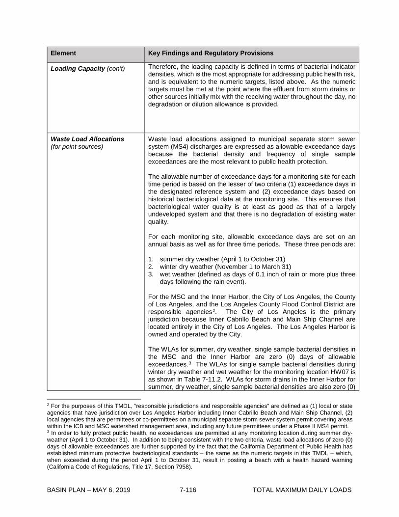
BASIN PLAN – MAY 6, 2019 7-116 TOTAL MAXIMUM DAILY LOADS
Element Key Findings and Regulatory Provisions
Loading Capacity (con’t)
Therefore, the loading capacity is defined in terms of bacterial indicator densities, which is the most appropriate for addressing public health risk, and is equivalent to the numeric targets, listed above. As the numeric targets must be met at the point where the effluent from storm drains or other sources initially mix with the receiving water throughout the day, no degradation or dilution allowance is provided.
Waste Load Allocations (for point sources)
Waste load allocations assigned to municipal separate storm sewer system (MS4) discharges are expressed as allowable exceedance days because the bacterial density and frequency of single sample exceedances are the most relevant to public health protection. The allowable number of exceedance days for a monitoring site for each time period is based on the lesser of two criteria (1) exceedance days in the designated reference system and (2) exceedance days based on historical bacteriological data at the monitoring site. This ensures that bacteriological water quality is at least as good as that of a largely undeveloped system and that there is no degradation of existing water quality. For each monitoring site, allowable exceedance days are set on an annual basis as well as for three time periods. These three periods are: 1. summer dry weather (April 1 to October 31) 2. winter dry weather (November 1 to March 31) 3. wet weather (defined as days of 0.1 inch of rain or more plus three
days following the rain event). For the MSC and the Inner Harbor, the City of Los Angeles, the County of Los Angeles, and the Los Angeles County Flood Control District are responsible agencies2. The City of Los Angeles is the primary jurisdiction because Inner Cabrillo Beach and Main Ship Channel are located entirely in the City of Los Angeles. The Los Angeles Harbor is owned and operated by the City. The WLAs for summer, dry weather, single sample bacterial densities in the MSC and the Inner Harbor are zero (0) days of allowable exceedances.3 The WLAs for single sample bacterial densities during winter dry weather and wet weather for the monitoring location HW07 is as shown in Table 7-11.2. WLAs for storm drains in the Inner Harbor for summer, dry weather, single sample bacterial densities are also zero (0)
2 For the purposes of this TMDL, “responsible jurisdictions and responsible agencies” are defined as (1) local or state agencies that have jurisdiction over Los Angeles Harbor including Inner Cabrillo Beach and Main Ship Channel, (2) local agencies that are permittees or co-permittees on a municipal separate storm sewer system permit covering areas within the ICB and MSC watershed management area, including any future permittees under a Phase II MS4 permit. 3 In order to fully protect public health, no exceedances are permitted at any monitoring location during summer dry-weather (April 1 to October 31). In addition to being consistent with the two criteria, waste load allocations of zero (0) days of allowable exceedances are further supported by the fact that the California Department of Public Health has established minimum protective bacteriological standards – the same as the numeric targets in this TMDL – which, when exceeded during the period April 1 to October 31, result in posting a beach with a health hazard warning (California Code of Regulations, Title 17, Section 7958).

BASIN PLAN – MAY 6, 2019 7-117 TOTAL MAXIMUM DAILY LOADS
Element Key Findings and Regulatory Provisions
Waste Load Allocations (con’t)
days of allowable exceedances. The waste load allocation for the geometric mean during any time period or monitoring site in MSC or the Inner Harbor is zero (0) allowable exceedances. Discharges from general NPDES permits, general industrial storm water permits and general construction storm water permits are not expected to be a significant source of bacteria. Additionally, these discharges are not eligible for the reference system approach set forth in the implementation provisions for the bacteriological objectives in Chapter 3. Therefore, the waste load allocations for these discharges for all time periods are the bacteriological objectives contained in Chapter 3. Any future enrollees under a general NPDES permit, general industrial storm water permit or general construction storm water permit within the Inner Cabrillo Beach or the Main Ship Channel watersheds management area will also be subject to a WLA based on these bacteriological objectives. For Inner Cabrillo Beach, the City of Los Angeles is the responsible agency. For the Southern area of Inner Cabrillo Beach, the WLAs for summer dry weather, winter dry weather and wet weather single sample bacterial densities at the ICB swimming beach are zero (0) days of allowable exceedances. Further study of the storm drains on the north part of ICB may lead to the establishment of WLAs for single sample winter dry-weather and wet-weather for these storm drains. The waste load allocation for the geometric mean during any time period or monitoring site at ICB is zero (0) allowable exceedances.
Load Allocations (for nonpoint sources)
Load allocations are expressed as allowable exceedance days because the bacterial density and frequency of single sample exceedances are the most relevant to public health protection. The LAs for summer dry weather, winter dry weather and wet weather, single sample bacterial densities in the MSC are zero (0) days of allowable exceedances. The load allocation for the geometric mean during any time period or monitoring site in MSC or the Inner Harbor is zero (0) allowable exceedances. The LAs for summer dry weather, single sample bacterial densities at the ICB swimming beach are zero (0) days of allowable exceedances. The LAs for single sample bacterial densities during winter dry weather and wet weather for the monitoring locations CB1 and CB2 are as shown in Table 7-11.2. Further study of the north part of ICB may lead to the establishment of LAs for this area. The waste load allocation for the geometric mean during any time period or monitoring site at ICB is zero (0) allowable exceedances.

BASIN PLAN – MAY 6, 2019 7-118 TOTAL MAXIMUM DAILY LOADS
Element Key Findings and Regulatory Provisions
Implementation The regulatory mechanisms used to implement the TMDL will include, but are not limited to, the Los Angeles County MS4 NPDES Permit, any future Phase II MS4 permits, general and individual NPDES permits, general industrial storm water permits, general construction storm water permits, and the authority contained in Sections 13263, 13267, and 13383 of the California Water Code. Each NPDES permit assigned a WLA shall be reopened or amended at reissuance, in accordance with applicable laws, to incorporate the applicable WLAs as a permit requirement. Load allocations for nonpoint sources will be implemented consistent with the Statewide Policy for Implementation and Enforcement of the Nonpoint Source Control Program. This TMDL will be implemented in three phases over a five-year period (see Table 7-11.3). By March 10, 2010, there shall be no allowable exceedances of the single sample limits at any location during summer dry weather (April 1 to October 31) or winter dry weather (November 1 to March 31). By March 10, 2010, compliance with the allowable number of wet-weather exceedance days and geometric mean targets must be achieved. For those monitoring locations subject to the antidegradation provision (HW07, wet weather), there shall be no increase in exceedance days during the implementation period above the estimated days for the monitoring location in the critical year as identified in Table 7-11.2.
Margin of Safety The TMDL is set at levels that are exactly equivalent to the applicable water quality standards along with the proposed reference system/antidegradation implementation provisions set forth in Chapter 3. A margin of safety has been implicitly included through several conservative assumptions, such as the assumption that no dilution takes place between the on-shore sources and where the effluent initially mixes with the receiving water, and that bacterial degradation rates are not fast enough to affect bacteria densities in the receiving water.
Seasonal Variations and Critical Conditions
Seasonal variations are addressed by developing separate waste load allocations for three time periods (summer dry weather, winter dry weather, and wet weather) based on public health concerns and observed natural background levels of exceedance of bacterial indicators. The critical condition for bacteria loading is during wet weather, when historic monitoring data for Los Angeles Harbor and the reference beach indicate greater exceedance probabilities of the single sample bacteria objectives than during dry weather. To more specifically identify a critical condition within wet weather, in order to set the allowable exceedance days shown in Table 7-11.2, the 90th percentile ‘storm year’4 in terms of wet days5 is used as the reference year. Selecting the 90th percentile year avoids a situation where the reference system is frequently out of
4 For purposes of this TMDL, a ‘storm year’ means November 1 to October 31. The 90th percentile storm year was 1993 with 75 wet days at the LAX meteorological station. 5 A wet day is defined as a day with rainfall of 0.1 inch or more plus the 3 days following the rain event.

BASIN PLAN – MAY 6, 2019 7-119 TOTAL MAXIMUM DAILY LOADS
Element Key Findings and Regulatory Provisions
Seasonal Variations and Critical Conditions (con’t)
compliance. It is expected that because responsible jurisdictions and agencies will be planning for this ‘worst-case’ scenario, there will be fewer exceedance days than the maximum allowed in drier years.
Compliance Monitoring The City of Los Angeles will continue to monitor at sites CB1, CB2 and HW07 as required by Terminal Island Water Reclamation Plant NPDES Permit. Additional monitoring sites may be added by responsible parties as necessary and the compliance monitoring requirement may be moved to another permit if determined to be more appropriate by the Regional Board. A special study shall be conducted by the City of Los Angeles in the North area of Inner Cabrillo Beach to assess water quality and compliance with the standards in this TMDL. The special study of the North portion of Inner Cabrillo Beach can include details to support development of a Natural Sources Exclusion in this area if it is found that natural sources such as birds are the sources of bacterial impairment of the northern area of Inner Cabrillo Beach. Beach monitoring samples will be taken in compliance with Assembly Bill 411 and the Southern California Beach Water Quality Working Group procedures. Open water sampling sites will be taken at the surface. A special study shall be conducted by the County of Los Angeles and City of Los Angeles to assess water quality and compliance with the standards in this TMDL in the MSC. The schedules for special studies are shown in Table 7-11.3.

BASIN PLAN – APRIL 2, 2019 7-120 TOTAL MAXIMUM DAILY LOADS
Table 7-11.2 Los Angeles Harbor Bacteria TMDL: Final Allowable Exceedance Days by Sampling Location
Compliance Deadline March 10, 2010 March 10, 2010 March 10, 20102
Summer Dry Weather ^ Winter Dry Weather ^ Wet Weather ^
April 1 - October 31 November 1 – March 31 November 1 - October 31
Station
ID
Location Name Daily
sampling (No.
days)
Weekly
sampling (No.
days)
Daily
sampling (No.
days)
Weekly
sampling (No.
days)
Daily
sampling (No.
days)
Weekly
sampling (No.
days)
CB1;
CB2
Inner Cabrillo
Beach
0 0 8 (LA) 1 (LA) 17 (LA) 3 (LA)
HW07 Main Ship Channel 0 0 8 (WLA) 1 (WLA) 15* (WLA) 3* (WLA)
Notes: The number of allowable exceedances is based on the lesser of (1) the reference system or (2) existing levels of exceedance based on historical monitoring data. The allowable number of exceedance days during winter dry weather is calculated based on the 10th percentile storm year in terms of dry days at the LAX meteorological station The allowable number of exceedance days during wet weather is calculated based on the 90th percentile storm year in terms of wet days at the LAX meteorological station. ^ A dry day is defined as a non-wet day. A wet day is defined as a day with a 0.1-inch or more of rain and the three days following the rain event. *The Main Ship Channel (HW07) is already meeting the allowable exceedance days for wet weather and is subject to the antidegradation provision; there shall be no increase in exceedance days during the implementation period above that estimated for the monitoring location in the critical year (15 days/daily sampling, 3 days/weekly sampling).

BASIN PLAN – MAY 6, 2019 7-121 TOTAL MAXIMUM DAILY LOADS
Table 7-11.3 Inner Cabrillo Beach & Main Ship Channel Bacteria TMDL: Significant Dates Implementation Action Responsible Party Date
Implementation (ICB): Implement additional simple
Best Management Practices at ICB including
additional trash pickup and educational signage.
(Tier 1)
• City of Los Angeles
September 10, 2005
Implementation (ICB): Submit Work Plan to
Implement Best Management Practices and Source
Control at ICB for Executive Officer Approval
including, but not limited to storm drain repair and
reroute; inspect and repair gravity sewer line;
implement sand cleaning; repair bird exclusion
structure; additional education and signage. (Tier 1)
• City of Los Angeles September 10, 2005
Special Studies (ICB): Submit work plan to assess
water quality in the northern area of Inner Cabrillo
Beach for Executive Officer approval including a plan
to monitor northern ICB and assess the discharge
from storm drains into the Saltwater Marsh. (Tier 2)
• City of Los Angeles September 10, 2005
Special Studies (MSC): Submit work plan to assess
water quality in the Inner Harbor for Executive Officer
approval including a plan to monitor in proximity to
selected storm drains. (Tier 2)
• City of Los Angeles • County of Los Angeles
September 10, 2005
Implementation (ICB): Submit work plan for Tier 2
BMPs for Executive Officer approval, including but
not limited to alteration of bird exclusion structure,
control of sources from cat population, and sand
management. (Tier 2)
• City of Los Angeles September 10, 2005
Implementation (ICB): Complete implementation of
Source Control and BMPs at ICB as identified in work
plan including, but not limited to storm drain repair
and reroute; inspection and repair gravity sewer line;
trash disposal, sand cleanup; and repair bird
exclusion structure. (Tier 1)
• City of Los Angeles March 10, 2006
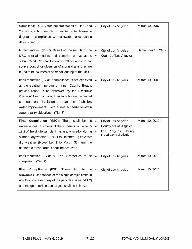
BASIN PLAN – MAY 6, 2019 7-122 TOTAL MAXIMUM DAILY LOADS
Compliance (ICB): After implementation of Tier 1 and
2 actions, submit results of monitoring to determine
degree of compliance with allowable exceedance
days. (Tier 3)
• City of Los Angeles March 10, 2007
Implementation (MSC): Based on the results of the
MSC special studies and compliance evaluation,
submit Work Plan for Executive Officer approval for
source control or diversion of storm drains that are
found to be sources of bacterial loading to the MSC.
• City of Los Angeles • County of Los Angeles
September 10, 2007
Implementation (ICB): If compliance is not achieved
at the southern portion of Inner Cabrillo Beach,
provide report to be approved by the Executive
Officer of Tier III actions, to include but not be limited
to, nearshore circulation or treatment of shallow
water improvements, with a time schedule to attain
water quality objectives. (Tier 3)
• City of Los Angeles
March 10, 2008
Final Compliance (MSC): There shall be no
exceedances in excess of the numbers in Table 7-
11.2 of the single sample limits at any location during
summer dry weather (April 1 to October 31) or winter
dry weather (November 1 to March 31) and the
geometric mean targets shall be achieved.
• City of Los Angeles • County of Los Angeles • Los Angeles County
Flood Control District
March 10, 2010
Implementation (ICB): All tier 3 remedies to be
completed. (Tier 3) • City of Los Angeles March 10, 2010
Final Compliance (ICB): There shall be no
allowable exceedances of the single sample limits at
any location during any of the periods (Table 7-11.2)
and the geometric mean targets shall be achieved.
• City of Los Angeles March 10, 2010

BASIN PLAN – MAY 6, 2019 7-123 TOTAL MAXIMUM DAILY LOADS
7-12 Ballona Creek Metals TMDL This TMDL was adopted by the Regional Water Quality Control Board on September 6, 2007.
This TMDL was approved by:
The State Water Resources Control Board on June 17, 2008. The Office of Administrative Law on October 6, 2008. The U.S. Environmental Protection Agency on October 29, 2008.
This TMDL was revised by:
The Regional Water Quality Control Board on December 5, 2013.
This revised TMDL was approved by:
The State Water Resources Control Board on June 17, 2014. The Office of Administrative Law on May 05, 2015. The U.S. Environmental Protection Agency on October 26, 2015.
The following tables include the elements of this TMDL.

BASIN PLAN – MAY 6, 2019 7-124 TOTAL MAXIMUM DAILY LOADS
Table 7-12.1 Ballona Creek Metals TMDL: Elements Element Key Findings and Regulatory Provisions
Problem Statement Ballona Creek is included on the Clean Water Act Section 303(d) list of impaired waterbodies for dissolved copper, dissolved lead, total selenium, dissolved zinc, and toxicity and Sepulveda Canyon Channel is included on the 303(d) list for lead. The metals subject to this TMDL are toxic pollutants, and the existing water quality objectives for the metals reflect national policy that the discharge of toxic pollutants in toxic amounts be prohibited. When one of the metals subject to this TMDL is present at levels exceeding the existing numeric objectives, then the receiving water is considered to be impaired. The following designated beneficial uses in Ballona Creek are impaired by these metals: water contact recreation (REC1); non-contact water recreation (REC2); warm freshwater habitat (WARM); and wildlife habitat (WILD). Ballona Creek Estuary, located immediately downstream of Ballona Creek, has the following designated beneficial uses: water contact recreation (REC1); non-contact water recreation (REC2); warm freshwater habitat (WARM); estuarine habitat (EST); marine habitat (MAR); wildlife habitat (WILD); rare and threatened or endangered species (RARE); migration of aquatic organisms (MIGR); reproduction and early development of fish (SPWN); commercial and sport fishing (COMM); and shellfish harvesting (SHELL).
Recent data indicate that selenium is not present at levels exceeding existing numeric targets and is not impairing the designated beneficial uses. Therefore, a TMDL for selenium is not included.
TMDLs are developed for reaches on the 303(d) list and metal allocations are developed for tributaries that drain to impaired reaches. This TMDL addresses dry- and wet-weather discharges of copper, lead, and zinc in Ballona Creek and Sepulveda Canyon Channel.
Numeric Target (Interpretation of the narrative and numeric water quality objective, used to calculate the load allocations)
Numeric water quality targets are based on the numeric water quality criteria established for metals by the California Toxics Rule (CTR). The targets are expressed in terms of total recoverable metals. There are separate numeric targets for dry and wet weather because hardness values and flow conditions in Ballona Creek and Sepulveda Canyon Channel vary between dry and wet weather. The dry-weather targets apply to days when the maximum daily flow in Ballona Creek is less than 64 cubic feet per second (cfs). The wet-weather targets apply to days when the maximum daily flow in Ballona Creek is equal to or greater than 64 cfs. Dry Weather The dry-weather targets for copper, lead, and zinc are based on the chronic CTR criteria and the 50th percentile hardness value of 396 mg/L for dry-weather flow collected at Sawtelle Boulevard. Conversion factors for copper, lead, and zinc are based on the dry-weather, 90th percentile ratio of the dissolved metals value to total recoverable metals value collected at Sawtelle. Dry-weather targets are also dependent on water effects ratios (WER), which have a default value of 1.0 unless a site-specific water effects ratio are approved. Dry-weather numeric targets (µg total recoverable metals/L)

BASIN PLAN – MAY 6, 2019 7-125 TOTAL MAXIMUM DAILY LOADS
Element Key Findings and Regulatory Provisions
Numeric Target (con’t)
Dissolved Conversion Factor Total Recoverable Copper 29.03*WER1 0.816 35.56*WER1 Lead 10.83*WER1 0.551 19.65*WER1 Zinc 379.16*WER1 0.849 446.55*WER1 Wet Weather The wet-weather targets for copper, lead and zinc are based on the acute CTR criteria and the 50th percentile hardness value of 82 mg/L for storm water, defined as days when the maximum daily flow in Ballona Creek is equal to or greater than 64 cfs collected at Sawtelle Boulevard. Conversion factors for copper, lead, and zinc are based on the wet-weather, 90th percentile of the dissolved metal values to total recoverable metal values collected at Sawtelle Boulevard. Wet-weather targets are also dependent on water effects ratios, which have a default value of 1.0 unless a site-specific water effects ratio are approved. Wet-weather numeric targets (µg total recoverable metals/L) Dissolved Conversion Factor Total Recoverable Copper 11.14*WER1 0.814 13.70*WER1 Lead 52.00*WER1 0.677 76.75*WER1 Zinc 99.04*WER1 0.945 104.77*WER1
Source Analysis
There are significant differences in the sources of copper, lead, and zinc loadings during dry weather and wet weather. During dry weather, most of the metals loadings are in the dissolved form. Storm drains convey a large percentage of the metals loadings during dry weather because although their flows are typically low, concentrations of metals in urban runoff may be quite high. During dry years, dry-weather loadings account for 25-35% of the annual metals loadings. Additional sources of dry weather flow and metals loading include groundwater discharge and flows from other permitted NPDES discharges within the watershed. During wet weather, most of the metals loadings in Ballona Creek are in the particulate form and are associated with wet-weather storm water flows. On an annual basis, storm water contributes about 91% of the copper loading and 92% of the lead loading to Ballona Creek. Storm water flow is permitted through the municipal separate storm sewer system (MS4) permit issued to the County of Los Angeles, a separate Caltrans storm water permit, a general construction storm water permit, and a general industrial storm water permit. Non-point sources are not considered to be a significant source in this TMDL. Direct atmospheric deposition of metals is insignificant relative to the annual dry-weather loading or the total annual loading. Indirect atmospheric deposition reflects the process by which metals deposited on the land surface may be washed off during storm events and delivered
1 The water quality targets for metals in the TMDL are expressed as the water quality criteria from the federal California Toxics Rule (CTR) at 40 CFR §131.38. Those criteria include a numerical threshold multiplied by a water-effect ratio (WER). The WER has a default value of 1.0 unless a site-specific WER is approved. To use a WER other than the default of 1.0, a study must be conducted consistent with USEPA’s WER derivation methodology. If the Regional Board approves site-specific WERs in these waterbodies, the TMDL targets will be modified in accordance with all legal and regulatory requirements, adopted by the Regional Board through the state’s basin plan amendment process and implemented in accordance with the approved WERs using the equations set forth above.

BASIN PLAN – MAY 6, 2019 7-126 TOTAL MAXIMUM DAILY LOADS
Element Key Findings and Regulatory Provisions
Source Analysis (con’t)
to Ballona Creek and its tributaries. The loading of metals associated with indirect atmospheric deposition is accounted for in the estimates of the storm water loading.
Loading Capacity TMDLs are developed for copper, lead, and zinc for Ballona Creek and Sepulveda Canyon Channel and are based on the numeric targets, which may be modified by a site-specific WER as described above in “Numeric Targets”. Dry Weather Dry-weather loading capacities for Ballona Creek and Sepulveda Canyon Channel are equal to the dry-weather numeric targets multiplied by the critical dry-weather flow for each waterbody. Based on long-term flow records for Ballona Creek at Sawtelle Boulevard the median dry-weather flow is 17 cfs. The median dry-weather flow for Sepulveda Canyon Channel, based on measurements conducted in 2003, is 6.3 cfs. Dry-weather loading capacity (grams total recoverable metals/day) Copper Lead Zinc Ballona Creek 1,479.2 817.2 18,573.1 Sepulveda Channel 548.2 302.9 6,883.0 Wet Weather Wet-weather loading capacities are calculated by multiplying the daily storm volume by the wet-weather numeric target for each metal. Wet-weather loading capacity (grams total recoverable metals/day) Metal Load Capacity Copper Daily storm volume x 13.7 µg/L Lead Daily storm volume x 76.75 µg/L Zinc Daily storm volume x 104.77 µg/L
Load Allocations (for nonpoint sources)
Load allocations (LA) are assigned to non-point sources for Ballona Creek and Sepulveda Canyon Channel and are based on the numeric targets, which may be modified by a site-specific WER as described above in “Numeric Targets”. Dry Weather Dry-weather load allocations for copper, lead and zinc are developed for direct atmospheric deposition. The mass-based load allocations are equal to the ratio of the length of each segment over the total length multiplied by the estimates of direct atmospheric loading for Ballona Creek (3.5 g/day for copper, 2.3 g/day for lead, and 11.7 k/day for zinc). Dry-weather direct air deposition LAs (total recoverable metals) Copper (g/day) Lead (g/day) Zinc (g/day) Ballona Creek 2.0 1.4 6.8 Sepulveda Channel 0.3 0.2 0.9
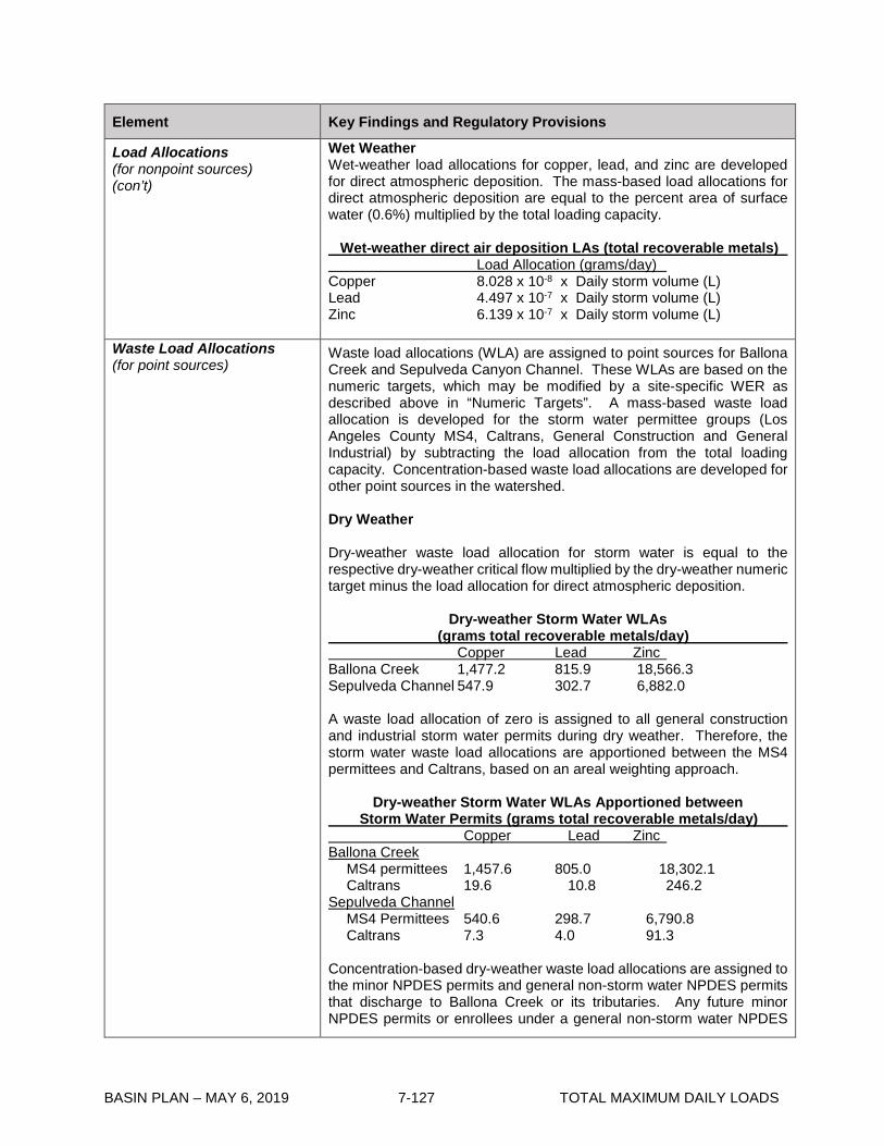
BASIN PLAN – MAY 6, 2019 7-127 TOTAL MAXIMUM DAILY LOADS
Element Key Findings and Regulatory Provisions
Load Allocations (for nonpoint sources) (con’t)
Wet Weather Wet-weather load allocations for copper, lead, and zinc are developed for direct atmospheric deposition. The mass-based load allocations for direct atmospheric deposition are equal to the percent area of surface water (0.6%) multiplied by the total loading capacity. Wet-weather direct air deposition LAs (total recoverable metals) Load Allocation (grams/day) Copper 8.028 x 10⁻⁸ x Daily storm volume (L) Lead 4.497 x 10⁻⁷ x Daily storm volume (L) Zinc 6.139 x 10⁻⁷ x Daily storm volume (L)
Waste Load Allocations (for point sources)
Waste load allocations (WLA) are assigned to point sources for Ballona Creek and Sepulveda Canyon Channel. These WLAs are based on the numeric targets, which may be modified by a site-specific WER as described above in “Numeric Targets”. A mass-based waste load allocation is developed for the storm water permittee groups (Los Angeles County MS4, Caltrans, General Construction and General Industrial) by subtracting the load allocation from the total loading capacity. Concentration-based waste load allocations are developed for other point sources in the watershed. Dry Weather Dry-weather waste load allocation for storm water is equal to the respective dry-weather critical flow multiplied by the dry-weather numeric target minus the load allocation for direct atmospheric deposition.
Dry-weather Storm Water WLAs (grams total recoverable metals/day) Copper Lead Zinc Ballona Creek 1,477.2 815.9 18,566.3 Sepulveda Channel 547.9 302.7 6,882.0 A waste load allocation of zero is assigned to all general construction and industrial storm water permits during dry weather. Therefore, the storm water waste load allocations are apportioned between the MS4 permittees and Caltrans, based on an areal weighting approach.
Dry-weather Storm Water WLAs Apportioned between Storm Water Permits (grams total recoverable metals/day) Copper Lead Zinc Ballona Creek MS4 permittees 1,457.6 805.0 18,302.1 Caltrans 19.6 10.8 246.2 Sepulveda Channel MS4 Permittees 540.6 298.7 6,790.8 Caltrans 7.3 4.0 91.3 Concentration-based dry-weather waste load allocations are assigned to the minor NPDES permits and general non-storm water NPDES permits that discharge to Ballona Creek or its tributaries. Any future minor NPDES permits or enrollees under a general non-storm water NPDES
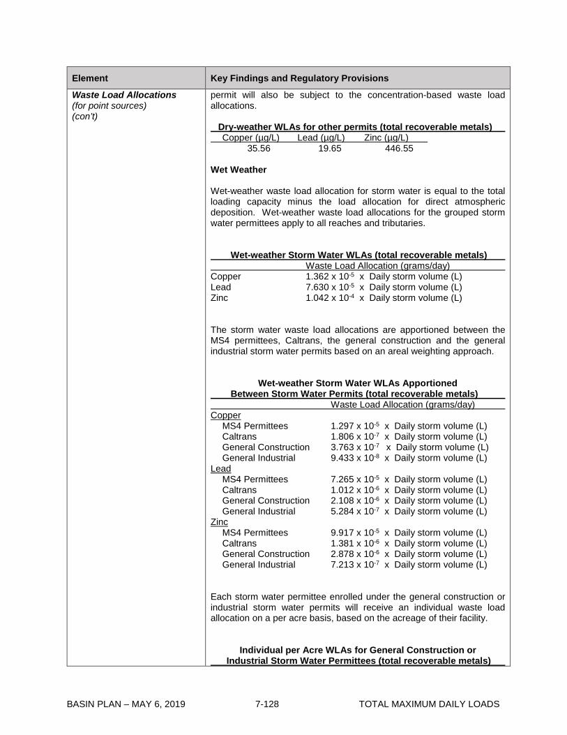
BASIN PLAN – MAY 6, 2019 7-128 TOTAL MAXIMUM DAILY LOADS
Element Key Findings and Regulatory Provisions
Waste Load Allocations (for point sources) (con’t)
permit will also be subject to the concentration-based waste load allocations. Dry-weather WLAs for other permits (total recoverable metals) Copper (µg/L) Lead (µg/L) Zinc (µg/L) 35.56 19.65 446.55 Wet Weather Wet-weather waste load allocation for storm water is equal to the total loading capacity minus the load allocation for direct atmospheric deposition. Wet-weather waste load allocations for the grouped storm water permittees apply to all reaches and tributaries. Wet-weather Storm Water WLAs (total recoverable metals) Waste Load Allocation (grams/day) Copper 1.362 x 10⁻⁵ x Daily storm volume (L) Lead 7.630 x 10⁻⁵ x Daily storm volume (L) Zinc 1.042 x 10⁻⁴ x Daily storm volume (L) The storm water waste load allocations are apportioned between the MS4 permittees, Caltrans, the general construction and the general industrial storm water permits based on an areal weighting approach.
Wet-weather Storm Water WLAs Apportioned Between Storm Water Permits (total recoverable metals) Waste Load Allocation (grams/day) Copper MS4 Permittees 1.297 x 10⁻⁵ x Daily storm volume (L) Caltrans 1.806 x 10⁻⁷ x Daily storm volume (L) General Construction 3.763 x 10⁻⁷ x Daily storm volume (L) General Industrial 9.433 x 10⁻⁸ x Daily storm volume (L) Lead MS4 Permittees 7.265 x 10⁻⁵ x Daily storm volume (L) Caltrans 1.012 x 10⁻⁶ x Daily storm volume (L) General Construction 2.108 x 10⁻⁶ x Daily storm volume (L) General Industrial 5.284 x 10⁻⁷ x Daily storm volume (L) Zinc MS4 Permittees 9.917 x 10⁻⁵ x Daily storm volume (L) Caltrans 1.381 x 10⁻⁶ x Daily storm volume (L) General Construction 2.878 x 10⁻⁶ x Daily storm volume (L) General Industrial 7.213 x 10⁻⁷ x Daily storm volume (L) Each storm water permittee enrolled under the general construction or industrial storm water permits will receive an individual waste load allocation on a per acre basis, based on the acreage of their facility.
Individual per Acre WLAs for General Construction or Industrial Storm Water Permittees (total recoverable metals)

BASIN PLAN – MAY 6, 2019 7-129 TOTAL MAXIMUM DAILY LOADS
Element Key Findings and Regulatory Provisions
Waste Load Allocations (for point sources) (con’t)
Waste Load Allocation (grams/day/acre) Copper 1.673 x 10⁻¹⁰ x Daily storm volume (L) Lead 9.369x 10⁻¹⁰ x Daily storm volume (L) Zinc 1.279 x 10⁻⁹ x Daily storm volume (L) Concentration-based wet-weather waste load allocations are assigned to the minor NPDES permits and general non-storm water NPDES permits that discharge to Ballona Creek or its tributaries. Any future minor NPDES permits or enrollees under a general non-storm water NPDES permit will also be subject to the concentration-based waste load allocations. Short-term discharges of potable water that are required by statute are not assigned WLAs but may be subject to alternative permit limits pursuant to the State Water Resources Control Board’s Policy for Implementation of Toxic Standards for Inland Surface Waters, Enclosed Bays, and Estuaries of California (2005). Wet-weather WLAs for other permits (total recoverable metals) Copper (µg/L) Lead (µg/L) Zinc (µg/L) 13.70 76.75 104.77
Margin of Safety There is an implicit margin of safety through the use of the 90th percentile conservative values for the conversion factors from total recoverable metals to the dissolved fraction during dry and wet-weather. In addition, the TMDL includes a margin of safety by evaluating dry-weather and wet-weather conditions separately and assigning allocations based on these two different critical conditions.
Implementation
The regulatory mechanisms used to implement the TMDL will include the Los Angeles County Municipal Storm Water NPDES Permit (MS4), the State of California Department of Transportation (Caltrans) Storm Water Permit, minor NPDES permits, general NPDES permits, general industrial storm water NPDES permits, and general construction storm water NPDES permits. Nonpoint sources will be regulated through the authority contained in Sections 13263 and 13269 of the Water Code, in conformance with the State Water Resources Control Board’s Nonpoint Source Implementation and Enforcement Policy (May 2004). Each NPDES permit assigned a WLA shall be reopened or amended at re-issuance, in accordance with applicable laws, to incorporate the applicable WLAs as a permit requirement. Table 7-12.2 presents the implementation schedule for the responsible permittees. Minor NPDES Permits and General Non-Storm Water NPDES Permits: The concentration-based waste load allocations for the minor NPDES permits and general non-storm water NPDES permits will be implemented as NPDES permit limits. Permit writers may translate applicable waste load allocations into effluent limits for the minor and general NPDES permits by applying the effluent limitation procedures in Section 1.4 of the State Water Resources Control Board’s Policy for Implementation of Toxics Standards for Inland Surface Waters, Enclosed

BASIN PLAN – MAY 6, 2019 7-130 TOTAL MAXIMUM DAILY LOADS
Element Key Findings and Regulatory Provisions
Implementation (con’t)
Bays, and Estuaries of California (2005) or applying other appropriate methodologies authorized under federal regulations. The minor and general non-storm water NPDES permittees may be allowed up to January 11, 2016 to achieve the waste load allocations. A discharger that can not comply immediately with effluent limitations specified to meet waste load allocations will be required to apply for an individual permit, in order to demonstrate the need for a compliance schedule. Permittees that hold individual NPDES permits and solely discharge storm water may be allowed (at Regional Board discretion) compliance schedules up to January 11, 2016 to achieve compliance with final WLAs. General Industrial Storm Water Permits: Dry-weather Implementation Non-storm water flows authorized by Order No. 97-03 DWQ, or any successor order, are exempt from the dry-weather waste load allocation equal to zero. Instead, these authorized non-storm water flows shall meet the concentration-based waste load allocations assigned to the other NPDES Permits. The dry-weather waste load allocation equal to zero applies to unauthorized non-storm water flows, which are prohibited by Order No. 97-03 DWQ. It is anticipated that the dry-weather waste load allocations will be implemented by requiring improved best management practices (BMPs) to eliminate the discharge of unauthorized non-storm water flows or adequately control the discharge of authorized non-storm water to achieve the concentration-based waste load allocations. However, the permit writers must provide adequate justification and documentation to demonstrate that specified BMPs are expected to result in attainment of the numeric waste load allocations. Wet-weather Implementation The general industrial storm water permittees are allowed interim wet-weather concentration-based waste load allocations based on benchmarks contained in EPA’s Storm Water Multi-sector General Permit for Industrial Activities. The interim waste load allocations apply to all industry sectors until no later than January 11, 2016. Interim Wet-Weather WLAs for General Industrial Storm Water Permittees (total recoverable metals) Copper (µg/L) Lead (µg/L) Zinc (µg/L) 63.6 81.6 117 The general industrial storm water permittees shall achieve final wet-weather waste load allocations no later than January 11, 2016, which shall be expressed as NPDES water quality-based effluent limitations (WQBELs).

BASIN PLAN – MAY 6, 2019 7-131 TOTAL MAXIMUM DAILY LOADS
Element Key Findings and Regulatory Provisions
Implementation (con’t)
Permittees may demonstrate compliance with WQBELs in one of two ways. First, general industrial and construction storm water permittees may be deemed in compliance with permit limitations if they demonstrate that there are no exceedances of the permit limitations at their discharge points or outfalls. Second, if permittees provide a quantitative demonstration that control measures and best management practices (BMPs) will achieve WQBELs consistent with the schedule in Table 7-12.2, then compliance may be demonstrated by implementation of those control measures and BMPs, subject to Executive Officer approval. General Construction Storm Water Permits: Dry-weather Implementation Non-storm water flows authorized by the General Permit for Storm Water Discharges Associated with Construction Activity (Water Quality Order No. 2009-0009 DWQ), or any successor order, are exempt from the dry-weather waste load allocation equal to zero as long as they are authorized non-storm discharges and are (1) infeasible to eliminate (2) comply with BMPs as described in the Storm Water Pollution Prevention Plan prepared by the permittee, and (3) do not cause or contribute to a violation of water quality standards, or comparable provisions in any successor order. Unauthorized non-storm water flows are already prohibited by Order No. 2009-0009 DWQ. Wet-weather Implementation The general construction storm water permits shall achieve final wet-weather waste load allocations no later than January 11, 2016, which shall be expressed as NPDES water quality-based effluent limitations (WQBELs). Permittees may demonstrate compliance with WQBELs in one of two ways. First, general industrial and construction storm water permittees may be deemed in compliance with permit limitations if they demonstrate that there are no exceedances of the permit limitations at their discharge points or outfalls. Second, if permittees provide a quantitative demonstration that control measures and best management practices (BMPs) will achieve WQBELs consistent with the schedule in Table 7-12.2, then compliance may be demonstrated by implementation of those control measures and BMPs, subject to Executive Officer approval.
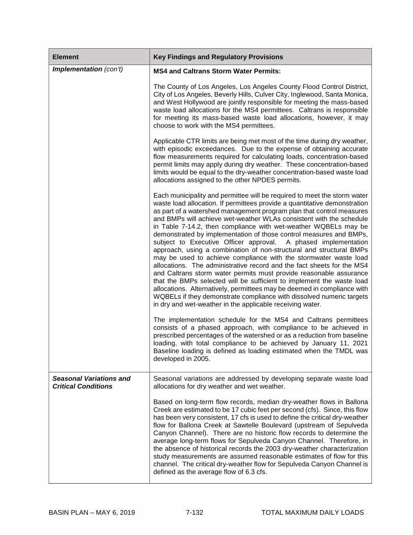
BASIN PLAN – MAY 6, 2019 7-132 TOTAL MAXIMUM DAILY LOADS
Element Key Findings and Regulatory Provisions
Implementation (con’t)
MS4 and Caltrans Storm Water Permits: The County of Los Angeles, Los Angeles County Flood Control District, City of Los Angeles, Beverly Hills, Culver City, Inglewood, Santa Monica, and West Hollywood are jointly responsible for meeting the mass-based waste load allocations for the MS4 permittees. Caltrans is responsible for meeting its mass-based waste load allocations, however, it may choose to work with the MS4 permittees. Applicable CTR limits are being met most of the time during dry weather, with episodic exceedances. Due to the expense of obtaining accurate flow measurements required for calculating loads, concentration-based permit limits may apply during dry weather. These concentration-based limits would be equal to the dry-weather concentration-based waste load allocations assigned to the other NPDES permits. Each municipality and permittee will be required to meet the storm water waste load allocation. If permittees provide a quantitative demonstration as part of a watershed management program plan that control measures and BMPs will achieve wet-weather WLAs consistent with the schedule in Table 7-14.2, then compliance with wet-weather WQBELs may be demonstrated by implementation of those control measures and BMPs, subject to Executive Officer approval. A phased implementation approach, using a combination of non-structural and structural BMPs may be used to achieve compliance with the stormwater waste load allocations. The administrative record and the fact sheets for the MS4 and Caltrans storm water permits must provide reasonable assurance that the BMPs selected will be sufficient to implement the waste load allocations. Alternatively, permittees may be deemed in compliance with WQBELs if they demonstrate compliance with dissolved numeric targets in dry and wet-weather in the applicable receiving water. The implementation schedule for the MS4 and Caltrans permittees consists of a phased approach, with compliance to be achieved in prescribed percentages of the watershed or as a reduction from baseline loading, with total compliance to be achieved by January 11, 2021 Baseline loading is defined as loading estimated when the TMDL was developed in 2005.
Seasonal Variations and Critical Conditions
Seasonal variations are addressed by developing separate waste load allocations for dry weather and wet weather. Based on long-term flow records, median dry-weather flows in Ballona Creek are estimated to be 17 cubic feet per second (cfs). Since, this flow has been very consistent, 17 cfs is used to define the critical dry-weather flow for Ballona Creek at Sawtelle Boulevard (upstream of Sepulveda Canyon Channel). There are no historic flow records to determine the average long-term flows for Sepulveda Canyon Channel. Therefore, in the absence of historical records the 2003 dry-weather characterization study measurements are assumed reasonable estimates of flow for this channel. The critical dry-weather flow for Sepulveda Canyon Channel is defined as the average flow of 6.3 cfs.
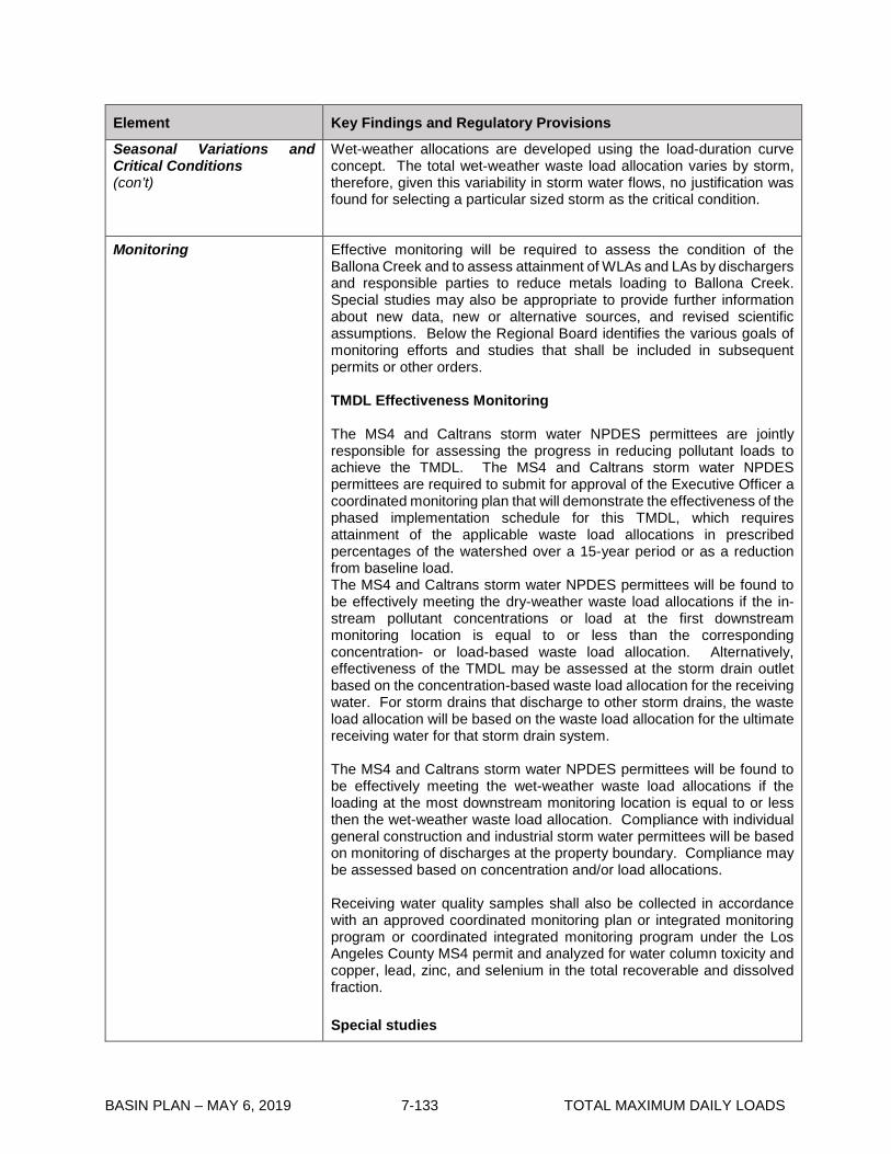
BASIN PLAN – MAY 6, 2019 7-133 TOTAL MAXIMUM DAILY LOADS
Element Key Findings and Regulatory Provisions
Seasonal Variations and Critical Conditions (con’t)
Wet-weather allocations are developed using the load-duration curve concept. The total wet-weather waste load allocation varies by storm, therefore, given this variability in storm water flows, no justification was found for selecting a particular sized storm as the critical condition.
Monitoring
Effective monitoring will be required to assess the condition of the Ballona Creek and to assess attainment of WLAs and LAs by dischargers and responsible parties to reduce metals loading to Ballona Creek. Special studies may also be appropriate to provide further information about new data, new or alternative sources, and revised scientific assumptions. Below the Regional Board identifies the various goals of monitoring efforts and studies that shall be included in subsequent permits or other orders. TMDL Effectiveness Monitoring The MS4 and Caltrans storm water NPDES permittees are jointly responsible for assessing the progress in reducing pollutant loads to achieve the TMDL. The MS4 and Caltrans storm water NPDES permittees are required to submit for approval of the Executive Officer a coordinated monitoring plan that will demonstrate the effectiveness of the phased implementation schedule for this TMDL, which requires attainment of the applicable waste load allocations in prescribed percentages of the watershed over a 15-year period or as a reduction from baseline load. The MS4 and Caltrans storm water NPDES permittees will be found to be effectively meeting the dry-weather waste load allocations if the in-stream pollutant concentrations or load at the first downstream monitoring location is equal to or less than the corresponding concentration- or load-based waste load allocation. Alternatively, effectiveness of the TMDL may be assessed at the storm drain outlet based on the concentration-based waste load allocation for the receiving water. For storm drains that discharge to other storm drains, the waste load allocation will be based on the waste load allocation for the ultimate receiving water for that storm drain system. The MS4 and Caltrans storm water NPDES permittees will be found to be effectively meeting the wet-weather waste load allocations if the loading at the most downstream monitoring location is equal to or less then the wet-weather waste load allocation. Compliance with individual general construction and industrial storm water permittees will be based on monitoring of discharges at the property boundary. Compliance may be assessed based on concentration and/or load allocations. Receiving water quality samples shall also be collected in accordance with an approved coordinated monitoring plan or integrated monitoring program or coordinated integrated monitoring program under the Los Angeles County MS4 permit and analyzed for water column toxicity and copper, lead, zinc, and selenium in the total recoverable and dissolved fraction. Special studies
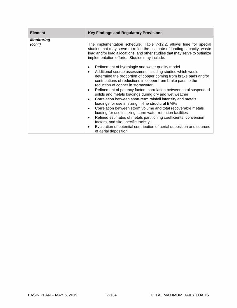
BASIN PLAN – MAY 6, 2019 7-134 TOTAL MAXIMUM DAILY LOADS
Element Key Findings and Regulatory Provisions
Monitoring (con’t)
The implementation schedule, Table 7-12.2, allows time for special studies that may serve to refine the estimate of loading capacity, waste load and/or load allocations, and other studies that may serve to optimize implementation efforts. Studies may include: • Refinement of hydrologic and water quality model • Additional source assessment including studies which would
determine the proportion of copper coming from brake pads and/or contributions of reductions in copper from brake pads to the reduction of copper in stormwater
• Refinement of potency factors correlation between total suspended solids and metals loadings during dry and wet weather
• Correlation between short-term rainfall intensity and metals loadings for use in sizing in-line structural BMPs
• Correlation between storm volume and total recoverable metals loading for use in sizing storm water retention facilities
• Refined estimates of metals partitioning coefficients, conversion factors, and site-specific toxicity.
• Evaluation of potential contribution of aerial deposition and sources of aerial deposition.

BASIN PLAN – MAY 6, 2019 7-135 TOTAL MAXIMUM DAILY LOADS
Table 7-12.2 Ballona Creek Metals TMDL: Implementation Schedule Date Action
January 11, 2006 Regional Board permit writers shall incorporate the waste load allocations into the NPDES permits. Waste load allocations will be implemented through NPDES permit limits in accordance with the implementation schedule contained herein, at the time of permit issuance or re-issuance.
January 11, 2010 Responsible jurisdictions and agencies shall provide to the Regional Board results of the special studies.
January 11, 2011 The Regional Board shall reconsider this TMDL to re-evaluate the waste load allocations and the implementation schedule.
MINOR NPDES PERMITS AND GENERAL NON-STORM WATER NPDES PERMITS
Upon permit issuance or renewal
The non-storm water NPDES permittees shall achieve the waste load allocations, which shall be expressed as NPDES water quality-based effluent limitations specified in accordance with federal regulations and state policy on water quality control. The minor and general non-storm water NPDES permittees are allowed up to January 11, 2016 to achieve the waste load allocations. Permittees that hold individual NPDES permits and solely discharge storm water may be allowed (at Regional Board discretion) compliance schedules up to January 11, 2016 to achieve compliance with final WLAs.
GENERAL INDUSTRIAL STORM WATER PERMITS
Upon permit issuance or renewal
The general industrial storm water NPDES permittees shall achieve dry-weather waste load allocations, which shall be expressed as NPDES water quality-based effluent limitations specified in accordance with federal regulations and state policy on water quality control. Effluent limitations may be expressed as permit conditions, such as the installation, maintenance, and monitoring of Regional Board-approved BMPs. Permittees shall begin to install and test BMPs to meet the interim wet-weather WLAs. BMP effectiveness monitoring will be implemented to determine progress in achieving interim wet-weather waste load allocations.
January 11, 2011 The general industrial storm water NPDES permittees shall achieve the interim wet-weather waste load allocations, which shall be expressed as NPDES water quality-based effluent limitations specified in accordance with federal regulations and state policy on water quality control. Effluent limitations may be expressed as permit conditions, such as the installation, maintenance, and monitoring of Regional Board-approved BMPs. Permittees shall begin an iterative BMP process including BMP effectiveness monitoring to achieve compliance with final wet-weather WLAs.
January 11, 2016 The general industrial storm water NPDES permittees shall achieve the final wet-weather waste load allocations, which shall be expressed as NPDES water quality-based effluent limitations
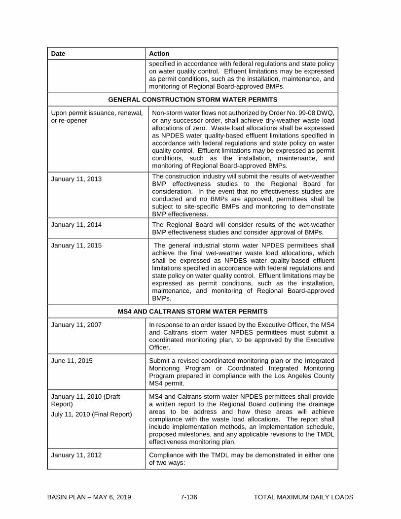
BASIN PLAN – MAY 6, 2019 7-136 TOTAL MAXIMUM DAILY LOADS
Date Action specified in accordance with federal regulations and state policy on water quality control. Effluent limitations may be expressed as permit conditions, such as the installation, maintenance, and monitoring of Regional Board-approved BMPs.
GENERAL CONSTRUCTION STORM WATER PERMITS
Upon permit issuance, renewal, or re-opener
Non-storm water flows not authorized by Order No. 99-08 DWQ, or any successor order, shall achieve dry-weather waste load allocations of zero. Waste load allocations shall be expressed as NPDES water quality-based effluent limitations specified in accordance with federal regulations and state policy on water quality control. Effluent limitations may be expressed as permit conditions, such as the installation, maintenance, and monitoring of Regional Board-approved BMPs.
January 11, 2013 The construction industry will submit the results of wet-weather BMP effectiveness studies to the Regional Board for consideration. In the event that no effectiveness studies are conducted and no BMPs are approved, permittees shall be subject to site-specific BMPs and monitoring to demonstrate BMP effectiveness.
January 11, 2014 The Regional Board will consider results of the wet-weather BMP effectiveness studies and consider approval of BMPs.
January 11, 2015 The general industrial storm water NPDES permittees shall achieve the final wet-weather waste load allocations, which shall be expressed as NPDES water quality-based effluent limitations specified in accordance with federal regulations and state policy on water quality control. Effluent limitations may be expressed as permit conditions, such as the installation, maintenance, and monitoring of Regional Board-approved BMPs.
MS4 AND CALTRANS STORM WATER PERMITS
January 11, 2007
In response to an order issued by the Executive Officer, the MS4 and Caltrans storm water NPDES permittees must submit a coordinated monitoring plan, to be approved by the Executive Officer.
June 11, 2015 Submit a revised coordinated monitoring plan or the Integrated Monitoring Program or Coordinated Integrated Monitoring Program prepared in compliance with the Los Angeles County MS4 permit.
January 11, 2010 (Draft Report) July 11, 2010 (Final Report)
MS4 and Caltrans storm water NPDES permittees shall provide a written report to the Regional Board outlining the drainage areas to be address and how these areas will achieve compliance with the waste load allocations. The report shall include implementation methods, an implementation schedule, proposed milestones, and any applicable revisions to the TMDL effectiveness monitoring plan.
January 11, 2012 Compliance with the TMDL may be demonstrated in either one of two ways:

BASIN PLAN – MAY 6, 2019 7-137 TOTAL MAXIMUM DAILY LOADS
Date Action 1. The MS4 and Caltrans storm water NPDES permittees shall
demonstrate that 50% of the total drainage area served by the MS4 is effectively meeting the dry-weather waste load allocations and 25% of the total drainage area served by the MS4 is effectively meeting the wet-weather waste load allocations.
Alternatively, permittees shall attain a 50% reduction in dry-
weather and 25% reduction in wet-weather in the difference between the baseline loadings and WLAs, as measured at the relevant existing MS4 permit monitoring location and/or at relevant MS4 monitoring stations identified in an approved coordinated monitoring plan.
January 11, 2014 Compliance with the TMDL may be demonstrated in either one of two ways: 1. The MS4 and Caltrans storm water NPDES permittees shall
demonstrate that 75% of the total drainage area served by the MS4 is effectively meeting the dry-weather waste load allocations.
2. Alternatively, permittees shall attain a 75% reduction in the
difference between the baseline loadings and WLAs, as measured at the relevant existing MS4 permit monitoring location and/or at relevant MS4 monitoring stations identified in an approved coordinated monitoring plan.
January 11, 2016 Compliance with the TMDL may be demonstrated in either one of two ways: 1. The MS4 and Caltrans storm water NPDES permittees shall
demonstrate that 100% of the total drainage area served by the MS4 is effectively meeting the dry-weather waste load allocations and 50% of the total drainage area served by the MS4 is effectively meeting the wet-weather waste load allocations.
2. Alternatively, permittees shall attain a 100% reduction in
dry-weather and 50% reduction in wet-weather in the difference between the baseline loadings and WLAs, as measured at the relevant existing MS4 permit monitoring location and/or at relevant MS4 monitoring stations identified in an approved coordinated monitoring plan.
January 11, 2021 Compliance with the TMDL may be demonstrated in either one
of two ways:

BASIN PLAN – MAY 6, 2019 7-138 TOTAL MAXIMUM DAILY LOADS
Date Action 1. The MS4 and Caltrans storm water NPDES permittees shall
demonstrate that 100% of the total drainage area served by the MS4 is effectively meeting both the dry-weather and wet-weather waste load allocations.
2. Alternatively, permittees shall attain a 100% reduction of
both dry and wet-weather in the difference between the baseline loadings and WLAs, as measured at the relevant existing MS4 permit monitoring location and/or at relevant MS4 monitoring stations identified in an approved coordinated monitoring plan.

BASIN PLAN – MAY 6, 2019 7-139 TOTAL MAXIMUM DAILY LOADS
7-13 Los Angeles River and Tributaries Metals TMDL This TMDL was adopted by:
The Regional Water Quality Control Board on June 2, 2005.
This TMDL was approved by:
The State Water Resources Control Board on October 20, 2005. Office of Administrative Law on December 9, 2005. The U.S. Environmental Protection Agency on December 22, 2005.
This TMDL was voided and set aside on: May 6, 2009.
This TMDL was re-adopted by
The Regional Water Quality Control Board on September 6, 2007.
This TMDL was approved by:
The State Water Resources Control Board on June 17, 2008. The Office of Administrative Law on October 14, 2008. The U.S. Environmental Protection Agency on October 29, 2008.
This TMDL was revised and adopted by
The Regional Water Quality Control Board on May 6, 2010.
This TMDL revision was approved by:
The State Water Resources Control Board on April 19, 2011. The Office of Administrative Law on July 27, 2011. The U.S. Environmental Protection Agency on November 3, 2011.
The effective date of this TMDL revision is: November 3, 2011.
This TMDL was revised and adopted by
The Regional Water Quality Control Board on April 9, 2015.
This TMDL revision was approved by:

BASIN PLAN – MAY 6, 2019 7-140 TOTAL MAXIMUM DAILY LOADS
The State Water Resources Control Board on November 17, 2015. The Office of Administrative Law on July 11, 2016. The U.S. Environmental Protection Agency on December 12, 2016.
The effective date of this TMDL revision is: December 12, 2016
The following table includes the elements of this TMDL.

BASIN PLAN – MAY 6, 2019 7-141 TOTAL MAXIMUM DAILY LOADS
Table 7-13.1 Los Angeles River and Tributaries Metals TMDL: Elements Element Key Findings and Regulatory Provisions
Problem Statement Segments of the Los Angeles River and its tributaries are on the Clean Water Act section 303(d) list of impaired waterbodies for copper, cadmium, lead, zinc, aluminum and selenium. The metals subject to this TMDL are toxic pollutants, and the existing water quality objectives for the metals reflect national policy that the discharge of toxic pollutants in toxic amounts be prohibited. When one of the metals subject to this TMDL is present at levels exceeding the existing numeric objectives, then the receiving water is toxic. The beneficial uses impaired by metals in the Los Angeles River and its tributaries are those associated with aquatic life and water supply, including wildlife habitat, rare, threatened or endangered species, warm freshwater habitat, wetlands, and groundwater recharge. TMDLs are developed for reaches on the 303(d) list and for reaches where recent data indicate additional impairments. Addressing the impairing metals throughout the Los Angeles River watershed will ensure that the metals do not contribute to an impairment elsewhere in the watershed. Metals allocations are therefore developed for upstream reaches and tributaries that drain to impaired reaches. These TMDLs address wet- and dry-weather discharges of copper, lead, zinc and selenium and wet-weather discharges of cadmium. Impairments related to cadmium only occur during wet weather. Impairments related to selenium are confined to Reach 6 and its tributaries. Dry-weather impairments related to zinc only occur in Rio Hondo Reach 1. The aluminum listing was based on water quality objectives set to support the municipal water supply beneficial use (MUN). MUN is a conditional use in the Los Angeles River watershed. The United States Environmental Protection Agency (USEPA) has determined that TMDLs are not required for impairments of conditional uses.
Numeric Target (Interpretation of the numeric water quality objective, used to calculate the waste load allocations)
Numeric water quality targets are based on the numeric water quality criteria established by the California Toxics Rule (CTR). The targets are expressed in terms of total recoverable metals. There are separate targets for dry and wet weather because hardness values and flow conditions in the Los Angeles River and tributaries vary between dry and wet weather. The dry-weather targets apply to days when the maximum daily flow in the River is less than 500 cfs. The wet-weather targets apply to days when the maximum daily flow in the River is equal to or greater than 500 cfs. The dry-weather targets for copper are based on chronic CTR criteria. The dry-weather targets for lead are based on recalculated chronic lead criteria. The dry-weather targets for zinc are based on acute CTR criteria. Copper, lead and zinc targets are dependent on hardness and a water-effect ratio (WER), which are both factors built into the CTR criteria to adjust for site specific conditions, and conversion factors to convert between dissolved and total recoverable metals. Copper and lead dry-weather targets are based on 50th percentile hardness values. The zinc dry-weather target is based on 10th percentile hardness values. Site-specific copper conversion factors are applied immediately downstream of the Tillman and LA-Glendale water reclamation plants (WRP). CTR default conversion factors are used for copper, lead, and zinc in all other

BASIN PLAN – MAY 6, 2019 7-142 TOTAL MAXIMUM DAILY LOADS
Element Key Findings and Regulatory Provisions
Numeric Target (con’t)
cases. The dry-weather target for selenium is independent of hardness or conversion factors.
Dry-weather conversion factors: Default Below Tillman WRP Below LA-Glendale WRP Copper 0.96 0.74 0.80 Lead 0.79 Zinc 0.61 Dry-weather numeric targets (µg total recoverable metals/L) Cu Pb Zn Se Reach 5, 6 and Bell Creek WER1 x 30 WER1 x 170 5 Reach 4 WER2 x 26 WER1 x 83 Tujunga Wash WER3 x 20 WER1 x 83 Reach 3 above LA-Glendale WRP WER2 x 23 WER1 x 102 Verdugo Wash WER4 x 23 WER1 x 102 Reach 3 below LA-Glendale WRP WER2 x 26 WER1 x 100 Burbank Western Channel (above WRP) WER5 x 26 WER1 x 126 Burbank Western Channel (below WRP) WER5 x 19 WER1 x 75 Reach 2 WER2 x 22 WER1 x 94 Arroyo Seco WER6 x 22 WER1 x 94 Reach 1 WER2 x 23 WER1 x 102 Compton Creek WER7 x 19 WER1 x 73 Rio Hondo Reach 1 WER8 x 13 WER1 x 37 WER1 x 131 Monrovia Canyon WER1 x 66 1 WER(s) have a default value of 1.0 unless site-specific WER(s) are approved. 2 The WER for this constituent in this reach is 3.97. 3 The WER for this constituent in this reach is 8.28. 4 The WER for this constituent in this reach is 2.18. 5 The WER for this constituent in this reach is 4.75. 6 The WER for this constituent in Reaches 1 and 2 of this reach is 1.32. 7 The WER for this constituent in this reach is 3.36. 8 The WER for this constituent in this reach is 9.69.
The wet-weather targets for cadmium, copper, and zinc are based on acute CTR criteria. For lead, the wet-weather target is based on the recalculated acute lead criterion. Numeric targets for all metals are adjusted based on the 50th percentile hardness values for storm water collected at the Wardlow gage station, multiplied by a WER. Conversion factors for copper, lead and zinc are based on a regression of dissolved metals values to total recoverable metals values collected at Wardlow. The CTR default conversion factor is applied to cadmium. The wet-

BASIN PLAN – MAY 6, 2019 7-143 TOTAL MAXIMUM DAILY LOADS
Element Key Findings and Regulatory Provisions
Numeric Target (con’t)
weather target for selenium is independent of hardness or conversion factors.
Wet-weather conversion factors:
Cadmium 0.94 Copper 0.65 Lead 0.82 Zinc 0.61
Wet-weather numeric targets (µg total recoverable metals/L) Cd Cu Pb Zn Se WER1 x 3.1 WER2 x 17 WER1 x 94 WER1 x 159 5 1 WER(s) have a default value of 1.0 unless site-specific WER(s) are approved. 2 The WER for this constituent is 3.97.
Source Analysis There are significant differences in the sources of metals loadings during dry weather and wet weather. During dry weather, most of the metals loadings are in the dissolved form. The three major publicly owned treatment works (POTWs) that discharge to the river (Tillman WRP, LA-Glendale WRP, and Burbank WRP) constitute the majority of the flow and metals loadings during dry weather. The storm drains also contribute a large percentage of the loadings during dry weather because although their flows are typically low, concentrations of metals in urban runoff may be quite high. The remaining portion of the dry weather flow and metals loadings represents a combination of tributary flows, groundwater discharge, and flows from other permitted NPDES discharges within the watershed. During wet weather, most of the metals loadings are in the particulate form and are associated with wet-weather storm water flow. On an annual basis, storm water contributes about 40% of the cadmium loading, 80% of the copper loading, 95% of the lead loading and 90% of the zinc loading. This storm water flow is permitted through two municipal separate storm sewer system (MS4) permits, a separate statewide storm water permit for the California Department of Transportation (Caltrans), a general construction storm water permit and a general industrial storm water permit. Nonpoint sources of metals may include tributaries that drain the open space areas of the watershed. Direct atmospheric deposition of metals on the river is also a small source. Indirect atmospheric deposition on the land surface that is washed off during storms is a larger source, which is accounted for in the estimates of storm water loadings. The sources of selenium appear to be related to natural levels of selenium in soils in the upper watershed. Separate studies are underway to evaluate whether selenium levels represent a “natural condition” for this watershed.
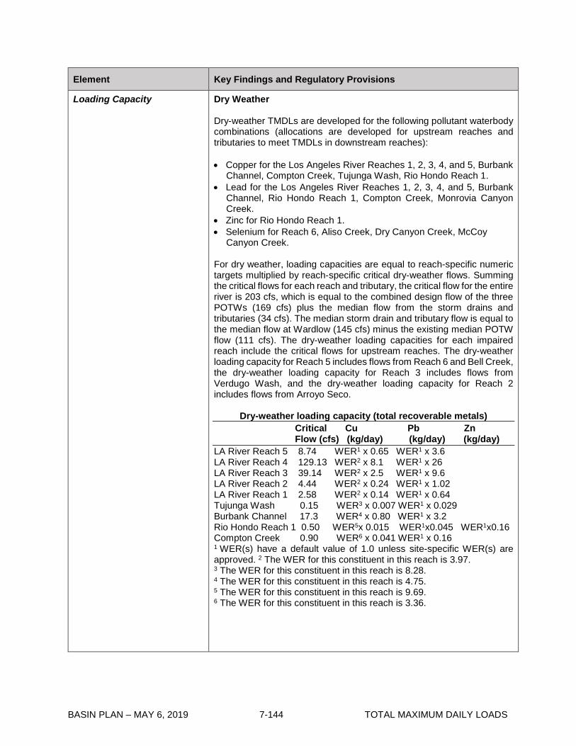
BASIN PLAN – MAY 6, 2019 7-144 TOTAL MAXIMUM DAILY LOADS
Element Key Findings and Regulatory Provisions
Loading Capacity
Dry Weather Dry-weather TMDLs are developed for the following pollutant waterbody combinations (allocations are developed for upstream reaches and tributaries to meet TMDLs in downstream reaches):
• Copper for the Los Angeles River Reaches 1, 2, 3, 4, and 5, Burbank
Channel, Compton Creek, Tujunga Wash, Rio Hondo Reach 1. • Lead for the Los Angeles River Reaches 1, 2, 3, 4, and 5, Burbank
Channel, Rio Hondo Reach 1, Compton Creek, Monrovia Canyon Creek.
• Zinc for Rio Hondo Reach 1. • Selenium for Reach 6, Aliso Creek, Dry Canyon Creek, McCoy
Canyon Creek.
For dry weather, loading capacities are equal to reach-specific numeric targets multiplied by reach-specific critical dry-weather flows. Summing the critical flows for each reach and tributary, the critical flow for the entire river is 203 cfs, which is equal to the combined design flow of the three POTWs (169 cfs) plus the median flow from the storm drains and tributaries (34 cfs). The median storm drain and tributary flow is equal to the median flow at Wardlow (145 cfs) minus the existing median POTW flow (111 cfs). The dry-weather loading capacities for each impaired reach include the critical flows for upstream reaches. The dry-weather loading capacity for Reach 5 includes flows from Reach 6 and Bell Creek, the dry-weather loading capacity for Reach 3 includes flows from Verdugo Wash, and the dry-weather loading capacity for Reach 2 includes flows from Arroyo Seco.
Dry-weather loading capacity (total recoverable metals) Critical Cu Pb Zn Flow (cfs) (kg/day) (kg/day) (kg/day) LA River Reach 5 8.74 WER1 x 0.65 WER1 x 3.6 LA River Reach 4 129.13 WER2 x 8.1 WER1 x 26 LA River Reach 3 39.14 WER2 x 2.5 WER1 x 9.6 LA River Reach 2 4.44 WER2 x 0.24 WER1 x 1.02 LA River Reach 1 2.58 WER2 x 0.14 WER1 x 0.64 Tujunga Wash 0.15 WER3 x 0.007 WER1 x 0.029 Burbank Channel 17.3 WER4 x 0.80 WER1 x 3.2 Rio Hondo Reach 1 0.50 WER5x 0.015 WER1x0.045 WER1x0.16 Compton Creek 0.90 WER6 x 0.041 WER1 x 0.16 1 WER(s) have a default value of 1.0 unless site-specific WER(s) are approved. 2 The WER for this constituent in this reach is 3.97. 3 The WER for this constituent in this reach is 8.28. 4 The WER for this constituent in this reach is 4.75. 5 The WER for this constituent in this reach is 9.69. 6 The WER for this constituent in this reach is 3.36.

BASIN PLAN – MAY 6, 2019 7-145 TOTAL MAXIMUM DAILY LOADS
Element Key Findings and Regulatory Provisions
Loading Capacity (con’t) No dry-weather loading capacities are calculated for lead in Monrovia Canyon Creek or selenium in Reach 6 or its tributaries. Concentration-based allocations are assigned for these metals in these reaches. Wet Weather Wet-weather TMDLs are calculated for cadmium, copper, lead, and zinc in Reach 1. Allocations are developed for all upstream reaches and tributaries to meet these TMDLs. Wet-weather loading capacities are calculated by multiplying daily storm volumes by the wet-weather numeric target for each metal. The resulting curves identify the load allowance for a given flow.
Wet-weather loading capacity (total recoverable metals) Metal Load Duration Curve (kg/day) Cadmium Daily storm volume x WER1 x 3.1 µg/L Copper Daily storm volume x WER2 x 17 µg/L Lead Daily storm volume x WER1 x 94 µg/L Zinc Daily storm volume x WER1 x 159 µg/L 1 WER(s) have a default value of 1.0 unless site-specific WER(s) are approved. 2 The WER for this constituent is 3.97.
Load Allocations (for nonpoint sources)
Dry Weather Dry-weather nonpoint source load allocations (LAs) for copper and lead apply to open space and direct atmospheric deposition to the river. Dry-weather open space load allocations are equal to the critical flow for the upper portion of tributaries that drain open space, multiplied by the numeric targets for these tributaries.
Open space dry-weather LAs (total recoverable metals) Critical Flow Cu (kg/day) Pb (kg/day) Tujunga Wash 0.12 WER2 x 0.0056 WER1 x 0.024 Arroyo Seco 0.33 WER3 x 0.018 WER1 x 0.075 1 WER(s) have a default value of 1.0 unless site-specific WER(s) are approved. 2 The WER for this constituent in this reach is 8.28. 3 The WER for this constituent in Reaches 1 and 2 of this reach is 1.32. Load allocations for direct atmospheric deposition to the entire river are obtained from previous studies (3 kg/year for copper, 2 kg/year for lead and 10 kg/year for zinc.) Loads are allocated to each reach and tributary based on their length. The ratio of the length of each river segment to the total length of the river is multiplied by the estimates of direct atmospheric loading to the entire river.

BASIN PLAN – MAY 6, 2019 7-146 TOTAL MAXIMUM DAILY LOADS
Element Key Findings and Regulatory Provisions
Load Allocations (con’t)
Direct air deposition dry-weather LAs (total recoverable metals) Cu (kg/day) Pb (kg/day) Zn(kg/day) LA River Reach 6 3.3x10⁻⁴ 2.2x10⁻⁴ LA River Reach 5 3.6x10⁻⁴ 2.4x10⁻⁴ LA River Reach 4 8.1x10⁻⁴ 5.4x10⁻⁴ LA River Reach 3 6.04x10⁻⁴ 4.03x10⁻⁴ LA River Reach 2 1.4 x10⁻³ 9.5x10⁻⁴ LA River Reach 1 4.4x10⁻⁴ 2.96x10⁻⁴ Bell Creek 2.98x10⁻⁴ 1.99x10⁻⁴ Tujunga Wash 7.4x10⁻⁴ 4.9x10⁻⁴ Verdugo Wash 4.7x10⁻⁴ 3.2x10⁻⁴ Burbank Channel 7.1x10⁻⁴ 4.7x10⁻⁴
Arroyo Seco 7.3x10⁻⁴ 4.9x10⁻⁴ Rio Hondo Reach 1 6.4x10⁻⁴ 4.2x10⁻⁴ 2.1x10⁻³ Compton Creek 6.5x10⁻⁴ 4.3x10⁻⁴
A dry-weather concentration-based load allocation for lead equal to the dry-weather numeric target (WER1 x 66 µg/L) applies to Monrovia Canyon Creek. The load allocation is not assigned to a particular nonpoint source or group of nonpoint sources. 1 WER(s) have a default value of 1.0 unless site-specific WER(s) are approved. A dry-weather concentration-based load allocation for selenium equal to the dry-weather numeric target (5 µg/L) is assigned to Reach 6 and its tributaries. The load allocation is not assigned to a particular nonpoint source or group of nonpoint sources. Wet Weather Wet-weather load allocations for open space are equal to the percent metals loading from open space (predicted by the wet-weather model) multiplied by the total loading capacity, then by the ratio of open space located outside the municipal separate storm sewer systems (MS4s) to the total open space area. There is no load allocation for cadmium because open space is not believed to be a source of the wet-weather cadmium impairment in Reach 1.
Wet-weather open space LAs (total recoverable metals)
Metal Load Allocation (kg/day) Copper WER2 x 2.6x10-10 µg /L/day x daily storm volume(L) Lead WER1 x 2.4x10-10 µg /L/day x daily storm volume(L) Zinc WER1 x 1.4x10-9 µg /L/day x daily storm volume(L) 1 WER(s) have a default value of 1.0 unless site-specific WER(s) are approved. 2 The WER for this constituent is 3.97. Wet-weather load allocations for direct atmospheric deposition are equal to the percent area of the watershed comprised by surface water (0.2%) multiplied by the total loading capacity.

BASIN PLAN – MAY 6, 2019 7-147 TOTAL MAXIMUM DAILY LOADS
Element Key Findings and Regulatory Provisions
Load Allocations (con’t)
Wet-weather direct air deposition LAs (total recoverable metals)
Metal Load Allocation (kg/day) Cadmium WER1 x 6.2x10-10 µg /L/day x daily storm volume(L) Copper WER2 x 3.4x10-10 µg /L/day x daily storm volume(L) Lead WER1 x 1.88x10-10 µg /L/day x daily storm volume(L) Zinc WER1 x 3.2x10-9 µg /L/day x daily storm volume(L) 1 WER(s) have a default value of 1.0 unless site-specific WER(s) are approved. 2 The WER for this constituent is 3.97. A wet-weather concentration-based load allocation for selenium equal to the dry-weather numeric target (5 µg/L) is assigned to Reach 6 and its tributaries. The load allocation is not assigned to a particular nonpoint source or group of nonpoint sources.
Waste Load Allocations (for point sources)
Dry Weather Dry-weather point source waste load allocations (WLAs) apply to the three POTWs (Tillman, Glendale, and Burbank). A grouped waste load allocation applies to the storm water permittees (Los Angeles County MS4 permittees, Long Beach MS4 permittee, Caltrans, General Industrial and General Construction permittees), which is calculated by subtracting load allocations (and waste load allocations for reaches with POTWs) from the total loading capacity. Concentration-based waste load allocations are developed for other point sources in the watershed. Mass- and concentration-based waste load allocations for Tillman, Los Angeles-Glendale and Burbank WRPs are developed to meet the dry-weather targets for copper and lead in Reach 4, Reach 3 and the Burbank Western Channel, respectively.
POTW dry-weather WLAs (total recoverable metals)*: Cu Pb Tillman Concentration-based (µg/L) WER2 x 26 WER1 x 83 Mass-based (kg/day) WER2 x 7.8 WER1 x 25 Glendale Concentration-based (µg/L) WER2 x 26 WER1 x 100 Mass-based (kg/day) WER2 x 2.0 WER1 x 7.6 Burbank Concentration-based (µg/L) WER3 x 19 WER1 x 75 Mass-based (kg/day) WER3 x 0.64 WER1 x 2.6 1 WER(s) have a default value of 1.0 unless site-specific WER(s) are approved. 2 The WER for this constituent is 3.97. 3 The WER for this constituent is 4.75. *Regardless of the WER, for discharges regulated under this TMDL with concentrations below WER-adjusted allocations, effluent limitations shall ensure that effluent concentrations do not exceed the levels of water quality that can be reliably maintained by the facility’s applicable treatment technologies existing at the time of permit issuance,

BASIN PLAN – MAY 6, 2019 7-148 TOTAL MAXIMUM DAILY LOADS
Element Key Findings and Regulatory Provisions
Waste Load Allocations (con’t)
reissuance, or modification unless anti-backsliding requirements in Clean Water Act section 402(o) and anti-degradation requirements are met. Permit compliance with anti-degradation and anti-backsliding requirements shall be documented in permit fact sheets. Dry-weather waste load allocations for storm water permittees are equal to storm drain flows (critical flows minus median POTW flows minus median open space flows) multiplied by reach-specific numeric targets, minus the contribution from direct air deposition.
Storm water Permittees’ dry-weather WLAs (total recoverable metals)*
Critical Flow Cu Pb Zn (cfs) (kg/day) (kg/day) (kg/day) LA River Reach 6 7.20 WER1 x 0.53 WER1 x 3.0 LA River Reach 5 0.75 WER1 x 0.05 WER1 x 0.31 LA River Reach 4 5.13 WER2 x 0.32 WER1 x1.04 LA River Reach 3 4.84 WER2 x 0.06 WER1 x 1. 18 LA River Reach 2 3.86 WER2 x 0.13 WER1 x 0.89 LA River Reach 1 2.58 WER2 x 0.14 WER1 x 0.64 Bell Creek 0.79 WER1 x 0.06 WER1 x 0.33 Tujunga Wash 0.03 WER3 x 0.001 WER1 x0.0053 Burbank Channel 3.3 WER4 x 0.15 WER1 x 0.61 Verdugo Wash 3.3 WER5 x 0.18 WER1 x 0.82 Arroyo Seco 0.25 WER6 x 0.01 WER1 x 0.06 Rio Hondo Reach 1 0.50 WER7x 0. 01 WER1x0.045 WER1x 0.16 Compton Creek 0.90 WER8 x 0.04 WER1 x 0.16 1 WER(s) have a default value of 1.0 unless site-specific WER(s) are approved. 2 The WER for this constituent is 3.97. 3 The WER for this constituent is 8.28. 4 The WER for this constituent is 4.75. 5 The WER for this constituent is 2.18. 6 The WER for this constituent in Reaches 1 and 2 is 1.32. 7 The WER for this constituent is 9.69. 8 The WER for this constituent is 3.36. * Where existing concentrations in MS4 discharges are below WER-adjusted allocations upon the effective date of these revisions to the TMDL, MS4 Permittees shall track trends in concentrations and loads and, where increasing trends are observed and are determined to be statistically significant, shall conduct an evaluation of the cause(s) of the increasing trends in concentration and/or load within the contributing drainage area(s). Permittees shall propose criteria for determining whether a trend is statistically significant as an addendum to their approved Coordinated Integrated Monitoring Program (CIMP) or Integrated Monitoring Program (IMP) under their respective MS4 permit, or the Regional Board will specify criteria if a Permittee is following the baseline monitoring program of a MS4 permit. If the increasing trend is caused or contributed to by MS4 discharges, the MS4 Permittees shall then report on and evaluate the cause(s) of any increasing trends and shall include actions to arrest increasing trends in their annual reports

BASIN PLAN – MAY 6, 2019 7-149 TOTAL MAXIMUM DAILY LOADS
Element Key Findings and Regulatory Provisions
Waste Load Allocations (con’t)
and/or as part of their adaptive management process in an approved Watershed Management Program or Enhanced Watershed Management Program. Further, regardless of the WER, Permit compliance with anti-degradation and anti-backsliding requirements shall be documented in permit fact sheets. A zero waste load allocation is assigned to all general industrial and construction storm water permittees during dry weather. The remaining waste load allocations are shared by the MS4 permittees and Caltrans. Other NPDES Permits Concentration-based dry-weather waste load allocations apply to the other NPDES permits* that discharge to the reaches and tributaries in the following table. * “Other NPDES permits” refers to minor NPDES permits, general non-storm water NDPES permits, and major permits other than the Tillman, LA-Glendale, and Burbank POTWs.
Other dry-weather WLAs (µg total recoverable metals/L) Cu Pb Zn Se Reach 5, 6 and Bell Creek WER1 x 30 WER1 x 170 5 Reach 4 WER2 x 26 WER1 x 83 Tujunga Wash WER3 x 20 WER1 x 83 Reach 3 above LA-Glendale WRP WER2 x 23 WER1 x 102 Verdugo Wash WER4 x 23 WER1 x 102 Reach 3 below LA-Glendale WRP WER2 x 26 WER1 x 100 Burbank Western Channel(above WRP) WER5 x 26 WER1 x 126 Burbank Western Channel (below WRP) WER5 x 19 WER1 x 751 Reach 2 WER2 x 22 WER1 x 94 Arroyo Seco WER6 x 22 WER x 94 Reach 1 WER2 x 23 WER1 x 102 Compton Creek WER7 x 19 WER1 x 73 Rio Hondo Reach 1 WER8 x 13 WER1 x 37 WER1 x 131 1 WER(s) have a default value of 1.0 unless site-specific WER(s) are approved. 2 The WER for this constituent in this reach is 3.97. 3 The WER for this constituent in this reach is 8.28. 4 The WER for this constituent in this reach is 2.18. 5 The WER for this constituent in this reach is 4.75. 6 The WER for this constituent in Reaches 1 and 2 of this reach is 1.32. 7 The WER for this constituent in this reach is 3.36. 8 The WER for this constituent in this reach is 9.69.
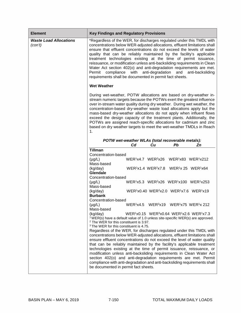
BASIN PLAN – MAY 6, 2019 7-150 TOTAL MAXIMUM DAILY LOADS
Element Key Findings and Regulatory Provisions
Waste Load Allocations (con’t)
*Regardless of the WER, for discharges regulated under this TMDL with concentrations below WER-adjusted allocations, effluent limitations shall ensure that effluent concentrations do not exceed the levels of water quality that can be reliably maintained by the facility’s applicable treatment technologies existing at the time of permit issuance, reissuance, or modification unless anti-backsliding requirements in Clean Water Act section 402(o) and anti-degradation requirements are met. Permit compliance with anti-degradation and anti-backsliding requirements shall be documented in permit fact sheets. Wet Weather During wet-weather, POTW allocations are based on dry-weather in-stream numeric targets because the POTWs exert the greatest influence over in-stream water quality during dry weather. During wet weather, the concentration-based dry-weather waste load allocations apply but the mass-based dry-weather allocations do not apply when influent flows exceed the design capacity of the treatment plants. Additionally, the POTWs are assigned reach-specific allocations for cadmium and zinc based on dry weather targets to meet the wet-weather TMDLs in Reach 1.
POTW wet-weather WLAs (total recoverable metals): Cd Cu Pb Zn Tillman Concentration-based (µg/L) WER1x4.7 WER2x26 WER1x83 WER1x212 Mass-based (kg/day) WER1x1.4 WER2x7.8 WER1x 25 WER1x64 Glendale Concentration-based (µg/L) WER1x5.3 WER2x26 WER1x100 WER1x253 Mass-based (kg/day) WER1x0.40 WER2x2.0 WER1x7.6 WER1x19 Burbank Concentration-based (µg/L) WER1x4.5 WER3x19 WER1x75 WER1x 212 Mass-based (kg/day) WER1x0.15 WER3x0.64 WER1x2.6 WER1x7.3 1 WER(s) have a default value of 1.0 unless site-specific WER(s) are approved. 2 The WER for this constituent is 3.97. 3 The WER for this constituent is 4.75. Regardless of the WER, for discharges regulated under this TMDL with concentrations below WER-adjusted allocations, effluent limitations shall ensure effluent concentrations do not exceed the level of water quality that can be reliably maintained by the facility’s applicable treatment technologies existing at the time of permit issuance, reissuance, or modification unless anti-backsliding requirements in Clean Water Act section 402(o) and anti-degradation requirements are met. Permit compliance with anti-degradation and anti-backsliding requirements shall be documented in permit fact sheets.

BASIN PLAN – MAY 6, 2019 7-151 TOTAL MAXIMUM DAILY LOADS
Element Key Findings and Regulatory Provisions
Waste Load Allocations (con’t)
Wet-weather waste load allocations for the grouped storm water permittees are equal to the total loading capacity minus the load allocations for open space and direct air deposition and the waste load allocations for the POTWs. Wet-weather waste load allocations for the grouped storm water permittees apply to all reaches and tributaries.
Storm water wet-weather WLAs (total recoverable metals): Metal Waste Load Allocation (kg/day) Cadmium WER1 x 3.1x10-9 x daily volume(L) – 1.95 Copper WER2 x 1.7x10-8 x daily volume (L) – 10 Lead WER1 x 9.4x10-8 x daily volume (L) – 35 Zinc WER1 x 1.6x10-7 x daily volume (L) – 90 1 WER(s) have a default value of 1.0 unless site-specific WER(s) are approved. 2 The WER for this constituent is 3.97. The combined storm water waste load allocation is apportioned between the different storm water categories by their percent area of the portion of the watershed served by storm drains.
MS4 wet-weather WLAs (total recoverable metals): Metal Waste Load Allocation (kg/day) Cadmium WER1 x 2.8x10-9 x daily volume(L) – 1.8 Copper WER2 x 1.5x10-8 x daily volume (L) – 9.5 Lead WER1 x 8.5x10-8 x daily volume (L) – 32 Zinc WER1 x 1.4x10-7 x daily volume (L) – 83 1 WER(s) have a default value of 1.0 unless site-specific WER(s) are approved. 2 The WER for this constituent is 3.97. * Where existing concentrations in MS4 discharges are below WER-adjusted allocations upon the effective date of these revisions to the TMDL, MS4 Permittees shall track trends in concentrations and loads and, where increasing trends are observed and are determined to be statistically significant, shall conduct an evaluation of the cause(s) of the increasing trends in concentration and/or load within the contributing drainage area(s). Permittees shall propose criteria for determining whether a trend is statistically significant as an addendum to their approved CIMP or IMP under their respective MS4 permit, or the Regional Board will specify criteria if a Permittee is following the baseline monitoring program of a MS4 permit. If the increasing trend is caused or contributed to by MS4 discharges, the MS4 Permittees shall then report on and evaluate the cause(s) of any increasing trends and shall include actions to arrest increasing trends in their annual reports and/or as part of their adaptive management process in an approved Watershed Management Program or Enhanced Watershed Management Program. Further, regardless of the WER, Permit compliance with anti-degradation and anti-backsliding requirements shall be documented in permit fact sheets.
Caltrans wet-weather WLAs (total recoverable metals):

BASIN PLAN – MAY 6, 2019 7-152 TOTAL MAXIMUM DAILY LOADS
Element Key Findings and Regulatory Provisions
Waste Load Allocations (con’t)
Metal Waste Load Allocation (kg/day) Cadmium WER1 x 5.3x10-11 x daily volume(L) – 0.03 Copper WER2 x 2.9x10-10 x daily volume (L) – 0.2 Lead WER1 x 1.6x10-9 x daily volume (L) – 0.6 Zinc WER1 x 2.7x10-9 x daily volume (L) – 1.6 1 WER(s) have a default value of 1.0 unless site-specific WER(s) are approved. 2 The WER for this constituent is 3.97. * Where existing concentrations in MS4 discharges are below WER-adjusted allocations upon the effective date of these revisions to the TMDL, MS4 Permittees shall track trends in concentrations and loads and, where increasing trends are observed and are determined to be statistically significant, shall conduct an evaluation of the cause(s) of the increasing trends in concentration and/or load within the contributing drainage area(s). Permittees shall propose criteria for determining whether a trend is statistically significant as an addendum to their approved CIMP or IMP under their respective MS4 permit, or the Regional Board will specify criteria if a Permittee is following the baseline monitoring program of a MS4 permit. If the increasing trend is caused or contributed to by MS4 discharges, the MS4 Permittees shall then report on and evaluate the cause(s) of any increasing trends and shall include actions to arrest increasing trends in their annual reports and/or as part of their adaptive management process in an approved Watershed Management Program or Enhanced Watershed Management Program. Further, regardless of the WER, Permit compliance with anti-degradation and anti-backsliding requirements shall be documented in permit fact sheets.
General Industrial wet-weather WLAs (total recoverable metals): Metal Waste Load Allocation (kg/day) Cadmium WER1 x 1.6x10-10 x daily volume(L) – 0.11 Copper WER2 x 8.8x10-10 x daily volume (L) – 0.5 Lead WER1 x 4.9x10-9 x daily volume (L) – 1.9 Zinc WER1 x 8.3x10-9 x daily volume (L) – 4.8 1 WER(s) have a default value of 1.0 unless site-specific WER(s) are approved. 2 The WER for this constituent is 3.97.
General Construction wet-weather WLAs (total recoverable metals): Metal Waste Load Allocation (kg/day) Cadmium WER1 x 5.9x10-11 x daily volume(L) – 0.04 Copper WER2 x 3.2x10-10 x daily volume (L) – 0.2 Lead WER1 x 1.8x10-9 x daily volume (L) – 0.68 Zinc WER1 x 3.01x10-9 x daily volume (L) – 4.8 1 WER(s) have a default value of 1.0 unless site-specific WER(s) are approved. 2 The WER for this constituent is 3.97. Each storm water permittee under the general industrial and construction storm water permits will receive individual waste load allocations per acre based on the total acres of their facility.
Individual General Construction or Industrial Permittees WLAs (total recoverable metals):
Metal Waste Load Allocation (g/day/acre) Cadmium WER1 x 7.6x10-12 x daily volume(L) – 4.8x10⁻⁶ Copper WER2 x 4.2x10-11 x daily volume (L) – 2.6x10⁻⁵ Lead WER1 x 2.3x10-10 x daily volume (L) –8.7x10⁻⁵

BASIN PLAN – MAY 6, 2019 7-153 TOTAL MAXIMUM DAILY LOADS
Element Key Findings and Regulatory Provisions
Waste Load Allocations (con’t)
Zinc WER1 x 3.9x10-10 x daily volume (L) – 2.2x10⁻⁴ 1 WER(s) have a default value of 1.0 unless site-specific WER(s) are approved. 2 The WER for this constituent is 3.97. *Regardless of the WER, for discharges regulated under this TMDL with concentrations below WER-adjusted allocations, effluent limitations shall ensure effluent concentrations do not exceed the level of water quality that can be reliably maintained by the facility’s applicable treatment technologies existing at the time of permit issuance, reissuance, or modification unless anti-backsliding requirements in Clean Water Act section 402(o) and anti-degradation requirements are met. Permit compliance with anti-degradation and anti-backsliding requirements shall be documented in permit fact sheets Other NPDES Permits Concentration-based wet-weather waste load allocations apply to the other NPDES permits* that discharge to all reaches of the Los Angeles River and its tributaries.
Wet-weather WLAs for other permits (total recoverable metals) Cadmium (µg /L) Copper (µg /L) Lead (µg /L) Zinc (µg /L) WER1 x 3.1 WER2 x 17 WER1 x 94 WER1 x 159 1 WER(s) have a default value of 1.0 unless site-specific WER(s) are approved. 2 The WER for this constituent is 3.97. *Regardless of the WER, for discharges regulated under this TMDL with concentrations below WER-adjusted allocations, effluent limitations shall ensure effluent concentrations do not exceed the level of water quality that can be reliably maintained by the facility’s applicable treatment technologies existing at the time of permit issuance, reissuance, or modification unless anti-backsliding requirements in Clean Water Act section 402(o) and anti-degradation requirements are met. Permit compliance with anti-degradation and anti-backsliding requirements shall be documented in permit fact sheets. * “Other NPDES permits” refers to minor NPDES permits, general non-storm water NDPES permits, and major permits other than the Tillman, LA-Glendale, and Burbank POTWs.
Margin of Safety There is an implicit margin of safety that stems from the use of conservative values for the translation from total recoverable to the dissolved fraction during the dry and wet periods. In addition, the TMDL includes a margin of safety by evaluating wet-weather conditions separately from dry-weather conditions, which is in effect, assigning allocations for two distinct critical conditions. Furthermore, the use of the wet-weather model to calculate load allocations for open space can be applied to the margin of safety because it tends to overestimate loads from open spaces, thus reducing the available waste load allocations to the permitted discharges. Conservative assumptions were made in the development of site-specific WERs, such as the use of the Streamlined Procedure calculation method, which results in a lower WER.

BASIN PLAN – MAY 6, 2019 7-154 TOTAL MAXIMUM DAILY LOADS
Element Key Findings and Regulatory Provisions
Implementation
The regulatory mechanisms used to implement the TMDL will include the municipal separate storm sewer system NPDES permits that cover MS4 discharges within the Los Angeles River Watershed, including the Los Angeles County Municipal Separate Storm Sewer System (MS4) NPDES Permit, the City of Long Beach MS4 NPDES Permit, and the Caltrans NPDES Statewide Storm Water Permit; major NPDES permits, including individual industrial storm water permits; minor NPDES permits; general NPDES permits, including the general permit for discharges of potable water from water supply distribution systems; general industrial storm water NPDES permits; and general construction storm water NPDES permits. Nonpoint sources will be regulated through the authority contained in sections 13263 and 13269 of the Water Code, in conformance with the State Water Resources Control Board’s Nonpoint Source Implementation and Enforcement Policy (May 2004). Each NPDES permit assigned a WLA shall be reopened or amended at reissuance, in accordance with applicable laws, to incorporate the applicable WLAs as a permit requirement. Table 7-13-2 presents the implementation schedule for the responsible permittees. Implementation of WERs Site-specific WERs may be modified or revert back to a default of 1.0 through a basin planning process if data indicate that the WERs are not protective of either the beneficial uses of the waterbody to which they apply or downstream beneficial uses. Any WER that is incorporated into a discharger’s permit shall include an appropriate reopener that authorizes the Regional Board to modify the WER as appropriate to accommodate new information. Other NPDES permits (including POTWs, other major, minor, and general permits): Permit writers may translate applicable waste load allocations into daily maximum and monthly average effluent limits for the major, minor and general NPDES permits by applying the effluent limitation procedures in Section 1.4 of the State Water Resources Control Board’s Policy for Implementation of Toxics Standards for Inland Surface Waters, Enclosed Bays, and Estuaries of California (2000) or other applicable engineering practices authorized under federal regulations. Permittees that hold individual NPDES permits and solely discharge storm water may be allowed (at Regional Board discretion) compliance schedules up to January 11, 2016 to achieve compliance with final WLAs. General industrial storm water permits: Waste load allocations will be incorporated into the State Board general permit upon renewal or the Regional Board will develop a watershed-

BASIN PLAN – MAY 6, 2019 7-155 TOTAL MAXIMUM DAILY LOADS
Element Key Findings and Regulatory Provisions
Implementation (con’t)
specific general industrial storm water permit to incorporate waste load allocations. Dry-weather implementation Non-storm water flows authorized by Order No. 97-03 DWQ, or any successor order, including Order No. 2014-0057-DWQ, are exempt from the dry-weather waste load allocation equal to zero. Instead, these authorized non-storm water flows shall meet the reach-specific concentration-based waste load allocations assigned to the “other NPDES permits”. The dry-weather waste load allocation equal to zero applies to unauthorized non-storm water flows, which are prohibited by Order No. 97-03 DWQ and Order No. 2014-0057-DWQ. It is anticipated that the dry-weather waste load allocations will be implemented by requiring improved best management practices (BMPs) to eliminate the discharge of non-storm water flows. However, permit writers must provide adequate justification and documentation to demonstrate that specified BMPs are expected to result in attainment of the numeric waste load allocations. Wet-weather implementation General industrial storm water permittees are allowed interim wet-weather concentration-based waste load allocations based on benchmarks contained in EPA’s Storm Water Multi-sector General Permit for Industrial Activities. The interim waste load allocations apply to all industry sectors and apply until no later than January 11, 2016.
Interim wet-weather WLAs for general industrial storm water permittees (total recoverable metals)*
Cd (µg/L) Cu(µg/L) Pb(µg/L) Zn(µg/L) 15.9 63.6 81.6 117 *Based on USEPA benchmarks for industrial storm water sector Prior to January 11, 2011, interim waste load allocations will not be interpreted as enforceable permit conditions. If monitoring demonstrates that interim waste load allocations are being exceeded, the permittee shall evaluate existing and potential BMPs, including structural BMPs, and implement any necessary BMP improvements. It is anticipated that monitoring results and any necessary BMP improvements would occur as part of an annual reporting process. After January 11, 2011, interim waste load allocations shall be translated into enforceable permit conditions. Compliance with permit conditions may be demonstrated through the installation, maintenance, and monitoring of Regional Board-approved BMPs. If this method of compliance is chosen, permit writers must provide adequate justification and documentation to demonstrate that BMPs are expected to result in attainment of interim waste load allocations.

BASIN PLAN – MAY 6, 2019 7-156 TOTAL MAXIMUM DAILY LOADS
Element Key Findings and Regulatory Provisions
Implementation (con’t)
The general industrial storm water permits shall achieve final wet-weather waste load allocations no later than January 11, 2016, which shall be expressed as NPDES water quality-based effluent limitations. Effluent limitations may be expressed as permit conditions, such as the installation, maintenance, and monitoring of Regional Board-approved BMPs if adequate justification and documentation demonstrate that BMPs are expected to result in attainment of waste load allocations. General construction storm water permits: Waste load allocations will be incorporated into the State Board general permit upon renewal or into a watershed-specific general permit developed by the Regional Board. Dry-weather implementation Non-storm water flows authorized by the General Permit for Storm Water Discharges Associated with Construction Activity (Water Quality Order No. 99-08 DWQ), or any successor order, including Order No. 2009-0009-DWQ, are exempt from the dry-weather waste load allocation equal to zero as long as they comply with the provisions of sections C.3.and A.9 of the Order No. 99-08 DWQ, and sections III, V.A., and VI of Order No. 2009-0009-DWQ. Unauthorized non-storm water flows are already prohibited by Order No. 99-08 DWQ and Order No. 2009-0009-DWQ. Wet-weather implementation Each general construction storm water permit holder will be subject to site-specific BMPs and monitoring requirements to demonstrate compliance with final waste load allocations. MS4 and Caltrans permits Applicable CTR limits are being met most of the time during dry weather, with episodic exceedances. Due to the expense of obtaining accurate flow measurements required for calculating loads, concentration-based permit limits may apply during dry weather. These concentration-based limits would be equal to dry-weather reach-specific numeric targets. Each municipality and permittee will be required to meet the storm water waste load allocations shared by the MS4 and Caltrans permittees at the designated TMDL effectiveness monitoring points. A phased implementation approach, using a combination of non-structural and structural BMPs may be used to achieve compliance with the waste load allocations. The administrative record and the fact sheets for the MS4 and Caltrans storm water permits must provide reasonable assurance that the BMPs selected will be sufficient to implement the waste load allocations. The implementation schedule for the MS4 and Caltrans permittees consists of a phased approach. The watershed is divided into five jurisdictional groups based on the subwatersheds of the tributaries that
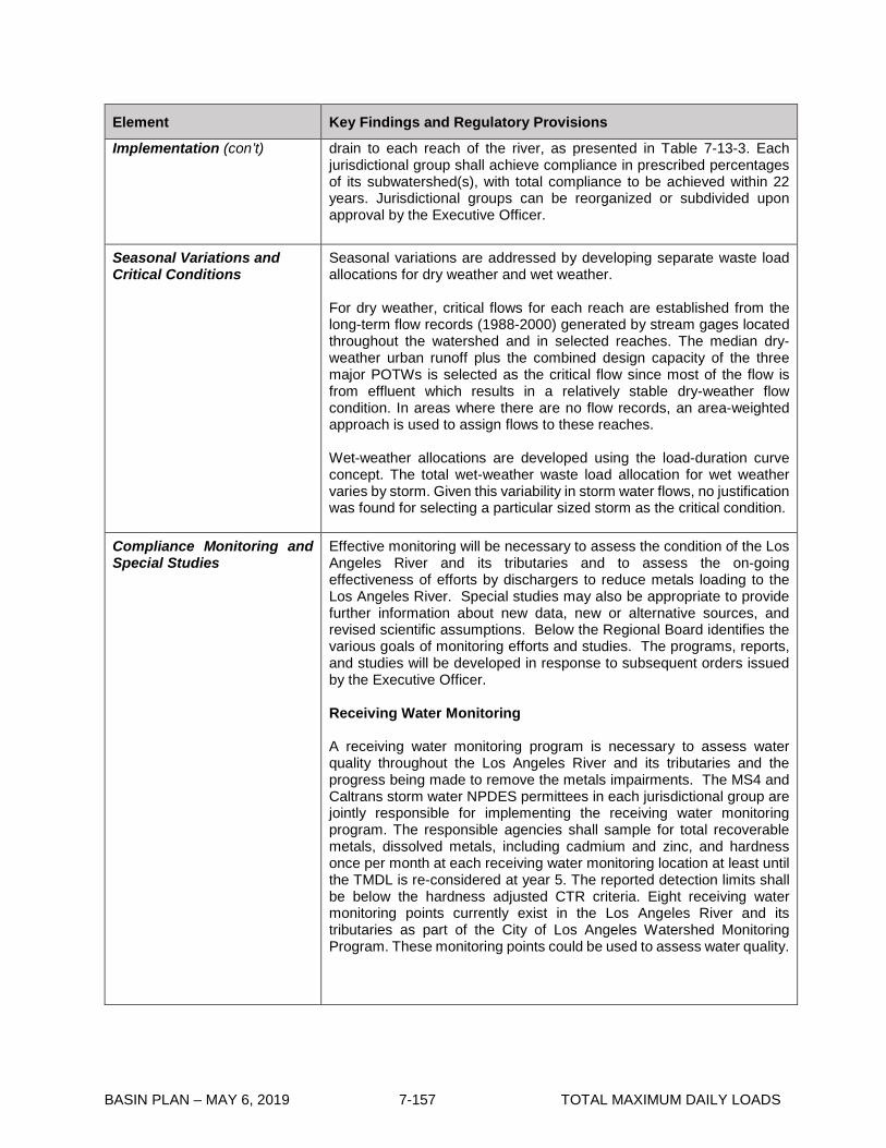
BASIN PLAN – MAY 6, 2019 7-157 TOTAL MAXIMUM DAILY LOADS
Element Key Findings and Regulatory Provisions
Implementation (con’t)
drain to each reach of the river, as presented in Table 7-13-3. Each jurisdictional group shall achieve compliance in prescribed percentages of its subwatershed(s), with total compliance to be achieved within 22 years. Jurisdictional groups can be reorganized or subdivided upon approval by the Executive Officer.
Seasonal Variations and Critical Conditions
Seasonal variations are addressed by developing separate waste load allocations for dry weather and wet weather. For dry weather, critical flows for each reach are established from the long-term flow records (1988-2000) generated by stream gages located throughout the watershed and in selected reaches. The median dry-weather urban runoff plus the combined design capacity of the three major POTWs is selected as the critical flow since most of the flow is from effluent which results in a relatively stable dry-weather flow condition. In areas where there are no flow records, an area-weighted approach is used to assign flows to these reaches. Wet-weather allocations are developed using the load-duration curve concept. The total wet-weather waste load allocation for wet weather varies by storm. Given this variability in storm water flows, no justification was found for selecting a particular sized storm as the critical condition.
Compliance Monitoring and Special Studies
Effective monitoring will be necessary to assess the condition of the Los Angeles River and its tributaries and to assess the on-going effectiveness of efforts by dischargers to reduce metals loading to the Los Angeles River. Special studies may also be appropriate to provide further information about new data, new or alternative sources, and revised scientific assumptions. Below the Regional Board identifies the various goals of monitoring efforts and studies. The programs, reports, and studies will be developed in response to subsequent orders issued by the Executive Officer. Receiving Water Monitoring A receiving water monitoring program is necessary to assess water quality throughout the Los Angeles River and its tributaries and the progress being made to remove the metals impairments. The MS4 and Caltrans storm water NPDES permittees in each jurisdictional group are jointly responsible for implementing the receiving water monitoring program. The responsible agencies shall sample for total recoverable metals, dissolved metals, including cadmium and zinc, and hardness once per month at each receiving water monitoring location at least until the TMDL is re-considered at year 5. The reported detection limits shall be below the hardness adjusted CTR criteria. Eight receiving water monitoring points currently exist in the Los Angeles River and its tributaries as part of the City of Los Angeles Watershed Monitoring Program. These monitoring points could be used to assess water quality.

BASIN PLAN – MAY 6, 2019 7-158 TOTAL MAXIMUM DAILY LOADS
Element Key Findings and Regulatory Provisions
Compliance Monitoring and Special Studies (con’t)
Receiving Water Monitoring Points Reaches and Tributaries White Oak LA River 6, Aliso Creek, McCoy Creek, Bell Creek Avenue Sepulveda LA River 5, Bull Creek Boulevard Tujunga LA River 4, Tujunga Wash Avenue Colorado LA River 3, Burbank Western Channel, Verdugo Wash Boulevard Figueroa LA River 3, Arroyo Seco Street Washington LA River 2 Boulevard Rosecrans LA River 2, Rio Hondo (gage just above Rio Hondo) Avenue Willow LA River 1, Compton Creek (gage at Wardlow) Street TMDL Effectiveness Monitoring The MS4 and Caltrans storm water NPDES permittees in each jurisdictional group are jointly responsible for assessing progress in reducing pollutant loads to achieve the TMDL. Each jurisdictional group is required to submit for approval by the Executive Officer a coordinated monitoring plan that will demonstrate the effectiveness of the phased implementation schedule for this TMDL (See Table 7-13.2), which requires attainment of the applicable waste load allocations in prescribed percentages of each subwatershed over a 22-year period. The monitoring locations specified for the receiving water monitoring program may be used as effectiveness monitoring locations. The MS4 and Caltrans storm water NPDES permittees will be found to be effectively meeting dry-weather waste load allocations if the in-stream pollutant concentration or load at the first downstream monitoring location is equal to or less than the corresponding concentration- or load-based waste load allocation. Alternatively, effectiveness of the TMDL may be assessed at the storm drain outlet based on the waste load allocation for the receiving water. For storm drains that discharge to other storm drains, the waste load allocation will be based on the waste load allocation for the ultimate receiving water for that storm drain system. The MS4 and Caltrans storm water NPDES permittees will be found to be effectively meeting wet-weather waste load allocations if the loading at the downstream monitoring location is equal to or less then the wet-weather waste load allocation. The general industrial storm water permit shall contain a model monitoring and reporting program to evaluate BMP effectiveness. A permittee enrolled under the general permit shall have the choice of

BASIN PLAN – MAY 6, 2019 7-159 TOTAL MAXIMUM DAILY LOADS
Element Key Findings and Regulatory Provisions
Compliance Monitoring and Special Studies (con’t)
conducting individual monitoring based on the model program or participating in a group monitoring effort. MS4 permittees are encouraged to take the lead in group monitoring efforts for industrial facilities within their jurisdiction because compliance with waste load allocations by these facilities will in many cases translate to reductions in metals loads to the MS4. The Tillman, LA-Glendale, and Burbank POTWs, and the remaining permitted discharges in the watershed will have effluent monitoring requirements to ensure compliance with waste load allocations. Monitoring to Determine Ongoing Protectiveness of WERs The Tillman, LA-Glendale, and Burbank POTWs, and the Caltrans, Los Angeles County MS4, and Long Beach MS4 permittees shall conduct additional receiving water monitoring to verify that water quality conditions are similar to those of the 2008 and 2014 copper WER study periods. Monitoring is also required to determine if the WER-based copper WLAs will achieve downstream water quality standards. This additional monitoring shall be required through the POTWs’ NPDES permit monitoring and reporting programs and the Los Angeles County and Long Beach MS4 Permits’ monitoring and reporting programs or the Integrated Monitoring Programs and/or Coordinated Integrated Monitoring Programs, where approved by the Executive Officer of the Regional Board in lieu of the MS4 permits’ monitoring and reporting programs, or other Regional Board required monitoring programs. Copper WER evaluation monitoring will consist of receiving water monitoring for key chemical parameters needed for estimates of WERs utilizing the Biotic Ligand Model (BLM). Monitoring shall be conducted at the locations sampled in the 2008 and 2014 copper WER studies, as well as additional locations in upstream portions of tributaries. The upstream tributary monitoring may be discontinued or reduced if it is shown that downstream tributary monitoring locations are representative of the entire tributary. If BLM-predicted WERs significantly change, then responsible agencies shall submit a plan for Executive Officer approval to conduct WER toxicity testing in the applicable reaches or tributaries in order to reassess WERs. Responsible parties will include criteria for determining what constitutes a significant change in BLM-predicted WERs. The Regional Board will evaluate the copper WLAs based on potential changes in BLM-predicted WERs and subsequent additional WER testing, and will revise the WERs and copper WLAs through a basin planning process, if necessary, to ensure protection of beneficial uses. Monitoring of sediment chemistry shall be conducted at one site immediately above the Los Angeles River Estuary and one site within the Estuary annually for analysis of general sediment quality constituents and metals. Special Studies The implementation schedule (see Table 7-13.2) allows time for special studies that may serve to refine the estimate of loading capacity, waste load and/or load allocations, and other studies that may serve to optimize

BASIN PLAN – MAY 6, 2019 7-160 TOTAL MAXIMUM DAILY LOADS
Element Key Findings and Regulatory Provisions
Compliance Monitoring and Special Studies (con’t)
implementation efforts. The Regional Board will re-consider the TMDL by January 11, 2011 in light of the findings of these studies. Studies may include: • Refined flow estimates for the Los Angeles River mainstem and
tributaries where there presently are no flow gages and for improved gaging of low-flow conditions.
• Water quality measurements, including a better assessment of hardness, water chemistry data (e.g., total suspended solids and organic carbon) that may refine the use of metals partitioning coefficients.
• Effects studies designed to evaluate site-specific toxic effects of metals on the Los Angeles River and its tributaries.
• Source studies designed to characterize loadings from background or natural sources
• Review of water quality modeling assumptions including the relationship between metals and total suspended solids as expressed in the potency factors and buildup and washoff and transport coefficients.
• Evaluation of aerial deposition and sources of aerial deposition. • POTWs that are unable to demonstrate compliance with final
waste load allocations must conduct source reduction audits by January 11, 2008.
• POTWs that will be requesting the Regional Board to extend their implementation schedule to allow for the installation of advanced treatment must prepare work plans, with time schedules to allow for the installation advanced treatment. The work plan must be submitted January 11, 2010.

BASIN PLAN – MAY 6, 2019 7-161 TOTAL MAXIMUM DAILY LOADS
Table 7-13.2 Los Angeles River and Tributaries Metals TMDL: Implementation Schedule Date Action
January 11, 2006 Regional Board permit writers shall incorporate waste load allocations into NPDES permits. Waste load allocations will be implemented through NPDES permit limits in accordance with the implementation schedule contained herein, at the time of permit issuance, renewal, or re-opener.
January 11, 2010 Responsible jurisdictions and agencies shall provide to the Regional Board results of the special studies. POTWs that will be requesting the Regional Board to extend their implementation schedule to allow for the installation of advanced treatment must submit work plans.
January 11, 2011 The Regional Board shall reconsider this TMDL to re-evaluate the waste load allocations and the implementation schedule.
OTHER NPDES PERMITS (INCLUDING POTWS, OTHER MAJOR, MINOR, AND GENERAL PERMITS)
Upon permit issuance, renewal, or re-opener
The other NPDES permits shall achieve waste load allocations, which shall be expressed as NPDES water quality-based effluent limitations specified in accordance with federal regulations and state policy on water quality control. Permit writers may translate applicable waste load allocations into daily maximum and monthly average effluent limits for the major, minor and general NPDES permits by applying the effluent limitation procedures in Section 1.4 of the SIP or other applicable engineering practices authorized under federal regulations. Effluent limitations based on WER-adjusted WLAs shall ensure that effluent concentrations and mass discharges do not exceed the levels of water quality that can be attained by performance of a facility’s treatment technologies existing at the time of permit issuance, reissuance, or modification. Permittees that hold individual NPDES permits and solely discharge storm water may be allowed (at Regional Board discretion) compliance schedules up to January 11, 2016 to achieve compliance with final WLAs.
GENERAL INDUSTRIAL STORM WATER PERMITS
Upon permit issuance, renewal, or re-opener
The general industrial storm water permittees shall achieve dry-weather waste load allocations, which shall be expressed as NPDES water quality-based effluent limitations specified in accordance with federal regulations and state policy on water quality control. Effluent limitations may be expressed as permit conditions, such as the installation, maintenance, and monitoring of Regional Board-approved BMPs. Permittees shall begin to install and test BMPs to meet the interim wet-weather WLAs. BMP effectiveness monitoring will be implemented to determine progress in achieving interim wet-weather waste load allocations.

BASIN PLAN – MAY 6, 2019 7-162 TOTAL MAXIMUM DAILY LOADS
Date Action
January 11, 2011 The general industrial storm water permits shall achieve interim wet-weather waste load allocations, which shall be expressed as NPDES water quality-based effluent limitations. Effluent limitations may be expressed as permit conditions, such as the installation, maintenance, and monitoring of Regional Board-approved BMPs. Permittees shall begin an iterative BMP process including BMP effectiveness monitoring to achieve compliance with final waste load allocations.
January 11, 2016 The general industrial storm water permits shall achieve final wet-weather waste load allocations, which shall be expressed as NPDES water quality-based effluent limitations. Effluent limitations may be expressed as permit conditions, such as the installation, maintenance, and monitoring of Regional Board-approved BMPs.
GENERAL CONSTRUCTION STORM WATER PERMITS
Upon permit issuance, renewal, or re-opener
Non-storm water flows not authorized by Order No. 99-08 DWQ, or any successor order, including Order No. 2009-0009-DWQ, shall achieve dry-weather waste load allocations of zero. Waste load allocations shall be expressed as NPDES water quality-based effluent limitations specified in accordance with federal regulations and state policy on water quality control. Effluent limitations may be expressed as permit conditions, such as the installation, maintenance, and monitoring of Regional Board-approved BMPs.
January 11, 2015 All general construction storm water permittees shall be subject to site-specific BMPs and monitoring requirements to demonstrate compliance with final waste load allocations.

BASIN PLAN – MAY 6, 2019 7-163 TOTAL MAXIMUM DAILY LOADS
MS4 AND CALTRANS STORM WATER PERMITS
April 11, 2007 In response to an order issued by the Executive Officer, each jurisdictional group must submit a coordinated monitoring plan, to be approved by the Executive Officer, which includes both TMDL effectiveness monitoring and ambient monitoring. Once the coordinated monitoring plan is approved by the Executive Officer ambient monitoring shall commence within 6 months.
January 11, 2010 (Draft Report) July 11, 2010 (Final Report)
Each jurisdictional group shall provide a written report to the Regional Board outlining the how the subwatersheds within the jurisdictional group will achieve compliance with the waste load allocations. The report shall include implementation methods, an implementation schedule, proposed milestones, and any applicable revisions to the TMDL effectiveness monitoring plan.
January 11, 2012 Each jurisdictional group shall demonstrate that 50% of the group’s total drainage area served by the storm drain system is effectively meeting the dry-weather waste load allocations and 25% of the group’s total drainage area served by the storm drain system is effectively meeting the wet-weather waste load allocations.
January 11, 2020 Each jurisdictional group shall demonstrate that 75% of the group’s total drainage area served by the storm drain system is effectively meeting the dry-weather WLAs.
January 11, 2024 Each jurisdictional group shall demonstrate that 100% of the group’s total drainage area served by the storm drain system is effectively meeting the dry-weather WLAs and 50% of the group’s total drainage area served by the storm drain system is effectively meeting the wet-weather WLAs.
January 11, 2028 Each jurisdictional group shall demonstrate that 100% of the group’s total drainage area served by the storm drain system is effectively meeting both the dry-weather and wet-weather WLAs.
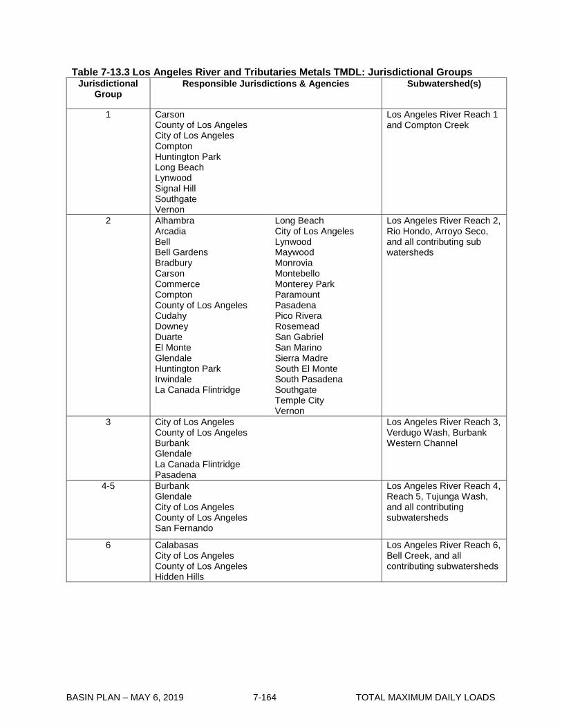
BASIN PLAN – MAY 6, 2019 7-164 TOTAL MAXIMUM DAILY LOADS
Table 7-13.3 Los Angeles River and Tributaries Metals TMDL: Jurisdictional Groups Jurisdictional
Group Responsible Jurisdictions & Agencies Subwatershed(s)
1 Carson County of Los Angeles City of Los Angeles Compton Huntington Park Long Beach Lynwood Signal Hill Southgate Vernon
Los Angeles River Reach 1 and Compton Creek
2 Alhambra Arcadia Bell Bell Gardens Bradbury Carson Commerce Compton County of Los Angeles Cudahy Downey Duarte El Monte Glendale Huntington Park Irwindale La Canada Flintridge
Long Beach City of Los Angeles Lynwood Maywood Monrovia Montebello Monterey Park Paramount Pasadena Pico Rivera Rosemead San Gabriel San Marino Sierra Madre South El Monte South Pasadena Southgate Temple City Vernon
Los Angeles River Reach 2, Rio Hondo, Arroyo Seco, and all contributing sub watersheds
3 City of Los Angeles County of Los Angeles Burbank Glendale La Canada Flintridge Pasadena
Los Angeles River Reach 3, Verdugo Wash, Burbank Western Channel
4-5 Burbank Glendale City of Los Angeles County of Los Angeles San Fernando
Los Angeles River Reach 4, Reach 5, Tujunga Wash, and all contributing subwatersheds
6 Calabasas City of Los Angeles County of Los Angeles Hidden Hills
Los Angeles River Reach 6, Bell Creek, and all contributing subwatersheds
BASIN PLAN – MAY 6, 2019 7-165 TOTAL MAXIMUM DAILY LOADS
7-14 Ballona Creek Estuary Toxic Pollutants TMDL This TMDL was adopted by:
The Regional Water Quality Control Board on July 7, 2005.
This TMDL was approved by:
The State Water Resources Control Board on October 20, 2005. The Office of Administrative Law on December 15, 2005. The U.S. Environmental Protection Agency on December 22, 2005.
This TMDL was revised by:
The Regional Water Quality Control Board on December 5, 2013.
This revised TMDL was approved by:
The State Water Resources Control Board on June 17, 2014. The Office of Administrative Law on May 05, 2015. The U.S. Environmental Protection Agency on October 26, 2015.
The following tables include the elements of this TMDL.

BASIN PLAN – MAY 6, 2019 7-166 TOTAL MAXIMUM DAILY LOADS
Table 7-14.1 Ballona Creek Estuary Toxic Pollutants TMDL: Elements Element Key Findings and Regulatory Provisions
Problem Statement Ballona Creek and Ballona Creek Estuary (Estuary) is on the Clean Water Act Section 303(d) list of impaired waterbodies for cadmium, copper, lead, silver, zinc, chlordane, DDT, PCBs, PAHs and toxicity in sediments. The following designated beneficial uses are impaired by these toxic pollutants: water contact recreation (REC1); non-contact water recreation (REC2); estuarine habitat (EST); marine habitat (MAR); wildlife habitat (WILD); rare and threatened or endangered species (RARE); migration of aquatic organisms (MIGR); reproduction and early development of fish (SPWN); commercial and sport fishing (COMM); and shellfish harvesting (SHELL). Recent data indicate that PAHs are not present at levels exceeding existing numeric targets and are not impairing the designated beneficial uses. Therefore, a TMDL for PAHs is not included.
Numeric Target (Interpretation of the narrative and numeric water quality objective, used to calculate the allocations)
Sediment targets are based on the narrative standards of this Basin Plan, the narrative standards of the State Water Quality Control Plan for Enclosed Bays and Estuaries (EB&E Plan Part 1), which contains the State’s Sediment Quality Objectives, the sediment quality guidelines compiled by the National Oceanic and Atmospheric Administration (NOAA), and associated sediments targets, required to achieve fish tissue targets, determined from various other sources. Sediment Targets for Direct Effects Numeric water quality targets are based on the sediment quality guidelines compiled by the National Oceanic and Atmospheric Administration, which are used in evaluating waterbodies within the Los Angeles Region for development of the 303(d) list. The NOAA Effects Range-Low (ERLs) guidelines are established as the numeric targets for metals in sediments in Ballona Creek Estuary. Metal Numeric Targets (mg/kg) Cadmium Copper Lead Silver Zinc 1.2 34 46.7 1.0 150 In addition, the categories designated in the State’s SQOs as Unimpacted and Likely Unimpacted by the interpretation and integration of multiple lines of evidence shall be considered as the protective objective for sediment toxicity and benthic community direct effects. The thresholds established in the SQOs are based on statistical significance and magnitude of the effect. Therefore, this TMDL implicitly includes sediment toxicity and benthic community targets by its use of the SQO Part 1. Sediment Targets for Indirect Effects and Fish Tissue Fish tissue targets were determined from Fish Contaminant Goals and Advisory Tissue Levels for Common Contaminants in California Sport Fish: Chlordane, DDTs, Dieldrin, Methylmercury, PCBs, Selenium, and Toxaphene, developed by the California Office of Environmental Health Hazard Assessment (2008) to assist agencies in developing fish tissue-

BASIN PLAN – MAY 6, 2019 7-167 TOTAL MAXIMUM DAILY LOADS
Element Key Findings and Regulatory Provisions
Numeric Target (Interpretation of the narrative and numeric water quality objective, used to calculate the allocations) (con’t)
based criteria for pollution mitigation or elimination and to protect humans from consumption of contaminated fish. Fish tissue targets are set for the Chlordane, Total DDT, and Total PCBs based on these Fish Contaminant Goals. Fish tissue associated sediment targets are set for Chlordane and Total DDT based on the 2007 San Francisco Bay Estuary Institute Newport Bay Indirect Effects draft report and for Total PCBs based on the 2010 San Francisco Bay Bioaccumulation study of Gobas and Arnot.
Fish Tissue Targets and Fish Tissue Associated Sediment Targets
Pollutant Fish Tissue target
(μg/kg wet)
Associated sediment target
(μg/kg dry) Chlordane 5.6 1.3 Total DDT 21 1.9
Total PCBs 3.6 3.2
Source Analysis Urban storm water has been recognized as a substantial source of metals. Numerous researchers have documented that the most prevalent metals in urban storm water (i.e., copper, lead, zinc, and to a lesser degree cadmium) are consistently associated with suspended solids. Because metals are typically associated with fine particles in storm water runoff, they have the potential to accumulate in estuarine sediments where they may pose a risk of toxicity. McPherson et al.1 estimated that 83% of the cadmium and 86% of the lead were associated with the particle phase in Ballona Creek. Similar to metals, the majority of organic constituents in storm water are associated with particulates, measured concentrations of PAHs, phthalates, and organochlorine compounds in Sepulveda Channel, Centinela Creek, and Ballona Creek found that the majority of these compounds occurred in association with suspended solids. There is toxicity associated with suspended solids in urban runoff discharged from Ballona Creek, as well as with the receiving water sediments. Nonpoint sources are not considered a significant source of toxic pollutants in this TMDL. Nonpoint sources are urban runoff from the Ballona Wetland, since this area discharges directly to the Estuary through a tide gate, and direct atmospheric deposition. The Ballona Wetlands cover approximately 460 acres or 0.6% of the watershed, therefore, loading from this source is considered insignificant. Direct atmospheric deposition of metals is considered insignificant because the portion of the Ballona Creek watershed covered by water is small, approximately 480 acres or 0.6% of the watershed. Indirect atmospheric deposition reflects the process by which metals deposited on the land surface may be washed off during storm events and delivered to Ballona Creek and its tributaries. The loading of metals associated with indirect atmospheric deposition are accounted for in the storm water runoff.
1 McPherson, T.N., S.J. Burian, H.J. Turin, M.K. Stenstrom and I.H. Suffet. 2002. Comparison of Pollutant Loads in Dry and Wet Weather Runoff in a Southern California Urban Watershed. Water Science and Technology 45:255-261.
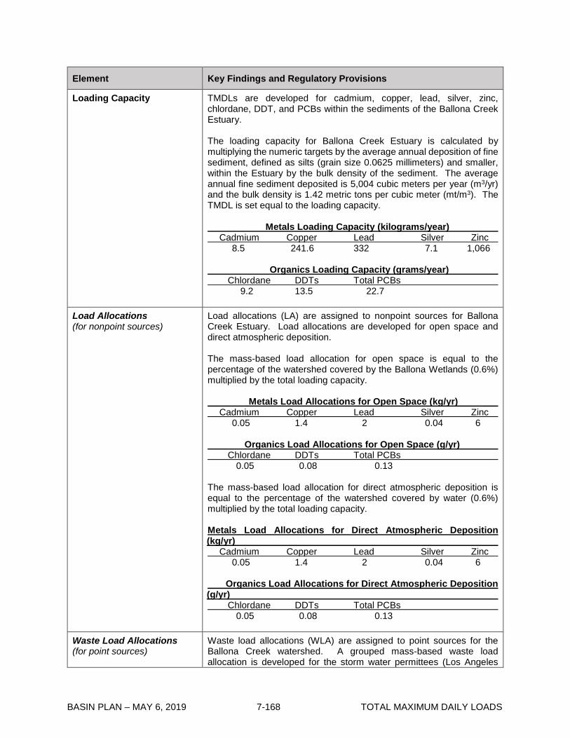
BASIN PLAN – MAY 6, 2019 7-168 TOTAL MAXIMUM DAILY LOADS
Element Key Findings and Regulatory Provisions
Loading Capacity TMDLs are developed for cadmium, copper, lead, silver, zinc, chlordane, DDT, and PCBs within the sediments of the Ballona Creek Estuary. The loading capacity for Ballona Creek Estuary is calculated by multiplying the numeric targets by the average annual deposition of fine sediment, defined as silts (grain size 0.0625 millimeters) and smaller, within the Estuary by the bulk density of the sediment. The average annual fine sediment deposited is 5,004 cubic meters per year (m3/yr) and the bulk density is 1.42 metric tons per cubic meter (mt/m3). The TMDL is set equal to the loading capacity. Metals Loading Capacity (kilograms/year) Cadmium Copper Lead Silver Zinc 8.5 241.6 332 7.1 1,066 Organics Loading Capacity (grams/year) Chlordane DDTs Total PCBs 9.2 13.5 22.7
Load Allocations (for nonpoint sources)
Load allocations (LA) are assigned to nonpoint sources for Ballona Creek Estuary. Load allocations are developed for open space and direct atmospheric deposition. The mass-based load allocation for open space is equal to the percentage of the watershed covered by the Ballona Wetlands (0.6%) multiplied by the total loading capacity. Metals Load Allocations for Open Space (kg/yr) Cadmium Copper Lead Silver Zinc 0.05 1.4 2 0.04 6 Organics Load Allocations for Open Space (g/yr) Chlordane DDTs Total PCBs 0.05 0.08 0.13 The mass-based load allocation for direct atmospheric deposition is equal to the percentage of the watershed covered by water (0.6%) multiplied by the total loading capacity. Metals Load Allocations for Direct Atmospheric Deposition (kg/yr) Cadmium Copper Lead Silver Zinc 0.05 1.4 2 0.04 6 Organics Load Allocations for Direct Atmospheric Deposition (g/yr) Chlordane DDTs Total PCBs 0.05 0.08 0.13
Waste Load Allocations (for point sources)
Waste load allocations (WLA) are assigned to point sources for the Ballona Creek watershed. A grouped mass-based waste load allocation is developed for the storm water permittees (Los Angeles

BASIN PLAN – MAY 6, 2019 7-169 TOTAL MAXIMUM DAILY LOADS
Element Key Findings and Regulatory Provisions
Waste Load Allocations (con’t)
County MS4, Caltrans, General Construction and General Industrial permittees) by subtracting the load allocations from the total loading capacity. Concentration-based waste load allocations are developed for other point sources in the watershed. Waste load allocations are expressed as allowable sediment-bound pollutant load that can be deposited to the estuary.
Metals Waste Load Allocations for Storm Water (kg/yr) Cadmium Copper Lead Silver Zinc
8.4 238.8 328 7.02 1,054 Organics Waste Load Allocations for Storm Water (g/yr) Chlordane DDTs Total PCBs 9.13 13.35 22.48 The storm water waste load allocations are apportioned between the MS4 permittees, Caltrans, the general construction and the general industrial storm water permits based on an areal weighting approach. Metals Storm Water WLAs Apportioned between Permits (kg/yr) Cadmium Copper Lead Silver Zinc MS4 Permittees 8.0 227.3 312.3 6.69 1003 Caltrans 0.11 3.2 4.4 0.09 14 General Construction 0.23 6.6 9.1 0.20 29 General Industrial 0.06 1.7 2.3 0.05 7 Organics Storm Water WLAs Apportioned between Permits (g/yr) Chlordane DDTs Total PCBs MS4 Permittees 8.69 12.70 21.40 Caltrans 0.12 0.18 0.30 General Construction 0.25 0.37 0.62 General Industrial 0.06 0.09 0.16 Each storm water permittee enrolled under the general construction or industrial storm water permits will receive an individual waste load allocation on a per acre basis, based on the acreage of their facility.
Metals per Acre WLAs for Individual General Construction or Industrial Storm Water Permittees (g/yr/ac) Cadmium Copper Lead Silver Zinc 0.1 3 4 0.1 13
Organics per Acre WLAs for Individual General Construction or Industrial Storm Water Permittees (mg/yr/ac) Chlordane DDTs Total PCBs 0.11 0.16 0.28 Concentration-based waste load allocations are assigned to the minor NPDES permits and general non-storm water NPDES permits that discharge to Ballona Creek or its tributaries. Any future minor NPDES permits or enrollees under a general non-storm water NPDES permit

BASIN PLAN – MAY 6, 2019 7-170 TOTAL MAXIMUM DAILY LOADS
Element Key Findings and Regulatory Provisions
Waste Load Allocations (con’t)
will also be subject to the concentration-based waste load allocations. Short-term discharges of potable water that are required by statute are not assigned WLAs but may be subject to alternative permit limits pursuant to the State Water Resources Control Board’s Policy for Implementation of Toxic Standards for Inland Surface Waters, Enclosed Bays, and Estuaries of California (2005). Metals Concentration-based Waste Load Allocations (mg/kg) Cadmium Copper Lead Silver Zinc 1.2 34 46.7 1.0 150 Organic Concentration-based Waste Load Allocations (µg/kg) Chlordane DDTs Total PCBs 1.3 1.9 3.2
Margin of Safety The addition of numeric targets for indirect effects and multiple compliance options listed in the implementation section for sediments serve as an implicit margin of safety.
Implementation
Compliance with the TMDL shall be determined through sediment and fish tissue monitoring and comparison with the WLAs and LAs and numeric targets. Compliance with the sediment TMDL for metals shall be based on achieving the LAs and WLAs or, alternatively, demonstrating attainment of the State’s direct effects SQO through the sediment triad/multiple lines of evidence approach outlined therein. Compliance with the TMDL for chlordane, DDT and PCBs shall be based on achieving the LAs or WLAs, the fish tissue related sediment target or, alternatively, by meeting fish tissue targets. If monitoring data or special studies indicate that load and waste load allocations will be attained, but fish tissue targets may not be achieved, the Regional Board shall reconsider the TMDL to modify the waste load and load allocations to ensure that the fish tissue targets are attained. The regulatory mechanisms used to implement the TMDL will include the Los Angeles County Municipal Storm Water NPDES Permit (MS4), the State of California Department of Transportation (Caltrans) Storm Water Permit, minor NPDES permits, general NPDES permits, general industrial storm water NPDES permits, general construction storm water NPDES permits. Nonpoint sources will be regulated through the authority contained in sections 13263 and 13269 of the Water Code, in conformance with the State Water Resources Control Board’s Nonpoint Source Implementation and Enforcement Policy (May 2004). Each NPDES permit assigned a WLA shall be reopened or amended at re-issuance, in accordance with applicable laws, to incorporate the applicable WLAs as a permit requirement. Table 7-14.2 presents the implementation schedule for the responsible permittees.

BASIN PLAN – MAY 6, 2019 7-171 TOTAL MAXIMUM DAILY LOADS
Element Key Findings and Regulatory Provisions
Implementation (con’t)
Minor NPDES Permits and General Non-Storm Water NPDES Permits: The concentration-based waste load allocations for the minor NPDES permits and general non-storm water NPDES permits will be implemented through NPDES permit limits. Permit writers may translate applicable waste load allocations into effluent limits for the minor and general NPDES permits by applying the effluent limitation procedures in Section 1.4 of the State Water Resources Control Board’s Policy for Implementation of Toxic Standards for Inland Surface Waters, Enclosed Bays, and Estuaries of California (2005) or applying other applicable methodologies authorized under federal regulations. The minor and general non-storm water NPDES permittees are allowed until January 11, 2013 to achieve the waste load allocations. General Industrial and Construction Storm Water Permit: Waste load allocations will be incorporated into the State Board general permits upon renewal or into watershed specific permits developed by the Regional Board. General construction permittees must attain WLAs by January 11, 2015. General industrial permittees must attain WLAs by January 11, 2013. Permittees may demonstrate compliance with WLAs in one of two ways. First, general industrial and construction storm water permittees may be deemed in compliance with permit limitations if they demonstrate that there are no exceedances of the permit limitations at their discharge points or outfalls. Second, if permittees provide a quantitative demonstration that control measures and best management practices (BMPs) will achieve wet-weather WLAs consistent with the schedule in Table 7-14.2, then compliance may be demonstrated by implementation of those control measures and BMPs, subject to Executive Officer approval. MS4 and Caltrans Storm Water Permits: The County of Los Angeles, Los Angeles County Flood Control District, City of Los Angeles, Beverly Hills, Culver City, Inglewood, Santa Monica, and West Hollywood are jointly responsible for meeting the mass-based waste load allocations assigned to the MS4 permittees. Caltrans is responsible for meeting its mass-based waste load allocations, however, it may choose to work with the other MS4 permittees. Compliance with sediment WLAs for copper, lead, and zinc, may be demonstrated via any one of three different means:

BASIN PLAN – MAY 6, 2019 7-172 TOTAL MAXIMUM DAILY LOADS
Element Key Findings and Regulatory Provisions
Implementation (con’t)
a. Sediment numeric targets are met in bed sediments. b. The qualitative sediment condition of Unimpacted or Likely
Unimpacted via the interpretation and integration of multiple lines of evidence as defined in the SQOs is met.
c. Final sediment allocations, as presented above, are met. Compliance with sediment WLAs for Chlordane, total DDT, and total PCBs may be demonstrated via any one of four different means:
a. Sediment numeric targets are met in bed sediments. b. Fish tissue targets are met in species resident to Ballona
Creek Estuary. c. Final sediment allocations, as presented above, are met. d. Demonstrate that the sediment quality condition protective of
fish tissue is achieved per the Statewide Enclosed Bays and Estuaries Plan, as amended to address contaminants in resident finfish and wildlife.
Each municipality and permittee will be required to meet the waste load allocations. If permittees provide a quantitative demonstration as part of a watershed management program that control measures and BMPs will achieve wet-weather WLAs consistent with the schedule in Table 7-14.2, then compliance with wet-weather WQBELs may be demonstrated by implementation of those control measures and BMPs, subject to Executive Officer approval. A phased implementation approach, using a combination of non-structural and structural BMPs may be used to achieve compliance with the waste load allocations. The administrative record and the fact sheets for the MS4 and Caltrans storm water permits must provide reasonable assurance that the BMPs selected will be sufficient to implement the numeric waste load allocations. We expect that reductions to be achieved by each BMP will be documented and that sufficient monitoring will be put in place to verify that the desired reductions are achieved. The permits should also provide a mechanism to adjust the required BMPs as necessary to ensure their adequate performance. The implementation schedule for the MS4 and Caltrans permittees consists of a phased approach, with compliance to be achieved in prescribed percentages of the watershed or as a reduction from the baseline loading, with total compliance to be achieved by January 11, 2021. Baseline loading is defined as loading estimated when the TMDL was developed in 2005.
Seasonal Variations and Critical Conditions
There is a high degree of inter- and intra-annual variability in sediments deposited at the mouth of Ballona Creek. This is a function of the storms, which are highly variable between years. Studies by the Army Corps of Engineers have shown that sediment delivery to Ballona Creek is related to the size of the storm (USACE, 2003). The TMDL is based on a long-term average deposition patterns over a 10-year period from 1991 to 2001. This time period contains a wide range of storm conditions and flows in the Ballona Creek watershed. Use of the average condition for the TMDL is appropriate because issues of sediment effects on benthic communities and potential for bioaccumulation to higher trophic levels occurs over long time periods.
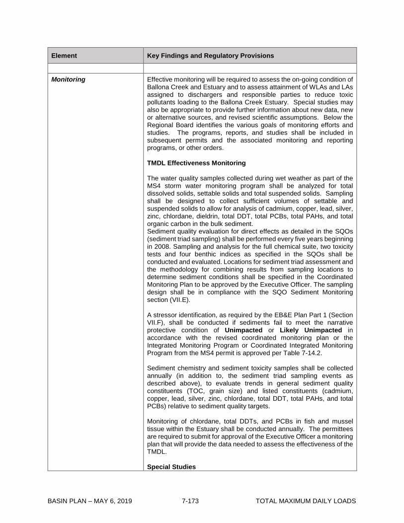
BASIN PLAN – MAY 6, 2019 7-173 TOTAL MAXIMUM DAILY LOADS
Element Key Findings and Regulatory Provisions
Monitoring
Effective monitoring will be required to assess the on-going condition of Ballona Creek and Estuary and to assess attainment of WLAs and LAs assigned to dischargers and responsible parties to reduce toxic pollutants loading to the Ballona Creek Estuary. Special studies may also be appropriate to provide further information about new data, new or alternative sources, and revised scientific assumptions. Below the Regional Board identifies the various goals of monitoring efforts and studies. The programs, reports, and studies shall be included in subsequent permits and the associated monitoring and reporting programs, or other orders. TMDL Effectiveness Monitoring The water quality samples collected during wet weather as part of the MS4 storm water monitoring program shall be analyzed for total dissolved solids, settable solids and total suspended solids. Sampling shall be designed to collect sufficient volumes of settable and suspended solids to allow for analysis of cadmium, copper, lead, silver, zinc, chlordane, dieldrin, total DDT, total PCBs, total PAHs, and total organic carbon in the bulk sediment. Sediment quality evaluation for direct effects as detailed in the SQOs (sediment triad sampling) shall be performed every five years beginning in 2008. Sampling and analysis for the full chemical suite, two toxicity tests and four benthic indices as specified in the SQOs shall be conducted and evaluated. Locations for sediment triad assessment and the methodology for combining results from sampling locations to determine sediment conditions shall be specified in the Coordinated Monitoring Plan to be approved by the Executive Officer. The sampling design shall be in compliance with the SQO Sediment Monitoring section (VII.E). A stressor identification, as required by the EB&E Plan Part 1 (Section VII.F), shall be conducted if sediments fail to meet the narrative protective condition of Unimpacted or Likely Unimpacted in accordance with the revised coordinated monitoring plan or the Integrated Monitoring Program or Coordinated Integrated Monitoring Program from the MS4 permit is approved per Table 7-14.2. Sediment chemistry and sediment toxicity samples shall be collected annually (in addition to, the sediment triad sampling events as described above), to evaluate trends in general sediment quality constituents (TOC, grain size) and listed constituents (cadmium, copper, lead, silver, zinc, chlordane, total DDT, total PAHs, and total PCBs) relative to sediment quality targets. Monitoring of chlordane, total DDTs, and PCBs in fish and mussel tissue within the Estuary shall be conducted annually. The permittees are required to submit for approval of the Executive Officer a monitoring plan that will provide the data needed to assess the effectiveness of the TMDL. Special Studies

BASIN PLAN – MAY 6, 2019 7-174 TOTAL MAXIMUM DAILY LOADS
Element Key Findings and Regulatory Provisions
Monitoring (con’t)
Special studies are recommended to refine source assessments, to provide better estimates of loading capacity, and to optimize implementation efforts. Special studies may include: • Evaluation and use of low detection level techniques to evaluate
water quality concentrations for those contaminants where standard detection limits cannot be used to assess compliance for CTR standards or are not sufficient for estimating source loadings from tributaries and storm water.
• Developing and implementing a monitoring program to collection the data necessary to apply a multiple lines of evidence approach.
• Evaluation and use of sediment stressor identification in compliance with the EB&E Plan Part 1 to evaluate causes of any recurring sediment toxicity.
• Evaluate partitioning coefficients between water column and sediment to assess the contribution of water column discharges to sediment concentrations in the Estuary.
• Studies to refine relationship between pollutants and suspended solids aimed at better understanding of the delivery of pollutants to the watershed.
• Studies to understand transport of sediments to the estuary, including the relationship between storm flows, sediment loadings to the estuary, and sediment deposition patterns within the estuary.
• Studies to evaluate effectiveness of BMPs to address pollutants and/or sediments.

BASIN PLAN – MAY 6, 2019 7-175 TOTAL MAXIMUM DAILY LOADS
Table 7-14.2 Ballona Creek Estuary Toxic Pollutants TMDL: Implementation Schedule Date Action
January 11, 2006 Regional Board permit writers shall incorporate the waste load allocations for sediment into the NPDES permits. Waste load allocations will be implemented through NPDES permit limits in accordance with the implementation schedule contained herein, at the time of permit issuance, renewal or re-opener.
Within 6 months after the effective date of the State Board adopted sediment quality objectives and implementation policy
The Regional Board will re-assess the numeric targets and waste load allocations for consistency with the State Board adopted sediment quality objectives.
January 11, 2011 Responsible jurisdictions and agencies shall provide to the Regional Board result of any special studies.
January 11, 2012 The Regional Board shall reconsider this TMDL to re-evaluate the waste load allocations and the implementation schedule.
MINOR NPDES PERMITS AND GENERAL NON-STORM WATER NPDES PERMITS
January 11, 2013 The non-storm water NPDES permits shall achieve the concentration-based waste load allocations for sediment per provisions allowed for in NPDES permits.
GENERAL INDUSTRIAL STORM WATER PERMIT
January 11, 2013 The general industrial storm water permits shall achieve the mass-based waste load allocations for sediment per provisions allowed for in NPDES permits.
GENERAL CONSTRUCTION STORM WATER PERMIT
January 11, 2015 The general construction storm water permits shall achieve the mass-based waste load allocations for sediment per provisions allowed for in NPDES permits.
MS4 AND CALTRANS STORM WATER PERMITS
January 11, 2007 In response to an order issued by the Executive Officer, the MS4 and Caltrans storm water NPDES permittees must submit a coordinated monitoring plan, to be approved by the Executive Officer, which includes both ambient monitoring and TMDL effectiveness monitoring. Once the coordinated monitoring plan is approved by the Executive Officer, ambient monitoring shall commence within 6 months.
June 11, 2015 Revise the coordinated monitoring plan or the Integrated Monitoring Program or Coordinated Integrated Monitoring Program prepared in compliance with the Los Angeles County MS4 permit.
January 11, 2011 (Draft Report) July 11, 2011 (Final Report)
The MS4 and Caltrans storm water NPDES permittees shall provide a written report to the Regional Board outlining how they will achieve the waste load allocations for sediment to Ballona Creek Estuary. The report shall include implementation methods, an implementation schedule, proposed milestones, and any applicable revisions to the TMDL effectiveness monitoring plan.

BASIN PLAN – MAY 6, 2019 7-176 TOTAL MAXIMUM DAILY LOADS
Date Action January 11, 2013 Compliance with the metals TMDLs may be demonstrated via any one
of three different means:
1. Demonstrate that the sediment quality condition of Unimpacted or Likely Unimpacted via the interpretation and integration of multiple lines of evidence as defined in the SQOs, is met; or
2. Sediment numeric targets are met in bed sediments; or
3. Interim allocations in the discharge are met, as described below:
The MS4 and Caltrans storm water NPDES permittees shall demonstrate that 25% of the total drainage area served by the MS4 is effectively meeting the waste load allocations for sediment.
Alternatively, permittees shall attain a 25% reduction in the difference between the baseline loadings and WLAs, as measured at the relevant existing MS4 permit monitoring location and/or at relevant MS4 monitoring stations identified in an approved coordinated monitoring plan. Compliance with sediment WLAs for Chlordane, total DDT, and total PCBs may be demonstrated via any one of three different means:
1. Sediment numeric targets are met in bed sediments.
2. Fish tissue targets are met in species resident to Ballona Creek Estuary.
3. Demonstrate that the sediment quality condition protective
of fish tissue is achieved per the Statewide Enclosed Bays and Estuaries Plan, as amended to address contaminants in resident finfish and wildlife.
4. Interim allocations in the discharge are met, as described below:
The MS4 and Caltrans storm water NPDES permittees shall demonstrate that 25% of the total drainage area served by the MS4 is effectively meeting the waste load allocations for sediment.
Alternatively, permittees shall attain a 25% reduction in the difference between the baseline loadings and WLAs, as measured at the relevant existing MS4 permit monitoring location and/or at relevant MS4 monitoring stations identified in an approved coordinated monitoring plan.
January 11, 2016 Compliance with the metals TMDLs may be demonstrated via any one of three different means:

BASIN PLAN – MAY 6, 2019 7-177 TOTAL MAXIMUM DAILY LOADS
Date Action
1. Demonstrate that the sediment quality condition of Unimpacted or Likely Unimpacted via the interpretation and integration of multiple lines of evidence as defined in the SQOs, is met; or
2. Sediment numeric targets are met in bed sediments; or
3. Interim allocations in the discharge are met, as described
below:
The MS4 and Caltrans storm water NPDES permittees shall demonstrate that 50% of the total drainage area served by the MS4 is effectively meeting the waste load allocations for sediment.
Alternatively, permittees shall attain a 50% reduction in the difference between the baseline loadings and WLAs, as measured at the relevant existing MS4 permit monitoring location and/or at relevant MS4 monitoring stations identified in an approved coordinated monitoring plan. Compliance with sediment WLAs for Chlordane, total DDT, and total PCBs may be demonstrated via any one of three different means:
1. Sediment numeric targets are met in bed sediments.
2. Fish tissue targets are met in species resident to Ballona Creek Estuary.
3. Demonstrate that the sediment quality condition protective
of fish tissue is achieved per the Statewide Enclosed Bays and Estuaries Plan, as amended to address contaminants in resident finfish and wildlife.
4. Interim allocations in the discharge are met, as described
below:
The MS4 and Caltrans storm water NPDES permittees shall demonstrate that 50% of the total drainage area served by the MS4 is effectively meeting the waste load allocations for DDT and chlordane. For PCBs, 25% of the total drainage area must meet the allocations required by the TMDL in effect in 20132. Alternatively, for DDT and chlordane, permittees shall attain a 50% reduction in the difference between the baseline loadings and WLAs, as measured at the relevant existing MS4 permit monitoring location and/or at relevant MS4 monitoring stations identified in an approved coordinated monitoring plan. For PCBs, a 25% reduction in loading of the TMDL in effect in 20132 shall be obtained.
2 In 2013, the PCB target was 22.7 µg/kg and the WLA for stormwater was 159 g/yr.

BASIN PLAN – MAY 6, 2019 7-178 TOTAL MAXIMUM DAILY LOADS
Date Action January 11, 2017 Compliance with the metals TMDLs may be demonstrated via any one
of three different means:
1. Demonstrate that the sediment quality condition of Unimpacted or Likely Unimpacted via the interpretation and integration of multiple lines of evidence as defined in the SQOs, is met; or
2. Sediment numeric targets are met in bed sediments; or
3. Interim allocations in the discharge are met, as described
below:
The MS4 and Caltrans storm water NPDES permittees shall demonstrate that 75% of the total drainage area served by the MS4 is effectively meeting the waste load allocations for sediment. Alternatively, permittees shall attain a 75% reduction in the difference between the baseline loadings and WLAs, as measured at the relevant existing MS4 permit monitoring location and/or at relevant MS4 monitoring stations identified in an approved coordinated monitoring plan.
Compliance with sediment WLAs for Chlordane, total DDT, and total PCBs may be demonstrated via any one of three different means:
1. Sediment numeric targets are met in bed sediments.
2. Fish tissue targets are met in species resident to Ballona Creek Estuary.
3. Demonstrate that the sediment quality condition protective
of fish tissue is achieved per the Statewide Enclosed Bays and Estuaries Plan, as amended to address contaminants in resident finfish and wildlife.
4. Interim allocations in the discharge are met, as described
below:
The MS4 and Caltrans storm water NPDES permittees shall demonstrate that 75% of the total drainage area served by the MS4 is effectively meeting the waste load allocations for Chlordane and DDT and for PCBs the MS4 and Caltrans storm water NPDES permittees shall demonstrate that 25% of the total drainage area is effectively meeting the waste load allocations. Alternatively, for DDT and Chlordane permittees shall attain a 75% reduction in the difference between the baseline loadings and WLAs, as measured at the relevant existing MS4 permit monitoring location and/or at relevant MS4 monitoring stations identified in an approved coordinated monitoring plan.

BASIN PLAN – MAY 6, 2019 7-179 TOTAL MAXIMUM DAILY LOADS
Date Action
March 23, 2018 The Regional Board shall reconsider the TMDL based upon new data, technical studies, and revisions to State or regional water quality control plans or policies.
January 11, 2021 Compliance with the metals TMDLs may be demonstrated via any one of three different means:
1. Demonstrate that the sediment quality condition of Unimpacted or Likely Unimpacted via the interpretation and integration of multiple lines of evidence as defined in the SQOs, is met; or
2. Sediment numeric targets are met in bed sediments; or
3. Final allocations in the discharge are met, as described
below:
The MS4 and Caltrans storm water NPDES permittees shall demonstrate that 100% of the total drainage area served by the MS4 is effectively meeting the waste load allocations for sediment. Alternatively, permittees shall attain a 100% reduction in the difference between the baseline loadings and WLAs, as measured at the relevant existing MS4 permit monitoring location and/or at relevant MS4 monitoring stations identified in an approved coordinated monitoring plan.
Compliance with sediment WLAs for Chlordane, total DDT, and total PCBs may be demonstrated via any one of three different means:
1. Sediment numeric targets are met in bed sediments.
2. Fish tissue targets are met in species resident to Ballona Creek Estuary.
3. Demonstrate that the sediment quality condition protective
of fish tissue is achieved per the Statewide Enclosed Bays and Estuaries Plan, as amended to address contaminants in resident finfish and wildlife.
4. Final allocations in the discharge are met, as described
below: The MS4 and Caltrans storm water NPDES permittees shall demonstrate that 100% of the total drainage area served by the MS4 is effectively meeting the waste load allocations for Chlordane and DDT and for PCBs the MS4 and Caltrans storm water NPDES permittees shall demonstrate that 50% of the total drainage area is effectively meeting the waste load allocations. Alternatively, for DDT and Chlordane, permittees shall attain a 100% reduction in the difference between the baseline

BASIN PLAN – MAY 6, 2019 7-180 TOTAL MAXIMUM DAILY LOADS
Date Action loadings and WLAs, as measured at the relevant existing MS4 permit monitoring location and/or at relevant MS4 monitoring stations identified in an approved coordinated monitoring plan and for PCBs permittees shall attain a 50% reduction in the difference between the baseline loadings and WLAs, as measured at the relevant existing MS4 permit monitoring location and/or at relevant MS4 monitoring stations identified in an approved coordinated monitoring plan.
January 11, 2025 Compliance with sediment WLAs total PCBs may be demonstrated via any one of three different means:
1. Sediment numeric targets are met in bed sediments.
2. Fish tissue targets are met in species resident to Ballona Creek Estuary.
3. Demonstrate that the sediment quality condition protective
of fish tissue is achieved per the Statewide Enclosed Bays and Estuaries Plan, as amended to address contaminants in resident finfish and wildlife.
4. Final allocations in the discharge are met, as described
below: The MS4 and Caltrans storm water NPDES permittees shall demonstrate that 100% of the total drainage area served by the MS4 is effectively meeting the waste load allocations for sediment. Alternatively, permittees shall attain a 100% reduction in the difference between the baseline loadings and WLAs, as measured at the relevant existing MS4 permit monitoring location and/or at relevant MS4 monitoring stations identified in an approved coordinated monitoring plan.
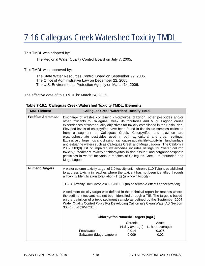
BASIN PLAN – MAY 6, 2019 7-181 TOTAL MAXIMUM DAILY LOADS
7-16 Calleguas Creek Watershed Toxicity TMDL This TMDL was adopted by:
The Regional Water Quality Control Board on July 7, 2005.
This TMDL was approved by:
The State Water Resources Control Board on September 22, 2005. The Office of Administrative Law on December 22, 2005. The U.S. Environmental Protection Agency on March 14, 2006.
The effective date of this TMDL is: March 24, 2006.
Table 7-16.1 Calleguas Creek Watershed Toxicity TMDL: Elements
TMDL Element Calleguas Creek Watershed Toxicity TMDL
Problem Statement Discharge of wastes containing chlorpyrifos, diazinon, other pesticides and/or other toxicants to Calleguas Creek, its tributaries and Mugu Lagoon cause exceedances of water quality objectives for toxicity established in the Basin Plan. Elevated levels of chlorpyrifos have been found in fish tissue samples collected from a segment of Calleguas Creek. Chlorpyrifos and diazinon are organophosphate pesticides used in both agricultural and urban settings. Excessive chlorpyrifos and diazinon can cause aquatic life toxicity in inland surface and estuarine waters such as Calleguas Creek and Mugu Lagoon. The California 2002 303(d) list of impaired waterbodies includes listings for “water column toxicity,” “sediment toxicity,” “chlorpyrifos in fish tissue,” and “organophosphate pesticides in water” for various reaches of Calleguas Creek, its tributaries and Mugu Lagoon.
Numeric Targets A water column toxicity target of 1.0 toxicity unit – chronic (1.0 TUc) is established to address toxicity in reaches where the toxicant has not been identified through a Toxicity Identification Evaluation (TIE) (unknown toxicity).
TUc = Toxicity Unit Chronic = 100/NOEC (no observable effects concentration)
A sediment toxicity target was defined in the technical report for reaches where the sediment toxicant has not been identified through a TIE. The target is based on the definition of a toxic sediment sample as defined by the September 2004 Water Quality Control Policy For Developing California’s Clean Water Act Section 303(d) List (SWRCB).
Chlorpyrifos Numeric Targets (ug/L) Chronic
(4 day average) Acute
(1 hour average) Freshwater 0.014 0.025 Saltwater (Mugu Lagoon) 0.009 0.02

BASIN PLAN – MAY 6, 2019 7-182 TOTAL MAXIMUM DAILY LOADS
TMDL Element Calleguas Creek Watershed Toxicity TMDL
Numeric Targets (con’t)
Diazinon Numeric Targets (ug/L) Chronic
(4 day average) Acute
(1 hour average) Freshwater 0.10 0.10 Saltwater (Mugu Lagoon) 0.40 0.82
Additionally, the diazinon criteria selected as numeric targets are currently under review by the USEPA. If water quality objectives become available, the Regional Board may reconsider this TMDL and revise the water toxicity numeric target.
Source Analysis Source analysis determined that agricultural and urban uses are the largest sources of chlorpyrifos and diazinon in the watershed. Urban use of diazinon and chlorpyrifos is unlikely to be a long-term source to the Calleguas Creek Watershed (CCW) as both of these pesticides have been banned for sale for non-agricultural uses on December 31, 2005 by federal regulation. As a result, the proportion of the loading from urban sources will likely decrease after December 2005.
Chlorpyrifos – Sources by Use
Dry Weather Wet Weather Agriculture 66% 80% Urban 23% 20% POTW 11% <1% Other <1% <1%
Diazinon – Sources by Use Dry Weather Wet Weather Agriculture 30% 1% Urban 13% 62% POTW 57% 37% Other <1% <1%
Linkage Analysis Water quality modeling established the linkage of sources of chlorpyrifos and diazinon in the CCW to observed water quality data. The linkage analysis qualitatively describes the connection between water column concentrations and sediment and fish tissue concentrations. The qualitative analysis demonstrates that the water column analysis conducted by laboratories implicitly includes sediment associated diazinon and chlorpyrifos loads transported to receiving waters as almost all water quality data do not differentiate between dissolved and particulate fractions. The linkage analysis assumes a reduction in water column concentrations will result in a reduction in fish tissue as chlorpyrifos in freshwater fish tissue rapidly depurate within several days of removal from exposure. Additionally, as chlorpyrifos preferentially binds to sediment the linkage analysis suggests that sediment concentrations of chlorpyrifos will need to decrease to achieve water quality numeric targets. The modeling approach reflects the uncertainty in current conditions and the potential impacts of watershed planning actions that may affect those conditions. A detailed description of the model is provided in an Attachment to the TMDL Technical Report.
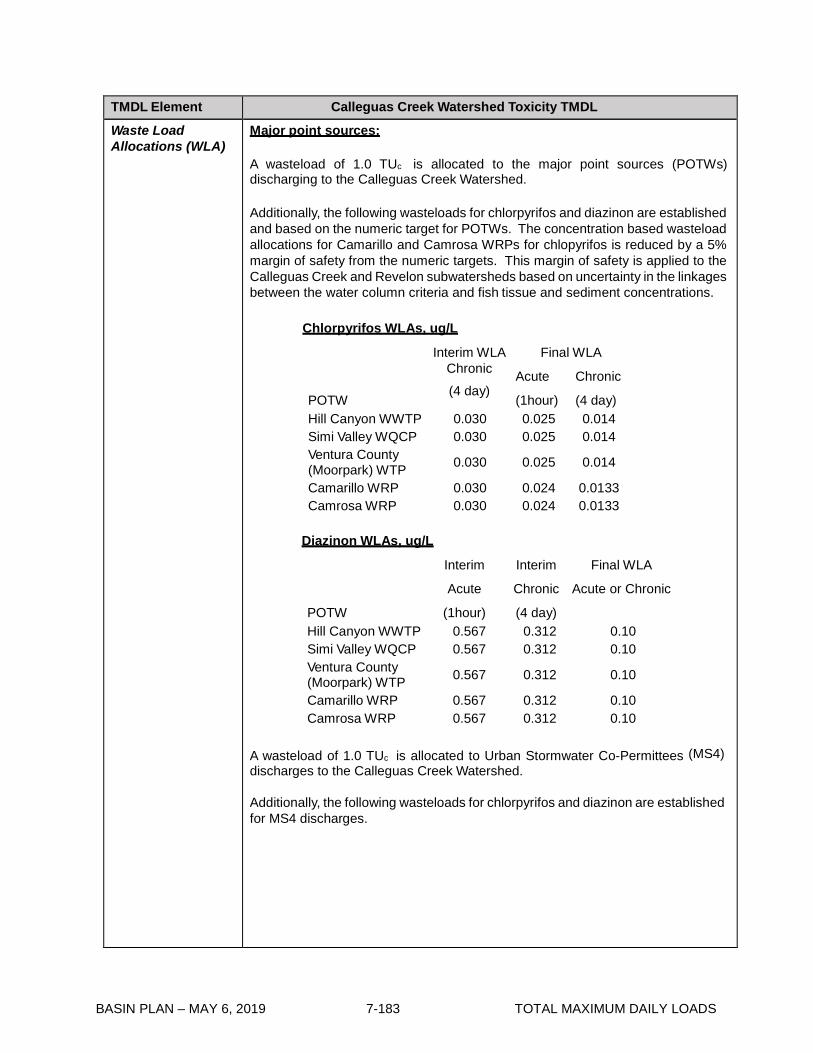
BASIN PLAN – MAY 6, 2019 7-183 TOTAL MAXIMUM DAILY LOADS
TMDL Element Calleguas Creek Watershed Toxicity TMDL
Waste Load Allocations (WLA)
Major point sources: A wasteload of 1.0 TUc is allocated to the major point sources (POTWs) discharging to the Calleguas Creek Watershed.
Additionally, the following wasteloads for chlorpyrifos and diazinon are established and based on the numeric target for POTWs. The concentration based wasteload allocations for Camarillo and Camrosa WRPs for chlopyrifos is reduced by a 5% margin of safety from the numeric targets. This margin of safety is applied to the Calleguas Creek and Revelon subwatersheds based on uncertainty in the linkages between the water column criteria and fish tissue and sediment concentrations.
Chlorpyrifos WLAs, ug/L
POTW
Interim WLA Chronic (4 day)
Final WLA
Acute Chronic
(1hour) (4 day) Hill Canyon WWTP 0.030 0.025 0.014 Simi Valley WQCP 0.030 0.025 0.014 Ventura County (Moorpark) WTP 0.030 0.025 0.014
Camarillo WRP 0.030 0.024 0.0133 Camrosa WRP 0.030 0.024 0.0133
Diazinon WLAs, ug/L
POTW
Interim Interim Final WLA
Acute Chronic Acute or Chronic
(1hour) (4 day) Hill Canyon WWTP 0.567 0.312 0.10 Simi Valley WQCP 0.567 0.312 0.10 Ventura County (Moorpark) WTP 0.567 0.312 0.10
Camarillo WRP 0.567 0.312 0.10 Camrosa WRP 0.567 0.312 0.10
A wasteload of 1.0 TUc is allocated to Urban Stormwater Co-Permittees (MS4) discharges to the Calleguas Creek Watershed.
Additionally, the following wasteloads for chlorpyrifos and diazinon are established for MS4 discharges.

BASIN PLAN – MAY 6, 2019 7-184 TOTAL MAXIMUM DAILY LOADS
TMDL Element Calleguas Creek Watershed Toxicity TMDL
Waste Load Allocations (WLA) (con’t)
Chlorpyrifos WLAs, ug/L
Interim WLA (4 day)
Final WLA (4 day)
0.45 0.014 Diazinon WLAs, ug/L
Interim WLA Acute (1 hour)
Interim WLA Chronic (4 day)
Final WLA Acute and Chronic
1.73 0.556 0.10 Minor point sources:
Minor sources include NPDES permittees other than POTWs, and Urban Stormwater Co-Permittees (MS4s) discharging to the Calleguas Creek Watershed.
A wasteload of 1.0 TUc is allocated to the minor point sources discharging to the Calleguas Creek Watershed.
Additionally, the following wasteloads for chlorpyrifos and diazinon are established. Chlorpyrifos WLAs, ug/L
Interim WLA Final WLA Chronic Acute Chronic (4 day) (1 hour) (4 day)
0.45 0.025 0.014 Diazinon WLAs, ug/L
Interim WLA Interim WLA Final WLA Acute Chronic Acute and Chronic
(1 hour) (4 day) 1.73 0.556 0.10

BASIN PLAN – MAY 6, 2019 7-185 TOTAL MAXIMUM DAILY LOADS
TMDL Element Calleguas Creek Watershed Toxicity TMDL
Load Allocations Non Point Source Dischargers: A load of 1.0 TUc is allocated to nonpoint sources discharging to the Calleguas Creek Watershed.
Additionally, the following loads for chlorpyrifos and diazinon are established and based on the numeric targets. These loads apply to dischargers in accordance with the subwatershed into which the dischargers discharge. The concentration based load allocations for the Calleguas Creek and Revelon subwatersheds for chlopyrifos is reduced by a 5% margin of safety from the numeric targets. This margin of safety is based on uncertainty in the linkages between the water column criteria and fish tissue and sediment concentrations.
Chlorpyrifos Load Allocations, ug/L
Subwatershed
Interim Interim Final Acute Chronic Acute Chronic
(1-hour) (4-day) (1-hour) (4-day) Arroyo Simi 2.57 0.810 0.025 0.014 Las Posas 2.57 0.810 0.025 0.014 Conejo 2.57 0.810 0.025 0.014 Calleguas 2.57 0.810 0.024 0.0133 Revolon 2.57 0.810 0.024 0.0133 Mugu Lagoon 2.57 0.810 0.025 0.014
Diazinon Load Allocations, ug/L
Interim LA Interim LA Final LA Acute Chronic Acute and Chronic
(1 hour) (4 day) 0.278 0.138 0.10
Margin of Safety In addition to the implicit margin of safety achieved by conservative assumptions and by using a concentration based TMDL, an explicit margin of safety of 5% has been added to the targets for chlorpyrifos in the Calleguas and Revolon subwatersheds and to the Camarillo and Camrosa WRPs to address uncertainty in the linkages between the water column criteria and fish tissue and sediment concentrations. The Calleguas and Revolon subwatersheds include those reaches listed for sediment toxicity and chlorpyrifos in fish tissue.
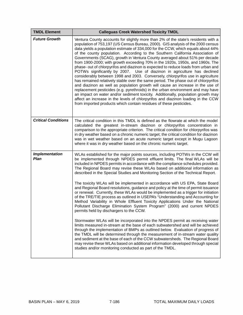
BASIN PLAN – MAY 6, 2019 7-186 TOTAL MAXIMUM DAILY LOADS
TMDL Element Calleguas Creek Watershed Toxicity TMDL
Future Growth Ventura County accounts for slightly more than 2% of the state’s residents with a population of 753,197 (US Census Bureau, 2000). GIS analysis of the 2000 census data yields a population estimate of 334,000 for the CCW, which equals about 44% of the county population. According to the Southern California Association of Governments (SCAG), growth in Ventura County averaged about 51% per decade from 1900-2000; with growth exceeding 70% in the 1920s, 1950s, and 1960s. The phase- out of chlorpyrifos and diazinon is expected to reduce loads from urban and POTWs significantly by 2007. Use of diazinon in agriculture has declined considerably between 1998 and 2003. Conversely, chlorpyrifos use in agriculture has remained relatively stable over the same period. The phase out of chlorpyrifos and diazinon as well as population growth will cause an increase in the use of replacement pesticides (e.g. pyrethroids) in the urban environment and may have an impact on water and/or sediment toxicity. Additionally, population growth may affect an increase in the levels of chlorpyrifos and diazinon loading in the CCW from imported products which contain residues of these pesticides.
Critical Conditions The critical condition in this TMDL is defined as the flowrate at which the model calculated the greatest in-stream diazinon or chlorpyrifos concentration in comparison to the appropriate criterion. The critical condition for chlorpyrifos was in dry weather based on a chronic numeric target; the critical condition for diazinon was in wet weather based on an acute numeric target except in Mugu Lagoon where it was in dry weather based on the chronic numeric target.
Implementation Plan
WLAs established for the major points sources, including POTWs in the CCW will be implemented through NPDES permit effluent limits. The final WLAs will be included in NPDES permits in accordance with the compliance schedules provided. The Regional Board may revise these WLAs based on additional information as described in the Special Studies and Monitoring Section of the Technical Report.
The toxicity WLAs will be implemented in accordance with US EPA, State Board and Regional Board resolutions, guidance and policy at the time of permit issuance or renewal. Currently, these WLAs would be implemented as a trigger for initiation of the TRE/TIE process as outlined in USEPA’s “Understanding and Accounting for Method Variability in Whole Effluent Toxicity Applications Under the National Pollutant Discharge Elimination System Program” (2000) and current NPDES permits held by dischargers to the CCW. Stormwater WLAs will be incorporated into the NPDES permit as receiving water limits measured in-stream at the base of each subwatershed and will be achieved through the implementation of BMPs as outlined below. Evaluation of progress of the TMDL will be determined through the measurement of in-stream water quality and sediment at the base of each of the CCW subwatersheds. The Regional Board may revise these WLAs based on additional information developed through special studies and/or monitoring conducted as part of the TMDL.

BASIN PLAN – MAY 6, 2019 7-187 TOTAL MAXIMUM DAILY LOADS
TMDL Element Calleguas Creek Watershed Toxicity TMDL
Implementation Plan (con’t)
As shown in Table 7-16.2 the following implementation actions will be taken by the MS4s discharging to the CCW and POTWs located in the CCW:
• Plan, develop, and implement an urban pesticides public education program; • Plan, develop, and implement urban pesticide education and chlorpyrifos and
diazinon collection program; • Study diazinon and chlorpyrifos replacement pesticides for use in the urban
environment; and, • Conduct environmental monitoring as outlined in the Monitoring Plan and
NPDES Permits. LAs for chlorpyrifos and diazinon will be implemented through the State’s Nonpoint Source Pollution Control Program (NPSPCP), nonpoint source pollution (i.e. Load Allocations). The LARWQCB is currently developing a Conditional Waiver for Irrigated Lands. Once adopted, the Conditional Waiver Program will implement allocations and attain numeric targets of this TMDL. Compliance with LAs will be measured at the monitoring sites approved by the Executive Officer of the Regional Board through the monitoring program developed as part of the Conditional Waiver, or through a monitoring program that is required by this TMDL.
The toxicity LAs will be implemented in accordance with US EPA, State Board and Regional Board resolutions, guidance and policy at the time of permit or waiver issuance or renewal.
The following implementation actions will be taken by agriculture dischargers
located in the CCW: • Enroll for coverage under a waiver of waste discharge requirements for
irrigated lands; • Implement monitoring required by this TMDL and the Conditional Waiver
program; • Complete studies to determine the most appropriate BMPs given crop type,
pesticide, site specific conditions, as well as the critical condition defined in the development of the LAs; and,
• Implement appropriate BMPs and monitor to evaluate effectiveness on in-stream water and sediment quality.
The Regional Board may revise this TMDL based on monitoring data and special studies of this TMDL. If the Regional Board revises NPDES permits or the Basin Plan to use other methods of evaluating toxicity or if other information supporting other methods becomes available, the Regional Board may reconsider this TMDL and revise the water toxicity numeric target. Additionally, the development of sediment quality guidelines or criteria and other water quality criteria revisions may call for the reevaluation of the TMDL. The Implementation Plan includes this provision for reevaluating the TMDL to consider sediment quality guidelines or criteria and revised water quality objectives and the results of implementation studies, if appropriate.

BASIN PLAN – MAY 6, 2019 7-188 TOTAL MAXIMUM DAILY LOADS
Table 7-16.2 Overall Implementation Schedule for Calleguas Creek Watershed Toxicity TMDL
Implementation Action Responsible Party Date
1 Interim chlorpyrifos and diazinon waste-load allocations apply.1
POTW permittees and MS4 Copermittees
Effective date2
2 Interim chlorpyrifos and diazinon load allocations apply.1
Agricultural Dischargers Effective date2
3 Finalize and submit workplan for integrated Calleguas Creek Watershed Monitoring Program for approval by the Regional Board Executive Officer. 3
POTW permittees, MS4 Copermittees, and Agricultural Dischargers
6 months after effective date of amendment2
4 Initiate Calleguas Creek Watershed Toxicity TMDL Monitoring Program developed under Task 3 workplan.
POTW permittees, MS4 Copermittees, and Agricultural Dischargers
6 months after E.O. approval of Monitoring Program (task 3) workplan.
5 Conduct Special Study #1-Investigate the pesticides that will replace diazinon and chlorpyrifos in the urban environment, their potential impact on receiving waters, and potential control measures.
POTW permittees and MS4 Copermittees
2 years after effective date2
6 Conduct Special Study #2 – Consider results of monitoring of sediment concentrations by source/land use type through special study required in Special Study #1 of the OC Pesticides, PCBs and siltation TMDL Implementation Plan. If the special study is not completed through the OC Pesticides, PCBs and Siltation TMDL no consideration is necessary3
Agricultural Dischargers3 and MS4 Copermittees
6 months after completion of CCW OC Pesticides, PCBs and Siltation TMDL sediment concentrations special study.2
7 Develop and implement collection program for diazinon and chlorpyrifos and an educational program. Collection and education could occur through existing programs such as household hazardous waste collection events
POTW permittees and MS4 Copermittees
3 years after effective date2
8 Develop an Agricultural Water Quality Management Plan in conjunction with the Conditional Waiver for Irrigated Lands, or (if the Conditional Waiver is not adopted in a timely manner) develop an Agricultural Water Quality Management Plan as part of the Calleguas Creek WMP.
Agricultural Dischargers3 3 years after effective date2
9 Identify the most appropriate BMPs given crop type, pesticide, site specific conditions, as well as the critical condition defined in the development of the LAs.
Agricultural Dischargers3 3 years after effective date2
10 Implement educational program on BMPs identified in the Agricultural Water Quality Management Plan.
Agricultural Dischargers 1 year after E.O. approval of Plan (Task 7)2

BASIN PLAN – MAY 6, 2019 7-189 TOTAL MAXIMUM DAILY LOADS
Implementation Action Responsible Party Date
11 Conduct Special Study #3-Calculation of sediment transport rates in CCW. Consider findings of transport rates developed through Special Study #1 of the OC Pesticides, PCBs and siltation TMDL Implementation Plan. If the special study is not completed through the OCs TMDL, no consideration is necessary.3
Agricultural Dischargers3 and MS4 Copermittees
6 months after completion of CCW OC Pesticides, PCBa and Siltation TMDL sediment transport special study.2
12 Begin implementation of BMPs. Agricultural Dischargers3 1 year after E.O. approval of Plan (Task 8)2
13 Evaluate effectiveness of BMPs. Agricultural Dischargers3 3 years after E.O. approval of Plan (Task 8)2
14 Reevaluate the TMDLs, interim or final WLAs and LAs, and implementation schedule based on monitoring data and on the results of Implementation Actions 1-13 and if sediment guidelines are promulgated, or water quality criteria are revised, and/or if targets are achieved without attainment of WLAs or LAs.
Stakeholders and Regional Board
2 years after the submittal of information necessary to reevaluate the TMDL
15 Achievement of Final WLAs POTW permittees and MS4 Copermittees
2 years after the effective date of the TMDL2
16 Achievement of Final LAs Agricultural Dischargers 10 years after the effective date of the TMDL2
1 Interim WLAs and LAs are effective immediately upon TMDL adoption. WLAs will be placed in POTW NPDES permits
as effluent limits. WLAs will be placed in stormwater NPDES permits as in-stream limits. LAs will be implemented using applicable regulatory mechanisms.
2 Effective date of this TMDL. 3 The Regional Board regulatory programs addressing all discharges in effect at the time an implementation task is due
may contain requirements substantially similar to the requirements of an implementation task. If such a requirement is in place in another regulatory program including other TMDLs, the Executive Officer may determine that such other requirements satisfy the requirements of an implementation task of the TMDL and thereby coordinate this TMDL implementation plan with other regulatory programs.

BASIN PLAN – MAY 6, 2019 7-190 TOTAL MAXIMUM DAILY LOADS
This page intentionally left blank

BASIN PLAN – MAY 6, 2019 7-191 TOTAL MAXIMUM DAILY LOADS
7-17 Calleguas Creek Organochlorine Pesticides, Polychlorinated Biphenyls, and Siltation TMDL This TMDL was adopted by:
The Regional Water Quality Control Board on July 7, 2005.
This TMDL was approved by:
The State Water Resources Control Board on September 22, 2005. The Office of Administrative Law on January 20, 2006. The U.S. Environmental Protection Agency on March 14, 2006.
The effective date of this TMDL is: March 24, 2006.
The following table includes the elements of the TMDL:
Table 7-17.1. Calleguas Creek Watershed OC Pesticides, PCBs, and Siltation TMDL: Elements
TMDL Element Calleguas Creek Watershed OC Pesticide, PCBs, and Siltation TMDL
Problem Statement
Eleven of fourteen reaches in the Calleguas Creek Watershed (CCW) were identified on the 2002 303(d) list of water-quality limited segments as impaired due to elevated levels of organochlorine (OC) pesticides and/or polychlorinated biphenyls (PCBs) in water, sediment, and/or fish tissue. Additionally, Mugu Lagoon was listed as impaired for sedimentation/siltation. OC pesticides and PCBs can bioaccumulate in fish tissue and cause toxicity to aquatic life in estuarine and inland waters. Siltation may transport OC Pesticides and PCBs to surface waters and impair aquatic life and wildlife habitats.
TMDL Element Calleguas Creek Watershed OC Pesticide, PCBs, and Siltation TMDL

BASIN PLAN – MAY 6, 2019 7-192 TOTAL MAXIMUM DAILY LOADS
Numeric Targets
The following tables provide the targets for water, fish tissue, and sediment for this TMDL. Water column targets were derived from the California Toxic Rule (CTR) water quality criteria for protection of aquatic life. Chronic criteria (Criteria Continuous Concentration, or CCC) were applied unless otherwise noted in the table below:
Water Quality Targets (ng/L)1 Constituent Freshwater Marine2 Aldrin 300.0 130.0 Chlordane 4.3 4.0 Dacthal 3,500,000.0 (a)3
4,4’-DDD4 (a)3 (a)3
4,4’-DDE5 (a)3 (a)3
4,4’-DDT6 1.0 1.0 Dieldrin 56.0 1.9 Endosulfan I 56.0 8.7 Endosulfan II 56.0 8.7 Endrin 36.0 2.3 HCH (alpha-BHC7) (a)3 (a)3 HCH (beta-BHC) (a)3 (a)3 HCH (delta-BHC) (a)3 (a)3 HCH (gamma BHC) 950.0 160.0 Heptachlor 3.8 3.6 Heptachlor Epoxide 3.8 3.6 PCBs 140.08 30.0 Toxaphene 0.2 0.2
1 ng/L: nanogram per litter 2 Marine numeric targets applied to Mugu Lagoon 3 Numeric targets have not been established for these constituents 4 DDD: Dichlorodiphenyldichloroethane 5 DDE: Dichlorodiphenyldichloroethylene 6 DDT: Dichlorodiphenyltrichloroethane 7 BHC: Hexachlorocyclohexane 8 Applies to sum of all congener or isomer or homolog or Aroclor analyses

BASIN PLAN – MAY 6, 2019 7-193 TOTAL MAXIMUM DAILY LOADS
TMDL Element Calleguas Creek Watershed OC Pesticide, PCBs, and Siltation TMDL
Numeric Targets (con’t)
Fish tissue targets are derived from CTR human health criteria for consumption of organisms.
Fish Tissue Targets (ng/Kg) Constituent Aldrin 50.0 Chlordane 830.0 Dacthal (a)9 4,4’-DDD 45,000.0 4,4’-DDE 32,000.0 4,4’-DDT 32,000.0 Dieldrin 650.0 Endosulfan I 65,000,000.0 Endosulfan II 65,000,000.0 Endrin 3,200,000.0 HCH (alpha-BHC) 1,700.00 HCH (beta-BHC) 6,000.0 HCH (delta-BHC) (a)9 HCH (gamma BHC) 8,200. Heptachlor 2,400.0 Heptachlor Epoxide 1,200.0 PCBs 5,300.010 Toxaphene 9,800.0
9 Numeric targets have not been established for these constituents 10 Applies to sum of all congener or isomer or homolog or Aroclor analyses

BASIN PLAN – MAY 6, 2019 7-194 TOTAL MAXIMUM DAILY LOADS
TMDL Element Calleguas Creek Watershed OC Pesticide, PCBs, and Siltation TMDL
Numeric Targets (con’t)
Sediment targets were derived from sediment quality guidelines contained in National Oceanographic and Atmospheric Administration (NOAA) Screening Quick Reference Tables (SQuiRT, Buchman, 1999).
Sediment Quality Targets (ng/dry Kg) Constituent Freshwater, TEL11 Marine12, ERL13
Aldrin (a)9 (a)9
Chlordane 4,500.0 500.0
Dacthal (a)9 (a)9
4,4’-DDD 3,500.0 2,000.0
4,4’-DDE 1,400.0 2,200.0
4,4’-DDT (a)9 1,000.0
Dieldrin 2,900.0 20.0
Endosulfan I (a)9 (a)9
Endosulfan II (a)9 (a)9
Endrin 2,700.0 (a)9
HCH (alpha-BHC) (a)9 (a)9
HCH (beta-BHC) (a)9 (a)9
HCH (delta-BHC) (a)9 (a)9
HCH (gamma BHC) 940.0 (a)9
Heptachlor (a)9 (a)9
Heptachlor Epoxide 600.0 (a)9
PCBs 34,000.010 23,000.0
Toxaphene (a)9 (a)9
9 Numeric targets have not been established for these constituents 10 Applies to sum of all congener or isomer or homolog or Aroclor analyses 11 TEL = Threshold Effects Level 12 Marine numeric targets applied to Mugu Lagoon 13 ERL = Effects Range-Low.
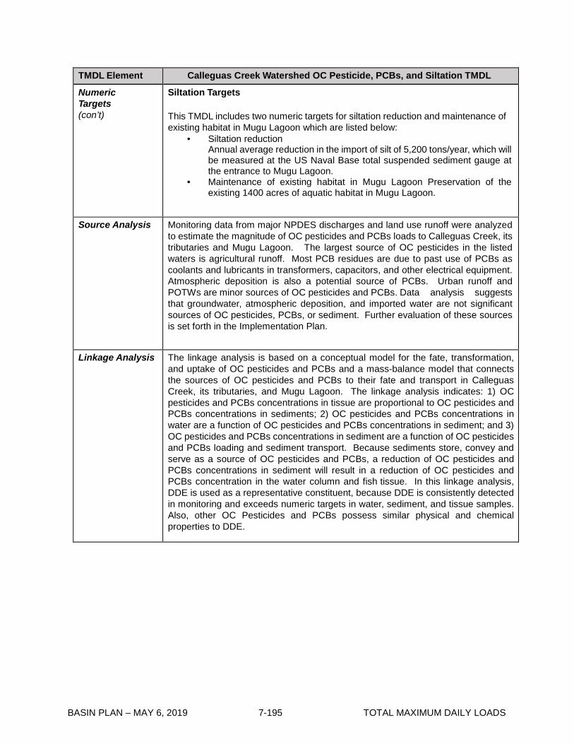
BASIN PLAN – MAY 6, 2019 7-195 TOTAL MAXIMUM DAILY LOADS
TMDL Element Calleguas Creek Watershed OC Pesticide, PCBs, and Siltation TMDL
Numeric Targets (con’t)
Siltation Targets This TMDL includes two numeric targets for siltation reduction and maintenance of existing habitat in Mugu Lagoon which are listed below:
• Siltation reduction Annual average reduction in the import of silt of 5,200 tons/year, which will be measured at the US Naval Base total suspended sediment gauge at the entrance to Mugu Lagoon.
• Maintenance of existing habitat in Mugu Lagoon Preservation of the existing 1400 acres of aquatic habitat in Mugu Lagoon.
Source Analysis Monitoring data from major NPDES discharges and land use runoff were analyzed to estimate the magnitude of OC pesticides and PCBs loads to Calleguas Creek, its tributaries and Mugu Lagoon. The largest source of OC pesticides in the listed waters is agricultural runoff. Most PCB residues are due to past use of PCBs as coolants and lubricants in transformers, capacitors, and other electrical equipment. Atmospheric deposition is also a potential source of PCBs. Urban runoff and POTWs are minor sources of OC pesticides and PCBs. Data analysis suggests that groundwater, atmospheric deposition, and imported water are not significant sources of OC pesticides, PCBs, or sediment. Further evaluation of these sources is set forth in the Implementation Plan.
Linkage Analysis The linkage analysis is based on a conceptual model for the fate, transformation, and uptake of OC pesticides and PCBs and a mass-balance model that connects the sources of OC pesticides and PCBs to their fate and transport in Calleguas Creek, its tributaries, and Mugu Lagoon. The linkage analysis indicates: 1) OC pesticides and PCBs concentrations in tissue are proportional to OC pesticides and PCBs concentrations in sediments; 2) OC pesticides and PCBs concentrations in water are a function of OC pesticides and PCBs concentrations in sediment; and 3) OC pesticides and PCBs concentrations in sediment are a function of OC pesticides and PCBs loading and sediment transport. Because sediments store, convey and serve as a source of OC pesticides and PCBs, a reduction of OC pesticides and PCBs concentrations in sediment will result in a reduction of OC pesticides and PCBs concentration in the water column and fish tissue. In this linkage analysis, DDE is used as a representative constituent, because DDE is consistently detected in monitoring and exceeds numeric targets in water, sediment, and tissue samples. Also, other OC Pesticides and PCBs possess similar physical and chemical properties to DDE.

BASIN PLAN – MAY 6, 2019 7-196 TOTAL MAXIMUM DAILY LOADS
TMDL Element Calleguas Creek Watershed OC Pesticide, PCBs, and Siltation TMDL
Waste Load Allocations
1. Interim and Final WLAs* for Pollutants in Effluent for POTWs.
The interim wasteload allocations for POTWs will be re-considered by the Regional Board on a 5-year basis. This re-consideration will be based on sufficient data to calculate Interim Wasteload Allocations in accordance with SIP procedures.
a) Interim WLAs (ng/L)
Constituent POTW Hill Canyon Simi Valley Moorpark Camarillo Camrosa Daily Daily Daily Daily Daily
Chlordane 1.2 100.0 100.0 100.0 100.0 4,4-DDD 20.0 50.0 50.0 6.0 50.0 4,4- DDE 260.0 1.2 1.2 188.0 50.0 4,4-DDT 10.0 10.0 10.0 10.0 10.0 Dieldrin 10.0 10.0 10.0 10.0 10.0 PCBs 500.0 500.0 500.0 31.0 500.0
Toxaphene 500.0 500.0 500.0 500.0 500.0 * WLAs shall be applied to POTWs’effluent
b) Final WLAs (ng/L)
POTW
Constituent Hill Canyon Simi Valley Moorpark Camarillo Camrosa
Daily Monthly Daily Monthly Daily Monthly Daily Monthly Daily Monthly
Chlordane 1.2 0.59 1.2 0.59 1.2 0.59 1.2 0.59 1.2 0.59
4,4-DDD 1.7 0.84 1.7 0.84 1.7 0.84 1.7 0.84 1.7 0.84
4,4- DDE 1.2 0.59 1.2 0.59 1.2 0.59 1.2 0.59 1.2 0.59
4,4-DDT 1.2 0.59 1.2 0.59 1.2 0.59 1.2 0.59 1.2 0.59
Dieldrin 0.28 0.14 0.28 0.14 0.28 0.14 0.28 0.14 0.28 0.14
PCBs 0.34 0.17 0.34 0.17 0.34 0.17 0.34 0.17 0.34 0.17
Toxaphene 0.33 0.33 0.16 0.33 0.16 0.33 0.16 0.33 0.16 0.33 0.16
The final WLAs will be included in NPDES permits in accordance with schedule in the implementation plan. The Regional Board may revise final WLAs prior to the dates they are placed into permits and/or prior to the dates of final WLA achievement based on special studies and monitoring of this TMDL.

BASIN PLAN – MAY 6, 2019 7-197 TOTAL MAXIMUM DAILY LOADS
TMDL Element Calleguas Creek Watershed OC Pesticide, PCBs, and Siltation TMDL
Waste Load Allocations (con’t)
2. Interim and Final WLAs for Pollutants in Sediment for Stormwater Permittees
a) Interim WLAs (ng/g) Constituent Subwatershed
Mugu Lagoon1
Calleguas Creek
Revolon Slough
Arroyo Las Posas
Arroyo Simi
Conejo Creek
Chlordane 25.0 17.0 48.0 3.3 3.3 3.4 4,4-DDD 69.0 66.0 400.0 290.0 14.0 5.3 4,4- DDE 300.0 470.0 1,600.0 950.0 170.0 20.0 4,4-DDT 39.0 110.0 690.0 670.0 25.0 2.0 Dieldrin 19.0 3.0 5.7 1.1 1.1 3.0 PCBs 180.0 3,800.0 7,600.0 25,700.0 25,700.0 3,800.0 Toxaphene 22,900.0 260.0 790.0 230.0 230.0 260.0
Compliance with sediment based WLAs is measured as an in-stream annual average at the base of each subwatershed where the discharges are located. b) Final WLAs (ng/g) Constituent Subwatershed Mugu
Lagoon1 Calleguas
Creek Revolon Slough
Arroyo Las Posas
Arroyo Simi
Conejo Creek
Chlordane 3.3 3.3 0.9 3.3 3.3 3.3 4,4-DDD 2.0 2.0 2.0 2.0 2.0 2.0 4,4- DDE 2.2 1.4 1.4 1.4 1.4 1.4 4,4-DDT 0.3 0.3 0.3 0.3 0.3 0.3 Dieldrin 4.3 0.2 0.1 0.2 0.2 0.2 PCBs 180.0 120.0 130.0 120.0 120.0 120.0 Toxaphene 360.0 0.6 1.0 0.6 0.6 0.6
1 The Mugu Lagoon subwatershed includes Duck Pond/Agricultural Drain/Mugu/Oxnard Drain #2. Compliance with sediment based WLAs is measured as an in-stream annual average at the base of each subwatershed where the discharges are located. 3. Final WLAs for Pollutants in Water Column for Minor Point Sources WLAs for pollutants in water column are allocated below to minor point sources enrolled under NPDES permits or WDRs, which discharge to Calleguas Creek.
Constituent Daily Maximum (ng/L) Monthly Average (ng/L) Chlordane 1.2 0.59 4,4-DDD 1.7 0.84 4,4- DDE 1.2 0.59 4,4-DDT 1.2 0.59 Dieldrin 0.28 0.14 PCBs 0.34 0.17
Toxaphene 0.33 0.16 4. Siltation WLA for MS4
MS4 dischargers will receive an allocation of 2,496-tons/yr. reduction in sediment yield to Mugu Lagoon. The baseline from which the load reduction will be evaluated will be determined by a special study of this TMDL. The load allocation will apply after the baseline is established, as described in the Implementation Plan.

BASIN PLAN – MAY 6, 2019 7-198 TOTAL MAXIMUM DAILY LOADS
TMDL Element Calleguas Creek Watershed OC Pesticide, PCBs, and Siltation TMDL
Load Allocations Compliance with sediment based LAs listed below is measured as an in-stream annual average at the base of each subwatershed. 1. Interim and Final Load Allocations a) Interim Sediment LAs (ng/g) Constituent Subwatershed
Mugu Lagoon1
Calleguas Creek
Revolon Slough
Arroyo Las Posas
Arroyo Simi
Conejo Creek
Chlordane 25.0 17.0 48.0 3.3 3.3 3.4 4,4-DDD 69.0 66.0 400.0 290.0 14.0 5.3 4,4- DDE 300.0 470.0 1,600.0 950.0 170.0 20.0 4,4-DDT 39.0 110.0 690.0 670.0 25.0 2.0 Dieldrin 19.0 3.0 5.7 1.1 1.1 3.0 PCBs 180.0 3,800.0 7,600.0 25,700.0 25,700.0 3,800.0 Toxaphene 22,900.0 260.0 790.0 230.0 230.0 260.0
1 The Mugu Lagoon subwatershed includes Duck Pond/Agricultural Drain/Mugu/Oxnard Drain #2.
b) Final Sediment LAs (ng/g) Constituent Subwatershed Mugu
Lagoon1 Calleguas
Creek Revolon Slough
Arroyo Las Posas
Arroyo Simi
Conejo Creek
Chlordane 3.3 3.3 0.9 3.3 3.3 3.3 4,4-DDD 2.0 2.0 2.0 2.0 2.0 2.0 4,4- DDE 2.2 1.4 1.4 1.4 1.4 1.4 4,4-DDT 0.3 0.3 0.3 0.3 0.3 0.3 Dieldrin 4.3 0.2 0.1 0.2 0.2 0.2 PCBs 180.0 120.0 130.0 120.0 120.0 120.0 Toxaphene 360.0 0.6 1.0 0.6 0.6 0.6
1 The Mugu Lagoon subwatershed includes Duck Pond/Agricultural Drain/Mugu/Oxnard Drain #2.
2. Siltation LAs Agricultural dischargers will receive an allocation of 2,704 tons/yr. Reduction in sediment yield to Mugu Lagoon. The baseline from which the load reduction will be evaluated will be determined by a special study of this TMDL. The load allocation will apply after the baseline is established, as described in the Implementation Plan.
Margin of Safety This TMDL relies on an implicit margin of safety, by incorporating conservative assumptions throughout its development, including:
• Basing percent reductions on the historical data set of water and fish tissue concentrations, which does not reflect the effects of attenuation the over the past ten years.
• Determining the percent reduction in sediment, by basing it on the greater percent reduction of either water or fish tissue concentrations based on available data.
• Reducing the allowable concentration for upstream subwatersheds, to ensure protection of those subwatersheds downstream from upstream inputs.

BASIN PLAN – MAY 6, 2019 7-199 TOTAL MAXIMUM DAILY LOADS
TMDL Element Calleguas Creek Watershed OC Pesticide, PCBs, and Siltation TMDL
Margin of Safety (con’t)
Choosing Threshold Effects Levels (TELs) and Effects Range Lows
(ERLs) as numeric targets for sediment, which are the most protective
applicable sediment guidelines.
8. Selecting the more stringent of the allowable concentration (as calculated by percent reduction methodology) or the numeric target for sediment (TEL or ERL),
Future Growth Ventura County accounts for slightly more than 2% of the state’s residents with a population of 753,197 (US Census Bureau, 2000). GIS analysis of the 2000 census data yields a population estimate of 334,000 for the CCW, which equals about 44% of the county population. According to the Southern California Association of Governments (SCAG), growth in Ventura County averaged about 51% per decade from 1900-2000; with growth exceeding 70% in the 1920s, 1950s, and 1960s. Significant population growth is expected to occur within and near present city limits until at least 2020. Since most of the listed OCs and PCBs in the CCW are banned, this growth is not expected to increase current loads. Urban application of those OC pesticides which are still legal (dacthal and endosulfan) may increase, but overall use may decrease because urban expansion tends to reduce total acreage of agricultural land.
Population growth may result in greater OC loading to POTW influent from washing food products containing OC residues. This loading may be proportional to the increase in population, if per capita domestic water use and pesticide load per household remain constant. Increased flow from POTWs should not result in impairment of the CCW as long as effluent concentration standards are met for each POTW.
As urban development occurs, construction activities may have a range of effects on OC loading to the CCW. Exposure of previously vegetated or deeply buried soil might lead to increased rates of transportation and volatilization. Conversely, urbanization of open space and/or agriculture areas may cover OC pesticides bound to sediments.
Future growth in the CCW may result in increased groundwater concentrations of currently used OC pesticides. This is a potential concern for dacthal, which is still used and has been found in groundwater (although current levels of dacthal are significantly lower than all available targets). The effects of future growth upon PCB loads are unknown, but not likely to prove significant, since atmospheric deposition and accidental spills are the primary loading pathways. Any increase in OCs due to population growth may be offset by decreased inputs from banned OCs, as their presence attenuates due to fate and transport processes.
Critical Conditions
The linkage analysis found correlation between concentrations of OC pesticides and PCBs in water and total suspended solids (TSS), and a potential correlation between OC pesticides and PCBs concentrations in water and seasonality (wet vs. dry season). A similar correlation between sediment loading and wet weather is also noted.

BASIN PLAN – MAY 6, 2019 7-200 TOTAL MAXIMUM DAILY LOADS
TMDL Element Calleguas Creek Watershed OC Pesticide, PCBs, and Siltation TMDL
Critical Conditions (con’t)
OC pesticides and PCB pollutants are of potential concern in the Calleguas Creek Watershed due to possible long-term loading and food chain bioaccumulation effects. There is no evidence of short-term effects. However, pollutant loads and transport within the watershed may vary under different flow and runoff conditions. Therefore the TMDLs consider seasonal variations in loads and flows but are established in a manner which accounts for the longer time horizon in which ecological effects may occur. Wet weather events, which may occur at any time of the year, produce extensive sediment redistribution and transport downstream. This would be considered the critical condition for loading. However, the effects of organochlorine compounds are manifested over long time periods in response to bioaccumulation in the food chain. Therefore, short-term loading variations (within the time scale of wet and dry seasons each year) are not likely to cause significant variations in beneficial use effects. Therefore, although seasonal variations in loads and flows were considered, the TMDL was established in a manner which accounts for the longer time horizon in which ecological effects may occur
Implementation Plan
The final WLAs will be included in NPDES permits in accordance with the compliance schedules provided in Table 7-17.2. The Regional Board may revise these WLAs based on additional information developed through Special Studies and/or Monitoring of this TMDL.
WLAs established for the five major POTWs in this TMDL will be implemented through NPDES permit limits. The proposed permit limits will be applied as end-of-pipe concentration-based effluent limits for POTWs. Compliance will be determined through monitoring of final effluent discharge as defined in the NPDES permit. The implementation plan for POTWs focuses on implementation of source control activities. Consideration of annual averaging of compliance data will be evaluated at the time of permit renewal based on available information, Regional Board policies, and US EPA approval. In accordance with current practice, a group concentration-based WLA has been developed for MS4s, including the Caltrans MS4. The grouped allocation will apply to all NPDES-regulated municipal stormwater discharges in the CCW. Other NPDES-regulated stormwater permittees will be assigned a concentration-based WLA consistent with the interim and final WLAs set forth above. Stormwater WLAs will be incorporated into the NPDES permit as receiving water limits measured at the downstream points of each subwatershed and are expected to be achieved through the implementation of BMPs as outlined in the implementation plan.
The Regional Board will need to ensure that permit conditions are consistent with the assumptions of the WLAs. If BMPs are to be used, the Regional Board will need to detail its findings and conclusions supporting the use of BMPs in the NPDES permit fact sheets. Should federal, state, or regional guidance or practice for implementing WLAs into permits be revised, the Regional Board may reevaluated the TMDL to incorporate such guidance. LAs will be implemented through the State’s Nonpoint Source Pollution Control Program (NPSPCP). The LARWQCB is developing a Conditional Waiver for Irrigated Lands, which includes monitoring at sites subject to approval by the Executive Officer of the Regional Board. Should adoption of the Conditional Waiver be delayed, monitoring will be required as part of this TMDL.

BASIN PLAN – MAY 6, 2019 7-201 TOTAL MAXIMUM DAILY LOADS
TMDL Element Calleguas Creek Watershed OC Pesticide, PCBs, and Siltation TMDL
Implementation Plan (con’t)
Studies are currently being conducted to assess the effectiveness of BMPs for reduction of pollutants from agricultural operations. Results will be used to develop Agricultural Water Quality Management Plans, including the implementation of agricultural BMPs. Additionally, an agricultural education program will be developed to inform growers of the recommended BMPs and the Management Plan. As shown in Table 7-17.2, implementation actions will be taken by agricultural dischargers located in the CCW. The implementation of agricultural BMPs will be based on a comprehensive approach to address pollutant loads discharged from agricultural operations. The Regional Board may revise these LAs based on the collection of additional information developed through special studies and/or monitoring conducted as part of this TMDL.
A number of provisions in this TMDL might provide information that could result in revisions to the TMDL. Additionally, the development of sediment quality criteria and other water quality criteria revisions may require the reevaluation of this TMDL. Finally, the use of OC pesticides in other countries which may be present in imported food products, compounded with the persistence of OC pesticides and PCBs in the environment, indicate that efforts to control sources and transport of OCs to receiving waters may not result in attainment of targets and allocations due to activities that are outside the control of local agencies and agriculture. For these reasons, the Implementation Plan includes this provision for reevaluating the TMDL to consider revised water quality objectives and the results of implementation studies, if appropriate. The siltation portion of the TMDL includes wasteload and load allocations set as an annual mass reduction from a baseline value of sediment and silt deposited in Mugu Lagoon. The baseline value of sediment and silt conveyed to Mugu Lagoon is to be determined by a TMDL Special Study and established by the Regional Board through an amendment to the TMDL. The Special Study is eight years in duration to ensure that the full range of current conditions that affect loading of sediment and siltation to Mugu Lagoon are considered. If appropriate, the Special Study may also result in a revision to the mass load reduction. The Special Study will be overseen by a Science Advisory Panel consisting of local, regional, and/or national experts in estuarine habitat biology, hydrology, and engineering. At the conclusion of the special study, the Regional Board will reconsider the TMDL to establish sustainable wasteload and load allocations recommended by the Special Study to support aquatic life and wetland habitat beneficial uses.
In implementing this TMDL, staff recognize that dischargers may be implementing management measures and management practices to reduce sediment and Siltation loads through permit and waiver programs during the special studies. Further, since the effective date of the Consent Decree, reaches of Calleguas Creek have been listed due to sediment, and another TMDL may be initiated during the Special Study of this TMDL. Staff’s intent is to coordinate the requirements of this TMDL with other programs that reduce sedimentation and siltation. The Special Study can consider sediment and silt load reductions through existing permits and the forthcoming conditional waiver for irrigated lands. Load and wasteload allocations become effective after the Regional Board actions based on the Special Study, nine years after the effective date of the TMDL.

BASIN PLAN – MAY 6, 2019 7-202 TOTAL MAXIMUM DAILY LOADS
Table 7-17.2 Calleguas Creek Watershed OC Pesticides, PCBs, and Siltation TMDL: Implementation Schedule
Item
Implementation Action 1
Responsible Party
Completion Date
1 Interim organochlorine pesticide and polychlorinated biphenyls wasteload allocations apply.
NPDES Permittees Effective date of the amendment
2 Interim organochlorine pesticide and polychlorinated biphenyls load allocations apply.
Agricultural Dischargers
Effective date of the amendment
3 Finalize and submit workplan for organochlorine pesticide and polychlorinated biphenyls TMDL monitoring, or finalize and submit a workplan for an Integrated Calleguas Creek Watershed organochlorine pesticide and polychlorinated biphenyls Monitoring Program for approval by the Executive Officer. The monitoring workplan will include, but not be limited to, appropriate water, biota, and sediment loading and monitoring to verify attainment of targets and protection of beneficial uses.
POTW Permittees, MS4 Permittees, Agricultural Dischargers, US Navy
6 months after effective date of the amendment
4 Initiate Calleguas Creek Watershed organochlorine pesticide, polychlorinated biphenyls, and siltation Monitoring Program developed under the Task 3 workplan approved by the Executive Officer.
POTW Permittees, MS4 Permittees, Agricultural Dischargers, US Navy
6 months after Executive Officer approval of Monitoring Program (Task 3) workplan
5 Submit a workplan for approval by the Executive Officer to identify urban, industrial and domestic sources of organochlorine pesticides and polychlorinated biphenyls and control methods and to implement a collection and disposal program for organochlorine pesticides and polychlorinated biphenyls .
POTW Permittees, MS4 Permittees, US Navy
1 year after effective date of the amendment
6 Submit a workplan for approval by the Executive Officer to identify agricultural sources and methods to implement a collection and disposal program for organochlorine pesticides and polychlorinated biphenyls.
Agricultural Dischargers
1 year after effective date of the amendment

BASIN PLAN – MAY 6, 2019 7-203 TOTAL MAXIMUM DAILY LOADS
Item
Implementation Action 1
Responsible Party
Completion Date
7 Special Study #1 – Submit a workplan and convene a Science Advisory Panel to quantify sedimentation in Mugu Lagoon and sediment transport throughout the Calleguas Creek Watershed. Evaluate management methods to control siltation and contaminated sediment transport to Calleguas Creek, identify appropriate BMPs to reduce sediment loadings, evaluate numeric targets and wasteload and load allocations for siltation/sedimentation to support habitat related beneficial uses in Mugu Lagoon, evaluate the effect of sediment on habitat preservation in Mugu Lagoon, and evaluate appropriate habitat baseline, effectiveness of sediment and siltation load allocations on a subwatershed basis, and methods to restore habitat for approval by the Executive Officer. Additionally, this special study will evaluate the concentration of organochlorine pesticides and polychlorinated biphenyls in sediments from various sources/land use types. 2
POTW Permittees, MS4 Permittees, Agricultural Discharges, and US Navy
1 year after effective date of the amendment
8 Special study #2 – Conduct a study to identify land areas with high organochlorine pesticide and polychlorinated biphenyls concentrations, and submit a workplan including milestones and an implementation period that is as short as possible, but not to exceed 6 years, for removal to mitigate the effects of flood control practices on organochlorine pesticides, polychlorinated biphenyls, and sediment loadings to Calleguas Creek waterbodies from any high concentration areas identified. Milestones shall include proposed percentages of reductions achieved by removal. Such practices include but are not limited to management of agricultural runoff, sediment reduction practices and structures, streambank stabilization, and other projects related to stormwater conveyance and flood control improvements in the Calleguas Creek watershed. 2
Agricultural Dischargers, MS4 Permittees, US Navy
1 years after effective date of the amendment
9 Develop an Agricultural Water Quality Management Plan in consideration of the forthcoming Conditional Waiver for Irrigated Lands, or, if the Conditional Waiver for Irrigated Lands is not adopted in a timely manner, develop an Agricultural Water Quality Management Plan as part of the Calleguas Creek WMP. Implement an educational program on BMPs identified in the Agricultural Water Quality Management Plan.
Agricultural Dischargers
3 years after effective date of the amendment
10 Based on results of the Task 5 workplan approved by Executive Officer, implement a collection and disposal program for organochlorine pesticides and polychlorinated biphenyls.
POTW Permittees, MS4 Permittees, US Navy
5 years after effective of the amendment
11 Based on results of the Task 6 workplan approved by Executive Officer implement a collection and disposal program for organochlorine pesticides and polychlorinated biphenyls.
Agricultural Dischargers
5 years after effective of the amendment

BASIN PLAN – MAY 6, 2019 7-204 TOTAL MAXIMUM DAILY LOADS
Item Implementation Action 1 Responsible Party
Completion Date
12 Re-evaluation of POTW Interim wasteload allocations for organochlorine pesticides and polychlorinated biphenyls based on State Implementation Plan procedures.
Regional Board 5 years, 10 years and 15 years after the effective date of the amendment
13 Special Study #1 – Submit results of Special Study #1, including recommendations for refining the siltation load and wasteload allocations.
POTW Permittees, MS4 Permittees, Agricultural Dischargers, and US Navy
8 years after effective date of the amendment
14 Re-evaluation of siltation and sediment load and wasteload allocations based on Special Study #1.
Regional Board 9 years after effective date of the amendment
15 Effective date of siltation load allocation and wasteload allocation.
Agricultural dischargers, US Navy, MS4 permittees
9 years after effective date of the amendment
16 Special Study #3 – Evaluate natural attenuation rates and evaluate methods to accelerate organochlorine pesticide and polychlorinated biphenyl attenuation and examine the attainability of wasteload and load allocations in the Calleguas Creek Watershed. 2, 3
POTW Permittees, Agricultural Discharges, MS4 Permittees, and US Navy
10 years after effective date of the amendment
17 Special Study #4 (optional) – Examine of the food web and bioconcentration relationships throughout the watershed to evaluate assumptions contained in the Linkage Analysis and ensure that protection of beneficial uses is achieved. 2
Interested Parties
12 years after effective date of the amendment
18 Based on the results of Implementation Items 1-17, if sediment guidelines are promulgated or water quality criteria are revised, and/or if fish tissue and water column targets are achieved without attainment of WLAs or LAs, the Regional Board will consider revisions to the TMDL targets, allocations, and schedule for expiration of Interim Wasteload and Interim Load Allocations.3
Regional Board 10 years after effective date of the amendment
19 Achieve Final WLAs and LAs Agricultural Dischargers, POTW Permittees, and MS4 Permittees
20 years after effective date of the amendment
1 The Regional Board regulatory programs addressing all discharges in effect at the time an implementation task is due may contain requirements substantially similar to the requirements of an implementation task. If such a requirement is in place in another regulatory program including other TMDLs, the Executive Officer may determine that such other requirements satisfy the requirements of an implementation task of this TMDL and thereby coordinate this TMDL implementation plan with other regulatory programs.
2 Special studies included in the Implementation Plan are based on the TMDL Technical Documents. 3 After completion of this special study, the TMDL will be reopened in order to enable the Regional Board to evaluate
whether a shorter time period is appropriate for the achievement of the final WLAs and LAs.

BASIN PLAN – MAY 6, 2019 7-205 TOTAL MAXIMUM DAILY LOADS
7-18 Marina del Rey Harbor Toxic Pollutants TMDL This TMDL was adopted by:
The Regional Water Quality Control Board on October 6, 2005.
This TMDL was approved by:
The State Water Resources Control Board on January 13, 2006. The Office of Administrative Law on March 13, 2006. The U.S. Environmental Protection Agency on March 13, 2006.
This TMDL was revised by:
The Regional Water Quality Control Board on February 6, 2014.
This revised TMDL was approved by:
The State Water Resources Control Board on September 9, 2014. The Office of Administrative Law on May 4, 2015. The U.S. Environmental Protection Agency on October 16, 2015.
The following tables include the elements of this TMDL.
Table 7-18.1 Marina del Rey Harbor Toxic Pollutants TMDL: Elements Element Key Findings and Regulatory Provisions
Problem Statement Marina del Rey Harbor is on the Clean Water Act Section 303(d) list of impaired waterbodies for chlordane, copper, lead, zinc, PCBs, DDT, dieldrin, sediment toxicity and a fish consumption advisory. Review of available data during the development of this TMDL indicated that dieldrin is no longer a cause of impairment, and that there is a dissolved copper impairment in the water column as well as in the sediment. The following designated beneficial uses are impaired by chlordane, copper, lead, zinc, PCBs, DDT, and sediment toxicity: water contact recreation (REC1); marine habitat (MAR); wildlife habitat (WILD); commercial and sport fishing (COMM); and shellfish harvesting (SHELL).

BASIN PLAN – MAY 6, 2019 7-206 TOTAL MAXIMUM DAILY LOADS
Element Key Findings and Regulatory Provisions
Numeric Target (Interpretation of the narrative and numeric water quality objective, used to calculate the allocations)
Numeric Targets for Sediment Sediment targets were established based on the narrative objectives of this Basin Plan, the State’s Water Quality Control Plan for Enclosed Bays and Estuaries – Part 1 Sediment Quality (EBE Plan Part 1), the sediment quality guidelines compiled by the National Oceanic and Atmospheric Administration (NOAA), and associated sediments targets required to achieve fish tissue targets. The EBE Plan Part 1 includes sediment objectives to protect aquatic life (direct effects) and human health (indirect effects of sediment contamination in fish tissue), and the lower objective is used as the numeric target. The NOAA Effects Range-Low (ERLs) guidelines are established as the numeric targets for copper, lead, zinc, chlordane, total DDTs, and p,p’-DDE in sediments in Marina del Rey Harbor. The numeric target for total PCBs in sediment is selected to protect humans from consumption of contaminated fish tissue and is based on the fish tissue target and the food web bioaccumulation model developed by Gobas and Arnot (2010)1. Numeric Targets for Metals in Sediment (mg/kg) Copper Lead Zinc 34 46.7 150 Numeric Targets for Organic Compounds in Sediment (µg/kg)
Chlordane Total PCBs Total DDTs p,p’-DDE 0.5 3.2 1.58 2.2
In addition to the above numeric sediment targets, the categories designated in the EBE Plan Part 1 as Unimpacted and Likely Unimpacted by the interpretation and integration of multiple lines of evidence shall be considered as the protective narrative objective for sediment toxicity and benthic community effects. The thresholds established in the EBE Plan Part 1 are based on statistical significance and magnitude of the effect. Therefore, this TMDL implicitly includes sediment toxicity and benthic community targets by its application of the EBE Plan Part 1. Numeric Targets for Water Column and Fish Tissue In addition to the sediment numeric targets, water column and fish tissue targets are set to address the PCB impairment in fish tissue and a water column target is set to address the dissolved copper impairment. The California Toxics Rule (CTR) criterion for the protection of human health from the consumption of aquatic organisms is selected as the final numeric target for total PCBs in the water column. Final Target for total PCBs in the Water Column: 0.00017 µg/L The numeric target for PCBs in fish tissue is the Office of Environmental Health Hazard Assessment (OEHHA) Fish Contaminant Goal (FCG). Numeric Target for total PCBs in Fish Tissue: 3.6 µg/Kg
1 Gobas F. A.P.C. and J.A. Arnot. 2010. Food web bioaccumulation model for polychlorinated biphenyls in San Francisco Bay, California, USA. Environmental Toxicology and Chemistry 23(6): 1385-1395.
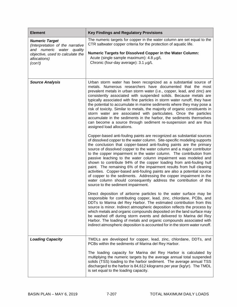
BASIN PLAN – MAY 6, 2019 7-207 TOTAL MAXIMUM DAILY LOADS
Element Key Findings and Regulatory Provisions
Numeric Target (Interpretation of the narrative and numeric water quality objective, used to calculate the allocations) (con’t)
The numeric targets for copper in the water column are set equal to the CTR saltwater copper criteria for the protection of aquatic life. Numeric Targets for Dissolved Copper in the Water Column: Acute (single sample maximum): 4.8 µg/L Chronic (four-day average): 3.1 µg/L
Source Analysis Urban storm water has been recognized as a substantial source of metals. Numerous researchers have documented that the most prevalent metals in urban storm water (i.e., copper, lead, and zinc) are consistently associated with suspended solids. Because metals are typically associated with fine particles in storm water runoff, they have the potential to accumulate in marine sediments where they may pose a risk of toxicity. Similar to metals, the majority of organic constituents in storm water are associated with particulates. Once the particles accumulate in the sediments in the harbor, the sediments themselves can become a source through sediment re-suspension and are thus assigned load allocations. Copper-based anti-fouling paints are recognized as substantial sources of dissolved copper to the water column. Site-specific modeling supports the conclusion that copper-based anti-fouling paints are the primary source of dissolved copper to the water column and a major contributor to the copper impairment in the water column. The contribution from passive leaching to the water column impairment was modeled and shown to contribute 94% of the copper loading from anti-fouling hull paint. The remaining 6% of the impairment results from hull cleaning activities. Copper-based anti-fouling paints are also a potential source of copper to the sediments. Addressing the copper impairment in the water column should consequently address the contribution of this source to the sediment impairment. Direct deposition of airborne particles to the water surface may be responsible for contributing copper, lead, zinc, chlordane, PCBs, and DDTs to Marina del Rey Harbor. The estimated contribution from this source is minor. Indirect atmospheric deposition reflects the process by which metals and organic compounds deposited on the land surface may be washed off during storm events and delivered to Marina del Rey Harbor. The loading of metals and organic compounds associated with indirect atmospheric deposition is accounted for in the storm water runoff.
Loading Capacity
TMDLs are developed for copper, lead, zinc, chlordane, DDTs, and PCBs within the sediments of Marina del Rey Harbor. The loading capacity for Marina del Rey Harbor is calculated by multiplying the numeric targets by the average annual total suspended solids (TSS) loading to the harbor sediment. The average annual TSS discharged to the harbor is 84,612 kilograms per year (kg/yr). The TMDL is set equal to the loading capacity.

BASIN PLAN – MAY 6, 2019 7-208 TOTAL MAXIMUM DAILY LOADS
Element Key Findings and Regulatory Provisions
Loading Capacity (continued)
Metals Loading Capacity (kilograms/year) Copper Lead Zinc 2.88 3.95 12.69 Organics Loading Capacity (grams/year)
Chlordane Total PCBs Total DDTs p,p’-DDE 0.04 1.92 0.13 0.19
A TMDL is also developed for dissolved copper in the water column. Based on modeling results, the loading capacity for copper in the water column is 554 kg/yr.
Load Allocations (for nonpoint sources)
Load allocations (LA) are developed for nonpoint sources in Marina del Rey Harbor. Non-point sources of the sediment impairment include direct atmospheric deposition and internal sources from the harbor sediments. Non-point sources of the water column copper impairment include the discharge of dissolved copper from boat hulls through passive leaching and hull cleaning. LAs for Sediment Impairments The load allocations for atmospheric deposition are not assigned to a particular nonpoint source or group of nonpoint sources. The mass-based load allocation for direct atmospheric deposition is equal to the percentage of the watershed covered by water (11.7%) multiplied by the total loading capacity. Metals Load Allocations for Direct Atmospheric Deposition (kg/yr) Copper Lead Zinc 0.34 0.46 1.49 Organics Load Allocations for Direct Atmospheric Deposition (g/yr)
Chlordane Total PCBs Total DDTs p,p’-DDE 0.005 0.225 0.016 0.022
The in-harbor LAs for concentrations in sediment are set equal to the numeric targets.
Load Allocations for Metals in Sediment (mg/kg) Copper Lead Zinc
34 46.7 150
Load Allocations for Organic Compounds in Sediment (µg/kg) Chlordane Total PCBs Total DDTs p,p’-DDE
0.5 3.2 1.58 2.2

BASIN PLAN – MAY 6, 2019 7-209 TOTAL MAXIMUM DAILY LOADS
Element Key Findings and Regulatory Provisions
Load Allocations (for nonpoint sources) (con’t)
LAs for Copper Water Column Impairment The LAs for discharges of dissolved copper from boats is an 85% reduction in the baseline copper load from boats of 3609 kg/yr. Compliance with the load allocations may be demonstrated by any one of three means: a. Meeting numeric targets in the water column, or b. Demonstrating that 85% of boats in the harbor are using copper free hull paints, or c. Another acceptable means of demonstrating compliance as approved by the Executive Officer of the Regional Board that would result in attainment of copper numeric targets in the water column (e.g. demonstrating that 100% of boats in the harbor are using hull paint that discharges 85% less copper than the baseline load).
Waste Load Allocations (for point sources)
Waste load allocations (WLA) are assigned to point sources for the Marina del Rey watershed. A grouped mass-based waste load allocation is developed for the storm water permittees (Los Angeles County MS4, Caltrans, General Construction and General Industrial) by subtracting the load allocations from the total loading capacity. Concentration-based waste load allocations are developed for other point sources in the watershed. Metals Waste Load Allocations for Storm Water (kg/yr) Copper Lead Zinc 2.54 3.49 11.20 Organics Waste Load Allocations for Storm Water (g/yr)
Chlordane Total PCBs Total DDT p,p’-DDE 0.04 1.70 0.12 0.16
The storm water waste load allocations are apportioned between the MS4 permittees, Caltrans, the general construction and the general industrial storm water permittees based on an estimate of the percentage of land area covered under each permit. Metals Storm Water WLAs Apportioned between Permittees (kg/yr) Copper Lead Zinc MS4 Permittees 2.26 3.10 9.96 Caltrans 0.036 0.05 0.16 General Construction 0.23 0.32 1.03 General Industrial 0.012 0.016 0.053

BASIN PLAN – MAY 6, 2019 7-210 TOTAL MAXIMUM DAILY LOADS
Element Key Findings and Regulatory Provisions
Waste Load Allocations (for point sources) (con’t)
Organics Storm Water WLAs Apportioned between Permittees
(g/yr)
Chlordane Total PCBs
Total DDT
p’p-DDE
MS4 Permittees 0.0332 1.51 0.10 0.15 Caltrans 0.0005 0.024 0.0017 0.0024 General
Construction 0.0034 0.16 0.011 0.015
General Industrial 0.0002 0.0080 0.0006 0.0008 Each storm water permittee enrolled under the general construction or industrial storm water permits will receive an individual waste load allocation on a per acre basis, based on the acreage of their facility.
Metals per Acre WLAs for Individual General
Construction or Industrial Storm Water Permittees (g/yr/ac) Copper Lead Zinc
1.9 2.6 8.5
Organics per acre WLAs for Individual General
Construction or Industrial Storm Water Permittees (mg/yr/ac) Chlordane Total PCBs Total DDTs p,p’-DDE
0.03 1.3 0.09 0.12
Concentration-based waste load allocations are assigned to the minor NPDES permits and general non-storm water NPDES permits that discharge to Marina del Rey Harbor. Any future minor NPDES permits or enrollees under a general non-storm water NPDES permit will also be subject to the concentration-based waste load allocations. Metals Concentration-based Waste Load Allocations (mg/kg) Copper Lead Zinc
34 46.7 150
Organic Concentration-based Waste Load Allocations (µg/kg) Chlordane Total PCBs Total DDTs p,p’-DDE
0.5 3.2 1.58 2.2
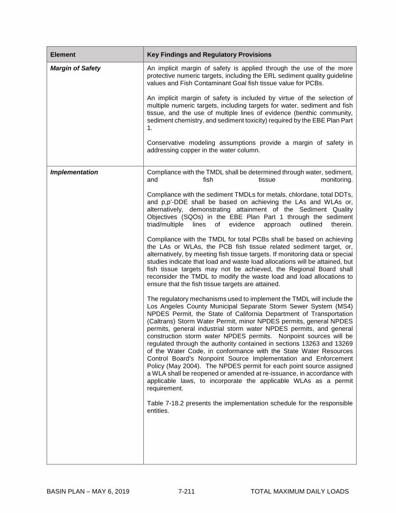
BASIN PLAN – MAY 6, 2019 7-211 TOTAL MAXIMUM DAILY LOADS
Element Key Findings and Regulatory Provisions
Margin of Safety An implicit margin of safety is applied through the use of the more protective numeric targets, including the ERL sediment quality guideline values and Fish Contaminant Goal fish tissue value for PCBs. An implicit margin of safety is included by virtue of the selection of multiple numeric targets, including targets for water, sediment and fish tissue, and the use of multiple lines of evidence (benthic community, sediment chemistry, and sediment toxicity) required by the EBE Plan Part 1. Conservative modeling assumptions provide a margin of safety in addressing copper in the water column.
Implementation
Compliance with the TMDL shall be determined through water, sediment, and fish tissue monitoring. Compliance with the sediment TMDLs for metals, chlordane, total DDTs, and p,p’-DDE shall be based on achieving the LAs and WLAs or, alternatively, demonstrating attainment of the Sediment Quality Objectives (SQOs) in the EBE Plan Part 1 through the sediment triad/multiple lines of evidence approach outlined therein. Compliance with the TMDL for total PCBs shall be based on achieving the LAs or WLAs, the PCB fish tissue related sediment target, or, alternatively, by meeting fish tissue targets. If monitoring data or special studies indicate that load and waste load allocations will be attained, but fish tissue targets may not be achieved, the Regional Board shall reconsider the TMDL to modify the waste load and load allocations to ensure that the fish tissue targets are attained. The regulatory mechanisms used to implement the TMDL will include the Los Angeles County Municipal Separate Storm Sewer System (MS4) NPDES Permit, the State of California Department of Transportation (Caltrans) Storm Water Permit, minor NPDES permits, general NPDES permits, general industrial storm water NPDES permits, and general construction storm water NPDES permits. Nonpoint sources will be regulated through the authority contained in sections 13263 and 13269 of the Water Code, in conformance with the State Water Resources Control Board’s Nonpoint Source Implementation and Enforcement Policy (May 2004). The NPDES permit for each point source assigned a WLA shall be reopened or amended at re-issuance, in accordance with applicable laws, to incorporate the applicable WLAs as a permit requirement. Table 7-18.2 presents the implementation schedule for the responsible entities.

BASIN PLAN – MAY 6, 2019 7-212 TOTAL MAXIMUM DAILY LOADS
Element Key Findings and Regulatory Provisions
Implementation (con’t)
Minor NPDES Permits and General Non-Storm Water NPDES Permits: The concentration-based waste load allocations for the minor NPDES permittees and general non-storm water NPDES permittees will be implemented as permit limits. Permit writers may translate applicable waste load allocations into effluent limits for the minor and general NPDES permits by applying the effluent limitation procedures in Section 1.4 of the State Water Resources Control Board’s Policy for Implementation of Toxic Standards for Inland Surface Waters, Enclosed Bays, and Estuaries of California or applying other applicable methodologies authorized under federal regulations. The minor and currently enrolled general non-storm water NPDES permittees are allowed up to March 22, 2016 to achieve the waste load allocations. General Industrial and Construction Storm Water Permits: Waste load allocations will be incorporated into the State Board general permits or into watershed specific permits developed by the Regional Board. General construction permittees must attain WLAs by March 22, 2016. General industrial permittees must attain WLAs by March 22, 2016. Permittees may demonstrate compliance with WLAs in one of two ways. First, general industrial and construction storm water permittees may be deemed in compliance with permit limitations if they demonstrate that there are no exceedances of the permit limitations at their discharge points or outfalls. Second, if permittees provide a quantitative demonstration, similar to the “reasonable assurance analysis” required by the recently adopted Los Angeles County MS4 Permit (Order No. R4-2012-0175), that control measures and best management practices (BMPs) will achieve WLAs consistent with the schedule in Table 7-18.2, then compliance may be demonstrated by implementation of those control measures and BMPs, subject to Executive Officer approval. MS4 and Caltrans Storm Water Permits: The County of Los Angeles, County of Los Angeles Flood Control District, City of Los Angeles, and Culver City are jointly responsible for meeting the mass-based waste load allocations assigned to the MS4 permittees. Caltrans is responsible for meeting its mass-based waste load allocations, however, it may choose to work with the other MS4 permittees. Compliance with the sediment WLAs for Cu, Pb, Zn, Chlordane, p’p-DDE and total DDT may be demonstrated via any one of three different means:

BASIN PLAN – MAY 6, 2019 7-213 TOTAL MAXIMUM DAILY LOADS
Element Key Findings and Regulatory Provisions
Implementation (con’t)
a. The qualitative sediment condition of Unimpacted or Likely Unimpacted via the interpretation and integration of multiple lines of evidence as defined in the EBE Plan Part 1, is met.
b. Sediment numeric targets are met in bed sediments. c. Final sediment WLAs, as presented above, are met. Compliance with the sediment WLAs for PCBs may be demonstrated via any of four different means: a. Fish tissue targets are met in species resident to the waterbody. b. Final sediment allocations, as presented above, are met. c. Sediment numeric targets to protect fish tissue are met in bed
sediments. d. Demonstrate that the sediment quality condition protective of fish
tissue is achieved per the Statewide Enclosed Bays and Estuaries Plan, as amended to address contaminants in resident finfish and wildlife.
Each municipality and permittee will be required to meet the waste load allocations. If permittees provide a quantitative demonstration as part of a watershed management program similar to the “reasonable assurance analysis” required by the recently adopted Los Angeles County MS4 Permit (Order No. R4-2012-0175) that control measures and BMPs will achieve WLAs consistent with the schedule in Table 7-18.2, then compliance with permit water quality based effluent limitations (WQBELs) may be demonstrated by implementation of those control measures and BMPs, subject to Executive Officer approval. A phased implementation approach, using a combination of non-structural and structural BMPs may be used to achieve compliance with the waste load allocations. The administrative record and the fact sheets for the MS4 and Caltrans storm water permits must provide reasonable assurance that the BMPs selected will be sufficient to implement the numeric waste load allocations. The quantitative demonstration must include an estimate of the reductions to be achieved by each BMP and sufficient monitoring must be conducted to verify that the necessary reductions are achieved. The permits must also provide a mechanism to adjust the required BMPs as necessary to ensure their adequate performance. The implementation schedule for the MS4 and Caltrans permittees consists of a phased approach, with compliance to be achieved in prescribed percentages of the watershed or as a reduction from the baseline loading, with total compliance to be achieved by March 22, 2018. Load Allocations for In-Harbor Sediments The County of Los Angeles is the responsible party for the load allocations assigned to in-harbor sediments. Load allocations shall be implemented through the following: (1) Memorandum of Agreement (MOA), or (2) Cleanup and Abatement Order or other regulatory order
The County of Los Angeles shall be allowed one year from the effective date of the TMDL reconsideration to enter into a MOA with the Regional Board, detailing the voluntary efforts that will be undertaken to attain the load allocations. The MOA shall include development of a contaminated

BASIN PLAN – MAY 6, 2019 7-214 TOTAL MAXIMUM DAILY LOADS
Element Key Findings and Regulatory Provisions
Implementation (con’t)
sediment management plan. The MOA shall comply with the Water Quality Control Policy for Addressing Impaired Waters: Regulatory Structure and Options (“Policy”), including part II, section 2.c.ii. and related provisions, and shall be consistent with the requirements of this TMDL. If the MOA is timely adopted, and so long as it is implemented, the program described in the MOA shall be deemed “certified”, pursuant to the Policy, subject to the conditions of section 2.e. of the Policy. The MOA must be approved by the Executive Officer, and may be amended with Executive Officer approval, as necessary. If an MOA is not established within one year or if the responsible party does not comply with the terms of the MOA, a cleanup and abatement order pursuant to California Water Code section 13304 or another appropriate regulatory order shall be issued to implement the load allocations. The MOA shall contain interim deliverables so that compliance can be assessed throughout implementation of the MOA and prior to the final sediment remediation deadline. Load Allocations for Discharges of Dissolved Copper The load allocations for discharges of dissolved copper from boats are assigned to the County of Los Angeles, individual anchorages, and persons owning boats moored in the Marina. The Regional Board has the authority to implement LAs through waste discharge requirements (WDRs), conditional waivers of WDRs, or other regulatory mechanisms in accordance with the Nonpoint Source Implementation and Enforcement Policy. The Regional Board will develop a regulatory mechanism(s) to implement the LAs within two years of the effective date of the TMDL. Should a voluntary program be developed by responsible parties and approved by the Executive Officer within two years of the effective date of the TMDL, such a program may be reflected in the regulatory mechanism. Compliance with the load allocations may be demonstrated by any one of three means: a. Meeting numeric targets in the water column, or b. Demonstrating that 85% of boats in the harbor are using copper free
hull paints, or c. Another acceptable means of demonstrating compliance as
approved by the Executive Officer of the Regional Board that would result in attainment of copper numeric targets in the water column (e.g. demonstrating that 100% of boats in the harbor are using hull paint that discharges 85% less copper than the baseline load).
Reconsideration of TMDL The TMDL may be reconsidered to revise the implementation schedule in order to ensure that pollutant sources are controlled and a suitable location for contaminated sediment disposal is available prior to remediation of contaminated sediments if the County has made a good faith effort to plan, fund, and permit sediment remediation activities.

BASIN PLAN – MAY 6, 2019 7-215 TOTAL MAXIMUM DAILY LOADS
Element Key Findings and Regulatory Provisions
Seasonal Variations and Critical Conditions
There is a high degree of inter- and intra-annual variability in total suspended solids discharged to Marina del Rey Harbor. This is a function of the storms, which are highly variable between years. The TMDL is based on a TSS load derived from long-term average rainfall over a 52-year period from 1948 to 2000. This time period contains a wide range of storm conditions and drain discharges to Marina del Rey Harbor. Use of the average condition for the TMDL is appropriate because issues of sediment effects on benthic communities and potential for bioaccumulation to higher trophic levels occurs over long time periods.
Monitoring
Monitoring will be required to assess the on-going condition of Marina del Rey Harbor and to assess attainment of WLAs and LAs assigned to dischargers and responsible parties in the Marina del Rey Watershed. Special studies may also be appropriate to provide further information about new data, new or alternative sources, and revised scientific assumptions. Below the Regional Board identifies the various goals of monitoring efforts and studies that shall be developed in a coordinated manner. The programs, reports, and studies will be included as requirements in subsequent permits or other orders issued by the Executive Officer. MS4 and Caltrans Monitoring MS4 permittees and Caltrans are jointly responsible for TMDL monitoring. Discharge water quality samples shall be collected during wet weather, and shall be analyzed for total dissolved solids, settleable solids and total suspended solids. Sampling shall be designed to collect sufficient volumes of settleable and suspended solids to allow for analysis of copper, lead, zinc, chlordane, total PCBs, total DDTs, p,p’-DDE, and total organic carbon in the sediment. Receiving water quality samples shall be collected monthly in accordance with an approved TMDL coordinated monitoring plan, or integrated monitoring program or coordinated integrated monitoring program under the Los Angeles County MS4 Permit, and analyzed for total PCBs at detection limits that are at or below the minimum levels. The minimum levels are those published by the State Water Resources Control Board in Appendix 4 of the Policy for the Implementation of Toxic Standards for Inland Surface Water, Enclosed Bays, and Estuaries of California, March 2, 2000. Special emphasis should be placed on achieving detection limits that will allow evaluation relative to the CTR standards. Receiving water quality samples shall also be collected monthly and analyzed for copper. For metals water column analysis, methods that allow for (1) the removal of salt matrix to reduce interference and avoid inaccurate results prior to the analysis; and (2) the use of trace metal clean sampling techniques, should be applied. Examples of such methods include EPA Method 1669 for sample collection and handling, and EPA Method 1640 for sample preparation and analysis.
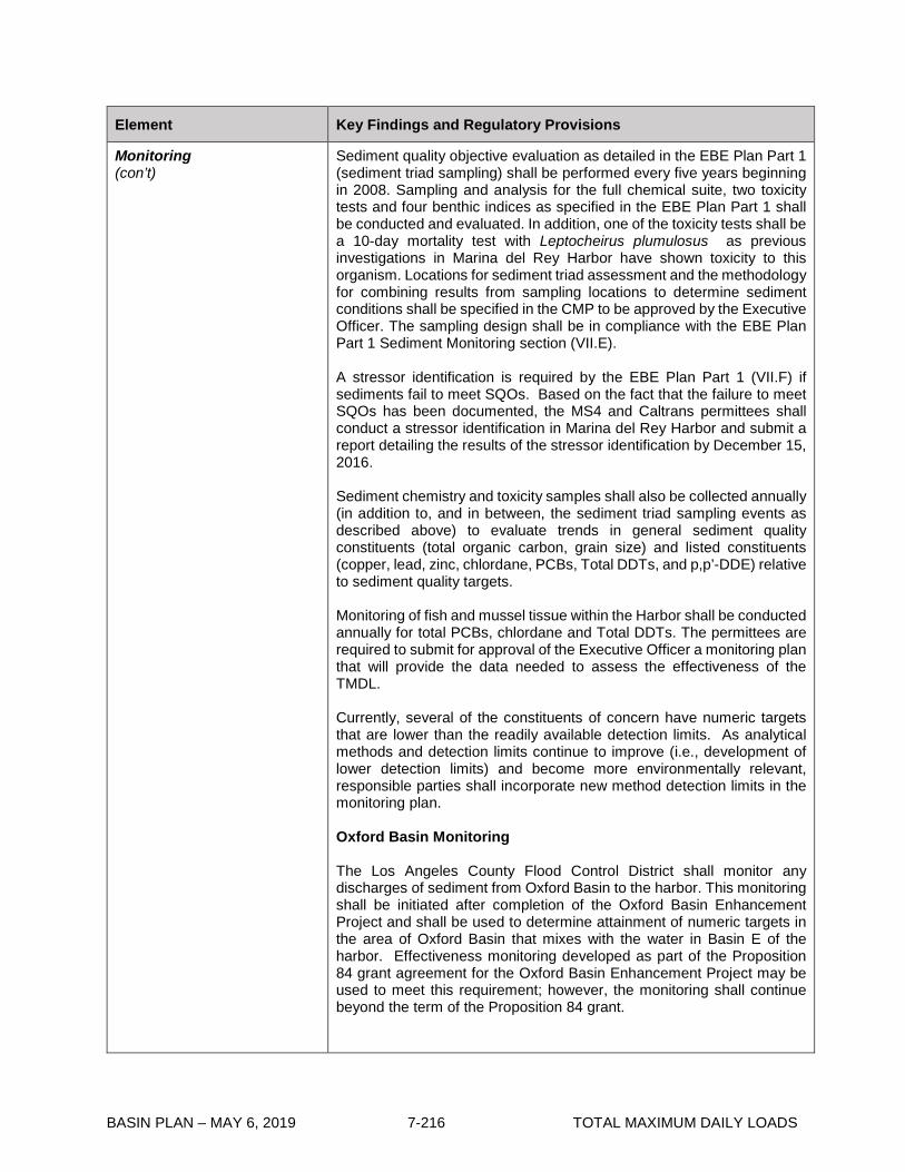
BASIN PLAN – MAY 6, 2019 7-216 TOTAL MAXIMUM DAILY LOADS
Element Key Findings and Regulatory Provisions
Monitoring (con’t)
Sediment quality objective evaluation as detailed in the EBE Plan Part 1 (sediment triad sampling) shall be performed every five years beginning in 2008. Sampling and analysis for the full chemical suite, two toxicity tests and four benthic indices as specified in the EBE Plan Part 1 shall be conducted and evaluated. In addition, one of the toxicity tests shall be a 10-day mortality test with Leptocheirus plumulosus as previous investigations in Marina del Rey Harbor have shown toxicity to this organism. Locations for sediment triad assessment and the methodology for combining results from sampling locations to determine sediment conditions shall be specified in the CMP to be approved by the Executive Officer. The sampling design shall be in compliance with the EBE Plan Part 1 Sediment Monitoring section (VII.E). A stressor identification is required by the EBE Plan Part 1 (VII.F) if sediments fail to meet SQOs. Based on the fact that the failure to meet SQOs has been documented, the MS4 and Caltrans permittees shall conduct a stressor identification in Marina del Rey Harbor and submit a report detailing the results of the stressor identification by December 15, 2016. Sediment chemistry and toxicity samples shall also be collected annually (in addition to, and in between, the sediment triad sampling events as described above) to evaluate trends in general sediment quality constituents (total organic carbon, grain size) and listed constituents (copper, lead, zinc, chlordane, PCBs, Total DDTs, and p,p’-DDE) relative to sediment quality targets. Monitoring of fish and mussel tissue within the Harbor shall be conducted annually for total PCBs, chlordane and Total DDTs. The permittees are required to submit for approval of the Executive Officer a monitoring plan that will provide the data needed to assess the effectiveness of the TMDL. Currently, several of the constituents of concern have numeric targets that are lower than the readily available detection limits. As analytical methods and detection limits continue to improve (i.e., development of lower detection limits) and become more environmentally relevant, responsible parties shall incorporate new method detection limits in the monitoring plan. Oxford Basin Monitoring The Los Angeles County Flood Control District shall monitor any discharges of sediment from Oxford Basin to the harbor. This monitoring shall be initiated after completion of the Oxford Basin Enhancement Project and shall be used to determine attainment of numeric targets in the area of Oxford Basin that mixes with the water in Basin E of the harbor. Effectiveness monitoring developed as part of the Proposition 84 grant agreement for the Oxford Basin Enhancement Project may be used to meet this requirement; however, the monitoring shall continue beyond the term of the Proposition 84 grant.
BASIN PLAN – MAY 6, 2019 7-217 TOTAL MAXIMUM DAILY LOADS
Element Key Findings and Regulatory Provisions
Monitoring (con’t)
Other Permittees and Responsible Parties Monitoring Monitoring for other permittees, general industrial and construction stormwater permittees, and responsible parties for the in-harbor sediment and dissolved copper load allocations shall be included in the regulatory mechanisms developed to implement the load and waste load allocations for these sources.

BASIN PLAN – MAY 6, 2019 7-218 TOTAL MAXIMUM DAILY LOADS
Table 7-18.2 Marina del Rey Harbor Toxic Pollutants TMDL: Implementation Schedule Date Action
March 22, 2006 Effluent limitations consistent with the assumptions and requirements of waste load allocations will be implemented through NPDES permits in accordance with the implementation schedule contained herein, at the time of permit issuance, renewal or re-opener.
1 year after effective date of the TMDL as amended by Resolution No. R14-004
Memorandum of Agreement (MOA) between County of Los Angeles and Regional Board to address LAs for in-harbor sediments
2 years after effective date of the TMDL as amended by Resolution No. R14-004
Develop regulatory mechanism for implementation of LAs for discharges of dissolved copper from boats
March 22, 2024 The LAs for discharges of dissolved copper from boats shall be attained.
March 22, 2029 The LAs for in-harbor sediments shall be attained.
MINOR NPDES PERMITS AND GENERAL NON-STORM WATER NPDES PERMITS
March 22, 2013 The non-storm water NPDES permits shall achieve the concentration-based waste load allocations for sediment per provisions allowed for in NPDES permits.
GENERAL INDUSTRIAL STORM WATER PERMIT
Up to March 22, 2016 The general industrial storm water permits shall achieve the mass-based waste load allocations for sediment per provisions allowed for in NPDES permits.
GENERAL CONSTRUCTION STORM WATER PERMIT
Up to March 22, 2016 The general construction storm water permits shall achieve the mass-based waste load allocations for sediment per provisions allowed for in NPDES permits.
MS4 AND CALTRANS STORM WATER PERMITS
June 22, 2015 The MS4 and Caltrans storm water NPDES permittees shall submit a revised coordinated monitoring plan or the MS4 Permit required Integrated Monitoring Program or Coordinated Integrated Monitoring Program, reflecting the revised requirements of this TMDL as amended by Resolution No. R14-004.
December 15, 2016 The MS4 and Caltrans storm water NPDES permittees shall conduct a stressor identification in Marina del Rey Harbor and submit a report detailing the results to the Regional Board.
Schedule for MS4 and Caltrans Permittees for Marina del Rey Harbor Back Basins (Basins D, E, and F)
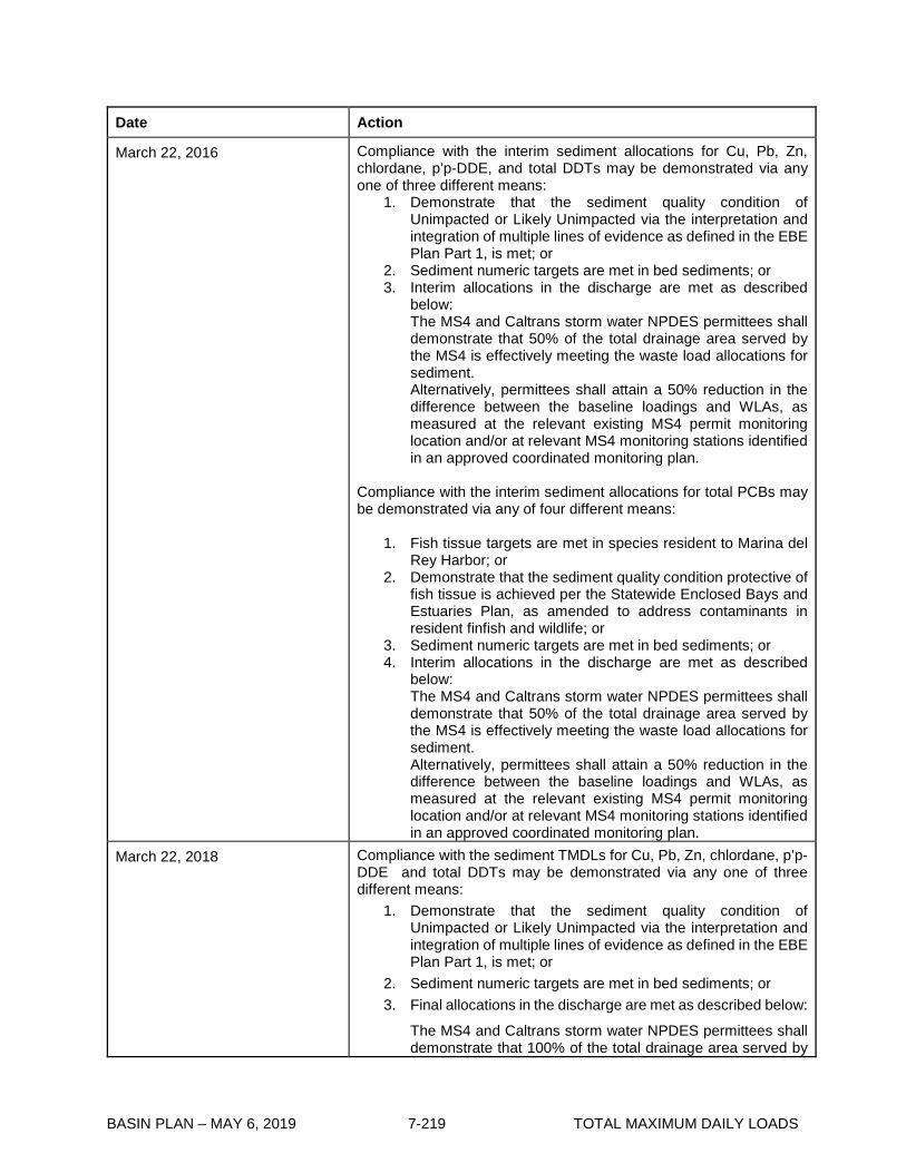
BASIN PLAN – MAY 6, 2019 7-219 TOTAL MAXIMUM DAILY LOADS
Date Action
March 22, 2016 Compliance with the interim sediment allocations for Cu, Pb, Zn, chlordane, p’p-DDE, and total DDTs may be demonstrated via any one of three different means:
1. Demonstrate that the sediment quality condition of Unimpacted or Likely Unimpacted via the interpretation and integration of multiple lines of evidence as defined in the EBE Plan Part 1, is met; or
2. Sediment numeric targets are met in bed sediments; or 3. Interim allocations in the discharge are met as described
below: The MS4 and Caltrans storm water NPDES permittees shall demonstrate that 50% of the total drainage area served by the MS4 is effectively meeting the waste load allocations for sediment. Alternatively, permittees shall attain a 50% reduction in the difference between the baseline loadings and WLAs, as measured at the relevant existing MS4 permit monitoring location and/or at relevant MS4 monitoring stations identified in an approved coordinated monitoring plan.
Compliance with the interim sediment allocations for total PCBs may be demonstrated via any of four different means:
1. Fish tissue targets are met in species resident to Marina del Rey Harbor; or
2. Demonstrate that the sediment quality condition protective of fish tissue is achieved per the Statewide Enclosed Bays and Estuaries Plan, as amended to address contaminants in resident finfish and wildlife; or
3. Sediment numeric targets are met in bed sediments; or 4. Interim allocations in the discharge are met as described
below: The MS4 and Caltrans storm water NPDES permittees shall demonstrate that 50% of the total drainage area served by the MS4 is effectively meeting the waste load allocations for sediment. Alternatively, permittees shall attain a 50% reduction in the difference between the baseline loadings and WLAs, as measured at the relevant existing MS4 permit monitoring location and/or at relevant MS4 monitoring stations identified in an approved coordinated monitoring plan.
March 22, 2018 Compliance with the sediment TMDLs for Cu, Pb, Zn, chlordane, p’p-DDE and total DDTs may be demonstrated via any one of three different means:
1. Demonstrate that the sediment quality condition of Unimpacted or Likely Unimpacted via the interpretation and integration of multiple lines of evidence as defined in the EBE Plan Part 1, is met; or
2. Sediment numeric targets are met in bed sediments; or 3. Final allocations in the discharge are met as described below:
The MS4 and Caltrans storm water NPDES permittees shall demonstrate that 100% of the total drainage area served by

BASIN PLAN – MAY 6, 2019 7-220 TOTAL MAXIMUM DAILY LOADS
Date Action the MS4 is effectively meeting the waste load allocations for sediment.
Compliance with the sediment TMDL for total PCBs may be demonstrated via any of four different means:
1. Fish tissue targets are met in species resident to Marina del Rey Harbor; or
2. Demonstrate that the sediment quality condition protective of fish tissue is achieved per the Statewide Enclosed Bays and Estuaries Plan, as amended to address contaminants in resident finfish and wildlife; or
3. Sediment numeric targets are met in bed sediments; or 4. Final allocations in the discharge are met as described below:
The MS4 and Caltrans storm water NPDES permittees shall demonstrate that 100% of the total drainage area served by the MS4 is effectively meeting the waste load allocations for sediment.
Schedule for MS4 and Caltrans Permittees for Marina del Rey Harbor Front Basins (Basins A, B, C, G, and H)
March 22, 2019 Compliance with the interim sediment allocations for Cu, Pb, Zn, chlordane, p’p-DDE, and total DDTs may be demonstrated via any one of three different means:
1. Demonstrate that the sediment quality condition of Unimpacted or Likely Unimpacted via the interpretation and integration of multiple lines of evidence as defined in the EBE Plan Part 1, is met; or
2. Sediment numeric targets are met in bed sediments; or 3. Interim allocations in the discharge are met as described
below: The MS4 and Caltrans storm water NPDES permittees shall demonstrate that 50% of the total drainage area served by the MS4 is effectively meeting the waste load allocations for sediment. Alternatively, permittees shall attain a 50% reduction in the difference between the baseline loadings and WLAs, as measured at the relevant existing MS4 permit monitoring location and/or at relevant MS4 monitoring stations identified in an approved coordinated monitoring plan.
Compliance with the interim sediment allocations for total PCBs may
be demonstrated via any of four different means:
1. Fish tissue targets are met in species resident to Marina del Rey Harbor; or
2. Demonstrate that the sediment quality condition protective of fish tissue is achieved per the Statewide Enclosed Bays and Estuaries Plan, as amended to address contaminants in resident finfish and wildlife; or

BASIN PLAN – MAY 6, 2019 7-221 TOTAL MAXIMUM DAILY LOADS
Date Action 3. Sediment numeric targets are met in bed sediments; or 4. Final allocations in the discharge are met as described below:
The MS4 and Caltrans storm water NPDES permittees shall demonstrate that 50% of the total drainage area served by the MS4 is effectively meeting the waste load allocations for sediment. Alternatively, permittees shall attain a 50% reduction in the difference between the baseline loadings and WLAs, as measured at the relevant existing MS4 permit monitoring location and/or at relevant MS4 monitoring stations identified in an approved coordinated monitoring plan.
March 22, 2021 Compliance with the sediment TMDLs for Cu, Pb, Zn, chlordane, p’p-DDE and total DDTs may be demonstrated via any one of three different means:
1. Demonstrate that the sediment quality condition of Unimpacted or Likely Unimpacted via the interpretation and integration of multiple lines of evidence as defined in the EBE Plan Part 1, is met; or
2. Sediment numeric targets are met in bed sediments; or 3. Final allocations in the discharge are met as described below:
The MS4 and Caltrans storm water NPDES permittees shall demonstrate that 100% of the total drainage area served by the MS4 is effectively meeting the waste load allocations for sediment.
Compliance with the sediment TMDL for total PCBs may be
demonstrated via any of four different means:
1. Fish tissue targets are met in species resident to Marina del Rey Harbor; or
2. Demonstrate that the sediment quality condition protective of fish tissue is achieved per the Statewide Enclosed Bays and Estuaries Plan, as amended to address contaminants in resident finfish and wildlife; or
3. Sediment numeric targets are met in bed sediments; or 4. Final allocations in the discharge are met as described below:
The MS4 and Caltrans storm water NPDES permittees shall demonstrate that 100% of the total drainage area served by the MS4 is effectively meeting the waste load allocations for sediment.

BASIN PLAN – MAY 6, 2019 7-222 TOTAL MAXIMUM DAILY LOADS
This page intentionally left blank

BASIN PLAN – MAY 6, 2019 7-223 TOTAL MAXIMUM DAILY LOADS
7-19 Calleguas Creek Watershed Metals and Selenium TMDL This TMDL was adopted by:
The Regional Water Quality Control Board on June 8, 2006.
This TMDL was approved by:
The State Water Resources Control Board on October 25, 2006. The Office of Administrative Law on February 2, 2007. The U.S. Environmental Protection Agency on March 26, 2007.
The effective date of this TMDL is March 26, 2007.
This TMDL was revised by:
The Regional Water Quality Control Board on October 13, 2016.
This revised TMDL was approved by:
The State Water Resources Control Board on February 22, 2017 The Office of Administrative Law on May 18, 2017. The U.S. Environmental Protection Agency on June 9, 2017.
The following tables include the elements of this TMDL.
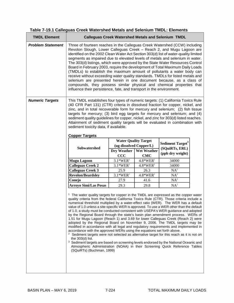
BASIN PLAN – MAY 6, 2019 7-224 TOTAL MAXIMUM DAILY LOADS
Table 7-19.1 Calleguas Creek Watershed Metals and Selenium TMDL: Elements TMDL Element Calleguas Creek Watershed Metals and Selenium TMDL
Problem Statement Three of fourteen reaches in the Calleguas Creek Watershed (CCW) including Revolon Slough, Lower Calleguas Creek – Reach 2, and Mugu Lagoon are identified on the 2002 Clean Water Act Section 303(d) list of water-quality limited segments as impaired due to elevated levels of metals and selenium in water. The 303(d) listings, which were approved by the State Water Resources Control Board in February 2003, require the development of Total Maximum Daily Loads (TMDLs) to establish the maximum amount of pollutants a water body can receive without exceeding water quality standards. TMDLs for listed metals and selenium are presented herein in one document because, as a class of compounds, they possess similar physical and chemical properties that influence their persistence, fate, and transport in the environment.
Numeric Targets
This TMDL establishes four types of numeric targets: (1) California Toxics Rule (40 CFR Part 131) (CTR) criteria in dissolved fraction for copper, nickel, and zinc, and in total recoverable form for mercury and selenium; (2) fish tissue targets for mercury; (3) bird egg targets for mercury and selenium; and (4) sediment quality guidelines for copper, nickel, and zinc for 303(d) listed reaches. Attainment of sediment quality targets will be evaluated in combination with sediment toxicity data, if available. Copper Targets
Dry Weather CCC
Wet Weather CMC
Mugu Lagoon 3.1*WER1 4.8*WER1 34000Calleguas Creek 2 3.1*WER1 4.8*WER1 34000Calleguas Creek 3 25.9 26.3 NA2
Revolon/Beardsley 3.1*WER1 4.8*WER1 NA2
Conejo 27.9 41.6 NA2
Arroyo Simi/Las Posas 29.3 29.8 NA2
Water Quality Target (ug dissolved Copper/L)Subwatershed
Sediment Target3
(SQuiRTs, ERL) (ppb dry weight)
1 The water quality targets for copper in the TMDL are expressed as the copper water quality criteria from the federal California Toxics Rule (CTR). Those criteria include a numerical threshold multiplied by a water-effect ratio (WER). The WER has a default value of 1.0 unless a site-specific WER is approved. To use a WER other than the default of 1.0, a study must be conducted consistent with USEPA’s WER guidance and adopted by the Regional Board through the state’s basin plan amendment process. WERs of 1.51 for Mugu Lagoon (Reach 1) and 3.69 for lower Calleguas Creek (Reach 2) were adopted by the Regional Board on November 9, 2006. The TMDL targets may be modified in accordance with all legal and regulatory requirements and implemented in accordance with the approved WERs using the equations set forth above. 2 Sediment targets were not selected as alternative target for this reach as it is not on
the 303(d) list. 3 Sediment targets are based on screening levels endorsed by the National Oceanic and
Atmospheric Administration (NOAA) in their Screening Quick Reference Tables (SQuiRTs) (Buchman, 1999)

BASIN PLAN – MAY 6, 2019 7-225 TOTAL MAXIMUM DAILY LOADS
TMDL Element Calleguas Creek Watershed Metals and Selenium TMDL
Numeric Targets (con’t)
Mercury Targets
Media TargetFish Tissue (Human Health) 0.3 mg methylmercury/kg wet weightFish Tissue (Wildlife) * Trophic Level (TL) 31<50 mm 0.03 mg methylmercury/kg wet weight * TL3 50-150 mm 0.05 mg methylmercury/kg wet weight * TL3 150-350 mm 0.1 mg methylmercury/kg wet weightBird Egg (Wildlife) less than 0.5 mg total mercury/kg wet weightWater Column 0.051 ug total mercury/L
1 Tropic Level 3: Predators (e.g., minnows, sunfish) on tropic level 2 organism (e.g., copepods and water fleas)
Nickel Targets
Dry Weather CCC
Wet Weather CMC
Mugu Lagoon 8.2 74 20900Calleguas Creek 2 8.2 74 NA2
Calleguas Creek 3 149 856 NA2
Revolon/Beardsley 8.2 74 NA2
Conejo 160 1292 NA2
Arroyo Simi/Las Posas 168 958 NA2
Water Quality Target (ug dissolved Nickel/L)Subwatershed
Sediment Target1
(SQuiRTs, ERL) (ppb dry weight)
1 Sediment targets are based on screening levels endorsed by the National Oceanic and Atmospheric Administration (NOAA) in their Screening Quick Reference Tables (SQuiRTs) (Buchman, 1999) 2 Sediment targets were not selected as alternative target for this reach as it is not listed
on the 303(d) list. Selenium Targets
Dry Weather CCC
Wet Weather CMC
Mugu Lagoon 71 290 6Calleguas Creek 2 5 290 6Calleguas Creek 3 5 NA1 6Revolon/Beardsley 5 290 6Conejo 5 NA1 6Arroyo Simi/Las Posas 5 NA1 6
Water Quality Target (ug total selenium/L)Subwatershed Bird Egg
(ug/g)
1 “NA” indicates that a target is not available for this constituent because criterion for fresh water is not defined in the CTR.

BASIN PLAN – MAY 6, 2019 7-226 TOTAL MAXIMUM DAILY LOADS
TMDL Element Calleguas Creek Watershed Metals and Selenium TMDL
Numeric Targets (con’t)
Zinc Targets
Dry Weather CCC
Wet Weather CMC
Mugu Lagoon 81 90 150000Calleguas Creek 2 81 90 NA2
Calleguas Creek 3 338 214 NA2
Revolon/Beardsley 81 90 NA2
Conejo 365 324 NA2
Arroyo Simi/Las Posas 382 240 NA2
Water Quality Target (ug dissolved Zinc/L) Subwatershed
Sediment Target1
(SQuiRTs, ERL) (ppb dry weight)
1 Sediment targets are based on screening levels endorsed by the National Oceanic and Atmospheric Administration (NOAA) in their Screening Quick Reference Tables (SQuiRTs) (Buchman, 1999) 2 Sediment targets were not selected as alternative target for this reach because it is not on the 303(d) list.
Source Analysis Significant sources of metals and selenium include urban runoff, agricultural runoff, groundwater seepage, and POTW effluent. For mercury, open space was also a significant source. Sources were also analyzed as a function of wet and dry weather. Higher loads were delivered during wet weather for all constituents, due to the association between metals and particulate matter. The source analysis indicates naturally occurring mercury in soil may be a significant source, and that naturally occurring nickel, copper, zinc, and selenium in soil may be a contributing source, and that naturally occurring selenium in groundwater may be a significant source. The TMDL Implementation Plan includes special studies to further assess natural sources of metals in soil.
Linkage Analysis Linkage between sources and instream pollutant concentrations was established through a dynamic water quality Hydrologic Simulation Program – FORTRAN (HSPF). The model output generally resulted in a conservative estimate of receiving water concentrations for metals. The model was used to calculate load reductions necessary to meet the numeric targets. The load reductions were used to calculate the load and waste load allocations.
Waste Load Allocations
In the case of copper, nickel, and selenium, waste load allocations (WLAs) were developed for both wet and dry-weather. The dry-weather WLAs apply to days when flows in the stream are less than the 86th percentile flow rate for each reach. The wet-weather WLAs apply to days when flows in the stream exceed the 86th percentile flow rate for each reach. Annual mass loads of mercury in suspended sediment were developed according to low, medium, and high annual flow categories. Publicly Owned Treatment Works (POTWs)
Concentration-based and mass-based WLAs are established for copper, and nickel, in total recoverable forms, and are applied to POTWs during both wet

BASIN PLAN – MAY 6, 2019 7-227 TOTAL MAXIMUM DAILY LOADS
TMDL Element Calleguas Creek Watershed Metals and Selenium TMDL
Waste Load Allocations (con’t)
and dry weather. Mass-based WLAs are developed for mercury for POTWs. Zinc allocations are not set because current information indicate that numeric targets for zinc are attained. The TMDL Implementation Plan includes a task to provide State Board data to support delisting of zinc. Waste load allocations for selenium are not set for POTWs because POTWs do not discharge to reaches listed for selenium. Interim limits are included to allow time for dischargers to put in place implementation measures necessary to achieve final waste load allocations. The daily maximum and monthly average interim limits are set equal to the 99th and 95th percentile of available discharge data, respectively.
Interim and Final WLAs for Total Recoverable Copper in Water Column
Daily Maximum
(ug/L)
Monthly Average (ug/L)
Daily Maximum
(ug/L)
Monthly Average (ug/L)
lb/day
Hill Canyon WWTP 20.0 16.0 (a) 6.0 0.70
Simi Valley WQCP (b) (b) 31.0 30.5 (c)
Moorpark WTP (b) (b) 31.0 30.5 (d)
Camarillo WRP 57.0 20.0 (a) 9.0 0.54
Camrosa WRP (b) (b) 27.4 27.0 (d)
POTW
Interim Final1
1 Final mass-based WLAs for Hill Canyon WWTP and Camarillo WRP were calculated using current performance concentrations and design capacities applicable to POTWs. Current performance concentrations were calculated based on the 95th percentile of 2010-2015 data. Regardless of the final WERs, total copper loading shall not exceed current loading. In addition, effluent concentrations shall not exceed the performance standards of current treatment technologies.
(a) Concentration-based final limits will be included in the permits in accordance with NPDES guidance and requirements, but are not calculated as part of the TMDL.
(b) Interim limits are not required because the discharger is meeting the final limits. (c) Discharges from Simi Valley WQCP do not reach lower Calleguas Creek and
Mugu Lagoon during dry weather. Monitoring will be conducted and mass-based WLAs will be evaluated if targets are not met in Arroyo Simi/Las Posas or downstream reaches.
(d) Discharger does not contribute loading during dry weather. Concentration-based WLAs apply during wet weather when discharges occur. Monitoring will be conducted and mass-based WLAs will be evaluated if targets are not met in receiving water and/or downstream reaches.

BASIN PLAN – MAY 6, 2019 7-228 TOTAL MAXIMUM DAILY LOADS
TMDL Element Calleguas Creek Watershed Metals and Selenium TMDL
Waste Load Allocations (con’t)
Interim and Final WLAs for Total Recoverable Nickel in Water Column
Daily Maximum
(ug/L)
Monthly Average (ug/L)
Daily Maximum
(ug/L)1
Monthly Average (ug/L)2
lb/day
Hill Canyon WWTP 8.3 6.4 (a) (a) 0.3
Simi Valley WQCP (b) (b) 960.0 169.0 (c)
Moorpark WTP (b) (b) 960.0 169.0 (d)
Camarillo WRP 16.0 6.2 (a) (a) 0.2
Camrosa WRP (b) (b) 858.0 149.0 (d)
POTW
Interim Final
1 Concentration-based targets have been converted to total recoverable allocations using the CTR default translator of 0.998.
2 Concentration-based targets have been converted to total recoverable allocations using the CTR default translator of 0.997.
(a) Concentration-based final limits will be included in the permits in accordance with NPDES guidance and requirements, but are not calculated as part of the TMDL.
(b) Interim limits are not required because the discharger is meeting the final limits. (c) Discharges from Simi Valley WQCP do not reach lower Calleguas Creek and
Mugu lagoon during dry weather. Monitoring will be conducted and mass-based WLAs will be evaluated if targets are not met in Arroyo Simi/Las Posas or downstream reaches.
(d) Discharger does not contribute loading during dry weather. Concentration-based WLAs apply during wet weather when discharges occur. Monitoring will be conducted and mass-based WLAs will be evaluated if targets are not met in receiving water and/or downstream reaches.
Interims and Final WLAs for Mercury in Suspended Sediment
POTW Interim
(lb/month)Final
(lb/month)Hill Canyon WWTP 0.23 0.022Simi Valley WQCP 0.18 0.031Moorpark WTP N/A N/ACamarillo WRP 0.03 0.015Camrosa WRP N/A N/A
Waste load allocations for POTWs are based on the median monthly mercury effluent concentrations multiplied by the design flow where the total load in water is assumed equal to the suspended sediment load. Interim WLAs for mercury are based on the 90th percentile concentration observed in effluent discharge and multiplied by the design flow, and apply to all flow conditions.

BASIN PLAN – MAY 6, 2019 7-229 TOTAL MAXIMUM DAILY LOADS
TMDL Element Calleguas Creek Watershed Metals and Selenium TMDL
Waste Load Allocations (con’t)
Permitted Stormwater Dischargers (PSDs)
PSDs include mass-based WLAs established for copper, nickel, and selenium in total recoverable forms. Mass-based WLAs are developed for mercury in suspended sediment. Interim limits are included to allow time for dischargers to put in place implementation measures necessary to achieve final waste load allocations. The daily maximum and monthly average interim limits are set equal to the 99th and 95th percentile of available discharge data.
Interim Limits and Final WLAs for Total Recoverable Copper, Nickel, and Selenium Interim limits and waste load allocations are applied to receiving water.
A. Interim Limits
Dry Daily Maximum
(ug/L)
Dry Monthly Average (ug/L)
Wet Daily Maximum
(ug/L)
Dry Daily Maximum
(ug/L)
Dry Monthly Average (ug/L)
Wet Daily Maximum
(ug/L)
Copper 23 19 204 23 19 204Nickel 15 13 (a) 15 13 (a)
Selenium (b) (b) (b) 14 (c) 13 (c) (a)
Calleguas and Conejo Creek Revolon Slough
Constituents
(a) The current loads do not exceed the TMDL under wet conditions; interim limits are
not required. (b) Selenium allocations have not been developed for this reach as it is not on the
303(d) list. (c) Attainment of interim limits will be evaluated in consideration of background loading
data, if available consistent with EPA’s 2016 Recommended Aquatic Life Ambient Water Quality Criterion for Selenium in Freshwater. B. Final WLAs for Total Recoverable Copper, Nickel, and Selenium
Dry-Weather WLAs in Water Column
Low Flow Average Flow
Elevated Flow Low Flow Average
FlowElevated
Flow Copper1 (lbs/day)
0.04*WER - 0.02
0.12*WER - 0.02
0.18*WER - 0.03
0.03*WER - 0.01
0.06*WER - 0.03
0.13*WER - 0.02
Nickel (lbs/day) 0.100 0.120 0.440 0.050 0.069 0.116
Selenium (lbs/day) (a) (a) (a) 0.004 0.003 0.004
Flow Range
Calleguas and Conejo Creek Revolon Slough
1 The approved site-specific WER of 1.51 for Mugu Lagoon is used to calculate the assigned WLAs for discharges to Calleguas and Conejo Creek to ensure the downstream standard is achieved. Permitted storm water dischargers may apply a WER of up to 3.69 for discharges to upstream reaches, with the exception of Reaches 4 and 5, to calculate the assigned WLAs. If a WER of greater than 1.51 is applied, permitted storm water dischargers shall be required to provide a detailed quantitative analysis to demonstrate that the WLAs as modified by the WER are protective of downstream reaches. No site specific WER for Revolon Slough subwatershed was approved so default WER value of 1 is applied. Regardless of the final WERs, total copper loading shall not exceed current loading. (a) Selenium allocations have not been developed for this reach as it is not on the
303(d) list.

BASIN PLAN – MAY 6, 2019 7-230 TOTAL MAXIMUM DAILY LOADS
TMDL Element Calleguas Creek Watershed Metals and Selenium TMDL
Waste Load Allocations (con’t)
Wet-Weather WLAs in Water Column
Constituent Calleguas Creek Revolon SloughCopper1
(lbs/day)(0.00054*Q^2*0.032*Q - 0.17)*WER - 0.06 (0.0002*Q2+0.0005*Q)*WER
Nickel2
(lbs/day) 0.014*Q^2+0.82*Q 0.027*Q^2+0.47*QSelenium2
(lbs/day) (a) 0.027*Q^2+0.47*Q
1 The approved site-specific WER of 1.51 for Mugu Lagoon is used to calculate the assigned WLAs for discharges to Calleguas and Conejo Creek to ensure the downstream standard is achieved. Permitted storm water dischargers may apply a WER of up to 3.69 for discharges to upstream reaches, with the exception of Reaches 4 and 5, to calculate the assigned WLAs. If a WER of greater than 1.51 is applied, permitted storm water dischargers shall be required to provide detailed quantitative analysis to demonstrate that the WLAs as modified by the WER are protective of downstream reaches. No site specific WER for Revolon Slough was approved so default WER value of 1 is applied. Regardless of the final WERs, total copper loading shall not exceed current loading. 2 Current loads do not exceed loading capacity during wet weather. Sum of all
loads cannot exceed loads presented in the table (a) Selenium allocations have not been developed for this reach as it is not on the
303(d) list. Q: Daily storm volume (cfs).
Interim Limits and Final WLAs for Mercury in Suspended Sediment
Final WLAs are set at 80% reduction of HSPF load estimates. Interim limits for mercury in suspended sediment are set equal to the highest annual load within each flow category, based on HSPF output for the years 1993-2003.
Interim (lbs/yr)
Final (lbs/yr)
Interim (lbs/yr)
Final (lbs/yr)
0-15,000 MGY 3.3 0.4 1.7 0.1
15,000-25,000 MGY 10.5 1.6 4 0.7
Above 25,000 MGY 64.6 9.3 10.2 1.8
Calleguas Creek Revolon Slough
Flow Range
MGY: million gallons per year.
Final WLAs for Other NPDES Dischargers Final WLAs for Total Recoverable Copper, Nickel, and Selenium

BASIN PLAN – MAY 6, 2019 7-231 TOTAL MAXIMUM DAILY LOADS
TMDL Element Calleguas Creek Watershed Metals and Selenium TMDL
Waste Load Allocations (con’t)
Dry Monthly Everage (ug/L)2
Wet Daily Maximum
(ug/L)2
Dry Monthly Average (ug/L)3
Wet Daily Maximum
(ug/L)3
Dry Monthly Average (ug/L)
Wet Daily Maximum
(ug/L)
1 3.7*WER 5.8*WER 8.2 74 (b) (b)2 3.7*WER 5.8*WER 8.2 74 (b) (b)3 27.0 27.4 149 859 (b) (b)4 3.7*WER 5.8*WER 8.3 75 5 2905 3.7*WER 5.8*WER 8.3 75 5 2906 (a) 31.0 (a) 958 (b) (b)7 (a) 31.0 (a) 958 (b) (b)8 (a) 31.0 (a) 958 (b) (b)9 29.1 43.3 160 1296 (b) (b)
10 29.1 43.3 160 1296 (b) (b)11 29.1 43.3 160 1296 (b) (b)12 29.1 43.3 160 1296 (b) (b)13 29.1 43.3 160 1296 (b) (b)
Reach
Copper1 Nickel Selenium
1 The approved site-specific WER of 1.51 for Mugu Lagoon is used to calculate the
assigned WLAs for discharges to Calleguas and Conejo Creek to ensure the downstream standard is achieved. Other NPDES dischargers may apply a WER of up to 3.69 for discharges to upstream reaches, with the exception of Reaches 4 and 5, to calculate the assigned WLAs. If a WER of greater than 1.51 is applied, the other NPDES dischargers shall be required to provide detailed quantitative analysis to demonstrate that the WLAs as modified by the WER are protective of downstream reaches. No site specific WER for Revolon Slough was approved so default WER value of 1 is applied. Regardless of the final WERs, total copper loading shall not exceed current loading. In addition, effluent concentrations shall not exceed the performance standards of current treatment technologies
2 Concentration-based targets have been converted to total recoverable allocations using the CTR default translator of 0.96 for freshwater reaches and 0.83 for saltwater reaches.
3 Concentration-based targets have been converted to total recoverable allocations using the CTR default translator of 0.997 for freshwater reaches and 0.99 for saltwater reaches.
(a) Discharges from these reaches do not reach lower Calleguas Creek and Mugu Lagoon during dry weather. Allocations are not required for these reaches.
(b) Selenium waste load allocations have not been developed for this reach as it is not on the 303(d) list. Final WLAs for Mercury There is insufficient information to assign mass based WLAs to these sources. Therefore concentration-based waste loads allocations are set equal to 0.051 ug/L for other NPDES dischargers based on the CTR water column target for protection of human health from consumption organism only.
Load Allocation
Mass-based load allocations (LAs) for agriculture, and open space are developed for copper, nickel, and selenium in total recoverable forms. Open space represents background loads from ambient sources (i.e. natural soil concentrations, atmospheric deposition, and natural groundwater seepage) discharged from undeveloped open space, but not ambient sources that are discharged from developed land, such as agricultural and urban areas. LAs are developed for both wet and dry-weather. The dry-weather LAs apply to days when flows in the stream are less than 86th percentile flow rate for each reach. The wet-weather LAs apply to days when flows in the stream exceed 86th

BASIN PLAN – MAY 6, 2019 7-232 TOTAL MAXIMUM DAILY LOADS
TMDL Element Calleguas Creek Watershed Metals and Selenium TMDL
Load Allocation (con’t)
percentile flow rate for each reach. Annual mass loads of mercury in suspended sediment were developed according to low, medium, and high annual flow categories. Interim and Final Load Allocations for Total Recoverable Copper, Nickel, and Selenium
Interim limits are included to allow time for dischargers to put in place implementation measures necessary to achieve final load allocations. The daily maximum and monthly average interim limits are set equal to the 99th and 95th percentile of available discharge data. Interim limits and final load allocations are applied in receiving water at the compliance points. A. Interim Limits
Dry Daily Maximum
(ug/L)
Dry Monthly Average (ug/L)
Wet Daily Maximum
(ug/L)
Dry Daily Maximum
(ug/L)
Dry Monthly Average (ug/L)
Wet Daily Maximum
(ug/L)
Copper 24 19 1390 24 19 1390Nickel 43 42 (a) 43 42 (a)Selenium (b) (b) (b) 6.7 (c) 6 (c) (a)
Calleguas and Conejo Creek Revolon Slough
Constituents
(a) The current loads do not exceed the TMDL under wet conditions, interim limits are
not required. (b) Selenium allocations have not been developed for this reach as it is not on the
303(d) list. Implementation actions include consideration of watershed-wide selenium impacts.
(c) Attainment of interim limits will be evaluated in consideration of background loading data, if available consistent with EPA’s 2016 Recommended Aquatic Life Ambient Water Quality Criterion for Selenium in Freshwater. B. Final Load Allocation
Dry Weather LAs in Water Column
Low Flow Average Flow
Elevated Flow
Low Flow
Average Flow
Elevated Flow
Agriculture 0.07* WER-0.03
0.12* WER-0.02
0.31*WER - 0.05
0.07*WER - 0.03
0.14*WER- 0.07
0.35*WER - 0.07
Open Space 0.150 0.080 0.130 0.050 0.120 0.110Agriculture 0.420 0.260 0.970 0.390 0.690 1.600Open Space 0.450 0.420 0.560 0.010 0.020 0.020Agriculture (a) (a) (a) 0.008 0.007 0.018Open Space (a) (a) (a) 0.180 0.310 0.490
Selenium (lbs/day)
Calleguas and Conejo CreekConstituent
Revolon Slough
Copper1
(lbs/day)
Nickel (lbs/day)
1 The approved site-specific WER of 1.51 for Mugu Lagoon is used to calculate the
assigned LAs for discharges to Calleguas and Conejo Creek to ensure the downstream standard is achieved. Agricultural dischargers may apply a WER of up to 3.69 for discharges to upstream reaches, with the exception of Reaches 4 and 5, to calculate the assigned WLAs. If a WER of greater than 1.51 is applied, the agricultural dischargers shall be required to provide detailed quantitative analysis to demonstrate that the WLAs as modified by the WER are protective of downstream reaches. No site specific WER for Revolon Slough was approved so default WER value of 1 is applied. Regardless of the final WERs, total copper loading shall not exceed current loading.
(a) Selenium allocations have not been developed for this reach as it is not on the 303(d) list. Implementation actions include consideration of the watershed-wide selenium impacts.
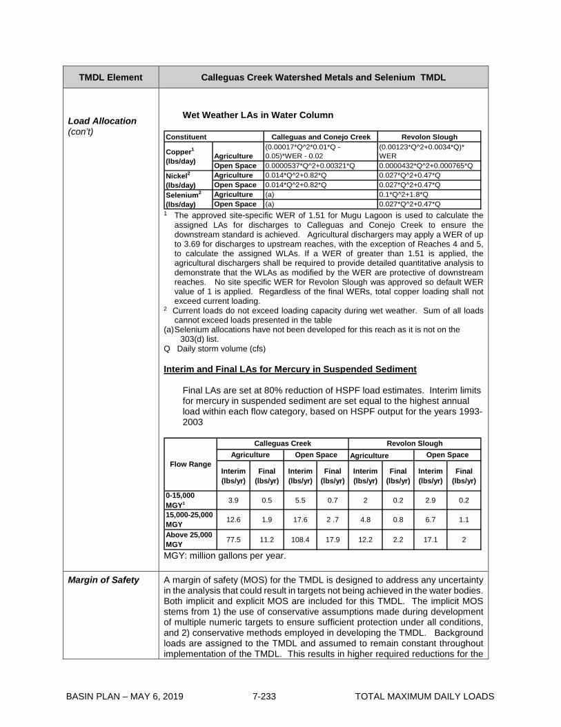
BASIN PLAN – MAY 6, 2019 7-233 TOTAL MAXIMUM DAILY LOADS
TMDL Element Calleguas Creek Watershed Metals and Selenium TMDL
Load Allocation (con’t)
Wet Weather LAs in Water Column
Calleguas and Conejo Creek Revolon Slough
Agriculture(0.00017*Q^2*0.01*Q - 0.05)*WER - 0.02
(0.00123*Q^2+0.0034*Q)* WER
Open Space 0.0000537*Q^2+0.00321*Q 0.0000432*Q^2+0.000765*QAgriculture 0.014*Q^2+0.82*Q 0.027*Q^2+0.47*QOpen Space 0.014*Q^2+0.82*Q 0.027*Q^2+0.47*QAgriculture (a) 0.1*Q^2+1.8*QOpen Space (a) 0.027*Q^2+0.47*Q
Copper1
(lbs/day)
Nickel2
(lbs/day)Selenium2
(lbs/day)
Constituent
1 The approved site-specific WER of 1.51 for Mugu Lagoon is used to calculate the
assigned LAs for discharges to Calleguas and Conejo Creek to ensure the downstream standard is achieved. Agricultural dischargers may apply a WER of up to 3.69 for discharges to upstream reaches, with the exception of Reaches 4 and 5, to calculate the assigned WLAs. If a WER of greater than 1.51 is applied, the agricultural dischargers shall be required to provide detailed quantitative analysis to demonstrate that the WLAs as modified by the WER are protective of downstream reaches. No site specific WER for Revolon Slough was approved so default WER value of 1 is applied. Regardless of the final WERs, total copper loading shall not exceed current loading.
2 Current loads do not exceed loading capacity during wet weather. Sum of all loads cannot exceed loads presented in the table
(a) Selenium allocations have not been developed for this reach as it is not on the 303(d) list.
Q Daily storm volume (cfs) Interim and Final LAs for Mercury in Suspended Sediment
Final LAs are set at 80% reduction of HSPF load estimates. Interim limits for mercury in suspended sediment are set equal to the highest annual load within each flow category, based on HSPF output for the years 1993-2003
Interim (lbs/yr)
Final (lbs/yr)
Interim (lbs/yr)
Final (lbs/yr)
Interim (lbs/yr)
Final (lbs/yr)
Interim (lbs/yr)
Final (lbs/yr)
0-15,000 MGY1 3.9 0.5 5.5 0.7 2 0.2 2.9 0.2
15,000-25,000 MGY 12.6 1.9 17.6 2 .7 4.8 0.8 6.7 1.1
Above 25,000 MGY 77.5 11.2 108.4 17.9 12.2 2.2 17.1 2
Flow Range
Calleguas Creek Revolon SloughAgriculture Open Space Agriculture Open Space
MGY: million gallons per year.
Margin of Safety
A margin of safety (MOS) for the TMDL is designed to address any uncertainty in the analysis that could result in targets not being achieved in the water bodies. Both implicit and explicit MOS are included for this TMDL. The implicit MOS stems from 1) the use of conservative assumptions made during development of multiple numeric targets to ensure sufficient protection under all conditions, and 2) conservative methods employed in developing the TMDL. Background loads are assigned to the TMDL and assumed to remain constant throughout implementation of the TMDL. This results in higher required reductions for the

BASIN PLAN – MAY 6, 2019 7-234 TOTAL MAXIMUM DAILY LOADS
TMDL Element Calleguas Creek Watershed Metals and Selenium TMDL
Margin of Safety (con’t)
other sources. Calculation of allocations is based on never exceeding numeric target concentrations more than once in three years as specified in the CTR. Calculations of current loads and loading capacity for Mugu Lagoon are based on the combined discharges from Calleguas Creek and Revolon Slough (without any dilution provided by tidal flushing), which over predicts actual concentrations in the Lagoon. A 15% explicit MOS is also included for copper and nickel to account for the uncertainty resulting from the calculation of the allowable load based on the median flow rate and translator of each flow category. The 15% explicit MOS is determined sufficient to address the elevated flow category, but still account for the more conservative nature of low and average category.
Future Growth Ventura County accounts for slightly more than 2% of the state’s residents with a population of 753,197 (US Census Bureau, 2000). GIS analysis of the 2000 census data yields a population estimate of 334,000 for the CCW, which equals about 44% of the county population. According to the Southern California Association of Governments (SCAG), growth in Ventura County averaged about 51% per decade from 1900-2000; with growth exceeding 70% in the 1920s, 1950s, and 1960s. Significant population growth is expected to occur within and near present city limits until at least 2020. Future growth may initially increase loadings as construction activities expose bare soil and increase erosion-related discharges to receiving water. However, once development has been completed the presence of impermeable land surface and landscaped areas may reduce the amount of natural soils that are eroded and carried to the stream. For copper, future growth could increase loadings from urban areas and POTWs due to increased traffic (i.e., brake pad residues), architectural copper use and corrosion of copper pipes. Selenium loading may increase if increased irrigation raises the groundwater table and increases high selenium groundwater seepage to surface waters. However, if increased growth results in increased water demand and high selenium groundwater is pumped and treated to supply this demand, the selenium could decrease.
Seasonal Variations and Critical Conditions
Seasonal variations are addressed for copper, nickel, and selenium by developing separate allocations for wet and dry weather. Critical conditions for copper, nickel, and selenium were developed using model results to calculate the maximum observed 4-day average dry weather concentration and the associated flow condition. Wet weather, as a whole, is defined as a critical condition. For mercury, there is no indication that mercury contamination in Mugu Lagoon is consistently exacerbated at any particular time of the year. Since the potential effects of mercury are related to bioaccumulation in the food chain over a long period time, any other short term variations in concentration which might occur are not likely to cause significant impacts upon beneficial uses. Therefore, seasonal variations do not affect critical conditions for the Calleguas Creek watershed mercury TMDL.
Special Studies and Monitoring Plan
Special Studies Several special studies are planned to improve understanding of key aspects related to achievement of WLAs and LAs for the Metals and Selenium TMDL 1. Special Study #1 (Optional) – Evaluation and Initiation of Natural Sources Exclusion

BASIN PLAN – MAY 6, 2019 7-235 TOTAL MAXIMUM DAILY LOADS
TMDL Element Calleguas Creek Watershed Metals and Selenium TMDL
Special Studies and Monitoring Plan (con’t)
The TMDL technical report has identified ambient sources as the primary significant selenium and mercury loadings in the watershed and as potentially significant sources of copper and nickel. The portion of all ambient sources associated with open space runoff and natural groundwater seepage is accounted for in this TMDL as “background load.” This special study will evaluate whether or not background loads for each constituent qualify for natural source exclusion. This study will also consider whether any portion of the ambient source contribution for agricultural or urban runoff loads qualify for natural source exclusions and/or provide a basis for site specific objectives. The presence of natural sources makes achievement of selenium and mercury targets during all conditions unlikely. For copper, achievement of the CTR targets or the WER based targets (if approved) in Revolon Slough may not be feasible due to the magnitude of background loads. Completion of site specific objectives and/or a use attainability analysis shall be required to review any potential change to water quality objectives for these constituents. This special study will be used to develop the necessary information to revise the water quality objectives for selenium and mercury and possibly for copper and nickel. 2. Special Study #2 – Identification of selenium contaminated Groundwater Sources The purpose of this special study will be to identify groundwater with high concentrations of selenium that is either being discharged directly to the stream or used as irrigation water. The investigation will focus on areas where groundwater has a high probability of reaching the stream and identify practical actions to reduce the discharge of the groundwater to the stream. The analysis will include an assessment of the availability of alternative water supplies for irrigation water, the costs of the alternative water supplies and the costs of reducing groundwater discharges. 3. Special Study #3– Investigation of Soil Concentrations and Identification of “Hot Spots” The purpose of this special study will be to identify terrestrial areas with high concentrations of metals and/or selenium, either due to anthropogenic sources or resulting from high natural concentrations in soils. Use of detailed soil maps for the watershed in combination with field survey and soil sampling may lead to identification of areas important for reducing overall loads reaching the stream. Identification of any areas with elevated soil concentrations of metals and/or selenium would create an opportunity for efficient and targeted implementation actions, such as remediation or erosion control. 4. Special Study #4 (Optional) – Determination of Water Effect Ratio for Copper in Revolon Slough The purpose of this optional special study would be to calculate a WER for copper that is specific to Revolon Slough. A WER was not previously developed for Revolon Slough because it was not listed for copper. Subsequent monitoring demonstrated that the saltwater copper CTR criterion was exceeded in Revolon Slough. This Study would parallel the developed WER for Mugu Lagoon and Calleguas Creek. This is an optional special study to be conducted if desired by the stakeholders or determined necessary and appropriate by the Executive Officer.

BASIN PLAN – MAY 6, 2019 7-236 TOTAL MAXIMUM DAILY LOADS
TMDL Element Calleguas Creek Watershed Metals and Selenium TMDL
Special Studies and Monitoring Plan (con’t)
5. Special Study #5 (Optional) – Determination of Site-Specific Objectives for Mercury and Selenium Special Study #1 will evaluate whether a natural source exclusion is appropriate for background loads of mercury and selenium or any portion of the ambient source contributions to non-background loads in the Calleguas Creek watershed. This special study will develop any SSOs deemed necessary to account for the background conditions and/or site-specific impacts of mercury and selenium (and possibly for copper and nickel) on wildlife and humans in the watershed. This is an optional special study to be conducted if desired by the stakeholders or determined necessary for establishing a natural source exclusion. Monitoring Plan The Calleguas Creek Watershed TMDL Monitoring Plan (CCWTMP) is designed to monitor and evaluate the implementation of this TMDL and refine the understanding of metal and selenium loads. CCWTMP is intended to parallel efforts of the Calleguas Creek Watershed Nutrients TMDL, Toxicity TMDL, and OC Pesticide, PCBs, and Sediment TMDL monitoring programs. The proposed CCWTMP shall be made available for public review before approval by the Executive Officer. The goals of the CCWTMP include: (1) to determine compliance with copper, mercury, nickel, and selenium numeric targets at receiving water monitoring stations and at POTWs discharges; (2) to determine compliance with waste load and load allocations for copper, mercury, nickel, and selenium at receiving water monitoring stations and at POTWs discharges; (3) to monitor the effect of implementation action by PSDs, POTW, agricultural dischargers, and other NPDES permittees on in-stream water quality; and (4) to implement the CCWTMP in a manner consistent with other TMDL implementation plans and regulatory actions within the Calleguas Creek watershed. Monitoring conducted through the Conditional Waiver for Discharges from Irrigated Lands (Conditional Waiver Program) may meet part of the needs of the CCWTMP. To the extent monitoring required by the Metals and Selenium TMDL Implementation Plan parallels monitoring required by the Conditional Waiver Program, monitoring shall be coordinated with monitoring conducted by individuals and groups subject to the term and conditions of the Conditional Waiver Program. Monitoring will begin within one year of the effective date of the TMDL. For the first year, in-stream water column samples will be collected monthly for analysis of general water quality constituents (GWQC), copper, mercury, nickel, selenium, and zinc. After the first year, the Executive Officer will review the monitoring report and revise the monitoring frequency as appropriate. In-stream water column samples will be generally be collected at the base of Revolon Slough and Calleguas Creek, and in Mugu Lagoon (collection of flow-based samples will occur above the tidal prism). Additionally, sediment samples will be collected semi-annually in Mugu Lagoon and analyzed for sediment toxicity resulting from copper, mercury, nickel, selenium, and zinc. At such a time as numeric targets are consistently met at these points, an additional site or sites will be considered for monitoring to ensure numeric targets are met throughout the lower watershed.
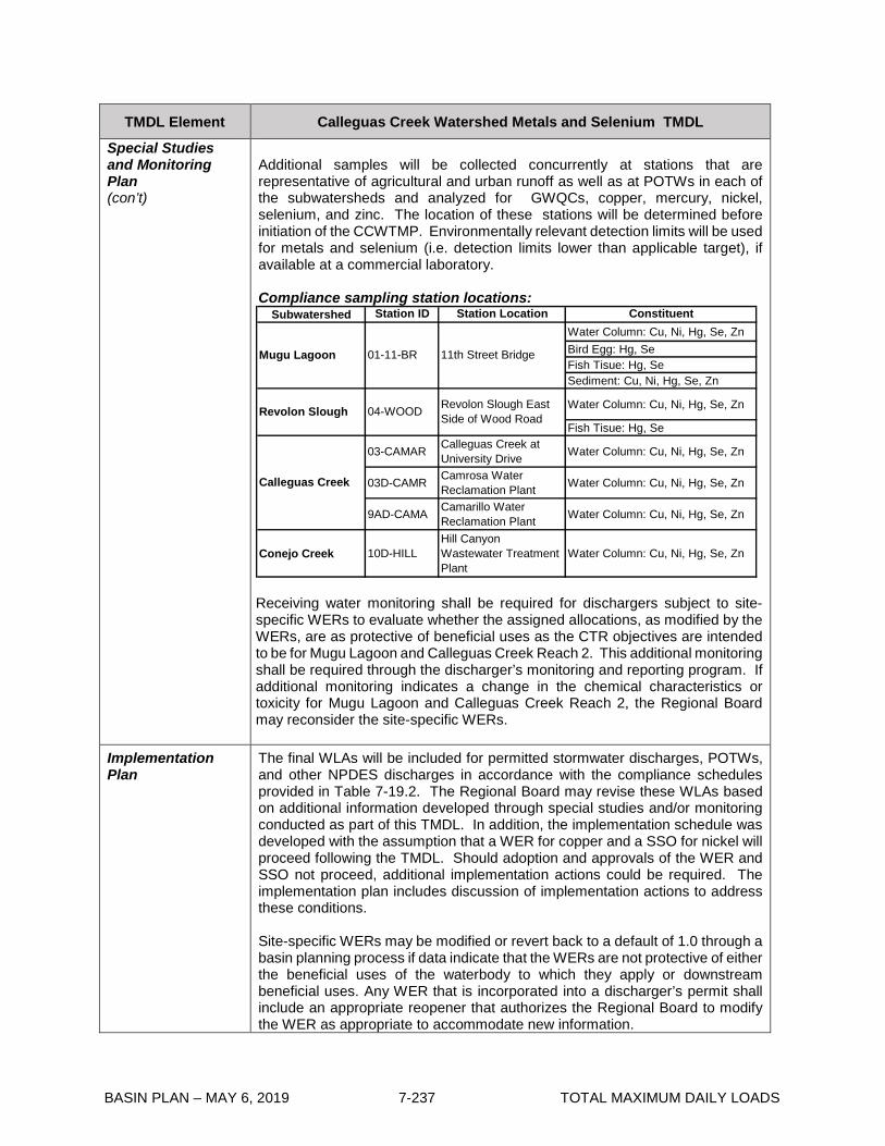
BASIN PLAN – MAY 6, 2019 7-237 TOTAL MAXIMUM DAILY LOADS
TMDL Element Calleguas Creek Watershed Metals and Selenium TMDL
Special Studies and Monitoring Plan (con’t)
Additional samples will be collected concurrently at stations that are representative of agricultural and urban runoff as well as at POTWs in each of the subwatersheds and analyzed for GWQCs, copper, mercury, nickel, selenium, and zinc. The location of these stations will be determined before initiation of the CCWTMP. Environmentally relevant detection limits will be used for metals and selenium (i.e. detection limits lower than applicable target), if available at a commercial laboratory. Compliance sampling station locations:
Subwatershed Station ID Station Location ConstituentWater Column: Cu, Ni, Hg, Se, ZnBird Egg: Hg, SeFish Tisue: Hg, SeSediment: Cu, Ni, Hg, Se, Zn
Water Column: Cu, Ni, Hg, Se, Zn
Fish Tisue: Hg, Se
03-CAMAR Calleguas Creek at University Drive Water Column: Cu, Ni, Hg, Se, Zn
03D-CAMR Camrosa Water Reclamation Plant Water Column: Cu, Ni, Hg, Se, Zn
9AD-CAMA Camarillo Water Reclamation Plant Water Column: Cu, Ni, Hg, Se, Zn
Conejo Creek 10D-HILLHill Canyon Wastewater Treatment Plant
Water Column: Cu, Ni, Hg, Se, Zn
Calleguas Creek
Mugu Lagoon 01-11-BR 11th Street Bridge
04-WOOD Revolon Slough East Side of Wood RoadRevolon Slough
Receiving water monitoring shall be required for dischargers subject to site-specific WERs to evaluate whether the assigned allocations, as modified by the WERs, are as protective of beneficial uses as the CTR objectives are intended to be for Mugu Lagoon and Calleguas Creek Reach 2. This additional monitoring shall be required through the discharger’s monitoring and reporting program. If additional monitoring indicates a change in the chemical characteristics or toxicity for Mugu Lagoon and Calleguas Creek Reach 2, the Regional Board may reconsider the site-specific WERs.
Implementation Plan
The final WLAs will be included for permitted stormwater discharges, POTWs, and other NPDES discharges in accordance with the compliance schedules provided in Table 7-19.2. The Regional Board may revise these WLAs based on additional information developed through special studies and/or monitoring conducted as part of this TMDL. In addition, the implementation schedule was developed with the assumption that a WER for copper and a SSO for nickel will proceed following the TMDL. Should adoption and approvals of the WER and SSO not proceed, additional implementation actions could be required. The implementation plan includes discussion of implementation actions to address these conditions. Site-specific WERs may be modified or revert back to a default of 1.0 through a basin planning process if data indicate that the WERs are not protective of either the beneficial uses of the waterbody to which they apply or downstream beneficial uses. Any WER that is incorporated into a discharger’s permit shall include an appropriate reopener that authorizes the Regional Board to modify the WER as appropriate to accommodate new information.
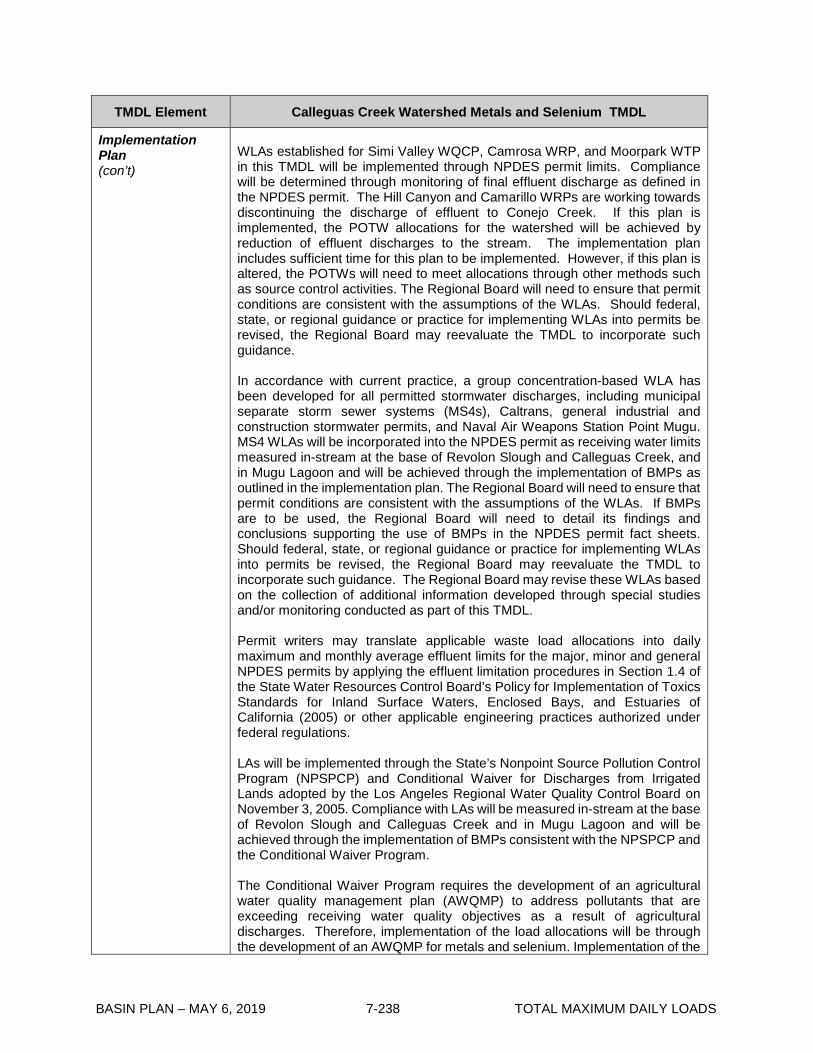
BASIN PLAN – MAY 6, 2019 7-238 TOTAL MAXIMUM DAILY LOADS
TMDL Element Calleguas Creek Watershed Metals and Selenium TMDL
Implementation Plan (con’t)
WLAs established for Simi Valley WQCP, Camrosa WRP, and Moorpark WTP in this TMDL will be implemented through NPDES permit limits. Compliance will be determined through monitoring of final effluent discharge as defined in the NPDES permit. The Hill Canyon and Camarillo WRPs are working towards discontinuing the discharge of effluent to Conejo Creek. If this plan is implemented, the POTW allocations for the watershed will be achieved by reduction of effluent discharges to the stream. The implementation plan includes sufficient time for this plan to be implemented. However, if this plan is altered, the POTWs will need to meet allocations through other methods such as source control activities. The Regional Board will need to ensure that permit conditions are consistent with the assumptions of the WLAs. Should federal, state, or regional guidance or practice for implementing WLAs into permits be revised, the Regional Board may reevaluate the TMDL to incorporate such guidance. In accordance with current practice, a group concentration-based WLA has been developed for all permitted stormwater discharges, including municipal separate storm sewer systems (MS4s), Caltrans, general industrial and construction stormwater permits, and Naval Air Weapons Station Point Mugu. MS4 WLAs will be incorporated into the NPDES permit as receiving water limits measured in-stream at the base of Revolon Slough and Calleguas Creek, and in Mugu Lagoon and will be achieved through the implementation of BMPs as outlined in the implementation plan. The Regional Board will need to ensure that permit conditions are consistent with the assumptions of the WLAs. If BMPs are to be used, the Regional Board will need to detail its findings and conclusions supporting the use of BMPs in the NPDES permit fact sheets. Should federal, state, or regional guidance or practice for implementing WLAs into permits be revised, the Regional Board may reevaluate the TMDL to incorporate such guidance. The Regional Board may revise these WLAs based on the collection of additional information developed through special studies and/or monitoring conducted as part of this TMDL. Permit writers may translate applicable waste load allocations into daily maximum and monthly average effluent limits for the major, minor and general NPDES permits by applying the effluent limitation procedures in Section 1.4 of the State Water Resources Control Board’s Policy for Implementation of Toxics Standards for Inland Surface Waters, Enclosed Bays, and Estuaries of California (2005) or other applicable engineering practices authorized under federal regulations. LAs will be implemented through the State’s Nonpoint Source Pollution Control Program (NPSPCP) and Conditional Waiver for Discharges from Irrigated Lands adopted by the Los Angeles Regional Water Quality Control Board on November 3, 2005. Compliance with LAs will be measured in-stream at the base of Revolon Slough and Calleguas Creek and in Mugu Lagoon and will be achieved through the implementation of BMPs consistent with the NPSPCP and the Conditional Waiver Program. The Conditional Waiver Program requires the development of an agricultural water quality management plan (AWQMP) to address pollutants that are exceeding receiving water quality objectives as a result of agricultural discharges. Therefore, implementation of the load allocations will be through the development of an AWQMP for metals and selenium. Implementation of the

BASIN PLAN – MAY 6, 2019 7-239 TOTAL MAXIMUM DAILY LOADS
TMDL Element Calleguas Creek Watershed Metals and Selenium TMDL
Implementation Plan (con’t)
load allocations will also include the coordination of BMPs being implemented under other required programs to ensure metal discharges are considered in the implementation. Additionally, agricultural dischargers will participate in educational seminars on the implementation of BMPs as required under the Conditional Waiver Program. Studies are currently being conducted to assess the extent of BMP implementation and provide information on the effectiveness of BMPs for agriculture. This information will be integrated into the AWQMP that will guide the implementation of agricultural BMPs in the Calleguas Creek watershed. After implementation of these actions, compliance with the allocations and TMDL will be evaluated and the allocations reconsidered if necessary based on the special studies and monitoring plan section of the implementation plan Agricultural and PSDs dischargers will have a required 25%, 50% and 100% reduction in the difference between the current loadings and the load allocations at 5, 10 and 15 years after the effective date, respectively. Achievement of required reductions will be evaluated based on progress towards BMP implementation as outlined in the UWQMPs, AWQMP, Conditional Waiver Program, and in consideration of background loading information, if available. If the interim reductions are not met, the dischargers will submit a report to the Executive Officer detailing why the reductions were not met and the steps that will be taken to meet the required reductions. As shown in Table 7-19.2, implementation of LAs will be conducted over a period of time to allow for implementation of the BMPs, as well as coordination with special studies and implementation actions resulting from other TMDL Implementation Plans for the Calleguas Creek watershed. The Regional Board may revise the LAs based on the collection of additional information developed through special studies and/or monitoring conducted as part of this TMDL.

BASIN PLAN – MAY 6, 2019 7-240 TOTAL MAXIMUM DAILY LOADS
Table 7-19.2 Calleguas Creek Watershed Metals and Selenium TMDL: Implementation Schedule
Item Implementation Action1 Responsible Party Completion
Date
1 Effective date of interim Metals and Selenium
TMDL waste load allocation (WLAs), and final
WLAs for other NPDES permittees
POTWs, Permitted
Stormwater Dischargers2
(PSD), Other NPDES
Permittees
March 27, 2007
2 Effective date of interim Metals and Selenium
TMDL load allocation (LAs) Agricultural Dischargers March 27, 2007
3a Submit Calleguas Creek Watershed Metals and
Selenium Monitoring Program
POTWs, PSD,
Agricultural Dischargers June 27, 2007
3b Implement Calleguas Creek Watershed Metals
and Selenium Monitoring Program
POTWs, PSD,
Agricultural Dischargers April 30, 2009
3c Re-calibrate HSPF water quality model based
on first year of monitoring data
POTWs, PSD,
Agricultural Dischargers
1 year after submittal of first annual monitoring report
4a
Conduct a source control study, develop and
submit an Urban Water Quality Management
Program (UWQMP) for copper, mercury, nickel,
and selenium
MS4s March 27, 2009
4b Conduct a source control study, develop and
submit an UWQMP for copper, mercury, nickel,
and selenium
Caltrans March 27, 2009
4c Conduct a source control study, develop and
submit an UWQMP for copper, mercury, nickel,
and selenium
NAWS point Mugu (US
Navy) March 27, 2009
1 The Regional Board regulatory programs addressing all discharges in effect at the time this implementation task is due may contain requirements substantially similar to the requirements of these implementation tasks. If such requirements are in place in another regulatory program including other TMDLs, the Executive Officer may revise or eliminate this implementation task to coordinate this TMDL implementation plan with other regulatory programs. 2 Permitted Stormwater Dischargers (PSD) include MS4s, Caltrans, the Naval Air Weapons Station at Point Mugu, and general industrial and construction permittees.
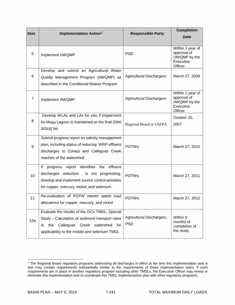
BASIN PLAN – MAY 6, 2019 7-241 TOTAL MAXIMUM DAILY LOADS
Item Implementation Action3 Responsible Party Completion
Date
5 Implement UWQMP PSD Within 1 year of approval of UWQMP by the Executive Officer
6 Develop and submit an Agricultural Water
Quality Management Program (AWQMP) as
described in the Conditional Waiver Program
Agricultural Dischargers March 27, 2009
7 Implement AWQMP Agricultural Dischargers Within 1 year of approval of AWQMP by the Executive Officer
8 Develop WLAs and LAs for zinc if impairment
for Mugu Lagoon is maintained on the final 2006
303(d) list Regional Board or USEPA
October 25,
2007
9
Submit progress report on salinity management
plan, including status of reducing WRP effluent
discharges to Conejo and Calleguas Creek
reaches of the watershed
POTWs March 27, 2010
10
If progress report identifies the effluent
discharges reduction is not progressing,
develop and implement source control activities
for copper, mercury, nickel, and selenium
POTWs March 27, 2011
11 Re-evaluation of POTW interim waste load
allocations for copper, mercury, and nickel POTWs March 27, 2012
12a
Evaluate the results of the OCs TMDL, Special
Study – Calculation of sediment transport rates
in the Calleguas Creek watershed for
applicability to the metals and selenium TMDL
Agricultural Dischargers,
PSD
Within 6 months of completion of the study
3 The Regional Board regulatory programs addressing all discharges in effect at the time this implementation task is due may contain requirements substantially similar to the requirements of these implementation tasks. If such requirements are in place in another regulatory program including other TMDLs, the Executive Officer may revise or eliminate this implementation task to coordinate this TMDL implementation plan with other regulatory programs.
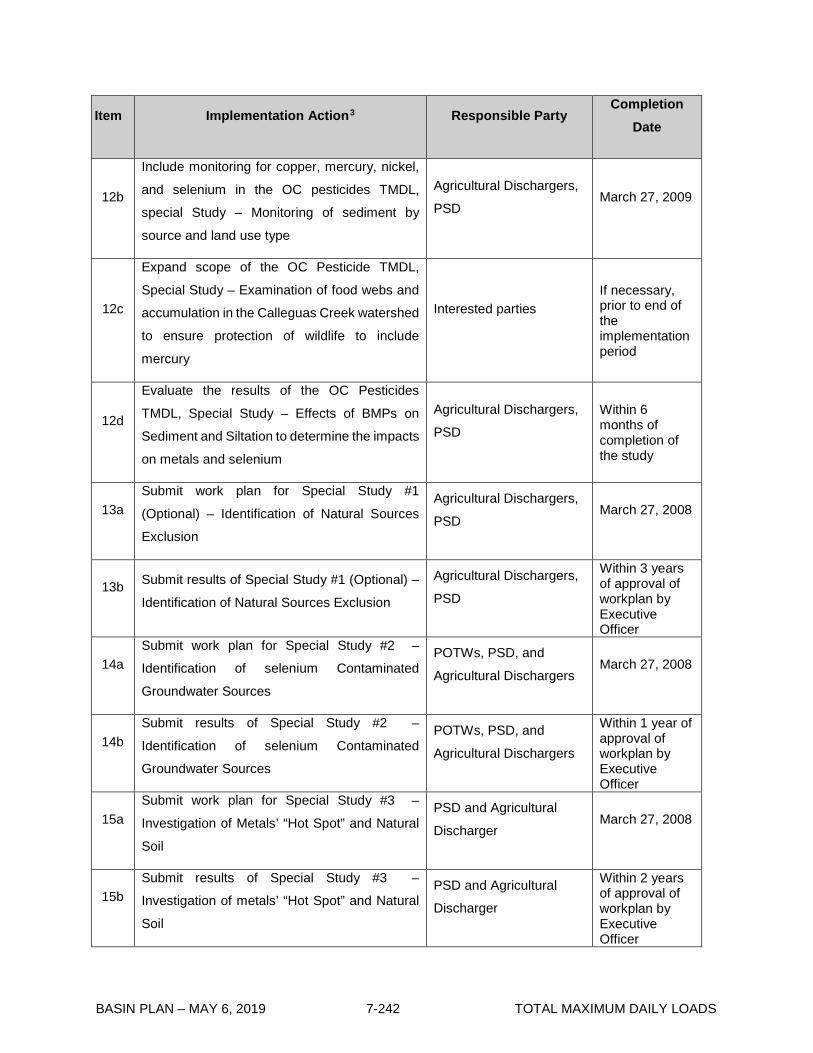
BASIN PLAN – MAY 6, 2019 7-242 TOTAL MAXIMUM DAILY LOADS
Item Implementation Action3 Responsible Party Completion
Date
12b
Include monitoring for copper, mercury, nickel,
and selenium in the OC pesticides TMDL,
special Study – Monitoring of sediment by
source and land use type
Agricultural Dischargers,
PSD March 27, 2009
12c
Expand scope of the OC Pesticide TMDL,
Special Study – Examination of food webs and
accumulation in the Calleguas Creek watershed
to ensure protection of wildlife to include
mercury
Interested parties If necessary, prior to end of the implementation period
12d
Evaluate the results of the OC Pesticides
TMDL, Special Study – Effects of BMPs on
Sediment and Siltation to determine the impacts
on metals and selenium
Agricultural Dischargers,
PSD
Within 6 months of completion of the study
13a Submit work plan for Special Study #1
(Optional) – Identification of Natural Sources
Exclusion
Agricultural Dischargers,
PSD March 27, 2008
13b Submit results of Special Study #1 (Optional) –
Identification of Natural Sources Exclusion
Agricultural Dischargers,
PSD
Within 3 years of approval of workplan by Executive Officer
14a Submit work plan for Special Study #2 –
Identification of selenium Contaminated
Groundwater Sources
POTWs, PSD, and
Agricultural Dischargers March 27, 2008
14b Submit results of Special Study #2 –
Identification of selenium Contaminated
Groundwater Sources
POTWs, PSD, and
Agricultural Dischargers
Within 1 year of approval of workplan by Executive Officer
15a Submit work plan for Special Study #3 –
Investigation of Metals’ “Hot Spot” and Natural
Soil
PSD and Agricultural
Discharger March 27, 2008
15b Submit results of Special Study #3 –
Investigation of metals’ “Hot Spot” and Natural
Soil
PSD and Agricultural
Discharger
Within 2 years of approval of workplan by Executive Officer

BASIN PLAN – MAY 6, 2019 7-243 TOTAL MAXIMUM DAILY LOADS
Item Implementation Action3 Responsible Party Completion
Date
16 Special Study #4 (Optional) – Determination of
WER for copper in Revolon Slough
PSD and Agricultural
Dischargers
If necessary, prior to end of the implementation period
17 Special Study #5 (Optional) – Determination of
Site Specific Objective for Mercury and
Selenium
PSD and Agricultural
Dischargers
If necessary, prior to end of the implementation period
18 Evaluate effectiveness of BMPs implemented
under the AWQMP and UWQMP in controlling
metals and selenium discharges
PSD and Agricultural
Dischargers March 27, 2013
19 Evaluate the results of implementation actions
14 and 15 (Special Study #2 & #3) and
implement actions identified by the studies
POTWs, PSD, and
Agricultural Dischargers Within 1 year after the completion of the studies
20
If needed, implement additional BMPs or revise
existing BMPs to address any issues not
covered by implementation efforts of related
Calleguas Creek watershed TMDLs (Nutrients,
Toxicity, OC Pesticides, PCBs, and Siltation)
and the Conditional Waiver Program
Agricultural Dischargers March 27, 2014
21 Consider nickel SSO proposed by stakeholders Regional Board March 27, 2008
22 Publicly notice tentative copper water effects
ratio for Regional Board consideration, if
deemed appropriate based on peer review Regional Board Staff
Within 2 months of receipt of peer review comments
23 Based on the result from items 1-23, Regional
Board will consider re-evaluation of the TMDLs,
WLAs, and LAs if necessary
Regional Board
2 years from submittal of information necessary for re-evaluation
24
POTWs will be required to reduce loadings by
50%, and 100% of the difference between the
current loading and the WLAs at 8 and 10 years
after the effective date, respectively.
POTWs March 27, 2015 and March 27, 2017
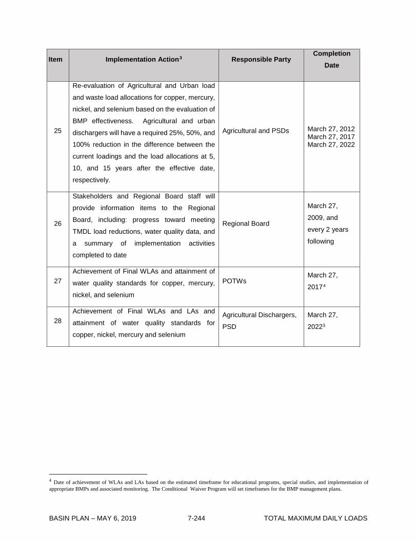
BASIN PLAN – MAY 6, 2019 7-244 TOTAL MAXIMUM DAILY LOADS
Item Implementation Action3 Responsible Party Completion
Date
25
Re-evaluation of Agricultural and Urban load
and waste load allocations for copper, mercury,
nickel, and selenium based on the evaluation of
BMP effectiveness. Agricultural and urban
dischargers will have a required 25%, 50%, and
100% reduction in the difference between the
current loadings and the load allocations at 5,
10, and 15 years after the effective date,
respectively.
Agricultural and PSDs March 27, 2012 March 27, 2017 March 27, 2022
26
Stakeholders and Regional Board staff will
provide information items to the Regional
Board, including: progress toward meeting
TMDL load reductions, water quality data, and
a summary of implementation activities
completed to date
Regional Board
March 27,
2009, and
every 2 years
following
27 Achievement of Final WLAs and attainment of
water quality standards for copper, mercury,
nickel, and selenium
POTWs March 27,
20174
28 Achievement of Final WLAs and LAs and
attainment of water quality standards for
copper, nickel, mercury and selenium
Agricultural Dischargers,
PSD
March 27,
20223
4 Date of achievement of WLAs and LAs based on the estimated timeframe for educational programs, special studies, and implementation of appropriate BMPs and associated monitoring. The Conditional Waiver Program will set timeframes for the BMP management plans.
BASIN PLAN – MAY 6, 2019 7-245 TOTAL MAXIMUM DAILY LOADS
7-20 Implementation Plan for the San Gabriel River Watershed Metals and Selenium TMDL This Implementation Plan was adopted by: The California Regional Water Quality Control Board, Los Angeles Region on June 6, 2013. This Implementation Plan was approved by: The State Water Resources Control Board on March 4, 2014. The Office of Administrative Law on October 13, 2014. The U.S. Environmental Protection Agency on May 11, 2017. This Implementation Plan is effective on October 13, 2014. Summary of U.S. EPA Established San Gabriel River and Impaired Tributaries Metals and Selenium TMDL San Gabriel River was included on the 1998, 2002, 2006, and 2010 California Clean Water Act (CWA) section 303(d) lists as an impaired waterbody for copper, zinc, lead, and selenium. The sources of metals loading in the watershed include point sources (such as inputs from municipal, industrial and construction storm water permittees, publicly owned treatment works (POTWs), and power plants) and nonpoint sources (such as air deposition and irrigated agriculture) within the San Gabriel River Watershed. The U.S. EPA established the San Gabriel River and Impaired Tributaries Total Maximum Daily Load for Metals and Selenium on March 26, 2007. The U.S. EPA-established TMDL includes the problem statement, numeric targets for copper, zinc, lead, and selenium based on water quality criteria for the protection of aquatic life as set forth in section 131.38 of title 40 of the Code of Federal Regulations (40 CFR), source analysis, loading capacity, load allocations (LAs) and waste load allocations (WLAs) based on the numeric targets, and margin of safety, but does not include an implementation plan or schedule. The following tables address implementation of the San Gabriel River Metals TMDL.

BASIN PLAN – MAY 6, 2019 7-246 TOTAL MAXIMUM DAILY LOADS
Table 7-20.1 San Gabriel River and Impaired Tributaries Metals and Selenium TMDL: Implementation Element Key Findings and Regulatory Provisions Implementation
The regulatory mechanisms used to implement the TMDL wasteload allocations assigned to point sources, and associated requirements, shall include but not be limited to:
• NPDES Permit(s) for Municipal Separate Storm Sewer System (MS4) discharges within the San Gabriel River Watershed,
• the NPDES Statewide Storm Water Permit for the State of California Department of Transportation,
• general NPDES permit(s) for storm water discharges associated with construction and land disturbance activities,
• general NPDES permit(s) for storm water discharges associated with industrial activities,
• major NPDES permit(s) (including publicly owned treatment works), • other general NPDES permits, and • minor NPDES permits.
Effluent limitations consistent with the assumptions and requirements of the WLAs shall be incorporated into each permit, at the time of permit issuance, modification, or renewal. The regulatory mechanisms used to implement the load allocations assigned to nonpoint sources shall include but not be limited to the authority contained in sections 13263 and 13269 of the California Water Code, in conformance with the State Water Resources Control Board’s (State Water Board) Policy for Implementation and Enforcement of the Nonpoint Source Pollution Control Program. POTWs, power plants, and other non-storm water program NPDES permits Effluent limitations shall be consistent with the concentration-based WLAs established for non-storm water point sources in this TMDL. Permit writers may translate applicable WLAs into final effluent limitations for the major, minor, and general NPDES permits by applying the effluent limitation derivation procedures in Section 1.4 of the State Water Board’s Policy for Implementation of Toxics Standards for Inland Surface Waters, Enclosed Bays, and Estuaries of California or other appropriate methodologies subject to Executive Officer approval. Wet-weather WLAs will not be used to determine monthly permit limits, but will only be used in determination of a daily limit. For permits subject to both dry- and wet-weather WLAs, permit writers would write a monthly limit based on the dry-weather WLA and two separate daily maximum limits based on dry- and wet-weather WLAs. Compliance Schedules1 for Copper WLAs During Dry Weather Applicable to Haynes and AES Alamitos Generating Stations The implementation schedules in Table 7-20.2 for the Haynes and AES Alamitos Generating Stations apply to the WLAs for copper in dry weather, which are based on the chronic saltwater criterion for protection of aquatic life as set forth in 40 CFR section 131.38. Where the Water Boards have authorization for issuing compliance schedules to the power plants pursuant to CWA section 303(c)(2), the Water Boards may provide compliance schedules in NPDES permits for the power plants up to the
1 “Compliance schedule” means a schedule of remedial measures, including an enforceable sequence of actions or operations leading to compliance with an effluent limitation, other limitations, prohibition, or standard.

BASIN PLAN – MAY 6, 2019 7-247 TOTAL MAXIMUM DAILY LOADS
Implementation (con’t)
dates in Table 7-20.2 and in accordance with the State Water Board’s Policy for Compliance Schedules in National Pollutant Discharge Elimination System Permits (Resolution No. 2008-0025) (“Compliance Schedule Policy”) and 40 CFR section 122.47. Any compliance schedule is subject to the provisions in the section entitled “Compliance Schedule Requirements” below. The implementation schedules for the Haynes and AES Alamitos Generating Stations provide the necessary time for these power plants to replace once through cooling, consistent with the implementation plans submitted pursuant to the State Water Board’s Once Through Cooling Policy, which will lead to compliance with effluent limitations consistent with the assumptions and requirements of their assigned WLAs. General Industrial and Construction Storm Water Permits Implementation of Dry-weather WLAs The dry-weather WLAs equal to zero apply to unauthorized non-storm water discharges, which are prohibited by the statewide General Permit for Discharges of Storm Water Associated with Construction Activity and the statewide Industrial Storm Water General Permit. Non-storm water discharges from construction or industrial activities authorized by State Water Board Order No. 2009-0009-DWQ or Order No. 97-03-DWQ, respectively, or any successor order, are exempt from the dry-weather WLA equal to zero. Instead, the reach-specific concentration-based WLAs assigned to the “other NPDES permits” shall apply to these non-storm water discharges. Dry-weather WLAs shall be incorporated into permits as permit limitations2 or discharge prohibitions, consistent with the assumptions and requirements of the WLAs. Compliance with dry-weather WLAs shall be assessed once per discharge event or by a demonstration of no discharge. Dry-weather permit limitations shall be expressed as instantaneous maximums. Implementation of Wet-weather WLAs Wet-weather mass-based WLAs for the general industrial and general construction storm water permittees shall be incorporated into permits as permit limitations and requirements consistent with the assumptions and requirements of the TMDL WLAs. Wet-weather permit limitations shall be expressed as event mean concentrations. Compliance with wet-weather WLAs shall be assessed at a minimum with one wet-weather sampling event. Permittees may demonstrate compliance with wet-weather WLAs in any one of three ways. First, general industrial and construction storm water permittees may be deemed in compliance with permit limitations if they demonstrate that there are no exceedances of the permit limitations at their discharge points or outfalls. Second, general industrial and construction storm water permittees may be deemed in compliance with permit limitations if they demonstrate that there are no exceedances of the permit limitations in the receiving water at, or downstream of, the permittee’s outfalls. Third, if permittees provide a quantitative demonstration that control measures and best management practices (BMPs) will achieve wet-weather WLAs consistent with the schedule in Table 7-20.2, then compliance may be demonstrated by implementation of those control measures and BMPs, subject to Executive Officer approval.
2 Permit limitation means a water quality-based effluent limitation or a receiving water limitation. Pursuant to 40 CFR section 130.2(h), wasteload allocations constitute a type of water quality-based effluent limitation.

BASIN PLAN – MAY 6, 2019 7-248 TOTAL MAXIMUM DAILY LOADS
Implementation (con’t)
Compliance Schedules for Wet Weather WLAs Applicable to Existing General Industrial and Construction Storm Water Dischargers The implementation schedule in Table 7-20.2 for the general industrial and construction stormwater permits applies to the WLAs for copper, lead, and zinc in wet weather, which are based on criteria in 40 CFR section 131.38. Where the Water Boards have authorization for issuing compliance schedules to existing general industrial and construction stormwater dischargers pursuant to CWA section 303(c)(2), the Water Boards may provide compliance schedules in the general industrial and construction stormwater permits up to the dates in Table 7-20.2 and in accordance with the State Water Board’s Compliance Schedule Policy and 40 CFR section 122.47. Any compliance schedule is subject to the section entitled “Compliance Schedule Requirements” below. Compliance schedules are not authorized for new dischargers. The implementation schedule for the general construction and industrial permits provides the necessary time for existing dischargers3 to implement BMPs, which will lead to compliance with WLAs as soon as possible and ensure that water quality standards are met by the end of the implementation period. Compliance Schedule Requirements An existing discharger who seeks a compliance schedule must demonstrate to the satisfaction of the Water Board that the discharger needs time to implement actions to comply with a more stringent permit limitation. In the case of individual permits, the discharger shall make a request for a compliance schedule up to the dates in Table 7-20.2 and provide the documentation required by Paragraph 4 (Application Requirements) of the Compliance Schedule Policy as part of its report of waste discharge. In the case of general permits, the discharger shall make a request for a compliance schedule up to the dates in Table 7-20.2 and provide the documentation required by Paragraph 4 (Application Requirements) of the Compliance Schedule Policy as part of its Permit Registration Documents or during the public comment period for renewal or reconsideration of the general permit. If the Water Board determines that an existing discharger has met the application requirements for a compliance schedule, then the Water Board may include an appropriate compliance schedule in the permit. Any compliance schedule must require compliance as soon as possible, taking into account the amount of time reasonably required for the discharger to implement actions, such as designing and constructing facilities or implementing new or significantly expanded programs and securing financing, if necessary, to comply with a more stringent permit limitation. The compliance schedule in the permit cannot, under any circumstances, exceed the maximum length for compliance schedules contained in this implementation plan. If the Water Board establishes a compliance schedule in the permit, the Water Board shall include interim requirements and dates for their achievement. If the compliance schedule exceeds one year, the Water Board shall establish interim numeric limitations for the pollutant in the permit; and may also impose interim requirements to control the pollutant, such as pollutant minimization and source control measures. Numeric interim limitations for the pollutant must, at a minimum, be based on current treatment facility performance or on existing permit limitations, whichever is more stringent. There shall be no more than one year between interim dates. The interim
3 Existing discharger is defined consistent with the State’s Policy for Compliance Schedules in National Pollutant Discharge Elimination System Permits.

BASIN PLAN – MAY 6, 2019 7-249 TOTAL MAXIMUM DAILY LOADS
Implementation (con’t)
requirements shall state that the discharger must notify the Water Board, in writing, no later than 14 days following each interim date, of its compliance or noncompliance with the interim requirements. The entire compliance schedule, including interim requirements and final permit limitations, shall be included as enforceable terms of the permit, whether or not the final compliance date is within the permit term. The permit shall include appropriate findings that the compliance schedule is necessary and that the schedule requires compliance as soon as possible within the timeframe allowed by the TMDL implementation schedule and in accordance with the Compliance Schedule Policy and 40 CFR section 122.47. The permit fact sheet shall adequately describe the basis for these findings. A Water Board is not prevented from requiring immediate compliance with permit limitations if a Water Board finds that immediate protection of beneficial uses of waters of the United States or California is in the best interest of the people of the state. However, in such an event, the Water Board shall make a finding stating the beneficial uses and specific interests of the people of the state that are being protected or promoted. MS4 and Caltrans Storm Water Permits Dry-weather and wet-weather waste load allocations apply to MS4 discharges and discharges by the State of California Department of Transportation (Caltrans). The WLAs for these discharges shall be incorporated into MS4 permits, including the statewide storm water permit for Caltrans, as water quality-based effluent limitations (WQBELs). These effluent limitations apply to Caltrans and all NPDES-regulated MS4 discharges in the San Gabriel River Watershed. MS4 Permittees and Caltrans may be deemed in compliance with WQBELs if they demonstrate that: (1) there are no violations of the WQBEL at the Permittee’s applicable MS4 outfall(s); (2) there are no exceedances of the receiving water limitations in the receiving water at, or downstream of, the Permittee’s outfalls; or (3) there is no direct or indirect discharge from the Permittee’s MS4 to the receiving water during the time period subject to the WQBEL. If permittees provide a quantitative demonstration as part of a watershed management program plan that control measures and BMPs will achieve wet-weather WQBELs consistent with the schedule in Table 7-20.2, then compliance with wet-weather WQBELs may be demonstrated by implementation of those control measures and BMPs, subject to Executive Officer approval. Compliance Schedules for MS4 and Caltrans Storm Water Permits For MS4 and Caltrans storm water permits that contain effluent limitations pursuant to CWA sections 402(p)(3)(B) and/or 303(d), any compliance schedule is subject to the requirements of 40 CFR section 122.47. Water Quality Attainment Strategies Permittees may attain the WLAs assigned in the TMDL using any lawful means. Examples of attainment strategies include, but are not limited to: pollution prevention, runoff reduction through low impact development or regional retention facilities, and tiered treatment control.

BASIN PLAN – MAY 6, 2019 7-250 TOTAL MAXIMUM DAILY LOADS
Implementation (con’t)
Other Implementation Actions Other governmental agencies and organizations may implement and adopt regulations that reduce and eliminate the discharges of metals to the San Gabriel River Watershed.
Monitoring Monitoring will be necessary to assess the efforts by dischargers to reduce metals loading to the San Gabriel River watershed and determine compliance with the WLAs and attainment of numeric targets. The TMDL monitoring program shall consist of two components: (1) receiving water monitoring, and (2) outfall monitoring. Monitoring requirements to assess implementation progress and determine compliance with the WLAs and numeric targets shall be included in subsequent permits or other orders.

BASIN PLAN – MAY 6, 2019 7-251 TOTAL MAXIMUM DAILY LOADS
Table 7-20.2 San Gabriel River Metals TMDL: Implementation Schedule Date Action September 30, 2020 The Los Angeles Water Board may reconsider this TMDL, including the
WLAs, LAs, and implementation schedule, if warranted, based on the results of monitoring and special studies and/or other new information.
POWER PLANTS Up to December 31, 2013
The Haynes Generating Station shall achieve the dry weather copper WLA for discharges from Unit 5 and 6 on or before December 31, 2013
Up to December 31, 2029
The Haynes Generating Station shall achieve the dry weather copper WLA for discharges from Units 1, 2, and 8 on or before December 31, 2029
Up to December 31, 2020
The AES Alamitos Generating Station shall achieve the dry weather copper WLA for all discharge points on or before December 31, 2020
OTHER NON-STORM WATER PROGRAM NPDES PERMITS (INCLUDING POTWs, OTHER MAJOR, MINOR, AND GENERAL PERMITS) Upon permit issuance, renewal, or re-opener
The non-storm water point sources shall achieve WLAs, expressed as effluent limitations derived using procedures in Section 1.4 of the State Water Board’s Policy for Implementation of Toxics Standards for Inland Surface Waters, Enclosed Bays, and Estuaries of California or other appropriate methodologies approved by the Executive Officer.
GENERAL INDUSTRIAL AND CONSTRUCTION STORM WATER PERMITS Upon permit issuance, renewal, or re-opener
The general industrial and general construction storm water permittees shall achieve dry-weather WLAs.
Up to September 30, 2017
The general industrial and general construction storm water permittees shall achieve wet-weather WLAs.
MS4 AND CALTRANS STORM WATER PERMITS September 30, 2015 MS4 and Caltrans storm water permittees shall submit a coordinated
monitoring plan, to be approved by the Executive Officer, which includes both TMDL compliance monitoring and receiving water monitoring. Monitoring shall commence within six months of approval of the coordinated monitoring plan by the Executive Officer. A monitoring program submitted pursuant to Order No. R4-2012-0175 may be used by permittees subject to that Order to satisfy the TMDL monitoring requirements.
September 30, 2016
MS4 and Caltrans storm water permittees shall provide a written report to the Los Angeles Water Board outlining how they will achieve compliance with the WLAs. The report shall include implementation methods, an implementation schedule, proposed milestones, and any revisions to the TMDL monitoring plan. An Enhanced Watershed Management Program or Watershed Management Program, including the Reasonable Assurance Analysis, submitted in fulfillment of requirements in Order No. R4-2012-0175 may be used by permittees subject to that Order to satisfy the TMDL implementation plan requirements.
September 30, 2017 MS4 and Caltrans storm water permittees shall demonstrate that 30% of the total drainage area served by the storm drain system is effectively meeting the dry-weather WLAs and 10% of the total drainage area served by the storm drain system is effectively meeting the wet-weather WLAs.

BASIN PLAN – MAY 6, 2019 7-252 TOTAL MAXIMUM DAILY LOADS
Alternatively, permittees shall attain a 30% reduction in the difference between the current loadings and the dry-weather WLAs and a 10% reduction in the difference between the current loadings and the wet-weather WLAs at storm drain outfalls, as measured at the relevant existing MS4 permit monitoring location and/or at relevant MS4 monitoring stations identified in an approved coordinated integrated monitoring plan.
September 30, 2020 The MS4 and Caltrans storm water permittees shall demonstrate that 70% of the total drainage area served by the storm drain system is effectively meeting the dry-weather WLAs and 35% of the total drainage area served by the storm drain system is effectively meeting the wet-weather WLAs. Alternatively, permittees shall attain a 70% reduction in the difference between the current loadings and the dry-weather WLAs and a 35% reduction in the difference between the current loadings and the wet-weather WLAs at storm drain outfalls, as measured at the relevant existing MS4 permit monitoring location and/or at relevant MS4 monitoring stations identified in an approved coordinated integrated monitoring plan.
September 30, 2023 The MS4 and Caltrans storm water permittees shall demonstrate that 100% of the total drainage area served by the storm drain system is effectively meeting the dry-weather WLAs and 65% of the total drainage area served by the storm drain system is effectively meeting the wet-weather WLAs. Alternatively, permittees shall attain a 65% reduction in the difference between the current loadings and the wet-weather WLAs at storm drain outfalls, as measured at the relevant existing MS4 permit monitoring location and/or at relevant MS4 monitoring stations identified in an approved coordinated integrated monitoring plan.
September 30, 2026 The MS4 and Caltrans storm water permittees shall demonstrate that 100% of the total drainage area served by the storm drain system is effectively meeting both the dry-weather and wet-weather WLAs and attaining water quality standards for copper, lead, and zinc.

BASIN PLAN – MAY 6, 2019 7-253 TOTAL MAXIMUM DAILY LOADS
7-21 Ballona Creek, Ballona Estuary, and Sepulveda Channel Bacteria TMDL This TMDL was adopted by the Regional Water Quality Control Board on June 8, 2006.
This TMDL was approved by:
The State Water Resources Control Board on November 15, 2006. The Office of Administrative Law on February 20, 2007. The U.S. Environmental Protection Agency on March 26, 2007.
This TMDL was revised and adopted by:
The Regional Water Quality Control Board on June 7, 2012.
This revised TMDL was approved by:
The State Water Resources Control Board on March 19, 2013. The Office of Administrative Law on November 8, 2013. The U.S. Environmental Protection Agency on July 2, 2014.
The following table includes all the elements of this TMDL.

BASIN PLAN – MAY 6, 2019 7-254 TOTAL MAXIMUM DAILY LOADS
Table 7-21.1 Ballona Creek, Estuary, and Tributaries Bacteria TMDL: Elements Element Key Findings and Regulatory Provisions
Problem Statement Elevated bacterial indicator densities are causing impairment of the water contact recreation (REC-1) beneficial use designated for Ballona Estuary and Sepulveda Channel, limited water contact recreation (LREC) designated for Ballona Creek Reach 2, and non-contact recreation (REC-2) beneficial uses of Ballona Creek Reach 1. Recreating in waters with elevated bacterial indicator densities has long been associated with adverse human health effects. Specifically, local and national epidemiological studies compel the conclusion that there is a causal relationship between adverse health effects and recreational water quality, as measured by bacterial indicator densities.
Numeric Target (Interpretation of the numeric water quality objective, used to calculate the waste load allocations)
The TMDL has a multi-part numeric target based on the bacteriological water quality objectives for marine and fresh water to protect the contact and non-contact recreation uses. These targets are the most appropriate indicators of public health risk in recreational waters. These bacteriological objectives are set forth in Chapter 3 of the Basin Plan.1 The objectives are based on four bacterial indicators and include both geometric mean limits and single sample limits. The Basin Plan objectives that serve as the numeric targets for this TMDL are: In Marine Waters Designated for Water Contact Recreation (REC-1) 1. Geometric Mean Limits a. Total coliform density shall not exceed 1,000/100 ml. b. Fecal coliform density shall not exceed 200/100 ml. c. Enterococcus density shall not exceed 35/100 ml. 2. Single Sample Limits a. Total coliform density shall not exceed 10,000/100 ml. b. Fecal coliform density shall not exceed 400/100 ml. c. Enterococcus density shall not exceed 104/100 ml. d. Total coliform density shall not exceed 1,000/100 ml, if the
ratio of fecal-to-total coliform exceeds 0.1. In Fresh Waters Designated for Water Contact Recreation (REC-1) 1. Geometric Mean Limits a. E. coli density shall not exceed 126/100 ml. 2. Single Sample Limits a. E. coli density shall not exceed 235/100 ml.
1 The bacteriological objectives were revised by a Basin Plan amendment adopted by the Regional Board on October 25, 2001, and subsequently approved by the State Water Resources Control Board, the Office of Administrative Law and finally by U.S. EPA on September 25, 2002. The bacteriological objectives for freshwater were revised a second time by a Basin Plan amendment adopted by the Regional Board on July 8, 2010, and subsequently approved by the State Water Resources Control Board, the Office of Administrative Law and finally by U.S. EPA on December 5, 2011.

BASIN PLAN – MAY 6, 2019 7-255 TOTAL MAXIMUM DAILY LOADS
Element Key Findings and Regulatory Provisions
Numeric Target (con’t)
In Fresh Waters Designated for Limited Water Contact Recreation (LREC-1)2 1. Geometric Mean Limits a. E. coli density shall not exceed 126/100 ml. 2. Single Sample Limits a. E. coli density shall not exceed 576/100 ml. In Fresh Waters Designated for Non-Contact Water Recreation (REC-2) 1. Geometric Mean Limits a. Fecal coliform density shall not exceed 2000/100 ml. 2. Single Sample Limits a. Fecal coliform density shall not exceed 4000/100 ml. The targets apply throughout the year. Determination of attainment of the targets will be at in-stream monitoring sites to be specified in the compliance monitoring report. In this TMDL, implementation of the above REC-1 and LREC-1 bacteria objectives and the associated TMDL numeric targets is achieved using a ‘reference system/anti-degradation approach’ rather than the alternative ‘natural sources exclusion approach subject to antidegradation policies’ or strict application of the single sample objectives. As required by the federal Clean Water Act and California Water Code, Basin Plans include beneficial uses of waters, water quality objectives to protect those uses, an anti-degradation policy, collectively referred to as water quality standards, and other plans and policies necessary to implement water quality standards. This TMDL and its associated waste load allocations, which shall be incorporated into relevant permits, and load allocations are the vehicles for implementation of the Region’s standards. This TMDL uses a “reference system/anti-degradation approach” to implement the water quality objectives per the implementation provisions in Chapter 3. On the basis of the historical exceedance frequency at Southern California reference reaches, a certain number of daily exceedances of the single sample bacteria objectives are permitted. The geometric mean targets may not be exceeded at any time. For the purposes of this TMDL, the geometric means shall be calculated weekly as a rolling geometric mean using 5 or more samples, for six week periods starting all calculation weeks on Sunday. For the single sample targets, each existing monitoring site in Ballona Creek and its tributaries is assigned an allowable number of exceedance days for two time periods (1) dry weather and (2) wet-weather (defined as days with 0.1 inch of rain or greater and the three days following the rain event.) Each monitoring site in Ballona Estuary is assigned an allowable number of exceedance days for three time periods (1) summer dry-weather (April 1
2 The bacteriological objectives for the LREC-1 use designation were provided in a Basin Plan Amendment adopted by State Board on January 20, 2005, and subsequently approved by the Office of Administrative Law and finally by U.S. EPA on February 17, 2006

BASIN PLAN – MAY 6, 2019 7-256 TOTAL MAXIMUM DAILY LOADS
Element Key Findings and Regulatory Provisions
Numeric Target (con’t)
to October 31), (2) winter dry-weather (November 1 to March 31), and (3) wet-weather (defined as days with 0.1 inch of rain or greater and the three days following the rain event.) Implementation of the REC-2 target will be as specified in the Basin Plan. The REC-2 bacteria objectives allow for a 10% exceedance frequency of the single sample limit in samples collected during a 30-day period. This allowance, which is based on an acceptable level of health risk, will be applied in lieu of the allowable exceedance days discussed earlier. As with the other REC-1 and LREC-1 objectives, the geometric mean target for REC-2, which is based on periods as defined above, will be strictly adhered to and may not be exceeded at any time.
Source Analysis The major contributors of flows and associated bacteria loading to Ballona Creek and Estuary, are dry- and wet-weather urban runoff discharges from the storm water conveyance system. Run-off to Ballona Creek is regulated as a point source under the Los Angeles County MS4 Permit, the Caltrans Storm Water Permit, and the General Construction and Industrial Storm Water Permits. In addition to these regulated point sources, the Ballona Estuary receives input from the Del Rey Lagoon and Ballona Wetlands through connecting tide gates. Preliminary data suggest that the Ballona Wetlands are a sink for bacteria from Ballona Creek and it is therefore not considered a source in this TMDL. Inputs to Ballona Estuary from Del Rey Lagoon, are considered non-point sources of bacterial contamination. This waterbody may be considered for a natural source exclusion if its contributing bacteria loads are determined to be as a result of wildlife in the area, as opposed to anthropogenic inputs. The TMDL will require a source identification study for the lagoon in order to apply the natural source exclusion. Other nonpoint sources in Ballona Creek and Estuary include natural sources from birds, waterfowl and other wildlife. Data do not currently exist to quantify the extent of the impact of wildlife on bacteria water quality in the Estuary.
Loading Capacity The loading capacity is defined in terms of bacterial indicator densities, which is the most appropriate for addressing public health risk, and is equivalent to the numeric targets, listed above.
Waste Load Allocations (for point sources)
The Los Angeles County MS4, Caltrans, and any future Phase II MS4 storm water permittees and co-permittees are assigned waste load allocations (WLAs) expressed as the number of daily or weekly sample days that may exceed the single sample targets equal to the TMDLs established for the impaired reaches (see Table 7-21.2a), and Waste Load Allocations assigned to waters tributary to impaired reaches (Table 7-21.2b). Waste load allocations are expressed as allowable exceedance days because the bacterial density and frequency of single sample exceedances are the most relevant to public health protection.
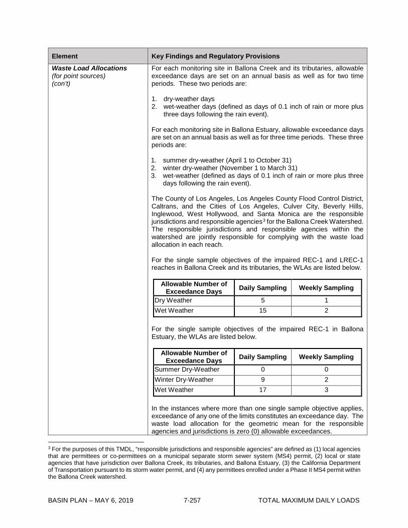
BASIN PLAN – MAY 6, 2019 7-257 TOTAL MAXIMUM DAILY LOADS
Element Key Findings and Regulatory Provisions
Waste Load Allocations (for point sources) (con’t)
For each monitoring site in Ballona Creek and its tributaries, allowable exceedance days are set on an annual basis as well as for two time periods. These two periods are: 1. dry-weather days 2. wet-weather days (defined as days of 0.1 inch of rain or more plus
three days following the rain event). For each monitoring site in Ballona Estuary, allowable exceedance days are set on an annual basis as well as for three time periods. These three periods are: 1. summer dry-weather (April 1 to October 31) 2. winter dry-weather (November 1 to March 31) 3. wet-weather (defined as days of 0.1 inch of rain or more plus three
days following the rain event). The County of Los Angeles, Los Angeles County Flood Control District, Caltrans, and the Cities of Los Angeles, Culver City, Beverly Hills, Inglewood, West Hollywood, and Santa Monica are the responsible jurisdictions and responsible agencies3 for the Ballona Creek Watershed. The responsible jurisdictions and responsible agencies within the watershed are jointly responsible for complying with the waste load allocation in each reach. For the single sample objectives of the impaired REC-1 and LREC-1 reaches in Ballona Creek and its tributaries, the WLAs are listed below.
Allowable Number of Exceedance Days Daily Sampling Weekly Sampling
Dry Weather 5 1 Wet Weather 15 2
For the single sample objectives of the impaired REC-1 in Ballona Estuary, the WLAs are listed below.
Allowable Number of Exceedance Days Daily Sampling Weekly Sampling
Summer Dry-Weather 0 0 Winter Dry-Weather 9 2 Wet Weather 17 3
In the instances where more than one single sample objective applies, exceedance of any one of the limits constitutes an exceedance day. The waste load allocation for the geometric mean for the responsible agencies and jurisdictions is zero (0) allowable exceedances.
3 For the purposes of this TMDL, “responsible jurisdictions and responsible agencies” are defined as (1) local agencies that are permittees or co-permittees on a municipal separate storm sewer system (MS4) permit, (2) local or state agencies that have jurisdiction over Ballona Creek, its tributaries, and Ballona Estuary, (3) the California Department of Transportation pursuant to its storm water permit, and (4) any permittees enrolled under a Phase II MS4 permit within the Ballona Creek watershed.

BASIN PLAN – MAY 6, 2019 7-258 TOTAL MAXIMUM DAILY LOADS
Element Key Findings and Regulatory Provisions
Waste Load Allocations (for point sources) (con’t)
For the single sample objectives of the impaired REC-2 reach, the WLA for all periods is a 10% exceedance frequency of the REC-2 single sample water quality objectives. The waste load allocation for the geometric mean for the responsible agencies and jurisdictions is zero (0) allowable exceedances. In addition to assigning TMDLs for the impaired reaches, Waste Load Allocations and Load Allocations are assigned to the tributaries to these impaired reaches. These WLAs and LAs are to be met at the confluence of each tributary and its downstream reach (see Table 7-21.2b). Discharges from general NPDES permits, general industrial storm water permits and general construction storm water permits are not expected to be a significant source of bacteria. Additionally, these discharges are not eligible for the reference system approach set forth in the implementation provisions for the bacteriological objectives in Chapter 3. Therefore, the waste load allocations for these discharges for all time periods are the bacteriological objectives contained in Chapter 3. Any future enrollees under a general NPDES permit, general industrial storm water permit or general construction storm water permit within the Ballona Creek watershed management area will also be subject to a WLA based on these bacteriological objectives.
Load Allocations (for nonpoint sources)
Load allocations are expressed as the number of daily or weekly sample days that may exceed the single sample targets identified under “Numeric Target” at a monitoring site, along with a geometric mean limit. Load allocations are expressed as allowable exceedance days because the bacterial density and frequency of single sample exceedances are the most relevant to public health protection. Del Rey Lagoon is considered a nonpoint source and is therefore subject to load allocations. The LAs for dry-weather and wet-weather in Ballona Creek and its tributaries are listed below.
Allowable Number of Exceedance Days Daily Sampling Weekly Sampling
Dry Weather 5 1 Wet Weather 15 2
The LAs for summer dry-weather, winter dry-weather, and wet-weather in Ballona Estuary are listed below.
Allowable Number of Exceedance Days Daily Sampling Weekly Sampling
Summer Dry-Weather 0 0 Winter Dry-Weather 9 2 Wet Weather 17 3
In the instances where more than one single sample objective applies, exceedance of any one of the limits constitutes an exceedance day. The

BASIN PLAN – MAY 6, 2019 7-259 TOTAL MAXIMUM DAILY LOADS
Element Key Findings and Regulatory Provisions
Load Allocations (for nonpoint sources) (con’t)
load allocation for the geometric mean limit for the responsible agencies and jurisdictions is zero (0) allowable exceedances (see Table 7-21.2a). The City of Los Angeles is the responsible jurisdiction for the Del Rey lagoon, and is responsible for complying with the assigned load allocations presented in Table 7-21.2b at the tide gate(s) between the Lagoon and the Estuary. If other unidentified nonpoint sources are directly impacting bacteriological water quality and causing an exceedance of the numeric targets, within the Estuary, the permittee(s) under the MS4 NPDES Permits are not responsible through these permits. However, the jurisdiction or agency adjacent to the monitoring location may have further obligations to identify and control such sources.
Implementation
The regulatory mechanisms used to implement the TMDL will include the Los Angeles County MS4 NPDES Permit, the Caltrans Storm Water Permit, any future Phase II MS4 permits, general NPDES permits, general industrial storm water permits, general construction storm water permits, and the authority contained in Sections 13263, 13267, and 13383 of the California Water Code, and other appropriate regulatory mechanisms. Each NPDES permit assigned a WLA shall be reopened or amended at re-issuance, in accordance with applicable laws, to incorporate the applicable WLAs as a permit requirement. Each responsible jurisdiction and agency will be required to meet the MS4 waste load allocations at the designated compliance monitoring points. An iterative implementation approach using a combination of non-structural and structural BMPs may be used to achieve compliance with the waste load allocations. The administrative record and the fact sheets for the MS4 and Caltrans storm water permits must provide reasonable assurance that the BMPs selected will be sufficient to achieve the waste load allocation. Load allocations for nonpoint sources will be implemented through Waste Discharge Requirements, Memorandum of Understandings or other appropriate mechanisms consistent with the Nonpoint Source Implementation and Enforcement Policy. This TMDL will be implemented in two phases over a ten-year period (see Table 7-21.3). By April 27, 2013, compliance with the allowable number of dry-weather exceedance days must be achieved. By July 15, 2021, compliance with the allowable number of wet-weather exceedance days and the geometric mean targets must be achieved. The responsible jurisdictions and the responsible agencies must submit a report to the Executive Officer (see Table 7-21.3) describing how they intend to comply with the dry-weather and wet-weather WLAs. As the primary jurisdiction, the City of Los Angeles is responsible for submitting the implementation plan report described above.

BASIN PLAN – MAY 6, 2019 7-260 TOTAL MAXIMUM DAILY LOADS
Element Key Findings and Regulatory Provisions
Implementation (con’t)
In addition, as the responsible agency for Del Rey Lagoon, the City of Los Angeles must submit a report detailing how it intends to comply with the load allocations assigned to this waterbody. Alternatively, the City of Los Angeles may submit data clearly demonstrating that Del Rey Lagoon is not a source, for the Regional Board’s consideration.
Margin of Safety By directly applying the numeric water quality standards and implementation procedures as Waste Load Allocations, there is little uncertainty about whether meeting the TMDLs will result in meeting the water quality standards.
Seasonal Variations and Critical Conditions
Seasonal variations are addressed by developing separate waste load allocations for two time periods (dry weather and wet weather) in Ballona Creek and its tributaries, and three time periods (summer dry-weather, winter dry-weather, and wet weather) in Ballona Estuary based on public health concerns and observed natural background levels of exceedance of bacterial indicators. The critical condition for bacteria loading to the Ballona Creek, Ballona Estuary, and Sepulveda Channel is during wet weather when monitoring data indicate greater exceedance probabilities of the single sample bacteria objectives than during dry weather. The Santa Monica Bay Beaches Bacteria TMDL identified the critical condition within wet weather more specifically, in order to set the allowable number of exceedances of the single sample limit days. The 90th percentile storm year in terms of wet days was used as the reference year. The number of wet-weather days in the 1993 reference year was 75 days, and the number of dry-weather days was 290 days (210 summer dry-weather days and 80 winter dry-weather days).
Monitoring
The monitoring program will assess attainment of the allowable exceedances for Ballona Creek, Ballona Estuary, and Sepulveda Channel, and the WLAs for the tributaries. Responsible jurisdictions and responsible agencies shall conduct daily or systematic weekly sampling at a minimum of two locations within Ballona Estuary and Reach 2 of Ballona Creek, at least one location each in Reach 1 of Ballona Creek and Sepulveda Channel, and at the confluence with Centinela Creek and Benedict Canyon Channel, to determine compliance. Similar monitoring at the connecting tide gates of Del Rey Lagoon is also required. Where monitoring locations are located at or close to the boundary of two reaches, data from sampling points will also be used to assess the immediate downstream reach. This will ensure that the downstream reaches, which have more stringent water quality objectives, are adequately protected. Responsible jurisdictions and agencies shall submit an outfall monitoring plan by within 6 months of the effective date of the TMDL revised by Resolution R12-008. The outfall monitoring plan shall propose an

BASIN PLAN – MAY 6, 2019 7-261 TOTAL MAXIMUM DAILY LOADS
Element Key Findings and Regulatory Provisions
Monitoring (con’t)
adequate number of representative outfalls to be sampled, a sampling frequency, and protocol for enhanced outfall monitoring as a result of an in-stream exceedance. Responsible jurisdictions and agencies can use existing outfall monitoring stations in the MS4 permit, where appropriate for both the permit and TMDL objectives. If the number of exceedance days is greater than the allowable number of exceedance days in the REC-1 and LREC-1 waters, and/or the frequency of exceedance is greater than 10% in the REC-2 waters, the responsible jurisdictions and/or responsible agencies shall be considered not to be attaining the TMDLs and/or assigned allocations (non-attaining). Responsible jurisdictions or agencies shall not be deemed non-attaining if the outfall monitoring described in the paragraph above demonstrates that bacterial sources originating within the jurisdiction of the responsible agency have not caused or contributed to the exceedance.

BASIN PLAN – APRIL 2, 2019 7-262 TOTAL MAXIMUM DAILY LOADS
Table 7-21.2a: Ballona Creek, Ballona Estuary and Sepulveda Channel Bacteria TMDL: Final Allowable Exceedance Days by Reach
Time Period Ballona Estuary* Ballona Creek Reach 2, and Sepulveda Channel
*
Ballona Creek Reach 1**
Dry Weather
Zero (0) exceedance days for summer dry-weather
Nine (9) exceedance days (daily sampling) or two (2) exceedance days (weekly sampling) based on the applicable Single Sample Bacteria Water Quality Objectives for winter dry-weather
Five (5) exceedance days (daily sampling) or one (1) exceedance day (weekly sampling) based on the applicable Single Sample Bacteria Water Quality Objectives
No more than 10% of sample days
Wet Weather
(days with ≥0.1 inch of rain + 3 days following the rain event)
17 exceedance days (daily sampling) or three (3) exceedance days (weekly sampling) based on the applicable Single Sample Bacteria Water Quality Objectives
15*** exceedance days (daily sampling) or two (2) exceedance days (weekly sampling) based on the applicable Single Sample Bacteria Water Quality Objectives
No more than 10% of sample days
Geometric Mean
Zero (0) exceedances of the Geometric Mean Bacteria Water Quality Objectives
Zero (0) exceedances of the Geometric Mean Bacteria Water Quality Objectives
Zero (0) exceedances of the Geometric Mean Bacteria Water Quality Objectives
* Exceedance days for Ballona Estuary based on REC-1 marine water numeric targets; for Ballona Creek Reach 2 based on LREC-1 freshwater numeric targets; and for Sepulveda Channel, based on fresh water REC-1 numeric targets **Exceedance frequency for Ballona Creek Reach 1 based on freshwater REC-2 numeric targets *** In Reach 2, the greater of the allowable exceedance days under the reference system approach or high flow suspension shall apply.
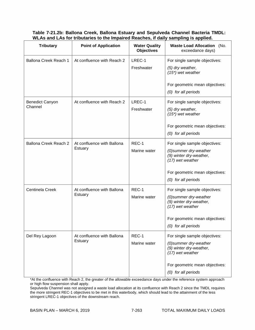
BASIN PLAN – MARCH 6, 2019 7-263 TOTAL MAXIMUM DAILY LOADS
Table 7-21.2b: Ballona Creek, Ballona Estuary and Sepulveda Channel Bacteria TMDL: WLAs and LAs for tributaries to the Impaired Reaches, if daily sampling is applied.
Tributary Point of Application Water Quality Objectives
Waste Load Allocation (No. exceedance days)
Ballona Creek Reach 1 At confluence with Reach 2 LREC-1
Freshwater
For single sample objectives:
(5) dry weather, (15*) wet weather
For geometric mean objectives:
(0) for all periods
Benedict Canyon Channel
At confluence with Reach 2 LREC-1
Freshwater
For single sample objectives:
(5) dry weather, (15*) wet weather
For geometric mean objectives:
(0) for all periods
Ballona Creek Reach 2 At confluence with Ballona Estuary
REC-1
Marine water
For single sample objectives:
(0)summer dry-weather (9) winter dry-weather, (17) wet weather
For geometric mean objectives:
(0) for all periods
Centinela Creek At confluence with Ballona Estuary
REC-1
Marine water
For single sample objectives:
(0)summer dry-weather (9) winter dry-weather, (17) wet weather
For geometric mean objectives:
(0) for all periods
Del Rey Lagoon At confluence with Ballona Estuary
REC-1
Marine water
For single sample objectives:
(0)summer dry-weather (9) winter dry-weather, (17) wet weather
For geometric mean objectives:
(0) for all periods
*At the confluence with Reach 2, the greater of the allowable exceedance days under the reference system approach or high flow suspension shall apply. Sepulveda Channel was not assigned a waste load allocation at its confluence with Reach 2 since the TMDL requires the more stringent REC-1 objectives to be met in this waterbody, which should lead to the attainment of the less stringent LREC-1 objectives of the downstream reach.

BASIN PLAN – MARCH 6, 2019 7-264 TOTAL MAXIMUM DAILY LOADS
Table 7-21.3 Ballona Creek, Ballona Estuary and Sepulveda Channel Bacteria TMDL: Significant Dates
Date Action Responsible Jurisdictions for the Waste Load Allocations
April 27, 2008 Responsible jurisdictions and responsible agencies must submit, for Regional Board approval, a comprehensive bacteria water quality monitoring plan for the Ballona Creek Watershed. The plan must be approved by the Executive Officer before the monitoring data can be considered during the implementation of the TMDL. The plan must provide for analyses of all applicable bacteria indicators for which the Basin Plan and subsequent amendments have established objectives. The plan must also include a minimum of two sampling locations (mid-stream and downstream) in Ballona Estuary, Ballona Creek (Reach 1 and 2), and their tributaries. The draft monitoring report shall be made available for public comment and the Executive Officer shall accept public comments for at least 30 days. Once the coordinated monitoring plan is approved by the Executive Officer, monitoring shall commence within 6 months.
October 27, 2009 Responsible jurisdictions and agencies must provide a draft Implementation Plan to the Regional Board outlining how each intends to cooperatively achieve compliance with the dry-weather and wet-weather TMDL Waste Load Allocations. The report shall include implementation methods, an implementation schedule, and proposed milestones. The description of the implementation methods and milestones shall include a technically defensible quantitative linkage to the interim and final waste load allocations (WLAs). The linkage should include target reductions in stormwater runoff and/or fecal indicator bacteria. The plan shall include quantitative estimates of the water quality benefits provided by the proposed structural and non-structural BMPs. Estimates should address reductions in exceedance days, bacteria concentration and loading, and flow in the drain and at each beach compliance monitoring location. As part of the draft plan, responsible agencies must submit results of all special studies and/or Environmental Impact Assessments, designed to determine feasibility of any strategy that requires diversion and/or reduction of Creek flows. The draft Plan shall be made available for public comment and the Executive Officer shall accept public comments for at least 30 days.
3 months after receipt of Regional Board comments on the draft plan
Responsible jurisdictions and agencies submit a Final Implementation Plan to the Regional Board.
Responsible agencies for Load Allocations
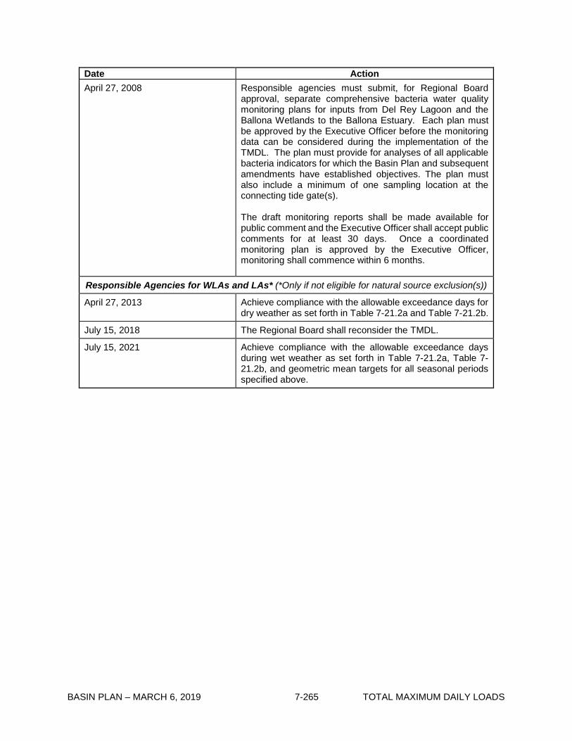
BASIN PLAN – MARCH 6, 2019 7-265 TOTAL MAXIMUM DAILY LOADS
Date Action April 27, 2008 Responsible agencies must submit, for Regional Board
approval, separate comprehensive bacteria water quality monitoring plans for inputs from Del Rey Lagoon and the Ballona Wetlands to the Ballona Estuary. Each plan must be approved by the Executive Officer before the monitoring data can be considered during the implementation of the TMDL. The plan must provide for analyses of all applicable bacteria indicators for which the Basin Plan and subsequent amendments have established objectives. The plan must also include a minimum of one sampling location at the connecting tide gate(s). The draft monitoring reports shall be made available for public comment and the Executive Officer shall accept public comments for at least 30 days. Once a coordinated monitoring plan is approved by the Executive Officer, monitoring shall commence within 6 months.
Responsible Agencies for WLAs and LAs* (*Only if not eligible for natural source exclusion(s))
April 27, 2013 Achieve compliance with the allowable exceedance days for dry weather as set forth in Table 7-21.2a and Table 7-21.2b.
July 15, 2018 The Regional Board shall reconsider the TMDL.
July 15, 2021 Achieve compliance with the allowable exceedance days during wet weather as set forth in Table 7-21.2a, Table 7-21.2b, and geometric mean targets for all seasonal periods specified above.

BASIN PLAN – MARCH 6, 2019 7-266 TOTAL MAXIMUM DAILY LOADS
This page intentionally left blank
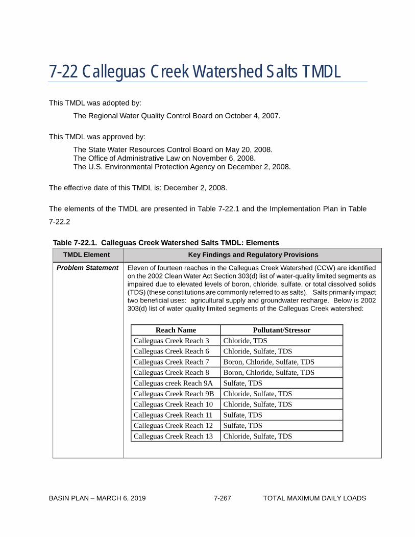
BASIN PLAN – MARCH 6, 2019 7-267 TOTAL MAXIMUM DAILY LOADS
Reach Name Pollutant/Stressor Calleguas Creek Reach 3 Chloride, TDS Calleguas Creek Reach 6 Chloride, Sulfate, TDS Calleguas Creek Reach 7 Boron, Chloride, Sulfate, TDS Calleguas Creek Reach 8 Boron, Chloride, Sulfate, TDS Calleguas creek Reach 9A Sulfate, TDS Calleguas Creek Reach 9B Chloride, Sulfate, TDS Calleguas Creek Reach 10 Chloride, Sulfate, TDS Calleguas Creek Reach 11 Sulfate, TDS Calleguas Creek Reach 12 Sulfate, TDS Calleguas Creek Reach 13 Chloride, Sulfate, TDS
7-22 Calleguas Creek Watershed Salts TMDL This TMDL was adopted by:
The Regional Water Quality Control Board on October 4, 2007.
This TMDL was approved by:
The State Water Resources Control Board on May 20, 2008. The Office of Administrative Law on November 6, 2008. The U.S. Environmental Protection Agency on December 2, 2008.
The effective date of this TMDL is: December 2, 2008.
The elements of the TMDL are presented in Table 7-22.1 and the Implementation Plan in Table
7-22.2
Table 7-22.1. Calleguas Creek Watershed Salts TMDL: Elements
TMDL Element Key Findings and Regulatory Provisions
Problem Statement Eleven of fourteen reaches in the Calleguas Creek Watershed (CCW) are identified on the 2002 Clean Water Act Section 303(d) list of water-quality limited segments as impaired due to elevated levels of boron, chloride, sulfate, or total dissolved solids (TDS) (these constitutions are commonly referred to as salts). Salts primarily impact two beneficial uses: agricultural supply and groundwater recharge. Below is 2002 303(d) list of water quality limited segments of the Calleguas Creek watershed:

BASIN PLAN – MARCH 6, 2019 7-268 TOTAL MAXIMUM DAILY LOADS
TMDL Element Key Findings and Regulatory Provisions
Problem Statement (con’t)
The list of impaired segments of the Calleguas Creek watershed in the 2002 303(d) list was maintained in the 2006 303(d) list.
The segment of Reach 4 below Laguna Road is tidally influenced and therefore not impaired for chloride, boron, sulfate, and TDS. Consequently, the waste load and load allocations developed for Reach 4 in this TMDL do not apply below Laguna Road. The goal of this TMDL is to protect and restore the water quality in the Calleguas Creek watershed by controlling the loading and accumulation of salts.
Numeric Targets
Numeric targets are based on the site-specific numeric water quality objectives (WQOs) provided in the Basin Plan.
1. Surface Water Quality Objectives
Site-specific surface water quality objectives for the Calleguas Creek watershed are applicable upstream of Potrero Road. Site specific objectives have not been determined for Calleguas Creek below Potrero Road because the reach is tidally influenced. Below are WQOs for Calleguas Creek upstream of Potrero Road.
Constituent Water Quality
Objective Upstream Potrero Road
(mg/L) Boron 1 Chloride 150 S ulfate 250 TDS 850
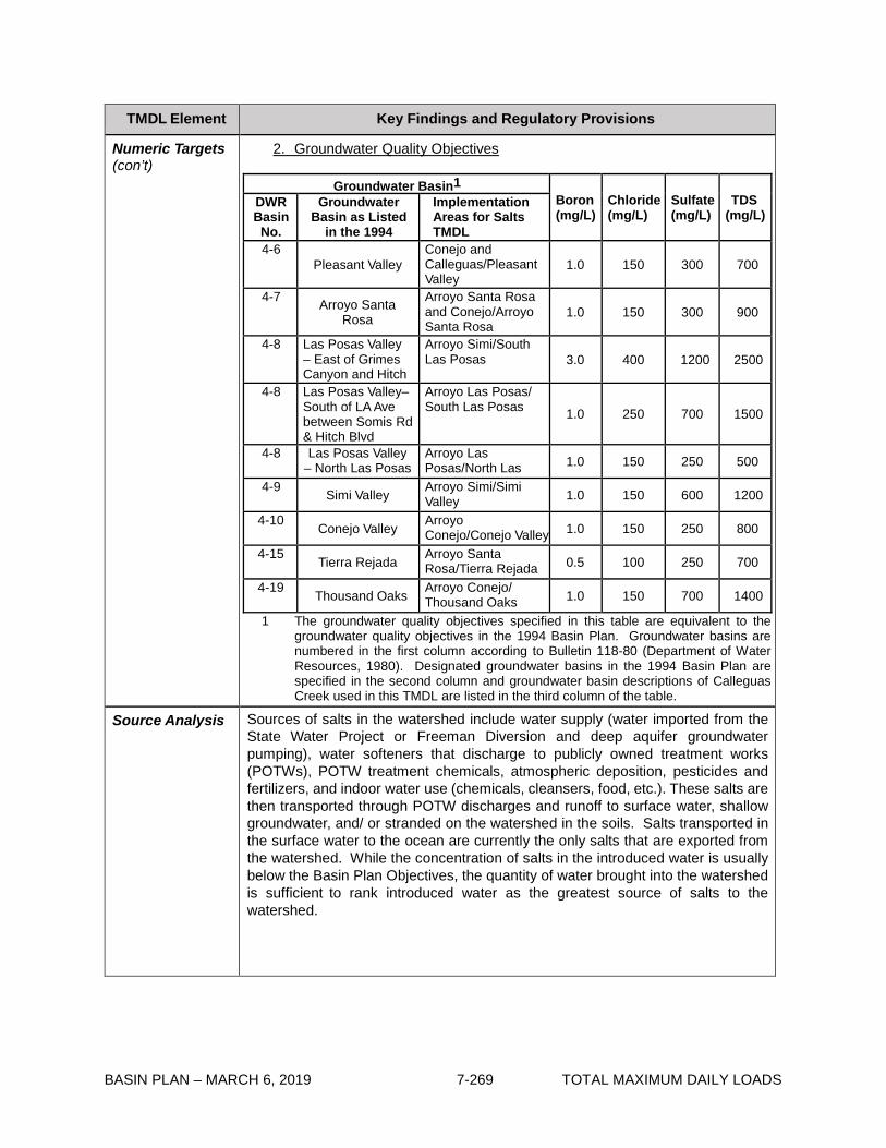
BASIN PLAN – MARCH 6, 2019 7-269 TOTAL MAXIMUM DAILY LOADS
TMDL Element Key Findings and Regulatory Provisions
Numeric Targets (con’t)
2. Groundwater Quality Objectives
Groundwater Basin1 Boron (mg/L)
Chloride (mg/L)
Sulfate (mg/L)
TDS (mg/L)
DWR Basin No.
Groundwater Basin as Listed
in the 1994
Implementation Areas for Salts TMDL
4-6 Pleasant Valley
Conejo and Calleguas/Pleasant Valley
1.0 150 300 700
4-7 Arroyo Santa Rosa
Arroyo Santa Rosa and Conejo/Arroyo Santa Rosa
1.0 150 300 900
4-8 Las Posas Valley – East of Grimes Canyon and Hitch
Arroyo Simi/South Las Posas 3.0 400 1200 2500
4-8 Las Posas Valley– South of LA Ave between Somis Rd & Hitch Blvd
Arroyo Las Posas/ South Las Posas 1.0 250 700 1500
4-8 Las Posas Valley – North Las Posas
Arroyo Las Posas/North Las 1.0 150 250 500
4-9 Simi Valley Arroyo Simi/Simi Valley 1.0 150 600 1200
4-10 Conejo Valley Arroyo Conejo/Conejo Valley 1.0 150 250 800
4-15 Tierra Rejada Arroyo Santa Rosa/Tierra Rejada 0.5 100 250 700
4-19 Thousand Oaks Arroyo Conejo/ Thousand Oaks 1.0 150 700 1400
1 The groundwater quality objectives specified in this table are equivalent to the groundwater quality objectives in the 1994 Basin Plan. Groundwater basins are numbered in the first column according to Bulletin 118-80 (Department of Water Resources, 1980). Designated groundwater basins in the 1994 Basin Plan are specified in the second column and groundwater basin descriptions of Calleguas Creek used in this TMDL are listed in the third column of the table.
Source Analysis
Sources of salts in the watershed include water supply (water imported from the State Water Project or Freeman Diversion and deep aquifer groundwater pumping), water softeners that discharge to publicly owned treatment works (POTWs), POTW treatment chemicals, atmospheric deposition, pesticides and fertilizers, and indoor water use (chemicals, cleansers, food, etc.). These salts are then transported through POTW discharges and runoff to surface water, shallow groundwater, and/ or stranded on the watershed in the soils. Salts transported in the surface water to the ocean are currently the only salts that are exported from the watershed. While the concentration of salts in the introduced water is usually below the Basin Plan Objectives, the quantity of water brought into the watershed is sufficient to rank introduced water as the greatest source of salts to the watershed.

BASIN PLAN – MARCH 6, 2019 7-270 TOTAL MAXIMUM DAILY LOADS
TMDL Element Key Findings and Regulatory Provisions
Source Analysis (con’t)
Salts that are transported during dry weather to the surface water are quantified via the following mechanisms: groundwater pumping, groundwater exfiltration, POTWs, dry weather urban and agricultural runoff. Wet weather loadings from each of these sources have the potential to be significant, but tend to be lower in concentration and do not occur during the critical conditions for salts. Wet weather loads are significant from the perspective of transporting stranded salts off the watershed.
Linkage Analysis The linkage analysis for salts focuses on the surface water concentrations of salts. However, surface water concentrations are only one component of the watershed salts issue. Because it is difficult to model other aspects of the salt problem (i.e. surface water and groundwater interactions, stranded salts), two simplified approaches have been used to demonstrate that salts will be removed from the watershed, which should have a correspondingly positive impact on surface water and groundwater salts concentrations. First, a surface water model was developed to provide a linkage between sources and surface water quality and to demonstrate the impact of projects on receiving water quality in the watershed. Second, a salt balance was developed to quantify the removal of salts from the watershed with the goal of achieving a mass balance in which the mass of boron, sulfate, TDS and chloride imported into Calleguas Creek subwatersheds is no more than the mass of boron, sulfate, TDS and chloride exported from the Calleguas Creek subwatershed. Achieving a salt balance in the watershed will prevent additional build-up of salts in any medium in the watershed and protect ground water supplies from increasing in salt concentrations.
The Calleguas Creek Modeling System is a mass balance based model that was developed for the surface water to provide a linkage between sources and surface water quality. To estimate the salts balance in the watershed, a simple chloride mass balance was developed by the Camrosa Water District (Hajas, 2003a) and modified to address the other salts.
Waste Load Allocations
A. POTWs The TMDL includes waste load allocations (WLAs) for five POTWs in the Calleguas Creek watershed: Simi Valley Water Quality Control Plant (WQCP), Hill Canyon Wastewater Treatment Plan (WWTP), Moorpark WWTP, Camarillo Water Reclamation Plant (WRP), and Camrosa Water Reclamation Facility (WRF). At the end of the implementation period, only Simi Valley WQCP and the Hill Canyon WWTP are expected to discharge to surface waters. Moorpark WWTP and Camrosa WRF currently discharge directly to ponds under dry weather conditions. As part of the TMDL implementation, the Renewable Water Resources Management Program (RWRMP) will introduce treated wastewater from the Camarillo WRP into the Camrosa recycled water storage and distribution system. Surplus treated wastewater from Camarillo WRP and Camrosa WRF will be discharged at a point downstream of Potrero Road Bridge to Calleguas Creek. Dry weather WLAs are included for the case when Camarillo WRP, Camrosa WRF, and Moorpark WWTP need to discharge to the stream (for example, if there is insufficient recycled water demand during the wet season). Including WLAs for these POTWs ensures that water quality objectives are not exceeded as a result of their discharge.

BASIN PLAN – MARCH 6, 2019 7-271 TOTAL MAXIMUM DAILY LOADS
TMDL Element Key Findings and Regulatory Provisions
Waste Load Allocations (con’t)
POTW mass-based WLAs are calculated as the POTW effluent flow rate multiplied by the water quality objective and include a mass-based adjustment factor (AF) that is subtracted from the product of the flow-rate and the water quality objective. The adjustment factor is used to link POTW allocations to the required reductions in background loads. The adjustment factors are implemented through mechanisms that export salts out of the subwatershed, such as groundwater pumping, to meet the salt balance requirements. To ensure that the loading capacity is achieved in surface water and the reductions in background loads are achieved, minimum salt exports shown below are required for POTWs and are included in WLAs as a component of the adjustment factors. If the background load reductions are not achieved, POTWs shall be responsible for providing additional load reductions to achieve water quality standards. The AF is set equal to the difference between the minimum salts export requirement to attain a salt balance in the subject reaches and the actual salts export. If the calculated annual dry weather salt exports from the subwatershed to which the POTW discharges are less than the minimum required exports for the previous year and the annual average receiving water concentration at the base of the subwatershed to which the POTW discharges exceeds water quality objectives for the previous year, the POTW allocations will be reduced using the adjustment factor. The adjustment factors are also used to address unusual conditions in which the inputs to the POTWs from the water supply may challenge the POTWs ability to meet the assigned WLAs. The adjustment factor allows for the additional POTW loading only when the water quality objectives are met in the receiving waters. POTW allocations can be adjusted upwards when imported water supply chloride concentrations exceed 80 mg/L and discharges from the POTW exceed the WLA. In order to apply the AF to the assigned WLAs, the POTW is required to submit documentation of the water supply chloride concentrations, receiving water chloride concentration, the effluent mass, and evidence of increased salt exports to offset the increased discharges from the POTW to the RWQCB for approval.
WLAs shown in table below apply to POTWS during dry weather when the flows in the receiving water are below the 86th percentile flow. During wet weather, the loading capacity of the stream is significantly increased by stormwater flows with very low salt concentrations. Any discharges from the POTWs during wet weather would be assimilated by these large storm flows and would not cause exceedances of water quality objectives. Boron is only listed in the Simi and Pleasant Valley (Revolon) subwatersheds and exceedances of boron do not occur in other portions of the watershed. Therefore, boron allocations are only included for the Simi Valley WQCP.
Interim limits are included to allow time for dischargers to put in place implementation measures necessary to achieve final waste load allocations. The monthly average interim limits are set equal to the 95th percentile of available discharge data.

BASIN PLAN – MARCH 6, 2019 7-272 TOTAL MAXIMUM DAILY LOADS
TMDL Element Key Findings and Regulatory Provisions
Waste Load Allocations (con’t)
1. Minimum Salt Export Requirements for Adjustment Factor a
POTW
Minimum Chloride Export (lb/day)
Minimum TDS Export
(lb/day)
Minimum Sulfate Export (lb/day)
Minimum Boron Export (lb/day)
Simi Valley WQCP 460 3220 9120 3.3 Moorpark WWTP 460 3220 9120 3.3 Hill Canyon WWTP 1060 7920 4610 0 Camrosa WRF 1060 7920 4610 0 Camarillo WRP 1060 7920 4610 0 a. Minimum export requirements include a 10% Margin of Safety
2. Interim Monthly Average WLAs for POTWs
POTW Chloride (mg/L)
TDS (mg/L
Sulfate (mg/L)
Boron (mg/L)
Simi Valley WQCP 183 955 298 N/A Hill Canyon 189 N/A N/A N/A Moorpark WWTP 171 N/A 267 N/A Camarillo WRP 216 1012 283 N/A Camrosa WRF* N/A N/A N/A N/A
* Camrosa WRF has not discharged to surface water during the period under which interim limits were calculated. When effluent data are available, the Regional Board may adopt interim WLAs for Camrosa WRF. N/A: The 95th percentile concentration is below the Basin Plan objective so interim limits are not necessary.
8. Final WLAs for POTWs a,d
POTW Chloride (lb/day)c
TDS (lb/day)c
Sulfate (lb/day)c
Boron (lb/day)c
Simi Valley WQCP 150*Q-AF 850*Q-AF 250*Q-AF 1.0*Q-AF
Hill Canyon WWTP 150*Q-AF 850*Q-AF 250*Q-AF N/A
Moorpark WWTPb 150*Q-AF 850*Q-AF 250*Q-AF N/A
Camarillo 150*Q-AF 850*Q-AF 250*Q-AF N/A Camrosa 150*Q-AF 850*Q-AF 250*Q-AF N/A
a. The allocations shown only apply during dry weather (as defined in this TMDL). During wet weather discharges from the POTWs do not cause exceedances of water quality objectives.
b. These POTWs are not expected to discharge after the end of the implementation period.
c. AF is the adjustment factor and equals the difference between the minimum salts export requirement and the actual salts export.
d. Q represents the POTW flow at the time the water quality measurement is collected and a conversion factor to lb/day based on the units of measurement for the flow.
N/A Boron is not listed in the reaches to which the POTW discharges. No WLA is required.

BASIN PLAN – MARCH 6, 2019 7-273 TOTAL MAXIMUM DAILY LOADS
TMDL Element Key Findings and Regulatory Provisions
Waste Load Allocations (con’t)
B. Urban Runoff Permitted stormwater dischargers that are responsible parties to this TMDL include the Municipal Stormwater Dischargers (MS4s) of the Cities of Camarillo, Moorpark, Thousand Oaks, County of Ventura, Ventura County Watershed Protection District, and general industrial and construction permittees. Permitted stormwater dischargers are assigned a dry weather wasteload allocation equal to the average dry weather critical condition flow rate multiplied by the numeric target for each constituent. Waste load allocations apply in the receiving water at the base of each subwatershed. Because wet weather flows transport a large mass of salts at low concentrations, these dischargers meet water quality objectives during wet weather. Dry weather allocations apply when instream flow rates are below the 86th percentile flow and there has been no measurable precipitation in the previous 24 hours. Interim limits are assigned for dry weather discharges from areas covered by NPDES stormwater permits to allow time to implement appropriate actions. The interim limits are assigned as concentration based receiving water limits set to the 95th percentile of the discharger data as a monthly average limit except for chloride. The 95th percentile for chloride was 267 mg/L which is higher than the recommended criteria set forth in the Basin Plan for protection of sensitive beneficial uses including aquatic life. Therefore, the interim limit for chloride for Permitted Stormwater Dischargers is set equal to 230 mg/L to ensure protection of sensitive beneficial uses in the Calleguas Creek watershed. 1. Interim Dry Weather WLAs for Permitted Stormwater Dischargers
2. Final Dry Weather WLAs for Permitted Stormwater Dischargers
Subwatershed Critical
Condition Flow Rate (mgd)
Chloride Allocation
(lb/day)
TDS Allocation
(lb/day)
Sulfate Allocation
(lb/day)
Boron Allocation
(lb/day) Simi 1.39 1,738 9,849 2,897 12 Las Posas 0.13 157 887 261 N/A Conejo 1.26 1,576 8,931 2,627 N/A Camarillo 0.06 72 406 119 N/A Pleasant Valley (Calleguas)
0.12 150 850 250 N/A
Pleasant Valley (Revolon)
0.25 314 1,778 523 2
Constituent Interim Limit (mg/L) Boron Total 1.3 Chloride Total 230 Sulfate Total 1289 TDS Total 1720

BASIN PLAN – MARCH 6, 2019 7-274 TOTAL MAXIMUM DAILY LOADS
TMDL Element Key Findings and Regulatory Provisions
Waste Load Allocations (con’t)
C. Final WLAs for Other NPDES Dischargers Concentration-based WLAs are assigned at the Basin Plan objectives for other NPDES dischargers.
Constituent Allocation (mg/L) Chloride 150 TDS 850 Sulfate 250
Borona 1.0
Other NPDES dischargers include, but are not limited to, permitted groundwater cleanup projects that could have significant salt concentrations as a result of the stranded salts in the shallow groundwater basins being treated. To facilitate the cleanup of the basins prior to alternative discharge methods (such as the brine line) being available, interim limits for other NPDES dischargers will be developed on a case-by-case basis and calculated as a monthly average using the 95th percentile of available discharge data.
Load Allocations
Dry weather load allocations are assigned as a group allocation to irrigated agricultural discharges. The load allocation (LA) is equal to the average dry weather critical condition flow rate multiplied by the numeric target for each constituent. Load allocations apply in the receiving water at the base of each subwatershed. Because wet weather flows transport a large mass of salts at a typically low concentration, these dischargers should meet water quality objectives during wet weather. Dry weather allocations apply when instream flow rates are below the 86th percentile flow and there has been no measurable precipitation in the previous 24 hours.
Interim limits are assigned for dry weather discharges from irrigated agricultural areas to allow time to implement appropriate actions. The interim limits are assigned as concentration based receiving water limits set to the 95th percentile of the discharger data as a monthly average limit except for chloride. The 95th percentile for chloride was 499 mg/L which is higher than the recommended criteria set forth in the Basin Plan for protection of sensitive beneficial uses including aquatic life. Therefore, the interim limit for chloride for Irrigated Agricultural Dischargers is set equal to 230 mg/L to ensure protection of sensitive beneficial uses in the Calleguas Creek watershed.
I. Interims Load Allocations for Irrigated Agricultural Dischargers
Constituent Interim Limit (mg/L) Boron Total 1.8 Chloride Total 230 Sulfate Total 1962 TDS Total 3995

BASIN PLAN – MARCH 6, 2019 7-275 TOTAL MAXIMUM DAILY LOADS
TMDL Element Key Findings and Regulatory Provisions
Load Allocations (con’t)
II. Final Load Allocations for Irrigated Agricultural Dischargers
Subwatershed
Chloride Allocati
on
TDS Allocati
on
Sulfate Allocati
on
Boron Allocati
on Simi 641 3,631 1,068 4 Las Posas 2,109 11,952 3,515 N/A Conejo 743 4,212 1,239 N/A Camarillo 59 336 99 N/A Pleasant 305 1,730 509 N/A Revolon 7,238 41,015 12,063 48
Margin of Safety A margin of safety (MOS) for the TMDL is designed to address uncertainties in the analysis that could result in targets not being achieved in the waterbodies. The primary uncertainties associated with this TMDL include the impact of implementing a salt balance on receiving water quality. The effect of the salt balance is estimated by the mass-balance and subject to the following uncertainties: 1) the flow rates used to determine the loading capacity may change due to TMDL implementation, 2) the use of a daily load for determining allocations and an annual mass balance to attain water quality objectives, and 3) the sources of salts may not be completely known. Both implicit and explicit MOS are included for this TMDL. The implicit MOS stems from the use of conservative assumptions made during development of the TMDL. The mass of salts transported out of the watershed during wet weather is on average over 15% of the annual mass of salts introduced to the watershed for all constituents. The salt export during wet weather ranges from 7% to 41% for TDS, 9% to 48% for chloride, and 13% to 89% for sulfate of the export required to meet a salt balance in the watershed. This mass is not used to determine compliance with the salt balance and represents a significant implicit margin of safety. The model also contains a component that serves to model the impact of “stranded” salts in the watershed. The component assumes low irrigation efficiencies and the ability of all salts applied as irrigation water anywhere in the watershed to be discharged to receiving water in critical years. This likely overestimates the impact of “stranded” salts and results in a higher concentration of salts due to irrigation in the receiving water. An explicit MOS of 10% is applied to the adjustment factors for the POTWs to account for the uncertainties in the TMDL analysis. By applying the margin of safety to the adjustment factor, more salts are required to be exported than are necessary to offset the background loads in the watershed. This additional salt export provides a margin of safety on the salt balance to address uncertainties that the salt balance will result in compliance with water quality objectives. The 10% explicit MOS is determined sufficient to address the uncertainties associated with the estimated impact of the salt balance on receiving water loadings.

BASIN PLAN – MARCH 6, 2019 7-276 TOTAL MAXIMUM DAILY LOADS
TMDL Element Key Findings and Regulatory Provisions
Future Growth Ventura County accounts for slightly more than 2% of the state’s residents with a population of 753,197 (US Census Bureau, 2000). GIS analysis of the 2000 census data yields a population estimate of 334,000 for the CCW, which equals about 44% of the county population. According to the Southern California Association of Governments (SCAG), growth in Ventura County averaged about 51% per decade from 1900-2000; with growth exceeding 70% in the 1920s, 1950s, and 1960s. Significant population growth is expected to occur within and near present city limits until at least 2020. Increased growth requires additional water. Therefore, future growth could result in increased loads of salts being imported into the watershed. However, the TMDL implementation plan is designed to maintain a salts balance in the watershed. If additional salts are imported into the watershed, a larger volume of salts will also be exported out of the watershed to maintain the balance. Consequently, increased imports from future growth are not expected to result in higher concentrations in receiving waters.
Seasonal Variations and Critical Conditions
The critical condition for salts is during dry weather periods. During wet weather, stormwater flows dilute the salt discharges and receiving water concentrations are significantly lower than water quality objectives. Dry weather, defined as days with flows lower than the 86th percentile flow and no measurable precipitation, is a critical condition regardless of the dry weather flows in the stream. The driving conditions for exceedances of water quality objectives are the concentrations in the water supply (which is driven by surface water concentrations in Northern California) and the previous year’s annual precipitation and corresponding flows. Elevated salts concentrations during dry weather occur when stranded salts are discharged into the surface water after higher than average rainfall years. The elevated concentrations occur during years when the previous annual flow is greater than the 75th percentile of the annual flows for the watershed (critical year). The higher concentrations occur during the dry periods of critical years regardless of whether the annual flow for the critical year is an average flow year, higher than average year, or lower than average year. The key parameter determining a critical year is the total annual flow volume for the previous year. Based on model results, four critical years were defined based on modeled results that resulted in receiving water concentrations greater than the 99th percentile concentration during at least 10% of the dry period. The critical years identified from the model occur with conditions similar to what occurred in 1978, 1979, 1983 and 1998.

BASIN PLAN – MARCH 6, 2019 7-277 TOTAL MAXIMUM DAILY LOADS
TMDL Element Key Findings and Regulatory Provisions
Special Studies and Monitoring Plan
Special Studies Several special studies are planned to improve understanding of key aspects related to achievement of WLAs and LAs for the Salts TMDL.
1. Special Study #1 (Optional) – Develop Averaging Periods and Compliance Points
The TMDL technical report has provided information that shows instantaneous salts objectives may not be required to protect groundwater recharge and agricultural beneficial uses. It is possible that the beneficial uses will be protected and a salt balance achieved without achieving instantaneous water quality objectives in all reaches of the watershed. This optional special study is included to allow an investigation of averaging periods for the salts objectives in the CCW. Additionally, this study will investigate the locations of beneficial uses and the possibility of identifying compliance points for the salts objectives at the point of beneficial use impacts. The use of compliance points would alleviate the need to develop site-specific objectives for the reaches of the watershed upstream of the POTW discharges (described in Special Study #3) while still ensuring the protection of beneficial uses. Sensitive beneficial uses are not present in the upper reaches and POTW discharges dilute the salts from the upper reaches and may allow compliance with the objectives at the point of groundwater recharge downstream. This is an optional special study to be conducted if desired by the stakeholders or determined necessary or appropriate by the Executive Officer. 2. Special Study #2 (Optional) – Develop Natural Background Exclusion
Discharges of groundwater from upstream of the Simi Valley WQCP (Reaches 7 and 8) and Hill Canyon WWTP (Reaches 12 and 13) and downstream of the Camrosa WRF (Reach 3) contain high salts concentrations. Natural marine sediments may contribute to the high concentrations in those discharges. This special study would evaluate whether or not the groundwater discharges in these areas would qualify for a natural sources exclusion. The special study could follow a ‘reference system/anti-degradation approach’ and/or a ‘natural sources exclusion approach’ for any allocations included in this TMDL that are proven unattainable due to the magnitude of natural sources. The purpose of a ‘reference system/anti-degradation approach’ is to ensure water quality is at least as good as an appropriate reference site and no degradation of existing water quality occurs where existing water quality is better than that of a reference site. The intention of a ‘natural sources exclusion approach’ is to ensure that all anthropogenic sources of salts are controlled such that they do not cause exceedances of water quality objectives. These approaches are consistent with state and federal anti-degradation policies (State Board Resolution No. 68-16 and 40 C.F.R. 131.12). This is an optional special study to be conducted if desired by the stakeholders or determined necessary for establishing a natural sources exclusion by the Executive Officer.
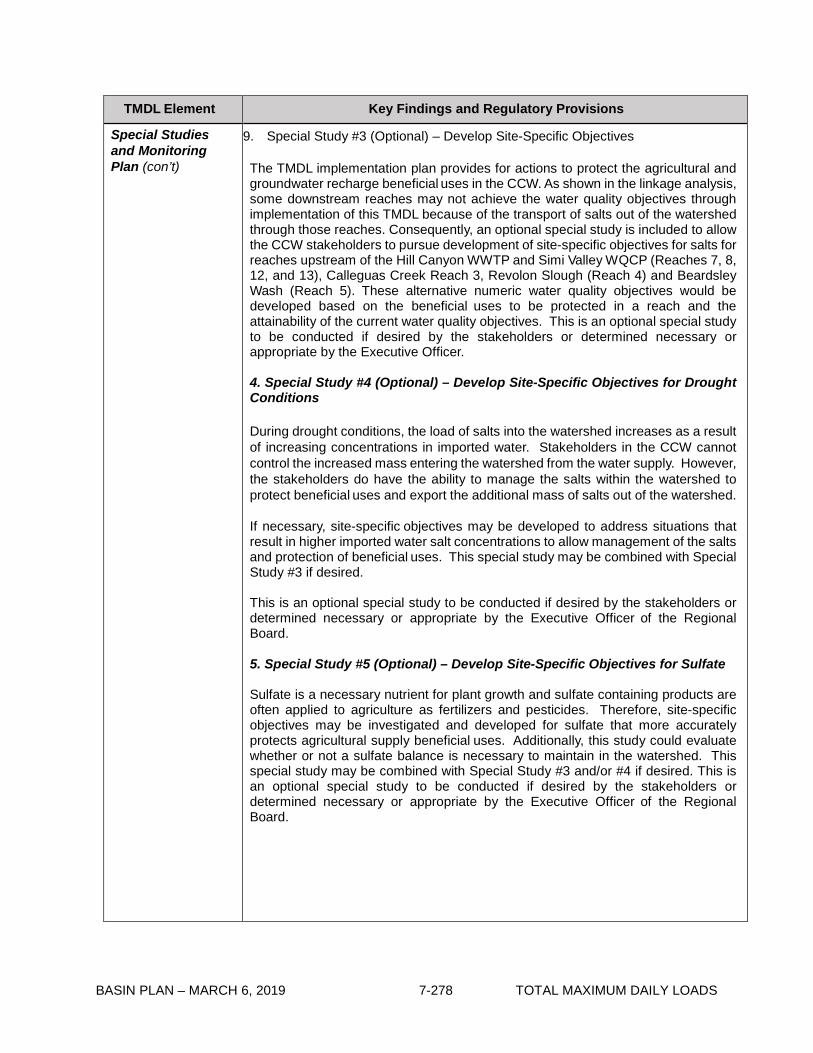
BASIN PLAN – MARCH 6, 2019 7-278 TOTAL MAXIMUM DAILY LOADS
TMDL Element Key Findings and Regulatory Provisions
Special Studies and Monitoring Plan (con’t)
9. Special Study #3 (Optional) – Develop Site-Specific Objectives
The TMDL implementation plan provides for actions to protect the agricultural and groundwater recharge beneficial uses in the CCW. As shown in the linkage analysis, some downstream reaches may not achieve the water quality objectives through implementation of this TMDL because of the transport of salts out of the watershed through those reaches. Consequently, an optional special study is included to allow the CCW stakeholders to pursue development of site-specific objectives for salts for reaches upstream of the Hill Canyon WWTP and Simi Valley WQCP (Reaches 7, 8, 12, and 13), Calleguas Creek Reach 3, Revolon Slough (Reach 4) and Beardsley Wash (Reach 5). These alternative numeric water quality objectives would be developed based on the beneficial uses to be protected in a reach and the attainability of the current water quality objectives. This is an optional special study to be conducted if desired by the stakeholders or determined necessary or appropriate by the Executive Officer.
4. Special Study #4 (Optional) – Develop Site-Specific Objectives for Drought Conditions
During drought conditions, the load of salts into the watershed increases as a result of increasing concentrations in imported water. Stakeholders in the CCW cannot control the increased mass entering the watershed from the water supply. However, the stakeholders do have the ability to manage the salts within the watershed to protect beneficial uses and export the additional mass of salts out of the watershed. If necessary, site-specific objectives may be developed to address situations that result in higher imported water salt concentrations to allow management of the salts and protection of beneficial uses. This special study may be combined with Special Study #3 if desired.
This is an optional special study to be conducted if desired by the stakeholders or determined necessary or appropriate by the Executive Officer of the Regional Board.
5. Special Study #5 (Optional) – Develop Site-Specific Objectives for Sulfate
Sulfate is a necessary nutrient for plant growth and sulfate containing products are often applied to agriculture as fertilizers and pesticides. Therefore, site-specific objectives may be investigated and developed for sulfate that more accurately protects agricultural supply beneficial uses. Additionally, this study could evaluate whether or not a sulfate balance is necessary to maintain in the watershed. This special study may be combined with Special Study #3 and/or #4 if desired. This is an optional special study to be conducted if desired by the stakeholders or determined necessary or appropriate by the Executive Officer of the Regional Board.

BASIN PLAN – MARCH 6, 2019 7-279 TOTAL MAXIMUM DAILY LOADS
TMDL Element Key Findings and Regulatory Provisions
Special Studies and Monitoring Plan (con’t)
Monitoring Plan To ensure that the goal of a salts balance in the watershed is being achieved and water quality objectives are being met, a comprehensive method of tracking inputs and outputs to the watershed will be developed. A monitoring plan will be submitted to the RWQCB for Executive Officer approval within six months of the effective date of the CCW Salts TMDL. Monitoring will begin one year after Executive Officer approval of the monitoring plan to allow time for the installation of automated monitoring equipment.
1. Input Tracking
Inputs to the watershed are tracked through four mechanisms:1) Information on the import of State Water Project water is readily available and provides information on the mass of salts brought into the watershed; 2) Groundwater pumping records provide information on the mass of salts imported into the watershed from deep aquifer pumping; 3) Import records of water supply form the Santa Clara River can be obtained to determine the mass of salts imported through this source; 4) Monitoring data on imported water quality can be compared to monitoring of effluent quality to estimate the amount of salts added through human use of the water. 2. Output Tracking and Determining Compliance with Water Quality Objectives
Outputs from the watershed will be tracked through surface water monitoring at key locations in the watershed and monitoring of discharges to the brine line. Monitoring will include both flow and quality. Compliance with water quality objectives will be determined at key locations where beneficial uses occur in the watershed. The stations used for output tracking will also be used to determine compliance with water quality objectives. The monitoring program will determine if the TMDL compliance points are protective of the beneficial uses for the subwatershed. If the monitoring determines that the compliance points are not protective of beneficial uses, an alternative compliance point will be selected. The Executive Officer may revise the TMDL compliance point based on the result of the monitoring. Additionally, if other places in the watershed are identified where sensitive beneficial uses occur, water quality monitoring stations can be added to determine compliance with water quality objectives. For the RWRMP, three new or upgraded automated flow measuring and sample collection stations will be installed at three points on the stream system to continuously record flow and various water quality parameters during dry weather. Preliminary monitoring locations include Arroyo Conejo in Hill Canyon, Conejo Creek at Baron Brothers Nursery and Calleguas Creek at University Drive. For the NRRWMP, one new or upgraded automated flow measuring and sample collection station will be added downstream of Simi Valley at the point at which groundwater recharge begins. A preliminary monitoring location is at Hitch Blvd. where an existing flow gauging station exists. However, the amount of groundwater recharge upstream of this site will need to be evaluated to determine the exact monitoring location. For Revolon Slough, the existing monitoring station at Wood Road. will be used to monitor quality and flow on Revolon Slough to determine the outputs from the Revolon portion of the Pleasant Valley subwatershed.
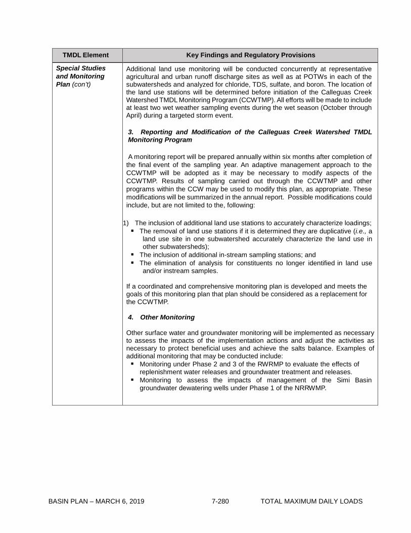
BASIN PLAN – MARCH 6, 2019 7-280 TOTAL MAXIMUM DAILY LOADS
TMDL Element Key Findings and Regulatory Provisions
Special Studies and Monitoring Plan (con’t)
Additional land use monitoring will be conducted concurrently at representative agricultural and urban runoff discharge sites as well as at POTWs in each of the subwatersheds and analyzed for chloride, TDS, sulfate, and boron. The location of the land use stations will be determined before initiation of the Calleguas Creek Watershed TMDL Monitoring Program (CCWTMP). All efforts will be made to include at least two wet weather sampling events during the wet season (October through April) during a targeted storm event.
3. Reporting and Modification of the Calleguas Creek Watershed TMDL Monitoring Program
A monitoring report will be prepared annually within six months after completion of the final event of the sampling year. An adaptive management approach to the CCWTMP will be adopted as it may be necessary to modify aspects of the CCWTMP. Results of sampling carried out through the CCWTMP and other programs within the CCW may be used to modify this plan, as appropriate. These modifications will be summarized in the annual report. Possible modifications could include, but are not limited to the, following:
1) The inclusion of additional land use stations to accurately characterize loadings; The removal of land use stations if it is determined they are duplicative (i.e., a
land use site in one subwatershed accurately characterize the land use in other subwatersheds);
The inclusion of additional in-stream sampling stations; and The elimination of analysis for constituents no longer identified in land use
and/or instream samples. If a coordinated and comprehensive monitoring plan is developed and meets the goals of this monitoring plan that plan should be considered as a replacement for the CCWTMP.
4. Other Monitoring
Other surface water and groundwater monitoring will be implemented as necessary to assess the impacts of the implementation actions and adjust the activities as necessary to protect beneficial uses and achieve the salts balance. Examples of additional monitoring that may be conducted include: Monitoring under Phase 2 and 3 of the RWRMP to evaluate the effects of
replenishment water releases and groundwater treatment and releases. Monitoring to assess the impacts of management of the Simi Basin
groundwater dewatering wells under Phase 1 of the NRRWMP.

BASIN PLAN – MARCH 6, 2019 7-281 TOTAL MAXIMUM DAILY LOADS
TMDL Element Key Findings and Regulatory Provisions
Implementation Plan The identified implementation actions provided in this TMDL will result in a salt balance in the stream and are expected to result in compliance with the allocations. The implementation plan is comprised of actions that directly impact discharges to the receiving water and actions that will indirectly impact discharges to receiving water. Responsible agencies and jurisdictions shall consider minimum flow requirements that may be imposed by federal or state regulatory agencies when implementing actions to comply with this TMDL. Should the proposed implementation actions not result in compliance with objectives and site-specific objective are not adopted, additional implementation actions may be required to achieve the water quality objectives. Any plans or programs for implementation of the TMDL for the Southern Reaches of the CCW upstream of the Conejo Creek Diversion and the Northern Reaches of the CCW, that would result in significant reduction in instream flow, including but not limited to, an application for Water Reclamation Requirements (WRRs) shall include an analysis of potential impacts to instream beneficial uses that could result from the reclamation of wastewater or extracted groundwater. For Phase 1 of the Southern Reaches of the CCW Renewable Water Resource Management Program (RWRMP), Water Rights Decision 1638 from SWRCB satisfies these requirements and establishes the minimum flow requirements for Conejo and Calleguas Creek downstream of the Conejo Creek Diversion Project. Any WRRs shall require that timely written notice be given to the Regional Board, and to any regulatory agency whose instream flow is at issue, if diversion or reclamation of waste water or extraction of groundwater results or threatens to result in (or contributes to) insufficient flows to maintain beneficial uses. The Executive Officer shall issue an order pursuant to Water Code section 13267, which requires responsible agencies and jurisdictions to file a technical report if reclamation of waste water or extraction of groundwater results or threatens to result in (or contributes to) insufficient flows to maintain beneficial uses. The order shall require that the technical report identify the causes of the impairments or threatened impairments, and identifies options to abate the conditions. The Regional Board shall reconsider this TMDL if adequate flows to protect instream beneficial uses are not maintained. The implementation actions described in the TMDL represent a range of activities that could be conducted to achieve a salts balance in the watershed. Future considerations may result in other actions being implemented rather than the options presented. However, any proposed actions will be reviewed using the salt balance model to ensure the action does not adversely impact other implementation actions in the watershed or the salt balance of a downstream subwatershed. Currently, the implementation plan is presented in phases with a tentative schedule for each phase. The implementation of projects may occur earlier than planned or begin during an earlier phase. Additionally, many of the implementation actions require the use of the Regional Salinity Management Conveyance (RSMC or brine line). As such, the implementation schedule for those actions will be linked the construction schedule for the RSMC.

BASIN PLAN – MARCH 6, 2019 7-282 TOTAL MAXIMUM DAILY LOADS
TMDL Element Key Findings and Regulatory Provisions
Implementation Plan (con’t)
The implementation plan for the Salts TMDL includes regional and subwatershed specific implementation actions. There are four key structural elements to the regional implementation: Regional Salinity Management Conveyance (RSMC), Water Conservation, Water Softeners, and Best Management Practices for Irrigated Agriculture. Subwatershed implementation includes Renewable Water Resource Management Program (RWRMP) for the Southern Reaches and Northern Reach Renewable Water Management Plan (NRRWMP). Detailed discussion for each implementation element including description of the action, status and schedule for implementing the action, and a summary of the expected contribution to achievement of the salts balance are provided in the Staff Report and Technical Report for this TMDL. Proposed implementation actions in the watershed, responsible agencies, and the estimated completion date based on the effective date of the TMDL are summarized below. Summary of Proposed Implementation Actions
The sections below provide discussion of the application of the final WLAs for POTWs, specific permitted stormwater discharges, other NPDES dischargers, and agricultural dischargers.
Action Responsible Agency/ies Schedule
for Completion
Water Conservation POTWs, Permitted Stormwater Dischargers, and Other NPDES Permittees
3 years
Water Softeners POTWs and Permitted Stormwater Dischargers
10 years
Best Management Practice for Agricultural Dischargers Agricultural Dischargers
2 years
RMSC Phase 1 Calleguas Municipal Water District 2 year RMSC Phase 2 Calleguas Municipal Water District 5 year RMSC Phase 3 Calleguas Municipal Water District 10 years
RWRMP Phase 1 CamrosaWater District, Camarillo Sanitation District
3 years
RWRMP Phase 2 Camrosa Water District, City of Thousand Oaks
6 years
RWRMP Phase 3 Camrosa Water District, City of Thousand Oaks
10 years
RWRMP Phase 4 To Be Determined 15 years
NRRWMP Phase 1 Calleguas Municipal Water District, City of Simi Valley, Ventura County Water Work- District No.1
3 years
NRRWMP Phase 2 Calleguas Municipal Water District, Ventura County Water Work-District No.1, City of Camarillo
7 years
NRRWMP Phase 3 City of Camarillo, City of Simi Valley 10 years NRRWMP Phase 4 To Be Determined 15 years Final Completion Date 15 years

BASIN PLAN – MARCH 6, 2019 7-283 TOTAL MAXIMUM DAILY LOADS
TMDL Element Key Findings and Regulatory Provisions
Implementation Plan (con’t)
I. POTWs, permitted stormwater discharges, and other NPDES discharges
The final WLAs will be included for permitted stormwater discharges, POTWs, and other NPDES discharges in accordance with the compliance schedules provided in Table 7-22.2. The Regional Board may revise these WLAs based on additional information developed through special studies and/ or monitoring conducted as part of this TMDL. POTWs WLAs established for the POTWs in this TMDL will be implemented through NPDES permit limits. Compliance will be determined through monitoring of final effluent discharge as defined in the NPDES permit. The proposed permit limits will be applied as end-of-pipe mass-based monthly average effluent limits. Daily maximum effluent limit is not required because chloride is not expected to have an immediate or acute effect on the beneficial uses. Compliance with the minimum salt export requirements for POTWs will be based on the salt export from the subwatershed to which they discharge. The mechanisms for meeting the minimum salt export requirements and for monitoring progress towards meeting those requirements will be included in the monitoring program work plan and approved by the Executive Officer. At the end of each year, the amount of salt exported will be compared to the minimum required salt export. POTW allocations will be reduced using the adjustment factor if both of the following conditions occur: • The annual dry weather salt exports from the subwatershed to which the POTW
discharges are below the minimum required exports for the previous year; and
• The water quality objectives were exceeded in the receiving water at the base of the subwatershed
The POTW allocations will be reduced for the following year by the difference between the minimum required salt export and the actual amount exported. The discharger shall be notified by the Regional Board that the assigned WLAs are reduced and the reduced effluent limits shall be applied for the next year. If the POTW allocations are reduced, the POTW will need to increase the amount of salt export or reduce the mass of salts discharged from the POTW before the end of the following year when the adjustment will be evaluated again. POTWs can only request to adjust the assigned WLAs upwards using the adjustment factor under limited conditions provided below:
• Water quality objectives are met in the receiving waters; • Imported water supply chloride concentrations exceed 80 mg/L; and • Discharges from the POTW exceed the allocation.

BASIN PLAN – MARCH 6, 2019 7-284 TOTAL MAXIMUM DAILY LOADS
TMDL Element Key Findings and Regulatory Provisions
Implementation Plan (con’t)
When imported water supply chloride concentrations exceed 80 mg/L, the POTW will monitor the effluent to determine if the wasteload allocation is exceeded. If the wasteload allocation is exceeded and the POTW desires an adjustment to the allocation, the POTW will submit documentation of the water supply chloride concentrations, the receiving water chloride concentration, the effluent mass, and the evidence of increased salt exports to offset the increased discharges from the POTW to the Regional Board for approval. The adjustment factor will apply for three months and the POTW must submit the evidence outlined above every three months to keep the adjustment factor active. As long as the required information is submitted, the adjustment factor will be in effect upon notification in writing from the RWQCB.
Urban Stormwater Discharger
A group mass-based dry weather WLA has been developed for all permitted stormwater discharges, including municipal separate storm sewer systems (MS4s), and general industrial and construction stormwater permits. USEPA regulation allows allocations for NPDES-regulated stormwater discharges from multiple point sources to be expressed as a single categorical WLA when the data and information are insufficient to assign each source or outfall individual WLAs (40 CFR 130). The grouped allocation will apply to all NPDES-regulated municipal stormwater discharges in the CCW. MS4 WLAs will be incorporated into the NPDES permit as receiving water limits measured in-stream at the base of each subwatershed.
Other NPDES Dischargers
WLAs established for other NPDES permitted dischargers in this TMDL, including minor non-stormwater permittees (other than Camrosa WRP) and general non-stormwater permittees, will be implemented through NPDES permit limits. The proposed permit limits will be applied as end-of-pipe concentration-based effluent limits, and compliance determined through monitoring of final effluent discharge as defined in the NPDES permit.

BASIN PLAN – MARCH 6, 2019 7-285 TOTAL MAXIMUM DAILY LOADS
TMDL Element Key Findings and Regulatory Provisions
Implementation Plan (con’t)
II. Agriculture
Load allocations for salts will be implemented through Conditional Waiver of Discharges from Irrigated Lands (Conditional Waiver Program) adopted by the LARWQCB on November 3, 2005. Compliance with LAs will be measured in-stream at the base of the subwatersheds and will be achieved through the implementation of Best Management Practices (BMPs) consistent with the Conditional Waiver Program. The Conditional Waiver Program requires the development of an agricultural water quality management plan (AWQMP) to address pollutants that are exceeding receiving water quality objectives as a result of agricultural discharges. Therefore, implementation of the load allocations will be through the development of an agricultural management plan for salts. Implementation of the load allocations will also include the coordination of BMPs being implemented under other required programs to ensure salts discharges are considered in the implementation. Additionally, agricultural dischargers will participate in educational seminars on the implementation of BMPs as required under the Conditional Program. Studies are currently being conducted to assess the extent of BMP implementation and provide information on the effectiveness of BMPs for agriculture. This information will be integrated into the AWQMP that will guide the implementation of agricultural BMPs in the Calleguas Creek watershed. After implementation of these actions, compliance with the allocations and TMDL will be evaluated and the allocations reconsidered if necessary based on the special studies and monitoring plan section of the implementation plan.
As shown in Table 7-22.2, implementation of LAs will be conducted over a period of time to allow for implementation of the BMPs, as well as coordination with special studies and implementation actions resulting from other TMDL Implementation Plans (Nutrient, Historic Pesticides and PCBs, Sediment, Metals, Bacteria, etc.).

BASIN PLAN – MARCH 6, 2019 7-286 TOTAL MAXIMUM DAILY LOADS
Table 7-22.2 Calleguas Creek Watershed Salts TMDL: Implementation Schedule
Item Implementation Action Responsible Party Completion Date 1 Effective date of interim Salts TMDL waste load
allocations (WLAs) POTWs, Permitted Stormwater Dischargers1 (PSD), and Other NPDES Permittees
Effective date of the amendment
2 Effective date of interim Salts TMDL load allocations (LAs)
Agricultural Dischargers Effective date of the amendment
3 Responsible jurisdictions and agencies shall submit compliance monitoring plan to the Los Angeles Regional Board for Executive Officer approval.
POTWs, PSD, Other NPDES Permittees, and Agricultural Dischargers
6 months after effective date of the TMDL
4 Responsible jurisdictions and agencies shall begin monitoring as outlined in the approved monitoring plan.
POTWs, PSD, Other NPDES Permittees, and Agricultural Dischargers
1 year after monitoring plan approval by Executive Officer
5 Responsible jurisdictions and agencies shall submit workplans for the optional special studies.
POTWs, PSD, Other NPDES Permittees, and Agricultural Dischargers
Within 10 years of effective date of the TMDL
6 Responsible jurisdictions and agencies shall submit results of the special studies.
POTWs, PSD, Other NPDES Permittees, and Agricultural Dischargers
2 years after workplan approval by Executive Officer
7 Re-evaluation of the interim WLAs and interim LAs for boron, chloride, sulfate, and TDS based on new data. Responsible jurisdictions and agencies shall demonstrate that implementation actions have reduced the boron, sulfate, TDS, and chloride imbalance by 20%.
POTWs, PSD, Other NPDES Permittees, and Agricultural Dischargers
3 years after effective date of the TMDL
8 Re-evaluation of the interim WLAs and interim LAs for boron, chloride, sulfate, and TDS based on new data. Responsible jurisdictions and agencies shall demonstrate that implementation actions have reduced the boron, sulfate, TDS and chloride imbalance by 40%.
POTWs, PSD, Other NPDES Permittees, and Agricultural Dischargers
7 years after effective date of the TMDL
9 Re-evaluation of the interim WLAs and interim LAs for boron, chloride, sulfate, and TDS based on new data. Responsible jurisdictions and agencies shall demonstrate that implementation actions have reduced the boron, sulfate, TDS, and chloride imbalance by 70%.
POTWs, Permitted Stormwater Dischargers (PSD), Other NPDES Permittees, and Agricultural
10 years after effective date of the TMDL
10 The Los Angeles Regional Board shall reconsider this TMDL to re-evaluate numeric targets, WLAs, LAs and the implementation schedule based on the results of the special studies and/or compliance monitoring.
The Regional Board 12 years after effective date of the TMDL

BASIN PLAN – MARCH 6, 2019 7-287 TOTAL MAXIMUM DAILY LOADS
Item Implementation Action Responsible Party Completion Date
11 Responsible jurisdictions and agencies shall demonstrate that the watershed has achieved an annual boron, sulfate, TDS, and chloride balance.
POTWs, PSD, Other NPDES Permittees, and Agricultural Dischargers
15 years after effective date of the TMDL
12 The POTWs and non-storm water NPDES permits shall achieve WLAs, which shall be expressed as NPDES mass- based effluent limitation specified in accordance with federal regulations and state policy on water quality control.
POTWs and Other NPDES Permittees
15 years after effective date of the TMDL
13 Irrigated agriculture shall achieve LAs, which will be implemented through the Conditional Waiver for Irrigated Lands as mass-based receiving water limits.
Agricultural Dischargers
15 years after effective date of the TMDL
14 The permitted stormwater dischargers shall achieve WLAs, which shall be expressed as NPDES mass-based limits specified in accordance with federal regulations and state policy on water quality control.
Permitted Stormwater Dischargers
15 years after effective date of the TMDL
15 Water quality objectives will be achieved at the base of the subwatersheds designated in the TMDL.
POTWs, PSD, Other NPDES Permittees, and Agricultural Dischargers
15 years after effective date of the TMDL
1 Permitted stormwater dischargers that are responsible parties to this TMDL include the Municipal Stormwater Dischargers (MS4s) of the Cities of Camarillo, Moorpark, Thousand Oaks, County of Ventura, Ventura County Watershed Protection District, and general industrial and construction permittees.

BASIN PLAN – MARCH 6, 2019 7-288 TOTAL MAXIMUM DAILY LOADS
This page intentionally left blank

BASIN PLAN – MARCH 6, 2019 7-289 TOTAL MAXIMUM DAILY LOADS
7-23 Lake Elizabeth, Munz Lake, and Lake Hughes Trash TMDL This TMDL was adopted by:
The Regional Water Quality Control Board on June 7, 2007.
This TMDL was approved by:
The State Water Resources Control Board on December 4, 2007. The Office of Administrative Law on February 8, 2008. The U.S. Environmental Protection Agency on February 27, 2008.
The effective date of this TMDL is: March 6, 2008.
The elements of the TMDL are presented in Table 7-23.1 and the Implementation Plan in Tables
7-23.2a and 7-23.2b.
Table 7-23.1 Lake Elizabeth, Munz Lake, and Lake Hughes Trash TMDL: Elements
Element Lake Elizabeth, Munz Lake, and Lake Hughes Trash TMDL
Problem Statement Current levels of trash discharges into Lake Elizabeth and Lake Hughes violate water quality objectives and are impairing beneficial uses. Based on trash abatement and cleanup efforts by the local landowner in the vicinity of Munz Lake and site visits by Regional Board staff, current assessment of trash levels indicates that Munz Lake is no longer impaired by trash and the local landowner will provide date to evaluate the feasibility of delisting Munz Lake. Relevant water quality objectives include Floating Material and Solid, Suspended, or Settleable Materials. The following designated beneficial uses are impacted by trash: water contact recreation (REC 1) and non-contact water recreation (REC 2), warm freshwater habitat (WARM), and wildlife habitat (WILD); rare and threatened species (RARE), that is specific for Lake Elizabeth.
Numeric Target (interpretation of the narrative water quality objective, used to calculate the load allocations)
Zero trash in Lake Elizabeth, Munz Lake, and Lake Hughes and their shorelines. Zero is defined as (1) for nonpoint sources, no trash immediately following each assessment and collection event consistent with an established Minimum Frequency of Assessment and Collection Program (MFAC Program). The MFAC Program is established at an interval that prevents trash from accumulating in deleterious amounts that cause nuisance or adversely affect beneficial uses between collections, and (2) for point sources, zero trash discharged into Lake Elizabeth, Munz Lake and Lake Hughes and their shorelines.

BASIN PLAN – MARCH 6, 2019 7-290 TOTAL MAXIMUM DAILY LOADS
Element Lake Elizabeth, Munz Lake, and Lake Hughes Trash TMDL
Source Analysis Litter from adjacent land areas, roadways and direct dumping and deposition are sources of trash to Lake Elizabeth and Lake Hughes. Point sources such as storm drains are also sources of trash discharged to Lake Elizabeth and Lake Hughes.
Loading Capacity Zero, as defined in the Numeric Target. Waste Load Allocations (for point sources)
Waste Load Allocations (WLAs) are assigned to the Permitees under the Los Angeles County Municipal Separate Storm Sewer System (MS4) NPDES permit, including Los Angeles County and local land owners with storm drains that discharge to Lake Elizabeth and Lake Hughes. WLAs are zero trash. WLAs may be issued to additional responsible jurisdictions in the future under Phase 2 of the US EPA Stormwater Permitting Program, or other applicable regulatory programs.
Load Allocations (for nonpoint sources)
Load Allocations (LAs) are assigned to the National Forest Service and local land owners. LAs are zero trash. LAs may be issued to additional responsible jurisdictions in the future under applicable regulatory programs.
Implementation Implementation of the trash TMDL for Lake Elizabeth and Lake Hughes includes structural and non-structural best management practices (BMPs) and a program of minimum frequency of assessment and collection (MFAC) to address point and nonpoint trash sources.
Point Sources
WLAs shall be implemented through storm water permits and via the authority vested in the Executive Officer by section 13267 of the Porter- Cologne Water Quality Control Act (Water Code section 13000 et seq.).
If point source dischargers comply with WLAs by implementing an Executive Officer certified full capture system on conveyances that discharge to Lake Elizabeth and Lake Hughes through a progressive implementation schedule of full capture devices, they will be deemed in compliance with the WLA.
In certain circumstances (if approved by the Executive Officer), point source dischargers may alternatively comply with WLAs by implementing a program for minimum frequency of assessment and collection in conjunction with best management practices (MFAC/ BMPs).

BASIN PLAN – MARCH 6, 2019 7-291 TOTAL MAXIMUM DAILY LOADS
Element Lake Elizabeth, Munz Lake, and Lake Hughes Trash TMDL
Implementation (con’t)
1. Compliance with the final WLA may be achieved through an adequately sized and maintained full capture system, once the Executive Officer has certified that the system meets the following minimum criteria. A full capture system, at a minimum, consists of any device or series of devices that traps all particles retained by a 5 mm mesh screen and has a design treatment capacity of not less than the peak flow rate (Q) resulting from a one-year, one-hour, storm in the sub-drainage area. The rational equation is used to compute the peak flow rate:
Q = C × I × A, where Q = design flow rate (cubic feet per second, cfs); C = runoff coefficient (dimensionless); I = design rainfall intensity (inches per hour); and A= subdrainage area (acres).
Point sources that choose to comply via a full capture system, must demonstrate a phased implementation of full capture devices over an 8-year period until the final WLA of zero is attained. Zero will be deemed to have been met if full capture systems have been installed on all conveyances discharging to Lake Elizabeth and Lake Hughes.
Irrespective of whether point sources employ a full capture system, they may comply with the WLA in any lawful manner.
2. Compliance through a MFAC program in conjunction with BMPs may
be proposed to the Regional Board for incorporation into the relevant NPDES permit. The MFAC program must include requirements equivalent to those described in the Conditional Waiver set forth below. Agencies that are responsible for both point and nonpoint sources will be deemed in compliance with both the WLAs and LAs if a MFAC/BMP program, approved by the Executive Officer, is implemented.
Nonpoint Sources
LAs shall be implemented through either (1) a conditional waiver from waste discharge requirements, or (2) an alternative program implemented through waste discharge requirements or an individual waiver or another appropriate order of the Regional Board.
Non-point source dischargers may achieve compliance with the LAs by implementing a MFAC/BMP program approved by the Executive Officer. Responsible jurisdictions that are responsible for both point and nonpoint sources will be deemed in compliance with both the WLAs and LAs if a MFAC/BMP program, approved by the Executive Officer, is implemented.
1) Conditional Waiver: Pursuant to Water Code section 13269, waste discharge requirements are waived for any responsible jurisdiction that implements a MFAC/BMP Program which, to the satisfaction of the Executive Officer, meets the following criteria:

BASIN PLAN – MARCH 6, 2019 7-292 TOTAL MAXIMUM DAILY LOADS
Element Lake Elizabeth, Munz Lake, and Lake Hughes Trash TMDL
Implementation (con’t) a) The MFAC/BMP Program includes an initial minimum frequency of trash assessment and collection and suite of structural and/or nonstructural BMPs. The MFAC/BMP program shall include collection and disposal of all trash found in the water and shoreline. Responsible jurisdictions shall implement an initial suite of BMPs based on current trash management practices in land areas that are found to be sources of trash to Lake Elizabeth, and Lake Hughes. For Lake Elizabeth and Lake Hughes, the initial minimum frequency shall be set as follows:
1. Once per week on the water, shoreline and the adjacent land areas of Lake Elizabeth and Lake Hughes where they are publicly accessible, as defined in the Executive Officer approved Trash Monitoring and Reporting Plan (TMRP), during May 15 through October 15. Once per month for areas with limited access.
2. Once per month on the water, shoreline and the adjacent land areas for Lake Elizabeth and Lake Hughes, as defined in the Executive Officer approved TMRP, from October 15 to May 15.
3. Within one week on the water, shoreline and the adjacent land areas of Lake Elizabeth and Lake Hughes after each storm event with one inch of rain or greater, and after each wind advisory.
b) The MFAC/BMP Program includes reasonable assurances that it will be implemented by the responsible jurisdiction.
c) The MFAC/BMP Program includes a Trash Monitoring and Reporting Plan, as described below, and a requirement that the responsible jurisdictions will self-report any non-compliance with its provisions. The results and report of the Trash Monitoring and Reporting Plan must be submitted to Regional Board on an annual basis.
d) MFAC protocols may be based on SWAMP protocols for rapid trash assessment, or alternative protocols proposed by dischargers and approved by the Executive Officer.
e) Implementation of the MFAC/BMP program should include a Health and Safety Program to protect personnel. The MFAC/BMP program shall not require responsible jurisdictions to access and collect trash from areas where personnel are prohibited.
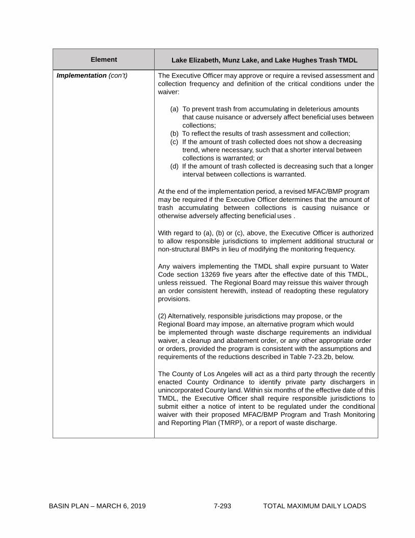
BASIN PLAN – MARCH 6, 2019 7-293 TOTAL MAXIMUM DAILY LOADS
Element Lake Elizabeth, Munz Lake, and Lake Hughes Trash TMDL
Implementation (con’t) The Executive Officer may approve or require a revised assessment and collection frequency and definition of the critical conditions under the waiver:
(a) To prevent trash from accumulating in deleterious amounts
that cause nuisance or adversely affect beneficial uses between collections;
(b) To reflect the results of trash assessment and collection; (c) If the amount of trash collected does not show a decreasing
trend, where necessary, such that a shorter interval between collections is warranted; or
(d) If the amount of trash collected is decreasing such that a longer interval between collections is warranted.
At the end of the implementation period, a revised MFAC/BMP program may be required if the Executive Officer determines that the amount of trash accumulating between collections is causing nuisance or otherwise adversely affecting beneficial uses .
With regard to (a), (b) or (c), above, the Executive Officer is authorized to allow responsible jurisdictions to implement additional structural or non-structural BMPs in lieu of modifying the monitoring frequency.
Any waivers implementing the TMDL shall expire pursuant to Water Code section 13269 five years after the effective date of this TMDL, unless reissued. The Regional Board may reissue this waiver through an order consistent herewith, instead of readopting these regulatory provisions.
(2) Alternatively, responsible jurisdictions may propose, or the Regional Board may impose, an alternative program which would be implemented through waste discharge requirements an individual waiver, a cleanup and abatement order, or any other appropriate order or orders, provided the program is consistent with the assumptions and requirements of the reductions described in Table 7-23.2b, below.
The County of Los Angeles will act as a third party through the recently enacted County Ordinance to identify private party dischargers in unincorporated County land. Within six months of the effective date of this TMDL, the Executive Officer shall require responsible jurisdictions to submit either a notice of intent to be regulated under the conditional waiver with their proposed MFAC/BMP Program and Trash Monitoring and Reporting Plan (TMRP), or a report of waste discharge.

BASIN PLAN – MARCH 6, 2019 7-294 TOTAL MAXIMUM DAILY LOADS
Element Lake Elizabeth, Munz Lake, and Lake Hughes Trash TMDL
Monitoring and Reporting Plan
Responsible jurisdictions will develop a TMRP for Executive Officer approval that describes the methodologies that will be used to assess and monitor trash in Lake Elizabeth and Lake Hughes and/or within responsible jurisdiction land areas.
Requirements for the TMRP shall include, but are not limited to, assessment and quantification of trash collected from the surfaces and shoreline of Lake Elizabeth and Lake Hughes or from responsible jurisdiction land areas. The monitoring plan shall provide details of the frequency, location, and reporting of trash monitoring. Responsible jurisdictions shall propose a metric (e.g., weight, volume, pieces of trash) to measure the amount of trash in Lake Elizabeth and Lake Hughes and on the land area surrounding Lake Elizabeth and Lake Hughes, as defined in the Executive Officer approved TMRP.
The TMRP shall include a prioritization of areas that have the highest trash generation rates. The TMRP shall give preference to this prioritization when scheduling the installation of full capture devices, BMPs, or trash collection programs.
The TMRP shall also include an evaluation of effectiveness of the MFAC/BMP program to prevent trash from accumulating in deleterious amounts that cause nuisance or adversely affect beneficial uses between collections, proposals to enhance BMPs, and a revised MFAC for Executive Officer review.
Responsible Jurisdictions may coordinate their TMRP activities for Lake Elizabeth and Lake Hughes.
Margin of Safety Zero is a conservative numeric target which contains an implicit margin of safety.
Seasonal Variations and Critical Conditions
Discharge of trash from the conveyances occurs primarily during or shortly after a major rain event. Discharge of trash from nonpoint sources occurs during all seasons, but can be increased during or shortly after high wind events, which are defined as periods of wind advisories issued by the National Weather Service.

BASIN PLAN – MARCH 6, 2019 7-295 TOTAL MAXIMUM DAILY LOADS
Table 7-23.2a Lake Elizabeth, Munz Lake, and Lake Hughes Trash TMDL: Implementation Schedule Point Sources
Task No.
Task
Responsible Jurisdiction
Date
1 Submit Trash Monitoring and Reporting Plan, including a plan for defining the trash baseline WLA and a proposed definition of “major rain event”.
Los Angeles County and local land owners with conveyances that discharge to Lake Elizabeth and Lake Hughes.
6 months from effective date of TMDL. If a plan is not approved by the Executive Officer within 9 months, the Executive Officer will establish an appropriate monitoring plan.
2 Implement Trash Monitoring and Reporting Plan.
Los Angeles County and local land owners with conveyances that discharge to Lake Elizabeth and Lake Hughes.
6 months from receipt of letter of approval from Regional Board Executive Officer, or the date a plan is established by the Executive Officer.
3 Submit results of Trash Monitoring and Reporting Plan, recommend trash baseline WLA, and propose prioritization of Full Capture System installation or implementation of other measures to attain the required trash reduction.
Los Angeles County and local land owners with conveyances that discharge to Lake Elizabeth and Lake Hughes.
2 years from receipt of letter of approval for the Trash Monitoring and Reporting Plan from Regional Board Executive Officer.
4 Installation of Full Capture Systems or other measures to achieve 20% reduction of trash from Baseline WLA*.
Los Angeles County, Los Angeles County Flood Control Districts, and local land owners with conveyances that discharge to Lake Elizabeth and Lake Hughes.
Four years from effective date of TMDL.
5 Installation of Full Capture Systems or other measures to achieve 40% reduction of trash from Baseline WLA*.
Los Angeles County and local land owners with conveyances that discharge to Lake Elizabeth and Lake Hughes.
Five years from effective date of TMDL.
6 Evaluate the effectiveness of Full Capture Systems or other measures, and reconsider the WLA*.
Regional Board. Five years from effective date of TMDL.
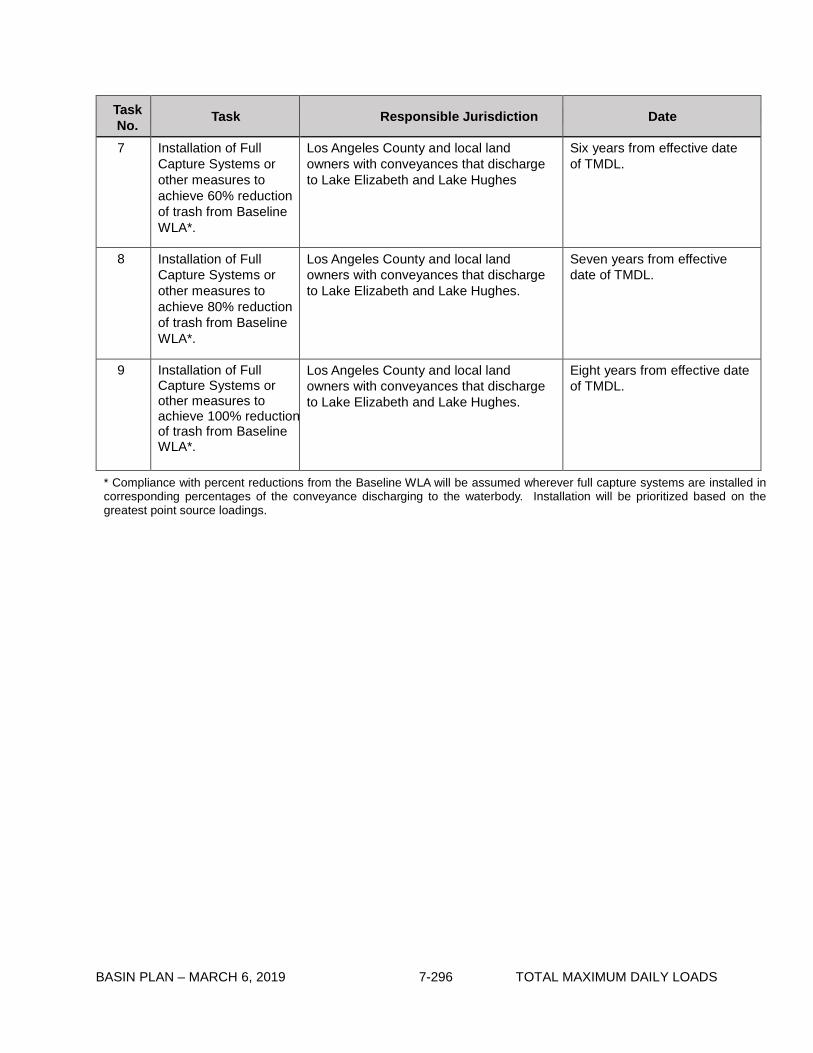
BASIN PLAN – MARCH 6, 2019 7-296 TOTAL MAXIMUM DAILY LOADS
Task No. Task Responsible Jurisdiction Date
7 Installation of Full Capture Systems or other measures to achieve 60% reduction of trash from Baseline WLA*.
Los Angeles County and local land owners with conveyances that discharge to Lake Elizabeth and Lake Hughes
Six years from effective date of TMDL.
8 Installation of Full Capture Systems or other measures to achieve 80% reduction of trash from Baseline WLA*.
Los Angeles County and local land owners with conveyances that discharge to Lake Elizabeth and Lake Hughes.
Seven years from effective date of TMDL.
9 Installation of Full Capture Systems or other measures to achieve 100% reduction of trash from Baseline WLA*.
Los Angeles County and local land owners with conveyances that discharge to Lake Elizabeth and Lake Hughes.
Eight years from effective date of TMDL.
* Compliance with percent reductions from the Baseline WLA will be assumed wherever full capture systems are installed in corresponding percentages of the conveyance discharging to the waterbody. Installation will be prioritized based on the greatest point source loadings.

BASIN PLAN – MARCH 6, 2019 7-297 TOTAL MAXIMUM DAILY LOADS
Table 7-23.2b Lake Elizabeth, Munz Lake, and Lake Hughes TMDL: Implementation Schedule Minimum Frequency of Assessment and Collection Program *
Task No.
Task Responsible Jurisdiction Date
1 Conditional Waiver in effect.
National Forest Service; Land owners in the vicinity of Lake Elizabeth and Lake Hughes.
Regional Board adoption of TMDL.
2 Submit Notice of Intent to Comply with Conditional Waiver of Discharge Requirements, including MFAC/ BMP Program and Trash Monitoring and Reporting Plan.
National Forest Service; Land owners in the vicinity of Lake Elizabeth and Lake Hughes.
Six months from TMDL effective date.
3 Implement MFAC/ BMP Program.
National Forest Service; Land owners in the vicinity of Lake Elizabeth and Lake Hughes.
Six months from receipt of Notice of Acceptance from Regional Board Executive Officer.
4 Submit annual TMRP reports including proposal for revising MFAC/BMP for Executive Officer approval.
National Forest Service; Land owners in the vicinity of Lake Elizabeth and Lake Hughes.
Two years from effective date of TMDL, and annually thereafter.
5 Reconsideration of Trash TMDL based on evaluation of effectiveness of MFAC/BMP program.
Regional Board. Five years from effective date of TMDL.
* At Task 3, all Responsible Jurisdictions must be attaining the zero trash target after each required trash assessment and collection event. At Task 4, all Responsible Jurisdictions must demonstrate full compliance and attainment of the zero trash target’s requirement that trash is not accumulating in deleterious amounts between the required trash assessment and collection events. Based on Responsible Jurisdiction monitoring reports, the Executive Officer may adjust the minimum frequency of assessment and collection as necessary to ensure compliance between the required trash assessment and collection events.

BASIN PLAN – MARCH 6, 2019 7-298 TOTAL MAXIMUM DAILY LOADS
This page intentionally left blank

BASIN PLAN – MARCH 6, 2019 7-299 TOTAL MAXIMUM DAILY LOADS
7-24 Revolon Slough and Beardsley Wash Trash TMDL This TMDL was adopted by:
The Regional Water Quality Control Board on June 7, 2007.
This TMDL was approved by:
The State Water Resources Control Board on December 4, 2007. The Office of Administrative Law on January 24, 2008. The U.S. Environmental Protection Agency on February 27, 2008.
The effective date of this TMDL is: March 6, 2008.
The elements of the TMDL are presented in Table 7-24.1 and the Implementation Plan in Tables
7-24.2a and 7-24.2b.
Table 7-24.1 Revolon Slough and Beardsley Wash Trash TMDL: Elements
Element Revolon Slough and Beardsley Wash Trash TMDL
Problem Statement Current levels of trash discharges into Revolon Slough and Beardsley Wash violate water quality objectives and are impairing beneficial uses. Relevant water quality objectives include Floating Material and Solid, Suspended, or Settleable Materials. The following designated beneficial uses are impacted by trash: water contact recreation (REC1); non- contact water recreation (REC2); warm freshwater habitat (WARM); wildlife habitat (WILD); wetland habitat (WET).
Numeric Target (Interpretation of the narrative water quality objective, used to calculate the load allocations)
Zero trash in Revolon Slough and Beardsley Wash, and in the channel. Zero is defined as (1) for nonpoint sources, no trash immediately following each assessment and collection event consistent with an established Minimum Frequency of Assessment and Collection Program (MFAC Program). The MFAC Program is established at an interval that prevents trash from accumulating in deleterious amounts that cause nuisance or adversely affect beneficial uses between collections, and (2) for point sources, zero trash discharged into Revolon Slough and Beardsley Wash, shoreline and channel.
Source Analysis Litter from adjacent land areas, roadways and direct dumping and deposition are sources of trash to Revolon Slough and Beardsley Wash. Point sources such as storm drains are also sources of trash discharged to Revolon Slough and Beardsley Wash.
Loading Capacity Zero, as defined in the Numeric Target.
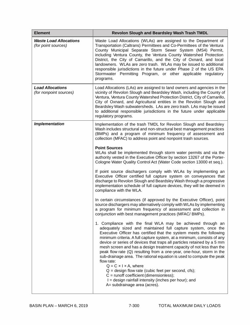
BASIN PLAN – MARCH 6, 2019 7-300 TOTAL MAXIMUM DAILY LOADS
Element Revolon Slough and Beardsley Wash Trash TMDL
Waste Load Allocations (for point sources)
Waste Load Allocations (WLAs) are assigned to the Department of Transportation (Caltrans) Permittees and Co-Permittees of the Ventura County Municipal Separate Storm Sewer System (MS4) Permit, including Ventura County, the Ventura County Watershed Protection District, the City of Camarillo, and the City of Oxnard, and local landowners. WLAs are zero trash. WLAs may be issued to additional responsible jurisdictions in the future under Phase 2 of the US EPA Stormwater Permitting Program, or other applicable regulatory programs.
Load Allocations (for nonpoint sources)
Load Allocations (LAs) are assigned to land owners and agencies in the vicinity of Revolon Slough and Beardsley Wash, including the County of Ventura, Ventura County Watershed Protection District, City of Camarillo, City of Oxnard, and Agricultural entities in the Revolon Slough and Beardsley Wash subwatersheds. LAs are zero trash. LAs may be issued to additional responsible jurisdictions in the future under applicable regulatory programs. Implementation Implementation of the trash TMDL for Revolon Slough and Beardsley Wash includes structural and non-structural best management practices (BMPs) and a program of minimum frequency of assessment and collection (MFAC) to address point and nonpoint trash sources.
Point Sources WLAs shall be implemented through storm water permits and via the authority vested in the Executive Officer by section 13267 of the Porter- Cologne Water Quality Control Act (Water Code section 13000 et seq.).
If point source dischargers comply with WLAs by implementing an Executive Officer certified full capture system on conveyances that discharge to Revolon Slough and Beardsley Wash through a progressive implementation schedule of full capture devices, they will be deemed in compliance with the WLA.
In certain circumstances (if approved by the Executive Officer), point source dischargers may alternatively comply with WLAs by implementing a program for minimum frequency of assessment and collection in conjunction with best management practices (MFAC/ BMPs).
1. Compliance with the final WLA may be achieved through an
adequately sized and maintained full capture system, once the Executive Officer has certified that the system meets the following minimum criteria. A full capture system, at a minimum, consists of any device or series of devices that traps all particles retained by a 5 mm mesh screen and has a design treatment capacity of not less than the peak flow rate (Q) resulting from a one-year, one-hour, storm in the sub-drainage area. The rational equation is used to compute the peak flow rate:
Q = C × I × A, where Q = design flow rate (cubic feet per second, cfs); C = runoff coefficient (dimensionless); I = design rainfall intensity (inches per hour); and
A= subdrainage area (acres).

BASIN PLAN – MARCH 6, 2019 7-301 TOTAL MAXIMUM DAILY LOADS
Element Revolon Slough and Beardsley Wash Trash TMDL
Implementation (con’t) Point sources that choose to comply via a full capture system, must demonstrate a phased implementation of full capture devices over an 8- year period until the final WLA of zero is attained. Zero will be deemed to have been met if full capture systems have been installed on all conveyances discharging to Revolon Slough and Beardsley Wash.
Irrespective of whether point sources employ a full capture system, they may comply with the WLA in any lawful manner.
2. Compliance through a MFAC program in conjunction with BMPs may be proposed to the Regional Board for incorporation into the relevant NPDES permit. The MFAC program must include requirements equivalent to those described in the Conditional Waiver set forth below. Agencies that are responsible for both point and nonpoint sources will be deemed in compliance with both the WLAs and LAs if a MFAC/BMP program, approved by the Executive Officer, is implemented.
Nonpoint Sources
LAs shall be implemented through either (1) a conditional waiver from waste discharge requirements, or (2) an alternative program implemented through waste discharge requirements or an individual waiver or another appropriate order of the Regional Board.
Non-point source dischargers may achieve compliance with the LAs by implementing a MFAC/BMP program approved by the Executive Officer. Responsible jurisdictions that are responsible for both point and nonpoint sources will be deemed in compliance with both the WLAs and LAs if an MFAC/BMP program, approved by the Executive Officer, is implemented.
1) Conditional Waiver: Pursuant to Water Code section 13269, waste discharge requirements are waived for any responsible jurisdiction that implements a MFAC/BMP Program which, to the satisfaction of the Executive Officer, meets the following criteria:
a) The MFAC/BMP Program includes an initial minimum
frequency of trash assessment and collection and suite of structural and/or nonstructural BMPs. The MFAC/ BMP program shall include collection and disposal of all trash found in the water and on the shoreline. Responsible jurisdictions shall implement an initial suite of BMPs based on current trash management practices in land areas that are found to be sources of trash to Revolon Slough and Beardsley Wash. For Revolon Slough and Beardsley Wash, the initial minimum frequency shall be set as follows:

BASIN PLAN – MARCH 6, 2019 7-302 TOTAL MAXIMUM DAILY LOADS
Element Revolon Slough and Beardsley Wash Trash TMDL
Implementation (con’t) 1. Monthly on Revolon Slough and its adjacent land areas at Wood Road (the end of the concrete-lined channel), as defined in the Executive Officer approved Trash Monitoring and Reporting Plan (TMRP).
2. Bi-monthly on the water, shoreline and channels
of Beardsley Wash and Revolon Slough in areas under the jurisdiction of the County of Ventura, and agricultural lands.
3. Monthly assessment and collection at outlets on north side of Camarillo Hills Drain between Las Posas Rd. and Wood Rd.
4. Monthly on Las Posas Estate Drain between Central Ave. and the 101 Freeway.
5. Monthly at the inlet to the North Ramona Place Drain debris basin.
6. Monthly at inlet to Beardsley Wash at Wright
Road and the adjacent land areas, as defined in the Executive Officer approved TMRP.
7. Monthly on a rotating basis of the following
channels from the City of Oxnard (i.e. one drain cleaned per month):
a. Fifth Street Drain from Del Norte Blvd.
to Revolon Slough b. Sturgis Drain from Oxnard City Limits to
Revolon Slough c. Nyeland Drain from Center Drive to
Friedrich Rd. d. Del Norte Drain from Del Norte Blvd. to
Revolon Slough
8. All Drains listed above will also be cleaned within one week of every storm event greater than 1 inch of rain.
b) The MFAC/BMP Program includes reasonable
assurances that it will be implemented by the responsible jurisdiction.
c) The MFAC/BMP Program includes a Trash Monitoring and Reporting Plan, as described below, and a requirement that the responsible jurisdictions will self-report any non-compliance with its provisions. The results and report of the Trash Monitoring and Reporting Plan must be submitted to Regional Board on an annual basis.

BASIN PLAN – MARCH 6, 2019 7-303 TOTAL MAXIMUM DAILY LOADS
Element Revolon Slough and Beardsley Wash Trash TMDL
Implementation (con’t) d) MFAC protocols may be based on SWAMP protocols for rapid trash assessment, or alternative protocols proposed by dischargers and approved by the Executive Officer.
e) Implementation of the MFAC/BMP program should
include a Health and Safety Plan to protect personnel. The MFAC/BMP shall not require responsible jurisdictions to access and collect trash from areas where personnel are prohibited.
Compliance for Agricultural Sources
For agricultural dischargers, the Conditional Waiver for Irrigated Lands will be revised to include a MFAC/BMP program for enrollees in the Revolon Slough and Beardsley Wash subwatershed.
The Executive Officer may approve or require a revised assessment and collection frequency and definition of the critical conditions under the waiver:
(a) To prevent trash from accumulating in deleterious amounts that
cause nuisance or adversely affect beneficial uses between collections;
(b) To reflect the results of trash assessment and collection; (c) If the amount of trash collected does not show a decreasing
trend, where necessary, such that a shorter interval between collections is warranted; or
(d) If the amount of trash collected is decreasing such that a longer interval between collections is warranted.
At the end of the implementation period, a revised MFAC/BMP program may be required if the Executive Officer determines that the amount of trash accumulating between collections is causing nuisance or otherwise adversely affecting beneficial uses.
With regard to (a), (b) or (c), above, the Executive Officer is authorized to allow responsible jurisdictions to implement additional structural or non-structural BMPs in lieu of modifying the monitoring frequency. Any waivers implementing the TMDL shall expire pursuant to Water Code section 13269 five years after the effective date of this TMDL, unless reissued. The Regional Board may reissue this waiver through an order consistent herewith, instead of readopting these regulatory provisions.
(2) Alternatively, responsible jurisdictions may propose, or the Regional Board may impose, an alternative program which would be implemented through waste discharge requirements, an individual waiver, a cleanup and abatement order, or any other appropriate order or orders, provided the program is consistent with the assumptions and requirements of the reductions described in Table 7-24.2b, below.
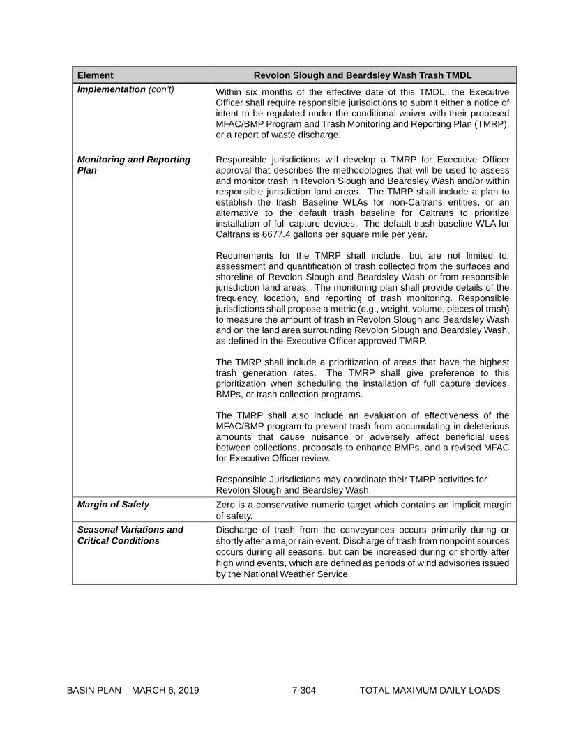
BASIN PLAN – MARCH 6, 2019 7-304 TOTAL MAXIMUM DAILY LOADS
Element Revolon Slough and Beardsley Wash Trash TMDL Implementation (con’t) Within six months of the effective date of this TMDL, the Executive
Officer shall require responsible jurisdictions to submit either a notice of intent to be regulated under the conditional waiver with their proposed MFAC/BMP Program and Trash Monitoring and Reporting Plan (TMRP), or a report of waste discharge.
Monitoring and Reporting Plan
Responsible jurisdictions will develop a TMRP for Executive Officer approval that describes the methodologies that will be used to assess and monitor trash in Revolon Slough and Beardsley Wash and/or within responsible jurisdiction land areas. The TMRP shall include a plan to establish the trash Baseline WLAs for non-Caltrans entities, or an alternative to the default trash baseline for Caltrans to prioritize installation of full capture devices. The default trash baseline WLA for Caltrans is 6677.4 gallons per square mile per year.
Requirements for the TMRP shall include, but are not limited to, assessment and quantification of trash collected from the surfaces and shoreline of Revolon Slough and Beardsley Wash or from responsible jurisdiction land areas. The monitoring plan shall provide details of the frequency, location, and reporting of trash monitoring. Responsible jurisdictions shall propose a metric (e.g., weight, volume, pieces of trash) to measure the amount of trash in Revolon Slough and Beardsley Wash and on the land area surrounding Revolon Slough and Beardsley Wash, as defined in the Executive Officer approved TMRP.
The TMRP shall include a prioritization of areas that have the highest trash generation rates. The TMRP shall give preference to this prioritization when scheduling the installation of full capture devices, BMPs, or trash collection programs. The TMRP shall also include an evaluation of effectiveness of the MFAC/BMP program to prevent trash from accumulating in deleterious amounts that cause nuisance or adversely affect beneficial uses between collections, proposals to enhance BMPs, and a revised MFAC for Executive Officer review.
Responsible Jurisdictions may coordinate their TMRP activities for Revolon Slough and Beardsley Wash.
Margin of Safety Zero is a conservative numeric target which contains an implicit margin of safety.
Seasonal Variations and Critical Conditions
Discharge of trash from the conveyances occurs primarily during or shortly after a major rain event. Discharge of trash from nonpoint sources occurs during all seasons, but can be increased during or shortly after high wind events, which are defined as periods of wind advisories issued by the National Weather Service.

BASIN PLAN – MARCH 6, 2019 7-305 TOTAL MAXIMUM DAILY LOADS
Table 7-24.2a Revolon Slough and Beardsley Wash Trash TMDL: Implementation Schedule - Point Sources
Task No. Task Responsible Jurisdiction Date
1 Submit Trash Monitoring and Reporting Plan, including a plan for defining the trash baseline WLA and a proposed definition of “major rain event”.
City of Camarillo; City of Oxnard; Ventura County Watershed Protection District; Ventura County; Caltrans; Local land owners with conveyances
6 months from effective date of TMDL. If a plan is not approved by the Executive Officer within 9 months, the Executive Officer will establish an appropriate monitoring plan.
2 Implement Trash Monitoring and Reporting Plan.
City of Camarillo; City of Oxnard; Ventura County Watershed Protection District; Ventura County; Caltrans; Local land owners with conveyances
6 months from receipt of letter of approval from Regional Board Executive Officer, or the date a plan is established by the Executive Officer.
3 Submit results of Trash Monitoring and Reporting Plan, recommend trash baseline WLA, and propose prioritization of Full Capture System installation or implementation of other measures to attain the required trash reduction.
City of Camarillo; City of Oxnard; Ventura County Watershed Protection District; Ventura County; Caltrans; Local land owners with conveyances
2 years from receipt of letter of approval for the Trash Monitoring and Reporting Plan from Regional Board Executive Officer.
4 Installation of Full Capture Systems or other measures to achieve 20% reduction of trash from Baseline WLA*.
City of Camarillo; City of Oxnard; Ventura County Watershed Protection District; Ventura County; Caltrans; Local land owners with conveyances
Four years from effective date of TMDL.
5 Installation of Full Capture Systems or other measures to achieve 40% reduction of trash from Baseline WLA*.
City of Camarillo; City of Oxnard; Ventura County Watershed Protection District; Ventura County; Caltrans; Local land owners with conveyances
Five years from effective date of TMDL.
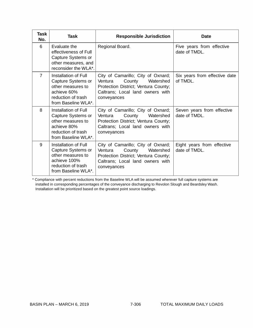
BASIN PLAN – MARCH 6, 2019 7-306 TOTAL MAXIMUM DAILY LOADS
Task No. Task Responsible Jurisdiction Date
6 Evaluate the effectiveness of Full Capture Systems or other measures, and reconsider the WLA*.
Regional Board. Five years from effective date of TMDL.
7 Installation of Full Capture Systems or other measures to achieve 60% reduction of trash from Baseline WLA*.
City of Camarillo; City of Oxnard; Ventura County Watershed Protection District; Ventura County; Caltrans; Local land owners with conveyances
Six years from effective date of TMDL.
8 Installation of Full Capture Systems or other measures to achieve 80% reduction of trash from Baseline WLA*.
City of Camarillo; City of Oxnard; Ventura County Watershed Protection District; Ventura County; Caltrans; Local land owners with conveyances
Seven years from effective date of TMDL.
9 Installation of Full Capture Systems or other measures to achieve 100% reduction of trash from Baseline WLA*.
City of Camarillo; City of Oxnard; Ventura County Watershed Protection District; Ventura County; Caltrans; Local land owners with conveyances
Eight years from effective date of TMDL.
* Compliance with percent reductions from the Baseline WLA will be assumed wherever full capture systems are installed in corresponding percentages of the conveyance discharging to Revolon Slough and Beardsley Wash. Installation will be prioritized based on the greatest point source loadings.

BASIN PLAN – MARCH 6, 2019 7-307 TOTAL MAXIMUM DAILY LOADS
Table 7-24.2b Revolon Slough and Beardsley Wash Trash TMDL: Implementation Schedule - Minimum Frequency of Assessment and Collection Program *
Task No.
Task Responsible Jurisdiction Date
1 Conditional Waiver in effect.
City of Camarillo; City of Oxnard; Ventura County; Agricultural dischargers; Ventura County Watershed Protection District; Caltrans; Local land owners with conveyances
Regional Board adoption of TMDL.
2 Submit Notice of Intent to Comply with Conditional Waiver of Discharge Requirements, including MFAC/BMP Program and Trash Monitoring and Reporting Plan.
City of Camarillo; City of Oxnard; Ventura County; Agricultural dischargers; Ventura County Watershed Protection District; Caltrans; Local land owners with conveyances
Six months from TMDL effective date.
3 Implement MFAC/BMP Program.
City of Camarillo; City of Oxnard; Ventura County; Agricultural dischargers; Ventura County Watershed Protection District; Caltrans; Local land owners with conveyances
Six months from receipt of Notice of Acceptance from Regional Board Executive Officer.
4 Submit annual TMRP reports including proposal for revising MFAC/BMP for Executive Officer approval.
City of Camarillo; City of Oxnard; Ventura County; Agricultural dischargers; Ventura County Watershed Protection District; Caltrans; Local land owners with conveyances
Two years from effective date of TMDL, and annually thereafter.
5 Reconsideration of Trash TMDL based on evaluation of effectiveness of MFAC/ BMP program.
Regional Board. Five years from effective date of TMDL.
* At Task 3, all Responsible Jurisdictions must be attaining the zero trash target after each required trash assessment and collection event. At Task 4, all Responsible Jurisdictions must demonstrate full compliance and attainment of the zero trash target’s requirement that trash is not accumulating in deleterious amounts between the required trash assessment and collection events. Based on Responsible Jurisdiction monitoring reports, the Executive Officer may adjust the minimum frequency of assessment and collection as necessary to ensure compliance between the required trash assessment and collection events.

BASIN PLAN – MARCH 6, 2019 7-308 TOTAL MAXIMUM DAILY LOADS
This page intentionally left blank

BASIN PLAN – MARCH 6, 2019 7-309 TOTAL MAXIMUM DAILY LOADS
7-25 Ventura River Estuary Trash TMDL This TMDL was adopted by:
The Regional Water Quality Control Board on June 7, 2007.
This TMDL was approved by:
The State Water Resources Control Board on December 4, 2007. The Office of Administrative Law on February 11, 2008. The U.S. Environmental Protection Agency on February 27, 2008.
The effective date of this TMDL is: March 6, 2008.
The elements of the TMDL are presented in Table 7-25.1 and the Implementation Plan in Tables
7-25.2a and 7-25.2b.
Table 7-25.1 Ventura River Estuary Trash TMDL: Elements
Element Ventura River Estuary Trash TMDL
Problem Statement Current levels of trash discharges into the Ventura River Estuary violate water quality objectives and are impairing beneficial uses. Relevant water quality objectives include Floating Material and Solid, Suspended, or Settleable Materials. The following designated beneficial uses are impacted by trash: navigation (NAV), contact recreation (REC 1) and non-contact recreation (REC 2), commercial and sport fishing (COMM), warm fresh water habitat (WARM), estuarine habitat (EST), marine habitat (MAR), wildlife habitat (WILD), rare, threatened or endangered species (RARE), migration of aquatic organisms (MIGR), spawning, reproduction, and/or early development (SPWN), shellfish harvesting (SHELL), and wetland habitat (WET).
Numeric Target (Interpretation of the narrative water quality objective, used to calculate the load allocations)
Zero trash in the Ventura River Estuary, shoreline and in the channel. Zero is defined as (1) for nonpoint sources, no trash immediately following each assessment and collection event consistent with an established Minimum Frequency of Assessment and Collection Program (MFAC Program). The MFAC Program is established at an interval that prevents trash from accumulating in deleterious amounts that cause nuisance or adversely affect beneficial uses between collections, and (2) for point sources, zero trash discharged into the Ventura River Estuary, shoreline, and channel.
Source Analysis Litter from adjacent land areas, roadways and direct dumping and deposition are sources of trash to the Ventura River Estuary. Point sources such as storm drains are also sources of trash discharged to the Ventura River Estuary.

BASIN PLAN – MARCH 6, 2019 7-310 TOTAL MAXIMUM DAILY LOADS
Element Ventura River Estuary Trash TMDL
Loading Capacity Zero, as defined in the Numeric Target.
Waste Load Allocations (for point sources)
Waste Load Allocations (WLAs) are assigned to the City of Ventura, County of Ventura, Ventura County Watershed Protection District, California Department of Food and Agriculture, and Caltrans with conveyances that discharge to the Ventura River Estuary. WLAs are zero trash. WLAs may be issued to additional responsible jurisdictions in the future under Phase 2 of the US EPA Stormwater Permitting Program, or other applicable regulatory programs.
Load Allocations (for nonpoint sources)
Load Allocations (LAs) are assigned to the City of Ventura, Ventura County, Ventura County Watershed Protection District, California Department of Parks and Recreation, California Department of Food and Agriculture, and Agricultural Dischargers. LAs are zero trash. LAs may be issued to additional responsible jurisdictions in the future under applicable regulatory programs.
Implementation Implementation of the trash TMDL for the Ventura River Estuary includes structural and non-structural best management practices (BMPs) and a program of minimum frequency of assessment and collection (MFAC) to address point and nonpoint trash sources.
Point Sources
WLAs shall be implemented through storm water permits and via the authority vested in the Executive Officer by section 13267 of the Porter- Cologne Water Quality Control Act (Water Code section 13000 et seq.).
If point source dischargers comply with WLAs by implementing an Executive Officer certified full capture system on conveyances that discharge to the Ventura River Estuary through a progressive implementation schedule of full capture devices, they will be deemed in compliance with the WLA.
In certain circumstances (if approved by the Executive Officer), point source dischargers may alternatively comply with WLAs by implementing a program for minimum frequency of assessment and collection in conjunction with best management practices (MFAC/ BMPs).
1. Compliance with the final WLA may be achieved through an
adequately sized and maintained full capture system, once the Executive Officer has certified that the system meets the following minimum criteria. A full capture system, at a minimum, consists of any device or series of devices that traps all particles retained by a 5 mm mesh screen and has a design treatment capacity of not less than the peak flow rate (Q) resulting from a one-year, one-hour, storm in the sub-drainage area. The rational equation is used to compute the peak flow rate:
Q = C × I × A, where Q = design flow rate (cubic feet per second, cfs); C = runoff coefficient (dimensionless); I = design rainfall intensity (inches per hour); and
A= subdrainage area (acres).

BASIN PLAN – MARCH 6, 2019 7-311 TOTAL MAXIMUM DAILY LOADS
Element Ventura River Estuary Trash TMDL
Implementation (con’t) Point sources that choose to comply via a full capture system, must demonstrate a phased implementation of full capture devices over an 8-year period until the final WLA of zero is attained. Zero will be deemed to have been met if full capture systems have been installed on all conveyances discharging to the estuary.Irrespective of whether point sources employ a full capture system, they may comply with the WLA in any lawful manner.
2. Compliance through a MFAC program in conjunction with BMPs may be proposed to the Regional Board for incorporation into the relevant NPDES permit. The MFAC program must include requirements equivalent to those described in the Conditional Waiver set forth below. Agencies that are responsible for both point and nonpoint sources will be deemed in compliance with both the WLAs and LAs if an MFAC/BMP program, approved by the Executive Officer, is implemented.
Nonpoint Sources
LAs shall be implemented through either (1) a conditional waiver from waste discharge requirements, or (2) an alternative program implemented through waste discharge requirements or an individual waiver or another appropriate order of the Regional Board.
Non-point source dischargers may achieve compliance with the LAs by implementing a MFAC/BMP program approved by the Executive Officer. Responsible jurisdictions that are responsible for both point and nonpoint sources will be deemed in compliance with both the WLAs and LAs if a MFAC/BMP program, approved by the Executive Officer, is implemented.
1) Conditional Waiver: Pursuant to Water Code section 13269, waste discharge requirements are waived for any responsible jurisdiction that implements a MFAC/BMP Program which, to the satisfaction of the Executive Officer, meets the following criteria:
a) The MFAC/BMP Program includes an initial minimum
frequency of trash assessment and collection and suite of structural and/or nonstructural BMPs. The MFAC/BMP program shall include collection and disposal of all trash found in the water, shoreline, and the channel. Responsible jurisdictions shall implement an initial suite of BMPs based on current trash management practices in land areas that are found to be sources of trash to the Ventura River Estuary. For the Ventura River Estuary, the initial minimum frequency shall be set as follows:
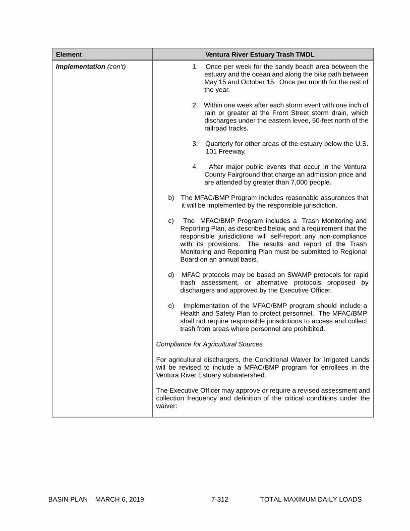
BASIN PLAN – MARCH 6, 2019 7-312 TOTAL MAXIMUM DAILY LOADS
Element Ventura River Estuary Trash TMDL
Implementation (con’t) 1. Once per week for the sandy beach area between the estuary and the ocean and along the bike path between May 15 and October 15. Once per month for the rest of the year.
2. Within one week after each storm event with one inch of
rain or greater at the Front Street storm drain, which discharges under the eastern levee, 50-feet north of the railroad tracks.
3. Quarterly for other areas of the estuary below the U.S.
101 Freeway.
4. After major public events that occur in the Ventura County Fairground that charge an admission price and are attended by greater than 7,000 people.
b) The MFAC/BMP Program includes reasonable assurances that
it will be implemented by the responsible jurisdiction.
c) The MFAC/BMP Program includes a Trash Monitoring and Reporting Plan, as described below, and a requirement that the responsible jurisdictions will self-report any non-compliance with its provisions. The results and report of the Trash Monitoring and Reporting Plan must be submitted to Regional Board on an annual basis.
d) MFAC protocols may be based on SWAMP protocols for rapid
trash assessment, or alternative protocols proposed by dischargers and approved by the Executive Officer.
e) Implementation of the MFAC/BMP program should include a
Health and Safety Plan to protect personnel. The MFAC/BMP shall not require responsible jurisdictions to access and collect trash from areas where personnel are prohibited.
Compliance for Agricultural Sources
For agricultural dischargers, the Conditional Waiver for Irrigated Lands will be revised to include a MFAC/BMP program for enrollees in the Ventura River Estuary subwatershed.
The Executive Officer may approve or require a revised assessment and collection frequency and definition of the critical conditions under the waiver:
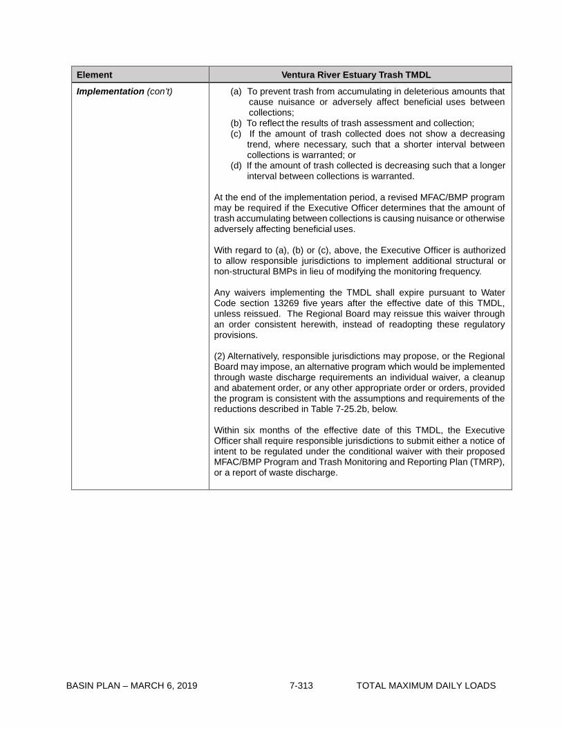
BASIN PLAN – MARCH 6, 2019 7-313 TOTAL MAXIMUM DAILY LOADS
Element Ventura River Estuary Trash TMDL
Implementation (con’t) (a) To prevent trash from accumulating in deleterious amounts that cause nuisance or adversely affect beneficial uses between collections;
(b) To reflect the results of trash assessment and collection; (c) If the amount of trash collected does not show a decreasing
trend, where necessary, such that a shorter interval between collections is warranted; or
(d) If the amount of trash collected is decreasing such that a longer interval between collections is warranted.
At the end of the implementation period, a revised MFAC/BMP program may be required if the Executive Officer determines that the amount of trash accumulating between collections is causing nuisance or otherwise adversely affecting beneficial uses.
With regard to (a), (b) or (c), above, the Executive Officer is authorized to allow responsible jurisdictions to implement additional structural or non-structural BMPs in lieu of modifying the monitoring frequency.
Any waivers implementing the TMDL shall expire pursuant to Water Code section 13269 five years after the effective date of this TMDL, unless reissued. The Regional Board may reissue this waiver through an order consistent herewith, instead of readopting these regulatory provisions.
(2) Alternatively, responsible jurisdictions may propose, or the Regional Board may impose, an alternative program which would be implemented through waste discharge requirements an individual waiver, a cleanup and abatement order, or any other appropriate order or orders, provided the program is consistent with the assumptions and requirements of the reductions described in Table 7-25.2b, below.
Within six months of the effective date of this TMDL, the Executive Officer shall require responsible jurisdictions to submit either a notice of intent to be regulated under the conditional waiver with their proposed MFAC/BMP Program and Trash Monitoring and Reporting Plan (TMRP), or a report of waste discharge.

BASIN PLAN – MARCH 6, 2019 7-314 TOTAL MAXIMUM DAILY LOADS
Element Ventura River Estuary Trash TMDL
Monitoring and Reporting Plan
Responsible jurisdictions will develop a TMRP for Executive Officer approval that describes the methodologies that will be used to assess and monitor trash in the Ventura River Estuary and/or within responsible jurisdiction land areas. The TMRP shall include a plan to establish the trash Baseline WLAs for non-Caltrans entities, or an alternative to the default trash baseline for Caltrans to prioritize installation of full capture devices. The default trash baseline WLA for Caltrans is 6677.4 gallons per square mile per year.
Requirements for the TMRP shall include, but are not limited to, assessment and quantification of trash collected from the surfaces and shoreline of the Ventura River Estuary or from responsible jurisdiction land areas. The monitoring plan shall provide details of the frequency, location, and reporting of trash monitoring. Responsible jurisdictions shall propose a metric (e.g., weight, volume, pieces of trash) to measure the amount of trash in the estuary and on the land area surrounding the estuary, as defined in the Executive Officer approved TMRP.
The TMRP shall include a prioritization of areas that have the highest trash generation rates. The TMRP shall give preference to this prioritization when scheduling the installation of full capture devices, BMPs, or trash collection programs.
The TMRP shall also include an evaluation of effectiveness of the MFAC/BMP program to prevent trash from accumulating in deleterious amounts that cause nuisance or adversely affect beneficial uses between collections, proposals to enhance BMPs, and a revised MFAC for Executive Officer review.
Responsible Jurisdictions may coordinate their TMRP activities for the Ventura River Estuary.
Margin of Safety Zero is a conservative numeric target which contains an implicit margin of safety.
Seasonal Variations and Critical Conditions
Discharge of trash from the conveyances occurs primarily during or shortly after a major rain event. Discharge of trash from nonpoint sources occurs during all seasons, but can be increased during or shortly after high wind events, which are defined as periods of wind advisories issued by the National Weather Service, and the period from May 15 to October 15, or during and after public events that occur in the Ventura County Fairground.

BASIN PLAN – MARCH 6, 2019 7-315 TOTAL MAXIMUM DAILY LOADS
Table 7-25.2a Ventura River Estuary Trash TMDL: Implementation Schedule - Point Sources
Task No. Task Responsible Jurisdiction Date
1 Submit Trash Monitoring and Reporting Plan, including a plan for defining the trash baseline WLA and a proposed definition of “major rain event”.
City of Ventura, Ventura County, Ventura County Watershed Protection District, California Department of Food and Agriculture, and Caltrans.
6 months from effective date of TMDL. If a plan is not approved by the Executive Officer within 9 months, the Executive Officer will establish an appropriate monitoring plan.
2 Implement Trash Monitoring and Reporting Plan.
City of Ventura, Ventura County, Ventura County Watershed Protection District, California Department of Food and Agriculture, and Caltrans.
6 months from receipt of letter of approval from Regional Board Executive Officer, or the date a plan is established by the Executive Officer.
3 Submit results of Trash Monitoring and Reporting Plan, recommend trash baseline WLA, and propose prioritization of Full Capture System installation or implementation of other measures to attain the required trash reduction.
City of Ventura, Ventura County, Ventura County Watershed Protection District, California Department of Food and Agriculture, and Caltrans.
2 years from receipt of letter of approval for the Trash Monitoring and Reporting Plan from Regional Board Executive Officer.
4 Installation of Full Capture Systems or other measures to achieve 20% reduction of trash from Baseline WLA*.
City of Ventura, Ventura County, Ventura County Watershed Protection District, California Department of Food and Agriculture, and Caltrans.
Four years from effective date of TMDL.
5 Installation of Full Capture Systems or other measures to achieve 40% reduction of trash from Baseline WLA*.
City of Ventura, Ventura County, Ventura County Watershed Protection District, California Department of Food and Agriculture, and Caltrans.
Five years from effective date of TMDL.

BASIN PLAN – MARCH 6, 2019 7-316 TOTAL MAXIMUM DAILY LOADS
Task No. Task Responsible Jurisdiction Date
6 Evaluate the effectiveness of Full Capture Systems or other measures, and reconsider the WLA*.
Regional Board. Five years from effective date of TMDL.
7 Installation of Full Capture Systems or other measures to achieve 60% reduction of trash from Baseline WLA*.
City of Ventura, Ventura County, Ventura County Watershed Protection District, California Department of Food and Agriculture, and Caltrans.
Six years from effective date of TMDL.
8 Installation of Full Capture Systems or other measures to achieve 80% reduction of trash from Baseline WLA*.
City of Ventura, Ventura County, Ventura County Watershed Protection District, California Department of Food and Agriculture, and Caltrans.
Seven years from effective date of TMDL.
9 Installation of Full Capture Systems or other measures to achieve 100% reduction of trash from Baseline WLA*.
City of Ventura, Ventura County, Ventura County Watershed Protection District, California Department of Food and Agriculture, and Caltrans.
Eight years from effective date of TMDL.
* Compliance with percent reductions from the Baseline WLA will be assumed wherever full capture systems are installed in corresponding percentages of the conveyance discharging to the estuary. Installation will be prioritized based on the greatest point source loadings.
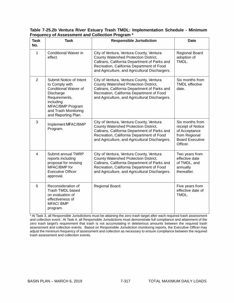
BASIN PLAN – MARCH 6, 2019 7-317 TOTAL MAXIMUM DAILY LOADS
Table 7-25.2b Ventura River Estuary Trash TMDL: Implementation Schedule - Minimum Frequency of Assessment and Collection Program * Task No.
Task Responsible Jurisdiction Date
1 Conditional Waiver in effect.
City of Ventura, Ventura County, Ventura County Watershed Protection District, Caltrans, California Department of Parks and Recreation, California Department of Food and Agriculture, and Agricultural Dischargers.
Regional Board adoption of TMDL.
2 Submit Notice of Intent to Comply with Conditional Waiver of Discharge Requirements, including MFAC/BMP Program and Trash Monitoring and Reporting Plan.
City of Ventura, Ventura County, Ventura County Watershed Protection District, Caltrans, California Department of Parks and Recreation, California Department of Food and Agriculture, and Agricultural Dischargers.
Six months from TMDL effective date.
3 Implement MFAC/BMP Program.
City of Ventura, Ventura County, Ventura County Watershed Protection District, Caltrans, California Department of Parks and Recreation, California Department of Food and Agriculture, and Agricultural Dischargers.
Six months from receipt of Notice of Acceptance from Regional Board Executive Officer.
4 Submit annual TMRP reports including proposal for revising MFAC/BMP for Executive Officer approval.
City of Ventura, Ventura County, Ventura County Watershed Protection District, Caltrans, California Department of Parks and Recreation, California Department of Food and Agriculture, and Agricultural Dischargers.
Two years from effective date of TMDL, and annually thereafter.
5 Reconsideration of Trash TMDL based on evaluation of effectiveness of MFAC/ BMP program.
Regional Board. Five years from effective date of TMDL.
* At Task 3, all Responsible Jurisdictions must be attaining the zero trash target after each required trash assessmentand collection event. At Task 4, all Responsible Jurisdictions must demonstrate full compliance and attainment of thezero trash target’s requirement that trash is not accumulating in deleterious amounts between the required trashassessment and collection events. Based on Responsible Jurisdiction monitoring reports, the Executive Officer mayadjust the minimum frequency of assessment and collection as necessary to ensure compliance between the requiredtrash assessment and collection events.

BASIN PLAN – MARCH 6, 2019 7-318 TOTAL MAXIMUM DAILY LOADS
This page intentionally left blank
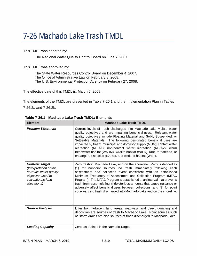
BASIN PLAN – MARCH 6, 2019 7-319 TOTAL MAXIMUM DAILY LOADS
7-26 Machado Lake Trash TMDL This TMDL was adopted by:
The Regional Water Quality Control Board on June 7, 2007.
This TMDL was approved by:
The State Water Resources Control Board on December 4, 2007. The Office of Administrative Law on February 8, 2008. The U.S. Environmental Protection Agency on February 27, 2008.
The effective date of this TMDL is: March 6, 2008.
The elements of the TMDL are presented in Table 7-26.1 and the Implementation Plan in Tables
7-26.2a and 7-26.2b.
Table 7-26.1 Machado Lake Trash TMDL: Elements
Element Machado Lake Trash TMDL
Problem Statement Current levels of trash discharges into Machado Lake violate water quality objectives and are impairing beneficial uses. Relevant water quality objectives include Floating Material and Solid, Suspended, or Settleable Materials. The following designated beneficial uses are impacted by trash: municipal and domestic supply (MUN); contact water recreation (REC-1); non-contact water recreation (REC-2); warm freshwater habitat (WARM); wildlife habitat (WILD), rare, threatened, or endangered species (RARE), and wetland habitat (WET).
Numeric Target (Interpretation of the narrative water quality objective, used to calculate the load allocations)
Zero trash in Machado Lake, and on the shoreline. Zero is defined as (1) for nonpoint sources, no trash immediately following each assessment and collection event consistent with an established Minimum Frequency of Assessment and Collection Program (MFAC Program). The MFAC Program is established at an interval that prevents trash from accumulating in deleterious amounts that cause nuisance or adversely affect beneficial uses between collections, and (2) for point sources, zero trash discharged into Machado Lake and on the shoreline.
Source Analysis Litter from adjacent land areas, roadways and direct dumping and deposition are sources of trash to Machado Lake. Point sources such as storm drains are also sources of trash discharged to Machado Lake.
Loading Capacity Zero, as defined in the Numeric Target.

BASIN PLAN – MARCH 6, 2019 7-320 TOTAL MAXIMUM DAILY LOADS
Element Machado Lake Trash TMDL
Waste Load Allocations (for point sources)
Waste Load Allocations (WLAs) are assigned to the California Department of Transportation (Caltrans) and permittees under the Los Angeles County Municipal Separate Storm Sewer System (MS4) NPDES permit, including Los Angeles County, Los Angeles Flood Control District, and the Cities of Carson, Lomita, Los Angeles, Palos Verdes Estates, Rancho Palos Verdes, Redondo Beach, Rolling Hills, Rolling Hills Estates, and Torrance.
WLAs are zero trash. WLAs may be issued to additional responsible jurisdictions in the future under Phase 2 of the US EPA Stormwater Permitting Program, or other applicable regulatory programs.
Load Allocations (for nonpoint sources)
Load Allocations (LAs) are assigned to the City of Los Angeles. LAs are zero trash. LAs may be issued to additional responsible jurisdictions in the future under applicable regulatory programs.
Implementation Implementation of the trash TMDL for Machado Lake includes structural and non-structural best management practices (BMPs) and a program of minimum frequency of assessment and collection (MFAC) to address point and nonpoint trash sources. Point Sources
WLAs shall be implemented through storm water permits and via the authority vested in the Executive Officer by section 13267 of the Porter- Cologne Water Quality Control Act (Water Code section 13000 et seq.).
If point source dischargers comply with WLAs by implementing an Executive Officer certified full capture system on conveyances that discharge to Machado Lake through a progressive implementation schedule of full capture devices, they will be deemed in compliance with the WLA.
In certain circumstances, (if approved by the Executive Officer), point source dischargers may alternatively comply with WLAs by implementing a program for minimum frequency of assessment and collection in conjunction with best management practices (MFAC/ BMPs). 1. Compliance with the final WLA may be achieved through an
adequately sized and maintained full capture system, once the Executive Officer has certified that the system meets the following minimum criteria. A full capture system, at a minimum, consists of any device or series of devices that traps all particles retained by a 5 mm mesh screen and has a design treatment capacity of not less than the peak flow rate (Q) resulting from a one-year, one-hour, storm in the sub-drainage area. The rational equation is used to compute the peak flow rate:
Q = C × I × A, where Q = design flow rate (cubic feet per second, cfs); C = runoff coefficient (dimensionless); I = design rainfall intensity (inches per hour); and
A= subdrainage area (acres).
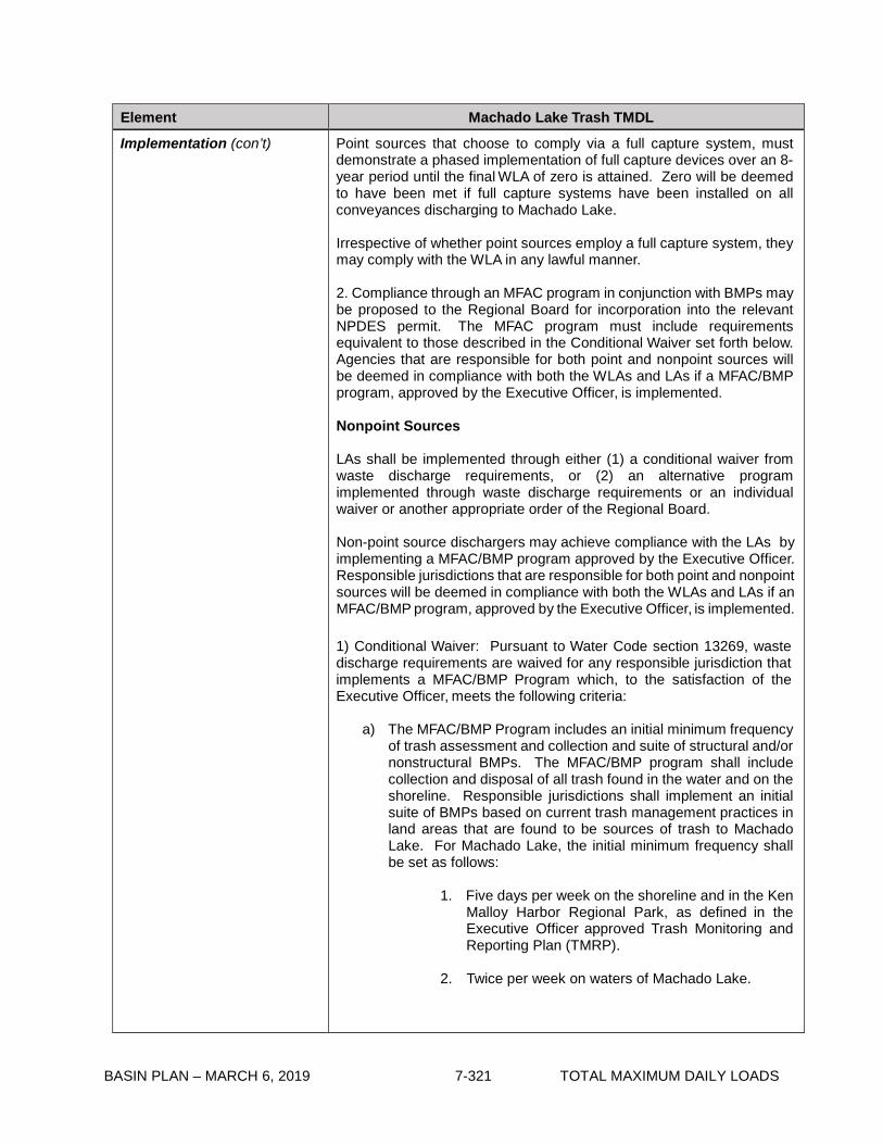
BASIN PLAN – MARCH 6, 2019 7-321 TOTAL MAXIMUM DAILY LOADS
Element Machado Lake Trash TMDL
Implementation (con’t) Point sources that choose to comply via a full capture system, must demonstrate a phased implementation of full capture devices over an 8-year period until the final WLA of zero is attained. Zero will be deemed to have been met if full capture systems have been installed on all conveyances discharging to Machado Lake.
Irrespective of whether point sources employ a full capture system, they may comply with the WLA in any lawful manner.
2. Compliance through an MFAC program in conjunction with BMPs may be proposed to the Regional Board for incorporation into the relevant NPDES permit. The MFAC program must include requirements equivalent to those described in the Conditional Waiver set forth below. Agencies that are responsible for both point and nonpoint sources will be deemed in compliance with both the WLAs and LAs if a MFAC/BMP program, approved by the Executive Officer, is implemented.
Nonpoint Sources
LAs shall be implemented through either (1) a conditional waiver from waste discharge requirements, or (2) an alternative program implemented through waste discharge requirements or an individual waiver or another appropriate order of the Regional Board.
Non-point source dischargers may achieve compliance with the LAs by implementing a MFAC/BMP program approved by the Executive Officer. Responsible jurisdictions that are responsible for both point and nonpoint sources will be deemed in compliance with both the WLAs and LAs if an MFAC/BMP program, approved by the Executive Officer, is implemented. 1) Conditional Waiver: Pursuant to Water Code section 13269, waste discharge requirements are waived for any responsible jurisdiction that implements a MFAC/BMP Program which, to the satisfaction of the Executive Officer, meets the following criteria:
a) The MFAC/BMP Program includes an initial minimum frequency
of trash assessment and collection and suite of structural and/or nonstructural BMPs. The MFAC/BMP program shall include collection and disposal of all trash found in the water and on the shoreline. Responsible jurisdictions shall implement an initial suite of BMPs based on current trash management practices in land areas that are found to be sources of trash to Machado Lake. For Machado Lake, the initial minimum frequency shall be set as follows:
1. Five days per week on the shoreline and in the Ken
Malloy Harbor Regional Park, as defined in the Executive Officer approved Trash Monitoring and Reporting Plan (TMRP).
2. Twice per week on waters of Machado Lake.
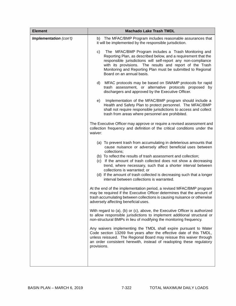
BASIN PLAN – MARCH 6, 2019 7-322 TOTAL MAXIMUM DAILY LOADS
Element Machado Lake Trash TMDL
Implementation (con’t) b) The MFAC/BMP Program includes reasonable assurances that it will be implemented by the responsible jurisdiction.
c) The MFAC/BMP Program includes a Trash Monitoring and
Reporting Plan, as described below, and a requirement that the responsible jurisdictions will self-report any non-compliance with its provisions. The results and report of the Trash Monitoring and Reporting Plan must be submitted to Regional Board on an annual basis.
d) MFAC protocols may be based on SWAMP protocols for rapid
trash assessment, or alternative protocols proposed by dischargers and approved by the Executive Officer.
e) Implementation of the MFAC/BMP program should include a
Health and Safety Plan to protect personnel. The MFAC/BMP shall not require responsible jurisdictions to access and collect trash from areas where personnel are prohibited.
The Executive Officer may approve or require a revised assessment and collection frequency and definition of the critical conditions under the waiver:
(a) To prevent trash from accumulating in deleterious amounts that
cause nuisance or adversely affect beneficial uses between collections;
(b) To reflect the results of trash assessment and collection; (c) If the amount of trash collected does not show a decreasing
trend, where necessary, such that a shorter interval between collections is warranted; or
(d) If the amount of trash collected is decreasing such that a longer interval between collections is warranted.
At the end of the implementation period, a revised MFAC/BMP program may be required if the Executive Officer determines that the amount of trash accumulating between collections is causing nuisance or otherwise adversely affecting beneficial uses.
With regard to (a), (b) or (c), above, the Executive Officer is authorized to allow responsible jurisdictions to implement additional structural or non-structural BMPs in lieu of modifying the monitoring frequency.
Any waivers implementing the TMDL shall expire pursuant to Water Code section 13269 five years after the effective date of this TMDL, unless reissued. The Regional Board may reissue this waiver through an order consistent herewith, instead of readopting these regulatory provisions.
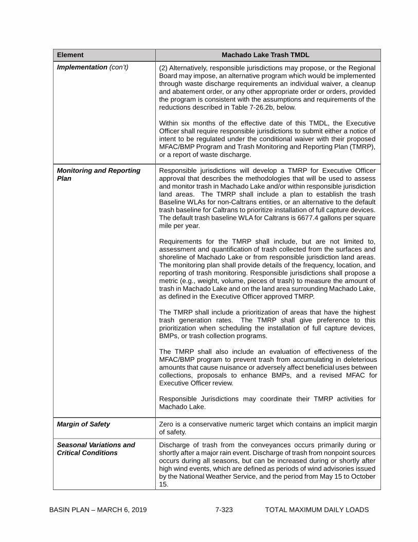
BASIN PLAN – MARCH 6, 2019 7-323 TOTAL MAXIMUM DAILY LOADS
Element Machado Lake Trash TMDL
Implementation (con’t) (2) Alternatively, responsible jurisdictions may propose, or the Regional Board may impose, an alternative program which would be implemented through waste discharge requirements an individual waiver, a cleanup and abatement order, or any other appropriate order or orders, provided the program is consistent with the assumptions and requirements of the reductions described in Table 7-26.2b, below.
Within six months of the effective date of this TMDL, the Executive Officer shall require responsible jurisdictions to submit either a notice of intent to be regulated under the conditional waiver with their proposed MFAC/BMP Program and Trash Monitoring and Reporting Plan (TMRP), or a report of waste discharge.
Monitoring and Reporting Plan
Responsible jurisdictions will develop a TMRP for Executive Officer approval that describes the methodologies that will be used to assess and monitor trash in Machado Lake and/or within responsible jurisdiction land areas. The TMRP shall include a plan to establish the trash Baseline WLAs for non-Caltrans entities, or an alternative to the default trash baseline for Caltrans to prioritize installation of full capture devices. The default trash baseline WLA for Caltrans is 6677.4 gallons per square mile per year.
Requirements for the TMRP shall include, but are not limited to, assessment and quantification of trash collected from the surfaces and shoreline of Machado Lake or from responsible jurisdiction land areas. The monitoring plan shall provide details of the frequency, location, and reporting of trash monitoring. Responsible jurisdictions shall propose a metric (e.g., weight, volume, pieces of trash) to measure the amount of trash in Machado Lake and on the land area surrounding Machado Lake, as defined in the Executive Officer approved TMRP.
The TMRP shall include a prioritization of areas that have the highest trash generation rates. The TMRP shall give preference to this prioritization when scheduling the installation of full capture devices, BMPs, or trash collection programs.
The TMRP shall also include an evaluation of effectiveness of the MFAC/BMP program to prevent trash from accumulating in deleterious amounts that cause nuisance or adversely affect beneficial uses between collections, proposals to enhance BMPs, and a revised MFAC for Executive Officer review.
Responsible Jurisdictions may coordinate their TMRP activities for Machado Lake.
Margin of Safety Zero is a conservative numeric target which contains an implicit margin of safety.
Seasonal Variations and Critical Conditions
Discharge of trash from the conveyances occurs primarily during or shortly after a major rain event. Discharge of trash from nonpoint sources occurs during all seasons, but can be increased during or shortly after high wind events, which are defined as periods of wind advisories issued by the National Weather Service, and the period from May 15 to October 15.
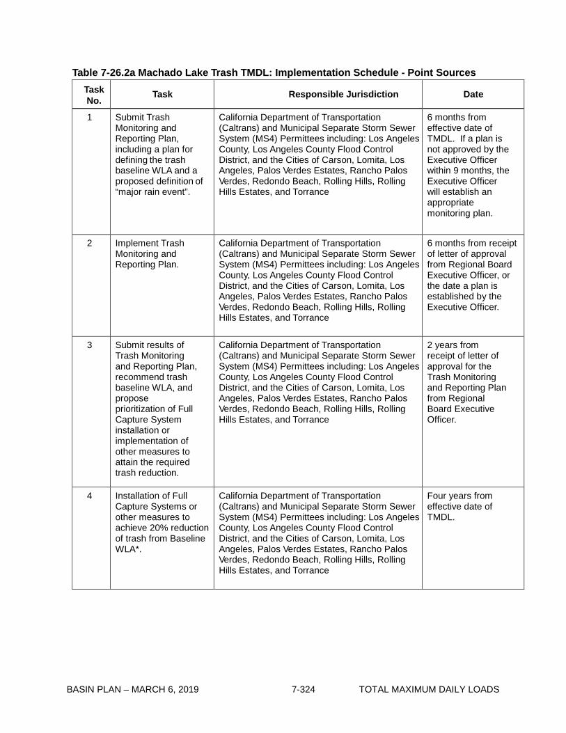
BASIN PLAN – MARCH 6, 2019 7-324 TOTAL MAXIMUM DAILY LOADS
Table 7-26.2a Machado Lake Trash TMDL: Implementation Schedule - Point Sources
Task No. Task Responsible Jurisdiction Date
1 Submit Trash Monitoring and Reporting Plan, including a plan for defining the trash baseline WLA and a proposed definition of “major rain event”.
California Department of Transportation (Caltrans) and Municipal Separate Storm Sewer System (MS4) Permittees including: Los Angeles County, Los Angeles County Flood Control District, and the Cities of Carson, Lomita, Los Angeles, Palos Verdes Estates, Rancho Palos Verdes, Redondo Beach, Rolling Hills, Rolling Hills Estates, and Torrance
6 months from effective date of TMDL. If a plan is not approved by the Executive Officer within 9 months, the Executive Officer will establish an appropriate monitoring plan.
2 Implement Trash Monitoring and Reporting Plan.
California Department of Transportation (Caltrans) and Municipal Separate Storm Sewer System (MS4) Permittees including: Los Angeles County, Los Angeles County Flood Control District, and the Cities of Carson, Lomita, Los Angeles, Palos Verdes Estates, Rancho Palos Verdes, Redondo Beach, Rolling Hills, Rolling Hills Estates, and Torrance
6 months from receipt of letter of approval from Regional Board Executive Officer, or the date a plan is established by the Executive Officer.
3 Submit results of Trash Monitoring and Reporting Plan, recommend trash baseline WLA, and propose prioritization of Full Capture System installation or implementation of other measures to attain the required trash reduction.
California Department of Transportation (Caltrans) and Municipal Separate Storm Sewer System (MS4) Permittees including: Los Angeles County, Los Angeles County Flood Control District, and the Cities of Carson, Lomita, Los Angeles, Palos Verdes Estates, Rancho Palos Verdes, Redondo Beach, Rolling Hills, Rolling Hills Estates, and Torrance
2 years from receipt of letter of approval for the Trash Monitoring and Reporting Plan from Regional Board Executive Officer.
4 Installation of Full Capture Systems or other measures to achieve 20% reduction of trash from Baseline WLA*.
California Department of Transportation (Caltrans) and Municipal Separate Storm Sewer System (MS4) Permittees including: Los Angeles County, Los Angeles County Flood Control District, and the Cities of Carson, Lomita, Los Angeles, Palos Verdes Estates, Rancho Palos Verdes, Redondo Beach, Rolling Hills, Rolling Hills Estates, and Torrance
Four years from effective date of TMDL.
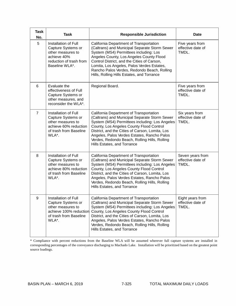
BASIN PLAN – MARCH 6, 2019 7-325 TOTAL MAXIMUM DAILY LOADS
Task No.
Task Responsible Jurisdiction Date
5 Installation of Full Capture Systems or other measures to achieve 40% reduction of trash from Baseline WLA*.
California Department of Transportation (Caltrans) and Municipal Separate Storm Sewer System (MS4) Permittees including: Los Angeles County, Los Angeles County Flood Control District, and the Cities of Carson, Lomita, Los Angeles, Palos Verdes Estates, Rancho Palos Verdes, Redondo Beach, Rolling Hills, Rolling Hills Estates, and Torrance
Five years from effective date of TMDL.
6 Evaluate the effectiveness of Full Capture Systems or other measures, and reconsider the WLA*.
Regional Board. Five years from effective date of TMDL.
7 Installation of Full Capture Systems or other measures to achieve 60% reduction of trash from Baseline WLA*.
California Department of Transportation (Caltrans) and Municipal Separate Storm Sewer System (MS4) Permittees including: Los Angeles County, Los Angeles County Flood Control District, and the Cities of Carson, Lomita, Los Angeles, Palos Verdes Estates, Rancho Palos Verdes, Redondo Beach, Rolling Hills, Rolling Hills Estates, and Torrance
Six years from effective date of TMDL.
8 Installation of Full Capture Systems or other measures to achieve 80% reduction of trash from Baseline WLA*.
California Department of Transportation (Caltrans) and Municipal Separate Storm Sewer System (MS4) Permittees including: Los Angeles County, Los Angeles County Flood Control District, and the Cities of Carson, Lomita, Los Angeles, Palos Verdes Estates, Rancho Palos Verdes, Redondo Beach, Rolling Hills, Rolling Hills Estates, and Torrance
Seven years from effective date of TMDL.
9 Installation of Full Capture Systems or other measures to achieve 100% reduction of trash from Baseline WLA*.
California Department of Transportation (Caltrans) and Municipal Separate Storm Sewer System (MS4) Permittees including: Los Angeles County, Los Angeles County Flood Control District, and the Cities of Carson, Lomita, Los Angeles, Palos Verdes Estates, Rancho Palos Verdes, Redondo Beach, Rolling Hills, Rolling Hills Estates, and Torrance
Eight years from effective date of TMDL.
* Compliance with percent reductions from the Baseline WLA will be assumed wherever full capture systems are installed in corresponding percentages of the conveyance discharging to Machado Lake. Installation will be prioritized based on the greatest point source loadings.

BASIN PLAN – MARCH 6, 2019 7-326 TOTAL MAXIMUM DAILY LOADS
Table 7-26.2b Machado Lake Trash TMDL: Implementation Schedule - Minimum Frequency of Assessment and Collection Program *
Task No.
Task Responsible Jurisdiction Date
1 Conditional Waiver in effect.
City of Los Angeles Regional Board adoption of TMDL.
2 Submit Notice of Intent to Comply with Conditional Waiver of Discharge Requirements, including MFAC/ BMP Program and Trash Monitoring and Reporting Plan.
City of Los Angeles Six months from TMDL effective date.
3 Implement MFAC/ BMP Program.
City of Los Angeles Six months from receipt of Notice of Acceptance from Regional Board Executive Officer.
4 Submit annual TMRP reports including proposal for revising MFAC/BMP for Executive Officer approval.
City of Los Angeles Two years from effective date of TMDL, and annually thereafter.
5 Reconsideration of Trash TMDL based on evaluation of effectiveness of MFAC/BMP program.
Regional Board. Five years from effective date of TMDL.
* At Task 3, all Responsible Jurisdictions must be attaining the zero trash target after each required trash assessment and collection event. At Task 4, all Responsible Jurisdictions must demonstrate full compliance and attainment of the zero trash target’s requirement that trash is not accumulating in deleterious amounts between the required trash assessment and collection events. Based on Responsible Jurisdiction monitoring reports, the Executive Officer may adjust the minimum frequency of assessment and collection as necessary to ensure compliance between the required trash assessment and collection events.

BASIN PLAN – MARCH 6, 2019 7-327 TOTAL MAXIMUM DAILY LOADS
7-27 Legg Lake Trash TMDL This TMDL was adopted by:
The Regional Water Quality Control Board on June 7, 2007.
This TMDL was approved by:
The State Water Resources Control Board on December 4, 2007. The Office of Administrative Law on February 5, 2008. The U.S. Environmental Protection Agency on February 27, 2008.
The effective date of this TMDL is: March 6, 2008.
The elements of the TMDL are presented in Table 7-27.1 and the Implementation Plan in Tables
7-27.2a and 7-27.2b.
Table 7-27.1 Legg Lake Trash TMDL: Elements
Element Legg Lake Trash TMDL
Problem Statement Current levels of trash discharges into Legg Lake violate water quality objectives and are impairing beneficial uses. Relevant water quality objectives include Floating Material and Solid, Suspended, or Settleable Materials. The following designated beneficial uses are impacted by trash: water contact recreation (REC 1) and non-contact water recreation (REC 2), warm freshwater habitat (WARM), cold freshwater (COLD), wildlife habitat (WILD), and wetland habitat (WET).
Numeric Target (Interpretation of the narrative water quality objective, used to calculate the load allocations)
Zero trash in Legg Lake and its shoreline. Zero is defined as (1) for nonpoint sources, no trash immediately following each assessment and collection event consistent with an established Minimum Frequency of Assessment and Collection Program (MFAC Program). The MFAC Program is established at an interval that prevents trash from accumulating in deleterious amounts that cause nuisance or adversely affect beneficial uses between collections, and (2) for point sources, zero trash discharged into Legg Lake and its shoreline.
Source Analysis Litter from adjacent land areas, roadways and direct dumping and deposition are sources of trash to Legg Lake. Point sources such as storm drains are also sources of trash discharged to Legg Lake.
Loading Capacity Zero, as defined in the Numeric Target.

BASIN PLAN – MARCH 6, 2019 7-328 TOTAL MAXIMUM DAILY LOADS
Element Legg Lake Trash TMDL
Waste Load Allocations (for point sources)
Waste Load Allocations (WLAs) are assigned to the California Department of Transportation, and permittees under the Los Angeles County Municipal Separate Storm Sewer System (MS4) NPDES permit, including the Los Angeles County Flood Control District, the County of Los Angeles, and the Cities of El Monte and South El Monte. WLAs are zero trash. WLAs may be issued to additional responsible jurisdictions in the future under Phase 2 of the US EPA Stormwater Permitting Program, or other applicable regulatory programs.
Load Allocations (for nonpoint sources)
Load Allocations (LAs) are assigned to the County of Los Angeles. LAs are zero trash. LAs may be issued to additional responsible jurisdictions in the future under applicable regulatory programs.
Implementation Implementation of the trash TMDL for Legg Lake includes structural and non-structural best management practices (BMPs) and a program of minimum frequency of assessment and collection (MFAC) to address point and nonpoint trash sources.
Point Sources
WLAs shall be implemented through storm water permits and via the authority vested in the Executive Officer by section 13267 of the Porter- Cologne Water Quality Control Act (Water Code section 13000 et seq.). If point source dischargers comply with WLAs by implementing an Executive Officer certified full capture system on conveyances that discharge to Legg Lake through a progressive implementation schedule of full capture devices, they will be deemed in compliance with the WLA. In certain circumstances (if approved by the Executive Officer), point source dischargers may alternatively comply with WLAs by implementing a program for minimum frequency of assessment and collection in conjunction with best management practices (MFAC/ BMPs).
1. Compliance with the final WLA may be achieved through an
adequately sized and maintained full capture system, once the Executive Officer has certified that the system meets the following minimum criteria. A full capture system, at a minimum, consists of any device or series of devices that traps all particles retained by a 5 mm mesh screen and has a design treatment capacity of not less than the peak flow rate (Q) resulting from a one-year, one-hour, storm in the sub-drainage area. The rational equation is used to compute the peak flow rate:
Q = C × I × A, where Q = design flow rate (cubic feet per second, cfs); C = runoff coefficient (dimensionless); I = design rainfall intensity (inches per hour); and
A= subdrainage area (acres).

BASIN PLAN – MARCH 6, 2019 7-329 TOTAL MAXIMUM DAILY LOADS
Element Legg Lake Trash TMDL
Implementation (con’t) Point sources that choose to comply via a full capture system, must demonstrate a phased implementation of full capture devices over an 8-year period until the final WLA of zero is attained. Zero will be deemed to have been met if full capture systems have been installed on all conveyances discharging to Legg Lake. Irrespective of whether point source dischargers employ a full capture system, they may comply with the WLA in any lawful manner.
2. Compliance through a MFAC program in conjunction with BMPs may be proposed to the Regional Board for incorporation into the relevant NPDES permit. The MFAC program must include requirements equivalent to those described in the Conditional Waiver set forth below. Agencies that are responsible for both point and nonpoint sources will be deemed in compliance with both the WLAs and LAs if a MFAC/BMP program, approved by the Executive Officer, is implemented.
Nonpoint Sources
LAs shall be implemented through either (1) a conditional waiver from waste discharge requirements, or (2) an alternative program implemented through waste discharge requirements or an individual waiver or another appropriate order of the Regional Board.
Non-point source dischargers may achieve compliance with the LAs by implementing an MFAC/BMP program approved by the Executive Officer. Responsible jurisdictions that are responsible for both point and nonpoint sources will be deemed in compliance with both the WLAs and LAs if a MFAC/BMP program, approved by the Executive Officer, is implemented.
1) Conditional Waiver: Pursuant to Water Code section 13269, waste discharge requirements are waived for any responsible jurisdiction that implements a MFAC/BMP Program which, to the satisfaction of the Executive Officer, meets the following criteria:
a) The MFAC/BMP Program includes an initial minimum frequency
of trash assessment and collection and suite of structural and/or nonstructural BMPs. The MFAC/BMP program shall include collection and disposal of all trash found in the water and shoreline. Responsible jurisdictions shall implement an initial suite of BMPs based on current trash management practices in land areas that are found to be sources of trash to Legg Lake. For Legg Lake, the initial minimum frequency shall be set as follows:
1. Five days per week on the shoreline and in the
Whittier Narrows Recreation Park Area, as defined in the Executive Officer approved Trash Monitoring and Reporting Plan (TMRP).
2. Once per week on waters of Legg Lake.

BASIN PLAN – MARCH 6, 2019 7-330 TOTAL MAXIMUM DAILY LOADS
Element Legg Lake Trash TMDL
Implementation (con’t) b) The MFAC/BMP Program includes reasonable assurances that it will be implemented by the responsible jurisdiction.
c) The MFAC/BMP Program includes a Trash Monitoring and
Reporting Plan, as described below, and a requirement that the responsible jurisdictions will self-report any non-compliance with its provisions. The results and report of the Trash Monitoring and Reporting Plan must be submitted to Regional Board on an annual basis.
d) MFAC protocols may be based on SWAMP protocols for rapid
trash assessment, or alternative protocols proposed by dischargers and approved by the Executive Officer.
e) Implementation of the MFAC/BMP program should include a
Health and Safety Program to protect personnel. The MFAC/ BMP program shall not require responsible jurisdictions to access and collect trash from areas where personnel are prohibited.
The Executive Officer may approve or require a revised assessment and collection frequency and definition of the critical conditions under the waiver:
(a) To prevent trash from accumulating in deleterious amounts that
cause nuisance or adversely affect beneficial uses between collections;
(b) To reflect the results of trash assessment and collection; (c) If the amount of trash collected does not show a decreasing
trend, where necessary, such that a shorter interval between collections is warranted; or
(d) If the amount of trash collected is decreasing such that a longer interval between collections is warranted.
At the end of the implementation period, a revised MFAC/BMP program may be required if the Executive Officer determines that the amount of trash accumulating between collections is causing nuisance or otherwise adversely affecting beneficial uses .
With regard to (a), (b) or (c), above, the Executive Officer is authorized to allow responsible jurisdictions to implement additional structural or non-structural BMPs in lieu of modifying the monitoring frequency. Any waivers implementing the TMDL shall expire pursuant to Water Code section 13269 five years after the effective date of this TMDL, unless reissued. The Regional Board may reissue this waiver through an order consistent herewith, instead of readopting these regulatory provisions.

BASIN PLAN – MARCH 6, 2019 7-331 TOTAL MAXIMUM DAILY LOADS
Element Legg Lake Trash TMDL
Implementation (con’t) (2) Alternatively, responsible jurisdictions may propose, or the Regional Board may impose, an alternative program which would be implemented through waste discharge requirements an individual waiver, a cleanup and abatement order, or any other appropriate order or orders, provided the program is consistent with the assumptions and requirements of the reductions described in Table 7-27.2b, below.
Within six months of the effective date of this TMDL, the Executive Officer shall require responsible jurisdictions to submit either a notice of intent to be regulated under the conditional waiver with their proposed MFAC/BMP Program and Trash Monitoring and Reporting Plan (TMRP), or a report of waste discharge.
Monitoring and Reporting Plan
Responsible jurisdictions will develop a TMRP for Executive Officer approval that describes the methodologies that will be used to assess and monitor trash in Legg Lake and/or within responsible jurisdiction land areas. The TMRP shall include a plan to establish the trash Baseline WLAs for non-Caltrans entities, or an alternative to the default trash baseline for Caltrans to prioritize installation of full capture devices. The default trash baseline WLA for Caltrans is 6677.4 gallons per square mile per year.
Requirements for the TMRP shall include, but are not limited to, assessment and quantification of trash collected from the surfaces and shoreline of Legg Lake or from responsible jurisdiction land areas. The monitoring plan shall provide details of the frequency, location, and reporting of trash monitoring. Responsible jurisdictions shall propose a metric (e.g., weight, volume, pieces of trash) to measure the amount of trash in Legg Lake and on the land area surrounding Legg Lake, as defined in the Executive Officer approved TMRP.
The TMRP shall include a prioritization of areas that have the highest trash generation rates. The TMRP shall give preference to this prioritization when scheduling the installation of full capture devices, BMPs, or trash collection programs.
The TMRP shall also include an evaluation of effectiveness of the MFAC/BMP program to prevent trash from accumulating in deleterious amounts that cause nuisance or adversely affect beneficial uses between collections, proposals to enhance BMPs, and a revised MFAC for Executive Officer review.
Responsible Jurisdictions may coordinate their TMRP activities for Legg Lake.
Margin of Safety Zero is a conservative numeric target which contains an implicit margin of safety.
Seasonal Variations and Critical Conditions
Discharge of trash from the conveyances occurs primarily during or shortly after a major rain event. Discharge of trash from nonpoint sources occurs during all seasons, but can be increased during or shortly after high wind events, which are defined as periods of wind advisories issued by the National Weather Service.

BASIN PLAN – MARCH 6, 2019 7-332 TOTAL MAXIMUM DAILY LOADS
Table 7-27.2a Legg Lake Trash TMDL: Implementation Schedule - Point Sources
Task No. Task Responsible Jurisdiction Date
1 Submit Trash Monitoring and Reporting Plan, including a plan for defining the trash baseline WLA and a proposed definition of “major rain event”.
Los Angeles County, Los Angeles County Flood Control Districts, the Cities of El Monte and South El Monte, and Caltrans.
6 months from effective date of TMDL. If a plan is not approved by the Executive Officer within 9 months, the Executive Officer will establish an appropriate monitoring plan.
2 Implement Trash Monitoring and Reporting Plan.
Los Angeles County, Los Angeles County Flood Control Districts, the Cities of El Monte and South El Monte, and Caltrans.
6 months from receipt of letter of approval from Regional Board Executive Officer, or the date a plan is established by the Executive Officer.
3 Submit results of Trash Monitoring and Reporting Plan, recommend trash baseline WLA, and propose prioritization of Full Capture System installation or implementation of other measures to attain the required trash reduction.
Los Angeles County, Los Angeles County Flood Control Districts, the Cities of El Monte and South El Monte, and Caltrans.
2 years from receipt of letter of approval for the Trash Monitoring and Reporting Plan from Regional Board Executive Officer.
4 Installation of Full Capture Systems or other measures to achieve 20% reduction of trash from Baseline WLA*.
Los Angeles County, Los Angeles County Flood Control Districts, the Cities of El Monte and South El Monte, and Caltrans.
Four years from effective date of TMDL.
5 Installation of Full Capture Systems or other measures to achieve 40% reduction of trash from Baseline WLA*.
Los Angeles County, Los Angeles County Flood Control Districts, the Cities of El Monte and South El Monte, and Caltrans.
Five years from effective date of TMDL.
6 Evaluate the effectiveness of Full Capture Systems or other measures, and reconsider the WLA*.
Regional Board. Five years from effective date of TMDL.

BASIN PLAN – MARCH 6, 2019 7-333 TOTAL MAXIMUM DAILY LOADS
Task No. Task Responsible Jurisdiction Date
7 Installation of Full Capture Systems or other measures to achieve 60% reduction of trash from Baseline WLA*.
Los Angeles County, Los Angeles County Flood Control Districts, the Cities of El Monte and South El Monte, and Caltrans
Six years from effective date of TMDL.
8 Installation of Full Capture Systems or other measures to achieve 80% reduction of trash from Baseline WLA*.
Los Angeles County, Los Angeles County Flood Control Districts, the Cities of El Monte and South El Monte, and Caltrans
Seven years from effective date of TMDL.
9 Installation of Full Capture Systems or other measures to achieve 100% reduction of trash from Baseline WLA*.
Los Angeles County, Los Angeles County Flood Control Districts, the Cities of El Monte and South El Monte, and Caltrans.
Eight years from effective date of TMDL.
* Compliance with percent reductions from the Baseline WLA will be assumed wherever full capture systems are installed in corresponding percentages of the conveyance discharging to the waterbody. Installation will be prioritized based on the greatest point source loadings.

BASIN PLAN – MARCH 6, 2019 7-334 TOTAL MAXIMUM DAILY LOADS
Table 7-27.2b Legg Lake TMDL: Implementation Schedule - Minimum Frequency of Assessment and Collection Program *
Task No.
Task Responsible Jurisdiction Date
1 Conditional Waiver in effect.
Los Angeles County, City of South El Monte, City of El Monte.
Regional Board adoption of TMDL.
2 Submit Notice of Intent to Comply with Conditional Waiver of Discharge Requirements, including MFAC/ BMP Program and Trash Monitoring and Reporting Plan.
Los Angeles County, City of South El Monte, City of El Monte.
Six months from TMDL effective date.
3 Implement MFAC/BMP Program.
Los Angeles County, City of South El Monte, City of El Monte.
Six months from receipt of Notice of Acceptance from Regional Board Executive Officer.
4 Submit annual TMRP reports including proposal for revising MFAC/BMP for Executive Officer approval.
Los Angeles County, City of South El Monte, City of El Monte.
Two years from effective date of TMDL, and annually thereafter.
5 Reconsideration of Trash TMDL based on evaluation of effectiveness of MFAC/BMP program.
Regional Board. Five years from effective date of TMDL.
* At Task 3, all Responsible Jurisdictions must be attaining the zero trash target after each required trash assessment and collection event. At Task 4, all Responsible Jurisdictions must demonstrate full compliance and attainment of the zero trash target’s requirement that trash is not accumulating in deleterious amounts between the required trash assessment and collection events. Based on Responsible Jurisdiction monitoring reports, the Executive Officer may adjust the minimum frequency of assessment and collection as necessary to ensure compliance between the required trash assessment and collection events.
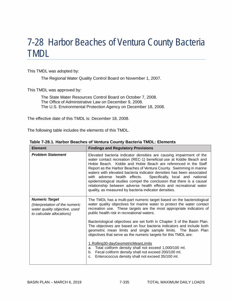
BASIN PLAN – MARCH 6, 2019 7-335 TOTAL MAXIMUM DAILY LOADS
7-28 Harbor Beaches of Ventura County Bacteria TMDL This TMDL was adopted by:
The Regional Water Quality Control Board on November 1, 2007.
This TMDL was approved by:
The State Water Resources Control Board on October 7, 2008. The Office of Administrative Law on December 9, 2008. The U.S. Environmental Protection Agency on December 18, 2008.
The effective date of this TMDL is: December 18, 2008.
The following table includes the elements of this TMDL.
Table 7-28.1. Harbor Beaches of Ventura County Bacteria TMDL: Elements
Element Findings and Regulatory Provisions
Problem Statement Elevated bacteria indicator densities are causing impairment of the water contact recreation (REC-1) beneficial use at Kiddie Beach and Hobie Beach. Kiddie and Hobie Beach are referenced in the Staff Report as the Harbor Beaches of Ventura County. Swimming in marine waters with elevated bacteria indicator densities has been associated with adverse health effects. Specifically, local and national epidemiological studies compel the conclusion that there is a causal relationship between adverse health effects and recreational water quality, as measured by bacteria indicator densities.
Numeric Target (Interpretation of the numeric water quality objective, used to calculate allocations)
The TMDL has a multi-part numeric target based on the bacteriological water quality objectives for marine water to protect the water contact recreation use. These targets are the most appropriate indicators of public health risk in recreational waters.
Bacteriological objectives are set forth in Chapter 3 of the Basin Plan. The objectives are based on four bacteria indicators and include both geometric mean limits and single sample limits. The Basin Plan objectives that serve as the numeric targets for this TMDL are:
1. Rolling 30-day Geometric Mean Limits a. Total coliform density shall not exceed 1,000/100 ml. b. Fecal coliform density shall not exceed 200/100 ml. c. Enterococcus density shall not exceed 35/100 ml.

BASIN PLAN – MARCH 6, 2019 7-336 TOTAL MAXIMUM DAILY LOADS
Element Findings and Regulatory Provisions
Numeric Target (Interpretation of the numeric water quality objective, used to calculate allocations) (con’t)
2. Single Sample Limits a. Total coliform density shall not exceed 10,000/100 ml. b. Fecal coliform density shall not exceed 400/100 ml. c. Enterococcus density shall not exceed 104/100 ml. d. Total coliform density shall not exceed 1,000/100 ml, if the ratio of
fecal-to-total coliform exceeds 0.1. These objectives are based on health risk for marine recreational waters of 19 illnesses per 1,000 exposed individuals as set by the United States Environmental Protection Agency (USEPA, 1986). For the Harbor Beaches of Ventura County, the targets will apply at existing monitoring sites, with samples taken at ankle to knee-high depths. These targets apply during both dry- and wet-weather.
This TMDL uses a “reference system/anti-degradation approach” which means that on the basis of historical exceedance levels at existing monitoring locations, including a local reference beach within the Los Angles Region, a certain number of daily exceedances of the single sample bacteria objectives are permitted. The allowable number of exceedance days is set such that (1) bacteriological water quality at any site is at least as good as at a designated reference site within the watershed and (2) there is no degradation of existing bacteriological water quality. This approach recognizes that there are natural sources of bacteria that may cause or contribute to exceedances of the bacteriological objectives and that it is not the intent of the Regional Board to require treatment or diversion of natural coastal creeks or to require treatment of natural sources of bacteria from undeveloped areas.
The geometric mean targets may not be exceeded at any time. The rolling 30-day geometric mean will be calculated on each sample day. For the single sample targets, each existing monitoring site is assigned an allowable number of exceedance days for three time periods (1) summer dry-weather (April 1 to October 31), (2) winter dry-weather (November 1 to March 31), and (3) wet-weather (defined as days with 0.1 inch of rain or greater and the three days following the rain event.)
Source Analysis Bacteria sources in the Harbor Beaches of Ventura County include anthropogenic and non-anthropogenic sources and point and non-point sources. Each of these sources contributes to the elevated levels of bacteria indicator densities at the Harbor Beaches of Ventura County during dry- and wet-weather. As of December 2006, there are four active, National Pollutant Discharge Elimination System (NPDES) permits or Waste Discharge Requirements (WDRs) for discharges to Channel Islands Harbor or Edison Canal.
Discharges from the Statewide MS4 Permit for the California Department of Transportation (Caltrans) are a potentially significant source of bacteria loading.
Discharges from general NPDES permits, individual NPDES permits, WDRs, the Statewide Industrial Storm Water General Permit, and the Statewide Construction Activity Storm Water General Permit are not expected to be a significant source of bacteria.

BASIN PLAN – MARCH 6, 2019 7-337 TOTAL MAXIMUM DAILY LOADS
Element Findings and Regulatory Provisions
Source Analysis (con’t) While a source identification study conducted at the Channel Islands Harbor indicated that local non-point sources are the majority contributor in summer dry-weather, high bacteria densities and exceedances during wet-weather may be more indicative of urban and agricultural run-off.
Potential non-point sources of bacteria contamination at the Harbor Beaches of Ventura County include: marina activities such as waste disposal from boats, boat deck and slip washing, swimmer “wash-off”, and restaurant washouts; natural sources including birds, waterfowl, and feral cat; and agricultural sources.
Loading Capacity Loading capacity for the Harbor Beaches of Ventura County is defined in terms of bacteria indicator densities, which is the most appropriate for addressing public health risk, and is equivalent to the numeric targets, listed above. As the numeric targets shall be met at the specific sampling locations, which are representative of the corresponding beaches, no degradation or dilution allowance is provided.
Waste Load Allocations (for point sources)
Waste load allocations (WLAs) are expressed as allowable exceedance days.
The allowable number of exceedance days for a monitoring site for each time period is based on the more stringent of two criteria (1) exceedance days in the designated reference system and (2) exceedance days based on historical bacteriological data at the monitoring site. This ensures that bacteriological water quality is at least as good as that of a largely undeveloped system and that there is no degradation of existing water quality.
For each beach, allowable exceedance days are set on an annual basis as well as for three time periods. These three periods are:
1. Summer dry-weather (April 1 to October 31) 2. Winter dry-weather (November 1 to March 31) 3. Wet-weather days (defined as days of 0.1 inch of rain or more plus
three days following the rain event) For the Channel Islands Harbor Beaches, the County of Ventura, the Ventura County Watershed Protection District (VCWPD) and associated Municipal Separate Storm Sewer System (MS4) permittees in the Channel Islands Harbor subwatershed, the City of Oxnard, and Caltrans are assigned WLAs.
All WLAs for summer dry-weather single sample bacteria densities at the Harbor Beaches of Ventura County are zero (0) days of allowable exceedances.

BASIN PLAN – MARCH 6, 2019 7-338 TOTAL MAXIMUM DAILY LOADS
Element Findings and Regulatory Provisions
Waste Load Allocations (for point sources) (con’t)
The WLA for the rolling 30-day geometric mean during any time period or monitoring site at the Harbor Beaches of Ventura County is zero (0) days of allowable exceedances.
The WLA for winter dry-weather and wet-weather single sample bacteria densities for Kiddie Beach and Hobie Beach are listed in Table 7-28.2.
General NPDES permits, individual NPDES permits, the Statewide Industrial Storm Water General Permit, the Statewide Construction Activity Storm Water General Permit, and WDR permittees in the Channel Islands Harbor subwatershed are assigned WLAs of zero (0) days of allowable exceedances for all three time periods and for the single sample limits and the rolling 30-day geometric mean.
Any future enrollees under a general NPDES permit, individual NPDES permit, the Statewide Industrial Storm Water General Permit, the Statewide Construction Activity Storm Water General Permit, and WDR will also be subject to a WLA of zero (0) days of allowable exceedances.
The Harbor Beaches of Ventura County are assigned interim WLAs upon the effective date of the TMDL. Interim WLAs for single sample and the 30-day rolling geometric mean are expressed in terms of an exceedance day and listed below.
Single Sample Exceedances:
Location Daily Sampling Weekly Sampling Kiddie Beach 54 8 Hobie Beach 40 6
Summer Dry-Weather
Winter Dry-Weather
Location Daily Sampling Weekly Sampling Kiddie Beach 23 4 Hobie Beach 25 4
Wet-Weather
Location Daily Sampling Weekly Sampling Kiddie Beach 32 5 Hobie Beach 38 6
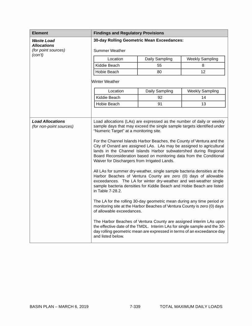
BASIN PLAN – MARCH 6, 2019 7-339 TOTAL MAXIMUM DAILY LOADS
Element Findings and Regulatory Provisions
Waste Load Allocations (for point sources) (con’t)
30-day Rolling Geometric Mean Exceedances: Summer Weather
Winter Weather
Location Daily Sampling Weekly Sampling Kiddie Beach 92 14 Hobie Beach 91 13
Load Allocations (for non-point sources)
Load allocations (LAs) are expressed as the number of daily or weekly sample days that may exceed the single sample targets identified under “Numeric Target” at a monitoring site.
For the Channel Islands Harbor Beaches, the County of Ventura and the City of Oxnard are assigned LAs. LAs may be assigned to agricultural lands in the Channel Islands Harbor subwatershed during Regional Board Reconsideration based on monitoring data from the Conditional Waiver for Dischargers from Irrigated Lands.
All LAs for summer dry-weather, single sample bacteria densities at the Harbor Beaches of Ventura County are zero (0) days of allowable exceedances. The LA for winter dry-weather and wet-weather single sample bacteria densities for Kiddie Beach and Hobie Beach are listed in Table 7-28.2.
The LA for the rolling 30-day geometric mean during any time period or monitoring site at the Harbor Beaches of Ventura County is zero (0) days of allowable exceedances.
The Harbor Beaches of Ventura County are assigned interim LAs upon the effective date of the TMDL. Interim LAs for single sample and the 30-day rolling geometric mean are expressed in terms of an exceedance day and listed below.
Location Daily Sampling Weekly Sampling Kiddie Beach 55 8 Hobie Beach 80 12

BASIN PLAN – MARCH 6, 2019 7-340 TOTAL MAXIMUM DAILY LOADS
Element Findings and Regulatory Provisions
Load Allocations (for non-point sources) (con’t)
Single Sample Exceedances: Summer Dry-Weather
Location Daily Sampling Weekly Sampling
Kiddie Beach 54 8 Hobie Beach 40 6
Winter Dry-Weather
Location Daily Sampling Weekly Sampling
Kiddie Beach 23 4 Hobie Beach 25 4
Wet-Weather
Location Daily Sampling Weekly Sampling
Kiddie Beach 32 5 Hobie Beach 38 6
30-day Rolling Geometric Mean Exceedances:
Summer Weather
Location Daily Sampling Weekly Sampling
Kiddie Beach 55 8 Hobie Beach 80 12
Winter Weather
Location Daily Sampling Weekly Sampling Kiddie Beach 92 14 Hobie Beach 91 13
Implementation The regulatory mechanisms used to implement the TMDL will include general NPDES permits, individual NPDES permits, WDRs, the Statewide Industrial Storm Water General Permit, the Statewide Construction Activity Storm Water General Permit, the Conditional Waiver for Dischargers from Irrigated Lands, the Statewide MS4 Permit for Caltrans, and the authority contained in Sections 13263 and 13267 of the Water Code. Each NPDES permit, assigned a WLA, shall be reopened or amended when the permit is reissued, in accordance with applicable laws, to incorporate the applicable WLAs as a permit requirement. LAs for non-point sources will be implemented within the context of this TMDL.

BASIN PLAN – MARCH 6, 2019 7-341 TOTAL MAXIMUM DAILY LOADS
Element Findings and Regulatory Provisions
Implementation (con’t) This TMDL will be implemented in accordance with the implementation schedule for the Harbor Beaches of Ventura County.
The compliance and implementation schedules are detailed in Table 7-28.3.
Responsible parties are not specifically required to conduct pilot projects for Best Management Practices (BMPs), though conducting pilot projects is within their discretion. The Regional Board recognizes the long duration required to conduct a pilot project. As such, time is allocated in the implementation schedule for the option of piloting structural BMPs, which include but are not limited to enhanced circulation devices.
Special studies are not required for implementation of the TMDL, though conducting special studies is within the discretion of the responsible parties.
The Regional Board shall reconsider this TMDL four years after the effective date of the TMDL for the Harbor Beaches of Ventura County to re-evaluate WLAs and LAs based on monitoring data; to re-evaluate allowable exceedance levels, including whether the allowable number of exceedance days maybe adjusted based on a Ventura County rainfall record; to re-evaluate the selection of the reference beach if additional, appropriate reference beach options have been developed; to consider a natural source exclusion approach, subject to the antidegradation policy, if it can be demonstrated that such an approach is warranted by demonstration of the control of all anthropogenic sources of bacteria to the beaches, and demonstration that beneficial uses are being met; and to assign LAs to agricultural lands in the Chanel Islands Harbor subwatershed based on monitoring in the Conditional Waiver for Dischargers from Irrigated Lands.
Five years after the effective date of the TMDL, there shall be no allowable exceedances of the single sample limits, in excess of the allowable exceedances listed in Table 7-28.2, at any monitoring location at the Harbor Beaches of Ventura County during summer dry- weather, winter dry-weather, and the rolling 30-day geometric mean targets shall be achieved. Ten years after the effective date of the TMDL there shall be no allowable exceedances of the single sample limits, in excess of the allowable exceedances listed in Table 7-28.2, at any monitoring location during dry-weather or wet-weather at the Harbor Beaches of Ventura County, and the rolling 30-day geometric mean targets shall be achieved.

BASIN PLAN – MARCH 6, 2019 7-342 TOTAL MAXIMUM DAILY LOADS
Element Findings and Regulatory Provisions
Margin of Safety An implicit margin of safety is included through several conservative assumptions, such as the assumption that no dilution takes place between the on-shore sources and where the effluent initially mixes with the receiving water, and that bacteria degradation rates are not sufficient to affect bacteria densities in the receiving water. In addition, an explicit margin of safety has been incorporated, as the load allocations will allow exceedances of the single sample targets no more than 5% of the time on an annual basis, based on the cumulative allocations for dry- and wet-weather. The Water Quality Control Policy for Developing California’s Clean Water Act Section 303(d) List concludes that there are water quality impairments using a binomial distribution method which lists waterbodies when the exceedances are between approximately 8 and 10 percent.
Seasonal Variations and Critical Conditions
Seasonal variations are addressed by developing separate waste load allocations for summer dry-weather, winter dry-weather, and wet-weather based on public health concerns and observed natural background levels of exceedance of bacteria indicators.
Historic monitoring data for the Harbor Beaches of Ventura County and the reference beach indicate that the critical condition for bacteria loading is during wet-weather due to greater exceedance probabilities of the single sample bacteria objectives then during dry-weather. To more specifically identify a critical condition within wet-weather, in order to set the allowable exceedance days shown in Table 7-28.2, the 90th percentile ‘storm year’1 in terms of wet days2 is used as the reference year for the reference system. Selecting the 90th percentile year avoids a situation where the reference system is frequently out of compliance. Selecting the 90th percentile year is a more conservative approach that will accommodate a ‘worst-case’ scenario resulting in fewer exceedance days than the maximum allowed in drier years. Conversely, in the 10% of wetter years, there may be more than the allowable number of exceedance days.
Compliance Monitoring Compliance and monitoring for Harbor Beaches of Ventura County is based on existing monitoring protocols and locations.
Monitoring shall continue at sampling locations (VCEHD 36000 and VCEHD 37000) and at the current weekly monitoring frequency, consistent with AB411 compliance monitoring. Monitoring shall be conducted on a year-round basis at the current monitoring locations including the summer months (i.e., April to October) and winter months (i.e., November to March). Bacteria sampling shall be conducted in ankle- to knee-high water, consistent with AB411. However, if additional monitoring stations are added or if changes are made to the sampling frequencies or existing monitoring locations, then submittal of a monitoring plan is required for Executive Officer approval. For agricultural dischargers, the Conditional Waiver for Dischargers from Irrigated Lands shall be revised to include monitoring for enrollees in the Channel Islands Harbor subwatershed.
1 For purposes of this TMDL, a ‘storm year’ means November 1 to October 31. The 90th percentile storm year was 1993 with 75 wet days at the LAX meteorological station. 2 A wet day is defined as a day with rainfall of 0.1 inch or more plus the 3 days following the rain event.

BASIN PLAN – MARCH 6, 2019 7-343 TOTAL MAXIMUM DAILY LOADS
Table 7-28.2. Harbor Beaches of Ventura County Bacteria TMDL: Final Allowable Exceedance Days by Location
Location
Summer dry- weather*
Compliance Deadline
Winter dry-weather
Compliance Deadline
Wet-weather**
Compliance Deadline
Daily sampling
(No. days)
Weekly sampling
(No. days)
Daily sampling
(No. days)
Weekly sampling
(No. days)
Daily sampling
(No. days)
Weekly sampling
(No. days)
Hobie Beach 0 0
Five years after
effective date of the
TMDL
3 1
Five years after
effective date of the
TMDL
17 3 Ten years after
effective date of the TMDL
Kiddie Beach 0 0
Five years after
effective date of the
TMDL
3 1
Five years after
effective date of the
TMDL
17 3 Ten years after
effective date of the TMDL
*A dry day is defined as a non-wet day. **A wet day is defined as a day with 0.1-inch or more of rain and the three days following the rain event.
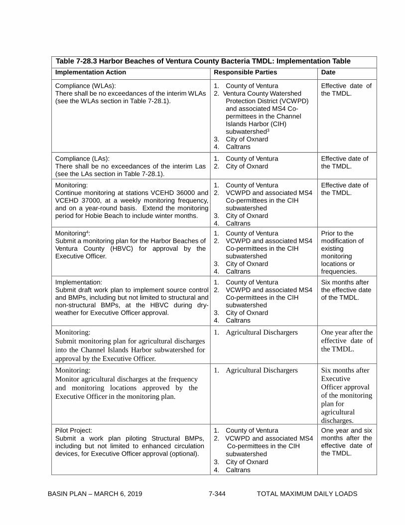
BASIN PLAN – MARCH 6, 2019 7-344 TOTAL MAXIMUM DAILY LOADS
Table 7-28.3 Harbor Beaches of Ventura County Bacteria TMDL: Implementation Table Implementation Action Responsible Parties Date
Compliance (WLAs): There shall be no exceedances of the interim WLAs (see the WLAs section in Table 7-28.1).
1. County of Ventura 2. Ventura County Watershed
Protection District (VCWPD) and associated MS4 Co- permittees in the Channel Islands Harbor (CIH) subwatershed3
3. City of Oxnard 4. Caltrans
Effective date of the TMDL.
Compliance (LAs): There shall be no exceedances of the interim Las (see the LAs section in Table 7-28.1).
1. County of Ventura 2. City of Oxnard
Effective date of the TMDL.
Monitoring: Continue monitoring at stations VCEHD 36000 and VCEHD 37000, at a weekly monitoring frequency, and on a year-round basis. Extend the monitoring period for Hobie Beach to include winter months.
1. County of Ventura 2. VCWPD and associated MS4
Co-permittees in the CIH subwatershed
3. City of Oxnard 4. Caltrans
Effective date of the TMDL.
Monitoring4: Submit a monitoring plan for the Harbor Beaches of Ventura County (HBVC) for approval by the Executive Officer.
1. County of Ventura 2. VCWPD and associated MS4
Co-permittees in the CIH subwatershed
3. City of Oxnard 4. Caltrans
Prior to the modification of existing monitoring locations or frequencies.
Implementation: Submit draft work plan to implement source control and BMPs, including but not limited to structural and non-structural BMPs, at the HBVC during dry- weather for Executive Officer approval.
1. County of Ventura 2. VCWPD and associated MS4
Co-permittees in the CIH subwatershed
3. City of Oxnard 4. Caltrans
Six months after the effective date of the TMDL.
Monitoring: Submit monitoring plan for agricultural discharges into the Channel Islands Harbor subwatershed for approval by the Executive Officer.
1. Agricultural Dischargers One year after the effective date of the TMDL.
Monitoring: Monitor agricultural discharges at the frequency and monitoring locations approved by the Executive Officer in the monitoring plan.
1. Agricultural Dischargers Six months after Executive Officer approval of the monitoring plan for agricultural discharges.
Pilot Project: Submit a work plan piloting Structural BMPs, including but not limited to enhanced circulation devices, for Executive Officer approval (optional).
1. County of Ventura 2. VCWPD and associated MS4
Co-permittees in the CIH subwatershed
3. City of Oxnard 4. Caltrans
One year and six months after the effective date of the TMDL.

BASIN PLAN – MARCH 6, 2019 7-345 TOTAL MAXIMUM DAILY LOADS
Table 7-28.3 Harbor Beaches of Ventura County Bacteria TMDL: Implementation Table Implementation Action Responsible Parties Date
Implementation: Submit draft work plan to implement source control and BMPs, including but not limited to structural and non-structural BMPs, at the HBVC during wet- weather for Executive Officer approval.
1. County of Ventura 2. VCWPD and associated MS4
Co-permittees in the CIH subwatershed
3. City of Oxnard 4. Caltrans
One year and six months after the effective date of the TMDL.
Pilot Project: Completion of Structural BMP pilot projects, including but not limited to enhanced circulation devices (optional).
1. County of Ventura 2. VCWPD and associated MS4
Co-permittees in the CIH subwatershed
3. City of Oxnard 4. Caltrans
Two years and six months after the effective date of the TMDL.
Implementation: Submit final work plan; to implement source control and BMPs, including but not limited to structural and non-structural BMPs, at the HBVC during dry-weather for Executive Officer approval.
1. County of Ventura 2. VCWPD and associated MS4
Co-permittees in the CIH subwatershed
3. City of Oxnard 4. Caltrans
Three years and six months after the effective date of the TMDL.
Regional Board Reconsideration: a. Re-evaluate WLAs and LAs based on data. b. Re-evaluate the implementation schedule
based on results from pilot projects. c. Re-evaluate allowable exceedance levels,
including whether the allowable number of exceedance days maybe adjusted based on a Ventura County rainfall record.
d. Re-evaluate the selection of the reference beach if additional, appropriate reference beach options have been developed and if an appropriate reference system cannot be identified for this enclosed harbor, evaluate using the ‘natural sources exclusion’ approach subject to antidegradation policies rather than the ‘reference system/antidegradation’ approach.
e. Assign LAs to agricultural lands in the Channel Islands Harbor subwatershed based on monitoring in the Conditional Waiver for Dischargers from Irrigated Lands.
Regional Board Four years after effective date of the TMDL.
Implementation: Submit final work plan to implement source control and BMPs, including but not limited to structural and non-structural BMPs, at the HBVC during wet- weather for Executive Officer approval.
1. County of Ventura 2. VCWPD and associated MS4
Co-permittees in the CIH subwatershed
3. City of Oxnard 4. Caltrans
Four years after the effective date of the TMDL.
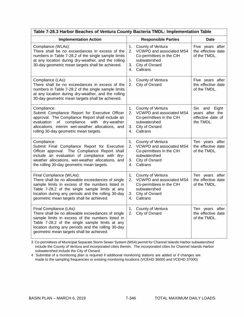
BASIN PLAN – MARCH 6, 2019 7-346 TOTAL MAXIMUM DAILY LOADS
Table 7-28.3 Harbor Beaches of Ventura County Bacteria TMDL: Implementation Table Implementation Action Responsible Parties Date
Compliance (WLAs): There shall be no exceedances in excess of the numbers in Table 7-28.2 of the single sample limits at any location during dry-weather, and the rolling 30-day geometric mean targets shall be achieved.
1. County of Ventura 2. VCWPD and associated MS4
Co-permittees in the CIH subwatershed
3. City of Oxnard 4. Caltrans
Five years after the effective date of the TMDL.
Compliance (LAs): There shall be no exceedances in excess of the numbers in Table 7-28.2 of the single sample limits at any location during dry-weather, and the rolling 30-day geometric mean targets shall be achieved.
1. County of Ventura 2. City of Oxnard
Five years after the effective date of the TMDL.
Compliance: Submit Compliance Report for Executive Officer approval. The Compliance Report shall include an evaluation of compliance with dry-weather allocations, interim wet-weather allocations, and rolling 30-day geometric mean targets.
1. County of Ventura 2. VCWPD and associated MS4
Co-permittees in the CIH subwatershed
3. City of Oxnard 4. Caltrans
Six and Eight years after the effective date of the TMDL.
Compliance: Submit Final Compliance Report for Executive Officer approval. The Compliance Report shall include an evaluation of compliance with dry- weather allocations, wet-weather allocations, and the rolling 30-day geometric mean targets.
1. County of Ventura 2. VCWPD and associated MS4
Co-permittees in the CIH subwatershed
3. City of Oxnard 4. Caltrans
Ten years after the effective date of the TMDL.
Final Compliance (WLAs): There shall be no allowable exceedances of single sample limits in excess of the numbers listed in Table 7-28.2 of the single sample limits at any location during any periods and the rolling 30-day geometric mean targets shall be achieved.
1. County of Ventura 2. VCWPD and associated MS4
Co-permittees in the CIH subwatershed
3. City of Oxnard 4. Caltrans
Ten years after the effective date of the TMDL.
Final Compliance (LAs): There shall be no allowable exceedances of single sample limits in excess of the numbers listed in Table 7-28.2 of the single sample limits at any location during any periods and the rolling 30-day geometric mean targets shall be achieved.
1. County of Ventura 2. City of Oxnard
Ten years after the effective date of the TMDL.
3 Co-permittees of Municipal Separate Storm Sewer System (MS4) permit for Channel Islands Harbor subwatershed include the County of Ventura and incorporated cities therein. The incorporated cities for Channel Islands Harbor subwatershed include the City of Oxnard.
4 Submittal of a monitoring plan is required if additional monitoring stations are added or if changes are made to the sampling frequencies or existing monitoring locations (VCEHD 36000 and VCEHD 37000)

BASIN PLAN – MARCH 6, 2019 7-347 TOTAL MAXIMUM DAILY LOADS
7-29 Machado Lake Eutrophic, Algae, Ammonia, and Odors (Nutrient) TMDL This TMDL was adopted by:
The Regional Water Quality Control Board on May 1, 2008.
This TMDL was approved by:
The State Water Resources Control Board on December 2, 2008. The Office of Administrative Law on February 19, 2009. The U.S. Environmental Protection Agency on March 11, 2009.
The effective date of this TMDL is: March 11, 2009.
The elements of the TMDL are presented in Table 7-29.1 and the Implementation Plan in Table
7-29.2
Table 7-29.1. Machado Lake Eutrophic, Algae, Ammonia, and Odors (Nutrient) TMDL: Elements
TMDL Element Regulatory Provisions
Problem Statement
Excessive loadings of nutrients, in particular nitrogen (including ammonia) and phosphorus, cause eutrophic effects, including algae and odors, which impair the beneficial uses of Machado Lake. The nutrient enrichment results in high algal productivity; algal blooms have been observed in the lake during summer months. In addition, high nutrient concentrations contribute to excessive and nuisance macrophyte growth. Algae respiration and decay depletes oxygen from the water column creating an adverse aquatic environment. Machado Lake was placed on the Clean Water Act 303(d) list of impaired waterbodies in 1998, 2002, and 2006 for ammonia, algae, odors, and eutrophic.
Applicable Water Quality Objectives for this TMDL are narrative objectives for Biostimulatory Substances and Taste and Odor; and numeric objectives for Dissolved Oxygen and Ammonia.
The beneficial uses of Machado Lake include beneficial uses associated with recreation (REC 1 and REC 2), aquatic life (WARM, WILD, RARE, and WET) and water supply (MUN).
This TMDL addresses the eutrophic, algae, ammonia, and odor listings which impair these uses.
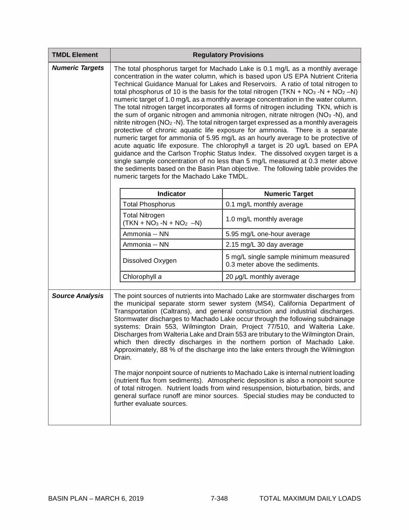
BASIN PLAN – MARCH 6, 2019 7-348 TOTAL MAXIMUM DAILY LOADS
TMDL Element Regulatory Provisions
Numeric Targets The total phosphorus target for Machado Lake is 0.1 mg/L as a monthly average concentration in the water column, which is based upon US EPA Nutrient Criteria Technical Guidance Manual for Lakes and Reservoirs. A ratio of total nitrogen to total phosphorus of 10 is the basis for the total nitrogen (TKN + NO3 -N + NO2 –N) numeric target of 1.0 mg/L as a monthly average concentration in the water column. The total nitrogen target incorporates all forms of nitrogen including TKN, which is the sum of organic nitrogen and ammonia nitrogen, nitrate nitrogen (NO3 -N), and nitrite nitrogen (NO2 -N). The total nitrogen target expressed as a monthly averageis protective of chronic aquatic life exposure for ammonia. There is a separate numeric target for ammonia of 5.95 mg/L as an hourly average to be protective of acute aquatic life exposure. The chlorophyll a target is 20 ug/L based on EPA guidance and the Carlson Trophic Status Index. The dissolved oxygen target is a single sample concentration of no less than 5 mg/L measured at 0.3 meter above the sediments based on the Basin Plan objective. The following table provides the numeric targets for the Machado Lake TMDL.
Indicator Numeric Target Total Phosphorus 0.1 mg/L monthly average Total Nitrogen (TKN + NO3 -N + NO2 –N) 1.0 mg/L monthly average
Ammonia -- NN 5.95 mg/L one-hour average Ammonia -- NN 2.15 mg/L 30 day average
Dissolved Oxygen 5 mg/L single sample minimum measured 0.3 meter above the sediments.
Chlorophyll a 20 μg/L monthly average
Source Analysis The point sources of nutrients into Machado Lake are stormwater discharges from the municipal separate storm sewer system (MS4), California Department of Transportation (Caltrans), and general construction and industrial discharges. Stormwater discharges to Machado Lake occur through the following subdrainage systems: Drain 553, Wilmington Drain, Project 77/510, and Walteria Lake. Discharges from Walteria Lake and Drain 553 are tributary to the Wilmington Drain, which then directly discharges in the northern portion of Machado Lake. Approximately, 88 % of the discharge into the lake enters through the Wilmington Drain.
The major nonpoint source of nutrients to Machado Lake is internal nutrient loading (nutrient flux from sediments). Atmospheric deposition is also a nonpoint source of total nitrogen. Nutrient loads from wind resuspension, bioturbation, birds, and general surface runoff are minor sources. Special studies may be conducted to further evaluate sources.

BASIN PLAN – MARCH 6, 2019 7-349 TOTAL MAXIMUM DAILY LOADS
TMDL Element Regulatory Provisions
Linkage Analysis The linkage analysis focuses on the relationship between the nutrient loading to the lake and the numeric targets established to measure attainment of beneficial uses. The Nutrient Numeric Endpoints BATHTUB Spreadsheet Model, which was developed by Tetra Tech for US EPA, was used to establish the linkage between nutrient loading to Machado Lake and the predicted water quality response. The model performs water and nutrient balance calculations under steady-state conditions. Eutrophication related water quality conditions are expressed in terms of total phosphorus, ortho-phosphourus, total nitrogen, inorganic nitrogen, chlorophyll a, transparency (Secchi depth), and hypolimnetic oxygen depletion rates. The linkage analysis demonstrates that assigning waste load and load allocations for total nitrogen and total phosphorus will address eutrophication related water quality conditions.
Waste Load Allocations
Waste load allocations are assigned to urban stormwater dischargers (MS4, Caltrans, general construction and general industrial) in both wet and dry weather. The final waste load allocations are assigned as concentration based allocations of 0.1 mg/L and 1.0 mg/L as monthly averages for total phosphorus and total nitrogen (TKN + NO3 -N + NO2 –N), respectively.
Interim WLAs are based on current in-lake concentrations. The effective date interim total nitrogen and total phosphorus waste load allocations are set as the 95th percentile of current concentrations in the lake. The 5 year interim total nitrogen WLAs are established as a 30 percent reduction from current in-lake concentrations. Concentration-based interim and final WLAs will be included in stormwater permits in accordance with NPDES guidance and requirements. The tables below present the interim and final waste load allocations for the stormwater discharges.
Waste Load Allocations Total Phosphorus Total Nitrogen
(TKN + NO3 -N + NO2 -N)
Final WLA (mg/L) Final WLA (mg/L)
MS4 Permittees1 Caltrans, General Construction and Industrial stormwater permits
0.1 1.0
1 Municipal Separate Storm Sewer System (MS4) Permittees that are responsible for discharges to Machado Lake include: Los Angeles County, Los Angeles County Flood Control District, and the Cities of Carson, Lomita, Los Angeles, Palos Verdes Estates, Rancho Palos Verdes, Redondo Beach, Rolling Hills, Rolling Hills Estates, and Torrance.

BASIN PLAN – MARCH 6, 2019 7-350 TOTAL MAXIMUM DAILY LOADS
TMDL Element Regulatory Provisions
Waste Load Allocations (con’t)
Waste Load Allocations
Years After Effective Date
Interim Total Phosphorus WLAs (mg/L)
Interim Total Nitrogen (TKN + NO3-N + NO2-N)
WLAs (mg/L)
MS4 Permittees, Caltrans, General Construction and Industrial Stormwater permits
At Effective Date1
1.25 3.50
52 1.25 2.45 9.5
(Final WLAs3) 0.10 1.00
1 The compliance point for all effective date interim WLAs is measured in the lake. 2 The compliance point for all year 5 interim WLAs is measured as specified in
Implementation Plan Section II of Table 7-29.1 3 The compliance point for all final WLAs is measured as specified in
ImplementationPlan Section II of Table 7-29-.1 Load Allocations Load allocations are assigned for nonpoint source discharges to the lake, primarily
internal loading from the lake. The final load allocations for internal loading are concentration based allocations of 0.1 mg/L and 1.0 mg/L as monthly averages for total phosphorus and total nitrogen (TKN + NO3 -N + NO2 –N), respectively. Concentration based load allocations are appropriate and can be evaluated by monitoring the nutrient concentrations in the water column.
Interim LAs are based on current in-lake concentrations. The effective date interim total nitrogen and phosphorus load allocations are set at the 95th percentile of current concentrations in the lake. The 5 year interim total nitrogen LAs are established as a 30 percent reduction from current in-lake concentrations. The tables below present the final and interim load allocations for the nonpoint sources.
Load Allocations
Total Phosphorus Total Nitrogen
(TKN + NO -N + NO -N) Final LA (mg/L) Final LA (mg/L) Internal Nutrient Load (City of Los Angeles Department of Recreation and Parks)
0.1 1.0
Load Allocations Years After Effective Date
Interim Total Phosphorus LAs
(mg/L)
Interim Total Nitrogen (TKN + NO3-N + NO2-N)
LAs (mg/L) Internal Nutrient Load (City of Los Angeles Department of Recreation and Parks)
At Effective Date 1.25 3.50 5 1.25 2.45
9.5 (Final LAs) 0.10 1.00

BASIN PLAN – MARCH 6, 2019 7-351 TOTAL MAXIMUM DAILY LOADS
TMDL Element Regulatory Provisions
Margin of Safety The uncertainties associated with this TMDL are due to limited data from the stormdrains entering the lake and the inherent seasonal and annual variability in delivery of phosphorus and nitrogen for external sources and nutrient cycling within the lake. To address these uncertainties, conservative numeric targets were selected by establishing the targets under a critical lake volume. Likewise, the waste load and load allocations are based on a constant value for internal loading. Moreover, the lake conditions under which the load capacity was developed were based on dry weather critical conditions when the lake level is reduced and therefore loading capacity is reduced. These conservative approaches provide an implicit margin of safety.
Seasonal Variations and Critical Conditions
The external nutrient loading to Machado Lake generally occurs during winter and spring months, in conjunction with storm events. During the dry season the lake receives minimal external loading. In the summer there is the release of nutrients from the sediments. At the same time there is very little water inflow and a decreased lake level due to evaporation. These seasonal variations cause increased nutrient concentrations. Moreover, the reduced lake volume during the summer months provides less assimilative capacity. The critical condition for the attainment of beneficial uses at Machado Lake occurs during the summer months. Also, the critical conditions for dissolved oxygen impairments related to algae growth are during the warm dry summer months when algal respiration is highest. The Machado Lake nutrient TMDL accounts for seasonal and critical conditions of the summer months by assigning a load allocation to the lake sediments and requiring a reduction in this source of nutrients to the lake, and by assigning WLAs to urban stormwater dischargers year-round.
Special Studies and Monitoring Plan
Special Studies Additional monitoring and special studies may be undertaken by dischargers and responsible agencies to evaluate the uncertainties and assumptions made in the development of this TMDL. (The results of special studies may be used to reevaluate waste load allocations and load allocations when the Machado Lake Nutrient TMDL is reconsidered.)
Optional Study #1: Core flux study to estimate the nutrient flux from sediments under equilibrium conditions. Results from this study would be beneficial to gauge the success of implementation measures such as aeration.
Optional Study #2: A study to understand factors such as nitrogen and phosphorus sedimentation rates (particulate settling velocities), the overall lake sedimentation rate, and sediment resuspension rate. These factors would be important for a Machado Lake nutrient budget and gauging the potential need for periodic hydraulic dredging. Optional Study #3: A work plan for permittees to assess compliance with TMDL WLAs on a mass basis for total nitrogen and total phosphorous. The work plan should detail testing methodologies, BMPs, and treatments to be implemented to attain and demonstrate a reduction of total nitrogen and phosphorous loading on a mass basis. A final report including the results shall be submitted to the Regional Board for Executive Officer approval.
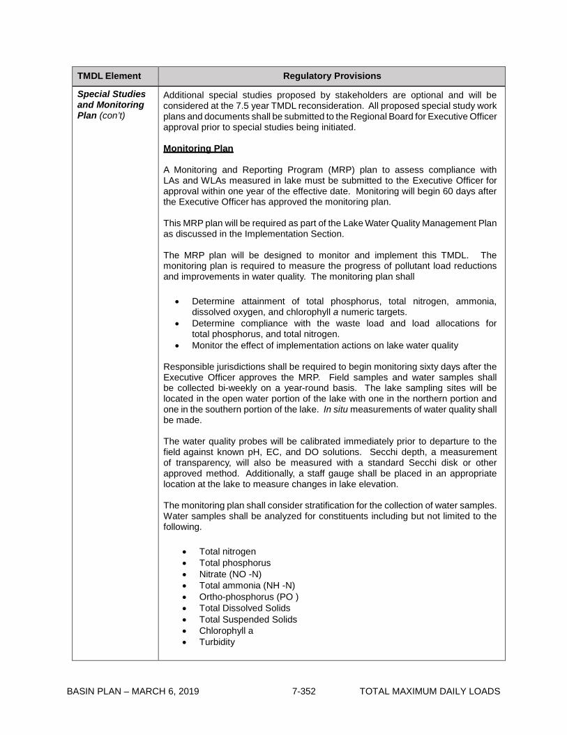
BASIN PLAN – MARCH 6, 2019 7-352 TOTAL MAXIMUM DAILY LOADS
TMDL Element Regulatory Provisions
Special Studies and Monitoring Plan (con’t)
Additional special studies proposed by stakeholders are optional and will be considered at the 7.5 year TMDL reconsideration. All proposed special study work plans and documents shall be submitted to the Regional Board for Executive Officer approval prior to special studies being initiated.
Monitoring Plan
A Monitoring and Reporting Program (MRP) plan to assess compliance with LAs and WLAs measured in lake must be submitted to the Executive Officer for approval within one year of the effective date. Monitoring will begin 60 days after the Executive Officer has approved the monitoring plan.
This MRP plan will be required as part of the Lake Water Quality Management Plan as discussed in the Implementation Section.
The MRP plan will be designed to monitor and implement this TMDL. The monitoring plan is required to measure the progress of pollutant load reductions and improvements in water quality. The monitoring plan shall
• Determine attainment of total phosphorus, total nitrogen, ammonia,
dissolved oxygen, and chlorophyll a numeric targets. • Determine compliance with the waste load and load allocations for
total phosphorus, and total nitrogen. • Monitor the effect of implementation actions on lake water quality
Responsible jurisdictions shall be required to begin monitoring sixty days after the Executive Officer approves the MRP. Field samples and water samples shall be collected bi-weekly on a year-round basis. The lake sampling sites will be located in the open water portion of the lake with one in the northern portion and one in the southern portion of the lake. In situ measurements of water quality shall be made.
The water quality probes will be calibrated immediately prior to departure to the field against known pH, EC, and DO solutions. Secchi depth, a measurement of transparency, will also be measured with a standard Secchi disk or other approved method. Additionally, a staff gauge shall be placed in an appropriate location at the lake to measure changes in lake elevation. The monitoring plan shall consider stratification for the collection of water samples. Water samples shall be analyzed for constituents including but not limited to the following.
• Total nitrogen • Total phosphorus • Nitrate (NO -N) • Total ammonia (NH -N) • Ortho-phosphorus (PO ) • Total Dissolved Solids • Total Suspended Solids • Chlorophyll a • Turbidity

BASIN PLAN – MARCH 6, 2019 7-353 TOTAL MAXIMUM DAILY LOADS
TMDL Element Regulatory Provisions
Special Studies and Monitoring Plan (con’t)
Detection limits shall be less than the numeric targets in this TMDL. A monitoring report shall be prepared and submitted to the Regional Board annually within six months after the completion of the final sampling event of the year.
If an alternative WLA compliance option is selected, an appropriate separate TMDL compliance MRP Plan and TMDL Implementation Plan must be submitted for Executive Officer approval. Annual monitoring reports demonstrating compliance or non-compliance with WLAs shall be submitted for Executive Officer approval.
All compliance monitoring must be conducted in conjunction with a Regional Board approved Quality Assurance Project Plan (QAPP). The QAPP shall include protocols for sample collection, standard analytical procedures, and laboratory certification.
Implementation Plan
Compliance with the TMDL is based on the assigned WLAs and LAs. Compliance with this TMDL will require the implementation of NPDES stormwater permit limits and lake management activities to reduce nutrient loading to the lake, reduce nutrient concentrations in the lake, prevent excessive algal biomass growth, and maintain an adequate dissolved oxygen concentration. Table 7-29.2 contains a schedule for responsible jurisdictions to implement BMPs and a Lake Water Quality Management Plan to comply with the TMDL.
I. Implementation and Determination of Compliance with LAs
Compliance with the LAs will be measured in the lake and will be achieved through a combination of implementation of lake management projects and BMPs to reduce external and internal nutrient loading to the lake and to reduce and manage internal nutrient sources. Load allocations will be implemented through the following:
(1) Memorandum of Agreement (MOA), or
(2) Clean Up and Abatement Order or Other Regulatory Order
The responsible jurisdictions for the load allocations shall be allowed one year from the effective date of this TMDL to enter into a Memorandum of Agreement (MOA) with the Executive Officer, detailing the voluntary efforts that will be undertaken to attain the load allocations. The MOA shall comply with the Water Quality Control Policy for Addressing Impaired Waters: Regulatory Structure and Options (“Policy”), including part II, section 2 c ii and related provisions, and shall be consistent the requirements of this TMDL. If the MOA is timely adopted, and so long as it is implemented, the program described in the MOA shall be deemed “certified”, pursuant to the Policy, subject to the conditions of Policy section 2 e. The MOA shall include development of a Lake Water Quality Management Plan (LWQMP), must be approved by the Executive Officer, and may be amended with Executive Officer approval, as necessary. If a MOA is not established with responsible jurisdictions within one year or if responsible jurisdictions do not comply with the terms of the MOA, a cleanup and abatement order pursuant to Water Code section 13304, or another appropriate regulatory order, shall be issued to implement the load allocations.

BASIN PLAN – MARCH 6, 2019 7-354 TOTAL MAXIMUM DAILY LOADS
TMDL Element Regulatory Provisions
Implementation Plan (con’t)
Furthermore, the implementation of the MOA must result in attainment of the TMDL load allocations. If the MOA and LWQMP are not implemented or otherwise do not result in attainment of load allocations, the certification shall be revoked, the MOA rescinded, and the load allocations shall be implemented through a cleanup and abatement order, or other order, as described above. Implementation of the MOA shall be reviewed annually by the Executive Officer as part of the Monitoring and Reporting Program (MRP) annual reports.
To the satisfaction of the Executive Officer the LWQMP shall meet the following criteria:
2) One and one half years from the effective date of the TMDL responsible
jurisdictions shall submit a LWQMP, MRP Plan and QAPP for approval by the Executive Officer.
• The LWQMP shall include a list of cooperating parties.
• The LWQMP shall address appropriate water quality monitoring and a timeline
for the implementation of management practices to reduce and manage nutrient loading to the lake. The timeline shall ensure that the implementation actions are underway prior to Regional Board reconsideration of the TMDL. The LWQMP shall present a comprehensive management plan and strategy for achieving the LAs at Machado Lake and attaining numeric targets and beneficial uses. The LWQMP shall include a schedule for implementation actions.
• The LWQMP shall achieve compliance with the load allocations through the
implementation of lake management strategies to reduce and manage internal nutrient sources. The lake management implementation actions may include, but are not limited to the following:
Wetland restoration Aeration system Hydraulic Lake dredging Hydroponic Islands Alum treatment Fisheries Management Macrophyte Management and Harvesting Maintain Lake Level – Supplemental Water
3) The LWQMP shall include a MRP Plan. The MRP shall include a requirement
that the responsible jurisdictions report compliance and non- compliance with load allocations as part of annual reports submitted to the Regional Board. Compliance with the load allocations shall be measured in the lake at two locations, one in the north portion and one in the south. The average of these two sampling locations shall determine compliance with the load allocations. MRP protocols may be based on Surface Water Ambient Monitoring Program (SWAMP) protocols for water quality monitoring or alternative protocols proposed by dischargers and approved by the Executive Officer.

BASIN PLAN – MARCH 6, 2019 7-355 TOTAL MAXIMUM DAILY LOADS
TMDL Element Regulatory Provisions
Implementation Plan (con’t)
• A QAPP shall also be submitted to the Regional Board for approval by the Executive Officer to ensure data quality. The QAPP shall include protocols for sample collection, standard analytical procedures, and laboratory certification. The QAPP may be based on SWAMP protocols for water quality monitoring and quality assurance or alternative protocols proposed by dischargers and approved by the Executive Officer.
• The MOA and LWQMP program shall include assurances that it will be
implemented by the responsible jurisdiction.
• Implementation of the LWQMP program should include a Health and Safety Plan to protect personnel.
The Executive Officer may require a revised assessment under the MOA and LWQMP:
(a) To prevent nutrients from accumulating or recycling in the lake in
deleterious amounts that impair water quality, contribute to negative eutrophic conditions or adversely affect beneficial uses;
(b) To reflect the results of nutrient assessment or special studies Cleanup and Abatement Order or Other Regulatory Order:
Alternatively, responsible jurisdictions may propose, or the Regional Board may impose, an alternative program which would be implemented through a cleanup and abatement order, or any other appropriate order or orders, provided the program is consistent with the allocations, reductions, and schedule described in Table 7-29.2.
Determination of Compliance with Interim LAs
Responsible parties shall comply with numeric interim LAs or may be deemed in compliance with the interim LAs through implementation of lake sediment removal and/or lake management implementation actions in accordance with the LWQMP schedule as approved by the Regional Board Executive Officer.
II. Implementation and Determination of Compliance with WLAs
WLAs will be incorporated into NPDES stormwater permits.
Stormwater permittees may be deemed in compliance with waste load allocations by actively participating in a LWQMP and attaining the waste load allocations for Machado Lake. Stormwater permittees and the responsible party for the lake may work together to implement the LWQMP and reduce external nutrient loading to attain the TMDL waste load allocations measured in the lake.

BASIN PLAN – MARCH 6, 2019 7-356 TOTAL MAXIMUM DAILY LOADS
TMDL Element Regulatory Provisions
Implementation Plan (con’t)
Alternatively, MS4 Permittees may be deemed in compliance with waste load allocations by demonstrating reduction of total nitrogen and total phosphorous on an annual mass basis measured at the stormdrain outfall of the permittee’s drainage area. The annual mass based allocation shall be equal to a monthly average concentration of 0.1 mg/L TP and 1.0 mg/L TN based on approved flow conditions. Permittees must demonstrate total nitrogen and total phosphorous load reductions to be achieved in accordance with a special study workplan approved by the Executive Officer. Compliance may also be demonstrated as concentration based monthly averages for TP and TN measured at the stormdrain outfall of the permittee’s drainage area. MS4 Permittees shall be required to develop and implement a MRP plan and TMDL Implementation Plan. The MRP plan shall include a requirement that the responsible jurisdictions report compliance and non-compliance with waste load allocations as part of annual reports submitted to the Regional Board.
Determination of Compliance with Interim WLAs
Responsible parties may comply with the numeric interim WLAs or may be deemed in compliance with the interim WLAs through implementation of external nutrient source reduction projects in accordance with the TMDL Implementation Plan schedule as approved by the Regional Board Executive Officer.
The Regional Board may revise these WLAs and the compliance point based on the collection of additional information developed through special studies or monitoring conducted as part of this TMDL.
The Regional Board will reconsider the TMDL at 7.5 years from the effective date based on water quality monitoring and special studies. III. APPLICATION OF ALLOCATIONS TO RESPONSIBLE JURISDICTIONS Responsible jurisdictions to attain WLAs for this TMDL include but are not limited to:
• Caltrans • General Stormwater Permit Enrollees • MS4 Permittees including:
Los Angeles County Los Angeles County Flood Control District Cities of Carson, City of Lomita, City of Los Angeles, City of Palos Verdes Estates, City of Rancho Palos Verdes, City of Redondo Beach, City of Rolling Hills, City of Rolling Hills Estates, City of Torrance.
The City of Los Angeles, Department of Recreation and Parks is responsible jurisdiction to implement the assigned Load Allocations for this TMDL.

BASIN PLAN – MARCH 6, 2019 7-357 TOTAL MAXIMUM DAILY LOADS
Table 7-29.2 Machado Lake Eutrophic, Algae, Ammonia, and Odors (Nutrient) TMDL: Implementation Schedule
Task Number Task Responsible Jurisdiction Date
1 Effective date interim waste load (WLA) and load allocations (LA) for total nitrogen and total phosphorus apply.
California Department of Transportation (Caltrans), Municipal Separate Storm Sewer System Permittees4 (MS4 Permittees), City of Los Angeles – Department of Recreation and Parks
Effective Date of TMDL
2 Responsible jurisdictions shall enter into a Memorandum of Agreement (MOA) with the Regional Board to implement the load allocations.
City of Los Angeles – Department of Recreation and Parks
1 year from effective date of TMDL
3 Regional Board staff shall begin development of a Clean Up and Abatement Order or other regulatory order to implement the load allocations if an MOA is not established with responsible jurisdictions.
Regional Board Staff 1 year from effective date of TMDL
4 Clean Up and Abatement Order or other regulatory order adopted by the Regional Board if an MOA is not established with responsible jurisdictions. The Clean Up and Abatement Order or other regulatory order shall reflect the TMDL Implementation Schedule.
Regional Board Staff 1.5 years from effective date of TMDL
5 Responsible jurisdictions whose compliance is determined as concentration based WLAs measured at end of pipe shall submit a Monitoring and Reporting Program (MRP) Plan to the Executive Officer for approval.
Caltrans, MS4 Permittees One year from effective date of TMDL
6 Responsible jurisdictions shall submit a Lake Water Quality Management Plan, MRP Plan and Quality Assurance Project Plan for approval by the Executive Officer to comply with MOA.
City of Los Angeles – Department of Recreation and Parks
1.5 years from effective date of TMDL
7 Responsible jurisdictions shall submit a work plan for optional special study #3 (if responsible jurisdictions choose to conduct this special study) for approval by the Executive Officer.
Caltrans, MS4 Permittees One year from effective date of TMDL
8 Responsible jurisdictions shall submit work plans for optional special studies #1 and #2 (if responsible jurisdictions choose to conduct special studies) for approval by the Executive Officer.
Caltrans, MS4 Permittees, City of Los Angeles – Department of Recreation and Parks
1.5 years from effective date of TMDL

BASIN PLAN – MARCH 6, 2019 7-358 TOTAL MAXIMUM DAILY LOADS
Task Number Task Responsible Jurisdiction Date
9 Responsible jurisdictions shall begin monitoring as outlined in the approved MRP plan.
Caltrans, MS4 Permittees, City of Los Angeles – Department of Recreation and Parks
Sixty days from date of MRP Plan approval
10 Responsible jurisdictions shall begin implementation of Lake Water Quality Management Plan.
City of Los Angeles – Department of Recreation and Parks
Sixty days from date of Lake Water Quality Management Plan approval
11 Responsible jurisdictions whose compliance is determined as concentration based WLAs measured at end of pipe shall submit a TMDL Implementation Plan including BMPs to address discharges from storm drains.
Caltrans, MS4 Permittees Two years from effective date of TMDL
12 Responsible jurisdictions whose compliance is determined as concentration based WLAs measured at end of pipe shall begin implementation of BMPs to address discharges from stormdrains
Caltrans, MS4 Permittees Sixty days from date of Implementation Plan approval
13 Responsible jurisdictions shall submit annual monitoring reports. The monitoring reports shall include a requirement that the responsible jurisdictions demonstrate compliance with the MOA. If the MOA and Lake Water Quality Management Plan are not implemented or otherwise do not result in attainment of load allocations, the Regional Board shall revoke the MOA and the load allocations shall be implemented through a Clean Up and Abatement Order or other regulatory order.
City of Los Angeles – Department of Recreation and Parks
Annually – from date of Lake Water Quality Management Plan approval
14 Responsible jurisdictions whose compliance is determined as concentration based WLAs measured at end of pipe shall submit annual monitoring reports.
Caltrans, MS4 Permittees Annually – from date of MPR Plan approval
15 Optional Special Study #3 completed and final report submitted for Executive Officer approval.
Caltrans, MS4 Permittees Within 2.5 years of effective date of TMDL
16 Responsible jurisdictions shall submit a MRP Plan and TMDL Implementation Plan for the alternative mass based WLA compliance option (if selected), to the Executive Officer for approval.
Caltrans, MS4 Permittees Within 2.5 years of effective date of TMDL

BASIN PLAN – MARCH 6, 2019 7-359 TOTAL MAXIMUM DAILY LOADS
Task Number
Task Responsible Jurisdiction Date
17 Responsible jurisdictions shall begin monitoring and implementing projects/ programs as outlined in the approved MRP and TMDL Implementation Plan for the alternative mass based WLA compliance option.
Caltrans, MS4 Permittees Sixty days from date of MRP/ Implementation Plan approval
18 Responsible jurisdictions whose compliance is determined as mass based WLAs measured at end of pipe shall submit annual monitoring reports.
Caltrans, MS4 Permittees Annually – from date of MPR/ Implementation Plan approval
19 Optional Special Studies completed and Special Study final reports submitted for Executive Officer approval.
Caltrans, MS4 Permittees, City of Los Angeles – Department of Recreation and Parks
Within 6 years of effective date of TMDL
20 Regional Board staff and responsible jurisdictions will present an Information Item to the Regional Board on the progress of TMDL implementation efforts and compliance with implementation schedules.
Regional Board staff and responsible jurisdictions
4 years from effective date of TMDL
21 5 Year interim total nitrogen WLA and LA apply. Caltrans, MS4 permittees, City of Los Angeles – Department Recreation and Parks
Within 5 years of effective date of TMDL
22 Regional Board will reconsider the TMDL to include results of optional special studies and water quality monitoring data completed by the responsible jurisdictions and revise numeric targets, WLAs, LAs, and the implementation schedule as needed.
Regional Board 7.5 years from effective date of TMDL
23 Responsible jurisdictions shall achieve Final WLAs and LAs for total nitrogen (including ammonia) and total phosphorus and demonstrate attainment of numeric targets for total nitrogen, ammonia, total phosphorus, dissolved oxygen, and chlorophyll a. Responsible parties shall demonstrate attainment of water quality standards for total nitrogen, ammonia, total phosphorus, dissolved oxygen, and biostimulatory substances in accordance with federal regulations and state policy on water quality control.
Caltrans, MS4 Permittees, City of Los Angeles – Department of Recreation and Parks
Within 9.5 years of effective date of TMDL
4 Municipal Separate Storm Sewer System (MS4) Permittees that are responsible for discharges to Machado Lake include: Los Angeles County, Los Angeles County Flood Control District, and the Cities of Carson, Lomita, Los Angeles, Palos Verdes Estates, Rancho Palos Verdes, Redondo Beach, Rolling Hills, Rolling Hills Estates, and Torrance.

BASIN PLAN – MARCH 6, 2019 7-360 TOTAL MAXIMUM DAILY LOADS
This page intentionally left blank
BASIN PLAN – MARCH 6, 2019 7-361 TOTAL MAXIMUM DAILY LOADS
7-30 Colorado Lagoon OC Pesticides, PCBs,Sediment Toxicity, PAHs, and Metals TMDLThis TMDL was adopted by:
The Regional Water Quality Control Board on October 1, 2009.
This TMDL was approved by:
The State Water Resources Control Board on November 16, 2010. The Office of Administrative Law on May 6, 2011. The U.S. Environmental Protection Agency on June 14, 2011.
The effective date of this TMDL is: July 28, 2011.
The elements of the TMDL are presented in Table 7-30.1 and the Implementation Plan in Table
7-30.2
Table 7-30.1. Colorado Lagoon OC Pesticides, PCBs, Sediment Toxicity, PAHs, and MetalsTMDL: ElementsTMDL Element Regulatory Provisions
Problem Statement
Colorado Lagoon is identified on the 1998, 2002, and 2006 Clean Water Act Section 303(d) lists of water-quality limited segments as impaired due to elevated levels of OC pesticides, PCBs, sediment toxicity, PAHs, and metals in fish tissue and sediment.
Applicable fish tissue, sediment, and water quality objectives for this TMDL are narrative objectives for chemical constituents, bioaccumulation, pesticides, and toxicity; and numeric objectives for metals and organic compounds.
The beneficial uses of Colorado Lagoon include water contact recreation (REC-1) and non-contact water recreation (REC-2), commercial and sport fishing (COMM), warm freshwater habitat (WARM), wildlife habitat (WILD), and shellfish harvesting (SHELL).
The goal of this TMDL is to protect and restore fish tissue and sediment quality in Colorado Lagoon by controlling the contaminated sediment loading and accumulation of contaminated sediment in the lagoon.

BASIN PLAN – MARCH 6, 2019 7-362 TOTAL MAXIMUM DAILY LOADS
TMDL Element Regulatory Provisions
Numeric Targets Colorado Lagoon is listed on the 303(d) list for sediment toxicity, PAHs, lead, and zinc in sediment; DDT, Dieldrin, and PCBs in fish tissue; and chlordane in fish tissue and sediment. In order to address these listings, water column, fish tissue and sediment targets are selected. The following table provides the numeric targets for the Colorado Lagoon OC Pesticides, PCBs, Sediment Toxicity, PAHs, and Metals TMDL.
Numeric targets for water, fish tissue, and sediment for OC Pesticides, PCBs, PAHs, and metals
Constituents Water Quality Target1
(ug/L) Fish Tissue Target2 (ug/kg)
ERL Sediment Target3 (ug/dry Kg)
Chlordane 0.00059 5.60 0.50 DDTs 0.00059 21.00 1.584 Dieldrin 0.00014 0.46 0.02 PCBs 0.000175 3.606 22.70 Total PAHs7 0.0498 5.47 4,022.00 Total LPAHs9 NA NA 552.00 Total HPAHs10 NA NA 1,700.00 Lead 8.1011 NA 46,700.00 Zinc 81.0011 NA 150,000.00 1 The California Toxics Rule (CTR) water quality criteria for consumption of organisms only are
applied as the numeric targets for Chlordane, 4,4’ DDT, Dieldrin, and PCBs for protection of human health. The CTR aquatic life criteria for saltwater are applied as the numeric targets for protection of aquatic life for lead and zinc.
2 Office of Environmental Health Hazard Assessment (OEHHA) Fish Contaminant Goals are applied as numeric targets for Chlordane, DDTs, Dieldrin, and PCBs. The U.S. Environmental Protection Agency (USEPA) screening value is applied as the numeric target for total PAHs.
3 Effect Range Low (ERL) sediment criteria from National Oceanic and Atmospheric Administration (NOAA) Sediment Quality Guidelines are applied as numeric targets.
4 DDTs in sediment are measured as the sum of DDT, DDE, and DDD. 5 PCBs in water are measured as the sum of all congener or isomer or homolog or aroclor. 6 PCBs in fish tissue and sediment are measured as sum of all congeners. 7 PAHs: Polycyclic aromatic hydrocarbons (sum of acenaphthylene, anthracene,
benz(a)anthracene, benzo(b)fluoranthene, benzo(k)fluoranthene, benzo(g,h,i)perylene, benzo(a)pyrene, chrysene, dibenz(a,h)anthracene, fluorene, indeno(1,2,3- c,d)pyrene, phenanthrene, and pyrene).
8 CTR human health criteria were not established for total PAHs, Therefore, the lowest CTR criteria for individual PAHs of 0.049 ug/L is applied to the sum of benz(a)anthracene, benzo(b)fluoranthene, benzo(k)fluoranthene, benzo(a)pyrene, chrysene, dibenz(a,h)anthracene, and indeno(1,2,3-c,d)pyrene. Other PAHs compounds in the CTR shall be screened as part of the TMDL monitoring plan.
9 LPAHs: Low molecular weight PAHs. 10 HPAHs: High molecular weight PAHs. 11 Saltwater criteria for metals are expressed in terms of the dissolved fraction of metals in water
column.

BASIN PLAN – MARCH 6, 2019 7-363 TOTAL MAXIMUM DAILY LOADS
TMDL Element Regulatory Provisions
Source Analysis Point sources The point sources of OC pesticides, PCBs, PAHs, and metals discharged to Colorado Lagoon are urban runoff and stormwater discharges from the municipal separate storm sewer systems (MS4s) and California Department of Transportation (Caltrans). The Colorado Lagoon watershed is divided into five sub-basins that discharge stormwater and urban dry weather runoff to Colorado Lagoon. Each of the sub-basins is served by a major storm sewer trunk line and supporting appurtenances that collect and transport stormwater and urban dry weather runoff to Colorado Lagoon. The sub-basins are as follows:
Sub-basin A.
Discharges to Colorado Lagoon via a 63-inch reinforced concrete pipe owned and operated by the Los Angeles County Flood Control District (Project 452 Drain) discharging into the north part of the west arm. The drainage pattern is generally to the south and east. Sub-basin A contains the most commercial activities mainly along Anaheim Street and the northern part of Redondo Avenue.
Sub-basin B.
Discharges to Colorado Lagoon via a 54-inch reinforced concrete pipe (Line I Storm Drain) discharging into the north part of the north arm. The drainage pattern is generally to the south and west. Sub-basin B is predominately park/golf course open space with some residential areas on the north east corner.
Sub-basin C.
Discharges to Colorado Lagoon via a 48-inch reinforced concrete pipe (Line k Storm Drain) discharging into the mid-point of the north arm. The drainage pattern is generally to the south and west. Sub-basin C is almost entirely residential with a few commercial activities at the eastern boundary.
Sub-basin D.
Discharges to Colorado Lagoon via a 24-inch reinforced concrete pipe (Line M Storm Drain) discharging into the south part of the west arm. The drainage pattern is generally to the north and east. Sub-basin D is almost entirely residential with schools and other public facilities.
Sub-basin E.
Discharges to Colorado Lagoon via a 48-inch reinforced concrete pipe (Termino Avenue Drain) discharging into the west arm. The drainage pattern is generally to the south and east. Sub-basin E is mainly residential with commercial activities located along 7th Street, Coronado and Redondo Avenues to the west, and public facilities to the north.
Several other smaller storm drains serve the areas immediately adjacent to the lagoon. These smaller storm drains contribute small amounts of contaminants relative to the five sub-basin discharges described above. Non-point Sources
Sediment loading from non-point sources to Colorado Lagoon is mainly runoff from urban, recreational park areas including two golf courses and adjacent park areas, a right-of-way greenbelt, and the picnic and park areas surrounding Colorado Lagoon, and atmospheric deposition.

BASIN PLAN – MARCH 6, 2019 7-364 TOTAL MAXIMUM DAILY LOADS
TMDL Element Regulatory Provisions
Linkage Analysis This TMDL analysis makes a simplifying assumption that the relationship between OC pesticides and PCBs concentrations in fish tissue and sediments is linear, with the slope of the line being the overall sediment–organism bioaccumulation factor (BAF).
The impairing contaminants in sediment are associated with fine-grained particles that are primarily delivered to the sediments through suspended solids in stormwater and urban runoff. It is expected that reductions in loadings of these pollutants will lead to reductions in sediment concentrations over time. The existing contaminants in surface sediments will be removed by dredging operations and reduced as sediments are scoured during storms. For the legacy pollutants (chlordane and PCBs), some losses will also occur through the slow decay and breakdown of these organic compounds. Concentrations in surface sediments will be reduced through mixing with cleaner sediments. Attenuation of pollutant concentration levels in sediment is expected to translate to reductions in fish tissue contaminant levels.
The linkage analysis focuses on the relationship between source contributions and in- lagoon water and sediment response. The Environmental Fluid Dynamics Code (EFDC) model was selected to simulate source loadings and transport of the listed pollutants in the Colorado Lagoon. This model estimates the metals, PAHs, PCBs, and DDT concentrations in the receiving water to evaluate potential management scenarios and to identify waste load allocations to support water and sediment quality management decisions for Colorado Lagoon. Hydrodynamic, water quality, and sediment transport was developed to simulate the dynamic interaction between Marine Stadium and Colorado Lagoon.
Waste Load Allocations
Sediment Waste Load Allocations (WLAs) for MS4 Discharges: Mass-based WLAs for MS4 Discharges
Mass-based waste load allocations for MS4 permittees including the City of Long Beach, Los Angeles County Flood Control District, and Caltrans are allocated to the five major storm drain outfalls that currently discharge to the lagoon. Because Colorado Lagoon is located completely within the jurisdictional boundaries of the City of Long Beach and land areas serviced by storm drains that currently discharge to the lagoon are under the jurisdiction of the City of Long Beach, the WLAs are assigned to the City of Long Beach. Caltrans and the City of Long Beach shall each be responsible for achieving the WLAs assigned to the Line I Storm Drain as it conveys stormwater from both Caltrans’ facilities and the City of Long Beach. The Los Angeles County Flood Control District (District) owns and operates the Project 452 Storm Drain; therefore, the District and the City of Long Beach shall each be responsible for achieving the WLAs assigned to the Project 452 Storm Drain. Mass- based WLAs are applied as annual limits and compliance with the mass-based WLAs for sediment will be determined at the storm drain outfalls to the lagoon.

BASIN PLAN – MARCH 6, 2019 7-365 TOTAL MAXIMUM DAILY LOADS
TMDL Element Regulatory Provisions
Waste Load Allocations (con’t)
Constituent
Final Mass-based WLAs (mg/yr) Project 452 Line I Termino Ave Line K Line M
Chlordane 5.10 3.65 12.15 1.94 0.73 Dieldrin 0.20 0.15 0.49 0.08 0.03 Lead 476,646.68 340,455.99 1,134,867.12 181,573.76 68,116.09 Zinc 1,530,985.05 1,093,541.72 3,645,183.47 583,213.37 218,788.29 PAHs 41,050.81 29,321.50 97,739.52 15,637.89 5,866.44 PCBs 231.69 165.49 551.64 88.26 33.11 DDT 16.13 11.52 38.40 6.14 2.30
Concentration-based WLAs for MS4 Discharges
Concentration-based WLAs for sediment are assigned to MS4 permittees including the City of Long Beach, Los Angeles County Flood Control District, and Caltrans. Concentration-based WLAs for sediment are applied as average monthly limits. Compliance with the concentration-based WLAs for sediment shall be determined by pollutant concentrations in the sediment in the lagoon at points in the West Arm, North Arm, and Central Arm that represent the cumulative inputs from the MS4 drainage system to the lagoon. Concentration-based WLAs for sediment are also assigned to all other minor storm drains discharging from the MS4 to the lagoon.
Concentration-based interim WLAs for sediment are set to allow time for removal of contaminated sediment through proposed implementation actions. Interim WLAs are based on the 95th percentile value of sediment data collected from 2000 to 2008. The use of 95th percentile values to develop interim limits is consistent with current NPDES permitting methodology. If the 95th percentile is equal to or lower than the numeric target, the interim limit is equal to the final WLAs. Interim and final WLAs will be included in MS4 permits in accordance with NPDES guidance and requirements.
Constituent
Concentration-based WLAs Interim WLAs
(ug/dry kg) Final WLAs (ug/dry kg)
Chlordane 129.65 0.50 Dieldrin 26.20 0.02 Lead 399,500.00 46,700.00 Zinc 565,000.00 150,000.00 PAHs 4,022.00 4,022.00 PCBs 89.90 22.7 DDT 149.80 1.58

BASIN PLAN – MARCH 6, 2019 7-366 TOTAL MAXIMUM DAILY LOADS
TMDL Element Regulatory Provisions
Waste Load Allocations (con’t)
Sediment Waste Load Allocations for Other Point Sources
Concentration-based waste load allocations are assigned to minor NPDES permits, other stormwater, and non-stormwater permittees. Any future minor NPDES permits or enrollees under a general non-stormwater NPDES permit, general industrial stormwater permit or general construction permit will also be subject to the concentration-based waste load allocations.
Constituents Waste Load Allocation (ug/dry kg)
Chlordane 0.50 Dieldrin 0.02 Lead 46,700.00 Zinc 150,000.00 PAHs 4,022.00 PCBs 22.70 DDT 1.58
Load Allocations A mass-based load allocation is developed for direct atmospheric deposition. An estimate of direct atmospheric deposition was developed based on the percent area of surface water within the watershed, which is approximately 15 acres or 1.3% of the total watershed area. The load allocation for atmospheric deposition is calculated by multiplying this percentage by the total loading capacity.
Constituent Load Allocation (mg/year)
Chlordane 0.36 Dieldrin 0.014 Lead 33,217.48 Zinc 106,694.25 PAHs 2,860.83 PCBs 16.15 DDT 0.71
Margin of Safety An implicit margin of safety exists in the final WLAs. The implicit margin of safety is based on the selection of multiple numeric targets, including targets for water, fish tissue and sediment to protect human health, and the selection of ERLs as numeric targets for sediment, which are the most protective of the potentially applicable sediment guidelines available.
Additionally, to address sources of uncertainty in the analysis, particularly the assumption of natural removal of contaminated sediment at the northern arm of the lagoon, an explicit 10% margin of safety is also included.

BASIN PLAN – MARCH 6, 2019 7-367 TOTAL MAXIMUM DAILY LOADS
TMDL Element Regulatory Provisions
Seasonal Variations and Critical Conditions
No correlation with flow or seasonality (wet vs. dry season) was found to exist in sediment or tissue data. Given that allocations for this TMDL are expressed in terms of OC pesticides, PCBs, PAHs, and metals concentrations in sediment, a critical condition is not identified based upon flow or seasonality.
Because the adverse effects of OC pesticides, PCBs, PAHs, and metals are related to sediment accumulation and bioaccumulation in the food chain over long periods of time, short term variations in concentrations are less likely to cause significant impacts upon beneficial uses.
Monitoring Plan The Colorado Lagoon TMDL Monitoring Plan (CLTMP) is designed to monitor and evaluate implementation of this TMDL, and refine the understanding of current sediment loadings. The goals of the CLTMP are:
To determine compliance with OC pesticides, PCBs, metals, and PAHs waste load and load allocations,
To monitor the effectiveness of implementation actions proposed by Los Angeles County Flood Control District and the City of Long Beach on water and sediment quality, including the potential impacts of redirecting discharges from the Termino Ave. Drain and from cleaning the culvert on Marine Stadium and Colorado Lagoon,
To monitor contaminated sediment levels in the Lagoon especially in the North Arm of the Lagoon and determine if additional implementation action such as dredging are necessary to achieve the TMDL, and
To implement the CLTMP in a manner consistent with other TMDL implementation plans and regulatory actions within the Colorado Lagoon watershed.
Monitoring shall begin six months after the monitoring plan is approved by the Executive Officer. Water column and sediment samples will be collected at the outlet of the storm drains discharging to the lagoon, while water column, sediment, and fish tissue samples will be collected in the West Arm, Central Arm, North Arm, at the outlet of the lagoon to Marine Stadium during an incoming tide, and at the outfall of Termino Ave. Drain to Marine Stadium. The number and location of monitoring sites shall be specified in the monitoring plan to be approved by the Executive Officer. The City of Long Beach, the Los Angeles County Flood Control District, and Caltrans are each responsible for conducting water, sediment, and fish tissue monitoring. However, they are encouraged to collaborate or coordinate their efforts to avoid duplication and reduce associated costs.
Water quality samples and total suspended solids samples shall be collected quarterly in the first year and semi-annually thereafter and analyzed for chlordane, dieldrin, OC pesticides, and total PCBs at detection limits that are at or below the minimum levels. The minimum levels are those published by the State Water Resources Control Board in Appendix 4 of the Policy for the Implementation of Toxic Standards for Inland Surface Water, Enclosed Bays, and Estuaries of California, 2005.

BASIN PLAN – MARCH 6, 2019 7-368 TOTAL MAXIMUM DAILY LOADS
TMDL Element Regulatory Provisions
Monitoring Plan (con’t)
Water quality samples shall also be collected quarterly in the first year and semi-annually thereafter and analyzed for general water quality constituents (GWQC), total recoverable and dissolved PAHs, lead, and zinc. If water quality objectives are exceeded at anytime, sampling frequency shall be accelerated to quarterly thereafter until water quality objectives are not exceeded. Total suspended solid samples shall also be collected to analyze for PAHs, lead, and zinc. For metal analysis, methods that allow for (1) the removal of salt matrix to reduce interference and avoid inaccurate results prior to the analysis; and (2) the use of trace metal clean sampling techniques, must be applied. Examples of such methods include EPA Method 1669 for sample collection and handling, and EPA Method 1640 for sample preparation and analysis.
Sediment samples will be collected annually for analysis of general sediment quality constituents (GSQC), OC pesticides, PCBs, PAHs, and metals. Lead, zinc, chlordane, dieldrin, and total PCBs shall be analyzed at detection limits that are lower than the ERLs. The sediment toxicity testing shall include testing a minimum of three species for lethal and non-lethal endpoints. Toxicity testing may include: the 28-day and 10-day amphipod mortality test, the sea urchin fertilization testing using sediment pore water, and the bivalve embryo testing of the sediment/water interface. The chronic 28-day and shorter- term 10-day amphipod tests may be conducted in the first year. If there is no significant difference in the tests, then the less expensive 10-day test can be used throughout the rest of the monitoring, with some periodic 28-day tests. Sediment toxicity monitoring shall be conducted annually to provide sufficient data over the implementation timeframe to evaluate changes in sediment quality due to implementation actions. If sediment objectives are exceeded or sediment toxicity is observed at any time, sampling frequency for both sediment and sediment toxicity shall be accelerated to semi-annually thereafter until sediment objectives are not exceeded and sediment toxicity is not observed.
Fish tissue samples will be collected annually and analyzed for chlordane, dieldrin, DDT, and PCBs to assess changes in concentrations of target organic constituents. The same rationale used for establishing sampling frequency for sediments is used to establish fish tissue sample collection frequency. For Colorado Lagoon, species with the potential for human and wildlife consumption will be targeted. Fish targeted to evaluate potential impacts to human health will be limited to species more commonly consumed by humans. Tissues analyzed will be based on the most appropriate and common preparation for the selected fish species. Tissues from resident California or bay mussels shall be collected annually and analyzed to further assess and track impairment.
Monitoring reports shall be prepared and submitted to the Regional Board annually within six months after the completion of the final sampling event of the year. All compliance monitoring must be conducted in conjunction with a Regional Board approved Quality Assurance Project Plan (QAPP). The QAPP shall include protocols for sample collection, standard analytical procedures, and laboratory certification.

BASIN PLAN – MARCH 6, 2019 7-369 TOTAL MAXIMUM DAILY LOADS
TMDL Element Regulatory Provisions
Implementation Plan
The City of Long Beach, Los Angeles County Flood Control District, and California Department of Transportation (Caltrans) are each responsible for meeting the waste load allocations. However, to the extent their effluent discharges are commingled, they will be held jointly liable for abating the pollutants in the commingled discharge to the extent any of them are unable to disprove their own contribution of pollutants.
Compliance with the TMDL is determined based on the assigned WLAs. NPDES permits will be amended to be consistent with the assumptions and requirements of the WLAs. Responsible agencies are required to implement the proposed actions to remove contaminated sediment; control the discharges of pollutants in urban runoff, stormwater and contaminated sediments to Colorado Lagoon; attain water, fish tissue, and sediment quality standards; and protect beneficial uses. Table 7-30.2 contains a schedule for responsible agencies to implement BMPs and proposed implementation actions to comply with the TMDL.
Responsible agencies may employ a variety of implementation strategies such as non- structural and structural best management practices (BMPs) to meet the required waste load allocations. The implementation actions described in this section represent a range of activities that are proposed by the Los Angeles County Flood Control District and City of Long Beach in the Los Angeles County Termino Avenue Drain Project and Colorado Lagoon Restoration Project, respectively.
Implementation and Determination of Compliance with the WLAs
The WLAs will apply to all NPDES dischargers in the Colorado Lagoon watershed. The regulatory mechanisms used to implement the TMDL include the Los Angeles County MS4 permit, the City of Long Beach MS4 permit, the Caltrans stormwater permit, and any future general industrial stormwater permits, general construction stormwater permits, minor NPDES permits, and general NPDES permits as well as any other appropriate regulatory mechanism, including Board orders, where required. Each NPDES permit may be reopened immediately after the TMDL becomes effective, or amended at re-issuance, in accordance with applicable laws, to incorporate the waste load allocations and other provisions of this TMDL.
Compliance with the WLAs will be measured at the storm drain outlets and in the lagoon and will be achieved through BMPs and a combination of proposed implementation actions provided in the Proposed Implementation section below to remove contaminated sediment and reduce loadings of contaminated sediment through the control of stormwater and contaminated sediments to Colorado Lagoon.
The final WLAs will be included for permitted MS4 discharges and other NPDES discharges in accordance with the compliance schedules provided in Table 7-30.2. The Regional Board may revise these WLAs based on additional information developed through monitoring or special studies. The WLAs for the minor NPDES permits and general non-stormwater NPDES permits will be implemented through effluent limitations consistent with the assumptions and requirements of the WLAs. Permit writers for the non-stormwater permits may translate applicable waste load allocations into effluent limitations for the minor and general NPDES permits by applying applicable engineering practices.

BASIN PLAN – MARCH 6, 2019 7-370 TOTAL MAXIMUM DAILY LOADS
TMDL Element Regulatory Provisions
Implementation Plan (con’t)
Proposed Implementation Actions Non-Structural Best Management Practices
The non-structural BMPs are based on the premise that specific land uses or critical sources can be targeted to achieve the TMDL waste load allocations. Available non-structural BMPs include better sediment control at construction sites and improved street cleaning by upgrading to vacuum type sweepers, storm drain cleaning, and public education and out reach. The lagoon is also impacted by irrigation runoff from the golf course located adjacent to the lagoon in the dry season. Improvements to the golf course operation should also be considered to protect lagoon resources by reducing watering needs and eliminating pesticide and herbicide use.
Site-Specific Implementation Actions: The Regional Board does not prescribe the methods of achieving compliance with the TMDL allocations. However, described below are several implementation actions proposed by the responsible agencies.
Relocation of the Termino Avenue Drain.
One of the major system outfalls, the Termino Avenue Drain, has been proposed by the Los Angeles County Flood Control District to be modified, which will no longer discharge into the Lagoon. As proposed in the Los Angeles County Flood Control District Termino Avenue Drain Project (TADP) the drain would bypass the Lagoon and discharge stormwater flows into Marine Stadium. Dry weather flows will be diverted into the sanitary sewer system. This project would also redirect flows from three other storm drains located on the south shore of the Lagoon that currently discharge into the Lagoon.
Low Flow Diversion and Trash Separation Device.
The City of Long Beach proposed in the Colorado Lagoon Restoration Project to divert low storm drain flows from other three major storm drain system outfalls and install trash separation devices to trap trash and debris prior to entering the wet well for the diverted runoff. The Colorado Lagoon Restoration Project would redirect or treat low flows from these drains to minimize contamination to water and sediment.
Vegetated Bioswale Installation.
The flows from the remaining four local storm drains would be treated via a vegetated bioswale as proposed in the Colorado Lagoon Restoration Project. A bioswale would also be developed on the north shore between the Lagoon and Recreation Park Golf Course. The vegetated bioswale would treat stormwater and dry weather runoff through filtration to remove sediment and pollutants prior to discharging into the Lagoon.
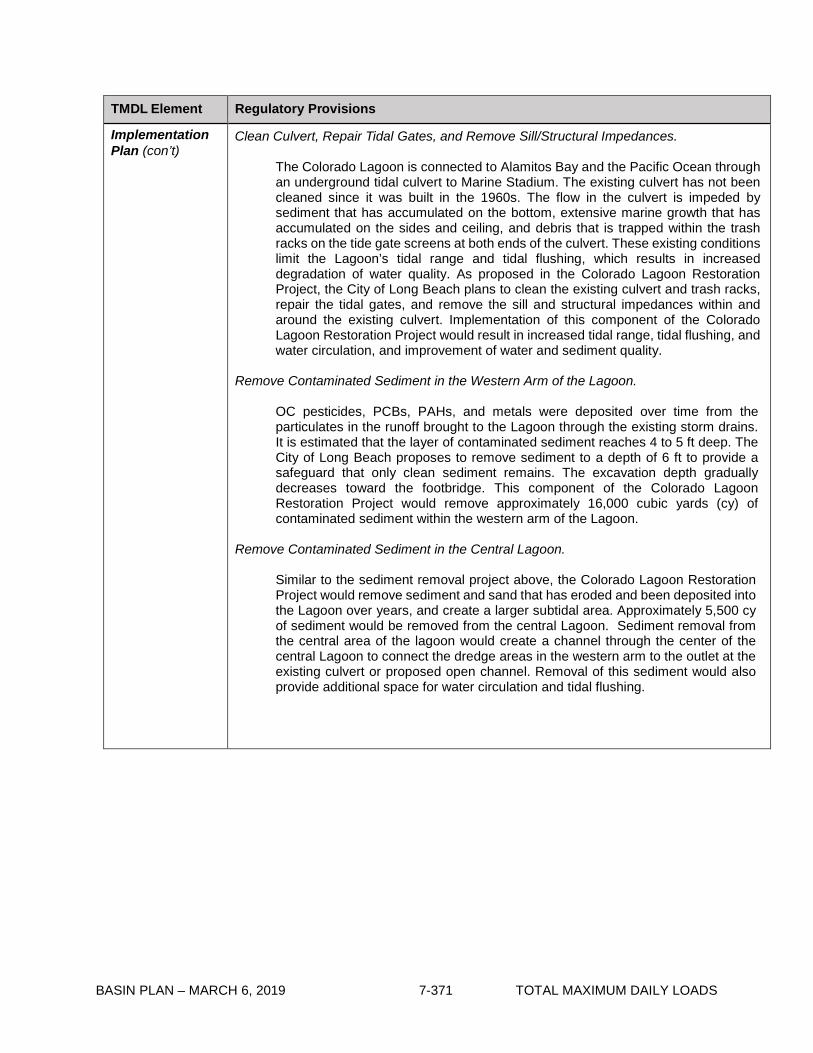
BASIN PLAN – MARCH 6, 2019 7-371 TOTAL MAXIMUM DAILY LOADS
TMDL Element Regulatory Provisions
Implementation Plan (con’t)
Clean Culvert, Repair Tidal Gates, and Remove Sill/Structural Impedances.
The Colorado Lagoon is connected to Alamitos Bay and the Pacific Ocean through an underground tidal culvert to Marine Stadium. The existing culvert has not been cleaned since it was built in the 1960s. The flow in the culvert is impeded by sediment that has accumulated on the bottom, extensive marine growth that has accumulated on the sides and ceiling, and debris that is trapped within the trash racks on the tide gate screens at both ends of the culvert. These existing conditions limit the Lagoon’s tidal range and tidal flushing, which results in increased degradation of water quality. As proposed in the Colorado Lagoon Restoration Project, the City of Long Beach plans to clean the existing culvert and trash racks, repair the tidal gates, and remove the sill and structural impedances within and around the existing culvert. Implementation of this component of the Colorado Lagoon Restoration Project would result in increased tidal range, tidal flushing, and water circulation, and improvement of water and sediment quality.
Remove Contaminated Sediment in the Western Arm of the Lagoon.
OC pesticides, PCBs, PAHs, and metals were deposited over time from the particulates in the runoff brought to the Lagoon through the existing storm drains. It is estimated that the layer of contaminated sediment reaches 4 to 5 ft deep. The City of Long Beach proposes to remove sediment to a depth of 6 ft to provide a safeguard that only clean sediment remains. The excavation depth gradually decreases toward the footbridge. This component of the Colorado Lagoon Restoration Project would remove approximately 16,000 cubic yards (cy) of contaminated sediment within the western arm of the Lagoon.
Remove Contaminated Sediment in the Central Lagoon.
Similar to the sediment removal project above, the Colorado Lagoon Restoration Project would remove sediment and sand that has eroded and been deposited into the Lagoon over years, and create a larger subtidal area. Approximately 5,500 cy of sediment would be removed from the central Lagoon. Sediment removal from the central area of the lagoon would create a channel through the center of the central Lagoon to connect the dredge areas in the western arm to the outlet at the existing culvert or proposed open channel. Removal of this sediment would also provide additional space for water circulation and tidal flushing.

BASIN PLAN – MARCH 6, 2019 7-372 TOTAL MAXIMUM DAILY LOADS
TMDL Element Regulatory Provisions Implementation Plan (con’t)
As proposed in the Colorado Lagoon Restoration Project, only the Western Arm and the Central Lagoon are planned to be dredged based on the recommendation from the Sediment Testing and Disposal Report. The TMDL monitoring program will determine if additional implementation actions such as dredging in the North Arm will be required to remove contaminated sediment in the Lagoon.
Build Alternate Channel or Underground Culvert between Lagoon and Marine Stadium.
City is considering an open channel or parallel underground culvert option to further improve water quality at the Colorado Lagoon. However, this project was not included in the certified EIR. This proposed project consists of replacing the existing concrete box culvert with an open channel or new underground culvert that would run from the Lagoon through Marina Vista Park to Marine Stadium in a location generally parallel to the existing culvert. Creating an open channel or underground culvert would improve tidal flushing by an increase in the tidal range, and result in a corresponding improvement of water and sediment quality. In addition, it would provide improved flood flow conveyance.
Implementation of the proposed actions should result in attainment of the TMDL allocations. If the proposed actions are not implemented or otherwise do not result in attainment of allocations, additional implementation actions shall be required.

BASIN PLAN – MARCH 6, 2019 7-373 TOTAL MAXIMUM DAILY LOADS
Table 7-30.2 Colorado Lagoon OC Pesticides, PCBs, Sediment Toxicity, PAHs, and Metals TMDL: Implementation Schedule
Item Implementation Action Responsible Party Date
1 Effective date of interim waste load allocations (WLAs).
The City of Long Beach, the Los Angeles County Flood Control District, and Caltrans
Effective date of the TMDL
2 Responsible agencies shall submit a monitoring plan to the Los Angeles Regional Board for Executive Officer approval.
The City of Long Beach, the Los Angeles County Flood Control District, and Caltrans
6 months after effective date of the TMDL
3 Responsible agencies shall begin monitoring as outlined in the approved monitoring plan.
The City of Long Beach, the Los Angeles County Flood Control District, and Caltrans
6 months after monitoring plan approved by E.O.
4 Responsible agencies shall submit annual reports to the Los Angeles Regional Board for review.
The City of Long Beach, the Los Angeles County Flood Control District, and Caltrans
15 months after monitoring starts and annually thereafter
5 Responsible agencies shall submit bi-annual progress reports to provide updates on the status of implementation actions performed under the TMDL. The plan shall contain mechanisms for demonstrating progress toward meeting the assigned WLAs.
The City of Long Beach, the Los Angeles County Flood Control District, and Caltrans
Every 2 years after effective date of the TMDL
6 Responsible agencies shall achieve WLAs.
The City of Long Beach, the Los Angeles County Flood Control District, and Caltrans
7 years after effective date of the TMDL

BASIN PLAN – MARCH 6, 2019 7-374 TOTAL MAXIMUM DAILY LOADS
This page intentionally left blank

BASIN PLAN – MAY 6, 2019 7-375 TOTAL MAXIMUM DAILY LOADS
7-31 Malibu Creek Watershed Trash TMDL This TMDL was adopted by:
The Regional Water Quality Control Board on May 1, 2008.
This TMDL was approved by:
The State Water Resources Control Board on March 17, 2009. The Office of Administrative Law on June 16, 2009. The U.S. Environmental Protection Agency on June 26, 2009.
The effective date of this TMDL is: July 7, 2009.
The elements of the TMDL are presented in Table 7-31.1 and the Implementation Plan in Tables
7-31.2a and 7-31.2b.
Table 7-31.1 Malibu Creek Watershed Trash TMDL: Elements
Element Malibu Creek Watershed Trash TMDL
Problem Statement Discharges of trash into Malibu Creek, Malibu Lagoon, Malibou Lake, Medea Creek (Reach 1 and Reach 2), Lindero Creek (Reach 1 and Reach 2), Lake Lindero, and Las Virgenes Creek violate water quality objectives and impair beneficial uses. The waterbodies above were listed in the 1998, 2002, 2004, and 2006 303(d) lists of impaired waterbodies for trash. Relevant water quality objectives in the Water Quality Control Plan Los Angeles Region include Floating Material and Solid, Suspended, or Settleable Materials. The following designated beneficial uses are impaired by trash: municipal and domestic supply (MUN), ground water recharge (GWR), contact water recreation (REC-1), non-contact water recreation (REC-2), warm freshwater habitat (WARM), cold freshwater habitat (COLD), migration of aquatic organisms (MIGR), wildlife habitat (WILD), rare, threatened, or endangered species (RARE), spawning, reproduction, and or early development (SPWN), and wetland habitat (WET).
Numeric Target (Interpretation of the narrative water quality objective, used to calculate the load allocations)
Zero trash in the above listed subwatersheds of the Malibu Creek Watershed, and on the shorelines of those waterbodies. Zero is defined for nonpoint sources as no trash immediately following each assessment and collection event consistent with an established Minimum Frequency of Assessment and Collection Program (MFAC Program). The MFAC Program is established at an interval that prevents trash from accumulating in deleterious amounts that cause nuisance or adversely affect beneficial uses between collections. For point sources, zero is defined as no trash discharged into the listed waterbodies of the Malibu Creek Watershed and on the shoreline of those waterbodies.

BASIN PLAN – MAY 6, 2019 7-376 TOTAL MAXIMUM DAILY LOADS
Element Malibu Creek Watershed Trash TMDL
Source Analysis Litter from adjacent land areas, roadways and direct dumping and deposition are sources of trash to Malibu Creek Watershed. Point sources such as storm drains are also sources of trash discharged to Malibu Creek Watershed.
Loading Capacity Zero, as defined in the Numeric Target.
Waste Load Allocations (for point sources)
Waste Load Allocations (WLAs) are assigned to the California Department of Transportation (Caltrans, permittee for Statewide National Pollutant Discharge Elimination System (NPDES) Storm Water Permit, No. 99-06-DWQ), Los Angeles County (principal permittee for NPDES Los Angeles County Municipal Separate Strom Sewer System (MS4) permit, No. CAS004001), and the Cities of Agoura Hills, Calabasas, Hidden Hills, Malibu, and Westlake Village (co-permittees for NPDES Los Angeles County MS4 permit) under the NPDES Los Angeles County MS4 permit, and to Ventura County Watershed Protection District (principal permittee for NPDES Ventura County MS4 permit, No. 004002), County of Ventura, and City of Thousand Oaks (co-permittees for NPDES Ventura County MS4 permit) under the NPDES Ventura County MS4 permit.
WLAs are zero trash. WLAs may be issued to additional responsible jurisdictions in the future under Phase 2 of the USEPA Stormwater Permitting Program, or other applicable regulatory programs.
Load Allocations (for nonpoint sources)
Load Allocations (LAs) are assigned to the National Park Service, California Department of Parks and Recreation, County of Los Angeles, County of Ventura, Ventura County Watershed Protection District, Santa Monica Mountains Conservancy, Cities of Malibu, Agoura Hills, Hidden Hills, Thousand Oaks, Westlake Village, and Calabasas, and land owners in the vicinity of listed waterbodies in the Malibu Creek Watershed. LAs are zero trash. LAs may be issued to additional responsible jurisdictions in the future under applicable regulatory programs.
Implementation Implementation of the trash TMDL for Malibu Creek Watershed includes structural and non-structural best management practices (BMPs) and a program of minimum frequency of assessment and collection (MFAC) to address point and nonpoint trash sources.
Point Sources
WLAs shall be implemented through storm water permits and via the authority vested in the Executive Officer by section 13267 of the Porter- Cologne Water Quality Control Act (Water Code section 13000 et seq.).
If point source dischargers comply with WLAs by implementing an Executive Officer certified full capture system on conveyances that discharge to the listed subwatersheds of the Malibu Creek Watershed through a progressive implementation schedule of full capture devices, they will be deemed in compliance with the WLA.

BASIN PLAN – MAY 6, 2019 7-377 TOTAL MAXIMUM DAILY LOADS
Element Malibu Creek Watershed Trash TMDL Implementation (con’t) In certain circumstances, (if approved by the Executive Officer), point
source dischargers may alternatively comply with WLAs by implementing a program for installing partial capture systems (PCS) in conjunction with best management practices. Compliance through implementation of a PCS/BMP program must demonstrate attainment of WLAs through trash monitoring in accordance with the Trash Monitoring and Reporting Plan (TMRP) approved by the Executive Officer.
1. Compliance with the final WLA may be achieved through an
adequately sized and maintained full capture system, once the Executive Officer has certified that the system meets the following minimum criteria. A full capture system, at a minimum, consists of any device or series of devices that traps all particles retained by a 5 mm mesh screen and has a design treatment capacity of not less than the peak flow rate (Q) resulting from a one-year, one-hour, storm in the sub-drainage area. The rational equation is used to compute the peak flow rate:
Q = C × I × A, where Q = design flow rate (cubic feet per second, cfs); C = runoff coefficient (dimensionless); I = design rainfall intensity (inches per hour); and
A= subdrainage area (acres). Point sources discharges that choose to comply via a full capture system must demonstrate a phased implementation of full capture devices over an 8-year period until the final WLA of zero is attained. Zero will be deemed to have been met if full capture systems have been installed on all conveyances discharging to the listed subwatersheds of the Malibu Creek Watershed.
Irrespective of whether point sources employ a full capture system, they may comply with the WLA in any lawful manner.
2. Compliance through a PCS/BMP program may be proposed to the Regional Board for incorporation into the relevant NPDES permit.
Nonpoint Sources
LAs shall be implemented through either (1) a conditional waiver from waste discharge requirements, (2) an alternative program implemented through waste discharge requirements, or (3) an individual waiver or another appropriate order of the Regional Board. Non-point source dischargers may achieve compliance with the LAs by implementing a MFAC/BMP program approved by the Executive Officer. Responsible jurisdictions that are responsible for both point and nonpoint sources will be deemed in compliance with both the WLAs and LAs if an MFAC/BMP program, approved by the Executive Officer, is implemented.

BASIN PLAN – MAY 6, 2019 7-378 TOTAL MAXIMUM DAILY LOADS
Element Malibu Creek Watershed Trash TMDL
Implementation (con’t) 1) Conditional Waiver: Pursuant to Water Code section 13269, waste discharge requirements are waived for any responsible jurisdiction that implements a MFAC/BMP Program which, to the satisfaction of the Executive Officer, meets the following criteria:
a) The MFAC/BMP Program includes an initial minimum frequency
of trash assessment and collection and suite of structural and/or nonstructural BMPs. The MFAC/BMP program shall include collection and disposal of all trash found in the water and on the shoreline. Responsible jurisdictions shall implement an initial suite of BMPs based on current trash management practices in land areas that are found to be sources of trash to Malibu Creek Watershed. For individual subwatershed in the Malibu Creek Watershed, the initial minimum frequency shall be set as follows:
Malibu Creek (from Malibu Lagoon to Malibou Lake)
1. Within City of Malibu, the waterbody, shorelines and areas adjacent to Malibu Creek: once per week and within 72 hours after critical conditions.
2. Within the County of Los Angeles and in the State
Parks: once per month, and within 72 hours after critical conditions.
Malibu Lagoon
1. The waterbody, shorelines, beach and areas adjacent to Malibu Lagoon: twice per week during high visitation seasons from May 15 through October 15.
2. The waterbody, shorelines, beach and areas adjacent to Malibu Lagoon: once per week from October 15 through May 15, and within 72 hours after critical conditions.
Malibou Lake
Once per month for the waterbody, shorelines and the adjacent lands, and within 72 hours after critical conditions.
Medea Creek Reach 1 (Malibou Lake to confluence with Lindero Creek)
Twice per month for the waterbody, shorelines and the adjacent areas, and within 72 hours after critical conditions.
Medea Creek Reach 2 (above confluence) 1. Once per week on the waterbody, shorelines and the
adjacent areas from the confluence with Lindero Creek to the intersection with Thousand Oaks Blvd., and within 72 hours after critical conditions.
2. Twice per month above the intersection with Thousand Oaks Blvd., and within 72 hours after critical conditions.

BASIN PLAN – MAY 6, 2019 7-379 TOTAL MAXIMUM DAILY LOADS
Element Malibu Creek Watershed Trash TMDL
Implementation (con’t) Lindero Creek Reach 1 (Confluence with Medea Creek to Lake Lindero)
Twice per month for Lindero Creek Reach 1 including the waterbody, shorelines and the adjacent areas, and within 72 hours after critical conditions.
Lindero Creek Reach 2 (Above Lake Lindero)
Twice per month for Lindero Creek Reach 2 including the waterbody, shorelines and the adjacent areas, and within 72 hours after critical conditions.
Lake Lindero
Twice per month for the waterbody, shorelines and the adjacent land, and within 72 hours after critical conditions.
Las Virgenes Creek
1. Within the State Parks northerly to the intersection with Mulholland Highway: once per month, and within 72 hours after critical conditions.
2. Once per week for the waterbody, shorelines and the adjacent areas between Mulholland Highway and Juan Bautista De Anza Park at Los Hills Road in the City of Calabasas, and within 72 hours after critical conditions.
3. Twice per week for the waterbody, shorelines and the adjacent areas for the rest of City of Calabasas.
4. Once per month for section in Los Angeles County along Ventura Freeway and within 72 hours after critical conditions.
5. Within Ventura County, once every two months for the waterbody, shorelines and the adjacent areas, and within 72 hours after critical conditions.
b) The MFAC/BMP Program includes reasonable assurances
that it will be implemented by the responsible jurisdiction. c) The MFAC/BMP Program includes a Trash Monitoring and
Reporting Plan, as described below, and a requirement that the responsible jurisdictions will self-report any non-compliance with its provisions. The results and report of the Trash Monitoring and Reporting Plan must be submitted to Regional Board on an annual basis.
d) MFAC protocols may be based on SWAMP protocols for rapid trash assessment, or alternative protocols proposed by dischargers and approved by the Executive Officer.
e) Implementation of the MFAC/BMP program should include a Health and Safety Plan to protect personnel. The MFAC/BMP shall not require responsible jurisdictions to access and collect trash from areas where personnel are prohibited.

BASIN PLAN – MAY 6, 2019 7-380 TOTAL MAXIMUM DAILY LOADS
Element Malibu Creek Watershed Trash TMDL
Implementation (con’t) The Executive Officer may approve or require a revised assessment and collection frequency, location, and definition of the critical conditions under the waiver:
(a) To prevent trash from accumulating in deleterious amounts that
cause nuisance or adversely affect beneficial uses between collections;
(b) To reflect the results of trash assessment and collection; (c) If the amount of trash collected does not show a decreasing
trend, where necessary to prevent nuisance or adverse effects on beneficial uses, such that a shorter interval between collections is warranted; or
(d) If the amount of trash collected is decreasing such that a longer interval between collections is warranted.
At the end of the implementation period, a revised MFAC/BMP program may be required if the Executive Officer determines that the amount of trash accumulating between collections is causing nuisance or otherwise adversely affecting beneficial uses.
With regard to (a), (b) or (c), above, the Executive Officer is authorized to allow responsible jurisdictions to implement additional structural or non-structural BMPs in lieu of modifying the monitoring frequency.
Any waivers implementing the TMDL shall expire pursuant to Water Code section 13269 five years after the effective date of this TMDL, unless reissued. The Regional Board may reissue this waiver through an order consistent herewith, instead of readopting these regulatory provisions. (2) Alternatively, responsible jurisdictions may propose, or the Regional Board may impose, an alternative program which would be implemented through waste discharge requirements, an individual waiver, a cleanup and abatement order, or any other appropriate order or orders, provided the program is consistent with the assumptions and requirements of the reductions described in Table 7-31.2b, below.
Within six months of the effective date of this TMDL, the Executive Officer shall require responsible jurisdictions to submit either a notice of intent to be regulated under the conditional waiver with their proposed MFAC/BMP Program and Trash Monitoring and Reporting Plan (TMRP), or a report of waste discharge.
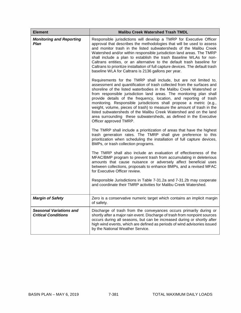
BASIN PLAN – MAY 6, 2019 7-381 TOTAL MAXIMUM DAILY LOADS
Element Malibu Creek Watershed Trash TMDL
Monitoring and Reporting Plan
Responsible jurisdictions will develop a TMRP for Executive Officer approval that describes the methodologies that will be used to assess and monitor trash in the listed subwatersheds of the Malibu Creek Watershed and/or within responsible jurisdiction land areas. The TMRP shall include a plan to establish the trash Baseline WLAs for non-Caltrans entities, or an alternative to the default trash baseline for Caltrans to prioritize installation of full capture devices. The default trash baseline WLA for Caltrans is 2136 gallons per year.
Requirements for the TMRP shall include, but are not limited to, assessment and quantification of trash collected from the surfaces and shoreline of the listed waterbodies in the Malibu Creek Watershed or from responsible jurisdiction land areas. The monitoring plan shall provide details of the frequency, location, and reporting of trash monitoring. Responsible jurisdictions shall propose a metric (e.g., weight, volume, pieces of trash) to measure the amount of trash in the listed subwatersheds of the Malibu Creek Watershed and on the land area surrounding these subwatersheds, as defined in the Executive Officer approved TMRP.
The TMRP shall include a prioritization of areas that have the highest trash generation rates. The TMRP shall give preference to this prioritization when scheduling the installation of full capture devices, BMPs, or trash collection programs.
The TMRP shall also include an evaluation of effectiveness of the MFAC/BMP program to prevent trash from accumulating in deleterious amounts that cause nuisance or adversely affect beneficial uses between collections, proposals to enhance BMPs, and a revised MFAC for Executive Officer review.
Responsible Jurisdictions in Table 7-31.2a and 7-31.2b may cooperate and coordinate their TMRP activities for Malibu Creek Watershed.
Margin of Safety Zero is a conservative numeric target which contains an implicit margin of safety.
Seasonal Variations and Critical Conditions
Discharge of trash from the conveyances occurs primarily during or shortly after a major rain event. Discharge of trash from nonpoint sources occurs during all seasons, but can be increased during or shortly after high wind events, which are defined as periods of wind advisories issued by the National Weather Service.

BASIN PLAN – MAY 6, 2019 7-382 TOTAL MAXIMUM DAILY LOADS
Table 7-31.2a Malibu Creek Watershed Trash TMDL: Implementation Schedule - Point Sources
Task No. Task Responsible Jurisdiction Date
1 Submit Trash Monitoring and Reporting Plan, including a plan for defining the trash baseline WLA and a proposed definition of “major rain event”.
California Department of Transportation, County of Los Angeles, County of Ventura, Ventura County Watershed Protection District, Cities of Agoura Hills, Calabasas, Hidden Hills, Malibu, Westlake Village and Thousand Oaks.
6 months from effective date of TMDL. If a plan is not approved by the Executive Officer within 9 months, the Executive Officer will establish an appropriate monitoring plan.
2 Implement Trash Monitoring and Reporting Plan.
California Department of Transportation, County of Los Angeles, County of Ventura, Ventura County Watershed Protection District, Cities of Agoura Hills, Calabasas, Hidden Hills, Malibu, Westlake Village and Thousand Oaks.
6 months from receipt of letter of approval from Regional Board Executive Officer, or the date a plan is established by the Executive Officer.
3 Submit results of Trash Monitoring and Reporting Plan, recommend trash baseline WLA, and propose prioritization of Full Capture System installation or implementation of other measures to attain the required trash reduction.
California Department of Transportation, County of Los Angeles, County of Ventura, Ventura County Watershed Protection District, Cities of Agoura Hills, Calabasas, Hidden Hills, Malibu, Westlake Village and Thousand Oaks.
One year from receipt of letter of approval for the Trash Monitoring and Reporting Plan from Regional Board Executive Officer, and annually thereafter.
4 Installation of Full Capture Systems or other measures to achieve 20% reduction of trash from Baseline WLA*.
California Department of Transportation, County of Los Angeles, County of Ventura, Ventura County Watershed Protection District, Cities of Agoura Hills, Calabasas, Hidden Hills, Malibu, Westlake Village and Thousand Oaks.
Four years from effective date of TMDL.
5 Installation of Full Capture Systems or other measures to achieve 40% reduction of trash from Baseline WLA*.
California Department of Transportation, County of Los Angeles, County of Ventura, Ventura County Watershed Protection District, Cities of Agoura Hills, Calabasas, Hidden Hills, Malibu, Westlake Village and Thousand Oaks.
Five years from effective date of TMDL.
6 Evaluate the effectiveness of Full Capture Systems or other measures, and reconsider the WLA*.
Regional Board. Five years from effective date of TMDL.

BASIN PLAN – MAY 6, 2019 7-383 TOTAL MAXIMUM DAILY LOADS
Task No.
Task Responsible Jurisdiction Date
7 Installation of Full Capture Systems or other measures to achieve 60% reduction of trash from Baseline WLA*.
California Department of Transportation, County of Los Angeles, County of Ventura, Ventura County Watershed Protection District, Cities of Agoura Hills, Calabasas, Hidden Hills, Malibu, Westlake Village and Thousand Oaks.
Six years from effective date of TMDL.
8 Installation of Full Capture Systems or other measures to achieve 80% reduction of trash from Baseline WLA*.
California Department of Transportation, County of Los Angeles, County of Ventura, Ventura County Watershed Protection District, Cities of Agoura Hills, Calabasas, Hidden Hills, Malibu, Westlake Village and Thousand Oaks.
Seven years from effective date of TMDL.
9 Installation of Full Capture Systems or other measures to achieve 100% reduction of trash from Baseline WLA*.
California Department of Transportation, County of Los Angeles, County of Ventura, Ventura County Watershed Protection District, Cities of Agoura Hills, Calabasas, Hidden Hills, Malibu, Westlake Village and Thousand Oaks.
Eight years from effective date of TMDL.
* Compliance with percent reductions from the Baseline WLA will be assumed wherever full capture systems are installed in corresponding percentages of the conveyance discharging to Malibu Creek Watershed. Installation will be prioritized based on the greatest point source loadings.

BASIN PLAN – MAY 6, 2019 7-384 TOTAL MAXIMUM DAILY LOADS
Table 7-31.2b Malibu Creek Watershed Trash TMDL: Implementation Schedule Minimum Frequency of Assessment and Collection Program * - Nonpoint Sources
Task No.
Task Responsible Jurisdiction Date
1 Conditional Waiver in effect. National Park Service, California Department of Parks and Recreation, County of Los Angeles, County of Ventura, Ventura County Watershed Protection District, Santa Monica Mountains Conservancy, Cities of Agoura Hills, Calabasas, Hidden Hills, Malibu, Westlake Village, and Thousand Oaks, and land owners in the vicinity of the waterbodies addressed in the Nonpoint Source Implementation Section of this Basin Plan Amendment.
Regional Board adoption of TMDL.
2 Submit Notice of Intent to Comply with Conditional Waiver of Discharge Requirements, including MFAC/BMP Program and Trash Monitoring and Reporting Plan.
National Park Service, California Department of Parks and Recreation, County of Los Angeles, County of Ventura, Ventura County Watershed Protection District, Santa Monica Mountains Conservancy, Cities of Agoura Hills, Calabasas, Hidden Hills, Malibu, Westlake Village, and Thousand Oaks, and land owners in the vicinity of the waterbodies addressed in the Nonpoint Source Implementation Section of this Basin Plan Amendment.
Six months from TMDL effective date. If a plan is not approved by the Executive Officer within 9 months, the Executive Officer will establish an appropriate monitoring plan.
3 Implement MFAC/BMP Program.
National Park Service, California Department of Parks and Recreation, County of Los Angeles, County of Ventura, Ventura County Watershed Protection District, Santa Monica Mountains Conservancy, Cities of Agoura Hills, Calabasas, Hidden Hills, Malibu, Westlake Village, and Thousand Oaks, and land owners in the vicinity of the waterbodies addressed in the Nonpoint Source Implementation Section of this Basin Plan Amendment.
6 months from receipt of letter of approval from Regional Board Executive Officer, or the date a plan is established by the Executive Officer.

BASIN PLAN – MAY 6, 2019 7-385 TOTAL MAXIMUM DAILY LOADS
Task No. Task Responsible Jurisdiction Date
4 Submit annual TMRP reports including proposal for revising MFAC/BMP for Executive Officer approval.
National Park Service, California Department of Parks and Recreation, County of Los Angeles, County of Ventura, Ventura County Watershed Protection District, Santa Monica Mountains Conservancy, Cities of Agoura Hills, Calabasas, Hidden Hills, Malibu, Westlake Village, and Thousand Oaks, and land owners in the vicinity of the waterbodies addressed in the Nonpoint Source Implementation Section of this Basin Plan Amendment.
One year from receipt of letter of approval for the Trash Monitoring and Reporting Plan from Regional Board Executive Officer, and annually thereafter.
5 Reconsideration of Trash TMDL based on evaluation of effectiveness of MFAC/ BMP program.
Regional Board. Five years from effective date of TMDL.
* At Task 3, all Responsible Jurisdictions must be attaining the zero trash target after each required trash assessment and collection event. At Task 4, all Responsible Jurisdictions must demonstrate full compliance and attainment of the zero trash target’s requirement that trash is not accumulating in deleterious amounts between the required trash assessment and collection events. Based on Responsible Jurisdiction monitoring reports, the Executive Officer may adjust the minimum frequency of assessment and collection as necessary to ensure compliance between the required trash assessment and collection events.

BASIN PLAN – MAY 6, 2019 7-386 TOTAL MAXIMUM DAILY LOADS
This page intentionally left blank

BASIN PLAN – MAY 6, 2019 7-387 TOTAL MAXIMUM DAILY LOADS
7-32 Implementation Plan for the Los Cerritos Channel Metals TMDL This Implementation Plan was adopted by:
The California Regional Water Quality Control Board, Los Angeles Region on June 6,
2013.
This Implementation Plan was approved by:
The State Water Resources Control Board on March 4, 2014. The Office of Administrative Law on October 13, 2014. This Implementation Plan is effective on October 13, 2014. The U.S. Environmental Protection Agency on May 11, 2017.
Summary of U.S. EPA Established Los Cerritos Channel Metals TMDL Los Cerritos Channel was included on the 1998, 2002, 2006, and 2010 California Clean Water Act (CWA) section 303(d) lists as an impaired waterbody for copper, zinc, and lead. The sources of metals loading in the watershed include point sources (such as inputs from municipal, industrial and construction stormwater permittees) and nonpoint sources (such as air deposition) within the Los Cerritos Channel Freshwater Watershed. The U.S. EPA established the Los Cerritos Channel Total Maximum Daily Load for Metals on March 17, 2010. The U.S. EPA-established TMDL includes the problem statement, numeric targets for copper, zinc, and lead based on water quality criteria for the protection of aquatic life as set forth in section 131.38 of title 40 of the Code of Federal Regulations (40 CFR), source analysis, loading capacity, load allocations (LAs) and waste load allocations (WLAs) based on the numeric targets, and margin of safety, but does not include an implementation plan or schedule. The following tables address implementation of the Los Cerritos Channel Metals TMDL. Table 7-32.1 Los Cerritos Channel Metals TMDL: Implementation Element Key Findings and Regulatory Provisions
Implementation
The regulatory mechanisms used to implement the wasteload allocations assigned to point sources, and associated requirements, shall include but not be limited to:

BASIN PLAN – MAY 6, 2019 7-388 TOTAL MAXIMUM DAILY LOADS
Implementation (con’t)
• NPDES permit(s) for Municipal Separate Storm Sewer System (MS4) discharges within the Los Cerritos Channel Freshwater Watershed,
• the NPDES Statewide Storm Water Permit for the State of California Department of Transportation,
• general NPDES permit(s) for storm water discharges associated with construction and land disturbance activities,
• general NPDES permit(s) for storm water discharges associated with industrial activities,
• other general NPDES permits, and • minor NPDES permits.
Effluent limitations consistent with the assumptions and requirements of the WLAs shall be incorporated into each permit, at the time of permit issuance, modification, or renewal. The regulatory mechanisms used to implement the load allocations assigned to nonpoint sources shall include but not be limited to the authority contained in sections 13263 and 13269 of the California Water Code, in conformance with the State Water Resources Control Board’s (State Water Board) Policy for Implementation and Enforcement of the Nonpoint Source Pollution Control Program. Non-Storm Water NPDES Permits Effluent limitations shall be consistent with the concentration-based WLAs established for non-storm water point sources in this TMDL. Permit writers may translate applicable waste load allocations into daily maximum and monthly average effluent limitations for the minor and general NPDES permits by applying the effluent limitation derivation procedures in Section 1.4 of the State Water Resources Control Board’s Policy for Implementation of Toxics Standards for Inland Surface Waters, Enclosed Bays, and Estuaries of California or other appropriate methodologies subject to Executive Officer approval. General Industrial and Construction Storm Water Permits Implementation of Dry-weather WLAs The dry-weather WLAs equal to zero apply to unauthorized non-storm water discharges, which are prohibited by the statewide General Permit for Discharges of Storm Water Associated with Construction Activity and the statewide Industrial Storm Water General Permit. Non-storm water discharges from construction or industrial activities authorized by State Water Board Order No. 2009-0009-DWQ or Order No. 97-03-DWQ, respectively, or any successor order, are exempt from the dry-weather WLA equal to zero. Instead, the reach-specific concentration-based WLAs assigned to the “other NPDES permits” shall apply to these authorized non-storm water discharges. Dry-weather WLAs shall be incorporated into permits as permit limitations1 or discharge prohibitions, consistent with the assumptions and requirements of the WLAs. Compliance with dry-weather WLAs shall be assessed once per discharge event or by a demonstration
1 Permit limitation means a water quality-based effluent limitation or a receiving water limitation. Pursuant to 40 CFR section 130.2(h), wasteload allocations constitute a type of water quality-based effluent limitation.

BASIN PLAN – MAY 6, 2019 7-389 TOTAL MAXIMUM DAILY LOADS
Implementation (con’t)
of no discharge. Dry-weather permit limitations shall be expressed as instantaneous maximums. Implementation of Wet-weather WLAs Wet-weather mass-based WLAs for the general industrial and general construction storm water permittees shall be incorporated into permits as permit limitations and requirements consistent with the assumptions and requirements of the TMDL WLAs. Wet-weather permit limitations shall be expressed as event mean concentrations. Compliance with wet-weather WLAs shall be assessed at a minimum with one wet-weather sampling event. Permittees may demonstrate compliance with wet-weather WLAs in any one of three ways. First, general industrial and construction storm water permittees may be deemed in compliance with permit limitations if they demonstrate that there are no exceedances of the permit limitations at their discharge points or outfalls. Second, general industrial and construction storm water permittees may be deemed in compliance with permit limitations if they demonstrate that there are no exceedances of the permit limitations in the receiving water at, or downstream of, the permittee’s outfalls. Third, if permittees provide a quantitative demonstration that control measures and best management practices (BMPs) will achieve WLAs consistent with the schedule in Table 7-32.2, then compliance may be demonstrated by implementation of those control measures and BMPs, subject to Executive Officer approval. Compliance Schedules for Wet Weather WLAs Applicable to Existing General Industrial and Construction Storm Water Dischargers The implementation schedule in Table 7-32.2 for the general industrial and construction stormwater permits applies to the WLAs for copper, lead, and zinc in wet weather, which are based on criteria in 40 CFR section 131.38. Where the Water Boards have authorization for issuing compliance schedules to existing general industrial and construction stormwater dischargers pursuant to CWA section 303(c)(2), the Water Boards may provide compliance schedules in the general industrial and construction stormwater permits up to the dates in Table 7-32.2 and in accordance with the State Water Board’s Compliance Schedule Policy and 40 CFR section 122.47. Any compliance schedule is subject to the section entitled “Compliance Schedule Requirements” below. Compliance schedules are not authorized for new dischargers. The implementation schedule for the general construction and industrial permits provides the necessary time for existing dischargers2 to implement BMPs, which will lead to compliance with WLAs as soon as possible and ensure that water quality standards are met by the end of the implementation period. Compliance Schedule Requirements An existing discharger who seeks a compliance schedule must demonstrate to the satisfaction of the Water Board that the discharger needs time to implement actions to comply with a more stringent permit
2 Existing discharger is defined consistent with the State’s Policy for Compliance Schedules in National Pollutant Discharge Elimination System Permits.

BASIN PLAN – MAY 6, 2019 7-390 TOTAL MAXIMUM DAILY LOADS
Implementation (con’t)
limitation. In the case of individual permits, the discharger shall make a request for a compliance schedule up to the dates in Table 7-32.2 and provide the documentation required by Paragraph 4 (Application Requirements) of the Compliance Schedule Policy as part of its report of waste discharge. In the case of general permits, the discharger shall make a request for a compliance schedule up to the dates in Table 7-32.2 and provide the documentation required by Paragraph 4 (Application Requirements) of the Compliance Schedule Policy as part of its Permit Registration Documents or during the public comment period for renewal or reconsideration of the general permit. If the Water Board determines that an existing discharger has met the application requirements for a compliance schedule, then the Water Board may include an appropriate compliance schedule in the permit. Any compliance schedule must require compliance as soon as possible, taking into account the amount of time reasonably required for the discharger to implement actions, such as designing and constructing facilities or implementing new or significantly expanded programs and securing financing, if necessary, to comply with a more stringent permit limitation. The compliance schedule in the permit cannot, under any circumstances, exceed the maximum length for compliance schedules contained in this implementation plan. If the Water Board establishes a compliance schedule in the permit, the Water Board shall include interim requirements and dates for their achievement. If the compliance schedule exceeds one year, the Water Board shall establish interim numeric limitations for the pollutant in the permit; and may also impose interim requirements to control the pollutant, such as pollutant minimization and source control measures. Numeric interim limitations for the pollutant must, at a minimum, be based on current treatment facility performance or on existing permit limitations, whichever is more stringent. There shall be no more than one year between interim dates. The interim requirements shall state that the discharger must notify the Water Board, in writing, no later than 14 days following each interim date, of its compliance or noncompliance with the interim requirements. The entire compliance schedule, including interim requirements and final permit limitations, shall be included as enforceable terms of the permit, whether or not the final compliance date is within the permit term. The permit shall include appropriate findings that the compliance schedule is necessary and that the schedule requires compliance as soon as possible within the timeframe allowed by the TMDL implementation schedule and in accordance with the Compliance Schedule Policy and 40 CFR section 122.47. The permit fact sheet shall adequately describe the basis for these findings. A Water Board is not prevented from requiring immediate compliance with permit limitations if a Water Board finds that immediate protection of beneficial uses of waters of the United States or California is in the best interest of the people of the state. However, in such an event, the Water Board shall make a finding stating the beneficial uses and specific interests of the people of the state that are being protected or promoted. MS4 and Caltrans Storm Water Permits
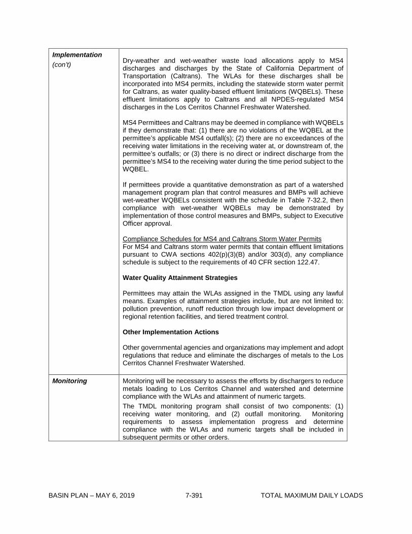
BASIN PLAN – MAY 6, 2019 7-391 TOTAL MAXIMUM DAILY LOADS
Implementation (con’t)
Dry-weather and wet-weather waste load allocations apply to MS4 discharges and discharges by the State of California Department of Transportation (Caltrans). The WLAs for these discharges shall be incorporated into MS4 permits, including the statewide storm water permit for Caltrans, as water quality-based effluent limitations (WQBELs). These effluent limitations apply to Caltrans and all NPDES-regulated MS4 discharges in the Los Cerritos Channel Freshwater Watershed. MS4 Permittees and Caltrans may be deemed in compliance with WQBELs if they demonstrate that: (1) there are no violations of the WQBEL at the permittee’s applicable MS4 outfall(s); (2) there are no exceedances of the receiving water limitations in the receiving water at, or downstream of, the permittee’s outfalls; or (3) there is no direct or indirect discharge from the permittee’s MS4 to the receiving water during the time period subject to the WQBEL. If permittees provide a quantitative demonstration as part of a watershed management program plan that control measures and BMPs will achieve wet-weather WQBELs consistent with the schedule in Table 7-32.2, then compliance with wet-weather WQBELs may be demonstrated by implementation of those control measures and BMPs, subject to Executive Officer approval. Compliance Schedules for MS4 and Caltrans Storm Water Permits For MS4 and Caltrans storm water permits that contain effluent limitations pursuant to CWA sections 402(p)(3)(B) and/or 303(d), any compliance schedule is subject to the requirements of 40 CFR section 122.47. Water Quality Attainment Strategies Permittees may attain the WLAs assigned in the TMDL using any lawful means. Examples of attainment strategies include, but are not limited to: pollution prevention, runoff reduction through low impact development or regional retention facilities, and tiered treatment control. Other Implementation Actions Other governmental agencies and organizations may implement and adopt regulations that reduce and eliminate the discharges of metals to the Los Cerritos Channel Freshwater Watershed.
Monitoring Monitoring will be necessary to assess the efforts by dischargers to reduce metals loading to Los Cerritos Channel and watershed and determine compliance with the WLAs and attainment of numeric targets. The TMDL monitoring program shall consist of two components: (1) receiving water monitoring, and (2) outfall monitoring. Monitoring requirements to assess implementation progress and determine compliance with the WLAs and numeric targets shall be included in subsequent permits or other orders.

BASIN PLAN – MAY 6, 2019 7-392 TOTAL MAXIMUM DAILY LOADS
Table 7-32.2 Los Cerritos Channel Metals TMDL: Implementation Schedule Date Action
September 30, 2020 The Los Angeles Water Board may reconsider this TMDL, including the WLAs, Las, and implementation schedule, if warranted, based on the results of monitoring and special studies and/or other new information.
NON-STORM WATER PROGRAM NPDES PERMITS
Upon permit issuance, renewal, or re-opener
The non-storm water point sources shall achieve WLAs, expressed as effluent limitations derived using procedures in Section 1.4 of the State Water Board’s Policy for Implementation of Toxics Standards for Inland Surface Waters, Enclosed Bays, and Estuaries of California or other appropriate methodologies approved by the Executive Officer.
GENERAL INDUSTRIAL AND CONSTRUCTION STORM WATER PERMITS
Upon permit issuance, renewal, or re-opener
The general industrial and general construction storm water permittees shall achieve dry-weather WLAs.
Up to September 30, 2017
The general industrial and general construction storm water permittees shall achieve wet-weather WLAs.
MS4 AND CALTRANS STORM WATER PERMITS
September 30, 2015 MS4 and Caltrans storm water permittees shall submit a coordinated monitoring plan, to be approved by the Executive Officer, which includes both TMDL compliance monitoring and receiving water monitoring. Monitoring shall commence within six months of approval of the coordinated monitoring plan by the Executive Officer. A monitoring program submitted pursuant to Order No. R4-2012-0175 may be used by permittees subject to that Order to satisfy the TMDL monitoring requirements.
September 30, 2016
MS4 and Caltrans storm water permittees shall provide a written report to the Los Angeles Water Board outlining how they will achieve compliance with the WLAs. The report shall include implementation methods, an implementation schedule, proposed milestones, and any revisions to the TMDL monitoring plan. An Enhanced Watershed Management Program or Watershed Management Program, including the Reasonable Assurance Analysis, submitted in fulfillment of requirements in Order No. R4-2012-0175 may be used by permittees subject to

BASIN PLAN – MAY 6, 2019 7-393 TOTAL MAXIMUM DAILY LOADS
that Order to satisfy the TMDL implementation plan requirements.
September 30, 2017 The MS4 and Caltrans storm water permittees shall demonstrate that 30% of the total drainage area served by the storm drain system is effectively meeting the dry-weather WLAs and 10% of the total drainage area served by the storm drain system is effectively meeting the wet-weather WLAs. Alternatively, permittees shall attain a 30% reduction in the difference between the current loadings and the dry-weather WLAs and a 10% reduction in the difference between the current loadings and the wet-weather WLAs at storm drain outfalls, as measured at the relevant existing City of Long Beach MS4 permit monitoring station.
September 30, 2020 The MS4 and Caltrans storm water permittees shall demonstrate that 70% of the total drainage area served by the storm drain system is effectively meeting the dry-weather WLAs and 35% of the total drainage area served by the storm drain system is effectively meeting the wet-weather WLAs. Alternatively, permittees shall attain a 70% reduction in the difference between the current loadings and the dry-weather WLAs and a 35% reduction in the difference between the current loadings and the wet-weather WLAs at storm drain outfalls, as measured at the relevant existing City of Long Beach MS4 permit monitoring station.
September 30, 2023 The MS4 and Caltrans storm water permittees shall demonstrate that 100% of the total drainage area served by the storm drain system is effectively meeting the dry-weather WLAs and 65% of the total drainage area served by the storm drain system is effectively meeting the wet-weather WLAs. Alternatively, permittees shall attain a 65% reduction in the difference between the current loadings and the wet-weather WLAs at storm drain outfalls, as measured at the relevant existing City of Long Beach MS4 permit monitoring station.
September 30, 2026 The MS4 and Caltrans storm water permittees shall demonstrate that 100% of the total drainage area served by the storm drain system is effectively meeting both the dry-weather and wet-weather WLAs and the receiving water of Los Cerritos Channel is attaining applicable water quality standards for copper, lead, and zinc.

BASIN PLAN – MAY 6, 2019 7-394 TOTAL MAXIMUM DAILY LOADS
This page intentionally left blank

BASIN PLAN – MAY 6, 2019 7-395 TOTAL MAXIMUM DAILY LOADS
7-34 Santa Monica Bay Nearshore Debris TMDL This TMDL was adopted by:
The Regional Water Quality Control Board on November 4, 2010.
This TMDL was approved by:
The State Water Resources Control Board on December 6, 2011 The Office of Administrative Law on March 15, 2011 The U.S. Environmental Protection Agency on March 20, 2012.
The elements of the TMDL are presented in Table 7-34.1 and the Implementation Plan in Tables
7-34.2 and 7-34.3.

BASIN PLAN – MAY 6, 2019 7-396 TOTAL MAXIMUM DAILY LOADS
Table 7-34.1 Santa Monica Bay Nearshore and Offshore Debris TMDL: Elements Elements Santa Monica Bay Nearshore and Offshore Debris TMDL
Problem Statement Discharges of debris3, including trash and plastic pellets, into Santa Monica Bay violate water quality objectives, impair beneficial uses, and cause pollution and nuisance. Nearshore and offshore areas of the Santa Monica Bay were listed on the 1998, 2002, and 2006 Federal Clean Water Act Section 303(d) lists of impaired waterbodies for debris. The water quality objectives applicable to debris include “Floating Material” and “Solid, Suspended, or Settleable Materials” in Chapter 3, and “Floating Particulates” in the California Ocean Plan (2005). The following designated beneficial uses of Santa Monica Bay are impaired by debris: industrial service supply (IND), navigation (NAV), water contact recreation (REC-1), non-contact water recreation (REC-2), commercial and sport fishing (COMM), estuarine habitat (EST), marine habitat (MAR), preservation of biological habitats (BIOL), migration of aquatic organisms (MIGR), wildlife habitat (WILD), rare, threatened, or endangered species (RARE), spawning, reproduction, and or early development (SPWN), shellfish harvesting (SHELL), and wetland habitat (WET).
Numeric Target (interpretation of the narrative water quality objectives for floating materials/particulates, and solid, suspended, or settleable materials4, used to calculate the load allocations)
Trash Zero trash in Santa Monica Bay. Plastic Pellets Zero plastic pellets in Santa Monica Bay.
Source Analysis
Along the West Coast, land-based debris comprises more than half of the debris observed in the marine environment, undetermined sources of debris comprise less than half of the debris observed in the marine environment, and ocean-based debris comprises only approximately one-tenth of the debris observed in the marine environment.5 Most of the land-based debris is discharged to the marine environment through storm drains. The primary sources of debris discharged from storm drains include litter, debris from commercial establishments and public venues, industrial discharges, garbage transportation, landfills, and construction debris. The principal source of plastic pellets is point source discharges through storm drains from industry that imports, manufactures, processes, transports, stores, recycles or otherwise handles plastic pellets. Accidental spills during transfer and transportation also contribute to
1 According to the National Oceanic and Atmospheric Administration (NOAA) Marine Debris Program, debris is defined as “any persistent solid material that is manufactured or processed and directly or indirectly, intentionally or unintentionally, disposed of or abandoned into the marine environment” (NOAA 2010). In this TMDL, trash does not include naturally occurring vegetation waste. Plastic pellets, also known as plastic resin pellets, are small, round pellets that are the raw form of plastic. These pellets are melted down to form plastic products. 2 Narrative objectives are specified in the 1994 Los Angeles Regional Board Basin Plan, and in the 2005 California Ocean Plan. 3 S.B. Sheavly. 2007. “National Marine Debris Monitoring Program: Final Program Report, Data Analysis and Summary.” Prepared for U.S. Environmental Protection Agency by Ocean Conservancy, Grant Number X83053401-02. 76 pp.

BASIN PLAN – MAY 6, 2019 7-397 TOTAL MAXIMUM DAILY LOADS
Elements Santa Monica Bay Nearshore and Offshore Debris TMDL
Source Analysis (con’t)
plastic pellets entering storm drains and, ultimately, the Santa Monica Bay. Land-based nonpoint sources of debris include inappropriate disposal of debris at land areas such as beaches and marinas adjacent to Santa Monica Bay or waterbodies within the Santa Monica Bay WMA. Other nonpoint sources of debris include direct deposition and dumping. Marine-based sources of trash include boats and vessels.
Loading Capacity Zero for both trash and plastic pellets, as defined in the Numeric Target.
Margin of Safety Zero is a conservative numeric target for both trash and plastic pellets, which contains an implicit margin of safety.
Seasonal Variations and Critical Conditions
Discharge of trash and plastic pellets from storm drains and open channels occurs primarily during or shortly after a major rain event. Discharge of trash from nonpoint sources occurs during all seasons, but can increase during high wind events, which are defined as periods of wind advisories issued by the National Weather Service. Additionally weekends and holidays, particularly those between April 15 through October 15, result in a substantial increase of trash littered on beaches, open space and parks.
Waste Load Allocations (for point sources)
Trash The WLA is zero trash. Zero trash is defined as no trash discharged into waterbodies within the Santa Monica Bay Watershed Management Area (WMA) and then into Santa Monica Bay or on the shoreline of Santa Monica Bay. Waste Load Allocations for trash (WLAs) are assigned to the California Department of Transportation (Caltrans, permittee for Statewide National Pollutant Discharge Elimination System (NPDES) Storm Water Permit, No. 99-06-DWQ); Los Angeles County and the Cities of Agoura Hills, Calabasas, Culver City, El Segundo, Hermosa Beach, Los Angeles, Malibu, Manhattan Beach, Palos Verdes Estates, Rancho Palos Verdes, Redondo Beach, Rolling Hills, Rolling Hills Estates, Santa Monica, Torrance, and Westlake Village (co-permittees within the Santa Monica Bay WMA under the Los Angeles County MS4 NPDES Permit, No. CAS004001); and County of Ventura, and City of Thousand Oaks (co-permittees within the Santa Monica Bay WMA under the Ventura County MS4 NPDES Permit, No. CAS 004002). Responsible agencies and jurisdictions covered by the Ballona Creek Watershed Trash TMDL including Caltrans, County of Los Angeles, and the Cities of Beverly Hills, Culver City, Inglewood, Los Angeles, Santa Monica, and West Hollywood, and responsible agencies and jurisdictions identified in the Malibu Creek Trash TMDL including Caltrans, Los Angeles County, Ventura County, Ventura County Watershed Protection District, and the Cities of Agoura Hills, Calabasas, Hidden Hills, Malibu, Thousand Oaks, and Westlake Village are also responsible for point source discharges of trash into the Santa Monica Bay via open channels

BASIN PLAN – MAY 6, 2019 7-398 TOTAL MAXIMUM DAILY LOADS
Elements Santa Monica Bay Nearshore and Offshore Debris TMDL
Waste Load Allocations (for point sources) (con’t)
and storm drains. The WLA applicable to MS4 Permittees that is established herein, and the associated requirements for these responsible agencies and jurisdictions shall be complied with through the Ballona Creek Trash TMDL (Regional Board Resolution No. R01-014 and any amendments thereto) and the Malibu Creek Trash TMDL (Regional Board Resolution No. R08-007 and any amendments thereto). Each responsible jurisdiction and agency, identified above, shall comply with the interim or final Waste Load Allocations for trash assigned to it and, therefore, should utilize all compliance strategies within its authority to achieve these allocations. If these strategies include installation of full or partial capture systems in the infrastructure of a flood control district, the jurisdiction is responsible for obtaining all necessary permits to do so. Flood control districts, such as the Los Angeles County Flood Control District or Ventura County Watershed Protection District, are not assigned Waste Load Allocations, based on jurisdictional area, if channel maintenance is performed in compliance with the municipal stormwater permit. However, they may be held responsible with a jurisdiction and/or agency for non-compliance where the flood control district has either: without good cause denied necessary authority to a responsible jurisdiction or agency for the timely installation and/or maintenance of full and/or partial capture trash control devices for purposes of TMDL compliance in parts of the MS4 physical infrastructure that are under its authority, or not fulfilled its obligations under its MS4 permit regarding proper BMP installation, operation and maintenance for purposes of TMDL compliance within the MS4 physical infrastructure under its authority, thereby causing or contributing to a responsible jurisdiction and/or agency to be out of compliance with its interim or final Waste Load Allocations. Under these circumstances, the flood control district’s responsibility shall be limited to non-compliance related to the drainage area(s) within the jurisdiction where the flood control district has authority over the relevant portions of the MS4 physical infrastructure. The WLA may be assigned to additional responsible jurisdictions or agencies discharging urban runoff and stormwater in the future. Plastic Pellets The WLA for plastic pellets is zero. Zero plastic pellets is defined as no discharge of plastic pellets from the premises of industrial facilities that import, manufacture, process, transport, store, recycle or otherwise handle plastic pellets. The WLA is consistent with Cal. Water Code § 13367 and 40 CFR 122.26(b)(12). WLAs for plastic pellets are assigned to permittees of the Industrial Storm Water General Permit (Order No. 97-03-DWQ, and NPDES Permit No. CAS 000001) within the Santa Monica Bay WMA. The Standard Industry Classification (SIC) codes associated with industrial activities involving plastic pellets may include, but are not limited to, 282X, 305X, 308X, 39XX, 25XX, 3261, 3357, 373X, and 2893. Additionally, industrial facilities with the term “plastic” in the facility or operator name, regardless

BASIN PLAN – MAY 6, 2019 7-399 TOTAL MAXIMUM DAILY LOADS
Elements Santa Monica Bay Nearshore and Offshore Debris TMDL
Waste Load Allocations (for point sources) (con’t)
of the SIC code, may be subject to the WLA for plastic pellets. Other industrial permittees within the Santa Monica Bay WMA that fall within the above categories, but are regulated through other general permits and/or individual industrial storm water permits are also required to comply with the WLA for plastic pellets.
Load Allocations (for nonpoint sources)
The Load Allocation (LA) is zero trash. Zero trash is defined for nonpoint sources as no trash on the shoreline or beaches, or in harbors adjacent to Santa Monica Bay, immediately following each assessment and collection event consistent with an established Minimum Frequency of Assessment and Collection Program (MFAC Program). The MFAC Program is established at an interval that prevents trash from accumulating in deleterious amounts that cause nuisance or adversely affect beneficial uses between collections. LAs are assigned to jurisdictions that own and/or manage beaches and harbors along Santa Monica Bay, which include California Department of Parks and Recreation, County of Los Angeles Department of Beaches and Harbors, and Cities of Hermosa Beach, Los Angeles, Santa Monica, and Redondo Beach. The National Park Service, California Department of Parks and Recreation, County of Los Angeles, County of Ventura, and State Lands Commission, which have jurisdiction over non-beach open space and/or parks are assigned LAs. The LA may be assigned to additional responsible jurisdictions and/or agencies in the future under appropriate regulatory programs.
Implementation
Point Sources Trash WLAs for trash shall be implemented through municipal separate storm sewer system (MS4) permits and via the authority vested in the Executive Officer by California Water Code sections 13267 and/or 13383. Dischargers may comply with the WLA in any lawful manner, including the use of full capture systems; partial capture systems; and/or institutional controls. (1) Compliance with the final WLA may be achieved through an adequately sized and maintained full capture system, once the Executive Officer has certified that the system meets the following minimum criteria. A full capture system, at a minimum, consists of any device or series of devices that traps all particles retained by a 5 mm mesh screen and has a design treatment capacity of not less than the peak flow rate (Q) resulting from a one-year, one-hour, storm in the subdrainage area. The rational equation is used to compute the peak flow rate: Q = C × I × A, where Q = design flow rate (cubic feet per second, cfs); C = runoff coefficient (dimensionless);

BASIN PLAN – MAY 6, 2019 7-400 TOTAL MAXIMUM DAILY LOADS
Elements Santa Monica Bay Nearshore and Offshore Debris TMDL
Implementation (con’t)
I = design rainfall intensity (inches per hour); and A= subdrainage area (acres). Point source discharges that choose to comply using full capture systems must demonstrate a phased implementation of full capture devices over an 8-year period until the final WLA of zero is attained. Zero will be deemed to have been met if full capture systems have been installed on all conveyances discharging to the waterbodies within the Santa Monica Bay WMA and the Santa Monica Bay. (2) Responsible agencies and jurisdictions may achieve compliance by using partial capture systems and/or institutional controls. Point source dischargers that elect to use partial capture systems or institutional controls shall use a mass balance approach based on the trash daily generation rate (DGR)6, to demonstrate compliance. Plastic Pellets The WLA of no discharge of plastic pellets shall be implemented through the statewide Waste Discharge Requirements for Discharges of Storm Water Associated with Industrial Activity (NPDES Permit No. CAS00001) (IGP), other general permits, individual industrial stormwater permits, or other Regional Board orders, consistent with California Water Code § 13367 and 40 CFR 122.26(b)(12). Jurisdictions and agencies identified as responsible jurisdictions for point sources of trash in this Santa Monica Bay Debris TMDL and in the existing Malibu Creek and Ballona Creek Trash TMDLs, including the Los Angeles County Flood Control District and the Ventura County Watershed Protection District, shall either prepare a Plastic Pellet Monitoring and Reporting Plan (PMRP), or demonstrate that a PMRP is not required under certain circumstances, as follows: Responsible jurisdictions that have industrial facilities or activities related to the manufacturing, handling, or transportation of plastic pellets within their jurisdiction shall prepare a PMRP to (i) monitor the amount of plastic pellets being discharged from the MS4; (ii) establish triggers for increased industrial facility inspections and enforcement of SWPPP requirements for industrial facilities identified as responsible for the plastic pellet WLA herein; and (iii) address possible plastic pellet spills. Responsible jurisdictions that have no industrial facilities or activities related to the manufacturing, handling, or transportation of plastic pellets, may not be required to conduct monitoring at MS4 outfalls, but shall be required to include a response plan in the PMRP. In order to be absolved of the requirement to conduct monitoring at MS4 outfalls, documentation of the absence of industrial facilities and activities within the jurisdiction that are related to the manufacturing, handling and transportation of plastic pellets must be provided in the proposed PMRP.
4 The DGR is the average amount of trash deposited during a 24-hour period, as measured in a specified drainage area.
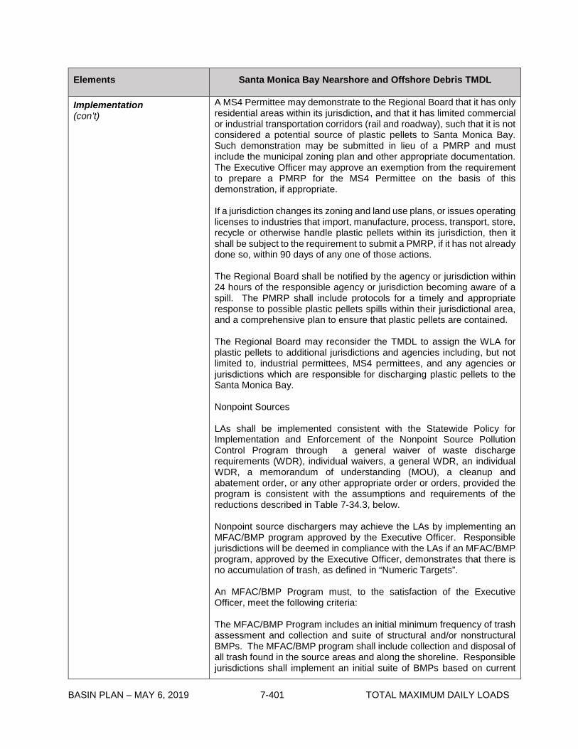
BASIN PLAN – MAY 6, 2019 7-401 TOTAL MAXIMUM DAILY LOADS
Elements Santa Monica Bay Nearshore and Offshore Debris TMDL
Implementation (con’t)
A MS4 Permittee may demonstrate to the Regional Board that it has only residential areas within its jurisdiction, and that it has limited commercial or industrial transportation corridors (rail and roadway), such that it is not considered a potential source of plastic pellets to Santa Monica Bay. Such demonstration may be submitted in lieu of a PMRP and must include the municipal zoning plan and other appropriate documentation. The Executive Officer may approve an exemption from the requirement to prepare a PMRP for the MS4 Permittee on the basis of this demonstration, if appropriate. If a jurisdiction changes its zoning and land use plans, or issues operating licenses to industries that import, manufacture, process, transport, store, recycle or otherwise handle plastic pellets within its jurisdiction, then it shall be subject to the requirement to submit a PMRP, if it has not already done so, within 90 days of any one of those actions. The Regional Board shall be notified by the agency or jurisdiction within 24 hours of the responsible agency or jurisdiction becoming aware of a spill. The PMRP shall include protocols for a timely and appropriate response to possible plastic pellets spills within their jurisdictional area, and a comprehensive plan to ensure that plastic pellets are contained. The Regional Board may reconsider the TMDL to assign the WLA for plastic pellets to additional jurisdictions and agencies including, but not limited to, industrial permittees, MS4 permittees, and any agencies or jurisdictions which are responsible for discharging plastic pellets to the Santa Monica Bay. Nonpoint Sources LAs shall be implemented consistent with the Statewide Policy for Implementation and Enforcement of the Nonpoint Source Pollution Control Program through a general waiver of waste discharge requirements (WDR), individual waivers, a general WDR, an individual WDR, a memorandum of understanding (MOU), a cleanup and abatement order, or any other appropriate order or orders, provided the program is consistent with the assumptions and requirements of the reductions described in Table 7-34.3, below. Nonpoint source dischargers may achieve the LAs by implementing an MFAC/BMP program approved by the Executive Officer. Responsible jurisdictions will be deemed in compliance with the LAs if an MFAC/BMP program, approved by the Executive Officer, demonstrates that there is no accumulation of trash, as defined in “Numeric Targets”. An MFAC/BMP Program must, to the satisfaction of the Executive Officer, meet the following criteria: The MFAC/BMP Program includes an initial minimum frequency of trash assessment and collection and suite of structural and/or nonstructural BMPs. The MFAC/BMP program shall include collection and disposal of all trash found in the source areas and along the shoreline. Responsible jurisdictions shall implement an initial suite of BMPs based on current

BASIN PLAN – MAY 6, 2019 7-402 TOTAL MAXIMUM DAILY LOADS
Elements Santa Monica Bay Nearshore and Offshore Debris TMDL
Implementation (con’t)
trash management practices in land areas that are found to be sources of trash to waterbodies within the Santa Monica Bay WMA and to Santa Monica Bay. Beaches and Harbors along Santa Monica Bay For beaches and harbors along Santa Monica Bay, the initial minimum frequency shall be set as follows: 1. The trash source areas of beaches and harbors shall be cleaned on a daily basis year round. 2. Trash on Santa Monica Bay shorelines shall be collected daily. An assessment shall immediately follow at the frequency specified in the TMRP. 3. The assessment performed immediately after the collection events shall focus on the shorelines or interface along Santa Monica Bay. 4. The protocol for conducting the assessment immediately after the collection event shall include methods and frequencies of assessment, specific locations on the beaches and harbors, in the TMRP. 5. Responsible jurisdictions for beaches and harbors shall conduct routine trash generation rate evaluation on the nonpoint source areas at selected beaches or harbors under their management. Protocols, as specified in the TMRP, for this evaluation include: i) The evaluation shall be performed in the late afternoon before dusk. Data collected may represent the daily trash quantity littered or deposited on the nonpoint source areas. ii) Methods, locations and frequencies of evaluation on the beaches and harbors shall be included in the TMRP. 6. Water in harbors shall be inspected and all trash found on the water shall be removed at a frequency and during critical conditions as defined in the approved TMRP. 7. Compliance for jurisdictions responsible for nonpoint source trash at areas where daily cleanup is implemented, is determined by the following conditions: i) The assessment conducted immediately after cleanup shall demonstrate that all trash on the shoreline or harbor is 100% removed and no trash remains. ii) Responsible jurisdictions for beaches and harbors where daily cleanup is performed, shall demonstrate that the trash generation rate of the source areas does not show an increasing trend and does not exceed the benchmark of 310 pounds (lbs) per mile of beach/harbor per day, or 113,150 lbs/mile/year. 8. Responsible jurisdictions shall initiate additional BMPs as specified in the TMRP, should trash amounts collected during evaluation at the source areas exceed 113,150 lbs/mile/year, or not indicate a decreasing trend. Non-Beach Open Space and Parks For open space and parks within the Santa Monica Bay WMA other than beaches and harbors, the initial minimum frequency shall be as follows:

BASIN PLAN – MAY 6, 2019 7-403 TOTAL MAXIMUM DAILY LOADS
Elements Santa Monica Bay Nearshore and Offshore Debris TMDL
Implementation (con’t)
Trash in open space and parks managed by responsible jurisdictions and agencies identified in the LA section of this table shall be 100% removed at each assessment and collection event as specified in the TMRP, within 72 hours after critical conditions, and immediately after special events when no safety hazards exist. The TMRP shall include protocols for trash assessment immediately after each cleanup event, assessment locations and frequencies. Compliance for jurisdictions responsible for open space and parks is determined by the following criteria: i) The assessment performed immediately after each cleanup event shall demonstrate that no trash remains. ii) The trash amount accumulated between cleanup events in open space and parks shall not exceed the LAs of 640 gallons per square mile per year (gal/mi2/yr), or 162,468 lbs/ mi2/yr, and shall show a decreasing trend. iii) Responsible jurisdictions shall increase the frequency of collection and/or implement additional BMPs, should trash amounts collected at cleanup events not indicate a decreasing trend. The MFAC/BMP Program includes assurances that it will be implemented by the responsible jurisdictions. The TMRP includes a MFAC/BMP Program, as described below, and a requirement that the responsible jurisdictions will self-report any non-compliance with its provisions. The results and report of the TMRP must be submitted to Regional Board on an annual basis. MFAC protocols may be based on SWAMP protocols for rapid trash assessment, or alternative protocols proposed by dischargers and approved by the Executive Officer of the Regional Board. Implementation of the MFAC/BMP program should include a Health and Safety Plan to protect personnel. The MFAC/BMP shall not require responsible jurisdictions to access and collect trash from areas where access by personnel is prohibited. The Executive Officer may approve or require a revised assessment and collection frequency and definition of the critical conditions: To prevent trash from accumulating in deleterious amounts that cause nuisance or adversely affect beneficial uses between collections; To reflect the results of trash assessment and collection; If the amount of trash collected does not show a decreasing trend, where necessary to prevent nuisance or adverse effects on beneficial uses, such that a shorter interval between collections is warranted; or If the amount of trash collected is decreasing such that a longer interval between collections is warranted.
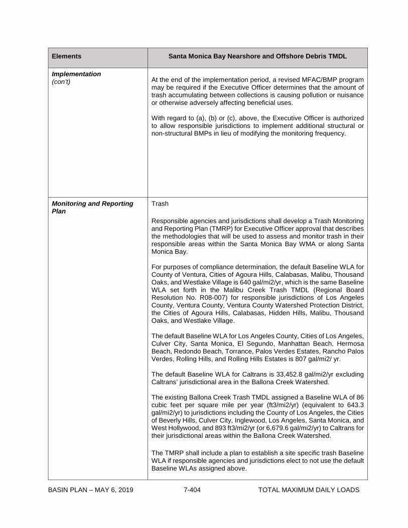
BASIN PLAN – MAY 6, 2019 7-404 TOTAL MAXIMUM DAILY LOADS
Elements Santa Monica Bay Nearshore and Offshore Debris TMDL
Implementation (con’t)
At the end of the implementation period, a revised MFAC/BMP program may be required if the Executive Officer determines that the amount of trash accumulating between collections is causing pollution or nuisance or otherwise adversely affecting beneficial uses. With regard to (a), (b) or (c), above, the Executive Officer is authorized to allow responsible jurisdictions to implement additional structural or non-structural BMPs in lieu of modifying the monitoring frequency.
Monitoring and Reporting Plan
Trash Responsible agencies and jurisdictions shall develop a Trash Monitoring and Reporting Plan (TMRP) for Executive Officer approval that describes the methodologies that will be used to assess and monitor trash in their responsible areas within the Santa Monica Bay WMA or along Santa Monica Bay. For purposes of compliance determination, the default Baseline WLA for County of Ventura, Cities of Agoura Hills, Calabasas, Malibu, Thousand Oaks, and Westlake Village is 640 gal/mi2/yr, which is the same Baseline WLA set forth in the Malibu Creek Trash TMDL (Regional Board Resolution No. R08-007) for responsible jurisdictions of Los Angeles County, Ventura County, Ventura County Watershed Protection District, the Cities of Agoura Hills, Calabasas, Hidden Hills, Malibu, Thousand Oaks, and Westlake Village. The default Baseline WLA for Los Angeles County, Cities of Los Angeles, Culver City, Santa Monica, El Segundo, Manhattan Beach, Hermosa Beach, Redondo Beach, Torrance, Palos Verdes Estates, Rancho Palos Verdes, Rolling Hills, and Rolling Hills Estates is 807 gal/mi2/ yr. The default Baseline WLA for Caltrans is 33,452.8 gal/mi2/yr excluding Caltrans’ jurisdictional area in the Ballona Creek Watershed. The existing Ballona Creek Trash TMDL assigned a Baseline WLA of 86 cubic feet per square mile per year (ft3/mi2/yr) (equivalent to 643.3 gal/mi2/yr) to jurisdictions including the County of Los Angeles, the Cities of Beverly Hills, Culver City, Inglewood, Los Angeles, Santa Monica, and West Hollywood, and 893 ft3/mi2/yr (or 6,679.6 gal/mi2/yr) to Caltrans for their jurisdictional areas within the Ballona Creek Watershed. The TMRP shall include a plan to establish a site specific trash Baseline WLA if responsible agencies and jurisdictions elect to not use the default Baseline WLAs assigned above.
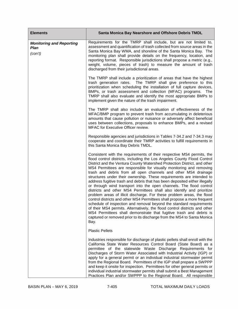
BASIN PLAN – MAY 6, 2019 7-405 TOTAL MAXIMUM DAILY LOADS
Elements Santa Monica Bay Nearshore and Offshore Debris TMDL
Monitoring and Reporting Plan (con’t)
Requirements for the TMRP shall include, but are not limited to, assessment and quantification of trash collected from source areas in the Santa Monica Bay WMA, and shoreline of the Santa Monica Bay. The monitoring plan shall provide details on the frequency, location, and reporting format. Responsible jurisdictions shall propose a metric (e.g., weight, volume, pieces of trash) to measure the amount of trash discharged from their jurisdictional areas. The TMRP shall include a prioritization of areas that have the highest trash generation rates. The TMRP shall give preference to this prioritization when scheduling the installation of full capture devices, BMPs, or trash assessment and collection (MFAC) programs. The TMRP shall also evaluate and identify the most appropriate BMPs to implement given the nature of the trash impairment. The TMRP shall also include an evaluation of effectiveness of the MFAC/BMP program to prevent trash from accumulating in deleterious amounts that cause pollution or nuisance or adversely affect beneficial uses between collections, proposals to enhance BMPs, and a revised MFAC for Executive Officer review. Responsible agencies and jurisdictions in Tables 7-34.2 and 7-34.3 may cooperate and coordinate their TMRP activities to fulfill requirements in this Santa Monica Bay Debris TMDL. Consistent with the requirements of their respective MS4 permits, the flood control districts, including the Los Angeles County Flood Control District and the Ventura County Watershed Protection District, and other MS4 Permittees are responsible for visually monitoring and removing trash and debris from all open channels and other MS4 drainage structures under their ownership. These requirements are intended to address fugitive trash and debris that has been deposited either illegally or through wind transport into the open channels. The flood control districts and other MS4 Permittees shall also identify and prioritize problem areas of illicit discharge. For these problem areas, the flood control districts and other MS4 Permittees shall propose a more frequent schedule of inspection and removal beyond the standard requirements of their MS4 permits. Alternatively, the flood control districts and other MS4 Permittees shall demonstrate that fugitive trash and debris is captured or removed prior to its discharge from the MS4 to Santa Monica Bay. Plastic Pellets Industries responsible for discharge of plastic pellets shall enroll with the California State Water Resources Control Board (State Board) as a permittee of the statewide Waste Discharge Requirements for Discharges of Storm Water Associated with Industrial Activity (IGP) or apply for a general permit or an individual industrial stormwater permit from the Regional Board. Permittees of the IGP shall prepare a SWPPP and keep it onsite for inspection. Permittees for other general permits or individual industrial stormwater permits shall submit a Best Management Practices Plan and/or SWPPP to the Regional Board. All responsible

BASIN PLAN – MAY 6, 2019 7-406 TOTAL MAXIMUM DAILY LOADS
Elements Santa Monica Bay Nearshore and Offshore Debris TMDL
Monitoring and Reporting Plan (con’t)
permittees as defined under the Waste Load Allocation section are required to prepare and submit annual monitoring reports with monitoring designed to ensure compliance with the assigned WLAs, to the Regional Board. The requirements for the monitoring report preparation shall be consistent with provisions specified in the IGP, any appropriate general permit, or individual industrial permit. MS4 permittees identified as responsible jurisdictions and agencies for point sources of trash in this Santa Monica Bay Debris TMDL and in the existing Malibu Creek and Ballona Creek Trash TMDLs, including the Los Angeles County Flood Control District and the Ventura County Watershed Protection District, shall either prepare a Plastic Pellet Monitoring and Reporting Plan (PMRP) , or demonstrate that a PMRP is not required under certain circumstances, as follows: Responsible jurisdictions that have industrial facilities or activities related to the manufacturing, handling, or transportation of plastic pellets within their jurisdiction shall prepare a PMRP to (i) monitor the amount of plastic pellets being discharged from the MS4 at critical locations and times (including, at a minimum, once during the dry season and once during the wet season); (ii) establish triggers for increased industrial facility inspections and enforcement of SWPPP requirements for industrial facilities identified as responsible for the plastic pellet WLA herein; and (iii) address possible plastic pellet spills. Responsible jurisdictions that have no industrial facilities or activities related to the manufacturing, handling, or transportation of plastic pellets, may not be required to conduct monitoring at MS4 outfalls, but shall be required to include a response plan in the PMRP. In order to be absolved of the requirement to conduct monitoring at MS4 out falls, documentation of the absence of industrial facilities and activities within the jurisdiction that are related to the manufacturing, handling and transportation of plastic pellets must be provided in the proposed PMRP. A MS4 Permittee may demonstrate to the Regional Board that it has only residential areas within its jurisdiction, and that it has limited commercial or industrial transportation corridors (rail and roadway), such that it is not considered a potential source of plastic pellets to Santa Monica Bay. Such demonstration may be submitted in lieu of a PMRP and must include the municipal zoning plan and other appropriate documentation. The Executive Officer may approve an exemption from the requirement to prepare a PMRP for the MS4 Permittee on the basis of this demonstration, if appropriate. The PMRP shall include protocols for a timely and appropriate response to possible plastic pellets spills within a Permittee’s jurisdictional area, and a comprehensive plan to ensure that plastic pellets are contained.

BASIN PLAN – MAY 6, 2019 7-407 TOTAL MAXIMUM DAILY LOADS
Table 7-34.2 Santa Monica Bay Nearshore and Offshore Debris TMDL: Implementation Schedule - Trash and Plastic Pellets from Point Sources
Task No.
Task Responsible Jurisdiction Date
1a Submit Trash Monitoring and Reporting Plan (TMRP), including a plan for defining the trash baseline WLA, a proposed definition of “major rain event” and “proper operation and maintenance”.
California Department of Transportation, Los Angeles County Flood Control District, Los Angeles County, Ventura County Watershed Protection District, County of Ventura, and Cities of Agoura Hills, Calabasas, Culver City, El Segundo, Hermosa Beach, Los Angeles, Malibu, Manhattan Beach, Palos Verdes Estates, Rancho Palos Verdes, Redondo Beach, Rolling Hills, Rolling Hills Estates, Santa Monica, and Torrance.
6 months from effective date of TMDL. If a plan is not approved by the Executive Officer within 9 months, the Executive Officer will establish appropriate monitoring plans.
1b Submit a Plastic Pellet Monitoring and Reporting Plan (PMRP) for monitoring plastic pellet discharges from the MS4, increased industrial facility inspections and enforcement, and response to possible plastic pellet spills, or a demonstration that a PMRP is not required7.
California Department of Transportation, Los Angeles County Flood Control District, Los Angeles County, Ventura County Watershed Protection District, County of Ventura, and Cities of Agoura Hills, Beverly Hills, Calabasas, Culver City, El Segundo, Hermosa Beach, Hidden Hills, Inglewood, Los Angeles, Malibu, Manhattan Beach, Palos Verdes Estates, Rancho Palos Verdes, Redondo Beach, Rolling Hills, Rolling Hills Estates, Santa Monica, Thousand Oaks, Torrance, West Hollywood, and Westlake Village.
18 months from effective date of this TMDL.
2a Implement TMRP. California Department of Transportation, Los Angeles County Flood Control District, Los Angeles County, Ventura County Watershed Protection District, County of Ventura, and Cities of Agoura Hills, Calabasas, Culver City, El Segundo, Hermosa Beach, Los Angeles, Malibu, Manhattan Beach, Palos Verdes Estates, Rancho Palos Verdes, Redondo Beach, Rolling Hills, Rolling Hills Estates, Santa Monica, and Torrance.
6 months from receipt of letter of approval from Regional Board Executive Officer, or the date a plan is established by the Executive Officer.
5 The responsible jurisdictions and agencies shall provide documentation as specified in Table 7-34.1.
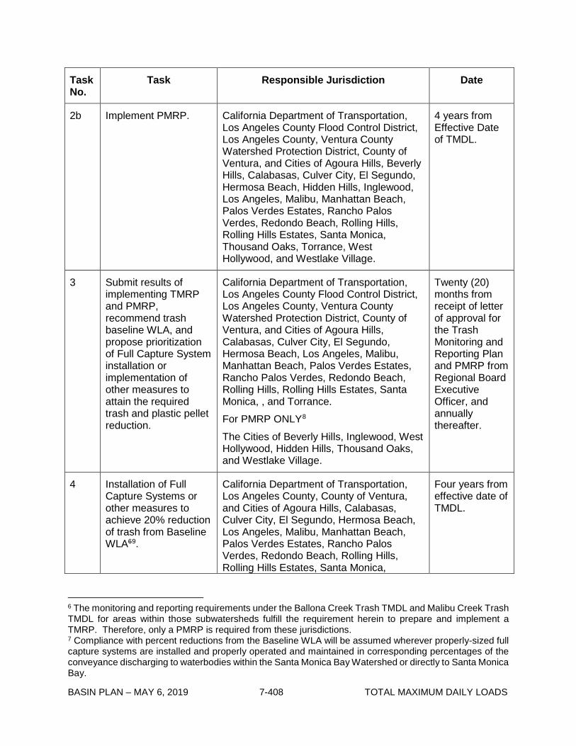
BASIN PLAN – MAY 6, 2019 7-408 TOTAL MAXIMUM DAILY LOADS
Task No.
Task Responsible Jurisdiction Date
2b Implement PMRP. California Department of Transportation, Los Angeles County Flood Control District, Los Angeles County, Ventura County Watershed Protection District, County of Ventura, and Cities of Agoura Hills, Beverly Hills, Calabasas, Culver City, El Segundo, Hermosa Beach, Hidden Hills, Inglewood, Los Angeles, Malibu, Manhattan Beach, Palos Verdes Estates, Rancho Palos Verdes, Redondo Beach, Rolling Hills, Rolling Hills Estates, Santa Monica, Thousand Oaks, Torrance, West Hollywood, and Westlake Village.
4 years from Effective Date of TMDL.
3 Submit results of implementing TMRP and PMRP, recommend trash baseline WLA, and propose prioritization of Full Capture System installation or implementation of other measures to attain the required trash and plastic pellet reduction.
California Department of Transportation, Los Angeles County Flood Control District, Los Angeles County, Ventura County Watershed Protection District, County of Ventura, and Cities of Agoura Hills, Calabasas, Culver City, El Segundo, Hermosa Beach, Los Angeles, Malibu, Manhattan Beach, Palos Verdes Estates, Rancho Palos Verdes, Redondo Beach, Rolling Hills, Rolling Hills Estates, Santa Monica, , and Torrance. For PMRP ONLY8 The Cities of Beverly Hills, Inglewood, West Hollywood, Hidden Hills, Thousand Oaks, and Westlake Village.
Twenty (20) months from receipt of letter of approval for the Trash Monitoring and Reporting Plan and PMRP from Regional Board Executive Officer, and annually thereafter.
4 Installation of Full Capture Systems or other measures to achieve 20% reduction of trash from Baseline WLA69.
California Department of Transportation, Los Angeles County, County of Ventura, and Cities of Agoura Hills, Calabasas, Culver City, El Segundo, Hermosa Beach, Los Angeles, Malibu, Manhattan Beach, Palos Verdes Estates, Rancho Palos Verdes, Redondo Beach, Rolling Hills, Rolling Hills Estates, Santa Monica,
Four years from effective date of TMDL.
6 The monitoring and reporting requirements under the Ballona Creek Trash TMDL and Malibu Creek Trash TMDL for areas within those subwatersheds fulfill the requirement herein to prepare and implement a TMRP. Therefore, only a PMRP is required from these jurisdictions. 7 Compliance with percent reductions from the Baseline WLA will be assumed wherever properly-sized full capture systems are installed and properly operated and maintained in corresponding percentages of the conveyance discharging to waterbodies within the Santa Monica Bay Watershed or directly to Santa Monica Bay.

BASIN PLAN – MAY 6, 2019 7-409 TOTAL MAXIMUM DAILY LOADS
Task No.
Task Responsible Jurisdiction Date
Thousand Oaks, Torrance, and Westlake Village.710
5
Installation of Full Capture Systems or other measures to achieve 40% reduction of trash from Baseline WLA7.
California Department of Transportation, Los Angeles County, County of Ventura, and Cities of Agoura Hills, Calabasas, Culver City, El Segundo, Hermosa Beach, Los Angeles, Malibu, Manhattan Beach, Palos Verdes Estates, Rancho Palos Verdes, Redondo Beach, Rolling Hills, Rolling Hills Estates, Santa Monica, Thousand Oaks, Torrance, and Westlake Village.8
Five years from effective date of TMDL.
6 Compliance with General or Individual Industrial NPDES permit requirements to achieve the plastic pellet WLA.
Permittees of the Industrial Storm Water General Permit (NPDES Permit No. CAS 000001), other general permits, or individual industrial storm water permits for industrial activities with SIC codes that may include, but are not limited to, 282X, 305X, 308X, 39XX, 25XX, 3261, 3357, 373X, 2893, or with the term “plastic” in the facility or operator name, regardless of SIC code.
Five years from the effective date of TMDL.
7 1. Evaluate the effectiveness of Full Capture Systems
Regional Board. Five years from effective date of TMDL.
8 Each responsible jurisdiction and agency, identified above, shall comply with the interim or final Waste Load Allocations for trash assigned to it and, therefore, should utilize all compliance strategies within its authority to achieve these allocations. Flood control districts, such as the Los Angeles County Flood Control District or Ventura County Watershed Protection District, may be held responsible with a jurisdiction and/or agency for non-compliance where the flood control district has either:
(i) without good cause denied necessary authority to a responsible jurisdiction or agency for the timely installation and/or maintenance of full and/or partial capture trash control devices for purposes of TMDL compliance in parts of the MS4 physical infrastructure that are under its authority, or
(ii) not fulfilled its obligations under its MS4 permit regarding proper BMP installation, operation and maintenance for purposes of TMDL compliance within the MS4 physical infrastructure under its authority,
thereby causing or contributing to a responsible jurisdiction and/or agency to be out of compliance with its interim or final Waste Load Allocations. Under these circumstances, the flood control district’s responsibility shall be limited to non-compliance related to the drainage area(s) within the jurisdiction where the flood control district has authority over the relevant portions of the MS4 physical infrastructure.

BASIN PLAN – MAY 6, 2019 7-410 TOTAL MAXIMUM DAILY LOADS
Task No.
Task Responsible Jurisdiction Date
or other measures to achieve trash WLA, 2. Evaluate BMPs implemented at industrial facilities for effectiveness in achieving plastic pellet WLA, 3. Reconsider the trash and plastic pellet WLAs, if warranted.
8
Installation of Full Capture Systems or other measures to achieve 60% reduction of trash from Baseline WLA7.
California Department of Transportation, Los Angeles County, County of Ventura, and Cities of Agoura Hills, Calabasas, Culver City, El Segundo, Hermosa Beach, Los Angeles, Malibu, Manhattan Beach, Palos Verdes Estates, Rancho Palos Verdes, Redondo Beach, Rolling Hills, Rolling Hills Estates, Santa Monica, Thousand Oaks, Torrance, and Westlake Village.8
Six years from effective date of TMDL.
9
Installation of Full Capture Systems or other measures to achieve 80% reduction of trash from Baseline WLA7.
California Department of Transportation, Los Angeles County, County of Ventura, and Cities of Agoura Hills, Calabasas, Culver City, El Segundo, Hermosa Beach, Los Angeles, Malibu, Manhattan Beach, Palos Verdes Estates, Rancho Palos Verdes, Redondo Beach, Rolling Hills, Rolling Hills Estates, Santa Monica, Thousand Oaks, Torrance, and Westlake Village.8
Seven years from effective date of TMDL.
10
Installation of Full Capture Systems or other measures to achieve 100% reduction of trash from Baseline WLA7.
California Department of Transportation, Los Angeles County, County of Ventura, and Cities of Agoura Hills, Calabasas, Culver City, El Segundo, Hermosa Beach, Los Angeles, Malibu, Manhattan Beach, Palos Verdes Estates, Rancho Palos Verdes, Redondo Beach, Rolling Hills, Rolling Hills Estates, Santa Monica, Thousand Oaks, Torrance, and Westlake Village.8
Eight years from effective date of TMDL.

BASIN PLAN – MAY 6, 2019 7-411 TOTAL MAXIMUM DAILY LOADS
Task No.
Task Responsible Jurisdiction Date
11 If within three (3) years of Regional Board adoption date of this TMDL, a city or county voluntarily adopts local ordinances to ban plastic bags, smoking in public places and single use expanded polystyrene food packaging, it shall receive a three-year extension of the final compliance date.
California Department of Transportation, Los Angeles County Flood Control District, Los Angeles County, Ventura County Watershed Protection District, County of Ventura, and Cities of Agoura Hills, Beverly Hills, Calabasas, Culver City, El Segundo, Hermosa Beach, Hidden Hills, Inglewood, Los Angeles, Malibu, Manhattan Beach, Palos Verdes Estates, Rancho Palos Verdes, Redondo Beach, Rolling Hills, Rolling Hills Estates, Santa Monica, Thousand Oaks, Torrance, West Hollywood, and Westlake Village.
11 years from effective date of TMDL.

BASIN PLAN – MAY 6, 2019 7-412 TOTAL MAXIMUM DAILY LOADS
Table 7-34.3 Santa Monica Bay Nearshore and Offshore Debris TMDL: Implementation Schedule Minimum Frequency of Assessment and Collection Program811 - Trash from Nonpoint Sources
Task No.
Task Responsible Jurisdiction Date
1 Submit a TMRP including an MFAC/BMP Program.
National Park Service, California Department of Parks and Recreation, County of Los Angeles, County of Ventura, State Lands Commission for open space and parks, and California Department of Parks and Recreation, Los Angeles County Department of Beaches and Harbors, Cities of Hermosa Beach, Los Angeles, Santa Monica and Redondo Beach for beaches and harbors.
Six months from TMDL effective date. If a plan is not approved by the Executive Officer within 9 months, the Executive Officer will establish an appropriate monitoring plan.
2 Implement the TMRP and the MFAC/BMP Program.
National Park Service, California Department of Parks and Recreation, County of Los Angeles, County of Ventura, State Lands Commission for open space and parks, and California Department of Parks and Recreation, Los Angeles County Department of Beaches and Harbors, Cities of Hermosa Beach, Los Angeles, Santa Monica and Redondo Beach for beaches and harbors.
6 months from receipt of letter of approval from Regional Board Executive Officer, or the date a plan is established by the Executive Officer.
3 Achieve LA immediately after each collection and assessment event.
National Park Service, California Department of Parks and Recreation, County of Los Angeles, County of Ventura, State Lands Commission for open space and parks, and California Department of Parks and Recreation, Los Angeles County Department of Beaches and Harbors, Cities of Hermosa Beach, Los Angeles, Santa Monica and Redondo Beach for beaches and harbors.
6 months from receipt of letter of approval from Regional Board Executive Officer, or the date a plan is established by the Executive Officer.
4 Submit annual TMRP reports including proposal
National Park Service, California Department of Parks and Recreation, County of Los Angeles, County of
Twenty (20) months from receipt of letter of approval for the
9 Based on annual reports, the Executive Officer may adjust the minimum frequency of assessment and collection as necessary to ensure compliance between the required trash assessment and collection events.

BASIN PLAN – MAY 6, 2019 7-413 TOTAL MAXIMUM DAILY LOADS
Task No.
Task Responsible Jurisdiction Date
for revising MFAC/BMP for Executive Officer approval.
Ventura, State Lands Commission for open space and parks, and California Department of Parks and Recreation, Los Angeles County Department of Beaches and Harbors, Cities of Hermosa Beach, Los Angeles, Santa Monica and Redondo Beach for beaches and harbors.
Trash Monitoring and Reporting Plan from Regional Board Executive Officer, and annually thereafter.
5 Demonstrate full compliance by achieving LA between required trash collection and assessment events.
National Park Service, California Department of Parks and Recreation, County of Los Angeles, County of Ventura, State Lands Commission for open space and parks, and California Department of Parks and Recreation, Los Angeles County Department of Beaches and Harbors, Cities of Hermosa Beach, Los Angeles, Santa Monica and Redondo Beach for beaches and harbors.
Five years from effective date of TMDL.
6
Reconsider the TMDL based on evaluation of effectiveness of MFAC/BMP program, if warranted.
Regional Board. Five years from effective date of TMDL.
7 If within three (3) years of Regional Board adoption date of this TMDL, a city or county voluntarily adopts local ordinances to ban plastic bags, smoking in public places and single use expanded polystyrene food packaging, it shall receive a three-year extension of the final compliance date.
National Park Service, California Department of Parks and Recreation, County of Los Angeles, County of Ventura, State Lands Commission for open space and parks, and California Department of Parks and Recreation, Los Angeles County Department of Beaches and Harbors, Cities of Hermosa Beach, Los Angeles, Santa Monica and Redondo Beach for beaches and harbors.
Eight (8) years from effective date of TMDL.

BASIN PLAN – MAY 6, 2019 7-414 TOTAL MAXIMUM DAILY LOADS
This page intentionally left blank

BASIN PLAN – MAY 6, 2019 7-415 TOTAL MAXIMUM DAILY LOADS
7-35 Ventura River and Tributaries Algae, Eutrophic Conditions, and Nutrients TMDL This TMDL was adopted by:
The Regional Water Quality Control Board on December 6, 2012.
This TMDL was approved by:
The State Water Resources Control Board on February 19, 2013 The Office of Administrative Law on June 4, 2013 The U.S. Environmental Protection Agency on June 28, 2013
This TMDL is effective on June 28, 2013
The elements of the TMDL are presented in Table 7-35.1 and the Implementation Plan in Table
7-35.2.
Table 7-35.1. Ventura River and Tributaries Algae, Eutrophic Conditions, and Nutrients TMDL: Elements
TMDL Element Regulatory Provisions
Problem Statement
The Ventura River Estuary and Reaches 1 and 2 are on the Clean Water Act (CWA) section 303(d) list as impaired for algae and eutrophic conditions. San Antonio Creek and Cañada Larga are on the CWA section 303(d) list as impaired for nitrogen and dissolved oxygen, respectively. Recent data confirm these impairments and demonstrate additional impairments for low dissolved oxygen in the Estuary, San Antonio Creek, and Reaches 1-4. The algae and nutrient-related impairments are caused by excessive loading of nutrients, particularly nitrogen and phosphorus, to Ventura River and its tributaries. The water quality impairments due to eutrophication and increased nutrient loading occur during the dry season when algae growth primarily occurs. For purposes related to this TMDL, the dry season is defined as occurring from May 1 to September 30. The water quality objectives used to assess impairment for this TMDL are the narrative water quality objective for biostimulatory substances and the numeric water quality objectives for dissolved oxygen (DO) and pH contained in Chapter 3. Nutrient loading and the resulting ecological responses in the Ventura River, including the Estuary, and its tributaries result in impairments of beneficial uses associated with recreation activities (water contact and non-contact) and aquatic life (warm and cold freshwater habitat; estuarine and wetland habitat; rare, threatened or endangered species; migration of aquatic organisms; spawning, reproduction, and/or early development). The most sensitive beneficial use is the cold water aquatic habitat use and the associated migratory and spawning and early development uses. The Ventura River and its tributaries are home to the Southern California Steelhead, which is an endangered species.
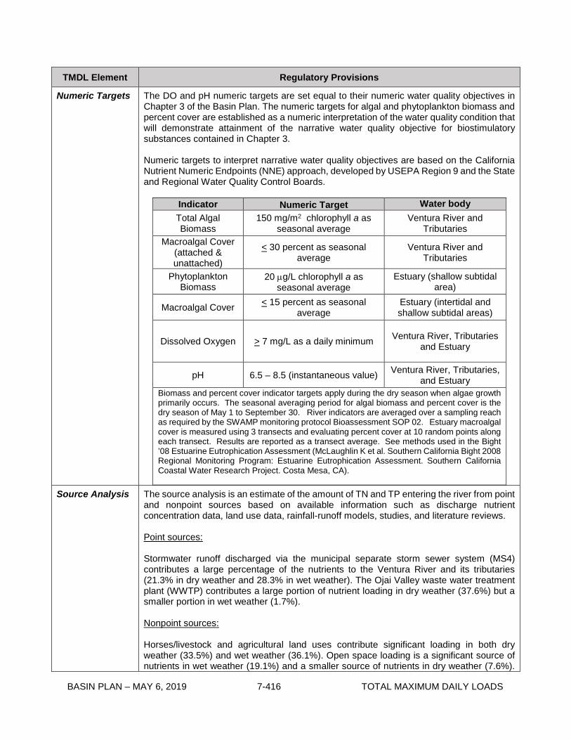
BASIN PLAN – MAY 6, 2019 7-416 TOTAL MAXIMUM DAILY LOADS
TMDL Element Regulatory Provisions
Numeric Targets The DO and pH numeric targets are set equal to their numeric water quality objectives in Chapter 3 of the Basin Plan. The numeric targets for algal and phytoplankton biomass and percent cover are established as a numeric interpretation of the water quality condition that will demonstrate attainment of the narrative water quality objective for biostimulatory substances contained in Chapter 3. Numeric targets to interpret narrative water quality objectives are based on the California Nutrient Numeric Endpoints (NNE) approach, developed by USEPA Region 9 and the State and Regional Water Quality Control Boards.
Indicator Numeric Target Water body Total Algal Biomass
150 mg/m2 chlorophyll a as seasonal average
Ventura River and Tributaries
Macroalgal Cover (attached & unattached)
< 30 percent as seasonal average
Ventura River and Tributaries
Phytoplankton Biomass
20 µg/L chlorophyll a as seasonal average
Estuary (shallow subtidal area)
Macroalgal Cover < 15 percent as seasonal average
Estuary (intertidal and shallow subtidal areas)
Dissolved Oxygen > 7 mg/L as a daily minimum Ventura River, Tributaries and Estuary
pH 6.5 – 8.5 (instantaneous value) Ventura River, Tributaries, and Estuary
Biomass and percent cover indicator targets apply during the dry season when algae growth primarily occurs. The seasonal averaging period for algal biomass and percent cover is the dry season of May 1 to September 30. River indicators are averaged over a sampling reach as required by the SWAMP monitoring protocol Bioassessment SOP 02. Estuary macroalgal cover is measured using 3 transects and evaluating percent cover at 10 random points along each transect. Results are reported as a transect average. See methods used in the Bight ’08 Estuarine Eutrophication Assessment (McLaughlin K et al. Southern California Bight 2008 Regional Monitoring Program: Estuarine Eutrophication Assessment. Southern California Coastal Water Research Project. Costa Mesa, CA).
Source Analysis
The source analysis is an estimate of the amount of TN and TP entering the river from point and nonpoint sources based on available information such as discharge nutrient concentration data, land use data, rainfall-runoff models, studies, and literature reviews. Point sources: Stormwater runoff discharged via the municipal separate storm sewer system (MS4) contributes a large percentage of the nutrients to the Ventura River and its tributaries (21.3% in dry weather and 28.3% in wet weather). The Ojai Valley waste water treatment plant (WWTP) contributes a large portion of nutrient loading in dry weather (37.6%) but a smaller portion in wet weather (1.7%). Nonpoint sources: Horses/livestock and agricultural land uses contribute significant loading in both dry weather (33.5%) and wet weather (36.1%). Open space loading is a significant source of nutrients in wet weather (19.1%) and a smaller source of nutrients in dry weather (7.6%).

BASIN PLAN – MAY 6, 2019 7-417 TOTAL MAXIMUM DAILY LOADS
TMDL Element Regulatory Provisions
Source Analysis (con’t)
Septic systems are estimated to contribute 4.7% of the annual nutrient load. Groundwater discharge and direct atmospheric deposition to the water surface are responsible for a small portion of the annual load (1.3% and 0.2%, respectively).
Linkage Analysis The critical condition is the dry season and the linkage analysis for both the Ventura River and Estuary is for dry-weather conditions. Basing the linkage analysis on dry-weather conditions is a conservative approach to assessing conditions in the dry season. Nutrients are loaded from the watershed to the Ventura River and Estuary in both dry and wet weather, but the nutrients loaded in the dry season are predominately responsible for the algae, eutrophic conditions, and nutrient impairments in the Ventura River and Estuary. Linkage analysis for the river The linkage analysis for the river is based on the River and Stream Water Quality Model (QUAL2K). QUAL2K predicts the nutrient concentrations and algal biomass in the various reaches of the Ventura River based on an estimate of watershed-based loading. The results of the model are used to determine allowable in-stream nutrient concentrations to meet algal biomass targets and to evaluate various source reduction scenarios to set dry-weather load and waste load allocations. Linkage analysis for the Estuary The linkage analysis for the Estuary is based on two lines of evidence that establish the relationship between nutrient loading to the Estuary and the resulting nutrient concentrations and algal biomass in the Estuary. The first approach uses the NNE BATHTUB spreadsheet modeling tool to establish the linkage between nutrient loading to the Estuary and the predicted water quality response, assuming that the open water portion of the Estuary, formed by the closing of the berm in the late summer and early fall, acts like a freshwater reservoir. The second approach uses empirical relationships between nutrient loading and algal biomass (peak macroalgae biomass and annual average chlorophyll a) in estuaries developed as part of a 2008 Southern California Bight Regional Monitoring Program study. Both approaches predict that the current nutrient loading to the Estuary will attain the phytoplankton numeric target. Moreover, the watershed loading reductions required to protect the river will reduce nutrient concentrations delivered to the Estuary and ensure attainment of numeric targets and protection of beneficial uses.

BASIN PLAN – MAY 6, 2019 7-418 TOTAL MAXIMUM DAILY LOADS
TMDL Element Regulatory Provisions
Allocations
Waste load allocations (WLAs) and load allocations (LAs) addressing point and nonpoint sources of nutrients are assigned to discharges to the Ventura River watershed. Because the critical condition for this TMDL is dry weather, and it is the dry-weather loading that results in water quality impairments, the allocations are primarily focused on dry-weather nutrient loading reductions. However, wet-weather WLAs and LAs are assigned as well. Dry-weather Allocations The dry-weather WLAs for Ojai Valley WWTP are expressed as seasonal loads. The TN WLA is expressed as a summer dry-weather load based on an estimated 153 summer dry-weather days and a winter dry-weather load based on an estimated 178 winter dry-weather days. The TP WLA is expressed as a dry-weather load based on an estimated 331 dry-weather days. Dry-weather WLAs for the Ojai Valley WWTP are as follows:
Summer Dry-Weather TN WLA
(lb/season)
Winter Dry-Weather TN WLA (lb/season)
Dry-Weather TP WLA
(lb/season)
8,044 12,477 5,799
At the TMDL reconsideration, the Ojai Valley WWTP allocation may be revised (i.e. increased) if the Ojai WWTP has accepted additional flows from other watershed sources such as septic systems in order to achieve the TMDL. The Ojai WWTP will document and report annually the number, flow and TN load from watershed sources for the Regional Board to consider as part of the TMDL reconsideration. Dry-weather WLAs for Ventura County MS4 and Caltrans are expressed as daily loads based on an estimated 331 dry-weather days per year. Dry-weather WLAs for Ventura County MS4 and Caltrans are as follows:
Source Type Dry-Weather WLA (lb/day)
Dry-Weather TP WLA (lb/day)
Dry-weather WLAs for Ventura MS4 28 0.5
Dry-weather WLAs for Caltrans 1.1 0.11
The dry-weather WLAs for the general industrial and construction stormwater permittees are equal to the in-stream nutrient concentrations required to meet algal biomass numeric targets. Dry-weather WLAs for general industrial and construction stormwater permittees are as follows:
Permittee TN (mg/L) TP (mg/L) General Industrial Stormwater Permittees 1.15 0.115
General Construction Stormwater Permittees 1.15 0.115
Applied as an annual dry-weather average.
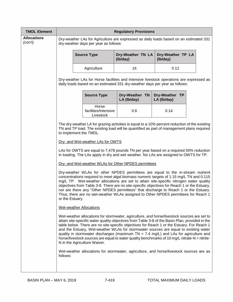
BASIN PLAN – MAY 6, 2019 7-419 TOTAL MAXIMUM DAILY LOADS
TMDL Element Regulatory Provisions Allocations (con’t)
Dry-weather LAs for Agriculture are expressed as daily loads based on an estimated 331 dry-weather days per year as follows:
Source Type Dry-Weather TN LA (lb/day)
Dry-Weather TP LA (lb/day)
Agriculture 16 0.12
Dry-weather LAs for Horse facilities and intensive livestock operations are expressed as daily loads based on an estimated 331 dry-weather days per year as follows:
Source Type Dry-Weather TN LA (lb/day)
Dry-Weather TP LA (lb/day)
Horse facilities/Intensive
Livestock 0.6 0.14
The dry-weather LA for grazing activities is equal to a 10% percent reduction of the existing TN and TP load. The existing load will be quantified as part of management plans required to implement the TMDL. Dry- and Wet-weather LAs for OWTS LAs for OWTS are equal to 7,478 pounds TN per year based on a required 50% reduction in loading. The LAs apply in dry and wet weather. No LAs are assigned to OWTS for TP. Dry- and Wet-weather WLAs for Other NPDES permittees Dry-weather WLAs for other NPDES permittees are equal to the in-stream nutrient concentrations required to meet algal biomass numeric targets of 1.15 mg/L TN and 0.115 mg/L TP. Wet-weather allocations are set to attain site-specific nitrogen water quality objectives from Table 3-8. There are no site-specific objectives for Reach 1 or the Estuary, nor are there any “Other NPDES permittees” that discharge to Reach 1 or the Estuary. Thus, there are no wet-weather WLAs assigned to Other NPDES permittees for Reach 1 or the Estuary. Wet-weather Allocations Wet-weather allocations for stormwater, agriculture, and horse/livestock sources are set to attain site-specific water quality objectives from Table 3-8 of the Basin Plan, provided in the table below. There are no site-specific objectives for Reach 1 or the Estuary. For Reach 1 and the Estuary, Wet-weather WLAs for stormwater sources are equal to existing water quality in stormwater discharges (maximum TN = 7.4 mg/L) and LAs for agriculture and horse/livestock sources are equal to water quality benchmarks of 10 mg/L nitrate-N + nitrite-N in the Agriculture Waiver. Wet-weather allocations for stormwater, agriculture, and horse/livestock sources are as follows:

BASIN PLAN – MAY 6, 2019 7-420 TOTAL MAXIMUM DAILY LOADS
TMDL Element Regulatory Provisions Allocations (con’t)
Reach Nitrate-N + Nitrite-
N (mg/L)
Estuary *
Reach 1 *
Reach 2 10
Cañada Larga 10
Reach 3 5
San Antonio Creek 5
Reach 4 5
Reach 5 5
*WLAs for stormwater are equal to 7.4 mg/ L TN and LAs for agriculture and horse/livestock sources are equal to 10 mg/L nitrate-N + nitrite-N. Wet-weather WLAs for the Ojai Valley WWTP are based on existing performance of the facility. Existing performance was calculated as the 90th percentile of the last 12 years of effluent data. Wet-weather WLAs for Ojai Valley WWTP
TN (mg/L) TP (mg/L)
7.6 2.6
Margin of Safety The sources of uncertainty in this TMDL are related to the selection of the algal biomass target, the relationship between nutrient concentrations and algal biomass in freshwater river systems and estuaries, the estimate of watershed-based nutrient loading, and the model-predicted water quality conditions in the receiving water. These areas of uncertainty are addressed with both an implicit margin of safety that includes conservative assumptions made when estimating watershed-based nutrient loading and the assignment of dry-weather allocations to address a dry-season impairment, and an explicit margin of safety calculated as the difference between the model-predicted maximum concentration in-stream after implementation of reduction scenarios and the desired in-stream concentrations. The explicit margin of safety was calculated as seven percent.

BASIN PLAN – MAY 6, 2019 7-421 TOTAL MAXIMUM DAILY LOADS
TMDL Element Regulatory Provisions
Seasonal Variations and Critical Conditions
This TMDL addresses impairments that are causing exceedances of the biostimulatory substances water quality objective during the dry season, when algae growth primarily occurs, in the Ventura River, the Estuary and its tributaries. The critical condition is the dry season. Nutrients are loaded from the watershed to the Ventura River and its tributaries, and the Estuary in both dry and wet weather, but the nutrients loaded in the dry season are predominately responsible for the algae, eutrophic conditions, and nutrient impairments. Nutrient concentrations present in the river during the winter months are sufficient to support algal growth; however, cofactors in the winter, such as greater flow and lower temperatures, mitigate algal growth in the winter. Also, the typical seasonal succession of primary producers generally shifts in the winter to be dominated by aquatic plants. The watershed nutrient wet-weather loads are generally delivered directly to the ocean and thus do not contribute to exceedance of the biostimulatory substances objective in the river or Estuary, which occurs during the dry season when algae growth primarily occurs. Nonetheless, to protect water quality year-round, wet-weather WLAs and LAs are assigned to meet water quality objectives and/or maintain existing discharge quality.
Monitoring
The TMDL monitoring program consists of three components: 1) receiving water monitoring, 2) discharge monitoring, and 3) optional special studies. All monitoring requirements may be included in subsequent permits or other orders and are subject to Executive Officer approval. Receiving Water Monitoring Responsible parties (Ojai Valley Sanitary District, Ventura County Watershed Protection District, Ventura County, City of Ojai, City of Ventura, Caltrans, and agricultural dischargers) are responsible for developing and implementing a comprehensive monitoring plan to assess numeric target attainment and measure in-stream nutrient concentrations. Responsible parties are encouraged to work together to submit a joint watershed wide plan. Ten years from the effective date of the TMDL, horse intensive livestock, and grazing activities shall participate in the implementation of the watershed-wide monitoring plan or submit their own plan. The monitoring plan should outline a program to sample for algal biomass, algal percent cover, nutrients (total and dissolved), in situ water quality parameters (dissolved oxygen, pH, temperature, electrical conductivity), and flow for the river and estuary. Monitoring should include visual observations documenting whether the Estuary is open or closed. The monitoring procedures/methods, analysis, and quality assurance shall be SWAMP comparable, where appropriate. The sampling frequency and locations must be adequate to assess beneficial use condition and attainment of applicable water quality objectives. At a minimum, for algal biomass and percent cover, the monitoring frequency shall be once per month in the dry season (May 1st to September 30th). After two years, if a significant difference between monthly algal biomass measurements is not observed, algal biomass monitoring may be reduced to three times per dry season, during the months of May, July, and September. DO and pH shall be measured continuously for two week periods on a quarterly basis. Continuous monitoring of DO and pH shall occur during the months of May and September in the 2nd and 3rd quarters. . All other parameters shall be monitored monthly. River indicators shall be averaged over a sampling reach as described in the SWAMP monitoring protocol - Bioassessment SOP 02. Estuary macroalgal cover is measured using three transects and evaluating percent cover at 10 random points along each transect. Results are reported as a transect average. See methods used in the Bight ’08 Estuarine Eutrophication Assessment (McLaughlin K et al. Southern California Bight 2008

BASIN PLAN – MAY 6, 2019 7-422 TOTAL MAXIMUM DAILY LOADS
TMDL Element Regulatory Provisions Monitoring (con’t)
Regional Monitoring Program: Estuarine Eutrophication Assessment. Southern California Coastal Water Research Project. Costa Mesa, CA). Existing receiving water monitoring conducted under other programs can be leveraged to assist in meeting these monitoring requirements. Responsible parties may build upon existing monitoring programs in the Ventura River watershed when developing the receiving water quality monitoring plan for this TMDL. Receiving water monitoring requirements shall be incorporated into the permit, waste discharge requirements (WDRs), or waiver for each responsible party upon issuance, renewal, or modification. The responsible parties may continue to coordinate a watershed-wide monitoring program to meet this requirement in order to fulfill individual permit, WDR, or waiver requirements. Receiving water monitoring shall continue beyond the final implementation date of the TMDL unless the Executive Officer approves a reduction or elimination of such monitoring. Discharge Monitoring Discharge monitoring will assess attainment of the WLAs and LAs. Discharge monitoring shall be required by regulatory mechanisms used to implement the WLAs and LAs. The monitoring to determine compliance with WLAs and LAs shall be conducted as specified in the Implementation Plan in the following section. The monitoring procedures/methods, analysis, and quality assurance shall be Surface Water Ambient Monitoring Program (SWAMP) comparable, where appropriate, and are subject to Executive Officer Approval. Special Studies Responsible parties within the watershed may conduct optional special studies designed to refine WLAs, LAs, and/or numeric targets. The results of special studies and monitoring may be used to revise numeric targets and allocations, if supported, when the TMDL is reconsidered. The following are potential special studies.
Build upon the algal biomass and total nitrogen relationship established in the 2008 UCSB Study (UCSB, 2009) and collect data to support the establishment of reach-specific relationships.
Confirm the conclusion that an algal biomass target of 150 mg/m2 is fully protective of aquatic life and minimizes the risk of low DO events.
Collect additional source assessment information and model input data to refine model-predicted relationships between watershed loading and in-stream nutrient concentrations.
Investigate the influence of OWTS on surface water quality. Collect data to support development of an estuary model, which takes into account
tidal influence, the dynamics of macroalgae and phytoplankton growth, residence time, and breaching conditions.
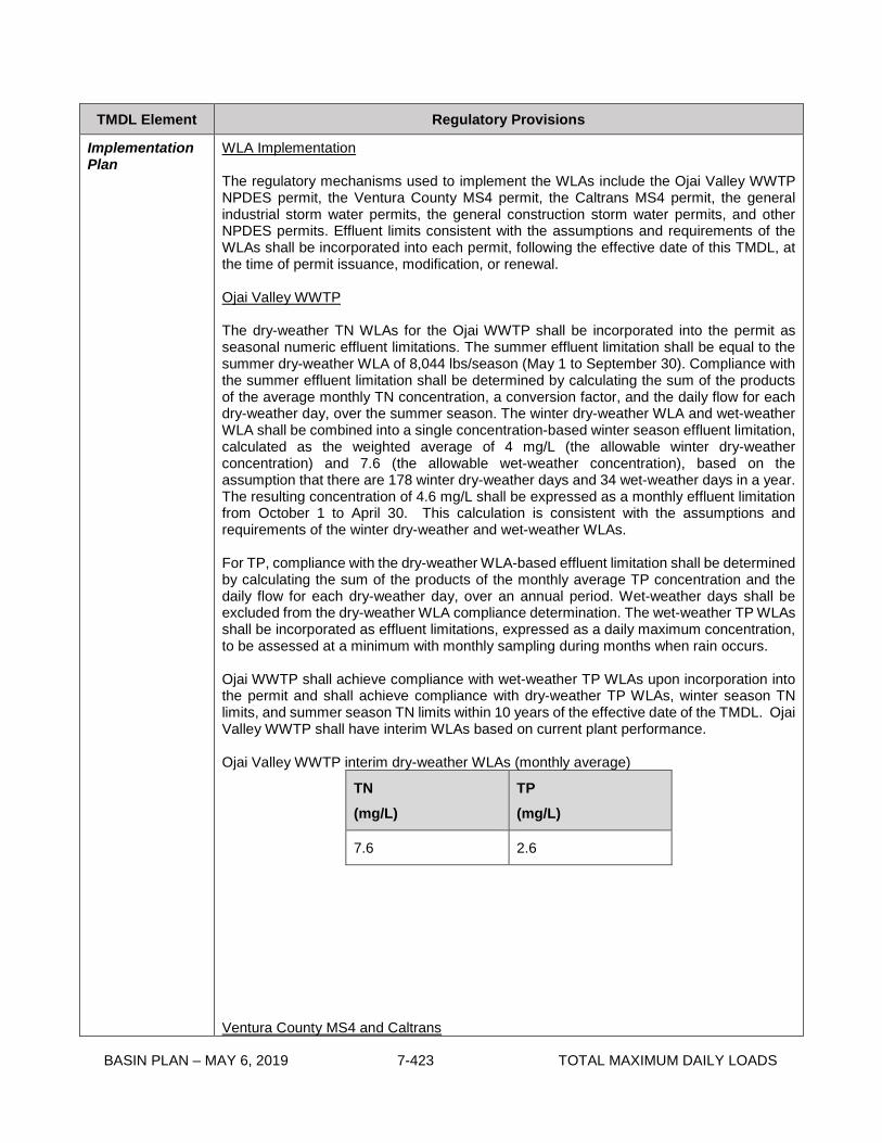
BASIN PLAN – MAY 6, 2019 7-423 TOTAL MAXIMUM DAILY LOADS
TMDL Element Regulatory Provisions
Implementation Plan
WLA Implementation The regulatory mechanisms used to implement the WLAs include the Ojai Valley WWTP NPDES permit, the Ventura County MS4 permit, the Caltrans MS4 permit, the general industrial storm water permits, the general construction storm water permits, and other NPDES permits. Effluent limits consistent with the assumptions and requirements of the WLAs shall be incorporated into each permit, following the effective date of this TMDL, at the time of permit issuance, modification, or renewal. Ojai Valley WWTP The dry-weather TN WLAs for the Ojai WWTP shall be incorporated into the permit as seasonal numeric effluent limitations. The summer effluent limitation shall be equal to the summer dry-weather WLA of 8,044 lbs/season (May 1 to September 30). Compliance with the summer effluent limitation shall be determined by calculating the sum of the products of the average monthly TN concentration, a conversion factor, and the daily flow for each dry-weather day, over the summer season. The winter dry-weather WLA and wet-weather WLA shall be combined into a single concentration-based winter season effluent limitation, calculated as the weighted average of 4 mg/L (the allowable winter dry-weather concentration) and 7.6 (the allowable wet-weather concentration), based on the assumption that there are 178 winter dry-weather days and 34 wet-weather days in a year. The resulting concentration of 4.6 mg/L shall be expressed as a monthly effluent limitation from October 1 to April 30. This calculation is consistent with the assumptions and requirements of the winter dry-weather and wet-weather WLAs. For TP, compliance with the dry-weather WLA-based effluent limitation shall be determined by calculating the sum of the products of the monthly average TP concentration and the daily flow for each dry-weather day, over an annual period. Wet-weather days shall be excluded from the dry-weather WLA compliance determination. The wet-weather TP WLAs shall be incorporated as effluent limitations, expressed as a daily maximum concentration, to be assessed at a minimum with monthly sampling during months when rain occurs. Ojai WWTP shall achieve compliance with wet-weather TP WLAs upon incorporation into the permit and shall achieve compliance with dry-weather TP WLAs, winter season TN limits, and summer season TN limits within 10 years of the effective date of the TMDL. Ojai Valley WWTP shall have interim WLAs based on current plant performance. Ojai Valley WWTP interim dry-weather WLAs (monthly average)
TN (mg/L)
TP (mg/L)
7.6 2.6
Ventura County MS4 and Caltrans

BASIN PLAN – MAY 6, 2019 7-424 TOTAL MAXIMUM DAILY LOADS
TMDL Element Regulatory Provisions Implementation Plan (con’t)
The WLAs for the Ventura County MS4 permittees and Caltrans shall be incorporated into the permits as numeric water quality-based effluent limitations. Permittees may be deemed in compliance with water-quality based effluent limitations if they demonstrate that (1) there are no violations of the water quality-based effluent limitation at the Permittee’s applicable MS4 outfall(s); or (2) there is no direct or indirect discharge from the Permittee’s MS4 to the receiving water during the time period subject to the water quality-based effluent limitation. Wet-weather numeric effluent limitations shall be expressed as event mean concentrations and shall apply immediately upon issuance, modification, or renewal of the permits. Compliance with wet-weather WLAs shall be assessed at a minimum with two wet-weather sampling events per year. If permittees provide a quantitative demonstration that watershed control measures and BMPs will achieve wet-weather water quality-based effluent limitations, then compliance with wet-weather water quality-based effluent limitations can be determined by implementing those actions, subject to Executive Officer approval. Dry-weather numeric effluent limitations shall be assessed at a minimum with quarterly sampling and shall be attained within 6 years of the effective date of the TMDL. Compliance will only be assessed on the day of sampling. Dry-weather sampling may occur 72 hours after a storm event. Consistent with the assumptions of the dry-weather waste load allocations, compliance with water quality-based effluent limitations may be demonstrated with area-weighted effluent limitations. Area-weighted effluent limitations shall be 0.0025 lb/day/acre TN and 4.7x10⁻⁵ lb/acre/day TP for the Ventura County MS4, and 0.0042 lb/acre/day TN and 4.2x10⁻⁴ lb/acre/day TP for Caltrans, derived by dividing the daily loads by the total land use area in the watershed covered by their respective permits (11,085 acres for the Ventura County MS4 and 251 acres for Caltrans, excluding the Coyote Creek subwatershed). Ventura County MS4 permittees and Caltrans shall provide an implementation plan to the Regional Board outlining how they intend to achieve compliance with the WLAs. The report shall include implementation methods and a quantitative analysis of the expected water quality outcomes of the implementation methods, an implementation schedule, proposed interim milestones, and compliance points. The report shall provide reasonable assurance that implementation methods will be sufficient to achieve the WLAs. General Industrial and Construction Stormwater Permittees The dry- and wet-weather WLAs for the general and industrial stormwater permittees shall apply immediately upon permit issuance, modification, or renewal and shall be incorporated into permits as numeric water quality-based effluent limitations. Wet-weather effluent limitations shall be expressed as event mean concentrations and dry-weather effluent limitations shall be expressed as instantaneous maximums. Compliance with wet-weather WLAs shall be assessed at a minimum with one wet-weather sampling event. Compliance with dry-weather WLAs shall be assessed at a minimum by averaging the results of two grab samples. Other NPDES Permittees The dry- and wet-weather WLAs for other NPDES permittees shall apply immediately upon permit issuance, modification, or renewal of applicable permits and shall be incorporated into permits as numeric effluent limitations. Wet-weather effluent limitations shall be expressed as event mean concentrations and dry-weather effluent limitations shall be expressed as instantaneous maximums. Compliance with wet-weather WLAs shall be

BASIN PLAN – MAY 6, 2019 7-425 TOTAL MAXIMUM DAILY LOADS
TMDL Element Regulatory Provisions Implementation Plan (con’t)
assessed at a minimum with one wet-weather sampling event. Compliance with dry-weather WLAs shall be assessed at a minimum with two grab samples. LA Implementation The regulatory mechanisms that will be used to implement the LAs include Basin Plan discharge prohibitions, WDRs, and waivers of WDRs. Agricultural Discharges The LAs for irrigated agricultural lands shall be implemented through the Conditional Waiver of Waste Discharge Requirements for Discharges from Irrigated Lands or other appropriate Regional Board order. Agricultural lands shall achieve compliance with dry- and wet-weather LAs within 6 years of the effective date of the TMDL. To implement the LAs in this TMDL, the monitoring program shall be revised to add representative sites in the lower watershed to monitor runoff from other crop types. In addition, VCAILG shall work with the Regional Board staff to relocate monitoring sites in the upper watershed to better assess potential dry-weather runoff from agriculture. The existing monitoring program for the Agriculture Waiver requires two dry-weather and two wet-weather sampling events. In order to implement the dry-weather LAs, dry-weather sampling may occur 72 hours after a storm event. The revised monitoring program shall be subject to approval by the Executive Officer. To assist in implementation of LAs, area-weighted benchmarks can be applied; if used, they shall be 0.008 lb/day/acre TN and 6.3x10⁻⁵ lb/acre/day TP, derived by dividing the daily loads by the total agriculture area in the watershed (1971 acres, excluding orchards and the Coyote Creek subwatershed). Order No. 2010-0186 states, “It is expected that source control management practices, such as improved irrigation efficiency and fertilizer management, employed by Dischargers to attain surface Water Quality Benchmarks will reduce loading to groundwater as well.” To implement this TMDL, the VCAILG water quality management plan shall specify that all growers in the Ventura River watershed shall implement nutrient-related source control BMPs. If the LAs are implemented in another Regional Board order in the future, then that order shall require growers in the Ventura River watershed to implement nutrient-related source control BMPs. The estimated costs for BMPs to control agricultural discharges such as filter strips, mulching, improved irrigation efficiency, nutrient management, manure management, and grazing management are approximately $1031 per acre, $808 per acre, $1784 per acre, $55 per acre-year, $4,500 (average cost of manure bunker), and $1,356 (average cost of a typical watering facility), respectively. Potential sources of financing for these implementation alternatives, such as Clean Water Act section 319(h) grant funding, are discussed in Chapter 4. As discussed in Chapter 4, the U.S. Department of Agriculture Soil Conservation Service and the Resource Conservation Districts provide information on, and assistance in, implementing BMPs. OWTS The LAs for OWTS shall be implemented through discharge prohibitions, WDRs, or waivers of WDRs. Commercial and multifamily OWTS are currently regulated by the Regional Board through WDRs. Single family residential OWTS are currently regulated by the City of Ojai, the City of Ventura, and the County of Ventura, as specified in memorandums of

BASIN PLAN – MAY 6, 2019 7-426 TOTAL MAXIMUM DAILY LOADS
TMDL Element Regulatory Provisions Implementation Plan (con’t)
understanding (MOUs) with the Regional Board, in order to implement a waiver of WDRs for single family residential OWTS adopted by the Regional Board in 2004. The MOUs require the Regional Board to evaluate the local agency every five years to ensure their municipal plumbing code and OWTS program is substantially equivalent to any statewide standards adopted pursuant to California Water Code sections 13290 and 13291. The State Water Resources Control Board (State Board) Water Quality Control Policy for Siting, Design, Operation, and Maintenance of Onsite Wastewater Treatment Systems (OWTS Policy) was adopted by the State Board to comply with California Water Code sections 13290 and 13291 on June 19, 2012. The OWTS Policy must be approved by the Office of Administrative Law before it becomes final and in effect. The OWTS in the Ventura River watershed fall under Tier 3 of the OWTS policy and this TMDL establishes the Advanced Protection Management Program for the watershed. The geographic area for the Advanced Protection Management Programs to implement this TMDL shall initially be the entire Ventura River watershed. The Regional Board will work with local agencies to determine which existing OWTS or areas of OWTS are contributing to the overall loading from OWTS to the Ventura River and its tributaries. Areas found not to be contributing to the overall loading may be removed from the Advanced Protection Management Program as approved in a Local Agency Management Program. Existing OWTS are required to be upgraded or modified to enhance their nitrogen removal or meet other requirements of the Advanced Protection Management Program if it is determined they are contributing to the impairment, and are subsequently covered under approved special provisions of a Local Agency Management Program, or the Regional Board issues subsequent orders requiring upgrades or modifications. Existing OWTS will remain regulated by existing MOUs and future Local Agency Management Programs until the above determination is made and subsequent upgrades are required. New or replacement OWTS installations, as defined by the OWTS Policy upon its becoming effective, that are within the Advanced Protection Management Program area, shall meet the supplemental treatment requirements for nitrogen per Tier 3 of the OWTS Policy. The Regional Board will evaluate the existing MOUs and any future submittal of a Local Agency Management Program under the OWTS Policy with the City of Ventura, the City of Ojai, and the County of Ventura to determine if their OWTS programs need to be updated to reflect the OWTS Policy, or if additional changes are needed to implement the LAs. OWTS dischargers shall achieve compliance with dry- and wet-weather LAs within 10 years of the effective date of the TMDL. Horse and Intensive Livestock Activities The LAs for horse and intensive livestock activities shall be regulated by WDRs, waivers of WDRs, or other regulatory mechanisms in accordance with the Nonpoint Source Implementation and Enforcement Policy (NPS Policy). The Regional Board will determine which horse and intensive livestock activities shall be subject to the WDRs, waivers of WDRs or other regulatory mechanisms during their development based on factors that may include, but are not limited to, type of operation, density of animals, and risk to water quality. Horse and intensive livestock activities shall be required to develop management plans for Executive Officer approval and implement management measures identified in management plans to attain LAs. Compliance with LAs will be demonstrated with monitoring approved by the Executive Officer of the Regional Board through the monitoring program developed as part of the waiver, WDR, or other regulatory mechanism. Monitoring may consist of documentation of

BASIN PLAN – MAY 6, 2019 7-427 TOTAL MAXIMUM DAILY LOADS
TMDL Element Regulatory Provisions Implementation Plan (con’t)
BMP implementation, and may include water quality monitoring as needed. Horse and intensive livestock activities shall achieve compliance with dry- and wet-weather LAs within 10 years of the effective date of the TMDL. Grazing Activities The LAs for grazing activities shall be regulated by WDRs, waivers of WDRs, or other regulatory mechanisms in accordance with the NPS Policy. Because the dry-weather load from grazing activities has not been quantified as of the effective date of this TMDL, and dry-weather LAs are based on a 10% reduction of existing dry-weather load, grazing activities shall be required to either conduct monitoring or utilize other acceptable data or studies as approved by the Executive Officer to determine baseline dry-weather pollutant load caused by grazing activities, unless the Regional Board has already quantified the existing dry-weather pollutant load. In addition, grazing activities may conduct baseline monitoring to confirm wet-weather pollutant loading. Baseline monitoring shall be required by WDRs, waivers of WDRs, or other regulatory mechanism, if necessary. Baseline monitoring may consist of water quality monitoring of sites impacted by grazing and compared to water quality monitoring from unimpacted natural background sites. If it is determined that there are no water quality impacts due to dry- and/or wet-weather pollutant loading from grazing in the Ventura River watershed, then the TMDL may be revised to adjust the source assessment and allocation scenario when the TMDL is reconsidered. If it is determined that there are water quality impacts due to dry- and/or wet-weather pollutant loading from grazing in the Ventura River watershed, then grazing activities shall develop management plans for approval by the Executive Officer and implement management measures identified in management plans to attain LAs. Compliance with LAs will be demonstrated with monitoring approved by the Executive Officer of the Regional Board through the monitoring program developed as part of the waiver, WDR, or other regulatory mechanism. Monitoring may consist of documentation of no discharge due to BMP implementation, and may include water quality monitoring during conditions under which discharge may occur, including wet weather. Grazing activities shall achieve compliance with dry- and wet-weather LAs within 10 years of the effective date of the TMDL.

BASIN PLAN – MAY 6, 2019 7-428 TOTAL MAXIMUM DAILY LOADS
Table 7-35.2. Ventura River, Ventura River Estuary, and Tributaries Algae, Eutrophic Conditions and Nutrients TMDL: Implementation Schedule
Task Due Date Submit results of optional special studies 4 years after effective date of
TMDL Reconsider TMDL to revise numeric targets and allocations if supported by special studies or other changes in the watershed.
5 years after effective date of TMDL
Ojai Valley Sanitary District Wet-weather and interim dry-weather WLAs apply Effective date of TMDL
Submit receiving water monitoring plan to assess numeric target attainment and measure in-stream nutrient concentrations
1 year after effective date of TMDL
Initiate receiving water monitoring plan 90 days after approval of monitoring plan
Discharge monitoring plan incorporated into permit Upon permit adoption, renewal, or modification
Dry-weather WLA apply No later than 12 years after effective date of TMDL*
Ventura County MS4 Permittees and Caltrans Wet-weather WLAs apply Effective date of TMDL
Discharge monitoring plan incorporated into permit Upon permit adoption, renewal, or modification
Submit monitoring plan to assess numeric target attainment and measure in-stream nutrient concentrations.
1 year after effective date of TMDL
Initiate receiving water monitoring plan 90 days after approval of monitoring plan
Submit implementation plan to achieve compliance with the WLAs. The plan shall include implementation methods, an implementation schedule, proposed interim milestones, and compliance points.
2 years after effective date of TMDL
Dry-weather WLAs apply 6 years after effective date of TMDL
General Industrial and Construction Stormwater Permittees Wet-weather and dry-weather WLAs apply Effective date of TMDL
Discharge monitoring plan incorporated into permit Upon permit adoption, renewal, or modification
Other NPDES Permittees Wet-weather and dry-weather WLAs apply Effective date of TMDL
Discharge monitoring plan incorporated into permit Upon permit adoption, renewal, or modification

BASIN PLAN – MAY 6, 2019 7-429 TOTAL MAXIMUM DAILY LOADS
Agricultural Discharges Discharge monitoring plan incorporated into Agriculture Waiver or other order or waiver
Upon adoption, renewal, or modification
Submit monitoring plan to assess numeric target attainment and measure in-stream nutrient concentrations.
1 year after effective date of TMDL
Initiate receiving water monitoring plan 90 days after approval of monitoring plan
Wet-weather and dry-weather LAs apply 6 years after effective date of TMDL
Onsite Waste Water Treatment Systems Regional Board staff and Ventura County will work to determine areas of OWTS to be included in an Advanced Protection Management Program area and a plan for a 50 percent reduction of loading from OWTS in these areas
3 years from the effective date of the TMDL
Wet-weather and dry-weather LAs apply 10 years after effective date of TMDL
Horse/ Intensive Livestock Activities Discharge monitoring plan submitted as part of waiver, WDR, or other regulatory mechanism requirement or in response to Regional Board order
5 years after effective date of TMDL
Conduct receiving water monitoring to assess numeric target attainment and measure in-stream nutrient concentrations
10 years after effective date of TMDL
Wet-weather and dry-weather LAs apply 10 years after effective date of TMDL
Grazing Activities Baseline monitoring plan or acceptable existing data or studies to determine baseline dry-weather pollutant load submitted as part of waiver or WDR requirement or in response to Regional Board order, unless the Regional Board has quantified the existing pollutant load
2 years after effective date of TMDL
Results of baseline monitoring submitted, if necessary 18 months after approval of baseline monitoring plan
Discharge monitoring plan submitted as part of waiver, WDR, or other regulatory mechanism requirement or in response to Regional Board order
5 years after effective date of TMDL
Conduct receiving water monitoring to assess numeric target attainment and measure in-stream nutrient concentrations
10 years after effective date of TMDL
Wet-weather and dry-weather LAs apply 10 years after effective date of TMDL
* If TMDL reconsideration results in more stringent WLAs, then the implementation schedule for OVSD may be extended, if necessary, by only the amount of time required to upgrade treatment processes to meet the more stringent WLAs.

BASIN PLAN – MAY 6, 2019 7-430 TOTAL MAXIMUM DAILY LOADS
This page intentionally left blank

BASIN PLAN – MAY 6, 2019 7-431 TOTAL MAXIMUM DAILY LOADS
7-36 Santa Clara River Estuary and Reaches 3, 5, 6 and 7 Indicator Bacteria TMDL This TMDL was adopted by the Regional Water Quality Control Board on July 8, 2010.
This TMDL was approved by:
The State Water Resources Control Board on October 4, 2011. The Office of Administrative Law on December 19, 2011. The U.S. Environmental Protection Agency on January 13, 2012.
This TMDL is effective on March 21, 2012
The following tables include the elements of this TMDL.

BASIN PLAN – MAY 6, 2019 7-432 TOTAL MAXIMUM DAILY LOADS
Table 7-36.1 Santa Clara River Estuary and Reaches 3, 5, 6, and 7 Indicator Bacteria TMDL: Elements
Element Key Findings and Regulatory Provisions
Problem Statement Elevated bacterial indicator densities are causing impairment of the water contact recreation (REC-1) beneficial use designated for the Santa Clara River (SCR) Estuary and Reaches 3, 5, 6, and 7. Recreating in waters with elevated bacterial indicator densities has long been associated with adverse human health effects. Specifically, local and national epidemiological studies demonstrate that there is a causal relationship between adverse health effects and recreational water quality, as measured by bacterial indicator densities.
Numeric Target (Interpretation of the numeric water quality objective, used to calculate the waste load and load allocations)
The TMDL will have multi-part numeric targets based on the bacteria water quality objectives for marine and fresh waters designated for water contact recreation (REC-1) set forth in Chapter 3. Both single-sample and geometric mean objectives apply.
Numeric Targets SCR Estuary
(Marine REC-1)
SCR Reaches 3, 5, 6 and 7 (Freshwater REC-1)
Single Sample
E. coli
Fecal coliform
Enterococcus
Total coliform*
NA
400/100ml
104/100ml
10,000/100ml
235/100ml
NA
NA
NA
Geometric mean
E. coli
Fecal coliform
Enterococcus
Total coliform
NA
200/100ml
35/100ml
1,000/100ml
126/100ml
NA
NA
NA
*Total coliform density shall not exceed 1,000/100 ml, if the ratio of fecal-to-total coliform exceeds 0.1. NA: not applicable.
The Basin Plan objectives and these targets are based on an acceptable health risk for recreational waters of 8-19 illnesses per 1,000 exposed individuals, as recommended by the US EPA (USEPA, 1986). To implement the single sample bacteria objectives for waters designated REC-1, and to set allocations based on the single sample targets, an allowable number of exceedance days is set for marine and fresh waters. The numeric targets in the TMDL are expressed as ‘allowable exceedance days’ since bacterial density and the frequency of exceedances is most relevant to public health. The allowable number of exceedance days is based on the more stringent of two criteria (1) exceedance days in the designated reference system and (2) exceedance days based on historical bacteriological data in the subject reach. This ensures that bacteriological water quality is at

BASIN PLAN – MAY 6, 2019 7-433 TOTAL MAXIMUM DAILY LOADS
Element Key Findings and Regulatory Provisions
Numeric Target (con’t)
least as good as that of a largely undeveloped system and that there is no degradation of existing water quality. This approach recognizes that there are natural sources of bacteria that may cause or contribute to exceedances of the single sample objectives and that it is not the intent of the Regional Board to require treatment or diversion of natural creeks or to require treatment of natural sources of bacteria from undeveloped areas. For the single sample targets, the Estuary and Reaches 3, 5, 6, and 7 are assigned an allowable number of exceedance days for dry weather and wet weather (defined as days with 0.1 inch of rain or greater and the three days following the rain event) as set forth in Table 7-36.2 The geometric mean targets may not be exceeded at any time.
Source Analysis The significant contributors of bacteria loading to the SCR and Estuary are dry- and wet-weather urban runoff discharges from the storm water conveyance system. Mass emission data collected by MS4 Permittees show elevated levels of bacteria in the river. Data from natural landscapes in the region indicate that open space loading is not a significant source of bacteria. Data from storm drains and channels draining urban areas show elevated levels of bacteria, indicating that urban areas are a source. Data from throughout the Los Angeles Region further demonstrate that bacteria concentrations are significantly greater in developed areas. Based on this information, staff concludes that runoff from urban areas served by the storm drain system is a significant source of bacteria. Other point and nonpoint sources were analyzed and found to be less significant or there were not enough data to quantify their contribution. However, all sources are considered potential sources and are assigned allocations accordingly.
Waste Load Allocations (for point sources)
MS4 permittees are assigned wasteload allocations (WLAs) equal to allowable exceedances days listed in Table 7-36.2 and interim WLAs equal to allowable exceedance days listed in Table 7-36.3. Compliance with interim WLAs will be assessed using in-stream monitoring. Compliance with final WLAs will be assessed using both in-stream monitoring and outfall monitoring as described in the monitoring section. Permittees that discharge to Reaches 1 and 2 have WLAs based on allowable exceedance days for the Estuary. Permittees that discharge to Reach 3 or above have WLAs based on allowable exceedance days for Reaches 3, 5, 6, and 7. The WLAs for the Saugus water reclamation plant (WRP), Valencia WRP, Fillmore wastewater treatment plant (WTP), Santa Paula water reclamation facility (WRF), and Newhall WRP are set equal to a 7-day median of 2.2 MPN/100 mL of E. coli and a daily max of 235 MPN/100 mL of E. coli to ensure zero (0) allowable exceedance days. No exceedances of the geometric mean targets shall be permitted.
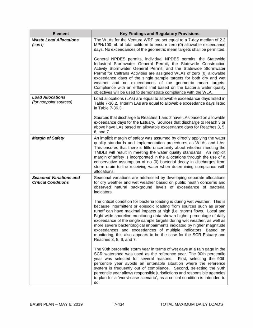
BASIN PLAN – MAY 6, 2019 7-434 TOTAL MAXIMUM DAILY LOADS
Element Key Findings and Regulatory Provisions Waste Load Allocations (con’t)
The WLAs for the Ventura WRF are set equal to a 7-day median of 2.2 MPN/100 mL of total coliform to ensure zero (0) allowable exceedance days. No exceedances of the geometric mean targets shall be permitted. General NPDES permits, individual NPDES permits, the Statewide Industrial Stormwater General Permit, the Statewide Construction Activity Stormwater General Permit, and the Statewide Stormwater Permit for Caltrans Activities are assigned WLAs of zero (0) allowable exceedance days of the single sample targets for both dry and wet weather and no exceedances of the geometric mean targets. Compliance with an effluent limit based on the bacteria water quality objectives will be used to demonstrate compliance with the WLA.
Load Allocations (for nonpoint sources)
Load allocations (LAs) are equal to allowable exceedance days listed in Table 7-36.2. Interim LAs are equal to allowable exceedance days listed in Table 7-36.3. Sources that discharge to Reaches 1 and 2 have LAs based on allowable exceedance days for the Estuary. Sources that discharge to Reach 3 or above have LAs based on allowable exceedance days for Reaches 3, 5, 6, and 7.
Margin of Safety An implicit margin of safety was assumed by directly applying the water quality standards and implementation procedures as WLAs and LAs. This ensures that there is little uncertainty about whether meeting the TMDLs will result in meeting the water quality standards. An implicit margin of safety is incorporated in the allocations through the use of a conservative assumption of no (0) bacterial decay in discharges from storm drain to the receiving water when determining compliance with allocations.
Seasonal Variations and Critical Conditions
Seasonal variations are addressed by developing separate allocations for dry weather and wet weather based on public health concerns and observed natural background levels of exceedance of bacterial indicators. The critical condition for bacteria loading is during wet weather. This is because intermittent or episodic loading from sources such as urban runoff can have maximal impacts at high (i.e. storm) flows. Local and Bight-wide shoreline monitoring data show a higher percentage of daily exceedance of the single sample targets during wet weather, as well as more severe bacteriological impairments indicated by higher magnitude exceedances and exceedances of multiple indicators. Based on monitoring, this also appears to be the case for the SCR Estuary and Reaches 3, 5, 6, and 7. The 90th percentile storm year in terms of wet days at a rain gage in the SCR watershed was used as the reference year. The 90th percentile year was selected for several reasons. First, selecting the 90th percentile year avoids an untenable situation where the reference system is frequently out of compliance. Second, selecting the 90th percentile year allows responsible jurisdictions and responsible agencies to plan for a ‘worst-case scenario’, as a critical condition is intended to do.

BASIN PLAN – MAY 6, 2019 7-435 TOTAL MAXIMUM DAILY LOADS
Element Key Findings and Regulatory Provisions
Implementation
The regulatory mechanisms used to implement the TMDL will include general NPDES permits, individual NPDES permits, MS4 Permits covering jurisdictions within the SCR watershed, the Statewide Industrial Storm Water General Permit, the Statewide Construction Activity Storm Water General Permit, the Statewide Stormwater Permit for Caltrans Activities, the Conditional Waiver for Irrigated Lands, WDRs, waivers of WDRs, the authority contained in Sections 13263, 13267, and 13269 of the Cal. Water Code, and other appropriate mechanisms. WLAs for point sources will be implemented through NPDES permits. Each NPDES permit assigned a WLA shall be reopened or amended at re-issuance, in accordance with applicable laws, to incorporate the assumptions and requirements of applicable WLAs as permit requirements. MS4 Permittees The cities of Santa Clarita, Fillmore, Santa Paula, and Ventura, and the Counties of Los Angeles and Ventura are responsible for MS4 WLAs. Cities and counties that have co-mingled storm water in the MS4 are jointly and severally responsible for meeting the WLAs assigned to MS4 discharges, unless the dischargers demonstrate that their discharges did not cause or contribute to the exceedances. Consistent with 40 C.F.R. § 122.26(a)(3)(vi), each co-permittee is only responsible for discharges from the municipal separate storm sewers for which they are operators. Responsible parties must provide an Implementation Plan to the Regional Board outlining how each intends to individually or cooperatively achieve compliance with the WLAs. The report shall include implementation methods, an implementation schedule, proposed milestones, and proposed outfall monitoring to determine compliance. Proposed milestones will be considered by the Regional Board as potential permit conditions when the MS4 is reopened or reissued. For responsible jurisdictions and agencies who will be proposing wet-weather load-based compliance at MS4 outfalls, the plan shall include an estimate of existing load and the allowable load from MS4 outfalls to attain the allowable number of exceedance days in-stream. The plan shall include a technically defensible quantitative linkage to the WLAs. The plan shall include quantitative estimates of the water quality benefits provided by the proposed implementation approach. Non-MS4 Permittees and Caltrans Permit Other dischargers are individually responsible for their WLAs. Nonpoint Sources LAs for irrigated agricultural lands will be implemented through requirements in the Conditional Waiver for Irrigated Lands (Order No. R4-2005-0080) or other order that are consistent with the LAs. LAs for onsite wastewater treatment systems will be implemented through WDRs or waivers of WDRs. LAs for other nonpoint sources, such as horses/livestock, aquaculture, onsite wastewater treatment systems, and golf courses, will be implemented through the Nonpoint Source Implementation and Enforcement Policy. The LAs for irrigated agricultural lands can be achieved by the implementation of on-farm best management practices (BMPs), which
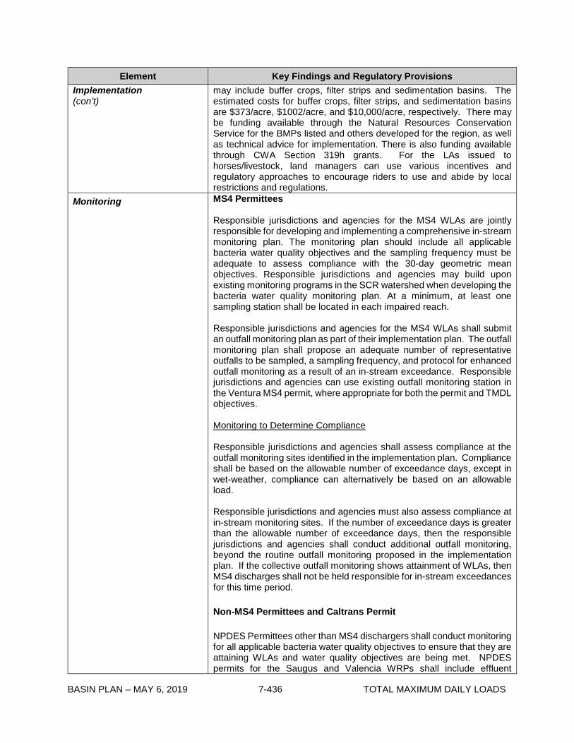
BASIN PLAN – MAY 6, 2019 7-436 TOTAL MAXIMUM DAILY LOADS
Element Key Findings and Regulatory Provisions Implementation (con’t)
may include buffer crops, filter strips and sedimentation basins. The estimated costs for buffer crops, filter strips, and sedimentation basins are $373/acre, $1002/acre, and $10,000/acre, respectively. There may be funding available through the Natural Resources Conservation Service for the BMPs listed and others developed for the region, as well as technical advice for implementation. There is also funding available through CWA Section 319h grants. For the LAs issued to horses/livestock, land managers can use various incentives and regulatory approaches to encourage riders to use and abide by local restrictions and regulations.
Monitoring
MS4 Permittees Responsible jurisdictions and agencies for the MS4 WLAs are jointly responsible for developing and implementing a comprehensive in-stream monitoring plan. The monitoring plan should include all applicable bacteria water quality objectives and the sampling frequency must be adequate to assess compliance with the 30-day geometric mean objectives. Responsible jurisdictions and agencies may build upon existing monitoring programs in the SCR watershed when developing the bacteria water quality monitoring plan. At a minimum, at least one sampling station shall be located in each impaired reach. Responsible jurisdictions and agencies for the MS4 WLAs shall submit an outfall monitoring plan as part of their implementation plan. The outfall monitoring plan shall propose an adequate number of representative outfalls to be sampled, a sampling frequency, and protocol for enhanced outfall monitoring as a result of an in-stream exceedance. Responsible jurisdictions and agencies can use existing outfall monitoring station in the Ventura MS4 permit, where appropriate for both the permit and TMDL objectives. Monitoring to Determine Compliance Responsible jurisdictions and agencies shall assess compliance at the outfall monitoring sites identified in the implementation plan. Compliance shall be based on the allowable number of exceedance days, except in wet-weather, compliance can alternatively be based on an allowable load. Responsible jurisdictions and agencies must also assess compliance at in-stream monitoring sites. If the number of exceedance days is greater than the allowable number of exceedance days, then the responsible jurisdictions and agencies shall conduct additional outfall monitoring, beyond the routine outfall monitoring proposed in the implementation plan. If the collective outfall monitoring shows attainment of WLAs, then MS4 discharges shall not be held responsible for in-stream exceedances for this time period. Non-MS4 Permittees and Caltrans Permit NPDES Permittees other than MS4 dischargers shall conduct monitoring for all applicable bacteria water quality objectives to ensure that they are attaining WLAs and water quality objectives are being met. NPDES permits for the Saugus and Valencia WRPs shall include effluent
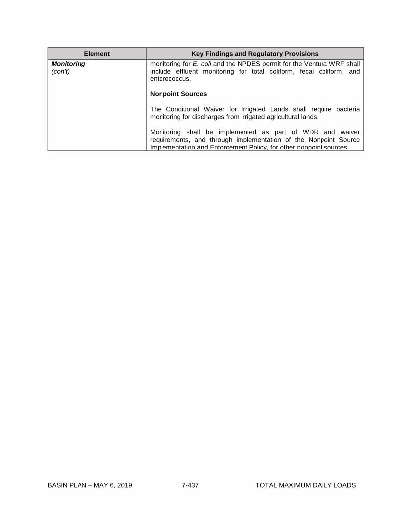
BASIN PLAN – MAY 6, 2019 7-437 TOTAL MAXIMUM DAILY LOADS
Element Key Findings and Regulatory Provisions Monitoring (con’t)
monitoring for E. coli and the NPDES permit for the Ventura WRF shall include effluent monitoring for total coliform, fecal coliform, and enterococcus. Nonpoint Sources The Conditional Waiver for Irrigated Lands shall require bacteria monitoring for discharges from irrigated agricultural lands. Monitoring shall be implemented as part of WDR and waiver requirements, and through implementation of the Nonpoint Source Implementation and Enforcement Policy, for other nonpoint sources.

BASIN PLAN – MAY 6, 2019 7-438 TOTAL MAXIMUM DAILY LOADS
Table 7-36.2 Santa Clara River Estuary and Reaches 3, 5, 6, and 7 Indicator Bacteria DL: Allowable Exceedance Days 1,2,3.
Time Period Santa Clara River Reaches 3, 5, 6, & 7 Santa Clara River Estuary
Dry Weather
5 allowable exceedance days of single sample objectives
0 allowable exceedances of geometric mean objectives
Not Applicable
Wet Weather
16 allowable exceedance days of single sample
objectives
0 allowable exceedances of geometric mean objectives
25 allowable exceedance days of single sample objectives
0 allowable exceedances of geometric mean objectives
Summer Dry Weather (April 1 – October 31) Not Applicable
10 allowable exceedance days of single sample objectives
0 allowable exceedances of geometric mean objectives
Winter Dry Weather (November 1 – March 31) Not Applicable
12 allowable exceedance days of single sample objectives
0 allowable exceedances of geometric mean objectives
1 Allowable exceedance days calculated by the following equation: Allowable Exceedance Days = WQO Exceedance Probability in Reference System(s) x Number of Days during 1995. 2 Consistent with the Santa Monica Bay Beaches TMDL, where the fractional remainder for the calculated allowable exceedance days exceeds 1/10th then the number of days are rounded up (e.g., 4.12 is rounded up to 5). In instances where the tenth decimal place for the allowable exceedance days (or weeks or months) is lower than 1/10th then the number of days are rounded down (e.g., 4.02 is rounded down to 4). 3 The calculated number of exceedance days assumes that daily sampling is conducted. To determine the number of allowable exceedances for less frequent sampling, a ratio is used.

BASIN PLAN – MAY 6, 2019 7-439 TOTAL MAXIMUM DAILY LOADS
Table 7-36.3 Santa Clara River Estuary and Reaches 3, 5, 6, and 7 Indicator Bacteria TMDL: Interim Allowable Exceedance Days1,2,3.
Time Period Santa Clara River
Reaches 3, 5, 6, & 7
Santa Clara River
Estuary
Dry Weather 17 allowable exceedance days
of single sample objectives Not Applicable
Wet Weather
61 allowable exceedance
days of single sample
objectives
62 allowable exceedance days
of single sample objectives
Summer Dry Weather
(April 1 – October 31) Not Applicable
150 allowable exceedance
days of single sample
objectives
Winter Dry Weather
(November 1 – March 31) Not Applicable
49 allowable exceedance days
of single sample objectives 1 Allowable exceedance days calculated by the following equation: Allowable Exceedance Days = Current WQO Exceedance Probability x Number of Days during 1995. 2 Consistent with the Santa Monica Bay Beaches TMDL, where the fractional remainder for the calculated allowable exceedance days exceeds 1/10th then the number of days are rounded up (e.g., 4.12 is rounded up to 5). In instances where the tenth decimal place for the allowable exceedance days (or weeks or months) is lower than 1/10th then the number of days are rounded down (e.g., 4.02 is rounded down to 4). 3 The calculated number of exceedance days assumes that daily sampling is conducted. To determine the number of allowable exceedances for less frequent sampling, a ratio is used.
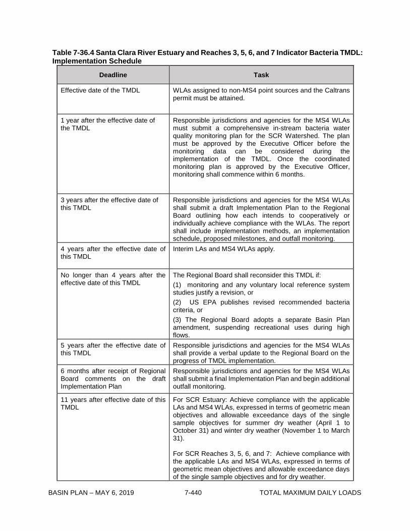
BASIN PLAN – MAY 6, 2019 7-440 TOTAL MAXIMUM DAILY LOADS
Table 7-36.4 Santa Clara River Estuary and Reaches 3, 5, 6, and 7 Indicator Bacteria TMDL: Implementation Schedule
Deadline Task
Effective date of the TMDL WLAs assigned to non-MS4 point sources and the Caltrans permit must be attained.
1 year after the effective date of the TMDL
Responsible jurisdictions and agencies for the MS4 WLAs must submit a comprehensive in-stream bacteria water quality monitoring plan for the SCR Watershed. The plan must be approved by the Executive Officer before the monitoring data can be considered during the implementation of the TMDL. Once the coordinated monitoring plan is approved by the Executive Officer, monitoring shall commence within 6 months.
3 years after the effective date of this TMDL
Responsible jurisdictions and agencies for the MS4 WLAs shall submit a draft Implementation Plan to the Regional Board outlining how each intends to cooperatively or individually achieve compliance with the WLAs. The report shall include implementation methods, an implementation schedule, proposed milestones, and outfall monitoring.
4 years after the effective date of this TMDL
Interim LAs and MS4 WLAs apply.
No longer than 4 years after the effective date of this TMDL
The Regional Board shall reconsider this TMDL if: (1) monitoring and any voluntary local reference system studies justify a revision, or (2) US EPA publishes revised recommended bacteria criteria, or (3) The Regional Board adopts a separate Basin Plan amendment, suspending recreational uses during high flows.
5 years after the effective date of this TMDL
Responsible jurisdictions and agencies for the MS4 WLAs shall provide a verbal update to the Regional Board on the progress of TMDL implementation.
6 months after receipt of Regional Board comments on the draft Implementation Plan
Responsible jurisdictions and agencies for the MS4 WLAs shall submit a final Implementation Plan and begin additional outfall monitoring.
11 years after effective date of this TMDL
For SCR Estuary: Achieve compliance with the applicable LAs and MS4 WLAs, expressed in terms of geometric mean objectives and allowable exceedance days of the single sample objectives for summer dry weather (April 1 to October 31) and winter dry weather (November 1 to March 31). For SCR Reaches 3, 5, 6, and 7: Achieve compliance with the applicable LAs and MS4 WLAs, expressed in terms of geometric mean objectives and allowable exceedance days of the single sample objectives and for dry weather.
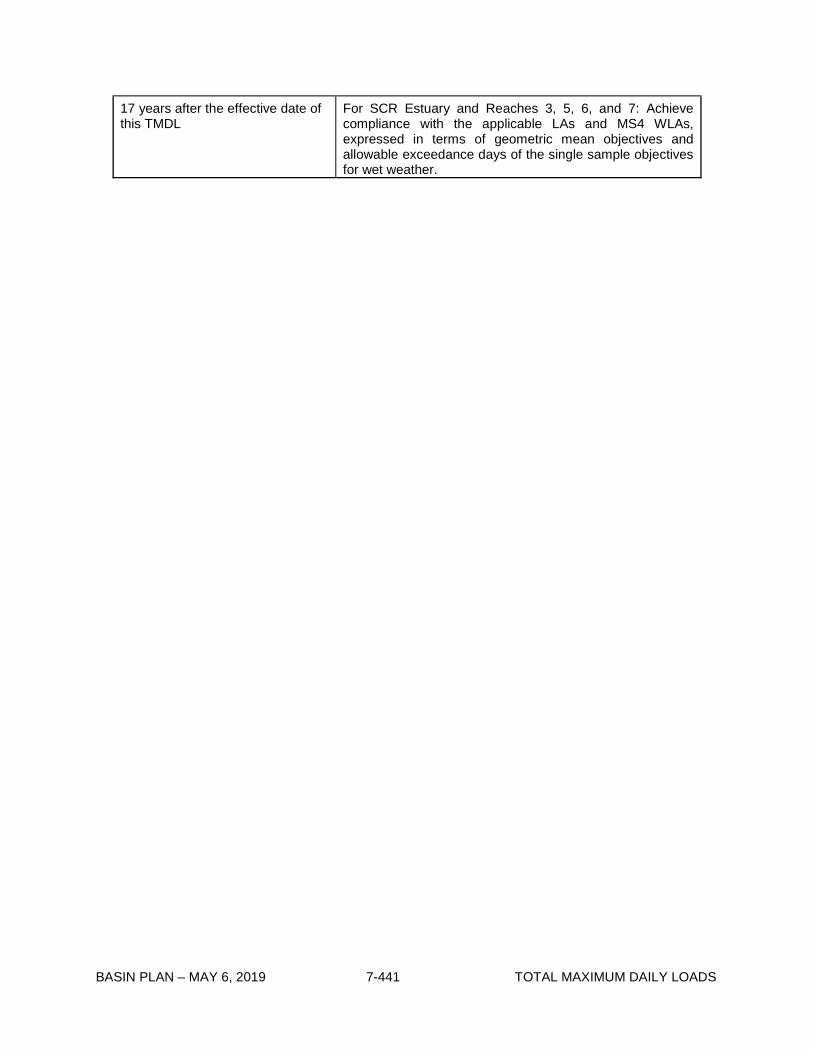
BASIN PLAN – MAY 6, 2019 7-441 TOTAL MAXIMUM DAILY LOADS
17 years after the effective date of this TMDL
For SCR Estuary and Reaches 3, 5, 6, and 7: Achieve compliance with the applicable LAs and MS4 WLAs, expressed in terms of geometric mean objectives and allowable exceedance days of the single sample objectives for wet weather.

BASIN PLAN – MAY 6, 2019 7-442 TOTAL MAXIMUM DAILY LOADS
This page intentionally left blank

BASIN PLAN – MAY 6, 2019 7-443 TOTAL MAXIMUM DAILY LOADS
7-37 McGrath Lake PCBs, Pesticides and Sediment Toxicity TMDL This TMDL was adopted by:
The Regional Water Quality Control Board on October 1, 2009.
This TMDL was approved by:
The State Water Resources Control Board on December 14, 2010. The Office of Administrative Law on May 31, 2011. The U.S. Environmental Protection Agency on June 30, 2011.
The effective date of this TMDL is: June 30, 2011.
The elements of the TMDL are presented in Table 7-37.1 and the Implementation Plan in Table
7-37.2.
Table 7-37.1. McGrath Lake PCBs, Pesticides and Sediment Toxicity TMDL: Elements
TMDL Element Regulatory Provisions
Problem Statement
McGrath Lake was placed on the Clean Water Act Section 303(d) list in 1998, 2002, and 2006 as impaired for organochlorine pesticides (chlordane, dieldrin, DDT and derivatives) and polychlorinated biphenyls (PCBs) in sediment and for sediment toxicity. These toxic organic chemicals bind to soil particles, are stored in the fat tissue of exposed organisms, and create long term environmental impairments. Past studies concluded that sediment toxicity in McGrath Lake was likely due to the elevated concentrations of pesticides and PCBs in sediment.
Applicable Water Quality Objectives for this TMDL are narrative water quality objectives for Chemical Constituents, Bioaccumulation, Pesticides and Toxicity contained in Chapter 3, the numeric water quality objective for PCBs contained in Chapter 3 and the numeric water quality criteria promulgated in 40 CFR 131 (California Toxics Rule (CTR)).
The exposure of the McGrath Lake ecosystem to chlordane, DDT, dieldrin, and PCBs in amounts exceeding the objectives and criteria has impaired the beneficial uses of the lake, including aquatic life uses (rare, threatened or endangered species and estuarine, wildlife, and wetland habitat) and recreation uses (contact and non-contact recreation and commercial and sport fishing).

BASIN PLAN – MAY 6, 2019 7-444 TOTAL MAXIMUM DAILY LOADS
TMDL Element Regulatory Provisions
Numeric Targets Water column targets for PCBs, chlordane, DDT, and dieldrin are based on the CTR water quality criteria for protection of human health (organisms only). These criteria are more stringent than those for the protection of aquatic life and thus will protect both aquatic life and fish consumption beneficial uses. The sediment numeric targets are derived from the Effects Range-Low (ER-Ls) guidelines compiled by the National Oceanographic and Atmospheric Administration (NOAA). The sediment toxicity impairment is addressed by these numeric targets, which are protective of aquatic life in sediment.
Pollutant Water Column
Targets (µg/L) Sediment
Targets (ng/dry g) Chlordane 0.00059 0.5 Dieldrin 0.00014 0.02 4,4’-DDT 0.00059 1 4,4’-DDE 0.00059 2.2 4,4’-DDD 0.00084 2 Total DDT -- 1.58 Total PCBs 0.00017 22.7
Source Analysis A source of the pesticide and PCB loading is contaminated surface water and sediments flushing into McGrath Lake from the Central Ditch, which drains agriculture and other lands. All of the contaminants included in this TMDL are legacy pollutants. While they are no longer legally sold or used, they remain ubiquitous in the environment, bound to fine-grained particles. Irrigation and rainfall in the watershed mobilize these particles, which are loaded to McGrath Lake. Surface water (stormwater and agricultural drainage) accounts for almost half of the total recharge of the lake, while groundwater accounts for the rest of the recharge. Pesticides and PCBs have been detected in the surface water inlet to the lake (Central Ditch) but not in the groundwater from local monitoring wells. There are no point sources of pesticides or PCBs to McGrath Lake. Atmospheric deposition may be contributing PCBs.
In addition to external loading, the in-situ sediments are likely a source of contaminants to the lake water column due to the high concentrations of contaminants in the sediment.
Linkage Analysis A conceptual model identifies the assimilative capacity of McGrath Lake and links the source loading information to the numeric targets. The chemical properties of the pesticides and PCBs result in strong binding to particulate matter, therefore most of the incoming contaminants from the Central Ditch to the lake are bound to suspended solids. However, pesticide exceedances are observed in the Central Ditch even in low-flow conditions, indicating that some of the contaminants are transported to the lake in the water fraction. Therefore, there are water column and suspended sediment allocations for the Central Ditch.
Once the suspended sediment settles to the lake bottom, desorption is possible due to the high contaminant concentrations, favorable environmental conditions and extended contact time (between the sediment and water). The contaminated lake sediments are toxic to benthic organisms and may also be taken up through bioturbation and feeding processes. Therefore, both external loading sources from the lake subwatershed and internal loading from contaminated lake sediments are assigned load allocations.

BASIN PLAN – MAY 6, 2019 7-445 TOTAL MAXIMUM DAILY LOADS
TMDL Element Regulatory Provisions
Load Allocations Load allocations (LAs) addressing non-point sources of pesticides and PCBs are assigned to discharges from the Central Ditch to the lake and internal sources from the lake sediments. The lake sediments are defined as bed sediments in the main body of the lake and the riparian corridor west of Harbor Boulevard.
The in-lake LAs are for concentrations in sediment only.
Pollutant Load Allocation for Concentration in Lake Sediment (µg/dry kg)
Chlordane 0.5 Dieldrin 0.02 4,4’-DDT 1 4,4’-DDE 2.2 4,4’-DDD 2 Total DDT 1.58 Total PCBs 22.7
The Central Ditch LAs are for concentrations in both suspended sediment and water. Pollutant Water Column Load
Allocation (µg/L) Load Allocation for
Concentration in Suspended Sediment (µg/dry kg)
Chlordane 0.00059 0.5 Dieldrin 0.00014 0.02 4,4’-DDT 0.00059 1 4,4’-DDE 0.00059 2.2 4,4’-DDD 0.00084 2 Total DDT -- 1.58 Total PCBs 0.00017 22.7
Margin of Safety The uncertainties associated with this TMDL are due to limited data on the amount and media by which PCBs and pesticides are entering the lake and the extent to which these contaminants are already in the lake. The seasonal and annual variability in the hydrologic budget also creates uncertainty. To address these uncertainties, an implicit margin of safety is applied. Conservative assumptions were used to calculate the loading to the lake and more the protective ER-L sediment quality guidelines were used for the sediment numeric targets.

BASIN PLAN – MAY 6, 2019 7-446 TOTAL MAXIMUM DAILY LOADS
TMDL Element Regulatory Provisions
Seasonal Variations and Critical Conditions
As the contaminants of concern for this TMDL are transported to the lake by the mobilization of sediment, it is expected that the greatest influx of PCBs and pesticides occurs during periods of increased runoff from the watershed. Due to the artificial interference in the watershed hydrologic cycle due to agricultural activities, peak runoff may not correspond to the southern California wet season. Seasonal variations and critical conditions are addressed by the use of concentration-based load allocations. However, due to the bioaccumulative properties of the pollutants, effects occur over extended time periods, which minimizes the importance of seasonal variations.
Monitoring Monitoring Program The monitoring program shall measure the progress of pollutant load reductions and improvements in water and sediment quality. The monitoring program shall:
• Determine attainment of numeric targets for PCBs and pesticides; • Determine compliance with the load allocations for PCBs and pesticides; and • Monitor the effect of implementation actions on lake water and sediment quality.
The monitoring program shall consist of two phases. The first phase will focus on sampling the Central Ditch (for the first 10 years of the TMDL implementation schedule) and will be conducted by the responsible parties for the Central Ditch LAs. For the remaining portion of the TMDL implementation schedule, required water and sediment samples will be collected from the Central Ditch by “responsible parties” for the Central Ditch LAs, while required water and sediment samples will be collected from the lake as prescribed by the McGrath Lake Work Plan (MLWP) developed pursuant to a Memorandum of Agreement (MOA) entered into by and between “cooperative parties” and the Regional Board. The “responsible parties” and “cooperative parties” are defined in the implementation section below.
Phase 1 Phase 1 requires the development of a monitoring and reporting plan (MRP) to comply with the TMDL requirements. The MRP shall propose a monitoring frequency for water and sediment sampling that will characterize the variability in water and sediment quality observed in the Central Ditch. Water samples will be analyzed for the following constituents:
• Total Organic Carbon • Total Suspended Solids • Total PCBs • DDT and Derivatives • Dieldrin • Total Chlordane

BASIN PLAN – MAY 6, 2019 7-447 TOTAL MAXIMUM DAILY LOADS
TMDL Element Regulatory Provisions
Monitoring (con’t)
Sediment samples will be analyzed for the following constituents:
• Total Organic Carbon • Total PCBs • DDT and Derivatives • Dieldrin • Total Chlordane
The annual monitoring reports will summarize proposed changes to the MRP based on the results of the previous year’s monitoring. Sampling frequency may be reduced during future years once characterization of the variability in water and sediment quality has been achieved. In addition to the constituents above, general water chemistry (temperature, dissolved oxygen, pH and electrical conductivity) and a flow measurement will be required at each sampling event.
Responsible parties for phase 1 monitoring shall submit a MRP plan to assess compliance with LAs and a Quality Assurance Project Plan (QAPP). The MRP and QAPP must be submitted to the Executive Officer for approval within six months of the effective date of the TMDL. The QAPP shall include protocols for sample collection, standard analytical procedures, and laboratory certification. All samples shall be collected in accordance with Surface Water Ambient Monitoring Program (SWAMP) protocols, where available or alternative protocols proposed by dischargers and approved by the Executive Officer. Monitoring shall begin 90 days after the Executive Officer has approved the MRP and QAPP.
At the time of TMDL adoption, several of the constituents of concern had numeric targets lower than the laboratory detection limits. As analytical methods and detection limits continue to improve (i.e. development of lower detection limits) and become more environmentally relevant, responsible parties shall incorporate new analytical methods with lower detection limits in the MRP and the QAPP.
A monitoring report shall be prepared and submitted to the Regional Board annually within three months after the completion of the final sampling event of the year.
Phase 2 The sampling, analysis and flow measurements begun in Phase 1 will continue. Additionally, samples will be collected from within the lake. Water column and surficial sediment (top 2 cm) samples will be collected at the northern end of the lake and from the deepest portion of the lake. All samples will be collected in accordance with SWAMP protocols. Cooperative parties shall only commence, participate or fund the Phase 2 monitoring as provided in the MLWP. Water samples will be analyzed for the following constituents:
• Total Organic Carbon • Total Suspended Solids • Total PCBs • DDT and Derivatives • Dieldrin • Total Chlordane

BASIN PLAN – MAY 6, 2019 7-448 TOTAL MAXIMUM DAILY LOADS
TMDL Element Regulatory Provisions
Monitoring (con’t)
Sediment samples will be analyzed for the following constituents:
• Total Organic Carbon • Total PCBs • DDT and Derivatives • Dieldrin • Total Chlordane • Toxicity (if toxicity is determined, a TIE shall be completed to elucidate the cause of
the toxicity) Samples from the lake will be collected annually. The annual reports required for Phase 1 will continue during Phase 2. Additional monitoring may be required depending on which implementation option is chosen.
Three years from the effective date of the TMDL, cooperative parties must submit the MLWP as discussed in the implementation section below.
At the time of TMDL adoption, several of the constituents of concern had numeric targets lower than the laboratory detection limits. All required monitoring under Phase 1 and Phase 2 shall incorporate new analytical methods, once commercially available with lower detection limits, in the MRP and the QAPP.
A monitoring report shall be prepared and submitted to the Regional Board annually within three months after the completion of the final sampling event of the year.
Implementation Plan
Compliance with this TMDL will require the elimination of pollutant loads in toxic amounts from the Central Ditch to the lake and identification and implementation of strategies to remediate the contaminated sediments at the bottom of the lake. Table 7-37.2 contains a schedule for cooperative parties to implement a MOA to jointly develop the MLWP to implement strategies to remediate the contaminated lake sediments and achieve lake sediment load allocations.
I. Implementation and Determination of Compliance with the Central Ditch LAs for Agricultural Non-point Source Discharges
The Central Ditch load allocations assigned to agriculture non-point source dischargers will be implemented through the Conditional Waiver of Waste Discharge Requirements for Discharges from Irrigated Lands (Conditional Waiver) or other appropriate Regional Board Orders. The load allocations for the Central Ditch shall be incorporated into the Conditional Waiver or other appropriate Regional Board Orders. It is likely that a combination of implementation measures will be needed to achieve the LAs. The Central Ditch implementation actions may include, but are not limited to the following:
• On-Farm BMPs • Regional Sub-Watershed BMPs • Regional Treatment System • Redirect Agriculture Discharge

BASIN PLAN – MAY 6, 2019 7-449 TOTAL MAXIMUM DAILY LOADS
TMDL Element Regulatory Provisions
Implementation Plan (con’t)
The estimated costs for on-farm BMPs such as buffer crops, filter strips, and sedimentation basins are approximately $373/acre of BMP, $1002/acre of BMP, and$10,000/acre of BMP, respectively. The estimated costs for regional sub-watershed BMPs, such as converting the Central Ditch to a grassed waterway or converting the dirt road that runs along the Central Ditch into a filter strip, are approximately $1,288/ per acre of BMP and $1002/per acre of BMP, respectively. The estimated cost of a regional treatment system to address the Central Ditch water is about $151,536/year. The estimated costs to redirect the agriculture discharge toward a nearby canal are $612,611 (open ditch) to $1,287,402 (piped diversion). Potential sources of financing for these implementation alternatives, such as Clean Water Act section 319(h) grant funding, are discussed in Chapter 4. As discussed in Chapter 4, the U.S. Department of Agriculture Soil Conservation Service and the Resource Conservation Districts provide information on, and assistance in, implementing BMPs.
Agricultural Dischargers will be considered in compliance with the TMDL LAs if they comply with all provisions of the Conditional Waiver established to implement the LAs, or those of any alternative regulatory order, if any, that may be established to implement the LAs in lieu of the Conditional Waiver.
II. Implementation of Memorandum of Agreement to Develop McGrath Lake Work Plan and Determination of Compliance with LAs for Contaminated Lake Sediments
The contaminated lake sediment LAs may be implemented through a MOA, which the Executive Officer is authorized to negotiate and execute, provided it is consistent with the following: The MOA shall detail the voluntary efforts that will be undertaken to attain the load allocations. The MOA shall comply with the Water Quality Control Policy for Addressing Impaired Waters: Regulatory Structure and Options (“Policy”), including part II, section 2 (c)(ii) and related provisions, and shall be consistent with the requirements of this TMDL. If the MOA is timely adopted in accordance with the implementation schedule below, the program described in the MOA shall be deemed “certified”, pursuant to the Policy, subject to the conditions of Policy section 2 (e). The MOA shall include development of the MLWP, which must be approved by the Executive Officer, and may be amended with Executive Officer approval, as necessary. Implementation of the MOA shall be reviewed annually by the Executive Officer as part of the MRP annual reports. The purpose of the MOA is not to create evidence of responsibility or ascertain legal liability for subsequent remediation of the lake sediments, but rather to organize stakeholders who have an interest in the remediation of the lake sediments.
To be a valid non-regulatory implementation program adopted by the Regional Board, the MOA shall include the following requirements and conditions:
• The MOA shall direct development of a MLWP that addresses the impaired
waterbody as approved by the Executive Officer.
• The MOA shall outline the roles and responsibilities of the Regional Board and each cooperative party.

BASIN PLAN – MAY 6, 2019 7-450 TOTAL MAXIMUM DAILY LOADS
TMDL Element Regulatory Provisions
Implementation Plan (con’t)
• The MOA shall contain conditions that require trackable progress on attaining load allocations and numeric targets. A timeline shall be included that identifies the point(s) at which Regional Board regulatory intervention and oversight will be triggered if the pace of work lags or fails.
• The MOA shall contain a provision that it shall be revoked based upon findings
that the program has not been adequately implemented, is not achieving its goals, or is no longer adequate to restore water quality.
• The MOA shall be consistent with the California Policy for Implementation and
Enforcement of the Non-point Source Pollution Control Program, including but not limited to, the “Key Elements of a Non-point Source Pollution Control Implementation Program”.
Pursuant to the terms of the MOA, the cooperative parties and the Regional Board will work jointly to develop the MLWP and remediate the lake sediments. The purpose of the MLWP is to set forth strategies to achieve lake sediment load allocations in a manner that is beneficial to subwatershed landowners and the public in general. To the satisfaction of the Executive Officer, the MLWP shall meet the following criteria:
• Three years from the effective date of the TMDL cooperative parties shall submit
a MLWP for approval by the Executive Officer.
• The MLWP shall include identification of implementation measures that will achieve lake sediment LAs.
• The MLWP shall include any additional monitoring needed to assess the
effectiveness of the MLWP’s chosen implementation strategies.
• The MLWP shall include a MRP and QAPP for phase 2 monitoring.
• The MLWP shall include a strategy to secure funds necessary to remediate the lake sediments and achieve lake sediment allocations.
• The MLWP shall include tasks and a clear timeline for task completion leading
to attainment of lake sediment LAs. The roles and responsibilities of each cooperative party shall also be outlined in the MLWP.
• The MLWP shall consider and address the potential impacts of lake sediment
remediation strategies on the implementation of the McGrath Beach Bacteria TMDL and ongoing restoration efforts at McGrath State Beach.
• The MLWP shall achieve compliance with the load allocations through the
implementation of lake management strategies to reduce and manage internal pesticide and PCBs sources from lake bed sediments. The lake management implementation actions may include:
• Sediment Capping; • Dredging/Hydraulic Dredging; • Monitored Natural Attenuation; or • Other appropriate means of implementation.
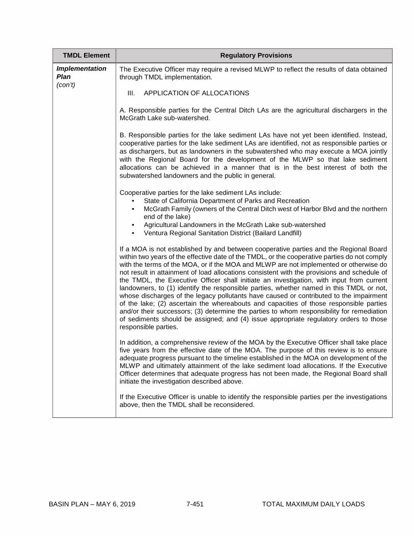
BASIN PLAN – MAY 6, 2019 7-451 TOTAL MAXIMUM DAILY LOADS
TMDL Element Regulatory Provisions
Implementation Plan (con’t)
The Executive Officer may require a revised MLWP to reflect the results of data obtained through TMDL implementation.
III. APPLICATION OF ALLOCATIONS A. Responsible parties for the Central Ditch LAs are the agricultural dischargers in the McGrath Lake sub-watershed.
B. Responsible parties for the lake sediment LAs have not yet been identified. Instead, cooperative parties for the lake sediment LAs are identified, not as responsible parties or as dischargers, but as landowners in the subwatershed who may execute a MOA jointly with the Regional Board for the development of the MLWP so that lake sediment allocations can be achieved in a manner that is in the best interest of both the subwatershed landowners and the public in general.
Cooperative parties for the lake sediment LAs include:
• State of California Department of Parks and Recreation • McGrath Family (owners of the Central Ditch west of Harbor Blvd and the northern
end of the lake) • Agricultural Landowners in the McGrath Lake sub-watershed • Ventura Regional Sanitation District (Bailard Landfill)
If a MOA is not established by and between cooperative parties and the Regional Board within two years of the effective date of the TMDL, or the cooperative parties do not comply with the terms of the MOA, or if the MOA and MLWP are not implemented or otherwise do not result in attainment of load allocations consistent with the provisions and schedule of the TMDL, the Executive Officer shall initiate an investigation, with input from current landowners, to (1) identify the responsible parties, whether named in this TMDL or not, whose discharges of the legacy pollutants have caused or contributed to the impairment of the lake; (2) ascertain the whereabouts and capacities of those responsible parties and/or their successors; (3) determine the parties to whom responsibility for remediation of sediments should be assigned; and (4) issue appropriate regulatory orders to those responsible parties.
In addition, a comprehensive review of the MOA by the Executive Officer shall take place five years from the effective date of the MOA. The purpose of this review is to ensure adequate progress pursuant to the timeline established in the MOA on development of the MLWP and ultimately attainment of the lake sediment load allocations. If the Executive Officer determines that adequate progress has not been made, the Regional Board shall initiate the investigation described above.
If the Executive Officer is unable to identify the responsible parties per the investigations above, then the TMDL shall be reconsidered.

BASIN PLAN – MAY 6, 2019 7-452 TOTAL MAXIMUM DAILY LOADS
Table 7-37.2 McGrath Lake PCBs and Pesticides TMDL: Implementation Schedule
Task Number
Task Deadline
1 Responsible parties assigned Central Ditch LAs shall submit a Monitoring and Reporting Plan (MRP) to the Executive Officer for review and approval to address Phase 1 monitoring.
6 months from the effective date of the TMDL
2 Responsible parties assigned Central Ditch LAs shall begin monitoring as outlined in the approved MRP.
90 days from the date of MRP approval
3 Responsible parties assigned Central Ditch LAs shall submit annual monitoring reports. Reports shall be submitted within three months after the completion of the final sampling event of the year.
Annually
4 Cooperative parties shall enter into a Memorandum of Agreement (MOA) with the Regional Board to implement the lake sediment LAs.
Two years from the effective date of the TMDL
5 Parties subject to the MOA shall submit a McGrath Lake Work Plan (MLWP) for review and approval by the Executive Officer.
Three years from the effective date of the TMDL
6 Parties subject to the MOA shall submit annual progress reports.
Annually from the date of MLWP approval
7 Responsible parties shall attain Central Ditch LAs. 10 years from the effective date of the TMDL
8 Begin implementation of McGrath Lake sediment remediation actions based on MLWP.
As soon as possible, but no later than 10 years from the effective date of the TMDL
9 Phase 2 monitoring shall begin as outlined in the MLWP. The results shall be included as part of the annual progress reports initiated in Task 6.
To be determined based on MLWP.
10 Lake sediment LAs shall be achieved. 14 years from the effective date of the TMDL

BASIN PLAN – MAY 6, 2019 7-453 TOTAL MAXIMUM DAILY LOADS
7-38 Machado Lake Pesticides and PCBs TMDL This TMDL was adopted by:
The Regional Water Quality Control Board on September 2, 2010.
This TMDL was approved by:
The State Water Resources Control Board on December 6, 2011 The Office of Administrative Law on February 29, 2012. The U.S. Environmental Protection Agency on March 20, 2012
This TMDL is effective on March 20, 2012
The elements of the TMDL are presented in Table 7-38.1 and the Implementation Plan in Table
7-38.2.

BASIN PLAN – MAY 6, 2019 7-454 TOTAL MAXIMUM DAILY LOADS
Table 7-38.1 Machado Lake Pesticides and PCBs TMDL: Elements TMDL Element Regulatory Provisions
Problem Statement
Machado Lake is identified on the 1998, 2002, 2006, and 2008 Federal Clean Water Act Section 303(d) lists of impaired waterbodies due to chlordane, DDT, dieldrin, Chem A, and PCBs in fish tissue. Chem A (the abbreviation for ‘chemical group A’) is a suite of bio-accumulative pesticides that includes chlordane and dieldrin. The 1998 303(d) listing (and subsequent listings) for Chem A was predominately based on fish tissue concentrations of chlordane and dieldrin; there was only minimal detection of other Chem A pollutants in 1983 and 1984. Chlordane and dieldrin have been recently detected in fish tissue, while other Chem A pollutants have not been detected in 25 years. Therefore, this TMDL only addresses the Chem A pollutants (chlordane and dieldrin) that are causing impairment. Because of potential harm to human health and the environment, the use of these pollutants has been banned for many years; however, the physio-chemical properties of the pollutants cause them to persist in the environment. These pollutants, bound to soil particles, are easily transported with surface runoff to waterbodies. Contaminated sediments accumulate in the receiving waterbodies and aquatic organisms are exposed to the toxic pollutants. Sediment toxicity has been documented at Machado Lake, and it is likely that pesticides and PCBs contribute to the toxic condition of the sediments. Moreover, all of these pollutants biomagnify as they move up the food chain, thereby increasing concentrations in higher trophic-level aquatic organisms and wildlife. The exposure of the Machado Lake ecosystem to chlordane, DDT, dieldrin, and PCBs has impaired the aquatic life (WARM, WILD, RARE, WET) and recreation (REC-1, REC-2), including fishing, designated beneficial uses of the lake. This TMDL addresses these impairments. Applicable water quality objectives for this TMDL are narrative objectives for Chemical Constituents, Bioaccumulation, Pesticides, and Toxicity in the Basin Plan and the numeric water quality criteria promulgated in 40 CFR section 131.38 (the California Toxics Rule (CTR)).
Numeric Targets
Numeric targets are for pesticides and PCBs in water, sediment, and fish tissue to protect aquatic life, fishing, and other recreational uses in the lake. The CTR criteria for human health (including protection for consumption of organisms) are the numeric targets for the water column. These targets will protect both aquatic life and human health because the CTR human health criteria are more stringent than the aquatic life criteria.
Pollutant Water Column Target (μg/L)
Total PCBs 0.00017
4,4’ DDT 0.00059
4,4’ DDE 0.00059
4,4’ DDD 0.00084
Chlordane 0.00059
Dieldrin 0.00014

BASIN PLAN – MAY 6, 2019 7-455 TOTAL MAXIMUM DAILY LOADS
TMDL Element Regulatory Provisions
Numeric Targets (con’t)
The sediment numeric targets are based on the freshwater Threshold Effect Concentration (TEC) guidelines compiled by the National Oceanic and Atmospheric Administration (NOAA). The fish tissue numeric targets are based on the Office of Environmental Health Hazard Assessment (OEHHA) Fish Contaminant Goals (FCGs).
Pollutant Sediment Target (μg/kg dry weight)
Fish Tissue Target (ng/g wet weight)
Total PCBs 59.8 3.6 DDT (all congeners) 4.16 No target DDE (all congeners) 3.16 No target DDD (all congeners) 4.88 No target Total DDT 5.28 21.0 Chlordane 3.24 5.6 Dieldrin 1.9 0.46
Source Analysis The point sources of pesticides and PCBs into Machado Lake are stormwater and urban runoff discharges from the municipal separate storm sewer system (MS4), California Department of Transportation (Caltrans), and general construction and industrial dischargers. Stormwater and urban runoff discharges to Machado Lake occur through the following subdrainage systems: Wilmington Drain, Project 77 and Project 510. PCBs, DDT, dieldrin, and chlordane are no longer legally sold or used, yet, they remain ubiquitous in the environment, bound to fine-grained particles. When these particles become waterborne, the chemicals are ferried to new locations. The more recent small discharges of pesticides and PCBs to Machado Lake most likely come from the erosion of pollutant-laden sediment further up in the watershed. Urban runoff and rainfall higher in the watershed mobilize the particles, which are then washed into storm drains and channels that discharge to the lake. The major nonpoint source of pesticides and PCBs to Machado Lake is the internal lake sediments. The contaminated lake sediments are a reservoir of historically deposited pollutants. The resuspension of these sediments contributes to the fish tissue impairment in the lake. Additionally, the feeding behaviors of fish expose them to contaminated sediments. Therefore, a load allocation is assigned to the existing reservoir of contaminated sediment. The estimated contribution of pesticides and PCBs from point sources is much smaller than the estimated contribution from internal lake sediments. However, a waste load allocation is assigned to ongoing point source discharges to the lake.
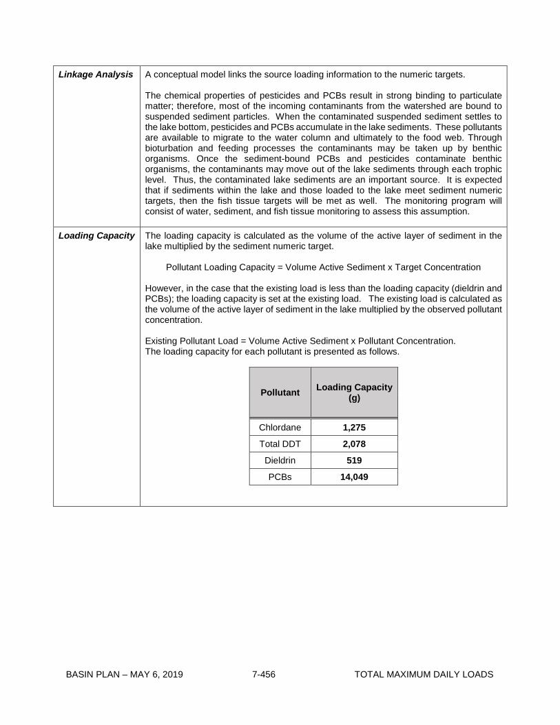
BASIN PLAN – MAY 6, 2019 7-456 TOTAL MAXIMUM DAILY LOADS
Linkage Analysis A conceptual model links the source loading information to the numeric targets. The chemical properties of pesticides and PCBs result in strong binding to particulate matter; therefore, most of the incoming contaminants from the watershed are bound to suspended sediment particles. When the contaminated suspended sediment settles to the lake bottom, pesticides and PCBs accumulate in the lake sediments. These pollutants are available to migrate to the water column and ultimately to the food web. Through bioturbation and feeding processes the contaminants may be taken up by benthic organisms. Once the sediment-bound PCBs and pesticides contaminate benthic organisms, the contaminants may move out of the lake sediments through each trophic level. Thus, the contaminated lake sediments are an important source. It is expected that if sediments within the lake and those loaded to the lake meet sediment numeric targets, then the fish tissue targets will be met as well. The monitoring program will consist of water, sediment, and fish tissue monitoring to assess this assumption.
Loading Capacity
The loading capacity is calculated as the volume of the active layer of sediment in the lake multiplied by the sediment numeric target.
Pollutant Loading Capacity = Volume Active Sediment x Target Concentration
However, in the case that the existing load is less than the loading capacity (dieldrin and PCBs); the loading capacity is set at the existing load. The existing load is calculated as the volume of the active layer of sediment in the lake multiplied by the observed pollutant concentration. Existing Pollutant Load = Volume Active Sediment x Pollutant Concentration. The loading capacity for each pollutant is presented as follows.
Pollutant Loading Capacity (g)
Chlordane 1,275
Total DDT 2,078
Dieldrin 519
PCBs 14,049

BASIN PLAN – MAY 6, 2019 7-457 TOTAL MAXIMUM DAILY LOADS
Waste Load Allocations
Waste load allocations (WLAs) for contaminants associated with suspended sediment are assigned to stormwater dischargers (MS4, Caltrans, general construction and general industrial dischargers) in both wet and dry weather.
Responsible Party Pollutant
WLA for Suspended Sediment-Associated
Contaminants1 (μg/kg dry weight)
MS4 Permittees1, Caltrans, General Construction and Industrial Stormwater Permittees, Other Non-stormwater NPDES Permittees
Total PCBs 59.8
DDT (all congeners) 4.16
DDE (all congeners) 3.16
DDD (all congeners) 4.88
Total DDT 5.28
Chlordane 3.24
Dieldrin 1.9 1 WLAs are applied with a 3-year averaging period.
Load Allocations Load allocations (LAs) addressing nonpoint sources of pesticides and PCBs are assigned to the existing lake sediments. The LAs are set to attain the lake loading capacity, including a 10% margin of safety.
Responsible Party Pollutant LA (grams)
City of Los Angeles, Department of Recreation and Parks
Chlordane 1,147
Total DDT 1,870
Dieldrin 467
PCBs 12,644
1 Municipal Separate Storm Sewer System (MS4) Permittees include: Los Angeles County, Los Angeles County Flood Control District, and the Cities of Carson, Lomita, Los Angeles, Palos Verdes Estates, Rancho Palos Verdes, Redondo Beach, Rolling Hills, Rolling Hills Estates, and Torrance.
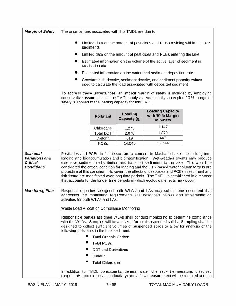
BASIN PLAN – MAY 6, 2019 7-458 TOTAL MAXIMUM DAILY LOADS
Margin of Safety The uncertainties associated with this TMDL are due to:
• Limited data on the amount of pesticides and PCBs residing within the lake sediments
• Limited data on the amount of pesticides and PCBs entering the lake
• Estimated information on the volume of the active layer of sediment in Machado Lake
• Estimated information on the watershed sediment deposition rate
• Constant bulk density, sediment density, and sediment porosity values used to calculate the load associated with deposited sediment
To address these uncertainties, an implicit margin of safety is included by employing conservative assumptions in the TMDL analysis. Additionally, an explicit 10 % margin of safety is applied to the loading capacity for this TMDL.
Pollutant Loading Capacity (g)
Loading Capacity with 10 % Margin
of Safety
Chlordane 1,275 1,147 Total DDT 2,078 1,870
Dieldrin 519 467 PCBs 14,049 12,644
Seasonal Variations and Critical Conditions
Pesticides and PCBs in fish tissue are a concern in Machado Lake due to long-term loading and bioaccumulation and biomagnification. Wet-weather events may produce extensive sediment redistribution and transport sediments to the lake. This would be considered the critical condition for loading and the CTR-based water column targets are protective of this condition. However, the effects of pesticides and PCBs in sediment and fish tissue are manifested over long time periods. The TMDL is established in a manner that accounts for the longer time periods in which ecological effects may occur.
Monitoring Plan
Responsible parties assigned both WLAs and LAs may submit one document that addresses the monitoring requirements (as described below) and implementation activities for both WLAs and LAs. Waste Load Allocation Compliance Monitoring Responsible parties assigned WLAs shall conduct monitoring to determine compliance with the WLAs. Samples will be analyzed for total suspended solids. Sampling shall be designed to collect sufficient volumes of suspended solids to allow for analysis of the following pollutants in the bulk sediment:
Total Organic Carbon Total PCBs DDT and Derivatives Dieldrin Total Chlordane
In addition to TMDL constituents, general water chemistry (temperature, dissolved oxygen, pH, and electrical conductivity) and a flow measurement will be required at each

BASIN PLAN – MAY 6, 2019 7-459 TOTAL MAXIMUM DAILY LOADS
Monitoring Plan (con’t)
sampling event. General chemistry measurements may be taken in the laboratory immediately following sample collection, if auto samplers are used for sample collection or if weather conditions are unsuitable for field measurements. The monitoring shall be conducted in two phases at appropriate locations in the subwatershed. Phase 1 Phase 1 monitoring will be conducted for a two-year period. Samples will be collected during three wet weather events each year. The first large storm event of the season shall be included as one of the monitoring events. Phase 2 Phase 2 monitoring will commence once Phase 1 monitoring has been completed. Samples will be collected during one wet weather event every other year. Monitoring shall be conducted under a technically appropriate Monitoring and Reporting Plan (MRP) and Quality Assurance Project Plan (QAPP). The MRP shall include a requirement that the responsible parties report compliance and non-compliance with waste load allocations as part of annual (or biennial during Phase 2 monitoring) reports submitted to the Regional Board. The QAPP shall include protocols for sample collection, standard analytical procedures, and laboratory certification. All samples shall be collected in accordance with SWAMP protocols. Phase 1 sampling shall begin within 60 days of Executive Officer approval of the MRP and QAPP. Stormwater dischargers that fully divert a stormwater discharge to the sanitary sewer may document the diversion as a wet-weather monitoring event and report both the flow and pollutant concentration as zero. Unless all stormwater discharges are fully diverted to the sanitary sewer, at least one wet-weather event must be sampled according to the monitoring requirements above. Stormwater discharges that are not fully diverted are subject to the WLA compliance monitoring described above. The reported pollutant concentration of zero may be combined with other measured sample concentrations (from stormwater discharges that are not fully diverted) when demonstrating compliance with the WLA over the 3-year averaging period. The Regional Board’s Executive Officer may reduce, increase, or modify Phase 2 monitoring and reporting requirements, as necessary, based on the results of Phase 1 monitoring. Currently, several of the constituents of concern have numeric targets that are lower than the readily available detection limits. As analytical methods and detection limits continue to improve (i.e., development of lower detection limits) and become more environmentally relevant, responsible parties shall incorporate new method detection limits in the MRP and QAPP. The Regional Board may reconsider the TMDL WLAs based on the results of Phase 1 and 2 monitoring, if necessary. Load Allocation Compliance and Numeric Target Assessment Monitoring Monitoring to determine compliance with the TMDL load allocations and attainment of numeric targets shall be conducted as part of the Lake Water Quality Management Plan (LWQMP). This monitoring shall commence following the remediation of lake sediments as presented in the LWQMP. Lake sediment samples will be collected from three locations in the lake (northern end, mid point, southern end). Immediately following remediation of lake sediments, samples will be collected at a frequency appropriate to assess post remediation conditions and demonstrate compliance with LAs. Thereafter, samples will be collected every three

BASIN PLAN – MAY 6, 2019 7-460 TOTAL MAXIMUM DAILY LOADS
Monitoring Plan (con’t)
years to assess attainment of numeric targets. All samples shall be collected in accordance with SWAMP protocols. Sediment samples will be analyzed for:
Total Organic Carbon Total PCBs DDT and Derivatives Dieldrin Total Chlordane
A water sample will be collected every three years from the mid point of the lake. Sample collection shall be associated with wet-weather conditions. Samples will be collected as a depth integrated water column sample and/or a bottom sample (collected near the sediments) as appropriate based on lake depth. All samples shall be collected in accordance with SWAMP protocols. Samples (unfiltered) will be analyzed for:
Total PCBs DDT and Derivatives Dieldrin Total Chlordane
Fish shall be collected for tissue analysis every 3 years. Fish tissue samples will be analyzed for:
Total PCBs DDT and Derivatives Total Chlordane Dieldrin
The fish collection and analysis shall be conducted in accordance with the U.S. EPA Guidance for Assessing Chemical Contaminant Data for Use in Fish Advisories: Volume 1 Fish Sampling and Analysis (EPA 823-B-00-0007) or updates. In addition to TMDL constituents, general water chemistry (temperature, dissolved oxygen, pH, and electrical conductivity) will be required at each sampling event. The Executive Officer may require additional monitoring depending on which implementation alternatives are pursued by the responsible parties. Currently, several of the constituents of concern have numeric targets that are lower than the readily available detection limits. As analytical methods and detection limits continue to improve (i.e., development of lower detection limits) and become more environmentally relevant, responsible parties shall incorporate new method detection limits in the MRP and QAPP. Wilmington Drain Monitoring The Los Angeles County Flood Control District shall monitor Wilmington Drain to demonstrate that Wilmington Drain is not re-contaminating Machado Lake. Monitoring shall include bed sediment sampling and visual inspection of channel maintenance and operation of best management practices (BMPs). Monitoring shall be required by Regional Board order or a conditional Water Quality Certification under section 401 of the Clean Water Act. This monitoring shall be initiated at the same time as all other required WLA monitoring.

BASIN PLAN – MAY 6, 2019 7-461 TOTAL MAXIMUM DAILY LOADS
Implementation Plan
Compliance with the TMDL is based on the assigned WLAs and LAs. Compliance with this TMDL will require the implementation of NPDES permit limitations for urban runoff and stormwater discharges and cleanup of contaminated lake sediments. Table 7-38.2 contains a schedule for responsible parties to implement BMPs and a LWQMP to comply with the TMDL. I. Implementation of WLAs
The TMDL WLAs shall be incorporated into the MS4, Caltrans, and general construction and industrial stormwater NPDES permits and any other non-stormwater NPDES permits. Permitted stormwater dischargers can implement a variety of implementation strategies to meet the required WLAs, such as non-structural and structural BMPs, and/or diversion and treatment to reduce sediment transport from the watershed to the lake. II. Implementation of LAs Load allocations shall be implemented through the following:
1.) Memorandum of Agreement (MOA), or
2.) Cleanup and Abatement Order or Other Regulatory Order.
The responsible parties for the load allocations shall be allowed one year from the effective date of this TMDL to enter into a Memorandum of Agreement (MOA) with the Regional Board, detailing the voluntary efforts that will be undertaken to attain the load allocations. The MOA shall include development of a LWQMP. The MOA shall comply with the Water Quality Control Policy for Addressing Impaired Waters: Regulatory Structure and Options (“Policy”), including part II, section 2.c.ii. and related provisions, and shall be consistent with the requirements of this TMDL. If the MOA is timely adopted, and so long as it is implemented, the program described in the MOA shall be deemed “certified”, pursuant to the Policy, subject to the conditions of section 2.e. of the Policy. The MOA must be approved by the Executive Officer, and may be amended with Executive Officer approval, as necessary. If an MOA is not established with responsible parties within one year or if responsible parties do not comply with the terms of the MOA, a cleanup and abatement order pursuant to California Water Code section 13304 or another appropriate regulatory order shall be issued to implement the load allocations. Furthermore, the implementation of the MOA must result in attainment of the TMDL load allocations. If the MOA and LWQMP are not implemented or otherwise do not result in attainment of load allocations, the certification shall be revoked, the MOA rescinded, and the load allocations shall be implemented through a cleanup and abatement order or other order as described above. Implementation of the MOA shall be reviewed annually by the Executive Officer as part of the MRP annual reports. Responsible parties entering into an MOA with the Regional Board shall submit and implement a LWQMP. The LWQMP must be approved by the Executive Officer and may be amended by Executive Officer approval, as necessary. The LWQMP shall include an MRP to address appropriate monitoring and a clear timeline for the implementation of measures that will achieve the lake sediment LAs. The LWQMP shall include annual reporting requirements. In addition to the LWQMP and MRP, a QAPP shall also be submitted to the Regional Board for approval by the Executive Officer to ensure data quality.

BASIN PLAN – MAY 6, 2019 7-462 TOTAL MAXIMUM DAILY LOADS
Implementation Plan (con’t)
One and one half years from the effective date of the TMDL, the responsible parties entering into the MOA shall submit a letter of intent, LWQMP, MRP, and QAPP for approval by the Executive Officer in order to be in compliance with the MOA adopted as part of this TMDL. If there is already an MOA, LWQMP, MRP, and QAPP in place to implement the Machado Lake Nutrient TMDL, these documents may be amended to implement and attain the load allocations of this TMDL. The Executive Officer may require a revised assessment under the MOA and LWQMP:
(a) To prevent pesticides and PCBs from accumulating or recycling in the lake in deleterious amounts that impair water quality and/or adversely affect beneficial uses;
(b) To reflect the results of special studies.
Cleanup and Abatement Order or Other Regulatory Order: Alternatively, responsible parties may propose or the Regional Board may impose an alternative program that would be implemented through a cleanup and abatement order, or any other appropriate order or orders, provided the program is consistent with the allocations and schedule described in Table 7-38.2. III. Compliance with Allocations and Attainment of Numeric Targets
TMDL effectiveness will be determined through water, sediment, and fish tissue monitoring and comparison with the TMDL waste load and load allocations and numeric targets. The compliance point for the stormwater WLA is at the storm drain outfall of the permittee’s drainage area. Alternatively, if stormwater dischargers select a coordinated compliance option, the compliance point for the stormwater WLA may be at storm drain outfalls which suitably represent the combined discharge of cooperating parties discharging to Machado Lake. Depending on potential BMPs implemented, alternative stormwater compliance points may be proposed by responsible parties subject to approval by the Regional Board Executive Officer. The compliance point for responsible parties receiving a load allocation is in Machado Lake.
Stormwater dischargers may coordinate compliance with the TMDL. Compliance with the TMDL may be based on a coordinated MRP and implementation plan. Dischargers interested in coordinated compliance shall submit a coordinated MRP and implementation plan that identifies stormwater BMPs and monitoring to be implemented by the responsible parties. After lake remediation activities, to address existing sediment contamination, are complete and LAs are attained, if Machado Lake is recontaminated as a result of continued polluted discharge from the surrounding watershed, the WLA compliance monitoring data will be used, along with other available information, to assess the relative contribution of watershed dischargers and determine their responsibility for secondary lake remediation activities. If a significant amount of contaminated sediment is transported to Machado Lake from the surrounding watershed after lake remediation actives are completed, but before monitoring is conducted to confirm attainment of LAs, Regional Board staff shall consider all information related to watershed discharges and lake conditions when assessing responsibility for secondary lake remediation activities. IV. Application of Allocations to Responsible Parties Responsible parties to attain WLAs for this TMDL include but are not limited to:
• Caltrans • General Stormwater Permit Enrollees

BASIN PLAN – MAY 6, 2019 7-463 TOTAL MAXIMUM DAILY LOADS
Implementation Plan (con’t)
• MS4 Permittees including: Los Angeles County Los Angeles County Flood Control District City of Carson City of Lomita City of Los Angeles City of Palos Verdes Estates City of Rancho Palos Verdes City of Redondo Beach City of Rolling Hills City of Rolling Hills Estates City of Torrance
• Other Non-stormwater Permittees
The City of Los Angeles is the responsible jurisdiction to implement the assigned Load Allocations for this TMDL.

BASIN PLAN – MAY 6, 2019 7-464 TOTAL MAXIMUM DAILY LOADS
Table 7-38.2. Machado Lake Pesticides and PCBs TMDL: Implementation Schedule Task
Number Task Responsible Party Deadline
Load Allocation Requirements
1
Enter into a Memorandum of Agreement (MOA) with the Regional Board to implement the load allocations. If there is already an MOA in place to implement the Machado Lake Nutrient TMDL, the current MOA may be amended to address the requirements of this TMDL.
City of Los Angeles, Department of Recreation and Parks
1 year from effective date of TMDL
2
Begin development of a Cleanup and Abatement Order or other regulatory order to implement the load allocations if an MOA is not established with responsible parties.
Regional Board 1 year from effective date of TMDL
3
Issue a Cleanup and Abatement Order or other regulatory order if an MOA is not established with responsible parties. The Cleanup and Abatement Order or other regulatory order shall reflect the TMDL Implementation Schedule.
Regional Board 1.5 years from effective date of TMDL
4
Submit a LWQMP2, MRP3 Plan, and QAPP4 for approval by the Executive Officer to comply with the MOA. If there is already a LWQMP, MRP Plan, and QAPP in place to implement the Machado Lake Nutrient TMDL, these documents may be amended to address the requirements of this TMDL.
City of Los Angeles, Department of Recreation and Parks
1.5 years from the effective date of the TMDL
5 Begin implementation of the LWQMP. City of Los Angeles, Department of Recreation and Parks
60 days from date of LWQMP approval
6 Achieve LAs for Pesticides and PCBs and assess attainment of numeric targets.
City of Los Angeles, Department of Recreation and Parks
September 30, 2019
Waste Load Allocation Requirements
7 Submit a MRP and QAPP for Executive Officer approval6.
Caltrans, MS4 Permittees5, General
Construction and Industrial Stormwater
Permittees
6 months from effective date of
TMDL or September 11, 2011 whichever
date is later
2 Lake Water Quality Management Plan 3 Monitoring Reporting Program 4 Quality Assurance Project Plan 5 Municipal Separate Storm Sewer System (MS4) Permittees include: Los Angeles County, Los Angeles County Flood Control District, and the Cities of Carson, Lomita, Los Angeles, Palos Verdes Estates, Rancho Palos Verdes, Redondo Beach, Rolling Hills, Rolling Hills Estates, and Torrance.

BASIN PLAN – MAY 6, 2019 7-465 TOTAL MAXIMUM DAILY LOADS
Task Number Task Responsible Party Deadline
8 Begin monitoring as outlined in the approved MRP and QAPP.
Caltrans, MS4 Permittees, General
Construction and Industrial Stormwater
Permittees
60 days from date of approval
9 Conduct Phase 1 Monitoring
Caltrans, MS4 Permittees, General
Construction and Industrial Stormwater
Permittees
2 year monitoring period
10
Based on the results of Phase 1 Monitoring, submit an implementation plan to attain WLAs or document that WLAs are
attained.
Caltrans, MS4 Permittees, General
Construction and Industrial Stormwater
Permittees
6 months from completion of
Phase 1 Monitoring (Submit Draft Plan)
1 year from
completion of Phase 1 Monitoring (Submit Final Plan)
11 Begin implementation actions to attain WLAs, as necessary.
Caltrans, MS4 Permittees, General
Construction and Industrial Stormwater
Permittees
60 days from date of plan approval
12 Achieve WLAs for Pesticides and PCBs
Caltrans, MS4 Permittees, General
Construction and Industrial Stormwater
Permittees
September 30, 2019
6The deadline for Responsible Parties assigned both WLAs and LAs to submit one document to address both WLA
and LA monitoring requirements and implementation activities shall be 1.5 years from the effective date.

BASIN PLAN – MAY 6, 2019 7-466 TOTAL MAXIMUM DAILY LOADS
This page intentionally left blank

BASIN PLAN – MAY 6, 2019 7-467 TOTAL MAXIMUM DAILY LOADS
7-39 Los Angeles River Bacteria TMDL This TMDL was adopted by:
The Regional Water Quality Control Board on July 09, 2010.
This TMDL was approved by:
The State Water Resources Control Board on November 1, 2011. The Office of Administrative Law on March 21, 2012. The U.S. Environmental Protection Agency on March 23, 2012.
The following table includes the elements of this TMDL.

BASIN PLAN – MAY 6, 2019 7-468 TOTAL MAXIMUM DAILY LOADS
Table 7-39.1. Los Angeles River Watershed Bacteria TMDL: Elements Element Findings and Regulatory Provisions
Problem Statement Elevated bacteria indicator densities are causing impairment of the water contact recreation (REC-1) beneficial use at the 303(d) listed waterbodies within the Los Angeles River Watershed. Recreating in waters with elevated bacteria indicator densities has been associated with adverse health effects. Specifically, local and national epidemiological studies demonstrate a causal relationship between adverse health effects and recreational water quality, as measured by bacteria indicator densities.
Numeric Target (Interpretation of the numeric water quality objective, used to calculate allocations)
The TMDL has a multi-part numeric target based on the bacteriological water quality objectives for fresh water to protect the water contact recreation use set forth in Chapter 3. These targets are the most appropriate indicators of public health risk in recreational waters. The numeric targets for this TMDL are: 1. Geometric Mean Target
a. E. coli density shall not exceed 126/100 mL.
2. Single Sample Target b. E. coli density shall not exceed 235/100 mL.
The Basin Plan includes objectives for both E. coli and fecal coliform. Fecal coliform objectives were retained in Chapter 3 after adoption of the E. coli objective. However, it has been demonstrated that E. coli comprise the majority of fecal coliform and the numeric targets for this TMDL are only the Basin Plan objectives for E. coli. The Basin Plan objectives and these targets are based on an acceptable health risk for fresh recreational waters of eight illnesses per 1,000 exposed individuals as recommended by the US EPA (USEPA, 1986). This TMDL uses a “reference system/anti-degradation approach” to implement the water quality objectives per the implementation provisions in Chapter 3. On the basis of the historical exceedance frequency at Southern California reference reaches, a certain number of daily exceedances of the single sample bacteria objectives are permitted. The allowable number of exceedance days is set such that (1) bacteriological water quality at any site is at least as good as at the reference site(s) and (2) there is no degradation of existing bacteriological water quality. This approach recognizes that there are natural sources of bacteria that may cause or contribute to exceedances of the single sample objectives and that it is not the intent of the Regional Board to require treatment or diversion of natural coastal creeks or to require treatment of natural sources of bacteria from undeveloped areas. For the single sample target, each river segment and tributary is assigned an allowable number of exceedance days for dry weather and wet weather (defined as days with 0.1 inch of rain or greater and the three days following the rain event.) The geometric mean target may not be exceeded at any time.

BASIN PLAN – MAY 6, 2019 7-469 TOTAL MAXIMUM DAILY LOADS
Element Findings and Regulatory Provisions
Source Analysis Bacteria sources in the Los Angeles River Watershed include anthropogenic and non-anthropogenic sources and point and non-point sources. Each of these sources contributes to the elevated levels of bacteria indicator densities in the Los Angeles River Watershed during dry and wet weather. There are currently five major National Pollutant Discharge Elimination System (NPDES) permits or Waste Discharge Requirements (WDRs) for discharges to the Los Angeles River Watershed. Of these, three are Water Reclamation Plants (WRPs), including the Donald C. Tillman WRP, Los Angeles-Glendale WRP, and Burbank WRP. There are three Municipal Separate Storm Sewer System (MS4) NPDES permits in the watershed, including the County of Los Angeles and the Incorporated Cities Therein, except the City of Long Beach; the City of Long Beach; and the California Department of Transportation (Caltrans) (referenced hereafter as the MS4 Permittees), which regulate municipal stormwater and urban runoff discharges. Discharges from storm drains and tributaries contribute roughly 13% of the flow in the Los Angeles River, while the three WRPs contribute roughly 72% of the flow in the river during dry weather. However, discharges from storm drains contribute almost 90% of the E. coli loading from point sources to the river during dry weather. During wet weather, WRP discharges may account for as little as 1% of the total flow in the river. While there are many sources of indicator bacteria to the MS4, discharges from the MS4 are the principal source of bacteria to the Los Angeles River and its tributaries in both dry weather and wet weather. Discharges from general NPDES permits, general industrial stormwater permits, general construction stormwater permits, industrial waste water permits, and WDR permits are not a significant source of bacteria to the river. Non-point sources include wildlife, direct human discharges, septic systems, equestrian activities, and birds. Though sanitary sewer overflows are frequent within the watershed they are estimated to account for only 2% of the total dry-weather load and a small portion of the wet-weather load. Non-point sources may also include in-channel sources such as re-growth or re-suspension from sediments; the relative contribution of such sources is unknown.
Waste Load Allocations (for point sources)
Waste load allocations (WLAs) are expressed as allowable exceedance days. The allowable number of exceedance days for dry weather and wet weather is based on the more stringent of two criteria (1) exceedance days in the designated reference system and (2) exceedance days based on historical bacteriological data in the subject reach. This ensures that bacteriological water quality is at least as good as that of a largely undeveloped system and that there is no degradation of existing water quality. For this TMDL, the mainstem of the Los Angeles River was broken down into segments for allocations due to the availability of flow data.
• Segment A includes Reaches 1 and a portion of Reach 2 • Segment B includes a portion of Reach 2

BASIN PLAN – MAY 6, 2019 7-470 TOTAL MAXIMUM DAILY LOADS
Element Findings and Regulatory Provisions Waste Load Allocations (con’t)
• Segment C includes Reach 3 and a portion of Reach 4 • Segment D includes a portion of Reach 4 and Reach 5 • Segment E includes Reach 6
For each segment and tributary, allowable exceedance days are set on an annual basis as well as for dry weather and wet weather days. Certain reaches and tributaries of the Los Angeles River are subject to a High Flow Suspension (HFS) of the recreational beneficial uses as identified in Chapter 2. The HFS applies during specified conditions as defined in Chapter 2. During these conditions, the REC-1 and REC-2 beneficial uses are suspended for the affected reaches and tributaries. For MS4 dischargers, the final dry-weather WLAs and wet-weather WLAs for the single sample targets are listed below.
Allowable Number of Exceedance Days Daily Sampling Weekly Sampling
Dry Weather 5 1 Non-HFS1 Waterbodies Wet Weather
15 2
HFS Waterbodies Wet Weather
10 (not including HSF days)
2 (not including HSF days)
The final WLAs for the geometric mean target during any time at any river segment and tributary in the Los Angeles River Watershed is zero (0) days of allowable exceedances.In addition, MS4 dischargers are assigned interim WLAs for dry weather. Interim dry weather WLAs are assigned for specific river segments and tributaries and are listed in the table, below.
River Segment or Tributary E. coli Load (109 MPN2/Day)
Los Angeles River Segment3 A 301 Los Angeles River Segment B 518 Los Angeles River Segment C 463 Los Angeles River Segment D 454 Los Angeles River Segment E 32 Aliso Canyon Wash 23 Arroyo Seco 24 Bell Creek 14 Bull Creek 9 Burbank Western Channel 86 Compton Creek 7 Dry Canyon 7 McCoy Canyon 7
1 HFS stands for high flow suspension as defined in Chapter 2. 2 MPN stands for most probable number. 3 The segments are defined in the Staff Report.

BASIN PLAN – MAY 6, 2019 7-471 TOTAL MAXIMUM DAILY LOADS
Element Findings and Regulatory Provisions Waste Load Allocations (con’t)
Rio Hondo 2 Tujunga Wash 10 Verdugo Wash 51
Unexpectedly high-loading outfalls may be excluded from interim compliance calculations under the following circumstances: If an outfall which was 1) loading E. coli at a rate less than the 25th percentile of outfalls during the monitoring events used to develop the “MS4 Load Reduction Strategy” (LRS), but, at the time of compliance monitoring, is 2) loading E. coli at a rate greater than the 90th percentile of outfalls, and 3) actions are taken prior to the end of the first phase (i.e. 10 years after the beginning of the segment or tributary specific phase) such that the outfall is returned to a loading less than the 50th percentile of the outfalls at compliance monitoring, then the 90th percentile data from the outfall can be excluded from the compliance loading calculations. Likewise, if an outfall which was 1) the subject of a dry weather diversion is found, at the time of compliance monitoring, to be 2) contributing greater than the 90th percentile loading rate, and 3) actions are taken such that the outfall is returned to a loading less than the 50th percentile of the outfalls at compliance monitoring, and a maintenance schedule for the diversion is submitted with the compliance report, then the 90th percentile data from the outfall can be excluded from the compliance loading calculations. MS4 dischargers can demonstrate compliance with the final dry weather WLAs by demonstrating that final WLA are met instream or by demonstrating one of the following conditions at outfalls to the receiving waters:
1. Flow-weighted concentration of E. coli in MS4 discharges during dry weather is less than or equal to 235 MPN/100mL, based on a weighted-average using flow rates from all measured outfalls; 2. Zero discharge during dry weather; 3. Demonstration of compliance as specified in the MS4 NPDES permit which may include the use of BMPs where the permit’s administrative record supports that the BMPs are expected to be sufficient to implement the WLA in the TMDL, the use of calculated loading rates such that loading of E. coli to the segment or tributary during dry weather is less than or equal to a calculated loading rates that would not cause or contribute to exceedances based on a loading capacity representative of conditions in the River at the time of compliance or other appropriate method.
In addition, individual or subgroups of MS4 dischargers can differentiate their dry weather discharges from other dischargers or upstream contributions by demonstrating one of the following conditions at outfalls to the receiving waters or at segment, tributary or jurisdictional boundaries:
1. Flow-weighted concentration of E. coli in individual or subgroup MS4 discharge during dry weather is less than or equal to 235 MPN/100mL, based on a weighted-average using flow rates from all measured outfalls; 2. Zero discharge from individual or subgroup MS4 dischargers during dry weather; 3. Demonstration that the MS4 loading of E. coli to the segment or tributary during dry weather is less than or equal to a calculated loading rates that would not cause or contribute to exceedances based on the

BASIN PLAN – MAY 6, 2019 7-472 TOTAL MAXIMUM DAILY LOADS
Element Findings and Regulatory Provisions Waste Load Allocations (con’t)
loading capacity representative of conditions in the River at the time of compliance.
The interim and final WLAs are group-based, shared among all MS4s that drain to a segment or tributary. However, WLA may be distributed based on proportional drainage area, upon approval of the Executive Officer. General NPDES permits, individual NPDES permits, the Statewide Industrial Storm Water General Permit, the Statewide Construction Activity Storm Water General Permit, and WDR permittees in the Los Angeles River Watershed are assigned WLAs of zero (0) days of allowable exceedances of the single sample target for both dry and wet weather and no exceedances of the geometric mean target. Compliance with an effluent limit based on the water quality objective can be used to demonstrate compliance with the WLA. In addition, permits which include stormwater effluent limitations for sites, which are measured in receiving waters, are assigned WLA for those sites in accordance with the table for MS4 dischargers listed above, where the subwatershed drained is open natural land and a demonstration has been made to the Regional Board that any exceedances are due to natural sources. The WLAs for the three WRPs in the watershed, which include D.C. Tillman, Los Angeles-Glendale, and Burbank WRP, are set equal to a 7-day median of 2.2 MPN/100 mL of E. coli or a daily max of 235 MPN/100mL to ensure zero (0) days of allowable exceedances. No exceedances of the geometric mean target shall be permitted.
Load Allocations (for non-point sources)
Load allocations (LAs) are expressed as the number of daily or weekly sample days that may exceed the single sample target identified under “Numeric Target.” Lands not covered by a MS4 permit, such as the US Forest Service lands, California Department of Parks and Recreation lands, or National Park Service lands are assigned LAs. The dry-weather LAs and wet-weather LAs for the single sample target are listed in the table, below.
Allowable Number of Exceedance Days Daily Sampling Weekly Sampling
Dry Weather 5 1 Non-HFS4 Waterbodies Wet Weather
15 2
HFS Waterbodies Wet Weather
10 (not including HSF days)
2 (not including HSF days)
Onsite Wastewater Treatment Systems are assigned LAs of zero (0) days of allowable exceedances for both dry and wet weather for the single sample target and geometric mean target. In addition, sewer collection systems are assigned LAs of zero (0) days of allowable exceedances for both dry and wet weather for the single sample target and the geometric mean target.
4 HFS stands for high flow suspension as defined in Chapter 2.

BASIN PLAN – MAY 6, 2019 7-473 TOTAL MAXIMUM DAILY LOADS
Element Findings and Regulatory Provisions
Load Allocations (for non-point sources) (con’t)
The LAs for the geometric mean target for any responsible party during any time at any river segment and tributary in the Los Angeles River Watershed is zero (0) days of allowable exceedances.
Implementation
The regulatory mechanisms used to implement the TMDL will include general NPDES permits, individual NPDES permits, MS4 Permits covering jurisdictions within the Los Angeles River Watershed, the Statewide Industrial Storm Water General Permit, the Statewide Construction Activity Storm Water General Permit, the Statewide Stormwater Permit for Caltrans Activities, and the authority contained in Sections 13263 and 13267 of the Cal. Water Code. For each discharger assigned a WLA, the appropriate Regional Board Order shall be reopened or amended when the order is reissued, in accordance with applicable laws, to incorporate the applicable WLA as a permit requirement. LAs for onsite wastewater treatment systems will be implemented through WDRs or waivers of WDRs. LAs for other nonpoint sources such as horses/livestock, aquaculture, irrigated agriculture,and golf courses, will be implemented through the Nonpoint Source Implementation and Enforcement Policy. This TMDL will be implemented through the mechanisms above in accordance with the implementation schedule. The implementation schedule is detailed in Table 7-39.3. MS4 Permittees may achieve the WLAs by employing any viable and legal implementation strategy. A recommended implementation approach is the LRS approach and requires coordinated effort by all MS4 Permittees within a segment or tributary. Each LRS must quantitatively demonstrate that the actions contained within the LRS are sufficient to result in attainment of the final WLAs. The interim WLAs represent a minimum threshold that must be attained after those actions are taken, per the implementation schedule. An LRS shall be approved by the Regional Board Executive Officer prior to implementation. Individual MS4 Permittees or subgroups of MS4 Permittees may choose to develop and implement alternative implementation strategies for dry weather implementation, then the group-based WLAs may be distributed based on proportional drainage area, upon approval of the Executive Officer. The implementation approaches herein, including the use of an MS4 Load Reduction Strategy, can still be followed based on the proportional WLAs. For MS4 Permittees that choose to not follow a MS4 Load Reduction Strategy, the compliance schedule to attain final WLAs is shorter because only one implementation phase is allowed. For the wet weather WLA, responsible parties must provide an Implementation Plan to the Regional Board outlining how each intends to cooperatively achieve compliance with the wet-weather WLAs. The report

BASIN PLAN – MAY 6, 2019 7-474 TOTAL MAXIMUM DAILY LOADS
Element Findings and Regulatory Provisions Implementation (continued)
shall include implementation methods, an implementation schedule, and proposed milestones. The plan shall include a technically defensible quantitative linkage to the final wet-weather WLAs. The linkage should include target reductions in stormwater runoff and/or E. coli. The plan shall include quantitative estimates of the water quality benefits provided by the proposed structural and non-structural BMPs. Responsible parties may propose wet-weather load-based compliance at MS4 outfalls, which shall include an estimate of existing load and the allowable load from MS4 outfalls to attain the allowable number of exceedance days instream. Twenty-five years after the effective date of the TMDL, final WLAs and LAs shall be achieved at all segments and tributaries for dry and wet weather. Regional Board staff shall convene and oversee a workgroup, or shall participate in a stakeholder-led workgroup, to address technical and regulatory issues associated with the Los Angeles River Bacterial TMDL, which may include, where appropriate a re-evaluation of recreational uses in the Los Angeles River, re-evaluation of the high flow suspension on a site specific basis, prioritization of bacteria risk, re-evaluation of bacteria objectives for fresh water, re-evaluation of implementation provisions and compliance metrics. These re-evaluations support both this TMDL and also support many of the current triennial review priorities identified by the Board. The workgroup shall provide technical input for stakeholder-led technical studies and may serve to provide technical input during the scoping and development of related Basin Plan Amendments that will be considered by the Regional Board. Over the course of TMDL implementation, the TMDL shall be re-considered to incorporate new information from these stakeholder-led technical studies, or other scientific studies, or to address revisions to water quality standards, such as adoption of revised water quality objectives based on recommendations from USEPA, or a revised implementation schedule. The schedule in Table 7-39.3 includes several specific re-consideration opportunities.
Margin of Safety An explicit margin of safety is included in the allocations. Cumulatively, the dry-weather and wet-weather WLAs and LAs allow exceedances of the single sample target no more than 5% of the time on an annual basis. The Water Quality Control Policy for Developing California’s Clean Water Act Section 303(d) List concludes that there are water quality impairments using a binomial distribution method, which lists waterbodies as impaired when the exceedances are between approximately 8 and 10 percent. An implicit margin of safety is incorporated in the interim allocations through the use of a conservative assumption of no (0) bacterial decay in discharges from storm drains to the receiving water when determining the assimilative capacity of the river segments and tributaries.
Seasonal Variations and Critical Conditions
Seasonal variations are addressed by developing separate allocations for dry weather and wet weather based on observed natural background levels of exceedance of bacteria indicators.

BASIN PLAN – MAY 6, 2019 7-475 TOTAL MAXIMUM DAILY LOADS
Element Findings and Regulatory Provisions
Seasonal Variations and Critical Conditions (con’t)
Historic monitoring data for the Los Angeles River Watershed indicate that the critical condition for bacteria loading is during wet weather due to greater exceedance probabilities of the single sample bacteria objective than during dry weather. The 90th percentile ‘storm year’5 in terms of wet days6 is used as the reference year. Selecting the 90th percentile year is a conservative approach that will accommodate a ‘worst-case’ scenario resulting in fewer exceedance days than the maximum allowed in drier years. Conversely, in the 10% of wetter years, there may be more than the allowable number of exceedance days.
Compliance Monitoring
For MS4 Permittees, monitoring shall entail compliance monitoring to assess attainment of WLAs and monitoring in support of Load Reduction Strategies or alternative compliance strategy and wet-weather implementation plans. An ambient water quality monitoring program shall be conducted by responsible parties as set forth in a Bacteria Coordinated Monitoring Plan (CMP), which shall be submitted for Executive Officer approval per the TMDL implementation schedule. The CMP shall detail: the number and location of sites, including at least one monitoring station per each river segment, reach and tributary addressed under this TMDL; measurements and sample collection methods; and monitoring frequencies. Responsible parties may also include in the CMP, for Executive Officer consideration, other meteorological stations which may be more representative of the existing hydrology and climate. Each segment, reach, and tributary addressed under this TMDL shall be monitored at least monthly until the subject segment, reach or tributary is at the end of the execution part of its first implementation phase (i.e. 7 years after beginning the segment or tributary-specific phase), to determine compliance with the interim WLA. Each segment, reach and tributary addressed under this TMDL shall be monitored at least weekly to determine compliance with the instream targets after the first implementation phase. For parties pursuing an LRS, intensive outfall monitoring will be conducted before and after implementation of the LRS. Pre-LRS monitoring will be used to estimate the E. coli loading from MS4 outfalls to the segment or tributary, and identify the outfalls and types of implementation actions that are expected to be necessary to attain the WLAs. Post-LRS monitoring will be used to evaluate compliance with the interim WLA and to plan for additional implementation actions to meet the final WLAs, in a second implementation phase, if necessary. When applicable, outfall monitoring shall including E. coli by USEPA-approved methods and flow rate at all MS4 outfalls (“snapshots”) that are discharging to a segment or tributary or across jurisdictional boundaries during a given monitoring event. For each Load Reduction Strategy, at least six (6) snapshots shall be conducted for pre-LRS monitoring, and at least three (3) snapshots shall be conducted for post-LRS monitoring. For MS4s that choose to follow a non-LRS implementation approach, but choose to demonstrate compliance with Equivalent Conditions, at least six (6) snapshots shall be conducted.
5 For purposes of this TMDL, a ‘storm year’ means November 1 to October 31. The 90th percentile storm year was 1993 with 75 wet days at the LAX meteorological station. 6 A wet day is defined as a day with rainfall of 0.1 inch or more plus the 3 days following the rain event.

BASIN PLAN – MAY 6, 2019 7-476 TOTAL MAXIMUM DAILY LOADS
Element Findings and Regulatory Provisions
Compliance Monitoring (con’t)
Responsible parties pursuing an alternative compliance strategies shall propose monitoring to support the plan. The Wet Weather Implementation Plans shall propose monitoring to support the Wet Weather Implementation Plans. Monitoring for dischargers other than MS4 permittees to determine compliance with WLAs and LAs shall be established through monitoring and reporting programs conducted as part of the discharger’s permit/waste discharge/waiver requirements and through implementation of the Nonpoint Source Implementation and Enforcement Policy, for nonpoint sources.

BASIN PLAN – APRIL 2, 2019 7-477 TOTAL MAXIMUM DAILY LOADS
7-39.2 Los Angeles River Bacteria TMDL: Responsible Parties for Waste Load or Load Allocations
Responsible Entity
Los Angeles River Segment Los Angeles River Tributary
A B C D E Aliso
Canyon Wash
Arroyo Seco
Bell Creek
Bull Creek
Burbank Western Channel
Compton Creek
Dry Canyon Creek
McCoy Canyon Creek
Rio Hondo
Tujunga Wash
Verdugo Wash
Alhambra √ √ Arcadia √ Bell √ Bell Gardens √ √ Bradbury √ Burbank √ √ √ Bureau of Land Management
√
Calabasas √ √ √ CA Dept. of Parks and Recreation
√ √
Caltrans √ √ √ √ √ √ √ √ √ √ √ √ √ √ √ √ Carson √ Commerce √ √ Compton √ √ √ Cudahy √ Downey √ √ Duarte √ El Monte √ Glendale √ √ √ √ √ √ Hidden Hills √ √ Huntington Park √ √
Irwindale √

BASIN PLAN – MAY 6, 2019 7-478 TOTAL MAXIMUM DAILY LOADS
Responsible Entity
Los Angeles River Segment Los Angeles River Tributary
A B C D E Aliso
Canyon Wash
Arroyo Seco
Bell Creek
Bull Creek
Burbank Western Channel
Compton Creek
Dry Canyon Creek
McCoy Canyon Creek
Rio Hondo
Tujunga Wash
Verdugo Wash
La Cañada Flintridge √ √ √
Lakewood √ Long Beach √ √ Los Angeles √ √ √ √ √ √ √ √ √ √ √ √ √ √ Los Angeles County √ √ √ √ √ √ √ √ √ √ √ √ √ √
LA County Flood Control √ √ √ √ √ √ √ √ √ √ √ √ √ √ √ √
Lynwood √ √ √ Maywood √ Monrovia √ Montebello √ √ Monterey Park √ √
National Park Service √ √
Paramount √ √ Pasadena √ √ √ √ √ Pico Rivera √ Rosemead √ San Fernando √
San Gabriel √ San Marino √ Santa Clarita √

BASIN PLAN – MAY 6, 2019 7-479 TOTAL MAXIMUM DAILY LOADS
Responsible Entity
Los Angeles River Segment Los Angeles River Tributary
A B C D E Aliso
Canyon Wash
Arroyo Seco
Bell Creek
Bull Creek
Burbank Western Channel
Compton Creek
Dry Canyon Creek
McCoy Canyon Creek
Rio Hondo
Tujunga Wash
Verdugo Wash
Sierra Madre √
Signal Hill √ South El Monte √
South Gate √ √ √ South Pasadena √ √ √
State Land Commission √
Temple City √ U.S. Forest Service √ √ √ √ √
Vernon √ √

BASIN PLAN – MAY 6, 2019 7-480 TOTAL MAXIMUM DAILY LOADS
7-39.3 Los Angeles River Bacteria TMDL: Implementation Schedule Italics in this Table refer to Permittees using an alternative compliance plan instead of an LRS.
Implementation Action Responsible Parties Deadline
Segment by Segment Schedule Dry Weather (Schedule for all river and wet weather is at the end of the Table)
SEGMENT B (upper and middle Reach 2 – Figueroa Street to Rosecrans Avenue) Dry Weather
First phase – Segment B
Submit a Load Reduction Strategy (LRS) for Segment B (or submit an alternative compliance plan)
MS4 and Caltrans NPDES Permittees discharging to Segment B
2.5 years after effective date of the TMDL
Approve LRS (or alternative compliance plan)
Regional Board, Executive Officer 6 months after submittal of LRS
Complete implementation of LRS MS4 and Caltrans NPDES Permittees discharging to Segment B, if using LRS
7 years after effective date of the TMDL
Achieve interim (or final) WLA and submit report to Regional Board
MS4 and Caltrans NPDES Permittees discharging to Segment B, if using LRS
10 years after effective date of the TMDL
Achieve final WLA or demonstrate that non-compliance is due to upstream contributions and submit report to Regional Board
MS4 and Caltrans NPDES Permittees discharging to Segment B, if using alternative compliance plan
10 years after effective date of the TMDL
Second phase, if necessary – Segment B (LRS only)
Submit a new LRS MS4 and Caltrans NPDES Permittees discharging to Segment B
11 years after effective date of the TMDL
Approve LRS Regional Board, Executive Officer 6 months after submittal of a second LRS
Complete implementation of LRS MS4 and Caltrans NPDES Permittees discharging to Segment B, if using LRS
14.5 years after effective date of the TMDL
Achieve final WLAs in Segment B or demonstrate that non-compliance is only due to upstream contributions and submit report to Regional Board
MS4 and Caltrans NPDES Permittees discharging to Segment B, if using LRS
16.5 years after effective date of the TMDL
SEGMENT B TRIBUTARIES (Rio Hondo and Arroyo Seco) Dry Weather
First phase – Segment B Tributaries (Rio Hondo and Arroyo Seco)
Submit a Load Reduction Strategy (LRS) for Segment B tributaries (or submit an alternative compliance plan)
MS4 and Caltrans NPDES Permittees discharging to Segment B tributaries
4 years after effective date of the TMDL

BASIN PLAN – MAY 6, 2019 7-481 TOTAL MAXIMUM DAILY LOADS
Implementation Action Responsible Parties Deadline
Approve LRS (or alternative compliance plan)
Regional Board, Executive Officer 6 months after submittal of LRS
Complete implementation of LRS MS4 and Caltrans NPDES Permittees discharging to Segment B tributaries, if using LRS
8.5 years after effective date of the TMDL
Achieve interim (or final) WLA and submit report to Regional Board
MS4 and Caltrans NPDES Permittees discharging to Segment B tributaries, if using LRS
11.5 years after effective date of the TMDL
Achieve final WLA or demonstrate that non-compliance is only due to upstream contributions and submit report to Regional Board
MS4 and Caltrans NPDES Permittees discharging to Segment B tributaries, if using alternative compliance plan
11.5 years after effective date of the TMDL
Second phase, if necessary – SEGMENT B TRIBUTARIES (Rio Hondo and Arroyo Seco) (LRS only)
Submit a new LRS MS4 and Caltrans NPDES Permittees discharging to Segment B tributaries
12.5 years after effective date of the TMDL
Approve LRS Regional Board, Executive Officer 6 months after submittal of a second LRS
Complete implementation of LRS MS4 and Caltrans NPDES Permittees discharging to Segment B tributaries, if using LRS
16 years after effective date of the TMDL
Achieve final WLAs Segment B tributaries or demonstrate that non-compliance is due to upstream contributions and submit report to Regional Board
MS4 and Caltrans NPDES Permittees discharging to Segment B tributaries, if using LRS
18 years after effective date of the TMDL
SEGMENT A (lower Reach 2 and Reach 1 – Rosecrans Avenue to Willow Street) Dry Weather
First phase – Segment A
Submit a Load Reduction Strategy (LRS) for Segment A (or submit an alternative compliance plan)
MS4 and Caltrans NPDES Permittees discharging to Segment A
4.5 years after effective date of the TMDL
Approve LRS (or alternative compliance plan)
Regional Board, Executive Officer 6 months after submittal of LRS
Complete implementation of LRS MS4 and Caltrans NPDES Permittees discharging to Segment A, if using LRS
9 years after effective date of the TMDL
Achieve interim (or final) WLA and submit report to Regional Board
MS4 and Caltrans NPDES Permittees discharging to Segment A, if using LRS
12 years after effective date of the TMDL

BASIN PLAN – MAY 6, 2019 7-482 TOTAL MAXIMUM DAILY LOADS
Implementation Action Responsible Parties Deadline
Achieve final WLA or demonstrate that non-compliance is due to upstream contributions and submit report to Regional Board
MS4 and Caltrans NPDES Permittees discharging to Segment A, if using alternative compliance plan
12 years after effective date of the TMDL
Second phase, if necessary – Segment A (LRS only)
Submit a new LRS MS4 and Caltrans NPDES Permittees discharging to Segment A
13 years after effective date of the TMDL
Approve LRS Regional Board, Executive Officer 6 months after submittal of a second LRS
Complete implementation of LRS MS4 and Caltrans NPDES Permittees discharging to Segment A, if using LRS
17.5 years after effective date of the TMDL
Achieve final WLAs in Segment A or demonstrate that non-compliance is due to upstream contributions and submit report to Regional Board
MS4 and Caltrans NPDES Permittees discharging to Segment A, if using LRS
19.5 years after effective date of the TMDL
SEGMENT A TRIBUTARY (Compton Creek) Dry Weather
First phase – Segment A Tributary
Submit a Load Reduction Strategy (LRS) for Segment A tributary (or submit an alternative compliance plan)
MS4 and Caltrans NPDES Permittees discharging to Segment A tributary
6 years after effective date of the TMDL
Approve LRS (or alternative compliance plan)
Regional Board, Executive Officer 6 months after submittal of LRS
Complete implementation of LRS MS4 and Caltrans NPDES Permittees discharging to Segment A tributary if using LRS
10.5 years after effective date of the TMDL
Achieve interim (or final) WLA and submit report to Regional Board
MS4 and Caltrans NPDES Permittees discharging to Segment A tributary if using LRS
13.5 years after effective date of the TMDL
Achieve final WLA or demonstrate that non-compliance is due to upstream contributions and submit report to Regional Board
MS4 and Caltrans NPDES Permittees discharging to Segment A tributary, if using alternative compliance plan
13.5 years after effective date of the TMDL
Second phase, if necessary – Segment A tributary (LRS only)
Submit a new LRS MS4 and Caltrans NPDES Permittees discharging to Segment A tributary
14.5 years after effective date of the TMDL
Approve LRS Regional Board, Executive Officer 6 months after submittal of a second LRS

BASIN PLAN – MAY 6, 2019 7-483 TOTAL MAXIMUM DAILY LOADS
Implementation Action Responsible Parties Deadline
Complete implementation of LRS MS4 and Caltrans NPDES Permittees discharging to Segment A tributary, if using LRS
18 years after effective date of the TMDL
Achieve final WLAs in Segment A tributary or demonstrate that non-compliance is due to upstream contributions and submit report to Regional Board
MS4 and Caltrans NPDES Permittees discharging to Segment A tributary, if using LRS
20 years after effective date of the TMDL
SEGMENT E (Reach 6 – LA River headwaters [confluence with Bell Creek and Calabasas Creek] to Balboa Boulevard) Dry Weather
First phase – Segment E
Submit a Load Reduction Strategy (LRS) for Segment E (or submit an alternative compliance plan)
MS4 and Caltrans NPDES Permittees discharging to Segment E
5.5 years after effective date of the TMDL
Approve LRS (or alternative compliance plan)
Regional Board, Executive Officer 6 months after submittal of LRS
Complete implementation of LRS MS4 and Caltrans NPDES Permittees discharging to Segment E, if using LRS
10 years after effective date of the TMDL
Achieve interim (or final) WLA and submit report to Regional Board
MS4 and Caltrans NPDES Permittees discharging to Segment E, if using LRS
13 years after effective date of the TMDL
Achieve final WLA or demonstrate that non-compliance is due to upstream contributions and submit report to Regional Board
MS4 and Caltrans NPDES Permittees discharging to Segment E, if using alternative compliance plan
13 years after effective date of the TMDL
Second phase, if necessary –Segment E, (LRS only)
Submit a new LRS MS4 and Caltrans NPDES Permittees discharging to Segment E
14 years after effective date of the TMDL
Approve LRS Regional Board, Executive Officer 6 months after submittal of a second LRS
Complete implementation of LRS MS4 and Caltrans NPDES Permittees discharging to Segment E, if using LRS
17.5 years after effective date of the TMDL
Achieve final WLAs in Segment E or demonstrate that non-compliance is due to upstream contributions and submit report to Regional Board
MS4 and Caltrans NPDES Permittees discharging to Segment E, if using LRS
19.5 years after effective date of the TMDL
SEGMENT E TRIBUTARIES (Dry Canyon Creek, McCoy Creek, Bell Creek, and Aliso Canyon Wash) Dry Weather

BASIN PLAN – MAY 6, 2019 7-484 TOTAL MAXIMUM DAILY LOADS
Implementation Action Responsible Parties Deadline
First phase – Segment E Tributaries
Submit a Load Reduction Strategy (LRS) for Segment E tributaries (or submit an alternative compliance plan)
MS4 and Caltrans NPDES Permittees discharging to Segment E tributaries
9.5 years after effective date of the TMDL
Approve LRS (or alternative compliance plan)
Regional Board, Executive Officer 6 months after submittal of LRS
Complete implementation of LRS MS4 and Caltrans NPDES Permittees discharging to Segment E tributaries if using LRS
14 years after effective date of the TMDL
Achieve interim (or final) WLA and submit report to Regional Board
MS4 and Caltrans NPDES Permittees discharging to Segment E tributaries, if using LRS
17 years after effective date of the TMDL
Achieve final WLA or demonstrate that non-compliance is due to upstream contributions and submit report to Regional Board
MS4 and Caltrans NPDES Permittees discharging to Segment E tributaries, if using alternative compliance plan
17 years after effective date of the TMDL
Second phase, if necessary – Segment E tributaries (LRS only)
Submit a new LRS MS4 and Caltrans NPDES Permittees discharging to Segment E tributaries
18 years after effective date of the TMDL
Approve LRS Regional Board, Executive Officer 6 months after submittal of a second LRS
Complete implementation of LRS MS4 and Caltrans NPDES Permittees discharging to Segment E tributaries, if using LRS
21.5 years after effective date of the TMDL
Achieve final WLAs in Segment E tributaries or demonstrate that non-compliance is due to upstream contributions and submit report to Regional Board
MS4 and Caltrans NPDES Permittees discharging to Segment E tributaries, if using LRS
23.5 years after effective date of the TMDL
Segment C (lower Reach 4 and Reach 3 – Tujunga Avenue to Figueroa Street) Dry Weather Segment C Tributaries (Tujunga Wash, Burbank Western Channel, and Verdugo Wash) Dry Weather Segment D (Reach 5 and upper Reach 4 – Balboa Boulevard to Tujunga Avenue) Dry Weather Segment D Tributaries (Bull Creek) Dry Weather
First phase – Segment C, Segment C Tributaries, Segment D, Segment D tributaries
Submit a Load Reduction Strategies (LRS) for Segment C, Segment C tributaries, Segment D, Segment D tributaries (or submit an alternative compliance plan)
MS4 and Caltrans NPDES Permittees discharging to Segment C, Segment C tributaries, Segment D, Segment D tributaries
11 years after effective date of the TMDL

BASIN PLAN – MAY 6, 2019 7-485 TOTAL MAXIMUM DAILY LOADS
Implementation Action Responsible Parties Deadline
Approve LRS (or alternative compliance plan)
Regional Board, Executive Officer 6 months after submittal of LRS
Complete implementation of LRS MS4 and Caltrans NPDES Permittees discharging to Segment C, Segment C tributaries, Segment D, Segment D tributaries, if using LRS
15.5 years after effective date of the TMDL
Achieve interim (or final) WLA and submit report to Regional Board
MS4 and Caltrans NPDES Permittees discharging to Segment C, Segment C tributaries, Segment D, Segment D tributaries, if using LRS
18.5 years after effective date of the TMDL
Achieve final WLA or demonstrate that non-compliance is due to upstream contributions and submit report to Regional Board
MS4 and Caltrans NPDES Permittees discharging to Segment C, Segment C tributaries, Segment D, Segment D tributaries, if using alternative compliance plan
18.5 years after effective date of the TMDL
Second phase, if necessary - Segment C, Segment C Tributaries, Segment D, Segment D Tributaries (LRS only)
Submit a new LRS MS4 and Caltrans NPDES Permittees discharging to Segment C, Segment C tributaries, Segment D, Segment D tributaries
19.5 years after effective date of the TMDL
Approve LRS Regional Board, Executive Officer 6 months after submittal of a second LRS
Complete implementation of LRS MS4 and Caltrans NPDES Permittees discharging to Segment C, Segment C tributaries, Segment D, Segment D tributaries if using LRS
23 years after effective date of the TMDL
Achieve final WLAs in Segment C, Segment C tributaries, Segment D, Segment D tributaries or demonstrate that non-compliance is due to upstream contributions and submit report to Regional Board
MS4 and Caltrans NPDES Permittees discharging to Segment C, Segment C tributaries, Segment D, Segment D tributaries if using LRS
25 years after effective date of the TMDL
All Los Angeles River Segments and Tributaries
Submit a Bacteria Coordinated Monitoring Plan (CMP)
All responsible parties 1 year after the effective date of the TMDL
Conduct ambient water quality monitoring set forth in the CMP
All responsible parties 6 months after approval of the CMP

BASIN PLAN – MAY 6, 2019 7-486 TOTAL MAXIMUM DAILY LOADS
Implementation Action Responsible Parties Deadline
Reconsider TMDL based upon technical studies or policy changes, including but not be limited to: (1) Alterations to recreational beneficial use designations (2) Revision of US EPA recommended bacteria criteria, Regional Board or State Board bacteria standards (3) Expansion of the High Flow Suspension provisions of Chapter 2 (i.e. extension in duration or spatial extent).
Regional Board 4 years after the effective date of the TMDL
Reconsider TMDL based upon technical studies or policy changes, including but not be limited to: (1) Alterations to recreational beneficial use designations (2) Revision of US EPA recommended bacteria criteria, Regional Board or State Board bacteria standards (3) Expansion of the High Flow Suspension provisions of Chapter 2 (i.e. extension in duration or spatial extent). (4) Technical evaluations of natural and anthropogenic sources of bacteria, including viable alternatives to defining natural or anthropogenic sources of bacteria (5) Wet weather compliance options
Regional Board 10 years after the effective date of the TMDL
Reconsider TMDL based upon technical studies or policy changes, including but not be limited to: (1) Natural sources exclusion
Regional Board Within one year of a demonstration that interim limits are met in a segment
Submit implementation plan for wet weather with interim milestones
All responsible parties Within 10 years of the effective date of the TMDL

BASIN PLAN – MAY 6, 2019 7-487 TOTAL MAXIMUM DAILY LOADS
Implementation Action Responsible Parties Deadline
Achieve final wet-weather WLAs and LAs and submit report to Regional Board demonstrating wet weather and dry weather compliance.
All responsible parties 25 years after effective date of the TMDL

BASIN PLAN – MAY 6, 2019 7-488 TOTAL MAXIMUM DAILY LOADS
This page intentionally left blank

BASIN PLAN – MAY 6, 2019 7-489 TOTAL MAXIMUM DAILY LOADS
7-40 Dominguez Channel and Greater Los Angeles and Long Beach Harbor Waters Toxic Pollutants TMDL This TMDL was adopted by:
The Regional Water Quality Control Board on May 5, 2011.
This TMDL was approved by:
The State Water Resources Control Board on February 7, 2012. The Office of Administrative Law on March 21, 2012. The U.S. Environmental Protection Agency on March 23, 2012.
This TMDL is effective on March 23, 2012.
The elements of the TMDL are presented in Table 7-40.1 and the Implementation Plan in
Table 7-40.2.

BASIN PLAN – MAY 6, 2019 7-490 TOTAL MAXIMUM DAILY LOADS
7-40.1 Dominguez Channel and Greater Los Angeles and Long Beach Harbor Waters Toxic Pollutants TMDL – Elements
TMDL Element Regulatory Provisions
Problem Statement
The waters of Dominguez Channel and the Greater Los Angeles and Long Beach Harbor area1 are impaired by heavy metals and organic pollutants. These water bodies are included on the State’s Clean Water Act 303(d) impaired waters list for one or more of the following pollutants: cadmium, chromium, copper, mercury, lead, zinc, chlordane, dieldrin, toxaphene, DDT, PCBs, certain PAH compounds, benthic community effects and toxicity. These impairments exist in one or more environmental media—water, sediment, or tissue. Impairments in fish tissue are for DDT, PCBs, toxaphene, chlordane and dieldrin. Beneficial uses designated in these waters to protect aquatic life include the marine habitat use (MAR) and rare, threatened or endangered species habitat use (RARE). In addition, the estuaries (EST) are recognized as areas for spawning, reproduction and/or early development (SPWN), migration of aquatic organisms (MIGR), and wildlife habitat (WILD). Dominguez Channel also has an existing designated use of warm freshwater habitat (WARM) and the Los Angeles River Estuary has the designated use of wetland habitat (WET). Beneficial uses associated with human use of these waters include recreational use for water contact (REC1), non-contact water recreation (REC2), industrial service supply (IND), navigation (NAV), commercial and sport fishing (COMM), and shellfish harvesting (SHELL). Because of the impairments, these waterbodies fail to fully support the designated beneficial uses. The goal of this TMDL is to protect and restore fish tissue, water and sediment quality in Dominguez Channel and Greater Los Angeles and Long Beach Harbor waters by remediating contaminated sediment and controlling the sediment loading and accumulation of contaminated sediment in the Harbors.
Numeric Targets
Applicable water quality objectives for this TMDL are narrative objectives for Chemical Constituents, Bioaccumulation, Pesticides, and Toxicity in the Basin Plan and the numeric water quality criteria promulgated in 40 CFR section 131.38 (the California Toxics Rule (CTR)). In addition, sediment condition objectives were determined using the State Water Quality Control Plan for Enclosed Bays and Estuaries – Part 1 Sediment Quality (SQO Part 1) and the sediment quality guidelines.2 The following tables provide the water, sediment and fish tissue targets for the Dominguez Channel and Greater Los Angeles and Long Beach Harbor Waters Toxic Pollutants TMDLs. Water Column Targets Water targets were determined by this Basin Plan and the California Toxics Rule (CTR). Site-specific conversion factors were developed to convert CTR acute dissolved metal criteria to total recoverable metals using The Metals Translator Guidance for Calculating a Total Recoverable Permit Limit From a Dissolved Criterion EPA 823-B-96-007.
1 Dominguez Channel includes the Dominguez Channel Estuary and Torrance Lateral Channel and Greater Los Angeles/Long Beach Harbor waters include Inner and Outer Harbor, Main Channel, Consolidated Slip, Southwest Slip, Fish Harbor, Cabrillo Marina, Inner Cabrillo Beach, Los Angeles River Estuary, and San Pedro Bay. 2 Long, ER, LJ Field and DD MacDonald. 1998. Predicting Toxicity in Marine Sediments with Numerical Sediment Quality Guidelines, Environ. Toxicol. Chem. 17:4, 714-727. MacDonald, DD, CG Ingersoll and TA Berger. 2000. Development and evaluation of consensus-based sediment quality guidelines for freshwater ecosystems. Arch. Environ. Contam. Toxicol. 39:20-31.

BASIN PLAN – MAY 6, 2019 7-491 TOTAL MAXIMUM DAILY LOADS
TMDL Element Regulatory Provisions Numeric Targets (con’t)
Because exceedances of CTR criteria were only observed in freshwaters of the Dominguez Channel during wet weather, targets are set for wet weather only. Site-specific wet-weather conversion factors were calculated using paired dissolved and total metals data and the statistical method outlined in the Guidance.
Dissolved Metals and Organic Compounds Targets
Pollutant
Criteria for the Protection of Aquatic Life (µg/L)
Criteria for Protection of Human Health (µg/L) For consumption of:
Freshwater Saltwater Organisms only Acute Chronic Acute Chronic
Dissolved Metals
Copper 6.99* 4.95* 4.8 3.1 -
Lead 30.14* 1.17* 210 8.1 -
Zinc 65.13* 65.66* 90 81 -
Mercury - - - - 0.051
Organic Compounds Chlordane n/a n/a 0.09 0.004 0.00059
4,4’-DDT 1.1 0.001 0.13 0.001 0.00059
Total PCBs - 0.014 - 0.03 0.00017
Benzo[a]pyrene** - - - - 0.049
Dieldrin 0.24 0.056 0.71 0.0019 0.00014 *Freshwater aquatic life criteria for Cu, Pb and Zn are expressed as a function of total hardness (mg/L) in the water body. Values presented correspond to median hardness from 2002 to 2010 of 50 mg/L based upon Los Angeles County Department of Public Works data from Station ID S28 (n = 35). - Means that no criteria were established for California. **CTR human health criteria were not established for total PAHs. Therefore, the CTR criteria for individual PAHs of 0.049 µg/L are applied individually to benzo(a)pyrene, benzo(a)anthracene, and chrysene. The CTR human health criterion for Pyrene is 11,000 µg/L. Other PAH compounds in the CTR shall be screened as part of the TMDL monitoring.
Total Recoverable Metals, Freshwater Targets
Metal Acute Dissolved CTR Criteria
Conversion Factor*
Acute Total Recoverable Metals
Copper 6.99 0.722 9.7 Lead 30.14 0.706 42.7 Zinc 65.13 0.935 69.6
* Site-specific conversion factors were calculated using Los Angeles County Department of Public Works data from Station ID S28 using the data record 2002-2010 (n = 35), which had a median hardness of 50 mg/L. Site-specific conversion factors maybe recalculated based on updated data at the time of permit issuance, modification, or renewal. Freshwater toxicity target: This TMDL also establishes a numeric toxicity target of 1.0 toxicity unit, chronic (1.0 TUc) to address toxicity.
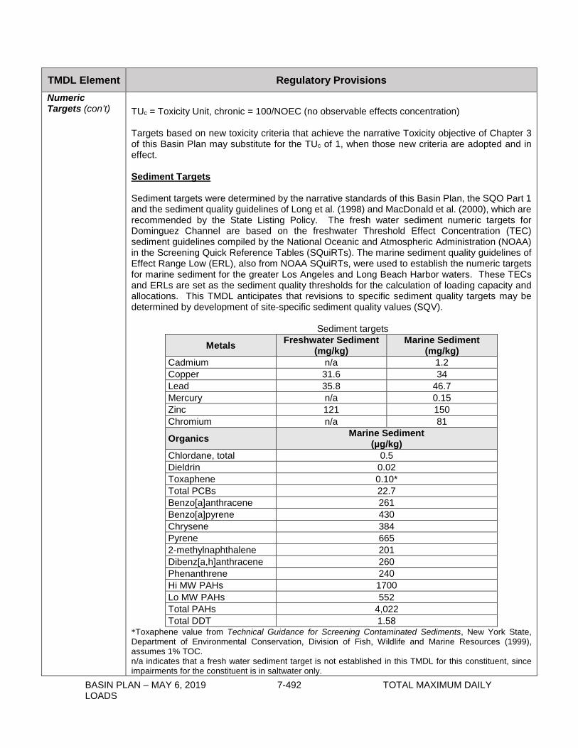
BASIN PLAN – MAY 6, 2019 7-492 TOTAL MAXIMUM DAILY LOADS
TMDL Element Regulatory Provisions Numeric Targets (con’t)
TUc = Toxicity Unit, chronic = 100/NOEC (no observable effects concentration) Targets based on new toxicity criteria that achieve the narrative Toxicity objective of Chapter 3 of this Basin Plan may substitute for the TUc of 1, when those new criteria are adopted and in effect. Sediment Targets Sediment targets were determined by the narrative standards of this Basin Plan, the SQO Part 1 and the sediment quality guidelines of Long et al. (1998) and MacDonald et al. (2000), which are recommended by the State Listing Policy. The fresh water sediment numeric targets for Dominguez Channel are based on the freshwater Threshold Effect Concentration (TEC) sediment guidelines compiled by the National Oceanic and Atmospheric Administration (NOAA) in the Screening Quick Reference Tables (SQuiRTs). The marine sediment quality guidelines of Effect Range Low (ERL), also from NOAA SQuiRTs, were used to establish the numeric targets for marine sediment for the greater Los Angeles and Long Beach Harbor waters. These TECs and ERLs are set as the sediment quality thresholds for the calculation of loading capacity and allocations. This TMDL anticipates that revisions to specific sediment quality targets may be determined by development of site-specific sediment quality values (SQV).
Sediment targets
Metals Freshwater Sediment (mg/kg)
Marine Sediment (mg/kg)
Cadmium n/a 1.2 Copper 31.6 34 Lead 35.8 46.7 Mercury n/a 0.15 Zinc 121 150 Chromium n/a 81
Organics Marine Sediment (µg/kg)
Chlordane, total 0.5 Dieldrin 0.02 Toxaphene 0.10* Total PCBs 22.7 Benzo[a]anthracene 261 Benzo[a]pyrene 430 Chrysene 384 Pyrene 665 2-methylnaphthalene 201 Dibenz[a,h]anthracene 260 Phenanthrene 240 Hi MW PAHs 1700 Lo MW PAHs 552 Total PAHs 4,022 Total DDT 1.58
*Toxaphene value from Technical Guidance for Screening Contaminated Sediments, New York State, Department of Environmental Conservation, Division of Fish, Wildlife and Marine Resources (1999), assumes 1% TOC. n/a indicates that a fresh water sediment target is not established in this TMDL for this constituent, since impairments for the constituent is in saltwater only.

BASIN PLAN – MAY 6, 2019 7-493 TOTAL MAXIMUM DAILY LOADS
TMDL Element Regulatory Provisions Numeric Targets (con’t)
These sediment targets are not intended to be used as ‘clean-up standards’ for navigational, capital or maintenance dredging or capping activities; rather they are long-term sediment concentrations that should be attained after reduction of external loads, targeted actions addressing internal reservoirs of contaminants, and environmental decay of contaminants in sediment. In addition, the categories designated in the SQO Part 1 as Unimpacted and Likely Unimpacted by the interpretation and integration of multiple lines of evidence shall be considered as the protective narrative objective for sediment toxicity and benthic community effects. The thresholds established in the SQO Part 1 are based on statistical significance and magnitude of the effect. Therefore, this TMDL implicitly includes sediment toxicity and benthic community targets by its use of the SQO Part 1. Fish Tissue and Associated Sediment Targets Fish tissue targets were determined from Fish Contaminant Goals and Advisory Tissue Levels for Common Contaminants in California Sport Fish: Chlordane, DDTs, Dieldrin, Methylmercury, PCBs, Selenium, and Toxaphene, developed by OEHHA (2008) to assist agencies in developing fish tissue-based criteria for pollution mitigation or elimination and to protect humans from consumption of contaminated fish. Associated sediment targets required to achieve the fish tissue targets were determined from several sources depending on the contaminant.
Fish Tissue and Associated Sediment Targets
Pollutant Fish Tissue
Target (µg/kg wet)
Associated Sediment Target (µg/kg dry)
Chlordane 5.6 1.3 b
Dieldrin 0.46 n/a
Total DDT 21 1.9 b
Total PCBs 3.6 3.2 c
Total PAHs 5.47a n/a
Toxaphene 6.1 0.1 d a Total PAHs in fish from EPA screening value. b Chlordane and total DDT associated sediment values from SFEI (2007) “Indicator development and framework for assessing indirect effects of sediment contaminants”, SFEI Contribution #524. c Total PCBs - associated sediment target from Gobas, F. and J. Arnot (2010) “Food Web Bioaccumulation Model for Polychlorinated Biphenyls in San Francisco Bay, California, USA”, ET&C 29:6, 1385-95. d Toxaphene value from New York State (1999), assumes 1% TOC. n/a indicates that an associated sediment target is not established in this TMDL at this time because there is no BSAF in literature to use in the calculation. If BSAFs are developed in the future, associated sediment targets for dieldrin and/or PAHs may be added during reconsideration of the TMDL.
Source Analysis
Monitoring data from NPDES discharges and land use runoff coefficients were used to estimate the magnitude of metals, organo-chlorine pesticides, PCBs, and PAHs loads to Dominguez Channel and Greater Los Angeles and Long Beach Harbor waters. PCBs, DDT, dieldrin, and chlordane are legacy pollutants for the most part, yet, they remain present in the environment, bound to fine-grained particles. Because they are legacy pollutants and are subject to environmental decay, their concentrations are gradually decreasing over time. When these particles become waterborne, the chemicals are ferried to new locations. Urban

BASIN PLAN – MAY 6, 2019 7-494 TOTAL MAXIMUM DAILY LOADS
TMDL Element Regulatory Provisions Source Analysis (con’t)
runoff and rainfall higher in the watersheds mobilize the particles, which are then washed into storm drains and channels that discharge to the Dominguez Channel and greater Harbor waters. Metals and PAHs are currently generated or deposited in the watersheds and are then washed into storm drains and channels that discharge to the Dominguez Channel and greater Harbor waters. Briefly there are several categories of pollutant sources to the waters of concern in these TMDLs. Point sources include stormwater and urban runoff (MS4) and other NPDES discharges, including but not limited to Port operations, Terminal Island Water Reclamation Plant (TIWRP), refineries, and generating plants. Nonpoint sources include existing contaminated sediments and direct (air) deposition. Dominguez Channel waters: The major point sources of organo-chlorine pesticides, PCBs, and metals into Dominguez Channel are stormwater and urban runoff discharges. Nonpoint sources include atmospheric deposition and fluxes from contaminated sediments into the overlying water. Current loads of metals into Dominguez Channel were estimated using Loading Simulation Program in C++ (LSPC) model output from simulated flows for 1995-2005. Monitoring data from NPDES discharges and land use runoff coefficients were analyzed along with Channel stream flow rates to estimate the magnitude of metal loadings. In recognition of the wide variety of stream flow rates generated by various rainfall conditions, flow duration curves were utilized to analyze the metals loading during wet weather. Greater Los Angeles and Long Beach Harbor waters: A variety of activities over the past decades in the four contributing watersheds (Dominguez Channel, Los Angeles River, San Gabriel River and the nearshore watershed) and in the Harbors themselves have contributed to the sediment contamination. The contaminated sediments are a reservoir of historically deposited pollutants. Stormwater runoff from manufacturing, military facilities, fish processing plants, wastewater treatment plants, oil production facilities, and shipbuilding or repair yards in both Ports discharged untreated or partially treated wastes into Harbor waters. Current activities also contribute pollutants to Harbor sediments. In particular, stormwater runoff from port facilities, commercial vessels (ocean going vessels and harbor craft), recreational vessels, and the re-suspension of contaminated sediments via natural processes and/or anthropogenic activities including (ship) propeller wash within the Ports also contributes to transport of pollutants within the Harbors. Loadings from the four contributing watersheds are also potential sources of metals, pesticides, PCBs, and PAHs to the Harbors. The major nonpoint source of pesticides and PCBs to the greater Harbor waters is the current sediments. The re-suspension of these sediments contributes to the fish tissue impairments. In addition, atmospheric deposition may be a potential nonpoint source of metals to the watershed, through either direct deposition or indirect deposition. Current loading of metals, PAHs, DDT and PCBs to contaminated sediments within the Dominguez Channel Estuary and Greater Harbor waters was estimated using monitoring data from special studies and water body surface area for air deposition; discharge results for refineries and TIWRP; and Environmental Fluid Dynamics Code (EFDC) model output for 2002-2005. Model inputs included the existing average sediment concentration in the top 5 cm of bed sediments and the total sediment deposition rate per waterbody.
Linkage Analysis
The linkage analysis connects pollutant loads to the numeric targets and protection of beneficial uses of Dominguez Channel and Greater Los Angeles and Long Beach Harbor waters. To
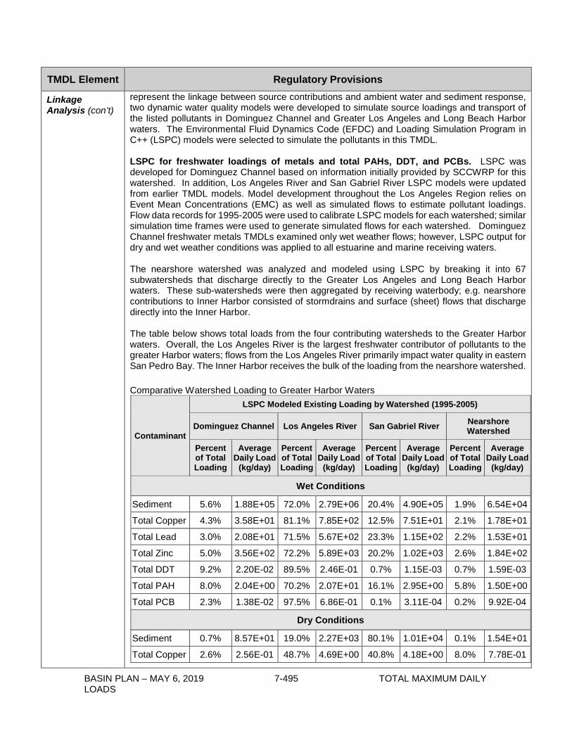
BASIN PLAN – MAY 6, 2019 7-495 TOTAL MAXIMUM DAILY LOADS
TMDL Element Regulatory Provisions
Linkage Analysis (con’t)
represent the linkage between source contributions and ambient water and sediment response, two dynamic water quality models were developed to simulate source loadings and transport of the listed pollutants in Dominguez Channel and Greater Los Angeles and Long Beach Harbor waters. The Environmental Fluid Dynamics Code (EFDC) and Loading Simulation Program in C++ (LSPC) models were selected to simulate the pollutants in this TMDL. LSPC for freshwater loadings of metals and total PAHs, DDT, and PCBs. LSPC was developed for Dominguez Channel based on information initially provided by SCCWRP for this watershed. In addition, Los Angeles River and San Gabriel River LSPC models were updated from earlier TMDL models. Model development throughout the Los Angeles Region relies on Event Mean Concentrations (EMC) as well as simulated flows to estimate pollutant loadings. Flow data records for 1995-2005 were used to calibrate LSPC models for each watershed; similar simulation time frames were used to generate simulated flows for each watershed. Dominguez Channel freshwater metals TMDLs examined only wet weather flows; however, LSPC output for dry and wet weather conditions was applied to all estuarine and marine receiving waters. The nearshore watershed was analyzed and modeled using LSPC by breaking it into 67 subwatersheds that discharge directly to the Greater Los Angeles and Long Beach Harbor waters. These sub-watersheds were then aggregated by receiving waterbody; e.g. nearshore contributions to Inner Harbor consisted of stormdrains and surface (sheet) flows that discharge directly into the Inner Harbor. The table below shows total loads from the four contributing watersheds to the Greater Harbor waters. Overall, the Los Angeles River is the largest freshwater contributor of pollutants to the greater Harbor waters; flows from the Los Angeles River primarily impact water quality in eastern San Pedro Bay. The Inner Harbor receives the bulk of the loading from the nearshore watershed. Comparative Watershed Loading to Greater Harbor Waters
Contaminant
LSPC Modeled Existing Loading by Watershed (1995-2005)
Dominguez Channel Los Angeles River San Gabriel River Nearshore Watershed
Percent of Total Loading
Average Daily Load
(kg/day)
Percent of Total Loading
Average Daily Load
(kg/day)
Percent of Total Loading
Average Daily Load
(kg/day)
Percent of Total Loading
Average Daily Load
(kg/day)
Wet Conditions
Sediment 5.6% 1.88E+05 72.0% 2.79E+06 20.4% 4.90E+05 1.9% 6.54E+04
Total Copper 4.3% 3.58E+01 81.1% 7.85E+02 12.5% 7.51E+01 2.1% 1.78E+01
Total Lead 3.0% 2.08E+01 71.5% 5.67E+02 23.3% 1.15E+02 2.2% 1.53E+01
Total Zinc 5.0% 3.56E+02 72.2% 5.89E+03 20.2% 1.02E+03 2.6% 1.84E+02
Total DDT 9.2% 2.20E-02 89.5% 2.46E-01 0.7% 1.15E-03 0.7% 1.59E-03
Total PAH 8.0% 2.04E+00 70.2% 2.07E+01 16.1% 2.95E+00 5.8% 1.50E+00
Total PCB 2.3% 1.38E-02 97.5% 6.86E-01 0.1% 3.11E-04 0.2% 9.92E-04
Dry Conditions
Sediment 0.7% 8.57E+01 19.0% 2.27E+03 80.1% 1.01E+04 0.1% 1.54E+01
Total Copper 2.6% 2.56E-01 48.7% 4.69E+00 40.8% 4.18E+00 8.0% 7.78E-01

BASIN PLAN – MAY 6, 2019 7-496 TOTAL MAXIMUM DAILY LOADS
TMDL Element Regulatory Provisions
Linkage Analysis (con’t)
Total Lead 0.9% 3.48E-02 19.8% 7.86E-01 72.9% 3.07E+00 6.5% 2.59E-01
Total Zinc 0.9% 5.65E-01 30.4% 1.90E+01 62.6% 4.15E+01 6.2% 3.89E+00
Total DDT 7.7% 1.90E-05 83.0% 2.01E-04 9.3% 2.38E-05 0.0% 2.88E-10
Total PAH 6.8% 7.06E-02 62.7% 6.39E-01 30.4% 3.29E-01 0.0% 4.18E-05
Total PCB 1.8% 1.06E-05 97.1% 5.59E-04 1.1% 6.43E-06 0.0% 1.45E-10
The EFDC was used to model hydrodynamics and water and sediment quality of the greater Los Angeles and Long Beach Harbor waters. The EFDC model applied a simulated time period of 2002-2005. The model was calibrated with numerous sediment monitoring studies, including Los Angeles and Long Beach Harbor’s 2006 sediment characterization study, which yielded sediment, porewater and overlying water concentrations as well as results from highly sensitive monitoring devices for detecting DDT, PCBs, and PAHs in the water column. The EFDC model also considered ocean water (outside breakwater) conditions and fine and coarse sediment transport and deposition. Ultimately the EFDC model was integrated with LSPC output – hourly for three watersheds, daily for nearshore watersheds – to model metals, PAHs, PCBs, and DDT (total) sediment concentrations in the receiving waters. The annual total (clean) sediment deposition rate for the top 5 cm (active sediment layer) was multiplied by the corresponding existing sediment pollutant level or the TMDL sediment quality target to yield pollutant load within each waterbody.
Annual (clean) Sediment Deposition Rates per (salt)Waterbody
Waterbody Name TMDL Zone
Area (acres)1 Area (m2)1 Total Deposition
(kg/yr)2 Dominguez Channel Estuary 01 140 567,900 2,470,201 Consolidated Slip 02 36 147,103 355,560 Inner Harbor - POLA 03 1,539 6,228,431 1,580,809 Inner Harbor - POLB 08 1,464 5,926,130 674,604 Fish Harbor 04 91 368,524 30,593 Cabrillo Marina 05 77 310,259 38,859 Cabrillo Beach 06 82 331,799 27,089 Outer Harbor - POLA 07 1,454 5,885,626 572,349 Outer Harbor - POLB 09 2,588 10,472,741 1,828,407 Los Angeles River Estuary 10 207 837,873 21,610,283 San Pedro Bay 11 8,173 33,073,517 19,056,271
1 Area obtained from GIS layer of the 2006 303(d) list. Available at: http://www.waterboards.ca.gov/water_issues/programs/tmdl/303d_lists2006_gis.shtml 2 Sediment deposition rates were calculated by approximating the average mass of total sediment (fine and coarse particles) deposited in each waterbody annually based on 2002-2005 EFDC output. Sediment flux for each grid cell, which is dependent on watershed inputs as well as tidal movements between waterbodies, was obtained from the EFDC model output. These values were summarized across each TMDL waterbody, resulting in the average deposition of both sediment fines and sand by waterbody. The total deposition rate is simply the sum of the rates for fines and sand and this value is the waterbody-specific average annual (clean) sediment deposition rate. The EFDC model was used to evaluate several management scenarios and relative contributions from various inputs to support water quality management decisions in Dominguez Channel and

BASIN PLAN – MAY 6, 2019 7-497 TOTAL MAXIMUM DAILY LOADS
TMDL Element Regulatory Provisions Linkage Analysis (con’t)
Greater Los Angeles and Long Beach Harbor waters. Preliminary results for two scenarios indicate that reducing freshwater input loads may not be sufficient to achieve target concentrations in water and sediments; thus reductions in contaminant levels in bed sediments may be required.
Loading Capacity
Loading capacity was calculated for both Dominguez Channel (wet weather) and in the Dominguez Channel Estuary and Greater Harbor waters (dry and wet weather). Dominguez Channel wet weather metals TMDLs: During wet weather, the loading capacity is a function of the volume of water in the Channel. Given the variability in wet-weather flows, the concept of a single critical flow was not justified. Instead, a load duration curve approach was used to establish the wet-weather loading capacity. The load duration curve was developed by multiplying the wet-weather flows by the in-stream numeric targets. The resulting curves identify the allowable load for a given flow. The wet-weather TMDLs for copper and zinc are defined by these load duration curves. Loading capacities were calculated by multiplying the daily volume by the appropriate numeric water quality target or, in the case of lead, the observed existing average concentration. The wet-weather loading capacity applies to any day when the maximum daily flow measured at a location within the Dominguez Channel is equal to or greater than 62.7 cfs, which is the 90th percentile of annual flow rates from estimated/modeled flow rates. The freshwater toxicity TMDL is equal to 1 TUc. Dominguez Channel Estuary and Greater Harbor waters, metals and organics in sediment TMDLs: Loading capacities for Dominguez Channel Estuary and Greater Harbor waters were calculated by estimating the sediment load (based on modeled sediment deposition rates) multiplied by the sediment quality target. The active sediment layer was defined as the top 5 cm of sediment; the habitat of approximately 95% of benthic organisms. In addition, chlordane, dieldrin, toxaphene and mercury TMDLs were defined for specific waterbodies as equivalent to the concentration-based sediment quality target.
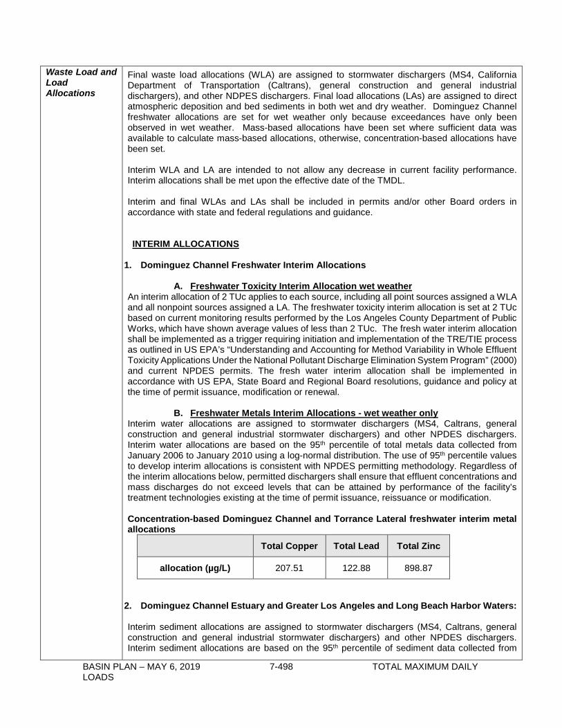
BASIN PLAN – MAY 6, 2019 7-498 TOTAL MAXIMUM DAILY LOADS
Waste Load and Load Allocations
Final waste load allocations (WLA) are assigned to stormwater dischargers (MS4, California Department of Transportation (Caltrans), general construction and general industrial dischargers), and other NDPES dischargers. Final load allocations (LAs) are assigned to direct atmospheric deposition and bed sediments in both wet and dry weather. Dominguez Channel freshwater allocations are set for wet weather only because exceedances have only been observed in wet weather. Mass-based allocations have been set where sufficient data was available to calculate mass-based allocations, otherwise, concentration-based allocations have been set. Interim WLA and LA are intended to not allow any decrease in current facility performance. Interim allocations shall be met upon the effective date of the TMDL. Interim and final WLAs and LAs shall be included in permits and/or other Board orders in accordance with state and federal regulations and guidance. INTERIM ALLOCATIONS
1. Dominguez Channel Freshwater Interim Allocations
A. Freshwater Toxicity Interim Allocation wet weather An interim allocation of 2 TUc applies to each source, including all point sources assigned a WLA and all nonpoint sources assigned a LA. The freshwater toxicity interim allocation is set at 2 TUc based on current monitoring results performed by the Los Angeles County Department of Public Works, which have shown average values of less than 2 TUc. The fresh water interim allocation shall be implemented as a trigger requiring initiation and implementation of the TRE/TIE process as outlined in US EPA’s “Understanding and Accounting for Method Variability in Whole Effluent Toxicity Applications Under the National Pollutant Discharge Elimination System Program” (2000) and current NPDES permits. The fresh water interim allocation shall be implemented in accordance with US EPA, State Board and Regional Board resolutions, guidance and policy at the time of permit issuance, modification or renewal.
B. Freshwater Metals Interim Allocations - wet weather only Interim water allocations are assigned to stormwater dischargers (MS4, Caltrans, general construction and general industrial stormwater dischargers) and other NPDES dischargers. Interim water allocations are based on the 95th percentile of total metals data collected from January 2006 to January 2010 using a log-normal distribution. The use of 95th percentile values to develop interim allocations is consistent with NPDES permitting methodology. Regardless of the interim allocations below, permitted dischargers shall ensure that effluent concentrations and mass discharges do not exceed levels that can be attained by performance of the facility’s treatment technologies existing at the time of permit issuance, reissuance or modification. Concentration-based Dominguez Channel and Torrance Lateral freshwater interim metal allocations
Total Copper Total Lead Total Zinc
allocation (µg/L) 207.51 122.88 898.87
2. Dominguez Channel Estuary and Greater Los Angeles and Long Beach Harbor Waters: Interim sediment allocations are assigned to stormwater dischargers (MS4, Caltrans, general construction and general industrial stormwater dischargers) and other NPDES dischargers. Interim sediment allocations are based on the 95th percentile of sediment data collected from

BASIN PLAN – MAY 6, 2019 7-499 TOTAL MAXIMUM DAILY LOADS
Waste Load and Load Allocations (con’t)
1998-2006. The use of 95th percentile values to develop interim allocations is consistent with NPDES permitting methodology. For waterbodies where the 95th percentile value has been equal to, or lower than, the numeric target, then the interim allocation is set equal to the final allocation. Regardless of the interim sediment allocations below, permitted dischargers shall ensure that effluent concentrations and mass discharges do not exceed levels that can be attained by performance of the facility’s treatment technologies existing at the time of permit issuance, reissuance or modification. Sediment, interim concentration-based allocations
Waterbody Pollutant (mg/kg sediment)
Copper Lead Zinc DDT PAHs PCBs Dominguez Channel Estuary 220.0 510.0 789.0 1.727 31.60 1.490 Long Beach Inner Harbor 142.3 50.4 240.6 0.070 4.58 0.060 Los Angeles Inner Harbor 154.1 145.5 362.0 0.341 90.30 2.107 Long Beach Outer Harbor (inside breakwater) 67.3 46.7 150 0.075 4.022 0.248 Los Angeles Outer Harbor (inside breakwater) 104.1 46.7 150 0.097 4.022 0.310 Los Angeles River Estuary 53.0 46.7 183.5 0.254 4.36 0.683 San Pedro Bay Near/Off Shore Zones 76.9 66.6 263.1 0.057 4.022 0.193 Los Angeles Harbor - Cabrillo Marina 367.6 72.6 281.8 0.186 36.12 0.199 Los Angeles Harbor - Consolidated Slip 1470.0 1100.0 1705.0 1.724 386.00 1.920 Los Angeles Harbor - Inner Cabrillo Beach Area 129.7 46.7 163.1 0.145 4.022 0.033 Fish Harbor 558.6 116.5 430.5 40.5 2102.7 36.6 Numbers in bold are also the final allocation.
Compliance with the interim concentration-based sediment allocations may be demonstrated via any one of three different means:
1. Demonstrate that the. sediment quality condition of Unimpacted or Likely Unimpacted via the interpretation and integration of multiple lines of evidence as defined in the SQO Part 1, is met; or
2. Meet the interim allocations in bed sediment over a three-year averaging period; or 3. Meet the interim allocations in the discharge over a three-year averaging period.
FINAL ALLOCATIONS
1. Dominguez Channel Freshwater Allocations A. Freshwater Toxicity Allocation in wet weather
A final allocation of 1 TUc, or its equivalent based on any Statewide Toxicity Policy, applies to each source, including all point sources assigned a WLA and all nonpoint sources assigned a LA.
B. Freshwater Metals Allocations in wet weather Wet-weather allocations are assigned to Dominguez Channel and all upstream reaches and tributaries of Dominguez Channel (above Vermont Avenue). Allocations are assigned to both point (WLA) and nonpoint sources (LA). A mass-based LA has been developed for direct atmospheric deposition. A mass-based waste load allocation (WLA) is divided between the MS4 permittees and Caltrans under its NPDES stormwater permit by subtracting the other stormwater or NPDES waste load allocations, air deposition and the margin

BASIN PLAN – MAY 6, 2019 7-500 TOTAL MAXIMUM DAILY LOADS
Waste Load and Load Allocations (con’t)
of safety from the total loading capacity. Concentration-based WLAs are assigned for the other point sources including but not limited to General Construction, General Industrial, Power Generating stations, minor permits and irregular dischargers, and other NPDES dischargers.
Mass-based Dominguez Channel Wet-weather Final Allocations
Total Copper (g/day)
Total Lead (g/day)
Total Zinc (g/day)
TMDL 1,485.1 6,548.8 10,685.5
Waste Load Allocations:
MS4 – LA County Permittees 1,300.3 5,733.7 9,355.5
MS4 - Caltrans 32.3 142.6 232.6
Load Allocations:
Air Deposition 4.0 17.7 28.9
Margin of Safety
MOS (10%) 148.5 654.9 1,069.6 Based on total recoverable metal targets, a hardness of 50 mg/L, and 90th percentile of annual flow rates (62.7 cfs) in Dominguez Channel. Recalculated mass-based allocations using ambient hardness and flow rate at the time of sampling are considered consistent with the assumptions and requirements of these waste load allocations. In addition to the wasteload allocations above, samples collected during flow conditions less than the 90th percentile of annual flow rates must demonstrate that the acute and chronic hardness dependent water quality criteria provided in the CTR are achieved.
Concentration-based Dominguez Channel Wet-weather Final Allocations (µg/L)
Total Copper Total Lead Total Zinc
Other stormwater/NPDES 9.7 42.7 69.7
Based on hardness = 50 mg/L. Recalculated concentration-based allocations using ambient hardness at the time of sampling are considered consistent with the assumptions and requirements of these waste load allocations. In addition to the wasteload allocations above, samples collected during flow conditions less than the 90th percentile of annual flow rates must demonstrate that the acute and chronic hardness dependent water quality criteria provided in the CTR are achieved.
2. Torrance Lateral Freshwater and Sediment Allocations Torrance Lateral is a subwatershed that flows directly into Dominguez Channel Estuary. Allocations are assigned to the ExxonMobil Torrance Refinery and all other dischargers. Mass-based sediment allocations are assigned to the ExxonMobil Torrance Refinery. This allocation has been developed based on an average discharge frequency of once every 7 years. If, at the end of Phase I of implementation, due to an increase in discharge frequency or volumes, it appears that the allocations are not supportive of the TMDL, these allocations may be revised. Sediment waste load allocations are assigned to all other dischargers to Torrance Lateral equal to the concentration-based sediment targets.

BASIN PLAN – MAY 6, 2019 7-501 TOTAL MAXIMUM DAILY LOADS
Waste Load and Load Allocations (con’t)
Torrance Lateral Wet-weather Waste Load Allocations and Sediment Waste Load Allocations, concentration-based
Media Total Copper Total Lead Total Zinc Water (unfiltered) (µg/L) 9.7 42.7 69.7 Sediment (mg/kg dry) 31.6 35.8 121
Hardness = 50 mg/L. Recalculated concentration-based allocations using ambient hardness at the time of sampling are considered consistent with the assumptions and requirements of these waste load allocations. In addition to the wasteload allocations above, samples collected during flow conditions less than the 90th percentile of annual flow rates must demonstrate that the acute and chronic hardness dependent water quality criteria provided in the CTR are achieved.
Waste Load Allocations for ExxonMobil Torrance Refinery into Torrance Lateral, mass-based
Media Total Copper Total Lead Total Zinc Water (unfiltered) (kg/yr) 1.36 5.98 9.75
Based on Q = 3.7 MGD for 7 days/year; and total metals targets No allocation for PAHs is assigned to ExxonMobil; however, discharges should not exceed existing water quality criteria for those compounds and monitoring shall continue.
Compliance with the freshwater metals allocations for Dominguez Channel and Torrance Lateral may be demonstrated via any one of three different means: a. Final allocations are met. b. CTR total metals criteria are met instream. c. CTR total metals criteria are met in the discharge. Dominguez Channel Estuary and Greater Harbor Waters Allocations Concentration-based WLAs for point sources in Dominguez Channel Estuary and Greater Harbor Waters (including refineries) for metals, PAHs, and bioaccumulative compounds in water. Non-MS4 point sources such as General Construction, General Industrial, individual industrial permittees, including power generating stations, minor permits and irregular dischargers into Dominguez Channel Estuary and Greater Harbor Waters are assigned concentration-based allocations. Mass-based WLA for other refineries based on appropriate data maybe considered during the TMDL reconsideration. (Refineries which have provided discharge flow data along with monitoring results are assigned mass-based allocations, whereas other refineries are assigned concentration-based allocations because no discharge flow data has been provided.) Any future minor NPDES permits or enrollees under a general NPDES permit are also assigned the concentration-based waste load allocations. The allocations are set equal to the saltwater targets for metals and equal to the human health targets for the organic compounds in CTR. The averaging period for the concentration-based WLAs shall be consistent with that specified in the regulation establishing the criterion or objective or relevant implementation guidance published by the establishing agency.
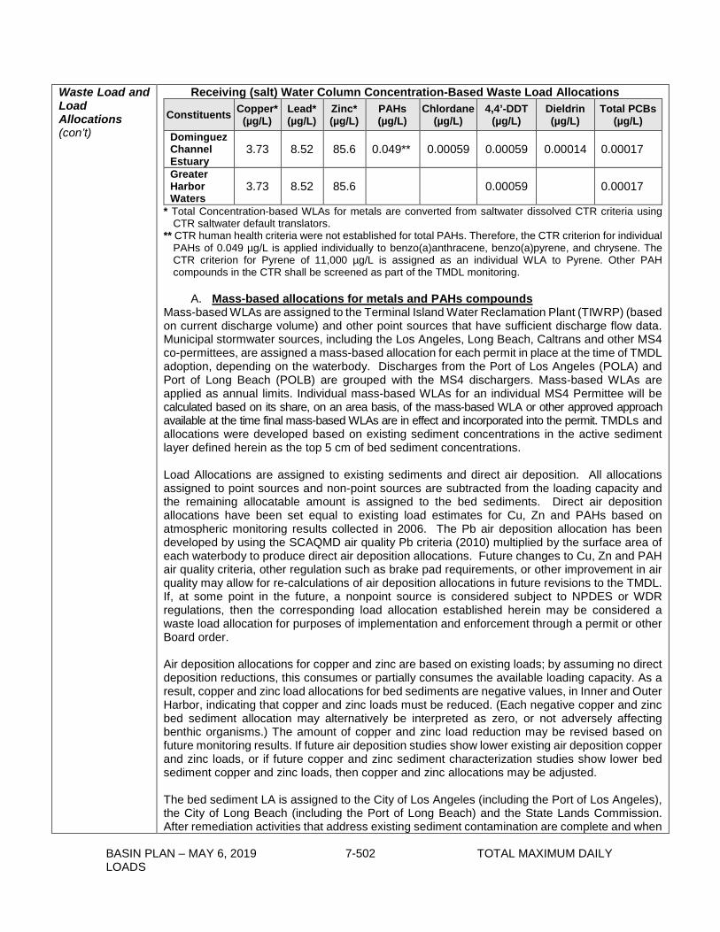
BASIN PLAN – MAY 6, 2019 7-502 TOTAL MAXIMUM DAILY LOADS
Waste Load and Load Allocations (con’t)
Receiving (salt) Water Column Concentration-Based Waste Load Allocations
Constituents Copper* (µg/L)
Lead* (µg/L)
Zinc* (µg/L)
PAHs (µg/L)
Chlordane (µg/L)
4,4’-DDT (µg/L)
Dieldrin (µg/L)
Total PCBs (µg/L)
Dominguez Channel Estuary
3.73 8.52 85.6 0.049** 0.00059 0.00059 0.00014 0.00017
Greater Harbor Waters
3.73 8.52 85.6 0.00059 0.00017
* Total Concentration-based WLAs for metals are converted from saltwater dissolved CTR criteria using CTR saltwater default translators.
** CTR human health criteria were not established for total PAHs. Therefore, the CTR criterion for individual PAHs of 0.049 µg/L is applied individually to benzo(a)anthracene, benzo(a)pyrene, and chrysene. The CTR criterion for Pyrene of 11,000 µg/L is assigned as an individual WLA to Pyrene. Other PAH compounds in the CTR shall be screened as part of the TMDL monitoring.
A. Mass-based allocations for metals and PAHs compounds
Mass-based WLAs are assigned to the Terminal Island Water Reclamation Plant (TIWRP) (based on current discharge volume) and other point sources that have sufficient discharge flow data. Municipal stormwater sources, including the Los Angeles, Long Beach, Caltrans and other MS4 co-permittees, are assigned a mass-based allocation for each permit in place at the time of TMDL adoption, depending on the waterbody. Discharges from the Port of Los Angeles (POLA) and Port of Long Beach (POLB) are grouped with the MS4 dischargers. Mass-based WLAs are applied as annual limits. Individual mass-based WLAs for an individual MS4 Permittee will be calculated based on its share, on an area basis, of the mass-based WLA or other approved approach available at the time final mass-based WLAs are in effect and incorporated into the permit. TMDLs and allocations were developed based on existing sediment concentrations in the active sediment layer defined herein as the top 5 cm of bed sediment concentrations. Load Allocations are assigned to existing sediments and direct air deposition. All allocations assigned to point sources and non-point sources are subtracted from the loading capacity and the remaining allocatable amount is assigned to the bed sediments. Direct air deposition allocations have been set equal to existing load estimates for Cu, Zn and PAHs based on atmospheric monitoring results collected in 2006. The Pb air deposition allocation has been developed by using the SCAQMD air quality Pb criteria (2010) multiplied by the surface area of each waterbody to produce direct air deposition allocations. Future changes to Cu, Zn and PAH air quality criteria, other regulation such as brake pad requirements, or other improvement in air quality may allow for re-calculations of air deposition allocations in future revisions to the TMDL. If, at some point in the future, a nonpoint source is considered subject to NPDES or WDR regulations, then the corresponding load allocation established herein may be considered a waste load allocation for purposes of implementation and enforcement through a permit or other Board order. Air deposition allocations for copper and zinc are based on existing loads; by assuming no direct deposition reductions, this consumes or partially consumes the available loading capacity. As a result, copper and zinc load allocations for bed sediments are negative values, in Inner and Outer Harbor, indicating that copper and zinc loads must be reduced. (Each negative copper and zinc bed sediment allocation may alternatively be interpreted as zero, or not adversely affecting benthic organisms.) The amount of copper and zinc load reduction may be revised based on future monitoring results. If future air deposition studies show lower existing air deposition copper and zinc loads, or if future copper and zinc sediment characterization studies show lower bed sediment copper and zinc loads, then copper and zinc allocations may be adjusted. The bed sediment LA is assigned to the City of Los Angeles (including the Port of Los Angeles), the City of Long Beach (including the Port of Long Beach) and the State Lands Commission. After remediation activities that address existing sediment contamination are complete and when

BASIN PLAN – MAY 6, 2019 7-503 TOTAL MAXIMUM DAILY LOADS
Waste Load and Load Allocations (con’t)
LAs are attained, if bed sediments are recontaminated as a result of continued polluted discharge from the surrounding watersheds, the WLA compliance monitoring data will be used, along with other available information, to assess the relative contribution of watershed dischargers and determine their responsibility and allocations for secondary remediation activities. Final, mass-based TMDLs and Allocations for metals and PAHs (Kg/year)
Waterbody/source Total Cu Total Pb Total Zn Total PAHs DomCh Estuary - TMDL 84 115.4 370.5 9.94
WLAs MS4- LA County et al. 22.4 54.2 271.8 0.134 MS4- City of Long Beach 0.6 1.52 7.6 0.0038 MS4- CalTrans 0.384 0.93 4.7 0.0023
LAs Air deposition 4.6 0.031 33.2 0.051 Bed sediments 56.0 58.7 53.3 9.7
Current Load 327.6 457.9 1799.0 28.1 Overall reduction 74% 75% 79% 65% Consolidated Slip - TMDL 12.1 16.6 53.3 1.43
WLAs MS4- LA County et al. 2.73 3.63 28.7 0.0058 MS4 CalTrans 0.043 0.058 0.5 0.00009
LAs Air deposition 1.2 0.008 8.6 0.013 Bed sediments 8.13 12.9 15.57 1.41
Current Load 92.1 127.3 398.9 11.5 Overall reduction 87% 87% 87% 88% Inner Harbor - TMDL 76.7 105.3 338.3 9.1
WLAs MS4- LA County et al. 1.7 34.0 115.9 0.088 MS4 City of Long Beach 0.463 9.31 31.71 0.024 MS4 CalTrans 0.032 0.641 2.18 0.0017
LAs Air deposition 97.6 0.67 710 1.08 Bed sediments (23.1) 60.7 (521.3) 7.88
Current Load 178.4 105.9 542.1 3.524 Overall reduction 57% 1% 38% 0%
Outer Harbor - TMDL 81.6 112.1 360.1 9.7 WLAs
MS4- LA County et al. 0.91 26.1 81.5 0.105 MS4 City of Long Beach 0.63 18.1 56.4 0.073

BASIN PLAN – MAY 6, 2019 7-504 TOTAL MAXIMUM DAILY LOADS
Waste Load and Load Allocations (con’t)
MS4 CalTrans 0.0018 0.052 0.162 0.00021 TIWRP = POTW
80.4 183.6 1845 1.056 (CTR & MGD***)
LAs Air deposition 17.9 0.9 108.1 1.5 Bed sediments (18.2) (116) (1731) 6.964
Current Load 119.0 66.7 403.4 0.626 Overall reduction 31% 0% 11% 0% Fish Harbor - TMDL 1.04 1.43 4.59 0.123
WLAs MS4- LA County et al. (POLA) 0.00017 0.54 1.62 0.007
MS4 CalTrans 0.0000005 0.00175 0.0053 0.000021 LAs
Air deposition 0.4 0.02 2.4 0.033 Bed sediments 0.636 0.87 0.5 0.084
Current Load 1.43 0.60 4.2 0.003 Overall reduction 27% 0% 0% 0%
Cabrillo Marina -TMDL 1.32 1.81 5.8 0.156 WLAs
MS4- LA County et al. (POLA) 0.0196 0.289 0.74 0.00016
MS4 CalTrans 0.00019 0.0028 0.007 0.0000016 LAs
Air deposition 0.34 0.017 2.05 0.028 Bed sediments 1.0 1.506 3.03 0.1285
Current Load 9.2 2.3 9.14 0.236 Overall reduction 86% 21% 36% 34% San Pedro Bay - TMDL 648 890 2858 76.6
WLAs MS4- LA County et al. 20.3 54.7 213.1 1.76 MS4 City of Long Beach 137.9 372.2 1449.7 12.0 MS4 CalTrans 0.88 2.39 9.29 0.077 MS4 Orange County** 9.8 26.4 102.9 0.85
LAs Air deposition 36 1.8 219 2.9 Bed sediments 442.9 432 865 59.0
Current Load 1251 1737 8167 3.63 Overall reduction 48% 49% 65% 0%

BASIN PLAN – MAY 6, 2019 7-505 TOTAL MAXIMUM DAILY LOADS
Waste Load and Load Allocations (con’t)
LA River Estuary - TMDL 735 1009 3242 86.9 WLAs
LAR Estuary dischargers* [Cu SQV] [Pb SQV] [Zn SQV] [PAH SQV] MS4- LA County et al. 35.3 65.7 242.0 2.31 MS4 City of Long Beach 375.8 698.9 2572.7 24.56 MS4 CalTrans 5.1 9.5 34.8 0.333
LAs Air deposition 6.7 0.046 48.9 0.075 Bed sediments 311.8 235.0 343.0 59.6
Current Load 1612 2641 20096 8.72 Overall reduction 54% 62% 84% 0%
Note: Cu and Zn air deposition load allocations are set equal to existing load with no reductions anticipated. Negative (values) for bed sediments indicate that bed sediment loads are expected to be reduced; the amount of reduction may be revised with additional monitoring results. *SQVs are currently set at ERLs **Orange County MS4 Permit is issued by the Santa Ana Regional Board. The allocations included, here, for the Seal Beach nearshore area, are for TMDL calculation purposes only, and an allocation is not assigned. ***For TIWRP, the discharge volume at the time of permit modification or reissuance shall be used to calculate the mass-based effluent limitations consistent with the assumptions and requirements of these WLAs. Studies may be conducted to determine the portion of the discharged pollutants that is deposited on bed sediment. The results of any such Executive Officer approved studies shall be evaluated at the TMDL reconsideration to modify these WLAs as appropriate. Consolidated Slip and Fish Harbor are impaired for mercury in sediments and the average sediment concentration (1.1 mg/kg dry) is significantly higher than the target concentration (0.15 mg/kg dry). Consolidated Slip and Dominguez Channel Estuary are impaired for cadmium in sediments, and Consolidated Slip is also impaired for chromium in sediments. Final Concentration-Based Sediment WLAs for metals in Dominguez Channel Estuary, Consolidated Slip and Fish Harbor
Concentration-based Sediment WLAs (mg/kg dry sediment) Cadmium Chromium Mercury
1.2 81 0.15 Mercury applies to both Consolidated Slip and Fish Harbor; Cd applies to Dominguez Channel Estuary and Consolidated Slip, and Cr applies to Consolidated Slip only. Compliance with these sediment TMDLs for Cu, Pb, Zn, Cd, Cr, Hg and total PAHs may be demonstrated via any one of three different means:
a. Final sediment allocations, as presented above, are met. b. The qualitative sediment condition of Unimpacted or Likely Unimpacted via the
interpretation and integration of multiple lines of evidence as defined in the SQO Part 1, is met, with the exception of Cr, which is not included in the SQO Part 1.
c. Sediment numeric targets are met in bed sediments over a three-year averaging period.
Compliance with mass-based WLAs shall be measured at designated discharge points. Compliance with concentration-based WLAs for existing sediment shall be determined by pollutant concentrations in ambient sediment in each waterbody. The average ambient bulk sediment level within a waterbody at or below the sediment quality target is considered compliance with these TMDLs.

BASIN PLAN – MAY 6, 2019 7-506 TOTAL MAXIMUM DAILY LOADS
Waste Load and Load Allocations (con’t)
B. Mass-based Allocations for Bioaccumulative Compounds
Fish tissue levels of certain bioaccumulative compounds are above desired numeric targets. These TMDLs are designed to reduce contaminated sediment levels, which will result in lower corresponding pollutant levels in fish tissue. These sediment allocations have been derived to support lowering fish tissue levels using biota-sediment accumulation factors (BSAFs) or ERLs, whichever is more protective. For chlordane and dieldrin, the ERL values are lower and more protective than BSAF values. The DDT sediment values are comparable (ERL = 1.58, BSAF = 1.9); the more stringent one was used for calculation. The PCBs sediment value associated with fish tissue is more stringent than the ERL sediment value for PCBs. Mass-based WLAs are assigned for TIWRP and other point sources that have sufficient discharge flow data. Municipal stormwater sources, including the Los Angeles, Long Beach, Caltrans and other MS4 co-permittees, are assigned a single, mass-based allocation by permit, depending on the waterbody. Discharges from the Port of Los Angeles (POLA) and Port of Long Beach (POLB) are grouped with the MS4 dischargers. Mass-based WLAs are applied as annual limits. Individual mass-based WLAs for an individual MS4 Permittee will be calculated based on its share, on an area basis, of the mass based WLA or other approved approach available at the time final mass-based WLAs are in effect and incorporated into the permit. Mass-based LAs are identified for bed sediments and direct air deposition. Direct air deposition allocations for total DDT are based on estimates of existing loads using atmospheric monitoring results collected close to Los Angeles/Long Beach Harbor at SCAQMD Wilmington Station in 2006. Pollutant-specific air deposition values (DDT = 29 ng/m2/day) were multiplied by the surface area of each waterbody to produce direct deposition allocations. Direct deposition allocations for PCBs are not included since air deposition has been measured to be less than water-to-air fluxes. DDT load allocations for bed sediments are negative values, with the exception of those for the Los Angeles River Estuary, indicating that DDT loads must be reduced. (Each negative DDT bed sediment allocation may alternatively be interpreted as zero, or interpreted as minimal bioaccumulation into the food web.) The amount of DDT load reduction may be revised based on future monitoring results. If future air deposition studies show lower existing air deposition DDT loads, or if future DDT sediment characterization studies show lower bed sediment DDT loads, then DDT load allocations may be adjusted. The Greater Harbor Waters (excluding LA River Estuary and Consolidated Slip) bed sediment LA is assigned to the City of Los Angeles (including the Port of Los Angeles), the City of Long Beach (including the Port of Long Beach) and the State Lands Commission. After remediation activities that address existing sediment contamination are complete and when LAs are attained, if bed sediments are recontaminated as a result of continued polluted discharge from the surrounding watersheds, the WLA compliance monitoring data will be used, along with other available information, to assess the relative contribution of watershed dischargers and determine their responsibility and allocations for secondary remediation activities. DDT and PCBs (total) TMDLs apply to all estuarine and marine waters in Greater Harbor area, including Inner Cabrillo Beach, Los Angeles River Estuary and Eastern San Pedro Bay. Final mass-based TMDLs and Allocations for total DDT and total PCBs (g/yr)
Waterbody/source DDT total PCBs total
DomCh Estuary – TMDL 3.90 7.90
WLAs MS4- LA County et al 0.250 0.207

BASIN PLAN – MAY 6, 2019 7-507 TOTAL MAXIMUM DAILY LOADS
Waste Load and Load Allocations (con’t)
MS4 City of Long Beach 0.007 0.006 MS4 CalTrans 0.004 0.004
LAs Air deposition 6.01 n/a Bed sediments (2.4) 7.7
Current Load 54.0 57.5 Overall reduction 93% 86%
Consolidated Slip - TMDL 0.56 1.14
WLAs MS4- LA County et al 0.009 0.004 MS4 CalTrans 0.00014 0.00006
LAs Air deposition 1.56 n/a Bed sediments (1.00) 1.13
Current Load 49.0 83.9 Overall reduction 99% 99%
Inner Harbor - TMDL 3.56 7.22
WLAs MS4- LA County et al 0.051 0.059 MS4 City of Long Beach 0.014 0.016 MS4 CalTrans 0.0010 0.0011
LAs Air deposition 129 n/a Bed sediments (125) 7.14
Current Load 21.67 29.51 Overall reduction 84% 76%
Outer Harbor - TMDL 3.79 7.68
WLAs MS4- LA County et al 0.005 0.020 MS4 City of Long Beach 0.004 0.014 MS4 CalTrans 0.000010 0.00004 TIWRP = POTW
12.7 0.37 (CTR & MGD***)
LAs Air deposition 173 n/a Bed sediments (182) 7.28
Current Load 30.8 34.7 Overall reduction 88% 78%
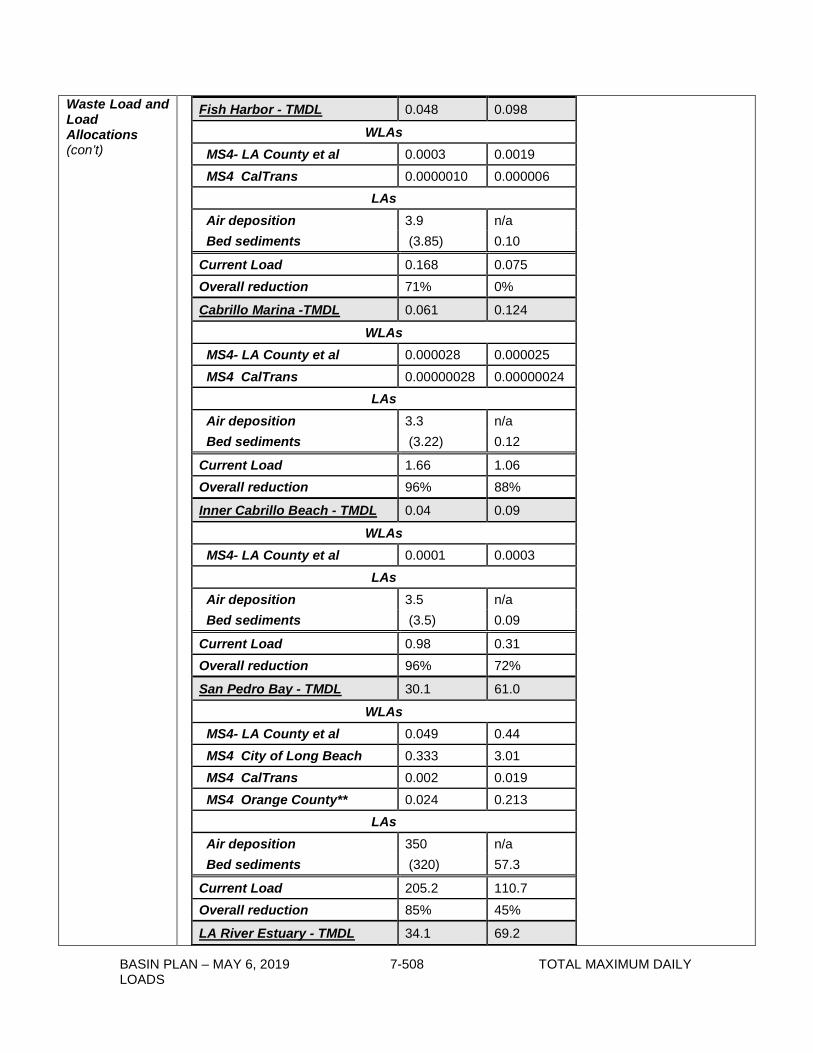
BASIN PLAN – MAY 6, 2019 7-508 TOTAL MAXIMUM DAILY LOADS
Waste Load and Load Allocations (con’t)
Fish Harbor - TMDL 0.048 0.098
WLAs MS4- LA County et al 0.0003 0.0019 MS4 CalTrans 0.0000010 0.000006
LAs Air deposition 3.9 n/a Bed sediments (3.85) 0.10
Current Load 0.168 0.075 Overall reduction 71% 0%
Cabrillo Marina -TMDL 0.061 0.124
WLAs MS4- LA County et al 0.000028 0.000025 MS4 CalTrans 0.00000028 0.00000024
LAs Air deposition 3.3 n/a Bed sediments (3.22) 0.12
Current Load 1.66 1.06 Overall reduction 96% 88%
Inner Cabrillo Beach - TMDL 0.04 0.09
WLAs MS4- LA County et al 0.0001 0.0003
LAs Air deposition 3.5 n/a Bed sediments (3.5) 0.09
Current Load 0.98 0.31 Overall reduction 96% 72%
San Pedro Bay - TMDL 30.1 61.0
WLAs MS4- LA County et al 0.049 0.44 MS4 City of Long Beach 0.333 3.01 MS4 CalTrans 0.002 0.019 MS4 Orange County** 0.024 0.213
LAs Air deposition 350 n/a Bed sediments (320) 57.3
Current Load 205.2 110.7 Overall reduction 85% 45%
LA River Estuary - TMDL 34.1 69.2

BASIN PLAN – MAY 6, 2019 7-509 TOTAL MAXIMUM DAILY LOADS
Waste Load and Load Allocations (con’t)
WLAs MS4- LA County et al 0.100 0.324 MS4 City of Long Beach 1.067 3.441 MS4 CalTrans 0.014 0.047
LAR Estuary dischargers [DDT SQV] [PCBs SQV] LAs
Air deposition 8.9 n/a Bed sediments 24.09 65.3
Current Load 231.6 402.2 Overall reduction 85% 83%
Note: DDT air deposition load allocation is set equal to existing load with no reductions anticipated. Negative values for bed sediments indicate that DDT bed sediment loads are expected to be reduced; the amount of reduction may be revised with additional monitoring results. *SQVs are currently set at the more protective of ERLs or fish tissue associated sediment targets. **Orange County MS4 Permit is issued by the Santa Ana Regional Board. The allocations included, here, for the Seal Beach nearshore area, are for TMDL calculation purposes only, and an allocation is not assigned. ***For TIWRP, the discharge volume at the time of permit modification or reissuance shall be used to calculate the mass-based effluent limitations consistent with the assumptions and requirements of these WLAs. Studies may be conducted to determine the portion of the discharged pollutants that is deposited on bed sediment. The results of any such Executive Officer approved studies shall be evaluated at the TMDL reconsideration to modify these WLAs as appropriate. In addition, bed sediment concentration-based allocations are assigned for chlordane in Dominguez Channel Estuary, Consolidated Slip, Fish Harbor, Los Angeles River Estuary and Eastern San Pedro Bay. Bed sediment concentration-based allocations are also assigned for dieldrin in Dominguez Channel Estuary and Consolidated Slip. Bed sediment concentration allocations are also assigned for toxaphene in Consolidated Slip. The TMDLs and allocations are set at target sediment concentrations: chlordane = 0.5, dieldrin = 0.02, toxaphene = 0.10 µg/kg dry sediment. Compliance with these bioaccumulative TMDLs may be demonstrated via any of four different means:
a. Fish tissue targets are met in species resident to the TMDL waterbodies3. b. Final sediment allocations, as presented above, are met. c. Sediment numeric targets to protect fish tissue are met in bed sediments over a three-
year averaging period. d. Demonstrate that the sediment quality condition protective of fish tissue is achieved per
the Statewide Enclosed Bays and Estuaries Plan, as amended to address contaminants in resident finfish and wildlife.
3 A site-specific study to determine resident species shall be submitted to the Executive Officer for approval. 3. Diazinon Los Angeles County monitoring data in Dominguez Channel freshwaters show diazinon exceedences from 2002-2005, but none from 2006-2010. This timing is concurrent with EPA’s ban on urban use of diazinon, effective Dec. 31, 2005. Based these results, no diazinon TMDLs are developed at this time.

BASIN PLAN – MAY 6, 2019 7-510 TOTAL MAXIMUM DAILY LOADS
Margin of Safety
The Dominguez Channel freshwater allocations included an explicit margin of safety (MOS) equal to 10% of the loading capacity or existing load to account for any additional uncertainty in the wet-weather TMDLs. The 10% MOS was subtracted from the loading capacity or existing load, whichever was smaller. Applying an explicit margin of safety is reasonable because a number of uncertain estimates are offset by the explicit margin of safety. While the observed dissolved-to-total metals ratios are not similar to CTR default conversion values, there appears to be very poor correlation between the fraction of particulate metals and TSS. Also, there is added uncertainty regarding stream flow rates during wet weather conditions, when the highest metal loads occur, thus an explicit margin of safety is justified. An implicit margin of safety exists in the final allocations to Dominguez Channel Estuary and Greater Harbor waters. The implicit margin of safety is based on the selection of multiple numeric targets, including targets for water, fish tissue and sediment among other conservative modeling assumptions. An additional explicit margin of safety must be considered and may be applied if any chemical-specific sediment quality target is revised or updated contingent on future sediment quality studies. That is, there may be uncertainty associated with revised sediment quality values, which may warrant including an additional explicit margin of safety.
Seasonal Variations and Critical Conditions
Wet weather events may produce extensive sediment redistribution and transport sediments to the harbors and the CTR-based water column targets are protective of this condition. This would be considered the critical condition for loading. No correlation with flow or seasonality (wet vs. dry season) was found to exist in sediment or tissue data. Given that allocations for this TMDL are expressed in terms pesticides, PCBs, PAHs, and metals concentrations in sediment, a critical condition is not identified based upon flow or seasonality. Because the adverse effects of pesticides, PCBs, PAHs, and metals are related to sediment accumulation and bioaccumulation in the food chain over long periods of time, short term variations in concentrations are less likely to cause significant impacts upon beneficial uses.
Monitoring Plan
Monitoring by assigned responsible parties is required in three waterbody areas: 1. Dominguez Channel, Torrance Lateral, and Dominguez Channel Estuary 2. Greater Los Angeles and Long Beach Harbor Waters (including Consolidated Slip) 3. Los Angeles River and San Gabriel River Monitoring shall be conducted under technically appropriate Monitoring and Reporting Plans (MRPs) and Quality Assurance Project Plans (QAPPs). The MRPs shall include a requirement that the responsible parties report compliance and non-compliance with waste load and load allocations as part of annual reports submitted to the Regional Board. The QAPPs shall include protocols for sample collection, standard analytical procedures, and laboratory certification. All samples shall be collected in accordance with SWAMP protocols. Monitoring Plans shall be submitted twenty (20) months after the effective date of the TMDL for public review and, subsequently, Executive Officer approval. Monitoring shall begin six months after the monitoring plan is approved by the Executive Officer. Responsible parties assigned both WLAs and LAs may submit one document that addresses the monitoring requirements (as described below) and implementation activities for both WLAs and LAs. Responsible parties shall submit annual monitoring reports. The Regional Board Executive Officer may reduce, increase, or modify monitoring and reporting requirements, as necessary, based on the results of the TMDL monitoring program. Currently, several of the constituents of concern have numeric targets that are lower than the readily available detection limits. As analytical methods and detection limits continue to improve (i.e., development of lower detection limits) and become more environmentally

BASIN PLAN – MAY 6, 2019 7-511 TOTAL MAXIMUM DAILY LOADS
Monitoring Plan (con’t)
relevant, responsible parties shall incorporate new method detection limits in the MRP and QAPP. 1. Dominguez Channel, Torrance Lateral, and Dominguez Channel Estuary Compliance
Monitoring Program
For Dominguez Channel, Dominguez Channel Estuary, and Torrance Lateral, water and total suspended solids samples shall be collected at the outlet of the storm drains discharging to the channel and the estuary. Fish tissue samples shall be collected in receiving waters of the Dominguez Channel Estuary. Sediment samples shall also be collected in the estuary. • Water Column Monitoring Water samples and total suspended solids samples shall be collected during two wet weather events and one dry weather event each year. The first large storm event of the season shall be included as one of the wet weather monitoring events. Water samples and total suspended solid samples shall be analyzed for a suite of compounds including, at a minimum, metals, including lead, zinc, and copper, DDT, PCBs, Benzo[a] anthrancene, Benzo[a]pyrene, Chrysene, Phenanthrene, and Pyrene. Sampling shall be designed to collected sufficient volumes of suspended solids to allow for analysis of the pollutants in the bulk sediment. In addition to TMDL constituents, general water chemistry (temperature, dissolved oxygen, pH, and electrical conductivity) and a flow measurement will be required at each sampling event. General chemistry measurements may be taken in the laboratory immediately following sample collection, if auto samplers are used for sample collection or if weather conditions are unsuitable for field measurements. In addition, toxicity shall be tested for in the freshwater portion of Dominguez Channel. • Sediment Monitoring A sediment monitoring program shall be developed consistent with the selected method for compliance and all samples shall be collected in accordance with SWAMP protocols. a) If compliance will be determined based on achieving sediment quality targets, sediment
chemistry samples shall be collected every two years for analysis of general sediment quality constituents and the full chemical suite as specified in SQO Part 1. In addition, benthic community effects shall be assessed in the Dominguez Channel Estuary.
b) If compliance will be determined based on the SQO compliance method, sediment chemistry samples shall also be collected every five years (in addition to, and in between, the sediment triad sampling events as described below), beginning after the first sediment triad event, to evaluate trends in general sediment quality constituents and listed constituents relative to sediment quality targets. Chemistry data without accompanying sediment triad data shall be used to assess sediment chemistry trends and shall not be used to determine compliance.
Sediment quality objective evaluation as detailed in the SQO Part 1 (sediment triad sampling) shall be performed every five years in coordination with the Biological Baseline and Bight regional monitoring programs, if possible. Sampling and analysis for the full chemical suite, two toxicity tests and four benthic indices as specified in SQO Part 1 shall be conducted and evaluated. If moderate toxicity as defined in the SQO Part 1 is observed, results shall be highlighted in annual reports and further analysis and evaluation to determine causes and remedies shall be required in accordance with the EO approved monitoring plan. Locations for sediment triad assessment and the methodology for combining results from sampling locations to determine sediment conditions shall be specified in the MRP to be approved by the Executive Officer. The sampling design shall be in compliance with the SQO Part 1 Sediment Monitoring section (VII.E.).

BASIN PLAN – MAY 6, 2019 7-512 TOTAL MAXIMUM DAILY LOADS
Monitoring Plan (con’t)
• Fish Tissue Monitoring Fish tissue samples shall be collected every two years from the Dominguez Channel Estuary and analyzed for chlordane, dieldrin, toxaphene, DDT, and PCBs. The target species in the Dominguez Channel Estuary shall be selected based on residency, local abundance and fish size at the time of field collection. Tissues analyzed shall be based on the most common preparation for the selected fish species.
The Dominguez Channel responsible parties are each individually responsible for conducting water, sediment, and fish tissue monitoring. However, they are encouraged to collaborate or coordinate their efforts to avoid duplication and reduce associated costs. Dischargers interested in coordinated monitoring shall submit a coordinated MRP that identifies monitoring to be implemented by the responsible parties. Under the coordinated monitoring option, the compliance point for the stormwater WLAs shall be storm drain outfalls or a point(s) in the receiving water that suitably represents the combined discharge of cooperating parties.
The details of the monitoring program including sampling locations and all methods shall be specified in the MRP to be approved by the Executive Officer.
2. Greater Los Angeles and Long Beach Harbor Waters Compliance Monitoring Program
At a minimum, compliance monitoring shall be conducted at the locations and for the constituents listed in the table below for water column, total suspended solids, and sediment. The exact locations of monitoring sites shall be specified in the MRP to be approved by the Executive Officer. During aspects of the remedial action(s) for the Montrose Superfund Site that may mobilize sediments and associated pollutants from the on- or near-property soils or “Neighborhood Areas”, it is recommended that US EPA, as the regulatory oversight agency, require that Potentially Responsible Parties (PRP) implement monitoring to evaluate pollutant loads and concentrations leaving the site and surrounding area, as well as pollutant concentrations in the bed sediments of Dominguez Channel Estuary and Consolidated Slip and coordinate such monitoring with other TMDL compliance monitoring.
• Water Column Monitoring Water samples and total suspended solids samples shall be collected during two wet weather events and one dry weather event each year. TSS shall be collected at several depths during wet weather events. The first large storm event of the season shall be included as one of the wet weather monitoring events. General water chemistry (temperature, dissolved oxygen, pH, and salinity) and a flow measurement shall be required at each sampling event.
• Sediment Monitoring Sediment chemistry samples shall be collected every five years (in addition to, and in between, the sediment triad sampling events as described below), beginning after the first sediment triad event, to evaluate trends in general sediment quality constituents and listed constituents relative to sediment quality targets. Chemistry data without accompanying sediment triad data shall be used to assess sediment chemistry trends and shall not be used to determine compliance.
Sediment chemistry monitoring requirements

BASIN PLAN – MAY 6, 2019 7-513 TOTAL MAXIMUM DAILY LOADS
Monitoring Plan (con’t)
Water Body Name
Station Id Station Location
Sample Media
WATER/TSS SEDIMENT
Consolidated Slip 01 Center of
Consolidated Slip Metals, PCBs, DDT
Metals, Chlordane, DDT PCBs, PAHs
Los Angeles Inner Harbor 02 East Turning
Basin Metals, PCBs, DDT
Metals, Toxicity, Benthic Community Effect
03 Center of the POLA West Basin
Metals, PCBs, DDT
04
Main Turning Basin north of Vincent Thomas Bridge
Metals, PCBs, DDT
05 Between Pier 300 and Pier 400
Metals, PCBs, DDT
Metals, Toxicity, Benthic Community Effect
06 Main Channel south of Port O’Call
Metals, PCBs, DDT
Metals, Toxicity, Benthic Community Effect
Fish Harbor 07 Center of inner portion of Fish Harbor
Metals, PCBs, DDT
Metals, Toxicity, PCBs, DDT, Chlordane, PAHs
Los Angeles Outer Harbor 08
Los Angeles Outer Harbor between Pier 400 and middle breakwater
Metals, PCBs, DDT Toxicity
09
Los Angeles Outer Harbor between the southern end of the reservation point and the San Pedro breakwater
Metals, PCBs, DDT Toxicity
Cabrillo Marina 10 Center of west
Channel Metals, PCBs, DDT
Inner Cabrillo Beach 11 Center of Inner
Cabrillo Beach Metals, PCBs, DDT Metals
Long Beach Inner Harbor 12
Cerritos Channel between the Heim Bridge and the Turning Basin
Metals, PCBs, DDT
Metals, Toxicity, Benthic Community Effect
13
Back Channel between Turning Basin and West Basin
Metals, PCBs, DDT
Metals, Toxicity, Benthic Community Effect
14 Center of West Basin
Metals, PCBs, DDT
Metals, Toxicity, Benthic Community Effect
15 Center of Southeast Basin
Metals, PCBs, DDT
Metals, Toxicity, Benthic Community Effect
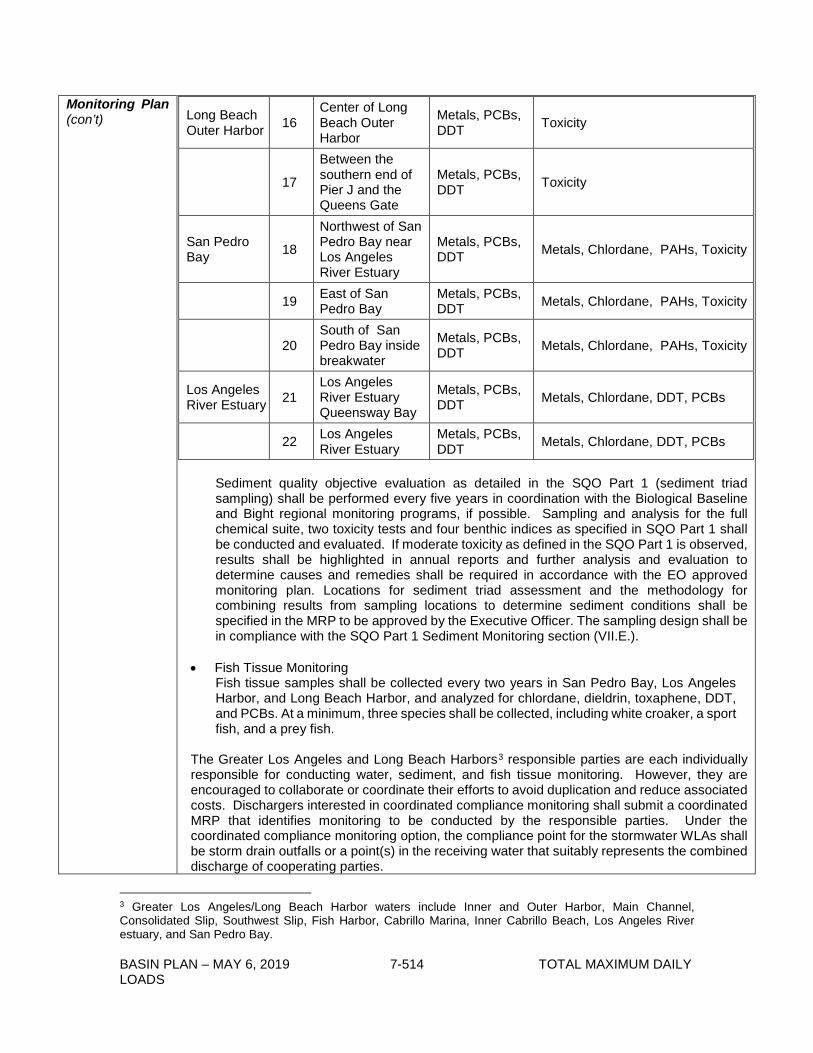
BASIN PLAN – MAY 6, 2019 7-514 TOTAL MAXIMUM DAILY LOADS
Monitoring Plan (con’t)
Long Beach Outer Harbor 16
Center of Long Beach Outer Harbor
Metals, PCBs, DDT Toxicity
17
Between the southern end of Pier J and the Queens Gate
Metals, PCBs, DDT Toxicity
San Pedro Bay 18
Northwest of San Pedro Bay near Los Angeles River Estuary
Metals, PCBs, DDT Metals, Chlordane, PAHs, Toxicity
19 East of San Pedro Bay
Metals, PCBs, DDT Metals, Chlordane, PAHs, Toxicity
20 South of San Pedro Bay inside breakwater
Metals, PCBs, DDT Metals, Chlordane, PAHs, Toxicity
Los Angeles River Estuary 21
Los Angeles River Estuary Queensway Bay
Metals, PCBs, DDT Metals, Chlordane, DDT, PCBs
22 Los Angeles River Estuary
Metals, PCBs, DDT Metals, Chlordane, DDT, PCBs
Sediment quality objective evaluation as detailed in the SQO Part 1 (sediment triad sampling) shall be performed every five years in coordination with the Biological Baseline and Bight regional monitoring programs, if possible. Sampling and analysis for the full chemical suite, two toxicity tests and four benthic indices as specified in SQO Part 1 shall be conducted and evaluated. If moderate toxicity as defined in the SQO Part 1 is observed, results shall be highlighted in annual reports and further analysis and evaluation to determine causes and remedies shall be required in accordance with the EO approved monitoring plan. Locations for sediment triad assessment and the methodology for combining results from sampling locations to determine sediment conditions shall be specified in the MRP to be approved by the Executive Officer. The sampling design shall be in compliance with the SQO Part 1 Sediment Monitoring section (VII.E.).
• Fish Tissue Monitoring Fish tissue samples shall be collected every two years in San Pedro Bay, Los Angeles Harbor, and Long Beach Harbor, and analyzed for chlordane, dieldrin, toxaphene, DDT, and PCBs. At a minimum, three species shall be collected, including white croaker, a sport fish, and a prey fish.
The Greater Los Angeles and Long Beach Harbors3 responsible parties are each individually responsible for conducting water, sediment, and fish tissue monitoring. However, they are encouraged to collaborate or coordinate their efforts to avoid duplication and reduce associated costs. Dischargers interested in coordinated compliance monitoring shall submit a coordinated MRP that identifies monitoring to be conducted by the responsible parties. Under the coordinated compliance monitoring option, the compliance point for the stormwater WLAs shall be storm drain outfalls or a point(s) in the receiving water that suitably represents the combined discharge of cooperating parties.
3 Greater Los Angeles/Long Beach Harbor waters include Inner and Outer Harbor, Main Channel, Consolidated Slip, Southwest Slip, Fish Harbor, Cabrillo Marina, Inner Cabrillo Beach, Los Angeles River estuary, and San Pedro Bay.
BASIN PLAN – MAY 6, 2019 7-515 TOTAL MAXIMUM DAILY LOADS
Monitoring Plan (con’t)
The Consolidated Slip sub-group responsible parties are responsible for conducting water, sediment, and fish tissue monitoring in Consolidated Slip.
The details of the monitoring program including sampling locations and all methods shall be specified in the MRP to be approved by the Executive Officer.
3. Los Angeles River and San Gabriel River Compliance Monitoring Program Los Angeles River Watershed and San Gabriel River Watershed responsible parties identified in effective metals TMDLs for Los Angeles River and San Gabriel River are responsible for conducting water and sediment monitoring above the Los Angeles River Estuary and at the mouth of the San Gabriel River, respectively, to determine the Rivers’ contribution to the impairments in the Greater Harbor waters.
• Water Column Monitoring
Water samples and total suspended solids samples shall be collected at, at least one site during two wet weather events and one dry weather event each year. The first large storm event of the season shall be included as one of the wet weather monitoring events. Water samples and total suspended solid samples shall be analyzed for metals, DDT, PCBs, and PAHs. Sampling shall be designed to collect sufficient volumes of suspended solids to allow for analysis of the listed pollutants in the bulk sediment. General water chemistry (temperature, dissolved oxygen, pH, and electrical conductivity) and a flow measurement shall be required at each sampling event. General chemistry measurements may be taken in the laboratory immediately following sample collection if auto samplers are used for sample collection or if weather conditions are unsuitable for field measurements.
• Sediment Monitoring For sediment chemistry, sediment samples shall be collected at, at least one site every two years for analysis of general sediment quality constituents and the full chemical suite as specified in SQO Part 1. All samples shall be collected in accordance with SWAMP protocols. The details of the monitoring program including sampling locations and all methods shall be specified in the MRP to be approved by the Executive Officer.
BASIN PLAN – MAY 6, 2019 7-516 TOTAL MAXIMUM DAILY LOADS
Implementation Plan
The regulatory mechanisms to implement the TMDL include, but are not limited to, general NPDES permits, individual NPDES permits, MS4 Permits covering jurisdictions and flood control districts within these waters, the Statewide Industrial Storm Water General Permit, the Statewide Construction Activity Storm Water General Permit, the Statewide Stormwater Permit for Caltrans Activities, and the authority contained in Sections 13263, 13267 and 13383 of the Cal. Water Code. For each discharger assigned a WLA, the appropriate Regional Board Order shall be reopened or amended when the order is reissued, in accordance with applicable laws, to incorporate the applicable WLA(s) as a permit requirement consistent with federal regulation and related guidance (40 CFR 144.22(d)(1)(vii)(B); US EPA Memorandum “Revisions to the November 22, 2002 Memorandum ‘Establishing Total Maximum Daily Load (TMDL) Wasteload Allocations (WLAs) for Storm Water Sources and NPDES Permit Requirements Based on Those WLAs’” (November 12, 2010)). LAs will be implemented in a manner consistent with federal and state laws, regulations and policies, including the Nonpoint Source Implementation and Enforcement Policy. Implementation by assigned responsible parties is required in three waterbody areas: 1. Dominguez Channel, Torrance Lateral, and Dominguez Channel Estuary 2. Greater Los Angeles and Long Beach Harbor waters (including Consolidated Slip) 3. Los Angeles River and San Gabriel River Actions to achieve WLA and LA may be implemented in phases with information from each phase being used to inform the implementation of the next phase. These sediment targets are not intended to be used as ‘clean-up standards’ for navigational, capital or maintenance dredging or capping activities; rather they are long-term sediment concentrations that should be attained after reduction of external loads, targeted actions addressing internal reservoirs of contaminants, and environmental decay of contaminants in sediment. The implementation may be adjusted, as necessary, based on information gained during each phase. Table 7-40.2 contains the schedule for responsible parties to develop and implement TMDL implementation plans and sediment management plans to comply with the TMDL.
8. Dominguez Channel, Torrance Lateral, and Dominguez Channel Estuary
Responsible parties can implement a variety of implementation strategies to meet the required WLAs and LAs, such as non-structural and structural BMPs, diversion and treatment to reduce sediment transport from the watershed to Dominguez Channel and Greater Harbor waters, and sediment removal activities. Nonpoint source elements include legacy sediments and air deposition across Dominguez Channel and Harbor waters. The responsible parties identified in the Allocation section and in part 6. Application of Allocations to Responsible Parties of this section are assigned sediment load allocations and responsibility for remediation of the contaminated sediments to attain the load allocations.
Phase I The purpose of the Phase I implementation is to reduce the amount of sediment transport from point sources that directly or indirectly discharge to Dominguez Channel and the Harbor waters. Phase I should include watershed-wide implementation actions. Important components of Phase I should be to secure the relationships and agreements between cooperating parties and to develop a detailed scope of work with priorities. Potential watershed-wide non-structural BMPs include more frequent and appropriately timed storm drain catch basin cleaning, improved street cleaning by upgrading to vacuum type sweepers, and educating residents and industries about good housekeeping practices.
BASIN PLAN – MAY 6, 2019 7-517 TOTAL MAXIMUM DAILY LOADS
Implementation Plan (con’t)
Structural BMPs may include the placement of stormwater treatment devices designed to reduce sediment loading, such as infiltration trenches, vegetated swales, and/or filter strips at critical points in the watershed. Structural BMPs may also include diversion and treatment facilities to divert runoff directly, or provide capture and storage of runoff and then diversion to a location for treatment. Treatment options to reduce sediment could include sand or media filters. The Los Angeles County Flood Control District (District) owns and operates Dominguez Channel; therefore, the District and the cities that discharge to Dominguez Channel shall each be responsible for conducting implementation actions to address contaminated sediments in Dominguez Channel. Responsible parties in Dominguez Channel shall develop a Sediment Management Plan to address contaminated sediment in Dominguez Channel and Dominguez Channel Estuary. Sediment conditions shall be evaluated through the Sediment Quality Objective (SQO) process detailed in the SQO Part 1. If chemicals within sediments are contributing to an impaired benthic community or toxicity, then causative agent(s) shall be determined using SQO recommended procedures, SQO Part 1 (VII.F.). Impacted sediments shall be included in the list of sites to be managed.
Phase II
Phase II should include the implementation of additional BMPs and site remedial actions, as determined to be effective based on the success of upstream source control, evaluation of TMDL monitoring data collected during Phase I, and targeted source reduction activities as identified in Phase I. Regional responsible parties should develop, prioritize, and implement Phase II elements based on data from the TMDL monitoring program and other available information from special studies. Possible actions include implementation of additional structural and non-structural BMPs throughout the watershed by municipalities, LA County, Caltrans, and others. Phase II should include the implementation of site-specific cleanup actions for areas identified as high priority in the Dominguez Channel Estuary and in accordance with the Sediment Management Plan.
- As management actions are planned for a contaminated site, site-specific cleanup criteria should be determined following protocols that are consistent with state and national guidance. The site improvements should be confirmed through a sediment monitoring program.
- There are two Superfund sites located within Dominguez Channel Watershed: the Montrose Superfund Site and the Del Amo Superfund Site. The US EPA has not yet reached a final remedial decision with respect to certain of the Montrose Superfund Site Operable Units (OUs) that remain contaminated with DDT, including the on- and near-property soils (OU1), the current storm water pathway (OU2), and the “Neighborhood Areas” (OU4 and OU6). The TMDL, its waste load and load allocations, and other regulatory provisions of this TMDL may be applicable or relevant and appropriate requirements (ARARs) as set forth in Section 121(d) of the Comprehensive Environmental Response, Compensation, and Liability Act (42 U.S.C. §§ 9621(d)) for those OUs. Whether provisions within the TMDL are ARARs will be determined in accordance with CERCLA when US EPA develops Records of Decision for the Superfund sites. The TMDL for DDT should be taken into account in the course of the remedial decision-making process. The City of Los Angeles and/or Los Angeles County, should they decide to take action that impacts one of the OUs, shall consult with US EPA’s Superfund Division in advance of such action. Detection of DDT compounds in water or sediment samples collected within Torrance Lateral shall trigger additional monitoring, by parties to be determined by the Executive Officer, in coordination with EPA, to evaluate potential contribution from contaminated soils

BASIN PLAN – MAY 6, 2019 7-518 TOTAL MAXIMUM DAILY LOADS
Implementation Plan (con’t)
related to upstream Montrose operable units discharging via the Kenwood storm drain. Upon reconsideration of the TMDL, all monitoring results for DDT compounds collected by responsible parties or other entities shall be considered as part of source analysis and to determine potential future allocation(s) that may be necessary to minimize impacts to downstream waters and restore beneficial uses in TMDL waterbodies.
Phase III Phase III should include implementation of secondary and additional remediation actions as necessary to be in compliance with final allocations by the end of the implementation period. TMDLs to allocate additional contaminant loads between dischargers in the Dominguez Channel, Torrance Lateral and Dominguez Channel Estuary subwatersheds may also be developed, if necessary.
9. Greater Los Angeles and Long Beach Harbor Waters (including Consolidated Slip) Responsible parties can implement a variety of implementation strategies to meet the required WLAs, such as non-structural and structural BMPs, and/or diversion and treatment to reduce sediment transport from the nearshore watershed to the Greater Harbor waters.
Phase I The purpose of Phase I implementation is to reduce the amount of sediment transport from point sources that directly or indirectly discharge to the Harbor waters. Phase I should include actions to be implemented throughout the nearshore watershed and specific implementation actions at the Ports. Important components of Phase I should be to secure the relationships and agreements between cooperating parties and to develop a detailed scope of work with priorities. Potential watershed-wide non-structural BMPs include more frequent and appropriately timed storm drain catch basin cleaning, improved street cleaning by upgrading to vacuum type sweepers, and educating residents and industries about good housekeeping practices. Structural BMPs may include the placement of stormwater treatment devices designed to reduce sediment loading, such as infiltration trenches, vegetated swales, and/or filter strips at critical points in the watershed. Structural BMPs may also include diversion and treatment facilities to divert runoff directly, or provide capture and storage of runoff and then diversion to a location for treatment. Treatment options to reduce sediment could include sand or media filters. Implementation actions at the Ports should be developed to address different sources that contribute loading to the Harbors such as Port-wide activities and associated control measures for water and sediment, control measures to reduce the discharges from various land uses in the Harbors, nearshore discharges, and on-water discharges. The implementation actions described in the Water Resources Action Plan (WRAP) adopted by the Port of Los Angeles and the Port of Long Beach represent a range of activities that could be conducted to control discharges of polluted stormwater and contaminated sediments to the Harbors.
To meet necessary reductions in sediment bed loads, a Sediment Management Plan shall be developed by the dischargers assigned a sediment bed load LA, the Cities of Los Angeles and Long Beach and the State Lands Commission. Phase I implementation elements for the improvement of the Harbors’ sediment quality should be conducted through the continuation of source reduction, source control, and sediment management. Below are proposed
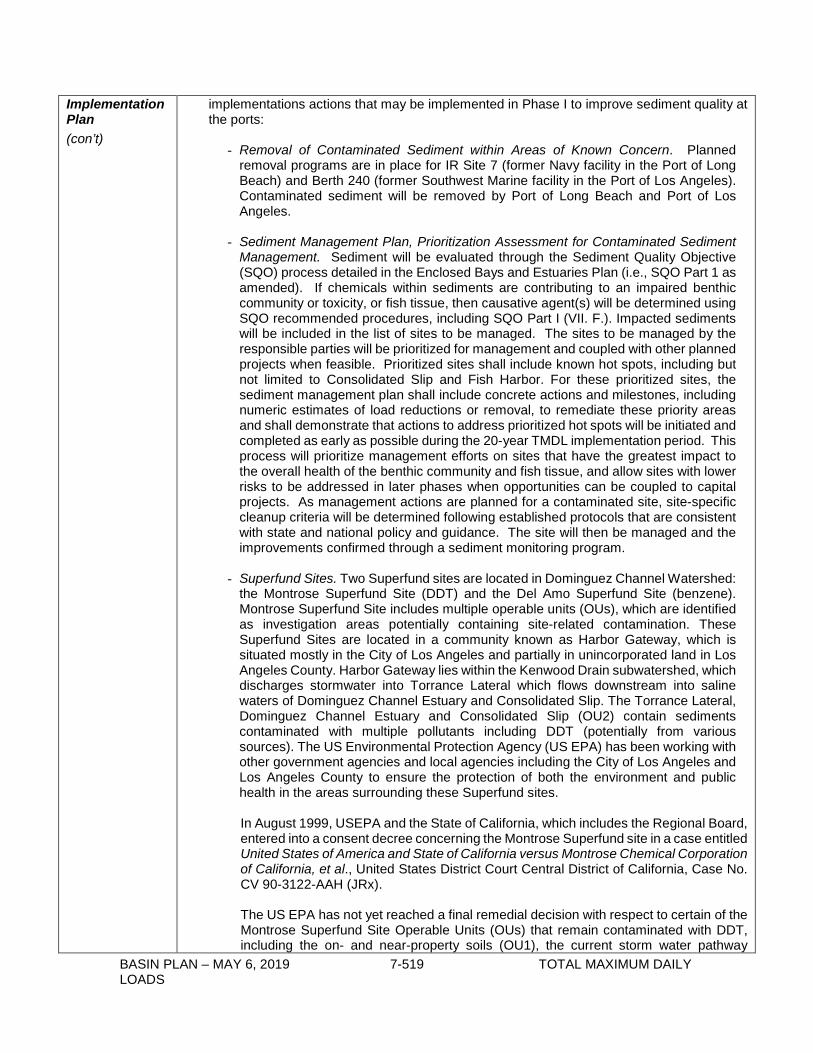
BASIN PLAN – MAY 6, 2019 7-519 TOTAL MAXIMUM DAILY LOADS
Implementation Plan (con’t)
implementations actions that may be implemented in Phase I to improve sediment quality at the ports:
- Removal of Contaminated Sediment within Areas of Known Concern. Planned removal programs are in place for IR Site 7 (former Navy facility in the Port of Long Beach) and Berth 240 (former Southwest Marine facility in the Port of Los Angeles). Contaminated sediment will be removed by Port of Long Beach and Port of Los Angeles.
- Sediment Management Plan, Prioritization Assessment for Contaminated Sediment
Management. Sediment will be evaluated through the Sediment Quality Objective (SQO) process detailed in the Enclosed Bays and Estuaries Plan (i.e., SQO Part 1 as amended). If chemicals within sediments are contributing to an impaired benthic community or toxicity, or fish tissue, then causative agent(s) will be determined using SQO recommended procedures, including SQO Part I (VII. F.). Impacted sediments will be included in the list of sites to be managed. The sites to be managed by the responsible parties will be prioritized for management and coupled with other planned projects when feasible. Prioritized sites shall include known hot spots, including but not limited to Consolidated Slip and Fish Harbor. For these prioritized sites, the sediment management plan shall include concrete actions and milestones, including numeric estimates of load reductions or removal, to remediate these priority areas and shall demonstrate that actions to address prioritized hot spots will be initiated and completed as early as possible during the 20-year TMDL implementation period. This process will prioritize management efforts on sites that have the greatest impact to the overall health of the benthic community and fish tissue, and allow sites with lower risks to be addressed in later phases when opportunities can be coupled to capital projects. As management actions are planned for a contaminated site, site-specific cleanup criteria will be determined following established protocols that are consistent with state and national policy and guidance. The site will then be managed and the improvements confirmed through a sediment monitoring program.
- Superfund Sites. Two Superfund sites are located in Dominguez Channel Watershed:
the Montrose Superfund Site (DDT) and the Del Amo Superfund Site (benzene). Montrose Superfund Site includes multiple operable units (OUs), which are identified as investigation areas potentially containing site-related contamination. These Superfund Sites are located in a community known as Harbor Gateway, which is situated mostly in the City of Los Angeles and partially in unincorporated land in Los Angeles County. Harbor Gateway lies within the Kenwood Drain subwatershed, which discharges stormwater into Torrance Lateral which flows downstream into saline waters of Dominguez Channel Estuary and Consolidated Slip. The Torrance Lateral, Dominguez Channel Estuary and Consolidated Slip (OU2) contain sediments contaminated with multiple pollutants including DDT (potentially from various sources). The US Environmental Protection Agency (US EPA) has been working with other government agencies and local agencies including the City of Los Angeles and Los Angeles County to ensure the protection of both the environment and public health in the areas surrounding these Superfund sites. In August 1999, USEPA and the State of California, which includes the Regional Board, entered into a consent decree concerning the Montrose Superfund site in a case entitled United States of America and State of California versus Montrose Chemical Corporation of California, et al., United States District Court Central District of California, Case No. CV 90-3122-AAH (JRx).
The US EPA has not yet reached a final remedial decision with respect to certain of the Montrose Superfund Site Operable Units (OUs) that remain contaminated with DDT, including the on- and near-property soils (OU1), the current storm water pathway
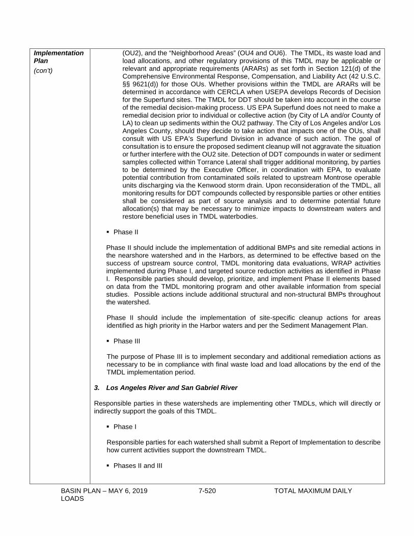
BASIN PLAN – MAY 6, 2019 7-520 TOTAL MAXIMUM DAILY LOADS
Implementation Plan (con’t)
(OU2), and the “Neighborhood Areas” (OU4 and OU6). The TMDL, its waste load and load allocations, and other regulatory provisions of this TMDL may be applicable or relevant and appropriate requirements (ARARs) as set forth in Section 121(d) of the Comprehensive Environmental Response, Compensation, and Liability Act (42 U.S.C. §§ 9621(d)) for those OUs. Whether provisions within the TMDL are ARARs will be determined in accordance with CERCLA when USEPA develops Records of Decision for the Superfund sites. The TMDL for DDT should be taken into account in the course of the remedial decision-making process. US EPA Superfund does not need to make a remedial decision prior to individual or collective action (by City of LA and/or County of LA) to clean up sediments within the OU2 pathway. The City of Los Angeles and/or Los Angeles County, should they decide to take action that impacts one of the OUs, shall consult with US EPA’s Superfund Division in advance of such action. The goal of consultation is to ensure the proposed sediment cleanup will not aggravate the situation or further interfere with the OU2 site. Detection of DDT compounds in water or sediment samples collected within Torrance Lateral shall trigger additional monitoring, by parties to be determined by the Executive Officer, in coordination with EPA, to evaluate potential contribution from contaminated soils related to upstream Montrose operable units discharging via the Kenwood storm drain. Upon reconsideration of the TMDL, all monitoring results for DDT compounds collected by responsible parties or other entities shall be considered as part of source analysis and to determine potential future allocation(s) that may be necessary to minimize impacts to downstream waters and restore beneficial uses in TMDL waterbodies.
Phase II Phase II should include the implementation of additional BMPs and site remedial actions in the nearshore watershed and in the Harbors, as determined to be effective based on the success of upstream source control, TMDL monitoring data evaluations, WRAP activities implemented during Phase I, and targeted source reduction activities as identified in Phase I. Responsible parties should develop, prioritize, and implement Phase II elements based on data from the TMDL monitoring program and other available information from special studies. Possible actions include additional structural and non-structural BMPs throughout the watershed. Phase II should include the implementation of site-specific cleanup actions for areas identified as high priority in the Harbor waters and per the Sediment Management Plan.
Phase III The purpose of Phase III is to implement secondary and additional remediation actions as necessary to be in compliance with final waste load and load allocations by the end of the TMDL implementation period.
3. Los Angeles River and San Gabriel River Responsible parties in these watersheds are implementing other TMDLs, which will directly or indirectly support the goals of this TMDL.
Phase I
Responsible parties for each watershed shall submit a Report of Implementation to describe how current activities support the downstream TMDL.
Phases II and III

BASIN PLAN – MAY 6, 2019 7-521 TOTAL MAXIMUM DAILY LOADS
Implementation Plan (con’t)
Implementation actions may be developed and required in Phases II and III as necessary to meet the targets in the Greater Harbor waters. TMDLs to allocate contaminant loads between dischargers in the Los Angeles and San Gabriel Rivers watersheds may also be developed, if necessary.
4. Special Studies and Reconsideration of TMDL Targets, Allocations, and Schedule This TMDL recognizes that as work to understand these waters and the chemical, physical and biological processes, continues, the targets, allocations, and the flow threshold for wet-weather conditions and the implementation actions to reach those targets and allocations may need to be adjusted. Furthermore, if impairments are identified during flow conditions less than the 90th percentile flow in Dominguez Channel and/or Torrance Lateral, additional allocations for those flow conditions will be developed and applied at the TMDL reconsideration. In addition, it may be necessary to make adjustments to the TMDL to be responsive to new State policies including, but not limited to, SQO Part II; toxicity policy; possible changes to air quality criteria and other regulations affecting air quality. Optional special studies, which could result in changes to these TMDLs, include but are not limited to: studies to further refine the site specific link between sediment pollutant concentrations, depth of bed sediment contamination and fish tissue concentrations; foraging ranges of targeted fish; additional data to refine watershed and hydrodynamic models, including that collected pursuant to this TMDL; additional data on contaminant contributions of the Los Angeles River or San Gabriel River to Greater Harbor waters; stressor identifications; and additional diazinon data. Completion of studies to further refine the site specific link between sediment pollutant concentrations and fish tissue pollutant concentrations and evaluate the range and habitat of specific fish populations will be used to evaluate changes in TMDL targets, WLAs and LAs, and to guide future implementation actions. In addition, further characterization of direct air deposition loadings for heavy metals and legacy pesticides is an optional special study. Allocations of certain pollutants in certain waterbodies are confounded by the existing estimates of pollutant loading via direct air deposition onto the waterbodies. Additional monitoring of these pollutants at air sampling sites more closely resembling the respective waterbodies will help characterize these loadings. Limited data exist for dry deposition so this study could be extended over longer timeframes. Measurements of wet deposition for each pollutant may also be appropriate to estimate air deposition more completely. Study results could provide data to reconsider pollutant-specific allocations in this TMDL. Detection of DDT compounds in water or sediment samples collected within Torrance Lateral shall trigger additional monitoring, by parties to be determined by the Executive Officer, in coordination with EPA, to evaluate potential contribution from contaminated soils related to upstream Montrose operable units discharging via the Kenwood storm drain. Upon reconsideration of the TMDL, all monitoring results for DDT compounds collected by responsible parties or other entities shall be considered as part of source analysis and to determine potential future allocation(s) that may be necessary to minimize impacts to downstream waters and restore beneficial uses in TMDL waterbodies. As allocation-specific data are collected, interim targets for the end of Phase II may be identified. The TMDL will be reconsidered by the Regional Board at the end of Phase I to consider completed special studies or policy changes.
5. Compliance with Allocations and Attainment of Numeric Targets Compliance with the TMDL shall be determined through water, sediment, and fish tissue monitoring and comparison with the TMDL waste load and load allocations and numeric targets. Compliance with the sediment TMDL for metals and PAH compounds shall be based on achieving the loads and waste load allocations or, alternatively, demonstrating attainment of the

BASIN PLAN – MAY 6, 2019 7-522 TOTAL MAXIMUM DAILY LOADS
Implementation Plan (con’t)
SQO Part 1 through the sediment triad/multiple lines of evidence approach outlined therein. Compliance with the TMDLs for bioaccumulative compounds shall be based on achieving the assigned loads and waste load allocations or, alternatively, by meeting fish tissue targets. If at any point during the implementation plan, monitoring data or special studies indicate that load and waste load allocations will be attained, but fish tissue targets may not be achieved, the Regional Board shall reconsider the TMDL to modify the waste load and load allocations to ensure that the fish tissue targets are attained. The compliance point for the stormwater WLAs shall be at the storm drain outfall of the permittee’s drainage area. Alternatively, if stormwater dischargers select a coordinated compliance monitoring option, the compliance point for the stormwater WLA may be at storm drain outfalls or at a point in the receiving water, which suitably represents the combined discharge of cooperating parties discharging to Dominguez Channel and Greater Los Angeles and Long Beach Harbor waters. Depending on potential BMPs implemented, alternative stormwater compliance points may be proposed by responsible parties subject to approval by the Regional Board Executive Officer. The compliance point(s) for responsible parties receiving load allocations shall be in the receiving waters or the bed sediments of the Dominguez Channel and the Greater Los Angeles and Long Beach waters. 6. Application of Allocations to Responsible Parties Responsible parties for monitoring and to attain LAs and WLAs for this TMDL include but are not limited to:
1. Dominguez Channel Responsible Parties
• Dominguez Channel, Torrance Lateral, and Dominguez Channel Estuary MS4 Permittees
Los Angeles County Los Angeles County Flood Control District Caltrans City of Carson City of Compton City of El Segundo City of Gardena City of Hawthorne City of Inglewood City of Lawndale City of Long Beach City of Los Angeles City of Manhattan Beach City of Redondo Beach City of Torrance
• Individual and General Stormwater Permit Enrollees • Other Non-stormwater Permittees • Dominguez Channel Estuary Subgroup for bed sediment and fish:
Los Angeles County Los Angeles County Flood Control District Caltrans City of Carson City of Compton City of Gardena City of Los Angeles City of Long Beach

BASIN PLAN – MAY 6, 2019 7-523 TOTAL MAXIMUM DAILY LOADS
Implementation Plan (con’t)
City of Torrance
2. Greater Los Angeles and Long Beach Harbor Waters Responsible Parties
• Greater Los Angeles and Long Beach Harbor Waters MS4 Permittees Los Angeles County Los Angeles County Flood Control District Caltrans Bellflower City of Lakewood City of Long Beach City of Los Angeles City of Paramount City of Signal Hill City of Rolling Hills City of Rolling Hills Estates Rancho Palos Verdes
• City of Los Angeles (including the Port of Los Angeles) • City of Long Beach (including the Port of Long Beach) • State Lands Commission • Individual and General Stormwater Permit Enrollees • Other Non-stormwater Permittees, including City of Los Angeles (TIWRP) • Los Angeles River Estuary Subgroup for bed sediment and fish:
Los Angeles County Los Angeles County Flood Control District City of Long Beach City of Los Angeles City of Signal Hill Caltrans
• Consolidated Slip Responsible Parties subgroup4 Consolidated Slip MS4 Permittees
Los Angeles County Los Angeles County Flood Control District City of Los Angeles
3. Los Angeles River and San Gabriel River Watershed TMDLs Responsible Parties
Los Angeles River and San Gabriel River metals TMDLs responsible parties (For list of responsible parties, see Chapter 7-13 herein and US EPA, “Total Maximum Daily Loads for Metals and Selenium: San Gabriel River and Impaired Tributaries”, March 26, 2007.)
4 US EPA is the regulatory oversight agency pursuant to CERCLA with respect to the two Superfund sites within the Consolidated Slip subarea but is not identified as a Responsible Party under the TMDL. As the regulatory oversight agency, US EPA is responsible for choosing an appropriate remedy for these sites. Furthermore, under CERCLA, US EPA is responsible for assuring that the CERCLA PRPs clean up the site in compliance with CERCLA and applicable or relevant and appropriate requirements (ARARs) (CERCLA section 121(d)).

BASIN PLAN – MAY 6, 2019 7-524 TOTAL MAXIMUM DAILY LOADS
Table 7-40.2 Dominguez Channel and Greater Los Angeles and Long Beach Harbor Waters Toxic Pollutants TMDL: Implementation Schedule
Task Number
Task Responsible Party Deadline
1 Interim allocations are achieved. All Responsible Parties Effective date of the TMDL
2 Submit a Monitoring Plan to the Los Angeles Regional Board for Executive Officer approval.
Dominguez Channel Responsible parties; Greater Harbors Responsible Parties; Consolidated Slip Responsible Parties subgroup; Los Angeles and San Gabriel River Responsible Parties
20 months after effective date of the TMDL
3 Implement Monitoring Plan Dominguez Channel Responsible parties; Greater Harbors Responsible Parties; Consolidated Slip Responsible Parties subgroup; Los Angeles and San Gabriel River Responsible Parties
6 months after monitoring plan approved by Executive Officer.
4 Submit annual monitoring reports to the Los Angeles Regional Board.
All Responsible parties 15 months after monitoring starts and annually thereafter
5 Submit an Implementation Plan and Contaminated Sediment Management Plan (CSMP). The Implementation Plan and CSMP shall be circulated for public review for 30 days. The CSMP shall include concrete milestones with numeric estimates of load reductions or removal, including milestones for remediating hot spots, including but not limited to Dominguez Channel Estuary, Consolidated Slip and Fish Harbor, for Executive Officer approval. The Executive Officer shall consider the Consent Decree for the Montrose Superfund site in determining whether to approve the CSMPs.
Dominguez Channel Responsible parties; Greater Harbors Responsible Parties; Consolidated Slip Responsible Parties subgroup
2 years after effective date of the TMDL
6 Submit Report of Implementation to the Los Angeles Regional Board.
Los Angeles and San Gabriel River Responsible Parties
2 years after effective date of the TMDL
7 Submit annual implementation reports to the Los Angeles Regional Board. Report on implementation progress and demonstrate progress toward meeting the assigned LAs and WLAs.
All Responsible parties 3 years after effective date of the TMDL and annually thereafter
8 Complete Phase I of TMDL Implementation Plan and Sediment Management Plan.
Dominguez Channel Responsible parties; Greater Harbors Responsible Parties; Consolidated Slip Responsible Parties subgroup
5 years after effective date of the TMDL

BASIN PLAN – MAY 6, 2019 7-525 TOTAL MAXIMUM DAILY LOADS
Task Number
Task Responsible Party Deadline
9 Submit updated Implementation Plan and Contaminated Sediment Management Plan.
Dominguez Channel Responsible parties; Greater Harbors Responsible Parties; Consolidated Slip Responsible Parties subgroup
5 years after effective date of the TMDL
10 Regional Board will reconsider targets, WLAs, and LAs based on new policies, data or special studies. Regional Board will consider requirements for additional implementation or TMDLs for Los Angeles and San Gabriel Rivers and interim targets and allocations for the end of Phase II.
Regional Board 6 years after the effective date of the TMDL
11 Report on status of implementation and scope and schedule of remaining Phase II implementation actions to Regional Board.
All Responsible parties 10 years after the effective date of the TMDL
12 Complete Phase II of TMDL Implementation Plan and Sediment Management Plan.
Dominguez Channel Responsible parties; Greater Harbors Responsible Parties; Consolidated Slip Responsible Parties subgroup
15 years after effective date of the TMDL
13 Complete Phase III of TMDL Implementation Plan and Sediment Management Plan.
Dominguez Channel Responsible parties; Greater Harbors Responsible Parties; Consolidated Slip Responsible Parties subgroup
20 years after effective date of the TMDL
14 Demonstrate attainment of LAs and WLAs using the means identified under Waste Load and Load Allocations in Table 7-40.1
All Responsible parties 20 years after effective date of the TMDL

BASIN PLAN – MAY 6, 2019 7-526 TOTAL MAXIMUM DAILY LOADS
This page intentionally left blank

BASIN PLAN – MAY 6, 2019 7-527 TOTAL MAXIMUM DAILY LOADS
7-41 San Gabriel River, Estuary and Tributaries Indicator Bacteria TMDL This TMDL was adopted by:
The Regional Water Quality Control Board on June 10, 2015.
This TMDL was approved by:
The State Water Resources Control Board on November 17, 2015 The Office of Administrative Law on April 14, 2016. The U.S. Environmental Protection Agency on June 14, 2016.
This TMDL is effective on June 14, 2016.
The following tables include the elements of this TMDL.

BASIN PLAN – MAY 6, 2019 7-528 TOTAL MAXIMUM DAILY LOADS
Table 7-41.1 San Gabriel River, Estuary and Tributaries Indicator Bacteria TMDL: Elements
Element Key Findings and Regulatory Provisions
Problem Statement Elevated bacterial indicator densities are causing impairment of the water contact recreation (REC-1) and non-contact recreation (REC-2) beneficial uses in several reaches of the San Gabriel River, San Gabriel River Estuary, and its tributaries. Recreating in waters with elevated bacterial indicator densities has long been associated with adverse human health effects. Specifically, local and national epidemiological studies demonstrate that there is a causal relationship between adverse health effects and recreational water quality, as measured by bacterial indicator densities.
Numeric Target (Interpretation of the numeric water quality objective, used to calculate the waste load and load allocations)
The TMDL has a multi-part numeric target based on the bacteriological water quality objectives for fresh and marine water to protect the REC-1 and REC-2 beneficial uses. These targets are the most appropriate indicators of public health risk in recreational waters. These bacteriological objectives are set forth in Chapter 3 of the Basin Plan. The objectives are based on four bacterial indicators and include both geometric mean limits and single sample limits. The Basin Plan objectives that serve as the numeric targets for this TMDL are: In Marine Waters Designated for Water Contact Recreation (REC-1) 1. Geometric Mean Limits a. Total coliform density shall not exceed 1,000/100 ml. b. Fecal coliform density shall not exceed 200/100 ml. c. Enterococcus density shall not exceed 35/100 ml. 2. Single Sample Limits a. Total coliform density shall not exceed 10,000/100 ml. b. Fecal coliform density shall not exceed 400/100 ml. c. Enterococcus density shall not exceed 104/100 ml. d. Total coliform density shall not exceed 1,000/100 ml, if the
ratio of fecal-to-total coliform exceeds 0.1. In Fresh Waters Designated for Water Contact Recreation (REC-1) 1. Geometric Mean Limits a. E. coli density shall not exceed 126/100 ml. 2. Single Sample Limits a. E. coli density shall not exceed 235/100 ml. The targets apply throughout the year. Determination of attainment of the targets will be at monitoring sites to be specified monitoring plans to be submitted by responsible entities. In this TMDL, implementation of the above bacteria objectives and the associated TMDL numeric targets is achieved using a “reference

BASIN PLAN – MAY 6, 2019 7-529 TOTAL MAXIMUM DAILY LOADS
Element Key Findings and Regulatory Provisions
Numeric Target (con’t)
system/anti-degradation approach” rather than the alternative “natural sources exclusion approach” or strict application of the single sample objectives. As required by the federal Clean Water Act and California Water Code, Basin Plans include beneficial uses of waters, water quality objectives to protect those uses, an anti-degradation policy, collectively referred to as water quality standards, and other plans and policies necessary to implement water quality standards. This TMDL uses a “reference system/anti-degradation approach” to implement the water quality objectives per the implementation provisions in Chapter 3. On the basis of the historical exceedance frequency in Southern California reference waterbodies, a certain number of daily exceedances of the single sample bacteria objectives are permitted. The geometric mean targets may not be exceeded at any time. For the purposes of this TMDL, the geometric means shall be calculated weekly as a rolling geometric mean using 5 or more samples, for six week periods starting all calculation weeks on Sunday. For the single sample targets, the San Gabriel River and its tributaries are assigned an allowable number of exceedance days for two time periods (1) dry-weather, and (2) wet-weather (defined as days with 0.1 inch of rain or greater and the three days following the rain event.) The San Gabriel River Estuary is assigned an allowable number of exceedance days for three time periods (1) summer dry-weather (April 1 to October 31), (2) winter dry-weather (November 1 to March 31), and (3) wet-weather (defined as days with 0.1 inch of rain or greater and the three days following the rain event.)
Source Analysis The significant contributors of bacteria loading to the San Gabriel River, San Gabriel River Estuary, and its tributaries are dry- and wet-weather discharges from municipal separate storm sewer systems (MS4s). Watershed-wide data show elevated levels of bacteria in the river. Data collected from natural landscapes in the upper watershed indicate that open space loading is not a significant source of bacteria. Data from storm drains and channels draining urban areas show elevated levels of bacteria, indicating that urban areas are a source. Data from throughout the Los Angeles Region further demonstrate that bacteria concentrations are significantly greater in developed areas. Based on this information, runoff from urban areas served by MS4s is a significant source of bacteria. Other point and nonpoint sources were analyzed but there were not sufficient data to quantify their contribution.
Waste Load Allocations (for point sources)
Waste Load Allocations (WLAs) assigned to municipal separate storm sewer system (MS4) discharges are expressed as the number of daily or weekly sample days that may exceed the single sample limits as identified under “Numeric Target.” No exceedances are allowed for the geometric mean limits.

BASIN PLAN – MAY 6, 2019 7-530 TOTAL MAXIMUM DAILY LOADS
Element Key Findings and Regulatory Provisions
Waste Load Allocations (con’t)
The allowable days of exceedance for the single sample limits differ depending on season, dry weather or wet weather, and locations as described in Table 7-41.2. For the San Gabriel River and its tributaries, allowable exceedance days are set on an annual basis (April 1 to March 31) for two conditions: 1. dry-weather 2. wet-weather (defined as days of 0.1 inch of rain or more plus three
days following the rain event).
For the San Gabriel River Estuary, allowable exceedance days are set on an annual basis for three time periods/conditions. These three periods/conditions are: 1. summer dry-weather (April 1 to October 31) 2. winter dry-weather (November 1 to March 31) 3. wet-weather (defined as days of 0.1 inch of rain or more plus three
days following the rain event).
Certain reaches and tributaries of the San Gabriel River are subject to a High Flow Suspension (HFS) of the recreational beneficial uses as identified in Chapter 2. The HFS applies during specified conditions as defined in Chapter 2. During these conditions, the REC-1 and REC-2 beneficial uses are suspended for the affected reaches and tributaries. For the single sample objectives in the San Gabriel River and its tributaries, the WLAs are listed below.
Allowable Number of Exceedance Days Daily Sampling Weekly Sampling
Dry Weather 5 1 Non-HFS Waterbodies Wet Weather
17 3
HFS Waterbodies Wet Weather
11 (not including HFS days)
2 (not including HFS days)
For the single sample objectives in San Gabriel Estuary, the WLAs are listed below.
Allowable Number of Exceedance Days Daily Sampling Weekly Sampling
Summer Dry-Weather 0 0 Winter Dry-Weather 9 2 Wet Weather 20 3
In the instances where more than one single sample objective applies, exceedance of any one of the limits constitutes an exceedance day. The waste load allocation for the geometric mean for the responsible agencies and jurisdictions is zero (0) allowable exceedances.
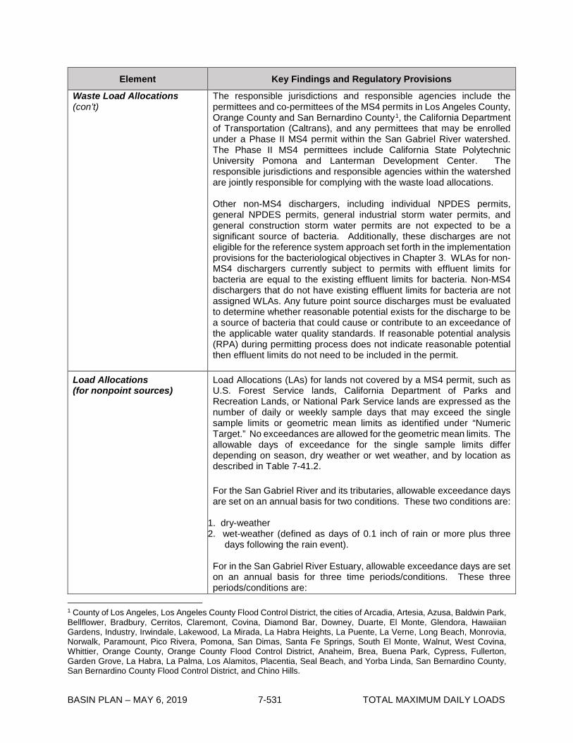
BASIN PLAN – MAY 6, 2019 7-531 TOTAL MAXIMUM DAILY LOADS
Element Key Findings and Regulatory Provisions
Waste Load Allocations (con’t)
The responsible jurisdictions and responsible agencies include the permittees and co-permittees of the MS4 permits in Los Angeles County, Orange County and San Bernardino County1, the California Department of Transportation (Caltrans), and any permittees that may be enrolled under a Phase II MS4 permit within the San Gabriel River watershed. The Phase II MS4 permittees include California State Polytechnic University Pomona and Lanterman Development Center. The responsible jurisdictions and responsible agencies within the watershed are jointly responsible for complying with the waste load allocations. Other non-MS4 dischargers, including individual NPDES permits, general NPDES permits, general industrial storm water permits, and general construction storm water permits are not expected to be a significant source of bacteria. Additionally, these discharges are not eligible for the reference system approach set forth in the implementation provisions for the bacteriological objectives in Chapter 3. WLAs for non-MS4 dischargers currently subject to permits with effluent limits for bacteria are equal to the existing effluent limits for bacteria. Non-MS4 dischargers that do not have existing effluent limits for bacteria are not assigned WLAs. Any future point source discharges must be evaluated to determine whether reasonable potential exists for the discharge to be a source of bacteria that could cause or contribute to an exceedance of the applicable water quality standards. If reasonable potential analysis (RPA) during permitting process does not indicate reasonable potential then effluent limits do not need to be included in the permit.
Load Allocations (for nonpoint sources)
Load Allocations (LAs) for lands not covered by a MS4 permit, such as U.S. Forest Service lands, California Department of Parks and Recreation Lands, or National Park Service lands are expressed as the number of daily or weekly sample days that may exceed the single sample limits or geometric mean limits as identified under “Numeric Target.” No exceedances are allowed for the geometric mean limits. The allowable days of exceedance for the single sample limits differ depending on season, dry weather or wet weather, and by location as described in Table 7-41.2. For the San Gabriel River and its tributaries, allowable exceedance days are set on an annual basis for two conditions. These two conditions are:
1. dry-weather 2. wet-weather (defined as days of 0.1 inch of rain or more plus three
days following the rain event). For in the San Gabriel River Estuary, allowable exceedance days are set on an annual basis for three time periods/conditions. These three periods/conditions are:
1 County of Los Angeles, Los Angeles County Flood Control District, the cities of Arcadia, Artesia, Azusa, Baldwin Park, Bellflower, Bradbury, Cerritos, Claremont, Covina, Diamond Bar, Downey, Duarte, El Monte, Glendora, Hawaiian Gardens, Industry, Irwindale, Lakewood, La Mirada, La Habra Heights, La Puente, La Verne, Long Beach, Monrovia, Norwalk, Paramount, Pico Rivera, Pomona, San Dimas, Santa Fe Springs, South El Monte, Walnut, West Covina, Whittier, Orange County, Orange County Flood Control District, Anaheim, Brea, Buena Park, Cypress, Fullerton, Garden Grove, La Habra, La Palma, Los Alamitos, Placentia, Seal Beach, and Yorba Linda, San Bernardino County, San Bernardino County Flood Control District, and Chino Hills.

BASIN PLAN – MAY 6, 2019 7-532 TOTAL MAXIMUM DAILY LOADS
Element Key Findings and Regulatory Provisions
Load Allocations (con’t)
1. summer dry-weather (April 1 to October 31) 2. winter dry-weather (November 1 to March 31) 3. wet weather (defined as days of 0.1 inch of rain or more plus three
days following the rain event). For the single sample objectives in the San Gabriel River and its tributaries, the LAs are listed below.
Allowable Number of Exceedance Days Daily Sampling Weekly Sampling
Dry Weather 5 1 Non-HFS Waterbodies Wet Weather
17 3
HFS Waterbodies Wet Weather
11 (not including HFS days)
2 (not including HFS days)
For the single sample objectives in the San Gabriel Estuary, the LAs are listed below.
Allowable Number of Exceedance Days Daily Sampling Weekly Sampling
Summer Dry-Weather 0 0 Winter Dry-Weather 9 2 Wet Weather 20 3
LAs equal to zero days of allowable exceedances for the single sample and geometric mean targets are assigned to onsite wastewater treatment systems, golf courses, horse and livestock facilities, and irrigated agricultural lands within the watershed.
Margin of Safety An implicit margin of safety was assumed by directly applying the water quality standards and implementation procedures as WLAs and LAs. This ensures that there is little uncertainty about whether meeting the TMDLs will result in meeting the water quality standards.
Seasonal Variations and Critical Conditions
Seasonal variations are addressed by developing separate waste load allocations for two conditions (dry weather and wet weather) in the San Gabriel River and its tributaries, and three time periods/conditions (summer dry-weather, winter dry-weather, and wet weather) in the San Gabriel River Estuary based on public health concerns and observed natural background levels of exceedance of bacterial indicators. The critical condition for bacteria discharges to the San Gabriel River Estuary, the San Gabriel River, and its tributaries is during wet weather when monitoring data indicate a higher probability of exceedance of the single sample bacteria objectives than during dry weather.

BASIN PLAN – MAY 6, 2019 7-533 TOTAL MAXIMUM DAILY LOADS
Element Key Findings and Regulatory Provisions
Seasonal Variations and Critical Conditions (con’t)
The critical condition within wet weather more specifically, in order to set the allowable number of exceedances of the single sample limit days, is the 90th percentile storm year in terms of wet days. The 1994 storm year is the reference year for purposes of identifying the wet weather critical condition. The number of wet-weather days in the 1994 reference year was 87 days, and the number of dry-weather days was 278 days (199 summer dry-weather days and 79 winter dry-weather days). Of these 87 days, 30 days fall under the definition of a HFS day.
Implementation
The regulatory mechanisms used to implement the TMDL will include the Los Angeles County MS4 permit, the City of Long Beach MS4 permit, the Orange County MS4 permit and the San Bernardino County MS4 permit (under the jurisdiction of the Santa Ana Regional Water Board), the Caltrans Storm Water permit, the statewide Phase II MS4 permit and any regional Phase II MS4 permits, minor and major NPDES permits, general NPDES permits, general industrial storm water permits, general construction storm water permits, and the authority contained in Sections 13263, 13267, 13269, and 13383 of the California Water Code, and other appropriate regulatory mechanisms. NPDES permits for each discharge assigned a WLA shall be reopened or amended at re-issuance, in accordance with applicable laws, to incorporate effluent limitations consistent with the assumptions and requirements of the WLAs herein. WLAs shall be incorporated into MS4 permits as water quality-based effluent limitations (WQBELs). MS4 Permittees may be deemed in compliance with WQBELs if they demonstrate that: (1) there are no violations of the WQBEL at the Permittee’s applicable MS4 outfall(s); (2) there are no exceedances of the receiving water limitations in the receiving water at, or downstream of, the Permittee’s outfalls; or (3) there is no direct or indirect discharge from the Permittee’s MS4 to the receiving water during the time period subject to the WQBEL. If permittees provide a quantitative demonstration as part of a watershed management program that control measures and best management practices (BMPs) will achieve WQBELs consistent with the schedule in Table 7-41.3, then compliance with WQBELs may be demonstrated by implementation of those control measures and BMPs, subject to Executive Officer approval. Responsible agencies must provide an Implementation Plan to the Regional Water Board outlining how each intends to individually or cooperatively achieve the WLAs. The report shall include implementation methods, an implementation schedule, proposed milestones, and proposed outfall monitoring to determine compliance. A Watershed Management Program (WMP) or Enhanced Watershed Management Program (EWMP) developed by the responsible agency(ies) in accordance with their MS4 permit(s), which has been approved by the Regional Water Board, satisfy the requirements for an Implementation Plan, where the WMP or EWMP addresses the applicable waterbody-pollutant combinations of this TMDL consistent with the implementation schedule set forth in Table 7-41.3. The responsible agency(ies) shall modify their WMP/EWMP no later than the next Adaptive Management Process cycle after provisions consistent with the assumptions and

BASIN PLAN – MAY 6, 2019 7-534 TOTAL MAXIMUM DAILY LOADS
Element Key Findings and Regulatory Provisions
Implementation (con’t)
requirements of the TMDL WLAs are incorporated into the applicable MS4 permits. LAs for nonpoint sources will be implemented through the Conditional Waiver for Irrigated Lands (Order No. R4-2010-0186 or other successor order), Waste Discharge Requirements, Waivers of Waste Discharge Requirements, Memoranda of Understanding or other appropriate mechanisms consistent with the State’s Nonpoint Source Implementation and Enforcement Policy. This TMDL will be implemented in two phases over a twenty-year period (see Table 7-41.3). By ten years from effective date of TMDL, compliance with the allowable number of dry-weather exceedance days must be achieved. By twenty years from effective date of TMDL, compliance with the allowable number of wet-weather exceedance days and the geometric mean targets must be achieved.
Monitoring
MS4 Permittees Responsible jurisdictions and agencies for the MS4 WLAs are responsible for developing and implementing a comprehensive in-stream monitoring plan. The monitoring plan should include all applicable bacteria water quality objectives and the sampling frequency must be adequate to assess compliance with the geometric mean objectives. The Integrated Monitoring Program (IMP) or Coordinated Integrated Monitoring Program (CIMP) approved by the Executive Officer may partially or fully be deemed equivalent to a compliance monitoring plan at the Regional Water Board’s discretion. Responsible jurisdictions and agencies may build upon existing monitoring programs, IMPs, or CIMPs in the San Gabriel River watershed when developing the bacteria water quality monitoring plan. At a minimum, at least one sampling station shall be located in each impaired reach. Responsible jurisdictions and agencies shall conduct three wet-weather sampling events and quarterly dry-weather sampling, at a minimum, for at least one sampling site in each impaired reach prior to the dry-weather compliance deadline. After the dry-weather compliance deadline has passed, the responsible agencies shall conduct at least weekly sampling to support calculation of the geometric mean and assessment of compliance with allowable exceedance days. Responsible jurisdictions and agencies for the MS4 WLAs shall also submit an outfall monitoring plan. The outfall monitoring plan shall propose an adequate number of representative outfalls to be sampled, a sampling frequency, and protocol for enhanced outfall monitoring as a result of an in-stream exceedance. Responsible jurisdictions and agencies may use existing outfall monitoring stations in their IMPs or CIMPs to satisfy the monitoring requirements for the MS4 permits and the TMDL. Responsible jurisdictions and agencies must assess compliance at in-stream monitoring sites. If the number of exceedance days is greater than the allowable number of exceedance days the water body segment

BASIN PLAN – MAY 6, 2019 7-535 TOTAL MAXIMUM DAILY LOADS
Element Key Findings and Regulatory Provisions
Monitoring (con’t)
shall be considered not attaining the TMDL. Responsible jurisdictions or agencies shall not be deemed non-attaining if the outfall monitoring described in the paragraph above demonstrates that bacterial sources originating within the jurisdiction of the responsible agency have not caused or contributed to the exceedance. Non-MS4 Permittees NPDES Permittees other than MS4 dischargers shall conduct monitoring as part of their permit requirements for all applicable bacteria water quality objectives to ensure that they are attaining WLAs and that water quality objectives are being met. Nonpoint Sources The Conditional Waiver for Irrigated Lands or other regulatory mechanism shall require bacteria monitoring for discharges from irrigated agricultural lands. Monitoring shall be implemented as part of WDR and waiver requirements, and through implementation of the Nonpoint Source Implementation and Enforcement Policy, for other nonpoint sources.

BASIN PLAN – MAY 6, 2019 7-536 TOTAL MAXIMUM DAILY LOADS
Table 7-41.2 San Gabriel River, Estuary and Tributaries Indicator Bacteria TMDL: Allowable Exceedance Days1,2,3.
1 Allowable exceedance days calculated by the following equation: Allowable Exceedance Days = WQO Exceedance Probability in Reference System(s) x Number of Days during 1994. 2 Where the fractional remainder for the calculated allowable exceedance days exceeds 1/10th then the number of days are rounded up (e.g., 4.12 is rounded up to 5). In instances where the tenth decimal place for the allowable exceedance days (or weeks or months) is lower than 1/10th then the number of days are rounded down (e.g., 4.02 is rounded down to 4). 3 The calculated number of exceedance days assumes that daily sampling is conducted. To determine the number of allowable exceedances for less frequent sampling, a ratio is used. 4 Non-HFS waterbodies include Puente Creek, Walnut Creek Wash, and San Gabriel River Estuary. 5 HFS waterbodies include Big Dalton Wash, Coyote Creek, Coyote Creek North Fork, San Gabriel River Reaches 1, 2, and 3, and San Jose Creek Reaches 1and 2.
Time Period/Condition
San Gabriel River and its Tributaries San Gabriel River Estuary
Dry Weather
Five (5) exceedance days (daily sampling) or one (1) exceedance day (weekly sampling) of single sample
objectives
Zero (0) exceedances of geometric mean objectives
Not Applicable
Non-HFS Waterbodies4 Wet Weather
17 exceedance days (daily sampling) or three (3) exceedance days (weekly sampling) of single sample objectives
Zero (0) exceedances of geometric
mean objectives
20 exceedance days (daily sampling) or three (3) exceedance days (weekly
sampling) of single sample objectives
Zero (0) exceedances of geometric mean objectives
HFS Waterbodies5 Wet Weather (not
including HFS days)
11 exceedance days (daily sampling) or two (2) exceedance days (weekly
sampling) of single sample objectives
Zero (0) exceedances of geometric mean objectives
Not Applicable
Summer Dry Weather (April 1 – October 31) Not Applicable
Zero (0) exceedance days of single sample objectives
Zero (0) exceedances of geometric
mean objectives
Winter Dry Weather (November 1 – March
31) Not Applicable
Nine (9) exceedance days (daily sampling) or two (2) exceedance days
(weekly sampling) of single sample objectives
Zero (0) exceedances of geometric
mean objectives
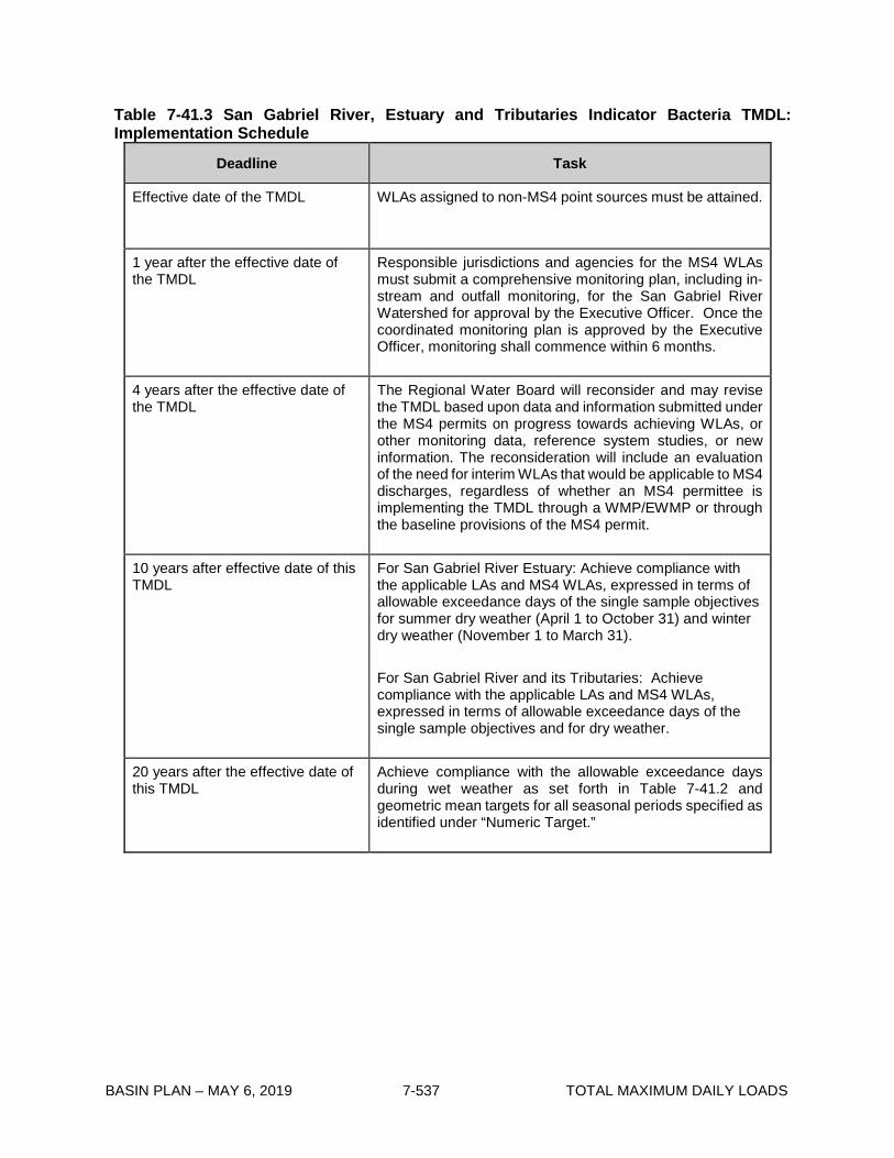
BASIN PLAN – MAY 6, 2019 7-537 TOTAL MAXIMUM DAILY LOADS
Table 7-41.3 San Gabriel River, Estuary and Tributaries Indicator Bacteria TMDL: Implementation Schedule
Deadline Task
Effective date of the TMDL WLAs assigned to non-MS4 point sources must be attained.
1 year after the effective date of the TMDL
Responsible jurisdictions and agencies for the MS4 WLAs must submit a comprehensive monitoring plan, including in-stream and outfall monitoring, for the San Gabriel River Watershed for approval by the Executive Officer. Once the coordinated monitoring plan is approved by the Executive Officer, monitoring shall commence within 6 months.
4 years after the effective date of the TMDL
The Regional Water Board will reconsider and may revise the TMDL based upon data and information submitted under the MS4 permits on progress towards achieving WLAs, or other monitoring data, reference system studies, or new information. The reconsideration will include an evaluation of the need for interim WLAs that would be applicable to MS4 discharges, regardless of whether an MS4 permittee is implementing the TMDL through a WMP/EWMP or through the baseline provisions of the MS4 permit.
10 years after effective date of this TMDL
For San Gabriel River Estuary: Achieve compliance with the applicable LAs and MS4 WLAs, expressed in terms of allowable exceedance days of the single sample objectives for summer dry weather (April 1 to October 31) and winter dry weather (November 1 to March 31). For San Gabriel River and its Tributaries: Achieve compliance with the applicable LAs and MS4 WLAs, expressed in terms of allowable exceedance days of the single sample objectives and for dry weather.
20 years after the effective date of this TMDL
Achieve compliance with the allowable exceedance days during wet weather as set forth in Table 7-41.2 and geometric mean targets for all seasonal periods specified as identified under “Numeric Target.”

BASIN PLAN – MAY 6, 2019 7-538 TOTAL MAXIMUM DAILY LOADS
This page intentionally left blank

BASIN PLAN – MAY 6, 2019 7-539 TOTAL MAXIMUM DAILY LOADS
7-42 Implementation Plan for the Malibu Creek Nutrients TMDL and the Malibu Creek and Lagoon Sedimentation and Nutrients TMDL to Address Benthic Community Impairments This TMDL was adopted by:
The Regional Water Quality Control Board on December 8, 2016.
This TMDL was approved by:
The State Water Resources Control Board on February 22, 2017 The Office of Administrative Law on May 16, 2017.
This Implementation Plan is effective on May 16, 2017.
The following tables include the elements of this TMDL.

BASIN PLAN – MAY 6, 2019 7-540 TOTAL MAXIMUM DAILY LOADS
Summary of the Malibu Creek Nutrients TMDL and the Malibu Creek and Lagoon Sedimentation and Nutrients TMDL to Address Benthic Community Impairments
The United States Environmental Protection Agency (U.S. EPA) established the “Malibu Creek Watershed Nutrients TMDL” (2003 TMDL) on March 21, 2003 to address impairments due to ammonia, nutrients, dissolved oxygen, algae, scum, and odor in Malibu Lagoon, Malibu Creek and its tributaries, and four lakes in the watershed. On July 2, 2013, U.S. EPA established the “Malibu Creek and Lagoon Sedimentation and Nutrients TMDL to Address Benthic Community Impairments” (2013 TMDL) to address impairments of Malibu Creek and Las Virgenes Creek related to impacted benthic macroinvertebrates and sedimentation/siltation and impairments of Malibu Lagoon related to adverse benthic community effects.
The sources of nutrients and/or sediment loading in the Malibu Creek Watershed include point sources, such as discharges from storm drains regulated under municipal separate storm sewer system (MS4) permits, direct discharges from the Tapia Water Reclamation Facility (WRF), and nonpoint sources, such as discharges from onsite wastewater treatment systems (OWTS), Tapia WRF irrigation and sludge disposal, and runoff from golf courses, agriculture, livestock facilities, and open space.
Both TMDLs include a problem statement, numeric targets, source analysis, loading capacity, waste load allocations (WLAs) for point sources, load allocations (LAs) for nonpoint sources, and a margin of safety, but do not include an implementation plan or schedule. The 2003 TMDL sets numeric targets for nutrients, chlorophyll a, dissolved oxygen, ammonia, and algal cover; and assigns WLAs and LAs for total nitrogen (expressed as Nitrite-N + Nitrate-N in the 2003 TMDL) and total phosphorus to sources discharging to all waterbodies within the Malibu Creek Watershed. The 2013 TMDL sets numeric targets for nutrients, chlorophyll a, dissolved oxygen, and algal cover as well as sedimentation, benthic community diversity, and benthic community bioscores, and assigns WLAs and LAs for total nitrogen (expressed as organic-N + inorganic-N) and total phosphorus to sources discharging to waterbodies in the eastern portion of the Malibu Creek Watershed below Malibou Lake. These waterbodies include: Malibu Creek, Cold Creek, Stokes Creek, Las Virgenes Creek, and four lakes (Malibou Lake, Lindero Lake, Westlake Lake, and Sherwood Lake). In addition, the 2013 TMDL sets sediment WLAs and LAs based on a 38 percent reduction in the sediment transport capacity of the Malibu Creek Watershed. Sediment WLAs are assigned for point sources below Malibou Lake, and sediment LAs are assigned to discharges from the combined area upstream of Malibou Lake, discharges from protected land below Malibou Lake, and the Ventura County unincorporated area along Las Virgenes Creek. The following tables address implementation of the 2003 TMDL and the 2013 TMDL.

BASIN PLAN – MAY 6, 2019 7-541 TOTAL MAXIMUM DAILY LOADS
Table 7-42.1. Malibu Creek Nutrients TMDL and Malibu Creek and Lagoon Sedimentation and Nutrients TMDL to Address Benthic Community Impairments: Implementation Elements Key Findings and Regulatory Provisions 2003 and 2013 TMDL Nutrient Implementation
I. Implementation and Determination of Compliance with Nutrient WLAs Tapia WRF The nutrient WLAs in the 2013 TMDL will be incorporated into the Tapia WRF NPDES permit and translated into effluent limitations expressed as concentration-based summer and winter seasonal averages. Compliance with the concentration-based seasonal averages shall be determined by calculating the sum of all nutrient concentration samples collected during the season divided by the number of samples collected during that season. The 2013 TMDL summer nutrient WLAs shall be achieved five years from the effective date of this Implementation Plan. The 2013 TMDL winter nutrient WLAs shall be achieved thirteen and a half years from the effective date of this Implementation Plan. Interim nutrient WLAs are established based on current performance equal to the maximum effluent concentration from the past three years and shall be updated during each permit renewal with the most current data or based on current permit limitations2, whichever are more stringent.
2 The current permit limits for the Tapia WRF (Order No. R4-2010-0165) include a monthly average limit for nitrite-N + nitrate-N of 8 mg/l and 1.1x10³ lbs/day and a monthly average limit for Total Phosphorus of 3.0 mg/L and 4.0x10² lbs/day during the summer and winter season. The permit also sets a daily maximum limit for Total Phosphorus at 4.0 mg/L and 5.4x10² lbs/day during the winter season.
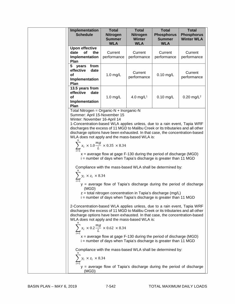
BASIN PLAN – MAY 6, 2019 7-542 TOTAL MAXIMUM DAILY LOADS
Implementation Schedule
Total Nitrogen Summer
WLA
Total Nitrogen Winter WLA
Total Phosphorus
Summer WLA
Total Phosphorus Winter WLA
Upon effective date of the Implementation Plan
Current performance
Current performance
Current performance
Current performance
5 years from effective date of Implementation Plan
1.0 mg/L Current performance 0.10 mg/L Current
performance
13.5 years from effective date of Implementation Plan
1.0 mg/L 4.0 mg/L1 0.10 mg/L 0.20 mg/L2
Total Nitrogen = Organic-N + Inorganic-N Summer: April 15-November 15 Winter: November 16-April 14 1-Concentration-based WLA applies unless, due to a rain event, Tapia WRF discharges the excess of 11 MGD to Malibu Creek or its tributaries and all other discharge options have been exhausted. In that case, the concentration-based WLA does not apply and the mass-based WLA is:
𝑥𝑥𝑖𝑖 × 1.0𝑚𝑚𝑚𝑚𝐿𝐿
× 0.35 × 8.34𝑛𝑛
𝑖𝑖=1
x = average flow at gage F-130 during the period of discharge (MGD) i = number of days when Tapia’s discharge is greater than 11 MGD
Compliance with the mass-based WLA shall be determined by:
𝑦𝑦𝑖𝑖 × 𝑧𝑧𝑖𝑖 × 8.34𝑛𝑛
𝑖𝑖=1
y = average flow of Tapia’s discharge during the period of discharge (MGD)
z = total nitrogen concentration in Tapia’s discharge (mg/L) i = number of days when Tapia’s discharge is greater than 11 MGD
2-Concentration-based WLA applies unless, due to a rain event, Tapia WRF discharges the excess of 11 MGD to Malibu Creek or its tributaries and all other discharge options have been exhausted. In that case, the concentration-based WLA does not apply and the mass-based WLA is:
𝑥𝑥𝑖𝑖 × 0.2𝑚𝑚𝑚𝑚𝐿𝐿
× 0.62 × 8.34𝑛𝑛
𝑖𝑖=1
x = average flow at gage F-130 during the period of discharge (MGD) i = number of days when Tapia’s discharge is greater than 11 MGD
Compliance with the mass-based WLA shall be determined by:
𝑦𝑦𝑖𝑖 × 𝑧𝑧𝑖𝑖 × 8.34𝑛𝑛
𝑖𝑖=1
y = average flow of Tapia’s discharge during the period of discharge (MGD)

BASIN PLAN – MAY 6, 2019 7-543 TOTAL MAXIMUM DAILY LOADS
Elements Key Findings and Regulatory Provisions z = total phosphorus concentration in Tapia’s discharge (mg/L) i = number of days when Tapia’s discharge is greater than 11 MGD
MS4 Permits The 2003 TMDL encompasses the whole Malibu Creek Watershed; therefore, the 2003 TMDL MS4 nutrient WLAs will be implemented through NPDES permits that regulate MS4 discharges within the Malibu Creek Watershed, which include but may not be limited to the Los Angeles County MS4 Permit, Ventura County MS4 Permit, and California Department of Transportation (Caltrans) Statewide Storm Water Permit. The 2013 TMDL only addresses the portion of the watershed below Malibou Lake; therefore, the 2013 TMDL MS4 nutrient WLAs will be implemented through the Los Angeles County MS4 and Caltrans MS4 permits only. Additional MS4 discharges within the Malibu Creek Watershed that may be designated in the future under Phase II of the U.S. EPA Stormwater Permitting Program will implement the MS4 WLAs through the applicable NPDES permit. Other discharges may also be required to implement the MS4 WLAs if the State or U.S. EPA exercise their residual designation authority under CWA section 402(p)(2)(E). The 2003 TMDL nutrient LAs for “runoff from developed areas” and “dry weather urban runoff” are newly interpreted as nutrient WLAs for MS4 permittees in this Implementation Plan. These newly interpreted nutrient WLAs were summed and apportioned between MS4 permittees based on their relative area above and below Malibou Lake. The newly interpreted nutrient WLAs for MS4 permittees below Malibou Lake are superseded by the 2013 TMDL nutrient WLAs. Los Angeles County and Ventura County The newly interpreted 2003 TMDL nutrient WLAs above Malibou Lake shall be achieved by December 28, 2021 for the discharges covered under the Los Angeles County MS4 Permit and within five years of the effective date of the permit renewal for discharges covered under the Ventura County MS4 Permit, but not to exceed 10 years from the effective date of this Implementation Plan. The 2013 TMDL nutrient WLAs below Malibou Lake shall be achieved by December 28, 2023 for the discharges covered under the Los Angeles County MS4 Permit. Interim nutrient WLAs are included based on existing permit requirements.
Implementation Schedule
Total Nitrogen Summer
Total Nitrogen Winter
Total Phosphorus
Summer
Total Phosphorus
Winter LA County MS4s above Malibou Lake
December 28, 2017 8.0 lbs/day*
8.0 mg/L* 0.80 lbs/day N/A
December 28, 2021 1.6 lbs/day*
8.0 mg/L* 0.16 lbs/day N/A
LA County MS4s below Malibou Lake

BASIN PLAN – MAY 6, 2019 7-544 TOTAL MAXIMUM DAILY LOADS
December 28, 2017 8.0 lbs/day*
8.0 mg/L* 0.80 lbs/day N/A
December 28, 2023 1.0 mg/L** 4.0 mg/L** 0.10 mg/L 0.20 mg/L
Ventura County MS4s Effective date of this Implementation Plan
Current permit
limits***
8.0 mg/L*
Current permit
limits*** N/A
5 years from the effective date of the Ventura County MS4 Permit adoption, renewal, or modification but no later than 10 years from the effective date of this Implementation Plan
3.1 lbs/day*
8.0 mg/L* 0.31 lbs/day N/A
* Total Nitrogen = Nitrate-N + Nitrite-N ** Total Nitrogen = Organic-N + Inorganic-N *** Current Permit = Order No. R4-2010-0108 Summer: April 15 to November 15 Winter: November 16 to April 14
Nutrient WLAs shall be incorporated into MS4 permits as water quality-based effluent limitations (WQBELs). The 2003 TMDL summer nutrient WLAs shall be incorporated as daily loads and the winter nutrient WLA shall be incorporated as a seasonal average. The 2013 TMDL summer and winter nutrient WLAs shall be incorporated as seasonal averages. MS4 Permittees may be deemed in compliance with WQBELs if they demonstrate that:
(1) there are no violations of the WQBEL at the Permittee’s applicable MS4 outfall(s); (2) there are no exceedances of the numeric targets in the receiving water downstream of the Permittee’s outfalls; or (3) there is no direct or indirect discharge from the Permittee’s MS4 to the receiving water during the time period subject to the WQBEL.
The MS4 permittees shall provide an implementation plan to the Regional Water Board outlining how they intend to achieve the nutrient WLAs. A Regional Water Board approved Watershed Management Program (WMP) or Enhanced Watershed Management Program (EWMP) developed in accordance with a MS4 permit will satisfy the requirements of an implementation plan where the WMP or EWMP addresses the applicable waterbody-pollutant combinations of the TMDLs consistent with the implementation schedules in Table 7-42.2. MS4 permittees shall modify their WMP/EWMP no later than the next Adaptive Management Process cycle after provisions consistent with the assumptions and requirements of the TMDL nutrient WLAs are incorporated into the applicable MS4 permits. Caltrans The nutrient WLAs assigned to Caltrans will be implemented through the Caltrans statewide stormwater permit (Order No. 2012-0011-DWQ as amended by Order No. 2014-02006-EXEC, Order No. 2011-0077-DWQ, and Order No. 2015-0036-EXEC, or other successor order).

BASIN PLAN – MAY 6, 2019 7-545 TOTAL MAXIMUM DAILY LOADS
Implementation Schedule
Total Nitrogen Summer
Total Nitrogen Winter
Total Phosphorus
Summer
Total Phosphorus
Winter Caltrans above Malibou Lake According to the schedule in the revised TMDL Reach Prioritization, but no later than 2032
0.032 lbs/day* 8.0 mg/L* 0.0032
lbs/day N/A
Implementation Schedule
Total Nitrogen Summer
Total Nitrogen Winter
Total Phosphorus
Summer
Total Phosphorus
Winter Caltrans below Malibou Lake According to the schedule in the revised TMDL Reach Prioritization, but no later than 2032
1.0 mg/L**
4.0 mg/L** 0.10 mg/L 0.20 mg/L
* Total Nitrogen = Nitrate-N + Nitrite-N ** Total Nitrogen= Organic-N + Inorganic-N Summer: April 15 to November 15 Winter: November 16 to April 14
Some of the 2013 TMDL nutrient WLAs are currently included Order No. 2012-0011-DWQ, but none of the 2003 TMDL nutrient WLAs are. The Caltrans statewide stormwater permit includes TMDL-specific requirements for the TMDLs incorporated into the permit. Order No. 2012-0011-DWQ requires Caltrans to prioritize impaired reaches subject to TMDLs for implementation by reach, so that all TMDLs are addressed by 2032. In order to reflect this Implementation Plan, the reaches covered by the 2013 TMDL, which were previously not included in Order No. 2012-0011-DWQ, and all of the reaches covered by the 2003 TMDL shall be added to Attachment IV of Order No. 2012-0011-DWQ when it is reopened consistent with provision E.11.b. of the Order. Within a year of the permit reopener, Caltrans shall submit a revised TMDL Reach Prioritization to include the additional reaches.
II. Implementation and Determination of Compliance with Nutrient LAs Tapia WRF The nutrient LAs for irrigation from the Tapia WRF to the Rancho Las Virgenes Farm (also known as the spray field), Pepperdine University, Rancho Las Virgenes Compost Facility, and other recycled water users will be implemented through the Tapia WRF Water Reclamation Requirements. The nutrient LAs for sludge applied to the Rancho Las Virgenes Farm will be implemented through the Rancho Las Virgenes Waste Discharge Requirements (WDRs). The nutrient LAs shall be incorporated into these permits as requirements for the application of sludge and reclaimed water for irrigation. The permits shall require that irrigation and sludge be applied in compliance with current regulations and at rates to ensure that the amount of total nitrogen and phosphorus applied does not exceed the vegetative requirements of the crops or landscaping.

BASIN PLAN – MAY 6, 2019 7-546 TOTAL MAXIMUM DAILY LOADS
Elements Key Findings and Regulatory Provisions The nutrient LAs in the 2003 and 2013 TMDL for Tapia WRF sludge and irrigation shall be attained upon the effective date of this Implementation Plan. Onsite wastewater treatment systems (OWTS) The 2003 TMDL and 2013 TMDL LAs for OWTS shall be implemented through WDRs or waivers of WDRs and local agency oversight where local agencies (city and county health departments and/or building departments) are implementing their permitting authority. Commercial and multifamily OWTS are currently regulated by the Regional Water Board through WDRs. Single family residential OWTS are currently regulated by local agencies through a memorandum of understanding (MOU) with the Regional Water Board or, in lieu of an MOU, by the Regional Water Board directly, via WDRs. The State Water Resources Control Board (State Water Board) adopted a water quality control policy for siting, design, operation, and maintenance of onsite wastewater treatment systems (OWTS Policy) as Resolution No. 2012-0032 to comply with Water Code sections 13290 and 13291. The policy emphasizes local management of OWTS. The policy requires an Advanced Protection Management Program (APMP) for OWTS near impaired waterbodies. Local agencies are authorized to implement APMPs in conjunction with their existing programs and in collaboration with the Regional Water Board through a Local Agency Management Program (LAMP). The U.S.EPA-established TMDLs assign LAs generally to all OWTS in the watershed, but do not specify which, if any, specific OWTS must reduce discharges to meet the LAs. As such, the TMDLs define the geographic area for the APMP as the entire watershed. Local agencies may conduct a special study to determine which existing OWTS are contributing to the nutrient loading to any waterbody within the Malibu Creek Watershed. Areas found not to be contributing to the overall loading may be removed from the APMP as approved in a LAMP. The study may build upon previous studies completed according to the Malibu Creek Bacteria TMDL (Resolution No. 2004-019). Existing,new, and replacement OWTS included in an APMP are required to be upgraded or modified to meet the supplemental treatment requirements for nitrogen per Tier 3 of the OWTS Policy and any other requirements of the APMP. If a local agency chooses to develop a LAMP, the LAMP shall include a schedule for upgrades or modifications based on the results of the study. Existing OWTS shall remain regulated by the existing MOU and LAMP until the above determination is made, the LAMP is revised, and subsequent OWTS upgrades are required. The Regional Water Board will evaluate existing MOUs and any future submittal of a LAMP under the OWTS Policy to determine if additional changes are needed to implement the LAs. All OWTS discharges within the APMP shall achieve compliance with LAs as soon as possible, but no later than 10 years after the effective date of this Implementation Plan. The owners of OWTS are ultimately responsible for achieving the LAs. Golf Courses The nutrient LAs for nutrients for golf courses in the 2003 and 2013 TMDLs will be implemented through WDRs or conditional waivers of WDRs consistent with the State’s Nonpoint Source Implementation and Enforcement Policy. WDRs or conditional waivers of WDRs may include requirements that golf courses submit fertilizer application plans and implement designated types of BMPs to comply with the TMDLs.
BASIN PLAN – MAY 6, 2019 7-547 TOTAL MAXIMUM DAILY LOADS
Elements Key Findings and Regulatory Provisions Golf courses shall attain the nutrient LAs within five years of the effective date of this Implementation Plan. Agriculture Sources The nutrient LAs for agriculture in the 2003 and 2013 TMDLs will be implemented through the Conditional Waiver of Waste Discharge Requirements for Discharges from Irrigated Agricultural Lands (Order No. R4-2016-0143) (Agriculture Waiver) or other appropriate Regional Water Board order. The existing Agriculture Waiver includes the 2003 and 2013 TMDL nutrient LAs as benchmarks. Agricultural lands shall achieve the nutrient LAs in the 2003 and 2013 TMDLs by October 14, 2022. This compliance date shall be updated in the waiver when it is renewed or replaced with another order by April 2022. Livestock Sources The nutrient LAs for livestock in the 2003 and the 2013 TMDLs, including horse facilities and grazing, will be regulated by WDRs, conditional waivers of WDRs, or other regulatory mechanisms in accordance with the Nonpoint Source Implementation and Enforcement Policy. The Regional Water Board will determine which horse/livestock facilities and grazing operations shall be subject to the WDRs, waivers of WDRs or other regulatory mechanisms during the development of these regulatory mechanisms based on factors that may include, but are not limited to, type of operation, density of animals, and risk to water quality. As part of the regulatory mechanism, horse/livestock facilities and grazing operations shall be required to develop management plans for Executive Officer approval and implement management measures identified in management plans to attain nutrient LAs. Horse/livestock facilities and grazing operations shall achieve compliance with the nutrient LAs in the 2003 and 2013 TMDLs within 5 years of the effective date of this Implementation Plan. The estimated costs for practices to control agricultural discharges such as filter strips, mulching, improved irrigation efficiency, nutrient management, manure management, and grazing management are approximately $1031 per acre, $808 per acre, $1784 per acre, $55 per acre-year, $4,500 (average cost of manure bunker), and $1,356 (average cost of a typical watering facility), respectively. Potential sources of financing for these implementation alternatives, such as Clean Water Act section 319(h) grant funding, are discussed in Chapter 4. As discussed in Chapter 4, the U.S. Department of Agriculture Soil Conservation Service and the Resource Conservation Districts provide information on, and assistance in, implementing BMPs. Lakes The nutrient LAs in the 2013 TMDL for lake overflow from Malibou Lake, Lindero Lake, Westlake Lake, and Sherwood Lake will be implemented through WDRs, conditional waivers of WDRs, or other regulatory mechanisms in accordance with the Nonpoint Source Implementation and Enforcement Policy. The nutrient LAs will apply at the outlet of the lake or dam and are shared among the cities, counties, state, and federal lands in the subwatersheds draining to each lake, and the owners/operators of each lake. Cooperative parties for the lake nutrient LAs are identified, not as responsible parties or as dischargers, but as landowners and
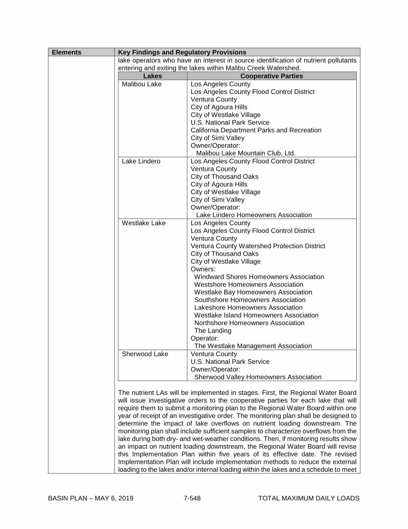
BASIN PLAN – MAY 6, 2019 7-548 TOTAL MAXIMUM DAILY LOADS
Elements Key Findings and Regulatory Provisions lake operators who have an interest in source identification of nutrient pollutants entering and exiting the lakes within Malibu Creek Watershed.
Lakes Cooperative Parties Malibou Lake Los Angeles County
Los Angeles County Flood Control District Ventura County City of Agoura Hills City of Westlake Village U.S. National Park Service California Department Parks and Recreation City of Simi Valley Owner/Operator: Malibou Lake Mountain Club, Ltd.
Lake Lindero Los Angeles County Flood Control District Ventura County City of Thousand Oaks City of Agoura Hills City of Westlake Village City of Simi Valley Owner/Operator: Lake Lindero Homeowners Association
Westlake Lake Los Angeles County Los Angeles County Flood Control District Ventura County Ventura County Watershed Protection District City of Thousand Oaks City of Westlake Village Owners: Windward Shores Homeowners Association Westshore Homeowners Association Westlake Bay Homeowners Association Southshore Homeowners Association Lakeshore Homeowners Association Westlake Island Homeowners Association Northshore Homeowners Association The Landing Operator: The Westlake Management Association
Sherwood Lake Ventura County U.S. National Park Service Owner/Operator: Sherwood Valley Homeowners Association
The nutrient LAs will be implemented in stages. First, the Regional Water Board will issue investigative orders to the cooperative parties for each lake that will require them to submit a monitoring plan to the Regional Water Board within one year of receipt of an investigative order. The monitoring plan shall be designed to determine the impact of lake overflows on nutrient loading downstream. The monitoring plan shall include sufficient samples to characterize overflows from the lake during both dry- and wet-weather conditions. Then, if monitoring results show an impact on nutrient loading downstream, the Regional Water Board will revise this Implementation Plan within five years of its effective date. The revised Implementation Plan will include implementation methods to reduce the external loading to the lakes and/or internal loading within the lakes and a schedule to meet

BASIN PLAN – MAY 6, 2019 7-549 TOTAL MAXIMUM DAILY LOADS
Elements Key Findings and Regulatory Provisions the nutrient LAs. Cooperative parties may propose their own approaches for the revised Implementation Plan that the Regional Water Board may consider.
2013 TMDL Sedimentation Implementation
The sedimentation WLAs and LAs in the 2013 TMDL apply to the eastern portion of the watershed, below Malibou Lake and above gage F-130. Compliance with the sedimentation WLAs and LAs in the 2013 TMDL can be achieved through an individual compliance alternative or as part of a watershed-wide implementation alternative.
I. Individual Compliance Alternative
Los Angeles County MS4 and Caltrans MS4 Permits The sedimentation WLAs shall be incorporated into the Los Angeles County and Caltrans MS4 permits as receiving water limits. To determine compliance, the annual sediment load at the F-130 gage shall be multiplied by the allocation fractions (17.4% for Los Angeles County MS4 permittees subject to the WLA and 0.8% for Caltrans) and compared to the respective WLAs (1,012 tons/year for Los Angeles County and 44 tons/year for Caltrans). Due to the annual variability of sediment transport, which is linked to wet-weather events, compliance shall be averaged over a three-year period. The Los Angeles County MS4 permittees shall provide an implementation plan to the Regional Water Board outlining how they intend to achieve the sedimentation WLAs. The plan shall include implementation methods, proposed interim milestones, and proposed receiving water monitoring to determine compliance. A Regional Water Board approved WMP or EWMP developed in accordance with a MS4 permit that explicitly addresses the sedimentation WLAs will satisfy the requirements of an implementation plan. Caltrans shall implement Order No. 2012-0011-DWQ as discussed in the Nutrients Implementation section in order to meet the sedimentation WLAs. In order to reflect this Implementation Plan, additional TMDL specific monitoring requirements shall be added to Attachment IV of Order No. 2012-0011-DWQ when it is reopened consistent with provision E.11.b. of the Order. The Los Angeles County MS4 permittees and the Caltrans MS4 below Malibou Lake and above F-130 shall attain the sedimentation WLAs by December 2025.
Protected Land Below Malibou Lake The sedimentation LA in the 2013 TMDL for the protected land below Malibou Lake will be implemented through WDRs, conditional waivers of WDRs, or other regulatory mechanisms assigned to State Parks and National Park Service lands in accordance with the Nonpoint Source Implementation and Enforcement Policy. The sedimentation LAs may be incorporated into the regulatory mechanisms as water quality benchmarks or receiving water limits. To determine compliance, the annual sediment load at the F-130 gage will be multiplied by the allocation fraction of 13.7% and compared to the LA of 796 tons/year. Due to the annual variability of sediment transport, which is linked to wet-weather events, compliance will be averaged over a three-year period. If the sedimentation LAs are not being achieved, the responsible entities will be required to submit a plan(s) for

BASIN PLAN – MAY 6, 2019 7-550 TOTAL MAXIMUM DAILY LOADS
Elements Key Findings and Regulatory Provisions riparian/stream bank restoration and/or improved operation and management of impervious areas, including roads. The sedimentation LA for protected land below Malibou Lake and above gage F-130 shall be attained by December 2025. Combined Area Upstream Malibou Lake The parties responsible for implementing the sedimentation LA in the 2013 TMDL for the area above Malibou Lake are the same as the cooperative parties identified for the nutrient LA in the 2013 TMDL for lake overflow. The sedimentation LA applies at a point below Malibou Lake. Within one year of the effective date of the Implementation Plan, the Regional Water Board intends to issue an investigative order to the cooperative parties to install a new gage below Malibou Lake to collect TSS and flow data to determine the annual sediment load from the area above Malibou Lake. If monitoring results show that the sediment discharged is greater than the sedimentation LA of 3,950 tons/year, the Regional Water Board will revise this Implementation Plan within five years of its effective date to identify applicable sedimentation WLAs and LAs for specific jurisdictions upstream of Malibou Lake. Unincorporated Area along Las Virgenes Creek To meet the sedimentation LA in the 2013 TMDL for the unincorporated area along Las Virgenes Creek, within one year of receipt of an investigative order, Ventura County shall submit a monitoring plan to collect sediment data at the county line or at an appropriate downstream site in order to determine the annual sediment load for the unincorporated area along Las Virgenes Creek. If monitoring results show sediment has discharged is greater than the sedimentation LA of 16 tons/year, the Regional Water Board will revise this Implementation Plan within five years of its effective date to identify potential sedimentation WLAs and/or LAs for specific jurisdictions in the unincorporated area along Las Virgenes Creek.
II. Watershed-wide approach
The responsible entities in the Malibu Creek Watershed may work collaboratively to develop a comprehensive implementation approach to reduce sediment transport capacity watershed-wide. This compliance alternative is a hybrid of the implementation options described above and would ensure long-term compliance with the 2013 TMDL and attainment of the required 38% reduction in sediment transport capacity at gage F-130. This approach would include a combination of (1) projects to reduce work on the stream caused by elevated flows in the upper urbanized portion of the watershed above gage F-130 and (2) stream restoration projects on eroding stream channels in the upper and lower watershed (above and below gage F-130) caused by the elevated work on the stream. A watershed-based approach implemented collectively by the responsible parties should focus on reducing effective work because effective work is what controls sediment transport capacity. Effective work is based on excess shear stress and stream velocity. Compliance will be assessed by demonstrating a reduction in the 2-year and 10-year peak flows to achieve a 38 percent reduction in effective work at gage F-130. The 2013 TMDL report identifies the required peak flows at gage F-130 for the two storm sizes (1,180 cfs for the 2-year interval and 5,370 cfs for the 10-year interval) and calculation of change in effective work.

BASIN PLAN – MAY 6, 2019 7-551 TOTAL MAXIMUM DAILY LOADS
Elements Key Findings and Regulatory Provisions Compliance monitoring for this alternative shall include monitoring at gage F-130 and additional monitoring throughout the impaired reaches and areas downstream of LID projects, regional BMP facilities, and channel restoration projects. These data should be collected to ensure accurate calculation of effective work and 2-year and 10-year peak flows at gage F-130. Compliance with the watershed-wide approach would be required within 15 years from the effective date of this Implementation Plan. If this watershed-wide compliance strategy is chosen, responsible entities will work collaboratively, but their responsibilities and requirements will be included in their individual regulatory mechanisms.
Monitoring The TMDL monitoring program shall consist of two components: (1) TMDL effectiveness monitoring in the receiving water to assess implementation progress and attainment of numeric targets, and (2) compliance monitoring of discharges to determine compliance with the WLAs and LAs. Monitoring requirements shall be included in subsequent permits or other orders. TMDL Effectiveness Monitoring Responsible entities are responsible for developing and implementing a comprehensive TMDL Effectiveness monitoring plan within two years of the effective date of this Implementation Plan to assess numeric target attainment and to determine the effectiveness of implementation actions on receiving water quality. Monitoring shall commence within six months of approval of the TMDL effectiveness monitoring plan.
1. Nutrient TMDL Effectiveness Monitoring Responsible entities include the Las Virgenes-Triunfo JPA, the Ventura County Watershed Protection District, the County of Ventura, the County of Los Angeles, the County of Los Angeles Flood Control District, Caltrans, the City of Thousand Oaks, the City of Westlake Village, the City of Agoura Hills, the City of Calabasas, the City of Hidden Hills, the City of Malibu, the California Department of Parks and Recreation, and the National Park Service. Responsible entities shall outline a nutrient monitoring program for total nitrogen (organic-N + inorganic-N), total phosphorus, dissolved oxygen, pH, temperature, ammonia and chlorophyll a. Monitoring shall also include field observations for percent algae cover, the presence of scum/foam, the presence of odors, and whether Malibu Lagoon is open or closed to the ocean. The sampling frequency and locations must be adequate to assess beneficial use conditions and attainment of nutrient related water quality objectives. Monitoring locations should be located at the upstream and downstream ends of nutrient impaired 303(d) listed streams and at downstream ends of hydrologically-connected segments directly above their confluence with listed streams. At a minimum, nutrient monitoring shall be conducted monthly in Malibu Lagoon, the Malibu Lagoon inlet, Malibu Creek, Las Virgenes Creek, Medea Creek Reach 1 and Reach 2, and Lindero Creek Reach 1 and Reach 2. In addition, nutrient monitoring shall be conducted quarterly in Hidden Valley Creek, Potrero Valley Creek, Triunfo Creek Reach 1 and Reach 2, Palo Comado Creek, Chesebooro Canyon Creek, Stokes Creek, and Cold Creek. To account for the critical condition for dissolved oxygen, dissolved oxygen shall be monitored at pre-dawn. Responsible entities may request a reduction in the frequency of nutrient sampling after four years of sampling has been
BASIN PLAN – MAY 6, 2019 7-552 TOTAL MAXIMUM DAILY LOADS
conducted if justified based on a demonstration of no variability between sample events or consistent improvements in water quality.
2. Benthic TMDL Effectiveness Monitoring Responsible entities include the Las Virgenes-Triunfo JPA, the County of Los Angeles, the County of Los Angeles Flood Control District, Caltrans, the City of Agoura Hills, the City of Calabasas, the City of Hidden Hills, the City of Malibu, the California Department of Parks and Recreation, and the National Park Service. Responsible entities shall include a benthic monitoring program to collect invertebrate and physical habitat data for benthic community evaluations and stream health assessments using the SC-IBI bioscore and the CSCI, pMMI, and CA-O/E scores. The sampling frequency and locations must be adequate to assess the beneficial use condition and attainment of benthic-related water quality objectives. Monitoring locations should be located at the upstream and downstream ends of benthic impaired 303(d) listed streams. At a minimum, benthic monitoring shall be conducted annually in Las Virgenes Creek, Middle Malibu Creek, the Malibu Lagoon inlet, and Malibu Lagoon. Attainment of the benthic community diversity numeric targets will be calculated as an annual average. Attainment of the SC-IBI, CSCI, pMMI, CA-O/E numeric targets will be calculated as a median of four years of data to account for year-to-year variability.
Responsible entities may build upon existing monitoring programs in the Malibu Creek Watershed when developing the TMDL effectiveness monitoring plans. TMDL effectiveness monitoring requirements shall be incorporated into the regulatory mechanisms for each responsible entity upon issuance, renewal, or modification or through separate investigatory orders. Monitoring procedures, analysis, and quality assurance shall be SWAMP comparable and shall continue beyond the final implementation date of the TMDL unless the Executive Officer approves a reduction or elimination of such monitoring. Exceedances of the biological response numeric targets (percent algae cover, benthic community diversity, or biological scores) at the Malibu Lagoon inlet at frequencies greater than the averaging periods specified in the numeric targets section will trigger additional TMDL effectiveness monitoring and additional preventative activities to reduce nutrient and sediment loads to Malibu Lagoon through existing adaptive management processes in Regional Board orders such as the Los Angeles County MS4 permit and/or a reconsideration of this Implementation Plan. Compliance Monitoring To assess attainment of the nutrient and sedimentation WLAs and LAs, compliance monitoring shall include monitoring for total nitrogen (as defined by the 2003 TMDL or the 2013 TMDL), total phosphorus, TSS, and flow. The monitoring frequencies to comply with the WLAs and LAs are as follows:
o To demonstrate compliance with the nutrient WLAs for the Tapia WRF, nutrient monitoring shall be conducted monthly at the Tapia WRF discharge points, when discharging.
o To demonstrate compliance with the nutrient LAs for the Tapia WRF nonpoint source discharges, quarterly groundwater monitoring shall be incorporated into the WDRs for the Rancho Las Virgenes Farm spray fields to evaluate the quantity and quality of reclaimed water that re-enters the system through groundwater.
o To demonstrate compliance with the nutrient LAs for agriculture, dischargers shall monitor according to the requirements of Order No. R4-2016-0143 or other appropriate Regional Water Board order.
o To demonstrate compliance with the nutrient LAs for horse/livestock facilities, grazing operations, and golf courses, monitoring may consist of

BASIN PLAN – MAY 6, 2019 7-553 TOTAL MAXIMUM DAILY LOADS
documentation of BMP implementation, and may include water quality monitoring as needed to determine the effectiveness of the BMPs in reducing nutrient loadings.
o To demonstrate compliance with the nutrient LAs for OWTS, monitoring will be conducted in accordance with the local agencies’ LAMPs.
o To demonstrate compliance with the nutrient LAs for lake overflow, cooperative parties shall conduct monitoring as described in the nutrient implementation section.
o To demonstrate compliance with the nutrient WLAs for MS4 discharges, monitoring will be conducted three times within the year during storm events and four times during non-storm events, with a minimum of two non-stormwater samples within the summer season. Stormwater monitoring will target the first significant rain event of the storm year. During dry weather, sampling shall occur a minimum of 72 hours after a storm event. MS4 permittees shall address the TMDL compliance monitoring requirements through their Monitoring Reporting Programs (MRPs). The Regional Board will modify the MRPs, or approve coordinated integrated monitoring program (CIMP) modifications proposed by permittees, to incorporate additional monitoring requirements to determine compliance with nutrient WLAs. Compliance monitoring will require MS4 permittees to include representative outfall and receiving water monitoring locations within their jurisdiction within the Malibu Creek watershed.
o To demonstrate compliance with the sedimentation WLAs for Los Angeles County MS4 discharges, monitoring shall include flow and TSS during dry and wet weather to calculate the annual sediment load moving past gage F-130 if the individual compliance option is chosen. Dischargers shall modify their CIMPs to include sufficient sampling to accurately calculate the sediment load. Additional parameters that are more cost-effective or continuous may be useful to collect, such as turbidity. With a robust dataset, these can be used to develop statistical relationships and expand the extent of data. Upon approval by the Executive Officer, alternative parameters (based on statistical analyses) could be used to document compliance with the sedimentation WLAs. In addition, existing monitoring at gage F-130 conducted under other programs can be leveraged to assist in meeting these monitoring requirements.
o To demonstrate compliance with the nutrient and sediment WLAs for Caltrans MS4 discharges, Caltrans will monitor according to the requirements of State Water Board Order No. 2012-0011-DWQ.
o To demonstrate compliance with the sedimentation LA for the area above Malibou Lake, if the individual compliance option is chosen, responsible entities shall conduct monitoring as described in the sedimentation implementation section.
o To demonstrate compliance with the sedimentation LA for the discharges from the unincorporated area along Las Virgenes Creek, if the individual compliance option is chosen, Ventura County shall conduct monitoring as described in the sedimentation implementation section.
o To demonstrate compliance with the sedimentation LA for the discharges from the protected land below Malibou Lake and above F-130, if the individual compliance option is chosen, State Parks, and National Parks Service shall conduct monitoring as described in the sediment implementation section.
o To demonstrate compliance with the sedimentation LAs and WLAs if the watershed-wide compliance option is chosen, responsible entities shall conduct monitoring as described in the sedimentation implementation section.

BASIN PLAN – MAY 6, 2019 7-554 TOTAL MAXIMUM DAILY LOADS
Compliance monitoring shall be required through the regulatory mechanisms used to implement the sedimentation and nutrient WLAs and LAs. The monitoring procedures/methods, analysis, and quality assurance shall be SWAMP comparable where appropriate.

BASIN PLAN – MAY 6, 2019 7-555 TOTAL MAXIMUM DAILY LOADS
Table 7-42.2. Malibu Creek Nutrients TMDL and Malibu Creek and Lagoon Sedimentation and Nutrients TMDL to Address Benthic Community Impairments: Implementation Schedule
Task Date* The Regional Water Board will reconsider this Implementation Plan within five years of its effective date
5 years from the effective date of this Implementation Plan
Tapia WRF Tapia WRF shall attain nutrient LAs for indirect discharges Upon the effective date of this
Implementation Plan Las Virgenes-Triunfo JPA shall submit a TMDL effectiveness monitoring plan for nutrients and benthic community evaluations individually or in collaboration with other responsible entities
Two years from the effective date of this Implementation Plan
Tapia WRF shall attain interim 2013 TMDL nutrient winter WLAs and final 2013 TMDL nutrient summer WLAs
Five years from the effective date of this Implementation Plan
Tapia WRF shall attain final 2013 TMDL nutrient winter WLAs 13.5 years from the effective date of this Implementation Plan
Los Angeles County MS4-whole Malibu Creek Watershed
Los Angeles County MS4 permittees within the whole Malibu Creek Watershed shall submit a nutrient implementation plan or modify existing WMP or EWMP
By the next adaptive management process cycle after WLAs are incorporated into MS4 permit
Los Angeles County MS4 permittees within the whole MCW shall submit a TMDL effectiveness monitoring plan for nutrients and benthic community evaluations individually or in collaboration with other responsible entities
Two years from the effective date of this Implementation Plan
Los Angeles County MS4-above Malibou Lake Los Angeles County MS4 permittees above Malibou Lake shall attain their current permit limits for nutrients (as set forth in Order No. R4-2012-0175)
December 28, 2017
Los Angeles County MS4 permittees above Malibou Lake shall attain newly interpreted 2003 nutrient WLAs
December 28, 2021
Los Angeles County MS4-below Malibou Lake Los Angeles County MS4 permittees below Malibou Lake shall attain their current permit limits for nutrients (as set forth in Order No. R4-2012-0175)
December 28, 2017
Los Angeles County MS4 permittees below Malibou Lake shall attain 2013 nutrient WLAs
December 28, 2023
Los Angeles County MS4 permittees below Malibou Lake shall submit a sedimentation implementation plan
By the next adaptive management process cycle after WLAs are incorporated into MS4 permit
Los Angeles County MS4 permittees below Malibou Lake shall attain 2013 sedimentation WLAs (if watershed-wide approach is not chosen)
December 28, 2025

BASIN PLAN – MAY 6, 2019 7-556 TOTAL MAXIMUM DAILY LOADS
Task Date* Ventura County Ventura County shall submit a monitoring plan for the area along Los Virgenes Creek to determine the annual sediment load
One year from receipt of an investigative order
Ventura County MS4 Ventura County MS4 permittees shall attain 2003 TMDL nutrient winter WLAs for MS4 discharges
Upon the effective date of this Implementation Plan
Ventura County MS4 permittees shall submit a MS4 nutrient implementation plan or WMP or EWMP
One year from the effective date of this Implementation Plan or as per the schedule for the WMP/EWMP under the MS4 permit if appropriate
Ventura County MS4 permittees shall submit a TMDL effectiveness monitoring plan for nutrients individually or in collaboration with other responsible entities
Two years from the effective date of this Implementation Plan
Ventura County MS4 permittees shall attain newly interpreted 2003 TMDL nutrient summer WLAs
5 years from the effective date of the Ventura County MS4 Permit adoption, renewal, or modification, but no later than 10 years from the effective date of this Implementation Plan
Caltrans-entire Malibu Creek Watershed
Additional reaches subject to the 2003 and 2013 TMDLs shall be added to Attachment IV of Order No. 2012-0011-DWQ
Upon reopener of Order No. 2012-0011-DWQ consistent with provision E.11.b. of the Order
Caltrans shall submit a revised TMDL Reach Prioritization to include the 2013 TMDL impaired reaches that were omitted from the prioritization and to add the 2003 TMDL impaired reaches
Within a year of reopener of Order No. 2012-0011-DWQ
Caltrans shall submit a TMDL effectiveness monitoring plan for nutrients and benthic community evaluations individually or in collaboration with other responsible entities
Two years from the effective date of this Implementation Plan
Caltrans-above Malibu Creek Watershed
Caltrans above Malibou Lake shall attain newly interpreted 2003 nutrient WLAs
According to the schedule in the revised TMDL Reach Prioritization, but no later than 2032
Caltrans-below Malibu Creek Watershed
Caltrans below Malibou Lake shall attain final 2013 nutrient WLAs
According to the schedule in the revised TMDL Reach Prioritization, but no later than 2032
The area of the Caltrans MS4 below Malibou Lake shall attain 2013 sedimentation WLAs (if watershed-wide approach is not chosen)
December 28, 2025
Onsite Wastewater Treatment Systems Local agencies (city and county health departments and/or building departments) may submit a work plan for a study to determine which existing OWTS are contributing to the nutrient loading to any waterbody within the Malibu Creek Watershed for approval by the Executive Officer.
Three years from the effective date of the Implementation Plan
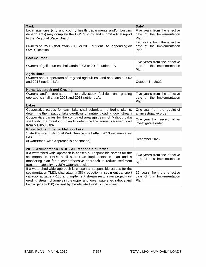
BASIN PLAN – MAY 6, 2019 7-557 TOTAL MAXIMUM DAILY LOADS
Task Date* Local agencies (city and county health departments and/or building departments) may complete the OWTS study and submit a final report to the Regional Water Board.
Five years from the effective date of the Implementation Plan
Owners of OWTS shall attain 2003 or 2013 nutrient LAs, depending on OWTS location
Ten years from the effective date of the Implementation Plan
Golf Courses
Owners of golf courses shall attain 2003 or 2013 nutrient LAs Five years from the effective date of the Implementation Plan
Agriculture Owners and/or operators of irrigated agricultural land shall attain 2003 and 2013 nutrient LAs
October 14, 2022
Horse/Livestock and Grazing Owners and/or operators of horse/livestock facilities and grazing operations shall attain 2003 and 2013 nutrient LAs
Five years from the effective date of the Implementation Plan
Lakes Cooperative parties for each lake shall submit a monitoring plan to determine the impact of lake overflows on nutrient loading downstream
One year from the receipt of an investigative order
Cooperative parties for the combined area upstream of Malibou Lake shall submit a monitoring plan to determine the annual sediment load from Malibou Lake
One year from receipt of an investigative order.
Protected Land below Malibou Lake State Parks and National Park Service shall attain 2013 sedimentation LAs (if watershed-wide approach is not chosen)
December 2025
2013 Sedimentation TMDL - All Responsible Parties If a watershed-wide approach is chosen all responsible parties for the sedimentation TMDL shall submit an implementation plan and a monitoring plan for a comprehensive approach to reduce sediment transport capacity by 38% watershed-wide
Two years from the effective date of this Implementation Plan
If a watershed-wide approach is chosen all responsible parties for the sedimentation TMDL shall attain a 38% reduction in sediment transport capacity at gage F-130 and implement stream restoration projects on eroding stream channels in the upper and lower watershed (above and below gage F-130) caused by the elevated work on the stream
15 years from the effective date of this Implementation Plan

BASIN PLAN – MAY 6, 2019 7-558 TOTAL MAXIMUM DAILY LOADS
This page intentionally left blank

BASIN PLAN – MAY 6, 2019 7-559 TOTAL MAXIMUM DAILY LOADS
7-43 Santa Clara River Lakes Nutrient TMDL This TMDL was adopted by:
The Los Angeles Water Board on September 8, 2016 This TMDL was approved by:
The State Water Resources Control Board on March 7, 2017 The Office of Administrative Law on June 22, 2017 The U.S. Environmental Protection Agency on June 27, 2017
This TMDL is effective on June 27, 2017 The elements of the TMDL are presented in Table 7-43.1 and the Implementation Plan in Table 7-43.2

BASIN PLAN – MAY 6, 2019 7-560 TOTAL MAXIMUM DAILY LOADS
Table 7-43.1. Santa Clara River Lakes Nutrient TMDL: Elements TMDL Element Regulatory Provisions Problem Statement
The Santa Clara River Lakes (Elizabeth Lake, Lake Hughes, and Munz Lake) are impacted by water quality problems stemming from eutrophication. The eutrophic condition is due to excess nutrients (nitrogen and phosphorus) in the lakes. The nutrient enrichment results in high algal productivity and macrophyte growth. Algal respiration and decay deplete oxygen from the water column, creating an adverse aquatic environment. Likewise, the decay of algal blooms and other eutrophic-related impairments can create offensive odors leading to a nuisance and an unpleasant environment. Elizabeth Lake is on the Clean Water Act Section 303(d) list for eutrophic conditions, pH, low dissolved oxygen, and organic enrichment. Lake Hughes is on the 303(d) list for algae, eutrophic conditions, fish kills, and odor. Munz Lake is on the 303(d) list for eutrophic conditions. This nutrient TMDL addresses all of these listings. The nutrient-related listings affect the water contact recreation (REC1), non-contact water recreation (REC2), warm freshwater habitat (WARM), and wildlife habitat (WILD) beneficial uses of all three Santa Clara River Lakes. In addition, the nutrient-related listings also affect the rare/threatened/endangered species (RARE) beneficial use of Elizabeth Lake, and the groundwater recharge (GWR) beneficial use of Munz Lake.
Numeric Targets
The dissolved oxygen and pH numeric targets are set equal to their numeric water quality objectives in Chapter 3 of the Basin Plan. The numeric targets for chlorophyll a are established as a numeric interpretation of the water quality condition that will demonstrate attainment of the narrative water quality objective for biostimulatory substances contained in Chapter 3. Numeric targets to interpret narrative water quality objectives are based on the California Nutrient Numeric Endpoints (NNE) approach, developed by USEPA Region 9 and the State and Regional Water Quality Control Boards. Numeric targets for total nitrogen and total phosphorus are based on simulation of allowable concentrations from the NNE BATHTUB spreadsheet model. The following tables provide the numeric targets for the Santa Clara River Lakes. ELIZABETH LAKE Parameter Numeric Target Chlorophyll a ≤20 µg/L summer average (May – September) and annual
average Dissolved Oxygen ≥7 mg/L minimum mean annual
≥5 mg/L single sample minimum pH The pH of inland surface waters shall not be depressed below
6.5 or raised above 8.5 as a result of waste discharges. Ambient pH levels shall not be changed more than 0.5 units from natural conditions as a result of waste discharge.
Total Nitrogen* ≤1.13 mg N/L summer average (May – September) and annual average
Total Phosphorous* ≤0.113 mg P/L summer average (May – September) and annual average
*If the numeric targets for chlorophyll a, dissolved oxygen, and pH are achieved and maintained in the lakes, and nutrient allocations are being implemented and attained, then the TMDL is considered achieved regardless of whether the total nitrogen and total phosphorus targets are being achieved

BASIN PLAN – MAY 6, 2019 7-561 TOTAL MAXIMUM DAILY LOADS
TMDL Element Regulatory Provisions Numeric Targets (continued)
LAKE HUGHES Parameter Numeric Target Ammonia ≤1.56 mg NH3-N/L one-hour average
≤1.41 mg NH3-N/L four-day average ≤0.56 mg NH3-N/L 30-day average
Chlorophyll a ≤20 µg/L summer average (May – September) and annual average
Dissolved Oxygen ≥7 mg/L minimum mean annual ≥5 mg/L single sample minimum
Total Nitrogen* ≤1.13 mg N/L summer average (May – September) and annual average
Total Phosphorous* ≤0.113 mg P/L summer average (May – September) and annual average
*If the numeric targets for chlorophyll a, dissolved oxygen, and pH are achieved and maintained in the lakes, and nutrient allocations are being implemented and attained, then the TMDL is considered achieved regardless of whether the total nitrogen and total phosphorus targets are being achieved MUNZ LAKE Parameter Numeric Target Chlorophyll a ≤20 µg/L summer average (May – September) and annual
average Total Nitrogen* ≤1.13 mg N/L summer average (May – September) and annual
average Total Phosphorous* ≤0.113 mg P/L summer average (May – September) and
annual average *If the numeric targets for chlorophyll a, dissolved oxygen, and pH are achieved and maintained in the lakes, and nutrient allocations are being implemented and attained, then the TMDL is considered achieved regardless of whether the total nitrogen and total phosphorus targets are being achieved
Source Analysis The major nonpoint source of nutrients to Elizabeth Lake and Lake Hughes is internal nutrient loading (nutrient flux from sediments). This source constitutes over 99% of the total phosphorus and total nitrogen loading in Elizabeth Lake and Lake Hughes. Another nonpoint source of nutrients to Elizabeth Lake and Lake Hughes is onsite wastewater treatment systems (OWTS). The Lake Hughes Community Wastewater Treatment Facility is a nonpoint source of nutrients to Lake Hughes. Runoff from surrounding areas is a nonpoint source of nutrients to all of the Santa Clara River Lakes. Direct atmospheric deposition is also a nonpoint source of nitrogen to all of the Santa Clara River Lakes. The point sources of nutrients into the Santa Clara River Lakes are discharges from storm drains, including discharges from the municipal separate storm sewer system (MS4).
Linkage Analysis The linkage analysis focuses on the relationship between the nutrient loading to the Santa Clara River Lakes and the numeric targets established to meet water quality objectives. The NNE BATHTUB model was used to establish the linkage between nutrient loading to the Santa Clara River Lakes and the predicted water quality response. BATHTUB is a steady-state model that calculates nutrient concentrations, chlorophyll a concentration, turbidity, and hypolimnetic oxygen depletion based on nutrient loading, hydrology, lake morphometry, and internal nutrient cycling processes. The linkage analysis demonstrates that assigning waste load allocations and load allocations for total nitrogen and total phosphorus will address the eutrophication-related water quality impairments in the Santa Clara Lakes.

BASIN PLAN – MAY 6, 2019 7-562 TOTAL MAXIMUM DAILY LOADS
TMDL Element Regulatory Provisions Waste Load Allocations
The table below presents the waste load allocations (WLAs) for total phosphorus and total nitrogen assigned to storm drain discharges to the Santa Clara River Lakes.
Lake Total Phosphorus (lb-P/yr) Total Nitrogen (lb-N/yr) Allocation % Reduction Allocation % Reduction
Munz Lake 29.1 11.74% 142.1 22.83% Elizabeth Lake 436.7 18.67% 2536.8 19.843% Lake Hughes 106.6 3.2% 520.8 20.7%
Load Allocations
The following tables present the load allocations (LAs) assigned to nonpoint source discharges to the Santa Clara River Lakes. Load allocations are assigned to internal loads (in Elizabeth Lake and Lake Hughes), nonpoint source runoff, onsite wastewater treatment systems, the Lake Hughes Community Wastewater Treatment Facility, and direct atmospheric deposition to the lakes’ surface.
ELIZABETH LAKE
Input
Total Phosphorus (lb-P/yr) Total Nitrogen (lb-N/yr)
Allocation % Reduction Allocation %
Reduction Nonpoint source runoff from drainage area encompassed by Angeles National Forest
22.1 18.67% 191.4 19.843%
Nonpoint source runoff from drainage area within County of Los Angeles
39.4 18.67% 359.0 19.843%
Onsite wastewater treatment systems 130.1 18.67% 770.3 19.843%
Internal loading (in-lake sediments) 2,166.0 99.715% 11,042.2 99.974%
Atmospheric deposition (to the lake surface) NA NA 28.9 19.843%
Total 2,357.6 99.7% 12,391.8 99.97%
LAKE HUGHES
Input
Total Phosphorus (lb-P/yr)
Total Nitrogen (lb-N/yr)
Allocation
% Reductio
n Allocatio
n %
Reduction Nonpoint source runoff from drainage area encompassed by Angeles National Forest
3.6 3.2% 27.6 20.7%
Lake Hughes Community Wastewater Treatment Facility 1.4 3.2% 138.2 20.7%
Onsite wastewater treatment systems 1.9 3.2% 11.1 20.7%
Internal loading (in-lake sediments) 197.3 99.64% 956.4 99.9884%
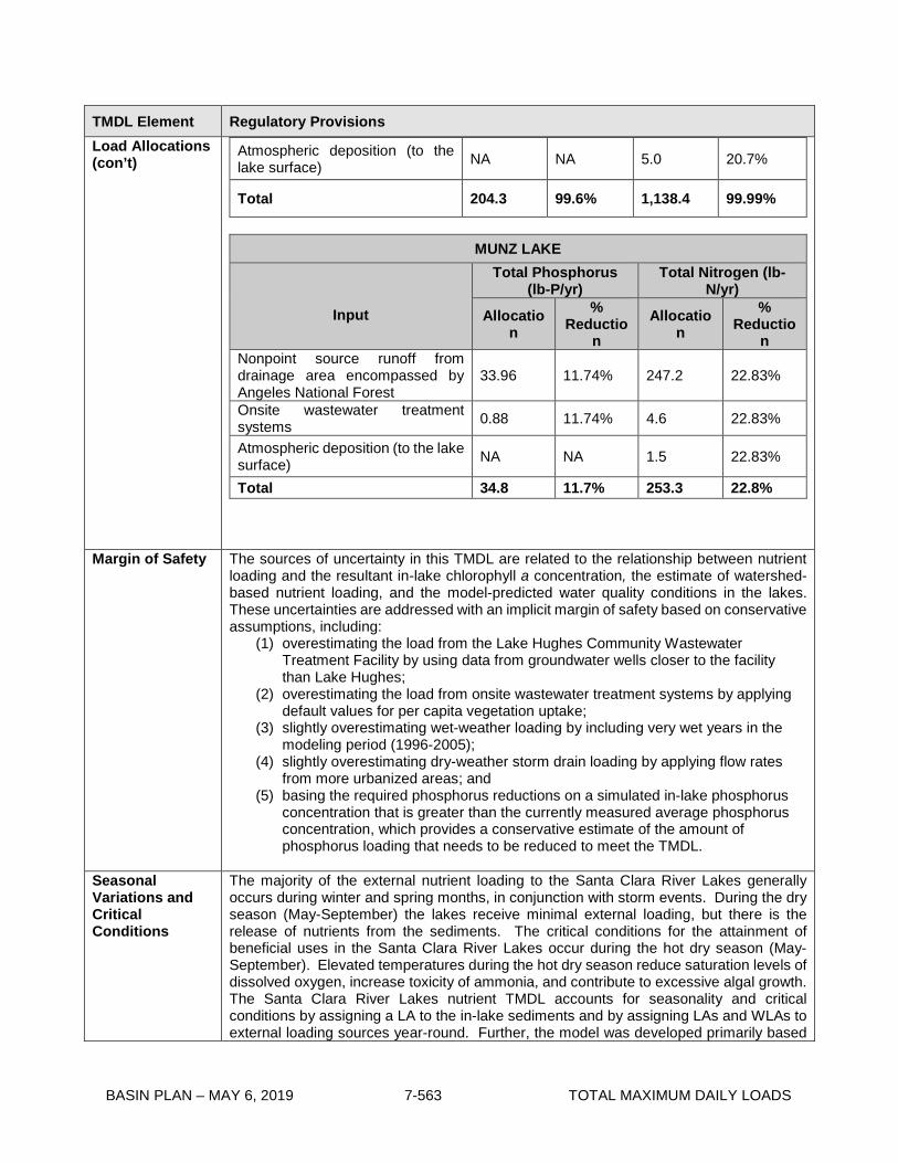
BASIN PLAN – MAY 6, 2019 7-563 TOTAL MAXIMUM DAILY LOADS
TMDL Element Regulatory Provisions Load Allocations (con’t)
Atmospheric deposition (to the lake surface) NA NA 5.0 20.7%
Total 204.3 99.6% 1,138.4 99.99%
MUNZ LAKE
Input
Total Phosphorus (lb-P/yr)
Total Nitrogen (lb-N/yr)
Allocation
% Reductio
n Allocatio
n
% Reductio
n Nonpoint source runoff from drainage area encompassed by Angeles National Forest
33.96 11.74% 247.2 22.83%
Onsite wastewater treatment systems 0.88 11.74% 4.6 22.83%
Atmospheric deposition (to the lake surface) NA NA 1.5 22.83%
Total 34.8 11.7% 253.3 22.8%
Margin of Safety The sources of uncertainty in this TMDL are related to the relationship between nutrient loading and the resultant in-lake chlorophyll a concentration, the estimate of watershed-based nutrient loading, and the model-predicted water quality conditions in the lakes. These uncertainties are addressed with an implicit margin of safety based on conservative assumptions, including:
(1) overestimating the load from the Lake Hughes Community Wastewater Treatment Facility by using data from groundwater wells closer to the facility than Lake Hughes;
(2) overestimating the load from onsite wastewater treatment systems by applying default values for per capita vegetation uptake;
(3) slightly overestimating wet-weather loading by including very wet years in the modeling period (1996-2005);
(4) slightly overestimating dry-weather storm drain loading by applying flow rates from more urbanized areas; and
(5) basing the required phosphorus reductions on a simulated in-lake phosphorus concentration that is greater than the currently measured average phosphorus concentration, which provides a conservative estimate of the amount of phosphorus loading that needs to be reduced to meet the TMDL.
Seasonal Variations and Critical Conditions
The majority of the external nutrient loading to the Santa Clara River Lakes generally occurs during winter and spring months, in conjunction with storm events. During the dry season (May-September) the lakes receive minimal external loading, but there is the release of nutrients from the sediments. The critical conditions for the attainment of beneficial uses in the Santa Clara River Lakes occur during the hot dry season (May-September). Elevated temperatures during the hot dry season reduce saturation levels of dissolved oxygen, increase toxicity of ammonia, and contribute to excessive algal growth. The Santa Clara River Lakes nutrient TMDL accounts for seasonality and critical conditions by assigning a LA to the in-lake sediments and by assigning LAs and WLAs to external loading sources year-round. Further, the model was developed primarily based

BASIN PLAN – MAY 6, 2019 7-564 TOTAL MAXIMUM DAILY LOADS
TMDL Element Regulatory Provisions on observations in 2014, which was a very hot dry year. For example, while lake depths could not be collected in 2014, and average depths were used as model inputs, other model parameters were collected during this hot dry year, including pH, nutrients and chlorophyll a.
Monitoring
The Santa Clara River Lakes monitoring shall consist of receiving water monitoring and discharge monitoring. Monitoring is required to measure the progress of pollutant load reductions and improvements in water quality. The monitoring plan has several goals.
• Determine attainment of total phosphorus, total nitrogen, ammonia, dissolved oxygen, pH, and chlorophyll a numeric targets.
• Determine compliance with the waste load and load allocations for total phosphorus and total nitrogen.
• Monitor the effect of implementation actions on lake water quality
Receiving Water Monitoring A Monitoring and Reporting Program (MRP) Plan for Elizabeth Lake and Lake Hughes shall be included as part of the Lake Work Plans for internal loading discussed in the implementation section. The MRP for Munz Lake shall be submitted separately for Executive Officer approval within five years of the effective date of the TMDL. Water samples shall be collected quarterly in each lake, on a year-round basis unless otherwise approved by the Executive Officer. The sampling sites shall be located at two sampling sites in Elizabeth Lake and one site each in Munz Lake and Lake Hughes, in the open water portion of the lakes unless otherwise approved by the Executive Officer. In situ measurements of water quality and lake characteristics shall be made at each sampling site. These shall include dissolved oxygen, pH, temperature, electrical conductivity, transparency, and changes in lake elevation using a staff gauge. Water samples shall be analyzed for the following constituents unless otherwise approved by the Executive Officer:
• Total nitrogen • Total phosphorus • Nitrate (NO3-N) • Total ammonia (NH3-N) • Ortho-phosphorus (PO4) • Total Dissolved Solids • Total Suspended Solids • Chlorophyll a • Turbidity • pH
Detection limits shall be less than the numeric targets in this TMDL. A monitoring report shall be prepared and submitted to the Los Angeles Water Board annually within six months after the completion of the final sampling event of the year. Discharge Monitoring Discharge monitoring shall be required through the regulatory mechanisms used to implement the waste load and load allocations. The monitoring procedures/methods, analysis, and quality assurance shall be SWAMP comparable.
Implementation
I. Implementation and Determination of Compliance with WLAs
The regulatory mechanism used to implement the WLAs for storm drain discharges within the Santa Clara River Lakes watershed is the Los Angeles County MS4 Permit; or for additional responsible entities in the future, MS4 permits under Phase II of the US EPA Stormwater Permitting Program; or the residual designation authority of the state under

BASIN PLAN – MAY 6, 2019 7-565 TOTAL MAXIMUM DAILY LOADS
TMDL Element Regulatory Provisions Implementation (con’t)
Clean Water Action section 402(p)(2)(E), and other applicable regulatory programs. WLAs shall be incorporated into MS4 permits as water quality-based effluent limitations (WQBELs). MS4 Permittees may be deemed in compliance with WQBELs if they demonstrate that: (1) there are no violations of the WQBEL at the Permittee’s applicable MS4 outfall(s); (2) there are no exceedances of the numeric targets in the lake downstream of the Permittee’s outfalls; or (3) there is no direct or indirect discharge from the Permittee’s MS4 to the lake. The WLAs for storm drain discharges shall be achieved fifteen years from the effective date of the TMDL. II. Implementation and Determination of Compliance with LAs Internal Loading Compliance with the internal loading LAs will be measured in the lake and will be achieved through implementation of lake management projects to reduce internal nutrient loading to the lake. Cooperative parties for the lake sediment LAs are identified, not as responsible parties or as dischargers, but as landowners who have an interest in lake restoration. Cooperative parties for the lake sediment LAs include the owners of Elizabeth Lake and Lake Hughes. Load allocations for internal loading will be implemented through the following:
(1) Memorandum of Agreement (MOA), or (2) Clean Up and Abatement Order or Other Regulatory Order
If chosen as the implementation strategy, cooperative parties shall develop and enter an MOA with the Regional Water Board to implement LAs within three years from the effective date of the TMDL. The MOA shall detail the voluntary efforts that will be undertaken to attain the load allocations for Elizabeth Lake and Lake Hughes within 15 years of the effective date of the TMDL. The MOA shall comply with the Water Quality Control Policy for Addressing Impaired Waters: Regulatory Structure and Options (“Policy”), including part II, section 2 c ii and related provisions, and shall be consistent the requirements of this TMDL. If the MOA is timely adopted in accordance with the implementation schedule in Table 7-41.2, and so long as it is implemented, the program described in the MOA shall be deemed “certified”, pursuant to the Policy, subject to the conditions of Policy section 2 e. To be a valid non-regulatory implementation program adopted by the Los Angeles Water Board, the MOA shall include the following requirements and conditions:
• The MOA shall contain conditions that require trackable progress on attaining load allocations and numeric targets. A timeline shall be included that identifies the point or points at which Los Angeles Water Board regulatory intervention and oversight will be triggered if the pace of work lags or fails.
• The MOA shall contain a provision that it shall be revoked based upon findings by the Executive Officer that the program has not been adequately implemented, is not achieving its goals, or is no longer adequate to restore water quality.
• The MOA shall be consistent with the California Policy for Implementation and Enforcement of the Non-point Source Pollution Control Program, including but not limited to the “Key Elements of a Non-point Source Pollution Control Implementation Program”.
The MOA shall include development of Lake Work Plans, which must be approved by the Executive Officer, and may be amended with Executive Officer approval, as necessary. To the satisfaction of the Executive Officer the Lake Work Plans shall meet the following criteria:
• Within five years from the effective date of the TMDL, cooperative parties shall submit Lake Work Plans, including MRP plans, for approval by the Executive Officer.

BASIN PLAN – MAY 6, 2019 7-566 TOTAL MAXIMUM DAILY LOADS
TMDL Element Regulatory Provisions Implementation (con’t)
• The Lake Work Plans shall present a comprehensive management plan and strategy for achieving the LAs in the Santa Clara River Lakes and attaining numeric targets. The Lake Work Plans shall include a schedule for implementation actions.
• The Lake Work Plans shall achieve compliance with the load allocations through the implementation of lake management strategies to reduce and manage internal nutrient sources. The lake management implementation actions may include, but are not limited, to the following: o Hydraulic/traditional lake dredging o Hydroponic islands (may not be appropriate for all lakes) o Maintain lake level – Supplemental water
• Since the Santa Clara River Lakes cycle through dry periods, the Lake Work Plans may consider aligning lake management activities when the lake beds are dry or nearly dry to minimize impacts and reduce costs.
• The MOA and Lake Work Plans programs shall include assurances that they will be implemented by the cooperative parties.
If an MOA is not established within three years of the effective date of the TMDL, or the cooperative parties do not comply with the terms of the MOA, or if the MOA and Lake Work Plans are not implemented or otherwise do not result in attainment of load allocations consistent with the provisions and schedule of the TMDL, a cleanup and abatement order pursuant to Water Code section 13304, or another appropriate regulatory order, shall be issued to implement the load allocations. Nonpoint Source Runoff Load allocations are established for the runoff from areas surrounding the Santa Clara River Lakes not served by storm drains. These areas lie within the Angeles National Forest and unincorporated area of the County of Los Angeles. The LAs shall be implemented through WDRs, waivers of WDRs, or other regulatory mechanisms in accordance with the Nonpoint Source Implementation and Enforcement Policy (NPS Policy). The Los Angeles Water Board may choose to implement the LAs for runoff through the same mechanism as the LAs for internal loading in order to increase efficiency. If this strategy is chosen, the cooperative parties would include measures to prevent runoff from reaching the lakes as part of their Lake Work Plans. Compliance with the TMDLs for Elizabeth Lake and Lake Hughes may be based on coordinated MRPs and lake work plans for both the internal loading LAs and nonpoint source runoff LAs that set forth responsibilities for each cooperative party. The LAs for runoff shall be attained 15 years after the effective date of the TMDL. OWTS The LAs for OWTS shall be implemented through WDRs or waivers of WDRs. Commercial and multifamily OWTS are currently regulated by the Regional Water Board through WDRs. Single family residential OWTS are currently regulated by the County of Los Angeles. The State Water Resources Control Board (State Water Board) adopted a water quality control policy for siting, design, operation, and maintenance of onsite wastewater treatment systems (OWTS Policy) as Resolution No. 2012-0032 to comply with Water Code sections 13290 and 13291. The OWTS Policy became effective on May 13, 2013. The policy emphasizes local management of OWTS. The policy requires an Advanced Protection Management Program (APMP) and local agencies are authorized to implement APMPs in conjunction with their existing programs and in collaboration with the Regional Water Board. This TMDL assigns load allocations generally to all OWTS in the watershed, but does not specify which, if any, specific OWTS must reduce discharges to meet the load allocations. The County may conduct a study to refine the area subject to the load allocations and determine which OWTS are contributing to nutrient loading to the lakes. Those systems shall then be included in the APMP of the County’s Local Agency Management Program
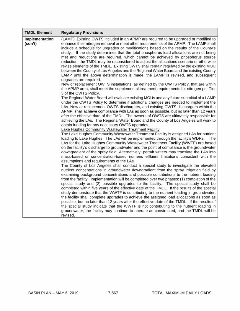
BASIN PLAN – MAY 6, 2019 7-567 TOTAL MAXIMUM DAILY LOADS
TMDL Element Regulatory Provisions Implementation (con’t)
(LAMP). Existing OWTS included in an APMP are required to be upgraded or modified to enhance their nitrogen removal or meet other requirements of the APMP. The LAMP shall include a schedule for upgrades or modifications based on the results of the County’s study. If the study determines that the total phosphorus load allocations are not being met and reductions are required, which cannot be achieved by phosphorus source reduction, the TMDL may be reconsidered to adjust the allocations scenario or otherwise revise elements of the TMDL. Existing OWTS shall remain regulated by the existing MOU between the County of Los Angeles and the Regional Water Board and the existing County LAMP until the above determination is made, the LAMP is revised, and subsequent upgrades are required. New or replacement OWTS installations, as defined by the OWTS Policy, that are within the APMP area, shall meet the supplemental treatment requirements for nitrogen per Tier 3 of the OWTS Policy. The Regional Water Board will evaluate existing MOUs and any future submittal of a LAMP under the OWTS Policy to determine if additional changes are needed to implement the LAs. New or replacement OWTS dischargers, and existing OWTS dischargers within the APMP, shall achieve compliance with LAs as soon as possible, but no later than 12 years after the effective date of the TMDL. The owners of OWTS are ultimately responsible for achieving the LAs. The Regional Water Board and the County of Los Angeles will work to obtain funding for any necessary OWTS upgrades. Lake Hughes Community Wastewater Treatment Facility The Lake Hughes Community Wastewater Treatment Facility is assigned LAs for nutrient loading to Lake Hughes. The LAs will be implemented through the facility’s WDRs. The LAs for the Lake Hughes Community Wastewater Treatment Facility (WWTF) are based on the facility’s discharge to groundwater and the point of compliance is the groundwater downgradient of the spray field. Alternatively, permit writers may translate the LAs into mass-based or concentration-based numeric effluent limitations consistent with the assumptions and requirements of the LAs. The County of Los Angeles shall conduct a special study to investigate the elevated nutrient concentrations in groundwater downgradient from the spray irrigation field by examining background concentrations and possible contributions to the nutrient loading from the facility. Implementation will be completed over two phases: (1) completion of the special study and (2) possible upgrades to the facility. The special study shall be completed within five years of the effective date of the TMDL. If the results of the special study demonstrate that the WWTF is contributing to the nutrient loading in groundwater, the facility shall complete upgrades to achieve the assigned load allocations as soon as possible, but no later than 12 years after the effective date of the TMDL. If the results of the special study indicate that the WWTF is not contributing to the nutrient loading in groundwater, the facility may continue to operate as constructed, and the TMDL will be revised.

BASIN PLAN – MAY 6, 2019 7-568 TOTAL MAXIMUM DAILY LOADS
Table 7-43.2. Santa Clara River Lakes Nutrient TMDL: Implementation Schedule
Task Date
The Los Angeles Water Board will reconsider this TMDL within eight years of its effective date to revise the numeric targets, revise or redistribute LAs and WLAs among sources, and revise the implementation schedule and any other element of the TMDL based on the results of any new information or data. The Regional Board will use its best efforts to help obtain sufficient public funding to ensure timely compliance with the TMDL’s implementation schedule. If public funding is not obtained within eight years after adoption of the TMDL, as part of reconsideration of the TMDL at a Regional Board meeting, Regional Board management will recommend an extension of the TMDL implementation schedule until funding is identified and secured.
8 years from the effective date of the TMDL
Storm Drain Discharges Responsible entities shall meet assigned WLAs for total nitrogen and total phosphorus.
Within 15 years of the effective date of the TMDL
Onsite Wastewater Treatment Systems If the County of Los Angeles chooses to conduct a study to determine which existing OWTS are contributing to the nutrient loading to the Santa Clara River Lakes, the County shall submit a work plan for the study for approval by the Executive Officer.
Within three years of the effective date of the TMDL
If the County of Los Angeles chooses to conduct the OWTS study, the County shall complete the study and submit a final report to the Regional Water Board.
Within five years of the effective date of the TMDL
Complete OWTS upgrades (as necessary) As soon as possible, but no later than 12 years after the effective date of the TMDL
Attain LAs for total nitrogen and total phosphorus for OWTS As soon as possible, but no later than 12 years after the effective date of the TMDL
Internal Loading for Elizabeth Lake and Lake Hughes If chosen as the implementation strategy, cooperative parties shall develop and enter a Memorandum of Agreement (MOA) with the Regional Water Board to implement LAs.
Within 3 years of the effective date of the TMDL
The Regional Water Board shall begin development of a cleanup and abatement order or other regulatory order to implement the LAs if an MOA is not established with cooperative parties.
3 years from the effective date of the TMDL
Cooperative parties shall submit Lake Work Plans for each lake, including a MRP, for approval by the Executive Officer to comply with the MOA.
Within 5 years of the effective date of the TMDL
Cooperative parties shall submit annual monitoring reports on the progress of Lake Work Plan implementation.
Within 6 years of the effective date of the TMDL
Internal loading LAs for total nitrogen and total phosphorus shall be attained.
Within 15 years of the effective date of the TMDL
Nonpoint Source Runoff A MRP shall be developed and submitted for nonpoint source runoff from the drainage area surrounding the lakes
Within 5 years of effective date of the TMDL

BASIN PLAN – MAY 6, 2019 7-569 TOTAL MAXIMUM DAILY LOADS
Task Date
Nonpoint source runoff from the drainage area surrounding the lakes shall attain LAs for total nitrogen and total phosphorus for runoff not served by storm drains.
Within 15 years of the effective date of the TMDL
Lake Hughes Community Wastewater Treatment Facility The Lake Hughes Community Wastewater Treatment Facility shall complete the special study and submit the final report to the Los Angeles Water Board
Within 5 years of the effective date of the TMDL
Complete WWTF upgrades (as necessary) As soon as possible, but no later than 12 years after the effective date of the TMDL
The Lake Hughes Community Wastewater Treatment Facility shall achieve LAs for total nitrogen and total phosphorus.
As soon as possible, but no later than 12 years after the effective date of the TMDL

BASIN PLAN – MAY 6, 2019 7-570 TOTAL MAXIMUM DAILY LOADS
This page intentionally left blank