chapter 8 streetscapes, parks & trails barbadensis aloe vera/medicinal aloe ... convolvulus...
TRANSCRIPT

Chapter 8
STREETSCAPES,PARKS & TRAILS
This chapter provides guidance for design
and approval of landscaped areas within
streetscape corridors, developing park
master plans and individual park designs
and creating non-paved, non-motorized and
shared use trails throughout the city.
8-1 LANDSCAPED MEDIANS/ROWS
8-2 PARKS
8-3 NON-PAVED TRAILS
8
Design Standards & Policies ManualCity of Scottsdale - August 2008

DEPARTMENT RESOURCE INFORMATION
Aviation/Airport
Advance Planning Services
Capital Project Management
Current Planning
Customer Service
Downtown Group
Facilities Management
Fire & Life Safety/Inspections
Fire Plan Review
Inspections & Land Survey
Parks Department
One Stop Shop/Permit Services
Plan Review
Records Division
Solid Wastewater Management
Stormwater Management
Street Operations
Transportation
Water Resources
15000 N. Airport Dr.
7506 E. Indian School Rd.
7447 E. Indian School Rd., Suite 205
7447 E. Indian School Rd., Suite 105
7447 E. Indian School Rd., Suite 100
4248 N. Craftsman Ct.
9191 E. San Salvador Dr.
8401 E. Indian School Rd.
7447 E. Indian School Rd., Suite 125
9191 N. San Salvador Dr.
7340 Scottsdale Mall
7447 E. Indian School Rd., Suite 100
7447 E. Indian School Rd., Suite 125
7447 E. Indian School Rd., Suite 100
9191 N. San Salvador Dr.
7447 E. Indian School Rd., Suite 205
9191 N. San Salvador Dr.
7447 E. Indian School Rd., Suite 205
9388 E. San Salvador Dr.
480-312-2321
480-312-7990
480-312-7250
480-312-7000
480-312-7800
480-312-7750
480-312-5999
480-312-1855
480-312-7080
480-312-5750
480-312-2915
480-312-2500
480-312-7080
480-312-2356
480-312-5600
480-312-7250
480-312-5626
480-312-7696
480-312-5685
City of Scottsdale www.scottsdaleaz.gov
Design Standards & Policies ManualCity of Scottsdale - August 2008
Section 8-1
LANDSCAPEDMEDIANS/ROWS
This section is intended to aid designers in
developing hardscape, landscape, irrigation and
general aesthetic improvements for areas within
the city’s streetscape corridors. It recommends
plants for special character areas, provides
landscape, irrigation, design, and sight distance
guidelines and requirements for inspections and
as-built submittals.
8-1
Design Standards & Policies ManualCity of Scottsdale - August 2008

DEPARTMENT RESOURCE INFORMATION
Aviation/Airport
Advance Planning Services
Capital Project Management
Current Planning
Customer Service
Downtown Group
Facilities Management
Fire & Life Safety/Inspections
Fire Plan Review
Inspections & Land Survey
Parks Department
One Stop Shop/Permit Services
Plan Review
Records Division
Solid Wastewater Management
Stormwater Management
Street Operations
Transportation
Water Resources
15000 N. Airport Dr.
7506 E. Indian School Rd.
7447 E. Indian School Rd., Suite 205
7447 E. Indian School Rd., Suite 105
7447 E. Indian School Rd., Suite 100
4248 N. Craftsman Ct.
9191 E. San Salvador Dr.
8401 E. Indian School Rd.
7447 E. Indian School Rd., Suite 125
9191 N. San Salvador Dr.
7340 Scottsdale Mall
7447 E. Indian School Rd., Suite 100
7447 E. Indian School Rd., Suite 125
7447 E. Indian School Rd., Suite 100
9191 N. San Salvador Dr.
7447 E. Indian School Rd., Suite 205
9191 N. San Salvador Dr.
7447 E. Indian School Rd., Suite 205
9388 E. San Salvador Dr.
480-312-2321
480-312-7990
480-312-7250
480-312-7000
480-312-7800
480-312-7750
480-312-5999
480-312-1855
480-312-7080
480-312-5750
480-312-2915
480-312-2500
480-312-7080
480-312-2356
480-312-5600
480-312-7250
480-312-5626
480-312-7696
480-312-5685
City of Scottsdale www.scottsdaleaz.gov
Design Standards & Policies ManualCity of Scottsdale - August 2008
Design Standards & Policies ManualCity of Scottsdale - August 2008
Page 1
8-1.000GENERAL INFORMATIONA. Median & Streetscape Character AreasThere are different median design standards for each character area within the city; contact the City of Scottsdale’s Plan Review office to determine which character area designation to use for each specific project. Streetscape information is available at www.ScottsdaleAZ.gov/planning/corridorplans.Medians within Commercial Cores as identified in the General Plan will be allowed a higher percentage of plant coverage with the plant materials for the character area in which they are located.
B. Downtown and Urban Character The Downtown and Urban Character classification is given to the areas of the city in which pedestrian comfort is a primary consideration. When designing these areas concentrate on elements such as arcaded walkways, shade, decorative paving, and landscaping so that a comfortable setting can be created for this use-intensive area.1. Balance the use of plant material with decorative paving (stamped concrete, exposed
aggregate, and pavers, etc.) to minimize the exposure of decomposed granite.2. Median landscaping in the Downtown couplet system must conform to specifications in
Appendix 8-1A and the Downtown Urban Design and Architectural Guidelines, see *www.ScottsdaleAZ.gov/planning/policycards/pc_downtowndesign.
3. Plant palette and quantities must also conform to the Downtown Urban Design and Architectural Guidelines* and Appendix 8-1A.
Downtown guidelines can be found online at www.ScottsdaleAZ.gov/downtown.
C. Suburban CharacterThe suburban character applies to areas of the city where compatibility should be achieved between pedestrians and transportation routes within a medium density development pattern. Using trees that are native and/or desert adapted and which achieve a broad, dense canopy is encouraged for the main theme of the streetscape. Separating pedestrians from vehicular traffic can be accomplished through landscape areas and sidewalk alignment.1. Use decomposed granite, exposed aggregate, and grouted riprap in place of decorative
paving. 2. Plant palette should begin to incorporate more arid-type materials or desert adapted, as
shown in Section 8-1.100.
streetscapes,parks & trails
LANDSCAPED MEDIANS/ROWS 8-1
Section 8-1 LANDSCAPED MEDIANS/ROWS
Design Standards & Policies ManualCity of Scottsdale - August 2008
Page 2
D. Transitional Arid CharacterFor areas of the city where the development pattern is medium to low, and the streetscape serves as a buffer between traffic and adjacent land uses, the transitional arid character classification is applied. Landscape materials should include native plants or plants compatible with a desert environment. Special care should be given to protect existing vegetation and natural features that can be incorporated into the design.1. Handset riprap and decomposed granite are to be the primary inorganic materials. 2. Plant palette shall consist of indigenous and desert-compatible materials, see Section 8-
1.100.
E. Natural CharacterA goal of the natural streetscape designation is to keep the streetscape compatible with the natural desert. For this reason, the applicant should select plants that are native to the Upper Sonoran desert and match densities to the existing and adjacent desert environment. The design elements for the Natural Character area are governed in part by the city’s Environmentally Sensitive Lands Ordinance (ESLO). See this ordinance for specific requirements on plant and materials selection, www.ScottsdaleAZ.gov/codes/eslo. 1. Native stone and indigenous decomposed granite are to be primary inorganic materials. 2. Plant palette is to consist of indigenous materials only, and shall conform to the native
distribution patterns, densities and maturity, see Section 10-1.100.
F. Blending of Abutting Character AreasWhere two different character areas adjoin, a blending of the two categories should occur to prevent a marked difference between opposing sides of streets. These guidelines apply to all landscaped areas within the public rights-of-way. Areas between the rights-of-way and building setback lines are encouraged to use the guidelines as well. Transitional areas which abut Environmentally Sensitive Lands (or the Natural Character) should primarily use native plants in order to strengthen the tie to the natural desert and to prevent the spread of invasive, non-native species into natural areas.
8-1.100 RECOMMENDED PLANTS
8-1.101 DOWNTOWN AND URBAN CHARACTERSee Appendix 8-1A for Downtown Area recommended plants; other plants will be considered on an individual basis. The Downtown Guidelines contain recommended plants to be used in the Urban Character Area, www.ScottsdaleAZ.gov/downtown.
Section 8-1LANDSCAPED MEDIANS/ROWS
Design Standards & Policies ManualCity of Scottsdale - August 2008
Page 3
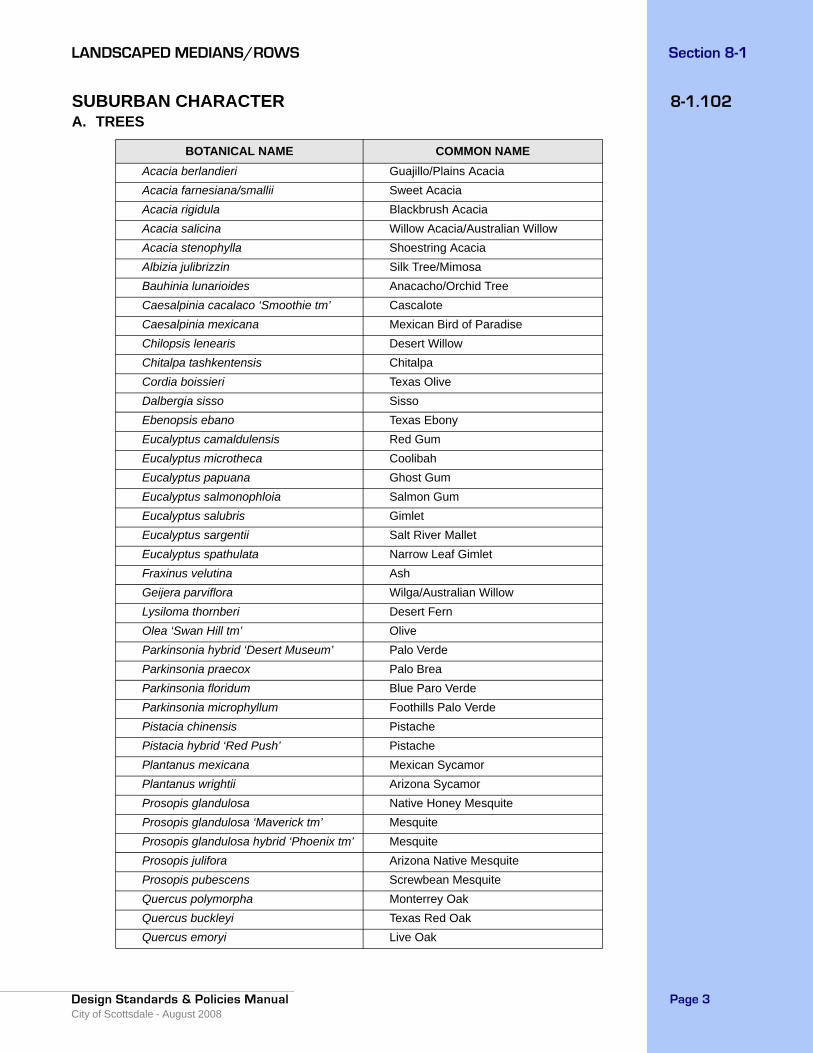
8-1.102SUBURBAN CHARACTERA. TREES
BOTANICAL NAME COMMON NAMEAcacia berlandieri Guajillo/Plains AcaciaAcacia farnesiana/smallii Sweet AcaciaAcacia rigidula Blackbrush AcaciaAcacia salicina Willow Acacia/Australian WillowAcacia stenophylla Shoestring AcaciaAlbizia julibrizzin Silk Tree/MimosaBauhinia lunarioides Anacacho/Orchid TreeCaesalpinia cacalaco ‘Smoothie tm’ CascaloteCaesalpinia mexicana Mexican Bird of ParadiseChilopsis lenearis Desert WillowChitalpa tashkentensis ChitalpaCordia boissieri Texas OliveDalbergia sisso SissoEbenopsis ebano Texas EbonyEucalyptus camaldulensis Red GumEucalyptus microtheca CoolibahEucalyptus papuana Ghost GumEucalyptus salmonophloia Salmon GumEucalyptus salubris GimletEucalyptus sargentii Salt River MalletEucalyptus spathulata Narrow Leaf GimletFraxinus velutina AshGeijera parviflora Wilga/Australian WillowLysiloma thornberi Desert FernOlea ‘Swan Hill tm’ OliveParkinsonia hybrid ‘Desert Museum’ Palo VerdeParkinsonia praecox Palo BreaParkinsonia floridum Blue Paro VerdeParkinsonia microphyllum Foothills Palo VerdePistacia chinensis PistachePistacia hybrid ‘Red Push’ PistachePlantanus mexicana Mexican SycamorPlantanus wrightii Arizona SycamorProsopis glandulosa Native Honey MesquiteProsopis glandulosa ‘Maverick tm’ MesquiteProsopis glandulosa hybrid ‘Phoenix tm’ MesquiteProsopis julifora Arizona Native MesquiteProsopis pubescens Screwbean MesquiteQuercus polymorpha Monterrey OakQuercus buckleyi Texas Red OakQuercus emoryi Live Oak
Section 8-1 LANDSCAPED MEDIANS/ROWS
Design Standards & Policies ManualCity of Scottsdale - August 2008
Page 4
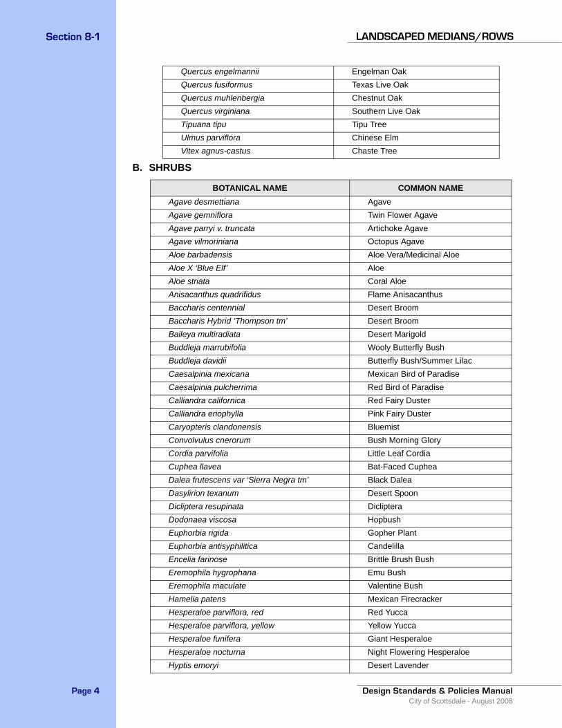
B. SHRUBS
Quercus engelmannii Engelman OakQuercus fusiformus Texas Live OakQuercus muhlenbergia Chestnut OakQuercus virginiana Southern Live OakTipuana tipu Tipu TreeUlmus parviflora Chinese ElmVitex agnus-castus Chaste Tree
BOTANICAL NAME COMMON NAMEAgave desmettiana AgaveAgave gemniflora Twin Flower AgaveAgave parryi v. truncata Artichoke AgaveAgave vilmoriniana Octopus AgaveAloe barbadensis Aloe Vera/Medicinal AloeAloe X ‘Blue Elf’ AloeAloe striata Coral AloeAnisacanthus quadrifidus Flame AnisacanthusBaccharis centennial Desert BroomBaccharis Hybrid ‘Thompson tm’ Desert BroomBaileya multiradiata Desert MarigoldBuddleja marrubifolia Wooly Butterfly BushBuddleja davidii Butterfly Bush/Summer LilacCaesalpinia mexicana Mexican Bird of ParadiseCaesalpinia pulcherrima Red Bird of ParadiseCalliandra californica Red Fairy DusterCalliandra eriophylla Pink Fairy DusterCaryopteris clandonensis BluemistConvolvulus cnerorum Bush Morning GloryCordia parvifolia Little Leaf CordiaCuphea llavea Bat-Faced CupheaDalea frutescens var ‘Sierra Negra tm’ Black DaleaDasylirion texanum Desert SpoonDicliptera resupinata DiclipteraDodonaea viscosa HopbushEuphorbia rigida Gopher PlantEuphorbia antisyphilitica CandelillaEncelia farinose Brittle Brush BushEremophila hygrophana Emu BushEremophila maculate Valentine BushHamelia patens Mexican FirecrackerHesperaloe parviflora, red Red YuccaHesperaloe parviflora, yellow Yellow YuccaHesperaloe funifera Giant HesperaloeHesperaloe nocturna Night Flowering HesperaloeHyptis emoryi Desert Lavender
Section 8-1LANDSCAPED MEDIANS/ROWS
Design Standards & Policies ManualCity of Scottsdale - August 2008
Page 5
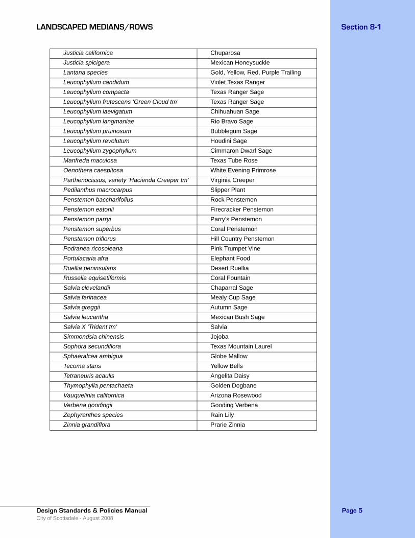
Justicia californica ChuparosaJusticia spicigera Mexican HoneysuckleLantana species Gold, Yellow, Red, Purple TrailingLeucophyllum candidum Violet Texas RangerLeucophyllum compacta Texas Ranger SageLeucophyllum frutescens ‘Green Cloud tm’ Texas Ranger SageLeucophyllum laevigatum Chihuahuan SageLeucophyllum langmaniae Rio Bravo SageLeucophyllum pruinosum Bubblegum SageLeucophyllum revolutum Houdini SageLeucophyllum zygophyllum Cimmaron Dwarf SageManfreda maculosa Texas Tube RoseOenothera caespitosa White Evening PrimroseParthenocissus, variety ‘Hacienda Creeper tm’ Virginia Creeper Pedilanthus macrocarpus Slipper PlantPenstemon baccharifolius Rock PenstemonPenstemon eatonii Firecracker PenstemonPenstemon parryi Parry’s PenstemonPenstemon superbus Coral PenstemonPenstemon triflorus Hill Country PenstemonPodranea ricosoleana Pink Trumpet VinePortulacaria afra Elephant FoodRuellia peninsularis Desert RuelliaRusselia equisetiformis Coral FountainSalvia clevelandii Chaparral SageSalvia farinacea Mealy Cup SageSalvia greggii Autumn SageSalvia leucantha Mexican Bush SageSalvia X ‘Trident tm’ SalviaSimmondsia chinensis JojobaSophora secundiflora Texas Mountain LaurelSphaeralcea ambigua Globe MallowTecoma stans Yellow BellsTetraneuris acaulis Angelita DaisyThymophylla pentachaeta Golden DogbaneVauquelinia californica Arizona RosewoodVerbena goodingii Gooding VerbenaZephyranthes species Rain LilyZinnia grandiflora Prarie Zinnia
Section 8-1 LANDSCAPED MEDIANS/ROWS
Design Standards & Policies ManualCity of Scottsdale - August 2008
Page 6
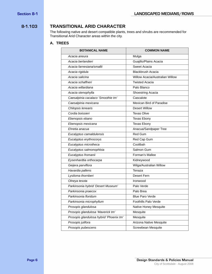
8-1.103 TRANSITIONAL ARID CHARACTERThe following native and desert compatible plants, trees and shrubs are recommended for Transitional Arid Character areas within the city.
A. TREES
BOTANICAL NAME COMMON NAME
Acacia aneura Mulga
Acacia berlandieri Guajillo/Plains Acacia
Acacia farnesiana/smallii Sweet Acacia
Acacia rigidula Blackbrush Acacia
Acacia salicina Willow Acacia/Australian Willow
Acacia schaffneri Twisted Acacia
Acacia willardiana Palo Blanco
Acacia stenophylla Shoestring Acacia
Caesalpinia cacalaco ‘Smoothie tm’ Cascalote
Caesalpinia mexicana Mexican Bird of Paradise
Chilopsis lenearis Desert Willow
Cordia boissieri Texas Olive
Ebenopsis ebano Texas Ebony
Ebenopsis mexicana Texas Ebony
Ehretia anacua Anacua/Sandpaper Tree
Eucalyptus camaldulensis Red Gum
Eucalyptus erythrocorys Red Cap Gum
Eucalyptus microtheca Coolibah
Eucalyptus salmonophloia Salmon Gum
Eucalyptus fromanii Forman’s Mallee
Eysenhardtia orthocarpa Kidneywood
Geijera parviflora Wilga/Australian Willow
Havardia pallens Tenaza
Lysiloma thornberi Desert Fern
Olneya tesota Ironwood
Parkinsonia hybrid ‘Desert Museum’ Palo Verde
Parkinsonia praecox Palo Brea
Parkinsonia floridum Blue Paro Verde
Parkinsonia microphyllum Foothills Palo Verde
Prosopis glandulosa Native Honey Mesquite
Prosopis glandulosa ‘Maverick tm’ Mesquite
Prosopis glandulosa hybrid ‘Phoenix tm’ Mesquite
Prosopis julifora Arizona Native Mesquite
Prosopis pubescens Screwbean Mesquite
Section 8-1LANDSCAPED MEDIANS/ROWS
Design Standards & Policies ManualCity of Scottsdale - August 2008
Page 7
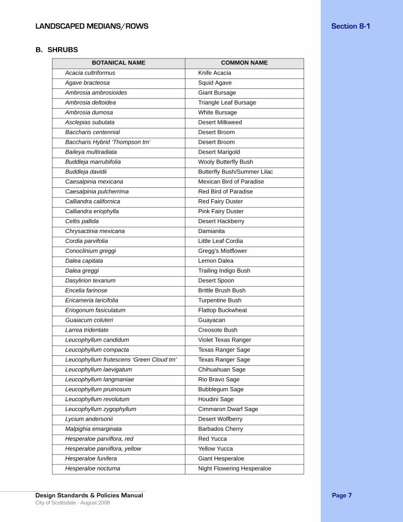
B. SHRUBSBOTANICAL NAME COMMON NAME
Acacia cultriformus Knife Acacia
Agave bracteosa Squid Agave
Ambrosia ambrosioides Giant Bursage
Ambrosia deltoidea Triangle Leaf Bursage
Ambrosia dumosa White Bursage
Asclepias subulata Desert Milkweed
Baccharis centennial Desert Broom
Baccharis Hybrid ‘Thompson tm’ Desert Broom
Baileya multiradiata Desert Marigold
Buddleja marrubifolia Wooly Butterfly Bush
Buddleja davidii Butterfly Bush/Summer Lilac
Caesalpinia mexicana Mexican Bird of Paradise
Caesalpinia pulcherrima Red Bird of Paradise
Calliandra californica Red Fairy Duster
Calliandra eriophylla Pink Fairy Duster
Celtis pallida Desert Hackberry
Chrysactinia mexicana Damianita
Cordia parvifolia Little Leaf Cordia
Conoclinium greggi Gregg’s Mistflower
Dalea capitata Lemon Dalea
Dalea greggi Trailing Indigo Bush
Dasylirion texanum Desert Spoon
Encelia farinose Brittle Brush Bush
Ericameria laricifolia Turpentine Bush
Eriogonum fasiculatum Flattop Buckwheat
Guaiacum coluteri Guayacan
Larrea tridentate Creosote Bush
Leucophyllum candidum Violet Texas Ranger
Leucophyllum compacta Texas Ranger Sage
Leucophyllum frutescens ‘Green Cloud tm’ Texas Ranger Sage
Leucophyllum laevigatum Chihuahuan Sage
Leucophyllum langmaniae Rio Bravo Sage
Leucophyllum pruinosum Bubblegum Sage
Leucophyllum revolutum Houdini Sage
Leucophyllum zygophyllum Cimmaron Dwarf Sage
Lycium andersonii Desert Wolfberry
Malpighia emarginata Barbados Cherry
Hesperaloe parviflora, red Red Yucca
Hesperaloe parviflora, yellow Yellow Yucca
Hesperaloe funifera Giant Hesperaloe
Hesperaloe nocturna Night Flowering Hesperaloe

Section 8-1 LANDSCAPED MEDIANS/ROWS
Design Standards & Policies ManualCity of Scottsdale - August 2008
Page 8
Hyptis emoryi Desert Lavender
Justicia californica Chuparosa
Justicia spicigera Mexican Honeysuckle
Nolina nelsoni Blue Beargrass Tree
Nolina texana Beargrass
Nolina matapensis Sonoran Tree Beargrass
Ocotillo Ocotillo
Oenothera caespitosa White Evening Primrose
Opuntia basilaris Beavertail Prickly Pear
Opuntia ficus indica Indian Fig
Opuntia santa-rita Purple Prickly Pear
Penstemon baccharifolius Rock Penstemon
Penstemon eatonii Firecracker Penstemon
Penstemon parryi Parry’s Penstemon
Penstemon superbus Coral Penstemon
Penstemon triflorus Hill Country Penstemon
Podranea ricosoleana Pink Trumpet Vine
Russelia equisetiformis Coral Fountain
Salvia clevelandii Chaparral Sage
Salvia farinacea Mealy Cup Sage
Salvia greggii Autumn Sage
Salvia leucantha Mexican Bush Sage
Salvia X ‘Trident tm’ Salvia
Simmondsia chinensis Jojoba
Sophora secundiflora Texas Mountain Laurel
Sphaeralcea ambigua Globe Mallow
Tetraneuris acaulis Angelita Daisy
Thymophylla pentachaeta Golden Dogbane
Vauquelinia californica Arizona Rosewood
Viguiera parishii Goldeneye
Yucca baccata Banana Yucca
Yucca elata Soaptree Yucca
Yucca carnerosana Spanish Dagger
Yucca pallida Pale Leaf Yucca
Yucca rupicola Twisted Leaf Yucca
Zinnia grandiflora Prarie Zinnia
Section 8-1LANDSCAPED MEDIANS/ROWS
Design Standards & Policies ManualCity of Scottsdale - August 2008
Page 9
8-1.200LANDSCAPE GUIDELINESAll streetscape designs must meet the following minimum requirements based upon the city’s ordinances. See COS Supplement to MAG Section 430 and related details for more specific information, www.ScottsdaleAZ.gov/design/COSMAGSupp.
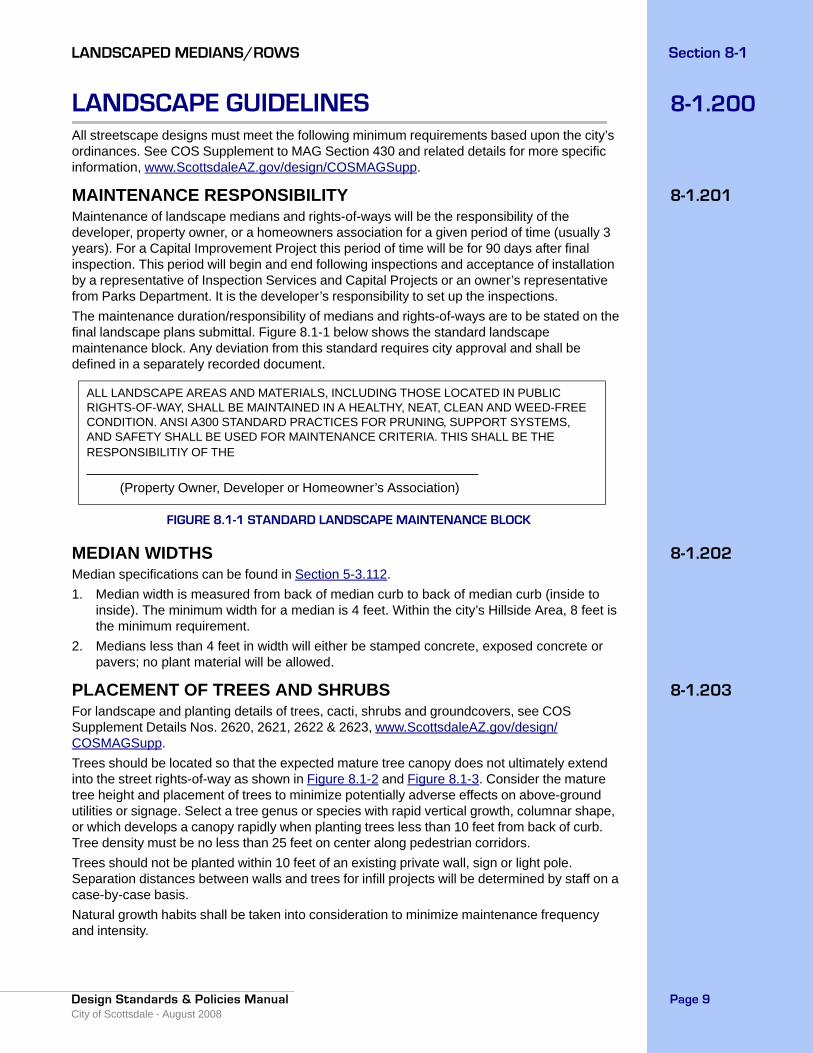
8-1.201MAINTENANCE RESPONSIBILITYMaintenance of landscape medians and rights-of-ways will be the responsibility of the developer, property owner, or a homeowners association for a given period of time (usually 3 years). For a Capital Improvement Project this period of time will be for 90 days after final inspection. This period will begin and end following inspections and acceptance of installation by a representative of Inspection Services and Capital Projects or an owner’s representative from Parks Department. It is the developer’s responsibility to set up the inspections. The maintenance duration/responsibility of medians and rights-of-ways are to be stated on the final landscape plans submittal. Figure 8.1-1 below shows the standard landscape maintenance block. Any deviation from this standard requires city approval and shall be defined in a separately recorded document.
FIGURE 8.1-1 STANDARD LANDSCAPE MAINTENANCE BLOCK
8-1.202MEDIAN WIDTHS Median specifications can be found in Section 5-3.112.1. Median width is measured from back of median curb to back of median curb (inside to
inside). The minimum width for a median is 4 feet. Within the city’s Hillside Area, 8 feet is the minimum requirement.
2. Medians less than 4 feet in width will either be stamped concrete, exposed concrete or pavers; no plant material will be allowed.
8-1.203PLACEMENT OF TREES AND SHRUBSFor landscape and planting details of trees, cacti, shrubs and groundcovers, see COS Supplement Details Nos. 2620, 2621, 2622 & 2623, www.ScottsdaleAZ.gov/design/COSMAGSupp.Trees should be located so that the expected mature tree canopy does not ultimately extend into the street rights-of-way as shown in Figure 8.1-2 and Figure 8.1-3. Consider the mature tree height and placement of trees to minimize potentially adverse effects on above-ground utilities or signage. Select a tree genus or species with rapid vertical growth, columnar shape, or which develops a canopy rapidly when planting trees less than 10 feet from back of curb. Tree density must be no less than 25 feet on center along pedestrian corridors.Trees should not be planted within 10 feet of an existing private wall, sign or light pole. Separation distances between walls and trees for infill projects will be determined by staff on a case-by-case basis. Natural growth habits shall be taken into consideration to minimize maintenance frequency and intensity.
ALL LANDSCAPE AREAS AND MATERIALS, INCLUDING THOSE LOCATED IN PUBLIC RIGHTS-OF-WAY, SHALL BE MAINTAINED IN A HEALTHY, NEAT, CLEAN AND WEED-FREE CONDITION. ANSI A300 STANDARD PRACTICES FOR PRUNING, SUPPORT SYSTEMS, AND SAFETY SHALL BE USED FOR MAINTENANCE CRITERIA. THIS SHALL BE THE RESPONSIBILITIY OF THE _____________________________________________________ (Property Owner, Developer or Homeowner’s Association)

Section 8-1 LANDSCAPED MEDIANS/ROWS
Design Standards & Policies ManualCity of Scottsdale - August 2008
Page 10
Landscaping clearance shall be provided to prevent conflict with signs, lighting, fire equipment or median crossings.Landscaping must not create hazards to public safety though either plant growth habit, structure, or location.For Saguaro relocation procedures, see Section 10-1.300.
FIGURE 8.1-2 RESIDENTIAL ROADWAY CLEARANCES (30 MPH OR LESS)
FIGURE 8.1-3 ARTERIAL OR COLLECTOR ROADWAY CLEARANCES (35 MPH OR GREATER)
8-1.204 TREE QUANTITIES AND SIZESTrees should be provided at the rate of 1 tree per each 35 lineal feet of median length. The minimum size is 15 gallon with 50 percent to be provided as mature trees or larger (as defined in Article III of the Zoning Ordinance). Salvaged trees must meet ANSI A300 (Part 1) Pruning Standards and ANSI A300 (Part 6) Transplanting Standards with a minimum of 2 1/2” trunk caliper.
Parking LaneBike LaneShoulder
SidewalkStripe
PreferredSmoothTrim Line
Travelway Widthx13.5’ Clearance
Height
SidewalkStripe
Parking LaneBike LaneShoulder
PreferredSmoothTrim Line
Full Lane Widthx13.5’ Clearance
Height
Section 8-1LANDSCAPED MEDIANS/ROWS
Design Standards & Policies ManualCity of Scottsdale - August 2008
Page 11
8-1.205GRADING1. Mounding should not be used in the areas designated as Downtown and Urban Character
zones. Care should be taken when designing landscaping within the sight distance triangles. Mounds within sight distance easements must not exceed a height of 18 inches as measured above the final grade elevation. All mounding should blend with the adjacent existing terrain.
2. The maximum slope of any mounding shall be 4:1 (25%). 3. The finished landscape grade with decomposed granite should be smooth, uniform, and a
minimum of 2 inches below the top of curb.
8-1.206DECOMPOSED GRANITE1. Size must be ½ inch screened Desert Gold or of a matching color to that of adjacent
landscaped areas. The decomposed granite color must match native earth tones.2. For installation and details for public works construction, see COS Standard Detail No.
2620-1, www.ScottsdaleAZ.gov/design/COSMAGSupp.3. A sample will be submitted to a representative from Parks Department for approval prior to
the contractor ordering and bringing it onto the site. Color shall match what exists in the area.
4. Decomposed granite will be distributed uniformly to a depth of 2 inches covering the entire landscape area.
8-1.207BOULDERSBoulders are not acceptable for City of Scottsdale landscaped medians and rights-of-way, unless otherwise approved by Risk Management. Call 480-312-5082 for more information.
8-1.208PLANT SELECTIONAll plant materials used in a median are required to come from the Arizona Department of Water Resources low water use plant list for the Phoenix Active Management Area. The selected plant materials are also to be consistent with the appropriate character areas described in Section 8-1.100.Public rights-of-way that are located in the Environmentally Sensitive Lands (ESL) Upper Desert and Hillside landforms must be landscaped with plants from the City of Scottsdale’s Indigenous Plants for Environmentally Sensitive Lands list and www.ScottsdaleAZ.gov/codes/nativeplant/ESLO. This list is available in the city’s One Stop Shop. See the Scottsdale Revised Code Section 49-78 and 49-79, Scottsdale Landscape Ordinance and the ESLO for additional specific plant selection requirements, www.ScottsdaleAZ.gov/codes.
8-1.209HYDROSEEDING & NAOS RESTORATIONSeed mix shall be composed of native species as defined in the Environmentally Sensitive Lands Ordinance, www.ScottsdaleAZ.gov/codes/eslo.
8-1.300IRRIGATION GUIDELINESSee the City of Scottsdale’s most current supplement to MAG Section 440 and related details for more specific information.
A. Approved Irrigation System TypesCentralized control or solar powered.
Section 8-1 LANDSCAPED MEDIANS/ROWS
Design Standards & Policies ManualCity of Scottsdale - August 2008
Page 12
B. ControllersPlace controllers in the center of the median, a minimum of 50 feet before the beginning of the turn bay. Approved controllers are Motorola Irrinet/Scorpio or Leit/DIG X Services. Contact COS Irrigation Department for Motorola Irrinet/Scorpio controller and antenna locations.
C. Power Source1. The contractor is responsible for initiating account and service connection. 2. If the power source cannot be placed within the median or the rights-of-way, a utility
easement must be provided. This location is to be indicated and noted on the final irrigation plans and also inside of the controller cabinet.
D. Water Source1. Show both the water source and location of the proposed tap on the final irrigation plans. 2. Contact Water Resources at 480-312-5650 for information on tapping into city waterlines.3. Plans must indicate existing and design operating water pressure requirements.4. The water meter should be located within a median wherever possible.
E. Remote Control Electric Valves1. Valves are to be of brass construction, and a minimum size of 1 inch. 2. An approved valve is Rainbird series GB. 3. Full Port brass ball valves must be installed immediately upstream of all control valves. 4. All direct buried control valve wiring shall be a minimum 14 gauge.5. Master valves are to be installed on all irrigation mainlines.
F. Back Flow Prevention Devices1. Only reduced pressure assemblies will be used. 2. All backflow prevention devices will have a security enclosure. 3. A certified tester, recognized by the City of Scottsdale, must test backflow prevention
devices before the city will accept responsibility for maintaining the system.
8-1.301 GENERAL IRRIGATION DESIGN CRITERIA1. The irrigation system is to be located entirely within the median. Sleeving from median-to-
median is acceptable. 2. The contractor is responsible for initiating the account and having the water meter set. 3. Trees and shrubs shall be valved separately. 4. The entire irrigation system must be independent of other users. For example, landscape
dedicated to the City of Scottsdale for maintenance must have separate power and water meters from other irrigation systems.
5. Plans must indicate valve flow rates, designation (tree, shrubs, turf, etc.) and station number.
8-1.302 FINAL PLAN SUBMITTALFinal submittal for irigation and landscape plans must show related details.
Section 8-1LANDSCAPED MEDIANS/ROWS
Design Standards & Policies ManualCity of Scottsdale - August 2008
Page 13
8-1.400SIGHT DISTANCEAny plant material installed in a questionable area (such as safety triangles, sight lines) will be identified by traffic engineering and removed by the contractor. Sight distance must be considered for vehicles entering and exiting adjacent properties, as well as for vehicles using abutting roadways.
A. Sight Distances & Safety Triangle1. To determine sight distances, use the criteria specified in Section 5-3.119.2. The sight line, as shown in Figure 5.3-26, shall be clearly indicated and delineated on the
final landscape plan submittal.
B. Planting within the Sight Triangle1. Shrubs planted within the sight triangle are to have a mature height of not more than 18
inches. Height will be from edge of pavement, and total height will include the height of any mounding.
2. Trees planted within the safety triangle are to have a canopy pruned to a height of 8 feet or greater upon installation. Height will be from edge of pavement, and total height will include the height of any mounding.
8-1.500ALTERATIONS & AS-BUILTS If field conditions require relocating a water meter, backflow prevention device, controller, valve, or any other major component of the irrigation system as shown on approved plans, contact Inspection Services at 480-312-5750 prior to any installation.The contractor must provide an accurate set of as-built Mylar drawings and CAD format per Section 5-2.400 to the Parks Department representative prior to the final acceptance of a system.
8-1.600SPECIFIC AREA DESIGN GUIDELINESIn circumstances where a special theme is desired, the city may designate specific design standards to be implemented on select streets. Contact the One Stop Shop at 480-312-2500 for more information.
8-1.700SCOTTSDALE GATEWAYSScottsdale shares common boundaries with several municipalities. When entering Scottsdale from a neighboring community, it is helpful for residents and visitors to have a sense of arrival into the city. Through the use of a city limits identification system, those entering the city should be able to readily recognize their entrance into Scottsdale. The Gateways Map shows the locations of city entrance points. See the city’s General Plan Environmental Design Element, www.ScottsdaleAZ.gov/generalplan.
Section 8-1 LANDSCAPED MEDIANS/ROWS
Design Standards & Policies ManualCity of Scottsdale - August 2008
Page 14
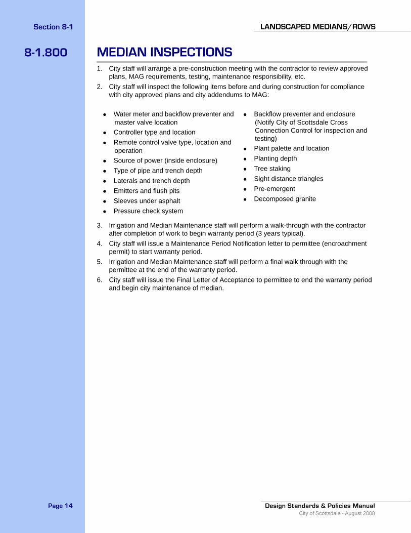
8-1.800 MEDIAN INSPECTIONS1. City staff will arrange a pre-construction meeting with the contractor to review approved
plans, MAG requirements, testing, maintenance responsibility, etc.2. City staff will inspect the following items before and during construction for compliance
with city approved plans and city addendums to MAG:
3. Irrigation and Median Maintenance staff will perform a walk-through with the contractor after completion of work to begin warranty period (3 years typical).
4. City staff will issue a Maintenance Period Notification letter to permittee (encroachment permit) to start warranty period.
5. Irrigation and Median Maintenance staff will perform a final walk through with the permittee at the end of the warranty period.
6. City staff will issue the Final Letter of Acceptance to permittee to end the warranty period and begin city maintenance of median.
• Water meter and backflow preventer and master valve location
• Controller type and location• Remote control valve type, location and
operation• Source of power (inside enclosure)• Type of pipe and trench depth• Laterals and trench depth• Emitters and flush pits• Sleeves under asphalt• Pressure check system
• Backflow preventer and enclosure (Notify City of Scottsdale Cross Connection Control for inspection and testing)
• Plant palette and location• Planting depth• Tree staking• Sight distance triangles• Pre-emergent• Decomposed granite
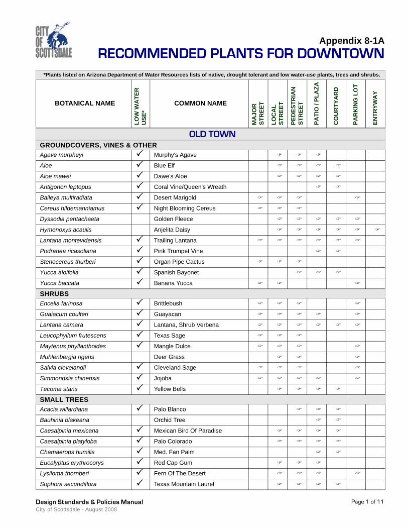
Appendix 8-1ARECOMMENDED PLANTS FOR DOWNTOWN
*Plants listed on Arizona Department of Water Resources lists of native, drought tolerant and low water-use plants, trees and shrubs.
BOTANICAL NAME
LOW
WA
TER
U
SE*
COMMON NAME
MA
JOR
ST
REE
T
LOC
AL
STR
EET
PED
ESTR
IAN
ST
REE
T
PATI
O /
PLA
ZA
CO
UR
TYA
RD
PAR
KIN
G L
OT
ENTR
YWA
Y
Page 1 of 11Design Standards & Policies Manual City of Scottsdale - August 2008
OLD TOWNGROUNDCOVERS, VINES & OTHERAgave murpheyi Murphy's Agave
Aloe Blue Elf
Aloe mawei Dawe's Aloe
Antigonon leptopus Coral Vine/Queen's Wreath
Baileya multiradiata Desert Marigold
Cereus hildemanniamus Night Blooming Cereus
Dyssodia pentachaeta Golden Fleece
Hymenoxys acaulis Anjelita Daisy
Lantana montevidensis Trailing Lantana
Podranea ricasoliana Pink Trumpet Vine
Stenocereus thurberi Organ Pipe Cactus
Yucca aloifolia Spanish Bayonet
Yucca baccata Banana Yucca
SHRUBSEncelia farinosa Brittlebush
Guaiacum coulteri Guayacan
Lantana camara Lantana, Shrub Verbena
Leucophyllum frutescens Texas Sage
Maytenus phyllanthoides Mangle Dulce
Muhlenbergia rigens Deer Grass
Salvia clevelandii Cleveland Sage
Simmondsia chinensis Jojoba
Tecoma stans Yellow Bells
SMALL TREESAcacia willardiana Palo Blanco
Bauhinia blakeana Orchid Tree
Caesalpinia mexicana Mexican Bird Of Paradise
Caesalpinia platyloba Palo Colorado
Chamaerops humilis Med. Fan Palm
Eucalyptus erythrocorys Red Cap Gum
Lysiloma thornberi Fern Of The Desert
Sophora secundiflora Texas Mountain Laurel
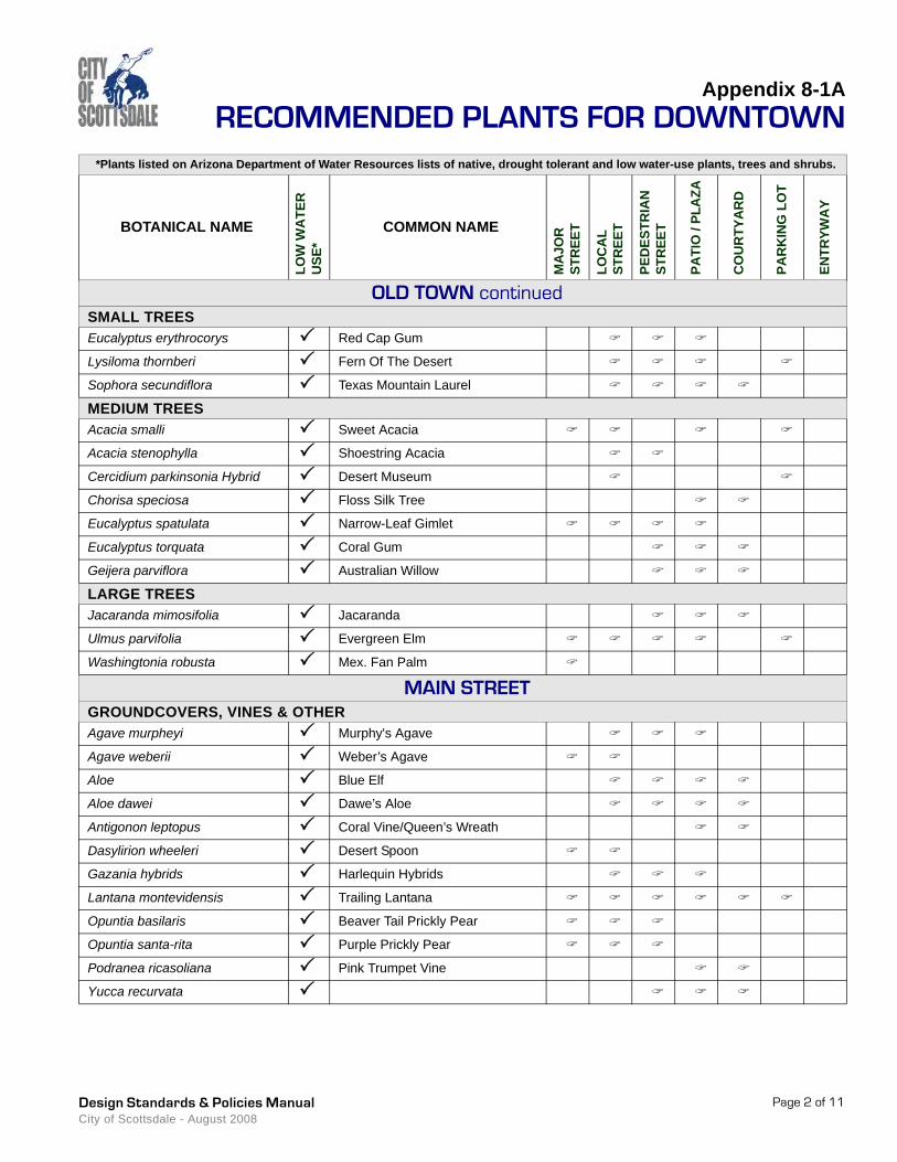
Appendix 8-1ARECOMMENDED PLANTS FOR DOWNTOWN
*Plants listed on Arizona Department of Water Resources lists of native, drought tolerant and low water-use plants, trees and shrubs.
BOTANICAL NAME
LOW
WA
TER
U
SE*
COMMON NAME
MA
JOR
ST
REE
T
LOC
AL
STR
EET
PED
ESTR
IAN
ST
REE
T
PATI
O /
PLA
ZA
CO
UR
TYA
RD
PAR
KIN
G L
OT
ENTR
YWA
Y
Page 2 of 11Design Standards & Policies Manual City of Scottsdale - August 2008
OLD TOWN continuedSMALL TREESEucalyptus erythrocorys Red Cap Gum
Lysiloma thornberi Fern Of The Desert
Sophora secundiflora Texas Mountain Laurel
MEDIUM TREESAcacia smalli Sweet Acacia
Acacia stenophylla Shoestring Acacia
Cercidium parkinsonia Hybrid Desert Museum
Chorisa speciosa Floss Silk Tree
Eucalyptus spatulata Narrow-Leaf Gimlet
Eucalyptus torquata Coral Gum
Geijera parviflora Australian Willow
LARGE TREESJacaranda mimosifolia Jacaranda
Ulmus parvifolia Evergreen Elm
Washingtonia robusta Mex. Fan Palm
MAIN STREETGROUNDCOVERS, VINES & OTHERAgave murpheyi Murphy's Agave
Agave weberii Weber’s Agave
Aloe Blue Elf
Aloe dawei Dawe’s Aloe
Antigonon leptopus Coral Vine/Queen’s Wreath
Dasylirion wheeleri Desert Spoon
Gazania hybrids Harlequin Hybrids
Lantana montevidensis Trailing Lantana
Opuntia basilaris Beaver Tail Prickly Pear
Opuntia santa-rita Purple Prickly Pear
Podranea ricasoliana Pink Trumpet Vine
Yucca recurvata
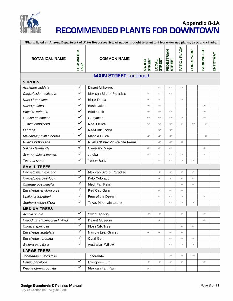
Appendix 8-1ARECOMMENDED PLANTS FOR DOWNTOWN
*Plants listed on Arizona Department of Water Resources lists of native, drought tolerant and low water-use plants, trees and shrubs.
BOTANICAL NAME
LOW
WA
TER
U
SE*
COMMON NAME
MA
JOR
ST
REE
T
LOC
AL
STR
EET
PED
ESTR
IAN
ST
REE
T
PATI
O /
PLA
ZA
CO
UR
TYA
RD
PAR
KIN
G L
OT
ENTR
YWA
Y
Page 3 of 11Design Standards & Policies Manual City of Scottsdale - August 2008
MAIN STREET continuedSHRUBSAsclepias sublata Desert Milkweed
Caesalpinia mexicana Mexican Bird of Paradise
Dalea frutescens Black Dalea
Dalea pulchra Bush Dalea
Encelia farinosa Brittlebush
Guaiacum coulteri Guayacan
Justica candicans Red Justica
Lantana Red/Pink Forms
Maytenus phyllanthoides Mangle Dulce
Ruellia brittoniana Ruellia ‘Katie’ Pink/White Forms
Salvia clevelandii Cleveland Sage
Simmondsia chinensis Jojoba
Tecoma stans Yellow Bells
SMALL TREESCaesalpinia mexicana Mexican Bird of Paradise
Caesalpinia platyloba Palo Colorado
Chamaerops humilis Med. Fan Palm
Eucalyptus erythrocorys Red Cap Gum
Lysiloma thornberi Fern of the Desert
Sophora secundiflora Texas Mountain Laurel
MEDIUM TREESAcacia smalli Sweet Acacia
Cercidium Parkinsonia Hybrid Desert Museum
Chorisa speciosa Floss Silk Tree
Eucalyptus spatulata Narrow Leaf Gimlet
Eucalyptus torquata Coral Gum
Geijera parviflora Australian Willow
LARGE TREESJacaranda mimosifolia Jacaranda
Ulmus parvifolia Evergreen Elm
Washingtonia robusta Mexican Fan Palm
Appendix 8-1ARECOMMENDED PLANTS FOR DOWNTOWN
*Plants listed on Arizona Department of Water Resources lists of native, drought tolerant and low water-use plants, trees and shrubs.
BOTANICAL NAME
LOW
WA
TER
U
SE*
COMMON NAME
MA
JOR
ST
REE
T
LOC
AL
STR
EET
PED
ESTR
IAN
ST
REE
T
PATI
O /
PLA
ZA
CO
UR
TYA
RD
PAR
KIN
G L
OT
ENTR
YWA
Y
Page 4 of 11Design Standards & Policies Manual City of Scottsdale - August 2008
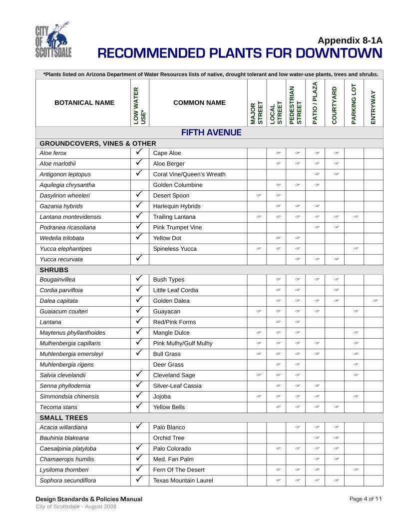
FIFTH AVENUEGROUNDCOVERS, VINES & OTHERAloe ferox Cape Aloe
Aloe marlothii Aloe Berger
Antigonon leptopus Coral Vine/Queen’s Wreath
Aquilegia chrysantha Golden Columbine
Dasylirion wheeleri Desert Spoon
Gazania hybrids Harlequin Hybrids
Lantana montevidensis Trailing Lantana
Podranea ricasoliana Pink Trumpet Vine
Wedelia trilobata Yellow Dot
Yucca elephantipes Spineless Yucca
Yucca recurvata
SHRUBSBougainvillea Bush Types
Cordia parvifloia Little Leaf Cordia
Dalea capitata Golden Dalea
Guaiacum coulteri Guayacan
Lantana Red/Pink Forms
Maytenus phyllanthoides Mangle Dulce
Mulhenbergia capillaris Pink Mulhy/Gulf Mulhy
Muhlenbergia emersleyi Bull Grass
Muhlenbergia rigens Deer Grass
Salvia clevelandii Cleveland Sage
Senna phyllodemia Silver-Leaf Cassia
Simmondsia chinensis Jojoba
Tecoma stans Yellow Bells
SMALL TREESAcacia willardiana Palo Blanco
Bauhinia blakeana Orchid Tree
Caesalpinia platyloba Palo Colorado
Chamaerops humilis Med. Fan Palm
Lysiloma thornberi Fern Of The Desert
Sophora secundiflora Texas Mountain Laurel

Appendix 8-1ARECOMMENDED PLANTS FOR DOWNTOWN
*Plants listed on Arizona Department of Water Resources lists of native, drought tolerant and low water-use plants, trees and shrubs.
BOTANICAL NAME
LOW
WA
TER
U
SE*
COMMON NAME
MA
JOR
ST
REE
T
LOC
AL
STR
EET
PED
ESTR
IAN
ST
REE
T
PATI
O /
PLA
ZA
CO
UR
TYA
RD
PAR
KIN
G L
OT
ENTR
YWA
Y
Page 5 of 11Design Standards & Policies Manual City of Scottsdale - August 2008
FIFTH AVENUE continuedMEDIUM TREESCercidium Parkinsonia Hybrid Desert Museum
Chorisa speciosa Floss Silk Tree
Eucalyptus spatulata Narrow-Leaf Gimlet
Eucalyptus torquata Coral Gum
Geijera parviflora Australian Willow
LARGE TREESDalbergia sisso Sissoo Tree
Eucalyotus citriodora Lemon Scented Gum
Eucalyptus salmonoploia Salmon Gum
Jacaranda mimosifolia Jacaranda
Ulmus parvifolia Evergreen Elm
Washingtonia robusta Mex. Fan Palm
MARSHALL WAYGROUNDCOVERS, VINES & OTHERAloe ferox Cape Aloe
Aloe marlothii A. Berger
Antigonon leptopus Coral Vine/Queen's Wreath
Dasylirion wheeleri Desert Spoon
Gazania hybrids Harlequin Hybrids
Lantana montevidensis Trailing Lantana
Podranea ricasoliana Pink Trumpet Vine
Yucca recurvata
SHRUBSBougainvillea Bush Types
Convolvulus cneorum Bush Morning Glory
Eremophila maculata Emu Bush-Valentine
Guaiacum coulteri Guayacan
Justica sonorae Sonoran Honeysuckle
Maytenus phyllanthoides Mangle Dulce
Poliomintha maderensis Mexican Oregano, Lavender Spice
Appendix 8-1ARECOMMENDED PLANTS FOR DOWNTOWN
*Plants listed on Arizona Department of Water Resources lists of native, drought tolerant and low water-use plants, trees and shrubs.
BOTANICAL NAME
LOW
WA
TER
U
SE*
COMMON NAME
MA
JOR
ST
REE
T
LOC
AL
STR
EET
PED
ESTR
IAN
ST
REE
T
PATI
O /
PLA
ZA
CO
UR
TYA
RD
PAR
KIN
G L
OT
ENTR
YWA
Y
Page 6 of 11Design Standards & Policies Manual City of Scottsdale - August 2008
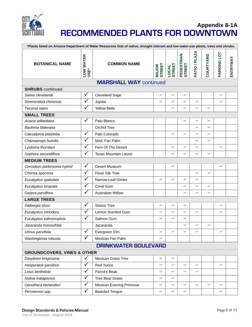
MARSHALL WAY continuedSHRUBS continuedSalvia clevelandii Cleveland Sage
Simmondsia chinensis Jojoba
Tecoma stans Yellow Bells
SMALL TREESAcacia willardiana Palo Blanco
Bauhinia blakeana Orchid Tree
Caesalpinia platyloba Palo Colorado
Chamaerops humilis Med. Fan Palm
Lysiloma thornberi Fern Of The Desert
Sophora secundiflora Texas Mountain Laurel
MEDIUM TREESCercidium parkinsonia hybrid Desert Museum
Chorisa speciosa Floss Silk Tree
Eucalyptus spatulata Narrow-Leaf Gimlet
Eucalyptus torquata Coral Gum
Geijera parviflora Australian Willow
LARGE TREESDalbergia sisso Sissoo Tree
Eucalyotus citriodora Lemon Scented Gum
Eucalyptus salmonoploia Salmon Gum
Jacaranda mimosifolia Jacaranda
Ulmus parvifolia Evergreen Elm
Washingtonia robusta Mexican Fan Palm
DRINKWATER BOULEVARDGROUNDCOVERS, VINES & OTHERDasylirion longissima Mexican Grass Tree
Hesperaloe parvilora Red Yucca
Lotus berthelotii Parrot's Beak
Nolina matapensis Tree Bear Grass
Oenothera berlandieri Mexican Evening Primrose
Penstemon spp. Bearded Tongue
Appendix 8-1ARECOMMENDED PLANTS FOR DOWNTOWN
*Plants listed on Arizona Department of Water Resources lists of native, drought tolerant and low water-use plants, trees and shrubs.
BOTANICAL NAME
LOW
WA
TER
U
SE*
COMMON NAME
MA
JOR
ST
REE
T
LOC
AL
STR
EET
PED
ESTR
IAN
ST
REE
T
PATI
O /
PLA
ZA
CO
UR
TYA
RD
PAR
KIN
G L
OT
ENTR
YWA
Y
Page 7 of 11Design Standards & Policies Manual City of Scottsdale - August 2008
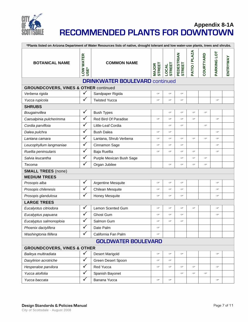
DRINKWATER BOULEVARD continuedGROUNDCOVERS, VINES & OTHER continuedVerbena rigida Sandpaper Rigida
Yucca rupicola Twisted Yucca
SHRUBSBougainvillea Bush Types
Caesalpinia pulcherimma Red Bird Of Paradise
Cordia parvifloia Little-Leaf Cordia
Dalea pulchra Bush Dalea
Lantana camara Lantana, Shrub Verbena
Leucophyllum langmaniae Cinnamon Sage
Ruellia peninsularis Baja Ruellia
Salvia leucantha Purple Mexican Bush Sage
Tecoma Organ Jubilee
SMALL TREES (none)MEDIUM TREESProsopis alba Argentine Mesquite
Prosopis chilenesis Chilean Mesquite
Prosopis glandulosa Honey Mesquite
LARGE TREESEucalyotus citriodora Lemon Scented Gum
Eucalyptus papuana Ghost Gum
Eucalyptus salmonoploia Salmon Gum
Phoenix dactylifera Date Palm
Washingtonia filifera California Fan Palm
GOLDWATER BOULEVARDGROUNDCOVERS, VINES & OTHERBaileya multiradiata Desert Marigold
Dasylirion acrotriche Green Desert Spoon
Hesperaloe parvilora Red Yucca
Yucca aloifolia Spanish Bayonet
Yucca baccata Banana Yucca
Appendix 8-1ARECOMMENDED PLANTS FOR DOWNTOWN
*Plants listed on Arizona Department of Water Resources lists of native, drought tolerant and low water-use plants, trees and shrubs.
BOTANICAL NAME
LOW
WA
TER
U
SE*
COMMON NAME
MA
JOR
ST
REE
T
LOC
AL
STR
EET
PED
ESTR
IAN
ST
REE
T
PATI
O /
PLA
ZA
CO
UR
TYA
RD
PAR
KIN
G L
OT
ENTR
YWA
Y
Page 8 of 11Design Standards & Policies Manual City of Scottsdale - August 2008
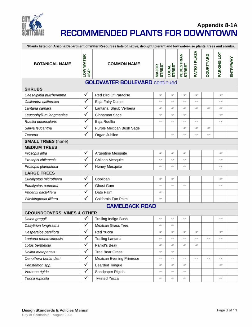
GOLDWATER BOULEVARD continuedSHRUBSCaesalpinia pulcherimma Red Bird Of Paradise
Calliandra californica Baja Fairy Duster
Lantana camara Lantana, Shrub Verbena
Leucophyllum langmaniae Cinnamon Sage
Ruellia peninsularis Baja Ruellia
Salvia leucantha Purple Mexican Bush Sage
Tecoma Organ Jubilee
SMALL TREES (none)MEDIUM TREESProsopis alba Argentine Mesquite
Prosopis chilenesis Chilean Mesquite
Prosopis glandulosa Honey Mesquite
LARGE TREESEucalyptus microtheca Coolibah
Eucalyptus papuana Ghost Gum
Phoenix dactylifera Date Palm
Washingtonia filifera California Fan Palm
CAMELBACK ROADGROUNDCOVERS, VINES & OTHERDalea greggii Trailing Indigo Bush
Dasylirion longissima Mexican Grass Tree
Hesperaloe parvilora Red Yucca
Lantana montevidensis Trailing Lantana
Lotus berthelotii Parrot's Beak
Nolina matapensis Tree Bear Grass
Oenothera berlandieri Mexican Evening Primrose
Penstemon spp. Bearded Tongue
Verbena rigida Sandpaper Rigida
Yucca rupicola Twisted Yucca
Appendix 8-1ARECOMMENDED PLANTS FOR DOWNTOWN
*Plants listed on Arizona Department of Water Resources lists of native, drought tolerant and low water-use plants, trees and shrubs.
BOTANICAL NAME
LOW
WA
TER
U
SE*
COMMON NAME
MA
JOR
ST
REE
T
LOC
AL
STR
EET
PED
ESTR
IAN
ST
REE
T
PATI
O /
PLA
ZA
CO
UR
TYA
RD
PAR
KIN
G L
OT
ENTR
YWA
Y
Page 9 of 11Design Standards & Policies Manual City of Scottsdale - August 2008
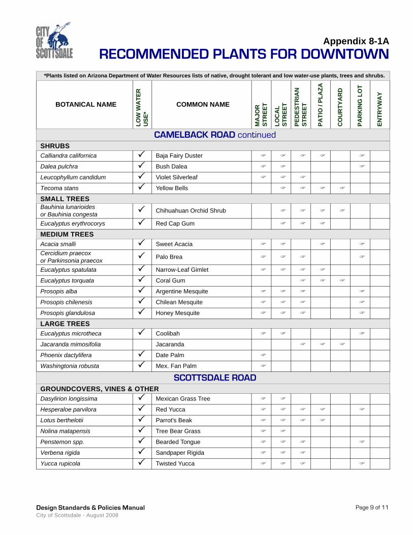
CAMELBACK ROAD continuedSHRUBSCalliandra californica Baja Fairy Duster
Dalea pulchra Bush Dalea
Leucophyllum candidum Violet Silverleaf
Tecoma stans Yellow Bells
SMALL TREESBauhinia lunarioides or Bauhinia congesta Chihuahuan Orchid Shrub
Eucalyptus erythrocorys Red Cap Gum
MEDIUM TREESAcacia smalli Sweet AcaciaCercidium praecox or Parkinsonia praecox Palo Brea
Eucalyptus spatulata Narrow-Leaf Gimlet
Eucalyptus torquata Coral Gum
Prosopis alba Argentine Mesquite
Prosopis chilenesis Chilean Mesquite
Prosopis glandulosa Honey Mesquite
LARGE TREESEucalyptus microtheca Coolibah
Jacaranda mimosifolia Jacaranda
Phoenix dactylifera Date Palm
Washingtonia robusta Mex. Fan Palm
SCOTTSDALE ROADGROUNDCOVERS, VINES & OTHERDasylirion longissima Mexican Grass Tree
Hesperaloe parvilora Red Yucca
Lotus berthelotii Parrot's Beak
Nolina matapensis Tree Bear Grass
Penstemon spp. Bearded Tongue
Verbena rigida Sandpaper Rigida
Yucca rupicola Twisted Yucca

Appendix 8-1ARECOMMENDED PLANTS FOR DOWNTOWN
*Plants listed on Arizona Department of Water Resources lists of native, drought tolerant and low water-use plants, trees and shrubs.
BOTANICAL NAME
LOW
WA
TER
U
SE*
COMMON NAME
MA
JOR
ST
REE
T
LOC
AL
STR
EET
PED
ESTR
IAN
ST
REE
T
PATI
O /
PLA
ZA
CO
UR
TYA
RD
PAR
KIN
G L
OT
ENTR
YWA
Y
Page 10 of 11Design Standards & Policies Manual City of Scottsdale - August 2008
SCOTTSDALE ROAD continuedSHRUBSGuaiacum coulteri Guayacan
Leucophyllum candidum Violet Silverleaf
SMALL TREESBauhinia lunarioides or Bauhinia congesta Chihuahuan Orchid Shrub
Caesalpinia platyloba Palo Colorado
MEDIUM TREESAcacia smalli Sweet Acacia
Cercidium Parkinsonia Hybrid Desert MuseumCercidium praecox or Parkinsonia praecox Palo Brea
Prosopis alba Argentine Mesquite
Prosopis chilenesis Chilean Mesquite
Prosopis glandulosa Honey Mesquite
LARGE TREESEucalyptus microtheca Coolibah
Eucalyptus papuana Ghost Gum
Washingtonia robusta Mexican Fan Palm
INDIAN SCHOOL ROADGROUNDCOVERS, VINES & OTHERBaileya multiradiata Desert Marigold
Dalea greggii Trailing Indigo Bush
Dasylirion acrotriche Green Desert Spoon
Hesperaloe parvilora Red Yucca
Penstemon spp. Bearded Tongue
Yucca aloifolia Spanish Bayonet
Yucca baccata Banana Yucca
SHRUBSCordia parvifloia Little-Leaf Cordia
Leucophyllum candidum Violet Silverleaf
Ruellia peninsularis Baja Ruellia
Salvia leucantha Purple Mexican Bush Sage
Tecoma stans Yellow Bells
Tecoma Organ Jubilee
Appendix 8-1ARECOMMENDED PLANTS FOR DOWNTOWN
*Plants listed on Arizona Department of Water Resources lists of native, drought tolerant and low water-use plants, trees and shrubs.
BOTANICAL NAME
LOW
WA
TER
U
SE*
COMMON NAME
MA
JOR
ST
REE
T
LOC
AL
STR
EET
PED
ESTR
IAN
ST
REE
T
PATI
O /
PLA
ZA
CO
UR
TYA
RD
PAR
KIN
G L
OT
ENTR
YWA
Y
Page 11 of 11Design Standards & Policies Manual City of Scottsdale - August 2008
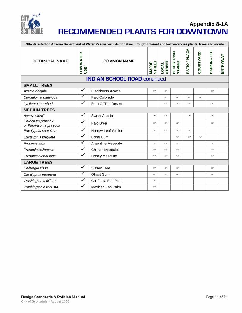
INDIAN SCHOOL ROAD continuedSMALL TREESAcacia ridigula Blackbrush Acacia
Caesalpinia platyloba Palo Colorado
Lysiloma thornberi Fern Of The Desert
MEDIUM TREESAcacia smalli Sweet AcaciaCercidium praecox or Parkinsonia praecox Palo Brea
Eucalyptus spatulata Narrow-Leaf Gimlet
Eucalyptus torquata Coral Gum
Prosopis alba Argentine Mesquite
Prosopis chilenesis Chilean Mesquite
Prosopis glandulosa Honey Mesquite
LARGE TREESDalbergia sisso Sissoo Tree
Eucalyptus papuana Ghost Gum
Washingtonia filifera California Fan Palm
Washingtonia robusta Mexican Fan Palm


Section 8-2
PARKS
This section provides guidance for developing park
master plans, identifies their review and approval
process, and provides requirements for park
designs. The design review of each park is done
on an individual basis. These design standards
and policies help assure that Scottsdale’s parks
and recreation facilities provide quality and safe
experiences for its citizens.
8-2
Design Standards & Policies ManualCity of Scottsdale - August 2008

DEPARTMENT RESOURCE INFORMATION
Aviation/Airport
Advance Planning Services
Capital Project Management
Current Planning
Customer Service
Downtown Group
Facilities Management
Fire & Life Safety/Inspections
Fire Plan Review
Inspections & Land Survey
Parks Department
One Stop Shop/Permit Services
Plan Review
Records Division
Solid Wastewater Management
Stormwater Management
Street Operations
Transportation
Water Resources
15000 N. Airport Dr.
7506 E. Indian School Rd.
7447 E. Indian School Rd., Suite 205
7447 E. Indian School Rd., Suite 105
7447 E. Indian School Rd., Suite 100
4248 N. Craftsman Ct.
9191 E. San Salvador Dr.
8401 E. Indian School Rd.
7447 E. Indian School Rd., Suite 125
9191 N. San Salvador Dr.
7340 Scottsdale Mall
7447 E. Indian School Rd., Suite 100
7447 E. Indian School Rd., Suite 125
7447 E. Indian School Rd., Suite 100
9191 N. San Salvador Dr.
7447 E. Indian School Rd., Suite 205
9191 N. San Salvador Dr.
7447 E. Indian School Rd., Suite 205
9388 E. San Salvador Dr.
480-312-2321
480-312-7990
480-312-7250
480-312-7000
480-312-7800
480-312-7750
480-312-5999
480-312-1855
480-312-7080
480-312-5750
480-312-2915
480-312-2500
480-312-7080
480-312-2356
480-312-5600
480-312-7250
480-312-5626
480-312-7696
480-312-5685
City of Scottsdale www.scottsdaleaz.gov
Design Standards & Policies ManualCity of Scottsdale - August 2008
Design Standards & Policies Manual City of Scottsdale - August 2008
Page 1
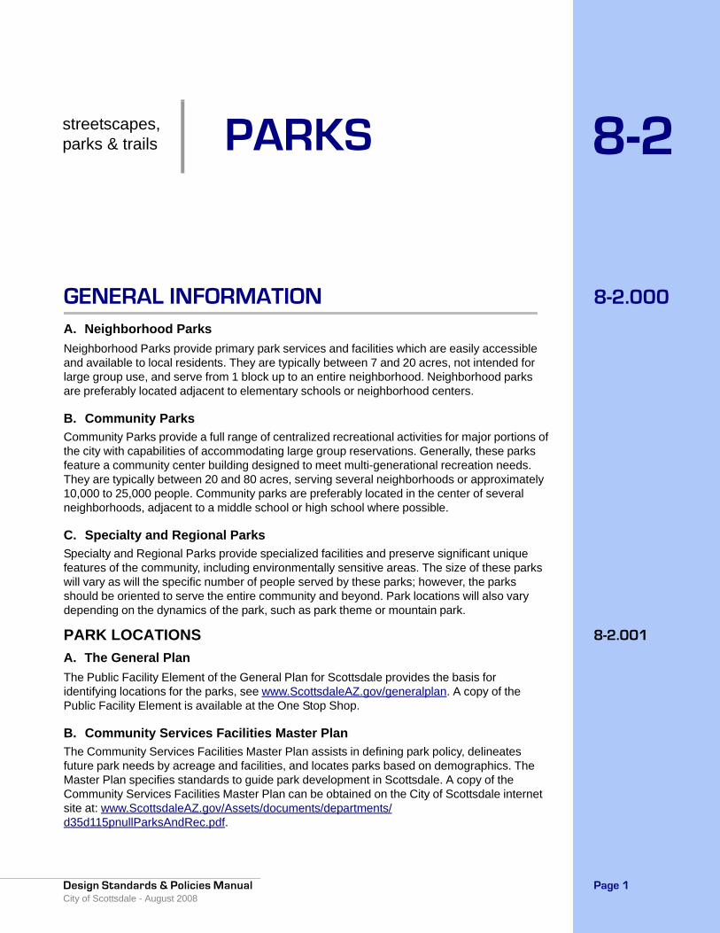
8-2.000GENERAL INFORMATIONA. Neighborhood ParksNeighborhood Parks provide primary park services and facilities which are easily accessible and available to local residents. They are typically between 7 and 20 acres, not intended for large group use, and serve from 1 block up to an entire neighborhood. Neighborhood parks are preferably located adjacent to elementary schools or neighborhood centers.
B. Community ParksCommunity Parks provide a full range of centralized recreational activities for major portions of the city with capabilities of accommodating large group reservations. Generally, these parks feature a community center building designed to meet multi-generational recreation needs. They are typically between 20 and 80 acres, serving several neighborhoods or approximately 10,000 to 25,000 people. Community parks are preferably located in the center of several neighborhoods, adjacent to a middle school or high school where possible.
C. Specialty and Regional ParksSpecialty and Regional Parks provide specialized facilities and preserve significant unique features of the community, including environmentally sensitive areas. The size of these parks will vary as will the specific number of people served by these parks; however, the parks should be oriented to serve the entire community and beyond. Park locations will also vary depending on the dynamics of the park, such as park theme or mountain park.
8-2.001PARK LOCATIONSA. The General PlanThe Public Facility Element of the General Plan for Scottsdale provides the basis for identifying locations for the parks, see www.ScottsdaleAZ.gov/generalplan. A copy of the Public Facility Element is available at the One Stop Shop.
B. Community Services Facilities Master PlanThe Community Services Facilities Master Plan assists in defining park policy, delineates future park needs by acreage and facilities, and locates parks based on demographics. The Master Plan specifies standards to guide park development in Scottsdale. A copy of the Community Services Facilities Master Plan can be obtained on the City of Scottsdale internet site at: www.ScottsdaleAZ.gov/Assets/documents/departments/d35d115pnullParksAndRec.pdf.
streetscapes,parks & trails PARKS 8-2
PARKSSection 8-2
Design Standards & Policies ManualCity of Scottsdale - August 2008
Page 2
8-2.100 PARK MASTER PLANSA master plan is developed for each park and the Public Facility Element of the General Plan, in conjunction with the Community Services Facilities Master Plan, helps guide the planning of facilities for each park.
8-2.101 MUNICIPAL USE MASTER PLAN APPROVAL PROCESS1. Planning Consultant/Parks & Recreation Team
• Prepares alternative development concepts• Conducts public input meetings with neighborhood and community• Develops a preliminary master development plan for presentation
2. Parks & Recreation Commission• Conducts a public hearing to review and recommend on the preliminary park master
plan
3. Planning Consultant/Parks & Recreation Team• Prepares Final Park Master Plan from Parks & Recreation Commission
recommendation• Makes application for municipal use permit to Planning Commission
4. Parks & Recreation Commission• Reviews the final park master plan and recommends action (approval or otherwise) to
the Planning Commission and the City Council
5. Planning Commission• Reviews the municipal use permit and recommends action (approval or otherwise) to
City Council, based on the recommended Final Park Master Plan
6. City Council• Reviews and approves, or rejects, the Final Park Master Plan and municipal use permit
7. Approved Park Master Plan
8-2.200 PARK DESIGNPark designs must be approved by the Development Review Board before any development occurs on the park site (after City Council Master Plan approval). Whenever possible, parks should be located adjacent to school sites to create a fluid joint use between the park and school facilities.
8-2.201 WALKWAYS1. Designated multiuse paths will be a minimum of 12 feet in width. See Section 5-7.000 and
Section 5-8.000 for shared-use paths and bikeways.
2. Sidewalks utilized specifically for pedestrians will be a minimum of 8 feet in width.
3. All multiuse paths will be located a safe distance away from active courts or fields.
4. Where concrete is used, it will be MAG “A” spec, 5 inch slump 3,000 psi, 6 inch deep or 4 inch deep with 6 inch turndowns. Curb ramps will be constructed in accordance with MAG Details.

Section 8-2PARKS
Design Standards & Policies Manual City of Scottsdale - August 2008
Page 3
5. Where concrete or asphalt is not used, walkways will be surfaced with stabilized decomposed granite.
6. Sidewalk slopes and cross slopes will comply with ADA standards, unless technically infeasible.
7. All walkways leading to, into, and throughout sporting areas will be ADA compliant unless to do so would fundamentally alter the nature of the facility/activity.
8-2.202DRINKING FOUNTAINS1. Ensure drinking fountains meet ADA guidelines by having a wheelchair accessible
fountain installed at 34 inches AFF, (measured to the deck), and a standard height drinking fountain installed at 40 inches AFF. Do not construct drinking fountains with ferrous metals whether protected by galvanization, paint, or otherwise. Drinking fountains within 100 feet of playgrounds will have assessable sand traps installed on the drains. It is more desirable to install drinking fountains on a building than installing free-standing units. Locate chillers within 24 inches of the drinking fountains, and no recirculating pumps are allowed. Use copper water piping for the drinking fountains, and insulate chilled water tubing.
2. Install chilled drinking fountain(s) near the playground, but preferably not closer than 25 feet due to problems encountered with sand. In addition to the above, install a child-height drinking fountain at 28 inches AFF.
8-2.203PLAYGROUNDS1. Playgrounds must meet or exceed all current U.S. Consumer Products Safety
Commission (CPSC), American Society of Test/Measurement (ASTM), Americans with Disabilities Act (ADA) and International Play Equipment Manufacturers Association (IPEMA) standards.
2. Upon completion/installation of new playground equipment, the installation will be inspected by a third party National Playground Safety Inspector (NPSI).
3. Ensure that playground equipment/play opportunities are available for preschool children (2 - 5 years old) and school-age children (5 - 12 years old).
4. Metal playground slides are unacceptable.
5. Install and/or use appropriate playground elements, equipment and materials to meet ADA access standards for accessible playgrounds.
6. Make sure that playground surface safety zones consist of double washed premium sand, with a minimum depth of 12 inches.
7. Make certain that there is some type of shade protection either from adjacent ramadas, (16 feet x 16 feet minimum) and/or non-deciduous trees on the perimeter of the playground (30 inch box).
8-2.204SOFTBALL/BASEBALL FIELDS1. Ensure that all fields are lighted to meet all current Illuminating Engineering Society (IES)
standards, and utilize effective shielding systems to reduce spill light off play areas, such as the MUSCO Control Link Central series.
2. Construct infields with an approved non-toxic organic binder, red color mix material especially prepared for ballfields. Material will be a minimum of 4 inches in compacted depth. Bind by crushed aggregate screenings down to 1/4 inch or 3/8 inch fine particles.

PARKSSection 8-2
Design Standards & Policies ManualCity of Scottsdale - August 2008
Page 4
3. Fill home plate and mounds with a minimum of 2 inches of fine grey brick clay incorporated at a uniform rate with established infield red mix. Infields and outfield turf areas will consist of a Tif Hybrid Bermuda Grass.
4. When grading playing fields, adhere to Sports Fields Manual for Design and Contruction standards and requirements for design and construction.
5. Finish grade for sports fields must be no greater than 1% in slope.
6. Outfield warning tracks are not to be included in ballfield designs.
8-2.205 SPORTS FIELD LIGHTINGLighting shall be the following: • Energy efficient and cost effective to operate.• Proactively monitored to detect fixture outages.• Installed with remote on/off controls.• Designed such that the light levels and the entire system is guaranteed for a period of 25
years.• Designed so playing surfaces will have guaranteed average constant light level and unifor-
mity as follows:
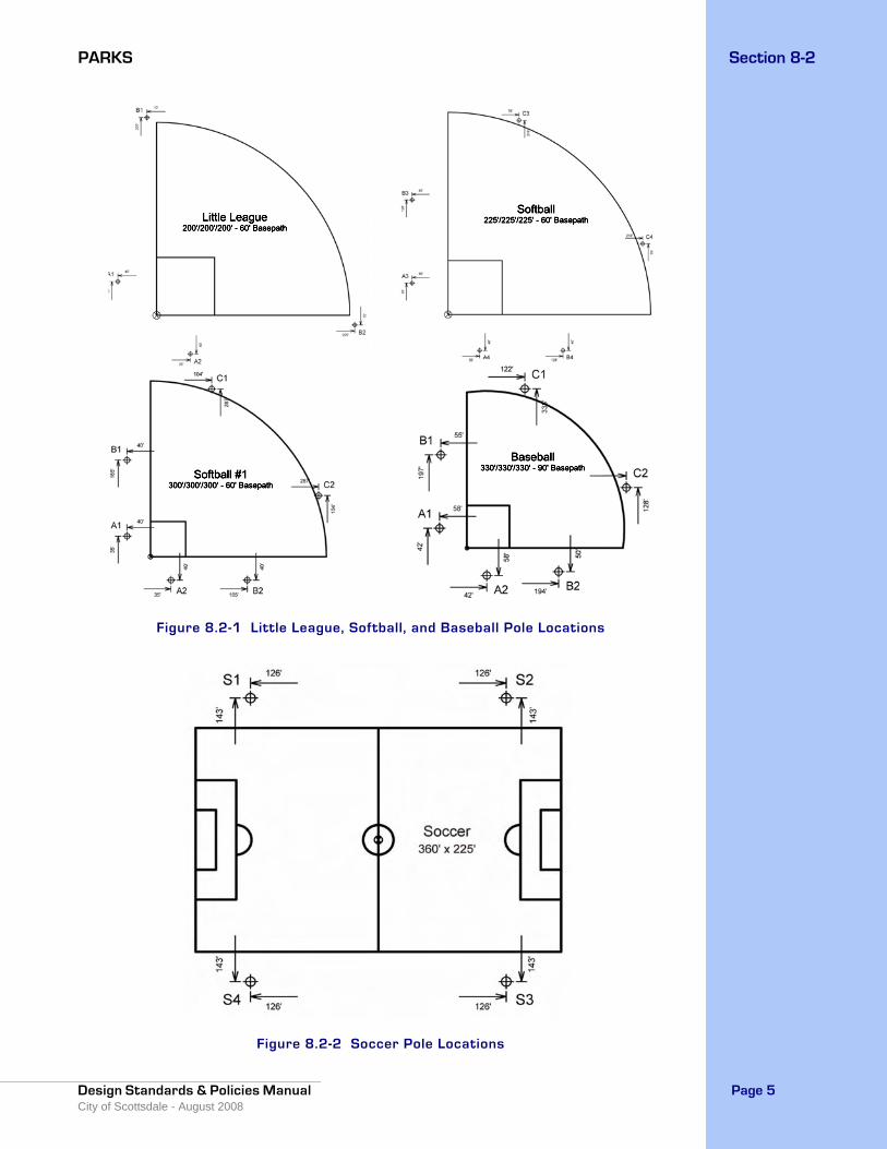
Life cycle costs for the lighting system shall be calculated and include luminaries energy consumption, cost of maintenance, spot re-lamping, Group re-lamping all luminaires and total 25 year Life Cycle operating Cost. Lighting system will not produce excessive spill light or glare. Maximum vertical foot-candles for each field shall be determined per project with the primary goal to have levels as low as possible so as not to negatively impact neighbors with excessive spill light or glare. No luminaires will be aimed less than 25 degrees below horizontal. All luminaires with have both internal and external shielding for glare and spill light control.All poles will include a factory installed mounting bracket for security lights 20ft up the pole and infield poles will have a factory provided electrical outlet enclosure mounted on the lower portions of the pole.Pole heights will vary depending on field size and location. Poles in general will be between 60ft to 80ft. General Pole locations are as follows for different fields.
Area of Lighting Average Constant Light Levels Max. to Min. Uniformity Ratio
Infield 50 foot-candles 2.0 to 1.0
Outfield 30 foot-candles 2.5 to 1.0
Soccer/Football 30 foot-candles 2.5 to 1.0
Section 8-2PARKS
Design Standards & Policies Manual City of Scottsdale - August 2008
Page 5
Figure 8.2-1 Little League, Softball, and Baseball Pole Locations
Figure 8.2-2 Soccer Pole Locations
PARKSSection 8-2
Design Standards & Policies ManualCity of Scottsdale - August 2008
Page 6
Lighting system shall consist of the following: • Galvanized steel poles and cross arm assembly• Pre-stressed concrete base embedded in concrete backfill.• All luminaires shall be constructed with a die-cast aluminum housing to protect the lumi-
naire reflector system. • Manufacturer will remote all ballasts and supporting electrical equipment in aluminum
enclosures mounted approximately 10’ above grade. The enclosures shall include ballast, capacitor and fusing for each luminaire. Safety disconnect per circuit for each pole struc-ture will be located in the enclosure.
• Wire harness complete with an abrasion protection sleeve, strain relief and plug-in con-nections.
• Controls and Monitoring Cabinet to provide on-off control and monitoring of the lighting system constructed of NEMA Type 4 aluminum. Communication method shall be provided by manufacturer. Cabinet shall contain custom configured contactor modules for 30, 60, and 100 amps, labeled to match field diagrams and electrical design. Manual Off-On-Auto selector switches shall be provided.
• All components shall be designed and manufactured as a system. All luminaires, wire har-nesses, ballast and other enclosures shall be factory assembled, aimed, wired and tested.
• All exposed components shall be constructed of corrosion resistant material and/or coated to help prevent corrosion. All exposed steel shall be hot dip galvanized per ASTM A123. All exposed hardware and fasteners shall be stainless steel of at least 18-8 grade, passi-vated and polymer coated to prevent possible galvanic corrosion to adjoining metals. All exposed aluminum shall be powder coated with high performance polyester. All exterior reflective inserts shall be anodized, coated with a clear, high gloss, durable fluorocarbon, and protected from direct environmental exposure to prevent reflective degradation or cor-rosion. All wiring shall be enclosed within the cross arms, pole, or electrical components enclosure.
• Lightning Protection: All structures shall be equipped with lightning protection meeting NFPA 780 standards and be properly grounded.
• All system components shall be UL Listed for the appropriate application.
8-2.206 COURT FACILITIES1. Make sure that all court facilities are lighted to meet all current IES standards. Tennis
courts should also meet United States Tennis Association (USTA) standards.
2. Ensure that all tennis courts meet USTA standards. Concrete courts should be considered due to extended life in a desert environment.
3. Sand Volleyball courts should consist of Double Washed Mortar Premium Grade at a depth of 12 inches.
4. For wetting courts, provide water in the net standards with a Hunter series head in each standard. Also, use domestic water as a source instead of water from the irrigation system. Make sure that all water piping is type L copper. And finally, control the water with a system timer that allows for watering times up to 15 minutes, and locks out the controls for a minimum of 30 minutes between activations. Activation will be by a 24 volt momentary contact switch mounted on a net standard or other pole.
8-2.207 IRRIGATION GUIDELINESSee the City of Scottsdale’s current supplement to MAG Section 440 and related details for more specific information.
• Irrigation backflow preventers to be installed inside approved enclosure.

Section 8-2PARKS
Design Standards & Policies Manual City of Scottsdale - August 2008
Page 7
• Approved controllers are Motorola Irrinet/Scorpio. Contact COS Irrigation Department for Motorola Irrinet/Scorpio controller and antenna locations.
• Pushbuttons to be installed on controller cabinets to activate ballfield dust control valves.
• Ballfields to have irrigation installed for dust control.• Master valve/flow meters (Hydrometers) to be installed on all irrigation mainlines.• Drip irrigation systems shall be installed using rigid pvc piping.• Valves are to be of brass construction and a minimum size of 1"• Trees and shrubs are to be valved separately• Plans must indicate existing and design operating water pressure requirements.• Plans must indicate valve flow rates, designation (tree, shrub,turf,etc.) and station
number.• Plans must include City details for all irrigation system components to be installed. • Drip irrigation to be installed for all trees in turf areas for supplemental watering.• Top, bottom and middle of sloped tuf areas 4:1 or greater shall be irrigated/valved
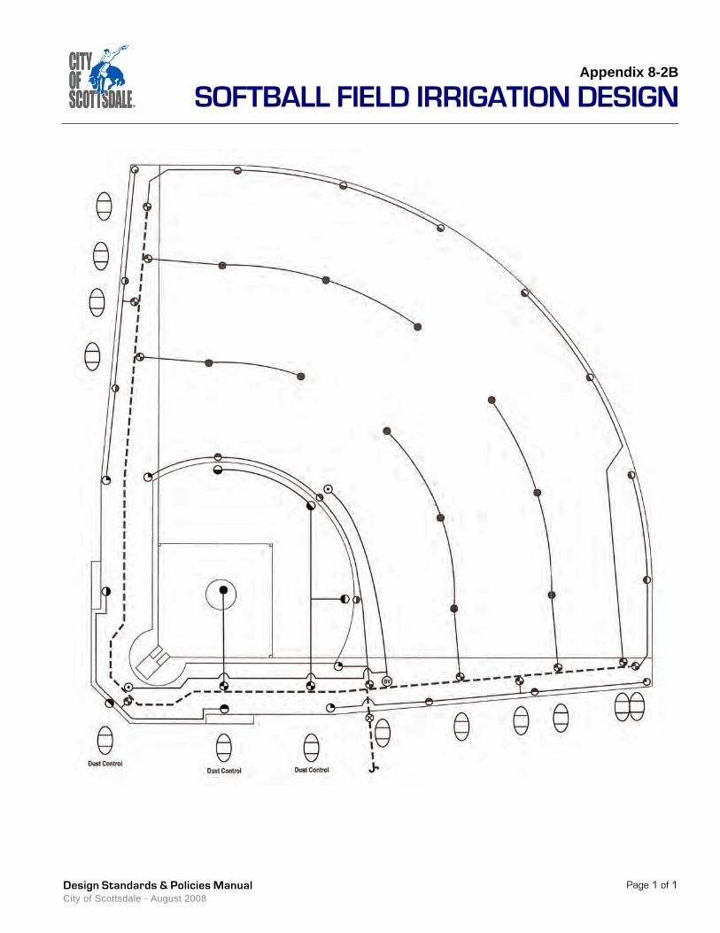
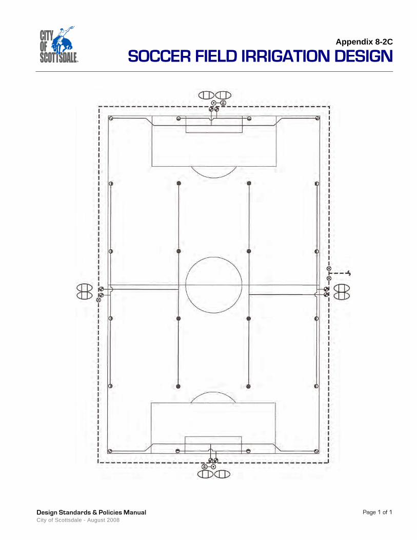
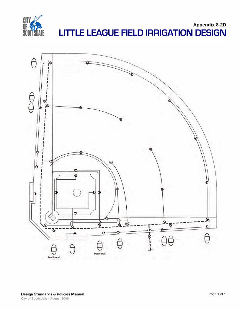
seperately.For a suggested Baseball Field Irrigation Design refer to Appendix 8-2A.For a suggested Softball Field Irrigation Design refer to Appendix 8-2B.For a suggested Soccer Field Irrigation Design refer to Appendix 8-2C.For a suggested Little League Field Irrigation Design refer to Appendix 8-2D.
8-2.208LANDSCAPINGFor landscaping, use low-water use, drought-tolerant species that adhere to ADWR plant list. Plant material must be approved by Parks Department staff prior to installation. See the City of Scottsdale’s most current supplement to MAG, Section 430, and related details for more specific information, www.ScottsdaleAZ.gov/design/COSMAGSupp. Refer to Sections 8-1.102 and 8-1.103 for suggested plant material to be used in parks per character area (Suburban and Transitional).
• Tree type to conform to the character area in which the park is located. • Decomposed granite is to be 1/2" screened Desert Gold unless otherwise approved by
COS Parks and Recreation Division.• Trees shall not be planted within 10' of an existing private wall, sign, or light pole.• Landscape plans must provide COS planting details.• Site distance standards shall be used for park entries. Refer to Section 5-3.188, 8-
1.400 and Figure 5.3-26.• Natural growth habits shall be taken into consideration to minimize maintenance
frequency and intensity.• Salvaged trees must meet ANSI A300 (Part 1) pruning standards and ANSI A300 (Part
6) transplanting standards with a minimum 2-1/2" trunk caliper.• Landscape clearances shall be provided to prevent conflict with signs, light poles, fire
hydrants or median crossings.• Landscaping must not create hazards to public safety through either plant growth habit,
structure or location.
PARKSSection 8-2
Design Standards & Policies ManualCity of Scottsdale - August 2008
Page 8
8-2.209 CONSTRUCTION MATERIAL 1. Use steel, metal, aluminum, recycled material or approved equal for park fixtures and
ramadas. Wood will not be permitted. Roofing material needs to be 20 year guaranteed metal, standing seam with Kynar finish.
2. Between turf and landscaped areas, install headers consisting of concrete, brick, ultraviolet-treated vinyl, or metal.
3. Windscreen material to be double leno polypropelent, 85% shade open mesh. Color is to be dark green.
4. Wabash Manufacturing trash receptacles are to be installed or approved equal.
8-2.210 SIGNAGE 1. Place the standard park sign at the main entrance of every neighborhood and community
park. The park sign mold can be obtained from Recreation or the Parks Department
2. Specialty parks may deviate from standard park signage with the approval from both Recreation and Parks Department. A marquee that meets the city’s Sign Ordinance may be acceptable upon the approval of both Recreation and Parks Department and obtaining a city sign permit.
3. Certify that all signage meets the Scottsdale Sign Ordinance, and ADA signage specifications. Ordinance information can be obtained at the One Stop Shop and www.ScottsdaleAZ.gov/codes.
8-2.211 PARKING1. Ensure that all parking meets ADA Guidelines and the City of Scottsdale’s parking
requirements stipulated in the Parks Master Plan and city zoning requirements. Preferred parking spaces utilize Universal Parking dimension specified in Section 2-4.000.
2. Ensure that parking lots lights meet all current IES standards.
3. Plant non-deciduous trees (24 inch boxes minimum) adjacent to parking lots to provide shading. An acceptable ratio is 1 tree per every 15 parking stalls.
8-2.212 PUBLIC POOLSAll public pool facilities must meet or exceed Maricopa County Environmental Health Code Section 1 General Provisions Regulation 1 - 15 for Pool and Facility Design, also all State of Arizona or City of Scottsdale codes or regulations.See current City of Scottsdale Aquatic Maintenance Supplement for specific details. Supplement may be obtained from COS Aquatic Maintenance Coordinator (480-312-4005).1. Mechanical Room Controller Device (MRCD) to be by the BECKS Manufacture Model
SYSTEM 7.
2. Commercial High Rate Sand Filters: EKO 3 Manufactured by NEMATO with an integrated automatic backwash control system.
3. Chlorine Gas CL2 Equipment by Capital Controls.
4. Emergency Vapor Scrubber Systems (EVSS) by Siemens Water Technologies.
8-2.213 DECORATIVE FOUNTAINS/WATER FEATURESThe City of Scottsdale will not incorporate any additional Decorative Fountains or Water Features into its future projects in the interest of water conservation and safety concerns.However, if a fountain/water feature is approved for a project, City of Scottsdale Aquatic Maintenance will provide a set of mechanical guidelines to the designer.See current City of Scottsdale Aquatic Maintenance Fountain/Water Feature Supplement for specific details. Supplement may be obtained from COS Aquatic Maintenance Coordinator (480-312-4005)
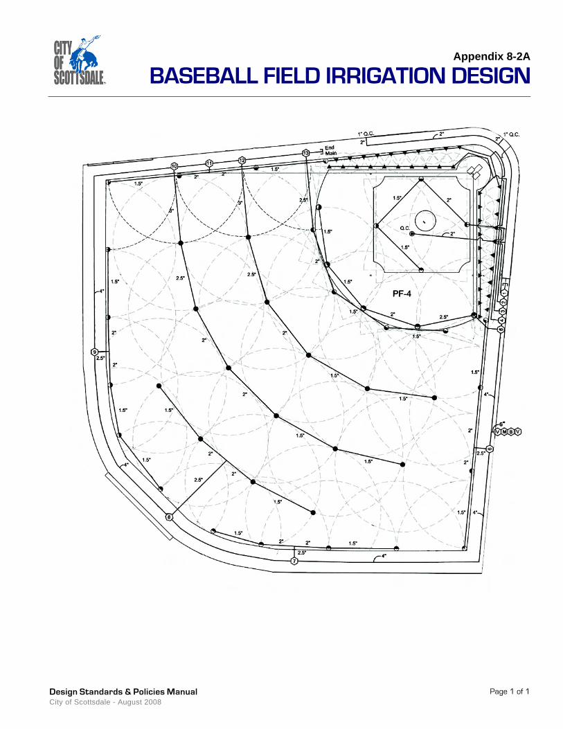
Appendix 8-2A
BASEBALL FIELD IRRIGATION DESIGN
Page 1 of 1Design Standards & Policies Manual City of Scottsdale - August 2008

Appendix 8-2B
SOFTBALL FIELD IRRIGATION DESIGN
Page 1 of 1Design Standards & Policies Manual City of Scottsdale - August 2008

Appendix 8-2C
SOCCER FIELD IRRIGATION DESIGN
Page 1 of 1Design Standards & Policies Manual City of Scottsdale - August 2008

Appendix 8-2D
LITTLE LEAGUE FIELD IRRIGATION DESIGN
Page 1 of 1Design Standards & Policies Manual City of Scottsdale - August 2008


Section 8-3
NON-PAVED TRAILS
This section addresses the planning, design,
maintenance and construction of trails within the
city. The term “trails” refers to non-paved, non-
motorized, shared use trails, which are legally
accessible by the general public.
8-3
Design Standards & Policies ManualCity of Scottsdale - August 2008

DEPARTMENT RESOURCE INFORMATION
Aviation/Airport
Advance Planning Services
Capital Project Management
Current Planning
Customer Service
Downtown Group
Facilities Management
Fire & Life Safety/Inspections
Fire Plan Review
Inspections & Land Survey
Parks Department
One Stop Shop/Permit Services
Plan Review
Records Division
Solid Wastewater Management
Stormwater Management
Street Operations
Transportation
Water Resources
15000 N. Airport Dr.
7506 E. Indian School Rd.
7447 E. Indian School Rd., Suite 205
7447 E. Indian School Rd., Suite 105
7447 E. Indian School Rd., Suite 100
4248 N. Craftsman Ct.
9191 E. San Salvador Dr.
8401 E. Indian School Rd.
7447 E. Indian School Rd., Suite 125
9191 N. San Salvador Dr.
7340 Scottsdale Mall
7447 E. Indian School Rd., Suite 100
7447 E. Indian School Rd., Suite 125
7447 E. Indian School Rd., Suite 100
9191 N. San Salvador Dr.
7447 E. Indian School Rd., Suite 205
9191 N. San Salvador Dr.
7447 E. Indian School Rd., Suite 205
9388 E. San Salvador Dr.
480-312-2321
480-312-7990
480-312-7250
480-312-7000
480-312-7800
480-312-7750
480-312-5999
480-312-1855
480-312-7080
480-312-5750
480-312-2915
480-312-2500
480-312-7080
480-312-2356
480-312-5600
480-312-7250
480-312-5626
480-312-7696
480-312-5685
City of Scottsdale www.scottsdaleaz.gov
Design Standards & Policies ManualCity of Scottsdale - August 2008
Design Standards & Policies Manual City of Scottsdale - August 2008
Page 1
8-3.000GENERAL INFORMATIONThe City of Scottsdale’s goal is to develop and maintain a citywide interconnecting network of trails to provide valuable recreation and transportation opportunities for city residents and visitors. Trails function as transportation links between schools, residential areas, parks, places of employment, shopping areas and other areas of interest. Trails also provide hikers, walkers, joggers, equestrians, mountain bicyclists, and people with disabilities opportunities to improve health and fitness, spend time with family and friends, enjoy the natural environment and escape the stress of everyday life.Several trails plans must be consulted for identifying trail alignments within the city. The Trail Master Plan approved by the City Council in February 2004 identifies trail locations citywide, see www.ScottsdaleAZ.gov/trails/plan/. Additional detailed plans provide guidance for developing trails specifically within the McDowell Sonoran Preserve, see www.ScottsdaleAZ.gov/preserve.
8-3.001TRAIL CLASSIFICATIONSA. Primary TrailsThe management objective for Primary Trails is to provide both transportation and recreation links between residential areas, schools, businesses, parks, places of employment and other areas of significant community activity. Primary Trails will typically experience the highest use levels. User groups include hikers, equestrians and bicyclists. Motorized vehicles are only permitted for maintenance and emergency purposes. The trail surface may be comprised of either native soil or decomposed granite. Urban Trails have the greatest width of all trail classifications and therefore accommodate leisurely side-by-side travel and easy passing for multiple user types. These trails are typically located within areas of relatively level topography.
B. Secondary TrailsThe management objective for Secondary Trails is to provide secondary transportation and recreation links through areas such as washes, scenic and vista corridors, and other desert open space areas. Secondary Trails typically experience a lower level of use than Primary Trails. User groups include hikers, equestrians and bicyclists. Motorized vehicles are only permitted for maintenance and emergency purposes and where trail widths allow. Secondary Trails are narrower than Primary Trails; therefore, occasional single file travel by users may be required. These trails are typically located within areas of level to moderate topography.
streetscapes,parks & trails NON-PAVED TRAILS 8-3
NON-PAVED TRAILSSection 8-3
Design Standards & Policies ManualCity of Scottsdale - August 2008
Page 2
C. Local TrailsThe management objective for Local Trails is to provide access from neighborhood areas to Primary and Secondary Trails. Local Trails typically act as “feeder” trails to the more regional trail network and share the same physical characteristics as Secondary Trails. User groups include hikers, equestrians and bicyclists. Motorized vehicles are only permitted for maintenance and emergency purposes, and where trail widths allow.
D. Neighborhood TrailsThe management objective for Neighborhood Trails is to serve very localized areas and provide close-to-home recreational opportunities. In most cases, Neighborhood Trails connect to Local Trails, which connect to Primary and Secondary Trails. Trail users create localized loops, which enable outdoor activities within close proximity to their homes; user groups include hikers, equestrians and bicyclists. Motorized vehicles are only permitted for maintenance and emergency purposes and where trail widths allow.
E. Preserve Primary TrailsThe management objective for Preserve Primary Trails is to provide safe and enjoyable trail recreation opportunities within preserved open space areas of the city, while having a minimum impact on the surrounding environment. These trails typically provide connections between major trail access points and Preserve Secondary Trails. User groups include hikers, equestrians and bicyclists. Certain user groups may be prohibited if deemed appropriate, see Section 8-3.101. Motorized vehicles with a wheelbase of less than 48 inches may be used for maintenance and emergency purposes only. These trails are typically located within areas of moderate to slightly more rugged topography. The installation of erosion control structures may be necessary along trail sections with steeper longitudinal slopes. Trail widths may occasionally be too narrow to allow side-by-side travel by users.
F. Preserve Secondary TrailsThe management objective for Preserve Secondary Trails is to provide safe and enjoyable trail recreation opportunities within preserved open space areas of the city, while having a minimum impact on the surrounding environment. These trails typically serve as secondary routes emanating as spurs from Preserve Primary Trails. Certain user groups may be prohibited if deemed appropriate, see Section 8-3.101. Use may be limited to foot traffic only, as widths and grades may not permit the safe use by equestrians and mountain bicyclists. Motorized vehicles, excluding helicopters, may be unable to operate for maintenance or emergency purposes due to the narrow tread width. Preserve Secondary Trails traverse areas with rugged topography; therefore, longitudinal grades are steeper, more difficult and require erosion-control structures. The trail tread is narrower than Preserve Primary Trails, thus requiring single file travel by users.
G. Interpretive TrailsThe management objective for Interpretive Trails is to provide educational opportunities along a common theme. Education and interpretation can occur in a variety of forms including, but not limited to, signage and brochures. Use by equestrians and bicyclists are prohibited. Motorized vehicles are only permitted for maintenance and emergency purposes, and where trail widths allow. These trails are generally established in areas of gentle topography; therefore, longitudinal grades are easy to moderate. The trail tread should be wide enough to accommodate some side-by-side travel and 2-way traffic. Barrier-Free standards may be achieved with additional improvements.
H. Barrier-Free TrailsThe management objective of Barrier-Free Trails is to provide trail opportunities for persons with physical disabilities including mobility, visual and hearing impairments. The design of
NON-PAVED TRAILS Section 8-3
Design Standards & Policies Manual City of Scottsdale - August 2008
Page 3
Barrier-Free Trails should provide access to viewpoints, activity areas and other points of interest, and should meet the standards of the ADA. Equestrians and bicyclists are not permitted on Barrier-Free Trails. Motorized vehicles (excluding electric wheelchairs and other types of mobility aids) are permitted only for maintenance and emergency purposes. Caution must be exercised when using vehicles to avoid damaging hardened surfaces. These trails are generally established in areas that are flat with very gentle topography and level longitudinal grades. The trail tread is wide enough to accommodate side-by-side travel and 2-way traffic, and is composed of a hardened or stabilized surface.
8-3.100TRAIL DESIGNThe city’s objective is to design, construct and maintain trails that:1. Provide safe, non-motorized transportation links, and/or close-to-home recreation
opportunities2. Provide legal public access to destination points and other areas of interest3. Blend with the surrounding environment4. Minimize impacts on the natural environment5. Minimize impacts on adjacent landowners 6. Require minimum levels of maintenance
8-3.101DESIGN CONSIDERATIONSA. Human FactorsTrails must be planned and constructed with the needs of the trail user in mind. Trail users tend to desire routes that access and connect areas of significant community activity such as schools, businesses, shopping areas and parks, as well as other areas of interest such as viewpoints, water sources, natural areas, desert preserves, scenic and vista corridors, and interesting geologic features. Visual qualities are important to trail users, therefore trails should be designed to blend with the surrounding environment. Views from the trail to the surrounding environment should also be considered. Trail users enjoy changes in scenery, thus the increasing demand for loop trails and trail networks that allow the user to return to the starting point without traveling the same trail twice. Loop trails also provide the comfort of knowing that the trail will return to the starting point, thus reducing the chance of anyone becoming lost. Trail users tend to favor the easiest, most obvious route. If the designated trail is not the easiest and most obvious, trail users will begin to create new, unauthorized trails.
B. Coinciding EasementsTrails are frequently located within common tracts and easements dedicated for other purposes such as drainage, flood control, public utility, natural area open space, and scenic and vista corridors. In situations where these common tracts and easements are wider than that needed for a trail easement, it may be advantageous to dedicate the same area of these coinciding common tracts and easements for the purposes of public trail use. This will increase the flexibility to properly lay out, design and construct public trails, and will allow the trail to be positioned away from undesirable areas such as low-flow wash channels, areas of extreme topography, dense vegetation, critical animal habitats and adjacent properties. This will also allow future realignment of the trail, should such a realignment become necessary. In cases where a separate trail easement is delineated within other easements or common tracts, it is extremely important that the alignment of the trail easement be reviewed on the ground to assure suitability.
NON-PAVED TRAILSSection 8-3
Design Standards & Policies ManualCity of Scottsdale - August 2008
Page 4
C. Trail ViewshedThe line of sight from a trail to the surrounding landscape and from the surrounding landscape to a trail are important design considerations. Views from the trail to the surrounding landscape improve the quality of the trail users’ experience; therefore, trails should be designed to provide users varying views of the surrounding area. However, obscuring views of the trail from the surrounding landscape is also important, since adjacent landowners may not want to view the trail from their properties.
D. Native PlantsThe design, construction and maintenance of trails within the City of Scottsdale must take into account the Native Plant Ordinance, Section 7.500 of the city’s Zoning Ordinance, see www.ScottsdaleAZ.gov/codes/nativeplant. Trails should be aligned to avoid disturbance of, and have a minimum effect on the following plant species: whitethorn acacia, catclaw acacia, crucifixion thorn, hackberry, blue palo verde, foothill palo verde, desert willow, juniper, ironwood, cottonwood, mesquite, scrub oak, sugar sumac, Arizona rosewood, saguaro, barrel cacti, ocotillo and soaptree yucca.
E. Sensitive Wildlife HabitatTrail design and construction within natural desert park and preserve areas should be evaluated in terms of the effect that the trail will have on sensitive wildlife habitats. The Arizona Game and Fish Department should be consulted during the trail design process to assure that the trail will not have a negative impact on such resources. The best means of preventing negative impacts on wildlife is to simply avoid sensitive areas. Seasonal trail closures may be necessary in some situations.
F. Archaeological and Cultural ResourcesTrail design and construction should be evaluated in terms of the effect the trail will have on archaeological and cultural resources. Such activities should be done in accordance with the City of Scottsdale Archeological Ordinance, www.ScottsdaleAZ.gov/codes.Potential options to prevent and mitigate damage to these resources include:1. Altering the trail alignment to avoid archaeological and cultural resources.2. Protecting the resources by utilizing methods to obscure them from view.3. Mitigating the cultural resource, which involves removal and thorough documentation of
the items by a professional archaeologist. The documentation of the resource may then be interpreted as part of the trail opportunity.
G. Design for Shared-UseTrails within the city are open to all non-motorized uses unless otherwise stated. Decisions to prohibit any non-motorized use from trails must be based on coordinated planning efforts involving appropriate user groups and city staff. Characteristics that should be considered as part of this process include, but are not limited to, longitudinal and cross slopes, surface materials, line of sight, amount of use, sensitivity of surrounding environment, soil types and native plant and animal habitats.The following means of preventing potential user conflicts are based on methods identified in “Conflict on Multiple Use Trails” (Moore, 1994), and should be considered when planning, designing, constructing and maintaining shared-use trails: 1. Separate user types at trailheads and along the first, most crowded, stretches of trail.2. Provide adequate sight distances. 3. Build trails wide enough to accommodate expected levels and types of use.4. Build and maintain trails wide enough for safe passing and/or provide periodic turnouts.
NON-PAVED TRAILS Section 8-3
Design Standards & Policies Manual City of Scottsdale - August 2008
Page 5
5. Design trails to control speeds where necessary by varying the trail surface and avoiding long, straight downhill stretches.
6. Provide adequate trailhead facilities for all user types.
8-3.102TRAIL LOCATIONSLocation work must begin early in the trail design process and be completed prior to construction. The amount and level of work that is required varies depending on the type of trail being designed and the terrain on which the trail is being constructed. The necessary steps to properly layout the trail include the following: Reconnaissance, Grade, Drainage and Staking/Flagging, see Paragraphs A through D below.
A. ReconnaissanceThe reconnaissance process includes the identification and evaluation of alternative routes, which leads to final selection of the best possible route to meet the established objectives. Application of sound principles of trail location, alignment and grade will minimize future operation and maintenance problems.The first step is to examine the most recent topographic maps and aerial photos of the area to identify significant landforms, drainage patterns and vegetation. The next step, for which there is no substitute, is to walk the area and examine potential routes. Conduct a systematic study of the area by walking various routes and viewing the area from different vantage points. Control points, which are features that are favorable for or inhibit trail construction, should be identified through this process. The control points will help to identify the best possible route, with the understanding that situations may exist where trails must pass through negative control points.Control points that are favorable for trail construction:
Control points that inhibit trail construction and should be avoided:
• Existing road crossings (underpasses, overpasses and intersections with traffic lights or stop signs)
• Natural wash crossings• Ridgelines• Hillside benches
• Areas of light vegetation• Scenic vistas• Areas of well drained soils• Good trailhead access
• Wet areas and poorly drained flat areas• Sensitive wildlife habitats• Wash bottoms• Areas adjacent to sources of excessive
noise, such as airports• Areas adjacent to plants that are
poisonous to horses such as oleanders• Steep rocky slopes• Unstable or fragile soils• Abrupt elevation changes• Bluffs, ledges and cliffs except where
featured as scenic resources
• Frequent wash crossings• Locations requiring bridges or culverts• Areas of heavy or fragile vegetation• Areas requiring switchbacks• Excessively long, straight sections• Areas of archeological/cultural sensitivity• Lightning-prone areas• Unsafe or uncontrolled road crossings• Known habitats of threatened or
endangered plant or animal species

NON-PAVED TRAILSSection 8-3
Design Standards & Policies ManualCity of Scottsdale - August 2008
Page 6
B. GradeThe degree to which a trail rises or falls over a linear distance is an important factor in determining the length of the trail, level of difficulty, appropriate user types and drainage and maintenance requirements. Occasional fluctuations in the trail grade should be considered to provide variation for trail users and to facilitate proper drainage. Frequent or drastic changes in grade should be avoided. The grade line between control points can be plotted on paper to determine if switchbacks or other special features will be needed to sustain a certain grade. On moderate to steep side slopes a periodic reverse in the grade should be included to create dips for drainage purposes. When grade dips are included in initial trail construction, the need for waterbars is eliminated.
C. DrainageProper drainage of surface water is the most important factor in design, construction and maintenance of trails. Surface erosion resulting from improper drainage will have a detrimental impact on the trail surface, causing damage to the natural environment and increasing maintenance requirements. The potential for erosion depends on three factors: soil type, velocity of water on the trail and the distance water travels down the trail. Alteration of any of these factors can reduce the potential for erosion. Proper outsloping of the trail tread and the installation of grade dips or water bars will help decrease the potential for erosion of the trail surface. If distances allow, grade dips are preferred over waterbars. Existing drainage patterns of the surrounding area, such as concentrated drainage channels, must be maintained. Attempts to alter the existing drainage patterns will have a negative effect on the natural environment and will most likely result in severe damage to the trail.
D. Staking/FlaggingStakes or flags act as a guide so that the alignment, grade and distances can be easily followed during construction. A clinometer, topographic map, compass, measuring tape and notebook are all necessary tools. Proper location of the flag line is easily accomplished with three people acting as surveyor, rod holder and recorder. Stakes or flags should be located along the trail centerline with the location of dips, walls and other special structures indicated with color-coded flagging. The trail alignment should pass through control points that are favorable for trail construction and avoid control points which will inhibit trail construction. Normally, trail alignments follow the contours of the land and consist of a series of gently sweeping curves. Long straight segments with sharp angular turns should be avoided.
8-3.200 TRAIL CLASSIFICATIONS
8-3.201 PRIMARY TRAILSA. GradeMaximum sustained grade should not exceed 8 percent. A maximum grade of 10 percent may be used for wash crossings, grade dips and other trail segments to avoid impassable areas for a distance not to exceed 50 linear feet.
B. TreadPrimary trail widths must be 8 feet in built environments and may narrow to no less than 4 feet in un-built environments. The trail tread should be comprised of native soils in undisturbed desert areas and decomposed granite in areas that have been graded, landscaped, or will otherwise remain significantly unnatural. Compaction of a native soil tread surface may be necessary to prevent damage from use and to increase resistance to erosion. If decomposed granite is used it must be ¼ inch minus, Madison Gold or similar, wetted and compacted to a 4

NON-PAVED TRAILS Section 8-3
Design Standards & Policies Manual City of Scottsdale - August 2008
Page 7
inch depth. A soil stabilizer may be added to the decomposed granite according to manufacturers’ specifications. The trail tread must be smooth and free of all obstacles. The trail tread must be delineated from the surrounding terrain. For example, utilizing decomposed granite of a different size or color in the surrounding landscape will help distinguish the trail tread. The location of landscape plants, fences and other physical barriers can also be used to delineate the trail.
C. Vegetation ClearanceTrails should be designed to have a minimum impact on plants identified for protection in the Native Plant Ordinance, see www.ScottsdaleAZ.gov/codes/nativeplant. Trail alignments that avoid and have the least impact on surrounding vegetation are preferred. If the trail must pass within an unacceptable distance to any plants, the preference is to relocate the plants rather than destroy them.Vegetation may not exceed a mature height of 3 feet within a 3-foot distance of the trail tread. Vertical clearance must be at least 10 feet above the trail tread. This in no way implies that the trail corridor should be devoid of plants. Low growing desert shrubs such as bursage and brittlebush present no hazard to trail users; therefore, are acceptable to have within the clearing limits. The purpose of the vegetation clearing limits is to keep taller, potentially more dangerous plants such as thorny trees and larger cacti a safe distance from the trail. All remaining roots and stumps must be grubbed out of the trail surface to provide a smooth tread. No teddy bear cholla may be located within 3 feet of the trail tread. In areas where new landscaping is to be installed, trees, cacti and other spiny plants must be planted at least 5 feet from the trail tread.
D. DrainageThe trail surface must have a cross slope of 3 to 5 percent. This is critical in preventing water from pooling on and channeling down the trail. If the trail traverses the side slope of a hill, the cross slope of the trail surface must be downward from the uphill to the downhill edge of the trail (outslope). This will allow surface water to drain off the edge of the trail rather than running down the length of the trail. The installation of erosion control structures such as water bars or grade dips may be required. The cross slope of such a trail tread must NOT be downward from the downhill to the uphill edge of the trail (inslope). Such a scenario will result in water channeling down the length of the trail, causing extreme levels of erosion. If the trail is located on level ground, the trail surface should be crowned to drain water off both sides of the trail and prevent pooling.
E. Easement Widths and Setback from StreetPrimary Trails must be contained in a minimum 15-foot-wide trail easement. In situations where a trail easement overlaps with common tracts or easements dedicated for other purposes, it may be beneficial to dedicate the entire width for public trail purposes. For more detail see Section 8-3.101. For trails along streets, the minimum distance from back of curb to the edge of the trail is 25 feet along expressways and parkways, 15 feet along arterials, 10 feet along collectors and the maximum distance feasible in all other locations.
8-3.202SECONDARY TRAILSA. GradeMaximum sustained grade should not exceed 10 percent. A maximum grade of 15 percent may be used for wash crossings, grade dips and other trail segments to avoid impassable areas for a distance not to exceed 100 linear feet.
NON-PAVED TRAILSSection 8-3
Design Standards & Policies ManualCity of Scottsdale - August 2008
Page 8
B. TreadSecondary trail widths must be 4 feet in both built and un-built environments. The trail tread should be comprised of native soils in undisturbed desert areas and decomposed granite in areas that have been graded, landscaped, or will otherwise remain significantly unnatural. Compaction of a native soil tread surface may be necessary to prevent damage from use and to increase resistance to erosion. If decomposed granite is used, it must be ¼ inch minus, Madison Gold or similar, wetted and compacted to a 4 inch depth. A soil stabilizer may also be added to the decomposed granite according to manufacturers’ specifications. The trail tread must be smooth and free of all obstacles. The trail tread must be delineated from the surrounding terrain. For example, utilizing decomposed granite of a different size or color in the surrounding landscape will help distinguish the trail tread. The location of landscape plants, fences and other physical barriers can also be used to delineate the trail.
C. Vegetation ClearanceTrails should be designed to have a minimum impact on plants identified for protection in the Native Plant Ordinance, see www.ScottsdaleAZ.gov/codes/nativeplant. Trail alignments that avoid and have the least impact on surrounding vegetation are preferred. If the trail must pass within an unacceptable distance to any plants, the preference is to relocate the plants rather than destroy them.Vegetation may not exceed a mature height of 3 feet within a 3-foot distance of the trail tread. Vertical clearance must be at least 10 feet above the trail tread. This in no way implies that the trail corridor should be devoid of plants. Low growing desert shrubs such as bursage and brittlebush present no hazard to trail users; therefore, are acceptable to have within the clearing limits. The purpose of the vegetation clearing limits is to keep taller, potentially more dangerous plants such as thorny trees and larger cacti a safe distance from the trail. All remaining roots and stumps must be grubbed out of the trail surface to provide a smooth tread. No teddy bear cholla may be located within 3 feet of the trail tread. In areas where new landscaping is to be installed, trees, cacti and other spiny plants must be planted at least 5 feet from the trail tread.
D. DrainageThe trail surface must have a cross slope of 3 to 5 percent. This is critical in preventing water from pooling on and channeling down the trail. If the trail traverses the side slope of a hill, the cross slope of the trail surface must be downward from the uphill to the downhill edge of the trail (outslope). This will allow surface water to drain off the edge of the trail rather than running down the length of the trail. The installation of erosion control structures such as water bars or grade dips may be required. The cross slope of such a trail tread must NOT be downward from the downhill to the uphill edge of the trail (inslope). Such a scenario will result in water channeling down the length of the trail causing extreme levels of erosion. If the trail is located on level ground, the trail surface should be crowned to drain water off the trail and prevent pooling.
E. Easement Width and Setback from StreetSecondary Trails must be contained in a minimum 25-foot-wide trail easement. In situations where a trail easement overlaps with common tracts or easements dedicated for other purposes, it may be beneficial to dedicate the entire width for public trail purposes, see Section 8-3.101 for more detail. Secondary Trails must be located the maximum distance feasible from the edge of the street.
NON-PAVED TRAILS Section 8-3
Design Standards & Policies Manual City of Scottsdale - August 2008
Page 9
8-3.203LOCAL TRAILSA. GradeMaximum sustained grade should not exceed 10 percent. A maximum grade of 15 percent may be used for wash crossings, grade dips and other trail segments to avoid impassable areas for a distance not to exceed 100 linear feet.
B. TreadLocal trail widths must be 4 feet in a built environment and can narrow to 2 feet in more natural, un-built settings. The trail tread should be comprised of native soils in undisturbed desert areas and decomposed granite in areas that have been graded, landscaped, or will otherwise remain significantly unnatural. Compaction of a native soil tread surface may be necessary to prevent damage from use and to increase resistance to erosion. If decomposed granite is used it must be ¼ inch minus, Madison Gold or similar, wetted and compacted to a 4 inch depth. A soil stabilizer may also be added to the decomposed granite according to manufacturers’ specifications. The trail tread must be smooth and free of all obstacles. The trail tread must be delineated from the surrounding terrain. For example, utilizing decomposed granite of a different size or color in the surrounding landscape will help distinguish the trail tread. The location of landscape plants, fences and other physical barriers can also be used to delineate the trail.
C. Vegetation ClearanceTrails should be designed to have a minimum impact on plants identified for protection in the Native Plant Ordinance, see www.ScottsdaleAZ.gov/codes/nativeplant. Trail alignments that avoid and have the least impact on surrounding vegetation are preferred. If the trail must pass within an unacceptable distance to any plants, the preference is to relocate the plants rather than destroy them.Vegetation may not exceed a mature height of 3 feet within a 3-foot distance of the trail tread. Vertical clearance must be at least 10 feet above the trail tread. This in no way implies that the trail corridor should be devoid of plants. Low growing desert shrubs such as bursage and brittlebush present no hazard to trail users; therefore, are acceptable to have within the clearing limits. The purpose of the vegetation clearing limits is to keep taller, potentially more dangerous plants such as thorny trees and larger cacti a safe distance from the trail. All remaining roots and stumps must be grubbed out of the trail surface to provide a smooth tread. No teddy bear cholla may be located within 3 feet of the trail tread. In areas where new landscaping is to be installed, trees, cacti and other spiny plants must be planted at least 5 feet from the trail tread.
D. DrainageThe trail surface must have a cross slope of 3 to 5 percent. This is critical in preventing water from pooling on and channeling down the trail. If the trail traverses the side slope of a hill, the cross slope of the trail surface must be downward from the uphill to the downhill edge of the trail (outslope). This will allow surface water to drain off the edge of the trail rather than running down the length of the trail. The installation of erosion control structures such as water bars or grade dips may be required. The cross slope of such a trail tread must NOT be downward from the downhill to the uphill edge of the trail (inslope). Such a scenario will result in water channeling down the length of the trail causing extreme levels of erosion. If the trail is located on level ground, the trail surface should be crowned to drain water off the trail and prevent pooling.
E. Easement Width and Setback from StreetLocal Trails must be contained in a minimum 15-foot-wide trail easement. In situations where a trail easement overlaps with common tracts or easements dedicated for other purposes, it may
NON-PAVED TRAILSSection 8-3
Design Standards & Policies ManualCity of Scottsdale - August 2008
Page 10
be beneficial to dedicate the entire width for public trail purposes, see Section 8-3.101 for more detail. Local Trails must be located the maximum distance feasible from the edge of the street.
8-3.204 NEIGHBORHOOD TRAILSA. GradeMaximum sustained grade shall not exceed 10 percent. A maximum grade of 15 percent may be used for wash crossings, grade dips and other trail segments to avoid impassable areas for a distance not to exceed 100 linear feet.
B. TreadNeighborhood trail widths are typically 2 feet in width, but may be widened to 4 feet in areas of higher use. The trail tread is typically comprised of native soils. Compaction of a native soil tread surface may be necessary to prevent damage from use and to increase resistance to erosion. The trail tread must be smooth and free of all obstacles. The trail tread must be delineated from the surrounding terrain. For example, the location of landscape plants, fences and other physical barriers can be used to delineate the trail.
C. Vegetation ClearanceTrails should be designed to have a minimum impact on plants identified for protection in the Native Plant Ordinance, see www.ScottsdaleAZ.gov/codes/nativeplant. Trail alignments that avoid and have the least impact on surrounding vegetation are preferred. If the trail must pass within an unacceptable distance to any plants, the preference is to relocate the plants rather than destroy them.Vegetation may not exceed a mature height of 3 feet within a 3-foot distance of the trail tread. Vertical clearance must be at least 10 feet above the trail tread. This in no way implies that the trail corridor should be devoid of plants. Low growing desert shrubs such as bursage and brittlebush present no hazard to trail users; therefore, are acceptable to have within the clearing limits. The purpose of the vegetation clearing limits is to keep taller, potentially more dangerous plants such as thorny trees and larger cacti a safe distance from the trail. All remaining roots and stumps must be grubbed out of the trail surface to provide a smooth tread. No teddy bear cholla may be located within 3 feet of the trail tread. In areas where new landscaping is to be installed, trees, cacti and other spiny plants must be planted at least 5 feet from the trail tread.
D. DrainageThe trail surface must have a cross slope of 3 to 5 percent. This is critical in preventing water from pooling on and channeling down the trail. If the trail traverses the side slope of a hill, the cross slope of the trail surface must be downward from the uphill to the downhill edge of the trail (outslope). This will allow surface water to drain off the edge of the trail rather than running down the length of the trail. The installation of erosion control structures such as water bars or grade dips may be required. The cross slope of such a trail tread must NOT be downward from the downhill to the uphill edge of the trail (inslope). Such a scenario will result in water channeling down the length of the trail causing extreme levels of erosion. If the trail is located on level ground, the trail surface should be crowned to drain water off the trail and prevent pooling.
E. Easement Widths and Setback from StreetNeighborhood Trails must be contained in a minimum 15-foot-wide trail easement. In situations where a trail easement overlaps with common tracts or easements dedicated for other purposes, it may be beneficial to dedicate the entire width for public trail purposes, see Section 8-3.101 for more detail. Neighborhood Trails must be located the maximum distance feasible from the edge of the street.
NON-PAVED TRAILS Section 8-3
Design Standards & Policies Manual City of Scottsdale - August 2008
Page 11
8-3.205PRESERVE PRIMARY TRAILSA. GradeMaximum sustained grade should not exceed 15 percent. A maximum grade of 25 percent is allowed for wash crossings, grade dips and other trail segments to avoid impassable areas for a distance not to exceed 100 linear feet. Switchbacks may be utilized when surrounding terrain has a side slope of 20 to 45 percent. Switchbacks supported by retaining walls may be utilized when surrounding terrain has a side slope up to 55 percent.
B. TreadPreserve Primary trail widths must be 2 feet with 12-foot cleared shoulders on each side of the trail tread. The trail surface should be native soil and must be smooth and free of major obstacles. All stumps and root balls within the tread surface must be completely removed.
C. Vegetation ClearanceTrails should be designed to have a minimum impact on plants identified for protection in the Native Plant Ordinance, see www.ScottsdaleAZ.gov/codes/nativeplant. Trail alignments that avoid and have the least impact on surrounding vegetation are preferred. If the trail must pass within an unacceptable distance to any plants, the preference is to relocate the plants rather than destroy them.Vegetation may not exceed a mature height of 3 feet within a 3-foot distance of the trail tread. Vertical clearance must be at least 10 feet above the trail tread. This in no way implies that the trail corridor should be devoid of plants. Low growing desert shrubs such as bursage and brittlebush present no hazard to trail users; therefore, are acceptable to have within the clearing limits. The purpose of the vegetation clearing limits is to keep taller, potentially more dangerous plants such as thorny trees and larger cacti a safe distance from the trail. All remaining roots and stumps must be grubbed out of the trail surface to provide a smooth tread. No teddy bear cholla may be located within 3 feet of the trail tread. This distance may need to be increased on the uphill side of trails that traverse steep hillsides. This will prevent pieces of cacti from falling onto the trail tread and creating a safety hazard.
D. DrainageThe trail surface must have a cross slope of 3 to 5 percent. This is critical in preventing water from pooling on and channeling down the trail. If the trail traverses the side slope of a hill, the cross slope of the trail surface must be downward from the uphill to the downhill edge of the trail (outslope). This will allow surface water to drain off the edge of the trail rather than running down the length of the trail. The installation of erosion control structures may be required. The cross slope of such a trail tread must NOT be downward from the downhill to the uphill edge of the trail (inslope). Such a scenario will result in water channeling down the length of the trail causing extreme levels of erosion. If the trail is located on level ground, the trail surface should be crowned to drain water off the trail and prevent pooling.
E. Easement WidthPreserve Primary Trails are typically located within large open space areas controlled by the city. In situations where these trails must be located within easements, the easement width must be a minimum of 100 feet.
8-3.206PRESERVE SECONDARY TRAILSA. GradeMaximum sustained grade should not exceed 20 percent. A maximum grade of 30 percent is allowed for wash crossings, grade dips and other trail segments to avoid impassable areas for a distance not to exceed 100 linear feet. Switchbacks may be utilized when surrounding
NON-PAVED TRAILSSection 8-3
Design Standards & Policies ManualCity of Scottsdale - August 2008
Page 12
terrain has a side slope of 20 to 45 percent. Switchbacks supported by retaining walls may be utilized when surrounding terrain has a side slope up to 55 percent.
B. TreadPreserve Secondary trail widths must be 2 feet, with NO cleared shoulders. The trail surface should be native soil and must be smooth and free of major obstacles. All stumps and root balls within the tread surface must be completely removed.
C. Vegetation ClearanceTrails should be designed to have a minimum impact on plants identified for protection in the Native Plant Ordinance, see www.ScottsdaleAZ.gov/codes/nativeplant. Trail alignments that avoid and have the least impact on surrounding vegetation are preferred. If the trail must pass within an unacceptable distance to any plants, the preference is to relocate the plants rather than destroy them.Vegetation may not exceed a mature height of 3 feet within a 3-foot distance of the trail tread. Vertical clearance must be at least 10 feet above the trail tread. This in no way implies that the trail corridor should be devoid of plants. Low growing desert shrubs such as bursage and brittlebush present no hazard to trail users; therefore, are acceptable to have within the clearing limits. The purpose of the vegetation clearing limits is to keep taller, potentially more dangerous plants such as thorny trees and larger cacti a safe distance from the trail. All remaining roots and stumps must be grubbed out of the trail surface to provide a smooth tread. No teddy bear cholla may be located within 3 feet of the trail tread. This distance may need to be increased on the uphill side of trails that traverse steep hillsides. This will prevent pieces of cacti from falling onto the trail tread and creating a safety hazard.
D. DrainageThe trail surface must have a cross slope of 3 to 5 percent. This is critical in preventing water from pooling on and channeling down the trail. If the trail traverses the side slope of a hill, the cross slope of the trail surface must be downward from the uphill to the downhill edge of the trail (outslope). This will allow surface water to drain off the edge of the trail rather than running down the length of the trail. The installation of erosion control structures may be required. The cross slope of such a trail tread must NOT be downward from the downhill to the uphill edge of the trail (inslope). Such a scenario will result in water channeling down the length of the trail causing extreme levels of erosion. If the trail is located on level ground, the trail surface should be crowned to drain water off the trail and prevent pooling.
E. Easement WidthPreserve Secondary Trails are typically located within large open space areas controlled by the city. In situations where these trails must be located within easements, the easement must be a minimum of 100 feet wide.
8-3.207 INTERPRETIVE TRAILSInterpretive Trails differ from other trails because their primary function is to provide educational opportunities for trail users. Education and interpretation can occur in a variety of forms including signage and/or brochures. This manual contains only general guidelines for the design and construction of Interpretive Trails.
A. GradeMaximum sustained grade should not exceed 10 percent. A maximum grade of 15 percent is allowed for wash crossings, grade dips and other trail segments to avoid impassable areas for a distance not to exceed 100 linear feet. Switchbacks may be utilized when surrounding terrain has a side slope of 20 to 45 percent. Switchbacks supported by retaining walls may be utilized when surrounding terrain has a side slope up to 55 percent.

NON-PAVED TRAILS Section 8-3
Design Standards & Policies Manual City of Scottsdale - August 2008
Page 13
B. TreadInterpretive trail widths must be 4 feet to 6 feet. The trail tread should be comprised of native soils in undisturbed desert areas and decomposed granite in areas that have been graded, landscaped, or will otherwise remain significantly unnatural. Compaction of a native soil tread surface may be necessary to prevent damage from use and to increase resistance to erosion. If decomposed granite is used it must be ¼ inch minus, Madison Gold or similar, wetted and compacted to a 4 inch depth. A soil stabilizer may also be added to the decomposed granite according to manufacturers’ specifications. The trail tread must be smooth and free of all obstacles. The trail tread must be delineated from the surrounding terrain. For example, utilizing decomposed granite of a different size or color in the surrounding landscape will help distinguish the trail tread. The location of landscape plants, fences and other physical barriers can also be used to delineate the trail.
C. Vegetation ClearanceTrails should be designed to have a minimum impact on plants identified for protection in the Native Plant Ordinance, see www.ScottsdaleAZ.gov/codes/nativeplant. Trail alignments that avoid and have the least impact on surrounding vegetation are preferred. If the trail must pass within an unacceptable distance to any plants, the preference is to relocate the plants rather than destroy them.Vegetation may not exceed a mature height of 3 feet within a 3 foot distance of the trail tread. Vertical clearance must be at least 8 feet above the trail tread. This in no way implies that the trail corridor should be devoid of plants. Low growing desert shrubs such as bursage and brittlebush present no hazard to trail users; therefore, are acceptable to have within the clearing limits. The purpose of the vegetation clearing limits is to keep taller, potentially more dangerous plants such as thorny trees and larger cacti a safe distance from the trail. All remaining roots and stumps must be grubbed out of the trail surface to provide a smooth tread. No teddy bear cholla may be located within 3 feet of the trail tread. This distance may need to be increased on the uphill side of trails that traverse steep hillsides. This will prevent pieces of cacti from falling onto the trail tread and creating a safety hazard.
D. DrainageThe trail surface must have a cross slope of 3 to 5 percent. This is critical in preventing water from pooling on and channeling down the trail. If the trail traverses the side slope of a hill, the cross slope of the trail surface must be downward from the uphill to the downhill edge of the trail (outslope). This will allow surface water to drain off the edge of the trail rather than running down the length of the trail. The installation of erosion control structures may be required. The cross slope of such a trail tread must NOT be downward from the downhill to the uphill edge of the trail (inslope). Such a scenario will result in water channeling down the length of the trail causing extreme levels of erosion. If the trail is located on level ground, as opposed to the side slope of a hill, the trail surface should be crowned to drain water off the trail and prevent pooling.
8-3.208BARRIER-FREEBarrier-free Trails are designed to provide opportunities for persons with physical disabilities including mobility, visual and hearing impairments, and shall meet the standards of the ADA. This manual contains only general guidelines for the design and construction of Barrier-free Trails.
A. GradeBarrier-free trails must be designed with the least possible longitudinal slope. Specific grade requirements shall comply with the ADA.
NON-PAVED TRAILSSection 8-3
Design Standards & Policies ManualCity of Scottsdale - August 2008
Page 14
B. TreadBarrier-free trail widths must be a minimum of 8 feet. There are many varieties of accessible surface materials available. Materials should be selected to achieve the maximum level of accessibility practicable according to the desired recreation experience and the natural setting. The chosen surface must be stable, firm and slip resistant. The material must match the surrounding environment. Specific surface requirements shall comply with the ADA.
C. Vegetation ClearanceTrails should be designed to have a minimum impact on plants identified for protection in the Native Plant Ordinance, see www.ScottsdaleAZ.gov/codes/nativeplant. Trail alignments that avoid and have the least impact on surrounding vegetation are preferred. If the trail must pass within an unacceptable distance to any plants, the preference is to relocate the plants rather than destroy them.Vegetation may not exceed a mature height of 3 feet within a 3-foot distance of the trail tread. Vertical clearance must be at least 8 feet above the trail tread. This in no way implies that the trail corridor should be devoid of plants. Low growing desert shrubs such as bursage and brittlebush present no hazard to trail users; therefore, are acceptable to have within the clearing limits. The purpose of the vegetation clearing limits is to keep taller, potentially more dangerous plants such as thorny trees and larger cacti a safe distance from the trail. All remaining roots and stumps must be grubbed out of the trail surface to provide a smooth tread. No teddy bear cholla may be located within 3 feet of the trail tread. This distance may need to be increased on the uphill side of trails that traverse steep hillsides. This will prevent pieces of cacti from falling onto the trail tread and creating a safety hazard.
D. DrainageThe trail surface must have a cross slope of 1 to 3 percent. This is critical in preventing water from pooling on and channeling down the trail. If the trail traverses the side slope of a hill, the cross slope of the trail surface must be downward from the uphill to the downhill edge of the trail (outslope). This will allow surface water to drain off the edge of the trail rather than running down the length of the trail. The cross slope of such a trail tread must NOT be downward from the downhill to the uphill edge of the trail (inslope). Such a scenario will result in water channeling down the length of the trail causing extreme levels of erosion. If the trail is located on level ground, the trail surface should be crowned to drain water off the trail and prevent pooling. The longitudinal slope of barrier-free trails must be kept to the minimum standard, which makes the installation of erosion control structures unnecessary.
E. Additional SpecificationsSupport facilities for Barrier-free Trails and such as signage, restrooms, benches and parking areas must be constructed to meet accessibility standards.
8-3.300 TRAIL CONSTRUCTION
8-3.301 TREAD CONSTRUCTION A. Surface MaterialsTrail surface materials must correspond to the specification for the appropriate trail classification under Section 8-3.200.
B. Cross SlopeThe cross slope, which is the slope of the tread surface perpendicular to the longitudinal slope, is a critical factor in the design, construction and maintenance of trails. The cross slope allows

NON-PAVED TRAILS Section 8-3
Design Standards & Policies Manual City of Scottsdale - August 2008
Page 15
surface water to drain off the side of the trail rather than along the longitudinal slope. The three primary types of cross slopes are outslope, inslope and crowned. Outsloped and insloped trail surfaces typically occur on trails that traverse the side slope of a hill, and a crowned trail surface is typically found on trails that travel across relatively level ground, see Figure 8.3-1.
FIGURE 8.3-1 CROSS SLOPES
1. OutslopeOutslope is the most common type of cross slope used on trails that traverse the side slopes of hills, and occurs when the trail surface slopes downward from the uphill to the downhill edge of the trail. Standard outslopes range from 3 to 5 percent, depending on the trail classification.2. InslopeInslope is the most infrequent variety of cross slope used on trails that traverse the side slopes of hills, and occurs when the trail surface slopes downward from the downhill to the uphill edge of the trail. Insloped trails are discouraged and only recommended when used as a component of switchback turns. Inslopes must be used in conjunction with rock-lined swales that collect the water and channel it away from the trail. The improper use of an insloped trail surface will cause extreme erosion to the trail surface and the surrounding environment; therefore, should not be built without consulting the city Trails Coordinator.3. CrownedA crowned surface is most commonly used on trails that traverse relatively level ground. A crowned trail surface slopes downward from the centerline to each outside edge for the

NON-PAVED TRAILSSection 8-3
Design Standards & Policies ManualCity of Scottsdale - August 2008
Page 16
purpose of preventing surface water from pooling on the trail surface. The slopes from the centerline to each edge should be 5 percent.
C. BackslopeThe backslope is the area from which material is excavated on the uphill side of the trail tread. Backslopes range from steep to gentle depending on the side slope of the hill and the characteristics of the soil. As a general rule, the backslope cannot be steeper than the soil’s ability to remain in place under typical climatic conditions. Riprap on moderate backslopes and retaining walls on steeper backslopes may be needed to stabilize the backslope in areas with steep side slopes or unstable soils. The use of retaining walls to support the backslope will require excavating less material. See below Figure 8.3-2.
FIGURE 8.3-2 TYPICAL TRAIL PROFILE
D. FillslopeAdding material to build up and support the downhill edge of the trail tread creates the fillslope. The material removed as part of the backslope or from nearby borrow pits is often used in the fillslope. Riprap on moderate fillslopes and retaining walls on steeper fillslopes may be needed to support the fillslope in areas with steep side slopes or loose soils. The fillslope should be revegetated following construction to regain its natural appearance and to reduce the potential for erosion, see above Figure 8.3-2.
E. Typical Trail Cross-sectionsSee Figure 8.3-3 for examples of trail construction for various side slopes.1. Full BenchFull bench construction involves the greatest amount of soil removal, but provides the most stable trail surface. In this type of construction, soil is removed from the backslope and cast down the hill. The excavated material is not used as fill to support the trail tread. Instead, the entire trail tread is supported by solid mineral soil. Full bench construction is best suited for trails on steep side slopes greater than 50 percent because fill will erode easily.
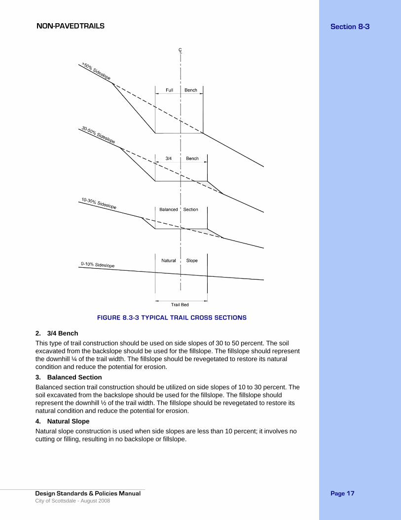
NON-PAVED TRAILS Section 8-3
Design Standards & Policies Manual City of Scottsdale - August 2008
Page 17
FIGURE 8.3-3 TYPICAL TRAIL CROSS SECTIONS
2. 3/4 BenchThis type of trail construction should be used on side slopes of 30 to 50 percent. The soil excavated from the backslope should be used for the fillslope. The fillslope should represent the downhill ¼ of the trail width. The fillslope should be revegetated to restore its natural condition and reduce the potential for erosion.3. Balanced SectionBalanced section trail construction should be utilized on side slopes of 10 to 30 percent. The soil excavated from the backslope should be used for the fillslope. The fillslope should represent the downhill ½ of the trail width. The fillslope should be revegetated to restore its natural condition and reduce the potential for erosion.4. Natural SlopeNatural slope construction is used when side slopes are less than 10 percent; it involves no cutting or filling, resulting in no backslope or fillslope.
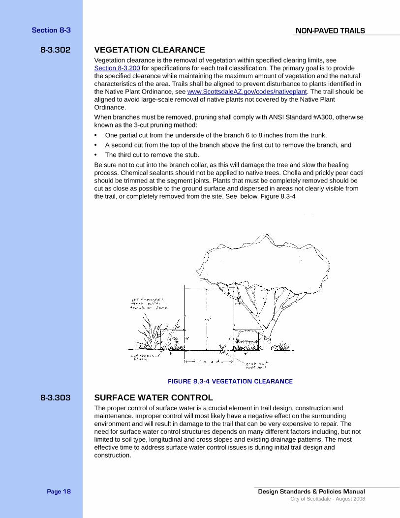
NON-PAVED TRAILSSection 8-3
Design Standards & Policies ManualCity of Scottsdale - August 2008
Page 18
8-3.302 VEGETATION CLEARANCEVegetation clearance is the removal of vegetation within specified clearing limits, see Section 8-3.200 for specifications for each trail classification. The primary goal is to provide the specified clearance while maintaining the maximum amount of vegetation and the natural characteristics of the area. Trails shall be aligned to prevent disturbance to plants identified in the Native Plant Ordinance, see www.ScottsdaleAZ.gov/codes/nativeplant. The trail should be aligned to avoid large-scale removal of native plants not covered by the Native Plant Ordinance.When branches must be removed, pruning shall comply with ANSI Standard #A300, otherwise known as the 3-cut pruning method:• One partial cut from the underside of the branch 6 to 8 inches from the trunk,• A second cut from the top of the branch above the first cut to remove the branch, and• The third cut to remove the stub.Be sure not to cut into the branch collar, as this will damage the tree and slow the healing process. Chemical sealants should not be applied to native trees. Cholla and prickly pear cacti should be trimmed at the segment joints. Plants that must be completely removed should be cut as close as possible to the ground surface and dispersed in areas not clearly visible from the trail, or completely removed from the site. See below. Figure 8.3-4
FIGURE 8.3-4 VEGETATION CLEARANCE
8-3.303 SURFACE WATER CONTROLThe proper control of surface water is a crucial element in trail design, construction and maintenance. Improper control will most likely have a negative effect on the surrounding environment and will result in damage to the trail that can be very expensive to repair. The need for surface water control structures depends on many different factors including, but not limited to soil type, longitudinal and cross slopes and existing drainage patterns. The most effective time to address surface water control issues is during initial trail design and construction.

NON-PAVED TRAILS Section 8-3
Design Standards & Policies Manual City of Scottsdale - August 2008
Page 19
A. Grade DipsGrade dips are short segments of trail with a grade opposite to the prevailing longitudinal grade of the trail. They are most effective when installed during new trail construction and sited to take advantage of natural drainage patterns. The low point of the dip must be outsloped at the maximum percentage permitted for the given trail classification to assure that water will flow off and away from the trail. A rock apron may need to be constructed where the water flows out of the dip to prevent excessive erosion. Grade dips are generally more effective than waterbars, require less maintenance, and are more suitable for equestrians and mountain bicyclists. See below Figure 8.3-5.
FIGURE 8.3-5 GRADE DIPS
B. WaterbarsWaterbars are native rocks or logs embedded in the trail surface at a 45-degree angle to the longitudinal slope for the purpose of directing surface water off the trail. Waterbars should extend at least 1 foot beyond each edge of the trail tread to ensure that water is diverted completely. Use fill material to build up the downhill side of the waterbar. Construct a drain ditch leading off the edge of the trail to ensure that runoff flows away from the trail. The drain should be at least 1 foot wide and 8 inches deep. Rocks should be placed in the bottom of the drain ditch to lessen the amount of erosion. Place additional rocks, logs, brush, or other debris in locations that will prevent trail users from detouring around the waterbar. Waterbars are not the preferred drainage structures on trails with large amounts of equestrian and mountain bicycle use. Grade dips are more appropriate in such situations.
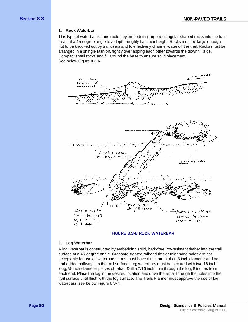
NON-PAVED TRAILSSection 8-3
Design Standards & Policies ManualCity of Scottsdale - August 2008
Page 20
1. Rock Waterbar This type of waterbar is constructed by embedding large rectangular shaped rocks into the trail tread at a 45-degree angle to a depth roughly half their height. Rocks must be large enough not to be knocked out by trail users and to effectively channel water off the trail. Rocks must be arranged in a shingle fashion, tightly overlapping each other towards the downhill side. Compact small rocks and fill around the base to ensure solid placement. See below Figure 8.3-6.
FIGURE 8.3-6 ROCK WATERBAR
2. Log Waterbar A log waterbar is constructed by embedding solid, bark-free, rot-resistant timber into the trail surface at a 45-degree angle. Creosote-treated railroad ties or telephone poles are not acceptable for use as waterbars. Logs must have a minimum of an 8 inch diameter and be embedded halfway into the trail surface. Log waterbars must be secured with two 18 inch-long, ½ inch-diameter pieces of rebar. Drill a 7/16 inch hole through the log, 8 inches from each end. Place the log in the desired location and drive the rebar through the holes into the trail surface until flush with the log surface. The Trails Planner must approve the use of log waterbars, see below Figure 8.3-7.

NON-PAVED TRAILS Section 8-3
Design Standards & Policies Manual City of Scottsdale - August 2008
Page 21
FIGURE 8.3-7 LOG WATERBAR
C. CulvertsIn desert environments, most watercourses flow only seasonally, therefore culverts are usually not necessary. Culverts tend to be maintenance intensive and can detract from the aesthetics of the natural environment. Culverts should only be constructed where a gentle grade must be maintained such as with a Barrier-free Trail or where there is permanently flowing water. In all other situations, a wash crossing should be used, see Section 8-3.304 . Rock or pipe culverts must match the downstream gradient and have a diameter of at least 12 inches to accommodate necessary cleaning. Improperly constructed culverts will clog with debris causing water to flow over and damage the trail tread. All rock used in the construction of culverts must be native.
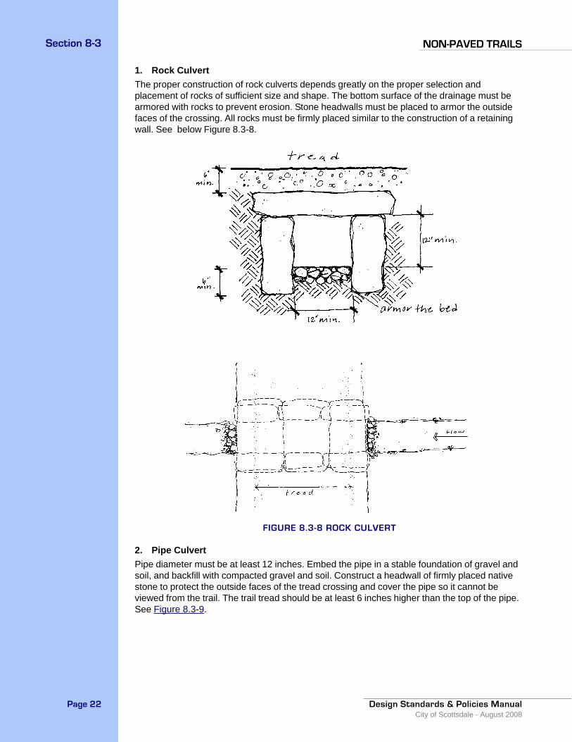
NON-PAVED TRAILSSection 8-3
Design Standards & Policies ManualCity of Scottsdale - August 2008
Page 22
1. Rock Culvert The proper construction of rock culverts depends greatly on the proper selection and placement of rocks of sufficient size and shape. The bottom surface of the drainage must be armored with rocks to prevent erosion. Stone headwalls must be placed to armor the outside faces of the crossing. All rocks must be firmly placed similar to the construction of a retaining wall. See below Figure 8.3-8.
FIGURE 8.3-8 ROCK CULVERT
2. Pipe CulvertPipe diameter must be at least 12 inches. Embed the pipe in a stable foundation of gravel and soil, and backfill with compacted gravel and soil. Construct a headwall of firmly placed native stone to protect the outside faces of the tread crossing and cover the pipe so it cannot be viewed from the trail. The trail tread should be at least 6 inches higher than the top of the pipe. See Figure 8.3-9.
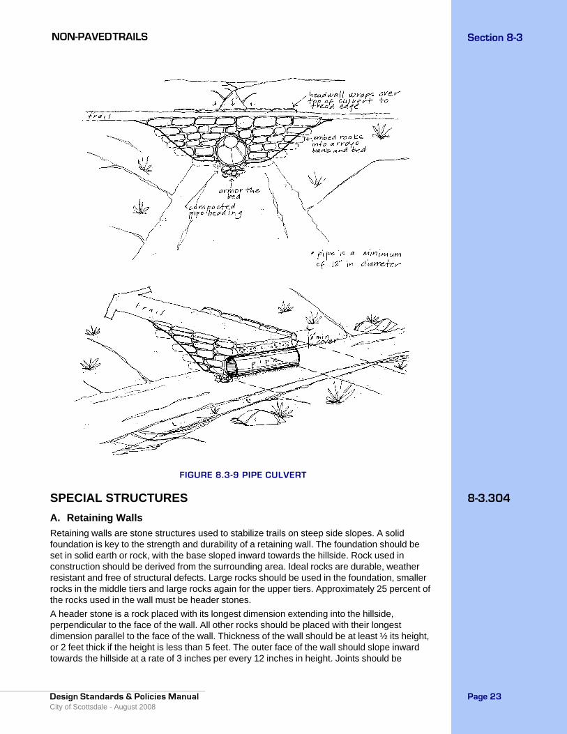
NON-PAVED TRAILS Section 8-3
Design Standards & Policies Manual City of Scottsdale - August 2008
Page 23
FIGURE 8.3-9 PIPE CULVERT
8-3.304SPECIAL STRUCTURESA. Retaining Walls Retaining walls are stone structures used to stabilize trails on steep side slopes. A solid foundation is key to the strength and durability of a retaining wall. The foundation should be set in solid earth or rock, with the base sloped inward towards the hillside. Rock used in construction should be derived from the surrounding area. Ideal rocks are durable, weather resistant and free of structural defects. Large rocks should be used in the foundation, smaller rocks in the middle tiers and large rocks again for the upper tiers. Approximately 25 percent of the rocks used in the wall must be header stones. A header stone is a rock placed with its longest dimension extending into the hillside, perpendicular to the face of the wall. All other rocks should be placed with their longest dimension parallel to the face of the wall. Thickness of the wall should be at least ½ its height, or 2 feet thick if the height is less than 5 feet. The outer face of the wall should slope inward towards the hillside at a rate of 3 inches per every 12 inches in height. Joints should be
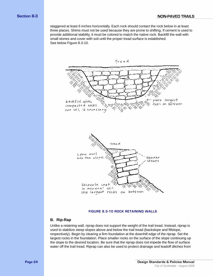
NON-PAVED TRAILSSection 8-3
Design Standards & Policies ManualCity of Scottsdale - August 2008
Page 24
staggered at least 6 inches horizontally. Each rock should contact the rock below in at least three places. Shims must not be used because they are prone to shifting. If cement is used to provide additional stability, it must be colored to match the native rock. Backfill the wall with small stones and cover with soil until the proper tread surface is established. See below Figure 8.3-10.
FIGURE 8.3-10 ROCK RETAINING WALLS
B. Rip-RapUnlike a retaining wall, riprap does not support the weight of the trail tread. Instead, riprap is used to stabilize steep slopes above and below the trail tread (backslope and fillslope, respectively). Begin by clearing a firm foundation at the downhill edge of the riprap. Set the largest rocks in the foundation. Place smaller rocks on the surface of the slope continuing up the slope to the desired location. Be sure that the riprap does not impede the flow of surface water off the trail tread. Riprap can also be used to protect drainage and leadoff ditches from

NON-PAVED TRAILS Section 8-3
Design Standards & Policies Manual City of Scottsdale - August 2008
Page 25
heavy erosion and to stabilize switchback turns. Riprap should be constructed of native rock. If cement is used to provide additional stability, it must be colored to match the native rock. See below Figure 8.3-11.
FIGURE 8.3-11 RIP RAP
C. Wash CrossingsWhen trails cross washes, the greatest concern is protecting the trail from flowing water. The trail segments approaching the crossing and the location where the trail meets each edge of the wash must be stabilized with securely placed rocks. Trail segments approaching the wash should range from 8 to 15 percent for all trail classifications and cross at a 90 degree angle to the wash to prevent water from leaving the primary channel and flowing along the trail surface. The slopes adjacent to the trail may need to be stabilized with riprap. A row of large rocks should be embedded along the wash banks at the point of contact with the trail. Be sure that the flowing water will not undercut these rocks. See Figure 8.3-12.
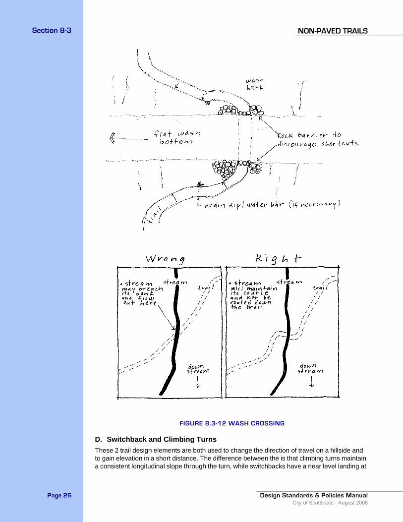
NON-PAVED TRAILSSection 8-3
Design Standards & Policies ManualCity of Scottsdale - August 2008
Page 26
FIGURE 8.3-12 WASH CROSSING
D. Switchback and Climbing TurnsThese 2 trail design elements are both used to change the direction of travel on a hillside and to gain elevation in a short distance. The difference between the is that climbing turns maintain a consistent longitudinal slope through the turn, while switchbacks have a near level landing at
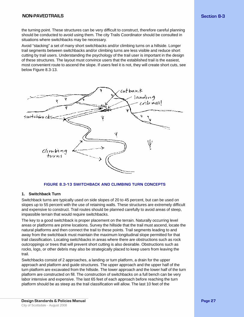
NON-PAVED TRAILS Section 8-3
Design Standards & Policies Manual City of Scottsdale - August 2008
Page 27
the turning point. These structures can be very difficult to construct, therefore careful planning should be conducted to avoid using them. The city Trails Coordinator should be consulted in situations where switchbacks may be necessary.Avoid “stacking” a set of many short switchbacks and/or climbing turns on a hillside. Longer trail segments between switchbacks and/or climbing turns are less visible and reduce short cutting by trail users. Understanding the psychology of the trail user is important in the design of these structures. The layout must convince users that the established trail is the easiest, most convenient route to ascend the slope. If users feel it is not, they will create short cuts, see below Figure 8.3-13.
FIGURE 8.3-13 SWITCHBACK AND CLIMBING TURN CONCEPTS
1. Switchback Turn Switchback turns are typically used on side slopes of 20 to 45 percent, but can be used on slopes up to 55 percent with the use of retaining walls. These structures are extremely difficult and expensive to construct. Trail routes should be planned carefully to avoid areas of steep, impassible terrain that would require switchbacks.The key to a good switchback is proper placement on the terrain. Naturally occurring level areas or platforms are prime locations. Survey the hillside that the trail must ascend, locate the natural platforms and then connect the trail to these points. Trail segments leading to and away from the switchback must maintain the maximum longitudinal slope permitted for that trail classification. Locating switchbacks in areas where there are obstructions such as rock outcroppings or trees that will prevent short cutting is also desirable. Obstructions such as rocks, logs, or other debris may also be strategically placed to keep users from leaving the trail. Switchbacks consist of 2 approaches, a landing or turn platform, a drain for the upper approach and platform and guide structures. The upper approach and the upper half of the turn platform are excavated from the hillside. The lower approach and the lower half of the turn platform are constructed on fill. The construction of switchbacks on a full bench can be very labor intensive and expensive. The last 65 feet of each approach before reaching the turn platform should be as steep as the trail classification will allow. The last 10 feet of the

NON-PAVED TRAILSSection 8-3
Design Standards & Policies ManualCity of Scottsdale - August 2008
Page 28
approaches should be smoothly transitioned into the grade of the turn platform. A flat grade approaching the turn platform must be avoided because it will cause trail users to short cut the switchback, see Figure 8.3-14 below.As the upper approach descends toward the turn, a drain dip should be installed. Below this point, the tread and the upper half of the turn platform must be insloped towards a drain ditch. The ditch must be 1 foot deep and 1 foot wide and have a rock apron at the spill point.The turn platform must not exceed a slope of 5 percent. The upper side is excavated from the hillside. The removed soil is then used to fill in the lower portion. Riprap or retaining walls may be required to provide stability to the backslope and fillslope. The turning radius must be no less than 8 feet to provide adequate turning area for equestrians and mountain bicyclists.The lower portion of the turn platform and the lower approach should be outsloped. Riprap or a retaining wall may be needed along the inner portion of the switchback to maintain the backslope of the lower approach.
FIGURE 8.3-14 SWITCHBACK TURN
2. Climbing TurnsClimbing turns are similar to switchbacks because they are also used to reverse the direction of travel and gain elevation. Climbing turns differ however because they maintain a uniform longitudinal slope through the turn. There is no level turning platform. A climbing turn is built on the same slope as the hillside. Where the slope of the hillside turns, the climbing turn ascends at the same rate. Climbing turns must not be constructed on side slopes greater than 20
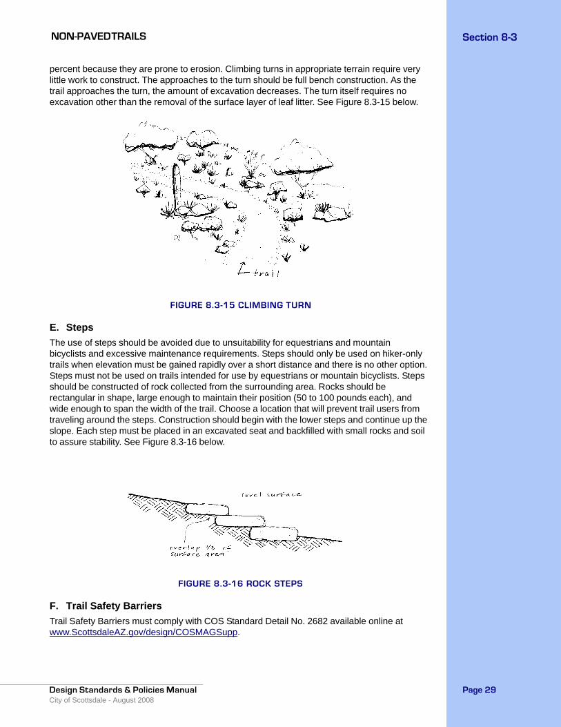
NON-PAVED TRAILS Section 8-3
Design Standards & Policies Manual City of Scottsdale - August 2008
Page 29
percent because they are prone to erosion. Climbing turns in appropriate terrain require very little work to construct. The approaches to the turn should be full bench construction. As the trail approaches the turn, the amount of excavation decreases. The turn itself requires no excavation other than the removal of the surface layer of leaf litter. See Figure 8.3-15 below.
FIGURE 8.3-15 CLIMBING TURN
E. Steps The use of steps should be avoided due to unsuitability for equestrians and mountain bicyclists and excessive maintenance requirements. Steps should only be used on hiker-only trails when elevation must be gained rapidly over a short distance and there is no other option. Steps must not be used on trails intended for use by equestrians or mountain bicyclists. Steps should be constructed of rock collected from the surrounding area. Rocks should be rectangular in shape, large enough to maintain their position (50 to 100 pounds each), and wide enough to span the width of the trail. Choose a location that will prevent trail users from traveling around the steps. Construction should begin with the lower steps and continue up the slope. Each step must be placed in an excavated seat and backfilled with small rocks and soil to assure stability. See Figure 8.3-16 below.
FIGURE 8.3-16 ROCK STEPS
F. Trail Safety Barriers Trail Safety Barriers must comply with COS Standard Detail No. 2682 available online at www.ScottsdaleAZ.gov/design/COSMAGSupp.

NON-PAVED TRAILSSection 8-3
Design Standards & Policies ManualCity of Scottsdale - August 2008
Page 30
1. LocationThe location of safety barriers should not restrict sight distances for roadway traffic or trail users. See Figure 5.3-46 for roadway sight distance requirements. Special attention to the design and construction of barriers is particularly important near intersections. Safety barriers must be installed between a trail and a roadway if the trail is located within an unsafe distance to the roadway, or if the trail shares an underpass or overpass with a roadway. Safety barriers must also be installed if the trail is elevated above an adjacent roadway and the side slope is greater than 6:1, or where trails are in close proximity to other steep drop-offs. All safety barriers must be at least 3 feet from the edge of the trail.2. Design CriteriaAppropriate safety barriers include fences, railings, or suitably thick vegetation. Other types of materials may be suitable subsequent to approval of the city Trails Coordinator. The materials and character of the barrier must be compatible with adjacent development, landscaping and topography. The minimum height should be 4 feet for structural barriers and 5 feet for vegetation barriers. 3. Trail Access Gates Trail Access Gates must comply with COS Standard Detail No’s. 2680-1 and 2680-2, available online at www.ScottsdaleAZ.gov/design/COSMAGSupp. These gates are designed to restrict motorized access to trails except as permitted for maintenance and emergency purposes. The gate design must permit equestrian passage without requiring the rider to dismount. These gates should be located at trailheads, where trails cross major roads, and at other points where motorized vehicles are likely to attempt to access a trail.
8-3.305 ROAD CROSSINGSA. OverpassesAn overpass is a structure spanning a roadway, canal and wash, etc. that functions exclusively as a crossing for a shared-use trail. There are many different varieties of overpasses that may be acceptable. The city Trails Planner must be involved in the planning and design process, and must approve all overpasses prior to construction. In general, minimum clearance is 10 feet both horizontally and vertically.
B. BridgesA bridge is a structure spanning a roadway, canal, wash, or other obstacle that serves as a crossing for a roadway as well as a shared-use trail. The city Trails Planner must be involved in the planning and design process, and must approve all bridge crossings prior to construction. The minimum width of a trail crossing a bridge is 8 feet and the minimum vertical clearance is 10 feet.
C. Underpasses These structures, used to provide passage for trail users under roadways, are typically constructed of pre-cast concrete box culverts. Other varieties of culverts are acceptable provided they meet the required dimensions and allow footing that is appropriate for all types of trail users. The width of a trail traveling through an underpass should not be less than 10 feet. Vertical clearance is an important concern, particularly for equestrian trail users. The minimum vertical clearance is 10 feet. Natural or vandal-resistant electric lighting should be installed for underpasses greater than 50 feet in length. Lighting shall achieve an average of 2-foot candles. Sight distances approaching and exiting the underpass must be adequate, so as not to create a safety hazard. Underpass design should not allow for the accumulation of nuisance water on the trail. If water does not drain from the underpass by gravity flow, a pump system must be provided to remove the water. The surface of the underpass should be slip resistant, such as broom finished concrete.
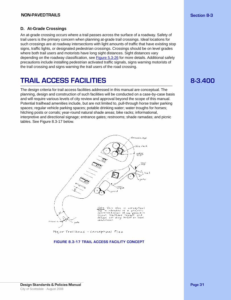
NON-PAVED TRAILS Section 8-3
Design Standards & Policies Manual City of Scottsdale - August 2008
Page 31
D. At-Grade CrossingsAn at-grade crossing occurs where a trail passes across the surface of a roadway. Safety of trail users is the primary concern when planning at-grade trail crossings. Ideal locations for such crossings are at roadway intersections with light amounts of traffic that have existing stop signs, traffic lights, or designated pedestrian crossings. Crossings should be on level grades where both trail users and motorists have long sight distances. Sight distances vary depending on the roadway classification, see Figure 5.3-26 for more details. Additional safety precautions include installing pedestrian activated traffic signals, signs warning motorists of the trail crossing and signs warning the trail users of the road crossing.
8-3.400TRAIL ACCESS FACILITIESThe design criteria for trail access facilities addressed in this manual are conceptual. The planning, design and construction of such facilities will be conducted on a case-by-case basis and will require various levels of city review and approval beyond the scope of this manual. Potential trailhead amenities include, but are not limited to, pull-through horse trailer parking spaces; regular vehicle parking spaces; potable drinking water; water troughs for horses; hitching posts or corrals; year-round natural shade areas; bike racks; informational, interpretive and directional signage; entrance gates; restrooms; shade ramadas; and picnic tables. See Figure 8.3-17 below.
FIGURE 8.3-17 TRAIL ACCESS FACILITY CONCEPT
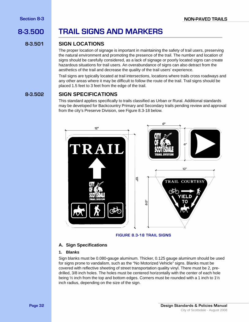
NON-PAVED TRAILSSection 8-3
Design Standards & Policies ManualCity of Scottsdale - August 2008
Page 32
8-3.500 TRAIL SIGNS AND MARKERS
8-3.501 SIGN LOCATIONSThe proper location of signage is important in maintaining the safety of trail users, preserving the natural environment and promoting the presence of the trail. The number and location of signs should be carefully considered, as a lack of signage or poorly located signs can create hazardous situations for trail users. An overabundance of signs can also detract from the aesthetics of the trail and decrease the quality of the trail users’ experience.Trail signs are typically located at trail intersections, locations where trails cross roadways and any other areas where it may be difficult to follow the route of the trail. Trail signs should be placed 1.5 feet to 3 feet from the edge of the trail.
8-3.502 SIGN SPECIFICATIONSThis standard applies specifically to trails classified as Urban or Rural. Additional standards may be developed for Backcountry Primary and Secondary trails pending review and approval from the city’s Preserve Division, see Figure 8.3-18 below.
FIGURE 8.3-18 TRAIL SIGNS
A. Sign Specifications1. BlanksSign blanks must be 0.080-gauge aluminum. Thicker, 0.125 gauge aluminum should be used for signs prone to vandalism, such as the “No Motorized Vehicle” signs. Blanks must be covered with reflective sheeting of street transportation quality vinyl. There must be 2, pre-drilled, 3/8 inch holes. The holes must be centered horizontally with the center of each hole being ½ inch from the top and bottom edges. Corners must be rounded with a 1 inch to 1½ inch radius, depending on the size of the sign.

NON-PAVED TRAILS Section 8-3
Design Standards & Policies Manual City of Scottsdale - August 2008
Page 33
2. Lettering• Font must be Garamond or similar style. • Point size should be relative to the size of the sign.
3. ColorsBackground must be dark brown with reflective white lettering and symbols. There must be a ¼ inch to ½ inch, white reflective border. For regulatory signs such as the “No Motorized Vehicle” sign, there shall be a white reflective background with red lettering.4. Sign Mounting Hardware
• 3/8 inch, vandal resistant, steel drive rivets.
B. Post SpecificationPosts shall be constructed of 1-¾ inches x 1-¾ inches, 12-gauge, square steel tubing with 7/16 inch, pre-punched knockouts on 1 inch centers. Post lengths must be 6 feet. All steel posts shall be powder coated with color to match natural rust as closely as possible. The trails planner must approve color samples prior to fabrication.
C. Sleeve and Anchor SpecificationsSleeves and anchors shall be used in locations where it is possible for a vehicle to come into contact with the signpost, such as adjacent to a street. The use of the sleeve and anchor promote easy breaking-away of the sign post in the event of a collision and increase the ease at which the sign can be replaced.1. AnchorsAnchors shall be 2 inches x 2 inches x 30 inches, 12-gauge galvanized square tubing with 7/16 inch, pre-punched knockouts on 1 inch centers.2. Sleeves
• Sleeves shall be 2-¼ inches x 2-¼ inches x 12 inches, 12-gauge, galvanized square tubing, with
• 7/16 inch, pre-punched knockouts on 1 inch centers.3. Anchor Assembly Hardware
• 3/8 inch, vandal resistant, steel drive rivets.4. Telescoping PropertiesThe finish post, anchor and sleeve must be straight with a smooth uniform finish to allow each component to telescope with each consecutive larger or smaller piece.
8-3.503INSTALLATIONSignposts adjacent to streets are to be installed according to COS Standard Detail No. 2131, available online at www.ScottsdaleAZ.gov/design/COSMAGSupp, and the Manual of Uniform Traffic Control Devices. In non-roadside locations the signpost can be mounted directly into concrete. The finished height of the post should be 5.5 feet. Various combinations of signs can be mounted on a single post to address the management needs of the particular area. All signs are to be mounted to the posts with 3/8 inch, vandal resistant, steel drive rivets, see Figure 8.3-19.

NON-PAVED TRAILSSection 8-3
Design Standards & Policies ManualCity of Scottsdale - August 2008
Page 34
FIGURE 8.3-19 TRAIL SIGN INSTALLATION
8-3.504 DEVELOPER-PROVIDED SIGN STANDARDDevelopers may provide their own signage consistent in color and theme with the surrounding development. At a minimum, these signs must accommodate the triangular “Trail Courtesy” graphic, the “City of Scottsdale Trail System” logo, and the standard hiker, equestrian and mountain bicycle icons. These required signs may be installed on the same post as developer-provided signs, or the graphics may be incorporated directly into the developer-provided sign. The graphics for the signs may be obtained by contacting the city Trails Planner.
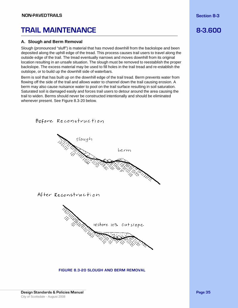
NON-PAVED TRAILS Section 8-3
Design Standards & Policies Manual City of Scottsdale - August 2008
Page 35
8-3.600TRAIL MAINTENANCEA. Slough and Berm Removal Slough (pronounced “sluff”) is material that has moved downhill from the backslope and been deposited along the uphill edge of the tread. This process causes trail users to travel along the outside edge of the trail. The tread eventually narrows and moves downhill from its original location resulting in an unsafe situation. The slough must be removed to reestablish the proper backslope. The excess material may be used to fill holes in the trail tread and re-establish the outslope, or to build up the downhill side of waterbars. Berm is soil that has built up on the downhill edge of the trail tread. Berm prevents water from flowing off the side of the trail and allows water to channel down the trail causing erosion. A berm may also cause nuisance water to pool on the trail surface resulting in soil saturation. Saturated soil is damaged easily and forces trail users to detour around the area causing the trail to widen. Berms should never be constructed intentionally and should be eliminated whenever present. See Figure 8.3-20 below.
FIGURE 8.3-20 SLOUGH AND BERM REMOVAL
NON-PAVED TRAILSSection 8-3
Design Standards & Policies ManualCity of Scottsdale - August 2008
Page 36
B. Vegetation Clearance MaintenanceAll plants encroaching on the vegetation clearance limits for the particular trail classification must be cut back. Branches should be cut close to the main stem without cutting into the branch collar. Plants being removed must be cut flush with the ground and stumps must be removed to prevent safety hazards. All plants growing within the trail tread must be grubbed-out. Trails within landscaped areas may be sprayed with herbicide. All removed plant material must be scattered in a location not visible from the trail.
C. Tread MaintenanceIn addition to slough and berm removal, the remaining trail tread should be restored to its original design condition. All loose rocks, rock points, stumps and roots protruding from the trail surface should be removed. All holes should be filled to create a smooth, obstacle-free trail tread. Maintaining a proper outslope is critical to the long-term condition of the trail.
D. Drainage MaintenanceSpecial attention should be directed to the maintenance of drainage structures. These structures are extremely important in protecting the trail from erosion. If they are not maintained properly, the trail will be prone to erosion and may become unsafe for public use and require extensive amounts of labor to repair. All repairs to drainage structures must restore them to their original standard construction specifications.
E. Special Structure MaintenanceStructures such as waterbars, culverts, switchbacks, retaining walls, wash crossings, overpasses and bridges, etc. are rather expensive and labor intensive to construct. Proper maintenance will prolong the life of the structures and help prevent safety hazards. Structures should be inspected annually and maintenance performed as needed. All repairs to special structures must restore them to their original standard construction specifications.
F. Sign MaintenanceSign maintenance includes replacing missing or damaged signs and assuring the accuracy of the information on the signs, as conditions may change over time. All signs that are damaged, weathered, or for any other reason do not serve their intended purpose should be repaired or replaced according to the sign standards described in this manual.