chapter 9: ecology and biodiversity pdf - wordpress.com · chapter 9 ecology and biodiversity...
TRANSCRIPT

P O R T I S H E A D B R A N C H L I N E P R E L I M I N A R Y E N V I R O N M E N T A L I N F O R M A T I O N R E P O R T V O L U M E 2
C H A P T E R 9
Ecology and Biodiversity


Table of Contents Section Page
9 Ecology and Biodiversity ..................................................................................................... 9-1 9.1 Introduction ..................................................................................................................... 9-1 9.2 Legislation and Policy Framework ................................................................................... 9-2 9.3 Methodology.................................................................................................................... 9-5 9.4 Baseline, Future Conditions, and Importance of Features ............................................ 9-19 9.5 Measures Adopted as Part of the DCO Scheme ............................................................ 9-51 9.6 Assessment of Effects .................................................................................................... 9-52 9.7 Mitigation and Residual Effects ..................................................................................... 9-66 9.8 Cumulative Effects ......................................................................................................... 9-67 9.9 Limitations Encountered in Compiling the PEI Report................................................... 9-68 9.10 Summary ........................................................................................................................ 9-69 9.11 References ..................................................................................................................... 9-77 9.12 Abbreviations and Acronyms ......................................................................................... 9-77
List of Tables
Table 9-1: Summary of relevant NPSNN advice regarding ecology and biodiversity Table 9-2: Summary of Local Policy on Nature Conservation Table 9-3: Summary of consultation responses Table 9-4: Definition of Importance of features Table 9-5: Definition of Magnitude of Impact Table 9-6: Significance of Effects Table 9-7: Definition of the Significance Categories Table 9-8: Internationally designated sites within 30km Table 9-9: Nationally designated sites within 2 km Table 9-10: Local Wildlife Sites, SNCIs, and Nature Reserves within 0.5km (ordered by distance
from the Portishead to Pill disused line) Table 9-11: Evaluation for the Bat Roost Resource on the Disused Railway Line Table 9-12: Summary of Importance and Likelihood of Significant Effects (requiring detailed
assessment) on ecological features Portishead to Pill. Table 9-13: Internationally designated sites within 30km Table 9-14: Nationally designated sites within 2 km Table 9-15: Wildlife Sites and SNCIs within 0.5km of the DCO Scheme (ordered by distance
from the Portbury Freight Line) Table 9-16: Evaluation of the Bat Roost Resource on the Portbury Freight Line Table 9-17: Notable and important Plant Species Table 9-18: Summary of importance and likelihood of significant effects (requiring detailed
assessment) on ecological features, Portbury Freight Line Table 9-19: Summary of worst case scenarios adopted in the environmental assessment Table 9-20: Assessment of indirect effects on designated sites from the DCO Scheme Table 9-21: Indirect construction impacts to non- statutory sites (ordered by distance from the
Portbury Freight Line) Table 9-22 Numbers of individuals of Sorbus affected Table 9-23: Potential Impacts, Mitigation and Residual Impacts for the DCO Scheme on
Ecology
CHAPTER 9 ECOLOGY AND BIODIVERSITY
PORTISHEAD BRANCH LINE PRELIMINARY ENVIRONMENTAL INFORMATION REPORT, VOLUME 2
9-2
Figures See Volume 3 Book of Figures Figure 9.1 Internationally designated sites Figure 9.2 Statutory designated sites Figure 9.3 Non statutory wildlife sites and ancient woodland Figure 9.4 Fauna surveys List of Appendices for the Ecology Chapter
See Volume 4 Appendices Appendix 9.1 Extended Phase 1 Habitat Survey Appendix 9.2 Bat surveys Appendix 9.3 Ornithological Surveys Appendix 9.4 Amphibians Appendix 9.5 Reptiles Appendix 9.6 Badgers CONFIDENTIAL Appendix 9.7 Dormice Appendix 9.8 Otters Appendix 9.9 Water Voles Appendix 9.10 Flora

PORTISHEAD BRANCH LINE PRELIMINARY ENVIRONMENTAL INFORMATION REPORT, VOLUME 2
CHAPTER 9 ECOLOGY AND BIODIVERSITY
9-1
SECTION 9
9 Ecology and Biodiversity 9.1 Introduction
The Portishead Branch Line (MetroWest Phase 1) Development Consent Order Scheme (“the DCO Scheme”) has the potential to give rise to likely significant effects on ecology and biodiversity. This Chapter:
• describes the relevant legal and policy framework which informs the undertaking of the assessment;
• describes the methodology used for the identification and assessment of likely significant ecology and biodiversity effects in this Preliminary Environmental Information Report ("PEI Report");
• describes the ecology and biodiversity baseline having regard to existing information;
• describes the measures that have been adopted as part of the DCO Scheme;
• identifies and assesses the likely significant effects that could result from the DCO Scheme during the construction, operation and decommissioning phases;
• considers mitigation of likely significant effects and assesses those residual effects that will result
• considers the cumulative effects of other developments in combination with the DCO Scheme on habitats, flora and fauna;
• identifies the limitations encountered in compiling the PEI Report; and
• provides a summary of the residual effects for the mitigated DCO Scheme.
This chapter focuses on the important ecological features which comprise: sites which are designated (statutory and non-statutory) for their nature conservation importance at the European, national and local level; sensitive and valued habitats (e.g. wetland and mature trees); species which are protected through European or national legislation; and habitats and species which are valued through either policy, biodiversity action plans ("BAP") or as priorities for conservation. Some ecological features may still be important but not covered by the stated criteria because they provide an important ecological function, for example hedgerows and linear habitats which provide potential corridors for movement for species. These ecological features have potential to experience impacts which are significant at the European, national, regional or local level.
This chapter should be read in conjunction with Chapter 4 Description of the Proposed Works and Chapter 6 Planning Framework. This chapter is also supported by baseline ecological reports in Appendices 9.1 to 9.10.
This chapter draws on outputs of other topics of the environmental impact assessment (“EIA”), notably Chapter 7 Air Quality and Greenhouse Gases, Chapter 13 Noise and Vibration, and Chapter 17 Water Resources, Drainage and Flood Risk, to determine the nature and extent of possible impacts on ecological features. There is also cross-referencing to the landscaping proposals, particularly in relation to mitigation, which is presented in Chapter 11 Landscape and Visual Impact. However, the evaluation of the significance of such impacts on ecological features are addressed in this chapter.

CHAPTER 9 ECOLOGY AND BIODIVERSITY
PORTISHEAD BRANCH LINE PRELIMINARY ENVIRONMENTAL INFORMATION REPORT, VOLUME 2
9-2
9.2 Legislation and Policy Framework EU and National Legislation
The Conservation of Habitats and Species Regulations 2010 (as amended) ("the Habitat Regulations") transpose Council Directive 92/43/EEC on the conservation of natural habitats and of wild fauna and flora ("the Habitats Directive") into national law. The Habitat Regulations provide for the designation and protection of European sites, the protection of European protected species listed in the Habitats Directive, and the adaptation of planning and other controls for the protection of European Sites. European sites are defined in the Habitats Regulations to include all Special Areas of Conservation (“SAC”), candidate SACs ("cSAC") proposed by the UK Government to the European Commission, sites of community importance ("SCI") placed on a list adopted by the European Commission prior to designation as SACs by the Government, and Special Protection Areas (“SPA”) for wild birds. As a matter of planning policy, the UK Government extends the same level of protection to proposed sites once a Ministerial announcement has been made that it is proposed to consult on the designation of such sites. The UK Government also, as a matter of policy, applies the same level of protection to Ramsar sites, which are wetlands of international importance designated under the Ramsar Convention.
The DCO Scheme runs through the Avon Gorge Woodlands SAC along the Portbury Freight Line. The scheme also lies within 30 m (temporary footpath diversion) and 1.2 km (pilling works) of the Severn Estuary SPA/SAC/Ramsar and lies within 30 km of two European designated sites with bats as a qualifying feature; the North Somerset and Mendip Bats SAC (8 km to the south) and the Bath and Bradford-on-Avon Bats SAC (c24 km to the east). Screening for appropriate assessment under the Habitats Regulations is being undertaken and will be presented in the ES to be submitted with the DCO application.
The Wildlife and Countryside Act 1981 (as amended) ("WCA") consolidated and amended domestic legislation to implement the Convention on the Conservation of European Wildlife and Natural Habitats ("Bern Convention") and Council Directive 79/409/EEC on the Conservation of Wild Birds ("Birds Directive") in Great Britain. The WCA is the main piece of national legislation which protects animals, plants, and in some cases their habitats in England.
The Protection of Badgers Act 1992 provides that it is an offence to kill, injure, take, possess or cruelly ill-treat a badger, or to damage or interfere with a sett unless a licence is obtained from a statutory authority. Sett interference includes disturbing badgers while they are occupying a sett, as well as damaging or destroying a sett or obstructing access to it.
The Natural Environment and Rural Communities Act 2006 ("NERC") extended the biodiversity duty set out in the Countryside and Rights of Way ("CRoW") Act 2000 to public bodies and statutory undertakers to ensure due regard to the conservation of biodiversity. The Duty is set out in Section 40 of the Act which states that: "Every public authority must, in exercising its functions, have regard, so far as is consistent with the proper exercise of those functions, to the purpose of conserving biodiversity". This Act includes lists of Habitats and Species of Principal Importance for England and there is an obligation to implement measures to further the conservation interest of such species and to restore or enhance their populations or habitats.

PORTISHEAD BRANCH LINE PRELIMINARY ENVIRONMENTAL INFORMATION REPORT, VOLUME 2
CHAPTER 9 ECOLOGY AND BIODIVERSITY
9-3
National Policy National Policy Statement for National Networks
The National Policy Statement for National Networks ("NPSNN") advises on biodiversity and ecological conservation in the context of national networks. Table 9-1 below identifies those policies of direct relevance to this assessment and the location where they are considered in the PEI Report.
Table 9-1: Summary of relevant NPSNN advice regarding ecology and biodiversity
Summary of NPS provisions Consideration within the PEI Report
Paragraph 5.22 states that the ES should set out the likely significant effects on internationally, nationally and locally designated sites of ecological or geological importance, protected species, habitats and species of principal importance for the conservation of biodiversity, and consider potential impacts on ecosystems.
Section 9.6 presents the findings of the assessment on ecological designated sites.
Impacts on geologically designated sites are assessed in Chapter 10 on Geology, Hydrogeology, Ground Conditions and Contaminated Land.
Paragraph 5.23 states that the applicant should show how the project has taken advantage of opportunities to conserve and enhance biodiversity and geological conservation interests.
Section 9.5 summarises measures incorporated into the Scheme and Section 9.6 presents further mitigation.
Chapter 10 presents information on Geology, Hydrogeology, Ground Conditions and Contaminated Land.
National Planning Policy Framework
The National Planning Policy Framework ("NPPF") includes Chapter 11 Conserving and Enhancing the Natural Environment. In addition to being concerned with the protection of statutorily designated sites, the NPPF outlines ways in which the planning system is required to contribute to and enhance the local environment and sets out guidance for local authorities in respect of the consideration of biodiversity and green infrastructure, including "minimising impacts on biodiversity and providing net gains in biodiversity where possible" and "establishing coherent ecological networks that are more resilient to current and future pressures". The NPPF is a material planning consideration.
Local Policy An overview of local policies for North Somerset Council and Bristol City Council is
presented in Chapter 6 Planning Framework. Table 9-2 identifies the policies concerned with nature conservation.
Table 9-2: Summary of Local Policy on Nature Conservation
Policy No. Title Description
North Somerset Council Core Strategy, adopted January 2017
CS1 Addressing climate change and carbon reduction
This is an overarching policy to encourage implementation of measures to reduce CO2, through design, use of walking, public transport and reuse of land. Items 5) a network of multi-functional green infrastructure will be planned for and delivered through new development…; and 6) protecting and enhancing biodiversity across North Somerset including species and habitats that are characteristic of the area, in order to support adaptation to climate change.

CHAPTER 9 ECOLOGY AND BIODIVERSITY
PORTISHEAD BRANCH LINE PRELIMINARY ENVIRONMENTAL INFORMATION REPORT, VOLUME 2
9-4
Table 9-2: Summary of Local Policy on Nature Conservation
Policy No. Title Description
CS4 Nature conservation This policy promotes the conservation and enhancement of biodiversity through various measures. The biodiversity of North Somerset will be maintained and enhanced by:
"1) seeking to meet local and national Biodiversity Action Plan targets taking account of climate change and the need for habitats and species to adapt to it;
2) seeking to ensure that new development is designed to maximise benefits to biodiversity, incorporating, safeguarding and enhancing natural habitats and features and adding to them where possible, particularly networks of habitats. A net loss of biodiversity interest should be avoided, and a net gain achieved where possible;
3) seeking to protect, connect and enhance important habitats, particularly designated sites, ancient woodlands and veteran trees;
4) promoting the enhancement of existing and provision of new green infrastructure of value to wildlife;
5) promoting native tree planting and well targeted woodland creation, and encouraging retention of trees, with a view to enhancing biodiversity."
Bristol Development Framework Core Strategy, adopted June 2011
BCS9 Green Infrastructure The City Council aims to increase the connectivity of the strategic green infrastructure network, retain and prevent its loss.
DM17 Development involving existing green infrastructure
The Core Strategy seeks to conserve existing green infrastructure assets. This policy sets out the detailed approach to this where further detail to support the Core Strategy is required.
DM19 Development and Nature Conservation
This policy seeks to ensure that consideration is given to the likely impact that development could have upon habitat, species or features, which contribute to nature conservation in Bristol, and that appropriate mitigation is provided where such impacts would occur.
There are various biodiversity action plans relevant to this DCO Scheme. Biodiversity 2020: A strategy for England's wildlife and ecosystem services, (Defra, 2011), is the most recent biodiversity strategy for England (replacing the UK BAP following the publication of the UK Post-2010 Biodiversity Framework published by JNCC and Defra in July 2012).
The Action for Nature North Somerset Biodiversity Action Plan (NSC, 2005) ("NSBAP") and the Bristol BAP ("BBAP") (BCC, undated) identify priority habitats and species and set targets for their conservation. This includes habitats and species of relevance to the DCO Scheme, such as woodland, standing open water, rivers and streams, greater horseshoe bat Rhinolophus ferrumequinum and hedgehog Erinaceus europaeus.

PORTISHEAD BRANCH LINE PRELIMINARY ENVIRONMENTAL INFORMATION REPORT, VOLUME 2
CHAPTER 9 ECOLOGY AND BIODIVERSITY
9-5
9.3 Methodology Guidance and Best Practice
The ecological impact assessment has been undertaken in accordance with the Guidelines for Ecological Impact Assessment in the UK and Ireland produced by the Chartered Institute of Ecology and Environmental Management (CIEEM, 2016). It also considers Highways Agency1 guidelines in the Design Manual for Roads and Bridges, Volume 11 Environmental Assessment, Section 3, Part 4 Ecology and Nature Conservation.
Consultations A summary of the consultations undertaken to date is presented in Table 9-3 below.
Further information on the consultation process is presented in Chapter 5 Approach to the Environmental Statement and the Consultation Report on the informal stakeholder consultations undertaken in 2015 which is available at http://travelwest.info/project/metrowest-phase-1.
1 On 1 April 2015 the Highways Agency became a government-owned Strategic Highways Company, limited by shares, with the Secretary of State as sole shareholder and is known as “Highways England”.


PORTISHEAD BRANCH LINE PRELIMINARY ENVIRONMENTAL INFORMATION REPORT, VOLUME 2
CHAPTER 9 ECOLOGY AND BIODIVERSITY
9-7
Table 9-3: Summary of consultation responses
Organisation and date Summary of response Consideration within PEI Report
Planning Inspectorate
Responses to the Scoping Report August 2015
Paragraph 3.29. Further information is required to scope out the cumulative effects of the other works on MetroWest Phase 1 with inter alia ecology and biodiversity.
Consideration for the cumulative effect of the DCO Scheme with other schemes is being made and will be reported in the ES for the project.
Paragraph 3.45. Careful assessment of impacts on a range of receptors (designated sites, records).
Consideration throughout this document.
Paragraph 3.46. Agree the methodology with Natural England and other relevant consultees.
Natural England has been consulted a number of times with regards to the methodology for assessment of the works and where applicable these recommendations have been incorporated into the PEI Report.
Paragraph 3.47. Design and likely effectiveness of mitigation should be agreed with Natural England.
Natural England is being consulted with regards to the design and development of mitigation. The mitigation strategy for the project is being developed and Natural England will be given the opportunity to comment on the likely effectiveness of the mitigation proposed.
Paragraph 3.48. Assess the impact of the railway as part of an ecological network.
It is recognised that the railway represents an important connection and dispersal corridor for a number of species and this is considered within Section 9.6.
Paragraph 3.49. Consider the need for a Habitats Regulations Assessment (“HRA”).
The need for a HRA is discussed within this document.
Paragraph 3.50. Agree a methodology for an arboricultural survey with the relevant local tree officer and include the results in the Environmental Statement (“ES”).
Discussions have been held with the NSC Tree Officer. A Preliminary Arboricultural assessment of trees in the Avon Gorge has been undertaken. This assessment has identified a number of trees which potentially threaten the existing freight line. Network Rail has been informed of the location of these features and has implemented a plan of management for these areas.

CHAPTER 9 ECOLOGY AND BIODIVERSITY
PORTISHEAD BRANCH LINE PRELIMINARY ENVIRONMENTAL INFORMATION REPORT, VOLUME 2
9-8
Table 9-3: Summary of consultation responses
Organisation and date Summary of response Consideration within PEI Report
Paragraph 3.51. Address the implications of invasive species. A number of invasive species have been identified within and adjacent to the site. Management of these species will be considered in the Code of Construction Practice (“CoCP”) which is being developed and will be presented in the ES submitted with the DCO application.
Paragraph 3.52. Consider the potential impact from disturbance of wildlife due to piling.
Considered within this document in Section 9.6.
Paragraph 3.5.3. Take account of inter-relationships between impacts on noise, vibration, air quality (including dust), soil quality and water quality on ecological receptors. Cross refer to relevant topic chapters.
Considered within this document in Section 9.6.
Bristol City Council
Responses to the Scoping Report August 2015
Ecological mitigation should address legally protected species and priority species and habitats found in surveys.
Overall, the ecological impact assessment completed to date indicates that the DCO Scheme, if unmitigated, is likely to give rise to some significant adverse effects on ecology and biodiversity for the purpose of the EIA Regulations. Accordingly, a number of measures are being developed in consultation with the regulatory authorities and will be presented in the ES submitted with the DCO application.
Severn Beach / Avonmouth Signalling. Confirm to Bristol City Council whether any percussive piling works are required within 300 m of the SPA. Further survey and mitigation may be required for legally protected species, and priority species and habitats found.
Consideration for the impact of noise and vibration on the Severn Estuary SPA interest features is considered within Section 9.6 of this document.
Bedminster Down Relief Line. Further surveys required and mitigation proposed for legally protected species, and priority species and habitats found.
A site survey on 18 August 2015 by a Network Rail ecologist identified potential suitable habitats for amphibians, reptiles, badgers and bats. The need for further surveys will be considered following further design. Any works on the Bedminster Down Relief Line will be undertaken by Network Rail under their permitted development rights.

PORTISHEAD BRANCH LINE PRELIMINARY ENVIRONMENTAL INFORMATION REPORT, VOLUME 2
CHAPTER 9 ECOLOGY AND BIODIVERSITY
9-9
Table 9-3: Summary of consultation responses
Organisation and date Summary of response Consideration within PEI Report
Environment Agency
Responses to the Scoping Report August 2015
Include otter assessments / surveys particularly in respect of breeding sites and use of any near watercourses. Provide suitable mitigation for otters.
Otter survey and assessment completed for the DCO Scheme and included in the PEI Report in Section 9.6 and in Appendix 9.8.
Natural England
Avon Gorge Walk through
One of Natural England’s National Plant Specialist participated in a walkthrough of the Avon Gorge on the 15th of December 2016. Although a formal response is yet to be received from Natural England following this activity it appears that Natural England recognise the positive opportunities that the scheme can bring to the designated site, if the scheme is carefully managed and implemented.
Consideration for the opportunities for positive management of the Avon Gorge is being developed and will be outlined in the ES.
Natural England
Scheme Design and development meetings:
28th November 2016 (Chris Westcott)
30th June 2017 (Alison Howe)
4th July 2017 (Chris Westcott, Avon Gorge)
A number of consultation meetings have been held with the Natural England Team through the Discretionary Advice Service (DAS).
Avon Gorge SAC: Natural England understands that the DCO Scheme will cause temporary disturbance to the Avon Gorge and will result in the loss of a number of individual whitebeam trees, but they also recognise the positive opportunities that the scheme can bring to the designated site, for example:
• The management of invasive and unfavourable species, • The reduction of scrub encroachment for important areas of grassland, • The identification and awareness generation of important habitat
features, • The development of skills to promote the in situ and ex-situ propagation
of whitebeam • The further development of a collaborative working partnership
between stakeholders and landowners to further the conservation objectives of the Avon Gorge.
• These measures have been incorporated into the development of a Habitat Management and Mitigation Plan for the Site. Natural England has also asked for consideration of the other important botanical species in the Avon Gorge and this has been addressed within Appendix 9.10. North Somerset and Mendip SAC: Natural England recognises that lesser and greater horseshoe bats regularly occur between Portbury Common

CHAPTER 9 ECOLOGY AND BIODIVERSITY
PORTISHEAD BRANCH LINE PRELIMINARY ENVIRONMENTAL INFORMATION REPORT, VOLUME 2
9-10
Table 9-3: Summary of consultation responses
Organisation and date Summary of response Consideration within PEI Report
and Royal Portbury Dock and the disused railway line appears to be an important corridor for bats with movement between the line and Brockley Hall Stables SSSI, a link with the North Somerset and Mendip SAC. Accordingly, Natural England has requested that an additional radio tracking survey for bats be undertaken to further understand the importance of the rail corridor. This survey, which is proposed for the Autumn or Spring of 2017/2018 will be reported in documentation to be submitted with the DCO application.
Protected Species: Natural England has broadly accepted the approach to protected species and has been made aware that licences will be required for bats, badgers, dormice and great crested newts (“GCN”). Natural England has asked that a summary of this approach and the likely time frame for the application of licences be sent to their central licensing team for consideration.
Natural England
Responses to the Scoping Report August 2015
Natural England is generally satisfied with the approach to the assessment in the Scoping Report
Portbury Nature Reserve. Consider the indirect effect of the Scheme on birds in the Severn Estuary designated site.
The indirect impact of the DCO Scheme is considered in Section 9.6 within this document.
Avon Gorge Woodlands SAC (and SSSI). Full details required for works through the Avon Gorge Woodlands SAC. Need to define the limit of the works and extent of vegetation removal. Consider the protection of interest features along the tow path and adjacent areas in Leigh Woods. Protection and management of rare species on cliff faces affected by the project. Treatment of invasive species. Impact of replacing fencing.
The design of the DCO Scheme is under development and the details will be provided in the DCO application. A description of the works is presented in Chapter 4. The impacts of the DCO Scheme are considered in Section 9.6 based on the emerging design.

PORTISHEAD BRANCH LINE PRELIMINARY ENVIRONMENTAL INFORMATION REPORT, VOLUME 2
CHAPTER 9 ECOLOGY AND BIODIVERSITY
9-11
Table 9-3: Summary of consultation responses
Organisation and date Summary of response Consideration within PEI Report
HRA and Avon Gorge Woodlands SAC. Need to study bats in the Avon Gorge, although not a qualifying features of the SAC. The HRA needs to include the assessment of works in the Portbury Wharf Nature Reserve on the Severn Estuary SPA and Ramsar site, the impact of horseshoe bats in relation to the two bat SACs (Mendips and Bath and Bradford SACs), and works through the Avon Gorge Woodlands SAC.
Various surveys of protected species and the flora of the Avon Gorge Woodlands SAC is presented in Appendices 9.1 to 9.10. Consideration of the potential impacts is provided in Section 9.6. An HRA is being prepared and will be presented in the ES to be submitted with the DCO application.
If an EPS licence is likely to be required, a shadow licence should be in place prior to DCO submission.
Consideration is being given to drafting a shadow licence application to accompany the DCO submission.
Natural England
Meeting on 30th September 2014 (Simon Stonehouse)
Informal consultation during 2014 on the proposed assessment methodology resulting in a response from the Discretionary Advice Service (“DAS”).
The DAS response is appendixed to the Scoping Report, available on The Planning Inspectorate’s Portal for NSIPs.
Meeting on 4th December 2015 (Chris Westcott)
Preparation of an interim HRA and request for working in the SSSI to remove vegetation in winter/spring 2016 to facilitate the inspection of structures and earthworks as part of the design studies.
HRA completed and agreed with Natural England. The vegetation clearance and surveys of structures was completed in 2016.
North Somerset District Council (NSDC) Ecology Team
The NSDC ecology team has been consulted on the project on a number of occasions, they have participated in a site visit and been party to a number of sessions outlining the approach to the scheme. They are broadly content with the approach but have asked that measures to enhance the ecological setting of the route be considered wherever possible for example that disused railway structures be retained and protected to support roosting features for bats and that herbicide is not used on the rail corridor in close proximity to any of the non statutory and statutory designated sites during the operation and construction of the DCO Scheme.
measures are being developed in consultation with stakeholders to mitigate predicted likely significant effects of the DCO Scheme. These will be presented in the ES to be submitted with the DCO application.
Avon Wildlife Trust
Informal Consultation
AWT provide species information for Portbury Wharf Nature Reserve. Discussed mitigation measures for Sheepway Maintenance Track and potential compensation schemes in partnership with the Trust.
Species information is included in Appendix 9.3, 9.4 and 9.5 Indicative planting is shown in Figure 4.9 for the Sheepway Maintenance Track design to be developed in consultation with and reported in the ES to be submitted with the DCO application.


PORTISHEAD BRANCH LINE PRELIMINARY ENVIRONMENTAL INFORMATION REPORT, VOLUME 2
CHAPTER 9 ECOLOGY AND BIODIVERSITY
9-13
Definition of the Study Area The study area for the DCO Scheme focuses on the Order limits defined by the Red Line
Boundary around the DCO Scheme from the proposed new station in Portishead to Ashton Junction and a 0.5 km buffer around the centreline of the railway. Consideration has also been given to potential effects on internationally designated sites within 5 km (and 30 km for sites with bats as a qualifying feature).
The study area has been divided into Portishead to Pill (disused line) and Portbury Freight Line due to the differences in the DCO Scheme for each section and differences in baseline ecology.
The cumulative effects section covers proposed developments within 0.5 km of the DCO Scheme and the other works required for MetroWest Phase 1 comprising the Bedminster Down Relief Line, Severn Beach / Avonmouth Signalling and Bathampton Turnback. Background information on these three schemes for MetroWest Phase 1 is available in the Baseline Report, Appendix B, which can be downloaded from The Planning Inspectorate’s website at the following address https://infrastructure.planninginspectorate.gov.uk/projects/south-west/portishead-branch-line-metrowest-phase-1/.
The Order limits and the 0.5 km buffer zone is considered sufficient to include the likely zone of influence of the DCO Scheme on habitats, flora and fauna.
Key Features The key features for the ecological impact assessment are:
• European designated sites – SPA, SAC, and Ramsar sites
• European protected species (bats and great crested newts Triturus cristatus and dormice are present in the study area)
• Nationally protected sites – Sites of Special Scientific Interest (“SSSI”) and National Nature Reserves (“NNR")
• Locally designated sites – Local Nature Reserves (“LNR”), Sites of Nature Conservation Interest (“SNCI”), and Wildlife Sites (“WS”)
• Nationally protected species
• Ancient Woodland as shown on the Natural England’s inventory
• The green corridor provided by trees and scrub along the disused line.
Defining the Baseline Information on ecology was obtained from the following sources.
• Bristol Regional Environmental Records Centre ("BRERC"). A data search was undertaken in April 2014 for records of protected and priority species in the UK, locally important species of conservation concern and statutory and non-statutory designated sites of nature conservation interest. A 0.5 km buffer from the centreline of the railway was used for all protected species records (extended to 2.5 km for bats) and locally designated sites, a 2 km buffer for nationally designated sites, and a 5 km buffer for internationally designated sites, except for those with bats as a qualifying feature where the buffer was extended to 30 km. This area is considered to be sufficient to cover the likely zone of influence of the DCO Scheme.

CHAPTER 9 ECOLOGY AND BIODIVERSITY
PORTISHEAD BRANCH LINE PRELIMINARY ENVIRONMENTAL INFORMATION REPORT, VOLUME 2
9-14
• The Multi-Agency Geographic Information for the Countryside (“MAGIC”) website (www.magic.gov.uk).
• Adjacent land owners including the National Trust and the Forestry Commission.
• North Somerset Council Ecology Team
• Natural England ("NE") and Joint Nature Conservation Committee ("JNCC") Protected Site data.
Ecological surveys were undertaken for the DCO Scheme between 2011 and 2017. The reports detailing the findings of the surveys and subsequent recommendations have formed part of the basis for the ecological impact assessment. The reports used within this assessment are listed below.
• Appendix 9.1: Extended Phase 1 Habitat Survey (CH2M August 2017). • Appendix 9.2: Bat surveys (Pure Ecology on behalf of CH2M 2017) • Appendix 9.3: Ornithological Surveys (CH2M, 2017) • Appendix 9.4: Amphibians (CH2M, 2017) • Appendix 9.5: Reptiles (CH2M, 2017) • Appendix 9.6: Badgers CONFIDENTIAL (CH2M, 2017) • Appendix 9.7: Dormice (CH2M, 2017) • Appendix 9.8: Otters (CH2M, 2017) • Appendix 9.9: Water Voles (CH2M, 2017) • Appendix 9.10: Flora (Dr Tim Rich and Libby Houston on behalf of CH2M, 2017)
Assessment of Construction and Operational Impacts
In accordance with the CIEEM ecology impact assessment guidance (CIEEM 2016), the following factors will be considered in determining the potential ecological impacts of the activities associated with the construction and operation of the proposed development:
• Extent; • Magnitude; • Duration; • Reversibility; • Timing and frequency; and • Cumulative effects.
The guidelines allow for features to be scoped out of the impact assessment. They advise that features to be subject to more detailed assessment should be both of sufficient importance that impacts upon them may be significant and potentially vulnerable to significant impacts arising from the development. This approach is consistent with the EIA Regulations, which require the provision of information on likely significant effects. For the purposes of this assessment, the threshold level of value of a feature below which it is considered that an impact would not be considered significant will be set at District importance. Therefore, impacts will be assessed in detail only for features of at least district (or Unitary Authority) importance or subject to some form of legal protection, for example, under the WCA, the Protection of Badgers Act 1992, and Habitats Regulations.
Assessment of Decommissioning Impacts No specific plans have been formulated for the decommissioning phase of the Portishead
Branch Line. It is expected that the services will continue for as long as there is a business case for doing so. Closure of railways is a regulated process, overseen by the Office of Rail
PORTISHEAD BRANCH LINE PRELIMINARY ENVIRONMENTAL INFORMATION REPORT, VOLUME 2
CHAPTER 9 ECOLOGY AND BIODIVERSITY
9-15
and Road. Disposal of railway assets is also regulated by the Office of Rail and Road under the terms of Network Rail's licence.
Railways are not designed to be decommissioned, although in accordance with paragraph 5.85 of the NPSNN, development plan policies [and Network Rail's Sustainable Development Strategy], consideration will be given to the sustainability of materials used in construction, including their embodied carbon content, where choice is available and some information on this is provided in Chapter 12 Materials and Waste. For the NSIP, in the event that the train operating company decides to cease services on the Portishead Branch Line, it is likely that the railway assets will remain in place, as occurred after traffic ceased in the 1980s. Previous practice following railway closures suggests that the railway formation will remain available either for re-development over time or finding an alternative transport use such as a guided busway or a cycle path. Such proposals would be subject to their own assessment including consideration of environmental effects. As such proposals are not reasonably foreseeable, the likely impacts cannot be assessed.
For any abandoned part of the railway track bed, vegetation would gradually encroach upon the railway line, with herbaceous plants, shrubs and trees gradually recolonising the railway corridor. The assets comprising the trackbed would gradually fall into disrepair due to the action of erosion and corrosion from rain, plants and animals. As the railway to be authorised by the DCO is largely laid at surface level between Portishead and Pill it is not anticipated that there would be significant need for ongoing maintenance work for embankments or cuttings. Ongoing maintenance of the cuttings and embankments would still be required along the operational railway from the Port to the main line. Network Rail would probably recover (and ideally re-use) items of values such as wiring, signalling equipment and principal supply points (“PSP”).
Remaining assets such as fencing would continue to be maintained. The bridges carrying highways over the DCO scheme and public rights of way would continue to be maintained to standards appropriate for the public use, as a result of the obligations of North Somerset District Council as local highway authority.
It is anticipated the line between Royal Portbury Dock and Parson Street would remain open for services to the Port. The currently operational railway would remain open for freight traffic even if passenger services ceased and any decision regarding the cessation of freight services would be one for the Freight Operating Companies and Bristol Port Company, so decommissioning the operational railway is not considered relevant or foreseeable for assessing the DCO Scheme. Were any decommissioning of all or part of the operational railway to be proposed in the future, a separate project would be developed, which would be accompanied by a specific assessment of the implications for the Avon Gorge Woodlands SAC.
It is not anticipated that the associated development comprising highway works or car parks at Portishead would be altered as a result of the cessation of rail passenger services between Portishead and Bristol. Similarly it is anticipated the car parks at Pill would remain as car parks albeit for all of the car parks development proposals might come forward over time and would be assessed for their planning impacts and any environmental effects at such time as such schemes came forward for the local planning authority to consider. Changes to the UK's use of fuel for transport mean that the nature of emissions from vehicles undertaking any removal of items could only be a matter of speculation.
Assessment of Cumulative Effects Effects are unlikely to be significant where features of low importance or sensitivity are
subject to small or short-term impacts. However, where there are a number of small scale

CHAPTER 9 ECOLOGY AND BIODIVERSITY
PORTISHEAD BRANCH LINE PRELIMINARY ENVIRONMENTAL INFORMATION REPORT, VOLUME 2
9-16
effects on a feature that are not significant alone, the assessor may determine that, cumulatively, these may result in an overall significant effect. It is also necessary to assess the cumulative effects with regard to environmental trends (e.g. climate change), multiple effects impacts on the same features, other works associated with the MetroWest Phase 1 project such as Bathampton Turnback and other developments for which planning consent has been granted along the DCO Scheme route.
Habitats Regulations Assessment As the Portbury Freight Line passes close to and through European designated sites, a
draft Habitats Regulations Assessment ("HRA") screening report has been prepared in accordance with the requirements of the Infrastructure Planning (Environmental Impact Assessment) Regulations 2009 (as amended) and the Planning Inspectorate's Advice note ten: Habitats Regulations Assessment relevant to nationally significant infrastructure projects. The first draft of the HRA screening report was presented in the Scoping Report which was issued to the Planning Inspectorate and is available on their planning portal. A revised version, taking into account the findings of surveys, is in preparation.
Use of Significance Criteria The significance of likely impacts has been determined through a three stage process:
• identifying the ecological features likely to be affected and determining their importance;
• determine the magnitude and nature of impacts; and
• characterising the nature of the individual and combined impacts on each important feature, to determine significant effects for the feature in terms of ecological structure and function.
Importance of Ecological Features
The nature conservation importance or potential importance of an ecological feature is determined within the geographic context defined in Table 9-4.
Table 9-4: Definition of Importance of features
International or European Importance
Natura 2000 sites including: Sites of Community Importance (“SCI”); Special Protection Areas (“SPA”); potential SPAs (“pSPA”); Special Areas of Conservation (“SAC”); candidate or possible SACs (“cSAC” or “pSAC”); and Wetlands of International Importance (Ramsar sites).
UK or National Importance
Nationally designated sites including: Sites of Special Scientific Interest (“SSSI”) and National Nature Reserves (“NNR”).
Areas of Ancient Woodland e.g. woodland listed within the Ancient Woodland Inventory.
Regional Importance
Areas of key/priority habitats identified in the Regional BAP (where available); areas of key/priority habitat identified as being of Regional importance in the appropriate Natural Area Profile (or equivalent); areas that have been identified by regional plans or strategies as areas for restoration or re-creation of priority habitats; and areas of key/priority habitat listed within the BAP.
A feature that may contribute to the functionality of strategic flyways used by greater horseshoe bats associated with a site of international importance.

PORTISHEAD BRANCH LINE PRELIMINARY ENVIRONMENTAL INFORMATION REPORT, VOLUME 2
CHAPTER 9 ECOLOGY AND BIODIVERSITY
9-17
Table 9-4: Definition of Importance of features
County or District Importance
Designated sites including: Sites of Importance for Nature Conservation (“SINC”); County Wildlife Sites (“CWS”); and Local Nature Reserves (“LNR”) designated in the county or unitary authority area (District) context.
Areas which meet the published selection criteria for those sites listed above but which are not themselves designated as such.
Areas of key/priority habitats identified in the Local BAP; and areas of habitat identified in the appropriate Natural Area Profile (or equivalent).
Local Importance
Designated sites including: LNRs designated in the local context.
Trees that are protected by Tree Preservation Orders (“TPOs”).
Areas of habitat; or populations/communities of species considered to appreciably enrich the habitat resource within the local context (such as veteran trees), including features of importance for migration, dispersal or genetic exchange.
Important in the immediate zone of influence only
Habitat mosaic of grassland and scrub which may support a diversity of common wildlife species.
Source: Adapted from IAN 130, Nature Conservation
Magnitude of Impact
Table 9-5 provides a definition of the magnitude of impact.
Table 9-5: Definition of Magnitude of Impact
Magnitude of Impact Descriptors
Major Loss of resource and/or quality and integrity of resource; severe damage to key characteristics, features or elements (Adverse).
Large scale or major improvement of resource quality; extensive restoration or enhancement; major improvement of attribute quality (Beneficial).
Moderate Loss of resource, but not adversely affecting the integrity; partial loss of or damage to key characteristics, features or elements (Adverse).
Benefit to, or addition of, key characteristics, features or elements, improvement of attribute quality (Beneficial).
Minor Some measurable change in attributes, quality or vulnerability; minor loss of, or alteration to, one (maybe more) key characteristics, features or elements (Adverse).
Minor benefit to, or addition of, one (maybe more) key characteristics, features or elements; some beneficial impact on attribute or a reduced risk of negative impact occurring (Beneficial).
Negligible Very minor loss or detrimental alteration to one or more characteristics, features or elements (Adverse).
Very minor benefit to or positive addition of one or more characteristics, features or elements (Beneficial).
No Change No loss or alteration of characteristics, features or elements; no observable impact in either

CHAPTER 9 ECOLOGY AND BIODIVERSITY
PORTISHEAD BRANCH LINE PRELIMINARY ENVIRONMENTAL INFORMATION REPORT, VOLUME 2
9-18
Table 9-5: Definition of Magnitude of Impact
Magnitude of Impact Descriptors
direction.
Source: DMRB, Volume 11, Section 2, Part 5
Significance of Effect
The significance of the effect is reached through the combination of the importance or sensitivity of the feature and the magnitude of change as shown in Table 9-6 and the significance categories are defined in Table 9-7.
Table 9-6: Significance of Effects
Magnitude of Change
Importance of feature
International and National Regional
County and District Local Negligible
Major Very Large Large / Very Large Moderate / Large Moderate Slight
Moderate Large / Very Large Moderate / Large Moderate Slight Neutral
Minor Moderate / Large Moderate Slight Neutral Neutral
Negligible Slight Slight Neutral Neutral Neutral
No Change Neutral Neutral Neutral Neutral Neutral
Table 9-7: Definition of the Significance Categories
Significance Category Typical Descriptors of Effect
Very large
Very large effects represent key factors in the decision-making process. These effects are generally, but not exclusively, associated with sites or features of international, national or regional importance that are likely to undergo major change to key characteristics, features or elements. A major change in a site or feature of local importance may also enter this category.
Large These beneficial or adverse effects are considered to be very important considerations and are likely to be material in the decision-making process.
Moderate These beneficial or adverse effects may be important, but are not likely to be key decision-making factors. The cumulative effects of such factors may influence decision-making if they lead to an increase in the overall adverse effect on a particular resource or feature.
Slight These beneficial or adverse effects may be raised as local factors. They are unlikely to be critical in the decision-making process, but are important in influencing the subsequent design of the project.
Neutral No effects or those that are beneath levels of perception, within normal bounds of variation or within the margin of forecasting error.
A significant effect in relation to the EIA Regulations is considered to be moderate adverse or larger.

PORTISHEAD BRANCH LINE PRELIMINARY ENVIRONMENTAL INFORMATION REPORT, VOLUME 2
CHAPTER 9 ECOLOGY AND BIODIVERSITY
9-19
9.4 Baseline, Future Conditions, and Importance of Features Regional Overview
The ecological importance of the MetroWest wider study area is reflected in the designation of international (e.g. Severn Estuary SAC, SPA, and Ramsar site; the Avon Gorge Woodlands SAC, and Bath and Bradford-on-Avon SAC), national (SSSIs and a National Nature Reserve ("NNR")), and local designated conservation sites (e.g. Portbury Wharf Nature Reserve and River Avon).
The MetroWest programme lies within Natural England's Severn and Avon Vales Natural Area (Number 56) and Bristol, Avon Valleys and Ridges Natural Area (Number 62). The Severn and Avon Vales Natural Area is characterised by undulating low-lying land, where the river floodplains regularly flood in winter, including seasonally flooded washland, and there are relict wetland sites and features such as old pollards, wet pastures, ditches and tall hedges. The Bristol, Avon Valleys and Ridges Natural Area is a complex and variable landscape, characterised by alternating ridges and broad valleys with some steep wooded slopes and open rolling farmland. The large urban expanse of Bristol and the limestone Avon Gorge dominate the central part. Elsewhere the area supports parklands of conservation value, limited areas of calcareous grasslands and a number of significant water bodies including reservoirs and some wildlife-rich rivers and streams.
A number of habitats and species considered to be of principal importance in England and for the purposes of section 41 of the Natural Environment and Rural Communities Act 2006 are also found within the region. These include intertidal mudflats, lowland woodlands, great crested newt and greater horseshoe bat.
The base line information presented is in two parts: Portishead to Pill and then the Portbury Freight Line. This has been done for two reasons. Firstly, the habitat and landscape between these two sections differs, with the disused section largely running through open farmland scrub and less mature woodland, whilst the freight line section is enclosed by its position in the gorge and the blocks of mature woodland that flank the slopes of the site. The current operational uses of these sections also differ, meaning that they are currently subject to different operational Influences. The freight line is an existing operational route, whilst the disused section is not used for rail t present.
Portishead to Pill Designated Sites
Internationally designated nature conservation sites are shown on Figure 9.1 in Volume 3. Further descriptions of the designated and non-designated sites are provided in the Extended Phase 1 Habitat Survey in Appendix 9.1. The internationally designated sites will be described in more detail in the HRA Screening Report which is being drafted and will be presented in the ES and submitted with the DCO application. Details of the sites and their distance from the DCO Scheme are presented in Table 9-8. The Tables give the approximate distance to the closest point of the red line boundary of the DCO Scheme.

CHAPTER 9 ECOLOGY AND BIODIVERSITY
PORTISHEAD BRANCH LINE PRELIMINARY ENVIRONMENTAL INFORMATION REPORT, VOLUME 2
9-20
Table 9-8: Internationally designated sites within 30 km
Designated site Qualifying feature
Approximate distance from the closest point of the
designation to the Portishead to Pill disused line
Severn Estuary SAC Estuaries, mudflats, sandflats, Atlantic salt meadows and fish species. 30 m
Severn Estuary SPA Internationally important assemblage of overwintering birds. 60 m
Severn Estuary Ramsar Tidal range, estuarine communities, fish, waterfowl. 60 m
Avon Gorge Woodlands SAC
Tilio-Acerion forests of slopes, screes and ravines.
Semi-natural dry grasslands and scrubland facies on calcareous substrates Festuco-Brometalia.
2.8 km
North Somerset and Mendip Bats SAC
Tilio-Acerion forests of slopes, screes and ravines.
Lesser horseshoe and greater horseshoe bats.
8 km
Bath and Bradford on Avon Bats SAC
Lesser horseshoe, greater horseshoe and Bechstein’s bats Myotis bechsteinii.
24 km
Three nationally designated sites are located within a 2 km radius of Portishead to Pill disused line as detailed in Table 9-9 and shown on Figure 9.2. These are of National importance for nature conservation. Details of the sites and their distance from the disused section of the DCO Scheme are presented in Table 9-9.
Table 9-9: Nationally designated sites within 2 km
Designated site Qualifying feature
Approximate distance from the closest point of the
designation to the Portishead to Pill disused line
Severn Estuary SSSI Boundary within SAC, SPA, and Ramsar. 60 m
Weston Big Wood SSSI Mixed deciduous ancient woodland. 1.2 km
Horseshoe Bend, Shirehampton SSSI
Saltmarsh and wooded river cliff. 1.8 km
There are no Local Nature Reserves within 0.5 km of the disused section of the DCO Scheme.
There are a number Wildlife Sites ("WS") and Sites of Nature Conservation Importance ("SNCI") (non-statutory designated sites within North Somerset and the City of Bristol) within 0.5 km of the disused section of the DCO Scheme. The locations of these sites are shown on Figure 9.3 and details of these sites and their distance from the disused section of the DCO Scheme are given in Table 9-10. The WS and SNCIs are of District importance for nature conservation.
Priory Farm is an Avon Wildlife Trust (“AWT”) Nature Reserve. Portbury Wharf Nature Reserve was an AWT Nature Reserve from 2010 to 2015, but is now managed by North Somerset Council. These sites are of County importance for nature conservation.

PORTISHEAD BRANCH LINE PRELIMINARY ENVIRONMENTAL INFORMATION REPORT, VOLUME 2
CHAPTER 9 ECOLOGY AND BIODIVERSITY
9-21
Table 9-10: Local Wildlife Sites, SNCIs, and Nature Reserves within 0.5 km (ordered by distance from the Portishead to Pill disused line)
Designated site Qualifying features
Approximate distance from the closest point of the
designation to Portishead to Pill disused line
Portbury Wharf Nature Reserve North Somerset Wildlife Site (“NSWS”) (Avon Wildlife Trust (“AWT”) Nature Reserve from 2010-2015)
Marshy grassland, open water and associated habitats and species
0 m
Field east of M5 Motorway, Lodway NSWS Marshy grassland and semi-improved neutral grassland
0 m
Drove Rhyne and adjacent fields NSWS Swamp, standing water (ditches), and semi-improved neutral grassland
0 m
Fields between railway line and A369, Portbury NSWS
Species rich marshy grassland 0 m
Field east of Court House NSWS Species rich unimproved neutral grassland
0 m
Priory Farm (AWT Nature Reserve) Wetland with reed bed 0 m
Land adjacent to Severn Estuary SSSI (Portbury) NSWS
Species rich marshy grassland 12 m
Fields between A369 and M5 Motorway, Portbury NSWS
Species rich marshy grassland. Many breeding sedge warblers and reed warblers.
22 m
Fields on Caswell Moor NSWS Swamp, standing water (ditches), and semi-improved neutral grassland
206 m
Fields adjacent to M5 Motorway, Portbury NSWS
Species rich semi-improved neutral grassland
254 m
Lamplighter’s Marsh SNCI Brackish marshland, saltmarsh influenced grassland and secondary woodland
304 m
Lamplighter’s Open Space Bristol Wildlife Network Site (BWNS)
Amenity parkland with trees 351 m
CHAPTER 9 ECOLOGY AND BIODIVERSITY
PORTISHEAD BRANCH LINE PRELIMINARY ENVIRONMENTAL INFORMATION REPORT, VOLUME 2
9-22
Habitats
The following habitats are found along the disused section of the railway between Portishead and Pill (Appendix 9.1).
• Woodland, trees and scrub - Mature ash Fraxinus excelsior trees and silver birch Betula pendula woodland are present within the DCO Scheme along with small willow Salix sp. and alder Alnus glutinosa woodland with a bramble Rubus fruticosa agg. and hawthorn Crataegus monogyna understorey. These habitats are considered to be of Regional importance representing a linear corridor for the foraging and movement of bats. The habitat also provides connectivity within the wider landscape such as the network of hedgerows and woodland belts for a variety of species groups including mammals, birds, invertebrates, amphibians and reptiles. A number of trees supporting potential roosting habitat for bats and barn owls is also present in this woodland. None of the hedgerows are considered to be ‘Important’ under the Hedgerow Regulations 1997.
• It should be noted that the vegetation along the railway corridor was partially cleared in 2013, 2015 and 2017 to facilitate access to the railway corridor and to permit access for the site investigations to facilitate the project design. During this clearance a corridor of approximately 10 m wide was cleared. It is estimated that approximately 600 semi-mature trees have been removed from the 10 m wide corridor during these works. The cleared trees were common tree species typical of successional habitat from scrub to woodland, i.e. self-seeded ash, silver birch and willow. Even though trees and scrub have been cleared, the linear corridor is still considered to be of regional importance as detailed above
• Grassland - Two areas of semi-improved grassland, one to the west of Quays Avenue in Portishead (colt's-foot Tussilago farfara and sedge Carex sp. present with bramble and butterfly bush encroaching) and one at the far western end of this section near Pill (species include cock's-foot Dactylis glomerata, common bent Agrostis capillaris, teasel Dipsacus fullonum, vetch Lathyrus sp., white clover Trifolium repens and creeping cinquefoil Potentilla reptans) where patches of bare ground are present and bramble is starting to develop within the sward. The grassland areas are considered to be of importance within the immediate zone of influence only.
• Tall Ruderals - Common nettle Urtica dioica is the dominant species, along with broad-leaved dock Rumex obtusifolius, rosebay willowherb Chamerion angustifolium and cleavers Galium aparine in areas surrounded by bramble. The tall ruderal areas are considered to be of importance within the immediate zone of influence.
• Reedbed and Wetlands - Stands of common reed Phragmites australis within the railway corridor were dry, except reed growing immediately east of Portbury Dock Road, which was associated with a wet ditch. Reed stands were species-poor and generally small in extent and are considered to be of importance within the immediate zone of influence only.
• Watercourses and ponds - A number of watercourses and drains are present passing beneath the DCO Scheme and draining parallel to the site. In most cases the watercourses were wet at the time of the survey and are considered to be ephemeral features. Ponds or standing water in ditches within the DCO Scheme are all shallow and shaded features of small extent and often covered with duckweed Lemna minor. There are a number of ponds outside the disused railway line boundary. They provide a link between other wetlands to the north and south and are considered to be of

PORTISHEAD BRANCH LINE PRELIMINARY ENVIRONMENTAL INFORMATION REPORT, VOLUME 2
CHAPTER 9 ECOLOGY AND BIODIVERSITY
9-23
Local importance for nature conservation and are not considered further in this report except where they have been identified as supporting protected species.
• Structures - Over-bridges and culverts cross the railway corridor. The over-bridges have the potential to support breeding, roosting and hibernating fauna, such as bats as well as lichens and mosses. These structures are therefore considered to be of up to Local importance for nature conservation and are not considered further in this report except where they have been identified as supporting protected species.
Protected Species Protected species records from BRERC and ecological surveys confirm the presence of the
following species within or in habitat immediately adjacent to the DCO Scheme.
Amphibians
Amphibians are partially protected by the WCA. Great crested newts are fully protected by the WCA and the Conservation of Habitats and Species Regulations 2010 ("the Habitats Regulations"). The great crested newt is also a European Protected Species and is listed as a priority species within the National BAP.
• Forty-seven potential waterbodies, including ponds and ditches, have been identified within 250 m of the DCO Scheme.
• Following further inspection between 2015 and 2017, nine of the forty-seven waterbodies were found to be either unsuitable for HSI, not found or not able to be accessed. The remaining 38 were subject to Habitat Suitability Index surveys. Following the HSI results, great crested newt presence/absence surveys were undertaken at 20 waterbodies by experienced and licenced ecologists. Details of the surveys are presented in Appendix 9.4 Great Crested Newt Survey Report.
• The presence of great crested newts was confirmed in three of the 20 waterbodies surveyed in 2015 (numbers 9, 17 and 26). In 2016, following eDNA surveys, great crested newts were confirmed at four more waterbodies (6, 22, 28 and 37), which were then surveyed on six further occasions to ascertain likely population sizes. Despite positive eDNA and the additional surveys no great crested newts were found at waterbodies 6, 22 and 37. The remaining four waterbodies with great crested newts (9, 17, 26 and 28) showed results indicating presence of small populations e.g. less than 10 individuals found at the peak count. In 2017, eDNA surveys also confirmed another waterbody (14c) with the presence of great crested newts. The small population present is considered to be of Local importance for nature conservation.
• Smooth newt Lissotriton vulgaris and Palmate newt Lissotriton helveticus are thought to be widespread across the DCO Scheme footprint. The population present is considered to be of Local importance for nature conservation.
• Common frog Rana temporaria is considered to be widespread across the DCO Scheme footprint and a registered toad crossing is active on the cycle path in Pill next to the DCO Scheme and other toad patrols are set up in the wider area, e.g. one centred on Fennel Road, Portishead2. The population present is considered to be of Local importance for nature conservation
2 www.froglife.org

CHAPTER 9 ECOLOGY AND BIODIVERSITY
PORTISHEAD BRANCH LINE PRELIMINARY ENVIRONMENTAL INFORMATION REPORT, VOLUME 2
9-24
Badgers
Badgers Meles meles and their setts are protected under the Protection of Badgers Act 1992.
Twelve badger setts have been recorded along the disused section of the railway corridor. These are two active main/annexe setts, an active sett of unknown status, three active outlier setts and six disused outlier setts. Of these, three active setts are within railway land.
A detailed badger survey of the two active main/annexe setts (Sett A and B) confirmed the potential existence of two separate social groups within the study area, each with a main/annexe sett. It has not been possible to establish the territorial boundaries of the two social groups. Suggestions have been made where territory boundaries might be present. However, no other large setts close to setts A and B were recorded.
Considering the location of the site and the level of activity within the site and the surrounding area, the site and badger population is considered to be of Local importance.
Bats
All bat species and their places of refuge are fully protected by Habitats Regulations and the WCA.
A bat survey undertaken in 2011 by Mott MacDonald found a high level of bat activity with mostly foraging behaviour along the disused section of the Portishead Branch Line DCO Scheme; below bridges at Sheepway and from the Portbury area to Pill. In Portishead commuting behaviour was recorded with low levels of foraging and with overall lower numbers of bats than the rest of the railway line.
A further preliminary bat survey along the disused section of the Portishead Branch Line DCO Scheme was undertaken from August to October 2014 (Appendix 9.2 Bat Technical Appendix). The surveys showed that the disused railway line was being used by at least six bat species during late summer and autumn 2014, including the rare lesser horseshoe bats Rhinolophus hipposideros and greater horseshoe bats. Bat roost potential is confined to a low number of trees and structures.
Further bat surveys were undertaken along the disused line in 2015-17 (Appendix 9.2). These comprised bat activity transects, automated bat dataloggers, trapping surveys, radio-tracking of a greater horseshoe bat, emergence surveys of structures and climbing and ground inspection surveys of trees. The bat activity surveys confirmed ten species of bats including lesser horseshoe, greater horseshoe, Leisler’s bat Nyctalus leisleri, Myotis sp. and Nathusius’ pipistrelle Pipistrellus nathusii.
The rare lesser and greater horseshoe bats regularly occur between Portbury Common and Royal Portbury Dock and the disused railway line appears to be an important passage for movement throughout the activity season. Lesser and greater horseshoe bats have territories several square kilometres in size and the radio-tracking study of a male greater horseshoe bat (Appendix 9.2) demonstrates there is movement between the disused railway line and Brockley Hall Stables SSSI (approximately 9 km south-west of the DCO Scheme at NGR ST471696) and a link with the North Somerset and Mendip SAC. Four bat roosts were confirmed on the disused railway line, with three small day roosts in two of the bridge structures used by common pipistrelle Pipistrellus pipistrellus and soprano pipistrelle Pipistrellus pygmaeus, and a night roost used by lesser and greater horseshoe bats in a derelict store. The Bat Mitigation Guidelines (Mitchell-Jones, 2004) provide guidance on the conservation significance of bat roosts according to the roost status and this has been used to evaluate the roost resource on a geographical scale in Table 9-11.

PORTISHEAD BRANCH LINE PRELIMINARY ENVIRONMENTAL INFORMATION REPORT, VOLUME 2
CHAPTER 9 ECOLOGY AND BIODIVERSITY
9-25
Table 9-2: Evaluation for the Bat Roost Resource on the Disused Railway Line
Roost Conservation Significance Importance on a
Geographical Scale
Common pipistrelle bats in Sheepway bridge
Low – a roost that supports individual bats of common species
Immediate zone of influence only
Common pipistrelle bats in Royal Portbury Dock Road bridge
Low – a roost that supports individual bats of common species
Immediate zone of influence only
Soprano pipistrelle bats in Royal Portbury Dock Road bridge
Low – a roost with a small number of bats of a common species: not a maternity site
Immediate zone of influence only
Lesser and greater horseshoe bats in a derelict store near Station Road
Moderate – feeding perches of an Annex 2* species
Local
*Species listed on Annex 2 of the Habitats Directive in 1992 (Council Directive 92/43/EEC)
No evidence of roosting bats were found in the trees inspected although four are categorised as providing high potential for roosting bats and seven have moderate potential.
The disused railway line is an integral part of a permeable landscape for lesser and greater horseshoe bats and provides a corridor for movement west of the Avon Gorge Woodlands SAC, a stronghold for these species. It is of consequence to the greater horseshoe bat population of the North Somerset and Mendip Bats SAC, which is of European importance. Its importance as a linear landscape feature is significant at a Regional level for the movement of bats.
Birds
All breeding birds are protected in the UK under the WCA while actively nesting.
Numerous bird records have been provided for the search area. These include Red List species (Eaton et al., 2015), birds listed on Section 41 of the NERC Act 2006, and species listed on Schedule 1 of the WCA. Many species of wetland bird have been recorded, due to the proximity to the Severn Estuary, and there are records for ground nesting species, raptors and passerine species.
The Severn Estuary SPA, Ramsar and SSSI is of value at the international level for birds as it is an EU Natura 2000 site. The site boundaries in the vicinity of the DCO Scheme lie about 30 m from a temporary footpath diversion and about 80 m from works at Avon Road bridge in Pill where piling may be required and c.1.2 km north of the closest point of the Trinity Primary School bridge where pilling works may be required.
The Severn Estuary SPA, Ramsar and SSSI is designated in particular due to important wintering populations of:
• Tundra (Bewick's) swan Cygnus columbianus bewickii, • Curlew Numenius arquata, • Dunlin Calidris alpina, • Pintail Anas acuta, • Common redshank Tringa totanus and, • Common shelduck Tadorna tadorna.
Portbury Wharf Nature Reserve is situated immediately north of the disused line. The grazing marsh areas are important for birds such as snipe and lapwing. An ornithological assessment of the nature reserve has been undertaken using bird data provided by AWT

CHAPTER 9 ECOLOGY AND BIODIVERSITY
PORTISHEAD BRANCH LINE PRELIMINARY ENVIRONMENTAL INFORMATION REPORT, VOLUME 2
9-26
from 2011 to 2015 inclusive (Appendix 9.3a Ornithology of Portbury Wharf Nature Reserve). Many bird species are found at the site, including at least 13 that are Red-listed and 33 that are Amber listed as Birds of Conservation Concern with numerous waterbirds (i.e. waders, gulls, ducks and geese) as well as notable farmland birds such as skylark Alauda arvensis, reed bunting Emberiza schoeniclus and barn owl Tyto alba. The nature reserve is functionally linked to the Severn Estuary designated
Based on the wide range of bird and other notable species occurring here and uncommon habitats contained within the site boundaries, it is considered that the ecological features present at this non-statutory site are of value up to the county level.
During the 2014 Phase 1 Habitat survey and a breeding bird survey (Mott MacDonald 2011) passerine birds such as Blue tit Cyanistes caeruleus, Blackbird Turdus merula and Robin Erithacus rubecula were present throughout the length of the disused section of the DCO Scheme. Numerous opportunities for nesting and foraging exist within the site in hedgerows, trees and scrub. The scrub and woodland habitats of the rail corridor are therefore regarded to be of Local importance for widespread passerine birds.
Wintering bird surveys undertaken for the DCO Scheme in 2015-2016 (Appendix 9.3b Wintering Bird Surveys Pill Marshes). Ten waterfowl species were recorded within the survey area of the Severn Estuary SPA and Ramsar on Pill Marshes. Two of these, redshank and curlew, are qualifying species for the Severn Estuary SPA/Ramsar site. However they did not occur in significant numbers within the survey area (i.e. <2% of the estuary populations of redshank and curlew.)
A survey of WCA Schedule 1 bird species for Barn owl Tyto alba and Peregrine falcon Falco peregrinus was undertaken in 2017 along the DCO Scheme (Appendix 3c Ornithology Survey Report WCA Schedule 1). No positive sightings were made of barn owls during the walkovers of the DCO Scheme study area, although an adult bird was observed on 25 July 17 approximately 550 m from the disused section of the railway at Portbury Wharf Nature Reserve. Barn Owls can fly over a kilometre during foraging and it is likely that this animal uses the rail corridor, given its foraging opportunities.
During the walkovers nine potential barn owl roosting/nesting locations were identified, and the desk study revealed one known location of barn owl breeding activity (Portbury Wharf Nature Reserve) and one nearby barn owl roosting location (a veteran oak tree at Court House Farm).
The barn owl features were all within the section from Portishead to the southern end of the Avon Gorge, where there is suitable foraging habitat (rough meadow and grassland) in good quantities nearby in addition to the potential roost/nest features. It is considered that the rail corridor and surrounding grassland between Portishead and the Avon Gorge is of County importance to barn owls.
Dormice. The hazel dormouse Muscardinus avellanarius is fully protected under Schedule 5 of the WCA and Schedule 2 of Habitats Regulations.
There are records of dormouse 600 m south of the site at Portbury Common (BRERC, 2014). Dormice have been recorded with dispersal distances of over 1 km so it is likely that they would use the disused rail corridor if suitable habitat is present.
Dormice presence was discounted from the disused rail corridor (Appendix 9.1) due to limited habitat quality and the lack of a suitable woodland connection to the rail corridor. However further evaluation of the site by an experienced dormouse worker has identified that suitable dispersal habitat for dormice, namely hedgerows, does in fact connect the site to blocks of woodland, where dormice are present, to the site. Furthermore scrub and woodland along the rail corridor contains suitable forage, refuge and dispersal

PORTISHEAD BRANCH LINE PRELIMINARY ENVIRONMENTAL INFORMATION REPORT, VOLUME 2
CHAPTER 9 ECOLOGY AND BIODIVERSITY
9-27
opportunities conducive to the presence of dormice. The habitat is however not optimum and the rail corridor is therefore considered to be of local importance for dormice.
Reptiles
Widespread reptiles receive a limited degree of protection in the UK under the WCA. Reptiles likely to use the site (e.g. grass snake Natrix natrix and slow worm Angui fragilis) are protected against killing, injury and sale.
A reptile survey was undertaken by Mott Macdonald (2011). A single juvenile grass snake was found at the western end of the site and a low population of slow worms was recorded along the length of the disused railway (valued as a medium population of reptiles).
A second reptile survey was undertaken of the disused line between April and June 2015 (Appendix 9.5 Reptile Survey Report). Slow worms and grass snakes have been recorded along the entire length. The entire survey area provides good habitat for reptiles with particular strongholds located between the edge of the urban area of Portishead and 0.5 km west of Portbury Dock Road. The survey findings suggest that there is a medium to large population present along the disused line.
The vegetative structure and connectivity of the site provides excellent reptile habitat, key components of the site include south facing banks, variable structure, good connectivity and lack of disturbance. Reptiles were found within areas of grass, tall ruderal, bramble and occasionally within sparsely vegetated sections of ballast. Potential reptile hibernacula such as wooden sleepers and dead wood habitats are also frequent along the disused railway line.
Considering the extent of the site, the size of the reptile population, high quality habitat and connectivity it is considered to be of District importance for nature conservation.
European eel. In their response to consultation, the Environment Agency states that there are records of European eel Anguila anguila in the vicinity of the DCO Scheme. This species occurs in watercourses and marshes of the low lying coastal plains. The European eel is not protected under legislation, but it is classified as critically endangered on the IUCN Red List. There are a number of watercourses and drains passing beneath the DCO Scheme and draining parallel to the site. In most cases the watercourses are considered to be ephemeral features and are unlikely to be of value to eels and are considered to be of importance within the immediate zone of influence only. No eel surveys have been undertaken. However, consideration will be given to protecting watercourses potentially supporting eels in the Code of Construction Practice (“CoCP”) which is being developed and will be presented in the ES and submitted with the DCO application.
Invertebrates
A number of invertebrate species receive different levels of protection under various pieces of legislation. Some species are protected under Schedule 5 of the WCA. In addition, almost 400 invertebrate species, some of which are also Schedule 5 and European Protected Species ("EPS"), are listed under Section 41 of the NERC Act 2006, and form the Species of Principal Importance in England list as a Government priority for conservation action.
An invertebrate survey of the disused section of the Portishead Branch Line DCO Scheme was conducted in 2011 (Mott MacDonald 2011) and five Nationally Scarce invertebrate species were recorded. Of these, only one (a parasitoid fly Athrycia curvinervis) is considered important, although it is thought that this species is under-recorded. Small areas of rough grassland and tall ruderal vegetation in Portishead and between Marsh

CHAPTER 9 ECOLOGY AND BIODIVERSITY
PORTISHEAD BRANCH LINE PRELIMINARY ENVIRONMENTAL INFORMATION REPORT, VOLUME 2
9-28
Lane and Pill were considered to be of value to invertebrates. The areas of dense scrub have no significant conservation importance for invertebrates.
Numerous invertebrate records have been provided for the search area (BRERC, 2014), including records for notable beetles, dragonfly and other odonata, grasshoppers and crickets, butterflies and moths, many of which are listed on Schedule 5 of the WCA 1981 (sale only) and Section 41 of the NERC Act 2006. The majority of the records are from the designated sites outside the disused railway line.
Further survey of the rough grassland and tall ruderal vegetation identified as having invertebrate value has not been undertaken because the small areas will not be substantially damaged by the DCO Scheme. The site is considered to be of Local importance for invertebrate species and invertebrates are not considered further in this report except as an enhancement opportunity (Section 9.6) where opening up the densely scrubbed-over areas will provide opportunities to enhance the habitat for invertebrates.
Otter
Otters are a European protected species (EPS) and are also fully protected under Schedule 5 of the WCA. This protection makes it an offence to kill, disturb or injure otters, damage or destroy a breeding or resting place or obstruct access to their resting or sheltering places without a licence.
Otters are present at Portbury Wharf Nature Reserve3. The waterbodies near Portbury Wharf Nature Reserve, the fishing lake at Station Road and the habitat to the east of the M5 at Pill were assessed for suitability for otters and surveyed for otter signs in October 2015 (Appendix 9.8 Otter Survey Report).
The area to the east of the M5 near Pill is good otter habitat due to lack of disturbance, dense vegetation and links via the saltmarsh to the River Avon. A mammal pathway and possible otter lying up site were found in this area. The study area is considered to be of District importance to otters.
Plants
Plant species listed on Schedule 8 of the WCA receive protection under Section 13. Three of these species, round-headed leek (Allium sphaerocephalon), Bristol rock-cress (Arabis scabra) and spiked speedwell (Veronica spicata) are known to occur in Avon Gorge. Section 13 of the WCA makes it an offence to:
• intentionally pick, uproot or destroy (Section 13 1a);
• sell, offer for sale, possess or transport for the purpose of sale (live or dead, part or derivative) (Section 13 2a);
• advertise (any of these) for buying or selling (Section 13 2b).
Section 14 (2) of the WCA prohibits planting or otherwise causes to grow in the wild any plant which is included in Part II of Schedule 9. Species listed on Schedule 9 include Japanese knotweed (Fallopia japonica), Himalayan balsam (Impatiens glandulifera), various cotoneaster species (Cotoneaster sp.) and Virginia creeper (Parthenocissus quinquefolia).
The NERC Act 2006 states that "Every public authority must, in exercising its functions, have regard, so far as is consistent with the proper exercise of those functions, to the purpose of conserving biodiversity" (Section 40).
3 www.avonwildlifetrust.org.uk

PORTISHEAD BRANCH LINE PRELIMINARY ENVIRONMENTAL INFORMATION REPORT, VOLUME 2
CHAPTER 9 ECOLOGY AND BIODIVERSITY
9-29
Numerous records of notable plants have been provided for the search area. The majority of the records are from the designated sites outside of the disused railway line. No notable plant species were identified during the Phase 1 habitat survey and the site is considered to be of importance for plants within the immediate zone of influence only and are not considered further in this report.
The invasive species Japanese knotweed Fallopia japonica was identified within a section of railway east of Quays Avenue in Portishead.
Water vole
Water voles and their places of shelter receive full protection under the provisions of Section 9 of the WCA. A population of water vole was recorded in 2007 in Drove Rhyne approximately 0.75 km to the north of the disused section of the Portishead Branch Line DCO Scheme. This species has also been reintroduced to Portbury Wharf Nature Reserve, which extends immediately north of the disused line.
Sixteen waterbodies were surveyed for habitat suitability and water vole signs in June 2015 (Appendix 9.7), of which four water bodies were considered to provide suitable habitat for water voles and four water bodies may provide ‘sink habitat’ for dispersing water voles. However, no signs of water voles were found. The site is considered to be of importance for water voles within the immediate zone of influence only and is not considered further in this report, except for the need to undertake a pre-construction water vole survey and consider measures to be included in the CoCP to protect watercourses near construction sites which is being drafted and will be submitted in the ES with the DCO application.
Summary
A summary of valuation and likelihood of significant effects (requiring detailed assessment) on all the habitat and species detailed in this section is presented in Table 9-12.

CHAPTER 9 ECOLOGY AND BIODIVERSITY
PORTISHEAD BRANCH LINE PRELIMINARY ENVIRONMENTAL INFORMATION REPORT, VOLUME 2
9-30
Table 9-3: Summary of Importance and Likelihood of Significant Effects (requiring detailed assessment) on ecological features Portishead to Pill.
Feature Nature Conservation
Protection Importance of
Feature Potential for
Effect Subject to detailed
assessment
6 SAC/SPA or Ramsar sites
Habitats Regulations International Construction and operational disturbance
Yes, due to importance of feature
3 SSSIs WCA 1981 (as amended
National Construction and operational disturbance
Yes, due to importance of feature
Portbury Wharf Nature Reserve and Priory Farm Nature Reserve
NSC Core Strategy Policy CS4
County Habitat loss and disturbance, Operational disturbance.
Yes, due to importance of feature
10 Wildlife Sites or SNCIs
NSC Core Strategy Policy CS4
County Habitat loss and disturbance, operational disturbance.
Yes, due to importance of feature
Trees and Woodland NSC Core Strategy Policy CS4
Regional Loss of habitat. Yes, due to importance of feature
Grassland None Zone of influence Loss of habitat No, feature below threshold for detailed assessment
Tall ruderal None Zone of influence Loss of habitat No, feature below threshold for detailed assessment
Reedbed/wetland None Zone of influence Loss of habitat No, feature below threshold for detailed assessment
Watercourses/ponds None Zone of influence Loss of habitat, disturbance
No, feature below threshold for detailed assessment
Structures None Local Construction and operational disturbance
No, feature below threshold for detailed assessment
Great Crested Newts WCA, Habitats Regulations
Local Loss of habitat, fragmentation, operational disturbance
Yes, due to legal protection
Badgers The Protection of Badgers Act 1992
Local Disturbance and harm
Yes, due to legal protection
Bats – structures WCA, Habitats Regulations
Local/Zone of influence
Loss of habitat, disturbance
Yes, due to legal protection

PORTISHEAD BRANCH LINE PRELIMINARY ENVIRONMENTAL INFORMATION REPORT, VOLUME 2
CHAPTER 9 ECOLOGY AND BIODIVERSITY
9-31
Table 9-3: Summary of Importance and Likelihood of Significant Effects (requiring detailed assessment) on ecological features Portishead to Pill.
Feature Nature Conservation
Protection Importance of
Feature Potential for
Effect Subject to detailed
assessment
Bats – commuting corridor
Regional Loss of habitat Yes, due to importance of feature
Nesting birds – railway habitat
WCA Local Loss of habitat, disturbance
Yes, due to legal protection
Barn Owl WCA, Habitats Regulations
County Loss of habitat, disturbance
Yes, due to importance of feature
Reptiles WCA District Loss of habitat Yes, due to importance of feature
Fish IUCN Red list Zone of influence Disturbance during construction
No, except in CoCP
Invertebrates 1 Nationally Scarce Local Habitat Loss Yes, due to enhancement opportunity
Otter WCA, Habitats Regulations
District Disturbance Yes, due to importance of feature and legal protection
Plants, including invasive non-native species
Wildlife and Countryside Act (WCA) 1981 (as amended), Schedule 9
None Potential to cause the spread into the wild
Yes, due to importance of feature and legal protection
Water vole WCA Zone of influence Likely absence of water voles
Yes, due to importance of feature and legal protection

CHAPTER 9 ECOLOGY AND BIODIVERSITY
PORTISHEAD BRANCH LINE PRELIMINARY ENVIRONMENTAL INFORMATION REPORT, VOLUME 2
9-32
Portbury Freight Line Designated Sites
International and national designated conservation sites are shown on Figures 9.1 and 9.2 in Volume 3. Further descriptions of the designated and non-designated sites are provided in the Extended Phase 1 Habitat Survey Report in Appendix 9.1. Details of the sites and their distance from the DCO Scheme are presented in Table 9-13.
Table 9-4: Internationally designated sites within 30 km
Designated site Qualifying feature
Approximate distance to the closest point from Portbury
Freight Line
Avon Gorge SAC Tilio-Acerion forests of slopes, screes and ravines.
Semi-natural dry grasslands and scrubland facies on calcareous substrates Festuco-Brometalia.
0 m
Severn Estuary SAC Estuaries, mudflats, sandflats, Atlantic salt meadows and fish species.
60 m
Severn Estuary SPA Internationally important assemblage of overwintering birds.
60 m
Severn Estuary Ramsar
Tidal range, estuarine communities, fish, waterfowl.
60 m
North Somerset and Mendip bats SAC
Lesser horseshoe, greater horseshoe and Bechstein’s bats.
12.5 km
Bath and Bradford on Avon bats SAC
Greater Horseshoe and Bechstein’s bats 21.5 km
Nine nationally designated sites are located within a 2 km radius of the Portbury Freight Line as detailed in Table 9-14. These are of National importance for nature conservation.
Table 9-5: Nationally designated sites within 2 km
Designated site Qualifying feature Approximate distance to the closest
point to Portbury Freight Line
Avon Gorge SSSI Boundary within Avon Gorge SAC
0 m
Leigh Woods NNR Boundary within Avon Gorge SAC, SSSI
0 m
Leigh Woods/Oak Wood Ancient Woodland
Boundary within Avon Gorge SSSI
0 m
Rownham Wood Ancient Woodland Boundary within Avon Gorge SSSI
0 m
Severn Estuary SSSI Boundary within SAC, SPA, Ramsar.
60 m

PORTISHEAD BRANCH LINE PRELIMINARY ENVIRONMENTAL INFORMATION REPORT, VOLUME 2
CHAPTER 9 ECOLOGY AND BIODIVERSITY
9-33
Table 9-5: Nationally designated sites within 2 km
Designated site Qualifying feature Approximate distance to the closest
point to Portbury Freight Line
Ashton Court SSSI Diverse and nationally scarce saproxylic invertebrate fauna and ancient trees
70 m
Clifton Down Wood Ancient Woodland (on the other side of the River Avon compared to the DCO Scheme)
Ancient and semi-natural woodland
150 m
Leigh Wood/Markham Bottom Ancient Woodland
Ancient and semi-natural woodland
185 m
Horseshoe Bend Shirehampton SSSI (on the other side of the River Avon compared to the DCO Scheme)
Saltmarsh and wooded river cliff 650 m
There are no Local Nature Reserves within 0.5 km of the DCO Scheme.
There are 29 Wildlife Sites ("WS") and ten Sites of Nature Conservation Importance ("SNCI") (non-statutory designated sites within North Somerset and the City of Bristol) within 0.5 km of the DCO Scheme. The locations of these sites are shown on Figure 9.3 and details of these sites and their distance from the DCO Scheme are given in Table 9-15. The WS and SNCIs are of District importance for nature conservation.
Table 9-6: Wildlife Sites and SNCIs within 0.5 km of the DCO Scheme (ordered by distance from the Portbury Freight Line)
Designated site Qualifying features
Approximate distance to the closest point to Portbury
Freight Line
Bower Ashton Playing Fields BWNS Amenity grassland 0 m
River Avon (part of) NSWS Saltmarsh and saltmarsh influenced grassland
0 m
River Avon (part of) SNCI Saltmarsh habitats 0 m
Avon Gorge and Leigh Woods NSWS Extremely diverse area including endemic species
0 m
Bower Ashton Allotments BWNS Allotments 0 m
Land between railway line and the River Avon BWNS
Allotments and amenity grassland with trees
0 m
White City Allotments BWNS Allotments 0 m
Alderman Moore Allotments BWNS Allotments and scrub 0 m
Bower Ashton Line BWNS Linear scrub and hedgerow habitat
0 m
Railway line near Bedminster Down BWNS
Linear scrub and hedgerow habitats
0 m
Bower Ashton Mineral Railway Scrub, ruderal communities and 1 m

CHAPTER 9 ECOLOGY AND BIODIVERSITY
PORTISHEAD BRANCH LINE PRELIMINARY ENVIRONMENTAL INFORMATION REPORT, VOLUME 2
9-34
Table 9-6: Wildlife Sites and SNCIs within 0.5 km of the DCO Scheme (ordered by distance from the Portbury Freight Line)
Designated site Qualifying features
Approximate distance to the closest point to Portbury
Freight Line
(disused) SNCI grassland
Ashton Court Estate SNCI A mosaic of habitats including ancient trees and areas of diverse grassland
1 m
Parson Street station BWNS Linear scrub and hedgerow habitat
16 m
Bedminster Down Allotments BWNS Allotments 29 m
Lamplighter’s Marsh SNCI Brackish marshland, saltmarsh influenced grassland and secondary woodland
52 m
Ashton Court Estate NSWS Ancient trees and areas of diverse grassland
61 m
Ilchester Crescent Open Space BWNS Amenity parkland with trees 65 m
Avon Gorge SNCI Extremely diverse area including endemic species
82 m
Land between Hotwell Road and Sion Hill BWNS
Deciduous woodland 95 m
Cumberland Basin Lock BWNS Canal lock 124 m
Kennel Lodge Road Allotments BWNS Allotments 141 m
Land between Sneyd Park and the Portway BWNS
Semi improved grassland 148 m
Signal Station Allotments and Harbour Wall BWNS
Allotments with trees 160 m
Sneyd Park SNCI Grazed unimproved and semi-improved species rich grassland
170 m
Colliter’s Brook SNCI Semi improved calcareous grassland, hedgerows and scrubby woodland.
190 m
Land between Windsor Place and The Paragon BWNS
Deciduous woodland 191 m
Clifton and Durdham Downs SNCI Unimproved and semi-improved calcareous grasslands
203 m
Cumberland Basin BWNS Canal with some trees beside 221 m
Butterfly Junction BWNS Trees and scrub 269 m
River Trym confluence with River Avon BWNS
Tidal mudflats and saltmarsh 272 m
Manor Farm Sports Ground and Playing Amenity grassland bordered by 299 m

PORTISHEAD BRANCH LINE PRELIMINARY ENVIRONMENTAL INFORMATION REPORT, VOLUME 2
CHAPTER 9 ECOLOGY AND BIODIVERSITY
9-35
Table 9-6: Wildlife Sites and SNCIs within 0.5 km of the DCO Scheme (ordered by distance from the Portbury Freight Line)
Designated site Qualifying features
Approximate distance to the closest point to Portbury
Freight Line
Fields BWNS saltmarsh
Malago Valley SNCI Mosaic of scrub, deciduous woodland and semi-improved grassland
295 m
Cornwallis Gardens BWNS Deciduous woodland 332 m
Enterprise Allotments BWNS Allotments 336 m
Ashton Park School Playing fields BWNS Amenity grassland bordered by trees
344 m
Land north of Ashton Vale fields BWNS Semi improved grassland 351 m
Lamplighter’s Open Space Bristol Wildlife Network Site BWNS
Amenity parkland with tress 365 m
City and Port of Bristol Sports Ground BWNS
Amenity grassland with trees bordered by saltmarsh
389 m
Trym Valley SNCI River and semi-natural broadleaf woodland
414 m
Habitats
The following habitats are present along the Portbury Freight line between Pill and Ashton Junction.
SAC Habitats
The Avon Gorge Woodlands SAC is designated for two habitat types, the semi-natural dry grasslands and scrubland faces on calcareous substrates Festuco-Brometalia and the Tilio-Acerion forests of slopes, screes and ravines.
Festuco-Brometalia dry grasslands
The Festuco-Brometalia grassland is a qualifying feature for which the SAC is designated, which is defined as being composed of National Vegetation Classification (“NVC”) types CG1 to CG9 (European Commission 2007). Within the Avon Gorge, these comprise NVC types CG1 Festuca ovina-Carlina vulgaris grassland, CG2 Festuca ovina-Avenula pratensis grassland and CG3 Bromus erectus grassland. In accordance with the SAC designation these grasslands are regarded to be of International importance to nature conservation.
The cliff ledges, whilst not supporting grasslands per se, are cited as supporting a high number of uncommon species, such as Bristol rock-cress, in the SAC designation. The NVC type for these is OV39 Asplenium trichomanes - A. ruta-muraria community.
These communities are present in two places within the study area, immediately south of Clifton Tunnel No. 1 and immediately north of Clifton Tunnel No. 2. In both cases these include cliffs and ledges within the railway boundary and grasslands on the associated River Avon tow path. Both areas are of key importance for maintaining the interest of the SSSI/SAC.

CHAPTER 9 ECOLOGY AND BIODIVERSITY
PORTISHEAD BRANCH LINE PRELIMINARY ENVIRONMENTAL INFORMATION REPORT, VOLUME 2
9-36
South of Clifton Tunnel No. 1
At Clifton Tunnel No. 1, there is a very diverse important area on the ‘ramp’ (an area of southwest facing limestone ledges) above the south end of the cutting by the tunnel. This has supported CG1 Festuca ovina-Carlina vulgaris / CG3 Bromus erectus grassland in the past but is now partly scrubbed over with privet Ligustrum vulgare, hawthorn Crataegus monogyna, traveller’s joy Clematis vitalba, Cotoneaster species and dogwood Cornus sanguinea. The Schedule 8 species Spiked speedwell Veronica spicata is still present in abundance, with red valerian Centranthus rubra, sheep’s fescue Festuca ovina and Southern polypody Polypodium cambricum. The area requires management to restore it to SAC quality.
On the adjacent cutting cliff face there is more spiked speedwell in very sparse OV39 Asplenium trichomanes - A. ruta-muraria community to within 20 m of the tunnel entrance. Scrub at the cliff base and ivy climbing the face require control to maintain this population.
On the limestone rocks between the River Avon tow path and the railway there is another area of diverse vegetation which includes the OV39 Asplenium trichomanes - A. ruta-muraria community, small areas of CG2 Festuca ovina-Avenula pratensis grassland and more CG1 Festuca ovina-Carlina vulgaris grassland heavily invaded by scrub. These rocks support many rare plants including spiked speedwell, basil thyme Clinopodium arvensis and dwarf mouse-ear Cerastium pumilum and requires management to restore it to SAC quality.
North of Clifton Tunnel No. 2
The north portal of the tunnel has open ledges which support rare plants in the OV39 Asplenium trichomanes - A. ruta-muraria community. There is a small population of the Schedule 8 Bristol rock-cress (Arabis stricta) about 5-10 m south of the tunnel exit on the ledges, growing with fingered sedge (Carex digitata). This area is threatened by invasion of scrub, especially by different Cotoneaster species.
Between the railway wall and the River Avon tow path there is a narrow band of rocks, which has fingered sedge and used to support Bristol rock-cress but is currently covered with open scrub with ash, dogwood, privet and bramble. This requires management to restore it to SAC quality.
On the east side of the River Avon tow path on Network Rail land is a narrow strip of CG3 Bromus erectus grassland which supports spring cinquefoil Potentilla tabernaemontani and field garlic Allium oleraceum. It is currently being colonised by open scrub and requires management to maintain it.
Tilio-Acerion forests
Tilio-Acerion forests of slopes, screes and ravines is a qualifying feature for which the SAC is designated, which is defined as being composed of NVC types W8 Fraxinus excelsior-Acer campestre-Mercurialis perennis woodland and W9 Fraxinus excelsior-Sorbus aucuparia-Mercurialis perennis woodland (European Commission 2007). Within the Avon Gorge, this comprises the NVC type W8 Fraxinus - Acer - Mercurialis woodland.
The Tilio-Acerion forests are broadly defined as being mixed forests of secondary species (Acer pseudoplatanus, Fraxinus excelsior, Tilia cordata, Ulmus glabra) on slopes of coarse screes, rocky slopes or colluvions comprising calcareous or siliceous substrates. Much of the Avon Gorge woodland, both ancient woodland and secondary woodland, clearly meets this definition, but are interpreted by Natural England in this instance to only include the ancient woodland.

PORTISHEAD BRANCH LINE PRELIMINARY ENVIRONMENTAL INFORMATION REPORT, VOLUME 2
CHAPTER 9 ECOLOGY AND BIODIVERSITY
9-37
The scrub (mainly NVC types W21d Crataegus-Hedera and W24 Rubus scrub) is not a qualifying habitat of the SAC, but is cited in the designation as important for the species-rich transitions to scrub and herb-rich calcareous grasslands associated with the small-leaved lime woodland.
• Scrub - Both scattered and dense scrub comprising bramble, hawthorn with sections of blackthorn Prunus spinosa, willow and Butterfly-bush Buddleja davidii were identified, particularly in the urban areas. Scrub in the Avon Gorge is often encroaching on more valuable grassland habitats. Botanically, it is considered to have value within the Immediate zone of influence.
• Woodland
Ancient semi-natural
• The woodland canopy of the Avon Gorge is dominated by small-leaved lime (Tilia cordata) with beech (Fagus sylvatica), ash Fraxinus excelsior and wych elm Ulmus glabra, with yew Taxus baccata associated with the more natural slopes, rocky outcrops and cliffs. Much of this is diverse Ancient Woodland of fairly typical composition but with occasional uncommon species in the ground flora such as lily-of the-valley Convallaria majalis. This woodland occurs on the natural rocks and slopes, for example around the first Clifton Bridge No. 1 Tunnel (Down line Pill portal), and small widths are included in the Network Rail land bordering the railway. Other than small scraps on the steepest slopes and cliffs, it has been extensively managed.
• Some woodland areas have probably been heavily managed in the past and have been replanted with a canopy of beech and ash, and sometimes non-native species such as sweet chestnut. The woodland is regarded to be of international importance to nature conservation.
Secondary woodland
• Secondary woodland (taller than 5 m) is the main woodland type along the railway cuttings, in quarries, between the railway and the River Avon tow path, and between the River Avon tow path and the river, with small-leaved lime, oak, ash, English elm, wych elm, hazel, hawthorn, traveller's joy, bramble and invasive non-native species such as holm oak, sycamore and Norway maple. Much of this woodland is not diverse, but the more open areas are a key habitat for some of the rare whitebeams.
• Some areas of secondary woodland form a continuum grading into scrub.
• The ancient broad-leaved woodland within the SAC falls within the definition of the Annex I habitat Tilio-Acerion forests of slopes, screes and ravines and is of International value.
• The secondary woodland often has an abundance of non-native species, but incorporates some floristic features characteristic of the adjacent Annex I habitat and serves as a valuable buffer, in addition to providing connectivity to the wider landscape. For these reasons it is considered to have National value as part of the SSSI.
• Introduced scrub - Small areas of butterfly bush are present adjacent to the River Avon tow path between the Portbury Freight Line and River Avon. Cotoneaster is occasional on rock exposures and cherry laurel is occasional in woodland and scrub habitats. These species are considered as invasive within the SAC/SSSI.

CHAPTER 9 ECOLOGY AND BIODIVERSITY
PORTISHEAD BRANCH LINE PRELIMINARY ENVIRONMENTAL INFORMATION REPORT, VOLUME 2
9-38
• Tall Ruderals - There are some dense patches of common nettle Urtica dioica, along with broad-leaved dock Rumex obtusifolius, rosebay willowherb and cleavers in areas surrounded by bramble. Two stands of Japanese knotweed were recorded. The tall ruderal areas are considered to be of importance within the immediate zone of influence only and are not considered further in this report.
• Ephemeral/short perennial - Sections of railway ballast along the track are distinctly species-rich and include species such as bristly ox-tongue Helminthotheca echioides, clover Trifolium repens, purslane Claytonia sibirica, germander speedwell Veronica chamaedrys, herb Robert Geranium robertianum, barren strawberry Potentilla sterilis and wood sedge Carex sylvatica. The ephemeral/short perennial areas are considered to be of importance within the immediate zone of influence only and are not considered further in this report.
• Watercourses - The River Avon runs parallel to the railway for much of its length. A number of ditches and streams run parallel and underneath the site. The River Avon is designated as a SNCI and watercourses are therefore considered to be of District importance for nature conservation.
• Ponds - Two ponds were lie approximately 50 m from the DCO Scheme near Ham Green. These are considered to be of Local importance for nature conservation. A further pond is also present in Leigh Woods, see Amphibian section.
• Structures - There are four tunnels along this section of railway, which are described in Chapter 4 Description of the Proposed Works. A number of over-bridges, under-passes and viaducts run across and under the site and there is one derelict building close to the DCO Scheme near Ashton Gate. The structures have the potential to support breeding, roosting and hibernating fauna, such as bats and the faces of some of the tunnel portals are within the Avon Gorge SAC and support internationally rare flora, including Tilio-Acerion forests of slopes, screes and ravines and are therefore considered to be of International importance for nature conservation.
The habitats within this section are largely limited to the sides and banks adjacent to the railway line itself. The habitats flanking the railway line provide an important linear habitat and connectivity to habitat features within the wider landscape, such as hedgerows, woodlands and watercourses as well as providing habitat corridor within the urban area of Bristol.
Protected and Notable Species Protected and notable species records from BRERC and ecological surveys have confirmed
the presence of the following species within or in habitat immediately adjacent to the DCO Scheme. As the legal protection for a number of protected species has been illustrated in earlier sections of this document it will only be referenced in subsequent sections if a species or habitat is novel to this section of the route.
Amphibians
As part of the ongoing surveys to support the DCO Scheme a pond located within 250 m of the scheme boundary has been identified within Leigh Woods National Nature Reserve on National Trust land (referred to as Stokeleigh Pond by the National Trust). The pond does not show on aerial photography and records of GCN have not previously been identified for the area. A visit to the pond in late spring 2016 found it to be dry. The pond will be revaluated in the active GCN season of 2018 and an eDNA assessment will be undertaken if water levels allow. No other ponds suitable for GCN have been identified within 250 m of this element of the DCO Scheme. Common and palmate newts and toads are likely to be

PORTISHEAD BRANCH LINE PRELIMINARY ENVIRONMENTAL INFORMATION REPORT, VOLUME 2
CHAPTER 9 ECOLOGY AND BIODIVERSITY
9-39
present across the scheme footprint and their numbers are regarded to be of Local importance.
Badgers
Records of badger within 500 m of the freight line on the western side of the River Avon are concentrated at Chapel Pill, Leigh Woods NNR and Ashton Gate, with a few records at Ham Green and Bower Ashton.
A badger survey of the Portbury Freight Line was undertaken in October 2015 and two badger setts, comprising one active annexe/subsidiary sett and one active outlier sett were identified within Network Rail land.
Considering the location of the site and the level of activity within the site and the surrounding area, the site is considered to be of Local importance for badgers.
Bats
Greater and lesser horseshoe bats and Daubenton's bat Myotis daubentonii are known to be present within the Avon Gorge Woodlands SAC and Leigh Woods NNR. Records were also received from BRERC for other bat species including Leisler's bat, common pipstrelle and Noctule Nyctalus noctula.
Bat surveys were undertaken around the four tunnels on the Portbury freight line in 2015. The surveys were undertaken to identify summer roosting and autumn swarming potential of the tunnels and comprised trapping surveys, tunnel observations, automated dataloggers and daytime inspection. Winter hibernation surveys were undertaken from December 2015 to February 2016.
The Clifton 1, Clifton 2 and Sandstone tunnels are being used by low numbers of bats as day roosts during summer, but there are no confirmed maternity roosts in any of the tunnels. Clifton 2 has been confirmed as a night roost. The tunnels are not considered to be important swarming sites, but surveys in autumn recorded social activity and bats appear to use the shelter of the tunnels for socialising. The use of the tunnels by bats is summarised and evaluated in Table 9-16 below. The conservation significance of bat roosts according to roost status provided in the Bat Mitigation Guidelines (Mitchell-Jones, 2004) has been used in the evaluation.
Table 9-7: Evaluation of the Bat Roost Resource on the Portbury Freight Line
Tunnel Survey findings Importance on a
Geographical Scale
Clifton 1
54 m long
Fully brick-lined except for relieving arches
Solitary or low numbers of common pipistrelle bats may roost in the tunnel in summer. The surroundings are relatively well lit at night because of street lighting on Clifton Suspension Bridge and the A4 road. A low level of social activity was recorded in autumn.
Immediate zone of influence only

CHAPTER 9 ECOLOGY AND BIODIVERSITY
PORTISHEAD BRANCH LINE PRELIMINARY ENVIRONMENTAL INFORMATION REPORT, VOLUME 2
9-40
Table 9-7: Evaluation of the Bat Roost Resource on the Portbury Freight Line
Tunnel Survey findings Importance on a
Geographical Scale
Clifton 2
210 m long
C80% unlined, c20% brick-lined.
During summer, a low number of lesser horseshoe bats has been recorded roosting during the day and Myotis sp. bats are known to use the tunnel as a night roost.
During autumn, Clifton 2 attracts social activity. It is evident from datalogger monitoring that there is regular activity and there are peaks in activity during the night. Whilst the level of activity is much lower than would be expected at a swarming site, peaks of activity on an hourly basis suggest that low numbers of lesser and greater horseshoe bats and Myotis sp. may be gathering and socialising at the tunnel. Male brown long-eared bats were captured near the tunnel portal in September and were possibly gathering for mating.
Local
Sandstone
80 m long
Fully stone block and brick lined.
Bat droppings in the tunnel confirm that crevices are being used by serotine bat and a small bat (species identification pending DNA analysis). The time of year bats are roosting in the tunnel has not been confirmed, but it is possible crevice features are being used throughout the year. The number of droppings found in the tunnel suggests low numbers of bats are roosting.
Surveys in autumn confirm that Sandstone Tunnel is important for social activity. It is evident from datalogger monitoring that there is regular activity and peaks in activity during the night. Whilst the level of activity is significantly lower than would be expected at a swarming site, peaks of activity on an hourly basis suggest that low numbers of bats may be gathering and socialising at the tunnel. Greater horseshoe bats, Myotis sp. and long-eared bats socialise at Sandstone Tunnel. Trapping surveys caught male serotine bats, brown long-eared bats and Natterer’s bat near the tunnel. These adult males may be gathering for mating.
Local
Pill
609 m long
Fully brick-lined.
No evidence of bats roosting during summer was recorded, although the tunnel has potential for bats to roost in crevices in the brickwork.
During autumn, it is evident that social activity occurs at the site, but the level of activity is lower than other tunnels and peaks in activity (that indicates sustained activity) are less frequent. Where there are occasional peaks in activity, this tends to be by greater horseshoe bats or Myotis sp. of bat. Observational data from swarming activity surveys support the assertion that low numbers of bats use the tunnel in autumn.
Immediate zone of influence only
The preliminary assessment of the bat roost resource evaluates the woodland within Network Rail land as being of local value, with the trees being significant within a site context for local bat populations that inhabit the Avon Gorge Woodlands. Further assessment is not required to evaluate the overall tree roost resource for bats, but consideration will be given to establishing if the tree works will impact on roosts within individual trees.
Consultation with the National Trust and the Forestry Commission has identified a number of trees which support a roost resource adjacent to the proposed works zone. As yet the

PORTISHEAD BRANCH LINE PRELIMINARY ENVIRONMENTAL INFORMATION REPORT, VOLUME 2
CHAPTER 9 ECOLOGY AND BIODIVERSITY
9-41
status of these features is unclear and further surveys and consultation will be required to ascertain the value of these features.
Birds
Numerous bird records have been provided for the search area. These include Red List species (Eaton et al., 2015), birds listed under Section 41 of the NERC Act 2006 and species listed in Schedule 1 of the WCA. Many species of wetland bird have been recorded, owing to the proximity to the Severn Estuary, and there are records for ground nesting species, raptors and passerine species.
During the 2014 Phase 1 Habitat survey passerine birds were present throughout Portbury Freight Line. Species recorded were blackbird, goldfinch Carduelis carduelis, wren Troglodytes troglodytes, dunnock Prunella modularis, common gull Larus canus, jay Garrulus glandarius, carrion crow Corvus corone, pheasant Phasianus colchicus, great tit Parus major, long-tailed tit Aegithalos caudatus, robin and starling Sturnus vulgaris, with coot Fulica atra and mallard Anas platyrhynchos on waterbodies beyond the site. Records of Peregrine falcon Falco peregrinus are also known from the western side of the Avon Gorge (BRERC, 2014). Numerous opportunities for nesting and foraging exist within the site in hedgerows, trees and scrub and the habitat is considered to be of Local importance.
Seven potential peregrine Falco peregrinus roosting/nesting locations were identified on cliff habitats within the Avon Gorge. A potential peregrine nesting site was identified directly above the planned operational works corridor on a nest known to have been formerly occupied by breeding ravens, and an adult bird was seen sitting on the nest with another nearby on the second visit. However, no sign of young birds or feeding behaviour was seen either at or near the nest and no signs of peregrine activity were observed so peregrine breeding appears not to have occurred here in 2017 (but may potentially occur in future years). The Avon Gorge is a local/ County important resource for peregrine.
Dormice
The hazel dormouse is fully protected under Schedule 5 of the WCA and Schedule 2 of Habitats Regulations. Records of dormice are known from Leigh Woods NNR, Ham Green Lake and habitat along the Avon Gorge.
The whole route of the railway through the SAC crosses habitat suitable for dormouse. A dormouse survey was undertaken along a 700 m section of railway on the Portbury Freight Line between Clifton Tunnel No. 1 and the southern end of the SAC from April to September 2015
No dormice or dormouse nests were found in the trees/scrub immediately adjacent to the 700 m section of railway line. Nevertheless, this does not mean they are absent from the wider area, and they should be assumed as present in the woodland. In high quality mature woodland habitats dormice may not be as prevalent in their use of nest tubes, as there are likely to be a number of natural alternative opportunities. This assumption is based on records of dormice using nest boxes in woodland in the wider area (Natural England, pers. comm.). Therefore the survey area was assessed as being of local value to dormice, although the wider woodland is of national importance and consideration to protect dormice habitat will be considered in the CoCP which is being developed and will be presented in the ES submitted with the DCO application.
Reptiles
Records of slow worms have been recorded in the gardens of Lodway and Pill. Grass snakes, slow worms and viviparous lizards have also been recorded within the Avon Gorge and in habitats adjacent to the Portbury Freight Line.

CHAPTER 9 ECOLOGY AND BIODIVERSITY
PORTISHEAD BRANCH LINE PRELIMINARY ENVIRONMENTAL INFORMATION REPORT, VOLUME 2
9-42
A reptile survey was undertaken between 1st and 25th September 2015 along the freight line between Lodway Close in Pill and a location approximately 100 m west of Pill Tunnel portal (Appendix 9.5 Reptile Survey Report). High numbers of slow worms were found and occasional grass snakes.
The survey findings and quality of habitat suggest that there is a medium population of slow worms and low population of grass snakes along the freight line at Pill. The vegetative structure and connectivity of the site provides excellent reptile habitat. Key components of the site include south facing banks, variable structure, good connectivity and lack of disturbance. Reptiles were found within areas of grass, tall ruderal, bramble and occasionally within sparsely vegetated sections of ballast. Considering the size of the reptile population, high quality habitat and connectivity it is considered to be of District importance for nature conservation.
Invertebrates
Numerous invertebrate records have been provided for the search area (BRERC, 2014), including records for notable beetles, dragonfly and other odonata, grasshoppers and crickets, butterflies and moths, many of which are listed on Schedule 5 of the WCA 1981, UK and Avon BAP and under Section 41 of the NERC Act 2006. Four notable species of butterflies have been recorded in Leigh Woods and Avon Gorge; white letter hairstreak Satyrium w-album, chalk-hill blue Lysandra coridon, pearl-bordered fritillary Boloria euphrosyne and marsh fritillary Euphydryas aurinia and the site is considered to be of County importance to invertebrate species due to the presence of notable species.
Otter
BRERC (2014) returned one record of an otter spraint on the saltmarsh of the River Avon near Ashton Avenue Swing Bridge, Ashton Gate in Bristol. Otters are known to use the River Avon and Floating Harbour in Bristol.
An otter assessment and survey was undertaken in October 2015 (Appendix 9.8 Otter Survey Report). The habitat identified at Ham Lake is considered optimal otter habitat with otter spraint found, confirming presence. The habitat along the River Avon adjacent to the freight line is suitable otter habitat but is disturbed by regular use of the River Avon Tow Path by pedestrians and cyclists. The site is considered to be of District importance due to the extent of habitat and regular use by otters.
Notable Plant Species
There are many notable plant species within the Avon Gorge which is one of the top five richest botanical sites in Britain. It is the most diverse site for whitebeams (Sorbus spp.) in the world, with about 21 taxa recorded, the diversity resulting from a series of on-going evolutionary events related to the occurrence of sexual diploid species crossing with apomictic polyploid species giving rise to new species (Rich et al. 2010). 23 notable plant species have been identified in the Avon Gorge which are described in Table 9-17.

PORTISHEAD BRANCH LINE PRELIMINARY ENVIRONMENTAL INFORMATION REPORT, VOLUME 2
CHAPTER 9 ECOLOGY AND BIODIVERSITY
9-43
Table 9-8: Notable and Important Plant Species
Species Status Location
Field Garlic, Allium oleraceum
Nationally Uncommon
In the Avon Gorge it is known at four sites on the Bristol side, but on the Somerset side it is known only by the River Avon tow path south of the Blockhouse slope, and opposite Quarry 1 Underbridge.
Compact Brome, Anisantha madritensis
Data deficient Within the Avon Gorge this annual grass is scattered throughout and varies in abundance from year to year. On the Somerset side, it is restricted to very small populations on the river bank near Clifton Tunnel No. 2, Quarries 1, 2 and 4, and the railway. On the railway line it occurs by Clifton Tunnel No. 1 (Bristol side) and on Miles Dock underbridge.
Bristol Rockcress, Arabis scabra
Schedule 8 Only occurs as a native in Britain in the Avon Gorge, its most northerly site in the world - a long distance from its nearest sites in the mountains of southern Europe. It is a short-lived perennial whose populations can vary from year to year and which spreads around within suitable areas of habitat. Throughout the Avon Gorge, Bristol rockcress is showing a steady decline, the reasons for which are not fully understood, and any existing populations need careful management. On the Somerset side it is very restricted to the area between Clifton tunnel No. 2 and Quarry 2, with a small population recently discovered in Quarry 4. On the railway it occurs on the rocks around the northern (Pill) portal of Clifton Tunnel No. 2(5 plants have been recorded on 4 separate ledges), and on the rocks and grassland adjacent to the River Avon tow path. It has occurred sporadically on the trackside cliff adjacent to Quarry 1 behind the safety fence.
Narrow-leaved Bittercress, Cardamine impatiens
Nationally Scarce The Avon Gorge has one of the largest populations in Britain, and is an important site for it but surprisingly it only occurs on the Somerset side and is absent from the Bristol side. On the railway it is locally frequent and occurs south of Clifton Tunnel No. 2 l, south of Quarry 3, and from Miles Dock underbridge northwards. There are occasional patches on the River Avon tow path, but none are currently known on Network Rail land. The immediate track sides were sprayed with herbicide in May 2017 and no plants could be seen.
Fingered Sedge, Carex digitata
Nationally Scarce It only occurs in the Gully on the Bristol side of the gorge, but is scattered along the Somerset side from Nightingale Valley to Quarry 5. On the railway line it occurs on rocks at the Clifton Tunnel No. 2, north (Pill) portal, and on and above the cutting cliff by Quarry 3.
Dwarf Sedge, Carex humilis
Nationally Scarce It is locally abundant in Wiltshire, but is very scare elsewhere and is at its northern limit in Britain in the Avon Gorge and Wye Valley. There are some good populations on the Bristol side, but only two very small populations on the Somerset side. There is a small population on open grassland over Clifton Tunnel No. 2 which has been subject to conservation work by Bristol University, and on the railway, about 100 m to the south, there is a single, heavily shaded, relict plant above the south (Bristol) portal of Clifton Tunnel No. 2

CHAPTER 9 ECOLOGY AND BIODIVERSITY
PORTISHEAD BRANCH LINE PRELIMINARY ENVIRONMENTAL INFORMATION REPORT, VOLUME 2
9-44
Table 9-8: Notable and Important Plant Species
Species Status Location
Dwarf Mouse-ear, Cerastium pumilum
Nationally Scarce The Avon Gorge is one of its longest and best known localities, but it has shown a marked decline over the last decade. On the Bristol side it is known at several sites on St Vincent's Rocks, the Gully and Sea Walls, but only in very small numbers. There are 3 extant populations on the Somerset side, and a number of old sites where it has not been seen in recent years.
It occurs on the rocks by the River Avon tow path at Clifton Tunnel No. 1 south (Bristol) portal where it is threatened by scrub growth, and used to occur above the cutting on the steep rocks on the west side.
Basil thyme, Clinopodium acinos (Acinos arvensis)
Section 41 species
In the Avon Gorge it is locally frequent on rocks, grassland and scree on both the Bristol and Somerset sides, but has never been fully documented. By the railway, it occurs on the rocks at Clifton Tunnel No. 1 (Bristol side).
Little Robin, Geranium purpureum
Nationally Scarce Within the Avon Gorge this species is scattered on the Bristol side, but has only one site on the Somerset side at Clifton Tunnel No. 1. It has been recorded above the Clifton Tunnel No. 1 south (Bristol) portal in the past but has not been seen recently due to scrub development. It also used to occur here beside the River Avon tow path by the tunnel. As it responds to disturbance and has a long-lived seed bank, suitable conservation management work may result in its reappearance.
Gloucester hawkweed, Hieracium glevense
Nationally Scarce Gloucester hawkweed is recorded from about 30 sites nationally, but the Avon Gorge is the only site in Somerset, where it is scattered on rocks and in the old quarries. On the railway it occurs in small quantity on the rocks over the Clifton Tunnel No. 2 north (Portishead) tunnel exit.
Hutchinsia, Hornungia petraea
Nationally Scarce This Nationally Scarce annual of open calcareous grasslands and screes is more typical of upland sites than lowland rocks. In lowland Britain it is very rare, and the Avon Gorge has had good populations but it has shown a considerable decline in recent years. It is scattered throughout the Bristol side but on the Somerset side has only been known around the Clifton Tunnel No. 1 south (Bristol) portal. The population above the River Avon tow path just north of the portal is one of the three largest and most important remaining in the Avon Gorge. It may still occur by the Veronica spicata on the ramp on the west side above the cutting. The population above the River Avon tow path was lost following railway wall repointing works near the tunnel in 2009.
Pale St John’s-wort, Hypericum montanum
Nationally Uncommon
It occurs throughout the Avon Gorge which is an important site nationally, but on the Somerset side it is known only on the Blockhouse Slope, in Quarry 4, beside the River Avon tow path at Q3, and on the railway cess north and south of Quarry 3 underbridge.
Ivy Broomrape, Orobanche hederae
Nationally Uncommon
In the Avon Gorge it is widespread and locally abundant where there is lots of ivy for it to grow on. It is locally frequent along the River Avon tow path, some populations of which are on Network Rail land; this species is not mapped as it occurs throughout the gorge and is locally abundant along the River Avon tow path.

PORTISHEAD BRANCH LINE PRELIMINARY ENVIRONMENTAL INFORMATION REPORT, VOLUME 2
CHAPTER 9 ECOLOGY AND BIODIVERSITY
9-45
Table 9-8: Notable and Important Plant Species
Species Status Location
Angular Solomon's-seal, Polygonatum odoratum
Nationally Scarce In the Avon Gorge it only occurs on the Somerset side in two places. One population occurs in and above Quarry 4, and another very small population occurs on Network Rail land above the Quarry 3 cliff.
Spring Cinquefoil, Potentilla tabernaemontani
Nationally Scarce This perennial of calcareous grasslands is scattered in Britain, and the Avon Gorge and Mendip populations are amongst the most southerly. Within the Avon Gorge there are eight populations on rocks and in relict grasslands on the Bristol side, and three on the Somerset side. On the railway it occurs on the ramp above the cutting at the Clifton Tunnel No. 1 south (Bristol) portal, on the rocks and grassland adjacent to the River Avon tow path below (some of which is Network Rail land), and beside the River Avon tow path at Quarry 1 on Network Rail land.
Spiked Speedwell, Veronica spicata
Schedule 8 The Avon Gorge populations may be the biggest in Britain. On the Bristol side it occurs around St Vincent’s Rocks, and only occurs on the Somerset side at Clifton Tunnel No. 1 south (Bristol). On the railway it occurs on the ramp and on the rock face of the cutting at the Clifton Tunnel No. 1 south (Bristol) end, and on the rocks adjacent to the River Avon tow path on Network Rail land below. Both sites are threatened by scrub invasion.
Avon Whitebeam Sorbus avonensis
Critically Endangered IUCN ‘Endangered’
This Nationally Rare Avon Gorge endemic is known to have a clonal population of about 42 individuals. Most of the world population of c. 42 trees is found beside the railway between Clifton Tunnel No. 1 and Clifton Tunnel No. 2 where 31 trees were recorded in the survey. One tree died in 2017 so there are now 30 on Network Rail land.
Bristol Whitebeam Sorbus bristoliensis
This Nationally Rare, IUCN ‘Endangered’
37 trees were recorded in survey which represents about 12% of the total world population of about 300 trees. It is widespread along the Avon Gorge on both limestone and Old Red Sandstone. Along the railway it occurs in roughly three areas - Nightingale Valley to Clifton Tunnel No. 2 (Pill portal), from Quarry 3 to Quarry 4, and from Quarry 6 Underbridge to Sandstone Tunnel.
Round-leaved Whitebeam Sorbus eminens
Nationally Rare, Red Data Book-listed British IUCN ‘Vulnerable’ and is a UK BAP priority species/Section 41 species.
The total world population is over 800+ trees scattered from Cheddar to the Wye Valley, with most in the Avon Gorge. Detailed surveys in the gorge have now shown more plants than previously known, especially along the River Avon tow path-railway wall at the north end of the SSSI where however most plants are less than 1 m tall. Along the railway there are four main sites - Clifton Tunnel No. 1 to Quarry 3, Quarry 5 to Quarry 6 Underbridge (the main population) with a secondary band from Quarry 6 Underbridge to the Sandstone Tunnel (Bristol portal), and one isolated tree on the embankment overhanging the River Avon tow path just north of Miles Dock Underbridge. 414 trees were recorded in the survey which represents about 50% of the total world population. Unfortunately 33 trees of this species had died by 2017, 25 having been removed by an unknown member of the public along the River Avon tow path and railway retaining wall.

CHAPTER 9 ECOLOGY AND BIODIVERSITY
PORTISHEAD BRANCH LINE PRELIMINARY ENVIRONMENTAL INFORMATION REPORT, VOLUME 2
9-46
Table 9-8: Notable and Important Plant Species
Species Status Location
Leigh Woods Whitebeam Sorbus leighensis
Nationally Rare, IUCN ‘Endangered’.
Most of the world’s c. 300 trees occur on the Leigh Woods side of the gorge, with 3 or 4 on the Bristol side. Along the railway most of the plants occur between Quarry 2 and Quarry 6 Underbridge with the main concentration north of the Quarry 3 underbridge. 184 trees were recorded in the survey which represents about 61% of the total world population.
Grey-leaved Whitebeam Sorbus porrigentiformis
Nationally Scarce With a total world population of about 500 plants, 50-60 trees are found in the Avon Gorge. Along the railway it occurs on the trackside cliff at Quarry 3 (7 trees) and one the slope above (4 trees).
Observatory Whitebeam Sorbus spectans
Nationally Rare, Avon Gorge IUCN ‘Endangered’.
It was only known from the Bristol side of the gorge until three poorly grown and shaded trees were discovered along the railway between Quarry 1 and Quarry 2 during the surveys. Over 60 trees occur on the rocks cliffs and slopes of St Vincent’s Rocks, so these represent about 5% of the total world population.
Wilmott’s Whitebeam Sorbus wilmottiana
This Nationally Rare, Red Data Book-listed IUCN ‘Endangered’.
Scattered on both side of the Avon Gorge with total population of 97 trees in 2013 mostly on the Somerset side; some of these have succumbed to a disease and deliberate vandalism recently. Along the railway 14 trees were found between Quarry 1 and Quarry 2 and another 4 had died by 2017.

PORTISHEAD BRANCH LINE PRELIMINARY ENVIRONMENTAL INFORMATION REPORT, VOLUME 2
CHAPTER 9 ECOLOGY AND BIODIVERSITY
9-47
Invasive Species
21 non-native and potentially invasive plant species were recorded within the survey area, including six species listed on Schedule 9 of the WCA. Invasive species although not of nature conservation value represent a significant threat to the internationally important habitats of the Avon Gorge SAC.
Acer platanoides Norway maple
This deciduous tree which has escaped from gardens is widespread in the Avon Gorge and along the railway.
Acer pseudoplatanus, Sycamore
Although a typical component of the Tilio-Acerion forests of slopes, screes and ravines SAC habitat in its native range in Europe, this deciduous tree is very widely naturalised in Britain, often dominating woodland. It is common and widespread in the Avon Gorge as both mature trees and regenerating seedlings and saplings and is very frequent along the railway line.
Allium carinatum, Keeled garlic
This garden escape is invasive in grassland habitats, and has been recorded in several sites along the railway River Avon tow path (e.g. between ST5644473023 to ST5646472946, and north of Clifton Tunnel No. 2).
Buddleja davidi, Butterfly bush
This garden shrub is widely invasive. It occurs in many places in the Avon Gorge, especially along the railway, the River Avon tow path and embankments and can form some dense patches or be mixed amongst other shrubs.
Castanea sativa, Sweet chestnut
This tree has been widely grown for the edible fruits and is occasionally naturalised. In the Avon Gorge there are trees along the lower edge of the wood between Quarry 5 and Quarry 6, perhaps where originally planted.
Centranthus ruber, Red valerian
This garden plant is extensively naturalised on calcareous rocks throughout Britain and is hard to control. It occurs widely on the exposed limestone rocks where it competes with rare plants such as spiked speedwell and Bristol rockcress. It is widespread along the limestone exposures of the railway line in the Avon Gorge, and sometimes on the ballast.
Cotoneaster species (C. simonsii, C. microphyllus), Cotoneaster
Cotoneaster species, which include the Schedule 9 species C. simonsii and C. microphyllus and possibly C. integrifolius, are widespread in the Avon Gorge on rocks and scrub edges, and are frequent along the railway on rock outcrops. C. microphyllus can form dense patches which over-grow the native plants. This plant is being extensively controlled on National Trust land and a wider control program is needed throughout the Avon Gorge.
Fallopia japonica, Japanese knotweed
This is a widely invasive Schedule 9 species. There are several stands in woodland along the railway’s western boundary south of Clifton Tunnel No. 1, one of which has been treated with herbicide and shows significant dieback, but several other stands in the area along both boundaries of the railway corridor have not been treated.

CHAPTER 9 ECOLOGY AND BIODIVERSITY
PORTISHEAD BRANCH LINE PRELIMINARY ENVIRONMENTAL INFORMATION REPORT, VOLUME 2
9-48
Impatiens glandulifera, Himalayan balsam
Himalayan balsam is a widely invasive Schedule 9 species. There is a small population in woodland west of the railway in the old quarry south of Clifton Tunnel No. 1.
Parthenocissus quinquefolia, Virginia creeper
A few small shoots of this Schedule 9 species were seen growing out of ballast along the railway’s eastern boundary at ST5658272423.
Prunus laurocerasus, Cherry laurel
This evergreen shrub can form dense thickets which shade out ground flora species. It is widespread in the Avon Gorge and frequent on the railway land (e.g. at the old Nightingale Valley station and Miles Dock). It has been controlled on National Trust land and a wider control program is needed throughout the Avon Gorge.
Quercus cerris, Turkey oak
This deciduous oak is invasive in woodland and scrub habitats and may have escaped from former cultivation in the Leigh Woods forests. It is scattered along the railway in small quantity, but is locally frequent in the sandstone tunnel area.
Quercus ilex, Holm oak
This evergreen tree is probably the biggest invasive species problem in the Avon Gorge. The dense shade and large size results in shading out of many species and it is tolerant of drought on shallow soils so colonises open limestone rocks where rare plants grow. Along the railway it can form dense stands, for example around the Clifton Tunnel No. 2 portal. It has been controlled on National Trust land and a wider control program is needed throughout the Avon Gorge.
Quercus rubra, Red oak
This deciduous oak has been cultivated in Leigh Woods and is locally frequent in the Sandstone Tunnel area and rarely elsewhere.
Rhododendron ponticum, Rhododendron
This Schedule 9 invasive species is an evergreen which can form dense stands and shades out ground flora. It is locally frequent in the Sandstone Tunnel area, and requires coordinated control
Rosa rugose, Japanese rose
This Schedule 9 invasive garden rose can form dense thickets and is invasive in some habitats such as sand dunes. In the Avon Gorge there is one white-flowered clump by the River Avon tow path at Clifton Tunnel No. 2 north portal (ST56217379).
Smyrnium olusatrum, Alexanders
This winter-green ancient pot herb is widespread in Britain and has increased markedly over the last 40 years as the climate has warmed. In the Avon Gorge it forms dense stands in winter and spring and smothers native vegetation. It is widespread along the River Avon tow path on Network Rail land.
Sedum album, White stonecrop
This garden escape is very drought tolerant and can form dense stands on open calcareous soils and rocks. In the Avon Gorge it is occasional on limestone rocks.

PORTISHEAD BRANCH LINE PRELIMINARY ENVIRONMENTAL INFORMATION REPORT, VOLUME 2
CHAPTER 9 ECOLOGY AND BIODIVERSITY
9-49
Symphoricarpos albus and hybrids, Snowberry
This rhizomatous shrub can spread to form dense thickets which are hard to eliminate. It is occasionally naturalised in the Avon Gorge, especially along the railway (for example, it is dominant in woodland between the railway and River Avon tow path, extending 30 m northwards from just north of the bridge at ST5657372471 and is locally dominant along the western railway boundary ST5652672630).
Viburnum tinus, Laurustinus
This evergreen garden shrub or small tree is occasionally naturalised in Britain and forms dense shade. In the Avon Gorge it occurs on both sides, and along the railway mainly as isolated trees or shrubs.
Water vole
No suitable water vole habitat was identified within the Portbury Freight Line section and water voles are not considered further.
Summary
A summary of importance and likelihood of significant effects (requiring detailed assessment) on all the habitat and species detailed in this section is presented in Table 9-18.
Table 9-9: Summary of importance and likelihood of significant effects (requiring detailed assessment) on ecological features, Portbury Freight Line
Feature Nature Conservation
Protection Importance of
feature Potential for Effect Subject to detailed
assessment
6 SAC/SPA or Ramsar sites
Habitats Regulations International Construction and operational disturbance
Yes, due to importance of feature
9 SSSIs, NNR and Ancient woodland sites
WCA National Construction and operational disturbance
Yes, due to importance of feature
39 Wildlife Sites or SNCIs
NSC Core Strategy Policy CS4, Bristol Core Strategy Policy BCS9, Bristol Site Allocations and Development Management Policies Policy DM19.
District Habitat loss and disturbance, operational disturbance.
Yes, due to importance of feature
Scrub None Zone of influence
Loss of habitat Yes, as a habitat component for dormice, reptiles and amphibians.
Trees and Woodland
WCA, Habitats Regulations
International Loss of habitat Yes, due to importance of feature
Introduced scrub None Negligible Loss of habitat No, feature below threshold for detailed assessment

CHAPTER 9 ECOLOGY AND BIODIVERSITY
PORTISHEAD BRANCH LINE PRELIMINARY ENVIRONMENTAL INFORMATION REPORT, VOLUME 2
9-50
Table 9-9: Summary of importance and likelihood of significant effects (requiring detailed assessment) on ecological features, Portbury Freight Line
Feature Nature Conservation
Protection Importance of
feature Potential for Effect Subject to detailed
assessment
Grassland WCA International Loss of habitat Yes, due to importance of feature
Tall ruderal None Zone of influence
Loss of habitat No, feature below threshold for detailed assessment
Ephemeral/short perennial
None Zone of influence
Loss of habitat No, feature below threshold for detailed assessment
Watercourses NSC Core Strategy Policy CS4, Bristol Core Strategy Policy BCS9, Bristol Site Allocations and Development Management Policies Policy DM19.
District Loss of habitat Yes, due to importance of feature
Ponds None Zone of influence
Loss of habitat, disturbance
No, feature below threshold for detailed assessment
Structures WCA International Loss of habitat Yes, due to importance of feature
Great Crested Newts
Habitats Regulations, WCA
None No
Badgers The Protection of Badgers Act 1992
Local Disturbance and harm Yes, due to legal protection
Bats – tunnels WCA, Habitats Regulations
Local/Zone of influence
Construction and operational disturbance
Yes, due to legal protection
Nesting birds – passerine
WCA Local Loss of habitat, disturbance
Yes, due to legal protection
Birds – overwintering near Pill in association with Severn Estuary SAC/SPA/Ramsar
WCA, Habitats Regulations
International Construction and operational disturbance
Yes, due to importance of feature
Dormice WCA, Habitats Regulations
Negligible Construction disturbance
No, except in CoCP
Reptiles WCA District Loss of habitat Yes, due to importance of

PORTISHEAD BRANCH LINE PRELIMINARY ENVIRONMENTAL INFORMATION REPORT, VOLUME 2
CHAPTER 9 ECOLOGY AND BIODIVERSITY
9-51
Table 9-9: Summary of importance and likelihood of significant effects (requiring detailed assessment) on ecological features, Portbury Freight Line
Feature Nature Conservation
Protection Importance of
feature Potential for Effect Subject to detailed
assessment
feature
Invertebrates WCA County Loss of habitat Yes, due to importance of feature
Otter WCA, Habitats Regulations
District Disturbance Yes, due to importance of feature and legal protection
Plants, nationally rare/notable
WCA National Loss of habitat Yes, due to importance of feature
Plants, invasive non-native species
WCA, Schedule 9 None Potential to cause the spread into the wild
Yes, due to mitigation opportunities by controlling non-native species in the Avon Gorge SAC/SSSI
Water vole WCA None Likely absence of water voles
No
9.5 Measures Adopted as Part of the DCO Scheme A number of measures have been included as part of the project design in order to
minimise certain environmental effects. These include:
• careful designing of the project to ensure key receptors are avoided where possible;
• construction adopting best practices techniques, which will be set out in Code of Construction Practice ("CoCP") - this document is still being finalised and will be submitted with the DCO application; and.
• compliance with regulatory and legislative regimes as required by law.
The final ES will fully set out and detail those embedded mitigation measures.

CHAPTER 9 ECOLOGY AND BIODIVERSITY
PORTISHEAD BRANCH LINE PRELIMINARY ENVIRONMENTAL INFORMATION REPORT, VOLUME 2
9-52
9.6 Assessment of Effects Construction Phase Portishead to Pill Internationally and nationally designated sites
The Severn Estuary SAC/SPA/Ramsar is functionally linked to the DCO Scheme via Portbury Wharf Nature Reserve. Assessment of AWT bird survey data has indicated that a relatively small number of SPA/Ramsar birds use the nature reserve (the overall waterfowl assemblage contains up to 0.5-0.66% of the populations of the designated sites as a whole (see Appendix 9.3a). This, together with the small amount of potential habitat suitable for SPA/Ramsar species being lost by the construction of the DCO Scheme compared to the designated site as a whole, and the distance from the proposed works (at least 600 m away from pools/lagoons where SPA/Ramsar birds are most likely to occur), no indirect impacts are expected. The magnitude of the impact is no change and the significance of the effect is considered to be neutral.
No construction works are proposed within the North Somerset and Mendips Bats SAC, but greater horseshoe bats using the SAC rely on habitats outside the designated site boundaries. Greater horseshoe bats associated with the SAC have been recorded on the disused railway line, with a single male bat captured near Sheepway bridge radio-tracked approximately 9 km to Brockley Stables SSSI, which supports a maternity roost.
Although, the railway line is beyond the ‘core sustenance zone’ of Brockley Stables SSSI, (which is broadly defined as key foraging habitats within 5 km of the SSSI) and is therefore not considered to be significant for breeding female greater horseshoe bats, or the rearing of their young. The railway line is a navigational route that is likely to be particularly important for long distance movement by greater horseshoe bats from summer breeding roosts to over wintering sites, where mating can take place and where males from different maternity colonies gather with unrelated females. This is important for genetic interchange. Without mitigation, the magnitude of the loss or deterioration of this navigational route to the North Somerset and Mendips Bats SAC as a result of the DCO Scheme is considered to be a large long term adverse impact.
Non statutory designated sites
A summary of the effects of the DCO Scheme on non-designated sites is summarised in Table 9.19 below.

PORTISHEAD BRANCH LINE PRELIMINARY ENVIRONMENTAL INFORMATION REPORT, VOLUME 2
CHAPTER 9 ECOLOGY AND BIODIVERSITY
9-53
Table 9-19: Summary of potential impacts on non-statutory designated sites
Designated site Likelihood of impact
Portbury Wharf Nature Reserve North Somerset Wildlife Site (“NSWS”) (Avon Wildlife Trust (“AWT”) Nature Reserve from 2010-2015)
Installation of the Sheepway maintenance track will lead to a permanent loss of improved grassland at Portbury Wharf Nature Reserve. The magnitude of impact is minor. The magnitude of impact is moderate and is considered to lead to a moderate adverse effect.
Field east of M5 Motorway, Lodway NSWS
The bridleway extension under the M5 will lead to a loss of habitat within the field east of the M5 motorway NSWS. The magnitude of impact is negligible and the significance of the effect is considered to be neutral due to the small area of land to be lost.
Drove Rhyne and adjacent fields NSWS
Un mitigated, the project has the potential to cause pollution and associated impacts from the incursion of vehicles and machinery during construction. The magnitude of impact is moderate and is considered to lead to a moderate adverse effect.
Fields between railway line and A369, Portbury NSWS
Un mitigated, the project has the potential to cause pollution and associated impacts from the incursion of vehicles and machinery during construction. The magnitude of impact is moderate and is considered to lead to a moderate adverse effect.
Field east of Court House NSWS
Un mitigated, the project has the potential to cause pollution and associated impacts from the incursion of vehicles and machinery during construction. The magnitude of impact is moderate and is considered to lead to a moderate adverse effect.
Priory Farm (AWT Nature Reserve)
Un mitigated, the project has the potential to cause pollution and associated impacts from the incursion of vehicles and machinery during construction. The magnitude of impact is moderate and is considered to lead to a moderate adverse effect.
Land adjacent to Severn Estuary SSSI (Portbury) NSWS
Un mitigated, the project has the potential to cause pollution and associated impacts from the incursion of vehicles and machinery during construction. The magnitude of impact is moderate and is considered to lead to a moderate adverse effect.
Fields between A369 and M5 Motorway, Portbury NSWS
Un mitigated, the project has the potential to cause pollution and associated impacts from the incursion of vehicles and machinery during construction. The magnitude of impact is moderate and is considered to lead to a moderate adverse effect.
Fields on Caswell Moor NSWS
This feature is situated at a sufficient distance to be unaffected by the DCO Scheme. The magnitude of impact is negligible and the significance of the effect is considered to be neutral due to the small area of land to be lost.
Fields adjacent to M5 Motorway, Portbury NSWS
This feature is situated at a sufficient distance to be unaffected by the DCO Scheme. The magnitude of impact is negligible and the significance of the effect is considered to be neutral due to the small area of land to be lost.
Lamplighter’s Marsh SNCI
This feature is situated at a sufficient distance to be unaffected by the DCO Scheme. The magnitude of impact is negligible and the significance of the effect is considered to be neutral due to the small area of land to be lost.

CHAPTER 9 ECOLOGY AND BIODIVERSITY
PORTISHEAD BRANCH LINE PRELIMINARY ENVIRONMENTAL INFORMATION REPORT, VOLUME 2
9-54
Lamplighter’s Open Space Bristol Wildlife Network Site (BWNS)
This feature is situated at a sufficient distance to be unaffected by the DCO Scheme. The magnitude of impact is negligible and the significance of the effect is considered to be neutral due to the small area of land to be lost.
The overall likely unmitigated impact of the DCO Scheme on the non-statutory designated
sites is considered to be a moderate adverse impact in the long term.
Woodland and trees
The proposed works will result in the removal of a linear corridor of trees and scrub along the disused section of the railway to facilitate the construction and operational widths of the DCO Scheme. This corridor is functionally important providing forage and dispersal habitat for a number of species, including barn owls, bats, dormice, badgers, amphibians and reptiles. The unmitigated clearance of parts of this feature will result in the reduction of available habitat for these species and cause fragmentation of dispersal habitat. This is likely to result in a long term moderate adverse impact to this receptor.
Great Crested Newts (“GCN”)
The proposed work will not result in the direct loss of GCN breeding ponds, but there will be loss of terrestrial foraging and hibernation habitat, and the potential to kill and injure GCN during the construction process. If unmitigated, the loss of adult animals, particularly breeding females and the deterioration of hibernation features used by a number of animals, is likely result in a long term moderate adverse impact to this receptor.
Badgers
The proposed works will result in the direct loss of five outlier setts and disturbance to two main/annexe setts and five further outlier setts. Foraging and dispersal habitat will also be lost for the duration of the construction period. Disturbance to badgers may also arise from machinery, vibration and noise, together with potential injury and death of badgers. Unmitigated this will be a short term moderate adverse impact to badgers. Badgers are a relatively robust and ubiquitous species and so they are likely to recolonise the area following the completion of construction.
Bats
Bat Roosts. Reopening the disused railway line will include minor repairs to five overbridges Two of these overbridges support bat roosts of importance within the immediate zone of influence. Unmitigated works to these features have the potential to damage and permanently obstruct a roost or kill bats using these features thereby causing a long term moderate adverse impact to bats.
The derelict store near Sheepway on the disused railway line will be retained if possible and will be fenced from the operational railway. There may be minor disruption to the use of the derelict store by bats during the construction period when vegetation is cleared but this is temporary and unlikely to have a significant long term adverse effect.
The removal of trees to support the construction and operational widths of the rail corridor will result in the removal and reduction of available roost habitat, without mitigation, this will result in a long term moderate adverse impact to bats.
Bats – foraging and commuting habitats. The proposed works will result in the reduction and removal of a linear corridor of trees and scrub to facilitate the construction and operational widths of the DCO Scheme. In several areas, namely adjacent to the M5 and
PORTISHEAD BRANCH LINE PRELIMINARY ENVIRONMENTAL INFORMATION REPORT, VOLUME 2
CHAPTER 9 ECOLOGY AND BIODIVERSITY
9-55
Portbury Dock, this will result in the loss of the physical structure of the corridor as well as increase the permeability of this feature to light and disturbance from adjacent sites.
This regionally important corridor is functionally important providing forage and dispersal habitat for bats. More widespread species such as pipistrelles may be able to adapt more readily to this impact over time, but the rarer horseshoe bats are less likely to be able to accommodate this change and are likely to decline. The unmitigated removal of this feature will therefore be a long term moderate adverse impact to a number of bat species.
Birds
Site clearance and vegetation removal will result in the reduction of foraging, refuge and breeding habitat for a number of common and passerine birds. Unmitigated, the loss of this habitat will result in the reduction in available habitat, which will reduce the opportunities for a number of these species to persist in the locality. It is therefore considered that if unmitigated the works will cause a local reduction in the assemblage of passerine species present and therefore a term long term moderate adverse impact to birds using the area.
The site and adjacent corridor is known to support forage and breeding habitat for a Schedule 1 bird species namely Barn owl. Construction works will result in the loss and destruction of a barn owl nesting site and the reduction of forage areas used by this species. This is considered likely to result in the reduced recruitment of young animals to the population. Unmitigated this loss will be a long term long term moderate adverse impact to barn owls.
Piling will be undertaken for the construction of Trinity Footbridge, approximately 1.2 km from the Severn Estuary designated site. No impacts on birds is expected due to the distance from the DCO Scheme and no impacts are anticipated given the functional link to the estuary via Portbury Wharf Nature Reserve. No change is expected for the magnitude of the impact and the significance of the effect on overwintering birds is considered to be neutral.
Reptiles
The site and adjacent corridor supports widespread reptile species. Construction activities such as site clearance, excavation and the construction of haul routes have the potential to kill and injure reptiles, degrade and fragment habitats and reduce opportunities for hibernation and forage. Unmitigated this impact will result in the localised decline of animals that would be recruited into the population, this is likely to have a moderate long term impact to reptiles in the vicinity of the scheme.
Invertebrates
The impact on invertebrates, by opening up the densely scrubbed-over areas, will enhance the habitat for invertebrates leading to a slight beneficial effect. If the proposed works entail the removal of rough grassland to the east of the M5, which is good invertebrate habitat, this would lead to a slight adverse effect.
Otter
Otters are evidently present to the east of the M5 in Pill and a mammal pathway and possible otter lying up site was found along one of the waterbodies adjacent to the site. Site Clearance and construction will reduce cover for this area and will lead to increased disturbance from site personnel, security lighting and machinery during construction, unmitigated this will be a short term moderate impact to otters.

CHAPTER 9 ECOLOGY AND BIODIVERSITY
PORTISHEAD BRANCH LINE PRELIMINARY ENVIRONMENTAL INFORMATION REPORT, VOLUME 2
9-56
Portbury Freight Line
Internationally and nationally designated sites
The DCO Scheme will result in the clearance of woodland and vegetation within the geographic boundaries of the Avon Gorge Woodlands SAC. Unmitigated this could result in the loss or damage to rare and important plants, the proliferation and spread of invasive species and pathogens (such as ash die back). Unmitigated clearance also has the potential to promote the faster re growth rate of unfavourable species which can out compete with the rarer slow growing species.
Construction within the Festuco-Brometalia dry grasslands or the Ancient Woodland areas of the Tilio-Acerion forest is not anticipated. However, unmitigated site clearance and construction adjacent to these features has the potential to cause:
• Windthrow to stands of Ancient Woodland trees, particularly areas of mature coppice, as they will be more exposed following the removal of front stands of trees;
• Invasive species and pathogen transfer, as machinery and materials moves across the site; and
• Disturbance and incursions to these areas from site personnel, machinery and storage of materials and equipment.
The key impacts to notable plant species within the SAC are anticipated to be as follows:
• Loss of 11 S. avonensis (Chainage 6920-6980) in the cutting and area exiting the tunnel; this is a significant proportion (26%) of the c. 42 known individuals of this rare endemic.
• Loss of 34 S. eminens (Chainage 9090-9280), mostly growing along the top of the retaining wall in a group of 26 trees. The total world population is c. 500+ trees (no systematic survey data available).
• Loss of a few, scattered individuals of S. leighensis and S. bristoliensis.
• Loss of patches of Hypericum montanum and Cardamine impatiens which occur on the railway ballast and in the cess are directly at risk.
Unmitigated the magnitude of the impact and significance of effect of the proposed works upon the SAC is therefore considered to be a long term major adverse impact .
There is a risk of indirect construction impacts on overwintering birds and waterfowl using the Severn Estuary SPA/Ramsar/SSSI. The closest construction works will be at Jenny’s Lane, approximately 30 m from the designated site. It is considered that the proposed DCO Scheme would not have a significant effect on the Severn Estuary bird population due owing to the following reasons:
• Wintering bird surveys of the Pill Marshes and the adjacent intertidal section of the River Avon have indicated that the designated species of the European Sites do not occur in significant numbers within the survey area close to the DCO Scheme (i.e. <2% of the estuary populations of redshank and curlew, with no other designated species recorded);
• Those designated species that occurred within the survey area (redshank and curlew) were restricted to the intertidal area, which due to the topography is screened from the DCO Scheme;
• The survey area is currently subject to a range of noise and visual disturbance, including the freight rail traffic, M5 traffic and dog walkers; and

PORTISHEAD BRANCH LINE PRELIMINARY ENVIRONMENTAL INFORMATION REPORT, VOLUME 2
CHAPTER 9 ECOLOGY AND BIODIVERSITY
9-57
• Other waterfowl species recorded during the surveys were predominantly common / widespread species (mainly gulls) that are generally considered to be tolerant of human disturbance.
Indirect impacts on the North Somerset and Mendips Bats SAC have been linked to the DCO Scheme (see Section 9.6.3 and 9.6.12). No additional indirect impacts are expected from the construction works proposed on the Portbury Freight Line.
Indirect construction impacts have been assessed at other sites detailed in Table 9-20.
Table 9-10: Assessment of indirect effects on designated sites from the DCO Scheme
Designated Site Distance from
the DCO Scheme Assessment of effects
Severn Estuary SAC 30 m No indirect impacts on habitats owing to distance from the DCO Scheme
Bath and Bradford on Avon Bats SAC
21.5 km No indirect impacts on bats but assessment (including surveys of tunnels) are still on-going.
Ashton Court SSSI 70 m No indirect impact on flora or fauna.
Clifton Down Wood Ancient Woodland
150 m No indirect impact due to distance and the wood being on the other side of the River Avon from the DCO Scheme.
Horseshoe Bend Shirehampton SSSI
650 m No indirect impact due to distance and the SSSI being on the other side of the River Avon from the DCO Scheme.
Non-statutory designated sites
Construction impacts to non-statutory sites have been assessed as detailed in Table 9-21 below.
Table 9-21: Indirect construction impacts to non- statutory sites (ordered by distance from the Portbury Freight Line)
Designated site Qualifying features
Approximate distance to the closest point to Portbury Freight
Line
Bower Ashton Playing Fields BWNS
Direct: An area of 6450 m2 of improved grassland habitat will be temporarily lost from Bower Ashton playing fields BWNS due to a construction site compound. Unmitigated, this impact is considered to be moderate adverse
0 m
River Avon (part of) NSWS and River Avon (part of) SNCI
Indirect: Construction associated disturbance from noise, lighting vibration and human disturbance. The sites location adjacent to a regularly used River Avon tow path means it is already subject to a high level of disturbance and will therefore be tolerant to such impacts as such the impact is considered to be slight adverse.
0 m
Avon Gorge and Leigh Woods NSWS
Direct impact: vegetation clearance and management will be required to facilitate the scheme as discussed in relation to the international sites. The impact is therefore considered to be moderate adverse.
0 m
Bower Ashton Allotments BWNS
Direct impact: vegetation clearance will be required to facilitate the DCO Scheme. The impact is therefore considered to be moderate adverse.
0 m

CHAPTER 9 ECOLOGY AND BIODIVERSITY
PORTISHEAD BRANCH LINE PRELIMINARY ENVIRONMENTAL INFORMATION REPORT, VOLUME 2
9-58
Table 9-21: Indirect construction impacts to non- statutory sites (ordered by distance from the Portbury Freight Line)
Designated site Qualifying features
Approximate distance to the closest point to Portbury Freight
Line
Land between railway line and the River Avon BWNS
Direct impact: vegetation clearance will be required to facilitate the DCO Scheme. The impact is therefore considered to be moderate adverse.
0 m
White City Allotments BWNS
Direct impact: vegetation clearance will be required to facilitate the DCO Scheme. The impact is therefore considered to be moderate adverse.
0 m
Alderman Moore Allotments BWNS
Direct impact: vegetation clearance will be required to facilitate the scheme. The impact is therefore considered to be moderate adverse.
0 m
Bower Ashton Line BWNS
Direct impact: vegetation clearance will be required to facilitate the scheme. The impact is therefore considered to be moderate adverse.
0 m
Railway line near Bedminster Down BWNS
Direct impact: vegetation clearance will be required to facilitate the scheme. The impact is therefore considered to be moderate adverse.
0 m
Bower Ashton Mineral Railway (disused) SNCI
Direct impact: vegetation clearance will be required to facilitate the scheme. The impact is therefore considered to be moderate adverse.
1 m
Ashton Court Estate SNCI
Direct impact: vegetation clearance will be required to facilitate the scheme. The impact is therefore considered to be moderate adverse.
1 m
Parson Street station BWNS
Undetermined 16 m
Bedminster Down Allotments BWNS
Undetermined 29 m
Lamplighter’s Marsh SNCI
No impact anticipated neutral. 52 m
Ashton Court Estate NSWS
No impact anticipated neutral. 61 m
Ilchester Crescent Open Space BWNS
No impact anticipated neutral. 65 m
Avon Gorge SNCI No impact anticipated neutral. 82 m
Land between Hotwell Road and Sion Hill BWNS
No impact anticipated neutral. 95 m
Cumberland Basin Lock BWNS
No impact anticipated neutral. 124 m
Kennel Lodge Road Allotments BWNS
No impact anticipated neutral. 141 m
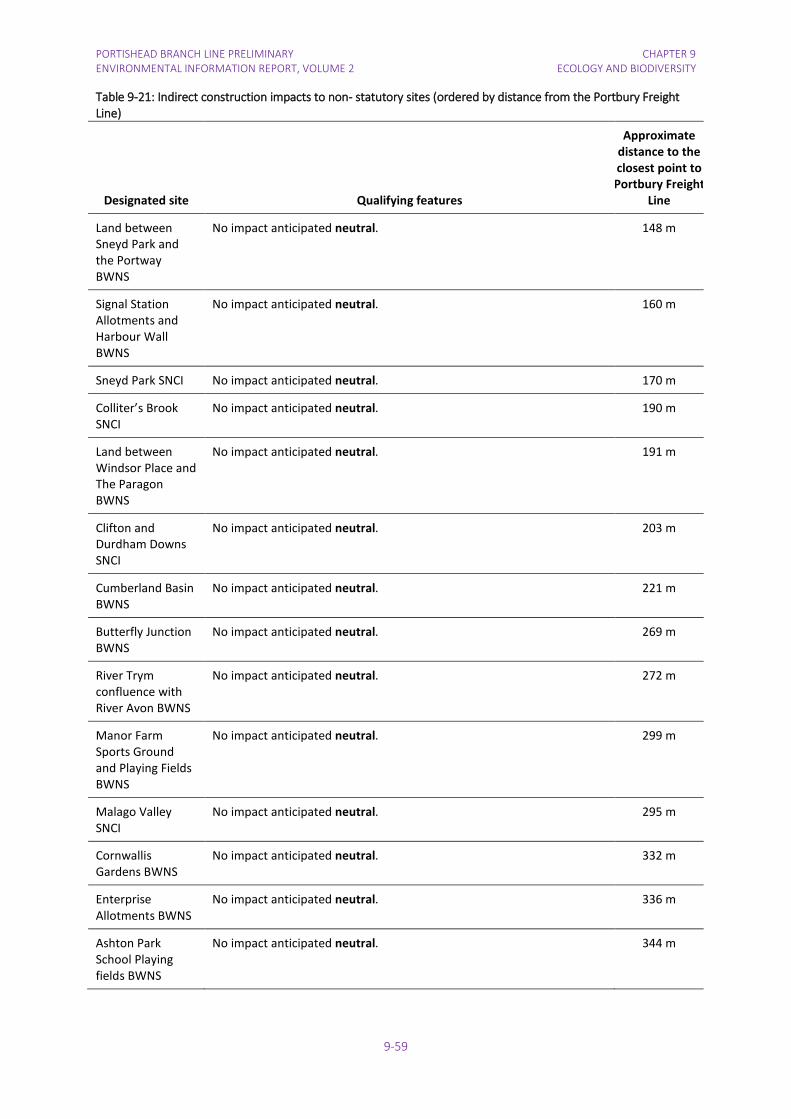
PORTISHEAD BRANCH LINE PRELIMINARY ENVIRONMENTAL INFORMATION REPORT, VOLUME 2
CHAPTER 9 ECOLOGY AND BIODIVERSITY
9-59
Table 9-21: Indirect construction impacts to non- statutory sites (ordered by distance from the Portbury Freight Line)
Designated site Qualifying features
Approximate distance to the closest point to Portbury Freight
Line
Land between Sneyd Park and the Portway BWNS
No impact anticipated neutral. 148 m
Signal Station Allotments and Harbour Wall BWNS
No impact anticipated neutral. 160 m
Sneyd Park SNCI No impact anticipated neutral. 170 m
Colliter’s Brook SNCI
No impact anticipated neutral. 190 m
Land between Windsor Place and The Paragon BWNS
No impact anticipated neutral. 191 m
Clifton and Durdham Downs SNCI
No impact anticipated neutral. 203 m
Cumberland Basin BWNS
No impact anticipated neutral. 221 m
Butterfly Junction BWNS
No impact anticipated neutral. 269 m
River Trym confluence with River Avon BWNS
No impact anticipated neutral. 272 m
Manor Farm Sports Ground and Playing Fields BWNS
No impact anticipated neutral. 299 m
Malago Valley SNCI
No impact anticipated neutral. 295 m
Cornwallis Gardens BWNS
No impact anticipated neutral. 332 m
Enterprise Allotments BWNS
No impact anticipated neutral. 336 m
Ashton Park School Playing fields BWNS
No impact anticipated neutral. 344 m
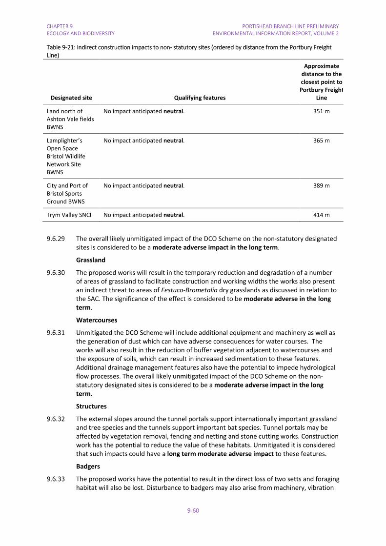
CHAPTER 9 ECOLOGY AND BIODIVERSITY
PORTISHEAD BRANCH LINE PRELIMINARY ENVIRONMENTAL INFORMATION REPORT, VOLUME 2
9-60
Table 9-21: Indirect construction impacts to non- statutory sites (ordered by distance from the Portbury Freight Line)
Designated site Qualifying features
Approximate distance to the closest point to Portbury Freight
Line
Land north of Ashton Vale fields BWNS
No impact anticipated neutral. 351 m
Lamplighter’s Open Space Bristol Wildlife Network Site BWNS
No impact anticipated neutral. 365 m
City and Port of Bristol Sports Ground BWNS
No impact anticipated neutral. 389 m
Trym Valley SNCI No impact anticipated neutral. 414 m
The overall likely unmitigated impact of the DCO Scheme on the non-statutory designated sites is considered to be a moderate adverse impact in the long term.
Grassland
The proposed works will result in the temporary reduction and degradation of a number of areas of grassland to facilitate construction and working widths the works also present an indirect threat to areas of Festuco-Brometalia dry grasslands as discussed in relation to the SAC. The significance of the effect is considered to be moderate adverse in the long term.
Watercourses
Unmitigated the DCO Scheme will include additional equipment and machinery as well as the generation of dust which can have adverse consequences for water courses. The works will also result in the reduction of buffer vegetation adjacent to watercourses and the exposure of soils, which can result in increased sedimentation to these features. Additional drainage management features also have the potential to impede hydrological flow processes. The overall likely unmitigated impact of the DCO Scheme on the non-statutory designated sites is considered to be a moderate adverse impact in the long term.
Structures
The external slopes around the tunnel portals support internationally important grassland and tree species and the tunnels support important bat species. Tunnel portals may be affected by vegetation removal, fencing and netting and stone cutting works. Construction work has the potential to reduce the value of these habitats. Unmitigated it is considered that such impacts could have a long term moderate adverse impact to these features.
Badgers
The proposed works have the potential to result in the direct loss of two setts and foraging habitat will also be lost. Disturbance to badgers may also arise from machinery, vibration

PORTISHEAD BRANCH LINE PRELIMINARY ENVIRONMENTAL INFORMATION REPORT, VOLUME 2
CHAPTER 9 ECOLOGY AND BIODIVERSITY
9-61
and noise, together with potential injury and death of badgers. Unmitigated this will be a short term moderate adverse impact to badgers.
Bats
Upgrade of the Portbury Freight Line will include remedial work to Clifton Tunnel No. 2 which is an important roost site (local importance) that is occupied throughout most of the year by low numbers of bats. Unmitigated, works have the potential to kill, injure and disturb bats causing a moderate long term adverse impact to bats.
Birds
Vegetation removal will result in the reduction of available nesting and forage habitat for birds. If under taken during the nesting bird season this may result in the death or injury of birds. Unmitigated this will be a short term moderate adverse impact to birds.
Piling will be undertaken for the construction of the footbridge at Pill Station, approximately 340 m from the Severn Estuary internationally and nationally designated site, important for overwintering birds and waterfowl. Other construction works at Avon Road Bridge are approximately 60 m from the designated site. Adverse impacts are not expected as discussed in Section 9.6.21 and the effect on overwintering birds is considered to be neutral.
Reptiles
The site and adjacent corridor support widespread reptile species. Construction activities such as site clearance, excavation and the construction of haul routes have the potential to kill and injure reptiles, degrade and fragment habitats and reduce opportunities for hibernation and forage. Unmitigated this impact could result in the localised decline of animals that would be recruited into the population, this is likely to have a moderate long term impact to reptiles in the vicinity of the scheme.
Invertebrates
There will be some losses of woodland and grassland habitat used by invertebrates due to vegetation clearance for construction the DCO Scheme. However, extensive areas of suitable habitat will remain. The magnitude of effect on invertebrates is negligible and the significance of the effect is considered to be neutral.
Otter
Otters may be affected by disturbance from construction noise, lighting and visual impacts. In the absence of mitigation, the magnitude of the impact to otters will be minor adverse and the significance of effects on otters is considered to be moderate adverse in the long term.
Plants
Veronica spicata and Arabis stricta, both statutorily protected Schedule 8 species, should be unaffected by the proposals. Although both occur on rocks immediately adjacent to the track, where they could be inadvertently damaged by construction works.
Of the other rare plants, only Cardamine impatiens and Hypericum montanum which occur on the railway ballast and in the cess are directly at risk from construction.
The ballast cleaning will remove any Cardamine impatiens plants and any seedbank in the ballast. Use of herbicides along the immediate track will may eliminate populations there.
Hypericum montanum currently occurs along the edge of the cess, and 11 plants may be affected by ballast cleaning.

CHAPTER 9 ECOLOGY AND BIODIVERSITY
PORTISHEAD BRANCH LINE PRELIMINARY ENVIRONMENTAL INFORMATION REPORT, VOLUME 2
9-62
Impacts on Sorbus The impacts on Sorbus are set out in Table 9-22 below.
Table 9-22: Numbers of individuals of Sorbus affected
Species IUCN Conservation status 2016 Lost/directly affected May be affected
S. avonensis Critically Endangered 11 9
S. bristoliensis Endangered 3 2
S. eminens Vulnerable 34 3
S. leighensis Endangered 2 12
S. porrigentiformis Vulnerable 0 2
The key impacts on whitebeams are:
• Loss of 11 trees of S. avonensis (Chainage 6920-6980) in the cutting and area exiting the tunnel; this is a significant proportion (26%) of the c. 42 known individuals of this rare endemic. This is a significant impact and will seriously affect the affect the value of the population in the SAC.
• Loss of 34 trees of S. eminens (Chainage 9090-9280), mostly growing along the top of the retaining wall in a group of 26 trees. The total world population is c. 800+ trees (no systematic survey data available) and this is about 8% of the population in the study area, and about 4% of the world population. This is a significant impact and will seriously affect the affect the value of the population in the SAC.
• Loss of 2 trees of S. leighensis. This is about 0.67% of the total world population and is a more minor impact on the population in the SAC.
• Loss of 3 trees of S. bristoliensis. This is about 1% of the total world population and is a more minor impact on the population in the SAC.
In the absence of mitigation the loss of critically endangered and notable plant species as a result of the proposed works is anticipated to be an overall long term major adverse impact.
Non-native and invasive plants
The proposed works have the potential to promote the spread dispersal of invasive species. These species compete with the slower growing notable and important plant species for growth and nutrients. Promoting their spread either through the movement of machinery and personnel or during site clearance has the potential to cause a long term major adverse impact.
Operation Phase Portishead to Pill Internationally and nationally designated sites
The DCO Scheme may result in increased recreational/tourism disturbance to the Severn Estuary designated site in the operational phase. There may be some increase in levels of noise disturbance and increase in recreational activities in this area once the new railway service is operational, but these are predicted to have a neutral effect considering the presence of extensive residential and commercial areas nearby. It is anticipated that birds

PORTISHEAD BRANCH LINE PRELIMINARY ENVIRONMENTAL INFORMATION REPORT, VOLUME 2
CHAPTER 9 ECOLOGY AND BIODIVERSITY
9-63
will quickly habituate to the noise from passage of trains and disturbance associated with use of Sheepway maintenance track.
Non statutory designated sites
The Sheepway access track at Portbury Wharf Nature Reserve will be used no more than twice a month for a van access and no less than once in 12 months for low loader access. It will be used as a van access to undertake routine maintenance (such as track patrolling) and as a rail access for renewals works using machines brought in by low loaders. No storage is planned at this location (other than temporarily for renewals works). It is anticipated that birds and other species at the Portbury Wharf Nature Reserve will quickly habituate to the noise associated with use of the Sheepway maintenance track and the effect is considered to be neutral.
An extension of the bridleway is proposed through the field east of the M5 motorway NSWS. This track will not be lit and will therefore not have any detrimental effect on otters or bats. Operational use of the 2 m wide track is considered to have a neutral effect.
Woodland and trees
Unmitigated, some vegetation removed during construction clearance may naturally re-establish. However, clearance of woodland and trees, in accordance with standard rail clearance regimes, to maintain operational site widths and the application of herbicides to maintain this vegetation free corridor has the potential to degrade the vegetative corridor further resulting in a long term moderate adverse effect.
Badgers
It is likely that badgers will quickly habituate to the increased numbers and higher speed trains. However it is considered likely that the increase in use will result in a minor increase in collision associated casualties and is therefore considered to have a slight adverse effect.
Bats
The assessment of the scheme on bats is in progress pending ongoing surveys and will be reported in the ES.
Birds
Bird habitat will re-establish post construction within the railway corridor. Over a 15 year period, compared to the baseline the magnitude of the effect on the linear corridor with is minor adverse and the significance of the operational effect on breeding birds, including barn owl is considered to be neutral.
The operational effect on overwintering birds is discussed in Section 9.6.35-36 and is considered to be neutral.
Reptiles and Amphibians
Network Rail maintenance allows for a mosaic habitat of rough grassland, scrub and trees to be present within the railway corridor, which will be suitable for reptiles. Operational effects are considered to be neutral.
Invertebrates
The linear corridor of rough grassland, trees and scrub will re-establish post construction within the unmanaged section of the railway corridor. Compared to the baseline, the operational effects are considered to be a slight beneficial effect due to the changing habitat from primarily dense scrub to a mosaic, more open habitat of greater value to invertebrates.

CHAPTER 9 ECOLOGY AND BIODIVERSITY
PORTISHEAD BRANCH LINE PRELIMINARY ENVIRONMENTAL INFORMATION REPORT, VOLUME 2
9-64
Otter
Operational use of the disused line is unlikely to lead to material disturbance of otters using sites close to the line such as Portbury Wharf Nature Reserve due to the service ceasing at midnight and limited lighting and noise. The magnitude of the impact is negligible and the significance of the effect on otters will be neutral.
Portbury Freight Line
Internationally and nationally designated sites
Operational Impacts on the woodlands of the Avon Gorge include clearance and removal of important and notable species growing close to the railway for the safe running of the trains.
Chapter 7 Air Quality and Greenhouse Gases assesses the impact of the DCO Scheme on air quality including impacts on the Avon Gorge SAC. Predicted nitrogen deposition rates for all scenarios exceed the critical load range (10 to 20 N kg ha-1 yr-1) for all habitats within the SAC in the Base Year. The impact of the DCO Scheme on N-deposition is small for all receptors with increases in deposition rates of up to 0.07 kg N kg ha-1 yr-1. The greatest changes are shown at the receptors located closest to the railway line, which is consistent with the results reported for NOx concentrations, and these do drop off with distance. Overall, the impact on nitrogen deposition as a result of the DCO Scheme is less than 0.3 % at all receptors. This is a small change, which is considered to be not significant in regards to the EIA Regulations.
Operational impacts on overwintering birds and waterfowl using the Severn Estuary SPA/Ramsar/SSSI are not predicted to be significant. Pill Marshes and the adjacent intertidal section of the River Severn are currently subject to a range of noise and visual disturbance, including the freight rail traffic, M5 traffic and dog walkers and this is not expected to change following increased rail movements from the running of the passenger line. The magnitude of the impact is no change and the significance of effect is neutral.
Non-statutory designated sites
The assessment of the operational impacts on non-statutory designated sites adjoining the railway is ongoing and will be reported in the ES.,
Woodland and trees
See section 9.6.51 above.
Grassland
It is anticipated that grassland will be affected by operational management of the railway e.g. stone picking and vegetation removal of cliffs where the alignment comes close to the cliffs. A Site Vegetation Management Statement will be drafted in consultation with Natural England for the management of vegetation for the passenger rail service within the Avon Gorge Woodlands SAC/SSSI. Until the Site Management Statement is agreed, the effect is unknown.
Watercourses
No operational impact is anticipated on the watercourses and the effect is considered to be neutral. Further information is provided in Chapter 17 Water Resources, Drainage and Flood Risk.
Structures
The tunnel portals support internationally important grassland species and may require management as part of the operational management of the railway e.g. maintaining

PORTISHEAD BRANCH LINE PRELIMINARY ENVIRONMENTAL INFORMATION REPORT, VOLUME 2
CHAPTER 9 ECOLOGY AND BIODIVERSITY
9-65
fences and netting. A Site Vegetation Management Statement will be drafted in consultation with Natural England for the management of structures for the passenger rail service within the Avon Gorge SAC/SSSI. Until the Site Vegetation Management Statement is agreed, the effect is unknown.
Badgers
It is likely that badgers will quickly habituate to the increased numbers and higher speed trains. However it is considered likely that the increase in use will result in a minor increase in collision associated casualties and is therefore considered to have a slight adverse effect.
Bats
Bat Roosts. Upgrade of Portbury Freight Line will result in an increase in trains through tunnels in the Avon Gorge that are used by roosting bats. The increase in frequency and speed of trains through the tunnels will increase levels of disturbance caused by turbulence and diesel emissions. Whilst this is not expected to disturb crevice dwelling bats such as Myotis species, it is possible that lesser horseshoe bats that hang from the tunnel walls will abandon summer roosts and hibernation sites. The passenger line will run an hourly plus service (45 minutes in the peak periods and hourly in the non-peak periods) until midnight, which may discourage night roosting within all four tunnels on Portbury Freight Line. There may also be disruption to social activity, particularly in autumn when bats are mating. The dark sheltered environment of the tunnels attracts social activity, but this would be disrupted for a short duration as each train passes. There is a small risk that individual bats trapped in the tunnel could be killed, but given the levels of bat activity recorded and frequency of passing trains the magnitude is predicted to be a very minor negative impact. Furthermore, there will be no disturbance from the train service after midnight and consequently no disruption to night roosting or social behaviour within any of the tunnels. Peak social activity by bats often occurs several hours after sunset and therefore the train service does not coincide with the entire period of bat activity and night roosting.
The displacement of lesser horseshoe bats from roosts within Clifton Tunnel No. 1 is predicted to have a minor negative impact on the local population, but given the abundance of potential roost sites in natural features (such as caves) in the Avon Gorge Woodlands SAC/SSSI, it can be predicted with adequate certainty that the impacts will not affect the distribution of bats within their natural range and habitats, or have an adverse effect on the favourable conservation of the species. The minor negative impacts are predicted to have a slight adverse effect on local bat populations, which can be offset with the provision of alternative roosts. Intermittent disturbance due to increased numbers of trains on the railway line will have a moderate impact on social activity within the tunnels, but given the tunnels are not swarming sites the impact on social behaviour is considered to be a slight adverse effect.
Birds
Operation of the freight line will not lead to a significant effect on passerine birds due to the small area of habitat affected compared to the habitat available, therefore the magnitude of impact is no change and the significance of the effect is neutral.
No operational impacts are anticipated on overwintering birds as discussed in Section 9.6.59 and the effect is therefore neutral.
Reptiles
The linear corridor of rough grassland, trees and scrub will remain within the railway corridor. On-going management of reptile receptor sites will be undertaken as detailed in

CHAPTER 9 ECOLOGY AND BIODIVERSITY
PORTISHEAD BRANCH LINE PRELIMINARY ENVIRONMENTAL INFORMATION REPORT, VOLUME 2
9-66
the reptile mitigation strategy. Compared to the baseline, the magnitude of the impact is negligible and the significance of the effects are considered to be neutral.
Invertebrates
Vegetation will be managed along the Portbury Freight Line by Network Rail. The magnitude of the impacts will largely be determined by the habitat management regime required for Network Rail’s operations within the Avon Gorge. However, large areas of suitable habitat will remain. The magnitude of effect on invertebrates is negligible and the significance of the effect is considered to be neutral.
Otter
Operational use of the freight line for a passenger service is unlikely to lead to significant disturbance of otters using sites close to the line such as the River Avon due to the service ceasing at midnight and limited additional lighting and noise compared to existing disturbance from freight trains, road noise and use of the River Avon tow path between the freight line and River Avon. The magnitude of the impact is negligible and the significance of the effect on otters will be neutral.
Plants
Vegetation will be managed along the Portbury Freight Line by Network Rail. The magnitude of the impacts will largely be determined by the habitat management regime required for Network Rail’s operations within the Avon Gorge. Such regimes are governed by funding and safety restrictions for the operation of the rail corridor. Without careful and considerate implementation for the sites sensitive features such regimes can lead to the spread of invasive species and the removal of important and notable plants thereby leading to a long term moderate adverse impact.
Decommissioning Phase For the reasons set out at 9.3.12 – 9.3.17 it is not possible to identify realistic options for
decommissioning for assessment and no basis on which to consider that there would be reasonably foreseeable significant environmental impacts on ecological receptors resulting from decommissioning.
9.7 Mitigation and Residual Effects The potential impacts of the DCO Scheme will become clearer once the revised scheme
design for GRIP 3 has been completed. Proposals for woodland management on Network Rail land through the Avon Gorge Woodlands SAC /SSSI will be developed in consultation with Natural England and adjoining land owners, in particular the Forestry Commission and the National Trust. The types of measures being considered include: the removal of invasive species, translocation of rare species of Sorbus, and habitat improvement.
It is anticipated that it will be necessary to apply to Natural England for licences to close badger setts and implement mitigation strategies for European protected species. The scope of these measures is currently being developed and the proposed strategies will be developed in consultation with Natural England. The measures will be presented in shadow licence applications to accompany the DOC application.
Measures to protect flora and fauna during construction are being considered and will be incorporated into the CoCP for the contractor to implement. The CoCP will be presented in the ES and submitted with the DCO application.

PORTISHEAD BRANCH LINE PRELIMINARY ENVIRONMENTAL INFORMATION REPORT, VOLUME 2
CHAPTER 9 ECOLOGY AND BIODIVERSITY
9-67
Consideration is being given to the need for pre-construction ecological surveys. This will be discussed with stakeholders and the details will be presented in the ES and submitted with the DCO application.
Other mitigation measures will be considered as appropriate where adverse (but not significant effects with regards to the EIA Regulations) are identified. The project team is currently finalising the design of the project and appropriate measures will be described and documented in the ES. The ES will also report further on discussions with key stakeholders prior to submission of the DCO application.
9.8 Cumulative Effects Other Projects along the Portishead Branch Line
Three other projects are considered to have potential to lead to adverse cumulative effects in the absence of mitigation, as detailed in Appendix 18.2. These are as follows:
• National Grid Hinkley Point C Connection, which may lead to a moderate adverse effect due to crossing the disused line and impacts on Portbury Wharf Nature Reserve.
• Application reference 12/P/1255/O, furniture store, Wyndham Way, Portishead, which may lead to a slight adverse effect due to great crested newts.
• Application reference 16/P/1987/F, for storage of vehicles and associated infrastructure, including a crossing over the disused railway between the current Royal Portbury Dock estate and land at Court House Farm, Marsh Lane, Easton-in-Gordano. It is anticipated that this project will lead to a moderate adverse effect on great crested newts, bats and barn owls in combination with an unmitigated impact from the DCO Scheme.
Other Works for MetroWest Phase 1 Other elements of MetroWest Phase 1, namely the modifications for Parson Street
Junction (including Liberty Sidings) and Parson Street Station, Bedminster Down Relief Line, Severn Beach / Avonmouth Signalling and Bathampton Turnback comprise small scale works, confined within the existing railway land. These works are to be undertaken by Network Rail under their permitted development rights and do not form part of the DCO Application.
Network Rail has undertaken an environmental appraisal, environmental risk register and environmental action plan of the works required for the modifications for Parson Street Junction, the Bedminster Down Relief Line, Severn Beach / Avonmouth Signalling, and new turnback facility at Bathampton as part of the reporting for Network Rail’s Governance for Railway investment Projects (“GRIP”) process. This process identifies the potential impacts and captures the need for mitigation during design and construction. The results will be carried forward from the present GRIP 3 and 4 phases, into the detailed design phase (GRIP 5) and construction (GRIP 6).
Liberty Lane Freight Depot (MetroWest Phase 1): A buffer stop and trap points are required at the depot entrance, within the sidings to enable the continuation of the existing freight train shunting movements from the depot across Parson Street Junction onto the Up Relief Line. These works are within Network Rail's operational boundary and will be implemented using their General Permitted Development rights. These works must be completed before the Portishead Branch Line DCO Scheme starts operating.
Parson Street Junction (MetroWest Phase 1): Part of the existing junction (switches and crossovers) needs to be renewed, which entails replacement of the track across the
CHAPTER 9 ECOLOGY AND BIODIVERSITY
PORTISHEAD BRANCH LINE PRELIMINARY ENVIRONMENTAL INFORMATION REPORT, VOLUME 2
9-68
junction, replacement of signalling equipment and associated works. These works are within Network Rail's operational boundary and will be implemented using its General Permitted Development rights. These works must be completed before the Portishead Branch Line DCO Scheme starts operating.
Parson Street Station (MetroWest Phase 1): Minor platform works are required to use platform 3, including adjustment to the platform copers, works to improve track drainage and associated works. These works are within Network Rail's operational boundary and will be implemented using its General Permitted Development rights. These works must be completed before the Portishead Branch Line DCO Scheme starts operating.
Bedminster Down Relief Line (MetroWest Phase 1): The Down Carriage Line running from Bristol Temple Meads will be extended past Bedminster station to a new turn out on to the Down Main between Bedminster Station and Parson Street Station. The new turnout is required to enable freight trains returning to Royal Portbury Dock to be held in the southbound direction, allowing passenger trains to pass. The works will include the construction of a new crossover (turnout), renewal of approximately 1 km of track on the Down Carriage Line and associated signalling. These works are within Network Rail's operational boundary and will be implemented using its General Permitted Development rights. These works must be completed before the Portishead Branch Line DCO Scheme starts operating.
Severn Beach / Avonmouth Signalling (MetroWest Phase 1): Minor signalling works are required to enable a longer layover period for passenger trains at Avonmouth station and Severn Beach station. These works are within Network Rail's operational boundary and will be implemented using its General Permitted Development rights. These works are not required for the operation of the Portishead Branch Line DCO Scheme. The effects of these works on ecological features will be insignificant.
Bathampton Turnback (MetroWest Phase 1): The Bathampton Turnback will comprise a new crossover between the existing Up line to London and the Down line to Bristol. A short walkway (unsurfaced path) will be provided on the existing Up loop for train drivers to walk from one end of a train to the other end. After stopping at Bath, the local train from Bristol would continue into the Up loop at Bathampton from the Up line. The driver would then descend onto the walkway, walk to the other end of the train and mount the train, before moving forward and exiting the loop via a new signal and through the crossover to the Down line back to Bristol. All the works will be confined to Network Rail's existing land holding and will be undertaken by Network Rail under its General Permitted Development rights. These works are not required for the operation of the Portishead Branch Line DCO Scheme.
Given the small scale nature of these works and the distances between these projects and the Portishead Branch Line (MetroWest Phase 1) DCO Scheme, it is considered that there are no significant cumulative effects during the construction and operation of these projects on habitats, flora and fauna. Consequently, these works have been scoped out of further cumulative impact assessment for Portishead Branch Line (MetroWest Phase 1) DCO Scheme.
9.9 Limitations Encountered in Compiling the PEI Report The design of the DCO Scheme is still being developed so details such as the alignment of
the pathway and the potential need for vegetation removal are unknown at this stage.
A number of mitigation measures are still being considered as part of the iterative environmental impact assessment. As the PEI Report only demonstrates those

PORTISHEAD BRANCH LINE PRELIMINARY ENVIRONMENTAL INFORMATION REPORT, VOLUME 2
CHAPTER 9 ECOLOGY AND BIODIVERSITY
9-69
environmental effects at a certain point in time pre-application, these will be further refined as the ES to be submitted with the DCO application is finalised.
9.10 Summary Table 9-23 sets out the potential construction and operational impacts and effects on the
resources and features that have been identified.
9.10.1.1 Overall, the ecological impact assessment completed to date indicates that the DCO Scheme, if unmitigated, will have a significant effect on some ecology and biodiversity receptors for the purpose of the EIA Regulations.


PORTISHEAD BRANCH LINE PRELIMINARY ENVIRONMENTAL INFORMATION REPORT, VOLUME 2
CHAPTER 9 ECOLOGY AND BIODIVERSITY
9-71
Table 9-23: Potential Impacts for the DCO Scheme on Ecology
Aspect of the Project Potential Impact Features Mitigation Residual Effects
Construction activities Portishead to Pill
Site clearance, loss of habitat including felling of trees, along the disused section
Loss of habitat, disturbance and risk of harm
• Portbury Wharf NR • Importance: County
Helping to implement the relevant areas of Portbury Wharf Nature Reserve Management Plan (AWT, 2013) such as enhancement of existing grassland for native flora and fauna particularly during reinstatement of the improved grassland field that will be used for the construction compound.
Neutral
• Field east of the M5 motorway NSWS
• Importance: District
Plant scrub with trees. Neutral
• Trees and woodland • Importance: County
The linear corridor of trees and scrub will be retained as far as possible by keeping at least one side of the vegetation along the track and replanting.
Retained trees close to the construction works will be protected by protective fencing.
Replanting with scrub.
Neutral
• Great crested newts • Importance: Local
A great crested newt mitigation strategy will be written and a European Protected Species Licence sought from Natural England prior to commencement of construction works.
Neutral
• Badgers • Importance: Local
A pre-construction badger survey will be undertaken. Piling within 100 m of badger setts and use of heavy machinery within 30 m will be avoided where possible. Temporary fencing will be used to protect retained badger setts from construction impacts. Licence from Natural England will be obtained for any sett closure or disturbance.
Slight adverse
• Bats – structures • Importance: Local/Zone of
influence
Bat licence and artificial replacement roosts. Neutral

CHAPTER 9 ECOLOGY AND BIODIVERSITY
PORTISHEAD BRANCH LINE PRELIMINARY ENVIRONMENTAL INFORMATION REPORT, VOLUME 2
9-72
Table 9-23: Potential Impacts for the DCO Scheme on Ecology
Aspect of the Project Potential Impact Features Mitigation Residual Effects
• Bats – commuting corridor • Importance: Regional
The linear corridor of trees and scrub will be retained as far as possible by keeping at least one side of the vegetation along the track and replanting.
To facilitate movement by bats under the roads new fencing between the railway line and NCN26 will provide linkages for sheltered flight paths along the commuting corridor.
As the railway line passes under the M5 motorway, the underpass may allow passage for bats, but an alternative route for bats will follow the bridleway LA8/67/10, which will divert north and pass under the elevated section of motorway over the River Avon.
To be confirmed
• Breeding birds – railway corridor
• Importance: Local
Vegetation removal will be scheduled to occur outside the breeding bird season (March-August inclusive). If it is not possible to do this, then a check for nesting birds will be undertaken by an experienced ecologist within 24 hours of the works commencing.
Neutral
• Reptiles • Importance: District
Reptiles will be displaced from the working area by strimming or will be translocated. Destructive searches will be undertaken under ecological supervision where required.
Neutral
Construction site pollution incidents and dust
Indirect damage to habitats
• Internationally designated sites
• Importance: International
Best practice pollution prevention and control measures for indirect impacts from dust and water pollution.
Neutral
Construction noise and lighting
Disturbance • Breeding birds – in association with Portbury Wharf NR
• Importance: County
No night time working if possible, directing lighting away from habitats to the north of the construction compound where barn owls may be foraging and screening the site compound if light spill and noise is still considered to lead to disturbance.
Neutral
• Otter • Importance: District
A pre-construction survey for otter will be undertaken.
Where works are to be undertaken close to areas suitable for otters, measures to minimise disturbance will be implemented. During night working, construction noise and vibration will be minimised as far as possible to avoid disturbance to otters.
Slight adverse

PORTISHEAD BRANCH LINE PRELIMINARY ENVIRONMENTAL INFORMATION REPORT, VOLUME 2
CHAPTER 9 ECOLOGY AND BIODIVERSITY
9-73
Table 9-23: Potential Impacts for the DCO Scheme on Ecology
Aspect of the Project Potential Impact Features Mitigation Residual Effects
• Construction activities – Portbury Freight Line
Site clearance, vegetation removal
Loss of habitat, disturbance and risk of harm
• Avon Gorge Woodlands SAC/SSSI/NNR/Ancient woodland, woodland and trees, grassland, structures within SAC
• Importance: International
Minimise habitat loss and implement Site Vegetation Management Statement.
Unknown
• Bower Ashton Playing Fields BWNS
• Importance: District
Planting at Clanage Road construction compound. Slight adverse
• Badgers • Importance: Local
Avoid setts, licence if necessary. Neutral
• Bats • Importance: Local
Avoid roosts, artificial roosts replacement if necessary. Neutral
• Breeding birds • Importance: Local
Vegetation removal will be scheduled to occur outside the breeding bird season (March-August inclusive). If it is not possible to do this, then a check for nesting birds will be undertaken by an experienced ecologist within 24 hours of the works commencing.
Neutral
• Reptiles • Importance: District
Displacement or translocation Slight adverse
Construction site pollution incidents and dust
Indirect damage to habitats
• Internationally designated sites
• Importance: International
Best practice pollution prevention and control measures for indirect impacts from dust and water pollution.
Neutral
Construction noise and lighting
Disturbance • Otter • Importance: District
During night time working minimise light spill, directing lighting away from habitats suitable for otters.
Slight adverse
• Operational activities Portishead to Pill

CHAPTER 9 ECOLOGY AND BIODIVERSITY
PORTISHEAD BRANCH LINE PRELIMINARY ENVIRONMENTAL INFORMATION REPORT, VOLUME 2
9-74
Permanent habitat loss along the disused section
Loss and fragmentation of semi-natural habitats and green infrastructure and loss and fragmentation of associated species populations
• Woodland and trees • Importance: County
Scrub planting, habitat management to maximise biodiversity. Neutral
• Great crested newt • Importance: Local
Pond improvements. Neutral
• Badgers • Importance: Local
Possible loss or no access to foraging (subject to badger bait marking survey).
Unknown
• Bat roosts • Importance: Local
Artificial bat roosts. Neutral
• Bat foraging and commuting • Importance: Regional
Tree and scrub planting, habitat management to maximise biodiversity, monitoring.
Neutral
• Reptiles • Importance: District
Management of railway corridor and receptor sites. Neutral
• Invertebrates • Importance: Local
Open up dense scrub habitat. Slight beneficial
Operational disturbance from rail noise, vibration, lighting, greater number of visitors
Disturbance and disruption to breeding and feeding activity
• Internationally designated sites
• Importance: International
No change. Neutral
• Portbury Wharf Nature Reserve
• Importance: County
Hedgerow with trees to screen maintenance yard. Neutral
• Field east of M5 NSWS • Importance: District
No lighting Neutral
• Otters • Importance: District
Service ceases at midnight, limited increase in noise or lighting Neutral

PORTISHEAD BRANCH LINE PRELIMINARY ENVIRONMENTAL INFORMATION REPORT, VOLUME 2
CHAPTER 9 ECOLOGY AND BIODIVERSITY
9-75
• Operational activities Portbury Freight Line
Permanent habitat loss along the freight line
Loss and fragmentation of habitats and green infrastructure and loss and fragmentation of associated species populations
• Avon Gorge Woodlands SAC/SSSI/NNR/Ancient woodland, woodland and trees, grassland, structures within SAC
• Importance: International
Careful signal sighting, implementation of Site Vegetatoin Management Statement.
Unknown
• Bower Ashton playing field BWNS
• Importance: District
Screening by planting. Neutral
• Badgers • Importance: Local
No effect. Neutral
• Reptiles • Importance: District
Appropriate management of railway corridor and reptile receptor sites. Neutral
• Invasive plants Remove/control as part of the Site Vegetation Management Statement of the Avon Gorge and management of the freight line.
Beneficial
Operational disturbance from rail noise, vibration, lighting, greater number of visitors
Disturbance and disruption to breeding and feeding activity
• Internationally designated sites
• Importance: International
No change. Neutral
• Bats • Importance: Local
Assess likelihood of impact on horseshoe bats hibernation following detailed design and completion of bat hibernation survey.
Unknown
• Field east of M5 NSWS • Importance: District.
No lighting. Neutral
• Otters • Importance: District.
Service ceases at midnight, limited increase in noise or lighting. Neutral


PORTISHEAD BRANCH LINE PRELIMINARY ENVIRONMENTAL INFORMATION REPORT, VOLUME 2
CHAPTER 9 ECOLOGY AND BIODIVERSITY
9-77
9.11 References ARUP, 2015. Phase 1 Habitat Survey: Bedminster to Parson Street and Bathampton. Report number W1097B-ARP-SUR-EEN-000001 produced for Network Rail 16 December 2015.
Avon Wildlife Trust, 2013. Portbury Wharf Nature Reserve Management Plan 2013-2018.
CIEEM, 2016. Guidelines for the ecological impact assessment in the UK and Ireland. Chartered Institute of Ecology and Environmental Management, Winchester.
Eaton et al. 2015. Birds of Conservation Concern 4. Birds of Conservation Concern 4: the population status of birds in the UK, Channel Islands and Isle of Man. British Birds 108, p708–746.
Halcrow, 2011. Ecological Appraisal, Portishead railway. Report for North Somerset Council.
Mitchell-Jones 2004. Bat Mitigation Guidelines. English Nature, Peterborough.
Mott Macdonald 2011. Portishead railway project, Phase 2 habitat and protected species report. Report for North Somerset Council.
Natural England, 2015. Site Improvement Plan, Avon Gorge Woodlands.
9.12 Abbreviations and Acronyms BAP Biodiversity Action Plan BBAP Bristol Biodiversity Action Plan BRERC Bristol Regional Environmental Records Centre BWNS Bristol Wildlife Network Site CRoW Countryside and Rights of Way Act cSAC Candidate Special Area of Conservation eDNA Environmental DNA analysis for presence of great crested newts EIA Environmental Impact Assessment EPS European protected species HRA Habitat Regulations Assessment HSI Habitat Suitability Index IUCN International Union for Conservation of Nature JNCC Joint Nature Conservation Council LNR Local Nature Reserve MAGIC Multi-Agency Geographic Information for the Countryside NE Natural England NERC Natural Environment and Rural Communities Act 2006 NNR National Nature Reserve NPPF National planning policy framework NSBAP North Somerset Biodiversity Action Plan NSC North Somerset Council NVC National Vegetation Classification SAC Special Area of Conservation SCI Sites of community importance SNCI Sites of nature conservation interest SPA Special Protection Area SSSI Site of Special Scientific Interest WCA Wildlife and Countryside Act 1981 (as amended) WS Wildlife site