chapter five community infrastructure · town of star valley ranch municipal master plan final –...
TRANSCRIPT

CHAPTER FIVE COMMUNITY INFRASTRUCTURE
5.1 INTRODUCTION
Chapter Five examines various types of community and regional infrastructure that will be needed to support future land use development in Star Valley Ranch. This evaluation focuses upon the municipal road network, the municipal water system, and electrical distribution system. The potential need for a future wastewater collection system is also explored.
Future needs are considered in the context of anticipated community growth that is presented in Chapter Two. The analysis of the municipal water system relies primarily upon recent water system plans completed by Forsgren Associates. The evaluation of municipal road needs is drawn largely from recent road and surface water studies completed by Sunrise Engineering in 2013, as well as insights provided by the Star Valley Ranch Town Council.
5.2 TRANSPORTATION
5.2.1 Vehicular Access to Star Valley Ranch
U.S. Highway 89 is the principal arterial that provides vehicular access to the Town of Star Valley Ranch (Figure 5-1). Between the communities of Thayne and Etna, this highway is a paved, two-lane roadway that provides access to various communities in Star Valley and southeast Idaho. North of Alpine, U.S. Highway 89 provides access to the Town of Jackson, Grand Teton National Park, and Yellowstone National Park. Southwest of Star Valley, U.S. Highway 89 provides an important link to Salt Lake City and various communities in northern Utah.
Four Lincoln County roads extend east of U.S. Highway 89 to Muddy String Road (Lincoln County Road 117). These collectors include Clark Lane (Lincoln County Road 115), Prater Canyon Road (Lincoln County Road 116), Cedar Creek Drive (Lincoln County Road 118), and Perkins Road (Lincoln County Road 119). Each of these roadways, as well as Muddy String Road, are two-lane roadways that are constructed within a 60-foot road right-of-way (Teichert, 2008).
Town of Star Valley Ranch Municipal Master Plan Final – December 5, 2014 Page 5-1

Town of Star Valley Ranch Municipal Master Plan Final – December 5, 2014 Page 5-2

5.2.2 Vehicular Traffic Volumes in the Vicinity of Star Valley Ranch
Seasonal vehicular traffic counts are conducted and used by the Wyoming Department of Transportation to estimate annual daily traffic volumes at selected locations along U.S. Highway 89. Available data for 2013 indicates an average daily traffic of about 4,037 vehicles travel through the intersection of U.S. Highway 89 and Wyoming Highway 239.
Roughly 95 percent of this traffic included travel by passenger vehicles and light trucks (Wyoming Department of Transportation, Planning Program, 2013). Otherwise, no traffic data is available for the Lincoln County roads that intersect with Muddy String Road near Star Valley Ranch.
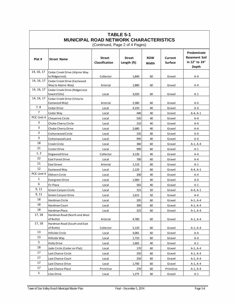
5.2.3 Municipal Vehicular Road Network Town of Star Valley Ranch assumed ownership of all roads in Star Valley Ranch in the spring of 2007. This was achieved by the Town through a “friendly” Eminent Domain action against the Star Valley Ranch Association. The municipal vehicular road network includes some 31 miles of roadway (Figure 5-2 and Table 5-1). The network includes a combination of roadways that have been classified as Town arterials, neighborhood collectors, local and primitive roads. Existing roadways have been constructed within 40, 50, or 60-foot right-of-ways (Sunrise Engineering, 2013). The primary access to the municipal road network is Muddy String Road. This road, which is owned and maintained by Lincoln County, is also considered to be an arterial roadway. Roadways within Star Valley Ranch Classified as Town Arterials • Vista Drive • Cedar Creek Drive • Hardman Road • East Street • portions of Butte Drive
Neighborhood Collector Streets • Vista West Drive • Vista East Drive • Vista Drive (from Muddy String to Alpine) • Birch Drive • Dogwood Drive • Cedar Creek (Hardman to Ridgecrest) • Last Chance Drive • portions of Hardman (Butte Drive to Last Chance Drive) • Bonneville Road • Lilac Drive
All other remaining roadways, which comprise roughly two-thirds of the municipal road network, are classified as local roads. Primitive roads include unimproved roads in the Town of Star Valley Ranch that are located within undeveloped cul-de-sacs. These roads will not be improved by the Town until houses are built on adjoining lots (Sunrise Engineering, 2013).
Town of Star Valley Ranch Municipal Master Plan Final – December 5, 2014 Page 5-3

Town of Star Valley Ranch Municipal Master Plan Final – December 5, 2014 Page 5-4

Plat #
Street Name
Street Classification
Street Length (ft)
ROW Width
Current Surface
Predominate Basement
Soil in 12" to 24" Depth
15 Alpen Way Local 475 60 Gravel A-4 15 Alpenglow Circle Local 800 60 Gravel A-4 15 Alpenglow Drive Local 2,400 60 Gravel A-4 9 Alpine Circle Local 220 50 Gravel A-4
9, 12, 14, Alpine Way (North of Vista) Local 1,060 50, 60 Gravel A-4 9, 12, 14,
16 Alpine Way (Ridgecrest to Cedar Creek)
Arterial
1,550
50, 60
Gravel
A-4
9, 12, 14, 16
Alpine Way (Vista to Ridge Crest)
Arterial
2,700
50, 60
Asphalt
A-4
14, 16 Alta Drive (Eastwood Way to Cedar Creek)
Local
2,900
60
Gravel
A-4
14, 16 Alta Drive (Vista To Eastwood Way)
Local
2,030
60
Gravel
A-4
2, 3 Aspen Way Local 3,540 40 Gravel A-4 PCE Unit 4 Aztec Drive Local 1,125 40 Gravel A-4
5 Barbary Way Local 1,130 40 Gravel A-1 21 Bearlake Drive Local 1,050 60 Gravel A-1 21 Bingham Drive Local 1,120 60 Gravel A-1 2 Birch Circle Local 220 40 Gravel A-4 2 Birch Drive Collector 980 50 Gravel A-4 7 Blackwood Drive Local 790 40 Gravel A-1
21 Bonneville Road Collector 2,220 60 Gravel A-1 3 Box Elder Place Local 185 40 Gravel A-4 4 Bramble Berry Drive Collector 1,615 40 Gravel A-1 4 Brushwood Drive Local 1,090 40 Gravel A-1
21 Butte Drive (East Street to West Street)
Local
2,190
60
Gravel
A-1
21 Butte Drive (East Street to Hardman)
Arterial
1,060
60
Gravel
A-1 13 Canyon Pines Way Local 1,130 60 Gravel A-4
TABLE 5-1 MUNICIPAL ROAD NETWORK CHARACTERISTICS
TOWN OF STAR VALLEY RANCH December 2013
Source: Sunrise Engineering, Inc. (Four pages)
Town of Star Valley Ranch Municipal Master Plan Final – December 5, 2014 Page 5-5
Plat #
Street Name
Street Classification
Street Length (ft)
ROW Width
Current Surface
Predominate Basement Soil in 12" to 24"
Depth 14, 16, 17 Cedar Creek Drive (Alpine Way
to Ridgecrest)
Collector
1,840
60
Gravel
A-4 14, 16, 17 Cedar Creek Drive (Eastwood
Way to Alpine Way)
Arterial
1,880
60
Gravel
A-4 14, 16, 17 Cedar Creek Drive (Ridgecrest
toward Silo)
Local
3,020
60
Gravel
A-1 14, 16, 17 Cedar Creek Drive (Vista to
Eastwood Way)
Arterial
2,580
60
Gravel
A-4 7, 8 Cedar Drive Local 4,150 40 Gravel A-4
7 Cedar Way Local 440 40 Gravel A-4, A-1 PCE Unit 4 Cheyenne Circle Local 520 40 Gravel A-4
3 Choke Cherry Circle Local 210 40 Gravel A-4 3 Choke Cherry Drive Local 2,680 40 Gravel A-4 3 Cottonwood Circle Local 235 40 Gravel A-4 3 Cottonwood Lane Local 995 40 Gravel A-4
18 Creek Circle Local 360 60 Gravel A-1, A-4 21 Custer Drive Local 990 60 Gravel A-1
1, 2 Dogwood Drive Collector 3,130 40 Gravel A-4 22 East Forest Drive Local 700 60 Gravel A-4 21 East Street Arterial 1,110 60 Gravel A-1 12 Eastwood Way Local 1,120 60 Gravel A-4, A-1
PCE Unit 4 Elkhorn Circle Local 200 40 Gravel A-4 1 Evergreen Drive Local 1,960 40 Gravel A-4 6 Fir Place Local 565 40 Gravel A-1
9, 11 Green Canyon Circle Local 315 50 Gravel A-4, A-1 9, 11 Green Canyon Drive Local 1,615 50 Gravel A-4
18 Hardman Circle Local 205 60 Gravel A-1, A-4 18 Hardman Court Local 300 60 Gravel A-1, A-4 18 Hardman Place Local 225 60 Gravel A-1, A-4
17, 18 Hardman Road (North and West of Butte)
Arterial
4,780
60
Gravel
A-1, A-4
17, 18 Hardman Road (South and East of Butte)
Collector
5,120
60
Gravel
A-1, A-4
13 Hillside Circle Local 4,065 60 Gravel A-4 13 Hillside Way Local 1,710 60 Gravel A-4 5 Holly Drive Local 1,665 40 Gravel A-1
18 Jade Circle (Cedar on Plat) Local 170 60 Gravel A-1, A-4 17 Last Chance Circle Local 250 60 Gravel A-1, A-4 17 Last Chance Court Local 250 60 Gravel A-1, A-4 17 Last Chance Drive Local 1,700 60 Gravel A-1, A-4 17 Last Chance Place Primitive 270 60 Primitive A-1, A-4 5 Lilac Drive Local 1,275 40 Gravel A-1
TABLE 5-1 MUNICIPAL ROAD NETWORK CHARACTERISTICS
(Continued, Page 2 of 4 Pages)
Town of Star Valley Ranch Municipal Master Plan Final – December 5, 2014 Page 5-6

TABLE 5-1 MUNICIPAL ROAD NETWORK CHARACTERISTICS
(Continued, Page 3 of 4 Pages)
Plat #
Street Name
Street Classification
Street Length (ft)
ROW Width
Current Surface
Predominate Basement Soil in 12" to 24"
Depth 3 Mahogany Circle Local 170 40 Gravel A-4 3 Mahogany Way Local 2,930 40 Gravel A-4
17 Middle Branch Circle Local 330 60 Gravel A-1, A-4 17 Middle Branch Court Local 320 60 Gravel A-1, A-4 17 Middle Branch Drive Local 2,730 60 Gravel A-1, A-4 17 North Branch Circle Local 675 60 Gravel A-1, A-4 17 North Branch Court Local 300 60 Gravel A-1, A-4 22 North Forest Drive Local 2,270 60 Gravel A-6 6 Oak Drive Local 820 40 Gravel A-1
18 Paint Brush Court (Cedar on Plat) Local 390 60 Gravel A-1, A-4 3 Pine Drive Local 1,305 40 Gravel A-4
12 Pineview Circle Local 275 60 Gravel A-4 PCE Unit 4 Piute Drive Local 1,285 40 Gravel A-4
18 Ponderosa Circle Local 230 60 Gravel A-1, A-4 18 Ponderosa Court Local 220 60 Gravel A-1, A-4 18 Ponderosa Drive Local 2,120 60 Gravel A-1, A-4 18 Ponderosa Place Local 210 60 Gravel A-1, A-4 18 Porto Circle Local 170 60 Gravel A-1, A-4 18 Porto Court Local 325 60 Gravel A-1, A-4 18 Porto Place Local 220 60 Gravel A-1, A-4 18 Porto Road Local 2,300 60 Gravel A-1, A-4
PCE Unit 4 Prater Canyon Drive Local 1,105 40 Gravel A-4 PCE Unit 4 Prater Circle Local 275 40 Gravel A-4
7, 8 Redwood Circle Local 1,190 40 Gravel A-4 6, 7, 8 Redwood Drive Local 2,710 40 Gravel A-4
13 Ridgecrest Circle Local 150 60 Gravel 13 Ridgecrest Drive Arterial 2,110 60 Asphalt A-4 5 Sage Way Local 865 40 Gravel A-1 5 Scrub Oak Drive Local 2,245 40 Gravel A-1
15 Snow Forest Circle Local 430 60 Gravel A-4 15 Snow Forest Drive Local 2,810 60 Gravel A-4 10 Solitude Circle Local 200 50 Gravel A-4 14 Solitude Circle South Local 375 60 Gravel A-4 12 Solitude Court Local 675 60 Gravel A-4
12, 14 Solitude Drive Local 2,650 60 Gravel A-4, A-1 22 South Forest Drive Local 1,630 60 Gravel A-4
Town of Star Valley Ranch Municipal Master Plan Final – December 5, 2014 Page 5-7

TABLE 5-1 MUNICIPAL ROAD NETWORK CHARACTERISTICS
(Continued, Page 4 of 4 Pages)
Plat #
Street Name
Street Classification
Street Length (ft)
ROW Width
Current Surface
Predominate Basement Soil in 12" to 24"
Depth 1, 2 Spruce Drive (North of
Evergreen)
Local
3,570
40
Gravel
A-4 1, 2 Spruce Drive (South of
Evergreen)
Local
1,240
40
Gravel
A-4 7, 8 Spur Wood Drive Local 1,255 40 Gravel A-4, A-6 17 Star Circle Local 350 60 Gravel A-1, A-4 9 Star Peaks Court Local 445 50 Gravel A-4 9 Star Peaks Way Local 800 50 Gravel A-4
10 Sugar Loaf Circle Local 180 50 Gravel A-4 10 Sugar Loaf Drive Local 2,205 50 Gravel A-4 5 Tumbleweed Lane Local 990 40 Gravel A-1 9 Vista Circle Local 230 50 Gravel A-4 9 Vista Court Local 230 50 Gravel A-4
9, 13 Vista Drive (Alpine Way to Star Peaks Way)
Collector
1,230
60
Gravel
A-4
9, 13 Vista Drive (East of Star Peaks Way)
Local
3,555
60
Gravel
A-4, A-1
9, 13 Vista Drive (Muddy String to Alpine Way)
Arterial
3,500
60
Asphalt
A-4
6 Vista East Court Local 250 40 Gravel A-4 6, 7, 9, 11
Vista East Drive (North of Pond)
Collector
2,325
50
Asphalt
A-4 6, 7, 9, 11
Vista East Drive (South of Pond)
Collector
2,055
50
Asphalt
A-4 7, 10 Vista West Drive (Corner of Field
to Vista East)
Collector
2,385
50
Asphalt
A-4, A-6 7, 10 Vista West Drive (Vista East to
Redwood Dr)
Collector
690
50
Gravel
A-4, A-6 7, 10 Vista West Drive(Vista to Corner
of Field)
Collector
2,925
50
Asphalt
A-4, A-6 6, 9, 10, 11 Walnut Drive Local 3,090 50, 40 Gravel A-4 PCE Unit 4 West Elkhorn Drive Local 3,120 40 Gravel A-4
22 West Forest Drive Local 715 60 Gravel A-4 21 West Street Local 1,130 60 Gravel A-1 6 White Pine Avenue Local 775 40 Gravel A-1
10 Wildcat Circle Local 170 50 Gravel A-4
Town of Star Valley Ranch Municipal Master Plan Final – December 5, 2014 Page 5-8

5.2.4 Planned Road Improvements
In a December 2013 Master Roads Study, Sunrise Engineering recommended the completion of various road improvement projects (Table 5-2). A companion Surface Water Study, which also completed by Sunrise Engineering, also included recommended road drainage projects. In combination, these studies included an extensive list of structural and road drainage improvements to various roadways in the Town. In the Master Roads Study, a priority for each road project is also identified along with cost estimates for selected road improvements.
The Town Council re-examined the list of recommended road improvement projects on September 16, 2014, and discussed project priorities for the coming decade with representatives of Sunrise Engineering. These discussions identified a priority for two roadway projects:
• improvements to Cedar Creek Drive from Vista Drive to Hardman Road, Hardman Road to the south and east to Butte Drive, south to East Street, and south on east Street to where it intersects with Perkins Lane. Road improvements envisioned for these roadways include road drainage improvements and improvement of the gravel roadway surface.
• Vista Drive from Cedar Creek to just east of Vista East Drive where the paved surface terminates. Improvements to this roadway segment include improved road drainage, flood control, and roadway with full drainage, subgrade improvements, and construction of a paved, asphalt surface (Redlin, 2014).
It was also determined that pathways be established in conjunction with these road improvement projects if grant funds were available (Redlin, 2014).
5.2.5 Municipal Road Needs
5.2.5.1 Future Road Surfacing
Responses to the Community Survey included a considerable number of residents desiring the construction of paved, road surfaces within the community. The Master Roads Study provides insight concerning a lingering question concerning the type of roads that should be constructed within the Town in the future. Sunrise Engineering recommended that the construction of paved road surfaces should be reserved for roadways with greater traffic. This conclusion was based upon a net present worth analysis that indicated:
• the maintenance of a well-maintained paved road costs approximately 50 percent more than the maintenance of a well-maintained gravel road; and,
• initial construction costs for a paved road are about 80 percent more than for construction of a gravel road.
Town of Star Valley Ranch Municipal Master Plan Final – December 5, 2014 Page 5-9

TABLE 5-2 PLANNED MUNICIPAL ROAD IIMPROVEMENTS
Source: Sunrise Engineering, Inc.
Potential Project Description Project Score Public Safety Property
Protection Cost Impacts to Residents Long Term
Maintenance Public Convenience
Town Infrastructure
Plans Total Score
Reconstruct arterial streets with failing pavements Ridgecrest Drive 17 9 0 63 26 17 132 Vista Drive (Cedar Creek Drive to Vista East) 0 14 0 80 20 52 166 Reconstruct collector street with failing pavements Vista East Drive (North of Pond) 30 26 0 40 12 10 118 Vista East Drive (South of Pond) 75 -13 0 30 40 0 132 Vista West Drive (Corner of Field to Vista East) 0 -8 0 34 0 -10 16 Vista West Drive (Vista East to Redwood Dr) 29 7 0 22 20 0 78 Vista West Drive(Vista to Corner of Field) 28 27 0 80 24 -5 154 Reconfigure roads with poor sight distance or geometry Cedar Drive 133 -5 0 6 36 52 222 Redwood Road 89 2 0 6 28 57 182 Spurwood Drive 44 -5 0 3 10 18 70 Spruce Drive 67 2 0 3 16 18 106 Evergreen Drive 60 -5 0 3 12 13 83 Cottonwood 38 -1 0 0 4 8 49 Pine Drive 48 -1 0 0 8 13 68 Clark and Chokecherry + Birch 56 -28 0 0 7 17 52 Reconfigure roads with steep grades >20% Green Canyon Drive 54 -14 0 30 34 13 117 Redwood Drive 78 -20 0 37 38 -12 121 Snow Forest Drive 63 -76 0 25 26 -42 -4 Spruce Drive (North of Evergreen) 43 -55 0 21 30 13 52 Sugar Loaf Drive 70 12 0 3 40 31 156 Walnut Drive 57 8 0 7 38 8 118 White Pine Avenue 53 -51 0 14 20 -2 34 Construct Roadside Ditches Vista Drive (Cedar Creek to Vista East) 0 22 0 68 40 18 148 Vista West (Vista to Redwood) 0 18 0 72 44 18 152 Vista East (Various Locations) 0 38 0 50 44 18 150 Install Paved Low Water Crossings Cedar Creek Drive 0 32 0 77 26 17 152 Solitude Drive 0 15 0 36 24 17 92 Vista East 0 23 0 40 26 17 106 Choke Cherry Drive 0 29 0 42 26 17 114 Mahogany Way 0 14 0 31 22 17 84 Install asphalt pavement on gravel arterial roads Alpine Way (Ridgecrest to Cedar Creek) 8 26 0 7 26 42 109 Butte Drive (East Street to Hardman) 16 29 0 7 26 42 120 Cedar Creek Drive (Eastwood Way to Alpine
16 29 0 7 32 42 126
Cedar Creek Drive (Vista to Eastwood Way) 16 29 0 7 32 42 126 East Street 16 29 0 7 26 42 120 Hardman Road (North and West of Butte) 16 28 0 7 26 42 119 Install asphalt pavement on gravel collector roads Birch Drive 23 35 0 48 26 42 174 Bonneville Road 4 7 0 48 12 22 93 Bramble Berry Drive 4 7 0 48 12 22 93 Cedar Creek Drive (Alpine Way to Ridgecrest) 16 10 0 7 28 32 93 Dogwood Drive 16 19 0 36 28 22 121 Hardman Road (South and East of Butte) 16 22 0 36 18 22 114 Vista Drive (Alpine Way to Star Peaks Way) 0 19 0 48 12 22 101 Vista West Drive (Vista East to Redwood Dr) 4 13 0 34 12 22 85 Install asphalt pavement on local roads presently
Alpenglow Drive 4 26 0 44 30 14 118 Cedar Creek Drive (Ridgecrest toward Silo) 12 10 0 7 30 22 81 Choke Cherry Drive 16 10 0 44 33 18 121 Cottonwood Lane 16 10 0 22 29 10 87 Green Canyon Drive 16 1 0 29 28 6 80 Last Chance Drive 16 10 0 22 28 10 86 Snow Forest Drive 20 1 0 25 16 0 62 Snow Forest Circle 16 10 0 22 26 0 74 Sugar Loaf Drive 16 10 0 22 28 0 76 Provide Emergency Ingress-Egress Prater Canyon water crossing 32 39 0 22 34 8 135 Emergency Exit from Cedar Drive Area 40 -10 0 -22 28 12 48 Emergency Exit on north end Alpenglow Drive
area 40 -10 0 -11 0 -4 15
Emergency Exit from north Spruce Drive. 40 -10 0 -11 0 -4 15 Emergency Exit from Evergreen Drive
40 -10 0 -11 0 -14 5
Town of Star Valley Ranch Municipal Master Plan Final – December 5, 2014 Page 5-10

During a September 2014 meeting of the Town Council, it was also determined that the Town public works personnel will continue to maintain and improve municipal roads using the best possible gravel surface material and “cold patch” damaged areas of paved road surfaces (Redlin, 2014).
5.2.5.2 Appropriate Scheduling of Road Improvement Projects
Aside from the recommendations of the Master Roads Study, the paving of any municipal roads is not recommended until planned water system improvements for the water distribution system are completed by the Town of Star Valley Ranch. Ideally, these improvements could be made immediately following the installation of planned water distribution system improvements along these roadways.
5.2.6 U.S. Forest Service Emergency Access Needs
In the event of a wildfire within Star Valley Ranch or a forest fire within Bridger-Teton National Forest, the U.S. Forest Service needs a designated route to facilitate vehicular access for fire suppression and other emergency vehicles. Both Vista Drive and Cedar Creek Drive represent potential options because of their available road right-of way and proximity to a U.S. Forest Service parking area north of the SVRA Silo Building. However, the preferred route for the designated emergency access would be via Vista Drive, Alpine Way, and Ridgecrest. A formal, written agreement, which identifies the use of this access route during future emergency conditions, should be adopted by the Town of Star Valley Ranch and the U.S. Forest Service, to ensure a predictable and efficient response by Forest Service fire crews.
5.2.7 Lincoln County Road Needs
5.2.7.1 Bus Stops
Lincoln County School District presently provides bus transportation for Star Valley Ranch children who attend elementary, middle, and high schools in Star Valley. Several student bus stops are located along Muddy String Road, as well as within Town. Some parents with children desire Lincoln County to build more identifiable bus stops that would each contain a bus shelter. Adjacent to each shelter, parents report that there is also a need for some limited vehicular parking areas along the road right-of-way.
5.2.7.2 Improved Road Shoulders
The Star Valley Trails and Open Space Plan calls for the establishment of striped bicycle shoulders along three Lincoln County roads in the vicinity of Star Valley Ranch. These roads include Muddy String Road, Clark Lane, and Cedar Creek Drive (Lincoln County Office of Planning and Development, 2006).
The plan envisions that the striped bicycle shoulders could be accommodated on paved lanes that contain a pavement width of, at least, 14 feet. The typical bicycle shoulder should contain four feet of paving, but a five-foot pavement width is recommended for uphill road segments and road segments that include bridge railings or guard rails (Lincoln County Office of Planning and Development, 2006).
Town of Star Valley Ranch Municipal Master Plan Final – December 5, 2014 Page 5-11
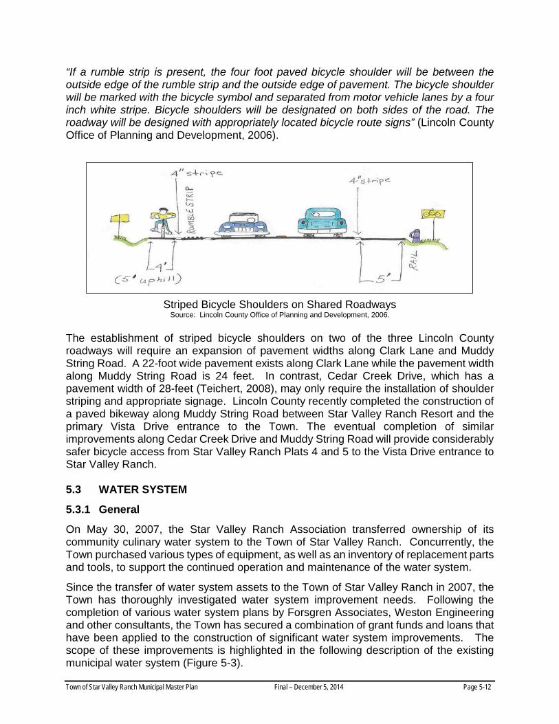
“If a rumble strip is present, the four foot paved bicycle shoulder will be between the outside edge of the rumble strip and the outside edge of pavement. The bicycle shoulder will be marked with the bicycle symbol and separated from motor vehicle lanes by a four inch white stripe. Bicycle shoulders will be designated on both sides of the road. The roadway will be designed with appropriately located bicycle route signs” (Lincoln County Office of Planning and Development, 2006).
Striped Bicycle Shoulders on Shared Roadways
Source: Lincoln County Office of Planning and Development, 2006. The establishment of striped bicycle shoulders on two of the three Lincoln County roadways will require an expansion of pavement widths along Clark Lane and Muddy String Road. A 22-foot wide pavement exists along Clark Lane while the pavement width along Muddy String Road is 24 feet. In contrast, Cedar Creek Drive, which has a pavement width of 28-feet (Teichert, 2008), may only require the installation of shoulder striping and appropriate signage. Lincoln County recently completed the construction of a paved bikeway along Muddy String Road between Star Valley Ranch Resort and the primary Vista Drive entrance to the Town. The eventual completion of similar improvements along Cedar Creek Drive and Muddy String Road will provide considerably safer bicycle access from Star Valley Ranch Plats 4 and 5 to the Vista Drive entrance to Star Valley Ranch. 5.3 WATER SYSTEM
5.3.1 General
On May 30, 2007, the Star Valley Ranch Association transferred ownership of its community culinary water system to the Town of Star Valley Ranch. Concurrently, the Town purchased various types of equipment, as well as an inventory of replacement parts and tools, to support the continued operation and maintenance of the water system.
Since the transfer of water system assets to the Town of Star Valley Ranch in 2007, the Town has thoroughly investigated water system improvement needs. Following the completion of various water system plans by Forsgren Associates, Weston Engineering and other consultants, the Town has secured a combination of grant funds and loans that have been applied to the construction of significant water system improvements. The scope of these improvements is highlighted in the following description of the existing municipal water system (Figure 5-3).
Town of Star Valley Ranch Municipal Master Plan Final – December 5, 2014 Page 5-12

Town of Star Valley Ranch Municipal Master Plan Final – December 5, 2014 Page 5-13

While the municipal water system provides potable water to all residential, commercial and public facilities in the Town, there is a second water system in the community. The Star Valley Ranch Association operates and maintains a separate water system that is used to seasonally irrigate the Aspen Hills and Cedar Creek golf courses.
5.3.2 Potable Water Supply
A combination of surface and groundwater sources are used to provide potable water for the municipal water system. However, ground water is the primary source of supply for the municipal water system.
5.3.2.1 Spring Water Supply
A spring in Prater Canyon is situated at about the 7,390-foot elevation. This spring, which was re-conditioned in 2012, provides the culinary system with a supply of roughly 250 gallon per minute (Smith, 2014).
5.3.2.2 Groundwater Supply
Three municipal groundwater wells are used to obtain ground water from local aquifers.
• The Airstrip #1 Well, which is located on the west side of Vista Drive, was completed in 1993, but was re-developed in 2013. This well provides a supply of approximately 300 to 350 gallons per minute (Smith, 2014).
• Well #2 is situated near the municipal public works complex and Fox Run Park. This well, which is operated with a variable speed pump, provides a supply of about 350 gallons per minute (Smith, 2014).
• Well #3 is situated northeast of the First Response building and Mail Center. This well, which also is operated with a variable speed pump, yields a supply of approximately 650 to 700 gallons per minute (Smith, 2014).
5.3.3 Water Storage
Transmission lines from the Prater Canyon spring collection system carry water downslope to two water storage tanks in Prater Canyon. These include an older, buried concrete storage tank which has a storage capacity of approximately 175,000 gallons. A newer 400,000 gallon storage tank was constructed near the older water tank in 2010 (Smith, 2014).
A third water storage facility is located in Green Canyon. This 400,000 gallon water storage facility was purchased from the Star Valley Ranch Association in 2010.
#1
#3
#2
Town of Star Valley Ranch Municipal Master Plan Final – December 5, 2014 Page 5-14

5.3.4 Transmission and Distribution System
The original transmission and distribution system was significantly under-sized and buried at shallow depths. In addition, there were a significant amount of leaks in the transmission and distribution system. These system characteristics contributed to losses in system pressures and required the Town, during winter months, to run water to keep shallow distribution lines from freezing and damaging portions of the water distribution system.
For this reason, the Town replaced all steel transmission and distribution piping that was part of the original water system between 2010 and 2012. The installation of new distribution piping was also supplemented with the installation of new pressure relief valves, control valves and fire hydrants. On a cumulative basis, these improvements, which were substantially completed in October, 2012, encompassed roughly 40 percent of the municipal transmission and distribution system (Wilkes, 2014).
A new pump station was also constructed in Green Canyon. Installed pump station equipment is connected to a SCADA system which enables the off-site monitoring of water system operations and adjustments to rates of water production, water storage volumes, and system pressures.
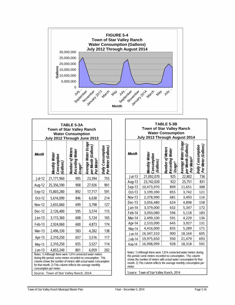
5.3.5 Average Day Demand
Average day demands for the municipal water system reflect highly variable levels of consumption (Figure 5-4). This variability typically reflects the influx of seasonal residents in the months of May and June and their subsequent departure in September or October. For example, 928 of the 1,014 water meters recorded consumption in August 2014 compared to 624 meters recording water usage in December 2013 (Table 5-3B).
• Municipal water meter records from July 2012 and August 2014 indicate that higher summer household consumption (June through September) ranged between 202 gallons per day (gpd) in June 2013 and 901 gpd in August 2012 (Table 5-3A). Higher summer household consumption reflects additional water usage for lawn irrigation, as well as significant system leakage prior to October 2012 when the replacement of about 40 percent of the distribution piping was completed.
• Fall and winter consumption between July 2012 and August 2014 dropped considerably with the normal loss of seasonal residents. Average household consumption was 214 gpd in October 2012 compared to 115 gpd in December 2012.
Town of Star Valley Ranch Municipal Master Plan Final – December 5, 2014 Page 5-15
0
5,000,000
10,000,000
15,000,000
20,000,000
25,000,000
30,000,000G
allo
ns
Month
FIGURE 5-4Town of Star Valley Ranch
Water Consumption (Gallons)July 2012 Through August 2014
TABLE 5-3A Town of Star Valley Ranch
Water Consumption July 2012 Through June 2013
Month Mo
nthl
y Wat
er
Cons
umpt
ion
(Gall
ons)
Num
ber o
f Met
ers
Reco
rdin
g W
ater
Us
age(1
Aver
age W
ater
Usa
ge
per M
onth
(Gall
ons)
Pe
r Met
er(2
Daily
Con
sum
ptio
n Pe
r Met
er (G
allon
s)
Jul-12 21,171,960 905 23,394 755 Aug-12 25,356,590 908 27,926 901 Sep-12 15,803,280 892 17,717 591 Oct-12 5,616,090 846 6,638 214 Nov-12 2,655,060 699 3,798 127 Dec-12 2,126,400 595 3,574 115 Jan-13 3,115,360 608 5,124 165 Feb-13 2,924,060 600 4,873 174 Mar-13 2,496,330 583 4,282 138 Apr-13 2,310,250 657 3,516 117
May-13 2,310,250 655 3,527 114 Jun-13 4,853,240 801 6,059 202
Notes: 1) Although there were 1,014 connected water meters during this period; some meters recorded no consumption. This column shows the number of meters with actual water consumption for that month. 2) This column reflects the average monthly consumption per meter. Source: Town of Star Valley Ranch, 2014
TABLE 5-3B Town of Star Valley Ranch
Water Consumption July 2013 Through August 2014
Month Mo
nthl
y Wat
er
Cons
umpt
ion
(Gall
ons)
Num
ber o
f Met
ers
Reco
rdin
g W
ater
U
sage
(1
Aver
age W
ater
Usa
ge
per M
onth
(Gall
ons)
P
er M
eter
(2
Daily
Con
sum
ptio
n P
er M
eter
(Gall
ons)
Jul-13 21,092,070 925 22,802 736 Aug-13 23,742,020 922 25,751 831 Sep-13 10,473,970 899 11,651 388 Oct-13 3,199,390 855 3,742 121 Nov-13 2,378,990 681 3,493 116 Dec-13 3,056,480 624 4,898 158 Jan-14 3,379,000 632 5,347 172 Feb-14 3,050,080 596 5,118 183 Mar-14 2,499,100 591 4,229 136 Apr-14 2,533,090 645 3,927 131 May-14 4,416,000 835 5,289 171 Jun-14 16,347,310 900 18,164 605 July-14 19,975,650 930 21,479 693
Aug-14 16,998,999 928 18,318 591
Notes: 1) Although there were 1,014 connected water meters during this period; some meters recorded no consumption. This column shows the number of meters with actual water consumption for that month. 2) This column reflects the average monthly consumption per meter.
Source: Town of Star Valley Ranch, 2014
Town of Star Valley Ranch Municipal Master Plan Final – December 5, 2014 Page 5-16
Despite variations in summer precipitation and seasonal resident population, available water meter records for the July 2012-August 2014 period indicate that the replacement of aging distribution piping has clearly contributed to a reduction in household consumption throughout the year. Household consumption ranged between 591 and 693 gallons per day from June-August 2014 compared to between 755 and 901 gpd in July-August of 2012. This represents a 28 to 30 percent reduction in consumption.
5.3.6 Water System Needs
Recent improvements made to surface and groundwater production, water storage, as well as a portion of the transmission and distribution system, will enable the Town to easily meet continuing water demands for the coming decade. In its evaluation of future water demands and the sizing of well production and water storage facilities, Forsgren Associates assumed a potential build-out of the community, i.e., approximately 2,000 equivalent residential units, and an average day consumption of 466 gallons per water connection that would generate the need for a 647 gallon per minute supply. Forsgren Associates also estimated a maximum day demand of 1,470 gallons per water connection that would require a supply of 2,042 gallons per minute (Forsgren Associates, Inc., 2009).
As of January 2014, only 47 percent of the residential lots in the Town have been developed. And, as stated earlier, the potential build-out of the community during the coming decade is expected to range somewhere between 50 and 60 percent.
Despite recent overall improvements to the water system, existing piping in roughly 60 percent of the transmission and distribution system remains significantly under-sized and buried at shallow depths. These conditions thwart the Town's delivery of adequate system pressures, increase system repair costs, and generate some water losses due to leakage in some remaining segments of the distribution system.
The replacement of aging pipe material in roughly 60 percent of the transmission and distribution system represents an essential system improvement that is necessary to:
• provide adequate system pressures to residential customers and fire hydrants needed for fire suppression;
• reduce repairs associated with the freezing of distribution piping that is buried too shallow; and,
• further reduce system leakage and conserve the water resources from local aquifers.
It is also important that the replacement of piping is supplemented with the related installation of pressure relief and control valves, as well as new fire hydrants.
At the time of this report, the Town has applied for a combination of grant and loan funds from the State Lands Investment Board to enable the construction of an initial phase of these improvements.
Town of Star Valley Ranch Municipal Master Plan Final – December 5, 2014 Page 5-17

5.4 WASTEWATER SYSTEM
5.4.1 Introduction
No centralized wastewater system serves the Town of Star Valley Ranch. All homes, community facilities, and public facilities are connected to individual onsite wastewater disposal systems. Most, if not all, of these systems represent septic tank systems with drainfields.
5.4.2 Potential Long-Term Impact of Onsite Wastewater Disposal Systems
Chapter Four discusses, in part, the capability of surface soils to support future land use development. This evaluation considered the capability of soils to support the construction of residential dwellings, as well as the suitability of soils to treat domestic wastewater via septic tanks. This brief analysis concluded that:
• Onsite wastewater disposal systems in the Town, e.g., septic tank with drainfield, generally do not provide adequate soil-based wastewater treatment.
• Inadequate wastewater treatment simply introduces contaminated wastewater into the local ground water.
• The location of two alluvial fans and existing land contours suggest a potential downstream migration of contaminants, e.g., elevated nitrate levels, bacteria and viruses, to some areas west and southwest of Star Valley Ranch.
The potential long-term, impact of wastewater flows generated from an increased “build-out” of the Town is evaluated more specifically by Robert Palmquist, Ph.D. in a 2008 On-Site Wastewater Study for the Town of Star Valley Ranch. This study examines and calculates potential nitrate concentrations and density of virus that might be generated from the continued use of septic tanks and drainfields as a greater build-out occurs in each of the Town's 21 platted subdivisions. The study, concludes, in part:
The results indicate that septic systems in some plats will pose a ground water quality problem. Nitrate concentrations will the exceed EPA limit in Plat 10 at 65 percent build out and virus will enter ground water in all plats south of CR # 116. Viral travel distances will extend beyond Town boundaries for Plats 4, 5, 10, 16, 17, 18, and 21. Water quality problems could appear in domestic wells located adjacent to Plats 17, 18, and 21. If the Shallow and Deep Aquifer are separated by a leaky aquitard, public supply wells in the vicinity of the present Airstrip Well #1 could be affected (Palmquist, 2008).
As of January 2014, the overall build-out of all subdivisions within the Town was approximately 47 percent. In the coming decade, the overall build-out of the Town is expected to range somewhere between 50 and 60 percent. The build-out of subdivision plat 10 in December 2013 was approximately 58 percent. No estimate has been made of when Plat 10 when the build-out of this plat will reach beyond 65 percent, but this could occur sometime near the end of the coming decade. Consequently, the potential impact of effluent from the continued use of septic systems upon groundwater quality represents a potential longer-term consideration.
Town of Star Valley Ranch Municipal Master Plan Final – December 5, 2014 Page 5-18

The results of periodic monitoring at each of the Town's three groundwater wells also provides another important measure of the potential influence of septic tank system effluent discharges upon groundwater quality. The 2013 municipal water quality report of water quality associated with the Town's three groundwater wells indicates little or no influence by septic effluent as nitrate levels ranged only between 0.1 and 0.6 parts per million (ppm) in 2013. Required monitoring of the Town's
groundwater wells will continue to provide an important tool for measuring the potential impact of septic system effluent upon local groundwater quality.
5.4.3 Potential Long-Term Needs
In the long-term, the Town may need to eventually consider alternate approaches to future wastewater management. For example, a long-term solution may require the eventual development of a regional treatment facility by a future wastewater district that can support the treatment of wastewater from the Town and other nearby subdivisions. Any future wastewater management plans should keep in mind that there is no land available within the municipal boundary to support the establishment of municipal wastewater treatment facilities.
5.5 ELECTRICAL ENERGY SYSTEM
5.5.1 General
Lower Valley Energy, based in Afton Wyoming, provides electrical service to the Town of Star Valley Ranch. Lower Valley Energy is a rural, member-owned cooperative that generally serves Lincoln, Sublette and Teton counties in Wyoming; Bonneville and Caribou counties in Idaho; and portions of Yellowstone National Park.
5.5.2 Freedom Substation
Lower Valley Energy operates and maintains an electrical substation near Freedom along the southeast side of U.S Highway 89/Lincoln County Road 116 intersection (Figure 5-5). This substation has been increased to a winter capacity of 27,200 kilowatts (KW). Four feeders from this substation provide electrical energy to the communities of Etna, Freedom, Star Valley Ranch, and Thayne. Three of the four feeders serve different portions of the Town of Star Valley Ranch.
Lower Valley Energy periodically evaluates the capacity of its distribution system to meet the anticipated electrical energy needs of its residential and commercial customers. Lower Valley Energy estimates that peak demands in the service area supported by the Freedom Substation are expected to increase to a peak demand of about 16.0 MW by 2017 (Jones, 2014).
Town of Star Valley Ranch Municipal Master Plan Final – December 5, 2014 Page 5-19
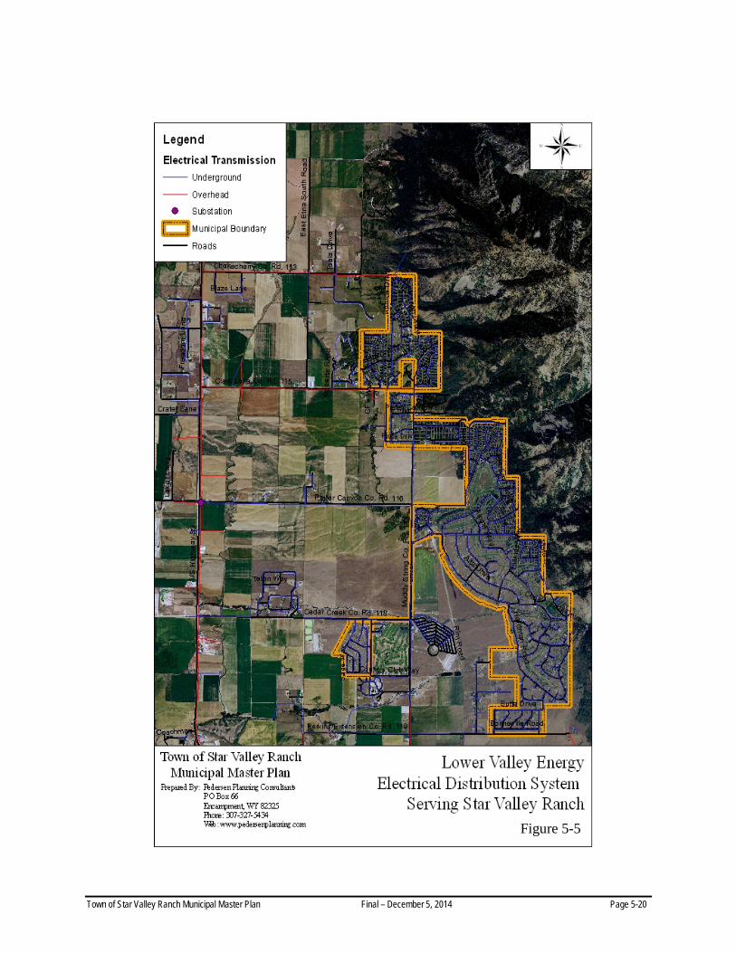
Figure 5-5
Town of Star Valley Ranch Municipal Master Plan Final – December 5, 2014 Page 5-20

5.5.3 Electrical Distribution
The electrical distribution system serving the Town of Star Valley Ranch is owned and operated by Lower Valley Energy. The 7.2 Kv feeder line along Lincoln County Road 113 and the 12.5 Kv feeder line along Lincoln County Road 115 are both overhead lines. In contrast, the 12.5 Kv feeder line along Lincoln County Road 116 is installed underground (Figure 5-4).
Within Star Valley Ranch, the distribution system comprises a combination of 12.5 and 7.2 Kv distribution lines. The entire distribution system within the Town is installed underground (Figure 5-4).
5.5.4 Energy Consumption
Lower Valley Energy services 926 customers within the Town of Star Valley Ranch. The utility projects a peak load of 4,677 Kva during the winter of 2015 (Jones, 2014).
5.5.5 Electrical Distribution Needs
In 2007, engineering representatives of Lower Valley Energy previously indicated that they were investigating possible site alternatives for a new substation somewhere east of U.S. Highway 89. However, after further evaluation, Lower Valley Energy more recently decided to maintain the use of its Freedom Substation (Jones, 2014) which appears to have ample capacity to serve the future energy needs of the Town during the coming decade.
Town of Star Valley Ranch Municipal Master Plan Final – December 5, 2014 Page 5-21