chapter i.-descriptive·
TRANSCRIPT

CHAPTER I.-DESCRIPTIVE·--Seotion A.- Physioal Aspeots.
The name Gurgdon is a corruption of Guru Gaon or village CKl!:..I, A.of a spiritual leader. It is said that Judhistar, leader of the PhysicalPandavaa, gave this village to his guru, Drona Ohara], whose Aspeot •.tank still exists on the west side of the road to the Railway d ~am! allaStation. Another explanation of the name is that Drona Charaj ermUon.gave spiritual instruction to Kairavas and Pandavas.
The total area of the district by the survey of 1873-76 Aorea.is 1,946'87 square miles, and by the recent Settlement measure-ments 1,927'46 square miles.
Gurgaon is the southernmost of the seven districts of the Boun4ariu.Delhi Division,and lies between north latitude 27° 39' and 28°31', and east longitude 76° 21' and 77° 35' forming the extremesouth-east corner of the Province, Its shape is exceedinglyirregular. It is bounded on the north-east by the Delhi district;on the east by the Jamna which separates it from the districtsof Bulandshahr and Aligarh of the United Provinces j on the southby the Mathra district of the United Provinces and by the Stateof Bhartpur; on the west by the Alwar State; on the south.west (that is south of the Rewari tahsil, by the Jaipur par-gana of Kot Kasim, by the Bdwal parqama. of Nabha, and byAlwar; on the north-west by the Kanti pargano, of Nabha ;and on the north by Dujdna, the. British district of Rohtak, andthe little State of Pataudi which it almost embraces in itsclasp.
The Gurgaon and Rewari tahsfLB, forming the northern G • Ii • r &1and western parts of the district, are generally sandy,-the coDfiguralioLlands near the hills being very inferior and often cut up intoa perfect net-work of ravines, while further from the hills, !in some tracts, the soil is better, approaching a light loamin its character; in other places it is of very looseconsistency,and someparts present a desolate appearance with high hillocksof sand. To the south-east and south-west of Gurgaon, the -low-lying lands of a better character are found, whioh arebenefited by natural irrigation; and on the north border ofGurgson is the low basis of the Najafgarh jhil. The banksof the Jamna are generally high; but in the north-east cornerof the Palwal tahslZ there is a small tract between the mainand a small branch ohannel of the river, low-lyingand liableto inundation. From the J amna and this tract westwards thereis a stretch of country some 30 to 35 miles from north tosouth, and some 15 to 20 miles from east to west, of a level~ood loam, rising gradually from the .J amna andthen sloping

2GURGAON DISTRICT.] [PART A.
CHAP. I, A. to the east and south, and extending. over most of the PalwalPhysical tahsil and the eastern portions of the N11hand Ffrozpur iahsile,Aspects. Between this plain and the range of hills mentioned as dividingGeneral Gurg~lon and Alwar, there is in Nuh a low-lying tract of country.
configuration. There the prevailing soil is clay, but immediately under thehill and to the north-east of Nrih and in the north-west ofPalwal, the country is very sandy. The part of Nrih whichlies above the hills is a high-lying table-land of a consistentbut sandy loam, inferior near the hills, but sloping down towardsthe somewhat better lands in its central and· western parts j
while the part of Firozpur not contained in the plain above-mentioned, consists of a valley between two ranges of hills,the lands of which are generally good, but are partly damagedby sand deposits; the soils near the hills are generally in-ferior, and the valley merges on the north in the Nrih tract ofdepression.
-. The hill ranges of the district form a marked feature inits physical characteristics: they are connected with the greatAravali chain, of which they are among the most northernspurs, and like that range their general direction is fromS.-S.- ·W. to N.-N.-E. One chain forms the western borderof the district from the south-western corner of the Firozpurtahsil to a point about opposite the town of Nrih. There thedistrict boundary line turns off to the west, while the rangeruns on in the same course, and then sweeping off in a curveto the west, ends in three short spurs, two thrown out tothe north and one to the west. Another range on the eastof this one runs almost parallel to, but gradually divergingfrom it. After a course of 25 miles northwards from thesouthern border of the district, it becomes more and morebroken, and for 20 miles its existence can only be traced bya line of detached rocky hillocks of various sizes, appearinghere and there above the surface of the ground. Then it oncemore re-appears as a range, and, .forming the north-easternboundary of the district, runs with gradually lessening heightpast the northern boundary of the district into Delhi. Theseare the only chains of any unbroken length; but short brokenranges and detached hills are numerous in the south andwest of Rewari, whence they just cross the border into Rohtakand are also found to the north-east of Rewari, the north.west of N iih, and in the eastern portion of the FJrozpur'tahsil,formerly known as the pa1'gal1a of Punahana. fl'trhe total hillarea of the district is shown by the survey as 99'397 squaremilesf The hills are of inconsiderable height, generally, lessen-ing as you proceed northwards, of the same general characteras the well-known ridge at Delhi, and frequently of considerablebreadth at the summit; the range between Delhi and Gurgaonis in places more than three miles broad. The ordinaryheighl
The hill •.
GURGAON DISTRIOT.]S
[PART A.
of the ranges above the plain is from 500 to 750 feet : the ClIAP. I,A.hill above Meoli is marked on the map as 1,347 feet. above Physicalthe sea, the elevation of the plain below being about 625 Alpectl.feet. The isolated hill of Tankrl is the highest in the district,and must reach quite 2,000 feet above the sea. -.':
On account of the numerous hill ranges. the scenery of Scenery.the greater part of the district is pleasing, and escapes themonotony of the ordinary district of the Punjab plains.
Except the Jamna, the deep stream of which forms the Biyers,eastern boundary of the district and the province, there is no streame, lakes. f flow i h d' . ' and naturalriver 0 permanent ow III t e istrict. drainage.
Owing to the construction of the Western Jamna and Agra The Jamna.Canals the flow of water in the cold season is very small, but in therainy season heaxy floods come down. There are 27 riverainvillages, but in only 20 is the area liable to inundation consider-able. Tho khadar lands are not usually flooded except to asmall extent, and the cultivation is dependent not on flooding buton the rainfall which is assisted by the high level of the springwater. In a normal year the lands are not flooded and thepeople do not want floods. It is only when heavy flood comesdown that it sweeps over the country destroying the crops. Theseinundations are followed by a thick growth of ddb and gandergrasses, against which, with the depredations of wild animals,the peasant has a hard fight to wage. Total cessation of floodingon the other hand leaves the soil dry and infertile, as it consistsof only a thin layer of alluvial deposit over river sand.
The worst part of the khadar is an island formed by 8destructive n<iln called the Jahr, which flows out of the river nearChainsa in the Delhi district and rejoins it lower down in thePalwal tahsil. It runs in a deep, narrow and dangerous channel,and does a great deal of damage in years of heavy flooding; anunsuccessful attempt was made to dam this ndl« at its head, butthe dam was swept away and has not been reconstructed.
The hardness of the life and the precarious nature of the culti-vation cause the tenants, who are of the worst cultivating classes,to desert their villages, and there is a constan t danger of the landfalling out of cultivation: the lands which border on the rivergenerally remain uncultivated and are covered with a thickgrowth of .ihdo (tamarisk) and pula (mlt/lj grass), which shelterdestructive droves of pig and herds of deer.
f 11 . . f he natural drai f h di . t Streams and.The 0 owmg account 0 t e natura ramage 0 t e istrict, lakes.which is abstracted from memoranda prepared by Messrs.Maconaohie and Hallifax, contains information about all theimportant streams and lakes of the district, and shows theirconnection with the natural drainage system >--
"The total area of the Gurgaon district may be taken roughly as'? / _~?,square miles, of which perhaps one-fourth oy 500 miles keep their

ellAP. I, A..
PhllicalA..peeta.Streams and
lakel.
Kadoti drain·all.
Centrel Re·"'ri.
Sahibi drain-al'.
•GUBGAON DISTRICT,]
rainfall in situ, while the remaining 1,51)0 have a drainage slopewhich under flood causes a large proportion of their water to move. Thetwo great places of e~it are-ll) NaJafgarh jhfl for the Kasaoti, Sli.hibi, andNorth Gurgaon drainage systems, and (2) the Bbartpur jhiZ of PahariKandla for the rest, which consists of South Gurgaon, Ballabgarh inflow,central Nuh basin, Landoha floods with inflow from Alwar, South Nuh fiatsand Luhinga. valley drainage. 'I'he area of the drainage, which passesdown into Najafgarh jhil through the Gurgaon district, may be guessedat some 700 square miles while the narrow passage down to Bhartpurprovides the ultimate means of exit for the surplus water of about .1,000miles including 100 miles of Alwnr drainedby the Landoha and 100 nulesofBallabgarh which send their waste waters down to Ntih by Iodri. Thegreater part of the hangar tract of Nuh and Palwal has no dynamicaldrainage. , • "
Beginning at the west there is fil'Et the yaUey of the Kaslioti stream,a hill torrent which rises south of our limits in native territories andcomes in at the south-west corner of H.ewari tah8il from Na.bha. Thisstream is not of great importance to us and flows only in heavy rainfall,but it marks off I!. portion of West Rewari, which, lying in its valley, pre-sents differences of agriculture from the country in its immediate neigh-bourhood on either side. • • •
At NangalPatMni_ the stream passes under the Rewari-FlrozpurRailway, and thence flows away into Rohtak where it joins the Sti.hibibefore falling into the Najafgarh jhil,
In the' neighbourbood of the Kasaoti, though quite distinct from itsdrainage, is a. local flow of water from the bills of Khol towards thenorth and then east through Khaleta to the north-east.
Between the Khol and Khori ranges there is a. considerable drainagecoming in from the south which often reaches Batanri and even further.
East of Khori hills there is some drainage passing north towardsSabaranwas.
Thet:e is D? other drainage requiring notice west of Rewari. Thecountry IS practically speaking fiat and rainfall stays in situ. • • .
East of Rewari the drainage falls into the Sahibi, a powerfnl streamwhich comes into our district from Jaipur rising. about 90 miles away tothe south. Ita western branch, the Sotba, has been 'banded' in theupper }18rtof its course, but there is DO perceptible decrease in its powerand volume. It has a broad sandy bed in Rewari tah8il, After heavy rainin Jaipur, this stream sometimes came down with grea.~ force, and it hastwice flooded the town of Rewari, in 1845 and on the 15th August 1873.On both occasions the water came from the south by Lalpur and Dawana.having left tbe proper bed, which must gradually have been raised bythe deposits of sand in the Alwar State. In August 1873,' the water cameat mid-night, and was some three feet deep in the city; it flowed away tothe northwards in some three or four hours, but caused considerable damagein the city and outside, it utterly destroyed the railway bungalow and619'ept away large portions of the line; but owing to the construction of thebafta at Buch!1rR in Jaipur excessive flooding has ceased, and the watersnow never spread far beyond the river bed.
A section of the Sahibi drainage which approaches it from the Taorupa1'gana of Nuh, tahsU and j;>insit before reaching- the long Railway bridge~~etweeil Jatau~l an~ K;hahIpur deserves separate mention. The Indori1S a stream which rises III Alwal', some 12 or 15 miles south of our border,

GURGAON DISTRICT.]
5[PART A.
CRAP. I. A.
PhysicalAspects.
Bows due north into tho Taoru rCl1'gana and curving round to thewest receives all the drainage west (If the hills overlooking Bhundsf, Sohnaand Nuh. There are 5 (,1' 0 considerable drainages passing down intoit through channels, which in many places are deep ravines in the goodsoil of 'I'aoru, but which eventually debouch in flat levels between U ntonand Bahorac and with the parent stream makea large drainage.
After receiving the Iudori drainage in Pataudi State the Snhibi passesthrough the Railway bridges between Jatauli and Khalilpur, Tbero seemssome foundation for the allegation made that tho heading up of tho COIlJ-
bined streams here has disturbed their course, and has led to tho depositof sand. But the Sahibi has always boon Famous for its vagaries, andsand has always been more 01' less deposited. Any harm done in this wayhas on the whole becn more than counterbalanced by tho increase of mois-ture obtained by the practical heading up by the Railway embankment.'1'110 floods on the Sahibi in 1885 and in 1887 were enormous, while 18i:l8had heavy passages of water for some 4 or 5 days, Nothing ought to belistened to which urgm; a diminution of Wetter either in tho rainfall orby-reason of the Jaipur band on the Letha branch.
After passing through Pataudi the main Sahibi gocs into Rohtak,sweeping round with a wiele curve to tho north. A branch goes moredirectly to the north through the wcst of Paruklmagar tract running inawell defined and rather deep channel through soil for the most part of astiff dark loam.
.• We COlDenow to thc last section of the Nn.jafgarh jhil system, viz., the North GUl·.
North Gurgaon drainage. This itself consists of 2 parts according to iLs g:iondrainagestarting point :-
(a) the hills dividing GUl'gaonfrom Delhi;
(b) the northern slope of the central hills of Gurgaoa tahsil.
Of the first the most important is the Badshahpur ntil« which bringsdown the drainage of part of thc Ballabgarh tahsil. of Delhi, through agorge in the range, dividing Delhi and Gurgaon j it formerly flowedsouthwards through the Bbundsi valley, but more than a century-and-a-half ago it was diverted by the construction of a band. by Bahadur Singhof Ghasera into its present course, falling into the Najafgttrh Jhil. In theheavy Hoods of 1875, part of its stream found out its old channel and sweptdown past Bhundsf, Of the second the chief drainages are the Manef'ar andKasan nalas, which flowing almost in a north-westerly direction fall intothe jhil at its western corner.
We now have arrived at the practical watershed of the district. South Gur-From about 6t miles south of Gurgaon the country begins that slope to the gaon drainagssouth which takes all its drainage below this point down towards Bhart-pur. The most important streams which feed the South Gurgaon drain- The Landohaage are the :MeblldwRl'a,. the Baloj and the Landoha, Of these by far themost important is the Landoha which is formed by the union of two streamsin Alwar, ODeflowing south from the direction of Tijarah and the other joi,-ing it nearlyat right angles from the west. After pursuing its southwardcourse to a point nearly directly west of the southern end of the Ffrozpurtahsil, it sweeps round in a curve, and, crossing the border, flows north.wards up the Ffrozpur valley, and if left to itself would finally fall intothe Kot In ihil. Considerable difficulty has always been exporienced inmaintaining fairly tho respective rights of the Alw&l'and Gurgaon zamin-dara in ite waters.
Sahibi drain.age.
6GURGAON DISTRIOT.] [PART A. ,
CHAP. I, A. Atla~t Settlement, after a long and exhaustive enquiry, the a.-range-Physical ments detailed in paragraph 30 of Mr. Channing's Settlement ReportAspeots. were made with the Alwar State for securing to the zamindars of the
Firozpur valley thei~' fair share ?f the Landoha waters. Tho agreement!r[hn~~~e1\~arrived at may be briefly summarized as foHows:-war State a- (a) The Alwnr State admitted its responsibility to maintain an em-~ohtthe Lan- bankment called the Jat band, so as in all seasons to prevento a. any portion of the stream passing to the east at this point.
(b) The entrance to the channel called E.E.E. in the correspondenceof last Settl ement was to be closed by a masonry dam 2feet high, and, to prevent the bed of the stream at this pointbeing lowered below its present level, a. wall of masonry wassunk across it at right angles, so that the top of the wa.llshould be flush with tbe then bed of tbe stream.
(c) With reference to works situated higher up the stream thanthe points referred to in (a) and (b) it was decided that nointerference could be attempted under the principle acceptedin 1836 on the following recommendation of Mr. Gubbins :-, It would, in my opinion, allow tho Alwar Raja an ampleshare of the water were he permitted to irrigate whateverlands belonging to him are situated higher up the streamthan the point where in its natural COurseit enters onr terri-tory, obliging him at the same time to direct all the waterhe did not so use into its old cha.nnel before it reached us,and not allowing him, to turn any part of the ttaddi intothe Tirbaini jhf.l, which is situate as regards the naturachannel lower down the stream than our territory.'
(d) The Gurgaon authorities were to have a right of inspectionso as to assure themselves of the observance of the arrange-ments arrived at.
Since last Settlement the Alwar State, besides damming most of thetributaries of tho Landoha, has converted the Atria band from a lowearthen etnba.nkment a few chains long into a dam 6, miles long, of whichmore than half is faced with masonry.
A further extension of ~he embankment to the north is contemplated.This action has almost certainly decreased the amount of flooding re-ceived in Ftrospur, but under the principle quoted at (c) no objeotionto it can be taken by Gurga.on.
'Formerly a far more important stream, the Manasne (or Manaslei.e., man-taker}, now generally known 88 the Rupareil, entered the districtfrom Alwar and passed up the Firozpur valley along the Landoha channel.Babar in his autobiography mentions that it then fell into the Kotla lake,but later, it either was artificially diverted or naturally found out it.present course into Bhartp~l'. The tradition as recorded by Mr. C. Gub-bins is, that some Moos violated and then murdered some women in thebed of the river, then dry in the hot winds, and that a. fakir who livednear by left it with the curse, that the streams should lleveragain enterthe polluted bed.
I T~e Me~ndwara.. stream is a powerful drainage, mainly coming fromTho Mehn· the Ro]hka hills, Joined by the unarrested water of the Sohna valley, itsd",ira. floods descend on to the flats north-east and east of Indri hill. 'I'hey
there meet the Sailani drainage which brings in the overflow of'about 100square miles from Ballabgarh. There are, however, a series of hollows anddepreuiona on the way which have to be filled before the water moves,
-'

GUBGAON DISTBIOT.] "[PART A.so that nothing considerable arrives in our jurisdiotion till the rains have ClUJ'. It A.been in progress sometime, but when heavy floods move down, the collect- Ph;;icaled mass of water is enormous. In Augr;st ,1885 there must have been Aspects.15 or 16 square miles of water east of Indri alone, without looking westof the hill, where the expense' was if anything larger.'
The Bdloj rises in Alwar territory in the hills which form the The Bit 10.western boundary of the Firozpur tahsil, and joins the Landohaat Naglna, It often flows with great volume and brings downlarge quantities of sand.
The movement of the South Gurgaon drainage is thus describ-ed by Mr. Hallifax, Deputy Commissioner, in his note on theGurgaon Bands written in 1898 :- "
"Four very considerable depressions in the level of the district areknown as the Khalilpur, Chandaini, Sangel-Ujina and Kotla jMls.
The Khalilpur jhU is ~ituaLed in the north-east ?f ~6h tahsil: it is Khalilpurthe deepest -part of a low pIece of country about 10 miles 10 extent around jhit.Khalilpur, Indri and other villages, regarding which Mr. Maoonaohie hasnoted that "during ordinary rainy seasons the whole DC this is flooded.A part of it just north of Khalilpur village; .... has II. more marked depres-sion: water stands 4 or 5 feet deep here after the rains, and the land isa more or less permanent swamp. • . . Its area may be reckoned atabout 1:500 acres."
The Chandainijhil lies about 10 miles to the west of the OhandainiKhalflpur jMl, and is situated in the north-west of Ntih tahsil. JMZ.Regarding it Mr. Maconachie writes ;-
H Here is another permanent swamp, with standing water which veryrarely dries up altogether. The area which comes under flooding here isabout as large as the Indri jhil, the permanent basin is perhaps somewhatsmaller, say about 1,000 acres."
The Sangel-Ujina jhil is in the south of Nrih, it is not so Sangel.U" aclearly defined a basin as the other jMls, but from this fact, ;I!.il. lID
when water stands in it, it spreads over a larger' area than iscovered at Khalilpur or Chandaini, and the lands of numerousvillages near Sangel and Ujina are widely flooded, so that thedamage caused to them is extremely serious.
ft The fourth and most important jMl, that of Kotla, which is the Kotla jMI.largest in the district being 3 miles long and 2, broad, lies in both Nuhand Firozpur, where these iahsil« adjoin each other at the foot of the AlwarHills. • • . These Jhils are filled by the drainage coming down tothem from all four points of the compass. The north drainage comes fromthe direction of Sohna and is that of the eastern slopes of the Taoru plateauand the spurs adjoining it. From the north-west the Mehndwara, a con-siderable torrent, and some smaller streams come down, bringing thedrainage of 100 square miles between Bhundsi and the hills towards Rojh-ka on the Delhi-Gurgaon . border. -
The line of watershed separating the flow towards Kotla and that to-wards Najafgarh is found at about seven miles from Gurg40n. The re-duced level of what may be taken to be the highest point being about756 feet above the sea at Khadaka and the rainfall of all the country to

MGURGAON DISTRICT.] [PART A.
CHAP.I,A.PhysicalAspects.
Kotla jhil.
the south of this line is therefore thrown towards the Kotla jhil. Thewater of the Selma Mehndwars, and other streams is joined in the flatcountry to the north-east and east of the Indri Hills by the Sailani drain-age, which brings down ,vater from a catchment area of about 100 milesin the Delhi district towards Ballabgarh, and fills two small Jhils at Khunt-puri and Sannathla on its way to Sailiini. A small part of these north andnorth-west floods reached the Ohandaiui jha direct" but they chiefly wentto fill up the Indri-Khalilpur basin, whence they spilled over into Ohan-daini. The general level of both tho Khalilpur and Ohandaini basins, isabout 625 feeG above the sea, thongh parts of the Ohandaini basin arelower. After filling these basins the floods naturally overflow the higherground by which they' are surrounded and find an exit from Ohandaini to-wa.rds the south.v Originally Ohaudaini discharged itself directly iuto theKotla Jhil and Rwelled the volume of water that collected there, thus in-creasing the difficulty of dealing with it. But the Chandaini cut was de-vised to prevent this, and if any overflow now occurs it is taken by the cutinto the Sangel-Ujina flats which are generally lower than the Chandeinibasin itself, being on an average elevation of about 620 feet above sea.level. . . • Bnt the most important drainage toward'! the Kotlajhil is that coming from the south along the Firozpur valley. The Landohawhich has a. catchment area on both sides of the Alwar Hills (from whichthe Jhil' stream also joins it near Ffrozpur) as well as en the hills fromBajhora to Ghata Sliamsabad, collects anenormous volume of water dur-ing its course of over 22 miles. Theclrainage of the hills to the westparticularly the Baloj stream-and of the B:ingar to the past, also flowedinto the Kotla basin, the character of which at an elevation of about 608feet only above sea level, surrounded as it is by high land on all sides,prevented any outlet uutil the ihll was full. When this happened the wholecountry £01' many miles around was under a continuous sheet of water whichfilially escaped by flowing south-east between Bajhera and Kalinjar' roundthe range of hills ending at Bajhera, and continuing its course by Sakrawa,Punahana and Lohinga, filling up and overflowing from numerous depres-sions on the way, till it ultimately reached the Bhartpur border of thedistrict, .
The damage caused hy the jh£ls WIIS thus incalculable. The Kotlajhil before it wa.s protected could never have been dry, the other jhi.ls inwet years would always contain a largo area in the lowest parts of theirbasins which was uneulturablo On account of floods: tl).eykept good landsout of cultivation, and permanently flooded the low IanIs best suited forcultivation: they detrimentally affected the health of the tracts in whichthey were situated, which-and that of Nuh in particular-was at one timea hot bed of fever: and they always, in times of flood, seriously endangeredthe position of the town of Ntih and of all villages near them or the line oftheir overflow."
The above describes the course which the drainage of thedistrict would take if not artificially controlled. As a matter offact, the evils resulting from swamping and uncontrolled floodinghave long been recognised, and attempts were made early in thehistory of the district to drain the swamps and control the floodsby means of embankments. Those in existence 25 years ago havebeen supplemented by many new ones built since 1887 either byor on the initiative of Mr. Maconachie when Deputy Commissioner.A detail of these works is given ill Chapter II, Section A. Herereference neeclonly be made to their effect on the natural drainage.
Drainageworks,

9GtrnG!ON DISTRIOT.] [PART A.
The North Gurg~on works have not of course succeeded in eRA.!:.!. A..draining the Najafgarh jMl all it is fed mainly by the Sahibi, and ryaiCalin years of heavy rainfall there is always a large area submerged apeota.throughout the .year. (At-the beginning of the hot weather of D~aiDag81909 the area was 1,403 acres, and at the same period of 1910 wor.it will probably be 500 aores.) But they have checked harmfulravining and levelled and improved inferior land, and havecaused a more beneficial and profitable distribution of the avail-able moisture. The effect of the South Gurgaon bands is thatthe KhaHlpur iMl is now never submerged and the Chandaini,Kotla and Sangel-Ujina jM.ls are in ordinary years dry by theautumn. It is true that at the end of the extra rabi crop in-spection of 1909 the areas submerged in these basins amountedto 236,998 and 1,781 acres, but 1908-09 was an abnormallywet year and it would not be fair to take it as a test of the bandsystem. The bands are imperfect and capable of considerabledevelopment, but even in their present condition have vastly im-proved the drainage and in consequencethe agriculture and healthof the district.
Geologically the district forms part of the Indo-Gangetic Geology.alluvial plain, but contains also the hills previously mentionedwhich are sedimentary rocks of Peninsular type. They belongto the transition age and form outlines of the Aravali rocks.They are composed of a lower group of slates and limestones,and an upper and much thicker group of quartzetes. The soilcontains plenty of lime and kankar deposits are commonevery-where.
I am indebted to Mr. J. McC. Douie, C.S.!., for the follow- BolDT.ing classificationof the more common or noteworthy trees andshrubs of the district :-
Class. Botanical Name. Local Name.
Anacardiacem ... Mangifera Indica Am.
ApocynllC&e Carissa spinarum ... Murelan.
Bignoniaceal Mi11ingtoniaHortensia ••. ViJAyau BaDin.
Tecoma undulata ..• ... Ruhfra.
:Bixi.nhe ... Hacourtia sepiaria Kakero or Rahfra.
Bovaginaceae cordiamyxa ... Lesora or Lasaura.
Bnrturaceal •.. Balsamodendron mukul Gugal.
(lapparldeae Capparis aphylla ... Karll.
Capparis horrida Hins.
Crataeva re1igiosa Barwa. .,-

CHAP. I. A.-~ca1AIjIeoti.
Bolan),.
10GURGAON DISTRIOT.] (PART A.
Class. Local Name.Botanical Name.
Cinbretaceal
EOOnaceal •••
Ausgeissus Pendula Dhauk.
Diospyr08 montana (grows near tanks. Kamdu.A near relation of the well knownfruit· tree in the hills called Amlok,Diospyros lotus).
Butea Frondosa ,.. DMk.LeguminoslB
Meliace!e •••
Cassia Fistula
Albuzzia Lebbek
Dalbergia SiS8U
Tamarindus Indica
Parkinsonia acerbata
Prosopia spici.gera
Acacia Arabica .••
Acacia Senegal •.•
Acacia Jacquemontii
Acacia Leneophloca
Melia azadirachta
Do. Azedarach
PhOlnix sylvestris
Borassus Flabellifer
Ziziphus jujuba
.. Khijur.
Tiri
•. Ber.
AII1altis.
Siris. '
Shisham.
Imli.
Vil&yati Klkar.
Jant.
Kikar.
Khair.
BambUI.
Nimbar or Raunj,
Nim.
Bak8.in.
PaimeIB
RhaUDe/B ..•
RuliaeelB •.•
BalvadorelB
ZiziphuB Rotundifolia or NummuIaria rurberi.
Mitragyna Parirfolioa or Stephegyne Kaim or Kadam.panrfolia.
Salvadora olooides J&l or Dongar.
Salvadora Persies
Balaintes lBgypteaca Bingo.
Tamarix dioica ... ilio •
Do. articulata Farish.
Ficus glomerata Gular.
Ficus religiosa Pipal.
Ficus I!engalensis Bar.
Beleoptelee integrifolia PMphri.
UrticaceIB
The district is not well wooded,and some portions of it, suchas the low-lying tract in Nuh, are peculiarly bare of trees. InRewa:f the f(JIJ'd8h is especially prev~ent, and here the farashtrees m waste lands and along the village roads often form the

11GUBGAON DISTBICT.] [PAB.T A.
bi t f hi di t' t f h . hi f h 'I CHAP. It A.au jec a an owners IP, ISanc rom t e owners Ip ate SOl. ~The kf/(.a,1'is found all over the district; it grows in large numbers Ib18icalin some villages a few miles south-west of Gurgaon, and in the apeets.Palwal tahstl may be found kikar plantations carefully preserved Botany.by the village communities. The l,xibli 1,;[1';(£1'(Acacia Fa'l'nesiana)is also common. The nfm, is generally found growing in andaround the village sites, where also the p1pal and the bar are offrequent occurrence. In some parts of the district, particularlyin low-lying floodedtracts, in which the soil is naturally sandy,asat SulMnpur in the Gurgaon tahsil, and near Sailtini, the khijuror date-palm grows abundantly; but the fruit is very inferior.In the east and south of the district there are a few scatteredspecimensof the tart or palmyra. The Palwal tahsil is by tar thebest wooded; there most Jat villages preserve a certain'portionof their area sacred from the plough, and regard in a semi-sacrilegious light the cutting down of the trees growing there.The greater part of the vegetation ordinarily found in such bamieor rikhida, as they are called, consists of the karil, the hins or[nokar, the jdl or donqar, the m'ltnjh and the khai« ; but there arealso found the dhdk, the gUla1', the phdpri and the lasaura; as wellas some of the other trees already mentioned. The kadan» isfairly common towards Palwal and Hodal; the baruxi and theimli are met with, but are not common. 'I'he rim is extremelyrare. The bakdin is of ordinary occurrence, and the amalUs isnot very infrequent. The her is planted in orchards for the sakeof its fruit especiallynear large towns, and is also foundelsewhere.The shisham and thesi1'ds are confined to the sidesof the roads,where they have been planted by the District Officers; nearGurgaon a very successfulexperiment has been made in plantingan avenue with the t'ild1Jati balaiin, a handsome quick-growingtree with a beautiful white flower. The special tree of the hillranges is the dha'ltk, at one time the hills are said to have beenvery fairly covered with dlHLule trees, but now, except in a fewplaces where the villages preserve the trees, until they reach asize which fits them for sale, every sapling is at once cut down orgrazed down by goats. On the Tankri hill there are some gttgaZor balsam trees.
,One of the most characteristic plants of the district is the
zizyph'us wuswmularia, ordinarily called peild or jha?'·be1'i. . This iscommonall over the district, except in low-lying inundated tract;but it especially favours high-lying and sandy lands, such as arefound near Taoru and in parts of Rewari ; there in Septemberand October the fields are often so thickly covered with thisprickly shrub that it is not easy either to walk or ride overthem. It is invaluable to the people: the leaves are threshed outand given as fodder to the cattle, the fruit is eaten or taken forsale to the towns, the thorny branches ate used for hedges or fuel, .and the root for dying leather. Hardly less useful is the'irnmj grass

i~GURGAON DISTRICT. j [PART A.
eRA..!:,!, A.. (Saccha:twtn s,zm), which is found all over the district, and seemsIhY8i~I to flourish both in high sandy lands, as near Bolni in Rewari, and
spec 8. in low floodedtracts, as near Pahval on the east. Its uses are tooBotany. well known to require description here. Among the numerous
other plants found in the district, the followingdeserve notice ;-The jkcio covers the low alluvial lands along the banks of the
Jamna j its twigs are used in basket-making and in the construc-tion of temporary well-cylinders. The bdms« (teplwoswi pWl'pm'ea)grows abundantly near the hills; the cylinders of temporarywells are ordinarily made by weaving together its branches.Kihp (o'l't/utllthem viminea) grows on salt land, and used to be usedill the Nrih salt-pans to quicken the crystallization of the salt.Baihua. (chenopodium album) and chaulcii (ama,mnthus ?) arecommonpot herbs: the former grows chiefly in irrigated lands.The seeds of the sdn1Val~ (p(tnicum colom,lm) are also eaten by thepoor. The 1u:ili (ipoma,ea 'reptans), which grows in submergedlands, is also used as a pot herb: and among the wild gourds thekachri (c1wttrnis pubescens) and the banka?'ela imemordica c/tamntia)are eaten by the people. In poor soils near the hills there often~row the kasie grass (saccharum spontane1tm) and the bhurt(cenChr'llS ecki1lal'ltS) with its troublesome and prickly burs; andin the flooded lands of some villages in the north of Firozpur(especiallyin Gohana and Bahddri] is found the narsai (a1''lmdokad,;a), a most tenacious aquatic plant, which it is almostimpossibleto eradicate. Pipe stems are made of its reeds. Theonly other plant which it seems necessary to mention, is thenag-pltani (Oadlls IndiC'lts), which forms a thick hedge round manyvillages in Rewari, and other parts of the district.
Wild Am. ,. The days whentigers aboundedin Gurgaon on the then woodymats. banks of the Jamna, are now long since gone by., The panther
(taind'UJa) is now the largest representative of the feline family.They occasionally appear in the hills, wandering in from theadjacent hilly tracts of Alwar. A large wild cat (banbilla) is alsocommonlyfound in the jungles near the hills. Hyenas have arepresentative in the striped hyena (jarag) not common,andfound only in the neighbourhood of the hills. Wolves (bhel'ia),formerly numerous, are now only scarce, but foxes (lom1'i) andjackals (g{da1') are common in all paris of the district. Themongoose (niola) is common. A larger animal of the same'speciesis found in the hills. It is about twice the size of the ordinarymongoose,and instead of brown, has a dark grey fur. Hares arevery plentiful in all parts of the district, and the porcupine iscommon,generally found in the neighbourhoodof the hills. Ratsand mice are very common, and the bandicoot infests some of thetowns. Dormice are found in all parts, but chiefly in sandy andsaline tracts burrowing in the ground and living in large com..munities, and frequently causing damage to extensive patches ofcultivation. In gardens and groves, the striped squirrel is always

18GUBGAON DISTRICT.] . [PART A.
to be found. Musk rats are common, and so also is the little CHAP. I, A.hedge-hog. Flying faxes are chiefly seen about Gurgaon, where Physicalthey infest some of the gardens. The common bat inhabits old Aspects.ruins and kluil/galls in great numbers. The sacred monkey is to Wild Ani.befound in great numbers about Hodal, and there are also a few mals,in Rewiiri and Gurgiion. The wild boar inhabits the low hillsnear Bhundsf and Sohna, and the kluidar lands of the Janina,
Ruminants are represented by the black buck and the ravinedeer, both of which are fairly plentiful, the latter in the hilly andsandy parts, the former in the low-lands. 'I'he nilgdi is alsofound in the west of the Palwal tali.sil and in the Jamna kluidar.Hogdeer are occasionally met with in the kluidar. During thepast five years rewards amounting to Rs. 1,667 were paid for thedestruction of 27 leopards, 23 wolves, and 5,902 snakes. Thespecies of snakes found are given below.
'I'he jhils of this district attract great numbers and varieties Birds.of water fowl. During the cold months, wild geese, the grey andthe barred, come in great numbers, arriving about the heginningof October. Also ducks of the mallard, pintail, and painted billvarieties; and pochards, sheldrakes, shovellers, red-heads,wigeons and teal swarm in all the marshes, With them also comea host of cranes, the common and the demoiselles; pelicans, spoon-bills, flamingos, grey curlew, snipe, crakes, mils, and sand-pipers.All these winter visitants disappear about the end of March. Thesri'ms, the largest of the cranes, is a permanent resident, andbreeds in the rains. They are usually seen in pairs in thelowlands about Nrih, and the neighbouring villages. '1'he combduck, or uaki«, comes in the rains to breed, and builds its nestgenerally in old ruins. 'I'he painted bill-duck is also a permanentresident of these parts and breeds in the rains. Adjutants andseveral other cranes come in great numbers during the rains.The ibis visits these parts in the rains in great numbers. Peafowlare considered sacred generally throughout the district. Theyare very common, and are chiefly seen about villages. Th« wildor blue pigeon is very common, living in great numbers in ruinsand deserted wells. Green pigeon are more rare, but are fairlyplentiful. The wood pigeon, or stock dove, comes in great flocksduring the cold season, and are chiefly to be seen near Bhadas inthe Firozpur tahsil,' and J atauli between Gurgiion and Rewdri,Grey doves, ring doves, and turtle doves are plentiful. Thereare four kinds of sand-grouse to be found in this district. TheImperial or black-breasted is a winter visitant and abounds inparts of thi? district, from .Novembe!' to the end of Fe?l'uary.They ate chiefly to be seen III the neighbourhood of Gurgaon andFarukhnagar. 'I'he common, the pintail, and the painted, areresidents of the district. The painted are only to be found onthe rocky hills, and are nocturnal in their habits. Grey partridgeabound in every part of the district. The black is also plentiful

14GURGAONDISTRICT.] [PART A.
CRAP.I.A.PhysicalAspects.
Birds.
in some parts. Bush quail, both jungle and rock, are common,and when the wheat is about to ripen in March, the commonquail appears in great numbers. The ubar« is occasionallyseen.The lik or painted florican comeshere to breed in the rains in thesandy parts of the district. The Indian Roller, or blue jay, iscommon,and kingfishers of the blue and the spotted kind areplentiful near jMls.
Tortoises are found in the Jamna, and a small kind in sometanks and wells. The small tortoise is sometimes brought fromlong distances and put into wells and tanks to keep the waterpure. .
Snakes appear only in the hot and rainy season, the com-monest are the cobra and the k'f'ait known here as the Bissunda.The daboia and the afae are also found. Dluuoam, domuhi,kalgandatith, padam, Chamelia, azdahd (python) are occasionallyseen.
The largest of the lizards is the goa, a smaller kind is thebiskabra, supposed -tobe very poisonous. There are also, thehouse lizards, the sand lizards, the sanda, or the edible lizard, thetree lizard or chameleon, and the beautiful bamni lizard.
Besides the J amna and the Agra Canal, there are fewlocalities where fish are to be found. The Jhir stream in the hillpass above Ftrozpur has a few species of small fish, and here andthere some of the large tanks have fishof the ophiscipali (saol) andmacrones (tm1{/'ra) species peculiar to muddy and stagnant waters.There is a large tank at Hodal that contains someof the smallerkinds of river fish. This tank is fed from the Agra Canal. Ofthe jhils in the interior of the district, the Najafgarh lake is theonly one where there are fish, and this is due to this lake beingconnected with the Jamna by the drainage canal. In the lake allthe better kinds of fish can be caught, but fish,as food, are scarcelyknown in this district. A few are occasionally brought from theNajafgarh jhfl into the market at Gurgaon, The following betterkinds of fish are known :-'}'ohn (labes rohita), kalbae (labeskalleas), '1nahsi1'(barbastor). Bhur, narani, bamcha, barn (eel),qwaUi,sing hi, moh, phapta, are the local names of the commoner kinds.
The following complete list of the game birds of the districthas been supplied by Mr. R. Harrison, District Engineer :-The Common Starling •.• '" I Sturnus vulgaris.
'l'he Rose·coloul'ed Paator 01' Jowari Bird .•. Pastor roseus,
The Large or Imperial Sand-grouse... ... Pterocles arenarlus.
The Common Band-grouse Pterocles exustus,
The Pin-tailed Sand- grouse ._. Pterocles alchata,
The Pr.inted Sand-grouse ..• ' Pterocles fascia

GUBGAONDISTRIar.]
The Common Peacock
The Black Partridge
The Common Grey Partridge
The Jungle Bush Quail .••
The Common European Or large Grey Quail
The Black.breasted Rain Quail .••
The Indian Button Quail
The Little Button Quail ••
The Ubara "Bustard
The Saras Crane •.•
The Demoiselle Crane
The Common Crane
The Pin·tail Snipe
The Common Snipe
The Jack. Snipe or Judcock
The Painted Snipe
The Black-tailed Godwit ..•
The Pigmy Rail or Baillous Crake
The Spotted Orake
The Ruddy Crake
The Brown or Ashy Orake
The Grey Leg Goose
The Pink.footed Goose
The White-fronted or Laughing Goose •.
The Dwarf Goose
The Barred-headed Goose
The Comb Duck
. The Cotton Teal
The Lesser Whistling Teal
The Larger Whistling Teal
The Ruddy Shell. drake or Brahminy Duck
The Shell.drake or Barrow Duck
The Shoveller
The Mallard
The Spotted Billed Duck
The Gadwall
he Marbled Teal
Paro cristatus.
Francolinus vulgaris.
ortygornis ponticeriana.
Perdicula Asiatica.
Cotumix communis.
Coturnix coromandelica.
Turnix Joudera,
Tumix dussumieri.
Houbara Macqueenii.
Grus antigone.
Anthropoides virgo.
Grus cinerea.
. -i.·
Gallinago stenura.
GaUinago scolopaeina
Oallinago gallinula,
Rhynchrea capensis.
Limosa regooephala.
Porzana bailloni,
Porzana maruetta.
Porzana fusca.
Porzana akool.
Anser cinereus.
·Anser brachyrrhynchus.
Anser albifrous.
Anser erythropus.
Anser indious.
SarkidiorDia meIanonotu8.
Nettapus oo~mandelianu8 •
Dendrocygna javanica.
Dendrocygna fulva.
Caaaroa ruilla.
Tadorna comuta,
Spatula clypeata.
Anas boscas,
Anas p8lOilorhyncha.
Ohaulelasmus streperus.
ChalllelalIDus angus tirosiIia.
15[PA.RT A.
CHAP.I,A.PhysicalAspects.Birds.
16GURGAON DISTRICT.]
CHAP· I. A.. The Pintail
Physical The WigeonA.spect,.Birds,
Climate.
Rainfall.
[PART A.... , Dafila acuta.
The Common Teal
The Gargruy Teal or Blue-winged Teal
'rhe Bronze-capped Teal
The Bed-crested Pochard
The Tufted Pochard
;
.•. ' Mareca penelope.I
... I Quel'quedula crecca.
.• Querquedula circia.i
••• ! Querquedula falcata.I .
... . Fuligula ruIDns.I
... Fuligula cristata.
The Pochard, Dun-Bird 01' Great-headed i Fuligula ferina.Wigeon.
The White.eyed Pochard or Terruginous Duck Fuligula nyroca.
The Golden Eye or Oarrot •.. CJangula glancion.
The climate generally is more temperate than that of thePunjab proper, the cold in winter and the heat in summer being bothless extreme. N ear the hill ranges, however, and in the Firozpurvalley, bounded as it is by hills on either side, the heat is verygreat; and in some villages which lie immediately under the hills,the people are accustomed to go out in the fields to sleep at night,so as to escape the heat radiated from the glowing masses of rocks.
The flooded tracts near Nrih used to be terribly fever-strickenin years of abundant rainfall, and few men could stand a lengthenedresidence at N uh without injury to their constitution, but theembankments constructed since 1883 have greatly mitigated theunhealthiness of this part of the district. The higher parts of thedistrict, and notably the, Taoru table-land, are very healthy, andthis remark used to apply to the high plain of Palwal and the eastof Null and Firozpur,but the Agra Canal has brought fever intothis tract.
Table 3 shews for each rain-gauge station in the district, theaverage annual rainfall for the agricultural year ending May 31stand the actual rainfall from 1885-86 onwards. Table·4 shews themonthly rainfall in inches at the district head-quarters, while table5 shews the seasonal rainfall at the head-quarters of each tahsil.
The rain-gauge stations given in table 3 are distributed amongthe five tahsils as follows: -
{Jatu~na.
Rewari ... Rewari,SMhjahanpur (moved to Khol in 1904).
{Palwal.
.•. Hodal.(Taoru...·tNuh.Bathin.{Firozpur.
.•• Punahdna,(Farukhnagar •
... ~ Gurg~on.lSohnp,.
Palwal
'-'Nub
Firozpur •.•
Gurgaon 0"
GURGAON DISTRICT.]17
[PART A
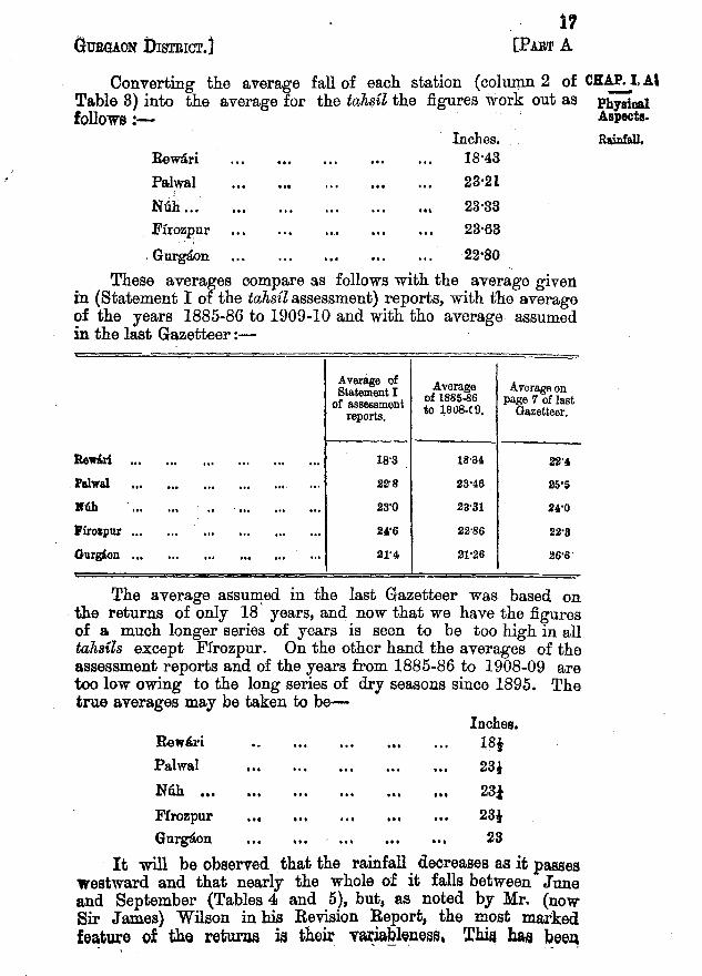
Converting the average fall of each station (column2 of CRAP.I,AlTable 3) into the average for the tahsil the figures work out as PhYsicalfollows!- . Aspects.
Inches. Rainfall.Rewari 18'43Palwal .., 23'21
Nuh ... ••• 23'33. Firozpur 23'68
.Gnrgaon 22'80These averages compareas followswith the average given
in (Statement I of the tahsil assessment)reports, with the averageof the years 1885-86 to 1909-10 and with the average assumedin the last Gazetteer:-
Average of Average Average onStatement Iof assessment of 1885-86 page 7 of last
reports. to ~908.C9. Gazetteer,
ReMri ... ... ... ." ". ." 1S'3 18'34. 22"
ralwal ... ... ". '" ... ,.. 22'8 23'46 25'S
M'Uh ... ... .. ... " ... ... 23'0 23'31 240'0
I'irolpur ... ... .., ". ". ... 240'6 22'86 22'3
Gurgaon ... ,.. ... ... ... .., 21'4 21'26 26'6
The average. assumed in the last Gazetteer was based onthe returns of only 18 years, and now that we have the figuresof a much longer series of years is seen to be too high in alltah8ils except Firozpur. On the other hand the averages of theassessment reports and of the years from 1885-86 to 1908-09 aretoo low owing to the long series of dry seasons since 1895. Thetrue averages may be taken to be-
Inches.Rewari ISlPalwal 23,
NUb ••• ••• 23iFrrozpur 28,Gnrgaon ••• 23
It will be observed that the rainfall decreases as it passeswestward and that nearly the whole of it falls between Juneand September (Tables 4 and 5), but, as noted by Mr. (nowSir James) Wilson in his Revision Report, the most markedfeature of the returna ia their vari~blelle~f3, l'~ hae been
. - - '. - .

isGUBGAON DISTRICT.]
ClU.P. I. A. especially noticeable of recent years-in fact since 1899 years ofPhylical scanty and heavy rainfall have tended to alternate. " Moreover,"Aspects. to quote the same authority, "the success or failure of the cropsRainfall. depends more on the distribution than on the mere amount
of the annual fall; and while the figures showing the totalrainfall are well worth. discussion, they are only a very roughindex to the nature of the seasons as favourable or otherwiseto the crops."
Another characteristic of the local rainfall is its extremepartiality. Heavy rain is often received at one place, whileat another a few. miles away much less or' none at all isreceived.
All these vagaries are due presumably, to the situation ofthe district at the tail end of both the Bay and the Arabian Seacurrents, but, whatever the cause, the resulting precariousnessof the cropping is deplorable. Table 5 shews that nearlythe whole of the annual fall is received between June andSeptember, and that the winter rains are both scanty anduncertain. In consequence the kharif is almost everywhere theimportant harvest, and the rabi harvest on unirrigated landis exceptionally precarious. The few tracts in the district whichare more dependent on their rabi than on their kharif crops,such as the Dahar and Chiknot circles of Niih and Firozpur,the Khadar circle of Palwal and the Sahibi circle of Gurgaon,are notoriously unprosperous.
In the ideal year from the agricultural point of view themonsoon commences by or before the middle of June, asthe yield of the cotton crop depends largely on early rains.The first showers must not be too heavy or the seed in sandylands is washed out and has to be resown.· Good showersalternating with sunshine rare required in July and August.Continuous cloud and rain during these months causes the cropsto mildew and prevents weeding, while if there is too .littlerain or a strong west wind the crops dry up. The first half ofSeptember is the critical period of the whole year, as on therainfall of this period the ripening of the kharif and the sowingof the rabi harvest depend .. The showers must not be too heavyor they will cause the grain of the j01.Va1· and bafrr1l to blackenand rot, but they must be heavy enough' to leave sufficientmoisture in the soil for rabi sowings, and they should continueup to the middle of September. The success of the rabi cropsdepends on adequate showers falling between December 15thand January 15th. A shower in the last half of February is alsovery beneficial, but after this rain is not desired, as there isalwa.ys danger of h~il falling.