chapter-vi - information and library network...
TRANSCRIPT
CHAPTER-VI
lOR REGION: CONTEMPORARY GEOPOLITICAL AND
GEOSTRATEGIC SIGNIFICANCE
Geopolitics is a universally recognised spatial approach to vexed political
problems of various levels- global, regional and local. It is a political paradigm
that helps the practioners of politics or statecraft to identify the criteria for the
choice of problems concerning the interstate relationships, when taken for
applications. Geopolitics, however, is only one of the subjects studied by
political geographers. It is concerned basically with the application of
geographic information and geographic perspectives to the development of a
state's foreign policies. 1 But each state's approach to geopolitics manifests
differences and variations in its dimension because it sets the paradigm in its
own perspective. Taylor (1985) has rightly remarked:
One feature of geopolitics that each researcher's theory invariably fits the particular needs of researcher's country. 2
The fundamentals of geopolitics, however, continue to be the same
since the paradigm was first tested and brought into practice as a means to
model problems and solutions by the German academicians, politicians and
1 M.l. Glassner and H.J. de Blij, Systematic Political Geography (New York: John Willey & Sons,
1979), p. 263. 2
P.J. Taylor, Political Geographv: World Economy Nation-State and Locality (London: Longman. 1985), p. 37.
228
war strategists with regard to their state's 'spatial requirements'. 3 However, its
definition and dimensions have changed over the years which involved
philosophical debates and methodological discussion, whenever, the world
has experienced changes in its political territorial patterns and interstate power
relations as well as equations. As Her:ry Kissinger (1979) claimed:
Geopolitics a synonymity with global equilibrium and permanent national interest in the world balance of power.4
However, in essence, geopolitics is an attempt to draw attention to the
importance of certain geographical patterns in political history. It is a theory of
spatial rel~tionships and historical causation.
Furthermore, it can be argued that geopolitics is to emphasis that
political predominance is a question not just of having power in the sense of
human or material resources, but also in the geographical context within which
that power is exercised. This is not to say that the geographical environment
determines the objectives or strategies of the foreign or internal policies of a
particular state. Instead, geographical configurations present opportunities for
policy makers and politicians.
Every century has its own geographical perspective.5 The geographical
perspective of the twenty-first century is different from that of the twentieth
century. However, the extent to which geographical opportunities will be
exploited depends on strategy that is concerned with the deployment and use
3 SeeS. Adhikari, 'A New Dimension to Post-Cold War Geopolitics', Geographical Review of India. Vol. 61, No. I, March \999. 4 K. Kissinger, The White House Ye~..- (Boston: Little Brown, 1979), p. 914. 5 H.J. Mackinder, Democratic Ideals and Reality (London: Constable, 1919), p. 39.
229
of armed forces to attain particular political objectives. Political objectives are
consequence of choices made by policymakers. It is from these choices that
political and strategic importance is attached to geographical configurations
and locations. It also ieflects the nature of politics as a decision-making
process. In this process the geographical factors which influence politics are
product of policy-makers, selecting particular objectives for the formulation of
strategies. Furthermore, geography can be described as the mother of
strategy.6 In that the geographical configuration of land and sea, with respect
to a state's strategic policy or an alliance between states, can exercise a
twofold strategic influence: on locations important for defence and on the
routes and geographical configurations which in turn favour an attacking force,
be it on land or sea. 7
Geopolitical Change in the Post-Cold War Era
The well known fact is that, evolution of the world geopolitical system follows
organismic developmental principles. Global imbalance is a function of
changes among geostrategic regions. As power becomes more diffused
across the evolving world system so? The geopolitical changes are also taking
shape in the same proportion. After the Second World War, the world was
divided into two geostrategic realms; each controlled by a superpower. But
later on a new balance was then fashioned, as geopolitical regions became
t. Geoffrey Sloan and Colin S. Gray. 'Why Geopolitics?', The Journal of Strategic Studies. June/September 1999. Vol. 22, No. 2/3, p. 3. 7 lbid-3
230
important subsets of the world system8. This was due to the rise of additional
great power centres and the emergence of important regionally based state.
Since the 1980s, many events took place like Soviet withdrawal from
Afghanistan, the tearing down of the Berlin Wall and the unification of
Germany in 1989 and 1990, the collapse of East European Communism,
America's changed status from a creditor to debtor nation,9 the disintegration
of Soviet Union at the end of the Cold War, America's lead role in defeating
Iraq 10, geopolitical change in the Adriatic region (Yugoslavia disintegration),
end of Apartheid regime in South Africa, terrorist attack in the WTC Tower and
the recent fight against terrorism in Afghanistan. These are all part of the
process of geopolitical change. Moreover, change is not limited to the
relationship between the North Atlantic and the European Heartland centres.
The emergence of regional powers in the 1970s (China, Japan, India, Iran and
Australia), developments in most of the developing world in 1980s and
emergence of many trade blocs as well as WTO in 1990s have contributed to
global geopolitical shifts.
Since the cold war the military rivalries have been superseded by the
multinational corporate networks, global capital flows, and the specialization of
industry, technological transfer and adoption. While these forces are viewed
as global, in fact, these also often have regional clustering. This regional
8 Saul B. Cohen, 'Global Geopolitical Change in the Post-Cold War Era', Annals of the Association of
American Geographers. No. 85, 199\, p. 554. 9
Ibid., p. 559. 10
Despite its sweeping military victory, America's political and economic dependence upon the support of other nations tc wage the Gulf War has demonstrated its basic inability to impose American hegemony in the entire world.
231
impact contributes to the salience of the geopolitical region, as the second
order powers interact with other countries in their regional arenas. Smaller
states (in terms of economy, military) like Malaysia, India, Iran, UAE, Israel
and Kenya have become specialised centres of economic and political activity
with the global network. They also have a shadow effect on the regions within
which they are located.
Here one thing is noteworthy to mention that the new major and
regional powers have challenged and in the process changed the bipolar
world, but they have not displaced the Superpowers. Rather, they have
become absorbed within an evolving system. However, one .:;an notice from
the past history that the economic decline and over-extension of military
commitments ultimately brought the downfall of all great powers.
Today's world system is fundamentally different from that of the past. In
the present scenario, the economic hierarchy is not necessarily translated into
a political hierarchy. We have learned from the experience of economically
resurgent Japan and Germany that the exercise of parallel political/military
power is neither necessary nor desirable for a nation to enjoy economic and
social prosperity.
In addition, resources are being increasingly substituted, and a modern
service and high-technology-oriented economy is emerging which relies
increasingly on sophisticated manpower. The power and functions of the
international agencies (Security Council, IMF) are becoming stronger; hence
the major powers no longer wish to assume independent action.
232
Consequently, the gap in international political inequality between large and
small states is narrowing in behaviour. Finally, hegemonic structure is
becoming increasingly complex, as the concept of hierarchy of cultures is now
widely challenged. The old notions of 'Eurocentric' cultural primacy are fading.
Specially, the success of sophisticated offshore Asian economic undermines
the myth of western cultural supremacy.
Geopolitical System
World War II and the end of colonialism paved the way for New World
geopolitical arrangements. In the early post war years the two bipolar realms
were controlled by the Soviet Union and the U.S. There was a general believe
that the Superpowers could influence all parts of their respective geostrategic
arenas, without the need for any intermediaries. However, that system quickly
changed. Within the Maritime World, specialised regional cores like EU and
Japan rose; initially as junior partners and then as friendly competitors to the
U.S.A. Within the Eurasian realm, China soon challenged Russia for strategic
parity and the USA in economic and weapons parity. These new power
centres began to develop independent ties with other states and regions. In
the same way, Pakistan has the capacity to challenge the Supremacy of India.
In the 1970s, a number of regionally important states began to emerge.
This gave added dimension to the regional geopolitical structure. These states
imposed a hierarchy of their own within their respective region. In the lOR
region, India became dominant after defeating Pakistan in war and casted its
stamp upon Bangladesh and Sri Lanka. The emergence of Iraq as an
233
important geopolitical entity is due to the recognition by the Great Powers of
the special strategies and economic significance of the Mesopotamian
region. 11 In the 1980s, Iran and Iraq emerged as dominating powers in the
Middle East. lnspite of their involvement in the war (Iran-Iraq war) during this
period both the countries were called as Germany and France of Asia .12
Entropy and Orders of Powers
A key element in the dynamism of the geopolitical system is the power shifts
among different states and regions. Some power changes are the· result of
domestic development in economic structures and social orders. Others can
be attributed to external and transnational forces. Three orders of national
power: the first or the major, tile second or the regional, and the third or the
sub-regional, affect the balance of the global system. Even lesser order states
are change agents which influence regional and global patterns. Here one can
notice the role of Afghanistan, Iraq, Kosovo, Palestine and Israel in the recent
world geopolitical scenario. As Cohen (1991) in his article 'Global Geopolitical
change in the Post-Cold War Era' use entropy level for scientific explanation of
the world geopolitical system. Entropy level is indicative of the fitness of the
state or region in the various orders of power. It is also a useful measure of
balance in relationships between geopolitical units.
1: IU. de Blij, Systematic Political Geography (New York: John Wiley and Sons, 1973), p. 252.
I. Defined in physical systems, as the availability of energy to do work. Entropy is always on the increase as energy becomes exhausted. Thus a system's ability to work constantly declines. If the world functions as closed geopolitical units, then surely each unit would ultimately collapse. Geopolitical entities whose leadership seeks to close them ofT from outside forces do sutTer from the exhaust ion of their human and natural resources and sink to high levels of entropy. Consequently, they become recharged through energy in the form of peoples, goods and ideas.
234
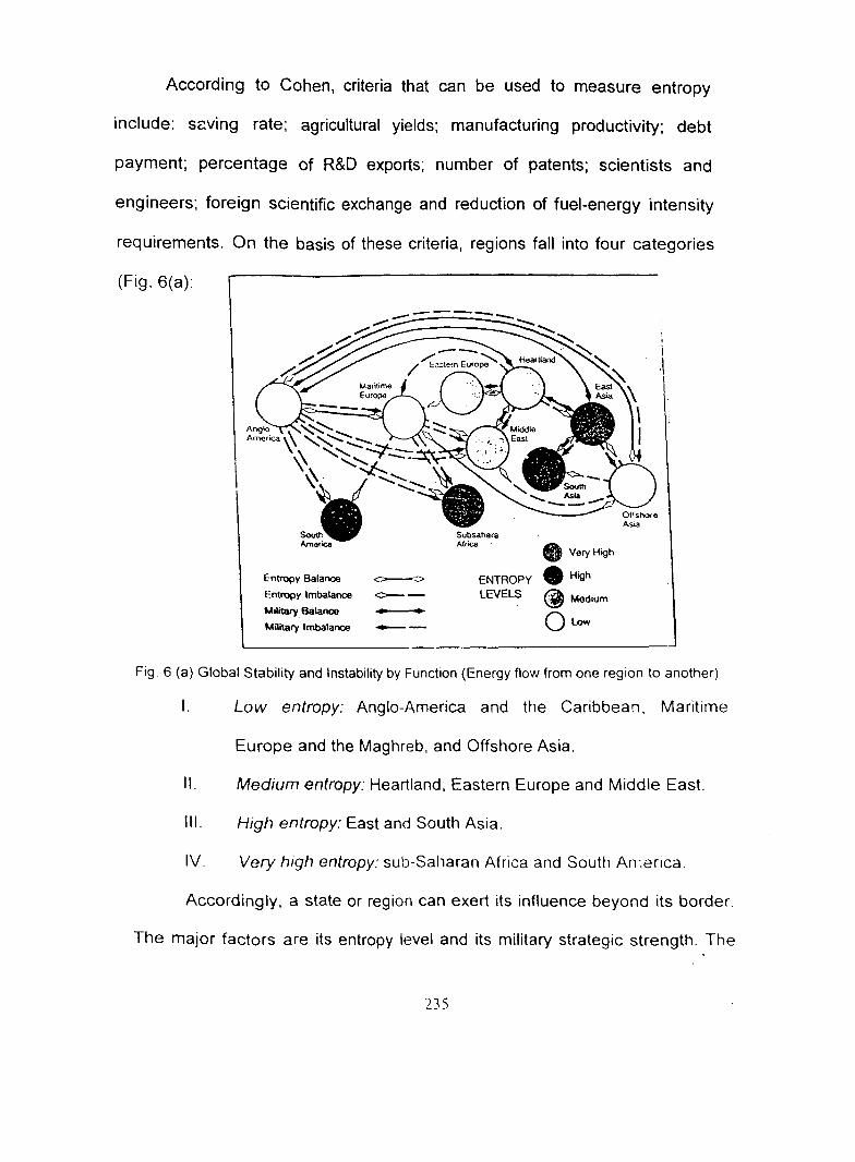
According to Cohen, criteria that can be used to measure entropy
include: szving rate; agricultural yields; manufacturing productivity; debt
payment; percentage of R&D exports; number of patents; scientists and
engineers; foreign scientific exchange and reduction of fuel-energy intensity
requirements. On the basis of these criteria, regions fall into four categories
(Fig. 6(a):
Entropy Balance ~
Entropy Imbalance c- -Military Balance
Military Imbalance --
Subsahara A1rk;a
• VeryHigh
• Hinh ENTROPY . ., LEVELS ~Medium
Qt.ow
Fig 6 {a) Global Stability and Instability by Function (Energy flow from one region to another)
I. Low entropy: Anglo-America and the Caribbean. Maritime
Europe and the Maghreb, and Offshore Asia.
II. Medium entropy: Heartland, Eastern Europe and Middle East.
Ill. High entropy: East and South Asia.
IV. Very high entropy: sub-Saharan Africa and South An-.erica.
Accordingly, a state or region can exert its influence beyond its border.
The major factors are its entropy level and its military strategic strength. The
235
reach can be measured by external trade, capital flow, diplomatic relations,
immigration, transit links and overseas military base. On the basis of these
measures, the US is quite strong in five regions: Maritime Europe, Offshore
Asia, South America, sub-Saharan Africa and the Middle East. Within a small
region like lOR, only few countries like India, South Africa and Australia have
partly reached such level.
The entropic level of EU is low. It is fully capable of transporting surplus
energy to Eastern Europe and Russia. The EU has substantial geopolitical
reach to Anglo-America, Offshore Asia and Eastern Europe. Europe is in
balance with Anglo-America, Offshore Asia. It is over balance with its other
regions of major contact. Offshore Asia, spearheaded by Japan and its
successfully industrialized neighbours, reaches to Anglo-America, the Middle
East, Europe, South and East Asia. With its very low level of entropy, it is also
in a position to project substantial reach to the Heartland. The region is in
balance with Anglo-America and Europe. The heartland is at a medium
entropic level, which is rising rapidly in the light of its recent economic
stagnation and the collapse of the centralized Russian political system.
Regional or the Second order powers are cores for their regions. They
have nodal characteristic in terms of trade, transportation and military
influence. They aspire for regional or sub-regional hegemony. Limited extra
regional economic or political ties are also characteristic of such powers.
Finally, such regions are overshadowed by a great power. The economies like
236
India. Pakistan, South Africa, etc., of lOR region can be categorised under the
second-order powers.
The third order states influence regional events in special ways. They
compete with neighbouring regional powers on ideological and political
grounds or for having a specialised resm•rce base. They lack in population,
military and general economic capacities of the second order rivals. Saudi
Arabia, Malaysia, UAE, Yemen, Singapore and Sri Lanka can be categorised
under this system. Lesser order states like Sudan, Tanzania, Mozambique and
Somalia retain such status in the lOR region. They have impact only on their
nearest neighbours. While the fifth order states like Bangladesh, Myanmar,
Madagascar, Qatar, Bahrain, Eritrea, and Djibouti have only marginal external
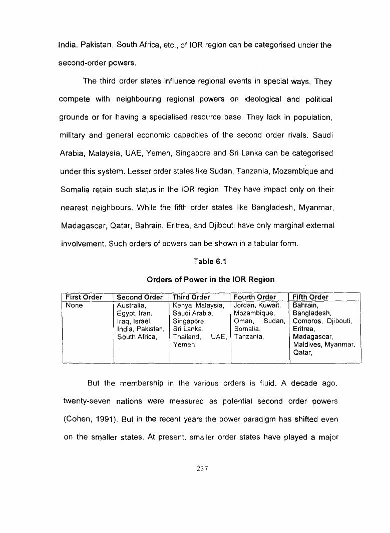
involvement. Such orders of powers can be shown in a tabular form.
Table 6.1
Orders of Power in the lOR Region
--First Order Second Order Third Order Fourth Order Fifth Order None Australia, Kenya, Malaysia, Jordan, Kuwait, Bahrain,
Egypt, Iran, Saudi Arabia, Mozambique, Bangladesh, Iraq, Israel, Singapore, Oman, Sudan, Comoros, Djibouti, India, Pakistan, Sri Lanka, Somalia, Eritrea, South Africa, Thailand, UAE, Tanzania, Madagascar,
Yemen, Maldives, Myanmar, Qatar,
But the membership in the various orders is fluid. A decade ago.
twenty-seven nations were measured as potential second order powers
(Cohen, 1991 ). But in the recent years the power paradigm has shifted even
on the smaller states. At present, smaller order states have played a major
237

role in the disorder of the world geopolitical system. The combined inputs of
the major powers and the second and the third order give birth to regionalism
in the geopolitical structures. The best examples are the role of Israel and
Kuwait in the Middle Eastern geopolitical system.
Role of Asymmetrical State in Geopolitics
A state, which may be described as 'asymmetrical', plays special role in the
regional personality. It promotes turbulence 13 by challenging the norms of
hegemonic regional structures and injecting unwelcomed energy· into the
system. Israel, Iran and Iraq as well as Myanmar are examples of
asymmetrical states that have profound impact upon their respective regions.
According to the present behaviour of Pakistan, it may also be categorised
under asymmetrical state. At present the geopolitical scenario is in transitional
phase due to the turbulent activity of asymmetrical states.
Geostrategic Realms and Regions
The geostrategic realm is the highest regional level of the world system. There
are two geostrategic realms, namely the Trade Dependent Maritime World and
the Eurasian Continental World. Despite the profound changes that have
taken place in the world in recent years, the basic framework is intact. Of the
world's five major power centres, only the US is a both military and an
economic power. Russia and China are great military forces but are relatively
weak economically. Japan and European Union are dominant economic forces
13 F. Clifford German. 'A Tentative Evaluation of World Power', Journal of Conflict Resolution, Yol.4. 1960, p. 141.
238

without strong military capacities. They lack vast strategic space and are
vulnerable to the military pressures of their Chinese or Russian neighbours. In
this s!tuation, the strategic alliance with the US is the strongest security card
for them.
South Asia does not belong to any geostrategic realm. Instead it has a
separate geopolitical regional status. As an independent geopolitical region
dominated by India, South Asia remains rural-based and with continental
orientation (inward-orientation) like the heartland. This does not minimize the
growing importance to the region of overseas trade, shipping, and modern-day
immigration. Inward-orientation of India has mi11imized its merchanjise trade.
Consequently, India's extra regional impact is relatively limited and which cast
a shadow over its geopolitical objectives. (See chapter IV table top five trading
"',-_. :·t • .... ,., ,,., c;,o,,,.,t,:: "••:m• ,,.._...,..,...,.Y&<._ "-•: .. 0 t'\o(•p··~··:c.- .... :,·,·n .. ~ ,,. ~~:: ••. , ...•• ..... J • .... ,: .......... , .. "··•-· t ..... -c--..... ·~-- D · ·- ·· "~.· ~-·_:_:
0 ............. _ ..
o.--c•~-· -~·...-cO'\.•'-•-
Fig 6(b) Geostrategic Realms and Regions of the World
Japan's situation as the dominant economic and political power 1n
Offshore Asia is unique because of its reluctance to exercise military pressure.
239
This is reverse in South Asia. The situation is the same in most of the lOR
countries. If we look at the history since the end of Cold War, the lOR region is
the perpetual battle ground and region of conflict. The West Asia and Gulf
crisis in the Middle East region and lndo-Pak tensions over Kashmir have
changed the geopolitical scenario of the lOR region.
The Quarter-Sphere of Marginality
The area centring on the South Atlantic and their bordering oceans represent
the quarter of the world's land and oceans which can be referred as the
'Quarter-Sphere of Marginality' (Cohen, 1991 ). Economically, this area suffers
from chronic over-production of commercial crops and minerals. T.,e post
industrial regions no longer regard this area as the potential storehouse of the
world. The two southern continents, namely South America and Africa,
especially Sub-Sahara come under the 'quarter-sphere of marginality'.
However, North and East Africa come under our study area. The burden of
high debt, low international trade levels, overpopulation, low life expectancy
and low calorie consumption (Chapter Ill) will continue to plague the East
African economies. Due to these problems, local conflicts and acquisition of
mass weapons would affect global stability.
While dominated by the US and EU power centres, the 'quarter-sphere
of marginality' is marginal in strategic sense. Naval and air strike forces, long
range air weapons and satellite surveillance capabilities have minimized the
significance to the Maritime World of East Africa. Moreover, the Suez Canal
and shipping routes around the Cape of Good Hope enhanced the
240
geostrategic importance of this region, especially for the US and Maritime
Europe.
Shatterbelts
Shatterbelts are used as strategically-oriented regions, being politically
fragmented areas of competition between the maritime and continental realms.
The distinguishing feature of the shatterbelt, is that it presents an equal
playing field to two or more competing powers, operating from different
geostrategic realms. By the end of the 1940s, the Middle East and Southeast
Asia had emerged as shatterbelts. In the 1970s (Cohen, 1991) the major
change in the geopolitical map is that Southeast Asia has lost its shatterbelt
status, due to considerable industrial development and economic linkages with
Japan and the USA. It has become economically and politically part of
Offshore Asia and the Maritime World. Myanmar is an exception due to
military regime. It is almost isolated and has no foreign trade and contacts.
When the military regime is eventually overthrown, and the country opens
itself to the world, it will probably become re-oriented to South Asia.
Shatterbelt areas and their boundaries are fluid. During the 1970s and
1980s, Sub-Sahara Africa also became a shatterbelt. The Soviet Union used
its Cuban strategy as well as its Eastern European satellites to provide military
and technical support to Ethiopia, Namibia, Angola and Mozambique. 14 Its
adjoining Middle Eastern European bases were important jumping-off points
14 Cohen. 'Global Geopolitical Change in the Post-Cold War Era', op. cit., p. 567.
241

for Africa. But with the retreat of Russia from Africa, the region has shifted
back to the Maritime World.
At present, the Middle East is the only shatterbelt. It is internally highly
fragmented and there are six powers in this region: Egypt, Iran, Iraq, Israel,
Syria and Turkey. They cast their shadow over remaining states. But the
alliances among these states are fluid. The outside powers like the USA, EU
and China, as well as Pakistan can help for regional stability in the Middle
East, particularly by pressing for elimination of weapons of mass destruction,
reduction of conventional arms and commitments to act against regional
aggressors.
However, since the Gulf crisis, every Middle East state and some of the
major ethnic and religious groups (Jewish and Muslim) are directly or indirectly
involved in the conflict. Basically, interpenetrating seas like the Mediterranean
Red Sea, Persian Gulf, Arabian and Caspian; and the Turkish and Iranian land
bases played militarily significant roles. Moreover, in the recent years, oil
pipeline networks, interregional migration, capital flows and water, all emerged
as factors that shape the regional personality.
Particularly, in the Post-Gulf war, Maritime Europe exerted more
influence on the Middle East scene and emerged as the second major
intrusive power, after the USA. Now Russia and China play a secondary role.
Hence there is a possibility that a new balance can be developed. Indeed,
Russia and China play a stabilizing role between Europe and US, in pursuing
their own agenda.
242
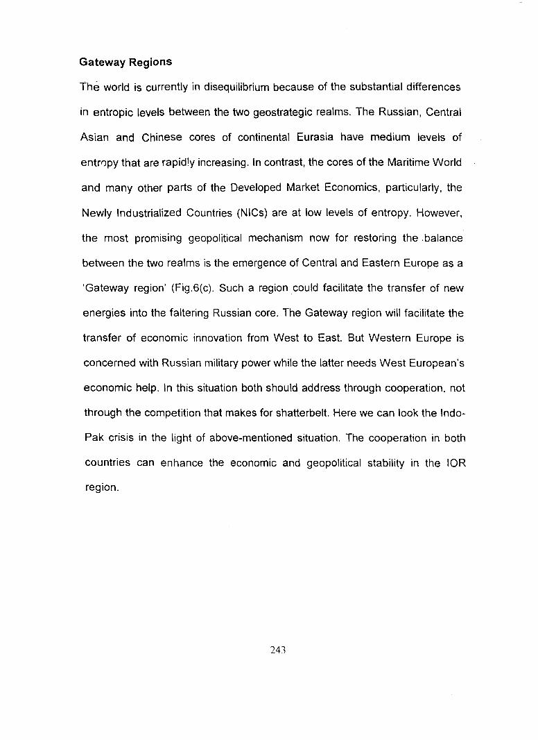
Gateway Regions
The world is currently in disequilibrium because of the substantial differences
in entropic levels between the two geostrategic realms. The Russian, Central
Asian and Chinese cores of continental Eurasia have medium levels of
entropy that are rapidly increasing. In contrast, the cores of the Maritime World
and many other parts of the Developed Market Economics, particularly, the
Newly Industrialized Countries (NICs) are at low levels of entropy. However,
the most promising geopolitical mechanism now for restoring the .balance
between the two realms is the emergence of Central and Eastern Europe as a
'Gateway region' (Fig.6(c). Such a region could facilitate the transfer of new
energies into the faltering Russian core. The Gateway region will facilitate the
transfer of economic innovation from West to East. But Western Europe is
concerned with Russian military power while the latter needs West European's
economic help. In this situation both should address through cooperation, not
through the competition that makes for shatterbelt. Here we can look the lndo
Pak crisis in the light of above-mentioned situation. The cooperation in both
countries can enhance the economic and geopolitical stability in the lOR
region.
243
Gateway states -by mid·' t st century 0 Gateway states- by urty ~1st century S
Geopontical Aeglons -Geostrateglc Realms --
Fig . 6(c) . Prospect of Gateway States, S.B. Cohen: Global Geopolitical Changes, Annals
No.85, 1991
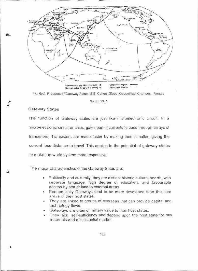
Gateway States
The function of Gateway st3tes are just like microelectronil.: circuit. In a
microelectronic circuit or chips, gates permit currents to pass through arrays of
transistors. Transistors are made faster by making them smaller, giving the
current less distance to travel. This applies to the potential of gateway states
to make the world system more responsive.
The major characteristics of the Gateway Sates are:
• Politically and culturally, they are distinct historic cultural hearth, with separate language, high degree of education, and favourable access by sea or land to external areas.
• Economically Gateways tend to be more developed than the core areds of their host states.
• They are linked to groups of overseas that can provide capital ana technology flows.
• Gateways are often of military value to their host states. • They lack self-sufficiency and depend upon the host state for raw
materials and a substantial market.
244
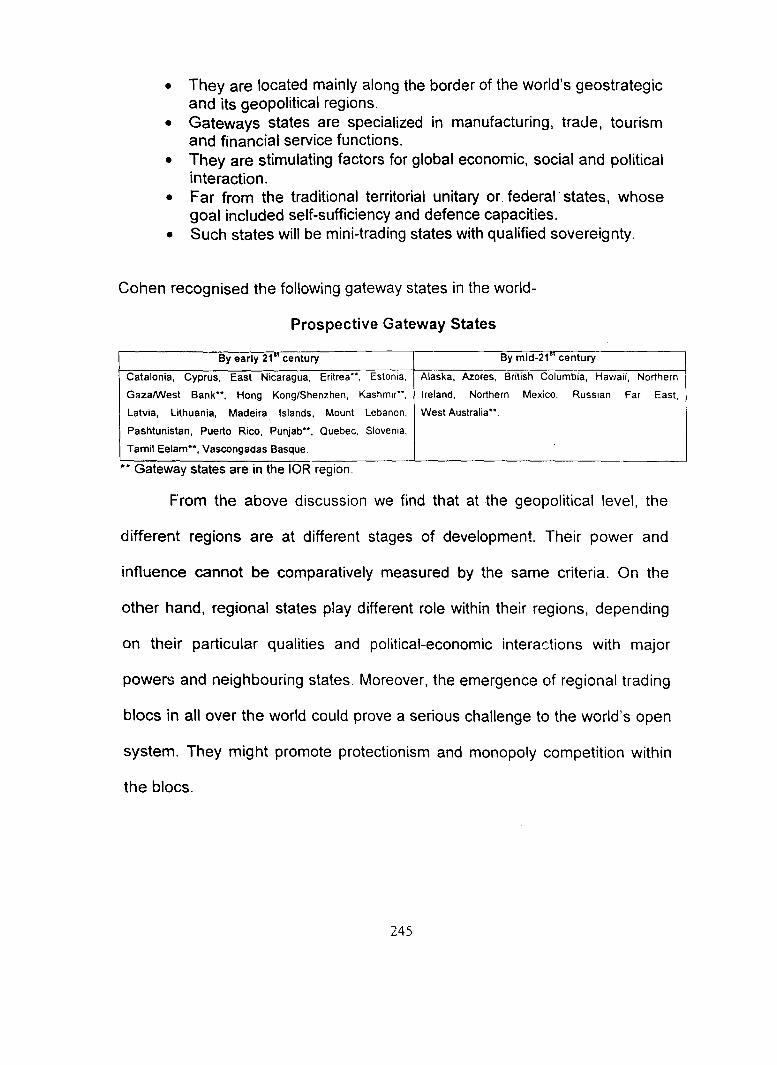
• They are located mainly along the border of the world's geostrategic and its geopolitical regions.
• Gateways states are specialized in manufacturing, traue, tourism and financial service functions.
• They are stimulating factors for global economic, social and political interaction.
• Far from the traditional territorial unitary or federal states, whose goal included self-sufficiency and defence capacities.
• Such states will be mini-trading states with qualified sovereignty.
Cohen recognised the following gateway states in the world-
Prospective Gateway States
By early 21 .. century By mid-21"' century
Catalonia, Cyprus, East Nicaragua, Eritrea**, Estonia, Alaska, Azores, British Columbia, Hawaii, Nortflern
Gaza/VVest Bank**, Hong Kong/Shenzhen, Kashmir**, Ireland, Northern Mexico, Russian Far East.
Latvia, Lithuania, Madeira Islands, Mount Lebanon, West Australia**.
Pashtunistan, Puerto Rico, Punjab**, Quebec, Slovenia,
Tamil Eelam**, Vascongadas Basque.
•• Gateway states are tn the lOR regton.
From the above discussion we find that at the geopolitical level, the
different regions are at different stages of development. Their power and
influence cannot be comparatively measured by the same criteria. On the
other hand, regional states play different role within their regions, depending
on their particular qualities and political-economic interactions with major
powers and neighbouring states. Moreover, the emergence of regional trading
blocs in all over the world could prove a serious challenge to the world's open
system. They might promote protectionism and monopoly competition within
the blocs.
245

From Geopolitics to Gao-economics
Although power and security constitute the nuclei of the foreign policy of every
state but the emphasis on the economic aspect of their relationship has now
assumed new dimensions. After the Cold \fl./ar, the bilateral or multilateral
relations of each state have had shifted from the centrality of political factors to
that of economic interests. Economic factors have become influencing forces
in the making of foreign policies of the nations. The age of military
superpowers is passing away and we are slowly passing into a new age of
economic superpowers. 15 Military power can no doubt be a powerful source of
influence in the international relations, but economic power can prove to be a
stronger source of influence in the world affairs.
It has been observed in recent times that the major power blocs have
been reducing political confrontations and moving towards trade-cum-
commercial groupings. Particularly the emergence of a global economy with
the growth of world trade and spread of foreign investments in the international
markets, coupled with the production of innovative electronics and the
revolution in communication technology ,show that there has been a clear shift
of the international affairs from politics to economics. A former president of the
U.S. Bill Clinton declared:
In this new era, our first foreign priority and domestic priority are one and the same: reviving our econor.·ty. I will elevate economies in foreign policy, create an Economic Security Council._. and change
IS P. C. Alexander, Recent Trends in International Relations, Emerging Trends in International Relations (Banglore: Ecumenical Christian Centre, 1992), p. II
246
the State Depar.ment's culture so that economics is no longer a poor cousin to old school diplomacy. 16
Reason for Weak Geopolitical Role of lOR Economics
In the lOR region India, Australia, Malaysia, Singapore, UAE, South Africa and
MauritiL;s are in the growing stage of development of their own economic
productive forces. This has gradually led to the involvement of these
economies in the economy, society and politics of the region. The tie
developed among the lOR countries is based on political economy. These
overseas ties have been manifested through aid programmes, contracts, joint
venture investment, technology transfers, banking and trade facilitation. The
data, of the top five trading partners of the world and the top five trading
partners within the region(see chapter IV) shows the economic dependency of
the lOR countries on the superpower economies (U.S.A, Japan, China,
Germany, Malaysia and Singapore). This is particularly important if we are to
translate a political economic analysis of the lOR countries' to the study of lOR
countries foreign relations. They are prone to experience the pressure of big
economies in determining their foreign policies and relations. Finally, it
weakened the geopolitical and gee-economics importance of the lOR
countries within the region to give the scope of being dominated by the
outsider economies.
16 Quoted in Span, May 1994.
247
However, another reason for weak geopolitical role of the region is the
mass poverty. Due to this reason the lOR economies can only mobilize their
potential productive capacity up to a certain point. The mass poverty limited
the outward expansion of the economy and the future of domestic
development strategy. Further, they act as an encumbrance on existing
resources and necessitate continued import of aid from the economic powers;
thus keeping most of the lOR countries in a dependent position. This
continuing dependence imposes constraints on most of the lOR countries,
which led them towards foreign debt. Similarly, the constant threat of mass
internal unrest which aborts lOR's new overseas ambitions is also a result of
th1s continuing mass poverty and internal social oppression. Another reason
for weak geopolitical role of the lOR economies is that even some interstate
problems (boundaries, terrorism) can not be solved without the interference of
the Western industrialized countries, especially the US and UK.
The Geopolitics of Regionalism
In the context of post-cold war scenario, much academic and media attention
has been focused on issues concerning regionalism and the consolidation of
regional trading and security blocs such as, European Union (EU), Mercado
Commun Conodel Sur (MERCOSUR), Asia-Pacific Economic Co-operation
(APEC), lOR-ARC, North Atlantic Treaty Organisation (NATO) and North
American Free Trade Agreement (NAFTA). This growing trend towards
regional cooperation and networks has undoubtedly been facilitated by the
dissolution of coid war geopolitical landscape. It has been argued within the
248

Southern Hemisphere, regional groupings such as MERCOSUR, the South
African Development Community (SADC) and the Association of South East
Asian Nations (ASEAN) are designed to promote regional economic
bargaining power on one hand and these gmups are a reaction to the
'deterritorialisation' of state power by the activities of multinational corporation
and global markets on the other hand. 17
Most of the liberal and realist commentary on regional cooperation and
new security agendas believes that these processes directly contribute to
political stability, economic integration and democratic integration. 18
Regionalism and regional security organizations are important contributions to
the management of international security. in the twentieth century, new
economic and political relationships have changed the regulatory powers of
the state and the relationship among state, region and the world economy.
International politics based on the notion of a territorially bounded sovereign
state have also been challenged by a range of transnational issues such as
environmental affairs, electronic currency flows and global information
network. As a consequence, regional organizations can be understood as a
part of a political strategy in which member states seek to increase their
bargaining power in the face of economic and political globalization. 19
Regional cooperation over trade barriers, common markets and commercial
17 P. Evans, 'The Eclipse of the State? Reflections on Stateness in an Era of Globalization', World
Politics, 50, 1997; also see K. Anderson & R. Blackhurst (eds.), Regional Integration and the Global Trading System (London: Harvester Wheatsheaf, 1993 ). 18
A. Hurrel, 'Security in Latin America', International Affairs·, Vol. 74, No.3, 1998, pp. 529-546. 19
J. Mittelman, 'Rethinking the new regionalism in the context of globalization', Global Governance, Vol. 2, 1996, pp. 189-213.
249
transaction is widely perceived to be one particular strategy for dealing with
external trading pressures. Regionalism in the lOR is not simply promoted due
to geographical proximity and economic interdependence but also by common
historical experiences such as colonialism, political ideologies and war.20
In this market competitive era, states have had to adjust their roles in
the world political economy in the light of new development, networks and
organizations such as banks, foreign exchange markets and transnational
corporations. The behaviour of states and their adjustments to global political
economy has been of critical concern into the new international political
economy. Regionalism, in general, is the tendency towards and preference for
regional systems. It seeks to defend a certain cultural disposition. The aim of
regionalism is towards a degree of autonomy in the management of regional
affairs. In the sphere of international security, regionalism is the attempt by a
group of states in order to further their relations among each other, to advance
commonly agreed aims.
Pipeline Geopolitics of the Middle East
The Middle East has about 60 percent of the world's proven oil reserves and
the world's highest reserve-to-production ratio. In addition, 9 of the world's 10
largest oilfields and 28 of the 33 super-giant fields that have over half of the
world's oil are located in the region. 21 Most of these vast fields are
concentrated within the Arabian-Iranian oil province, an area measuring some
2° K. Dodds, 'The Geopolitics of Regionalism: The Valdivia Group and Southern Hemispheric Environmental Cooperation'. Third World Quarterly, Vol. 19, No.4, 1998, p. 730. ~ 1 A. Dry~dale, 'Oilfields and Pipelines', in Gerald eta/ (ed.). The Cambridge Atlas (lf'h" Middle East and North Africa (Cambridge: Cambridge University Press, 1987), p. 67.
250
1200 by 800 Kilometres around the head of the Persian Gulf Caino-Zoic
sedimentary belt.22 Consequently, Saudi Arabia, Kuwait, Iran, and Iraq
between them have roughly 80 percent of the region's reserve.
Although the Middle East is the major producer of oil, it is not a major
consumer. Most of the; oil is shipped to Western Europe, Far East, North
America and the lOR countries by tankers. Accordingly, elaborate networks of
pipelines link the oilfields with marine export terminals, loading platforms and
refineries. Of particular interest are the strategic pipelines that greatly shorten
tanker voyages. In certain cases there are by-pass shipping routes which are
vulnerable to political interference. The most important is the 1718KM Tapline
(Trans-Arabian Pipeline), built in 1950 which transported oil from eastern
Saudi Arabia via Jordan, the Golan Height and Syria to Saida or Sidon in
Lebanon. This avoids the 4800Km long tanker route through the Suez Canal
or the much longer Cape of Good Hope route. 23
Tapline has been vulnerable to closure because it passes through
major war zone and has been the subject of frequent disputes over transit
fees. About 40 percent of the crude oil from the Middle East flowed westward
by pipelines to ports of the Mediterranean Sea for shipment and refining in
Europe and North America. 24 Of far greater significance is Saudi Arabia's
1213 Km Petroline, opened in 1981, which connects the eastern oil fields with
Yanbu on the Red Sea. When used in conjunction with Egypt's 335 Km
22 Ibid. 23 G.C. Leong, and G.C. Morgan, Human and Economic Geography (Oxford: Oxford University Press, Reprinted l99.'i), p. 428. 24 T.A. Hartshorn and J.W. Alexander, Economic Geography (USA: Prentice-Hall, 1988), p. 153.
251
Sumed Pipeline, which runs between the Gulf of Suez and the Mediterranean,
Petroline will allow a substantial proportion of Saudi oil to be shipped out of the
Middle East without having to go through the vulnerable Hormuz and Bab al
Mandeb straits, the Suez Canal, Syria and Lebanon or around the Cape of
Good Hope. Saudi Arabia, Iraq, United Arab Emirates and Oman are also
exploring the possibility of building a second line that would by-pass the Strait
of Hormuz, which would run from Ras Tannurah to the Gulf of Oman. 25
Of all the oil-producing countries in the region, Iraq is the most
dependent on international pipelines for exporting its oil. Almost all of its oil is
pumped from Kirkuk to the Mediterranean ports of Tripoli in Lebanon and
Baniyas in Syria. These lines are very unreliable because of frequent political
disagreements and transit fee disputes. However, this route was closed in
1976 and 1979 due to conflict between Syria and Iraq. Hence, in 1976 it
opened a strategic pipeline to AI-Faw on the Persian Gulf. The following year,
oil began flowing through a 986 Km line through Turkey to Yumurtalik on the
Mediterranean. But both pipelines were disrupted in the 1980s due to Iraq,
Iran war and in 1990s because of American bombardment and international
embargo. Iraq also planned to construct a parallel pipeline of petroline to
Yanbu on the Red Sea.
However, a decade of pipeline construction has diversified the Middle
East's oil export routes and significantly reduced their vulnerability.
25 Drysdale, "Oilfields and Pipelines', op. cit., p. 69.
252
Hydrocarbon and Pipeline Geopolitics in the lOR Region
Central Asia, through which the once-famous Silk Route passed in the 16th
century, has always been an object of geopolitical fantasies. Mackinder
referred to its vital location as a "heartland country". Also, the German
geopolitics Karl Haushofer took part in developing ideas about "Great
Turkestan. 26"
The Caspian-Caucasus region of Central Asia has the potential to
become the largest supplier of oil and gas to Asia, Europe and North America
with its estimated reserves approximately 200 billion barrels- surpassing any
other region outside the Persian Gulf?7 The quest for exploration and
exploitation of hydrocarbon resources in the region is termed as the "New
Great Game". More significantly, the prospects of Caspian Sea natural
resources have put some of the Central Asian republics in spotlight on the
global strategic map. But in recent years the oil pipeline geopolitics of the
Caspian region has become more important. The drain of Caspian
hydrocarbon geopolitics has the strength to change the geopolitical
cartographic map of some area of the lOR, especially Iran, Pakistan and India.
At present, the US stands behind all the strategically important
processes in the Caucasus and the Central Asia. The strong advocacy for
Baku-Tbilis-Ceyhan pipeline route is a reflection of this crucial strategic
26 M.H. Nuri. "Pipeline Diplomacy in Central Asia: Problems and Prospects', Regional Studies, Vol.
X I X, No. I. Winter 2000-0 I, p. 36. . 27
Bulen! Gokay, 'Caspian Uncertainties: Regional Rivalries and Pipelines. Percc!1tions'. Journal of lnrernational Affairs, Vol. 3, No. I, March-May, 1998, p. 49.
253

interest.28 Another US interest is to align with those of the Russian Federation
as regards containment of Muslim extremism/militancy, cross-border terrorism,
check on nuclear proliferation, control of small-arms and drug-trafficking,
stability of the region, protection of foreign investment besides pursuing
Washington's own agenda that includes promotion of western economic
interests. 29 Also, US policy has been to block Russia and Iran from becoming
transit nations for the Caspian oil.
Though, Iran is interested 1n playing an active role in solving the
problem of transportation of oil and gas resources of the Caspian republics of
the CIS to the world markets but faces American opposition. Russians could
gain if they (CIS countries) support projects meant to transport oil and gas of
Azerbaijan and Turkmenistan through Iranian territory onwards to potential
markets of South and South East Asia, through Persian Gulf and diverting
pipelines (India and Pakistan). Economically, this is the shortest and the
cheapest long-term export route option for the Caspian Sea. On the other
hand, Iran is keen to export natural gas to Pakistan and India. Both South
Asian countries could benefit from the proposed $5 billion Iran, Pakistan, India
gas pipeline project, which is expected to post $700 million revenue per
annum to Pakistan $500 million as annual transit fee and additional $200
million saved through cheap gas. 30 Under this project. nearly 2,670 Km
pipeline of 56 inches diameter is required to be laid for the supply of gas from
2K Nuri 'Pipeline Diplomacy', op. cif., p. 38.
2'1 Ibid., p. 39.
)o The News. 23 August 2000, p. 16.
2)4
Iran to Pakistan which would ensure flow of 3.3 billion cubic feet. 31
Unfortunately, due to India-Pakistan political discord the project could not take
off. Pakistan is geostrategically located as a transport corridor for supply of
gas. This pipeline holds greater prospects than Turkmenistan-Afghanistan-
Pakistan pipelines.
Originally, the Iranian Gas Company planned to deliver 2 billion cubic
feet of gas daily to Karachi and Multan with an option to extend it to India and
onwards to some countries in the Far East.32 However, India has reservations
about this land route as in her view it would pass through "hostile" Pakistani
territory. India is thinking of an alternative sea route being developed by the
Russian Company, Gazprom that has a 10 percent share in the South Pars of
shore gas fields of Iran.
On the other hand Turkmenistan as a gas-rich country is keen to export
it to Pakistan and India and then onwards to Southeast Asia. The proposed $2
billion trans-Afghanistan pipeline covering 1464 Km is a 48-inch diameter
pipeline that is proposed to connect the Daulatabad gas fields in Southeast
Turkmenistan to Multan in central Pakistan. It is also proposed that it may be
extended 600 Km into India after traversing 750 Km in Afghanistan. 33 Talks on
the above proposal between Turkmenistan and Pakistan have been going on
for many years but have been hampered by the recent war in Afghanistan.
31 Ibid. 32 The News, 26 August 2000, p. 7. 33 Svante E. Cornell. 'Geopolitics and Strategic Alignments in the Caucasus anrl \cntral Asia', Perceptions, Vol. IV. No. 2, June-August 1999, p. 122.
255

P::~k-China Economic Strategic Ties: Gwadar Seaport and Makran Coastal
Highway
In August 2001 Pakistan and China singed a formal agreement under which
Chinese government would provide financial support of $200 million for the
construction of the first phase of the Gwadar Seaport and Makran coastal
highway.34 There is also a possibility that US firms may build a pipeline from
the Central Asian Republics, via Afghanistan to Pakistan (Gwadar)?5 Both
projects (Gwadar and Makran) hold commercial as well as ·strategic
significance. Gwadar will emerge as the second and alternative seaport of
Pakistan. In crisis this port would give Pakistan navy the ability to move naval
assets away from vulnerable locations. Gwadar is near the r nouth of Gulf of
Oman, about 50 miles from Pakistan's border with Iran.
The Chinese investment in the mega projects is seen in the West as
strategically motivated. The Washington Times stated that development of
Gwadar port would give Beijing "a potential staging ground to exert influence
along some of the world's busiest shipping lanes flowing into and out of the
Persian Gulf.36
A network of oil and gas pipelines could be a stabilizing factor in the region
and may foster regional integration. At the same time seeds for conflict
resolution may germinate in war-prone South Asia if new pipelines could lead
to regional cooperation.
34 M. H. Nuri, 'Pak-China Economic Strategic Ties', Regional Studies. Vol. XIX, No., Summer 200 I, p.
61. 35 Ibid., p.61. 36 The News, I June 2001.
256
Gas Pipeline Geopolitics: Middle East and South Asia
The gas pipeline geopolitics is a very sensitive issue for the survival of India's
economy and security. In a decade, India's oil import will go to 320 million
tonnes and gas to 150 million cubic meters.37 We vvill then be facing an
unprec3dented crisis-not because of supply problem, but because of financial
problems. On an average India already spends about $8 billion to $9 billion on
the imports annually. Near future about 70 percent of foreign exchange
resources will go into oil and gas imports, leaving very little for other purposes.
On the other hand our automobiles transport system is one of the largest.
Similarly the gas-based industries are multiplying. We are always at the brink
of war with our hostile neighbour. Hence we need perpetual deployment of
armies for security. There is a question mark for India's survival without
importing hydrocarbons from the Middle East and Central Asia. At present,
tankers are the only option for imports. But according to the demand
magnitude, tankers are not going to fulfil our requirement. Therefore, pipelines
are the only option. The seabed pipelines are economically and technically
very expensive and land route pipeline is very economic. For this the pipelines
from the Middle East have to cross Pakistan's territory. On the other hand,
from Central Asia, India can follow either the route from Pakistan or China. In
both cases, India has to compromise with two distant neighbours.
37 Trihune (Chandigarh). 18 August 2000.
257
Iran-Pakistan-India Gas Pipeline
Addressing the 1 ih annual conference of the International Association for
Energy Economics in January 1990, New Delhi, the Iranian Deputy Minister of
Mines and Metals, Mi. Ali Shams Ardekani proposed a 3300 Km Trans-Asia
natural gas pipeline from Bandar Abbas in Iran to Calcutta. 38 The $11.7
billion pipeline would take 4 or 5 years to be completed and would pay for itself
in just 4 years. The pipeline, with the capacity of around 100 million cubic
meter of natural gas, start from Bandar Abbas. The line will cross Pakistan
where 20-25 million cubic meters per day of gas will be consumed. The
remaining gas will enter India. The pipelines originate in Bandar Abbas and
pass through the cities of Minab and lransuauar and enter Pakistan in the
Panjkoor area. The pipeline will enter India in the Viavea area (Gujarat) and
will pass through Radhanpur into Ahmedabad, from where it will be extended
up to Calcutta.
The length of the Iranian segment of the pipeline will be 752 Km, of the
Pakistani segment 960 Km and of the Indian segment 1600 Km. The diameter
of the pipe in these segments will be 1420, 1320 and 1170 and construction
cost $3.25 bn., $4.30 bn. and $4.20 bn. respectively. If Brezhnev can do it by
succeeding on the Trans-Siberian pipeline project despite opposition we can
also do it, the Iranian Minister added.39 The pipeline would be a good vehicle
to reduce tension. Again, the Australian BHP Corporation proposed the
JR The Times of India (New Delhi), 12 February 1990. 39 Ibid.
258
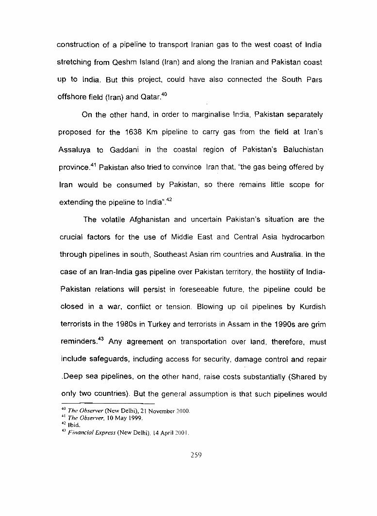
construction of a pipeline to transport Iranian gas to the west coast of India
stretching from Qeshm Island (Iran) and along the Iranian and Pakistan coast
up to India. But this project, could have also connected the South Pars
offshore field (Iran) and Qatar.40
On the other hand, in order to marginalise India, Pakistan separately
proposed for the 1638 Km pipeline to carry gas from the field at Iran's
Assaluya to Gaddani in the coastal region of Pakistan's Baluchistan
province.41 Pakistan also tried to convince Iran that, "the gas being offered by
Iran would be consumed by Pakistan, so there remains little scope for
extending the pipeline to lndia".42
The volatile Afghanistan and uncertain Pakistan's situation are the
crucial factors for the use of Middle East and Central Asia hydrocarbon
through pipelines in south, Southeast Asian rim countries and Australia. In the
case of an Iran-India gas pipeline over Pakistan territory, the hostility of India-
Pakistan relations will persist in foreseeable future, the pipeline could be
closed in a war, conflict or tension. Blowing up oil pipelines by Kurdish
terrorists in the 1980s in Turkey and terrorists in Assam in the 1990s are grim
reminders.43 Any agreement on transportation over land, therefore, must
include safeguards, including access for security, damage control and repair
.Deep sea pipelines, on the other hand, raise costs substantially (Shared by
only two countries). But the general assumption is that such pipelines would
40 The Observer (New Delhi), 21 November 2000. 41 The Observer, 10 May 1999. 42 Ibid. 43 Financial Express (New Delhi), 14 April 200 I.
259

be more secure. A hostile country could easily interdict the pipelines. If this
happens, India would not even be in a position to send a protest note to
Islamabad or complain to an international regulatory institution. On the other
hand, repairs to damaged deep-sea pipelines are much more costly.
Proposals to bring gas from Oman to the Gujarat coast through a sub-sea
pipeline have the probability of same consequences.
India-Bangladesh Gas Pipeline
The total reserve of natural gas of Bangladesh is 11 trillion cubic feet:44 On 26
August 1980, Dhaka proposed to sell one trillion cubic feet45 of natural gas to
India but cancelled due to opposition by the people. Othe1· major considerable
factors for the cancellation of this proposal were: sharing of Farakka water,
control over the New Moor Islands in the Bay of Bengal, demarcation of
boundary and tri-junction boundary etc which are still unresolved source of
contention. Another problem was related to the finance of 175 mile pipeline
and the fixation of price of Bangladesh's gas. Dhaka proposed that India
should bear the whole cost of the pipeline construction. On the other hand,
Japan, Greece and US are very keen to import and develop the gas of
Bangladesh. This is a big threat to the Indian economy and polity.
The Bangladesh government is afraid of not having enough supply for
itself if Bangladesh wants to wait until its government proves how big the
reserves are, and then it may be too late. India will have found other ways to
44 The Hindustan Times (New Delhi), 15 October 1992. 4s Economic Times (New Delhi), 28 August 1980.
260

meet its energy needs.46 On the other hand, the foreign bidders are worried
about India. If this good client goes out of their hands due to the slow process
and lack of prompt decision by the Bangladesh government, then the exploring
companies feel that they would be in trouble with the huge quantity of gas
without any big consumer. India is the only county which offers P good price
for the purchase of Bangladesh gas as the transportation cost would be
lower.47
However, one obvious and effective way for Pakistan and India to join
for tackling the real problem, is that the two-share-economic and social
development. It would determinedly strengthen South Asian regional
cooperation. In this way, India and Pakistan can jointly propose Iran's
membership of SAARC.48 Iran has historical, economic and geographical ties
with the Indian subcontinent. Similarly, pipeline gas from Bangladesh will cost
less than LNG (Liquefied Natural Gas) imports from the Middle East through
tankers. It will foster stability and improve relations between the two countries.
Geopolitics of Boundaries
To determine the limiting line on the earth's surface on one side on which all men and things are subject to jurisdiction of one state, whereas the moment that line is crossed everything is subject to another state. Such a line has therefore enormous effect on the lives of the people whose citizenship it alone determines. Not nearly under what government they must live for what state be ready to fight and die, but even where they must sell their products, where purchase their supplies, what language their school must, for the most part, use, what history, literature
46 National Herald (New Delhi), 2 July 200 I.
47 Financial Express (New Delhi), I July 199. 48 New Time (Hyderabad), 24 June 2001.
261

and songs their children will be taught, under what national, cultural, and moral influence they will be brought up all of these are determined for millions of people by the exact location of an international boundary line such an area as this.49
The years after the Cold War witnessed the beginnings of dramatic changes in
people's identities and the symbols of those identities. Global politics began to
be configurated along cultural lines. 50 In the Post-Cold War world, the most
important distinctions among peoples are not ideological, political or economic
rather they are cultural. Peoples and nations are attempting to answer the
most basic question, human can face: Who are we?51 People define
themselves in terms of ancestry, religion, language, history, values, customs
and institutions. They identify with cultural groups; tribes, ethnic group,
religious communities, nations and at the broadest level civilization. All
identifications finally assimilate to the state. It is an internationally recognised
political and judicial entity. It claims sovereignty over specific area of land and
possibly adjacent sea. This area is delimited in the minds of individuals and
groups owing allegiance to the state by boundaries. Boundaries indicate the
accepted territorial integrity of the state and the extent of government control.
In the majority of cases boundaries are legally recognised by the states which
share them and also by the international community.
However, as a result of the global geopolitical changes over the past
decade, approximately one-quarter of the world's land boundaries can be
49 Richard Hartshorne, 'Geographic and Political Boundaries in Upper Silesia', Annals of the Association of American Geographers, Vol. XXIIl, 1933, p. 201. 50 Huntington, The Clash of Civilizations, op. cit., p. 19. 51 Ibid., p.20.
262

classified as unstable.52 In addition, some two-thirds of the global maritime
boundaries have yet to be settled. 53
Since the possession of agreed boundaries has a cruciai bearing upon
state security, conflicts related to boundaries are likely to remain a key
component of the international geopolitical scene. It is hardly surprising that a
high proportion of global flashpoints can be related to boundaries. Moreover,
states are the key component of the global political system and boundaries are
a major concern of their political decision-making. It is probably true to say that
most territorial disputes have some element of boundary conflict. Though, the
majority of the boundaries of Africa, Asia and Latin America were drawn by
Europeans, largely according to their colonial interests. The geographical,
ethnic and language factors were largely ignored in the face of the economic,
strategic and diplomatic interests of the European states.
Boundary Disputes in Littoral African and Middle Eastern Region
Many of the international boundaries of contemporary Africa, especially, south
of the Sahara, were defined by the Berlin Conference of 1884-85 by the
European colonial powers54, on the basis of superficial knowledge gained from
records of missionaries, explorers and traders. 55
This is well known fact that most of the boundaries in the eastern and
northern littoral Africa are arbitrarily drawn. Such boundaries were drawn a
52 E.W. Anderson, 'Geopolitics: International Boundaries as Fighting Places', The Journal of Strategic Studies, Vol. 22, No. 2/3, June I September 1999,p.l25. 53 Ibid. 54 A.C.G. Best, & H.J. de Blij, African Survey,(New York: John Wiley & Sons, 1976), p. 100. 55 N.J.G. Pounds, Political Geography (New York: McGraw-Hill, 1963), p. 61.
263
straight lines from one known point to another or were made to follow physical
features. Such types of boundaries are referred as geometric boundaries, they
are defined by mathematical methods, not by any consideration for land or
people between the end points. Examples include the boundaries between
Kenya and Tanzania, Egypt and Sudan; Somalia and Ethiopia and most of the
Middle Eastern States. Several of these b0undaries have since become
seriously disputed. In the morphological classification of boundaries,
geographers simply consider physical features. In the eastern African region,
international boundary lines have been drawn through lakes, along
escarpments and mountain ranges. Lakes namely Victoria, Rudolf, Albert,
Edward, Kivu, Tanganyika and Malawi were selected for matters of
convenience and then divided by geometrical lines. The boundaries between
Zaire and Sudan, the Central African Republics and Sudan, and Malawi and
Mozambique follow watersheds divides. Such boundaries that lie along
physical features are called physiographic boundaries. The present boundary
along the Jordan River between Israel and Jordan is a physiographic political
boundary. Between Sudan and Ethiopia, which skirts the lowest slopes of the
giant.· Ethiopian mountain-land (and place follows a river) is in the same
class.56
A boundary that coincides with a cultural discontinuity is identified as an
anthropogeographic boundary. This is what the Somalia people of the Horn of
Africa want, that is to have their political boundary moved to incorporate all
56 H.J. de Blij, Geography, Regions and Concept (New York: John Welley & Sons, 1971 ), p. 387.
264

those people now separated from the Somali Republic. 57 Thus all Somali will
be unified in a Somali state, with non-Somali country across the border. In
other words, the conflict of border dispute, specially related with Somalia and
Ethiopia is related with the ethnic differences, between the pastoral Somali-
speaking peoples and Amharic speaking (Ethiopia), who are mainly
cultivators.58 Furthermore, the present poor relations of the Horn of Africa
provided scope for the involvement of the great world powers (US and
Russia), who contributed to an increasing build up of arms, which made a
much more intensive as well as an extensive conflict possible.
However, it has ·already mentioned that Ethiopia has ongoing conflicts
on three of its five international boundaries, namely those with Sudan, Eritrea
and the Somalia Republic. After the independence of Eritrea, Ethiopia lost her
strategic coastline, and Assab and Massaw ports as well as vital contacts with
the outside worlds. Territorial disputes also exist over the Sudan-Egypt
boundary. Both states claim a small piece of territory, i.e. Wadi Haifa, now
under the waters of Lake Nasser. Further east, Sudan seems reluctant to
acknowledge Egyptian sovereignty over tribal grazing lands administered by
Sudan since 1902.59
The creation of Israel in 1948 as a sovereign state was not a problem
but the manner of territorial division, under the United Nations Partition Plan of
57 Ibid., p.387. 58
R.M. Prothero, 'North-East Africa: A Pattern of Conflict', in his edited book A Geography of Africa: Regional Essays on Fundamental Characteristics: Issues and Problems (New York: Praeger, 1964), p. 157. 59
Blake, The Atlas of the Middle East and North Africa, op. cit., p. 69.
265
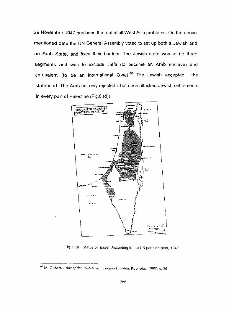
29 November 1947 has been the root of all West Asia problems. On the above
mentioned date the UN General Assembly voted to set up both a Jewish and
an Arab State, and fixed their borders. The Jewish state was to be three
segments and was to exclude Jaffa (to become an Arab enclave) and
Jerusalem (to be an International Zone).60 The Jewish accepted the
statehood. The Arab not only rejected it but once attacked Jewish settlements
in every part of Palestine (Fig.6 (d)).
THE UNITED NATIONS PARTITION PLAN, 1941
Medircrrane:~n
S••
\"~..:~~) o•-·-' '
Fig. 6.(d) Status of Israel According to the UN partition plan, 1947
60 M. Gilbert. Atlas of the Arah-lsraeli Conflict (London: Routledge, 1998), p. 36.
266

Syria insists on the return of the Golan region occupied in 1967 and
Jordan equally demands the return of the West Bank to Arab control. Similarly,
ihe new Egypt-Israel boundary agreed in 1982 is still the subject of legal and
technical disputes at the local level. Moreover, the boundaries of Israel are the
least permeable in the world. Until 1979 Israel had no borders, only ceasefire
lines from a series of wars in 1948, 1967 and 1973. Treaties with Egypt in
1979 and Jordan in 1984 led to these borders being defined and agreed.
Negotiations over Israeli settlements in disputed territories such as the West
Bank, and the issue of self-government for the Palestinians, continue. Saudi
Arabia's boundaries with her two southern neighbours (Yemen and Oman)
have not yet been aligned/demarcated due to desert, but is the least disputed.
In the Middle East, the classic case of a potential dispute is the boundary
between Iraq and Iran which follows the river Shatt-ai-Arab. The position of the
boundary between Iraq and Iran along the Shatt-ai-Arab was the immediate
cause of war in 1980.61 Similarly, the Kuwait-Saudi Arabia boundary was
drawn in 1922, a Neutral Zone of 5700 Km2 was left in a region whose
ownership was undecided. Although, in 1966, this Neutral Zone was
partitioned between the two states and the revenue from petroleum was
shared by both, but the partition agreement did not resolve disputed ownership
of the islands of Qaru and Umm-ai-Maradin, which lie off the Neutral Zone.
The islands were occupied by Saudi Arabia but are claimed by Kuwait. The
islands are small but large areas of seabed are involved. Following border
61 Ibid., p. 99.
267

agreements in 1981, the Neutral Zone, west of Kuwait was partitioned
between Saudi Arabia and Kuwait. The boundary settlement between Kuwait
and Iraq resulted in a change of location for the international boundary from
the median line of Khor Zubair to the low water line (springs) on the Kuwaiti
side. Thus from having originally shared it, Iraq gained full access to the port
of Umm Qasr.62 Similarly, there is an o~shore boundary dispute between Iran
and the United Arab Emirates (UAE) over Abu Musa and the Tunbs Islands in
the Persian Gulf.63
Boundary Dispute in Southeast Asian Region
Political boundaries of Southeast Asian states are very typical. Most of the
boundaries run through the region's emptier areas. Malaysia and Indonesia
are fragmented states. The geographical area of Indonesia is entirely on
islands. Here internal frictions and secessionist uprisings, especially in
Sumatra and Sulawesi are very common. The government of such fragmented
country is bound to concentrate on secessionist movements which generate
centrifugal forces. The peoples of the outer Islands have shown resentment
against Javanese domination in Indonesian affairs.
·Malaysia lies partly on a continental mainland and partly on Islands.
Far-flung Malaysia was force to yield to the centrifugal forces inherent in its
62 E. W. Anderson and J. Karam, 'The Kuwait-Iraq Border: A Reappraisal', RUSI Journal 139/3
Autumn 1994, pp. 47-50. 63 Ibid., p. 127.
268
ethnic complexity and its spatial and functional structure, and permitted the
microstate of Singapore to secede.64
The core areas of Thailand and Myanmar are compact, but in the south,
they share sections of the Malay Peninsula. These peninsular portions are
long and narrow, and states that have such extensions leading away from the
main body of territory are rderred to as prorupt states. The proruption of
Thailand extends nealry 600 miles south ward from Bangkok, where the
Thailand-Myanmar boundary runs along the peninsula. The Thai proruption is
in some places less than 20 miles wide. This area is far away form the core
and also lacks easy transportation. Sometimes this area becomes
troublesome.
In a region of peninsulas and islands such as Southeast Asia, the
surrounding and intervening waters are of extraordinary significance.
Specially, since the exploration of offshore hydrocarbon, the claim for territorial
water became more acute. Other minerals also can be expected to lie in the
subsoil. The whole Southeast Asian Sea Zone is surrou.1ded by the
Indonesian Islands, though the continental shelf of this region is less than 500
feet below sea level. That means the seabed rocks are very accessible. At
present about 20 percent petroleum comes from the continental shelf mainly
form North Sea, Gulf of Mexico, Persian Gulf, North China Sea and off-shore
Mumbai (Continental shelf of the Arabian Sea). Though, Southeast Asia's
continental shelf is one of the largest and it may well become an area of
64 Blij. Geography Regions and Concept, op. cit., p. 537.
269
exploration and competition. Hence in near future it is going to be the most
disputed region of the world.
Boundary Dispute in South Asia
Boundary dispute arises when two or more adjacent governments contest
about the line to be drawn between their respective territorial domains. In such
cases it is a common feature that both (or more) states have lawful claims to
adjacent territory. The real question to be decided is how this territory can be
divided between them. For instance, in the Sino-Indian boundary disputes, the
Chinese government has challenged the traditional boundary delimitations and
has demanded the redrawing of the contested boundaries. On the other hand,
territorial dispute arises when one government seaks to supersede or
eliminate another in relation to a particular land area. For instance, in Kashmir,
which was attacked and partially occupied by Pakistan in 1948, both India
and Pakistan are claiming an absolute title to entire territory, and are
demanding suppression of one state by another. Such disputes may not
involve the drawing of lines between adjacent territorial communities.65
Disputes over Jammu and Kashmir have caused three serious wars
between India and Pakistan. Since 1947, most international maps show the
'Line of Control' (LoC) agreed in 1972 as the de facto border.
The LoC came into prominence after the 1971 war when India
unilaterally ended the fighting in the western sector after Pakistan had
65 S.P Shanna, Delimitation of Land and Sea Boundaries Between Neighbouring Countries (New Delhi: Lancer Books, 1989), pp. 3-4.
270

surrendered in the east and Bangladesh had been born. 66 As the Para IV of
the Shimla Agreement (1972) states:
In Jammu and Kashmir the line of control resulting form ceasefire of December 17, 1971, shall be respected by both sides without prejudice to the recognised position of either side. 57
Furthermore, the accord makes a distinction in "the international border
(between India and Pakistan) and 'the line of control". Under the Shimla
Agreement the two forces fell back to the international borders, but the line of
control was different from the ceasefire line that prevailed before the 1971
conflict. However, the situation is further complicated by a Kash;niri
independence movement, active since the late 1980s.
India has boundary disputes with almost all neighbouring
countries. In 197 4, India signed an agreement demarcating the land boundary
with Bangladesh. The agreement signed between Mrs. Indira Gandhi and
Sheikh Mujibur Rehman, gave the ownership of Berubari enclave to lndia.68
But the tri junction boundaries in the southern part among India, Myanmar and
Bangladesh and India, Myanmar and China in the northern part are still
unresolved.
But much of the discord over river waters between India and
Bangladesh relates to the Farakka Barrage, built to divert the Ganga waters
into the Bhagirathi-Hooghly in order to save the Kolkata port. In Article 18 of
66 Tribune (Chandigarh), 7 July 1998. 67
S.M Koreshi, Contemporary Power Politics and Pakistan (Islamabad: Institute of Policy Studies, 1991), p. 135. 68 Indian Express (New Delhi), 21 November 1974.
271

the Indo-Bangladesh Joint Declaration of Prime Ministers of the two countries
of May, 1974, it was clearly laid down that:
The two sides expressed their determination that before the Farakka barrage is commissioned they would arrive at mutually acceptable allocation of the water available during the periods of minimum flow in the Ganga.69
On October 1, 1993, Bangladesh Prime 'vlinister Begum Khaleda Zia
addressing the 481h session of the UN General Assembly said.
The unilateral withdrawal of Ganges water by India upstream of Farakka has created a life and death problem for Bangladesh.70
However, the crux of the problem is the water sharing arrangement
during the January to May dry season. Bangladesh proposed long-term
sharing of the Ganges water on the basis of the 'Ganges Water Agreement of
1977.71 Apart form the Ganges water-sharing dispute, issue of a permanent
sharing of the flows of the Barahmaputra, the Teesta and the Meghna are still
unresolved.
Apart from land boundary, India had already signed agreements
demarcating the marine boundary with Sri Lanka and Indonesia. The maritime
agreement signed with Sri Lanka, recognised the ownership of Colombo over
Kachechativu.72 Demarcation of maritime boundaries has become an urgent
international task because of the possibility of finding off-shore oil. The
69 Bangladesh Observe (Dhaka), 28 October 1993. 70 Ibid. 71 Bangladesh Observer (Dhaka), 22 December 1993. 72 Indian Express, 21 Nov. 1974.
272

maritime boundaries of India with Bangladesh and Pakistan have not been
demarcated as yet.
The above discussion has demonstrated that international law
recognizes the importance of the possession of landmass as a basis of
national power potential and prescribes rules and policies designed to protect
boundaries as juridically separating lines of territorial integrity and exclusive
control. However, the overall community objective of these rules and policies
is to promote a territorial organization of the world which will best serve the
common interests of all people. This can be achieved only when states make
positive efforts to settle boundary disputes peacefully.
The decolonization process that began after World War II led to the
decline in the powers and the influence of the traditional extra regional powers.
The British gradually began to withdraw from the Indian Ocean. But keeping in
view the importance of the transportation and communication facilities, the
British maintained their control over some islands like Seychelles and the
Chagos Archipelago in which small islet of Diego Garcia is situated. The new
colony, the British Indian Ocean Territories (BlOT) was set up.
The island of Diego Garcia in the Chagos Archipelago, was originally
administered as part of Mauritius. When Mauritius was granted independence,
Diego Garcia and two other atolls in the Archipelago were bought by the
British Government from Mauritius for 3 million pounds. The 1966 Anglo-
273
American Agreement made the islands comprising the BlOT available to both
countries for military purposes for a period of 50 years. 73
Agreement between the United States and Britain, signed in 1972,
permitted the United States to build a US $ 19 million naval communications
station on the island for joint use. It came into operation in the spring of 1973.
['iego Garcia was then added to the United States Communications network in
the Indian Ocean extending from Armara of Ethiopia (at present Eritrea) to the
North West Cape of Australia. 74 From 1975, Diego Garcia became a fully
fledged naval and air base. It is now considered to be one of America's most
important overseas military installations, establishing and supporting American
power in the Indian Ocean, Asia, the Persian Gulf and beyond. It has recently
seen action in the Gulf War, the 1992 intervention in Somalia, action in
Afghanistan against Osama bin Laden and 600 sorties were flown from the
Island during the 1999 bombing of lraq.75 Diego Garcia and similar bases are
viewed as essential to American air power and its ability to react to crisis the
world over; put simply, Americar. bomber, even the latest B-25, cannot
conduct all of their operations from the continental United States.76
· The status of Diego Garcia has remained a bone of contention between
Britain, America and Mauritius. The Government of Mauritius maintains its
73 United Nations, Geneva Assembly, A/AC, 159/, 3 May 1974. Also SeeK. Subrahmanyam and J.P. Anand, 'Indian Ocean as an Area of Peace', Indian Quarterly, Vol. XXVII, No.4, October-December 1971, pp. 289-90. 74 Ibid. 75 Mauritius News, August 2000, p. 3. 76 B. Watts, 'American Air Power', in Williamson Murray (ed.), The Emerging Strategic Environment: Challenges ofthe Twenty First Centwy (West Post, CT: Praeger, 1999), p. 157.
274

claim to sovereignty.77 Though it remains a matter of international debate, it is
unlikely that America will give up what is considered to be an integral part of its
worldwide military structures.78 A 1990 White Paper noted that:
"The Strategy of US forces were, to be able to strike at any point in the world from only three bases - one in the US, another on the Pacific Island of Guam, and a third on Diego Garcia." 79
The strategic imperatives of previous centuries of imperial warfare
remained in the Indian Ocean at the end of the Second World War, and the
drawing Cold War and the nuclear age has layered it with new significance.
Mauritians became the pioneer corps backbone of Middle East Land Forces
until the Suez Crisis of 1956. The Royal Navy remained on Mauritius until the
mid 1970s. It maintained a communications station on Mauritius until 1976.
Similarly Seychelles remained under British until 1976. Mauritius had
performed its traditional role as a facility for ship, and had seen its importance
as a comml!nications facility enhanced by the closure of the wireless station at
Welisara in Sri Lanka. As late as 1968 Mauritius and its Indian Ocean
dependencies were of significance to Britain's east Suez strategy. 80 With the
rapid shrinking of the empire, Aden remained one of the only two main bases
77 Mauritius News, August 2000. 78 See Jooneed Khan, 'Diego Garcia: The Militarization of on Indian Ocean Island', in Robin Cohen (ed) African islands and Enclaves, (London: Sage Publications, 1983); Timothy Lunch, 'Diego Garcia: Competing Claims to a Strategic isle', Journal of international Law, No. 16, 1984; Vivian Forbes, 'British Indian Ocean Territory: Chagos Archipelago', The Indian Ocean Review, March 1992; K.S. Jawatkar, Diego Garcia in international Diplomacy (New Delhi: Sangam Books, 1983); Joel Larus, Diego Garcia: Political Clouds Over a Vital US Base', Strategic Review, 10, 1982 and Ashley Jackson, War and Empire in Mauritius and the indian Ocean (London: Palgrave, 2001). 79 R. Aldrich and C. John, The Last Colonies (Cambridge: Cambridge University Press, 1998), p. 182.
80 Neville Brown, Arms Without Empire (London: Penguin, 1968), pp. 135-168.
275
east of Suez, following the withdrawals from Palestine, Egypt and Kenya and
the failure to get the UN mandate on Libya.81 Political unrest in Aden
threatened its utility as a base. So Socotra, the Seychelles, Mauritius and
Diego Garcia were canvassed as possible alternatives.82 In a world of imperial
contraction, Britain sought to pursue her traditional strategic ends and use
imperial connections to provide footholds in the new world of Cold War
defence. The Raj had gone; Britain still felt an obligation to be in a position to
offer defensive aid to her ex-colonies. Britain had a keen interest in the Indian
Ocean Rim, particularly the Middle East and Persian Gulf and in retaining
control of the oceanic 'gate ways' to the Indian Ocean .
. With growing interest in the sea after World War II and the growing
dependence of the industrialised countries on Persian Gulf petroleum,
interests in the Indian Ocean began to awaken. This interest was reinforced by
the beginning of the decolonisation process on three sides of the ocean.83
During the Cold War, the world's oceans were transferred into a series of
militarized geographies based on shipping lanes, defence areas and strategic
coke-points. In this period, the emergence of Russia was the biggest threat to
the western interest. However, the ending of the Cold War has changed the
political geographies of the Indian Ocean. Despite the 'official' ending of the
81 Libya was under British and French military administration until 1949, and although Britain retained bases in Libya until 1960s, a UN mandate would have enabled Libya to be used as a replacement for the Suez Canal Base. 82 G. King, lmperal Outpost- Aden: Place in British Strategic Policy (London: Chatham House, 1964), p. 5. 83 Glassner, Systematic Political Geography, op. cit., p. 279.
276

Cold War and the dramatic dismantling of the Soviet Union, the geostrategic-
military discourse of national security persists in the Indian Ocean region. As
0. Tuathail and Agnew have pointed out:
The Cold War as a discourse may have lost its credibility and meaning, as a consequence of the events of 1989 but it is clear from the Gulf crisis that intellectuals of statecraft in the West at least, and the military industrial complex behind them, will try to create a new set of enemies in a restructured world order. The factories, reactors, laboratories and bases used to develop, maintain and deploy nuclear weapons have a global distribution and constitute a major sector of industrial and military activity; they will not stop working overnight.84
More recently, with the two traditional South Asian rivals-India amd
Pakistan the geostrategic environment of the Indian Ocean region has
acquired an unprecedented complexity. China's growing strategic and
economic interests in the lOR, including important defence ties with Pakistan
and Bangladesh, growing involvement in Africa, and bilateral marine
cooperation with Kenya, Sri Lanka and Tanzania, have been perceived by
some in India as part of China's maritime strategy to expand its influence far
beyond the South and East China Seas. The Indian defence sector is
concerned over the deepening Chinese relationship with Myanmar which now
includes the supply of military aid to Yangon and the joint construction of
communication networks ..
84 G.O. Tuathail, and J. Agnew, 'Geopolitics and discourse: practical geopolitical reasoning in American foreign policy'. Political Geography, vol. II, no. 2, 1992, pp. 190-204.
277

The proliferation of small arms and the growth of drug trafficking are
also of increasing concern to the countries of the Indian Ocean region. The
connection between the supply of arms and the production and trade in
narcotics in the region, is resulting in a lethal mix of narco-terrorism.
278