chart no.1 - 11th edition, 2011
DESCRIPTION
Explains nautical chart symbols, terminology, and conventions. Distributed by Starpath School of Navigation, online training courses. www.starpath.comTRANSCRIPT
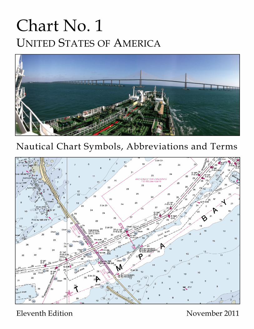
Chart No. 1UNITED STATES OF AMERICA
Nautical Chart Symbols, Abbreviations and Terms
Eleventh Edition November 2011
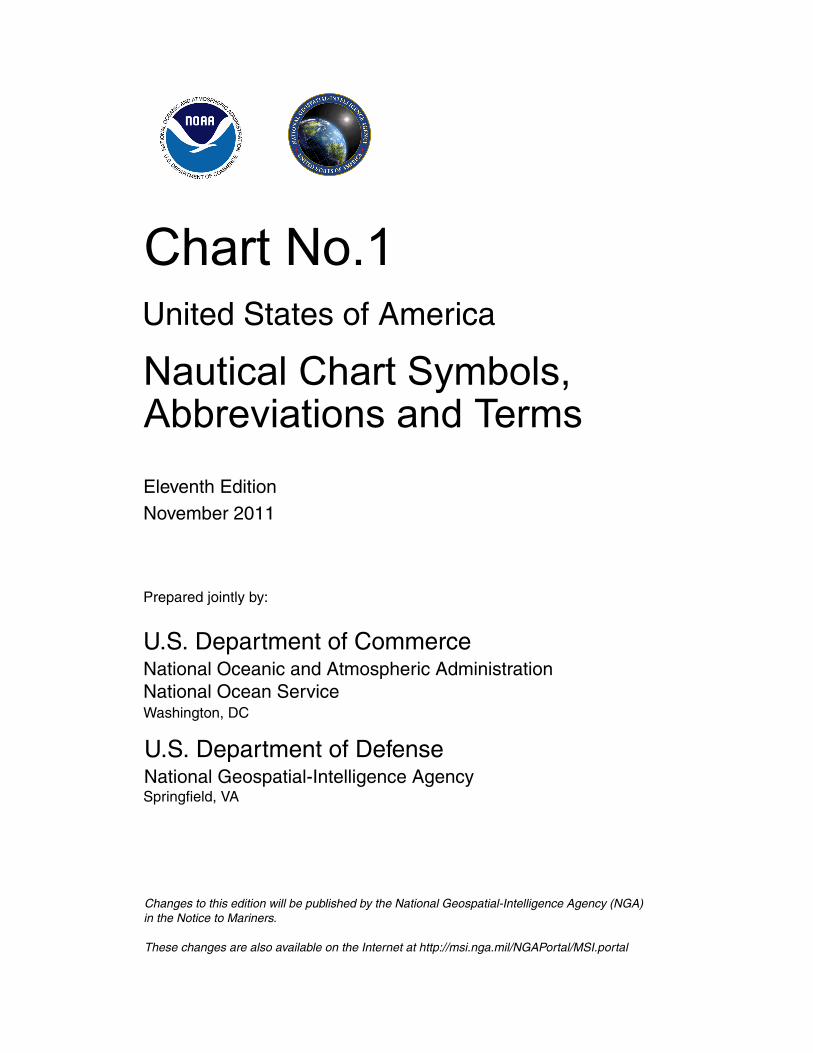
Chart No.1United States of America
Nautical Chart Symbols, Abbreviations and Terms
Eleventh EditionNovember 2011
Prepared jointly by:
U.S. Department of CommerceNational Oceanic and Atmospheric AdministrationNational Ocean ServiceWashington, DC
U.S. Department of DefenseNational Geospatial-Intelligence AgencySpringfield, VA
Changes to this edition will be published by the National Geospatial-Intelligence Agency (NGA) in the Notice to Mariners.
These changes are also available on the Internet at http://msi.nga.mil/NGAPortal/MSI.portal
2
Record of Corrections
Supplement No. Notice No. Corrected On Corrected by
3
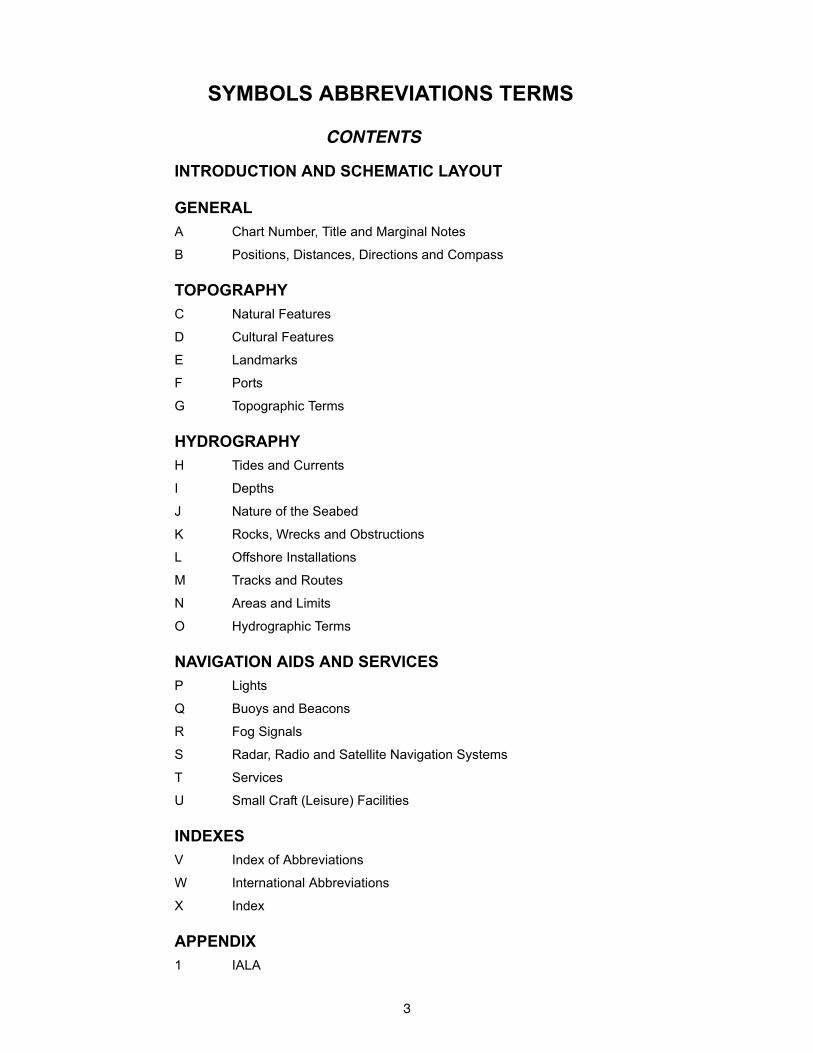
SYMBOLS ABBREVIATIONS TERMS
CONTENTS
INTRODUCTION AND SCHEMATIC LAYOUT
GENERAL
A Chart Number, Title and Marginal Notes
B Positions, Distances, Directions and Compass
TOPOGRAPHY
C Natural Features
D Cultural Features
E Landmarks
F Ports
G Topographic Terms
HYDROGRAPHY
H Tides and Currents
I Depths
J Nature of the Seabed
K Rocks, Wrecks and Obstructions
L Offshore Installations
M Tracks and Routes
N Areas and Limits
O Hydrographic Terms
NAVIGATION AIDS AND SERVICES
P Lights
Q Buoys and Beacons
R Fog Signals
S Radar, Radio and Satellite Navigation Systems
T Services
U Small Craft (Leisure) Facilities
INDEXES
V Index of Abbreviations
W International Abbreviations
X Index
APPENDIX
1 IALA
4
INTRODUCTION
Purpose - The 11th edition of U. S. Chart No. 1, Nautical Chart Symbols, Abbreviations and Terms presents the
symbols depicted on paper nautical charts produced by the National Oceanic and Atmospheric Administration
(NOAA) and the National Geospatial-Intelligence Agency (NGA), as well as digital raster representations of those
charts, such as Raster Nautical Charts (RNC®). This document also shows the symbols described in the
Regulations of the IHO for International (INT) Charts and Chart Specifications of the IHO published by the
International Hydrographic Organization (IHO), which are portrayed in the three official language versions of
International Chart 1 (INT 1).
Electronic Charts - The symbols and abbreviations displayed on navigation systems portraying NOAA-produced
Electronic Navigational Charts (NOAA ENC®) or NGA-produced Digital Nautical Charts (DNC®) are quite similar to
those used on paper charts for some features, but different for others. This document is not intended as a reference
for the use of these vector-based products.
Change in Column Order - Previous editions of U.S. Chart No. 1 showed U.S. symbology on the left side of the
page and INT 1 symbology in the second column from the right. This edition of Chart No. 1 has reversed the order.
INT 1 symbols now appear in the second column from the left, after the symbol number. Any variations from INT 1
symbology that are used on charts produced by NOAA or NGA are shown in the NOAA, NGA and the “NGA
reproduction of foreign charts” columns (columns 4, 5, and 6 respectively).
When columns 4 and 5 are combined, this indicates that NOAA and NGA use the same symbol for that particular
feature. When any of columns 4, 5, or 6 are blank, then the INT 1 symbol has been adopted for use by the
organization for which that column applies. The schematic layout following this introduction shows a typical symbol
table page and describes the table headers and the types of information presented in each of the columns.
Sample Chart Layouts – Section A presents two schematics showing typical layouts of the major elements of
NOAA and NGA charts.
Soundings - The sounding datum reference is stated in the chart title. Soundings on NOAA and NGA charts may be
shown in fathoms, feet, fathoms and feet, fathoms and fractions, or meters and decimeters. In all cases the unit of
depth used is shown in the chart title and outside the border of the chart in bold type. (See item Ab in Section A.)
Heights - Heights of lights, landmarks, structures, etc. refer to the shoreline plane of reference. The unit of height is
shown in the chart title. When the elevations of islets or bare rocks are offset into the adjacent water, they are shown
in parentheses.
Drying Heights - For rocks and banks that cover and uncover, elevations are underlined and are referenced to the
sounding datum as stated in the chart title. When the heights of rocks that cover and uncover are offset into the
adjacent water, they are shown in parentheses.
Shoreline - Shoreline shown on charts represents the line of contact between the land and a selected water
elevation. In areas affected by tidal fluctuation, this line of contact is usually the mean high-water line. In confined
coastal waters of diminished tidal influence, a mean water level may be used. The shoreline of interior waters
(rivers, lakes) is usually a line representing a specified elevation above a selected datum. Shoreline is symbolized
by a heavy line (symbol C1). Apparent shoreline is depicted on charts to show the outer edge of marine vegetation
where the shoreline limit would be expected to appear to the observer, or where it prevents the shoreline from being
clearly defined. Apparent shoreline is symbolized by a lighter line (symbols C32, C33, Ca, Cq and Cr).
5
Landmarks - A structure or a conspicuous feature on a structure may be shown by a landmark symbol with a
descriptive label (see Section E). Prominent buildings that could assist the navigator may be shown by actual shape
as viewed from above (see Sections D and E). On NGA charts, a landmark legend that is shown in capital letters
indicates that the landmark is conspicuous; the landmark may also be labeled “CONSPICUOUS” or “CONSPIC.” On
NOAA charts, all landmarks are considered to be conspicuous, and landmark legends shown in all capital letters
indicate the landmark has been positioned accurately; legends using both upper and lower case letters indicate an
approximate position.
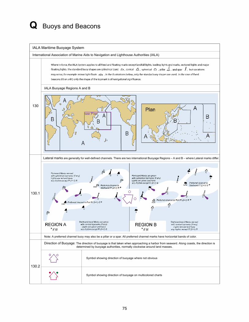
IALA Buoyage System - The International Association of Marine Aids to Navigation and Lighthouse Authorities
(IALA) Maritime Buoyage System is followed by most of the world’s maritime nations; however systems used in
some foreign waters may be different. IALA buoyage is divided into two regions: Region A and Region B. All
navigable waters of the United States follow IALA Region B rules, except U.S. possessions west of the International
Date Line and south of 10° north latitude, which follow IALA Region A.
The major difference in the two buoyage Regions is the color of the lateral marks. Region A uses red-to-port
marks and Region B uses red-to-starboard marks when entering from seaward. The shapes of lateral marks,
however, are the same in both Regions: can to port and cone (nun) to starboard, when entering from seaward.
Cardinal and other marks, such as isolated danger marks, safe water marks, and special marks are also the same in
both Regions. Section Q and Appendix 1 illustrate the IALA Buoyage System for both Regions A and B.
U.S. Lateral Marks - Most of U.S. waters lie withing IALA Region B. In the U.S. system, on entering a channel from
seaward, buoys and beacon dayboards on the starboard side are red with even numbers and have red lights, if lit.
Buoys and beacon dayboards on the port side are green with odd numbers and have green lights, if lit. Preferred
channel buoys have red and green horizontal bands with the top band color indicating the preferred side of passage.
Light Range (Visibility) - A light’s range or visibility is given in nautical miles, except on the Great Lakes and
adjacent waterways, where light ranges are given in statute miles. For lights having more than one color, NOAA
charts give only the shortest range of all the colors. On NGA charts, multiple ranges may be shown using the
following convention. For lights with two colors, the first number indicates the range of the first color and the second
number indicates the range of the second color. For example, Fl WG 12/8M indicates that the range of the white light
is 12 nautical miles and the range of green light is 8 nautical miles. For lights with three colors, only the longest and
shortest ranges are given. For example, Fl WRG 12-8M indicates that the range of the white light is 12 nautical miles,
the range of green light is 8 nautical miles, and the range of the red light is somewhere between 8 and 12 nautical
miles..
Positioning of Aids to Navigation - The fixed and floating aids to navigation depicted on charts have varying
degrees of reliability. Floating aids are moored to sinkers by varying lengths of chain and may shift due to sea
conditions and other causes. Buoys may also be carried away, capsized or sunk. Lighted buoys may be
extinguished and sound signals may not function, because of ice or other causes. Therefore, prudent mariners will
not rely solely on any single aid to navigation, particularly on floating aids, but will also use bearings from fixed
objects and aids to navigation on shore.
6
Colors - Color conveys the nature and importance of features found on nautical charts. Chart elements significant to
marine navigation, such as lights, compass roses and regulated areas, are emphasized with magenta. Lateral
marks on NOAA charts are shown with a red or green fill. Shades of blue depict potential hazards to navigation,
typically shallow water and submerged obstructions. Areas of deeper water believed to be clear of obstructions are
shown as white. Land, and other features that are always dry, are depicted with buff on NOAA charts and gray on
NGA charts. Foreshore and other intertidal features are portrayed with a green tint. Other colors may be used to
provide additional information, such as protected areas, which are outlined in blue or green and mineral lease
blocks, which are outlined in red.
Traffic Separation Schemes - Traffic separation schemes show recommended vessel traffic lanes to increase
safety of navigation, particularly in areas of high-density shipping. These schemes are described in the International
Maritime Organization (IMO) publication Ships’ Routeing. Traffic separation schemes are generally shown on
nautical charts at scales of 1:600,000 and larger. When possible, traffic separation schemes are plotted to scale and
shown as depicted in Section M.
Conversion Scales - Depth conversion scales are provided on all charts to enable the user to work in meters,
fathoms or feet.
Correction Date - The date of each new chart edition is shown below the lower left border of the chart. The date of
the latest NGA-issued U.S. Notice to Mariners applied to the chart is shown after the edition date. NOAA charts
include the date of the latest U.S. Coast Guard Local Notice to Mariners applied to the chart.
Additional Resources - Information about the use of nautical charts, aids to navigation, sounding datum, and the
general practice of navigation can be found in The American Practical Navigator, available via the “Publications”
hyperlink at http://msi.nga.mil/NGAPortal/MSI.portal.
Tide and tidal current data in U.S. waters is available from the NOAA Center for Operational Oceanographic
Products and Services at http://tidesandcurrents.noaa.gov.
Detailed information about specific lights, buoys, and beacons located in United States waters, and general
information about the U.S. Aids to Navigation System and the Uniform State Waterway Marking Systems is
published in the U.S. Coast Guard Light List, available at http://www.navcen.uscg.gov/?pageName=lightLists.
Information about lighted and radio aids to navigation located in waters outside of the United States is published in
the NGA List of Lights, available via the “Publications” hyperlink at http://msi.nga.mil/NGAPortal/MSI.portal.
Other important information that cannot be shown conveniently on nautical charts can be found in the NOAA U.S.
Coast Pilot® publications, available at http://www.nauticalcharts.noaa.gov/staff/chartspubs.html, or in the NGA
Sailing Directions publications, available via the “Publications” hyperlink at http://msi.nga.mil/NGAPortal/MSI.portal.
U.S. Nautical Chart Catalogs and Indexes - These catalogs list nautical charts, auxiliary maps, and related
publications. They include general information relative to the use and ordering of nautical products. NOAA catalogs
are available at http://www.nauticalcharts.noaa.gov/mcd/ccatalogs.htm. NGA product catalog entries are available
as a searchable database via the “Product Catalog” hyperlink at http://msi.nga.mil/NGAPortal/MSI.portal.
7
Corrections and Comments - Notices of corrections to this publication are published in the U.S. Notice to
Mariners, available via the “Notice to Mariners” hyperlink at http://msi.nga.mil/NGAPortal/MSI.portal.
Users should refer corrections, additions and comments to the Worldwide Navigational Warning Service 24-hour
Watch Desk, toll free: 1-800-362-6289, commercial: 571-547-5455, DSN: 547-5455, e-mail: [email protected] or
[email protected], or by mail to:
Maritime Safety Office
Mail Stop N64-SH
National Geospatial-Intelligence Agency
7500 GEOINT Drive
Springfield, VA 22150-7500
8
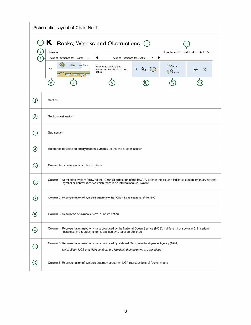
Schematic Layout of Chart No.1:
Section
Section designation
Sub-section
Reference to “Supplementary national symbols” at the end of each section
Cross-reference to terms in other sections
Column 1: Numbering system following the “Chart Specification of the IHO”. A letter in this column indicates a supplementary national symbol or abbreviation for which there is no international equivalent
Column 2: Representation of symbols that follow the “Chart Specifications of the IHO”
Column 3: Description of symbols, term, or abbreviation
Column 4: Representation used on charts produced by the National Ocean Service (NOS), if different from column 2. In certain instances, the representation is clarified by a label on the chart
Column 5: Representation used on charts produced by National Geospatial-Intelligence Agency (NGA)
Note: When NOS and NGA symbols are identical, their columns are combined
Column 6: Representation of symbols that may appear on NGA reproductions of foreign charts

9
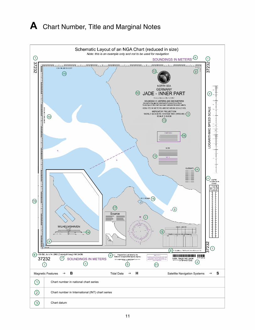
A Chart Number, Title and Marginal Notes
Magnetic Features B Tidal Data H Satellite Navigation Systems S
Chart number in national chart series
Chart number in International (INT) chart series
Chart datum

10
A Chart Number, Title and Marginal Notes
Publication note (imprint)
Copyright note
Edition note
Notice to Mariners corrections
Dimensions of inner borders
Corner coordinates
Chart title
Explanatory notes on chart construction, etc. To be read before using chart
Seal(s)
Scale of chart. Some charts have scale at a stated latitude
Linear scale on large-scale charts
Linear border scale on large-scale charts. On smaller scales use latitude borders for sea miles
Cautionary notes (if any), Information on particular features, to be read before using chart
Source Diagram (if any). The source Diagram should be studied before using the chart in order to assess the reliability of the sources. Navigators should be cautious where surveys are inadequate
Reference to a larger-scale chart
Reference to an adjoining chart of similar scale
Instruction to refer to complementary nautical publications
Conversion Scales.
Reference to the units used for depth measurement
Compass Rose
Bar code and stock number
Glossary: Translation of words on chart that are not in English
Identification of a latticed chart (if any)
Tidal and Tidal Stream information within the chart coverage
11
A Chart Number, Title and Marginal Notes
Magnetic Features B Tidal Data H Satellite Navigation Systems S
Chart number in national chart series
Chart number in International (INT) chart series
Chart datum
12
A Chart Number, Title and Marginal Notes
Publication note (imprint)
Copyright note
Edition note
Notice to Mariners corrections
Dimensions of inner borders
Corner coordinates
Chart title
Explanatory notes on chart construction, etc. To be read before using chart
Seal(s)
Scale of chart. Some charts have scale at a stated latitude
Linear scale on large-scale charts
Linear border scale on large-scale charts. On smaller scales use latitude borders for sea miles
Cautionary notes (if any), Information on particular features, to be read before using chart
Source Diagram (if any). The source Diagram should be studied before using the chart in order to assess the reliability of the sources. Navigators should be cautious where surveys are inadequate
Reference to a larger-scale chart
Reference to an adjoining chart of similar scale
Instruction to refer to complementary nautical publications
Conversion Scales.
Reference to the units used for depth measurement
Compass Rose
Bar code and stock number
Glossary: Translation of words on chart that are not in English
Identification of a latticed chart (if any)
Tidal and Tidal Stream information within the chart coverage

13
B Positions, Distances, Directions and Compass
Geographical Positions
1 Lat Latitude
2 Long Longitude
3 International Meridian (Greenwich)
4 Degree(s)
5 Minute(s) of arc
6 Second(s) of arc
7 PA Position approximate PA (PA)
8 PD Position doubtful PD (PD)
9 N North
10 E East
11 S South
12 W West
13 NE Northeast
14 SE Southeast
15 NW Northwest
16 SW Southwest
Control Points
20 Triangulation point
21 Observation spot
22 Fixed point
23 Benchmark
24 Boundary mark
25.1 Distance along waterway, no visible marker
25.2 Distance along waterway, with visible marker
Symbolized Positions (Examples)
30 Symbols in plan: position is center of primary symbol
14
B Positions, Distances, Directions and Compass
31 Symbols in profile: position is at bottom of symbol
32 Point symbols: accurate positions
33 Approximate position
Units Supplementary national symbols: a – m
40 km Kilometer(s)
41 m Meter(s)
42 dm Decimeter(s)
43 cm Centimeter(s)
44 mm Millimeter(s)
45 M International nautical mile(s) or, sea mile(s) (1852m)
Mi NMi NM
46 Cable (0.1M) cbl
47 ft Foot/Feet
48 Fathom(s) fm
49 h Hour hr
50 m min Minute(s) of time
51 s sec Second(s) of time
52 kn Knot(s)
53 t Tonne(s), Ton(s) Tonnage (weight)
54 cd Candela
Magnetic Compass Supplementary national symbols: n
60 Variation var VAR
61 Magnetic mag
62 Bearing brg
63 True T
64 Decreasing
65 Increasing
66 Annual change
67 Deviation dev
15
B Positions, Distances, Directions and Compass
68.1 Note of magnetic variation, in position
68.2 Note of magnetic variation, out of position
70
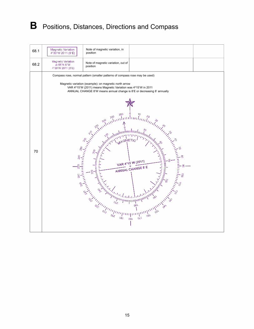
Compass rose, normal pattern (smaller patterns of compass rose may be used)
Magnetic variation (example): on magnetic north arrowVAR 4o15’W (2011) means Magnetic Variation was 4o15’W in 2011ANNUAL CHANGE 8’W means annual change is 8’E or decreasing 8’ annually
16
B Positions, Distances, Directions and Compass
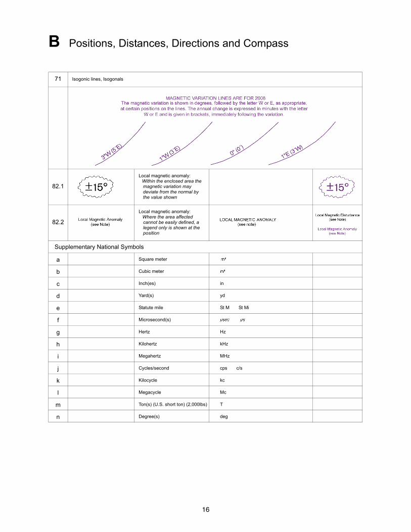
71 Isogonic lines, Isogonals
82.1
Local magnetic anomaly:Within the enclosed area the magnetic variation may deviate from the normal by the value shown
82.2
Local magnetic anomaly:Where the area affected cannot be easily defined, a legend only is shown at the position
Supplementary National Symbols
a Square meter
b Cubic meter
c Inch(es) in
d Yard(s) yd
e Statute mile St M St Mi
f Microsecond(s)
g Hertz Hz
h Kilohertz kHz
i Megahertz MHz
j Cycles/second cps c/s
k Kilocycle kc
l Megacycle Mc
m Ton(s) (U.S. short ton) (2,000lbs) T
n Degree(s) deg

17
C Natural Features
Coastline Supplementary national symbols: a – d, p – t
Foreshore I, J
1 Coastline, surveyed
2 Coastline, unsurveyed
3 Cliffs, Steep coast, Steep coast with rock cliffs
4 Hillocks
5 Flat coast
6 Sandy shore
7 Stony shore, Shingly shore
8 Sandhills, Dunes
18
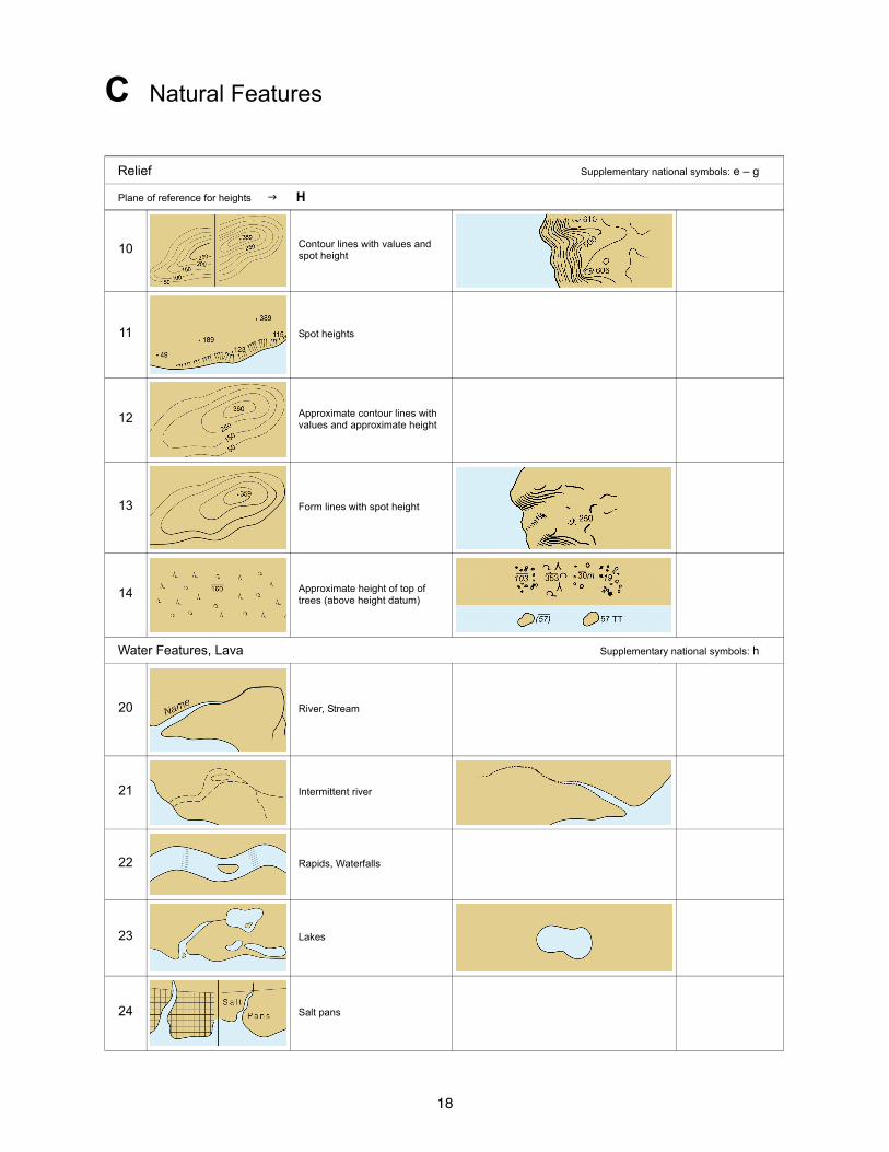
C Natural Features
Relief Supplementary national symbols: e – g
Plane of reference for heights H
10 Contour lines with values and spot height
11 Spot heights
12 Approximate contour lines with values and approximate height
13 Form lines with spot height
14 Approximate height of top of trees (above height datum)
Water Features, Lava Supplementary national symbols: h
20 River, Stream
21 Intermittent river
22 Rapids, Waterfalls
23 Lakes
24 Salt pans
19
C Natural Features
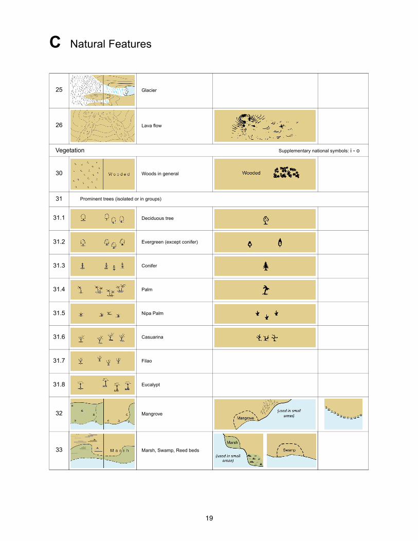
25 Glacier
26 Lava flow
Vegetation Supplementary national symbols: i - o
30 Woods in general
31 Prominent trees (isolated or in groups)
31.1 Deciduous tree
31.2 Evergreen (except conifer)
31.3 Conifer
31.4 Palm
31.5 Nipa Palm
31.6 Casuarina
31.7 Filao
31.8 Eucalypt
32 Mangrove
33 Marsh, Swamp, Reed beds
20
C Natural Features
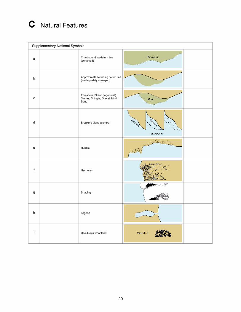
Supplementary National Symbols
a Chart sounding datum line (surveyed)
b Approximate sounding datum line (inadequately surveyed)
cForeshore; Strand (in general) Stones; Shingle; Gravel; Mud; Sand
d Breakers along a shore
e Rubble
f Hachures
g Shading
h Lagoon
i Deciduous woodland
21
C Natural Features
j Coniferous woodland
k Tree plantation
l Cultivated fields
m Grassfields
n Paddy (rice) fields
o Bushes
p Apparent Shoreline
q Vegetation or topographic (Feature Area Limit- in general)
r Cypress
s Grass
t Eelgrass
22
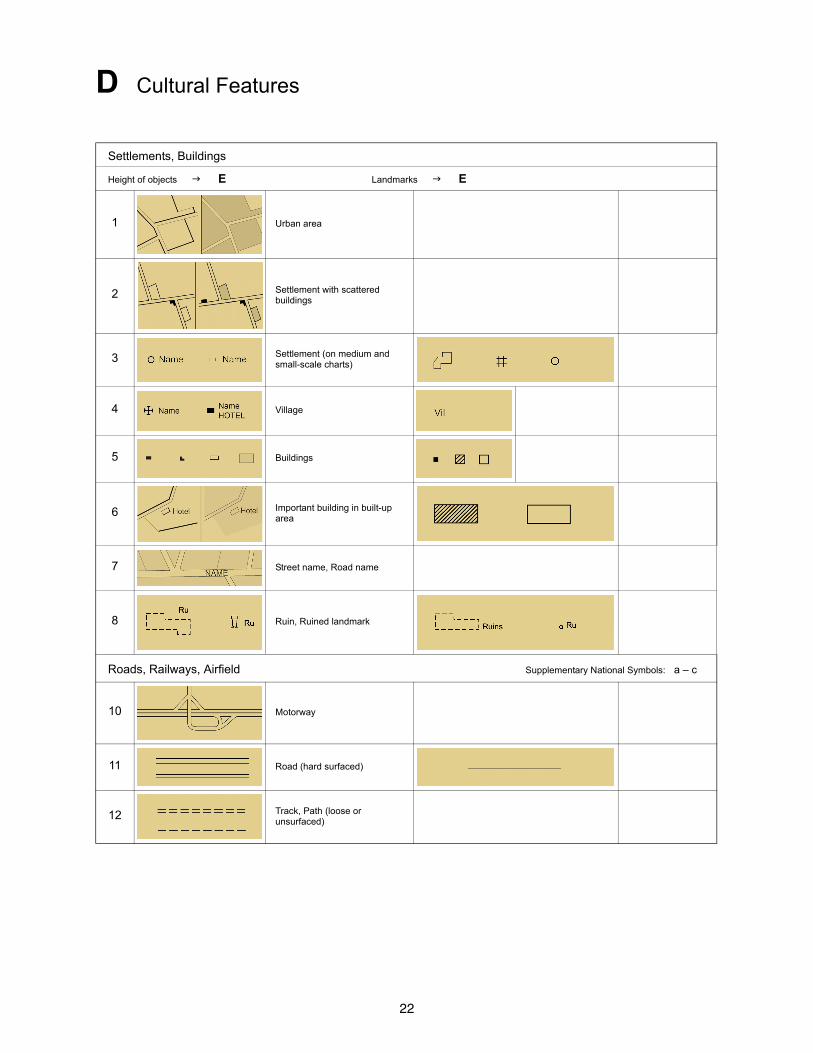
D Cultural Features
Settlements, Buildings
Height of objects E Landmarks E
1 Urban area
2 Settlement with scattered buildings
3 Settlement (on medium and small-scale charts)
4 Village
5 Buildings
6 Important building in built-up area
7 Street name, Road name
8 Ruin, Ruined landmark
Roads, Railways, Airfield Supplementary National Symbols: a – c
10 Motorway
11 Road (hard surfaced)
12 Track, Path (loose or unsurfaced)
23
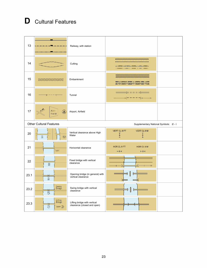
D Cultural Features
13 Railway, with station
14 Cutting
15 Embankment
16 Tunnel
17 Airport, Airfield
Other Cultural Features Supplementary National Symbols: d - i
20 Vertical clearance above High Water
21 Horizontal clearance
22 Fixed bridge with vertical clearance
23.1 Opening bridge (in general) with vertical clearance
23.2 Swing bridge with vertical clearance
23.3 Lifting bridge with vertical clearance (closed and open)
24
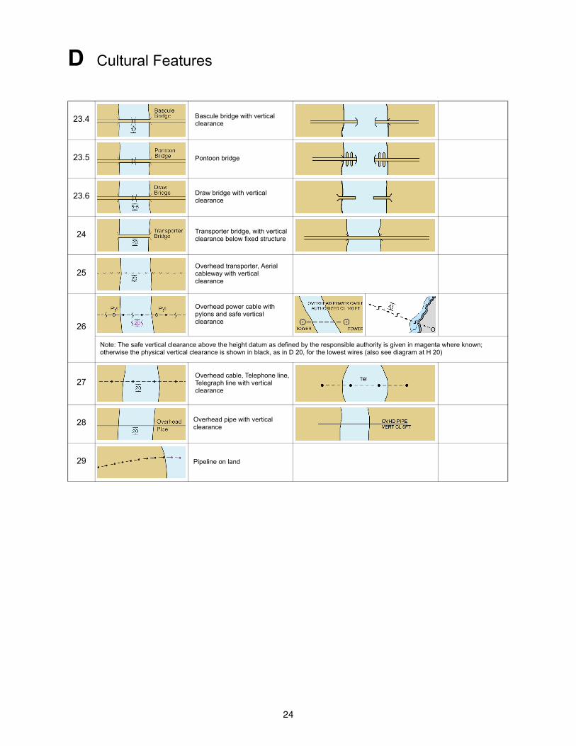
D Cultural Features
23.4 Bascule bridge with vertical clearance
23.5 Pontoon bridge
23.6 Draw bridge with vertical clearance
24 Transporter bridge, with vertical clearance below fixed structure
25Overhead transporter, Aerial cableway with vertical clearance
26
Overhead power cable with pylons and safe vertical clearance
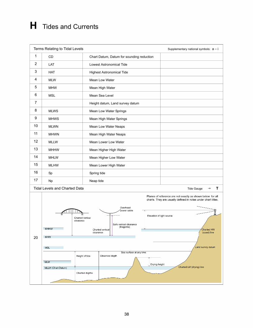
Note: The safe vertical clearance above the height datum as defined by the responsible authority is given in magenta where known; otherwise the physical vertical clearance is shown in black, as in D 20, for the lowest wires (also see diagram at H 20)
27Overhead cable, Telephone line, Telegraph line with vertical clearance
28 Overhead pipe with vertical clearance
29 Pipeline on land
25
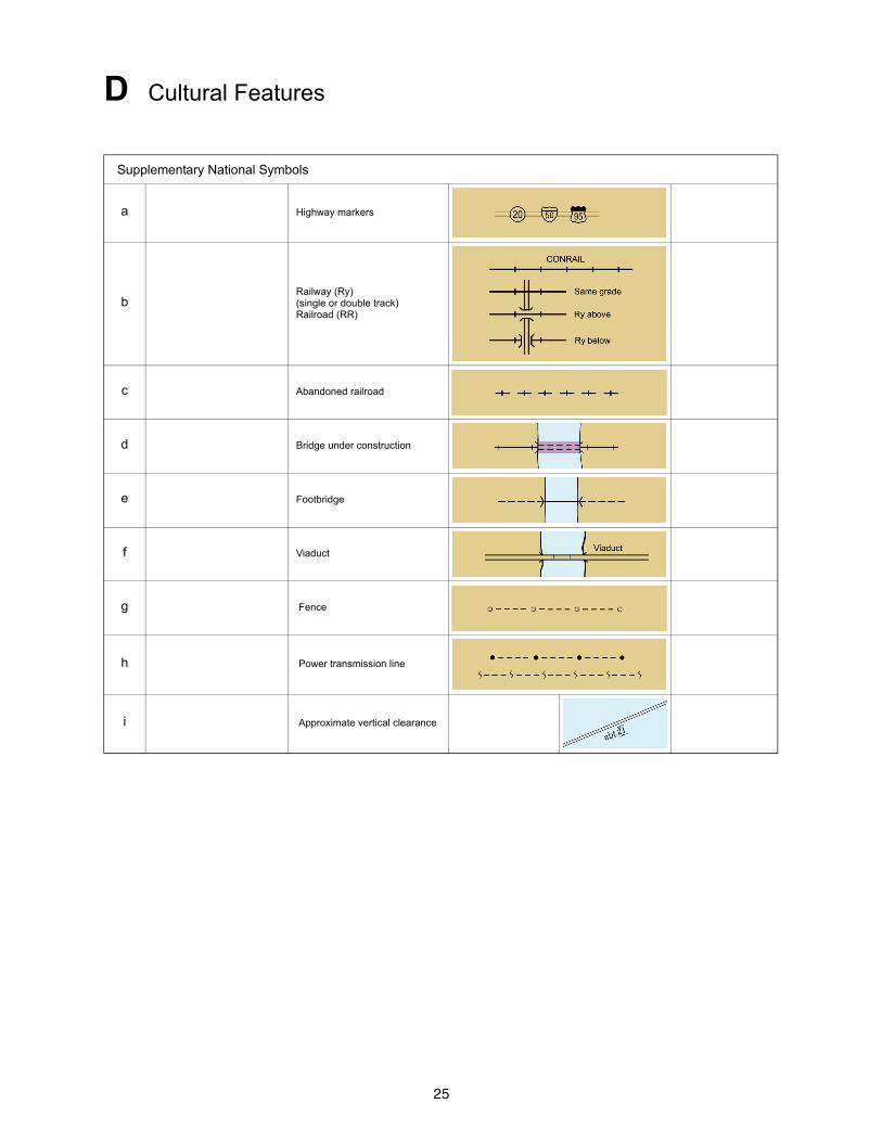
D Cultural Features
Supplementary National Symbols
a Highway markers
bRailway (Ry)(single or double track)Railroad (RR)
c Abandoned railroad
d Bridge under construction
e Footbridge
f Viaduct
g Fence
h Power transmission line
i Approximate vertical clearance
26
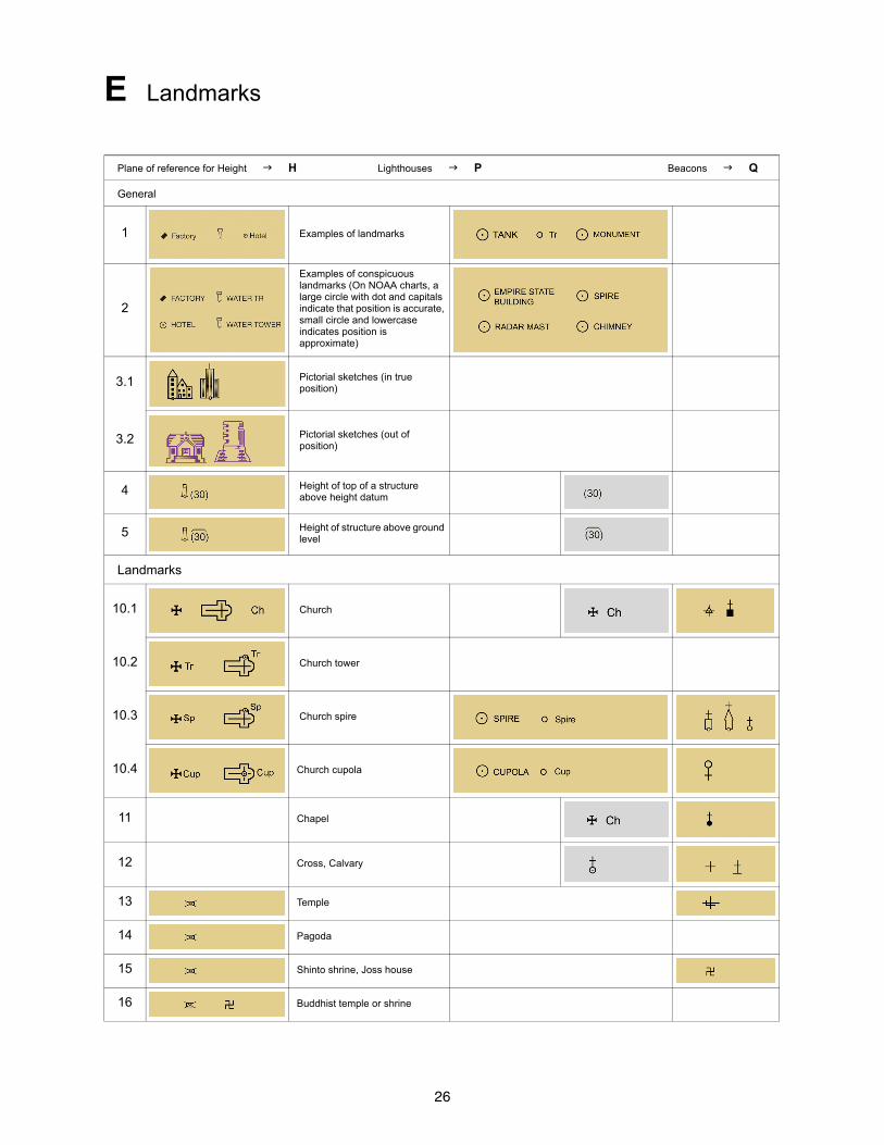
E Landmarks
Plane of reference for Height H Lighthouses P Beacons Q
General
1 Examples of landmarks
2
Examples of conspicuous landmarks (On NOAA charts, a large circle with dot and capitals indicate that position is accurate, small circle and lowercase indicates position is approximate)
3.1 Pictorial sketches (in true position)
3.2 Pictorial sketches (out of position)
4 Height of top of a structure above height datum
5 Height of structure above ground level
Landmarks
10.1 Church
10.2 Church tower
10.3 Church spire
10.4 Church cupola
11 Chapel
12 Cross, Calvary
13 Temple
14 Pagoda
15 Shinto shrine, Joss house
16 Buddhist temple or shrine
27
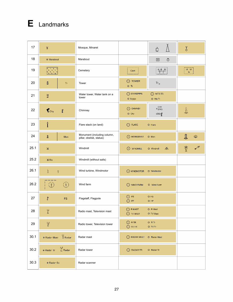
E Landmarks
17 Mosque, Minaret
18 Marabout
19 Cemetery
20 Tower
21 Water tower, Water tank on a tower
22 Chimney
23 Flare stack (on land)
24 Monument (including column, pillar, obelisk, statue)
25.1 Windmill
25.2 Windmill (without sails)
26.1 Wind turbine, Windmotor
26.2 Wind farm
27 Flagstaff, Flagpole
28 Radio mast, Television mast
29 Radio tower, Television tower
30.1 Radar mast
30.2 Radar tower
30.3 Radar scanner
28
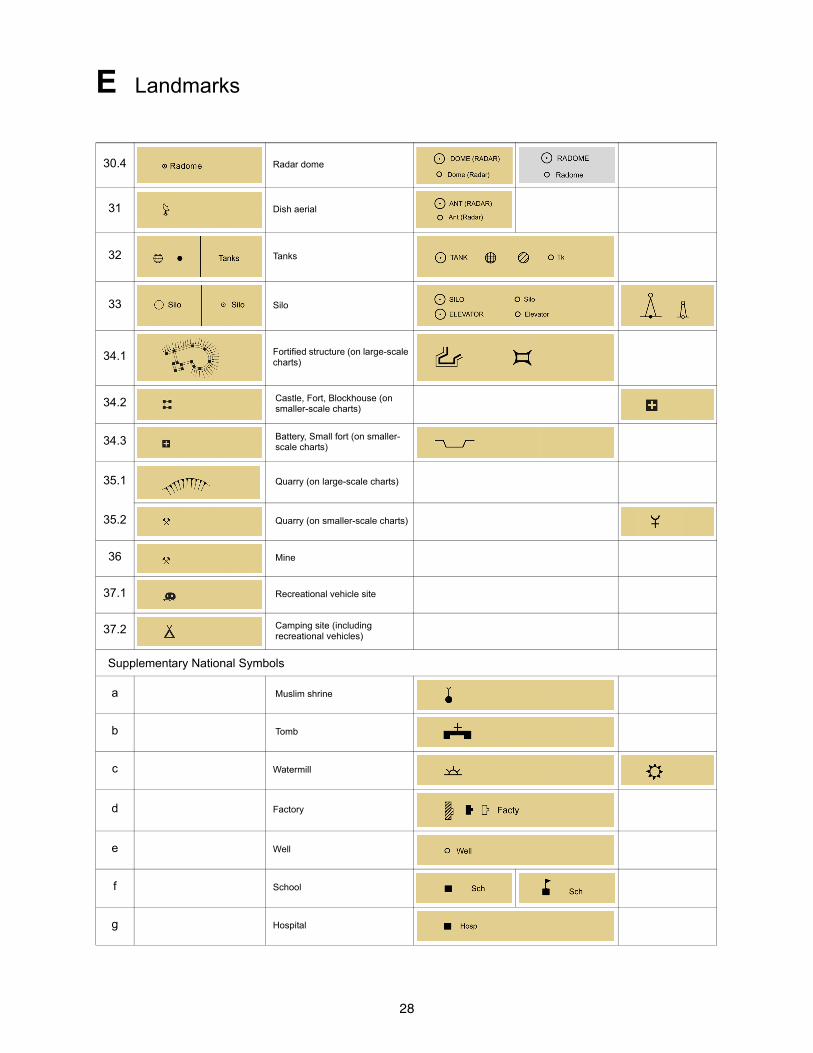
E Landmarks
30.4 Radar dome
31 Dish aerial
32 Tanks
33 Silo
34.1 Fortified structure (on large-scale charts)
34.2 Castle, Fort, Blockhouse (on smaller-scale charts)
34.3 Battery, Small fort (on smaller-scale charts)
35.1 Quarry (on large-scale charts)
35.2 Quarry (on smaller-scale charts)
36 Mine
37.1 Recreational vehicle site
37.2 Camping site (including recreational vehicles)
Supplementary National Symbols
a Muslim shrine
b Tomb
c Watermill
d Factory
e Well
f School
g Hospital
29
E Landmarks
h University
i Gable
k Telegraph Telegraph office
TelTel Off
l Magazine Magz
m Government house Govt Ho
n Institute Inst
o Courthouse Ct Ho
p Pavilion Pav
q Telephone T
r Limited Ltd
s Apartment Apt
t Capitol Cap
u Company Co
v Corporation Corp
30
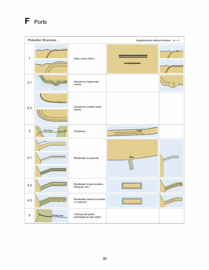
F Ports
Protection Structures Supplementary national symbols: a – c
1 Dyke, Levee, Berm
2.1 Seawall (on large-scale charts)
2.2 Seawall (on smaller-scale charts)
3 Causeway
4.1 Breakwater (in general)
4.2 Breakwater (loose boulders, tetrapods, etc.)
4.3 Breakwater (slope of concrete or masonry)
5 Training wall (partly submerged at high water)
31
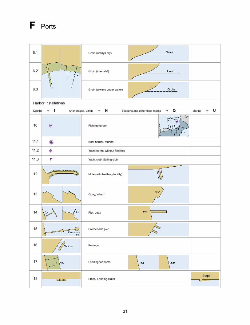
F Ports
6.1 Groin (always dry)
6.2 Groin (intertidal)
6.3 Groin (always under water)
Harbor Installations
Depths I Anchorages, Limits N Beacons and other fixed marks Q Marina U
10 Fishing harbor
11.1 Boat harbor, Marina
11.2 Yacht berths without facilities
11.3 Yacht club, Sailing club
12 Mole (with berthing facility)
13 Quay, Wharf
14 Pier, Jetty
15 Promenade pier
16 Pontoon
17 Landing for boats
18 Steps, Landing stairs
32
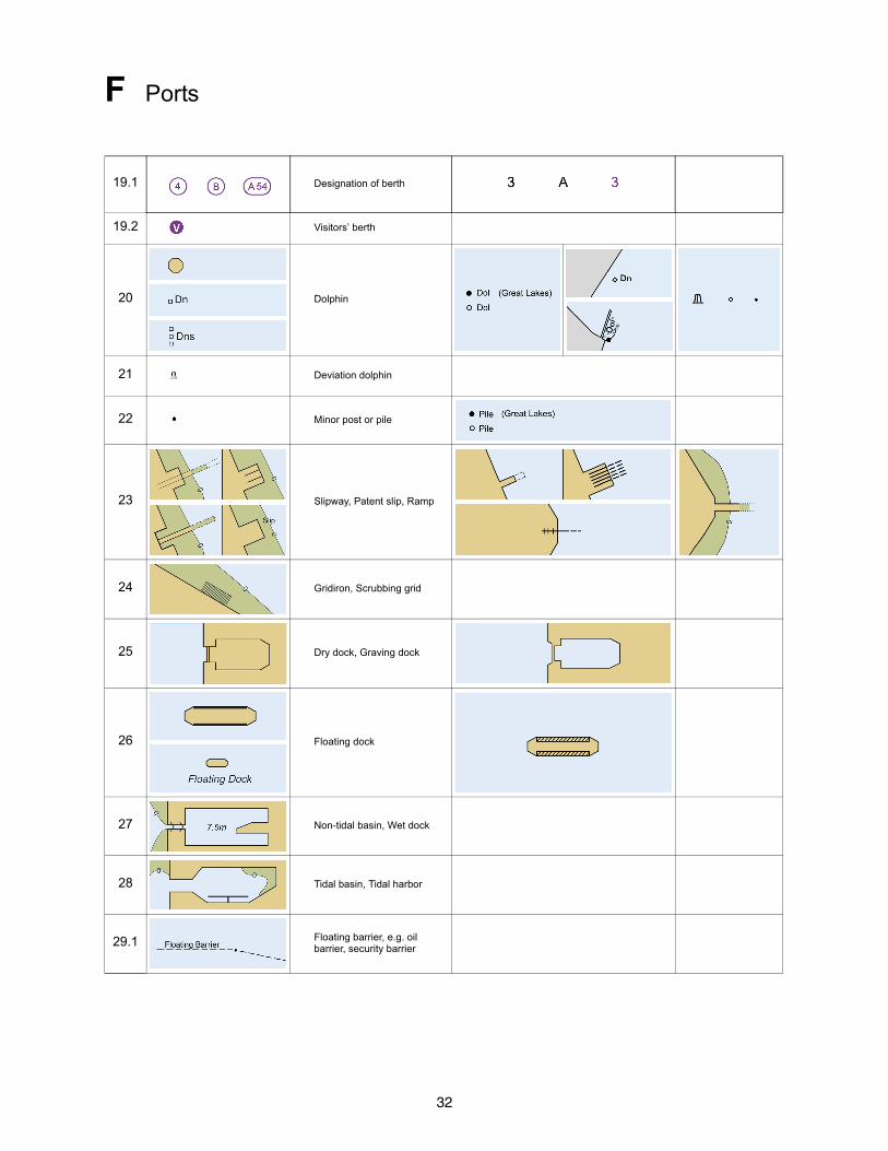
F Ports
19.1 Designation of berth
19.2 Visitors’ berth
20 Dolphin
21 Deviation dolphin
22 Minor post or pile
23 Slipway, Patent slip, Ramp
24 Gridiron, Scrubbing grid
25 Dry dock, Graving dock
26 Floating dock
27 Non-tidal basin, Wet dock
28 Tidal basin, Tidal harbor
29.1 Floating barrier, e.g. oil barrier, security barrier
33
F Ports
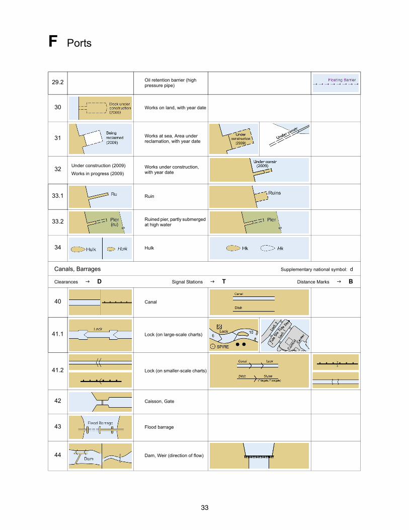
29.2 Oil retention barrier (high pressure pipe)
30 Works on land, with year date
31 Works at sea, Area under reclamation, with year date
32Under construction (2009)
Works in progress (2009)
Works under construction, with year date
33.1 Ruin
33.2 Ruined pier, partly submerged at high water
34 Hulk
Canals, Barrages Supplementary national symbol: d
Clearances D Signal Stations T Distance Marks B
40 Canal
41.1 Lock (on large-scale charts)
41.2 Lock (on smaller-scale charts)
42 Caisson, Gate
43 Flood barrage
44 Dam, Weir (direction of flow)
34
F Ports
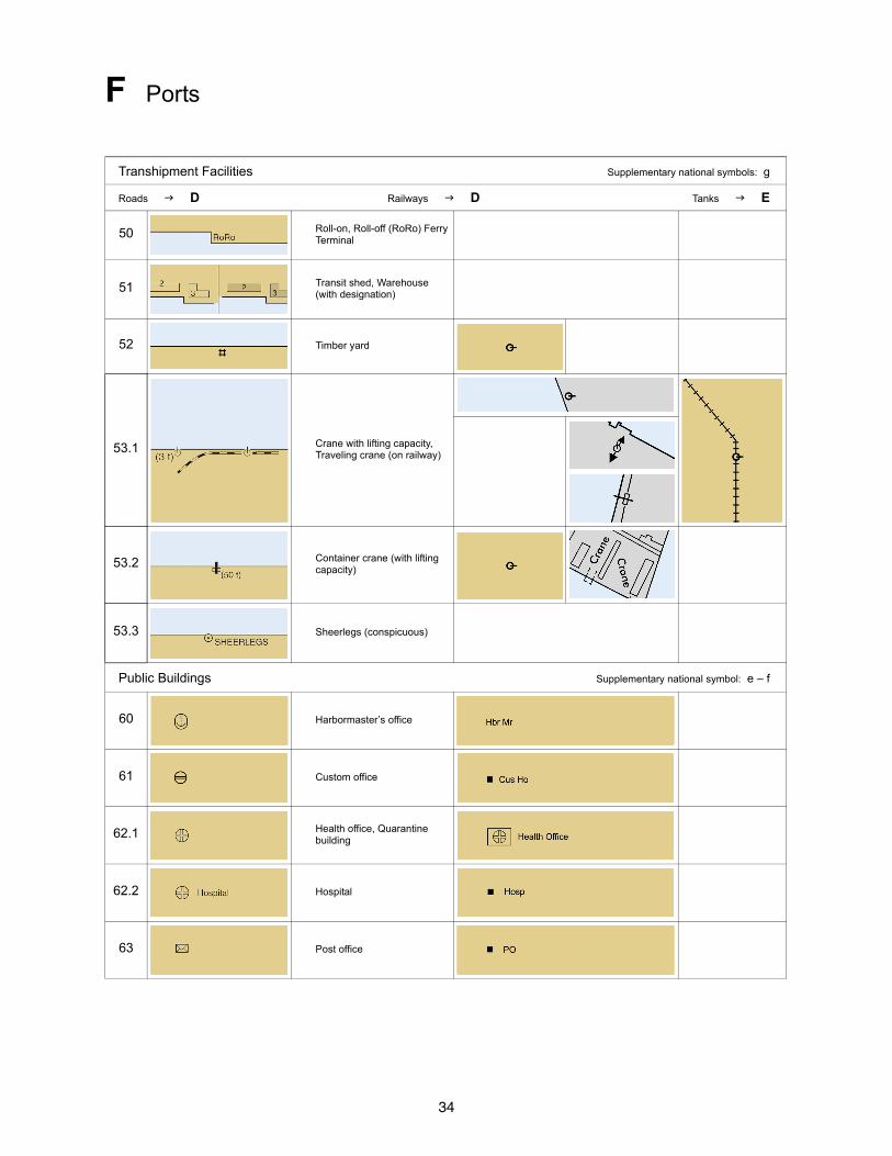
Transhipment Facilities Supplementary national symbols: g
Roads D Railways D Tanks E
50 Roll-on, Roll-off (RoRo) Ferry Terminal
51 Transit shed, Warehouse (with designation)
52 Timber yard
53.1 Crane with lifting capacity, Traveling crane (on railway)
53.2 Container crane (with lifting capacity)
53.3 Sheerlegs (conspicuous)
Public Buildings Supplementary national symbol: e – f
60 Harbormaster’s office
61 Custom office
62.1 Health office, Quarantine building
62.2 Hospital
63 Post office
35
F Ports
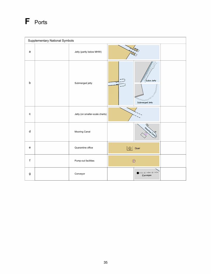
Supplementary National Symbols
a Jetty (partly below MHW)
b Submerged jetty
c Jetty (on smaller-scale charts)
d Mooring Canal
e Quarantine office
f Pump-out facilities
g Conveyor

36
G Topographic Terms
Coast
1 Island 8 Head, Headland
2 Islet 9 Point
3 Cay 10 Spit
4 Peninsula 11 Rock
5 Archipelago 12 Salt marsh, Saltings
6 Atoll 13 Lagoon
7 Cape
Natural Inland Features
20 Promontory 30 Plateau
21 Range 31 Valley
22 Ridge 32 Ravine, Cut
23 Mountain, Mount 33 Gorge
24 Summit 34 Vegetation
25 Peak 35 Grassland
26 Volcano 36 Paddy field
27 Hill 37 Bushes
28 Boulder 38 Deciduous woodland
29 Table-land, Tableland 39 Coniferous woodland
Settlements
50 City, Town 53 Farm
51 Village 54 Saint
52 Fishing village
Buildings
60 Structure 74 Institute
61 House 75 Cathedral
62 Hut 76 Monastery, Convent
63 Multi-story building 77 Lookout station, Watch tower
64 Castle 78 Navigation school
65 Pyramid 79 Naval college
66 Column 80 Factory
67 Mast 81 Brick kiln, Brick works
68 Lattice tower 82 Cement works
69 Mooring mast 83 Water mill
70 Floodlight 84 Greenhouse
71 Town hall 85 Warehouse, Storehouse
72 Office 86 Cold store, Refrigerating storage
73 Observatory 87 Refinery
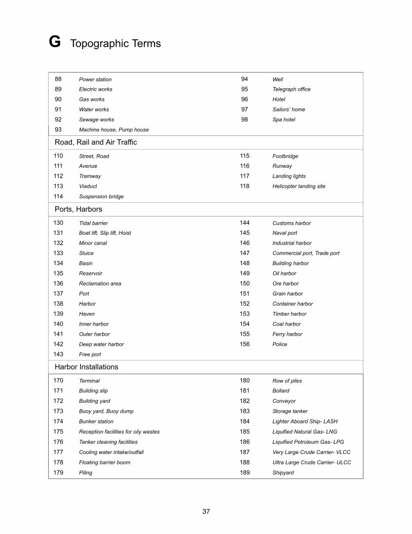
37
G Topographic Terms
88 Power station 94 Well
89 Electric works 95 Telegraph office
90 Gas works 96 Hotel
91 Water works 97 Sailors’ home
92 Sewage works 98 Spa hotel
93 Machine house, Pump house
Road, Rail and Air Traffic
110 Street, Road 115 Footbridge
111 Avenue 116 Runway
112 Tramway 117 Landing lights
113 Viaduct 118 Helicopter landing site
114 Suspension bridge
Ports, Harbors
130 Tidal barrier 144 Customs harbor
131 Boat lift, Slip lift, Hoist 145 Naval port
132 Minor canal 146 Industrial harbor
133 Sluice 147 Commercial port, Trade port
134 Basin 148 Building harbor
135 Reservoir 149 Oil harbor
136 Reclamation area 150 Ore harbor
137 Port 151 Grain harbor
138 Harbor 152 Container harbor
139 Haven 153 Timber harbor
140 Inner harbor 154 Coal harbor
141 Outer harbor 155 Ferry harbor
142 Deep water harbor 156 Police
143 Free port
Harbor Installations
170 Terminal 180 Row of piles
171 Building slip 181 Bollard
172 Building yard 182 Conveyor
173 Buoy yard, Buoy dump 183 Storage tanker
174 Bunker station 184 Lighter Aboard Ship- LASH
175 Reception facilities for oily wastes 185 Liquified Natural Gas- LNG
176 Tanker cleaning facilities 186 Liquified Petroleum Gas- LPG
177 Cooling water intake/outfall 187 Very Large Crude Carrier- VLCC
178 Floating barrier boom 188 Ultra Large Crude Carrier- ULCC
179 Piling 189 Shipyard
38
H Tides and Currents
Terms Relating to Tidal Levels Supplementary national symbols: a – i
1 CD Chart Datum, Datum for sounding reduction
2 LAT Lowest Astronomical Tide
3 HAT Highest Astronomical Tide
4 MLW Mean Low Water
5 MHW Mean High Water
6 MSL Mean Sea Level
7 Height datum, Land survey datum
8 MLWS Mean Low Water Springs
9 MHWS Mean High Water Springs
10 MLWN Mean Low Water Neaps
11 MHWN Mean High Water Neaps
12 MLLW Mean Lower Low Water
13 MHHW Mean Higher High Water
14 MHLW Mean Higher Low Water
15 MLHW Mean Lower High Water
16 Sp Spring tide
17 Np Neap tide
Tidal Levels and Charted Data Tide Gauge T
20
39
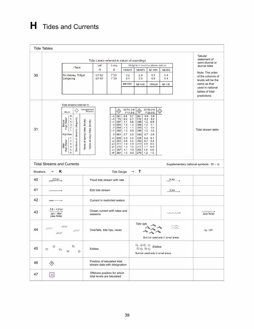
H Tides and Currents
Tide Tables
30
Tabular statement of semi-diurnal or diurnal tides
Note: The order of the columns of levels will be the same as that used in national tables of tidal
predictions
31 Tidal stream table
Tidal Streams and Currents Supplementary national symbols: m – u
Breakers K Tide Gauge T
40 Flood tide stream with rate
41 Ebb tide stream
42 Current in restricted waters
43 Ocean current with rates and seasons
44 Overfalls, tide rips, races
45 Eddies
46 Position of tabulated tidal stream data with designation
47 Offshore position for which tidal levels are tabulated
40
H Tides and Currents
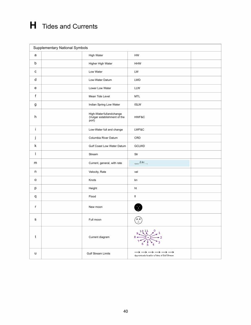
Supplementary National Symbols
a High Water HW
b Higher High Water HHW
c Low Water LW
d Low-Water Datum LWD
e Lower Low Water LLW
f Mean Tide Level MTL
g Indian Spring Low Water ISLW
hHigh-Water full and change (Vulgar establishment of the port)
HWF&C
i Low-Water full and change LWF&C
j Columbia River Datum CRD
k Gulf Coast Low Water Datum GCLWD
l Stream Str
m Current, general, with rate
n Velocity, Rate vel
o Knots kn
p Height ht
q Flood fl
r New moon
s Full moon
t Current diagram
u Gulf Stream Limits
41
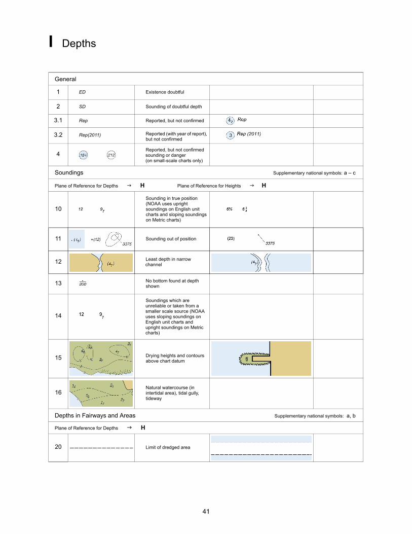
I Depths
General
1 ED Existence doubtful
2 SD Sounding of doubtful depth
3.1 Rep Reported, but not confirmed
3.2 Rep(2011) Reported (with year of report), but not confirmed
4Reported, but not confirmed sounding or danger (on small-scale charts only)
Soundings Supplementary national symbols: a – c
Plane of Reference for Depths H Plane of Reference for Heights H
10
Sounding in true position (NOAA uses upright soundings on English unit charts and sloping soundings on Metric charts)
11 Sounding out of position
12 Least depth in narrow channel
13 No bottom found at depth shown
14
Soundings which are unreliable or taken from a smaller scale source (NOAA uses sloping soundings on English unit charts and upright soundings on Metric charts)
15 Drying heights and contours above chart datum
16Natural watercourse (in intertidal area), tidal gully, tideway
Depths in Fairways and Areas Supplementary national symbols: a, b
Plane of Reference for Depths H
20 Limit of dredged area
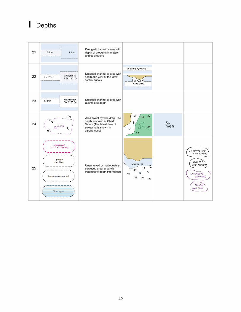
42
I Depths
21Dredged channel or area with depth of dredging in meters and decimeters
22Dredged channel or area with depth and year of the latest control survey
23 Dredged channel or area with maintained depth
24
Area swept by wire drag. The depth is shown at Chart Datum (The latest date of sweeping is shown in parentheses)
25Unsurveyed or inadequately surveyed area; area with inadequate depth information
43
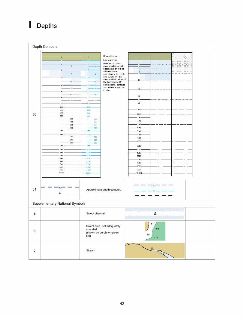
I Depths
Depth Contours
30
31 Approximate depth contours
Supplementary National Symbols
a Swept channel
bSwept area, not adequately sounded (shown by purple or green tint)
c Stream
44
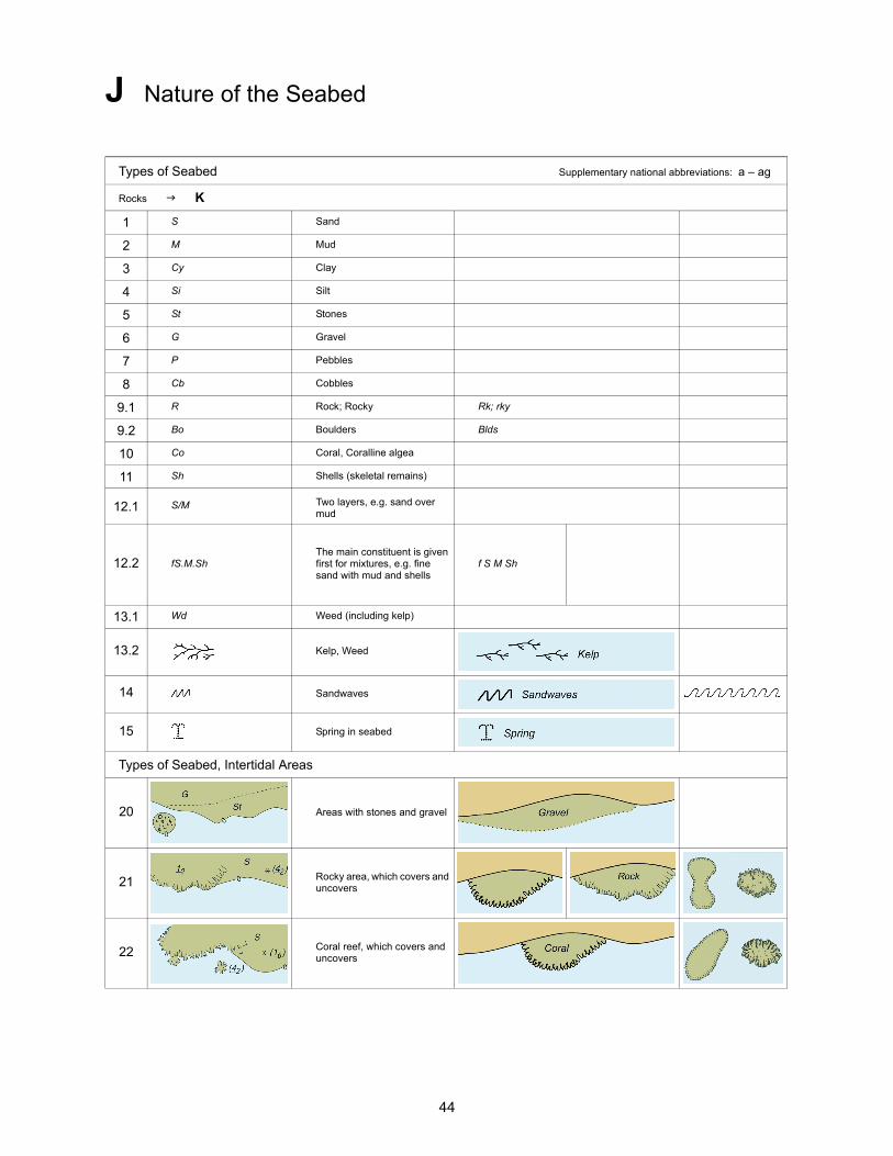
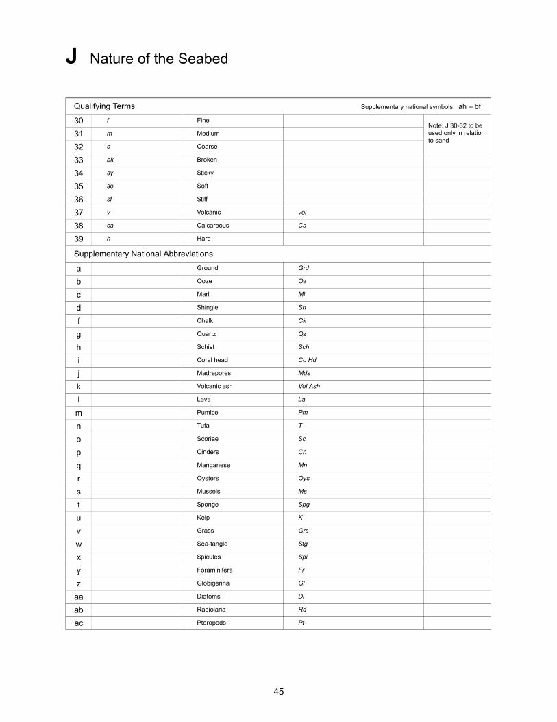
J Nature of the Seabed
Types of Seabed Supplementary national abbreviations: a – ag
Rocks K
1 S Sand
2 M Mud
3 Cy Clay
4 Si Silt
5 St Stones
6 G Gravel
7 P Pebbles
8 Cb Cobbles
9.1 R Rock; Rocky Rk; rky
9.2 Bo Boulders Blds
10 Co Coral, Coralline algea
11 Sh Shells (skeletal remains)
12.1 S/M Two layers, e.g. sand over mud
12.2 fS.M.ShThe main constituent is given first for mixtures, e.g. fine sand with mud and shells
f S M Sh
13.1 Wd Weed (including kelp)
13.2 Kelp, Weed
14 Sandwaves
15 Spring in seabed
Types of Seabed, Intertidal Areas
20 Areas with stones and gravel
21 Rocky area, which covers and uncovers
22 Coral reef, which covers and uncovers
45
J Nature of the Seabed
Qualifying Terms Supplementary national symbols: ah – bf
30 f FineNote: J 30-32 to be used only in relation to sand
31 m Medium
32 c Coarse
33 bk Broken
34 sy Sticky
35 so Soft
36 sf Stiff
37 v Volcanic vol
38 ca Calcareous Ca
39 h Hard
Supplementary National Abbreviations
a Ground Grd
b Ooze Oz
c Marl Ml
d Shingle Sn
f Chalk Ck
g Quartz Qz
h Schist Sch
i Coral head Co Hd
j Madrepores Mds
k Volcanic ash Vol Ash
l Lava La
m Pumice Pm
n Tufa T
o Scoriae Sc
p Cinders Cn
q Manganese Mn
r Oysters Oys
s Mussels Ms
t Sponge Spg
u Kelp K
v Grass Grs
w Sea-tangle Stg
x Spicules Spi
y Foraminifera Fr
z Globigerina Gl
aa Diatoms Di
ab Radiolaria Rd
ac Pteropods Pt

46
J Nature of the Seabed
ad Polyzoa Po
ae Cirripedia Cir
af Fucus Fu
ag Mattes Ma
ah Small sml
ai Large lrg
aj Rotten rt
ak Streaky str
al Speckled spk
am Gritty gty
an Decayed dec
ao Flinty fly
ap Glacial glac
aq Tenacious ten
ar White wh
as Black bl; bk
at Violet vi
au Blue bu
av Green gn
aw Yellow yl
ax Orange or
ay Red rd
az Brown br
ba Chocolate ch
bb Gray gy
bc Light lt
bd Dark dk
be Varied vard
bf Uneven unev
47
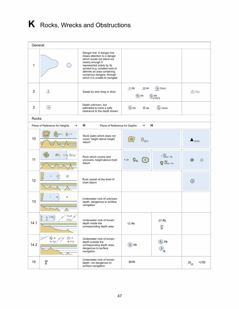
K Rocks, Wrecks and Obstructions
General
1
Danger line: A danger line draws attention to a danger which would not stand out clearly enough if represented solely by its symbol (e.g. isolated rock) or delimits an area containing numerous dangers, through which it is unsafe to navigate
2 Swept by wire drag or diver
3Depth unknown, but estimated to have a safe clearance to the depth shown
Rocks
Plane of Reference for Heights H Plane of Reference for Depths H
10Rock (islet) which does not cover, height above height datum
11Rock which covers and uncovers, height above chart datum
12 Rock awash at the level of chart datum
13Underwater rock of unknown depth, dangerous to surface navigation
14.1Underwater rock of known depth inside the corresponding depth area
14.2
Underwater rock of known depth outside the corresponding depth area, dangerous to surface navigation
15Underwater rock of known depth, not dangerous to surface navigation
48
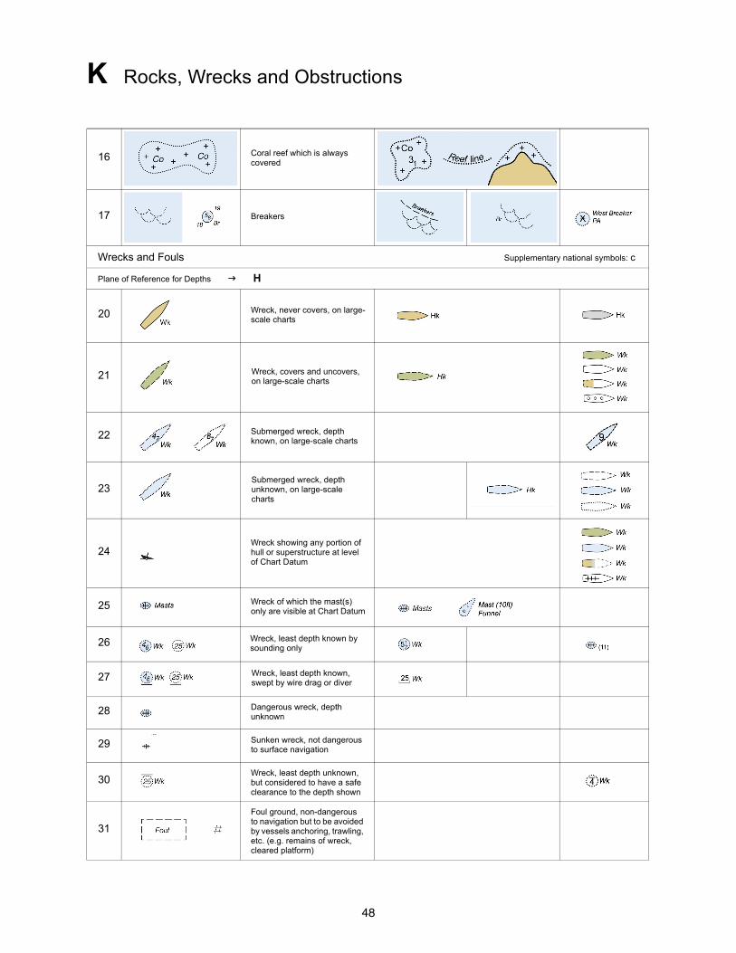
K Rocks, Wrecks and Obstructions
16 Coral reef which is always covered
17 Breakers
Wrecks and Fouls Supplementary national symbols: c
Plane of Reference for Depths H
20 Wreck, never covers, on large-scale charts
21 Wreck, covers and uncovers, on large-scale charts
22 Submerged wreck, depth known, on large-scale charts
23Submerged wreck, depth unknown, on large-scale charts
24Wreck showing any portion of hull or superstructure at level of Chart Datum
25 Wreck of which the mast(s) only are visible at Chart Datum
26 Wreck, least depth known by sounding only
27 Wreck, least depth known, swept by wire drag or diver
28 Dangerous wreck, depth unknown
29 Sunken wreck, not dangerous to surface navigation
30Wreck, least depth unknown, but considered to have a safe clearance to the depth shown
31
Foul ground, non-dangerous to navigation but to be avoided by vessels anchoring, trawling, etc. (e.g. remains of wreck, cleared platform)
49
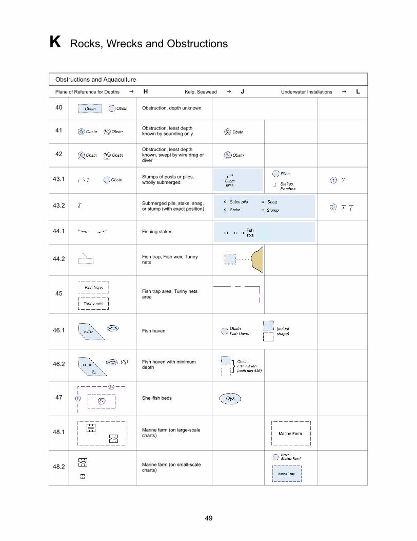
K Rocks, Wrecks and Obstructions
Obstructions and Aquaculture
Plane of Reference for Depths H Kelp, Seaweed J Underwater Installations L
40 Obstruction, depth unknown
41 Obstruction, least depth known by sounding only
42Obstruction, least depth known, swept by wire drag or diver
43.1 Stumps of posts or piles, wholly submerged
43.2 Submerged pile, stake, snag, or stump (with exact position)
44.1 Fishing stakes
44.2 Fish trap, Fish weir, Tunny nets
45 Fish trap area, Tunny nets area
46.1 Fish haven
46.2 Fish haven with minimum depth
47 Shellfish beds
48.1 Marine farm (on large-scale charts)
48.2 Marine farm (on small-scale charts)
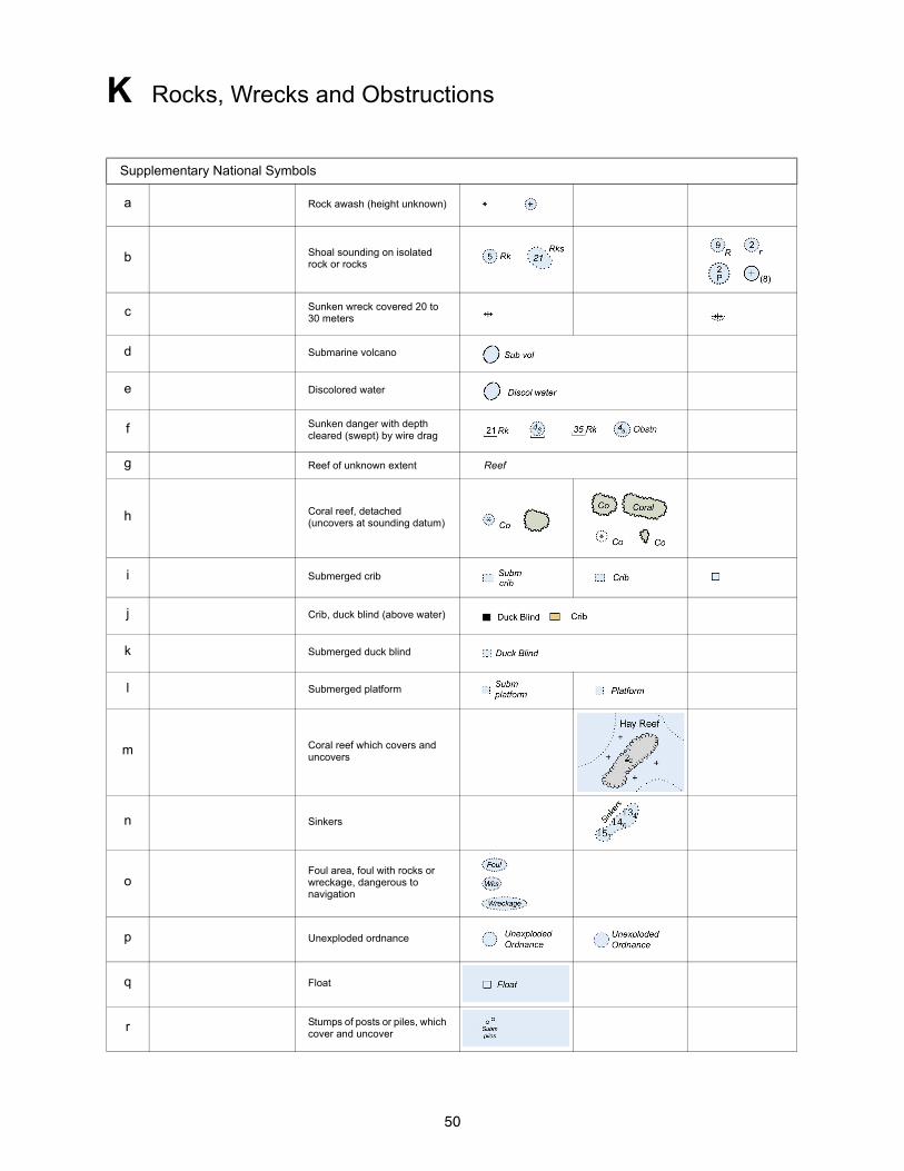
50
K Rocks, Wrecks and Obstructions
Supplementary National Symbols
a Rock awash (height unknown)
b Shoal sounding on isolated rock or rocks
c Sunken wreck covered 20 to 30 meters
d Submarine volcano
e Discolored water
f Sunken danger with depth cleared (swept) by wire drag
g Reef of unknown extent Reef
h Coral reef, detached (uncovers at sounding datum)
i Submerged crib
j Crib, duck blind (above water)
k Submerged duck blind
l Submerged platform
m Coral reef which covers and uncovers
n Sinkers
oFoul area, foul with rocks or wreckage, dangerous to navigation
p Unexploded ordnance
q Float
r Stumps of posts or piles, which cover and uncover
51
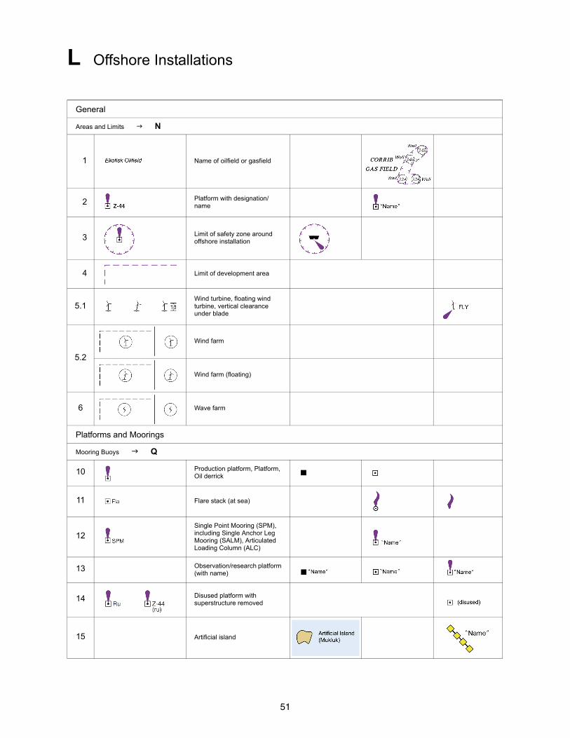
L Offshore Installations
General
Areas and Limits N
1 Name of oilfield or gasfield
2 Platform with designation/name
3 Limit of safety zone around offshore installation
4 Limit of development area
5.1Wind turbine, floating wind turbine, vertical clearance under blade
5.2
Wind farm
Wind farm (floating)
6 Wave farm
Platforms and Moorings
Mooring Buoys Q
10 Production platform, Platform, Oil derrick
11 Flare stack (at sea)
12Single Point Mooring (SPM), including Single Anchor Leg Mooring (SALM), Articulated Loading Column (ALC)
13 Observation/research platform (with name)
14 Disused platform with superstructure removed
15 Artificial island

52
L Offshore Installations
16Single Buoy Mooring (SBM), Oil or gas installation buoy, Catenary Anchor Leg Mooring (CALM)
17 Moored storage tanker
18 Mooring ground tackle
Underwater Installations Supplementary national symbol: a
Plane of Reference for Depths H Obstructions K
20 Submerged production well
21.1 Suspended well, depth over wellhead unknown
21.2 Suspended well, with depth over wellhead
21.3 Wellhead with height above the sea floor
22 Site of cleared platform
23 Above-water wellhead (lit or unlit)
24 Underwater turbine
25Subsurface Ocean(ographic) Data Acquisition System (ODAS)
Submarine Cables
30.1 Submarine cable
30.2 Submarine cable area
31.1 Submarine power cable
31.2 Submarine power cable area
32 Disused submarine cable
53
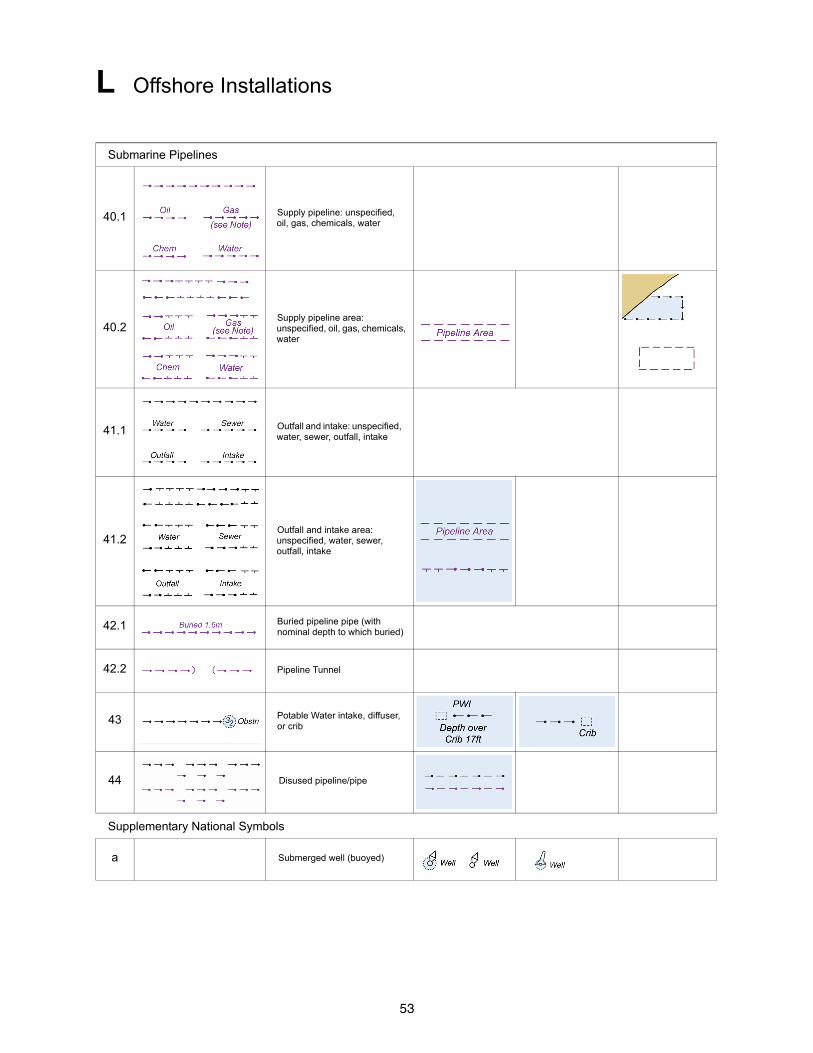
L Offshore Installations
Submarine Pipelines
40.1 Supply pipeline: unspecified, oil, gas, chemicals, water
40.2Supply pipeline area: unspecified, oil, gas, chemicals, water
41.1 Outfall and intake: unspecified, water, sewer, outfall, intake
41.2Outfall and intake area: unspecified, water, sewer, outfall, intake
42.1 Buried pipeline pipe (with nominal depth to which buried)
42.2 Pipeline Tunnel
43 Potable Water intake, diffuser, or crib
44 Disused pipeline/pipe
Supplementary National Symbols
a Submerged well (buoyed)
54
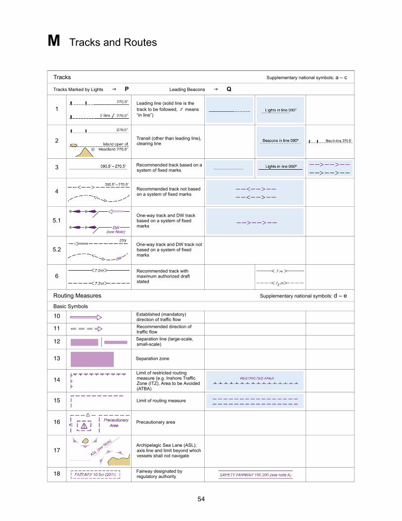
M Tracks and Routes
Tracks Supplementary national symbols: a – c
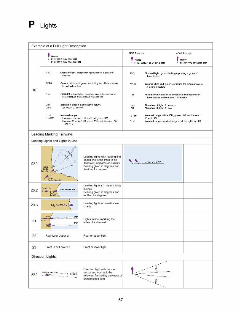
Tracks Marked by Lights P Leading Beacons Q
1Leading line (solid line is the track to be followed, , means “in line”)
2 Transit (other than leading line), clearing line
3 Recommended track based on a system of fixed marks
4 Recommended track not based on a system of fixed marks
5.1One-way track and DW track based on a system of fixed marks
5.2One-way track and DW track not based on a system of fixed marks
6Recommended track with maximum authorized draft stated
Routing Measures Supplementary national symbols: d – e
Basic Symbols
10 Established (mandatory) direction of traffic flow
11 Recommended direction of traffic flow
12 Separation line (large-scale, small-scale)
13 Separation zone
14Limit of restricted routing measure (e.g. Inshore Traffic Zone (ITZ), Area to be Avoided (ATBA)
15 Limit of routing measure
16 Precautionary area
17Archipelagic Sea Lane (ASL); axis line and limit beyond which vessels shall not navigate
18 Fairway designated by regulatory authority
55
M Tracks and Routes
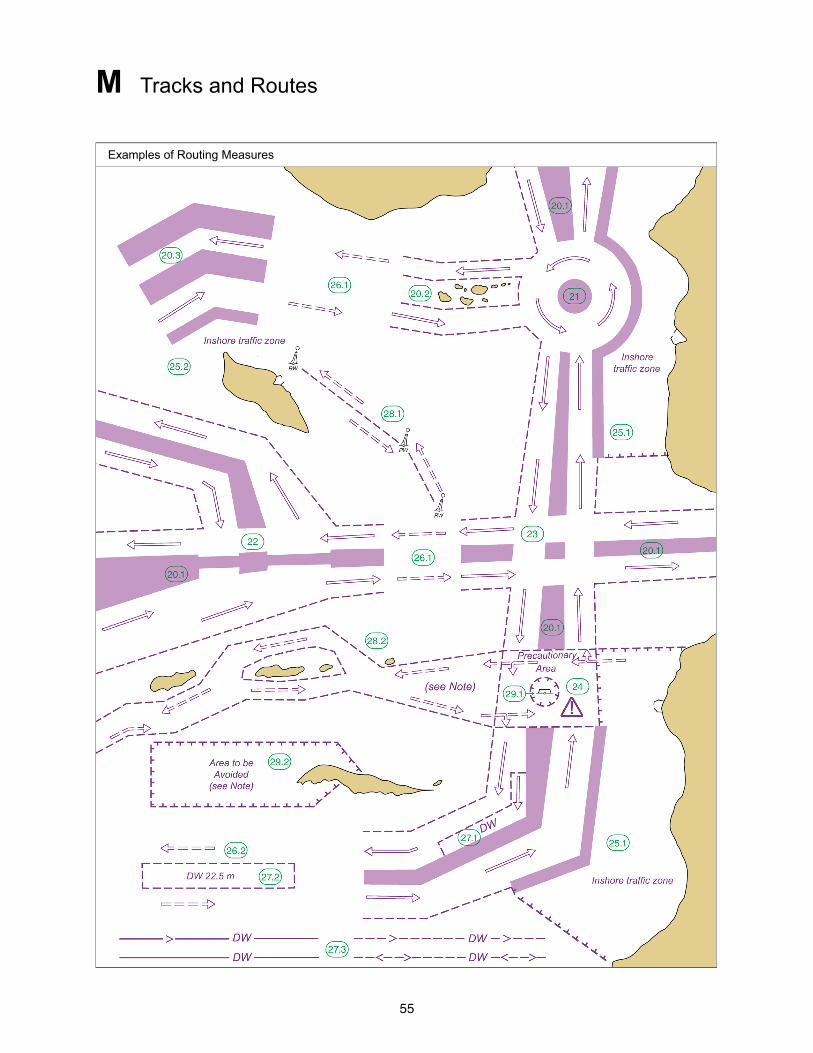
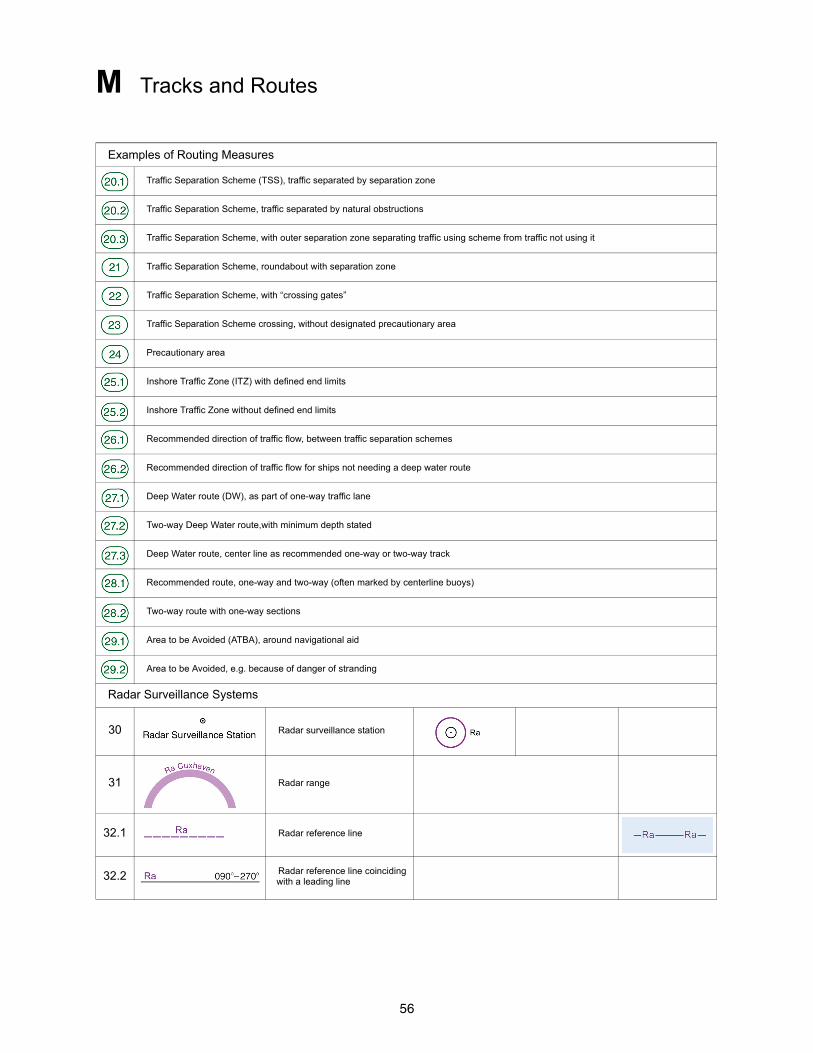
Examples of Routing Measures
56
M Tracks and Routes
Examples of Routing Measures
Traffic Separation Scheme (TSS), traffic separated by separation zone
Traffic Separation Scheme, traffic separated by natural obstructions
Traffic Separation Scheme, with outer separation zone separating traffic using scheme from traffic not using it
Traffic Separation Scheme, roundabout with separation zone
Traffic Separation Scheme, with “crossing gates”
Traffic Separation Scheme crossing, without designated precautionary area
Precautionary area
Inshore Traffic Zone (ITZ) with defined end limits
Inshore Traffic Zone without defined end limits
Recommended direction of traffic flow, between traffic separation schemes
Recommended direction of traffic flow for ships not needing a deep water route
Deep Water route (DW), as part of one-way traffic lane
Two-way Deep Water route,with minimum depth stated
Deep Water route, center line as recommended one-way or two-way track
Recommended route, one-way and two-way (often marked by centerline buoys)
Two-way route with one-way sections
Area to be Avoided (ATBA), around navigational aid
Area to be Avoided, e.g. because of danger of stranding
Radar Surveillance Systems
30 Radar surveillance station
31 Radar range
32.1 Radar reference line
32.2 Radar reference line coinciding with a leading line
57
M Tracks and Routes
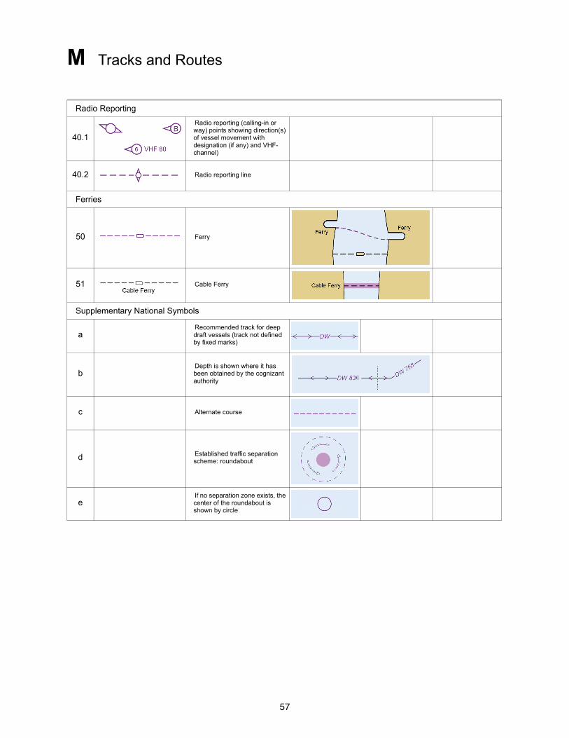
Radio Reporting
40.1
Radio reporting (calling-in or way) points showing direction(s) of vessel movement with designation (if any) and VHF-channel)
40.2 Radio reporting line
Ferries
50 Ferry
51 Cable Ferry
Supplementary National Symbols
aRecommended track for deep draft vessels (track not defined by fixed marks)
bDepth is shown where it has been obtained by the cognizant authority
c Alternate course
d Established traffic separation scheme: roundabout
eIf no separation zone exists, the center of the roundabout is shown by circle
58
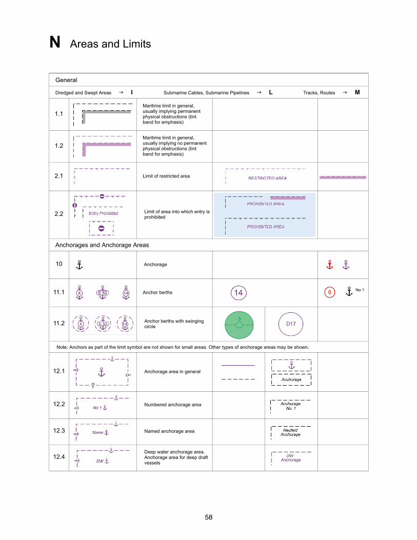
N Areas and Limits
General
Dredged and Swept Areas I Submarine Cables, Submarine Pipelines L Tracks, Routes M
1.1Maritime limit in general, usually implying permanent physical obstructions (tint band for emphasis)
1.2Maritime limit in general, usually implying no permanent physical obstructions (tint band for emphasis)
2.1 Limit of restricted area
2.2 Limit of area into which entry is prohibited
Anchorages and Anchorage Areas
10 Anchorage
11.1 Anchor berths
11.2 Anchor berths with swinging circle
Note: Anchors as part of the limit symbol are not shown for small areas. Other types of anchorage areas may be shown.
12.1 Anchorage area in general
12.2 Numbered anchorage area
12.3 Named anchorage area
12.4Deep water anchorage area, Anchorage area for deep draft vessels

59
N Areas and Limits
12.5 Tanker anchorage area
12.6 Anchorage area for periods up to 24 hours
12.7 Explosives anchorage area
12.8 Quarantine anchorage area
12.9 Reserved anchorage area
13 Seaplane operating area
14 Anchorage for seaplanes
Restricted Areas Supplementary national symbols: d, e, g
20 Anchoring prohibited
21 Fishing prohibited
60
N Areas and Limits
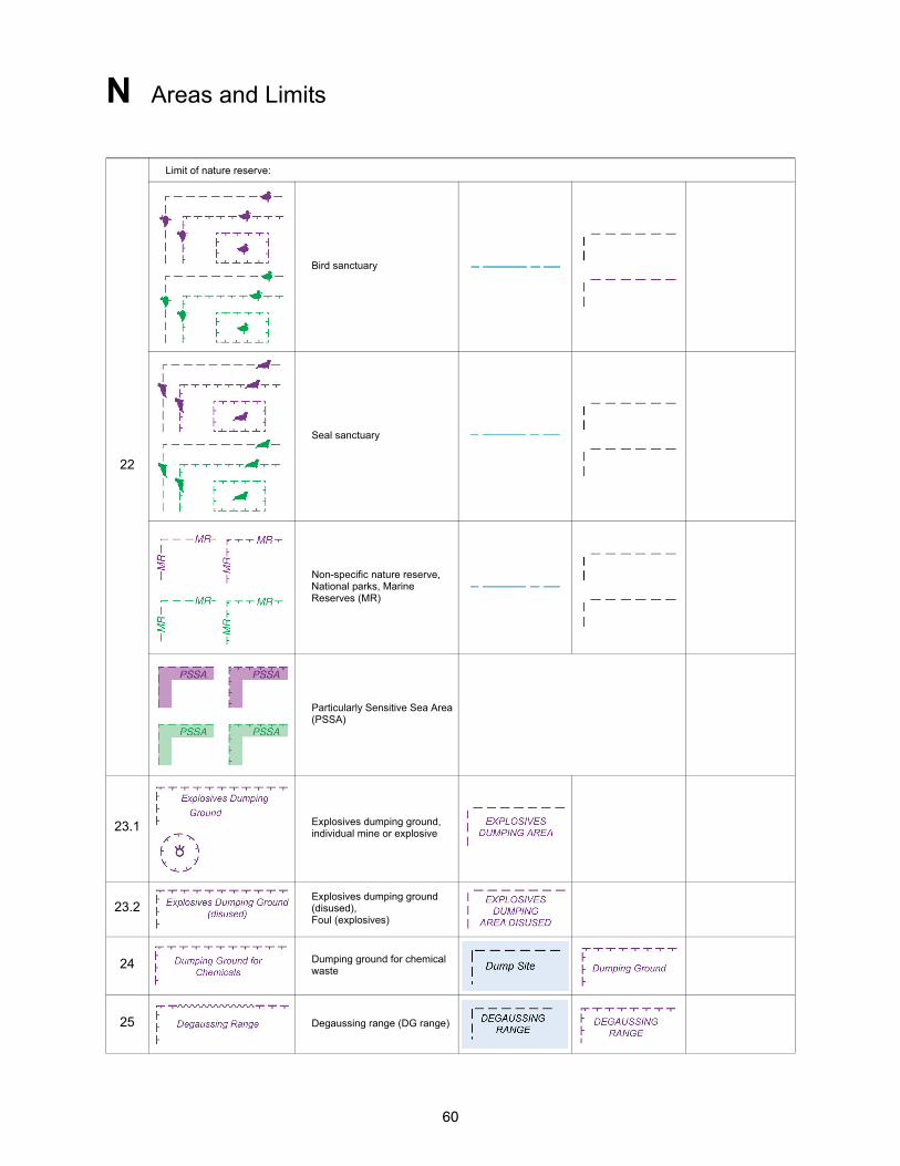
22
Limit of nature reserve:
Bird sanctuary
Seal sanctuary
Non-specific nature reserve, National parks, Marine Reserves (MR)
Particularly Sensitive Sea Area (PSSA)
23.1 Explosives dumping ground, individual mine or explosive
23.2Explosives dumping ground (disused), Foul (explosives)
24 Dumping ground for chemical waste
25 Degaussing range (DG range)
61
N Areas and Limits
26 Historic wreck and restricted area
27 Maximum speed
Military Practice Areas
30 Firing practice area
31 Military restricted area, entry prohibited
32 Mine-laying (and counter-measures) practice area
33 Submarine transit lane and exercise area
34 Minefield
International Boundaries and National Limits Supplementary national symbols: a, f, h
40 International boundary on land
41 International maritime boundary
42 Straight territorial sea baseline with base point
43 Seaward limit of territorial sea
44 Seaward limit of contiguous zone
45 Limits of fishery zones
46 Limit of continental shelf
47 Limit of Exclusive Economic Zone (EEZ)
48 Customs limit

62
N Areas and Limits
49 Harbor limit
Various Limits Supplementary national symbols: a, b
60.1 Limit of fast ice, Ice front (with date)
60.2 Limit of sea ice (pack ice) seasonal (with date)
61Floating barrier, including log ponds, security barriers, ice booms, shark nets
62.1 Spoil ground
62.2 Spoil ground (disused)
63 Extraction (dredging) area
64 Cargo transhipment area
65 Incineration area
Supplementary National symbols
a COLREGS demarcation line
b Limit of fishing area (fish trap areas)
c Dumping ground
d Dumping area (Dump site)
e Limit of airport
f Reservation line (Options)
g Dump site
h Three Nautical Mile Line
i No Discharge Zone
63
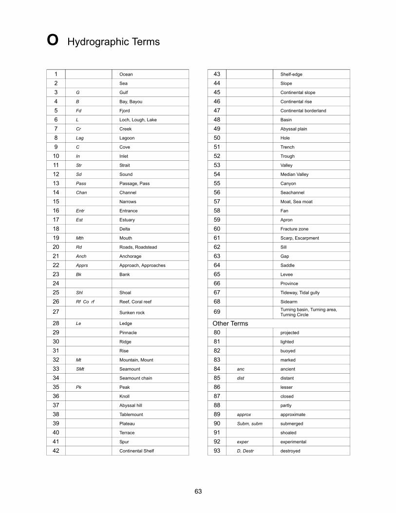
O Hydrographic Terms
1 Ocean 43 Shelf-edge
2 Sea 44 Slope
3 G Gulf 45 Continental slope
4 B Bay, Bayou 46 Continental rise
5 Fd Fjord 47 Continental borderland
6 L Loch, Lough, Lake 48 Basin
7 Cr Creek 49 Abyssal plain
8 Lag Lagoon 50 Hole
9 C Cove 51 Trench
10 In Inlet 52 Trough
11 Str Strait 53 Valley
12 Sd Sound 54 Median Valley
13 Pass Passage, Pass 55 Canyon
14 Chan Channel 56 Seachannel
15 Narrows 57 Moat, Sea moat
16 Entr Entrance 58 Fan
17 Est Estuary 59 Apron
18 Delta 60 Fracture zone
19 Mth Mouth 61 Scarp, Escarpment
20 Rd Roads, Roadstead 62 Sill
21 Anch Anchorage 63 Gap
22 Apprs Approach, Approaches 64 Saddle
23 Bk Bank 65 Levee
24 66 Province
25 Shl Shoal 67 Tideway, Tidal gully
26 Rf Co rf Reef, Coral reef 68 Sidearm
27 Sunken rock 69 Turning basin, Turning area, Turning Circle
28 Le Ledge Other Terms29 Pinnacle 80 projected
30 Ridge 81 lighted
31 Rise 82 buoyed
32 Mt Mountain, Mount 83 marked
33 SMt Seamount 84 anc ancient
34 Seamount chain 85 dist distant
35 Pk Peak 86 lesser
36 Knoll 87 closed
37 Abyssal hill 88 partly
38 Tablemount 89 approx approximate
39 Plateau 90 Subm, subm submerged
40 Terrace 91 shoaled
41 Spur 92 exper experimental
42 Continental Shelf 93 D, Destr destroyed
64
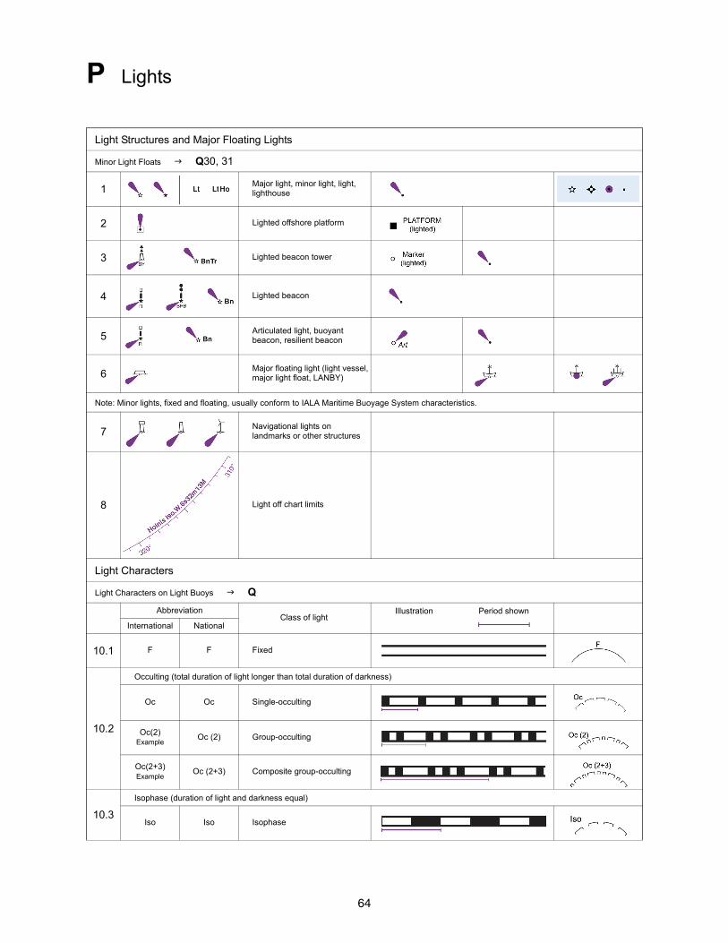
P Lights
Light Structures and Major Floating Lights
Minor Light Floats Q30, 31
1Major light, minor light, light, lighthouse
2 Lighted offshore platform
3 Lighted beacon tower
4 Lighted beacon
5Articulated light, buoyant beacon, resilient beacon
6Major floating light (light vessel, major light float, LANBY)
Note: Minor lights, fixed and floating, usually conform to IALA Maritime Buoyage System characteristics.
7Navigational lights on landmarks or other structures
8 Light off chart limits
Light Characters
Light Characters on Light Buoys Q
AbbreviationClass of light
Illustration Period shown
International National
10.1 F F Fixed
10.2
Occulting (total duration of light longer than total duration of darkness)
Oc Oc Single-occulting
Oc(2)Example
Oc (2) Group-occulting
Oc(2+3)Example
Oc (2+3) Composite group-occulting
10.3
Isophase (duration of light and darkness equal)
Iso Iso Isophase
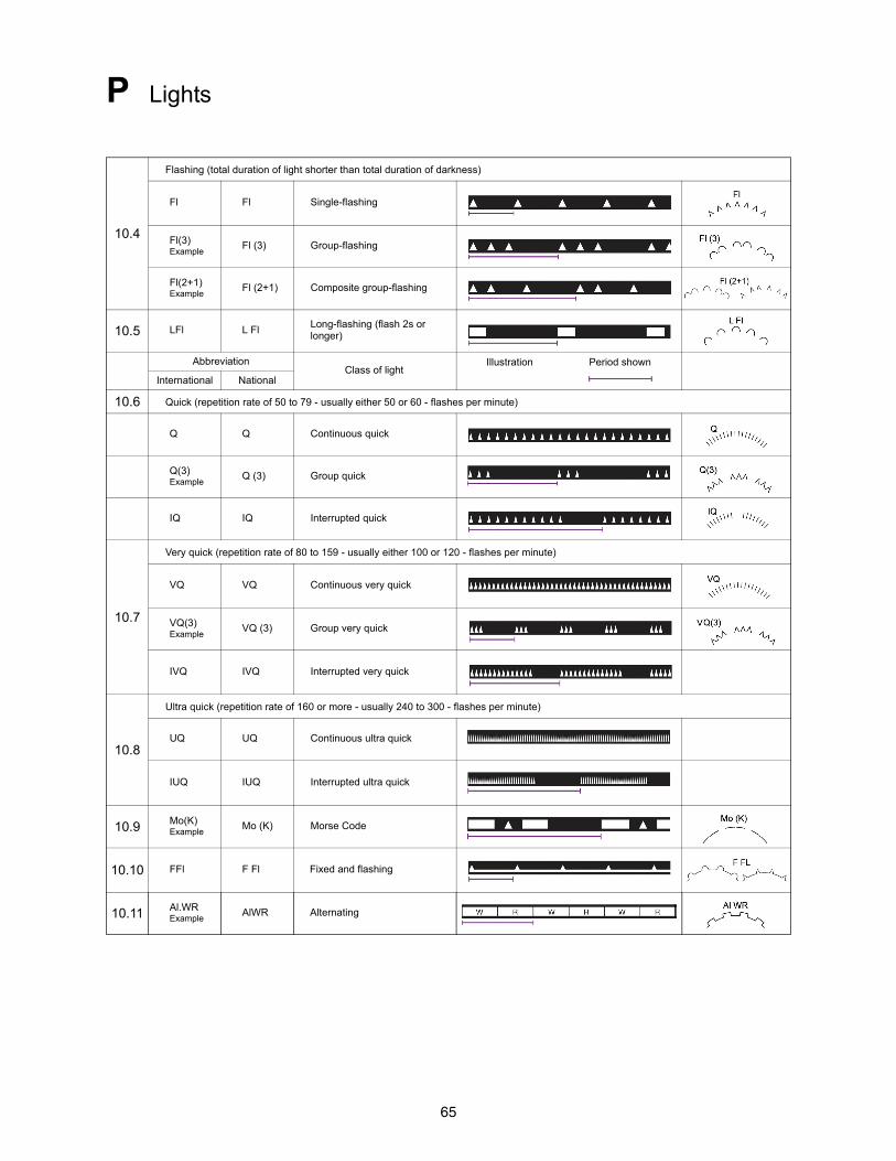
65
P Lights
10.4
Flashing (total duration of light shorter than total duration of darkness)
Fl Fl Single-flashing
Fl(3)Example
Fl (3) Group-flashing
Fl(2+1)Example
Fl (2+1) Composite group-flashing
10.5 LFl L FlLong-flashing (flash 2s or longer)
AbbreviationClass of light
Illustration Period shown
International National
10.6 Quick (repetition rate of 50 to 79 - usually either 50 or 60 - flashes per minute)
Q Q Continuous quick
Q(3)Example
Q (3) Group quick
IQ IQ Interrupted quick
10.7
Very quick (repetition rate of 80 to 159 - usually either 100 or 120 - flashes per minute)
VQ VQ Continuous very quick
VQ(3)Example
VQ (3) Group very quick
IVQ IVQ Interrupted very quick
10.8
Ultra quick (repetition rate of 160 or more - usually 240 to 300 - flashes per minute)
UQ UQ Continuous ultra quick
IUQ IUQ Interrupted ultra quick
10.9 Mo(K)Example
Mo (K) Morse Code
10.10 FFl F Fl Fixed and flashing
10.11 Al.WRExample
AlWR Alternating

66
P Lights
Colors of Lights and Marks
11.1 WWhite (only on sector and alternating lights)
11.2 R Red
11.3 G Green
11.4 Bu Blue
11.5 Vi Violet
11.6 Y Yellow
11.7 Y Or Orange
11.8 Y Am Amber
Period
12 2.5s 90sPeriod in seconds and tenths of a second
Elevation
Plane of Reference for Heights H Tidal Levels H
13 12mElevation of light given in meters or feet
36ft
Range
14
15M Light with single range
15/10M Light with two different ranges
10MNOAA: only lesser
of two ranges is charted
15/10M
15-7MElevation of light given in meters or feet
7MNOAA: only least of
three ranges is charted
Note: Charted ranges are nominal ranges given in Nautical Miles
Disposition
15
(hor) Horizontally disposed
(vert) Vertically disposed
67
P Lights
Example of a Full Light Description
16
Leading Marking Fairways
Leading Lights and Lights in Line
20.1
Leading lights with leading line (solid line is the track to be followed) and arcs of visibilityBearing given in degrees and tenths of a degree
20.2
Leading lights (, means lights in line)Bearing given in degrees and tenths of a degree
20.3Leading lights on small-scale charts
21Lights in line, marking the sides of a channel
22 Rear Lt or Upper Lt Rear or upper light
23 Front Lt or Lower Lt Front or lower light
Direction Lights
30.1
Direction light with narrow sector and course to be followed, flanked by darkness or unintensified light
68
P Lights
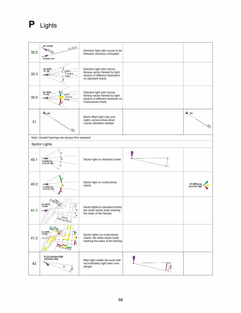
30.2Direction light with course to be followed, sector(s) uncharted
30.3
Direction light with narrow fairway sector flanked by light sectors of different characters on standard charts
30.4
Direction light with narrow fairway sector flanked by light sectors of different character on multicolored charts
31
Moiré effect light (day and night), arrows show when course alteration needed
Note: Quoted bearings are always from seaward
Sector Lights
40.1 Sector light on standard charts
40.2Sector light on multicolored charts
41.1Sector lights on standard charts, the white sector limits marking the sides of the fairway
41.2Sector lights on multicolored charts, the white sector limits marking the sides of the fairway
42Main light visible all-round with red subsidiary light seen over danger
69
P Lights
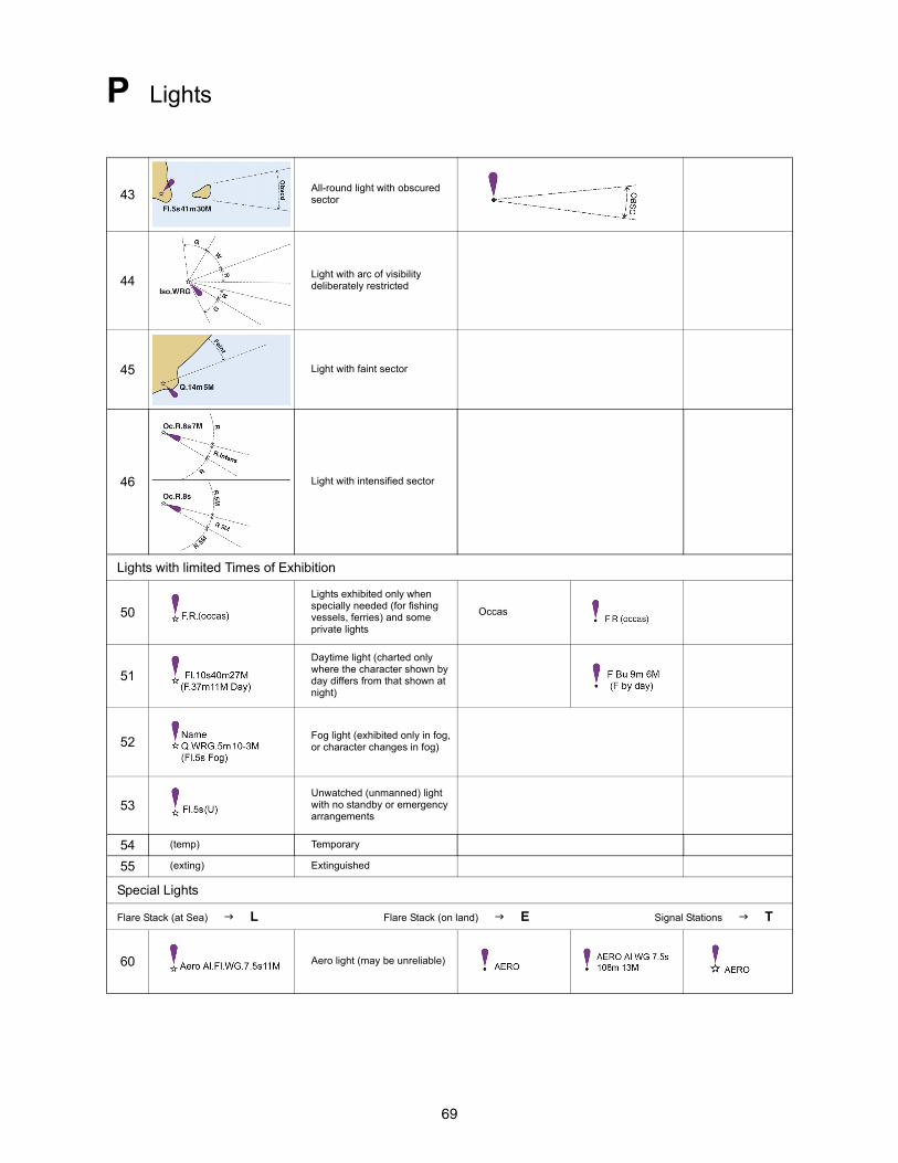
43All-round light with obscured sector
44Light with arc of visibility deliberately restricted
45 Light with faint sector
46 Light with intensified sector
Lights with limited Times of Exhibition
50
Lights exhibited only when specially needed (for fishing vessels, ferries) and some private lights
Occas
51
Daytime light (charted only where the character shown by day differs from that shown at night)
52Fog light (exhibited only in fog, or character changes in fog)
53Unwatched (unmanned) light with no standby or emergency arrangements
54 (temp) Temporary
55 (exting) Extinguished
Special Lights
Flare Stack (at Sea) L Flare Stack (on land) E Signal Stations T
60 Aero light (may be unreliable)
70
P Lights
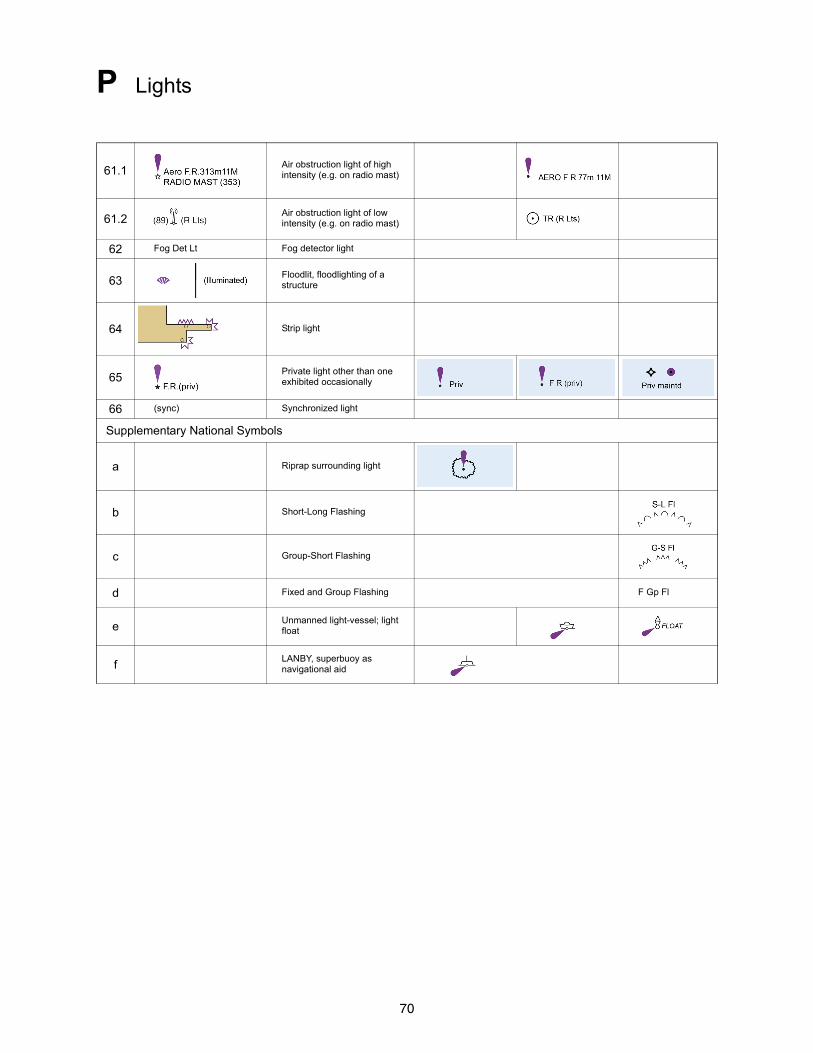
61.1Air obstruction light of high intensity (e.g. on radio mast)
61.2Air obstruction light of low intensity (e.g. on radio mast)
62 Fog Det Lt Fog detector light
63Floodlit, floodlighting of a structure
64 Strip light
65Private light other than one exhibited occasionally
66 (sync) Synchronized light
Supplementary National Symbols
a Riprap surrounding light
b Short-Long Flashing
c Group-Short Flashing
d Fixed and Group Flashing F Gp Fl
eUnmanned light-vessel; light float
fLANBY, superbuoy as navigational aid
71
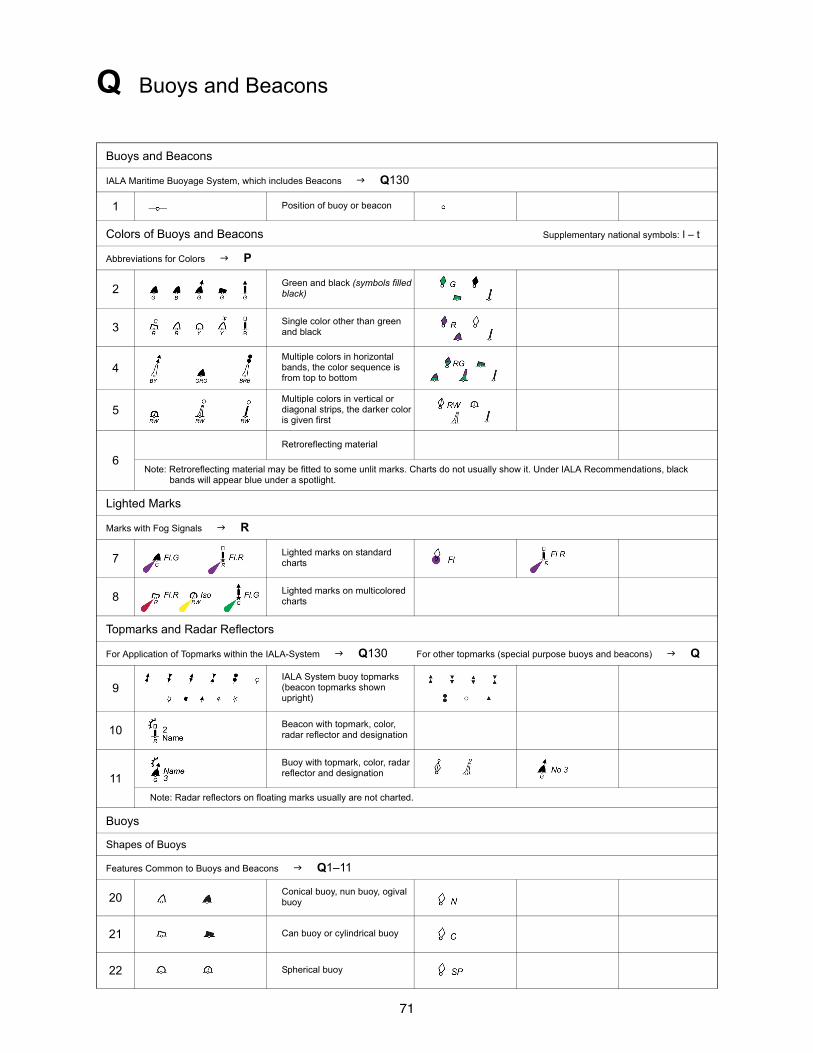
Q Buoys and Beacons
Buoys and Beacons
IALA Maritime Buoyage System, which includes Beacons Q130
1 Position of buoy or beacon
Colors of Buoys and Beacons Supplementary national symbols: l – t
Abbreviations for Colors P
2Green and black (symbols filled black)
3Single color other than green and black
4Multiple colors in horizontal bands, the color sequence is from top to bottom
5Multiple colors in vertical or diagonal strips, the darker color is given first
6
Retroreflecting material
Note: Retroreflecting material may be fitted to some unlit marks. Charts do not usually show it. Under IALA Recommendations, black bands will appear blue under a spotlight.
Lighted Marks
Marks with Fog Signals R
7Lighted marks on standard charts
8Lighted marks on multicolored charts
Topmarks and Radar Reflectors
For Application of Topmarks within the IALA-System Q130 For other topmarks (special purpose buoys and beacons) Q
9IALA System buoy topmarks (beacon topmarks shown upright)
10Beacon with topmark, color, radar reflector and designation
11
Buoy with topmark, color, radar reflector and designation
Note: Radar reflectors on floating marks usually are not charted.
Buoys
Shapes of Buoys
Features Common to Buoys and Beacons Q1–11
20Conical buoy, nun buoy, ogival buoy
21 Can buoy or cylindrical buoy
22 Spherical buoy
72
Q Buoys and Beacons
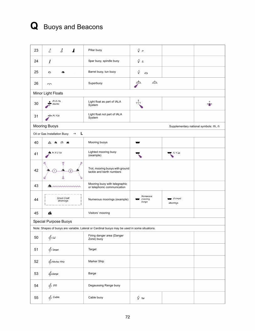
23 Pillar buoy
24 Spar buoy, spindle buoy
25 Barrel buoy, tun buoy
26 Superbuoy
Minor Light Floats
30Light float as part of IALA System
31Light float not part of IALA System
Mooring Buoys Supplementary national symbols: m, n
Oil or Gas Installation Buoy L
40 Mooring buoys
41Lighted mooring buoy (example)
42Trot, mooring buoys with ground tackle and berth numbers
43Mooring buoy with telegraphic or telephonic communication
44 Numerous moorings (example)
45 Visitors’ mooring
Special Purpose Buoys
Note: Shapes of buoys are variable. Lateral or Cardinal buoys may be used in some situations.
50Firing danger area (Danger Zone) buoy
51 Target
52 Marker Ship
53 Barge
54 Degaussing Range buoy
55 Cable buoy
73
Q Buoys and Beacons
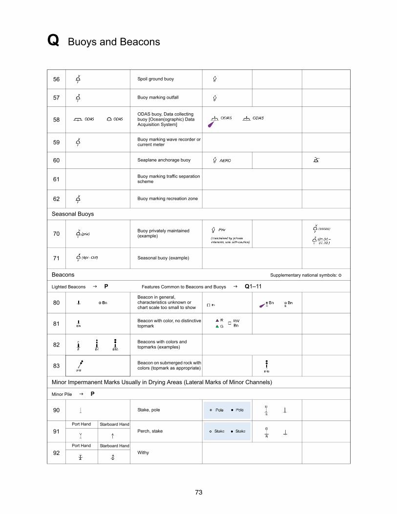
56 Spoil ground buoy
57 Buoy marking outfall
58ODAS buoy, Data collecting buoy [Ocean(ographic) Data Acquisition System]
59Buoy marking wave recorder or current meter
60 Seaplane anchorage buoy
61Buoy marking traffic separation scheme
62 Buoy marking recreation zone
Seasonal Buoys
70Buoy privately maintained (example)
71 Seasonal buoy (example)
Beacons Supplementary national symbols: o
Lighted Beacons P Features Common to Beacons and Buoys Q1–11
80Beacon in general, characteristics unknown or chart scale too small to show
81Beacon with color, no distinctive topmark
82Beacons with colors and topmarks (examples)
83Beacon on submerged rock with colors (topmark as appropriate)
Minor Impermanent Marks Usually in Drying Areas (Lateral Marks of Minor Channels)
Minor Pile P
90 Stake, pole
91Port Hand Starboard Hand
Perch, stake
92Port Hand Starboard Hand
Withy
74
Q Buoys and Beacons
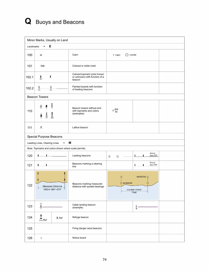
Minor Marks, Usually on Land
Landmarks E
100 Cairn
101 Colored or white mark
102.1Colored topmark (color known or unknown) with function of a beacon
102.2Painted boards with function of leading beacons
Beacon Towers
110Beacon towers without and with topmarks and colors (examples)
111 Lattice beacon
Special Purpose Beacons
Leading Lines, Clearing Lines M
Note: Topmarks and colors shown where scale permits.
120 Leading beacons
121Beacons marking a clearing line
122Beacons marking measured distance with quoted bearings
123Cable landing beacon (example)
124 Refuge beacon
125 Firing danger area beacons
126 Notice board
75
Q Buoys and Beacons
IALA Maritime Buoyage System
International Association of Marine Aids to Navigation and Lighthouse Authorities (IALA)
130
IALA Buoyage Regions A and B
130.1
Lateral marks are generally for well-defined channels. There are two international Buoyage Regions – A and B – where Lateral marks differ.
Note: A preferred channel buoy may also be a pillar or a spar. All preferred channel marks have horizontal bands of color.
130.2
Direction of Buoyage: The direction of buoyage is that taken when approaching a harbor from seaward. Along coasts, the direction is determined by buoyage authorities, normally clockwise around land masses.
Symbol showing direction of buoyage where not obvious
Symbol showing direction of buoyage on multicolored charts
76
Q Buoys and Beacons
130.3
Cardinal Marks: indicating navigable water to the named side of the marks. In the illustration, all marks are the same in Regions A and B.
130.4
Isolated Danger Marks stationed over dangers with navigable water around them.
130.5
Safe Water Marks such as mid-channel and landfall marks.
130.6
Special Marks not primarily to assist navigation but to indicate special features.
Supplementary National Symbols
a Bell buoy
b Gong buoy
c Whistle buoy
dFairway buoy (red and white vertical stripe)
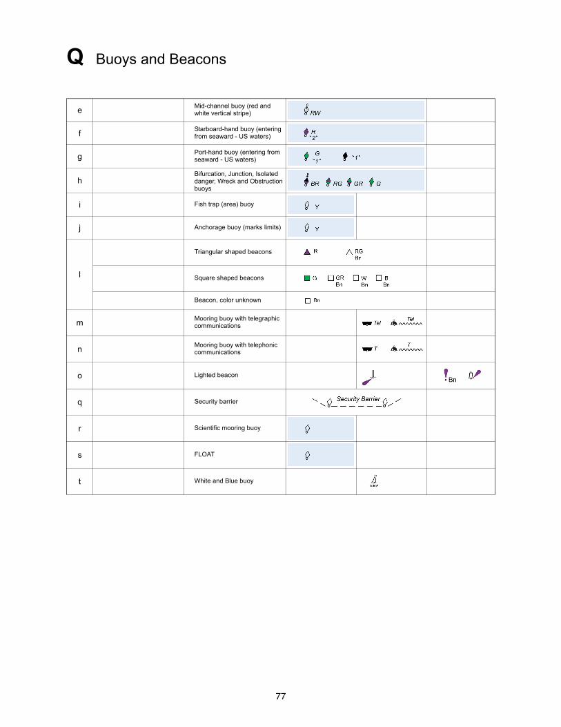
77
Q Buoys and Beacons
eMid-channel buoy (red and white vertical stripe)
fStarboard-hand buoy (entering from seaward - US waters)
gPort-hand buoy (entering from seaward - US waters)
hBifurcation, Junction, Isolated danger, Wreck and Obstruction buoys
i Fish trap (area) buoy
j Anchorage buoy (marks limits)
l
Triangular shaped beacons
Square shaped beacons
Beacon, color unknown
mMooring buoy with telegraphic communications
nMooring buoy with telephonic communications
o Lighted beacon
q Security barrier
r Scientific mooring buoy
s FLOAT
t White and Blue buoy

78
R Fog Signals
General
Fog Detector Light P Fog Light P
1 Position of fog signal, type of fog signal not stated.
Types of Fog Signals, with Abbreviations Supplementary national symbol: a
10 Explos Explosive GUN
11 Dia Diaphone DIA
12 Siren Siren SIREN
13 Horn Horn (nautophone, reed, tyfon) HORN
14 Bell Bell BELL
15 Whis Whistle WHIS
16 Gong Gong GONG
Examples of Fog Signal Descriptions
Note: The fog signal symbol is usually omitted when a description of the signal is given
20Siren at a lighthouse, giving a long blast followed by a short one (N), repeated every 60 seconds
21 Wave-actuated bell buoy
22Light buoy, with horn giving a single blast every 15 seconds, in conjunction with a wave-actuated whistle
Supplementary National Symbol
a Morse Code fog signal Mo
79
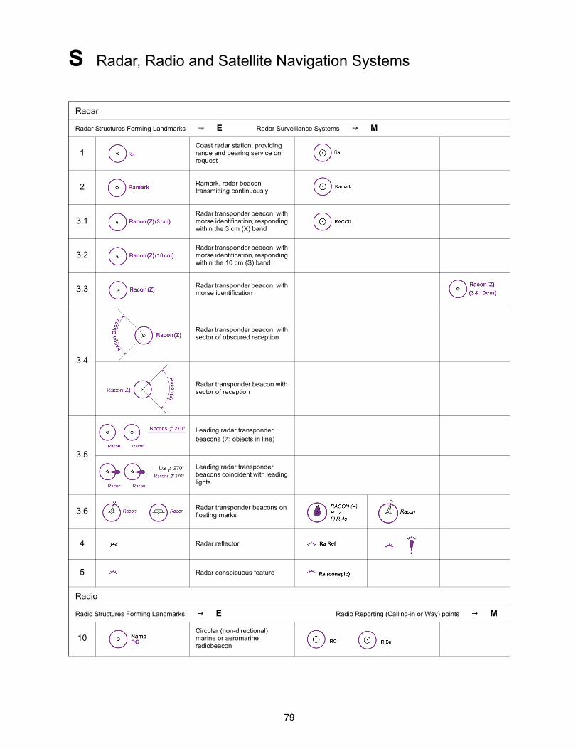
S Radar, Radio and Satellite Navigation Systems
Radar
Radar Structures Forming Landmarks E Radar Surveillance Systems M
1Coast radar station, providing range and bearing service on request
2 Ramark, radar beacon transmitting continuously
3.1Radar transponder beacon, with morse identification, responding within the 3 cm (X) band
3.2Radar transponder beacon, with morse identification, responding within the 10 cm (S) band
3.3 Radar transponder beacon, with morse identification
3.4
Radar transponder beacon, with sector of obscured reception
Radar transponder beacon with sector of reception
3.5
Leading radar transponder beacons (,: objects in line)
Leading radar transponder beacons coincident with leading lights
3.6 Radar transponder beacons on floating marks
4 Radar reflector
5 Radar conspicuous feature
Radio
Radio Structures Forming Landmarks E Radio Reporting (Calling-in or Way) points M
10Circular (non-directional) marine or aeromarine radiobeacon
80
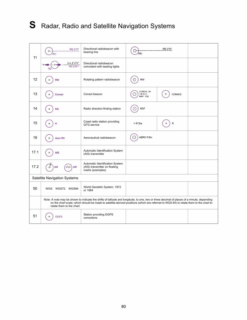
S Radar, Radio and Satellite Navigation Systems
11
Directional radiobeacon with bearing line
Directional radiobeacon coincident with leading lights
12 Rotating pattern radiobeacon
13 Consol beacon
14 Radio direction-finding station
15 Coast radio station providing QTG service
16 Aeronautical radiobeacon
17.1 Automatic Identification System (AIS) transmitter
17.2Automatic Identification System (AIS) transmitter on floating marks (examples)
Satellite Navigation Systems
50 WGS WGS72 WGS84World Geodetic System, 1972 or 1984
Note: A note may be shown to indicate the shifts of latitude and longitude, to one, two or three decimal of places of a minute, depending on the chart scale, which should be made to satellite-derived positions (which are referred to WGS 84) to relate them to the chart to relate them to the chart.
51 Station providing DGPS corrections
81
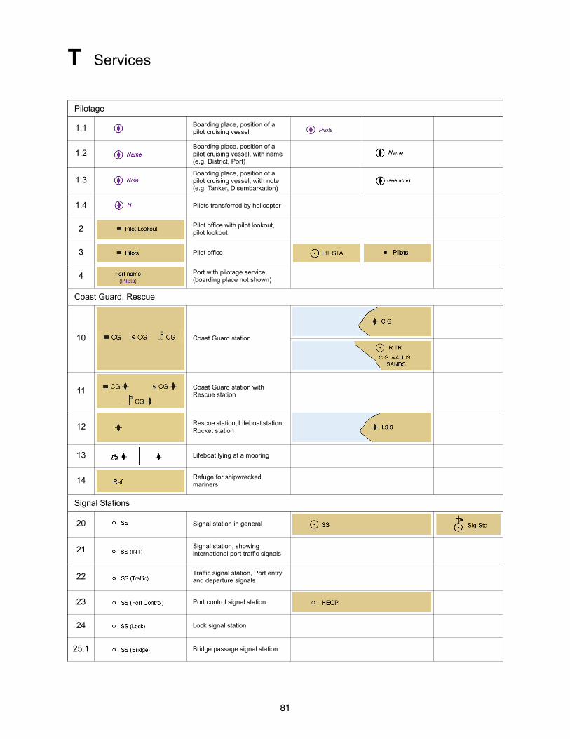
T Services
Pilotage
1.1 Boarding place, position of a pilot cruising vessel
1.2Boarding place, position of a pilot cruising vessel, with name (e.g. District, Port)
1.3Boarding place, position of a pilot cruising vessel, with note (e.g. Tanker, Disembarkation)
1.4 Pilots transferred by helicopter
2 Pilot office with pilot lookout, pilot lookout
3 Pilot office
4 Port with pilotage service (boarding place not shown)
Coast Guard, Rescue
10 Coast Guard station
11 Coast Guard station with Rescue station
12 Rescue station, Lifeboat station, Rocket station
13 Lifeboat lying at a mooring
14 Refuge for shipwrecked mariners
Signal Stations
20 Signal station in general
21 Signal station, showing international port traffic signals
22 Traffic signal station, Port entry and departure signals
23 Port control signal station
24 Lock signal station
25.1 Bridge passage signal station
82
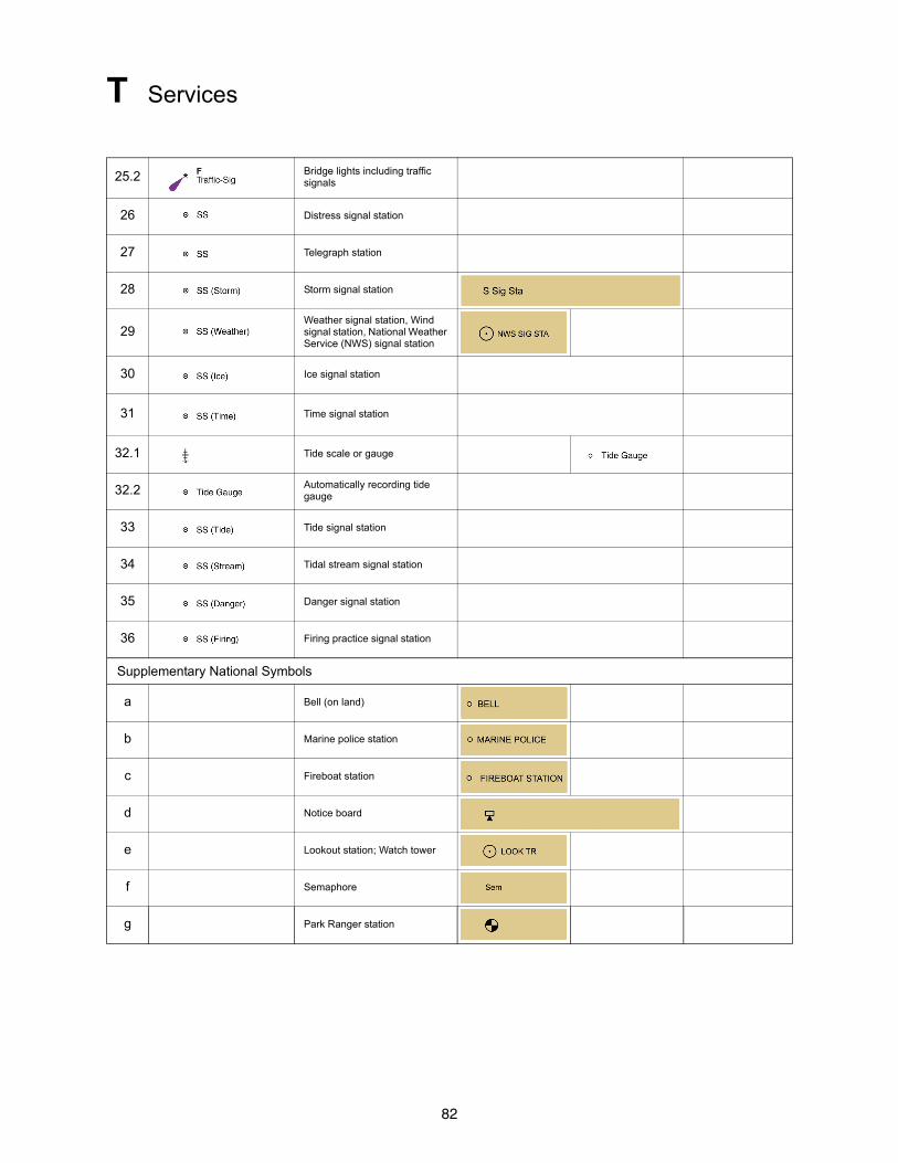
T Services
25.2 Bridge lights including traffic signals
26 Distress signal station
27 Telegraph station
28 Storm signal station
29Weather signal station, Wind signal station, National Weather Service (NWS) signal station
30 Ice signal station
31 Time signal station
32.1 Tide scale or gauge
32.2 Automatically recording tide gauge
33 Tide signal station
34 Tidal stream signal station
35 Danger signal station
36 Firing practice signal station
Supplementary National Symbols
a Bell (on land)
b Marine police station
c Fireboat station
d Notice board
e Lookout station; Watch tower
f Semaphore
g Park Ranger station
83
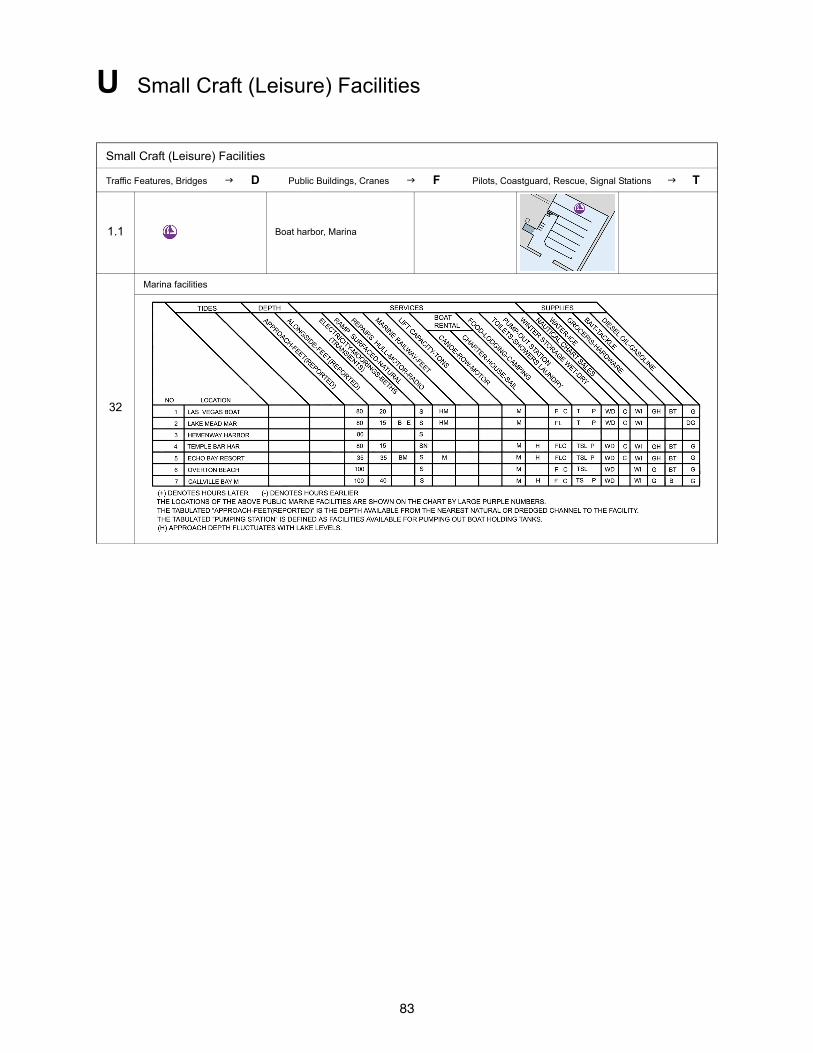
U Small Craft (Leisure) Facilities
Small Craft (Leisure) Facilities
Traffic Features, Bridges D Public Buildings, Cranes F Pilots, Coastguard, Rescue, Signal Stations T
1.1 Boat harbor, Marina
32
Marina facilities

84
V Index of Abbreviations
A Br Breakers K 17
abt About D i br Brown J az
AERO, Aero Aeronautical light P 60 brg Bearing B 62
Aero RBn Aeronautical radiobeacon S 16 brk Broken J 33
Aero RC Aeronautical radiobeacon S 16 Bu Blue P 11.4
AISAutomatic Indentification System
S 17.1, 17.2 C
Al Alternating P 10.11 c Coarse J 32
ALC Articulated Loading Column L 12 C Can, cylindrical Q 21
Am Amber P 11.8 C Cove O 9
anc Ancient O 84 C. Cape G 7
ANCH, Anch AnchorageN 20, O 21
ca, Ca Calcareous J 38
CALM Centenary Anchor Leg Mooring L 16
Ant, ANT Antenna E 31 Cap Capitol E t
approx Approximate O 89 Cas Castle E 34.2
Apprs Approaches O 22 Cb Cobbles J 8
Apr April cbl Cable B 46
Apt Apartment E s cd Candela B 54
Arch Archipelago G 5 CD Chart Datum H 1
ASL Archipelagic Sea Lane M 17 Cem Cemetery E 19
ATBA Area to be Avoided M 29.1 CG Coast Guard station T 10
Aug AugustChem Chemical
L 40.1, 40.2auth Authorized K 46.2
Ave Avenue G 111 Chan Channel O 14
Ch Church E 10.1
B Ch Chocolate J ba
B Bay, bayou O 4 Chy, CHY Chimney E 22
B Black Q 2 Cir Cirripedia J ae
Bdy Mon Boundary mark B 24 Ck Chalk J f
Bk Bank O 23 Cl Clay J 3
bk Broken J 33CL Clearance
D 20, 21, 26, 28bk Black J as
Bkw Breakwater F 4.1 cm Centimeter(s) B 43
Bl Blue P 11.4 Cn Cinders J p
bl Black J as Co Coralline algae J 10
BM Bench mark B 23 Co Company E u
Bn, Bns Beacon(s)M 1-2, P 4-5, Q 80-81
Co Hd Coral head J i
constr Construction F 32
Bn Tr Beacon Tower P 3COLREGS
International Regulations for Preventing Collisions at Sea
N aBo Boulder(s) J 9.2
Bol Bollard G 181 Co rf Coral reef O 26
cov Covers L 21.2
85
V Index of Abbreviations
C (cont’d)ESSA
Environmentally Sensitive Sea Areas
N 22cps Cycles per second B j
Corp Corporation E v Est Estuary O 17
Cr Creek O 7 exper Experimental O 92
CRD Columbia River Datum H j Explos Explosive R 10
crs Coarse J 32 Exting, exting Extinguished P 55
c/s Cycles per second B j
Cswy Causeway F 3 F
Ct Ho Courthouse E o f Fine J 30
Cup Cupola E 10.4 F Fixed P 10.1
Cus Ho Customs house F 61 Facty Factory E d
Cy Clay J 3 Fd Fjord O 5
Feb February
D F Fl Fixed and flashing P 10.10
D Destroyed O 94 FISH Fishing N 21
Dec December F Gp Fl Fixed and group flashing P f
dec Decayed J an Fl Flashing P 10.4
Deg Degree(s) B n fl Flood H q
Destr Destroyed O 93 Fla Flare stack L 11
dev Deviation B 67 fly Flinty J ao
DG Degaussing Range Q 54 fm, fms Fathom(s) B 48
DF Direction Finder fne Fine J 30
DGPSDifferential Global Positioning System
S 51Fog Det Lt Fog detector light P 62
Fog Sig Fog signal R 1
Di Diatoms J aa FP Flagpole E 27
DIA, Dia Diaphone R 11 Fr Foraminifera J y
Dir Direction light P 30, 31 Fs, FS Flagstaff E 27
dist Distant O 85 Fsh stks Fishing stakes K 44.1
Discol Discolored K eft, FT Foot, Feet B 47, D 20
dk Dark J bd
dm Decimeter(s) B 42 Fu Fucus J af
Dol Dolphin(s) F 20
Dn, Dns Dolphin(s) F 20 G
DW Deep Water TrackM 27.1, N 12.4
G Gravel J 6
G Green P 11.3
DZ Danger Zone Q 50 G Gulf O 3
GAB, Gab Gable E i
E GCLWD Gulf Coast Low Water Datum H k
E East B 10 Gl Globigerina J z
ED Existence doubtful I 1 glac Glacial J ap
EEZ Exclusive Economic Zone N 47 gn Green J av
Entr Entrance O 16 Govt Ho Government House E m
Gp Fl Group flashing P 10.4
86
V Index of Abbreviations
G (cont’d) ISLW Indian Spring Low Water H g
Gp Oc Group occulting P 10.2 Iso Isophase P 10.3
GPS Global Positioning System ITZ Inshore Traffic Zone M 25.1
Grd Ground J a IUQ Interrupted ultra quick P 10.8
Grs Grass J v IVQ Interrupted very quick P 10.7
GT Gross Tonnage
gty Gritty J am J
gy Gray J bb Jan January
Jul July
H
h Hard J 39 K
h Hour B 49 K Kelp J u
H Helicopter T 1.4 kc Kilocycle B k
HAT Highest Astronomical Tide H 3 kHz Kilohertz B h
Hbr Mr Harbormaster F 60 km Kilometer(s) B 40
HHW Higher High Water H b kn Knot(s) B 52
Hk HulkF 34, K 21, 22 L
Ho House G 61 L Loch, lough, lake O 6
hor Horizontal disposed P 15 La Lava J l
Hor CL Horizontal clearance D 21 Lag Lagoon O 8
Hosp Hospital E g, F 62.2LANBY
Large Automatic Navigational Buoy
P 6hr Hour B 49
hrd Hard J 39 Lat Latitude B 1
ht Height H p LASH Lighter Aboard Ship G 184
HW High Water H a LAT Lowest Astronomical Tide H 2
HWF&C High Water Full & Change H h Ldg Landing F 17
Hz Hertz B g Ldg Leading P 20.3
Le Ledge O 28
I L Fl Long flashing P 10.5
IALAInternational Association of Lighthouse Authorities
Q 130LLW Lower Low Water H e
Lndg Landing F 17
IHOInternational Hydrographic Organization
LNG Liquified Natural Gas G 185
LoLo Load-on, Load-off
illum Illuminated P 63 Long Longitude B 2
IMOInternational Maritime Organization
LPG Liquified Petroleum Gas G 186
LS S Life saving station T 12
In Inlet O 10 lrg Large J ai
in, ins Inch(es) B c Lt, Lts Light(s) P 1
Inst Institute E n lt Light J bc
INT International A 2, T 21 Ltd Limited E r
Intens Intensified P 46 Lt Ho Light house P 1
IQ Interrupted quick P 10.6

87
V Index of Abbreviations
L (cont’d) N
LW Low Water H c N North B 9
LWD Low water datum H d N Nun Q 20
LWF&C Low Water Full and Change H i NE Northeast B 13
NGANational Geospatial-Intelligence AgencyM
m Meter(s) B 41 NM, NMi Nautical mile(s) B 45
m Minute(s) of time B 50 No Number N 12.2
m Medium (in relation to sound) J 31NOAA
National Oceanic and Atmospheric AdministrationM Mud, muddy J 2
M Nautical mile(s) B 45 NOS National Ocean Service
Ma Mattes J ag Nov November
mag Magnetic B 61 Np Neap tide H 17
Magz Magazine E l NTM Notice to Mariners
Mar March NW Northwest B 15
Mc Megacycles B lNWS SIG STA
National weather service signal station
T 29Mds Madrepores J j
MHHW Mean Higher High Water H 13
MHLW Mean Higher Low Water H 14 O
MHW Mean High Water H 5 OBSC, Obscd Obsured P 43
MHWN Mean High Water Neaps H 11 Obs Spot Observation spot B 21
MHWS Mean High Water Springs H 9 Obstn Obstruction K 41
Mi Nautical mile(s) B 45 Oc Occulting P 10.2
min Minute of time B 50 Occas Occasional P 50
min Minimum K 46.2 Oct October
Mk Mark Q 101 ODAS Ocean Data Acquisition System Q 58
Ml Marl J c Or Orange P 11.7
MLHW Mean Lower High Water H 15 OVHD Overhead D 28
MLLW Mean Lower Low Water H 12 Oys Oysters J r
MLW Mean Low Water H 4
MLWN Mean Low Water Neaps H 10 P
MLWS Mean Low Water Springs H 8 P Pebbles J 7
mm Millimeter(s) B 44 P Pillar Q 23
Mn Manganese J q (P) Preliminary (NTM)
Mo Morse P 10.9 PA Position approximate B 7
MON, Mon Monument E 24 Pass Passage, Pass O 13
Ms Mussels J s Pav Pavillion E p
MSL Mean Sea Level H 6 PD Position doubtful B 8
Mt Mountain, Mount O 32 Pk Peak O 35
Mth Mouth O 19 PLT STA Pilot station T 3
MTL Mean Tide Level H f Pm Pumice J m
Maintd Maintained P 65
MR Marine Reserves N 22
88
V Index of Abbreviations
P (cont’d) Rf Reef O 26
Po Polyzoa J ad RG Radio direction finding station S 14
PO Post office F 63 Rk Rocks J 9.1, K b
pos, posn Position Rky Rocky J 9.1
Post Off Post office F 63 R Lts Air obstruction lights P 61.2
Priv, priv Private P 65, Q 70 R Mast Radio mast E 28
Prod well Production well L 20 RoRo Roll on Roll off F 50
PROHIB Prohibited N 2.2 R Sta Radio Station S 15
PSSA Particularly Sensitive Sea Area N 22 rt Rotten J aj
Pt Pteropods J ac R TR, R Tr Radio tower E 29
Pyl Pylon D 26 R Tower Radio tower E 29
Ru, ru Ruins D 8, F 33.1
Q RW Rotating pattern radiobeacon S 12
Q Quick P 10.6 RWVS Red and white vertical stripe Q d, e
QTG Service providing DF signals S 15
Quar Quarantine F e S
Qz Quartz J g S Sand J 1
S South B 11
R S Spar, spindle Q 24
R Radio Station S 15s Second of time B 51
SALM Single Anchor Leg Mooring L 12
R Red P 11.2 SBM Single Buoy Mooring L 16
R, r Rock, Rocky J 9.1, K b Sc Scanner E 30.3
Ra Radar reference line M 32.1 Sc Scoriae J o
Ra Dome Radar dome E 30.4 Sch School E f
Ra (conspic) Radar conspicuous object S 5 Sch Schist J h
Ra Antenna Dish aerial E 31 Sd Sound O 12
Racon Radar transponder beacon S 3 SD Sounding doubtful I 2
Radar Sc Radar scanner E 30.3 SD Sailing Directions
Radar Tr, RADAR TR
Radar tower E 30.2SE Southeast B 14
sec Second of time B 51
Radome, Radar dome E 30.4 Sep September
Ramark Radar marker beacon S 2 sf Stiff J 36
Ra Ref Radar reflector S 4 sft Soft J 35
RBn Circular radiobeacon S 10 Sh Shells J 11
RC Circular radiobeacon S 10 Shl Shoal O 25
Rd Roads, roadstead G 110 Si Silt J 4
Rd Radiolaria J ab Sig Signal R 1
rd Red J ay Sig Sta Signal station T 20
RD Directional radiobeacon S 11 S-L Fl Short-Long Flashing P d
RDF Radio direction finding station S 14 S/M Sand over mud J 12.1
Ref Refuge Q 124 sml Small J ah
Rep Reported I 3 Sn Shingle J d
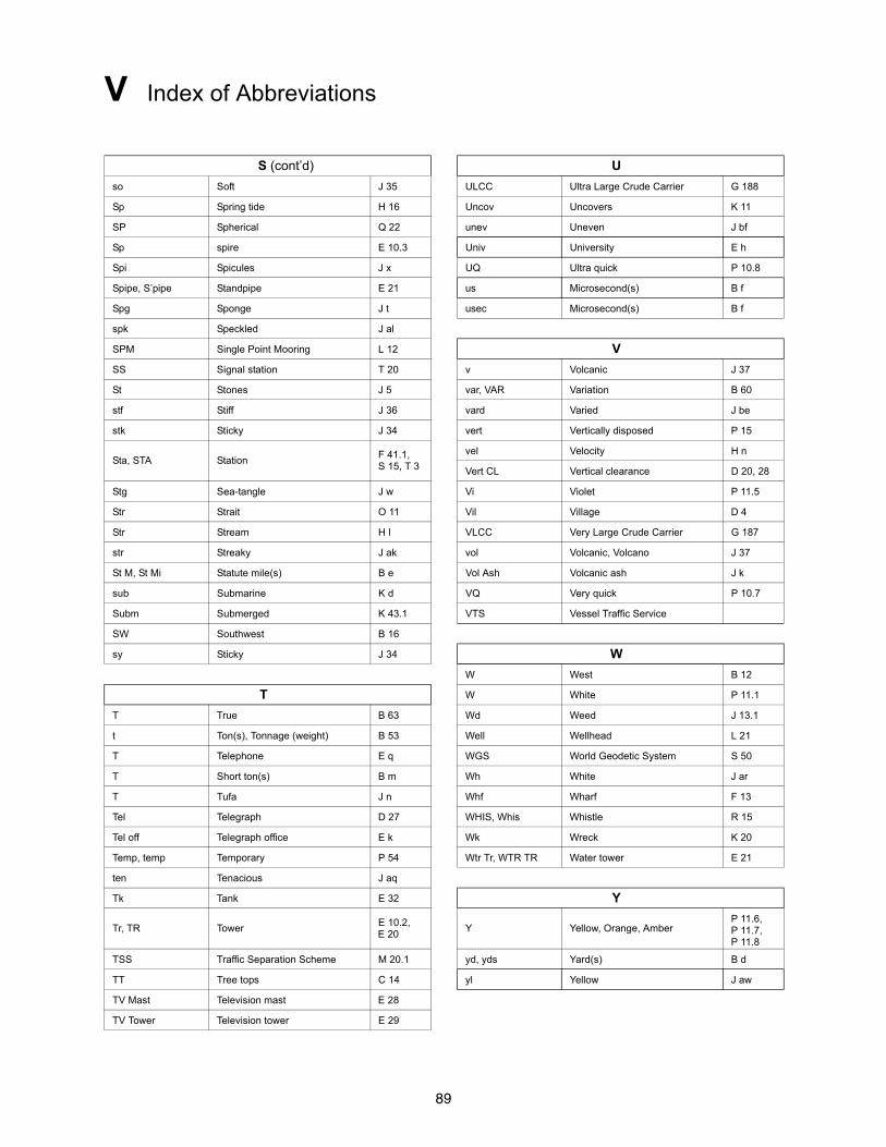
89
V Index of Abbreviations
S (cont’d) U
so Soft J 35 ULCC Ultra Large Crude Carrier G 188
Sp Spring tide H 16 Uncov Uncovers K 11
SP Spherical Q 22 unev Uneven J bf
Sp spire E 10.3 Univ University E h
Spi Spicules J x UQ Ultra quick P 10.8
Spipe, S’pipe Standpipe E 21 us Microsecond(s) B f
Spg Sponge J t usec Microsecond(s) B f
spk Speckled J al
SPM Single Point Mooring L 12 V
SS Signal station T 20 v Volcanic J 37
St Stones J 5 var, VAR Variation B 60
stf Stiff J 36 vard Varied J be
stk Sticky J 34 vert Vertically disposed P 15
Sta, STA StationF 41.1, S 15, T 3
vel Velocity H n
Vert CL Vertical clearance D 20, 28
Stg Sea-tangle J w Vi Violet P 11.5
Str Strait O 11 Vil Village D 4
Str Stream H l VLCC Very Large Crude Carrier G 187
str Streaky J ak vol Volcanic, Volcano J 37
St M, St Mi Statute mile(s) B e Vol Ash Volcanic ash J k
sub Submarine K d VQ Very quick P 10.7
Subm Submerged K 43.1 VTS Vessel Traffic Service
SW Southwest B 16
sy Sticky J 34 W
W West B 12
T W White P 11.1
T True B 63 Wd Weed J 13.1
t Ton(s), Tonnage (weight) B 53 Well Wellhead L 21
T Telephone E q WGS World Geodetic System S 50
T Short ton(s) B m Wh White J ar
T Tufa J n Whf Wharf F 13
Tel Telegraph D 27 WHIS, Whis Whistle R 15
Tel off Telegraph office E k Wk Wreck K 20
Temp, temp Temporary P 54 Wtr Tr, WTR TR Water tower E 21
ten Tenacious J aq
Tk Tank E 32 Y
Tr, TR TowerE 10.2, E 20
Y Yellow, Orange, AmberP 11.6, P 11.7, P 11.8
TSS Traffic Separation Scheme M 20.1 yd, yds Yard(s) B d
TT Tree tops C 14 yl Yellow J aw
TV Mast Television mast E 28
TV Tower Television tower E 29
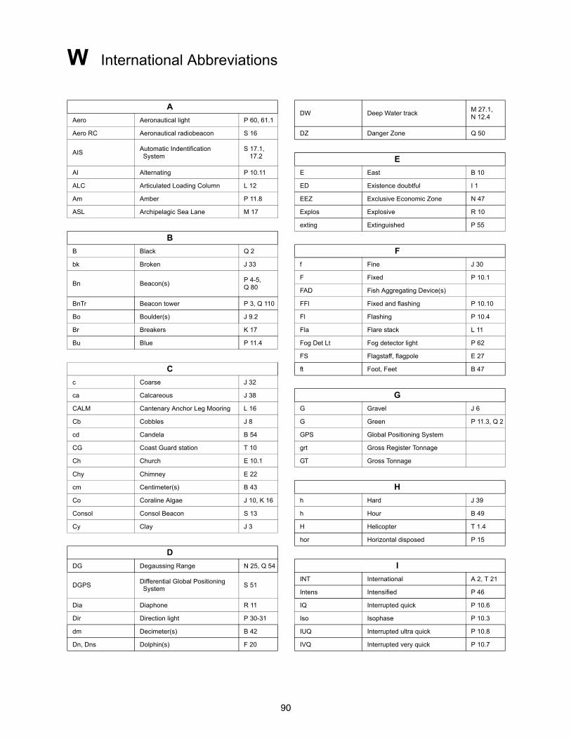
90
W International Abbreviations
ADW Deep Water track
M 27.1, N 12.4Aero Aeronautical light P 60, 61.1
Aero RC Aeronautical radiobeacon S 16 DZ Danger Zone Q 50
AISAutomatic Indentification System
S 17.1, 17.2 E
Al Alternating P 10.11 E East B 10
ALC Articulated Loading Column L 12 ED Existence doubtful I 1
Am Amber P 11.8 EEZ Exclusive Economic Zone N 47
ASL Archipelagic Sea Lane M 17 Explos Explosive R 10
exting Extinguished P 55
B
B Black Q 2 F
bk Broken J 33 f Fine J 30
Bn Beacon(s)P 4-5, Q 80
F Fixed P 10.1
FAD Fish Aggregating Device(s)
BnTr Beacon tower P 3, Q 110 FFl Fixed and flashing P 10.10
Bo Boulder(s) J 9.2 Fl Flashing P 10.4
Br Breakers K 17 Fla Flare stack L 11
Bu Blue P 11.4 Fog Det Lt Fog detector light P 62
FS Flagstaff, flagpole E 27
C ft Foot, Feet B 47
c Coarse J 32
ca Calcareous J 38 G
CALM Cantenary Anchor Leg Mooring L 16 G Gravel J 6
Cb Cobbles J 8 G Green P 11.3, Q 2
cd Candela B 54 GPS Global Positioning System
CG Coast Guard station T 10 grt Gross Register Tonnage
Ch Church E 10.1 GT Gross Tonnage
Chy Chimney E 22
cm Centimeter(s) B 43 H
Co Coraline Algae J 10, K 16 h Hard J 39
Consol Consol Beacon S 13 h Hour B 49
Cy Clay J 3 H Helicopter T 1.4
hor Horizontal disposed P 15
D
DG Degaussing Range N 25, Q 54 I
DGPSDifferential Global Positioning System
S 51INT International A 2, T 21
Intens Intensified P 46
Dia Diaphone R 11 IQ Interrupted quick P 10.6
Dir Direction light P 30-31 Iso Isophase P 10.3
dm Decimeter(s) B 42 IUQ Interrupted ultra quick P 10.8
Dn, Dns Dolphin(s) F 20 IVQ Interrupted very quick P 10.7
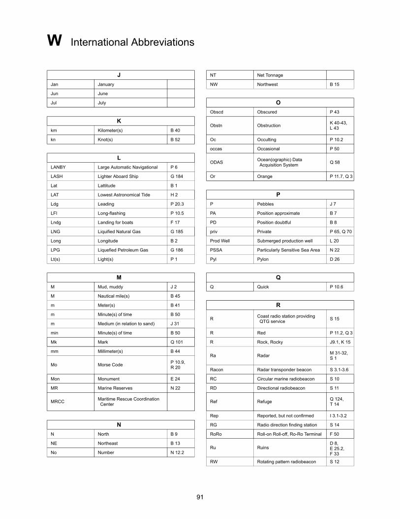
91
W International Abbreviations
J NT Net Tonnage
Jan January NW Northwest B 15
Jun June
Jul July O
Obscd Obscured P 43
KObstn Obstruction
K 40-43, L 43km Kilometer(s) B 40
kn Knot(s) B 52 Oc Occulting P 10.2
occas Occasional P 50
LODAS
Ocean(ographic) Data Acquisition System
Q 58LANBY Large Automatic Navigational P 6
LASH Lighter Aboard Ship G 184 Or Orange P 11.7, Q 3
Lat Lattitude B 1
LAT Lowest Astronomical Tide H 2 P
Ldg Leading P 20.3 P Pebbles J 7
LFl Long-flashing P 10.5 PA Position approximate B 7
Lndg Landing for boats F 17 PD Position doubtful B 8
LNG Liquified Natural Gas G 185 priv Private P 65, Q 70
Long Longitude B 2 Prod Well Submerged production well L 20
LPG Liquefied Petroleum Gas G 186 PSSA Particularly Sensitive Sea Area N 22
Lt(s) Light(s) P 1 Pyl Pylon D 26
M Q
M Mud, muddy J 2 Q Quick P 10.6
M Nautical mile(s) B 45
m Meter(s) B 41 R
m Minute(s) of time B 50R
Coast radio station providing QTG service
S 15m Medium (in relation to sand) J 31
min Minute(s) of time B 50 R Red P 11.2, Q 3
Mk Mark Q 101 R Rock, Rocky J9.1, K 15
mm Millimeter(s) B 44Ra Radar
M 31-32, S 1
Mo Morse CodeP 10.9, R 20 Racon Radar transponder beacon S 3.1-3.6
Mon Monument E 24 RC Circular marine radiobeacon S 10
MR Marine Reserves N 22 RD Directional radiobeacon S 11
MRCCMaritime Rescue Coordination Center
Ref RefugeQ 124, T 14
Rep Reported, but not confirmed I 3.1-3.2
N RG Radio direction finding station S 14
N North B 9 RoRo Roll-on Roll-off, Ro-Ro Terminal F 50
NE Northeast B 13Ru Ruins
D 8, E 25.2, F 33No Number N 12.2
RW Rotating pattern radiobeacon S 12
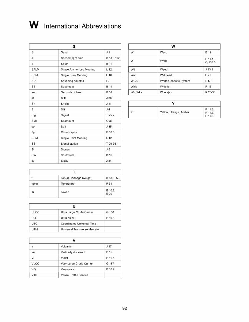
92
W International Abbreviations
S W
S Sand J 1 W West B 12
s Second(s) of time B 51, P 12W White
P 11.1, Q 130.5S South B 11
SALM Single Anchor Leg Mooring L 12 Wd Weed J 13.1
SBM Single Buoy Mooring L 16 Well Wellhead L 21
SD Sounding doubtful I 2 WGS World Geodetic System S 50
SE Southeast B 14 Whis Whistle R 15
sec Seconds of time B 51 Wk, Wks Wreck(s) K 20-30
sf Stiff J 36
Sh Shells J 11 Y
Si Silt J 4Y Yellow, Orange, Amber
P 11.6, P 11.7, P 11.8Sig Signal T 25.2
SMt Seamount O 33
so Soft J 35
Sp Church spire E 10.3
SPM Single Point Mooring L 12
SS Signal station T 20-36
St Stones J 5
SW Southwest B 16
sy Sticky J 34
T
t Ton(s), Tonnage (weight) B 53, F 53
temp Temporary P 54
Tr TowerE 10.2, E 20
U
ULCC Ultra Large Crude Carrier G 188
UQ Ultra quick P 10.8
UTC Coordinated Universal Time
UTM Universal Transverse Mercator
V
v Volcanic J 37
vert Vertically disposed P 15
Vi Violet P 11.5
VLCC Very Large Crude Carrier G 187
VQ Very quick P 10.7
VTS Vessel Traffic Service
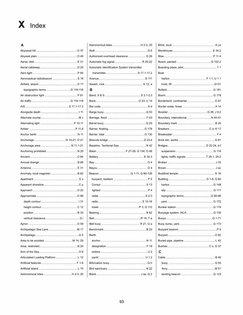
93
X Index
A Astronomical tides.....................................H 2-3, 20 Blind, duck ....................................................... K j-k
Abysssal hill .....................................................O 37 Atoll ....................................................................G 6 Blockhouse ................................................... E 34.2
Abyssal plain....................................................O 49 Authorized overhead clearance .......................D 26 Blue............................................................... P 11.4
Aerial, dish .......................................................E 31 Automatic fog signal....................................R 20-22 Board, painted ............................................Q 102.2
Aerial cableway............................................. ...D 25 Automatic Identification System transmitter Boarding place, pilot .......................................... T 1
Aero light ..........................................................P 60 transmitter.........................................S 17.1-17.2 Boat
Aeronautical radiobeacon ................................S 16 Avenue........................................................... G 111 harbor ...............................................F 1.1, U 1.1
Airfield, airport ..................................................D 17 Awash, rock ................................................. K 12, a hoist, lift ......................................................G131
topographic terms ...............................G 116-118 B Bollard............................................................G 181
Air obstruction light ..........................................P 61 Band, X & S ..............................................S 3.1-3.3 Boom .............................................................G 178
Air traffic ..................................................G 116-118 Bank....................................................... O 23, U 14 Borderland, continental ....................................O 47
AIS ........................................................S 17.1-17.2 Bar code............................................................. A d Border scale, linear.......................................... A 14
Alongside depth .................................................I 11 Barge buoy.......................................................Q 53 Boulder .................................................. G 28, J 9.2
Alternate course.................................................M c Barrage, flood .................................................. F 43 Boundary, international ...............................N 40-41
Alternating light ........................................... P 10.11 Barrel buoy.......................................................Q 25 Boundary mark ................................................ B 24
Amber ........................................................... P 11.8 Barrier, floating...............................................G 178 Breakers ...................................................C d, K 17
Anchor berth .................................................... N 11 Barrier, tidal....................................................G 130 Breakwater......................................................... F 4
Anchorage.........................................N 10-21, O 21 Bascule bridge ..............................................D 23.4 Brick kiln, works ...............................................G 81
Anchorage area .......................................N 11.1-21 Baseline, Territorial Sea ...................................N 42 Bridges..................................................D 22-24, d-f
Anchoring prohibited ........................................N 20 Basin ......................................F 27-28, G 134, O 48 suspension ................................................ G 114
Ancient .............................................................O 84 Battery........................................................... E 34.3 lights, traffic signals ......................... T 25.1, 25.2
Annual change .................................................B 66 Bay.....................................................................O 4 Broken ..............................................................J 33
Antenna............................................................E 31 Bayou.................................................................O 4 Brown................................................................ J az
Anomaly, local magnetic ..................................B 82 Beacon.........................................Q 1-11, Q 80-126 Buddhist temple ............................................... E 16
Apartment .......................................................... E s buoyant, resilient ............................................ P 5 Building ................................................. D 1-8, G 60
Apparent shoreline .............................................C p Consol .......................................................... S 13 harbor ........................................................G 148
Approach..........................................................O 22 lighted............................................................. P 4 slip .............................................................G 171
Approximate.....................................................O 89 radar ............................................................S 2-3 topographic terms...................................G 60-98
depth contour................................................ I 31 radio.........................................................S 10-16 yard............................................................G 172
height contour ..............................................C 12 tower ....................................................P 3, Q 110 Bunker station................................................G 174
position ........................................................B 33 Bearing............................................................. B 62 Buoyage system, IALA ..................................Q 130
vertical clearance............................................D i Bell ............................................................R 14, T a Buoys............................................................Q 1-71
Apron ...............................................................O 59 Bell buoy .................................................. R 21, Q a Buoy dump, yard............................................G 173
Archipelagic Sea Lane .................................... M 17 Benchmark....................................................... B 23 Buoyant beacon................................................. P 5
Archipelago ........................................................G 5 Berth Buoyed.............................................................O 82
Area to be avoided.................................... M 14, 29 anchor........................................................... N 11 Buried pipe, pipeline .........................................L 42
Area, restricted.................................................N 20 designation ................................................... F 19 Bushes..................................................... C o, G 37
Arm of the Sea ...................................................O 6 visitors.............................................................U 2 C
Articulated Loading Platform............................ L 12 yacht ............................................................U 1.2 Cable ............................................................... B 46
Artificial features ............................................. F 1-6 Bifurcation buoy .................................................Q h buoy ............................................................Q 55
Artificial island .................................................. L 15 Bird sanctuary ..................................................N 22 ferry.............................................................M 51
Astronomical tides.....................................H 2-3, 20 Black ......................................................... J as, Q 2 landing beacon..........................................Q 123
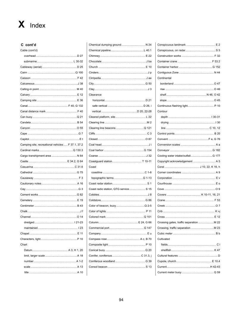
94
X Index
C cont’d Chemical dumping ground...............................N 24 Conspicuous landmark ...................................... E 2
Cable (cont’d) Chemical pipeline...........................................L 40.1 Conspicuous, on radar....................................... S 5
overhead .....................................................D 27 Chimney........................................................... E 22 Construction works .......................................... F 32
submarine............................................... L 30-32 Chocolate..........................................................J ba Container crane ............................................ F 53.2
Cableway (aerial) .............................................D 25 Church ............................................................. E 10 Container harbor............................................G 152
Cairn ..............................................................Q 100 Cinders................................................................J p Contiguous Zone ............................................. N 44
Caisson ............................................................ F 42 Cirripedia...........................................................J ae Continental
Calcareous........................................................J 38 City...................................................................G 50 borderland ....................................................O 47
Calling-in point ................................................ M 40 Clay.....................................................................J 3 rise ...............................................................O 46
Calvary.............................................................E 12 Clearance shelf.................................................... N 46, O 42
Camping site ....................................................E 36 horizontal.....................................................D 21 slope .............................................................O 45
Canal.................................................... F 40, G 132 safe vertical .............................................. D 26, i Continuous flashing light.................................. P 10
Canal distance mark ........................................ F 40 vertical ..............................................D 20, 22-28 Contour
Can buoy..........................................................Q 21 Cleared platform, site........................................L 22 depth ....................................................... I 30-31
Candela............................................................B 54 Clearing line .......................................................M 2 drying ............................................................I 30
Canyon.............................................................O 55 Clearing line beacons ....................................Q 121 line ........................................................ C 10, 12
Cape ..................................................................G 7 Cliffs ...................................................................C 3 Control points................................................... B 20
Capitol .................................................................E t Closed..............................................................O 87 Convent ....................................................F e, G 76
Camping site, recreational vehicles ..... F 37.1, 37.2 Coal head............................................................. J i Conversion scales ............................................. A a
Cardinal marks............................................Q 130.3 Coal harbor ....................................................G 154 Conveyor .......................................................G 182
Cargo transhipment area .................................N 64 Coarse ..............................................................J 32 Cooling water intake/outfall............................G 177
Castle.................................................. E 34.2, G 64 Coastguard station...................................... T 10-11 Copyright acknowledgement ............................. A 5
Casuarina......................................................C 31.6 Coast Coral ............................................. J 10, 22, K 16, h
Cathedral .........................................................G 75 coastline ......................................................C 1-8 Corner coordinates ............................................ A 9
Causeway .......................................................... F 3 topographic terms......................................G 1-13 Corporation ........................................................ E v
Cautionary notes..............................................A 16 Coast radar station............................................. S 1 Courthouse ........................................................ E o
Cay.....................................................................G 3 Coast radio station, QTG service..................... S 15 Cove ..................................................................O 9
Cement works ..................................................G 82 Cobbles...............................................................J 8 Covers ............................................ K 10-11, 16, 21
Cemetery .........................................................E 19 Coldstore..........................................................G 86 Crane ............................................................... F 53
Centimeter .......................................................B 43 Color of beacon, buoy.....................................Q 2-5 Creek .................................................................O 7
Chalk....................................................................J f Color of lights ................................................... P 11 Crib ................................................................... K i-j
Channel............................................................O 14 Colored mark .................................................Q 101 Cross ............................................................... E 12
dredged ................................................... I 21-23 Column................................................... E 24, G 66 Crossing gates, traffic separation ....................M 22
maintained.................................................... I 23 Commercial port.............................................G 147 Crossing, traffic separation ..............................M 23
Chapel.............................................................. E 11 Company............................................................ E u Cubic meter ....................................................... B b
Characters, light ...............................................P 10 Compass rose...........................................A c, B 70 Cultivated
Chart Composite light ................................................ P 10 fields............................................................... C l
Datum.............................................. A 3, H 1, 20 Conical buoy ....................................................Q 20 shellfish ....................................................... K 47
limit, larger scale .........................................A 18 Conifer, coniferous..................................... C 31.3, j Cultural features ................................................... D
number .......................................................A 1-2 Coniferous woodland .......................................G 39 Cupola, church.............................................. E 10.4
scale ............................................................A 13 Consol beacon................................................. S 13 Current........................................................H 42-43
title ..............................................................A 10 Current meter buoy..........................................Q 59
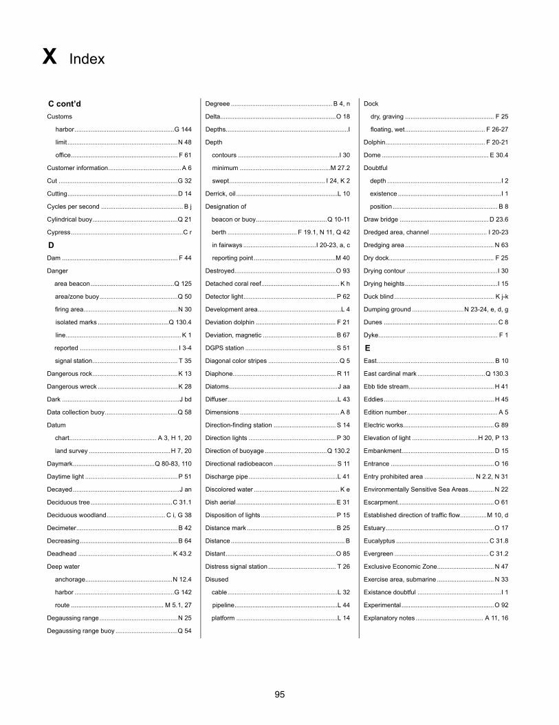
95
X Index
C cont’d Degreee ......................................................... B 4, n Dock
Customs Delta.................................................................O 18 dry, graving .................................................. F 25
harbor........................................................G 144 Depths.....................................................................I floating, wet............................................. F 26-27
limit..............................................................N 48 Depth Dolphin........................................................ F 20-21
office............................................................ F 61 contours .........................................................I 30 Dome ............................................................ E 30.4
Customer information.........................................A 6 minimum ...................................................M 27.2 Doubtful
Cut ...................................................................G 32 swept...................................................... I 24, K 2 depth ................................................................I 2
Cutting..............................................................D 14 Derrick, oil .........................................................L 10 existence ..........................................................I 1
Cycles per second .............................................. B j Designation of position........................................................... B 8
Cylindrical buoy................................................Q 21 beacon or buoy........................................Q 10-11 Draw bridge .................................................. D 23.6
Cypress...............................................................C r berth ....................................... F 19.1, N 11, Q 42 Dredged area, channel ................................ I 20-23
D in fairways .........................................I 20-23, a, c Dredging area .................................................. N 63
Dam ................................................................. F 44 reporting point ..............................................M 40 Dry dock........................................................... F 25
Danger Destroyed.........................................................O 93 Drying contour ...................................................I 30
area beacon...............................................Q 125 Detached coral reef............................................ K h Drying heights....................................................I 15
area/zone buoy............................................Q 50 Detector light.................................................... P 62 Duck blind ........................................................ K j-k
firing area.....................................................N 30 Development area...............................................L 4 Dumping ground .............................N 23-24, e, d, g
isolated marks ........................................Q 130.4 Deviation dolphin ............................................. F 21 Dunes ................................................................ C 8
line.................................................................K 1 Deviation, magnetic ......................................... B 67 Dyke................................................................... F 1
reported ....................................................... I 3-4 DGPS station ................................................... S 51 E
signal station................................................ T 35 Diagonal color stripes ........................................Q 5 East.................................................................. B 10
Dangerous rock................................................K 13 Diaphone.......................................................... R 11 East cardinal mark ......................................Q 130.3
Dangerous wreck .............................................K 28 Diatoms.............................................................J aa Ebb tide stream................................................ H 41
Dark ..................................................................J bd Diffuser..............................................................L 43 Eddies.............................................................. H 45
Data collection buoy.........................................Q 58 Dimensions ........................................................ A 8 Edition number................................................... A 5
Datum Direction-finding station ................................... S 14 Electric works...................................................G 89
chart................................................. A 3, H 1, 20 Direction lights ................................................. P 30 Elevation of light .....................................H 20, P 13
land survey ..............................................H 7, 20 Direction of buoyage ...................................Q 130.2 Embankment.................................................... D 15
Daymark..............................................Q 80-83, 110 Directional radiobeacon ................................... S 11 Entrance ..........................................................O 16
Daytime light ....................................................P 51 Discharge pipe..................................................L 41 Entry prohibited area ............................ N 2.2, N 31
Decayed............................................................J an Discolored water ................................................ K e Environmentally Sensitive Sea Areas.............. N 22
Deciduous tree..............................................C 31.1 Dish aerial ........................................................ E 31 Escarpment......................................................O 61
Deciduous woodland................................. C i, G 38 Disposition of lights .......................................... P 15 Established direction of traffic flow...............M 10, d
Decimeter.........................................................B 42 Distance mark .................................................. B 25 Estuary.............................................................O 17
Decreasing.......................................................B 64 Distance ................................................................ B Eucalyptus .................................................... C 31.8
Deadhead .....................................................K 43.2 Distant..............................................................O 85 Evergreen ..................................................... C 31.2
Deep water Distress signal station ...................................... T 26 Exclusive Economic Zone................................ N 47
anchorage.................................................N 12.4 Disused Exercise area, submarine ................................ N 33
harbor ........................................................G 142 cable..............................................................L 32 Existance doubtful ...............................................I 1
route .................................................... M 5.1, 27 pipeline..........................................................L 44 Experimental ....................................................O 92
Degaussing range............................................N 25 platform .........................................................L 14 Explanatory notes ...................................... A 11, 16
Degaussing range buoy ...................................Q 54
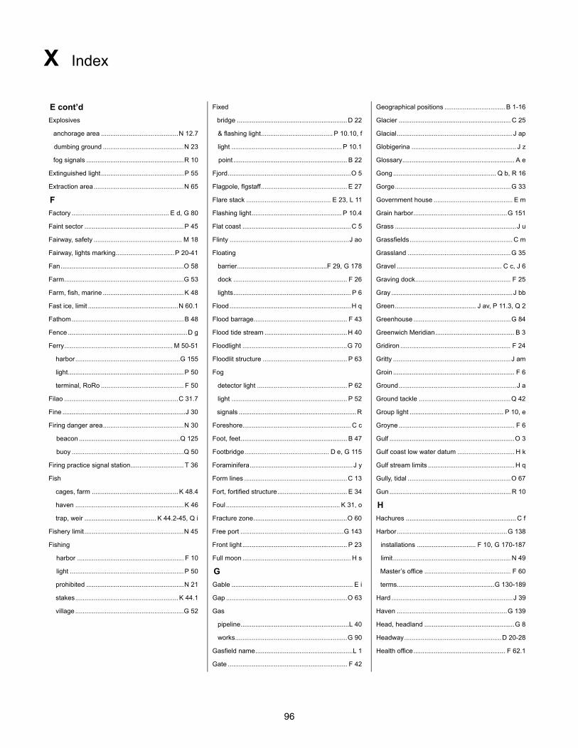
96
X Index
E cont’d Fixed Geographical positions ................................. B 1-16
Explosives bridge ............................................................D 22 Glacier ............................................................. C 25
anchorage area ..........................................N 12.7 & flashing light....................................... P 10.10, f Glacial...............................................................J ap
dumbing ground ............................................N 23 light ............................................................ P 10.1 Globigerina ......................................................... J z
fog signals .....................................................R 10 point .............................................................. B 22 Glossary............................................................. A e
Extinguished light .............................................P 55 Fjord...................................................................O 5 Gong ........................................................ Q b, R 16
Extraction area.................................................N 65 Flagpole, flgstaff............................................... E 27 Gorge...............................................................G 33
F Flare stack .............................................. E 23, L 11 Government house ........................................... E m
Factory ..................................................... E d, G 80 Flashing light................................................. P 10.4 Grain harbor...................................................G 151
Faint sector ......................................................P 45 Flat coast ...........................................................C 5 Grass ..................................................................J u
Fairway, safety ................................................ M 18 Flinty .................................................................J ao Grassfields........................................................ C m
Fairway, lights marking................................P 20-41 Floating Grassland ........................................................G 35
Fan...................................................................O 58 barrier.................................................F 29, G 178 Gravel ......................................................... C c, J 6
Farm.................................................................G 53 dock .............................................................. F 26 Graving dock.................................................... F 25
Farm, fish, marine ............................................K 48 lights................................................................ P 6 Gray ..................................................................J bb
Fast ice, limit .................................................N 60.1 Flood..................................................................H q Green............................................ J av, P 11.3, Q 2
Fathom.............................................................B 48 Flood barrage................................................... F 43 Greenhouse .....................................................G 84
Fence .................................................................D g Flood tide stream .............................................H 40 Greenwich Meridian........................................... B 3
Ferry........................................................... M 50-51 Floodlight .........................................................G 70 Gridiron ............................................................ F 24
harbor.........................................................G 155 Floodlit structure .............................................. P 63 Gritty ................................................................J am
light...............................................................P 50 Fog Groin .................................................................. F 6
terminal, RoRo ............................................. F 50 detector light ................................................. P 62 Ground................................................................J a
Filao ..............................................................C 31.7 light ............................................................... P 52 Ground tackle ..................................................Q 42
Fine ...................................................................J 30 signals ................................................................R Group light ................................................... P 10, e
Firing danger area............................................N 30 Foreshore........................................................... C c Groyne ............................................................... F 6
beacon .......................................................Q 125 Foot, feet.......................................................... B 47 Gulf ....................................................................O 3
buoy .............................................................Q 50 Footbridge.............................................. D e, G 115 Gulf coast low water datum ............................... H k
Firing practice signal station............................. T 36 Foraminifera........................................................J y Gulf stream limits ............................................... H q
Fish Form lines ........................................................C 13 Gully, tidal ........................................................O 67
cages, farm ...............................................K 48.4 Fort, fortified structure...................................... E 34 Gun .................................................................. R 10
haven ...........................................................K 46 Foul .............................................................. K 31, o H
trap, weir ....................................... K 44.2-45, Q i Fracture zone...................................................O 60 Hachures ............................................................ C f
Fishery limit ......................................................N 45 Free port ........................................................G 143 Harbor............................................................G 138
Fishing Front light ......................................................... P 23 installations ................................ F 10, G 170-187
harbor .......................................................... F 10 Full moon ........................................................... H s limit................................................................ N 49
light ..............................................................P 50 G Master’s office ............................................... F 60
prohibited .....................................................N 21 Gable .................................................................. E i terms.....................................................G 130-189
stakes........................................................K 44.1 Gap ..................................................................O 63 Hard ..................................................................J 39
village ...........................................................G 52 Gas Haven ............................................................G 139
pipeline...........................................................L 40 Head, headland .................................................G 8
works.............................................................G 90 Headway.....................................................D 20-28
Gasfield name.....................................................L 1 Health office.................................................. F 62.1
Gate ................................................................. F 42
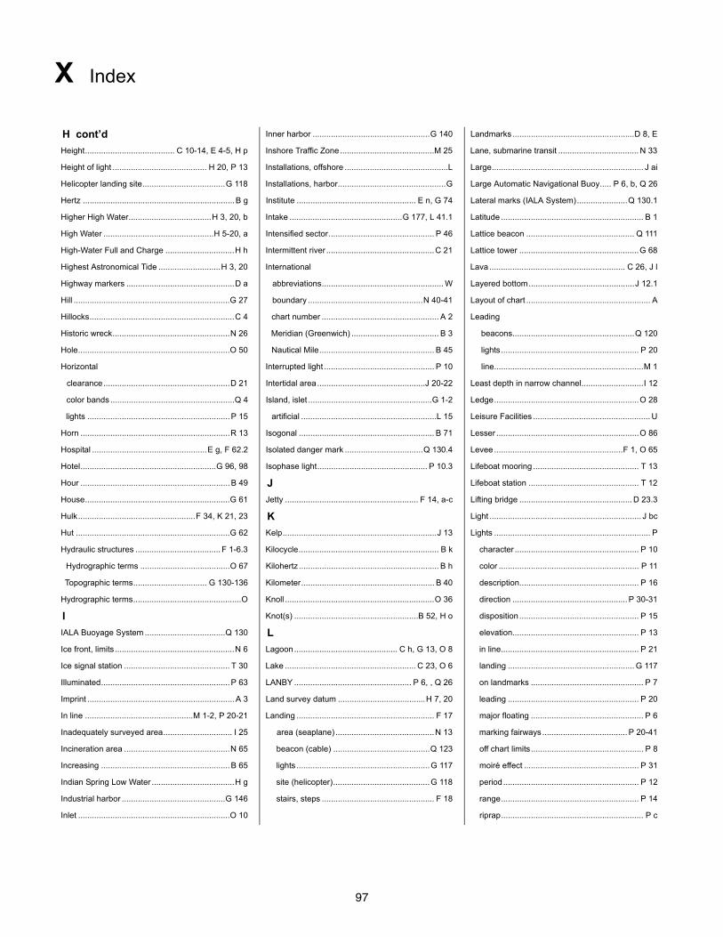
97
X Index
H cont’d Inner harbor ...................................................G 140 Landmarks .....................................................D 8, E
Height....................................... C 10-14, E 4-5, H p Inshore Traffic Zone.........................................M 25 Lane, submarine transit ................................... N 33
Height of light ......................................... H 20, P 13 Installations, offshore .............................................L Large.................................................................. J ai
Helicopter landing site....................................G 118 Installations, harbor...............................................G Large Automatic Navigational Buoy..... P 6, b, Q 26
Hertz ..................................................................B g Institute .................................................... E n, G 74 Lateral marks (IALA System)......................Q 130.1
Higher High Water....................................H 3, 20, b Intake .................................................G 177, L 41.1 Latitude .............................................................. B 1
High Water ................................................H 5-20, a Intensified sector.............................................. P 46 Lattice beacon ............................................... Q 111
High-Water Full and Charge ..............................H h Intermittent river ...............................................C 21 Lattice tower ....................................................G 68
Highest Astronomical Tide ...........................H 3, 20 International Lava ........................................................... C 26, J l
Highway markers ...............................................D a abbreviations..................................................... W Layered bottom..............................................J 12.1
Hill ....................................................................G 27 boundary ..................................................N 40-41 Layout of chart ...................................................... A
Hillocks...............................................................C 4 chart number ................................................... A 2 Leading
Historic wreck...................................................N 26 Meridian (Greenwich) ...................................... B 3 beacons.....................................................Q 120
Hole..................................................................O 50 Nautical Mile.................................................. B 45 lights............................................................ P 20
Horizontal Interrupted light ................................................ P 10 line.................................................................M 1
clearance.......................................................D 21 Intertidal area...............................................J 20-22 Least depth in narrow channel...........................I 12
color bands ......................................................Q 4 Island, islet ......................................................G 1-2 Ledge...............................................................O 28
lights ..............................................................P 15 artificial ...........................................................L 15 Leisure Facilities ................................................... U
Horn .................................................................R 13 Isogonal ........................................................... B 71 Lesser ..............................................................O 86
Hospital ..................................................E g, F 62.2 Isolated danger mark ..................................Q 130.4 Levee ........................................................F 1, O 65
Hotel...........................................................G 96, 98 Isophase light................................................ P 10.3 Lifeboat mooring .............................................. T 13
Hour .................................................................B 49 J Lifeboat station ................................................ T 12
House...............................................................G 61 Jetty .......................................................... F 14, a-c Lifting bridge ................................................. D 23.3
Hulk...................................................F 34, K 21, 23 K Light .................................................................. J bc
Hut ...................................................................G 62 Kelp...................................................................J 13 Lights .................................................................... P
Hydraulic structures ..................................... F 1-6.3 Kilocycle............................................................. B k character ...................................................... P 10
Hydrographic terms .......................................O 67 Kilohertz ............................................................. B h color ............................................................. P 11
Topographic terms................................ G 130-136 Kilometer.......................................................... B 40 description.................................................... P 16
Hydrographic terms...............................................O Knoll .................................................................O 36 direction .................................................. P 30-31
I Knot(s) ......................................................B 52, H o disposition .................................................... P 15
IALA Buoyage System ...................................Q 130 L elevation....................................................... P 13
Ice front, limits ....................................................N 6 Lagoon............................................. C h, G 13, O 8 in line............................................................ P 21
Ice signal station .............................................. T 30 Lake ......................................................... C 23, O 6 landing ....................................................... G 117
Illuminated........................................................P 63 LANBY ................................................... P 6, , Q 26 on landmarks ................................................. P 7
Imprint ................................................................A 3 Land survey datum ......................................H 7, 20 leading ......................................................... P 20
In line ...............................................M 1-2, P 20-21 Landing ............................................................ F 17 major floating ................................................. P 6
Inadequately surveyed area.............................. I 25 area (seaplane) ...........................................N 13 marking fairways ..................................... P 20-41
Incineration area ..............................................N 65 beacon (cable) ..........................................Q 123 off chart limits................................................. P 8
Increasing ........................................................B 65 lights ..........................................................G 117 moiré effect .................................................. P 31
Indian Spring Low Water ....................................H g site (helicopter)..........................................G 118 period........................................................... P 12
Industrial harbor .............................................G 146 stairs, steps ................................................. F 18 range............................................................ P 14
Inlet ..................................................................O 10 riprap.............................................................. P c
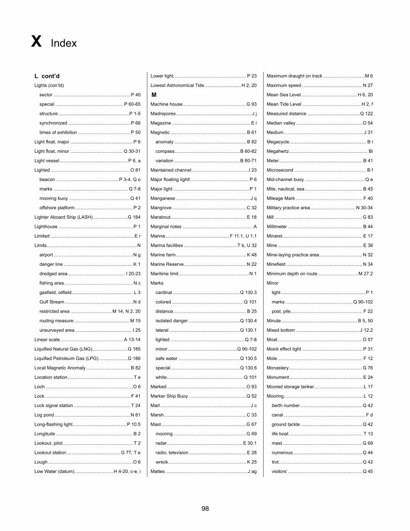
98
X Index
L cont’d Lower light........................................................ P 23 Maximum draught on track ................................M 6
Lights (con’td) Lowest Astronomical Tide............................H 2, 20 Maximum speed .............................................. N 27
sector ...........................................................P 40 M Mean Sea Level........................................... H 6, 20
special .....................................................P 60-65 Machine house.................................................G 93 Mean Tide Level ............................................. H 2, f
structure ......................................................P 1-5 Madrepores.......................................................... J j Measured distance ........................................Q 122
synchronized ................................................P 66 Magazine ............................................................ E l Median valley...................................................O 54
times of exhibition ........................................P 50 Magnetic .......................................................... B 61 Medium .............................................................J 31
Light float, major ................................................P 6 anomaly ....................................................... B 82 Megacycle........................................................... B l
Light float, minor ........................................ Q 30-31 compass..................................................B 60-82 Megahertz............................................................ Bi
Light vessel ....................................................P 6, a variation ..................................................B 60-71 Meter................................................................ B 41
Lighted .............................................................O 81 Maintained channel............................................I 23 Microsecond ....................................................... B f
beacon ................................................P 3-4, Q o Major floating lightl ............................................. P 6 Mid-channel buoy ..............................................Q e
marks ......................................................... Q 7-8 Major light .......................................................... P 1 Mile, nautical, sea ............................................ B 45
mooring buoy ...............................................Q 41 Manganese .........................................................J q Mileage Mark ................................................... F 40
offshore platform ............................................P 2 Mangrove.........................................................C 32 Military practice area...................................N 30-34
Lighter Aboard Ship (LASH) ..........................G 184 Marabout.......................................................... E 18 Mill ...................................................................G 83
Lighthouse .........................................................P 1 Marginal notes ...................................................... A Millimeter ......................................................... B 44
Limited ................................................................E r Marina.................................................F 11.1, U 1.1 Minaret............................................................. E 17
Limits.....................................................................N Marina facilities .........................................T b, U 32 Mine ................................................................. E 36
airport .............................................................N g Marine farm...................................................... K 48 Mine-laying practice area................................. N 32
danger line .....................................................K 1 Marine Reserve................................................N 22 Minefield .......................................................... N 34
dredged area............................................ I 20-23 Maritime limit......................................................N 1 Minimum depth on route ...............................M 27.2
fishing area.....................................................N c Marks Minor
gasfield, oilfield............................................... L 3 cardinal ...................................................Q 130.3 light ................................................................ P 1
Gulf Stream ....................................................N d colored .......................................................Q 101 marks ....................................................Q 90-102
restricted area ................................M 14, N 2, 20 distance........................................................ B 25 post, pile....................................................... F 22
routing measure .......................................... M 15 isolated danger .......................................Q 130.4 Minute .......................................................... B 5, 50
unsurveyed area ........................................... I 25 lateral ......................................................Q 130.1 Mixed bottom .................................................J 12.2
Linear scale.................................................A 13-14 lighted .........................................................Q 7-8 Moat.................................................................O 57
Liquified Natural Gas (LNG)...........................G 185 minor .....................................................Q 90-102 Moiré effect light .............................................. P 31
Liquified Petroleum Gas (LPG) ......................G 186 safe water ...............................................Q 130.5 Mole ................................................................. F 12
Local Magnetic Anomaly..................................B 82 special .....................................................Q 130.6 Monastery ........................................................G 76
Location station .................................................. T e white...........................................................Q 101 Monument........................................................ E 24
Loch ...................................................................O 6 Marked.............................................................O 83 Moored storage tanker......................................L 17
Lock ................................................................. F 41 Marker Ship Buoy ............................................Q 52 Mooring.............................................................L 12
Lock signal station ........................................... T 24 Marl .....................................................................J c berth number................................................Q 42
Log pond ..........................................................N 61 Marsh...............................................................C 33 canal .............................................................. F d
Long-flashing light.........................................P 10.5 Mast .................................................................G 67 ground tackle ...............................................Q 42
Longitude ...........................................................B 2 mooring ........................................................G 69 life boat ........................................................ T 13
Lookout, pilot...................................................... T 2 radar.......................................................... E 30.1 mast .............................................................G 69
Lookout station......................................... G 77, T e radio, television ............................................ E 28 numerous .....................................................Q 44
Lough .................................................................O 6 wreck............................................................ K 25 trot................................................................Q 42
Low Water (datum)..............................H 4-20, c-e, i Mattes ...............................................................J ag visitors’ .........................................................Q 45
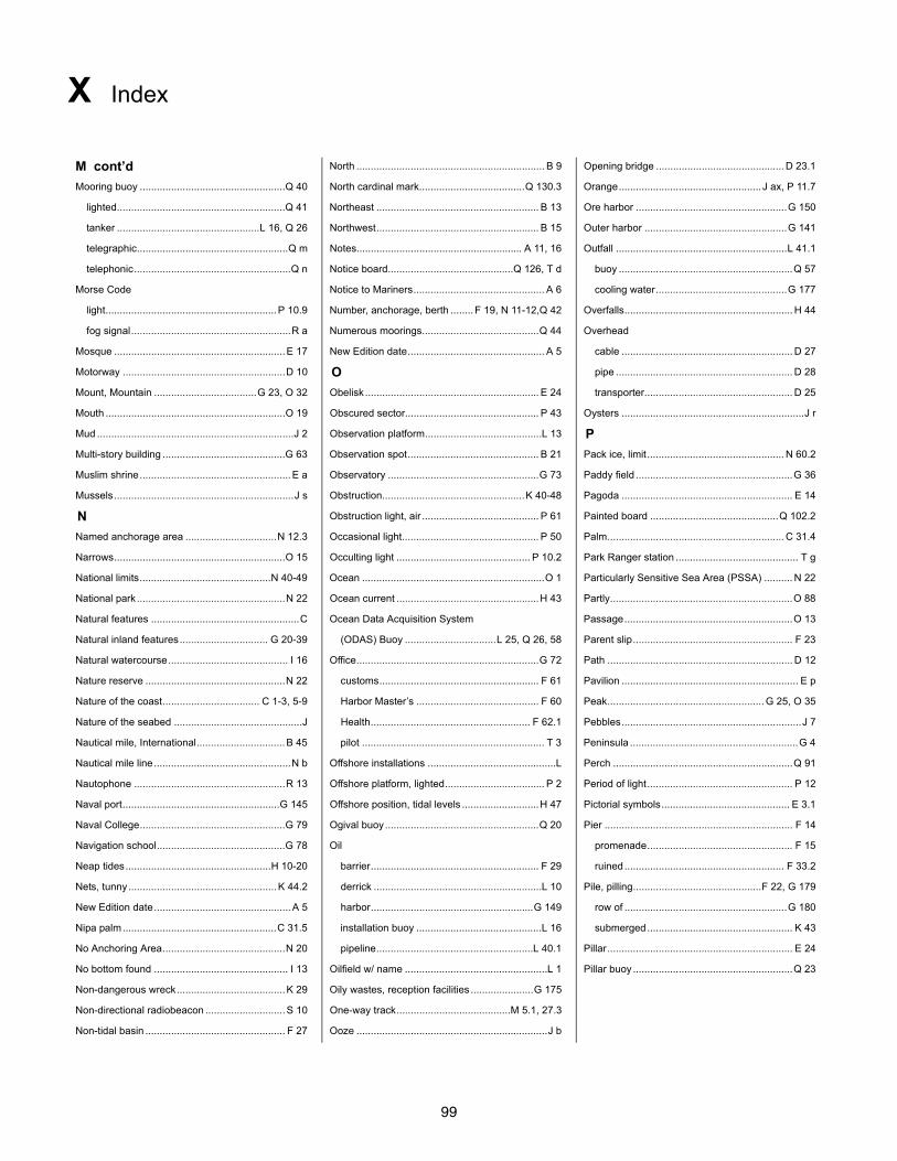
99
X Index
M cont’d North .................................................................. B 9 Opening bridge ............................................. D 23.1
Mooring buoy ...................................................Q 40 North cardinal mark.....................................Q 130.3 Orange.................................................. J ax, P 11.7
lighted...........................................................Q 41 Northeast ......................................................... B 13 Ore harbor .....................................................G 150
tanker ..................................................L 16, Q 26 Northwest......................................................... B 15 Outer harbor ..................................................G 141
telegraphic.....................................................Q m Notes.......................................................... A 11, 16 Outfall ............................................................L 41.1
telephonic.......................................................Q n Notice board............................................Q 126, T d buoy .............................................................Q 57
Morse Code Notice to Mariners.............................................. A 6 cooling water..............................................G 177
light............................................................P 10.9 Number, anchorage, berth ........ F 19, N 11-12,Q 42 Overfalls........................................................... H 44
fog signal........................................................R a Numerous moorings.........................................Q 44 Overhead
Mosque ............................................................E 17 New Edition date................................................ A 5 cable ............................................................ D 27
Motorway .........................................................D 10 O pipe .............................................................. D 28
Mount, Mountain ....................................G 23, O 32 Obelisk ............................................................. E 24 transporter.................................................... D 25
Mouth ...............................................................O 19 Obscured sector............................................... P 43 Oysters ................................................................J r
Mud .....................................................................J 2 Observation platform.........................................L 13 P
Multi-story building ...........................................G 63 Observation spot.............................................. B 21 Pack ice, limit................................................ N 60.2
Muslim shrine.....................................................E a Observatory .....................................................G 73 Paddy field .......................................................G 36
Mussels...............................................................J s Obstruction..................................................K 40-48 Pagoda ............................................................ E 14
N Obstruction light, air ......................................... P 61 Painted board .............................................Q 102.2
Named anchorage area ................................N 12.3 Occasional light................................................ P 50 Palm.............................................................. C 31.4
Narrows............................................................O 15 Occulting light ............................................... P 10.2 Park Ranger station ........................................... T g
National limits..............................................N 40-49 Ocean ................................................................O 1 Particularly Sensitive Sea Area (PSSA) .......... N 22
National park ....................................................N 22 Ocean current ..................................................H 43 Partly................................................................O 88
Natural features ....................................................C Ocean Data Acquisition System Passage...........................................................O 13
Natural inland features............................... G 20-39 (ODAS) Buoy ................................L 25, Q 26, 58 Parent slip........................................................ F 23
Natural watercourse.......................................... I 16 Office................................................................G 72 Path ................................................................. D 12
Nature reserve .................................................N 22 customs........................................................ F 61 Pavilion .............................................................. E p
Nature of the coast.................................. C 1-3, 5-9 Harbor Master’s ........................................... F 60 Peak....................................................... G 25, O 35
Nature of the seabed .............................................J Health........................................................ F 62.1 Pebbles...............................................................J 7
Nautical mile, International...............................B 45 pilot ................................................................ T 3 Peninsula ...........................................................G 4
Nautical mile line................................................N b Offshore installations .............................................L Perch ...............................................................Q 91
Nautophone .....................................................R 13 Offshore platform, lighted................................... P 2 Period of light................................................... P 12
Naval port.......................................................G 145 Offshore position, tidal levels ...........................H 47 Pictorial symbols............................................. E 3.1
Naval College...................................................G 79 Ogival buoy......................................................Q 20 Pier .................................................................. F 14
Navigation school.............................................G 78 Oil promenade................................................... F 15
Neap tides...................................................H 10-20 barrier........................................................... F 29 ruined........................................................ F 33.2
Nets, tunny....................................................K 44.2 derrick ...........................................................L 10 Pile, pilling.............................................F 22, G 179
New Edition date................................................A 5 harbor.........................................................G 149 row of .........................................................G 180
Nipa palm......................................................C 31.5 installation buoy ............................................L 16 submerged................................................... K 43
No Anchoring Area...........................................N 20 pipeline.......................................................L 40.1 Pillar................................................................. E 24
No bottom found ............................................... I 13 Oilfield w/ name ..................................................L 1 Pillar buoy ........................................................Q 23
Non-dangerous wreck......................................K 29 Oily wastes, reception facilities ......................G 175
Non-directional radiobeacon ............................S 10 One-way track........................................M 5.1, 27.3
Non-tidal basin ................................................. F 27 Ooze ...................................................................J b
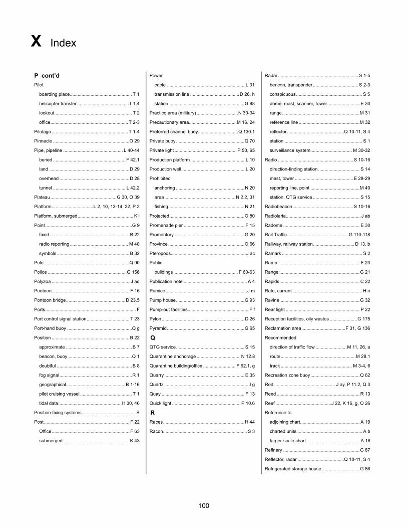
100
X Index
P cont’d Power Radar .............................................................. S 1-5
Pilot cable .............................................................L 31 beacon, transponder ................................... S 2-3
boarding place................................................ T 1 transmission line ......................................D 26, h conspicuous................................................... S 5
helicopter transfer ........................................T 1.4 station ..........................................................G 88 dome, mast, scanner, tower......................... E 30
lookout............................................................ T 2 Practice area (military) ................................N 30-34 range............................................................M 31
office............................................................ T 2-3 Precautionary area.....................................M 16, 24 reference line ...............................................M 32
Pilotage ........................................................... T 1-4 Preferred channel buoy...............................Q 130.1 reflector ............................................Q 10-11, S 4
Pinnacle ...........................................................O 29 Private buoy .....................................................Q 70 station ............................................................ S 1
Pipe, pipeline .............................................. L 40-44 Private light ................................................ P 50, 65 surveillance system................................ M 30-32
buried ........................................................ F 42.1 Production platform...........................................L 10 Radio .......................................................... S 10-16
land ..............................................................D 29 Production well..................................................L 20 direction-finding station ................................ S 14
overhead ......................................................D 28 Prohibited mast, tower ............................................. E 28-29
tunnel ........................................................ L 42.2 anchoring .....................................................N 20 reporting line, point ......................................M 40
Plateau...................................................G 30, O 39 area.......................................................N 2.2, 31 station, QTG service .................................... S 15
Platform................................L 2, 10, 13-14, 22, P 2 fishing...........................................................N 21 Radiobeacon............................................... S 10-16
Platform, submerged........................................... K l Projected..........................................................O 80 Radiolaria..........................................................J ab
Point...................................................................G 9 Promenade pier ............................................... F 15 Radome ........................................................... E 30
fixed..............................................................B 22 Promontory ......................................................G 20 Rail Traffic............................................... G 110-118
radio reporting ............................................. M 40 Province...........................................................O 66 Railway, railway station................................ D 13, b
symbols ........................................................B 32 Pteropods..........................................................J ac Ramark .............................................................. S 2
Pole..................................................................Q 90 Public Ramp ............................................................... F 23
Police .............................................................G 156 buildings.................................................. F 60-63 Range ..............................................................G 21
Polyzoa .............................................................J ad Publication note ................................................. A 4 Rapids.............................................................. C 22
Pontoon............................................................ F 16 Pumice...............................................................J m Rate, current ...................................................... H n
Pontoon bridge..............................................D 23.5 Pump house.....................................................G 93 Ravine..............................................................G 32
Ports...................................................................... F Pump-out facilities............................................... F f Rear light ......................................................... P 22
Port control signal station................................. T 23 Pylon................................................................D 26 Reception facilities, oily wastes .....................G 175
Port-hand buoy ..................................................Q g Pyramid............................................................G 65 Reclamation area..................................F 31, G 136
Position ............................................................B 22 Q Recommended
approximate ...................................................B 7 QTG service..................................................... S 15 direction of traffic flow ........................M 11, 26, a
beacon, buoy..................................................Q 1 Quarantine anchorage ..................................N 12.8 route..........................................................M 28.1
doubtful ..........................................................B 8 Quarantine building/office ......................... F 62.1, g track ....................................................... M 3-4, 6
fog signal........................................................R 1 Quarry .............................................................. E 35 Recreation zone buoy......................................Q 62
geographical..............................................B 1-16 Quartz .................................................................J g Red ............................................... J ay, P 11.2, Q 3
pilot cruising vessel ........................................ T 1 Quay ................................................................ F 13 Reed ................................................................ R 13
tidal data.................................................H 30, 46 Quick light ..................................................... P 10.6 Reef ...........................................J 22, K 16, g, O 26
Position-fixing systems .........................................S R Reference to
Post.................................................................. F 22 Races...............................................................H 44 adjoining chart.............................................. A 19
Office............................................................ F 63 Racon................................................................. S 3 charted units .................................................. A b
submerged ...................................................K 43 larger-scale chart ......................................... A 18
Refinery ...........................................................G 87
Reflector, radar ....................................Q 10-11, S 4
Refrigerated storage house .............................G 86
101
X Index
R cont’d Safety fairway ..................................................M 18 Sector (con’t)
Refuge beacon..................................... Q 124, T 14 Safety zone.........................................................L 3 obscured ...................................................... P 43
Relief ...........................................................C 10-14 Sailing club.....................................................F 11.3 restricted ...................................................... P 44
Reported anchorage ........................................N 10 Sailmaker ...........................................................U 8 Semaphore ......................................................... T f
Reported depth ................................................ I 3-4 Sailor’s home ...................................................G 97 Separation line.................................................M 12
Reporting, Radio ............................................. M 40 Saint.................................................................G 54 Separation scheme............. M 10-13, 20.1-29.2, d-f
Rescue station ............................................ T 11-12 Salt pans ..........................................................C 24 Separation zone.........................................M 13, 20
Research platform............................................ L 13 Saltings, salt marsh................................ C 33, G 12 Settlements......................................D 1-8, G 50-54
Reservation line .................................................N h Sand....................................................................J 1 Sewage works .................................................G 92
Reserve fog signal ...........................................R 22 Sandhills, Sand dunes .......................................C 8 Sewer................................................................L 41
Reserved anchorage area ............................N 12.9 Sandwaves .......................................................J 14 Shading.............................................................. C g
Reservoir........................................................G 135 Sandy shore.......................................................C 6 Shapes, buoy..............................................Q 20-26
Resilient beacon ................................................P 5 Satellite navigation systems............................. S 50 Shed, transit..................................................... F 51
Restricted area......................................M 14, N 2.1 Scanner, radar .............................................. E 30.3 Sheerlegs...................................................... F 53.3
Restricted light sector ......................................P 44 Scarp................................................................O 61 Shelf............................................................O 42-43
Retroreflecting material ......................................Q 6 Schist ..................................................................J h Shellfish bed .................................................... K 47
Ridge......................................................G 22, O 30 School ....................................................... E f, G 78 Shells ................................................................ J 11
Riprap surrounding light ..................................... P c Scoriae................................................................J o Shingle................................................................J d
Rise............................................................O 31, 46 Scrubbing grid.................................................. F 24 Shingly shore ..................................................... C 7
River............................................................C 20-21 Sea.....................................................................O 2 Shinto shrine.................................................... E 15
Road ...........................................................D 10-12 ice limit ......................................................N 60.2 Ship lift ...........................................................G 131
topographic terms .................G 110-111, 113-115 loch ................................................................O 6 Shipyard.........................................................G 189
Road traffic..............................................G 110-118 mile .............................................................. B 45 Shoal........................................................ K b, O 25
Roads, roadstead............................................ O 20 moat .............................................................O 57 Shoaled............................................................O 91
Rock.................................... G 11, J 9.1, K 10-15, n Seabed, types of ....................................................J Shore, shoreline..........................................C 1-8, q
Rock awash .......................................................K a Sea channel .....................................................O 56 Showers........................................................... U 21
Rocky area........................................................J 21 Seal.................................................................. A 12 Side arm ..........................................................O 68
Rocket station .................................................. T 12 Seal sanctuary .................................................N 22 Signals, fog ...............................................R 1-22, a
Roll-on, Roll-off (RoRo) ferry terminal.............. F 50 Seamount....................................................O 33-34 Signal station ................................... T 20-31, 33-36
Rotating pattern radiobeacon...........................S 12 Seaplane Sill ....................................................................O 62
Roundabout, traffic separation ................. M 21, d-e anchorage ....................................................N 14 Silo................................................................... E 33
Route ......................................................... M 27-28 anchorage buoy ...........................................Q 60 Silt.......................................................................J 4
Routeing measures..........................M 10-29.2, a-b landing area .................................................N 13 Single Buoy Mooring (SBM) ...................L 16, Q 26
Row of piles ...................................................G 180 Seasonal sea ice limit ...................................N 60.2 Single Point Mooring (SPM) .............................L 12
Rubble................................................................C e Seasonal buoy .................................................Q 71 Sinker................................................................. K n
Ruin...........................................................D 8, F 33 Sea-tangle.......................................................... J w Siren ................................................................ R 12
Runway ..........................................................G 116 Seawall .............................................................. F 2 Sketches ......................................................... E 3.2
S Second......................................................... B 6, 51 Slip.................................................................G 171
Saddle..............................................................O 64 Sector Slipway .....................................................F 23, U 5
Safe clearance depth .........................................K 3 faint .............................................................. P 45 Slope...........................................................O 44-45
Safe vertical clearance........................... D 26, H 20 intensified..................................................... P 46 Sluice .............................................................G 133
Safe water marks ........................................Q 130.5 lights........................................................P 40-41 Small.................................................................J ah
102
X Index
S cont’d Stations (con’t) Suspended well ................................................L 21
Small craft facilities ...............................................U signal....................................................... T 20-36 Suspension bridge ......................................... G 114
Snags...............................................................K 43 storm ............................................................ T 28 Swamp............................................................. C 33
Soft....................................................................J 35 Starboard-hand buoy ..........................................Q f Swept (depth)
Sound...............................................................O 12 Statute mile ........................................................ B e area.................................................... I 24, b, K 2
Soundings ...................................................... I 1-24 Steep coast ........................................................C 3 channel ............................................................I a
Sources (diagram) ...........................................A 17 Steps .........................................................F 18, U 7 Swing bridge ................................................. D 23.2
South................................................................ B 11 Sticky ................................................................J 34 Swinging circle.............................................. N 11.2
South cardinal mark ....................................Q 130.3 Stiff ....................................................................J 36 Symbols in plan ............................................... B 30
Southeast.........................................................B 14 Stock number..................................................... A d Symbols in profile ............................................ B 31
Southwest ........................................................B 16 Stones.................................................................J 5 Symbolized positions .................................. B 30-33
Spa hotel ..........................................................G 98 Stony shore........................................................C 7 T
Spar buoy.........................................................Q 24 Storage tanker.......................................G 183, L 17 Tableland .........................................................G 29
Special lights ...............................................P 60-65 Storehouse.......................................................G 85 Tablemount ......................................................O 38
Special marks..............................................Q 130.6 Strait.................................................................O 11 Tank ................................................................. E 32
Special purpose buoys........................... Q 50-62, p Stranded wreck .....................................K 20-21, 24 Tanker
Special purpose beacons....................... Q 120-126 Streaky..............................................................J ak anchorage area......................................... N 12.5
Speckled ............................................................J al Stream .......................................................C 20, H l cleaning facilities........................................G 176
Speed limit .......................................................N 27 Street ..................................................... D 7, G 110 mooring buoy ......................................L 16, Q 26
Spherical buoy ...................................................Q 2 Strip light .......................................................... P 64 storage..............................................G 183, L 17
Spindle buoy ......................................................Q 2 Stumps ............................................................. K 43 Tap, water ........................................................ U 17
Spicules...............................................................J x Submarine Target buoy ......................................................Q 51
Spire..............................................................E 10.3 cable ....................................................... L 30-32 Telegraph
Spit ...................................................................G 10 exercise area ...............................................N 33 line ............................................................... D 27
Spoil ground .....................................................N 62 pipeline.................................................... L 40-44 office ........................................................ G 95, k
Spoil ground buoy ............................................Q 56 transit line.....................................................N 33 station .......................................................... T 27
Sponge.................................................................J t volcano........................................................... K d Telephone line.................................................. D 27
Spot heights ................................................C 11-13 Submerged........................................................O 90 Telephone .................................................E q, U 25
Spring, seabed ..................................................J 15 crib .................................................................. K i Telephonic mooring buoy.................................Q 43
Spring tides ...................................................H 8-20 duck blind....................................................... K k Televison mast, tower ................................. E 28-29
Spur..................................................................O 41 jetty ................................................................ F b Temple ........................................................ E 13-16
Square meter .....................................................B a platform ........................................................... K l Temporary light ................................................ P 54
Square shaped beacons .....................................Q l rock, beacon on ...........................................Q 83 Tenacious..........................................................J aq
Stake ..............................................K 44.1, Q 90-91 well (buoyed)...................................................L a Terminal .........................................................G 170
Stations Subsidiary light................................................. P 42 Terrace.............................................................O 40
bunker ........................................................G 174 Summit.............................................................G 24 Territorial Sea limit ........................................... N 43
coastguard .............................................. T 10-11 Sunken Territorial Sea, straight baseline ...................... N 42
coast radar ...........................................M 30, S 1 danger (swept) ................................................ K f Three Nautical Mile Line .................................... N b
coast radio...............................................S 14-15 rock ..............................................................O 27 Tidal
fuel ...............................................................U 18 wreck.............................................................. K c barrier.........................................................G 130
lookout..........................................................G 77 Superbuoy................................. L 16, P 6, Q 26, 58 basin ............................................................ F 28
railway ..........................................................D 13 Supply pipeline..................................................L 40 gully..............................................................O 67
rescue ..................................................... T 11-13 Surveyed coastline.............................................C 1 harbor........................................................... F 28
103
X Index
T cont’d Traffic surveillance station................................M 30 Underwater installations ............................. L 20-24
Tidal level ......................................................H 1-30 Trailer park .......................................................U 28 Underwater rock ......................................... K 11-15
station, offshore............................................H 47 Training wall ....................................................... F 5 Underwater turbine ...........................................L 24
table .............................................................H 30 Tramway ........................................................G 112 Uneven ..............................................................J bf
Tidal stream ..........................................H 31-47, l-o Transhipment facilities ................................ F 50-53 Unexploded ordnance........................................ K p
ebb, flood ................................................H 40-41 Transhipment area...........................................N 64 Units.....................................................A b, B 40-54
station...........................................................H 46 Transit ................................................................M 2 Unknown extent, reef......................................... K g
signal station ................................................ T 34 lane ..............................................................N 33 Unmanned, unwatched light ........................ P 53, a
table ..................................................... A g, H 30 shed ............................................................. F 51 Unsurveyed
Tide Transmission line ....................................D 26-27, h area................................................................I 25
gauge, scale................................................. T 32 Transmitter, AIS ....................................S 17.1-17.2 coastline......................................................... C 2
rips ...............................................................H 44 Transponder beacon.......................................... S 3 wreck....................................................... K 28-30
signal station ................................................ T 33 Transporter bridge ...........................................D 24 Upper light ....................................................... P 22
Tideway............................................................O 67 Transporter, overhead for cables .....................D 25 Urban area......................................................... D 1
Timber harbor.................................................G 153 Trap, fish ..................................................K 44.2-45 V
Timber yard ...................................................... F 52 Travelling crane ............................................ F 53.1 Valley ................................................G 31, O 53-34
Times ..........................................................B 49-51 Trees Variable arrow light .......................................... P 31
Time signal station ........................................... T 31 height to top .................................................C 14 Variation.......................................... B 60, 68.1-68.2
Toilets ...............................................................U 23 types .................................................C 31-32, i-k Varied................................................................J be
Tomb ..................................................................E b Trench..............................................................O 51 Vegetation.................................... C 30-33, i-r, G 34
Ton, tonne, tonnage ....................................B 53, m Triangular shaped beacon ..................................Q l Velocity .............................................................. H n
Topmark .............................................Q 9-11, 102.1 Triangulation point ........................................... B 20 Vertical
Topographic terms ................................................G Trot, mooring....................................................Q 42 clearance ..........................................D 20, 22-28
Tower ...............................................................E 20 Trough..............................................................O 52 color stripes....................................................Q 5
beacon ............................................... P 3, Q 110 True (compass) ................................................ B 63 lights............................................................. P 15
church. ......................................................E 10.2 Tufa.....................................................................J n Very Large Crude Carrier (VLCC)..................G 187
lattice............................................................G 68 Ton buoy ..........................................................Q 25 Very quick light.............................................. P 10.7
radar..........................................................E 30.2 Tunnel ..................................................D 16, L 42.2 Vessel, lighted...................................... P 6, a, Q 31
radio, television ............................................E 29 Tunny nets ..................................................K 44-45 Viaduct.....................................................D f, G 113
watch............................................................G 77 Turbine.......................................... E 26.1, L 5.1, 24 Views .............................................................. E 3.2
water ............................................................E 21 Turning area.....................................................O 69 Village ................................................. D 4, G 51-52
Town.................................................................G 50 Turning basin ...................................................O 69 Violet......................................................P 11.5, J at
Town Hall .........................................................G 71 Turning circle ...................................................O 69 Visitors’ berth, mooring ................................. F 19.2
Track ...............................................D 12, M 1-6, 27 Two-way route......................................M 27.2, 28.2 Volcanic ............................................................J 37
Trade port.......................................................G 147 Two-way track ....................................................M 4 Volcanic ash........................................................ J k
Traffic (road, rail, air) ...............................G 110-118 Tyfon ................................................................R 13 Volcano ............................................................G 26
Traffic flow, direction ............................ M 10-11, 26 Types of seabed.....................................................J W
Traffic Separation Scheme (TSS) .............. M 10-25 U Wall, training ...................................................... F 5
buoy .............................................................Q 61 Ultra quick light ............................................. P 10.8 Warehouse..............................................F 51, G 85
example......................................... M 20.1-29.2, f Ultra Large Crude Carrier (ULCC) .................G 188 Watermill ............................................................ E c
structure ...........................................M 10-13, d-f Uncovers................................................. K 11,21, h Watch tower .....................................................G 77
Traffic signal....................................... T 21-22, 25.2 Under construction, reclamation ................. F 30-32
104
X Index
W cont’d Well .......................................................... E e, G 94 Works in progress. ...................................... F 30-32
Water head ..............................................................L 23 World Geodetic System (WGS) ................A 3, S 50
discolored.......................................................K e production .....................................................L 20 Wreck.......................................................... K 20-31
features ...................................................C 20-25 submerged (buoyed).......................................L a buoyed ...........................................................Q h
mill................................................................G 83 suspended ....................................................L 21 historic.......................................................... N 26
pipe, pipeline ........................................... L 40-41 West................................................................. B 12 Y
police............................................................U 31 west cardinal mark......................................Q 130.3 Yacht berth, harbor ........................................F 11.2
tap ................................................................U 17 Wet dock .......................................................... F 27 Yacht club ......................................................F 11.3
tower ............................................................E 21 Wharf ............................................................... F 13 Yard(s) (measurment)........................................ B d
works............................................................G 91 Whistle .............................................................R 15 Yard
Waterfall ...........................................................C 22 Whistle buoy ......................................................Q c building.......................................................G 172
Wave farm.......................................................... L 6 White......................................................J ar, P 11.1 buoy ...........................................................G 173
Wave recorder buoy.........................................Q 59 White mark.....................................................Q 101 timber........................................................... F 52
Wave-actuated fog signal............................R 21-22 Wind farm............................................... E 26.2, L 5 Yellow............................................J aw, P 11.6, Q 3
Way point ........................................................ M 40 Wind signal station........................................... T 29 Z
Weather signal staion....................................... T 29 Windmill ........................................................... E 25 Zone
Weed..............................................................J 13.1 Windmotor........................................................ E 26 Exclusive Economic (EZZ)........................... N 47
Weir.................................................................. F 44 Wind turbine........................................ E 26.1, L 5.1 frishing ......................................................... N 45
Weir, fish .......................................................K 44.2 Wire drag sweep........................................ I 24, K 2 fracture.........................................................O 60
Withy................................................................Q 92 inshore traffic ...............................................M 25
Woodland, woods .............................C 30, G 38-39 seaward, contiguous.................................... N 44
Works..........................................................G 81-92 separation ..........................................M 13, 20, e
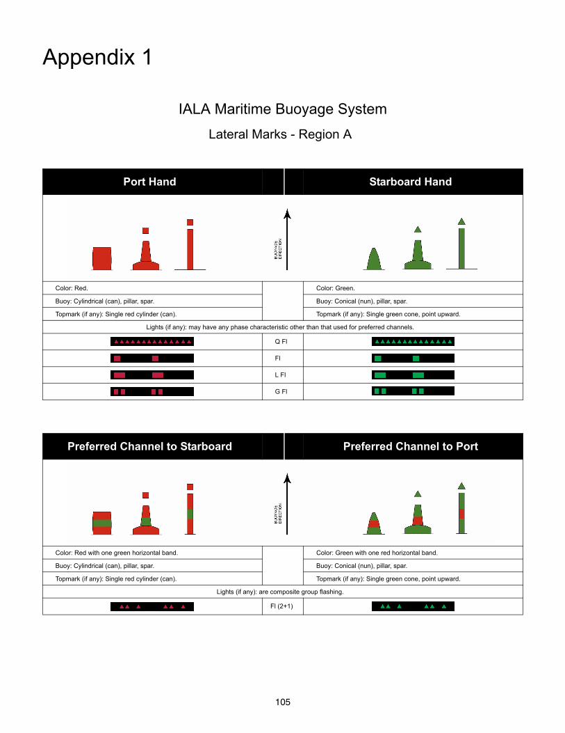
105
Appendix 1
IALA Maritime Buoyage System
Lateral Marks - Region A
Port Hand Starboard Hand
Color: Red. Color: Green.
Buoy: Cylindrical (can), pillar, spar. Buoy: Conical (nun), pillar, spar.
Topmark (if any): Single red cylinder (can). Topmark (if any): Single green cone, point upward.
Lights (if any): may have any phase characteristic other than that used for preferred channels.
Q Fl
Fl
L Fl
G Fl
Preferred Channel to Starboard Preferred Channel to Port
Color: Red with one green horizontal band. Color: Green with one red horizontal band.
Buoy: Cylindrical (can), pillar, spar. Buoy: Conical (nun), pillar, spar.
Topmark (if any): Single red cylinder (can). Topmark (if any): Single green cone, point upward.
Lights (if any): are composite group flashing.
Fl (2+1)
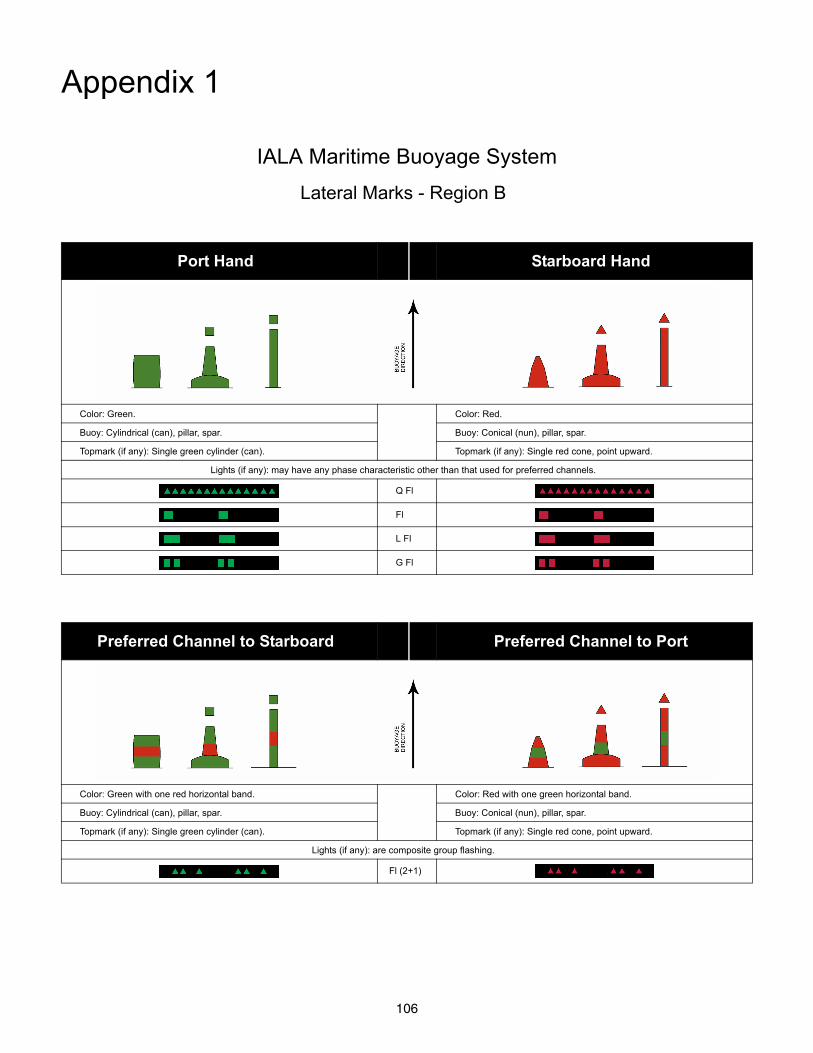
106
Appendix 1
IALA Maritime Buoyage System
Lateral Marks - Region B
Port Hand Starboard Hand
Color: Green. Color: Red.
Buoy: Cylindrical (can), pillar, spar. Buoy: Conical (nun), pillar, spar.
Topmark (if any): Single green cylinder (can). Topmark (if any): Single red cone, point upward.
Lights (if any): may have any phase characteristic other than that used for preferred channels.
Q Fl
Fl
L Fl
G Fl
Preferred Channel to Starboard Preferred Channel to Port
Color: Green with one red horizontal band. Color: Red with one green horizontal band.
Buoy: Cylindrical (can), pillar, spar. Buoy: Conical (nun), pillar, spar.
Topmark (if any): Single green cylinder (can). Topmark (if any): Single red cone, point upward.
Lights (if any): are composite group flashing.
Fl (2+1)
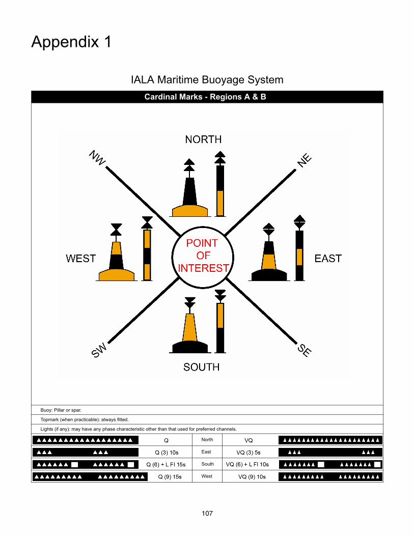
107
Appendix 1
IALA Maritime Buoyage System
Cardinal Marks - Regions A & B
Buoy: Pillar or spar.
Topmark (when practicable): always fitted.
Lights (if any): may have any phase characteristic other than that used for preferred channels.
North
East
South
West
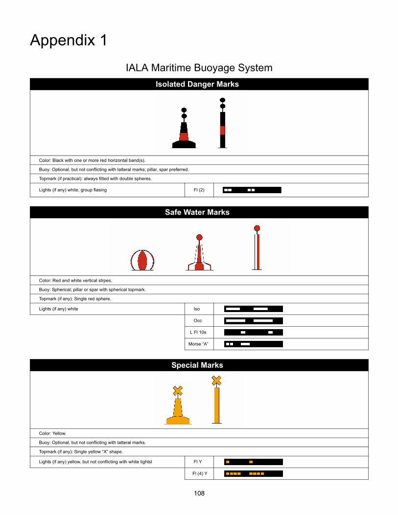
108
Appendix 1
IALA Maritime Buoyage System
Isolated Danger Marks
Color: Black with one or more red horizontal band(s).
Buoy: Optional, but not conflicting with latteral marks; pillar, spar preferred.
Topmark (if practical): always fitted with double spheres.
Lights (if any) white, group flasing Fl (2)
Safe Water Marks
Color: Red and white vertical strpes.
Buoy: Spherical; pillar or spar with spherical topmark.
Topmark (if any): Single red sphere.
Lights (if any) white Iso
Occ
L Fl 10s
Morse “A”
Special Marks
Color: Yellow.
Buoy: Optional, but not conflicting with latteral marks.
Topmark (if any): Single yellow “X” shape.
Lights (if any) yellow, but not conflicting with white lightsl Fl Y
Fl (4) Y
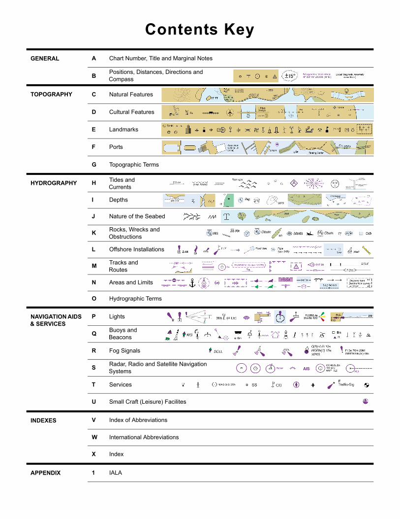
Contents Key
GENERAL A Chart Number, Title and Marginal Notes
BPositions, Distances, Directions and Compass
TOPOGRAPHY C Natural Features
D Cultural Features
E Landmarks
F Ports
G Topographic Terms
HYDROGRAPHY H Tides and Currents
I Depths
J Nature of the Seabed
KRocks, Wrecks and Obstructions
L Offshore Installations
MTracks and Routes
N Areas and Limits
O Hydrographic Terms
NAVIGATION AIDS & SERVICES
P Lights
QBuoys and Beacons
R Fog Signals
SRadar, Radio and Satellite Navigation Systems
T Services
U Small Craft (Leisure) Facilites
INDEXES V Index of Abbreviations
W International Abbreviations
X Index
APPENDIX 1 IALA