chatlee quarry - epa tasmaniaepa.tas.gov.au/documents/chatlee quarry assessment...
TRANSCRIPT
FORESTRY TASMANIA MURCHISON DISTRICT
November 21, 2011
Authored by: Mark Pearce
Chatlee Quarry
Level 2 Activity Application & EER Cover Report
1
C
ha
tle
e Q
ua
rry
| 1
1/2
1/2
01
1
Chatlee Quarry
Level 2 Activity Application & EER Cover Report
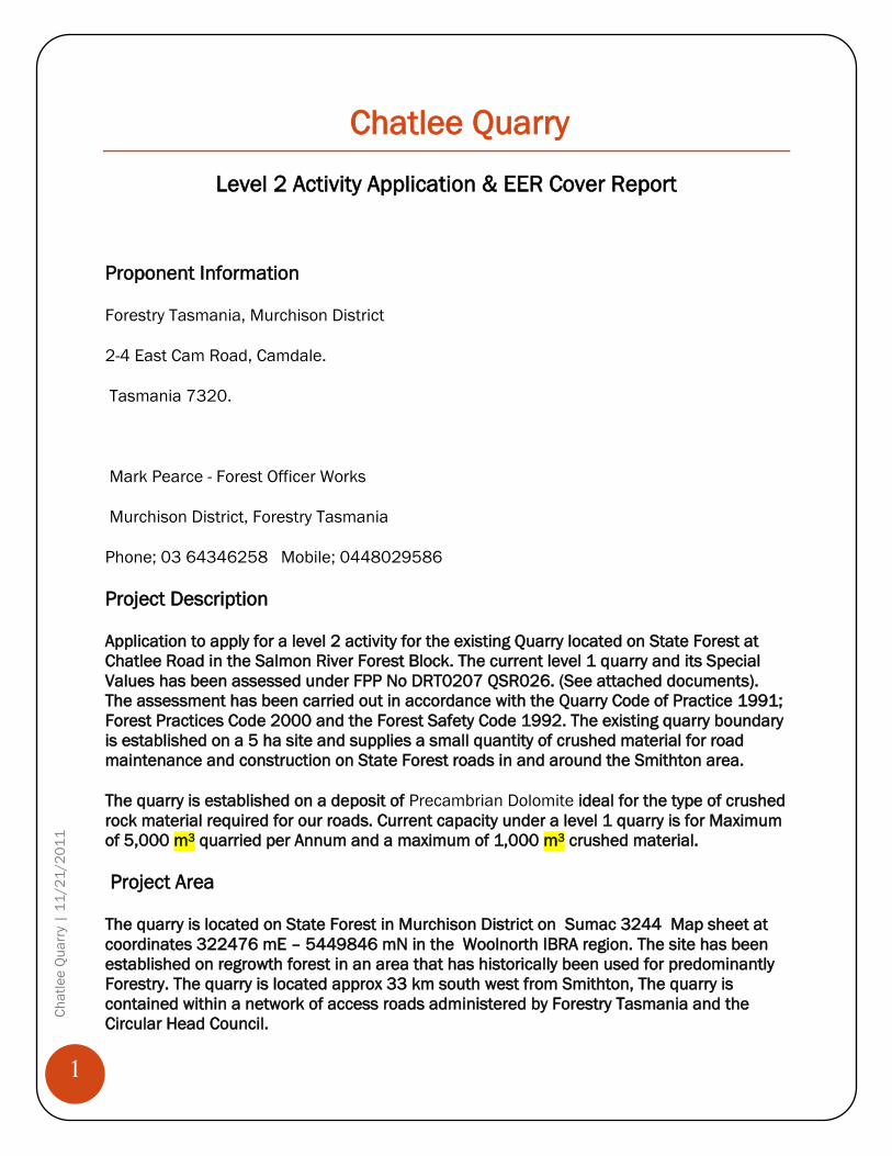
Proponent Information
Forestry Tasmania, Murchison District
2-4 East Cam Road, Camdale.
Tasmania 7320.
Mark Pearce - Forest Officer Works
Murchison District, Forestry Tasmania
Phone; 03 64346258 Mobile; 0448029586
Project Description
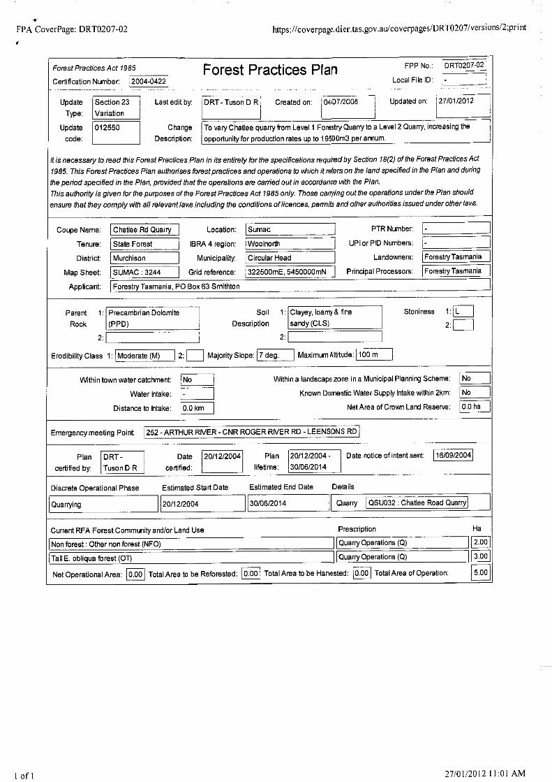
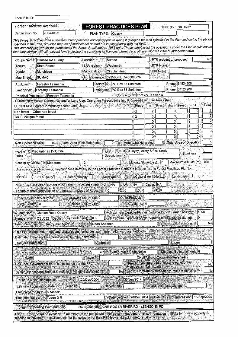
Application to apply for a level 2 activity for the existing Quarry located on State Forest at
Chatlee Road in the Salmon River Forest Block. The current level 1 quarry and its Special
Values has been assessed under FPP No DRT0207 QSR026. (See attached documents).
The assessment has been carried out in accordance with the Quarry Code of Practice 1991;
Forest Practices Code 2000 and the Forest Safety Code 1992. The existing quarry boundary
is established on a 5 ha site and supplies a small quantity of crushed material for road
maintenance and construction on State Forest roads in and around the Smithton area.
The quarry is established on a deposit of Precambrian Dolomite ideal for the type of crushed
rock material required for our roads. Current capacity under a level 1 quarry is for Maximum
of 5,000 m3 quarried per Annum and a maximum of 1,000 m3 crushed material.
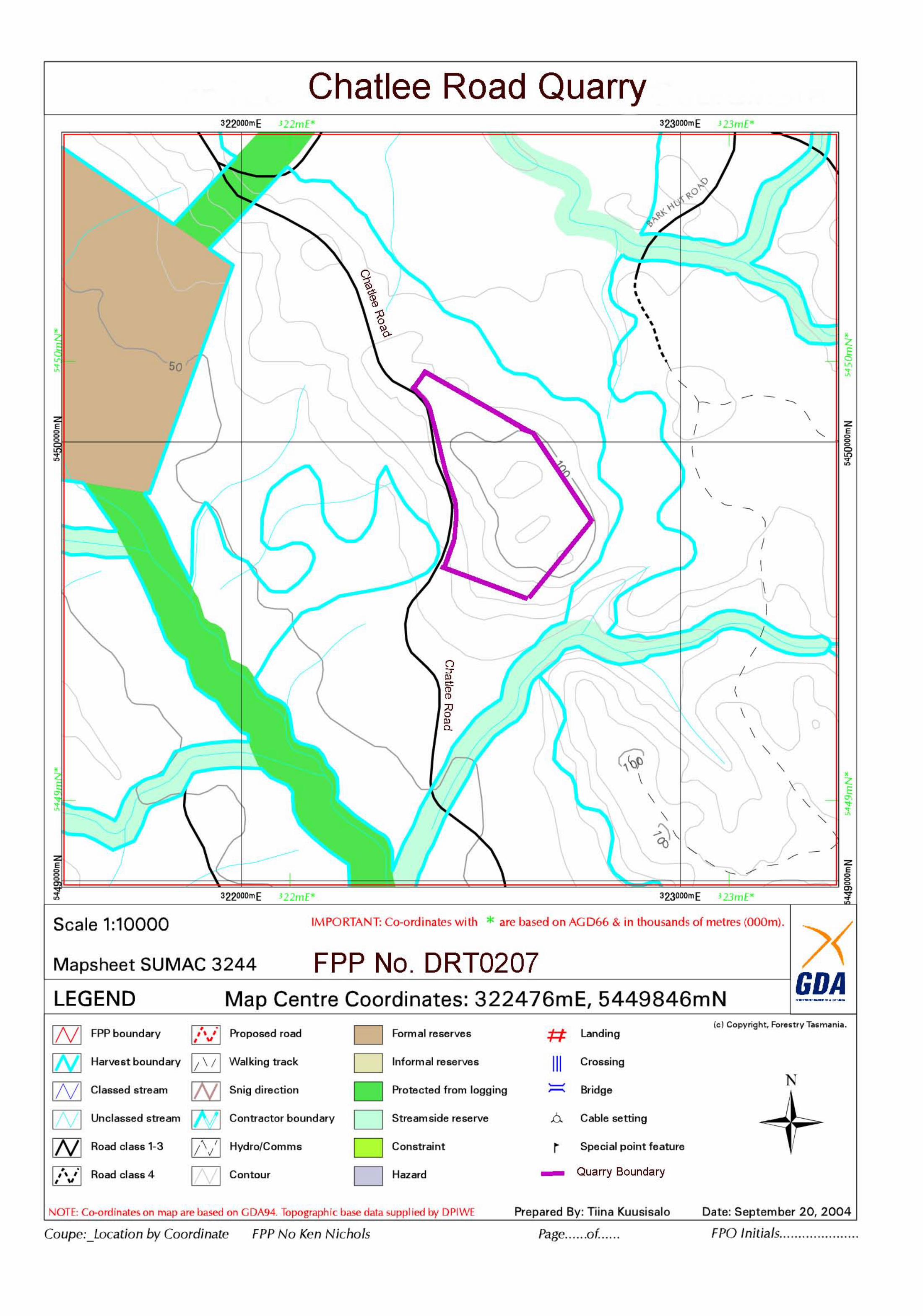
Project Area
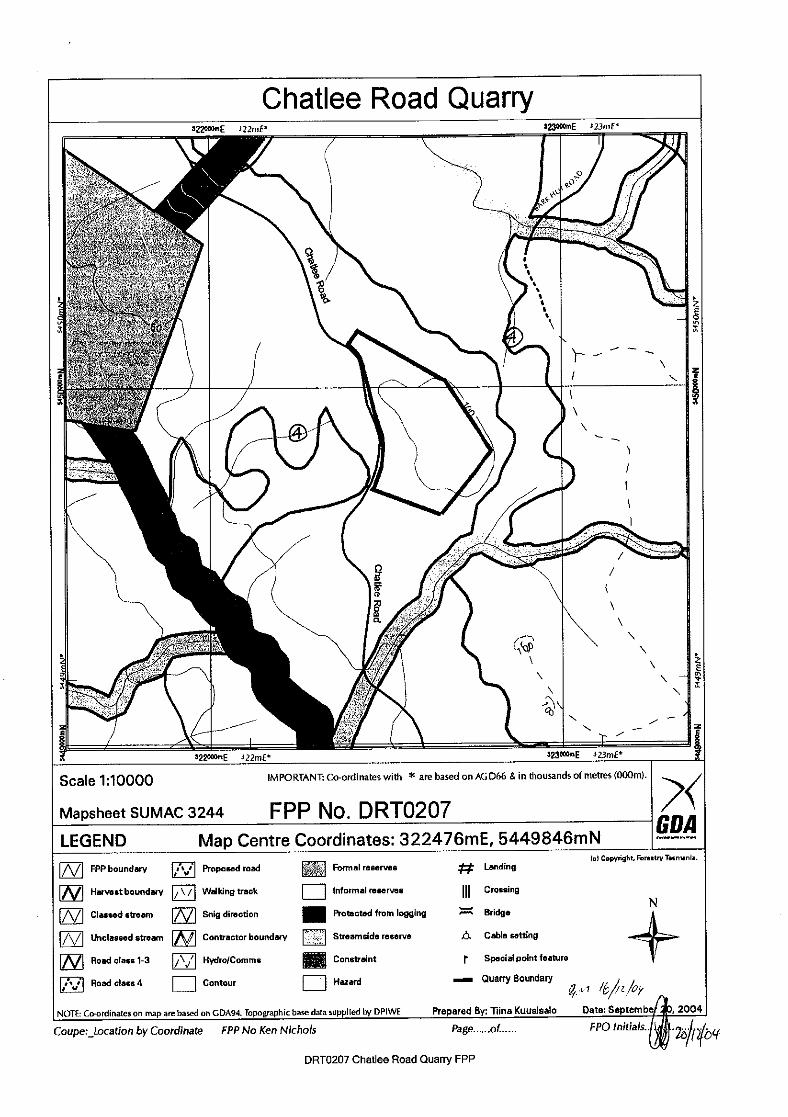
The quarry is located on State Forest in Murchison District on Sumac 3244 Map sheet at
coordinates 322476 mE – 5449846 mN in the Woolnorth IBRA region. The site has been
established on regrowth forest in an area that has historically been used for predominantly
Forestry. The quarry is located approx 33 km south west from Smithton, The quarry is
contained within a network of access roads administered by Forestry Tasmania and the
Circular Head Council.
2
C
ha
tle
e Q
ua
rry
| 1
1/2
1/2
01
1
Land tenure in the area is State Forest managed by Forestry Tasmania. The nearest private
residence is approximately 7 kms east from the quarry site.
The 5.0 ha site is established on a regrowth forest coupe SR013D (1988 ) site dominated
Tall E. obliqua Wet schlerophyll forest over on Precambrian Dolomite Dark clayey with course sand and Dolomite gravels of moderate soil erodibility. The area sits on a moderate
slope with a westly aspect and is subject to an average annual rainfall of approximately
1000- 1250mm.
Site Operation
Forestry Tasmania, Murchison District, operates its quarries in accordance with the Forest
Practices code 2000, Mineral Exploration Code of Practice 1999 and the Forest safety Code
Tasmania 2002.
The site is currently operated under level 1 requirement where maximum quantity per
Annum 5,000 m3 to be quarried and maximum amount to be crushed is 1,000 m3 per
annum. The proposal is to lift the capacity of the site to Level 2 with maximum quarried
capacity to 19,500 m3 per annum and maximum crushed amount to 2,000 m3 per annum.
The increased capacity is due to the focus of harvesting and available wood product
markets expected in the next 5 years. The site is located to allow efficiencies in cost
associated with the maintenance and construction of our existing road networks on
expected cart routes. The site will be operated in accordance with the current regulations
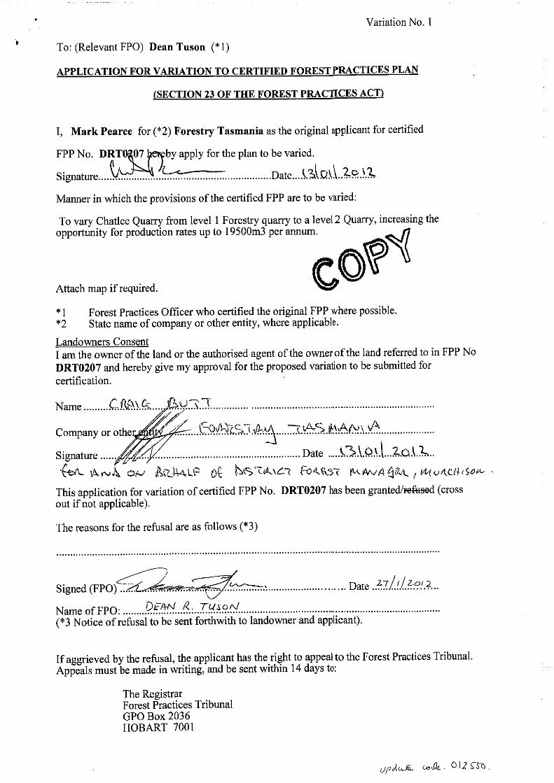
and acts, under section 18 of the Forest Practice Act 1985 and a Forest Practice Plan (FPP)
has been prepared for the area.
The FPP includes a natural and cultural values assessment of potential impacts on Flora,
Fauna, geomorphology, Cultural Heritage, Landscape, soil and water. The FPP also
stipulates how the quarry will be operated under the plan and includes;
Topsoil and stripping
Drainage and erosion Control
Planned quarry development and sequence
Natural and Cultural Values
Other Environmental prescriptions
Management of Fuels and lubricants
Planned Rehabilitation procedures
The plan is audited and managed under Forestry Tasmania’s Forest Management System
(FMS) and within the framework of the Forest Practices Code (1985) and appropriate
regulations administered by the Tasmanian Forest Practices Authority. In addition the
operation also comes under the Forest Safety Code 1999 and associated regulations
administered by Workplace
3
C
ha
tle
e Q
ua
rry
| 1
1/2
1/2
01
1
Standards Tasmania. See attached documentation Forest Practice Plan DRT0207-01 for
the designation for Chatlee Road Quarry and all special value information.
Activity from on site machinery may include excavators and dozers and or drilling and
blasting, and or the use of mobile crushing plant, and supporting vehicles.
The quarry will be an ongoing operation for the proposed life of the FPP. It is planned that
the quarry will operate during the hours between 6:00am – 5:00pm five days a week to
coincide with planned harvesting and road construction and maintenance activities.
Access to the site is via Chatlee Road all weather class 3 roads which provides access to the
Salmon River forest block and associated coupes in the area.
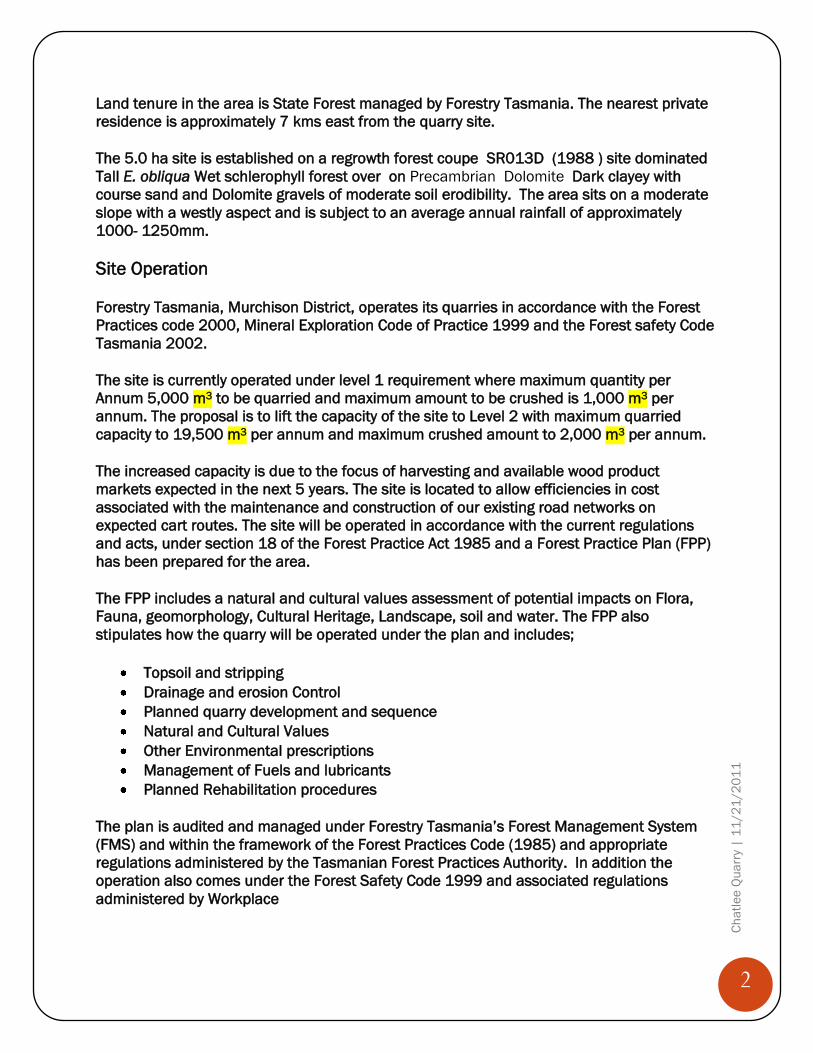
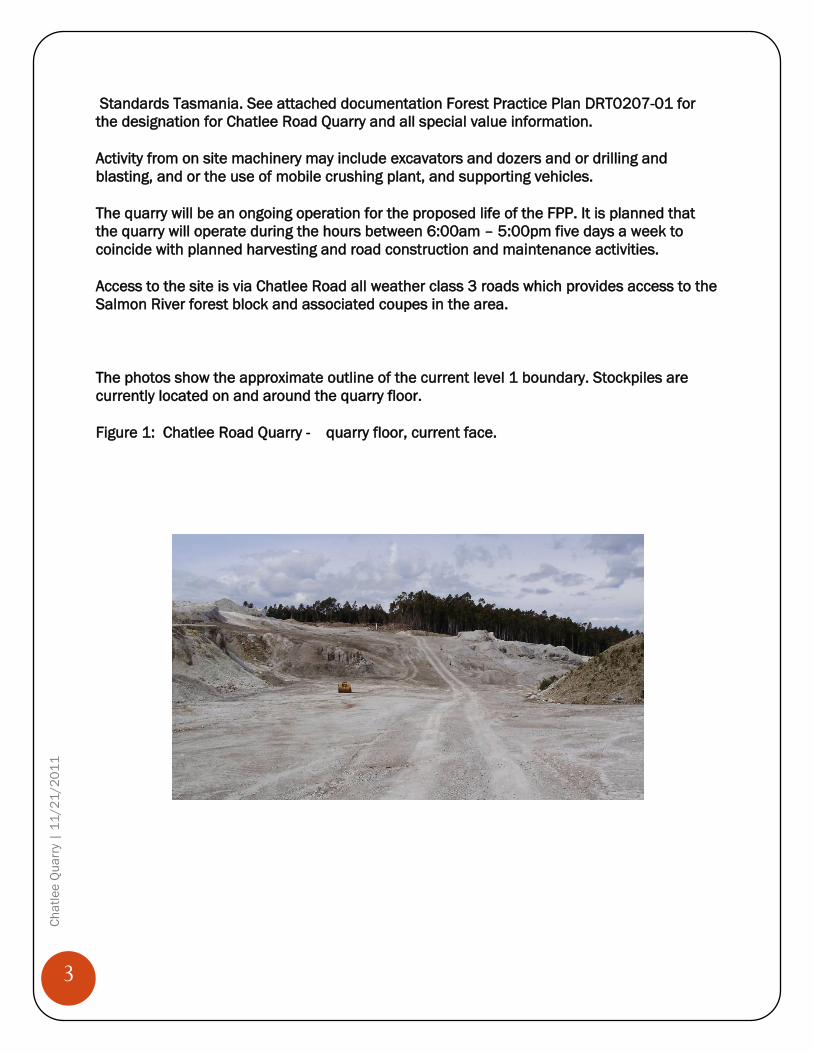
The photos show the approximate outline of the current level 1 boundary. Stockpiles are
currently located on and around the quarry floor.
Figure 1: Chatlee Road Quarry - quarry floor, current face.
4
C
ha
tle
e Q
ua
rry
| 1
1/2
1/2
01
1
Figure 2: Chatlee Road Quarry - quarry floor, current face.
Evaluation of Potential Site Impacts
Any potential of site impacts are managed by Forestry Tasmania’s Forest Management
System, the Forest Practices Code (2000), the Mineral Exploration Code of Practice (1999)
and the Forest Safety Code (2000) The potential site impacts are listed with comments;
Rivers, Creeks, Wetlands and Estuaries- Drainage and soil water movement from the
quarry area is controlled as per normal practices by the use of culverts, silt traps and
silt fences and ripraps where needed.
Significant areas- No significant areas are located close or near the proposed quarry
site.
Air Emissions-No potential air emissions are expected from this quarry by increasing
the capacity and production levels
Liquid Effluent - No discharge of effluents are expected from the site during
operations. Any accidental spills of fuel & lubricants are managed by adequate
procedures required by Forestry Tasmania and their contractors FMS and safety
Management Systems.
Noise Emissions- Due to the quarries isolated location and the industrial nature of
the area; there is unlikely to be any noise emissions outside acceptable levels from
this operation.
5
C
ha
tle
e Q
ua
rry
| 1
1/2
1/2
01
1
Transport Impacts- Transport is an integral feature of the area in which this quarry is
operating. Forestry activities, including log carting, road building and maintenance is
an everyday occurrences with increases in activity during the summer months.
Dangerous Goods & Substances- All dangerous goods including Explosives, fuel &
lubricants are all managed around these operations in accordance with Tasmanian
legislation, regulations, and the required codes of practices in which we operate.
Cultural Heritage- The site has been assessed as per the requirements under the
Forest Practices Code (2000) in accordance with the Aboriginal relics Act(1975)
Access and Sites of Public Interest- The site is located near forestry roads (Salmon
River road) and Chatlee Road. Salmon River and Chatlee Roads roads are a part of
the Forestry Tasmania’s road network and are boom gated for security reasons.
As part of the FPP process all forest quarries are assessed through the Forest Practices
Code, Quarry Code of Practice and Forest Safety Code framework and as such do not have a
significant impact on surrounding or adjoining land uses. This is because they are mostly
located in areas that are used for forestry and are isolated from sensitive areas or
residences. The attached FPP and special Values information adequately addresses the EPA
requirements for the application to lift this site from level 1 to a level 2 Quarry.
By increasing capacity of this quarry, there is little potential for serious, material or
environment harm and impact. Any likely impacts would be local and of a minor nature,
where any consequence can easily be avoided or mitigated under our current management
systems. In addition the quarry is of small commercial scale and the remote location is
unlikely to generate any public interest.
The proposal is unlikely to require assessment under the Commonwealth Environment
Protection and Biodiversity Conservation Act 1999, as the quarry is covered by a certified
Forest Practices Plan under the Forest Practices Act (1985)
As the Plan is developed under the Forest Practices Act (1985) the application for an
existing Level 1 Forest Quarry will not require assessment by the Commonwealth on
application for a level 2 activity.
Attachments;
Cover Letter
Notice of Intent
Cover Report
Forest Practice Plan DRT0207
Location Map
Special Values Assessment information.
Quarry P.C and Weed Report