cherry lane - indiana
TRANSCRIPT

20 NORTH 3RD STREET (765) 423-9242 SALLIE DELL FAHEY LAFAYETTE, INDIANA 47901-1209 (765) 423-9154 [FAX] EXECUTIVE DIRECTOR
www.tippecanoe.in.gov/apc Date: December 31, 2013 Re: RED FLAG INVESTIGATION
DES # Cherry Lane Cherry Lane Extension West Lafayette, Tippecanoe County, Indiana NARRATIVE Cherry Lane will be extended to intersect with US 231. The project is currently programmed in the TIP and classified as a collector. SUMMARY
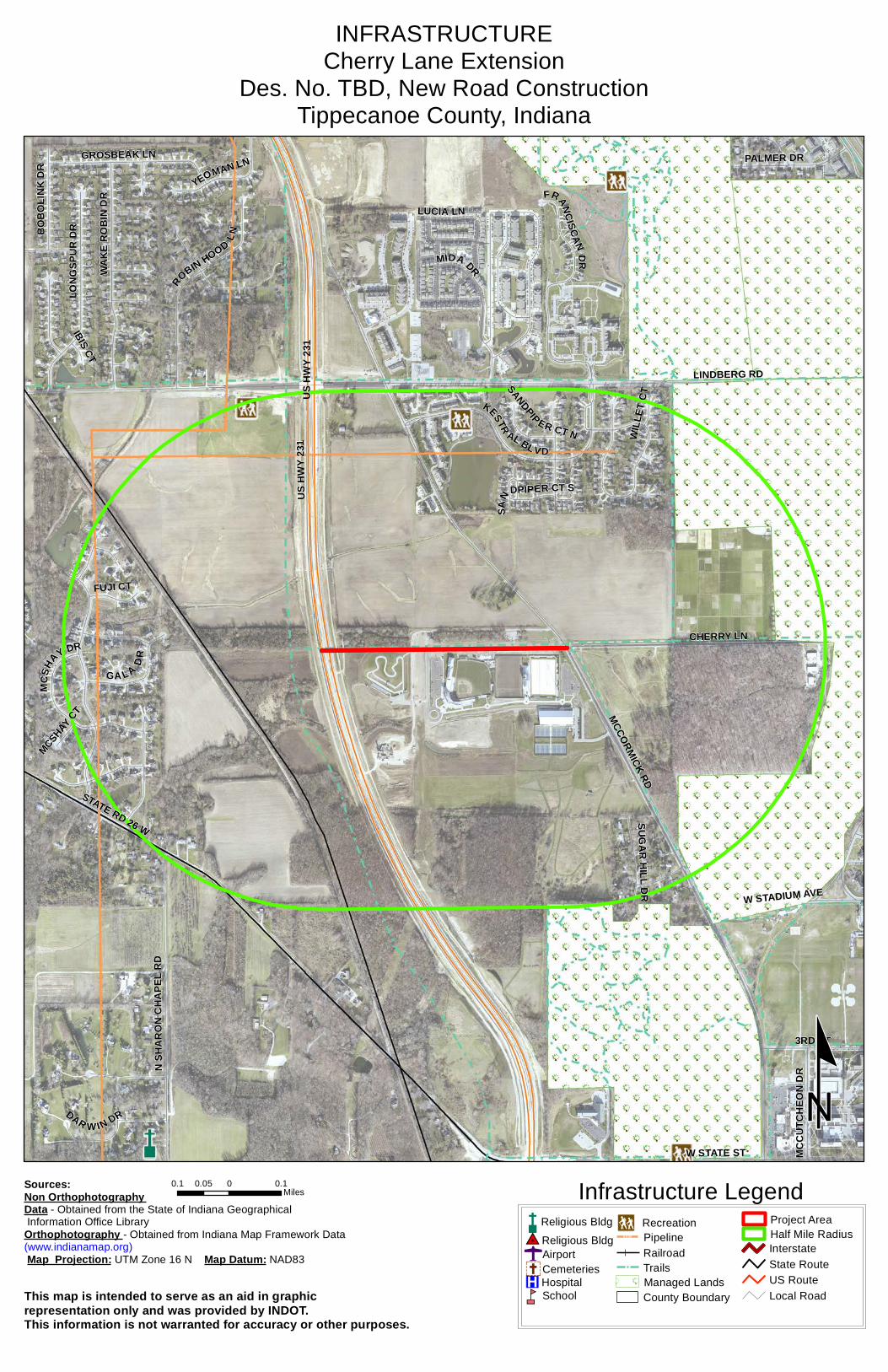
INFRASTRUCTURE As identified below the following items of concern were found within ½ mile:.
Religious Facilities N/A Recreational Facilities 2 Airports N/A Pipelines 2
Cemeteries N/A Railroads 1 Hospitals N/A Trails 3 Schools N/A Managed Lands 2
One recreational facility is within ½ mile of the project, the tennis court at Blackbird Farms Apartments. The court is over 2,000 feet away from the project line and won’t be affected by project work. Two natural gas pipelines are within ½ mile of the project area. Both are owned by Vectren. The closest is 1,900 feet from the project line and are not likely to be affected. The KBSR railroad line is within ½ mile of the project area. The line is more than 1,000 feet from the project’s western terminus and not likely to be affected. Three trails are within ½ mile of the project. They are the current and planned Cherry Lane trail, the US 231 trails and the Cattail Trail. Coordination with the trail owners will be necessary. Purdue University’s golf course and the Horticultural Park woods are the only managed lands within ½ mile of the project area.
A R E A P L A N C O M M I S S I O N
OF TIPPECANOE COUNTY
Planning for Lafayette, West Lafayette, Dayton, Battle Ground, Clarks Hill and Tippecanoe County

WATER RESOURCES As identified below the following items of concern were found within ½ mile:
NWI - Points N/A NWI - Wetlands 11 Karst Springs N/A IDEM 303d Listed Lakes
Canal Structures – Historic N/A Lakes 3 NWI - Lines N/A Floodplain - DFIRM 1
IDEM 303d Listed Rivers and Streams (Impaired) N/A Cave Entrance Density N/A
Rivers and Streams 7 Sinkhole Areas N/A Canal Routes - Historic N/A Sinking-Stream Basins N/A
Seven streams are within ½ mile of the project. All are intermittent or associated with drainage ponds. All noted wetlands, lakes and floodplain are also associated with the same drainage ponds. None are close enough to likely affect project work
MINING/MINERAL EXPLORATION As identified below the following items of concern were found within ½ mile:
Petroleum Wells N/A Petroleum Fields N/A Mines – Surface N/A Mines – Underground N/A
There are no areas of mining or mineral exploration within ½ mile of the project area.
HAZMAT CONCERNS As identified below the following items of concern were found within ½ mile:
Brownfield Sites N/A Restricted Waste Sites N/A Corrective Action Sites (RCRA) N/A Septage Waste Sites N/A Confined Feeding Operations N/A Solid Waste Landfills N/A
Construction Demolition Waste N/A State Cleanup Sites N/A Industrial Waste Sites (RCRA
Generators) N/A Tire Waste Sites N/A
Infectious/Medical Waste Sites N/A Waste Transfer Stations N/A
Lagoon/Surface Impoundments N/A RCRA Waste Treatment, Storage, and Disposal Sites (TSDs) N/A
Leaking Underground Storage Tanks (LUSTs) 1 Underground Storage Tanks N/A
Manufactured Gas Plant Sites N/A Voluntary Remediation Program N/A NPDES Facilities N/A Superfund N/A
NPDES Pipe Locations N/A Institutional Control Sites N/A Open Dump Sites N/A
There is 1 leaking underground storage tank located at the Purdue University golf course maintenance building. It is more than 2,000 feet from the project area and not likely to be impacted.
Planning for Lafayette, West Lafayette, Dayton, Battle Ground, Clarks Hill and Tippecanoe County

Ecological Information The Tippecanoe County listing of the Indiana Natural Heritage Data Center information on endangered, threatened, or rare (ETR) species and high quality natural communities is attached. The ETR species on the state or federal registers are highlighted. Cultural Resources No state- or federal-register historic structures are within ½ mile of the project area. RECOMMENDATIONS INFRASTRUCTURE: Trail coordination is required. WATER RESOURCES: N/A MINING/MINERAL EXPLORATION: N/A HAZMAT CONCERNS: Purdue University should be involved in any discussions regarding LUSTs on university property. ECOLOGICAL INFORMATION: Coordination with IDNR will be needed to determine if any listed species and/or habitats may be impacted by the proposed project. CULTURAL RESOURCES: No state- or federally- registered historic structures or districts are within ½ mile of the project area. Prepared by: Anna Burman Transportation GIS Specialist Area Plan Commission of Tippecanoe County
Planning for Lafayette, West Lafayette, Dayton, Battle Ground, Clarks Hill and Tippecanoe County

US H
WY 2
31
MCCORMICK RD
LINDBERG RD
STATE RD 26 W
CHERRY LN
W STATE ST
MIDA DR
3RD ST
WAKE
ROB
IN D
R
LONG
SPUR
DR
N SH
ARON
CHA
PEL R
DROBIN HOOD LN
FRANCISCANDR
KESTR AL BL VD
GROSBEAK LN PALMER DR
W STADIUM AVE
LUCIA LN
MCSH
AY DR
GA L A DR
BOBO
LINK
DR
FUJI CT
MCCU
TCHE
ON D
R
SUGAR HILL DR
YEOMAN LN
DAR W IN DR
SANDPIP ER CT N
SANDPIPER CT S
IBIS CT
MCSHAY CT
WILL
ET C
TUS H
WY 2
31
PROJECT AREACherry Lane Extension
Des. No. TBD, New Road ConstructionTippecanoe County, Indiana
º0.1 0 0.10.05
Miles Project Area Map
This map is intended to serve as an aid in graphicrepresentation only and was provided by INDOT.This information is not warranted for accuracy or other purposes.
Sources:Non Orthophotography Data - Obtained from the State of Indiana Geographical Information Office LibraryOrthophotography - Obtained from Indiana Map Framework Data(www.indianamap.org) Map Projection: UTM Zone 16 N Map Datum: NAD83
Half Mile Radius
Project
US H
WY 2
31
MCCORMICK RD
LINDBERG RD
STATE RD 26 W
CHERRY LN
W STATE ST
MIDA DR
3RD ST
WAKE
ROB
IN D
R
LONG
SPUR
DR
N SH
ARON
CHA
PEL R
DROBIN HOOD LN
FRANCISCANDR
KESTR AL BL VD
GROSBEAK LN PALMER DR
W STADIUM AVE
LUCIA LN
MCSH
AY DR
GA L A DR
BOBO
LINK
DR
FUJI CT
MCCU
TCHE
ON D
R
SUGAR HILL DR
YEOMAN LN
DAR W IN DR
SANDPIP ER CT N
SANDPIPER CT S
IBIS CT
MCSHAY CT
WILL
ET C
TUS H
WY 2
31
INFRASTRUCTURECherry Lane Extension
Des. No. TBD, New Road ConstructionTippecanoe County, Indiana
ºThis map is intended to serve as an aid in graphic representation only and was provided by INDOT.This information is not warranted for accuracy or other purposes.
Sources:Non Orthophotography Data - Obtained from the State of Indiana Geographical Information Office LibraryOrthophotography - Obtained from Indiana Map Framework Data(www.indianamap.org) Map Projection: UTM Zone 16 N Map Datum: NAD83
0.1 0 0.10.05Miles Infrastructure Legend
0 Religious Bldg
Religious Bldg#IpAirportÝCemeteries®v Hospitalnm School
PipelineRailroadTrailsManaged LandsCounty Boundary
_ Recreation Project AreaHalf Mile RadiusInterstateState RouteUS RouteLocal Road

US H
WY 2
31
MCCORMICK RD
LINDBERG RD
STATE RD 26 W
CHERRY LN
W STATE ST
MIDA DR
3RD ST
WAKE
ROB
IN D
R
LONG
SPUR
DR
N SH
ARON
CHA
PEL R
DROBIN HOOD LN
FRANCISCANDR
KESTR AL BL VD
GROSBEAK LN PALMER DR
W STADIUM AVE
LUCIA LN
MCSH
AY DR
GA L A DR
BOBO
LINK
DR
FUJI CT
MCCU
TCHE
ON D
R
SUGAR HILL DR
YEOMAN LN
DAR W IN DR
SANDPIP ER CT N
SANDPIPER CT S
IBIS CT
MCSHAY CT
WILL
ET C
TUS H
WY 2
31
WATER RESOURCESCherry Lane Extension
Des. No. TBD, New Road ConstructionTippecanoe County, Indiana
º0.1 0 0.10.05
Miles Water Resources Legend
Canal Route - Historic
RiverNPS NRI listed"
! !Stream - Impaired
NWI- LineXWXW0Canal Structure - Historic\ NWI - Point Wetlands
Lake - ImpairedLakeFloodplain - DFIRMCounty Boundary
Project Area
Half Mile Radius
InterstateState RouteUS RouteLocal RoadThis map is intended to serve as an aid in graphic
representation only and was provided by INDOT.This information is not warranted for accuracy or other purposes.
Sources:Non Orthophotography Data - Obtained from the State of Indiana Geographical Information Office LibraryOrthophotography - Obtained from Indiana Map Framework Data(www.indianamap.org) Map Projection: UTM Zone 16 N Map Datum: NAD83

US H
WY 2
31 LINDBERG RDMCCORMICK RD
STATE RD 26 W
CHERRY LN
MIDA DR
3RD ST
LONG
SPUR
DR
KESTR AL BL VD
ROBIN HOOD LN
W STADIUM AVE
WAKE
ROB
IN D
R
N SH
ARON
CHA
PEL R
D
MCSH
AY DR
GA L A DR
FUJI CT
SUGAR HILL DR
SANDPIP ER CT N
SANDPIPER CT S
MCSHAY CT
WILL
ET C
T
US H
WY 2
31
HAZMAT CONCERNSCherry Lane Extension
Des. No. TBD, New Road ConstructionTippecanoe County, Indiana
º
This map is intended to serve as an aid in graphic representation only and was provided by INDOT.This information is not warranted for accuracy or other purposes.
Sources:Non Orthophotography
Data - Obtained from the State of Indiana Geographical Information Office Library
Orthophotography - Obtained from Indiana Map Framework Data(www.indianamap.org)
Map Projection: UTM Zone 16 N Map Datum: NAD83
0.15 0 0.150.075Miles
HazMat Concerns Legend
InterstateState RouteUS RouteLocal Road
County Boundary
Half Mile RadiusProject Area
Institutional Controlskj Brownfield
!& Confined Feeding OperationXW Construction/Demolition Site.- Leaking Underground Storage Tank!@ Manufactured Gas Plant
!< Open Dump Waste Site
A@ NPDES FacilitesO NPDES Pipe Locations
A@ RCRA Corrective Action Sites
SR RCRA Generator/TSD
!. Septage Waste SiteMP Restricted Waste Site

Species Name Common Name STATEFED
Page 1 of 4
04/16/2013Indiana County Endangered, Threatened and Rare Species List
GRANK SRANK
TippecanoeCounty:
Mollusk: Bivalvia (Mussels)
Cyprogenia stegaria Eastern Fanshell Pearlymussel LE SE G1Q S1
Epioblasma torulosa rangiana Northern Riffleshell LE SE G2T2 SX
Epioblasma torulosa torulosa Tubercled Blossom LE SE G2TX SX
Epioblasma triquetra Snuffbox LE SE G3 S1
Fusconaia subrotunda Longsolid SE G3 SX
Lampsilis fasciola Wavyrayed Lampmussel SSC G5 S3
Lampsilis ovata Pocketbook G5 S2
Leptodea leptodon Scaleshell LE SX G1G2 SX
Ligumia recta Black Sandshell G5 S2
Obovaria retusa Ring Pink LE SX G1 SX
Obovaria subrotunda Round Hickorynut SSC G4 S1
Plethobasus cicatricosus White Wartyback LE SE G1 SX
Plethobasus cyphyus Sheepnose LE SE G3 S1
Pleurobema clava Clubshell LE SE G2 S1
Pleurobema cordatum Ohio Pigtoe SSC G4 S2
Pleurobema plenum Rough Pigtoe LE SE G1 S1
Pleurobema rubrum Pyramid Pigtoe SE G2G3 SX
Potamilus capax Fat Pocketbook LE SE G1G2 S1
Ptychobranchus fasciolaris Kidneyshell SSC G4G5 S2
Quadrula cylindrica cylindrica Rabbitsfoot C SE G3G4T3 S1
Simpsonaias ambigua Salamander Mussel SSC G3 S2
Toxolasma lividus Purple Lilliput SSC G3 S2
Villosa fabalis Rayed Bean LE SSC G2 S1
Insect: Coleoptera (Beetles)
Lissobiops serpentinus A Rove Beetle SE GNR S1
Insect: Ephemeroptera (Mayflies)
Paracloeodes minutus A Small Minnow Mayfly SR G5 S2
Insect: Lepidoptera (Butterflies & Moths)
Speyeria idalia Regal Fritillary SE G3 S1
Insect: Mecoptera
Merope tuber Earwig Scorpionfly SE G3G5 S1
Insect: Odonata (Dragonflies & Damselflies)
Erpetogomphus designatus Eastern Ringtail ST G5 S2
Somatochlora tenebrosa Clamp-tipped Emerald SR G5 S2S3
Fish
Etheostoma tippecanoe Tippecanoe Darter SSC G3G4 S3
Amphibian
Hemidactylium scutatum Four-toed Salamander SSC G5 S2
Indiana Natural Heritage Data Center
Division of Nature Preserves
Indiana Department of Natural Resources
This data is not the result of comprehensive county
surveys.
Fed: LE = Endangered; LT = Threatened; C = candidate; PDL = proposed for delisting
State: SE = state endangered; ST = state threatened; SR = state rare; SSC = state species of special concern;
SX = state extirpated; SG = state significant; WL = watch list
GRANK: Global Heritage Rank: G1 = critically imperiled globally; G2 = imperiled globally; G3 = rare or uncommon
globally; G4 = widespread and abundant globally but with long term concerns; G5 = widespread and abundant
globally; G? = unranked; GX = extinct; Q = uncertain rank; T = taxonomic subunit rank
SRANK: State Heritage Rank: S1 = critically imperiled in state; S2 = imperiled in state; S3 = rare or uncommon in state;
G4 = widespread and abundant in state but with long term concern; SG = state significant; SH = historical in
state; SX = state extirpated; B = breeding status; S? = unranked; SNR = unranked; SNA = nonbreeding status
unranked

Species Name Common Name STATEFED
Page 2 of 4
04/16/2013Indiana County Endangered, Threatened and Rare Species List
GRANK SRANK
TippecanoeCounty:
Reptile
Clemmys guttata Spotted Turtle SE G5 S2
Emydoidea blandingii Blanding's Turtle SE G4 S2
Liochlorophis vernalis Smooth Green Snake SE G5 S2
Terrapene carolina carolina Eastern Box Turtle SSC G5T5 S3
Terrapene ornata ornata Ornate Box Turtle SE G5T5 S1
Bird
Aimophila aestivalis Bachman's Sparrow G3 SXB
Ammodramus henslowii Henslow's Sparrow SE G4 S3B
Ardea herodias Great Blue Heron G5 S4B
Asio flammeus Short-eared Owl SE G5 S2
Asio otus Long-eared Owl G5 S2
Aythya collaris Ring-necked Duck G5 SHB
Bartramia longicauda Upland Sandpiper SE G5 S3B
Botaurus lentiginosus American Bittern SE G4 S2B
Buteo platypterus Broad-winged Hawk No Status SSC G5 S3B
Carduelis pinus Pine Siskin G5 S3N
Cistothorus platensis Sedge Wren SE G5 S3B
Dendroica cerulea Cerulean Warbler SE G4 S3B
Falco peregrinus Peregrine Falcon No Status SE G4 S2B
Grus canadensis Sandhill Crane No Status SSC G5 S2B,S1N
Haliaeetus leucocephalus Bald Eagle LT,PDL SSC G5 S2
Ixobrychus exilis Least Bittern SE G5 S3B
Lanius ludovicianus Loggerhead Shrike No Status SE G4 S3B
Nycticorax nycticorax Black-crowned Night-heron SE G5 S1B
Rallus elegans King Rail SE G4 S1B
Sturnella neglecta Western Meadowlark SSC G5 S2B
Tyto alba Barn Owl SE G5 S2
Mammal
Corynorhinus rafinesquii Rafinesque's Big-eared Bat SSC G3G4 SH
Geomys bursarius Plains Pocket Gopher SSC G5 S2
Lasiurus borealis Eastern Red Bat SSC G5 S4
Mustela nivalis Least Weasel SSC G5 S2?
Myotis septentrionalis Northern Myotis SSC G4 S3
Myotis sodalis Indiana Bat or Social Myotis LE SE G2 S1
Nycticeius humeralis Evening Bat SE G5 S1
Reithrodontomys megalotis Western Harvest Mouse G5 S2
Spermophilus franklinii Franklin's Ground Squirrel SE G5 S2
Taxidea taxus American Badger SSC G5 S2
Vascular Plant
Indiana Natural Heritage Data Center
Division of Nature Preserves
Indiana Department of Natural Resources
This data is not the result of comprehensive county
surveys.
Fed: LE = Endangered; LT = Threatened; C = candidate; PDL = proposed for delisting
State: SE = state endangered; ST = state threatened; SR = state rare; SSC = state species of special concern;
SX = state extirpated; SG = state significant; WL = watch list
GRANK: Global Heritage Rank: G1 = critically imperiled globally; G2 = imperiled globally; G3 = rare or uncommon
globally; G4 = widespread and abundant globally but with long term concerns; G5 = widespread and abundant
globally; G? = unranked; GX = extinct; Q = uncertain rank; T = taxonomic subunit rank
SRANK: State Heritage Rank: S1 = critically imperiled in state; S2 = imperiled in state; S3 = rare or uncommon in state;
G4 = widespread and abundant in state but with long term concern; SG = state significant; SH = historical in
state; SX = state extirpated; B = breeding status; S? = unranked; SNR = unranked; SNA = nonbreeding status
unranked

Species Name Common Name STATEFED
Page 3 of 4
04/16/2013Indiana County Endangered, Threatened and Rare Species List
GRANK SRANK
TippecanoeCounty:
Androsace occidentalis Western Rockjasmine ST G5 S2
Arenaria patula Pitcher's Stitchwort SE G4 S1
Aster oblongifolius Aromatic Aster SR G5 S2
Astragalus tennesseensis Tennessee Milk-vetch SRE G3 SX
Bacopa rotundifolia Roundleaf Water-hyssop ST G5 S1
Besseya bullii Kitten Tails SE G3 S1
Botrychium matricariifolium Chamomile Grape-fern SR G5 S2
Botrychium simplex Least Grape-fern SE G5 S1
Camassia angusta Wild Hyacinth SE G5?Q S1
Carex flava Yellow Sedge ST G5 S2
Carex gravida Heavy Sedge SE G5 S1
Chelone obliqua var. speciosa Rose Turtlehead WL G4T3 S3
Chrysopsis villosa Hairy Golden-aster ST G5 S2
Circaea alpina Small Enchanter's Nightshade SX G5 SX
Cirsium hillii Hill's Thistle SE G3 S1
Coeloglossum viride var. virescens Long-bract Green Orchis ST G5T5 S2
Crataegus pedicellata Scarlet Hawthorn ST G5 S2
Cypripedium candidum Small White Lady's-slipper WL G4 S2
Eriophorum angustifolium Narrow-leaved Cotton-grass SR G5 S2
Erysimum capitatum Prairie-rocket Wallflower ST G5 S2
Euphorbia obtusata Bluntleaf Spurge SE G5 S1
Gentiana alba Yellow Gentian SR G4 S2
Houstonia nigricans Narrowleaf Summer Bluets SR G5 S2
Linum sulcatum Grooved Yellow Flax SR G5 S2
Lithospermum incisum Narrow-leaved Puccoon SE G5 S1
Melampyrum lineare American Cow-wheat SR G5 S2
Muhlenbergia cuspidata Plains Muhlenbergia SE G4 S1
Napaea dioica Glade Mallow SR G4 S2
Onosmodium hispidissimum Shaggy False-gromwell SE G4 S1
Orobanche riparia Bottomland Broomrape SE G5 S2
Oryzopsis racemosa Black-fruit Mountain-ricegrass SR G5 S2
Panicum rigidulum var. pubescens Long-leaved Panic-grass SX G5T5? SX
Plantago cordata Heart-leaved Plantain SE G4 S1
Poa paludigena Bog Bluegrass WL G3 S3
Psoralea tenuiflora Few-flowered Scurf-pea SX G5 SX
Sanguisorba canadensis Canada Burnet SE G5 S1
Selaginella apoda Meadow Spike-moss WL G5 S1
Silene regia Royal Catchfly ST G3 S2
Trichostema dichotomum Forked Bluecurl SR G5 S2
Viola pedatifida Prairie Violet ST G5 S2
Indiana Natural Heritage Data Center
Division of Nature Preserves
Indiana Department of Natural Resources
This data is not the result of comprehensive county
surveys.
Fed: LE = Endangered; LT = Threatened; C = candidate; PDL = proposed for delisting
State: SE = state endangered; ST = state threatened; SR = state rare; SSC = state species of special concern;
SX = state extirpated; SG = state significant; WL = watch list
GRANK: Global Heritage Rank: G1 = critically imperiled globally; G2 = imperiled globally; G3 = rare or uncommon
globally; G4 = widespread and abundant globally but with long term concerns; G5 = widespread and abundant
globally; G? = unranked; GX = extinct; Q = uncertain rank; T = taxonomic subunit rank
SRANK: State Heritage Rank: S1 = critically imperiled in state; S2 = imperiled in state; S3 = rare or uncommon in state;
G4 = widespread and abundant in state but with long term concern; SG = state significant; SH = historical in
state; SX = state extirpated; B = breeding status; S? = unranked; SNR = unranked; SNA = nonbreeding status
unranked

Species Name Common Name STATEFED
Page 4 of 4
04/16/2013Indiana County Endangered, Threatened and Rare Species List
GRANK SRANK
TippecanoeCounty:
High Quality Natural Community
Barrens - gravel Gravel Slope Barrens SG G3 S1
Barrens - sand Sand Barrens SG G3 S2
Forest - upland dry-mesic Dry-mesic Upland Forest SG G4 S4
Forest - upland mesic Mesic Upland Forest SG G3? S3
Lake - lake Lake SG GNR S2
Prairie - dry-mesic Dry-mesic Prairie SG G3 S2
Wetland - fen Fen SG G3 S3
Wetland - marsh Marsh SG GU S4
Wetland - seep circumneutral Circumneutral Seep SG GU S1
Other Significant Feature
Geomorphic - Nonglacial Erosional Feature -
Water Fall and CascadeWater Fall and Cascade GNR SNR
Indiana Natural Heritage Data Center
Division of Nature Preserves
Indiana Department of Natural Resources
This data is not the result of comprehensive county
surveys.
Fed: LE = Endangered; LT = Threatened; C = candidate; PDL = proposed for delisting
State: SE = state endangered; ST = state threatened; SR = state rare; SSC = state species of special concern;
SX = state extirpated; SG = state significant; WL = watch list
GRANK: Global Heritage Rank: G1 = critically imperiled globally; G2 = imperiled globally; G3 = rare or uncommon
globally; G4 = widespread and abundant globally but with long term concerns; G5 = widespread and abundant
globally; G? = unranked; GX = extinct; Q = uncertain rank; T = taxonomic subunit rank
SRANK: State Heritage Rank: S1 = critically imperiled in state; S2 = imperiled in state; S3 = rare or uncommon in state;
G4 = widespread and abundant in state but with long term concern; SG = state significant; SH = historical in
state; SX = state extirpated; B = breeding status; S? = unranked; SNR = unranked; SNA = nonbreeding status
unranked