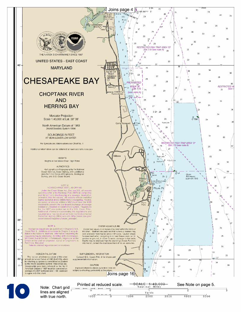
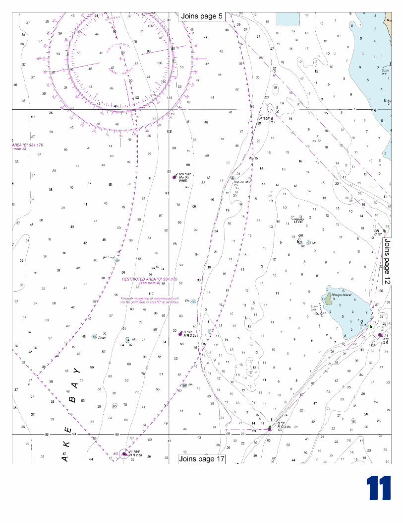
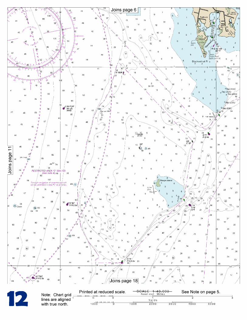
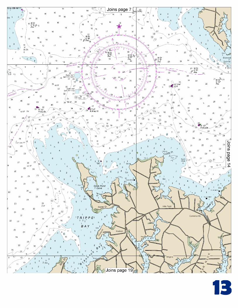
chesapeake bay choptank river and herring bay · chesapeake bay choptank river and herring bay ....
TRANSCRIPT
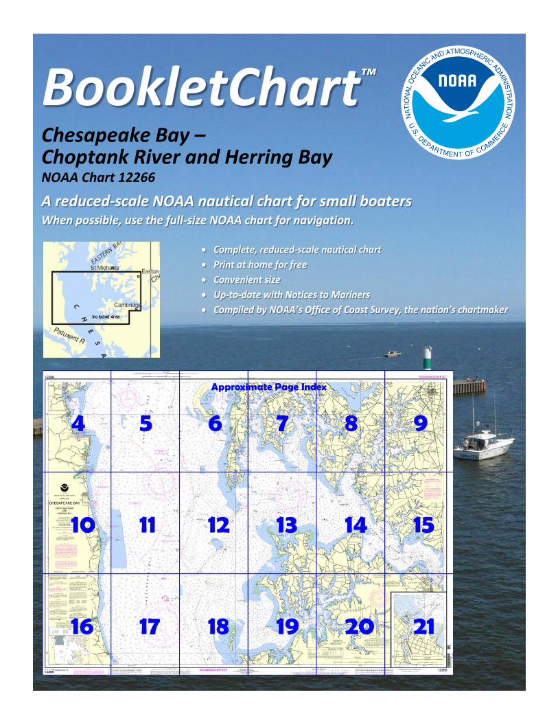
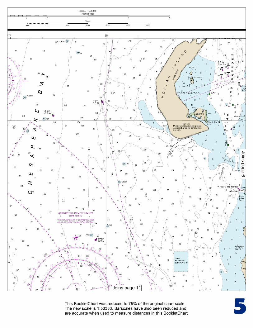
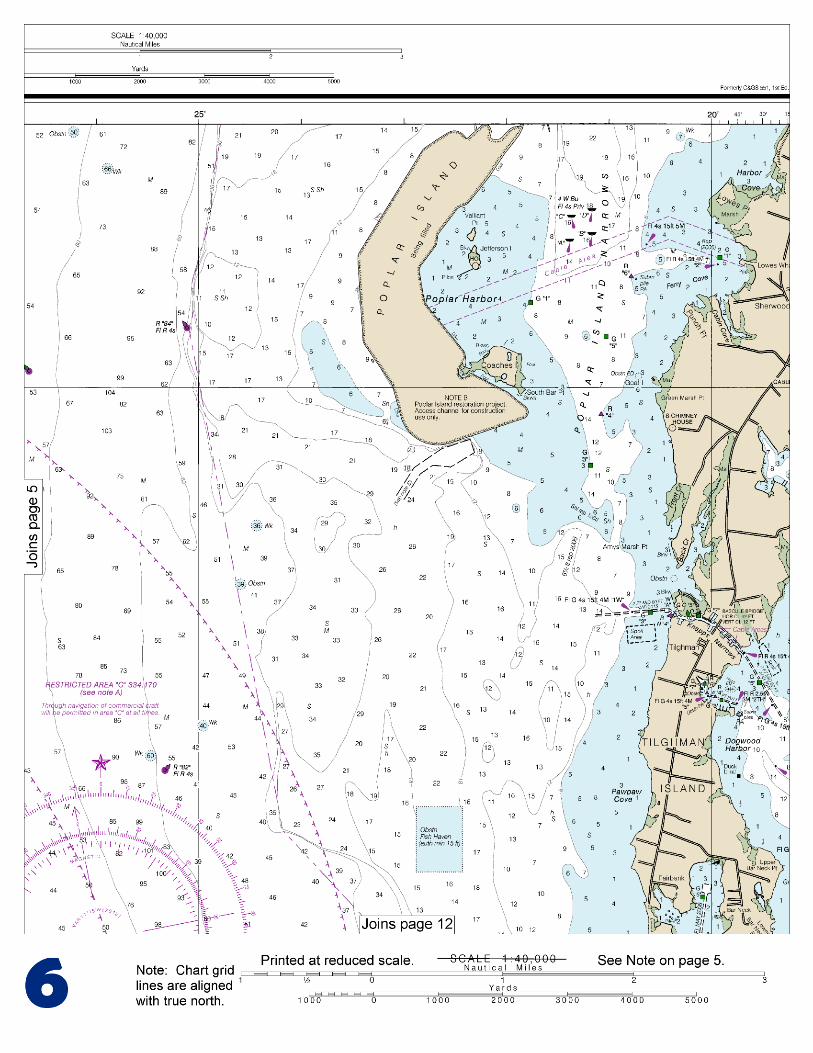
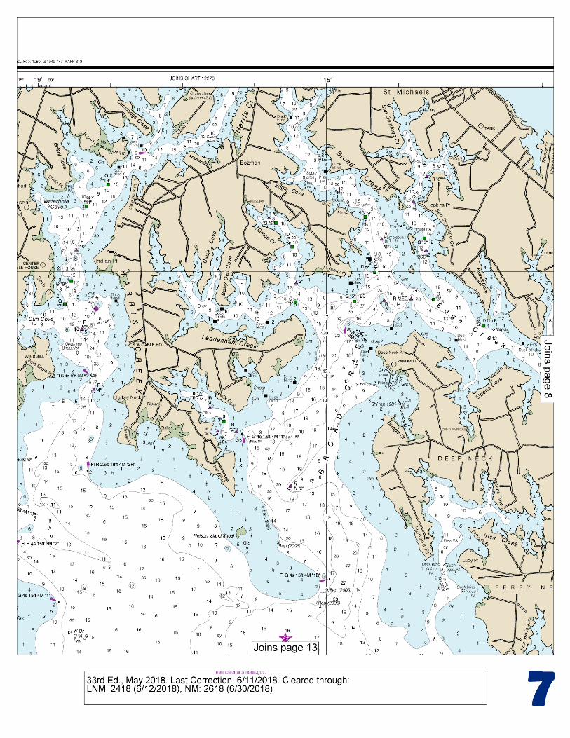
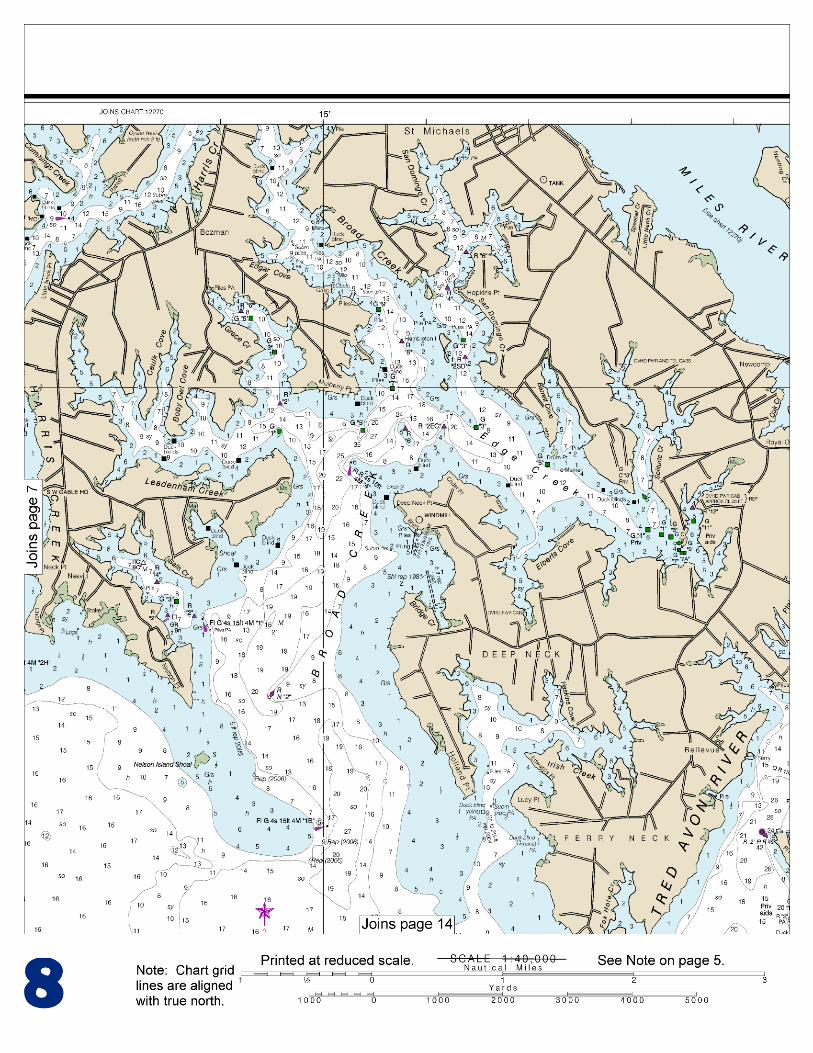
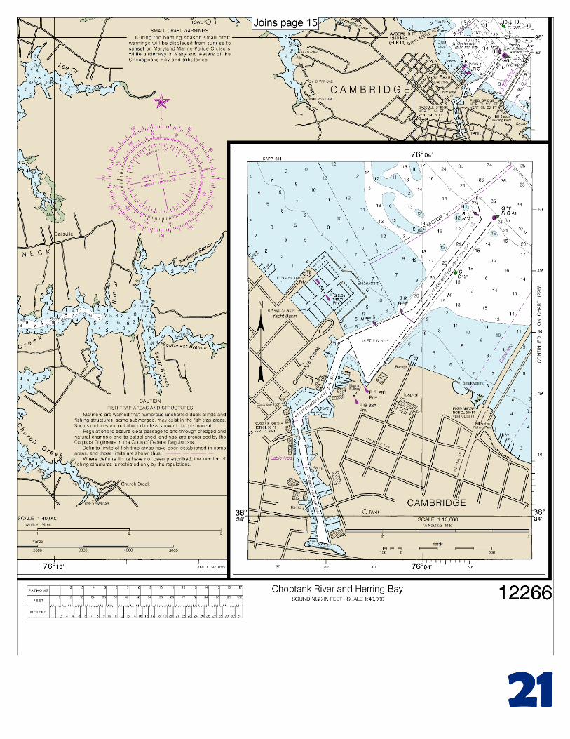
BookletChart™ Chesapeake Bay – Choptank River and Herring Bay NOAA Chart 12266
A reduced-scale NOAA nautical chart for small boaters When possible, use the full-size NOAA chart for navigation.
2
Published by the National Oceanic and Atmospheric Administration
National Ocean Service Office of Coast Survey
www.NauticalCharts.NOAA.gov 888-990-NOAA
What are Nautical Charts?
Nautical charts are a fundamental tool of marine navigation. They show water depths, obstructions, buoys, other aids to navigation, and much more. The information is shown in a way that promotes safe and efficient navigation. Chart carriage is mandatory on the commercial ships that carry America’s commerce. They are also used on every Navy and Coast Guard ship, fishing and passenger vessels, and are widely carried by recreational boaters.
What is a BookletChart?
This BookletChart is made to help recreational boaters locate themselves on the water. It has been reduced in scale for convenience, but otherwise contains all the information of the full-scale nautical chart. The bar scales have also been reduced, and are accurate when used to measure distances in this BookletChart. See the Note at the bottom of page 5 for the reduction in scale applied to this chart.
Whenever possible, use the official, full scale NOAA nautical chart for navigation. Nautical chart sales agents are listed on the Internet at http://www.NauticalCharts.NOAA.gov.
This BookletChart does NOT fulfill chart carriage requirements for regulated commercial vessels under Titles 33 and 44 of the Code of Federal Regulations.
Notice to Mariners Correction Status
This BookletChart has been updated for chart corrections published in the U.S. Coast Guard Local Notice to Mariners, the National Geospatial Intelligence Agency Weekly Notice to Mariners, and, where applicable, the Canadian Coast Guard Notice to Mariners. Additional chart corrections have been made by NOAA in advance of their publication in a Notice to Mariners. The last Notices to Mariners applied to this chart are listed in the Note at the bottom of page 7. Coast Pilot excerpts are not being corrected.
For latest Coast Pilot excerpt visit the Office of Coast Survey website at http://www.nauticalcharts.noaa.gov/nsd/searchbychart.php?chart=12266.
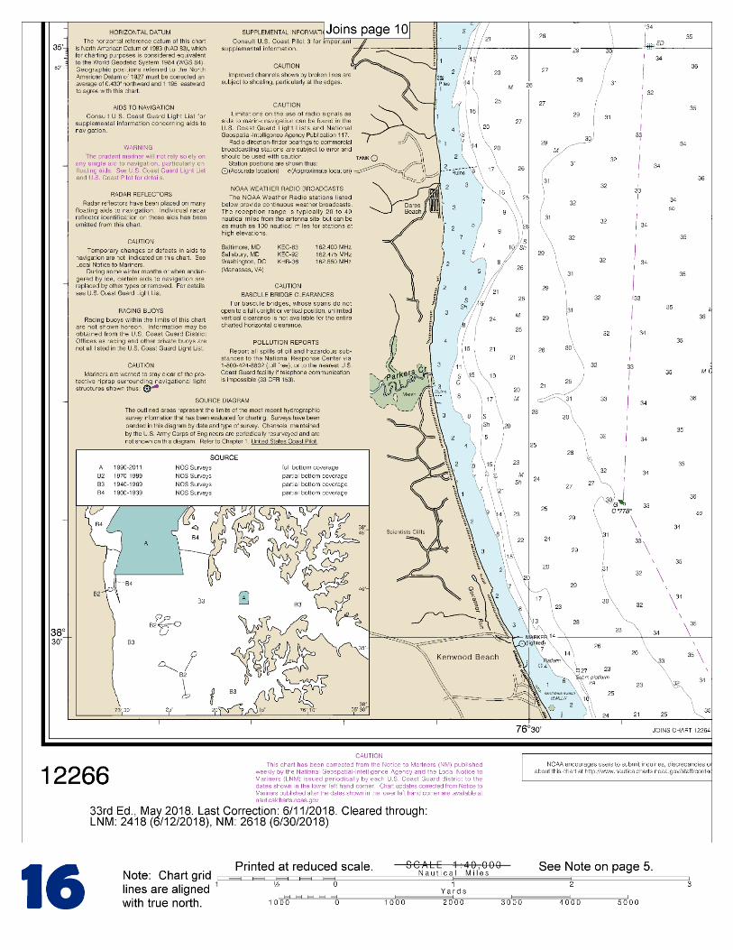
(Selected Excerpts from Coast Pilot) Plum Point Creek (38°36.9'N., 76°30.7'W.) empties into the west side of Chesapeake Bay 15 miles north-northwest of Cove Point. In 1997, depths of 4.5 feet were reported in the entrance to the creek and in the small-boat basin. A marina on the north side of the creek can provide some berths, gasoline, some supplies, and a sewage pump-out station. Overhead telephone and power cables with
a clearance of 52 feet cross the creek 0.1 mile above the mouth. The danger zone of the Naval Research Laboratory firing range fans out from a point near Randle Cliff Beach (38°38.5'N., 76°31.7'W.), 18 miles northward of Cove Point. (See 334.170, chapter 2, for limits and
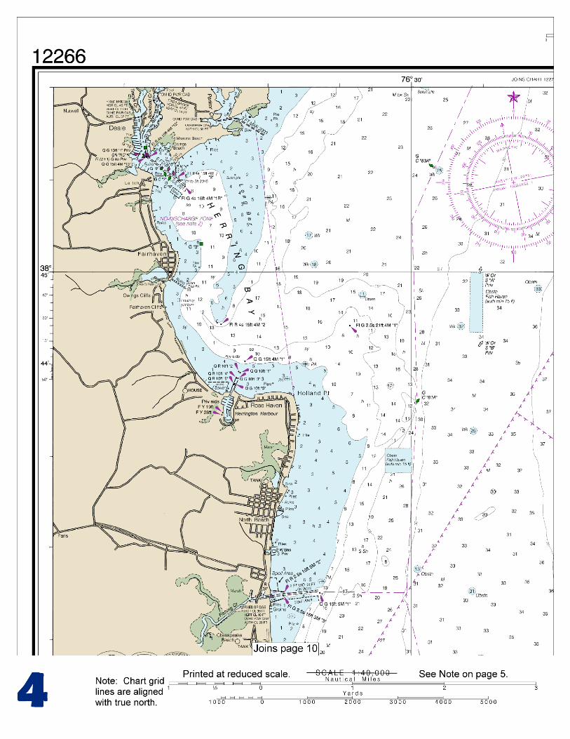
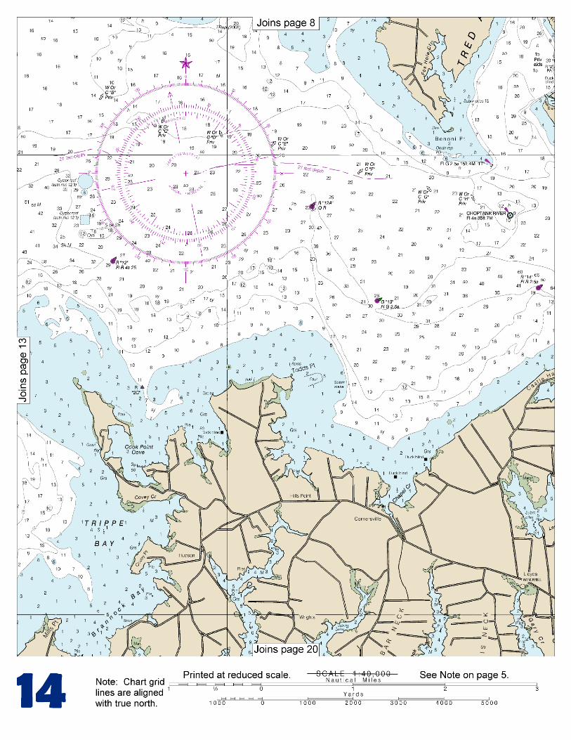
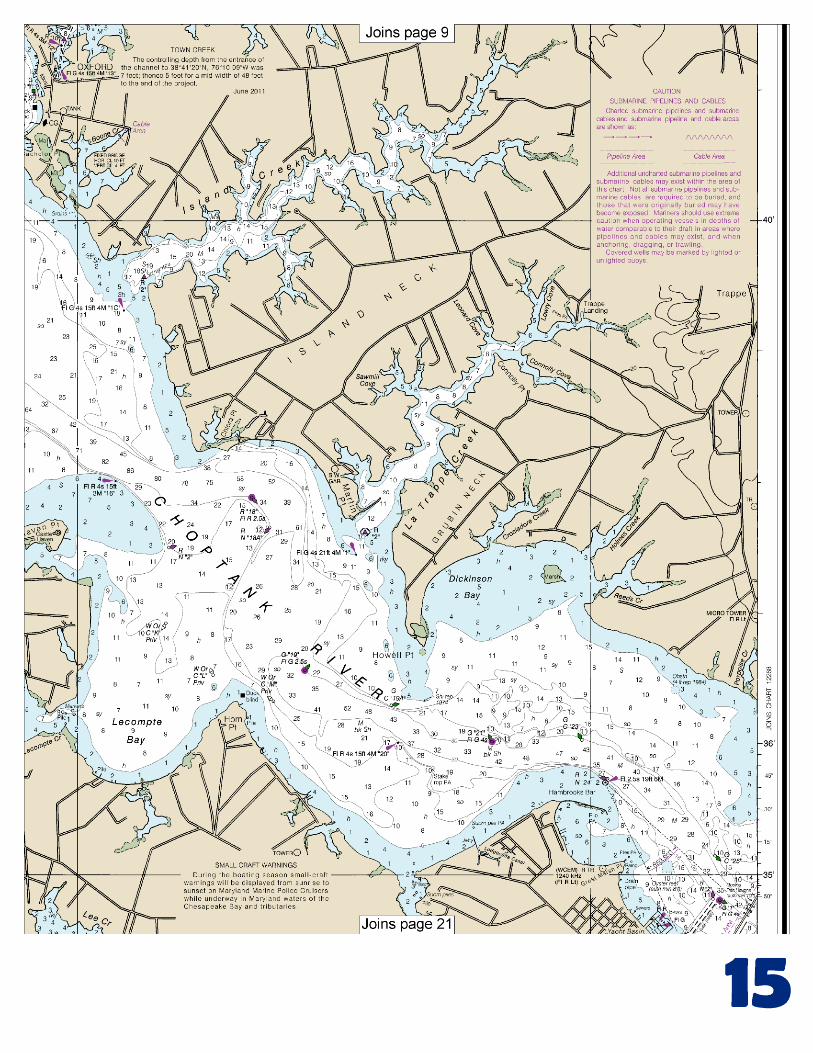
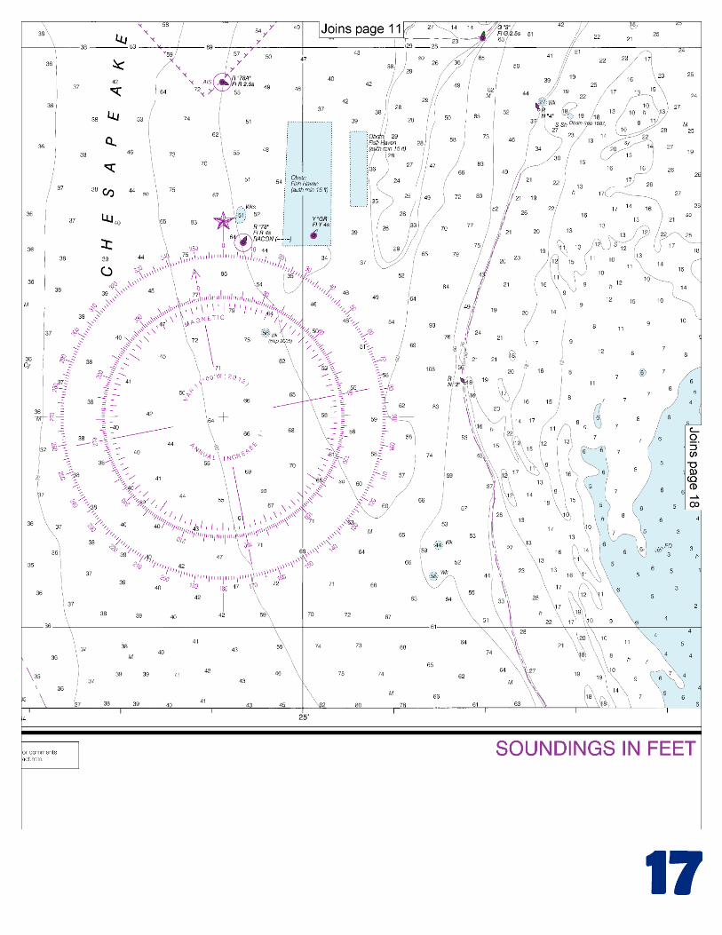
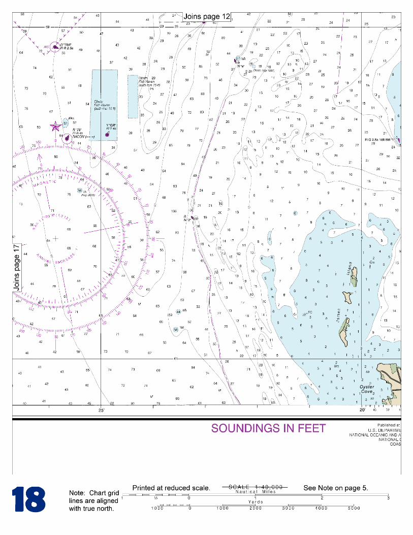
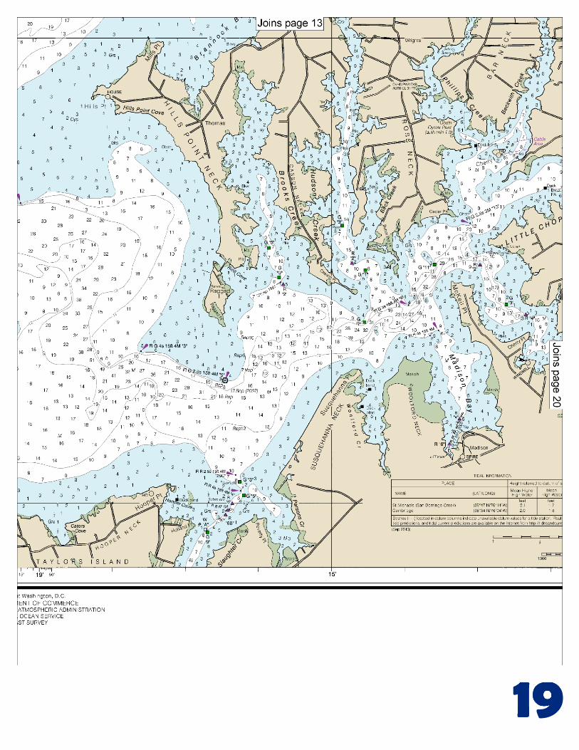
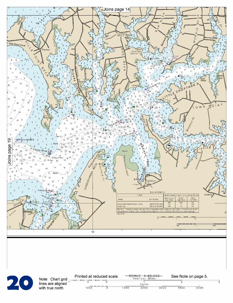
regulations.) The laboratory towers are prominent. Chesapeake Beach (38°41.8'N., 76°32.0'W.) is a resort and fishing center on the western shore of Chesapeake Bay 19.6 miles northward of Cove Point. Fishing Creek, on the north side of the resort, is entered by a dredged channel which leads from the bay through jetties to an anchorage basin in the creek. The channel is marked by a lighted range and other aids. In 2011, the controlling depth was 3 feet at midchannel, thence depths of 3 to 4 feet were available in the basin. The fixed highway bridge 0.3 mile above the jetties has a width of 36 feet and a clearance of 10 feet. Small-craft facilities.–Small-craft facilities, on the south side of the creek at Chesapeake Beach, have gasoline, diesel fuel, a pump-out station, water, ice, berths, and marine supplies. Hull and engine repairs can be made; marine railway, 50 feet; lift, 40 tons. A group of rocks at about 38°37.0'N., 76°21.8'W., sometimes awash at low tide, is all that remains of Sharps Island. Submerged pilings are about 0.2 mile southward of the rocks. Fish havens with an authorized minimum depth of 15 feet are about 4 miles south-southwestward of Sharps Island. Little Choptank River joins the eastern side of Chesapeake Bay 6 miles south-southeastward of Sharps Island. Although obstructed by shoals, the river has depths of 11 feet in a crooked channel for 7 miles and the tributaries have depths of 5 feet for considerable distances. The river is marked as far as Fishing Creek, above which it is difficult to carry more than 7 feet without local knowledge. The tributary channels are usually marked by bush stakes, but navigation is difficult without some local information. Tide and currents.–The current velocity is about 0.3 knot. The river carries some commercial traffic in shellfish and shells. The entrance to Little Choptank River is between James Island on the southwest and Hills Point on the northeast. James Island is subject to rapid erosion. Good anchorage is available in depths of 12 to 18 feet in the bight between James Island and Hooper Point, which is on the west side of the entrance to Slaughter Creek. Slaughter Creek (chart 12264), on the south side of Little Choptank River 4 miles above the mouth, has depths of 3.7 feet over the bar, thence 6 feet to the bridge at the village of Taylors Island, 2 miles above the entrance. The creek is marked by lights and daybeacons; a daybeacon on the west side of the entrance marks a submerged pile. A marina on the east side of the creek just north of the bridge has gasoline, diesel fuel, some supplies, and berths; a 25-ton mobile hoist is available for repairs. Brooks Creek, on the north side of Little Choptank River 5 miles above the mouth, has depths of 10 to 4 feet in a narrow channel for 2 miles then depths decrease to 2 feet at the head. The narrow entrance is marked, but local knowledge is required to carry the best water. There are small-craft facilities on the west side of the creek along Hills Point Neck. A marine railway can handle boats up to 40 feet for repairs. Hudson Creek, on the north side of Little Choptank River 6 miles above the mouth, has depths of 5 feet for 3.2 miles to just below Hudson, a village at the head. The entrance is marked, and the upper reaches usually are bush-staked. The wharves at Hudson are in poor condition. Madison Bay, on the south side of the river opposite Hudson Creek, has depths of 1 to 9 feet. The entrance to the bay is marked by a light. A dredged channel, marked by daybeacons, leads through the upper part of the bay to a turning basin. The east end of the turning basin is connected to an anchorage basin at Madison.
U.S. Coast Guard Rescue Coordination Center 24 hour Regional Contact for Emergencies
RCC Norfolk Commander
5th CG District (575) 398-6231 Norfolk, VA
G
NOAA’s navigation managers serve as ambassadors to the maritime community. They help identify navigational challenges facing professional and recreational mariners, and provide NOAA resources and information for safe navigation. For additional information, please visit nauticalcharts.noaa.gov/service/navmanagers
To make suggestions or ask questions online, go to nauticalcharts.noaa.gov/inquiry. To report a chart discrepancy, please use ocsdata.ncd.noaa.gov/idrs/discrepancy.aspx.
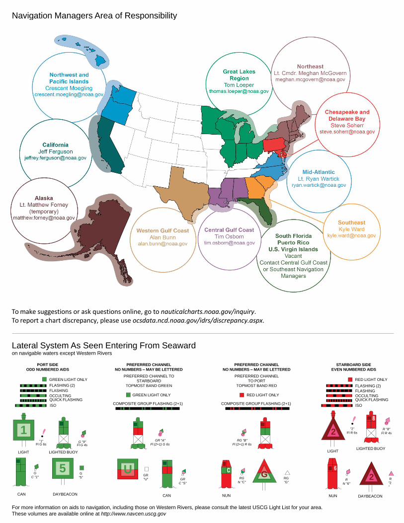
Lateral System As Seen Entering From Seaward on navigable waters except Western Rivers
PORT SIDE
ODD NUMBERED AIDS
GREEN LIGHT ONLY
FLASHING (2)
PREFERRED CHANNEL
NO NUMBERS – MAY BE LETTERED
PREFERRED CHANNEL TO
STARBOARD
TOPMOST BAND GREEN
PREFERRED CHANNEL
NO NUMBERS – MAY BE LETTERED
PREFERRED CHANNEL
TO PORT
TOPMOST BAND RED
STARBOARD SIDE
EVEN NUMBERED AIDS
RED LIGHT ONLY
FLASHING (2)
FLASHING FLASHING
OCCULTING GREEN LIGHT ONLY RED LIGHT ONLY OCCULTING QUICK FLASHING QUICK FLASHING
ISO COMPOSITE GROUP FLASHING (2+1) COMPOSITE GROUP FLASHING (2+1) ISO
"1"
Fl G 6s
G "9"
Fl G 4s
GR "A"
Fl (2+1) G 6s
RG "B"
Fl (2+1) R 6s
"2"
Fl R 6s
8
R "8"
Fl R 4s
LIGHT
G
C "1"
LIGHTED BUOY
G
"5"
GR
"U"
GR
C "S"
RG
N "C"
RG
"G"
LIGHT
6
R
N "6"
LIGHTED BUOY
R
"2
"
CAN DAYBEACON
CAN NUN NUN
DAYBEACON
For more information on aids to navigation, including those on Western Rivers, please consult the latest USCG Light List for your area.
These volumes are available online at http://www.navcen.uscg.gov
Navigation Managers Area of Responsibility
Northeast
Lt. Meghan McGovern
Northwest and
Pacific Islands
Crescent Moegling
Great Lakes Region
Tom Loeper
Chesapeake and
Delaware Bay
Steve Soherr
California
Jeff Ferguson
[email protected] Mid-Atlantic
Lt. Ryan Wartick
Alaska
Lt. Timothy M. Smith
Western Gulf Coast
Alan Bunn
Central Gulf Coast
Tim Osborn
[email protected] South Florida
Puerto Rico
U.S. Virgin Islands
Michael Henderson
Southeast
Kyle Ward
2
2 C U 5
1

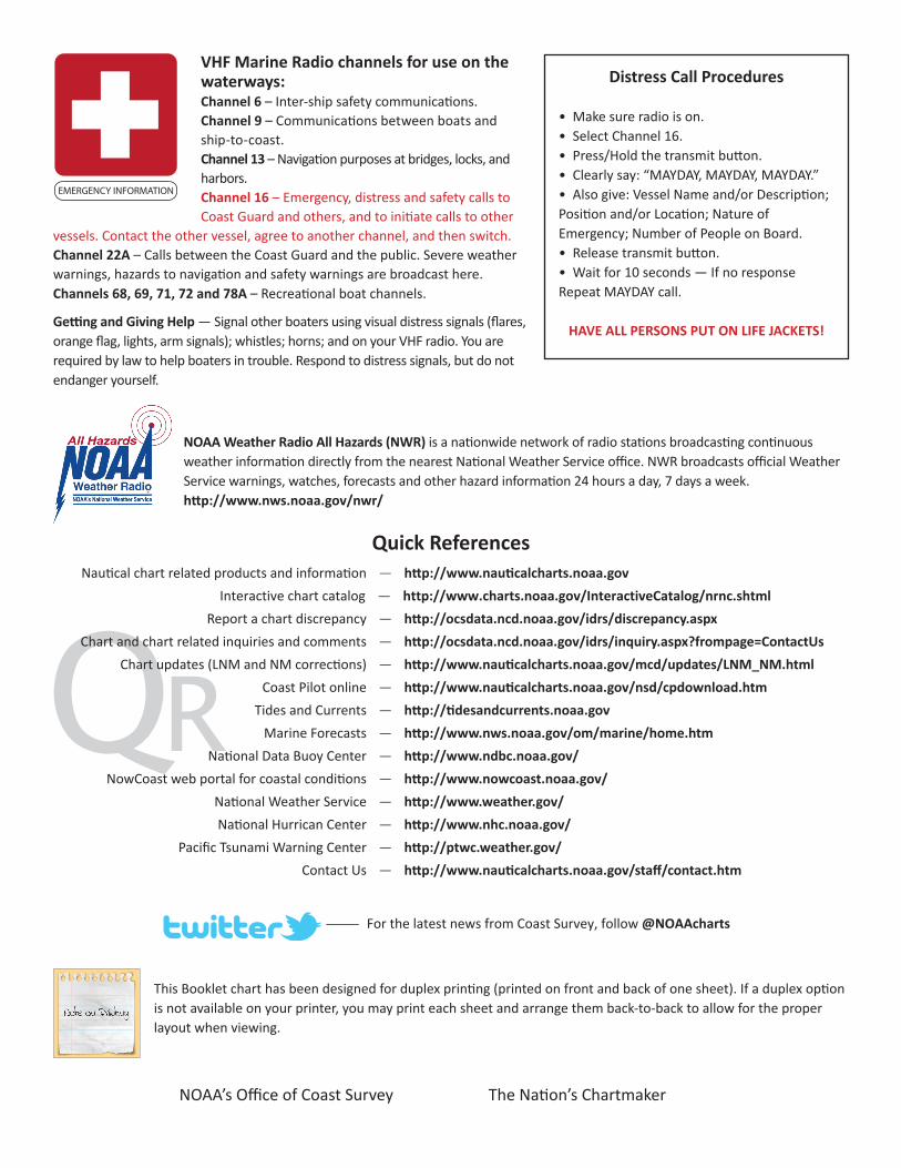
VHF Marine Radio channels for use on the waterways:Channel 6 – Inter-ship safety communications.Channel 9 – Communications between boats and ship-to-coast.Channel 13 – Navigation purposes at bridges, locks, and harbors.Channel 16 – Emergency, distress and safety calls to Coast Guard and others, and to initiate calls to other
vessels. Contact the other vessel, agree to another channel, and then switch.Channel 22A – Calls between the Coast Guard and the public. Severe weather warnings, hazards to navigation and safety warnings are broadcast here.Channels 68, 69, 71, 72 and 78A – Recreational boat channels.
Getting and Giving Help — Signal other boaters using visual distress signals (flares, orange flag, lights, arm signals); whistles; horns; and on your VHF radio. You are required by law to help boaters in trouble. Respond to distress signals, but do not endanger yourself.
EMERGENCY INFORMATION
Distress Call Procedures
• Make sure radio is on.• Select Channel 16.• Press/Hold the transmit button.• Clearly say: “MAYDAY, MAYDAY, MAYDAY.”• Also give: Vessel Name and/or Description;Position and/or Location; Nature of Emergency; Number of People on Board.• Release transmit button.• Wait for 10 seconds — If no responseRepeat MAYDAY call.
HAVE ALL PERSONS PUT ON LIFE JACKETS!
This Booklet chart has been designed for duplex printing (printed on front and back of one sheet). If a duplex option is not available on your printer, you may print each sheet and arrange them back-to-back to allow for the proper layout when viewing.
QR
Quick ReferencesNautical chart related products and information - http://www.nauticalcharts.noaa.gov
Interactive chart catalog - http://www.charts.noaa.gov/InteractiveCatalog/nrnc.shtmlReport a chart discrepancy - http://ocsdata.ncd.noaa.gov/idrs/discrepancy.aspx
Chart and chart related inquiries and comments - http://ocsdata.ncd.noaa.gov/idrs/inquiry.aspx?frompage=ContactUs
Chart updates (LNM and NM corrections) - http://www.nauticalcharts.noaa.gov/mcd/updates/LNM_NM.html
Coast Pilot online - http://www.nauticalcharts.noaa.gov/nsd/cpdownload.htm
Tides and Currents - http://tidesandcurrents.noaa.gov
Marine Forecasts - http://www.nws.noaa.gov/om/marine/home.htm
National Data Buoy Center - http://www.ndbc.noaa.gov/
NowCoast web portal for coastal conditions - http://www.nowcoast.noaa.gov/
National Weather Service - http://www.weather.gov/
National Hurrican Center - http://www.nhc.noaa.gov/
Pacific Tsunami Warning Center - http://ptwc.weather.gov/
Contact Us - http://www.nauticalcharts.noaa.gov/staff/contact.htm
NOAA’s Office of Coast Survey The Nation’s Chartmaker
For the latest news from Coast Survey, follow @NOAAcharts
NOAA Weather Radio All Hazards (NWR) is a nationwide network of radio stations broadcasting continuous weather information directly from the nearest National Weather Service office. NWR broadcasts official Weather Service warnings, watches, forecasts and other hazard information 24 hours a day, 7 days a week. http://www.nws.noaa.gov/nwr/