chino airport - san bernardino county - official website · i-2 chino airport - existing facilities...
TRANSCRIPT
Prepared ByRay A. Vidal
Aviation PlanningConsultant
COMPREHENSIVELAND USE PLAN
CHINO AIRPORT
November 1991San Bernardino County
Airport Land Use Commission
Prepared ByRay A. Vidal
Aviation PlanningConsultant
(916) 823-2273
COMPREHENSIVE
LAND USE PLAN
CHINO AIRPORT
November 1991San Bernardino County
Airport Land Use Commission

i
TABLE OF CONTENTS
PageINTRODUCTION and BACKGROUND................................................................ 1-1
ABBREVIATIONS and GLOSSARY ..................................................................... 1-3
REFERENCES ........................................................................................................ 1-6
PLAN CONSISTENCY .......................................................................................... 1-7
AIRPORT OPERATIONS and FACILITIESExisting .......................................................... 1-8Ultimate.......................................................... 1-9
SUMMARY of FINDINGS and RECOMMENDATIONS ................................... 1-11Referral Area “A”................................................................. 1-12Referral Area “B” ................................................................. 1-13Referral Area “C”................................................................. 1-14Riverside County.................................................................. 1-15General................................................................................. 1-16
NOISE IMPACT AREA and PLANNING BOUNDARIES..................................... 2-1
SAFETY IMPACT AREA and PLANNING BOUNDARIES ................................. 3-1Land Use and Po0pulation Densities........................................ 3-8Airspace Restrictions ............................................................ 3-12
OTHER IMPACTS .................................................................................................. 4-1
ENVIRONMENTAL REVIEW ............................................................................... 4-1
APPENDIXES
“A” State Aeronautics Act - Public Utilities Code Section 21670.
“B” California Administrative Code – Noise Standards - Title 21, Subchapter 6.
“C” FAR Part 77, Objects Affecting Navigable Airspace.
“D” Riverside County Notification.
ii
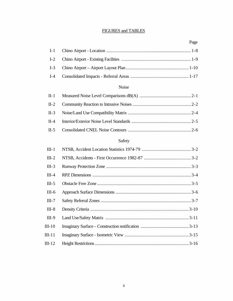
FIGURES and TABLES
Page
I-1 Chino Airport - Location .......................................................................... 1-8
I-2 Chino Airport - Existing Facilities ............................................................. 1-9
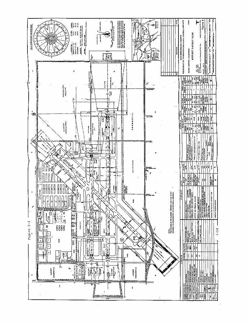
I-3 Chino Airport – Airport Layout Plan....................................................... 1-10
I-4 Consolidated Impacts - Referral Areas ................................................... 1-17
Noise
II-1 Measured Noise Level Comparisons dB(A) ............................................. 2-1
II-2 Community Reaction to Intrusive Noises ................................................... 2-2
II-3 Noise/Land Use Compatibility Matrix ....................................................... 2-4
II-4 Interior/Exterior Noise Level Standards .................................................... 2-5
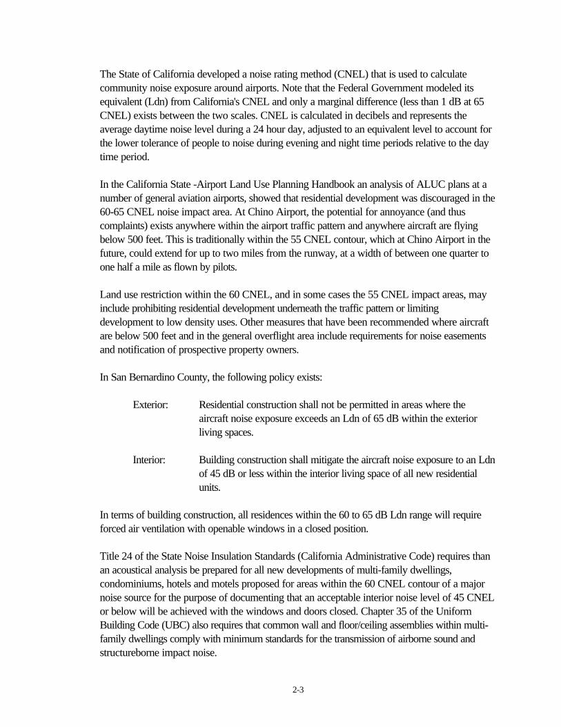
II-5 Consolidated CNEL Noise Contours ....................................................... 2-6
Safety
III-1 NTSB, Accident Location Statistics 1974-79 ........................................... 3-2
III-2 NTSB, Accidents - First Occurrence 1982-87 ......................................... 3-2
III-3 Runway Protection Zone .......................................................................... 3-3
III-4 RPZ Dimensions ...................................................................................... 3-4
III-5 Obstacle Free Zone .................................................................................. 3-5
III-6 Approach Surface Dimensions .................................................................. 3-6
III-7 Safety Referral Zones ............................................................................... 3-7
III-8 Density Criteria ...................................................................................... 3-10
III-9 Land Use/Safety Matrix ......................................................................... 3-11
III-10 Imaginary Surface - Construction notification .......................................... 3-13
III-11 Imaginary Surface - Isometric View ........................................................ 3-15
III-12 Height Restrictions .................................................................................. 3-16
1-1
INTRODUCTION AND BACKGROUND
This Airport Comprehensive Land Use Plan (ACLUP) was prepared pursuant to Chapter 4, Article3.5 of the California Public Utilities Code**. The plan was prepared by airport planning consultant,Ray A. Vidal, in conjunction with, and assistance from, staff of the San Bernardino County AirportLand Use Commission (ALUC), the City of Chino – Community Development Department.
The unique elements associated with aviation and airports, dictates that special considerations begiven to planning the peaceful and safe coexistence of airports and their surrounding communities.Consequently, the California State Legislature enacted airport land use planning laws which areintended to:
- provide for the orderly development of each public use airport in the Stateand the area surrounding these airports so as to promote the overall goalsand objectives of the California airport noise standards adopted pursuantto Section 21669 and to prevent the creation of new noise and safetyproblems.
- protect public health, safety, and welfare by ensuring the orderlyexpansion of airports and the adoption of land use measures that minimizethe public’s exposure to excessive noise and safety hazards within areasaround public airports to the extent that these areas are not alreadydevoted to incompatible uses.
The general mechanism that the statutes provided for compliance with the airport planning laws, isfor counties to establish an ALUC. In turn, the commission shall adopt a Comprehensive Land UsePlan (CLUP) that will provide for the orderly growth of each public airport and the area surroundingthe airport within the jurisdiction of the commission.
The initial object of this ACLUP is to effectively identify areas, located outside of the airport proper,that would be influenced by the future operations of the airport. Planning boundaries are establishedon the perimeters of these areas, which are plotted, by applying the specific operational criteria ofthe airport, to various planning models that have been primarily developed by the FAA.
** Appendix “A”, Section 21670 et seq. State Aeronautics Act, Public Utilities Code (Chapter 4,Article 3.5)

1-2
The planning boundaries and some specific calculations etc. found within this plan have beencompiled from a variety of Federal, State and local guidelines, specifically for the operations of theChino Airport. They are not necessarily applicable to, nor compatible with, any other airport.
In an effort to simplify and consolidate the various findings and recommendations unique to the areasurrounding the Chino Airport, this ACLUP has established three general referral areas, within thesection titles “Summary of Findings and Policies.” Note that, land use compatibility is determined bycomparing proposed land uses against each of the safety, height and noise guidelines and/or criteria.Any proposed land use must by compatible with all.
The Noise and Safety Impact sections of this ACLUP contain information that is intended toprovide the reader with a general understanding of the specific effects of each impact, the size of,and how the boundaries of each impact area are plotted and just what mitigation alternatives areavailable.
The text of this plan may in many cases contain only a brief description of a particular action orregulation. It is necessary, when using this plan, to thoroughly review the appendix and otherreference material, in conjunction with the “Summary of Findings and Recommendation,” beforemaking any planning decisions.
This plan is based upon a consolidation of airport generated impacts emanating from an analysis ofpresent day operations at the airport, plus the airports 20 year projections as contained with the1986 Airport Master Plan prepared by consultants A.J. Parry & Associates Inc. and AriesConsultants Ltd.
Certain impact areas plotted in this ACLUP project beyond the boundary of San BernardinoCounty and into neighboring Riverside County. A substantial identification of these impact areas iscontained within the “Safety Impact” section of the plan. Details of jurisdiction pertaining to this areais included within the “Summary of Findings and Recommendations” section of this ACLUP.

1-3
ABBREVIATIONS and GLOSSARY
AICUZ: Air Installation Compatible Use Zone: In study form, an identification of impact zones,generated from military airfield use, on the land surrounding the specific military facility. (DODInstruction 4165.57, November 8, 1977)
ACLUP: Airport Comprehensive Land Use Plan: Terminology used in some general plans todifferentiate between an existing comprehensive land use plans (unrelated to airports) and an airportcomprehensive land use plan, the subject of PUC Section 21670.
ALUC: Airport Land Use Commission: A California State authorized body, existing in eachcountypursuant to PUC Section 21670, and having the responsibility to develop plans for achievingland use compatibility between airports and their environs.
APZ: Accident Potential Zone: A designated area of higher likelihood of accidents.
Basic Utility Airport – Stage I: An airport that serves 75% of the single-engine and small twin-engine airplanes used for personal and business purposes.
Basic Utility Airport – Stage II: An airport that serves all the airplanes of Stage I, plus some smallbusiness and air taxi-type twin-engine airplanes. Precision approach operations are not usuallyanticipated.
CFR: Code of Federal Regulations: A codification of the general and permanent rules published inthe Federal Register by the executive department and agencies of the Federal Government.
CLUP: Comprehensive Land Use Plan: A specific plan, formulated by the ALUC, that will providefor the orderly growth of each public airport and the area surrounding the airport within thejurisdiction of the ALUC.
CNEL: Community Noise Equivalent Level: An average daily noise level, averaged for each of the24 hours, and weighted more heavily during evening and nighttime hours to account for the lowertolerance of persons to noise during those hours.
dB: Decibel: A unit for describing the intensity or level of sound, equal to 20 times the logarithm tothe base 10 of the ratio of the pressure of the sound measured to a standard reference pressure.

1-4
dB(A): A-weighted sound level, in decibels, as measured on a sound level meter equipped withweighting networks that represent the way the human ear hears certain sounds.
Displaced Threshold: A runway threshold that is located at a point other than the designatedbeginning of the runway.
DOA: Division of Aeronautics: A division of the California, Department of Transportation withresponsibility for the health and safety of all public use airports located within the State.
FAA: Federal Aviation Administration: A Federal agency charged with regulating air commerce topromote its safety and development, encouraging and developing civil aviation, air traffic control,and air navigation and promoting the development of a national system of airports.
FAR: Federal Aviation Regulation: Regulations issued by the FAA to regulate air commerce; issuedas separate “Parts”.
FSS: Flight Service Station: FAA facilities which provide pilot briefings on weather, airports,altitudes, routes, and other flight planning information.
GA: General Aviation: All types of aviation other than that performed by air carriers and the military.
General Utility Airport – Stage I: This type of airport serves all small airplanes. Precision approachoperations are not usually anticipated.
General Utility Airport – Stage II: This type of airport serves larger aircraft having an approachspeed of up to 121 knots. The capability for precision approach operations usually exists.
IFR: Instrument Flight Rules: Rules governing the procedures for conducting flight under instrumentmeteorological conditions.
ILS: Instrument Landing System: An electronic instrument guidance system, designed to permit thepilot of a properly equipped aircraft, exact alignment and angle of descent on final approach forlanding.
Ldn: Average day-night sound level. The average equivalent A-weighted sound level during a 24hour day obtained by adding ten decibels to the hourly noise levels measured during the night (from10 p.m. to 7 am).
1-5
NAVAID: Navigational Aid: Any visual or electronic device (airborne or on the surface) whichprovides point to point guidance information or position data to aircraft in flight. A frangibleNAVAID is a NAVAID whose properties allow it to fail at a specified impact load.
Nonprecision Instrument Runway: A runway having an existing or planned instrument approachprocedure from which a straight in landing is approved by no electronic glide slope information isavailable and for which no precision facilities are planned.
NTSB: National Transportation Safety Board: Federal Government agency that investigates andrecords all aviation accidents.
NPIAS: National Plan of Integrated Airport Systems: A plan, prepared by the FAA, whichidentifies the nation’s system of airports and airport development.
OFA: Object Free Area: A two dimensional ground area surrounding runways, taxiways, andtaxilanes which is clear of objects except for objects whose location is fixed by function.
OFZ: Obstacle Free Zone: The airspace above any of 3 surfaces that comprise the overall OFZ, i.e.Ruway OFZ (centered on the runway centerline), the Inner-Approach OFZ (centered on theextended runway centerline) and the Inner-transitional OFZ (located on the outer edges of therunway OFZ and the inner-apporach OFZ).
OPR: Office of Planning and Research: Author of the State of California, General Plan Guidelinesand CEQA Guidelines.
Referral Area: A designated area consisting of various noise, safety and height restriction impacts,grouped together by the level of intensity of the associated impacts.
Runway: A defined rectangular surface on an airport prepared or suitable for landing or takeoff ofairplanes.
RPZ: Runway Protection Zone: An area (formerly known as the clear zone) used to enhance thesafety of aircraft operations. It is at ground level beyond the runway end.
Safety Zone: An area located in the vicinity of an airport in which land use restrictions areestablished to protect the safety of the public.
Threshold: The beginning of that portion of the runway available and suitable for the landing ofairplanes.
VFR: Visual Flight Rules: Flight rules that identify conditions when weather is adequate for aircraftto maintain safe separation by visual means. Under VFR conditions safe separation between aircraftis the responsibility of the pilot.
1-6
REFERENCES
Federal Government:
FAA – Advisory Circular 150/5020-1. Noise Control and Compatibility Planning forAirports.
FAA – Advisory Circular 150/5300-13. Airport Design.
FAR Part 77 – Objects Affecting Navigable Airspace.
FAR Part 150 – Airport Noise Compatibility Planning.
California State Government:
DOA – Airport Land Use Planning Handbook.
OPR – Guidelines for the Preparation and Control of the Noise Elements of the GeneralPlan.
OPR – California Environmental Quality Act Guidelines.
OPR – General Plan Guidelines.
San Bernardino County:
General Plan – Noise Element– Man-Made Hazards
a. Airport Safety Issueb. Noise Issue
ALUC - Interim Plan.
Chino Airport Master Plan – November 1986.
1-7
ALUC PLAN CONSISTENCY
Once this ACLUP has been adopted by the San Bernardino County ALUC, developmentapplications that fall within the criteria of this plan, need no longer be referred to the ALUC forapproval. Airport related review of development applications shall be accomplished by thereviewing jurisdiction pursuant to the policies and standards contained in this document. Any zoningchanges (apart from those recommended, and thus adopted, within this ACLUP) contemplated bythe County or the City of Chino, that lie within the referral areas defined within this plan, along withspecific plan and general plan required by Public Utilities Code, Section 21676, must still be firstreferred to the ALUC.
Section 65302.3 of the California Government Code - Planning and Zoning Law requires thatgeneral plans be consistent with ALUC plans. Once adopted by the ALUC, the County or the Cityof Chino have 180 days to accomplish this consistency, with this ACLUP.
If the ALUC finds that the County or the City of Chino have not revised their general plans, oroverruled the ALUC, the ALUC may require the County or City to submit all subsequent actions,regulations, or permits in the affected area to the ALUC for consistency determination. If the ALUCfinds the proposed action inconsistent, the County or the City must hold a public hearing to recon-sider its proposal. If, after the public hearing, the County or City still wishes to pursue the action, itmay overrule the ALUC, once again, on a two-third majority vote, based on specific findings, asstated in PUC Section 21676.5.

1-8
AIRPORT OPERATIONS AND FACILITIES:
a). Existing:
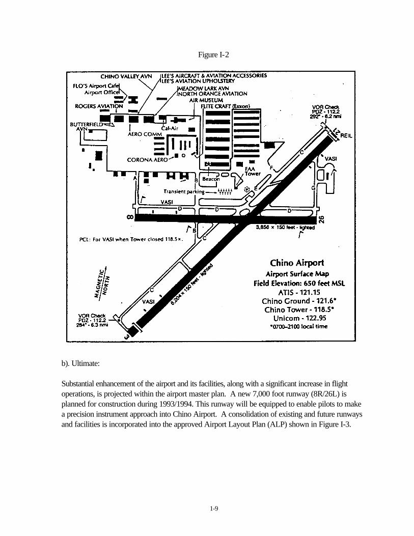
Chino Airport is located approximately 4 miles South-East of the City of Chino (Figure I-1) within apredominately Agricultural Preserve area. The airport is owned and operated by the County of SanBernardino – Department of Airports. The airport office (phone {714} 597-3910) is open duringnormal office hours. Chino airport is classified in the National Plan of Integrated Airport Systems(NP1AS) as a Basic Transport, Reliever Airport.
Chino Airport is an Air Traffic Controlled facility lying under the Ontario Airport Radar ServiceArea. The airport has a 6,204 foot primary runway (designation 3/21) and a 3,856 foot cross-windrunway (designation 8/26).
Fuel (80-100LL & Jet-A) is available along with tie-downs and transient parking. Over 600,primarily single engine aircraft are based at the airport. A basic diagram of the existing facilities andlayout of the airport is shown in Figure 1-2.
Figure I-1
1-9
Figure I-2
b). Ultimate:
Substantial enhancement of the airport and its facilities, along with a significant increase in flightoperations, is projected within the airport master plan. A new 7,000 foot runway (8R/26L) isplanned for construction during 1993/1994. This runway will be equipped to enable pilots to makea precision instrument approach into Chino Airport. A consolidation of existing and future runwaysand facilities is incorporated into the approved Airport Layout Plan (ALP) shown in Figure I-3.
1-11
SUMMARY OF FINDINGS AND RECOMMENDATIONS
The location of Chino Airport within a predominately rural setting, helps to ensure that the overallintent of California's Airport Land Use Planning Law will be met. The adoption of recommendationscontained herein will help ensure that future development within the region will be as compatible aspossible with the Chino Airport and its future operations at a much expanded level.
The referral areas defined within this plan are in accordance with various regulatory agenciesguidelines. Where ever possible, graphics illustrating specific impacts incorporated within the ChinoAirport Master plan and/or E.I.R., have been used, or in the alternative consolidated and/oroverlaid onto other area maps for the purposes necessary within this plan.
This section of the ACLUP consolidates all of the Chino Airport generated impacts into threeprimary referral areas (Figure I-4). Each impact description and land use recommendation isdeliberately intended to be as brief as possible. As such, when reviewing this section, it is necessaryto refer to the more detailed impact identifications contained within the noise and safety impactsections of this plan.

1-12
Referral Area "A"
This is the most critical safety impact area associated with any airport. The area is made up of theFAA classified primary surface of the airport, the Runway Protection Zone (RPZ) and a portion ofthe approach and departure surface. The majority of this area is designated as an Object Free Area(OFA) with this status also applying to moving objects, i.e. vehicles.
The RPZ was formerly known as the "Clear Zone". The intent is to ensure that this zone remainsclear of all obstacles that could create a potential hazard to aviation. This ACLUP recommends (inaccordance with FAA Advisory Circular 150/5300-13, Section 212 b.) that the airport owner (theCounty of San Bernardino) acquire all land that lies within this zone. The Airport Layout Plan(Figure I-3) plots the RPZ's and the area not presently located on airport property.
All of the 75 CNEL and 90% of the 70 CNEL noise impact zones (described in more detail inFigure II-6) at Chino Airport, lie within Referral Area "A". The recommendation that the airportowner acquire all land within this zone, for safety reasons, also effectively mitigates the noiseconsequences within this referral area.
Land use within Referral Area "A" is extremely restricted. Under normal circumstances, nostructures what-so-ever are permitted. Few people (no people is preferred, or if absolutelynecessary, for a short time only, up to 10 persons per acre at any one time) should be allowedwithin the outer area of the RPZ. Open Space or agricultural use (provided that it doesn't attractbirds) is acceptable in this zone.
Existing County "Agricultural/Agricultural Preserve" land use district (AG-AP), located on theperimeter of this referral area (within the area recommended for acquisition by the airport owner) isconsistent with the land use recommendations of this plan.
1-13
Referral Area "B"
This area is made up of Safety Zone II plus the balance of the approach and departure zones notfalling within the RPZ. A small pocket of the 70 CNEL noise impact zone exists within the City ofChino "Urban Reserve" zoned area located at the western end of Referral Area "A". All of the 65CNEL noise impact zone emanating from the Chino Airport, is locatedwithin this referral area.
Traditionally, this area experiences a high percentage of traffic accidents. As such, all proposedresidential and industrial development within this area should be carefully evaluated. Additionally, theprovisions of the State's noise standards (particularly Section 5014 -see Appendix Page "B-7")must be adhered to when granting permits for residential development.
A limited number of detached, Single Family dwellings are acceptable within this area. All generalassembly buildings are prohibited, along with any other facility or outdoor usage that could result ina congregation of 50 persons or more per acre.
Limited light industrial and manufacturing land uses would be acceptable within this area providedthat population density and FAR Part 77 height restrictions are adhered to. No use what-so-ever ofany hazardous nature is permitted.
Existing County "Agricultural/Agricultural Preserve" land use district (AG-AP) is consistent withrecommended land uses within this referral area. Irrespective, zoning should be amended toincorporate restrictions in regard to limiting the number of persons permitted within any facility atany given time. In addition, special consideration should be given to ensuring that interior noise levelsof no more than 45 Ldn (CNEL) apply to all proposed single family dwellings in this area.

1-14
Referral Area "C"
The outer boundary of this referral area lies on an arc with a radius of approximately 10,000 feetfrom the airport. This area is substantially the same as Safety Zone III. The threat of aircraftaccidents in this area is below that of the other referral areas, however some do occur, and it isnecessary to ensure that some continuing restrictions on land use are imposed when planning withinthis area. Noise levels vary, however they could average in the range of 55/60 CNEL, which undersome conditions may still be the cause of considerable annoyance to some members of thecommunity.
No restrictions are generally placed on residential zoning within this area. Light industrial andmanufacturing uses are also acceptable, provided that they do not generate any visual, electronic orphysical hazards to aircraft. No above ground hazardous materials are allowed, howeverunderground fuel tanks are acceptable. General business facilities, office buildings, motels, banksand eating and drinking facilities are permitted. In all cases, consideration should be given to someform of shielding, such as the use of trees etc. near buildings.
All existing County "Institutional" and "Agricultural Preserve" land use districts are consistent withthe recommended uses within this referral area and should be maintained.
All existing City of Chino "Business", "Residential" and "Office" zoning, located near the North-Eastern perimeter of Referral Area "C", are consistent uses within this zone and should bemaintained.
The existing land uses (other than the Correctional Facility) within the City of Chino "UrbanReserve" zoned areas are consistent with those permitted within this referral area. At such time asuses are re-evaluated within this area, specific consideration should be given to the impactsgenerated by the airport, and any prospective changes should be referred to the ALUC forapproval.
1-15
Riverside County:
Certain impacts emanating from Chino Airport protrude into neighboring Riverside County. TheCalifornia Attorney General, in an opinion issued on May 7,1991 (no. 90-914), found that thejurisdiction of a County ALUC is limited by County boundaries. Accordingly all recommendationsof this ACLUP shall be limited to those areas located within San Bernardino County, within thejurisdiction of the San Bernardino County ALUC.
This ACLUP does however identify those areas located in Riverside County that fall within thevarious impact zones from Chino Airport. These are:
a) the Eastern end of Referral Area "B"b) the South-Easterly portion of Referral Area "C"c) the Western end of the FAR Part 77 designated "Extended Runway Centerline"
Existing Riverside County "Agricultural" zoning (A2-10) located within these impact zones iscertainly consistent with recommended land uses for all of these areas.
Riverside County ALUC was notified of this position in a March 5, 1991 letter (Appendix "D").

1-16
General
An ALUC has no power over the operations of an airport, nor does it have any control over anyexisting facilities or land uses located within the impact areas of the airport, as defined within thisACLUP. As such, this plan does not take into consideration any existing land useswithin its sphere of influence, however it does recommend that, to the extent possible, specific landuses within the vicinity should be modified to conform with acceptable criteria for land uses withinthe vicinity of airports.
Two correctional institutions are located within the vicinity of the airport, and it is recognized thatthis type of land use is not compatible with airport operations. While the actual facility proximity isclose to the airport, their locations in respect to the runway configuration (the runway centerlineprojections) is marginally compatible.
As Chino Airport has Air Traffic Control, the airport owner, in conjunction with the FAAcontrollers, are in a position to effectively mitigate many potential impacts that may be generated byaircraft overflying surrounding areas at low altitudes. It is recommended that, to the extent possible,flight paths (at altitudes below 1,000 ft) be restricted to the safety zones (runway centerlines) plottedin this plan. Note that the flight pattern altitude at Chino Airport is 1,400 feet MSL (750 feet aboveground level) for reciprocating engine aircraft and 2,000 ft MSL for jet aircraft.
Specific emphasis should also be placed on directing traffic as far away as possible, from the twocorrectional facilities (actual buildings) and also from the concentrated residential area (zoned RD-14) located near the perimeter of the North-Western portion of Referral Area "C".
While not specifically incorporated as a referral area, a Conical Surface extends for a distance of4,000 feet from the perimeter of Referral Area "c I'. This area is still the subject of FAA Part 77height restrictions, and as such, should be identified within the overall impact area where it isnecessary to obtain an Avigation Easement.
It is recommended that the County of San Bernardino and the City of Chino obtain a standard formof Avigation Easement for all land transfers and/or proposed development located within the areabetween the airport and the outer boundary of the Conical Surface.

1-17
Figure I-4
Chino Airport Referral Areas

NOISE IMPACT
and
REFERRAL AREAS

2-1
NOISE
The intensity of aircraft noise varies, depending upon the type of aircraft and the proximity of thelistener. The ear shattering sound of a large jet aircraft at close range is a far cry from the soundof a small, single engine, general aviation aircraft at a distance of a couple of hundred yards.Examples of common indoor and outdoor sound levels are provided in Figure II-1.
The dB scale measure single event noise incidents on an occurrence by occurrence basis. Withaircraft noise, the sound level increases as the aircraft approaches and it diminishes as theaircraft flies away. The sound measurements of the events itemized were taken at the peak ofthe occurrence.
Figure II-1Measured Noise Level Comparisons, dB(A)
COMMON OUTDOOR NOISE LEVEL COMMON INDOORSOUND LEVELS dB (A) SOUND LEVELS
___ 110 ROCK BANDCONCORDE LANDING AT 370 ft.
707 LANDING AT 370 ft.707 TAKEOFF AT 1000 ft. ___ 100 INSIDE SUBWAY TRAIN (New York)
GAS LAWN MOWER AT 3 ft.___ 90
DIESEL TRUCK AT 50 ft. FOOD BLENDER AT 3 ft.
NOISY URBAN DAYTIME ___ 80 GARBAGE DISPOSAL AT 3 ft.SHOUTING AT 3 ft
747 TAKEOFF AT 1000 ft. ___ 70 VACUUM CLEANER AT 10 ft
COMMERCIAL AREA NORMAL SPEECH AT 3 ft .___ 60
LARGE BUSINESS OFFICE
QUIET URBAN DAYTIME ___ 50 DISHWASHER NEXT ROOM
QUIET4.JRBAN NIGHTTIME ___ 40 SMALL THEATRE. LARGE CONFERENCEROOM (Background)
QUIET SUBURBAN NIGHTTIME LIBRARY___ 30
BEDROOM AT NIGHTQUIET RURAL NIGHTTIME CONCERT HALL (Background)
___ 20
BROADCAST & RECORDING STUDIO___ 10
THRESHOLD OF HEARING___ 0
2-2
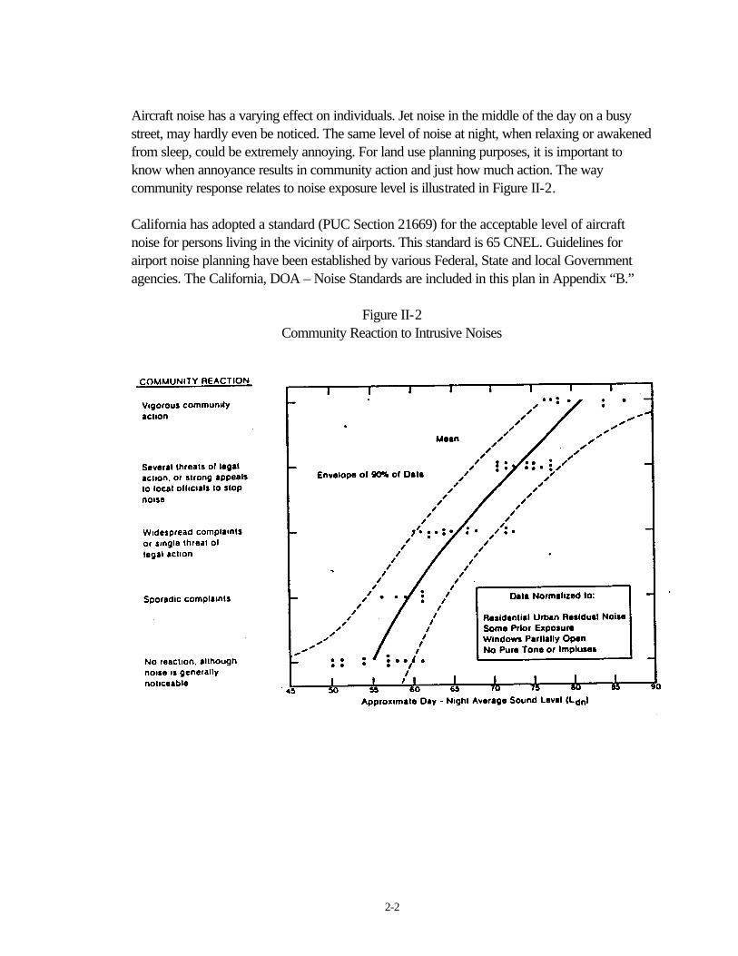
Aircraft noise has a varying effect on individuals. Jet noise in the middle of the day on a busystreet, may hardly even be noticed. The same level of noise at night, when relaxing or awakenedfrom sleep, could be extremely annoying. For land use planning purposes, it is important toknow when annoyance results in community action and just how much action. The waycommunity response relates to noise exposure level is illustrated in Figure II-2.
California has adopted a standard (PUC Section 21669) for the acceptable level of aircraftnoise for persons living in the vicinity of airports. This standard is 65 CNEL. Guidelines forairport noise planning have been established by various Federal, State and local Governmentagencies. The California, DOA – Noise Standards are included in this plan in Appendix “B.”
Figure II-2Community Reaction to Intrusive Noises
2-3
The State of California developed a noise rating method (CNEL) that is used to calculatecommunity noise exposure around airports. Note that the Federal Government modeled itsequivalent (Ldn) from California's CNEL and only a marginal difference (less than 1 dB at 65CNEL) exists between the two scales. CNEL is calculated in decibels and represents theaverage daytime noise level during a 24 hour day, adjusted to an equivalent level to account forthe lower tolerance of people to noise during evening and night time periods relative to the daytime period.
In the California State -Airport Land Use Planning Handbook an analysis of ALUC plans at anumber of general aviation airports, showed that residential development was discouraged in the60-65 CNEL noise impact area. At Chino Airport, the potential for annoyance (and thuscomplaints) exists anywhere within the airport traffic pattern and anywhere aircraft are flyingbelow 500 feet. This is traditionally within the 55 CNEL contour, which at Chino Airport in thefuture, could extend for up to two miles from the runway, at a width of between one quarter toone half a mile as flown by pilots.
Land use restriction within the 60 CNEL, and in some cases the 55 CNEL impact areas, mayinclude prohibiting residential development underneath the traffic pattern or limitingdevelopment to low density uses. Other measures that have been recommended where aircraftare below 500 feet and in the general overflight area include requirements for noise easementsand notification of prospective property owners.
In San Bernardino County, the following policy exists:
Exterior: Residential construction shall not be permitted in areas where theaircraft noise exposure exceeds an Ldn of 65 dB within the exteriorliving spaces.
Interior: Building construction shall mitigate the aircraft noise exposure to an Ldnof 45 dB or less within the interior living space of all new residentialunits.
In terms of building construction, all residences within the 60 to 65 dB Ldn range will requireforced air ventilation with openable windows in a closed position.
Title 24 of the State Noise Insulation Standards (California Administrative Code) requires thanan acoustical analysis be prepared for all new developments of multi-family dwellings,condominiums, hotels and motels proposed for areas within the 60 CNEL contour of a majornoise source for the purpose of documenting that an acceptable interior noise level of 45 CNELor below will be achieved with the windows and doors closed. Chapter 35 of the UniformBuilding Code (UBC) also requires that common wall and floor/ceiling assemblies within multi-family dwellings comply with minimum standards for the transmission of airborne sound andstructureborne impact noise.

2-4
The most commonly referred to matrix of its type in California (Table II-3) details land usecompatibility for community noise equivalent levels. It is sourced from the Governor’s Office ofPlanning and Research, Guidelines for the preparation and content of the Noise Element of theGeneral Plan, Appendix A.
Figure II-3
LAND USE COMPATIBILITY FOR COMMUNITY NOISE ENVIRONMENTS
COMMUNITY NOISE EXPOSURELdn OR CNEL, Db
INTREPRETATIONLAND USE CATEGORY
55 60 65 70 75 80NORMALLY ACCEPTABLE
RESIDENTIAL – LOW DENSITYSINGLE FAMILY, DUPLEXMOBILEHOMES
Specified land use is satisfactory, based uponthe assumption that any buildings involved are ofnormal conventional construction, without anyspecial noise insulation requirements.
RESIDENTIAL – MULITI. FAMILY
CONDITIONALLY ACCEPTABLETRANSIENT LODGINGMOTELS, HOTELS
SCHOOLS, LIBRARIESCHURCHES, HOSPITALS,NURSING HOMES
New construction or development should beundertaken only after a detailed analysis of thenoise reduction requirements is made andneeded noise insulation features included in thedesign. Conventional construction, but withclosed windows and fresh air supply systems orair conditioning will normally suffice.
AUDITORIUMS, CONCERTHALLS, AMPHITHEATRES
NORMALLY UNACCEPTABLESPORTS ARENA, OUTDOORSPECTATOR SPORTS
PLAYGROUNDS,NEIGHBORHOOD PARKS
New construction or development shouldgenerally be discouraged. If new construction ordevelopment does proceed, a detailed analysis ofthe noise reduction requirements must be madeand needed noise insulation features included inthe design.
GOLF COURSES, RIDINGSTABLES, WATER RECREATION,CEMETERIES
CLEARLY UNACCEPTABLEOFFICE BUILDINGS, BUSINESSCOMMERCIAL ANDPROFESSIONAL
INDUSTRIAL, MANUFACTURINGUTILITIES, AGRICULTURE
New construction or development shouldgenerally not be undertaken.

2-5
Figure II-4 (sourced from the Noise Element of the San Bernardino County General Plan)provides the standards that are followed in this plan.
Figure II-4
Interior/Exterior Noise Level StandardsMobile Noise Sources
Land Uses Ldn (or CNEL), dB
Categories Uses Interior1 Exterior2
Residential Single & multi-family, duplex 45 603
Mobile Home 45 603
Commercial Hotel, motel, transient lodging 45 603
Commercial retail, bank, 50 ?restaurant
Office building, research & 45 65development, professionaloffices
Amphitheater, concert ball, 45 ?auditorium, movie theater
Institutional/ Hospital, nursing home, 45 65Public school, classroom, church,
library
Open Space Park ? 65
1. Interior living environment excluding bathroom, kitchens, toilets, closets corridors.
2. Outdoor environment limited to:Private yard of single family dwellingsMulti-family private patios or balconiesMobile home parksHospital/office building patiosPark picnic areasSchool playgroundsHotel and motel recreation areas
3. An exterior noise level of up to 65 dB Ldn (or CNEL) will be allowed provided exterior noise levelshave been substantially mitigated through a reasonable application of the best available noisereduction technology, and interior noise exposure does not exceed 45 dB Ldn (or CNEL) withwindows and doors closed. Requiring that windows and doors remain closed to achieve anacceptable interior noise level win necessitate the use of air conditioning or mechanical ventilation.
Figure II-5
SAFETY IMPACT
and
PLANNING BOUNDARIES

3-1
SAFETY
The overriding objective of California's airport land use planning law is to protect the public's health,safety and welfare. Two critical elements must be addressed when assessing safety issues andattempting to determine measures that would effectively minimize potential injury and/or loss of lifethat could result from any incident related to an aircraft. These are safety on the ground and safety inthe air.
In proportion to overall air operations, the actual incidence of aviation accidents is extremely minute.Additionally, .it is normally not feasible to plan in advance (at other than major air carrier airports)measures that would minimize loss of life on the ground should an accident, such as a 747 crash intoa heavily populated urban area, occur. As such, the potential for such a disaster is not exploredwithin the context of this plan. On the other hand, this plan attempts to ensure that every effort ismade to minimize any potential impact should an aircraft crash of any type occur, within the regionsurrounding the airport, by an aircraft that has taken off or intends to land at Chino Airport.
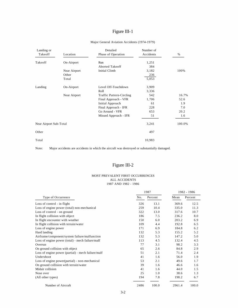
A number of theories exist in respect to the level of appropriate land uses and/or populationdensities around airports verses the potential for injury or property damage should an accidentoccur. An assessment of National Transportation Safety Board (NTSB) statistics reveals that whilean overwhelming majority of general aviation (GA) accidents occur actually on the airport proper,the potential for an accident to take place near the airport is still substantial, and in the majority ofcases, more serious in nature. Additionally, the statistics reveal that accidents that occur nearairports tend to be evenly divided between aircraft taking off and aircraft landing Note that due to arevision of NTSB reporting formats, the most recent statistics showing the actual location of GAaccidents in relationship to airports, were published for the period 1974-1979 (Table III-l). Arecent study, undertaken for inclusion within the Kern County ALUC "Policy Plan", also suggeststhat Safety should be a concern well beyond an airport's Runway Protection Zone (RPZ ).
Table III-2 shows more recent NTSB statistics, however on-airport accidents during landing andtakeoff were not broken out of the broader classifications. Irrespective of these considerations, littledifference within the percentages between the categories is apparent with the more recent figuresand thus, it is logical to assume that the percentage of accident locations derived from the 1974-1979 statistics remains constant.
3-2
Figure III-1
Major General Aviation Accidents (1974-1979)
Landing or Detailed Number ofTakeoff Location Phase of Operation Accidents %
Takeoff On-Airport Run 1,251Aborted Takeoff 384
Near Airport Initial Climb 3,182 100%Other 236Total 5,053
Landing On-Airport Level Off-Touchdown 3,909Roll 3,336
Near Airport Traffic Pattern-Circling 542 16.7%Final Approach - VFR 1,706 52.6Initial Approach 61 1.9Final Approach - IFR 228 7.0Go Around - VFR 653 20.2Missed Approach - IFR 51 1.6
Near Airport Sub-Total 3,241 100.0%
Other 497
Total 10,983
Note: Major accidents are accidents in which the aircraft was destroyed or substantially damaged.
Figure III-2
MOST PREVALENT FIRST OCCURRENCESALL ACCIDENTS
1987 AND 1982 - 1986
1987 1982 - 1986
Type of Occurrence No. Percent Mean Percent
Loss of control - in flight 326 13.1 369.6 12.5Loss of engine power (total) non-mechanical 259 10.4 335.0 11.3Loss of control - on ground 322 13.0 317.6 10.7In flight collision with object 186 7.5 236.2 8.0In flight encounter with weather 150 6.0 203.2 6.9In flight collision with terrain/water 109 4.4 192.8 6.5Loss of engine power 171 6.9 184.8 6.2Hard landing 132 5.3 155.2 5.2Airframe/component/system failure/malfunction 132 5.3 147.2 5.0Loss of engine power (total) - mech failure/malf 113 4.5 132.4 4.5Overrun 77 3.1 98.2 3.3On ground collision with object 65 2.6 84.8 2.9Loss of engine power (partial) - mech failure/malf 51 2.1 71.4 2.4Undershoot 41 1.6 56.0 1.9Loss of engine power(partial) - non-mechanical 53 2.1 49.6 1.7On ground collision with terrain/water 39 1.6 46.6 1.6Midair collision 41 1.6 44.0 1.5Nose over 25 1.0 38.6 1.3(All other types) 194 7.8 198.2 6.7
Number of Aircraft 2486 100.0 2961.4 100.0
3-3
The obvious solution to minimize injury or loss of life on the ground, should an aircraft accidentoccur near the airport, is to ensure that no structures or activities involving the public take place inareas extending outwards from the runway centerline. This area is referred to as a safety zone.
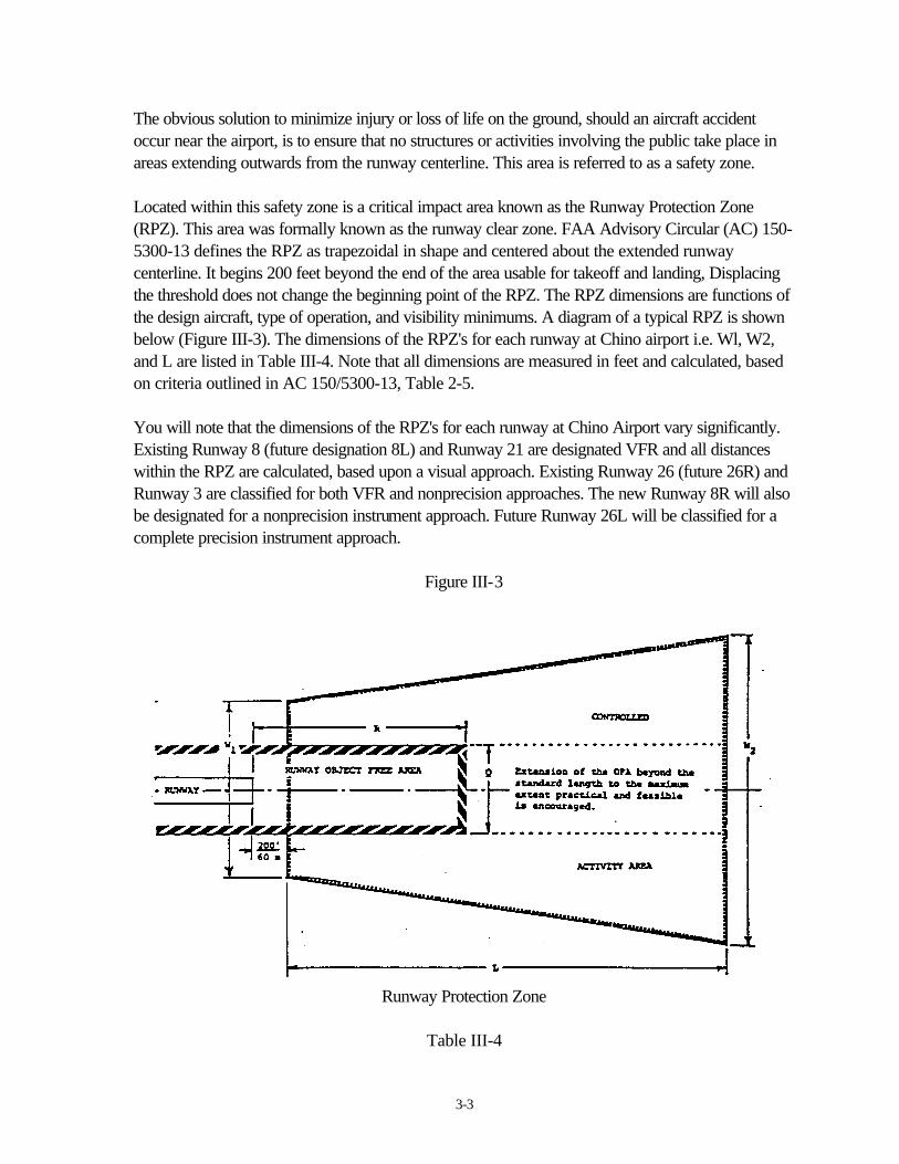
Located within this safety zone is a critical impact area known as the Runway Protection Zone(RPZ). This area was formally known as the runway clear zone. FAA Advisory Circular (AC) 150-5300-13 defines the RPZ as trapezoidal in shape and centered about the extended runwaycenterline. It begins 200 feet beyond the end of the area usable for takeoff and landing, Displacingthe threshold does not change the beginning point of the RPZ. The RPZ dimensions are functions ofthe design aircraft, type of operation, and visibility minimums. A diagram of a typical RPZ is shownbelow (Figure III-3). The dimensions of the RPZ's for each runway at Chino airport i.e. Wl, W2,and L are listed in Table III-4. Note that all dimensions are measured in feet and calculated, basedon criteria outlined in AC 150/5300-13, Table 2-5.
You will note that the dimensions of the RPZ's for each runway at Chino Airport vary significantly.Existing Runway 8 (future designation 8L) and Runway 21 are designated VFR and all distanceswithin the RPZ are calculated, based upon a visual approach. Existing Runway 26 (future 26R) andRunway 3 are classified for both VFR and nonprecision approaches. The new Runway 8R will alsobe designated for a nonprecision instrument approach. Future Runway 26L will be classified for acomplete precision instrument approach.
Figure III-3
Runway Protection Zone
Table III-4

3-4
Dimensions for Approach End RPZRunway End
LengthL
InnerWidth
W1
OuterWidth
W2
Area(acres)
26L (Future) 2,500 1,000 1,750 78.914 8R (Future) 1,700 1,000 1,425 47.32026L (Future) 1,700 500 1,010 29.465 3 1,700 500 1,010 29.465 8L (Future) 1,000 500 700 13.77021 1,000 500 700 13.770
Also located within the RPZ is a two dimensional ground area known as the runway Object FreeArea (OFA. The runway OFA clearing standards precludes parked airplanes and objects, exceptfor those objects whose location is fixed by function For runways 8L and 21, the OFA extends fora distance of 600 feet from the end of each runway at a width of 500 feet. The OFA of all otherexisting and future runways at Chino Airport are 800 feet in width and 1,000 feet in length, beyondthe end of each runway.
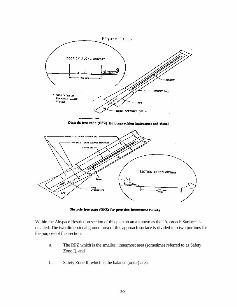
Supplementing the RPZ is an Obstacle Free Zone (OFZ). Figure III-5 diagrammatically shows thedifference between the OFZ's for precision instrument and nonprecision instrument/visual runways.The OFZ is a three dimensional volume of airspace which supports the transition of ground toairborne aircraft operations (and vice versa). The OFZ clearing standards preclude taxiing andparked airplanes and object penetrations except for frangible NAVAID's whose location is fixed byfunction The runway OFZ and the inner approach OFZ comprise the overall OFZ of ChinoAirport.
At all airports, the combined, runway and inner-approach OFZ extends for a distance of 200 feetbeyond each end of each runway in a rectangular shape. At Chino Airport, the width of the OFZ is400 feet for Runway 26L and 250 feet for all other existing and future runways.
3-5
Within the Airspace Restriction section of this plan an area known as the "Approach Surface" isdetailed. The two dimensional ground area of this approach surface is divided into two portions forthe purpose of this section:
a. The RPZ which is the smaller , innermost area (sometimes referred to as SafetyZone I), and
b. Safety Zone II, which is the balance (outer) area.
3-6
Safety Zone II: Also referred to as the Outer Safety Zone, the center of which, runs along animaginary projection of the runway centerline. While conforming with the shape of the FAA Part 77Approach Surface, a variance in shape is suggested to incorporate any major flight track emanatingfrom the primary departure runway in order to protect areas regularly overflown by departingaircraft.
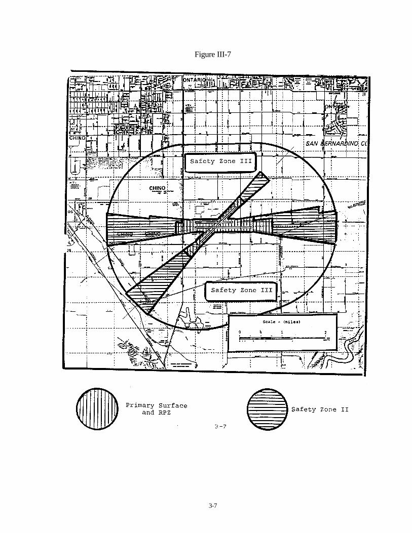
Safety Zone III: This zone is also known as the Traffic Pattern/Overflight Zone. The traffic patternfor general aviation airports is the envelope of aircraft flight paths associated with the pattern entrypoint, downwind, base, and final legs, while the overflight area is the larger area where aircraft aremaneuvering to enter the pattern for landing. The flight pattern altitude at Chino Airport is 1,400 feetMSL (750 feet above ground level) for reciprocating engine aircraft and 2,000 feet MSL for jetaircraft. This area is also detailed within the Airspace Restriction section of this ACLUP under"Horizontal Surface".
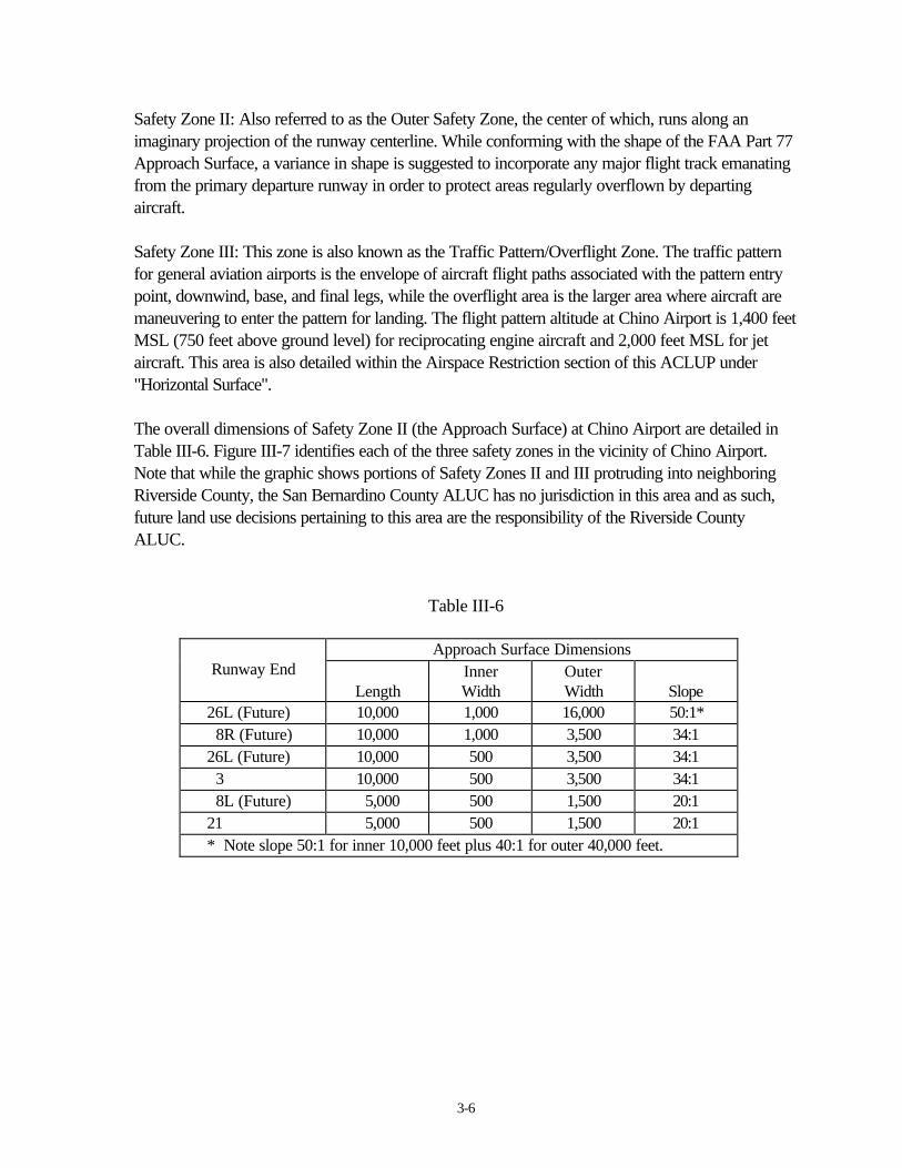
The overall dimensions of Safety Zone II (the Approach Surface) at Chino Airport are detailed inTable III-6. Figure III-7 identifies each of the three safety zones in the vicinity of Chino Airport.Note that while the graphic shows portions of Safety Zones II and III protruding into neighboringRiverside County, the San Bernardino County ALUC has no jurisdiction in this area and as such,future land use decisions pertaining to this area are the responsibility of the Riverside CountyALUC.
Table III-6
Approach Surface DimensionsRunway End
LengthInnerWidth
OuterWidth Slope
26L (Future) 10,000 1,000 16,000 50:1* 8R (Future) 10,000 1,000 3,500 34:126L (Future) 10,000 500 3,500 34:1 3 10,000 500 3,500 34:1 8L (Future) 5,000 500 1,500 20:121 5,000 500 1,500 20:1* Note slope 50:1 for inner 10,000 feet plus 40:1 for outer 40,000 feet.
3-7
Figure III-7
3-8
Land Uses and Population Densities
a) Runway Protection Zone:
FAA AC 150/5300-13 identifies a controlled activity area (Figure III-3) as the portion of the RPZbeyond the sides of the OFA. Within the area under the control of the airport authority, thefollowing standards shall be implemented.
The airport owner shall acquire or control the RPZ to meet the clearing and land use standards.
i. Land uses shall be prohibited which might create glare and misleading lights or lead to theconstruction of residences, fuel handling and storage facilities, smoke generating activities,and places of assembly. Churches, schools, office buildings, shopping centers, and stadiumstypify places of public assembly.
ii. While it is desirable to clear all objects from the RPZ, uses such as agricultural operations,provided they do not attract birds, and golf courses are normally acceptable outside of theOFA. Automobile parking, although discouraged, may be permitted provided it is locatedoutside of the runway OFA extended and below the approach surface.
Note: The FAA studies existing and proposed, objects and activities, both off and on airports, withrespect to their effect upon the safe and efficient use of the airports and the safety of persons andproperty on the ground. These objects need not be obstructions to air navigation, as defined in FARPart 77. As a result of a study, the FAA may issue an advisory recommendation in opposition to thepresence of any off-airport object or activity in the vicinity of the airport that conflicts with an airportplanning or design standard or recommendation (AC 150/5300-13 paragraph 212).
b) Safety Zone II:
Residential land use should be strongly discouraged and other land uses restricted. Densityrestrictions are needed to ensure that large concentrations of people are not located within thissafety zone. Recommended density limits are as follows:
- uses in structures: no more than 25 persons per acre at any one time; no more than15 people in any one building.
- uses not in structures; no more than 50 persons per acre at any one time.
3-9
c) Safety Zone III:
Generally, ALUC's place few restrictions on residential uses within this area. Strong emphasis is stillplaced on limiting large assemblies of people in uses such as:
HospitalsStadiums and arenasAuditoriums and concert hallsOutdoor amphitheaters and music shellsRegional shopping centersJails and detention centers
Additionally, land use activities which may present visual, electronic, or physical hazards to aircraftin flight should be avoided in this and all other safety zones. Visual hazards include distracting lights(particularly lights which can be confused with airfield lights), glare, and sources of smoke.Electronic hazards include any uses which interfere with aircraft radio communications. The principalphysical hazards, other than the height of structures, are bird strikes/Any land use which can attractbirds should be avoided. Particularly inappropriate uses are artificial attractors and sanitary landfills.
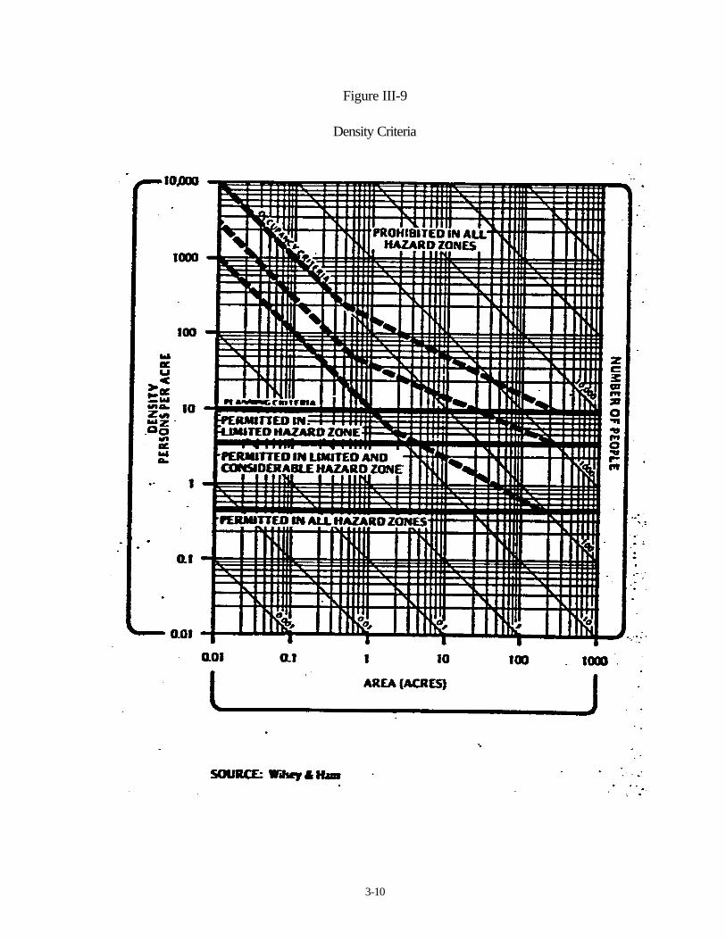
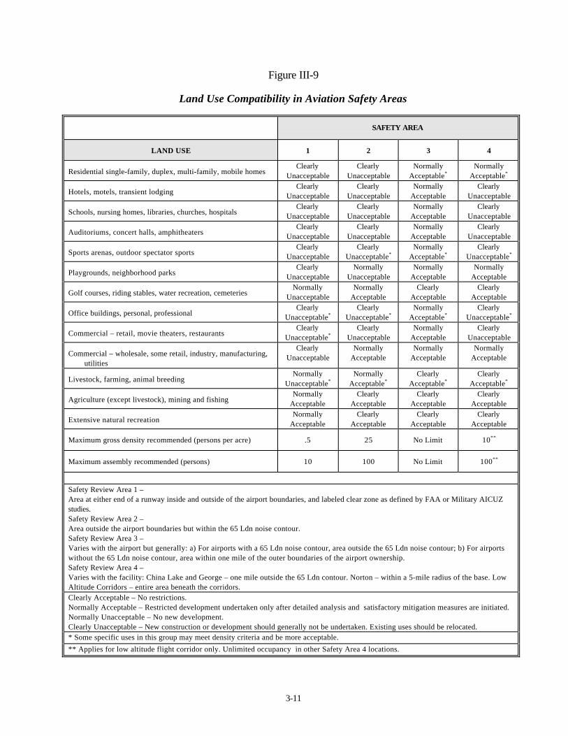
The San Bernardino County General Plan - Man Made Hazards, contains suggested density criteria(Figure III-8) with air safety zone and land use suitability matrixes, along with otherrecommendations and standards. A departmental review of all residential development that exceedsa density of two dwelling units per gross acre is also required. Figure III-9 (Land Use Compatibilityin Aviation Safety Areas) was also sourced from the San Bernardino County General Plan.
3-10
Figure III-9
Density Criteria
3-11
Figure III-9
Land Use Compatibility in Aviation Safety Areas
SAFETY AREA
LAND USE 1 2 3 4
Residential single-family, duplex, multi-family, mobile homesClearly
UnacceptableClearly
UnacceptableNormally
Acceptable*Normally
Acceptable*
Hotels, motels, transient lodgingClearly
UnacceptableClearly
UnacceptableNormally
AcceptableClearly
Unacceptable
Schools, nursing homes, libraries, churches, hospitalsClearly
UnacceptableClearly
UnacceptableNormally
AcceptableClearly
Unacceptable
Auditoriums, concert halls, amphitheatersClearly
UnacceptableClearly
UnacceptableNormally
AcceptableClearly
Unacceptable
Sports arenas, outdoor spectator sportsClearly
UnacceptableClearly
Unacceptable*Normally
Acceptable*Clearly
Unacceptable*
Playgrounds, neighborhood parksClearly
UnacceptableNormally
UnacceptableNormally
AcceptableNormally
Acceptable
Golf courses, riding stables, water recreation, cemeteriesNormally
UnacceptableNormally
AcceptableClearly
AcceptableClearly
Acceptable
Office buildings, personal, professionalClearly
Unacceptable*Clearly
Unacceptable*Normally
Acceptable*Clearly
Unacceptable*
Commercial – retail, movie theaters, restaurantsClearly
Unacceptable*Clearly
UnacceptableNormally
AcceptableClearly
Unacceptable
Commercial – wholesale, some retail, industry, manufacturing,utilities
ClearlyUnacceptable
NormallyAcceptable
NormallyAcceptable
NormallyAcceptable
Livestock, farming, animal breedingNormally
Unacceptable*Normally
Acceptable*Clearly
Acceptable*Clearly
Acceptable*
Agriculture (except livestock), mining and fishingNormally
AcceptableClearly
AcceptableClearly
AcceptableClearly
Acceptable
Extensive natural recreationNormally
AcceptableClearly
AcceptableClearly
AcceptableClearly
Acceptable
Maximum gross density recommended (persons per acre) .5 25 No Limit 10**
Maximum assembly recommended (persons) 10 100 No Limit 100**
Safety Review Area 1 –Area at either end of a runway inside and outside of the airport boundaries, and labeled clear zone as defined by FAA or Military AICUZstudies.Safety Review Area 2 –Area outside the airport boundaries but within the 65 Ldn noise contour.Safety Review Area 3 –Varies with the airport but generally: a) For airports with a 65 Ldn noise contour, area outside the 65 Ldn noise contour; b) For airportswithout the 65 Ldn noise contour, area within one mile of the outer boundaries of the airport ownership.Safety Review Area 4 –Varies with the facility: China Lake and George – one mile outside the 65 Ldn contour. Norton – within a 5-mile radius of the base. LowAltitude Corridors – entire area beneath the corridors.Clearly Acceptable – No restrictions.Normally Acceptable – Restricted development undertaken only after detailed analysis and satisfactory mitigation measures are initiated.Normally Unacceptable – No new development.Clearly Unacceptable – New construction or development should generally not be undertaken. Existing uses should be relocated.* Some specific uses in this group may meet density criteria and be more acceptable.
** Applies for low altitude flight corridor only. Unlimited occupancy in other Safety Area 4 locations.
3-12
Airspace Restrictions
Federal Rule 14 CFR Part 77* clearly establishes criteria for height restrictions in the vicinity ofairports. In addition it notices requirements for construction that could impact airspace anywherewithin the County. All ALUC's base height limitations on FAR Part 77 and San Bernardino Countyhas adopted Part 77 standards into its General Plan**, which shall be applicable to this ACLUP.
Height restrictions are necessary to protect ; navigable airspace required for safe air operations.California's airport land use planning laws further attempt to effectively mitigate the potential threatto the public's safety and welfare that could be caused by incidents in conflict with structures thatimpose into the states airspace.
Specifically impacting all decisions on airspace located within the vicinity of the Chino Airport, is thefact that most operations at Chino Airport are conducted on a Visual Flight Rule (VFR) basis. It iscommon for pilots flying VFR to navigate by using visual references such as freeways and railroadlines etc. The combination of these visual reference points and in some cases electronic navigationalaids, forms a network of VFR "flyways". The safety of aircraft operations along these flyways ismost effected by tall structures when weather is marginal. It is during these conditions that pilotsmust fly at low altitudes to remain in visual contact with the ground. The potential threat of tallstructures to aviation is obviously compounded, during marginal weather, when an aircraft isoperated under Instrument Flight Rules (IFR).
It is important to note that Part 77 obstruction standards, which are used by ALUC's as heightlimits, are used by the FAA in quite a different manner. These standards identify elevations abovewhich air safety may be a problem subject to further review on a case by case basis. If a determin-ation is made indicating a hazard to air navigation, the FAA's authority ceases -at this point. It isthen up to the local zoning agencies to enforce the FAA recommendations and relieve the safetyproblem. The standards'attempt to provide a reasonable and defensible balance between the needsof the airspace users and the rights of the property owners beneath the flight patterns.
* Appendix "C" - FAR Part 77.
** San Bernardino County - General Plan Update Background report, Man MadeHazards - Airport Safety Issue

3-13
The standards applicable, in FAR Part 77, as they relate to Chino Airport and the surroundingregion, are divided into two principal elements, vis:- notice requirements and obstruction standards.
1) Notice Requirements: FAR Part 77.11 through 77.19.
This section requires that each person proposing any kind of construction or alteration, as describedbelow, notify the FAA administrator of their intentions. This section also specifies the procedure fornotification and details some exceptions.
Minimum notice requirements:
Any construction or alteration of:
- more than 200 feet in height above the ground level at its site, and/or
- a greater height than an imaginary surface extending outward and upward at a slope of100 to 1 for a horizontal distance of 20,000 feet from the nearest point of the nearestrunway, example Figure III-10
Figure III-10
Notice requirements related to airports.
3-14
2) Obstruction standards: FAR Part 77.21 through 77.25.
This section establishes standards for determining obstructions to air navigation. It applies to existingand proposed manmade objects, objects of natural growth, and terrain. The standards apply to theuse of navigational airspace by aircraft and to existing air navigation facilities, such as an airnavigation id, airport, Federal airway, instrument approach or departure procedure, or approvedfacility or use, or a change in an existing facility or use.
Obstruction planning criteria is established by the use of imaginary surfaces, formulated to conformwith the size and use of any particular airport. The imaginary surfaces determined by FAR Part77.25 and applicable to Chino Airport are as follows:
a) Primary Surface: A surface longitudinally centered along the runway, extending 200feet beyond each end of the paved runway and having a width of 50O feet for allother existing and future runways at Chino Airport. Note that the elevation of anypoint on the primary surface is the same as the elevation of the nearest point on therunway centerline.
b) Horizontal Surface: A horizontal plane 150 feet above the established airportelevation, the perimeter of which is constructed by swinging an arc 10,000 feet outfrom the center of each end of the primary surface of each runway at Chino (exceptrunways 8L and 21 ) and connecting the adjacent arcs of lines tangent to these arcs.
c) Approach Surface: A surface longitudinally centered on the extended runwaycenterline and extending outward and upward from each end of the primary surface.The approach surface dimensions are shown in Table III-6.
d) Transitional Surface: These surfaces extend outward and upward at right angles tothe runway centerline and the runway centerline extended at a slope of 7 to 1 fromthe sides of the primary surface and from the sides of the approach surface.Transitional surfaces for those portions of the precision approach surface whichproject through and beyond the limits of the conical surface, extended a distance of5,000 feet measured horizontally from the edge of the approach surface and at rightangles to the runway centerline.
3-15
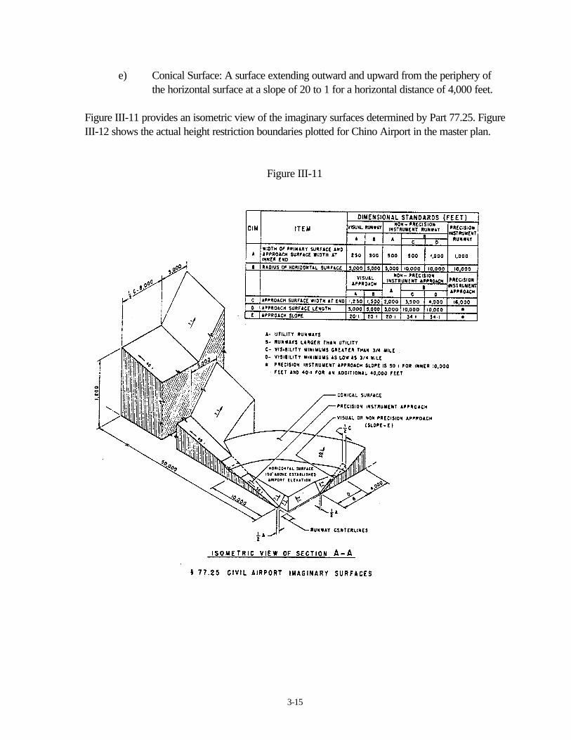
e) Conical Surface: A surface extending outward and upward from the periphery ofthe horizontal surface at a slope of 20 to 1 for a horizontal distance of 4,000 feet.
Figure III-11 provides an isometric view of the imaginary surfaces determined by Part 77.25. FigureIII-12 shows the actual height restriction boundaries plotted for Chino Airport in the master plan.
Figure III-11

OTHER IMPACTS
and
ENVIRONMENTAL REVIEW
4-1
OTHER IMPACTS
For the purposes of this CLUP, specifically within the scope of the Airport Land Use Planning Law,no other impacts, apart from those identified herein, were found to impact the area surrounding theChino Airport. No ground access problems are anticipated at the airport, provided that the futureuses of the airport, remain within the context of the airport master plan.
ENVIRONMENTAL REVIEW
An Environmental Impact Report (E.I.R.) covering all aspects of the future operations of the airport,as projected within the 1986 Airport Master Plan, was Cprepared in May 1988. This E.I.R. wasadopted by the j San Bernardino County ALUC in May 1989.
An initial environmental review of this CLUP indicates that this plan (project) will not have anyimpact on the environment. While the recommendations/policies included within this CLUP dorequire the amendment of zoning ordinances, no physical changes to the environment will result as aconsequence of implementation of this plan which is either restrictive or consistent with existingzoning.
The provisions of Article 6 of the California Environmental Quality Act, Section 15070 (a) Quote"The initial study shows that there is no substantial evidence that the project may have a significanteffect on the environment" end quote, have clearly been met. As such, a Negative Declaration iswarranted.
APPENDIX “A”
State Aeronautics Act
Public Utilities Code Section 21670

A-1
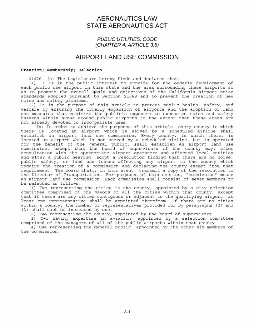
AERONAUTICS LAW STATE AERONAUTICS ACT
PUBLIC UTILITIES. CODE
(CHAPTER 4, ARTICLE 3.5)
AIRPORT LAND USE COMMISSION Creation; Membership; Selection
21670. (a) The Legislature hereby finds and declares that: (1) It is in the public interest to provide for the orderly development of each public use airport in this state and the area surrounding these airports so as to promote the overall goals and objectives of the California airport noise standards adopted pursuant to Section 21669 and to prevent the creation of new noise and safety problems. (2) It is the purpose of this article to protect public health, safety, and welfare by ensuring the orderly expansion of airports and the adoption of land use measures that minimize the public’s exposure to excessive noise and safety hazards within areas around public airports to the extent that these areas are not already devoted to incompatible uses. (b) In order to achieve the purposes of this article, every county in which there is located an airport which is served by a scheduled airline shall establish an airport land use commission. Every county, in which there, is located an airport which is not served by a scheduled airline, but is operated for the benefit of the general public, shall establish an airport land use commission, except that the board of supervisors of the county may, after consultation with the appropriate airport operators and affected local entities and after a public hearing, adopt a resolution finding that there are no noise, public safety, or land use issues affecting any airport in the county which require the creation of a commission and declaring the county exempt from that requirement. The board shall, in this event, transmit a copy of the resolution to the Director of Transportation. For purposes of this section, “commission” means an airport land use commission. Each commission shall consist of seven members to be selected as follows: (1) Two representing the cities in the county, appointed by a city selection committee comprised of the mayors of all the cities within that county, except that if there are any cities contiguous or adjacent to the qualifying airport, at least one representative shall be appointed therefrom. If there are no cities within a county, the number of representatives provided for by paragraphs (2) and (3) shall each be increased by one. (2) Two representing the county, appointed by the board of supervisors. (3) Two having expertise in aviation, appointed by a selection committee comprised of the managers of all of the public airports within that county. (4) One representing the general public, appointed by the other six members of the commission.

A-2
(c) Public officers, whether elected or appointed, may be appointed and serve as members of the commission during their terms of public office. (d) Each member shall promptly appoint a single proxy to represent him or her in commission affairs and to vote on all matters when the member is not in attendance. The proxy shall be designated in a signed written instrument which shall be kept on file at the commission offices, and the proxy shall serve at the pleasure of the appointing member. A vacancy in the office of proxy shall be filled promptly by appointment of a new proxy. (e) A person having an “expertise in aviation: means a person who, by way of education, training, business, experience, vocation, or avocation has acquired and possesses particular knowledge of, and familiarity with, the function, operation, and role of airports, or is an elected official of a local agency which owns or operates an airport. The commission shall be constituted pursuant to this section on and after March 1, 1988. Action by Designated Body Instead of Commission 21670.1. (a) Notwithstanding any other provision of this article, if the board of supervisors and the city selection committee of mayors in the county each makes a determination by a majority vote that proper land use planning can be accomplished through the actions of an appropriately designated body, then the body so designated shall assume the planning responsibilities of an airport land use commission as provided for in this article, and a commission need not be formed in that county. (b) A body designated pursuant to subdivision (a) which does not include among its membership at least two members having an expertise in aviation, as defined in subdivision (e) of Section 21670, shall, when acting in the capacity of an airport land use commission, be augmented so that the body, as augmented, will have at least two members having that expertise. The commission shall be constituted pursuant to this section on and after March 1, 1988. Applicability to Los Angeles County 21670.2. (a) Sections 21670 and 21670.1 do not apply to the County of Los Angeles. In that county, the county regional planning commission has the responsibility for coordinating the airport planning of public agencies within the county. In instances where impasses result relative to this planning, an appeal may be made to the county regional planning commission by any public agency involved. The action taken by the county regional planning commission on such an appeal may be overruled by a four-fifths vote of the governing body of a public agency whose planning led to the appeal. (b) By January 1, 1992, the county regional planning commission shall adopt the comprehensive land use plans required pursuant to Section 21675. (c) Sections 21675.1, 21675.2, and 21679.5 do not apply to the County of Los Angeles until January 1, 1992. If the comprehensive land use plans required pursuant to Section 21675 are not adopted by the county regional planning commission by January 1, 1992, Sections 21675.1 and 21675.2 shall apply to the County of Los Angeles until the plans are adopted.

A-3
Airport Owned by a City, District, or County; Appointment of Certain Members by Cities and Counties 21671. In any county where there is an airport operated for the general public which is owned by a city or district in another county or by another county, one of the representatives provided by paragraph (1) of subdivision (b) of Section 21670 shall be appointed by the city selection committee of mayors of the cities of the county in which the owner of that airport is located, and one of the representatives provided by paragraph (2) of subdivision (b) of Section 21670 shall be appointed by the board of supervisors of the county in which the owner of that airport is located. Term of office; Removal of Members; Vacancies; Compensation; Staff Assistance; Meetings 21671.5 (a) Except for the terms of office of the members of the first commission, the term of office of each member shall be four years and until the appointment and qualification of his or her successor. The members of the first commission shall classify themselves by lot so that the term of office of one member is one year, of two members is two years, of two members is three years, and of two members is four years. The body which originally appointed a member whose term has expired shall appoint his or her successor for a full term of four years. Any member may be removed at any time and without cause by the body appointing him or her. The expiration date of the term of office of each member shall be the first Monday in May in the year in which his or term is to expire. Any vacancy in the membership of the commission shall be filled for the unexpired term by appointment by the body which originally appointed the member whose office has become vacant. The chairperson of the commission shall be selected by the members thereof. (b) Compensation, if any, shall be determined by the board of supervisors. (c) Staff assistance, including the mailing of notices and the keeping of minutes, and necessary quarters, equipment, and supplies shall be provided by the county. The usual and necessary operating expenses of the commission shall be a county charge. (d) Notwithstanding any other provisions of this article, the commission shall not employ any personnel either as employees or independent contractors without the prior approval of the board of supervisors. (e) The commission shall meet at the call of the commission chairperson or at the request of the majority of the commission members. A majority of the commission members shall constitute a quorum for the transaction of business. No action shall be taken by the commission except by the recorded vote of a majority of the full membership. (f) The commission may establish a schedule of fees for reviewing and processing proposals and for providing the copies of land use plans, as required by subdivision (d) of Section 21675. Those fees shall be charged to the proponents of actions, regulations, or permits, shall not exceed the estimated reasonable cost of providing the service, and shall be imposed pursuant to Chapter 13 (commencing with Section 54990) of Part I of Division 2 of Title 5 of the Government Code. After June 30, 1991, a commission which has not adopted the comprehensive land use plan required by Section 21675 shall not charge fees pursuant to this subdivision until the commission adopts the plan.
A-4
Rules and Regulations 21672. Each commission shall adopt rules and regulations with respect to the temporary disqualification of its members from participating in the review or adoption of a proposal because of conflict of interest and with respect to appointment of substitute members in such cases. Initiation of proceedings for Creation by Owner of Airport 21673. In any county not having a commission or a body designated to carry out the responsibilities of a commission, any owner of a public airport may initiate proceedings for the creation of a commission by presenting a request to the board of supervisors that a commission be created and showing the need therefor to the satisfaction of the board of supervisors. Powers and Duties 21674. The commission has the following powers and duties, subject to the limitations upon its jurisdiction set forth in Section 21676: (a) To assist local agencies in ensuring compatible land uses in the vicinity of all new airports and in the vicinity of existing airports to the extent that the land in the vicinity of those airports is not already devoted to incompatible uses. (b) To coordinate planning at the state, regional, and local levels so as to provide for the orderly development of air transportation, while at the same time protecting the public health, safety, and welfare. (c) To prepare and adopt an airport land use plan pursuant to Section 21675. (d) To review the plans, regulations, and other actions of local agencies and airport operators pursuant to Section 21676. (e) The powers of the commission shall in no way be construed to give the commission jurisdiction over the operation of any airport. (f) In order to carry out its responsibilities, the commission may adopt rules and regulations consistent with this article. Land Use Plan 21675. (a) Each commission shall formulate a comprehensive land use plan that will provide for the orderly growth of each public airport and the area surrounding the, airport within the jurisdiction of the commission, and will safeguard the general welfare of the inhabitants within the vicinity of the airport and the public in general. The commission plan shall include and shall be based on a long-range master plan or an airport layout plan, as determined by the Division of Aeronautics of the Department of Transportation, that reflects the anticipated growth of the airport during at least the next 20 years. In formulating a land use plan, the commission may develop height restrictions on buildings, specify use of land, and determine building standards, including soundproofing adjacent to airports, within the planning area. The comprehensive land use plan shall be reviewed as often as necessary in order to accomplish its purposes, but shall not be amended more than once in any calendar year. (b) The commission may include, within its plan formulated pursuant to subdivision (a), the area within the jurisdiction of the commission surrounding and federal military airport for all of the purposes specified in subdivision (a). This subdivision does not give the commission any jurisdiction or authority over the territory or operations of any military airport.
A-5
(c) The planning boundaries shall be established by the commission after hearing and consultation with the involved agencies. (d) The commission shall submit to the Division of Aeronautics of the department one copy of the plan and each amendment to the plan. (e) If a comprehensive land use plan does not include the matters required to be included pursuant to this article, the Division of Aeronautics of the department shall notify the commission responsible for the plan. Date of adoption; review of actions; approval or disapproval 21675.1. (a) By June 30, 1991, each commission shall adopt the comprehensive land use plan required pursuant to Section 21675. (b) Until a commission adopts a comprehensive land use plan, a city or county shall first submit all actions regulations and permits within the vicinity of a public airport to the commission for review and approval. Before the commission approves or disapproves any actions, regulations, or permits, the commission shall give public notice in the same manner as the city or county is required to give for those actions, regulations, or permits. As used in this section, “vicinity” means land which will be included or reasonably could be included within the plan. If the commission has not designated a study area for the plan, then “vicinity” means land within two miles of the boundary of a public airport. (c) The commission may approve an action, regulation, or permit if it finds, based on substantial evidence in the record, all of the following: (1) The commission is making substantial progress toward the completion of the plan. (2) There is a reasonable probability that the action, regulation, or permit will be consistent with the plan being prepared by the commission. (3) There is little or no probability of substantial detriment to or interference with the future adopted plan if the action, regulation, or permit is ultimately inconsistent with the plan. (d) If the commission disapproves an action, regulation, or permit, the commission shall notify the city or county. The city or county may overrule the commission, by a two-thirds vote of its governing. body, if it makes specific findings that the proposed action, regulation, or permit is consistent with the purposes of this article, as stated in Section 21670. (e) If a city or county overrules the commission pursuant to subdivision (d), that action shall not relieve the city or county from further compliance with this article after the commission adopts the plan. (f) If a city or county overrules the commission pursuant to subdivision (d) with respect to a publicly owned airport that the city or county does not operate, the operator of the airport shall be immune from liability for damages to property or personal injury from the city’s or county’s decision to proceed with the action, regulation, or permit. (g) A commission may adopt rules and regulations which exempt any ministerial permit for single-family dwellings from the requirements of subdivision (b) if it makes the findings required pursuant to subdivision (c) for the proposed rules and regulations, except that the rules and regulations may not exempt either of the following: (1) More than two single-family dwellings by the same applicant within a subdivision prior to June 30, 1991. (2) Single-family dwellings in a subdivision where 25 percent or more of the parcels are undeveloped.
A-6
Failure to Approve or Disapprove 21675.2. (a) If a commission fails to act to approve or disapprove any actions, regulations, or permits within 60 days of receiving the request pursuant to Section 21675.1, the applicant or his or her representative may file an action pursuant to Section 1094.5 of the Code of Civil Procedure to compel the commission to act, and the court shall give the proceedings preference over all other actions or proceedings, except previously filed pending matters of the same character. (b) The action, regulation, or permit shall be deemed approved only if the public notice required by this subdivision has occurred. If the applicant has provided seven days advance notice to the Commission of the intent to provide public notice pursuant to this subdivision, then, not earlier than the date of the expiration of the time limit established by Section 21675.1, an applicant may provide the required public notice. If the applicant chooses to provide public notice, that notice shall include a description of the proposed action, regulation, or permit substantially similar to the descriptions which are commonly used in public notices by the commission, the location of any proposed development, the application number, the name and address of the commission, and a statement that the action, regulation, or permit shall be deemed approved if the commission has not acted within 60 days. If the applicant has provided the public notice specified in this subdivision, the time limit for action by the commission shall be extended to 60 days after the public notice is provided. If the applicant provides notice pursuant to this section, the commission shall refund to the applicant any fees which were collected for providing notice and which were not used for that purpose. (c) Failure of an applicant to submit complete or adequate information pursuant to Sections 65943 to 65946, inclusive, of the Government Code, may constitute grounds for disapproval of actions, regulations, or permits. (d) Nothing in this section diminishes the commission’s legal responsibility to provide, where applicable, public notice and hearing before acting on an action, regulation, or permit. Review of Local General Plans 21676. (a) Each local agency whose general plan includes areas covered by an airport land use commission plan shall, by July 1, 1983, submit a copy of its plan or specific plans to the airport land use commission. The commission shall determine by August 31, 1983, whether the plan or plans are consistent or inconsistent with the commission’s plan. If the plan or plans are inconsistent with the commission’s plan, the local agency shall be notified and that local agency shall have another hearing to reconsider its plans. The local agency may overrule the commission after such hearing by a two-thirds vote of its governing body if it makes specific findings that the proposed action is consistent with the purposes of this article stated in Section 21670. (b) Prior to the amendment of a general plan or specific plan, or the adoption or approval of a zoning ordinance or building regulation within the planning boundary established by the airport land use commission pursuant to Section 21675, the local agency shall first refer the proposed action to the commission. If the commission determines that the proposed action is inconsistent with the commission’s plan, the referring agency shall be notified.

A-7
The local agency may, after a public hearing, overrule the commission by a two-thirds vote of its governing body if it makes specific findings that the proposed action is consistent with the purposes of this article stated in Section 21670. (c) Each public agency owning any airport within the boundaries of an airport land use commission plan shall, prior to modification of its airport master plan, refer such proposed change to the airport land use commission. If the commission determines that the proposed action is inconsistent with the commission’s plan, the referring agency shall be notified. The public agency may, after a public hearing, overrule the commission by a two-thirds vote of its governing body if it makes specific findings that the proposed action is consistent with the purposes df this article stated in Section 21670. (d) Each commission determination pursuant to subdivision (b) or (c) shall be made within 60 days from the date of referral of the proposed action. If a commission fails to make the determination within that period, the proposed action shall be deemed consistent with the commission’s plan. Review of Local Plans 21676.5. (a) If the commission finds that a local agency has not revised its general plan or specific plan or overruled the commission by a two-thirds vote of its governing body after making specific findings that the proposed action is consistent with the purposes of this article as stated in Section 21670, the commission may require that the local agency submit all subsequent actions, regulations, and permits to the commission for review until its general plan or specific plan is revised or the specific findings are made. If, in the determination of the commission, an action, regulation, or permit of the local agency is inconsistent with the commission plan, the local agency shall be notified and that local agency shall hold a hearing to reconsider its plan. The local agency may overrule the commission after the hearing by a two-thirds vote of its governing body if it makes specific findings that the proposed action is consistent with the purposes of this article as stated in Section 21670. (b) Whenever the local agency has revised its general plan or specific plan or has overruled the commission pursuant to subdivision (a), the proposed action of the local agency shall not be subject to further commission review, unless the commission and the local agency agree that individual projects shall be reviewed by the commission. Marin County Override Provisions 21677. Notwithstanding Section 21676, any public agency in the County of Marin may overrule the Marin County Airport Land Use Commission by a majority vote of its governing body. Airport Owner’s Immunity 21678. With respect to a publicly owned airport that a public agency does not operate, if the public agency pursuant to Section 21676 or 21676.5 overrides a commission’s action or recommendation, the operator of the airport shall be immune from liability for damages to property or personal injury caused by or resulting directly or indirectly from the public agency’s decision to override the commission’s action or recommendation.

A-8
Court Review 21679. (a) In any county in which there is no airport land use commission or other body designated to assume the responsibilities of an airport land use commission, or in which the commission, or other designated body has not adopted an airport land use plan, an interested party may initiate proceedings in a court of competent jurisdiction to postpone the effective date of a zoning change, a zoning variance, the issuance of a permit, or the adoption of a regulation by a local agency, which directly affects the use of land within one mile of the boundary of a public airport within the county. (b) The court may issue an injunction which postpones the effective date of the zoning change, zoning variance, permit, or regulation until the governing body of the local agency which took the action does one of the following: (1) In the case of an action which is a legislative act, adopts a resolution declaring that the proposed action is consistent with the purposes of this article stated in Section 21670. (2) In the case of an action which is not a legislative act, adopts a resolution making findings based on substantial evidence in the record that the proposed action is consistent with the purposes of this article stated in Section 21670. (3) Rescinds the action. (4) Amends its action to make it consistent with the purposes of this article stated in Section 21670, and complies with either paragraph (1) or (2) of this subdivision, whichever is applicable. (c) The court shall not issue an injunction pursuant to subdivision (b) if the local agency which took the action demonstrates that the general plan and any applicable specific plan of the agency accomplishes the purposes of an airport land use plan as provided in Section 21675. (d) An action brought pursuant to subdivision (a) shall be commenced within 30 days of the decision or within the appropriate time periods set by Section 21167 of the Public Resources Code, whichever is longer. (e) If the governing body of the local agency adopts a resolution pursuant to subdivision (b) with respect to a publicly owned airport that the local agency does not operate, the operator of the airport shall be immune from liability for damages to property or personal injury from the local agency’s decision to proceed with the zoning change, zoning variance, permit, or regulation. (f) As used in this section, “interested party” means any owner of land within two miles of the boundary of the airport or any organization with a demonstrated interest in airport safety and efficiency. Action to Postpone Effective Date of Zoning Change, Etc. 21679.5. (a) Until June 30, 1991, no action pursuant to Section 21679 to postpone the effective date of a zoning change, a zoning variance, the issuance of a permit, or the adoption of a regulation by a local agency, directly affecting the use of land within one mile of the boundary of a public airport, shall be commenced in any county in which the commission or other designated body has not adopted an airport land use plan, but is making substantial progress toward the completion of the plan.

A-9
(b) If a commission has been prevented from adopting the comprehensive land use plan by June 30, 1991, or if the adopted plan could not become effective, because of a lawsuit involving the adoption of the plan, the June 30, 1991, date in subdivision (a) shall be extended by the period of time during which the lawsuit was pending in a court of competent jurisdiction. (c) Any action pursuant to Section 21679 commented prior to January 1, 1990, in a county in which the commission or other designated body has not adopted an airport land use plan, but is making substantial progress toward the completion of the plan, which has not proceeded to final judgment, shall be held in abeyance until June 30, 1991. If the commission or other designated body adopts an airport land use plan on or before June 30, 1991 the action shall be dismissed. If the commission or other designated body does not adopt an airport land use plan on or before June 30, 1991 the plaintiff or plaintiffs may proceed with the action. (d) An action to postpone the effective date of a zoning change, a zoning variance, the issuance of a permit, or the adoption of a regulation by a local agency, directly affecting the use of land within one mile of the boundary of a public airport for which an airport land use plan has not been adopted by June 30, 1991, shall be commenced within 30 days of June 30, 1991, or within 30 days of the decision by the local agency, or within the appropriate time periods set by Section 21167 of the Public Resources Code, whichever date is later. Revised 4/20/90


APPENDIX “B”
California Administrative Code
Noise Standards
Title 21, Subchapter 6


TITLE 21 DIVISION OF AERONAUTICS § 5001 (Register 90, No. 10—3-10-90) (p. 219)
B-1
SUBCHAPTER 6. NOISE STANDARDS
Article 1. General 5000. Preamble.
The following rules and regulations are promulgated in accordance with Article 3, Chapter 4, Part 1, Division 9, Public Utilities Code (Regulation of Airports) to provide noise standards governing the operation of aircraft and aircraft engines for all airports operating under a valid permit issued by the Department of Transportation. These standards are based upon two separate legal grounds: (1) the power of airport proprietors to impose noise ceilings and other limitations on the use of the airport, and 2) the power of the state to act to an extent not prohibited by federal law. The regulations are designed to cause the airport proprietor, aircraft operator, local governments, pilots, and the department to work cooperatively to diminish noise problems. The regulations accomplish these ends by controlling and reducing the noise impact area in communities in the vicinity of airports. NOTE: Authority cited: Section 21669, Public Utilities Code. Reference: Sections 21669-21669.4, Public Utilities Code. HISTORY: 1. Amendment filed 2-20-90; operative 3-22-90 (Register 90, No. 10). 5001. Definitions.
The definitions in the following subsections apply to this subchapter. (a) Air Carrier: Air carrier is any aircraft operating pursuant to a federal certificate of
public convenience and necessity, including any certificate issued pursuant to 49 U.S.C. Section 1371 and any permit issued pursuant to 49 U.S.C. Section 1371.
(b) Aircraft Operator: Aircraft operator means the legal or beneficial owner of the aircraft with authority to control the aircraft utilization except where the aircraft is leased, the lessee is the operator.
(c) Airport Proprietor: Airport proprietor means the holder of an airport permit issued by the department pursuant to Article 3, Chapter 4, Part 1, Division 9, Public Utilities Code.
(d) Annual CNEL: The annual CNEL, in decibels, is the average (on an energy basis) of the daily CNEL over a 12-month period. The annual CNEL is calculated in accordance with the following:
Annual CNEL = 10 log10 [ (1 /365) Antilog (CNEL (i)/10) where CNEL(i) = the daily CNEL for each day in a continuous 12-month period, and means summation.
When the annual CNEL is approximated by measurements on a statistical basis, as specified in Section 5034, the number 365 is replaced by the number of days for which measurements are obtained.
(e) County: County, as used herein, shall mean the county board of supervisors or its designee authorized to exercise the powers and duties herein specified.

§ 5001 DIVISION OF AERONAUTICS TITLE 21 (p. 220) (Register 90, No. 103-10-90)
B-2
(f) Daily Community Noise Equivalent Level (CNEL): Community noise equivalent
level, in decibels, represents the average daytime noise level during a 24-hour day, adjusted to an equivalent level to account for the lower tolerance of people to noise during evening and night time periods relative to the day-time period. Community noise equivalent level is calculated from the hourly noise levels by the following:
CNEL = 10 log (1/24) [ antilog (HNLD/10) + 3 antilog (HNLE/10) + 10 antilog (HNLN/10)]
Where HNLD are the hourly noise levels for the period 0700-1900 hours; HNLE are the hourly noise levels for the period 1900-2200 hours; HNLN are the hourly noise levels for the period 2200-0700 hours; and means summation.
(g) Department: Department means the Department of Transportation of the State of California.
(h) General Aviation: General aviation aircraft are an aircraft other than air carrier aircraft and military aircraft.
(i) Hourly Noise Level (HNL): The hourly noise level, in decibels, is the average (on an energy basis) noise level during a particular hour. Hourly noise level is determined by subtracting 35.6 decibels (equal to 10 log10 3600) from the noise exposure level measured during the particular hour, integrating for those periods during which the noise level exceeds a threshold noise level.
For implementation in this subchapter of these regulations, the threshold noise level shall be a noise level which is 10 decibels below the numerical value of the appropriate Community Noise Equivalent Level (CNEL) standard specified in Section 5012. At some microphone locations, sources of noise other than aircraft may contribute to the CNEL. Where the airport proprietor can demonstrate that the accuracy of the CNEL measurement will remain within the required tolerance specified in Section 5070, the department may grant a waiver to increase the threshold noise level.
(j) Noise Exposure Level (NEL): The noise exposure level is the level of noise accumulated during a given event, with reference to a duration of one second. More specifically, noise exposure level, in decibels, is the level of the time-integrated A-weighted squared sound pressure for a stated time interval or event, based on the reference pressure of 20 micronewtons per square meter and reference duration of one second.
(k) Noise Impact Area: Noise impact area is the area within the noise impact boundary that is composed of incompatible land use.
(l) Noise Impact Boundary: Noise impact boundary is the locus of points around an airport for which the annual CNEL is equal to the airport noise standard established in Section 5012. The concepts of noise impact boundary and noise impact area are illustrated in Figure 1.
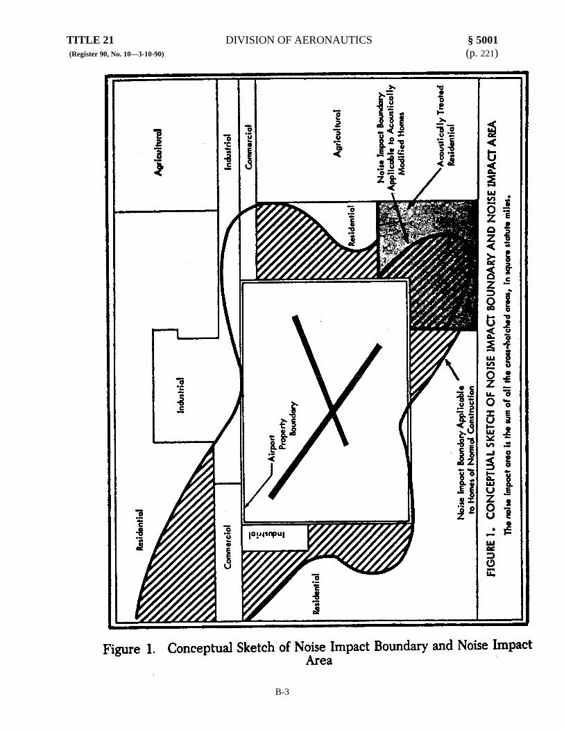
TITLE 21 DIVISION OF AERONAUTICS § 5001 (Register 90, No. 10—3-10-90) (p. 221)
B-3

§ 5002 DIVISION OF AERONAUTICS TITLE 21 (p. 222) (Register 90, No. 103-10-90)
B-4
(m) Noise Level (NL): Noise level is the measure in decibels of an A-weighted sound pressure level as measured using the slow dynamic characteristic for sound level meters specified in American National Standard Specification for Sound Level Meters, (ANSI S1.4-1983 as revised by ANSI Sl.4A-1985) which is hereby incorporated by reference. The A-weighting characteristic modifies the frequency response of the measuring instrument to account approximately for the frequency characteristics of the human ear. The reference pressure is 20 micronewtons/square meter (2 X 10⁻⁴ microbar).
(n) Noise Problem Airport: “Noise problem airport” is an airport that the county in which the airport is located has declared to have a noise problem under section 5020.
(o) Single Event Noise Exposure Level (SENEL): The single event noise exposure level, in decibels, is the noise exposure level of a single event, such as an aircraft flyby, measured over the time interval between the initial and final times for which the noise level of a single event exceeds a predetermined threshold noise level.
(p) Sound Pressure Level (SPL): The sound pressure level, in decibels (dB), of a sound is 20 times the logarithm to the base 10 of the ratio of the pressure of that sound to the reference pressure 20 micronewtons/ square meter (2 X 10⁻⁴ microbar). NOTE: Authority cited: Section 21669, Public Utilities Code. Reference: Sections 21669-21669.4, Public Utilities Code. HISTORY: 1. Renumbering and amendment of former Section 5001 to Section 5002, and renumbering and amendment of former Section 5006 to Section 5001 filed 2-20-90; operative 3-22-90 (Register 90, No. 10). For prior history, see Register 79, No. 21. 5002. Liberal Construction.
This subchapter shall be liberally construed and applied to promote its under-lying purposes which are to protect the resolve incompatibilities between airports and their surrounding neighbors. NOTE: Authority cited: Section 21669, Public Utilities Code. Reference: Sections 21669-21669.4, Public Utilities Code. HISTORY: 1. Renumbering of former Section 5002 to Section 5003, and renumbering of Section 5001 to Section 5002 filed 2-20-90; operative 3-22-90 (Register 90, No. 10). For prior history, see Register 79, No. 21. 5003. Constitutionality. If any provision of this subchapter or the application thereof to any person or circumstance is held to be unconstitutional, the remainder of the subchapter and the application of such provision to other persons or circumstances shall not be affected thereby. NOTE: Authority cited: Section 21669, Public Utilities Code. Reference: Sections 21669-21669.4, Public Utilities Code. HISTORY: 1. Renumbering of former Section 5003 to Section 5004, and renumbering of former Section 5002 to Section 5003 filed 2-20-90; operative 3-22-90 (Register 90, No. 10). For prior history, see Register 79, No. 21.

TITLE 21 DIVISION OF AERONAUTICS § 5006 (Register 90, No. 10—3-10-90) (p. 223)
B-5
5004. Provisions Not Exclusive. The provisions of this subchapter are not exclusive, and the remedies provided for in this
subchapter shall be in addition to any other remedies provided for in any other law or available under common law. It is not the intent of these regulations to preempt the field of aircraft noise limitation in the state. The noise limits specified herein are not intended to prevent any local government to the extent not prohibited by federal law or any airport proprietor from setting more stringent standard. NOTE: Authority. cited: Section 21669, Public Utilities Code. Reference: Sections 21669-21669.4, Public Utilities Code. HISTORY: 1. Renumbering and amendment of former Section 5004 to Section 5005, and renumbering of former Section 5003 to Section 5004 filed 2-20-90; operative 3-22-90 (Register 90, No. 10). For prior history, see Register 79, No. 21. 5005. Applicability.
These regulations establish to the extent not prohibited by Federal law a mandatory procedure which is applicable to all airports in California that are required to operate under a valid permit issued by the department. These regulations are applicable (to the extent not prohibited by Federal law) to all operations of aircraft and aircraft engines which produce noise.
The regulations established by this subchapter are not intended to set noise levels applicable in litigation arising out of claims for damages occasioned by noise. Nothing herein contained in these regulations shall be construed to be a duty of care in favor of, or to create any evidentiary presumption by, any person or entity other than the State of California, counties and airport proprietors in the enforcement of these regulations. NOTE: Authority cited: Section 21669, Public Utilities Code. Reference: Sections 21669-21669.4, Public Utilities Code. HISTORY: 1. Renumbering and amendment of former Section 5005 to Section 5006, and renumbering and amendment of former Section 5004 to Section 5005 filed 2-20-90; operative 3-22-90 (Register 90, No. 10). For prior history, see Register 79, No. 21. 5006. Findings.
Citizens residing in the vicinity of airports are exposed to the noise of aircraft operations. There have been numerous instances wherein individual citizens or organized citizen groups have complained about airport noise to various authorities. The severity of these complaints has ranged from a few telephone calls to organized legal action. Many of these cases have been studied by acoustics research workers under sponsorship of governmental and private organizations. These studies have generally shown that the severity the complaint is principally associated with a combination of the following factors:
(a) Magnitude and duration of the noise from aircraft operations; (b) Number of aircraft operations; and (c) Time of occurrence during the day (daytime, evening or night). There are many reasons given by residents for their complaints; however, those most
often cited are interference with speech communication, TV, and sleep. Numerous studies have been made related to speech interference and hearing damage, and some studies have been made related to sleep disturbance and other physiological effects. These studies provide substantial evidence for the relationship between noise level and its interference with speech communication and its effect relative to hearing loss. Significantly less information is available from the results of sleep and physiological studies.

§ 5010 DIVISION OF AERONAUTICS TITLE 21 (p. 224) (Register 90, No. 103-10-90)
B-6
In order to provide a systematic method for evaluating and eventually reducing noise incompatibilities in the vicinity of airports, it is necessary to quantify the noise problem. For this purpose, these regulations establish a procedure for defining a noise impact area surrounding an individual airport. The criteria and noise levels utilized to define the boundaries of the noise impact area have been based on existing evidence from studies of community noise reaction, noise interference with speech and sleep, and noise induced hearing loss.
One of the fundamental philosophies underlying the procedures in these regulations is that any noise quantity specified by these regulations be measurable by relatively simple means. Therefore, these regulations utilize as their basic measure the A-weighted noise level, which is the most commonly accepted simple measure. To insure consistency between criteria and measurement, the units for the criteria are also based on the A-weighted sound level rather than one of the several more complex perceived noise levels.
The level of noise acceptable to a reasonable person residing in the vicinity of an airport is established as a community noise equivalent level (CNEL) value of 65 dB for purposes of these regulations. This criterion level has been chosen for reasonable persons residing in urban residential areas where houses are of typical California construction and may have windows partially open. It has been selected with reference to speech, sleep and community reaction.
It is recognized that there is a considerable individual variability in the reaction to noise. Further, there are several factors that undoubtedly influence this variability and which are not thoroughly understood. Therefore, this criterion level does not have a degree of precision which is often associated with engineering criteria for a physical phenomenon (e.g., the strength of a bridge, building, et cetera). For this reason, the state will review the criterion periodically, taking into account any new information that might become available. NOTE: Authority cited: Sections 21243 and 21669, Public Utilities Code. Reference: Air Transport Association of America v. Crotti (N.D.Cal. 1975) 389 F.Supp. 58. HISTORY: 1. Renumbering and amendment of former Section 5006 to Section 5001, and renumbering and amendment of former Section 5005 to Section 5006 filed 2-20-90; operative 3-22-90 (Register 90, No. 10). For prior history, see Register 79, No. 21. 5010. Purpose.
The purpose of these regulations is to provide a positive basis to accomplish resolution of existing noise problems in communities surrounding airports and to prevent the development of new noise problems. To accomplish this purpose, these regulations establish a quantitative framework which the various interested parties (i.e., airport proprietors, aircraft operators, local communities, counties and the state) can work together cooperatively to reduce and prevent airport noise problems. NOTE: Authority cited: Section 21669, Public Utilities Code. Reference: Sections 21669-21669.4, Public Utilities Code. HISTORY: 1. Amendment filed 2-20-90; operative 3-22-90 (Register 90, No. 10). 5011. Methodology for Controlling and Reducing Noise Problems. HISTORY: 1. Renumbering and amendment of former Section 5011 to Section 5037 filed 2-20-90, operative 3-22-90 (Register 90, No. 10). For prior history, see Register 79, No. 21.
TITLE 21 DIVISION OF AERONAUTICS § 5014 (Register 90, No. 10—3-10-90) (p. 225)
B-7
5012. Airport Noise Standard. The standard for the acceptable level of aircraft noise for persons living in the vicinity of
airports is hereby established to be a community noise equivalent level of 65 decibels. This standard forms the basis for the following limitation.
No airport proprietor of a noise problem airport shall operate an airport with a noise impact area based on the standard of 65 dB CNEL unless the operator has applied for or received a variance as prescribed in Article 5 of this subchapter. NOTE: Authority cited: Section 21669, Public Utilities Code. Reference: Sections 21669-21669.4, Public Utilities Code. HISTORY: 1. Repealer of former Section 5012, and renumbering and amendment of former Section 5062 to Section 5012 filed 2-20-90; operative 3-22-90 (Register 90, No. 10). For prior history, see Register 79, No. 21. 5013. Noise Impact Boundary. HISTORY: 1. Repealer filed 2-20-90; operative 3-22-90 (Register 90, No. 10). 5014. Incompatible Land Uses Within the Noise Impact Boundary.
For the purpose of determining the size of the noise impact area, the following land uses are incompatible:
(a) Residences, including but not limited to, detached single-family dwelling, multi-family dwelling, high-rise apartments or condominiums, and mobile homes, unless:
(1) an avigation easement for aircraft noise has been acquired by the airport proprietor, or (2) the dwelling unit was in existence at the same location prior to January 1, 1989, and
has adequate acoustic insulation to ensure an interior CNEL due to aircraft noise of 45 dB or less in all habitable rooms. However, acoustic treatment alone does not convert residences having an exterior CNEL of 75 dB or greater due to aircraft noise to a compatible land use if the residence has an exterior normally occupiable private habitable area such as a backyard, patio, or balcony. Or,
(3) the residence is a high rise apartment or condominium having an interior CNEL of 45 dB or less in all habitable rooms due to aircraft noise, and an air circulation or air conditioning system as appropriate, or
(4) the airport proprietor has made a genuine effort as determined by the department in accordance with adopted land use compatibility plans and appropriate laws and regulations to acoustically treat residences exposed to an exterior CNEL less than 80 dB (75 dB if the residence has an exterior normally occupiable private habitable area such as a backyard, patio, or balcony) or acquire avigation easements, or both, for the residences involved, but the property owners have refused to take part in the program, or
(5) the residence is owned by the airport proprietor. (b) Public and private schools of standard construction for which an avigation easement
for noise has not been acquired by the airport proprietor, or that do not have adequate acoustic performance to ensure an interior CNEL of 45 dB or less in all classrooms due to aircraft noise;
(c) hospitals and convalescent homes for which an avigation easement for noise has not been acquired by the airport proprietor, or that do not have adequate acoustic performance to provide an interior CNEL of 45 dB or less due to aircraft noise in all rooms used for patient care;
§ 5015 DIVISION OF AERONAUTICS TITLE 21 (p. 226) (Register 90, No. 103-10-90)
B-8
(d) churches, synagogues, temples, and other places of worship for which an avigation easement for noise has not been acquired by the airport proprietor, or that do not have adequate acoustic performance to ensure an interior CNEL of 45 dB or less due to aircraft noise. NOTE: Authority cited: Sections 21243 and 21669, Public Utilities Code. Reference: Air Transport Association of America v. Crotti (N.D.Cal 1975) 389 F. Supp. 58. HISTORY: 1. Amendment filed 2-20-90; operative 3-22-90 (Register 90, No. 10). For prior history, see Registers 79, No. 21 and 78, No. 38. 5015. Changes in Airport Ownership or Control. NOTE: Authority cited: Section 21243, Public Utilities Code. Ref6rence: Sections 21669-21669.5, Public Utilities Code. HISTORY: 1. New section filed 5-30-78 as an emergency, effective upon filing (Register 78, No. 22). 2. Certificate of Compliance filed 9-22-78 (Register 78, No. 38). 3. Renumbering and amendment of former Section 5015 to Section 5090 filed 2-20-90; operative 3-22-90 (Register 90, No. 10).
Article 2. Implementation by Counties 5020. Designating Noise Problem Airport.
Any county may, at any time, in accordance with the procedure herein, declare any airport within its boundaries to have a noise problem, by adopting a resolution to this effect and forwarding it to this department. In making the determination, the county shall:
(a) Review relevant information, including but not limited to, the record of complaints made, and litigation filed, by residents of the area regarding airport related aircraft noise.
(b) Investigate the possible existence of a noise impact area. (c) Coordinate with and give due consideration to the recommendations of the applicable
airport land use commission established under section 21670 of the Public Utilities Code. (d) For an airport with joint use by both military and civilian aircraft operations, base its
finding only on civilian operations. NOTE. Authority cited: Section 21669, Public Utilities Code. Reference: Sections 21669-21669.4, Public Utilities Code. HISTORY: 1. Renumbering and amendment of former Section 5020 to Section 5032, and new Section 5020 filed 2-20-90; operative 3-22-90 (Register 90, No. 10). For prior history, see Register 78, No. 22. 5021. Review of Finding.
Any person or government agency shown, by the results of an investigation conducted under section 5020(b) or by independent competent evidence, to own, reside in, or have jurisdiction over any area within the 65 dB CNEL boundary of any airport may seek review of the finding of the county under section 5020 solely on the issue of substantial evidence by filing a petition to this effect with the department within 10 days of adoption of the finding. NOTE: Authority cited: Section 21669, Public Utilities Code. Reference: Sections 21669-21669.4, Public Utilities Code. HISTORY: 1. Repealer and new section filed 2-20-90; operative 3-22-90 (Register 90, No. 10). For prior history, see Register 78, No. 22.
TITLE 21 DIVISION OF AERONAUTICS § 5025 (Register 90, No. 10—3-10-90) (p. 226.1)
B-9
5022. County Enforcement. The county wherein a noise problem airport is situated shall enforce this subchapter.
NOTE: Authority cited: Section 21669, Public Utilities Code. Reference: Sections 21669-21669.4, Public Utilities Code. HISTORY: 1. Renumbering and amendment of former Section 5022 to Section 5034, and new Section 5022 filed 2-20-90; operative 3-22-90 (Register 90, No. 10). For prior history, see Register 78, No. 22. 5023. Noise Monitoring.
The county shall require the airport proprietor for each airport within its jurisdiction determined to have a noise problem, for which the estimated location of the noise impact boundary extends into incompatible land uses, to establish a program of noise monitoring to validate the location of the noise impact boundary in accordance with a monitoring plan approved by the department. NOTE: Authority cited: Section 21669, Public Utilities Code. Reference: Sections 21669-21669.4, Public Utilities Code. HISTORY: 1. Repealer and new section filed 2-20-90; operative 3-22-90 (Register 90, No. 10). For prior history, see Register 78, No. 22. 5024. Audit. For each noise problem airport, the county shall review and audit noise monitoring data supplied by the airport proprietor for the purpose of ensuring that the data were produced in accordance with the monitoring system plan approved by the department and that the information presented by the airport proprietor is certified as being true and correct by the person in charge of operating the noise monitoring system. Duplicative monitoring the county is not required. NOTE: Authority cited: Section 21669, Public Utilities Code. Reference: Sections 21669-21669.4, Public Utilities Code. HISTORY: 1. Renumbering of former Section 5024 to Section 5047, and new Section 5024 filed 2-20-90; operative 3-22-90 (Register 90, No 10). For prior history, see Register 78, No. 22. 5025. County Report.
The county shall submit quarterly to the department for each noise problem airport within 75 days after the end of each calendar quarter, a report containing at least the following information:
(a) A map illustrating the location of the noise impact boundary, as validated by measurement, and the location of measurement points, in the four preceding calendar quarters;
(b) The annual noise impact area as obtained from the preceding four calendar quarterly reports, an estimate of the number of dwelling units, and the number people residing therein;
(c) The daily CNEL measurement, together with identification of the date on which each measurement was made, number of total aircraft operations presented during the calendar quarter, estimated number of operations of the highest noise level aircraft type (as defined in the 14th Code of Federal Regulations, Part 1, for the certification of airmen), in the calendar quarter, and any other data pertinent to the activity. The Hourly Noise Level (HNL) data shall be retained for at least 3 years, and made available to the department upon request.
§ 5030 DIVISION OF AERONAUTICS TITLE 21 (p. 226.2) (Register 90, No. 103-10-90)
B-10
(d) The quarterly report shall include use of a standard information format provided by the department (form DOA 617, dated 10/89). The standard form provides a listing for certain summary information including size of noise impact area and the aircraft operational data specified in paragraph (c) above. NOTE: Authority cited: Sections 21243 and 21669, Public Utilities Code. Reference: Sections 21669-21669.4, Public Utilities Code. HISTORY: 1. Renumbering and amendment of former Section 5025 to Section 5049, and new Section 5025 filed 2-20-90; operative 2-20-90 (Register 90, No. 10). For prior history, see Register 78, No. 22.
Article 3. Implementation by Airport Proprietors 5030. Cooperation with County.
(a) Each airport proprietor shall cooperate with the county in the county’s investigations to determine the existence of a noise problem and shall furnish data it may have concerning the location of the 65 and 70 dB CNEL contours upon request by the county. NOTE: Authority cited: Section 21669, Public Utilities Code. Reference: Sections 21669-21669.4, Public Utilities Code. HISTORY: 1. Renumbering and amendment of former Section 5060 (a) to Section 5030 filed 2-20-90; operative 3-22-90 (Register 90, No. 10). For history of former Section 5030, see Register 79, No. 21. 5031. Establishment of the Noise Impact Boundary.
Each noise problem airport shall measure, establish and validate noise impact boundaries by noise monitoring as required by this subchapter and shall furnish such information to the county. NOTE: Authority cited. Section 21669, Public Utilities Code. Reference: Sections 21669-21669.4, Public Utilities Code. HISTORY: 1. Renumbering and amendment of former Section 5060 (b) to Section 5031 filed 2-20-90; operative 3-22-90 (Register 90, No. 10). For history of former Section 5031, see Register 79, No. 21. 5032. Validation of the Noise Impact Boundary.
The noise impact boundary shall be validated by measurements made at locations approved for this purpose by the department. The noise problem airport proprietor shall ascertain the noise impact boundary within a tolerance of plus or minus 1.5 decibels annual CNEL by measurements made in accordance with, and at locations designated in, a noise monitoring plan approved by the department. The noise impact boundary may be ascertained directly from information gathered from monitors or from the combined use of an approved computer model and the data reported by the noise monitoring system. Monitoring shall be accomplished at locations in the approved monitoring system layout plan. The locations shall be selected to facilitate locating the maximum extent (closure points) of the noise impact boundary when the contour extremities encompass incompatible land uses. NOTE. Authority cited: Section 21669, Public Utilities Code. Reference: Sections 21669-21669.4, Public Utilities Code. HISTORY: 1. Renumbering and amendment of former Section 5020 to Section 5032 filed 2-20-90, operative 3-22-90 (Register 90, No. 10). For history of former Section 5032, see Register 79, No. 21.
TITLE 21 DIVISION OF AERONAUTICS § 5035 (Register 90, No. 10—3-10-90) (p. 227)
B-11
5033. Submittal of Monitoring Plan. Each proprietor of a noise problem airport shall submit a description of the proposed
monitoring plan to the department for approval containing at least the following information: (a) the general monitoring system plan, including at least locations and the type of
instrumentation to be employed; (b) Justification for any proposed deviations from the measurement system locations
specified in these regulations; (c) Statistical sampling plan proposed for intermittent monitoring at community
locations; (d) Additional information as pertinent or as requested by the department.
NOTE: Authority cited: Sections 21243 and 21669, Public Utilities Code. Reference: Air Transport Association of America v. Crotti (N.D.Cal. 1975) 389 F.Supp. 58. HISTORY: 1. Renumbering and amendment of former Section 5063 to Section 5033 filed 2-20-90; operative 3-22-90 (Register 90, No. 10). For prior history, see Register 79, No. 21. 5034. Frequency of Measurement.
(a) For airports with 1,000 or more homes within the noise impact boundary based on CNEL of 70 dB, continuous monitoring is required at those monitoring positions which fall within residential areas. Measurement for at least 48 weeks in a year shall be considered as continuous monitoring.
(b) For all other noise problem airports, an intermittent monitoring schedule is allowed. The intermittent monitoring schedule shall be designed so as to obtain the resulting annual CNEL as computed from measurements at each location which will correspond to the value that would be measured by a monitor operated continuously throughout the year at that location, within an accuracy of plus or minus 1.5 dB.
Thus, it is required that the intermittent monitoring schedule be designed to obtain a realistic statistical sample of the noise at each location. As a minimum, this requires that measurements be taken continuously for 24-hour periods during four 7-day samples throughout the year, chosen so that for each sample, each day of the week is represented, the four seasons of the year are represented, and the results account for the effect of annual proportion of runway utilization. At most airports, these intermittent measurements can be accomplished by a single portable monitoring instrument. NOTE: Authority cited: Section 21669, Public Utilities Code. Reference: Sections 21669-21669.4, Public Utilities Code. HISTORY: 1. Renumbering and amendment of former Section 5022 to Section 5034 filed 2-20-90; operative 3-22-90 (Register 90, No. 10). For prior history, see Register 79, No. 21. 5035. Schedule of Implementation.
Within 90 days following the declaration by a county that an airport has a noise problem, and current estimates indicate that a noise impact area exists, the airport proprietor shall forward a schedule of major actions and events involved in the initiation of noise monitoring to the county and to the department. The schedule shall include an estimate of the number of dwelling units inside the 70 dB CNEL contour based upon current airport operations, and the forecast dates for budget amendments, contract award, system design, system
§ 5037 DIVISION OF AERONAUTICS TITLE 21 (p. 228) (Register 90, No. 103-10-90)
B-12
construction, system installation, and the system becoming operational in cases where continuous monitoring is required. NOTE: Authority cited: Section 21669, Public Utilities Code. Reference: Sections 21669-21669.4, Public Utilities Code. HISTORY: 1. New section filed 2-20-90; operative 3-22-90 (Register 90, No. 9). For history of former Section 5035, see
Register 79, No. 21. 5037. Suggested Methodology for Controlling and Reducing Noise Problems.
The methods whereby the impact of airport noise may be controlled and reduced include, but are not limited to, the following:
(a) Encouraging use of the airport by aircraft classes with lower noise level characteristics and discouraging use by higher noise level aircraft classes;
(b) Encouraging approach and departure flight paths and procedures to minimize the noise in residential areas;
(c) Planning runway utilization schedules to take into account adjacent residential areas, noise characteristics of aircraft and noise sensitive time periods;
(d) Reduction of the flight frequency, particularly in the most noise sensitive time periods and by the noisier aircraft;
(e) Employing shielding for advantage, using natural terrain, buildings, and other obstructions to noise; and
(f) Development of compatible land uses within the noise impact boundary through rezoning, acquisition of avigation easements for noise (voluntarily in exchange for acoustical insulation, an agreed fee, or by eminent domain), application of acoustical insulation, or acquisition of property as examples.
Preference shall be given to actions which reduce the impact of airport noise on existing communities. Land use conversion involving existing residential communities shall normally be considered the least desirable action for achieving compliance with these regulations. NOTE: Authority cited: Section 21669, Public Utilities Code. Reference: Sections 21669-21669.4, Public Utilities Code. HISTORY: 1. Renumbering and amendment of former Section 5011 to Section 5037 filed 2-20-90; operative 3-22-90 (Register 90, No. 10). For prior history, see Register 79, No. 21). 5039. Grounds for Approval.
Failure of the airport proprietor to comply with the provisions of this subchapter constitutes a ground for revocation of its airport permit. NOTE: Authority cited: Section 21668, Public Utilities Code. Reference: Section 21668, Public Utilities Code. HISTORY: 1. Renumbering and amendment of former Section 5064 to Section 5039 filed 2-20-90; operative 3-22-90 (Register 90, No. 10). For prior history, see Register 79, No. 21.
Article 4. Implementation by the Department 5040. Departmental Review.
Upon receipt of a petition for review under section 5021, the department shall conduct an investigation on, and make a determination as to, whether the county’s finding is based on substantial evidence. If the department determines the county’s finding to be not based on substantial evidence, it may either remand the matter to the county for reconsideration or decide the issue on the merits, either classifying the airport as having a noise problem or not. Notice of the determination and of classification as to whether a noise problem exists,

TITLE 21 DIVISION OF AERONAUTICS § 5044 (Register 90, No. 10—3-10-90) (p. 229)
B-13
together with the record of the investigation, shall be served by mail on the county, the airport proprietor, and the petitioner. The determination shall, unless a request for hearing is filed, become final on the day after the time for demanding a hearing has lapsed. NOTE: Authority cited: Section 21669, Public Utilities Code. Reference: Sections 21669-21669.4, Public Utilities Code. HISTORY: 1. Renumbering and amendment of former Section 5040 to Section 5048, and new Section 5040 filed 2-20-90; operative 3-22-90 (Register 90, No. 10.) For prior history, see Register 79, No. 21. 5041. Hearing on Determination.
Upon services of a determination, the county, airport proprietor, or petitioner under section 5021, may demand a hearing by notice to the department, county, airport proprietor, petitioner, and any additional parties of interest in writing within 10 days. The department shall then arrange for the hearing in accordance with the Administrative Procedure Act (Government Code, Section 11,500 et seq.) and will give appropriate consideration to the findings and recommendations of the administrative law judge before issuing its final determination. NOTE: Authority cited: Section 21669, Public Utilities Code. Reference: Sections 21669-21669.4 and 21669.6, Public Utilities Code. HISTORY: 1. New section filed 2-20-90; operative 3-22-90 (Register 90, No. 10). 5042. Effective Date of Determination.
Upon a final determination that the county’s finding is not based on substantial evidence, the department shall issue a decision regarding whether the airport shall be deemed a noise problem airport. NOTE: Authority cited: Section 21669, Public Utilities Code. Reference: Sections 21669-21669.4, Public Utilities Code. HISTORY: 1. New section filed 2-20-90; operative 3-22-90 (Register 90, No. 10). 5043. Approval of Noise Monitoring Plans.
The department will consider monitor system plans filed by airport proprietors for approval in accordance with the requirements of these regulations. NOTE: Authority cited: Section 21669, Public Utilities Code. Reference: Sections 21669-21669.4, Public Utilities Code. HISTORY: 1. New section filed 2-20-90; operative 3-22-90 (Register 90, No. 10). 5044. Review of Quarterly Reports.
The department will review the data submitted quarterly by the counties for the purpose of assessing progress toward reducing the noise impact area. The department’s review will include, but not be limited to, observation of any changes in noise monitor positions, and numerical values of CNEL. NOTE: Authority cited: Section 21669, Public Utilities Code. Reference: Sections 21669-21669.4, Public Utilities Code. HISTORY: 1. Renumbering and amendment of former Section 5065 to Section 5044, and new Section 5044 filed 2-20-90; operative 3-22-90 (Register 90, No. 10). For prior history, see Register 79, No. 21.

§ 5045 DIVISION OF AERONAUTICS TITLE 21 (p. 230) (Register 90, No. 103-10-90)
B-14
5045. Retention of Monitoring Data. The department will maintain the quarterly reports of noise monitoring forward by the
counties pursuant to these regulations for three years in accordance with the provisions of the California Public Records Act (Government Code, Chapter 3.5, Division 7, Title 1, Section 6250 et seq.). NOTE: Authority cited: Section 21669, Public Utilities Code. Reference: Sections 21669-21669.4, Public Utilities Code. HISTORY: 1. Renumbering and amendment of former Section 5045 to Section 5070, and new Section 5045 filed 2-20-90; operative 3-22-90 (Register 90, No. 10). For prior history, see Register 79, No. 21. 5046. Detailed Specifications. HISTORY: 1. Renumbering and amendment of former Section 5046 to Section 5071 Filed 2-20-90; operative 3-22-90 (Register 90, No. 10). For prior history, see Register 79, No. 21. 5047. Deviations from Specified Measurement Locations.
Recognizing the unique geographic and land use features surrounding specific airports, the department will consider measurement plans tailored to fit any airport for which the specified CNEL monitoring locations are impractical. For example, monitors should not be located on bodies of water or at points where other noise sources might interfere with aircraft CNEL measurements, nor are measurements required in regions where land use will clearly remain compatible. NOTE: Authority cited: Section 21669, Public Utilities Code. Reference: Sections 21669-21669.4, Public Utilities Code. HL13TORY: 1. Renumbering and amendment of former Section 5047 to Section 5072, and renumbering of former Section 5024 to Section 5047 filed 2-20-90; operative 3-22-90 (Register 90, No. 10). For prior history, see Register 79, No. 21. 5048. Additional Monitoring Locations.
Nothing in this subchapter precludes any airport proprietor from establishing monitors in addition to those required herein. NOTE: Authority cited: Section 21669, Public Utilities Code. Reference: Sections 21669-21669.4, Public Utilities Code. HISTORY: 1. Renumbering and amendment of former Section 5048 to Section 5073, and renumbering and amendment of former Section 5040 to Section 5048 filed 2-20-90; operative 3-22-90 (Register 90, No. 10). For prior history, see Register 79, No. 21. 5049. Alternative Measurement Systems.
The use of noise measurement systems that are more extensive or technically unproved over those specified herein is encouraged, particularly at airports where a major noise problem requires more comprehensive noise monitoring, for example, to monitor noise abatement flight procedures. Airports contemplating the acquisition of such monitoring systems may apply to the department or exemptions from specific monitoring requirements set forth in this subchapter. NOTE: Authority cited: Section 21669, Public Utilities Code. Reference: Sections 21669-21669.4, Public Utilities Code. HISTORY: 1. Renumbering and amendment of former Section 5025 to Section 5049 filed 2-20-90, operative 3-22-90 (Register 90, No. 10). For prior history, see Register 79, No. 21.

TITLE 21 DIVISION OF AERONAUTICS § 5053 (Register 90, No. 10—3-10-90) (p. 231)
B-15
Article 5. Variances 5050. Variances.
In granting variances, the department shall be guided by the underlying policy that the proprietor of each existing airport having a noise impact area be required to develop and implement programs to reduce the noise impact area of the airport to an acceptable degree in an orderly manner over a reasonable period of time. NOTE: Authority cited: Section 21669, Public Utilities Code. Reference: Sections 21669-21669.4, Public Utilities Code. HISTORY: 1. Repealer of former Section 5050, and renumbering and amendment of former Section 5075 (a) to Section 5050 filed 2-20-90; operative 3-22-90 (Register 90, No. 10). For prior history, see Registers 85, No. 51 and 79, No. 21. 5051. Variance Request.
A proprietor of a noise problem airport may request variances from the requirement of Section 5012 for periods of not exceeding three years as set forth hereinafter. NOTE: Authority cited: Section 21669, Public Utilities Code. Reference: Sections 21669-21669.4, Public Utilities Code. HISTORY: 1. Renumbering and amendment of former Section 5075 (b) to Section 5051 filed 2-20-90; operative 3-22-90 (Register 90, No. 10). For prior history, see Register 85, No. 51. 5052. Procedure.
(a) The airport proprietor shall apply to the department for a variance. (b) An application for a variance shall be made upon a form which the department shall
make available (DOA Form 618, dated 11-21-89). (c) Such application shall set forth the reasons why the airport proprietor believes a
variance is necessary. The application shall state the date by which the airport proprietor expects to achieve compliance with the requirement that there not be a noise impact area based upon the airport noise standards identified in Section 5012. The application shall set forth an incremental schedule of noise impact area reductions for the intervening time. NOTE: Authority cited: Section 21669, Public Utilities Code. Reference: Sections 21669-21669.4, Public Utilities Code. HISTORY: 1. Renumbering and amendment of former Section 5075 (b) (1) - (b) (3) to Section 5052 filed 2-20-90; operative 3-22-90 (Register 90, No. 10). For prior history, see Register 85, No. 51. 5053. Conditions of Variance.
The department may grant a variance if to do so would be in the public public interest. In weighing the public interest, the department’s considerations include but are not limited to the following:
(a) The economic and technological feasibility of complying with the noise standards set by these regulations; (b) The noise impact should the variance be granted;
(c) The value to the public of the services for which the variance is sought; and
§ 5054 DIVISION OF AERONAUTICS TITLE 21 (p. 232) (Register 90, No. 103-10-90)
B-16
(d) Whether the airport proprietor is taking good faith measures to the best of its ability to achieve the airport noise standards. NOTE: Authority cited: Section 21669, Public Utilities Code. Reference: Sections 21669-21669.4, Public Utilities Code. HISTORY: 1. Renumbering and amendment of former Section 5075 (b) (4) - (b) (5) to Section 5053 filed 2-20-90; operative 3-22-90 (Register 90, No. 10). For prior history, see Register 85, No. -51. 5054. Reasonable Conditions.
The department in granting a variance may impose reasonable conditions to achieve the purposes of this subchapter of these regulations. NOTE: Authority cited: Section 21669, Public Utilities Code. Reference: Sections 21669-21669.4, Public Utilities Code. HISTORY: 1. Renumbering and amendment of former Section 5075(b) (7) to Section 5054 filed 2-20-90; operative 3-22-90 (Register 90, No. 10). For prior history, see Register 85, No. 51. 5055. Hearing.
On its own motion, or upon the request of any person or governmental agency residing, owning property within, or having jurisdiction over, the noise impact area, the department shall hold a public hearing under the provisions of the Administrative Procedure Act on the application for variance. Any person may obtain from the department information on pending requests for variances at any time. NOTE. Authority cited: Section 21669, Public Utilities Code. Reference: Sections 21669-21669.4, Public Utilities Code. HISTORY: 1. Renumbering and amendment of former Section 5075(b) (6) to Section 5055 filed 2-20-90; operative 3-22-90 (Register 90, No. 10). For prior history, see Registers 85, No. 51 and 79, No. 21. 5056. Burden of Proof.
The burden of proof shall be upon the applicant for the variance. NOTE: Authority cited: Section 21669, Public Utilities Code. Reference: Sections 21669-21669.4, Public Utilities Code. HISTORY: 1. New section filed 2-20-90; operative 3-22-90 (Register 90, No. 10). 5057. Additional Variances.
In the event a variance has been granted and it reasonably appears that the airport proprietor cannot within the term of the variance achieve compliance with the requirement that there be no noise impact area based upon the airport noise standard identified in Section 5012, an application for a further variance from such requirement must be made not less than thirty days before the termination date of the prior variance. In the event timely application is made under the provisions of this section, the prior variance shall continue in effect until the department acts on the application. NOTE: Authority cited: Sections 21243 and 21669, Public Utilities Code. Reference: Section 21669, Public Utilities Code. HISTORY: 1. Renumbering and amendment of former Section 5075 (b) (8) to Section 5057 filed 2-20-90; operative 3-22-90 (Register 90, No. 10). For prior history, see Register 85, No. 51.
TITLE 21 DIVISION OF AERONAUTICS § 5070 (Register 90, No. 10—3-10-90) (p. 233)
B-17
Article 6. (Reserved) 5060. Monitoring Requirements. HISTORY: 1. Renumbering and amendment of former Section 5060(a) to Section 5030 and renumbering and amendment of Section 5060(b) to Section 5031 filed 2-20-90; operative 3-22-90 (Register 90, No. 10). For prior history, see Register 79, No. 21.
5061. Single Event Noise Limit Violations. NOTE: Authority cited: Sections 21243 and 21669, Public Utilities Code. Reference: Air Transport Association of America v. Crotti (N.D.Cal. 1975) 389 F.Supp. 58. HISTORY: 1. Repealer filed 5-23-79; effective thirtieth day thereafter (Register 79, No. 21). For history of former section, see Register 77, No. 10.
5062. Noise Impact Area Violations. HISTORY: 1. Renumbering and amendment of former Section 5062 to Section 5012 filed 2-20-90; operative 3-22-90 (Register 90, No. 10). For prior history, see Register 79, No. 21.
5063. Submittal of Monitoring Plan. NOTE: Authority cited: Sections 21243 and 21669, Public Utilities Code. Reference: Air Transport Association of America v. Crotti (N.D.Cal. 1975) 389 F.Supp. 58. HISTORY: 1. Amendment filed 5-23-79; effective thirtieth day thereafter (Register 79, No. 21). 2. Renumbering and amendment of former Section 5063 to Section 5033 filed 2-20-90; operative 3-22-90 (Register 90, No. 10). For prior history, see Register 79, No. 21.
5064. Grounds for Approval. HISTORY: 1. Renumbering and amendment of former Section 5064 to Section 5039 filed 2-20-90; operative 3-22-90 (Register 90, No. 10). For prior history, see Register 79, No. 21.
Article 11. Implementation by the Department
5065. Implementation by the Department. HISTORY: 1. Renumbering and amendment of former Section 5065 to Section 5044 filed 2-20-90; operative 3-22-90 (Register 90, No. 10). For prior history, see Register 79, No. 21.
Article 7. Noise Monitoring System Requirements
5070. General Specifications. (a) The noise monitoring system shall measure with an accuracy within plus or minus 1.5
dB on the CNEL scale and record the hourly noise level for each hour of the day, together with identification of the hour, and the CNEL for each day. NOTE: Authority cited: Section 21669, Public Utilities Code. Reference: Sections 21669-21669.4, Public Utilities Code. HISTORY: 1. Repealer of former Section 5070, and renumbering and amendment of former Section 5045 to Section 5070 filed 2-20-90; operative 3-22-90 (Register 90, No. 10). For prior history, see Register 79, No. 21.

§ 5071 DIVISION OF AERONAUTICS TITLE 21 (p. 234) (Register 90, No. 103-10-90)
B-18
5071. Detailed Specifications. Noise monitoring systems shall comply with the specifications given in Sections 5080
through 5080.5 of these regulations. NOTE: Authority cited: Section 21669, Public Utilities Code. Reference: Sections 21669-21669.4, Public Utilities Code. HISTORY: 1. Renumbering and amendment of former Section 5046 to Section 5071 filed 2-20-90; operative 3-22-90 (Register 90, No. 10). For prior history, see Register 79, No. 21. 5072. Field Measurement Requirements.
Specific locations of the monitoring system shall be chosen whenever possible, such that the CNEL from sources other than aircraft in flight is equal to or less than 55 dB. This objective may be satisfied by selecting locations in a residential area not immediately adjacent to a noisy industry, freeway, railroad track, et cetera. The measurement microphone shall be placed 20 feet above the ground level, or at least 10 feet above neighboring roof tops, whichever is higher and has a clear fine of sight to the path of aircraft in flight.
No obstructions which significantly influence the sound field from the aircraft shall exist within a conical space above the measurement position, the cone being defined by a vertical axis and by a half angle of 75 degrees from that axis. NOTE: Authority cited: Sections 21243 and 21669, Public Utilities Code. Reference: Air Transport Association of America v. Crotti (N.D.Cal. 1975) 389 F.Supp. 58. HISTORY: 1. Renumbering and amendment of former Section 5047 to Section 5072 filed 2-20-90; operative 3-22-90 (Register 90, No. 10). For prior history, see Register 79, No. 21. 5073. Number of Measurement Systems.
The frequency of measurement specified in Section 5034 has been designed to limit the number of monitoring systems required. The minimum number of systems required per airport is one for intermittent measurements of the noise impact boundary.
For continuous monitoring systems the number of monitoring locations will increase where necessary to provide ample information to ensure the accuracy tolerance of plus or minus 1.5 dB CNEL for location of the noise impact boundary in areas where land use is incompatible. The minimum number of continuous monitoring system stations will be determined by the monitoring system layout plan for each individual airport. NOTE: Authority cited: Sections 21243 and 21669, Public Utilities Code. Reference: Air Transport Association of America v. Crotti (N.D.Cal. 1975) 389 F.Supp. 58. HISTORY: 1. Renumbering and amendment of former Section 5048 to Section 5073 filed 2-20-90; operative 3-22-90 (Register 90, No. 10). For prior history, see Register 79, No. 21. 5075. Variances. NOTE: Authority cited: Sections 21243 and 21669, Public Utilities Code. Reference: Section 21669, Public Utilities Code. HISTORY: 1. New subsection (b) (8) filed 5-23-79; effective thirtieth day thereafter (Register 79, No. 21). 2. Amendment of subsection (b) filed 12-16-85; effective thirtieth day thereafter (Register 85, No. 51). 3. Renumbering and amendment of former Section 5075 (a) to Section 5050 and renumbering and amendment of former Section 5075 (b) to Sections 5051-5055 and 5057 filed 2-20-90; operative 3-22-90 (Register 90, No. 10). For prior history, see Registers 85, No. 51 and 79, No. 21.

TITLE 21 DIVISION OF AERONAUTICS § 5080.1 (Register 90, No. 10—3-10-90) (p. 235)
B-19
Article 8. Specification: Noise Monitoring System 5080. Purpose and Scope.
(a) Purpose. This specification establishes the minimum requirements for instrumentation to be utilized by airport proprietors required to monitor aircraft noise in accordance with this subchapter.
(b) Scope. The measurement systems defined herein shall be used to monitor noise levels at specifically designated locations in a community surrounding an airport. (c) Design Goals. The design goals for the noise monitoring system are accuracy, reliability, and ease of maintenance. The measurement techniques set forth herein are sufficiently uncomplicated so that current state-of-the-art instrumentation equipment may be used. The monitor system specifications are not intended to be unduly restrictive in specifying individual system components. The specifications allow the utilization of equipment ranging from analog systems to automated computer systems. The exact configuration will depend upon the specific monitoring requirement and the nature of existing user instrumentation.
This is a total systems specification. It is the prerogative of the user to configure the system with components that will be most compatible with his existing equipment and personnel. NOTE: Authority cited: Sections 21243 and 21669, Public Utilities Code. Reference: Air Transport Association of America v. Crotti (N.D.Cal. 1975) 389 F.Supp. 58. HISTORY: 1. Amendment of subsection (b) filed 5-23-79; effective thirtieth day thereafter (Register 79, No. 21). 2. Amendment filed 2-20-90; operative 3-22-90 (Register 90, No. 10). 5080.1. Additional Definitions Applicable to Article 8.
(a) Field Instrumentation. Field instrumentation are those elements or components of a noise monitoring system that are exposed to the outdoor environment in the vicinity of the measurement microphone. This equipment functions within specification during exposure to a year-around environment adjacent to any public use airport in the state of California.
(b) Centralized Instrumentation. Centralized Instrumentation are those elements of a noise monitoring system that are contained in an environmentally-controlled room.
(c) HNL Monitoring System. The HNL monitoring system is one which measures the hourly noise level and provides identification of the hour. This system is deployed as a community monitoring system. An HNL system consists of two subsystems: a noise level subsystem and an integrator/logger subsystem.
(d) Noise Level Subsystem. Noise level subsystem is a subsystem composed of a microphone, an A-weighted filter, a squaring circuit and a lag network. This subsystem is used to derive a signal representing the mean square, A-weighted value of acoustic pressure.

§ 5080.2 DIVISION OF AERONAUTICS TITLE 21 (p. 236) (Register 90, No. 103-10-90)
B-20
(e) Integrator/Logger Subsystem. Integrator/logger subsystem is a subsystem composed of a threshold comparator, an integrator, a clock, an accumulator, a logger or printer and a logarithmic converter. This subsystem is used to transform the output from a noise level subsystem in excess of a pre-set threshold into HNL. NOTE: Authority cited: Sections 21243 and 21669, Public Utilities Code. Reference: Air Transport Association of America v. Crotti (N.D.Cal. 1975) 389 F.Supp. 58. HISTORY: 1. Amendment filed 5-23-79; effective thirtieth day thereafter (Register 79, No. 21). 2. Amendment filed 2-20-90; operative 3-22-90 (Register 90, No. 10). 5080.1 Examples of Possible System Configurations. NOTE: Authority cited: Sections 21243 and 21669, Public Utilities Code. Reference: Air Transport Association of America v. Crotti (N.D.Cal. 1975) 389 F.Supp. 58. HISTORY: 1. Amendment filed 5-23-79; effective thirtieth day thereafter (Register 79, No. 21). 2. Repealer filed 2-20-90; operative 3-22-90 (Register 90, No. 10). 5080.3. Performance Specifications.
(a) Overall Accuracy. The overall accuracy of the HNL Monitoring System shall be plus or minus 1.5 dB when measuring noise from aircraft in flight. It is the intent of the following specifications to verify this accuracy with laboratory simulation.
(b) Noise Level Subsystem. (1) Frequency Response and Microphone Characteristics. The frequency response, and associated tolerance of the subsystem, shall be in accordance with American National Standard Specification For Sound Level Meters (ANSI S1.4-1983, as amended by ANSI Sl.4A-1985) for Type I precision sound level meters for the A-weighting network, which is hereby incorporated by reference.
(2) Dynamic Range. The system output shall be proportional to the antilog of the noise level over a noise level range of at least 60 dB to 120 dB. For the noise level subsystem, the internal electrical noise shall not exceed an equivalent input noise level of 50 dB, and the full scale range of 120 dB shall apply to signals with a crest factor as great as 3:1.
(3) Linearity. The electrical amplitude response to sine waves in the frequency range of 22.4 Hz to 11.200 Hz shall be linear within one decibel from 30 dB below each full scale range up to 7dB above the full scale range on any given range of the instrument.
(c) Integrator/Logger Subsystem. (1) Threshold Comparator. For HNL, the threshold level shall be adjustable over a noise
level range of at least 55 to 70 dB. Threshold triggering shall be repeatable within plus or minus 0.5 dB.
(2) Clock. The clock shall be capable of being set to the time of day within an accuracy of 10 seconds and shall not drift more than 20 seconds in a 24-hour period.
(3) End-to-End Accuracy. The end-to-end accuracy of the integrator/logger subsystem is defined in terms of a unipolar, positive-going square wave input. The logged, integrated output of the system shall fall within plus or minus 1 dB of the true value predicted for the wave of a given duration at an amplitude exceeding the measurement threshold by at least 10 dB, and at all higher amplitudes within the range. The square wave shall be applied at the input to the integrator and level comparator.
TITLE 21 DIVISION OF AERONAUTICS § 5080.5 (Register 90, No. 10—3-10-90) (p. 237)
B-21
(A) HNL Integrator/Logger Subsystem. 1. For each hour during which no noise event exceeds the HNL system noise level
threshold, the subsystem shall output the time on the hour, and indicate that the antilog of the HNL for the preceding hour is zero.
2. The overall accuracy of a noise monitoring system pursuant to these regulations shall be determined over a range of HNL from 45 dB to 95 dB for each combination of the following conditions which gives a value in this range:
a. Square waves, as defined above, shall have repetitions of 1, 3, 10, 30 and 100 cycles. b. Square waves shall have durations of 40, 20, 10, and 5 seconds.
c. Square waves shall have amplitudes equivalent to sound pressure levels of 70, 80, 90, 100 and 110 dB.
d. Overall System Accuracy Demonstration. The overall system accuracy shall be demonstrated for several conditions within each of the above specified ranges, utilizing a 1000 Hz sinusoidal acoustic plane wave oriented along the preferred plane wave axis of the microphone, or an equivalent signal generated in an acoustic coupler: NOTE: Authority cited: Sections 21243 and 21669, Public Utilities Code. Reference: Air Transport Association of America v. Crotti (N.D.Cal. 1975) 389 F.Supp. 58. HISTORY: 1. Repealer of subsection (d) (1) filed 5-23-79; effective thirtieth day thereafter (Register 79, No. 21). 2. Amendment filed 2-20-90; operative 3-22-90 (Register 90, No. 10). 5080.4. Field Calibration.
The monitoring system shall include an internal electrical means to electrically check and maintain calibration without resort to additional equipment. Provision shall also be made to enable calibration with an external acoustic coupler. NOTE: Authority cited: Section 21669, Public Utilities Code. Reference: Sections 21669-21669.4, Public Utilities Code. HISTORY: 1. New NOTE filed 2-20-90; operative 3-22-90 (Register 90, No. 10). 5080.5. Environmental Precautions and Requirements.
(a) The field instrumentation shall be provided with suitable protection such that the system performance specified will not be degraded while the system is operating within the range of weather conditions encountered at airports within the State of California.
(b) Humidity. The effect of changes in relative humidity on sensitivity of field instrumentation shall be less than 0.5 decibel at any frequency between 22.4 and 11,200 Hz in the range of 5 to 100 percent relative humidity.
(c) Vibration. The field instrumentation shall be designed and constructed to minimize the effects of vibration resulting from mechanical excitation. Shock mounting of the field instrumentation shall be provided as required to preclude degradation of system performance.
(d) Acoustic Noise. The field instrumentation shall be designed and constructed so as to minimize effects of vibration resulting from airborne noise, and shall operate in an environment of 125 dB SPL broadband noise over a frequency range of 22.4 to 11,200 Hz without degradation of system performance.
§ 5090 DIVISION OF AERONAUTICS TITLE 21 (p. 238) (Register 90, No. 103-10-90)
B-22
(e) Magnetic, Electrostatic and Radio Frequency Interference. The effects of magnetic, electrostatic and radio frequency interference shall be reduced to minimum. The magnitude of such fields which would degrade the performance of the system in accordance with the specifications in Section 5080.3 shall be determined and stated.
(f) Windscreen. A windscreen suitable for use with the microphone shall be used at all times. The windscreen shall be designed so that for windspeeds of 20 miles per hour or less, the overall accuracy of the measurement system specified in Section 5080.3 (a) is not compromised. NOTE: Authority cited: Section 21669, Public Utilities Code. Reference: Sections 21669-21669.4, Public Utilities Code. HISTORY: 1. Amendment of subsections (c) and (e) filed 2-20-90; operative 3-22-90 (Register 90, No. 10).
Article 9. Changes in Airport Ownership 5090. Changes in Airport Ownership or Control.
In the case of a change in airport ownership or control, the new airport proprietor shall be deemed to be in full compliance with these regulations until such time as the department takes final action on the new proprietor’s application for a variance in accordance with Article 5, provided, however, that the new proprietor complies with the following:
(a) The new proprietor shall make application to the department for a variance within twenty (20) days after assuming ownership or control, and
(b) The new proprietor, in operating the airport, shall not permit or authorize any activity in conjunction with the airport that results in an increase of the size of the noise impact area. NOTE: Authority cited: Section 21669, Public Utilities Code. Reference: Sections 21669-21669.4, Public Utilities Code. HISTORY: 1. Renumbering and amendment of former Section 5015 to Section 5090 filed 2-20-90, operative 3-22-90 (Register 90, No. 10). For prior history, see Register 79, No. 21.
FIGURE 4. TYPICAL HOURLY NOISE LEVEL (HNL) SYSTEM
NOTE: Authority cited: Sections 21243 and 21669, Public Utilities Code. Reference: Air Transport Association of America v. Crotti (N.D.Cal. 19175) 389 F.Supp. 58. HISTORY: 1. Repealer of Figure 4, and renumbering of Figure 5 to Figure 4 filed 5-23-79; effective thirtieth day thereafter (Register 79, No. 21). 2. Repealer filed 2-20-90; operative 3-22-90 (Register 90, No. 10).
(Next page is 245)
APPENDIX “C”
14 CFR Part 77 Federal Aviation Administration
Objects Affecting Navigable Airspace

14 CFR Part 77
Note: A notice of proposed rulemaking was filed on August 3, 1990. Final revision is expected during 1992. No substantial changes effecting ALUC height restrictions are
contemplated.

Federal Aviation Administration, DOT §77.2
115
PART 77-OBJECTS AFFECTING NAVIGABLE AIRSPACE
Subpart A-General
Sec. 77.1 Scope. 77.2 Definition of terms. 77.3 Standards. 77.5 Kinds of objects affected.
Subpart B-Notice of Construction or Alteration
77.11 Scope. 77.13 Construction or alteration requiring notice. 77.15 Construction or alteration not requiring notice. 77.17 Form and time of notice. 77.19 Acknowledgment of notice.
Subpart C-Obstruction Standards 77.21 Scope. 77.23 Standards for determining obstructions. 77.25 Civil airport imaginary surfaces. 77.27 (Reserved] 77.28 Military airport imaginary surfaces. 77.29 Airport imaginary surfaces for heliports.
Subpart D-Aeronautical Studios of Effect of Proposed Construction on Navigable Airspace
77.31 Scope. 77.33 Initiation of studies. 77.35 Aeronautical studies. 77.37 Discretionary review. 77.39 Effective period of determination of no hazard.
Subpart E-Rules of Practice for Hearings Under Subpart D
77.41 Scope. 77.43 Nature of hearing. 77.45 Presiding officer. 77.47 Legal officer. 77.49 Notice of hearing. 77.51 Parties to the hearing. 77.53 Prehearing conference. 77.55 Examination of witnesses. 77.57 Evidence. 77.59 Subpoenas of witnesses and exhibits. 77.61 Revision of construction or alteration proposal. 77.63 Record of hearing. 77.65 Recommendations by parties. 77.67 Final decision of the Administrator. 77.69 Limitations on appearance and representation. Sec.
Subpart F-Establishment of Antenna Form
Areas 77.71 Scope. 77.73 General provisions. 77.75 Establishment of antenna farm areas. AUTHORITY: Secs. 104, 307, 313, 1001, and 1101, 72 Stat. 740; 49 U.S.C. 1304, 1348, 1354, 1431, 1501. Source: Docket No. 1882. 30 FR 1839, Feb. 10, 1965, unless otherwise noted.
Subpart AGeneral § 77.1 Scope. This part: (a) Establishes standards for determining obstructions in navigable airspace; (b) Sets forth the requirements for notice to the Administrator of certain proposed construction or alteration; (c) Provides for aeronautical studies of obstructions to air navigation, to determine their effect on the safe and efficient use of airspace; (d) Provides for public hearings on the hazardous effect of proposed construction or alteration on air navigation; and (e) Provides for establishing antenna farm areas. § 77.2 Definition of terms. For-the purpose of this part: “Airport available for public use” means an airport that is open to the general public with or without a prior request to use the airport. “A seaplane base” is considered to be an airport only if its sea lanes are outlined by visual markers. “Nonprecision instrument runway” means a runway having an existing instrument approach procedure utilizing air navigation facilities with only horizontal guidance, or area type navigation equipment, for which a straight-in nonprecision instrument approach procedure has been approved, or planned, and for which no precision approach facilities are planned, or indicated on an FAA planning document or military service military airport planning document. “Precision instrument runway” means a runway having an existing in-

§77.3 14 CFR Ch. 1 (1-1-89 Edition)
116
strument approach procedure utilizing an Instrument Landing System (ILS), or a Precision Approach Radar (PAR). It also means a runway for which a precision approach system is planned and is so indicated by an FAA approved airport layout plan; a military service approved military airport layout plan; any other FAA planning document, or military service military airport planning document. “Utility runway” means a runway that is constructed for and intended to be used by propeller driven aircraft of 12,500 pounds maximum gross weight and less. “Visual runway” means a runway intended solely for the operation of aircraft using visual approach procedures, with no straight-in instrument approach procedure and no instrument designation indicated on an FAA approved airport layout plan, a military service approved military airport layout plan, or by any planning document submitted to the FAA by competent authority. [Amdt. 77-5. 33 FR 5256, Apr. 2, 1968. as amended by Amdt. 77-9. 36 FR 5969, Apr. 1, 19711 § 77.3 Standards. (a) The standards established in this part for determining obstructions to air navigation are used by the Administrator in: (1) Administering the Federal-aid Airport Program and the Surplus Airport Program; (2) Transferring property of the United States under section 16 of the Federal Airport Act; (3) Developing technical standards and guidance in the design and construction of airports; and (4) Imposing requirements for public notice of the construction or alteration of any structure where notice will promote air safety. (b) The standards used by the Administrator in the establishment of flight procedures and aircraft operational limitations are not set forth in this part but are contained in other publications of the Administrator. [Doc. No. 1882, 30 FR 1839, Feb. 10, 1965, as amended by Amdt. 77-9, 36 FR 5970, Apr. 1. 1971) § 77.5 Kinds of objects affected.
This part applies to: (a) Any object of natural growth, terrain, or permanent or temporary construction or alteration, including equipment or materials used therein, and apparatus of a permanent or temporary character; and (b) Alteration of any permanent or temporary existing structure by a change in its height (including appurtenances), or lateral dimensions, including equipment or materials used therein.
Subpart B-Notice of Construction or Alteration
§ 77.11 Scope. (a) This subpart requires each person proposing any kind of construction or alteration described in § 77.13(a) to give adequate notice to the Administrator. It specifies the locations and dimensions of the con-struction or alteration for which notice is required and prescribes the form and manner of the notice. It also requires supplemental notices 48 hours before the start and upon the completion of certain construction or alteration that was the subject of a notice under § 77.13(a). (b) Notices received under this subpart provide a basis for: (1) Evaluating the effect of the construction or alteration on operational procedures and proposed operational procedures; (2) Determinations of the possible hazardous effect of the proposed construction or alteration on air navigation; (3) Recommendations for identifying the construction or alteration in accordance with the current Federal Aviation Administration Advisory Circular AC 70/7460-1 entitled “Obstruction Marking and Lighting,” which is available without charge from the Department of Transportation, Distribution Unit, TAD 484.3, Washington, D.C. 20590. (4) Determining other appropriate measures to be applied for continued safety of air navigation; and

Federal Aviation Administration, DOT §77.13
117
(5) Charting and other notification to airmen of the construction or alteration. (Sec. 6, 80 Stat. 937, 49 U.S.C. 1655) (Doc. No. 1882, 30 FR 1839, Feb. 10, 1965. as amended by Amdt. 77-8, 33 PR 18614, Dec. 17, 1968; Amdt. 77-10. 37 PR 4705, Mar. 4, 1972) § 77.13 Construction or alteration requiring notice. (a) Except as provided in § 77.15, each sponsor who proposes any of the following construction or alteration shall notify the Administrator in the form and manner prescribed in § 77.17: (1) Any construction or alteration of more than 200 feet in height above the ground level at its site. (2) Any construction or alteration of greater height than an imaginary surface extending outward and upward at one of the following slopes: (i) 100 to 1 for a horizontal distance of 20,000 feet from the nearest point of the nearest runway of each airport specified in paragraph (a)(5) of this section with at least one runway more than 3,200 feet in actual length, excluding heliports. (ii) 50 to 1 for a horizontal distance of 10,000 feet from the nearest point of the nearest runway of each airport specified in paragraph (a)(5) of this section with its longest runway no more than 3,200 feet in actual length, excluding heliports. (iii) 25 to 1 for a horizontal distance of 5,000 feet from the nearest point of the nearest landing and takeoff area of each heliport specified in paragraph (a)(5) of this section. (3) Any highway, railroad, or other traverse way for mobile objects, of a height which, if adjusted upward 17 feet for an Interstate Highway that is part of the National System of Military and Interstate Highways where overcrossings are designed for a minimum of 17 feet vertical distance, 15 feet for any other public roadway, 10 feet or the height of the highest mobile object that would normally traverse the road, whichever is greater, for a private road, 23 feet for a railroad. and for a waterway or any other traverse way not previously mentioned, an amount equal to the height of the highest mobile object that
would normally traverse it, would exceed a standard of paragraph (a) (1) or (2) of this section. (4) When requested by the FAA, any construction or alteration that would be in an instrument approach area (defined in the FAA standards governing instrument approach procedures) and available information indicates it might exceed a standard of Subpart C of this part. (5) Any construction or alteration on any of the following airports (including heliports): (i) An airport that is available for public use and is listed in the Airport Directory of the current Airman’s Information Manual or in either the Alaska or Pacific Airman’s Guide and Chart Supplement. (ii) An airport under construction, that is the subject of a notice or proposal on file with the Federal Aviation Administration, and, except for military airports, it is clearly indicated that that airport will be available for public use. (iii) An airport that is operated by an armed force of the United States. (b) Each sponsor who proposes construction or alteration that is the subject of a notice under paragraph (a) of this section and is advised by an FAA regional office that a supplemental notice is required shall submit that notice on a prescribed form to be received by the FAA regional office at least 48 hours before the start of the construction or alteration. (c) Each sponsor who undertakes construction or alteration that is the subject of a notice under paragraph (a) of this section shall, within 5 days after that construction or alteration reaches its greatest height, submit a supplemental notice on a prescribed form to the FAA regional office having jurisdiction over the region involved, if (1) The construction or alteration is more than 200 feet above the surface level of its site; or (2) An FAA regional office advises him that submission of the form is required. [Amdt. 77-5, 33 PR 5256, Apr. 2, 1968, as amended by Amdt. 77-9, 36 PR 5970, Apr. 1, 1971; Amdt. 77-10, 37 PR 4705, Mar. 4, 1972)

§77.15 14 CFR Ch. 1 (1-1-89 Edition)
118
§ 77.15 Construction or alteration not requiring notice.
No person is required to notify the Administrator for any of the following construction or alteration: (a) Any object that would be shielded by existing structures of a permanent and substantial character or by natural terrain or topographic features of equal or greater height, and would be located in the congested area of a city, town, or settlement where it is evident beyond all reasonable doubt that the structure so shielded will not adversely affect safety in air naviga-tion. (b) Any antenna structure of 20 feet or less in height except one that would increase the height of another antenna structure. (c) Any air navigation facility, airport visual approach or landing aid, aircraft arresting device, or meteorological device, of a type approved by the Administrator, or an appropriate military service on military airports, the location and height of which is fixed by its functional purpose. (d) Any construction or alteration for which notice is required by any other FAA regulation. [Doc. No. 1882, 30 PR 1839, Feb. 10, 1965, as amended by Amdt. 77-5, 33 PR 5257, Apr. 2, 1968; Amdt. 77-9. 36 F9R 5970, Apr. 1. 1971] § 77.17 Form and time of notice. (a) Each person who is required to notify the Administrator under §77.13(a) shall send one executed form set (four copies) of FAA Form 7460-1, Notice of Proposed Construction or Alteration. to the Chief, Air Traffic Division, FAA Regional Office having jurisdiction over the area within which the construction or alteration will be located. Copies of FAA Form 7460-1 may be obtained from the headquarters of the Federal Aviation Administration and the regional offices. (b) The notice required under §77.13(a) (1) through (4) must be submitted at least 30 days before the earlier of the following dates: (1) The date the proposed construction or alteration is to begin. (2) The date an application for a construction permit is to be filed.
However, a notice relating to proposed construction or alteration that is subject to the licensing requirements of the Federal Communications Act may be sent to FAA at the same time the application for construction is filed with the Federal Communications Commission, or at any time before that filing. (c) A proposed structure or an alteration to an existing structure that exceeds 2,000 feet in height above the ground will be presumed to be a hazard to air navigation and to result in an inefficient utilization of airspace and the applicant has the burden of overcoming that presumption. Each notice submitted under the pertinent provisions of this Part 77 proposing a structure in excess of 2,000 feet above ground, or an alteration that will make an existing structure exceed that height, must contain a detailed showing, directed to meeting this burden. Only in exceptional cases, where the FAA concludes that a clear and compelling showing has been made that it would not result in an inefficient utilization of the airspace and would not result in a hazard to air navigation, will a determination of no hazard be issued. (d) In the case of an emergency involving essential public services, public health. or public safety that requires immediate construction or alteration, the 30-day requirement in paragraph (b) of this section does not apply and the notice may be sent by telephone, telegraph, or other expeditious means, with an executed FAA Form 7460-1 submitted within 5 days thereafter. Outside normal business hours, emergency notices by telephone or telegraph may be submitted to the nearest FAA Flight Service Station. (e) Each person who is required to notify the Administrator by paragraph (b) or (c) of § 77.13, or both, shall send an executed copy of FAA Form 117-1. Notice of Progress of Construction or Alteration, to the Chief, Air Traffic Division, FAA Regional Office having jurisdiction over the area involved. (Sec. 6, 80 Stat. 937, 49 U.S.C. 1655) [Doc. No. 1882, 30 PR 1839, Feb. 10, 1965, as amended by Amdt. 77-2, 31 FR 9449, July

Federal Aviation Administration, DOT §77.21
119
12, 1966; Amdt. 77-8, 33 PR 18614, Dec. 17, 1968; Amdt. 77-10, 37 PR 4705, Mar. 4, 1972] § 77.19 Acknowledgment of notice. (a) The FAA acknowledges in writing the receipt of each notice submitted under §77.13(a). (b) If the construction or alteration proposed in a notice is one for which lighting or marking standards are prescribed in the FAA Advisory Circular AC 70/7460-1. entitled “Obstruction Marking and Lighting,” the acknowledgment contains a statement to that effect and information on how the structure should be marked and lighted in accordance with the manual. (c) The acknowledgment states that an aeronautical study of the proposed construction or alteration has resulted in a determination that the construction or alteration: (1) Would not exceed any standard of Subpart C and would not be a hazard to air navigation; (2) Would exceed a standard of Subpart C but would not be a hazard to air navigation; or (3) Would exceed a standard of Subpart C and further aeronautical study is necessary to determine whether it would be a hazard to air navigation, that the sponsor may request within 30 days that further study, and that, pending completion of any further study, it is presumed the construction or alteration would be a hazard to air navigation. [Doc. No. 1882, 30 FR 1839, Feb. 10, 1965, as amended by Amdt. 77-4, 32 PR 12997, Sept. 13, 1967; Amdt. 77-5, 33 PR 5257, Apr. 2, 1968]
Subpart CObstruction Standards §77.21 Scope.
(a) This subpart establishes standards for determining obstructions to air navigation. It applies to existing and proposed manmade objects, objects of natural growth, and terrain. The standards apply to the use of navigable airspace by aircraft and to exist-ing air navigation facilities, such as an air navigation aid, airport, Federal airway, instrument approach or departure procedure, or approved off-airway route. Additionally, they apply to a planned facility or use, or a change in an existing facility or use, if a proposal therefor is on file with the Federal Aviation Administration or an
appropriate military service on the date the notice required by §77.13(a) is filed. (b) At those airports having defined runways with specially prepared hard surfaces, the primary surface for each such runway extends 200 feet beyond each end of the runway. At those airports having defined strips or pathways that are used regularly for the taking off and landing of aircraft and have been designated by appropriate authority as runways, but do not have specially prepared hard surfaces, each end of the primary surface for each such runway shall coincide with the corresponding end of the runway. At those airports, excluding seaplane bases, having a defined landing and takeoff area with no defined pathways for the landing and taking off of aircraft, a determination shall be made as to which portions of the landing and takeoff area are regularly used as landing and takeoff pathways. Those pathways so determined shall be considered runways and an appropriate primary surface as defined in §77.25(c) will be considered as being longitudinally centered on each runway so determined, and each end of that primary surface shall coincide with the corresponding end of that runway. (c) The standards in this subpart apply to the effect of construction or alteration proposals upon an airport if, at the time of filing of the notice required by §77.13(a), that airport is (1) Available for public use and is listed in the Airport Directory of the current Airman’s Information Manual or in either the Alaska or Pacific Airman’s Guide and Chart Supplement; or (2) A planned or proposed airport or an airport under construction, that is the subject of a notice or proposal on file with the Federal Aviation Admin-istration, and, except for military airports, it is clearly indicated that that airport will be available for public use; or, (3) An airport that is operated by an armed force of the United States.
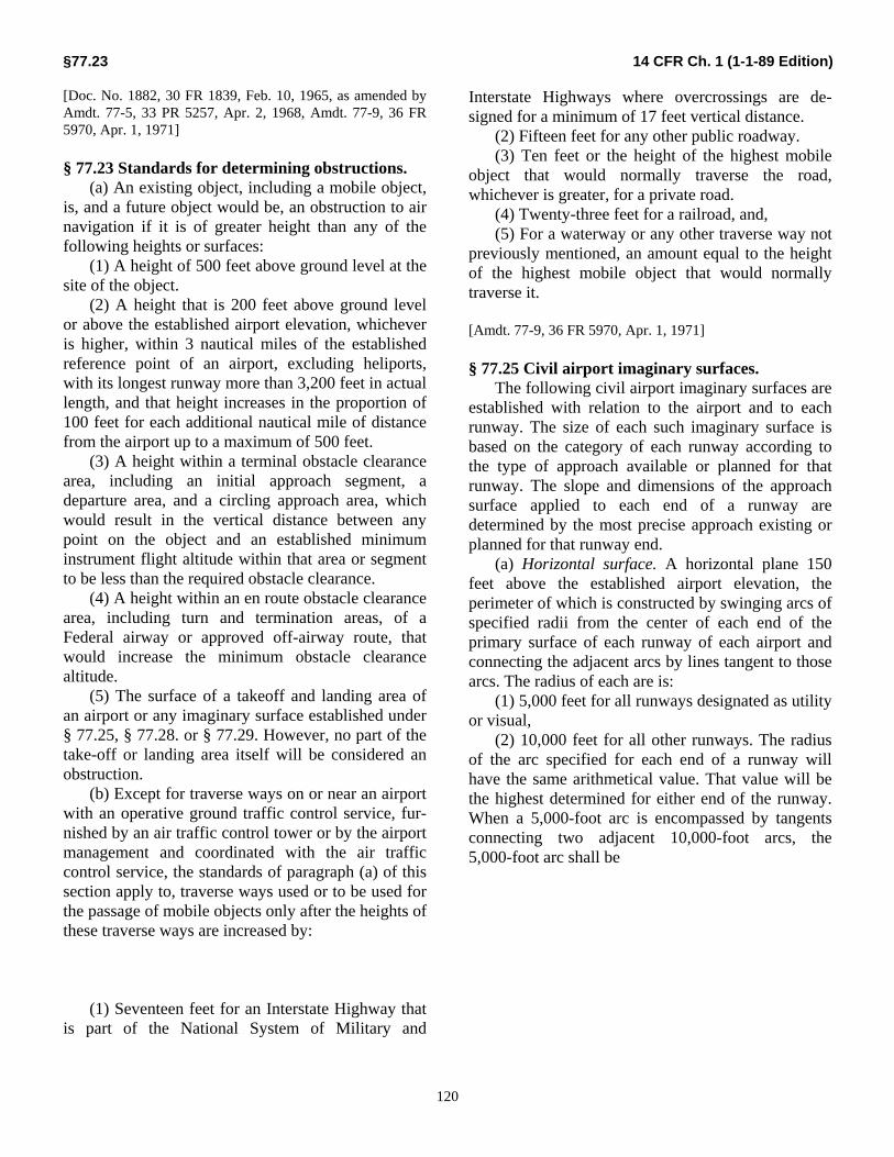
§77.23 14 CFR Ch. 1 (1-1-89 Edition)
120
[Doc. No. 1882, 30 FR 1839, Feb. 10, 1965, as amended by Amdt. 77-5, 33 PR 5257, Apr. 2, 1968, Amdt. 77-9, 36 FR 5970, Apr. 1, 1971] § 77.23 Standards for determining obstructions. (a) An existing object, including a mobile object, is, and a future object would be, an obstruction to air navigation if it is of greater height than any of the following heights or surfaces: (1) A height of 500 feet above ground level at the site of the object. (2) A height that is 200 feet above ground level or above the established airport elevation, whichever is higher, within 3 nautical miles of the established reference point of an airport, excluding heliports, with its longest runway more than 3,200 feet in actual length, and that height increases in the proportion of 100 feet for each additional nautical mile of distance from the airport up to a maximum of 500 feet. (3) A height within a terminal obstacle clearance area, including an initial approach segment, a departure area, and a circling approach area, which would result in the vertical distance between any point on the object and an established minimum instrument flight altitude within that area or segment to be less than the required obstacle clearance. (4) A height within an en route obstacle clearance area, including turn and termination areas, of a Federal airway or approved off-airway route, that would increase the minimum obstacle clearance altitude. (5) The surface of a takeoff and landing area of an airport or any imaginary surface established under § 77.25, § 77.28. or § 77.29. However, no part of the take-off or landing area itself will be considered an obstruction. (b) Except for traverse ways on or near an airport with an operative ground traffic control service, fur-nished by an air traffic control tower or by the airport management and coordinated with the air traffic control service, the standards of paragraph (a) of this section apply to, traverse ways used or to be used for the passage of mobile objects only after the heights of these traverse ways are increased by: (1) Seventeen feet for an Interstate Highway that is part of the National System of Military and
Interstate Highways where overcrossings are de-signed for a minimum of 17 feet vertical distance. (2) Fifteen feet for any other public roadway. (3) Ten feet or the height of the highest mobile object that would normally traverse the road, whichever is greater, for a private road. (4) Twenty-three feet for a railroad, and, (5) For a waterway or any other traverse way not previously mentioned, an amount equal to the height of the highest mobile object that would normally traverse it. [Amdt. 77-9, 36 FR 5970, Apr. 1, 1971] § 77.25 Civil airport imaginary surfaces. The following civil airport imaginary surfaces are established with relation to the airport and to each runway. The size of each such imaginary surface is based on the category of each runway according to the type of approach available or planned for that runway. The slope and dimensions of the approach surface applied to each end of a runway are determined by the most precise approach existing or planned for that runway end. (a) Horizontal surface. A horizontal plane 150 feet above the established airport elevation, the perimeter of which is constructed by swinging arcs of specified radii from the center of each end of the primary surface of each runway of each airport and connecting the adjacent arcs by lines tangent to those arcs. The radius of each are is: (1) 5,000 feet for all runways designated as utility or visual, (2) 10,000 feet for all other runways. The radius of the arc specified for each end of a runway will have the same arithmetical value. That value will be the highest determined for either end of the runway. When a 5,000-foot arc is encompassed by tangents connecting two adjacent 10,000-foot arcs, the 5,000-foot arc shall be

Federal Aviation Administration, DOT §77.25
121
disregarded on the construction of the perimeter of the horizontal surface. (b) Conical surface. A surface extending outward and upward from the periphery of the horizontal surface at a slope of 20 to 1 for a horizontal distance of 4,000 feet. (c) Primary surface. A surface longitudinally centered on a runway. When the runway has a specially prepared hard surface, the primary surface extends 200 feet beyond each end of that runway; but when the runway has no specially prepared hard surface, or planned hard surface, the primary surface ends at each end of that runway. The elevation of any point on the primary surface is the same as the eleva-tion of the nearest point on the runway centerline. The width of a primary surface is: (1) 250 feet for utility runways having only visual approaches. (2) 500 feet for utility runways having nonprecision instrument approaches. (3) For other than utility runways the width is: (i) 500 feet for visual runways having only visual approaches. (ii) 500 feet for nonprecision instrument runways having visibility minimums greater than three-fourths statute mile. (iii) 1,000 feet for a nonprecision instrument runway having a nonprecision instrument approach with visibility minimums as low as three-fourths of a statute mile, and for precision instrument runways. The width of the primary surface of a runway will be that width prescribed in this section for the most precise approach existing or planned for either end of that runway. (d) Approach surface. A surface longitudinally centered on the extended runway centerline and extending outward and upward from each end of the primary surface. An approach surface is applied to each end of each runway based upon the type of approach available or planned for that runway end. (1) The inner edge of the approach surface is the same width as the primary surface and it expands uniformly to a width of: (i) 1,250 feet for that end of a utility runway with only visual approaches; (ii) 1,500 feet for that end of a runway other than a utility runway with only visual approaches;
(iii) 2,000 feet for that end of a utility runway with a nonprecision instrument approach; (iv) 3,500 feet for that end of a nonprecision instrument runway other than utility, having visibility minimums greater than three-fourths of a statute mile; (v) 4,000 feet for that end of a nonprecision instrument runway, other than utility, having a nonprecision instrument approach with visibility minimums as low as three-fourths statute mile; and (vi) 16,000 feet for precision instrument runways. (2) The approach surface extends for a horizontal distance of: (i) 5.000 feet at a slope of 20 to 1 for all utility and visual runways; (ii) 10,000 feet at a slope of 34 to 1 for all nonprecision instrument runways other than utility; and, (iii) 10,000 feet at a slope of 50 to 1 with an additional 40,000 feet at a slope of 40 to 1 for all precision instrument runways. (3) The outer width of an approach surface to an end of a runway will be that width prescribed in this subsection for the most precise approach existing or planned for that runway end. (e) Transitional surface. These surfaces extend outward and upward at right angles to the runway centerline and the runway centerline extended at a slope of 7 to 1 from the sides of the primary surface and from the sides of the approach surfaces. Transitional surfaces for those portions of the pre-cision approach surface which project through and beyond the limits of the conical surface, extend a distance of 5,000 feet measured horizontally from the edge of the approach surface and at right angles to the runway centerline. [Amdt. 77-9, 36 FR 5970, Apr. 1, 1971; 36 FR 6741, Apr. 8. 1971]

§77.28 14 CFR Ch. 1 (1-1-89 Edition)
122
§ 77.27 [Reserved] § 77.28 Military airport imaginary surfaces. (a) Related to airport reference points. These surfaces apply to all military airports. For the purposes of this section a military airport is any airport operated by an armed force of the United States. (1) Inner horizontal surface. A plane is oval in shape at a height of 150 feet above the established airfield elevation. The plane is constructed by scrib-ing an arc with a radius of 7,600 feet about the centerline at the end of each runway and interconnecting these arcs with tangents. (2) Conical surface. A surface extending from the periphery of the inner horizontal surface outward and upward at a slope of 20 to 1 for a horizontal distance of 7,000 feet to a height of 500 feet above the estab-lished airfield elevation. (3) Outer horizontal surface. A plane, located 500 feet above the established airfield elevation, extending outward from the outer periphery of the conical surface for a horizontal distance of 30,000 feet. (b) Related to runways. These surfaces apply to all military airports. (1) Primary surface. A surface located on the ground or water longitudinally centered on each runway with the same length as the runway. The width of the primary surface for runways is 2,000 feet. However, at established bases where substantial construction has taken place in accordance with a previous lateral clearance criteria, the 2,000-foot width may be reduced to the former criteria. (2) Clear zone surface. A surface located on the ground or water at each end of the primary surface, with a length of 1,000 feet and the same width as the primary surface. (3) Approach clearance surface. An inclined plane, symmetrical about the runway centerline extended, beginning 200 feet beyond each end of the primary surface at the centerline elevation of the runway end and extending for 50,000 feet. The slope of the approach clearance surface is 50 to 1 along the runway centerline extended until it reaches an elevation of 500 feet above the established airport elevation. It then continues horizontally at this elevation to a point 50,000 feet from the point of beginning. The width of
this surface at the runway end is the same as the primary surface, it flares uniformly, and the width at 50,000 is 16,000 feet. (4) Transitional surfaces. These surfaces connect the primary surfaces, the first 200 feet of the clear zone surfaces, and the approach clearance surfaces. to the inner horizontal surface, conical surface, outer horizontal surface or other transitional surfaces. The slope of the transitional surface is 7 to 1 outward and upward at right angles to the runway centerline. [Doc. No. 1882, 30 FR 1839, Feb. 10, 1965, as amended by Amdt. 77-1, 30 FR 6713, May 18, 1965; Amdt. 77-9, 36 FR 5971, Apr. 1, 1971] § 77.29 Airport imaginary surfaces for heliports. (a) Heliport primary surface. The area of the primary surface coincides in size and shape with the designated take-off and landing area of a heliport. This surface is a horizontal plane at the elevation of the established heliport elevation. (b) Heliport approach surface. The approach surface begins at each end of the heliport primary surface with the same width as the primary surface, and extends outward and upward for a horizontal distance of 4,000 feet where its width is 500 feet. The slope of the approach surface is 8 to 1 for civil heli-ports and 10 to 1 for military heliports. (c) Heliport transitional surfaces These surfaces extend outward and upward from the lateral boundaries of the heliport primary surface and from the approach surfaces at a slope of 2 to 1 for a distance of 250 feet measured horizontally from the centerline of the primary and approach surfaces. [Doc. No. 1882, 30 FR 1839, Feb. 10, 1965. as amended by Amdt. 77-9, 36 FR 5971, Apr. 1, 1971; 36 FR 6741, Apr. 8, 1971]

Federal Aviation Administration, DOT §77.37
123
Subpart D-Aeronautical Studies, of Effect of Proposed Construction on Navigable
Airspace § 77.31 Scope. (a) This subpart applies to the conduct of aeronautical studies of the effect of proposed construction or alteration on the use of air navigation facilities or navigable airspace by aircraft. In the aeronautical studies, present and future IFR and VFR aeronautical operations and procedures are reviewed and any possible changes in those operations and procedures and in the construction proposal that would eliminate or alleviate the conflicting demands are ascertained. (b) The conclusion of a study made under this subpart is normally a determination as to whether the specific proposal studied would be a hazard to air navigation. [Doc. No. 18820, 30 PR 1839, Feb. 10, 1965, as amended by Amdt. 77-6, 33 FR 10843, July 31, 1968] § 77.33 Initiation of studies. (a) An aeronautical study is conducted by the FAA: (1) Upon the request of the sponsor or any construction or alteration for which a notice is submitted under Subpart B of this part, unless that construction or alteration would be located within an antenna farm area established under Subpart F of this part; or (2) Whenever the FAA determines it appropriate. [Doc. No. 1882, 30 FR 1839, Feb. 10, 1965, as amended by Amdt. 77-4, 32 PR 12997, Sept. 13, 1967] § 77.35 Aeronautical studies. (a) The Regional Director of the region in which the proposed construction or alteration would be located, or his designee, conducts the aeronautical study of the effect of the proposal upon the operation of air navigation facilities and the safe and efficient utilization of the navigable airspace. This study may include the physical and electromagnetic radiation effect the proposal may have on the operation of an air navigation facility. (b) To the extent considered necessary, the Regional Director or his designee:
(1) Solicits comments from all interested persons; (2) Explores objections to the proposal and attempts to develop recommendations for adjustment of aviation requirements that would accommodate the proposed construction or alteration; (3) Examines possible revisions of the proposal that would eliminate the exceeding of the standards in Subpart C of this part; and (4) Convenes a meeting with all interested persons for the purpose of gathering all facts relevant to the effect of the proposed construction or alteration on the safe and efficient utilization of the navigable airspace. (c) The Regional Director or his designee issues a determination as to whether the proposed construction or alteration would be a hazard to air navigation and sends copies to all known interested persons. This determination is final unless a petition for review is granted under § 77.37. (d) If the sponsor revises his proposal to eliminate exceeding of the standards of Subpart C of this part, or withdraws it, the Regional Director. or his designee, terminates the study and notifies all known interested persons. [Doc. No. 1882, 30 FR 1839, Feb. 10, 1965, as amended by Amdt. 77-6, 33 FR 10843, July 31,1968] § 77.37 Discretionary review. (a) The sponsor of any proposed construction or alteration or any person who stated a substantial aeronautical objection to it in an aeronautical study, or any person who has a substantial aeronautical objection to it but was not given an opportunity to state it, may petition the Administrator, within 30 days after issuance of the determination under §77.19 or §77.35 or revision or, extension of the determination under §77.39(c), for a review of the determination, revision, or extension. This paragraph does not apply to any acknowledgment issued under §77.19(c)(1).

§77.39 14 CFR Ch. 1 (1-1-89 Edition)
124
(b) The petition must be in triplicate and contain a full statement of the basis upon which it is made. (c) The Administrator examines each petition and decides whether a review will be made and, if so, whether it will be: (1) A review on the basis of written materials, including study of a report by the Regional Director of the aeronautical study, briefs, and related sub-missions by any interested party, and other relevant facts, with the Administrator affirming, revising, or reversing the determination issued under §77.19, §77.35 or §77.39(c); or (2) A review on the basis of a public hearing, conducted in accordance with the procedures, prescribed in Subpart E of this part. [Doc. No. 1882, 30 FR 1839, Feb. 10, 1965, as amended by Amdt. 77-3, 32 PR 6970, May 6, 1967] § 77.39 Effective period of determination of no
hazard. (a) Unless it is otherwise extended, revised, or terminated, each final determination of no hazard- made under this subpart or Subpart B or E of this part expires 18 months after its effective date, regardless of whether the proposed construction or alteration has been started, or on the date the proposed construction or alteration is abandoned, whichever is earlier. (b) In any case, including a determination to which paragraph (d) of this section applies, where the proposed construction or alteration has not been started during the applicable period by actual structural work, such as the laying of a foundation, but not including excavation, any interested person may, at least 15 days before the date the final determination expires, petition the FAA official who issued the determination to: (1) Revise the determination based on new facts that change the basis on which it was made; or (2) Extend its effective period. (c) The FAA official who issued the determination reviews each petition presented under paragraph (b) of this section, and revises, extends, or affirms the determination as indicated by his findings. (d) In any case in which a final determination made under this subpart or Subpart B or E of this part relates to proposed construction or alteration that may not be started unless the Federal Communications
Commission issues an appropriate construction permit, the effective period of each final determination includes (1) The time required to apply to the Commission for a construction permit, but not more than 6 months after the effective date of the determination; and (2) The time necessary for the Commission to process the application except in a case where the Administrator determines a shorter effective period is required by the circumstances. (e) If the Commission issues a construction permit, the final determination is effective until the date prescribed for completion of the construction. If the Commission refuses to issue a construction permit, the final determination expires on the date of its refusal. [Doc. No. 1882, 30 FR 1839, Feb. 10, 1965, as amended by Amdt. 77-5, 33 FR 5257, Apr. 2, 1968]
Subpart E-Rules of Practice for Hearings Under Subpart D
§ 77.41 Scope. This subpart applies to hearings held by the FAA under Titles I, III, and X of the Federal Aviation Act of 1958 (49 U.S.C. Subchapters I, III, and X), on proposed construction or alteration that affects the use of navigable airspace. § 77.43 Nature of hearing. Sections 4, 5, 7, and 8 of the Administrative Procedure Act (5 U.S.C. 1003, 1004, 1006, and 1007) do not apply to hearings held on proposed construc-tion or alteration to determine its effect on the safety of aircraft and the efficient use of navigable airspace because those hearings are fact-finding in nature. As a fact-finding procedure each hearing is non-adversary and there are no formal pleadings or ad-verse parties.
Federal Aviation Administration, DOT §77.55
125
§ 77.45 Presiding officer. (a) If, under §79.37, the Administrator grants a public hearing on any proposed construction or alteration covered by this part, the Director of the Air Traffic Service designates an FAA employee to be the presiding officer at the hearing. (b) The presiding officer may: (1) Give notice of the date and location of the hearing and any prehearing conference that may be held; (2) Administer oaths, and affirmations; (3) Examine witnesses; (4) Issue subpoenas and take depositions or have them taken; (5) Obtain, in the form of a public record, all pertinent and relevant facts relating to the subject matter of the hearing; (6) Rule, with the assistance of the legal officer, upon the admissibility of evidence; (7) Regulate the course and conduct of the hearing; and (8) Designate parties to the hearing and revoke those designations. § 77.47 Legal officer. The Chief Counsel designates a member of his staff to serve as legal officer at each hearing under this subpart. The legal officer may examine witnesses and assist and advise the presiding officer on questions of evidence or other legal questions arising during the hearing. [Doc. No. 1882, 30 FR 1839, Feb. 10, 1965, as amended at 38 FR 26444, Sept. 17, 1973] § 77.49 Notice of hearing. In designating a time and place for a hearing under this subpart the presiding officer considers the needs of the FAA and the convenience of the parties and witnesses. The time and place of each hearing is published in the “Notices” section of the FEDERAL REGISTER before the date of the hearing, unless the notice is impractical or unnecessary. § 77.51 Parties to the hearing. The presiding officer designates the following as parties to the hearing (a) The proponent of the proposed construction or alteration.
(b) Those persons whose activities would be substantially affected by the proposed construction or alteration. § 77.53 Prehearing conference. (a) The presiding officer may, in his discretion, hold a prehearing conference with the parties to the hearing and the legal officer before the hearing. (b) At the direction of the presiding officer, each party to a prehearing conference shall submit a brief written statement of the evidence he intends to provide through his witnesses and by questioning other witnesses at the hearing, and shall provide enough copies of the statement so that the presiding officer may keep three for the FAA and give one to each other party. (c) At the prehearing conference, the presiding officer reduces and simplifies the subject matter of the hearing so far as possible and advises the parties of the probable order of presenting the evidence. § 77.55 Examination of witnesses. (a) Each witness at a hearing under this subpart shall, after being sworn by the presiding officer, give his testimony under oath. (b) The party for whom a witness, other than an employee of the FAA, is testifying shall examine that witness. After that examination, other parties to the hearing may examine the witness, in the order fixed by the presiding officer. The presiding officer and the legal officer may then examine the witness. The presiding officer may grant any party an additional opportunity to examine any witness, if that party adequately justifies the additional examination. (c) The legal officer examines each FAA employee who is a witness, before the other parties examine him. After that examination, the order prescribed in paragraph (b) of this section applies. An FAA employee may testify only as to facts within his personal knowledge and the application of FAA regulations, standards, and policies.
§77.57 14 CFR Ch. 1 (1-1-89 Edition)
126
§ 77.57 Evidence. (a) The presiding officer receives all testimony and exhibits that are relevant to the issues of the hearing. So far as possible, each party shall submit enough copies of his exhibits that the presiding officer may keep three copies for the FAA and give one to each other party. (b) The presiding officer excludes any testimony that is irrelevant, unduly repetitious, or consists of statements made during an aeronautical study in an effort to reconcile or compromise aviation or construction or alteration requirements. A party to the hearing may object to the admission of evidence only on the ground that it is irrelevant. § 77.59 Subpoenas of witnesses and exhibits. (a) The presiding officer of a hearing may issue subpoenas for any witness or exhibit that he determines may be material and relevant to the issues of the hearing. So far as possible, each party to the hearing shall provide the witnesses and exhibits that he intends to present at the hearing. (b) If any party to the hearing is unable to provide his necessary witnesses and exhibits, he shall advise the presiding officer far enough in advance that the presiding officer can determine whether he should issue subpoenas for the desired witnesses or exhibits. § 77.61 Revision of construction or alteration proposal. (a) The sponsor of any proposed construction or alteration covered by this part may revise his proposal at any time before or during the hearing. If he revises it, the presiding officer decides whether the revision affects the proposal to the extent that he should send it to the Administrator for a re-determination of the need for a hearing. (b) If the presiding officer decides that it does not need to be resubmitted to the Administrator, he advises the parties of the revised proposal and takes the action necessary to allow all parties to effectively participate in the hearing on the revised proposal. Without limiting his discretion, the presiding officer may recess and reconvene the hearing, or hold another prehearing conference.
§ 77.63 Record of hearing. (a) Each hearing is recorded verbatim by an official reporter under an FAA contract. The transcript, and all exhibits, become a part of the record of the hearing. (b) Any person may buy a copy of the transcript of the hearing from the reporter at the price fixed for it. (c) The presiding officer may allow any party to withdraw an original document if he submits authenticated copies of it. (d) Any person may buy, from the FAA, photostatic copies of any exhibit by paying the copying costs. (e) A change in the official transcript of a hearing may be made only if it involves an error of substance. Any recommendation to correct the transcript must be filed with the presiding officer within 5 days after the hearing closes. The presiding officer reviews each request for a correction to the extent he considers appropriate and shall make any revisions that he finds appropriate as a result of that review. § 77.65 Recommendations by parties. Within 20 days after the mailing of the record of hearing by the official reporter, or as otherwise directed by the presiding officer, each party may submit to the presiding officer five copies of his recommendations for a final decision to be made by the Administrator. § 77.67 Final decision of the Administrator. After reviewing the evidence relevant to the questions of fact in a hearing, including the official transcript and the exhibits, the Administrator resolves all these questions, based on the weight of evidence, and makes his determination, stating the basis and reasons for it. He then issues an appropriate order to be served on each of the parties.
Federal Aviation Administration, DOT §77.75
127
§ 77.69 Limitations on appearance and representation.
(a) A former officer or employee of the FAA may not appear on behalf of, or represent, any party before the FAA in connection with any matter to which this part applies, if he considered or passed on that matter while he was an officer or employee of the FAA. (b) A person appealing before the FAA on any matter to which this part applies may not, in connection with that appearance, knowingly accept assistance from, or share fees with, any person who is prohibited by paragraph (a) of this section, from appearing himself on that matter. (c) A former official or employee of the FAA may not, within 6 months after he ceases to be such an officer or employee, appear before the FAA on behalf of, or represent, any party in connection with any proceeding that was pending under this part while he was an officer or employee of the FAA, unless he obtains written consent from an appropriate officer of the FAA. Based on a verified showing that he did not personally consider the matter concerned or gain particular knowledge of it while he was an officer or employee of the FAA.
Subpart F-Establishment of Antenna Farm Areas
§ 77.71 Scope. (a) This subpart establishes antenna farm areas in which antenna structures may be grouped to localize their effect on the use of navigable airspace. (b) It is the policy of the FAA to encourage the use of antenna farms and the single structure- multiple antenna concept for radio and television towers whenever possible. In considering proposals for establishing antenna farm areas, it considers as far as possible the revision of aeronautical procedures and operations to accommodate antenna structures that will fulfill broadcasting requirements.
§ 77.73 General provisions. (a) An antenna farm area consists of a specified geographical location with established dimensions of area and height, where antenna towers with a common impact on aviation may be grouped. Each such area is established by appropriate rule making action. (b) Each proposal for an antenna farm area is evaluated on the basis of its effect on the use of navigable airspace. The views of the Federal Com-munications Commission are requested on the effect that each establishment of an antenna farm area would have on its statutory responsibilities. Any views submitted by it are fully considered before the antenna farm concerned is established. If the Com-mission advises that the establishment of any proposed antenna farm area would interfere with its statutory responsibility, the proposed area is not established. (c) The establishment of an antenna farm area is considered whenever it is proposed by: (1) The FAA; (2) The Federal Communications Commission; (3) The sponsor of a proposed antenna tower; or (4) Any other person having a substantial interest in a proposed antenna tower. [Doc. No. 1882, 30 FR 1839, Feb. 10, 1965, as amended by Amdt. 77-10, 37 FR 4705, Mar. 4, 1972] § 77.75 Establishment of antenna farm areas. The airspace areas described in the following sections of this subpart are established as antenna farm areas. NOTE: Sections 77.77 through 77.1100 reserved for descriptions of antenna farm areas.

APPENDIX “D”
RIVERSIDE COUNTY LETTER
