christiandevelopmentorganization.weebly.comchristiandevelopmentorganization.weebly.com/uploads/1/5/... ·...
TRANSCRIPT

Faisalabad District
Faisalabad District
District
Location of Faisalabad District(highlighted in orange) within Punjab.
Country Pakistan
Province Punjab
Capital Faisalabad City
Government
• Commissioner Faisalabad Division Ijaz Munir
• District Coordination Officer Muhammad Ameen Ch.
Population (2010)[1]
• Total 7,000,000
Time zone PST (UTC+5)

Number ofTehsils 6
Website http://www.faisalabad.gov.pk/
Faisalabad District (Urdu: آ�باد فیصل (ضلع is one of the districts of Punjab province, Pakistan. According to the 1998 census of Pakistan it had a population of 5,429,547 of which almost 42% were in Faisalabad City. It is a 3rd largest city of Pakistan after Karachi and Lahore .
In 1982 Toba Tek Singh District (until then a tehsil of Faisalabad) was created as a separate district from Faisalabad. As of 2006 it is a city district consisting of the city of Faisalabad.
Contents
[hide]
1 History 2 Language 3 Administration 4 See also 5 References 6 External links
History
In 1870s the colonial era Punjab government decided to increase the cultivated land by making barrages and canals to meet the demand of European markets. This led to the canal based irrigation of the areas now comprising the district of Faisalabad and Toba Tek Singh. In 1880, a colonial officer, Captain Poham Young, with the support of Sir James Broadwood Lyall founded the new Town it was named Lyallpur after his Surname. proposed a new town. The design was based on the Union Jack, with eight roads radiating from a large clock tower in the center.
It was called the Chenab Bar after renamed as Lyallpur District, large numbers of Muslims from Lahore District, Rawalpindi District andDera Ghazi Khan District migrated and settled in the newly irrigated areas. While some Sikhs from Eastern Punjab from Ludhiana District, Jalandhar District and Ambala District migrated to this new region where they established new villages naming them after their own villages which they left. Many villages Lyallpur District were named with prefix 'Chak'.
In 1903 it was decided to establish an agricultural college, the modern University of Agriculture. In 1904 the new district of Lyallpur was constituted, composed of the tehsils of Lyallpur, Samundri and Toba Tek Singh, with a subtehsil at Jaranwala which later became a full tehsil. By 1906, the district headquarters began to function in Lyallpur and all the bazaars and settlements within the bounds of a ring road were nearing completion. The city began to spread outside the circular road. The Town Committee was upgraded to a MunicipalCommittee in 1909 and the Deputy Commissioner was appointed as its first chairman. In 1916, the grain market saw its shops surging with customers. In the same year the civil hospital was expanded. With the advent of World War II, there was an increase in political awareness across the city. Revolutionary meetings were held, fiery speeches made, and slogans written on walls.[citation needed]
The first colonisation officer Raja Aurangzeb Khan made sure that no individual in this district owned more than 25 squares (625 acres (2.53 km2)) of land. The merit or method of allotting the land was to check each individual's hand who was applying for some land, and if the hands showed that individual had worked hard in the past, only then was land given to him, which has led to a district where there aren't any big land owners, as the land has been equally distributed amongst hard working men and it is their hard work that has led to Faisalabad becoming the third richest district in Pakistan.[citation needed]
In 1943, Quaid-e-Azam Mohammad Ali Jinnah visited the District and the City where he addressed a gathering of over 2 million in Dhobi Ghat Grounds.
The predominantly Muslim population supported Muslim League and Pakistan Movement. After the independence of Pakistan in 1947, the minority Hindus and Sikhs migrated to Indiawhile the Muslim refugees from India settled in the Faisalabad District.
In 1977, the name of the city and the District was changed to "Faisalabad" (City of Faisal), in honour of the late King Faisal of Saudi Arabia, who was held in high regard in Pakistan. In 1985, the district was upgraded to a division with the new districts of Faisalabad, Jhang and Toba Tek Singh.
The main Muslim Jat tribes and clans are Bajwa, Kahlon, Cheema, Waraich, Randhawa, Chatha, beniwal (vehniwal), Kharal, Naul, Sipra, Sial, Langrial, Bains etc. With other Main Muslimtribes are Arain and Awan clans in this district.

Language[]
Main Language of the people is Punjabi while Urdu is also spoken.
Administration
Until divisions were abolished in the year 2000 it was part of Faisalabad Division.
The district is currently subdivided into six tehsils:[3]
1. Faisalabad 2. Faisalabad Saddar Tehsil 3. Jaranwala Tehsil 4. Jhumra 5. Samundri Tehsil 6. Tandlianwala Tehsil
Chiniot District
From Wikipedia, the free encyclopediaFor other uses, see Chiniot.
Chiniot Districtچنیوٹ ضلع
District
Map of Punjab with Chiniot District highlighted

Country Pakistan
Province Punjab
Division Faisalabad Division
Capital Chiniot
Established February 2, 2009
Government
• District Coordination Officer Rana Arshad
Population (1998)
• Total 965,124
Time zone PST (UTC+5)
Number of Tehsils 3
Chiniot District (Urdu: ِچ�نيوٹ ِچضلع ), became the 36th district of the Punjab province of Pakistan in February 2009.[1] Earlier it was a tehsil of Jhang District.
Contents
[hide]
1 History 2 Language 3 Villages 4 Satellite town 5 Nalka Adda (Hussain Abad)
o 5.1 1. Riazwalao 5.2 2. Kandiwalo 5.3 3. Aliabado 5.4 4. Ratta Pur Balao 5.5 5. Sheikhan City

6 Fauna and flora 7 Architecture 8 References
History
Chiniot's name consists of two words of Punjabi, Chan and Ote, which translates as 'Behind the moon without light'. Until February 2009 Chiniot District formed part of Jhang District in the former Faisalabad Division. Chiniot forms a very important part of the historic area ofJhang District, the history of which goes back into antiquity. It is said that Alexander of Macedonia passed through the district while going back to Greece. But the first glimpse of this district appeared in 'Tuzk-e-Babari' written by Zaheerudin Babar, the founder of the Mughaldynasty in India, in the year 1526. CE Chiniot was known for its mastercrafted furniture, not only in Pakistan, but all over the world. Its highly special and master craft Jharokhas are known in the whole country. Sheikh, Sayed, Qazi, Japaa, Bala, Chadhar, Haral,Sangha, Khokhar,Lali, Sipra, Nesoana,Rehan, wallahRai and Khundowaa tribes are leading tribes [2]
The predominantly Muslim population supported Muslim League and Pakistan Movement. After the independence of Pakistan in 1947, the minority Hindus and Sikhs migrated to India while the Muslim refugees from India settled in the Chiniot District.
On 2 February 2009, Chief Minister Shahbaz Sharif formally approved the creation of Chiniot as the 36th district of Punjab province. [3] Calls for Chiniot to be made a district date back to 2005, when a movement was a launched to elevate the former tehsil to district level. The movement died down when the public were assured the next Nazim would be from Chiniot – however this was not to be the case.[4]
Rana Tahir-the maiden DCO Chiniot along with Mr Hamza Shahbaz Sharif, raised the flag of Pakistan on DCO office on the fine morning of 1 July 2009. The efforts of Rana Tahir in giving a proper developed outlook to the infant district will find a place in history and cannot be over-emphasized. Mr Dilmeir Khan appointed as first district accounts officer and Mr Fayaz Sunbal was appointed as First DPO Chiniot.
Language
Punjabi is the native language of majority people. Urdu is also spoken.
Villages

Most of the villages in the districts are named [[Chak [dawar](village)|Chak]], which means outpost in the Urdu and Punjabi languages, and suffixed by a number. Many of the villages were planned and established by British engineers during the colonial period. These villages were planned mostly along canal banks to distribute the population evenly.
Satellite town
Election commission office, Sui Gas office, Post Office, Hockey Ground, Excise and taxtation office, Zakat distribution office, Deaf & Dumb School are located in Satellite Town.thatta fateh ali is the most popular village of chiniot.
Nalka Adda (Hussain Abad)
This area is situated at about 47 km away from Chiniot city and about 10 km from tehsil Bhowana and almost boundary town of Chiniot district. This area is in moza Thatta Muhammad Shah. In Hussainabad there are two private schools and one bank which is mcb bank. Hussainabad is the centre of trade for the villagers.On every Saturday, a cattle mandi take place.Hussain Abad is developing rapidly after bhowana. In this moza there are several villages, which are:
1. Riazwala
This area is about 1.5 km from Hussainabad. This is on the name of a famous saint Sakhi Haji syed Riaz Hussain, whose sharine is situated in Wara Sadaat. This area is famous for its records corps. There is one basic health centre and primary school for boys and girls separately.
2. Kandiwal
Kandiwal is the 1st union council of the distt Chiniot. The famous folk singer Sanam Marvi is also a resident of Kandiwal.
3. Aliabad
There is one Middle school of boys and no any English medium school in the area. This whole area is under the influence of Sardars which are the landlords.The Sardars and Landlords do not want any development for the education of local people because do not want people to be educated and often patronage the thieves.
4. Ratta Pur Bala

It has fertile lands with small holdings. Important crops grown are wheat, rice, sugarcane, and maize. There are primary Schools for boys and girls. The entire village consists of only one caste "Balla". Most people of the village are illiterate. There are three tomb of "Olia-e-Kram". Most famous tomb is "Bava Syed Jhulan Shah". Annual Oras and Mela is continuing from Last 100 years. Malik Dilmer Khan Bala was first District accounts officer belong to this village.
5. Sheikhan City
Adda Sheikhan is situated 44 km away from District Chiniot. It contain fertile soil mostly useful for large scale production of wheat, rice, barley, cotton, vegetables and fruits. It has become the hub of trade, commerce and education. There are primary and middle schools for boys and girls at government level but some private schools such as Jinnah cadet school, Alqamar model school and Science system school are providing quality education in enhancing people's morale. There are also two Schools of religious thought, Jamia Imam -Ul- Asr(as) and Madrassa Qamr ul Uloom providing people the education of Quraan -o- Hadith and Fiqh. Adda Sneikhan produces many people having high education and research in different subjects and sharing there roles in different government institutions. Many famous personalities visit this area. Annual religious processions like Ashura and Eid meelad-un-Nabi are celebrated and both Shia and Sunni participate together which shows the intra-faith unity of local people. Recently, it has become the part of Chiniot District. But Adda Sheikkhan is not provided with any development program from Chiniot District the Chief Minister Shehbaz Shareef announce funds for different projects so people are worry about the negligence of this area. The authorities are not taking any attention to this area in case of any development as the area containing almost 30000 population and about 45 villages are connected for livelihood, business,education and trade but there in no infrastructure for these activities. The population want the urgent release of funds for construction of Government High schools for Boys and Girls and also for sewerage system because the area has right if merit is included.
Fauna and flora
The fauna and flora of the district include: Jand trees (Prosopis spicigera), Karir (Capparis aphylla), Beri (Zizyphus jajaba), Van (Salvadora abeoides), Kikar (Acacia arbica), Shisham (Dalbergia ) and Aak (Calotropois hamiltonit) are found within the district.[5]
Architecture

The Omar Hayat Mahal (also known as Gulzar Manzil, is a 19th-century palace in Chiniot. (Badshahi Masjid ) it was built by Nawab Saad Ullah Khan. It has same architecture as Shahi Masjid Lahore. Nawab Saad Ullah was minister in the cabinet of the Mughal Empire.

Jhang District
From Wikipedia, the free encyclopedia
Jhang District
District
Map of Punjab, with Jhang District shown in green.
Country Pakistan
Province Punjab
Capital Jhang city
Established 1849
Government
• District Coordination Officer Maqbool Ahmed Dhawla
• District Police Officer Faisal Ali Raja
Area
• Total 8,809 km2(3,401 sq mi)
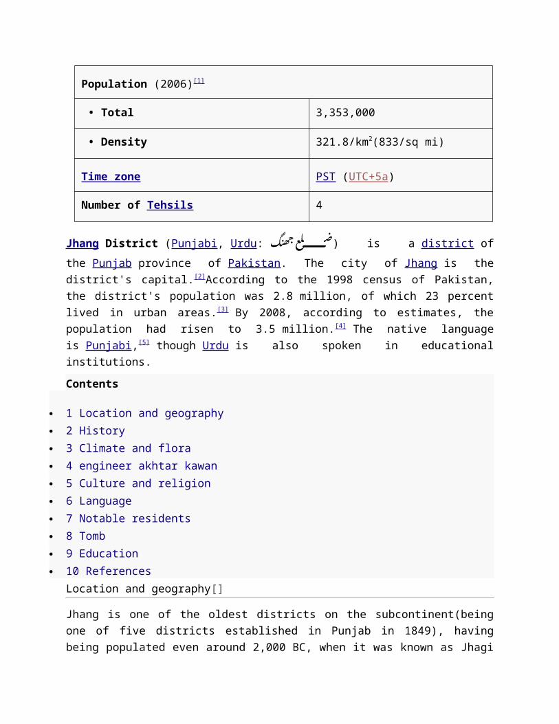
Population (2006)[1]

• Total 3,353,000
• Density 321.8/km2(833/sq mi)
Time zone PST (UTC+5a)
Number of Tehsils 4
Jhang District (Punjabi, Urdu: جھنگ .is a district of the Punjab province of Pakistan (ضلعThe city of Jhang is the district's capital.[2]According to the 1998 census of Pakistan, the district's population was 2.8 million, of which 23 percent lived in urban areas.[3] By 2008, according to estimates, the population had risen to 3.5 million.[4] The native language is Punjabi,[5] though Urdu is also spoken in educational institutions.
Contents
1 Location and geography 2 History 3 Climate and flora 4 engineer akhtar kawan 5 Culture and religion 6 Language 7 Notable residents 8 Tomb 9 Education 10 References
Location and geography[]
Jhang is one of the oldest districts on the subcontinent(being one of five districts established in Punjab in 1849), having being populated even around 2,000 BC, when it was known as Jhagi Sial. Jhang is bordered by Sargodha District to the north, Gujranwala District to the northeast, Faisalabad District and Toba Tek Singh District to the east, Khanewal and Muzaffargarh District to the south, Leiah District andBhakkar District to the west, and Khushab District to the northwest.
The district comprises on four administrative units (tehsils) Jhang, Athara Hazari, Shorkot, and Ahmad Pur Sial.[6]
Jhang District covers 8,809 km².[7] Almost all the area is cultivatable land except in the north near Rabwah and Chenab Nagar where the land turns rocky as it approaches the Kirana hills. The western portion of the district holds the Thal Desert, which starts in Mari Shah Sakhira and extends to banks of the Jhelum River far to the west in the districts of Khushab and Bhakkar. There is also an area known as the Sandal Bar arising from Pabbarwala near the Gujranwala boundary. "Bar", in the local language, means a forested area where there are no resources for cultivation, like water. This area used to be forested and was unable to be cultivated before British colonial rule, when a canal system was installed near the town of Lyallpur (now Faisalabad), which is now the textile industry hub of Pakistan. Between the rivers Jhelum and Chenab is also a small area of Kirana bar, ending at Ghoriwala village. The area alongside the banks of rivers Ravi, Chenab and Jhelum is called Hitthar (area in which flood water reaches), while the upland area between the bars and Hitthar is called Utar.
History[]
Jhang District was agricultural region with forests during the Indus Valley Civilization. The Vedic period is characterized by Indo-Aryan culture that invaded from Central Asia and settled inPunjab region. The Kambojas, Daradas, Kaikayas, Madras, Pauravas, Yaudheyas, Malavas, Saindhavas and Kurus invaded, settled and ruled ancient Punjab region. After overunning theAchaemenid Empire in 331 BCE, Alexander marched into present-day Punjab region with an army of 50,000. The Okara was ruled by Maurya Empire, Indo-Greek kingdom, Kushan Empire, Gupta Empire, White Huns, Kushano-Hephthalites and Shahi kingdoms.
In 997 CE, Sultan Mahmud Ghaznavi, took over the Ghaznavid dynasty empire established by his father, Sultan Sebuktegin, In 1005 he conquered the Shahis in Kabul in 1005, and followed it by the conquests of Punjab region. The Delhi Sultanate and later Mughal Empire ruled the region. The Punjab region became predominantly Muslim due to missionary Sufisaints whose dargahs dot the landscape of Punjab region. After the decline of the Mughal Empire, the Sikh invaded and occupied Jhang District. During the period of British rule, Jhang district increased in population and importance.
The predominantly Muslim population supported Muslim League and Pakistan Movement. After the independence of Pakistan in 1947, the

minority Hindus and Sikhs migrated to Indiawhile the Muslim refugees from India settled in the Jhang District.
Climate and flora[]
engineer akhtar kawan[]
The climate is hot and dry in the summer and cold and dry in winter. The surface of the district presents three distinct levels (Thal's sand dunes on the extreme west, a low lying river valley in the centre and the Sandal Bar on the extreme east). The rivers of Jhelum and Chanab make their way through the district and Trimmu Head-works is the point of their confluence. Mari Shah Sakhira, a big town in the Thal Desert, is the district's hottest area, sometimes exceeding 50 C in June and July.
The district's trees consist of jand (Prosopis spicigera), karir (Capparis aphylla), beri (Zizyphus jujuba), van (Salvadora oleoides), kikar (Acacia nilotica), shisham (Dalbergia sissoo) and aak (Calotropois spp).[8] Various herbs can also be found, including harmal, akrey and bathoo.
Culture and religion[]
Punjabi folk dances such as Jhummar and Sammi originated in Jhang District. Jhummar is a dance for men while Sammi is for women. The district also originated a well-known form of folk music known as "Dhola", or "Jhang da Dhola".
Traditionally men wear turbans and dhotis (similar to a skirt or kilt) though in recent years people have started wearing the national dress, the shalwar kameez. Some older women also wear dhotis. When women wear dhotis, the style is referred to called "Majhla" in Jhangochi; th male style is called "Dhudder". However, it is more common for women to wear shalwar kameez.
Street sports are important in Jhang District and include tent pegging (naiza baazi), kabaddi, volleyball, cricket and football (soccer).
In the past, women wove cloth with spinning wheels – known as Teeyan and Trinjan – but now that the area is industrialized the practice is no longer common.
The northwestern Jhang District, particularly the area at the west bank of the Jhelum River, is somewhat different in its culture because it is more influenced by the Thalochi culture emanating from the neighboring districts of Mianwali and Bhakkar .

Jhang District has dominant Muslim population(both Shia and Sunni.The non-Muslim minorities include small number of Ahmadiyya and Christian.
Language[]
The native language is Punjabi,[9] though Urdu is also spoken in educational institutions.[10]
Notable residents[]
Sultan Bahoo (ca 1628 – 1691), saint, founder of the Sarwari Qadiri Sufi order Abdus Salam , Nobel laureate in Physics Aleem Dar , An award winner and a member of the ICC Elite umpire panel Abida Hussain , politician, former Federal Minister and Ambassador to USA Faisal Saleh Hayat , Politician, Former Federal Minister Syed Ali Raza , President and Chairman of the National Bank of Pakistan Tariq Saleem Dogar , former Inspector General of Police, Punjab Muhammad Tahir-ul-Qadri , Sufi scholar Sufi scholar and former professor of
international constitutional law at the University of the Punjab Sheikh Waqas Akram , MNA Jhang; he was also a Minister of State for Labour and
Manpower Pakistan He resigned from the ministry and MNAship because he left PML-Q and announced to join PML-N before general elections of 2013.
Mariam Hasan , Played for Pakistan national women’s cricket team Majeed Amjad ,Tomb[]
Jhang District is home to the tomb of the heroine of a famous love story, Heer Ranjha. Heer's tomb lies just north of Jhang on the way to Faisalabad. An annual fair is held at her tomb. Engineer Imran Ali Pithorana Sial
Education[]
Govt. College, Jhang Faran Model College, Jhang Chenab College, Jhang Lahore College for Women University I-Soft College Of Commerce And Computer Sciences Jhang
8Superior College, Jhang
College Of Veterinary and Animal Sciences, Sub Campus- UVAS, Lahore. Arqam schools Jhang

Toba Tek Singh District
From Wikipedia, the free encyclopedia
Toba Tek Singh District
District
Location of TTS in Punjab.
Country Pakistan
Province Punjab
Capital Toba Tek Singh
Population (2009)
• Total 1,621,593
• Density 250,000/km2(600,000/sq mi)
Time zone PST (UTC+5)
Number ofTehsils 4
Toba Tek Singh District (Urdu: سنگھ ٹیک ٹوبہ (ضلع is a district in the Punjab province of Pakistan. It is located between 30°33' to 31°2' Degree north latitudes and 72°08' to 72°48' Degree longitudes.[1] It became a separate district in 1982.

Toba Tek Singh Train Station
Contents
[hide]
1 Historyo 1.1 Etymologyo 1.2 British Rajo 1.3 After independence
2 Demography 3 Language 4 Education 5 Notable places 6 Localities 7 Banks 8 Agriculture productions 9 Administration 10 Notable residents 11 References 12 External links
History[]
District was agricultural region with forests during the Indus Valley Civilization. The Vedic period is characterized by Indo-Aryan culture that invaded from Central Asia and settled in Punjab region. The Kambojas, Daradas, Kaikayas, Madras, Pauravas, Yaudheyas, Malavas andKurus invaded, settled and ruled ancient Punjab region. After overunning the Achaemenid Empire in 331

BCE, Alexander marched into present-day Punjab region with an army of 50,000. The Toba Tek Singh was ruled by Maurya Empire, Indo-Greek kingdom, Kushan Empire,Gupta Empire, White Huns, Kushano-Hephthalites and Shahi kingdoms.
In 997 CE, Sultan Mahmud Ghaznavi, took over the Ghaznavid dynasty empire established by his father, Sultan Sebuktegin, In 1005 he conquered the Shahis in Kabul in 1005, and followed it by the conquests of northern Punjab region. The Delhi Sultanate and later Mughal Empire ruled the region. The Punjab region became predominantly Muslim due to missionary Sufi saints whose dargahs dot the landscape ofPunjab region. After the decline of the Mughal Empire, the Sikh invaded and occupied Sahiwal.
Etymology
The town and district is named after a Sikh religious figure Tek Singh. Legend has it that Mr. Singh a kind hearted man served water and provided shelter to the worn out and thirsty travellers passing by a small pond ("TOBA" in Punjabi) which eventually was called Toba Tek Singh, and the surrounding settlement acquired the same name.[1] There is also a park here named after the Sardar Tek Singh.
British Raj
Toba Tek Singh was developed by the British toward the end of the 19th Century when a canal system was built. People from all over the Punjab (currently Indian and Pakistani Punjab) moved there as farmlands were allotted to them. Most of the people who migrated there belonged to Lahore, Jalandhar, Hoshiarpur districts. The Imperial Gazetteer of India described the tehsil of Toba Tek Singh as follows:
Tehsil of the new Faisalabad District, Punjab, lying between 30°50' and 31°23' N. and 72° 20' and 72°54' E., with an area of 865 square miles (2,240 km2). The population in 1906 was 148,984. It contains 342 villages, including Toba Tek Singh (population, 1,874), the headquarters, and Gojra (2,589), an important grain market on the Wazirabad-Khanewal branch of theNorth-Western Railway. The land revenue and cesses in 1905-6 amounted to 470,000. The tehsil consists of a level plain, wholly irrigated by the Chenab Canal. The soil, which is very fertile in the east of the tehsil, becomes sandy towards the west. The boundaries of the tehsil were somewhat modified at the time of the formation of the new District of Faisalabad" [2] The predominantly Muslim population supported Muslim League and Pakistan Movement. After the independence of Pakistan in 1947, the minority Hindus and Sikhs migrated to India while the Muslim refugees from India settled in the Toba Tek Singh District.

After independence[]
During 1970's, when many Pakistani cities were renamed to change names given after British Rulers to their original or native names or more acceptable names to local population like Montgomery was renamed to its old original name Sahiwal, Toba Tek Singh remained one of the very few cities to maintain its original name mainly because of reputation of Tek Singh. In 1982 Toba Tek Singh, formerly a subdivision, was separated from Faisalabad District and became a separate district.[1]
1970 Historical Kissan Conference, 200,000 Kissans (peasants) and progressive people from whole country gathered in Toba Tek Singh. The conference left a great impact on political history of Pakistan and led to Land reforms taken place in Bhutto Era.
Demography[]
Toba Tek Singh is located in central Punjab and occupies 3252 square kilometres and is made up of large areas of lowlands that flood frequently during the rainy season; the floods originate from the Ravi River that runs along the southern and southeastern borders. During the British raj Toba Tek Singh had a small Sikh polulation that migrated to India while theMuslim refugees from India settled in the Toba Tek Singh District.
According to the 1998 census of Pakistan the population was 905,580 of this, 720,601 were Muslim and 184,979 were non-Muslim, mainly Christian and Ahmadiyya.[3] According to the 2008 estimate the population had risen to 1.39 million.[4]
Language[]
Punjabi Language is the most spoken language. Punjabi Language Urdu
Education[]
Toba Tek Singh has a high literacy rate counted amongst the top 10 cities of Pakistan. it has many educational institutes.
University of Agriculture, Faisalabad Sub Campus CCAPS the new COMSAT University Govt Postgraduate Degree College,Jhang Road, Toba Tek Singh Govt College For Women,Jhang road Toba Tek Singh Govt PST college Kamalia. Govt Elemantry School for boys (ch 517 GB) Govt College of commerece in Toba Tek Singh, Gojra, Kamalia
Allama Iqbal College Gojra. Jinah Public School (JPS)Toba Tek Singh. ( Now Re-Named as Divisional Public
School Toba Tek Singh DPS on 28 April 2012 ) Fauji Foundation Model School Toba Tek Singh. Divisional Public Schol (Kamalia Public School)Kamalia. PC School (Housing Colony N0,1)Toba Tek Singh Berkeley Public High School. National College ,Qaim Center ,Toba tek singh. Chenab College Jhang road Toba Tek Singh. Nips College Punjab College ,Rajana road near Shalimar town Islamia College, Madina town ,Jhang road Toba Tek Singh Standard College Garden Town Toba Tek Singh. Superior Group of Colleges (Rajana Road, Toba Tek Singh) Prime Root Public School (PRPS) Toba Tek Singh. Sultan Foundation Girls Boys Higher Secondary School and CollegeToba Tek
Singh. Shiblee College Gojra. IBM Toba Tek Singh. Muslim High 430 JB Govt Model High School. Jhang road Toba Tek Singh The Knowledge School (An ILM Project) Saad Campus Govt. High School Maurusipur 251 GB Govt. Girls higher secondary school 251 GB Govt High School for boys (248GB) Gove. High School for girls (248 GB) Govt.High School Chak No 387 JB Govt Girls High School Chak No 388 JB Govt. Islamia High School Kamalia. T.T.Singh
Govt High School 394 GB jaja Toba Tek Singh Bahria college Gojra road Toba tek singh > Govt Girls primery school 393 JB khanPur Toba Tek Singh
Notable places[]

Manzoor Elahi Forest Park: A forest park with the name of Manzoor Elahi Forest Park has been established by the Government of Punjab for the citizens of Toba Tek Singh. It is located on Jhang Road at a distance of approximately 1 km from the old “Chungi”. The park comprises beautiful plantation, play grounds, recreational facilities for children, and tiled pathways.
Sports Stadium: Sports stadium was built a Five years ago under the supervision of the district government and aptly caters to the health needs of local people.
Al Huda Academy of Sciences:Al Huda Academy of Sciences is located in New Garden Town, Near Sports Stadium Jhang Road Toba Tek Singh.
Wild Life Park Rajana
'"MOTERWAY "' M4 Moterway "" M4 is an under-construction motorway in Punjab Is Located Faisalabad to Multan And Main Toll plaza 'Gojra' 'Toba Tek Singh'Waryam Wala Road 'Khaniwal' Multan
Localities[]
Major residential areas within Toba Tek Singh are
Mubarik Abad Christian Colony, Shorkot Road Shujaa colony(QAMAR CHOK) Chamra Mandi Awami Basti Minhas Street Manzoor Cotton Town Sirhand Colony Qazi Street Housing Colony No.1 Housing Colony No.2 Revenue Officers Colony No.2 Jhang Road Chak # 324 JB Parra Bhag jhang Road (W,B,Z,) Iqbal Nagar Chaudhary Park Islam Pura New Islam Pura
Chak No. 327 JB Bhulair Garden Town hazoor town (canal road) New Garden Town Gulberg Green Town Millat Town Fatima Town Taj Poshi Pur 429 JB Mohala Eid Gah Mustafa Abad Gobind Pura Usman Nagar (Kachi Basti) Tufail Nagar raja park Zia Colony Sittara Colony Jinnah Colony (Disposal Colony) Village no # 351-GB-Nagrah and Nagerah Pul - Toba Rejana Road, road, Toba Tek
Singh Village 346 GB (Karmon Wali) Rehman Pura {Ghau_shalla} Chak no-331: JB- Athwal Waryam Wala, road, Toba Tek Singh. Chak no-153:GB-Balagan,Toba Tek Singh. Chak 292 JB Syed Mehmood Rajana City Chak no 286 GB Gujer Basti permhal road Rajana Chak No 388 JB 11 km Jhang Road Toba Take Singh Chak No 330 JB Seowal of Col. Javed Chak No 322 JB Shahzada Noor Park New Noor Park Chak 339 GB Chota Bambih pura

Chak 517 GB (Mian Asad Farooq GS/o of Haji Khushi Muhammad Rari Wala) Chak 382 JB Jalalpur Muhammad Ashraf S/O Mukhtar Ahmed Chak No 393 JB KhanPur Toba Tek SinghBanks[]
Branches of all the famous banks are situated Toba Tek Singh. Most of the banks have their branches on Farooq Road e.g. Faysal Bank Limited, Meezan Bank Limited, Habib Bank Limited (Main Branch), Bank Alfalah, Bank Alhabib, JS Bank, and United Bank Limited (Main Branch). Bank of Punjab situated in Machhli Bazar, Allied Bank Limited, Habib Bank Limited and MCB Bank Limited in Grain Market, National Bank of Pakistan (Main Branch) in Housing Colony near District Courts.
Agriculture productions[]
District Toba Tek Singh is one of the best producer of orange "locally known as keno It contribute towards export standard quality of orange produced in all Pakistan. The majority of people living in this district have profession of agriculture and it produce several kind of agricultural and dairy products like meat, eggs, cotton, maize, several pulses, peach, guava, tomato, melon, water melon, mango, tobacco and onion.
Administration[]
The district of Toba Tek Singh is administratively subdivided into four tehsils and 82 Union Council
Name of Tehsil No of Unions
Gojra 24
Kamalia 9
Toba Tek Singh 32
Pir Mahal 17
Total 82
The district is represented in the provincial assembly by seven elected MPAs who represent the following constituencies:[7][8]
Constituency MPA Party
PP-84 Ch. Bilal Asghar Warraich Pakistan Muslim League (Q)
PP-85 Abdul Qadeer Alvi Pakistan Muslim League (N)
PP-86 Amjad Ali Javaid Pakistan Muslim League (N)
PP-87 Lieutenant Colonel (R) Sardar Muhammad Ayub Khan Gadhi
Pakistan Muslim League (N)
PP-88 Begum Nazia Raheel Pakistan Muslim League (N)
PP-89 Makhdoom Syed Ali Raza Shah Pakistan Muslim League (N)
PP-90 Mian Muhammad Rafique Pakistan Muslim League (N)
Until the year 2000, when the Divisions of Pakistan were abolished, Toba Tek Singh and Jhang districts were part of Faisalabad Division (this included Faisalabad District.
Major towns in Toba Tek Singh District are:
Pir Mahal

Gojra Kamalia Rajana Sandhilianwali Toba Tek Singh [9]
Notable residents[]
Mohammad Sarwar , British Labour Party politician, former Member of Parliament (MP)
Mian Muhammad Kashif Ashfaq , CEO chenone Chaudhary Ashfaq Group , Ex nazim Toba Tek Singh Khalil-ur-Rehman Ramday Alhajj Muhammad Riaz Abid, CEO Karwan-e-Hatim Hajj & Umrah (PVT) LTD. Ex
Deputy City Nazim Toba Tek Singh Mian Muhammad Aslam Mian Fareed Abbas Kathia