circular 199: epithermal deposits in new mexico · associated with emplacement of an epithermal,...
TRANSCRIPT


COVER—Miners at work in the silver mines. Much of New Mexico's early-day precious-metal production was won from the ground the hard way: double-jacking with hand-held steel by candlelight, shot with black powder, and the day's production packed out on the miners' backs. The more fortunate could hand-tram the ore out in one-ton wooden ore cars or hoist it to surface with the bucket and hand windlass. Machinery was a luxury beyond the reach of most early miners. Woodcut, courtesy of Engineering and Mining Journal, vol. 27, Feb. 1, 1879, p. 75.

Circular 199
New Mexico Bureau of Mines & Mineral Resources
A DIVISION OF NEW MEXICO INSTITUTE OF MINING & TECHNOLOGY
Epithermal deposits
in New Mexico
Compiled by Ted L. Eggleston Geoscience Department, New Mexico Institute of Mining and Technology, Socorro, New Mexico 87801
Socorro 1985
Contents
Preface T. L. EGGLESTON V
Geochemistry of host-rock alteration at the Eberle mine, Mogollon mining district,
southwestern New Mexico
T. J. BORNHORST & G. R. KENT 7
Geology and mineralization of the Hermosa mining district, Sierra County,
New Mexico
M. D. SHEPARD 17
Geology, character, and controls of epithermal silver mineralization in the
Carbonate Creek area, Kingston, New Mexico
V. M. CANBY & R. L. EVATT 25
Geology of the Dripping Gold Prospect, Mogollon mining district
C. A. WOLFE 33
Abundance of silver in mid-Cenozoic volcanic rocks of the MogollonDatil
volcanic field, southwestern New Mexico
T. J. BORNHORST & S. P. WOLFE 41
Geology and geochemistry of rhyolite-hosted tin deposits, northern Black Range and Sierra Cuchillo, southwestern New Mexico
T. L. EGGLESTON & D. I. NORMAN 45
Abstracts 57
111

Preface
Mogollon, Kingston, White Oaks, Chloride, Pinos Altos, Hermosa—to the explorationist and student of New Mexico's mineral deposits these districts are but a few of the epithermal-vein systems found within the boundaries of the state. Since the first visit by Europeans, these high-grade, generally shallow deposits have been the focus of much attention; in recent years, both academicians and explorationists have been studying these deposits. This volume contains a number of papers and abstracts generated as a result of a symposium on epithermal-ore deposits in New Mexico held at the 1984 spring meeting of the New Mexico Geological Society. The symposium brought academicians and explorationists together for an exchange of data and ideas in hope that the exchange might stimulate the study and further discoveries of these important deposits. Abstracts of all the papers that were presented are published in this volume. Of the six papers presented here, two were not read at the symposium; they are included because they directly relate to the topic.
The response to the call for papers for this volume was less than expected, but the papers presented and the abstracts contain much in-formation from company files that would otherwise remain unpublished. I would like to thank all the participants, the session chairmen, the speakers, and the New Mexico Geological Society for making the sym-posium a success; the authors for their patience during production of this volume; and Bob Eveleth, New Mexico Bureau of Mines and Mineral Resources, for captions to the historical photographs.
Ted Eggleston
V

New Mexico Bureau of Mines & Mineral Resources Circular 199, September 1985
Geochemistry of host-rock alteration at the Eberle mine, Mogollon mining district, southwestern New Mexico
by Theodore J. Bornhorst and Gretchen R. Kent
Department of Geology and Geological Engineering, Michigan Technological University, Houghton, Michigan 49931
Abstract
The Eberle mine is located in the Mogollon mining district of southwestern New Mexico. Epi -thermal mineralization consists of a silver—gold—copper-bearing quartz—calcite—fluorite vein which is an open-space filling along a normal fault. At the 100-ft level of the Eberle mine the footwall is rhyolite and the hanging wall is andesite. The host rocks were hydrothermally altered during the process of vein emplacement. Both the rhyolite and the andesite were silicified and sericitized, and only the andesite was chloritized. Geochemical data and quantitative element -mobility calculations suggest that the rhyolite and andesite in close proximity to the Eberle vein had massive addition of Ag, Au, Rb, and K from the hydrothermal fluid, whereas Ca and Sr were largely removed. Na was depleted from both rhyolite and andesite. Si and Mn were added to rhyolite and andesite closest to the vein, but in less altered samples fall to background values or less. Zr, Y, Ti, and Sc were practically immobile during hydrothermal alteration. Fe, Mg, Al, Zn, and Ba exhibit different mobility within the rhyolite as compared to the andesite. The host rock alteration at the Eberle mine is an example of K-metasomatism.
Introduction
Throughout the western United States, Mexico, and Central America there are many moderate- to high-grade, low-tonnage Cenozoic deposits of precious metals in quartz—calcite veins associated with a vol-canic environment (Buchanan, 1981). Pervasive pro-pylitization is characteristic of Tertiary volcanic-hosted precious-metal districts (Buchanan, 1981; Boyle, 1979). Depending upon the depth of erosion and proximity to the veins, alunitization, silicification, and adularization may also be common (Buchanan, 1981). Most studies of these Tertiary deposits have concentrated on topics related to the veins themselves or to the mineralogy of the altered host rocks. Few, if any, have attempted to quantitatively evaluate element mobility resulting from hydrothermal processes. The purpose of this paper is to provide a quantitative analysis of element mobility during host-rock alteration associated with emplacement of an epithermal, preciousmetal-bearing vein in the Mogollon mining district of southwestern New Mexico.
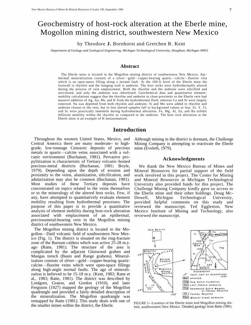
The Mogollon mining district is located in the Mo-gollon—Datil volcanic field of southwestern New Mex-ico (Fig. 1). The district is situated on the ring-fracture zone of the Bursum caldera which was active 25-28 m.y. ago (Ratte, 1981). The structure of the area is complicated by the adjacent Glenwood graben and Mangas trench (Basin and Range grabens). Mineral-ization consists of silver—gold—copper-bearing quartz-calcite—fluorite veins which were open-space fillings along high-angle normal faults. The age of minerali-zation is believed to be 15-18 m.y. (Kent, 1983; Ratte et al., 1983; Ratte, 1981). The district was described by Lindgren, Graton, and Gordon (1910), and later Ferguson (1927) mapped the geology of the Mogollon quadrangle and provided a fairly detailed description of the mineralization. The Mogollon quadrangle was remapped by Ratte (1981). This study deals with one of the smaller mines within the district, the Eberle.
Although mining in the district is dormant, the Challenge Mining Company is attempting to reactivate the Eberle mine (Eveleth, 1979).
Acknowledgments
We thank the New Mexico Bureau of Mines and Mineral Resources for partial support of the field work involved in this project. The Center for Mining and Mineral Resources at Michigan Technological University also provided funds for this project. The Challenge Mining Company kindly gave us access to the Eberle mine and their other holdings. Doug Mc-Dowell, Michigan Technological University, provided helpful comments on this study and reviewed the manuscript. Ted Eggleston, New Mexico Institute of Mining and Technology, also reviewed the manuscript.
7

Geology at the Eberle mine
The vein at the Eberle mine is dominantly quartz and calcite. It dips steeply to the east and follows a north—south-trending normal fault (Fig. 1). Along most of the vein the footwall is Fanney Rhyolite and the hanging wall is Mineral Creek Andesite. There are minor branches of the vein which are bounded by only rhyolite or only andesite.
Vein mineralization
Vein mineralization at the Eberle mine consists of hypogene early quartz followed by calcite and then fluorite (Fig. 2). Hypogene mineralization was fol-lowed, after a distinct time break, by supergene en-richment. Early hypogene quartz is usually micro-crystalline and is commonly banded or porcelaneous. It carries finely disseminated sulfide minerals (rarely more than 5 wt. %), which are often concentrated within chalcedonic bands. The sulfides are dominantly pyrite with lesser amounts of chalcopyrite, sphalerite, galena, argentite, stromeyerite, and chalcocite. Hypogene quartz and calcite are intergrown and the transition from Stage I to II is gradual. Banding is present in calcite due to changes in manganese content, relative crystallinity, and intergrowth with quartz or later fluorite (Ferguson, 1927; Scott, 1920). Hypogene sulfide minerals are larger and more coarsely crystalline in Stage II, but still form only a small per-centage of the vein material. The final stage of hy-pogene mineralization is fluorite, which is usually barren with respect to precious metals. Fluorite occurs as thin crystalline veneers or banded with calcite.
After hypogene mineralization there was a period of supergene alteration. In the district the oxidized zones typically occur as small, irregular bodies com-posed of sulfides, iron, manganese and rare copper oxides, copper carbonates, silver halides, and occa-sional native gold and silver. At the Eberle mine, Ferguson (1927) reports cerargyrite and native silver in oxidized ore. At the Eberle 100-ft level, boxwork and iron-stained quartz are pseudomorphic after calcite or coating calcite. The iron-oxide coating on supergene quartz may be due to weathered sulfide minerals and contains 48 ppm Ag.
Study of fluid inclusions in hypogene gangue quartz,
calcite, and fluorite suggests a drop in temperature during mineralization from 240 to 160°C (Bornhorst et al., 1984; Kent, 1983); fluids were not boiling. No fluid inclusions were found in the earliest variety of
quartz at the Eberle mine. Quartz from the nearby Confidence mine was deposited at about 260°C (Born-horst et al., 1984), but it is also not the earliest variety. The temperature for earliest quartz deposition probably exceeded 260°C. The salinity of mineralizing fluids apparently remained relatively constant at 3.2-3.5 wt. % equivalent NaCl. Bornhorst et al. (1984) suggest that if the Eberle vein was open to the surface, then during mineralization there was more than 500 m of cover over the Eberle 100-ft level.
Host-rock alteration
There is a relatively sharp contact between the vein and host rocks at the Eberle mine. The mineralogy and geochemistry of altered host rocks were studied at the 100-ft level of the Eberle mine, where the foot-wall is rhyolite and the hanging wall is andesite. A suite of samples was collected at 10-ft intervals roughly perpendicular to the vein at the 100-ft level, to distances of 50 ft into the rhyolite and 100 ft into the andesite. Samples of rhyolite and andesite directly adjacent to the vein were also studied, but not from along the same profile.
Rhyolite alteration
The mineralogy of the rhyolite outside the district is characterized by approximately 5% phenocrysts of predominantly anhedral to subhedral sanidine, pla-gioclase (An20-25), quartz, and occasional biotite with minor opaques, apatite, zircon, and sphene (Bornhorst, 1980; Rhodes, 1976). The groundmass ranges from glassy to spherulitic containing microcrystalline intergrowths of quartz and feldspar with minor iron oxides, apatite, zircon, and sphene. Adjacent to the vein, the rhyolite contains only rare, skeletal feldspar altered to quartz and sericite. Iron oxides are the only evidence of ferromagnesian minerals. Identifiable quartz is anhedral to subhedral and appears to have formed in fractures, flow-laminations, and other voids during silicification. The groundmass consists of abundant, small, remnant spherulitic and axiolitic de-vitrification structures of quartz and sericite, and micro- to crypocrystalline quartz, sericite, and possible minor K-feldspar. Throughout the traverse, away from the vein, there is a gradual transition from cr yptocrystalline to more coarsely crystalline groundmass. Identifiable muscovite is present at 40 ft or more from the vein. All of the rhyolite samples have been silicified and sericitized to varying degrees. Sample TR-10, at 10 ft from the vein, contains minor secondary calcite.
Andesite alteration
Relatively unaltered Mineral Creek Andesite is dif-ficult to find. The least altered samples within the area are composed of 5-7% ferromagnesian mineral phe-nocrysts, predominantly augite with some olivine altered to iddingsite, and 1-2% plagioclase phenocrysts. The groundmass consists of plagioclase laths with in-
8

9
terstitial magnetite and possible augite. Amygdule fillings are usually quartz and/or calcite. The miner-alogy and degree of alteration of the Mineral Creek Andesite varies systematically in a 100-ft traverse taken perpendicular to the vein. Immediately adjacent to the vein and for approximately 14 ft the Mineral Creek Andesite is extremely brecciated. The pulverized breccia matrix consists of smectite clays and quartz. The only clearly identifiable clasts are angular quartz fragments. At distances greater than 14 ft from the vein, the andesite consists of an identifiable vesicular- to amygdaloidal-flow top and a dense-flow interior. The dip of the andesite-flow top is approximately 20°W. Fractures within the andesite are roughly parallel to the vein, which dips approximately 70°E. Phenocrysts of ferromagnesian minerals, probably augite and minor olivine, have been altered to chlorite with minor iron oxides and iddingsite. Some relict, altered ophitic phenocrysts are present. Skeletal-plagioclase phenocrysts are zoned, with anorthitic cores altered to sericite and with the more albitic rims relatively unaltered.
The predominant amygdule filling is a mixture of quartz and chlorite with possible epidote and albite. Calcite is also present and often displays crosscutting relationship with earlier amygdule-filling minerals (Fig. 3). Chloritization and sericitization are common throughout the 100 ft of andesite profile away from the vein. The abundance of calcite alteration tends to decrease away from the vein and no calcite was seen in thin section at 70 ft or more from the vein.
Geochemistry of host-rock alteration
Analytical methods
Major- and trace-element compositions of eight samples of rhyolite and 11 samples of andesite from close proximity to the Eberle vein were determined for this study (Tables 1, 2). Most elements were an-alyzed using an automated Philips wavelength-dis-persive x-ray fluorescence spectrometer at Michigan Technological University. The analytical technique used is a modification from that of Leake et al. (1969). Major and trace elements were determined on pressed powder pellets. The system was calibrated utilizing French and U.S. Geological Survey geochemical standards. The precision of the major elements is typically about 0.5% of the amount determined. The precision of the trace elements is better than 10% of the amount determined.
Analyses for Au, Ag, and Mo were done by Neutron Activation Services, Ltd. of Hamilton, Ontario, Can-ada. Au was determined by neutron-activation anal-ysis using fire assay for separation of Au prior to irradiation (described by Hoffman et al., 1982; detec-tion limit 1 ppb). Values for Ag and Mo were deter-mined by D.C. Plasma emission spectrometry.
Geochemical-mobility calculations
Evaluation of element gains or losses during alteration requires that the altered rocks and the unaltered
parent initially belonged to a chemically uniform pop-ulation. The composition of unaltered parent for Fanney Rhyolite and for Mineral Creek Andesite was estimated through inspection of chemical data that were believed to be the freshest samples from these units. Data from Bornhorst (1980) and Ratte and Grotho (1979) were used, but interlaboratory bias was checked (unpublished data of Bornhorst) and appropriate corrections were made. There is certainly some primary compositional variation within these units as a whole, and as such the unaltered parent (Tables 1, 2) is our best estimate. However, we believe that within the close proximity of the Eberle mine the various samples of rhyolite and andesite had chemically uniform parents and, therefore, that chemical-mobility calculations are at least relatively correct.
Sometimes dramatic chemical changes caused by alteration can be correctly deduced from simple in-spection of raw chemical data. However, in most cases simple inspection is not satisfactory. Kerrich and Fyfe (1981) point out that since the major component oxides must sum to 100%, then no individual component is independent of the others and there is no limit to the number of solutions. The volume changes that accompany metasomatism must be known in order to quantitatively calculate compositional changes (Gresens, 1967). Volume changes during alteration of a volcanic rock might occur, for example, by filling of

vesicles (volume increase). The concentration of an immobile element would vary with volume change and gains or losses could be incorrectly deduced without knowledge of volume relations. Gresens (1967) presented a method for deducing volume changes and for calculation of the mass changes necessary to produce an alteration product from an assumed parent rock. His method has been successfully applied to evaluation of alteration associated with Archean lode-gold deposits in Canada (Kerrich, 1983; Kerrich and Fyfe, 1981) and the Mattagami Lake Archean vol-canogenic massive sulfide deposit in Canada (Costa, Barnett, and Kerrich, 1983).
Gresens' (1967) method of element-mobility calcu-lation requires that either the volume change is known or that at least one element can be assumed to be immobile. The method incorporates specific gravity, but manipulation of his formulae shows that knowl-edge of specific gravity is not necessary unless actual volume changes need to be calculated. The basic equa-tion used in the method by Gresens (1967) is
where XN is the amount of material lost or gained from the parent rock; fv is the volume factor; gA and gB are the specific gravities of the parent rock (A) and altered product (B), respectively; CNA and CNB are the concentrations of some element N in the parent rock (A) and altered product (B), respectively; and a is arbitrarily set to equal some specific amount. Since major-element chemical analyses sum to 100% by weight, a is set to 1 which results in calculated changes in grams per 100 g. When fv = 1, metasomatism is constant volume and, for example, fv = 0.5 and 1.5 represent a 50% volume reduction and 50% volume increase, respectively. For each element in a sample, fv can be calculated by assuming the element is immobile, XN = 0 (a = 1):
A clustering of fv's of several components empirically believed to be immobile (e.g., Zr, Sc, Al) provides a rational estimate of the volume change. Since the vol-ume factor is calculated by a ratio of an immobile element in the parent rock (CIMMA) to the same im-mobile element in the altered product( CIMMB), then
Substitution of equation (3) into equation (1) with a = 1 gives
Thus, gains and losses can be quantitatively calcu-lated without the need for specific-gravity data. A clustering of CNA/CNB ratios in an individual sample provides a means to estimate the "immobile element ratio":
The percentage loss or gain of a component relative to the original amount in the parent can be calculated by
Substitution of equation (4) into equation (5) gives
The latter ratio of ratios is often referred to as an enrichment factor.
Deduction of volume changes relies on the as-sumption of immobile elements (Kerrich, 1983). Im-mobile elements should maintain constant ratios relative to one another during alteration regardless of volume changes. Kerrich (1983) points out that if elements such as Ti, Al, Zr, and Sc, which do not covary in magmatic processes, maintain approxi-mately constant ratios during variable degrees of al-teration, then these elements can be presumed to be immobile. Otherwise, they would all have to be added or subtracted in the same proportion. Kerrich (1983), Costa, Barnett, and Kerrich (1983), and Kerrich and Fyfe (1981) have shown that Zr, Sr, Al, Ti, Y, and V are immobile to varying degrees during intense hydrothermal alteration. There is no element or a group of elements that can be considered to be always immobile because mobility depends on so many different factors, for example rock type and alteration conditions.
The chemical data listed in Tables 1 and 2 have been used to identify probable immobile elements and to evaluate IR for each sample . CNA/CNB was calculated for every element. Zr, Al, and Ti behaved coherently and were apparently immobile in the rhyolite. Zr and Sc were apparently immobile in the andesite. IR was calculated from the unweighted mean ratios (Tables 1, 2).
Rhyolite alteration
The rhyolite in close proximity to the Eberle vein underwent significant chemical changes during alter-ation (Fig. 4). There was massive addition of Ag, Au, Rb, and K in all analyzed samples. Na, Ca, Sr, and Mg were largely removed. Varying amounts of Fe, Ba, and Cu were added from the hydrothermal so-lutions, whereas Zn was removed. Si and Mn were added to the most intensely altered samples, which are generally close to the vein, and removed from the less altered samples. Y shows small and variable changes, and was nearly immobile during alteration. Zr, Al, and Ti were assumed to had been immobile during alteration of the rhyolite. Selected examples of the actual mass changes for the major elements are given in Table 3.
Andesite alteration
The chemical changes during alteration were more pronounced in the andesite than in the rhyolite (Fig. 5). On the basis of the IR's, probable volume changes within the andesite were also larger. Filling of vesicles and brecciation of the andesite support these observations. In the andesite there was pervasive and massive addition of Ag, Au, Rb, and K, and generally substantial removal of Sr and Ca. Na was depleted


13
Discussion
The conduits for hydrothermal fluids in the Mo-gollon mining district were interconnecting faults and fractures within the ring-fracture zone of the Bursum caldera. These existing structures were probably opened or reactivated during Basin and Range tec-tonism. The mineralizing fluids followed this im-proved plumbing system. Local circulation patterns were undoubtedly influenced by primary textures and structures in the host rock, particularly by flow lam-inations in the rhyolite and vesicular-flow tops in the andesite. Fluid movement into the wallrock probably became restricted as hydrothermal precipitation oc-curred and as the outer margins of the fault channel become coated with gangue and ore minerals.
The composition of the hydrothermal fluids is poorly constrained. The salinity of mineralizing fluids was approximately 3.3 wt. % equivalent NaCl (Bornhorst et al., 1984). Inclusion fluids in four samples of fluorite from the vicinity, but outside of the Mogollon mining district, have Na/K ratios between 0.6 and 2.5, Na/ Mg ratios between 2 and 20, and Na/Mn ratios between 6 and 20. The composition of the hydrothermal fluids can also be inferred from the precipitated gangue and ore minerals, but only to the extent that a component is present.
The chemical-mobility calculations reveal that pre-cious metals together with Rb and K were massively added to wallrocks from hydrothermal solutions. The
from all samples, but the degree of removal varies from partial to almost complete. Si, Al, Mn, and Zn were strongly enriched in the most intensely altered samples (generally closer to the vein) and fall to back-ground values in less altered samples. Cu was en-riched in the most intensely altered samples and depleted in less altered samples. In contrast, Mg, Fe, and Ba were enriched in less altered samples, but are strongly depleted in the more altered ones. V has a mixed pattern, but is generally removed by hydro-thermal solutions. Ni, Cr, Ti, and Y show variable enrichment and depletion, with Ti and Y being prac-tically immobile in most samples. Sc and Zr were assumed to had been immobile during hydrothermal alteration. Selected examples of the actual mass changes for the major elements are given in Table 3.
A strict profile of chemical changes in samples taken perpendicular to the vein shows a clear correlation with distance for some elements in the rhyolite or andesite (Fig. 6). Chemical changes with distance such as those of Si and Mn in the rhyolite and Si, Mn, Rb, K, Mg, and Na in the andesite are positive evidence that alteration is directly related to the Eberle vein and not simply to more regional hydrothermal activity.

14
comparatively low Na/K ratios for the mineralizing solutions are consistent with massive K and Rb in-troduction. Hydrothermal fluids also contributed var-iable amounts of Si, Fe, Mg, Ba, and Cu to the altered wallrocks. The most significant and obvious elements added to the veins were Si, Ca, CO2, F, Fe, Cu, S and precious metals. During alteration, Na, Sr, and Ca were largely removed from both andesite and rhyo-lite. The source for K, Rb, Si, Fe, Cu, and precious metals in the hydrothermal fluid had to be outside of the immediate vicinity of the veins, whereas some of the Ca and Na could have been leached from the wallrocks. The chemical changes in the andesite due to alteration are more pronounced than those in the rhyolite. This leads us to speculate that the hydro-thermal fluids may have been in equilibrium with more silicic rock types prior to interaction at the 100-ft level of the Eberle mine.
During hydrothermal alteration, the Fanney Rhy-olite adjacent to the Eberle 100-ft-level vein was sericitized and silicified. The rhyolite was probably devitrified prior to alteration and the microcrystalline groundmass had an enormous surface area available for reaction during alteration. The breakdown of phenocryst and groundmass feldspars during the formation of sericite would have released Na, Ca, and K:
In both cases, H+ had to be contributed by the hydro-thermal solution. The formation of large amounts of sericite would have stabilized K and geochemically similar Rb during alteration. In addition to SiO2 re-leased during sericite formation, some SiO2 was also apparently precipitated, as quartz, from the hydro-thermal fluids themselves. The hydrothermal solution probably cooled as it penetrated the rhyolite and the solubility of silica in solution should have decreased (Holland and Malinin, 1979), which would have pro-moted silica deposition. The liberated Na and Ca were removed by the hydrothermal fluids.
During hydrothermal alteration, the Mineral Creek Andesite adjacent to the Eberle 100-ft level was ser-icitized, silicified, chloritized, and carbonitized. The breakdown of plagioclase, pyroxene, minor olivine, and trace minerals during alteration would have made most elements available for either secondary-mineral formation or for removal by the hydrothermal solu-tions. Mg and Fe directly adjacent to the vein were removed, but further away the precipitation of chlorite caused the original contents of these elements to be retained. The enrichment of Mg and Fe over the unaltered-parent values suggests an additional con-tribution from the hydrothermal solutions. The for-mation of sericite captured K and probably H from the hydrothermal solutions. The high CaO gain in one sample (Fig. 5) was due to large quantities of calcite precipitated in vesicles. Significant quantities of silica were precipitated in vesicles, fractures, and matrix during hydrothermal alteration. Thus, for both the rhyolite and the andesite, chemical changes and secondary minerals formed during hydrothermal al-teration are grossly consistent with one another.
Conclusion
Mineralization at the Eberle mine consists of Ag-Au—Cu-bearing quartz—calcite—fluorite veins. Para-genetically, in gradual succession, quartz is followed by calcite and then by fluorite. Mineralizing hydro-thermal solutions were low-salinity, K-rich, and carried precious metals and a wide variety of other elements. The mineralizing fluids permeated the ad-jacent rhyolite and andesite wallrocks, causing sig-nificant chemical modification of the original rocks and the formation of secondary minerals. Both the rhyolite and andesite were massively enriched in Ag, Au, K, and Rb and depleted in Ca, Sr, and Na. Ser-icitization and silicification were characteristic of al-teration in both rhyolite and andesite, whereas chloritization was restricted to the andesite. The al-teration at the Eberle mine is an excellent example of K-metasomatism. Massive introduction of K is also a common feature of altered wallrocks surrounding Ca-nadian lode-Au deposits (Kerrich, 1983; Kerrich and Fyfe, 1981). Thus, K-fixation reactions may be a com-mon feature of precious-metal deposits.
At the Eberle mine, the altered Mineral Creek An-desite is more strongly enriched in precious metals than the Fanney Rhyolite (Figs. 4, 5). Thus, reactions between the andesite and mineralizing hydrothermal solutions promoted precious-metal precipitation. Per-haps the andesite played a role in precious-metal lo-calization in the vein. This idea is consistent with Scott's (1920) observation that economic mineraliza-tion within the district tends to be associated with the bimodal wallrock assemblage rhyolite—andesite.
Volume-corrected chemical-mass-balance calcula-tions lead to accurate deductions about element mo-bility during hydrothermal alteration. This technique is readily applicable to other mines in other districts and is the only rigorous way of analyzing geochemical changes during metasomatic alteration. By analyzing rocks at and beneath epithermal mineralisation, it may be possible to identify the source bed(s) for precious metals.

References
Bomhorst, T. J., 1980, Major and trace element geochemistry and mineralogy of upper Eocene to Quaternary volcanic rocks of the Mogollon-Datil volcanic field, southwestern New Mexico: Ph.D. Dissertation, University of New Mexico, Albuquerque, 1108 pp.
Bornhorst, T. J., Kent, G. R., Mann, K. L., and Richey, S. R., 1984, Temperature of mineralization in Mogollon mining district, southwestern New Mexico: New Mexico Geology, v. 6, pp. 5355.
Boyle, R. W., 1979, The geochemistry of gold and its deposits: Geological Survey of Canada, Bulletin 280, 584 pp.
Buchanan, L. J., 1981, Precious metal deposits associated with volcanic environments in the Southwest: Arizona Geological Society Digest, v. 14, pp. 237-262.
Costa, V. R., Barnett, R. L., and Kerrich, R., 1983, The Mattagami Lake mine Archean Zn-Cu sulfide deposit, Quebec: hydrother-mal coprecipitation of talc and sulfides in a sea-floor brine pool-evidence from geochemistry, 18O/16O, and mineral chemistry: Economic Geology, v. 78, pp. 1144-1203.
Eveleth, D. W., 1979, New methods of working an old mine-case history of the Eberle group, Mogollon, New Mexico: New Mexico Geology, v. 1, pp. 7-10.
Ferguson, H. G., 1927, Geology and ore deposits of the Mogollon mining district, New Mexico: U.S. Geological Survey, Bulletin 787, 100 pp.
Gresens, R. L., 1967, Composition-volume relationships of me-tasomatism: Chemical Geology, v. 2, pp. 47-65.
Hoffman, E. L., and Brooker, E. J., 1982, The determination of gold by neutron activation analysis; in Precious metals in the northern Cordillera: Association of Exploration Geochemists, Proceedings of a symposium held April 13-15, 1981 in Vancouver, B.C., Can-ada, pp. 69-77.
Holland, H. D., and Malinin, S. D., 1979, The solubility and oc-currence of non-ore minerals; in Barnes, H. L. (ed.), Geochem-istry of hydrothermal ore deposits: John Wiley & Sons, New York, pp. 461-508.
Kent, G. R., 1983, Temperature and age of precious metal vein mineralization and geochemistry of host rock alteration at the Eberle mine, Mogollon mining district, southwestern New Mexico: M.S. Thesis, Michigan Technological University, Houghton, 84 pp.
Kerrich, R., 1983, Geochemistry of gold deposits in the Abitibi greenstone belt: Canadian Institute of Mining and Metallurgy, Special Volume 27, 75 pp.
Kerrich, R., and Fyfe, W. S., 1981, The gold-carbonate association: Source of CO2 and CO2 fixation reactions in Archaean lode de-posits: Chemical Geology, v. 33, pp. 265-295.
Leake, B. E., Hendry, G. L., Kemp, A., Plant, A. G., Harvey, P. K., Wilson, J. R., Coats, J. S., Aucott, J. W., Lunel, T., and Howarth, R. J., 1969, The chemical analysis of rock powders by automatic x-ray fluorescence: Chemical Geology, v. 5, pp. 7-86.
Lindgren, W. A., Graton, L. C., and Gordon, C. H., 1910, Ore deposits of New Mexico: U.S. Geological Survey, Professional Paper 68, 361 pp.
Ratte, J. C., 1981, Geologic map of the Mogollon quadrangle, Ca-ton County, New Mexico: U.S. Geological Survey, Geological Quadrangle Map GC-1557, 1:24,000.
Ratte, J. C., and Grotho, T., 1979, Chemical analysis and norms of 81 volcanic rocks from part of the Mogollon-Datil volcanic field, southwestern New Mexico: U.S. Geological Survey, Open-file Report 79-1435, 16 pp.
Ratte, J. C., Marvin, R. F., Naeser, C. W., Brooks, W. E., and Finnell, T. L., 1983, Volcanic history of southwestern MogollonDatil volcanic field as recorded along the Morenci lineament, New Mexico and Arizona: Geological Society of America, Abstracts with Programs, v. 15, p. 303.
Scott, D. B., 1920, Ore deposits of the Mogollon district: American Institute of Mining Engineering, Transactions, v. 63, pp. 289310.
15


New Mexico Bureau of Mines & Mineral Resources Circular 199, September 1985 17
Geology and mineralization of the
Hermosa mining district, Sierra County, New Mexico
by Mark D. Shepard
Department of Geological Sciences, University of Texas at El Paso
(Present address: 2633B Granite NW, Albuquerque, New Mexico 87104)
Abstract
The old camp of Hermosa flourished during the period 1879-1893 and served as a support center for nearby mining activity in the eastern foothills of the Black Range, southwestern New Mexico. Since the initial discoveries, the mines in the district have pro duced over $1.5 million from small, high-grade deposits localized in Ordovician and Silurian dolomites.
Paleozoic sediments ranging from Ordovician through Pennsylvanian are exposed in a structurally elevated block at Hermosa and attain an aggregate thickness in excess of 610 m. The strata are flanked on the west by volcanic rocks of the Datil—Mogollon volcanic field and on the east by a major sediment-filled graben.
Detailed mapping has shown that the structural fabric is formed by normal faults of two dominant trends: north to northwest and east to northeast. Three major faults belonging to the first group are downthrown to the west 100 m or more and structurally control dikes and plugs of flow -banded rhyolite. They are interpreted as elements of a ring-fracture system along the northeast periphery of the Emory cauldron. Major areas of hydrothermal alteration and mineralization occur between ring fractures where complex fault and fracture systems have dislocated the Paleozoic sequence.
The majority of the ore deposits occur in two genetically related forms: (1) as irregularly distributed sulfide pods, stringers, and pipe-like bodies along steeply dipping fissure veins, and (2) as thin, concordant replacements just beneath the Silurian—Devonian unconformity. Both types show strong affinities for talc, with lesser amounts of calcite and quartz. Primary ore minerals include galena, sphalerite, and chalcopyrite, typically in coarse-grained aggregates, with finer concentrations of acanthite, tetrahedrite, polybasi te, pyrargyrite, and stephanite.
Fluid-inclusion thermometry indicates that the ores precipitated between 240 and 350°C (pressure corrected) from weak to moderately saline solutions (2.1 to 11.4 equivalent wt. % NaCl). The ore deposits are prime examples of unconformity-controlled mineralization within the ring-fracture zone of a major mid-Tertiary cauldron.
Introduction
Hermosa once was a small settlement which sup-ported nearby mining activity in the eastern foothills of the Black Range in southwestern New Mexico. Following the initial ore discoveries in 1879, the camp flourished for nearly 15 years until production was halted as the effect of silver demonetization became apparent. To date, the mines in the district have produced more than $1.5 million from deposits enriched in Pb, Zn, Ag, Cu, Sb, and Mo (Maxwell and Heyl, 1975). The principal ores are localized in Ordovician and Silurian dolomites.
Hermosa is situated about midway between the vil-lages of Chloride and Kingston, approximately 45 km (72 mi) west—northwest of Truth or Consequences, in western Sierra County. The mining district encom-passes more than 20 km2 (7.7 mi2) to the north, east, and south of the old townsite, and includes the prin-cipal mines at Palomas Camp, the Antelope—Ocean Wave area, the Flagstaff—American Flag claims, the
Wolford group, the Silver Queen area, and numerous other small workings and prospects (Fig. 1).
This article is essentially a scaled-down version of the author's M.S. thesis which included district-wide surface mapping at a scale of 1:6,000, underground mapping of nine mines at a scale of 1:240, ore pe-trography, and fluid-inclusion thermometry of ore and gangue minerals. Field work began during July of 1982 and continued off and on until September of 1983. The project was completed in May 1984.
Acknowledgments
Key support for this study was provided by Triple S Development Corporation of Albuquerque, New Mexico. Additional funding was received in the form of grants from the William N. McAnulty Memorial Fund and the New Mexico Bureau of Mines and Min-eral Resources, Dr. F. E. Kottlowski, Director.

1 8
Geologic setting
The Hermosa district is situated in a block of Pa-leozoic strata which measures approximately 16 km north to south, and 4 km at its widest point, east to west. This block is located at the boundary between the Mogollon Plateau volcanic province and the Rio Grande rift system; consequently, it is flanked on the west by a series of mid-Tertiary volcanic rocks and on the east by a north-trending structural depression termed the Winston graben (Kelley, 1955). The out-crop relations of the Paleozoic sediments and sur-rounding lithologies are shown on the general geologic map of the mining district (Fig. 2).
The major drainages which transect the study area incised steep-walled canyons in the Paleozoic section and exposed marine strata from Ordovician through Pennsylvanian in age. The oldest rocks at the surface are dolomitic limestones of the El Paso Group which outcrop at the base of Circle Seven Canyon, as well as in a structurally high position near the Silver Queen mines. Recent core drilling within the Paleozoic block has confirmed the presence and character of Cam
brian and Precambrian formations beneath the El Paso sediments.
To the west of Hermosa the terrane is primarily volcanic due to onlap of extrusive rocks from major mid-Tertiary eruptions and downthrown along the western sides of several north-trending faults. Flows, flow breccias, ash-flow tuffs, and epiclastic rocks dip gently westward toward the central core of the Black Range, where thick sequences (greater than 1,000 m) of Kneeling Nun Tuff occupy the northern portion of the Emory cauldron (Elston et al., 1975).
At the eastern edge of the district, the Winston graben comprises a subparallel offshoot of the Rio Grande rift system and is filled with an unknown thickness of Miocene through Pleistocene basin-fill deposits. These semiconsolidated sediments have been termed the Palomas Gravels, after exposures along Palomas Creek (Lindgren, Graton, and Gordon, 1910, p. 237), and are in juxtaposition with Paleozoic strata by virtue of considerable displacement along a range-boundary fault.

19

2 0
Stratigraphy Paleozoic sediments ranging from Ordovician
through Permian constitute the majority of rock ex-posures in the mining district and attain an aggregate thickness in excess of 610 m. General descriptions and thicknesses of these units are summarized in Table 1, which also includes subsurface formations. Much of the stratigraphic sequence was described and mea-sured in the Palomas Camp area by Jahns (1957); other units appeared for the first time in Shepard (1984). It should be noted that outcrops of the Permian Abo Formation are not present in stratigraphic sequence. These red beds occur as detached, raft-like blocks "floating" in and around the oldest sequence of volcanic rocks.
Mid-Tertiary breccia flows and lahars, lava flows, epiclastic rocks, and ash-flow tuffs are exposed along the western edge of the district; their outcrop areas extend well beyond the limits of mapping. The units, which reach a combined thickness greater than 550 m, were briefly described by Ericksen et al. (1970) and included in the calc-alkalic andesite to rhyolite and coeval basalt—basaltic andesite suites of Elston et al. (1976). Summary descriptions of Cenozoic volcanic and sedimentary rocks within the study area are listed in Table 2.
Intrusive rocks are not particularly abundant in the mining district, although they do occur in two struc-turally controlled forms: (1) as altered latite(?) dikes and small plugs along east—northeast-trending faults, and (2) as domes and irregular dikes of flow-banded rhyolite controlled by north-trending faults.
The Palomas Gravels are primarily composed of volcanic-rock fragments derived from the Black Range and further distant sources in the Mogollon Plateau. They have been roughly correlated with the Santa Fe Formation, Gila Conglomerate, and the informally used "Winston and Cuchillo beds" (Jahns et al., 1978).

21
Structure
General features
The Paleozoic strata which host the principal de-posits of the district form an intensely fractured block that has maintained its stability between two major tectonic features. The older of the two, the Emory cauldron, is a 55 by 25 km (34 x 15.5 mi) mid-Tertiary structure to the southwest of Hermosa; the younger Winston graben along the eastern edge of the district owes its origin to the inception of Basin and Range faulting. The positions of these features with respect to the Hermosa area and the tectonic framework of the surrounding region are shown in Fig. 3.
Detailed mapping of the mining district has shown that faulting conforms to two general trends: north to northwest and east to northeast. Major areas of hydrothermal alteration and mineralization tend to occur along zones of complex breakup in the Ordo-vician and Silurian dolomites. Such zones are only sporadically displayed in overlying limestone se-quences and the pre- and post-ore volcanic cover.
The Paleozoic rocks dip to the northeast at angles less than 15°, although local variations are consider-able, especially in the vicinity of the major faults. The volcanics dip to the southwest, west, and northwest at low angles, forming a gentle arc away from the older strata.
North to northwest-trending faults
The Hermosa, Bull Frog, and Circle Seven faults comprise the major features of the north to northwest-trending group. They are high-angle normal faults with down-to-the-west separations in excess of 100 m, and are interpreted to represent part of the ring-fracture zone associated with the northeast periphery of the Emory cauldron (Shepard, 1984). Two of the structures, the Hermosa and Bull Frog faults, have rotational displacements; i.e., stratigraphic separation increases northward along their fault traces. A
small plug of flow-banded rhyolite has been emplaced along the Bull Frog fault in the northern part of the district (Fig. 2).

22
Lesser elements of the ring-fracture system include the Pelican and Palomas Chief faults, two structures that evidently developed in conjunction with the min-eralizing event. In the Day mine scattered accumu-lations of ore minerals are found along the Pelican fault, but most of the displacement appears to post-date mineralization. These two faults collectively bound a north-trending horst which contains all of the pre-viously discovered ore deposits at Palomas Camp.
East to northeast-trending faults Faults with east to northeast trends are widespread
in the mining district and include some of the oldest as well as youngest structures. The most prominent elements of this group are the Emerick Mountain and Dark Canyon faults, both with down-to-the-southeast separations greater than 100 m (see Fig. 2). Whereas the Emerick Mountain fault offsets Paleozoic sedi-ments and is buried by younger volcanic rocks, the Dark Canyon fault offsets both rock types and is either a younger structure, or has experienced later reacti-vation.
The Mexican, Cliff, and Kendall breaks are part of a pronounced structural zone which crosscuts the Palomas Camp area bearing N 50° E and measuring over 366 m in width. Offsets along these faults are well displayed in the bluffs overlooking Palomas Can-yon and in many of the underground workings, al-though only the latter two structures are known to be mineralized.
From the available evidence it is apparent that many faults of this group pre-date the mineralization epoch; however, the trend has been active for extended pe-riods of time. Some of these structures may have de-
veloped as radial fractures related to the development of the Emory cauldron.
Mineralized structures Major loci of hydrothermal activity seem to occur
where faults of the two dominant trends intersect; to date, three areas have been identified: (1) the Palomas Camp area, (2) the Antelope—Ocean Wave area, and (3) the Flagstaff—American Flag area (still unexplored in favorable dolomite horizons). Within each of these areas mineralization occurs throughout a group of closely spaced subparallel faults with displacements that range from about 6 m to as little as 10 cm. The most productive structures trend north to northwest, dip steeply, and terminate at, or just above, the Fusselman—Onate
contact. The largest ore bodies are lo-calized at structural intersections.
At Palomas Camp the mineralized zone is elongated north to northwest, has a known strike length of 700 m, and measures about 550 m across at its widest point. Unfortunately, at least 50% of this zone has been eroded away by the steady downcutting of Palo-mas Creek. A similar, though less extensive, structural pattern is present at the Antelope—Ocean Wave mines where mineralization occurs along strike for at least 213 m.
Some of the mineralized structures are generally simple faults that persist both laterally and vertically; other mineralization occurs in areas characterized by a complex array of fractures, but these are usually of local extent. Either of these types may occur within a short distance of the other. Bedding-plane faults, more typical of complex structural sites, are also known to be mineralized.
Ore deposits
General relations and character Throughout the mining district, the ore deposits
are confined to three stratigraphic intervals: (1) the Upper Ordovician and Silurian units; i.e., the Upham, Aleman, Cutter, and Fusselman Dolomites; (2) the Lake Valley and Kelly Limestones; and (3) a massive limestone bed in the Madera Formation. Almost all of the previous production has come from the dolo-mite sequence.
The ore deposits occur in a variety of different forms. Most are found along steeply dipping fissure veins as stringers, small pockets and pods, pipe-like bodies, and disseminations wholly encased in talc. Lesser amounts of ore have been mined from thin, concor-dant deposits at or near the contact between the Fus-
selman Dolomite and the (Mate Formation. In many of the old workings, the manto-like ores overlie, and are often connected to, the fissure veins.
At the Antelope—Ocean Wave mines a larger per-centage of the ores consists of vuggy, silicified breccia containing disseminated sulfide minerals. These sili-ceous ores typically occupy the central portions of the veins and are surrounded by mixed sulfides and talc. Early miners confined their efforts to the talcose en-velope as it was amenable to hand-sorting techniques, and much of the siliceous ore was discarded; today it remains scattered throughout the mine dumps. The siliceous material averages between 3 and 6 ounces of silver per ton and has a higher silver/base metal ratio than the talcose ores.
Mineralization
Over 35 mineral species were identified in the dis-trict by Jicha (1954), including a wide assortment of both primary and secondary occurrences. The hy-pogene ores are composed mainly of galena, sphal-erite, and chalcopyrite, with lesser but economically significant amounts of acanthite, tetrahedrite, poly-
basite, pyrargyrite, and stephanite. Native silver and silver halides (cerargyrite, bromyrite, and embolite) evidently accounted for some of the bonanzas dis-covered in the early mining history of the district.
The chief sulfides occur in various ratios through-out the deposits. In general, ores of high sphalerite

23
content are low in silver value, whereas galena and chalcopyrite tend to be the major components of high-silver ores. Within individual deposits the sulfide minerals are often found as coarse-grained aggregates, which suggests unrestricted growth in open spaces or in a soft talc matrix.
Hydrothermal alteration is evidenced by two main types of occurrence: (1) talc, with associated calcite and lesser silicification in Ordovician and Silurian do-lomites; and (2) irregular silicification, including the development of jasperoid bodies in Mississippian and Pennsylvanian limestones. In several areas these types of alteration appear to be manifestations of different levels within the same hydrothermal system. Talc re-places dolomite and dolomitic fault gouge in, and adjacent to, mineralized veins and commonly extends
perpendicular to the structures along bedding planes. Many of the original cher t nodules in the Cutter and Aleman Dolomites have also been replaced by mix-tures of talc and calcite at some distance from known veins. This type of alteration is widespread in areas that have experienced increased heat flow and can be used as a general guide to mineralization.
Natural solution cavities, caves, and other open watercourses have developed along throughgoing faults and fractures, and are prominent in many of the underground workings. The oxidized ores are typically composed of cerussite—silica boxworks encrusted by one or more of the following minerals: smithsonite, descloizite, anglesite, vanadinite, pyro-morphite, mimetite, or wulfenite.
Fluid-inclusion studies
Introduction
Fluid-inclusion thermometry was undertaken to as-certain the prevailing temperatures of ore deposition and the salinities of parent hydrothermal fluids. In many respects, both ore and gangue minerals from the mining district are ideally suited for this type of study. Sphalerite, quartz, and calcite are sufficiently transparent and coarse-grained to provide excellent working material, and they can be separated from other minerals with relative ease. The data presented in this section represent an investigation of these three mineral species from six mines in the district.
Methods of study
With an R. CHAIXMECA heating and freezing stage, visual fluid-inclusion thermometry was conducted on doubly polished mineral plates whose thicknesses ranged between 0.5 and 1 mm. Above room temperature, the apparatus is calibrated by comparing known micro-melting points of standard compounds with their observed melting points during heating runs. These data are plotted to form a calibration curve which is then used as a correction factor for all subsequent homogenization measurements. Calibration of the freezing stage with deionized water showed it to be in equilibrium with the stage thermocouple; i.e., the thermal lag at or near 0°C was negligible. In light of the slight freezing-temperature depressions encountered, no further calibration was considered necessary.
Character of inclusions
Because fluid inclusions form at various stages during the history of a particular grain or crystal, dis-tinction between types of inclusions must be made (i. e. , primary, secondary, or pseudosecondary). For a discussion of the various criteria used to make this distinction the reader is directed to articles by Roed-der (1972, 1979). All three kinds of inclusions were encountered during the study, although secondary and pseudosecondary types prevailed.
With the exception of one large inclusion which contained a small group of unidentified daughter
crystals, all other inclusions were simple two-phase varieties with estimated gas volumes from 5 to 15%, and all homogenized in the liquid phase. Strong evi-dence of fluid entrapment at or near boiling conditions was observed in a small group of inclusions in quartz from the Drake workings. These pseudo-secondary inclusions contained varied gas/liquid ratios, but homogenized within a fairly narrow temperature range; the homogenization occurred by the expansion of the dominant phase. They were the only inclusions which exhibited this behavior; it was thus assumed that boiling conditions were not widespread during precipitation of the ores.
Samples of sphalerite and quartz from the various mines in the district typically contained countless numbers of inclusions, but most of them were too small and opaque to study. Most temperature measurements were conducted on inclusions which ranged from 0.15 mm to less than 40 microns in size. These included a variety of negatively faceted, rounded to columnar shapes, as well as numerous indusions with irregular outlines.
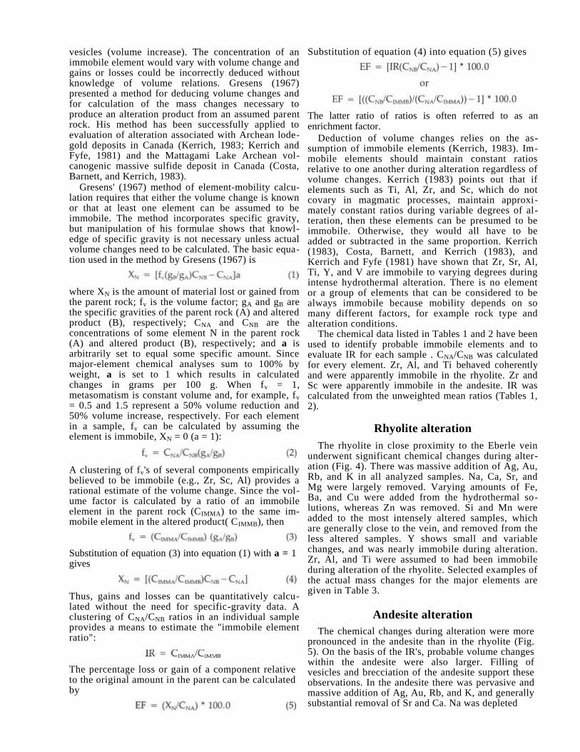
Homogenization and freezing data
The fluid-inclusion study included over 80 homog-enization and 15 freezing-point determinations. The results of these measurements are summarized in Fig. 4.
One of the more interesting aspects of the homog-enization data is the limited variation in temperatures between the two mining centers of the district. Sphal-erite in ore samples from the Lewandowski (H-15) shaft (Antelope—Ocean Wave area) and the Day mine (Palomas Camp) are located about 2 km (1.2 mi) apart, yet they show strikingly similar ranges [If (filling tem-perature) 265-301°C and 250-307°C, respectively]. This fact suggests that mineralization in both areas oc-curred from similar, although probably separate, hydrothermal systems. Eight primary and pseudo-secondary inclusions measured from the Palomas Chief mine (eastern Palomas Camp) show a range of ho-mogenization temperatures in general accordance with sphalerite from the other two workings. However, they include some of the lowest readings observed in
24
this mineral (note filling temperature range of 238-269°C).
Quartz inclusions from the Antelope—Ocean Wave mines (Slater crosscut; Tf 219-336°C) and the Palomas Camp area (Drake workings; Tf 280-338°C) also show similar temperature characteristics. The highest homogenization temperatures recorded are in direct agreement, although the Slater crosscut samples showed the widest range of values.
Clear, coarse-grained calcite, which typically occurs as vug and cavity fillings, was probably deposited during the waning stages of hydrothermal activity. Pseudosecondary inclusions from both the Albatross drift and Slater crosscut showed low homogenization temperatures (82-115°C). Many of the inclusions ob-served in calcite samples did not contain a vapor phase.
Freezing-point determinations indicate that parent hydrothermal solutions were weakly to moderately saline brines whose compositions varied between 2.1 and 11.4 equivalent wt. % NaCI. Inclusion fluids in quartz, which generally precedes sphalerite in the paragenetic sequence, show lower salinity ranges (2.1-4.5 as compared with 2.6-11.4 for sphalerite). How-ever, clear-cut salinity trends cannot be established from such widely spaced sampling and small data base. It should be noted that sphalerite samples from a single deposit in the Lewandowski (H-15) shaft showed a wide range of salinity values (2.6-11.1 equivalent wt. % NaCl). This variation may have re-sulted from dilution, or mixing, of hydrothermal so-lutions with fresher ground waters.
References
Alminas, H. V., Watts, K.C., Griffitts, W. R., Siems, D. L., Krax-berger, V. E., and Curry, K. J., 1975, Map showing anomalous distribution of tungsten, fluorite, and silver in stream-sediment concentrates from the Sierra Cuchillo–Animas uplifts and adjacent areas, southwestern New Mexico: U.S. Geological Survey, Miscellaneous Inventory Map 1-880.
Elston, W. E., Rhodes, R. C., Coney, P. J., and Deal, E. G., 1976, Progress report on the Mogollon Plateau volcanic field, south-western New Mexico, No. 3—surface expression of a pluton; in Cenozoic volcanism in southwestern New Mexico: New Mexico Geological Society, Special Publication no. 5, pp. 3-28.
Elston, W. E., Seager, W. R., and Clemons, R. E., 1975, Emory cauldron, Black Range, New Mexico: source of the Kneeling Nun Tuff: New Mexico Geological Society, Guidebook 26, pp. 283292.
Ericksen, G. E., Wedow, Helmuth, Jr., Eaton, G. P., and Leland, G. R., 1970, Mineral resources of the Black Range primitive area, Grant, Sierra, and Catron Counties, New Mexico: U.S. Geological Survey, Bulletin 1319-E, 162 pp.
Harley, G. T., 1934, The geology and ore deposits of Sierra County, New Mexico: New Mexico Bureau of Mines and Mineral Re-sources, Bulletin 10, 220 pp.
Hedlund, D. C., 1977, Geologic map of the Hillsboro and San Lorenzo quadrangles, Sierra and Grant Counties, New Mexico: U.S. Geological Survey, Miscellaneous Field Studies Map MF 900-A.
Jahns, R. H., 1955, Geology of the Sierra Cuchillo: New Mexico Geological Society, Guidebook 6, pp. 158-174.
Jahns, R. H., 1957, The Pelican area, Palomas (Hermosa) district, Sierra County, New Mexico: New Mexico Bureau of Mines and Mineral Resources, Bulletin 55, 5 pp.
Jahns, R. H., McMillan, D. K., O'Brient, J. D., and Fisher, D. L., 1978, Geologic section in the Sierra Cuchillo and flanking areas, Sierra and Socorro Counties, New Mexico; in Field guide to se-lected cauldrons and mining districts of the Datil–Mogollon vol-
canic field, New Mexico: New Mexico Geological Society, Special Publication no. 7, pp. 131-138.
Jicha, H. L., Jr., 1954, Paragenesis of the ores of the Palomas (Her-mosa) district, southwestern New Mexico: New Mexico Bureau of Mines and Mineral Resources, Circular 27, 20 pp.; Economic Geology, v. 49, pp. 759-778.
Kelley, V. C., 1955, Regional tectonics of south-central New Mexico: New Mexico Geological Society, Guidebook 6, pp. 96-104. Lindgren, W., Graton, L. C., and Gordon, C. H., 1910, The ore deposits of New Mexico: U.S. Geological Survey, Professional Paper 68, p. 237. Maxwell, C. H., and Heyl, A. V., 1975, Mineralization and structure
of mineral deposits in the Hermosa, Chloride, and Phillipsburg areas, New Mexico (abstract): New Mexico Geological Society, Guidebook 26, pp. 341-342.
Maxwell, C. H., and Heyl, A. V., 1976, Geology of the Winston quadrangle, New Mexico: U.S. Geological Survey, Open-file Map 76-858.
Potter, R. W., Clynne, M. A., and Brown, D. L., 1978, Freezing point depression of aqueous sodium chloride solutions: Economic Geology, v. 73, pp. 284-285.
Roedder, E., 1972, Composition of fluid inclusions: U.S. Geological Survey, Professional Paper 440-JJ, 164 pp.
Roedder, E., 1979, Fluid inclusions as samples of ore fluids; in Barnes, H. L. (ed.), Geochemistry of hydrothermal ore deposits, 2nd edition: Wiley-Interscience, New York, pp. 684-737. Roedder, E., Heyl, A. V., and Creel, J. P., 1968, Environment of ore deposition at the Mex-Tex deposits, Hansonburg district, New Mexico, from studies of fluid inclusions: Economic Geology, v. 63, pp. 336-348. Shepard, M. D., 1984, Geology and ore deposits of the Hermosa
mining district, Sierra County, New Mexico: M.S. thesis, University of Texas at El Paso, 215 pp.
Woodard, T. W., 1982, Geology of the Lookout Mountain area, northern Black Range, Sierra County, New Mexico: M.S. thesis, University of New Mexico, 95 pp.
New Mexico Bureau of Mines & Mineral Resources Circular 199, September 1985

Geology, character, and controls of epithermal silver mineralization
in the Carbonate Creek area, Kingston, New Mexico
by Vertrees McNeil Canby1 and Rex L. Evatt
2
1Department of Geoscience, New Mexico Institute of Mining and Technology, Socorro, New Mexico 87801
2Department of Geology, Western New Mexico University, Silver City, New Mexico 88061
Abstract
The silver—gold deposits of the Carbonate Creek area are entirely within Paleozoic sedimentary rocks. The Fusselman Dolomite, limestones of the El Paso Group, and Lake Valley Limestone were extensively replaced by fine-grained silica (jasperoid) along a series of NW-trending faults prior to silver—gold mineralization. These faults are the major ore control in the area.
Silicification took place in three stages, with ore mineralization during the latest stage. In the first stage solutions flowed along the faults, jasperoidizing the wall rocks. The carbonate rocks, mostly the Lake Valley Limestone, Fusselman Dolomite, and Lower Montoya Group, which were in contact with the faults, were largely replaced, forming jasperoid bodies. In the second and third stages, reactivation of faults in the area brecciated the jasperoid zones. Solutions then flowed along the faults silicifying and mineralizing the breccia zones. The peculiar alteration that preceded, or coincided with, mineralization rendered limestone to a powdery, soft, calcite—clay mixture which, along with fault gouge, may have clogged faults where they traversed limestone, resulting in reduced permeability.
Ore minerals present are acanthite, ruby silver, and polybasite, with some native silver, native gold, chalcocite, and small amounts of azurite, malachite, and chlorargyrite. Gangue mineralization is mostly silica, with some calcite, limonite, hematite, and small amounts of manganese oxides, pyrite, fluorite, dickite, and adularia.
Introduction
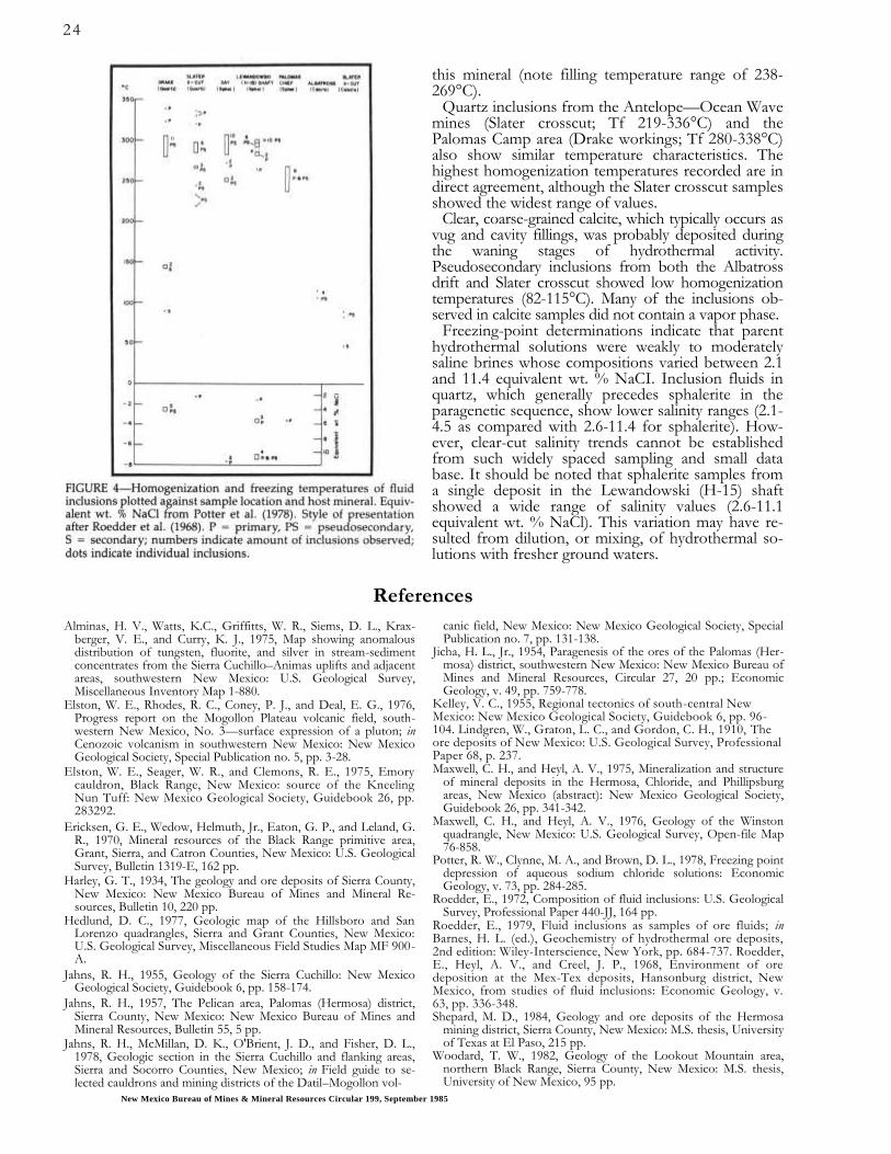
The study area is located in the Kingston mining district on the west side of Carbonate Creek, which is on the east slope of the Black Range approximately 3 mi due north of Kingston, New Mexico (sections 25 and 36, T. 1 S., R. 9 W.—Fig. 1). Silver was discovered in the area in 1882 by two prospectors named Shedd and Henry. While prospecting their claim on the southwestern slope of what is now called Silver Gulch, they discovered acanthite float ranging from marble size to 250-lb masses (Fig 2). Downhill from the claim staked by Shedd and Henry was a claim owned by Governor Tabor of Leadville, Colorado. It is reported that a crew of men working for Tabor collected over $80,000 worth of silver within a few weeks.
Despite numerous workings, the source of the acanthite float was never discovered. The workings in the area are shallow and most explore silica and calcite pods, some of which contain acanthite min-eralization.
Acknowledgments
We are indebted to Robert North, mineralogist at the New Mexico Bureau of Mines and Mineral Re-sources, for the use of x-ray-diffraction equipment, rock saws, atomic-absorption equipment, and assay facilities. Mr. North also provided excellent advice
and discussions on the project and reviewed the manuscript. We are also indebted to Phillip Fields, a New Mexico Tech student, for spending many hours with us collecting samples, and to Thomas Keller for some assistance in the field.
25

Geology
To the west of the study area are exposed Precam-brian rocks consisting of granite and schist. Overlying the Precambrian rocks are Paleozoic sediments, mostly carbonates, which are host rocks for ore deposits in the area. The Paleozoic sediments dip to the east and are cut by N—NW-trending normal faults of small dis-placement. These faults parallel the large Carbonate fault which has a displacement of approximately 600 ft (Fig. 3).
Rubio Peak andesite lies unconformably on the Magdalena Group north of Silver Gulch and is dis-placed by some of the normal faults. Faults are gen-erally harder to recognize in the andesite due to its homogeneity, but are marked in some places by slight argillic alteration. To the west, some of the Precam-brian basement rocks are overlain by the Kneeling Nun Tuff.
Precambrian rocks
The Precambrian rocks consist of granite and horn-blende—chlorite schist cut by metadiabase dikes. The granite is fine- to medium-grained, light red to tan, and contains perthite, quartz, plagioclase, biotite, and minor amounts of magnetite, ilmenite, zircon, fluo-rite, and chlorite. The metadiabase is dark green to black and contains hornblende and chlorite with small amounts of biotite, magnetite, ilmenite, plagioclase, and epidote (Kuellmer, 1954, pp. 6-10).
Paleozoic rocks
Paleozoic rocks consist of the Pennsylvanian Mag-dalena Group, Mississippian Lake Valley Limestone, Devonian Percha Shale, Ordovician Montoya Lime-stone and El Paso Group, and Cambrian Bliss Sand-stone. The Magdalena Group is approximately 900-ft thick and consists of gray to black, thick- to thin-bedded fossiliferous limestone with interbedded shale; fossils are chiefly brachiopods and fusulinids. The Magdalena Group in this area has a basal unit 50-ft thick. The Lake Valley Limestone is approximately 100-ft thick and consists of gray to black thick- to thin-bedded cherty limestone which is in part shaly and fossiliferous, with brachiopods, crinoids, trilobites, and bryozoans common.
The Percha Shale is approximately 150-ft thick and consists of a lower member of black fissile, fossiliferous shale and an upper member of green, highly fossiliferous calcareous shale. The upper member contains nodules and thin beds of fossiliferous limestone with brachiopods, crinoid columnals, and bryozoans.
The Fusselman Dolomite is approximately 50-ft thick. It consists of gray- to brownish-gray and black fine-grained massive dolomite with thin beds of limestone and sparse nodules and lenses of gray chert.
The Montoya Limestone is approximately 150-ft thick and consists of gray to black, thick- to thin-bedded cherty limestone and dolomite with interbedded calcareous siltstone. The Montoya has a basal unit of white coarse-grained sandstone and locally contains a distinctive chert layer 25 to 35-ft thick, which is probably of secondary origin.
The El Paso Limestone is approximately 950-ft thick and consists of gray, fine-grained, slabby to massive-bedded limestone with abundant yellow—brown silt-stone partings.
The Bliss Sandstone is approximately 75-ft thick and consists of glauconitic and hematitic sandstone, silt-stone, and shale, with a few thin layers of limestone, pebble conglomerate, and quartzite (Kuellmer 1954, pp. 11-27).
Tertiary volcanic rocks
Tertiary volcanic rocks in the study area consist of the Rubio Peak Formation and the Kneeling Nun Tuff. The Rubio Peak Formation is a series of andesitic flows and autobreccias consisting of silicic amphibole latites and pyroxene andesites. Their colors range from pinkish gray to various shades of red, lavender, purple, brown, and black. Phenocrysts may be large or small, and the rock may be glassy or almost entirely crystalline.
The Kneeling Nun Tuff is a pinkish-gray to reddish-brown, medium-grained, highly porphyritic, welded rhyolite tuff. Phenocrysts consist of quartz as much as 3 mm in diameter, with lesser amounts of sanidine and plagioclase of similar size and minor biotite in a fine-grained glassy matrix (Jicha 1954, pp. 40, 44).
Ore deposits
Mineralization in the Carbonate Creek area was dis-covered in 1882 by prospectors who found large masses of acanthite float in what is now called Silver Gulch. Mining consisted of hand-collecting the float; it is re-ported that 80,000 ounces of silver were recovered. However, despite numerous later workings, the source of the large masses was never found.
At least two stages of mineralization have been rec-ognized in the Carbonate Creek area: an early barren stage of fine-grained jasperoid as replacement of car-bonates, shales, and sandstones, and at least one later
stage of fine- to coarse-grained quartz that was wide-spread, but contains ore minerals only locally.
Jasperoid occurs throughout the Kingston district, but is most abundant in the study area, north of the historic mining area. It is concentrated in several spe-cific stratigraphic horizons: the Fusselman Dolomite-Percha Shale contact, where it replaces both shale and dolomite; the lower sandstone member of the Montoya Group, where it replaces carbonates on both sides of the contact as well as the sandstone; the upper Magdalena Group; and the "blue crinoidal" member
27


29
of the Lake Valley Formation. It also occurs along faults, which suggests that solutions depositing jas-peroid followed permeable structures (i.e., the lower sandstone member of the Montoya Group, as well as breccia zones along faults), or were channeled under impermeable horizons such as the Percha Shale, an ore-capping horizon that has been productive throughout much of southwestern New Mexico. Jasperoids in the Montoya-El Paso contact average about 5 m in thickness and are more abundant and laterally extensive than those in other horizons; some can be followed for over 300 m along strike. Jasperoids in the other horizons average about 3 m in thickness and are generally less extensive along strike. The jas-peroid is composed of very fine-grained quartz with no other megascopic minerals, and is tan, gray, yellow, or red-brown. Original structures in the host rocks are completely replaced and jasperoid/hostrock contacts are sharp. Although it contains no contemporaneous ore minerals, jasperoid is important because of its competence which allowed open space to form when faults were reactivated. In places, tuffs of the Kneeling Nun Tuff have been deposited on eroded jasperoid surfaces, indicating an age of early or middle Oligocene for jasperoid formation.
Vertical movement again occurred along old faults as well as on new ones, resulting in formation of both jasperoid and carbonate breccias. Shearing also oc-curred along bedding planes, especially in competent jasperoid beds, resulting in breccias composed of flat slabs oriented parallel to bedding; this is so extensive that few jasperoids can be found in the field that have not been brecciated either by vertical faulting or bed-ding-plane slippage. A second stage of fine- to coarse-grained quartz cements these breccias. The quartz
commonly occurs as comb growths around vugs and fractures, the crystals frequently having multiple growth terminations. Locally, this second stage of quartz contains pyrite and minor fluorite, dickite, chalcopyrite, and adularia. Samples of this material rich in pyrite contain up to 0.15 oz Au/ton and 2.5 oz Ag/ton; the few average samples available of large, iron-stained jasperoids with this type of quartz veining contain about 0.01-0.03 oz Au/ton and about 1.5 oz Ag/ton.
Thirty fluid inclusions from second-stage quartz of this type were analyzed for homogenization temper-atures and salinities. The samples came from a small jasperoid along a north-trending fault, north of the Blacky prospect. Pyrite-rich samples from this locality contain up to 0.15 oz Au/ton, with little Ag. The in-clusions measured all were two-phase primary or pseudosecondary types with similar phase ratios; many had negative crystal shapes. Mean homogenization temperature for these inclusions is 224°C, uncorrected for pressure, with a range of 220-231°C. Salinities were very low (< 1%) and all inclusions were homogenized to a liquid.
Silver mineralization occurred after a third move-ment along the faults. It appears, however, that only a few of the faults were reactivated and displacements were very small. Ore minerals—small grains of acan-thite, gold, polybasite, cinnabar, and realgar—were deposited in open space. Two prospects containing rich silver mineralization were examined: the Blacky claim and a prospect about 800 m west of the study area, referred to as the "West prospect."
The West prospect affords an excellent example of the sequence of mineralization in the area. Brecciated gray jasperoid (replacing the lower sandstone mem-ber of the Montoya Group) had been cemented by pyrite and quartz, which were in turn shattered and cemented by quartz containing polybasite, realgar, and native silver. Although the structure at the pros-pect is not completely clear, it does lie in a small north-trending fault that appears to have had at least three periods of movement.
On the Blacky claim, late silver mineralization oc-curs in faulted jasperoid that replaces the Tierra Blanca Member of the Lake Valley Formation. As can be seen on the map (Fig. 3), a normal fault of small displace-ment cuts down-slope and down-dip of the silver-bearing jasperoids, both of which lie along the strike of this fault. The down-dip extension of the jasperoid in both cases has been eroded or displaced by faulting and its contact with the fault has been erased. Ore-generation quartz varies from finely banded chalcedony to coarse and granular, and fills vugs containing earlier quartz crystals. It is commonly white, but the richest silver values are found in bright yellow or purple quartz. In some places sharp jasperoid fragments are cemented with acanthite-bearing quartz, but most often the contact of silver-bearing quartz and jasperoid is gradational, and it appears that some replacement has taken place. Although the earlier, second-stage quartz is present, there is no pyrite. Acanthite is abundant in many specimens as grains up to 2 mm in diameter. Native gold and silver are relatively common, often being intergrown with the

30
acanthite. Cinnabar has been found in one polished section as tiny grains frozen in quartz with acanthite, as well as in placer grains.
Twenty-four fluid inclusions from Blacky ore sam-ples were analyzed for homogenization temperature and salinity. Unfortunately, only relatively large crys-tals were amenable to measurement and no inclusions
were measured in the banded, chalcedony-type quartz that appears to be associated with ore minerals. Mean homogenization temperature for these inclusions was 214°C, uncorrected for pressure, with a range of 200-231°C. Like the samples discussed above, salinities were below 1%.
Alteration
Two types of altered rock are found in the study area, but their relation to silver mineralization is un-certain. The most apparent is a large area on the south side of Silver Gulch. Here limestones of the middle Lake Valley Formation and lower Magdalena Group have been altered to a powdery white clay-like ma-terial that is composed of calcite and montmorillonite. All texture of the original limestones is erased and approximately 10% of the original calcite has been removed. Altered and unaltered limestones were compared by x-ray-diffraction analysis and no min-eralogical change has been found. The montmoril-lonite was present in both samples; it is probably detrital. Montmorillonite has been enriched relative to calcite in the altered samples due to its resistance to leaching. This type of alteration covers at least 10,000 m
2 as now exposed, and has been found over an even
larger area under soil cover. Its contact with unaltered limestones is gradational and fragments of unaltered limestone are found surrounded by alteration. The relation of this material to structures is not clear, al-though it roughly follows bedding planes in some places. Where explored by old workings, the small faults in the altered area are filled with gouge that ends abruptly at the slickensided walls. No conclu-sions can be made relating faults and alteration in the study area.
This type of alteration occurs elsewhere in the dis-trict, although nowhere is it as strong as in the study area. In these cases it forms along, or in, faults of varying displacement, and is always associated with irregular quartz pods. No rich silver mineralization
occurs at any of these other localities, although some contain minor gold and silver anomalies (up to 0.02 oz Au/ton and 0.5 oz Ag/ton). Quartz in these pods is granular and bears no resemblance to either jas-peroid or second-generation quartz.
Alteration of a different type occurs on the north side of Silver Gulch in the Rubio Peak andesite and Magdalena Group. Here, along its contact with the Rubio Peak andesite, Magdalena limestone has been irregularly replaced by bright-red, hematite-rich silica. This replacement is most intense along the contact and the altered beds are up to 3-m thick. The overlying andesite has been bleached from its typical bluish color to a bright-white, hard rock stained red by li-monite on fracture surfaces. Mineralogically, the orig-inal andesite (composed of andesine, amphiboles, and quartz) has been enriched in quartz, K-feldspar, mus-covite (probably as sericite), and depleted of andesine and dark minerals. Pyrite occurs sparingly in the al-tered andesite.
The white, strongly altered andesite clearly occurs along fractures; away from the fractures, the andesite is weakly altered to a light-yellow color. Irregular areas of this strong alteration also occur. Wide breccia zones are not common in the andesite, but some occur along projections of small faults mapped in sediments south of Silver Gulch. As one proceeds further inside the andesite (away from the contact), alteration diminishes and faults become hard to trace. A large proportion of the andesite on the hill north of Silver Gulch is altered to varying degrees.
Conclusions
The silver deposits in the Carbonate Creek area occur in an unusual setting for epithermal deposits. No mineralized veins occur in volcanics, and, thus far, ore-grade mineralization has been found only in roughly pipe-like bodies following shattered jasperoid beds. No replacement ores have been found. Metallic mineralization appears to have occurred in two stages, with silver deposition restricted to the second stage. The relation of ore deposits to faulting is difficult to determine due to the reactivation of faults throughout time; some of the faults have been active since ore formation. However, the ore seen does occur as open-space filling in either fault or bedding-slip breccias. Faults explored in unsilicified limestones are largely gouge-filled, with restricted open space.
The fluid-inclusion data available are too limited to permit conclusions on the nature of solutions corre-sponding to different stages in paragenesis. However, the similarity of homogenization temperatures and salinities of quartz from the two sample areas suggests that the second-stage-quartz mineralization occurred under similar conditions in these two places, and that the homogeneity of this type of quartz throughout the study area may be true over a larger area. The banded texture of quartz and ore minerals as a filling around coarse quartz crystals (from which the Blacky inclusion measurements were taken), and the occurrence of ore minerals cementing second-stage quartz and pyrite at the West prospect both imply that silver mineralization began after coarse quartz
31
was deposited. Deposition of ore minerals could be due to physical or chemical changes in the same so-lution that deposited coarse quartz (such as boiling), or due to mixing of a new solution. Ore mineralization probably occurred in the waning stages of a hydro-thermal system that had largely sealed itself, and thus was restricted to places where open space allowed access of the solutions and physical and chemical con-ditions were right for deposition.
The deposits lack the classic epithermal-alteration types, but it must be remembered that there are few volcanics here and a solution moving in the carbon-
ate-dominated stratigraphic column would be quickly buffered. Thus, another facet is added to the problem of ore deposition. Further fluid-inclusion studies are expected to reveal more about the evolution of the hydrothermal system and factors which controlled ore deposition. In light of the assay data obtained thus far, the extensive jasperoids in the area deserve ex-amination for bulk-tonnage low-grade deposits that are being reassessed throughout the Southwest. Fur-ther geologic work on the small, bonanza deposits may define the ore environment well enough to war-rant search for these higher-risk orebodies.
References
Jicha, H. L., Jr., 1954, Geology and mineral deposits of Lake Valley quadrangle, Grant, Luna and Sierra Counties, New Mexico: New Mexico Bureau of Mines and Mineral Resources, Bulletin 37, 93
P P .
Kuellmer, F. V., 1954, Geologic section of the Black Range at Kings-ton, New Mexico: New Mexico Bureau of Mines and Mineral Resources, Bulletin 33, 100 pp.

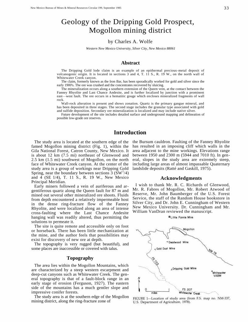
New Mexico Bureau of Mines & Mineral Resources Circular 199, September 1985
Geology of the Dripping Gold Prospect,
Mogollon mining district
by Charles A. Wolfe
Western New Mexico University, Silver City, New Mexico 88061
Abstract
The Dripping Gold lode claim is an example of an epithermal precious-metal deposit of volcanogenic origin. It is located in sections 3 and 4, T. 11 S., R. 19 W., on the north wall of Whitewater Creek canyon.
The claim, formerly known as the Iron Bar, has been sporadically worked for gold and silver since the early 1900's. The ore was crushed and the concentrates recovered by sluicing.
The mineralization occurs along a southern extension of the Queen vein, at the contact between the Fanney Rhyolite and Last Chance Andesite, and is further localized by junction with a prominent east—west fault. The ore occurs in a hematitic gouge which encloses mineralized fragments of wall rock.
Wall-rock alteration is present and shows zonation. Quartz is the primary gangue mineral, and has been deposited in three stages. The second stage includes the granular type associated with gold and sulfide deposition. Secondary ore mineralization is localized and may include native silver.
Future development of the site includes detailed surface and underground mapping and delineation of possible low-grade ore reserves.
Introduction
The study area is located at the southern edge of the famed Mogollon mining district (Fig. 1), within the Gila National Forest, Catron County, New Mexico. It is about 12 km (7.5 mi) northeast of Glenwood and 2.5 km (1.5 mi) southwest of Mogollon, on the north face of Whitewater Creek canyon. At the center of the study area is a group of workings near Dripping Gold Spring, near the boundary between sections 3 (SW
1/4)
and 4 (SE 1/4), T. 11 S., R. 19 W., New Mexico
Principal Meridian. Early miners followed a vein of auriferous and ar-
gentiferous quartz along the Queen fault for 87 m and mined out several other mineralized ore shoots. Fluids from depth encountered a relatively impermeable host in the dense ring-fracture flow of the Fanney Rhyolite, and were localized along an area of intense cross-faulting where the Last Chance Andesite hanging wall was readily altered, thus permitting the solutions to permeate it.
The site is quite remote and accessible only on foot or horseback. There has been little mechanization at the mine, and the author feels that possibilities may exist for discovery of new ore at depth.
The topography is very rugged (but beautiful), and some places are inaccessible or covered with talus.
Topography
The area lies within the Mogollon Mountains, which are characterized by a steep western escarpment and deep-cut canyons such as Whitewater Creek. The gen-eral topography is that of a fault-block range in an early stage of erosion (Ferguson, 1927). The eastern side of the mountains has a much gentler slope and impressive conifer forests.
The study area is at the southern edge of the Mogollon mining district, along the ring-fracture zone of
the Bursum cauldron. Faulting of the Fanney Rhyolite has resulted in an imposing cliff which walls in the area adjacent to the mine workings. Elevations range between 1950 and 2300 m (5944 and 7010 ft). In gen-eral, slopes in the study area are extremely steep, including large areas of almost impassable Quaternary landslide deposits (Ratté and Gaskill, 1975).
Acknowledgments
I wish to thank Mr. R. C. Richards of Glenwood, Mr. R. Fabres of Mogollon, Mr. Robert Atwood of Reserve, Mr. John Baumberger of the U.S. Forest Service, the staff of the Random House bookstore in Silver City, and Dr. John E. Cunningham of Western New Mexico University. Dr. Cunningham and Mr. William VanDran reviewed the manuscript.
33
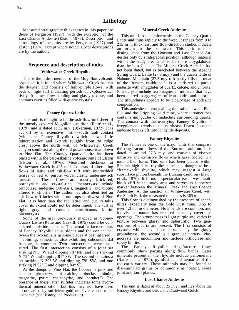
Lithology
Measured stratigraphic thicknesses in this paper are those of Ferguson (1927), with the exception of the Last Chance Andesite (Elston, 1976). Description and chronology of the units are by Ferguson (1927) and Elston (1976), except where noted. Local descriptions are by the author.
Sequence and description of units
Whitewater Creek Rhyolite
This is the oldest member of the Mogollon volcanic sequence; it is found where Whitewater Creek has cut the deepest, and consists of light-purple flows, with beds of light tuff indicating periods of explosive ac-tivity. It shows flow banding and glassy texture, and contains cavities filled with quartz crystals.
Cooney Quartz Latite
This unit is thought to be the ash-flow-tuff sheet of the mostly covered Mogollon cauldron (Ratté et al., 1979), and is dated at 32 m.y. (Bikerman, 1972). It is cut off by an extensive north—south fault contact (with the Fanney Rhyolite) which shows little mineralization and extends roughly from the ridge crest above the north wall of Whitewater Creek canyon southeast along the old powerhouse road down to Pine Flat. The Cooney Quartz Latite has been placed within the calc-alkaline volcanic suite of Elston (Elston et al., 1976). Measured thickness at Whitewater Creek is 425 m. It consists of alternating flows of latite and ash-flow tuff with interbedded lenses of red to purple volcaniclastic andesine-rich sandstone. These flows are mostly brick-red, porphyritic, and crystal-rich. Phenocrysts include orthoclase, andesine (Ab7An3), magnetite, and biotite altered to chlorite. The author has also identified an ash-flow-tuff facies which outcrops northwest of Pine Flat. It is later than the red latite, and due to talus cover its extent could not be determined. The tuff is light gray and contains conspicuous biotite phenocrysts.
Some of the area previously mapped as Cooney Quartz Latite (Ratté and Gaskill, 1975) could be con-sidered landslide deposits. The actual surface consists of Fanney Rhyolite talus slopes and the contact be-tween the two units is in some places at best inferred.
Jointing, sometimes also exhibiting subconchoidal fracture, is common. Two intersections were mea-sured. The first intersection consists of a joint set striking N 5° W and dipping 78° NE, and one striking N 75° W and dipping 81° SW. The second contains a set striking N 30° W and dipping 79° SW, and one striking N 52° E and dipping 84° SE.
At the dumps at Pine Flat, the Cooney is pink and contains phenocrysts of calcite, orthoclase, biotite, magnetite, pyrite, chalcopyrite, and bornite(?). The presence of these latter sulfides indicates some hydro-thermal mineralization, but this may not have been accompanied by sufficient gold or silver values to be economic (see History and Production).
Mineral Creek Andesite
This unit lies uncomformably on the Cooney Quartz Latite and thins rapidly to the west. It ranges from 0 to 215 m in thickness, and flow-direction studies indicate an origin to the southwest. This unit can be distinguished from the Houston and Last Chance An-desites only by stratigraphic position, although material within the study area tends to be more amygdaloidal than the Last Chance. The Mineral Creek Andesite has not been dated, but is bracketed between the Apache Spring Quartz Latite (27.3 m.y.) and the quartz latite of Nabours Mountain (27.5 m.y.). It partly fills the moat of the Bursum cauldron. It is a dark-red to purple andesite with amygdules of quartz, calcite, and chlorite. Phenocrysts include ferromagnesian minerals that have been altered to aggregates of iron oxides and chlorite. The groundmass appears to be plagioclase of andesine composition.
This andesite outcrops along the trails between Pine Flat and the Dripping Gold mine, where it sometimes contains amygdules of malachite surrounding quartz. The contact with the overlying Fanney Rhyolite is irregular and trends to the northeast. Down-slope the andesite breaks off into landslide deposits.
Fanney Rhyolite
The Fanney is one of the major units that comprise the ring-fracture flows of the Bursum cauldron. It is dated at around 27.3 m.y. and consists of viscous intrusive and extrusive flows which have cooled in a mound-like form. This unit has been placed within Elston's high-silica rhyolite suite; it is thought to be a "framework" rhyolite, which may suggest a large subsurface pluton beneath the Bursum cauldron (Elston et al., 1976). It forms a spectacular east—west fault-block cliff in the study area and serves as a horizon marker between the Mineral Creek and Last Chance Andesites. At the junction of Whitewater Creek with the South Fork the measured thickness is 365 m.
This flow is distinguished by the presence of spher-ulites (especially near the Gold Dust mine) 0.65 to over 1.3 cm in diameter. Flow bands are common, and its viscous nature has resulted in many cavernous openings. The groundmass is light purple and varies in texture between glassy and spherulitic. Two gen-erations of quartz are present. The first consists of crystals which have been intruded by the glassy groundmass, the second is a granular variety. Phe-nocrysts are uncommon and include orthoclase and rarely biotite.
The Fanney Rhyolite ring-fracture flows commonly show parting along flow bands. Later minerals present in the rhyolite include psilomelane (Ratté et al., 1979), pyrolusite, and hematite of the red-earth variety. These minerals may be found as disseminated grains or commonly as coating along joint and fault planes.
Last Chance Andesite
The unit is dated at about 25 m.y., and lies above the Fanney Rhyolite and below the Deadwood Gulch
34

35
Rhyolite Tuff. Both the Last Chance and Mineral Creek Andesites have been placed within Elston's basaltic suite (Elston et al., 1976). The Last Chance is about 95 m thick in the study area and borders the Fanney Rhyolite to the west. It may be less basic than the Mineral Creek Andesite. The name is derived from the Last Chance mine, where it forms the hanging wall of the vein.
The Last Chance Andesite consists of dark-red to purple andesite with phenocrysts of altered pyrox-enes (to chlorite) and biotite. Flows are mostly thin, alternating with pyroclastics. Breccias and agglom-erates present indicate explosive action accompany-ing the eruptions. The groundmass is composed primarily of andesine, but contains minor amounts of altered pyroxenes (augite?) and biotite.
This unit alters readily and served as a host rock for ore mineralization along fault contacts with the Fanney Rhyolite, as it fractured to permit entry of hydrothermal solutions. Fault scarps northeast of the mine adit show conspicuous quartz veining, and the
contact with the Fanney is irregular and shows inter tonguing.
Deadwood Gulch Rhyolite Tuff
This distinctively white unit outcrops strikingly on the ridge north of the working, where it is in contact with the Fanney Rhyolite along the Queen fault. It consists of small fragments of white flow-banded rhy-olite in a siliceous groundmass. Sandstone occurs as beds and lenses throughout the unit. It is relatively soft and may show weathering pockets.
Mogollon Andesite
This is the youngest unit in the study area, out-cropping in the northeast corner near the Deadwood mine. It consists of dark-colored andesite with a non-oriented plagioclase groundmass and some dacite flows. The most numerous phenocryst is plagioclase of approximate composition Ab5An7.
History and production
The Dripping Gold lode claim was formerly known as the Iron Bar. In 1909, the Iron Bar group was being worked by Peterson, Lambert & Company, with prin-cipal development along the southern part of the Queen vein. A tunnel 52 m long connected with a shaft 21 m deep. Ore from the shaft was valued from $25.00 to as high as $71.60 per ton (1909 prices). Silver to gold ratio was estimated at 2:1. Some ore was also found on the adjacent Iron Cross, Iron Ring, and Iron Crown claims. The property was assessed as one of good potential, but requiring both a road and a mill site (Rackocy, 1981). However, a road was never built to the Iron Bar. The ore was pulverized with a small crusher, sluiced, and the concentrates recovered by the cyanide process. All drilling was done with hand steels. The main adit has rails, and a small ore cart was emptied into a hopper which fed the crusher. Miners lived in a cave above the workings, which is a natural pocket in the Fanney Rhyolite. There was also a telephone line to the site.
The mine entrance at Pine Flat has either caved or has been blasted shut, and there is no record of pro-duction for that mine. As the best ore at the Iron Bar was being depleted, the miners may have been in-duced by presence of primary sulfides in the Cooney Quartz Latite to tunnel in, hoping for a bonanza which did not exist.
The main adit (Fig. 2) is 87 m long and bears N 1° W along the Queen vein at the junction of the Last Chance hanging wall and the Fanney footwall. A ver-tical shaft of at least 21 m in depth appears to connect with a lower adit.
At a bearing from the main adit of N 19° W for 54 m is a drift which bears N 15° E for 18.5 m. A lower adit about 70 m south of the main tunnel strikes N 40° E. Length is not known because this working is caved shut as well as flooded.


Origin and structure
The structure of the Mogollon area was described by Coney (1976), who recognized three periods of deformation of the Mogollon Plateau. The earliest period coincides with the deposition of the Apache Spring and Fanney Formations.
The second period of deformation occurred pene-contemporaneously with emplacement of the Mogollon—Dog Gulch Formation, before ore mineralization and before the eruption of the Bearwallow Mountain Formation. This period resulted in a downfaulted graben which includes the Mogollon mining district.
The third period of deformation occurred during and after emplacement of the Bearwallow Mountain Formation and Gila Conglomerate. This period re-sulted in the present western fault scarp along the Mogollon Range, which averages about 60°. The re-sultant horst was tilted eastward during this time.
The Mogollon district has the general form of an anticlinal structure, as evidenced by doming above a possible intrusive in the ring-fracture zone of the Bur-sum cauldron (Ratté et al., 1979). This doming along with localization of ore bodies at fault intersections (a cupola?) may suggest further evidence for the inferred Bursum pluton proposed by Elston (1976).
Ferguson (1927) recognized two periods of faulting in the Mogollon district, the latter producing the present-day fault scarp. The first period was later than
the local andesites, perhaps late Miocene. These faults are the sites of quartz veins, which carry the sulfide mineralization. The gold and silver veins at Mogollon are younger than the Deadwood Gulch Rhyolite Tuff, but older than the Bearwallow Mountain Basaltic An-desite, probably around 21 m.y. (Elston, Rhodes, and Erb, 1976).
The Queen vein can be traced for nearly 11 km (6.8 mi) in a north—south direction and is the site of the first-formed and most extensive fissuring. The fault plane dips to the east, possibly suggesting a graben structure. Veins west of the Queen are characterized by a predominantly quartz gangue and have been the most productive. Very little ore has come from east of the Queen, where the gangue is primarily calcite, much of it manganiferous. Banding and sheeting of minerals parallel to the wall rock is common (Fergu-son, 1927). The Dripping Gold workings are on a southern extension of the Queen vein. This extension may intersect with northwest-trending structures at Holt Gulch and Wilcox Peak (Ratté et al., 1979).
The ring-fracture zone of the Bursum cauldron may have created prominent channelways for hydrothermal solutions as well as sites for future fault activity. The resurgence of the cauldron resulted in tensional fractures, and veins in the Mogollon district follow the planes of subsequent normal faults. The lack of
37

38
timbering old workings may indicate tension relieved by faulting. Only basic shaft framing is present at the Dripping Gold.
Ore bodies within the district often occurred near points of intersection of the Queen with traverse veins, an example of which is the famed Last Chance—Con-fidence vein. These veins follow a series of east—west faults which are later than the Queen (Ferguson, 1927). Structural intersections are of basic importance in lo-calizing ore deposits, and many mining districts occur at such "crossroads" (Ratté et al., 1979).
The Queen vein strikes N 1° W at the entrance to the Dripping Gold mine and may be traced directly along the fault contact between the Fanney Rhyolite and Last Chance Andesite northward to the Deadwood mine, where it intersects the Last Chance—Confidence vein. A prominent traverse fault at the Dripping Gold shaft (Fig. 4) created fissuring which enabled ore-bearing solution to localize at this intersection.
Earliest faulting produced a horst of Fanney Rhy-olite, with downthrown blocks of Cooney Quartz La-tite to the west and Last Chance Andesite to the east. Subsequent faulting produced the ridge of Deadwood Gulch Rhyolite Tuff to the north. Part of the Last Chance Andesite was also uplifted, but a block of the andesite downthrown to the southwest sheared along and thrust over the resistant rhyolite. This created a large fissure with a lateral component and thus a site for hydrothermal deposition. Along the Queen, the hanging wall of the andesite dips about 70° to the east, with the prominent rhyolite horst tilted toward the west.
The complex faulting at the Dripping Gold is at least in part post-mineral (Ferguson, 1927). Red hematitic
gouge encloses crushed fragments of vein material. Considerable shearing has taken place along the strike of the Queen, evidenced by oriented argillic alteration, preferred orientation of wall-rock fragments, and slickenside striations.
Hydrothermal solutions rose through tensional post-cauldron fractures along the massive, relatively ho-mogeneous flow dome of the Fanney Rhyolite, which proved too impermeable to localize the ore. The an-desine groundmass of the Last Chance readily fractured, producing channelways for mineralization. Ferromagnesian minerals were altered to chlorite, with the groundmass undergoing intense alteration and brecciation. At this point the ore minerals, primarily native gold and argentite, were deposited in veins with silica that may have come from the adjacent rhyolite. This silicification appears to have cooled relatively slowly, producing a granular, sugary texture locally intergrown with masses of kaolin(?). Hematite and pyrolusite later followed fracture planes.
The main adit is the site of a prolific spring, and a similar situation exists at the lower adit, which is com-pletely inaccessible due to caving. The intense shear-ing and brecciation at the site have allowed ground water to percolate into much of the mine workings.
Due to the rugged topography, little ground water exists in most of the Mogollon district. The Queen vein has acted as a ground-water dam, and very few of the workings near Mogollon have encountered any subsurface springs. A notable exception is the Dead-wood mine north of the Dripping Gold adit along the strike of the Queen (Ferguson, 1927). This may sug-gest a structural intersection between the two areas.
Hydrothermal alteration
Rock alteration is present over the entire Mogollon district; the degree of alteration is dependent on the type of rock. Alteration of dense rhyolites is limited to silicification near the veins accompanied by seri-citization of the feldspars and chloritization of the biotite.
The andesites have undergone extensive alteration due to a higher percentage of easily altered minerals and higher porosity. Ferromagnesian minerals have been altered to iron oxides and chlorite, often leaving
crystal cavities. The iron oxides are at least in part derived from pyrite. Plagioclase phenocrysts may be replaced by calcite, quartz, kaolin, or sericite. The groundmass has altered readily, mostly to chlorite and calcite. This widespread alteration is attributed to hydrothermal action rather than weathering (Ferguson, 1927).
Hydrothermal alteration at the Dripping Gold mine is readily seen and shows zonation. The Last Chance Andesite of the hanging wall has been most affected,

39
while the Fanney Rhyolite has undergone silicification and possibly sericitization near the veins.
In the outermost zone, alteration has been propy-litic. Ferromagnesian minerals and biotite have be-come aggregates of chlorite and in some cases iron oxide. The groundmass has been altered to chlorite or pulverized to a hematitic gouge. Primary pyrite has been replaced by hematite that locally shows cu-bic crystal outline.
In the middle zone (of varying thickness), argillic alteration is present, primarily in the form of kaolin-ite(?). This zone exhibits striations due to shearing
movement and grades into an inner zone of intense silicification along the contact with the rhyolite. In some places crustification may be present. This sili-cified zone is associated with the deposition of pre-cious-metal sulfides. Early formed fractures, probably mostly tensional, appear to control the alteration.
Wall-rock alteration at the mine may be categorized as advanced argillic. In this type of alteration, silicic alteration near the veins grades outward to argillization and propylitization. Such alteration is common in epithermal precious-metal deposits; Goldfield, Nevada, is a type locality (Meyer and Hemley, 1967).
Paragenesis and mineralization
The most common gangue mineral is quartz, which has been deposited in three stages. The earliest, often within hematitic gouge, is a white, chalcedony-like, "porcelain" variety containing few sulfides. Thin banding may be present. Primary pyrite, locally showing crystal outlines, has been replaced by hem-atite, often giving this quartz a pink coloration or spotted appearance.
The second-stage quartz has a coarsely crystalline, drusy to granular appearance and locally contains cavities resulting from the solution of calcite. This type is associated with sulfide deposition and com-prises the bulk of the ore produced from the Dripping Gold. It is locally banded and may show a granitic texture.
The latest quartz may be intergrown with calcite; it has a hackly lamellar appearance where it has re-placed the calcite. This type is only sparingly present at the Dripping Gold, but is abundant on the dumps at Pine Flat.
Calcite is less common in the gangue, and the early manganiferous variety found in other parts of the district is completely absent. It fills some of the later-formed veins, particularly in the andesite. Secondary calcite is found coating underground workings where flooding is encountered; it is deposited from solution in a semibotryoidal form or as stalactites up to 10 cm long. Calcite is quite common in the Cooney Quartz Latite in the dumps at Pine Flat, where it is a primary
gangue mineral. It is white and often shows good cleavage.
No fluorite has been observed in the study area. The Gold Dust mine to the northwest has some light-green fluorite that occurs as small bands between layers of granular quartz.
In the Mogollon district, fragments of wall rock often served as nuclei for sulfide deposition. The Last Chance Andesite was enclosed in many places by a hematitic gouge, with the sulfide-bearing granular quartz having been deposited in channelways. This intermediate granular silica is contemporaneous with ore miner-alization. Ore minerals include native gold, argentite, and possibly stromeyerite. Historically, argentite in the district has been found in some places to border or replace older sulfides.
Secondary ore mineralization is localized, but can be readily seen at the dump near the upper workings. Here malachite and perhaps other minerals were de-posited as thin crusts and small veins. This type of occurrence in other parts of the district is sometimes associated with native silver (Ferguson, 1927).
Hematite is formed over a considerable period of time, but fairly recent material is found as slickensides on many fault planes. All hematite present is of the red-earth variety. Pyrolusite is the last metallic mineral to form; it is black with an earthy texture. It occurs as a coating or filling of thin veins, and locally has a dendritic appearance.
Conclusion
It is the opinion of the author that possibilities for undiscovered ore, possibly at depth, may exist within the study area. Although gold values have not been high, two samples, both taken from dump material, assayed 14.38 and 9.14 oz Ag per ton. All mining has been by hand methods, as there has never been road access to the site. These factors certainly could have limited development at the mine workings. The pos-sibility also exists of a structural intersection between the Dripping Gold mine, the Gold Dust mine to the northwest, and the Deadwood mine to the north.
Considerable portions of the mine workings are
presently inaccessible or unsafe due to flooding, cav-ing, or rotted timbering. Future plans include cor-recting these conditions, with special emphasis on gaining access to lower workings of the main shaft, as well as complete surface and underground map-ping. A thorough sampling program will then be im-plemented.
Long-term plans may include a crusher, rebuilding of the rail system and hopper, and reconstruction of existing sluiceworks, with emphasis on producing concentrate for further refining.

References
Bikerman, M., 1972, New K—Ar ages on volcanic rocks from Catron and Grant Counties, New Mexico: Isochron/West, no. 3, pp. 912.
Coney, P. J., 1976, Structure, volcanic stratigraphy, and gravity anomaly across the Mogollon Plateau; in Elston, W. E., and Northrop, S. A. (eds.), Cenozoic volcanism in southwestern New Mexico: New Mexico Geological Society, Special Publication no. 5, pp. 29-41.
Elston, W. E., 1976, Glossary of stratigraphic terms of the Mogo-llon—Datil volcanic province; in Elston, W. E., and Northrop, S. A. (eds.), Cenozoic volcanism in southwestern New Mexico: New Mexico Geological Society, Special Publication no. 5, pp. 131144.
Elston, W. E., Coney, P. J., Rhodes, R. C., and Deal, E. G., 1976, Progress report on the Mogollon Plateau volcanic field, south-western New Mexico; in Elston, W. E., and Northrop, S. A. (eds.), Cenozoic volcanism in southwestern New Mexico: New Mexico Geological Society, Special Publication no. 5, pp. 3-28.
Elston, W. E., Rhodes, R. C., and Erb, E. E., 1976, Control of mineralization by mid-Tertiary volcanic centers; in Elston, W. E.,
and Northrop, S. A. (eds.), Cenozoic volcanism in southwestern New Mexico: New Mexico Geological Society, Special Publication no. 5, pp. 125-130.
Ferguson, H. G., 1927, Geology and ore deposits of the Mogollon mining district, New Mexico: U.S. Geological Survey, Bulletin 787, pp. 3-87.
Meyer, C., and Hemley, J. J., 1967, Wall rock alteration; in Barnes, H. L. (ed.), Geochemistry of hydrothermal ore deposits: Holt, Rhinehart, and Winston, New York, pp. 166-232.
Rackocy, B., 1981, Mogollon mines (1909): Bravo Press, El Paso, 40 pp.
Raft& J. C., and Gaskill, D. L., 1975, Reconnaissance geologic map of the Gila Wilderness study area, southwestern New Mexico: U.S. Geological Survey, Miscellaneous Investigations Series Map 1-886.
Ratté, J. C., Gaskill, D. L., Eaton, G. P., Peterson, D. L., Stotel-meyer, R. B., and Meeves, H. C., 1979, Mineral resources of the Gila Primitive Area and Gila Wilderness, New Mexico: U.S. Geological Survey, Bulletin 1451, pp. 41, 106.
4 0
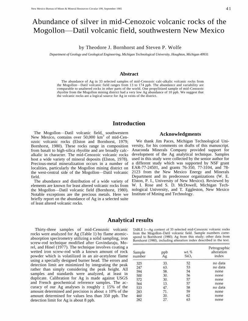
New Mexico Bureau of Mines & Mineral Resources Circular 199, September 1985
Abundance of silver in mid-Cenozoic volcanic rocks of the
Mogollon—Datil volcanic field, southwestern New Mexico
by Theodore J. Bornhorst and Steven P. Wolfe
Department of Geology and Geological Engineering, Michigan Technological University, Houghton, Michigan 49931
Abstract
The abundance of Ag in 33 selected samples of mid-Cenozoic calc-alkalic volcanic rocks from the Mogollon—Datil volcanic field ranges from 13 to 174 ppb. The abundance and variability are comparable to unaltered rocks in other parts of the world. One propylitized sample of mid-Cenozoic rhyolite from the Mogollon mining district had a very low Ag abundance of 10 ppb. We suggest that the volcanic rocks are a logical source for Ag in veins of the district.
Introduction
The Mogollon—Datil volcanic field, southwestern New Mexico, contains over 50,000 km
3 of mid-Cen-
ozoic volcanic rocks (Elston and Bornhorst, 1979; Bornhorst, 1980). These rocks range in composition from basalt to high-silica rhyolite and are broadly calc-alkalic in character. The mid-Cenozoic volcanic rocks host a wide variety of mineral deposits (Elston, 1978). Precious-metal mineralization occurs in a number of localities, particularly the Mogollon mining district on the west-central side of the Mogollon—Datil volcanic field.
The abundance and distribution of a wide variety of elements are known for least altered volcanic rocks from the Mogollon—Datil volcanic field (Bornhorst, 1980). Notable exceptions are the precious metals. Here we briefly report on the abundance of Ag in a selected suite of least altered volcanic rocks.
Acknowledgments
We thank Jim Paces, Michigan Technological Uni-versity, for his comments on drafts of this manuscript. Anaconda Minerals Company provided support for development of the Ag analytical technique. Samples used in this study were collected by the senior author for a different study which was supported by NSF grant EAR-77-24501, and grants 76-350, 77-3104, and 78-2123 from the New Mexico Energy and Minerals Department and its predecessor organizations (W. E. Elston, P. I., University of New Mexico). Reviewed by W. I. Rose and S. D. McDowell, Michigan Tech-nological University, and T. Eggleston, New Mexico Institute of Mining and Technology.
Analytical results
Thirty-three samples of mid-Cenozoic volcanic rocks were analyzed for Ag (Table 1) by flame atomic-absorption spectrometry utilizing a solid sampling, iron screw-rod technique modified after Govindaraju, Mo-rel, and Hinel (1977). The technique involves coating a wetted iron screw-rod with a known amount of rock powder which is volatilized in an air-acetylene flame using a specially designed burner head. The errors and detection limit are minimized by integrating the peak rather than simply considering the peak height. All samples and standards were analyzed, at least in duplicate. Calibration for Ag is made against USGS and French geochemical reference samples. The ac-curacy of our Ag analyses is roughly ± 15% of the amount determined and precision is about ± 10% of the amount determined for values less than 350 ppb. The detection limit for Ag is about 8 ppb.
4 1
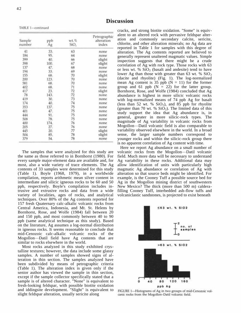
Discussion
The samples that were analyzed for this study are the same as those referred to in Bornhorst (1980). For every sample major-element data are available and, for most, also a wide variety of trace elements. The Ag contents of 33 samples were determined for this study (Table 1). Boyle (1968, 1979), in a worldwide compilation, reports arithmetic mean silver content in intermediate and silicic igneous rocks to be 60 and 50 ppb, respectively. Boyle's compilation includes in-trusive and extrusive rocks and data from a wide variety of localities, ages of rocks, and analytical techniques. Over 80% of the Ag contents reported for 157 fresh Quaternary calc-alkalic volcanic rocks from Central America, Indonesia, and Mt. St. Helens by Bornhorst, Rose, and Wolfe (1984) fall between 20 and 150 ppb, and most commonly between 40 to 90 ppb (same analytical technique as this study). Based on the literature, Ag assumes a log-normal distribution in igneous rocks. It seems reasonable to conclude that mid-Cenozoic calc-alkalic volcanic rocks of the Mogollon—Datil field have Ag contents that are similar to rocks elsewhere in the world.
Most rocks analyzed in this study exhibited crys-talline textures; however, the data include some glassy samples. A number of samples showed signs of al-teration in thin section. The samples analyzed have been subdivided by means of petrographic criteria (Table 1). The alteration index is given only if the senior author has viewed the sample in thin section, except if the sample collector specifically stated that a sample is of altered character. "None" is equivalent to fresh-looking feldspar, with possible biotite oxidation and iddingsite development. "Slight" is equivalent to slight feldspar alteration, usually sericite along
cracks, and strong biotite oxidation. "Some" is equiv-alent to an altered rock with pervasive feldspar alter-ation and commonly secondary calcite, sericite, chlorite, and other alteration minerals; no Ag data are reported in Table 1 for samples with this degree of alteration. The Ag contents reported are believed to generally represent unaltered magmatic values. Simple inspection suggests that there might be a crude correlation of Ag with rock type. Those rocks with 63 or less wt. % SiO2 (basalt and andesite) tend to have lower Ag than those with greater than 63 wt. % SiO2 (dacite and rhyolite) (Fig. 1). The log-normalized mean Ag content is 35 ppb (N = 11) for the former group and 61 ppb (N = 22) for the latter group. Bornhorst, Rose, and Wolfe (1984) concluded that Ag abundance is highest in more silicic volcanic rocks with log-normalized means of 74 ppb Ag for basalt (less than 52 wt. % SiO2), and 85 ppb for rhyolite (greater than 70 wt. % SiO2). The limited data of this study support the idea that Ag abundance is, in general, greater in more silicic-rock types. The magnitude of Ag variability in volcanic rocks from Mogollon—Datil volcanic field is also comparable to variability observed elsewhere in the world. In a broad sense, the larger sample numbers correspond to younger rocks and within the silicic-rock group there is no apparent correlation of Ag content with time.
Here we report Ag abundance on a small number of volcanic rocks from the Mogollon—Datil volcanic field. Much more data will be necessary to understand Ag variability in these rocks. Additional data may allow identification of units with particularly high magmatic Ag abundance or correlation of Ag with alteration so that source beds might be identified. For example, is the Cooney Tuff a possible source bed for Ag in the Mogollon mining district of southwestern New Mexico? The thick (more than 500 m) caldera-filling Cooney Tuff, interbedded ash-flow tuffs and volcaniclastic sandstones, is projected to exist beneath
42

43
the Mogollon mining district (Ratte, 1981). The base of the Cooney Tuff is today at a depth of 1,000 m or more (Ratte, 1981), and during mineralization was probably greater than 1,500 m (Bornhorst et al., 1984). The Cooney Tuff is pervasively propylitically altered in exposures on the flanks of the district. Thus, thickness, structural position, availability of permeable horizons, pervasive propylitic alteration, and analogy with modern geothermal systems (see Ellis, 1979) suggest that the Cooney Tuff could have been a hydro-thermal aquifer (Kent, 1983). We analyzed one strongly altered sample of Cooney Tuff from our collection of
"fresh" samples (sample no. 156 of Bornhorst, 1980) and found that it contained 10 ppb Ag. Even with volume corrections, Ag was likely leached from this sample. Rough calculations suggest that tens of mil-lions of oz Ag were probably present in the Cooney Tuff when it was emplaced (volume beneath the Mo-gollon mining district). The district production was about 13 million oz Ag (Ferguson, 1927). On the basis of one data point we speculate that the Cooney Tuff might have been the source bed for at least some of the Ag won from the veins. Clearly, additional studies are needed.
References
Bornhorst, T. J., 1980, Major and trace element geochemistry and mineralogy of upper Eocene to Quaternary volcanic rocks of the Mogollon—Datil volcanic field, southwestern New Mexico: Ph.D. dissertation, University of New Mexico, Albuquerque, New Mexico, 1108 pp.
Bornhorst, T. J., Rose, W. I., Jr., and Wolfe, S. P., 1984, Abundance of gold and silver in fresh calc-alkalic Quaternary volcanic rocks: Geological Society of America, Abstracts with Programs, v. 16, p. 450.
Bornhorst, T. J., Kent, G. R., Mann, K. L., and Richey, S. R., 1984, Temperature of mineralization in Mogollon mining district, southwestern New Mexico: New Mexico Geology, v. 6, pp. 5355.
Boyle, R. W., 1968, The geochemistry of silver and its deposits: Geological Survey of Canada, Bulletin 160, 264 pp.
Boyle, R. W., 1979, The geochemistry of gold and its deposits: Geological Survey of Canada, Bulletin 280, 584 pp.
Ellis, A. J., 1979, Explored geothermal systems; in Barnes, H. L. (ed.), Geochemistry of hydrothermal ore deposits: John Wiley & Sons, New York, pp. 632-683.
Elston, W. E., 1978, Mid-Tertiary cauldrons and their relationship
to mineral resources: a brief review: New Mexico Geological Society, Special Publication 7, pp. 107-113.
Elston, W. E., and Bomhorst, T. J., 1979, The Rio Grande rift in context of regional post-40 m.y. volcanic and tectonic events; in Riecker, R. E. (ed.), Rio Grande rift: tectonics and magmatism: American Geophysical Union, pp. 416-438.
Ferguson, H. G., 1927, Geology and ore deposits of the Mogollon mining district, New Mexico: U.S. Geological Survey, Bulletin 787, 100 pp.
Govindaraju, K., Morel, J., and Hinel, N. L., 1977, Solid sampling atomic absorption determination of silver in silicate rock refer-ence samples. Application to a homogeneity study of silver in a one-ton two mica granite reference sample: Geostandards Newsletter, v. 1, pp. 137-142.
Kent, G. R., 1983, Temperature and age of precious metal vein mineralization and geochemistry of host rock alteration at the Eberle mine, Mogollon mining district, southwestern New Mexico: M.S. Thesis, Michigan Technological University, Houghton, 84 pp.
Ratte, J. C., 1981, Geologic map of the Mogollon quadrangle, Catron County, New Mexico: U.S. Geological Survey, Geologic Quadrangle Map GC-1557, 1:24,000.


New Mexico Bureau of Mines & Mineral Resources Circular 199, September 1985
Geology and geochemistry of rhyolite-hosted tin deposits, northern Black Range and Sierra Cuchillo,
southwestern New Mexico
by Ted L. Eggleston and David I. Norman
Geoscience Department, New Mexico Institute of Mining and Technology, Socorro, New Mexico 87801
Abstract
Tertiary (28 my) rhyolite lavas host a number of tin occurrences in southwestern New Mexico. These lavas are typically crystal-rich, white, flow-banded, high SiO2, K20, F, Cl, and low CaO, Fe2O3 Sr, Ba "topaz" rhyolites. Vapor-phase recrystallization, due to magmatic fluids exolved during ascent and cooling of the lavas, bleached and recrystallized the groundmass glass to a fine mosaic of quartz and feldspar. Tin was partitioned into this fluid from the melt and was deposited from it near the carapace of the rhyolite domes in response to the extreme thermal gradients there. Temperatures for tin mineralization range from >600 to <400°C, with salinities exceeding 50 eq. wt. % NaCI. Lower temperatures (400-130°C) and lower salinities (2-5 eq. wt. % NaCl) suggest that meteoric water was important late in the cooling of the dome.
Introduction
Placer tin was first discovered in the northern Black Range of southwestern New Mexico in 1908 (Har-rington, 1943), and in 1918 hematite—cassiterite vein-lets were discovered in Tertiary rhyolite domes and flows (Hill, 1921). These discoveries led to a short-lived boom in the area. Sporadic exploration continues today. Fig. 1 shows the location of part of the lode-tin occurrences in the region. No production has been reported from these lodes. Placer deposits which sit on the top and flanks of the rhyolite domes that host the lodes have had modest production. In the Black Range, the region encompassing the tin occurrences is known as the Taylor Creek tin district. A similar but unnamed district is located in the Sierra Cuchillo, a low mountain range east of the Black Range. These deposits are similar to the larger and more extensive deposits found in Durango, Mexico (Lee Moreno, 1972; Pan, 1974; Huspeni et al., 1984) and are frequently referred to as "Mexican type" tin deposits.
The origin of these deposits and their relationship to the rocks that host them has long been a subject of speculation (Hill, 1921; Fries, 1940; Lufkin, 1972; Correa, 1981; Goerold, 1981). Little work has been directed at a district-wide understanding of the tin occurrences and their relationship to the rocks that host them. This paper presents preliminary results of such a study with the aim of understanding the origin and controls of the tin mineralization.
4 5
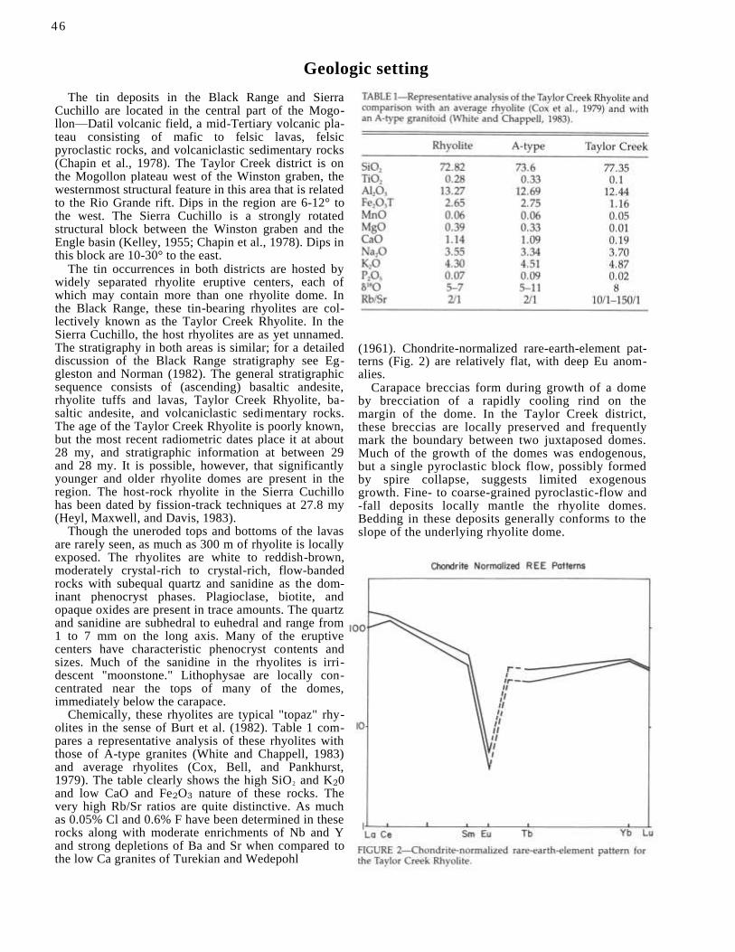
Geologic setting
The tin deposits in the Black Range and Sierra Cuchillo are located in the central part of the Mogo-llon—Datil volcanic field, a mid-Tertiary volcanic pla-teau consisting of mafic to felsic lavas, felsic pyroclastic rocks, and volcaniclastic sedimentary rocks (Chapin et al., 1978). The Taylor Creek district is on the Mogollon plateau west of the Winston graben, the westernmost structural feature in this area that is related to the Rio Grande rift. Dips in the region are 6-12° to the west. The Sierra Cuchillo is a strongly rotated structural block between the Winston graben and the Engle basin (Kelley, 1955; Chapin et al., 1978). Dips in this block are 10-30° to the east.
The tin occurrences in both districts are hosted by widely separated rhyolite eruptive centers, each of which may contain more than one rhyolite dome. In the Black Range, these tin-bearing rhyolites are col-lectively known as the Taylor Creek Rhyolite. In the Sierra Cuchillo, the host rhyolites are as yet unnamed. The stratigraphy in both areas is similar; for a detailed discussion of the Black Range stratigraphy see Eg-gleston and Norman (1982). The general stratigraphic sequence consists of (ascending) basaltic andesite, rhyolite tuffs and lavas, Taylor Creek Rhyolite, ba-saltic andesite, and volcaniclastic sedimentary rocks. The age of the Taylor Creek Rhyolite is poorly known, but the most recent radiometric dates place it at about 28 my, and stratigraphic information at between 29 and 28 my. It is possible, however, that significantly younger and older rhyolite domes are present in the region. The host-rock rhyolite in the Sierra Cuchillo has been dated by fission-track techniques at 27.8 my (Heyl, Maxwell, and Davis, 1983).
Though the uneroded tops and bottoms of the lavas are rarely seen, as much as 300 m of rhyolite is locally exposed. The rhyolites are white to reddish-brown, moderately crystal-rich to crystal-rich, flow-banded rocks with subequal quartz and sanidine as the dom-inant phenocryst phases. Plagioclase, biotite, and opaque oxides are present in trace amounts. The quartz and sanidine are subhedral to euhedral and range from 1 to 7 mm on the long axis. Many of the eruptive centers have characteristic phenocryst contents and sizes. Much of the sanidine in the rhyolites is irri-descent "moonstone." Lithophysae are locally con-centrated near the tops of many of the domes, immediately below the carapace.
Chemically, these rhyolites are typical "topaz" rhy-olites in the sense of Burt et al. (1982). Table 1 com-pares a representative analysis of these rhyolites with those of A-type granites (White and Chappell, 1983) and average rhyolites (Cox, Bell, and Pankhurst, 1979). The table clearly shows the high SiO2 and K20 and low CaO and Fe2O3 nature of these rocks. The very high Rb/Sr ratios are quite distinctive. As much as 0.05% Cl and 0.6% F have been determined in these rocks along with moderate enrichments of Nb and Y and strong depletions of Ba and Sr when compared to the low Ca granites of Turekian and Wedepohl
46
(1961). Chondrite-normalized rare-earth-element pat-terns (Fig. 2) are relatively flat, with deep Eu anom-alies.
Carapace breccias form during growth of a dome by brecciation of a rapidly cooling rind on the margin of the dome. In the Taylor Creek district, these breccias are locally preserved and frequently mark the boundary between two juxtaposed domes. Much of the growth of the domes was endogenous, but a single pyroclastic block flow, possibly formed by spire collapse, suggests limited exogenous growth. Fine- to coarse-grained pyroclastic-flow and -fall deposits locally mantle the rhyolite domes. Bedding in these deposits generally conforms to the slope of the underlying rhyolite dome.
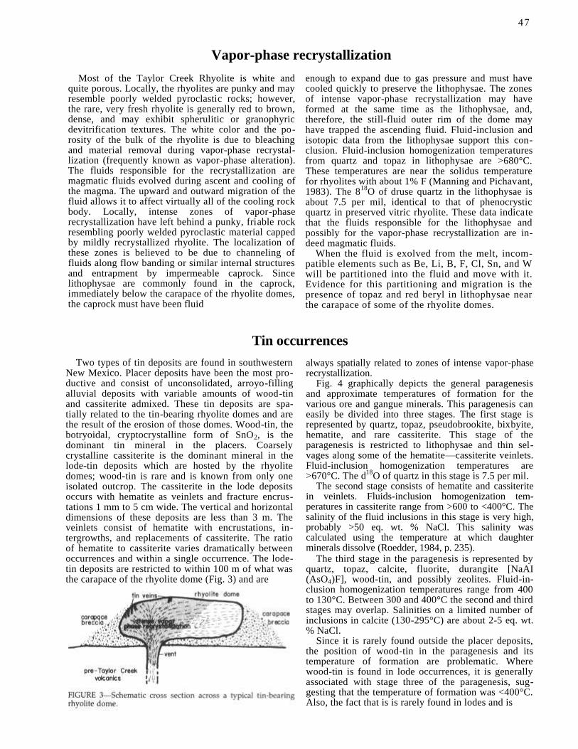
Vapor-phase recrystallization
Most of the Taylor Creek Rhyolite is white and quite porous. Locally, the rhyolites are punky and may resemble poorly welded pyroclastic rocks; however, the rare, very fresh rhyolite is generally red to brown, dense, and may exhibit spherulitic or granophyric devitrification textures. The white color and the po-rosity of the bulk of the rhyolite is due to bleaching and material removal during vapor-phase recrystal-lization (frequently known as vapor-phase alteration). The fluids responsible for the recrystallization are magmatic fluids evolved during ascent and cooling of the magma. The upward and outward migration of the fluid allows it to affect virtually all of the cooling rock body. Locally, intense zones of vapor-phase recrystallization have left behind a punky, friable rock resembling poorly welded pyroclastic material capped by mildly recrystallized rhyolite. The localization of these zones is believed to be due to channeling of fluids along flow banding or similar internal structures and entrapment by impermeable caprock. Since lithophysae are commonly found in the caprock, immediately below the carapace of the rhyolite domes, the caprock must have been fluid
enough to expand due to gas pressure and must have cooled quickly to preserve the lithophysae. The zones of intense vapor-phase recrystallization may have formed at the same time as the lithophysae, and, therefore, the still-fluid outer rim of the dome may have trapped the ascending fluid. Fluid-inclusion and isotopic data from the lithophysae support this con-clusion. Fluid-inclusion homogenization temperatures from quartz and topaz in lithophysae are >680°C. These temperatures are near the solidus temperature for rhyolites with about 1% F (Manning and Pichavant, 1983). The 8
18O of druse quartz in the lithophysae is
about 7.5 per mil, identical to that of phenocrystic quartz in preserved vitric rhyolite. These data indicate that the fluids responsible for the lithophysae and possibly for the vapor-phase recrystallization are in-deed magmatic fluids.
When the fluid is exolved from the melt, incom-patible elements such as Be, Li, B, F, Cl, Sn, and W will be partitioned into the fluid and move with it. Evidence for this partitioning and migration is the presence of topaz and red beryl in lithophysae near the carapace of some of the rhyolite domes.
Tin occurrences
Two types of tin deposits are found in southwestern New Mexico. Placer deposits have been the most pro-ductive and consist of unconsolidated, arroyo-filling alluvial deposits with variable amounts of wood-tin and cassiterite admixed. These tin deposits are spa-tially related to the tin-bearing rhyolite domes and are the result of the erosion of those domes. Wood-tin, the botryoidal, cryptocrystalline form of SnO2, is the dominant tin mineral in the placers. Coarsely crystalline cassiterite is the dominant mineral in the lode-tin deposits which are hosted by the rhyolite domes; wood-tin is rare and is known from only one isolated outcrop. The cassiterite in the lode deposits occurs with hematite as veinlets and fracture encrus-tations 1 mm to 5 cm wide. The vertical and horizontal dimensions of these deposits are less than 3 m. The veinlets consist of hematite with encrustations, in-tergrowths, and replacements of cassiterite. The ratio of hematite to cassiterite varies dramatically between occurrences and within a single occurrence. The lode-tin deposits are restricted to within 100 m of what was the carapace of the rhyolite dome (Fig. 3) and are
always spatially related to zones of intense vapor-phase recrystallization.
Fig. 4 graphically depicts the general paragenesis and approximate temperatures of formation for the various ore and gangue minerals. This paragenesis can easily be divided into three stages. The first stage is represented by quartz, topaz, pseudobrookite, bixbyite, hematite, and rare cassiterite. This stage of the paragenesis is restricted to lithophysae and thin sel-vages along some of the hematite—cassiterite veinlets. Fluid-inclusion homogenization temperatures are >670°C. The d
18O of quartz in this stage is 7.5 per mil.
The second stage consists of hematite and cassiterite in veinlets. Fluids-inclusion homogenization tem-peratures in cassiterite range from >600 to <400°C. The salinity of the fluid inclusions in this stage is very high, probably >50 eq. wt. % NaCl. This salinity was calculated using the temperature at which daughter minerals dissolve (Roedder, 1984, p. 235).
The third stage in the paragenesis is represented by quartz, topaz, calcite, fluorite, durangite [NaAI (AsO4)F], wood-tin, and possibly zeolites. Fluid-in-clusion homogenization temperatures range from 400 to 130°C. Between 300 and 400°C the second and third stages may overlap. Salinities on a limited number of inclusions in calcite (130-295°C) are about 2-5 eq. wt. % NaCl.
Since it is rarely found outside the placer deposits, the position of wood-tin in the paragenesis and its temperature of formation are problematic. Where wood-tin is found in lode occurrences, it is generally associated with stage three of the paragenesis, sug-gesting that the temperature of formation was <400°C. Also, the fact that is is rarely found in lodes and is
47
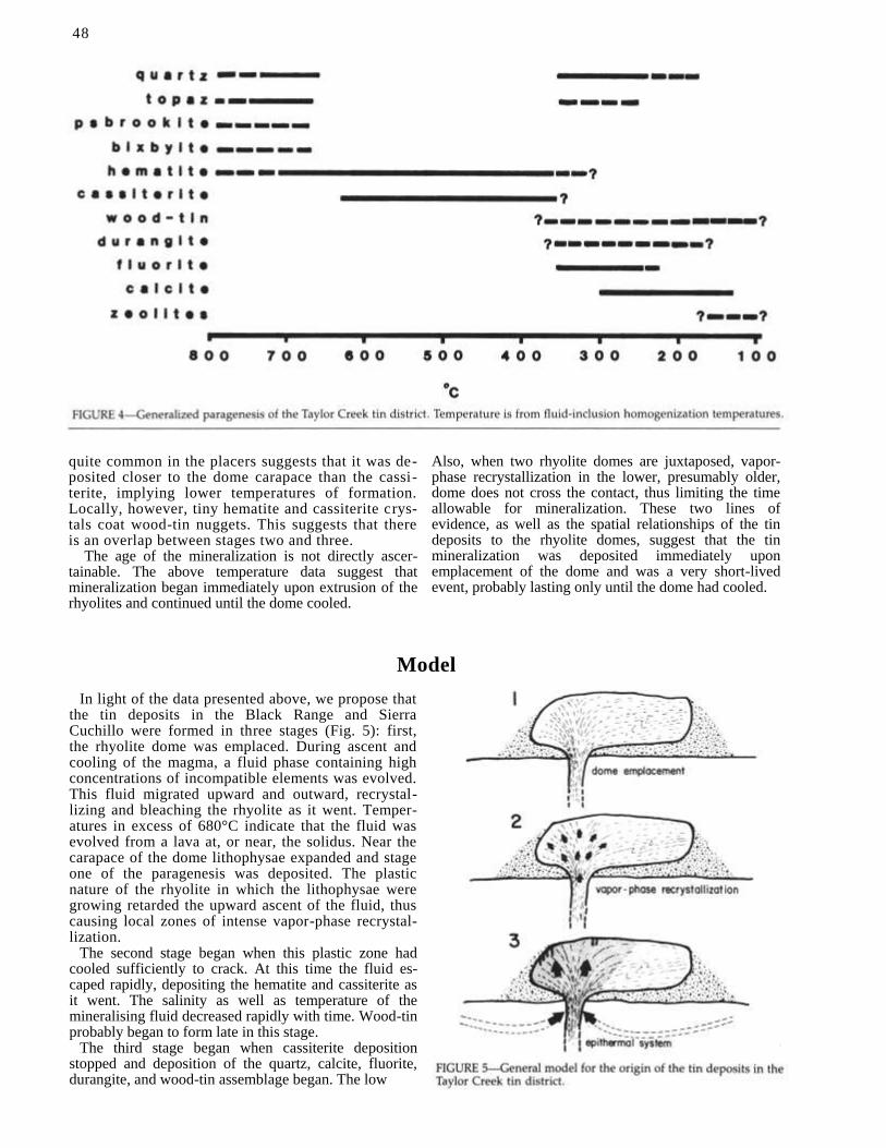
48
quite common in the placers suggests that it was de-posited closer to the dome carapace than the cassi-terite, implying lower temperatures of formation. Locally, however, tiny hematite and cassiterite crys-tals coat wood-tin nuggets. This suggests that there is an overlap between stages two and three.
The age of the mineralization is not directly ascer-tainable. The above temperature data suggest that mineralization began immediately upon extrusion of the rhyolites and continued until the dome cooled.
Also, when two rhyolite domes are juxtaposed, vapor-phase recrystallization in the lower, presumably older, dome does not cross the contact, thus limiting the time allowable for mineralization. These two lines of evidence, as well as the spatial relationships of the tin deposits to the rhyolite domes, suggest that the tin mineralization was deposited immediately upon emplacement of the dome and was a very short-lived event, probably lasting only until the dome had cooled.
Model
In light of the data presented above, we propose that the tin deposits in the Black Range and Sierra Cuchillo were formed in three stages (Fig. 5): first, the rhyolite dome was emplaced. During ascent and cooling of the magma, a fluid phase containing high concentrations of incompatible elements was evolved. This fluid migrated upward and outward, recrystal-lizing and bleaching the rhyolite as it went. Temper-atures in excess of 680°C indicate that the fluid was evolved from a lava at, or near, the solidus. Near the carapace of the dome lithophysae expanded and stage one of the paragenesis was deposited. The plastic nature of the rhyolite in which the lithophysae were growing retarded the upward ascent of the fluid, thus causing local zones of intense vapor-phase recrystal-lization.
The second stage began when this plastic zone had cooled sufficiently to crack. At this time the fluid es-caped rapidly, depositing the hematite and cassiterite as it went. The salinity as well as temperature of the mineralising fluid decreased rapidly with time. Wood-tin probably began to form late in this stage.
The third stage began when cassiterite deposition stopped and deposition of the quartz, calcite, fluorite, durangite, and wood-tin assemblage began. The low

4 9
salinities of the mineralizing fluids and the low d18O mixed and was replaced by meteoric water. The third suggest that the magmatic fluid responsible for the stage continued until the dome was too cold to sustain tin mineralization and vapor-phase recrystallization the hydrothermal system.
Conclusions
Preliminary conclusions from this study of the tin mineralization in southwestern New Mexico include:
1) The rhyolites that host the tin mineralization are effusive domes and flows mantled by carapace breccia and locally by pyroclastic material related to explosive eruptions during the dome-building process.
2) The rhyolites that host the tin mineralization are high SiO2, K2, F, Cl and low CaO, Fe2O3, Sr, Ba "topaz" rhyolites.
3) The tin mineralization is spatially, temporally, and genetically related to the host rhyolites.
4) The process responsible for the tin mineraliza-
tion is vapor-phase recrystallization. The fluid is a magmatic fluid evolved during the ascent and cooling of the rhyolite lava.
5) The tin was deposited within a few tens of me-ters of the carapace of the dome in an essentially fumarolic environment. Wood-tin was deposited closer to the dome carapace than cassiterite, and probably at somewhat lower temperatures.
6) As the rhyolite dome cooled, influx of meteoric water was in part responsible for the late-stage paragene sis .
References
Burt, D. M., Sheridan, M. F., Bikum, J. V., and Christiansen, E. H., 1982, Topaz rhyolites-distribution, origin, and significance for exploration: Economic Geology, v. 77, pp. 1818-1836. Correa, B. P., 1981, The Taylor Creek Rhyolite and associated tin deposits, southwestern New Mexico: M.S. Thesis, Arizona State University, 105 pp.
Cox, K. G., Bell, J. D., and Pankhurst, R. J., 1979, The interpretation of igneous rocks: George Allen and Unwin, London, 450 pp. Chapin, C. E., Jahns, R. H., Chamberlin, R. M., and Osburn, G. R., 1978, First day road log from Socorro to Truth or Consequences via Magdalena and Winston; in Chapin, C. E., and Elston, W. E. (eds.), Field guide to selected cauldrons and mining districts of the Datil-Mogollon volcanic field, New Mexico: New Mexico Geological Society, Special Publication 7, pp. 1-32. Eggleston, T. L., and Norman, D. I., 1983, Taylor Creek tin district-stratigraphy, structure, and timing of mineralization: New Mexico Geology, v. 5, pp. 1-4. Fries, C., 1940, Tin deposits of the Black Range, Catron and Sierra
Counties, New Mexico: U.S. Geological Survey, Bulletin 922-M, pp. 355-370.
Goerold, W. T., 1981, Geology and geochemistry of tin occurrences in southwestern New Mexico: M.S. thesis, Pennsylvania State University, 131 pp.
Harrington, E. R., 1943, Tin in New Mexico: Mines Magazine, v. 33, pp. 123, 130.
Heyl, A. V., Maxwell, C. H., and Davis, L. L., 1983, Geology and mineral deposits of the Priest Tank Quadrangle, Sierra County, New Mexico: U.S. Geological Survey, Map MF-1665.
Hill, J. M., 1921, The Taylor Creek tin deposits, New Mexico; in
Ransome, F. L., and Burchard, E. F. (eds.), Contributions to
economic geology-1921: U.S. Geological Survey, Bulletin 725, pp. 347-359.
Huspeni, I. R., Kesler, S. E., Ruiz, J., Tuta, Z., Sutter, J. F., and Jones, L. M., 1984, Petrology and geochemistry of rhyolites as-sociated with tin mineralization in northern Mexico: Economic Geology, v. 79, pp. 87-105.
Kelley, V. C., 1955, Regional tectonics of south-central New Mexico: New Mexico Geological Society, Guidebook 6, pp. 96-104.
Lee Moreno, J. L., 1972, Geological and geochemical exploration characteristics of Mexican tin deposits in rhyolite rocks: University of Arizona, 108 pp.
Lufkin, J. L., 1972, Tin mineralization within rhyolite flow domes, Black Range, New Mexico: Ph.D. Dissertation, Stanford Uni-versity, 149 pp.
Manning, D. A. C., and Pichavant, M., 1983, The role of fluorine and boron in the evolution of granitic melts; in Atherton, M. P., and Gribble, C. D. (eds.), Migmatites, melting, and metamor-phism: Shiva Publishing Co., Cheshire, pp. 94-109.
Pan, Y. S., 1974, The genesis of the Mexican type tin deposits in acid volcanics: Ph.D. Dissertation, Columbia University, 286 pp.
Ratte, J. C., Marvin, R. F., and Naeser, C. W., 1984, Calderas and ash-flow tuffs of the Mogollon Mountains, southwestern New Mexico: Journal of Geophysical Research, v. 89, pp. 8713-8732.
Roedder, E., 1984, Fluid inclusions: Mineralogical Society of Amer-ica, Reviews in Mineralogy, v. 12, 644 pp.
Turekian, K. K., and Wedepohl, K. H., 1961, The elements in some major units in the earth's crust: Geological Society of America, Bulletin, v. 72, pp. 175-192.
White, A. J. R., and Chappell, B. W., 1983, Granitoid types and their distribution in the Lachlan fold belt, southeastern Australia: Geological Society of America, Memoir 159, pp. 21-34.

New Mexico Bureau of Mines & Mineral Resources Circular 199, September 1985
Abstracts
CONODONT COLOR ALTERATION: A POSSIBLE EXPLORATION TOOL FOR ORE DEPOSITS
Kevin H. Cook, David Johnson, and David I. Norman, Department of Geoscience, New Mexico Institute of Mining and Technology, Socorro, New Mexico 87801
Conodont elements, which are microscopic toothlike hardparts of an unknown organism, irreversibly change in color in response to increasing temperature and time, and, therefore, these elements should record thermal events related to ore deposition. Three ore deposits representing different thermal environments were studied to test this concept; the Carthage Mississippi Valley-type deposit (70-120°C), the Hansonburg Mississippi Valley-type deposit (140-210°C), and the Continental Cu-skarn deposit (250-450°C). Samples of carbonate country rock were collected away from these deposits over vertical and horizontal intervals. Conodont elements, which are composed of francolite (a carbonate apatite), were extracted by dissolving the carbonate hosts in a 15% formic-acid solution. Conodont colors were defined by comparing the conodonts collected in the field to a set of conodont standards, as well as to the published conodont color-alteration index established by Epstein et al. Conodonts from the Carthage, Tennessee, deposit do not demonstrate any alteration, indicating either that the temperature of the deposit was insufficient to change conodont colors, or that the mineralizing event was too short-lived to imprint any thermal effects upon the conodont elements. The Hansonburg conodonts do show a progressive change in the color index away from the deposit, recording a thermal anomaly up to .4 km away from the deposit. The Continental Cu-skarn is located against a granodiorite intrusive stock. Conodonts extracted from the surrounding Paleozoic carbonates decrease in color away from the stock, and the conodont colors reflect the thermal anomaly associated with the intrusion rather than the later mineralizing event. From this study I have concluded that conodont color alteration may be used as a directional indicator towards sediment-hosted ore deposits which are >=140°C and spatially isolated from other heating sources.
THE STRUCTURAL CONTROL OF EPITHERMAL VEIN DEPOSITS IN WESTERN NORTH AMERICA John Drier, Sage Associates, Inc., 48 N. Tucson Blvd., Suite B, Tucson, Arizona 85716
The epithermal vein deposits of western North America, which are found throughout a region of some 800,000 km', occur in structures produced by regional tectonism. Veins of the early Tertiary, including those of Paleocene through early Oligocene age, occur in generally east—west-trending, vertical to subvertical strike—slip faults of minor offset. The host structures of this age comprise swarms consisting of many short, discontinuous faults. Individual veins within these systems are less than 2 km in length and commonly are of greatest extent in the vertical direction. Fault -veins of the early Tertiary are apparently related to the Mesozoic through Laramide compressive deformation of western North America.
In the western U.S., vein deposits of mid- to late Oligocene age are rare, but those surviving examples are poorly developed. Typical mid—late Oligocene veins would be the sheeted lodes and fracture-intersection deposits at Cripple Creek, Colorado. These bodies are characterized by replacement textures, assay walls, and the absence of vein breccias. They appear to have been localized in fracture zones of local extent produced by tectonism of the gentlest degree. Epithermal veins of Miocene age in western North America are more widespread and have been much more productive than those of the early and mid-Tertiary. Miocene epithermal veins occur in a great variety of structures. Within an area encompassing southwestern and southern Nevada, the low-desert area of southeastern California and Arizona, and stretching down around the Gulf of California to about Mazatlan, epithermal vein deposits of Miocene age occur in left - and right-lateral strike—slip faults, low-angle normal faults, listric normal faults, and decollement zones. Peripheral to this area on the north and east, epithermal veins of Miocene age are localized in generally north-trending normal faults having dip angles of 65 to 70°. Throughout western North America, epithermal veins of Miocene age are distinguished by great horizontal length and continuity. They occur in the wide variety of structures that opened in response to the tensional deformation of western North America which has been ongoing since about 25 m.y. ago.
While it is currently fashionable to relate epithermal veins to caldera development, this study has shown little if any relationship between ore-controlling structures and fractures produced by caldera subsidence.
GEOLOGY OF THE RED RIVER MINING DISTRICT, TAOS COUNTY, NEW MEXICO Karl M. Emanuel, Michael W. Selke, and Gary A. Parkison, NICOR Mineral Ventures, Inc., Albuquerque, New Mexico
The Red River mining district is centered on the town of Red River, nestled within the Sangre de Cristo Mountains of northern New Mexico. Past production from the district is minimal, with sporadic activity from 1890 to about 1940.
Precambrian crystalline rocks are overlain by a variable thickness of andesitic to rhyodacitic volcanic rocks of the Latir volcanic field, dated at 26 to 35 m.y. The south and southeast ring-fracture zone of the recently recognized Questa caldera has localized the intrusion of three extremely altered and mineralized granitic plutons along Red River that date at 22 to 23 m.y.
Precious-metal mineralization of the Red River district forms an arcuate pattern a few miles outside the ring-fracture zone peripheral to the late mineralized intrusives of the Questa caldera. Most mineralization is associated with quartz -cemented breccia zones or finely banded, massive or vuggy quartz veins. Many veins have argillically altered and weakly silicified and mineralized envelopes. Vein trends are generally east—west or north—south, are steeply dipping, and may be related to concentric ring-fracture zones and radial faults associated with the Questa caldera. Silver to gold ratios are typically 80:1 in mineralized zones. Known ore minerals are native gold, pyrargyrite, and chalcopyrite.
Fluid-inclusion studies indicate that boiling occurred. These studies also suggest a positive correlation between inclusion temperature and associated precious-metal grades. Precious-metal mineralization in the district may be related to the molybdenum deposits at Questa.
GEOLOGY OF THE PALM PARK BARITE DEPOSIT, SOUTHERN CABALLO MOUNTAINS, DONA ANA COUNTY, NEW MEXICO Bradford E. Filsinger, University of Texas at El Paso
Jasperoid—barite—fluorite—quartz—calcite mineralization of the Palm Park deposit occurs at and just below the Silurian Fusselman Dolomite—Devonian Percha Shale contact along the crest of a N 34° W-trending asymmetrical anticline. The
51

deposit crops out over a 6,000 ft (1,800 m) by generally 200 to 600 ft (60 to 180 m) ar ea. The ore zones average 12 ft (3.7 m) in thickness and contain approximately 25 to 30% barite and 3 to 4% fluorite. The Fusselman Dolomite and, to a lesser extent, the Percha Shale have been replaced by jasperoid and usually brecciated. Crustiform barite -fluoritequartz-calcite mineralization comprises the matrix of the brecciated jasperoid and fills vugs between beds that have been replaced by jasperoid.
Mineralization apparently occurred sometime during the Oligocene-Miocene time interval and was probably related to the early magmatic and/or hydrothermal activity of the Rio Grande rift. Fractures that formed due to rift deformation and perhaps the Laramide orogeny contain jasperoid and barite stratigraphically below the breccia and bedded ore and probably represent the conduits used by the ascending ore fluids. The combination of the Percha Shale and anticlinal fold acted to trap and concentrate the ascending fluids below the dolomite-shale contact, along the fold crest. Brecciation resulted from the solutioning and collapse of the host rocks as they were replaced by jasperoid. Subsequently, barite, fluorite, quartz, and calcite were precipitated predominantly in open spaces between breccia fragments and bedding planes, at temperatures ranging between 163.5 and 341.0°C.
There is excellent potential for extensions of the Palm Park deposit and for the presence of similar deposits in the surrounding region.
GEOLOGY AND PRECIOUS-METAL OCCURRENCES OF THE SAN JOSE DISTRICT, SOCORRO COUNTY, NEW MEXICO Jon Foruria, Colorado State University
The San Jose district encompasses several silver-gold "fissure-type" vein occurrences hosted within the Oligocene Vicks Peak Tuff. The Vicks Peak rhyolite is a thick, densely to partially welded ash-flow tuff overlain by the Springtime Canyon Quartz-latite flow and constitutes the majority of the upper felsic volcanic sequence exposed in the southern San Mateo Mountains. The major veins infill and replace steeply dipping, northeast- and northwest-trending normal faults possibly related to the proposed Nogal Canyon cauldron.
Hydrothermal-alteration effects contemporaneous with precious-metal mineralization consist of quartz-alunite-re-placement alteration, pervasive intermediate argillic alteration, and pervasive and veinlet silicification related to a singl e hydrothermal episode. Silicification is strongly localized along fracture and breccia zones, and is accompanied by the deposition of adularia, sericite, calcite, pyrolusite, and cryptomelane. Intermediate argillic alteration consists of mont -morillonite, montmorillonite-illite mixed layer, illite, kaolinite, and pyrite systematically zoned as reaction aureoles about major structures. Argillization typically broadens beneath the Vicks Peak Tuff-Springtime Canyon Quartz-latite contact, which acted as a permeability barrier to ascending hydrothermal fluids. Supergene alteration resulting primarily from hypogene-pyrite oxidation locally complicates hypogene-alteration patterns.
Mineralization accompanies vein-related silicification consisting of pyrite, cerargyrite, native gold, and native silver. Trace-element studies indicate the low-grade mineralization lacks significant base-metal introduction at present exposure levels and exhibits very low arsenic and antimony signatures. Cursory fluid-inclusion examinations document the presence of local boiling confined to structures which led to the development of argillic and advanced argillic assemblages.
Ag-Ni-Co-U MINERALIZATION IN THE BLACK HAWK MINING DISTRICT, GRANT COUNTY, NEW MEXICO J. E. Gerwe and D. I. Norman, Department of Geoscience, NMIMT, Socorro, New Mexico 87801
The Black Hawk mining district in the Burro Mountains near Silver City, New Mexico, was studied by field mapping, petrography, whole-rock major- and minor-element geochemistry, fluid-inclusion microthermometry, and K-Ar dating methods.
The predominant lithologies in the district are a Precambrian monzodiorite gneiss and a Late Cretaceous monzonite -porphyry stock (72.5 ± 4.7 m.y.) which intrudes the gneiss. The gneiss contains 35 ppm Co and 23 ppm Ni, while the monzonite contains 20 ppm Co and 11 ppm Ni. Ag-Ni-Co-U mineralization occurs in NE-trending fissure veins, dominantly in the monzodiorite gneiss. The major ore minerals are native silver, argentite, skutterudite, rammelsbergite, and uraninite within a carbonate gangue. Pyrite, quartz, clay, and carbona te are the most commonly occurring alteration minerals along the vein. Away from the vein, the maflc minerals are altered to chlorite, feldspars to sericite, and disseminated pyrite occurs along fractures. A whole-rock sample of the vein alteration assemblage yielded a date of 65.3 ± 1.2 m.y. There is a bimodal distribution of homogenization temperatures from the Black Hawk mine; one population with an average temperature of 357°C (299-404) and another with an average of 189°C (155-210). The salinities of the fluids were 0.0 to 2.6 eq. wt. % NaCl. Boiling occurred as evidenced by the coexistence of vapor- and liquid-filled inclusions.
The petrography, geochemistry, fluid-inclusion, and K-Ar-age data allow the following conclusions to be made. First, the source for the Ni and Co was probably the monzodiorite, since it has the largest areal distribution in the district and the highest Ni and Co concentrations of the predominant lithologies. Second, the low salinities of the fluids suggest that the water was meteoric in origin. Third, the high temperatures and the relatively similar ages of the intrusion and alteration suggest that the monzonite-porphyry intrusion was the heat source for the hydrothermal system. Finally, boiling and cooling of the fluids along the northeastern fractures were responsible for the Ag-Ni-Co-U mineralization.
GEOLOGY OF THE ST. CLOUD AND U.S. TREASURY MINES, SIERRA COUNTY, NEW MEXICO Richard Harrison, St. Cloud Mining Company, P.O. Box 1670, Truth or Consequences, New Mexico 87901
The St. Cloud and U.S. Treasury mines are located within the Chloride mining district, situated along the eastern flank of the Black Range in Sierra County, New Mexico. The district consists of precious- and base-metal-bearing epithermal fissure veins hosted primarily by intermediate volcanic and volcaniclastic rocks of the mid-Tertiary DatilMogollon volcanic field. The St. Cloud-U.S. Treasury vein system has a mineralized strike length of approximately 7,700 feet, with trends from N 45° W to N 70° W and dips from 65° to 85° to the southwest. Ore-grade mineralization occurs in distinct shoots within the vein system, with low-grade to barren-vein material surrounding the ore shoots. Recognized ore controls are primarily structural. The mineralogy of the ore shoots consists of bornite, sphalerite, galena, chalcocite, betekhtinite
(Cu10(Fe,Pb)6S6), and chalcopyrite, with minor hematite, covellite, malachite, native silver, and gold. Gangue mineralogy consists of quartz, calcite, and minor adularia (sericite).
52
OCCURRENCES AND GEOCHEMICAL CHARACTERIZATION OF CASSITERITE MINERALIZATION IN THE TAYLOR CREEK TIN DISTRICT David B. Harvey, University of Texas at El Paso
Tin mineralization occurs within rhyolite and ash-flow tuff in the Taylor Creek tin district. The occurrences of vein and disseminated mineralization in ash-flow tuff are in conflict with the age and spatial restrictions to the Taylor Creek Rhyolite as inferred by several previous investigators. Numerous mineralized localities are typified by irregular networks of hematite—cassiterite—silica veins with replacement and open-space textures.
Semiquantitative spectrographic analyses of surface and drill-hole samples demonstrate that As, Pb, Sb, and Zn enrichment as great as 5000 ppm, 15,000 ppm, 1000 ppm, 10,000 ppm, respectively, is associated with tin mineralization. Fluorine is highly enriched in mineralized zones in the form of microcrystalline fluorite. Alteration of hosts is primarily characterized by the introduction of hematite and corresponding iron enrichment, although silicification is locally significant.
Preliminary fluid-inclusion studies of cassiterite exhibit homogenization temperatures ranging from 344 to 417°C. Relatively high formational temperatures of crystalline cassiterite and intergrown wood tin are in contrast to low -temperature inferences commonly made. Daughter crystals are commonly abundant in fluid inclusions and reflect the complexity of mineralizing solutions.
Mineralization is not restricted to the domes and flows of the Taylor Creek Rhyolite (25 m.y.), and the occurrences in overlying Railroad Canyon Tuff (23.5 m.y.) indicate tin introduction to be significantly younger than Taylor Creek time. The temperature and chemical and mineralogical associations of cassiterite mineralization in the Taylor Creek tin district are compatible with a hydrothermal origin.
THE MINERALOGY AND GEOCHEMISTRY OF THE SOUTHERN AMETHYST VEIN SYSTEM AT CREEDE, COLORADO Mark P. Hemingway and David I. Norman, Department of Geoscience, New Mexico Institute of Mining and Technology, Socorro, New Mexico 87801
The Amethyst vein system is an epithermal, caldera-associated, Ag—base-metal deposit. Historically, the southern end of the system has been the most productive, with ores averaging 1300 ppm Ag.
A petrographic study was made on ore and country rock samples from over 300 m of vertical section at the south -ernmost end of the Amethyst. The paragenetic sequence observed is complex, dominated by multiple replacement episodes, and exhibiting some variations with height within the system.
Veins are primarily quartz, with up to three generations of colorless or white quartz preceding amethystine quartz. The bulk of the sulfide mineralization is within the colorless quartz, the amethyst being generally barren. Rhodochrosite with interstitial sulfides is the dominant Mn mineral in the stratigraphically lowest part of the system sampled, but disappears at higher levels in favor of Mn oxides of occasional Mn sulfides. The sulfide-replacement sequence may be summarized as sphalerite to galena to chalcopyrite to pyrite to argentiferous covellite to argentite to hematite, but any or most of these minerals may be minor or absent, and sequential variations appear as well.
Geochemical modeling of the mineralizing solutions indicates that the sequence of replacement observed could most simply be explained by a decrease in system temperature. This would result in thermodynamic instability of one mineral phase relative to another, causing replacement reactions. This explanation correlates well with previous work on Creede which postulated the mixing of hydrothermal solutions with cooler, less saline meteoric waters within the relatively shallow system.
ORGANIC COMPOUNDS IN EPITHERMAL ORE-DEPOSITING FLUIDS G. Hodge and D. I. Norman, Department of Geoscience, New Mexico Institute of Mining and Technology, Socorro, New Mexico 87801
Fluid inclusions in samples from epithermal-ore veins were analyzed by mass spectrometry to determine the volatile compounds present and their relative amounts. Identification of the organic constituents was of primary concern. Epithermal-ore fluids were characterized by a combination of N2 and organics. A typical gas analysis from the St. Cloud-U.S. Treasury mines yielded the following values (in weight percent): H2O, 94.690; CO2, 2.856; SO2, 1.102; N2, 0.869; organics, 0.481; and H2, 0.002. An analysis from the Cochiti—Bland mines contained: H2O, 98.121; SO2, 1.211; CO2, 0.326; CO, 0.153; N2, 0.117; organics, 0.042; H2S, 0.027; and CS2, 0.002. Organic content ranged from 1.203 to 0.006 wt. %. Compounds up to C6 were present and tentatively identified as short straight-chain alkanes (methane, propane, butane, pentane), cycloalkanes (possibly cyclopentane, methylcyclopentane, cyclohexane), and aromatics (benzene, toluene). These compounds correspond with literature reports of the types of organics present in subsurface brines. The signif icance of organic compounds and their role in ore deposition has not yet been determined.
TYPES OF EPITHERMAL DEPOSITS David I. Norman, Khosrow Bazrafshan, and Ted L. Eggleston, Department of Geoscience, New Mexico Institute of Mining and Technology, Socorro, New Mexico 87801
Hydrothermal systems can vary from oxidizing to very reducing. Oxidizing systems deposit Mn—Fe—W—Sn—Pb—ZnAg oxides. Reduced systems deposit precious and base metals with Au mineralization associated with the most reduced mineralizing waters.
Study of the Luis Lopez Mn deposits indicates that oxidizing epithermal systems are short-lived and have a number of geothermal characteristics that differ from reduced systems.
Epithermal systems may start as oxidizing and evolve in time to reducing systems. Characteristics of these two types of geothermal systems are:
53
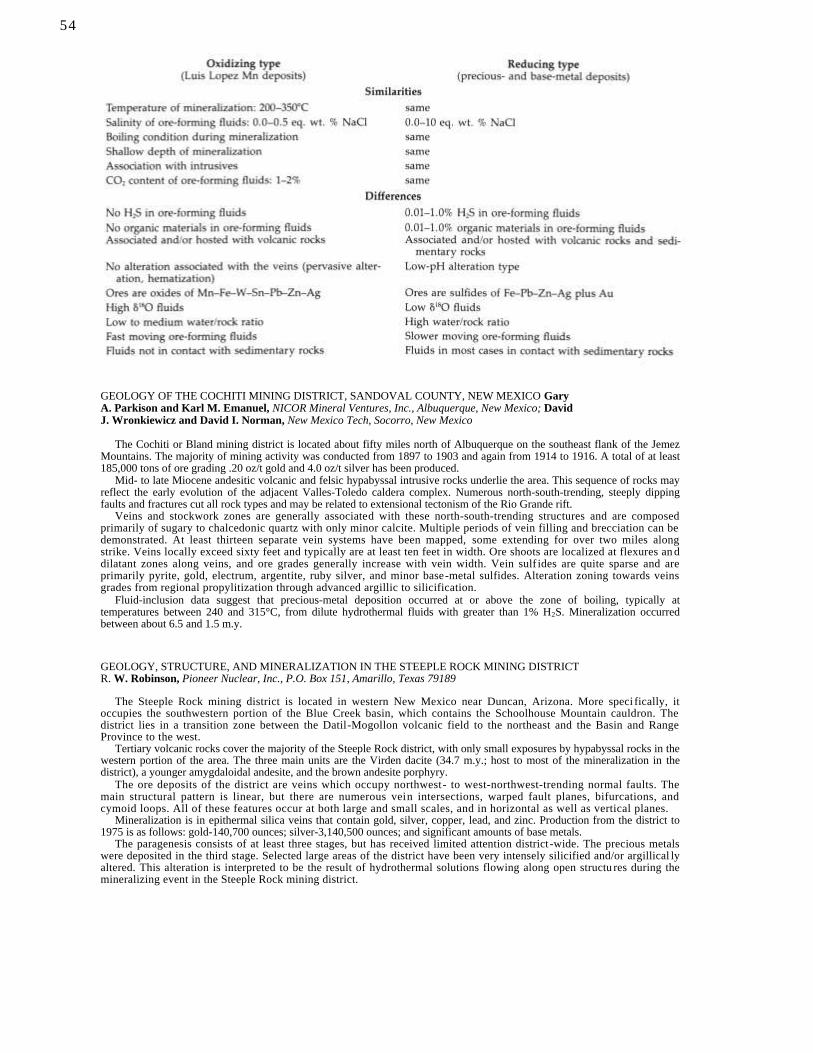
GEOLOGY OF THE COCHITI MINING DISTRICT, SANDOVAL COUNTY, NEW MEXICO Gary A. Parkison and Karl M. Emanuel, NICOR Mineral Ventures, Inc., Albuquerque, New Mexico; David J. Wronkiewicz and David I. Norman, New Mexico Tech, Socorro, New Mexico
The Cochiti or Bland mining district is located about fifty miles north of Albuquerque on the southeast flank of the Jemez Mountains. The majority of mining activity was conducted from 1897 to 1903 and again from 1914 to 1916. A total of at least 185,000 tons of ore grading .20 oz/t gold and 4.0 oz/t silver has been produced.
Mid- to late Miocene andesitic volcanic and felsic hypabyssal intrusive rocks underlie the area. This sequence of rocks may reflect the early evolution of the adjacent Valles-Toledo caldera complex. Numerous north-south-trending, steeply dipping faults and fractures cut all rock types and may be related to extensional tectonism of the Rio Grande rift.
Veins and stockwork zones are generally associated with these north-south-trending structures and are composed primarily of sugary to chalcedonic quartz with only minor calcite. Multiple periods of vein filling and brecciation can be demonstrated. At least thirteen separate vein systems have been mapped, some extending for over two miles along strike. Veins locally exceed sixty feet and typically are at least ten feet in width. Ore shoots are localized at flexures an d dilatant zones along veins, and ore grades generally increase with vein width. Vein sulf ides are quite sparse and are primarily pyrite, gold, electrum, argentite, ruby silver, and minor base-metal sulfides. Alteration zoning towards veins grades from regional propylitization through advanced argillic to silicification.
Fluid-inclusion data suggest that precious-metal deposition occurred at or above the zone of boiling, typically at temperatures between 240 and 315°C, from dilute hydrothermal fluids with greater than 1% H2S. Mineralization occurred between about 6.5 and 1.5 m.y.
GEOLOGY, STRUCTURE, AND MINERALIZATION IN THE STEEPLE ROCK MINING DISTRICT R. W. Robinson, Pioneer Nuclear, Inc., P.O. Box 151, Amarillo, Texas 79189
The Steeple Rock mining district is located in western New Mexico near Duncan, Arizona. More speci fically, it occupies the southwestern portion of the Blue Creek basin, which contains the Schoolhouse Mountain cauldron. The district lies in a transition zone between the Datil-Mogollon volcanic field to the northeast and the Basin and Range Province to the west.
Tertiary volcanic rocks cover the majority of the Steeple Rock district, with only small exposures by hypabyssal rocks in the western portion of the area. The three main units are the Virden dacite (34.7 m.y.; host to most of the mineralization in the district), a younger amygdaloidal andesite, and the brown andesite porphyry.
The ore deposits of the district are veins which occupy northwest- to west-northwest-trending normal faults. The main structural pattern is linear, but there are numerous vein intersections, warped fault planes, bifurcations, and cymoid loops. All of these features occur at both large and small scales, and in horizontal as well as vertical planes.
Mineralization is in epithermal silica veins that contain gold, silver, copper, lead, and zinc. Production from the district to 1975 is as follows: gold-140,700 ounces; silver-3,140,500 ounces; and significant amounts of base metals.
The paragenesis consists of at least three stages, but has received limited attention district -wide. The precious metals were deposited in the third stage. Selected large areas of the district have been very intensely silicified and/or argillical ly altered. This alteration is interpreted to be the result of hydrothermal solutions flowing along open structu res during the mineralizing event in the Steeple Rock mining district.
54
GEOLOGY OF THE KINGSTON MINING DISTRICT, WITH DETAILED WORK ON THE BLACK COLT MINE Peter A. Sanders, Redco Silver Inc., Enterprise, Utah; Thomas Giordano, New Mexico State University, Las Cruces, New Mexico
The Kingston mining district is located on the east flank of the Black Range, approximately 50 miles east of Silver City. The district produced more than six million oz. of Ag prior to 1904. The majority of the mineralization occurs between two major N—NW-trending faults which define the eastern structural margin of the Emory cauldron. A crude zonation occurs in the district; mines to the south and west have abundant copper, while mines to the east and north have abundant manganese. The Black Colt mine is located in the Mn-rich zone. At the Black Colt the primary mineralization occurs along ESE—WNW-trending fissure veins with related replacement deposits in the Fusselman Dolomite. Pods of massive sulfide, containing pyrite—alabandite—sphalerite—galena—minor acanthite—chalcopyrite (oldest—youngest) occur in a barren quartz vein. Pyrite—sphalerite—galena (oldest—youngest) occur in a rhodochrosite—calcite—quartz gangue in the adjacent replacement deposits. Two types of sphalerite have been distinguished, a dark, marmatitic sphalerite with abundant chalcopyrite blebs and a brown, resinous sphalerite lacking the chalcopyrite. Fluid-inclusion homogenization temperatures for the brown sphalerite range from 307 to 332°C, while the quartz temperatures range from 187 to 351°C. Limited sulfur-isotope analyses suggest disequilibrium during deposition.
55

Selected conversion factors*

Egglesto
n (co
mp
.) E
PIT
HE
RM
AL
DE
PO
SIT
S IN
NE
W M
EX
ICO
N
ew M
exico
Bu
reau o
f Min
es & M
ineral R
esou
rces C
ircular 1
99