cities in climate change initiative
DESCRIPTION
Cities in climate change initiative - city projectsTRANSCRIPT

C i t i e s i n C l i m a t e C h a n g e i n i t i a t i v e

Current Climate Change response and resilienCe
the city has organized its City disaster Coordinating Council informed by an existing city disaster risk management plan (2008-2009) and City land use plan. it also uses hazard maps on flooding and land slides sourced from the national government. in particular, the City agriculture office has initiated efforts on livelihood adaptation technologies particularly on rice production and fisheries. improved solid-waste management is also being implemented supported by local legislation. in september 2008, the city formally established its core team and technical working group for Climate Change.
in collaboration with the province and neighboring local governments, the city participates in the sorsogon Bay management Council. local government leaders expressed willingness to learn about climate change. the support of the academe, non-government organizations and people’s organizations is a lodestar of strategic partnership responses.
The above map simulates the effects of 3 stages of sea level rise showing the areas that will be submerged. © Sorsogon City Technical Working Group
Damaged seawalls cannot mitigate the effects of storm surges and typhoons. © UN-HABITAT/Yen Flores
Population: 151,454 (2007)
growth Rate: 1.78%
history: Created in 2000, through the merger of the municipalities of sorsogon and Bacon.
economy: agriculture, Fishing, trade, and services
governance: decentralized
Role in the Province: administrative, Commercial and educational Center
soRsogon City PhiliPPines Cities in Climate Change initiative
Key Activities PlAnned within ccci in tAndem with the sPAnish government-funded mdg fund on climAte chAnge
City overview
sorsogon City lies at the southernmost tip of luzon, the largest of the 7,100 islands of the philippine archipelago and is cradled between the pacific ocean and the south China sea. of its 64 barangays (lowest level of government) covering 31,292 hectares of land, 37 lie along the sea coast.
risks and vulneraBilities to Climate variaBilities and extremes
sorsogon City is the capital city of sorsogon province which is identified as a high risk province relative to combined climate and weather related risks and volcanic eruptions. the city is particularly at high risk to tropical cyclones and storm surges, extreme rainfall/flooding, increased precipitation, temperature variability and sea level rise.
there are 35,621 people or 24% of the city population who will be adversely affected as 9 urban coastal barangays were found to be highly vulnerable to climatic-induced hazards. settlements are highly at risk given their location, aging and previously damaged structures and linkage systems, and existing drainage facilities. Further, livelihoods of 993 fishermen and 211 small farmers tilling approximately 204 hectares of rice paddies are at risk. twenty four flood-prone barangays with a population of 55,452 (36.6%) risk being flooded. there is also a current prevalence of red tide in sorsogon Bay, found to be caused by climate related changes, thereby affecting food supply and livelihoods in the city.
the disastrous combination of a general public having limited knowledge on Climate Change related hazards and risks and a city lacking the proper disaster risk reduction equipment, tools and facilities makes the poor (43% of city population), who mostly populate the most high-risk areas and are inadequately covered with social protection schemes and safety nets, particularly vulnerable.
integrate existing hazard maps of the City planning and 1. development office in the on-going climate change vulnerability and adaptation assessments;develop knowledge products and document good practices 2. for sharing and cross-fertilization of ideas on mitigation and adaptation strategies;demonstrate innovative technologies to feed into the national 3. housing and urban development Coordinating Council initiatives on building climate-resilient human settlements especially in low-lying urban coastal areas; develop capacities of the city government particularly in 4. developing a shelter plan responsive to climatic-induced hazards including the use of geographic information system;advocate awareness on Climate Change among the 5. general public and stakeholders through various media and community activities in partnership with the Bicol university;Build partnerships among the private, public, academe, civil 6. society, and neighborhood associations to converge efforts in climate change mitigation and adaptation.

A busy street in the built up area of urban Sorsogon City. A 1-meter sea level rise will submerge most of the city center. © UN-HABITAT/Yen Flores
Seawalls protecting vulnerable communities living along the coastlines have been damaged due to strong typhoons that visit the city every year. © UN-HABITAT/Bernhard Barth
the national Context: PhiliPPines
although the philippines is a non-annex 1 country under the united nations Framework Convention on Climate Change, and has little contribution to the build up of greenhouse gases, it couples adaptation efforts with mitigation measures in recognition that climate change is a transboundary concern.
the philippine archipelago is a climate hotspot with 88% of its coastal areas facing oceanic waters. around 19-22 cyclones visit the philippines yearly. across the country, sea level has risen by 15 cm. with 1 meter sea level rise, about 700 million square meters of land in 64 out of 81 provinces will be inundated, potentially displacing at least 1.5 million Filipinos.
in response to climate change, the government has passed national policies on climate change adaptation and mitigation as a matter of sustainability and commitment of participation to the effort of the global community. support structures have been sequentially established for policy implementation, i.e., (1) national disaster Coordinating Council, (2) inter-agency Committee on Climate Change, (3) philippine Council for sustainable development, (4) designated national authority for Clean development mechanisms, (5) presidential task Force on Climate Change, and (6) inter-agency advisory Board on Climate Change monitoring and Communication. a bill to create a Climate Change Commission is pending in Congress. emerging private sector-led initiatives from business and the academe are becoming strong voice mechanisms on climate change issues.
un-haBitat’s Cities in Climate Change initiative
un-haBitat launched the sustainable urban development network (sud-net), an innovative network of global partners, promoting inter-disciplinary approaches to sustainable urban development.
the Cities in Climate Change initiative (CCCi) is the flagship programme of sud-net. the initiative aims to strengthen the climate change response of cities and local governments. Cities are key drivers of climate change due to their high energy consumption, land use, waste generation and other activities that result in the release of the vast majority of greenhouse gases. at the same time, it is cities, and in particular the urban poor, in the developing world, that are most vulnerable to and have the least resilience against, for example, storms, floods, and droughts. Cities need to respond to Climate Change by cutting their greenhouse gas emissions (mitigation). the negative impact of climate change seems however unavoidable and for most cities in developing countries adaptation to the risks is a must.
the Cities in Climate Change initiative brings together local and national governments, academia, ngos and international organizations with the aim to alert cities to the action they can take and by strengthening capacities of cities and their partners to respond to Climate Change. the key components of the Cities in Climate Change initiative are:
For more information, contact:
un-habitat global divisionurban environmental planning Branch p.o. Box 30030 00100 nairobi, kenyatel: +254 20 7625405Fax: +254 20 7623715email: [email protected]/sudnet
un-habitat Fukuokaregional office for asia and the pacificaCros 8F, 1-1-1 tenjin, Chuo-kuFukuoka 810-0001, Japantel: (81 92) 724 7121Fax: (81 92) 724 7124www.fukuoka.unhabitat.org
un-habitat philippines31/F yuchengco tower, rCBC plaza6819 ayala avenue1229 makati City, philippinestel: (632) 901 0432Fax: (632) 889 7505www.unhabitat.org.ph
Five sectors are considered as the major policy making players on climate change, namely, (1) housing and urban development, (2) energy, (3) environment and natural resources, (4) agriculture and fishery, and (5) population. thus far, the energy as well as the environment and natural resources sectors are most active in developing policies on adaptation and mitigation approaches. however, the lgus are acknowledged as the major source of empirical information for policy development and, more importantly, the implementors of policies on the ground.
advocacy, policy dialogue and policy change•tool development and tool application•piloting climate change mitigation and adaptation •measures knowledge management and dissemination, through, •amongst others, the un-haBitat partner universities and the partnership with un-haBitat’s local government training institutes network.
initially four cities, esmeraldas in ecuador, kampala in uganda, maputo in mozambique and sorsogon in the philippines will participate in the Cities in Climate Change initiative as key partner cities. at the same time good practices from other cities around the world are being promoted.

Population (canton: ineC, 2001): 175,000 inhabitants. Urban: 112,000, Rural: 64,445 afro-ecuadorian population: 70,347.
economy (ineC, 2001): primarily based on the services sector. of the economically active population, 55.3% are engaged in services, 16.2% in agricultural activities, and 15.4% in industrial activities.
Political/administrative Divisions: the canton of esmeraldas is divided into 5 urban parishes and 8 rural parishes.
esmeRalDas eCUaDoR Cities in Climate Change initiative
City overview
esmeraldas is a coastal city located in the extreme northwestern corner of ecuador covering a land area of 16,155.97 km². the teaone and esmeraldas rivers which pass by one side of the city and the pacific ocean together account for the hydrological system present in the canton. esmeraldas is part of the Choco micro-region which has one of the highest rates of biodiversity in the world.
environmental risks and vulneraBility
the city of esmeraldas, the capital of esmeraldas province, is considered to be one of the areas in ecuador that is most vulnerable to the effects of climate change.
approximately 14,000 families, 21% of the canton’s population, are highly vulnerable to different adverse climatic events. these families have few economic resources and live in houses made of substandard materials, primarily in informal settlements located in high-risk areas like the lower riverbanks of the esmeraldas and teaone rivers, hillsides and ravines.
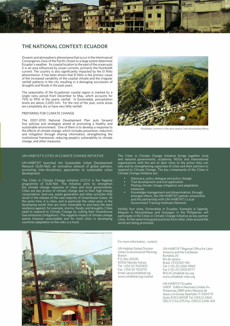
during the winter or rainy season, mudslides and river overflows, which can reach up to six meters over the normal water line, have devastating effects: houses and roads are destroyed, the sewer system collapses, neighborhoods are flooded, the trans-ecuadorian pipeline ruptures causing crude oil spills in the esmeraldas and teaone rivers, etc. the agricultural and fishing sector, on which 16% of the population depends, also suffer dire consequences. during the dry season, the drying up of the streams affects primarily rural populations who depend on this source of water for their day-to-day needs.
the city is becoming more and more vulnerable due to the inappropriate management of its natural resources: 1) the mangroves, which form a buffer area against the rising river levels, are gradually being lost due to logging; 2) primary forest areas are disappearing due to accelerating deforestation and mono-crop farming, including the african palm and eucalyptus; 3) high levels of industrial activity within the urban perimeter, like the state refinery and the thermoelectric power station, whose operations have created permanent air and water pollution, causing pressure and impacts that affect the health of the population.
preparing For Climate Change
in the city of esmeraldas, there is no culture of comprehensive risk management or disaster prevention in the face of natural events. efforts are being made through the Cantonal health Council, in coordination with different stakeholders at the national and local level that are involved in this issue, to prepare a risk management plan. one important advance in this area has been the preparation of a participatory land use plan for the city of esmeraldas, and the zoning of the riverbanks (the islands), which, among other things, is fundamental for identifying high-risk areas, protected and restricted areas, relocating settlements and stopping land invasions. in addition, a participatory effort by citizens and professionals has resulted in a proposed reforestation plan for the city’s hillsides and a proposal to declare them to be protective woodlands.
in coordination with the ministry of the environment, the municipality is implementing an environmental management plan for the teaone river, which includes: a program to collect and treat used oil; a solid waste management program; an oil spill control program; a flood prevention program; the rehabilitation of riversides through reforestation with native plants (giant bamboo), and others. since June 2007, the municipality, ministry of education and ministry of health have been carrying out an environmental education plan in 96 schools called “healthy schools program”. in addition, urban agriculture and permaculture projects are being implemented in various neighborhoods around the city, directly involving around 20 families.
© Municipio de Esmeraldas
Settlements along the riverbanks are vulnerable to seasonal flooding.
the national Context: eCUaDoR
oceanic and atmospheric phenomena that occur in the intertropical Convergence Zone of the pacific ocean to a large extent determine ecuador’s weather. its coastal location to the east of the ocean puts it in an area influenced by ocean currents, primarily the humboldt current. the country is also significantly impacted by the el niño phenomenon. it has been shown that el niño is the primary cause of the increased variability of the coastal climate and the irregular rainfall patterns in the city resulting in a damaging succession of droughts and floods in the past years.
the seasonality of the ecuadorian coastal region is marked by a single rainy period from december to may, which accounts for 75% to 95% of the yearly rainfall. in esmeraldas, precipitation levels are above 2,000 mm. For the rest of the year, some areas are completely dry or have very little rainfall.
preparing For Climate Change
the 2007-2010 national development plan puts forward four policies and strategies aimed at promoting a healthy and sustainable environment. one of them is to develop a response to the effects of climate change, which includes prevention, reduction and mitigation through sharing information, strengthening the institutional framework, reducing people’s vulnerability to climate change, and other measures.
un-haBitat’s Cities in Climate Change initiative
un-haBitat launched the sustainable urban development network (sud-net), an innovative network of global partners, promoting inter-disciplinary approaches to sustainable urban development.
the Cities in Climate Change initiative (CCCi) is the flagship programme of sud-net. the initiative aims to strengthen the climate change response of cities and local governments. Cities are key drivers of climate change due to their high energy consumption, land use, waste generation and other activities that result in the release of the vast majority of greenhouse gases. at the same time, it is cities, and in particular the urban poor, in the developing world, that are most vulnerable to and have the least resilience against, for example, storms, floods, and droughts. Cities need to respond to Climate Change by cutting their greenhouse gas emissions (mitigation). the negative impact of climate change seems however unavoidable and for most cities in developing countries adaptation to the risks is a must.
For more information, contact:
un-habitat global divisionurban environmental planning Branch p.o. Box 30030 00100 nairobi, kenyatel: +254 20 7625405Fax: +254 20 7623715email: [email protected]/sudnet
un-haBitat regional office for latin america and the Caribbean rumânia 20 rio de Janeiro Brasil. Cp22240-140tel: (+55-21) 2265-9960 Fax (+55-21) [email protected]
un-haBitat ecuadorundp - edificio naciones unidas av. amazonas 2889 entre mariana de Jesus y la granja apartado 17-0304731 Quito – eCuador tel: (593.2) 2460-330/1/2 ext.2115 Fax: (593.2) 2248-324
the Cities in Climate Change initiative brings together local and national governments, academia, ngos and international organizations with the aim to alert cities to the action they can take and by strengthening capacities of cities and their partners to respond to Climate Change. the key components of the Cities in Climate Change initiative are:
advocacy, policy dialogue and policy change•tool development and tool application•piloting climate change mitigation and adaptation •measures knowledge management and dissemination, through, •amongst others, the un-haBitat partner universities and the partnership with un-haBitat’s local government training institutes network.
initially four cities, esmeraldas in ecuador, kampala in uganda, maputo in mozambique and sorsogon in the philippines will participate in the Cities in Climate Change initiative as key partner cities. at the same time good practices from other cities around the world are being promoted.
Mudslides, common in the rainy season, have devastating effects.

Population: day time 2.5 million; night time 1.2million (2000 census)
gDP growth Rate: 8%
economy: Commerce and industrygovernance: decentralizedhistory: established as a Capital city in 1962
Role in the Country: Capital city, commercial, administrative and education centre
Rainfall: 1,750- 2,000mm with peaks in march - may and september - november. Dry seasons: June-July and december to January. mean annual temperature: 21.9ºC Relative humidity: 53 to 89%
KamPala UganDa Cities in Climate Change initiative
City overview
kampala city, located in Central uganda, on the northern shores of lake victoria, is the Capital City of the republic of uganda. Covering an area of 195 sq.km and at an average altitude of 3,910 ft (1,120 m) above sea level, it is situated on about 24 low flat topped hills that are surrounded by wetland valleys, characterized by an imprint of scattered unplanned settlements.
environmental risks & vulneraBilities
kampala City is faced with urban sprawl and increased growth of informal settlements and slums due to the ever increasing population pressure and inadequate land use planning. this has resulted in settlements being located in high risk areas especially those prone to flooding and poor sanitation. due to the high water table, most of the wells/springs are contaminated mainly by fecal materials and this puts safe water coverage at about 55%. the situation is further exacerbated by the low collection rate of solid waste, which currently stands at 55%. scarcity of urban land means that increased construction is taking place on the hill tops. the lack of water harvesting mechanisms and hard paving have caused degradation of the fragile hill slopes.
excessive use of wood fuel (79.4%) as a major source of energy for cooking, over dependence on reused vehicles, leaded fuels consumption and encroachment on fragile ecosystems have increased the occurrence of flush floods, air, land and water pollution and blockage of the drainage systems in the city. given these vulnerable conditions, the city dwellers are exposed to water borne diseases such as malaria, bilharzias and other related ailments such as respiratory tract infections and hiv/aids.
within the framework of the kampala City development strategy (Cds) and the local and national development plans, the following activities are proposed during the initial phase of the CCCi project:
establishment of national/city climate change network 1. comprised of various spheres of government, local government associations, Csos/ngos, universities, private sector, and other stakeholders addressing climate change;increasing the level of awareness and capacities of kampala 2. City Council on climate change mitigation and adaptation;increasing the synergies and links between national and 3. local climate change policies and programmes through consultations and policy dialogues to introduce governance and decentralization dimensions into climate change policies and strategies.

the national Context: UganDa
national responses to Climate Change
Concern over climate change in uganda emerged over 15 years ago, during preparation for and uganda’s high level participation in the second world Climate Conference in 1990. in 1993, uganda ratified the Convention and in 2002 acceded to the kyoto protocol at the third unCed in Johannesburg, south africa. after 15 years of involvement in global climate negotiations, awareness of climate change issues is still assessed to be fairly low outside of the meteorology department. Climate policy does not feature in the ministry’s policy framework as an independent policy area. national climate concerns are not formulated in policies such as the uganda Forestry policy of 2001, nor are climate concerns covered by a law or regulation like the land act of 1998, and neither are they addressed in a plan like the wetland sector strategic plan 2001-2010. the first official document directly addressing climate policy is the ‘initial national Communication to the unFCCC’ of 2002. uganda’s longer-term development framework formulated in key documents such as vision 25, the poverty eradication action plan (peap), and the plan for modernization of agriculture (pma) has not addressed climate change issues. lack of awareness at all levels is a major factor for this omission. Currently, the government is expanding the national Focal point hosted by the department of meteorology into a national Climate Change secretariat to deal with both mitigation and adaptation issues as a positive step forward.
un-haBitat’s Cities in Climate Change initiative
un-haBitat launched the sustainable urban development network (sud-net), an innovative network of global partners, promoting inter-disciplinary approaches to sustainable urban development.
the Cities in Climate Change initiative (CCCi) is the flagship programme of sud-net. the initiative aims to strengthen the climate change response of cities and local governments. Cities are key drivers of climate change due to their high energy consumption, land use, waste generation and other activities that result in the release of the vast majority of greenhouse gases. at the same time, it is cities, and in particular the urban poor, in the developing world, that are most vulnerable to and have the least resilience against, for example, storms, floods, and droughts. Cities need to respond to Climate Change by cutting their greenhouse gas emissions (mitigation). the negative impact of climate change seems however unavoidable and for most cities in developing countries adaptation to the risks is a must.
For more information, contact:
un-habitat global divisionurban environmental planning Branch p.o. Box 3003000100 nairobi, kenyatel: +254 20 7625405Fax: +254 20 7623715email: [email protected]/sudnet
director regional office for africa & the arab states un-habitat nairobi, kenya tel :254 20 7623075 Fax: 254 20 7623904 website:http://www.unhabitat.org/roaas
un-habitat programme manager - ugandaun-habitatundp-15B Clement hill roadpo Box 7184kampala-ugandatel: 256-41-233440/1/2/5mob: 256-77-479731Fax: 256-41-344801
the Cities in Climate Change initiative brings together local and national governments, academia, ngos and international organizations with the aim to alert cities to the action they can take and by strengthening capacities of cities and their partners to respond to Climate Change. the key components of the Cities in Climate Change initiative are:
advocacy, policy dialogue and policy change•tool development and tool application•piloting climate change mitigation and adaptation •measures knowledge management and dissemination, through, •amongst others, the un-haBitat partner universities and the partnership with un-haBitat’s local government training institutes network.
initially four cities, esmeraldas in ecuador, kampala in uganda, maputo in mozambique and sorsogon in the philippines will participate in the Cities in Climate Change initiative as key partner cities. at the same time good practices from other cities around the world are being promoted.
Wood fuel, including charcoal, constitute 80% of cooking fuel and generate incomes for women in the informal economy.
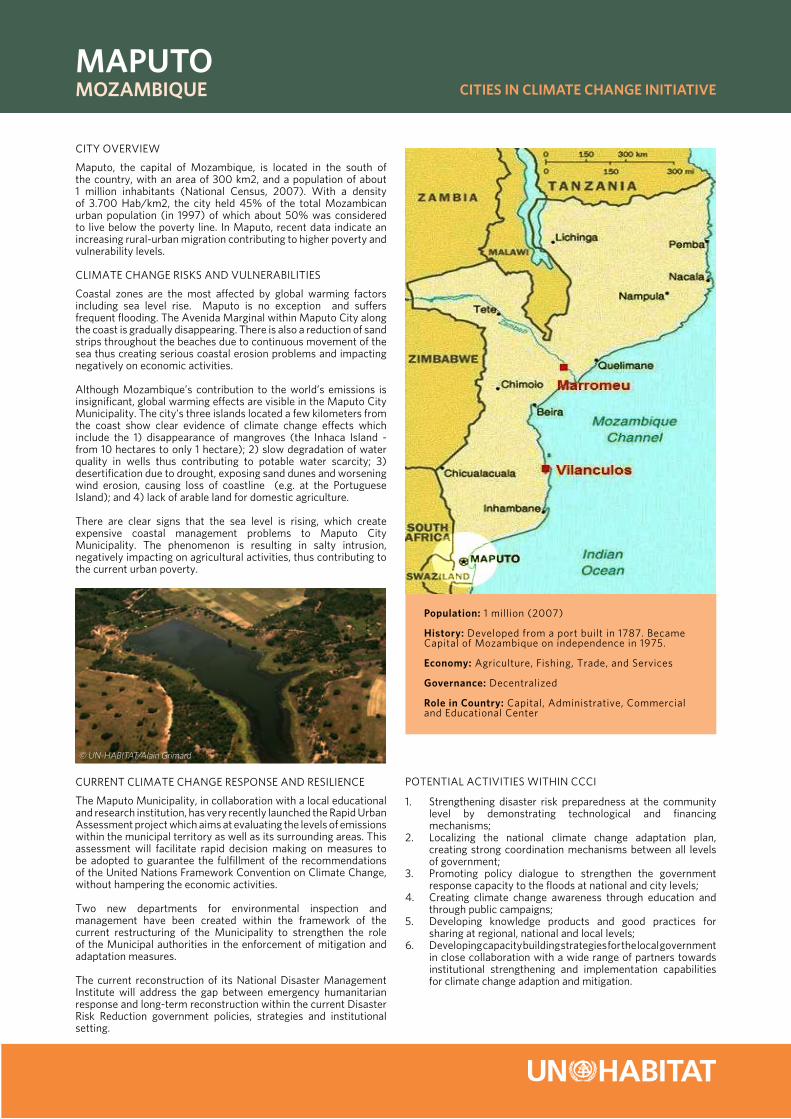
Population: 1 million (2007)
history: developed from a port built in 1787. Became Capital of mozambique on independence in 1975.
economy: agriculture, Fishing, trade, and services
governance: decentralized
Role in Country: Capital, administrative, Commercial and educational Center
maPUto mozambiqUe Cities in Climate Change initiative
City overview
maputo, the capital of mozambique, is located in the south of the country, with an area of 300 km2, and a population of about 1 million inhabitants (national Census, 2007). with a density of 3.700 hab/km2, the city held 45% of the total mozambican urban population (in 1997) of which about 50% was considered to live below the poverty line. in maputo, recent data indicate an increasing rural-urban migration contributing to higher poverty and vulnerability levels.
Climate Change risks and vulneraBilities
Coastal zones are the most affected by global warming factors including sea level rise. maputo is no exception and suffers frequent flooding. the avenida marginal within maputo City along the coast is gradually disappearing. there is also a reduction of sand strips throughout the beaches due to continuous movement of the sea thus creating serious coastal erosion problems and impacting negatively on economic activities.
although mozambique’s contribution to the world’s emissions is insignificant, global warming effects are visible in the maputo City municipality. the city’s three islands located a few kilometers from the coast show clear evidence of climate change effects which include the 1) disappearance of mangroves (the inhaca island - from 10 hectares to only 1 hectare); 2) slow degradation of water quality in wells thus contributing to potable water scarcity; 3) desertification due to drought, exposing sand dunes and worsening wind erosion, causing loss of coastline (e.g. at the portuguese island); and 4) lack of arable land for domestic agriculture.
there are clear signs that the sea level is rising, which create expensive coastal management problems to maputo City municipality. the phenomenon is resulting in salty intrusion, negatively impacting on agricultural activities, thus contributing to the current urban poverty.
Current Climate Change response and resilienCe
the maputo municipality, in collaboration with a local educational and research institution, has very recently launched the rapid urban assessment project which aims at evaluating the levels of emissions within the municipal territory as well as its surrounding areas. this assessment will facilitate rapid decision making on measures to be adopted to guarantee the fulfillment of the recommendations of the united nations Framework Convention on Climate Change, without hampering the economic activities.
two new departments for environmental inspection and management have been created within the framework of the current restructuring of the municipality to strengthen the role of the municipal authorities in the enforcement of mitigation and adaptation measures.
the current reconstruction of its national disaster management institute will address the gap between emergency humanitarian response and long-term reconstruction within the current disaster risk reduction government policies, strategies and institutional setting.
potential aCtivities within CCCi
strengthening disaster risk preparedness at the community 1. level by demonstrating technological and financing mechanisms;localizing the national climate change adaptation plan, 2. creating strong coordination mechanisms between all levels of government;promoting policy dialogue to strengthen the government 3. response capacity to the floods at national and city levels;Creating climate change awareness through education and 4. through public campaigns;developing knowledge products and good practices for 5. sharing at regional, national and local levels;developing capacity building strategies for the local government 6. in close collaboration with a wide range of partners towards institutional strengthening and implementation capabilities for climate change adaption and mitigation.
© UN-HABITAT/Alain Grimard

© UN-HABITAT/Alain Grimard
© UN-HABITAT/Alain Grimard
the national Context: mozambiqUe
mozambique, located in south-eastern africa, has a land area of 784,090n km2 with a coastal line length of 2,515 km and 17,500 km2 being under water. the terrain is mostly coastal lowland with a vast network of rivers and tributaries, many of them emptying into the indian ocean. the current population of mozambique is about 18.8 million with an annual growth rate of 1.22%. mozambique remains one of the poorest countries in the world ranking 168 out of 177 countries according to the human development index (undp 2004). the incidence of poverty in the rural areas is 71.3% compared to 62% in urban areas. it is estimated that slum dwellers represent more than 80% of the total urban population with majority of the settlements situated in areas prone to floods and other natural disasters.
mozambique’s coastline is highly susceptible to cyclones and tropical storms originating from the indian ocean, which is further exacerbated by the impact of climate change. since 1970, mozambique has been hit by 34 significant cyclones or tropical depressions and 4 major flood events (2000, 2001, 2007 and 2008), all seriously hampering its economic growth. a trend of increased temperature has been observed in mozambique according to the ipCC report of 2007.
in response, the country has put in place the national adaptation plan of action to Climate Change which highlights disaster preparation and management as well as environmental management. in addition, the 2nd poverty reduction strategy (prs) paper of mozambique for the period 2006-2009, clearly indicates orientations with the current international disaster risk reduction
un-haBitat’s Cities in Climate Change initiative
un-haBitat launched the sustainable urban development network (sud-net), an innovative network of global partners, promoting inter-disciplinary approaches to sustainable urban development.
the Cities in Climate Change initiative (CCCi) is the flagship programme of sud-net. the initiative aims to strengthen the climate change response of cities and local governments. Cities are key drivers of climate change due to their high energy consumption, land use, waste generation and other activities that result in the release of the vast majority of greenhouse gases. at the same time, it is cities, and in particular the urban poor, in the developing world, that are most vulnerable to and have the least resilience against, for example, storms, floods, and droughts. Cities need to respond to Climate Change by cutting their greenhouse gas emissions (mitigation). the negative impact of climate change seems however unavoidable and for most cities in developing countries adaptation to the risks is a must.
For more information, contact:
un-habitat global divisionurban environmental planning Branch p.o. Box 30030 00100 nairobi, kenyatel: +254 20 7625405Fax: +254 20 7623715email: [email protected]/sudnet
regional office for africa and arab statesun-habitatp.o. Box 30030gpo nairobi 00100, kenyatel.: +254 20 762 4717Fax: +254 20 762 3904email: [email protected]
un-habitat programme manager for mozambiqueun-habitatC/o undp Country office in maputo rua Francisco Barreto 322 - po Box 4595 phone: +258 21 481 481 Fax: +258 21 491 691 maputo - mozambique
agenda and the hyogo Framework for action 2005-2015. the prs consolidates the culture of prevention, and the adoption of preparedness and mitigation measures. the country’s master plan for disaster preparedness and mitigation includes important aspects of climate change mitigation and adaptation such as: the construction of public infrastructure with characteristics resistant to cyclones and floods; the construction of improved houses less vulnerable to floods in areas at risk; the enhancement of community participation in all disaster risk reduction (drr) activities; the inclusion of drr topics within the formal education system.
the Cities in Climate Change initiative brings together local and national governments, academia, ngos and international organizations with the aim to alert cities to the action they can take and by strengthening capacities of cities and their partners to respond to Climate Change. the key components of the Cities in Climate Change initiative are:
advocacy, policy dialogue and policy change•tool development and tool application•piloting climate change mitigation and adaptation •measures knowledge management and dissemination, through, •amongst others, the un-haBitat partner universities and the partnership with un-haBitat’s local government training institutes network.
initially four cities, esmeraldas in ecuador, kampala in uganda, maputo in mozambique and sorsogon in the philippines will participate in the Cities in Climate Change initiative as key partner cities. at the same time good practices from other cities around the world are being promoted.
© UN-HABITAT/Alain Grimard