city centre west of railway precinct ... city centre west of railway precinct structure plan vi...
TRANSCRIPT
Produced by
CITY CENTRE WEST OF RAILWAY PRECINCT
STRUCTURE PLAN
JUNE 2016

A R M A D A L E : C I T Y C E N T R E W E S T O F R A I LW AY P R E C I N C T S T R U C T U R E P L A N iii
TABLE OF VARiATiON(S) TO STRUCTURE PLAN
Variation No. Description of Variation Date Approved by the Authority

A R M A D A L E : C I T Y C E N T R E W E S T O F R A I LW AY P R E C I N C T S T R U C T U R E P L A N iV
CONTENTS
Executive SummaryStructure Plan Summary Table
PART ONE – STATUTORY SECTION
1. Structure Plan Area2. Structure Plan Content3. interpretation and Scheme Relationship4. Operation5. Land Use and Subdivision Requirements6. Development Requirements
Structure Plan Map
PART TWO – EXPLANATORY SECTION
1. PLANNING BACKGROUND
1.1 introduction and Purpose1.2 Land Description 1.2.1 Location 1.2.2 Area and Land Use 1.2.3 Legal Description and Ownership1.3 Planning Framework 1.3.1 Zoning and Reservations 1.3.2 Regional and Sub-Regional Structure Plan 1.3.3 Planning Strategies 1.3.4 Policies 1.3.5 Other Approvals and Decisions
2. SITE CONDITIONS AND CONSTRAINTS
2.1 Biodiversity and Natural Area Assets2.2 Landform and Soils2.3 Groundwater and Surface Water2.4 Heritage2.5 Context and Other Land Use Constraints
3. LAND USE AND SUBDIVISION REQUIREMENTS
3.1 Land Use3.2 Open Space3.3 Residential3.4 Movement Networks3.5 Water Management3.6 Education3.7 Activity Centres and Employment

A R M A D A L E : C I T Y C E N T R E W E S T O F R A I LW AY P R E C I N C T S T R U C T U R E P L A N V
3.8 infrastructure Coordination, Servicing and Staging3.9 Developer Contribution Arrangements3.10 Other Requirements
TECHNICAL APPENDICESAppendix 1: Market Feasibility StudyAppendix 2: Local Water Management StrategyAppendix 3: Servicing StrategyAppendix 4: Traffic Impact AssessmentAppendix 5: Design Guidelines

A R M A D A L E : C I T Y C E N T R E W E S T O F R A I LW AY P R E C I N C T S T R U C T U R E P L A N Vi
Executive Summary
This Structure Plan has been prepared by MW Urban planning and development consultants on behalf of the Metropolitan Redevelopment Authority (MRA) to guide the subdivision and development of the City Centre West of Railway Precinct within the Armadale Redevelopment Area.
The Structure Plan applies to the City Centre West of Railway Precinct, as identified in Appendices 1 and 4 of the Armadale Redevelopment Scheme. The Structure Plan area is a triangular precinct of approximately 10.84 hectares, bounded by Green Avenue, Forrest Road and Fifth Road.
Consistent with the Scheme objectives for the City Centre West of Railway Precinct, the Structure Plan facilitates predominantly high density residential/mixed use development.
The main structural elements of the Structure Plan are:
• retention of Tudor Road;• extension of Cornish Street to Green Avenue;• extension of Devonshire Terrace to the extended Cornish Street;• an urban square/plaza at the intersection of Green Avenue, Cornish Street and Devonshire
Terrace;• part of the Green Avenue reserve between Forrest and Tudor Roads reduced to 20m and
the balance incorporated into the abutting fire station site.
Provision is made for an urban plaza/open space at the intersection of Green Avenue and the extended Cornish Street and Devonshire Terrace, and extending north to provide a visual link to the train station. This public space will serve as a community and business focal point for the precinct.
Residential development will generally accord with the existing R80 and R-iC density codes identified for the precinct under the Armadale Redevelopment Scheme (Appendix 1). Residential Design Code variations in respect to building heights and plot ratio are identified in Part 1 of the Structure Plan to reflect the desired scale and intensity of development adjacent to the public transport hub.
The estimated dwelling yield for the Structure Plan area is 928 dwellings, based on the R80 and R-iC density codes and the R Code variations set out in Part 1. The estimated number of dwellings exceeds the density targets of Directions 2031 and Liveable Neighbourhoods.
The proposed movement network will significantly improve permeability and accessibility within the Structure Plan area, and create better links for all modes of movement between the surrounding residential areas, the train station/bus interchange and the Armadale town centre.
Existing developer contribution requirements are set out in the Armadale West of Rail Precinct Developer Contribution Scheme Report. These requirements are currently under review.

A R M A D A L E : C I T Y C E N T R E W E S T O F R A I LW AY P R E C I N C T S T R U C T U R E P L A N Vii
Structure Plan Summary Table
Item DataSection number
referenced within the Structure Plan Report
Gross Structure Plan Area 10.84 hectares 1.2.2
Area of each land use proposed:
Residential/Mixed Use
Roads
Public Open Space
6.55 hectares = 60.4%
4.10 hectares = 37.8%
0.19 hectares = 1.8%
3.1
Estimated Number of Dwellings 928 dwellings 3.3
Estimated Residential Density
- dwellings per gross hectare
- dwellings per site hectare
85.6 dwellings per gross hectare
141 dwellings per site hectare
3.3
Estimated Population 2,320 people@ 2.5 people/household 3.3
Number of Secondary Schools Nil 3.6
Number of Primary Schools Nil 3.6

A R M A D A L E : C I T Y C E N T R E W E S T O F R A I LW AY P R E C I N C T S T R U C T U R E P L A N Viii
SECTION ONE – STATUTORY SECTION
1. Structure Plan AreaThis Structure Plan applies to the area identified in the Armadale Redevelopment Scheme (the Scheme) as Precinct 1.2: City Centre West of Railway Precinct, being the land contained within the inner edge of the line denoting the Structure Plan boundary on the Structure Plan Map (Plan 1).
2. Structure Plan ContentThe Structure Plan comprises the following sections:
(i) Section One – Statutory Section. This section includes the Structure Plan Map and any textual provisions, standards or requirements that require statutory effect.
(ii) Section Two – Explanatory Section (Non-Statutory). This section provides the planning context and justification for the Structure Plan Map and the textual provisions contained in Part One of the Structure Plan. Part Two is to be used as a reference to guide interpretation and implementation of Part One.
(iii) Appendices, includes all specialist consultant reports and documentation used in the preparation of and to support the land use outcomes of the Structure Plan.
3. Interpretation and Scheme Relationship3.1 Unless otherwise specified in this part, the words and expressions used in this Structure
Plan shall have the respective meanings given to them in the Scheme including any amendments gazetted thereto.
3.2 Pursuant to clauses 4.7, 7.4 and 7.5 of the Scheme, in considering a development application or plan of subdivision (for objections and recommendations), the Metropolitan Redevelopment Authority is to have due regard to the provisions, standards and requirements specified under Part 1 of this Structure Plan.
3.3 The objectives, standards and requirements applicable under the Scheme to Precinct 1.2 of the Scheme shall apply to the same extent to the Structure Plan area, unless specific provision is made to the contrary in this part.
3.4 Part 2 of this Structure Plan and the Appendices are to be used as a reference only to clarify and guide interpretation and implementation of Part 1.
4. Operationin accordance with clause 7.12 of the Scheme, this Structure Plan comes into effect on the day on which it is approved by the Authority.

A R M A D A L E : C I T Y C E N T R E W E S T O F R A I LW AY P R E C I N C T S T R U C T U R E P L A N ix
5. Land Use and Subdivision Requirements5.1 Land use shall be in accordance with Part 6 of the Scheme. Preferred land uses are
noted on the Structure Plan Map.
5.2 Residential densities shall be in accordance with clauses 5.2 and 5.3 and Appendix 1 of the Scheme.
5.3 in respect of applications for the subdivision of land, the Metropolitan Redevelopment Authority may recommend to the Western Australian Planning Commission that a condition be imposed on the grant of subdivision approval for a notification to be placed on the Certificate(s) of Title(s) to ensure that prospective purchasers are advised of:
a) the potential for transport noise impacts generated from the nearby railway; and b) the potential for quiet housing design requirements in accordance with State Planning Policy 5.4 Road and Rail Transportation Noise and Freight Consideration in Land Use Planning (as amended).
6. Development Requirements6.1 Development shall be in accordance with the requirements of Part 5 of the Scheme, and
any applicable design guidelines or Local Development Plan, unless specific provision is made to the contrary in this part.
6.2 Minimum building heights of two (2) and three (3) storeys shall apply within the Structure Plan area, except where a minimum height of five (5) storeys is mandated, as shown on the Structure Plan Map.
6.3 The Structure Plan amends the following deemed-to-comply provisions of the Residential Design Codes, except where a minimum building height of five (5) storeys is mandated as shown on the Structure Plan Map. Where a minimum building height of five (5) storeys is mandated, the maximum plot ratio and building height shall be in accordance with the applicable Local Development Plan.

A R M A D A L E : C I T Y C E N T R E W E S T O F R A I LW AY P R E C I N C T S T R U C T U R E P L A N x
Design Element Current Provision Amended Deemed-to-Comply Provision
6.1.1 Building size – maximum plot ratio for R80 density coding (multiple dwellings)
Maximum plot ratio for R-IC density coding (multiple dwellings)
1.0
Refer to Residential Design Codes provisions
2.0
2.0
6.1.2 Building height -
R80 density coding (multiple dwellings)
R-IC density coding (multiple dwellings)
Top of external wall: 12mTop of external wall: 13m(concealed roof)Top of pitched roof: 15m Refer to Residential Design Codes provisions
Top of external wall: 15mTop of external wall: 16m(concealed roof)Top of pitched roof: 18m Top of external wall: 18mTop of external wall: 19m(concealed roof)Top of pitched roof: 21m
6.1.3 Open Space –
R80 density coding (multiple dwellings)
R-IC density coding (multiple dwellings)
Refer to local structure plan or local development plan which sets out development requirements. Refer to Residential Design Codes provisions
Minimum 30% unless the Design Guidelines or a local development plan require otherwise. Minimum 20%, unless the Design Guidelines or a local development plan require otherwise.

A R M A D A L E : C I T Y C E N T R E W E S T O F R A I LW AY P R E C I N C T S T R U C T U R E P L A N xi
Structure Plan Map
RAILW
AY
TUDOR
RD
GREE
N
FORREST
RD
FIFTH
RD
AV
RD
ST28.2m ROAD RESERVE
20m ROAD RESERVE
DEVONSHIRE TERRACE
20m
12.6m
ROAD RESERVE
* *
*
**
** *
ROADRESERVE
CORNISH
*
20 40 60 80 metres0 NCITY CENTRE WEST OF RAILWAY PRECINCT
STRUCTURE PLAN MAPMRA
MRA-1 006HPLAN:150810DATE:
REVISION OF 'SP'PROJECT:TW/AMDESIGNED:
1:2000SCALE: @ A3
DISCLAIMER: ISSUED FOR ILLUSTRATIVEPURPOSES ONLY. ALL AREAS AND DIMENSIONSARE SUBJECT TO DETAIL DESIGN AND SURVEY.
LEGENDStructure plan boundary
2 storeys minimum (mandatory), 3 storeys maximum
3 storeys minimum, 5 storeys maximum, apartment/mixed use development,except where a minimum of 5 storeys is mandated
5 storeys minimum (mandatory), 7 storeys maximum
3 storeys minimum, 6 storeys maximum, apartment/mixed use development,except where a minimum of 5 storeys in mandated
Plaza/open space - restaurants preferred at ground level of adjacent sites
Left in/ Left out intersection
Future proposed road widening by City of Armadale
*

A R M A D A L E : C I T Y C E N T R E W E S T O F R A I LW AY P R E C I N C T S T R U C T U R E P L A N 1
PART TWO – EXPLANATORY SECTION
1. PLANNING BACKGROUND
1.1 Introduction and PurposeThis Structure Plan has been prepared by MW Urban planning and development consultants on behalf of the Metropolitan Redevelopment Authority (MRA) to guide the subdivision and development of the City Centre West of Railway Precinct within the Armadale Redevelopment Area.
The MRA has identified the Structure Plan area as a key redevelopment site that is ideally located adjacent to the Armadale train station, making it well positioned for Transit Oriented Development (TOD). However, the ‘West of Railway Precinct Revised Structure Plan and Design Guideline (December 2010)’ does not meet MRA’s current objectives and vision for the precinct. As such, this Structure Plan, and the associated design guidelines prepared separately by the MRA, replaces the West of Railway Precinct Revised Structure Plan and Design Guideline (December 2010).
The Structure Plan has been prepared in accordance with the Western Australian Planning Commission’s Structure Plan Preparation Guidelines and consistent with Part 7 of the Armadale Redevelopment Scheme.
The Structure Plan is supported by the following technical reports:
• Market Feasibility Study prepared by JLL;• Local Water Management Strategy prepared by Emerge Associates;• Servicing Strategy prepared by BPA Engineering;• Traffic Impact Assessment prepared by Flyt.
1.2 Land Description1.2.1 LocationThe City Centre West of Railway Precinct is located immediately west of the Armadale train station and adjacent to the established Armadale town centre, which is east of the railway. Figure 1 shows the location of the Structure Plan area.
1.2.2 Area and Land UseThe Structure Plan applies to the City Centre West of Railway Precinct, as identified in Appendices 1 and 4 of the Armadale Redevelopment Scheme. The Structure Plan area is a triangular precinct of approximately 10.84 hectares, bound by Green Avenue, Forrest Road and Fifth Road.
A number of houses occupy lots within the Structure Plan area between Fifth Road and Tudor Road. Much of the Structure Plan area is vacant and undeveloped, including large tracts between Fifth Road and Tudor Road, and the area bounded by Green Avenue, Forrest Road and Tudor Road.
An existing retail/showroom development is located on the southern corner of the intersection

A R M A D A L E : C I T Y C E N T R E W E S T O F R A I LW AY P R E C I N C T S T R U C T U R E P L A N 2
of Forrest Road and Tudor Road.
Figure 2 shows the area to which this Structure Plan applies.
Figure 1: Structure Plan Area Location
400m
800m
400m
STRUCTURE PLAN AREA
ARMADALETOWN CENTRE
TRAINCENTRE
Figure 2: Structure Plan Area
RAILW
AYAV
TUDOR
RDFIFTH
RD
FIFTH
RD
ST
CORNISH
GREE
NAV
GREE
NAV
FORREST
RD
FORREST
RD
COMM
ERCE
AV
DEVONSHIRE
TCE
RDDALE
RDABBEEY
NEER
IGEN
ST
JULL
ST
RD
THIRD
FIFTH
RD
SEXTY
ST
SOUT
HW
ESTE
RN
SEVENTH
RD
A R M A D A L E : C I T Y C E N T R E W E S T O F R A I LW AY P R E C I N C T S T R U C T U R E P L A N 3
1.2.3 Legal Description and OwnershipThe structure plan area comprises land that is held in multiple ownership, as identified in the following table.
Table 1: Land Description and Ownership
Lot No.
Plan/Diagram
Certificate of Title
Address Proprieter
108 P 57309 2671/937 441 Green Ave Clybucca Holdings Pty Ltd106 P 57310 2971/938 8 Forrest Rd Clybucca Holdings Pty Ltd101 P 57308 2671/936 447 Green Ave Eva Pascoe11 D 13537 1167/288 25 Fifth Rd Eva Pascoe52 D 38040 382/174A 17 Fifth Rd Eva Pascoe2 D 13003 1877/481 9 Tudor Rd Erojin Pty Ltd3 D 13003 1877/482 14 Forrest Rd Erojin Pty Ltd4 D 13003 1877/483 12 Forrest Rd Erojin Pty Ltd5 D 13003 1877/484 10 Forrest Rd Erojin Pty Ltd102 P 31389 1964/915 11 Fifth Rd Erojin Pty Ltd80 D 76262 SP 22384
1947/992 20 Forrest Rd Gregory John & Louisa Case1947/993 20 Forrest Rd Gregory John & Louisa Case1947/994 20 Forrest Rd Gregory John & Louisa Case1947/995 20 Forrest Rd Gregory John & Louisa Case1953/83 20 Forrest Rd Association for the
Advancement of Christian Literature inc.
16 P 696 2212/299 14 Tudor Rd Citronella Pty Ltd17 P 696 1403/211 8 Tudor Rd Citronella Pty Ltd123 D 12635 1516/492 4 Tudor Rd Citronella Pty Ltd209 P 57306 2671/935 457 Green Ave Citronella Pty Ltd101 P 31389 2023/817 13 Fifth Rd Citronella Pty Ltd10 D 12851 1100/648 459 Green Ave Metropolitan Redevelopment
Authority18 P 696 1894/518 6 Tudor Rd Luigi Nicoletti8 D 12851 1094/399 2 Tudor Rd Metropolitan Redevelopment
Authority19 P 696 725/4 463 Green Ave Metropolitan Redevelopment
Authority20 P 696 725/4 463 Green Ave Metropolitan Redevelopment
Authority30 D 34012 2697/374 465 Green Ave Metropolitan Redevelopment
Authority21 D 25384 1248/777 33 Fifth Rd Metropolitan Redevelopment
Authority309 P 57306 LR3147/763 State of WA (Road Widening)

A R M A D A L E : C I T Y C E N T R E W E S T O F R A I LW AY P R E C I N C T S T R U C T U R E P L A N 4
66 D 38040 516/109 State of WA66 D 37228 1296/317 State of WA29 D 34012 1746/708 467 Green Ave Position Pty Ltd28 D 34012 1922/872 469 Green Ave Position Pty Ltd51 D 35733 1745/112 9 Fifth Rd Position Pty Ltd50 D 35733 1713/895 471 Green Ave Wanda Lisabeth Karpinski53 D 38040 335/120A 15 Fifth Rd Jonathon Keith Grover13 D 13537 1101/885 18 Fifth Rd Vince iozzi, Lisa iozzi, Joseph
Daniel iozzi12 D 13537 2082/141 21 Fifth Rd Michelle Ann Keen52 D 37228 244/98A 29 Fifth Rd Harvey Donald & Vicki Sharon
Richardson53 D 37228 244/95A 27 Fifth Rd Andrew Neil Farley, Gillian
Dawn Farley, Wayne Allan Beal, Merranie Lisa Beal, Stuart Campbell Mcgougan, Sondra Lee
47 D 31536 1805/458 31 Fifth Rd Vivienne Angela Kennedy, Estate Of Peter Kennedy
5 D 2651 1204/517 35 Fifth Rd Estate Of Anthony Morgan, Heather Margaret Morgan
4 D 2651 1204/330 37 Fifth Rd Councillor Kerry Busby, Gillian Busby
3 D 2651 1224/593 39 Fifth Rd A & A Kitchens WA Pty Ltd42 D 28803 1278/808 36 Forrest Rd Claire Elaine Grimes41 D 28803 1278/809 34 Forrest Rd Elizabeth Kramer37 D 27502 SP 3777
1604/886 32 Forrest Rd Teresa Thatcher1604/887 2A Forrest Rd Teresa Thatcher
43 D 31538 1441/141 3 Cornish St James Edward Korten44 D 31538 1441/142 7 Cornish St Albert George & Mildred Slack45 D 31536 13/338A 9 Cornish St Patricia isobel Scrivener, Ross
Owen Scrivener46 D 31536 9/358A 11 Cornish St Hanna Naim Snobar, Randa
Hanna Snobar48 D 31540 1478/209 10 Cornish St John Arthur Smith49 D 31540 1482/960 8 Cornish St Revanth Nadipalli50 D 31540 1777/771 4 Cornish St Wayne David Norris, Barbara
Melva Norris51 D 31540 41/129A 24 Forrest Rd Abdolreza Sadri502 P53376 2687/632 Green Avenue Housing Authority4 P181497 1452/160 Green Avenue Department of Fire and
Emergency Services

A R M A D A L E : C I T Y C E N T R E W E S T O F R A I LW AY P R E C I N C T S T R U C T U R E P L A N 5
1.3 Planning Framework1.3.1 Metropolitan Redevelopment AuthorityPursuant to the provisions of the Metropolitan Redevelopment Authority Act 2011, the Metropolitan Redevelopment Authority is responsible for planning, development management, land acquisition and disposal and other functions relating to the land that is the subject of this Structure Plan.
1.3.2 Armadale Redevelopment SchemeThe Structure Plan area is not zoned under the Metropolitan Region Scheme or under the City of Armadale Town Planning Scheme No. 4. The area is identified as a ‘redevelopment scheme/act area’ in the Metropolitan Region Scheme and similarly in Town Planning Scheme No. 4.
The subject land is located within the Armadale Redevelopment Scheme area. The Scheme divides the Armadale redevelopment area into precincts rather than zones. The Structure Plan area comprises the whole of the Precinct 1.2: City Centre West of Railway Precinct, as identified in the Scheme.
Clause 6.11 of the Armadale Redevelopment Scheme identifies the following objectives for the subject precinct:
Precinct 1.2: City Centre West of Railway PrecinctThe redeveloped station precinct, with improved east-west pedestrian connections, will reduce the divisive effect of the rail corridor and increase the capacity for integrating the areas east and west of the railway. A primary use of this precinct will continue to be residential development, however the area’s proximity to the station also creates opportunities for development that would benefit from being within easy walking distance of public transport facilities, including medium density housing and mixed use developments incorporating office-based commercial activities, especially on Green Avenue. On the Forrest Road frontage, commercial uses that would benefit from exposure to significant levels of passing traffic are appropriate.
Appendix 1 of the Scheme identifies residential density codes of R80 and R-IC for all land within the City Centre West of Railway Precinct.
Table 2 (Precinct Table) of the Scheme identifies the land uses that are permitted within each of the precincts in the Scheme area.
Appendix 3 of the Scheme designates the City Centre West of Railway Precinct as a Development Contribution Area. Schedule 2 of the Scheme describes the redevelopment works for the contribution area.
Appendix 4 of the Scheme includes the City Centre West of Railway Precinct as a Structure Plan Area. Clause 7.3 of the Scheme states:
“the purposes of Structure Plan Areas are to: (a) identify areas requiring comprehensive planning; and (b) coordinate subdivision and development in areas requiring comprehensive planning.”

A R M A D A L E : C I T Y C E N T R E W E S T O F R A I LW AY P R E C I N C T S T R U C T U R E P L A N 6
Part 7 of the Scheme sets out the requirements for the preparation and approval of a Structure Plan.
Clause 7.4 of the Scheme requires the Metropolitan Redevelopment Authority to have due regard for any approved structure plan when considering recommendations for a subdivision proposal, and clause 7.5 requires the MRA to have due regard for a structure plan when exercising discretion under the Scheme.
Clause 7.15 makes provision for the MRA, or a landowner at the request of the MRA, to prepare design guidelines or Detailed Area Plans/Local Development Plans “for the purpose of enhancing, elaborating and expanding the details or provisions contained in a structure plan.”
1.3.3 Planning Strategies – Directions 2031Directions 2031 was released by the Western Australian Planning Commission in August 2010 as a spatial framework and strategic plan that guides the detailed planning and delivery of housing, infrastructure and services necessary to accommodate and manage the future growth of the metropolitan Perth and Peel region.
Directions 2031 is based on the following vision:
“By 2031, Perth and Peel people will have created a world class liveable city: green, vibrant, more compact and accessible with a unique sense of place.”
The spatial framework of Directions 2031 comprises a hierarchy of activity centres, an integrated system of public and private transport networks, and a network of parks, reserves and conservation areas. In the hierarchy of activity centres, Armadale is identified as a ‘strategic metropolitan centre’.
Directions 2031 seeks a 50 per cent improvement on current infill residential development trends and sets a target of 47 per cent of new dwellings as infill development to “make the most efficient use of available land and infrastructure.” In particular, higher residential densities are promoted in areas close to public transport, and within and near activity centres.
Consistent with the objectives of Directions 2031, this Structure Plan facilitates the redevelopment of an urban infill site adjacent to an established strategic metropolitan centre and public transport hub. 1.3.4 Policies1.3.4.1 Liveable NeighbourhoodsLiveable Neighbourhoods is an operational policy of the WA Planning Commission. it guides structure planning and the subdivision of greenfield sites, and the redevelopment of large brownfield and urban infill sites.
The following table summarises the Structure Plan’s compliance with the Design Elements of Liveable Neighbourhoods.
A R M A D A L E : C I T Y C E N T R E W E S T O F R A I LW AY P R E C I N C T S T R U C T U R E P L A N 7
Table 2: Summary of Liveable Neighbourhoods Compliance
Design Elements
Structure Plan Response
Community Design
The Structure Plan provides for the redevelopment of an urban infill area close to a strategic metropolitan centre and a public transport hub. The plan is based on a compact, walkable neighbourhood structure, including an interconnected road network that improves links to the Armadale train station and activity centre. High density residential and mixed use development is promoted.
Movement Network
The Structure Plan promotes ‘transit oriented development’, and incorporates a safe and convenient interconnected road network that encourages walking, cycling and increased patronage of existing public transport services.
Lot Layout The Structure Plan facilitates increased residential densities and mixed used development in an urban infill area close to a strategic metropolitan centre and a public transport node.
Public Parkland
While the Armadale Redevelopment Scheme does not identify future public open space within the Structure Plan area, provision is made for an urban plaza at the intersection of Green Avenue and the extended Cornish Street and Devonshire Terrace as a community and business focal point for the precinct.
Urban Water Management
A Local Water Management Strategy has been prepared and is included in Appendix 2.
Utilities Utility services exist within and close to the structure plan area and can be extended to service new development.
Activity centres and employment
High density redevelopment of this urban infill area will complement and enhance the viability of the Armadale strategic metropolitan centre.
Schools No school sites are proposed.
1.3.4.2 Development Control Policy 1.6: Planning to Support Transit Use and Transit Oriented DevelopmentThis Structure Plan is consistent with the objectives of the WA Planning Commission’s Development Control Policy 1.6 of promoting higher residential densities in and around town centres, and high frequency public transport nodes and interchanges.
1.3.4.3 State Planning Policy 5.4: Road and Rail Transport Noise and Freight Considerations in Land Use PlanningState Planning Policy 5.4 sets out measures and standards that are aimed at minimising the adverse impacts of transport noise. Future residential development close to the railway line will need to address this issue at development approval stage.

A R M A D A L E : C I T Y C E N T R E W E S T O F R A I LW AY P R E C I N C T S T R U C T U R E P L A N 8
1.3.4.4 Armadale Redevelopment Area PoliciesPursuant to the provisions of the Armadale Redevelopment Scheme, the following policies, until rescinded or superseded by another development policy or design guidelines, are applicable to the Armadale Redevelopment Area and apply to the Structure Plan area:
• Variations to Site Coverage Requirements for Single Dwellings;• Signage Design Guidelines;• Planning Consultation Policy.
1.3.5 Other approvals and decisionsDevelopment of the Structure Plan area is currently guided by the ‘Armadale West of Railway Precinct Structure Plan and Design Guideline’, dated December 2010. These replaced Structure Plan and Design Guideline dated June 2006.
2. SITE CONDITIONS AND CONSTRAINTS
2.1 Biodiversity and Natural Area AssetsThe Structure Plan area is mostly cleared and has been partly developed. There are no known existing or proposed conservation areas within the Structure Plan area.
2.2 Landform and SoilsAs noted in the Local Water Management Strategy (Appendix 2), the site ranges in height from 49 metres Australian Height Datum (AHD) to 53 metres AHD. The highest levels are seen in the north east of the site with the lowest parts of the site located along the south western boundary along Fifth Road. The site slopes steadily from the north east corner with a decreasing gradient towards the Fifth Road boundary.
The majority of the site is underlain with Guildford formation sandy-clays with colluvial gravels encroaching across the south eastern border. These soils are described respectively as:
• sandy clay – white-grey to brown, fine to course grained, subangular to rounded sand, clay of moderate plasticity gravel and silt layers near scarp.
• gravelly sandy clay – variable, with lenses of silt and gravel, quartz sand, subangular with eolian rounded component, heavy minerals common; gravel rounded, of colluvial origin.
The WA Atlas Acid Sulfate Soil (ASS) risk mapping classifies the majority of the site as having a moderate to low risk of ASS being present within 3.0 metres of the natural surface. A small region extending along the south eastern border of the site is classified as having ‘no risk’ of ASS being present within 3.0 metres of the natural surface.
2.3 Groundwater and Surface WaterAs noted in the Local Water Management Strategy, soils underlying the site are largely sandy-clays with low permeability. However, due to the topography and depth to groundwater, areas of inundation are unlikely to occur within the site.
No surface water drains are located within the site. Drainage is currently located within the existing road reserves and discharges to both local government and Water Corporation

A R M A D A L E : C I T Y C E N T R E W E S T O F R A I LW AY P R E C I N C T S T R U C T U R E P L A N 9
infrastructure. Piped side entry drains along Fifth and Forrest Road are believed to link into the Neerigen Brook situated 100m to the north of the site running parallel with Forrest Road.
The Perth Groundwater Atlas indicates that minimum groundwater levels near the site are approximately 29 metres AHD. The lowest point on site is approximately 49 metres AHD and therefore depth to water is unlikely to go below 15 metres below ground level.
2.4 HeritageThere are no known places of Aboriginal heritage or European cultural heritage significance within the Structure Plan area.
2.5 Context and Other Land Use Constraints
Train station entry on Green Avenue.
The Structure Plan area is bounded by Green Avenue, Forrest Road and Fifth Road. Within the Structure Plan area, Tudor Road links Forrest Road and Green Avenue, and Cornish Street is a cul-de-sac off Forrest Road, between Fifth Road and Tudor Road. The subject section of Forrest Road is part of a bus route linking Kelmscott and Armadale train stations (routes 243 and 244).
The Structure Plan area is located immediately west of the Armadale train station. The established Armadale town centre is east of the train station. A bus interchange is situated south of the train station. The subject land is therefore ideally placed for ‘transit oriented development’, as the Structure Plan area is within approximately 400 metres of the train station and bus interchange. As noted in section 1.3.4.3, the potential noise impacts of the nearby railway line will need to be addressed at subdivision and development application stage.
The train station, bus interchange and surrounding land between Commerce and Green Avenues comprise Precinct 1.1: City Centre Rail Station Precinct of the Armadale Redevelopment Area. The Armadale Redevelopment Scheme identifies the following objectives for this precinct:
Public transport should continue to be a dominant function within this precinct, focused around the redeveloped station, with associated bus-rail interchange and park-and-ride facilities, and other uses that will help to reinforce and extend the structure of the city centre, for example by providing a significant development frontage on the western side of Commerce Avenue and by facilitating pedestrian movement across the rail corridor. Mixed-use, residential and community uses, including state and local government services, and also cafés and other uses will be encouraged that will extend activity beyond normal business hours and improve surveillance and security around the station.

A R M A D A L E : C I T Y C E N T R E W E S T O F R A I LW AY P R E C I N C T S T R U C T U R E P L A N 10
View of Green Ave-Forrest Rd-Tudor Rd area from train station.
The immediate surrounding area to the north, south and west is predominantly residential with a density coding of R40 under the City of Armadale Town Planning Scheme No. 4. The area south of Fifth Road contains a number of grouped dwelling developments while the remainder comprises predominantly single houses. The Structure Plan aims to improve links through the subject land to better connect the surrounding residential areas to the public transport hub and Armadale town centre.
The surrounding area contains a number of existing schools, including Neerigen Brook Primary School, Dale Christian School, John Calvin Primary School, Armadale
Primary School and Armadale Senior High School. The Australian Technical College is located near the corner of Commerce and Church Avenues.
Grouped dwelling development on Fifth Rd.Grouped dwelling development on Fifth
Ave north of Forrest Rd.
The Servicing Strategy (Appendix 3) identifies the following existing infrastructure:
• The area is currently serviced by Diameter Nominal (DN)150 PVC sewer mains discharging into a DN305VC (vitrified clay) main at the intersection of Fifth Avenue and Forrest Road.
• The existing water reticulation infrastructure comprises 100mm diameter asbestos cement and 100mm diameter cast iron water reticulation mains. A 300mm diameter ductile iron Distribution main runs along the northern side of the Forrest Road reserve.
• Gas reticulation includes:- 150 Steel high pressure main on 4.2m alignment along Green Avenue;- 100PVC medium pressure main on 1.5m alignment in Green Ave;

A R M A D A L E : C I T Y C E N T R E W E S T O F R A I LW AY P R E C I N C T S T R U C T U R E P L A N 11
- 50PVC medium pressure main on 1.5m alignment in Tudor Road;- 50PVC medium pressure main on 1.5m alignment in Cornish Street;- 100 PVC medium pressure main in Fifth Avenue.
• Western Power infrastructure includes:- high and voltage aerials run along the north side of Forrest Road;- two ground mounted transformers in the north east corner supplying the station
complex and the local low voltage network;- it is unknown how much spare capacity is available;- low voltage aerials run along the south side of Fifth Road and into Cornish Street;- a low voltage cable runs up the west side of Green Avenue;- the area is supplied from Byford substation.
• Telstra infrastructure exists in all existing streets.
The context, opportunities and constraints are shown in Figure 3.
Figure 3: Context, Opportunities and Constraints Plan
ARMADALESHOPPING
CENTRE
RAILW
AYAV
TUDOR
RDFIFTH
RD
FIFTH
RD
ST
CORNISH
GREE
NAV
GREE
NAV
TRAINSTATION
ARMADALECENTRAL
SHOPPINGCENTRE
R40
R40
R15/25
400m
400m
400m
400m
FORREST
RD
FORREST
RD
COMM
ERCE
AV
DEVONSHIRE
TCE
RDDALE
RDABBEEY
NEER
IGEN
ST
JULL
ST
RD
THIRD
FIFTH
RD
SEXTY
ST
SOUT
HW
ESTE
RN
SEVENTH
RD
STRUCTURE PLAN AREA

A R M A D A L E : C I T Y C E N T R E W E S T O F R A I LW AY P R E C I N C T S T R U C T U R E P L A N 12
3. LAND USE AND SUBDIVISION REQUIREMENTS
3.1 Land UseConsistent with the Scheme objectives for Precinct 1.2, the Structure Plan facilitates predominantly high density residential/mixed use development. Table 3 provides a breakdown of land uses.
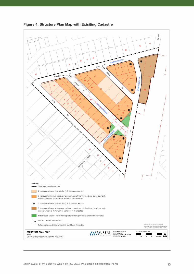
Table 3: Land UsesFigure 4 shows the structure plan map with exisiting cadastre.
Figure 5 shows a non-statutory, indicative concept of the MRA’s vision for the Structure Plan area. Whilst mostly outside the Structure Plan area, the potential development of the Armadale Fire
Station site and abutting land north of the train station, within the adjacent City Centre Rail Station Precinct, is also shown.
The main structural elements of the Structure Plan are:
• retention of Tudor Road;• extension of Cornish Street to Green Avenue;• extension of Devonshire Terrace to the extended Cornish Street;• an urban square/plaza at the intersection of Green Avenue, Cornish Street and Devonshire
Terrace, and extending north to provide a visual link to the train station;• part of the Green Avenue reserve between Forrest and Tudor Roads reduced to 20m and
the balance incorporated into the abutting fire station site.
Sites closest to the train station and Armadale town
A ‘main street’ example.
centre, such as those on Green Avenue, fronting Forrest Road (a main road into the Armadale town centre), and those located on the extended Cornish Street, are likely to be the most attractive for mixed use, apartment developments incorporating compatible non-residential uses (office/commercial/retail/cafes) at ground level.
Restaurants/cafes are preferred uses at ground level abutting the public plaza at the intersection of Green Avenue and the extended Cornish Street and Devonshire Terrace, so as to provide an active frontage to the plaza and natural surveillance of the space.
The extended Cornish Street is envisaged to become the primary, mixed use ‘main street’ within the Structure Plan area. Ground floor space along Cornish Street should be adaptable to allow for the conversion of dwellings to retail/commercial space over time as the latter become more viable. New design guidelines for this precinct will address these requirements.
Land Use AreaResidential/mixed use 6.55 haRoads 4.10 haOpen Space (plazas) 0.19 haTotal 10.84 ha
A R M A D A L E : C I T Y C E N T R E W E S T O F R A I LW AY P R E C I N C T S T R U C T U R E P L A N 13
Figure 4: Structure Plan Map with Exisiting Cadastre
RAILW
AY
TUDOR
RD
GREE
N
FORREST
RD
FIFTH
RD
AV
RD
ST
28.2m ROAD RESERVE
20m ROAD RESERVE
DEVONSHIRE TERRACE
20m
12.6m
ROAD RESERVE
* *
*
**
** *
ROADRESERVE
CORNISH
*
4
17
106
52
3
101
53
25
51
59
48
31
51
65
3
43
50
28
51
53
16
41
32
88
80
35
18
11
13
19
47
53
60
502
36
5
10
37
108
46
700
58
42
29
52
21
20
11
4
44
45
12
56
101 102
30
309209
818
66
50
49
45
2
20 40 60 80 metres0 NCITY CENTRE WEST OF RAILWAY PRECINCT
STRUCTURE PLAN MAPMRA
MRA-1 006HPLAN:150810DATE:
REVISION OF 'SP'PROJECT:TW/AMDESIGNED:
1:2000SCALE: @ A3
DISCLAIMER: ISSUED FOR ILLUSTRATIVEPURPOSES ONLY. ALL AREAS AND DIMENSIONSARE SUBJECT TO DETAIL DESIGN AND SURVEY.
LEGENDStructure plan boundary
2 storeys minimum (mandatory), 3 storeys maximum
3 storeys minimum, 5 storeys maximum, apartment/mixed use development,except where a minimum of 5 storeys is mandated
5 storeys minimum (mandatory), 7 storeys maximum
3 storeys minimum, 6 storeys maximum, apartment/mixed use development,except where a minimum of 5 storeys in mandated
Plaza/open space - restaurants preferred at ground level of adjacent sites
Left in/ Left out intersection
Future proposed road widening by City of Armadale
*

A R M A D A L E : C I T Y C E N T R E W E S T O F R A I LW AY P R E C I N C T S T R U C T U R E P L A N 14
Figure 5: Concept Plan
1. Traffic calmed entrance to Cornish Street. 2. Completion of Cornish Street as commercial mixed use street.
3. Angle parking to support commercial uses.
4. Central drainage swale and greenery.5. Devonshire Terrace extended to link
neighbourhood to rail and transit oriented development to local recreation fields.
6. Left in left out from Devonshire Terrace.7. ‘The Cornish’ Urban green square as
community and business focal point of transit oriented development.
8. North facing park and cafe plaza.9. Park plaza visually linking ‘The Cornish’
and Devonshire Terrace to Rail Station.10. Traffic calming and greening of Green
Avenue.11. Enhanced and reoriented Armadale Rail
Station plaza with view to ‘The Cornish’.12. Mixed use development overlooking
Armadale Rail Station plaza.13. Apartment development.

A R M A D A L E : C I T Y C E N T R E W E S T O F R A I LW AY P R E C I N C T S T R U C T U R E P L A N 15
3.2 Open SpaceThe Armadale Redevelopment Scheme does not identify future public open space within the Structure Plan area. Provision is made for an urban plaza/open space at the intersection of Green Avenue and the extended Cornish Street and Devonshire Terrace, and extending north to provide a visual link to the train station. This public space will serve as a community and business focal point for the precinct. North facing plaza areas will provide pleasant spaces that encourage use, including alfresco dining.
instead of vast areas of public open space, the urban plazas and streets within the Structure Plan area will be designed as important public spaces that encourage people to use them, consistent with the objective of reducing car dependency in this transit oriented precinct. As addressed in the Local Water Management Strategy (Appendix 2), urban water management measures will also be incorporated into the new streets instead of public open space.
Urban park example.
3.3 ResidentialResidential development will generally accord with the existing R80 and R-iC density codes identified for the precinct under the Armadale Redevelopment Scheme (Appendix 1). Residential Design Code variations in respect to building heights and plot ratio are identified in Part 1 of the Structure Plan.
At the time of preparation of this Structure Plan, the development requirements for the precinct are mostly contained within the ‘Armadale West of Railway Precinct Structure Plan and Design Guideline’ dated December 2010. The MRA intends to replace those with new design guidelines that reflect the current vision and objectives for the precinct. Until the new design guidelines come into effect, those from the 2010 structure plan, as contained in Appendix 5 of this Structure Plan, will continue to guide development within the precinct.
While the whole of the precinct is currently coded R80 and R-iC under the provisions of the Armadale Redevelopment Scheme, it is expected that the density of development will be greater closest to the train station, along Green Avenue and on Forrest Street (as a main entry to the Armadale town centre). Part 1 of the Structure Plan identifies mandatory minimum building heights, and R-Code variations to plot ratio and building heights, to reflect the desired scale and intensity of development adjacent to the public transport hub. A mandatory minimum

A R M A D A L E : C I T Y C E N T R E W E S T O F R A I LW AY P R E C I N C T S T R U C T U R E P L A N 16
building height of five (5) storeys is required on landmark and gateway sites, as identified on the Structure Plan Map.
The new design guidelines for the Structure Plan area will provide flexibility to vary the minimum and maximum building heights identified in Part 1 and on the Structure Plan map subject to certain design criteria being met.
it is envisaged that sites closest to the train station and Armadale town centre, surrounding the urban plazas, and fronting Green Avenue, Forrest Street, and the extended Cornish Street ‘main street’ will be developed with apartments (multiple dwellings), while the remainder of the precinct is more likely to be developed with grouped dwellings.
Pursuant to Table 4 of the R-Codes, the minimum open space requirement for multiple dwellings for the R80 and R-IC codings is to be identified in a local planning policy, local structure plan or local development plan (referred to as a Detailed Area Plan in the Armadale Redevelopment Scheme). Accordingly, Part 1 of the Structure Plan sets out a minimum open space requirement of 30% of the site area, unless Design Guidelines or a Detailed Area Plan require otherwise.
Six storey apartments. Four storey apartments.
Two storey housing, Harvest Lakes.
Two storey housing, Hollywood.

A R M A D A L E : C I T Y C E N T R E W E S T O F R A I LW AY P R E C I N C T S T R U C T U R E P L A N 17
A Market Feasibility Study is included in Appendix 1. The Study concludes that:
• “The population of the City of Armadale is anticipated to grow at a robust 4.3% per annum over the next 15 years which is approximately double the national growth rates.”
• “Typical product mix in metropolitan apartment developments is circa 60% two bedroom and 40% single bedroom units. Given the perceived socio economic situation of the City of Armadale…a slight variation of 55-60% and 40-45% for two and one bedroom units would provide a relevant unit product mix. This should be balanced by...early pre market research into this aspect.”
• Typical metropolitan apartment sizes are:
- one bedroom: 42-60 square metres (mean of 50 square metres); - two bedroom: 63-90 square metres (mean of 75-80 square metres).
• “the [proposed] heights and densities would prove to be viable as development propositions given careful design, sizes, product mix and relevant marketing”.
The estimated dwelling yield for the Structure Plan area is 928 dwellings, based on the R80 and R-iC density codes and the R Code variations set out in Part 1. The estimate assumes:
• an average plot ratio residential floor space of 1.0 in areas where the preferred height is 3-5 storeys;
• an average multiple dwelling size of 60 square metres of plot ratio floor space in areas where the preferred height is 3-5 storeys;
• an average site area of 120 square metres per grouped dwelling in the remaining areas with a minimum building height of two storeys.
Based on the above, Table 4 provides a breakdown of the estimated dwelling yield.
Table 4: Estimated Number of Dwellings
Dwelling Type Area Estimated Number of Dwellings
2 storeys: grouped dwellings 1.94 ha 1613-5 storeys: multiple dwellings/mixed use 3.82 ha 636Potential 5 storey apartments/mixed use* 0.79 ha 131Total 6.55 ha 928
* Former Green Avenue road reserve, within the Structure Plan area
Assuming an average household size of 2.5 persons, similar to that of the Cockburn Central TOD, the estimated future population of the Structure Plan area is 2,050.
The estimated number of dwellings exceeds the density targets of Directions 2031 and Liveable Neighbourhoods. Directions 2031 sets a target of 15 dwellings per gross urban zoned hectare of land in new development areas, which would equate to 162 dwellings for the Structure Plan area. Liveable Neighbourhoods sets a density target of 30-40 dwellings per site hectare within 400 metres of higher order centres and train stations. Based on a residential/mixed use area

A R M A D A L E : C I T Y C E N T R E W E S T O F R A I LW AY P R E C I N C T S T R U C T U R E P L A N 18
of 6.55 hectares, this equates to a density target of 196-262 dwellings for the Structure Plan area.
3.4 Movement NetworksThe proposed movement network will significantly improve permeability and accessibility within the Structure Plan area, and create better links for all modes of movement between the surrounding residential areas, the train station/bus interchange and the Armadale town centre.
The existing street network, consisting of Green Avenue, Fifth Road, Forrest Road, Tudor Road and Cornish Street, is to be retained. Provision is made for Forrest Road (currently 20 metres wide) to be widened by 4.1 metres within the Structure Plan area, so that the City of Armadale’s desired reserve width of 24.1 metres can be achieved. Green Avenue between Forrest and Tudor Roads will be reduced to a 20 metre reserve, with the remainder incorporated into the abutting fire station site.
A pedestrian friendly street.
Cornish Street, which is currently a cul de sac, will be widened to 28.2 metres and extended to connect to Green Avenue. The new Cornish Street will be designed as the precinct’s ‘main street’, as well as incorporating urban water management measures such as drainage swales.Devonshire Terrace, which currently terminates at Fifth Road, will be extended, with a reserve of 12.6 metres to match the existing, into the Structure Plan area to the extended Cornish Street, improving access through the Structure Plan area between the grouped dwelling developments south of Fifth Road, and the public transport hub and Armadale town centre beyond.
Potential cross sections for Cornish Street and Devonshire Terrace are shown in Figures 5 and 6.
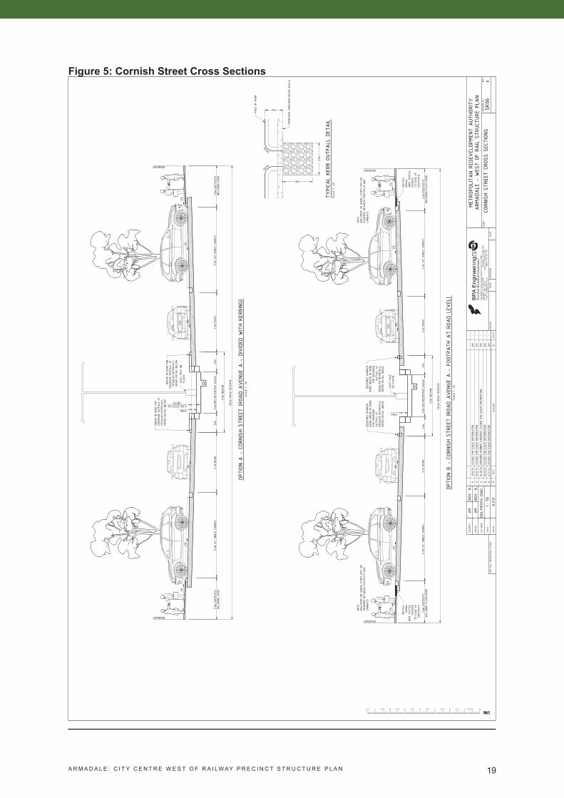
A R M A D A L E : C I T Y C E N T R E W E S T O F R A I LW AY P R E C I N C T S T R U C T U R E P L A N 19
Figure 5: Cornish Street Cross Sections
FILE
NAME
DATU
M
SCALE
DRAWN
DESIGN
ED
.DWG
REVISION
No.
APP
'D
DRAWING
No.
REV.
DATE
CHEC
KED
APP
ROVED
DATE
DATE
BY
P.O. B
ox 130
8, S
ubiaco
,
Wes
tern
Aus
tralia 6
904
ABN
42 0
76 143
130
E-mail:
bpa@
bpae
ng.com
.au
Ltd
Pty
460
Robe
rts
Road
Sub
iaco
Wes
tern
Aus
tralia 6
008
Facs
imile
: 61 8
938
2 80
06
BP
A E
ngin
eeri
ngC
ivil
And
Str
uctu
ral C
onsu
ltan
ts
Teleph
one
61 8
938
2 80
08
ONE
CALL
INF
ORMATION
SHO
WN
AM
AM
SK6-
M03
114NO
VNO
V1414
SK06
MET
ROPO
LITA
N RE
DEVEL
OPMEN
T AUT
HORITY
ARM
ADA
LE -
WES
T OF
RAIL S
TRUC
TURE
PLA
N
EPL
AN
A.H.D
1 : 50
CORN
ISH
STRE
ET C
ROSS
SEC
TION
SAM
-A
07.11
.14ISSU
ED F
OR C
LIEN
T INFO
RMATION
TYPICA
L KE
RB O
UTFA
LL D
ETAIL
SCALE
1 : 5
0
FACE
OF
KERB
2.0m
1.2m
PROP
OSED
LIMES
TONE
BLO
CK W
ALL
S
2.0m
AM
-B
05.12
.14ISSU
ED F
OR C
LIEN
T INFO
RMATION
R0.5m
R0.5m
C04
.02.15
DRAWING
NUMBE
R AMEN
DED, ISS
UED
FOR
CLIENT
INF
ORMATION
AM
-
OPTION
A -
COR
NISH
STR
EET
(ROA
D AVEN
UE A
- D
IVIDED
WITH
KERB
ING)
SCALE
1 : 5
0
BOUNDARY
BOUNDARY2%
2%
3%2%
3%2%
0.50m
BREA
K IN K
ERB
FOR
DRAINAGE
OUT
FALL
AT
REGU
LAR
INTE
RVALS
,RE
FER
DETA
IL B
ELOW
LIGH
T PO
LE O
NPL
INTH
BREA
K IN K
ERB
FOR
DRAINAGE
OUT
FALL
AT
REGU
LAR
INTE
RVALS
,RE
FER
DETA
IL B
ELOW
2.6m
FOO
TPATH
INCL
UDING
KERB
5.3m
45°
ANG
LE C
ARB
AY
3.7m
ROA
D2.6m
FOO
TPATH
INCL
UDING
KERB
5.3m
45°
ANG
LE C
ARB
AY
3.7m
ROA
D1.2
m1.2
m2.6m
BIO-R
ETEN
TION
SWALE
5.0m
MED
IAN
28.2m R
OAD
RESE
RVE
0.35m EFFECTIVEDEPTH
D10.02.15
ISSU
ED F
OR C
LIEN
T INFO
RMATION
AM
-
OPTION
B -
COR
NISH
STR
EET
(ROA
D AVEN
UE A
- F
OOTP
ATH
AT
ROAD
LEVEL
)SC
ALE
1 : 5
0
BOUNDARY
BOUNDARY
2%2%
3%2%
3%2%
0.50m
2.6m
FOO
TPATH
INCL
UDING
FLUS
H KE
RB5.3m
45°
ANG
LE C
ARB
AY
3.7m
ROA
D2.6m
FOO
TPATH
INCL
UDING
FLUS
H KE
RB5.3m
45°
ANG
LE C
ARB
AY
3.7m
ROA
D1.2
m1.2
m2.6m
BIO-R
ETEN
TION
SWALE
5.0m
MED
IAN
28.2m R
OAD
RESE
RVE
NOTE
:BO
LLARD
S OR
WHE
EL S
TOPS
MAY B
ERE
QUIRED
BET
WEE
N FO
OTPA
TH A
NDCA
RBAYS
LIGH
T PO
LEON
PLINT
H
NOTE
:BO
LLARD
S OR
WHE
EL S
TOPS
MAY B
ERE
QUIRED
BET
WEE
N FO
OTPA
TH A
NDCA
RBAYS
INST
ALL
600m
mWIDE
TACT
ILE
PAVER
STO
EASE
OF
FOOT
PATH
INST
ALL
600m
mWIDE
TACT
ILE
PAVER
STO
EASE
OF
FOOT
PATH
DEEP
ENED
BARR
IER
KERB
. BR
EAK
IN K
ERB
FOR
DRAINAGE
OUTF
ALL
AT
REGU
LAR
INTE
RVALS
,RE
FER
DETA
IL A
BOVE
DEEP
ENED
BARR
IER
KERB
. BR
EAK
IN K
ERB
FOR
DRAINAGE
OUTF
ALL
AT
REGU
LAR
INTE
RVALS
,RE
FER
DETA
IL A
BOVE
11.02.15
ISSU
ED F
OR C
LIEN
T INFO
RMATION
AM
-E

A R M A D A L E : C I T Y C E N T R E W E S T O F R A I LW AY P R E C I N C T S T R U C T U R E P L A N 20
Figure 6: Devonshire Terrace Cross Sections
DEVONSHIRE TERRACE (FOOTPATH AT ROAD LEVEL)SCALE 1 : 100 @ A3
3%
5.5m ROAD PAVEMENT
STORMWATER DRAINAGEGULLY GRATES/SEP'S/TREE
WELL DRAINAGE SYSTEM
DEVONSHIRE TERRACE WITH KERBINGSCALE 1 : 100 @ A3
3%2%
2%
5.5m ROAD PAVEMENT 0.3m KERB
STORMWATER DRAINAGEGULLY GRATES/SEP'S/TREE
WELL DRAINAGE SYSTEM
2%
BOUN
DARY
BOUN
DARY
BOUN
DARY
BOUN
DARY
12.6m ROAD RESERVE
3.55m VERGE INCLUDING FOOTPATH
0.3m KERB
3.55m VERGE INCLUDING FOOTPATH
12.6m ROAD RESERVE
2%
0.3m KERB
3.55m VERGE INCLUDING FOOTPATH
0.3m KERB
3.55m VERGE INCLUDING FOOTPATH
A R M A D A L E : C I T Y C E N T R E W E S T O F R A I LW AY P R E C I N C T S T R U C T U R E P L A N 21
A Transport impact Assessment (TiA) has been prepared by Flyt transport planning consultants for the Structure Plan area and is included in Appendix 4. The TiA notes that the proximity of the Structure Plan area to a major activity centre and public transport interchange will ensure residents and visitors will have excellent transport accessibility, with the majority of nearby activities and opportunities easily accessible by walking, cycling or public transport. The assessment concludes that for traffic movements in the forecast year of 2031, projected development does not result in any significant deterioration in local road network performance.
3.5 Water ManagementA Local Water Management Strategy (LWMS) is included in Appendix 2 of this Structure Plan. The LWMS has been developed in accordance with the Better Urban Water Management framework. The LWMS has adopted an integrated water cycle management approach to managing:
• groundwater;• surface water quality;• surface water quantity;• water conservation.
An integrated water cycle management approach first assesses the existing environmental constraints and opportunities, and uses these to inform the proposed management of the key integrated water cycle elements.
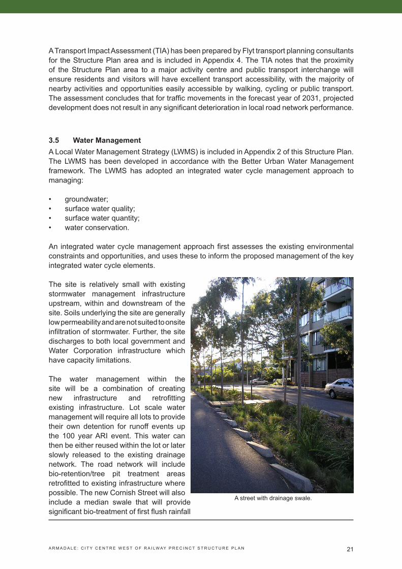
A street with drainage swale.
The site is relatively small with existing stormwater management infrastructure upstream, within and downstream of the site. Soils underlying the site are generally low permeability and are not suited to onsite infiltration of stormwater. Further, the site discharges to both local government and Water Corporation infrastructure which have capacity limitations.
The water management within the site will be a combination of creating new infrastructure and retrofitting existing infrastructure. Lot scale water management will require all lots to provide their own detention for runoff events up the 100 year ARi event. This water can then be either reused within the lot or later slowly released to the existing drainage network. The road network will include bio-retention/tree pit treatment areas retrofitted to existing infrastructure where possible. The new Cornish Street will also include a median swale that will provide significant bio-treatment of first flush rainfall

A R M A D A L E : C I T Y C E N T R E W E S T O F R A I LW AY P R E C I N C T S T R U C T U R E P L A N 22
events, stormwater detention for larger less frequent events and significant amenity. Those catchments where stormwater runoff cannot be captured and treated within either bio-retention areas or the median swale will be captured and treated by a subsurface storage and treated prior to discharge to the local drainage network.
The approach described in the LWMS (and summarised above) will ensure that stormwater quality is addressed, peak flow rates do not exceed that existing capacity of the downstream drainage network, groundwater quality is protected and use of potable water is minimised.
The LWMS outlines the work that will need to be done as a part of subdivision approval and detailed subdivision design, and provides a post-development monitoring framework that can be used to assess the effectiveness of the water management measures proposed in the LWMS.
3.6 Education FacilitiesNo education facilities are proposed within the Structure Plan area, given the locality is already well served, as previously noted.
3.7 Activity Centres and EmploymentThe Structure Plan provides for retail and commercial land uses immediately west of the train station, in accordance with the land use provisions of the Armadale Redevelopment Scheme. Such uses should complement the established Armadale activity centre east of the railway, which is identified as strategic metropolitan centre.
3.8 Infrastructure Coordination, Servicing and StagingA Servicing Strategy is included in Part 3, Appendix 3 of this Structure Plan. The findings in respect to servicing the site include:
• Water Corporation has reviewed the impact of additional flows on the DN305VC sewer and advise that, although it exceeds their preferred capacity, they will accept the increased flows without the need for any downstream upgrades. This advice needs to be reviewed once development proceeds.
• it is suggested that sections of sewer running through development areas which are not on existing/proposed boundaries be relocated to the road reserve to enable full development of the sites.
• The existing sewer in the extended Cornish Street road reserve will be located in the centre of the road under the proposed median/drainage swale. Water Corporation advises that further detail will be required to determine whether the sewer can remain or whether it needs to be realigned onto a standard alignment off the boundary.
• Water Corporation advises that as part of the redevelopment of the land it would provide an opportunity to upgrade/replace the existing mains or sections of these mains.
• ATCO Gas has modelled the proposed development and based on assumptions have indicated the existing network has the capacity to supply gas to the development.
• Western Power’s Network Capacity Mapping Tool shows adequate system capacity of

A R M A D A L E : C I T Y C E N T R E W E S T O F R A I LW AY P R E C I N C T S T R U C T U R E P L A N 23
5Mva up to 2020.
• Upgrades and extensions will be designed by Telstra for each subdivision application and costs provided at design stage. Where road widening occurs, Telstra may require their services to be relocated to the correct alignment.
3.9 Developer Contribution ArrangementsExisting developer contribution requirements are set out in the Armadale West of Rail Precinct Developer Contribution Scheme Report. These requirements are currently under review.
3.10 Other RequirementsThe MRA will prepare revised design guidelines to provide further direction regarding the desired land use and built form outcomes for the Structure Plan area.