City of Bellevue Development Services Department Land Use
13
City of Bellevue Development Services Department Land Use Staff Report Proposal Name: The Spring District – Final Short Plat Amendment Proposal Address: 1227 124 th Avenue NE Proposal Description: Application for an Amendment to a Final Short Plat to remove established building setback lines around the perimeter boundary of Lot 3, resulting from the original short plat approval. In addition, applicant requests modification of the established 25 foot critical area steep slope setback on the west side of Lot 3, through review and approval of site specific Critical Areas Land Use Permits to support any requested modification of the slope setback. (King Co. Rec. #20070319900012) File Number: 16-146835-LF Applicant: Wright Runstad & Company Carolyn Wennblom Decisions Included: Administrative Decision for a Modification to an approved Final Short Plat (Process II), Land Use Code 20.45B.240 Planner: Laurie Tyler, Associate Land Use Planner State Environmental Policy Act Threshold Determination: Exempt (WAC 197-11-800(6)(a)) Department Decision: Approval with Conditions __________________________________________ Laurie Tyler, Associate Planner Development Services Department Application Date: November 21, 2016 Notice of Application: December 15, 2016 Minimum Comment Period: December 29, 2016(14 days) Decision Publication Date: March 9, 2017 Appeal Deadline: March 23, 2017(14 days) For information on how to appeal a proposal, visit the Permit Center at City Hall or call (425) 452-6800 [TTY (425) 452-4636]. Appeal of the Decision must be made with the City Clerk by 5 PM on the date noted for appeal of the decisio
Proposal Name: The Spring District – Final Short Plat Amendment
Proposal Address: 1227 124th Avenue NE
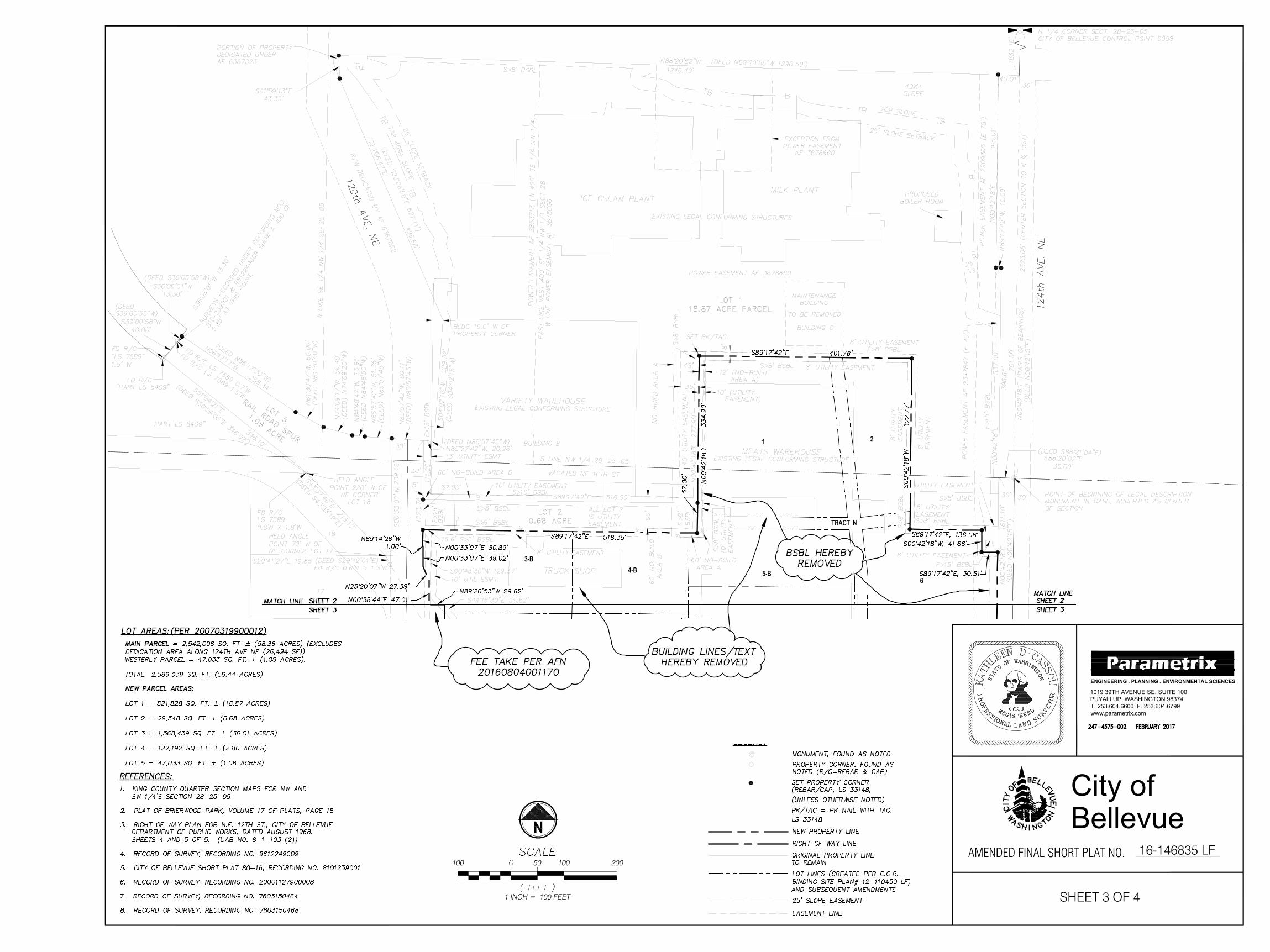
Proposal Description: Application for an Amendment to a Final Short Plat to remove established building setback lines around the perimeter boundary of Lot 3, resulting from the original short plat approval. In addition, applicant requests modification of the established 25 foot critical area steep slope setback on the west side of Lot 3, through review and approval of site specific Critical Areas Land Use Permits to support any requested modification of the slope setback. (King Co. Rec. #20070319900012)
File Number: 16-146835-LF
Applicant: Wright Runstad & Company Carolyn Wennblom
Decisions Included: Administrative Decision for a Modification to an approved Final Short Plat (Process II), Land Use Code 20.45B.240
Planner: Laurie Tyler, Associate Land Use Planner
State Environmental Policy
Act Threshold
Determination: Exempt (WAC 197-11-800(6)(a))
Department Decision: Approval with Conditions
__________________________________________ Laurie Tyler, Associate Planner Development Services Department
Application Date: November 21, 2016 Notice of Application: December 15, 2016 Minimum Comment Period: December 29, 2016(14 days) Decision Publication Date: March 9, 2017 Appeal Deadline: March 23, 2017(14 days) For information on how to appeal a proposal, visit the Permit Center at City Hall or call (425) 452-6800 [TTY (425) 452-4636]. Appeal of the Decision must be made with the City Clerk by 5 PM on the date noted for appeal of the decisio
The Spring District – Final Short Plat Amendment 16-146835-LF Page 2 of 6
I. DESCRIPTION OF PROPOSAL Application for a Final Short Plat Amendment to remove building setback lines around the perimeter boundary of Lot 3, and to modify the established 25’ critical area steep slope setback on the west side of the property, as shown on the face of the original approved conservation short plat (King Co. Rec #20070319900012). The Applicant requests the amendment in order to allow for the continuation of development of The Spring District over the entirety of Lot 3, using current development regulations. During review of the original conservation short plat, the applicant at the time (Safeway, Inc.) identified varying building setback lines around the perimeter boundary of Lot 3. This was to ensure adequate fire separation from the existing industrial warehouse buildings which existed at the time of approval. Now that Lot 3 has transitioned into The Spring District Master Development Plan, which includes a Binding Site Plan that parceled out the entirety of Lot 3, the building setback lines are no longer necessary, as future development of each parcel would follow current Bel-Red development standards.
The original conservation short plat also identified and analyzed a critical area steep slope along the western portion of the lot. At the time of review, a Geotechnical Report was provided which addressed existing soil conditions and requested to modify the code prescribed 50 foot top of slope buffer. Through demonstration of compliance with the geologic hazard critical areas modification criteria, the short plat was ultimately approved with a reduced top of slope setback of 25 feet, which is shown on the face of the plat. As The Spring District has begun to rapidly develop over the last few years, applicants which propose to develop on parcels that are encumbered with the 25 foot slope setback would like the option to further modify the required slope setback through site specific critical areas land use permits and associated geotechnical reports. Therefore, a clarification note has been placed on the face of the plat which states the following:
“Modification of the 25’ slope setback on Lot 3: This setback may be modified through review and approval of a site specific critical areas land use permit with geotechnical review to support any requested modification of the required setback.”
By maintaining the slope setback on the face of the plat and providing a clarification note, future development proposals will be permitted to either comply with the required 25 foot
slope setback, or apply for additional permitting and geotechnical review to modify. Refer to
Attachment 1 for Original Safeway Inc. Short Plat (#06-135856-LF), Recording
#20070319900012. Refer to Attachment 2 for Final Short Plat Amendment, Sheets 1-4
(#16-146835-LF).
II. SITE DESCRIPTION AND CONTEXT The subject site consists of approximately 36 acres and is now referred to as The Spring District Master Development Plan. The site is located within the southwestern portion of the City’s Bel-Red Corridor (Subarea), east of downtown, and approximately 1/2 mile east of Interstate 405 and 1/3 mile south of State Route 520. The site is bounded by 120th Avenue NE, NE 12th Street and 124th Avenue NE. Future roadway construction of Spring Boulevard would run east-west through the northern portion of the site. The property is bordered by the Safeway Ice Cream and Milk production buildings to the
The Spring District – Final Short Plat Amendment 16-146835-LF Page 3 of 6
north and the Coca-Cola production buildings to the east. The Safeway/Albertsons main distribution office is located southeast of the subject site, and a vehicle rental business to the south. Office and light industrial uses, including the AUDI dealership are located west of the site. The site is currently accessed via District Way off 124th Avenue NE, with future access from Spring Boulevard and both 120th Avenue NE and 124th Avenue NE. The site is located within the Bel-Red-Office/Residential-1 (BR-OR-1) and the Bel-Red-Office/Residential-2 (BR-OR-2) land use districts with a Comprehensive Plan designation of Bel-Red-Office/Residential-1 and Bel-Red-Office/Residential-2, and is located within the Bel-Red Subarea.
Figure 1 – Aerial Photograph
III. SITE HISTORY In 2006, Safeway Inc., proposed to subdivide a 60.14 acre parcel into 5 commercial lots. Safeway retained control of Lot 1 for production associated with their milk and ice cream facilities, in addition to Lots 2, 4 and 5. Lot 3 was made available for sale to an interested party for commercial development, which ultimately resulted in what is now referred to as The Spring District Master Development Plan.
IV. CONSISTENCY WITH LAND USE CODE/ZONING REQUIREMENTS The proposed amendment will not have any effect on the required Land Use Code dimensional or density requirements for the BR-OR-1 and BR-OR-2 zoning districts, as applied to this property. Removal of the varying building setback lines around the property boundary, and clarification of the use of the established 25’ slope setback would not result in
The Spring District – Final Short Plat Amendment 16-146835-LF Page 4 of 6
any compliance issues with required zoning standards.
V. STATE ENVIRONMENTAL POLICY ACT (SEPA) Original SEPA analysis was conducted in conjunction with the preliminary conservation short plat review (#06-103122-LN) to which a Determination of Non-Significance (DNS) was issued. As there are no changes to the existing steep slope critical area on the site, and no new critical areas have been identified on the site, this amendment is exempt from further SEPA review, pursuant to WAC 197-11-800(6)(a), BCC 22.02.032.
VI. SUMMARY OF TECHNICAL REVIEWS No concerns were received regarding this amendment request by the Clear and Grade, Fire,
Utilities and Survey Departments. Since the original short plat was recorded, right-of-way has been dedicated to the City of
Bellevue for NE District Way, 120th Avenue NE and 121st Avenue NE. These right of ways have been established on Lot 3 and shown on the mapping page, sheet 4, which has been updated to reflect this.
VII. PUBLIC COMMENT The City initially notified the public of this proposal on December 15, 2016 with mailed notice and publication in the Weekly Permit Bulletin. No written comments were received regarding the proposal and there are no parties of record besides the applicant.
VIII. DECISION CRITERIA: Land Use Code 20.45B.220 Final Short Plat Decision Criteria: Subject to LUC 20.45B.240, the Development Services Director shall approve a final short plat if it conforms to all conditions and requirements of the preliminary short plat approval. LUC 20.45B.240.B states that short subdivisions may be revised in accordance with the following requirements:
1. All affected ownership interests within the originally recorded short
subdivision must be a party to the revision application, or must express
written agreement to the proposed revision, including written agreement to
accept ownership of any property, or to transfer or convey ownership of any
property, which may be necessary as a result of the revision.
Finding: To date, there are multiple ownership interests within The Spring District, all of which are provided a signatory section on Sheet 1. All owners will be required to sign the revised short plat prior to recordation.
2. Any features contained in the original short subdivision which have been
relied upon in subsequent land development or land use planning decisions
and which are still applicable at the time of application shall be incorporated in
the short subdivision revision, unless such features are provided by other
legal means at the time of short subdivision revision.
Finding: All features contained in the original Safeway Inc. Short Plat approval (#06-103122-LN), with the exception of those items stipulated under the Surveyor’s
The Spring District – Final Short Plat Amendment 16-146835-LF Page 5 of 6
Declaration shown on Sheet 1, are required to be incorporated into the final short
plat mylars. Refer to Section X.1 for Condition of Approval regarding
Incorporation of Features in Original Safeway Inc. Short Plat
3. Procedures and requirements established by this chapter for preliminary short
subdivision approval shall be applicable to revision requests. Revisions shall
comply with applicable conditions and provisions of the original plat or short
plat and shall not adversely affect access, easements, or any land use
requirements as provided for in the laws of the City.
Finding: The Safeway Inc. (Spring District) Short Plat Amendment was processed per the requirements of LUC20.45B.240. The short plat amendment complies with all applicable conditions and provisions of the original short plat. The amendment to remove the perimeter building setback lines and clarification of the use of the 25’ slope setback will not adversely affect land use requirements.
4. Approval of any revision shall be filed and recorded as a supplemental
declaration of short subdivision which shall contain the adjusted legal
description and shall be effective upon being recorded by the Department of
Planning and Community Development with the King County Department of
Records and Elections and upon receipt of proof of recording.
Finding: The applicant is required to record the amended short plat approval depicting the adjusted legal description and also indicate those items which have been modified, which are stipulated under the Surveyor’s Declaration shown on Sheet 1.
IX. CONCLUSION AND DECISION: After conducting the various administrative reviews associated with this proposal, including applicable Land Use consistency, City Code, and standard compliance reviews, the
Development Services Director does hereby APPROVE the Safeway Inc. (Spring District)
Final Short Plat Amendment with conditions.
X. CONDITIONS OF APPROVAL: The following conditions are imposed under authority referenced:
COMPLIANCE WITH BELLEVUE CITY CODES AND ORDINANCES
The applicant shall comply with all applicable Bellevue City Codes, Standards, and Ordinances including but not limited to:
Applicable Codes, Standards and Ordinances Contact Person Fire Code – BCC 23.11 Sean Nichols, 425-452-2926 Land Use Code – BCC Title 20 Laurie Tyler, 425-452-2728 Transportation Development Code – BCC 14.60 Molly Johnson, 425-452-6175 Utility Code – BCC Title 24 Mark Dewey, 425-452-6179 Clearing and Grading – BCC 23.76 Savina Uzunow, 425-452-7860
The Spring District – Final Short Plat Amendment 16-146835-LF Page 6 of 6
GENERAL CONDITIONS OF APPROVAL
1. Incorporation of Features in Original Safeway Inc. Short Plat All features contained in the original short plat approval, with the exception of those items stipulated under the Surveyor’s Declaration shown on Sheet 1, shall be incorporated into the final short plat mylar. AUTHORITY: Land Use Code 20.45B.240 REVIEWER: Laurie Tyler, Development Services Department
ATTACHMENTS
1. Original Safeway Inc. Short Plat (#06-135856-LF) Recording #20070319900012
2. Final Short Plat Amendment, Sheets 1-4 (#16-146835-LF)
SHEET 1 OF 4
AMENDED FINAL SHORT PLAT NO.
SW & SE 1/4'S OF THE NW 1/4 AND NW, NE & SE
EXAMINED AND APPROVED: WITH RESPECT TO STREETS, ALLEYS AND RIGHTS OF WAY FOR ROADS, PATHS AND SLOPES
REAL PROPERTY & SURVEY DATE
DEVELOPMENT REVIEW DATE
EXAMINED AND APPROVED THIS DAY OF , 20 .
ASSESSOR DEPUTY ASSESSOR
ACCOUNT NO.
EXAMINED AND APPROVED:
ADMINISTRATOR DATE
EXAMINED AND APPROVED: WITH RESPECT TO WATER, SEWER AND DRAINAGE
ADMINISTRATOR DATE
KING CO. DEPT. OF ASSESSMENTS
DEVELOPMENT SERVICES DEPARTMENT
UTILITIES DEPARTMENT
TRANSPORTATION DEPARTMENT
RECORDER'S CERTIFICATEFILED FOR RECORD THIS DAY OF , 20 .AT M. IN BOOK OF SURVEYS AT PAGE(S) ,AT THE REQUEST OF THE CITY OF BELLEVUE.
MANAGER SUPT. OF RECORDS
RECORDING NO.
THIS MAP CORRECTLY REPRESENTS A SURVEY MADE BY W&H PACIFIC INCONFORMANCE WITH THE REQUIREMENTS OF THE SURVEY RECORDING ACT ATTHE REQUEST OF SAFEWAY, INC. IN OCTOBER, 2006 AND AS AMENDED BY ME FORTHE PURPOSE STATED ABOVE, IN CONFORMANCE WITH THE REQUIREMENTS OFTHE CITY OF BELLEVUE DEVELOPMENT SERVICES DEPARTMENT.PROFESSIONAL LAND SURVEYOR
KATHLEEN D. CASSOU, PLS 27133 DATE
SURVEYOR'S CERTIFICATE
City of
Bellevue
1/4'S OF THE SW 1/4, SEC. 28, T. 25 N., R. 5 E., W.M.
ENGINEERING . PLANNING . ENVIRONMENTAL SCIENCES
1019 39TH AVENUE SE, SUITE 100
PUYALLUP, WASHINGTON 98374
T. 253.604.6600 F. 253.604.6799
www.parametrix.com
16-146835 LF
AutoCAD SHX Text
OWNER'S CERTIFICATE AND DEDICATION:
AutoCAD SHX Text
KNOW ALL PEOPLE BY THESE PRESENTS THAT WE, THE UNDERSIGNED OWNERS OF INTEREST IN THE LAND HEREBY SHORT SUBDIVIDED, DECLARE THIS SHORT PLAT TO BE THE GRAPHIC REPRESENTATION OF THE SHORT SUBDIVISION MADE HEREBY AND DEDICATE TO THE PUBLIC FOREVER ALL STREETS AND AVENUES NOT SHOWN AS PRIVATE. WE DEDICATE THE USE FOR ALL PUBLIC PURPOSES NOT INCONSISTENT WITH PUBLIC HIGHWAY PURPOSES AND ALSO THE RIGHT TO MAKE ALL NECESSARY SLOPES FOR CUTS AND FILLS UPON THE LOTS SHOWN. WE FURTHER DEDICATE TO THE USE OF THE PUBLIC ALL THE EASEMENTS AND TRACTS SHOWN ON THIS SHORT PLAT FOR ALL PUBLIC PURPOSES AS INDICATED, INCLUDING BUT NOT LIMITED TO PARK, OPEN SPACE, UTILITIES, AND DRAINAGE--UNLESS SUCH EASEMENTS OR TRACTS ARE SPECIFICALLY IDENTIFIED ON THIS SHORT PLAT AS BEING DEDICATED OR CONVEYED TO A PERSON OR ENTITY OTHER THAN THE PUBLIC, IN WHICH CASE WE DEDICATE SUCH STREETS, EASEMENTS, OR TRACTS TO THE PERSON OR ENTITY IDENTIFIED AND FOR THE PURPOSE STATED. FURTHER, WE WAIVE FOR OURSELVES, FOR OUR HEIRS AND ASSIGNS, AND FOR ANY PERSON OR ENTITY DERIVING TITLE FROM THE UNDERSIGNED ANY AND ALL CLAIMS FOR DAMAGES AGAINST THE CITY OF BELLEVUE AND ITS SUCCESSORS AND ASSIGNS WHICH MAY BE OCCASIONED TO THE ADJACENT LANDS OF THIS SHORT SUBDIVISION BY THE ESTABLISHMENT, CONSTRUCTION, OR MAINTENANCE OF ROADS AND/OR DRAINAGE SYSTEMS WITHIN THIS SHORT SUBDIVISION. THIS SHORT SUBDIVISION, DEDICATION, AND WAIVER OF CLAIMS IS MADE WITH FREE CONSENT AND IN ACCORDANCE WITH OUR DESIRES.
AutoCAD SHX Text
IN WITNESS WHEREOF WE SET OUR HANDS AND SEALS: WR-SRI 120TH LLC, A DELAWARE LIMITED LIABILITY COMPANY, BY: SRI EIGHT 120TH LLC, A DELAWARE LIMITED LIABILITY COMPANY, ITS MANAGING MEMBER BY: NAME: TITLE: ACKNOWLEDGEMENT STATE OF } } } SS. } SS. COUNTY OF } } I CERTIFY THAT I KNOW OR HAVE SATISFACTORY EVIDENCE THAT _______________________ IS THE PERSON WHO APPEARED BEFORE ME, AND SAID PERSON ACKNOWLEDGED THAT SAID PERSON SIGNED THIS INSTRUMENT, AND ON OATH STATED THAT SAID PERSON WAS AUTHORIZED TO EXECUTE THE INSTRUMENT AND ACKNOWLEDGED IT AS THE _______________________ OF WR-SRI 120TH LLC, A DELAWARE LIMITED LIABILITY COMPANY BY SRI EIGHT 120TH LLC, A DELAWARE LIMITED LIABILITY COMPANY, ITS MANAGING MEMBER TO BE THE FREE AND VOLUNTARY ACT OF SUCH PARTY FOR THE USES AND PURPOSES MENTIONED IN THE INSTRUMENT. THIS DAY OF , 20__. DAY OF , 20__. DAY OF , 20__. , 20__. , 20__. NOTARY PUBLIC IN AND FOR THE STATE OF MY COMMISSION EXPIRES
AutoCAD SHX Text
IN WITNESS WHEREOF WE SET OUR HANDS AND SEALS: WR-SRI PARCEL 14 LLC, A DELAWARE LIMITED LIABILITY COMPANY, BY: WR-SRI 120TH LLC, A DELAWARE LIMITED LIABILITY COMPANY, ITS SOLE MEMBER BY: SRI EIGHT 120TH LLC, A DELAWARE LIMITED LIABILITY COMPANY, ITS MANAGING MEMBER BY: NAME: TITLE: ACKNOWLEDGEMENT STATE OF } } } SS. } SS. COUNTY OF } } I CERTIFY THAT I KNOW OR HAVE SATISFACTORY EVIDENCE THAT _______________________ IS THE PERSON WHO APPEARED BEFORE ME, AND SAID PERSON ACKNOWLEDGED THAT SAID PERSON SIGNED THIS INSTRUMENT, AND ON OATH STATED THAT SAID PERSON WAS AUTHORIZED TO EXECUTE THE INSTRUMENT AND ACKNOWLEDGED IT AS THE _______________________ WR-SRI PARCEL 14 LLC, A DELAWARE LIMITED LIABILITY COMPANY BY WR-SRI 120TH LLC, A DELAWARE LIMITED LIABILITY COMPANY, ITS SOLE MEMBER, BY SRI EIGHT 120TH LLC A DELAWARE LIMITED LIABILITY COMPANY, ITS MANAGING MEMBER TO BE THE FREE AND VOLUNTARY ACT OF SUCH PARTY FOR THE USES AND PURPOSES MENTIONED IN THE INSTRUMENT. THIS DAY OF , 20__. DAY OF , 20__. DAY OF , 20__. , 20__. , 20__. NOTARY PUBLIC IN AND FOR THE STATE OF MY COMMISSION EXPIRES
AutoCAD SHX Text
IN WITNESS WHEREOF WE SET OUR HANDS AND SEALS: WR-SRI 120TH NORTH LLC, A DELAWARE LIMITED LIABILITY COMPANY, BY: SRI EIGHT 120TH LLC, A DELAWARE LIMITED LIABILITY COMPANY, ITS MANAGING MEMBER BY: NAME: TITLE: ACKNOWLEDGEMENT STATE OF } } } SS. } SS. COUNTY OF } } I CERTIFY THAT I KNOW OR HAVE SATISFACTORY EVIDENCE THAT _______________________ IS THE PERSON WHO APPEARED BEFORE ME, AND SAID PERSON ACKNOWLEDGED THAT SAID PERSON SIGNED THIS INSTRUMENT, AND ON OATH STATED THAT SAID PERSON WAS AUTHORIZED TO EXECUTE THE INSTRUMENT AND ACKNOWLEDGED IT AS THE _______________________ WR-SRI 120TH NORTH LLC, A DELAWARE LIMITED LIABILITY COMPANY BY WR-SRI EIGHT 120TH LLC A DELAWARE LIMITED LIABILITY COMPANY, ITS MANAGING MEMBER, TO BE THE FREE AND VOLUNTARY ACT OF SUCH PARTY FOR THE USES AND PURPOSES MENTIONED IN THE INSTRUMENT. THIS DAY OF , 20__. DAY OF , 20__. DAY OF , 20__. , 20__. , 20__. NOTARY PUBLIC IN AND FOR THE STATE OF MY COMMISSION EXPIRES
AutoCAD SHX Text
%%UAMENDMENT TO SHORT PLAT:
AutoCAD SHX Text
IT IS HEREBY STIPULATED THAT THE SHORT PLAT APPROVED UNDER CITY OF BELLEVUE NO. LF-06-135856 ON MARCH 14, 2007 AND RECORDED UNDER AUDITOR'S FILE NUMBER 20070319900012 IN KING COUNTY, WASHINGTON SHALL BE AMENDED PURSUANT TO SECTION 20.45B.240 FINAL SHORT PLAT-REVISON OF THE CITY OF BELLEVUE LAND USE CODE AS FOLLOWS: 1. REMOVE LINE WORK DEPICTING BUILDING FOOTPRINT AND ASSOCIATED TEXT LABELS IDENTIFYING USE OF EXISTING BUILDINGS LOCATED ON LOT 3. 2. REMOVE NOTE 7 RELATING TO TREE PRESERVATION REGULATIONS SHOWN ON SHEET 2 OF 4 TOGETHER WITH CONTENT LABELS AND TREE SYMBOLS RELATING TO TREE RETENTION AND LOCATION SHOWN ON SHEET 4 OF 4. 3. REMOVAL OF BUILDING SETBACK LINES LOCATED ALONG EXTERIOR BOUNDARY LINES SHOWN ON SHEETS 3 & 4 OF 4. 4. MODIFICATION OF THE 25' SLOPE SETBACK ON LOT 3: THIS SETBACK MAY BE MODIFIED THROUGH REVIEW & APPROVAL OF A SITE SPECIFIC CRITICAL AREAS LAND USE PERMIT WITH GEOTECHNICAL REVIEW TO SUPPORT ANY REQUESTED MODIFICATION OF THE REQUIRED SETBACK. THE FOLLOWING ELEMENTS ARE ALSO BEING SHOWN WHICH HAVE RESULTED FROM SUBSEQUENT APPROVALS AND RECORDINGS PARTICULAR TO THIS SITE: 5. SUBTRACT FROM ORIGINAL SHORT PLAT, PUBLIC RIGHT OF WAY BY DEDICATION CONVEYANCE AND FEE TAKE FILED UNDER THE FOLLOWING RECORDER'S NOS. AND SHOWN ON SHEET 4 OF 4: - AFN 20151210000735 - 120TH AVE NE - 120TH AVE NE - AFN 20160804001170 - 120TH AVE NE - 120TH AVE NE - AFN - NE DISTRICT WAY - NE DISTRICT WAY - NE DISTRICT WAY - AFN - NE DISTRICT WAY - NE DISTRICT WAY - NE DISTRICT WAY - AFN - NE DISTRICT WAY - NE DISTRICT WAY - AFN - NE DISTRICT WAY/121ST AVE NE - NE DISTRICT WAY/121ST AVE NE - AFN - NE DISTRICT WAY/121ST AVE NE - NE DISTRICT WAY/121ST AVE NE - AFN- 121ST AVE NE - 121ST AVE NE 6. APPEND NEW LOT CONFIGURATION AND DESIGNATIONS ESTABLISHED BY CITY OF BELLEVUE BINDING SITE PLAN NO. 12-110450 LF, FILED UNDER RECORDING NO. 20121101000274, TOGETHER WITH SUBSEQUENT AMENDMENTS LISTED BELOW: THIS AMENDED FINAL SHORT PLAT REPRESENTS ONLY A GRAPHIC REPRESENTATION OF THE ORIGINAL SHORT PLAT AND DOES NOT ALTER ANY ELEMENTS OTHER THAN THE LINES AND TEXT STIPULATED ABOVE. EXCEPT AS OTHERWISE PROVIDED HEREIN, THE TERMS AND CONDITIONS THE ORIGINAL PLAT SHALL REMAIN IN FULL FORCE AND EFFECT.
AutoCAD SHX Text
SURVEYOR'S DECLARATION:
AutoCAD SHX Text
IN WITNESS WHEREOF WE SET OUR HANDS AND SEALS: PPF AMLI 121ST AVENUE NE, LLC BY: ______________________________BY: NAME: TITLE: ACKNOWLEDGEMENT STATE OF } } } SS. } SS. COUNTY OF } } I CERTIFY THAT I KNOW OR HAVE SATISFACTORY EVIDENCE THAT _______________________ IS THE PERSON WHO APPEARED BEFORE ME, AND SAID PERSON ACKNOWLEDGED THAT SAID PERSON SIGNED THIS INSTRUMENT, AND ON OATH STATED THAT SAID PERSON WAS AUTHORIZED TO EXECUTE THE INSTRUMENT AND ACKNOWLEDGED IT AS THE _______________________ OF WR-SRI 120TH LLC, A DELAWARE LIMITED LIABILITY COMPANY BY SRI EIGHT 120TH LLC, A DELAWARE LIMITED LIABILITY COMPANY, ITS MANAGING MEMBER TO BE THE FREE AND VOLUNTARY ACT OF SUCH PARTY FOR THE USES AND PURPOSES MENTIONED IN THE INSTRUMENT. THIS DAY OF , 20__. DAY OF , 20__. DAY OF , 20__. , 20__. , 20__. NOTARY PUBLIC IN AND FOR THE STATE OF MY COMMISSION EXPIRES
AutoCAD SHX Text
RECORDED AMENDMENTS TO THE ORIGINAL BINDING SITE PLAN AMEND.NO.CITY OF BELLEVUE NO.RECORDING NO.PARCELS AFFECTED NO.CITY OF BELLEVUE NO.RECORDING NO.PARCELS AFFECTED CITY OF BELLEVUE NO.RECORDING NO.PARCELS AFFECTED RECORDING NO.PARCELS AFFECTED PARCELS AFFECTED 1 14-128831 LJ2014042300086321 & 22 14-128831 LJ2014042300086321 & 22 2014042300086321 & 22 21 & 22 2 15-126565 LJ201602170006848 & 17 15-126565 LJ201602170006848 & 17 201602170006848 & 17 8 & 17 3 16-126082 LF2016050600076013, 14 & TRACTS D, E & F 16-126082 LF2016050600076013, 14 & TRACTS D, E & F2016050600076013, 14 & TRACTS D, E & F13, 14 & TRACTS D, E & F
AutoCAD SHX Text
SPRING I US TP SECURITY SPRING DISTRICT, LLC, A WASHINGTON LIMITED LIABILITY COMPANY BY: SP SPRING LLC, A DELAWARE LIMITED LIABILITY COMPANY, MANAGING MEMBER BY: SP MULTIFAMILY DEVELOPMENT COMPANY LLC, A WASHINGTON LIMITED LIABILITY COMPANY, SOLE MEMBER BY : ITS: STATE OF WASHINGTON ) SS ) COUNTY OF KING ) I CERTIFY THAT I KNOW OR HAVE SATISFACTORY EVIDENCE THAT IS THE PERSON WHO APPEARED IS THE PERSON WHO APPEARED BEFORE ME, AND SAID PERSON ACKNOWLEDGED THAT HE/SHE SIGNED THIS INSTRUMENT, ON OATH STATED THAT HE/SHE WAS AUTHORIZED TO EXECUTE THE INSTRUMENT AND ACKNOWLEDGED IT AS THE OF SP MULTIFAMILY DEVELOPMENT COMPANY LLC, A WASHINGTON LIMITED LIABILITY COMPANY, THE SOLE MEMBER OF A SP SPRING LLC, A DELAWARE LIMITED LIABILITY COMPANY, THE MANAGING MEMBER OF US TP SECURITY SPRING DISTRICT, LLC, A WASHINGTON LIMITED LIABILITY COMPANY, TO BE THE FREE AND VOLUNTARY ACT OF SUCH PARTY FOR THE USES AND PURPOSES MENTIONED IN THE INSTRUMENT. DATED THIS DAY OF , 20 . DAY OF , 20 . DAY OF , 20 . , 20 . , 20 . , 20 . , 20 . . . NOTARY PUBLIC IN AND FOR THE STATE OF WASHINGTON, RESIDING AT NAME (PRINTED OR TYPED) MY APPOINTMENT EXPIRES:
AutoCAD SHX Text
SPRING II SP BLAZE LLC, A DELAWARE LIMITED LIABILITY COMPANY BY: SP SPRING II LLC, A DELAWARE LIMITED LIABILITY COMPANY, IT'S MANAGER BY: ITS: STATE OF WASHINGTON ) SS ) COUNTY OF KING ) I CERTIFY THAT I KNOW OR HAVE SATISFACTORY EVIDENCE THAT IS THE PERSON WHO APPEARED IS THE PERSON WHO APPEARED BEFORE ME, AND SAID PERSON ACKNOWLEDGED THAT HE/SHE SIGNED THIS INSTRUMENT, ON OATH STATED THAT HE/SHE WAS AUTHORIZED TO EXECUTE THE INSTRUMENT AND ACKNOWLEDGED IT AS THE OF SP MULTIFAMILY DEVELOPMENT COMPANY LLC, A WASHINGTON LIMITED LIABILITY COMPANY, THE SOLE MEMBER OF A SP SPRING LLC, A DELAWARE LIMITED LIABILITY COMPANY, THE MANAGING MEMBER OF US TP SECURITY SPRING DISTRICT, LLC, A WASHINGTON LIMITED LIABILITY COMPANY, TO BE THE FREE AND VOLUNTARY ACT OF SUCH PARTY FOR THE USES AND PURPOSES MENTIONED IN THE INSTRUMENT. DATED THIS DAY OF , 20 . DAY OF , 20 . DAY OF , 20 . , 20 . , 20 . , 20 . , 20 . . . NOTARY PUBLIC IN AND FOR THE STATE OF WASHINGTON, RESIDING AT NAME (PRINTED OR TYPED) MY APPOINTMENT EXPIRES:
AutoCAD SHX Text
A
AutoCAD SHX Text
F
AutoCAD SHX Text
W
AutoCAD SHX Text
I
AutoCAD SHX Text
C
AutoCAD SHX Text
O
AutoCAD SHX Text
Y
AutoCAD SHX Text
T
AutoCAD SHX Text
E
AutoCAD SHX Text
I
AutoCAD SHX Text
N
AutoCAD SHX Text
H
AutoCAD SHX Text
S
AutoCAD SHX Text
T
AutoCAD SHX Text
G
AutoCAD SHX Text
O
AutoCAD SHX Text
N
AutoCAD SHX Text
B
AutoCAD SHX Text
E
AutoCAD SHX Text
L
AutoCAD SHX Text
L
AutoCAD SHX Text
E
AutoCAD SHX Text
V
AutoCAD SHX Text
U
AutoCAD SHX Text
247-4575-002 FEBRUARY 2017
AutoCAD SHX Text
27133
AutoCAD SHX Text
R
AutoCAD SHX Text
E
AutoCAD SHX Text
G
AutoCAD SHX Text
I
AutoCAD SHX Text
S
AutoCAD SHX Text
T
AutoCAD SHX Text
E
AutoCAD SHX Text
R
AutoCAD SHX Text
E
AutoCAD SHX Text
D
AutoCAD SHX Text
S
AutoCAD SHX Text
T
AutoCAD SHX Text
A
AutoCAD SHX Text
T
AutoCAD SHX Text
E
AutoCAD SHX Text
O
AutoCAD SHX Text
F
AutoCAD SHX Text
W
AutoCAD SHX Text
A
AutoCAD SHX Text
S
AutoCAD SHX Text
H
AutoCAD SHX Text
I
AutoCAD SHX Text
N
AutoCAD SHX Text
G
AutoCAD SHX Text
T
AutoCAD SHX Text
O
AutoCAD SHX Text
N
AutoCAD SHX Text
P
AutoCAD SHX Text
R
AutoCAD SHX Text
O
AutoCAD SHX Text
F
AutoCAD SHX Text
E
AutoCAD SHX Text
S
AutoCAD SHX Text
S
AutoCAD SHX Text
I
AutoCAD SHX Text
O
AutoCAD SHX Text
N
AutoCAD SHX Text
A
AutoCAD SHX Text
L
AutoCAD SHX Text
L
AutoCAD SHX Text
A
AutoCAD SHX Text
N
AutoCAD SHX Text
D
AutoCAD SHX Text
S
AutoCAD SHX Text
U
AutoCAD SHX Text
R
AutoCAD SHX Text
V
AutoCAD SHX Text
E
AutoCAD SHX Text
Y
AutoCAD SHX Text
O
AutoCAD SHX Text
R
AutoCAD SHX Text
K
AutoCAD SHX Text
A
AutoCAD SHX Text
T
AutoCAD SHX Text
H
AutoCAD SHX Text
L
AutoCAD SHX Text
E
AutoCAD SHX Text
E
AutoCAD SHX Text
N
AutoCAD SHX Text
D
AutoCAD SHX Text
.
AutoCAD SHX Text
C
AutoCAD SHX Text
A
AutoCAD SHX Text
S
AutoCAD SHX Text
S
AutoCAD SHX Text
O
AutoCAD SHX Text
U
SITE
City of
Bellevue
SHEET 2 OF 4
ENGINEERING . PLANNING . ENVIRONMENTAL SCIENCES
1019 39TH AVENUE SE, SUITE 100
PUYALLUP, WASHINGTON 98374
T. 253.604.6600 F. 253.604.6799
www.parametrix.com
AMENDED FINAL SHORT PLAT NO. 16-146835 LF
AutoCAD SHX Text
%%ULEGAL DESCRIPTION:
AutoCAD SHX Text
STEWART TITLE COMPANY COMMITMENT NO. 205125677, DATED MARCH 9, 2007. THAT PORTION OF THE NORTHWEST QUARTER OF SECTION 28, TOWNSHIP 25 NORTH, RANGE 5 EAST, W.M., AND OF TRACTS 17 TO 29, INCLUSIVE, AND OF TRACT 38 TO 64 INCLUSIVE OF BRIERWOOD PARK, ACCORDING TO PLAT RECORDED IN VOLUME 17 OF PLATS AT PAGE 18, IN KING COUNTY, WASHINGTON, AND OF VACATED 120TH AVE. N.E., FORMERLY CLANCY AVE., VACATED 122ND AVE. N.E., FORMERLY FLETCHER AVE., VACATED N.E. 16TH ST., FORMERLY MATHEWS ST., VACATED N.E. 14TH ST., FORMERLY MCDERMOTT ST., AND VACATED N.E. 12TH ST., FORMERLY KITTENGER ST., ADJOINING SAID TRACTS, WHICH UPON VACATION ATTACHED TO SAID PREMISES BY OPERATION OF LAW, DESCRIBED AS FOLLOWS: BEGINNING AT A CONCRETE MONUMENT AT THE SOUTHEAST CORNER OF SAID NORTHWEST QUARTER OF SECTION 28; THENCE NORTH 0°42'15" EAST, ALONG THE EAST LINE OF SAID NORTHWEST QUARTER, 761.50 FEET; THENCE NORTH 88°20'55" WEST1,296.50 FEET; THENCE SOUTH 1°09'43" WEST 15.94 FEET; THENCE SOUTH 23°06'50" EAST, 527.11 FEET; THENCE SOUTH 4°02'15" WEST, 229.32 FEET; THENCE NORTH 85°57'45" WEST, 131.63 FEET; THENCE NORTH 84°48'50" WEST, 23.91 FEET; THENCENORTH 74°09'20" WEST, 56.40 FEET; THENCE NORTH 61°30'50" WEST, 60 FEET; THENCE NORTH 56°17'20" WEST, 258.34 FEET; THENCE SOUTH 36°05'58" WEST, 13.30 FEET; THENCE SOUTH 39°00'55" WEST, 40 FEET; THENCE SOUTH 50°59'05" EAST, 346.02FEET; THENCE SOUTH 43°38'19" EAST, 215.17 FEET; THENCE SOUTH 29°42'01" EAST, 139 FEET TO THE SOUTHEAST CORNER OF TRACT 17 OF SAID BRIERWOOD PARK; THENCE SOUTH 0°32'27" WEST, ALONG THE WEST MARGIN OF SAID VACATED 120TH AVE.N.E., 885.59 FEET TO THE SOUTHEAST CORNER OF TRACT 10 OF SAID BRIERWOOD PARK; THENCE SOUTH 89°26'52" EAST, ALONG THE SOUTH LINE OF SAID TRACT 10 PRODUCED EASTERLY, 30 FEET TO THE CENTER LINE OF SAID VACATED 120TH AVE. N.E;THENCE SOUTH 0°32'27" WEST, ALONG SAID CENTER LINE, 312.39 FEET TO AN INTERSECTION WITH THE WESTERLY PRODUCTION OF THE SOUTH LINE OF SAID TRACT 29; THENCE SOUTH 89°26'52" EAST, ALONG SAID WESTERLY PRODUCTION AND THE SOUTHLINE OF SAID TRACTS 29 AND 38 AND THE EASTERLY PRODUCTION OF THE SOUTH LINE OF SAID TRACT 38, RESPECTIVELY, 650 FEET TO A POINT ON THE EAST MARGIN OF SAID 122ND AVE. N.E.; THENCE SOUTH 00°32'27" WEST, ALONG SAID MARGIN 348.29FEET TO AN INTERSECTION WITH THE NORTHWESTERLY MARGIN OF REDMOND-BELLEVUE ROAD; THENCE NORTHEASTERLY ALONG SAID MARGIN, BEING AN ARC OF A CURVE HAVING A RADIUS OF 1,462.69 FEET AND THE CENTER OF WHICH BEARS SOUTH 28°26'04" EAST, 1,462.69 FEET, A DISTANCE OF 312.39 FEET TO A POINT OF TANGENCY; THENCE NORTH 73°48'08" EAST, ALONG SAID MARGIN, 120.40 FEET TO AN INTERSECTION WITH THE WEST MARGIN OF 124TH AVE. N.E.; THENCE NORTH 0°42'15" EAST,ALONG SAID WEST MARGIN, 1,669.79 FEET TO THE SOUTH LINE OF SAID NORTHWEST QUARTER OF SECTION 28;THENCE SOUTH 88°21'04" EAST, ALONG SAID SOUTH LINE, 30 FEET TO THE POINT OF BEGINNING.TOGETHER WITH THAT PORTION OF VACATED 122ND AVE. NE AS VACATED BY CITY OF BELLEVUE ORDINANCE NO. 1651 AND RECORDED UNDER RECORDING NO. 7501300471, WHICH UPON VACATION ATTACHED TO SAID PREMISES BY OPERATION OF LAW. EXCEPTING THEREFROM THAT PORTION OF VACATED 122ND AVE. NE AS CONVEYED TO AURORA IMPROVEMENT CO. BY DEED RECORDED UNDER RECORDING NO. 7109080568. ALSO EXCEPTING THEREFROM THAT PORTION OF VACATED 122ND AVE. NE AS CONVEYED TO NICKOLS REALTY AND DEVELOPMENT CO. BY DEED RECORDED UNDER RECORDING NO. 7109080569. ALSO EXCEPTING THEREFROM THAT PORTION CONVEYED TO THE CITY OF BELLEVUE BY DEEDS RECORDED UNDER RECORDING NO.'S 6367822, 6367823, 7505090389, 7505090390 AND 20070309001776.
AutoCAD SHX Text
6. NO VARIANCE FROM REQUIRED SETBACKS OR DIMENSIONAL STANDARDS TO ACCOMMODATE A BUILDING LARGER THAN WILL FIT WITHIN THE BOUNDARIES INDICATED ON THE LOT WILL BE GRANTED. FUTURE DEVELOPMENT MUST MEET LOT COVERAGE AND IMPERVIOUS SURFACE LIMITATIONS FOR THE ZONING DISTRICT. 7. THE TREE PRESERVATION REGULATIONS OF LUC 20.20.900D REQUIRE THAT A MINIMUM OF 15% OF THE DIAMETER INCHES OF EXISTING SIGNIFICANT TREES BE SAVED. FOR THIS SITE, THE THE TREE PRESERVATION REGULATIONS OF LUC 20.20.900D REQUIRE THAT A MINIMUM OF 15% OF THE DIAMETER INCHES OF EXISTING SIGNIFICANT TREES BE SAVED. FOR THIS SITE, THE LAND USE CODE REQUIRES THAT 14.55 DIAMETER INCHES OF SIGNIFICANT TREES BE SAVED. WITH THIS APPLICATION, SAFEWAY HAS CHOSEN TO MAINTAIN ALL OF THE NINE TREES LOCATED IN THE TREE PRESERVATION AREA ON LOT 3, FOR A TOTAL RETENTION OF 97 INCHES. 8. THE NEW PROPERTY OWNER OF LOT 3 SHALL BE RESPONSIBLE FOR THE INSTALLATION OF INTERIOR LOT LINE LANDSCAPING AT THE COMPLETION OF ANY DEMOLITION AND BUILDING CONSTRUCTION ON THIS LOT. 9. AN EXISTING WATER TOWER STRADDLES LOTS 2 AND 3. SAID WATER TOWER SHALL REMAIN IN SERVICE AS PART OF THE EXISTING FIRE SUPPRESSION SYSTEM FOR THIS SITE UNTIL ABANDONMENT OCCURS PURSUANT TO THIS NOTE. ABANDONMENT OF SAID TOWER SHALL NOT TAKE PLACE UNTIL SUCH TIME AS A NEW PUMP IS INSTALLED AND CONNECTED TO THE CITY'S WATER MAIN. APPROVAL AND ISSUANCE OF FB-06-133781 DOES NOT CONSTITUTE APPROVAL TO DISCONNECT SAID TOWER. THE WATER TOWER SHALL BE DISCONNECTED AND DEMOLISHED AFTER FINAL INSPECTION OF THE NEW PUMP AND ITS CONNECTION TO THE CITY WATER MAIN BY THE CITY INSPECTOR. IN THE INTERIM, SAID TANK SHALL BE JOINTLY OWNED BY THE OWNERS OF LOTS 2 AND 3, AS EVIDENCED BY THAT CERTAIN DECLARATION OF COVENANT FILED UNDER KING COUNTY RECORDING NO. 20070309001777. MAINTENANCE RESPONSIBILITIES SHALL BE SOLELY ASSIGNED TO THE OWNER OF LOT 2. 10. SANITARY SEWER SERVICE SHALL BE AVAILABLE TO LOT 2 VIA A FUTURE EXTENSION OF THE SANITARY SEWER LOCATED IN THE EAST RIGHT-OF-WAY OF 120TH AVENUE NE. 11. NO NEW STRUCTURES MAY BE LOCATED WITHIN THE AREA DESIGNATED AS "NO-BUIILD AREA A" UNTIL SUCH TIME AS BUILDING A IS EITHER REMOVED, MODIFIED OR OTHERWISE BROUGHT INTO CONFORMANCE WITH ALL APPLICABLE CODES AND ORDINANCES. 12. NO NEW STRUCTURES MAY BE LOCATED WITHIN THE AREA DESIGNATED AS "NO-BUILD AREA B" ON LOT 2 UNTIL SUCH TIME AS BUILDING B IS EITHER REMOVED, MODIFIED OR OTHERWISE BROUGHT INTO CONFORMANCE WITH ALL APPLICABLE CODES AND ORDINANCES. 13. THE BUILDING DESIGNATED AS "BUILDING C" (MAINTENANCE BUILDING IN THE SOUTHEAST CORNER OF LOT 1) SHALL BE REMOVED AS A CONDITION FOR OCCUPANCY OF THE SAFEWAY BOILER BUILDING (CITY OF BELLEVUE PERMIT NO. 06-116644 BM). DEMOLITION IS APPROVED UNDER CITY OF BELLEVUE PERMIT 06-122338 BE.
AutoCAD SHX Text
EASEMENT PROVISIONS:
AutoCAD SHX Text
1. EASEMENTS ARE HEREBY RESERVED UNDER AND UPON ALL OF LOT 2 AND AS SHOWN ON THIS SHORT PLAT AND DESCRIBED AS "UTILITY EASEMENT" FOR THE BENEFIT OF THE OWNERS OF THE SHORT PLAT (AND NOT THE PUBLIC) FOR THE PURPOSE OF INSTALLING, MAINTAINING AND OPERATING STORM, SANITARY SEWER, WATER AND OTHER UTILITIES, TOGETHER WITH THE RIGHT TO ENTER UPON SAID EASEMENTS AT ALL TIMES FOR THE PURPOSES STATED. STRUCTURES SHALL NOT BE CONSTRUCTED UPON ANY AREA RESERVED FOR THESE EASEMENTS. FOLLOWING ANY USE, THE EASEMENT AREA SHALL BE RESTORED AS NEAR AS POSSIBLE TO THE ORIGINAL CONDITION.
AutoCAD SHX Text
NOTES:
AutoCAD SHX Text
5. POWER EASEMENT, IN FAVOR OF PUGET SOUND POWER AND LIGHT COMPANY, RECORDING NO. 3678660, DATED APRIL 21, 1947, ENCOMPASSES THE SOUTH 761.5 FEET OF THE SE 1/4 OF THE NW 1/4 OF SAID SECTION 28, EXCEPT THE WEST 400 FEET THEREOF AND EXCEPT THE NORTH 197 FEET OF THE EAST 220 FEET OF THE WEST 840 FEET THEREOF. 6. POWER EASEMENT, IN FAVOR OF PUGET SOUND POWER AND LIGHT COMPANY, RECORDING NO 3853713, DATED NOVEMBER 12, 1948, ENCOMPASSES WEST 400 FEET OF THE SOUTH 761.5 FEET OF THE SE 1/4 OF THE NW 1/4 OF SAID SECTION 28. 7. POWER EASEMENT IN FAVOR OF PUGET SOUND POWER AND LIGHT COMPANY, RECORDING NO. 5527155, DATED JANUARY 14, 1963, AFFECTS A PORTION OF TRACT 63 BRIERWOOD PARK, AT SOUTH END OF SUBJECT PROPERTY. (EASEMENT WAS FOR GUY POLE AND ANCHOR, WHICH ARE NO LONGER AT THIS LOCATION.) 8. RIGHT TO MAKE NECESSARY SLOPES FOR CUTS AND FILLS UPON SAID PREMISES FOR 120TH AVE. N.E., AS GRANTED BY DEED RECORDED JUNE 25, 1968, UNDER RECORDING NO. 6367822. 9. RIGHT TO MAKE NECESSARY SLOPES FOR CUTS AND FILL UPON SAID PREMISES FOR 120TH AVE. N.E., AS GRANTED BY DEED RECORDED JUNE 25, 1968, UNDER RECORDING NO. 6367823. 10. UTILITY EASEMENT, IN FAVOR OF CITY OF BELLEVUE, RECORDING NO. 7501300471, AFFECTS PORTION OF VACATED 122ND AVE. N.E. LYING SOUTH OF SOUTH LINE OF LOT 38, BRIERWOOD PARK. 11. EASEMENT FOR BRIDGE PURPOSES, IN FAVOR OF CITY OF BELLEVUE, RECORDING NO. 7505090388, N.E. 12TH ST (PORTION OF LOTS 62 AND 63, BRIERWOOD PARK). 12. TELEPHONE EASEMENT, IN FAVOR OF PACIFIC NORTHWEST BELL TELEPHONE COMPANY, RECORDING NO. 8409240756, AFFECTS 3' X 5' PORTION OF SOUTH END OF SUBJECT PROPERTY, LOT 64, BRIERWOOD PARK. 14. TELEPHONE EASEMENT, IN FAVOR OF U.S. WEST COMMUNICATIONS, INC., RECORDING NO. 9302220905, AFFECTS 15' WIDE PORTION OF SOUTH END OF SUBJECT PROPERTY, LOT 64, BRIERWOOD PARK.
AutoCAD SHX Text
1. THIS SHORT PLAT SURVEY UPDATES THAT RECORD OF SURVEY RECORDED UNDER RECORDING NO. 20040218900001. 2. BASIS OF BEARINGS FOR THIS SURVEY IS S00°42'18"W ALONG THE CENTERLINE OF 124TH AVE. NE, BETWEEN THE NORTH AND SOUTH 1/4 CORNERS SECTION 28-25-05 (CITY OFBELLEVUE CONTROL POINTS 0080 AND 0058). HORIZONTAL DATUM NAD 1983/91. 3. THIS SURVEY COMPLIES WITH ALL STANDARDS AND GUIDELINES OF THE "SURVEY RECORDING ACT", CHAPTER 58.09, AND WAC SECTION 332-130. FIELD MEASUREMENTS FOR THIS SURVEY WERE PERFORMED WITH A LEICA 1101 TOTAL STATION DURING THE PERIOD OF DECEMBER 2003 THROUGH JANUARY 2004 AND NOVEMBER 2005, AND MEET OR EXCEED A LINEAR CLOSURE OF 1:50,000. ALL PRIMARY MEASUREMENT EQUIPMENT HAS BEEN COMPARED AND ADJUSTED TO A NATIONAL GEODETIC BASELINE, WITHIN THE LAST YEAR. 4. THE DIMENSIONS SHOWN IN THE LEGAL DESCRIPTION ARE OF THE PROPERTY BOUNDARY AS PROVIDED IN THE REFERENCED TITLE REPORT. THE RECORD DESCRIPTION HAS A CLOSURE OF 0.06'. 5. PROPERTY TAX LOT AND ZONING DESIGNATIONS: TAX LOT NUMBER: 109910-0100-07 ZONING: LI, LIGHT INDUSTRIAL BUILDING SETBACKS: FRONT 15', REAR AND SIDES 8', 40% SLOPE SETBACK 25'
AutoCAD SHX Text
%%UEASEMENTS:
AutoCAD SHX Text
STEWART TITLE COMPANY COMMITMENT NO. 205125677, DATED NOVEMBER 21, 2006
AutoCAD SHX Text
2. POWER EASEMENT, IN FAVOR OF CITY OF SEATTLE, RECORDING NO. 2342847, DATED APRIL 28, 1927, AFFECTS EASTERLY PORTION OF SUBJECT PROPERTY WITHIN NORTHWEST QUARTER SAID SECTION 28. (CENTER OF TOWER CAN BE NO MORE THAN 40 FEET WEST OF EAST PROPERTY LINE) 3. POWER EASEMENT, IN FAVOR OF CITY OF SEATTLE, RECORDING NO. 2665306, DATED APRIL 7, 1931, AFFECTS EASTERLY 45 FEET OF SUBJECT PROPERTY WITHIN SOUTHWEST QUARTER OF SAID SECTION 28. 4. POWER EASEMENT, IN FAVOR OF CITY OF SEATTLE, RECORDING NO 2909365, DATED AUGUST 14, 1936, AFFECTS EASTERLY PORTION OF SUBJECT PROPERTY WITHIN NORTHWEST QUARTER OF SAID SECTION 28 (EXTENDS 75 FEET WEST OF POWER LINES AS CONSTRUCTED AT TIME OF RECORDING.)
AutoCAD SHX Text
405
AutoCAD SHX Text
520
AutoCAD SHX Text
124TH AVE NE
AutoCAD SHX Text
120TH AVE NE
AutoCAD SHX Text
116TH AVE NE
AutoCAD SHX Text
NE REDMOND BELLEVUE RD
AutoCAD SHX Text
NE MAIN ST
AutoCAD SHX Text
NE 8TH ST
AutoCAD SHX Text
LAKE
AutoCAD SHX Text
BELLEVUE
AutoCAD SHX Text
VICINITY MAP
AutoCAD SHX Text
NTS
AutoCAD SHX Text
NE 12TH ST
AutoCAD SHX Text
BELLEVUE
AutoCAD SHX Text
A
AutoCAD SHX Text
F
AutoCAD SHX Text
W
AutoCAD SHX Text
I
AutoCAD SHX Text
C
AutoCAD SHX Text
O
AutoCAD SHX Text
Y
AutoCAD SHX Text
T
AutoCAD SHX Text
E
AutoCAD SHX Text
I
AutoCAD SHX Text
N
AutoCAD SHX Text
H
AutoCAD SHX Text
S
AutoCAD SHX Text
T
AutoCAD SHX Text
G
AutoCAD SHX Text
O
AutoCAD SHX Text
N
AutoCAD SHX Text
B
AutoCAD SHX Text
E
AutoCAD SHX Text
L
AutoCAD SHX Text
L
AutoCAD SHX Text
E
AutoCAD SHX Text
V
AutoCAD SHX Text
U
AutoCAD SHX Text
247-4575-002 FEBRUARY 2017
AutoCAD SHX Text
27133
AutoCAD SHX Text
R
AutoCAD SHX Text
E
AutoCAD SHX Text
G
AutoCAD SHX Text
I
AutoCAD SHX Text
S
AutoCAD SHX Text
T
AutoCAD SHX Text
E
AutoCAD SHX Text
R
AutoCAD SHX Text
E
AutoCAD SHX Text
D
AutoCAD SHX Text
S
AutoCAD SHX Text
T
AutoCAD SHX Text
A
AutoCAD SHX Text
T
AutoCAD SHX Text
E
AutoCAD SHX Text
O
AutoCAD SHX Text
F
AutoCAD SHX Text
W
AutoCAD SHX Text
A
AutoCAD SHX Text
S
AutoCAD SHX Text
H
AutoCAD SHX Text
I
AutoCAD SHX Text
N
AutoCAD SHX Text
G
AutoCAD SHX Text
T
AutoCAD SHX Text
O
AutoCAD SHX Text
N
AutoCAD SHX Text
P
AutoCAD SHX Text
R
AutoCAD SHX Text
O
AutoCAD SHX Text
F
AutoCAD SHX Text
E
AutoCAD SHX Text
S
AutoCAD SHX Text
S
AutoCAD SHX Text
I
AutoCAD SHX Text
O
AutoCAD SHX Text
N
AutoCAD SHX Text
A
AutoCAD SHX Text
L
AutoCAD SHX Text
L
AutoCAD SHX Text
A
AutoCAD SHX Text
N
AutoCAD SHX Text
D
AutoCAD SHX Text
S
AutoCAD SHX Text
U
AutoCAD SHX Text
R
AutoCAD SHX Text
V
AutoCAD SHX Text
E
AutoCAD SHX Text
Y
AutoCAD SHX Text
O
AutoCAD SHX Text
R
AutoCAD SHX Text
K
AutoCAD SHX Text
A
AutoCAD SHX Text
T
AutoCAD SHX Text
H
AutoCAD SHX Text
L
AutoCAD SHX Text
E
AutoCAD SHX Text
E
AutoCAD SHX Text
N
AutoCAD SHX Text
D
AutoCAD SHX Text
.
AutoCAD SHX Text
C
AutoCAD SHX Text
A
AutoCAD SHX Text
S
AutoCAD SHX Text
S
AutoCAD SHX Text
O
AutoCAD SHX Text
U
AutoCAD SHX Text
NOTE 7 HEREBY REMOVED
1 2
TRACT N
4-B6
3-B
5-B
SHEET 3 OF 4
Bellevue
City of
ENGINEERING . PLANNING . ENVIRONMENTAL SCIENCES
1019 39TH AVENUE SE, SUITE 100
PUYALLUP, WASHINGTON 98374
T. 253.604.6600 F. 253.604.6799
www.parametrix.com
1 INCH = 100 FEET
100 50 200100AMENDED FINAL SHORT PLAT NO. 16-146835 LF
AutoCAD SHX Text
MAIN PARCEL = 2,542,006 SQ. FT. (58.36 ACRES) (EXCLUDES = 2,542,006 SQ. FT. ± (58.36 ACRES) (EXCLUDESDEDICATION AREA ALONG 124TH AVE NE (26,494 SF)) WESTERLY PARCEL = 47,033 SQ. FT. ± (1.08 ACRES).TOTAL: 2,589,039 SQ. FT. (59.44 ACRES) NEW PARCEL AREAS: LOT 1 = 821,828 SQ. FT. ± (18.87 ACRES) LOT 2 = 29,548 SQ. FT. ± (0.68 ACRES) LOT 3 = 1,568,439 SQ. FT. ± (36.01 ACRES) LOT 4 = 122,192 SQ. FT. ± (2.80 ACRES) LOT 5 = 47,033 SQ. FT. ± (1.08 ACRES).
AutoCAD SHX Text
%%ULOT AREAS:(PER 20070319900012)
AutoCAD SHX Text
1. KING COUNTY QUARTER SECTION MAPS FOR NW AND SW 1/4'S SECTION 28-25-05 2. PLAT OF BRIERWOOD PARK, VOLUME 17 OF PLATS, PAGE 18 3. RIGHT OF WAY PLAN FOR N.E. 12TH ST., CITY OF BELLEVUE DEPARTMENT OF PUBLIC WORKS, DATED AUGUST 1968. SHEETS 4 AND 5 OF 5. (UAB NO. 8-1-103 (2)) 4. RECORD OF SURVEY, RECORDING NO. 9612249009 5. CITY OF BELLEVUE SHORT PLAT 80-16, RECORDING NO. 8101239001 6. RECORD OF SURVEY, RECORDING NO. 20001127900008 7. RECORD OF SURVEY, RECORDING NO. 7603150464 8. RECORD OF SURVEY, RECORDING NO. 7603150468
AutoCAD SHX Text
%%UREFERENCES:
AutoCAD SHX Text
%%ULEGEND:
AutoCAD SHX Text
MONUMENT, FOUND AS NOTED
AutoCAD SHX Text
PROPERTY CORNER, FOUND AS
AutoCAD SHX Text
NOTED (R/C=REBAR & CAP)
AutoCAD SHX Text
SET PROPERTY CORNER
AutoCAD SHX Text
EASEMENT LINE
AutoCAD SHX Text
NEW PROPERTY LINE
AutoCAD SHX Text
ORIGINAL PROPERTY LINE
AutoCAD SHX Text
(REBAR/CAP, LS 33148,
AutoCAD SHX Text
PK/TAG = PK NAIL WITH TAG,
AutoCAD SHX Text
(UNLESS OTHERWISE NOTED)
AutoCAD SHX Text
LS 33148
AutoCAD SHX Text
25' SLOPE EASEMENT
AutoCAD SHX Text
TO REMAIN
AutoCAD SHX Text
LOT LINES (CREATED PER C.O.B.
AutoCAD SHX Text
BINDING SITE PLAN# 12-110450 LF)
AutoCAD SHX Text
AND SUBSEQUENT AMENDMENTS
AutoCAD SHX Text
RIGHT OF WAY LINE
AutoCAD SHX Text
S>8' BSBL
AutoCAD SHX Text
S>8' BSBL
AutoCAD SHX Text
S>10' BSBL
AutoCAD SHX Text
F>15'
AutoCAD SHX Text
S>8' BSBL
AutoCAD SHX Text
13' UTILITY ESMT
AutoCAD SHX Text
S>8' BSBL
AutoCAD SHX Text
F>15' BSBL
AutoCAD SHX Text
S>8' BSBL
AutoCAD SHX Text
60' NO-BUILD
AutoCAD SHX Text
5'
AutoCAD SHX Text
NO-BUILD AREA A
AutoCAD SHX Text
17
AutoCAD SHX Text
18
AutoCAD SHX Text
VACATED NE 16TH ST
AutoCAD SHX Text
POWER EASEMENT AF 2342847 (E 40')
AutoCAD SHX Text
POWER EASEMENT AF 2909365 (E 75')
AutoCAD SHX Text
POWER EASEMENT AF 3678660
AutoCAD SHX Text
EXCEPTION FROM
AutoCAD SHX Text
N00°42'18"E (BASIS OF BEARINGS)
AutoCAD SHX Text
761.50'
AutoCAD SHX Text
(DEED S88°21'04"E)
AutoCAD SHX Text
S LINE NW 1/4 28-25-05
AutoCAD SHX Text
W LINE SE 1/4 NW 1/4 28-25-05
AutoCAD SHX Text
MONUMENT IN CASE, ACCEPTED AS CENTER
AutoCAD SHX Text
OF SECTION
AutoCAD SHX Text
POINT OF BEGINNING OF LEGAL DESCRIPTION
AutoCAD SHX Text
2623.66' (CENTER SECTION TO N COR)14 COR)
AutoCAD SHX Text
30'
AutoCAD SHX Text
30'
AutoCAD SHX Text
30'
AutoCAD SHX Text
1862.16'
AutoCAD SHX Text
N 1/4 CORNER SECT. 28-25-05
AutoCAD SHX Text
CITY OF BELLEVUE CONTROL POINT 0058
AutoCAD SHX Text
30'
AutoCAD SHX Text
30'
AutoCAD SHX Text
(DEED N00°42'15"E)
AutoCAD SHX Text
(DEED N88°20'55"W 1296.50')
AutoCAD SHX Text
PORTION OF PROPERTY
AutoCAD SHX Text
DEDICATED UNDER
AutoCAD SHX Text
AF 6367823
AutoCAD SHX Text
(DEED S23°06'50"E 527.11')
AutoCAD SHX Text
(DEED S04°02'15"W)
AutoCAD SHX Text
(DEED N85°57'45"W)
AutoCAD SHX Text
(DEED) N85°57'45"W)
AutoCAD SHX Text
(DEED) N74°09'20"W)
AutoCAD SHX Text
(DEED N61°30'50"W)
AutoCAD SHX Text
(DEED N56°17'20"W)
AutoCAD SHX Text
(DEED S50°59'05"E 346.02')
AutoCAD SHX Text
(DEED S43°38'19"E)
AutoCAD SHX Text
(DEED S29°42'01"E)
AutoCAD SHX Text
SURVEYS RECORDED UNDER RECORDING NOS.
AutoCAD SHX Text
8101239001 & 9612249009 SHOW A JOG OF
AutoCAD SHX Text
0.85' AT THIS POINT.
AutoCAD SHX Text
FD R/C LS 7589 0.7'W
AutoCAD SHX Text
FD R/C LS 7589 1.5'W
AutoCAD SHX Text
MATCH LINE
AutoCAD SHX Text
SHEET 2
AutoCAD SHX Text
SHEET 3
AutoCAD SHX Text
MATCH LINE
AutoCAD SHX Text
SHEET 2
AutoCAD SHX Text
SHEET 3
AutoCAD SHX Text
POWER EASEMENT
AutoCAD SHX Text
AF 3678660
AutoCAD SHX Text
(DEED N84°48'50"W)
AutoCAD SHX Text
"HART LS 8409"
AutoCAD SHX Text
HELD ANGLE
AutoCAD SHX Text
POINT 220' W OF
AutoCAD SHX Text
NE CORNER
AutoCAD SHX Text
LOT 18
AutoCAD SHX Text
FD R/C LS 7589 0.8'N X 1.8'W
AutoCAD SHX Text
HELD ANGLE POINT 70' W OF NE CORNER LOT 17
AutoCAD SHX Text
FD R/C 0.6'N X 1.3'W
AutoCAD SHX Text
0.68 ACRE
AutoCAD SHX Text
40.01'
AutoCAD SHX Text
LOT 1
AutoCAD SHX Text
18.87 ACRE PARCEL
AutoCAD SHX Text
RAIL ROAD SPUR
AutoCAD SHX Text
1.08 ACRE
AutoCAD SHX Text
S01°59'13"E 43.39'
AutoCAD SHX Text
N00°42'18"E
AutoCAD SHX Text
365.01'
AutoCAD SHX Text
N00°42'18"E
AutoCAD SHX Text
537.90'
AutoCAD SHX Text
N89°17'42"W, 10.00'
AutoCAD SHX Text
N88°20'52"W
AutoCAD SHX Text
1246.49'
AutoCAD SHX Text
S23°06'47"E
AutoCAD SHX Text
496.98'
AutoCAD SHX Text
S04°02'18"W
AutoCAD SHX Text
229.32'
AutoCAD SHX Text
N85°57'42"W, 20.26'
AutoCAD SHX Text
BSBL
AutoCAD SHX Text
1223.78'
AutoCAD SHX Text
S88°20'02"E 30.00'
AutoCAD SHX Text
(DEED N00°42'15"E)
AutoCAD SHX Text
N00°42'18"E
AutoCAD SHX Text
1611.10'
AutoCAD SHX Text
N56°17'17"W
AutoCAD SHX Text
258.34'
AutoCAD SHX Text
N85°57'42"W, 51.26'
AutoCAD SHX Text
N84°48'47"W, 23.91'
AutoCAD SHX Text
N74°09'17"W, 56.40'
AutoCAD SHX Text
N61°30'47"W, 60.00'
AutoCAD SHX Text
(DEED) N85°57'45"W)
AutoCAD SHX Text
N85°57'42"W, 60.11'
AutoCAD SHX Text
S36°06'01"W 13.30'
AutoCAD SHX Text
S51°04'21"E
AutoCAD SHX Text
346.10'
AutoCAD SHX Text
S43°37'46"E
AutoCAD SHX Text
215.17'
AutoCAD SHX Text
S29°41'27"E 19.85'
AutoCAD SHX Text
S00°33'07"W
AutoCAD SHX Text
396.65'
AutoCAD SHX Text
S>8' BSBL
AutoCAD SHX Text
12' (NO-BUILD
AutoCAD SHX Text
8'
AutoCAD SHX Text
AREA B
AutoCAD SHX Text
57.00'
AutoCAD SHX Text
111.25'
AutoCAD SHX Text
8' UTILITY
AutoCAD SHX Text
8' UTILITY EASEMENT
AutoCAD SHX Text
57.00'
AutoCAD SHX Text
S00°42'18"W, 41.66'
AutoCAD SHX Text
S89°17'42"E, 30.51'
AutoCAD SHX Text
10' UTILITY EASEMENT
AutoCAD SHX Text
R/W DEDICATED BY AF 6367822
AutoCAD SHX Text
VARIETY WAREHOUSE
AutoCAD SHX Text
ICE CREAM PLANT
AutoCAD SHX Text
MILK PLANT
AutoCAD SHX Text
EASEMENT
AutoCAD SHX Text
8' UTILITY
AutoCAD SHX Text
EASEMENT
AutoCAD SHX Text
8' UTILITY
AutoCAD SHX Text
EASEMENT
AutoCAD SHX Text
8' UTILITY
AutoCAD SHX Text
EASEMENT
AutoCAD SHX Text
8' UTILITY EASEMENT
AutoCAD SHX Text
120th AVE. NE
AutoCAD SHX Text
124th AVE. NE
AutoCAD SHX Text
EXISTING LEGAL CONFORMING STRUCTURE
AutoCAD SHX Text
EXISTING LEGAL CONFORMING STRUCTURES
AutoCAD SHX Text
F>15' BSBL
AutoCAD SHX Text
60'
AutoCAD SHX Text
BSBL
AutoCAD SHX Text
60' NO-BUILD AREA B
AutoCAD SHX Text
LOT 2
AutoCAD SHX Text
518.50'
AutoCAD SHX Text
S89°17'42"E
AutoCAD SHX Text
8'
AutoCAD SHX Text
8'
AutoCAD SHX Text
8'
AutoCAD SHX Text
BLDG 19.0' W OF
AutoCAD SHX Text
PROPERTY CORNER
AutoCAD SHX Text
LOT 5
AutoCAD SHX Text
R>8'
AutoCAD SHX Text
10'
AutoCAD SHX Text
EASEMENT
AutoCAD SHX Text
IS UTILITY
AutoCAD SHX Text
ALL LOT 2
AutoCAD SHX Text
8'
AutoCAD SHX Text
277.90'
AutoCAD SHX Text
N00°42'18"E
AutoCAD SHX Text
45' UTILITY EASEMENT
AutoCAD SHX Text
401.76'
AutoCAD SHX Text
S89°17'42"E
AutoCAD SHX Text
48'
AutoCAD SHX Text
AREA A)
AutoCAD SHX Text
40%+
AutoCAD SHX Text
SLOPE
AutoCAD SHX Text
TOP SLOPE
AutoCAD SHX Text
25' SLOPE SETBACK
AutoCAD SHX Text
TOP 40%%%+ SLOPE
AutoCAD SHX Text
25' SLOPE SETBACK
AutoCAD SHX Text
35'
AutoCAD SHX Text
10' (UTILITY
AutoCAD SHX Text
EASEMENT)
AutoCAD SHX Text
16.6'
AutoCAD SHX Text
S00°43'30"W 129.37'
AutoCAD SHX Text
S44°16'30"E 55.62'
AutoCAD SHX Text
10' UTIL ESMT.
AutoCAD SHX Text
25'
AutoCAD SHX Text
SB
AutoCAD SHX Text
PROPOSED
AutoCAD SHX Text
BOILER ROOM
AutoCAD SHX Text
S>8' BSBL
AutoCAD SHX Text
F>15' BSBL
AutoCAD SHX Text
UTILITY EASEMENT
AutoCAD SHX Text
BUILDING B
AutoCAD SHX Text
MAINTENANCE
AutoCAD SHX Text
BUILDING
AutoCAD SHX Text
TO BE REMOVED
AutoCAD SHX Text
BUILDING C
AutoCAD SHX Text
SET PK/TAG
AutoCAD SHX Text
(DEED S36°05'58"W)
AutoCAD SHX Text
FD R/C
AutoCAD SHX Text
"HART LS 8409"
AutoCAD SHX Text
(DEED
AutoCAD SHX Text
S39°00'55"W)
AutoCAD SHX Text
FD R/C
AutoCAD SHX Text
"LS 7589"
AutoCAD SHX Text
1.5' W
AutoCAD SHX Text
S36°06'01"W 13.30'
AutoCAD SHX Text
S39°00'58"W 40.00'
AutoCAD SHX Text
S>8' BSBL
AutoCAD SHX Text
S>8' BSBL
AutoCAD SHX Text
MEATS WAREHOUSE
AutoCAD SHX Text
TRUCK SHOP
AutoCAD SHX Text
EXISTING LEGAL CONFORMING STRUCTURE
AutoCAD SHX Text
S89°17'42"E, 136.08'
AutoCAD SHX Text
334.90'
AutoCAD SHX Text
N00°42'18"E
AutoCAD SHX Text
322.77'
AutoCAD SHX Text
S00°42'18"W
AutoCAD SHX Text
518.35'
AutoCAD SHX Text
S89°17'42"E
AutoCAD SHX Text
8' UTILITY EASEMENT
AutoCAD SHX Text
10' UTILITY
AutoCAD SHX Text
EASEMENT
AutoCAD SHX Text
EAST LINE WEST 400' SE 1/4 NW 1/4 SECT 28
AutoCAD SHX Text
POWER EASEMENT AF 3853713 (W 400' SE 1/4 NW 1/4)
AutoCAD SHX Text
W LINE POWER EASEMENT AF 3678660
AutoCAD SHX Text
S>8' BSBL
AutoCAD SHX Text
S>8' BSBL
AutoCAD SHX Text
60' NO-BUILD
AutoCAD SHX Text
AREA A
AutoCAD SHX Text
N89°26'53"W 29.62'
AutoCAD SHX Text
N00°38'44"E 47.01'
AutoCAD SHX Text
N25°20'07"W 27.38'
AutoCAD SHX Text
N00°33'07"E 39.02'
AutoCAD SHX Text
N00°33'07"E 30.89'
AutoCAD SHX Text
239.12'
AutoCAD SHX Text
N89°14'26"W 1.00'
AutoCAD SHX Text
U
AutoCAD SHX Text
V
AutoCAD SHX Text
E
AutoCAD SHX Text
L
AutoCAD SHX Text
L
AutoCAD SHX Text
E
AutoCAD SHX Text
B
AutoCAD SHX Text
N
AutoCAD SHX Text
O
AutoCAD SHX Text
G
AutoCAD SHX Text
T
AutoCAD SHX Text
S
AutoCAD SHX Text
H
AutoCAD SHX Text
N
AutoCAD SHX Text
I
AutoCAD SHX Text
E
AutoCAD SHX Text
T
AutoCAD SHX Text
Y
AutoCAD SHX Text
O
AutoCAD SHX Text
C
AutoCAD SHX Text
I
AutoCAD SHX Text
W
AutoCAD SHX Text
F
AutoCAD SHX Text
A
AutoCAD SHX Text
247-4575-002 FEBRUARY 2017
AutoCAD SHX Text
27133
AutoCAD SHX Text
R
AutoCAD SHX Text
E
AutoCAD SHX Text
G
AutoCAD SHX Text
I
AutoCAD SHX Text
S
AutoCAD SHX Text
T
AutoCAD SHX Text
E
AutoCAD SHX Text
R
AutoCAD SHX Text
E
AutoCAD SHX Text
D
AutoCAD SHX Text
S
AutoCAD SHX Text
T
AutoCAD SHX Text
A
AutoCAD SHX Text
T
AutoCAD SHX Text
E
AutoCAD SHX Text
O
AutoCAD SHX Text
F
AutoCAD SHX Text
W
AutoCAD SHX Text
A
AutoCAD SHX Text
S
AutoCAD SHX Text
H
AutoCAD SHX Text
I
AutoCAD SHX Text
N
AutoCAD SHX Text
G
AutoCAD SHX Text
T
AutoCAD SHX Text
O
AutoCAD SHX Text
N
AutoCAD SHX Text
P
AutoCAD SHX Text
R
AutoCAD SHX Text
O
AutoCAD SHX Text
F
AutoCAD SHX Text
E
AutoCAD SHX Text
S
AutoCAD SHX Text
S
AutoCAD SHX Text
I
AutoCAD SHX Text
O
AutoCAD SHX Text
N
AutoCAD SHX Text
A
AutoCAD SHX Text
L
AutoCAD SHX Text
L
AutoCAD SHX Text
A
AutoCAD SHX Text
N
AutoCAD SHX Text
D
AutoCAD SHX Text
S
AutoCAD SHX Text
U
AutoCAD SHX Text
R
AutoCAD SHX Text
V
AutoCAD SHX Text
E
AutoCAD SHX Text
Y
AutoCAD SHX Text
O
AutoCAD SHX Text
R
AutoCAD SHX Text
K
AutoCAD SHX Text
A
AutoCAD SHX Text
T
AutoCAD SHX Text
H
AutoCAD SHX Text
L
AutoCAD SHX Text
E
AutoCAD SHX Text
E
AutoCAD SHX Text
N
AutoCAD SHX Text
D
AutoCAD SHX Text
.
AutoCAD SHX Text
C
AutoCAD SHX Text
A
AutoCAD SHX Text
S
AutoCAD SHX Text
S
AutoCAD SHX Text
O
AutoCAD SHX Text
U
AutoCAD SHX Text
( FEET )
AutoCAD SHX Text
SCALE
AutoCAD SHX Text
0
AutoCAD SHX Text
BSBL HEREBY REMOVED
AutoCAD SHX Text
BUILDING LINES/TEXT HEREBY REMOVED
AutoCAD SHX Text
FEE TAKE PER AFN 20160804001170
TRACT L
7
8
17
TRAC
T E
TRACT H
TRACT D
TRAC
T F
TRACTJ
9
10
TRACTG
11TRACT
K
13
14
12TRACTC
15
16
NE DISTRICT WAY
24
232221201918
4-A
3-A5-A
TRAC
T D
TRAC
T A
TRAC
T M
121S
T AV
E
TRACT B (REMAINING)
TRACT B (REMAINING)
City of
Bellevue
SHEET 4 OF 4
ENGINEERING . PLANNING . ENVIRONMENTAL SCIENCES
1019 39TH AVENUE SE, SUITE 100
PUYALLUP, WASHINGTON 98374
T. 253.604.6600 F. 253.604.6799
www.parametrix.com
1 INCH = 100 FEET
100 50 200100
AMENDED FINAL SHORT PLAT NO. 16-146835 LF
AutoCAD SHX Text
S>8' BSBL
AutoCAD SHX Text
R>8'BSBL
AutoCAD SHX Text
S>8' BSBL
AutoCAD SHX Text
5' UTILITY EASEMENT
AutoCAD SHX Text
FD ALUM DISK
AutoCAD SHX Text
"LS 6434 BRH"
AutoCAD SHX Text
1.5'S X 0.1'W
AutoCAD SHX Text
PORTION OF PROPERTY
AutoCAD SHX Text
DEDICATED UNDER
AutoCAD SHX Text
AF 7505090390
AutoCAD SHX Text
DEDICATED UNDER
AutoCAD SHX Text
AF 7505090389
AutoCAD SHX Text
FD SPIKE "6434 BRH"
AutoCAD SHX Text
0.2'S X 0.2'W
AutoCAD SHX Text
FD SPIKE, 0.1'W
AutoCAD SHX Text
61
AutoCAD SHX Text
62
AutoCAD SHX Text
63
AutoCAD SHX Text
64
AutoCAD SHX Text
65
AutoCAD SHX Text
13
AutoCAD SHX Text
14
AutoCAD SHX Text
15
AutoCAD SHX Text
16
AutoCAD SHX Text
17
AutoCAD SHX Text
12
AutoCAD SHX Text
11
AutoCAD SHX Text
10
AutoCAD SHX Text
30
AutoCAD SHX Text
37
AutoCAD SHX Text
31
AutoCAD SHX Text
36
AutoCAD SHX Text
32
AutoCAD SHX Text
35
AutoCAD SHX Text
BRIERWOOD PARK ADDITION
AutoCAD SHX Text
VOLUME 17, PAGE 18
AutoCAD SHX Text
BRIERWOOD PARK ADDITION
AutoCAD SHX Text
VOLUME 17, PAGE 18
AutoCAD SHX Text
POWER EASEMENT, AF 2665306
AutoCAD SHX Text
TELEPHONE ESMT,
AutoCAD SHX Text
AF 8409240756
AutoCAD SHX Text
US WEST TELE ESMT,
AutoCAD SHX Text
AF 9302220905
AutoCAD SHX Text
PACIFIC NW BELL
AutoCAD SHX Text
MON IN CASE
AutoCAD SHX Text
3" BRASS DISK
AutoCAD SHX Text
IN CONC W/PUNCH
AutoCAD SHX Text
0.1'S X 0.1'W
AutoCAD SHX Text
MON IN CASE
AutoCAD SHX Text
3" BRASS DISK
AutoCAD SHX Text
IN CONC W/PUNCH
AutoCAD SHX Text
0.1'S X 0.3'W
AutoCAD SHX Text
COB SURVEY MON
AutoCAD SHX Text
COB SURVEY MON
AutoCAD SHX Text
S00°42'18"W (BASIS OF BEARINGS)
AutoCAD SHX Text
2617.05' (S COR TO CENTER SECTION)14 COR TO CENTER SECTION)
AutoCAD SHX Text
30'
AutoCAD SHX Text
30'
AutoCAD SHX Text
S 1/4 CORNER
AutoCAD SHX Text
CITY OF BELLEVUE
AutoCAD SHX Text
40'
AutoCAD SHX Text
40'
AutoCAD SHX Text
40'
AutoCAD SHX Text
40'
AutoCAD SHX Text
50'
AutoCAD SHX Text
60'
AutoCAD SHX Text
VARIES
AutoCAD SHX Text
30'
AutoCAD SHX Text
30'
AutoCAD SHX Text
30'
AutoCAD SHX Text
30'
AutoCAD SHX Text
30'
AutoCAD SHX Text
(DEED S00°32'27"W)
AutoCAD SHX Text
(DEED S00°32'27"W 348.29')
AutoCAD SHX Text
(DEED Δ=12°14'12"
AutoCAD SHX Text
R=1462.69'
AutoCAD SHX Text
L=312.39')
AutoCAD SHX Text
(DEED N00°42'15"E)
AutoCAD SHX Text
(DEED S89°26'52"E)
AutoCAD SHX Text
ORIGINAL SE CORNER
AutoCAD SHX Text
LOT 17 BRIERWOOD
AutoCAD SHX Text
(AS PLATTED)
AutoCAD SHX Text
APPROX LOCATION
AutoCAD SHX Text
POWER ESMT
AutoCAD SHX Text
CITY OF BELLEVUE
AutoCAD SHX Text
MATCH LINE
AutoCAD SHX Text
SHEET 2
AutoCAD SHX Text
SHEET 3
AutoCAD SHX Text
MATCH LINE
AutoCAD SHX Text
SHEET 2
AutoCAD SHX Text
SHEET 3
AutoCAD SHX Text
AF 5527155
AutoCAD SHX Text
BRIDGE EASEMENT
AutoCAD SHX Text
AF 7505090388
AutoCAD SHX Text
SECT. 28-25-05
AutoCAD SHX Text
CONTROL POINT 0080
AutoCAD SHX Text
LOT 4 2.80 ACRE PARCEL
AutoCAD SHX Text
24' UTILITY
AutoCAD SHX Text
EASEMENT
AutoCAD SHX Text
55' UTILITY EASEMENT
AutoCAD SHX Text
16' UTILITY
AutoCAD SHX Text
EASEMENT
AutoCAD SHX Text
N00°38'44"E 386.35'
AutoCAD SHX Text
S00°33'07"W
AutoCAD SHX Text
197.74'
AutoCAD SHX Text
S89°26'53"E, 11.12'
AutoCAD SHX Text
S64°41'14"E 159.58'
AutoCAD SHX Text
S71°22'56"E 76.78'
AutoCAD SHX Text
S73°29'38"E 87.60'
AutoCAD SHX Text
S89°26'53"E
AutoCAD SHX Text
347.87'
AutoCAD SHX Text
S00°33'07"W
AutoCAD SHX Text
346.94'
AutoCAD SHX Text
N00°42'18"E 63.58'
AutoCAD SHX Text
N00°27'09"W(R)
AutoCAD SHX Text
PORTION OF PROPERTY
AutoCAD SHX Text
N00°42'18"E
AutoCAD SHX Text
1611.10'
AutoCAD SHX Text
1055.53'
AutoCAD SHX Text
363.23'
AutoCAD SHX Text
216.10'
AutoCAD SHX Text
143.17'
AutoCAD SHX Text
45.93'
AutoCAD SHX Text
N63°19'47"E
AutoCAD SHX Text
1253.74'
AutoCAD SHX Text
50'
AutoCAD SHX Text
360'
AutoCAD SHX Text
BLDG
AutoCAD SHX Text
OFFICE
AutoCAD SHX Text
BLDG
AutoCAD SHX Text
N89°26'53"W
AutoCAD SHX Text
S LINE SW 1/4 SECT
AutoCAD SHX Text
"6434 BRH"
AutoCAD SHX Text
NE 12th ST.
AutoCAD SHX Text
NE REDMOND-
AutoCAD SHX Text
BELLEVUE RD
AutoCAD SHX Text
124th AVE. NE
AutoCAD SHX Text
FD SCRIBE
AutoCAD SHX Text
17'
AutoCAD SHX Text
38'
AutoCAD SHX Text
8' UTILITY
AutoCAD SHX Text
EASEMENT
AutoCAD SHX Text
8' (UTILITY
AutoCAD SHX Text
S89°17'42"E
AutoCAD SHX Text
223.81'
AutoCAD SHX Text
N78°58'32"E
AutoCAD SHX Text
16.29'
AutoCAD SHX Text
20'
AutoCAD SHX Text
45'
AutoCAD SHX Text
322'
AutoCAD SHX Text
TOP 40%%%+ SLOPE
AutoCAD SHX Text
EASEMENT)
AutoCAD SHX Text
S44°16'30"E 55.62'
AutoCAD SHX Text
10' UTIL ESMT.
AutoCAD SHX Text
N88°31'16"W 54.96'
AutoCAD SHX Text
S01°28'44"W 28.81'
AutoCAD SHX Text
W END OF N LINE
AutoCAD SHX Text
EASEMENT 196.79'
AutoCAD SHX Text
S OF NW COR LOT 3
AutoCAD SHX Text
S04°05'09"W, 155.09'
AutoCAD SHX Text
R=1966.50' Δ=3°52'22"L=139.51'
AutoCAD SHX Text
S89°26'53"W 11.12'
AutoCAD SHX Text
F>15'BSBL
AutoCAD SHX Text
S>8' BSBL
AutoCAD SHX Text
S>8' BSBL
AutoCAD SHX Text
F>15' BSBL
AutoCAD SHX Text
F>15' BSBL
AutoCAD SHX Text
F>15' BSBL
AutoCAD SHX Text
OFFICE
AutoCAD SHX Text
RECYCLING BLDG
AutoCAD SHX Text
13"0AK/20'DL
AutoCAD SHX Text
10"CEDAR/8'DL
AutoCAD SHX Text
10"CEDAR/7'DL
AutoCAD SHX Text
8"CEDAR/7'DL
AutoCAD SHX Text
12"CEDAR/7'DL
AutoCAD SHX Text
10"CEDAR/8'DL
AutoCAD SHX Text
10"CEDAR/8'DL
AutoCAD SHX Text
12"OAK/16'DL
AutoCAD SHX Text
(DL=DRIPLINE)
AutoCAD SHX Text
(DEED S89°26'52"E)
AutoCAD SHX Text
120th AVE. NE
AutoCAD SHX Text
R/W DEDICATED BY AF 6367822
AutoCAD SHX Text
S00°33'07"W 130.15'
AutoCAD SHX Text
PLANNING & COMMUNITY DEVELOPMENT DEPT.
AutoCAD SHX Text
OTHERWISE APPROVED BY THE CITY OF BELLEVUE
AutoCAD SHX Text
RETAINED AND NOT REMOVED, UNLESS AS
AutoCAD SHX Text
THESE NINE (9) SIGNIFICANT TREES MUST BE
AutoCAD SHX Text
12"PINE
AutoCAD SHX Text
16'DL
AutoCAD SHX Text
FD TK/LD
AutoCAD SHX Text
0.1'S X 0.1'W
AutoCAD SHX Text
N73°48'25"E 4.40'
AutoCAD SHX Text
N56°45'12"E 55.57'
AutoCAD SHX Text
R/C, 36809
AutoCAD SHX Text
R/C, 36809
AutoCAD SHX Text
S89°43'09"W 0.08'
AutoCAD SHX Text
N26°38'07"E 3.99'
AutoCAD SHX Text
N00°33'07"E 100.00'
AutoCAD SHX Text
S89°26'53"E 40.03'
AutoCAD SHX Text
N89°26'53"W 29.62'
AutoCAD SHX Text
N00°38'44"E 47.01'
AutoCAD SHX Text
N25°20'07"W 27.38'
AutoCAD SHX Text
N88°37'30"W
AutoCAD SHX Text
2596.57'
AutoCAD SHX Text
N01°11'30"E
AutoCAD SHX Text
2610.19'
AutoCAD SHX Text
N00°54'19"E
AutoCAD SHX Text
2668.01'
AutoCAD SHX Text
N89°26'53"W
AutoCAD SHX Text
2627.91'
AutoCAD SHX Text
S00°42'18"W
AutoCAD SHX Text
5240.71'
AutoCAD SHX Text
2617.05'
AutoCAD SHX Text
2623.66'
AutoCAD SHX Text
FD MONUMENT
AutoCAD SHX Text
0.87' SOUTH OF
AutoCAD SHX Text
CENTER SECTION
AutoCAD SHX Text
VISITED DEC 2003
AutoCAD SHX Text
NW SECT. COR
AutoCAD SHX Text
C.O.B. # 57R
AutoCAD SHX Text
2" WSDOT BRASS CAP
AutoCAD SHX Text
NOT VISITED THIS
AutoCAD SHX Text
SURVEY
AutoCAD SHX Text
N 1/4 CORNER
AutoCAD SHX Text
C.O.B. # 58
AutoCAD SHX Text
CONC MON IN CASE
AutoCAD SHX Text
W/BRASS PLUG
AutoCAD SHX Text
VISITED DEC 2003
AutoCAD SHX Text
E 1/4 CORNER
AutoCAD SHX Text
C.O.B. # 70
AutoCAD SHX Text
CONC MON
AutoCAD SHX Text
132ND/16TH
AutoCAD SHX Text
NOT VISITED
AutoCAD SHX Text
THIS SURVEY
AutoCAD SHX Text
W 1/4 CORNER
AutoCAD SHX Text
C.O.B. # 71
AutoCAD SHX Text
CONC MON
AutoCAD SHX Text
116TH AVE.
AutoCAD SHX Text
NOT VISITED
AutoCAD SHX Text
THIS SURVEY
AutoCAD SHX Text
SW SECT. COR
AutoCAD SHX Text
C.O.B. # 79
AutoCAD SHX Text
CONC MON
AutoCAD SHX Text
116TH/NE 8TH
AutoCAD SHX Text
NOT VISITED
AutoCAD SHX Text
THIS SURVEY
AutoCAD SHX Text
S 1/4 CORNER, C.O.B. # 80
AutoCAD SHX Text
KING COUNTY BRASS CAP IN CASE
AutoCAD SHX Text
124TH/NE 8TH, NOT VISITED THIS SURVEY
AutoCAD SHX Text
HORIZONTAL DATUM: NAD 83/91
AutoCAD SHX Text
BASIS OF BEARINGS:
AutoCAD SHX Text
N00%%D24'18"E BETWEEN N 1/4
AutoCAD SHX Text
CORNER AND S 1/4 CORNER
AutoCAD SHX Text
MONUMENT AT INTERSECTION
AutoCAD SHX Text
REDMOND-BELLEVUE RD AND
AutoCAD SHX Text
124TH AV NE 926.06' N OF
AutoCAD SHX Text
S 1/4 CORNER PER NE 12TH
AutoCAD SHX Text
ST R/W PLANS; CALCULATED
AutoCAD SHX Text
925.99' N OF 1/4 CORNER
AutoCAD SHX Text
AND 0.10' W OF SECT. LINE
AutoCAD SHX Text
NE 12TH ST
AutoCAD SHX Text
120TH AV NE
AutoCAD SHX Text
124TH AV NE
AutoCAD SHX Text
NE REDMOND-
AutoCAD SHX Text
BELLEVUE RD
AutoCAD SHX Text
SECTION BREAKDOWN AND CONTROLLING MONUMENTS
AutoCAD SHX Text
SCALE: 1" = 1000'
AutoCAD SHX Text
SECTION 28, TOWNSHIP 25 NORTH, RANGE 5 EAST, W.M.
AutoCAD SHX Text
20
AutoCAD SHX Text
33
AutoCAD SHX Text
28
AutoCAD SHX Text
29
AutoCAD SHX Text
32
AutoCAD SHX Text
21
AutoCAD SHX Text
27
AutoCAD SHX Text
33
AutoCAD SHX Text
21
AutoCAD SHX Text
29
AutoCAD SHX Text
29
AutoCAD SHX Text
28
AutoCAD SHX Text
S88°22'19"E
AutoCAD SHX Text
2622.81'
AutoCAD SHX Text
S88°20'02"E
AutoCAD SHX Text
2618.94'
AutoCAD SHX Text
LINE BETWEEN E &
AutoCAD SHX Text
W 1/4 CORNERS
AutoCAD SHX Text
28
AutoCAD SHX Text
28
AutoCAD SHX Text
28
AutoCAD SHX Text
28
AutoCAD SHX Text
NE 12TH ST
AutoCAD SHX Text
120TH AV NE
AutoCAD SHX Text
124TH AV NE
AutoCAD SHX Text
NE REDMOND-
AutoCAD SHX Text
BELLEVUE RD
AutoCAD SHX Text
VACATED 122ND AV NE
AutoCAD SHX Text
N73°48'25"E
AutoCAD SHX Text
189.75'
AutoCAD SHX Text
147.87'
AutoCAD SHX Text
N73°29'38"W
AutoCAD SHX Text
546.99'
AutoCAD SHX Text
82.52'
AutoCAD SHX Text
N00°33'15"E
AutoCAD SHX Text
N00°33'07"E
AutoCAD SHX Text
Δ=32°41'57" R=950.00' L=542.17'
AutoCAD SHX Text
Δ=17°00'00" R=1432.40' L=425.00'
AutoCAD SHX Text
N56°48'25"E
AutoCAD SHX Text
N00°42'18"E
AutoCAD SHX Text
926.06'
AutoCAD SHX Text
Δ=19°30'00" R=1150.00' L=391.39'
AutoCAD SHX Text
Δ=14°18'23" L=287.15'
AutoCAD SHX Text
18.86'
AutoCAD SHX Text
FROM S 1/4
AutoCAD SHX Text
CORNER (AT
AutoCAD SHX Text
NE 8TH ST)
AutoCAD SHX Text
ROAD CENTERLINE GEOMETRY
AutoCAD SHX Text
SCALE: 1" = 300'
AutoCAD SHX Text
HELD PER NE 12TH ST R/W PLAN
AutoCAD SHX Text
ROTATED TO NAD 83/91 (CL 124TH)
AutoCAD SHX Text
MONUMENT, FOUND AS NOTED
AutoCAD SHX Text
PROPERTY CORNER, FOUND AS
AutoCAD SHX Text
NOTED (R/C=REBAR & CAP)
AutoCAD SHX Text
SET PROPERTY CORNER
AutoCAD SHX Text
EASEMENT LINE
AutoCAD SHX Text
NEW PROPERTY LINE
AutoCAD SHX Text
ORIGINAL PROPERTY LINE
AutoCAD SHX Text
(REBAR/CAP, LS 33148,
AutoCAD SHX Text
PK/TAG = PK NAIL WITH TAG,
AutoCAD SHX Text
(UNLESS OTHERWISE NOTED)
AutoCAD SHX Text
LS 33148
AutoCAD SHX Text
25' SLOPE EASEMENT
AutoCAD SHX Text
TO REMAIN
AutoCAD SHX Text
LOT LINES (CREATED PER C.O.B.
AutoCAD SHX Text
BINDING SITE PLAN# 12-110450 LF)
AutoCAD SHX Text
AND SUBSEQUENT AMENDMENTS
AutoCAD SHX Text
RIGHT OF WAY LINE
AutoCAD SHX Text
A
AutoCAD SHX Text
F
AutoCAD SHX Text
W
AutoCAD SHX Text
I
AutoCAD SHX Text
C
AutoCAD SHX Text
O
AutoCAD SHX Text
Y
AutoCAD SHX Text
T
AutoCAD SHX Text
E
AutoCAD SHX Text
I
AutoCAD SHX Text
N
AutoCAD SHX Text
H
AutoCAD SHX Text
S
AutoCAD SHX Text
T
AutoCAD SHX Text
G
AutoCAD SHX Text
O
AutoCAD SHX Text
N
AutoCAD SHX Text
B
AutoCAD SHX Text
E
AutoCAD SHX Text
L
AutoCAD SHX Text
L
AutoCAD SHX Text
E
AutoCAD SHX Text
V
AutoCAD SHX Text
U
AutoCAD SHX Text
247-4575-002 FEBRUARY 2017
AutoCAD SHX Text
27133
AutoCAD SHX Text
R
AutoCAD SHX Text
E
AutoCAD SHX Text
G
AutoCAD SHX Text
I
AutoCAD SHX Text
S
AutoCAD SHX Text
T
AutoCAD SHX Text
E
AutoCAD SHX Text
R
AutoCAD SHX Text
E
AutoCAD SHX Text
D
AutoCAD SHX Text
S
AutoCAD SHX Text
T
AutoCAD SHX Text
A
AutoCAD SHX Text
T
AutoCAD SHX Text
E
AutoCAD SHX Text
O
AutoCAD SHX Text
F
AutoCAD SHX Text
W
AutoCAD SHX Text
A
AutoCAD SHX Text
S
AutoCAD SHX Text
H
AutoCAD SHX Text
I
AutoCAD SHX Text
N
AutoCAD SHX Text
G
AutoCAD SHX Text
T
AutoCAD SHX Text
O
AutoCAD SHX Text
N
AutoCAD SHX Text
P
AutoCAD SHX Text
R
AutoCAD SHX Text
O
AutoCAD SHX Text
F
AutoCAD SHX Text
E
AutoCAD SHX Text
S
AutoCAD SHX Text
S
AutoCAD SHX Text
I
AutoCAD SHX Text
O
AutoCAD SHX Text
N
AutoCAD SHX Text
A
AutoCAD SHX Text
L
AutoCAD SHX Text
L
AutoCAD SHX Text
A
AutoCAD SHX Text
N
AutoCAD SHX Text
D
AutoCAD SHX Text
S
AutoCAD SHX Text
U
AutoCAD SHX Text
R
AutoCAD SHX Text
V
AutoCAD SHX Text
E
AutoCAD SHX Text
Y
AutoCAD SHX Text
O
AutoCAD SHX Text
R
AutoCAD SHX Text
K
AutoCAD SHX Text
A
AutoCAD SHX Text
T
AutoCAD SHX Text
H
AutoCAD SHX Text
L
AutoCAD SHX Text
E
AutoCAD SHX Text
E
AutoCAD SHX Text
N
AutoCAD SHX Text
D
AutoCAD SHX Text
.
AutoCAD SHX Text
C
AutoCAD SHX Text
A
AutoCAD SHX Text
S
AutoCAD SHX Text
S
AutoCAD SHX Text
O
AutoCAD SHX Text
U
AutoCAD SHX Text
( FEET )
AutoCAD SHX Text
SCALE
AutoCAD SHX Text
0
AutoCAD SHX Text
BSBL HEREBY REMOVED
AutoCAD SHX Text
BSBL HEREBY REMOVED
AutoCAD SHX Text
TREE PRESERVATION HEREBY REMOVED
AutoCAD SHX Text
BUILDING LINES/TEXT HEREBY REMOVED
AutoCAD SHX Text
BUILDING LINES/TEXT HEREBY REMOVED
AutoCAD SHX Text
BSBL HEREBY REMOVED 25' SLOPE SETBACK TO REMAIN WHERE COINCIDENT WITH BSBL