city of cambridge traffic, parking and transportation 344
TRANSCRIPT

CITY OF CAMBRIDGE
Traffic, Parking and Transportation 344 Broadway
Cambridge, Massachusetts 0213 9
www.cambridgema.gov/traffic Joseph Barr, Director Phone': (617) 349-4700
Fax: (617) 349-4747 Brad Gerratt, Assistant Director for Parking Management
MEMORANDUM
To:
From:
Cambridge Planning Board
Joseph E. Barr, Director f September 2, 2015 Date:
Re: MIT Kendall Square Redevelopment (PB#302 and #303)
The MIT Kendall Square Redevelopment Planned Unit Development (PUD) and Project Review Special Permit Application consists of redevelopment of six parcels in Kendall Square into six buildings totaling 1,759,600 gross square feet {GSF), and 1,673 parking spaces (179 spaces North of Main Street and 1,494 spaces South of Main Street). Overall, the Project will create 1,074 net new parking spaces in Kendall Square. The Project will provide 827 long-term and 197 short-term bicycle parking spaces to meet zoning.
MIT is seeking permits for two separate PUD areas, referred to as "NoMa" (North of Main) and "SoMa" (South of Main). Nonetheless, a single Traffic Impact Study (TIS) for the full Project was completed by Vanasse Hangen Brustlin, Inc. on behalf of MIT. The TIS evaluated the existing vehicular, bicycle, transit and pedestrian conditions, the proposed MIT Kendall Square Redevelopment project transportation impacts, and the cumulative traffic impacts for the study area by taking into account other approved or under construction projects.
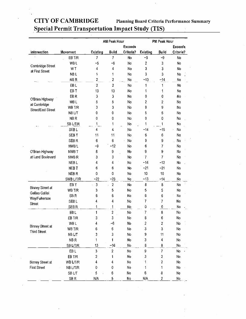
The TIS was completed and certified by the Cambridge Traffic, Parking and Transportation Department (TP& T) on July 21, 2015. The TIS indicated that there were 65 Planning Board Special Permit transportation exceedances (out of 500 data points evaluated), and the Project will generate the following trips:
• 5,858 daily vehicle trips, including 643 AM and 708 PM peak hour vehicle trips; • 7,508 daily transit trips {761AM/893 PM peak hour transit trips); • 3,524 daily pedestrian trips {201 AM/359 PM peak hour pedestrian trips); and, , • 1,922 daily bicycle trips {190 AM/227 PM peak hour bicycle trips).
The TIS summary sheets are attached and the TIS is available on the City's web site located at· http://www.cambridgema.gov/CDD/zoninganddevelopment/specialpermits/specialpermits.aspx. The TIS reported the following key transportation impacts:
• Weekday Daily, AM and PM peak hour vehicle trips exceeded the Planning Board Special Permit criteria thresholds.
• The Project will degrade the Vehicle level of service (VLOS) at 8 intersections.
Page 1 of6

MIT Kendall Square Redevelopment
• The Project exceeded the Planning Board Special Permit criteria thresholds for increased traffic volume on residential streets on segments of Broadway, Memorial Drive, Third Street, O'Brien Highway, and Amherst Street based on 1/3 or more residential uses on first floor frontage.
• The Project exceeded the vehicle lane queue criteria at the Land Boulevard/Binney Street and Third Street/ Broadway intersections.
• The Pedestrian Level of Service {PLOS) criteria threshold was exceeded at Binney Street/First Street, Binney Street/Third Str~et, and Binney Street/Galileo Galilei Way/Fulkerson Street intersections {note that these exceedances are due to signal timing changes forthe Binney Street reconstruction project and not directly because of the MIT Project).
• The TtS reported a lack of bicycle facilities on Wadsworth Street, Amherst Street, Hayward Street and Carleton Street {note that protected bicycle lane is proposed by the City for Ames Street between Main Street and Memorial Drive).
• The Project will add new daily and peak hour transit trips to the MBTA Red Line and will cause the MBTA bus routes #CT2 and #85 to be over capacity during peak hours.
The TP&T Department has been working with MIT and has reviewed the PUD and Project Review Special Permit Application. Overall, TP& T believes that the MIT Kendall Square Redevelopment Project is in many ways consistent with City goals for mixed-use development, including residential, retaiJ, office uses, and open space. The TP&T Department offers the following initial comments to the Planning Board for consideration in your Preliminary Determination, which typically asks for additional information, further refinement or changes to be incorporated into a Final Development Plan.
NoMa Project The NoMa {North of Main) Project proposes to construct a 290-300 unit residential building with 15,000 GSF office space, and 16,000 GSF ground floor retail space. The building will replace a 114 space surface parking lot with a 179 space above-grade parking garage, which will provide 157 reside:ntial spaces {0.52 space/unit), 14 office parking spaces {0.9 space/1,000 s.f.), and 8 retail parking spaces. {0.5 space/1,000 s.f.). The existing One Broadway building, which uses a 316 space parking garage and the 114 parking space surface lot today will be able to meet its parking needs by shifting parkers from the surface parking lot into the One Broadway garage, which has a peak occupancy of 64%.
Access to the parking garage will be from Main Street and include two loading docks that can accommodate single unit 30 foot trucks {SU-30). The proposed NoMa parking plan is summarized below.
NoMA Parking Facilities
Building 1 Garage One Broadway Garage
Total
Spaces
179 316
495
Notes
157 residential, 14 office, 8 retail spaces No Change from existing
The TP& T Department believes that NoMa is a positive project because it will create additional residential housing units, including 50 affordable units, ground floor retail space, and an improved pedestrian/bicycle connection between M~in Street and Broad Canal Way. The Planning Board may want ~o consider asking the Applicant for more information on the following questions:
• How will parking at the NoMa Garage be managed to not exceed the maximum 0.9 space/1,000 s.f. Office parking ratio and maximum 0.5 space/1,000 s.f. Retail parking ratio?
Page 2 of6
MIT Kendall Square Redevelopment
• Are the two proposed SU-30 loading docks sufficient in size and number to accommodate the building's service needs and how will resident move-in/move-out be accommodated?
• Why is it necessary for the new parking facility to be above-grade instead of below-grade? • The graphic materials showing Main Street should reflect a final layout plan approved by the City. • The Transportation Impact Study (TIS) discussed examples of Transportation Demand Management
(TDM) programs, but the PUD and Special Permit Applications for NoMa provided rio definitive TDM commitments. Residential TDM commitments should be inc:::luded in the Final Development Plan for NoMa.
SoMa Project The SoMa (South of Main) Project proposes to turn five surface parking lots into 5 buildings consisting of office, research and development, retail, museum, graduate housing (470 units to replace the existing 201 unit Eastgate graduate housing building), and child care space. The SoMa Project will total1.4 million gross square feet. The full Project is expected to be constructed in 7-10 years.
The SoMa area currently contains 990 parking spaces (874 academic and 116 office/retail parking spaces). The SoMa Project proposes 1,999 total parking spaces (1,009 net new parking spaces) including; a 1,156 space below-grade parking garage (SoMa garage), 278 space below-grade parking garage (Building 2 garage), a new 60 space surface parking lot, and no changes to the existing 60 space Amherst Street parking lot, 419 space East Campus parking garage, and 26 space Hermann parking garage. A summary of the proposed SoMa parking facilities and allocation of spaces is shown below.
SoMA Parking Facilities Academic Non-Academic Total Notes
SoMa Garage 509 647 1156 *see below Building 2 Garage 0 278 278 269 office, 9 retail spaces Site R Parking Lot 60 0 60 Replacement of existing spaces ---------------------------------------------------------------------------------------------------------------------------
Subtotal 569 925 1,494 ---------------------------------------------------------------------------------------------------------------------------East Campus Garage 419 0 419 No Change from existing Amherst Street Lot 60 0 60 No Change from existing Hermann Garage 26 0 26 No Change from existing
Total 1074 925 1,999 * SoMa garage:
Academic spaces - 260 replacement of existing academic spaces, 49 replacement graduate housing spaces, 200 MIT academic spaces shifted from elsewhere on campus. Non Academic spaces- 275 office spaces, 216 R&D spaces, 40 Retail spaces, and 116 replacement spaces of existing commercial land use spaces.
The SoMa Project will provide 504 long-term bicycle parking spaces and 123 short-term bicycle parking spaces, as required by zoning,
Eleven Loading bays will be provided below-grade in the SoMa garage with access from Hayward Street off of Main Street. Trucks up to 50 feet long (WB-50) will be accommodated in the below-grade parking garage. Loading for Building 6 is proposed at-grade behind the building on the existing surface parking lot. Loading for Building 2 will take place at-grade off Wadsworth Street and contain 3 loading bays; two that could accommodate a 55 foot truck (WB-55).
TP& T believes that the SoMa Project is an exciting opportunity to transform Kendall Square into a more vibrant urban, mixed use district. The development program for additional graduate housing, open space,
Page 3 of6

MIT Kendall Square Redevelopment
ground floor retail, and office/R&D space is a very positive change from the existing surface parking lots. The trade-off is that the project will create traffic impacts. However, because it is located in a transitoriented development area, containing the MBTA Kendall Square Red Line Station, the Project will create more transit trips than vehicle trips which reduces the roadway impacts.
The existing Red Line and bus capacity and their ability to accommodate new transit trips is a concern. The Project also proposes over 1,000 new parking spaces, which can be contrary to the City's transportation and sustainability goals to discourage automobile usage and encourage transit, bicycling and walking.
The Planning Board will need to determine ifthe benefits ofthe project outweigh its adverse impacts and if the investment in a large parking garage outweigh needed investments in transit improvements, while recognizing that one Project cannot solve the MBTA Red Line and bus capacity issues on its own. The Planning Board may want to consider asking the Applicant for more information on the following aspects of the SoMa Project:
• Are the proposed number of parking spaces the right amount? o Why does 100% of the 485 existing surface parking spaces {369 academic and 116 non
academic spaces) need to be replaced given that according to the TIS, only 75 percent are occupied at one time today?
o Why relocate 200 parking spaces to Kendall Square from elsewhere on campus, given that transit, bicycling and walking is preferred for Kendall Square?
• The TP&T Department is concerned about how we will be able to monitor the proposed 1,156 parking space SoMa garage with regards to the final approved parking ratios and PTDM plan, commercial parking regulations, and MIT's academic parking space inventory {i.e. maximum 0.8 space/1,000 sf for R&D use, maximum 0.9 space/1,000 sf for office use, maximum 0.5 space/1,000 sf for retail use, and MIT's parking inventory cap of 4,359 spaces). o The TIS stated that the SoMa garage will be managed with state of the art card access
technology, including a fixed number of permits for academic and commercial users. Why would a fixed number of permits be the best method to manage the parking? Separate parking facilities for academic and commercial spaces may be a simpler way to manage and monitor parking spaces. A more detailed parking management plan is needed, including parking best practices and how the TP& T Department will monitor the use of the parking spaces. In developing this parking management plan, MIT should also consider how the parking can be used in the most flexible possible way, so that commuters can make decisions on a daily basis as to how they commute, rather than being locked intq traveling by car because they have prepaid for a parking pass/permit.
o Parking programs such as, universal transportation passes, peak parking demand pricing, and other innovative parking management measures that allow people to drive on days when they need to drive but also provide incentives to use transit, bicycling or other non-single occupancy modes on other days should be implemented.
• The Graphic Materials for SoMa shows new paving material on Wadsworth Street, between Amherst Street and Main Street. Additional information should be provided to explain what is proposed. "
• Provide additional information on the expected new truck trips and consider design options for Hayward Street, such as a shared street, for all users including trucks, pedestrians, and cyclists.
• Further detailed review ofthe locations for short-term bicycle parking will be needed.
Page 4 of6

MIT Kendall Square Redevelopment
• Although the TIS provided examples of TOM measures, the PUD and Special P,ermit Application provided no specific commitments. The Project will need a very robust PTDM and TOM program in order to achieve the mode shares assumed in the TIS (i.e. 33% office employee SOV rate). What is the status of the Project's required Parking and Transportation Demand Management Plan (PTDM Plan)?
Overall Transportation Impacts and Mitigation The TP& T Department believes that the MIT Kendall Square Redevelopment Project has many positive aspects, and recognizes that MIT has made commitments through the zoning process a_s discussed in the PUD and Special Permit Application including:
• Community Fund Contribution up to $8.8 million, • Non-profit Community Benefits fund contribution up to $3.5 million, • 35 Cherry Street land contribution to the City, • $20,000 over 10 years for building trade apprenticeship path program, and • The Project will create public open space and create new tax revenue.
However, the Project will have transportation impacts and will create significant new_ demands on the local and regional transportation networks, and yet no substantial commitments have been made. The TP& T Department will work with MIT on transportation mitigation including when the conditions will need to be completed. A final transportation mitigation package should be established as. part of the Final Development Plan. The TP&T Department will work with MIT to develop a range of appropriate transportation mitigation elements in the areas described below.
• Transit improvements. o TP& T appreciates that MIT is participating in the Kendall Square M~bility Task Force,
which is looking to identify short-, medium and long-term transit improvement projects in Kendall Square. The study will not be completed for another 6-9 months, but the Planning Board may want to consider asking MIT to indicate what financial commitments MIT will provide for the final recommendations. Some potential commitments could be:
• Transit contributions based on a dollar amount per square feet of new development.
• Daily or yearly parking surcharges that are allocated to transit improvements. • Financial or in-kind contributions to advancing a feasibility study of
communication-based-train-control {CBTC) for the Red Line, which could significantly improve Red Line Capacity by allowing trains to run closer together (i.e. shorter headways).
o The MIT Kendall Square Redevelopment PUD and Special Permit Applications stated that MIT has had discussions with the MBTA and is exploring the opportunity to relocate and update the MBTA Red Line Head house. The Planning Board may want to consider asking MIT to provide more information, including MIT's commitments. One item to consider is how much the Headhouse should be setback from Main Street without reducing visibility and wayfinding on Main Street? Also, do the other Headhouses in Kendall Square need restoration (i.e. do stairways and bricks need cleaning or straightening, do the metal handrails need restoration, is the wayfinding signage and lighting sufficient?).
o According to the TIS, the MBTA Bus routes #CT2 and #85 will be over capacity because of new riders generated by the MIT Project. There is also currently no weekend bus service
Page 5 of6

MIT Kendall Square Redevelopment
from the EZ Ride and CT2 bus. How will these issues be mitigated {i.e. new buses and operating costs)?
• Infrastructure improvements o Design and reconstruct Ames Street, from Main Street to Memorial Drive to the Paul
Dudley White Multiuse Path. This work should include extending the existing two-way cycle track on Ames Street to the River as part of the bicycle network. ·
o Design and reconstruct Wadsworth Street between Main to Memorial Drive, including intersections.
o Design and construct improvements to Vassar Street/Massachusetts Avenue and Vassar Street/ Main Street intersections, with particular attention to bike accommodation and the cycle track transitions.
o Update outdated traffic signal equipment {i.e. controllers, conduit, mast arms, signal heads) at Ames Street/Main Street, Broadway/Ames Street, and Vassar/Main/Galileo Galilei Way.
o Possibly design and reconstruct Galileo Galilei Way, from Broadway to Main {unless undertaken by Cambridge Redevelopment Authority).
• Bicycle Improvements o The TIS indicated that there was insufficient bicycle parking in Kendall Square {250 bike
spaces and as many as 321 bikes counted). Although the Project will provide bicycle parking to meet zoning, TP& T does not consider meeting zoning a transportation mitigation unless the commitments are above and beyond what zoning requires. The Planning Board may want to consider asking MIT to demonstrate why the proposed bicycle parking plan will be sufficient to meet the growing need for bicycle parking in Kendall Square.
o Hubway Station planning should be occurring at this stage so tpat it is well integrated with the site planning and access. The TIS found that all Hubway bikes were used at 6:00 pm at Binney/Sixth and Kendall Street. A minimum of one new Hubway Station at the Broad Canal and another large station or two in other areas are needed.
o If the MBTA Headhouse is reconstructed, a public bicycle station should be included in the design. Another potential location for a public bicycle station can be at Building 6.
o MIT should evaluate the option of raising the cycle track on Main Street between the Longfellow Bridge and Third Street.
o More information about the Memorial Drive Phase II improvements should be provided and any contributions that MIT might be able to provide.
Cc: Adam Shulman, TPT; I ram Farooq, Jeff Roberts, Liza Paden, Susanne Rasmussen, Stuart Dash, Cara Seiderman, Suzannah Bigolin, Stephanie Groll, CDD; Michael Owu, MIT.
Page 6 of6

CITY OF CAMBRIDGE Planning Board Criteria Performance Summary
Special Permit Transportation Impact Study (TIS)
Planning Board Pe1·mit Numbe1·: _____ _
PROJECT NAME: MIT Kendall Square
PARKING:
Address:
Owner/Developer Name:
Contact Person:
Contact Address:
Contact Phone:
ITE sq. ft.:
Land Use Type:
238 Main Street, Suite 200 Cambridge MA 02139
Massachusetts Institute of Technology (MIT)
Michael K. Owu
238 Main Street, Suite 200
Cambridge, MA 02142
(617) 258-1012
1,759,600
Mixed Use Development Office, Research & Development, Residential, Retail,
Museum, Academic Graduate Housing, and Daycare
Existing Parking Spaces*: 599 Use: 230 Commercial/369 Academic
""'N'""e""w'-'P'""a"'rk"-'i'-"ng~Spl!.!a"-'c""es,_*_*~: -----"-'1.""67"-'3'-- Use: 947 Commercial/569 Academic/157 residential
Net New Parking Spaces*** + 1,074
*Existing parking spaces on TIS Building sites
**The total parking spaces of 1,673 include 200 relocated academic spaces and 485 replacement spaces of which 369 are
academic spaces and 116 are commercial spaces
***Includes the 200 relocated academic spaces
Date of Parking Registration Approval: N/A
TRIP GENERATION*:
Total Trips
Vehicle
Transit
Pedestrian
Bicycle
Daily
18,812
5,858
•7,508
3,524
1,922 ..
*Does not take into account ex1stmg s1te tnp cred1ts
AM Peak Hour PM Peak Hour
1,795 2,187
643 708
761 893
201 359
190 227
MODE SPLIT (PERSON TRIPS): RESEARCH & DEVELOPMENT/OFFICE (RESIDENTIAL) [RETAIL]{ACADEMIC}
Auto:
Transit:
Walk:
Bike:
Other:
TRANSPORTATION CONSULTANT:
Company Name: Vanasse Hangen Brustlin, Inc.
Contact Name: Susan Sloan-Rossiter
Phone: 617.728.7777
Date of Building Permit Approval: _______ _
Planning Board Permit Number: _____ _
41%(32%) [31%] {27%}
42%(30%) [30%] {41%}
7%(25%) [29%] {15%}
10% (10%) [8%] {14%}
0% (3%) [2%] {3%}

CITY OF CAMBRIDGE Planning Board Criteria Performance Summary
Special Permit Transportation Impact Study (TIS)
Project Name: MIT Kendall Square
Total Data Entries = 500 Total Number of Criteria Exceedances =Full Build= 65
1. Project Vehicle Trip Generation*
Time Period Criteria (tri~s) Build Exceeds Criteria?
Weekday Daily 2,000 5,858 -·yes'
Weekday AM Peak Hour 240 643 .~·Yes Weekdal PM Peak Hour 240 708 Nes.· ;>
*Does not take into account existing site trip credits
2. Level of Service (LOS)
AM Peak Hour PM Peak Hour Existing Build Traffic Exceeds Existing Build Traffic Exceeds
Intersection Condition Condition Increase Criteria? Condition Condition Increase Criteria?
O'Brien Highway at Third Street F F 3.0% No F F 2.9% No .I ..• : . . ·:;•~; 'J Cambridge Street at Third Street D D 5.9% No F F 5.1% ;
I ·•·Yes.·<·· 'l" _,_.___,_,_,_
Cambridge Street at First Street . E E 3.7% No F F 3.1% No O'Brien Highway at Cambridge c c 1.4% No B B 1.5% No StreeU East Street
O'Brien Highway at Land E E 2.5% No F F 2.9% No Boulevard/ Gilmore Bridge
Binney Street I Galileo Galilei Way c c 0.3% No D c 3.8% No I Fulkerson Street
Binney Street at Third Street D D 7.5% i__<~~i~J D D 7.5% ~'7~(- l J
Binney Street at First Street c c 3.1% No c c 3.7% No Land Boulevard at Binney Street B c 3.5% No c c 4.2% No Hampshire Street at Cardinal c D 3.1% 'Yes _ c c 2.7% No Medeiros Avenue
Broadway at Portland Street c D 2.8% Yes.: D D 2.9% No Broadway at Hampshire Street D E 5.4% Yes D D 5.6% No Broadway at Galileo Galilei Way F F 3.4% No E E 5.4% No
--
Broadway at Ames Street E E 9.4% Yes D D 11.7% Y~s: I
I Third Street at Broadway c E 15.2% Yes D D 7.9% Y~s i
Vassar Street at Main Street c c 9.2% No c c 10.2% No Main Street at Ames Street c c 44.9% . Yes ..
~j
c D 37.9% \([s~ Memorial Drive WB at Wadsworth B B 10.2% No B B 5.1% No Street Memorial Drive EB at Wadsworth
A A 4.9% No A A 5.2% No Street

CITY OF CAMBRIDGE Planning Board Criteria Performance Summary
Special Permit Transportation Impact Study (TIS)
3. Traffic on Residential Streets
AM Peak Hour , PM Peak Hour
Roadway
Portland Street
Amount of Existing Project Exceeds Existing Project Reviewed Segment Residential 2015 Trips Criteria? 2015 Trips Main Silo Washington St >1/3 but <1/2 655 0 No 733 0
Washington Silo Harvard St >1/3 but <1/2 653 0 No 733
733
0
0 Harvard Silo Broadway 1/3 or less 653 0 No
Broadway to Hampshire St 1/3 or less 650 0 No 727 0
______ Halllp~hir~ Silo Binney_ SL_ _____ 2_1/~_but ~1f1_ _______ 1_:3_Q_ ______ _co __ , No 830 0 Windsor Silo Dickinson St 1/2 or more 828 42 ·Yes • --921 ________ 4_6_1
Broadway --,----------- Dickinson Silo Clark St _ _jl?_Q!._!!\Q~~----·----~~~----- __ 4_2_~_Y"'"'e'-'-s_· _______ 92L _____ §___;
Medeiros Ave to Webster Ave 1/3 or less 653 40 No Hampshire Street
______ Webster Ave to~_lar_k_SI_ _ _:>_1!~~~1_~11_~-----------~-~~----- 40 No
_ __:6c::_8_--'--.''-'--''Yes .. Memorial Drive Ames St to Wadsworth St 1/2 or more 2343 -----------------
113 or less 769
>1/3 but <1/2 769
Third Street
762
762 --------------·-
3002
893
41
41
131
90
893 90
893 90
893 90
Exceeds Criteria?
No
No
No
No
No
'Yes
Yes No
No
Yes'
No Rodgers St to Bent St
Bent St to Charles St
Charles St to Hurley St
Hurley St to Spring St
Spring St to Thorndike St
1/2 or more
1/2 or more
1/3 or less
769
769
769
82
82
82
82
82 No 893 • 90 No
Thorndike Silo Otis St 1/2 or more 769 82 ; .. ;\Yes r __ ~il.~ ___ 9_o_f -- '(e_s ------ ------ - ----. ---~-------------
Cambridge Street Third Silo Sciarappa St 1/3 or less 612 0 No 649 0 No
______ Sci_ar_flJlJ]9_8_liQ 5th St ________ 1f~9JfJ_ ____________ ~1L ____ 0'-------N~o'------ 649 0 No ---------~ vas
Land Blvd to Leighton St O'Brien Highway Leighton Silo East
______ St/C~mbJidge St
Ames St to Carleton St
Amherst Street Carleton St to Hayward St
Hayward St to Wadsworth St *volume interpolated from nearest data available in study area
1/2 or more 2405
1/2 or more 2388
1/3 or less
>1/3 but <1/2
1/3 or less
255
246
236
4. Lane Queue (for signalized intersections)
AM Peak Hour Exceeds
Intersection Movement Existing Build Criteria?
NBUR 1 1 No O'Brien Highway
SEB T/R -24 -25 No at Third Street
NWBUT 0 0 No --------
EB LIT/R 7 7 No
Cambridge Street WB L/T/R 5 5 No
at Third Street NB UT/R 3 3 No
SB L No
SB T/R 14 16 No
36 No
36 No 2095 41 t .. v·_"es ___ ,__ _ '· 2233 41 !
287 No 349
287 r ';:r~_s. ._ 1 314
97 No 268
PM Peak Hour Exceeds
Existing Build Criteria?
5 5 No -17 -18 No -13 -13 No ------------
-13 -13 No -14 -14 No
7 8 No 0 0 No 3 4 No
391
391
128
No
Yes . l No
CITY OF CAMBRIDGE Planning Board Criteria Performance Summary
Special Permit Transportation Impact Study (TIS)
Intersection
Cambridge Street at First Street
Movement
EBT/R
WBL
WT
Existing
7 -5 4
AM Peak Hour Exceeds
Build Criteria? Existing
7 No -9 -6 No 2 4 No 3
PM Peak Hour Exceeds
Build Criteria?
-9 No
3 No
3 No NB L No 3 3 No
_________ "-'-'NB=---R'-"----------=2-~ ~2~ _________ N_o~---~1~----1~4 ____ ~No __ _
O'Brien Highway at Cambridge Street/East Street
EB L 2 2 No 1 No
EB T 13 13 No 1 No EB R 3 3 No 0 0 No
WB L 5
WB T/R 3 NBL/T 0 NB R 0
5
3 0 0
No No
No
No
2
9 5 0
2
9 5
0
No No
No
No
____________ S§J/T/R_~~----------~----fiq ____________ 1 _______ f'J_(l_ __
O'Brien Highway at Land Boulevard
Binney Street at Galileo Galilei Way/Fulkerson Street
Binney Street at Third Street
Binney Street at First Street
SEBL 4 4 No -14 -15 No
SEBT
SEBR
NWBL
NWBT
NWBR
NEB L
NEBT NEBR
SWB L/T/R
EBT
WBT/R SB R SEB L
11
6
-9 8 3 4 6
0 -22
3 3 6
4
SEB R ----'--~ EB L
EBT/R WBL
WBT/R
NB UT NBR
SB L/T/R
EB L
EB T/R WB L/T/R
NB UT/R SBL/T SB R
3 4 6
3
13
3
2
4 0
5 N/A
11 6
-12
9 3 4 6
0 -23
2
5 6
4
No 6
No 9 No 6
No 9 No 7 No -14
No -21
No 10 :...:.:No:__ __ -13
No 8 No 5 No 6
No 7
6 No
9 No 7 No
9 No
7 No -12 No
-21 No
10 No -14 No
8 No
5 No 6 No
7 No No 0 0 No ,
----------~-- -~- ------.
2
3 -6 6 3
1
-16 2
1 4 0 6
5
No 7 8 No
No 6 6 No No 2 2 No
No 3 3 No
No 9 11 No
No 3 4 No No 8 8 No
No 9 7 No
No 3 2 No No 1 2 No
No 1 No
No 6 8 No
No _ __c_N=/A-'--~---=-2 __ ~No=--

CITY OF CAMBRIDGE Planning Board Criteria Performance Summary
Special Permit Transportation Impact Study (TIS)
AM Peak Hour PM Peak Hour Exceeds Exceeds
Intersection Movement Existing Build Criteria? Existing Build Criteria?
EB LIR 3 2 No 5 2 No
Land Boulevard at NEB L 7 6 No 6 7 No NEB T 1 2 No 3 7 No
Binney Street 17
(, Yes,
i SWBT 7 i I 11 15 No
' SWBR 5 10 No 3 3 No
-----------------~------
NB L 0 0 No 1 No
NBT/R 2 2 No 2 2 No Hampshire Street
SB L 0 0 No 0 0 No at Cardinal Medeiros Avenue
SBT/R 5 5 No 5 5 No
SEB L/T/R 11 -12 No 6 7 No
NWB L/T/R 6 6 No 11 11 No --------------------------------------
EB L/T/R 13 -15 No 10 10 No
WB L/T/R 7 7 No 10 -11 No
Broadway at NB L 1 No No Portland Street NB T/R 7 7 No 8 8 No
SB L 1 1 No 0 0 No
SBT/R 2 2 No 2 2 No ----------.---------- --~--·----- ··-------··---- ------------
EB LIT 13 -14 No 9 10 No
EBR 3 3 No 0 0 No
WBL -5 -6 No 0 0 No
WBT 2 2 No 3 3 No Broadway at
WBR 0 0 No 2 No Hampshire Street
NB L 0 0 No 2 2 No
NB T/R No 2 2 No SB L 5 -8 No -8 -8 No
SBT/R 1 No 0 0 No ----------- --- -- -··------- ------- -- ··---------
EB L 4 4 No 3 3 No
EB T -17 -18 No 8 -9 No
EB R 2 3 No 1 1 No
WBL 2 2 No -6 -6 No Broadway at
WBT/R 5 5 No 6 7 No Galileo Galilei
NB L 2 2 No 3 3 No Way
NB T/R 4 4 No 8 9 No
SB L 2 2 No 2 No
SB T 11 11 No 7 7 No
SB R -5 -5 No -5 -5 No

CITY OF CAMBRIDGE Planning Board Criteria Performance Summary '
Special Permit Transportation Impact Study (TIS)
AM Peak Hour PM Peak Hour Exceeds Exceeds
Intersection Movement Existing Build Criteria? Existing Build Criteria?
EB T -20 -20 No -15 -15 No EB R 2 3 No 1 1 No
Broadway at WBL 4 3 No 2 1 No Ames Street WBT 9 8 No 8 7 No
NB L 2 2 No 2 2 No NB R 0 0 No 2 4 No
------~--~----
EB L 6 6 No 6 7 No EB T 5 4 No 3 4 No
Third Street at WBT 12 -21 9 9 No Broadway WBR 6 8 No 3 3 No
SB L 2 6 No -11 -12 No SB R 3 2 No. 1 2 No
EB L 4 4 No 4 5 No EB T/R 5 8 No 5 6 No WBL 1 No 1 No
Vassar Street at WBT/R 5 6 No 2 5 No Main Street NB LIT/R 5 5 No 5 6 No
SB L 1 2 No 1 No SB T 9 9 No 4 4 No SB R 6 6 No 2 2 No -- ----------------------~--- ---------~---- --------
EB L 1 No 0 0 No EB T/R 5 9 No 6 6 No WBL 0 2 No 0 No
Main Street at WBT/R No No Ames Street NB L 2 No -7 No
NB T/R 2 3 No 3 7 No SB L/T/R 3 6 No 2 3 No
SB R 5 4 No 2 2 No --------~----- -------~------ ---·
EB L 0 0 No 0 0 No EBT 0 0 No 0 0 No
Memorial Drive at WB T/R 9 11 No 13 14 No Wadsworth Street NB L 0 0 No 0 0 No
NBT 5 6 No 3 3 No SB R 0 0 No 2 No

CITY OF CAMBRIDGE Planning Board Criteria Performance Summary
Special Permit Transportation Impact Study (TIS)
5. Pedestrian and Bicycle Facilities
Intersection
O'Brien Highway at Third Street
Cambridge Street at Third Street
Cambridge Street at First Street
O'Brien Highway at Cambridge StreeUEast Street
O'Brien Highway at Land Boulevard
Binney Street at Galilee Galilei Way/Fulkerson Street
Binney Street at Third Street
AM Peak Hour
Existing Build Exceeds
PM Peak Hour
Existing Build Exceeds Crosswalk 2015 2015 Criteria? 2015 2015 Criteria?
East 0 0 No 0
West 0 0 No 0
South 0 0 No 0
East B B No B
West B B No B
North B B No B
South B B No B
East 0 0 No 0
West 0 0 No 0
South 0 0 No 0
East 0 0 No 0
West 0 0 No 0
North 0 0 No 0
South C C No C
West E E No E North E E No E
South E E No E . I
East C 0 · yes j C
West C 0 yes i C North B 0 ,y~s\ :j B
South C 0 Y ~~ . J C
0
0
0
B B B B 0
0 0
0
0
0
c E E
.E
0
No
No
No
No
No
No No
No
No
No
No No
No
No
No
No No
r- ·sre~·· ; :,
o l, Yes 0 1,. Yes o t -Yes
East 0 0 No 0 0 No
West 0 0 No 0 0 No
North C 0 ! , .Yes: , j C 0 _________ S"-'o'-"u""'th ___ c_c_ ___ o_~~Ye~'~~~--c~ __ o
f ry~;.
t. ---v~s';: .. ·~
Binney Street at First Street
East E E No E E
West E E No E E -~1
North B E Yes ; B E '
No
No 'j
-··-· -----~ I ---------=-South ----'A'-'---------'E=-----'--'-·.•-'---'Yes_i_,l____A --~~L~-·'-i '---"-'--=-:;_--"
West E E No E E No Land Boulevard at North E E No E E No Binney Street
_________ S~o~u=th~--~E=--------'E=--___ N~o ___ -=E __ _:E ___ ~No=---
Hampshire Street at Cardinal Medeiros Avenue
East B B No B B No
West B B No B B No
North B B No B B No
South B B No B B No

CITY OF CAMBRIDGE Planning Board Criteria Performance Summary
Special Permit Transportation Impact Study (TIS)
AM Peak Hour PM Peak Hour Existing Build Exceeds Existing Build Exceeds
Intersection Crosswalk 2015 2015 Criteria? 2015 2015 Criteria?
East B B No B B No
Broadway at Portland West B B No B B No Street North B B No B B No
South B B No B B No
East 0 0 No 0 0 No
Broadway at West 0 0 No 0 0 No Hampshire Street North c c No c c No
South c c No c c No
East 0 0 No 0 0 No
Broadway at Galilee West 0 0 No 0 0 No GalileiWay North 0 0 No 0 0 No
South 0 0 No 0 0 No
East 0 0 No 0 0 No Broadway at Ames
West 0 0 No 0 0 No Street South c c No c c No
East 0 0 No 0 0 No
Third Street at West 0 0 No 0 0 No Broadway North c c No c c No
South c No c No
East c c No c c No
Vassar Street at Main West c c No c c No Street North c c No B B No
South c c No B B No
East 0 0 No 0 0 No
Main Street at Ames West D 0 No 0 D No Street North c c No c c No
South c c .No c c No
Memorial Drive at East D 0 No D D No Wadsworth Street North D 0 No 0 0 No

CITY OF CAMBRIDGE Planning Board Criteria Performance Summary
Special Permit Transportation Impact Study (TIS)
Sidewalk and Bicycle Facilities
Adjacent Street
Main Street
Link (between)
Ames St to Wadsworth St (north side) Ames St to Wadsworth St (south Side) Wadsworth St to Longfellow Br (south side)
__________________ Third St to Broad Canal Way (north side)
Wadsworth Street
Main St to Amherst St (west side)
Sidewalks or Walkways Present?
Yes Yes Yes Yes
Yes Yes Yes
Exceeds Criteria?
No No No No
No No No
Bicycle Facilities or Right of Ways Present?
Under Construction*
Yes Yes
Yes
No No No
Exceeds Criteria?
No
No No No Yes--- 1
l y'es ;; l
-_-_ .• ,i_
Main St to Amherst St (east side) Amherst St to Memorial Dr (west side)
---···----·-····-··-·····-···--··· Amherst St to Memorial Dr (east side) Broad Canal Way to Broadway (west side)
·-Yes. No -j
-------'-Y-=-es-=--------------------------------'N.:.:o'-----------'-'----'Y-=-e.::..s -'-----__, Yes No Yes No
Third Street _________________________ Broad Canal Way to_ Broadway (east side) Yes ------~9 ________ -----'--Ye=s'----------,---,---N'--'--=-o ~
~=: ~:: ~::::: ~: ~:~~~ ~i:: ~= ~~ ~~ i~0~~;~;j Amherst Street
Carleton St to Hayward St(north side) Yes No No t -rc:'(e$;Y . .1'-j
~:~~r~ ~~ ~~ :::~:~ ~t0(~~rt~ds~!e) ~:: ~~ ~~J: l[;_._:_:_-_-_Yyy_:.·_;e~s~-i_:. __ -_i_l11 ___________ Haywar~~t toiJVadsworth St(south side)_ __ Yes No ___ -,--___:_:N.::.o -----+-~..:qc;~-
Hayward Main St to Amherst St (west side) Yes No No l,·-~-_-;_YYl\' __ ee.~s~_:_:_._-_•_:_-·_-_._j --~-~~~!~~------··· Main St to Amherst St (east side) Yes ~.Q _________ _.:.:Nc::.o ___ --+-:~~-'--:--'--1,
I Carleton Dock St/Deacon St to Amherst St (west side) Yes No No rc-Street Dock St/Deacon St to Amherst St (east side) Yes No No
*Main Street is currently under construction and the new roadway design will provide a new bike lane on the north side of the street as well as maintain the bike lane on the south side of the street. **As part of the MIT Kendall Square Project, Hayward Street will be turned into a pedestrian and bicycle connection through the site and will no longer provide vehicular access from Amherst Street to Main Street under Build Conditions.