city of chattahoochee hills comprehensive plan community
TRANSCRIPT
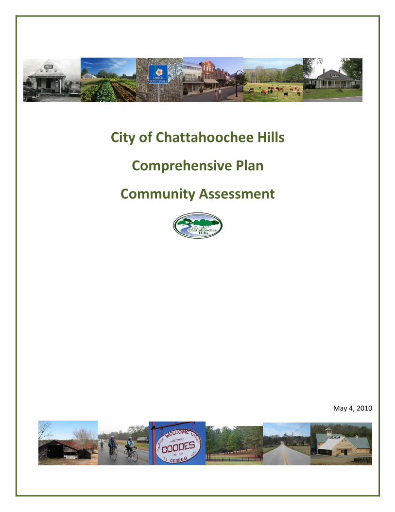
City of Chattahoochee Hills
Comprehensive Plan
Community Assessment
May 4, 2010
Chattahoochee Hills Mayor and City Council
Mayor Don Hayes John Taylor, District 1
Carl Hattaway, District 2 David Hanson, District 3 and Mayor Pro Tem
Faye Godwin, District 4 Rodney Peek, District 5
Comprehensive Plan Task Force
Paul Alford Fuller Anderson Clifford Blizard Carl Bouckaert
Dr. George Brown Margaret Clime
Brook Cole Steve Dray
John Graham Nancy Green Leigh
Gene Griffith Nehemiah Haire
Andy Hannah Don Harrelson Michael Harris Monty Harris
Judy Henderson Mark Hennessey
Sandra Huffmaster James Hutcherson
Steven Kopelman Wendy McGhee
Alan Merrill Steve Nygren Stacy Patton Mark Prater Tom Reed
Rocky Reeves Dan Sanders Laurie Searle Rick Sewell
Allen Shropshire Bob Simpson Clay Stafford Ricky Stevens Sandra Storrar
Hugh Tyer Dana Wicher
Rev. Dusty Womack
City of Chattahoochee Hills Staff
Carol Wolfe, City Manager Pat Crook, Finance Director Damon Jones, Police Chief
Larry Parrot, Public Works Director Jahnee Prince, City Planner
Dana Wicher, City Clerk
Planning Consultant Team
Steve Cover, HOK Jahnee Prince, HOK
Wally Warren, Keck and Wood (GIS maps)
3
Table of Contents List of Maps ................................................................................................................................................... 5
PART I. INTRODUCTION ................................................................................................................................ 7
Methodology and Schedule ...................................................................................................................... 8
City History ................................................................................................................................................ 9
Planning History of Chattahoochee Hills ................................................................................................ 12
PART II: SUMMARY OF ISSUES AND OPPORTUNITIES ............................................................................... 14
City Population Profile ............................................................................................................................ 14
Economic Development .......................................................................................................................... 16
Housing ................................................................................................................................................... 17
Natural and Cultural Resources .............................................................................................................. 18
Community Facilities and Services .......................................................................................................... 19
Transportation ........................................................................................................................................ 19
Intergovernmental Coordination ............................................................................................................ 20
Land Use .................................................................................................................................................. 21
PART III. ANALYSIS OF EXISTING DEVELOPMENT PATTERNS ..................................................................... 23
Geography ............................................................................................................................................... 23
Development Types ................................................................................................................................ 23
Existing Land Use Inventory .................................................................................................................... 25
Current Zoning ........................................................................................................................................ 27
Areas Requiring Special Attention .......................................................................................................... 29
Character Areas ....................................................................................................................................... 30
PART IV. TECHNICAL ADDENDUM .............................................................................................................. 43
Population ............................................................................................................................................... 43
Economic Development .......................................................................................................................... 47
4
Housing ................................................................................................................................................... 55
Natural and Cultural Resources .............................................................................................................. 57
Community Facilities and Services .......................................................................................................... 78
Intergovernmental Coordination ............................................................................................................ 90
Transportation ........................................................................................................................................ 95
5
List of Maps Existing Land Use Map ................................................................................................................................ 28 Character Areas Map .................................................................................................................................. 31 Bear Creek Reservoir Map .......................................................................................................................... 58 Wetlands Map ............................................................................................................................................. 62 Floodplain Map ........................................................................................................................................... 66 Steep Slopes Map........................................................................................................................................ 68 Community Facilities Map .......................................................................................................................... 79 Water Service Area Map ............................................................................................................................. 80 Functional Classification Map ..................................................................................................................... 96 Scenic Byways Map ..................................................................................................................................... 97
6
ACKNOWLEDGEMENTS
The development of a comprehensive plan is a significant endeavor. As the City of Chattahoochee Hills most important guiding document, the Mayor and City Council take the development of the Comprehensive Plan very seriously. A great deal of thought and consideration went into the selection of the Comprehensive Plan Task force. The City of Chattahoochee Hills has a longstanding tradition of a high level of civic involvement and enthusiasm for planning, giving the Mayor and City Council a large pool of enthusiastic and knowledgeable citizens from which to choose. The Mayor and City Council are following the progress of the process closely.
The writers of this document wish to thank the Mayor and City Council, the Planning Commission, the City staff, all of the members of the Task Force, and every citizen who gave time and energy to the Comprehensive Planning effort. A special thanks to the Atlanta Regional Commission and to the Georgia Department of Community Affairs for their assistance in the development of this document.
7
PART I. INTRODUCTION The purpose of the city’s Comprehensive Plan is to develop a vision for the community’s future that will be implemented through city policies and code of ordinances, the city’s Short Term Work Program and everyday decision-making by the Mayor and City Council and city staff. When implemented, the Comprehensive Plan will help the community address critical issues and opportunities while moving toward realization of its unique vision for the community’s future. A Comprehensive Plan, in the State of Georgia, is composed of three components:
1. Community Assessment 2. Community Participation Program 3. Community Agenda
This document represents the first component, the Community Assessment. The purpose of a Community Assessment is to present a factual foundation upon which the rest of the Comprehensive Plan is built. The assessment considers specific data categories and addresses a 20 year planning period. The scope of this plan is from 2010 to 2030. The goal of this plan is the articulation of an achievable vision for the future of the City of Chattahoochee Hills. As required in the Department of Community Affairs (DCA) Standards, the Community Assessment includes four basic components:
1. List of issues and opportunities that the community wants to address 2. Analysis of existing development patterns 3. Evaluation of current community policies, actions, and development patterns for consistency
with the Quality Community Objectives 4. Analysis of supportive data and information
In its coverage of these four components, this report is, written like an executive summary – short, concise and informative – so that citizens and decision makers can quickly review the essential elements and major findings of this planning effort. The Community Participation Program is the second component of the Comprehensive Plan. It describes steps that will be taken by the City of Chattahoochee Hills to ensure adequate public and stakeholder involvement in the preparation of the third component, the Community Agenda. The Community Agenda is the third and most important part of the Comprehensive Plan. In this component, the City of Chattahoochee Hills is charged with creating a vision for the future of the city, as well as a strategy for achieving the vision. The Community Agenda provides guidance for future decision making in the city.
8
Methodology and Schedule This Community Assessment document is the first major step in preparation of the city’s Comprehensive Plan. This document and the Community Participation Program will be submitted to the DCA for approval. This will be followed by a 30-day comment and review period by the Atlanta Regional Commission (ARC) and the DCA. Upon approval of both documents, work on the Community Agenda will commence. The Community Agenda is the most important part of the plan; it includes the community’s vision for the future, key issues and opportunities it chooses to address during the planning period, and its implementation program for achieving this vision and addressing the identified issues and opportunities. The Community Agenda will identify near-term and long-term critical planning strategies for the City of Chattahoochee Hills. These planning strategies are intended to help guide the pattern of development within the city while supporting the character guidelines for specific areas of the community. The goals and policies expressed in the Community Agenda identify how the City of Chattahoochee Hills will address demands associated with future anticipated population and work force growth while supporting the overall vision for the city. This Community Agenda will provide a complete update to the city’s currently adopted Comprehensive Plan, called Focus Fulton 2025. Focus Fulton 2025 is Fulton County’s comprehensive plan that the City of Chattahoochee Hills adopted when the city was incorporated in December of 2007. A portion of that plan specifically addressed the special needs of the area of Chattahoochee Hills, creating an overlay zoning district that called for preservation of 60% percent of the area in a relatively undisturbed state, with development concentrated in villages and hamlets located in specific areas. The City of Chattahoochee Hills now needs to adopt its own Comprehensive Plan, distinct from and more refined than Fulton County’s, to guide future planning efforts. The new comprehensive planning effort will be crafted by local citizens with the help of a professional city planning team to better fit the rural community of Chattahoochee Hills. The Chattahoochee Hills Comprehensive Plan is anticipated to further refine efforts to: • Provide for the permanent preservation of a rural landscape and quality of life; • Allow concentrated development in specific hamlet and village nodes; and, • Improve the city’s built aesthetics and design quality orientation. In the three years since the adoption of Focus Fulton, the leadership and citizens of Chattahoochee Hills have consistently demonstrated their willingness and their passion for the Plan, for raising the bar for preservation of rural land and lifestyles, and for promoting responsible development. The most prominent example of preservation-oriented development in the community is Serenbe, which has been substantially completed, and serves as an award-winning example of outstanding land conservation, planning and implementation. It is the intent of this Community Agenda to build upon the spirit that
9
was established in Focus Fulton, to identify problem areas, and to encourage even higher standards to create and to maintain a sustainable community for the citizens of Chattahoochee Hills.
City History The rural communities that are now a part of Chattahoochee Hills date back well over 100 years. Many of the families in the area have been here for generations. The reasons that keep many families in this area--a strong sense of community, a beautiful rural setting, and a love for nature--are also the reasons that are attracting new people, and potentially damaging sprawl, to the area. The area that is now southwest Fulton was once Campbell County. Historically, the rural southwestern region of Fulton County included several small ‘towns’, like Rico, Goodes, and Rivertown. The Rico area to this day is a distinct community within the City of Chattahoochee Hills.
New Cities in Fulton County In December 2005, changes in the law allowed new cities to incorporate within three miles of an existing city, allowing the north Fulton community of Sandy Springs to incorporate.,. However, the Georgia Municipal Association announced its intention to change the law back to its original wording after the 2006 legislative session. This meant that proposals for new cities had to be submitted by January 2005 in order to be considered. Residents of unincorporated north Fulton submitted proposals for the new cities of Milton and Johns Creek, which prompted local discussions leading to proposals to incorporate the City of Chattahoochee Hill Country and a City of South Fulton. (The City of South Fulton effort was led by a separate group.) In the winter of 2006, SB 553 was introduced to incorporate the City of Chattahoochee Hill Country. Just moments before the bill was passed, a legislative decision removed 7,000 acres of the Chattahoochee Hill Country into the proposed new City of South Fulton, thus removing portions of one of three village sites in the originally expected 40,000 acre Chattahoochee Hill Country. In March 2006, Gov. Perdue signed SB 553, allowing residents the opportunity to vote to become the City of Chattahoochee Hill Country.
Future City in Chattahoochee Hills In May 2006, a large land owner in the Chattahoochee Hill Country annexed into the adjoining city of Palmetto, thus removing the second of three village sites from the 40,000 acre Chattahoochee Hill Country. Chattahoochee Hill Country community leaders called an emergency community meeting to discuss the news and to take a straw poll vote on three options:
• Request annexation of the entire Chattahoochee Hill Country into the city of Palmetto. This
option provided the best chance at keeping the overlay intact. • Proceed with the original plan to form the City of Chattahoochee Hill Country.
This option provided the best chance for creating a community-based government. • Do nothing and remain unincorporated. This option provided the most uncertainty for the
future of the Chattahoochee Hill Country.
10
In June 2006, the residents at the community meeting voted to attempt to annex into Palmetto. In order to meet the annexation timeline specified by SB 553, the community needed signed petitions from 60+ percent of land owner and 60+ percent of registered voters--all within two weeks. In an amazing effort, the community set out on a door-to-door petition campaign and achieved those requirements. Only after the petitions were signed and collected did the community learn of additional requirements: to advertise in the local paper, and to set signs out for every land parcel that is being annexed. The community found a way to accomplish these goals, but then learned that the city of Palmetto was not able to process all of the annexation requests before the state deadline to meet this requirement, so the plan to annex into Palmetto was tabled.
In August 2006, community leaders called a community meeting to discuss the news and to take a straw poll vote on three new options:
• Annex into Palmetto by resolution. Under this option, legislature would have to rescind SB 553, which would dash future hopes of becoming a city.
• Request that the legislature redraw Palmetto’s city limits. • Continue to work toward becoming the City of Chattahoochee Hill Country.
On August 28, 2006, residents at the community meeting voted to continue their efforts towards becoming the City of Chattahoochee Hill Country. At the end of the meeting, residents signed up for committees to put their plan in place.
Chattahoochee Hills Organizing Committee Forms On October 24, 2006, the steering committee voted to incorporate the organizing committee as a Georgia nonprofit organization under the name, Chatt Hills Organizing Committee, Inc. The committee developed the following statements, which were adopted by the Steering Committee on Dec 5: Vision: A locally controlled, locally protected Chattahoochee Hill Country. Mission: The mission of the Organizing Committee is to develop a plan which outlines revenue sources, services provided, and other aspects of establishing the City of Chattahoochee Hill Country; and to communicate this plan to the community such that an informed electorate goes to the polls in June 2007. On December 5, 2006, the organizing committee filed its application to incorporate as a nonprofit organization with the Georgia Secretary of State.
Incorporation The Chattahoochee Hills Organizing Committee kicked-off its information campaign in January of 2007 with a community meeting. It introduced the new groups, shared the information it had to date, and talked individually with residents to collect questions and other concerns they had. Over the next five months, the information campaign continued with a series of 20 neighborhood information meetings throughout the community. Simultaneously, the Organizing Committee researched questions raised by the community. It also contracted with Georgia State University to conduct a feasibility study. In May and June of 2007, the Organizing Committee conducted a canvassing campaign to inform residents of the upcoming referendum.

11
On June 19, 2007, nearly 50 percent of the 1,381 eligible voters cast their ballots in the referendum vote to incorporate the City of Chattahoochee Hill Country, with 83% in favor of cityhood. The name of the city was later changed to “Chattahoochee Hills” in 2008.
First General Election Between July and November 2007, a full slate of candidates ran for public office and the opportunity to be the first to serve the City of Chattahoochee Hill Country. The election resulted in a run-off for the position of mayor, and council districts 2, 3, and 5. With the run-off election on Dec 4, the City of Chattahoochee Hill Country had its first slate of locally elected officials – the same officials who will supervise the creation and adoption of this Comprehensive Plan: Mayor: Don Hayes Council District 1: John Taylor Council District 2: Carl Hattaway Council District 3: Dave Hanson Council District 4: Faye Godwin Council District 5: Rodney Peek According to Fulton County, at the time of incorporation in December 2007, Chattahoochee Hills had approximately 2,158 residents.

12
Planning History of Chattahoochee Hills The rural communities that are now a part of Chattahoochee Hills date back more than 100 years. Many of the families native to the area have raised generations in the modest white frame homes that dot the countryside, and some elders, still cared for by extended families in the communities, recall life before rural electrification, paved roads, and bridges that crossed the Chattahoochee River. The reasons that keep many families in this area--a strong sense of community, a beautiful rural setting, and a real appreciation for the area’s natural bounty--are also the reasons that are attracting more people, as well as potentially damaging sprawl. The area that is now southwest Fulton was once Campbell County, merging with Fulton and Milton Counties to become a larger Fulton County during the tough financial times of the Great Depression. Because of its remoteness from the centers of power in Atlanta, the area that is now the City of Chattahoochee Hills has always felt somewhat neglected by Fulton County. Concerns over the level of service from Fulton County and worries about potentially damaging development led to several citizen-driven efforts to gain more local control (including two unsuccessful efforts to de-annex from Fulton County to join nearby Coweta County.)
South Fulton Parkway In the 1980’s, Georgia Department of Transportation conceived a plan for the South Fulton Parkway, a 20 mile thoroughfare designed to provide access to the undeveloped area south of the Atlanta. Politicians saw the Parkway as a catalyst for residential, commercial and industrial development; however, many residents saw the Parkway as a potential for bringing uncontrolled sprawl. Fortunately the slow progress of building the Parkway gave residents, potential developers, and Fulton County an opportunity to develop a plan.
Scenic Byway In the fall of 1997, Fulton County began a year-long series of meetings with south Fulton residents to discuss and plan a Scenic Byway. Throughout the planning process, county facilitators encouraged residents to consider things they liked about the area, things they wanted to change or to keep the same, and things they considered assets, such as Cochran Mill Park, tree-lined roads, open views of pasture land, farms, historic buildings, and recreational options such as hunting, fishing, and horseback riding. Using community input, Fulton County created a scenic overlay to its land use plan to protect these assets and designated several local roads as Scenic Byways routes.
Chattahoochee Hill Country Alliance In 2001, the Chattahoochee Hill Country Alliance (CHCA) formed as major landowners in what is now the Chattahoochee Hills area of south Fulton County, organized around a common vision supporting the conservation of existing greenspace, improving land values, and sustainable development. Through a charrette led by the director of the School of Architecture of Washington State University, the CHCA and other partners developed the idea that grew to create a master plan for the 40,000-acre region they called the Chattahoochee Hill Country.
13
Throughout the late summer and fall of 2001, CHCA led a series of neighborhood meetings to explain its mission and obtain broad support from the community’s landowners. Those in attendance were unanimous in their support of a master plan. As progress continued in the community meetings, a master plan was developed. This plan included neighborhood districts and land designations including three villages designated for mixed-used development, hamlets to provide small local services to the communities, and agricultural districts designed to preserve the existing rural character and natural features of the majority of the area.
Fulton County’s Planning Efforts Fulton County played a key role in laying the groundwork for the unique Chattahoochee Hill Country community through creative zoning and land use legislation. Beginning in 2000, Fulton County began working with residents in a grass roots initiative to create the Chattahoochee Hill Country. In 2002, Fulton County amended its Land Use Plan, officially designating the 40,000-acre-area known as the Chattahoochee Hill Country, and also adopted the Chattahoochee Hill Country Overlay District, which established the hamlet and village zoning districts and the corresponding goal of permanently preserving at least 60% of the land. In 2003, the County adopted a Transfer of Development Rights Ordinance, which provided for the permanent protection of land with the development of villages by consolidating development there using development rights transferred from the surrounding farm and forestlands. The first hamlet development was approved by the County in 2004. In 2005, Fulton County adopted the Chattahoochee Hill Country Conservation Subdivision Ordinance, making conservation subdivisions the only other development mode allowed in the Chattahoochee Hill Country. In 2006, Fulton County recorded the first two Transfer of Development Rights transactions in the State of Georgia. In 2007, when the City of Chattahoochee Hills was incorporated, the city adopted Fulton County’s Comprehensive Plan and development regulations. Since that time, the downturn in the economy has greatly reduced the development pressure experienced throughout the entire Atlanta region, including the City of Chattahoochee Hills. The assets that make the community attractive for development remain, however. The fact that development will focus here when the economy recovers makes now a good time to for the city to undertake its own comprehensive planning effort.
14
PART II: SUMMARY OF ISSUES AND OPPORTUNITIES
City Population Profile Historical information fixing the City of Chattahoochee Hills’ population with certainty is not available. Because the city was newly incorporated in 2007, no records exist for the exact geographical area that is now Chattahoochee Hills. The current layout of Chattahoochee Hills was never a Census Dedicated Place, nor was it a well defined planning area for Fulton County. Fulton County did keep some records for a larger area that included Chattahoochee Hills and nearby unincorporated areas, referenced in the Fulton County Comprehensive Plan as “Southwest Fulton County”. However “Southwest Fulton County”, as referenced in the Fulton County Comprehensive Plan (Focus Fulton 2025), is significantly bigger and more populous than the City of Chattahoochee Hills. Most of the demographic information in the Community Assessment is anecdotal or estimated. The city issued a survey to its residents at the outset of the comprehensive planning process, in March and April of 2010, to gain some basic knowledge of citizens concerns about planning and development. The survey was done on surveymonkey.com and was linked from the city website. A link to the online survey was included in the Chattahoochee Hills Weekly Reader, an email newsletter. Additionally, the survey was mailed to 995 households. There were 432 responses to the survey. The survey included some demographic questions and the results are included in this document. This information will be updated when the Census 2010 results are available. Fulton County’s records indicate that at the time of the city’s incorporation in December 2007, the population was 2158 persons. The 2008 American Community Survey 1-Year Estimates state that the Fulton County average household size is 2.62 persons. The city’s building permit records indicate that 34 residential building permits were issued in 2008, seven residential building permits were issued in 2009 and one has been issued in 2010 so far. There was one residential demolition in 2009 and one in 2010. The city’s building permit records show a total of 42 new residential building permits minus two residential demolitions, giving the city an additional 40 dwelling units since incorporation. Assuming a 2.62 average household size, it is estimated that the City of Chattahoochee Hills has grown in population by 105 people. Based on that data, the city’s population is estimated to be 2263.
Based on a physically verified 1028 households and using the Fulton County estimated average household size of 2.62, places the number of residents at approximately 2690. The Atlanta Regional Commission’s report of cities estimates the city’s population to be 2316, which is the number that we will use for the purposes of this report.
Regardless of which population estimate is used, the city has a much smaller population than virtually all of the surrounding communities. Our growth rate, based upon anecdotal information and recent local building permits, is indicative of a historically small community that has grown very slowly and continues to experience minimal growth pressure, despite its prime location for development. Though we do not
15
anticipate that these trends will remain constant in the future, they are illustrative of the “small town feel” that is so valuable to Chattahoochee Hills and the preservation of which will likely be a goal of our first comprehensive plan.
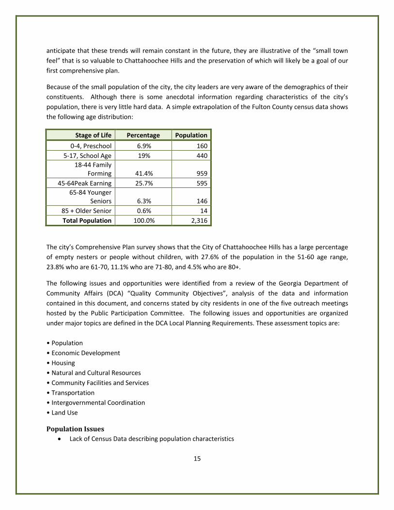
Because of the small population of the city, the city leaders are very aware of the demographics of their constituents. Although there is some anecdotal information regarding characteristics of the city’s population, there is very little hard data. A simple extrapolation of the Fulton County census data shows the following age distribution:
Stage of Life Percentage Population
0-4, Preschool 6.9% 160 5-17, School Age 19% 440
18-44 Family Forming 41.4% 959
45-64Peak Earning 25.7% 595 65-84 Younger
Seniors 6.3% 146 85 + Older Senior 0.6% 14 Total Population 100.0% 2,316
The city’s Comprehensive Plan survey shows that the City of Chattahoochee Hills has a large percentage of empty nesters or people without children, with 27.6% of the population in the 51-60 age range, 23.8% who are 61-70, 11.1% who are 71-80, and 4.5% who are 80+.
The following issues and opportunities were identified from a review of the Georgia Department of Community Affairs (DCA) “Quality Community Objectives”, analysis of the data and information contained in this document, and concerns stated by city residents in one of the five outreach meetings hosted by the Public Participation Committee. The following issues and opportunities are organized under major topics are defined in the DCA Local Planning Requirements. These assessment topics are: • Population • Economic Development • Housing • Natural and Cultural Resources • Community Facilities and Services • Transportation • Intergovernmental Coordination • Land Use
Population Issues • Lack of Census Data describing population characteristics
16
Economic Development
Economic Development Issues • Need for consistent branding of the Chattahoochee Hills vision of rural countryside and
villages/hamlets/sustainable development pattern
• Need for city code and financial mechanisms that facilitate economically and environmentally sustainable growth and traditional neighborhood development desired by the citizens of Chattahoochee Hills
• Marketing the City of Chattahoochee Hills as a model for regional development
• Placement of infrastructure to be cost effective and facilitate the type of growth desired by the citizens of Chattahoochee Hills
• Development of a framework to enable TDRs and the conservation easement process to offer maximum value to both sellers and recipients of the development credits
• Consideration of mitigation credits for any other environmental consideration that might conserve open space. Mitigation credits can be a big business for developers, GDOT, county and local governments, private business, etc.
• Promoting economic growth while maintaining 60-80% preservation/conservation
• Guidance for development of the city being professionally ‘expert’ driven (rather than politically driven)
• Quality of the schools in the city must improve to attract families with school age children
• How to market to preferred types of companies that emphasize the environment, green industry, green building, technology, professional development, health care, engineering, technical and scientific development and education
• Options to improve the city’s tax base except for conventional suburban sprawl
Economic Development Opportunities • Business incubator in Serenbe
• Local food movement requires locally grown food and may provide opportunities to promote agricultural activity in the city
• Planned development pattern of villages and hamlets is well accepted by local community
17
Housing
Housing Issues • Lack of housing data from the Census
• Consideration of the building code in the context of the Chattahoochee Hills brand with the need for design guidelines to encourage architectural variety, but require high quality and possibly green building
• Can TND neighborhood style development be affordable?
• TND can require mass grading by developers. How will greenspace and viewsheds be preserved?
• A preponderance of empty-nester and senior citizen households may present the city with housing challenges in future years when aging in place and housing specifically for seniors could become issues. When the 2010 census is released it will be important to reexamine Chattahoochee Hills’ population trends. The city will need to plan for housing options are provided to meet the needs of the aging population.
• Public perception of a lack of housing affordable for young families when the median house price is low for the Atlanta region
• Concern for housing for all life stages and price ranges, along with opposition to apartment complexes and mobile homes
• A consistent “no subdivisions” and “no cul-de-sacs” message from citizens vs. developers who don’t know how to or can’t get financing to build anything but conventional subdivisions
• Continued support for village/hamlet style development with live/work units
• Access to houses for fire trucks
Housing Opportunities • Planned villages and hamlets are excellent locations for a variety of housing types.
• Chattahoochee Hills has a relatively low median single family home price in the Atlanta region.
18
Natural and Cultural Resources
Natural and Cultural Resources Issues • Current TDR program, good in concept, is not preserving land now. Alternative mechanisms
that accelerate the preservation process in an equitable and transparent ways need to be considered.
• How land preservation is made permanent needs to be defined. Is it through easements? Deed restrictions? Non-profit bodies? The city needs to codify the definition of preservation – what ’counts’? Wetlands? Stream buffers? Steep slopes? Forests? Farms? A decision is needed on how much is ‘preserved’? (Is it percentage based? Is it certain high-value viewscapes and roadways? Are there other metrics?), and what are the priorities? What are the funding mechanisms for preservation? How much are ‘real’ agricultural uses and users desired? How will they be protected?
• The community wants the ‘look and feel’ of Chattahoochee Hills to stay the same – permanent preservation of our rural character, as possible. Preservation of the city’s rural roads’ driving appearance through visual buffering and other methods should be considered.
• Citizens do not have public access to the Chattahoochee River
• Maintaining the ability to hunt and fish in the city limits
• Illegal dumping
• Focus on promoting nodal density and preventing suburban sprawl while preserving as much of the rural character as possible in the non-developed areas. The limited funding structure for the city makes it difficult to prepare for the speed and scale of anticipated growth.
• The size and number of villages and other forms (and locations and final borders), part of the previously adopted Comprehensive Plan, need recalibration due to annexations.
• The current zoning has major flaws. It does not allow for best practices and actually limits the flexibility needed for real innovation.
• Contamination levels of local streams, lakes and the Chattahoochee River
• Fear that preservation of natural resources equals loss of private property rights
Natural and Cultural Resources Opportunities • City has recently purchased all parkland within its borders. This is an excellent opportunity for
preserving open space and habitat for wildlife.
19
Community Facilities and Services
Community Facilities and Services Issues • Wish list includes new city hall, courthouse, and local jail, community building, community clubs,
exercise area, pool, sports complex, walking trails, bike trails, park behind city hall, development of Rico Park (concessions, bleachers, walking track, etc.), improved internet service, continuing education facilities, elementary school, middle school and high school, amphitheater, and performing arts center
• Relocation of city government facilities to a village
Community Facilities and Services Opportunities • The City of Chattahoochee Hills has recently purchased all of the parkland in the city limits.
Transportation
Transportation Issues • Strong support for and strong opposition to the notion of public transportation.
• Common desire for improved connecting trails for multiple uses (bikes, horses, hiking, ATV’s) and novel road improvements (like roundabouts) to improve capacity without harming the rural look
• A desire to build new higher capacity roads where needed while keeping existing roads as they are, with development concentrated along the South Fulton Parkway corridor.
• What are the local transportation priorities (roundabouts instead of traffic lights, preference for traffic calming measures, etc.)?
• Desire to bring actual ferry back to cross Chattahoochee at least on the weekends
• A number of bridges in the city have low sufficiency ratings and will need to be replaced.
• State and federal money for transportation improvements is limited.
• Bike riders are sometimes viewed as a nuisance in the community.
Transportation Opportunities • The City of Chattahoochee Hills has minimal traffic indicated by relatively low traffic counts on
all of its roads.
• The city has received funding to construct the first leg of the city’s planned trail system.
• The South Fulton Parkway Access Study is underway.
• The Atlanta Regional Commission plans to start a South Fulton Comprehensive Transportation Plan in 2001.
20
Intergovernmental Coordination
Intergovernmental Coordination Issues • A number of different local governments make up the original Hill Country area, up to seven in
the expanded 65,000-acre area (Palmetto, City of Chattahoochee Hills, Fulton County, and parts of Coweta, Carroll and Douglas Counties). While the city is not responsible for those areas, they all can benefit from participation at some level in a preservation program. Preservation tools that can easily cross-governmental boundaries should be discussed with neighboring jurisdictions. Each government would need to adopt exactly the same ordinances (zoning and TDR’s) for the TDR concept to work.
• How will impacts of development on the city’s borders be addressed? Consider how to handle the areas that were in the overlay but not in the cityhood bill, the areas that were annexed out before cityhood, and the buffer areas of similar land that surround us, particularly in the context of nearby development patterns.
• Property is taxed at the "land use" level by Fulton Co. Taxing property on the "use value" is a critical factor in allowing our citizens to hold on to the land they have. When development takes off, land values will increase, and taxes will increase under the current broad-brush valuation model. People will be taxed off the land. This issue needs to be addressed by all local governments in Fulton County.
• Community concerns regarding being part of Fulton County
• Desire to set a local, regional and national example
• Desire to build cooperative relationships with nearby local governments and explore possibility of shared services
Intergovernmental Coordination Opportunities • The South Fulton Parkway Alliance meets regularly. • Joint planning efforts are already underway for the South Fulton Parkway Access Management
Study. • New Comprehensive Transportation Study for all of South Fulton will begin in 2011.
21
Land Use
Land Use Issues • Developments approved to date have required many variances, and have as yet not created
much real preservation. Current codes require modification if they are to succeed in their goal of preserving the rural character of the community.
• Zoning code needs to be updated to support the often-articulated common community vision of utilizing best practices to achieve desired development pattern. There are zoning districts in the ordinance that are not compatible with the currently adopted Comprehensive Plan.
• Current zoning is almost silent on development outside of villages, hamlets and conservation subdivisions, which could allow for development that is not in keeping with community desires.
• As originally conceived, the three villages and multiple hamlets envisioned will create around 30,000 units of housing in the Hill country – with an eventual population of up to 100,000 or more. (Not all within the current boundaries of the city.) In the Atlanta metropolitan area, this level of development is typically a recipe for a level of sprawl that would cover our entire community, leaving nothing of the current character.
• Lack of economic incentives for dense, nodal development in villages and hamlets, and disincentives for conventional suburban sprawl.
• Need to address the loss of 1-½ of our villages
• Community values issues including: dark sky and sign ordinances, etc.
• Minimum and maximum sizes of villages, hamlets and conservation subdivisions, consideration of new forms (larger villages or ‘towns’, for example)
• Incentives for ‘real’ farming, and how the AG-1 code fits with the community vision
• Balance between the level of regulation and community values that support personal freedom, but are sometimes conflicted on ‘neighbor freedom’. What is the minimum level of regulation that permanently enforces a community’s agreed concepts while not being so restrictive as to not allow for incorporation of future good ideas, and preservation and development concepts?
• Input of major landowner / developers. Their buy-in and success are required drivers of this process. A good outcome for them helps insure a good outcome for the community, as their impact fees and development spending will drive much of the needed city revenue.
• Concerns regarding development without city water or sewer available
• Concern about options for landowners to realize financial benefit from their land, without selling it to a developer
• Preservation of the rural character of the area
• Existing AG-1 zoning allows lots as small as one acre in size which is not consistent with rural character but with suburban large lot zoning.
22
• Protection of the South Fulton Scenic Byway, the State’s first, through strict development regulations and standards, especially when the Byway intersects one of the Hill Country’s crossroads communities
• Preservation of viewsheds of lakes and streams, farmland, horse pastures, riparian corridors and mature forests that are prevalent throughout the City of Chattahoochee Hills
• Preservation of historical and cultural sites throughout the City of Chattahoochee Hills with regards to the placement, size and type of future development. Any future development must occur sensitively on the land to respect the area’s historic and cultural significance.
Land Use Opportunities • The City of Chattahoochee Hills has a history of land use planning that supports the vision of
villages, hamlets and preserved open space including the CHC Land Use Plan and Community Guidelines, the CHC Overlay District Ordinance (for South Fulton County) and a Transfer of Development Rights Program. Through a community led and participative process, the Chattahoochee Hill County Alliance created the Chattahoochee Hill Country Community Plan, clustering development into the villages and hamlets. The Plan was incorporated into the South Fulton 2015 Amended Comprehensive Land Use Plan and the Fulton County Chattahoochee Hill Country Overlay District Ordinance.
• There is a high level of recognition of the level of developmental pressure that will come to bear on our area – and that fact that we cannot reasonably exist as a city without good development that (through tax revenues) supports both the city’s day-to-day operating needs and the common preservation vision.
23
PART III. ANALYSIS OF EXISTING DEVELOPMENT PATTERNS The purpose of analyzing existing land use is to enhance the community’s understanding of the geographic distribution of land uses leading to an understanding of the development patterns in the city. The process of developing a land use plan involves the analysis of existing land use patterns. This includes analysis of current and future public services and facilities. The analysis will further explore the physical environmental issues and opportunities that are related to land development and serve as the basis for long range growth and development in the city.
Geography The area that comprises the City of Chattahoochee Hills is approximately 38,000 acres and is defined and characterized by both the natural and built environment. It is a triangular-shaped landmass, bordered to the northwest by the Chattahoochee River, to the south by the Fulton/Coweta County line, and to the northeast by Pea Creek. Geographically, the City of Chattahoochee Hills lies in the Piedmont region and is characterized by rolling to hilly terrain, rocky outcroppings, and broad uplands with floodplains along several tributaries. Pea, Bear, White Oak, Tuggle, Cedar, and Turkey Creek are the main tributaries (and stream basins) which flow roughly east to west though the Hill Country into the Chattahoochee River. The area was
originally covered with oak, hickory and pine forest, much of which was cleared during the 19th
century for cultivation, and today has reverted back to secondary growth forest of mostly pines and hardwood mix, as agriculture became less desirable. However, open fields, pasturelands, and horse farms still exist, and are often cited by residents as characteristic of the areas’ celebrated rural nature.
Development Types There are four main development types in the City of Chattahoochee Hills: Agricultural, Crossroads Community, Hamlet and Suburban. Agriculture is the primary land use in the city. It is characterized by large tracts of land used for crop farming, pasture land, and forestry. Many large tracts of land in the city are zoned and suitable for agricultural activities but some are inactive at this time, often only containing a house. Crossroads communities are found at the intersections of one or more roads in a rural setting and have the appearance of a small village. They generally consist of a nucleus of landmark buildings and businesses such as churches, general stores and schools, surrounded by outlying residential development. There are five crossroads communities in the City of Chattahoochee Hills: Rivertown, Rico, County Line/Redwine, Goodes and Friendship. Each has its own distinct history, yet they also all share a connectedness due to their close proximity and through the families and people of the area who lived, went to school, worked and worshiped in them. The Rico, Redwine, and Rivertown communities developed in the early and mid-1800’s, in the western part of the city’s area nearer the Chattahoochee River.
24
Rivertown was once dominated by the Jones and Yates families who operated a cotton gin and leased their land holdings for tenant farming. The community of Rico, currently the largest remaining community, has numerous residential buildings, including a general store, two churches, the Old Rico School (now City Hall) and the Rico Lodge, which are located at intersections of Campbellton-Redwine, Kite and Rico Roads. A dilapidated general store, a few tenant houses and the antebellum Redwine Plantation house mark the area of the Redwine Community, located at the intersection of Campbellton-Redwine Road and Hutcheson Ferry Road. The communities of Goodes and Friendship to the east are somewhat newer, having developed in the late nineteenth century. Goodes once had a post office, general store and a school, but today is mainly a collection of residential structures. Friendship comprises the Friendship Baptist Church, the old Caldwell general store, the Civil War era Cook-Goodes House and a few other houses at the intersection of Cochran Mill Road and Rivertown Road. Serenbe is the City of Chattahoochee Hills’ only currently developed hamlet. A hamlet is a mixed use development with 60 percent open space that allows office, retail, and residential uses, with a maximum residential density of one house per acre. Serenbe has 1000 acres, with about 120 of a planned 1000 housing units and supporting retail and commercial buildings in place. The grounds also include an inn and an organic farm. There is one developed conventional suburban subdivision, Crossroads, off of Wilkerson Mill Road, that was developed in the early 1980’s. The layout of Crossroads reflects a typical suburban pattern with only one entrance to the development for 150+ houses and numerous cul-de-sacs. Houses in the Crossroads subdivision are on lots that are approximately 10,000 square feet in size. The subdivision is served by Fulton County Sewer. This subdivision has been one of the city’s main code enforcement problem areas. The city also has two abandoned subdivisions: Arbor Reserve and Bear Creek. No houses were ever built in Arbor Reserve, which was preliminary platted with 107 lots. Bear Creek was platted with 124 lots in phase one and 129 lots in phase two. There were seven houses built before the city was incorporated, all of which were torn down before they were occupied. Both subdivisions have had numerous erosion control problems and illegal dumping. Both stand vacant with uncertain futures. Two additional developments have received at least initial planning approval, but are not platted. Friendship Village is a Chattahoochee Hills village approved in 2007, located on Rivertown Road north of the South Fulton Parkway, with approximately 40% of the development within the city boundary. While
25
it is ultimately planned to include over 5500 residential units and a great deal of supporting mixed-use commercial and retail, work has not yet started. Foxhall Farms is a large-lot conservation subdivision of approximately 100 lots planned for the area between Whiteside Road and the Chattahoochee River. Work has not yet started.
Existing Land Use Inventory The Georgia Department of Community Affairs (DCA) states in its Local Planning Requirements that a community’s planning goals and objectives assure land use planning in support of efficient growth and development patterns that will promote sustainable economic development, protection of natural and cultural resources, and provision of adequate and affordable housing. The following analysis presents three components of existing development patterns: Existing Land Use, Areas Requiring Special Attention, and Character Areas. The existing land use map is a representation of current conditions on the ground during the preparation of the Community Assessment. The existing land use map has been prepared on information available as of March 2010. Existing land use information for the City of Chattahoochee Hills was gathered from a field survey completed in March of 2010. Land uses are classified into the eight standard land use classifications as described in DCA’s planning Standards and Procedures for Local Comprehensive Planning. Residential The predominant use of land within the residential category is for single family and multi-family dwelling units organized into general categories of net densities. Commercial This category is for land dedicated to non-industrial business uses, including retail sales, office, service and entertainment facilities, organized into general categories of intensities. Commercial uses may be located as a single use in one building or grouped together in a shopping center or office building. Communities may elect to separate office uses from other commercial uses, such as retail, service or entertainment facilities. Industrial This category is for land dedicated to manufacturing facilities, processing plants, factories, warehousing and wholesale trade facilities, mining or mineral extraction activities, or other similar uses. Public/Institutional This category includes certain state, federal or local government uses, and institutional land uses. Government uses include city halls and government building complexes, police and fire stations, libraries, prisons, post offices, schools, military installations, etc. Examples of institutional land uses include colleges, churches, cemeteries, hospitals, etc. Do not include facilities that are publicly owned, but would be classified more accurately in another land use category. For example, include publicly
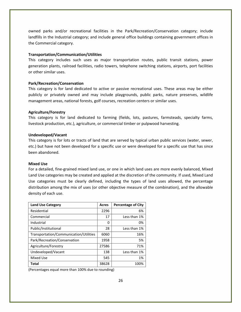
26
owned parks and/or recreational facilities in the Park/Recreation/Conservation category; include landfills in the Industrial category; and include general office buildings containing government offices in the Commercial category. Transportation/Communication/Utilities This category includes such uses as major transportation routes, public transit stations, power generation plants, railroad facilities, radio towers, telephone switching stations, airports, port facilities or other similar uses. Park/Recreation/Conservation This category is for land dedicated to active or passive recreational uses. These areas may be either publicly or privately owned and may include playgrounds, public parks, nature preserves, wildlife management areas, national forests, golf courses, recreation centers or similar uses. Agriculture/Forestry This category is for land dedicated to farming (fields, lots, pastures, farmsteads, specialty farms, livestock production, etc.), agriculture, or commercial timber or pulpwood harvesting. Undeveloped/Vacant This category is for lots or tracts of land that are served by typical urban public services (water, sewer, etc.) but have not been developed for a specific use or were developed for a specific use that has since been abandoned. Mixed Use For a detailed, fine-grained mixed land use, or one in which land uses are more evenly balanced, Mixed Land Use categories may be created and applied at the discretion of the community. If used, Mixed Land Use categories must be clearly defined, including the types of land uses allowed, the percentage distribution among the mix of uses (or other objective measure of the combination), and the allowable density of each use.
Land Use Category Acres Percentage of City
Residential 2296 6%
Commercial 17 Less than 1%
Industrial 0 0%
Public/Institutional 28 Less than 1%
Transportation/Communication/Utilities 6060 16%
Park/Recreation/Conservation 1958 5%
Agriculture/Forestry 27586 71%
Undeveloped/Vacant 138 Less than 1%
Mixed Use 545 1%
Total 38628 100%
(Percentages equal more than 100% due to rounding)
27
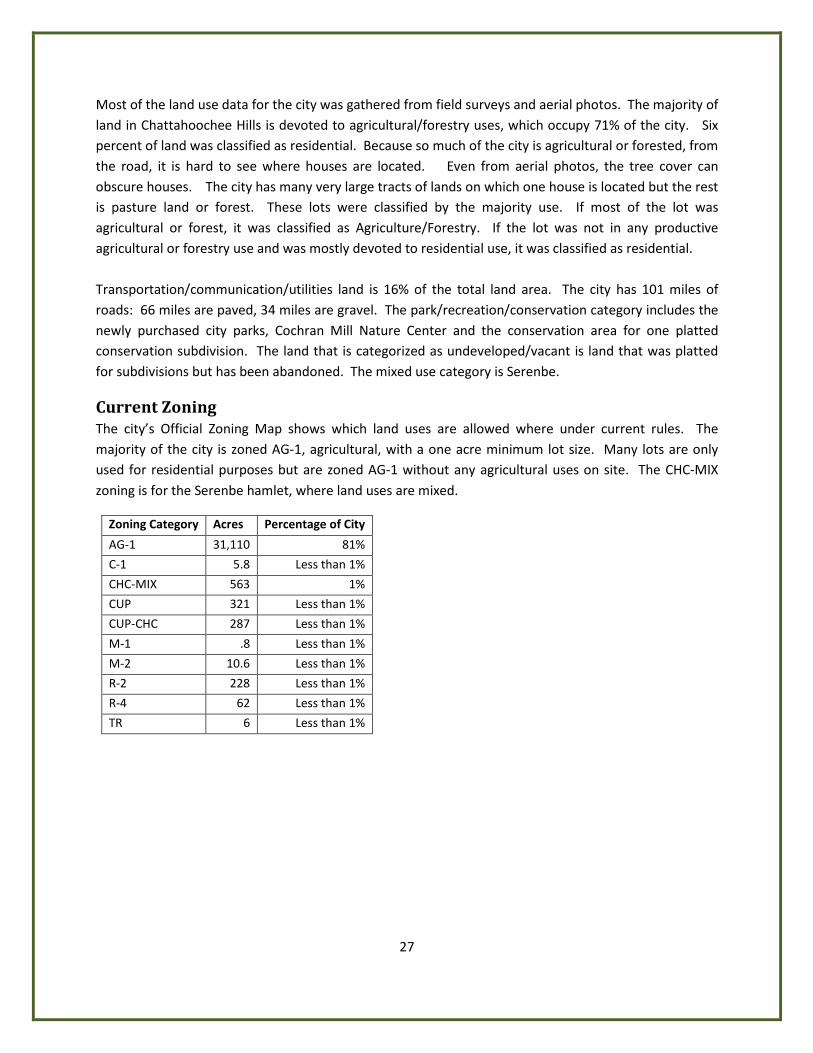
Most of the land use data for the city was gathered from field surveys and aerial photos. The majority of land in Chattahoochee Hills is devoted to agricultural/forestry uses, which occupy 71% of the city. Six percent of land was classified as residential. Because so much of the city is agricultural or forested, from the road, it is hard to see where houses are located. Even from aerial photos, the tree cover can obscure houses. The city has many very large tracts of lands on which one house is located but the rest is pasture land or forest. These lots were classified by the majority use. If most of the lot was agricultural or forest, it was classified as Agriculture/Forestry. If the lot was not in any productive agricultural or forestry use and was mostly devoted to residential use, it was classified as residential. Transportation/communication/utilities land is 16% of the total land area. The city has 101 miles of roads: 66 miles are paved, 34 miles are gravel. The park/recreation/conservation category includes the newly purchased city parks, Cochran Mill Nature Center and the conservation area for one platted conservation subdivision. The land that is categorized as undeveloped/vacant is land that was platted for subdivisions but has been abandoned. The mixed use category is Serenbe.
Current Zoning The city’s Official Zoning Map shows which land uses are allowed where under current rules. The majority of the city is zoned AG-1, agricultural, with a one acre minimum lot size. Many lots are only used for residential purposes but are zoned AG-1 without any agricultural uses on site. The CHC-MIX zoning is for the Serenbe hamlet, where land uses are mixed.
Zoning Category Acres Percentage of City
AG-1 31,110 81%
C-1 5.8 Less than 1%
CHC-MIX 563 1%
CUP 321 Less than 1%
CUP-CHC 287 Less than 1%
M-1 .8 Less than 1%
M-2 10.6 Less than 1%
R-2 228 Less than 1%
R-4 62 Less than 1%
TR 6 Less than 1%

RICO RD
SOUTH FULTON PW
RIVERTOWN RD
CAMP
B EL L
T ON
REDW
INE
R D
HUTCHESON FERRY RD
JONES FE RRY RD
KITE R
D
UP PER WOOTEN RD
CAPPS FERRY RD
PHILL
IPS
RD
O LD RICO RD
H AMI LTO N RD
SARD
IS R
D
OL D H AMILTON RD
PACE
R D
WATKINS R D
M IXON RD
PETERS BURG RD
HOPKINS RD
HEAR
N RD
BARNES RD
WILKERSON MILL RD
VERN
ON G
ROVE
RD
BRAZ
ELL R
D
WHITESIDE R D
ATLANTA NEW NAN R D
CRE EL RD
C OCHRAN MI LL R D
SELBORNE L N
CASCADE PALMETTO HW
GARRETTS FERRY RD
STEE D R D
WOO DRUF F RD
CEDA
R GR
OVE R
D
RICO TATUM R D
W ATE
R W
ORKS RD
JENK
INS
RD
OLD
P HILL
IPS
R D
MANSFIELD DR
BULLARD RD
BULLA RD WY
BRUI
N W
Y
RI CO LAKE RD
HENRY M I LL RD
SERE
NBE
LN
DRIVEWAY
RIVE
R LA
KE D
R
SELBORNE WAY
GRAV
EL R
D
CAINEY LN
MUT T RD
P INE Y WOO DS CHURCH RD
BEAV
ER RD
TAB WY
OLD COCHRAN RD
RICO WY
TIDER
ACE
CT
BIG BEAR CT
WHITESIDE RD
CAIN
EY LN
WILKE RSON MILL RD
WOODRUFF RD
MIXO N RD
RIC O TATUM RD
ATLA
NTA N
EWNA
N RD
COCH
RAN M
ILL R
D
CAP PS F E RRY R
D
WOODRUFF RD
JENKINS RD
PHILLIPS RD
SOUTH FULTON PW
RIVERTOWN RD
RIVERTOWN RD
COCHRAN MILL
RD
JONES FERRY RD
Existing Land UseUses
ResidentialCommercialIndustrialPublic / InstitutionalTransportation /Communication / UtilitiesParks / Recreation / ConservationAgricultual / ForestryUnedveloped / VacantMixed Use
±0 1 2 3 40.5
Miles
29
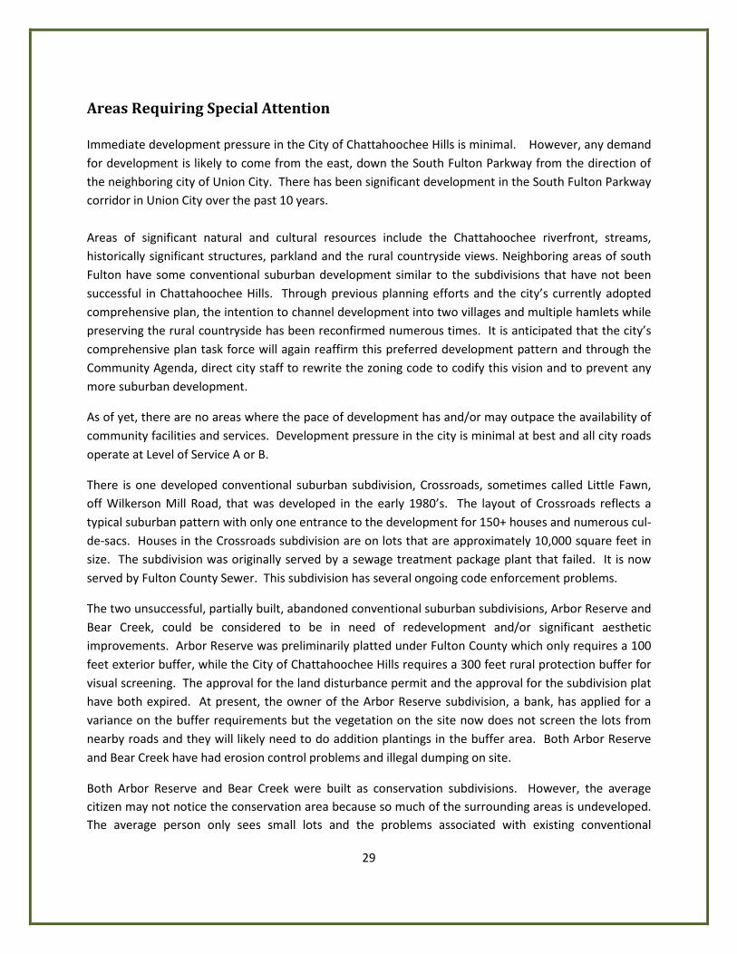
Areas Requiring Special Attention Immediate development pressure in the City of Chattahoochee Hills is minimal. However, any demand for development is likely to come from the east, down the South Fulton Parkway from the direction of the neighboring city of Union City. There has been significant development in the South Fulton Parkway corridor in Union City over the past 10 years. Areas of significant natural and cultural resources include the Chattahoochee riverfront, streams, historically significant structures, parkland and the rural countryside views. Neighboring areas of south Fulton have some conventional suburban development similar to the subdivisions that have not been successful in Chattahoochee Hills. Through previous planning efforts and the city’s currently adopted comprehensive plan, the intention to channel development into two villages and multiple hamlets while preserving the rural countryside has been reconfirmed numerous times. It is anticipated that the city’s comprehensive plan task force will again reaffirm this preferred development pattern and through the Community Agenda, direct city staff to rewrite the zoning code to codify this vision and to prevent any more suburban development.
As of yet, there are no areas where the pace of development has and/or may outpace the availability of community facilities and services. Development pressure in the city is minimal at best and all city roads operate at Level of Service A or B.
There is one developed conventional suburban subdivision, Crossroads, sometimes called Little Fawn, off Wilkerson Mill Road, that was developed in the early 1980’s. The layout of Crossroads reflects a typical suburban pattern with only one entrance to the development for 150+ houses and numerous cul-de-sacs. Houses in the Crossroads subdivision are on lots that are approximately 10,000 square feet in size. The subdivision was originally served by a sewage treatment package plant that failed. It is now served by Fulton County Sewer. This subdivision has several ongoing code enforcement problems.
The two unsuccessful, partially built, abandoned conventional suburban subdivisions, Arbor Reserve and Bear Creek, could be considered to be in need of redevelopment and/or significant aesthetic improvements. Arbor Reserve was preliminarily platted under Fulton County which only requires a 100 feet exterior buffer, while the City of Chattahoochee Hills requires a 300 feet rural protection buffer for visual screening. The approval for the land disturbance permit and the approval for the subdivision plat have both expired. At present, the owner of the Arbor Reserve subdivision, a bank, has applied for a variance on the buffer requirements but the vegetation on the site now does not screen the lots from nearby roads and they will likely need to do addition plantings in the buffer area. Both Arbor Reserve and Bear Creek have had erosion control problems and illegal dumping on site.
Both Arbor Reserve and Bear Creek were built as conservation subdivisions. However, the average citizen may not notice the conservation area because so much of the surrounding areas is undeveloped. The average person only sees small lots and the problems associated with existing conventional
30
suburban subdivisions in the community. Because of these concerns, there is a strong sentiment against this type of development. The City of Chattahoochee Hills has no strip commercial corridors or large abandoned structures or sites. Because the city is mostly agricultural or forestry, infill development opportunities are usually not considered. Most development in the city is greenfield development. There are no identifiable areas of significant disinvestment. Information regarding levels of poverty and/or unemployment is not available for the city due to lack of Census data.
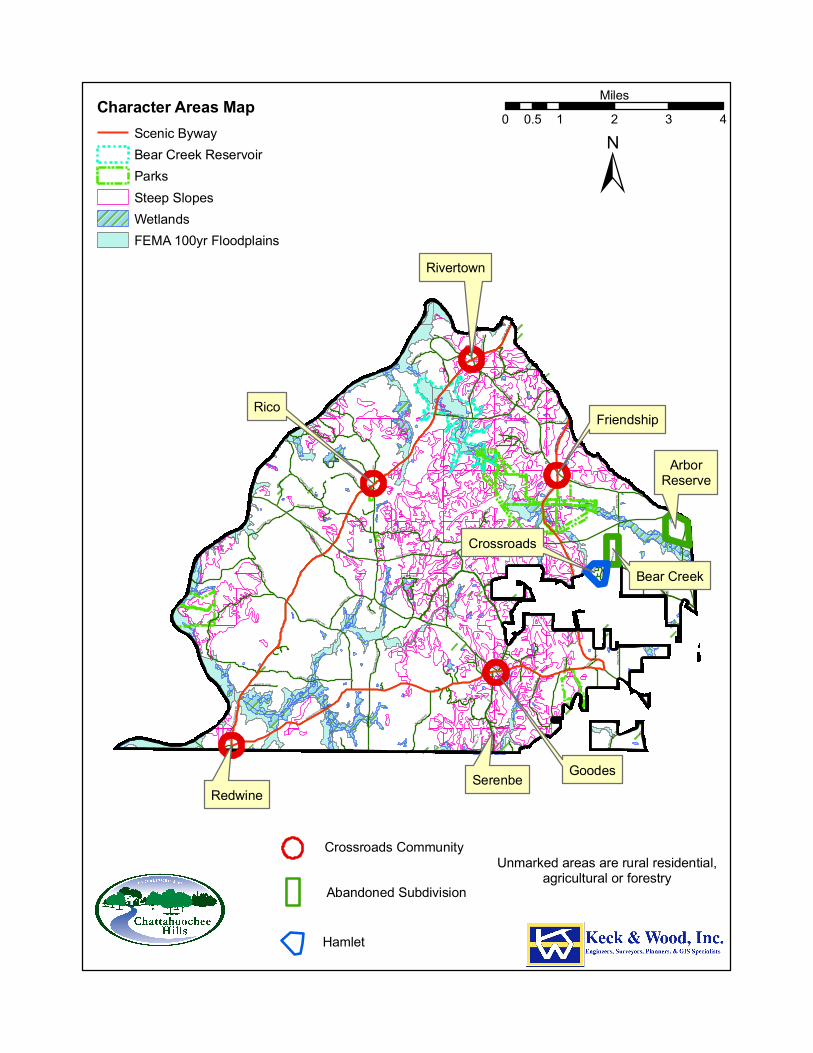
Character Areas The Character Areas Map for the city clearly shows many of the development constraints in the city. The proposed Bear Creek reservoir, city parks, floodplains, wetlands, steep slopes and scenic byways are shown on the map. Obviously the reservoir, parks, floodplains, wetlands and probably steep slopes are unbuildable areas. These areas are best designated for conservation. Along the entire frontage of the Scenic Byways, shown on page 97, a 100-foot natural, undisturbed buffer is required along the right-of-way with an additional 10-foot setback interior to the buffer. Only existing AG-1 (Agricultural) uses and pedestrian and bicycle paths are permitted in the setback. This standard applies to all properties with frontage on a Scenic Byway and along the rights-of-way of public roads which intersect a Scenic Byway for a distance of 300 feet measured from the intersection with the Scenic Byway. These rules make it difficult but not impossible to build on the Scenic Byways. Properties along the Scenic Byways are best for agriculture and forestry and rural residential uses. Crossroads communities are found at the intersections of one or more roads in a rural setting, along the Scenic Byways, and have the appearance of a small village. They generally consist of a nucleus of historic buildings and businesses such as churches, general stores and schools, surrounded by outlying residential development. There are five crossroads communities in the City of Chattahoochee Hills: Rivertown, Rico, County Line/Redwine, Goodes and Friendship. Each has its own distinct history that should be preserved. Any development in the crossroads communities should enhance the historic location. From Cochran Mill Park, south along Cochran Mill Road to Wilkerson Mill Road a greenway/trail is planned. The trail goes under South Fulton Parkway with a bridge large enough to ride a horse under. Full engineered plans for the project were completed by Fulton County and construction funds are programmed in the Atlanta Regional Commission’s 2008-2013 Transportation Improvement Program.
Because of the problems with existing conventional suburban subdivisions in the community, there is a strong sentiment against this type of development and it will likely be restricted in the future. Villages and hamlets are mixed use developments. Villages are larger, from 500 to 640 acres plus the rural protection buffer for visual screening. Hamlets are smaller, starting at 200 acres. One village
RICO RD
SOUTH FULTON PW
RIVERTOWN RD
CAMP
B EL L
T ON
REDW
INE
R D
HUTCHESON FERRY RD
JONES FE RRY RD
KITE R
D
UP PER WOOTEN RD
CAPPS FERRY RD
PHILL
IPS
RD
O LD RICO RD
H AMI LTO N RD
SARD
IS R
D
OL D H AMILTON RD
PACE
R D
WATKINS R D
M IXON RD
PETERS BURG RD
HOPKINS RD
HEAR
N RD
BARNES RD
WILKERSON MILL RD
VERN
ON G
ROVE
RD
BRAZ
ELL R
D
WHITESIDE R D
ATLANTA NEW NAN R D
CRE EL RD
C OCHRAN MI LL R D
SELBORNE L N
CASCADE PALMETTO HW
GARRETTS FERRY RD
STEE D R D
WOO DRUF F RD
CEDA
R GR
OVE R
D
RICO TATUM R D
W ATE
R W
ORKS RD
JENK
INS
RD
OLD
P HILL
IPS
R D
MANSFIELD DR
BULLARD RD
BULLA RD WY
BRUI
N W
Y
RI CO LAKE RD
HENRY M I LL RD
SERE
NBE
LN
DRIVEWAY
RIVE
R LA
KE D
R
SELBORNE WAY
GRAV
EL R
D
CAINEY LN
MUT T RD
P INE Y WOO DS CHURCH RD
BEAV
ER RD
TAB WY
OLD COCHRAN RD
RICO WY
TIDER
ACE
CT
BIG BEAR CT
WHITESIDE RD
CAIN
EY LN
WILKE RSON MILL RD
WOODRUFF RD
MIXO N RD
RIC O TATUM RD
ATLA
NTA N
EWNA
N RD
COCH
RAN M
ILL R
D
CAP PS F E RRY R
D
WOODRUFF RD
JENKINS RD
PHILLIPS RD
SOUTH FULTON PW
RIVERTOWN RD
RIVERTOWN RD
COCHRAN MILL
RD
JONES FERRY RD
Character Areas MapScenic BywayBear Creek ReservoirParksSteep SlopesWetlandsFEMA 100yr Floodplains
±0 1 2 3 40.5
Miles
Rico
Rivertown
Friendship
RedwineGoodes
ArborReserve
Bear Creek
Crossroads
Crossroads Community
Hamlet
Abandoned Subdivision
Serenbe
Unmarked areas are rural residential,agricultural or forestry

32
location is designated partly in the City of Chattahoochee Hills and partly in unincorporated Fulton County. It is at South Fulton Parkway at Rivertown Road, close to the existing Friendship Crossroads Community. Over 5500 residential units and a great deal of supporting mixed-use commercial and retail are planned. The Friendship Village has received DRI approval from ARC and already has the necessary mixed zoning in the city (CHC-MIX), however the developer is not currently moving forward with the project.
Serenbe is the only developed hamlet. It is planned to be 1000 residential units. Three hamlets are planned but locations are not designated in the currently adopted Comprehensive Plan.
33
Quality Community Objectives In 1999 the Board of the Department of Community Affairs adopted the Quality Community Objectives (QCOs) as a statement of the development patterns and options that will help Georgia preserve unique cultural, natural and historic resources while developing to its fullest potential. The Office of Planning and Quality Growth has created the Quality Community Objectives Assessment to assist local governments in evaluating their progress towards sustainable and livable communities. This assessment is meant to give a community an idea of how it is progressing toward reaching these objectives set by the Department, but no community will be judged on progress. The assessment is a tool for use at the beginning of the comprehensive planning process, much like a demographic analysis or a land use map, showing a community “you are here.” Each of the fifteen QCOs has a set of yes/no questions, with additional space available for assessors’ comments. The questions focus on local ordinances, policies, and organizational strategies intended to create and expand quality growth principles. A majority of “yes” answers for an objective may indicate that the community has in place many of the governmental options for managing development patterns. “No’s” may provide guidance as to how to focus planning and implementation efforts for those governments seeking to achieve these Quality Community Objectives. Some assessors may be able to answer these questions without much research, particularly in communities with few or no land use controls. Others may need to review land use ordinances and zoning regulations to find the answers, but this initial assessment is meant to provide an overall view of the community’s policies, not an in-depth analysis. There are no right or wrong answers to this assessment. Its merit lies in completion of the document and the ensuing discussions regarding future development patterns as governments undergo the comprehensive planning process. Should a community decide to pursue a particular objective, it may consider a “yes” to each statement a benchmark toward achievement. Please be aware, however, that this assessment is an initial step. Local governments striving for excellence in quality growth may consider additional measures to meet local goals.
34
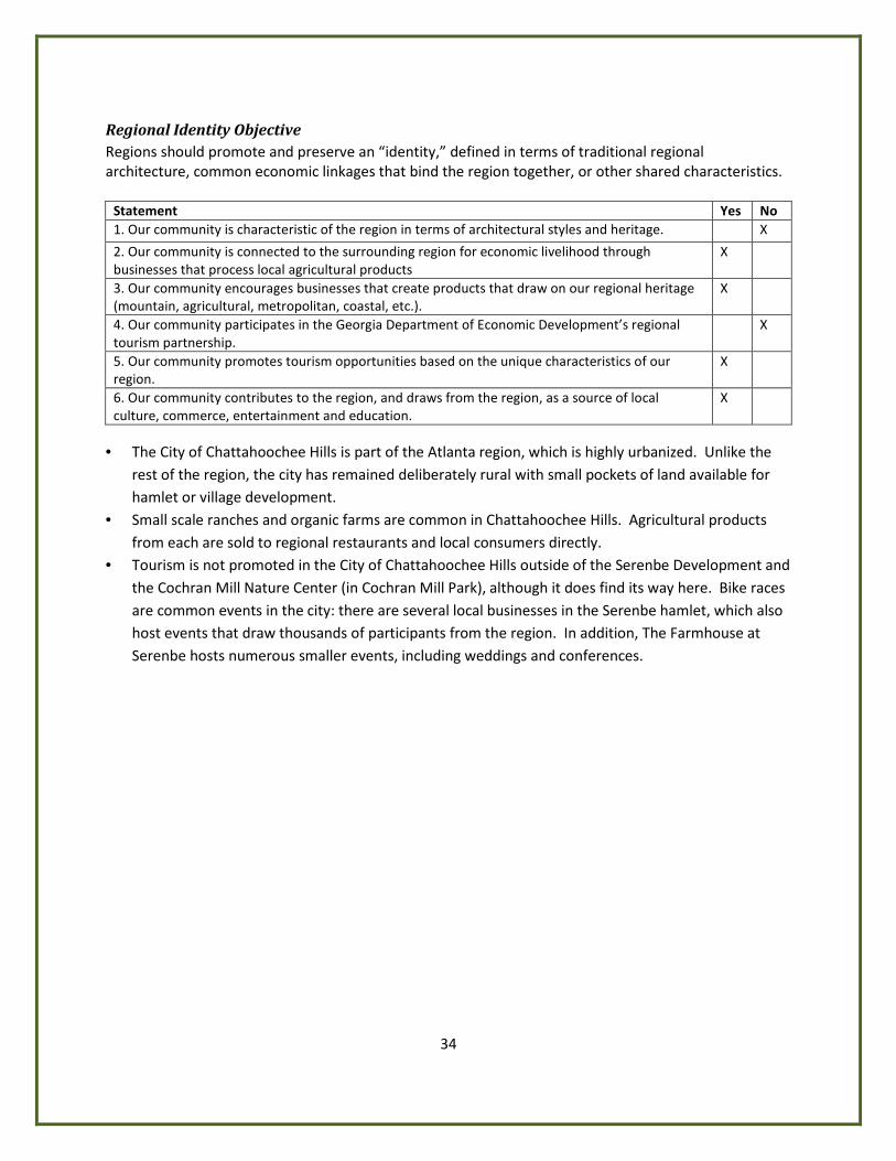
Regional Identity Objective Regions should promote and preserve an “identity,” defined in terms of traditional regional architecture, common economic linkages that bind the region together, or other shared characteristics.
Statement Yes No 1. Our community is characteristic of the region in terms of architectural styles and heritage. X
2. Our community is connected to the surrounding region for economic livelihood through businesses that process local agricultural products
X
3. Our community encourages businesses that create products that draw on our regional heritage (mountain, agricultural, metropolitan, coastal, etc.).
X
4. Our community participates in the Georgia Department of Economic Development’s regional tourism partnership.
X
5. Our community promotes tourism opportunities based on the unique characteristics of our region.
X
6. Our community contributes to the region, and draws from the region, as a source of local culture, commerce, entertainment and education.
X
• The City of Chattahoochee Hills is part of the Atlanta region, which is highly urbanized. Unlike the
rest of the region, the city has remained deliberately rural with small pockets of land available for hamlet or village development.
• Small scale ranches and organic farms are common in Chattahoochee Hills. Agricultural products from each are sold to regional restaurants and local consumers directly.
• Tourism is not promoted in the City of Chattahoochee Hills outside of the Serenbe Development and the Cochran Mill Nature Center (in Cochran Mill Park), although it does find its way here. Bike races are common events in the city: there are several local businesses in the Serenbe hamlet, which also host events that draw thousands of participants from the region. In addition, The Farmhouse at Serenbe hosts numerous smaller events, including weddings and conferences.
35
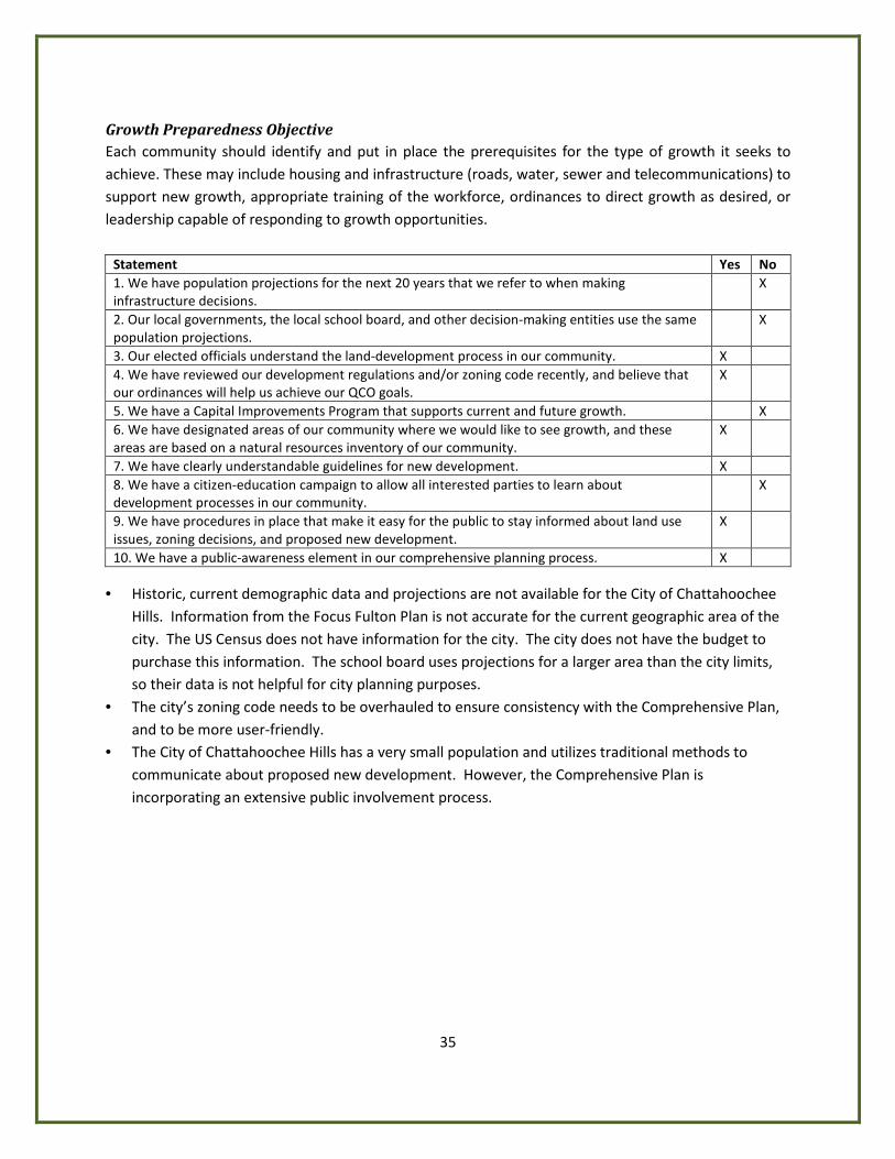
Growth Preparedness Objective Each community should identify and put in place the prerequisites for the type of growth it seeks to achieve. These may include housing and infrastructure (roads, water, sewer and telecommunications) to support new growth, appropriate training of the workforce, ordinances to direct growth as desired, or leadership capable of responding to growth opportunities.
Statement Yes No 1. We have population projections for the next 20 years that we refer to when making infrastructure decisions.
X
2. Our local governments, the local school board, and other decision-making entities use the same population projections.
X
3. Our elected officials understand the land-development process in our community. X 4. We have reviewed our development regulations and/or zoning code recently, and believe that our ordinances will help us achieve our QCO goals.
X
5. We have a Capital Improvements Program that supports current and future growth. X 6. We have designated areas of our community where we would like to see growth, and these areas are based on a natural resources inventory of our community.
X
7. We have clearly understandable guidelines for new development. X 8. We have a citizen-education campaign to allow all interested parties to learn about development processes in our community.
X
9. We have procedures in place that make it easy for the public to stay informed about land use issues, zoning decisions, and proposed new development.
X
10. We have a public-awareness element in our comprehensive planning process. X • Historic, current demographic data and projections are not available for the City of Chattahoochee
Hills. Information from the Focus Fulton Plan is not accurate for the current geographic area of the city. The US Census does not have information for the city. The city does not have the budget to purchase this information. The school board uses projections for a larger area than the city limits, so their data is not helpful for city planning purposes.
• The city’s zoning code needs to be overhauled to ensure consistency with the Comprehensive Plan, and to be more user-friendly.
• The City of Chattahoochee Hills has a very small population and utilizes traditional methods to communicate about proposed new development. However, the Comprehensive Plan is incorporating an extensive public involvement process.
36
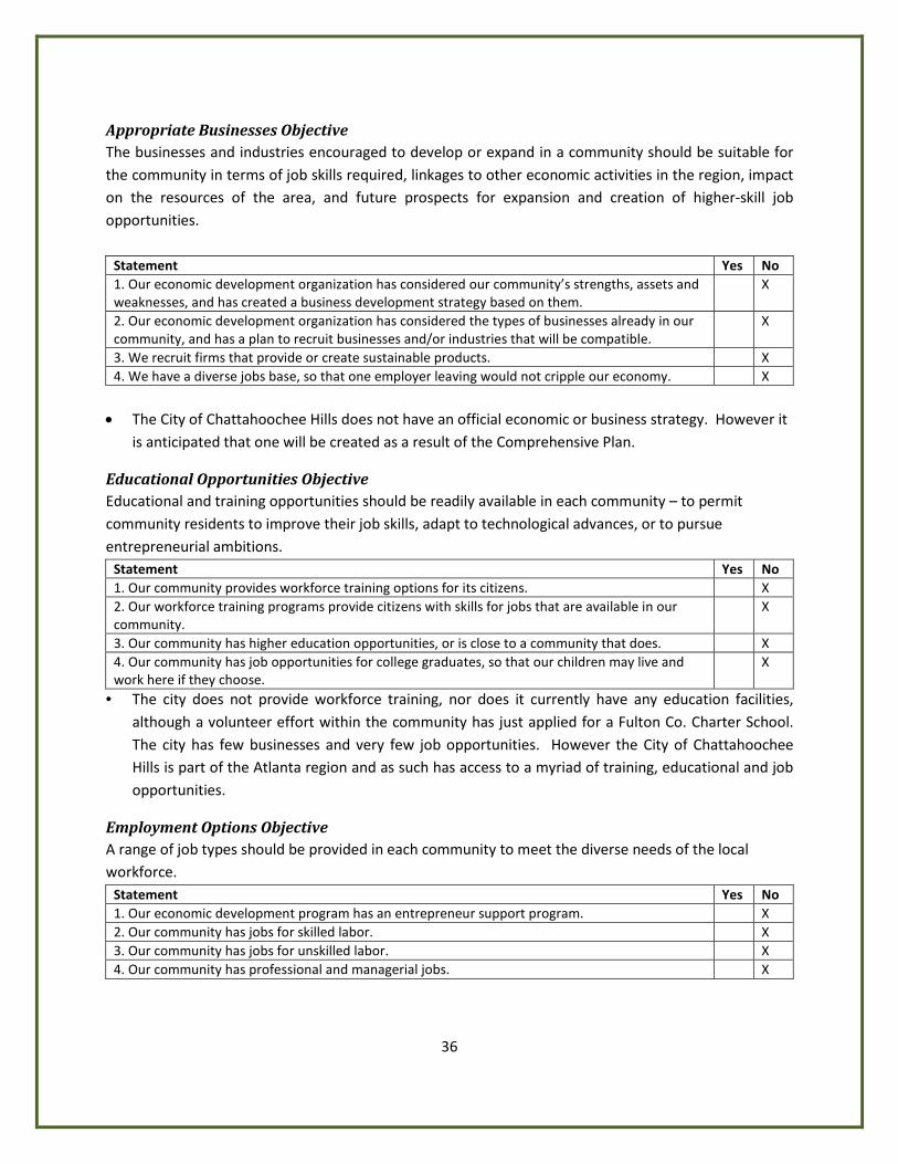
Appropriate Businesses Objective The businesses and industries encouraged to develop or expand in a community should be suitable for the community in terms of job skills required, linkages to other economic activities in the region, impact on the resources of the area, and future prospects for expansion and creation of higher-skill job opportunities.
Statement Yes No 1. Our economic development organization has considered our community’s strengths, assets and weaknesses, and has created a business development strategy based on them.
X
2. Our economic development organization has considered the types of businesses already in our community, and has a plan to recruit businesses and/or industries that will be compatible.
X
3. We recruit firms that provide or create sustainable products. X 4. We have a diverse jobs base, so that one employer leaving would not cripple our economy. X
• The City of Chattahoochee Hills does not have an official economic or business strategy. However it is anticipated that one will be created as a result of the Comprehensive Plan.
Educational Opportunities Objective Educational and training opportunities should be readily available in each community – to permit community residents to improve their job skills, adapt to technological advances, or to pursue entrepreneurial ambitions.
Statement Yes No 1. Our community provides workforce training options for its citizens. X 2. Our workforce training programs provide citizens with skills for jobs that are available in our community.
X
3. Our community has higher education opportunities, or is close to a community that does. X 4. Our community has job opportunities for college graduates, so that our children may live and work here if they choose.
X
• The city does not provide workforce training, nor does it currently have any education facilities, although a volunteer effort within the community has just applied for a Fulton Co. Charter School. The city has few businesses and very few job opportunities. However the City of Chattahoochee Hills is part of the Atlanta region and as such has access to a myriad of training, educational and job opportunities.
Employment Options Objective A range of job types should be provided in each community to meet the diverse needs of the local workforce.
Statement Yes No 1. Our economic development program has an entrepreneur support program. X 2. Our community has jobs for skilled labor. X 3. Our community has jobs for unskilled labor. X 4. Our community has professional and managerial jobs. X
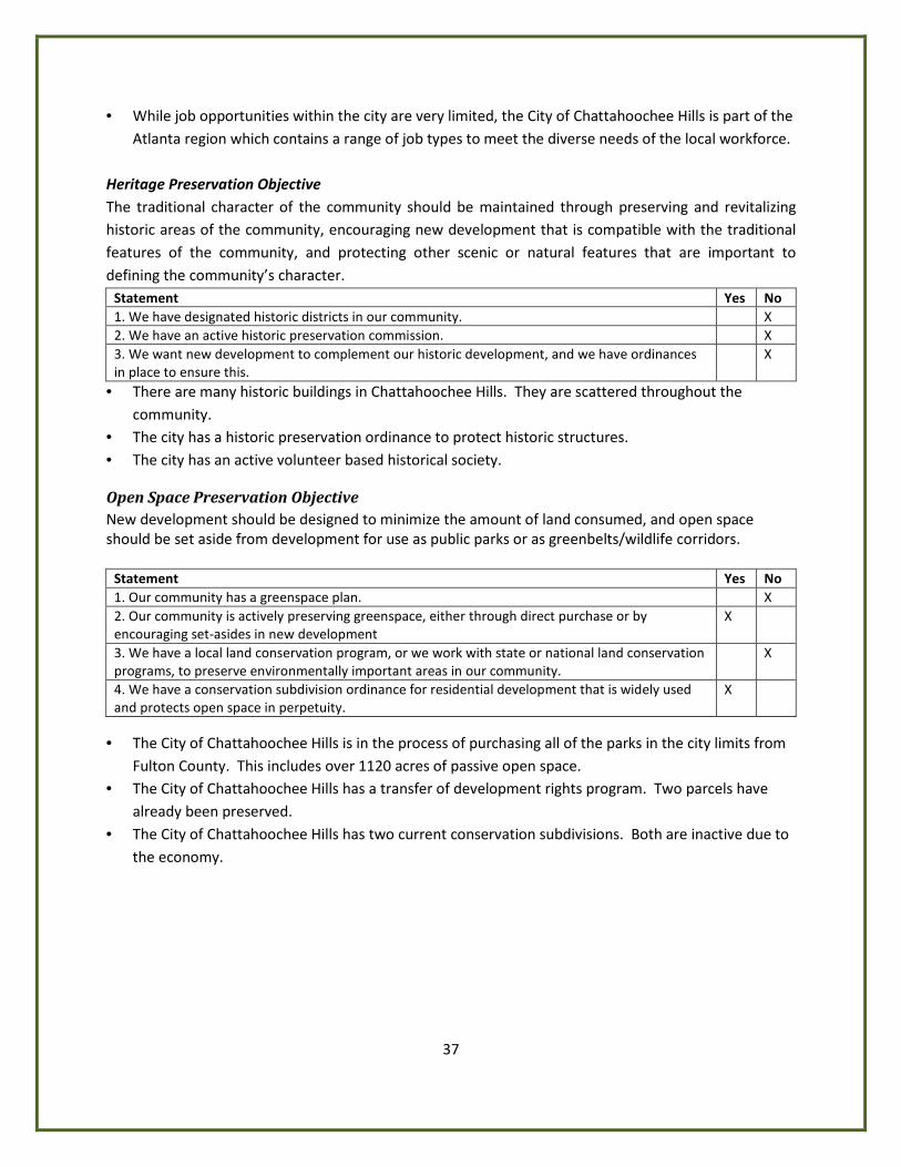
37
• While job opportunities within the city are very limited, the City of Chattahoochee Hills is part of the Atlanta region which contains a range of job types to meet the diverse needs of the local workforce.
Heritage Preservation Objective The traditional character of the community should be maintained through preserving and revitalizing historic areas of the community, encouraging new development that is compatible with the traditional features of the community, and protecting other scenic or natural features that are important to defining the community’s character.
Statement Yes No 1. We have designated historic districts in our community. X 2. We have an active historic preservation commission. X 3. We want new development to complement our historic development, and we have ordinances in place to ensure this.
X
• There are many historic buildings in Chattahoochee Hills. They are scattered throughout the community.
• The city has a historic preservation ordinance to protect historic structures. • The city has an active volunteer based historical society.
Open Space Preservation Objective New development should be designed to minimize the amount of land consumed, and open space should be set aside from development for use as public parks or as greenbelts/wildlife corridors.
Statement Yes No 1. Our community has a greenspace plan. X 2. Our community is actively preserving greenspace, either through direct purchase or by encouraging set-asides in new development
X
3. We have a local land conservation program, or we work with state or national land conservation programs, to preserve environmentally important areas in our community.
X
4. We have a conservation subdivision ordinance for residential development that is widely used and protects open space in perpetuity.
X
• The City of Chattahoochee Hills is in the process of purchasing all of the parks in the city limits from
Fulton County. This includes over 1120 acres of passive open space. • The City of Chattahoochee Hills has a transfer of development rights program. Two parcels have
already been preserved. • The City of Chattahoochee Hills has two current conservation subdivisions. Both are inactive due to
the economy.
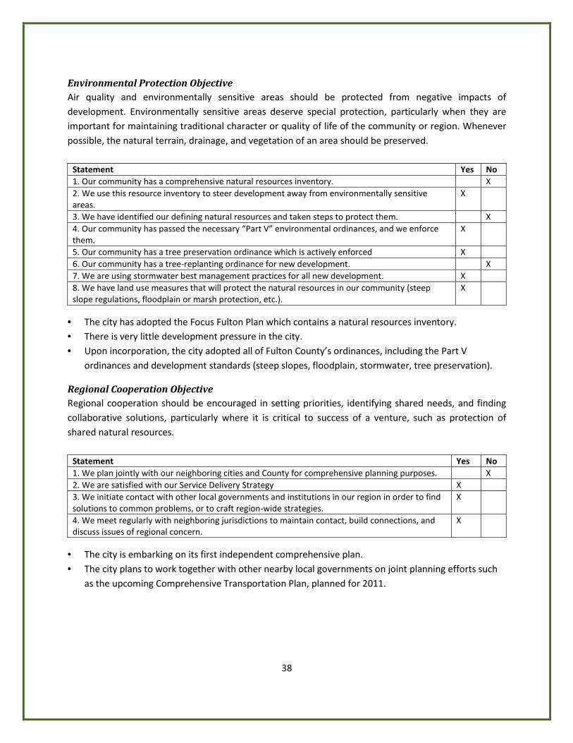
38
Environmental Protection Objective Air quality and environmentally sensitive areas should be protected from negative impacts of development. Environmentally sensitive areas deserve special protection, particularly when they are important for maintaining traditional character or quality of life of the community or region. Whenever possible, the natural terrain, drainage, and vegetation of an area should be preserved.
Statement Yes No 1. Our community has a comprehensive natural resources inventory. X 2. We use this resource inventory to steer development away from environmentally sensitive areas.
X
3. We have identified our defining natural resources and taken steps to protect them. X 4. Our community has passed the necessary “Part V” environmental ordinances, and we enforce them.
X
5. Our community has a tree preservation ordinance which is actively enforced X 6. Our community has a tree-replanting ordinance for new development. X 7. We are using stormwater best management practices for all new development. X 8. We have land use measures that will protect the natural resources in our community (steep slope regulations, floodplain or marsh protection, etc.).
X
• The city has adopted the Focus Fulton Plan which contains a natural resources inventory. • There is very little development pressure in the city. • Upon incorporation, the city adopted all of Fulton County’s ordinances, including the Part V
ordinances and development standards (steep slopes, floodplain, stormwater, tree preservation).
Regional Cooperation Objective Regional cooperation should be encouraged in setting priorities, identifying shared needs, and finding collaborative solutions, particularly where it is critical to success of a venture, such as protection of shared natural resources.
Statement Yes No 1. We plan jointly with our neighboring cities and County for comprehensive planning purposes. X 2. We are satisfied with our Service Delivery Strategy X 3. We initiate contact with other local governments and institutions in our region in order to find solutions to common problems, or to craft region-wide strategies.
X
4. We meet regularly with neighboring jurisdictions to maintain contact, build connections, and discuss issues of regional concern.
X
• The city is embarking on its first independent comprehensive plan. • The city plans to work together with other nearby local governments on joint planning efforts such
as the upcoming Comprehensive Transportation Plan, planned for 2011.
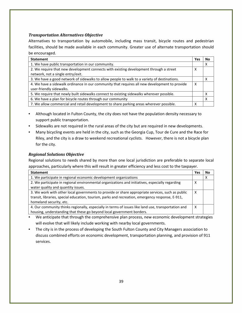
39
Transportation Alternatives Objective Alternatives to transportation by automobile, including mass transit, bicycle routes and pedestrian facilities, should be made available in each community. Greater use of alternate transportation should be encouraged.
Statement Yes No 1. We have public transportation in our community. X 2. We require that new development connects with existing development through a street network, not a single entry/exit.
X
3. We have a good network of sidewalks to allow people to walk to a variety of destinations. X 4. We have a sidewalk ordinance in our community that requires all new development to provide user-friendly sidewalks.
X
5. We require that newly built sidewalks connect to existing sidewalks wherever possible. X 6. We have a plan for bicycle routes through our community X 7. We allow commercial and retail development to share parking areas wherever possible. X
• Although located in Fulton County, the city does not have the population density necessary to
support public transportation. • Sidewalks are not required in the rural areas of the city but are required in new developments. • Many bicycling events are held in the city, such as the Georgia Cup, Tour de Cure and the Race for
Riley, and the city is a draw to weekend recreational cyclists. However, there is not a bicycle plan for the city.
Regional Solutions Objective Regional solutions to needs shared by more than one local jurisdiction are preferable to separate local approaches, particularly where this will result in greater efficiency and less cost to the taxpayer.
Statement Yes No 1. We participate in regional economic development organizations X 2. We participate in regional environmental organizations and initiatives, especially regarding water quality and quantity issues.
X
3. We work with other local governments to provide or share appropriate services, such as public transit, libraries, special education, tourism, parks and recreation, emergency response, E-911, homeland security, etc.
X
4. Our community thinks regionally, especially in terms of issues like land use, transportation and housing, understanding that these go beyond local government borders.
X
• We anticipate that through the comprehensive plan process, new economic development strategies will evolve that will likely include working with nearby local governments.
• The city is in the process of developing the South Fulton County and City Managers association to discuss combined efforts on economic development, transportation planning, and provision of 911 services.
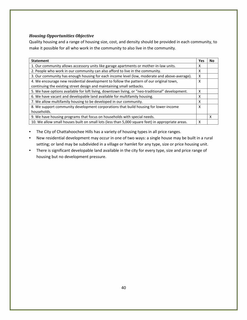
40
Housing Opportunities Objective Quality housing and a range of housing size, cost, and density should be provided in each community, to make it possible for all who work in the community to also live in the community.
Statement Yes No 1. Our community allows accessory units like garage apartments or mother-in-law units. X 2. People who work in our community can also afford to live in the community. X 3. Our community has enough housing for each income level (low, moderate and above-average). X 4. We encourage new residential development to follow the pattern of our original town, continuing the existing street design and maintaining small setbacks.
X
5. We have options available for loft living, downtown living, or “neo-traditional” development. X 6. We have vacant and developable land available for multifamily housing. X 7. We allow multifamily housing to be developed in our community. X 8. We support community development corporations that build housing for lower-income households.
X
9. We have housing programs that focus on households with special needs. X 10. We allow small houses built on small lots (less than 5,000 square feet) in appropriate areas. X
• The City of Chattahoochee Hills has a variety of housing types in all price ranges. • New residential development may occur in one of two ways: a single house may be built in a rural
setting; or land may be subdivided in a village or hamlet for any type, size or price housing unit. • There is significant developable land available in the city for every type, size and price range of
housing but no development pressure.
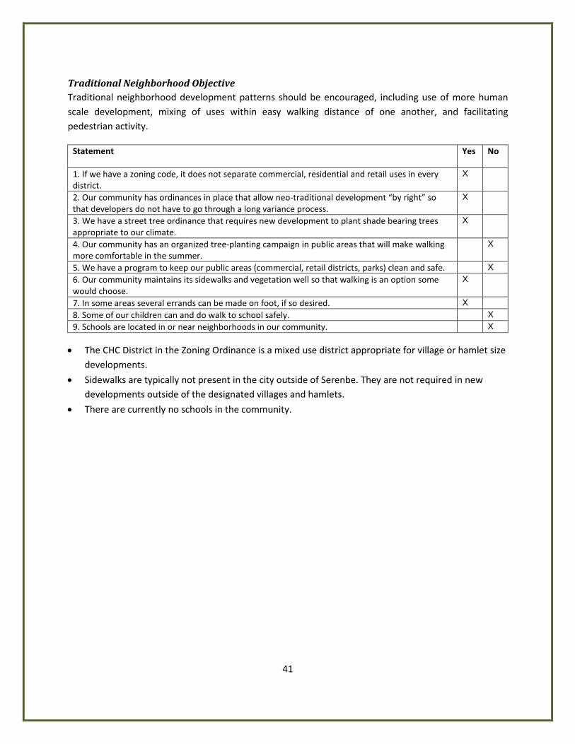
41
Traditional Neighborhood Objective Traditional neighborhood development patterns should be encouraged, including use of more human scale development, mixing of uses within easy walking distance of one another, and facilitating pedestrian activity.
Statement Yes No
1. If we have a zoning code, it does not separate commercial, residential and retail uses in every district.
X
2. Our community has ordinances in place that allow neo-traditional development “by right” so that developers do not have to go through a long variance process.
X
3. We have a street tree ordinance that requires new development to plant shade bearing trees appropriate to our climate.
X
4. Our community has an organized tree-planting campaign in public areas that will make walking more comfortable in the summer.
X
5. We have a program to keep our public areas (commercial, retail districts, parks) clean and safe. X 6. Our community maintains its sidewalks and vegetation well so that walking is an option some would choose.
X
7. In some areas several errands can be made on foot, if so desired. X 8. Some of our children can and do walk to school safely. X 9. Schools are located in or near neighborhoods in our community. X
• The CHC District in the Zoning Ordinance is a mixed use district appropriate for village or hamlet size
developments.
• Sidewalks are typically not present in the city outside of Serenbe. They are not required in new developments outside of the designated villages and hamlets.
• There are currently no schools in the community.
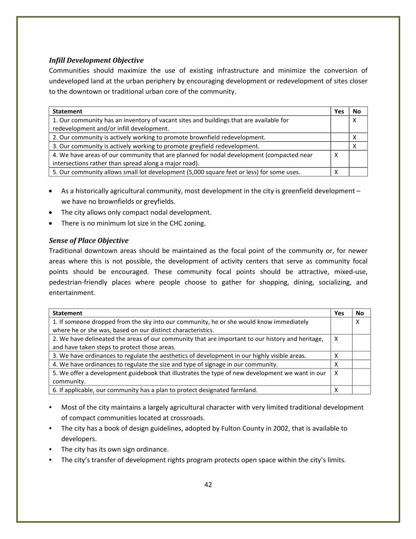
42
Infill Development Objective Communities should maximize the use of existing infrastructure and minimize the conversion of undeveloped land at the urban periphery by encouraging development or redevelopment of sites closer to the downtown or traditional urban core of the community.
Statement Yes No 1. Our community has an inventory of vacant sites and buildings that are available for redevelopment and/or infill development.
X
2. Our community is actively working to promote brownfield redevelopment. X 3. Our community is actively working to promote greyfield redevelopment. X 4. We have areas of our community that are planned for nodal development (compacted near intersections rather than spread along a major road).
X
5. Our community allows small lot development (5,000 square feet or less) for some uses. X • As a historically agricultural community, most development in the city is greenfield development –
we have no brownfields or greyfields.
• The city allows only compact nodal development.
• There is no minimum lot size in the CHC zoning.
Sense of Place Objective Traditional downtown areas should be maintained as the focal point of the community or, for newer areas where this is not possible, the development of activity centers that serve as community focal points should be encouraged. These community focal points should be attractive, mixed-use, pedestrian-friendly places where people choose to gather for shopping, dining, socializing, and entertainment.
Statement Yes No 1. If someone dropped from the sky into our community, he or she would know immediately where he or she was, based on our distinct characteristics.
X
2. We have delineated the areas of our community that are important to our history and heritage, and have taken steps to protect those areas.
X
3. We have ordinances to regulate the aesthetics of development in our highly visible areas. X 4. We have ordinances to regulate the size and type of signage in our community. X 5. We offer a development guidebook that illustrates the type of new development we want in our community.
X
6. If applicable, our community has a plan to protect designated farmland. X • Most of the city maintains a largely agricultural character with very limited traditional development
of compact communities located at crossroads. • The city has a book of design guidelines, adopted by Fulton County in 2002, that is available to
developers. • The city has its own sign ordinance. • The city’s transfer of development rights program protects open space within the city’s limits.
43
PART IV. TECHNICAL ADDENDUM
Population Unlike the other new cities that have come into being over the past several years, the demographic history of Chattahoochee Hills has not been accurately tracked. The cities of Sandy Springs, Milton, Johns Creek, and Dunwoody have all been specifically monitored as “Census Designated Places” over a number of census cycles. Because of Chattahoochee Hills’s rural location and historically diffuse population, it has never been specifically monitored by the U.S. Census Bureau. The census tracts in this area of Fulton County in no way line up with the boundaries of the City of Chattahoochee Hills and after consulting with a number of expert sources, city staff determined that there is no reliable, statistically valid method of extrapolating the extensive data required for a comprehensive plan in the Atlanta region where the advanced planning level is required.
Based on recommendations from ARC staff, the city considered using the figures provided in Fulton County’s “Focus Fulton 2025” comprehensive plan, which is the city’s currently adopted plan, as a starting point. The city explored this option, in depth, and determined that it would be unsatisfactory. Though the city did adopt the “Focus Fulton 2025” plan as a stop-gap measure to cover the time between incorporation and our first comprehensive planning deadline, continuing to base our long-term vision upon Fulton County’s plan would be contrary to our effort to become a city. Though Fulton’s plan does, indeed, include specific data and plans for an area that it labeled “South Fulton”, the boundaries of that area are not representative of the boundaries of Chattahoochee Hills and the demographic data particular to that area is definitely not representative of the City of Chattahoochee Hills.
In the Georgia DCA Local Planning Requirements, there is a provision for a small municipality to request permission to plan at a lower planning level. The City of Chattahoochee Hills has received a variance from the Georgia Department of Community Affairs to plan at the “basic” level, due to the lack of available required demographic data. Upon release of data from the 2010 Census, the city will review and evaluate all data that specifically pertain to Chattahoochee Hills to determine if any material generated by the census substantially impacts the issues, opportunities or other underlying assumptions upon which the city’s Community Agenda will be based. If such material is found and the Comprehensive Plan has already been adopted, the city will amend the plan at the time. If work on the plan is still underway when the census materials become available, the city will address the new material in the Comprehensive Plan prior to its submission to DCA for review.
To inform the members of the Chattahoochee Hills Comprehensive Plan task force of some basic demographic information and about issues and opportunities within the community, a survey was created for residents of the city. There were 432 responses to the survey and city staff has elected to include information from the survey in this document, particularly in sections where little or no census data is available and the survey results may be helpful. It is in no way intended to substitute for census data, which will be updated when the 2010 Census information is available. The Comprehensive Plan survey was intended only to help guide the task force who will be writing the Community Agenda.
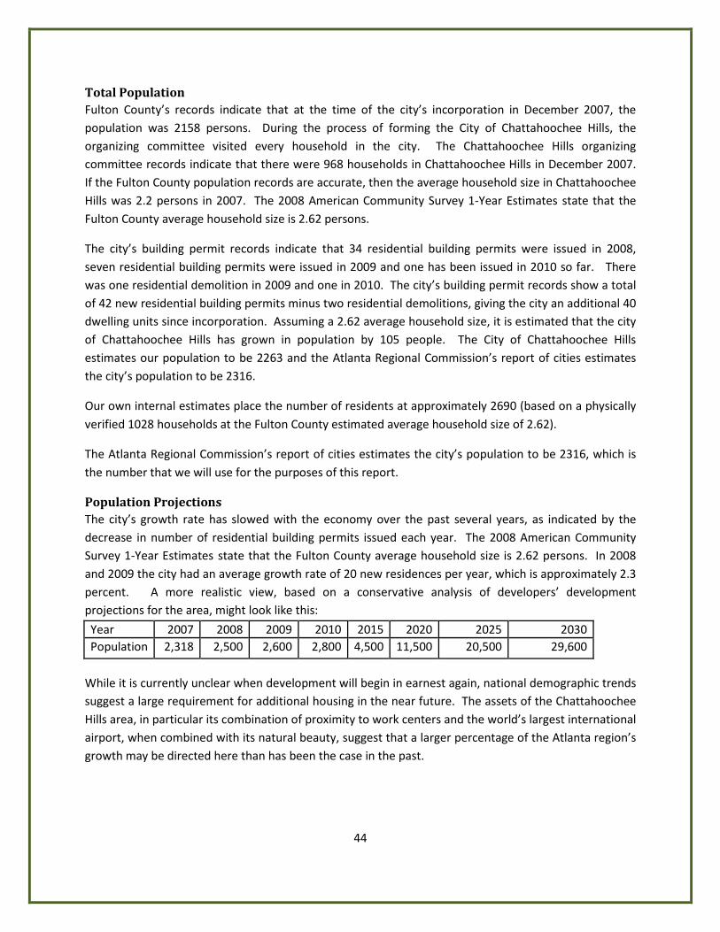
44
Total Population Fulton County’s records indicate that at the time of the city’s incorporation in December 2007, the population was 2158 persons. During the process of forming the City of Chattahoochee Hills, the organizing committee visited every household in the city. The Chattahoochee Hills organizing committee records indicate that there were 968 households in Chattahoochee Hills in December 2007. If the Fulton County population records are accurate, then the average household size in Chattahoochee Hills was 2.2 persons in 2007. The 2008 American Community Survey 1-Year Estimates state that the Fulton County average household size is 2.62 persons.
The city’s building permit records indicate that 34 residential building permits were issued in 2008, seven residential building permits were issued in 2009 and one has been issued in 2010 so far. There was one residential demolition in 2009 and one in 2010. The city’s building permit records show a total of 42 new residential building permits minus two residential demolitions, giving the city an additional 40 dwelling units since incorporation. Assuming a 2.62 average household size, it is estimated that the city of Chattahoochee Hills has grown in population by 105 people. The City of Chattahoochee Hills estimates our population to be 2263 and the Atlanta Regional Commission’s report of cities estimates the city’s population to be 2316.
Our own internal estimates place the number of residents at approximately 2690 (based on a physically verified 1028 households at the Fulton County estimated average household size of 2.62).
The Atlanta Regional Commission’s report of cities estimates the city’s population to be 2316, which is the number that we will use for the purposes of this report.
Population Projections The city’s growth rate has slowed with the economy over the past several years, as indicated by the decrease in number of residential building permits issued each year. The 2008 American Community Survey 1-Year Estimates state that the Fulton County average household size is 2.62 persons. In 2008 and 2009 the city had an average growth rate of 20 new residences per year, which is approximately 2.3 percent. A more realistic view, based on a conservative analysis of developers’ development projections for the area, might look like this:
Year 2007 2008 2009 2010 2015 2020 2025 2030 Population 2,318 2,500 2,600 2,800 4,500 11,500 20,500 29,600
While it is currently unclear when development will begin in earnest again, national demographic trends suggest a large requirement for additional housing in the near future. The assets of the Chattahoochee Hills area, in particular its combination of proximity to work centers and the world’s largest international airport, when combined with its natural beauty, suggest that a larger percentage of the Atlanta region’s growth may be directed here than has been the case in the past.
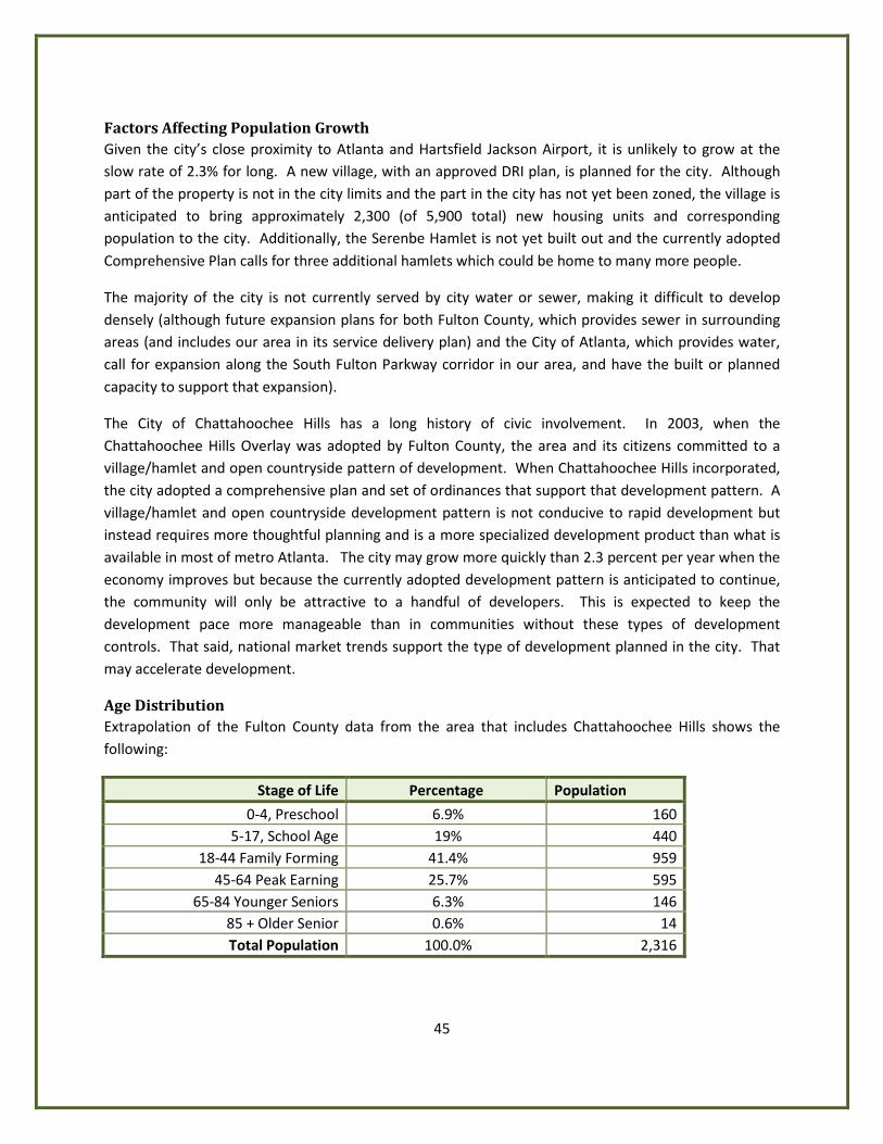
45
Factors Affecting Population Growth Given the city’s close proximity to Atlanta and Hartsfield Jackson Airport, it is unlikely to grow at the slow rate of 2.3% for long. A new village, with an approved DRI plan, is planned for the city. Although part of the property is not in the city limits and the part in the city has not yet been zoned, the village is anticipated to bring approximately 2,300 (of 5,900 total) new housing units and corresponding population to the city. Additionally, the Serenbe Hamlet is not yet built out and the currently adopted Comprehensive Plan calls for three additional hamlets which could be home to many more people.
The majority of the city is not currently served by city water or sewer, making it difficult to develop densely (although future expansion plans for both Fulton County, which provides sewer in surrounding areas (and includes our area in its service delivery plan) and the City of Atlanta, which provides water, call for expansion along the South Fulton Parkway corridor in our area, and have the built or planned capacity to support that expansion).
The City of Chattahoochee Hills has a long history of civic involvement. In 2003, when the Chattahoochee Hills Overlay was adopted by Fulton County, the area and its citizens committed to a village/hamlet and open countryside pattern of development. When Chattahoochee Hills incorporated, the city adopted a comprehensive plan and set of ordinances that support that development pattern. A village/hamlet and open countryside development pattern is not conducive to rapid development but instead requires more thoughtful planning and is a more specialized development product than what is available in most of metro Atlanta. The city may grow more quickly than 2.3 percent per year when the economy improves but because the currently adopted development pattern is anticipated to continue, the community will only be attractive to a handful of developers. This is expected to keep the development pace more manageable than in communities without these types of development controls. That said, national market trends support the type of development planned in the city. That may accelerate development.
Age Distribution Extrapolation of the Fulton County data from the area that includes Chattahoochee Hills shows the following:
Stage of Life Percentage Population
0-4, Preschool 6.9% 160 5-17, School Age 19% 440
18-44 Family Forming 41.4% 959 45-64 Peak Earning 25.7% 595
65-84 Younger Seniors 6.3% 146 85 + Older Senior 0.6% 14 Total Population 100.0% 2,316
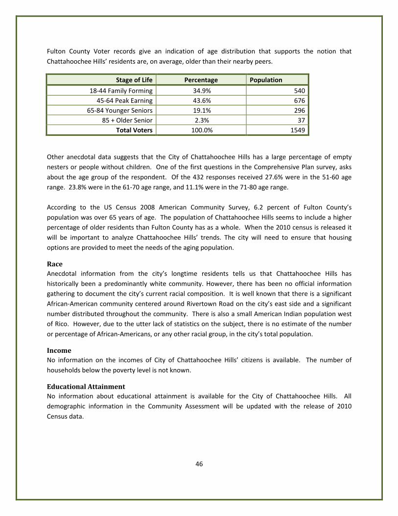
46
Fulton County Voter records give an indication of age distribution that supports the notion that Chattahoochee Hills’ residents are, on average, older than their nearby peers.
Stage of Life Percentage Population
18-44 Family Forming 34.9% 540 45-64 Peak Earning 43.6% 676
65-84 Younger Seniors 19.1% 296 85 + Older Senior 2.3% 37
Total Voters 100.0% 1549
Other anecdotal data suggests that the City of Chattahoochee Hills has a large percentage of empty nesters or people without children. One of the first questions in the Comprehensive Plan survey, asks about the age group of the respondent. Of the 432 responses received 27.6% were in the 51-60 age range. 23.8% were in the 61-70 age range, and 11.1% were in the 71-80 age range. According to the US Census 2008 American Community Survey, 6.2 percent of Fulton County’s population was over 65 years of age. The population of Chattahoochee Hills seems to include a higher percentage of older residents than Fulton County has as a whole. When the 2010 census is released it will be important to analyze Chattahoochee Hills’ trends. The city will need to ensure that housing options are provided to meet the needs of the aging population.
Race Anecdotal information from the city’s longtime residents tells us that Chattahoochee Hills has historically been a predominantly white community. However, there has been no official information gathering to document the city’s current racial composition. It is well known that there is a significant African-American community centered around Rivertown Road on the city’s east side and a significant number distributed throughout the community. There is also a small American Indian population west of Rico. However, due to the utter lack of statistics on the subject, there is no estimate of the number or percentage of African-Americans, or any other racial group, in the city’s total population.
Income No information on the incomes of City of Chattahoochee Hills’ citizens is available. The number of households below the poverty level is not known.
Educational Attainment No information about educational attainment is available for the City of Chattahoochee Hills. All demographic information in the Community Assessment will be updated with the release of 2010 Census data.
47
Economic Development
Economic Base On its own, the City of Chattahoochee Hills is too small to study economically. The city is part of Fulton County and the Atlanta metropolitan area. Fulton County has one of the strongest economies in Georgia. With state government and many corporate headquarters, it is both stable and diverse. Fulton County and the Atlanta Region are expected to continue to grow in the long term. Chattahoochee Hills should benefit from the continued economic growth of the larger region. The city has only a handful of businesses that are not home based, including one small locally owned grocery store with gas pumps, two restaurants, an inn with an additional associated restaurant, and several gift, clothing and furniture stores. There are a handful of property owners who ranch on their land and/or do organic farming on a small scale. The city has 40 non-agricultural home based businesses, in addition to many unpermitted home offices. (In the city’s Comprehensive Plan survey, 20 percent of respondents indicated that they work from home and 13 percent said that they own their own businesses.) In the Serenbe community, there is a business incubator which is active in the pursuit of additional businesses (primarily within the Serenbe Community). There is also a citizen-driven Sustainable Economic Development Committee which is working on local Economic Development initiatives. Most of the city’s business growth has been in the Serenbe community. Per the city’s development regulations, Serenbe is a small densely developed mixed use hamlet with the surrounding area used for organic farming or land conservation. Development of Serenbe began in 2005 and is continuing. All but one of the non-home based businesses listed above, the grocery store with the gas pumps, are in the Serenbe community. The grocery store is in the Rico community. Labor Force The 2008 American Community Survey indicates that 68.8 percent of persons over 16 in Fulton County are in the work force. In Georgia it is 66.8 percent and in the U.S. it is 65.2 percent. Labor force participation, personal income, employment by occupation, and employment by industry data is not available for the City of Chattahoochee Hills. The following are statistics for Fulton County. Although none of the US Census information below is available for the City of Chattahoochee Hills, anecdotal information about the city’s population and information from the city’s Comprehensive Plan survey may explain how the city differs from Fulton County economically. The percentage of labor force participation for the City of Chattahoochee Hills is likely to be smaller than that of Fulton County as a whole for both males and females due to the larger percentage of the population of senior citizens in Chattahoochee Hills (Chattahoochee Hills Comprehensive Plan survey results). Personal income is also likely to be lower with a higher percentage of retired persons in the city than in the county. Employment by occupation and employment by industry would likely be similar to Fulton County as a whole.
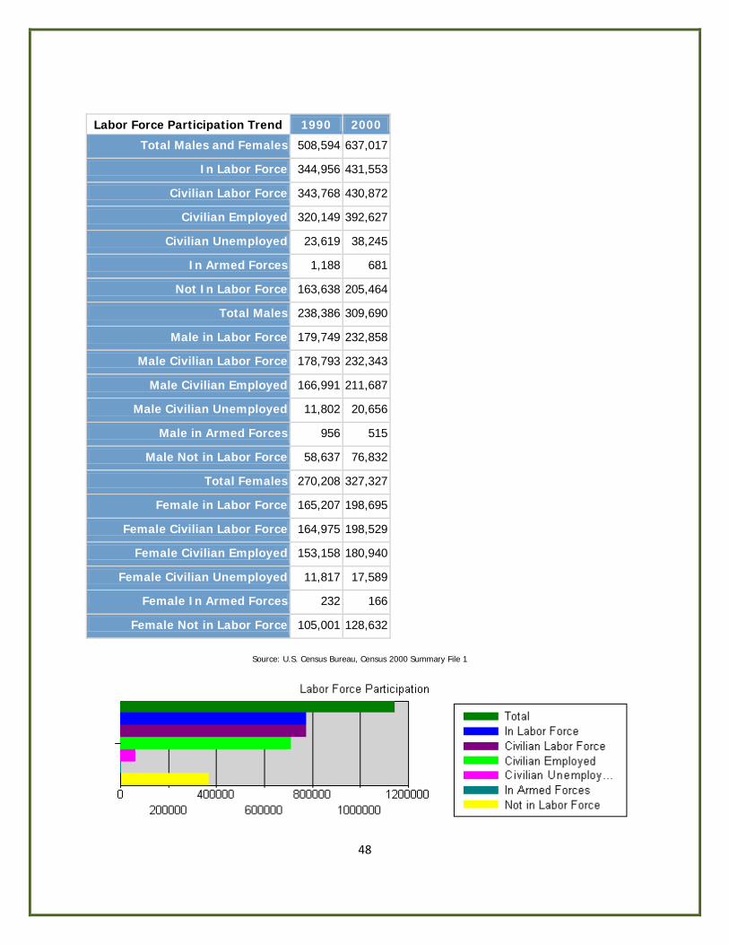
48
Labor Force Participation Trend 1990 2000
Total Males and Females 508,594 637,017
In Labor Force 344,956 431,553
Civilian Labor Force 343,768 430,872
Civilian Employed 320,149 392,627
Civilian Unemployed 23,619 38,245
In Armed Forces 1,188 681
Not In Labor Force 163,638 205,464
Total Males 238,386 309,690
Male in Labor Force 179,749 232,858
Male Civilian Labor Force 178,793 232,343
Male Civilian Employed 166,991 211,687
Male Civilian Unemployed 11,802 20,656
Male in Armed Forces 956 515
Male Not in Labor Force 58,637 76,832
Total Females 270,208 327,327
Female in Labor Force 165,207 198,695
Female Civilian Labor Force 164,975 198,529
Female Civilian Employed 153,158 180,940
Female Civilian Unemployed 11,817 17,589
Female In Armed Forces 232 166
Female Not in Labor Force 105,001 128,632
Source: U.S. Census Bureau, Census 2000 Summary File 1
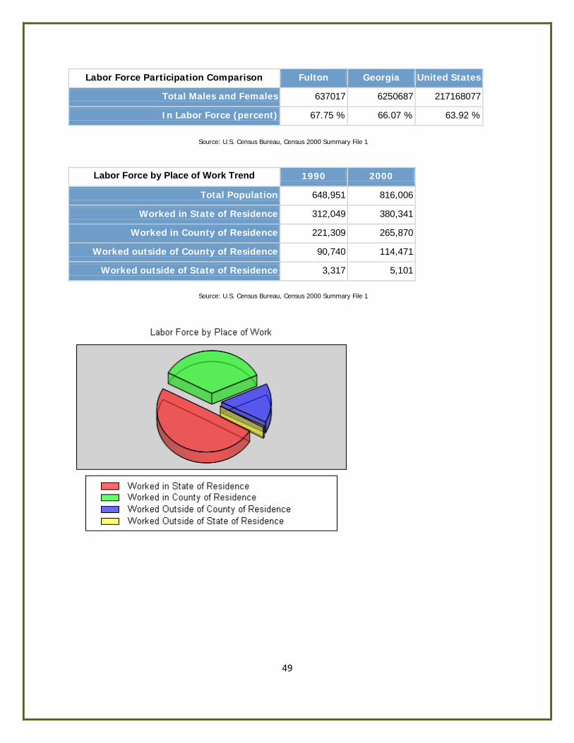
49
Labor Force Participation Comparison Fulton Georgia United States
Total Males and Females 637017 6250687 217168077
In Labor Force (percent) 67.75 % 66.07 % 63.92 %
Source: U.S. Census Bureau, Census 2000 Summary File 1
Labor Force by Place of Work Trend 1990 2000
Total Population 648,951 816,006
Worked in State of Residence 312,049 380,341
Worked in County of Residence 221,309 265,870
Worked outside of County of Residence 90,740 114,471
Worked outside of State of Residence 3,317 5,101
Source: U.S. Census Bureau, Census 2000 Summary File 1

50
Personal Income by Type Trend 1990 2000
Total Income 11,842,864,400 24,071,786,000
Aggregate wage or salary income for households 9,093,627,341 18,874,675,400
Aggregate other types of income for households 104,740,942 291,724,900
Aggregate self employment income for households 894,266,206 1,590,299,900
Aggregate interest, dividends, or net rental income 993,093,191 1,867,484,800
Aggregate social security income for households 373,197,586 581,378,600
Aggregate public assistance income for households 75,315,102 113,246,200
Aggregate retirement income for households 308,624,032 752,976,200
Source: U.S. Census Bureau, Census 2000 Summary File 1
Personal Income by Type Comparison Fulton Georgia
Total Income 100.00 % 100.00 %
Aggregate wage or salary income for households 78.41 % 78.24 %
Aggregate other types of income for households 1.21 % 1.70 %
Aggregate self employment income for households 6.61 % 5.60 %
Aggregate interest, dividends, or net rental income 7.76 % 5.27 %
Aggregate social security income for households 2.42 % 4.04 %
Aggregate public assistance income for households 0.47 % 0.00 %
Aggregate retirement income for households 3.13 % 4.57 %
Source: U.S. Census Bureau, Census 2000 Summary File 1
51
Employment by Occupation Comparison (percentage)
Fulton Georgia United States
Management 43.6 32.7 33.6
Service 13.5 13.4 14.9
Sales 27.7 26.8 26.7
Farming 0.2 0.6 0.7
Construction 6.0 10.8 9.4
Production 9.1 15.7 14.6
Agriculture 0.2 1.2 1.5
Manufacturing 8.4 14.8 14.1
Government 10.9 14.9 14.6
Source: U.S. Census Bureau, Census 2000 Summary File 1
Employment by Industry 1980 1990 2000
Total Employed Civilian Population 258,911 320,149 392,627
Agriculture, Forestry, Fishing, hunting & mining 2,167 3,691 1,057
Construction 12,998 16,214 20,789
Manufacturing 35,400 32,351 32,951
Wholesale Trade 13,674 19,114 15,369
Retail Trade 41,804 51,432 42,415
Transportation, warehousing, and utilities 27,633 33,518 23,027
Information NA NA 24461
Finance, Insurance, & Real Estate 21,775 33,651 38,440
Professional, scientific, management, administrative, and waste management services
15,016 23,490 66,113
Educational, health and social services 39,484 45,125 59,162
Arts, entertainment, recreation, accommodation and food services
18,343 4,375 36,424
Other Services 14,578 41,522 17,542
Public Administration 16,039 15,666 14,877
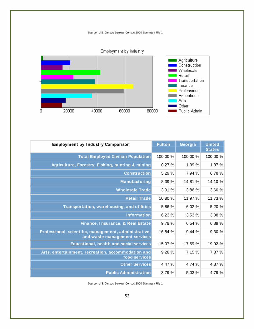
52
Source: U.S. Census Bureau, Census 2000 Summary File 1
Employment by Industry Comparison Fulton Georgia United States
Total Employed Civilian Population 100.00 % 100.00 % 100.00 %
Agriculture, Forestry, Fishing, hunting & mining 0.27 % 1.39 % 1.87 %
Construction 5.29 % 7.94 % 6.78 %
Manufacturing 8.39 % 14.81 % 14.10 %
Wholesale Trade 3.91 % 3.86 % 3.60 %
Retail Trade 10.80 % 11.97 % 11.73 %
Transportation, warehousing, and utilities 5.86 % 6.02 % 5.20 %
Information 6.23 % 3.53 % 3.08 %
Finance, Insurance, & Real Estate 9.79 % 6.54 % 6.89 %
Professional, scientific, management, administrative, and waste management services
16.84 % 9.44 % 9.30 %
Educational, health and social services 15.07 % 17.59 % 19.92 %
Arts, entertainment, recreation, accommodation and food services
9.28 % 7.15 % 7.87 %
Other Services 4.47 % 4.74 % 4.87 %
Public Administration 3.79 % 5.03 % 4.79 %
Source: U.S. Census Bureau, Census 2000 Summary File 1
53
Economic Resources The City of Chattahoochee Hills has access to the South Fulton Chamber of Commerce, a local Sustainable Economic Development Committee and a Business Incubator located in Serenbe. Residents have access to workforce training through all of the technical schools, colleges and universities in metro Atlanta. Educational attainment information is not available for the City of Chattahoochee Hills. The following information is for Fulton County.
Educational Attainment Trend
1980 1990 2000
Less than 9th Grade 60,482 32,935 26,515
9th to 12th Grade (no diploma)
57,857 59,201 56,568
High School Graduate (Includes Equivalency)
92,138 92,678 100,779
Some College (No Degree) 57,679 79,048 96,342
Associate Degree 20,328 24,344
Bachelor's Degree 44,338 87,950 138,834
Graduate or Professional Degree
35,589 43,051 76,885
Source: U.S. Census Bureau, Census 2000 Summary File 1
Educational Attainment Comparison Fulton Georgia United States
Less than 9th Grade 5.10 % 7.54 % 7.55 %
9th to 12th Grade (no diploma) 10.87 % 13.86 % 12.05 %
High School Graduate (Includes Equivalency)
19.37 % 28.71 % 28.63 %
Some College (No Degree) 18.52 % 20.40 % 21.05 %
Associate Degree 4.68 % 5.19 % 6.32 %
Bachelor's Degree 26.69 % 16.01 % 15.54 %
Graduate or Professional Degree 14.78 % 8.30 % 8.86 %
Source: U.S. Census Bureau, Census 2000 Summary File 1
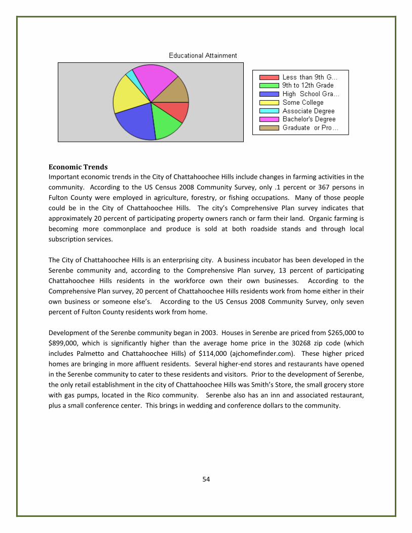
54
Economic Trends Important economic trends in the City of Chattahoochee Hills include changes in farming activities in the community. According to the US Census 2008 Community Survey, only .1 percent or 367 persons in Fulton County were employed in agriculture, forestry, or fishing occupations. Many of those people could be in the City of Chattahoochee Hills. The city’s Comprehensive Plan survey indicates that approximately 20 percent of participating property owners ranch or farm their land. Organic farming is becoming more commonplace and produce is sold at both roadside stands and through local subscription services. The City of Chattahoochee Hills is an enterprising city. A business incubator has been developed in the Serenbe community and, according to the Comprehensive Plan survey, 13 percent of participating Chattahoochee Hills residents in the workforce own their own businesses. According to the Comprehensive Plan survey, 20 percent of Chattahoochee Hills residents work from home either in their own business or someone else’s. According to the US Census 2008 Community Survey, only seven percent of Fulton County residents work from home. Development of the Serenbe community began in 2003. Houses in Serenbe are priced from $265,000 to $899,000, which is significantly higher than the average home price in the 30268 zip code (which includes Palmetto and Chattahoochee Hills) of $114,000 (ajchomefinder.com). These higher priced homes are bringing in more affluent residents. Several higher-end stores and restaurants have opened in the Serenbe community to cater to these residents and visitors. Prior to the development of Serenbe, the only retail establishment in the city of Chattahoochee Hills was Smith’s Store, the small grocery store with gas pumps, located in the Rico community. Serenbe also has an inn and associated restaurant, plus a small conference center. This brings in wedding and conference dollars to the community.

55
Housing
Housing Types and Mix The city’s building permit records indicate that 34 residential building permits were issued in 2008, seven residential building permits were issued in 2009 and one has been issued in 2010 so far. There was one residential demolition in 2009 and one in 2010. The city’s building permit records show a total of 42 new residential building permits minus two residential demolitions, giving the city an additional 40 dwelling units since incorporation in December 2007. Almost all of these units are single-family detached, with a limited number of multi-family units. The City of Chattahoochee Hills currently has 1068 housing units. There are 1033 single family detached houses located throughout the city. The majority of the city’s houses are on lots of at least one acre, with wells and septic systems. There is one developed conventional subdivision, Crossroads, off Wilkerson Mill Road, that was developed in the 1980’s. There are currently 30 occupied townhouse units (some of them live-work units) and 5 apartments located in Serenbe. The city also has two abandoned subdivisions called Arbor Reserve and Bear Creek. No houses were ever built in Arbor Reserve, which was platted with 107 lots. Bear Creek had seven houses built before the city was incorporated, all of which were torn down before they were occupied. Both subdivisions stand vacant with uncertain futures.
Condition and Occupancy No census information regarding the age or condition of the housing stock in the City of Chattahoochee Hills is available. Information regarding occupancy rates is not available for the city.
Housing Costs The Atlanta Journal Constitution website, ajchomefinder.com, has a home sales report by zip code for as recently as 2008. The City of Chattahoochee Hills is in the 30268 zip code, along with the neighboring City of Palmetto. The 2008 median home sale price for new homes and for resales was $114, 000. The median rent for the area is not available. No information is available regarding cost burdened households.
Special Housing Needs There is a group home for unwed mothers, called Angela’s House, located on Rico Road. The home is owned by the Fulton County Juvenile Justice Program. Anecdotal information from city leaders and from the city’s Comprehensive Plan survey indicates that the city has many older residents. According to the US Census 2008 American Community Survey, 6.2 percent of Fulton County’s population was over 65 years of age. The population of Chattahoochee Hills seems to include a much higher percentage of older residents than Fulton County has as a whole. When

56
the 2010 census is released it will be important to analyze Chattahoochee Hills’ trends. The city will need to ensure that housing options are provided to meet the needs of the aging population.
Jobs-Housing Balance No information is available regarding the jobs-housing balance in the City of Chattahoochee Hills.

57
Natural and Cultural Resources The Natural and Cultural Resources Element includes an inventory of the City of Chattahoochee Hills’ natural, environmentally sensitive, historic, and cultural resources as well as current and future needs for protection and management of these resources. Chattahoochee Hills has abundant and valuable natural resources including streams, the Chattahoochee River, lakes, and wetlands. All of these natural water features support a wide variety of uses for its citizens, from drinking water to recreation to irrigation. Additionally, water provides wildlife habitat for both aquatic and terrestrial animals. Both animals and humans depend on a clean water source for survival. Therefore, the forces that impact the health of local water supply are important to understand.
Environmental Planning Criteria
Water Supply Watersheds One of the city’s primary natural resources is the Chattahoochee River. It forms the city’s and Fulton County’s border to the west and to the north. The Chattahoochee River is the major drinking water source for Fulton County. Although most of the homes in the City of Chattahoochee Hills are served by wells, part of the city gets water from the City of Atlanta. The City of Atlanta’s Chattahoochee and Hemphill plants supply water to Sandy Springs, the City of Atlanta, and South Fulton residents, including those in the City of Chattahoochee Hills. Drinking water intakes are located in three locations near the city. One is the Douglas County Water and Sewer Authority’s intake on the Chattahoochee River. The other two intakes are in Longino Creek in the City of Palmetto. The Georgia Department of Natural Resources (DNR) defines water supply watershed as the areas of land upstream from government owned public drinking intakes or water supply reservoirs. DNR has two categories of watersheds – large (more than 100 square miles) and small (fewer than 100 square miles). There are parts of two small water supply watersheds, Bear Creek and Cedar Creek, located in the City of Chattahoochee Hills. The Metropolitan North Georgia Water Planning District Water Supply and Water Conservation Plan calls for a 15 million gallons per day reservoir to be built in the city on Bear Creek, which is a tributary to the Chattahoochee River. The reservoir would be managed by a proposed South Fulton Water Authority. Water treatment plants are planned for Bear Creek and Cedar Creek in Palmetto. The service provider for the Bear Creek water treatment plan will be determined through the Fulton County HB489/Service Delivery Strategy renegotiation process. The location of the Bear Creek reservoir is shown on the map on the following page.
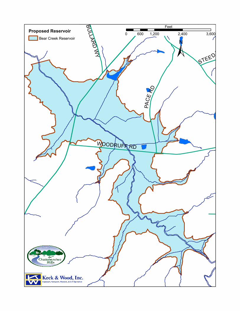
RIVERTOWN RDPACE
RD
STEE D RD
BULLA
RD RD
BULLARD WYWOODRUFF RD
Proposed ReservoirBear Creek Reservoir
±0 1,200 2,400 3,600600
Feet
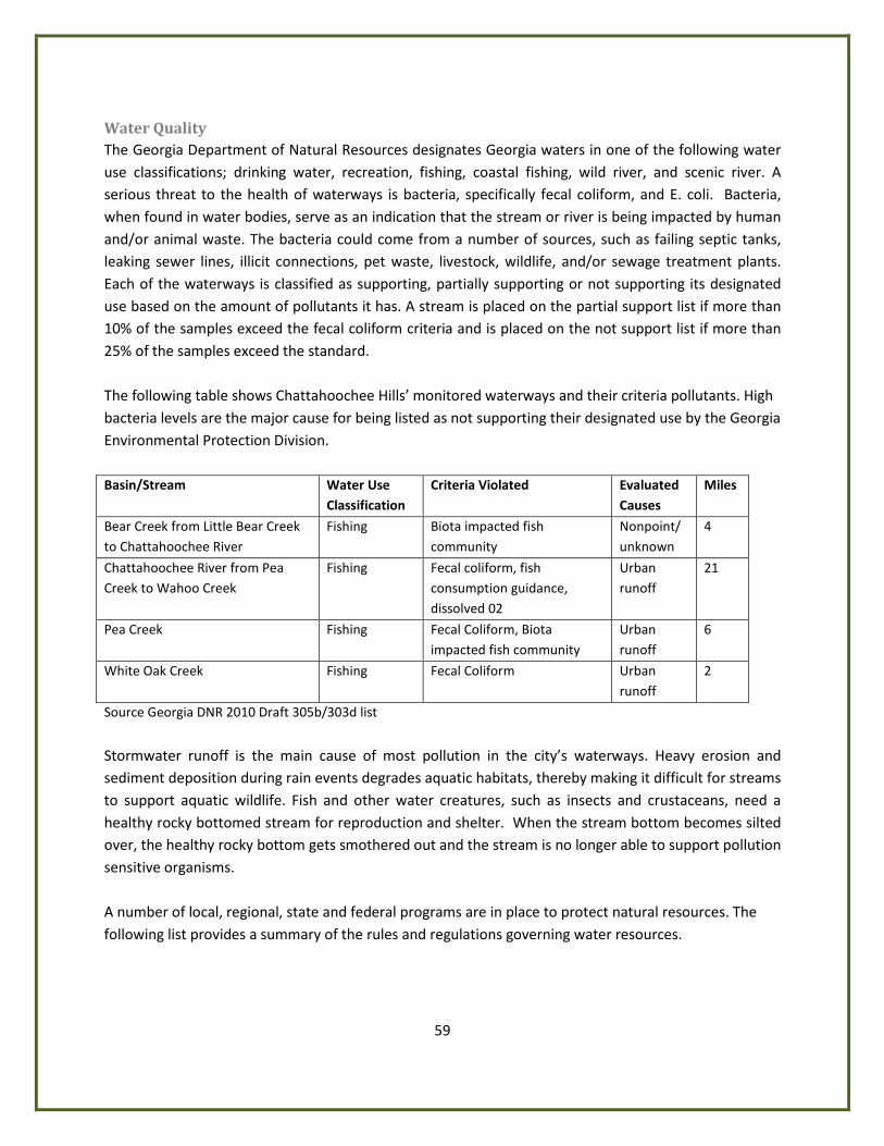
59
Water Quality The Georgia Department of Natural Resources designates Georgia waters in one of the following water use classifications; drinking water, recreation, fishing, coastal fishing, wild river, and scenic river. A serious threat to the health of waterways is bacteria, specifically fecal coliform, and E. coli. Bacteria, when found in water bodies, serve as an indication that the stream or river is being impacted by human and/or animal waste. The bacteria could come from a number of sources, such as failing septic tanks, leaking sewer lines, illicit connections, pet waste, livestock, wildlife, and/or sewage treatment plants. Each of the waterways is classified as supporting, partially supporting or not supporting its designated use based on the amount of pollutants it has. A stream is placed on the partial support list if more than 10% of the samples exceed the fecal coliform criteria and is placed on the not support list if more than 25% of the samples exceed the standard. The following table shows Chattahoochee Hills’ monitored waterways and their criteria pollutants. High bacteria levels are the major cause for being listed as not supporting their designated use by the Georgia Environmental Protection Division. Basin/Stream Water Use
Classification Criteria Violated Evaluated
Causes Miles
Bear Creek from Little Bear Creek to Chattahoochee River
Fishing Biota impacted fish community
Nonpoint/ unknown
4
Chattahoochee River from Pea Creek to Wahoo Creek
Fishing Fecal coliform, fish consumption guidance, dissolved 02
Urban runoff
21
Pea Creek Fishing Fecal Coliform, Biota impacted fish community
Urban runoff
6
White Oak Creek Fishing Fecal Coliform Urban runoff
2
Source Georgia DNR 2010 Draft 305b/303d list
Stormwater runoff is the main cause of most pollution in the city’s waterways. Heavy erosion and sediment deposition during rain events degrades aquatic habitats, thereby making it difficult for streams to support aquatic wildlife. Fish and other water creatures, such as insects and crustaceans, need a healthy rocky bottomed stream for reproduction and shelter. When the stream bottom becomes silted over, the healthy rocky bottom gets smothered out and the stream is no longer able to support pollution sensitive organisms. A number of local, regional, state and federal programs are in place to protect natural resources. The following list provides a summary of the rules and regulations governing water resources.
60
Metropolitan River Protection Act (MRPA) In 1973, the Georgia General Assembly enacted the Metropolitan River Protection Act (Georgia Code 12-5-440) to address development pressure near and pollution of the Chattahoochee River. Under this legislation, the Act established a 2,000-foot river corridor on both banks of the River and its impoundments, including stream beds and islands. The Chattahoochee River Corridor has established vulnerability standards based upon the character of the land, buffer zone standards (50 foot undisturbed – natural, 35 foot undisturbed – streams, 150-foot impervious surface setback) and floodplain standards. The Act also required the Atlanta Regional Commission (ARC) to adopt a plan to protect the water resources of the River Corridor and develop procedures to implement the Act, especially review of development proposals. The City of Chattahoochee Hills, along with other jurisdictions, implement the Act via land use controls, permitting, monitoring of land disturbing activities and enforcing other provisions of the Act.
Metropolitan North Georgia Water Planning District In response to significant current and projected water demands, the Metropolitan North Georgia Water Planning District was established on April 5, 2001 (2001 S.B. 130). The general purposes of the District are to establish policy, create plans, and promote intergovernmental coordination for all water issues in the district; to facilitate multi-jurisdictional water related projects; and to enhance access to funding for water related projects among local governments in the district area. The purposes of the District are to develop regional and watershed-specific plans for stormwater management, wastewater treatment, water supply, water conservation, and the general protection of water quality. These plans will be implemented by local governments in a 16-county area. In October 2002, the district adopted the following model ordinances:
• Ordinance for Post-Development Stormwater Management for New Development and Redevelopment
• Floodplain Management/Flood Damage Preservation
• Stream Buffer Protection
• Conservation Subdivision/Open Space Development
• Illicit Discharge and Illegal Connection
• Litter Control The purpose of the model ordinances was to give local governments tools that effectively address stormwater management issues. Local governments in the district are required to implement the model ordinances. Chattahoochee Hills adopted all of the ordinances upon incorporation in 2007. The Metro North Georgia Water Planning District has protection criteria for development within a seven mile radius of a small water supply watershed (less than 100 square miles) include:
• Maintain 100-foot buffer and 150-foot setback on each side of perennial stream
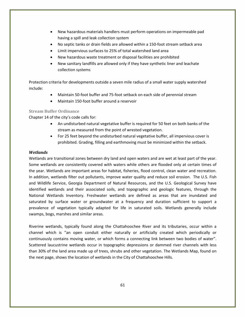
61
• New hazardous materials handlers must perform operations on impermeable pad having a spill and leak collection system
• No septic tanks or drain fields are allowed within a 150-foot stream setback area
• Limit impervious surfaces to 25% of total watershed land area
• New hazardous waste treatment or disposal facilities are prohibited
• New sanitary landfills are allowed only if they have synthetic liner and leachate collection systems
Protection criteria for developments outside a seven mile radius of a small water supply watershed include:
• Maintain 50-foot buffer and 75-foot setback on each side of perennial stream
• Maintain 150-foot buffer around a reservoir
Stream Buffer Ordinance Chapter 14 of the city’s code calls for:
• An undisturbed natural vegetative buffer is required for 50 feet on both banks of the stream as measured from the point of wrested vegetation.
• For 25 feet beyond the undisturbed natural vegetative buffer, all impervious cover is prohibited. Grading, filling and earthmoving must be minimized within the setback.
Wetlands Wetlands are transitional zones between dry land and open waters and are wet at least part of the year. Some wetlands are consistently covered with waters while others are flooded only at certain times of the year. Wetlands are important areas for habitat, fisheries, flood control, clean water and recreation. In addition, wetlands filter out pollutants, improve water quality and reduce soil erosion. The U.S. Fish and Wildlife Service, Georgia Department of Natural Resources, and the U.S. Geological Survey have identified wetlands and their associated soils, and topographic and geologic features, through the National Wetlands Inventory. Freshwater wetlands are defined as areas that are inundated and saturated by surface water or groundwater at a frequency and duration sufficient to support a prevalence of vegetation typically adapted for life in saturated soils. Wetlands generally include swamps, bogs, marshes and similar areas. Riverine wetlands, typically found along the Chattahoochee River and its tributaries, occur within a channel which is “an open conduit either naturally or artificially created which periodically or continuously contains moving water, or which forms a connecting link between two bodies of water”. Scattered laucustrine wetlands occur in topographic depressions or dammed river channels with less than 30% of the land area made up of trees, shrubs and other vegetation. The Wetlands Map, found on the next page, shows the location of wetlands in the City of Chattahoochee Hills.
RICO RD
SOUTH FULTON PW
RIVERTOWN RD
CAMP
BELL
TON
REDW
INE
RD
HUTCHESON FERRY RD
JONES FE RRY RD
KITE
RD
U P PER WOOTEN RD
CAPPS FERRY RD
PHILL
IPS
RD
O LD R ICO RD
HAMILTO N RD
SARD
IS R
D
OL D HAMILTON R D
PACE
RD
WA TKINS R D
M IXON RD
PETERSBU RG R D
HOPKINS RD
HEAR
N RD
BA RNES R D
WILKERSON MILL RD
VERN
ON G
ROVE
RD
BRAZ
ELL R
D
W HITESIDE R D
ATLANTA NEWNAN R D
CRE EL RD
COCH RAN MI LL RD
S ELBORNE L N
CASCADE PALMETTO HW
GARRETTS FERRY RD
STEE D RD
WOODRU F F RD
CEDA
R GRO
VE R
D
RICO TATUM R D
WATE
R WO
RKS RDJE
NKIN
S RD
OLD
P HIL
L IPS R
D
MANSFIELD DR
BULLARD RD
BULLA RD WY
BRUI
N WY
RI
CO LAKE RD
HENRY M ILL RD
SEREN
BE LN
DRIVEWAY
RIVE
R LA
KE D
R
SELBORNE WAY
GRAV
EL R
D
CAINEY LN
MUT T RD
PINE Y WOO DS CH URCH RD
BEAV
ER RD
TAB WY
OLD COCHRAN RD
RICO WY
TIDER
ACE C
T
BIG BEAR CT
WH ITESIDE RD
CAIN
EY LN
WILKERSON MILL RD
WOODRUFF RD
MIXO N RD
RICO TATUM RD
ATLA
NTA N
EWNA
N RD
COC H
RAN
MILL
RD
CAPPS F E RRY R
D
WOODRUFF RD
JENKINS RD
PH ILLIPS RD
SOUTH FULTON PW
RIVERTOWN RD
RIVERTOWN RD
COCHR AN MI LL
RD
JON ES FERRY RD
Wetlands MapWetlands
±0 1 2 3 40.5
Miles
63
The Georgia Department of Natural Resources developed the minimum criteria for the protection of wetlands. The city’s Wetlands Protection Ordinance requires that proposals for development located in a wetlands protection district or within 100 feet of a wetlands protection district, be reviewed and authorized by the United States Army Corp of Engineers (COE) before a land disturbance permit is issued. Any degradation or loss of wetlands must be mitigated through the restoration, creation, enhancement or preservation of other wetlands. The Wetlands Protection Ordinance primarily focuses on protection of wetlands rather than mitigating impacts to wetlands resulting from land development. Although, the Wetlands Protection Ordinance mandates wetland mitigation, no guidance is provided on measures to mitigate the impacts to wetlands. The COE has mitigation authority.
Groundwater Recharge Areas A groundwater recharge area is a surface land area where water that enters an aquifer is first absorbed into the ground. Groundwater recharge areas replenish underground water and are generally areas of level topography. Consequently, these areas are valuable for development. There is one Georgia Department of Natural Resources identified groundwater recharge area in the City of Chattahoochee Hills. It is in the northernmost tip of the city, north and east of Bear Creek. Many of the homes in the City of Chattahoochee Hills obtain drinking water from wells and use septic systems. The Fulton County Health Department inspects and approves sites and issues well construction permits. Once a well is permitted, the owner is responsible for ensuring protective measures against contamination. Areas that are not served by sewer utilize septic systems for waste collection and treatment. The Fulton County Health Department regulates and permits septic tank location and construction in the City of Chattahoochee Hills. Malfunctioning septic systems could affect/pollute groundwater recharge areas. The County’s regulations address a potential malfunction by requiring each site with a septic tank to have a reserved septic field if and when the septic system fails. Fulton County education programs offer septic tank education to reduce bacterial contamination in the County’s streams. This program focuses on proper care and maintenance techniques to prevent failures and groundwater pollution.
Groundwater Recharge Areas Ordinance As part of the Georgia Planning Act, the Department of Natural Resources (GA DNR) developed minimum criteria for the protection of groundwater recharge areas. To protect groundwater quality in Fulton County, the DNR groundwater recharge areas protection measures were adopted by Fulton County and incorporated into the County’s Groundwater Recharge Areas Ordinance in 2002. When the City of Chattahoochee Hills was incorporated, this ordinance was adopted by the city. The following protection criteria are part of the ordinance:
• Fulton County Department of Health and Wellness must approve any development to be served by a septic tank
• New residences served by a septic tank/drain field system shall be on lots no less than 1 acre
64
• New agricultural waste impoundment sites shall be lined
• New above-ground chemical or petroleum storage tanks shall have secondary containment
• New facilities which handle hazardous materials shall perform their operations on impervious surfaces and in conformance with any local, state, and federal regulations
• Permanent storm water infiltration basins are prohibited
The most significant aspect of the Groundwater Recharge Area Ordinance is the protection criteria to reduce adverse environmental impacts. Groundwater protection efforts focus on management of the diverse potential contaminant sources. Management efforts include public education, inventory and monitoring of potential contaminant sources, and revisions to the zoning ordinance and other local regulations for protection of groundwater. Adoption of the Groundwater Recharge Area Ordinance has protected the city’s groundwater recharge area. However, to address future impacts from septic fields, future policies and regulations should address limiting and/or prohibiting development requiring septic drainfields in the groundwater recharge area. Future land-use policies should prohibit the placement of underground petroleum storage tanks in the groundwater recharge area.
Protected Rivers The Chattahoochee River creates the natural boundary between the City of Chattahoochee Hills and Carroll and Douglas counties to the west. The river valley has a level floodplain of alluvial soil that is good for agricultural production. Pea Creek, Bear Creek and White Oak Creek are the primary tributaries to the river, generally running in a southeast to northwesterly course. A large wetland is located along White Oak Creek, just north of Hutcheson Ferry Road. The lakes in the area include Brown’s Lake near Rivertown, Rico Lake, Smith Lake and a lake near Turkey Creek north of Rico Road. In the Georgia Department of Natural Resources’ Rules for Environmental Planning Criteria, Protected River means any perennial river with an average annual flow of at least 400 cubic feet per second. However, those segments of rivers covered by the Metropolitan River Protection Act are specifically excluded from the definition of a protected river. River Corridors are the strips of land that flank major rivers. These corridors are of vital importance in order to preserve those qualities that make a river suitable as a habitat for wildlife, a site for recreation and a source for clean drinking water. River corridors also allow the free movement of wildlife from area to area within the state, help control erosion and river sedimentation and help absorb flood waters. The Chattahoochee River is a protected river. It supplies over 70% of the Atlanta region’s drinking water and is a major recreational resource. The Metropolitan River Protection Act provides for the protection of any major stream which constitutes the primary source of public water supply in each Standard Metropolitan Statistical Area of the state having a population of more than 1,000,000. As of the current census, the regulations only pertain to a section of the Chattahoochee River in the Atlanta region. No land-disturbing activities may occur in the
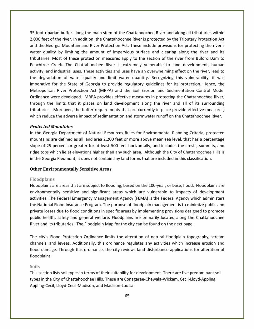
65
35 foot riparian buffer along the main stem of the Chattahoochee River and along all tributaries within 2,000 feet of the river. In addition, the Chattahoochee River is protected by the Tributary Protection Act and the Georgia Mountain and River Protection Act. These include provisions for protecting the river’s water quality by limiting the amount of impervious surface and clearing along the river and its tributaries. Most of these protection measures apply to the section of the river from Buford Dam to Peachtree Creek. The Chattahoochee River is extremely vulnerable to land development, human activity, and industrial uses. These activities and uses have an overwhelming effect on the river, lead to the degradation of water quality and limit water quantity. Recognizing this vulnerability, it was imperative for the State of Georgia to provide regulatory guidelines for its protection. Hence, the Metropolitan River Protection Act (MRPA) and the Soil Erosion and Sedimentation Control Model Ordinance were developed. MRPA provides effective measures in protecting the Chattahoochee River, through the limits that it places on land development along the river and all of its surrounding tributaries. Moreover, the buffer requirements that are currently in place provide effective measures, which reduce the adverse impact of sedimentation and stormwater runoff on the Chattahoochee River.
Protected Mountains In the Georgia Department of Natural Resources Rules for Environmental Planning Criteria, protected mountains are defined as all land area 2,200 feet or more above mean sea level, that has a percentage slope of 25 percent or greater for at least 500 feet horizontally, and includes the crests, summits, and ridge tops which lie at elevations higher than any such area. Although the City of Chattahoochee Hills is in the Georgia Piedmont, it does not contain any land forms that are included in this classification.
Other Environmentally Sensitive Areas
Floodplains Floodplains are areas that are subject to flooding, based on the 100-year, or base, flood. Floodplains are environmentally sensitive and significant areas which are vulnerable to impacts of development activities. The Federal Emergency Management Agency (FEMA) is the Federal Agency which administers the National Flood Insurance Program. The purpose of floodplain management is to minimize public and private losses due to flood conditions in specific areas by implementing provisions designed to promote public health, safety and general welfare. Floodplains are primarily located along the Chattahoochee River and its tributaries. The Floodplain Map for the city can be found on the next page. The city’s Flood Protection Ordinance limits the alteration of natural floodplain topography, stream channels, and levees. Additionally, this ordinance regulates any activities which increase erosion and flood damage. Through this ordinance, the city reviews land disturbance applications for alteration of floodplains.
Soils This section lists soil types in terms of their suitability for development. There are five predominant soil types in the City of Chattahoochee Hills. These are Conagaree-Chewala-Wickam, Cecil-Lloyd-Appling, Appling-Cecil, Lloyd-Cecil-Madison, and Madison-Louisa.
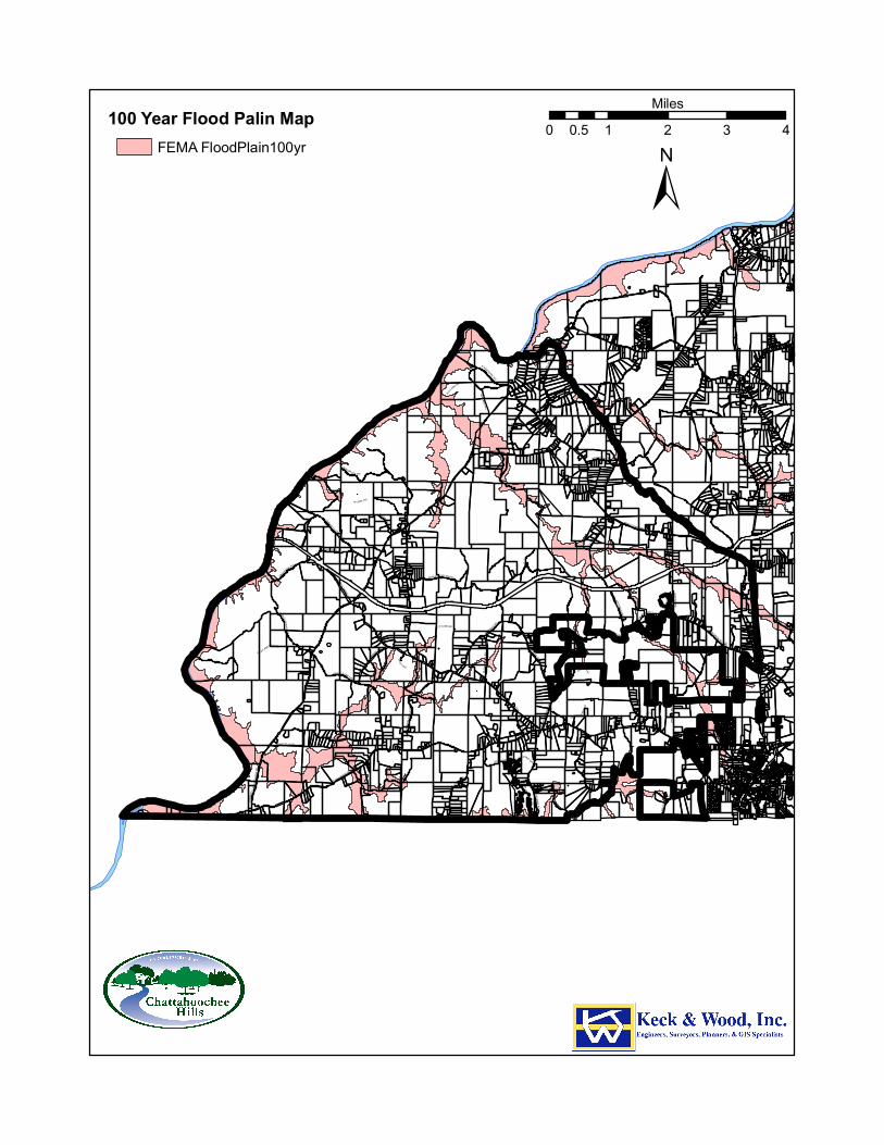
RICO RD
SOUTH FULTON PW
RIVERTOWN RD
CAMP
B EL L
T ON
REDW
INE
R D
HUTCHESON FERRY RD
JONES FE RRY RD
KITE R
D
UP PER WOOTEN RD
CAPPS FERRY RD
PHILL
IPS
RD
O LD RICO RD
H AMI LTO N RD
SARD
IS R
D
OL D H AMILTON RD
PACE
R D
WATKINS R D
M IXON RD
PETERS BURG RD
HOPKINS RD
HEAR
N RD
BARNES RD
WILKERSON MILL RD
VERN
ON G
ROVE
RD
BRAZ
ELL R
D
WHITESIDE R D
ATLANTA NEW NAN R D
CRE EL RD
C OCHRAN MI LL R D
SELBORNE L N
CASCADE PALMETTO HW
GARRETTS FERRY RD
STEE D R D
WOO DRUF F RD
CEDA
R GR
OVE R
D
RICO TATUM R D
W ATE
R W
ORKS RD
JENK
INS
RD
OLD
P HILL
IPS
R D
MANSFIELD DR
BULLARD RD
BULLA RD WY
BRUI
N W
Y
RI CO LAKE RD
HENRY M I LL RD
SERE
NBE
LN
DRIVEWAY
RIVE
R LA
KE D
R
SELBORNE WAY
GRAV
EL R
D
CAINEY LN
MUT T RD
P INE Y WOO DS CHURCH RD
BEAV
ER RD
TAB WY
OLD COCHRAN RD
RICO WY
TIDER
ACE
CT
BIG BEAR CT
WHITESIDE RD
CAIN
EY LN
WILKE RSON MILL RD
WOODRUFF RD
MIXO N RD
RIC O TATUM RD
ATLA
NTA N
EWNA
N RD
COCH
RAN M
ILL R
D
CAP PS F E RRY R
D
WOODRUFF RD
JENKINS RD
PHILLIPS RD
SOUTH FULTON PW
RIVERTOWN RD
RIVERTOWN RD
COCHRAN MILL
RD
JONES FERRY RD
100 Year Flood Palin MapFEMA FloodPlain100yr
±0 1 2 3 40.5
Miles
67
Conagaree-Chewala-Wickam soils are predominant along the Chattahoochee River and its tributaries. This area is characterized by well-drained slopes along the Chattahoochee River. However, along smaller streams; drainage is somewhat poor due to the buildup of sediment and the presence of vegetation. Cecil-Lloyd-Appling soils are located primarily east of the Chattahoochee River. This area is characterized by well drained rolling and hilly uplands. However, this soil is subject to moderate to severe erosion. Appling-Cecil soils are well drained and occur on hilly uplands primarily used for pasturelands. Lloyd-Cecil-Madison soils are located east of the Chattahoochee River. They are well drained and occur on rolling and hilly uplands. Madison-Louisa soils are rare in southwest Fulton. They are found on well drained steep V-shaped valleys, sharp ridges.
Steep Slopes Steep slopes are important for their scenic quality and for their hazard potential due to erosion or slippage. Steep slopes are unique natural areas. Ravines and steep hillsides often provide impressive scenic views. Vegetation in steep slopes provides not only wildlife habitat but also natural beauty. Wildlife exists in relative safety due to the limited accessibility of such sites. The naturally occurring vegetation on such sites also stabilizes the slopes, preventing severe erosion or landslides. In addition, such slopes often serve as natural boundaries and buffers between land uses or districts in a community. Changing the character of a slope can thus bring adjacent incompatible land uses into more direct conflict. Steep slopes greater than 15% are shown on the map on the next page. The city enforces slope stability during new development activities. The city’s Soil Erosion and Sedimentation Control Ordinance enforces stabilization of slopes during new development activities as follows:
• All slopes shall be stabilized immediately and shall remain so for a period of no less than one year from the issuance of the project's final certificate of occupancy and/or the recording of a final plat.
• All slopes greater than or equal to 3H:IV must be permanently stabilized with structural or vegetative BMPs.
• A plan must be submitted to demonstrate that all slopes associated with fill/cut sections have been adequately designed to be stabilized structurally (such as retaining walls) or vegetatively (erosion mat/blanket, tree bark mulch, etc). Such analysis, reports, or design shall be prepared and approved by a certified design professional.
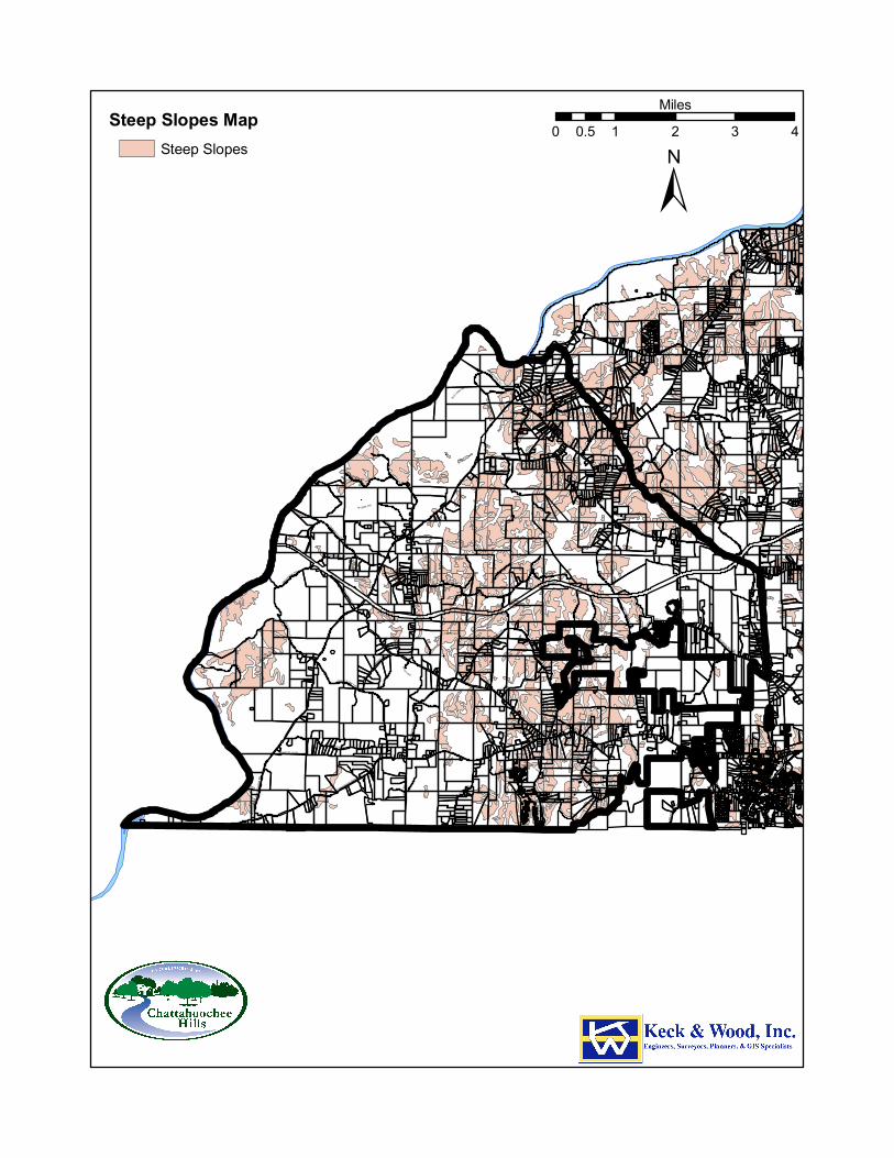
RICO RD
SOUTH FULTON PW
RIVERTOWN RD
CAMP
B EL L
T ON
REDW
INE
R D
HUTCHESON FERRY RD
JONES FE RRY RD
KITE R
D
UP PER WOOTEN RD
CAPPS FERRY RD
PHILL
IPS
RD
O LD RICO RD
H AMI LTO N RD
SARD
IS R
D
OL D H AMILTON RD
PACE
R D
WATKINS R D
M IXON RD
PETERS BURG RD
HOPKINS RD
HEAR
N RD
BARNES RD
WILKERSON MILL RD
VERN
ON G
ROVE
RD
BRAZ
ELL R
D
WHITESIDE R D
ATLANTA NEW NAN R D
CRE EL RD
C OCHRAN MI LL R D
SELBORNE L N
CASCADE PALMETTO HW
GARRETTS FERRY RD
STEE D R D
WOO DRUF F RD
CEDA
R GR
OVE R
D
RICO TATUM R D
W ATE
R W
ORKS RD
JENK
INS
RD
OLD
P HILL
IPS
R D
MANSFIELD DR
BULLARD RD
BULLA RD WY
BRUI
N W
Y
RI CO LAKE RD
HENRY M I LL RD
SERE
NBE
LN
DRIVEWAY
RIVE
R LA
KE D
R
SELBORNE WAY
GRAV
EL R
D
CAINEY LN
MUT T RD
P INE Y WOO DS CHURCH RD
BEAV
ER RD
TAB WY
OLD COCHRAN RD
RICO WY
TIDER
ACE
CT
BIG BEAR CT
WHITESIDE RD
CAIN
EY LN
WILKE RSON MILL RD
WOODRUFF RD
MIXO N RD
RIC O TATUM RD
ATLA
NTA N
EWNA
N RD
COCH
RAN M
ILL R
D
CAP PS F E RRY R
D
WOODRUFF RD
JENKINS RD
PHILLIPS RD
SOUTH FULTON PW
RIVERTOWN RD
RIVERTOWN RD
COCHRAN MILL
RD
JONES FERRY RD
Steep Slopes MapSteep Slopes
±0 1 2 3 40.5
Miles
69
Steep slopes are enforced through the Best Management Practices (BMPs) during construction. These areas present special concerns for development or building. Alteration of steeply sloped grades may result in excessive runoff, erosion, or hillside slippage. Such effects pose a danger not only to the property owner, but also to adjacent property owners.
Prime Agricultural and Forest Land As Fulton County and the Atlanta Region have grown and developed, the number of acres in farmland and the numbers of farms have decreased. The National Farm Land Trust in its report “Farming from the Edge: Sprawling Development Threatens America’s Best Farm Land”, identified South Fulton as having concentrations of prime and/or unique farmland coinciding with developing areas. The 2007 Agricultural Census shows that Fulton County farms raise livestock, and grow produce and hay. Some farms produce fruit, vegetables and corn. Some farms are horse farms. In 2007, there were 204 farms in Fulton County comprising 15,557 acres. Many of those are in Chattahoochee Hills. Most of the city’s forest lands are located in parks and on private land. The Fulton County Cooperative Extension’s Agriculture Horticulture & Environment programs promote stewardship and development of natural resources through education, technical assistance, testing, instruction, and services. The programs provide Fulton County citizens with information and assistance regarding sustainable agriculture, livestock and pasture management, forest and natural resource management, landscaping (turf), green industry (agribusiness), vegetable/fruit production, insect control (termites), plant disease, waste management, chemical pesticides (herbicide and insecticides) and water, soil, and plant analysis. Additionally, County Extension staff works with the Farm Bureau and agricultural producers. Trees improve the appearance of new development, slow stormwater runoff, improve air quality, reduce summer energy needs resulting from direct shading of trees, and reduce temperatures, reducing energy consumption and air pollution. The city’s Tree Ordinance, attempts to balance the needs of a growing community with the need to protect green space. The Ordinance provides standards for tree preservation during land development, building construction and timber harvesting. The Ordinance requires the approval of the city before any specimen trees can be cut down. As part of the land disturbance permit (LDP) application process, tree protection and landscape plans must be submitted for review and approval. Each site is walked and visited periodically during land disturbance activities. In addition, the LDP is not issued until the city approves the submitted tree protection plan. The State of Georgia provides a program to encourage land conservation and agricultural uses by reducing the amount of taxes paid. In the Use Valuation of Conservation Use Properties program, land is assessed by a formula that considers the income potential of the land based on productivity. Under this program, land is usually assessed at 5% of its value. A conservation use valuation is granted for ten years for agricultural, forestry, and environmentally sensitive lands. The purchase of development rights and a conservation easement on a property will also reduce the value of the parcel. When a property’s development rights have been encumbered by a conservation easement, then the land is assessed on its intrinsic value, such as agricultural productivity. Any property owner wishing to apply for the
70
conservation use assessment can do so through the Fulton County Tax Assessor’s Office. The decision to grant preferential tax assessment for both programs rests with the five-member Board of Assessors. The largest concentration of parcels in this program is in the City of Chattahoochee Hills.
Conservation Subdivision Ordinance When the City of Chattahoochee Hills was incorporated, it adopted a Conservation Subdivision Ordinance. The regulation promotes the preservation of open space within residential developments by providing flexibility to allow for creativity in developments. Open space is the portion of the conservation subdivision that has been set aside for permanent protection. The intent of the regulation is to minimize the environmental and visual impacts of new developments on critical natural resources and historically and culturally significant sites and structures. It encourages a more efficient form of development that consumes less open land and conforms to existing topography and natural features. Erosion and sedimentation is reduced by minimizing land disturbance and removal of vegetation. The Conservation Subdivision option is available for single family detached residential developments in agricultural and residential districts. Each conservation subdivision is required to provide a minimum of 60% of its total acreage as open space. The open space is designated as either primary conservation areas or as secondary conservation areas. Primary conservation areas form the core of the open space to be protected. Active recreation areas are prohibited in primary conservation areas. Secondary conservation areas consist of undeveloped but buildable land and protected (constrained) lands. Interconnectivity of all open space within a Conservation Subdivision is required.
Transfer of Development Rights Ordinance Transfer of Development Rights Ordinance allows property owners to sell the development rights to their property while retaining ownership of the land. On April 22, 2003, the State Legislature passed an amendment to the Transfer of Development Rights legislation (Senate Bill 86); making TDRs available to any county that adopts enabling TDR ordinances. Fulton County passed the enabling ordinance on April 2, 2003 and when the City of Chattahoochee Hills incorporated in 2007, it also adopted the ordinance. The purpose of Fulton County’s TDR Ordinance is to provide for the transfer of development rights (the maximum development that would be allowed on a parcel under its current zoning) from one property to another to promote the conservation of natural, agricultural, environmental, historical and cultural resources and encourage compact growth in appropriate areas. The TDR ordinance makes the transfer of development rights available to Chattahoochee Hills landowners with one acre or more of undeveloped property, excluding mandated stream buffers. The landowners are allowed 1 TDR per 1 acre of property without a residential structure.
Endangered Species According to the US Fish and Wildlife Service, there are two species of endangered animals in Fulton County and possibly in the City of Chattahoochee Hills. They are the Indiana bat (Myotis sodalist) and the red cockaded woodpecker (Picoides borealis). Although current city regulations address tree protection, there is a need for plant and animal habitat protection. These habitats are vulnerable to land development and are in danger of becoming permanently altered or completely lost because of sporadic
71
land development in and around ecologically sensitive areas. Ecologically sensitive areas include wetland, forests, and river corridor, and plant and animal habitats.
Other Significant Natural Resources The City of Chattahoochee Hills has recently contracted with Fulton County to purchase the parks within its boundaries. Included in the parks purchase was Cochran Mill Park (780 acres), Hutcheson Ferry Park (103 acres), and 234 acres of undeveloped land that borders the Chattahoochee River (see Community Facilities Element). Parks and recreation areas are included in the Community Facilities Element. The Cochran Mill Nature Center is located on 50 heavily wooded acres and is adjacent to Cochran Mill Park. All programs are designed to promote awareness, appreciation, and knowledge of the environment. Several of Cochran Mill Nature Center’s programs include Native Wildlife of Georgia, Exotic and Endangered Species, Forest Education and Backyard Habitats. Moreover, the nature center serves a rehabilitation center for injured and endangered wildlife.
Significant Cultural Resources
Scenic Byways In 1997, Georgia Department of Transportation designated three roads in what is now the City of Chattahoochee Hills as the first Georgia Scenic Byways. The effort to designate these three roadways as scenic byways emerged from community input in the update of the 2010 Fulton County Comprehensive Plan. The South Fulton Scenic Byways, made up of Cochran Mill Road, Hutcheson Ferry Road and State Route 70 (Campbellton-Redwine Road), represent a total combined length of 29.47 miles and provide a loop throughout a largely rural and pastoral section of the city. There is a Corridor Management Plan for the Scenic Byways. Additionally, students from the Heritage Preservation Masters Degree Program at Georgia State University conducted an inventory and evaluation of the intrinsic qualities of the Scenic Byways. The survey identified road sections with tree canopies, wooded parcels, pasture, farms, scenic vistas, and outcroppings. The survey identified three main scenic vistas. Property owners in this area developed a land use plan and development standards to protect the area’s rural character and scenic vistas. Both were adopted by the Fulton County Board of Commissioners in 2002. The plan calls for development to be concentrated along three main villages and for the protection of much of the land thru transfer of development rights. The development standards protect the view from the scenic byways thru a 100 foot natural undisturbed buffer. The Scenic Byways Historic Context report was done by the Fulton County Environment and Community Development Department in January 2007. The following information is an excerpt from that report.
In the Fulton County Historic Resources Survey, seventy-eight structures were surveyed along Hutcheson Ferry Road, Cochran Mill Road, and S.R. 70, Campbellton-Redwine Road and Cedar Grove Road. Of these, 55% (42 structures) may be eligible to be placed on the National Register of Historic Places. Most of the resources surveyed were, or are used as residences (85%). Other resource types include churches, stores, a lodge, and a historic marker. Several outbuildings along both S.R. 70 and Cochran Mill Road, most
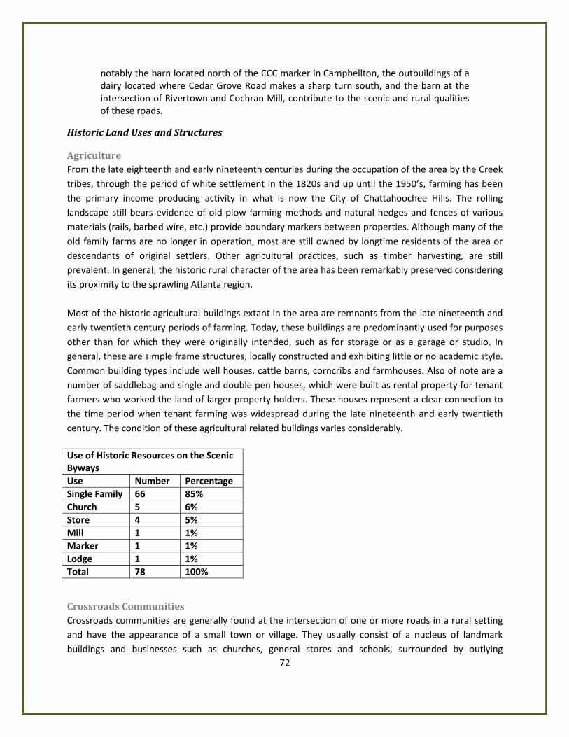
72
notably the barn located north of the CCC marker in Campbellton, the outbuildings of a dairy located where Cedar Grove Road makes a sharp turn south, and the barn at the intersection of Rivertown and Cochran Mill, contribute to the scenic and rural qualities of these roads.
Historic Land Uses and Structures
Agriculture From the late eighteenth and early nineteenth centuries during the occupation of the area by the Creek tribes, through the period of white settlement in the 1820s and up until the 1950’s, farming has been the primary income producing activity in what is now the City of Chattahoochee Hills. The rolling landscape still bears evidence of old plow farming methods and natural hedges and fences of various materials (rails, barbed wire, etc.) provide boundary markers between properties. Although many of the old family farms are no longer in operation, most are still owned by longtime residents of the area or descendants of original settlers. Other agricultural practices, such as timber harvesting, are still prevalent. In general, the historic rural character of the area has been remarkably preserved considering its proximity to the sprawling Atlanta region. Most of the historic agricultural buildings extant in the area are remnants from the late nineteenth and early twentieth century periods of farming. Today, these buildings are predominantly used for purposes other than for which they were originally intended, such as for storage or as a garage or studio. In general, these are simple frame structures, locally constructed and exhibiting little or no academic style. Common building types include well houses, cattle barns, corncribs and farmhouses. Also of note are a number of saddlebag and single and double pen houses, which were built as rental property for tenant farmers who worked the land of larger property holders. These houses represent a clear connection to the time period when tenant farming was widespread during the late nineteenth and early twentieth century. The condition of these agricultural related buildings varies considerably. Use of Historic Resources on the Scenic Byways Use Number Percentage Single Family 66 85% Church 5 6% Store 4 5% Mill 1 1% Marker 1 1% Lodge 1 1% Total 78 100%
Crossroads Communities Crossroads communities are generally found at the intersection of one or more roads in a rural setting and have the appearance of a small town or village. They usually consist of a nucleus of landmark buildings and businesses such as churches, general stores and schools, surrounded by outlying
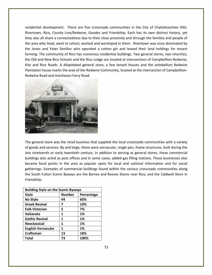
73
residential development. There are five crossroads communities in the City of Chattahoochee Hills: Rivertown, Rico, County Line/Redwine, Goodes and Friendship. Each has its own distinct history, yet they also all share a connectedness due to their close proximity and through the families and people of the area who lived, went to school, worked and worshiped in them. Rivertown was once dominated by the Jones and Yates families who operated a cotton gin and leased their land holdings for tenant farming. The community of Rico has numerous residential buildings. Two general stores, two churches, the Old and New Rico Schools and the Rico Lodge are located at intersections of Campbellton-Redwine, Kite and Rico Roads. A dilapidated general store, a few tenant houses and the antebellum Redwine Plantation house marks the area of the Redwine Community, located at the intersection of Campbellton-Redwine Road and Hutcheson Ferry Road.
The general store was the retail business that supplied the local crossroads communities with a variety of goods and services. By and large, these were vernacular, single pen, frame structures, built during the late nineteenth or early twentieth century. In addition to serving as general stores, these commercial buildings also acted as post offices and in some cases, added gas filling stations. These businesses also became focal points in the area as popular spots for local and national information and for social gatherings. Examples of commercial buildings found within the various crossroads communities along the South Fulton Scenic Byways are the Barnes and Reeves Stores near Rico, and the Caldwell Store in Friendship. Building Style on the Scenic Byways Style Number Percentage No Style 44 60% Greek Revival 7 10% Folk Victorian 5 7% Italianate 1 1% Gothic Revival 1 1% Neoclassical 1 1% English Vernacular 1 1% Craftsman 13 18% Total 73 100%
74
Mills Wilkerson Mill represents a second type of commercial building in the area that is more closely related to industry and manufacturing. Located on Little Bear Creek, off Wilkerson Mill Road, the three-story, timber frame construction features Greek Revival architectural elements and dates from the late 1860s. Like the old Cochran Mill, whose ruins are located just to the west, Wilkerson Mill was part of a commercial enterprise that processed local farmer’s corn and wheat produce. The building’s machinery operated on hydro energy and remained in use until the 1960s. At the time of its construction, grist milling was a common and profitable business, not only in Campbell County, but also throughout the region and the state of Georgia. Today, Wilkerson Mill is one of the few remaining gristmills within the Atlanta region.
Historic Houses and Farmhouses Most of the historic structures are houses and farmhouses and related outbuildings. The majority of significant buildings were built between 1880 and 1930. Most of these are one story vernacular houses with wood siding which were probably the center of small farms and most had attendant outbuildings. Some of the most prevalent house types include: gable ell cottages, central hallways, Georgian cottages, and bungalows. Smaller houses, mainly saddlebags most likely used by tenant farmers, are also present. Two story houses, which were often the center of larger farmsteads in the area, include five gable ell houses and four plantation plain house types. House Type on the Scenic Byways Type Number Percentage Single Pen 3 5% Double Pen 1 2% Saddlebag 5 8% Central Hall 16 24% Gable Cottage 9 14% Georgian Cottage 8 12% New South Cottage 1 2% Pyramid Cottage 1 25 Bungalow 12 18% Side Gable Cottage 1 25 Gable ell House 5 8% Plantation Plain House 4 16% Total 66 100% Historic houses in Chattahoochee Hills represent a broad pattern of the area’s history. The houses have a wide date range of construction (1830s through the 1950s) and a variety of popular architectural styles during that time frame. The majority of houses (60%) do not have an academic architectural style. However, many have elements of a style or a vernacular interpretation of a style that is commonly found in historic rural communities throughout Georgia. The most common style represented is the Craftsman style (18%). Other examples of high styles represented are: Greek Revival, Italianate, Folk
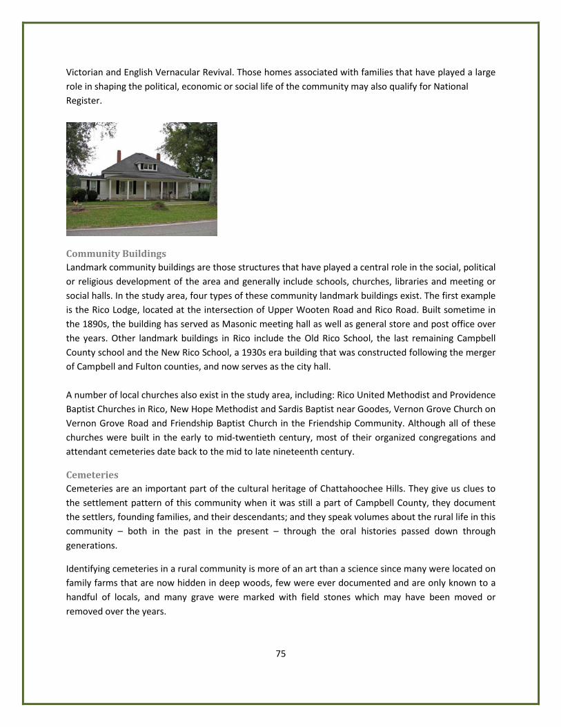
75
Victorian and English Vernacular Revival. Those homes associated with families that have played a large role in shaping the political, economic or social life of the community may also qualify for National Register.
Community Buildings Landmark community buildings are those structures that have played a central role in the social, political or religious development of the area and generally include schools, churches, libraries and meeting or social halls. In the study area, four types of these community landmark buildings exist. The first example is the Rico Lodge, located at the intersection of Upper Wooten Road and Rico Road. Built sometime in the 1890s, the building has served as Masonic meeting hall as well as general store and post office over the years. Other landmark buildings in Rico include the Old Rico School, the last remaining Campbell County school and the New Rico School, a 1930s era building that was constructed following the merger of Campbell and Fulton counties, and now serves as the city hall. A number of local churches also exist in the study area, including: Rico United Methodist and Providence Baptist Churches in Rico, New Hope Methodist and Sardis Baptist near Goodes, Vernon Grove Church on Vernon Grove Road and Friendship Baptist Church in the Friendship Community. Although all of these churches were built in the early to mid-twentieth century, most of their organized congregations and attendant cemeteries date back to the mid to late nineteenth century.
Cemeteries Cemeteries are an important part of the cultural heritage of Chattahoochee Hills. They give us clues to the settlement pattern of this community when it was still a part of Campbell County, they document the settlers, founding families, and their descendants; and they speak volumes about the rural life in this community – both in the past in the present – through the oral histories passed down through generations.
Identifying cemeteries in a rural community is more of an art than a science since many were located on family farms that are now hidden in deep woods, few were ever documented and are only known to a handful of locals, and many grave were marked with field stones which may have been moved or removed over the years.
76
In 2009, the Chattahoochee Hills Historical Society began a project to identify and document all of the cemeteries within the city of Chattahoochee Hills, as well as cemeteries of historical significance in adjoining historic Campbell County. As of March, 2010, 33 cemeteries have been identified and recorded on the website: www.chattahoocheehillshistoricalsociety.org.
Cemetery List
Church Cemeteries Community Cemeteries Family Cemeteries Primitive Cemeteries
Andrews Chapel UMC* Old Rico Cemetery Astin Cochran Mill Park #1
Campbellton Baptist * Rico Cemetery Bryant Cochran Mill Park #1
Campbellton Baptist 2* Tommy Lee Cook Rd * Burson
Campbellton Methodist*
Camp
Friendship Baptist Duggan *
Liberty Hill Methodist Jackson
Macedonia Lassetter *
New Hope UMC Little
Piney Woods Baptist Phillips
Rivertown UMC Richardson
Sardis Baptist Terry-Tanner
St. Paul AME Varner
Vernon Grove Watkins
Whiteside Rd
Zellars
* Denotes cemeteries of historical significance in adjoining historic Campbell County.
Types of Cemeteries
The Chattahoochee Hills Historical Society has identified four types of cemeteries: church, community, family, and primitive cemeteries.
Church cemeteries date back to the early 1800s, with the oldest identified as the Piney Woods Church Cemetery on Kite Road. This cemetery has approximately 50 visible grave sites including box slab tombs, graves covered in sea shells, traditional tombstones, and unmarked rocks. One side of the burial ground is the graves of the slaves of the families, according to an article written by Helen Collins Selman (We wanted to be called Green Eyes.) To date, nine church cemeteries have been identified within Chattahoochee Hills. Five are actively supported by churches: Friendship Baptist, New Hope United Methodist, Rivertown United Methodist, Sardis Baptist, and Vernon Grove Baptist; four are abandoned: Liberty Hill Methodist, Macedonia, Piney Woods, and St. Paul AME; and four are in historic Campbell County: Andrews Chapel UMC, Campbellton
77
Baptist, Campbellton Baptist, and Campbellton Methodist. Community cemeteries date back to the early 1800s. There are two in Chattahoochee Hills: The Rico Cemetery next to Providence Baptist Church on Campbellton Redwine Rd. which is still active; and the Old Rico Cemetery on private property on Rico Rd which is abandoned. One community cemetery is in historic Campbell County on Tommy Lee Cook Rd. Family cemeteries make up the majority of cemeteries, with 15 identified to date including 13 in Chattahoochee Hills and two in historic Campbell County. In naming these cemeteries, the Historical Society used one of the following conventions: the name of the cemetery known by the locals, the earliest know tombstone, the name of the majority of tombstones, or the street location of the cemetery (in that order). The two cemeteries in historic Campbell County are of particular interest:
• The Lassetter Family Cemetery is located on Hutcheson Ferry Farms in Whitesburg, GA. This land was once a part of Campbell County accessible via Hutcheson Ferry Road, and is significant to the history of Chattahoochee Hills because (it is believed that) Cheadle Cochran is buried there. Cheadle was a state senator and operated a mill in Campbell County in what is today Cochran Mill Park in Chattahoochee Hills. There are also decedents from the Lassetter Family currently living in our city. This history is according to the family member Carole Harper.
• The Duggan Family Cemetery is located on Rivertown Road just outside the boundaries of Chattahoochee Hills. While it only has four grave sites, one is of Pvt. John N. Duggan who served in the Confederate States Army.
There are a number of primitive cemeteries in Chattahoochee Hills marked only by fieldstones. In all instances, these cannot be validated as cemeteries without technical research and specialized equipment. The purpose in recording these cemeteries is to identify their location in the event the land is ever resold or developed. The cemetery notated as Cochran Mill Park #1 seems to more closely resemble a primitive cemetery than the others.
78
Community Facilities and Services The Community Facilities and Services element describes the facilities and services available to support existing development as well as the facilities and infrastructure that will be available for future growth. Adequate facilities promote public health, safety, and welfare throughout the city. This element provides a city-wide overview of various public services and facilities. The goal of this assessment is to promote a better understanding of service issues and provide a framework for coordinated planning. Specifically, the Community Facilities and Services Element evaluates the existing level of public services and facilities in the city including water, sewer, stormwater system, streets, fire protection, law enforcement, solid waste management, parks and recreation, administrative services, library, and school facilities, as required by the Georgia Department of Community Affairs. The element serves as a guide for decision-making by public officials and the development community in prioritizing decisions on infrastructure improvements and expenditures of funds. The City of Chattahoochee Hills provides public services to the residents of the city through city departments and contracted services. The Community Facilities Map, found on the next page, shows the location of community facilities in the city. The Water Service Area Map is on the following page. The city employs a highly dedicated workforce of over 40 people and has an approved operating budget for fiscal year 2010 of $2,597,507.
General Government Chattahoochee Hills is governed by a Mayor and City Council who are elected by the people of the city. The Mayor is elected at-large and councilmembers are elected by district. All Governing Body members serve four-year terms. As the elected representative of the people, the governing body adopts all ordinances and resolutions and determines the general goals and policies of the city.
The Mayor and City Council delegate administration of the government to the City Manager, who is appointed by the Mayor and City Council. The City of Chattahoochee Hills operates under the Council-Manager form of government. This system combines the strength of an elected City Council with a professional manager and staff. The City Manager is responsible for the operations of all city departments and the following department leadership reports directly to the City Manager: • Finance Director
• City Planner
• Public Works & Parks Director
• Police Chief / Fire Chief
• Municipal Court Clerk
• Information Technology Manager
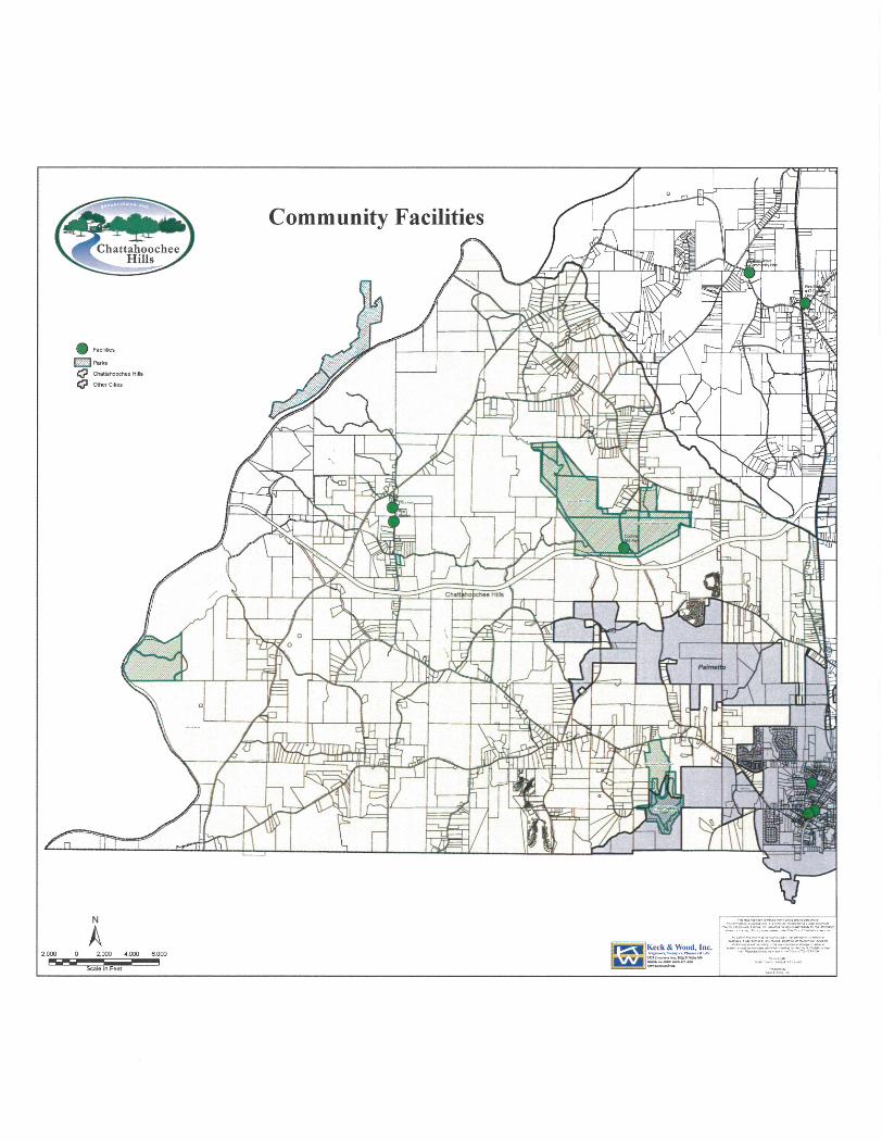
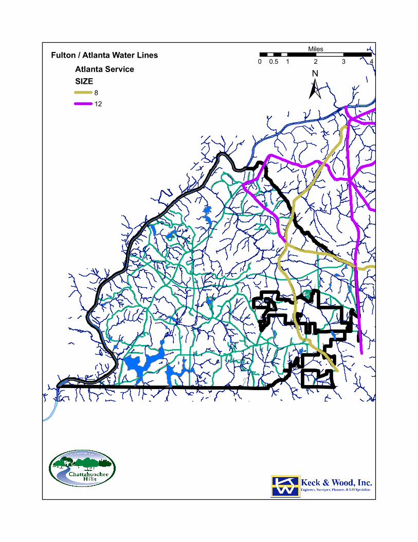
RICO RD
SOUTH FULTON PW
RIVERTOWN RD
CAMP
B EL L
T ON
REDW
INE
R D
HUTCHESON FERRY RD
JONES FE RRY RD
KITE R
D
UP PER WOOTEN RD
CAPPS FERRY RD
PHILL
IPS
RD
O LD RICO RD
H AMI LTO N RD
SARD
IS R
D
OL D H AMILTON RD
PACE
R D
WATKINS R D
M IXON RD
PETERS BURG RD
HOPKINS RD
HEAR
N RD
BARNES RD
WILKERSON MILL RD
VERN
ON G
ROVE
RD
BRAZ
ELL R
D
WHITESIDE R D
ATLANTA NEW NAN R D
CRE EL RD
C OCHRAN MI LL R D
SELBORNE L N
CASCADE PALMETTO HW
GARRETTS FERRY RD
STEE D R D
WOO DRUF F RD
CEDA
R GR
OVE R
D
RICO TATUM R D
W ATE
R W
ORKS RD
JENK
INS
RD
OLD
P HILL
IPS
R D
MANSFIELD DR
BULLARD RD
BULLA RD WY
BRUI
N W
Y
RI CO LAKE RD
HENRY M I LL RD
SERE
NBE
LN
DRIVEWAY
RIVE
R LA
KE D
R
SELBORNE WAY
GRAV
EL R
D
CAINEY LN
MUT T RD
P INE Y WOO DS CHURCH RD
BEAV
ER RD
TAB WY
OLD COCHRAN RD
RICO WY
TIDER
ACE
CT
BIG BEAR CT
WHITESIDE RD
CAIN
EY LN
WILKE RSON MILL RD
WOODRUFF RD
MIXO N RD
RIC O TATUM RD
ATLA
NTA N
EWNA
N RD
COCH
RAN M
ILL R
D
CAP PS F E RRY R
D
WOODRUFF RD
JENKINS RD
PHILLIPS RD
SOUTH FULTON PW
RIVERTOWN RD
RIVERTOWN RD
COCHRAN MILL
RD
JONES FERRY RD
Fulton / Atlanta Water LinesAtlanta ServiceSIZE
812
±0 1 2 3 40.5
Miles
81
The City Manager's office is also supported by a City Clerk who serves as the City Hall receptionist and performs administrative duties supporting the Mayor and Council and all city departments. The City Clerk is the keeper of all official city records and the city seal. The City Clerk is responsible for the preparation, execution, and archiving of all City Council documents as prescribed by state law and city code. These duties include: • Producing City Council and board/commission meeting agendas • Recording minutes for all City Council and board/commission meetings • Maintaining City Council meeting and election materials • Archiving all City Council documents, official proceedings, ordinances, and resolutions • Publicizing of legal notices • Providing Notary Public services • Maintaining board/commissions applications and appointments • Administering Special Events Permits • Providing clerical support the Mayor, City Council and all city departments • Serves as the city receptionist and first point of contact at City Hall
Municipal Court Municipal Court handles traffic citations, ordinance violations, and misdemeanor or criminal offenses committed within the city limits of Chattahoochee Hills. The Honorable Jim Barfield is the city's municipal court judge. All offenders under age 17 are directed to Fulton County’s juvenile court system.
Public Works and Parks Department The purpose of the Public Works & Parks Department is to manage the maintenance and repair of the city's right-of-way, public roadways, bridges and park land. Public works staff is also responsible for facilities and management of capital projects, both in-house and contracted.
Community Development The Community Development Department is responsible for the city's Comprehensive Plan, zoning, land use activities, code enforcement, building inspections and permitting. The Community Development Department also serves as the liaison to economic development activities.
Finance Department The Finance Department is responsible for accounting, budgeting, purchasing, treasury, payroll, billing/collection, business licensing, analysis, financial reporting and the administration of all other financial affairs of the city.
Public Safety The Public Safety Department is comprised of the Police and Fire Divisions. It is responsible for the general safety of the citizens of Chattahoochee Hills and the protection of property within the city limits. The Department of Public Safety is a full service 24-hour agency to meet the needs of the city.
82
The department’s challenges revolve around a limited budget and large service area requirements. The department indicated that it stays current with technology and that it maintains a regiment of quality training for its staff.
Police Department The department provides general law enforcement functions and has officers trained in specialized areas such as accident investigation, criminal and drug investigation, traffic enforcement, and juvenile crime. Municipal Court provides probation services through a contract with a private probation company. The department roster includes 11 full-time and 5 part time officers. There are eight vehicles assigned to the department. The department works closely with other law enforcement agencies in the area and is linked to both state and national crime information centers.
Fire Department The main function of the Fire Department is to protect life and property. This is accomplished by responding to emergency incidents and providing safety programs to the public that include:
• Fire response
• Rescue
• Medical first responder
• Fire inspections on all businesses
• Issue burn permits for all outside burning
• Fire safety education The Fire Department is staffed by nine full time and nine part time firefighters. The apparatus inventory includes two fire trucks, one ambulance, one support truck, and one administration vehicle. A full complement of rescue equipment is also carried. The department has received certification from the State of Georgia and the Georgia Emergency Management Agency for rescue operations. All full-time and a majority of the part-time firefighters are state and nationally certified.
Appointed Boards At this time, the City of Chattahoochee Hills has one appointed board. The Planning Commission was seated on March 4, 2008 and operates as an advisory board to the City Council. The Planning Commission hears requests for rezonings and proposed changes to the zoning ordinance and subdivision regulations.
City Buildings The City of Chattahoochee Hills has a City Hall building located at 6505 Rico Road, in the Old Rico School building. All of the city administration functions are housed in the City Hall building. The building also houses the city’s Police Department and the Chattahoochee Hills Community Library (not city owned or managed). The city’s fire station is located at 6515 Rico Road.
83
Libraries Although the City of Chattahoochee Hills is served by the Fulton County Library System, no Fulton County libraries are located in the city. The closest Fulton County library is located in Fairburn. There is however a community run library, operating on donations, located in the city hall building. It houses more than 10,000 books, videos, DVDs, audio books on tape and CD, and also has a computer and network access available to the community free of charge. The Library is managed by Community Brickworks, a local nonprofit organization, and staffed by local volunteers.
City Parks
Cochran Mill Park — 780 Acres 6875 Cochran Mill Road Located between Rivertown Road and Wilkerson Mill Road. Facilities: • Picnic Shelter • Restrooms • Primitive camping • Wildlife habitat • Hiking, jogging, and horse trails • Parking lot and road (gravel) • Bridge
Hutcheson Ferry Park — 103 Acres 9774 Hutcheson Ferry Road Located at the intersection of Hutcheson Ferry Road and Gravel Road.
Rico Park — 5 Acres 6505 Rico Road Located at the intersection of Rico Road and Upper Wooten Road. Facilities: • Park center building • Athletic field • Playground • Picnic shelter • Sand volleyball court • Walking trail • Picnic tables • Grills
Chattahoochee River Greenspace (Future Chattahoochee Riverside Park) — 234 Acres No address has been assigned to this property. It is located off Jones Ferry Road, fronting the Chattahoochee River. This parcel is currently totally unimproved, and currently accessible only through an easement from an adjoining property owner. The 233.54 acres were donated by a private land
84
owner, and are intended for future use as parkland. This is the only public access to the Chattahoochee River in the city.
Water Supply and Treatment The City of Atlanta water service area includes all of south Fulton County except for the cities of College Park, East Point and Palmetto. Within this area the City of Atlanta provides water on a wholesale basis to the cities of Fairburn, Hapeville and Union City. Coweta, Clayton and Fayette counties are also wholesale customers. The boundaries for the City of Atlanta’s retail service area are the boundaries for the City of Atlanta and unincorporated Fulton County prior to Fairburn and Union City’s November 2006 annexations. As such, a portion of Fairburn and Union City now lie within the retail area served by the City of Atlanta. The City of Atlanta has extended its water service lines within the eastern edge of the City of Chattahoochee Hills. However most of the City of Chattahoochee residents have private wells for drinking water. Serenbe is served by City of Atlanta’s water. Water Supply Facilities The City of Atlanta’s water supply and treatment system consists of multiple facilities and an extensive network of water mains. Key to this system are two intake structures, two raw water pumping stations, three reservoirs, three treatment plants, fifteen pump stations, 12 storage tanks, five major administrative facilities and approximately 2,700 miles of water mains and pipes. Chattahoochee River Intake operates pursuant to a withdrawal permit of 180 million gallons per day from the Georgia Environmental Protection Division (EPD) and is the source of water for the Chattahoochee and Hemphill Water Treatment Plants (WTPs). Water from the intake flows to the Chattahoochee Raw Water Pumping Station from which it is pumped to the Hemphill WTP reservoirs or the Chattahoochee WTP. The Chattahoochee WTP has a maximum permitted treatment capacity of 64.9 million gallons per day (mgd). The two raw water reservoirs located at the Hemphill Water Treatment Plant have a total capacity of approximately 550 million gallons. Water flows from the raw water reservoirs to the Hemphill Water Treatment Plant which has a permitted maximum treatment capacity of 136.5 mgd. The Atlanta-Fulton County Water Treatment Plant (AFCWTP) is a joint venture plant owned by the City of Atlanta and Fulton County. The facility is managed by the Atlanta-Fulton County Water Resources Commission. The City of Atlanta and Fulton County jointly own the land and the facility on a fifty-fifty basis. Each entity is entitled to 50% of the total supply of water treated by the plant at any time or fifty percent of the capacity, whichever is greater. The AFCWTP intake operates pursuant to a withdrawal permit of 90 mgd from the Environmental Protection Division (EPD). This water withdrawal permit is anticipated to be increased to 135 mgd and is the source of water for the Atlanta-Fulton County Water Treatment Plant. The raw water is pumped from the Chattahoochee River to the raw water reservoir which has capacity of approximately 1 billion gallons. From the reservoir the water flows to the AFCWTP, which has a permitted capacity 90 mgd. Ultimately, this plant is anticipated to be expanded to 155 mgd.
85
Water Distribution System The City of Atlanta’s water distribution system consists of fifteen storage tanks, twelve pump stations and approximately 2,700 miles of water mains. The City of Atlanta owns and operates the distribution system within the City of Atlanta and within Fulton County south of the Chattahoochee River. Atlanta’s distribution system includes the pipelines required to service retail customers up to the edge of the right-of-way where ownership of the pipeline transfers to others. It should also be noted that Atlanta uses its distribution system to deliver water to its wholesale water customers. The water lines in the system range in age from one year to over seventy-five years and have diameter ranging from two to seventy-two inches. Nearly all of the pipes are constructed of cast iron or ductile iron. The older pipes are cast iron, with the installation of ductile iron pipe starting in the 1960’s. The distribution system storage tanks and pump stations serve to dampen instantaneous water demand and pressure fluctuations in the service area. The pump stations allow water to be pumped uphill and ensure that there is adequate pressure throughout the water system. A majority of the pump stations operate on standby status to be utilized during peak demand or in the event service from the Atlanta-Fulton County WTP is interrupted. The storage tanks provide backup water during peak demand or when there is a loss of pressure in the system. Elevated storage tanks are used to maintain pressure in the distribution system for general water delivery and fire flow protection. Overall, the distribution system has approximately forty-two (42) million gallons of storage (excluding storage at the water treatment facilities). The current level of service provided by Atlanta’s drinking water system is good. The water treatment plants have adequate capacity, water is routinely distributed throughout the distribution system to the customers, and the drinking water meets all water quality standards. Although the City of Atlanta’s water treatment supply and distribution facilities currently meet system demands, significant capital improvements are needed to ensure the ongoing delivery of water throughout the service area and to develop and maintain the system to meet future are the land and easements necessary to construct the needed infrastructure easy to obtain. The Metropolitan North Georgia Water Planning District’s Water Supply and Water Conservation Management Plan calls for construction of a new five million gallons a day (mgd) Bear Creek reservoir and Bear Creek water treatment plant in the City of Chattahoochee Hills sometime between 2011 and 2015. No funding source is named and the entity that will be responsible for management of these facilities is unclear. The plan states that the management for the Bear Creek Reservoir should be determined in the HB 489 renegotiation process. The plan also calls for the reservoir and treatment plant to be expanded from five mgd to ten mgd between 2016 and 2025, and for another expansion from 10 to 15 mgd between 2026 and 2035. Because water facilities and pipelines are designed for lifetimes of 30 to 100 years, and because they are constructed before the development they serve, the location of the water supply pipelines may dictate where development can occur. As such, the siting and development of the water supply system should be closely tied to the land use and development patterns desired by the city. Within the financial
86
constraints of the city, it is the desired development pattern that should drive the development of the water supply system, not the other way around.
Sewerage System and Wastewater Treatment In 1977, the Little Bear Creek WPCP was originally constructed as a package sewage treatment plant in with an average design capacity of 100,000 gallons per day. The plant, which once served all homes in the Crossroads subdivision, is now only a pumping station. The Little Bear Creek WPCP has an 8-inch diameter collection sewer and a below-ground pump station. Wastewater from the facility is treated at the Camp Creek WPCP. The plant is currently operating at approximately 40% capacity and meets all permit requirements. The Serenbe hamlet has a biological wastewater treatment system rather than a traditional sewer system. This system is the first of its kind to be built in Georgia. Treatment happens in a three-phase process: 1. Each home has an interceptor tank where wastewater is collected, then transported to the central treatment area through pipes that range between two and four inches. This design prevents major digging to lay large sewer lines, conserving more of the natural landscape. 2. The wastewater is pumped into a constructed wetland, where it flows through gravel and plant roots and is naturally filtered. 3. Finally, the water flows through a sand filter that removes the last of the pollutants. The water is then ready for re-use, and will be applied to the land where it can replenish the aquifer. This entire process takes seven to 10 days, versus the several hours that it takes to cycle wastewater through a traditional treatment facility. The remainder of Chattahoochee Hills, west of Cascade Palmetto Highway, is mostly unsewered. In order to preserve open space, agricultural uses and the rural landscape, the currently adopted Comprehensive Plan calls for development to be concentrated in three mixed use villages. In order to support higher densities in these villages, the plan calls for construction of small scale wastewater treatment facilities that would only serve these villages. An alternative would be the extension of the Fulton County service to these areas.
Stormwater Federal, state and local regulations govern stormwater management. A summary of these regulations are provided in this section.
Federal Regulations The U.S. Environmental Protection Agency (USEPA), the U.S. Army Corps of Engineers (USACE), the Federal Emergency Management Agency (FEMA), and the U.S. Department of Interior (Fish and Wildlife Service) are federal agencies involved with stormwater management and water quality regulations. USACE is responsible for a section of the Clean Water Act (Section 404) which addresses protection of waters of the U.S. and wetlands from activities such as excavating, dredging, or depositing fill materials.
87
FEMA, through the Federal Insurance Administration (FIA), administers the National Flood Insurance Program (NFIP). This program provides federally supported flood insurance to community residents that voluntarily adopt and enforce regulations to reduce future flood damage. Other associated regulations include the National Flood Insurance Act of 1968 and the Flood Disaster Protection Act of 1973. The U.S. Fish and Wildlife Service is responsible for the protection of fish, wildlife, and plants that are listed as threatened or endangered in the U.S. USEPA is responsible implementation and enforcement of sections of the Clean Water Act. Section 405 of the Federal Water Quality Control Act of 1987 amended and Section 402 of the Federal Clean Water Act (CWA) of 1972 require the U.S. Environmental Protection Agency to establish regulations setting forth National Pollutant Discharge Elimination System (NPDES) permit application requirements. The USEPA regulates and enforces regulations related to Total Maximum Daily Loads (TMDLs), stormwater permits for construction areas, the municipal (NPDES) stormwater permit program, and the industrial stormwater permit program. Phase I of the NPDES Municipal Separate Storm Water Sewer System program was promulgated in 1990 and requires municipalities with a population of 100,000 or more to apply for stormwater discharge permits for their storm sewer systems. The EPA application rules are directed at areas believed to be the most significant sources of stormwater pollution conveyed by the municipal separate storm sewer system.
State Regulations Often regulations issued at the federal level, are enforced and implemented at the state or local level. The primary responsibility for regulating and enforcing federal and state water quality statutes is vested in the Georgia Department of Natural Resources (DNR), and the Environmental Protection Division (EPD). EPD requires local governments to conduct watershed assessments as part of the NPDES permitting process for wastewater treatment expansion. The NPDES permit issued by USEPA, through the Georgia Environmental Protection Division (EPD), for the Metro Atlanta area includes Fulton County, DeKalb County, Gwinnett County, Cobb County, Clayton County, and the City of Atlanta. Several other divisions within the GA DNR have authority in other areas related to stormwater. The following is a listing of state laws and regulations, with the agency’s responsibility for implementation following in parentheses.
• Erosion and Sedimentation Act (GADNR and GAEPD)
• River Corridor Protection Act (Georgia Department of Community Affairs)
• Georgia Safe Dams Act (GADNR, Water Resources Management, Safe Dams Programs).
• Georgia Planning Act (GADNR, Watershed Planning and Monitoring Program)
• Wellhead Protection Plan (GADNR, Geological Survey Branch)
• Water Quality Control Act (Georgia Department of Environmental Health)
• Hazardous Waste Management Act (GADNR, Hazardous Waste Management Branch)
• Emergency Response Team and Plan (GADNR, Emergency Response Team)
• Metropolitan River Protection Act (Atlanta Regional Commission, Local Governments).
88
City of Chattahoochee Hills Regulations Local government authorities within Georgia, including the City of Chattahoochee Hills, may adopt ordinances to implement and enforce regulations at a local level. The city has adopted ordinances that relate in whole or in part to a number of stormwater issues and contain language regarding regulations and enforcement. Stormwater issues are primarily addressed in Chapter 14, Land Development and Environmental Protection, of the city’s code, but are also included in the Tree Preservation Ordinance, Zoning Code and Subdivision Regulations. In the City of Chattahoochee Hills, existing and future stormwater management needs can be met with construction of stormwater infrastructure in new construction. The challenges associated with stormwater management over the twenty year planning period include the possibility of negative impacts on water quality. These could consist of increases in the speed of the run-off during storms, lower stream levels during non-storm events, increases in water temperatures, increases in flooding and water contamination. The administration, master planning and engineering, operations, and regulation/enforcement activities strive to prevent or reduce threats to water quality and habitat. The current opportunities to address stormwater needs include the potential development of regional planning for storage infrastructure, combined stormwater management facilities with parks and green space areas, and wetland mitigation banking, some of which is required for transportation projects.
Solid Waste Management The State of Georgia requires each local government to prepare a solid waste management plan. The City of Chattahoochee Hills adopted the Fulton County Solid Waste Management Plan upon incorporation in 2007. At this time, the city is in the process of preparing its own plan. The City of Chattahoochee Hills does not provide any waste collection services and does not own any transfer or disposal facilities. Each resident and business contracts individually with a private company for this service.
Consistency of Service Delivery Strategy The Georgia General Assembly adopted the “Service Delivery Strategy Act” (OCGA 36-70) in 1997. This Act requires all counties and cities in Georgia to prepare and adopt Service Delivery Strategy (SDS) for their jurisdictions on a countywide basis. The SDS preparation process is intended to minimize the duplication of services and competition between local governments and to resolve inefficiencies in the delivery of those services. It was also to provide a mechanism to resolve disputes over local government service delivery, funding equity, and land use. The SDS preparation process provides a tool for addressing incompatible land use plans, as well an agreement on how governments would provide funding for each specific service in each area.
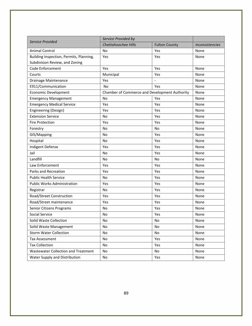
89
Service Provided Service Provided by
Chattahoochee Hills Fulton County Inconsistencies
Animal Control No Yes None
Building Inspection, Permits, Planning, Subdivision Review, and Zoning
Yes Yes None
Code Enforcement Yes Yes None
Courts Municipal Yes None
Drainage Maintenance Yes - None
E911/Communication No Yes None
Economic Development Chamber of Commerce and Development Authority None
Emergency Management No Yes None
Emergency Medical Service Yes Yes None
Engineering (Design) Yes Yes None
Extension Service No Yes None
Fire Protection Yes Yes None
Forestry No No None
GIS/Mapping No Yes None
Hospital No Yes None
Indigent Defense Yes Yes None
Jail No Yes None
Landfill No No None
Law Enforcement Yes Yes None
Parks and Recreation Yes Yes None
Public Health Service No Yes None
Public Works Administration Yes Yes None
Registrar No Yes None
Road/Street Construction Yes Yes None
Road/Street maintenance Yes Yes None
Senior Citizens Programs No Yes None
Social Service No Yes None
Solid Waste Collection No No None
Solid Waste Management No No None
Storm Water Collection No No None
Tax Assessment No Yes None
Tax Collection No Yes None
Wastewater Collection and Treatment No No None
Water Supply and Distribution No Yes None
90
Intergovernmental Coordination The City of Chattahoochee Hills is located in southwest Fulton County in the Atlanta region. The city is bounded on the north by Douglas County and unincorporated Fulton County. The Chattahoochee River separates the city from Douglas and Carroll Counties on the west. Coweta County and the City of Palmetto form the southern boundaries of the city. Palmetto and unincorporated Fulton County are to the east. Chattahoochee Hills is one of six municipalities within south Fulton County. Fulton County provides many services to the residents of the City of Chattahoochee Hills, as they are also residents of the County. The Service Delivery Strategy is designed to serve as the primary coordination mechanism between the city and county governments. In 1997 the State of Georgia passed the Service Delivery Strategy Act (HB489). This law mandates the cooperation of local governments with regard to service delivery issues. Each county was required to initiate development of a Service Delivery Strategy (SDS) between July 1, 1997 and January 1, 1998. Service Delivery Strategies must include an identification of services provided by various entities, assignment of responsibility for provision of services and the location of service areas, a description of funding sources, and an identification of contracts, ordinances, and other measures necessary to implement the SDS. The Service Delivery Strategy for Fulton County was adopted prior to incorporation of the city. The City of Chattahoochee Hills is not a signatory of this document, but, rather has shared services with the county through other intergovernmental agreements. The provision of services in the city is discussed in the Community Facilities and Services section. The major intergovernmental agreements between Fulton County and Chattahoochee Hills are summarized here. As the local governments meet to review and update the current Fulton County Service Delivery Strategy, each of the existing agreements listed here will be examined and evaluated.
Elections The intergovernmental agreement with Fulton County establishes that the county jointly provides election services to the City of Chattahoochee Hills. The city contracts with Fulton County for election services for each municipal election, including the appointment and compensation of workers, supplying equipment and materials, processing ballots, handling required advertisement.
Sheriff/Jail & Evictions The intergovernmental agreement establishes Fulton County as the provider of sheriff, jail, and eviction services to the City of Chattahoochee Hills.
Fire Protection/EMS The City of Chattahoochee Hills has a professional fire department. The city has mutual aid agreements with Fulton County, Coweta County and other nearby south Fulton cities
91
Emergency Management Services The intergovernmental agreement specifies that Fulton County is the provider of emergency management services to the City of Chattahoochee Hills.
Medical Examiner Fulton County provides any necessary medical examiner services to Chattahoochee Hills.
Emergency Management Fulton County provides any necessary emergency management services to Chattahoochee Hills.
Water Treatment/Water Distribution In the area of Chattahoochee Hills where public water is available, the City of Atlanta provides these services to the City of Chattahoochee Hills.
Wastewater Collection & Treatment In the area of Chattahoochee Hills where sewer is available, Fulton County provides these services to the City of Chattahoochee Hills.
Libraries Although there are no Fulton County libraries located in Chattahoochee Hills, the city and Fulton County have an intergovernmental agreement pertaining to library services. The small library located in City Hall is a community library funded by private donations and contributions from the City of Chattahoochee Hills.
Economic Development The current Service Delivery Strategy does not include an agreement between the city and the Fulton County Economic Development Authority for the provision of economic development and redevelopment coordination services. The city is responsible for its own economic development efforts.
School Board The Fulton County Board of Education oversees the Fulton County Public Schools, which serve the entire county except for the City of Atlanta. There are no schools located in the Chattahoochee Hills city limits. An application for a charter school to serve Chattahoochee Hills and surrounding areas has been made to the Fulton County School Board but the location of the school has not yet been determined.
South Fulton Intergovernmental Organizations
Monthly South Fulton Mayors meetings Chattahoochee Hills worked with local Fulton County Commissioner Bill Edwards to implement a South Fulton-wide monthly mayor’s meeting, with the goal of improving service and planning coordination in the area.
92
South Fulton Parkway Association A developer organization formed to promote a comprehensive program of quality development for the South Fulton Parkway through the cooperative partnership of area communities, businesses, land owners, Chamber of Commerce, local, county, and state agencies.
South Fulton Water Authority A multi-jurisdictional partnership between neighbor communities of Palmetto, Fairburn, and Union City which plans to build the Bear Creek reservoir on land within the city.
Regional and State Entities
Atlanta Regional Commission The Atlanta Regional Commission (ARC) serves as the regional development center for metropolitan Atlanta area including the City of Chattahoochee Hills. The ARC provides a variety of services to governments in its region, such as land use and transportation planning coordination, services for the elderly and workforce development. The ARC is responsible for serving the public interest of the state by promoting and implementing the comprehensive planning process among its ten county region and with involvement in local and regional planning related to land use, transportation, recreation, historic preservation, natural resources, and solid waste. The existing mechanisms of coordination between Chattahoochee Hills and the Atlanta Regional Commission are considered adequate and expected to remain constant through the planning period.
Metropolitan North Georgia Water Planning District With a finite water resource and a population of nearly 4 million and growing, the need to carefully and cooperatively manage and protect Metropolitan Atlanta's rivers and streams has become a priority. The Metropolitan North Georgia Water Planning District was signed into law on April 5, 2001 and is developing regional and watershed specific plans for stormwater management, wastewater management, and water supply and conservation in a 16 county area which encompasses Clayton, Bartow, Cherokee, Cobb, Coweta, DeKalb, Douglas, Fayette, Fulton, Forsyth, Gwinnett, Hall, Henry, Paulding, Rockdale and Walton Counties. Local governments within the District that do not substantially adopt the model ordinances will be ineligible for state grants or loans for stormwater related projects. This decision may be appealed to the District Board with a majority vote required to overturn. Those governments that do not implement plans that apply to them would have their current permits for water withdrawal, wastewater capacity or NPDES stormwater permits frozen. The city adopted the required watershed, wastewater, and water supply conservation measures upon incorporation in December, 2007.
Georgia Department of Transportation The Georgia Department of Transportation (GDOT) maintains and improves state and federal highways in Fulton County and provides financial assistance for local road improvements. Chattahoochee Hills coordinates with Fulton County and is tied with GDOT through the county’s Transportation Department. This coordination is expected to continue throughout the planning period.
93
Georgia Department of Natural Resources The Georgia Department of Natural Resources (DNR) is available to provide assistance and guidance to the city in a number of important areas including; water conservation, environmental protection, wildlife preservation, and historic preservation.
Georgia Department of Community Affairs The Georgia Department of Community Affairs (DCA) has overall management responsibilities for the state’s coordinated planning program and reviews plans for compliance with minimum planning standards. DCA provides a variety of technical assistance and grant funding opportunities to the city.
Georgia Municipal Association The Georgia Municipal Association is a non-profit organization that represents municipal governments in Georgia. The GMA provides legislative advocacy, educational programs, employee benefits, and technical consulting services.
Georgia City County Management Association The Georgia City County Management Association is the recognized affiliate organization of ICMA, the professional association of appointed administrators servicing cities, counties, regional councils, and other local government in the State of Georgia. The GCCMA provides training, technical and management assistance, and information resources.
Metro Atlanta Mayors Association The Metro Atlanta Mayors Association is a cooperative alliance of mayors from 65 cities within the 10-county metro Atlanta area. MAMA's goals are to foster communication among the cities in the region, support public policy decisions that are beneficial to the region, coordinate activities among the cities that benefit the region, and communicate needs to the federal, state, and regional agencies and the citizens of the region.
Private Entities
South Fulton Chamber of Commerce A non-profit membership organization, the Fulton County Chamber of Commerce provides assistance to new businesses wishing to locate their establishments in the county. The agency's activities are focused in the areas of business recruitment and retention. The City of Chattahoochee Hills does not generally work with the South Fulton Chamber for economic development but may do so in the future.
Georgia Power Company Georgia Power is a utility company servicing customers throughout the State of Georgia. There is little coordination required between the city and Georgia Power except for issues related to electric utility hookups.
Chattahoochee Hill Country Conservancy The Chattahoochee Hill Country Conservancy is a non-profit organization dedicated to preservation in the greater Hill Country area, which was organized to be the TDR bank for the Chattahoochee Hills area.

94
Chattahoochee Hills Civic Association The Chattahoochee Hills Civic Association is a volunteer organization which supports the needs of the citizens and City of Chattahoochee Hills. Affiliated groups include City Communications, Public Safety, Friends of the Parks, Adopt-a-Mile, Sustainable Economic Development, and more.

95
Transportation
Transportation System
Road Network The City of Chattahoochee Hills is served by a network of rural roads, bridges that cross local streams and a proposed trail system. The main east-west route through the city is the South Fulton Parkway. This two lane road segment of a planned four-lane parkway carries both local and through traffic and appears to be the most heavily travelled road in the city. However, at this time, the Georgia Department of Transportation does not have traffic counts for South Fulton Parkway available. Campbellton-Redwine Road, State Route 70 runs southwest – northeast in the western half of the city, connecting to Coweta County in the south, and the Fulton Industrial corridor in the north. Hutcheson Ferry Road is another east-west thoroughfare in the southern part of the city, connecting Campbellton-Redwine Road with the City of Palmetto. Rivertown Road is a main road in the northeastern part of the city, connecting Campbellton-Redwine with Fairburn. Cascade- Palmetto Highway, State Route 154 forms the city’s eastern boundary, connecting the South Fulton Parkway to the City of Palmetto. Cochran Mill Road runs north/south, and connects Hutcheson Ferry with old Campbellton. Within the city, the road network does not have any signalized intersections. Campbellton- Redwine Road, Hutcheson Ferry Road and Cochran Mill Road are all designated Georgia Scenic Byways. There are 100 miles of roads in the City of Chattahoochee Hills: 66 miles are paved and 34 miles are gravel.
Functional Classification of Roads Roads are given functional classification based on how a particular road is best utilized to maximize vehicular circulation and travel in the most effective manner, given its average daily trips and/or design capacity. Principal arterials are at the top of the road network hierarchical system. Principal arterials generally carry long distance, through travel movement. They also provide access to important traffic generators, such as major airports or regional shopping centers. Minor arterials are similar in function to principal arterials, except they carry trips of shorter distance and to lesser traffic generators. Collectors provide more access to property than do arterials. Collectors also funnel traffic from residential or rural areas to arterials. Local roads provide basic access between residential and commercial properties, connecting with higher order road systems. The Functional Classification Map on the following page shows the functional classification of roads in Chattahoochee Hills.
Road Name Functional Classification South Fulton Parkway Rural Principal Arterial Cascade-Palmetto Highway Rural Major Collector Campbellton-Redwine Road Rural Major Collector Hutcheson Ferry Road Rural Major Collector Rivertown Road Rural Major Collector Rico Road Rural Minor Collector Capps Ferry Road Rural Minor Collector Cochran Mill Road Rural Minor Collector Wilkerson Mill Road Rural Minor Collector
Source: Georgia DOT
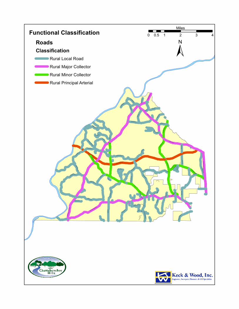
RICO RD
SOUTH FULTON PW
RIVERTOWN RD
CAMP
B EL L
T ON
REDW
INE
R D
HUTCHESON FERRY RD
JONES FE RRY RD
KITE R
D
UP PER WOOTEN RD
CAPPS FERRY RD
PHILL
IPS
RD
O LD RICO RD
H AMI LTO N RD
SARD
IS R
D
OL D H AMILTON RD
PACE
R D
WATKINS R D
M IXON RD
PETERS BURG RD
HOPKINS RD
HEAR
N RD
BARNES RD
WILKERSON MILL RD
VERN
ON G
ROVE
RD
BRAZ
ELL R
D
WHITESIDE R D
ATLANTA NEW NAN R D
CRE EL RD
C OCHRAN MI LL R D
SELBORNE L N
CASCADE PALMETTO HW
GARRETTS FERRY RD
STEE D R D
WOO DRUF F RD
CEDA
R GR
OVE R
D
RICO TATUM R D
W ATE
R W
ORKS RD
JENK
INS
RD
OLD
P HILL
IPS
R D
MANSFIELD DR
BULLARD RD
BULLA RD WY
BRUI
N W
Y
RI CO LAKE RD
HENRY M I LL RD
SERE
NBE
LN
DRIVEWAY
RIVE
R LA
KE D
R
SELBORNE WAY
GRAV
EL R
D
CAINEY LN
MUT T RD
P INE Y WOO DS CHURCH RD
BEAV
ER RD
TAB WY
OLD COCHRAN RD
RICO WY
TIDER
ACE
CT
BIG BEAR CT
WHITESIDE RD
CAIN
EY LN
WILKE RSON MILL RD
WOODRUFF RD
MIXO N RD
RIC O TATUM RD
ATLA
NTA N
EWNA
N RD
COCH
RAN M
ILL R
D
CAP PS F E RRY R
D
WOODRUFF RD
JENKINS RD
PHILLIPS RD
SOUTH FULTON PW
RIVERTOWN RD
RIVERTOWN RD
COCHRAN MILL
RD
JONES FERRY RD
Functional ClassificationRoadsClassification
Rural Local RoadRural Major CollectorRural Minor CollectorRural Principal Arterial
±0 1 2 3 40.5
Miles
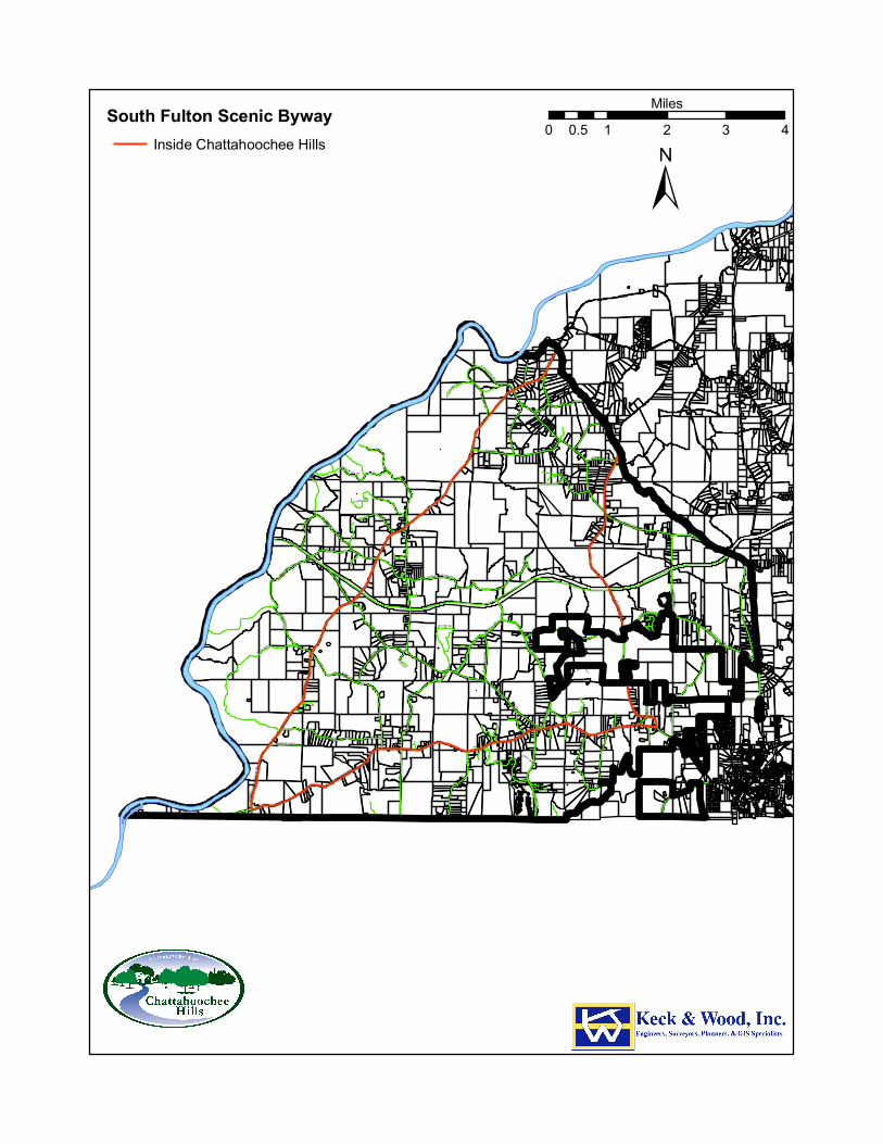
RICO RD
SOUTH FULTON PW
RIVERTOWN RD
CAMP
B EL L
T ON
REDW
INE
R D
HUTCHESON FERRY RD
JONES FE RRY RD
KITE R
D
UP PER WOOTEN RD
CAPPS FERRY RD
PHILL
IPS
RD
O LD RICO RD
H AMI LTO N RD
SARD
IS R
D
OL D H AMILTON RD
PACE
R D
WATKINS R D
M IXON RD
PETERS BURG RD
HOPKINS RD
HEAR
N RD
BARNES RD
WILKERSON MILL RD
VERN
ON G
ROVE
RD
BRAZ
ELL R
D
WHITESIDE R D
ATLANTA NEW NAN R D
CRE EL RD
C OCHRAN MI LL R D
SELBORNE L N
CASCADE PALMETTO HW
GARRETTS FERRY RD
STEE D R D
WOO DRUF F RD
CEDA
R GR
OVE R
D
RICO TATUM R D
W ATE
R W
ORKS RD
JENK
INS
RD
OLD
P HILL
IPS
R D
MANSFIELD DR
BULLARD RD
BULLA RD WY
BRUI
N W
Y
RI CO LAKE RD
HENRY M I LL RD
SERE
NBE
LN
DRIVEWAY
RIVE
R LA
KE D
R
SELBORNE WAY
GRAV
EL R
D
CAINEY LN
MUT T RD
P INE Y WOO DS CHURCH RD
BEAV
ER RD
TAB WY
OLD COCHRAN RD
RICO WY
TIDER
ACE
CT
BIG BEAR CT
WHITESIDE RD
CAIN
EY LN
WILKE RSON MILL RD
WOODRUFF RD
MIXO N RD
RIC O TATUM RD
ATLA
NTA N
EWNA
N RD
COCH
RAN M
ILL R
D
CAP PS F E RRY R
D
WOODRUFF RD
JENKINS RD
PHILLIPS RD
SOUTH FULTON PW
RIVERTOWN RD
RIVERTOWN RD
COCHRAN MILL
RD
JONES FERRY RD
South Fulton Scenic BywayInside Chattahoochee Hills
±0 1 2 3 40.5
Miles
98
Scenic Highways A Georgia Scenic Byway is defined as any designated highway, street, road, or route, which features certain intrinsic qualities that should be protected or enhanced. It is these qualities, be they scenic, historic, natural, archaeological, cultural, or recreational, which give the byway its character and appeal. Currently, twelve corridors have achieved Georgia Scenic Byways status as designated by the Georgia Department of Transportation. As stated above, Campbellton-Redwine Road, Hutcheson Ferry Road and Cochran Mill Road are all designated Georgia Scenic Byways. The city’s zoning ordinance offers addition protections to properties along the scenic byways.
Along the entire frontage of the South Fulton Scenic Byways, a 100-foot natural, undisturbed buffer is required along the right-of-way with an additional 10-foot setback interior to the buffer (except for approved access and utility crossings, improvements and replantings where sparsely vegetated subject to the approval of the Fulton County Arborist). Only existing AG-1 (Agricultural) uses and pedestrian and bicycle paths are permitted in the setback. This standard applies to all properties with frontage on a South Fulton Scenic Byway and along the rights-of-way of public roads which intersect a South Fulton Scenic Byway for a distance of 300 feet measured from the intersection with the South Fulton Scenic Byway.
Average Annual Daily Trip (AADT) Volumes The average annual daily traffic (ADT) counts are used to measure the present demand for service on the roads in the city. Traffic volume information is used to locate areas where new facilities or improvements to existing facilities are needed. The Georgia Department of Transportation provided the Annual Average Daily Trip (AADT) Volumes for 2008. The 2009 AADT information is not available yet. Average daily traffic trips are usually obtained through machine counts. These counts may be for both directions of travel or directional counts. Directional counts are used for capacity analyses and planning improvements. Counts are generally obtained through the use of mechanical traffic counters. There are ten regular traffic count locations in the City of Chattahoochee Hills and they are all two-way counts. Traffic counts are used to determine traffic patterns and flows for modeling purposes. They are also used in developing plans to aid in alleviating congestion with the construction of new routes or alternate designs. For example, Georgia's Office of Materials Research uses a combination of truck percentages and Annual Average Daily Traffic (AADT) data to develop factors that assess the deterioration of pavement. Georgia's Traffic Operations Office uses the volume data for safety related purposes (calculating crash rates and addressing safety issues). The Federal Highway Administration (FHWA) requires every state to submit an annual Highway Performance Monitoring System (HPMS) report containing traffic count data, physical characteristics, and other pertinent road data. This submittal is used in legislation, and to determine State funding of highway and road projects. Traffic counters are placed in a manner that allows traffic to proceed normally without significant lane changing or other maneuvers that might distort the count. The AADT gives the average number of cars that go through a particular juncture at any given day or time. The complete 2008 Annual Average Daily
99
Traffic (AADT) for roads in Chattahoochee Hills is shown in the Road Level of Service table on the next page. In 2008, no records were kept for the South Fulton Parkway.
Existing Transportation System Levels of Service A level of service (LOS) is a letter designation that describes a range of operating conditions on a particular type of facility (road). The level of service concept is a qualitative measure describing operational conditions within a traffic stream, and their perception by motorist and/or passengers. There are six levels of service, which are defined for capacity analysis. They are given letter designations A through F, with LOS A representing the best range of operating conditions and LOS F the worst. LOS is derived from the ratio of the volume of traffic on a road to the capacity (amount of traffic a road can carry) sufficiency rating (v/c ratio). A v/c ratio greater than 1.00, results when the traffic exceeds the operating capacity of a roadway segment. It clearly indicates insufficient capacity and the need for improvement. A v/c ratio of 0.90 indicates that the roadway could only withstand an increase of 10% capacity in demand before the operating capacity is exceeded. In general, LOS A describes a free-flowing condition in which individual vehicles of the traffic stream are not influenced by the presence of other vehicles. LOS F generally describes breakdown operations (except signalized intersections) which occur when flow arriving at a point is greater than the facility’s capacity to discharge flow. At such point, stacking develops and LOS F exists within the road, causing the breakdown. Speed, travel time, density are delay are just a few variables that have direct impact a roads level of service. The Atlanta Regional Commission describes level of service thresholds: Level of Service (LOS)
General Characteristics Volume to Capacity Ratio
A Free flow traffic with individual users virtually unaffected by the presence of others in the traffic steam
.00- .55
B Stable traffic flow with a high degree of freedom to select speed and operating conditions but with some influence from others
.00-.55
C Restricted flow which remains stable but with significant interactions with other in the traffic stream. Level of comfort and convenience declines noticeably at this level
.55-.77
D High-density flow in which speed and freedom to maneuver are severely restricted and comfort, and convenience have decline even through flow remains stable
.77-.93
E At capacity; unstable flow at or near capacity levels with poor levels of convenience and comfort, very little, if any, freedom to maneuver
.93-1.00
F Forced traffic flow in which amount of traffic approaching a point exceeds amount that can be served. LOS “F” characterized by stop and go waves, poor travel times, low comfort and convenience and increased accident exposure
>1.00
As shown in the table below, all of the roads in the City of Chattahoochee Hills that have Georgia Department of Transportation collected traffic counts are operating at a Level of Service A or B, indicating that the current city road network is adequate to serve the current population. In the planning period of 20 years, the existing road network will likely experience additional traffic as the city
100
develops. Focused transportation planning to accompany village or hamlet development could address any future traffic concerns in the city. Road Level of Service
Road Name From To AADT V/C LOS
Campbellton-Redwine Rd Coweta County Capps Ferry 2730 .52 A
Campbellton-Redwine Rd South Fulton Parkway Rivertown Road 890 .2 A
Rivertown Road Cascade-Palmetto Highway Jenkins Road 1420 .32 A
Rivertown Road Cochran Mill Road Campbellton-Redwine Rd 530 .12 A
Hutcheson Ferry Road Campbellton-Redwine Rd Rico Road 620 .14 A
Hutcheson Ferry Road Atlanta Newnan Road Phillips Road 2390 .53 B
Wilkerson Mill Road Cascade-Palmetto Highway Cochran Mill Road 660 .15 A
Rico Road Hutcheson Ferry Road Moss Creek 660 .15 A
Rico Road South Fulton Parkway Campbellton-Redwine Rd 1490 .33 A
Cochran Mill Road Cedar Grove Road Hutcheson Ferry Road 310 .07 A
Bridges Bridges in Georgia are monitored through the assignment of a sufficiency rating. A sufficiency rating is calculated based on the bridge's capacity, condition, and geometry. A sufficiency rating below 50 is considered to be in need of replacement. The City of Chattahoochee Hills has a network of streams that drain to the Chattahoochee River. There are numerous bridges throughout the city that are rated for sufficiency annually by the GDOT. The latest available bridge sufficiency ratings from 2009 are shown in the table below. Several bridges in Chattahoochee Hills have a sufficiency rating of less than 50 and are in need of replacement.
Bridge Name Year Built Sufficiency Rating Cochran Mill at Bear Creek 1970 70.21 Garretts Ferry 1964 25.81 Campbellton-Redwine at White Oak Creek 1994 90.53 Hamilton Road at White Oak Creek 1954 82.65 Hutcheson Ferry at Dry Branch 1993 99.63 Sardis Church at Dry Branch 1964 76.61 Atlanta Newnan Road at Cedar Creek 1962 68.06 Jones Ferry at White Oak Creek 1977 99.45 Vernon Grove Road at Longino Creek 1956 48.22 Phillips Road at Longino Creek 1962 54.82 Phillips Road at Little Bear Creek 1957 39.14 Cascade Palmetto at Bear Creek 1958 60.07 Petersburg Road at Bear Creek 1987 83.97 Wilkerson Mill at Little Bear Creek 1964 65.39 Cochran Mill at Bear Creek 1970 55.41 Porter Terry at Little Pea Creek 1953 7.00 Woodruff Road at Little Pea Creek 1982 76.86 Cochran Mills at Pea Creek 1935 24.67 Creel Road at Little Pea Creek 1985 80.85 Woodruff Road at Bear Creek 1989 82.94
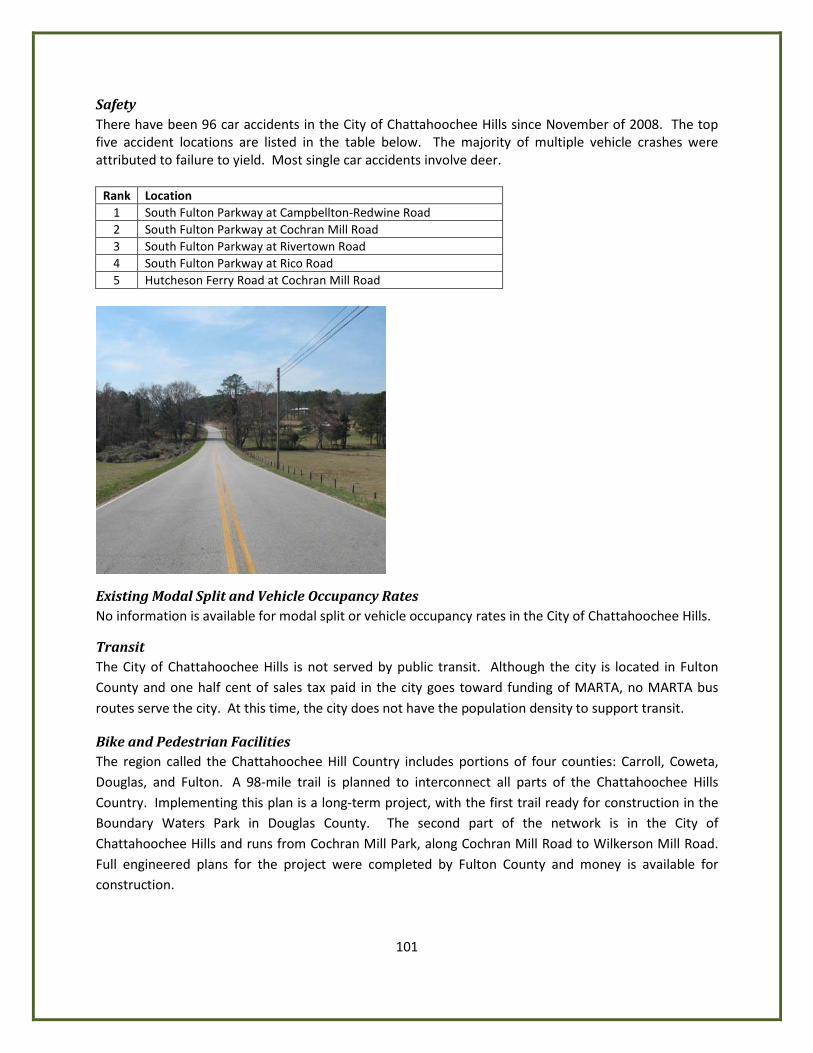
101
Safety There have been 96 car accidents in the City of Chattahoochee Hills since November of 2008. The top five accident locations are listed in the table below. The majority of multiple vehicle crashes were attributed to failure to yield. Most single car accidents involve deer.
Rank Location 1 South Fulton Parkway at Campbellton-Redwine Road 2 South Fulton Parkway at Cochran Mill Road 3 South Fulton Parkway at Rivertown Road 4 South Fulton Parkway at Rico Road 5 Hutcheson Ferry Road at Cochran Mill Road
Existing Modal Split and Vehicle Occupancy Rates No information is available for modal split or vehicle occupancy rates in the City of Chattahoochee Hills.
Transit The City of Chattahoochee Hills is not served by public transit. Although the city is located in Fulton County and one half cent of sales tax paid in the city goes toward funding of MARTA, no MARTA bus routes serve the city. At this time, the city does not have the population density to support transit.
Bike and Pedestrian Facilities The region called the Chattahoochee Hill Country includes portions of four counties: Carroll, Coweta, Douglas, and Fulton. A 98-mile trail is planned to interconnect all parts of the Chattahoochee Hills Country. Implementing this plan is a long-term project, with the first trail ready for construction in the Boundary Waters Park in Douglas County. The second part of the network is in the City of Chattahoochee Hills and runs from Cochran Mill Park, along Cochran Mill Road to Wilkerson Mill Road. Full engineered plans for the project were completed by Fulton County and money is available for construction.
102
The City of Chattahoochee Hills Zoning Ordinance calls for provision of bike and pedestrian facilities in villages and hamlets where land uses are mixed and walking may be easier than driving. The Zoning Ordinance does not require bike or pedestrian facilities in the undeveloped rural areas of the city. Most of the roads in the city carry low traffic volumes making it easy for cycling. However land uses in the rural areas of the city are very separated making walking or biking infeasible for errands or shopping, with the possible exception of the Rico Crossroads community where several civic buildings, a park, two churches and a store are located.
Parking The City of Chattahoochee Hills does not have any areas with insufficient parking or inadequate parking facilities or excess or obsolete surface parking facilities in need of retrofitting or redevelopment.
Railroads, Trucking, Port Facilities and Airports The City of Chattahoochee Hills does not have any freight or passenger rail lines, major rail intermodal facilities, non-rail freight operations, seaports, harbors, or commercial and general purpose air terminals.
Transportation and Land Use Connection There have been a few significant land use changes over the past ten years in the City of Chattahoochee Hills. Serenbe, a compact mixed use development planned to ultimately be 1000 acres containing 1000 housing units, including 30 live work units, is being developed and two conventional suburban subdivisions were started and abandoned. The stretch of Hutcheson Ferry Road that serves Serenbe carries more traffic than other similar roads in the city, yet still operates at a Level of Service (LOS) B. The fine grained mix of land uses in Serenbe decreases the number of car trips that its residents must take for their daily needs. A mix of land uses in close proximity can also be found in the historic crossroads community of Rico; however,this area does not have any pedestrian facilities. Because the majority of road segments where the GDOT collects traffic information operate at a LOS A, they may be considered to be underutilized. Most of the city is agricultural and forestry land uses where traffic volumes are consistently far below capacity. Next year, the Atlanta Regional Commission plans to begin a Comprehensive Transportation Plan for South Fulton County. This plan will fully consider the transportation land use connection along with the outcome of the city’s Comprehensive Plan.
Regional Transportation Plan The Regional Transportation Plan (RTP) prioritizes transportation investments in the 18-county Atlanta Metropolitan Planning Organization (MPO) area through the year 2030. Under federal law, a new RTP must be developed at least every four years and represent a balanced multimodal approach to addressing the region’s transportation challenges. ARC adopted the $67.1 billion Envision6 2030 RTP on September 26, 2007. Although the RTP focuses on new projects, a majority of the funding will be spent simply maintaining current infrastructure and maximizing its efficiency.
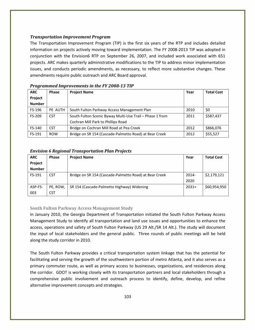
103
Transportation Improvement Program The Transportation Improvement Program (TIP) is the first six years of the RTP and includes detailed information on projects actively moving toward implementation. The FY 2008-2013 TIP was adopted in conjunction with the Envision6 RTP on September 26, 2007, and included work associated with 651 projects. ARC makes quarterly administrative modifications to the TIP to address minor implementation issues, and conducts periodic amendments, as necessary, to reflect more substantive changes. These amendments require public outreach and ARC Board approval.
Programmed Improvements in the FY 2008-13 TIP ARC Project Number
Phase Project Name Year Total Cost
FS-196 PE AUTH South Fulton Parkway Access Management Plan 2010 $0
FS-209 CST South Fulton Scenic Byway Multi-Use Trail – Phase 1 from Cochran Mill Park to Phillips Road
2011 $587,437
FS-140 CST Bridge on Cochran Mill Road at Pea Creek 2012 $866,076
FS-191 ROW Bridge on SR 154 (Cascade-Palmetto Road) at Bear Creek 2012 $55,527
Envision 6 Regional Transportation Plan Projects ARC Project Number
Phase Project Name Year Total Cost
FS-191 CST Bridge on SR 154 (Cascade-Palmetto Road) at Bear Creek 2014-2020
$2,179,121
ASP-FS-003
PE, ROW, CST
SR 154 (Cascade-Palmetto Highway) Widening 2031+ $60,954,950
South Fulton Parkway Access Management Study In January 2010, the Georgia Department of Transportation initiated the South Fulton Parkway Access Management Study to identify all transportation and land use issues and opportunities to enhance the access, operations and safety of South Fulton Parkway (US 29 Alt./SR 14 Alt.). The study will document the input of local stakeholders and the general public. Three rounds of public meetings will be held along the study corridor in 2010. The South Fulton Parkway provides a critical transportation system linkage that has the potential for facilitating and serving the growth of the southwestern portion of metro Atlanta, and it also serves as a primary commuter route, as well as primary access to businesses, organizations, and residences along the corridor. GDOT is working closely with its transportation partners and local stakeholders through a comprehensive public involvement and outreach process to identify, define, develop, and refine alternative improvement concepts and strategies.
104
Access management is the systematic control of the location, spacing, design and operation of driveways, median openings, interchanges and street connections to a roadway. The purpose of access management is to provide access to land development, while preserving the flow of traffic on the adjacent roadway system in terms of safety, capacity and speed. Goals of Access Management are achieved by applying the following ten principles:
1. Provide a specialized roadway system by designing and managing roads according to their primary function. 2. Limit direct access to major roadways which serve higher volumes of through traffic and need more access control. 3. Promote intersection hierarchy by providing appropriate transition from one classification of roadway to another. 4. Locate signals to favor through movements by using long, uniform spacing of intersections and signals and ensuring the ability to coordinate signal timing. 5. Preserve the functional area of intersections and interchanges by acknowledging how drivers need to respond with deceleration, maneuvering into another lane, stopping and turning. Access connections too close to intersections cause serious traffic conflicts and impair functionality. 6. Limit the number of conflict points between vehicles; vehicle and pedestrians; vehicles and bicyclists to reduce mistakes and collisions. 7. Separate conflict areas give drivers’ time to address one potential set of conflicts before facing another. 8. Remove turning vehicles from through-traffic lanes through the addition of turning lanes. 9. Use non-traversable medians to manage left-turn movements which promote safety and minimize left turns.
10. Provide a supporting street and circulation system to appropriately accommodate development. This study will look at current and future traffic and land use conditions along the corridor. Scenarios will be developed to understand the relationship of several potential land use and transportation decisions along the corridor. This will result in the development of an access management plan that provides transportation and land use policy guidance and recommendations to improve the transportation infrastructure needed to satisfy future travel demand. This plan will assist in managing access as new developments emerge along South Fulton Parkway. The study will:
• Protect infrastructure investment • Enhance mobility • Accommodate land use • Provide access • Address safety
The expected completion date for the South Fulton Parkway study is February 2011.