city of dexter · city of dexter existing land use ... background studies involving data inventory...
TRANSCRIPT

City of Dexter
Master Plan Amended March 2016


Cit
y o
f D
exte
r M
aste
r P
lan
| M
arc
h 2
01
6
ACKNOWLEDGEMENTS
City Council
Shawn Keough, Mayor
Jim Carson, Trustee
Julie Knight, Trustee
Donna Fisher, Trustee
Joe Semifero, Trustee
James Smith, Trustee
Ray Tell, Mayor Pro Tem
Carol Jones, Interim Clerk
Planning Commission
Matt Kowalski, Chairperson
Thomas Phillips
Marni Schmid
Alison Heatley
James Carty
Jack Donaldson
Scott Stewart
Tom Stoner
James Smith, Ex Officio
Administration
Courtney Nicholls, City Manager
Justin Breyer, Assistant to the City Manager
Marie Sherry, Treasurer/Finance Director
Michelle Aniol, Community Development Manager
Dan Schlaff, Sewer + Water Utilities Foreman
Kurt Augustine, Public Works Foreman

Cit
y o
f D
exte
r M
aste
r P
lan
| M
arc
h 2
01
6
TABLE OF CONTENTS Introduction
Purpose of the Master Plan .................................................................................................. 1
How is the Plan to be Used? ................................................................................................. 1
Historic Context ...................................................................................................................... 2
Planning Process .................................................................................................................... 2
Regional Setting ..................................................................................................................... 4
Community History of Dexter ............................................................................................... 5
Existing Land Use and Community Plans
Existing Land Use ................................................................................................................... 7
City Planning Initiatives ....................................................................................................... 11
County Planning Initiatives ................................................................................................. 13
Neighboring Communities .................................................................................................. 15
Community Goals and Objectives
Public Participation .............................................................................................................. 19
City of Dexter Goals.............................................................................................................. 20
Natural Resources....................................................................................................................... 21
Recreation/Open Space............................................................................................................. 22
Residential ................................................................................................................................... 24
Downtown – Mixed Use .............................................................................................................. 25
Dexter-Ann Arbor Road Corridor – Mixed Use ........................................................................ 26
Baker Road Corridor – Mixed Use ............................................................................................ 28
Commercial .................................................................................................................................. 30
Industrial ....................................................................................................................................... 31
Transportation ............................................................................................................................. 32
Community Facilities + Services ............................................................................................... 34
Future Land Use
Future Land Use Categories ............................................................................................... 35
Low Density Residential ............................................................................................................. 35
Village Residential ...................................................................................................................... 36
Multiple-Family Residential ....................................................................................................... 37

Cit
y o
f D
exte
r M
aste
r P
lan
| M
arc
h 2
01
6
Downtown – Mixed Use ........................................................................................................................ 38
Dexter-Ann Arbor Road Corridor – Mixed Use................................................................................... 41
Baker Road Corridor – Mixed Use ...................................................................................................... 42
Village Commercial ............................................................................................................................... 43
General Commercial ............................................................................................................................. 44
Light Industrial ....................................................................................................................................... 45
Research/Development ....................................................................................................................... 45
Public/Semi-Public ............................................................................................................................... 46
Open Space/Recreation ....................................................................................................................... 47
Transportation Plan
National Functional Classifications ........................................................................................... 49
Access Management ................................................................................................................... 51
Public Transportation .................................................................................................................. 51
Non-Motorized Transportation .................................................................................................... 54
Background Studies
Population and Housing Characteristics .................................................................................. 61
Population ..................................................................................................................................... 61
Housing Characteristics............................................................................................................... 65
Property Values ............................................................................................................................. 67
Capital Improvements/Community Facilities .......................................................................... 68
Wellhead Protection .................................................................................................................... 72
Property Transfer Agreements ................................................................................................... 73
Cityhood ......................................................................................................................................... 74
Natural Features ........................................................................................................................... 76
School Facilities ............................................................................................................................ 78
Parks and Recreation .................................................................................................................. 79
Economic Development .............................................................................................................. 83
Intergovernmental and Regional Cooperation ........................................................................ 84
Implementation
Zoning Requirements .................................................................................................................. 87
Zoning Adjustments ..................................................................................................................... 88

Cit
y o
f D
exte
r M
aste
r P
lan
| M
arc
h 2
01
6
Capital Improvement Program ................................................................................................... 90
Plan Education .............................................................................................................................. 90
Plan Updates ................................................................................................................................. 91
Appendix
Community Survey Results ......................................................................................................... 93
Figures
Figure 1. Planning Process ............................................................................................................ 3
Figure 2. Regional Setting ............................................................................................................. 4
Figure 3. Existing Land Use Map .................................................................................................. 9
Figure 4. Washtenaw County 2004 Comprehensive Plan – Recommended
Future Landscapes ................................................................................................. 14
Figure 5. Generalized Future Land Use Map for Surrounding Area Map ............................ 17
Figure 6. Future Land Use Map................................................................................................... 39
Figure 7. National Functional Classification Map .................................................................... 50
Figure 8. Possible Future Washtenaw County Transit Connections Map ............................ 53
Figure 9. Non-Motorized Transportation Map ........................................................................... 59
Figure 10. Parks and Community Facilities Map ..................................................................... 81
Tables
Table 1. City of Dexter Existing Land Use ................................................................................... 7
Table 2. Master Plan Land Use + Zoning District Classification Comparison ..................... 48
Table 3. WATS Non-Motorized Plan Improvements – City of Dexter .................................... 56
Table 4. Population Change 1960-2010 .................................................................................. 61
Table 5. Average Persons Per Household ................................................................................. 62
Table 6. Total Household by Community .................................................................................. 63
Table 7. Percent of Population by Age, 2010 .......................................................................... 64
Table 8. Total Housing Units by Community ............................................................................. 65
Table 9. Dwelling Unit Owner/Renter Composition by Community ...................................... 66
Table 10. City of Dexter SEV Plus IFT Growth ........................................................................... 67
Table 11. Parks and Recreation Facilities ................................................................................ 80

1
Cit
y o
f D
exte
r M
aste
r P
lan
| M
arc
h 2
01
6
Introduction
Purpose of the Master Plan
Planning is a process that involves the conscious selection of policy choices relating to land use,
growth, and physical development of the community. The purpose of the City of Dexter Master
Plan is to state the goals and identify the objectives and strategies regarding land use and
development that the City will pursue to attain those goals.
How Is the Plan to be Used?
The Master Plan is used in a variety of ways:
1. Most important, the Plan is a general statement of the City’s goals and policies and
provides a single, comprehensive view of the community's desires for the future.
2. The Plan serves as an aid in daily decision-making. The goals and policies outlined in
the Plan guide the Planning Commission, City Council and other City bodies in their
deliberations on zoning, subdivision, capital improvements and other matters related to
land use and development. The Plan provides a stable, long-term basis for decision-
making providing for a balance of land uses specific to the character of the City of
Dexter.
3. The Plan provides the statutory basis upon which zoning decisions are made. The
Michigan Planning Enabling Act (P.A. 33 of 2008, as amended) requires that the zoning
ordinance be based upon a plan designed to promote the public health, safety and
general welfare. It is important to note that the Master Plan and accompanying maps
do not replace other City Ordinances, specifically the Zoning Ordinance and Map.
4. The Plan attempts to coordinate public improvements and private developments
supported by the Capital Improvements Plan. For example, public investments such as
road or sewer and water improvements should be located in areas identified in the Plan
as resulting in the greatest benefit to the City and its residents.
5. Finally, the Plan serves as an educational tool and gives citizens, property owners,
developers and adjacent communities a clear indication of the City’s direction for the
future.
In summation, the City of Dexter Master Plan is the primary, officially-adopted document that
sets forth an agenda for the achievement of goals and policies. It is a long-range statement of
general goals and policies aimed at the unified and coordinated development of the City that
compliments the goals of nearby governmental units, wherever possible. It helps develop a
balance of orderly change in a deliberate and controlled manner that permits controlled growth.
As such, it provides the basis upon which zoning and land use decisions are made.
2
Cit
y o
f D
exte
r M
aste
r P
lan
| M
arc
h 2
01
6
Historic Context
This document represents an amendment to the 2011 Dexter Master Plan, which replaced the
2005 Master Plan that was adopted on April 11, 2005. An amendment of the 2005 plan was
made one (1) year later to incorporate the amendments made to the 1994 Master Plan in 1995
and 1997 into one (1) comprehensive plan. In addition, this document has been updated to
include all new information available to the City, (i.e. census) and addresses the City’s current
desires for the future.
Because communities are constantly changing, the information contained in a plan becomes
outdated in time. As the conditions change, so do opportunities and expectations for the future.
It is therefore essential to periodically update the information contained in the Master Plan as
well as reevaluate its basic vision and implementation programs. Current State Legislation
regarding City Planning requires five (5) year reviews of the Master Plan. The review process will
be discussed in more detail in the implementation section of the Ordinance.
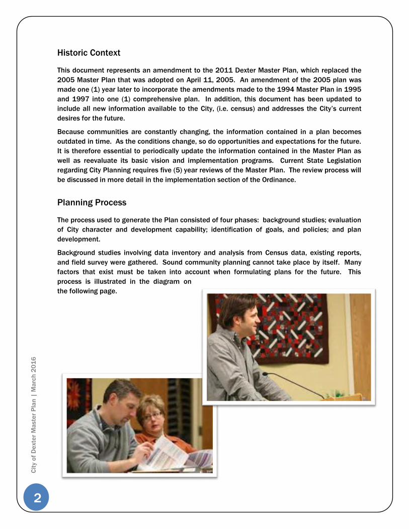
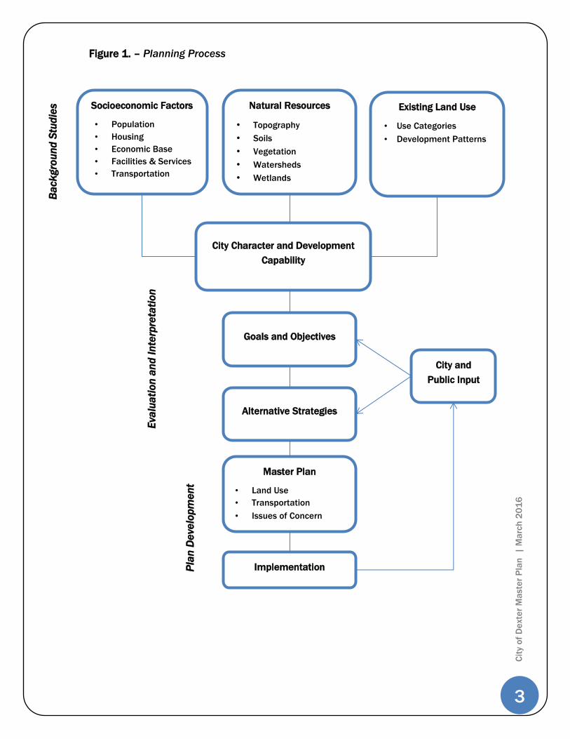
Planning Process
The process used to generate the Plan consisted of four phases: background studies; evaluation
of City character and development capability; identification of goals, and policies; and plan
development.
Background studies involving data inventory and analysis from Census data, existing reports,
and field survey were gathered. Sound community planning cannot take place by itself. Many
factors that exist must be taken into account when formulating plans for the future. This
process is illustrated in the diagram on
the following page.
3
Cit
y o
f D
exte
r M
aste
r P
lan
| M
arc
h 2
01
6
Socioeconomic Factors
• Population
• Housing
• Economic Base
• Facilities & Services
• Transportation
Natural Resources
• Topography
• Soils
• Vegetation
• Watersheds
• Wetlands
Existing Land Use
• Use Categories
• Development Patterns
City Character and Development
Capability
Goals and Objectives
Alternative Strategies
Master Plan
• Land Use
• Transportation
• Issues of Concern
Implementation
City and
Public Input
Ba
ck
gro
un
d S
tud
ies
Eva
lua
tio
n a
nd
In
terp
reta
tio
n
Pla
n D
eve
lop
me
nt
Figure 1. – Planning Process
4
Cit
y o
f D
exte
r M
aste
r P
lan
| M
arc
h 2
01
6
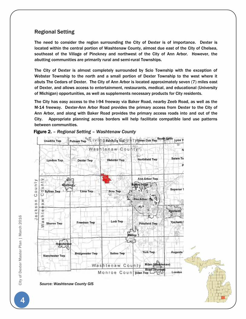
Regional Setting
The need to consider the region surrounding the City of Dexter is of importance. Dexter is
located within the central portion of Washtenaw County, almost due east of the City of Chelsea,
southeast of the Village of Pinckney and northwest of the City of Ann Arbor. However, the
abutting communities are primarily rural and semi-rural Townships.
The City of Dexter is almost completely surrounded by Scio Township with the exception of
Webster Township to the north and a small portion of Dexter Township to the west where it
abuts The Cedars of Dexter. The City of Ann Arbor is located approximately seven (7) miles east
of Dexter, and allows access to entertainment, restaurants, medical, and educational (University
of Michigan) opportunities, as well as supplements necessary products for City residents.
The City has easy access to the I-94 freeway via Baker Road, nearby Zeeb Road, as well as the
M-14 freeway. Dexter-Ann Arbor Road provides the primary access from Dexter to the City of
Ann Arbor, and along with Baker Road provides the primary access roads into and out of the
City. Appropriate planning across borders will help facilitate compatible land use patterns
between communities.
Figure 2. – Regional Setting – Washtenaw County
Source: Washtenaw County GIS
5
Cit
y o
f D
exte
r M
aste
r P
lan
| M
arc
h 2
01
6
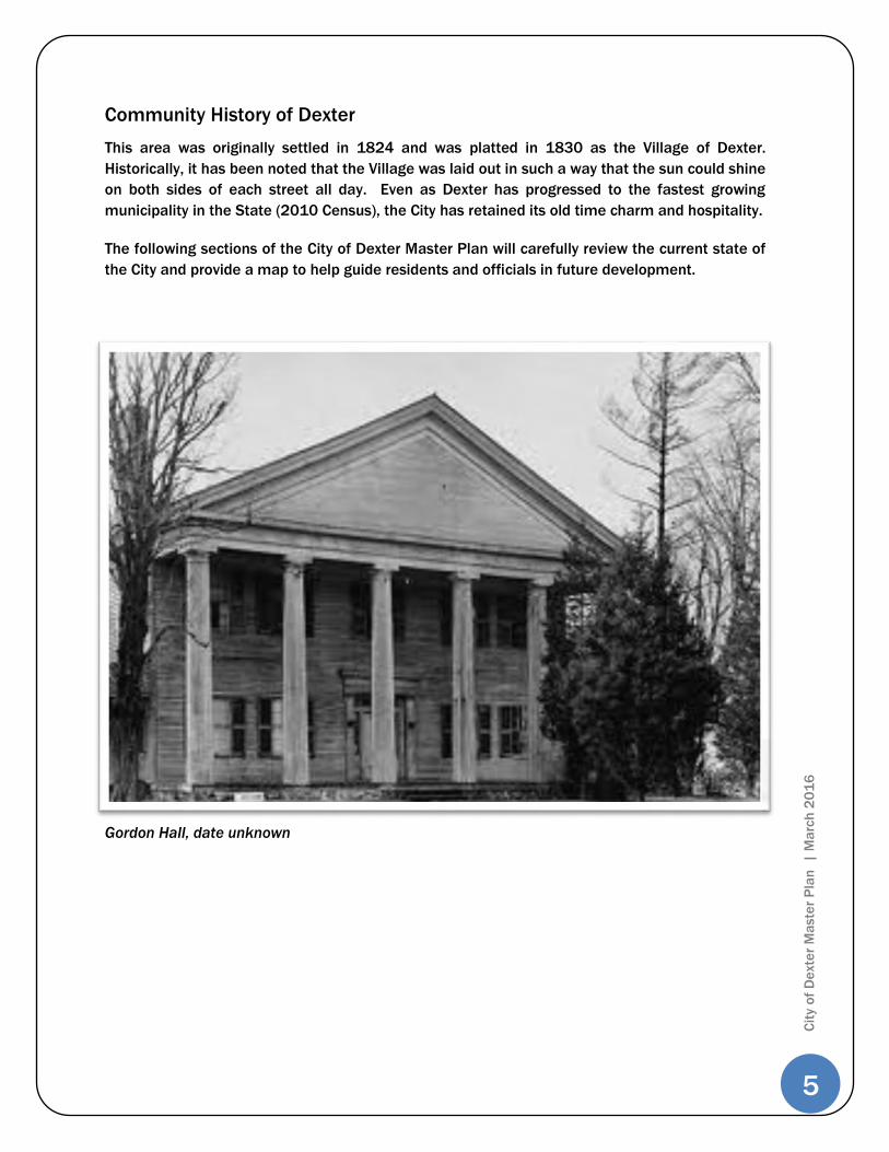
Community History of Dexter
This area was originally settled in 1824 and was platted in 1830 as the Village of Dexter.
Historically, it has been noted that the Village was laid out in such a way that the sun could shine
on both sides of each street all day. Even as Dexter has progressed to the fastest growing
municipality in the State (2010 Census), the City has retained its old time charm and hospitality.
The following sections of the City of Dexter Master Plan will carefully review the current state of
the City and provide a map to help guide residents and officials in future development.
Gordon Hall, date unknown

6
Cit
y o
f D
exte
r M
aste
r P
lan
| M
arc
h 2
01
6

7
Cit
y o
f D
exte
r M
aste
r P
lan
| M
arc
h 2
01
6
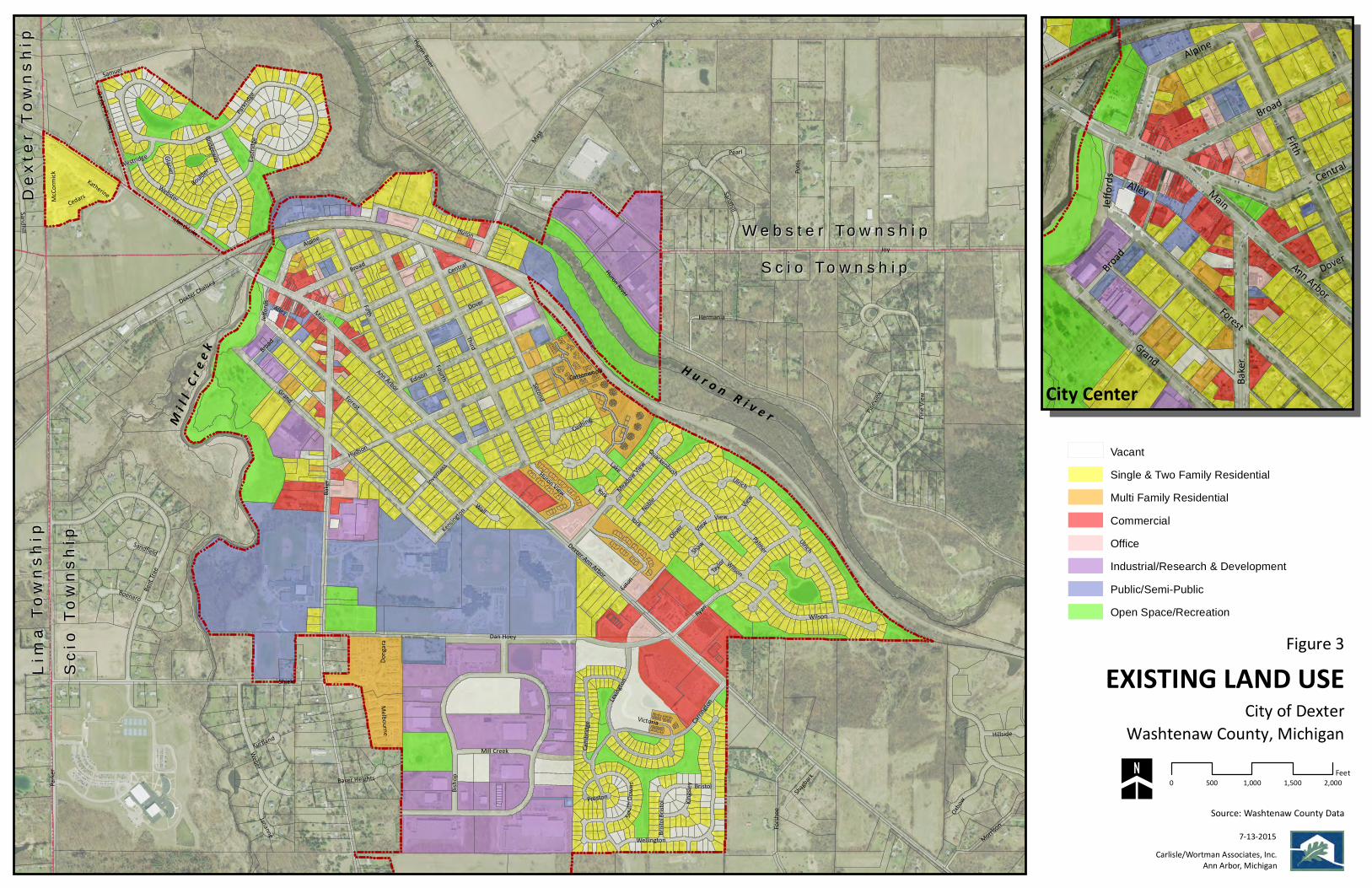
Existing Land Use and Community Plans The existing land use map and associated text indicates land use patterns and
associations as they exist currently within the City of Dexter. While change is
inevitable and growth will occur, the City of Dexter is committed to managing
growth to enhance economic benefit, recreation activities and overall quality of life
for all residents.
Existing Land Use
As illustrated on the Existing Land Use Map (Figure 3), the following land uses
currently exist in the City. They are demonstrated by acreage and percentage of
land area in Table 1 below.
Table 1. – City of Dexter Existing Land Use
Existing Land Use
Dexter (City)
Acres %
Vacant 68.13 6.7%
Single-Family Residential 316.58 31.4%
Multiple-Family Residential 53.77 5.3%
Commercial 55.79 5.5%
Office 14.32 1.4%
Industrial 136.40 13.6%
Industrial Research + Development 125.58 12.5%
Public/ Semi-Public 164.22 16.3%
Open Space/Recreation 0.88 0.1%
Transportation (Right-of-Ways) 71.06 7.1%
Total 1,006.73 100%

8
Cit
y o
f D
exte
r M
aste
r P
lan
| M
arc
h 2
01
6
Joy
Baker
Parker
Third
Mast
Shield
ForestGrand
Fifth
Dan Hoey
Dexter-Ann Arbor
Hudson
Central
Fourth
Potts
Huron
Ryan
Second
Broad
Island Lake
DoverMain
Bisho
p
Inverness
Ann Arbor
Dexter Chelsea
Edison
Bent Tr
ee
Carring
ton
Weber
Pinevi
ew
Huron River
Noble
Wilson
Forshe
e
Eastrid
ge
York
Ulrich
Lake
Wellington
Pine V
iew
Lexing
tonEato
n
Sandhill
Alpine
Morrison
Dexter Pinckney
Webster
Parkrid
ge
Alley
Victoria
Bridgeway
Hermania
Katherine
Oxbow
Donga
ra
Pearl
Cambri
dge
Mill Creek
Kensington Wall
Palmer
Shagbark
Quackenbush
Cedars
Bristo
l
Meadow View
View
Jananne
McCo
rmick
Hillside
Oliver
Huron View
Boenaro
Samuel
Kingsl
ey
Cushing
Glacier
Melbourne
Jeffor
ds
Ulrich
Daly
Cottonwood
Westridge
View
Bristol
Boulder
Sandfield
Kurtland
South
Down
sBaker Heights
ShawTayl
or
Preston
Broad
Sandhill
York
Huron River
Wilson
View
Bristo
lFigure 3
EXISTING LAND USECity of Dexter
Source: Washtenaw County Data
Carlisle/Wortman Associates, Inc.Ann Arbor, Michigan
0 500 1,000 1,500 2,000Feet
7-13-2015
Washtenaw County, Michigan
Fifth
Forest
Main
Broad
Baker
Grand
Alpine
CentralAlley
Ann Arbor
Jeffor
ds
DoverBroad
VacantSingle & Two Family ResidentialMulti Family ResidentialCommercialOfficeIndustrial/Research & DevelopmentPublic/Semi-PublicOpen Space/Recreation
S c i o To w n s h i pS c i o To w n s h i pW e b s t e r To w n s h i pW e b s t e r To w n s h i p
Scio
Tow
nshi
pSc
io T
owns
hip
Lim
a To
wns
hip
Lim
a To
wns
hip
Dex
ter
Tow
nshi
pD
exte
r To
wns
hip
City CenterH u r o n R i v e rM
i l l C
r ee k


11
Cit
y o
f D
exte
r M
aste
r P
lan
| M
arc
h 2
01
6
City Planning Initiatives
A number of existing and anticipated circumstances will affect Dexter’s future.
These include a growing population, decentralized places of employment with
increased commuting distances and conversely, an increase in those working from
home. These factors together with the attraction of the Ann Arbor area as a place
to live and work will provide development opportunities within Dexter and the
surrounding communities for years to come.
The City has responded to these challenges in a variety of ways, including a
continued commitment to community planning goals and policies geared to
preserving important natural features, while planning for growth in those areas
most suitable for development.
The following plans, policies and initiatives highlight Dexter’s commitment to land
use planning, and are incorporated into this Master Plan by reference:
Baker Road/Dexter Ann Arbor Road Corridors Joint Planning Initiative– City of
Dexter/Scio Township - A guide in evaluating development proposals within the
corridor along with the communities, current zoning, master plan, or other
applicable reports and studies. It should also be used as an action plan in relation
to the future land use and implementation portion of the report for both the City and
the Township. This plan is the result of a joint
planning effort between Scio Township and the
City of Dexter Planning Commission. While much
of the area discussed within the plan is for
outside the City limits, the City of Dexter Master
Plan endorses the goals and objectives of this
document.
Downtown Development Strategic Plan – The
DDA engaged the public, downtown merchants
and local elected leaders in a strategic planning
process in order to develop goals, objectives and
initiatives supportive of specific infrastructure
improvements, programming, activity generators
and public/private cooperation. The Strategic
Plan also provides Tax Increment Financing (TIF)
information required under State statute.
Downtown Dexter DDA Parking Study – The
objectives of the study are: to assess the existing
parking system within the context of the
downtown retail shopping district and adjacent
areas; to assess present and future parking
needs; to recommend specific improvements for
parking downtown; and to further recommend
12
Cit
y o
f D
exte
r M
aste
r P
lan
| M
arc
h 2
01
6
management strategies are incorporated by reference.
Park and Recreation Facilities Master Plan (2009) – The Plan outlines existing and
future parks and recreation needs, and identifies specific improvements, costs,
priorities and years of completion to better represent the long-range vision of the
Parks and Recreation Commission.
FY 2012 State Revolving Fund Project Plan (July 2011) – A study of alternatives to
upgrade the wastewater treatment plant that included upgrading the sludge
handling system (including an analysis that identified several alternatives to
upgrade the sludge handing system to provide adequate sludge processing and
storage), the grit system, and the instrumentation and controls system (SCADA).
This project plan is required to obtain funding through the State Revolving Loan
Fund.
Crosswalk Evaluation (November 2010) – A review of the crosswalks within the City
with recommendations for improvements at each crosswalk. The evaluation
included inspection and review of existing sidewalk ramps.
Drinking Water Revolving Loan Fund Project Plan (May 2009) – A study of
alternatives in order to provide the City with an additional water supply and repair
old water mains. The plan was required to obtain funding from the Drinking Water
Revolving Loan Fund. This plan led to the construction of the fifth City well, well
house, improvements to the iron removal plant and upgrades to the distribution
system. The Drinking Water Revolving Loan Fund Project Plan included a Water
System Improvements Report and a Water System Reliability Study.
Road Maintenance Program (June 2008, updated annually) – A review of the paved
road conditions throughout the City. Each road is ranked between one (1) and ten
(10), one (1) being totally degraded and ten (10) being a brand new road. This is
used to determine where to complete road maintenance in the City in any given
year. It is updated annually based on the maintenance that was completed that
year.
FY 2008 State Revolving Fund Project Plan (July 2007) - A study of alternatives in
order to provide the City with more capacity in the wastewater system, including the
wastewater treatment plan and distribution system. This Plan was required to
obtain funding from the State Revolving Fund. This plan led to the construction of
the equalization basin. The Plan included an Inflow and Infiltration Removal Study.
Storm Water Management Study (November 2004) – A study of the storm drainage
system in the old Village area, including defining how storm water is conveyed in
the area with figures that show existing drainage infrastructure and the drainage
district areas.
13
Cit
y o
f D
exte
r M
aste
r P
lan
| M
arc
h 2
01
6
Oil and Gas Drilling - The City of Dexter has experienced increased interest in oil
and gas exploration and development, which the City will balance with other
community goals for existing and planned land uses, including natural resource
protection.
County Planning Initiatives
A number of planning initiatives recently took place in
Washtenaw County and the City of Dexter which have
relevance to the current Plan. Elements of these
various plans and initiatives are incorporated
throughout this document.
2004 Washtenaw County Comprehensive Plan – While
the County Plan is now becoming dated, there are
elements of this plan that remain relevant for the City
of Dexter. The 2004 Comprehensive Plan for
Washtenaw County recommends a development
pattern for the City of Dexter described and illustrated
below as follows:
Sustainable small city and village development encouraging social
interaction and environmental health;
Reduce negative impacts and made future development more livable by
changing existing land use patterns in areas surrounding villages;
Development within one-half (1/2) mile of existing village limits should be
developed at higher densities, and a grid system of roads with sidewalks
should be required to provide convenient and alternative vehicle and
pedestrian access to downtown main streets;
Encourage infill development opportunities, particularly by encouraging
urban service districts; and
Develop model ordinance to ensure desired character of community is
retained such as architectural guidelines, landscaping, signs, lighting and
parking standards.
Washtenaw Area Transportation Study (WATS)(Updated 2011) - The Washtenaw
Area Transportation Study has updated a long-range transportation plan for the
County. The plan includes goals and capital and operating improvement projects
which involve reconstruction or resurfacing, transit improvements, intersection and
widening projects, as well as non-motorized projects (see Transportation Plan (pg.
49) for additional information).
Washtenaw County Non-Motorized Plan (2006) - WATS was also involved in the
Washtenaw County Non-Motorized Plan which inventoried existing County-wide, non-
motorized transportation facilities, identified missing links and provided
14
Cit
y o
f D
exte
r M
aste
r P
lan
| M
arc
h 2
01
6
implementation recommendations for communities (see Transportation Plan (pg.
49) for additional information).
Transit Plan for Washtenaw County (2007) - In an effort to move towards a
comprehensive transit service in Washtenaw County, WATS initiated this effort to
analyze data and to support a county-wide service plan that could be developed by
the Ann Arbor Transportation Authority (AATA) and the other area transit providers.
The Transit Plan for Washtenaw County identifies current providers of transit service
within Washtenaw County, deficiencies and needs including destinations that lack
adequate transit facilities (see Transportation Plan (pg. 49) for additional
information).
Moving You Forward Transit Master Plan Washtenaw County (2011) – The Moving
You Forward Transit Master Plan for Washtenaw County is a new long-range plan
which sets out a county-wide transit vision for the next thirty (30) years. The Plan
provides a robust, feasible and integrated package of transit investments and
services, designed to make transit a real transportation choice for everyone in
Washtenaw County (see Transportation Plan (pg. 49) for additional information).
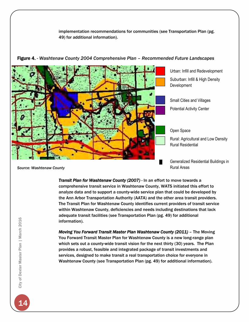
Urban: Infill and Redevelopment
Suburban: Infill & High Density
Development
Small Cities and Villages
Potential Activity Center
Open Space
Rural: Agricultural and Low Density
Rural Residential
Generalized Residential Buildings in
Rural Areas
Figure 4. - Washtenaw County 2004 Comprehensive Plan – Recommended Future Landscapes
Source: Washtenaw County
Source: Washtenaw County
Source: Washtenaw County
15
Cit
y o
f D
exte
r M
aste
r P
lan
| M
arc
h 2
01
6
Neighboring Communities
The City of Dexter is located at the cross-section of three (3) townships in
Washtenaw County, Michigan: Scio Township, Webster Township and Dexter
Township. In addition, Lima Township is less than one-half (1/2) mile west of the
City limits.
While the Townships generally share similar goals regarding maintaining rural
character and preserving farmland, the development activities and planning policies
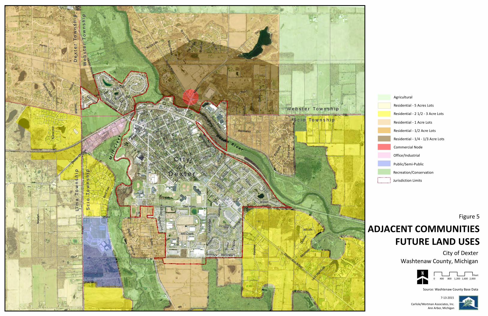
in these communities can influence the City of Dexter’s future character. Figure 3,
illustrates the different planned land uses for the areas adjacent to the City.
The areas surrounding the City of Dexter are generally planned for lower intensity
residential land use, with the exception of the “commercial node” found north of the
City on Mast Road. While this commercial area is not necessarily inconsistent with
the City, uses proposed by Webster Township in this area should be monitored by
the City for compatibility. Working with Webster Township early in the development
process for this area should be encouraged.
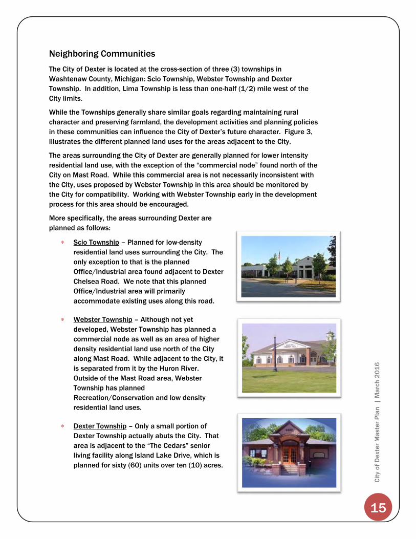
More specifically, the areas surrounding Dexter are
planned as follows:
Scio Township – Planned for low-density
residential land uses surrounding the City. The
only exception to that is the planned
Office/Industrial area found adjacent to Dexter
Chelsea Road. We note that this planned
Office/Industrial area will primarily
accommodate existing uses along this road.
Webster Township – Although not yet
developed, Webster Township has planned a
commercial node as well as an area of higher
density residential land use north of the City
along Mast Road. While adjacent to the City, it
is separated from it by the Huron River.
Outside of the Mast Road area, Webster
Township has planned
Recreation/Conservation and low density
residential land uses.
Dexter Township – Only a small portion of
Dexter Township actually abuts the City. That
area is adjacent to the “The Cedars” senior
living facility along Island Lake Drive, which is
planned for sixty (60) units over ten (10) acres.

16
Cit
y o
f D
exte
r M
aste
r P
lan
| M
arc
h 2
01
6
Joy
Baker
Parker
Huron River
Daly
Mast
Third
Shield
Forest
Dexter-Ann Arbor
Grand
Island Lake
Dexter Chelsea
Fifth
Dan Hoey
Hudson
Forshe
e
Central
Fourth
Newly
n
Potts
Huron
Ryan
Second
Island
Hill
Broad
DoverMain
Bisho
p
Inverness
Morrison
Ann Arbor
Sandhill
Edison
Bent Tr
ee
Carrington
Weber
Dexter Pinckney
Pinevi
ew
Noble
Brass Creek
Wilson
Eastridge
Harris
York
Ulrich
Lake
Wellington
Pine V
iew
Lexing
ton
Eaton
Alpine
Webster
Parkridge
Alley
Victoria
Hermania
Katherine
Oxbow
Donga
ra
Pearl
Cambri
dge
Mill Creek
Kensington
Stoney Field
Palmer
Quackenbush
Bristo
l
View
Jananne
McCormick
Hillside
Huron View
Kingsl
ey
Cushing
Melbourne
Ulrich
Brookside
Jessica
Cottonwood
WestridgeBoulder
Loch Highland
Kestrel
Taylor
Preston
Coventry
Bluebi
rd
Fox Sed
ge
Brass Creek
Broad
Huron River
Sandh
ill
York
ADJACENT COMMUNITIESFUTURE LAND USES
City of Dexter
Source: Washtenaw County Base Data
Carlisle/Wortman Associates, Inc.Ann Arbor, Michigan
0 400 800 1,200 1,600 2,000Feet
7-13-2015
Washtenaw County, Michigan
S c i o To w n s h i pS c i o To w n s h i p
W e b s t e r To w n s h i pW e b s t e r To w n s h i p
Scio
Tow
nshi
pSc
io T
owns
hip
Lim
a To
wnsh
ipLi
ma
Town
ship
Dext
er T
owns
hip
Dext
er T
owns
hip
H u r o n R i v e r
Mi l l
Cr e
e k
Commercial Node
AgriculturalResidential - 5 Acres LotsResidential - 2 1/2 - 3 Acre LotsResidential - 1 Acre LotsResidential - 1/2 Acre LotsResidential - 1/4 - 1/3 Acre Lots
Office/IndustrialPublic/Semi-PublicRecreation/Conservation
Web
ster
Tow
nshi
pW
ebst
er T
owns
hip
C i t yC i t yo fo f
D e x t e rD e x t e rJurisdiction Limits
Figure 5

19
Cit
y o
f D
exte
r M
aste
r P
lan
| M
arc
h 2
01
6
Community Goals and Objectives
The City of Dexter is a growing community that faces the difficult challenge of
accommodating increasing growth and development, and private land uses and
values, while retaining its small town character, protecting natural resources,
including air, water and public land. A key component of the City of Dexter Master
Plan is the articulation of a vision for the City’s future growth and the formulation of
community goals which reflect the community desires regarding how to respond to
future development.
The goals of the community attempt to balance the various interests and ensure
that each development decision is consistent with the overall vision for the City.
They help convey preferred development strategies and outline development
policies for the City.
The goals were developed with input from residents, property and business owners,
the Planning Commission, the City Council and other
City officials. Public participation was sought
through an on-line survey of residents. A summary
of the survey findings can be found in the Appendix.
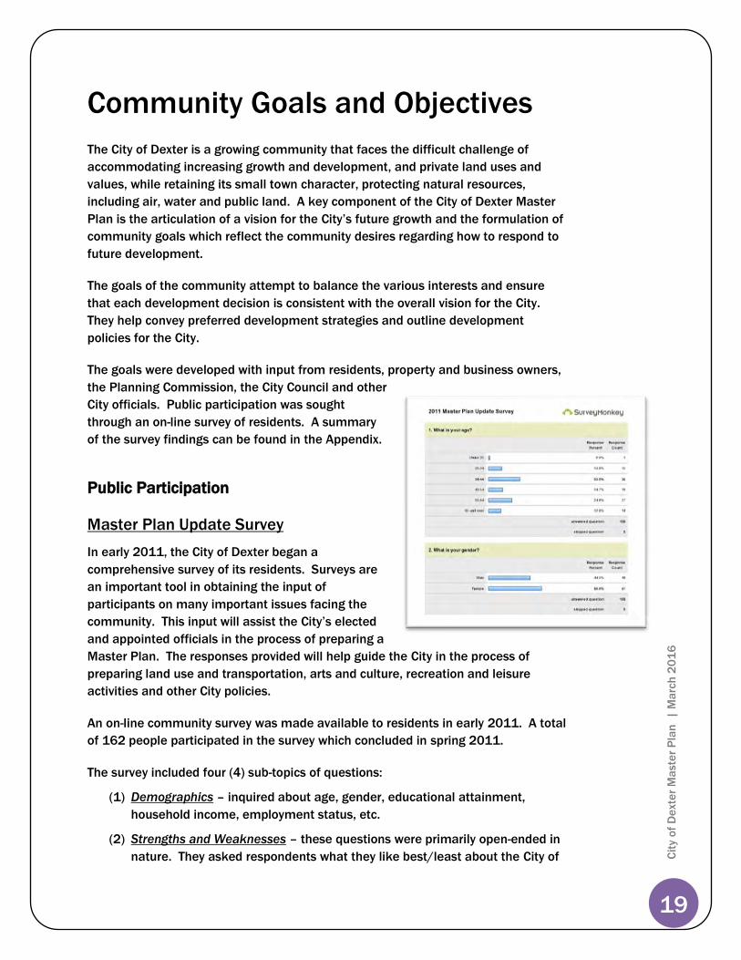
Public Participation
Master Plan Update Survey
In early 2011, the City of Dexter began a
comprehensive survey of its residents. Surveys are
an important tool in obtaining the input of
participants on many important issues facing the
community. This input will assist the City’s elected
and appointed officials in the process of preparing a
Master Plan. The responses provided will help guide the City in the process of
preparing land use and transportation, arts and culture, recreation and leisure
activities and other City policies.
An on-line community survey was made available to residents in early 2011. A total
of 162 people participated in the survey which concluded in spring 2011.
The survey included four (4) sub-topics of questions:
(1) Demographics – inquired about age, gender, educational attainment,
household income, employment status, etc.
(2) Strengths and Weaknesses – these questions were primarily open-ended in
nature. They asked respondents what they like best/least about the City of

20
Cit
y o
f D
exte
r M
aste
r P
lan
| M
arc
h 2
01
6
Dexter, what are the most/least important issues facing the City of Dexter,
and what types of development would you like to see in the City.
(3) Funding Options – discussed the possible funding of a light rail system to
gauge community support if pursued.
(4) Areas of Concern – These open-ended questions asked respondents to list
specific concerns that they felt should be addressed.
From evaluation of the survey results, background studies, existing land use
information and various referenced City and County Planning Initiatives, the City of
Dexter Planning Commission has formulated the following goals and objectives to
serve as the basis for the future development of the City of Dexter.
Goals are general statements that define the direction and character of future
development. Policies set forth a framework for action and form the basis upon
which more detailed development decisions may be made. Adoption of policies
does not commit the City of Dexter to any particular recommendation, but rather
constitutes a commitment to take actions consistent with policy guidelines.
Public Input Events
In addition to the survey noted previously, the Planning Commission held an open
forum session in December 2011 inviting the public to comment on the Master
Plan. The session was publicized on the City’s website, Facebook page, via City
email update, and in the Dexter Leader.
City of Dexter Goals
The following statements reflect the primary goals of the City of Dexter. The general
goals listed below are not in any particular order or preference.
Protect and maintain the City’s natural resources, particularly the Huron
River and Mill Creek areas.
Provide various passive and active recreational opportunities for all
residents of the City including programs and activities offered by the City
and other agencies.
Provide a desirable residential environment with diverse housing options for
City residents, recognizing that a viable, healthy residential component is of
primary importance to the overall health and vitality of the community.
Preserve and strengthen the existing character of the downtown area as an
historic, pedestrian-scaled community, with traditional site and architectural
design creating an aesthetically memorable place with vibrant streetscapes
and community spaces.

21
Cit
y o
f D
exte
r M
aste
r P
lan
| M
arc
h 2
01
6
Encourage development in the Baker Road and Dexter-Ann Arbor Road
corridors that is separate and distinct from the Downtown that serves the
needs of Dexter’s growing population.
Encourage common design elements, such as: architecture, streetscape,
signage, and landscaping that promote continuation of the downtown
theme along the Baker Road corridor.
Provide commercial areas that meet the needs of City residents in terms of
location and services offered.
Promote quality, job producing economic development within the City that
serves the needs of the City residents.
Provide a variety of safe, efficient modes of transportation to meet the
needs of City residents and visitors.
Provide timely, efficient and quality governmental services to City residents.
Assure that new development , and existing residential, commercial and
industrial areas, protect the City’s small town character, open space, natural
resources and recreational values of the City from activities and land uses
related or ancillary to mineral, sand and gravel, and oil and gas exploration
and development.
Objectives:
1. Guide development to foster the responsible
use of land, preserve natural features, and to
make the best use of existing public
services, utilities, and infrastructure.
2. Protect and enhance the Huron River and
Mill Creek. Collaborate with Huron-Clinton
Metropolitan Authority, Washtenaw County
Water Resources, Huron Watershed Council
and Washtenaw County, when possible to
improve water quality.
3. Promote protection and maintenance of the City’s natural landscape.
4. Protect and preserve existing trees and wooded areas within the City.
Natural Resources
Protect and maintain the City’s natural resources, particularly the Huron
River and Mill Creek areas.

22
Cit
y o
f D
exte
r M
aste
r P
lan
| M
arc
h 2
01
6
5. Promote street tree planting to help preserve the residential character and
tree-lined streets of the City.
6. Promote safe management of disposal of all waste materials, both
hazardous and non-hazardous, which are generated within or transported
through the City through coordination with state and local agencies to
ensure that contaminated sites are returned to an acceptable
environmentally safe condition.
7. Reduce noise and air pollution and site lighting levels so as to minimize
their impact on residential areas.
8. Continue to concentrate efforts on wellhead protection and groundwater
quality to protect this vital community resource through the protection
program initiated by the City.
9. Protect the water quantity and quality of the City’s rivers, streams,
groundwater, springs, lakes, ponds, wetlands, and creeks, particularly the
Huron River and Mill Creek, as a single interconnected hydrologic system.
10. Continue to monitor and improve the City’s wastewater treatment and
stormwater management systems to minimize negative impacts on City
residents, the Huron River and Mill Creek.
11. Utilize progressive stormwater management and erosion control techniques
to ensure that development will not adversely impact natural resources and
surrounding property. Incorporate Federal Phase II Stormwater
Requirements and Guidelines into planning review process of the City.
12. Encourage the use of best management practices and low impact
development (LID) strategies to minimize stormwater run-off.
Objectives:
1. Meet present and future community needs for parks, greenways, trails and
recreation by planning and developing a system of parks, greenways, open
space and recreation facilities and encouraging the preservation of green
space and the development of new parks and/or recreation assets when
opportunities arise.
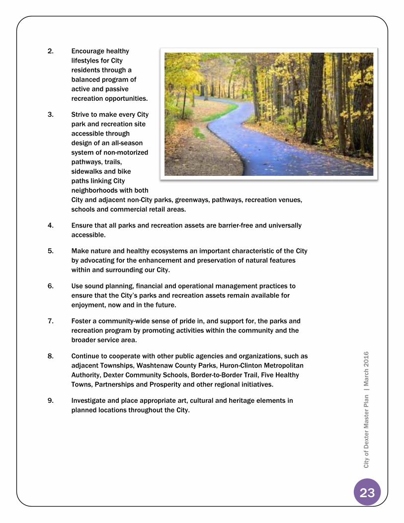
Recreation / Open Space
Provide various passive and active recreational opportunities for all
residents of the City including programs and activities offered by the City
and other agencies.
23
Cit
y o
f D
exte
r M
aste
r P
lan
| M
arc
h 2
01
6
2. Encourage healthy
lifestyles for City
residents through a
balanced program of
active and passive
recreation opportunities.
3. Strive to make every City
park and recreation site
accessible through
design of an all-season
system of non-motorized
pathways, trails,
sidewalks and bike
paths linking City
neighborhoods with both
City and adjacent non-City parks, greenways, pathways, recreation venues,
schools and commercial retail areas.
4. Ensure that all parks and recreation assets are barrier-free and universally
accessible.
5. Make nature and healthy ecosystems an important characteristic of the City
by advocating for the enhancement and preservation of natural features
within and surrounding our City.
6. Use sound planning, financial and operational management practices to
ensure that the City’s parks and recreation assets remain available for
enjoyment, now and in the future.
7. Foster a community-wide sense of pride in, and support for, the parks and
recreation program by promoting activities within the community and the
broader service area.
8. Continue to cooperate with other public agencies and organizations, such as
adjacent Townships, Washtenaw County Parks, Huron-Clinton Metropolitan
Authority, Dexter Community Schools, Border-to-Border Trail, Five Healthy
Towns, Partnerships and Prosperity and other regional initiatives.
9. Investigate and place appropriate art, cultural and heritage elements in
planned locations throughout the City.

24
Cit
y o
f D
exte
r M
aste
r P
lan
| M
arc
h 2
01
6
Objectives:
1. Provide for a range of housing options for City residents including affordable
housing and senior housing options.
2. Allow residential density levels that correspond to available infrastructure
(sewer, water and roads) and adjacent land use.
3. Incorporate new construction into the fabric of the City in a way that
recognizes the City’s historical characteristics.
4. Cooperate with building owners to utilize potential Community Development
Block Grants (CDBG) for Rental Rehabilitation projects for Downtown second
and third story residential properties.
5. Strengthen and protect the viability of residential neighborhoods by limiting
non-residential intrusions into residential areas, and by separating intrusive
commercial and industrial areas from residential areas with open space and
other buffers.
6. Improve living amenities in all residential neighborhoods through high
standards of housing design and construction, and by providing access to
usable contiguous and convenient open space.
7. Encourage continued maintenance of, and reinvestment in, residential
structures to protect existing housing from deterioration, and recognize that
in order to maintain high quality housing, some deteriorated homes or
residential areas may need to be
redeveloped.
Residential
Provide a desirable residential environment for City residents, recognizing
that a viable, healthy residential component is of primary importance to
the overall health and vitality of the community.

25
Cit
y o
f D
exte
r M
aste
r P
lan
| M
arc
h 2
01
6
8. Preserve and enhance the older, small town residential character of the City,
including the promotion of the visual compatibility of residential buildings in
size, setbacks and architectural features, and the provision of design
transitions between different types of buildings.
9. Encourage the pattern, layout and design elements of the existing
residential neighborhoods that will emphasize the City center’s rural, small
town image. A neo-traditional street pattern should be encouraged for new
developments that follow traditional neighborhood design (TND) guidelines.
10. Consider programs and techniques to help maintain and improve
neighborhoods and the condition of housing stock within the City, which
may include improvements to the City’s building inspection practices and
assisted housing rehabilitation.
11. Encourage pedestrian connections from neighborhoods to schools, parks,
downtown, other community facilities, and other neighborhoods.
Objectives:
1. Guide development to foster the responsible use of land
and natural features, and to make best use of existing
public services, utilities and infrastructure.
2. Expand the Central Business District, selectively, into
surrounding Village Commercial areas to open up
additional redevelopment opportunities and improve the
critical mass, density and walkability of the Downtown.
3. Encourage and permit mixed-uses with a village-scale
and character.
4. Cooperate with building owners to utilize potential
Community Development Block Grants (CDBG) for Rental Rehabilitation
projects for Downtown second and third story residential properties.
5. Identify and redevelop brownfield sites in cooperation with the Washtenaw
County Brownfield Redevelopment Authority.
Downtown – Mixed Use
Preserve and strengthen the existing character of the downtown area as
an historic, pedestrian-scaled community, with traditional site and
architectural design creating an aesthetically memorable place with
vibrant streetscapes and community spaces.
26
Cit
y o
f D
exte
r M
aste
r P
lan
| M
arc
h 2
01
6
6. Evaluate the Central Business and City Center zoning districts to ensure
accommodation of a compatible and complementary mix of uses within the
downtown area.
7. Encourage office uses to locate in secondary first floor spaces and upper
floors that will support the retail and restaurant uses in the downtown.
8. Encourage upper story residential development / redevelopment to create a
twenty-four (24) hour downtown supported by residents who can live, work
and play downtown.
9. Utilize form-based code ideals and concepts for spatial relation and
dimensional requirements.
10. Encourage high quality site and building designs that include the latest
“green” technology and contribute to strong neighborhoods, vital shopping
districts and desirable employment centers.
11. Integrate public gathering spaces within a pedestrian/non-motorized
circulation system.
The Dexter-Ann Arbor Road Corridor is defined as the area surrounding Dexter-Ann Arbor
Road from Kensington Street, southeast to the City boundary, and is considered a “gateway”
to the City center.
Objectives:
1. Guide development to foster the responsible use of land, preserve natural
features, and to make most efficient use of existing public services, utilities
and infrastructure.
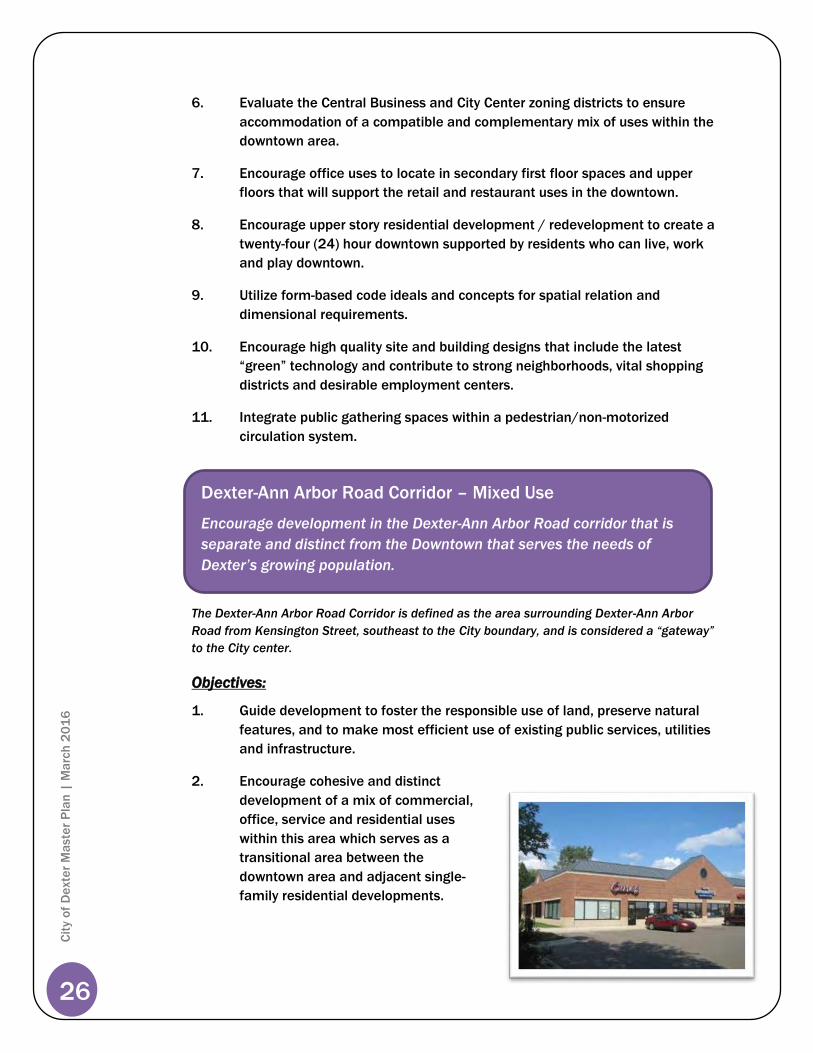
2. Encourage cohesive and distinct
development of a mix of commercial,
office, service and residential uses
within this area which serves as a
transitional area between the
downtown area and adjacent single-
family residential developments.
Dexter-Ann Arbor Road Corridor – Mixed Use
Encourage development in the Dexter-Ann Arbor Road corridor that is
separate and distinct from the Downtown that serves the needs of
Dexter’s growing population.

27
Cit
y o
f D
exte
r M
aste
r P
lan
| M
arc
h 2
01
6
3. Organize commercial
development into compact,
unified commercial centers that
complement the scale and
character of existing
development or that promote
the desired character for areas
where new
development/redevelopment is
planned.
4. Avoid piecemeal or scattered
development and discourage
uncoordinated commercial strip
development. Where individual parcels of land are to be developed for
commercial uses, encourage coordination with adjacent properties,
including common parking and drives in order to reduce the number of
access points to public roads.
5. Encourage residential or mixed-use development (including residential uses)
as a buffer between adjacent residential areas and other uses within this
planned area. Such uses shall not create adverse impacts on existing or
proposed residential uses, and will be scaled, designed and landscaped so
as to complement and enhance the adjacent properties.
6. Encourage preservation of natural features and development of parks and
consider their interrelationship with existing parkland, natural areas and
adjacent neighborhoods.
7. Encourage high quality site and building designs that include the latest
“green” technology and contribute to strong neighborhoods, vital shopping
districts and desirable employment centers.
8. Manage access to development by encouraging consolidation of curb cuts
and shared driveway access. Parking lots should be shared when possible
and located in the rear or on the side of
buildings when possible.
9. Integrate public gathering spaces at key
points of interest and entrances to
intersections within a pedestrian/non-
motorized circulation system.
10. Evaluate the ARC, Dexter-Ann Arbor Road
Corridor Overlay District to ensure
accommodation of a compatible and

28
Cit
y o
f D
exte
r M
aste
r P
lan
| M
arc
h 2
01
6
complementary mix of uses within this planned mixed use area.
11. Utilize form-based code ideals and concepts for spatial relation and
dimensional requirements.
The Baker Road Corridor is defined as the area bounded by Ann Arbor Street to the north
and the Dexter Community School property to the south along Baker Road, and is
considered a “gateway” to the City center.
Objectives:
1. Guide development to foster the responsible use of land, preserve natural
features, and to make best use of existing public services, utilities and
infrastructure.
2. Encourage cohesive and distinct development of a mix of commercial,
office, service and residential uses within this area which serves as a
transitional area between the downtown area and adjacent single-family
residential developments.
3. Upgrade existing infrastructure within the corridor to assist and meet the
needs of the redevelopment potential within the corridor.
4. Organize commercial development into compact, unified commercial
centers that complement the scale and character of existing development or
that promote the desired character for areas where new
development/redevelopment is planned.
Baker Road Corridor – Mixed Use
Encourage common design elements promoting continuation of the
downtown theme along the Baker Road Corridor.

29
Cit
y o
f D
exte
r M
aste
r P
lan
| M
arc
h 2
01
6
5. Avoid piecemeal or scattered development and discourage uncoordinated
commercial strip development. Where individual parcels of land are to be
developed for commercial uses, encourage coordination with adjacent
properties, including common parking and drives in order to reduce the
number of access points to public roads.
6. Encourage residential or mixed-use development (including residential uses)
as a buffer between adjacent residential areas and other uses within this
planned area. Such uses shall not create adverse impacts on existing or
proposed residential uses, and will be scaled, designed and landscaped so
as to complement and enhance the adjacent properties.
7. Encourage high quality site and building designs that include the latest
“green” technology and contribute to strong neighborhoods, vital shopping
districts and desirable employment centers.
8. Encourage preservation of natural features and development of parks and
consider their interrelationship with existing parkland, natural areas and
adjacent neighborhoods.
9. Encourage common design elements throughout the corridor to provide
visual consistency throughout the district. Design elements should promote
the continuation of the downtown streetscape theme and include
landscaping, signage, lighting and architectural design.
10. Manage access to development by encouraging consolidation of curb cuts
and shared driveway access. Parking lots should be shared when possible
and located in the rear or on the side of buildings when possible.
11. Integrate public gathering spaces at key points of interest and entrances to
intersections within a pedestrian/non-motorized circulation system.
Specifically, by promoting a connection to the future parkland and open
space adjacent to the Baker Road Corridor and along the Mill Creek.
Collaborate with Dexter Community Schools for interconnection with their
Outdoor Lab property.
12. Improve pedestrian access (sidewalks/bike trails) from adjacent
neighborhoods to the Baker Road planned mixed-use area.
13. Coordinate with Dexter Schools to improve the traffic flow into and across
the school campus focusing on improvements to the Dan Hoey/Baker and
Shield/Baker intersections.
14. Develop a Baker Road Mixed-Use Overlay District to ensure accommodation
of a compatible and complementary mix of uses within this planned mixed-
use area. Utilize form-based code ideals and concepts for spatial relation
and dimensional requirements.

30
Cit
y o
f D
exte
r M
aste
r P
lan
| M
arc
h 2
01
6
Objectives:
1. Guide development to foster the responsible use of land, preserve natural
features and to make best use of existing public services, utilities and
infrastructure.
2. Organize commercial development shall be organized into compact, unified
commercial centers that complement the scale and character of existing
development or that promote the desired character for areas where new
development is planned.
3. Avoid piecemeal or scattered development and discourage uncoordinated
commercial strip development. Where individual parcels of land are to be
development for commercial uses, encourage coordination with adjacent
properties, including common parking and drives, in order to reduce the
number of access points to public roads.
4. Encourage high quality site and building designs that include the latest
“green” technology and contribute to strong neighborhoods, vital shopping
districts and desirable employment centers.
5. Promote and coordinate activities aimed at improving the business climate
within the City, including cooperation with merchants and the Chamber of
Commerce.
6. Foster development, redevelopment and expansion within the City creating
new employment and business opportunities.
7. Utilize and collaborate with the Michigan Economic Development Corporation
(MEDC) and Ann Arbor
SPARK for economic
development
assistance.
Commercial
Provide commercial areas that meet the needs of City residents in terms
of location and services offered.
31
Cit
y o
f D
exte
r M
aste
r P
lan
| M
arc
h 2
01
6
Objectives:
1. Guide development to foster the responsible use of land, preserve natural
features and to make best use of existing public services, utilities and
infrastructure.
2. Encourage high quality site and building designs that include the latest
“green” technology and contribute to strong neighborhoods, vital shopping
districts and desirable employment centers.
3. Identify and develop brownfield sites within the City and work with the
Washtenaw County Brownfield Redevelopment Authority in this regard.
4. Explore expansion of Dexter Business and Research Park, particularly for an
additional access point.
5. Require adequate setbacks for industrial operations, landscape buffers and
greenbelts to minimize visual and environmental conflicts with adjoining
land uses.
6. Promote and coordinate activities aimed at improving the business climate
within the City, including cooperation with merchants and the Chamber of
Commerce.
7. Foster development, redevelopment and expansion within the City creating
new employment and business opportunities.
8. Minimize negative impacts of industrial areas on non-industrial areas and
on the environment.
9. Provide a balanced industrial development strategy to achieve
environmental compatibility and maintain the neighborhood character of
the City.
10. Utilize and collaborate with the Michigan Economic Development
Corporation (MEDC) and Ann Arbor SPARK for economic development
assistance.
Industrial
Promote quality, job producing economic development within the City
that serves the needs of residents.
32
Cit
y o
f D
exte
r M
aste
r P
lan
| M
arc
h 2
01
6
Objectives:
1. Maintain a transportation network that maximizes the capacity of existing
roads while maintaining roadways and facilitating safe and efficient
movement of vehicles and pedestrians throughout the Village.
2. Continue to evaluate and resolve issues with Village “through traffic”
constraints by coordinating and cooperating with the County Road
Commission.
3. Evaluate the impact of traffic generated by existing development and new or
expanded land uses, including extractive uses, and work toward
improvements, compatibility with other existing and planned uses, and
safety concurrent with new development and uses.
4. Continue to implement access management standards for new
development in order to improve the function and appearance of local
streets, streetscapes and alleys; providing adequate rights-of-ways and
appropriate improvements for traffic volume.
5. Encourage new streets to be designed in an interconnecting network with
flexibility within the neo-traditional residential pattern, similar to the existing
street network.
6. Coordinate transportation improvements with the County Road Commission
and state agencies, including participation in Washtenaw Area
Transportation Study
(WATS).
7. Provide a variety of
transportation choices
including public transit and
non-motorized
transportation, and areas for
bike parking.
8. Expand upon existing
connections to create a City-
wide, non-motorized network
to provide opportunities for pedestrian activity such
as walking, jogging and bicycling.
Transportation
Provide a variety of safe, efficient modes of transportation to meet the
needs of City residents and visitors.

33
Cit
y o
f D
exte
r M
aste
r P
lan
| M
arc
h 2
01
6
9. Develop open path connections for walkways, paths and greenways to
connect outlying parks for recreational use, including installation of
sidewalks on at least one (1) side of the street (with the long-term goal of
installation of sidewalks on both sides of the street) – expand the
walkability of Dexter.
10. Implement the recommendations of the annual Capital Improvements Plan
(CIP) to expand walkability within the City by installing sidewalks on at least
one (1) side of the street (with the long-term goal of installation on both
sides of the street). The placement and location of sidewalk installation
within the public rights-of-way should consider existing conditions, including
effective front yard, impacts to existing street trees, utilities, topography,
preservation of City character, and engineering standards.
11. Develop and improve sidewalks to link uses such as shopping, offices and
residential areas to parks, open spaces and activity centers.
12. Continue to coordinate transportation options through the Western-
Washtenaw Area Value Express (WAVE) to provide improved transit services
to City residents.
13. Provide senior citizen transportation options for City residents, including dial-
a-ride or similar opportunities.
14. Work with surrounding communities to consider forming a transit
consortium to fund services for a growing older population to provide transit
to life-line and leisure destinations.
15. Support expansion of the County transportation system/network,
particularly the efforts of the Ann Arbor Transit Authority (AATA).
16. Encourage the maintenance of and/or improvements to local streets and
sidewalks to ensure safe access to the City’s residential neighborhoods,
while discouraging extraneous non-residential traffic.
17. Provide safe traffic flow for industrial uses, separate from residential areas.
Pursue secondary access points into the industrial park where possible.
18. Promote the importance of walkability in
Dexter for all abilities and ages, and
implement the Complete Streets Policy in
accordance with the Complete Streets
Ordinance for all transportation projects, and
all modes of transportation.

34
Cit
y o
f D
exte
r M
aste
r P
lan
| M
arc
h 2
01
6
Objectives:
1. Provide and maintain open space, parks and recreation facilities to meet
the needs of Village residents as formulated in the Parks and Recreation
Master Plan.
2. Work with adjacent municipalities
and Washtenaw County to provide
area residents with high quality
community services and facilities.
3. Provide adequate level of services
regarding police, fire and safety
services.
4. Provide adequate and affordable
sewer and water service for Village
residents.
5. Provide a public restroom facility in the Downtown area.
6. Provide adequate storm and seasonal services to Village residents.
7. Initiate stormwater upgrades as necessary and investigate whether a
stormwater utility would be cost-effective for the Village.
8. Work with adjacent communities, Washtenaw County Water Resources
Department, and the Huron River Water Shed Council to protect the area
watershed.
9. Evaluate impact of new development and new and expanded land uses on
community services and facilities, such as police, fire, and parks, and work
to ensure there are adequate regulatory tools and resources available to
support new development and uses while protecting existing and planned
uses and environmental quality, in particular where uses involve a higher
risk of release, discharge, or spill of hazardous substances, pollutants, or
similar substances.
Community Facilities + Services
Provide timely, efficient and quality governmental services to City
residents.

35
Cit
y o
f D
exte
r M
aste
r P
lan
| M
arc
h 2
01
6
Future Land Use
The Future Land Use Plan defines the framework for the future growth of the City of
Dexter. It begins with a general description of the desired pattern of development
for the community and follows with a description of the future land use categories
as illustrated on the future land use map (Figure 6).
In addition to the future land use categories, specific development strategies are
formulated to achieve community goals for the downtown area (Main Street), the
Dexter-Ann Arbor Road and Baker Road corridors.
In general, the desired scenario for the City’s master plan includes continuation of
the traditional neighborhood development (TND) pattern at a scale complementary
to the rural, small town character of the City. Rehabilitation, redevelopment and
properly scaled infill development, as well as thoughtful growth management
policies are key to the sustainability of the City of Dexter’s small town atmosphere.
Future Land Use Categories
Specific land use categories are identified and illustrated on the future land use
map (Figure 5). The following identifies the intent of each category, describes the
desirable land uses and elements, the land use relationship with physical and
natural features, and lists the corresponding zoning districts.
Low Density Residential
Intent: The intent of this category is to maintain and create a larger lot residential
development pattern outside of the City center, and to provide direction for the
development of vacant lands in a transitional manner that is still compatible with
the existing traditional neighborhood development pattern.
Description: The Low Density Residential designation is contained within four (4)
peripheral locations in the City, each having an area of land under development or
recently developed. The recommended density in this area is two (2) to three (3)
dwelling units per acre.
Relationship to Physical and Natural Features: The Low Density Residential land
use category is located in areas where the public services and infrastructure are
adequate to accommodate the anticipated density. The natural features outside of
the City center vary extensively, each depending on the previous land use for the
site and/or in the area. Natural features within these areas must be considered and
preserved where possible including: wetlands, woodlands, steep slopes, flood plain,
etc.
Appropriate Uses: Desirable land uses and elements of the Low Density Residential
land use include:

36
Cit
y o
f D
exte
r M
aste
r P
lan
| M
arc
h 2
01
6
Single-family dwellings.
Density of between 2 and 3 dwelling units per acre.
Compatible Zoning Districts: Zoning districts compatible with the Low-Density
Residential future land use classification include R-1A and R-1B One-Family
Residential.
Village Residential
Intent: The intent of this category is to maintain the well-established character,
scale and density of the traditional pattern of the developed single-family
neighborhoods that are characteristic of the City of Dexter.
Description: Located primarily within the City center, these older neighborhoods
consist of detached single-family homes, including numerous historic structures.
The recommended density in these areas is four (4) to six (6) dwelling units per
acre. These predominant characteristics should be maintained by encouraging
programs and techniques to improve neighborhoods and housing conditions. In
addition, development on vacant lots within this residential classification should
only occur if the character, scale and development pattern of the new development
is consistent and compatible with the older, existing structures, and development
patterns of existing residential neighborhoods. There are limited areas outside the
City Center identified in the future land use map that also provide opportunities for
a higher density single-family atmosphere.
Relationship to Physical and Natural
Features: The Village Residential land use
category is located in areas where the public
services and infrastructure are adequate to
accommodate the planned density. The
natural features within this designation are
somewhat limited; however, natural features
such as existing trees and any relationship
with the Huron River or Mill Creek must be
considered in new development or
redevelopment of these areas.
Appropriate Uses: Desirable land uses and elements of the Village Residential land
use include:
Single-family dwellings.
Density of between 4 and 6 dwelling units per acre.

37
Cit
y o
f D
exte
r M
aste
r P
lan
| M
arc
h 2
01
6
Compatible Zoning Districts: The Village Residential (VR) zoning district is the only
zoning classification compatible with the Village Residential future land use
category.
Multiple-Family Residential
Intent: The intent of this category is to provide for a mix of multiple family uses
near the City center.
Description: The Multiple Family Residential designation encompasses five (5)
areas within the City: northeast of the City Center between Edison and Meadow View
along the railroad; both sides of Huron View; both sides of Eaton; both sides of
Grand between Broad and Baker; east side of Lexington bounded by Dan Hoey to
the north; and south of Dan Hoey west of the
Baker Road intersection. In addition to these
larger areas of Multiple-Family Residential,
there are smaller, single parcel areas
designated multiple-family mixed within the
single-family neighborhood west of the City
Center.
The anticipated uses in the Multiple-Family
Residential category include townhouses,
garden apartments, or two (2) to three (3) story
apartments at a density not to exceed nine (9)
dwelling units per acre.
Relationship to Physical and Natural Features:
The intent of this land use category necessitates the availability of the public
services and infrastructure, but much like the Village Residential designation,
Multiple Family Residential is planned in areas without significant natural features
present. Since limited natural features are present in these areas, consideration
should be taken in requiring pocket parks and bike parking.
Appropriate Uses: Desirable land uses and elements of the Multiple Family
Residential land use include:
Townhouses, garden apartments, two (2) to three (3) story apartments.
Density not to exceed nine (9) dwelling units per acre.
Compatible Zoning Districts: Zoning districts that are compatible with the Multiple-
Family Residential land use classification include R-3, Multiple-Family Residential
and MH, Mobile Home Park Residential.

38
Cit
y o
f D
exte
r M
aste
r P
lan
| M
arc
h 2
01
6
Downtown - Mixed Use
Intent: The Downtown – Mixed Use designation incorporates a mix of uses within
the core of the City. The intensity of the development within the District tends to be
higher than the rest of the City due to the smaller lots sizes. Parking cannot be
accommodated on most sites and the buildings cover the majority of the parcel.
Uses customarily found in the Downtown include municipal services, restaurants,
banks (no drive thru), personal services, comparison retail, offices, public spaces,
and single- and multiple family residences (second story). The continued
maintenance of the historical structures and encourage new structures to maintain
historic characteristics and character of the downtown are also essential within this
area.
Description: This designation is centered on the Main Street corridor between
Jeffords and Baker with the Mill Creek as the western gateway into the City and
Baker Road to the east.
Relationship to Physical and Natural Features: The intent of this land use category
necessitates the availability of the public services and infrastructure. While not
integral to the designation, the proximity to Mill Creek adds to the viability and
sense of place of this area. Limited other natural features exist within this area due
to the increased density and intensity of the planned uses.
Appropriate Uses: Desirable land uses and elements of the Downtown – Mixed Use
designation are:
Retail stores, personal service establishments, municipal facilities, offices,
off-street parking, public open spaces, and a town square.
Ground floor retail with office and/or multiple-family uses on the upper
floors.
Preservation of the Mill Creek
and Pond.
Historic preservation.
Highway-oriented and convenience
commercial uses which require high
accessibility and visibility are
incompatible with the character of the
City center and should be
discouraged. Appropriate areas for
bike parking should be considered.
Compatible Zoning Districts: The
Central Business District is the only zoning category compatible with the Downtown
– Mixed Use future land use category.
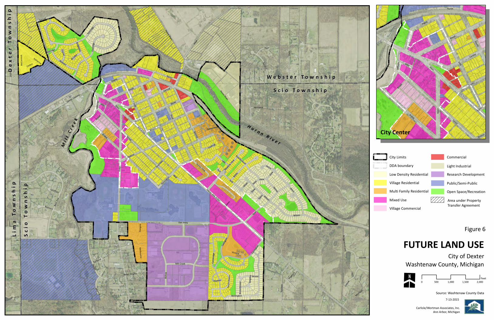
Joy
Baker
Parker
Third
Shield
ForestGrand
Mast
Fifth
Dexter-Ann Arbor
Dan Hoey
Hudson
Central
Fourth
Potts
Huron
Ryan
Second
Island Lake
Broad
DoverMain
Bisho
p
Inverness
Ann Arbor
Dexter Chelsea
Edison
Bent Tr
ee
Carring
ton
Weber
Forshe
e
Pinevi
ew
Noble
Wilson
Eastrid
ge
York
Ulrich
Huron River
Sandhill
Lake
Wellington
Pine V
iew
Lexing
tonEato
n
Alpine
Morrison
Webster
Parkrid
ge
Dexter Pinckney
Alley
Victoria
Bridgeway
Hermania
Katherine
Oxbow
Donga
ra
Pearl
Cambri
dge
Mill Creek
Kensington
Bridgewood Hills
Wall
Palmer
Shagbark
Quackenbush
Cedars
Bristo
l
Meadow View
View
Jananne
McCo
rmick
Hillside
Oliver
Huron View
Boenaro
Samuel
Kingsl
ey
Cushing
Glacier
Melbourne
Jeffor
ds
Ulrich
Cottonwood
Westridge
View
Bristol
Boulder
Sandfield
Kurtland
South
Down
sBaker Heights
ShawTayl
or
Preston
Broad
Sandhill
Huron River
Wilson
York
View
Bristo
l
FUTURE LAND USECity of Dexter
Source: Washtenaw County Data
Carlisle/Wortman Associates, Inc.Ann Arbor, Michigan
7-13-2015
Washtenaw County, Michigan
S c i o T o w n s h i pS c i o T o w n s h i pW e b s t e r T o w n s h i pW e b s t e r T o w n s h i p
Scio
Tow
nshi
pSc
io T
owns
hip
Lim
a To
wns
hip
Lim
a To
wns
hip
Dext
er T
owns
hip
Dext
er T
owns
hip
H u r o n R i v e rM i l l C
r ee k
0 500 1,000 1,500 2,000Feet
Figure 6
Fifth
Forest
Main
Broad
Baker
Grand
Central
Alpine
Alley
Ann Arbor
Fourth
Dover
Huron
Jeffor
ds
Hudson
Edison
Broad
CommercialLight IndustrialResearch DevelopmentPublic/Semi-PublicOpen Space/RecreationArea under PropertyTransfer Agreement
Low Density ResidentialVillage ResidentialMulti Family ResidentialMixed UseVillage Commercial
DDA boundaryCity Limits
City Center


41
Cit
y o
f D
exte
r M
aste
r P
lan
| M
arc
h 2
01
6
Dexter -Ann Arbor Road Corridor – Mixed Use
Intent: This mixed-use designation is intended to encourage development that is
separate and distinct from the City center. The designation also plans for the
following:
1. Compact commercial center/node at Dan Hoey intersection with less
intensive office or multiple-family residential uses throughout the rest of
the corridor.
2. Performance standards for density, scale, setbacks, parks, landscaping,
access management, linkages, etc.
3. Physical connections between the City center and the corridor.
4. Design guidelines to blend with the City center.
5. Flexibility in parking requirements, shared parking and shared parking
access standards with the specific goal of minimizing access points (curb
cuts) along Dexter-Ann Arbor Road and minimizing impervious area.
Description: The Dexter-Ann Arbor Road Corridor - Mixed Use area is located along
the Dexter-Ann Arbor Road corridor from Kensington Street southeast to the City
boundaries and contains a mix of existing land uses, as well as a limited amount of
vacant land.
Relationship to Physical and Natural Features: Utilities are available throughout the
Dexter-Ann Arbor Road corridor and the majority of the parcels have direct frontage
on Dexter-Ann Arbor Road. The depth of some of these parcels provided a natural
buffer for the adjacent uses.
Appropriate Uses: Desirable land uses and elements of the Dexter-Ann Arbor Road -
Mixed Use category are:
A mix of multiple family, office and commercial uses.
Uses are to be separate and distinct from the City center.
Commercial center at Dan Hoey intersection.
Lower density development pattern.
Architectural standards to create a unified theme.
Shared access along common drives, minimizing “curb cuts” along Dexter-
Ann Arbor Road.
Compatible Zoning Districts: The Dexter-Ann Arbor Road Corridor Overlay zoning
district is compatible with the Dexter-Ann Arbor Road Mixed Use future land use
designation.

42
Cit
y o
f D
exte
r M
aste
r P
lan
| M
arc
h 2
01
6
Baker Road Corridor - Mixed Use
Intent: This mixed-use designation is intended to accommodate existing uses,
encourage the upgrading of this area through redevelopment, and provide
amenities that encourage public transit use. The designation also plans for the
following:
1. Mix of complementary land uses.
2. Flexibility in parking requirements, shared parking and the reduction of
curb cuts.
3. Permit conversion of homes to non-residential land uses.
4. Encourage a variety of housing types and higher –densities for residential
infill projects.
5. Second story multiple-family residential uses.
6. Architectural standards and controls and unified design elements.
7. Better pedestrian and bicycle circulation/parking and access.
8. Encourage redevelopment and infill development.
9. Maintain and enhance the City’s small town, historic character.
10. Enhance the streetscape along Baker Road.
11. Establish a greenway connection along Mill Creek between the school and
Downtown.
12. Encourage economic development within the corridor.
Description: The Baker Road Corridor - Mixed Use area is located between Main
Street/Ann Arbor Road and Dan Hoey Road, and contains virtually every land use
and zoning classification found in the City. All parcels abutting Baker Road are
included within the designation, exclusive of the school property located at the
southern end of the corridor.
Relationship to Physical and Natural Features: Utilities are available throughout the
Baker Road corridor along with immediate access to Baker Road. The depth of
some of these parcels provided a natural buffer for the adjacent uses with non-
vegetative buffers required in closer proximity to the City center.
Appropriate Uses: Desirable land uses and elements of the Baker Road Corridor –
Mixed Use category are:
A mix of complementary uses, inclusive of Single Family Residential – City
Density uses.
Conversion of single-family homes to non-residential uses.

43
Cit
y o
f D
exte
r M
aste
r P
lan
| M
arc
h 2
01
6
High density residential uses.
Second story residential uses.
Senior housing.
Office uses and commercial uses that provide essential goods and services.
Activity and entertainment uses.
Architectural standards to create a unified theme.
Compatible Zoning Districts: The Baker Road Corridor – Mixed Use designation is
compatible with the Baker Road Corridor Overlay District.
Village Commercial
Intent: The Village Commercial
designation incorporates a mix of uses
typical of land abutting a central business
district. These areas exhibit a compact
development pattern, but have sufficient
land to accommodate on-site parking and
cover less land area. Uses typical of
these areas include convenience retail,
personal services, offices, public spaces,
and single and multiple family
residences. Further increases in
commercial floor space, through
redevelopment with historically consistent
architecture will improve the viability and attractiveness of this area into a high
density, walkable downtown area.
Description: This designation is located at the periphery of the Central Business
District, specifically the south side of Forest between Broad and Baker, and various
locations north of the City Center area.
Relationship to Physical and Natural Features: The intent of this land use category
necessitates the availability of the public services and infrastructure. Limited
natural features exist within this area due to the increased density and intensity of
the planned uses.
Appropriate Uses: Desirable land uses and elements of the Village Commercial
designation are:
Community Commercial Retail stores
Personal service establishments

44
Cit
y o
f D
exte
r M
aste
r P
lan
| M
arc
h 2
01
6
Offices
Public open spaces
Single and multiple family residences
Historic preservation and redevelopment with historically consistent
architecture
Compatible Zoning Districts: The Village Commercial future land use designation is
compatible with the Village Commercial zoning district.
General Commercial
Intent: The General Commercial designation incorporates those commercial uses
which are relatively independent and do not require a location in proximity to similar
uses or a leading tenant to attract business.
Description: This designation is located primarily between Dexter-Chelsea Road and
the railroad south of the City Center and at various locations along the railroad
between Dover and Broad north of the City Center.
Relationship to Physical and Natural Features: Areas planned for the General
Commercial designation generally, but not always, require good accessibility and
visibility along arterial roadways. The presence of natural features has little effect
on their existence.
Appropriate Uses: Desirable land uses and elements of the General Commercial
designation are:
Auto sales and services
Grocery stores
Restaurants
Shopping centers
Convenience stores
Gas stations
Home improvement showrooms.
Compatible Zoning Districts: The C-1, General Business zoning district is compatible
with the General Commercial future land use designation.

45
Cit
y o
f D
exte
r M
aste
r P
lan
| M
arc
h 2
01
6
Light Industrial
Intent: The Future Land Use Map establishes only one (1) area for Light Industrial
use. This designation is intended to allow the continued operation of the current
industrial uses.
Description: The Light Industrial area is located along Huron River Drive in the
northeast corner of the City.
Relationship to Physical and Natural Features: Direct access to this area is provided
via Huron River Drive. Municipal sewer and water are also available within this
area.
Appropriate Uses: Desirable land uses and elements
of the Light Industrial category are:
Light manufacturing, assembly, packaging,
and testing facilities that provide:
o Abundant landscaping
o Screening of services and loading
areas
o Landscape buffering to protect
adjacent residential uses
Oil and gas exploration and development,
and similar extractive activities, to the extent
the activities and uses are: sufficiently
setback from incompatible uses, such as
residential, office, commercial, recreation/conservation, and
environmentally sensitive areas and natural resources; and the ancillary
activities and uses generating potential nuisance effects such as traffic,
lights, vibration, and noise will not be incompatible with surrounding existing
or planned uses.
Land intensive industrial uses should not be permitted within the City limits due to
the associated off-site impacts that have the potential to significantly detract from
the quality of life in the City’s residential neighborhoods.
Compatible Zoning Districts: The I-1, Light Industrial zoning district is compatible to
the Light Industrial future land use classification.
Research/Development
Intent: The Research/Development land use classification provides for a diverse
range of wholesale, parts assembly, high-tech industry, research facilities,
laboratories and light fabrication operations.
46
Cit
y o
f D
exte
r M
aste
r P
lan
| M
arc
h 2
01
6
Description: The Future Land Use Map designates two (2) areas for
Research/Development use. The Dexter Business and Research Park is located
south of Dan Hoey Road and is a subdivided industrial park targeted toward
research and development activities. A second Research/Development area is
located between Second Street and the Railroad. In this area, the
Research/Development designation is intended to allow the continued operation of
its current uses.
Relationship to Physical and Natural Features: Utilities are available throughout the
Dexter Business and Research Park development area, and soils are generally good
for building construction. A woodlands buffer exists to the south of the industrial
park providing screening from uses within Scio Township.
The area between Second Street and the railroad has access via Second Street with
proximity to rail available to the rear. Municipal sewer and water are also available
within this area. Additional screening of the existing facility is appropriate due to its
proximity to an established single-family neighborhood.
Appropriate Uses: Desirable land uses and elements of the Research/Development
category are:
Wholesale, parts assembly, high-tech industry and light fabrication
operations that provide:
o Well-designed circulation systems
o Supportive facilities such as utilities
o Abundant landscaping, screening of services and loading areas
o Landscape buffering to protect adjacent residential uses.
Oil and gas exploration and development, and similar extractive activities, to
the extent the activities and uses are: sufficiently setback from incompatible
uses, such as residential, office, commercial, recreation/conservation, and
environmentally sensitive areas and natural resources; and the ancillary
activities and uses generating potential nuisance effects such as traffic,
lights, vibration, and noise will not be incompatible with surrounding existing
or planned uses.
Compatible Zoning Districts: The RD, Research and Development, zoning district is
compatible to the Research/Development future land use designation.
Public/Semi-Public
Intent: The Future Land Use Map designates uses such as existing and planned
municipal buildings and facilities, parks, churches, cemeteries, public schools, and
other uses providing public or semi-public services within this category. The Master
Plan also designates areas for additional neighborhood parks in the City to assist in
meeting the recreational needs associated with future population increases and the

47
Cit
y o
f D
exte
r M
aste
r P
lan
| M
arc
h 2
01
6
development of new residential
neighborhoods. These ‘neighborhood
squares’ serve an important social and
recreational role in the community and are
designated so as to provide convenient
pedestrian access for the residents.
Description: This category provides for
governmental, as well as, joint public and
private facilities. These facilities are
scattered throughout the City.
Relationship to Physical and Natural
Features: The location of these areas and the
necessary utilities to service them are dependent on the function each facility
serves.
Appropriate Uses:
Municipal buildings and facilities
Parks
Churches
Cemeteries
Public schools
Museums
Libraries
Compatible Zoning Districts: The PP,
Public Park, zoning district is
compatible with the Public/Semi-
Public future land use classification.
Open Space/Recreation
Intent: Open Space/Recreation areas
are designated on the Future Land
Use Map in areas surrounding the Huron River. These natural areas of the City and
adjacent townships contain environmentally sensitive resources such as wetlands,
woodlands, and sloped areas. All of these resources present constraints to
development for which the use of land should be restricted or even precluded.
The Open Space/Recreation areas are also meant to strengthen the edges or
boundaries of the City and protect its character by distinguishing the older parts of
the City from surrounding new development essentially creating a greenbelt.

48
Cit
y o
f D
exte
r M
aste
r P
lan
| M
arc
h 2
01
6
Therefore, development in the Open Space/Recreation areas should be discouraged
to protect the environmental resources and to maintain the City character.
Description: This designation is intended to protect and preserve the unique natural
resources of the Huron River while broadening recreation opportunities and
appropriate uses of land.
Relationship to Physical and Natural Features: Land in this use category generally
includes environmentally sensitive areas where natural features need to be
protected to preserve a balanced ecosystem.
Appropriate Uses:
Public or private conservation areas
Active and passive recreational uses
Compatible Zoning Districts: The PP, Public Park, zoning district is compatible with
the Open Space/Recreation future land use classification.
Table 2. – Master Plan Land Use + Zoning District Classification Comparison
Master Plan Land Use Designations Zoning District Classifications
Low Density Residential R-1A and R-1B, One Family Residential
Village Residential VR, Village Residential
Multiple Family Residential R-3, Multiple Family Residential and MH, Mobile
Home Park Residential
Mixed Use CBD, Central Business District, Dexter-Ann Arbor
Road Corridor Overlay
Village Commercial VC, Village Commercial
General Commercial C-1, General Business
Light Industrial I-1, Limited Industrial
Research / Development RD, Research and Development
Public / Semi-Public PP, Public Park
Open Space / Recreation PP, Public Park

49
Cit
y o
f D
exte
r M
aste
r P
lan
| M
arc
h 2
01
6
Transportation Plan The City of Dexter lies near the I-94 and M-14 Corridors approximately seven (7)
miles west of the City of Ann Arbor, two (2) miles northeast of I-94 (connecting at
Baker Road) and five (5) miles northeast of M-14 (connecting at Dexter-Ann Arbor
Road). Two (2) minor arterials lead into and out of the Village, Dexter-Ann Arbor
Road from the east and Baker Road from the south.
Within and surrounding the Village, the most important roads include: Dexter-Ann
Arbor Road (Main Street), Baker Road, Central Street, Huron River Drive, Island Lake
Road, Dexter-Chelsea Road, Dexter-Pinckney Road, Mast Road and Joy Road. These
roads provide access to the adjacent communities and the surrounding region. The
remainder of the road system is composed of local roads.
Adequate roads are essential to the conduct of commerce and daily activities. The
automobile will continue to be the dominant mode of transportation due to
scattered land use patterns, population densities and personal preferences.
However, energy availability and cost will make non-motorized transportation more
attractive, a factor which must be considered in future planning.
National Functional Classifications
There exists a strong inter-relationship between the road system and land use
patterns. The type and pattern of land use will strongly influence traffic volumes
along a given road. Likewise, adequacy of road may determine the type of adjacent
land development that occurs. Therefore, the benefit of the Transportation Plan is
to assist in establishing priorities for future transportation improvements, including
non-motorized and transit rather than just road improvements, based on the
function of roadway services.
Roads are classified as follows:
Interstate – Provides major “through traffic” between municipalities and
states.
Principal Arterial Roads – Primary function is to carry relatively long
distance, through travel movements and/or to service important traffic
generators, i.e. airports or regional shopping centers.
Minor Arterial Roads – Similar to Principal Arterial Roads, with trips carried
being shorter distances to lesser traffic generators.
Collector Roads – Funnel traffic from residential or rural areas to arterials.
Collector Roads also provide some access to property.
Local Roads – Primary function is to provide access to property, i.e.,
residential neighborhoods or rural areas.

50
Cit
y o
f D
exte
r M
aste
r P
lan
| M
arc
h 2
01
6
The above classifications correspond to the National Functional Classification Map
for Washtenaw County used by the Michigan Department of Transportation Bureau
of Transportation Planning. The road classification determines whether the road is
eligible for federal aid. “Federal aid” roads include all principal arterials, all minor
arterials, all urban collectors, and all rural major collectors.
The following describes all primary roads within and surrounding the City of Dexter
along with their designations:
Dexter-Ann Arbor Road (Main Street) – Minor Arterial
Baker Road – Minor Arterial
Central Street – Collector
Huron River Drive – Collector
Joy Road – Collector
Mast Road - Collector
Figure 7. - National Functional Classification
Map
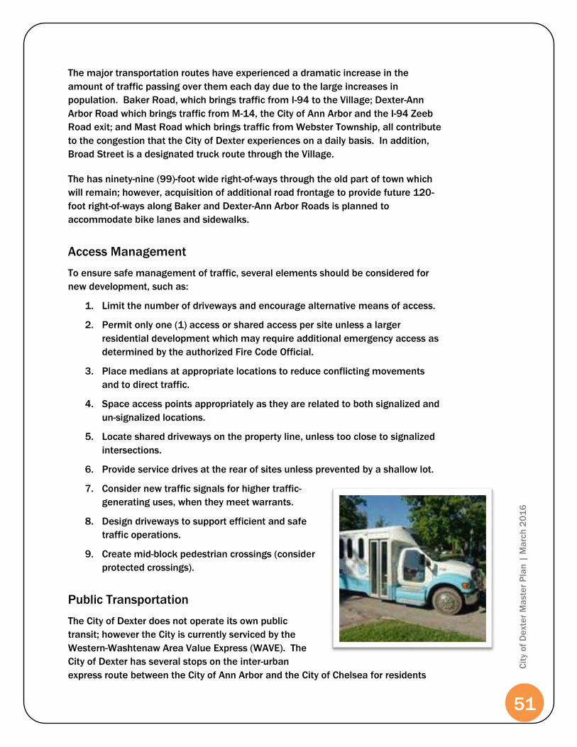
51
Cit
y o
f D
exte
r M
aste
r P
lan
| M
arc
h 2
01
6
The major transportation routes have experienced a dramatic increase in the
amount of traffic passing over them each day due to the large increases in
population. Baker Road, which brings traffic from I-94 to the Village; Dexter-Ann
Arbor Road which brings traffic from M-14, the City of Ann Arbor and the I-94 Zeeb
Road exit; and Mast Road which brings traffic from Webster Township, all contribute
to the congestion that the City of Dexter experiences on a daily basis. In addition,
Broad Street is a designated truck route through the Village.
The has ninety-nine (99)-foot wide right-of-ways through the old part of town which
will remain; however, acquisition of additional road frontage to provide future 120-
foot right-of-ways along Baker and Dexter-Ann Arbor Roads is planned to
accommodate bike lanes and sidewalks.
Access Management
To ensure safe management of traffic, several elements should be considered for
new development, such as:
1. Limit the number of driveways and encourage alternative means of access.
2. Permit only one (1) access or shared access per site unless a larger
residential development which may require additional emergency access as
determined by the authorized Fire Code Official.
3. Place medians at appropriate locations to reduce conflicting movements
and to direct traffic.
4. Space access points appropriately as they are related to both signalized and
un-signalized locations.
5. Locate shared driveways on the property line, unless too close to signalized
intersections.
6. Provide service drives at the rear of sites unless prevented by a shallow lot.
7. Consider new traffic signals for higher traffic-
generating uses, when they meet warrants.
8. Design driveways to support efficient and safe
traffic operations.
9. Create mid-block pedestrian crossings (consider
protected crossings).
Public Transportation
The City of Dexter does not operate its own public
transit; however the City is currently serviced by the
Western-Washtenaw Area Value Express (WAVE). The
City of Dexter has several stops on the inter-urban
express route between the City of Ann Arbor and the City of Chelsea for residents

52
Cit
y o
f D
exte
r M
aste
r P
lan
| M
arc
h 2
01
6
and visitor convenience. The WAVE service runs Monday through Friday from 5:30
am to 7:15 pm, with service approximately once every two (2) hours. In addition,
City residents may also utilize the WAVE lifeline van and door-to-door bus services
Monday through Friday from 8:00am to 4:30pm.
Additionally, the Ann Arbor Transit Authority (AATA) has developed a county-wide
transit Master Plan entitled Moving You Forward (2011). This plan provides a long-
range vision for various forms of public transit throughout Washtenaw County for
the next thirty (30) years. The Plan
outlines ten (10) strategies for a successful
county-wide transit system, which include:
Strategy 1: Essential Services County-Wide
Door-to-Door County-Wide
Flex-Ride Services
Strategy 2: County-Wide Connections
Enhanced WAVE Service
County-Wide Express Services
Local Community Circulators
Strategy 3: Urban Bus Network
Urban Bus Network Connections
Downtown Circulator
Bus Priority Measures
Strategy 4: High Capacity Transit
North/South Ann Arbor
Ann Arbor to Ypsilanti
Strategy 5: Regional Connections
Airport Shuttle and Taxi
Car/Vanpooling
Regional Commuter Rail
Strategy 6: Making Connections
Transit Center Upgrades/New
Multi-Modal Interchange
Local Transit Hubs
Park & Ride Intercept Lots
Stop Quality and Facility
Enhancements
Strategy 7: Integrating Transit into
Community
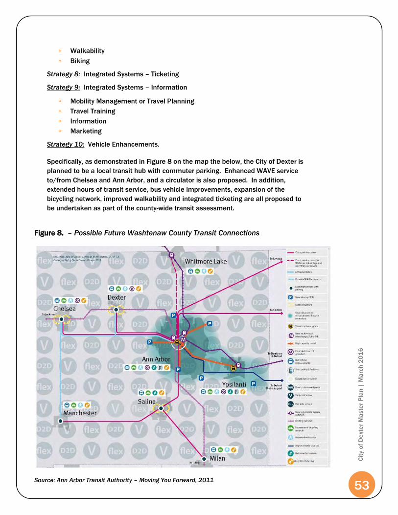
53
Cit
y o
f D
exte
r M
aste
r P
lan
| M
arc
h 2
01
6
Walkability
Biking
Strategy 8: Integrated Systems – Ticketing
Strategy 9: Integrated Systems – Information
Mobility Management or Travel Planning
Travel Training
Information
Marketing
Strategy 10: Vehicle Enhancements.
Specifically, as demonstrated in Figure 8 on the map the below, the City of Dexter is
planned to be a local transit hub with commuter parking. Enhanced WAVE service
to/from Chelsea and Ann Arbor, and a circulator is also proposed. In addition,
extended hours of transit service, bus vehicle improvements, expansion of the
bicycling network, improved walkability and integrated ticketing are all proposed to
be undertaken as part of the county-wide transit assessment.
Figure 8. – Possible Future Washtenaw County Transit Connections
Source: Ann Arbor Transit Authority – Moving You Forward, 2011

54
Cit
y o
f D
exte
r M
aste
r P
lan
| M
arc
h 2
01
6
Non-Motorized Transportation
The City of Dexter continues to promote safe pedestrian circulation, and promote
the sense of community with the establishment of non-motorized transportation
facilities. The purpose of a Non-Motorized Plan is to articulate a vision for non-
motorized transportation in the Village. The plan provides a vision for a Village-wide
non-motorized network, a plan for non-motorized facility development, and a clear
direction for the implementation of non-motorized facilities throughout the Village.
A Non-Motorized Plan is intended to guide non-motorized facility planning, design,
and construction for the City of Dexter. The plan is implementation-oriented and
utilizes community and stakeholder involvement and input. This type of plan is also
intended to serve as a foundation for future grant applications and funding
requests.
As Dexter has become increasingly active in the construction of pedestrian
pathways, a City Non-Motorized Plan becomes more important to ensure
coordinated development of non-motorized facilities. The City recently adopted a
Complete Streets Policy and Ordinance to further the goal of coordinated
development of non-motorized facilities. The Non-Motorized Transportation
Facilities Map (Figure 9, pg. 59) demonstrates both current and planned
expansions to sidewalks, bike lanes and shared-use pathways.
Dexter is collaborating with the Washtenaw County Parks Border-to-Border Trail
program that spans across Washtenaw County roughly following the Huron River.
The pathway will connect communities, parks and educational facilities. At
approximately thirty-five (35) miles in length, the trail will help to create a larger
non-motorized transportation network in the County. Construction commenced in
early August 2011 for a new Border-to-Border segment from Mill Creek Park (west
of Downtown Dexter) north
to Hudson Mills Metropark.
In addition, the City is part of
the Huron River Watershed
Council’s (HRWC) “River Up!”
project which is aimed at
revitalizing the recreation,
economic and ecologic
health of the Huron River
and the communities it runs
through. The HRWC is
focusing the group’s efforts
on the Huron River Water
Trail to create a 104-mile “trail” on and along the river with rest stop location,
restaurants, lodging, way-finding and historical markers educating visitors about the
history of the Huron River.

55
Cit
y o
f D
exte
r M
aste
r P
lan
| M
arc
h 2
01
6
The City of Dexter, along with several other Washtenaw County communities,
belongs to, and supports, the efforts of the Washtenaw Area Transportation Study
(WATS), an organization coordinating regional transportation planning. WATS is
responsible for monitoring the conditions of county roads, bicycle and pedestrian
paths, public transit systems, highways, and trail. WATS has been instrumental in
complete streets programming and non-motorized plans throughout Washtenaw
County.
The 2006 Non-Motorized Plan for Washtenaw County developed by WATS plans for
future county-wide, non-motorized bike and pedestrian improvements. Table 3 on
the following page, depicts the future pedestrian and bicycle Improvements outlined
by WATS as they relate directly to and adjacent to the City of Dexter.
The City and County’s individual non-motorized plans generally coincide with each
other and maintain collective goals and objectives.
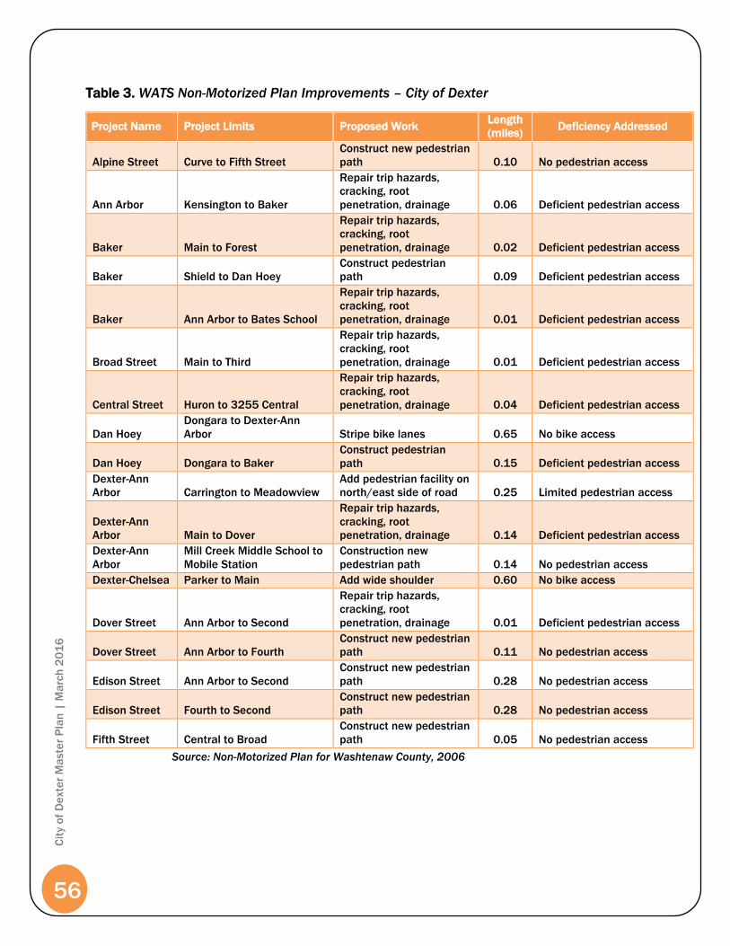
56
Cit
y o
f D
exte
r M
aste
r P
lan
| M
arc
h 2
01
6
Table 3. WATS Non-Motorized Plan Improvements – City of Dexter
Project Name Project Limits Proposed Work Length
(miles) Deficiency Addressed
Alpine Street Curve to Fifth Street
Construct new pedestrian
path 0.10 No pedestrian access
Ann Arbor Kensington to Baker
Repair trip hazards,
cracking, root
penetration, drainage 0.06 Deficient pedestrian access
Baker Main to Forest
Repair trip hazards,
cracking, root
penetration, drainage 0.02 Deficient pedestrian access
Baker Shield to Dan Hoey
Construct pedestrian
path 0.09 Deficient pedestrian access
Baker Ann Arbor to Bates School
Repair trip hazards,
cracking, root
penetration, drainage 0.01 Deficient pedestrian access
Broad Street Main to Third
Repair trip hazards,
cracking, root
penetration, drainage 0.01 Deficient pedestrian access
Central Street Huron to 3255 Central
Repair trip hazards,
cracking, root
penetration, drainage 0.04 Deficient pedestrian access
Dan Hoey
Dongara to Dexter-Ann
Arbor Stripe bike lanes 0.65 No bike access
Dan Hoey Dongara to Baker
Construct pedestrian
path 0.15 Deficient pedestrian access
Dexter-Ann
Arbor Carrington to Meadowview
Add pedestrian facility on
north/east side of road 0.25 Limited pedestrian access
Dexter-Ann
Arbor Main to Dover
Repair trip hazards,
cracking, root
penetration, drainage 0.14 Deficient pedestrian access
Dexter-Ann
Arbor
Mill Creek Middle School to
Mobile Station
Construction new
pedestrian path 0.14 No pedestrian access
Dexter-Chelsea Parker to Main Add wide shoulder 0.60 No bike access
Dover Street Ann Arbor to Second
Repair trip hazards,
cracking, root
penetration, drainage 0.01 Deficient pedestrian access
Dover Street Ann Arbor to Fourth
Construct new pedestrian
path 0.11 No pedestrian access
Edison Street Ann Arbor to Second
Construct new pedestrian
path 0.28 No pedestrian access
Edison Street Fourth to Second
Construct new pedestrian
path 0.28 No pedestrian access
Fifth Street Central to Broad
Construct new pedestrian
path 0.05 No pedestrian access
Source: Non-Motorized Plan for Washtenaw County, 2006

57
Cit
y o
f D
exte
r M
aste
r P
lan
| M
arc
h 2
01
6
Project Name Project Limits Proposed Work Length
(miles) Deficiency Addressed
Fifth Street Edison to Alpine
Repair trip hazards,
cracking, root
penetration, drainage 0.04
Deficient pedestrian
access
Forest Street Broad to Baker
Repair trip hazards,
cracking, root
penetration, drainage 0.04
Deficient pedestrian
access
Forest Street Baker to Kensington
Construct new pedestrian
path 0.28 No pedestrian access
Fourth Street Alley to end
Construct new pedestrian
path 0.08 No pedestrian access
Grand Street Hudson to Kensington
Construct new pedestrian
path 0.23 No pedestrian access
Hudson Street Ann Arbor to Second
Repair trip hazards,
cracking, root
penetration, drainage 0.01
Deficient pedestrian
access
Hudson Street Baker and Ann Arbor
Repair trip hazards,
cracking, root
penetration, drainage 0.02
Deficient pedestrian
access
Hudson Street Grand to Fourth
Construct new pedestrian
path 0.25 No pedestrian access
Huron Central to Third
Repair trip hazards,
cracking, root
penetration, drainage 0.01
Deficient pedestrian
access
Inverness Ann Arbor to Second
Construct pedestrian
path 0.19 No pedestrian access
Inverness Grand to Ann Arbor
Construct pedestrian
path 0.19 No pedestrian access
Island Lake
Dexter-Chelsea to Dexter-
Pinckney Add wide shoulder 0.35 No bike access
Kensington Grand to Ann Arbor
Construct pedestrian
path 0.19 No pedestrian access
Meadowview Dexter-Ann Arbor to end
Construct pedestrian
path 0.28
Deficient pedestrian
access
Mill Pond
Walking trails in reclaimed
Mill Pond Construct boardwalks 0.57 No pedestrian access
Second Street Central to end
Construct pedestrian
path 0.38 No pedestrian access
Third Street Central to end
Construct pedestrian
path 0.34 No pedestrian access
Third Street Dover to Broad
Repair trip hazards,
cracking, root
penetration, drainage 0.01
Deficient pedestrian
access
Third Street Dover to Kensington
Construct new pedestrian
path 0.38 No pedestrian access
Westside
Connector
Connection fro HCMA
Phase 2 to WCPARC
Segment D1
Construct non-motorized
connection 0.10 No pedestrian access
Border to
Border
Segment D1
Dexter to Dexter-Huron
Metropark
Non-Motorized Path
County Connector 1.4 County connector
Source: Non-Motorized Plan for Washtenaw County, 2006

58
Cit
y o
f D
exte
r M
aste
r P
lan
| M
arc
h 2
01
6

Joy
Baker
Parker
Third
Shield
Forest
Mast
Grand
Fifth
Dan Hoey
Dexter-Ann Arbor
Hudson
Central
Fourth
Potts
Huron
Ryan
Second
Island Lake
Broad
DoverMain
Bisho
p
Inverness
Ann Arbor
Dexter Chelsea
Edison
Bent Tr
ee
Carring
ton
Weber
Forshe
e
Pinevie
w
Noble
Wilson
Eastrid
ge
Huron River
York
Ulrich
Sandhill
Lake
Wellington
Pine V
iew
Lexing
tonEato
n
Alpine
Morrison
Webster
Dexter Pinckney
Parkrid
ge
Alley
Victoria
Bridgeway
Hermania
Katherine
Oxbow
Donga
ra
Pearl
Cambri
dge
Mill Creek
Kensington
Bridgewood Hills
Wall
Palmer
Shagbark
Quackenbush
Cedars
Bristo
l
Meadow View
View
Jananne
McCo
rmick
Hillside
Oliver
Huron View
Boenaro
Samuel
Kingsl
ey
Cushing
Glacier
Melbourne
Jeffor
ds
Ulrich
Cottonwood
Westridge
View
Bristol
Boulder
Sandfield
Kurtland
South
Down
sBaker Heights
ShawTayl
or
Preston
Broad
Sandhill
York
Wilson
Huron River
View
Bristo
l
NON-MOTORIZEDPATHWAYS MAP
City of Dexter
Source: Washtenaw County Base Datao
Carlisle/Wortman Associates, Inc.Ann Arbor, Michigan
0 500 1,000 1,500 2,000Feet
May 12, 2015
Washtenaw County, Michigan
S c i o T o w n s h i pS c i o T o w n s h i pW e b s t e r T o w n s h i pW e b s t e r T o w n s h i p
Scio
Tow
nshi
pSc
io T
owns
hip
Lim
a To
wnsh
ipLi
ma
Town
ship
Dext
er T
owns
hip
Dext
er T
owns
hip
H u r o n R i v e rM i l l C
r ee k
Bord er- to-Border Cou nty Tra i l
Shared Use Paths
Sidewalks
Bike Lanes
ExistingPlanned
ExistingPlannedShared Lane
ExistingPlanned by CityPlanned by Developer


61
Cit
y o
f D
exte
r M
aste
r P
lan
| M
arc
h 2
01
6
Background Studies
Population and Housing Characteristics
The review and analysis of population and housing in the Master Plan is done in part
to help evaluate the character of the community and understand the trends of the
past. This information is needed as a basis for a community to plan for their long-
term goals. The evaluation of the data is used to help understand the changing
trends in population, housing, employment, and economics. The data found is then
evaluated to help support the long-term decisions recommended for the Master
Plan.
Sources used for the information and data gathering were the 2010 U.S. Census
(available information at the time of update) and the Southeast Michigan Council of
Governments (SEMCOG).
Population
Table 4 represents population changes from 1960 – 2010 for the City of Dexter and
the surrounding areas. The Village’s population changed dramatically from 1990
through 2010, reversing a trend of declining population over the previous 30 years.
In 1960, the population was 1,702 and by 1990, the population had decreased to
1,497, a 12% decrease. During the period of time from 1990 to 2010, the Village’s
population has significantly increased. In SEMCOG’s 2040 Regional forecast, the
Village’s 2040 population is projected to be 4,885, but the Village’s actual 2010
population has exceeded the projection, reaching a total population size of 4,067.
From 1990 – 2000 the City of Dexter’s actual population had increased 56.2%, and
another 73.9% from 2000 - 2010.
The following population change table compares the Village’s growth over the last
50 years with the Townships surrounding the City of Dexter, the County and State.
Table 4. - Population Change 1960 – 2010
Community
1960
1970
1980
1990
2000
2010
% Change
2000-
2010
City of Dexter 1,702 1,729 1,524 1,497 2,338 4,067 73.9%
Dexter Township 1,698 2,238 3,872 4,407 5,248 6,042 15.1%
Lima Township 995 1,281 2,124 2,132 2,224 3,307 48.6%
Scio Township 4,454 5,476 6,505 9,580 15,759 20,081 27.4%
Webster Township 1,286 1,981 2,760 3,235 5,198 6,784 30.5%
Washtenaw County 172,440 234,103 264,748 282,937 322,895 344,791 6.8%
State of Michigan 7,823,194 8,875,083 9,262,078 9,295,297 9,938,444 9,883,640 <-1%
Source: 1960, 1970, 1980, 1990, 2000 & 2010 U.S. Census
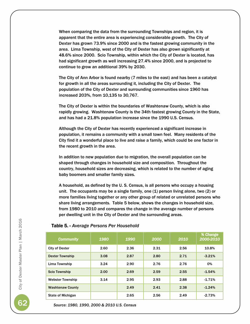
62
Cit
y o
f D
exte
r M
aste
r P
lan
| M
arc
h 2
01
6
When comparing the data from the surrounding Townships and region, it is
apparent that the entire area is experiencing considerable growth. The City of
Dexter has grown 73.9% since 2000 and is the fastest growing community in the
area. Lima Township, west of the City of Dexter has also grown significantly at
48.6% since 2000. Scio Township, within which the City of Dexter is located, has
had significant growth as well increasing 27.4% since 2000, and is projected to
continue to grow an additional 39% by 2030.
The City of Ann Arbor is found nearby (7 miles to the east) and has been a catalyst
for growth in all the areas surrounding it, including the City of Dexter. The
population of the City of Dexter and surrounding communities since 1960 has
increased 203%, from 10,135 to 30,767.
The City of Dexter is within the boundaries of Washtenaw County, which is also
rapidly growing. Washtenaw County is the 34th fastest growing County in the State,
and has had a 21.8% population increase since the 1990 U.S. Census.
Although the City of Dexter has recently experienced a significant increase in
population, it remains a community with a small town feel. Many residents of the
City find it a wonderful place to live and raise a family, which could be one factor in
the recent growth in the area.
In addition to new population due to migration, the overall population can be
shaped through changes in household size and composition. Throughout the
country, household sizes are decreasing, which is related to the number of aging
baby boomers and smaller family sizes.
A household, as defined by the U. S. Census, is all persons who occupy a housing
unit. The occupants may be a single family, one (1) person living alone, two (2) or
more families living together or any other group of related or unrelated persons who
share living arrangements. Table 5 below, shows the changes in household size,
from 1980 to 2010 and compares the change in the average number of persons
per dwelling unit in the City of Dexter and the surrounding areas.
Table 5. - Average Persons Per Household
Community
1980
1990
2000
2010
% Change
2000-2010
City of Dexter 2.60 2.36 2.31 2.56 10.8%
Dexter Township 3.08 2.87 2.80 2.71 -3.21%
Lima Township 3.24 2.90 2.76 2.76 0%
Scio Township 2.00 2.69 2.59 2.55 -1.54%
Webster Township 3.14 2.95 2.93 2.88 -1.71%
Washtenaw County 2.49 2.41 2.38 -1.24%
State of Michigan 2.65 2.56 2.49 -2.73%
Source: 1980, 1990, 2000 & 2010 U.S. Census

63
Cit
y o
f D
exte
r M
aste
r P
lan
| M
arc
h 2
01
6
In 2000, the City of Dexter had a household size of 2.31 persons per household, a
2.1% decrease from 1990. However, household size grew 10.8% between 2000
and 2010 to 2.56 persons per household. All surrounding areas experienced a
decrease in household size since 1990, except for Lima Township’s household size
which has remained constant for the last ten (10) years. The City of Dexter has the
second smallest household size in the area behind Scio Township by a small
margin.
Causes for the decreases in household size have been speculated to be the aging of
our national population, the likelihood that children are not living in homes with
their aging parents, and people are not choosing to have as many children as has
been historically documented. Simply put, fewer persons per home equates to
more homes housing fewer people each.
The total number of households within a community also helps explain the
community’s potential future population growth. The City of Dexter has experienced
both an increase household size, and total households and population. As
illustrated in Table 6, the City of Dexter has seen a dramatic increase in total
households since 1990.
Table 6. - Total Household By Community
Community
1980
1990
2000
2010 % Change
2000 -2010
City of Dexter 588 633 1,013 1,590 56.96%
Dexter Township 1,265 1,527 1,863 2,225 19.43%
Lima Township 659 891 1,168 1,197 2.5%
Scio Township 2,147 4,113 6,070 7,857 29.44%
Webster Township 884 1,097 1,774 2,353 34.92%
Washtenaw County 105,114 125,327 137,193 9.47%
State of Michigan 3,424,122 3,785,661 3,872,508 2.3%
Source: 1980, 1990, 2000 & 2010 U.S. Census
As shown in the table, the number of total households in the City of Dexter
increased 56.96% from 2000 – 2010, significantly more than all other surrounding
municipalities.
The reason for the significant increase in total households within the City of Dexter
is due to the annexation of approximately 330 acres of land in the early 1990s for
development of single-family homes, attached condominiums. Within those
annexed areas, the City anticipates a total household growth of 800 single-family
homes. The recently released 2010 Census results demonstrate that Dexter was
the fastest growing community in the State of Michigan

64
Cit
y o
f D
exte
r M
aste
r P
lan
| M
arc
h 2
01
6
The City of Dexter has experienced a surge in population due primarily to the
increase in buildable land (annexation), which resulted in a doubling of the available
housing units within the Village. Further, due to the amount of land annexed into
the City that has not yet been developed, the City of Dexter may continue to see
population and housing unit increases in the upcoming years.
The City of Dexter, compared to other communities, has the lowest median age in
the area. The Village’s median age in 1990 was 33.9 years, 33.7 in 2000, and grew
to 36.2 in 2010. Although the median age increased nearly three (3) years between
2000 and 2010, the City remains, on average, five (5) years younger then the
surrounding municipalities. In addition, 32.5% of the population is between the
ages of 25 – 44, and 32.7% of the population is 19 years old or younger. Generally
it can be determined that a young population between the ages of 25 – 44 years
are in the family forming stage of their life, which could also mean increases in the
potential for population growth in the near future.
Table 7. - Percent of Population by Age Group and Median Age, 2010
Age Group City of
Dexter
Dexter
Township
Lima
Township
Scio
Township
Webster
Township
Washtenaw
County
0-4 8.7 5.2 6.3 2.9 5.1 5.5
5-9 9.6 7.3 7.2 7.6 7.8 5.8
10-14 8.5 7.7 7.2 7.8 8.9 5.8
15-19 5.9 7 6.7 6.6 8.2 8.8
20-24 2.9 3.6 2.9 4.3 3.4 11.7
25-29 5.5 2.7 4.9 4.7 2.5 7.8
30-34 6.9 3.9 5.6 5.3 3.5 6.4
35-39 9.6 6 6.4 6.7 5.6 6.1
40-44 10.5 8 6.4 8.3 8.6 6.5
45-49 8.4 9.4 8.5 8.5 10.1 6.8
50-54 5 9.5 9.5 8.3 9.8 6.8
55-59 5.3 9.4 8 8 9 6.2
60-64 4.3 7.5 7.5 6.5 6.8 5.1
65-69 2.5 4.8 4.4 4.3 4.3 3.4
70-74 1.9 2.8 3.2 2.3 2.1 2.2
75-79 1.4 2.1 2.1 1.7 1.3 1.7
80-84 1.5 1.3 1.3 1.4 1.1 1.4
85+ 1.3 <1 1 1 <1 1.3
Median Age 36.2 43.8 41.5 40.5 42.8 33.3
Source: 2010 U.S. Census

65
Cit
y o
f D
exte
r M
aste
r P
lan
| M
arc
h 2
01
6
Housing Characteristics
The housing stock within the City of Dexter has increased dramatically since the
1990 U.S. Census. In 1990, the City had 676 total housing units, only a 10.3%
increase from the 1980 U.S. Census. By 2000, the Village’s housing units had
increased by 63.6%, from 676 units in 1990 to 1,106 units in 2000, and another
54% in 2010 (598 new units) (see Table 8).
The housing unit increase was due to the annexation of 330 acres of land into the
City in the early 1990s. Prior to the annexations, the City of Dexter had been built-
out with little or no room to grow.
Table 8. - Total Housing Units Available by Community
Community
1980
1990
2000
2010
% Change
2000 - 2010
City of Dexter 613 676 1,106 1,704 54%
Dexter Township 1,330 1,850 2,168 2,612 20.5%
Lima Township 684 802 1,198 1,250 4.3%
Scio Township 2,215 3,590 6,338 8,251 30.2%
Webster Township 917 1,173 1,859 2,479 33.4%
Washtenaw County 98,173 111,256 131,069 147,573 12.6%
Source: 1980, 1990, 2000 & 2010 U.S. Census
With the significant increases in new single-family construction, the percentage of
renter-occupied homes has decreased dramatically since 1990. In 1990, 40.2% of
the total dwelling units were renter-occupied and in 2000, 38.9% of the housing
units were renter-occupied. The 2010 Census reported that 24.5% of dwelling units
were renter-occupied. The City of Dexter maintains higher renter-occupied housing
composition than any of the surrounding communities; however it is over 12% lower
than Washtenaw County’s 36.3% renter-occupied composition (see Table 9 on the
next page). Within Washtenaw County, there are two (2) major educational
institutions that tend to increase the percentage of renter-occupied housing units.
Neither of these institutions are located within the City of Dexter. It would also
seem that the City of Dexter is an attractive place to rent because of the perception
of affordable rents and availability.
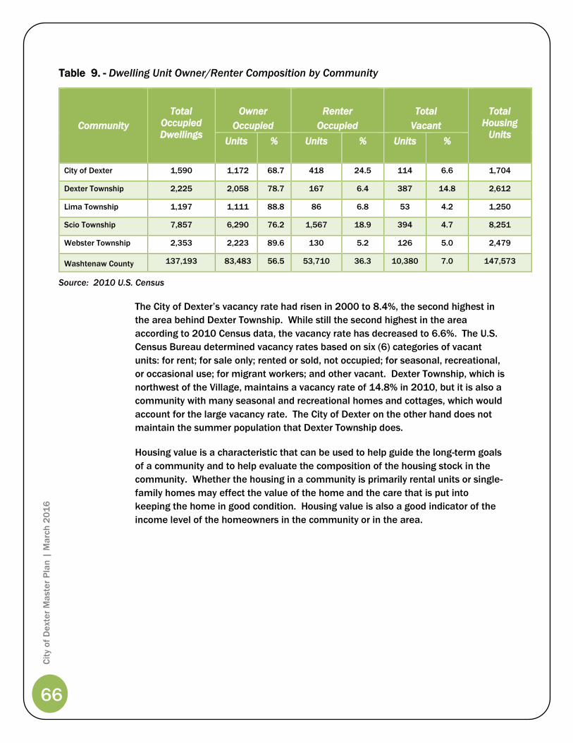
66
Cit
y o
f D
exte
r M
aste
r P
lan
| M
arc
h 2
01
6
Table 9. - Dwelling Unit Owner/Renter Composition by Community
Community
Total
Occupied
Dwellings
Owner
Occupied
Renter
Occupied
Total
Vacant
Total
Housing
Units Units % Units % Units %
City of Dexter 1,590 1,172 68.7 418 24.5 114 6.6 1,704
Dexter Township 2,225 2,058 78.7 167 6.4 387 14.8 2,612
Lima Township 1,197 1,111 88.8 86 6.8 53 4.2 1,250
Scio Township 7,857 6,290 76.2 1,567 18.9 394 4.7 8,251
Webster Township 2,353 2,223 89.6 130 5.2 126 5.0 2,479
Washtenaw County 137,193 83,483 56.5 53,710 36.3 10,380 7.0 147,573
Source: 2010 U.S. Census
The City of Dexter’s vacancy rate had risen in 2000 to 8.4%, the second highest in
the area behind Dexter Township. While still the second highest in the area
according to 2010 Census data, the vacancy rate has decreased to 6.6%. The U.S.
Census Bureau determined vacancy rates based on six (6) categories of vacant
units: for rent; for sale only; rented or sold, not occupied; for seasonal, recreational,
or occasional use; for migrant workers; and other vacant. Dexter Township, which is
northwest of the Village, maintains a vacancy rate of 14.8% in 2010, but it is also a
community with many seasonal and recreational homes and cottages, which would
account for the large vacancy rate. The City of Dexter on the other hand does not
maintain the summer population that Dexter Township does.
Housing value is a characteristic that can be used to help guide the long-term goals
of a community and to help evaluate the composition of the housing stock in the
community. Whether the housing in a community is primarily rental units or single-
family homes may effect the value of the home and the care that is put into
keeping the home in good condition. Housing value is also a good indicator of the
income level of the homeowners in the community or in the area.

67
Cit
y o
f D
exte
r M
aste
r P
lan
| M
arc
h 2
01
6
Property Values
Table 10, below, provides a history of the State Equalized Value (SEV) of all
properties within the Village, inclusive of the industrial facilities tax (IFT) which
results from the additional tax levied on the properties within the industrial park.
The largest gain in SEV between 1997 and 2010 was 21% in the year 2000, and
again in 2003. Overall, the Village’s SEV had steadily increased until the downturn
of the economy in 2008. It appears that 2010 may have been the bottom for the
decline, as valuations in 2011 appear to be holding steady. SEV is an indication of
the value of property in a community and is based on 50% of the “true” cash value
of property. The local assessor determines cash value of all properties in the
Village. Property taxes are based in part on 50% of the total value.
Table 10. - City of Dexter SEV Plus IFT Growth
Year
State Equalized
Valuation plus IFT
Percent Change from
Previous Year
1997 $85,340,000 --
1998 $99,059,000 16%
1999 $120,324,000 21%
2000 $127,594,000 6%
2001 $140,673,000 10%
2002 $157,519,700 12%
2003 $189,975,500 21%
2004 $225,291,700 15%
2005 $243,126,450 7%
2006 $265,561,051 9%
2007 $271,219,500 2%
2008 $253,951,400 -6%
2009 $236,440,400 -7%
2010 $216,955,400 -8%
2011 $210,206,300 -3%
Source: City of Dexter

68
Cit
y o
f D
exte
r M
aste
r P
lan
| M
arc
h 2
01
6
Capital Improvements/Community Facilities
City Organization
City Administration
The Village of Dexter built the first Village Hall in 1955 to serve as the primary
location for Village administrative and government duties. The Village Hall was built
on land originally intended for the construction of a mill by Henry Ford, but the land
was deeded to the Village from Scio Township in 1950. In 2002, the Village Hall’s
function changed from Village Offices to being the home of the Dexter Area Fire
Department and the Washtenaw County Sheriff Station. The Department of Public
Works (DPW) operations were also relocated to a new facility in 2007.
In 2002, the City Offices were moved to a temporary location above the PNC Bank
in downtown Dexter while plans for a new City Hall were considered. Relocation or
renovation space for a City Hall has been a priority for many years, although funding
and an accessible downtown location have been roadblocks for new building
construction or relocation.
City Utilities
Waste Water System
The City of Dexter’s
wastewater treatment plant
(WWTP) services the entire
Village. Many of the 8” clay
sewer lines were constructed
in the 1930’s, and additions
were made to the system to
accommodate the growth of
the Village in the 50’s and
again in the 70’s. In 2000-
2001, the Village participated
in a state rural development
project. The rural development
project provided the Village with gravity sewers on the northeast side of the Village,
which were previously serviced by lift stations and updated the wastewater
treatment equipment.
In 2010, an equalization basin was added to the system which provides 400,000
gallons of storage capacity helping to equalize the flow of water through the plant
during storm events. In addition, approximately 5,000 feet of sewer line were lined
using cured in place technology that restores the pipe to new condition.

69
Cit
y o
f D
exte
r M
aste
r P
lan
| M
arc
h 2
01
6
Water System
The City of Dexter has a limited system servicing the entire community
with five (5) municipal wells. Dexter’s water plant treats it’s water for the
removal of iron found naturally in the groundwater and with chlorine to
disinfect the water.
The Village’s current well system consists of four (4) wells along Ryan
Drive. A 500,000 gallon water tower is located in the Dexter Business and
Research Park. The water tower was installed to improve the water
pressure in the system, and to provide for emergency water storage and
fire protection. In 2010, a fifth well was added on the property of Dexter
High School. The addition of the fifth well provides a secondary source of
water for the Village; this well and other water system improvements were
funded through a MDEQ low-interest loan program. The Village’s overall capacity is
1.1 million gallons per day.
The City has been completing upgrades to its existing water lines. By the end of
2011, ninety-seven (97%) percent of the City water main has been upgraded to
eight (8”) inches or greater in diameter. The current system provides adequate flow
for fire suppression.
The rural development project also provided for the replacement of transmission
lines with new, larger pipes, renovations to existing lift stations, alarms for the wells
and lift stations, five (5) municipal wells, renovation of the iron filters, pumps and
chlorination systems at the water filtration plant.
Currently, the City does not extend new water services beyond its jurisdictional
borders, with the exception of requests made in accordance with the terms of the
existing 425 Agreements.
Storm Water Management
Open ditches and culverts service approximately 40% of the City of Dexter. Storm
drains throughout the City take both the collected storm water and the surface
runoff and discharges it into the Huron River and other nearby streams. In 2002,
the City of Dexter started working with the State of Michigan, Scio Township and the
Huron River Watershed Council to implement Phase 2 (MS4 Permit) storm water
management requirements in order to comply with Federal Phase 2 efforts to
improve the environmental impacts that untreated storm water discharge has when
it is discharged into the nearby rivers and streams. The implementation of the
Phase 2 requirements will include improved storm water management strategies,
such as detention and retention basin pretreatment requirements, water quality,
improved site plan review standards and community education.
The future of the Village’s storm water management system should be identified in
order for the City to plan for growth and development in the area. The City needs to
be aware of the condition of existing facilities and remaining capacity, if any. Storm
water facilities that are currently at capacity need to be earmarked for
reconstruction or repair so that development and redevelopment within the City are
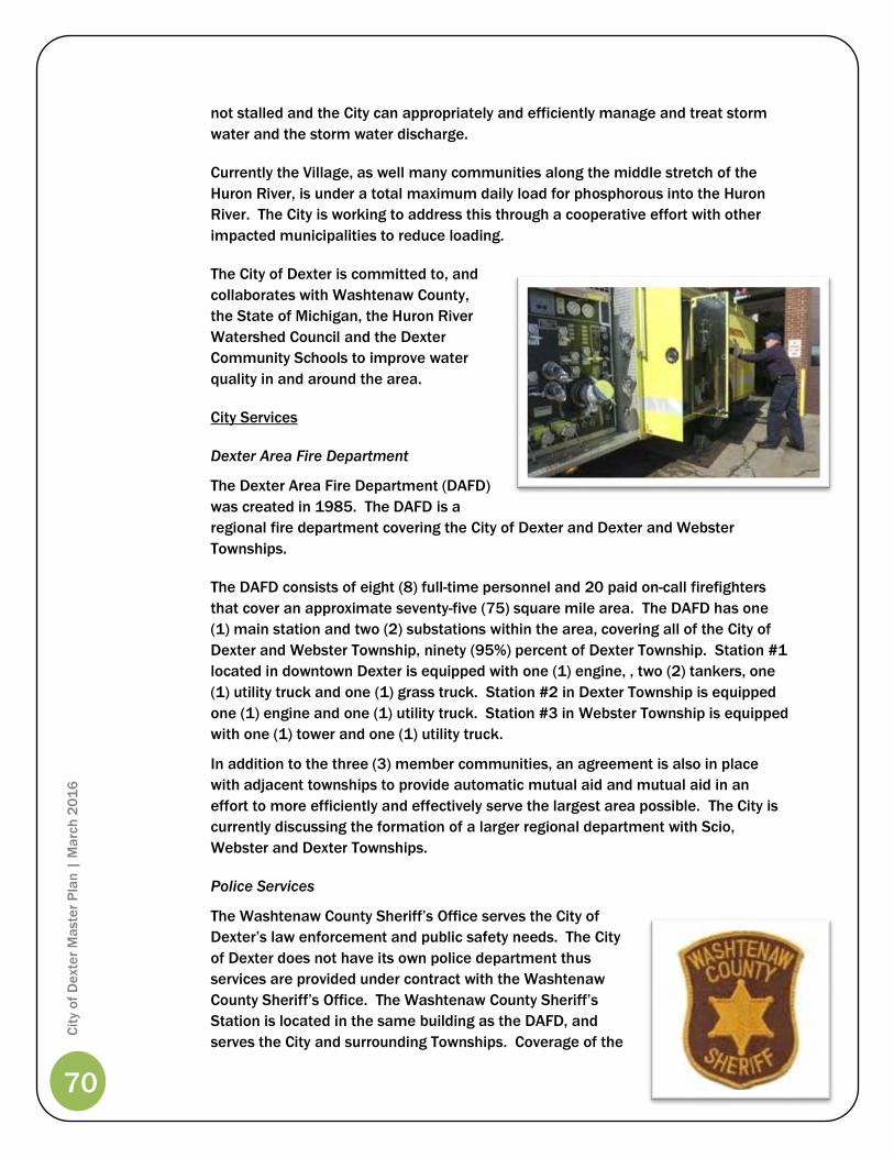
70
Cit
y o
f D
exte
r M
aste
r P
lan
| M
arc
h 2
01
6
not stalled and the City can appropriately and efficiently manage and treat storm
water and the storm water discharge.
Currently the Village, as well many communities along the middle stretch of the
Huron River, is under a total maximum daily load for phosphorous into the Huron
River. The City is working to address this through a cooperative effort with other
impacted municipalities to reduce loading.
The City of Dexter is committed to, and
collaborates with Washtenaw County,
the State of Michigan, the Huron River
Watershed Council and the Dexter
Community Schools to improve water
quality in and around the area.
City Services
Dexter Area Fire Department
The Dexter Area Fire Department (DAFD)
was created in 1985. The DAFD is a
regional fire department covering the City of Dexter and Dexter and Webster
Townships.
The DAFD consists of eight (8) full-time personnel and 20 paid on-call firefighters
that cover an approximate seventy-five (75) square mile area. The DAFD has one
(1) main station and two (2) substations within the area, covering all of the City of
Dexter and Webster Township, ninety (95%) percent of Dexter Township. Station #1
located in downtown Dexter is equipped with one (1) engine, , two (2) tankers, one
(1) utility truck and one (1) grass truck. Station #2 in Dexter Township is equipped
one (1) engine and one (1) utility truck. Station #3 in Webster Township is equipped
with one (1) tower and one (1) utility truck.
In addition to the three (3) member communities, an agreement is also in place
with adjacent townships to provide automatic mutual aid and mutual aid in an
effort to more efficiently and effectively serve the largest area possible. The City is
currently discussing the formation of a larger regional department with Scio,
Webster and Dexter Townships.
Police Services
The Washtenaw County Sheriff’s Office serves the City of
Dexter’s law enforcement and public safety needs. The City
of Dexter does not have its own police department thus
services are provided under contract with the Washtenaw
County Sheriff’s Office. The Washtenaw County Sheriff’s
Station is located in the same building as the DAFD, and
serves the City and surrounding Townships. Coverage of the

71
Cit
y o
f D
exte
r M
aste
r P
lan
| M
arc
h 2
01
6
Washtenaw County Sheriff’s Office includes all of the City of Dexter, Webster
Township and Dexter Township. There are nine (9) deputies, including one (1)
school liaison, four (4) rotating deputies, who patrol the three (3) municipalities;
“COPS” (community oriented police), that work in conjunction with the individual
municipalities on special problems, crime prevention and other local law
enforcement activities; and one (1) sergeant. The Washtenaw County Sheriff’s
Station is equipped with one (1) motorcycle for special events and day-to-day patrol,
five (5) marked patrol cars and one (1) unmarked patrol car to cover the entire 75
square mile service area.
Downtown Development Authority
The City of Dexter’s Downtown
Development Authority (DDA) is one of the
most active groups within the Village.
Within the past few years, the DDA has
spent over two (2) million dollars on
streetscape and infrastructure
improvements in the downtown district.
The DDA also continues to develop projects
that attract and retain businesses in the
Village’s downtown. See Figure 6, page 39,
for the DDA boundaries.
The downtown streetscape improvements
(completed in 1997) have contributed to an
increase in viable businesses in the
downtown and have encouraged individual
property owners to make facade improvements and continued building investment.
The City and the DDA are now working together in the development of long-term
expansion plans for the downtown, including the acquisition of property and the
redevelopment of underutilized sites. In 2003, the DDA constructed a new sixty-four
(64) space parking lot between Main Street and Forest Street, and in 2004
constructed a new parking lot to accommodate the needs of a new 21,000 square
foot building.
Subsequently, the DDA invested in additional parking and streetscape
improvements along Jeffords Street and a parking area one (1) block south of Main
Street to coincide with the construction of another 20,000 square foot building (has
not been constructed to date). The City and DDA also collaborated with the
Washtenaw County Road Commission (WCRC) on streetscape improvements to the
Main Street bridge during the bridge replacement and dam removal project in
2008.
As part of the City and DDA’s plan to continue to revitalize the downtown; parking,
and bridge and pedestrian improvements have become a priority. The Main Street
Bridge project was completed in 2008 and Mill Creek Park project was constructed

72
Cit
y o
f D
exte
r M
aste
r P
lan
| M
arc
h 2
01
6
in 2011. The DDA also purchased the former DAPCO Building (3045 Broad Street),
and will take possession of the property in 2012. Project plans are currently
underway with the assistance of a Community Development Block Grant (CDBG).
The City intends to redevelop the property to attract more businesses and residents
to Dexter, and to further improve the Village’s image south of Main Street.
Redevelopment of the DAPCO site will be the first step towards accomplishing the
goal of expanding the downtown and spurring additional redevelopment
surrounding Main Street.
Dexter Area Chamber of Commerce (DACC)
The DACC plays an active role in the economic and business development in Dexter
and is a partner with the City of Dexter. The recent population growth has also
prompted the Chamber to advocate the continued support of local businesses and
merchants.
The DACC has designated the Dexter area as “A Place to Grow” due to the
substantial increase in the population of the entire surrounding area. The DACC
helps organize and advertise many of the Village’s community events with the goal
of bettering the business environment and quality of life in the Village. Since the
population increase in the Village, the DACC has continued to be a very active
participant in community and business growth. The DACC’s membership has grown
to approximately 220 members since 2002.
DACC’s activities and other local service groups and
organizations support economic development
through additional community and social events,
such as:
Dexter Daze
Apple Daze
Summer Music Series
Holiday Hustle / Home for the Holidays
Ice Cream Social
Wellhead Protection
In 2002, the City of Dexter implemented its first Wellhead Protection Program
(WHPP) to protect the groundwater and the municipal drinking water. The City
provides water service to all residents within the City boundaries through its existing
water system and five (5) wells.
Protecting the groundwater is a way to protect the Village’s financial investment in
the municipal water supply system, and to protect drinking water supplies. The
Village’s WHPP includes a Wellhead Protection Team responsible for public
education programs and implementation activities.
73
Cit
y o
f D
exte
r M
aste
r P
lan
| M
arc
h 2
01
6
Developing a WHPP also requires communities to identify possible sources of
contamination within the community in an effort to provide additional education
and contaminant prevention to protect the Village’s drinking water.
Establishing programs through community organizations, the schools and the utility
department will make certain that a wide range of City residents and residents of
other communities are aware of the importance of protecting groundwater and how
their daily activities can impact groundwater and drinking water quality.
Wellhead Protection is an ongoing program that the City of Dexter hopes to
continue for a long period. The City is taking a proactive approach to the protection
of groundwater to ensure the health, safety and welfare of the residents and to
ensure safe, clean drinking water.
Wellhead Protection and the Relationship with the Master Plan
The future land-use plan should take into consideration the Wellhead Protection
Area and plan on making recommendations for future land uses within these areas.
The Wellhead Protection Plan provides for another layer of analysis that is used in
the development of the overall Master Plan. All rezoning requests and other land
use analysis should carefully consider the Wellhead Protection Plan and area as a
part of the deliberation. The City Planning Commission or City Council should not
approve specific development requests that have the capacity to negatively impact
the wellhead protection area.
Property Transfer Agreements
Figure 6, the City of Dexter Future Land Use Map (pg. 39), depicts lands currently
under agreement between the City of Dexter and surrounding communities for
transfer into the Village. The following is a brief summary of those agreements. As
the specific details of the transfers are beyond the scope of a Master Plan, the
specific details of the agreements can be obtained at the City Administrative
offices.
• Dexter/Scio Promulgation of Annexation Policy (June 23, 1981 and Amendment
to the Agreement (April 11, 1995). This agreement provides for the annexation
of property from Scio Township into the City of Dexter. Essentially, this
agreement provides specific areas to be annexed into the Village, upon request
of the property owners, after a December 31, 2006 moratorium expires in two
(2) phases. On February 9, 2010, Scio Township Board passed a resolution
declaring the agreement null and void. On March 8, 2010, the City also passed
a resolution declaring the agreement null and void.
• Dexter/Scio 425 Agreement for the Dexter High School, January 2000. An
agreement to provide municipal services to the Dexter High School site located
on the southeast corner of Parker and Shield Roads. The property in question
remains a part of Scio Township, but under the jurisdiction of the Village.

74
Cit
y o
f D
exte
r M
aste
r P
lan
| M
arc
h 2
01
6
• Dexter/Webster Conditional Transfer Agreement, April 1997. Provides for the
transfer of properties as shown on Map 3 in three (3) separate considerations.
A. 94.15 acre parcel located in Section 361 of Webster Township with frontage
on Island Lake Road and Dexter-Pinckney Road.
B. Twenty-eight separate parcels of land. To be conditionally transferred upon
request of owners. (Jurisdiction to the Village.)
C. Five parcels of property in Section 32 of Webster Township north of Joy
Road and east of Mast Road. Utilities may be extended by the City only for
industrial us of this property. (Jurisdiction of the Township)
Planning for Properties Outside the Current City Limits
In the case where properties are brought into the City either through annexation or
property transfer agreement (PA 425) the City shall, after study of the area, amend
the Master Plan to include said property into the Future Land Use Plan. The
designation of this property shall be based in part, but not be limited to, the
following factors:
• Existing land use and zoning of the subject site and adjacent parcels,
• Natural feature considerations, i.e. woodlands, wetlands, floodplains, etc.,
• Transportation, i.e. roadway capacity and condition,
• Availability and capacity of utilities, i.e. sewer and water, etc.,
• Any applicable planning studies conducted in the area of consideration.
Cityhood
At various times throughout the Village’s history, the idea of incorporating as a city
has been discussed. Most recently, a City Study Committee comprised of 18
residents was formed and met from July 31, 2006 to March 7, 2007. After
completing its research, the committee presented its findings to the public on
March 7, 2007 and to the Village Council on March 26, 2007. These presentations
included their recommendation that the Village Council move forward with the
incorporation process.
The first step in the process was the creation of a boundary map, which followed the
Village’s current boundary. Once this map was created, signatures were gathered
and the first petition was filed with the State Boundary Commission (SBC) on
November 6, 2009. This petition was found legally insufficient due to technical
issues with the boundary map.
During the meeting process for the first petition, the Boundary Commission raised a
concern that the Village’s current boundary was technically three pieces (commonly
referred to as the Scio section, Westridge and the Cedars of Dexter). To prepare for
the second filing a map was created that showed a contiguous Village boundary.

75
Cit
y o
f D
exte
r M
aste
r P
lan
| M
arc
h 2
01
6
This was done by drawing in additional land to connect the three areas of the
Village, including the Webster Township portion of the Dexter Area Historical Society
(Gordon Hall) property. The Webster Township section of 8180 Main Street (Mill
Creek Sporting Goods) because this property was left as an island (separate from
the rest of Webster Township).
This second petition was filed on December 15, 2010. The petition was found
legally sufficient by the Director of Licensing and Regulatory Affairs (who oversees
the SBC) on October 26, 2011. Due to the objection of Webster Township regarding
the additional land that was added to the boundary, the Village and Township
drafted an alternative boundary that only adds a small triangle parcel of Dexter
Area Historical Society (Gordon Hall) property to establish contiguity. On January 17,
2012 a public hearing on the incorporation was held at the Dexter District Library.
At this public hearing Webster Township and the Village asked that the SBC use the
alternative boundary as the final boundary for the city.
On May 9, 2012, the Boundary Commission reviewed all materials received at the
public hearing and during the 30 day public comment period following the meeting.
The Commission voted 5-0 to recommend that the Director of Licensing and
Regulatory Affairs approve the Village’s cityhood petition with the revised boundary
presented by the Village and Webster Township.
The Commission will meet again in June 2012 to approve their “Findings of Fact”,
which will then be transmitted to the Director. If the Director takes the
Commission’s recommendation and signs the final order of approval, the 45 day
referendum period will begin.
Referendum Period
During this period, citizens may gather signatures of 5% of the Village’s registered
voters in order to place the question of whether or not the incorporation process
should continue on a future election ballot. If enough signatures are gathered, the
question of whether the process should move forward is placed on an election ballot
as a “yes” or “no” vote. If there are not enough signatures gathered to place the
question on a future ballot during the 45-day period, a vote on the question would
not be scheduled and the process would move to the next step of electing a Charter
Commission.
If there are enough signatures gathered during the referendum period, and the
result of the scheduled vote is against continuing with the incorporation process,
the Village’s incorporation process ends. If the result of the scheduled vote is in
favor of the Village incorporation process continuing, the process will continue with
the next step of electing a Charter Commission.
Selection of Charter Commission/Creation of City Charter
Village voters will elect a nine member Charter Commission to write the Charter (or
governing document) for the new City. Once the Charter is drafted, Village voters
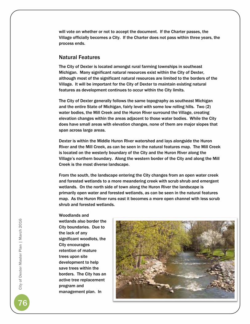
76
Cit
y o
f D
exte
r M
aste
r P
lan
| M
arc
h 2
01
6
will vote on whether or not to accept the document. If the Charter passes, the
Village officially becomes a City. If the Charter does not pass within three years, the
process ends.
Natural Features
The City of Dexter is located amongst rural farming townships in southeast
Michigan. Many significant natural resources exist within the City of Dexter,
although most of the significant natural resources are limited to the borders of the
Village. It will be important for the City of Dexter to maintain existing natural
features as development continues to occur within the City limits.
The City of Dexter generally follows the same topography as southeast Michigan
and the entire State of Michigan, fairly level with some low rolling hills. Two (2)
water bodies, the Mill Creek and the Huron River surround the Village, creating
elevation changes within the areas adjacent to those water bodies. While the City
does have small areas with elevation changes, none of them are major slopes that
span across large areas.
Dexter is within the Middle Huron River watershed and lays alongside the Huron
River and the Mill Creek, as can be seen in the natural features map. The Mill Creek
is located on the westerly boundary of the City and the Huron River along the
Village’s northern boundary. Along the western border of the City and along the Mill
Creek is the most diverse landscape.
From the south, the landscape entering the City changes from an open water creek
and forested wetlands to a more meandering creek with scrub shrub and emergent
wetlands. On the north side of town along the Huron River the landscape is
primarily open water and forested wetlands, as can be seen in the natural features
map. As the Huron River runs east it becomes a more open channel with less scrub
shrub and forested wetlands.
Woodlands and
wetlands also border the
City boundaries. Due to
the lack of any
significant woodlots, the
City encourages
retention of mature
trees upon site
development to help
save trees within the
borders. The City has an
active tree replacement
program and
management plan. In
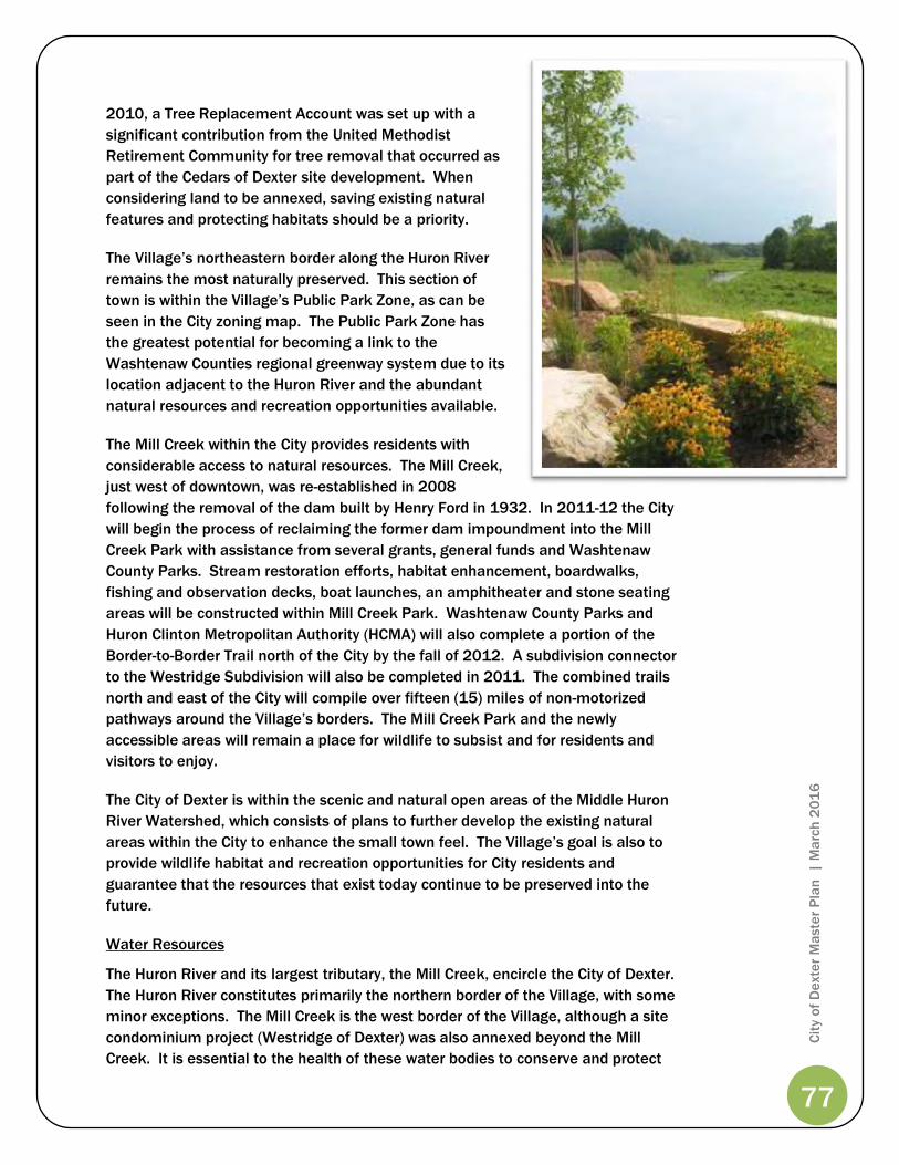
77
Cit
y o
f D
exte
r M
aste
r P
lan
| M
arc
h 2
01
6
2010, a Tree Replacement Account was set up with a
significant contribution from the United Methodist
Retirement Community for tree removal that occurred as
part of the Cedars of Dexter site development. When
considering land to be annexed, saving existing natural
features and protecting habitats should be a priority.
The Village’s northeastern border along the Huron River
remains the most naturally preserved. This section of
town is within the Village’s Public Park Zone, as can be
seen in the City zoning map. The Public Park Zone has
the greatest potential for becoming a link to the
Washtenaw Counties regional greenway system due to its
location adjacent to the Huron River and the abundant
natural resources and recreation opportunities available.
The Mill Creek within the City provides residents with
considerable access to natural resources. The Mill Creek,
just west of downtown, was re-established in 2008
following the removal of the dam built by Henry Ford in 1932. In 2011-12 the City
will begin the process of reclaiming the former dam impoundment into the Mill
Creek Park with assistance from several grants, general funds and Washtenaw
County Parks. Stream restoration efforts, habitat enhancement, boardwalks,
fishing and observation decks, boat launches, an amphitheater and stone seating
areas will be constructed within Mill Creek Park. Washtenaw County Parks and
Huron Clinton Metropolitan Authority (HCMA) will also complete a portion of the
Border-to-Border Trail north of the City by the fall of 2012. A subdivision connector
to the Westridge Subdivision will also be completed in 2011. The combined trails
north and east of the City will compile over fifteen (15) miles of non-motorized
pathways around the Village’s borders. The Mill Creek Park and the newly
accessible areas will remain a place for wildlife to subsist and for residents and
visitors to enjoy.
The City of Dexter is within the scenic and natural open areas of the Middle Huron
River Watershed, which consists of plans to further develop the existing natural
areas within the City to enhance the small town feel. The Village’s goal is also to
provide wildlife habitat and recreation opportunities for City residents and
guarantee that the resources that exist today continue to be preserved into the
future.
Water Resources
The Huron River and its largest tributary, the Mill Creek, encircle the City of Dexter.
The Huron River constitutes primarily the northern border of the Village, with some
minor exceptions. The Mill Creek is the west border of the Village, although a site
condominium project (Westridge of Dexter) was also annexed beyond the Mill
Creek. It is essential to the health of these water bodies to conserve and protect
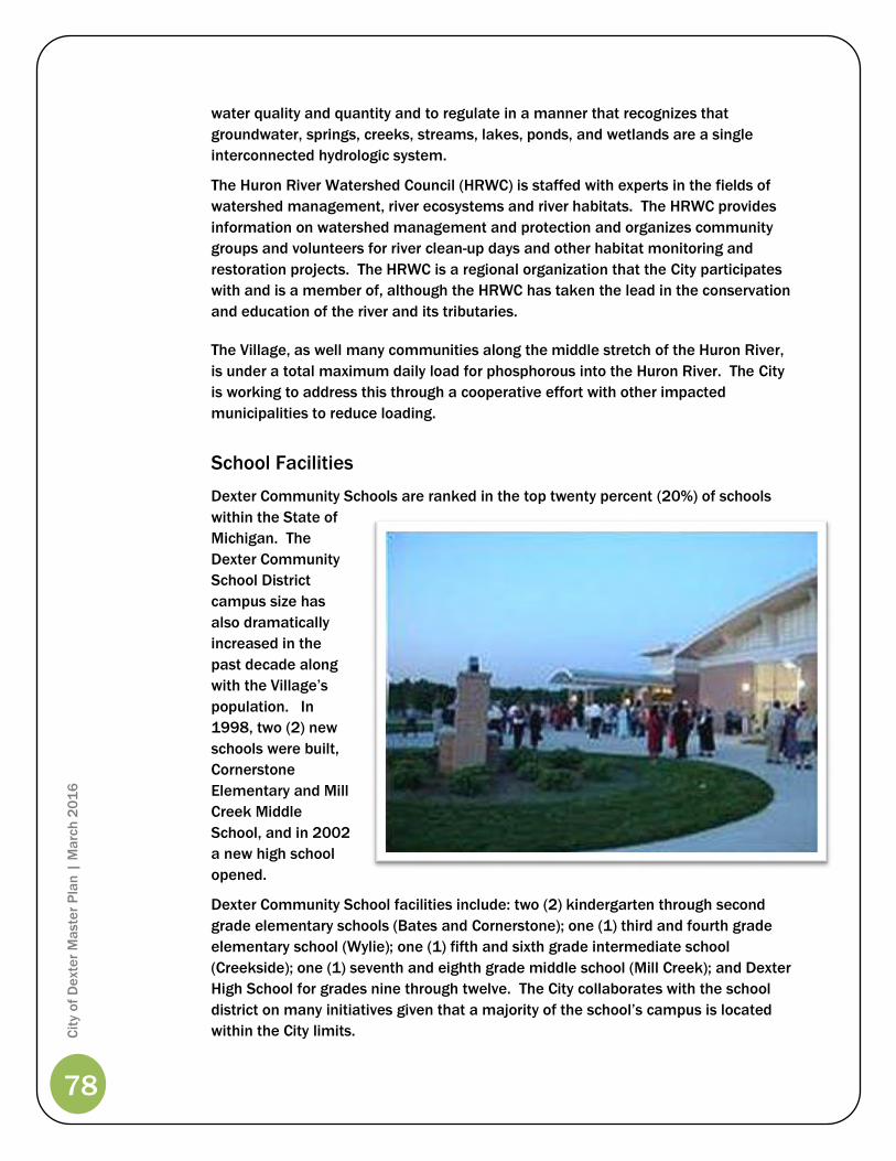
78
Cit
y o
f D
exte
r M
aste
r P
lan
| M
arc
h 2
01
6
water quality and quantity and to regulate in a manner that recognizes that
groundwater, springs, creeks, streams, lakes, ponds, and wetlands are a single
interconnected hydrologic system.
The Huron River Watershed Council (HRWC) is staffed with experts in the fields of
watershed management, river ecosystems and river habitats. The HRWC provides
information on watershed management and protection and organizes community
groups and volunteers for river clean-up days and other habitat monitoring and
restoration projects. The HRWC is a regional organization that the City participates
with and is a member of, although the HRWC has taken the lead in the conservation
and education of the river and its tributaries.
The Village, as well many communities along the middle stretch of the Huron River,
is under a total maximum daily load for phosphorous into the Huron River. The City
is working to address this through a cooperative effort with other impacted
municipalities to reduce loading.
School Facilities
Dexter Community Schools are ranked in the top twenty percent (20%) of schools
within the State of
Michigan. The
Dexter Community
School District
campus size has
also dramatically
increased in the
past decade along
with the Village’s
population. In
1998, two (2) new
schools were built,
Cornerstone
Elementary and Mill
Creek Middle
School, and in 2002
a new high school
opened.
Dexter Community School facilities include: two (2) kindergarten through second
grade elementary schools (Bates and Cornerstone); one (1) third and fourth grade
elementary school (Wylie); one (1) fifth and sixth grade intermediate school
(Creekside); one (1) seventh and eighth grade middle school (Mill Creek); and Dexter
High School for grades nine through twelve. The City collaborates with the school
district on many initiatives given that a majority of the school’s campus is located
within the City limits.

79
Cit
y o
f D
exte
r M
aste
r P
lan
| M
arc
h 2
01
6
Parks and Recreation
The purpose of the 2009 Parks and Recreation Master Plan is to guide recreation
planning and development efforts over the next five years. The Plan is the official
document to be used by the City to guide decisions regarding parks and recreation.
The current Plan builds upon the 1997 Parks and Recreation Plan and the update
completed by City staff in 2003.
The Plan outlines existing and future parks and recreation needs, specifically: parks,
greenways and open space development, as well as the preservation and
enhancement of the Village’s scenic and aesthetic features. The Plan also identifies
specific improvements, costs, priorities and years of completion to better represent
the long-range vision of the Parks and Recreation Commission.
The Plan is intended to meet State standards for community recreation planning
that are necessary to gain eligibility for grant programs.
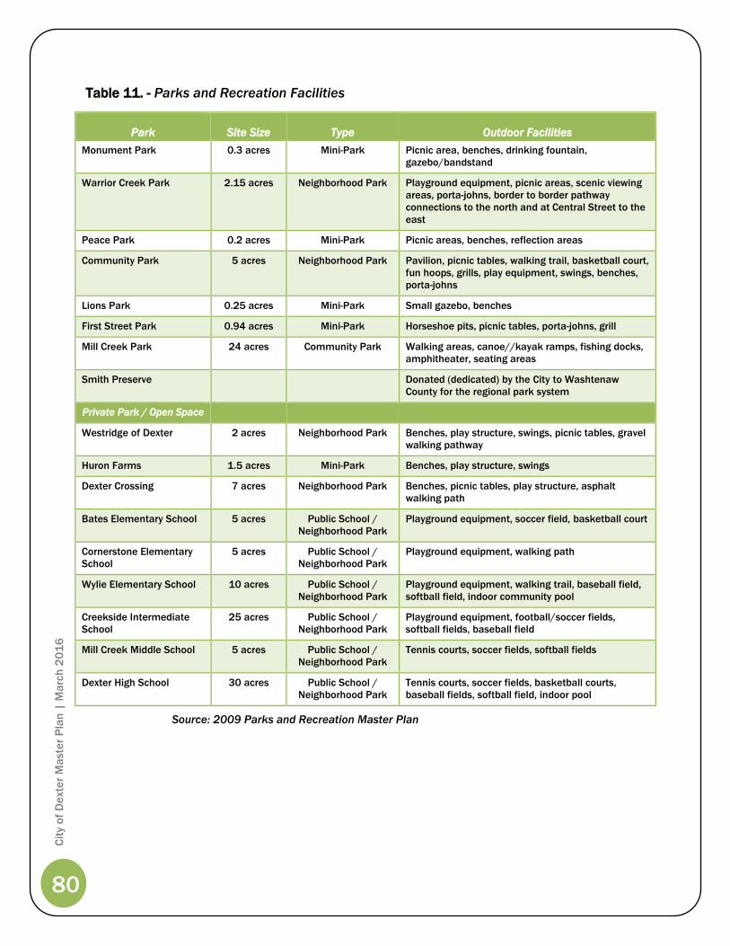
80
Cit
y o
f D
exte
r M
aste
r P
lan
| M
arc
h 2
01
6
Table 11. - Parks and Recreation Facilities
Park Site Size Type Outdoor Facilities
Monument Park 0.3 acres Mini-Park Picnic area, benches, drinking fountain,
gazebo/bandstand
Warrior Creek Park 2.15 acres Neighborhood Park Playground equipment, picnic areas, scenic viewing
areas, porta-johns, border to border pathway
connections to the north and at Central Street to the
east
Peace Park 0.2 acres Mini-Park Picnic areas, benches, reflection areas
Community Park 5 acres Neighborhood Park Pavilion, picnic tables, walking trail, basketball court,
fun hoops, grills, play equipment, swings, benches,
porta-johns
Lions Park 0.25 acres Mini-Park Small gazebo, benches
First Street Park 0.94 acres Mini-Park Horseshoe pits, picnic tables, porta-johns, grill
Mill Creek Park 24 acres Community Park Walking areas, canoe//kayak ramps, fishing docks,
amphitheater, seating areas
Smith Preserve Donated (dedicated) by the City to Washtenaw
County for the regional park system
Private Park / Open Space
Westridge of Dexter 2 acres Neighborhood Park Benches, play structure, swings, picnic tables, gravel
walking pathway
Huron Farms 1.5 acres Mini-Park Benches, play structure, swings
Dexter Crossing 7 acres Neighborhood Park Benches, picnic tables, play structure, asphalt
walking path
Bates Elementary School 5 acres Public School /
Neighborhood Park
Playground equipment, soccer field, basketball court
Cornerstone Elementary
School
5 acres Public School /
Neighborhood Park
Playground equipment, walking path
Wylie Elementary School 10 acres Public School /
Neighborhood Park
Playground equipment, walking trail, baseball field,
softball field, indoor community pool
Creekside Intermediate
School
25 acres Public School /
Neighborhood Park
Playground equipment, football/soccer fields,
softball fields, baseball field
Mill Creek Middle School 5 acres Public School /
Neighborhood Park
Tennis courts, soccer fields, softball fields
Dexter High School 30 acres Public School /
Neighborhood Park
Tennis courts, soccer fields, basketball courts,
baseball fields, softball field, indoor pool
Source: 2009 Parks and Recreation Master Plan

Dexter Schools
Cemetery
Police & Fire Dept.
Dexter Library
PostOffice
DexterMuseum
Mill CreekPark
LionsPark
First St.Park
City Offices
Gordon Hall
Hudson Mills Metropark
Cemetery
Dexter-Huron Metropark
SmithPreserve
CommmunityPark
NorthMill Creek
Park
Peace Park
MonumentPark
Joy
Baker
Parker
Third
Shield
Forest
Mast
Grand
Fifth
Dan Hoey
Dexter-Ann Arbor
Hudson
Central
Fourth
Potts
Huron
Ryan
Second
Broad
Island Lake
Dover
Main
Bisho
p
Inverness
Ann Arbor
Dexter Chelsea
Edison
Bent Tr
ee
Carring
ton
Weber
Forshe
e
Pinevi
ew
Noble
Wilson
Eastrid
ge
Huron River
York
Ulrich
Lake
Wellington
Pine V
iew
Lexing
tonEato
n
Sandhill
Morrison
Dexter Pinckney
Webster
Parkrid
ge
Alley
Victoria
Bridgeway
Hermania
Katherine
Oxbow
Donga
ra
Pearl
Cambri
dge
Mill Creek
Kensington Wall
Palmer
Shagbark
Quackenbush
Cedars
Bristo
l
Meadow View
View
Jananne
McCo
rmick
Hillside
Oliver
Huron View
Boenaro
Samuel
Kingsl
ey
Cushing
Glacier
Melbourne
Ulrich
Cottonwood
Westridge
View
Bristol
Boulder
Sandfield
Kurtland
South
Down
sBaker Heights
Shaw
Preston
Broad
Sandhill
York
Wilson
Huron River
View
Bristo
lPARKS & COMMUNITY
FACILITIESCity of Dexter
Source: Washtenaw County Base Data
Carlisle/Wortman Associates, Inc.Ann Arbor, Michigan
0 500 1,000 1,500 2,000Feet
7-13-2015
Washtenaw County, Michigan
S c i o T o w n s h i pS c i o T o w n s h i pW e b s t e r T o w n s h i pW e b s t e r T o w n s h i p
Scio
Tow
nshi
pSc
io T
owns
hip
Lim
a To
wnsh
ipLi
ma
Town
ship
Dext
er T
owns
hip
Dext
er T
owns
hip
H u r o n R i v e rMi l l
Cr e
e k City of Dexter Parks & CemeteryWashtenaw County Parks & PreservesHuron Clinton MetroparksSubdivision Open SpacesPublic, Quasi-Public FacilitiesOpen Water
Figure 10

83
Cit
y o
f D
exte
r M
aste
r P
lan
| M
arc
h 2
01
6
Economic Development
The City of Dexter is a member of Ann Arbor SPARK, an Ann Arbor-based economic
development corporation, and collaborates with the Michigan Economic
Development Corporation (MEDC) and Dexter Area Chamber of Commerce to help
retain existing and attract new business and industry within the City of Dexter.
As part of Dexter’s economic development, the State of Michigan permits
municipalities to offer tax abatements. A tax abatement is a tax break that
communities can offer as an incentive for businesses to locate in a particular
community. Industrial tax abatements within the City of Dexter last between one (1)
to twelve (12) years, and can be up to a fifty percent (50%) abatement or tax rate
(P.A. 198 of 1974, as amended). Tax abatements are only available within the
Village’s certified Research and Development Business Park. The Park was
originally formed as part of a Local Development Finance Authority (LDFA) that was
part of a Tax Increment Financing Authority (TIFA). In 2007, the TIFA district was
eliminated.
The City also encourages economic development through the Downtown
Development Authority (DDA), which is also a TIFA district. The DDA is within the
central downtown, and along the Dexter-Ann Arbor and Baker Road corridors (see
Figure 6). The DDA was created in 1986, and through the Authority is able to
capture tax increases associated with building and/or property improvements
within the district. The amount of taxes captured through the TIFA is then
reinvested in the DDA district facilitating further investment by property owners and
encouraging economic development.
The DDA’s reinvestment has funded significant streetscape and infrastructure
improvements. The DDA recently invested over $2 million in public infrastructure
improvements (2010), and has contributed to the approval of tax credits to jump
start several privately held projects within the DDA district.
The DDA can also utilize Brownfield Tax Credits as an incentive for development
within the DDA district. The purpose of Brownfield Tax Credits is to facilitate the
redevelopment of previously developed sites, consistent with Dexter’s commitment
to sustainability and its vision for the future. Brownfield tax credits provide a
mechanism for redevelopment and revitalization of underutilized and/or
contaminated sites, without which redevelopment is complicated, expensive and
may not occur. Redeveloping brownfield sites helps to ease urban sprawl, promotes
sustainability, encourages infill development and creates economic and job growth
within the City and DDA district.
The City of Dexter should continue to strengthen cooperation and commitment
efforts in economic development. The continued effort and support will help to
ensure that the City continues to attract top quality jobs and industry for the
residents of Dexter, as well as increasing the tax base within the Village.

84
Cit
y o
f D
exte
r M
aste
r P
lan
| M
arc
h 2
01
6
Intergovernmental and Regional Cooperation
Coordinated planning with adjacent jurisdictions helps limit the duplication of
services and helps support local planning efforts through joint planning and land
use decisions. Coordinated planning can encourage preservation of large areas of
open space and woodlands, and can also promote the planning of land uses that
compliment each other, limiting potential conflicts. Natural resources, such as air
and water, do not conform to jurisdictional boundaries; therefore, it is important
that there be collaboration between adjacent jurisdictions to guarantee their
protection.
There are a number of regional planning organizations, such as the Southeast
Michigan Council of Governments (SEMCOG), the Huron River Watershed Council
(HRWC), the Huron Clinton Metro parks Authority (HCMA), Washtenaw Area
Transportation Study (WATS), Five Healthy Towns, Partnership for Prosperity,
CAPT/DART (Dexter Area Regional Team), Washtenaw County Road Commission
(WCRC) and Washtenaw County Government that can assist the City in its
planning efforts.
Through regional cooperation, Dexter is part of the “Five Healthy Towns” initiative
created through the Chelsea Wellness Foundation (CWF). The CWF is a tax-
exempt, private foundation governed by a volunteer board of directors
representing the populations included in the Chelsea, Dexter, Grass Lake,
Manchester and Stockbridge school districts. The CWF has significant resources as
a result of the merger between Chelsea Community Hospital and St. Joseph Mercy
Health Systems. Their mission is to create a culture of wellness and foster
sustainable improvements in the health of their communities through stewardship
of their resources, innovative and collaborative grants, and engagement of the
residents in the pursuit of healthy life choices.
Gateway Community Initiative is another regional collaboration that the City of
Dexter, City of Chelsea and Village of Manchester, along with the Ann Arbor,
Ypsilanti and Jackson Visitor’s Bureaus have formed to brand Western Washtenaw
County, Eastern Jackson County and Southern Livingston County as a recreation
destination. This “partnership for prosperity” links conservation, commerce and the
participating communities.
Organizations such as SEMCOG facilitate regional planning in areas of
transportation, the environment, and community and economic development.
Some of the other organizations noted above facilitate planning for other regional
issues such as roads, transportation, parks and recreation, and watershed
protection that overlap jurisdictional boundaries.
Intergovernmental cooperation is a key component to an environmentally
conscious, viable and sustainable region. The City should take a lead role in
coordinated planning with the townships and municipalities in the area and
continue to participate in regional programs and organizations. As the region

85
Cit
y o
f D
exte
r M
aste
r P
lan
| M
arc
h 2
01
6
continues to grow, decisions made in one community could greatly influence
another, therefore communication, cooperation and planning is essential for the
City and the surrounding communities.

86
Cit
y o
f D
exte
r M
aste
r P
lan
| M
arc
h 2
01
6

87
Cit
y o
f D
exte
r M
aste
r P
lan
| M
arc
h 2
01
6
Implementation
The Master Plan is essentially a statement of goals and objectives designed to
accommodate future growth and redevelopment. As stated in the introduction of
this document, the Master Plan is the officially-adopted document that sets forth an
agenda for the achievement of goals and policies. It helps develop a balance of
orderly change in a deliberate and controlled manner that permits controlled
growth. As such, it provides the basis upon which zoning and land use decisions are
made.
The Plan forms the philosophical basis for the more technical and specific
implementation measures. It must be recognized that development and change
will occur either with or without planning, and that the Plan will have little effect
upon future development unless adequate implementation programs are
established. This section identifies actions and programs that will be useful if the
Plan is to be followed.
A variety of programs or administrative tools are available to allow the Plan to
succeed. These include:
Zoning Requirements
Zoning is the development control that has been most closely associated with
planning. Originally, zoning was intended to inhibit nuisances and protect property
values. However, zoning should also serve additional purposes that include:
To promote orderly growth in a manner consistent with land use policies and
the Master Plan.
To promote attractiveness in the Village’s physical environment by providing
variation in lot sizes, architectural design guidelines and appropriate land
uses.
To accommodate special, complex or unique uses through mechanisms
such as planned unit developments, overlay districts, or special land use
permits – specifically within the areas designated for mixed use in order to
allow complimentary uses and design guidelines.
To guide development away from conflicting land uses (i.e. industrial uses
adjacent to residential areas).
To preserve and protect existing land uses, natural resources, air, land,
water, and other significant natural features in accordance with the Master
Plan.
To promote the positive redevelopment of underutilized areas of the Village.

88
Cit
y o
f D
exte
r M
aste
r P
lan
| M
arc
h 2
01
6
To balance the increased interest in activities and land uses related or
ancillary to oil and gas exploration and development with other community
goals to ensure the uses occur in a manner consistent with other existing
and planned uses, and in a manner that protects the open space, natural
resources, recreation, and other priorities in the City.
The Zoning Ordinance and Future Land Use map by themselves should not be
considered as the major long range planning policy of the Village. Rather, the
Master Plan should be regarded as a statement of planning policy, and zoning
should be used to assist in implementing that policy.
Zoning Adjustments
Certain areas of the City have been designated for a land use classification in the
Master Plan which conflicts with either existing zoning or existing land uses. These
designations were developed in order to guide the desired development of these
areas. Certain areas may benefit from a Village-initiated rezoning in order to
provide more consistency. Additionally, other areas may continue with an existing
zoning designation that, although currently conflicting with the Future Land Use
designation, may be rezoned in the future once the existing use terminates or
conditions change. It is at this future time the land use recommendations will
provide guidance as to the proper zoning. The City Planning Commission should
further study and make decisions with regard to which areas warrant Village-
initiated rezoning. The following should be considered for Village-initiated rezoning:
1. Encourage new residential developments to provide contiguous internal
recreational amenities.
2. Modify the CBD zoning district to ensure redevelopment, increased
viability, adequate parking, walkability and the reuse of the upper floors of
the existing structures.
3. Create a tree preservation ordinance.
4. Create a Huron River, Mill Creek overlay zone to ensure natural feature
preservation.
5. Evaluate the adequacy of the noise, air and light standards of the Zoning
Ordinance.
6. Create provisions requiring bike parking for government, commercial and
educational institutions.
7. Evaluate likely potential effects of mineral, sand and gravel, and oil and
gas exploration and development, on the public health, safety, and
welfare; and review existing zoning and other police power ordinances to
ensure they balance the need for those sues with their effects on other
existing and planned uses in a manner that furthers and protects
community goals and priorities, including land use, land preservation and

89
Cit
y o
f D
exte
r M
aste
r P
lan
| M
arc
h 2
01
6
the protection of natural resources and water quantity and quality,
transportation, and safety and community facilities and services.
Adopt land development regulations that provide standards and regulations specific
to various elements within the Village:
1. Develop Stormwater Management Regulations that comply with Phase II
and encourage use of Best Management Practices.
2. Adopt regulations that recognize the connection of groundwater and
surface water, and include limitations that protect, and prevent pollution,
impairment or diminishment of, the quantity and quality of available
water resources, including aquifers, springs, rivers, creeks, ponds, and
wetlands, for existing and future water needs for residential recreation,
commercial, industrial, and for protection and preservation of water
bodies and their natural resources and uses.
3. Review City Ordinances to ensure the City is sufficiently reviewing and
collecting data and information regarding the likely effects of land uses on
the public health, safety, and welfare, including the effects on the City’s
environmental and natural resources.
4. Review ordinances to ensure the City requires sufficient disclosure of
information and permits, with sufficient conditions, to allow the fire and
police to provide an emergency response adequate to protect the public
health, safety, and welfare to the spill or other release of hazardous or
other dangerous substances or pollutants during transport of use.
5. Create development design guidelines as a means of preserving the
existing architectural character of the Village. The emphasis of the
guidelines shall be placed upon major renovation projects and new
construction.
6. Work to create incentives for the maintenance and rehabilitation of the
existing residential structures, such as Rental Rehabilitation and Façade
Rehabilitation programs through the MEDC.
7. Continue coordination with the Washtenaw County Brownfield Authority
and upon identifying a site, adopt a Brownfield Redevelopment Plan.
8. Pursue a property maintenance ordinance, a component of which would
recognize property owners who further the historic character of the Village.
9. Continue to coordinate a Village-wide path system that requires
developers to construct a pathway and/or contribute to the system which
links new residential developments to downtown, local parks and/or
schools.
90
Cit
y o
f D
exte
r M
aste
r P
lan
| M
arc
h 2
01
6
Capital Improvement Program
The Michigan Planning Enabling Act (PA 33 of 2008, as amended) authorizes
master plans and the creation of a Planning Commission. Once a Planning
Commission has drafted and adopted a Master Plan, in whole or in part, the Act
requires that all public works occurring within the municipality be submitted to the
Planning Commission for approval of the project. This would include items such as
sanitary sewers, water lines, road improvements, bridge improvements, etc. These
public works and capital improvement projects must be coordinated and reviewed
for consistency with the Master Plan.
The City of Dexter has a very active Capital Improvement Program (CIP) which
outlines a schedule of public service expenditures over the ensuing six (6)-year
period and beyond. The City of Dexter CIP does not address all of the capital
expenditures for the Village, but provides for large, physical improvements that are
permanent in nature, including the basic facilities, services and installations needed
for the functioning of the community. These include transportation systems,
utilities, municipal facilities and other miscellaneous projects.
To qualify for inclusion into the CIP, a project must meet the following standards:
Be consistent with either:
o An adopted or anticipated component of the Village’s Master Plan;
o A State or Federal requirement; or
o A City Council approved policy; and
Constitute permanent, physical or system improvements, or significant
equipment purchases, with a minimum project cost of $10,000; and
Add to the value or capacity of the infrastructure of the Village.
Projects that are considered operational, maintenance or recurring are excluded,
except when a limited duration project.
Preparation of the CIP is done under the authority of the Municipal Planning
Commission Act (PA 33 of 2008, as amended). It is the City Planning Commission’s
goal that the CIP be used as a tool to implement the Village’s Master Plan and
assist in the Village’s financial planning.
The CIP proposes project funding relative to the anticipated availability of fiscal
resources and the choice of specific improvements to be achieved throughout the
six (6)-year plan.
Plan Education
Citizen involvement and support will be necessary as the Plan is implemented.
Local officials should constantly strive to develop procedures that make citizens
more aware of the planning and zoning process and the day-to-day decision making

91
Cit
y o
f D
exte
r M
aste
r P
lan
| M
arc
h 2
01
6
which affects implementation of the Plan. A continuous program of discussion,
education, and participation will be extremely important as the City moves toward
realization of the goals and objectives contained within the Master Plan.
Currently, the City utilizes various media outlets to keep residents informed. These
include: a Facebook page, email updates, quarterly newsletter and City website.
Plan Updates
The Plan should not become a static document. The City Planning Commission
should attempt to re-evaluate and update portions of it on a periodic basis. In
accordance with Michigan Public Act 33 of 2008, as amended, the City is required
to review the Plan every five (5) years to determine whether to commence the
procedure to amend or adopt a new Plan. However, the Planning Commission
should set goals for the review of various section of this Plan on a yearly basis. The
Master Plan should also be coordinated with the City Parks and Recreation Master
Plan to provide proper long-range planning for parks and recreation improvements.

92
Cit
y o
f D
exte
r M
aste
r P
lan
| M
arc
h 2
01
6

93
Cit
y o
f D
exte
r M
aste
r P
lan
| M
arc
h 2
01
6
Appendix – Community Survey Results

94
Cit
y o
f D
exte
r M
aste
r P
lan
| M
arc
h 2
01
6

1 of 31
2011 Master Plan Update Survey
1. What is your age?
Response
Percent
Response
Count
Under 25 0.6% 1
25-34 12.3% 20
35-44 35.2% 57
45-54 18.5% 30
55-64 22.2% 36
65 and over 11.1% 18
answered question 162
skipped question 0
2. What is your gender?
Response
Percent
Response
Count
Male 41.4% 67
Female 58.6% 95
answered question 162
skipped question 0

2 of 31
3. Please select your household income.
Response
Percent
Response
Count
$200,000 or more 5.1% 8
$150,000 to $199,999 9.5% 15
$100,000 to $149,999 34.8% 55
$75,000 to $99,999 20.9% 33
$50,000 to $74,999 20.9% 33
$25,000 to $49,999 6.3% 10
Less than $25,000 2.5% 4
answered question 158
skipped question 4
4. Please select your highest level of education?
Response
Percent
Response
Count
Graduate/Professional Degree 38.1% 61
Bachelor's Degree 41.9% 67
Associate's Degree 8.8% 14
Some College, No Degree 8.8% 14
High School Graduate 1.9% 3
Did Not Graduate High School 0.6% 1
answered question 160
skipped question 2

3 of 31
5. What is your current employment status?
Response
Percent
Response
Count
Employed 64.4% 103
Retired 18.8% 30
Self-Employed 8.8% 14
Unemployed 1.9% 3
Homemaker/Stay-at-Home Parent 6.3% 10
answered question 160
skipped question 2
6. If you are employed, where do you work?
Response
Percent
Response
Count
Village of Dexter 20.9% 23
Ann Arbor 43.6% 48
Scio Township 6.4% 7
City of Chelsea 2.7% 3
Other Washtenaw County 5.5% 6
Home-based business 10.0% 11
Detroit Metro Area 10.9% 12
Other (please specify)
16
answered question 110
skipped question 52

4 of 31
7. Do you live in the Village of Dexter?
Response
Percent
Response
Count
Yes 68.6% 109
No 31.4% 50
answered question 159
skipped question 3
8. If yes to the previous question, please indicate how long you have been a resident of the
Village of Dexter. If no, skip to the next question.
Response
Percent
Response
Count
Less than 1 year 5.5% 6
1-5 years 30.9% 34
6-10 years 30.9% 34
11-20 years 20.0% 22
21-30 years 3.6% 4
More than 30 years 9.1% 10
answered question 110
skipped question 52
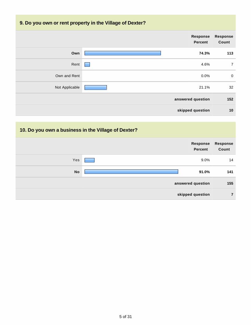
5 of 31
9. Do you own or rent property in the Village of Dexter?
Response
Percent
Response
Count
Own 74.3% 113
Rent 4.6% 7
Own and Rent 0.0% 0
Not Applicable 21.1% 32
answered question 152
skipped question 10
10. Do you own a business in the Village of Dexter?
Response
Percent
Response
Count
Yes 9.0% 14
No 91.0% 141
answered question 155
skipped question 7
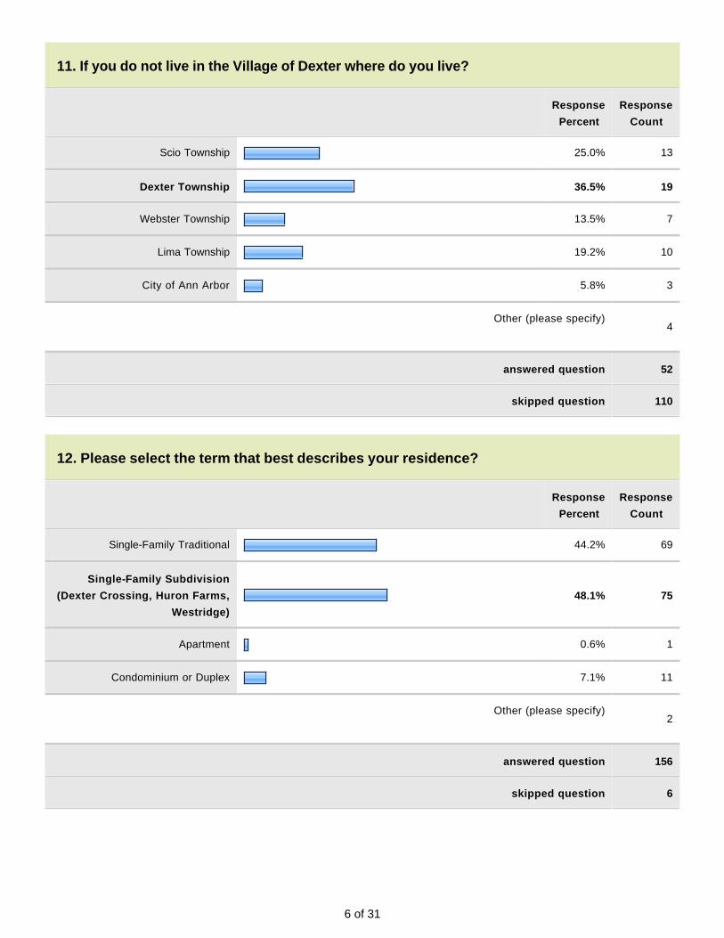
6 of 31
11. If you do not live in the Village of Dexter where do you live?
Response
Percent
Response
Count
Scio Township 25.0% 13
Dexter Township 36.5% 19
Webster Township 13.5% 7
Lima Township 19.2% 10
City of Ann Arbor 5.8% 3
Other (please specify)
4
answered question 52
skipped question 110
12. Please select the term that best describes your residence?
Response
Percent
Response
Count
Single-Family Traditional 44.2% 69
Single-Family Subdivision
(Dexter Crossing, Huron Farms,
Westridge)
48.1% 75
Apartment 0.6% 1
Condominium or Duplex 7.1% 11
Other (please specify)
2
answered question 156
skipped question 6
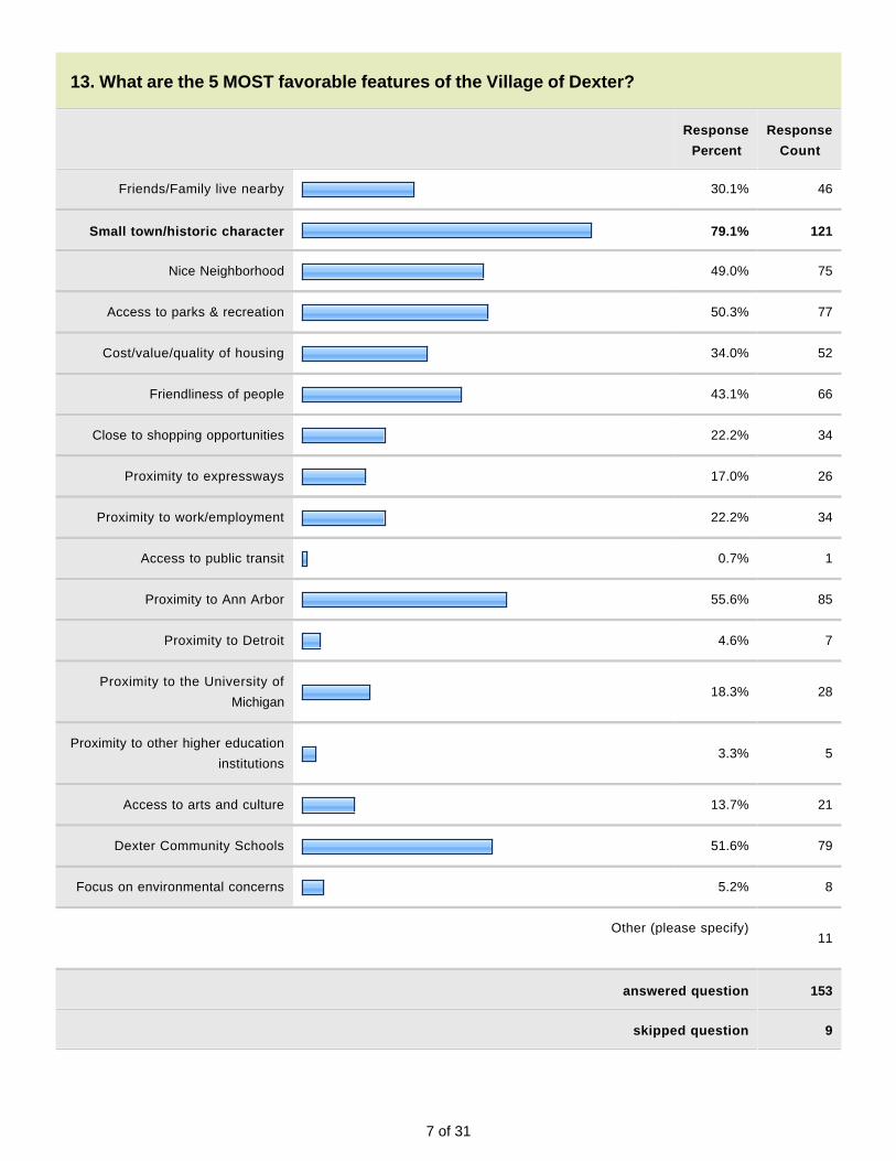
7 of 31
13. What are the 5 MOST favorable features of the Village of Dexter?
Response
Percent
Response
Count
Friends/Family live nearby 30.1% 46
Small town/historic character 79.1% 121
Nice Neighborhood 49.0% 75
Access to parks & recreation 50.3% 77
Cost/value/quality of housing 34.0% 52
Friendliness of people 43.1% 66
Close to shopping opportunities 22.2% 34
Proximity to expressways 17.0% 26
Proximity to work/employment 22.2% 34
Access to public transit 0.7% 1
Proximity to Ann Arbor 55.6% 85
Proximity to Detroit 4.6% 7
Proximity to the University of
Michigan18.3% 28
Proximity to other higher education
institutions3.3% 5
Access to arts and culture 13.7% 21
Dexter Community Schools 51.6% 79
Focus on environmental concerns 5.2% 8
Other (please specify)
11
answered question 153
skipped question 9
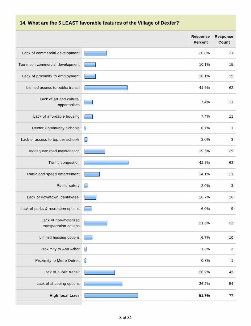
8 of 31
14. What are the 5 LEAST favorable features of the Village of Dexter?
Response
Percent
Response
Count
Lack of commercial development 20.8% 31
Too much commercial development 10.1% 15
Lack of proximity to employment 10.1% 15
Limited access to public transit 41.6% 62
Lack of art and cultural
opportunities7.4% 11
Lack of affordable housing 7.4% 11
Dexter Community Schools 0.7% 1
Lack of access to top tier schools 2.0% 3
Inadequate road maintenance 19.5% 29
Traffic congestion 42.3% 63
Traffic and speed enforcement 14.1% 21
Public safety 2.0% 3
Lack of downtown identity/feel 10.7% 16
Lack of parks & recreation options 6.0% 9
Lack of non-motorized
transportation options21.5% 32
Limited housing options 6.7% 10
Proximity to Ann Arbor 1.3% 2
Proximity to Metro Detroit 0.7% 1
Lack of public transit 28.9% 43
Lack of shopping options 36.2% 54
High local taxes 51.7% 77
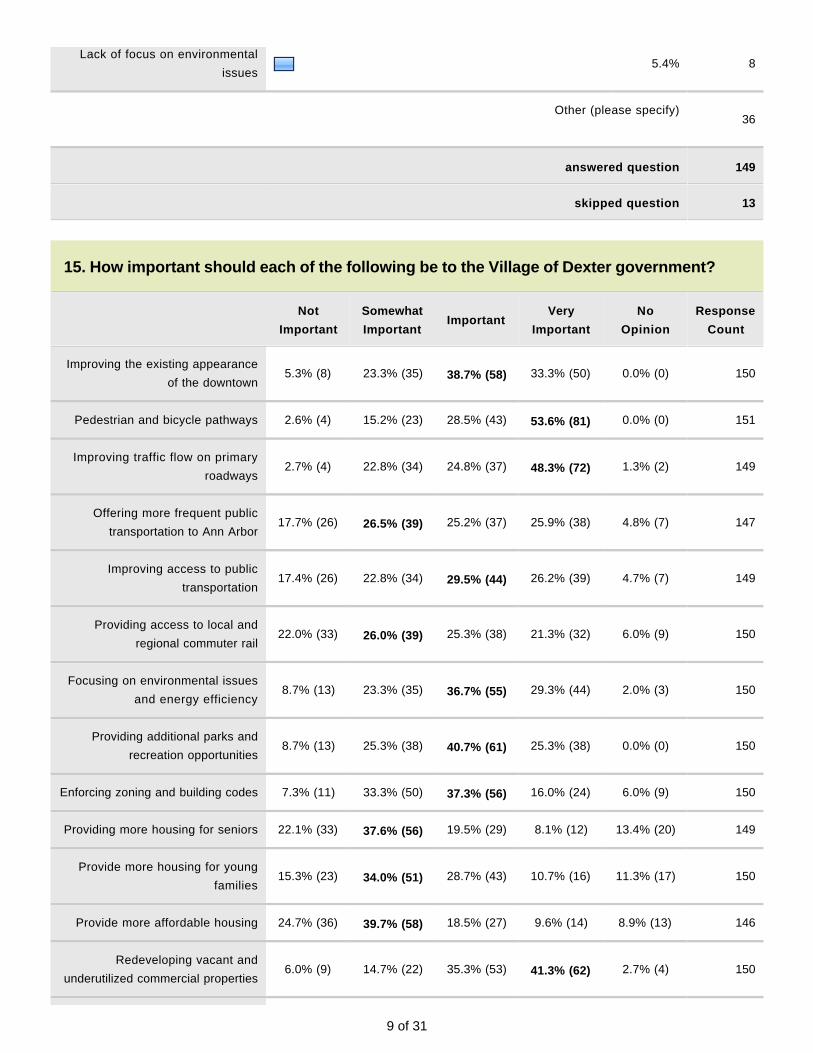
9 of 31
Lack of focus on environmental
issues5.4% 8
Other (please specify)
36
answered question 149
skipped question 13
15. How important should each of the following be to the Village of Dexter government?
Not
Important
Somewhat
ImportantImportant
Very
Important
No
Opinion
Response
Count
Improving the existing appearance
of the downtown5.3% (8) 23.3% (35) 38.7% (58) 33.3% (50) 0.0% (0) 150
Pedestrian and bicycle pathways 2.6% (4) 15.2% (23) 28.5% (43) 53.6% (81) 0.0% (0) 151
Improving traffic flow on primary
roadways2.7% (4) 22.8% (34) 24.8% (37) 48.3% (72) 1.3% (2) 149
Offering more frequent public
transportation to Ann Arbor17.7% (26) 26.5% (39) 25.2% (37) 25.9% (38) 4.8% (7) 147
Improving access to public
transportation17.4% (26) 22.8% (34) 29.5% (44) 26.2% (39) 4.7% (7) 149
Providing access to local and
regional commuter rail22.0% (33) 26.0% (39) 25.3% (38) 21.3% (32) 6.0% (9) 150
Focusing on environmental issues
and energy efficiency8.7% (13) 23.3% (35) 36.7% (55) 29.3% (44) 2.0% (3) 150
Providing additional parks and
recreation opportunities8.7% (13) 25.3% (38) 40.7% (61) 25.3% (38) 0.0% (0) 150
Enforcing zoning and building codes 7.3% (11) 33.3% (50) 37.3% (56) 16.0% (24) 6.0% (9) 150
Providing more housing for seniors 22.1% (33) 37.6% (56) 19.5% (29) 8.1% (12) 13.4% (20) 149
Provide more housing for young
families15.3% (23) 34.0% (51) 28.7% (43) 10.7% (16) 11.3% (17) 150
Provide more affordable housing 24.7% (36) 39.7% (58) 18.5% (27) 9.6% (14) 8.9% (13) 146
Redeveloping vacant and
underutilized commercial properties6.0% (9) 14.7% (22) 35.3% (53) 41.3% (62) 2.7% (4) 150
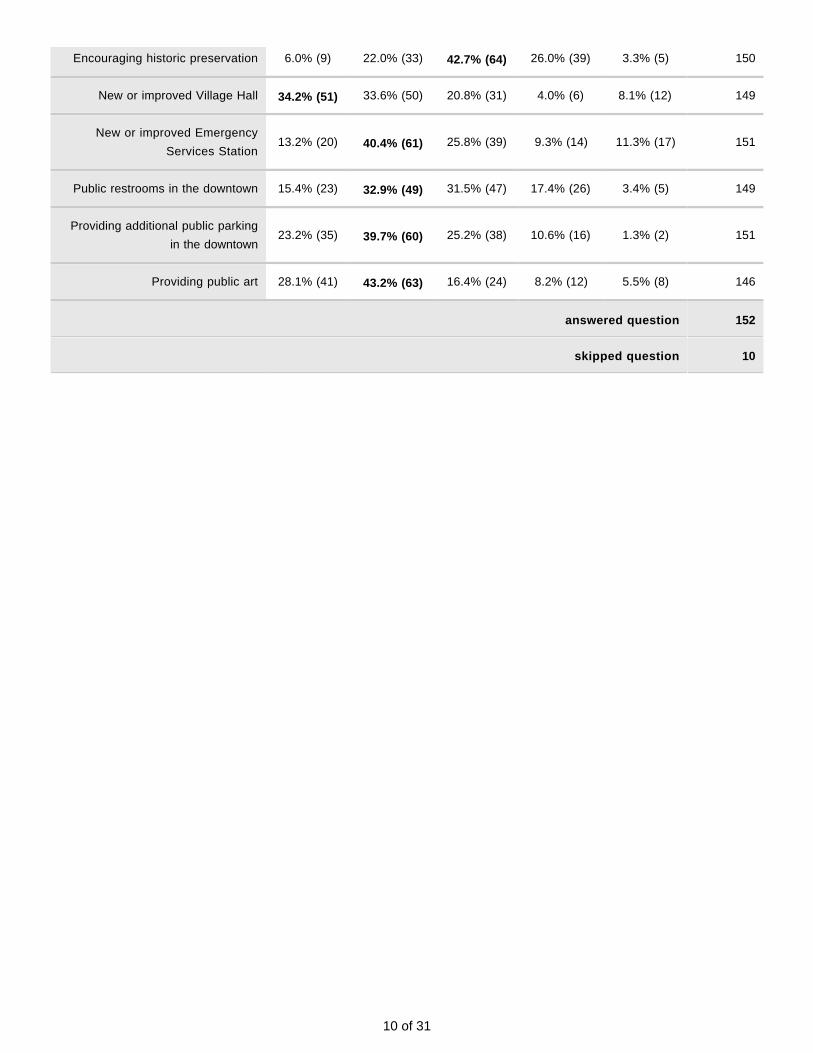
10 of 31
Encouraging historic preservation 6.0% (9) 22.0% (33) 42.7% (64) 26.0% (39) 3.3% (5) 150
New or improved Village Hall 34.2% (51) 33.6% (50) 20.8% (31) 4.0% (6) 8.1% (12) 149
New or improved Emergency
Services Station13.2% (20) 40.4% (61) 25.8% (39) 9.3% (14) 11.3% (17) 151
Public restrooms in the downtown 15.4% (23) 32.9% (49) 31.5% (47) 17.4% (26) 3.4% (5) 149
Providing additional public parking
in the downtown23.2% (35) 39.7% (60) 25.2% (38) 10.6% (16) 1.3% (2) 151
Providing public art 28.1% (41) 43.2% (63) 16.4% (24) 8.2% (12) 5.5% (8) 146
answered question 152
skipped question 10
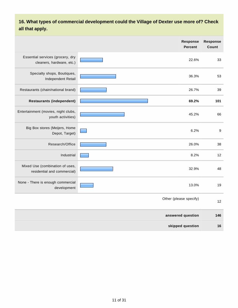
11 of 31
16. What types of commercial development could the Village of Dexter use more of? Check
all that apply.
Response
Percent
Response
Count
Essential services (grocery, dry
cleaners, hardware, etc.)22.6% 33
Specialty shops, Boutiques,
Independent Retail36.3% 53
Restaurants (chain/national brand) 26.7% 39
Restaurants (independent) 69.2% 101
Entertainment (movies, night clubs,
youth activities)45.2% 66
Big Box stores (Meijers, Home
Depot, Target)6.2% 9
Research/Office 26.0% 38
Industrial 8.2% 12
Mixed Use (combination of uses,
residential and commercial)32.9% 48
None - There is enough commercial
development13.0% 19
Other (please specify)
12
answered question 146
skipped question 16
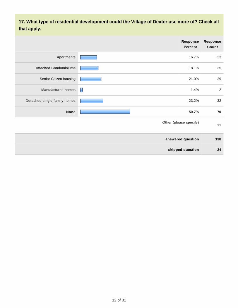
12 of 31
17. What type of residential development could the Village of Dexter use more of? Check all
that apply.
Response
Percent
Response
Count
Apartments 16.7% 23
Attached Condominiums 18.1% 25
Senior Citizen housing 21.0% 29
Manufactured homes 1.4% 2
Detached single family homes 23.2% 32
None 50.7% 70
Other (please specify)
11
answered question 138
skipped question 24

13 of 31
18. The Village of Dexter has several corridors that because of their location, unique
character, or development potential require special attention. Please prioritize these areas
that you feel need further study, development and/or redevelopment consideration and/or
policy direction. Use the priority numbers 1 (highest), 2, 3, 4, 5 (lowest).
1 2 3 4 5Response
Count
Dexter Ann Arbor Road 34.1% (47) 26.8% (37) 25.4% (35) 6.5% (9) 7.2% (10) 138
Main Street 37.5% (54) 24.3% (35) 18.8% (27) 11.8% (17) 8.3% (12) 144
Baker Road 34.3% (47) 27.7% (38) 26.3% (36) 5.8% (8) 5.8% (8) 137
Residential 7.7% (10) 13.1% (17) 18.5% (24) 45.4% (59) 15.4% (20) 130
Other 22.5% (9) 5.0% (2) 15.0% (6) 2.5% (1) 55.0% (22) 40
Other (please specify)
19
answered question 146
skipped question 16
19. If public transit or light rail service was improved in Dexter would you be more likely to
use it for any of the following destinations? Check all that apply.
Response
Percent
Response
Count
Ann Arbor 86.8% 99
Detroit 47.4% 54
Work 33.3% 38
Entertainment 57.9% 66
Other (please specify)
16
answered question 114
skipped question 48

14 of 31
20. Would you be supportive of funding improvements to public transit or light rail service in
Washtenaw County?
Response
Percent
Response
Count
In FAVOR of improvements and
FUNDING improvements51.8% 73
In FAVOR of improvements but
NOT FUNDING improvements27.7% 39
NOT in FAVOR 20.6% 29
answered question 141
skipped question 21
21. How often do you think that you would use rail service if available?
Response
Percent
Response
Count
1 time per week 30.1% 44
1 time per month 30.8% 45
2 times per year 17.1% 25
Never 21.9% 32
answered question 146
skipped question 16

15 of 31
22. Would you like the Village to host another Town Hall meeting with information on the
process of becoming a city and/or what it means to become a city or another topic?
Response
Percent
Response
Count
Yes 52.3% 69
No 47.7% 63
Other (please specify)
15
answered question 132
skipped question 30
23. What methods of communication do you find most valuable to receive Village
information? Check all that apply.
Response
Percent
Response
Count
Village E-mail Update 78.9% 116
Village Facebook Page 40.8% 60
Village Newsletter 38.8% 57
Village Website 36.7% 54
Newspaper 18.4% 27
Other (please specify)
1
answered question 147
skipped question 15

16 of 31
24. Are there specific areas of concern that you have that you would like the Village of
Dexter to address?
Response
Count
55
answered question 55
skipped question 107
25. Is there anything else that you would like the Village of Dexter to consider?
Response
Count
33
answered question 33
skipped question 129

17 of 31
Page 2, Q6. If you are employed, where do you work?
1 Telecommute May 4, 2011 7:27 PM
2 Jackson Apr 22, 2011 5:16 AM
3 Chelsea Hospital Apr 13, 2011 7:37 AM
4 lenawee county Apr 12, 2011 2:00 PM
5 Lansing Apr 12, 2011 12:54 PM
6 Jackson County Apr 10, 2011 3:47 PM
7 Lansing Apr 3, 2011 11:26 AM
8 Jackson Apr 2, 2011 3:53 PM
9 Jackson Apr 2, 2011 10:22 AM
10 Flint Apr 2, 2011 6:12 AM
11 Pinckney Mar 29, 2011 5:15 PM
12 Pinckney Mar 29, 2011 3:30 PM
13 Work remotely for NY-based business. Mar 29, 2011 3:01 PM
14 Pinckney Mar 29, 2011 1:50 PM
15 RN--contingent Mar 29, 2011 11:11 AM
16 Also in Fall I work in the Village of Dexter. Mar 29, 2011 9:12 AM
Page 2, Q11. If you do not live in the Village of Dexter where do you live?
1 Village of Dexter Apr 19, 2011 2:26 PM
2 Chelsea Apr 13, 2011 6:07 AM
3 Leoni Twp. Apr 12, 2011 2:27 PM
4 Hamburg Township Mar 29, 2011 8:08 AM
Page 2, Q12. Please select the term that best describes your residence?
1 Owner occupied apartment building Apr 13, 2011 6:08 AM
2 FARM Apr 5, 2011 10:16 AM
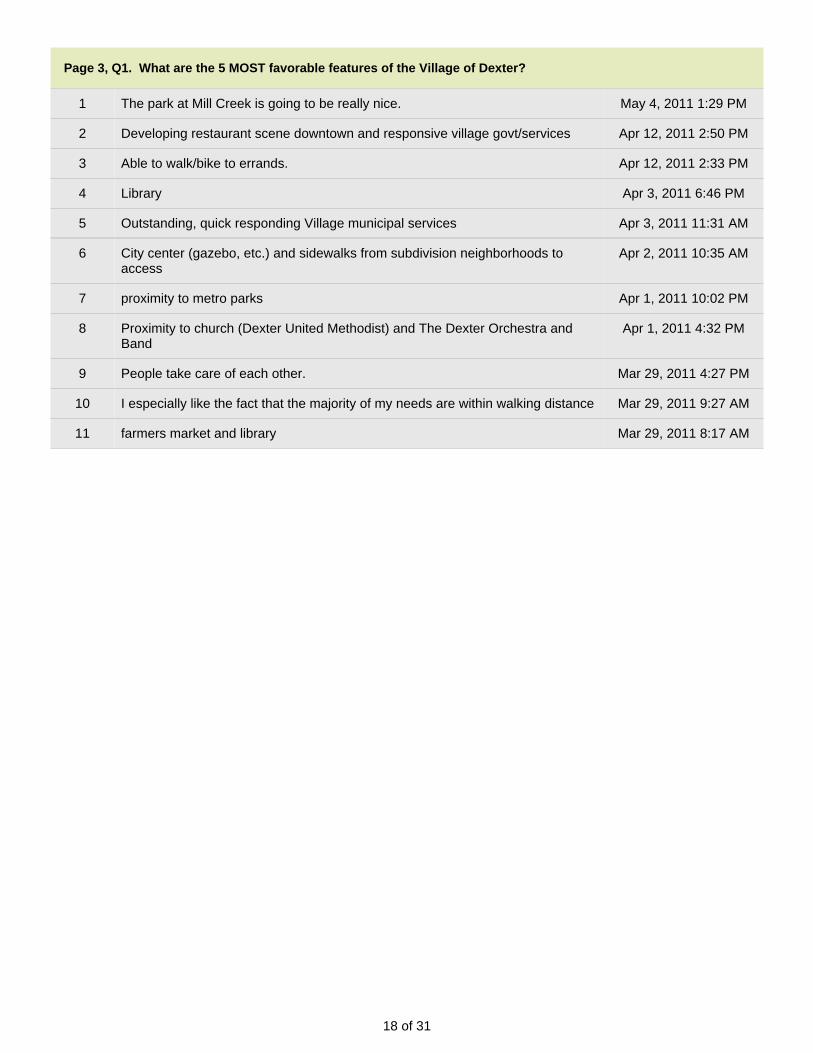
18 of 31
Page 3, Q1. What are the 5 MOST favorable features of the Village of Dexter?
1 The park at Mill Creek is going to be really nice. May 4, 2011 1:29 PM
2 Developing restaurant scene downtown and responsive village govt/services Apr 12, 2011 2:50 PM
3 Able to walk/bike to errands. Apr 12, 2011 2:33 PM
4 Library Apr 3, 2011 6:46 PM
5 Outstanding, quick responding Village municipal services Apr 3, 2011 11:31 AM
6 City center (gazebo, etc.) and sidewalks from subdivision neighborhoods toaccess
Apr 2, 2011 10:35 AM
7 proximity to metro parks Apr 1, 2011 10:02 PM
8 Proximity to church (Dexter United Methodist) and The Dexter Orchestra andBand
Apr 1, 2011 4:32 PM
9 People take care of each other. Mar 29, 2011 4:27 PM
10 I especially like the fact that the majority of my needs are within walking distance Mar 29, 2011 9:27 AM
11 farmers market and library Mar 29, 2011 8:17 AM

19 of 31
Page 3, Q2. What are the 5 LEAST favorable features of the Village of Dexter?
1 Too many empty spots in downtown (really miss Busch's downtown). Gun rangeand buck pole!
May 11, 2011 12:09 PM
2 existing vacant properties not mowed and kept neat..and there is no bi-law toenforce the upkeep of vacant lots in this village. Noxious weeds and rodentsthrive in these lots. There needs to be a law against this neglect by owners.
May 7, 2011 5:42 AM
3 Street maintenance in older section of village--curb & gutters needed on sidestreets. Less rental housing and or stricter restrictions for maintaining suchhousing, rental units need to have storage & parking areas provided by owner.
May 6, 2011 12:56 PM
4 Lack of Ordinace enforcment, Lack of traffic/ speed enforcement May 6, 2011 12:29 PM
5 Lacks variety of options for dining out May 4, 2011 5:34 PM
6 lack of family/economical restaurants May 4, 2011 5:19 PM
7 tendency for residents to be racist May 4, 2011 2:52 PM
8 Lack of Downtown Supermarkets and Lack of Restuarants Apr 19, 2011 2:46 PM
9 Lack of village support to ensure businesses can advertise using signs to drawattention.
Apr 18, 2011 2:12 PM
10 I like Dexter Apr 14, 2011 10:20 AM
11 Please keep the village "news boards" around town attractive and updated! Apr 14, 2011 7:44 AM
12 Poor sidewalks, no sidewalks in places. Apr 13, 2011 6:14 AM
13 lack of sidewalks on all village streets - at least one side of street Apr 13, 2011 5:10 AM
14 limited sidewalks Apr 12, 2011 6:49 PM
15 Many locals seem to fear change of any kind. Apr 12, 2011 3:55 PM
16 Downtown often not pedestrian-friendly on weekends and lack of safe bike/walkaccess from west
Apr 12, 2011 2:50 PM
17 Lack of safe walking routes and connectivity to newer developments in thevillage.
Apr 12, 2011 2:33 PM
18 Lack of attention to sidewalks: Missing on some streets and winter shovelingnot enforced.
Apr 12, 2011 2:03 PM
19 No Outdoor pool Apr 12, 2011 1:48 PM
20 lack of dining/restaurants with good, affordable food Apr 12, 2011 1:04 PM
21 We cannot believe how many roads are unpaved. It would be nice if there was atleast a plan to pave them.
Apr 12, 2011 12:59 PM
22 Lack of a good Recreation Center, like Saline's; lack of a bigger Library Apr 11, 2011 8:29 AM
23 The bridge between Dexter Township and the Village is very congested in themorning and evening.
Apr 5, 2011 9:32 AM
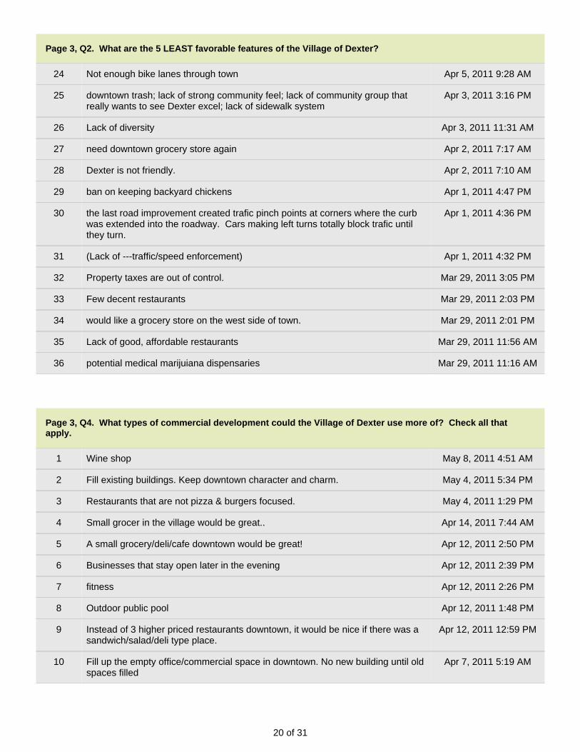
20 of 31
Page 3, Q2. What are the 5 LEAST favorable features of the Village of Dexter?
24 Not enough bike lanes through town Apr 5, 2011 9:28 AM
25 downtown trash; lack of strong community feel; lack of community group thatreally wants to see Dexter excel; lack of sidewalk system
Apr 3, 2011 3:16 PM
26 Lack of diversity Apr 3, 2011 11:31 AM
27 need downtown grocery store again Apr 2, 2011 7:17 AM
28 Dexter is not friendly. Apr 2, 2011 7:10 AM
29 ban on keeping backyard chickens Apr 1, 2011 4:47 PM
30 the last road improvement created trafic pinch points at corners where the curbwas extended into the roadway. Cars making left turns totally block trafic untilthey turn.
Apr 1, 2011 4:36 PM
31 (Lack of ---traffic/speed enforcement) Apr 1, 2011 4:32 PM
32 Property taxes are out of control. Mar 29, 2011 3:05 PM
33 Few decent restaurants Mar 29, 2011 2:03 PM
34 would like a grocery store on the west side of town. Mar 29, 2011 2:01 PM
35 Lack of good, affordable restaurants Mar 29, 2011 11:56 AM
36 potential medical marijuiana dispensaries Mar 29, 2011 11:16 AM
Page 3, Q4. What types of commercial development could the Village of Dexter use more of? Check all thatapply.
1 Wine shop May 8, 2011 4:51 AM
2 Fill existing buildings. Keep downtown character and charm. May 4, 2011 5:34 PM
3 Restaurants that are not pizza & burgers focused. May 4, 2011 1:29 PM
4 Small grocer in the village would be great.. Apr 14, 2011 7:44 AM
5 A small grocery/deli/cafe downtown would be great! Apr 12, 2011 2:50 PM
6 Businesses that stay open later in the evening Apr 12, 2011 2:39 PM
7 fitness Apr 12, 2011 2:26 PM
8 Outdoor public pool Apr 12, 2011 1:48 PM
9 Instead of 3 higher priced restaurants downtown, it would be nice if there was asandwich/salad/deli type place.
Apr 12, 2011 12:59 PM
10 Fill up the empty office/commercial space in downtown. No new building until oldspaces filled
Apr 7, 2011 5:19 AM

21 of 31
Page 3, Q4. What types of commercial development could the Village of Dexter use more of? Check all thatapply.
11 No Big Box stores!! Apr 4, 2011 4:49 PM
12 research & light industrial Mar 29, 2011 8:44 AM
Page 3, Q5. What type of residential development could the Village of Dexter use more of? Check all that apply.
1 Mix. More character less cheaply built subdivision homes. May 4, 2011 5:34 PM
2 many homes and lots for sale or in foreclosure, no reason to develop further atthis point.
Apr 26, 2011 5:44 AM
3 Downtown Housing - affordable loft style condo's above businesses Apr 19, 2011 2:46 PM
4 Concerned about the number of rental properties and their appearance... Apr 14, 2011 7:44 AM
5 Residential over retail/office downtown; brownstone-style units along Forest orGrant
Apr 12, 2011 2:50 PM
6 Let's try to maintain what we currently have. Apr 5, 2011 9:32 AM
7 Need places of employment first then housing for employees will follow Apr 3, 2011 7:50 AM
8 (affordable) Apr 1, 2011 4:32 PM
9 I don't know Apr 1, 2011 4:31 PM
10 No more "garage mahals"!!!! Mar 30, 2011 6:49 PM
11 Low income housing Mar 29, 2011 1:36 PM

22 of 31
Page 3, Q6. The Village of Dexter has several corridors that because of their location, unique character, ordevelopment potential require special attention. Please prioritize these areas that you feel need further study,development and/or redevelopment consideration and/or policy direction. Use the prior...
1 Absolutely need to understand traffic flow and how to best move traffic thrudowntown at peak times. That left turn light at Main and Central(?) isHORRIBLE.
May 11, 2011 12:09 PM
2 Dexter Chelsea Rd May 8, 2011 4:51 AM
3 At rush hours, people wanting to beat the traffic lights are cutting throughconnecting residential streets to beat the lights on Dex/A2 Rd. These cars arespeeding and create danger on an otherwise quiet residential street. Perhapsspeed bumps on these side streets would suffice?
May 7, 2011 5:42 AM
4 Railroad Corridor needs a common identity for the future Apr 19, 2011 2:46 PM
5 Mast Rd. Bridge & Central St Apr 19, 2011 10:53 AM
6 lowing speed limit on highly populated dirt roads Apr 18, 2011 2:12 PM
7 1. residential for Forest and Grant W of Baker; 2. downtown commercial adjacentto Creek; 3. Central St to Bridge
Apr 12, 2011 2:50 PM
8 neighborhood streets (Fifth, Fourth, others considered to relieve commutercongestion on arterials at peak times
Apr 10, 2011 5:19 PM
9 smaller side streets with access to commercial buildings Apr 9, 2011 6:48 PM
10 The Bridge by A&W is a traffic nightmare and scary for those families that try tobike or walk into town.
Apr 5, 2011 9:32 AM
11 The area around the new high school; Shield Rd and Parker Rd Apr 5, 2011 5:17 AM
12 Central St Apr 3, 2011 11:31 AM
13 I don't know Apr 1, 2011 4:31 PM
14 central from park to bridge Mar 30, 2011 3:29 PM
15 Mast Mar 29, 2011 5:48 PM
16 Dexter Pinckney/Territorial Rd. Area Mar 29, 2011 2:01 PM
17 Central/Mast Road Mar 29, 2011 9:33 AM
18 note I am not familar with current zoning so am unsure if change is required Mar 29, 2011 9:28 AM
19 tunnel under the tracks need work Mar 29, 2011 8:15 AM

23 of 31
Page 4, Q1. If public transit or light rail service was improved in Dexter would you be more likely to use it for anyof the following destinations? Check all that apply.
1 As the population ages there will be more of a need for this in the village infuture...particularly to A2 for appointments etc.
May 7, 2011 6:02 AM
2 Brighton, Novi May 4, 2011 5:45 PM
3 Metro airport May 4, 2011 1:15 PM
4 None Apr 20, 2011 7:41 AM
5 Detroit Metro Airport Apr 14, 2011 11:22 AM
6 Chicago Apr 14, 2011 7:50 AM
7 Chelsea Apr 13, 2011 6:17 AM
8 Teen transportation Apr 12, 2011 2:35 PM
9 doubt there is enough demand to a single destination to be economically viable. Apr 3, 2011 8:12 AM
10 Jackson Apr 2, 2011 10:40 AM
11 casinos Apr 2, 2011 7:21 AM
12 Airport Apr 1, 2011 7:55 PM
13 no Apr 1, 2011 4:39 PM
14 none Mar 31, 2011 6:50 PM
15 Don't want it in Dexter! Mar 29, 2011 11:21 AM
16 none Mar 29, 2011 9:37 AM

24 of 31
Page 4, Q4. Would you like the Village to host another Town Hall meeting with information on the process ofbecoming a city and/or what it means to become a city or another topic?
1 I am not in favor of the Village becoming a city. May 9, 2011 7:18 AM
2 Just communication, no time to attend meetings. May 4, 2011 5:45 PM
3 Too much time and effort has already been expended to no avail Apr 22, 2011 5:25 AM
4 I am a proponent of cityhood, but dont need another meeting Apr 17, 2011 5:44 AM
5 I think we should NOT become a City and it has been a huge waste of our taxdollars, We should focus on being the best Village in the State. The Boardneeds to play nicely with the Other Townships and vice versa and start thinkingabout their constituents and not about their own power trips.
Apr 14, 2011 10:22 AM
6 Not sure what the advantages are... Apr 14, 2011 7:50 AM
7 I still do not understand the need even though I attended a meeting. Apr 12, 2011 2:06 PM
8 Having moved here from a village of 30,000, and grown up in a village of 65,000we can't figure out why Dexter is so intent on becoming a city.
Apr 12, 2011 1:03 PM
9 If state level approval is obtained then have meeting. No mention of this statussince last Dec..
Apr 3, 2011 8:12 AM
10 No good reason for cityhood that I have heard of !! Apr 2, 2011 7:21 AM
11 Why? Aren't we in the middle of the process? Apr 1, 2011 10:43 AM
12 No city!!! Mar 30, 2011 6:51 PM
13 Don't want Dexter to become a city but if it is going to happen anyway, yes ameeting would be helpful; public voting on medical marijuiana dispensaries
Mar 29, 2011 11:21 AM
14 Only if something new comes up on the subject. Mar 29, 2011 9:37 AM
15 I'm just upset it's taking so long... Mar 29, 2011 9:04 AM
Page 4, Q5. What methods of communication do you find most valuable to receive Village information? Check allthat apply.
1 Twitter Mar 29, 2011 9:04 AM
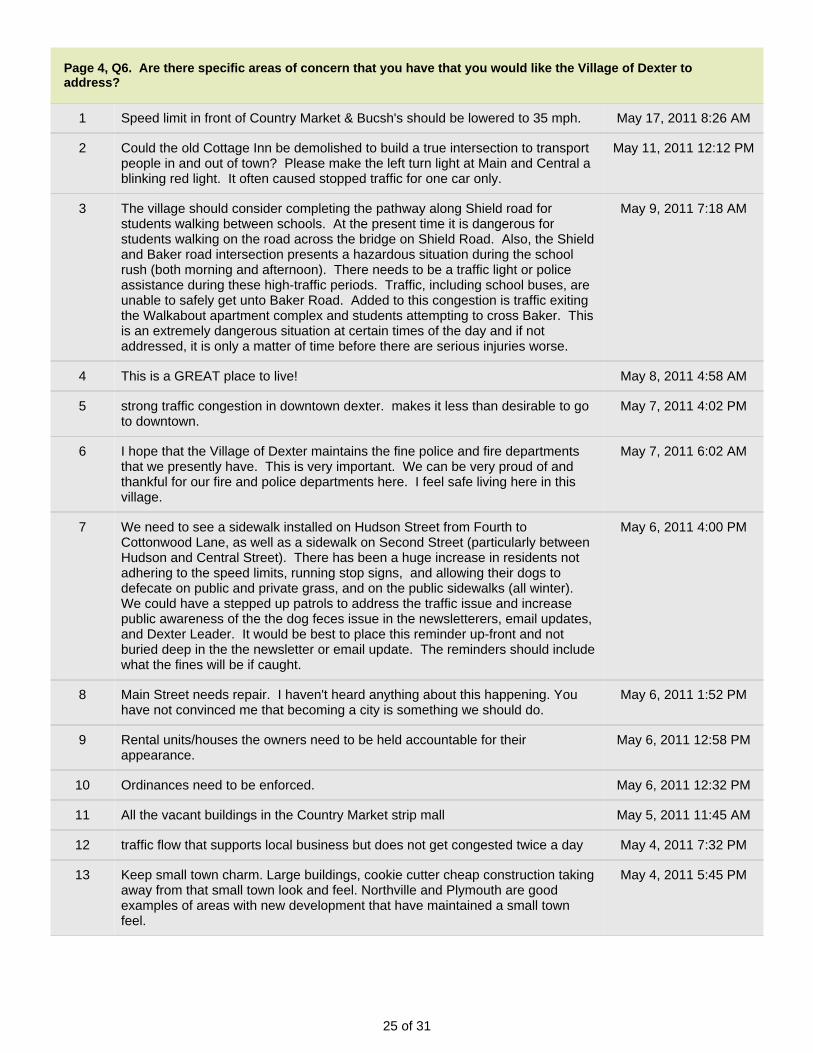
25 of 31
Page 4, Q6. Are there specific areas of concern that you have that you would like the Village of Dexter toaddress?
1 Speed limit in front of Country Market & Bucsh's should be lowered to 35 mph. May 17, 2011 8:26 AM
2 Could the old Cottage Inn be demolished to build a true intersection to transportpeople in and out of town? Please make the left turn light at Main and Central ablinking red light. It often caused stopped traffic for one car only.
May 11, 2011 12:12 PM
3 The village should consider completing the pathway along Shield road forstudents walking between schools. At the present time it is dangerous forstudents walking on the road across the bridge on Shield Road. Also, the Shieldand Baker road intersection presents a hazardous situation during the schoolrush (both morning and afternoon). There needs to be a traffic light or policeassistance during these high-traffic periods. Traffic, including school buses, areunable to safely get unto Baker Road. Added to this congestion is traffic exitingthe Walkabout apartment complex and students attempting to cross Baker. Thisis an extremely dangerous situation at certain times of the day and if notaddressed, it is only a matter of time before there are serious injuries worse.
May 9, 2011 7:18 AM
4 This is a GREAT place to live! May 8, 2011 4:58 AM
5 strong traffic congestion in downtown dexter. makes it less than desirable to goto downtown.
May 7, 2011 4:02 PM
6 I hope that the Village of Dexter maintains the fine police and fire departmentsthat we presently have. This is very important. We can be very proud of andthankful for our fire and police departments here. I feel safe living here in thisvillage.
May 7, 2011 6:02 AM
7 We need to see a sidewalk installed on Hudson Street from Fourth toCottonwood Lane, as well as a sidewalk on Second Street (particularly betweenHudson and Central Street). There has been a huge increase in residents notadhering to the speed limits, running stop signs, and allowing their dogs todefecate on public and private grass, and on the public sidewalks (all winter).We could have a stepped up patrols to address the traffic issue and increasepublic awareness of the the dog feces issue in the newsletterers, email updates,and Dexter Leader. It would be best to place this reminder up-front and notburied deep in the the newsletter or email update. The reminders should includewhat the fines will be if caught.
May 6, 2011 4:00 PM
8 Main Street needs repair. I haven't heard anything about this happening. Youhave not convinced me that becoming a city is something we should do.
May 6, 2011 1:52 PM
9 Rental units/houses the owners need to be held accountable for theirappearance.
May 6, 2011 12:58 PM
10 Ordinances need to be enforced. May 6, 2011 12:32 PM
11 All the vacant buildings in the Country Market strip mall May 5, 2011 11:45 AM
12 traffic flow that supports local business but does not get congested twice a day May 4, 2011 7:32 PM
13 Keep small town charm. Large buildings, cookie cutter cheap construction takingaway from that small town look and feel. Northville and Plymouth are goodexamples of areas with new development that have maintained a small townfeel.
May 4, 2011 5:45 PM

26 of 31
Page 4, Q6. Are there specific areas of concern that you have that you would like the Village of Dexter toaddress?
14 Safer roads to permit student to walk or bike to school. May 4, 2011 5:06 PM
15 A roundabout at Parker & Island Lake & Dexter Ann Arbor would help schooltraffic in the mornings and left turns.
May 4, 2011 1:32 PM
16 Traffic flow: 1) During peak hours, ensure efficient flow through main fares; 2)Not choking free traffic during non-peak hours (e.g., the horrible light @ MillCreek School) 3) Providing easier pedestrian (or bicycle) access from otherside of train bridge into downtown
May 4, 2011 1:22 PM
17 Improve the pedestrian sidewalk crossings at both Railroad crossings. Enhancelook of Mast Road Entrance to Village near Mast Road Bridge
Apr 19, 2011 2:47 PM
18 I would like to see more curb and gutter and sidewalks in the core, older part ofthe village. Also, more property maintenance efforts and enforcement ofordinances.
Apr 17, 2011 5:44 AM
19 Should support the medical marijuana initiative by being open to distributors andgrowers so long as they are in appropriate locations away from schools.
Apr 14, 2011 11:22 AM
20 Do NOT become a City!!! Apr 14, 2011 10:22 AM
21 Semi trucks going through the Main St./Ann Arbor St. are so noisy, and notconducive to pedestrian traffic/quality of life. Cross walks in the main shoppingarea should be clear and cars should slow down and stop for pedestrians.
Apr 14, 2011 7:50 AM
22 Cityhood, taxes Apr 13, 2011 6:17 AM
23 More complete sidewalks along roads. Apr 12, 2011 6:55 PM
24 More sidewalks Enforcement of speed limits Transportation to Ann Arbor Apr 12, 2011 6:33 PM
25 Need for outdoor public pool Apr 12, 2011 1:49 PM
26 The lights on Main Street really seem ill-timed, particularly the light at BroadStreet. Much of the congestion seems to be due to the timing of the lights. Ifthere truly is a round-a-bout planned to overcome the viaduct area, the lightswould have to be changed or you'd just back up on the round-a-bout at Broadand/or Baker. We much prefer looking at extending Parker Rd. rather than around-a-bout (but know cost should be a consideration too).
Apr 12, 2011 1:03 PM
27 Continue improving bike lanes and walking paths in the area Apr 9, 2011 6:50 PM
28 Let's focus on being proactive and having Dexter be a destination city forfamilies from Ann Arbor to travel to on the weekends. However, it is important tomaintain the small town feel, because that is what current families love about thetown. Let's work together to increase our property value and small town valueswithout jeopardizing the land around the town. We do not need anymore bigdevelopments.
Apr 5, 2011 9:34 AM
29 One lane rail bridge is dangerous and congested Apr 5, 2011 9:29 AM
30 More historic preservation and art installations. Apr 4, 2011 4:53 PM
31 Speeders and better control over drivers who ignore stop signs. Apr 4, 2011 2:18 PM
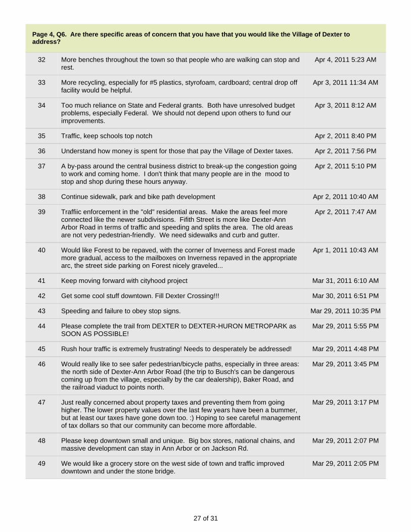
27 of 31
Page 4, Q6. Are there specific areas of concern that you have that you would like the Village of Dexter toaddress?
32 More benches throughout the town so that people who are walking can stop andrest.
Apr 4, 2011 5:23 AM
33 More recycling, especially for #5 plastics, styrofoam, cardboard; central drop offfacility would be helpful.
Apr 3, 2011 11:34 AM
34 Too much reliance on State and Federal grants. Both have unresolved budgetproblems, especially Federal. We should not depend upon others to fund ourimprovements.
Apr 3, 2011 8:12 AM
35 Traffic, keep schools top notch Apr 2, 2011 8:40 PM
36 Understand how money is spent for those that pay the Village of Dexter taxes. Apr 2, 2011 7:56 PM
37 A by-pass around the central business district to break-up the congestion goingto work and coming home. I don't think that many people are in the mood tostop and shop during these hours anyway.
Apr 2, 2011 5:10 PM
38 Continue sidewalk, park and bike path development Apr 2, 2011 10:40 AM
39 Traffiic enforcement in the "old" residential areas. Make the areas feel moreconnected like the newer subdivisions. Fifith Street is more like Dexter-AnnArbor Road in terms of traffic and speeding and splits the area. The old areasare not very pedestrian-friendly. We need sidewalks and curb and gutter.
Apr 2, 2011 7:47 AM
40 Would like Forest to be repaved, with the corner of Inverness and Forest mademore gradual, access to the mailboxes on Inverness repaved in the appropriatearc, the street side parking on Forest nicely graveled...
Apr 1, 2011 10:43 AM
41 Keep moving forward with cityhood project Mar 31, 2011 6:10 AM
42 Get some cool stuff downtown. Fill Dexter Crossing!!! Mar 30, 2011 6:51 PM
43 Speeding and failure to obey stop signs. Mar 29, 2011 10:35 PM
44 Please complete the trail from DEXTER to DEXTER-HURON METROPARK asSOON AS POSSIBLE!
Mar 29, 2011 5:55 PM
45 Rush hour traffic is extremely frustrating! Needs to desperately be addressed! Mar 29, 2011 4:48 PM
46 Would really like to see safer pedestrian/bicycle paths, especially in three areas:the north side of Dexter-Ann Arbor Road (the trip to Busch's can be dangerouscoming up from the village, especially by the car dealership), Baker Road, andthe railroad viaduct to points north.
Mar 29, 2011 3:45 PM
47 Just really concerned about property taxes and preventing them from goinghigher. The lower property values over the last few years have been a bummer,but at least our taxes have gone down too. :) Hoping to see careful managementof tax dollars so that our community can become more affordable.
Mar 29, 2011 3:17 PM
48 Please keep downtown small and unique. Big box stores, national chains, andmassive development can stay in Ann Arbor or on Jackson Rd.
Mar 29, 2011 2:07 PM
49 We would like a grocery store on the west side of town and traffic improveddowntown and under the stone bridge.
Mar 29, 2011 2:05 PM
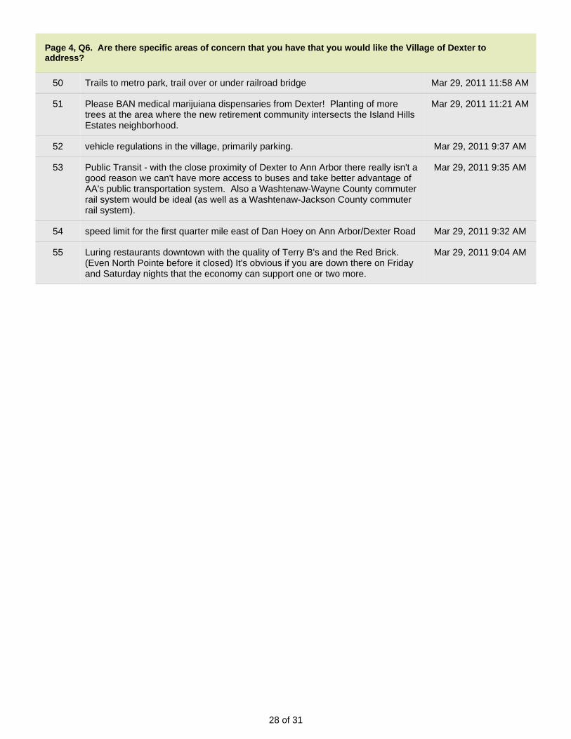
28 of 31
Page 4, Q6. Are there specific areas of concern that you have that you would like the Village of Dexter toaddress?
50 Trails to metro park, trail over or under railroad bridge Mar 29, 2011 11:58 AM
51 Please BAN medical marijuiana dispensaries from Dexter! Planting of moretrees at the area where the new retirement community intersects the Island HillsEstates neighborhood.
Mar 29, 2011 11:21 AM
52 vehicle regulations in the village, primarily parking. Mar 29, 2011 9:37 AM
53 Public Transit - with the close proximity of Dexter to Ann Arbor there really isn't agood reason we can't have more access to buses and take better advantage ofAA's public transportation system. Also a Washtenaw-Wayne County commuterrail system would be ideal (as well as a Washtenaw-Jackson County commuterrail system).
Mar 29, 2011 9:35 AM
54 speed limit for the first quarter mile east of Dan Hoey on Ann Arbor/Dexter Road Mar 29, 2011 9:32 AM
55 Luring restaurants downtown with the quality of Terry B's and the Red Brick.(Even North Pointe before it closed) It's obvious if you are down there on Fridayand Saturday nights that the economy can support one or two more.
Mar 29, 2011 9:04 AM

29 of 31
Page 4, Q7. Is there anything else that you would like the Village of Dexter to consider?
1 Thanks for all that you do. Dexter is an awesome place to live! May 11, 2011 12:12 PM
2 Nature trail or pedestrian access to Dexter Huron Metropark (bridge.) May 8, 2011 4:58 AM
3 Behind my lovely home in the village there is a vacant commercial property thatis never mowed or cared for by the owner who has it for sale. The weeds growto waist deep or more. There are many noxious weeds and also many types ofrodents living in this eyesore that is right in the village on Dexter Ann Arbor Rd.This is appalling. I phoned the village office to report this neglected lot and wastold there was nothing that the village could do about the lot. This is rediculous.The village should tell the owners to keep it mowed or the village should do themowing and add the charges to the owner's taxes plus a fine for non-compliance. This is how it is done in other municipalities. There needs to besomething put in place to protect the neighbors of such deadbeats, whether theybe domestic or commercial properties.
May 7, 2011 6:02 AM
4 Bike and walking paths connecting parks, residential and businesses fortransportation and recreation.
May 4, 2011 5:45 PM
5 A light rail connecting Chelsea-Dexter-Ann Arbor and beyond would get a lot ofuse. I would use it to commute to work daily and to shop along the corridor.
Apr 14, 2011 11:22 AM
6 Possibility of additional public park area/space for a open dog run. Apr 14, 2011 10:52 AM
7 Stopping the madness and waste of tax dollars on becoming a City and continueto offer charming new ideas like the bridge and landscaping and the skating rink.
Apr 14, 2011 10:22 AM
8 Thanks for everything. I love the brush pick-up on Wednesdays! Apr 14, 2011 7:50 AM
9 Pathway from Village to Hudson Mills park. Continue with outdoor entertainmentin Gazebo park during summer.
Apr 13, 2011 6:17 AM
10 No marijuana dispensaries! Apr 12, 2011 6:55 PM
11 Filling the vacant stores with businesses Apr 12, 2011 6:33 PM
12 I find out local government to be very reponsive and council members do a finejob.
Apr 12, 2011 2:06 PM
13 Provide discount in-home water treatment units for residents that do not wantfluoridated water. Accept more items for recycling. Update environmental sectionon web site.
Apr 12, 2011 1:16 PM
14 It would be nice to have a recreation center/facility like Saline. We have manyfamilies and a very long winter. A good, indoor recreational facility for villagetaxpayers would be an excellent improvement on the quality of life in the village.
Apr 11, 2011 8:32 AM
15 Historic district designation for individual structures and/or portions of thecommunity (a ticklish subject with many, but an important tool in securing thelong term stability and quality of historic areas within the community)
Apr 10, 2011 5:24 PM
16 More traffic control, speeds can be very uncomfortable for residents. Apr 4, 2011 4:53 PM

30 of 31
Page 4, Q7. Is there anything else that you would like the Village of Dexter to consider?
17 Something more for kids to do around the gazebo in the summer time. Ice rink isgreat in the winter, but it would be nice to bring the kids downtown in the summerfor something other than the DQ or bakery. The park at the river is too far away(feels remote) and their is no safe link between the park and library.
Apr 3, 2011 3:21 PM
18 More encouragement/assistance with building plan for Dexter Wellness Center.This project is much needed and highly anticipated among residents.
Apr 3, 2011 11:34 AM
19 Extending Mill Creek park walkway south to near Shield road is a nice FUTUREidea but NOT important near term. It should be funded locally, includingtownships. Lodi township should provide a portion of funding for a combinedFire Dept.; it was not included in recent newspaper articles giving fundingamounts.
Apr 3, 2011 8:12 AM
20 Love the community! Apr 2, 2011 10:40 AM
21 Don't get left behind by other surrounding communities. Try to attract young,educated families to live in the community. Making the schools known forexcellence would be a strong selling point.
Apr 2, 2011 7:53 AM
22 Do not allow medical marijuana distribution. Apr 2, 2011 7:47 AM
23 I don't understand why the planned ordinance that would have supportedbackyard chickens was changed to a ban. We are very disappointed, as we hadplanned to start keeping a few hens this year. I am surprised that a communitythat I thought was pretty progressive has gone against the movement towardmore sustainable and locally produced food.
Apr 1, 2011 4:51 PM
24 That the private association/subdivision rules are not necessarily the appropriateguidelines for the old Village.
Apr 1, 2011 10:43 AM
25 I just have to comment that this survey had many questions I found to be wordedpoorly with choices that seemed strange to me. It made it difficult to understandhow a response was really going to be helpful.
Mar 30, 2011 7:45 PM
26 Family Dollar, if done right, would be huge magnet for downtown, although Irealize we think we're too good for that.
Mar 30, 2011 6:51 PM
27 Notice how the upscale restaurants have given way to more pedestrian onesover the last 6 years? Dexter looks upscale, but catering to families is where themoney is. I STRONGLY encourage the Village to pursue independent eateriesto relocate here in Dexter. SPECIFICALLY, I'd like to see more Chinese andespecially MEXICAN/SOUTHWESTERN restaurants in the area!
Mar 29, 2011 5:55 PM
28 Having a better downtown chamber of commerce which has activities downtown.Chelsea always seems to be doing something fun and I don't know why thesame type of activities don't happen in Dexter. Such as ladies night out. TheChamber is pretty lame right now.
Mar 29, 2011 4:30 PM
29 This isn't all in your hands, but a connector someday to the Hudson Mills bikepaths would be fantastic--I believe it would be heavily used, and possibly have areal effect on community health and fitness. It's a historical oddity that ourcommunity basically borders a wonderful park, but to get to it we have to drive4.5 miles! I think an entrance in town would really boost the attractiveness ofliving downtown for active families.
Mar 29, 2011 3:45 PM
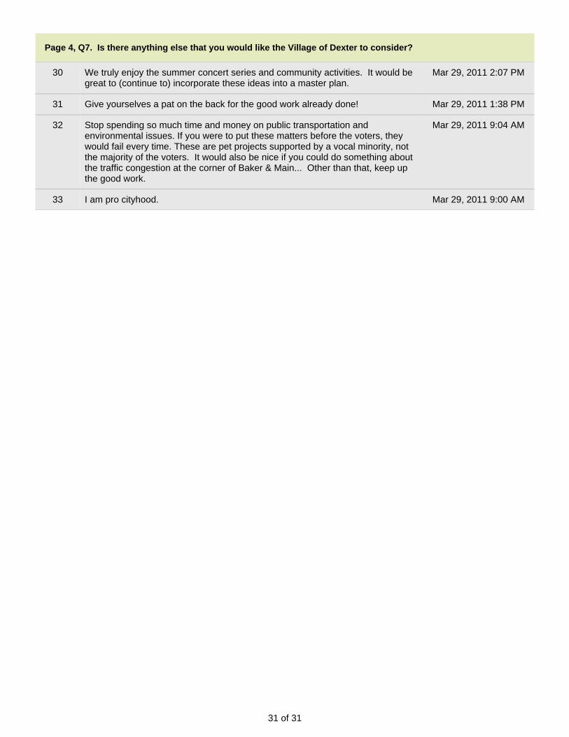
31 of 31
Page 4, Q7. Is there anything else that you would like the Village of Dexter to consider?
30 We truly enjoy the summer concert series and community activities. It would begreat to (continue to) incorporate these ideas into a master plan.
Mar 29, 2011 2:07 PM
31 Give yourselves a pat on the back for the good work already done! Mar 29, 2011 1:38 PM
32 Stop spending so much time and money on public transportation andenvironmental issues. If you were to put these matters before the voters, theywould fail every time. These are pet projects supported by a vocal minority, notthe majority of the voters. It would also be nice if you could do something aboutthe traffic congestion at the corner of Baker & Main... Other than that, keep upthe good work.
Mar 29, 2011 9:04 AM
33 I am pro cityhood. Mar 29, 2011 9:00 AM