city of clinton zoning ordinance zoning ord 2009.pdf · city of clinton zoning ordinance . adopted...
TRANSCRIPT
CITY OF CLINTON ZONING ORDINANCE
Adopted December 1990
Updated as of August 2009

CLINTON ZONING ORDINANCE
CLINTON, TENNESSEE
Title 14 of the Clinton Municipal Code
PLANNING AND ZONING
Prepared For The Clinton Municipal/ Regional Planning Commission
John Stair, Chairman
Robert Manning, Secretary David McCune
David Worthington Garry Whitley
Charlie Lyons, Vice Chairman Johnafred Thomas
Prepared By The
LOCAL PLANNING ASSISTANCE OFFICE
The Department of Economic and Community Development
Knoxville, Tennessee
Adopted December 1990 Updated as of August, 2009
TABLE OF CONTENTS
CHAPTER PAGE
1. MUNICIPAL PLANNING COMMISSION
Section
14-101 Creation and Membership...........................................................1 14-102. Organization, Powers, Duties, etc...............................................1 14-103. Additional Powers.......................................................................1
2. THE ZONING ORDINANCE OF THE CITY OF CLINTON
Section
14-201. Authority .....................................................................................2 14-202. Short Title ...................................................................................2 14-203. Purpose........................................................................................2 14-204. Definitions...................................................................................2
3. GENERAL PROVISIONS
Section
14-301. Continuance of Nonconforming Uses and Structures ..................................................................................10 14-302. Off-Street Automobile Parking.................................................11 14-303. Off-Street Loading and Unloading Space.................................12 14-304. Off-Street Parking Lot Design Requirements ...........................13 14-305. Ingress and Egress.....................................................................14 14-306. Access Control ..........................................................................14 14-307. Vision Clearance .......................................................................15 14-308. Planned Unit Development (PUD) Regulations .......................15 14-309. Signs..........................................................................................19 14-310. Site Plan Regulations for Commercial, Public, and Semi-Public Uses ...................................................33 14-311. Site Plan Regulations for Industrial Uses .................................37 14-312. Temporary, Mobile, Factory-Built, or Factory Assembled Structures................................................................40 14-313. Customary Home Occupations .................................................41 14-314. Gasoline Service Stations..........................................................42 14-315. Floodplain Hazard Management Regulations...........................43 14-316. Commercial Truck Stops...........................................................62 14-317. Daycares....................................................................................62
4. APPLICATION OF REGULATIONS
Section
14-401. Use ............................................................................................65 14-402. Street Frontage ..........................................................................65

14-403. Corner Lots ...............................................................................65 14-404. One Principal Building on a Lot ...............................................65 14-405. Reduction of Lot Size ...............................................................65 14-406. Yard and Other Spaces..............................................................65 14-407. Conformity to Subdivision Regulations....................................65 14-408. Accessory Building and Use Regulations.................................65 14-409. Height and Density....................................................................66
5. ESTABLISHMENT OF DISTRICTS
Section
14-501. Classification of Districts..........................................................67 14-502. Zoning District Boundaries.......................................................67
6. PROVISIONS GOVERNING USE DISTRICTS
Section
14-601. R-1 Low Density Residential ....................................................68 14-602. R-2 Medium Density Residential..............................................69 14-603. R-3 Multifamily Planned Residential District ..........................70 14-604. B-1 Central Business District....................................................71 14-605. B-2 General Business District...................................................72 14-606. B-3 Neighborhood Business District ........................................73 14-607. B-4 Interstate Business District ................................................74 14-608. M-1 Light Industrial District.....................................................74 14-609. M-2 Heavy Industrial District ...................................................76 14-610. F-1 Flood Hazard District .........................................................76 14-611. H-1 Historic District..................................................................76 14-612. MHP Mobile Home Park District .............................................77
7. REFERENCE TABLES
Section
14-701. Area, Yard, and Height Requirements ......................................81 14-702. Permitted Use Schedule ............................................................82 14-703. Site Plan Checklist ....................................................................88
8. EXCEPTIONS AND MODIFICATIONS
Section
14-801. Lot of Record ............................................................................89 14-802. Adjoining and Substandard Lots of Records ............................89 14-803. Exceptions for Carport or Garage Construction .......................89 14-804. Front Yards ...............................................................................89 14-805. Exceptions on Height Limits.....................................................89
9. ADMINISTRATION AND ENFORCEMENT
Section
14-901. Building Permit Required .........................................................91 14-902. Enforcing Officer ......................................................................91 14-903. Application For/Issuance of Building Permits ..........................91 14-904. Expiration/Extension of Building Permit Approvals ................91 14-905. Final Site Inspection/Issuance of Certificate of Occupancy...........................................................92 14-906. Violations ..................................................................................92 14-907. Penalties ....................................................................................92 14-908. Remedies ...................................................................................92
10. BOARD OF ZONING APPEALS
Section
14-1001. Creation and Appointment ........................................................93 14-1002. Procedure ..................................................................................93 14-1003. Appeals......................................................................................93 14-1004. Powers .......................................................................................93 14-1005. Action of the Board of Zoning Appeals....................................94
11. HISTORIC ZONING COMMISSION
Section
14-1101. Creation and Appointment ........................................................95 14-1102. Procedure ..................................................................................95 14-1103. Powers and Duties.....................................................................95 14-1104. Jurisdiction ................................................................................95 14-1105. Review of Decisions .................................................................96
12. AMENDMENTS
Section
14-1201. Procedure ..................................................................................97 14-1202. Approval by Planning Commission ..........................................97 14-1203. Introduction of Amendment......................................................97
13. LEGAL STATUS PROVISIONS
Section
14-1301. Conflict With Other Ordinances ...............................................98 14-1302. Validity......................................................................................98 14-1303. Effective Date ...........................................................................98 APPENDICES Appendix A..............................................................................................100

Appendix B ..............................................................................................102 Appendix C ..............................................................................................103 Appendix D..............................................................................................104
The printing of this ordinance, Ordinance No. 317, includes the following amendments: Ordinance No. 330 Approved by Planning Commission 7/22/91 Approved by City Council 10/7/91 Ordinance No. 331 Approved by Planning Commission 7/22/91 Approved by City Council 10/7/91 Ordinance No. 357 Approved by Planning Commission 3/28/94 Approved by City Council 5/16/94 Ordinance No. 359 Approved by Planning Commission 3/13/95 Approved by City Council 4/17/95 Ordinance No. 360 Approved by Planning Commission 3/13/95 Approved by City Council 4/17/95 Ordinance No. 364 Approved by Planning Commission 7/10/95 Approved by City Council 8/21/95 Ordinance No. 369 Approved by Planning Commission 8/12/96 Approved by City Council 9/16/96 Ordinance No. 438 Approved by Planning Commission 10/14/02 Approved by City Council 11/18/02 Ordinance No. 469 Approved by Planning Commission 7/11/05 Approved by City Council 9/19/05 Ordinance No. 486 Approved by Planning Commission 3/13/06 Approved by City Council 4/17/06 Ordinance No. 487 Approved by Planning Commission 3/13/06 Approved by City Council 4/17/06

Ordinance No. 488 Approved by Planning Commission 3/13/06 Approved by City Council 4/17/06 Ordinance No. 496 Approved by Planning Commission 5/8/06 Approved by City Council 5/24/06 Ordinance No. 497 Approved by Planning Commission 5/8/06 Approved by City Council 6/19/06 Ordinance No. 507 Approved by Planning Commission 7/10/06 Approved by City Council 9/18/06 Ordinance No. 508 Approved by Planning Commission 7/10/06 Approved by City Council 9/18/06 Ordinance No. 551 Approved by Planning Commission 5/11/09 Approved by City Council 7/20/09 Ordinance No. 552 Approved by Planning Commission 5/11/09 Approved by City Council 7/20/09 Ordinance No. 553 Approved by Planning Commission 5/11/09 Approved by City Council 7/20/09 Ordinance No. 554 Approved by Planning Commission 5/11/09 Approved by City Council 7/20/09 Ordinance No. 555 Approved by Planning Commission 5/11/09 Approved by City Council 7/20/09 Ordinance No. 556 Approved by Planning Commission 5/11/09 Approved by City Council 7/20/09 Ordinance No. 557 Approved by Planning Commission 5/11/09 Approved by City Council 7/20/09

Ordinance No. 558 Approved by Planning Commission 5/11/09 Approved by City Council 7/20/09 Ordinance No. 559 Approved by Planning Commission 5/11/09 Approved by City Council 7/20/09 Ordinance No. 560 Approved by Planning Commission 5/11/09 Approved by City Council 7/20/09
Reviewed by the Clinton Municipal/Regional Planning Commission:
this day of , .
Chairman Secretary

1
CHAPTER 1
MUNICIPAL PLANNING COMMISSION
SECTION 14-101. Creation and Membership 14-102. Organization, Powers, Duties, etc. 14-103. Additional Powers
14-101. Creation and Membership. Pursuant to the provisions of section 13-4-101 of the Tennessee Code Annotated there is hereby created a municipal planning commission, hereinafter referred to as the planning commission. The planning commission shall consist of seven (7) members; two of these shall be the mayor and another member of the governing body selected by the governing body; the other five (5) members shall be appointed by the mayor. All members of the planning commission shall serve as such without compensation. Except for the initial appointments, the terms of the five (5) members appointed by the mayor shall be for five (5) years each. The five (5) members first appointed shall be appointed for terms of one, two, three, four, and five years respectively so that the term of one member expires each year. The term of the mayor and the member selected by the governing body shall run concurrently with their terms of office. Any vacancy in an appointive membership shall be filled for the unexpired term by the mayor.
[1962 Code, sec. 11-101, as amended by Ords. dated May 7, 1964, and May 15, 1969, and modified]
14-102. Organization, Powers, Duties, etc. The planning commission shall be organized and shall carry out its powers, functions and duties in accordance with title 13 of the Tennessee Code Annotated.
[1962 Code, sec. 11-102]
14-103. Additional Powers. Having been designated as a regional planning commission, the municipal planning commission shall have the additional powers granted by, and shall otherwise be governed by the provisions of the state law relating to regional planning commissions.
[1962 Code, sec. 11-103]
CHAPTER 2
THE ZONING ORDINANCE OF THE CITY OF CLINTON, TENNESSEE SECTION 14-201. Authority 14-202. Short Title 14-203. Purpose 14-204. Definitions
14-201. Authority. An ordinance, in pursuance of the authority granted by Sections 13-7-201 through 13-7-210 and Section 13-7-401, Tennessee Code Annotated, for the purpose of promoting the public health, safety, morals, convenience, order, prosperity, and general welfare; to provide for the establishment of districts within the corporate limits; to regulate within such districts, the location, height, bulk, number of stories and size of buildings and structures, the percentage of lot occupancy, the required open spaces, the density of population and the uses of land, buildings and structures; to provide methods of administration of this ordinance and to prescribe penalties for the violation thereof.
BE IT ORDAINED by the City Council of the City of Clinton.
14-202. Short Title. Chapters 2 through 13 in this title shall be known as the "Zoning Ordinance of the City of Clinton, Tennessee." The map herein referred to as the "Zoning Map of Clinton, Tennessee," and all explanatory matter thereon are hereby adopted and made a part of this code. A copy of the zoning map is on file in the building official's office at the Clinton Municipal Building.
14-203. Purpose. These zoning regulations and districts as herein set forth have been made in accordance with a comprehensive plan for the purpose of promoting the health, safety, morals, and the general welfare of the community. They have been designed to lessen congestion in the streets, to secure safety from fire, panic and other danger, to provide adequate light and air, to prevent the overcrowding of land, to avoid undue concentration of population, to facilitate the adequate provision of transportation, water, sewerage, schools, parks, and other public requirements. They have been made with reasonable consideration among other things, as to the character of each district, and its particular suitability for particular uses, and with a view of conserving the value of buildings and encouraging the most appropriate use of land throughout the city.
14-204. Definitions. Unless otherwise stated, the following words shall, for the purpose of this ordinance, have the meaning herein indicated. Words used in the present tense include the future. The singular number includes the plural and the plural the singular. The word "shall" is mandatory, not directory. The words "used" or "occupied" as applied to any land or building shall be construed to include the words intended, arranged, or designed to be used or occupied.
1. Access. The right to cross between public and private property, thereby permitting pedestrians and vehicles to enter and leave property.
2. Advertising. Includes any writing, printing, graphics, painting, display, emblem, drawing, sign, or other device designed, used or intended for advertising, whether placed on the ground, rocks, trees, or other natural features or on buildings, structures, milestones, sign boards, billboards, wall board, roof board, frames, supports, fences or other man-made structure.
2
3. Alley. A vehicular travelway which affords a secondary means of access to the back or side of properties otherwise abutting a street.
4. Antenna. A metallic/graphic/fiberglass apparatus (aerial) for sending and receiving electromagnetic waves.
5. Arterial. A street with access control, channelized intersections, restricted parking, and which collects and distributes traffic to and from major collectors.
6. Boarding or Rooming House, Tourist Home, or Bed and Breakfast Inn. A building containing a single dwelling unit and not more that five guest rooms where lodging is provided with or without meals for compensation.
7. Buffer Strip. A strip of land not less than ten (10) feet in width and on which plant material is planted that has such growth characteristics as will provide an obscuring screen not less than six (6) feet in height within two (2) years of planting.
8. Buildable Area of a Lot. That portion of a lot bounded by the required rear yard, side yards and the building setback line (See Appendix A, Illustration A).
9. Building. Any structure having a roof supported by columns or by walls and intended for the shelter, housing, or enclosure of persons, animals, or chattel.
a. Building or Use, Accessory. A building or use customarily incidental and subordinate to the principal building or use and located on the same lot with such building or use.
b. Building, Modular. A unit of construction which is totally or in part constructed off-site and transported for on-site erection, placement, assembly or similar terms.
c. Building, Prefabricated. A building constructed on-site from components which have been prefabricated, panelized, or constructed in sections off-site.
d. Building, Principal. A building in which is conducted the main or principal use of the lot on which said building is located.
10. Building Height. The vertical distance measured from the finished grade at any building line to the highest point of the roof; provided that where land is subject to required minimum flood elevations, the building height shall be measured from such required elevation.
11. Building Setback Line. A line delineating the minimum allowable distance between the property line and a building on a lot, within which no building or other structure shall be placed except as otherwise provided. These setbacks shall be measured from the property line to the nearest point of exposed foundation, building/porch support, or farthest extending protrusion of the building/structure (See Appendix A, Illustration B).
12. Business Services. Establishments engaged primarily in rendering services to business establishments on a fee or contract basis, such as advertising and mailing; building maintenance; employment service; management and consulting services; protective services; and, office equipment rental.
3
13. Carport. A structure used for the storage of vehicles and having no enclosure other than its roof and such necessary support as will present the minimum obstruction to light, air and view.
14. Certificate of Appropriateness. Certification which is issued by either the building official or the Clinton Historic Zoning Commission and which is required prior to any exterior changes being undertaken to any structure or any alterations being made in parking, yards, or other open spaces within the H-1 District.
15. Club. Buildings and facilities owned or operated by an association or persons for a social or recreational purpose, but not operated primarily for profit or to render a service which is customarily carried on as business.
16. Condominium. A building, or group of buildings, in which units are owned individually, and the structure, common areas, and facilities are owned by all the owners on a proportional, undivided bases.
17. Day Care. An establishment which receives for care and supervision children or adults for less than 24 hours per day unattended by parent or legal guardian, and shall include day nurseries, child or senior adult day care services, nursery and play schools, and non-public kindergartens. The following are specific types of daycares:
a. Home Day Care. A licensed day care operated within an occupied residence as a
home occupation for the care of up to seven (7) children under the age of seventeen (17) years of age for less than a twenty-four (24) hour period.
b. Group Day Care. A licensed day care facility for the care of up to fifteen (15)
children under the age of seventeen (17) years of age for less than a twenty-four hour period.
c. Day Care Center. A licensed day care facility operated as the principal use for the
care of over fifteen (15) children under the age of seventeen (17) years of age for less than a twenty-four hour period.
d. Accessory Use Day Care Center. A licensed day care facility operated as an
accessory use for a church, school or business for the care of over fifteen (15) children under the age of seventeen (17) years of age for less than a twenty-four hour period.
18. Development. Any man-made change to improved or unimproved real estate, including but not limited to buildings or other structures, mining, dredging, filling, grading, paving, excavation, or drilling operations.
19. Driveway. A single curb cut allowing access to and/or from a parcel. A single driveway may be split by a median if the total width for entrance, exit, and median does not exceed forty (40) feet.
20. Dwelling Unit. One or more rooms designed as a unit for occupancy as living quarters for sleeping and cooking purposes.
4
a. Dwelling, Multi-Family. A building designed, constructed or reconstructed and used for more than two dwelling units, with each dwelling unit having a common structural wall with any other dwelling on the same floor.
b. Dwelling, Single Family. A building designed, constructed and used for one dwelling unit.
c. Dwelling, Two Family or Duplex. A building designed, constructed, or reconstructed and used for two dwelling units that are connected by a common structural wall.
21. Family. One or more persons occupying a premise and living together as a single housekeeping unit.
22. Flood. A temporary condition of partial or complete inundation of dry land areas from the overflow of water from streams or rapid accumulation or runoff of surface water from any source.
23. Floor Area. The total area of all floors of a building including a finished attic and finished basement.
24. Home Occupation. Any activity carried out for gain by a resident as an accessory use in the resident's dwelling unit and/or other structure located on the same lot as the dwelling unit.
25. Junkyard. A lot, land or structure, or part thereof, used primarily for collecting, storage, and/or sale of wastepaper, rags, scrap metal, or discarded materials or for collecting, dismantling, storing, and salvaging of machinery or vehicles not in running condition or for the sale of parts thereof.
26. Landscaping. The planting and maintenance of trees, shrubs, lawns, and other ground cover or materials, provided that terraces, fountains, retaining walls, street furniture, sculptures, or other art objects, and similar accessory features may be considered as landscaping if integrally designed.
27. Local Collector. A street which collects traffic from local streets and whose adjacent land use is primarily residential in nature.
28. Local Street. A street designed to provide vehicular access to abutting property and to discourage through traffic.
29. Lot. A parcel of land which fronts on and has access to a public (governmentally owned and maintained) street and which is occupied or intended to be occupied by a building or buildings with customary accessories and open spaces.
30. Lot Line. The boundary dividing a given lot from a street, alley, or adjacent lots.
a. Lot Line, Front. That property line running with the street right-of-way which gives access to the lot.
31. Lot of record. A lot existing prior to this ordinance, the boundaries of which are filed as legal record.
5
32. Major Collector. A street which collects traffic from local collectors and connects with arterials.
33. Medical Facilities.
a. Convalescent, Rest or Nursing Home. A health care facility where persons are housed and furnished with meals and continuing nursing care for compensation.
b. Dental Clinic or Medical Clinic. A facility for the examination and treatment of ill and afflicted human out-patients provided, however, that patients are not kept overnight except under emergency conditions.
c. Hospital. An institution providing health services primarily for human in-patient medical care for the sick or injured and including related facilities such as laboratories, out-patient facilities, emergency medical services, and staff offices which are an integral part of the facility.
d. Public Health Center. A facility utilized by a health unit for the provision of public health services.
34. Mobile Home. A detached residential dwelling unit built on a single chassis and designed for transportation after fabrication on streets or highways on its own wheels or on flatbed or other trailers, and arriving at the site where it is to be occupied as a dwelling complete and ready for occupancy except for minor and incidental unpacking and assembly operations, location on jacks or other temporary or permanent foundations, connections to utilities, and the like, and which meets all standards of the Southern Standard Building Code.
35. Mobile Home Park. A parcel or tract of land under single ownership which has been planned and improved for the placement of mobile homes for dwelling purposes under the planned unit development regulations.
36. Modular Building. See Building, Modular.
37. Nonconforming Use. Any structure or land lawfully occupied by a use that does not conform to the use regulations of the district in which it is situated.
38. Noxious Matter. Material (in gaseous, liquid, solid, particulate, or any other form) which is capable of causing injury to living organisms, chemical reactions, or detrimental effects upon the social, economic, or physiological well-being of individuals.
39. Personal Services. Establishments primarily engaged in providing services involving the care of a person or his or her apparel, such as beauty and barber shops, shoe repair, tailor and seamstress, and weight control and exercise salons.
40. Planned Unit Development. An integrated design for development of residential, commercial, or industrial uses or combination of uses which is professionally designed to allow flexibility and initiative in site and building design and location, in accordance with a plan approved by the planning commission.
41. Principal Use. The specific primary purpose for which land or a building is used.
6
42. Professional Office. The office of a physician, dentist, attorney, architect, engineer, urban planner, accountant, or related professions.
43. Retail Trade and Services. Establishments engaged in selling goods and/or offering services to the general public for personal, small business, or household use or consumption.
44. Satellite Dish Antenna. An earth station antenna, parabolic or spherical design, for the reception or transmission for the satellite or terrestrial communication services.
45. Shopping Center. For the purpose of this ordinance, a shopping center shall be considered as an enterprise located on a single parcel of property which is internally separated or segregated into individual shops or separate, distinct businesses or functions. Individual ownership is not a factor. These centers shall be considered as planned unit developments.
46. Sign. Any object, device, structure, or natural feature or part thereof, which is used to attract the attention of persons for the purpose of communicating a message by any means, including words, letters, figures, designs, symbols, fixtures, colors, illumination or projected images. Included within the definition of sign are the following types of signs.
a. Banner Sign. Any sign intended to be hung either with or without frames, possessing characters, letters, illustrations, or ornamentations applied to paper, plastic, or fabric of any kind. National flags, flags of political subdivisions, and symbolic flags of any institution shall not be considered banners for the purpose of this ordinance.
b. Bench Sign. A sign located on any part of the surface of a bench or seat placed on or adjacent to a public right-of-way.
c. Billboard or Off-Premise Sign. A non-point-of-sale sign which advertises a business, organization, event, person, place, or thing, unless such sign is more specifically defined herein.
d. Changeable Copy or Reader Board Sign. A sign that is designed so that characters, letters, or illustrations can be changed or rearranged without altering the face of the surface of the sign.
e. Construction Sign. Any sign giving the name or names of principal contractors, architects, and lending institutions responsible for construction on the site where the sign is placed, together with other information included thereon.
f. Directory Sign. A sign on which the names and locations of occupants or the use of a building is given.
g. Electronic Message Sign. A sign on which an electronic message is displayed. The message is not seen in its entirety, but portions of it are seen continually.
h. Freestanding Sign. Any mobile or portable sign or sign structure, not securely attached to the ground or to any other structure.
7
i. Ground Sign. Any sign which is supported by structures or supports in or upon the ground and independent of support from any building.
j. Illuminated Sign. Any sign illuminated in any manner by an artificial light source.
k. Integral Sign. Memorial signs or tablets, names of buildings, and date of erection when cut into any masonry surface or when constructed of bronze or other incombustible materials mounted on the face of a building.
l. Marquee Sign. Any sign attached to and made part of a marquee. A marquee is defined as a permanent roof-like structure projecting beyond a building wall at an entrance to a building or extending along and projecting beyond the building's wall. A marquee sign shall be considered a wall sign.
m. Nonconforming Sign. Any sign which does not conform to this ordinance.
n. Projecting Sign. Any sign other than a wall sign affixed to any building or wall whose leading edge extends beyond such building or wall.
o. Real Estate Sign. Any sign which is used to offer for sale, lease, or rent the property upon which the sign is placed.
p. Roof Sign. Any sign erected or constructed wholly upon and over the roof of any building and supported entirely on the roof structure.
q. Wall Sign. Any sign erected parallel to the face or on the outside wall of any building and supported throughout its entire length by such wall where the edges of the sign do not project more than twelve (12) inches therefrom.
47. Street, Public. Any vehicular way, except alleys, which is owned and maintained by the city, state, or federal governments.
48. Structure. Any combination of materials, including buildings, constructed or erected, the use of which requires location on the ground, excluding signs and fences.
49. Townhouse. A one-family dwelling in a row of at least three such units in which each unit has its own front and rear access to the outside, no unit is located over another unit, and each unit is separated from any other unit by one or more common fire resistant walls.
50. Travel Trailer. Any vehicle used, or so constructed as to permit its being used as conveyance upon the public streets or highways duly licensable as such, and constructed in such a manner as will permit occupancy thereof as a dwelling or sleeping place for one (1) or more persons, and designed, for short-term occupancy, for frequent and/or extensive travel, and for recreational and vacation use, including camper trucks and self-propelled campers, etc.
51. Travel Trailer Parks. Any plot of land approved as a planned unit development upon which two or more travel trailers are located and used as temporary living or sleeping quarters for periods of thirty days, or less.
8

52. Wholesale Trade. Establishments or places of business primarily engaged in selling merchandise to retailers; to industrial, commercial, institutional, or professional business users, or to other wholesalers; or acting as agents or brokers and buying merchandise for, or selling merchandise to, such individuals or companies.
53. Yard. An open space on the same lot with a principal building, open, unoccupied and unobstructed by buildings from the ground to the sky except as otherwise provided in this ordinance (See Appendix A, Illustration A).
a. Yard, front. The yard extending across the entire width of the lot between the front lot line and the nearest part of the principal building including covered porches. For the purposes of determining the front yard, the primary façade of the building fronting upon a right-of-way in which the building address is assigned shall be utilized (Ord 554).
b. Yard, rear. The yard extending across the entire width of the lot between the rear lot line and the nearest part of the principal building, including covered porches.
c. Yard, side. A yard extending along the side lot line from the front yard to the rear yard, and lying between the side lot line and the nearest part of the principal building, including covered porches.
[amended by Ord. 330 and Ord. 331]
9
CHAPTER 3
GENERAL PROVISIONS
SECTION 14-301. Continuance of Nonconforming Uses and Structures 14-302. Off-Street Automobile Parking 14-303. Off-Street Loading and Unloading Space 14-304. Off-Street Parking Lot Design Requirements 14-305. Ingress and Egress 14-306. Access Control 14-307. Vision Clearance 14-308. Planned Unit Development Regulations 14-309. Signs 14-310. Site Plan Regulations for Multi-Family Residential, Commercial, Public, and Semi-Public Uses 14-311. Site Plan Regulations for Industrial Uses 14-312. Temporary, Mobile, Factory-Built, or Factory-Assembled Structures 14-313. Customary Home Occupations 14-314. Gasoline Service Stations 14-315. Floodplain Hazard Management Regulations
14-301. Continuance of Nonconforming Uses and Structures. Lawful nonconforming uses, buildings, and structures existing at the time of the passage of this zoning ordinance, or any amendment thereto, shall be allowed to remain subject to the following provisions:
1. No building or land containing a nonconforming use shall hereafter be extended unless such extensions shall conform with the provisions of this ordinance for the district in which it is located; provided, however, that a nonconforming use may be extended throughout those parts of a building which were manifestly arranged or designed for such use prior to the time of enactment of this ordinance.
2. When the following conditions have existed for a period of six (6) months, it shall be evidence of an intent to abandon a nonconforming use; and no use of land or structures shall be undertaken thereafter unless it be in conformity with the provisions of the district within which such property is located.
a. Nonresidential Uses. No employees, customers, or clients are present on site who are there to actively conduct business, give or receive professional services, participate in activities, or use equipment that is considered to be essential to the character and operation of the nonconforming use, and, no serious attempts are being made to market the property for sale for its former use.
b. Residential Uses. No residents, whether they be owners or tenants, are present, and no serious attempts are being made to market the property for sale for its former use.
3. Any nonconforming building which has been damaged by fire or other causes, may be reconstructed and used as before unless the building official determines that the building is damaged to the extent of more than fifty (50) percent of its appraised value for tax purposes in which case any repair or reconstruction shall be in conformity with the provisions of this ordinance.
10
4. Nonconforming mobile homes located on single lots may be replaced with newer and/or more structurally sound mobile homes for protection of the health, welfare, and safety of the mobile home resident and surrounding property owners.
14-302. Off-Street Automobile Parking.
1. With the exception of uses within the B-1, Central Business District, the number of parking spaces provided shall meet the minimum requirements for the specific uses as set forth below. For uses not specifically mentioned herein, off-street parking requirements shall be determined by the Board of Zoning Appeals. Each space shall conform to off-street parking lot design requirements as established in Section 14-304.
a. Automobile repair shop and/or truck repair: One (1) space for each employee plus one (1) space for each two hundred and fifty (250) square feet of floor space used for repair work.
b. Bed & Breakfast/Tourist Homes: One (1) space for each room to be rented in addition to the two (2) spaces for the home.
c. Boarding houses and rooming houses: Not less than one (1) space for each room to be rented.
d. Bowling Alley: Not less than five (5) spaces for each bowling lane.
e. Churches: One (1) space for each four (4) seats.
f. Clubs and lodges: One (1) space for each three hundred (300) square feet of floor space.
g. Dwelling, single-family: Not less than two (2) spaces per dwelling unit.
h. Dwelling, multiple-family: Not less than two (2) spaces per dwelling unit.
i. Funeral parlors: One (1) space for each four (4) seats in the chapel.
j. Gasoline service stations and similar establishments: Four (4) spaces for each bay or similar facility plus one (1) space for each employee.
k. Hospitals and convalescent/nursing homes: One (1) space for each four (4) patient beds, plus one (1) space for each two (2) employees including staff doctors and nurses.
l. Hotels, motels, and other tourist accommodations: Not less than one (1) space for each room to be rented plus one (1) additional space per three (3) employees.
m. Manufacturing or other industrial use: Not less than one (1) space for each three (3) persons employed or intended to be employed, with a minimum of five (5) spaces for any establishment.
n. Mini-Warehouse/Self Storage: One (1) space per storage room rented out.
o. Mobile home parks: Two (2) spaces for each mobile home.
11
p. Movie Cinema: Not less than one (1) space for each four (4) seats.
q. Offices:
i. Medical - one (1) space for each three hundred (300) square feet of floor space.
ii. Other professional - one (1) space for each four hundred (400) square feet of floor space.
iii. General - one (1) space for each four hundred (400) square feet of floor space.
r. Places of public assembly: One space for each five (5) seats in the principal assembly room or area.
s. Restaurants: One (1) space per two (2) customers computed on a maximum seating capacity. Restaurants that also serve take-out orders shall provide six (6) additional spaces. Drive-thru restaurants with no indoor seating shall provide fourteen (14) spaces per 1,000 gross square feet of restaurant area.
t. Retail business, shopping centers and similar uses: Four (4) spaces for each one thousand (1,000) square feet of gross leasable area.
u. Schools: One (1) space for each faculty member and five (5) additional spaces for visitor parking, plus one space for each four (4) pupils except in elementary and junior high schools.
v. Wholesale business: One (1) space for each three (3) employees based on maximum employment.
2. Combination of required parking space. The required parking space for any number of separate uses may be combined in one (1) lot, but the required space assigned to one (1) use may not be assigned to another use; except that, the parking space required for churches, theaters, or assembly halls whose peak attendance will be at night or on Sundays may be assigned to a use which will be closed at night or on Sunday.
3. Remote Parking Space. If the off-street parking space required herein cannot reasonably be provided on the same lot on which the principal use is located, the Board of Zoning Appeals may permit such space to be provided on other off-street property provided such space lies within four hundred (400) feet of the main entrance to such principal use, provided that such land is in the same ownership as the principal use, provided it is not on the opposite side of a major street or stream, provided a sidewalk is constructed connecting the two parcels if none exists; and provided that such remote parking spaces are located within a zoning district which permits the same or similar uses to that of the use for which the parking is intended. Such land shall be used for no other purpose so long as no other adequate provision for parking space, meeting the requirements herein specified, has been made for the principal use.
14-303. Off-Street Loading and Unloading Space. With the exception of uses within the B-1, Central Business District, every building or structure hereafter constructed and used for industry, wholesale, business, or trade shall provide space for the loading and unloading of
12
vehicles off the public street or alley. Each space shall measure at a minimum of 12 x 30 feet and shall not be considered as part of the space requirements for off-street automobile storage.
14-304. Off-Street Parking Lot Design Requirements. To protect and enhance community appearance and to provide orderly, safe, and systematic circulation within parking areas, the following regulations shall apply:
1. All areas devoted to off-street parking shall be so designed and be of such size that no vehicle is required to back into a public street or alley to obtain egress.
2. All parking lots shall be set back a minimum of five (5) feet from all public right-of-ways.
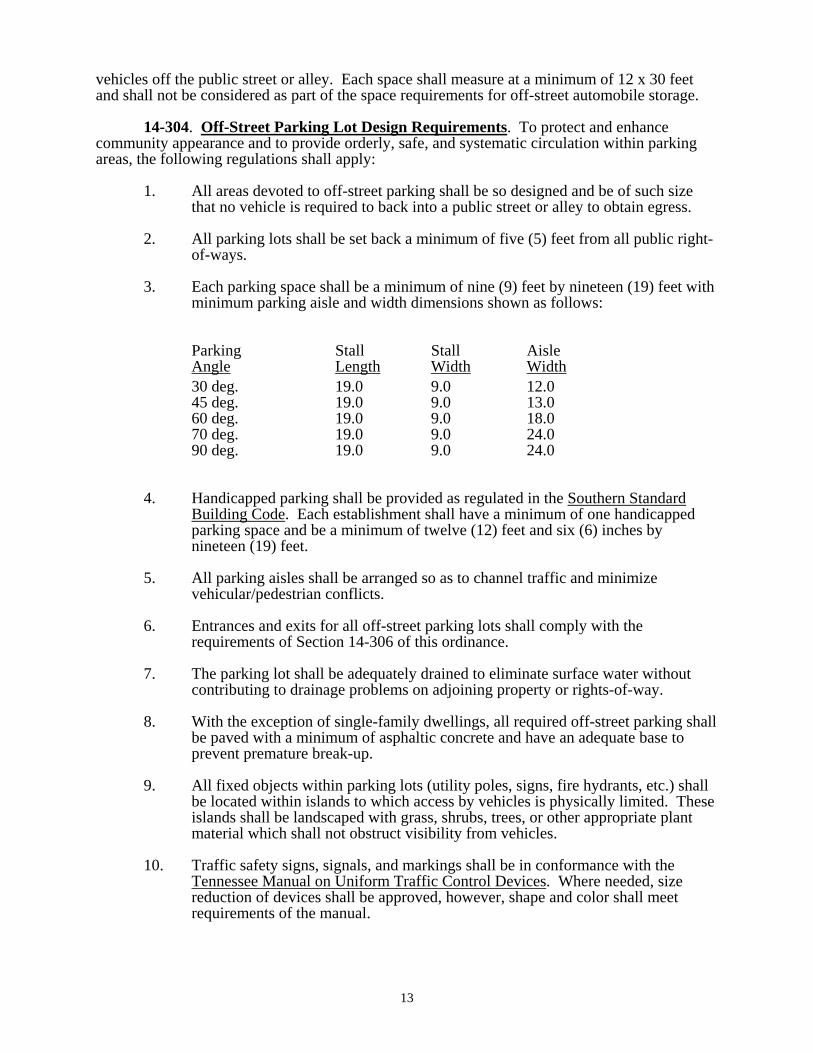
3. Each parking space shall be a minimum of nine (9) feet by nineteen (19) feet with minimum parking aisle and width dimensions shown as follows:
Parking Stall Stall Aisle Angle Length Width Width 30 deg. 19.0 9.0 12.0 45 deg. 19.0 9.0 13.0 60 deg. 19.0 9.0 18.0 70 deg. 19.0 9.0 24.0 90 deg. 19.0 9.0 24.0
4. Handicapped parking shall be provided as regulated in the Southern Standard Building Code. Each establishment shall have a minimum of one handicapped parking space and be a minimum of twelve (12) feet and six (6) inches by nineteen (19) feet.
5. All parking aisles shall be arranged so as to channel traffic and minimize vehicular/pedestrian conflicts.
6. Entrances and exits for all off-street parking lots shall comply with the requirements of Section 14-306 of this ordinance.
7. The parking lot shall be adequately drained to eliminate surface water without contributing to drainage problems on adjoining property or rights-of-way.
8. With the exception of single-family dwellings, all required off-street parking shall be paved with a minimum of asphaltic concrete and have an adequate base to prevent premature break-up.
9. All fixed objects within parking lots (utility poles, signs, fire hydrants, etc.) shall be located within islands to which access by vehicles is physically limited. These islands shall be landscaped with grass, shrubs, trees, or other appropriate plant material which shall not obstruct visibility from vehicles.
10. Traffic safety signs, signals, and markings shall be in conformance with the Tennessee Manual on Uniform Traffic Control Devices. Where needed, size reduction of devices shall be approved, however, shape and color shall meet requirements of the manual.
13

11. Parking rows and interior dividers shall be terminated with terminal islands not less than five (5) feet in width, constructed with raised curbs, and landscaped with appropriate cover.
12. Landscaping shall be required as established in Section 14-310.2. or 14-311.2.d.
13. Maintenance of all islands, parking spaces and ways, landscaping, and traffic control devices within the parking facility is the responsibility of the property owner. All elements shown on the site plan are to be maintained on a regular schedule. All structures or plant materials that are damaged must be replaced to original standards within ninety (90) days. The building official or his designated representative shall regularly inspect parking lots required to meet these regulations. The building official or his representative shall notify the property owner and/or manager upon finding deficiencies in structural or landscaped areas.
14-305. Ingress and Egress. A plan for adequate and safe ingress and egress for all land uses shall be required.
14-306. Access Control. It is the purpose of this section to establish reasonable and impartial regulations for the location of driveway entrances, and to promote the safety of users of the streets and lands of Clinton through the control of design, location, and construction of driveway entrances.
1. General Provisions. In no case shall any curbs on city streets or rights-of-way be cut or altered without first obtaining a driveway permit from the building official. Minimum paving requirements for such driveways shall be determined by the building official at the time of application. In all cases, the driveway extension over the right-of-way shall be paved to protect public streets.
2. Driveway Alignment. Single driveways shall be positioned at right angles to the roadway. Where two driveways are used on one frontage, and they are to be used for access to and from both directions of travel on the highway, each roadway shall be at right angles with the center line of the roadway. The driveway angle may be between 45 degrees (min.) and 60 degrees (max.) when the driveway is to be used by vehicles in only one direction of highway travel (right turns only) on a divided highway.
3. Driveway Entrance Regulations. All driveway entrances shall be located subject to the following controls:
a. On all streets classified as Arterial on the official Major Road Plan (See Appendix B), no driveway entrances shall be constructed within one hundred (100) feet of an intersecting street right-of-way line.
b. On all streets classified as Major Collector Streets and Local Collector Streets on the official Major Road Plan (See Appendix B), no driveway entrances shall be constructed within sixty (60) feet of an intersecting street right-of-way line.
c. On all streets classified as Local Streets on the official Major Road Plan (See Appendix B), no driveway entrances shall be constructed within twenty-five (25) feet of an intersecting street right-of-way line.
14
d. On all streets classified as Arterial on the official Major Road Plan, no driveway entrances shall be constructed within forty (40) feet of the side property line.
e. On all streets classified as Major Collector Streets and Local Collector Streets on the official Major Road Plan, no driveway entrances shall be constructed within twenty (20) feet of the side property line.
f. If neighboring property owners wish to share a driveway, the shared side property line setback requirements shall be waived. If a driveway is shared, this one driveway will count as two, or as one driveway per lot and all other access control requirements shall be met.
g. If a lot of record cannot meet the above access control requirements, a driveway cut will not be denied; but the spirit and intent of this section shall be adhered to as closely as possible.
4. Number of Driveway Entrances Allowed. In order to promote the safety of the motorist and to minimize traffic congestion and property damage by reducing the points of conflict, the following regulations shall apply:
a. Lots with less than one hundred fifty (150) feet frontage may have one (1) driveway entrance.
b. Lots with one hundred fifty (150) feet to eight hundred (800) feet of frontage may have two (2) driveway entrances.
c. Lots with over eight hundred (800) feet frontage may have one (1) additional driveway entrance for each additional four hundred (400) feet.
5. Driveway Entrance Widths. The width of all curb cuts shall be within the following limits.
a. Residential uses shall be limited to driveway widths between ten (10) and twenty-five (25) feet.
b. Uses serving twenty-five (25) or more large trucks per week shall have driveway widths between twenty (20) and forty (40) feet.
c. All other uses shall be limited to driveway widths between fifteen (15) and thirty (30) feet.
[amended by Ord. 330]
14-307. Vision Clearance. In all districts there shall be no plants or structures placed in or on any yard partition of a lot that would obstruct the vision of auto or pedestrian traffic using the intersecting public streets.
14-308. Planned Unit Development (PUD) Regulations. The purpose of the Planned Unit Development regulations is to provide for diversification in the relationship of uses and structures to their sites and also provide flexibility which will create a more desirable living environment. A PUD shall mean an integrated, professionally prepared design for development of residential, commercial, or industrial uses, or as permitted, combinations of such uses, to allow application of new techniques and technology of site and building design and location; this for the purpose of achieving economies in land usage, maintenance, and street and utility
15
systems while providing for attractive open areas, safe circulation, and general well-being of the inhabitants.
1. Applicability of PUD Regulations. A PUD may be developed in any district provided that the uses permitted and density requirements of the district allow the development and the PUD plan elements are approved by the planning commission. Residential, commercial, public, semi-public, or industrial uses, or combinations of these uses where district or special regulations permit, may be developed under the PUD concept. Cluster type subdivisions and condominiums, townhouses, multi-dwelling units, rental developments, multi-use parks, travel trailer parks, and multi-use or ownership developments shall be considered as PUD's for the purpose of this ordinance.
2. Relationships of PUD Regulations to District and Site Plan Regulations. Unless specifically altered by any provision of this section, the use and development regulations of Sections 14-601 through 14-611, Sections 14-310 and 14-311, or any other applicable provision of this ordinance shall apply to the development of a PUD.
3. General Requirements. All PUD developments shall comply with the following requirements.
a. Minimum Site. No PUD shall have an area less than that required by the planning commission as adequate for the proposed project; however, the minimum site shall not be less than the minimum lot size required in the district in which the proposed project is to be located.
b. Structures and Open Space. The planning commission shall require structures and open space to be arranged on the site in such a way that adjacent uses will not be adversely affected.
i. Where feasible, the highest height and intensity of uses shall be toward the interior of the projects.
ii. No freestanding building shall be located closer than twenty (20) feet to any other freestanding building.
iii. Minimum setback, and lot width at setback requirements for lots as established in Chapters 6 and 7 may be altered upon approval of the planning commission; except that, in no case shall the setbacks from any exterior project site side or rear property line be less than twenty-five (25) feet.
iv. Landscaping/buffering requirements, as contained in Sections 14-310 and 14-311 and Chapter 6, shall be applied to PUD developments; except that, the planning commission may require additional landscape materials or structures where it is deemed to be in the public interest to do so.
4. Open Space Requirements. Preservation, maintenance, and ownership of open space areas and facilities shall be accomplished by one or more of the following methods, and shall be established in an appropriate legal manner.
a. Dedication to and acceptance by the public as part of a governmentally administered park and open space system.
16

b. A property owners association.
c. The developer or management authority of the PUD.
5. Parking and Access Control Requirements. The provisions of this ordinance relating to vehicular access and parking (Sections 14-302 through 307) shall be adhered to; except that, the planning commission may alter these requirements in instances in which a superior design alternative is presented which will not be detrimental to the public interest or in conflict with the intent of this ordinance.
6. Density Requirements for Residential PUD. The density (units per gross acre) of dwelling units in a PUD shall be no greater than that allowed in the zoning district within which a PUD is located. The open spaces around public structures, such as schools and churches may be included in the gross acreage of the site for the purpose of calculating the number of residential units that are allowed within a PUD.
7. Signs. The number, size, type, and placement of signs within PUD's shall be governed by the applicable provisions of Section 14-309 of this ordinance.
8. Street and Utility Construction Standards. Public and common ways for pedestrian and vehicular circulation shall be developed in relationship to other existing or planned streets and ways and with the Clinton Major Road Plan. Whether or not the subdivision of property is proposed within a PUD, all project street and way improvements shall comply with the construction standards set out in the subdivision regulations. Due to the uniqueness of each PUD, the owner/developer of a PUD may request slight adjustments from widths of streets, ways, utility easements, curbing, and similar standards set out in the subdivision regulations; and, upon a determination of good cause being shown for such adjustments, the planning commission may permit changes or alterations in standards, provided the spirit and intent of this section can be preserved.
9. Plan Preparation and Review Process
a. PUDs Requiring The Subdivision of Property. In PUDs in which property is divided for the purpose of sale or rental, such as a subdivision or mobile home park, the following requirements for PUD plan preparation shall apply:
i. Preliminary PUD Plan. Prior to submitting a preliminary subdivision plat for review, a preliminary PUD plan shall be submitted to the planning commission which shall include the following: the general location of buildings and uses, general circulation patterns, open space and recreation areas, parking areas, ingress/egress points, sketch elevations and drainage, the boundary dimensions, overall density of development, public uses, landscaping concepts, zoning classification, and other information deemed pertinent by the planning commission. The approved preliminary PUD plan shall serve as the plan upon which the final PUD plan and preliminary subdivision plat are based. Approval of a preliminary PUD plan shall lapse twelve (12) months from the date it was approved.
ii. Final PUD Plan/Preliminary Subdivision Plat. In addition to meeting the applicable provisions of the subdivision regulations
17
regarding preparation of a preliminary plat, the final PUD plan shall include detailed architectural/engineering plans for: utilities, vehicular and pedestrian circulation systems, location of all structures, topographic intervals at no less than five (5) feet, minimum elevations, and grading, the physical relationship of uses, parking areas, open space and recreation areas, landscaped areas, buffer or screening materials and locations, areas proposed for dedication as parks, ways, or places, final drafts of legal documents, and other information deemed pertinent by the planning commission. Upon approval of the final PUD plan and the preliminary subdivision plat by the planning commission, development may commence with the installation of public improvements. No lots, however, shall be sold until final subdivision plat approval has been granted by the planning commission with all required improvements having either been installed or appropriate security posted for the installation of such improvements.
b. PUDs Not Requiring The Subdivision of Property. In PUDs in which no individual parcel of property is owned or rented, such as condominium, apartment, commercial, or industrial PUDs, and similar uses, the following requirements for PUD plan preparation apply:
i. Preliminary PUD Plan. A concept plan containing the following information shall be submitted to the planning commission for review: the general location of buildings and uses, general circulation patterns, open space and recreation areas, parking areas, ingress/egress points, sketch elevations and drainage, the boundary dimensions, overall density of development, public uses, landscaping concepts, zoning classification, and other information deemed pertinent by the planning commission. The approved preliminary PUD plan shall serve as the plan upon which the final PUD plan is based. Approval of a preliminary PUD plan shall lapse twelve (12) months from the date it was approved.
ii. Final PUD Plan. Following approval of a preliminary PUD plan, the developer may proceed to prepare a final PUD plan which shall include detailed architectural/engineering plans for: utilities, vehicular and pedestrian circulation systems, location of all structures, topographic intervals at no less than five (5) feet, minimum elevations, and grading, the physical relationship of uses, parking areas, open space and recreation areas, landscaped areas, buffer or screening materials and locations, areas proposed for dedication as parks, ways, or places, final drafts of legal documents, and other information deemed pertinent by the planning commission. Upon approval of the final PUD plan, a special conditions permit may be issued.
10. Staging of Development. The PUD applicant may elect to develop the site in successive stages. The stages and expected development periods shall be shown on the preliminary PUD development plan. However, each stage given final PUD approval must be substantially complete within itself. The planning commission may also require the development of a PUD project in stages if public facilities are not adequate to handle the entire development initially.
18
11. Permits. The developer of a PUD shall be entitled to receive appropriate development permits following approval of the final PUD plan and the preliminary subdivision plat, where applicable. However, none of these permits shall be issued until the building official receives a PUD plan which bears the signed certificates of approval and of application and agreement (See Appendix C for examples).
12. Changes and Modifications. A PUD project may be changed or modified under conditions established for minor changes and major changes.
a. Minor changes. The planning commission may approve changes in minor shifts of building locations proposed streets and ways, utilities and easements, recreation and open space areas or other features on the approved plan. However, these changes shall not increase densities, change exterior boundary lines, change uses, materially change location or amount of land devoted to specific uses, or significantly change the exterior features or appearance of buildings and uses shown on the approved plans.
b. Major changes. All changes other than those established as minor shall be considered as major changes to the PUD plan and shall require a new plan submission in accordance with the procedures and requirements for approval of a PUD plan.
[amended by Ord. 364]
14-309. Signs. It is the purpose and intent of this ordinance to:
Establish reasonable, impartial, and content neutral regulations for the location, design, and installation of signs within the zoning districts of the City of Clinton. Achieve a safe and more aesthetically desirable environment through flexible and diversified standards that provide for adequate light, air, and open spaces, and a reduction in congestion and hazardous conditions within the city. Balance the rights of persons to convey their message through signs, and the right of the public to be protected against the unrestricted proliferation of signs. Ensure the fair and consistent enforcement of sign regulations Provide a means for review through the Board of Zoning Appeals. Protect the public health, safety, and welfare of our citizens and visitors. Promote all applicable City of Clinton codes and ordinances.
1. Definitions.
Abandoned Sign: A sign that no longer correctly directs or exhorts any person, advertises a bona fide business, lessor, owner, project or activity conducted or product available on the premises where such sign is displayed; or an outdated temporary sign.
19

Advertising Sign: Sign that have as its purpose to promote, advertise, or sell a product or service obtainable on the premises upon which the sign is located, and not to identify the premises. Animated (Moving) Sign: Any sign or permanent structure depicting action, motion, light, or color changes through electrical or mechanical means. Although technologically similar to flashing or electric message center signs, the animated signs emphasizes graphics and artistic display. Variable display signs and electric message center signs are not animated signs under this ordinance. [amended by Ord. 488]
Awning, Canopy or Marquee Sign: A non-illuminated sign that is mounted, painted, or attached to an awning, canopy, or marquee.
Banners: Any temporary sign of cloth, paper, fabric or other flexible material. Billboard (Outdoor Advertising Display Sign): A sign that is affixed to or erected upon a free-standing framework that directs attention to a business, commodity, service, or entertainment conducted, sold or offered at a location other than the premises on which the sign is located. Note: This type of sign is also commonly referred to as an off-premise sign. Any sign that is not an on-premise sign, as defined herein, shall be an off-premises sign. Building Frontage: The maximum horizontal width of the ground floor of a building that approximately parallels and faces a public street or right-of-way. In the case of a building where an individual occupant’s main entrance faces a driveway or parking lot, the width of the occupant’s ground floor space facing the occupant’s entrance shall be considered that occupant’s separate and distinct building frontage. In cases where two or more different tenants occupy the ground floor of a building, the portion of the building frontage occupied by each tenant will be the tenant’s separate and distinct building frontage. Corner and through lots shall be considered to have a separate and distinct building frontage on each street. In cases where multiple buildings on the same lot are occupied by a single occupant, the building frontage of all buildings may be combined into a single frontage for the purposes of calculating allowable signage.
Business Sign: A sign which directs attention to a business or profession conducted, or a commodity or service, sold, offered, or manufactured, or to an entertainment on the premises upon which the sign is located, or to which it is affixed. Campaign Sign: See Free Speech and Expression Sign. Changeable Copy Sign (Readerboard): A sign or portion thereof on which the copy or symbols change either automatically through electrical or electronic means (for example, time and temperature units), or manually through placement of letters or symbols on a panel mounted in or on a track system. Electronic message center signs are considered changeable copy signs under this ordinance.
[amended by Ord. 488] Community Bulletin Board Sign: A publicly owned sign whose contents shall be in the nature of a directory listing several religious, educational, charitable, philanthropic, civic or professional organizations.
20
Community Identification Sign: A publicly-owned sign that states the logo, trademark, or other identifying symbol, address, or combination of the name, symbol, and address, which communicates the identity of the city. Construction Sign: A temporary sign located on the premises during the period of construction identifying the names of the architects, engineers, contractors, subcontractors, financial supporters and/or others associated with the construction and development of the project. Dilapidated Sign: A sign that is structurally unsound, has defective parts, or is in need of painting or other maintenance. Directional Sign: A sign whose message is exclusively limited to guiding the circulation and flow of vehicular and/or pedestrian traffic on the site such as signs that convey enter/entrance, exit, one-way, and drive-thru. Directory Sign: A sign, other than an identification sign, listing the names, uses, or locations of the various businesses or activities conducted within a building or group of buildings, which is centrally located and intended to provide on-site direction. Electronic Message Center Sign: A variable-message sign that utilizes computer-generated messages or some other electronic means of changing copy. These signs include displays using incandescent lamps, LEDs, LCDs, or a flipper matrix. Changes in text should not interfere or cause distraction that could be considered a traffic safety hazard.
[amended by Ord. 488] Electronic Moving Message Board Sign: See Electronic Message Center Sign.
[amended by Ord. 488]
Exempt Sign: Any sign which is exempt from the permit requirements established herein. (See Section 4) Flag: Any fabric or bunting containing distinctive colors, patterns or symbols that is used as a symbol of a governmental, commercial or non-commercial entity. (a) Commercial flag sign means any flag, which displays a commercial name, message, logo or symbol.
(b) Decorative flag means any flag which displays any holiday, season, design, or the like which does not include any commercial name, message, logo or symbol.
(c) Non-commercial/governmental/civic flag means any flag displaying a name, message, logo or symbol of any recognized governmental, religious, civic or non-profit agency. Flag Pole: A permanently mounted pole used solely for the purpose of displaying flags.
[amended by Ord. 488]
21

Flashing Sign: Any sign which contains an intermittent or flashing light source, or which includes the illusion of intermittent or flashing light by means of animation, changes in the degree of light intensity, an externally mounted intermittent light source, or reflective metal or plastic strips. (Prohibited by 14-309.3.a.) Free Speech or Expression Sign: A sign erected on private property expressing a social or political viewpoint, or showing support for a political cause or candidate(s). Front Face: The front elevation of a building that faces the front property line, as recorded on the plat and/or site plan. If a structure is located on a corner parcel, the side which includes the primary entrance shall be considered the front facade. If a structure located on a corner parcel contains more than one (1) primary entrance on more than one (1) side, the longer side with a primary entrance shall be considered the front facade. Ground Sign: Any sign, other than a pole sign, in which the entire bottom is in contact with or is close to the ground and is independent of any other structure. Height of Sign: The vertical distance from normal grade to the highest point of the sign. Any berming, filling, or excavating solely for the purpose of locating the sign shall be included as a part of the sign height. Note: The height of a sign shall be computed as the distance from the base of the sign at normal grade to the top of the highest point of the sign face. Normal grade shall be construed to be the newly established grade after construction, exclusive of any filling, berming, mounding, or excavating solely for the purpose of locating the sign. In cases in which the normal grade of the sign is lower than the grade of the adjacent public/private street, normal grade shall be construed as the grade of the adjacent public/private street.
Identification Sign: A sign giving the nature, logo, trademark, or other identifying symbol; address; or any combination of the name, symbol, and address of a building, business, development or establishment on the premises where it is located and which sets forth no other advertisement. Illegal Sign: Any of the following: (a) Signs erected without first obtaining a permit and/or complying with all regulations in effect at the time of its construction or use. (b) Non-conforming signs whose use have ceased because the business it identifies is no longer conducted on the premises. (c) Non-conforming signs for which the amortization period has expired. (d) Signs that were legally erected but which later became nonconforming and then were damaged to the extent of fifty percent (50%) or more of their current replacement value. (e) Signs that are a danger to the public or are unsafe.
22

(f) Signs that pertain to a specific event that have not been removed within seven (7) days after the occurrence of the event. (g) Signs erected on public property, rights-of-way, or utility poles. (h) Signs expressly prohibited by this ordinance. Illuminated Sign:
a. Direct: A sign whose light source is either located in the interior of the sign so that the rays go through the face of the sign, or which is attached to the face of the sign and is perceived as a design element of the sign.
b. Indirect: Illumination of a sign that is affected by a source of light
not contained within the sign itself and is not visible elsewhere on the plot or parcel where said illumination occurs.
Inflatable Sign: Any temporary sign that is either expanded to its full dimensions or supported by gases contained within the sign, or sign parts, included but not limited to a pressure greater than atmospheric pressure.
Instructional (Informative) Sign: Any on-premise sign containing no other message, copy, announcement, or decoration other than instruction or direction to the general public. Such signs include but are not limited to the following: identifying rest rooms, public telephones, walkways, entrance and exit drives, freight entrances and traffic direction. Moving Copy Sign: deleted by Ordinance No. 488 Multi-Occupancy Facility: A development including, but not limited to, shopping centers and office complexes, consisting of two (2) or more separate establishments sharing a common or connected building, and common or connected parking areas, or common pedestrian access and common or connected parking areas.
Neon Sign: An illuminated sign containing a glass tube filled with neon or phosphors which is bent to form letters, symbols or other shapes. Non-Conforming Sign: A sign lawfully erected and maintained prior to the adopting of this ordinance that does not conform with the requirements of this ordinance. See Section 6. Obsolete Sign: Any sign which identifies or advertises any product, accommodation, service, or business which is no longer available to the public at the location indicated on the sign. Official Sign: A sign whose content denotes an official program authorized or recognized by the City Manager or his/her designee to meet a public objective. Such signs shall include, but not be limited to, public notices, neighborhood watch programs, traffic control devices, etc. Off-Premise Sign: A sign that directs attention to a business, commodity, service, or entertainment not exclusively related to the premises where such sign is located or to which it is affixed. (Prohibited by 14-309.3.b.)
23

On-Premise Sign: Any sign identifying or advertising a business, person, activity, goods, products, or services, located on the premises where the sign is installed and maintained. Painted Wall Sign: Any sign or display painted directly on any exterior surface, exclusive of window or door glass areas. Pennants, Festoons, Streamers, and Balloons: Any temporary sign of cloth, paper, fabric or other flexible material that is mounted to allow movement caused by wind that is intended to attract the attention of the general public to a location or business. Festoons shall include, but are not limited to, a string of ribbons, tinsel, fringe, or pinwheels. Flags are not included under this ordinance. Pole Sign: A sign that is mounted on a freestanding support so that the bottom edge of the sign face is ten (10) feet or more above grade. Political Campaign Sign: See Free Speech and Expression Sign. Portable Sign: Any sign, by design or construction, intended to be easily and readily relocated, and not permanently affixed to the ground, a frame, a building or other structure. Portable signs shall include, but are not limited to, signs mounted upon a trailer, bench, wheeled carrier, or other non-motorized mobile structure with or without wheels. Projecting Sign: A sign wholly or partly projecting out from a building face or wall, generally at right angles to the building, supported by an approved bracket, with no exposed cables or turnbuckles. Real Estate Sign: A sign erected on private property temporarily, advertising the sale, lease, or rental of the premises on which it is located, including subdivision real estate signs. Roof Sign: Any sign erected or maintained in whole or part upon or attached to a sloped or flat roof of a building or upon a false front or roof like facade. (Prohibited by 14-309.3.e.) Sign: Any object, device, display, or structure, or part thereof, which is used to advertise, identify, display, direct, or visually attract attention to an object, person, institution, organization, business, product, service, event, or location by any means, including words, letters, figures, design, symbols, fixtures, colors, illumination, light, reflection, or projected images.
Note: This definition shall not include festival or holiday decorations, the noncommercial use of a flag, emblem, insignia, or other display of any nation or political subdivision, traffic, safety or similar regulatory devices; legal notices; signs or tablets which are primarily memorials; emblems of religious institutions that are attached to buildings; or flags or similar emblems of political, civic, philanthropic, educational, or religious organizations. Sign Administrator: The City Manager or his/her designee assigned to oversee the enforcement and interpretation of this sign ordinance.
Snipe Sign: Any sign that is tacked, nailed, posted, pasted, glued, or otherwise affixed to trees, utility poles, stakes, fences or other objects, where the message
24
appearing thereon is not applicable to the present use of the premises upon which the sign is located. Supergraphics: Any mosaic, mural, painting or graphic art or combination thereof which is professionally applied to a building that does not contain any brand name, product name, letters of the alphabet spelling or abbreviating the name of any product, company, profession, or business, or any logo, trademark, trade name, or other commercial message. Supergraphics are exempt.
Surface Display Area: The entire area within a continuous perimeter enclosing the extreme limits of the sign display which includes the writing, representation, emblem or any figure or similar character, together with any frame or other material or color forming an integral part of the display or used to differentiate this design from the background against which it is placed, excluding the necessary supporting framework or bracing that is clearly incidental to the display itself. The copy of signs composed of individual letters, numerals, or other devices shall be the sum of the area of the smallest rectangle or other geometric figure encompassing all of said letters or devices. Double-faced signs shall be constructed so that the perimeter of both faces coincide and are parallel and not more than twenty four (24) inches apart. If the two (2) faces of a double-faced sign are of unequal area, the area of the sign shall be taken as the area of the larger face. Temporary Signs: A sign including, but not limited to, placards, banners, posters, yard sale signs, political campaign signs, inflatable signs, or other outdoor advertising displays on private property, not intended to be permanently displayed. Type: See Ground Sign, Pole Sign, Projecting Sign, Wall Sign. Vehicle Mounted Sign: A sign mounted on, affixed to, or painted on a vehicle.
Wall Sign: A sign containing letters and/or graphics, installed flat against the exterior wall of a building or structure in such a manner that the wall becomes the supporting structure for, or forms the background surface of the sign, has no connection to the ground, and does not project more than twelve (12) inches from such building or structure. Window Sign: A sign posted, placed, affixed or painted on the interior of a window or door of a building exposed to public view. For the purpose of this ordinance, a temporary sign placed on the interior of a window for viewing from the exterior shall not be counted as a sign. Yard Sale Sign: A temporary sign erected on private property.
2. General Provisions.
a. Plans Required. The Building Official shall be provided with plans and
specifications identifying the proposed sign requiring a permit under the provisions of this section. Applicants shall submit:
Their name, address, telephone number, and if different, the property
owner’s name, address, and telephone number.
25

A scaled diagram and elevation view from ground level of the proposed sign with dimensions and estimated cost.
A scaled drawing of the property showing where the sign is proposed;
including, gross acreage, a closed boundary survey of the property, the location of existing streets, driveways, and parking spaces, existing structures and their dimensions, buried and overhead utilities, public and private easements, and any existing signs.
The name, address, and phone number of the sign contractor.
b. Height. Signs in residential zones may not exceed six (6) feet in height.
Minimum and maximum sign heights for Business and Industrial zones are shown on Table 5.d. Signs placed above a walkway shall have a minimum ground clearance of ten (10) feet. Signs placed above a driveway or parking area shall have a minimum ground clearance of fifteen (15) feet. (See Table 5.d.)
c. Setback. No part of any sign shall be placed closer than five (5) feet to a
vertical projection of any public right-of-way or adjoining property line; except that, directional signs of no more than three (3) square feet may be located at the edge of the right-of-way to designate entrances and exits, provided such signs are less than three (3) feet taller than the driveway grade, and do not obstruct the visibility of motorists and pedestrians.
d. Number of Permanent Signs. No business or industry shall have more
than two (2) signs, but not two (2) signs of the same type; except that on parcels which extend between parallel streets or on corner lots, businesses may have three (3) signs, two (2) of which may be of the same type, provided they do not front on the same street. Directional Signs are not included in the total number of signs allowed.
e. Maximum area of signs. Signs in residential areas shall not exceed a total
area of sixteen (16) square feet per parcel. (e.g. one 4’x 4’ sign or four 2’x 2’ signs) Maximum sign sizes in business and industrial zones are shown in Table 5.d.
f. Signs erected on street rights-of way and utility poles. Signs placed on
public property, street rights-of-way, and utility poles are prohibited by 14-309.3.g., as illegal signs, and have the immediate potential to create hazards to motorists by obstructing visibility and cause obstructions to utility and street maintenance workers. Illegal signs found on public property, rights-of-way, and utility poles shall be removed without notice and stored for a period of ten (10) days. City employees shall not be responsible for unpreventable damage to illegal signs while removing them from public property. Such removal of signs shall not preclude prosecution of violators. Persons wishing to claim their signs may contact the Building Official or his designee within this ten (10) day period, and pay a $20.00 per sign administrative recovery fee.
g. Sign Maintenance. All signs shall be maintained in good condition with
the proper cleaning, painting, and landscaping, and shall be properly secured and anchored. Dilapidated or neglected signs include those with rust or holes in the sign or structure, broken, missing, bent, or loose parts, faded or flaking paint, non-operative or partially non-operative
26
illumination, or missing words or letters. Owners of dilapidated or obsolete signs shall receive ten (10) days written notice to correct any deficiencies, and should the owner refuse or fail to make the necessary corrections, the Building Official shall have the sign removed at the owner’s expense.
h. Commercial Flags. Commercial flags are allowed in any non-residential
zoning district. One (1) flag will be allowed for each 0.25 acre of land area. In shopping centers and PUD’s, each individual business shall be allowed one (1) flag per twenty-five (25) feet of linear store frontage. No commercial flag shall be larger than three (3) feet by five (5) feet. When a flag is in a state of disrepair (i.e. torn, tattered, or faded), the Building Official can require replacement of such a flag no sooner than six (6) months after it has initially been flown. The flag poles, the location of the flag poles, and number of flags per parcel must receive written authorization from the Building Official. No commercial flag shall violate the provision of Section 14-309.2.c.
[amended by Ord. 486] i. Illumination Standards for Electronic Message Center Signs. In the
interest of preserving the nature of residential areas, these standards are established. Between the hours of 11 P.M. and 6 A.M., illumination of electronic message center signs shall be reduced by 30% of normal daytime operation when the sign is located in or adjacent to a residential district.
[amended by Ord. 487] 3. Prohibited Signs.
a. Signs which include action or motion, from either a mechanical or wind source; moving materials, commercial flags, spinners, pinwheels, reflectors, streamers, fringe, pennants, festoons, balloons, or which have any moving parts; or contain flashing or rotating lights or bulbs; or are intermittently lighted, pulsing or scrolling; or interfere with the view of traffic; or could be confused with or obstruct any authorized traffic control sign, signal, or device; with the exception of signs that display time and temperature and public service announcements only, without advertising matter.
b. Off-Premise Signs, or any sign that advertises an activity, business, product,
or service not conducted on the premises upon which the sign is actually located, including but not limited to billboards; except those signs allowed in Section 14-309.4.a and b.
c. Portable signs, except as permitted under Section 14-309.4.e., bench signs, A-
frame signs, and sidewalk signs. d. Signs (including temporary signs and banners) which are not securely affixed
to the ground and/or mounted in a frame and/or attached to a rigid backing, that prevents sagging and wind movements.
e. Roof signs.
27

f. Signs in any residential district that are internally illuminated.
g. Signs on rights-of-way and public property, including utility poles, except official signs erected by an authorized public entity.
h. Signs that display or advertise pornographic, obscene, or illegal information
or activities. Signs promoting legalization of existing crimes are not prohibited by this section.
i. Signs mounted on, affixed to, or painted on vehicles that are parked on public
or private property solely for the purpose of displaying the sign or advertising, but not including vehicles marked for and driven during the normal course of business.
j. Signs placed on private property without the permission of the property
owner.
k. Signs that emit sound.
l. Snipe signs.
m. All signs which are not expressly permitted by this ordinance or any other ordinance of the city.
4. Signs Permitted in all Zoning Districts. The following types of signs are
permitted in all districts, subject to the conditions set out below and other applicable provisions of this ordinance. Such signs do not require a permit.
a. Free Speech and Expression Signs. Signs of a maximum total area of sixteen
(16) square feet per parcel in residential zones and thirty-two (32) square feet per parcel in commercial and industrial zones that express a social or political position or viewpoint, or show support for a political cause or candidate.
b. Temporary Special Event Signs. Temporary signs up to a total area of sixteen
(16) square feet per parcel in residential zones and thirty-two (32) square feet per parcel in commercial and industrial zones, announcing a special event (yard sale, social event or activity, etc.) and containing no commercial advertisement may be erected on private property no more than fourteen (14) days prior to the event, but in no event shall such signs remain more than thirty (30) days. All special event signs shall be removed by the property owner within five (5) days of the conclusion of the event.
c. Directional Signs. Signs internal to parking areas that direct vehicular or
pedestrian traffic but bear no advertising, and shall be no larger than three (3) square feet each.
d. Construction Site Signs. One sign noting construction information and trades
shall be permitted for each site. The maximum size shall be sixteen (16) square feet per parcel in residential zones and thirty-two (32) square feet per parcel in commercial and industrial zones. The sign shall be allowed only until the project is complete and shall be removed prior to the issuance of a Certificate of Occupancy.
28

e. Residential Name / Address Signs. For each single family dwelling unit, One (1) nameplate indicating name, address, house number, home occupation, or an announcement of space for boarders or roomers if applicable, limited to two (2) square feet in area, is permitted.
f. Real Estate Signs. Signs advertising real estate sales, rentals, leases, auctions,
etc., conforming to the specifications shown in Table 5.d., may temporarily be erected on the property being advertised.
g. Signs erected on private property that prohibit trespassing, hunting, or fishing.
h. Signs or banners temporarily displayed at sporting or recreational functions at
city owned facilities.
i. Temporary Advertising Signs: Temporary advertising signs (excluding changeable copy signs) totaling a maximum sign area of thirty-two (32) square feet except for forty-eight (48) square feet for businesses with over 2 acres of property may be erected on commercially zoned property where the advertised activity, business, product or service is conducted. No Temporary Advertising Sign violate the provisions of Section 14-309.2.c or 14-309.3a.
5. Signs Requiring a Permit.
a. Residential Districts.
i. For subdivisions, PUDs, (including multi-family developments and mobile home parks) and all non-residential uses, one (1) permanent identification/entrance sign, not to exceed twenty (20) square feet in area or six (6) feet in height, is permitted. Individual buildings within a PUD may have one (1) identification sign not exceeding nine (9) square feet in area.
ii. While under development, a subdivision or PUD may have one (1)
temporary sign, not exceeding sixteen (16) square feet in area and six (6) feet in height. Such sign is permitted in addition to any permanent identification sign, but shall be removed after two (2) years or when ninety (90) percent of the project is sold, whichever occurs first.
b. Business Districts.
i. The maximum sign area and sign height permitted in business districts
shall be as shown in Table 5.d. ii. In the B-4 Interstate Business District, the maximum sign area for the
one allowable ground sign shall be two hundred (200) square feet. Shopping centers, malls, and commercial PUDs shall be limited to one (1) major directory sign, not to exceed one hundred and fifty (150) square feet in area, and each business within the development shall be limited to one (1) wall sign containing no more than one (1) square foot of sign area per linear foot of individual Building Frontage. Separate businesses on out parcels with public road frontage developed or marketed along with a shopping center, mall, or commercial PUD, may have one (1) ground sign and one (1) wall sign not exceeding the sizes set out in Table 5.d. Parking lot directional
29

signs shall not be included when determining the total square footage of sign area.
c. Industrial Districts.
i. Maximum sign area permitted for separate establishments on individual lots located outside a PUD, shall be one hundred and fifty (150) square feet per separate industrial use; whether wall or ground signs. See Table 5.d.
ii. In industrial PUDs or buildings housing more than one establishment,
each establishment may have one (1) ground sign per establishment not to exceed seventy-five (75) square feet and a wall or other type sign, so long as the total sign area for each establishment does not exceed one hundred and fifty (150) square feet. See Table 5.d.
iii. Industrial park entrance signs shall be limited to one (1) major directory sign not to exceed two hundred (200) square feet.
30
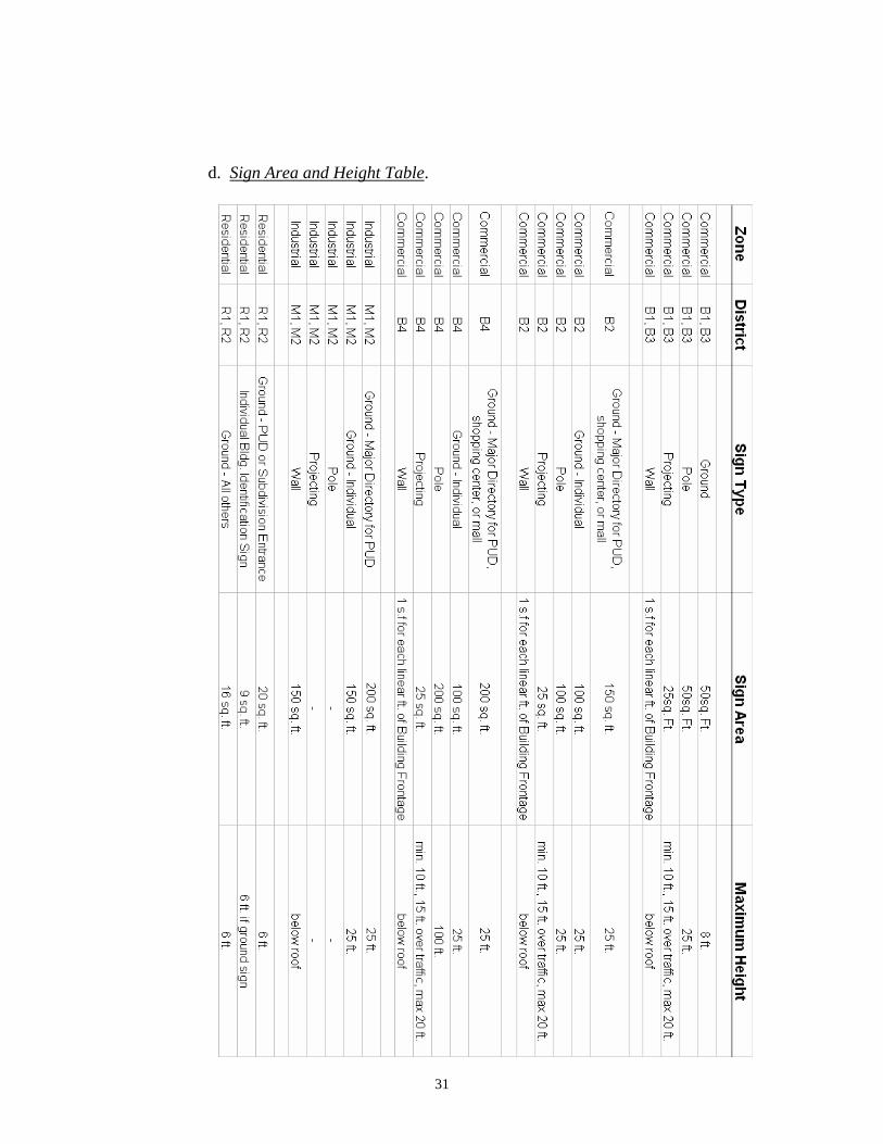
d. Sign Area and Height Table.
31
6. Non-Conforming Signs. Signs which were legally in existence immediately prior
to the adoption of this ordinance, or were characterized as a legal non-conforming sign under a previous ordinance, which do not conform to the provisions of this ordinance, are declared non-conforming signs, except that; signs illegally erected on the public right-of-way after the annexation of their location are excluded as non-conforming signs. Owners of existing non-exempt signs on rights-of-way shall receive written notice immediately after adoption of this ordinance and shall have sixty (60) days to bring their sign(s) into compliance.
a. General Non-Conforming Sign Provisions. Subject to the exceptions
hereinafter set forth, nothing shall prohibit the operation, repair, reinforcement or maintenance of a pre-existing non-conforming sign after the effective date of this ordinance, provided that non-conforming signs shall not be:
i. Changed to or replaced with another non-conforming sign. ii. Structurally altered as to extend their useful life. iii. Expanded. iv. Relocated. v. Re-established after damage of more than fifty percent (50%) of
the value at the time of such damage or destruction. vi. Such repair, reinforcement or maintenance shall not in any way
increase the degree of non-conformity of such sign. Nothing in this ordinance shall prevent the strengthening or restoring to a safe condition of any portion of a sign or structure declared unsafe by the Sign Administrator. Such signs may be improved only to the extent that such improvement does not exceed fifty percent (50%) of the current market value of the existing sign structure.
vii. Discontinuance or abandonment. Abandonment or obsolescence
after one (1) year of a non-conforming sign shall terminate immediately the right to maintain such a sign.
7. Administration. The City Manager or his/her designee shall act as the sign
administrator and shall enforce and carry out all provisions of this section. In the event there is a question concerning the general intent or meaning of any provision of this chapter, the sign administrator shall have the authority to make such administrative decisions and interpretations.
8. Application and permit process. Unless otherwise provided in the chapter,
permits are required for all types of signs. It shall be unlawful for any person, agency, firm, or corporation to erect, structurally repair (other than normal maintenance), replace, alter, relocate, change the panels of, change the establishment being advertised on a sign, as defined in this chapter, without first obtaining a permit from the Building Official.
32
(a) Applicants shall submit a completed sign application and the required fee to the city hall prior to commencing any work on the installation of a new or replacement sign. The required fee is per the schedule that is adopted in the Standard Building Code. Public entities are waived from the fee requirement.
9. Enforcement. Non-compliance with this ordinance shall be deemed a violation.
When the sign administrator finds a violation of the provisions of this section, the administrator shall document such findings and take appropriate action to correct said violations. A written notice shall be delivered, and if compliance is not obtained after ten (10) days, a citation to municipal court may be issued to the owner, agent, or employee for violations of this section. Any person violating any of the provisions of this section shall be deemed guilty of a misdemeanor and upon conviction there of may be fined an amount not to exceed fifty dollars ($50.00) plus court costs. Each day a violation is committed shall constitute a separate offense and shall be punishable as such. (Illegal signs removed from public property or rights-of-way do not require a ten (10) day notice before enforcement action may be taken.)
10. Appeals. The Clinton Board of Zoning Appeals shall have the following authority
and responsibilities:
(a) To hear and decide appeals regarding this ordinance where it is alleged by the appellant that there is an error in any order, requirement, permit decision, or refusal made by the sign administrator in carrying out or enforcement of any provision of this section.
(b) To authorize, upon an appeal relating to said property, a variance from
strict application so as to relieve difficulties or hardships. Variances shall not be considered or granted to allow any right-of-way encroachment, a larger sign, or a sign which is otherwise not permitted in this section. Variances shall be granted only where by special physical characteristics of the lot, parcel, or tract exist, that the strict application of the provisions of this section would deprive the applicant of an otherwise permitted sign.
[amended by Ord. 357 and Ord. 469]
14-310. Site Plan Regulations for Commercial, Multi-Family, Public, and Semi-Public Uses. It is the general purpose and intent of this section to require site plans for all new developments or redevelopments of commercial, multi-family, public, or semi-public uses to provide for a lessening of traffic congestion and for securing adequate light, air, and aesthetic conditions for residents of the city. These plans shall be approved by the planning commission as consistent with this ordinance and with the comprehensive planning program of the city prior to the issuance of grading or building permits. When a project lies within any historic district, the Clinton Historic Zoning Commission (CHZC) shall be the body which reviews and approves such site plans.
Site plans for small additions to existing buildings shall be exempt from review when, in the opinion of the building official and planning staff, the addition will not adversely affect the general purpose and intent of these regulations.
Shopping centers, mobile home parks, travel trailer parks, apartments, condominiums, and other similar types of projects shall be developed under the provisions of the Planned Unit Development (PUD) Regulations as set out in Section 14-308; except that, unless specifically altered by the provisions of Section 14-308 or the use and development regulations contained in
33

Sections 14-601 - 14-611 or any other applicable provision of this ordinance, all provisions relating to plan preparation and site development contained in this section shall also apply to the plan preparation and site development of all PUDs.
In accordance with the provisions of 13-4-104, Tennessee Code Annotated, site plans for any public use including, but not limited to, schools, parks, streets and highways, public buildings, and utilities, shall be submitted to the planning commission for review, and shall be prepared in accordance with the provisions of Sections 14-308, 14-601 - 14-611, and this section, as may be applicable.
A site plan shall set forth the proposed development of the total land tract and shall meet the following regulations:
1. General Provisions.
a. All site plans shall be prepared and certified by a licensed engineer, landscape architect, architect, and/or surveyor, as may be appropriate, and in accordance with state law regarding the practice of these professions. Drawings shall be at a scale of not less than 1" = 20' for small tracts and 1" = 50' for large tracts.
b. All site plans shall show:
i. Topography of existing and finished grades.
ii. Location of all land subject to flooding.
iii. Dimensions and calls of all property lines.
iv. North point, scale, acreage of site, and location map.
v. Location of all existing and proposed structures (including signs), street rights-of-way, sidewalks, easements, and covenants.
vi. Dimensions of all existing and proposed structures.
vii. Plans for vehicular and pedestrian circulation, utilities, solid waste disposal, landscaping and open space, signs, off-street parking, and storm water drainage.
2. Open Space and Landscaping Plan. To obtain sufficient space between uses and buildings for adequate light, air, privacy, and amenities, the following requirements for open space and landscaping are established:
a. Landscaping shall mean planting of grass, trees, shrubs, or other comparable surface cover or decorative plazas and/or pools. Where existing landscape features exist on site which can meet the purpose of this section, all or part of such features may be used to meet the requirements of this section upon the approval of the planning commission.
b. All developments shall meet the minimum yard (open space) requirements established in Chapters 6 and 7.
34

c. The setback space between a public street and parking areas shall be landscaped with berms and/or appropriate landscape plants which shall be maintained in a healthy, growing condition through a permanent maintenance program.
3. Signs. Sign size and placement shall be governed by the provisions of Section 14-309.
4. Off-Street Parking. The off-street parking and loading/unloading areas, points of ingress/egress, and driveways shall be developed in accordance with the provisions of Sections 14-302 through 14-306.
5. Waste Disposal. All waste disposal facilities shall be screened by fencing, walls, or evergreen plant materials in such a way that they are not visible from any public street or adjoining properties.
6. Stormwater Drainage: A certified plan and calculations for stormwater drainage
shall be included with the site plan which identifies all easements, drainage structures including sizes / capacities, and other pertinent information concerning the assumptions upon which the plan is based.
a. The plan shall include an engineer’s typical drawings for all construction
and structures. Detention pond(s) and other drainage structures to include underground detention structures shall be designed for the peak runoff rate resulting from the 2-year, 5-year, and 10-year, 24-hour SCS Type II storms for existing and developed conditions. The volume of all drainage structures shall be sufficient enough to attenuate the difference between existing and developed these two conditions for each of the storms while releasing at a rate not greater than the existing rate. An emergency or secondary spillway or other acceptable facilities shall be designed to pass the 100-year flood resulting from the developed conditions while maintaining adequate freeboard.
b. Once construction is complete, the Owner shall submit to the City of
Clinton as-built plans and drainage calculations based on the as-built conditions of stormwater drainage amenities prior to the issuance of a Certificate of Occupancy. Both the calculations and as-built plans shall be certified by a professional engineer who is licensed to practice in the State of Tennessee.
c. Construction: The following minimum requirements shall be used in the
design and construction of stormwater management detention facilities:
i. All inlets shall be located as far away from the outlet structure as possible;
ii. The length-to-width should be at least 2:1 (and preferably 3:1); for
above ground detention basins and ponds. iii. All outlet structures shall be constructed from concrete, double
brick, masonry block reinforced and poured solid, or other durable material. CMP risers will not be used as a riser. A means for cleanout access, such as a removable frame and grate casting, shall be provided;
35
iv. The specific flow-controlling elements of an outlet structure may
include one or more of the following: a circular orifice, a noncircular, a rectangular weir, a trapezoidal weir, a triangular weir, a V-notch weir;
v. Trash racks and other debris barriers shall be included in the
design. [amended by Ord. 438]
7. Site Improvements Bond. Prior to the issuance of a certificate of occupancy, the building official shall make a determination regarding whether or not all site improvements, as set out in this ordinance and the approved site plan, have been properly made or installed. If not, prior to issuing a certificate of occupancy, the building official and city manager shall determine the amount, form, and term of surety that must be established and must secure such guarantee for the purpose of ensuring the timely completion of the required site improvements.
8. Issuance of Building Permits. No building permit shall be issued until the building official receives a site plan which bears the signed certificates of site plan approval and of application and agreement (See Appendix D).
9. Expiration of Approved Site Plans. Site plans granted approval contingent upon corrections to the site plan shall have ten (10) days to make the required corrections and submit a revised site plan to the Building Official. Approval of all site plans shall expire six (6) months after the date of its approval unless a building permit has been issued and substantial progress has been made toward completion of the project (Ord 551).
36

14-311. Site Plan Regulations for Industrial Uses. It is the intent of this section to require site plans for all new industrial uses as well as any non-industrial uses which are permitted in the industrial districts of the city and shall apply to the expansion or redevelopment of any existing uses within the city's industrial districts. The purpose of these regulations is to protect the public health, safety, and welfare of the citizens of Clinton through a lessening of traffic congestion, the securing of adequate light and air, the preservation of aesthetic qualities, and the protection of property. These site plans shall be reviewed and approved by the planning commission as being consistent with the intent of this ordinance and the comprehensive planning program of the city prior to the issuance of any grading or building permit.
Industrial and/or commercial PUDs located in any industrial zoning district shall be developed under the provisions of the Planned Unit Development (PUD) Regulations as set out in Section 14-308; except that unless specifically altered by the provisions of Sections 14-308 or the use and development regulations contained in Sections 14-601 through 14-611 or any other applicable provision of this ordinance, all provisions relating to plan preparation and site development contained in this section shall also apply to the plan preparation and site development of all PUDs.
In accordance with the provisions of 13-4-104, Tennessee Code Annotated, site plans for any public use including but not limited to schools, parks, streets and highways, public buildings, and utilities, shall be submitted to the planning commission for review and shall be prepared in accordance with the provisions of Sections 14-308, 14-601 - 14-611, and this section, as may be applicable.
1. General Provisions
a. All site plans shall be prepared and certified by a licensed engineer, landscape architect, architect, and/or surveyor, as may be appropriate, and in accordance with state law regarding the practice of these professions. Drawings shall be at a scale of not less than 1" = 20' for small tracts and 1" = 50' for large tracts.
b. All site plans shall show:
i. Topography of existing and finished grades.
ii. Location of all land subject to flooding.
iii. Dimensions and calls of all property lines.
iv. North point, scale, acreage of site, and location map.
v. Location of all existing and proposed structures (including signs), street rights-of-way, sidewalks, easements, and covenants.
vi. Dimensions of all existing and proposed structures.
vii. Plans for vehicular and pedestrian circulation, utilities, solid waste disposal, landscaping and open space, signage, off-street parking, and storm water drainage.
2. Open Space and Landscaping Plan. To obtain sufficient space between uses and buildings for adequate light, air, privacy, and amenities, the following requirements for open space and landscaping are established:
37
a. Landscaping shall mean planting of grass, trees, shrubs, or other comparable surface cover or decorative plazas and/or pools. Where existing landscape features exist on site which can meet the purpose of this section, all or part of such features may be used to meet the requirements of this section upon the approval of the planning commission.
b. To minimize adverse visual and environmental impacts, no accessory buildings shall be permitted in areas established for open space.
c. All site plans shall meet the minimum yard requirements (open space) established in Chapter 6 and 7; except that, on sites adjoining residential districts, the following additional development standards shall apply:
i. The requirements for the yard (open space) area shall be one hundred (100) feet. Whenever highly combustible, flammable, or explosive materials or any other materials that have inherent characteristics that constitute a hazard to life or property are to be used on such sites, the planning commission may require additional yard area. Development within required yard areas adjacent to residential districts shall be subject to the following requirements:
(a) Off-street parking areas shall be setback no less than fifty (50) feet from the district boundary.
(b) At least the first fifty (50) feet of required yard area shall be appropriately landscaped by use of berms and grass, trees, shrubs, or other appropriate plants.
(c) No solid or liquid waste disposal areas shall be allowed in the required yard area, with the exception of solid waste dumpster facilities for non-industrial solid waste products.
d. The setback space between the public street and parking areas shall be landscaped.
i. Where possible berming shall be installed to screen parked cars and where berms are not used screening shall be achieved through use of trees and shrubs.
ii. All landscaping shall be maintained in a healthy growing condition through a permanent maintenance program.
3. Signs. Sign size and placement shall be governed by the provision of Section 14-309.
4. Off-Street Parking. The off-street parking and loading/unloading areas, points of ingress/egress, and driveways shall be developed in accordance with the provisions of Sections 14-302 through 14-306.
5. Emissions. To provide for the protection of the environment and the citizens of Clinton, a plan for emission control shall meet the following requirements:
38
a. No use shall create noise, vibrations, dust odor, or fumes which are in any way harmful to endanger the health, safety, and general welfare of the public.
b. Uses creating undue glare shall provide shielding so that glare cannot be seen off the site.
c. In the event that emission controls are questionable, the planning commission may require certification of the proposed controls by an environmental engineer or other appropriate expert.
d. If the city determines a violation of these emission standards is occurring, it shall be authorized to take whatever action it deems appropriate to safeguard the health, safety, and general welfare of the public. The burden of proof that no such violation is occurring or has been abated shall rest solely with the industrial use involved.
6. Waste Disposal.
a. No waste disposal facilities, whether they be for the disposal of industrial or non-industrial solid waste, shall be allowed within any front yard.
b. All waste disposal facilities shall be screened by fencing, walls, or evergreen plant materials in such a way that they are not visible from any public street or adjoining properties.
7. Stormwater Drainage: A certified plan and calculations for stormwater drainage
shall be included with the site plan which identities all easements, drainage structures including sizes / capacities, and other pertinent information concerning the assumptions upon which the plan is based.
a. The plan shall include an engineer’s typical drawings for all construction and
structures. Detention pond(s) and other drainage structures to include underground detention structures shall be designed for the peak runoff rate resulting from the 2-year, 5-year, and 10-year, 24-hour SCS Type II storms for existing and developed conditions. The volume of all drainage structures shall be sufficient enough to attenuate the difference between existing and developed these two conditions for each of the storms while releasing at a rate not greater than the existing rate. An emergency or secondary spillway or other acceptable facilities shall be designed to pass the 100-year flood resulting from the developed conditions while maintaining adequate free board.
b. Once construction is complete, the Owner shall submit to the City of Clinton
as-built plans and drainage calculations based on the as-built conditions of stormwater drainage amenities prior to the issuance of a Certificate of Occupancy. Both the calculations and as-built plans shall be certified by a professional engineer who is licensed to practice in the State of Tennessee.
c. Construction: The following minimum requirements shall be used in the
design and construction of stormwater management detention facilities: i. All inlets shall be located as far away from the outlet structure as
possible; ii. The length-to-width should be at least 2:1 (and preferably 3:1); for
above ground detention basins and ponds.
39
iii. All outlet structures shall be constructed from concrete, double brick, masonry block reinforced and poured solid, or other durable material, CMP risers will not be used as a riser. A means for cleanout access, such as a removable frame and grate casting, shall be provided;
iv. The specific flow-controlling elements of an outlet structure may include one or more of the following: a circular orifice, a noncircular, a rectangle weir, a trapezoidal weir, a triangular weir, a V-notch weir;
v. Trash racks and other debris barriers shall be included in the design.
[amended by Ord. 438]
8. Site Improvements Bond. Prior to the issuance of a certificate of occupancy, the building official shall make a determination regarding whether or not all site improvements, as set out in this ordinance and the approved site plan, have been properly made or installed. If not, prior to issuing a certificate of occupancy, the building official and city manager shall determine the amount, form, and term of surety that must be established and must secure such guarantee for the purpose of ensuring the timely completion of the required site improvements.
9. Issuance of Building Permits. No building permit shall be issued until the building official receives a site plan which bears the signed certificates of site plan approval and of application and agreement (See Appendix D).
10. Expiration of Approved Site Plans. Approval of a site plan shall expire six (6) months after the date of its approval unless a building permit has been issued and substantial progress has been made toward completion of the project.
14-312. Temporary, Mobile, Factory-Built, or Factory Assembled Structures. It shall be unlawful to place any temporary structure, trailer, mobile structure (including, but not limited to: cars, vans, trucks, or buses), tents and tent-type structures, factory-built or factory assembled structures designed for conveyance after fabrication, either on their own wheels, flatbed truck, or other trailers on any residential, commercial, or industrial lot within the town for the purpose of assembly, or for business, educational, hazardous, institutional, mercantile, residential, or storage occupancies, except as noted herein.
1. Permitted Temporary, Mobile, Factory-Built, or Factory Assembled Structures. The following structures shall be allowed subject to the provisions of this and other applicable sections of this ordinance and upon obtaining the proper permits from the building official.
a. Mobile homes located in approved mobile home parks.
b. Modular buildings for residential or nonresidential use installed on permanent concrete or masonry foundation as a finished building with permanent sewer or water connections. Such units shall be inspected at the point of manufacture and shall bear the insignia of approval of the Tennessee Department of Commerce and Insurance or other approved inspection agency, as provided for in Title 58, Chapter 36, Part 3, TCA.
c. Temporary office and storage buildings located on approved construction sites provided they are removed upon completion of construction.
40

d. Customary accessory storage buildings in approved residential locations.
e. Tents used by a person, firm, corporation, or group as an assembly occupancy for the purpose of a religious meeting, festival, fair, circus, or carnival for a limited time not to exceed thirty (30) days with proper permit procedure followed; additional permits may be granted for up to ninety (90) days in one calendar year.
f. Tents or temporary buildings used to sell fresh produce locally grown in Anderson County during the growing season or Christmas trees during the holiday season.
2. Replacement of Nonconforming Mobile Home Dwellings. See Section 14-301.4 of this ordinance.
3. Establishment of New or Expansion of Existing Mobile Home and Travel Trailer Parks. Mobile home and travel trailer parks shall be considered PUDs and the establishment or expansion of these uses shall be subject to the provisions of Section 14-308 and other applicable sections of this ordinance.
14-313. Customary Home Occupations. The following uses shall be permitted as home occupations within all residential zoning districts, subject to the applicable provisions of the zoning districts and the limitations and requirements set out in subsection 2 below:
1. Permitted Home Occupations.
a. Arts and crafts made by the owners of the premises.
b. Professional offices for architects, real estate brokers, engineers and other contract workers whose businesses rarely require clients to visit the home.
c. Tutorial instruction allowing two pupils per session, except for music instruction which shall be one student per session.
d. Beauty/barber shops.
e. Antique sales.
f. Any other use which the Board of Zoning Appeals finds to be of similar character.
2. Requirements/Limitations Regarding the Operation of Home Occupations.
a. Location on Premises. A home occupation shall be conducted within a dwelling which is the bona fide residence of the principal practitioner or in any building accessory thereto which is normally associated with a residential use.
b. Exterior Alterations. No alterations to the exterior appearance of the principal residential building or premises shall be made which changes the character thereof as a residence.
c. Outdoor Display or Storage. No outside display of goods or outside storage of equipment or materials used in the home occupation shall be permitted.
41
d. Employees. No persons other than a member of the immediate family occupying such dwelling, and one (1) person not a member of such family, may participate in or be employed by such occupation.
e. Level of Activity. The use of the dwelling unit for the home occupation shall be clearly incidental and subordinate to its use for residential purposes by its occupants, and shall under no circumstances change the residential character thereof.
f. Traffic, Parking. No traffic shall be generated by such home occupation in greater volumes than would normally be expected in a residential neighborhood, and any need for parking generated by the conduct of such home occupation shall be met off the street.
g. Equipment and Production Processes. No mechanical or electrical equipment shall be employed other than machinery or equipment customarily found in the home associated with a hobby or vocation not conducted for gain or profit, or machinery or equipment which is essential in the conduct of the home occupation; and, no equipment or process shall be used in such home occupation which creates noise, vibration, glare, fumes, odors, or electrical interference detectable to the normal senses off the premises. In the case of electrical interference, no equipment or process shall be used which creates visual or audible interference in any radio or televisions receivers off the premises.
h. Signs. No signs accessory to such home occupation shall be displayed except as permitted or authorized by Section 14-309.3.g.
14-314. Gasoline Service Stations. The following development standards shall apply to all gasoline service stations:
1. Front yard setbacks for all structures except the principal building, shall be reduced to fifteen (15) feet.
2. On all streets classified as Arterials on the official Major Road Plan, no driveways shall be constructed within sixty (60) feet of an intersecting street right-of-way line.
42
14-315. Floodplain Hazard Management Regulations. ARTICLE I. STATUTORY AUTHORIZATION, FINDINGS OF FACT, PURPOSE AND
OBJECTIVES Section A. Statutory Authorization The Legislature of the State of Tennessee has in Sections 13-7-201 through 13-7-210; Tennessee Code Annotated delegated the responsibility to local governmental units to adopt regulations designed to promote the public health, safety, and general welfare of its citizenry. Therefore, the Clinton, Tennessee Mayor and City Council, does ordain as follows: Section B. Findings of Fact 1. The Clinton Mayor and its Legislative Body wishes to maintain eligibility in the National
Flood Insurance Program and in order to do so must meet the requirements of 60.3 of the Federal Insurance Administration Regulations found at 44 CFR Ch. 1 (10-1-04 Edition).
2. Areas of Clinton are subject to periodic inundation which could result in loss of life and
property, health and safety hazards, disruption of commerce and governmental services, extraordinary public expenditures for flood protection and relief, and impairment of the tax base, all of which adversely affect the public health, safety and general welfare.
3. These flood losses are caused by the cumulative effect of obstructions in floodplains,
causing increases in flood heights and velocities; by uses in flood hazard areas which are vulnerable to floods; or construction which is inadequately elevated, flood-proofed, or otherwise unprotected from flood damages.
Section C. Statement of Purpose It is the purpose of this Ordinance to promote the public health, safety and general welfare, and to minimize public and private losses due to flood conditions in specific areas. This Ordinance is designed to: 1. Restrict or prohibit uses which are vulnerable to water or erosion hazards, or which result
in damaging increases in erosion, flood heights, or velocities; 2. Require that uses vulnerable to floods, including community facilities, be protected
against flood damage at the time of initial construction; 3. Control the alteration of natural floodplains, stream channels, and natural protective
barriers which are involved in the accommodation floodwaters; 4. Control filling, grading, dredging and other development which may increase flood
damage or erosion, and; 5. Prevent or regulate the construction of flood barriers which will unnaturally divert flood
waters or which may increase flood hazards to other lands.
Section D. Objectives The objectives of this Ordinance are: 1. To protect human life, health and property;
43

2. To minimize expenditure of public funds for costly flood control projects; 3. To minimize the need for rescue and relief efforts associated with flooding and generally
undertaken at the expense of the general public; 4. To minimize prolonged business interruptions; 5. To minimize damage to public facilities and utilities such as water and gas mains,
electric, telephone and sewer lines, streets and bridges located in floodable areas; 6. To help maintain a stable tax base by providing for the sound use and development of
flood prone areas in such a manner as to minimize blight in flood areas; 7. To ensure that potential homebuyers are notified that property is in a floodable area; and 8. To maintain eligibility for participation in the National Flood Insurance Program.
ARTICLE II. DEFINITIONS Unless specifically defined below, words or phrases used in this Ordinance shall be interpreted as to give them the meaning they have in common usage and to give this Ordinance it’s most reasonable application given its stated purpose and objectives. "Accessory Structure" shall represent a subordinate structure to the principal structure and, for the purpose of this section, shall conform to the following:
1. Accessory structures shall not be used for human habitation. 2. Accessory structures shall be designed to have low flood damage potential. 3. Accessory structures shall be constructed and placed on the building site so as to
offer the minimum resistance to the flow of floodwaters. 4. Accessory structures shall be firmly anchored to prevent flotation which may
result in damage to other structures. 5. Service facilities such as electrical and heating equipment shall be elevated or
floodproofed. "Act" means the statutes authorizing the National Flood Insurance Program that are incorporated in 42 U.S.C. 4001-4128. "Addition (to an existing building)" means any walled and roofed expansion to the perimeter of a building in which the addition is connected by a common load-bearing wall other than a firewall. Any walled and roofed addition, which is connected by a firewall or is separated by an independent perimeter load-bearing wall, shall be considered “New Construction”. "Appeal" means a request for a review of the local enforcement officer’s interpretation of any provision of this Ordinance or a request for a variance. "Area of Shallow Flooding" means a designated AO or AH Zone on a community's Flood Insurance Rate Map (FIRM) with one percent or greater annual chance of flooding to an average depth of one to three feet where a clearly defined channel does not exist, where the path of
44

flooding is unpredictable and indeterminate; and where velocity flow may be evident. (Such flooding is characterized by ponding or sheet flow.) "Area of Special Flood-related Erosion Hazard" is the land within a community which is most likely to be subject to severe flood-related erosion losses. The area may be designated as Zone E on the Flood Hazard Boundary Map (FHBM). After the detailed evaluation of the special flood-related erosion hazard area in preparation for publication of the FIRM, Zone E may be further refined. "Area of Special Flood Hazard" is the land in the floodplain within a community subject to a one- percent or greater chance of flooding in any given year. The area may be designated as Zone A on the FHBM. After detailed ratemaking has been completed in preparation for publication of the FIRM, Zone A usually is refined into Zones A, AO, AH, A1-30, AE or A99. "Base Flood" means the flood having a one percent chance of being equalled or exceeded in any given year. "Basement" means that portion of a building having its floor subgrade (below ground level) on all sides. "Breakaway Wall" means a wall that is not part of the structural support of the building and is intended through its design and construction to collapse under specific lateral loading forces, without causing damage to the elevated portion of the building or supporting foundation system. "Building", means any structure built for support, shelter, or enclosure for any occupancy or storage (See "Structure") "Development" means any man-made change to improved or unimproved real estate, including, but not limited to, buildings or other structures, mining, dredging, filling, grading, paving, excavating, drilling operations, or permanent storage of equipment or materials. "Elevated Building" means a non-basement building built to have the lowest floor of the lowest enclosed area elevated above the ground level by means of fill, solid foundation perimeter walls with openings sufficient to facilitate the unimpeded movement of floodwater, pilings, columns, piers, or shear walls adequately anchored so as not to impair the structural integrity of the building during a base flood event. "Emergency Flood Insurance Program" or "Emergency Program" means the program as implemented on an emergency basis in accordance with section 1336 of the Act. It is intended as a program to provide a first layer amount of insurance on all insurable structures before the effective date of the initial FIRM. "Erosion” means the process of the gradual wearing away of landmasses. This peril is not per se covered under the Program. "Exception” means a waiver from the provisions of this Ordinance which relieves the applicant from the requirements of a rule, regulation, order or other determination made or issued pursuant to this Ordinance. "Existing Construction" means any structure for which the "start of construction" commenced before the effective date of the first floodplain management code or ordinance adopted by the community as a basis for that community’s participation in the National Flood Insurance Program (NFIP)).
45
"Existing Manufactured Home Park or Subdivision" means a manufactured home park or subdivision for which the construction of facilities for servicing the lots on which the manufactured homes are to be affixed (including, at a minimum, the installation of utilities, the construction of streets, final site grading or the pouring of concrete pads) is completed before the effective date of the first floodplain management code or ordinance adopted by the community as a basis for that community’s participation in the National Flood Insurance Program (NFIP)). "Existing Structures" see "Existing Construction". "Expansion to an Existing Manufactured Home Park or Subdivision" means the preparation of additional sites by the construction of facilities for servicing the lots on which the manufactured homes are to be affixed (including the installation of utilities, the construction of streets, and either final site grading or the pouring of concrete pads). "Flood" or "Flooding" means a general and temporary condition of partial or complete inundation of normally dry land areas from:
1. The overflow of inland or tidal waters; 2. The unusual and rapid accumulation or runoff of surface waters from any source.
"Flood Elevation Determination" means a determination by the Administrator of the water surface elevations of the base flood, that is, the flood level that has a one percent or greater chance of occurrence in any given year. "Flood Elevation Study” means an examination, evaluation and determination of flood hazards and, if appropriate, corresponding water surface elevations, or an examination, evaluation and determination of mudslide (i.e., mudflow) or flood-related erosion hazards. "Flood Hazard Boundary Map (FHBM)" means an official map of a community, issued by the Federal Emergency Management Agency, where the boundaries of areas of special flood hazard have been designated as Zone A. "Flood Insurance Rate Map (FIRM)" means an official map of a community, issued by the Federal Emergency Management Agency, delineating the areas of special flood hazard or the risk premium zones applicable to the community. "Flood Insurance Study" is the official report provided by the Federal Emergency Management Agency, evaluating flood hazards and containing flood profiles and water surface elevation of the base flood. "Floodplain" or "Flood-prone Area" means any land area susceptible to being inundated by water from any source (see definition of "flooding"). "Floodplain Management” means the operation of an overall program of corrective and preventive measures for reducing flood damage, including but not limited to emergency preparedness plans, flood control works and floodplain management regulations. "Flood Protection System” means those physical structural works for which funds have been authorized, appropriated, and expended and which have been constructed specifically to modify flooding in order to reduce the extent of the area within a community subject to a "special flood hazard" and the extent of the depths of associated flooding. Such a system typically includes hurricane tidal barriers, dams, reservoirs, levees or dikes. These specialized flood modifying works are those constructed in conformance with sound engineering standards.
46
"Floodproofing" means any combination of structural and nonstructural additions, changes, or adjustments to structures which reduce or eliminate flood damage to real estate or improved real property, water and sanitary facilities, structures and their contents. "Flood-related Erosion" means the collapse or subsidence of land along the shore of a lake or other body of water as a result of undermining caused by waves or currents of water exceeding anticipated cyclical levels or suddenly caused by an unusually high water level in a natural body of water, accompanied by a severe storm, or by an unanticipated force of nature, such as a flash flood, or by some similarly unusual and unforeseeable event which results in flooding. "Flood-related Erosion Area" or "Flood-related Erosion Prone Area" means a land area adjoining the shore of a lake or other body of water, which due to the composition of the shoreline or bank and high water levels or wind-driven currents, is likely to suffer flood-related erosion damage. "Flood-related Erosion Area Management" means the operation of an overall program of corrective and preventive measures for reducing flood-related erosion damage, including but not limited to emergency preparedness plans, flood-related erosion control works and flood plain management regulations. "Floodway" means the channel of a river or other watercourse and the adjacent land areas that must be reserved in order to discharge the base flood without cumulatively increasing the water surface elevation more than a designated height. "Floor" means the top surface of an enclosed area in a building (including basement), i.e., top of slab in concrete slab construction or top of wood flooring in wood frame construction. The term does not include the floor of a garage used solely for parking vehicles. "Freeboard" means a factor of safety usually expressed in feet above a flood level for purposes of floodplain management. "Freeboard" tends to compensate for the many unknown factors that could contribute to flood heights greater than the height calculated for a selected size flood and floodway conditions, such as wave action, bridge openings and the hydrological effect of urbanization of the watershed. "Functionally Dependent Use" means a use which cannot perform its intended purpose unless it is located or carried out in close proximity to water. The term includes only docking facilities, port facilities that are necessary for the loading and unloading of cargo or passengers, and ship building and ship repair facilities, but does not include long-term storage or related manufacturing facilities. "Highest Adjacent Grade" means the highest natural elevation of the ground surface, prior to construction, adjacent to the proposed walls of a structure. "Historic Structure" means any structure that is:
1. Listed individually in the National Register of Historic Places (a listing maintained by the U.S. Department of Interior) or preliminary determined by the Secretary of the Interior as meeting the requirements for individual listing on the National Register;
2. Certified or preliminarily determined by the Secretary of the Interior as
contributing to the historical significance of a registered historic district or a district preliminarily determined by the Secretary to qualify as a registered historic district;
47
3. Individually listed on the Tennessee inventory of historic places and determined as eligible by states with historic preservation programs which have been approved by the Secretary of the Interior; or
4. Individually listed on a local inventory of historic places and determined as
eligible by communities with historic preservation programs that have been certified either:
a. By an approved state program as determined by the Secretary of the
Interior, or b. Directly by the Secretary of the Interior.
"Levee" means a man-made structure, usually an earthen embankment, designed and constructed in accordance with sound engineering practices to contain, control, or divert the flow of water so as to provide protection from temporary flooding. "Levee System" means a flood protection system, which consists of a levee, or levees, and associated structures, such as closure, and drainage devices, which are constructed and operated in accordance with sound engineering practices. "Lowest Floor" means the lowest floor of the lowest enclosed area, including a basement. An unfinished or flood resistant enclosure used solely for parking of vehicles, building access or storage in an area other than a basement area is not considered a building's lowest floor; provided, that such enclosure is not built so as to render the structure in violation of the applicable non-elevation design requirements of this Ordinance. "Manufactured Home" means a structure, transportable in one or more sections, which is built on a permanent chassis and designed for use with or without a permanent foundation when attached to the required utilities. The term "Manufactured Home" does not include a "Recreational Vehicle", unless such transportable structures are placed on a site for 180 consecutive days or longer. "Manufactured Home Park or Subdivision" means a parcel (or contiguous parcels) of land divided into two or more manufactured home lots for rent or sale. "Map" means the Flood Hazard Boundary Map (FHBM) or the Flood Insurance Rate Map (FIRM) for a community issued by the Agency. "Mean Sea Level" means the average height of the sea for all stages of the tide. It is used as a reference for establishing various elevations within the floodplain. For the purposes of this Ordinance, the term is synonymous with National Geodetic Vertical Datum (NGVD) or other datum, to which base flood elevations shown on a community's Flood Insurance Rate Map are referenced. "National Geodetic Vertical Datum (NGVD)" as corrected in 1929 is a vertical control used as a reference for establishing varying elevations within the floodplain. "New Construction" means any structure for which the "start of construction" commenced after the effective date of this ordinance or the effective date of the first floodplain management ordinance and includes any subsequent improvements to such structure. "New Manufactured Home Park or Subdivision" means a manufactured home park or subdivision for which the construction of facilities for servicing the lots on which the manufactured homes are to be affixed (including at a minimum, the installation of utilities, the
48

construction of streets, and either final site grading or the pouring of concrete pads) is completed after the effective date of this ordinance or the effective date of the first floodplain management ordinance and includes any subsequent improvements to such structure. "North American Vertical Datum (NAVD)" as corrected in 1988 is a vertical control used as a reference for establishing varying elevations within the floodplain. "100-year Flood" see "Base Flood". "Person" includes any individual or group of individuals, corporation, partnership, association, or any other entity, including State and local governments and agencies. "Recreational Vehicle" means a vehicle which is:
1. Built on a single chassis; 2. 400 square feet or less when measured at the largest horizontal projection; 3. Designed to be self-propelled or permanently towable by a light duty truck; and 4. Designed primarily not for use as a permanent dwelling but as temporary living
quarters for recreational, camping, travel, or seasonal use. "Regulatory Floodway" means the channel of a river or other watercourse and the adjacent land areas that must be reserved in order to discharge the base flood without cumulatively increasing the water surface elevation more than a designated height. "Riverine" means relating to, formed by, or resembling a river (including tributaries), stream, brook, etc. "Special Hazard Area" means an area having special flood, mudslide (i.e., mudflow) and/or flood-related erosion hazards, and shown on an FHBM or FIRM as Zone A, AO, A1-30, AE, A99, or AH. "Start of Construction" includes substantial improvement, and means the date the building permit was issued, provided the actual start of construction, repair, reconstruction, rehabilitation, addition, placement, or other improvement was within 180 days of the permit date. The actual start means either the first placement of permanent construction of a structure (including a manufactured home) on a site, such as the pouring of slabs or footings, the installation of piles, the construction of columns, or any work beyond the stage of excavation; and includes the placement of a manufactured home on a foundation. (Permanent construction does not include initial land preparation, such as clearing, grading and filling; nor does it include the installation of streets and/or walkways; nor does it include excavation for a basement, footings, piers, or foundations or the erection of temporary forms; nor does it include the installation on the property of accessory buildings, such as garages or sheds, not occupied as dwelling units or not part of the main structure. For a substantial improvement, the actual start of construction means the first alteration of any wall, ceiling, floor, or other structural part of a building, whether or not that alteration affects the external dimensions of the building. "State Coordinating Agency" The Tennessee Department of Economic and Community Development’s, Local Planning Assistance Office as designated by the Governor of the State of Tennessee at the request of the Administrator to assist in the implementation of the National Flood Insurance Program for the state.
49
"Structure", for purposes of this section, means a walled and roofed building that is principally above ground, a manufactured home, a gas or liquid storage tank, or other man-made facilities or infrastructures. "Substantial Damage" means damage of any origin sustained by a structure whereby the cost of restoring the structure to its before damaged condition would equal or exceed 50 percent of the market value of the structure before the damage occurred. "Substantial Improvement" means any repairs, reconstruction’s, rehabilitation’s, additions, alterations or other improvements to a structure, taking place during a 5-year period, in which the cumulative cost equals or exceeds fifty percent of the market value of the structure before the "start of construction" of the improvement. The market value of the structure should be (1) the appraised value of the structure prior to the start of the initial repair or improvement, or (2) in the case of damage, the value of the structure prior to the damage occurring. This term includes structures which have incurred "substantial damage", regardless of the actual repair work performed. For the purpose of this definition, “Substantial Improvement” is considered to occur when the first alteration of any wall, ceiling, floor or other structural part of the building commences, whether or not that alteration affects the external dimensions of the building. The term does not, however, include either: (1) Any project for improvement of a structure to correct existing violations of state or local health, sanitary, or safety code specifications which have been pre-identified by the local code enforcement official and which are the minimum necessary to assure safe living conditions and not solely triggered by an improvement or repair project or; (2) Any alteration of a "historic structure", provided that the alteration will not preclude the structure's continued designation as a "historic structure". "Substantially Improved Existing Manufactured Home Parks or Subdivisions" is where the repair, reconstruction, rehabilitation or improvement of the streets, utilities and pads equals or exceeds 50 percent of the value of the streets, utilities and pads before the repair, reconstruction or improvement commenced. "Variance" is a grant of relief from the requirements of this Ordinance which permits construction in a manner otherwise prohibited by this Ordinance where specific enforcement would result in unnecessary hardship. "Violation" means the failure of a structure or other development to be fully compliant with the community's floodplain management regulations. A structure or other development without the elevation certificate, other certification, or other evidence of compliance required in this Ordinance is presumed to be in violation until such time as that documentation is provided. "Water Surface Elevation" means the height, in relation to the National Geodetic Vertical Datum (NGVD) of 1929, (or other datum, where specified) of floods of various magnitudes and frequencies in the floodplains of riverine areas. ARTICLE III. GENERAL PROVISIONS Section A. Application This Ordinance shall apply to all areas within the incorporated area of Clinton, Tennessee.
50
Section B. Basis for Establishing the Areas of Special Flood Hazard The Areas of Special Flood Hazard identified on the Clinton, Tennessee, Federal Emergency Management Agency, Flood Insurance Study (FIS) and Flood Insurance Rate Map (FIRM), Community Panel Numbers 47001C0136F, 0137F, 0138F, 0139F, 0232F, 0234F, 0235F, 0245F, 0251F, and 0255F; dated January 17, 2007; along with all supporting technical data, are adopted by reference and declared to be a part of this Ordinance. Section C. Requirement for Development Permit A development permit shall be required in conformity with this Ordinance prior to the commencement of any development activities. Section D. Compliance No land, structure or use shall hereafter be located, extended, converted or structurally altered without full compliance with the terms of this Ordinance and other applicable regulations. Section E. Abrogation and Greater Restrictions This Ordinance is not intended to repeal, abrogate, or impair any existing easements, covenants, or deed restrictions. However, where this Ordinance conflicts or overlaps with another regulatory instrument, whichever imposes the more stringent restrictions shall prevail. Section F. Interpretation In the interpretation and application of this Ordinance, all provisions shall be: (1) considered as minimum requirements; (2) liberally construed in favor of the governing body, and; (3) deemed neither to limit nor repeal any other powers granted under Tennessee statutes. Section G. Warning and Disclaimer of Liability The degree of flood protection required by this Ordinance is considered reasonable for regulatory purposes and is based on scientific and engineering considerations. Larger floods can and will occur on rare occasions. Flood heights may be increased by man-made or natural causes. This Ordinance does not imply that land outside the Areas of Special Flood Hazard or uses permitted within such areas will be free from flooding or flood damages. This Ordinance shall not create liability on the part of the City of Clinton, Tennessee or by any officer or employee thereof for any flood damages that result from reliance on this Ordinance or any administrative decision lawfully made hereunder. Section H. Penalties for Violation Violation of the provisions of this Ordinance or failure to comply with any of its requirements, including violation of conditions and safeguards established in connection with grants of variance shall constitute a misdemeanor punishable as other misdemeanors as provided by law. Each day such violation continues shall be considered a separate offense. Nothing herein contained shall prevent the City of Clinton, Tennessee from taking such other lawful actions to prevent or remedy any violation.
51
ARTICLE IV. ADMINISTRATION Section A. Designation of Ordinance Administrator The Building Official is hereby appointed as the Administrator to implement the provisions of this Ordinance. Section B. Permit Procedures Application for a development permit shall be made to the Administrator on forms furnished by the community prior to any development activities. The development permit may include, but is not limited to the following: plans in duplicate drawn to scale and showing the nature, location, dimensions, and elevations of the area in question; existing or proposed structures, earthen fill placement, storage of materials or equipment, and drainage facilities. Specifically, the following information is required: 1. Application stage
a. Elevation in relation to mean sea level of the proposed lowest floor, including basement, of all buildings where BFE’s are available, or to the highest adjacent grade when applicable under this Ordinance.
b. Elevation in relation to mean sea level to which any non-residential building will
be flood-proofed where BFE’s are available, or to the highest adjacent grade when applicable under this Ordinance.
c. Design certificate from a registered professional engineer or architect that the
proposed non-residential flood-proofed building will meet the flood-proofing criteria in Article IV. Section B.
d. Description of the extent to which any watercourse will be altered or relocated as
a result of proposed development.
2. Construction Stage Within unnumbered A zones, where flood elevation data are not available, the Administrator shall record the elevation of the lowest floor on the development permit. The elevation of the lowest floor shall be determined as the measurement of the lowest floor of the building relative to the highest adjacent grade. For all new construction and substantial improvements, the permit holder shall provide to the Administrator an as-built certification of the regulatory floor elevation or floodproofing level upon the completion of the lowest floor or floodproofing. Within unnumbered A zones, where flood elevation data is not available, the elevation of the lowest floor shall be determined as the measurement of the lowest floor of the building relative to the highest adjacent grade. Any lowest floor certification made relative to mean sea level shall be prepared by or under the direct supervision of, a registered land surveyor and certified by same. When floodproofing is utilized for a non-residential building said certification shall be prepared by or under the direct supervision of, a professional engineer or architect and certified by same. Any work undertaken prior to submission of the certification shall be at the permit holder's risk. The Administrator shall review the above-referenced certification data.
52
Deficiencies detected by such review shall be corrected by the permit holder immediately and prior to further work being allowed to proceed. Failure to submit the certification or failure to make said corrections required hereby, shall be cause to issue a stop-work order for the project.
Section C. Duties and Responsibilities of the Administrator Duties of the Administrator shall include, but not be limited to: 1. Review of all development permits to assure that the permit requirements of this
Ordinance have been satisfied, and that proposed building sites will be reasonably safe from flooding.
2. Advice to permittee that additional federal or state permits may be required, and if
specific federal or state permit requirements are known, require that copies of such permits be provided and maintained on file with the development permit. This shall include Section 404 of the Federal Water Pollution Control Act Amendments of 1972, 33 U. S. C. 1334.
3. Notification to adjacent communities and the Tennessee Department of Economic and
Community Development, Local Planning Assistance Office, prior to any alteration or relocation of a watercourse, and submission of evidence of such notification to the Federal Emergency Management Agency.
4. For any altered or relocated watercourse, submit engineering data/analysis within six (6)
months to the Federal Emergency Management Agency to ensure accuracy of community flood maps through the Letter of Map Revision process. Assure that the flood carrying capacity within an altered or relocated portion of any watercourse is maintained.
5. Record the elevation, in relation to mean sea level or the highest adjacent grade, where
applicable of the lowest floor including basement of all new or substantially improved buildings, in accordance with Article IV. Section B.
6. Record the actual elevation; in relation to mean sea level or the highest adjacent grade,
where applicable to which the new or substantially improved buildings have been flood-proofed, in accordance with Article IV. Section B.
7. When flood proofing is utilized for a structure, the Administrator shall obtain
certification of design criteria from a registered professional engineer or architect, in accordance with Article IV. Section B.
8. Where interpretation is needed as to the exact location of boundaries of the areas of
special flood hazard (for example, where there appears to be a conflict between a mapped boundary and actual field conditions) the Administrator shall make the necessary interpretation. Any person contesting the location of the boundary shall be given a reasonable opportunity to appeal the interpretation as provided in this Ordinance.
9. When base flood elevation data or floodway data have not been provided by the Federal
Emergency Management Agency then the Administrator shall obtain, review and reasonably utilize any base flood elevation and floodway data available from a Federal, State, or other sources, including data developed as a result of these regulations, as criteria for requiring that new construction, substantial improvements, or other development in Zone A on the Community FIRM meet the requirements of this Ordinance.
53
Within unnumbered A zones, where base flood elevations have not been established and where alternative data is not available, the Administrator shall require the lowest floor of a building to be elevated or floodproofed to a level of at least three (3) feet above the highest adjacent grade (lowest floor and highest adjacent grade being defined in Article II of this Ordinance). All applicable data including elevations or flood proofing certifications shall be recorded as set forth in Article IV. Section B.
10. All records pertaining to the provisions of this Ordinance shall be maintained in the
office of the Administrator and shall be open for public inspection. Permits issued under the provisions of this Ordinance shall be maintained in a separate file or marked for expedited retrieval within combined files.
ARTICLE V. PROVISIONS FOR FLOOD HAZARD REDUCTION Section A. General Standards In all flood prone areas the following provisions are required: 1. New construction and substantial improvements to existing buildings shall be anchored
to prevent flotation, collapse or lateral movement of the structure; 2. Manufactured homes shall be elevated and anchored to prevent flotation, collapse, or
lateral movement. Methods of anchoring may include, but are not limited to, use of over-the-top or frame ties to ground anchors. This standard shall be in addition to and consistent with applicable state requirements for resisting wind forces;
3. New construction and substantial improvements to existing buildings shall be constructed
with materials and utility equipment resistant to flood damage; 4. New construction or substantial improvements to existing buildings shall be constructed
by methods and practices that minimize flood damage; 5. All electrical, heating, ventilation, plumbing, air conditioning equipment, and other
service facilities shall be designed and/or located so as to prevent water from entering or accumulating within the components during conditions of flooding;
6. New and replacement water supply systems shall be designed to minimize or eliminate
infiltration of flood waters into the system; 7. New and replacement sanitary sewage systems shall be designed to minimize or
eliminate infiltration of flood waters into the systems and discharges from the systems into flood waters;
8. On-site waste disposal systems shall be located and constructed to avoid impairment to them or contamination from them during flooding;
9. Any alteration, repair, reconstruction or improvements to a building that is in compliance
with the provisions of this Ordinance, shall meet the requirements of "new construction" as contained in this Ordinance; and,
10. Any alteration, repair, reconstruction or improvements to a building that is not in
compliance with the provision of this Ordinance, shall be undertaken only if said non-conformity is not further extended or replaced.
54
Section B. Specific Standards These provisions shall apply to ALL Areas of Special Flood Hazard as provided herein: 1. Residential Construction. Where base flood elevation data is available, new construction
or substantial improvement of any residential building (or manufactured home) shall have the lowest floor, including basement, elevated no lower than one (1) foot above the base flood elevation. Should solid foundation perimeter walls be used to elevate a structure, openings sufficient to facilitate equalization of flood hydrostatic forces on both sides of exterior walls and to ensure unimpeded movement of floodwater shall be provided in accordance with the standards of Article V. Section B.
Within unnumbered A zones, where base flood elevations have not been established and
where alternative data is not available, the Administrator shall require the lowest floor of a building to be elevated or floodproofed to a level of at least three (3) feet above the highest adjacent grade (lowest floor and highest adjacent grade being defined in Article II of this Ordinance). All applicable data including elevations or flood proofing certifications shall be recorded as set forth in Article IV. Section B.
2. Non-Residential Construction. New construction or substantial improvement of any
commercial, industrial, or non-residential building, when BFE data is available, shall have the lowest floor, including basement, elevated or floodproofed no lower than one (1) foot above the level of the base flood elevation.
Within unnumbered A zones, where base flood elevations have not been established and
where alternative data is not available, the Administrator shall require the lowest floor of a building to be elevated or floodproofed to a level of at least three (3) feet above the highest adjacent grade (lowest floor and highest adjacent grade being defined in Article II of this Ordinance). All applicable data including elevations or flood proofing certifications shall be recorded as set forth in Article IV. Section B.
Buildings located in all A-zones may be flood-proofed, in lieu of being elevated, provided that all areas of the building below the required elevation are watertight, with walls substantially impermeable to the passage of water, and are built with structural components having the capability of resisting hydrostatic and hydrodynamic loads and the effects of buoyancy. A registered professional engineer or architect shall certify that the design and methods of construction are in accordance with accepted standards of practice for meeting the provisions above, and shall provide such certification to the Administrator as set forth in Article IV. Section B.
3. Elevated Building. All new construction or substantial improvements to existing
buildings that include ANY fully enclosed areas formed by foundation and other exterior walls below the base flood elevation, or required height above the highest adjacent grade, shall be designed to preclude finished living space and designed to allow for the entry and exit of flood waters to automatically equalize hydrostatic flood forces on exterior walls.
a. Designs for complying with this requirement must either be certified by a
professional engineer or architect or meet the following minimum criteria.
1) Provide a minimum of two openings having a total net area of not less than one square inch for every square foot of enclosed area subject to flooding;
55
2) The bottom of all openings shall be no higher than one foot above the finish grade; and
3) Openings may be equipped with screens, louvers, valves or other
coverings or devices provided they permit the automatic flow of floodwaters in both directions.
b. Access to the enclosed area shall be the minimum necessary to allow for parking
of vehicles (garage door) or limited storage of maintenance equipment used in connection with the premises (standard exterior door) or entry to the elevated living area (stairway or elevator); and
c. The interior portion of such enclosed area shall not be partitioned or finished into
separate rooms in such a way as to impede the movement of floodwaters and all such petitions shall comply with the provisions of Article V. Section B. of this Ordinance.
4. Standards for Manufactured Homes and Recreational Vehicles
a. All manufactured homes placed, or substantially improved, on: (1) individual lots or parcels, (2) in expansions to existing manufactured home parks or subdivisions, or (3) in new or substantially improved manufactured home parks or subdivisions, must meet all the requirements of new construction, including elevations and anchoring.
b. All manufactured homes placed or substantially improved in an existing
manufactured home park or subdivision must be elevated so that either:
1) When base flood elevations are available the lowest floor of the manufactured home is elevated on a permanent foundation no lower than one (1) foot above the level of the base flood elevation; or,
2) Absent base flood elevations the manufactured home chassis is elevated
and supported by reinforced piers (or other foundation elements) at least three (3) feet in height above the highest adjacent grade.
c. Any manufactured home, which has incurred “substantial damage” as the result of
a flood or that has substantially improved, must meet the standards of Article V. Section B. 4 of this Ordinance.
d. All manufactured homes must be securely anchored to an adequately anchored
foundation system to resist flotation, collapse and lateral movement. e. All recreational vehicles placed on identified flood hazard sites must either:
1) Be on the site for fewer than 180 consecutive days; 2) Be fully licensed and ready for highway use. (A recreational vehicle is
ready for highway use if it is licensed, on its wheels or jacking system, attached to the site only by quick disconnect type utilities and security devices, and has no permanently attached structures or additions.
3) The recreational vehicle must meet all the requirements for new
construction, including the anchoring and elevation requirements of this section above if on the site for longer than 180 consecutive days.
56
5. Standards for Subdivisions
Subdivisions and other proposed new developments, including manufactured home parks, shall be reviewed to determine whether such proposals will be reasonably safe from flooding. If a subdivision proposal or other proposed new development is in a flood-prone area, any such proposals shall be reviewed to ensure that:
a. All subdivision proposals shall be consistent with the need to minimize flood
damage. b. All subdivision proposals shall have public utilities and facilities such as sewer,
gas, electrical and water systems located and constructed to minimize or eliminate flood damage.
c. All subdivision proposals shall have adequate drainage provided to reduce
exposure to flood hazards.
d. Base flood elevation data shall be provided for subdivision proposals and other proposed developments (including manufactured home parks and subdivisions) that are greater than fifty lots and/or five acres in area.
Section C. Standards for Areas of Special Flood Hazard with Established Base Flood
Elevations and With Floodways Designated Located within the Areas of Special Flood Hazard established in Article III. Section B, are areas designated as floodways. A floodway may be an extremely hazardous area due to the velocity of floodwaters, debris or erosion potential. In addition, the area must remain free of encroachment in order to allow for the discharge of the base flood without increased flood heights and velocities. Therefore, the following provisions shall apply:
1. Encroachments are prohibited, including earthen fill material, new construction, substantial improvements or other developments within the regulatory floodway. Development may be permitted however, provided it is demonstrated through hydrologic and hydraulic analyses performed in accordance with standard engineering practices that the cumulative effect of the proposed encroachments or new development, when combined with all other existing and anticipated development, shall not result in ANY increase the water surface elevation of the base flood level, velocities or floodway widths during the occurrence of a base flood discharge at any point within the community. A registered professional engineer must provide supporting technical data and certification thereof.
2. New construction or substantial improvements of buildings shall comply with all
applicable flood hazard reduction provisions of Article V. Section D. Standards for Areas of Special Flood Hazard Zones AE with Established
Base Flood Elevations but Without Floodways Designated Located within the Areas of Special Flood Hazard established in Article III. Section B, where streams exist with base flood data provided but where no floodways have been designated, (Zones AE) the following provisions apply: 1. No encroachments, including fill material, new structures or substantial improvements
shall be located within areas of special flood hazard, unless certification by a registered
57
professional engineer is provided demonstrating that the cumulative effect of the proposed development, when combined with all other existing and anticipated development, will not increase the water surface elevation of the base flood more than one (1) foot at any point within the community. The engineering certification should be supported by technical data that conforms to standard hydraulic engineering principles.
2. New construction or substantial improvements of buildings shall be elevated or flood-
proofed to elevations established in accordance with Article V. Section B. Section E. Standards for Streams without Established Base Flood Elevations or Floodways (A Zones) Located within the Areas of Special Flood Hazard established in Article III, where streams exist, but no base flood data has been provided (A Zones), OR where a Floodway has not been delineated, the following provisions shall apply:
1. When base flood elevation data or floodway data have not been provided in accordance
with Article III, then the Administrator shall obtain, review and reasonably utilize any scientific or historic base flood elevation and floodway data available from a Federal, State or other source, in order to administer the provisions of Article V. ONLY if data is not available from these sources, then the following provisions (2 & 3) shall apply:
2. No encroachments, including structures or fill material, shall be located within an area
equal to the width of the stream or twenty feet, whichever is greater, measured from the top of the stream bank, unless certification by registered professional engineer is provided demonstrating that the cumulative effect of the proposed development, when combined with all other existing and anticipated development, will not increase the water surface elevation of the base flood more than one (1) foot at any point within the community. The engineering certification should be supported by technical data that conforms to standard hydraulic engineering principles.
3. In special flood hazard areas without base flood elevation data, new construction or
substantial improvements of existing shall have the lowest floor of the lowest enclosed area (including basement) elevated no less than three (3) feet above the highest adjacent grade at the building site. Openings sufficient to facilitate the unimpeded movements of floodwaters shall be provided in accordance with the standards of Article V, Section B, and “Elevated Buildings".
Section F. Standards For Areas of Shallow Flooding (AO and AH Zones) Located within the Areas of Special Flood Hazard established in Article III, Section B, are areas designated as shallow flooding areas. These areas have special flood hazards associated with base flood depths of one to three feet (l'-3') where a clearly defined channel does not exist and where the path of flooding is unpredictable and indeterminate; therefore, the following provisions apply: 1. All new construction and substantial improvements of residential and non-residential
buildings shall have the lowest floor, including basement, elevated to at least one (1’) foot above the flood depth number specified on the Flood Insurance Rate Map (FIRM), in feet, above the highest adjacent grade. If no flood depth number is specified, the lowest floor, including basement, shall be elevated, at least three (3) feet above the highest adjacent grade. Openings sufficient to facilitate the unimpeded movements of floodwaters shall be provided in accordance with standards of Article V, Section B, and “Elevated Buildings".
58

2. All new construction and substantial improvements of nonresidential buildings may be
flood-proofed in lieu of elevation. The structure together with attendant utility and sanitary facilities must be flood proofed and designed watertight to be completely flood-proofed to at least one (1’) foot above the specified FIRM flood level, with walls substantially impermeable to the passage of water and with structural components having the capability of resisting hydrostatic and hydrodynamic loads and the effects of buoyancy. If no depth number is specified, the lowest floor, including basement, shall be flood proofed to at least three (3) feet above the highest adjacent grade. A registered professional engineer or architect shall certify that the design and methods of construction are in accordance with accepted standards of practice for meeting the provisions of this ordinance and shall provide such certification to the Administrator as set forth above and as required in Article IV, Section B.
3. Adequate drainage paths shall be provided around slopes to guide floodwaters around
and away from proposed structures. 4. The Administrator shall certify the elevation or the highest adjacent grade, where
applicable, and the record shall become a permanent part of the permit file.
Section G. Standards For Areas Protected by Flood Protection System (A-99 Zones) Located within the areas of special flood hazard established in Article III. Are areas of the 100-year floodplain protected by a flood protection system but where base flood elevations and flood hazard factors have not been determined. Within these areas (A-99 Zones) all provisions of Article IV. And Article V. Section A. shall apply. Section H. Standards for Unmapped Streams Located within Clinton, Tennessee are unmapped streams where areas of special flood hazard are neither indicated nor identified. Adjacent to such streams the following provisions shall apply: 1. In areas adjacent to such unmapped streams, no encroachments including fill material or
structures shall be located within an area of at least equal to twice the width of the stream, measured from the top of each stream bank, unless certification by a registered professional engineer is provided demonstrating that the cumulative effect of the proposed development, when combined with all other existing and anticipated development, will not increase the water surface elevation of the base flood more than one (1) foot at any point within the locality.
2. When new elevation data is available, new construction or substantial improvements of
buildings shall be elevated or flood proofed to elevations established in accordance with Article IV.
ARTICLE VI. VARIANCE PROCEDURES
The provisions of this section shall apply exclusively to areas of Special Flood Hazard within Clinton, Tennessee.
Section A. Board of Zoning Appeals
1. The Clinton Board of Zoning Appeals shall hear and decide appeals and requests for variances from the requirements of this Ordinance.
59

2. Variances may be issued for the repair or rehabilitation of historic structures (see
definition) upon a determination that the proposed repair or rehabilitation will not preclude the structure's continued designation as a historic structure and the variance is the minimum to preserve the historic character and design of the structure.
3. In passing upon such applications, the Board of Zoning Appeals shall consider all
technical evaluations, all relevant factors, all standards specified in other sections of this Ordinance, and:
a. The danger that materials may be swept onto other property to the injury of
others; b. The danger to life and property due to flooding or erosion; c. The susceptibility of the proposed facility and its contents to flood damage; d. The importance of the services provided by the proposed facility to the
community; e. The necessity of the facility to a waterfront location, in the case of a functionally
dependent facility; f. The availability of alternative locations, not subject to flooding or erosion
damage, for the proposed use; g. The relationship of the proposed use to the comprehensive plan and floodplain
management program for that area; h. The safety of access to the property in times of flood for ordinary and emergency
vehicles; i. The expected heights, velocity, duration, rate of rise and sediment transport of the
flood waters and the effects of wave action, if applicable, expected at the site, and;
j. The costs of providing governmental services during and after flood conditions
including maintenance and repair of public utilities and facilities such as sewer, gas, electrical, and water systems, and streets and bridges.
4. Upon consideration of the factors listed above, and the purposes of this Ordinance, the
Board of Floodplain Review may attach such conditions to the granting of variances as it deems necessary to effectuate the purposes of this Ordinance.
5. Variances shall not be issued within any designated floodway if any increase in flood
levels during the base flood discharge would result. Section B. Conditions for Variances 1. Variances shall be issued upon a determination that the variance is the minimum relief
necessary, considering the flood hazard; and in the instance of a historical building, a determination that the variance is the minimum relief necessary so as not to destroy the historic character and design of the building.
60

2. Variances shall only be issued upon: a showing of good and sufficient cause, a determination that failure to grant the variance would result in exceptional hardship; or a determination that the granting of a variance will not result in increased flood heights, additional threats to public safety, extraordinary public expense, create nuisance, cause fraud on or victimization of the public, or conflict with existing local laws or Ordinances.
3. Any applicant to whom a variance is granted shall be given written notice that the
issuance of a variance to construct a structure below the base flood level will result in increased premium rates for flood insurance, and that such construction below the base flood level increases risks to life and property.
4. The Administrator shall maintain the records of all appeal actions and report any
variances to the Federal Emergency Management Agency upon request.
ARTICLE VII. LEGAL STATUS PROVISIONS
Section A. Conflict with Other Ordinances
In case of conflict between this Ordinance or any part thereof, and the whole or part of any existing or future Ordinance of Clinton, Tennessee, the most restrictive shall in all cases apply.
Section B. Validity
If any section, clause, provision, or portion of this Ordinance shall be held to be invalid or unconstitutional by any court of competent jurisdiction, such holding shall not affect any other section, clause, provision, or portion of this Ordinance which is not of itself invalid or unconstitutional.
Section C. Effective Date
This Ordinance shall become effective immediately after its passage, in accordance with the Charter of Clinton, Tennessee, and the public welfare demanding it.
[amended by Ord. 507]
61
14-316. Commercial Truck Stops.
The following standards shall apply to permitted truck stops within the city:
1. The minimum lot size shall be two (2) acres in size; 2. Access is restricted to streets classified as Arterial or Major Collector Streets on
the official Major Road Plan (See Appendix B); 3. The lot shall not be located more than two-thousand and five hundred (2,500) feet
from the Interstate; 4. The minimum distance between truck stops shall be at least two thousand (2,000)
feet; 5. There shall be a perimeter setback of fifty (50) feet on all lot lines; 6. At least five percent (5%) of the total lot area shall be landscaped; 7. Adequate outdoor lighting that shall be shielded and directed toward the off-street
parking area in a manner that will not create visibility problems with motorists; Adequate parking shall be provided for truck stops and incidental uses in accordance with Sections 14-304 through 14-307;
8. Minimum individual parking space for tractor trailers shall be twelve (12) feet wide and fifty (50) feet long with a minimum of fifty additional feet provided for maneuverability.
[amended by Ord. 560] 14-317. Daycares.
A. HOME DAY CARE The following special standards shall apply to all home day cares: 1. The home day care use shall be clearly incidental to the residential use of the dwelling and shall
not change the essential residential character of the dwelling. 2. The operator of the day care must be the owner of the property and must reside on the property. 3. No more than seven (7) children under the age of seventeen (17) who are not permanent residents
of the dwelling may be cared for at any one time; provided, however, that the total number of children cared for at any one time, including those that are permanent residents.
4. All requirements of the State of Tennessee that pertain to the use and operation of the facility shall be met.
5. Outdoor play space shall not be permitted in the front yard area. 6. Outdoor play space shall be fenced or otherwise enclosed and shall not include driveways,
parking areas or land unsuited for children’s play space. 7. No portion of the fenced play area shall be closer than twenty (20) feet to any residential lot line
and shall be no closer than thirty (30) feet to any public street. 8. Operator of the facility must register information of the facility with the E-911 Office and
demonstrate an adequate loading/unloading area. B. GROUP DAY CARE
62

The following special standards shall apply to all home day cares: 1. The group day care use shall be the principal use of the dwelling. 2. Minimum lot size shall be 30,000 square feet in the R-1 District and 20,000 square feet in all
other permitted districts. 3. No more than fifteen (15) children under the age of seventeen (17) who are not permanent
residents of the dwelling may be cared for at any one time. 4. All requirements of the State of Tennessee that pertain to the use and operation of the facility
shall be met. 5. Outdoor play space shall not be permitted in the front yard area. 6. Outdoor play space shall be fenced or otherwise enclosed and shall not include driveways,
parking areas or land unsuited for children’s play space. 7. No portion of the fenced play area shall be closer than twenty-five (25) feet to any
residential lot line and shall be no closer than thirty (30) feet to any public street. 8. Operator of the facility must register information of the facility with the E-911 Office and
file floor plan with the fire department. 9. Compliance with all requirements of Section 14-601(5). C. ACCESSORY USE DAY CARE CENTER The following special standards shall apply to all accessory use day cares: 1. The day care center shall be clearly incidental to the principal use of the lot as a school, church or
business. 2. The facility generally will be located within the principal building, but can be located within a
secondary building on the same lot. 3. Minimum lot size shall be 30,000 square feet in the R-1 District and 20,000 square feet in all
other permitted districts. 4. No less than fifteen (15) children under the age of seventeen (17) who are not permanent
residents of the dwelling may be cared for at any one time. 5. All requirements of the State of Tennessee that pertain to the use and operation of the facility
shall be met. 6. Outdoor play space shall not be permitted in the front yard area. 7. Outdoor play space shall be fenced or otherwise enclosed and shall not include driveways,
parking areas or land unsuited for children’s play space. 8. No portion of the fenced play area shall be closer than twenty-five (25) feet to any
residential lot line and shall be no closer than fifty (50) feet to any public street. 9. Operator of the facility must register information of the facility with the E-911 Office and
file floor plan with the fire department. 10. Compliance with all requirements of Section 14-601(5). D. DAY CARE CENTER The following special standards shall apply to all day care centers: 1. The day care center shall be the principal use of the lot. 2. No less than fifteen (15) children under the age of seventeen (17) who are not permanent
residents of the dwelling may be cared for at any one time. 3. Minimum lot size shall be 30,000 square feet in the R-1 District and 20,000 square feet in all
other permitted districts.
63
4. All requirements of the State of Tennessee that pertain to the use and operation of the facility shall be met.
5. Outdoor play space shall not be permitted in the front yard area. 6. Outdoor play space shall be fenced or otherwise enclosed and shall not include driveways,
parking areas or land unsuited for children’s play space. 7. No portion of the fenced play area shall be closer than twenty-five (25) feet to any
residential lot line and shall be no closer than fifty (50) feet to any public street. 8. Operator of the facility must register information of the facility with the E-911 Office and
file floor plan with the fire department. 9. Compliance with all requirements of Section 14-601(5).
[amended by Ord. 555]
64
CHAPTER 4
APPLICATION OF REGULATIONS
SECTION 14-401. Use 14-402. Street Frontage 14-403. Corner Lots 14-404. One Principal Building On a Lot 14-405. Reduction of Lot Size 14-406. Yard and Other Spaces 14-407. Conformity to Subdivision Regulations 14-408. Accessory Building and Use Regulations 14-409. Height and Density
14-401. Use. Except as herein provided, no building or land shall hereafter be used and no building or part thereof shall be erected, moved or altered unless for a use expressly permitted by and in conformity with the regulations herein specified for the district in which it is located.
14-402. Street Frontage. No building shall be erected on a lot which does not abut on at least one public street for at least forty (40) feet. Residential planned unit developments may be excluded from this provision through the plan approval process for planned unit developments. If an approved public street is inadequate to serve a proposed development, the developer may be required to improve the existing street to approved city standards.
14-403. Corner Lots. The minimum width of a side yard along an intersecting street shall be fifty (50) percent greater than the minimum side yard requirements of the district in which the lot is located.
14-404. One Principal Building on a Lot. Only one principal building and its customary accessory buildings may hereafter be erected on any lot; except that planned unit developments may be excluded from this provision on the approval of the planning commission.
14-405. Reduction of Lot Size. No lot shall be reduced in area so that yards, lot width, building area, or other provisions of this ordinance shall not be maintained.
14-406. Yard and Other Spaces. No part of a yard or other open space required about any building for the purpose of complying with the provisions of this ordinance shall be included as a part of a yard or other open space required under this ordinance for another building.
14-407. Conformity to Subdivision Regulations. No building permit shall be issued for or no building shall be erected on any lot within the municipality, unless the street giving access to the lot upon which said building is proposed to be placed shall have been accepted or opened as a public street prior to that time or unless such street corresponds in its location and lines with a street shown on a subdivision plat approved by the Clinton Regional Planning Commission and such approval entered in writing on the plat by the secretary of the commission.
14-408. Accessory Building and Use Regulations. Buildings and/or uses which are customarily incidental and subordinate in size and function to the principal use of a site are considered to be accessory buildings and/or uses and are permitted on the same lot with a principal use. The establishment of accessory buildings and/or uses shall be subject to the following provisions and other applicable provisions of this ordinance:
65
1. General Provisions.
a. No accessory structure shall be occupied or used unless the principal structure to which it is accessory is occupied or being used.
b. If an accessory building shares a structural wall with a principal building, it shall be deemed to be a part of the principal building and shall comply with the requirements of the ordinance applicable to a principal building, such as setback, height, etc.
c. The construction of a carport or detached garage will not have a detrimental affect on the safety of adjoining properties or damage the aesthetic character of the surrounding neighborhood.
2. Location.
a. Residential districts. Accessory buildings may be located in all residential districts. Detached garages and carports may be located in the rear or side yard, but all other accessory buildings shall be located in the required rear yard only.
b. Detached Garage/Carport. Shall not exceed twenty-five percent (25%) of the required rear or side yard, except as may be provided for in Chapter Six and be located no closer than ten (10) feet from the property line. Detached garages or carports with rear access shall maintain a twenty (20) foot setback from the property line. Structures shall not exceed a maximum of one thousand (1,000) square feet in area.
c. Swimming Pools. Shall not exceed twenty-five percent (25%) of the required rear or side yard, except as may be provided for in Chapter Six and be located no closer than ten (10) feet from the property line. The swimming pool shall contain a perimeter wall or fence at least five (5) feet in height and maintained in good condition so as to prevent uncontrolled access.
c. Other Accessory Structures. Shall not exceed twenty-five percent (25%) of the required rear yard, except as may be provided for in Chapter Six. All accessory structures not exceeding one-hundred and twenty (120) square feet shall be located no closer than five (5) feet from the property line. Accessory structures exceeding one-hundred and twenty (120) square feet shall be located no closer than ten (10) feet from the property line.
d. No accessory buildings or uses shall be permitted within any required front yard, except for such items as mail boxes, yard ornaments, and light fixtures located so as not to create a nuisance or safety hazard to neighboring property or the public.
e. No accessory structure shall be located within an established easement.
f. No accessory structure shall be located closer than twenty (20) feet from a public right-of-way.
[amended by Ord. 559]
14-409. Height and Density. No building or structure shall hereafter be erected or altered so as to exceed the height limit, to accommodate or house a greater number of families, to have narrower or smaller front yards or side yards than are required or specified in the regulations herein for the district in which it is located.
66
CHAPTER 5
ESTABLISHMENT OF DISTRICTS
SECTION 14-501. Classification of Districts 14-502. Zoning District Boundaries
14-501. Classification of Districts. For the purpose of this ordinance, the City of Clinton, Tennessee, is hereby divided into twelve (12) classes of districts as follows: Residential R-1...........................Low Density Residential R-2...........................Medium Density Residential R-3...........................Multifamily Planned Residential District MHP……………...Mobile Home Park District Commercial B-1...........................Central Business District B-2...........................General Business District B-3...........................Neighborhood Business District B-4...........................Interstate Business District Industrial M-1..........................Light Industrial District M-2..........................Heavy Industrial District Flood F-1 ...........................Flood Hazard District Historic H-1 ..........................Historic District [amended by Ord. 508]
14-502. Zoning District Boundaries. The boundaries of these districts are hereby established as shown on the map entitled "Zoning Map of The City of Clinton, Tennessee," dated May 2006 and all amendments thereof, which is a part of this ordinance and which is on file in the building official's office. Unless otherwise specifically indicated on the map, the boundaries of districts are lot lines or the center lines of streets or alleys or such lines extended, the corporate limit lines, or a line midway between the main track of a railroad or the center lines of streams or other water bodies. Questions concerning the exact locations of district boundaries shall be determined by the Board of Zoning Appeals.
[amended by Ord. 508]
67
CHAPTER 6
PROVISIONS GOVERNING USE DISTRICTS
SECTION 14-601. R-1 Low Density Residential 14-602. R-2 Medium Density Residential 14-603. R-3 Multifamily Planned Residential District 14-604. B-1 Central Business District 14-605. B-2 General Business District 14-606. B-3 Neighborhood Business District 14-607. B-4 Interstate Business District 14-608. M-1 Light Industrial District 14-609. M-2 Heavy Industrial District 14-610. F-1 Flood Hazard District 14-611. H-1 Historic District 14-612. MHP Mobile Home Park District [amended by Ord. 369]
14-601. R-1 Low Density Residential. It is the purpose and intent of this district to establish low density residential areas along with open areas which appear likely to develop in a similar manner. The requirements of the district are designed to protect the total characteristics of the district, to promote and encourage an environment for family life, and to restrict all business oriented activities.
In order to achieve the purpose and intent of the R-1 Low Density Residential District, as shown on the zoning map of the City of Clinton, Tennessee, the following regulations apply and uses are permitted:
1. Single-family residences, except mobile homes.
2. Single-family and two-family (duplex) PUD's except mobile homes.
3. Customary general farming as the principal use of the lot, excluding on-site sales (Ord. 556).
4. Customary home occupations as regulated in Section 14-313.
5. Publicly owned buildings and uses, following approval by the planning commission as required in Tennessee Code Annotated, 13-4-104; schools offering general education; churches; and tennis clubs, country clubs, and other similar uses which are characteristically associated with ample open space areas and recreation or leisure activities, and are used for social purposes which restrict participation to members and guests only, provided that:
a. A site plan prepared as regulated in Section 14-310 is reviewed and approved by the planning commission;
b. The buildings are placed not less than fifty (50) feet from side and rear property lines;
c. There are planted buffer strips with a minimum of ten (10) feet in height along rear and side property lines;
68
d. That access be restricted to streets classified as Arterial and Major Collector Streets on the official Major Road Plan (See Appendix B); and
e. Any outside lighting of courts, parking lots, or other facilities shall be designed and constructed in such a manner as to not cause inconvenience to other uses in the immediate area.
6. Signs as regulated in Section 14-309.
7. Customary accessory buildings as regulated in Sections 14-408 and 14-803.
8. Access and parking as regulated in Sections 14-302 through 14-307.
9. Setback and height requirements as regulated in Chapter 7 (Ord.330).
10. The Board of Zoning Appeals may hear and determine if any use not listed as a permitted use is of the same general character as other permitted uses in the district and is consistent with the intent and purpose of the district (Ord. 557).
14-602. R-2 Medium Density Residential. It is the purpose and intent of this district to provide areas for higher density residential development plus open areas where similar development is likely to occur. Professional services are also permitted in this district provided that they meet applicable standards and are limited so as not to encourage general commercial activity. When proposed uses are not allowed in the R-1 Low Density Residential District, but are adjacent to the R-1 Low Density Residential District, a buffer strip shall be planted and maintained.
In order to achieve the purpose and intent of the R-2 Medium Density Residential District, as shown on the Zoning Map of the City of Clinton, Tennessee, the following regulations apply and uses are permitted:
1. Any use and regulations in the R-1 Residential District.
2. Three family (triplex) and four family (fourplex) residences.
3. Bed and breakfast inns.
4. Funeral homes; fraternal organizations; clubs not operated for profit; day care centers providing care and supervision for children, handicapped persons, or elderly for periods of less than twenty-four (24) hours; and professional offices of doctors, lawyers, accountants, architects, dentists, real estate, insurance agencies, and similar uses, provided:
a. A site plan prepared as regulated in Section 14-310 is reviewed and approved by the planning commission;
b. The buildings are placed not less than fifty (50) feet from side and rear property lines;
c. There are planted buffer strips with a minimum of ten (10) feet in height along rear and side property lines;
d. Any outside lighting of parking lots or other facilities shall be designed and constructed in such a manner as to not cause inconvenience to other uses in the immediate area.
69
e. That access be restricted to streets classified as Arterial and Major Collector Streets on the official Major Road Plan (See Appendix B); and
f. Existing buildings may be utilized provided that the provisions of this ordinance are met as closely as possible.
5. Signs as regulated in Section 14-309.
6. Customary accessory buildings as regulated in Sections 14-408 and 14-803.
7. Access and parking as regulated in Sections 14-302 through 14-307.
8. Setback and height requirements as regulated in Chapter 7 (Ords. 330 & 369).
9. The Board of Zoning Appeals may hear and determine if any use not listed as a permitted use is of the same general character as other permitted uses in the district and is consistent with the intent and purpose of the district (Ord 557).
14-603. R-3 Multifamily Planned Residential District. It is the purpose and intent of
this district to provide areas for high density, multiple dwelling unit planned residential developments located adjacent to public infrastructure capable of providing appropriate levels of service. In order to achieve the purpose and intent of the R-3 Multifamily Planned Residential District, as shown on the Zoning Map of the City of Clinton, Tennessee, the following uses shall be permitted and regulations shall apply:
1. Any multiple unit residential use, excluding mobile home parks, shall be
considered planned unit developments (PUDs) and shall be subject to the requirements of Section 14-308, Planned Unit Development (PUD) regulations. In addition, the following standards shall apply to all developments within the zone:
a. The minimum allowable lot size shall be two (2) acres.
b. The maximum density shall be twelve (12) units per acre, however,
maximum density is not guaranteed and is dependent on compliance with all applicable municipal codes.
c. Street access shall be restricted to arterial and collector streets as defined
by the Clinton Major Road Plan (see Appendix B).
d. The minimum allowable street frontage shall be one hundred fifty (150) feet along arterial or collector streets as defined by the Clinton Major Road Plan (see Appendix B).
e. A minimum of ten (10) percent of the development shall be reserved for
on site open space and recreational uses.
f. A planted and maintained buffer strip shall be required where a proposed development site is located adjacent to any residential, business, or
70
industrial district that is not already separated from the site by a publicly owned street, publicly owned open space, or public park.
2. Signs as regulated in Section 14-309. 3. Customary accessory buildings as regulated in Sections 14-408 and 14-803. 4. Ingress, egress, and parking as regulated in Sections 14-302 and 14-307. 5. Height and area requirements as regulated in Chapter 7 and Section 14-308.
[amended by Ord. 496]
14-604. B-1 Central Business District. It is the purpose and intent of this district to secure the commercial core of the City, to promote the historic preservation of the old CBD, and to encourage concentrated development of office and shopping facilities. The requirements of the district are designed to protect and improve this area as the principal shopping and office district of Clinton. Prior to the issuance of building permits for all new construction, site plans as required by Section 14-310, shall be reviewed and approved by the planning commission to determine if the projects meet all requirements and are in keeping with the comprehensive planning program of the City of Clinton, Tennessee. When proposed uses are adjacent to a residential district, a buffer strip shall be planted and maintained.
In order to achieve the purpose and intent of the B-1 Central Business District, as shown on the zoning map of the City of Clinton, Tennessee, the following regulations apply and uses are permitted:
1. Retail trade and services, excluding all types requiring outdoor display or storage.
2. Personal, business, and professional services, excluding repair garages, junkyards, waste collection or transfer sites, storage yards and other similar uses.
3. Cultural activities.
4. Churches, clubs, and lodges.
5. Dwelling units for the purpose of permanent occupancy located above street level.
6. Townhouses, condominiums, and similar types of housing may be established as separate uses as a PUD under the applicable provisions of Section 14-308 of this ordinance when the following development criteria are met:
a. There shall be no minimum lot size required for this type of development.
b. Setback requirements of the B-1, Central Business District, shall prevail.
c. The density of such developments shall not exceed fifteen (15) units per gross acre.
d. Parking as required in Sections 14-302 - 14-307.
71
7. Publicly owned buildings and uses, excluding schools and waste collection or transfer sites, following approval by the planning commission as required in Tennessee Code Annotated, 13-4-104.
8. Signs as regulated in Section 14-309.
9. Customary accessory uses and structures as regulated in Section 14-408.
10. No off-street parking is required, however, any off-street parking provided shall meet the applicable provisions in Sections 14-302 - 14-307.
11. Setback and height requirements as regulated in Chapter 7 (Ord 357).
12. The Board of Zoning Appeals may hear and determine if any use not listed as a permitted use is of the same general character as other permitted uses in the district and is consistent with the intent and purpose of the district (Ord 557).
14-605. B-2 General Business District. It is the purpose and intent of this district to provide for general commercial areas at convenient locations within the city. The regulations are designed to encourage concentrations of commercial activities and to preserve the traffic carrying capacity of the major collectors and arterials upon which such uses are located. The regulations are also designed to encourage groupings of compatible commercial activities in which parking and traffic congestion can be reduced to a minimum. Therefore, prior to issuance of building permits for all new construction, site plans, as required by Section 14-310, shall be reviewed and approved by the planning commission to determine if the projects meet all requirements and are in keeping with the comprehensive planning program of the City of Clinton, Tennessee. When proposed uses are adjacent to a residential district, a buffer strip shall be planted and maintained.
In order to achieve the purpose and intent of the B-2 General Business District, as shown on the zoning map of the City of Clinton, Tennessee, the following regulations apply and uses are permitted.
1. Personal, business, and professional services and offices, excluding junkyards, waste collection or transfer sites and other similar uses.
2. Storage yards provided a buffer strip is planted.
3. Retail business, including automobile and mobile home sales.
4. Lodges, clubs, hotels, motels, restaurants, and other similar services.
5. Funeral homes.
6. Churches and places of worship.
7. Gasoline service stations as regulated in Section 14-314.
8. Wholesale business and warehousing.
9. Places of amusements, recreation, entertainment, or assembly.
10. Shopping centers developed as planned unit developments as regulated in Section 14-308.
72
11. Commercial and travel trailer parks developed as planned unit developments as regulated in Section 14-308.
12. Publicly owned buildings and uses, excluding waste collection or transfer sites, following approval by the planning commission as required in Tennessee Code Annotated, 13-4-104; and schools and colleges offering general education.
13. Signs as regulated in Section 14-309.
14. Access and parking as regulated in Sections 14-302 through 14-307.
15. Customary accessory uses and structures as regulated in Section 14-408.
16. Setback and height requirements as regulated in Chapter 7 (Ord 357).
17. The Board of Zoning Appeals may hear and determine if any use not listed as a permitted use is of the same general character as other permitted uses in the district and is consistent with the intent and purpose of the district (Ord 557).
14-606. B-3 Neighborhood Business District. It is the purpose and intent of this district to establish areas to serve surrounding residential districts. The regulations are intended to discourage strip development and encourage grouping of uses in which parking and traffic congestion will be reduced, thereby protecting the general public and promoting a more desirable and aesthetically pleasing community. Prior to the issuance of a building permit for any new construction, a site plan, as required in section 14-310, shall be submitted to the planning commission for review and approval to determine if the project meets all requirements and is in keeping with the comprehensive planning program of the City of Clinton, Tennessee. When proposed uses are adjacent to a residential district, a buffer strip shall be planted and maintained.
In order to achieve the purpose and intent of the B-3 Neighborhood Business District, as shown on the Zoning Map of the City of Clinton, Tennessee, the following regulations apply and uses are permitted:
1. Any use permitted in the R-2 Residential District subject to the requirements of the R-2 District.
2. Grocery stores, bakery stores, hardware stores, shoe repair shops, tailor shops, photographic studios, barber and beauty shops, laundromats, self-service laundries, restaurants and other similar uses, provided access is restricted to streets classified as Arterial and Major Collector Streets on the official Major Road Plan (See Appendix B).
3. Multi-use commercial centers developed as planned unit developments as regulated in Section 14-308.
4. Signs as regulated in Section 14-309.
5. Access and parking as regulated in Sections 14-302 through 14-307.
6. Customary accessory uses and structures as regulated in Section 14-408.
7. Setback and height requirements as regulated in Chapter 7.
73

8. The Board of Zoning Appeals may hear and determine if any use not listed as a permitted use is of the same general character as other permitted uses in the district and is consistent with the intent and purpose of the district (Ord 557).
14-607. B-4 Interstate Business District. It is the purpose and intent of this district to provide for interstate highway oriented commercial areas adjacent to interstate highway interchanges. The regulations are designed to encourage concentrations of commercial activities associated with interstate highway traffic while also encouraging groupings of compatible commercial activities in which parking and traffic congestion can be reduced to a minimum. Therefore, prior to issuance of building permits for all new construction, site plans, as required by Section 11-310, shall be reviewed and approved by the planning commission to determine if the projects meet all requirements and are in keeping with the comprehensive planning program of the City of Clinton, Tennessee. When proposed uses are adjacent to residential districts, a buffer strip shall be planted and maintained.
In order to achieve the purpose and intent of the B-4 Interstate Highway Business District, as shown on the zoning map of the City of Clinton, Tennessee, the following regulations apply and uses are permitted.
1. Retail business, including automobile and mobile home sales.
2. Lodges, clubs, hotels, motels, restaurants, and other similar services.
3. Gasoline service stations as regulated in Section 11-314.
4. Planned Commercial developments as regulated in Section 11-308.
5. Personal, business, and professional services and offices, excluding junkyards, waste collection or transfer sites and other similar uses.
6. Publicly owned buildings and uses, excluding waste collection or transfer sites, following approval by the planning commission as required in Tennessee Code Annotated, 13-4-104; and schools and colleges offering general education.
7. Signs as regulated in Section 11-309.
8. Access and parking as regulated in Sections 11-302 through 11-307.
9. Customary accessory uses and structures as regulated in Section 11-408.
10. Setback and height requirements as regulated in Chapter 7 (Ord 357).
11. The Board of Zoning Appeals may hear and determine if any use not listed as a permitted use is of the same general character as other permitted uses in the district and is consistent with the intent and purpose of the district (Ord 557).
14-608. M-1 Light Industrial District. It is the purpose and intent of this district to establish areas for certain industrial and commercial establishments along with open areas which will likely develop in a similar manner. The regulations are designed to protect the essential community characteristics and to promote and encourage industrial, wholesaling, and commercial uses and to discourage residential development. Therefore, prior to the issuance of building permits for all new construction, site plans, as required by Section 14-311, shall be reviewed and approved by the planning commission to determine if the projects are in keeping with this ordinance and the comprehensive planning program of the City of Clinton, Tennessee.
74
In order to achieve the purpose and intent of the M-1 Light Industrial District, as shown on the Zoning Map of the City of Clinton, Tennessee, the following regulations apply and uses are permitted:
1. Personal, business, and professional services and offices.
2. Wholesale trade.
3. Warehouses.
4. Trucking terminals of moderate vehicle size and/or activities.
5. Contractor offices and equipment storage.
6. Building supplies.
7. Enclosed manufacturing uses as established below:
a. printing and publishing, limited to newspapers, books, periodicals, miscellaneous printing and publishing, and similar allied industries;
b. optical;
c. food and dairy products, meat packing except odorous cooking and preserving and slaughterhouse operations;
d. small article products including jewelry, musical instruments, toys, pens, pencils, and similar uses;
e. weaving and moderate textiles, apparel and other finished products made from fabrics and similar materials;
f. professional, scientific, and controlling products; and
g. lumber and wood products, furniture, and other products, except sawmills and paper mills.
8. Other uses of the same general character as the above uses, excluding jails.
9. Signs as regulated in Section 14-309.
10. Access and parking as regulated in Section 14-302 through 14-307.
11. Customary accessory uses and structures as regulated in Section 14-408.
12. Setback and height requirements as regulated in Chapter 7.
13. The Board of Zoning Appeals may hear and determine if any use not listed as a permitted use is of the same general character as other permitted uses in the district and is consistent with the intent and purpose of the district (Ord 557).
75
14-609. M-2 Heavy Industrial District. It is the purpose and intent of this district to establish areas for heavy industrial activities. The regulations are designed to protect essential community characteristics and promote the economy by encouraging industrial development in an orderly planned manner. Therefore, prior to the issuance of building permits for all new construction, site plans, as required by Section 14-311, shall be reviewed and approved by the planning commission for compliance with this ordinance and the comprehensive planning program of the City of Clinton, Tennessee.
In order to achieve the purpose and intent of the M-2 Heavy Industrial District, as shown on the Zoning Map of the City of Clinton, Tennessee, the following regulations apply and uses are permitted:
1. Any use permitted in the M-1 Light Industrial District.
2. Service terminals for waterways, trucks, railroads, and related facilities.
3. Any industry which does not cause injurious or obnoxious noise, odors, fire hazards, or other objectionable conditions as determined by the building official. Slaughterhouses, sawmill uses, and jails shall automatically be considered as non-allowed uses.
4. Access and parking as regulated in Sections 14-302 through 14-307.
5. Signs as regulated in Section 14-309.
6. Customary accessory uses and structures as regulated in Section 14-408.
7. Setback and height requirements as regulated in Chapter 7.
8. The Board of Zoning Appeals may hear and determine if any use not listed as a permitted use is of the same general character as other permitted uses in the district and is consistent with the intent and purpose of the district (Ord 557).
14-610. F-1 Flood Hazard District. The flood hazard district is established as an overlay district, the intent of which is to protect the health, safety, and welfare of the citizens by requiring that development within this district be regulated in accordance with the National Flood Disaster Act of 1973, and any subsequent amendment thereof. The regulations of any zoning district underlying the F-1 district shall prevail; except that, no building, development, or improvement project shall be commenced within the F-1 district unless a permit has been obtained from the building official stating that such project plans meet the requirements of the city's Floodplain Hazard Management Regulations, contained in section 14-315 of this ordinance.
[amended by Ord. 360]
14-611. H-1 Historic District. The H-1 District is established as an overlay district. The City of Clinton may designate areas within existing zoning districts as an H-1 district for the purpose of: preserving and protecting the historical and/or architectural value of buildings, other structures, or historically significant areas; regulating exterior design, arrangement, texture, and materials proposed to be used within the historic district to ensure compatibility; creating an aesthetic appearance which complements the historic building or other structures; stabilizing and improving property values; fostering civic beauty; strengthening the local economy; and promoting the use of historic districts for the education, pleasure, and welfare of the present and future citizens of the City of Clinton.
76
The regulations of any zoning district underlying the H-1 zone shall prevail, except that no building, development, or improvement project shall be commenced within the H-1 district unless such project has received a certificate of appropriateness from the building official and/or the Clinton Historic Zoning Commission.
14-612. MHP Mobile Home Park District. It is the purpose and intent of this district to provide areas for mobile home parks located adjacent to public infrastructure capable of providing appropriate levels of service.
In order to achieve the purpose and intent of the MHP Mobile Home Park District, as shown on the Zoning Map of the City of Clinton, Tennessee, the following uses shall be permitted and regulations shall apply:
1. Mobile home parks shall be considered planned unit developments (PUDs) and
shall be subject to the requirements of Section 14-308, Planned Unit Development (PUD) regulations. In addition, the following standards shall apply to all developments within the zone:
a. The minimum allowable size of a mobile home park shall be two (2) acres,
with no less than ten (10) mobile home spaces, available at the time of first occupancy shall be used for a mobile home park, however, the plans submitted for approval shall be designed for a minimum of seventeen (17) units.
b. The maximum density shall be twelve (12) mobile homes per acre,
however no individual mobile home space shall be less than five thousand (5000) square feet in area.
c. Street access shall be restricted to arterial and collector streets as defined
by the Clinton Major Road Plan (see Appendix B). d. The minimum allowable street frontage shall be one hundred fifty (150)
feet along arterial or collector streets as defined by the Clinton Major Road Plan (see Appendix B).
e. A minimum of ten (10) percent of the development shall be reserved for
on site open space and recreational uses. f. A planted and maintained buffer strip shall be required where a proposed
mobile home park site is located adjacent to any residential, business, or industrial district that is not already separated from the site by a publicly owned street, publicly owned open space, or public park.
g. Yards:
i. Each mobile home park shall have the required front yard front yard
setback from the street right-of-way line along the entire length of the parcel for the street classification (see Appendix B) on which it fronts.
77
ii. Each mobile home park shall have side and rear yard setbacks as
required by the PUD regulations.
h. No building or structure erected or stationed in any mobile home park shall have a height greater than one (1) story or fifteen (15) feet.
i. All mobile home parks shall be entirely enclosed, excluding driveways, at
their external boundaries by a solid wall or evergreen hedge not less than seven (7) feet in height. Along any public street, such wall or hedge shall be twenty five (25) feet from the street right-of-way.
j. Internal Access Roads, Drives, and Pedestrian Walkways:
i. All vehicular access to mobile home spaces shall be internal to the
development. Direct access from mobile home spaces to public streets is prohibited.
ii. Access roads within a mobile home park shall comply with the
requirements of the PUD regulations. iii. Mobile home spaces may abut upon a drive of not less than twenty
(20) feet in width, which shall have unobstructed access to the access road within the mobile home park.
iv. Vehicular access shall not be by alley, and all dead-end driveways
shall include adequate vehicular turning space or cul-de-sac. v. Paved walkways not less than two (2) feet wide shall be provided from
the mobile home spaces to service buildings.
k. Mobile Home Spaces:
i. All mobile home spaces shall be a minimum of forty (40) feet in width and one hundred twenty five (125) feet in depth.
ii. All mobile home spaces shall have four hundred (400) square feet of
paved parking area with direct access to a drive or access road.
iii. All mobile home spaces shall have ten (10) foot by fifty (50) foot or larger pad consisting of a minimum six (6) inches of compacted gravel, or other suitable paved material.
iv. All mobile home spaces shall have connections to a public water
supply and a public sanitary sewer system.
78

v. All mobile home spaces shall have planted grass in all areas not covered by gravel or a paved surface.
l. Allowed Uses and Structures:
i. Mobile homes in approved mobile home parks shall only be used for
single family residential occupancy.
ii. Decks, porches that are not enclosed, patios, or other similar structures shall be permitted.
iii. Individual accessory storage buildings not exceeding one hundred
(100) square feet in area per mobile home space.
m. Prohibited Uses and Structures:
i. Commercial, industrial, or other non-residential uses with a mobile home park shall be prohibited.
ii. Mobile homes that cannot be connected to a sanitary sewer system or
do not have toilet facilities shall be prohibited.
iii. Enclosed structures attached to the exterior of an individual mobile home shall be prohibited.
iv. Recreational vehicles shall be prohibited from using a mobile home
space for connection and occupation. 2. Signs as regulated in Section 14-309. 3. Customary accessory buildings as regulated in Sections 14-408 and 14-803. 4. Ingress, egress, and parking as regulated in Sections 14-302 and 14-307. 5. Height and area requirements as regulated in Chapter 7 and Section 14-308.
[amended by Ord. 496]
79
CHAPTER 7
REFERENCE TABLES
SECTION 14-701. Lot of Record 14-702. Permitted Use Schedule 14-703. Site Plan Checklist
80

81
14-701. Area, Yard, and Height Requirements. For the purpose of this ordinance, area, yard, and height requirements for the district classifications of the City of Clinton, Tennessee, Zoning Ordinance are hereby established as follows:
Minimum Lot Size Minimum Yard Requirements From Property Lines (feet)
District Area in Square Feet Square Feet Per Additional Family ****
Lot Width at Building Setback (feet)
Front Yard * Side Yard * Rear Yard * Maximum Height of Structures (feet)
R-1 12,000 12,000 75 30 10 ** 25 35
R-2 7,500 3,500 75 30 10 ** 25 35
R-3 The Area & Yard Requirements For This District Are Regulated by Section 14-603 35 *****
B-1 0 0 0 35 ***
B-2 30 15 25 35 ***
B-3 30 15 25 35
B-4 30 15 25 35
M-1 30 20 25 55
M-2 40 25 25 55 * Different setback requirements stated in Sections 14-308, 14-310, 14-311, and 14-601 through 14-611 shall take precedence over the above stated requirements.
** Structures greater than twenty (20) feet in height shall meet a fifteen (15) foot setback.
*** Height limits may be increased to 55 feet if an internal fire protection system and fire hydrants are installed.
**** Different Lot width requirements as stated in Section 14-308 shall take precedence over the above stated requirements.
***** Unless otherwise specified in Section 14-603
[amended by Ord. 357, Ord. 364, and Ord. 369]

USES R-1 R-2 R-3 MHP B-1 B-2 B-3 B-4 M-1 M-2 Reference Off-Street Parking Spaces
General farming P P (X) (X) (X) (X) (X) (X) (X) (X) 1 per employee
Apartments (X) (X) P (X) (X) (X) (X) (X) (X) (X) 2 per dwelling unitDuplexes & Townhouses P P P (X) P (X) P (X) (X) (X) 2 per dwelling unitTriplexes & Fourplexes (X) P P (X) (X) (X) P (X) (X) (X) 2 per dwelling unitMobile Home Parks (X) (X) (X) P (X) (X) (X) (X) (X) (X) 2 per dwelling unitMobile Homes on individual lots (X) (X) (X) (X) (X) (X) (X) (X) (X) (X) 2 per dwelling unitSingle-Family dwellings P P (X) (X) (X) (X) (X) (X) (X) (X) 2 per dwelling unit
Billboards (X) (X) (X) (X) (X) (X) (X) (X) (X) (X) N/ACustomary Home Occupations P P (X) (X) (X) (X) (X) (X) (X) (X) Section 14-313 ROther incidental accessory uses and blds P P P P P P P P P P Section 14-408 R
Adult Day Care (X) (X) (X) (X) P P P P (X) (X) 1 per bed + 1 per 2 employeesAssisted Living Facility (X) (X) (X) (X) P P P P (X) (X) 1 per bed + 1 per 2 employeesAirport (X) (X) (X) (X) (X) (X) (X) (X) (X) (X) N/AAmbulance Service P P (X) (X) P P P P P P RCemetery P P (X) (X) P P P P P P RChurches P P (X) (X) P P P P P P 1 per 4 seatsCivil Defense Facilities P P (X) (X) P P P P P P RCourts P P (X) (X) P P P P P P 1 per 5 seatsCollege, University P P (X) (X) P P P P P P 1 per faculty + 5 spaces + 1 per studentCultural activities (X) (X) (X) (X) P (X) (X) (X) (X) (X)Charitable, Fraternal or Social Org. P P (X) (X) (X) (X) (X) (X) (X) (X) RElectric Cooperative Offices P P (X) (X) P P P P P P RFire Stations P P (X) (X) P P P P P P RGroup Home R R R R R R R R R R RGovernment Offices P P (X) (X) P P P P P P RHospital P P (X) (X) P P P P P P 1 per bed + 1 per 2 employeesLibraries P P (X) (X) P P P P P P RMedical Clinic P P (X) (X) P P P P P P 1 per 300 sq ftNursing Home (X) (X) (X) (X) P P P P (X) (X) 1 per bed + 1 per 2 employeesPark - Public P P P P P P P P P P RPolice Stations P P (X) (X) P P P P P P RPost offices P P (X) (X) P P P P P P 1 per 4 seats + 1 per employee & vehicle
School - Private & Parochial, Grade K-12 P P (X) (X) P P P P P P 1 per faculty + 5 spaces + 1 per student
School - Public, Grades K-12 P P (X) (X) P P P P P P 1 per faculty + 5 spaces + 1 per student
Schools, Technical or Vocational P P (X) (X) P P P P P P 1 per faculty + 5 spaces + 1 per student
Student Center P P (X) (X) P P P P P P 1 per faculty + 5 spaces + 1 per student
Swimming Pools - Public P P P P P P P P P P RTelevisions Stations (X) (X) (X) (X) P P P P P P RTelephone Companies P P (X) (X) P P P P P P RUtility Facilities P P P P P P P P P P R
AGRICULTURAL USES
ACCESSORY USES AND STRUCTURES
RESIDENTIAL USES
PUBLIC & SEMI-PUBLIC USES
82
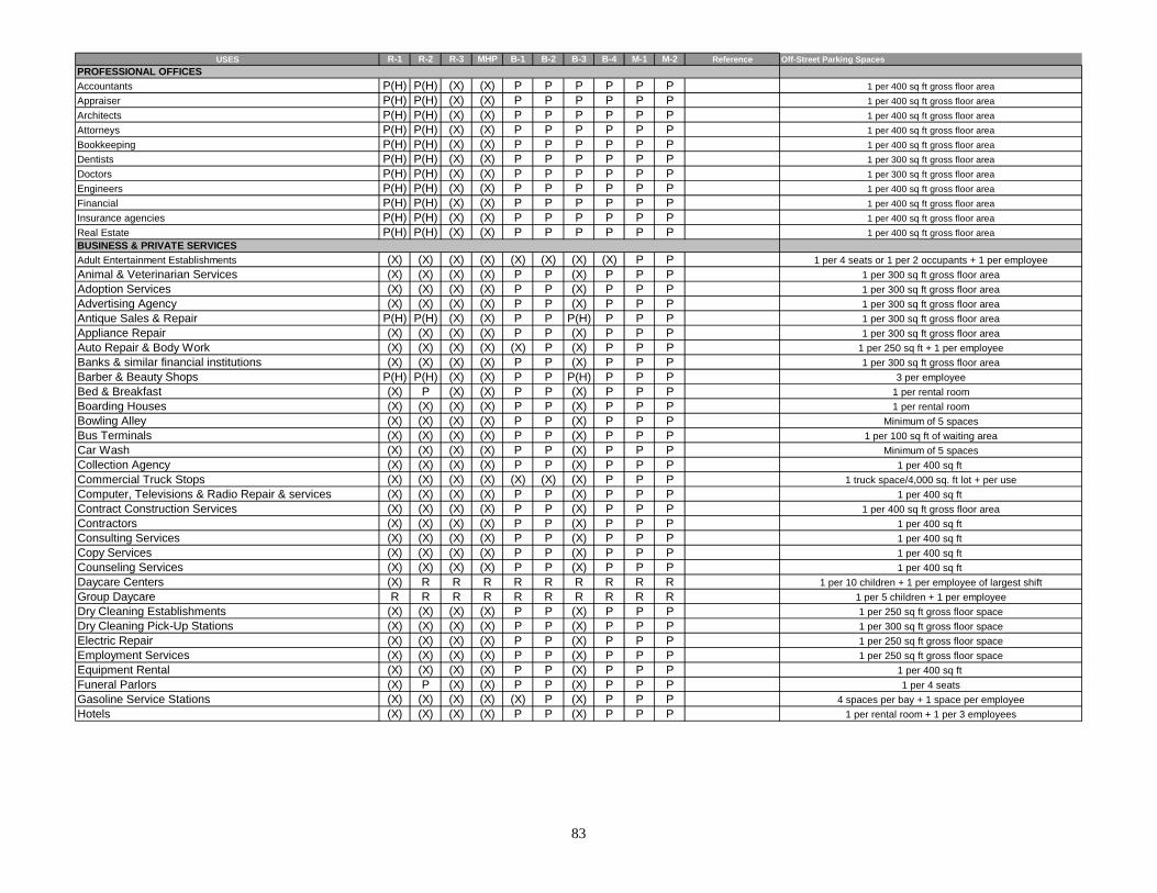
USES R-1 R-2 R-3 MHP B-1 B-2 B-3 B-4 M-1 M-2 Reference Off-Street Parking Spaces
Accountants P(H) P(H) (X) (X) P P P P P P 1 per 400 sq ft gross floor area
Appraiser P(H) P(H) (X) (X) P P P P P P 1 per 400 sq ft gross floor area
Architects P(H) P(H) (X) (X) P P P P P P 1 per 400 sq ft gross floor area
Attorneys P(H) P(H) (X) (X) P P P P P P 1 per 400 sq ft gross floor area
Bookkeeping P(H) P(H) (X) (X) P P P P P P 1 per 400 sq ft gross floor area
Dentists P(H) P(H) (X) (X) P P P P P P 1 per 300 sq ft gross floor area
Doctors P(H) P(H) (X) (X) P P P P P P 1 per 300 sq ft gross floor area
Engineers P(H) P(H) (X) (X) P P P P P P 1 per 400 sq ft gross floor area
Financial P(H) P(H) (X) (X) P P P P P P 1 per 400 sq ft gross floor area
Insurance agencies P(H) P(H) (X) (X) P P P P P P 1 per 400 sq ft gross floor area
Real Estate P(H) P(H) (X) (X) P P P P P P 1 per 400 sq ft gross floor area
Adult Entertainment Establishments (X) (X) (X) (X) (X) (X) (X) (X) P P 1 per 4 seats or 1 per 2 occupants + 1 per employee
Animal & Veterinarian Services (X) (X) (X) (X) P P (X) P P P 1 per 300 sq ft gross floor area
Adoption Services (X) (X) (X) (X) P P (X) P P P 1 per 300 sq ft gross floor area
Advertising Agency (X) (X) (X) (X) P P (X) P P P 1 per 300 sq ft gross floor area
Antique Sales & Repair P(H) P(H) (X) (X) P P P(H) P P P 1 per 300 sq ft gross floor area
Appliance Repair (X) (X) (X) (X) P P (X) P P P 1 per 300 sq ft gross floor area
Auto Repair & Body Work (X) (X) (X) (X) (X) P (X) P P P 1 per 250 sq ft + 1 per employee
Banks & similar financial institutions (X) (X) (X) (X) P P (X) P P P 1 per 300 sq ft gross floor area
Barber & Beauty Shops P(H) P(H) (X) (X) P P P(H) P P P 3 per employee
Bed & Breakfast (X) P (X) (X) P P (X) P P P 1 per rental room
Boarding Houses (X) (X) (X) (X) P P (X) P P P 1 per rental room
Bowling Alley (X) (X) (X) (X) P P (X) P P P Minimum of 5 spaces
Bus Terminals (X) (X) (X) (X) P P (X) P P P 1 per 100 sq ft of waiting area
Car Wash (X) (X) (X) (X) P P (X) P P P Minimum of 5 spaces
Collection Agency (X) (X) (X) (X) P P (X) P P P 1 per 400 sq ft
Commercial Truck Stops (X) (X) (X) (X) (X) (X) (X) P P P 1 truck space/4,000 sq. ft lot + per use
Computer, Televisions & Radio Repair & services (X) (X) (X) (X) P P (X) P P P 1 per 400 sq ft
Contract Construction Services (X) (X) (X) (X) P P (X) P P P 1 per 400 sq ft gross floor area
Contractors (X) (X) (X) (X) P P (X) P P P 1 per 400 sq ft
Consulting Services (X) (X) (X) (X) P P (X) P P P 1 per 400 sq ft
Copy Services (X) (X) (X) (X) P P (X) P P P 1 per 400 sq ft
Counseling Services (X) (X) (X) (X) P P (X) P P P 1 per 400 sq ft
Daycare Centers (X) R R R R R R R R R 1 per 10 children + 1 per employee of largest shift
Group Daycare R R R R R R R R R R 1 per 5 children + 1 per employee
Dry Cleaning Establishments (X) (X) (X) (X) P P (X) P P P 1 per 250 sq ft gross floor space
Dry Cleaning Pick-Up Stations (X) (X) (X) (X) P P (X) P P P 1 per 300 sq ft gross floor space
Electric Repair (X) (X) (X) (X) P P (X) P P P 1 per 250 sq ft gross floor space
Employment Services (X) (X) (X) (X) P P (X) P P P 1 per 250 sq ft gross floor space
Equipment Rental (X) (X) (X) (X) P P (X) P P P 1 per 400 sq ft
Funeral Parlors (X) P (X) (X) P P (X) P P P 1 per 4 seats
Gasoline Service Stations (X) (X) (X) (X) (X) P (X) P P P 4 spaces per bay + 1 space per employee
Hotels (X) (X) (X) (X) P P (X) P P P 1 per rental room + 1 per 3 employees
PROFESSIONAL OFFICES
BUSINESS & PRIVATE SERVICES
83

USES R-1 R-2 R-3 MHP B-1 B-2 B-3 B-4 M-1 M-2 Reference Off-Street Parking Spaces
Laundromats (X) (X) (X) (X) P P P P P P 1 per 250 sq ft gross floor spaceMarine Craft Sales, Service, and Repair (X) (X) (X) (X) P P P P P P 1 per 250 sq ft gross floor spaceMotion Picture Theaters and Theaters (X) (X) (X) (X) P P P P P P 1 per 4 seatsMotels (X) (X) (X) (X) P P P P P P 1 per rental room + 1 per 3 employeesNews Stands (X) (X) (X) (X) P P P P P P 1 per 400 sq ft Recreational Vehicle Repair & Service ( includes marine cra (X) (X) (X) (X) P P P P P P 1 per 250 sq ft gross floor spaceRental services (X) (X) (X) (X) P P P P P P 1 per 250 sq ft + 1 per employeeSelf-Storage Facilities (mini-warehouses) (X) (X) (X) (X) (X) P P P P P 1 per 400 sq ft Storage Yards (X) (X) (X) (X) (X) P P P P P 1 per 1,000 sq ft of lot areaTavern (X) (X) (X) (X) P P P P P P 1 per 2 seats + 1 per employee
Apparel Shop (X) (X) (X) (X) P P P P P P 1 per 300 sq ft gross floor spaceAppliance Sales (X) (X) (X) (X) P P P P P P 1 per 250 sq ft gross floor space
Automobile Sales (X) (X) (X) (X) (X) P (X) P P P1 per 250 sq ft gross floor space + 1 per 2,000 sq. ft
storage areaAutomobile supply (X) (X) (X) (X) P P P P P P 1 per 250 sq ft gross floor areaBakery - Retail (X) (X) (X) (X) P P P P P P 1 per 300 sq ft of gross floor areaBakery - Wholesale (X) (X) (X) (X) P P P P P P 1 per 300 sq ft of gross floor areaBookstore (X) (X) (X) (X) P P P P P P 1 per 400 sq ft of gross floor area
Building materials (X) (X) (X) (X) P P P P P P1 per 250 sq ft of gross floor area + 1 per 500 sq ft of
storage areaBicycle Sales (X) (X) (X) (X) P P P P P P 1 per 300 sq ft of gross floor areaBoat Sales (X) (X) (X) (X) P P P P P P 1 per 800 sq ft of gross floor area + 1 per service bayBridal Shop (X) (X) (X) (X) P P P P P P 1 per 300 sq ft of gross floor areaBusiness Machines & Supplies (X) (X) (X) (X) P P P P P P 1 per 300 sq ft of gross floor areaButcher shop - Retail (X) (X) (X) (X) P P P P P P 1 per 300 sq ft of gross floor areaCabinet Sales (X) (X) (X) (X) P P P P P P 1 per 250 sq ft of gross floor areaCarpet Sales (X) (X) (X) (X) P P P P P P 1 per 250 sq ft of gross floor areaCaterer (X) (X) (X) (X) P P P P P P 1 per 300 sq ft of gross floor areaConfectionary Sales (X) (X) (X) (X) P P P P P P 1 per 300 sq ft of gross floor areaConvenience Store (X) (X) (X) (X) P P P P P P 1 per 250 sq ft of gross floor areaClothing & Shoe Sales (X) (X) (X) (X) P P P P P P 1 per 300 sq ft of gross floor areaData Communication Equipment (X) (X) (X) (X) P P P P P P 1 per 300 sq ft of gross floor areaDelicatessen (X) (X) (X) (X) P P P P P P 1 per 300 sq ft of gross floor areaDepartment Store (X) (X) (X) (X) P P P P P P 1 per 250 sq ft of gross floor areaDrugstore (X) (X) (X) (X) P P P P P P 1 per 300 sq ft of gross floor areaDiving Equipment (X) (X) (X) (X) P P P P P P 1 per 300 sq ft of gross floor areaDoughnut Shop (X) (X) (X) (X) P P P P P P 1 per 300 sq ft of gross floor area
1 per 300 sq ft of gross floor area
RETAIL & WHOLESALE TRADE
BUSINESS & PRIVATE SERVICES (cont.)
84
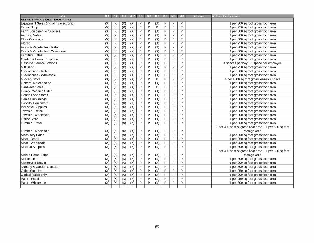
USES R-1 R-2 R-3 MHP B-1 B-2 B-3 B-4 M-1 M-2 Reference Off-Street Parking Spaces
RETAIL & WHOLESALE TRADE (cont.)
Equipment Sales (including electronic) (X) (X) (X) (X) P P (X) P P P 1 per 300 sq ft of gross floor areaFabric Shop (X) (X) (X) (X) P P P P P P 1 per 250 sq ft of gross floor areaFarm Equipment & Supplies (X) (X) (X) (X) P P (X) P P P 1 per 500 sq ft of gross floor areaFencing Sales (X) (X) (X) (X) P P (X) P P P 1 per 300 sq ft of gross floor areaFloor Coverings (X) (X) (X) (X) P P (X) P P P 1 per 300 sq ft of gross floor areaFlorist (X) (X) (X) (X) P P (X) P P P 1 per 250 sq ft of gross floor areaFruits & Vegetables - Retail (X) (X) (X) (X) P P (X) P P P 1 per 300 sq ft of gross floor areaFruits & Vegetables - Wholesale (X) (X) (X) (X) P P (X) P P P 1 per 300 sq ft of gross floor areaFurniture Sales (X) (X) (X) (X) P P (X) P P P 1 per 250 sq ft of gross floor areaGarden & Lawn Equipment (X) (X) (X) (X) P P (X) P P P 1 per 300 sq ft of gross floor areaGasoline Service Stations (X) (X) (X) (X) P P (X) P P P 4 spaces per bay + 1 space per employeeGift Shop (X) (X) (X) (X) P P (X) P P P 1 per 250 sq ft of gross floor areaGreenhouse - Retail (X) (X) (X) (X) P P (X) P P P 1 per 300 sq ft of gross floor areaGreenhouse - Wholesale (X) (X) (X) (X) P P (X) P P P 1 per 300 sq ft of gross floor areaGrocery Store (X) (X) (X) (X) P P P P P P 4 per 1000 sq ft of gross leasable spaceGeneral Merchandise (X) (X) (X) (X) P P (X) P P P 1 per 300 sq ft of gross floor areaHardware Sales (X) (X) (X) (X) P P P P P P 1 per 300 sq ft of gross floor areaHeavy Machine Sales (X) (X) (X) (X) P P (X) P P P 1 per 300 sq ft of gross floor areaHealth Food Stores (X) (X) (X) (X) P P (X) P P P 1 per 300 sq ft of gross floor areaHome Furnishings (X) (X) (X) (X) P P (X) P P P 1 per 300 sq ft of gross floor areaHospital Equipment (X) (X) (X) (X) P P (X) P P P 1 per 300 sq ft of gross floor areaIndustrial Supplies (X) (X) (X) (X) P P (X) P P P 1 per 300 sq ft of gross floor areaJeweler - Retail (X) (X) (X) (X) P P (X) P P P 1 per 250 sq ft of gross floor areaJeweler - Wholesale (X) (X) (X) (X) P P (X) P P P 1 per 300 sq ft of gross floor areaLiquor Store (X) (X) (X) (X) P P (X) P P P 1 per 300 sq ft of gross floor areaLumber - Retail (X) (X) (X) (X) P P (X) P P P 1 per 250 sq ft of gross floor area
Lumber - Wholesale (X) (X) (X) (X) P P (X) P P P1 per 300 sq ft of gross floor area + 1 per 500 sq ft of
storage areaMachinery Sales (X) (X) (X) (X) P P (X) P P P 1 per 300 sq ft of gross floor areaMeat - Retail (X) (X) (X) (X) P P (X) P P P 1 per 250 sq ft of gross floor areaMeat - Wholesale (X) (X) (X) (X) P P (X) P P P 1 per 250 sq ft of gross floor areaMedical Supplies (X) (X) (X) (X) P P (X) P P P 1 per 300 sq ft of gross floor area
Mobile Home Sales (X) (X) (X) (X) P P (X) P P P1 per 300 sq ft of gross floor area + 1 per 800 sq ft of
storage areaMonuments (X) (X) (X) (X) P P (X) P P P 1 per 300 sq ft of gross floor areaMotorcycle Dealer (X) (X) (X) (X) P P (X) P P P 1 per 300 sq ft of gross floor areaNursery & Garden Centers (X) (X) (X) (X) P P (X) P P P 1 per 300 sq ft of gross floor areaOffice Supplies (X) (X) (X) (X) P P (X) P P P 1 per 250 sq ft of gross floor areaOptical (sales only) (X) (X) (X) (X) P P (X) P P P 1 per 300 sq ft of gross floor areaPaint - Retail (X) (X) (X) (X) P P (X) P P P 1 per 250 sq ft of gross floor areaPaint - Wholesale (X) (X) (X) (X) P P (X) P P P 1 per 300 sq ft of gross floor area
85
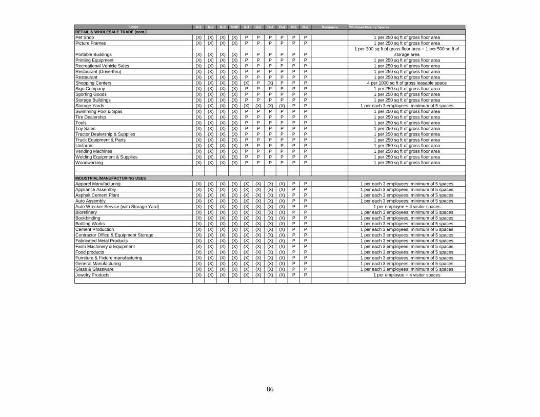
USES R-1 R-2 R-3 MHP B-1 B-2 B-3 B-4 M-1 M-2 Reference Off-Street Parking Spaces
Pet Shop (X) (X) (X) (X) P P P P P P 1 per 250 sq ft of gross floor areaPicture Frames (X) (X) (X) (X) P P P P P P 1 per 250 sq ft of gross floor area
Portable Buildings (X) (X) (X) (X) P P P P P P1 per 300 sq ft of gross floor area + 1 per 500 sq ft of
storage areaPrinting Equipment (X) (X) (X) (X) P P P P P P 1 per 250 sq ft of gross floor areaRecreational Vehicle Sales (X) (X) (X) (X) P P P P P P 1 per 250 sq ft of gross floor areaRestaurant (Drive-thru) (X) (X) (X) (X) P P P P P P 1 per 250 sq ft of gross floor area
RETAIL & WHOLESALE TRADE (cont.)
Restaurant (X) (X) (X) (X) P P P P P P 1 per 250 sq ft of gross floor areaShopping Centers (X) (X) (X) (X) (X) P (X) P P P 4 per 1000 sq ft of gross leasable spaceSign Company (X) (X) (X) (X) P P P P P P 1 per 250 sq ft of gross floor areaSporting Goods (X) (X) (X) (X) P P P P P P 1 per 250 sq ft of gross floor areaStorage Buildings (X) (X) (X) (X) P P P P P P 1 per 250 sq ft of gross floor areaStorage Yards (X) (X) (X) (X) (X) (X) (X) (X) P P 1 per each 3 employees; minimum of 5 spacesSwimming Pool & Spas (X) (X) (X) (X) P P P P P P 1 per 250 sq ft of gross floor areaTire Dealership (X) (X) (X) (X) P P P P P P 1 per 250 sq ft of gross floor areaTools (X) (X) (X) (X) P P P P P P 1 per 250 sq ft of gross floor areaToy Sales (X) (X) (X) (X) P P P P P P 1 per 250 sq ft of gross floor areaTractor Dealership & Supplies (X) (X) (X) (X) P P P P P P 1 per 250 sq ft of gross floor areaTruck Equipment & Parts (X) (X) (X) (X) P P P P P P 1 per 250 sq ft of gross floor areaUniforms (X) (X) (X) (X) P P P P P P 1 per 250 sq ft of gross floor areaVending Machines (X) (X) (X) (X) P P P P P P 1 per 250 sq ft of gross floor areaWelding Equipment & Supplies (X) (X) (X) (X) P P P P P P 1 per 250 sq ft of gross floor areaWoodworking (X) (X) (X) (X) P P P P P P 1 per 250 sq ft of gross floor area
Apparel Manufacturing (X) (X) (X) (X) (X) (X) (X) (X) P P 1 per each 3 employees; minimum of 5 spacesAppliance Assembly (X) (X) (X) (X) (X) (X) (X) (X) P P 1 per each 3 employees; minimum of 5 spacesAsphalt Cement Plant (X) (X) (X) (X) (X) (X) (X) (X) P P 1 per each 3 employees; minimum of 5 spacesAuto Assembly (X) (X) (X) (X) (X) (X) (X) (X) P P 1 per each 3 employees; minimum of 5 spacesAuto Wrecker Service (with Storage Yard) (X) (X) (X) (X) (X) (X) (X) (X) P P 1 per employee + 4 visitor spacesBiorefinery (X) (X) (X) (X) (X) (X) (X) (X) P P 1 per each 3 employees; minimum of 5 spacesBookbinding (X) (X) (X) (X) (X) (X) (X) (X) P P 1 per each 3 employees; minimum of 5 spacesBottling Works (X) (X) (X) (X) (X) (X) (X) (X) P P 1 per each 3 employees; minimum of 5 spacesCement Production (X) (X) (X) (X) (X) (X) (X) (X) P P 1 per each 3 employees; minimum of 5 spacesContractor Office & Equipment Storage (X) (X) (X) (X) (X) (X) (X) (X) P P 1 per each 3 employees; minimum of 5 spacesFabricated Metal Products (X) (X) (X) (X) (X) (X) (X) (X) P P 1 per each 3 employees; minimum of 5 spacesFarm Machinery & Equipment (X) (X) (X) (X) (X) (X) (X) (X) P P 1 per each 3 employees; minimum of 5 spacesFood products (X) (X) (X) (X) (X) (X) (X) (X) P P 1 per each 3 employees; minimum of 5 spacesFurniture & Fixture manufacturing (X) (X) (X) (X) (X) (X) (X) (X) P P 1 per each 3 employees; minimum of 5 spacesGeneral Manufacturing (X) (X) (X) (X) (X) (X) (X) (X) P P 1 per each 3 employees; minimum of 5 spacesGlass & Glassware (X) (X) (X) (X) (X) (X) (X) (X) P P 1 per each 3 employees; minimum of 5 spacesJewelry Products (X) (X) (X) (X) (X) (X) (X) (X) P P 1 per employee + 4 visitor spaces
INDUSTRIAL/MANUFACTURING USES
86
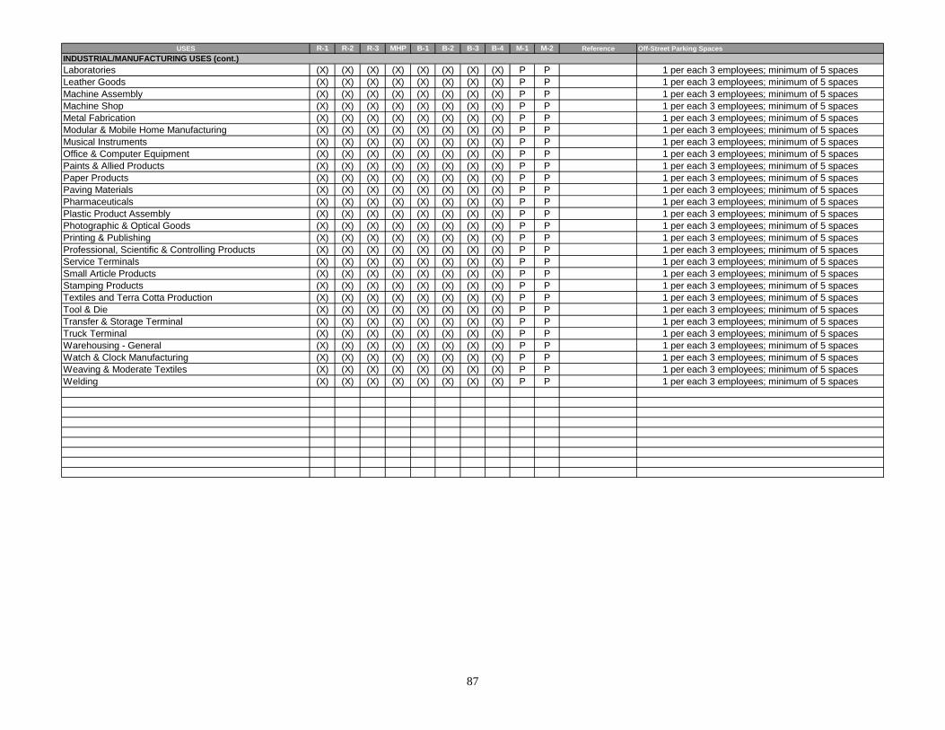
USES R-1 R-2 R-3 MHP B-1 B-2 B-3 B-4 M-1 M-2 Reference Off-Street Parking Spaces
Laboratories (X) (X) (X) (X) (X) (X) (X) (X) P P 1 per each 3 employees; minimum of 5 spacesLeather Goods (X) (X) (X) (X) (X) (X) (X) (X) P P 1 per each 3 employees; minimum of 5 spacesMachine Assembly (X) (X) (X) (X) (X) (X) (X) (X) P P 1 per each 3 employees; minimum of 5 spacesMachine Shop (X) (X) (X) (X) (X) (X) (X) (X) P P 1 per each 3 employees; minimum of 5 spacesMetal Fabrication (X) (X) (X) (X) (X) (X) (X) (X) P P 1 per each 3 employees; minimum of 5 spacesModular & Mobile Home Manufacturing (X) (X) (X) (X) (X) (X) (X) (X) P P 1 per each 3 employees; minimum of 5 spacesMusical Instruments (X) (X) (X) (X) (X) (X) (X) (X) P P 1 per each 3 employees; minimum of 5 spaces
INDUSTRIAL/MANUFACTURING USES (cont.)
Office & Computer Equipment (X) (X) (X) (X) (X) (X) (X) (X) P P 1 per each 3 employees; minimum of 5 spacesPaints & Allied Products (X) (X) (X) (X) (X) (X) (X) (X) P P 1 per each 3 employees; minimum of 5 spacesPaper Products (X) (X) (X) (X) (X) (X) (X) (X) P P 1 per each 3 employees; minimum of 5 spacesPaving Materials (X) (X) (X) (X) (X) (X) (X) (X) P P 1 per each 3 employees; minimum of 5 spacesPharmaceuticals (X) (X) (X) (X) (X) (X) (X) (X) P P 1 per each 3 employees; minimum of 5 spacesPlastic Product Assembly (X) (X) (X) (X) (X) (X) (X) (X) P P 1 per each 3 employees; minimum of 5 spacesPhotographic & Optical Goods (X) (X) (X) (X) (X) (X) (X) (X) P P 1 per each 3 employees; minimum of 5 spacesPrinting & Publishing (X) (X) (X) (X) (X) (X) (X) (X) P P 1 per each 3 employees; minimum of 5 spacesProfessional, Scientific & Controlling Products (X) (X) (X) (X) (X) (X) (X) (X) P P 1 per each 3 employees; minimum of 5 spacesService Terminals (X) (X) (X) (X) (X) (X) (X) (X) P P 1 per each 3 employees; minimum of 5 spacesSmall Article Products (X) (X) (X) (X) (X) (X) (X) (X) P P 1 per each 3 employees; minimum of 5 spacesStamping Products (X) (X) (X) (X) (X) (X) (X) (X) P P 1 per each 3 employees; minimum of 5 spacesTextiles and Terra Cotta Production (X) (X) (X) (X) (X) (X) (X) (X) P P 1 per each 3 employees; minimum of 5 spacesTool & Die (X) (X) (X) (X) (X) (X) (X) (X) P P 1 per each 3 employees; minimum of 5 spacesTransfer & Storage Terminal (X) (X) (X) (X) (X) (X) (X) (X) P P 1 per each 3 employees; minimum of 5 spacesTruck Terminal (X) (X) (X) (X) (X) (X) (X) (X) P P 1 per each 3 employees; minimum of 5 spacesWarehousing - General (X) (X) (X) (X) (X) (X) (X) (X) P P 1 per each 3 employees; minimum of 5 spacesWatch & Clock Manufacturing (X) (X) (X) (X) (X) (X) (X) (X) P P 1 per each 3 employees; minimum of 5 spacesWeaving & Moderate Textiles (X) (X) (X) (X) (X) (X) (X) (X) P P 1 per each 3 employees; minimum of 5 spacesWelding (X) (X) (X) (X) (X) (X) (X) (X) P P 1 per each 3 employees; minimum of 5 spaces
87

88
Section 14-703
The Clinton Municipal/Regional Planning Commission meets on the second Monday of each month at 6:00 p.m. at the City Hall and is open to the public.
Submission deadline for each month’s agenda is fourteen (14) days (including weekends) prior to the scheduled meeting date.
It is the applicant’s responsibility to submit nine (9) copies of the site plan to the Clinton Codes Enforcement Office for placement on the Clinton Municipal/Regional Planning Commission’s agenda. Only complete site plans with an attached checklists submitted by the deadline will be added to the agenda for review by the planning commission.
Site plan requirements are applicable to public and semi-public, commercial and industrial uses only. Copies of the site plan regulations are contained within the Clinton Zoning Ordinance and available at the Codes Enforcement Office.
CHECKLIST FOR SITE PLAN REVIEW & APPROVAL1
SITE PLAN REQUIREMENTS:
Applicant YES-NO-N/A
Staff Verification
Staff Comments
Certification & seal of preparer of site plan Topography of existing and proposed grades Location of floodable land Dimensions & calls of property lines North point, scale, site acreage & location map Location of existing & proposed structures Vehicular & pedestrian circulation plan Open space & landscaping requirements Minimum yard requirements Compliance with sign size and placement of
Section 14-309
Compliance with off-street parking requirements of Section 14-302 thru 14-306
Compliance with waste disposal requirements Submittal of Stormwater Drainage Plan Submittal of a Site Improvements Bond (if applicable)
Required certificates Other applicable requirements
Is the applicant requesting any variances from the Clinton Zoning Ordinance? No _____ Yes _____ If yes, identify variance being requested. ________________________ __________________________________________________________________________________Zoning Ordinance variances granted: (Authorized by the BZA) No _____ Yes _____Site Plan Approval Date: _____________ Other Comments: _____________________________________
1 Requirements are applicable to public & semi-public, commercial and industrial uses as noted. Additional requirements for a specific land use are denoted. This checklist is for general reference purposes only and confirmation of specific and/or additional requirements are the responsibility of the applicant.
CHAPTER 8
EXCEPTIONS AND MODIFICATIONS
SECTION 14-801. Lot of Record 14-802. Adjoining and Vacant Lots of Record 14-803. Exceptions for Carport or Garage Construction 14-804. Front Yards 14-805. Exceptions on Height Limits
14-801. Lot of Record. Where the owner of a lot consisting of one or more adjacent lots of official record at the time of the adoption of applicable zoning regulations does not own sufficient land to enable him to conform to the yard or other requirements of the zoning regulations, an application may be submitted to the Board of Zoning Appeals for a variance from the terms of the zoning ordinance. Such lot may be used as a building site; provided, however, that the yard and other requirements of the district are complied with as closely, in the opinion of the Board of Zoning Appeals, as is possible.
14-802. Adjoining and Substandard Lots of Records. Where two or more lots of record with a continuous frontage are under the same ownership, or where a substandard lot of record has continuous frontage with a larger tract under the same ownership, such lots shall be combined to form one or more building sites meeting the minimum requirements of the district in which they are located.
14-803. Exceptions for Carport or Garage Construction. For existing housing constructed on lots of record of less than 7,500 square feet in area and on which no garage or carport currently exists, carports or garages may be constructed in rear and side yards upon the building official making the following findings:
1. The size or shape of the lot or the location of the principal structure on the lot will not permit the construction of a carport or garage in a manner that will meet the current setback requirements of this ordinance.
2. That the construction of a carport or garage will not have a detrimental affect on the safety of adjoining properties or damage the aesthetic character of the surrounding neighborhood.
3. That the current setback requirements of the ordinance be followed as closely as possible, except that, no carport or garage shall be constructed less than five (5) feet from any property line unless a letter of consent first be obtained from the adjacent property owner.
14-804. Front Yards. The front yard setback requirements of this ordinance for dwellings shall not apply to any lot where the average depth of existing front yards on developed lots located within two hundred (200) feet on each side of such lot and within the same block and zoning district and fronting on the same street as such lot, is less than the minimum required front yard depth. In such case, the minimum front yard shall be the average of the existing front yard depths on the developed lots.
14-805. Exceptions on Height Limits. The height limitations of this ordinance shall not apply to any structure not intended for human occupancy, including but not limited to church spires, belfries, cupolas, domes, and chimneys attached to residential structures. Such structures including, but not limited to monuments, water towers, observation towers, transmission towers,
89

windmills, chimneys, smokestacks, derricks, conveyors, flag poles, radio towers, masts, and aerials shall be reviewed by the planning commission prior to construction.
90

CHAPTER 9
ADMINISTRATION AND ENFORCEMENT
SECTION 14-901. Building Permit Required 14-902. Enforcing Officer 14-903. Application for Issuance of Building Permits 14-904. Expiration/Extension of Building Permit Approvals 14-905. Final Site Inspection/Issuance of Certificate of Occupancy 14-906. Violations 14-907. Penalties 14-908. Remedies
14-901. Building Permit Required. It shall be unlawful to commence the excavation for or the construction of any building including accessory buildings, or to commence the moving or alteration of any building, including accessory buildings until the building official has issued for such work a building permit including a statement that the plans, specifications, and intended use of such building in all respects conform with the provisions of this ordinance. Application for a building permit shall be made to the building official.
14-902. Enforcing Officer. The provisions of this ordinance shall be administered and enforced by the Municipal Building Official. The building official shall have the authority to enter upon any land during reasonable hours and make examinations and surveys that do not occasion damage or injury to private property.
14-903. Application For/Issuance of Building Permits. For all multi-family residential, commercial, public, semi-public, or industrial uses, a site plan or PUD plan, whichever may be applicable, prepared in accordance with the provisions of Sections 14-310, 14-311, or 14-308, shall be submitted with an application for a building permit. Building permit applications for all other uses not requiring a site plan or PUD plan shall be accompanied by a dimensioned sketch or scale plan indicating the size and shape of the lot and the location and use of any existing or proposed buildings or structures on the site. No building permit for earth moving or construction shall be issued unless all the applicable provisions of this ordinance have been met. If the request for issuance of a building permit is refused, the building official shall state the reason for his refusal in writing.
14-904. Expiration/Extension of Building Permit Approvals.
1. Expiration of Building Permits. Unless provided for otherwise in this ordinance, building permits, along with any sketch or site plans upon which such permit was issued, shall be null and void six (6) months from the date of issuance and/or approval if substantial progress has not been made toward completion of the development activity as it was approved. Planned Unit Developments (PUDs) shall be null and void twelve (12) months from the date of approval if substantial progress has not been made toward completion of the development activity as it was approved.
The building official may grant any number of ninety (90) day extensions to a building permit holder for a building permit, if just cause can be given to justify the extension and if progress toward completion of the project can be shown.
91
2. Abandonment of Permitted Projects. Any project for which a building permit has been issued and where an accessory or principal building has only been partially constructed at the end of one (1) year and for which an application for extension has not been submitted, may be subject to being considered as an unsafe and illegal building and may be subject to the provisions of Section 102.4 of the Southern Standard Building Code and any other applicable provisions of this or any other ordinance of the city.
14-905. Final Site Inspection/Issuance of Certificate of Occupancy. In order to ensure that a building, structure, or addition has been constructed in accordance with the approved sketch, site, or PUD plan and will be occupied by a use lawful within the zoning district in which it is located, the building official shall make a final inspection upon notification by the owner or occupant that a premises is ready to be occupied. Within three (3) working days of such application, the building official shall make a final inspection of the property in question, and shall issue a certificate of occupancy if the building or structure is found to conform to the provisions of this ordinance and the statements made in the application for the building permit. If such a certificate is refused, the building official shall state such refusal in writing with the cause. No land or building hereafter erected or altered in its use shall be used until such a certificate of occupancy has been granted.
14-906. Violations. Any person whether owner, lessee, principal, agent, employee, or otherwise who violates any provision of this ordinance, permits any such violation, fails to comply with any of the provisions or requirements hereof, including any conditions, stipulations, or safeguards attached to any permit, variance, special exception, or other such final authorization or approval hereunder, or who erects, constructs or reconstructs any building or structure, or uses any land in violation of any written statement or plan submitted and approved pursuant to this ordinance shall be guilty of a misdemeanor.
14-907. Penalties. Any persons violating any provision of the ordinance shall be guilty of a misdemeanor, and upon conviction shall be fined not less than two dollars ($2.00) nor more than fifty dollars ($50.00) for each offense. Each day such violation shall continue shall constitute a separate offense.
14-908. Remedies. In case any building or structure is erected, constructed, altered, repaired, converted or maintained, or any building, structure or land is used in violation of this ordinance, the building official or any other appropriate authority or any adjacent or neighboring property owner who would be specifically damaged by such violation, in addition to other remedies, may institute injunction, mandamus, or other appropriate action or proceeding to prevent such unlawful erection, construction, reconstruction, alteration, repair, conversion, maintenance, or use; or to correct or abate such violation; or to prevent occupancy of such building, structure, or land.
92
CHAPTER 10
BOARD OF ZONING APPEALS
SECTION 14-1001. Creation and Appointment 14-1002. Procedure 14-1003. Appeals 14-1004. Powers 14-1005. Action of the Board of Zoning Appeals
14-1001. Creation and Appointment. A board of zoning appeals is hereby established in accordance with Section 13-7-205, Tennessee Code Annotated. The Clinton Municipal/Regional Planning Commission is hereby designated as the board of zoning appeals and the terms of the members of the board of zoning appeals shall be concurrent with the terms of the members of the Clinton Municipal/Regional Planning Commission.
14-1002. Procedure. Meetings of the board of zoning appeals shall be held at the call of the chairman or by a majority of the membership and at such other times as the board may determine. Such chairman, or in his/her absence, the acting chairman, may administer oaths and compel the attendance of witnesses. All meetings of the board shall be open to the public. The board shall keep minutes of its proceedings, showing the vote of each member upon each question, or, if absent or failing to vote, indicating such fact; shall take all evidence necessary to justify or explain its action, and shall keep records of its examinations and other official action, all of which shall be immediately filed in the office of the board and shall be a public record.
14-1003. Appeals. An appeal to the board of zoning appeals may be taken by any person, firm or corporation aggrieved, or by any governmental officer, department, board, or bureau affected by any decision of the building official based in whole or part on provisions of this ordinance. Such appeal shall be taken within a reasonable time, as provided by the rules of the board, by filing with the building official and with the board of zoning appeals a notice of appeal, specifying the grounds thereof. The building official shall transmit forthwith to the board all papers constituting the record upon which the action appeal was taken. The board shall fix a reasonable time for the hearing of the appeal, give public notice thereof, as well as due notice to the parties in interest, and decide the same within a reasonable time. Upon hearing, any party may appear in person or by agent or attorney.
14-1004. Powers. The board of zoning appeals shall have the following powers:
1. Administrative Review. To hear and decide appeals where it is alleged by the appellant that there is error in any order, or requirement, permit decision, determination or refusal made by the building official or other administrative official in the carrying out or enforcement of any provision of this ordinance.
2. Special Exceptions. To hear and decide special exceptions to this ordinance. In exercising its administrative judgment, decisions shall be guided by the following:
a. The use is consistent with adopted plans and policies of the city;
b. The use is in harmony with the general purpose and intent of the zoning regulations;
93

c. The use is compatible with the character of the general neighborhood where such use is proposed;
d. The use is consistent with other permitted uses of the zoning district where
such use is proposed;
e. The use will not negatively impact adjacent property by noise, lights, fumes, odors, vibration, traffic, congestion or be incompatible with other development in the surrounding area;
f. The use is not of a nature or so located as to draw substantial additional
traffic through residential streets;
g. The applicant for the special exception has submitted all required documentation, in accordance with the Clinton Zoning Ordinance.
3. Variance. To hear and decide applications for variance from the terms of this ordinance, but only where, by reason of exceptional narrowness, shallowness, or shape of a specific piece of property at the time of adoption of this ordinance was a lot of record; or where by reason of exceptional topographical conditions or other extraordinary or exceptional situations or conditions of a piece of property, the strict application of the provisions of this ordinance would result in exceptional practical difficulties to or exceptional and undue hardship upon the owner of such property, provided that such relief may be granted without substantial detriment to the public good and without substantially impairing the intent and purpose of this ordinance. In granting a variance, the board may attach thereto such conditions regarding the location, character, and other features of the proposed building, structure or use as it may deem advisable in furtherance of the purpose of this ordinance. Before any variance is granted it shall be shown that special circumstances are attached to the property which do not generally apply to other property in the neighborhood.
4. Interpretations/Special Questions. To hear and make interpretations on disputed lot lines, district boundaries or other interpretations directly related to the official zoning map. To hear and decide on special questions pertaining to the zoning ordinance.
14-1005. Action of the Board of Zoning Appeals. In exercising the aforementioned powers, the board of zoning appeals may, in conformity with the provisions of this ordinance, reverse or affirm, wholly or partly, or may modify the order, requirement, decision or determination appealed from, and to that end shall have all powers of the building official. The concurring vote of a majority of the board shall be necessary to reverse any order, requirement, decision or determination of any such administrative official, or to decide in favor of the applicant on any matter upon which it is required to pass under this ordinance, or to authorize any variance from the terms of this ordinance. The board will authorize the Municipal Building Official to issue a Certificate of Action for variances and a Special Use Permit for Special Exceptions, or uses authorized by interpretation following approval by the board, within thirty (30) days following official action taken by the board. In cases of issuance of a Special Use Permit, all conditions imposed by the board as a basis for approval shall be confirmed before issuance of the Special Use Permit.
94
CHAPTER 11
HISTORIC ZONING COMMISSION
SECTION 14-1101. Creation and Appointment 14-1102. Procedure 14-1103. Powers and Duties 14-1104. Jurisdiction 14-1105. Review and Decisions
14-1101. Creation and Appointment. In accordance with Chapter 13-7-104, Tennessee Code Annotated, a Historic Zoning Commission is hereby established. The City Council shall create a five (5) member Historic Zoning Commission which shall consist of a representative of a local patriotic or historical organization; an architect, if available; and a member of the planning commission, at the time of his appointment. The remaining members shall be appointed from the community in general. Historic Zoning Commission members shall be appointed by the Mayor of the City of Clinton and shall be confirmed by the City Council. Appointments to membership on the Historic Zoning Commission shall be arranged so that the term of one member shall expire each year and his successor shall be appointed in like manner in terms of five (5) years. All members shall serve without compensation.
14-1102. Procedure. The Historic Zoning Commission shall adopt by-laws which shall at least establish a regular meeting time and place, establish the manner of voting, set procedures for the recordation of procedures, and may address any additional matters relating to the conduct of the Historic Zoning Commission as the Historic Zoning Commission may deem appropriate.
14-1103. Powers and Duties. The Clinton Historic Zoning Commission shall have the following powers and duties:
1. To review all projects within any historic district that require the issuance of a permit before such projects can be lawfully commenced within the City of Clinton, and following such review, grant, grant with conditions, or deny a certificate of appropriateness; and further to review any projects not requiring a permit, but which the building official has been authorized to review by the Clinton Historic Zoning Commission within its "Design Review Guidelines," and for which he has refused to issue a certificate of appropriateness, and thereafter to grant, grant with conditions, or deny a certificate of appropriateness.
2. To adopt design review guidelines for each classification of historic district established in the City by which all projects subject to review in such historic districts are to be reviewed in order that the building official and/or Clinton Historic Zoning Commission may make a determination as to the granting or denial of a certificate of appropriateness.
3. To recommend to the planning commission the establishment of historic zones; and to review the recommendations of the planning commission, or any other group or person, for the establishment or change in boundaries of any historic zone.
14-1104. Jurisdiction. For the projects for which the building official is authorized to grant or grant with conditions a certificate of appropriateness, the building official shall render a decision within five (5) working days of the date on which he received sufficient data on which to make a judgement regarding the project's appropriateness. For projects which require review by the Clinton Historic Zoning Commission, and those other projects which the building official
95

refers to it for review, the Clinton Historic Zoning Commission shall render a decision to grant, grant with conditions, or deny a certificate of appropriateness within thirty (30) days of the date of the meeting at which sufficient data is available concerning the project to make a judgement regarding its appropriateness.
14-1105. Review of Decisions. Any person who may be aggrieved by any final order of judgement of the Historic Zoning Commission may have such order or judgement reviewed by the courts by the procedure of statutory certiorari, as provided for in Title 27, Chapter 8, Tennessee Code Annotated.
96
CHAPTER 12
AMENDMENTS
SECTION 14-1201. Procedure 14-1202. Approval by Planning Commission 14-1203. Introduction of Amendment
14-1201. Procedure. The city council may amend the regulations, boundaries, or any provision of this ordinance. Any member of the city council may introduce such amendment, or any official, board, or any other person may present a petition to the city council requesting an amendment or amendments to this ordinance.
14-1202. Approval by Planning Commission. No such amendment shall become effective unless the same be first submitted for approval, disapproval, or suggestions to the planning commission. If the planning commission disapproves after such submission, it shall require the favorable vote of a majority of the entire membership of the city council to become effective.
14-1203. Introduction of Amendment. Upon the introduction of an amendment of this ordinance or upon the receipt or a petition to amend this ordinance, the city council shall publish a notice of such request for an amendment, together with the notice of time set for hearing by the city council of the request change. Said notice shall be published in some newspaper of general circulation in the City of Clinton, Tennessee. Said hearing by the city council shall take place not sooner than fifteen (15) days after the date of publication of such notice.
97

CHAPTER 13
LEGAL STATUS PROVISIONS
SECTION 14-1301. Conflict with Other Ordinances 14-1302. Validity 14-1303. Effective Date
14-1301. Conflict with Other Ordinances. In the case of conflict between this ordinance or any part thereof, and the whole or part of any existing or future ordinance of the City of Clinton, the most restrictive shall in all cases apply.
14-1302. Validity. If any section, clause, provision or portion of this ordinance shall be held to be invalid or unconstitutional by any court of competent jurisdiction, such holding shall not affect any other section, clause, provision, or portion of this ordinance which is not of itself invalid or unconstitutional.
14-1303. Effective Date. This ordinance shall take effect and be in force from and after its passage, the public welfare demanding it.
Certified by Planning Commission _____May 11, 2009___ ________
Passed on First Reading ___May 18, 2009_____ ________
Passed on Second Reading ____July 20, 2009____ ________
Approved and Signed in Open Meeting
_______________________ ________
Attest:
City Recorder Mayor
98

APPENDICES
99

APPENDIX A
Illustration A
100

APPENDIX A
Illustration B
101
APPENDIX B
The streets and roads in the City of Clinton, Tennessee, are classified on the official Major Road Plan and for the purpose of this ordinance as follows: Arterial South Main Street (Highway 61) Charles G. Seviers Boulevard (Highway 61) Clinch Avenue (Highway 25W) Major Collectors North Main Street (Highway 25W) J.D. Yarnell Industrial Parkway Carden Farm Drive Old 25W Highway Drive North Market Street Hicks Street, South Hicks Street, and North Hicks Street East Broad Street between Charles G. Seviers Boulevard and South Hicks Street Weaver Avenue Local Collectors North Eagle Bend Road Christian Drive Eagle Bend Road Longmire Road from the city limits to Charles G. Seviers Boulevard West Spring Avenue Hillcrest Street Sunset Road Mariner Point Drive from South Main Street to Lagoon Drive Ridgeview Drive Lynn Street Block House Valley Road Lee Road Yarnell Road Local Streets All other streets and roads in the City of Clinton, Tennessee. [amended by Ord. 330]
102
APPENDIX C
CERTIFICATE OF PLANNED UNIT DEVELOPMENT APPROVAL We hereby certify that this Planned Unit Development (PUD) has been found to comply with the zoning and PUD regulations of the Clinton Municipal/Regional Planning Commission, with the exception of such alterations or variances, if any, as noted in the minutes of the Clinton Municipal/Regional Planning Commission and the Clinton Board of Zoning Appeals. ____________ ____________________________________ Date Chairman Clinton Municipal/Regional Planning Commission ____________ ____________________________________ Date Secretary Clinton Municipal/Regional Planning Commission
CERTIFICATE OF PUD APPLICATION AND AGREEMENT I (we) hereby certify that I (we) understand that the approval of a Planned Unit Development (PUD) shall expire twelve (12) months after the date of approval. ____________ ________________________ Date Applicant ____________ ________________________ Date Applicant
103

104
APPENDIX D
CERTIFICATE OF SITE PLAN APPROVAL We hereby certify that this site plan has been found to comply with the zoning and site plan regulations of the Clinton Municipal/Regional Planning Commission, with the exception of such variances, if any, as noted in the minutes of the Clinton Board of Zoning Appeals. ____________ ____________________________________ Date Chairman Clinton Municipal/Regional Planning Commission ____________ ____________________________________ Date Secretary Clinton Municipal/Regional Planning Commission
CERTIFICATE OF SITE PLAN APPLICATION AND AGREEMENT I (we) hereby certify that I (we) understand that the approval of a site plan shall expire six (6) months after the date of approval unless a building permit has been issued and substantial progress has been made toward completion of the project. ____________ ________________________ Date Applicant ____________ ________________________ Date Applicant