city of fresno - planning and development department€¦ · proposes to amend the fresno general...
TRANSCRIPT

CITY OF FRESNO - DEVELOPMENT AND RESOURCE MANAGEMENT DEPARTMENT
REQUEST FOR COMMENTS AND ENVIRONMENTAL ASSESSMENT, REVIEW OF
PLAN AMENDMENT APPLICATION NO. A-15-007, REZONE APPLICATION NO. R-15-016
Airport Land Use Commission
PROJECT DESCRIPTION AND LOCATION: Plan Amendment Application No. A-15-007 and Rezone Application No. R-15-016 were filed by the City of Fresno Development and Resource Management Director and pertains to ±265 acres of property located within the Fresno General Plan Planning Area. Plan Amendment Application No. A-15-007 proposes to amend the Fresno General Plan, the Bullard, Fresno High, McLane, Roosevelt, West Area, and Woodward Park Community Plans, the Tower District Specific Plan, the Fresno Yosemite Airport Land Use Compatibility Plan and the Sierra Sky Park Land Use Policy Plan, as noted in the City of Fresno General Plan Land Use Map Amendment and table attached. The Plan Amendment application was filed for consideration of additional general plan clean-up items, including implementation of Master Environmental Impact Report mitigation measures and technical adjustments to meet general plan goals and policies. Rezone Application No. R-15-016 proposes to update the Zoning Map of the City of Fresno to be consistent with the City of Fresno General Plan Land Use and Circulation Map adopted on December 18, 2014, and as subsequently amended. All conditions of zoning will remain in effect. See Zoning Map Update and Overlay District Map attached. More information will be available after January 8, 2016 on line at www.fresno.gov/mapupdate
APN: See Attached ADDRESS: See Attached
DATE ROUTED: January 25, 2016 COMMENT DEADLINE: Feb. 1, 2016
WILL THIS PROJECT AFFECT YOUR AGENCY/JURISDICTION? (If yes, specify.) SUGGESTION(S) TO REDUCE IMPACTS/ADDRESS CONCERNS: REQUIRED CONDITIONS OF APPROVAL:
IS ANY ADDITIONAL INFORMATION NEEDED FOR YOU TO COMPLETE YOUR REVIEW? (Be specific):
Return Completed Form to: Sophia Pagoulatos, Advanced Planning Email: [email protected] and [email protected] Development and Resource Management 2600 Fresno Street, Third Floor Fresno CA 93721-3604
REVIEWED BY: Name and Title Telephone Number Date
Attachments: A-15-007: General Plan Proposed Land Use Amendment Map General Plan Proposed Land Use Amendment Table General Plan Proposed Land Use and Circulation Map (with proposed changes incorporated) R-15-016: Existing Zoning Map Proposed Zoning Map Council Districts 1-7; Bullard, Fresno High, McLane, Roosevelt, West Area, and Woodward Park Community Plans, the Tower District Specific Plan, the Fresno Yosemite Airport Land Use Compatibility Plan and the Sierra Sky Park Land Use Policy Plan

!!!!
!!
!!
!!
!
!
!
!!!
!!
!!!
!!
YY
YY
YY
YY
Y
YY
YY
! ! !
!
! ! ! !
! ! ! ! ! ! !! ! ! !
!!
!! !!!!
YY
YY
YY
YY
YY
YY
YY
YY
!!
!!
!!
!!
!!
!
!!
!!
!!
!
!!
!!
!!
!!!
!!
!!
!!
!!
!!
!!
!!
!!
!!
!
YY
YY
! ! ! ! ! ! !
!!
!!
!!
!!
!!
YY
Y
Y
YY
!
!
!
! !
!!
!!
!DOWNTOWNPLANNING
AREA
Black
stone
Nees
Herndon
Bullard
Shaw
Ashlan
Shields
McKinley
Belmont
Whites Bridge
Alluvial
Sierra
Barstow
Gettysburg
Dakota
Clinton
Olive
Garfie
ld
Brya
n
Gran
tland
Haye
s
Polk
Corne
lia
Blythe
Braw
ley
Valen
tine
Marks
Van N
ess
West
Fruit
Palm
Fres
no
First Millb
rook
Ceda
rMa
ple Ches
tnut
Willo
w
Peac
h
Ashlan
Dakota
Shields
Clinton
McKinley
Olive
BelmontTulare
Butler
California
Church
Jensen
Annadale
North
Kings Canyon
Maroa
International
Copper
Behymer
Shepherd
Nees
Herndon
Bullard
Shaw
Gettysburg
Teague
Alluvial
Sierra
Barstow
Perrin
Clov
is
Sunn
yside
Fowl
er
Arms
trong
Temp
eranc
e
Loca
n
Clov
is
Fowl
er
Temp
eranc
e
Sunn
yside
Loca
n
Arms
trong
Ches
tnut
Peac
h
Willo
w
Minn
ewaw
a
Malaga
American
Ceda
r
Oran
ge
Maple
Elm East
Fig Cherr
y
Marks
West
Walnu
t
Hugh
es
Fruit
Gran
tland
Haye
s
Corne
lia
Brya
n
Polk
Braw
ley
Valen
tine
BlytheKearney
Muscat
North
Annadale
Muscat
Central
California
Jensen
Church
Central
Nielsen
·|}þ·|}þ
·|}þ
·|}þ
17
16
11
13
2
23
22
4 20
18
21
195
986
10
12
14
7
11
15
3
9941
180
168
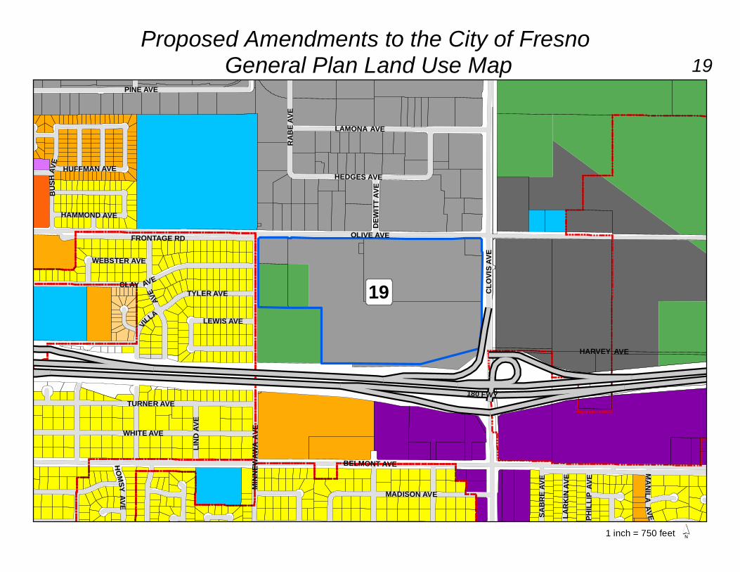
City of Fresno General Plan Land Use
Map Amendment
®
0 4 82Miles v. 1/12/2016
LegendGeneral Plan Land Use AmendmentsPublic Facilities
ChurchAirport
Open SpaceClear ZoneNeighborhood ParkOpen SpacePonding Basin
EmploymentOfficeBusiness ParkLight Industrial
ResidentialMedium Low DensityMedium DensityMedium High DensityUrban Neighborhood
CommercialMain StreetCommunityRecreationGeneral
BoundariesDowntown Planning AreaCity LimitsSphere Of Influence

Re:
From To
Part of 49406045T & 51T Open Space - Golf Course Public Facilities ‑ Airport 9.28
Part of 49406045T and
51T, part of 49402032T
and 33T, and 49402026ST
and X1 Light Industrial Public Facilities ‑ Airport 22.00
FM
CD
2
Proposed ponding
basin "DV."
Part of 31328012T, 22T,
23T, 24T, 25T, and 57T Res. Medium Low Density
Open Space - Ponding
Basin 13.50
Part of 50105001 and
50104702 Public Facilities ‑ Airport Open Space Clear Zone 0.35
50115303ST and part of
50115306S Community Commercial Open Space Clear Zone 0.46
Part of 50703015 Office Open Space Clear Zone 0.92
Open Space Clear Zone Office 2.60
General Commercial Open Space Clear Zone 0.28
Res. Medium Density Open Space Clear Zone 0.03
4 A-14-007 46323203 Res. Medium Density Office 0.57
5 A-12-002 45314115 Res. Medium High Density General Commercial 0.69
43602201 Regional Mixed Use Office 0.17
43602219
Res. Medium Density
Regional Mixed Use Office 0.19
7 A-11-001 30319083, 84 and 85
Public Facility - Middle and
Elementary School Community Commercial 2.78
51125002 Res. Medium Low Density Res. Medium High Density
51136324 Res. Medium Density Res. Medium High Density 4.86
Part of 31004138 Res. Medium Low Density Res. Medium Density 31.87
31004139 Community Commercial
Neighborhood Community
Commercial 2.14
10 A-11-004 41707058 Res. Medium Density Res. Medium High Density 1.86
11 A-11-009 51117124 and 25 Res. Medium Low Density Res. Medium High Density 4.79
12 A-11-011 50903069S Res. Medium Density Res. Medium High Density 10.17
13 A-11-013 40351159S Res. Medium Low Density Office 0.26
14 A-11-014 40420023 Res. Urban Neighborhood Office 3.57
15 A 44206033 Res. Medium High Res. Urban Neighborhood 4.65
16 B 44723001 Res. Medium Density Public Facilities - Church 0.61
17 C 45904109, 12, 13, 16-18 Res. Medium Density Commercial Main Street 0.83
18 D
31013201 - 09, 31013301 -
06, 31327057S - 76S, 80S,
83S - 86S, 92S, 93S, and
95S Business Park Light Industrial 78.90
45603015, 16, 18, 52, 56 Corridor/Center Mixed-Use Light Industrial 65.19
45603057T
Dual Land Use Designation:
Corridor/Center Mixed-Use
Dual Land Use Designation:
Light Industrial 3.65
20 F 46303022, 78, and 90 Corridor/Center Mixed-Use Office 1.60
21 G 45920001, 02, and 06T
Dual Land Use Designation:
Light Industrial
Dual Land Use Designation:
General Commercial 2.95
22 H 45913120 and 01
Dual Land Use Designation:
Res. Medium Density
Dual Land Use Designation:
Commercial Main Street 1.00
23 I 45903205 and 15 Residential Medium Density Light Industrial 0.38
City of Fresno General Plan Land Use Map Amendment Table
Part of 50703012ST
19 E
1
6
9 A-11-003
A-12-004
MM HAZ-3: Re-
designate area
located within FYI
Airport Zone 5
Sideline northeast of
airport to Public
Facilities Airport or
Open Space.
3
Sky Park Clear Zone
correction.
8 A-11-002
Acres
GP
ME
IR M
itig
ati
on
A
LU
CG
en
era
l P
lan
Am
en
dm
en
tsC
orr
ecti
on
GP Land Use Change Request
No Description APN

DEWITT AVE
AMHERST AVEMICHIGAN AVE
SIMPSON AVECORNELL AVE
FINE AVE
CLINTON WAY
WINE
RY A
VE
PERIMETER RDWELDON AVE
CHES
TNUT
AVE
CLOV
IS FT
RDW
SHIELDS AVE
ANN A
VERAMONA WAY
EDITH DR
JUDY
AVE
CLOV
IS AV
E
CARMEN AVE
HEL M
A VE -
CLINTON AVE
MCKINLEY AVE
LARK
IN AV
E
DUKE
AVE
SALERNO DR
YALE AVE
DAKOTA AVE
AIRCORP WAY
PONTIAC WAY
ANDERSEN AVE
WESTOVER AVE
GATE
WAY BLVD
ALY
MIAM
I AVE
HARVARD AVEBROWN AVE
SAGINAW WAYLANSING WAY
GAP DRDAYTON AVE
FOUNTAIN WAY
SUNN
YSID
EA V
E
SABR
E DR
PEAC
H AV
E
ARGY
LE AV
E
AIRWAYS BLVD
TERRY COOPER WAY
1
´
Proposed Amendments to the City of Fresno General Plan Land Use Map 1
1 inch = 1,500 feet

DEWE
Y AV
E
PALO ALTO AVE
BRAW
LEY
AVE
FIGARDEN DR
VERN
AL A
VE
BLYT
HE AV
E
ALVA
AVE
SAN PEDRO AVE
MALSBARYAV
E
BEECHWOOD AVE
WATHEN AVE
HANO
VER
AVE
SPRUCE AVE
KATY
LN
RAFA
ELAV
E
MENLO AVE
MARTY AVE
EL C
APITA
N AVE BR
UNSW
ICK
AVE
MAGILL AVE
PAUL AVE
KNOLLDR
BEND
EL A
VE
FREMONT AVE
LOCUST AVE
VINCENT LNSIERRA AVE
DOOLITTLE DR
DELLA LN
MCCAMPBELL DR
PIMA
AVE
HERNDON AVE
FIR AVESPAATZ AVE
KELLY AVE
FRONTAGE
BIRCH AVE
VANDEGRIFT AVE
HASL
AMAV
E
MITR
E AVE
TRAC
Y AV
ETA ME RA
AVE
SELL
AND
AVE
SANTA FE AVE
BERLINAVE
VALE
NTIN
E AVE
GENTRY AVE
CECELIA AVE
PRIVAT
E DR
ALLUVIAL AVE
3
´
Proposed Amendments to the City of Fresno General Plan Land Use Map 3
1 inch = 750 feet

BULLARD AVE
SAN JOSE AVE
POMEGRANATE LN
GATES AVE
SALINAS AV
E
SELL
AND
AVE
GALAXY AVE
OSWEGO AVE
STOC
KDAL
E DR
VERBA AVE
FRONTAGE RD
KRISTI DR
CELESTE AVE
AVOCADO LN
CALIMYRNA AVE
ALVA
AVE
APPLE TREE LN
BRAW
LEY
AVE
ARTEMISA DR
EL SOL AVE
BRUN
SWIC
K AV
EPINSAPO DR
MALS
BARY
AVE
CORONA AVE
JOLINEDR
REESE AVE
MORRIS AVE
SAN BRUNO AVE
BARSTOW AVE
MESA AVESA
N MARCOS AVE
MALIBU AVECITR
US LN
ALEX
IS DR
BROWNING AVE
DEWE
Y AV
E
CECE
LIA A
VE
AURORA AVE
REGENCY AVE
KADOTA AVE
AVILA DR
VERN
A LA V
E
DOVEWOOD LN
ROBERTS AVE
PRIVATE DR
VALE
NTIN
E AVE
BULLETIN AVE
MILB
URN
AVE
PERSIMMON LN
FIGARDEN DR
TRAC
Y AV
E
MITR
E AVE
MART
Y AV
E
FIG TREE LN
PRIVATE
DR
12
´
Proposed Amendments to the City of Fresno General Plan Land Use Map 12
1 inch = 750 feet

WASHINGTON AVE SHIR
LEY
AVE
IOWA AVE
STAN
FORD
AVE
MCKENZIE AVE
ILLINOIS AVE
PLATT AVE
FORD
HAM
AVE
FRONTAGE RD
GRANT AVE
NEVADA AVE
BELMONT AVE
TULARE STAR
MSTR
ONG
AVE
P UR D
UEAV
E
CYPR
ESS A
VE
FILLMORE AVE
180 FWY
HARVEY AVE
TURNER AVE
MADISON AVE
FOWL
ER AV
E
BURG
AN AV
ELAVERNE AVE
2
18
´
Proposed Amendments to the City of Fresno General Plan Land Use Map 18
1 inch = 750 feet
OLIVE AVE
SABR
E AVE
BUSH
AVE
MANILAAVE
MINN
EWAW
A AV
E
BELMONT AVE
180 FWY
HUFFMAN AVE
PHILL
IP AV
E
LIND A
VE
TURNER AVE
HAMMOND AVE
PINE AVE
MADISON AVE
WHITE AVE
RABE
AVE
CLAY AVE
DEWI
TT AV
E
LAMONA AVE
WEBSTER AVE
LEWIS AVE
TYLER AVE
HARVEY AVE
CLOV
IS AV
E
VILLA
AVE
HOMSYAVE
LARK
IN AV
E
HEDGES AVE
FRONTAGE RD
19
´
Proposed Amendments to the City of Fresno General Plan Land Use Map 19
1 inch = 750 feet