city of granite falls proposed shoreline...
TRANSCRIPT

Pilchuck River
South Fork Stillaguamish River
SR92
100th St NE
Engebretsen Rd
Jordan Rd
Mou
ntai
nLo
opHw
y
Menzel Lake Rd
Paradise Ln
E Galena St
116th Pl NE
Chappel Rd
Crooked Mile Rd
115th St NE
Gun Club Rd
Wayside Mine Rd
NG
rani
teAv
eS
Gra
nite
Ave
169t
hD
r NE
84th St NE
E Stanley St
Robe Menzel Rd
Ray
Gray
Rd
Hemming Way
Access Rd
PilchuckTree
FarmRd
Cas
cade
Ave
Skinner Rd
211th Ave NE
103rd Pl NE
W Wallace St
192n
dD
r NE
SK
entu
cky
Ave
Pros
pect
Ave
NA
lder
Rd
E Alpine St
E Union St
Saratoga St
Noble Way
W Galena St
191s
t Dr N
E
W Stanley St
114th Pl NE
118th St NE
169t
hAv
eN
E
Port
age
Ave
NB
ogar
tAve
174t
hAv
eN
E
184t
hAv
eN
E
Pilchuck St
172n
dAv
eN
E
181st Dr N
E
177t
hAv
eN
E
117th Pl NE
118th Pl NE
175t
hAv
eN
E
Eagl
eVi
ewD
r
113th St NE
114th St NE
SBogart AveTompkins Pl
Darw
insW
ay
184t
hD
r NE
172n
dD
r NE
Waite Mill Rd
Para
dise
Pkw
y
200t
hAv
eNE
90th St NE
SW
abas
hAv
e
Ald
erPl
E Grand St
Bergan Rd
E Wallace St91st St NE
Leol
aLn
NK
entu
cky
Ave
Mountain View St
117th St NE
Pine
Ln
Popl
arLn
ESt
anle
yPl
Man
orW
ay
Vista Ct
Bergan Rd
Access Rd
118thSt NE
169thAve
NE
Access Rd
117th Pl NE
172n
dDr
NE
2
1
PROPOSED SHORELINE JURISDICTION
All features depicted on this map are approximate. They have not been formally delineatedor surveyed and are intended for planning purposes only. Additional site-specific evaluationmay be needed to confirm/verify information shown on this map.
City Boundary*UGA Boundary*Shoreline JurisdictionParcel**SMP River**Other River or Stream**
CITY OF GRANITE FALLSSHORELINE MASTER PROGRAM
[0 1,300650
Feet
MountainLoop Hwy
1
[0 350175
Feet
Paradise Ln
Skinner Rd
SG
raniteAve
Fox Glove Cir
2
[0 350175
Feet
FIGURE 1
Snohomish County
Granite Falls
MAP FOLIO TABLE OF CONTENTS:- Figure 1: Proposed Shoreline Jurisdiction- Figure 2: Current Land Use- Figure 3: Stormwater System- Figure 4: Water & Sewer Systems- Figure 5: Impervious Surfaces- Figure 6: Land Cover- Figure 7: Soils- Figure 8: Wetlands & Topography- Figure 9: Priority Habitats & Species- Figure 10: FEMA Floodplain & Floodway- Figure 11: Water Quality & Shoreline Modifications- Figure 12: Public Access- Figure 13: Ecological Functions- Supplemental Figure A: Future Land Use Map- Supplemental Figure B: Zoning Map- Supplemental Figure C: Approximate Critical Areas Map- Supplemental Figure D: Flood Insurance Rate Map
October 2010 Data sources: *City of GraniteFalls, **Snohomish County,National Agricultural ImageryProgram

Pilchuck River
South Fork Stillaguamish River
SR92
100th St NE
Engebretsen Rd
Jordan Rd
Mou
ntai
nLo
opHw
y
Menzel Lake Rd
Paradise Ln
E Galena St
116th Pl NE
Chappel Rd
Crooked Mile Rd
115th St NE
Gun Club Rd
Wayside Mine Rd
NG
rani
teAv
eS
Gra
nite
Ave
169t
hD
r NE
84th St NE
E Stanley St
Robe Menzel Rd
Ray
Gray
Rd
Hemming Way
Access Rd
PilchuckTree
FarmRd
Cas
cade
Ave
Skinner Rd
211th Ave NE
103rd Pl NE
W Wallace St
192n
dD
r NE
SK
entu
cky
Ave
Pros
pect
Ave
NA
lder
Rd
E Alpine St
E Union St
Saratoga St
Noble Way
W Galena St
191s
t Dr N
E
W Stanley St
114th Pl NE
118th St NE
169t
hAv
eN
E
Port
age
Ave
NB
ogar
tAve
174t
hAv
eN
E
184t
hAv
eN
E
Pilchuck St
172n
dAv
eN
E
181st Dr N
E
177t
hAv
eN
E
117th Pl NE
118th Pl NE
175t
hAv
eN
E
Eagl
eVi
ewD
r
113th St NE
114th St NE
SBogart AveTompkins Pl
Darw
insW
ay
184t
hD
r NE
172n
dD
r NE
Waite Mill Rd
Para
dise
Pkw
y
200t
hAv
eNE
90th St NE
SW
abas
hAv
e
Ald
erPl
E Grand St
Bergan Rd
E Wallace St91st St NE
Leol
aLn
NK
entu
cky
Ave
Mountain View St
117th St NE
Pine
Ln
Popl
arLn
ESt
anle
yPl
Man
orW
ay
Vista Ct
Bergan Rd
Access Rd
118thSt NE
169thAve
NE
Access Rd
117th Pl NE
172n
dDr
NE
2
1
CURRENT LAND USE
All features depicted on this map are approximate. They have not been formally delineatedor surveyed and are intended for planning purposes only. Additional site-specific evaluationmay be needed to confirm/verify information shown on this map.
City Boundary*UGA Boundary*Shoreline JurisdictionSMP River**Other River or Stream**
Currrent Land Use (2010)**Senior Citizen Exemption ResidualResidentialSeptic System/Septic System & WellWellManufacturingTransportationUtilities and CommunicationRetail TradeServicesGovernmental & Educational ServicesCultural, Entertainment & RecreationalParksResource Production & ExtractionUndeveloped (Vacant) LandOther Undeveloped LandWater AreasOpen Space General
CITY OF GRANITE FALLSSHORELINE MASTER PROGRAM
[0 1,300650
Feet
MountainLoop Hwy
1
[0 350175
Feet
FIGURE 2
October 2010 Data sources: *City of GraniteFalls, **Snohomish County,National Agricultural ImageryProgram
Paradise Ln
Skinner Rd
SG
raniteAve
Fox Glove Cir
2
[0 350175
Feet

Pilchuck River
South Fork Stillaguamish River
SR92
100th St NE
Engebretsen Rd
Jordan Rd
Mou
ntai
nLo
opHw
y
Menzel Lake Rd
Paradise Ln
E Galena St
116th Pl NE
Chappel Rd
Crooked Mile Rd
115th St NE
Gun Club Rd
Wayside Mine Rd
NG
rani
teAv
eS
Gra
nite
Ave
169t
hD
r NE
84th St NE
E Stanley St
Robe Menzel Rd
Ray
Gray
Rd
Hemming Way
Access Rd
PilchuckTree
FarmRd
Cas
cade
Ave
Skinner Rd
211th Ave NE
103rd Pl NE
W Wallace St
192n
dD
r NE
SK
entu
cky
Ave
Pros
pect
Ave
NA
lder
Rd
E Alpine St
E Union St
Saratoga St
Noble Way
W Galena St
191s
t Dr N
E
W Stanley St
114th Pl NE
118th St NE
169t
hAv
eN
E
Port
age
Ave
NB
ogar
tAve
174t
hAv
eN
E
184t
hAv
eN
E
Pilchuck St
172n
dAv
eN
E
181st Dr N
E
177t
hAv
eN
E
117th Pl NE
118th Pl NE
175t
hAv
eN
E
Eagl
eVi
ewD
r
113th St NE
114th St NE
SBogart AveTompkins Pl
Darw
insW
ay
184t
hD
r NE
172n
dD
r NE
Waite Mill Rd
Para
dise
Pkw
y
200t
hAv
eNE
90th St NE
SW
abas
hAv
e
Ald
erPl
E Grand St
Bergan Rd
E Wallace St91st St NE
Leol
aLn
NK
entu
cky
Ave
Mountain View St
117th St NE
Pine
Ln
Popl
arLn
ESt
anle
yPl
Man
orW
ay
Vista Ct
Bergan Rd
Access Rd
118thSt NE
169thAve
NE
Access Rd
117th Pl NE
172n
dDr
NE
2
1
STORMWATER SYSTEM
All features depicted on this map are approximate. They have not been formally delineatedor surveyed and are intended for planning purposes only. Additional site-specific evaluationmay be needed to confirm/verify information shown on this map.
CITY OF GRANITE FALLSSHORELINE MASTER PROGRAM
[0 1,300650
Feet
City Boundary*UGA Boundary*Shoreline JurisdictionParcel**SMP River**Other River or Stream**Stormwater Conveyance*
! Stormwater Outfall*Stormwater Facility*
BioswaleDetention PondInfiltration PondUnderground Infiltration
October 2010 Data sources: *City of GraniteFalls, **Snohomish County,National Agricultural ImageryProgram
MountainLoop Hwy
1
[0 350175
Feet
Paradise Ln
Skinner Rd
SG
raniteAve
Fox Glove Cir
2
[0 350175
Feet
FIGURE 3

Pilchuck River
South Fork Stillaguamish River
SR92
100th St NE
Engebretsen Rd
Jordan Rd
Mou
ntai
nLo
opHw
y
Menzel Lake Rd
Paradise Ln
E Galena St
116th Pl NE
Chappel Rd
Crooked Mile Rd
115th St NE
Gun Club Rd
Wayside Mine Rd
NG
rani
teAv
eS
Gra
nite
Ave
169t
hD
r NE
84th St NE
E Stanley St
Robe Menzel Rd
Ray
Gray
Rd
Hemming Way
Access Rd
PilchuckTree
FarmRd
Cas
cade
Ave
Skinner Rd
211th Ave NE
103rd Pl NE
W Wallace St
192n
dD
r NE
SK
entu
cky
Ave
Pros
pect
Ave
NA
lder
Rd
E Alpine St
E Union St
Saratoga St
Noble Way
W Galena St
191s
t Dr N
E
W Stanley St
114th Pl NE
118th St NE
169t
hAv
eN
E
Port
age
Ave
NB
ogar
tAve
174t
hAv
eN
E
184t
hAv
eN
E
Pilchuck St
172n
dAv
eN
E
181st Dr N
E
177t
hAv
eN
E
117th Pl NE
118th Pl NE
175t
hAv
eN
E
Eagl
eVi
ewD
r
113th St NE
114th St NE
SBogart AveTompkins Pl
Darw
insW
ay
184t
hD
r NE
172n
dD
r NE
Waite Mill Rd
Para
dise
Pkw
y
200t
hAv
eNE
90th St NE
SW
abas
hAv
e
Ald
erPl
E Grand St
Bergan Rd
E Wallace St91st St NE
Leol
aLn
NK
entu
cky
Ave
Mountain View St
117th St NE
Pine
Ln
Popl
arLn
ESt
anle
yPl
Man
orW
ay
Vista Ct
Bergan Rd
Access Rd
118thSt NE
169thAve
NE
Access Rd
117th Pl NE
172n
dDr
NE
2
1
WATER & SEWER SYSTEMS
All features depicted on this map are approximate. They have not been formally delineatedor surveyed and are intended for planning purposes only. Additional site-specific evaluationmay be needed to confirm/verify information shown on this map.
City Boundary*UGA Boundary*Shoreline JurisdictionParcel**SMP River**Other River or Stream**Water Line*Sewer Line*
Sewer Points*! Lift Station! Manhole#Wastewater Treatment PlantSewer Basins*
Basin ABasin BBasin CBasin DBasin E
CITY OF GRANITE FALLSSHORELINE MASTER PROGRAM
[0 1,300650
Feet
October 2010 Data sources: *City of GraniteFalls, **Snohomish County,National Agricultural ImageryProgram
MountainLoop Hwy
1
[0 350175
Feet
Paradise Ln
Skinner Rd
SG
raniteAve
Fox Glove Cir
2
[0 350175
Feet
FIGURE 4

Pilchuck River
South Fork Stillaguamish River
SR92
100th St NE
Engebretsen Rd
Jordan Rd
Mou
ntai
nLo
opHw
y
Menzel Lake Rd
Paradise Ln
E Galena St
116th Pl NE
Chappel Rd
Crooked Mile Rd
115th St NE
Gun Club Rd
Wayside Mine Rd
NG
rani
teAv
eS
Gra
nite
Ave
169t
hD
r NE
84th St NE
E Stanley St
Robe Menzel Rd
Ray
Gray
Rd
Hemming Way
Access Rd
PilchuckTree
FarmRd
Cas
cade
Ave
Skinner Rd
211th Ave NE
103rd Pl NE
W Wallace St
192n
dD
r NE
SK
entu
cky
Ave
Pros
pect
Ave
NA
lder
Rd
E Alpine St
E Union St
Saratoga St
Noble Way
W Galena St
191s
t Dr N
E
W Stanley St
114th Pl NE
118th St NE
169t
hAv
eN
E
Port
age
Ave
NB
ogar
tAve
174t
hAv
eN
E
184t
hAv
eN
E
Pilchuck St
172n
dAv
eN
E
181st Dr N
E
177t
hAv
eN
E
117th Pl NE
118th Pl NE
175t
hAv
eN
E
Eagl
eVi
ewD
r
113th St NE
114th St NE
SBogart AveTompkins Pl
Darw
insW
ay
184t
hD
r NE
172n
dD
r NE
Waite Mill Rd
Para
dise
Pkw
y
200t
hAv
eNE
90th St NE
SW
abas
hAv
e
Ald
erPl
E Grand St
Bergan Rd
E Wallace St91st St NE
Leol
aLn
NK
entu
cky
Ave
Mountain View St
117th St NE
Pine
Ln
Popl
arLn
ESt
anle
yPl
Man
orW
ay
Vista Ct
Bergan Rd
Access Rd
118thSt NE
169thAve
NE
Access Rd
117th Pl NE
172n
dDr
NE
2
1
IMPERVIOUS SURFACES
All features depicted on this map are approximate. They have not been formally delineatedor surveyed and are intended for planning purposes only. Additional site-specific evaluationmay be needed to confirm/verify information shown on this map.
City Boundary*UGA Boundary*Shoreline JurisdictionParcel**SMP River**Other River or Stream**
Percent Impervious (2001)***01 - 2021 - 4041 - 6061 - 8081 - 100
CITY OF GRANITE FALLSSHORELINE MASTER PROGRAM
[0 1,300650
Feet
October 2010 Data sources: *City of GraniteFalls, **Snohomish County,***US Geological Survey,National Agricultural ImageryProgram
MountainLoop Hwy
1
[0 350175
Feet
Paradise Ln
Skinner Rd
SG
raniteAve
Fox Glove Cir
2
[0 350175
Feet
FIGURE 5

Pilchuck River
South Fork Stillaguamish River
SR92
100th St NE
Engebretsen Rd
Jordan Rd
Mou
ntai
nLo
opHw
y
Menzel Lake Rd
Paradise Ln
E Galena St
116th Pl NE
Chappel Rd
Crooked Mile Rd
115th St NE
Gun Club Rd
Wayside Mine Rd
NG
rani
teAv
eS
Gra
nite
Ave
169t
hD
r NE
84th St NE
E Stanley St
Robe Menzel Rd
Ray
Gray
Rd
Hemming Way
Access Rd
PilchuckTree
FarmRd
Cas
cade
Ave
Skinner Rd
211th Ave NE
103rd Pl NE
W Wallace St
192n
dD
r NE
SK
entu
cky
Ave
Pros
pect
Ave
NA
lder
Rd
E Alpine St
E Union St
Saratoga St
Noble Way
W Galena St
191s
t Dr N
E
W Stanley St
114th Pl NE
118th St NE
169t
hAv
eN
E
Port
age
Ave
NB
ogar
tAve
174t
hAv
eN
E
184t
hAv
eN
E
Pilchuck St
172n
dAv
eN
E
181st Dr N
E
177t
hAv
eN
E
117th Pl NE
118th Pl NE
175t
hAv
eN
E
Eagl
eVi
ewD
r
113th St NE
114th St NE
SBogart AveTompkins Pl
Darw
insW
ay
184t
hD
r NE
172n
dD
r NE
Waite Mill Rd
Para
dise
Pkw
y
200t
hAv
eNE
90th St NE
SW
abas
hAv
e
Ald
erPl
E Grand St
Bergan Rd
E Wallace St91st St NE
Leol
aLn
NK
entu
cky
Ave
Mountain View St
117th St NE
Pine
Ln
Popl
arLn
ESt
anle
yPl
Man
orW
ay
Vista Ct
Bergan Rd
Access Rd
118thSt NE
169thAve
NE
Access Rd
117th Pl NE
172n
dDr
NE
2
1
LAND COVER
All features depicted on this map are approximate. They have not been formally delineatedor surveyed and are intended for planning purposes only. Additional site-specific evaluationmay be needed to confirm/verify information shown on this map.
City Boundary*UGA Boundary*Shoreline JurisdictionParcel**SMP River**Other River or Stream**
Land Cover (2006)***Bare LandDeciduous ForestDeveloped Open SpaceEvergreen ForestGrasslandHigh Intensity DevelopedLow Intensity DevelopedMedium Intensity DevelopedMixed ForestPalustrine Emergent WetlandPalustrine Forested WetlandPalustrine Scrub/Shrub WetlandPasture/HayScrub/ShrubUnconsolidated ShoreWater
CITY OF GRANITE FALLSSHORELINE MASTER PROGRAM
[0 1,300650
Feet
FIGURE 6
October 2010 Data sources: *City of GraniteFalls, **Snohomish County,***National Oceanic &Atmospheric Administration,National Agricultural ImageryProgram
Paradise Ln
Skinner Rd
SG
raniteAve
Fox Glove Cir
2
[0 350175
Feet
MountainLoop Hwy
1
[0 350175
Feet

Pilchuck River
South Fork Stillaguamish River
80
17
16
63
56
57
77
17
80
18
76
83
73
57
56
33
77
17
33
48
75
7
47
33
16
33
75
26
77
7617
48
47
57
58
17
57
57
57 66
58
15
18
57
7
47
80
73
69
49
17
56
34
33
75
77
44
16
50
56
657
66
17
1933
66
33
81
14
77
75
68
57
18
75
69
56
57
7
1
66
83
37
34
50
17
776
34
34
69
76
57
82 57
69
6633
34
48
17
69
48
41
47
69
4777
67
7
17
48
80
3366
73
17
58
15
57
48
57
32
17
82
33 56
17 83
39
57
39
69
14
72
34
77
77
48
83
77
32
47
59
66
75
7
17
34
69
39
83
57
77
3932
17
18
57
83
66
82
39
65
34
16
14
77
57
SR92
100th St NE
Engebretsen Rd
Jordan Rd
Mou
ntai
nLo
opHw
y
Menzel Lake Rd
Paradise Ln
E Galena St
116th Pl NE
Chappel Rd
Crooked Mile Rd
115th St NE
Gun Club Rd
Wayside Mine Rd
NG
rani
teAv
eS
Gra
nite
Ave
169t
hD
r NE
84th St NE
E Stanley St
Robe Menzel Rd
Ray
Gray
Rd
Hemming Way
Access Rd
PilchuckTree
FarmRd
Cas
cade
Ave
Skinner Rd
211th Ave NE
103rd Pl NE
W Wallace St
192n
dD
r NE
SK
entu
cky
AvePros
pect
Ave
NA
lder
Rd
E Alpine St
E Union St
Saratoga St
Noble Way
W Galena St
191s
t Dr N
E
W Stanley St
114th Pl NE
118thSt NE
169t
hAv
eN
E
Port
age
Ave
NBogart Ave
174t
hAv
eN
E
184t
hAv
eN
E
Pilchuck St
172n
dAv
eN
E
177t
hAv
eN
E
117th Pl NE
175t
hAv
eN
E 113th St NE
114th St NE
Tompkins Pl
184t
hD
r NE
172n
dD
r NE
Waite Mill Rd
Para
dise
Pkw
y
90th St NE
SW
abas
hAv
e
Ald
erPl
E Grand St
Bergan Rd
Leol
aLn
NK
entu
cky
Ave
Mountain View St
Meadow Ln
Pine
Ln
Popl
arLn
Wab
ash
Pl
ESt
anle
yPl
Man
orW
ay
Vista Ct
Bergan Rd
Access Rd
169thAve
NE
Access Rd
117th Pl NE
2
1
SOILS
All features depicted on this map are approximate. They have not been formally delineatedor surveyed and are intended for planning purposes only. Additional site-specific evaluationmay be needed to confirm/verify information shown on this map.
City Boundary*UGA Boundary*Shoreline JurisdictionParcel**SMP River**Other River or Stream**
Soils (2009)***(1) Alderwood Gravelly Sandy Loam(14) Elwell Silt Loam(15) Elwell-Olomount Complex(16) Elwell-Olomount-Rock Outcrop Complex(17-19) Everett Gravelly Sandy Loam(26) Indianola Loamy Sand(32) McKenna Gravelly Silt Loam(33) Menzel Silt Loam(34) Mukilteo Muck(37) Nargar-Lynnwood Complex(39) Norma Loam(41) Ogarty-Tokul-Rock Outcrop Complex(44) Orcas Peat(47-48) Pastik Silt Loam(50) Pilchuck Loamy Sand(56) Puyallup Fine Sandy Loam(57-58) Ragnar Fine Sandy Loam(59) Riverwash(63) Skykomish Gravelly Loam(65) Sulsavar Gravelly Loam(66) Sultan Silt Loam(67) Sultan Variant Silt Loam(68) Sumas Silt Loam(69) Terric Medisaprists(7) Bellingham Silty Clam Loam(72-73) Tokul Gravelly Loam(75-76) Tokul-Ogarty-Rock Outcrop Complex(77) Tokul-Winston Gravelly Loams(80-81) Winston Gravelly Loam(82) Xerorthents(83) Water
CITY OF GRANITE FALLSSHORELINE MASTER PROGRAM
[0 1,300650
Feet
63
80
16
77
83
57
16
57
82
41 377677 77
MountainLoop Hwy
1
[0 350175
Feet
57
48
56
6676
50
68
75
18
75
17
66
33
66
5633 66
33
77
Paradise Ln
Skinner Rd
Fox GloveCir2
[0 350175
Feet
FIGURE 7
October 2010 Data sources: *City of GraniteFalls,, **Snohomish County,***US Dept of Agriculture,National Agricultural ImageryProgram

Pilchuck River
South Fork Stillaguamish River
SR92
100th St NE
Engebretsen Rd
Jordan Rd
Mou
ntai
nLo
opHw
y
Menzel Lake Rd
Paradise Ln
E Galena St
116th Pl NE
Chappel Rd
115th St NE
Gun Club Rd
Wayside Mine Rd
NG
rani
teAv
eS
Gra
nite
Ave
169t
hD
r NE
84th St NE
E Stanley St
RobeM
enzel Rd
Ray
Gray
Rd
Hemming Way
Access Rd
Cas
cade
Ave
Skinner Rd
103rd Pl NE
W Wallace St
192ndD
r NE
SK
entu
cky
Ave
Pros
pect
Ave
NA
lder
Rd
E Alpine St
E Union St
Saratoga St
Noble Way
W Galena St
114th Pl NE
118th St NE
169thAve
NE
NB
ogar
tAve
174t
hAv
eN
E
Pilchuck St
172n
dAv
eN
E
117th Pl NE
SBogart Ave
172n
dD
r NE
Waite Mill Rd
Para
dise
Pkw
y
90th St NE
91st St NE
NK
entu
cky
Ave
Mountain View St
Noble Pl
W Grand St
ESt
anle
yPl
Man
orW
ay
Vista Ct
172n
dDr
NE
Access Rd
117th Pl NE
2
1
WETLANDS & TOPOGRAPHY
All features depicted on this map are approximate. They have not been formally delineatedor surveyed and are intended for planning purposes only. Additional site-specific evaluationmay be needed to confirm/verify information shown on this map.
City Boundary*UGA Boundary*Shoreline JurisdictionParcel**SMP River**Other River or Stream**National Wetlands Inventory***50' Contour*
CITY OF GRANITE FALLSSHORELINE MASTER PROGRAM
[0 1,300650
Feet
MountainLoop Hwy
1
[0 350175
Feet
October 2010 Data sources: *City of GraniteFalls, **Snohomish County,***US Fish & Wildlife Service,National Agricultural ImageryProgram
FIGURE 8
Paradise Ln
Skinner Rd
SG
raniteAve
Fox Glove Cir
2
[0 350175
Feet

Pilchuck River
South Fork Stillaguamish River
SR92
100th St NE
Engebretsen Rd
Jordan Rd
Mou
ntai
nLo
opHw
y
Menzel Lake Rd
Paradise Ln
E Galena St
116th Pl NE
Chappel Rd
Crooked Mile Rd
115th St NE
Gun Club Rd
Wayside Mine Rd
NG
rani
teAv
eS
Gra
nite
Ave
169t
hD
r NE
84th St NE
E Stanley St
Robe Menzel Rd
Ray
Gray
Rd
Hemming Way
Access Rd
PilchuckTree
FarmRd
Cas
cade
Ave
Skinner Rd
211th Ave NE
103rd Pl NE
W Wallace St
192n
dD
r NE
SK
entu
cky
Ave
Pros
pect
Ave
NA
lder
Rd
E Alpine St
E Union St
Saratoga St
Noble Way
W Galena St
191s
t Dr N
E
W Stanley St
114th Pl NE
118th St NE
169t
hAv
eN
E
Port
age
Ave
NB
ogar
tAve
174t
hAv
eN
E
184t
hAv
eN
E
Pilchuck St
172n
dAv
eN
E
181st Dr N
E
177t
hAv
eN
E
117th Pl NE
118th Pl NE
175t
hAv
eN
E
Eagl
eVi
ewD
r
113th St NE
114th St NE
SBogart AveTompkins Pl
Darw
insW
ay
184t
hD
r NE
172n
dD
r NE
Waite Mill Rd
Para
dise
Pkw
y
200t
hAv
eNE
90th St NE
SW
abas
hAv
e
Ald
erPl
E Grand St
Bergan Rd
E Wallace St91st St NE
Leol
aLn
NK
entu
cky
Ave
Mountain View St
117th St NE
Pine
Ln
Popl
arLn
ESt
anle
yPl
Man
orW
ay
Vista Ct
Bergan Rd
Access Rd
118thSt NE
169thAve
NE
Access Rd
117th Pl NE
172n
dDr
NE
2
1
PRIORITY HABITATS & SPECIES
All features depicted on this map are approximate. They have not been formally delineatedor surveyed and are intended for planning purposes only. Additional site-specific evaluationmay be needed to confirm/verify information shown on this map.
City Boundary*UGA Boundary*Shoreline JurisdictionParcel**SMP River**Other River or Stream**Fish Distribution (see map notes) (2010)***
!Bald Eagle Nest (2010)***Marbled Murrelet Adjacent Section (2010)***
Bald Eagle Management Zones (2010)***400 Feet800 Feet
PHS Regions (2010)***Harlequin DuckUrban Natural Open SpaceWetlandWood Duck
CITY OF GRANITE FALLSSHORELINE MASTER PROGRAM
[0 1,300650
Feet
MountainLoop Hwy
1
[0 350175
Feet
Fish distribution in shoreline jurisdiction includes:bull trout, coast resident cutthroat,chinook salmon, chum salmon, coho salmon,pink salmon, steelhead trout
Fish distribution includes:bull trout, coho salmon, pink salmon,rainbow trout, steelhead trout
FIGURE 9
October 2010 Data sources: *City of GraniteFalls, **Snohomish County,***WA Dept of Fish & Wildlife,National Agricultural ImageryProgram
Paradise Ln
Skinner Rd
SG
raniteAve
Fox Glove Cir
2
[0 350175
Feet
Fish distribution includes:chum salmon, coho salmon
Fish distribution includes:bull trout, coast resident cutthroat,chinook salmon, chum salmon,coho salmon, pink salmon, steelhead trout

Pilchuck River
South Fork Stillaguamish River
SR92
100th St NE
Engebretsen Rd
Jordan Rd
Mou
ntai
nLo
opHw
y
Menzel Lake Rd
Paradise Ln
E Galena St
116th Pl NE
Chappel Rd
Crooked Mile Rd
115th St NE
Gun Club Rd
Wayside Mine Rd
NG
rani
teAv
eS
Gra
nite
Ave
169t
hD
r NE
84th St NE
E Stanley St
Robe Menzel Rd
Ray
Gray
Rd
Hemming Way
Access Rd
PilchuckTree
FarmRd
Cas
cade
Ave
Skinner Rd
211th Ave NE
103rd Pl NE
W Wallace St
192n
dD
r NE
SK
entu
cky
Ave
Pros
pect
Ave
NA
lder
Rd
E Alpine St
E Union St
Saratoga St
Noble Way
W Galena St
191s
t Dr N
E
W Stanley St
114th Pl NE
118th St NE
169t
hAv
eN
E
Port
age
Ave
NB
ogar
tAve
174t
hAv
eN
E
184t
hAv
eN
E
Pilchuck St
172n
dAv
eN
E
181st Dr N
E
177t
hAv
eN
E
117th Pl NE
118th Pl NE
175t
hAv
eN
E
Eagl
eVi
ewD
r
113th St NE
114th St NE
SBogart AveTompkins Pl
Darw
insW
ay
184t
hD
r NE
172n
dD
r NE
Waite Mill Rd
Para
dise
Pkw
y
200t
hAv
eNE
90th St NE
SW
abas
hAv
e
Ald
erPl
E Grand St
Bergan Rd
E Wallace St91st St NE
Leol
aLn
NK
entu
cky
Ave
Mountain View St
117th St NE
Pine
Ln
Popl
arLn
ESt
anle
yPl
Man
orW
ay
Vista Ct
Bergan Rd
Access Rd
118thSt NE
169thAve
NE
Access Rd
117th Pl NE
172n
dDr
NE
2
1
FEMA FLOODPLAIN & FLOODWAY
All features depicted on this map are approximate. They have not been formally delineatedor surveyed and are intended for planning purposes only. Additional site-specific evaluationmay be needed to confirm/verify information shown on this map.
City Boundary*UGA Boundary*Shoreline JurisdictionParcel**SMP River**Other River or Stream**
Floodplain (2010)***Zone A
CITY OF GRANITE FALLSSHORELINE MASTER PROGRAM
[0 1,300650
Feet
MountainLoop Hwy
1
[0 350175
Feet
Note: Floodplain data from draft Federal EmergencyManagement Agency (FEMA) mapping. Floodway not mappedin the City of Granite Falls.
October 2010 Data sources: *City of GraniteFalls, **Snohomish County,***Federal EmergencyManagement Agency, NationalAgricultural Imagery Program,
Paradise Ln
Skinner Rd
SG
raniteAve
Fox Glove Cir
2
[0 350175
Feet
FIGURE 10
Floodplain data along Pilchuck Riveramended by Letter of Map Revision (LOMR)dated September 15, 2010
Pilchuck River
South Fork Stillaguamish River
SR92
100th St NE
Engebretsen Rd
Jordan Rd
Mou
ntai
nLo
opHw
y
Menzel Lake Rd
Paradise Ln
E Galena St
116th Pl NE
Chappel Rd
Crooked Mile Rd
115th St NE
Gun Club Rd
Wayside Mine Rd
NG
rani
teAv
eS
Gra
nite
Ave
169t
hD
r NE
84th St NE
E Stanley St
Robe Menzel Rd
Ray
Gray
Rd
Hemming Way
Access Rd
PilchuckTree
FarmRd
Cas
cade
Ave
Skinner Rd
211th Ave NE
103rd Pl NE
W Wallace St
192n
dD
r NE
SK
entu
cky
Ave
Pros
pect
Ave
NA
lder
Rd
E Alpine St
E Union St
Saratoga St
Noble Way
W Galena St
191s
t Dr N
E
W Stanley St
114th Pl NE
118th St NE
169t
hAv
eN
E
Port
age
Ave
NB
ogar
tAve
174t
hAv
eN
E
184t
hAv
eN
E
Pilchuck St
172n
dAv
eN
E
181st Dr N
E
177t
hAv
eN
E
117th Pl NE
118th Pl NE
175t
hAv
eN
E
Eagl
eVi
ewD
r
113th St NE
114th St NE
SBogart AveTompkins Pl
Darw
insW
ay
184t
hD
r NE
172n
dD
r NE
Waite Mill Rd
Para
dise
Pkw
y
200t
hAv
eNE
90th St NE
SW
abas
hAv
e
Ald
erPl
E Grand St
Bergan Rd
E Wallace St91st St NE
Leol
aLn
NK
entu
cky
Ave
Mountain View St
117th St NE
Pine
Ln
Popl
arLn
ESt
anle
yPl
Man
orW
ay
Vista Ct
Bergan Rd
Access Rd
118thSt NE
169thAve
NE
Access Rd
117th Pl NE
172n
dDr
NE
2
1
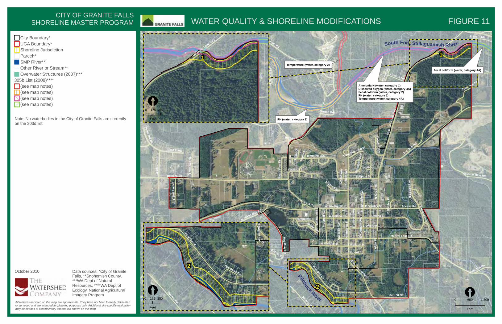
WATER QUALITY & SHORELINE MODIFICATIONS
All features depicted on this map are approximate. They have not been formally delineatedor surveyed and are intended for planning purposes only. Additional site-specific evaluationmay be needed to confirm/verify information shown on this map.
City Boundary*UGA Boundary*Shoreline JurisdictionParcel**SMP River**Other River or Stream**Overwater Structures (2007)***
305b List (2008)****(see map notes)(see map notes)(see map notes)(see map notes)
CITY OF GRANITE FALLSSHORELINE MASTER PROGRAM
[0 1,300650
Feet
MountainLoop Hwy
1
[0 350175
Feet PH (water, category 2)
Temperature (water, category 2)
Fecal coliform (water, category 4A)
Ammonia-N (water, category 1)Dissolved oxygen (water, category 4A)Fecal coliform (water, category 2)PH (water, category 1)Temperature (water, category 4A)
Note: No waterbodies in the City of Granite Falls are currentlyon the 303d list.
October 2010 Data sources: *City of GraniteFalls, **Snohomish County,***WA Dept of NaturalResources, ****WA Dept ofEcology, National AgriculturalImagery Program
Paradise Ln
Skinner Rd
SG
raniteAve
Fox Glove Cir
2
[0 350175
Feet
FIGURE 11

Pilchuck River
South Fork Stillaguamish River
SR92
100th St NE
Engebretsen Rd
Jordan Rd
Mou
ntai
nLo
opHw
y
Menzel Lake Rd
Paradise Ln
E Galena St
116th Pl NE
Chappel Rd
Crooked Mile Rd
115th St NE
Gun Club Rd
Wayside Mine Rd
NG
rani
teAv
eS
Gra
nite
Ave
169t
hD
r NE
84th St NE
E Stanley St
Robe Menzel Rd
Ray
Gray
Rd
Hemming Way
Access Rd
PilchuckTree
FarmRd
Cas
cade
Ave
Skinner Rd
211th Ave NE
103rd Pl NE
W Wallace St
192n
dD
r NE
SK
entu
cky
Ave
Pros
pect
Ave
NA
lder
Rd
E Alpine St
E Union St
Saratoga St
Noble Way
W Galena St
191s
t Dr N
E
W Stanley St
114th Pl NE
118th St NE
169t
hAv
eN
E
Port
age
Ave
NB
ogar
tAve
174t
hAv
eN
E
184t
hAv
eN
E
Pilchuck St
172n
dAv
eN
E
181st Dr N
E
177t
hAv
eN
E
117th Pl NE
118th Pl NE
175t
hAv
eN
E
Eagl
eVi
ewD
r
113th St NE
114th St NE
SBogart AveTompkins Pl
Darw
insW
ay
184t
hD
r NE
172n
dD
r NE
Waite Mill Rd
Para
dise
Pkw
y
200t
hAv
eNE
90th St NE
SW
abas
hAv
e
Ald
erPl
E Grand St
Bergan Rd
E Wallace St91st St NE
Leol
aLn
NK
entu
cky
Ave
Mountain View St
117th St NE
Pine
Ln
Popl
arLn
ESt
anle
yPl
Man
orW
ay
Vista Ct
Bergan Rd
Access Rd
118thSt NE
169thAve
NE
Access Rd
117th Pl NE
172n
dDr
NE
2
1
PUBLIC ACCESS
All features depicted on this map are approximate. They have not been formally delineatedor surveyed and are intended for planning purposes only. Additional site-specific evaluationmay be needed to confirm/verify information shown on this map.
City Boundary*UGA Boundary*Shoreline JurisdictionSMP River**Other River or Stream**City Parks*Snohomish County Parks**
CITY OF GRANITE FALLSSHORELINE MASTER PROGRAM
[0 1,300650
Feet
MountainLoop Hwy
1
[0 350175
Feet
FIGURE 12
October 2010 Data sources: *City of GraniteFalls, **Snohomish County,National Agricultural ImageryProgram
Paradise Ln
Skinner Rd
SG
raniteAve
Fox Glove Cir
2
[0 350175
Feet
Perrigoue Field
Galena Park
Jim Holm Park
Jack Webb Park
O'Reilly Acres
Riverscene

Pilchuck River
South Fork Stillaguamish River
SR92
100th St NE
Engebretsen Rd
Jordan Rd
Mou
ntai
nLo
opHw
y
Menzel Lake Rd
Paradise Ln
E Galena St
116th Pl NE
Chappel Rd
Crooked Mile Rd
115th St NE
Gun Club Rd
Wayside Mine Rd
NG
rani
teAv
eS
Gra
nite
Ave
169t
hD
r NE
84th St NE
E Stanley St
Robe Menzel Rd
Ray
Gray
Rd
Hemming Way
Access Rd
PilchuckTree
FarmRd
Cas
cade
Ave
Skinner Rd
211th Ave NE
103rd Pl NE
W Wallace St
192n
dD
r NE
SK
entu
cky
Ave
Pros
pect
Ave
NA
lder
Rd
E Alpine St
E Union St
Saratoga St
Noble Way
W Galena St
191s
t Dr N
E
W Stanley St
114th Pl NE
118th St NE
169t
hAv
eN
E
Port
age
Ave
NB
ogar
tAve
174t
hAv
eN
E
184t
hAv
eN
E
Pilchuck St
172n
dAv
eN
E
181st Dr N
E
177t
hAv
eN
E
117th Pl NE
118th Pl NE
175t
hAv
eN
E
Eagl
eVi
ewD
r
113th St NE
114th St NE
SBogart AveTompkins Pl
Darw
insW
ay
184t
hD
r NE
172n
dD
r NE
Waite Mill Rd
Para
dise
Pkw
y
200t
hAv
eNE
90th St NE
SW
abas
hAv
e
Ald
erPl
E Grand St
Bergan Rd
E Wallace St91st St NE
Leol
aLn
NK
entu
cky
Ave
Mountain View St
117th St NE
Pine
Ln
Popl
arLn
ESt
anle
yPl
Man
orW
ay
Vista Ct
Bergan Rd
Access Rd
118thSt NE
169thAve
NE
Access Rd
117th Pl NE
172n
dDr
NE
2
1
ECOLOGICAL FUNCTIONS
All features depicted on this map are approximate. They have not been formally delineatedor surveyed and are intended for planning purposes only. Additional site-specific evaluationmay be needed to confirm/verify information shown on this map.
City Boundary*UGA Boundary*Shoreline JurisdictionParcel**SMP River**Other River or Stream**
Ecological FunctionsModerateModerate/High
CITY OF GRANITE FALLSSHORELINE MASTER PROGRAM
[0 1,300650
Feet
MountainLoop Hwy
1
[0 350175
Feet
FIGURE 13
October 2010 Data sources: *City of GraniteFalls, **Snohomish County,National Agricultural ImageryProgram
Paradise Ln
Skinner Rd
SG
raniteAve
Fox Glove Cir
2
[0 350175
Feet

SUPPLEMENTAL FIGURE A CITY OF GRANITE FALLS SHORELINE MASTER PROGRAM
����������� ��������������������
���������
������
jlkj
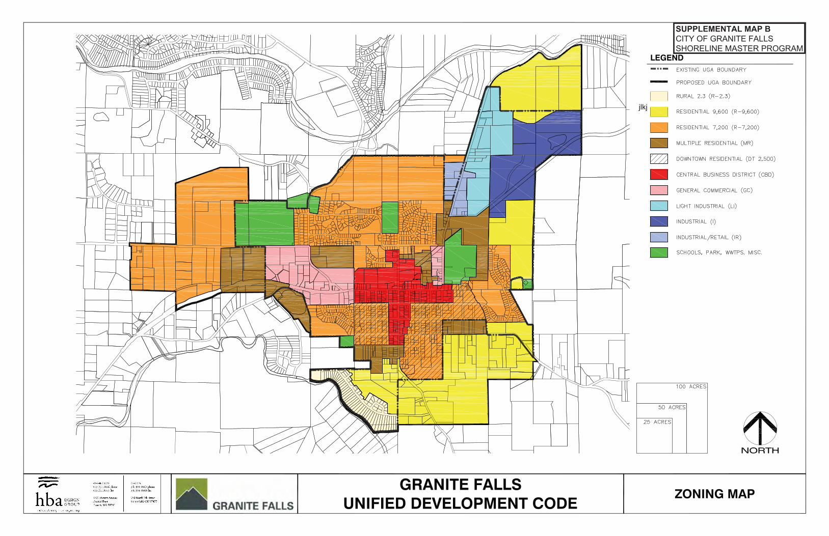
SUPPLEMENTAL MAP B CITY OF GRANITE FALLS SHORELINE MASTER PROGRAM

SUPPLEMENTAL FIGURE C CITY OF GRANITE FALLS SHORELINE MASTER PROGRAM

SUPPLEMENTAL FIGURE D CITY OF GRANITE FALLS SHORELINE MASTER PROGRAM