city of naples, florida sustainable stormwater
TRANSCRIPT
CITY OF NAPLES, FLORIDA SUSTAINABLE STORMWATER INFRASTRUCTURE IMPROVEMENTS
FOR IMPROVED COASTAL RESILIENCY
Karyn Erickson, PE, D CE, F ASCE1, Christin Perkinson2, PhD, PE, D CE, M ASCE and Gregg Strakaluse, PE, M ASCE3
1 President, Erickson Consulting Engineers, Inc., 7201 Delainey Court, Sarasota, FL
34240; PH (941) 373-6460; FAX (941) 373-6480; email: [email protected]
2 Vice President, Erickson Consulting Engineers, Inc., 7201 Delainey Court, Sarasota, FL 34240; PH (941) 373-6460; FAX (941) 373-6480; email: [email protected]
3 Director, City of Naples – Streets and Stormwater Department, 295 Riverside Circle, Naples, FL 34102; PH (239) 213-5000; email: [email protected]
ABSTRACT The City of Naples discharges stormwater through large pipes (18-48” diameter), supported by timber structures, which cross the beach and release the stormwater into the Gulf of Mexico during high frequency rainfall events. Periodic beach nourishment results in a dynamic shoreline which often blocks the outfall pipes’ flow due to sand build up, causing upstream flooding of the adjacent beach road which has elevations generally less than 4 ft MSL. This requires the upstream swales and roads to stage (flood) to open the blocked or tidally flooded pipelines for stormwater to discharge to the Gulf. In addition, these outfalls often become a petri dish for bacteria such as E-Coli and Enterococci and pre-date current, regulatory oversight prohibiting such discharges. The authors designed a functional and constructible stormwater infrastructure improvement project to reduce flooding (including sea level rise) and storm damage (for coastal resiliency) during high frequency events (e.g. <25-yr return period). The design consolidates the stormwater flow associated with five beach outfalls and conveys it to a pump station with water quality treatment and discharge through two directionally drilled pipelines a distance of 1,100 ft offshore. The beach outfalls will be removed from the sandy beach. Additionally, an overflow system will convey stormwater during extreme storm events when peak discharge volumes exceed the maximum capacity of the pump station. The design is a low impact and sustainable system to alleviate flooding and water quality issues on Naples Beach which was directly impacted by Hurricane Irma (Category 3) in September 2017.
INTRODUCTION Currently, the City of Naples (“City”) Drainage Basin II system collects stormwater and discharges through ten (10) beach outfalls located within the intertidal beach “swash” zone. These outfalls serve a drainage area of approximately 395 acres. The City has undertaken a proactive stormwater management program to implement projects and sustainable programs to improve water quality, flooding and coastal resiliency. In 2007, the City updated its stormwater masterplan to establish numerous goals and objectives and identified over $70-million in projects and programs aimed at managing stormwater as a resource, maximizing the treatment of water prior to discharge and improving flooding. There have been long-standing concerns from the State’s regulatory agencies, City officials and staff, environmental groups, property owners, residents and visitors that the City of Naples beach outfalls adversely impact beach erosion, beach access, sea turtle nesting habitat, water quality and beach aesthetics. In addition, the City has experienced significant flooding of the upstream roadway and properties during high frequency rainfall events. Beach outfalls typically pre-date current regulatory oversight prohibiting such discharges, and several nationally ranked beaches and Gulf coast tourist destinations have been affected by these same issues. In 2012, the City adopted a Resolution and amended their stormwater masterplan to require the removal of the City’s stormwater beach outfalls. These actions were taken in response to a Florida Department of Environmental Protection (FDEP) mandate to remove the outfalls as a condition of the County’s Beach Nourishment Projects. In 2013, an assessment was conducted to identify alternatives to reduce the impacts of the outfalls on the beach while maintaining the same level of service as compared to the existing conditions. These alternatives included the following:
1. Integration of beach outfalls with planned beach re-nourishment 2. Integration of beach outfalls with Aquifer Storage and Recovery (ASR)
system 3. Consolidation of beach outfall pipes with discharge through two beach
outfalls 4. Redirection of beach outfall flows via pump station to the Bay 5. Consolidation and extension of beach outfalls deeper and further into the Gulf
of Mexico (subaqueous outfalls)
Based on a combination of design, permitting and environmental considerations, and in consideration of Sarasota County’s recent success in the treatment of water quality and reduction in flooding by consolidating, treating and conveying stormwater discharge offshore through a pump station to an 18-inch offshore pipeline (Erickson, 2015), the City Council directed staff to pursue the subaqueous, Gulf outfall alternative. PROJECT GOALS AND OBJECTIVES In the current condition, the City of Naples discharges stormwater through large pipes (18-48” diameter), supported by timber structures, which cross the beach and release
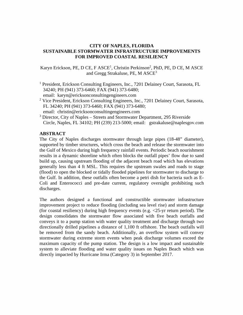
the stormwater into the Gulf of Mexico during high frequency rainfall events. Periodic beach nourishment results in a dynamic shoreline which often blocks the outfall pipes’ flow due to sand build up, causing upstream flooding of the adjacent beach road which has elevations generally less than 4 ft MSL. This requires the upstream swales and roads to stage (flood) to open the blocked or tidally flooded pipelines for stormwater to discharge to the Gulf. These outfalls, due to the aging concrete pipes and stagnant untreated stormwater, often become a petri dish for bacteria (Fecal Coliform and Enterococci). These existing conditions are reflected in Figure 1.
Figure 1. Existing Conditions
(Top Left: Blocked Discharge, Top Right: Water Quality Degradation; Bottom Left: Beach Erosion & Aesthetics Degradation; Bottom Right: Street Flooding) The central theme, or goal, of the Project was to design a functional and constructible stormwater infrastructure improvement project to reduce flooding (including sea level rise) and storm damage (for coastal resiliency) during high frequency events (e.g. <25-yr return period). To address the concerns identified – flooding, beach erosion, beach access, sea turtle nesting habitat, water quality and beach aesthetics – the following specific objectives were developed:
1. Reduce flooding (including the effects of sea level rise) of low-lying roadways 2. Improve the Level of Service and replace aging infrastructure 3. Improve Water Quality 4. Reduce Adverse Impacts to Beach Users (e.g. Swimming) 5. Reduce Impacts to Environmental Resources (e.g. Hardbottom) 6. Reduce Beach Erosion from Outfall Induced Scour
7. Improve Beach Access for Sea Turtles and Beach Users by Removing Pipes and Support Pilings
PROJECT OVERVIEW AND COMPONENTS The City’s Drainage Basin II is comprised of ten drainage sub-basins, each with beach outfall(s) (Figure 2). The outfall associated with drainage basin 1 is privately owned and excluded from the Project. Three of the City’s nine outfalls carry in excess of 60% of the total outflow to the Gulf. Outfall 2, located at the northernmost limit of the Project Area, represents 19% of the total flow, whereas Outfalls 6 and 8, in the southern portion of the Project Area, represent 31% and 17% of the total flow, respectively. As a result, the consolidation, and therefore pump station location(s), must be in close proximity to these outfalls due to spatial constraints and the geometric requirements of the pipeline to carry the flow. As such, the Project was divided into a “North System” and a “South System” as follows (Figure 3). The “North System” is designed to consolidate the existing stormwater flow associated with existing Outfalls 2, 3, and 4 (25-Yr) and convey the flow to a pump station located in sub-basin 2 with treatment and discharge lines deep drilled to a diffuser system placed offshore in the Gulf. The North System treats 100% of the 25-yr peak flow through the pump station. The City’s existing beach outfalls will be removed. The “South System” consolidates the existing stormwater flow associated with existing Outfalls 5, 6, 7, 8, 9 and 10 (25-Yr) and conveys the flow to a pump station in sub-basin 7 with treatment and discharge (5-Yr) through a diffuser system using directional drilled deep pipelines offshore. The South System treats 100% of the 5-yr and approximately 65% of the 25-yr peak flow through the pump station. The existing outfall in sub-basin 6will be modified to serve as an overflow line to convey stormwater (sub-basins 5 and 6) during extreme storm events, when peak discharge volumes exceed the maximum rate for the pump station, by diverting the flow from Alligator Lake. The overflow line will be located below the visible beach and open only during extreme storm events, estimated to occur once in 10-15 years. The remaining five beach outfalls are removed. In short, the Project components include:
1. Stormwater consolidation and conveyance to the pump stations 2. Two pump stations with backup generators 3. Directionally drilled pipelines for offshore discharge of stormwater 4. System overflow for extreme events (south system) 5. Pre-treatment/filtration for water quality improvement
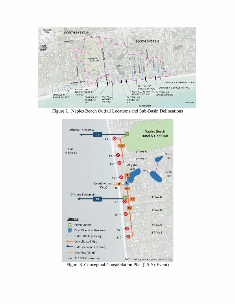
Figure 2. Naples Beach Outfall Locations and Sub-Basin Delineations
Figure 3. Conceptual Consolidation Plan (25-Yr Event)
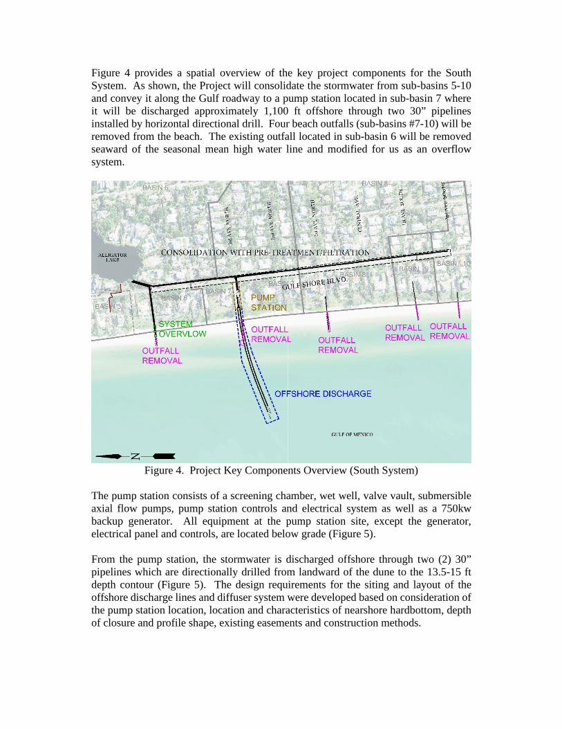
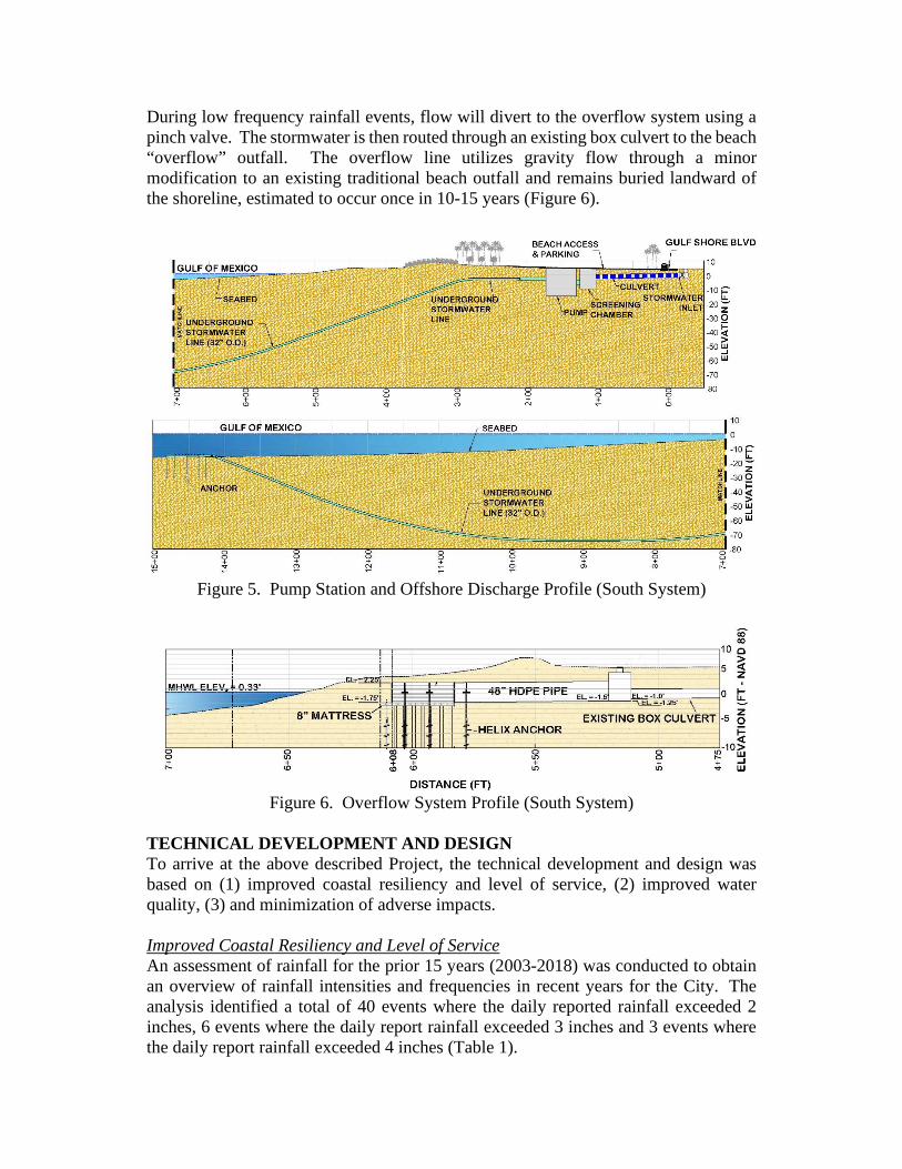
Figure 4 provides a spatial overview of the key project components for the South System. As shown, the Project will consolidate the stormwater from sub-basins 5-10 and convey it along the Gulf roadway to a pump station located in sub-basin 7 where it will be discharged approximately 1,100 ft offshore through two 30” pipelines installed by horizontal directional drill. Four beach outfalls (sub-basins #7-10) will be removed from the beach. The existing outfall located in sub-basin 6 will be removed seaward of the seasonal mean high water line and modified for us as an overflow system.
Figure 4. Project Key Components Overview (South System)
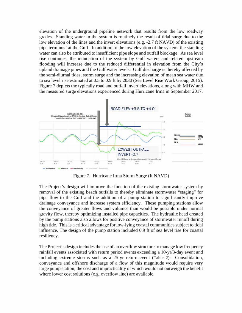
The pump station consists of a screening chamber, wet well, valve vault, submersible axial flow pumps, pump station controls and electrical system as well as a 750kw backup generator. All equipment at the pump station site, except the generator, electrical panel and controls, are located below grade (Figure 5). From the pump station, the stormwater is discharged offshore through two (2) 30” pipelines which are directionally drilled from landward of the dune to the 13.5-15 ft depth contour (Figure 5). The design requirements for the siting and layout of the offshore discharge lines and diffuser system were developed based on consideration of the pump station location, location and characteristics of nearshore hardbottom, depth of closure and profile shape, existing easements and construction methods.
During low frequency rainfall events, flow will divert to the overflow system using a pinch valve. The stormwater is then routed through an existing box culvert to the beach “overflow” outfall. The overflow line utilizes gravity flow through a minor modification to an existing traditional beach outfall and remains buried landward of the shoreline, estimated to occur once in 10-15 years (Figure 6).
Figure 5. Pump Station and Offshore Discharge Profile (South System)
Figure 6. Overflow System Profile (South System)
TECHNICAL DEVELOPMENT AND DESIGN To arrive at the above described Project, the technical development and design was based on (1) improved coastal resiliency and level of service, (2) improved water quality, (3) and minimization of adverse impacts. Improved Coastal Resiliency and Level of Service An assessment of rainfall for the prior 15 years (2003-2018) was conducted to obtain an overview of rainfall intensities and frequencies in recent years for the City. The analysis identified a total of 40 events where the daily reported rainfall exceeded 2 inches, 6 events where the daily report rainfall exceeded 3 inches and 3 events where the daily report rainfall exceeded 4 inches (Table 1).

Table 1. Rainfall Totals for the Naples Project Site (2003-2018)
Year Total
Days of Rainfall1
Total Days >0.5”
Total Days >1”
Total Days >2”
Total Days >3”
Total Days >4”
Total 1,746 377 165 40 6 3 Avg 109.1 29.9 13.1 3.3 0.6 0.2
Occurrence 29.90% 6.46% 2.83% 0.68% 0.10% 0.05% 1. (Weather Underground Naples Municipal Airport Gauge, 2019)
Rainfall intensities by return period are provided in Table 2, which include high frequency rainfall events represented by the 5-Yr/1-HR and 5-Yr/1-Day rainfall events to the low frequency 25-Yr/3-Day rainfall event.
Table 2. Design Storm Rainfall Totals Storm Event1 Rainfall Total (inches)
5-Yr/1-Hr 2.8 3-Yr/1-Day 4.5 5-Yr/1-Day 5.5 10-Yr/1-Day 7.0 10-Yr/3-Day 9.5 25-Yr/1-Day 8.0 25-Yr/3-Day 11.5
1. (SFWMD, 2016). Level of Service (LOS) is generally defined as the service capacity of the stormwater sewer system for a specific return period rainfall event based on the assumption that the collection structures and pipeline components of the stormwater sewer system are functioning at full capacity. The existing stormwater sewer is a gravity flow system with beach outfalls that are affected by mid to high tidal phases, storm surge and sand clogging the pipes; each of which compromise or reduce the LOS. The LOS, as it applies to the Project, is the design peak flow that the stormwater system can convey and contain prior to backup of the system (i.e., standing water within the streets). The LOS is a primary consideration in the system’s design as it establishes the system’s capacity (pump station, pipeline and stormwater structures sizing) and associated components (e.g. filter systems, etc) and as well as the system’s overflow line. The overflow line is required to provide discharge capacity during extreme low frequency storm events (i.e. conveys flows to the Gulf as a back-up or “overflow” to the primary conveyance system). The Project meets the City’s LOS requirements (5-yr/1-hr, 70 cfs) and 25-yr/3-day (152 cfs) for an improved LOS (Table 2). The primary site conditions that affect the pipeline design and consolidation were the low elevation of Gulf Shore Blvd and the adjacent ROW as well as the cumulative capacity required to convey the peak flow for a 25-Yr event. The roadway elevations within the Project area are low and range from +3.5 to +4.2 ft NAVD. The stormwater infrastructure is continually inundated with groundwater and tidal surge due to the
elevation of the underground pipeline network that results from the low roadway grades. Standing water in the system is routinely the result of tidal surge due to the low elevation of the lines and the invert elevations (e.g. -2.7 ft NAVD) of the existing pipe terminus’ at the Gulf. In addition to the low elevation of the system, the standing water can also be attributed to insufficient pipe slope and outfall blockage. As sea level rise continues, the inundation of the system by Gulf waters and related upstream flooding will increase due to the reduced differential in elevation from the City’s upland drainage pipes and the Gulf water levels. Gulf discharge is thereby affected by the semi-diurnal tides, storm surge and the increasing elevation of mean sea water due to sea level rise estimated at 0.5 to 0.9 ft by 2030 (Sea Level Rise Work Group, 2015). Figure 7 depicts the typically road and outfall invert elevations, along with MHW and the measured surge elevations experienced during Hurricane Irma in September 2017.
Figure 7. Hurricane Irma Storm Surge (ft NAVD)
The Project’s design will improve the function of the existing stormwater system by removal of the existing beach outfalls to thereby eliminate stormwater “staging” for pipe flow to the Gulf and the addition of a pump station to significantly improve drainage conveyance and increase system efficiency. These pumping stations allow the conveyance of greater flows and volumes than would be possible under normal gravity flow, thereby optimizing installed pipe capacities. The hydraulic head created by the pump stations also allows for positive conveyance of stormwater runoff during high tide. This is a critical advantage for low-lying coastal communities subject to tidal influence. The design of the pump station included 0.9 ft of sea level rise for coastal resiliency. The Project’s design includes the use of an overflow structure to manage low frequency rainfall events associated with return period events exceeding a 10-yr/3-day event and including extreme storms such as a 25-yr return event (Table 2). Consolidation, conveyance and offshore discharge of a flow of this magnitude would require very large pump station; the cost and impracticality of which would not outweigh the benefit where lower cost solutions (e.g. overflow line) are available.
Improved Water Quality A water quality sampling program was developed and implemented to identify and quantify the types and concentrations of pollutants that presently discharge through the City’s beach outfall pipes and identify suitable treatment to reduce levels of pollutants. Levels of nutrients (e.g. phosphorus, nitrogen) all tested below State Water Quality standards (F.A.C., 2016). In-depth testing for spatial and temporal variations showed bacteria at all outfalls exceeded State limits; however, while levels at the beach outfalls yielded high levels of Enterococci testing also revealed levels meeting State standards at the upstream weir. This strongly suggests the source of bacteria is the aging (>50 years) infrastructure. As such, the Project’s replacement of the lines will result in a direct and drastic improvement to bacteria levels. The water body impacted by the existing outfalls’ discharge is the Gulf of Mexico. No increase in discharge volume will occur as a result of the Project; therefore, no increase pollutants will be introduced in the marine environment. It is anticipated that the removal of debris, such as grass clippings, coconuts, branches and suspended sediment from the system, and the positive flow from the pump station with the new pipe network will contribute to significant improvements in overall water quality. Per City ordinance adopted in 2007, stormwater construction standards were implemented within the City limits to address water quality and quantity standards for new residential and commercial construction prior to discharge to the municipal stormwater system. All new development, redevelopment or substantial improvement of platted properties within the City of Naples shall meet a presumed pollutant removal of 85 percent Total Suspended Solids (TSS), Total Nitrogen (TN), and Total Phosphorus (TP). The new pump station includes a screening chamber which has a baffled ante-chamber where floating debris carried by the stormwater is intercepted. This ante-chamber will also serve as for grit collection, as heavier solids, sand, rocks, etc. will settle out prior to entering the back of the screening chamber. The chambers have access hatches and manholes for regular cleaning by city public works crews. In addition, the City will provide catch basin treatment by installing Grate Inlet Skimmer Boxes (GISB) at each new curb inlet drainage structure along the conveyance line within the Project Area. The City will also modify the existing Weir at Alligator Lake to capture coconuts prior to entering the stormwater conveyance system. The methods described herein will remove debris, sediment and nutrients (phosphorus, hydrocarbons, nitrogen) from the stormwater prior to discharge to the Gulf. Future implementations to improve water quality may include the incorporation of a combination of bio-swales, in-line sediment separators, and/or UV filtration systems selected based on the results of monitoring and adaptive management. Minimization of Impacts To avoid environmental impacts, the gulf discharge pipeline will be directionally drilled from a point landward of the dune. To avoid the periodic covering and scouring of the diffuser structure, the pipeline outfall must be located seaward of the depth of

closure, established as the -13.5 ft (NAVD 88) contour. This depth is based on a historical analysis of beach profile changes and represents the depth where sediment movement is negligible, and where sea bottom remains the same over time. In addition, the outfall structure must be located in sufficient depths so as not to become an obstruction to boaters and to maximize vertical mixing of freshwater and seawater. As such, the pipelines were designed to surface between the -14 and 16 ft (NAVD 88) depth contours. Another factor in determining the location of the outfall structures (pipeline emergence) is the offset to natural resources as this relates to the mixing zone. The mixing zone is defined as the region in which the dilution of discharged “freshwater” from the stormwater discharge is mixed and diffuses with the “ocean” waters to reach naturally occurring salinity levels. Full freshwater dilution is achieved within the mixing zone. Sediment concentration levels for the discharge flows must also be considered. The mixing zone for the freshwater discharge to the gulf waters is a function of the flow rates, total suspended solids (TSS), water depths and diffuser system design. Distance to a nearby artificial reef is more than 2.5 times the distance estimated for the mixing zone for low frequency rainfall events (5.5 inches in 24-Hr), resulting in Gulf water salinities expected to be 90% of ambient conditions. ANTICIPATED OUTCOME By removing the existing beach outfalls, the Project restores approximately 0.3 acres of beach thereby enhancing habitat for nesting sea turtles as well as restoring recreational use for beach users. The Project consolidates and conveys 100% of the 5-yr peak flow and 71% of the 25-yr flow to two pump stations for discharge offshore through HDD pipelines. The remaining 29% of the 25-yr flow is handled through an overflow line for conveyance of peak flow that exceeds design capacity during extreme storm events. The overflow utilizes an existing outfall which is modified to be located below the visible beach and open only during unusually high flow rates associated with extreme storm events. Hurricane Wilma (2005, 6” event) and similar storm events occurring over the past 14 years (2003- present) would not have resulted in flow that exceed the peak capacity of the system and storage capacity at Alligator Lake, resulting in opening of this overflow line. Only Hurricane Irma (2017, 13” event) would have resulted in the opening of the overflow line during this 15 year period. By replacing aging infrastructure, the target levels for bacteria (Enterococci and Fecal Coliform) are expected to be reduced up to 200% for compliance with Florida Standards (F.A.C., 2016). Using a combination of upstream pre-treatment at the catch basins and the pump stations’ screening chambers, as well as the continued implementation of the City’s stormwater standards for commercial and residential construction, up to 90% of total suspended solids, 70% of phosphorus, and 60% of nitrogen are expected to be removed from the collected stormwater prior to discharge to the Gulf. A comprehensive monitoring and adaptive management plan is developed to monitor the improvements to water quality and implement changes as necessary to maximize
efficiencies and ensure the program meets or exceeds State of Florida water quality standards. Sufficient spatial and design considerations were built into the Phase 1 system to accommodate the future implementation of bio-swales, in-line sediment separators, and/or UV filtration systems based on the results of quarterly monitoring and adaptive management. CONCLUSIONS The central theme, or goal, of the Project, was to design a functional and constructible stormwater infrastructure improvement project to reduce flooding (including sea level rise) and storm damage (for coastal resiliency) during high frequency events (e.g. <25-yr return period). The Project design address flooding, beach erosion, beach access, sea turtle nesting habitat, water quality and beach aesthetics, with plans for monitoring and adaptive management to ensure performance goals are met. Despite the high uncertainty of climate change and sea level rise, it is important that the City develop infrastructure to have the resiliency needed to function adequately in the face of change. The opportunity exists with projects such as this one, where infrastructure is being modified or improved, to build this adaptation and resiliency into the normal infrastructure renewal cycle. This concept of “mainstreaming” adaptation by focusing on the most urgent effect of climate change and sea level rise allows resiliency to happen at very little adaption cost. The overall Project Design provides a low impact coastal, environmental and stormwater engineering design that includes a directionally drilled pipeline and a diffuser system, and pump stations with a filtration system to reduce chronic flooding and improve water quality. REFERENCES Erickson Consulting Engineers, Inc. (2017). Naples Beach Restoration & Water
Quality Improvement Project: 30% Design Technical Report. Erickson, K. and Perkinson, C.
Erickson Consulting Engineers, Inc. (2018). Naples Beach Restoration & Water Quality Improvement Project: 60% Basis of Design. Erickson, K. and Perkinson, C.
Erickson, K. C. (2015). Construction of Offshore Stormwater Discharges Using HDD Technologies. North American Society for Trenchless Technology (NASTT). Denver, CO: TM2-T2-04.
F.A.C. (2016). 62-302.530 Table: Surface Water Quality Criteria. State of Florida. Sea Level Rise Work Group. (2015). Unified Sea Level Rise Project: Southeast
Florida. Southeast Florida Regional Compact Climate Change. SFWMD. (2014). SFWMD Environmental Resource Permit Applicant's Handbook,
Volume II. SFWMD. (2016). Environmental Resource Permit Applicant's Handbook Volume II.
South Florida Water Management District. Weather Underground Naples Municipal Airport Gauge. (2019, Jan).