city of siloam springs planning commission agenda
TRANSCRIPT

CITY OF SILOAM SPRINGS PLANNING COMMISSION Tuesday, June 8, 2021 at 5:30 p.m.
City Administration Building 400 N. Broadway
AGENDA
I. Planning Commission
A. Call to OrderB. Roll CallC. Approval of Minutes of the meeting of May 11, 2021D. Development Permit Approval
1. Significant Development Permit, SD21-0322000 Hwy. 16Owner: Beehive Enterprises, LLCAgent: Ingenium Enterprises, Inc, Erik Houston, PE To the Board on July 6, 2021Remanded from May 4, 2021 Board of Directors
2. Significant Development Permit, SD21-053600 S. Lincoln St.Owner: Arkansas Baptist State ConventionAgent: Lewis Architects Engineers, Josh Minton, P.E. To the Board on July 6, 2021
3. Significant Development Permit, SD21-074290 Hwy. 412 EastOwner: Randy and Donna McReynoldsAgent: Civil Engineering Inc, Ron Homeyer, PE. To the Board on July 6, 2021
4. Preliminary Plat Development Permit, PP21-03300 to 500 Block of E. Oak Crest Rd.Owner: Wakefield Investments, Jim KreinAgent: Civil Engineering Inc, Ron Homeyer, PE. To the Board on July 6, 2021
E. Staff Update on Preliminary Plat, PP21-02, Bellevue Estates.F. City Comprehensive Plan Monthly UpdateG. Board Approved Permits
1. Annexation / Zoning Development Permit, AX21-03 22100 Block of Hwy. 16Owner: Michael CoxTo the Board on June 15, 2021

2
2. Annexation / Zoning Development Permit, AX21-04 23324 Raines Road Owners: City of Siloam Spring and Michael and Roberta Burkitt To the Board on June 15, 2021
H. Staff Approved Permits
1. Lot Split Development Permit, LS21-07
1803 Dawn Hill Rd. Owners: Jeff Stewart Went to the Board for Easements on June 1, 2021
2. Lot Split Development Permit, LS21-09
21400 Block of Davidson Rd. Owners: Linda Busse and Barbara Kenney Went to the Board for Easements on June 1, 2021
3. Lot Line Adjustment Development Permit, LA21-04
2500 and 2690 Hwy. 412 East Owner: Stewart Geyer Agent: Bates and Associates – Jose Rios, PLS Went to the Board for Easements on June 1, 2021
I. Adjournment

MINUTES OF THE REGULAR MEETING OF THE PLANNING COMMISSION OF THE
CITY OF SILOAM SPRINGS, BENTON COUNTY, ARKANSAS MAY 11, 2021
The Planning Commission of the City of Siloam Springs, Benton County, Arkansas, met in regular session at the City Administration Building on May 11, 2021. The meeting was called to order by Chairman Smith. Roll Call: Song, Montgomery, Salley, McKinney, Smith, Driscoll, McKenzie – Present. Present City Staff: Senior City Planner, Ben Rhoads; City Engineer, Justin Bland; and City Attorney, Jay Williams; Permit Technician, Brian Phillips; all present. A copy of the April 13, 2021, minutes had previously been given to each Commissioner. A motion was made by Driscoll and seconded by McKenzie to accept the minutes. A Voice Vote was taken on the pending motion. Motion passed unanimously. Item D1. Significant Development Permit, SD21-06, 22100 Highway 16. Ben Rhoads briefed the item. Staff recommended approval with conditions. Following discussion by the commission, a motion was made by Montgomery to approve the item with staff’s stated conditions and seconded by Salley. Motion passed unanimously. This item will go to the Board of Directors on June 1, 2021. Item D2. Preliminary Plat Development Permit, PP21-02, 816 Arkansas Highway 16. Rhoads briefed the item. Staff advised the project is not ready for review due to need for a new drainage plan. Staff recommended tabling to the June 8th meeting. Following discussion by the commission, a motion was made by McKenzie to table the item and seconded by Song. Motion passed unanimously. This item will go to the Planning Commission on June 1, 2021. Item D3. Final Plat Development Permit, FP21-02, 2900 Block of Cheri Whitlock Drive. Rhoads briefed the item. Staff recommended approval with conditions. Following discussion by the commission, a motion was made by McKinney to approve the item with staff’s stated conditions and seconded by Driscoll. Motion passed unanimously. This item will go to the Board of Directors on June 1, 2021. Item D4. Rezone Development Permit, RZ21-03, 2900 Block of Cheri Whitlock Drive. Rhoads briefed the item. Staff recommended approval. Following discussion by the commission, a motion was made by McKenzie and seconded by Song. Motion passed unanimously. This item will go to the Board of Directors on June 1, 2021. Item D5. Rezone Development Permit, RZ21-04, 1803 Dawn Hill Road. Rhoads briefed the item. Staff recommended approval. Following discussion by the commission, a motion was made by Song and seconded by Salley. Motion passed unanimously. This item will go to the Board of Directors on June 1, 2021.

Item D6. Rezone Development Permit, RZ21-05, 3550 Highway 412 East. Rhoads briefed the item. Staff recommended approval. Following discussion by the commission, a motion was made by McKinney and seconded by McKenzie. Motion passed unanimously. This item will go to the Board of Directors on June 1, 2021. Item D7. Special Use Development Permit, SU21-03, 305 South Mt. Olive Street. Rhoads briefed the item. Staff recommended approval. Ron Jeffries, 307 South Mt. Olive Street, addressed the commission with concerns about extended use, planned improvements, repair of fence by the retaining wall, old foundation by retaining wall breaking down, and access to maintain utilities through his property. Carolyn Ruud, 308 South Mt. Olive Street, addressed the commission with concerns about the lack of parking at the location and did not want people to park in her location. Chad Dilday, 514 Tiger Boulevard, Bentonville, Arkansas addressed the stated concerns. Following discussion by the commission, a motion was made by Salley and seconded by Driscoll. Motion passed unanimously. This item will go to the Board of Directors on June 1, 2021. Item E. City Comprehensive Plan Monthly Update. Rhoads briefed the item. Item F1. Final Plat Development Permit, FP21-01, 2300 Block of N. Mt. Olive Street. Rhoads briefed the item. To the Board on June 1, 2021. Item G1. Lot Line Adjustment Development Permit, LA21-02, 3550 Highway 412 East. Rhoads briefed the item. Went to the Board for Easements on May 4, 2021. Item G2. Lot Line Adjustment Development Permit, LA21-03, 606 and 612 North Madison Street. Rhoads briefed the item. To the Board for Easements on May 18, 2021. There being no further business, a Motion was made by Driscoll and seconded by McKenzie to adjourn. A Voice Vote was called. Motion passed unanimously. Meeting adjourned. ATTEST: APPROVED: _________________________ ______________________________ Renea Ellis, City Clerk J.W. Smith, Chairman (SEAL)

PLANNING COMMISSION STAFF REPORT TO: Planning Commission FROM: Ben Rhoads, AICP, Senior Planner Justin Bland, PE, City Engineer Cc: Don Clark, Community Development Director DATE: May 13, 2021 RE: Significant Development Permit, SD21-03 / 22000 Hwy. 16 Recommendation: Motion to table SD21-03 (Significant Development Permit).
Section A: Background A-1) APPLICATION REVIEW DATES Planning Commission 1st review: April 13, 2021 Board of Directors review: May 4, 2021 (Remanded) Planning Commission 2nd review: June 8, 2021 A-2) APPLICANT AND AGENT Applicant/Owner: Beehive Enterprises LLC Agent: Ingenium Enterprises, Inc. – Erik Houston, P.E. A-3) SUBJECT PROPERTY ADDRESS
22000 Hwy. 16. A-4) PROJECT SUMMARY
The applicant requests to construct a 15,000 sq. ft. industrial / warehouse facility. This facility is the first phase of a larger five building complex. Due to the development approved development of Rock Hill Foods (SD21-06), the applicant has elected to make changes to their plan, in particular the configuration of the stormwater detention basin and related drainage ditch. This permit was remanded at the May 4, 2021 Board of Directors to the June 8, 2021 Planning Commission; however, the redesign was not provided for re-review until June 1, 2021. Therefore staff, on behalf of the applicant, is requesting that this application be tabled to the July 13, 2021 Planning Commission. The full staff report, attachments, and analysis will be furnished once a final design is ready for review.
A-5) LEGAL NOTICE
Site posted: February 5, 2021; reposted March 9, 2021. Newspaper legal notification: February 21, 2021 (Arkansas Democrat Gazette).; re-notified
on March 24, 2021 (Herald-Leader) Letter legal notification: March 17, 2021.1 Staff received three calls of a questioning nature and no correspondence on the request.
1The applicant failed to complete legal notice in February, so he had to renotify in March.
PLANNING COMMISSION STAFF REPORT
TO: Planning Commission FROM: Ben Rhoads, AICP, Senior Planner Justin Bland, PE, City Engineer Cc: Don Clark, Community Development Director DATE: May 14, 2021 RE: Significant Development Permit, SD21-05 / 3600 S. Lincoln St. Recommendation: Motion to approve SD21-05 (Significant Development Permit), subject to the following condition: 1.) The applicant shall provide a utility easement via separate instrument for the relocation of
the public sewer line, prior to building permit issuance. Section A: Background: A-1) APPLICATION REVIEW DATES
Planning Commission review: June 8, 2021 Board of Directors review: July 6, 2021
A-2) APPLICANT AND AGENT
Applicant/Owner: Camp Siloam – Jason Wilkie, Director / Ark. Baptist State Convention Agent: Lewis Architects Engineers – Josh Minton, P.E.
A-3) SUBJECT PROPERTY ADDRESS
3600 S. Lincoln St. A-4) PROJECT SUMMARY
The applicant requests to construct a 5,800 sq. ft. housing facility at an institutional church camp known as Camp Siloam.
A-5) LEGAL NOTICE Site posted: May 6, 2021. Newspaper legal notification: May 19, 2021 (Herald-Leader). Letter legal notification: May 14, 2021. Staff received no calls or correspondence on the request.
A-6) ANTICIPATED PROJECT APPROVAL EXPIRATION DATE If this project is approved on the projected Board of Directors’ review date, the project will expire if no work begins on or before: July 6, 2022. For cause shown, the applicant may request a 180-day deadline extension if received no less than 30 days prior to the shown expiration.
6/3/21 P.N. 03-00393-010, SD21-05 2
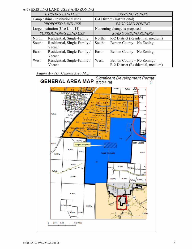
A-7) EXISTING LAND USES AND ZONING
EXISTING LAND USE EXISTING ZONING Camp cabins / institutional uses. G-I District (Institutional)
PROPOSED LAND USE PROPOSED ZONING Large institution (Use Unit 14) No zoning change is proposed
SURROUNDING LAND USE SURROUNDING ZONING North: Residential, Single-Family North: R-2 District (Residential, medium) South: Residential, Single-Family /
Vacant South: Benton County – No Zoning
East: Residential, Single-Family / Vacant
East: Benton County – No Zoning
West: Residential, Single-Family / Vacant
West: Benton County – No Zoning / R-2 District (Residential, medium)
Figure A-7 (1): General Area Map
6/3/21 P.N. 03-00393-010, SD21-05 3
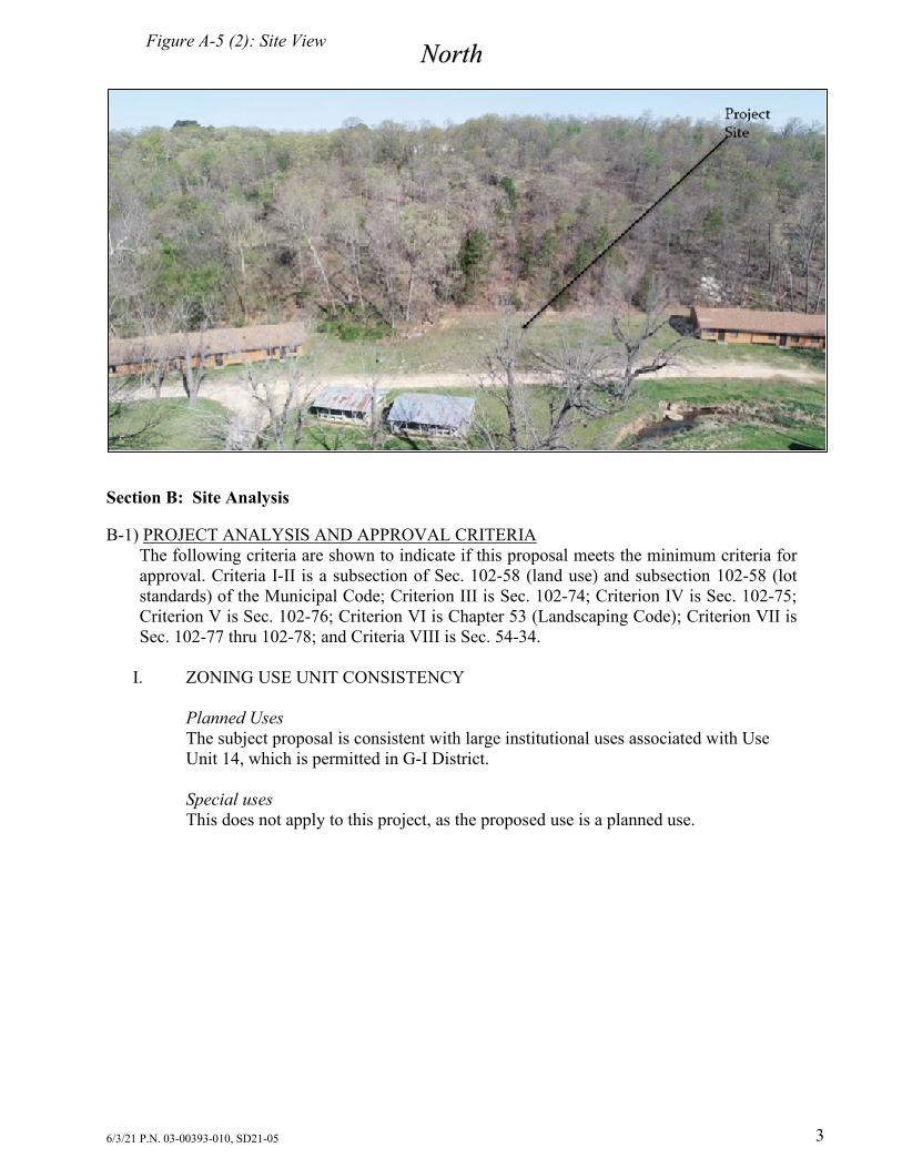
Figure A-5 (2): Site View
Section B: Site Analysis B-1) PROJECT ANALYSIS AND APPROVAL CRITERIA
The following criteria are shown to indicate if this proposal meets the minimum criteria for approval. Criteria I-II is a subsection of Sec. 102-58 (land use) and subsection 102-58 (lot standards) of the Municipal Code; Criterion III is Sec. 102-74; Criterion IV is Sec. 102-75; Criterion V is Sec. 102-76; Criterion VI is Chapter 53 (Landscaping Code); Criterion VII is Sec. 102-77 thru 102-78; and Criteria VIII is Sec. 54-34.
I. ZONING USE UNIT CONSISTENCY
Planned Uses The subject proposal is consistent with large institutional uses associated with Use Unit 14, which is permitted in G-I District. Special uses This does not apply to this project, as the proposed use is a planned use.
North

6/3/21 P.N. 03-00393-010, SD21-05 4
II. LOT STANDARDS CONSISTENCY The minimum G-I zone standards are compared with the subject property’s lot below:
MINIMUM (G-I) ZONING REQUIREMENTS
SUBJECT PROPERTY PROPOSAL
(d) lot dimensions (1) Lot Area: 5,000 sq. ft.
176.68 acres
(2) Lot Width: 50 ft. Approx. 1768.75 feet (e) Building limits (1)(c) Setback required from an arterial street or larger. 1. Front: 50 feet
1182 ft.1
2. Side: 10 feet 904 ft. (East side) 351 ft. (West side)
3. Side on Corner: 15 feet N/A 4. Rear: 20 feet 1,578 ft. (2)(a) Height Limit: 72 feet maximum Approx. 20 ft. (3) Floor / area Ratio: 0.60 (maximum) 1.76 % (4) Maximum Lot Coverage: 60 percent 4.0 % (f) Open Space2 (1) Landscape buffer not less than six feet wide along property lines and a 6 ft. opaque screen, 12 feet along the front property line if fronting on a principal arterial street
North: 945 ft. South: 136 ft East: 30 ft. West: 394 ft.
(2) Minimum percent of open space: 60% 96% 1Measured to the right-of-way of Hwy. 59 S. 2Based on existing site conditions, not the proposed structure.
III. PARKING SPACE DESIGN CONSISTENCY1
PARKING SPACE REQUIREMENTS SUBJECT PROPERTY PROPOSAL
(1) At least 9 ft. wide by18 ft. long Existing spaces comply (2) Graded for effective drainage Existing spaces comply (3) Surfaced with asphalt or concrete Existing spaces legal non-conforming (4) Sited to not block emergency
vehicle access Existing parking complies per FD review
(5) Minimum parking lane width: 24 ft (15 feet for a one-way drive).
N/A
(6) Curbed if 8 feet from sidewalk N/A (7) Lot striping N/A
1No new parking is proposed.

6/3/21 P.N. 03-00393-010, SD21-05 5
IV. PARKING STANDARDS CONSISTENCY According to Municipal Code, parking for the facility is best calculated by using the standards for schools. The formula is 1 space for every employee at the most staffed works shift.
USE REQUIRED PARKING
EXISTING PARKING
NET PROPOSED PARKING1
PARKING SURPLUS/ DEFICIT
Camp – 173 employees
173 163 0 -1574
Camp –Students 1000
02 0 0 0
1 Includes ADA accessible spaces. 2 Students are either bussed to the site and/or are not of legal driving age. 3 Existing spaces are gravel. 4 The parking deficit is considered legal non-conforming. The proposed facility does not require additional parking. See staff discussion for more details.
V. PARKING AREA DESIGN STANDARDS CONSISTENCY
CONDITION FOR NUMBER OF PARKING SPACES
SUBJECT PROPERTY PROPOSAL
(1) 5 or more spaces: shall be continuous lit at night.
No new outdoor parking lot lighting is proposed
(2) 8 or more spaces: adequate turn around.
The Fire Department reviewed the proposal and determined that it allows for adequate vehicular turn around on all proposed parking areas
(3) 10 or more: shall be paved with asphalt or concrete.
No new parking is proposed
(4) Parking lot landscaping is required as follows: a. 12-50: 6 percent of gross interior parking area
No new parking is proposed
(5) No parking allowed along easements, except as specifically shown
The parking area encroachment into the easement is typical and has been approved by all public and private utilities
VI. LANDSCAPING COMPLIANCE
After staff review, it was determined that the existing trees and shrubs accounts for all landscaping needs. As such, no landscaping plan is required.

6/3/21 P.N. 03-00393-010, SD21-05 6
VII. DRIVEWAY DESIGN STANDARDS CONSISTENCY The driveways are existing, no changes are proposed; therefore, the driveway design standards consistency is not reviewed as part of this proposal.
VIII. LAND USE CODE REQUIREMENTS
According to the Land Use Code, a significant development permit shall only be authorized when the applicant has convincingly demonstrated that the proposed significant project: (1) Will not interfere with other owners’ reasonable peace and enjoyment of their
neighboring properties:
(2) Will not substantially damage any property value in the neighborhood:
(3) Will be compatible with and respect the context of its location and the character of the surrounding existing neighborhoods:
(4) Will not, whether by the nature of the use, or by the siting, height, or design of structures or landscaping, tend to burden the present or future use of neighboring properties in accordance with current zoning standards:
1Founding date taken from the camp’s website: campsiloam.com
The applicant’s proposal is a bunkhouse structure. Staff is aware of no evidence that the proposed development will cause a consistent disturbance to the peace and enjoyment of the neighboring properties. Enforcement of the City Code’s nuisance chapter will ensure that excessive noise, or unsightly debris, etc. is mitigated. These rules ensure that the proposal will not inherently decrease the quality of life standards in place across the City.
There is no evidence that the proposal will cause any substantial burden to the present uses around the area. The proposed facility is in lieu of a facility that was approved, but was not built, in 2020. The previous unbuilt facility was meant to replace a one damaged by a tornado in October of 2019, therefore the proposed use will not increase the overall impact at the camp.
The proposed structure is consistent with the historic use as a church camp which has been in place at this site for at least 98 years1.
The property is located along a major thoroughfare and is zoned appropriately for institutional use. The general land use patterns of the City dictate that this use is consistent with historical uses on the site, and it will not substantially impact the existing property values in the area.

6/3/21 P.N. 03-00393-010, SD21-05 7
(5) Is adequately supported by infrastructure, including without limitation, water and sewage systems, streets, parking, and drainage:
(6) Is consistent with sound planning of the city’s growth in terms of health, safety, and convenience within the neighborhood and affected vicinity:
(7) Promotes favorable economic conditions or public welfare within the city.
B-2) COMPREHENSIVE PLAN CONSISTENCY
The 2030 future land use map describes this area as public facilities. The following zone is appropriate according to the designation: G-I. The proposed use is compliant with the G-I zone.
B-3) TRAFFIC IMPACT
As the proposed development is intended to replace an existing structure on the site, there is no expected increase in traffic to or from the site. As mentioned in report section VIII-4, the previously approved bunkhouse was never constructed.
The new camp expansion will provide and improved facility for their patrons, which will increase the value of the facility to the area and its parent institution.
There is nothing in the proposal which would indicate unsound city planning. The camp’s expansion is a repair to the existing land use, which is historically compatible with the neighborhood.
Water System There is an existing 6” water line that runs along Hwy. 59 to service the site as well as neighboring subdivisions. As staff does not expect the proposed bunk house to substantially change demands, staff finds this existing infrastructure to be adequate for fire and domestic water needs. Sanitary Sewer System The existing sewer system for the site is collected with private sewer lines that drain to a City sewer lift station that pumps the sewer to the north. As staff does not expect the proposed bunk house to substantially change demands, staff finds this existing infrastructure to be adequate, however a new sewer line easement is needed because the plan requires a line to be relocated on the site. See the staff suggested condition. Storm Sewer System Due to the size of the site and the location of the site being adjacent to Little Beaver Creek, storm water detention is not being proposed. This is typical of site alongside major drainage channels as detaining flows can inadvertently cause increases in the peak flow from the site. Parking
6/3/21 P.N. 03-00393-010, SD21-05 8
B-4) UTILITY DESIGN
Water The proposal ties into the existing water main with a service line adjacent to the building. Sanitary Sewer The proposal ties into the existing sewer main with a service line adjacent to the building. Storm Sewer/Drainage See discussion in Section B-1 (Criterion VIII-5)
B-5) STAFF DISCUSSION General Summary Proposal is 5,800 sq. ft. bunk house facility, intended for overnight lodging at the grounds
of Camp Siloam. The proposed facility replaces an existing bunkhouse that was damaged by a tornado on
October 21, 2019. In 2020, the applicant sought and received a significant development permit (SDP) to
construct a 9,275 sq. ft. guest housing facility. This facility was never constructed by the applicant due to complications surrounding Covid-19, which delayed camp operations in 2020.
The 2020 SDP became expired on March 3, 2021. The applicant may construct this larger bunkhouse; however, a new SDP will be required due to the expiration.
The current proposed facility is located on the northern side of the camp, situated between two existing bunkhouse structures.
The new site requires the removal, or relocation, of two outdoor seating pavilions, as it is positioned closer to the interior of the camp than the two structures on either side.
Traffic Flow and Site Design Existing drives will reach the proposed facility site, the existing drives service the other
housing facilities in the vicinity. Parking Area Design Due to the nature of this proposal, being a replacement of a damaged facility, no new
parking is proposed. Most users will be bussed, or driven, to and from the site, resulting in no new parking demand.
Pedestrian Mobility The built context of the camp is a pedestrian rich
facility with limited locations appropriate for motor vehicles. As such, the area is appropriate for a free-range of pedestrian movement and recreational spaces.
The facility will have ample pedestrian access and mobility.
Other Considerations Drainage will be handled through the existing creek run-off system. See Section B-1
Criterion VIII-5 for more information. A new sewer line is proposed that will require an utility easement, there is a condition
added to acquire this easement prior to building permit issuance.
Key Points: • Consistent with zoning • Replacement facility with
no new impacts • New parking is not needed • Adequate utility and
pedestrian access

6/3/21 P.N. 03-00393-010, SD21-05 9
Conditions and Staff Conclusions As shown on page 1 of this report, staff is recommending approval with one condition
needed relating to a needed utility easement for the sewer line. Section C: Fiscal Impact Per the existing Master Street Plan, offsite street improvements are not applicable for this project due to it replacing an existing, damaged facility. Attachments:
Site Proposal Architectural Rendering

G-I
FOUND IRON PIN
FOUND RIGHT-OF-WAY MARKER
FOUND STONE
BUILDING SETBACK LINE
UTILITY EASEMENT LINE
PROPOSED BUNK HOUSE5,800 S.F.
DATE:
REVISION:
PROJECT NO:DRAWN BY:
27 APR 202121031
JM
C2.01 OF 1
SCALE: 1" = 200'SIG. DEV. SITE PLAN
C2.01
NORTH
0 200 400
BUN
K H
OU
SE A
TC
AMP
SILO
AM
SILO
AM S
PRIN
GS,
AR
KAN
SAS
SD21-05 (Camp Siloam) 2nd Submittal
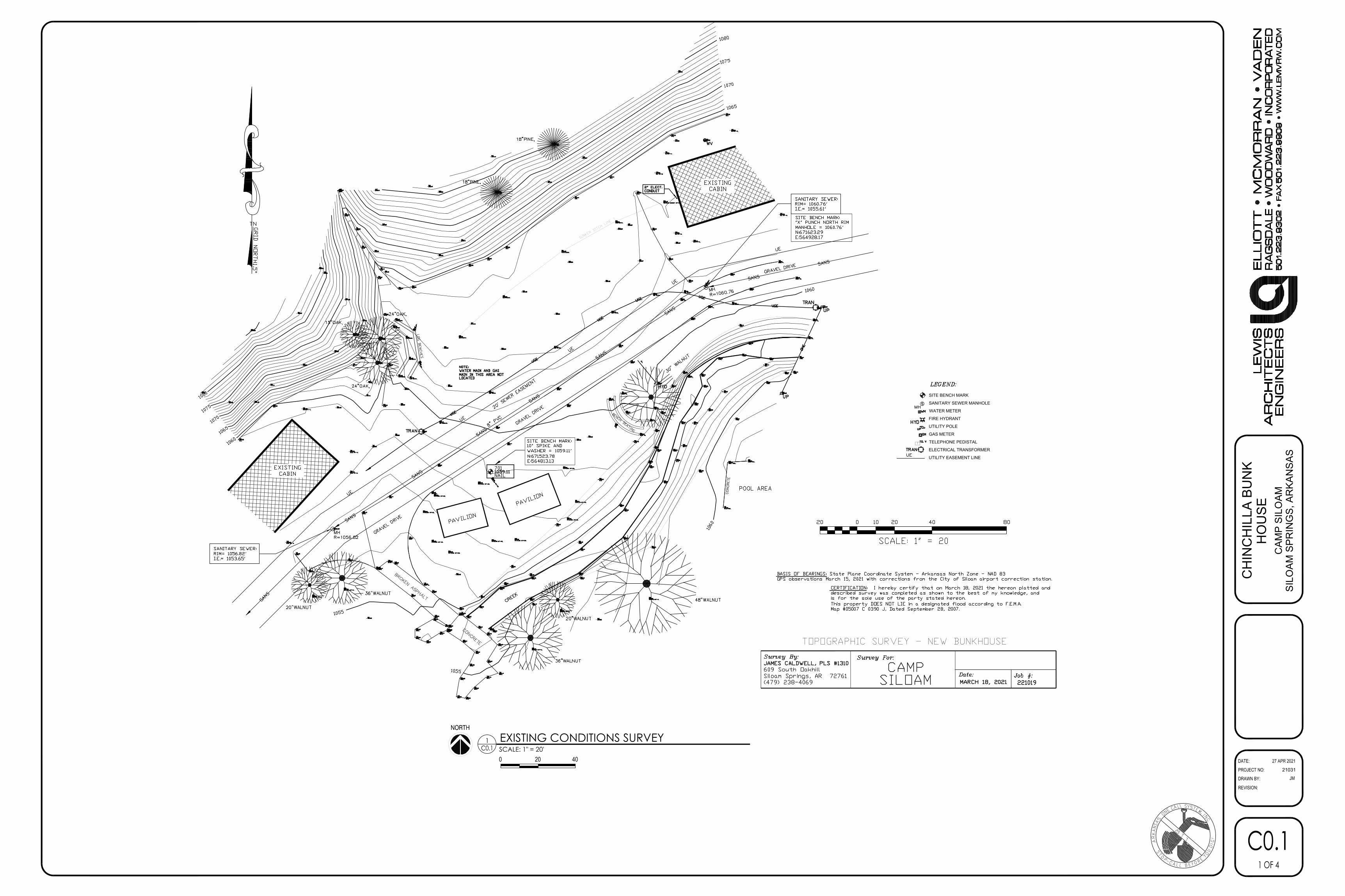
SITE BENCH MARK
SANITARY SEWER MANHOLE
WATER METER
FIRE HYDRANT
UTILITY POLE
GAS METER
TELEPHONE PEDISTAL
ELECTRICAL TRANSFORMER
UTILITY EASEMENT LINE
DATE:
REVISION:
PROJECT NO:DRAWN BY: JM
C0.11 OF 4
SCALE: 1" = 20'EXISTING CONDITIONS SURVEY
C0.11
NORTH
0 20 40 27 APR 2021
CH
INC
HIL
LA B
UN
KH
OU
SEC
AMP
SILO
AMSI
LOAM
SPR
ING
S, A
RKA
NSA
S
21031

BUNK HOUSEFFE=1063.00
*NOTE: SEE C1.2 FOR UTILITYRELOCATION AND DEMO UNDER
BUILDING PAD
ROCK DITCHCHECK (3/C1.0)
SILT FENCE (2/C1.0)
SILT FENCE (2/C1.0)
SILT FENCE (2/C1.0)
DEMO TREE &SEATING AREA
DEMO TREES &SEATING AREA
DEMO PAVILIONS
SEE E1.0 FOR UNDERGROUNDELEC. RELOCATION 1061
1062
1062
1063
1064
1062
1060
1058
1056
1059
1061
1062
SILT FENCE (2/C1.0)
ROCK DITCHCHECK (4/C1.0)
SCALE: N.T.S.SILT FENCE DETAIL2
C1.0
DATE:
REVISION:
PROJECT NO:DRAWN BY: JM
C1.02 OF 4
SCALE: 1" = 20'SITE DEMOLITION & EROSION CONTROL PLAN
C1.01
NORTH
0 20 40
27 APR 2021
CH
INC
HIL
LA B
UN
KH
OU
SEC
AMP
SILO
AMSI
LOAM
SPR
ING
S, A
RKA
NSA
S
21031
SCALE: N.T.S.ROCK DITCH CHECK DETAIL3
C1.0 SCALE: N.T.S.ROCK DITCH CHECK DETAIL4
C1.0

TS=1063.00
BUNK HOUSEFFE=1063.00
5,800 S.F.
FUTUREBUNK HOUSE
FUTUREBUNK HOUSE
FUTURE
DRIVE
FUTURE
DRIVE
TS=1063.00
TS=1062.85
TG=1062.33
TS=1062.85
2% MAX SLOPE INH.C. PARKING
TG=1062.50
1.0%
3:1
3:1
1061
18" RCP FESFL=1054.00 (VERIFY)EXTEND TO CREEK
18" RCP FESFL=1057.00
TG=1062.00
TS=1063.00
TS=1062.85
TS=1063.00
TG=1062.33
TG=1061.50
TS=TP=1062.85
TP=1062.45
TG=1060.00
TG=1058.50
8.0%
1062
1062
1063
1064
1062
1060
1058
1056
1059
1061
1062
2.0%
18" CPP @ 2.3 % SLOPE
PRE-CAST CONC.HEADWALLFL=1056.00
4" SCH. 40 PVC @ 1.0%MIN. SLOPE (CONDENSATE)
20.00'
32.61'
20.0
0'
R=50'
R=50'
DATE:
REVISION:
PROJECT NO:DRAWN BY: JM
C1.13 OF 4
SCALE: 1" = 20'SITE GRADING & STORM DRAINAGE PLAN
C1.01
NORTH
0 20 40
CH
INC
HIL
LA B
UN
KH
OU
SEC
AMP
SILO
AMSI
LOAM
SPR
ING
S, A
RKA
NSA
S
21031
27 APR 2021

SECTION B-B
STANDARD FRAMEAND COVER
24"
6" 4'-0" 6"
24"
VARIESPOURED IN PLACE MANHOLE
B B
12" 12"
PIPEO.D.
GROUT
3/4" CRUSHEDSTONE BACKFILL
SELECT BACKFILL ROCKSNO LARGER THAN 2"
GROUND SURFACE
BUNK HOUSEFFE=1063.00
VERIFY ALL UTILITY SERVICE, SIZE& DEPTH W/ PLUMBING PLANS
CONNECT TO EX. SEWERMH MA-4 STA. 2+88EX. TOP=1060.76'EX. FL OUT=1055.61 (PLUG)NEW FL OUT=1055.61
CONNECT TO EX. SEWERMH MA-1 STA. 0+00
EX. TOP=1056.82'EX. FL OUT=1053.65NEW FL IN=1053.96
SEWER MH MA-3STA. 2+03 (2/C1.2)
TOP=1063.00'FL IN S=1055.18FL IN E=1055.18FL OUT=1055.08
8" SDR-26 PVC (3/C1.2)S=0.5% L=120'
8" SDR-26 PVC (3/C1.2)S=0.5% L=85'
CAP EX. 8" SEWER
20' SEWER EASEMENT
20' SEWER EASEMENT
FUTUREBUNK HOUSE
FUTUREBUNK HOUSE
FUTURE DRIVE
FUTURE DRIVE
8" SDR-26 PVCS=0.5% L=5'CAP END FORFUTURE CON.
FREESTANDING FDC W/STORTZ CONNECTION &KNOX LOCKING CAP IN
ACCORDANCE W/ SILOAMSPRINGS FIRE (5/C1.2)
EX. 6" PVC WATERLINE
6" 90° BEND (4/C1.2)ABANDON EX. LINETO THE WEST
6" TEE (4/C1.2)
6" TEE (4/C1.2)ABANDON EX. LINE
TO THE EAST
REMOVE UTILITY LINES &COMPACT TRENCH W/ SELECT
FILL TO 10' OUTSIDE BLDG. PROTECT EX. HYDRANT
6" GATE VALVE,CAP & BLOCK FORFUTURE CON.
6" GATE VALVE,CAP & BLOCK FORFUTURE CON.
RPZ W/ HEATEDENCLOSURE (6/C1.2)
2" SDR-21 CL200PVC WATERLINE
6X2" TAPPED TEE (4/C1.2)
6" C900 DR14PVC WATERLINE
4" SDR-26 PVC [email protected]% MIN. SLOPE
6" TEE (4/C1.2)
EX. 4" GASLINE
EX. 4" GASLINE
8X4" WYE
6" TEE (4/C1.2)W/ GATE VALVE
& FIRE HYDRANT (7/C1.2)
6" GATE VALVE(DEMARCATION)
SEWER MH MA-2 STA. 0+83 (2/C1.2)
TOP=1062.00'FL IN E=1054.48FL OUT=1054.38
8" SDR-26 PVC (3/C1.2)S=0.5% L=83'
CONNECT TOEX. 4" GASLINE
CONTACT GAS CO. TOCONFIRM EX. METER CAN
SUPPLY ADDITIONAL1,200 CFH DEMAND
2" 5PSI GASLINE
2" PLUG VALVE
DATUM ELEV1050
PROPOSED GROUND
18" STORMFL=1056.40
GRADATION PLAN NOTE
SCALE: N.T.S.SEWER MANHOLE DETAIL
C1.22
SCALE: N.T.S.SEWER BEDDING DETAIL
C1.23
FIRE DEPARTMENT CONNECTION DETAILNOT TO SCALE
FIRE HYDRANT DETAILNOT TO SCALE
5C1.2
C1.27
DATE:
REVISION:
PROJECT NO:DRAWN BY: JM
C1.24 OF 4
SCALE: 1" = 20'SITE UTILITY PLAN
C1.01
NORTH
0 20 40
CH
INC
HIL
LA B
UN
KH
OU
SEC
AMP
SILO
AMSI
LOAM
SPR
ING
S, A
RKA
NSA
S
21031
SEWER PROFILE (MAIN A)HOR. 1"=50' VER. 1" = 5'C1.2
8
0 50 100
5 10
WATERLINE BLOCKING DETAILNOT TO SCALE
4C1.2
SCALE: N.T.S.RPZ IN HEATED ENCLOSURE DETAIL
C1.26
27 APR 2021

1830' OF FRONTAGE ON HYWREQ. TREES=91.5
REQ. SHRUBS=229OVER 330 EX. TREES/SHRUBS
ALONG FRONTAGE
12,770' PERIMETER LANDSCAPINGREQUIRED: 1 TREE EVERY 50'
EXISTING: 1 TREE APROX. EVERY 10'
PROPOSEDBUNK HOUSE5,800 S.F.
DATE:
REVISION:
PROJECT NO:DRAWN BY:
21031JM
C3.01 OF 1
SCALE: 1" = 200'LANDSCAPE PLAN
C3.01
NORTH
0 200 400
BUN
K H
OU
SE A
TC
AMP
SILO
AM
SILO
AM S
PRIN
GS,
AR
KAN
SAS
27 APR 2021

0' - 0"
LOWER LEVEL
10' - 1 1/2"
TRUSS BEARING
1
A4.1
PREFINISHED STANDING SEAM METAL ROOF SYSTEM
T1-11 WOOD SIDING, STAIN AND SEAL
PREFINISHED METAL RIDGE CAP
ALUMINUM STOREFRONT SYSTEM
PREFINISHED ICE / SNOW RETENTION SYSTEM
PREFINISHED METAL GUTTERS AND DOWNSPOUTS (DS)
1
A5.2_____________________
0' - 0"
LOWER LEVEL
10' - 1 1/2"
TRUSS BEARING
3
A4.1
2
A4.1
T1-11 WOOD SIDING, STAIN AND SEAL
INSULATED METAL DOOR IN HOLLOW METAL FRAME, PAINT
STONE VENEER WAINSCOT w/ STONE CAP
PREFINISHED ICE / SNOW RETENTION SYSTEM
PREFINISHED METAL GUTTERS AND DOWNSPOUTS (DS)
STONE VENEER w/ STONE CAP COLUMN FURRING
3
A5.1_____________________
0' - 0"LOWER LEVEL
10' - 1 1/2"TRUSS BEARING
1
A4.1
PREFINISHED STANDING SEAM METAL ROOF SYSTEM
T1-11 WOOD SIDING, STAIN AND SEAL
PREFINISHED METAL RIDGE CAP
ALUMINUM FIXED WINDOW w/ FROSTED GLASS
INSULATED METAL DOOR IN HOLLOW METAL FRAME, PAINT
1X4 WOOD CEDAR TRIM AROUND OPENINGS, TYP.
PREFINISHED ICE / SNOW RETENTION SYSTEM
PREFINISHED METAL GUTTERS AND DOWNSPOUTS (DS)
STONE VENEER WAINSCOT w/ STONE CAP
STONE VENEER w/ STONE CAP COLUMN FURRING
1
A5.1_____________________
2
A5.1_____________________
5
A5.1_____________________
0' - 0"
LOWER LEVEL
10' - 1 1/2"TRUSS BEARING
3
A4.1
2
A4.1
T1-11 WOOD SIDING, STAIN AND SEAL
INSULATED METAL DOOR IN HOLLOW METAL FRAME, PAINT
PREFINISHED ICE / SNOW RETENTION SYSTEM
PREFINISHED METAL GUTTERS AND DOWNSPOUTS (DS)
STONE VENEER w/ STONE CAP COLUMN FURRING
3
A5.1_____________________
DATE:
REVISION:
PROJECT NO:
DRAWN BY:
A3.15 OF 12
CH
INC
HIL
LA
BU
NK
HO
US
E
CA
MP
SIL
OA
MS
ILO
AM
SP
RIN
GS
, A
RK
AN
SA
S
MAR 31 2021
21031
WSD
1/8" = 1'-0"A3.1
SOUTH ELEVATION1
1/8" = 1'-0"A3.1
WEST ELEVATION2
1/8" = 1'-0"A3.1
NORTH ELEVATION3
1/8" = 1'-0"A3.1
EAST ELEVATION4

PLANNING COMMISSION STAFF REPORT TO: Planning Commission FROM: Ben Rhoads, AICP, Senior Planner Justin Bland, PE, City Engineer Cc: Don Clark, Community Development Director DATE: June 1, 2021 RE: Significant Development Permit, SD21-07 / 4290 Hwy. 412 E. Recommendation: Motion to approve SD21-07 (Significant Development Permit), subject to the following condition(s): 1.) The applicant shall file the associated lot consolidation permit with appropriate easements,
prior to construction associated with the proposed RV park drive aisle and sites. 2.) The applicant shall address remaining drainage comments (including addition of on-site
detention basin/rain garden, analysis of ditches and culverts, etc.), prior construction associated with the proposed RV park drive aisle and sites.
3.) The applicant shall supply an approved landscape plan, prior to construction associated with the proposed RV park drive aisle and sites.
A-1) APPLICATION REVIEW DATES
Planning Commission review: June 8, 2021 Board of Directors review: July 6, 2021
A-2) APPLICANT AND AGENT
Applicant/Owner: Randy McReynolds Agent: Civil Engineering, Inc. – Ron Homeyer, P.E.
A-3) SUBJECT PROPERTY ADDRESS
4290 Hwy. 412 E. A-4) PROJECT SUMMARY
The applicant requests to construct a 3.23-acre recreational vehicle park, with 15 sites, south of existing commercial buildings fronting on Hwy. 412.
A-5) LEGAL NOTICE
Site posted: May 7, 2021. Newspaper legal notification: May 19, 2021 (Herald Leader). Letter legal notification: May 11, 2021. Staff received no calls or correspondence on the request.
A-7) ANTICIPATED PROJECT APPROVAL EXPIRATION DATE
If this project is approved on the projected Board of Directors’ review date, the project will expire if no work begins on or before: July 6, 2022. For cause shown, the applicant may

6/3/21 P.N. 03-06326-000, SD21-02 2
request a 180-day deadline extension if received no less than 30 days prior to the shown expiration.
A-8) EXISTING LAND USES AND ZONING
EXISTING LAND USE EXISTING ZONING Vacant1 C-2 District (Roadway Commercial)
PROPOSED LAND USE PROPOSED ZONING Recreational vehicle park (Use Unit 17)
No zoning change is proposed
SURROUNDING LAND USE2 SURROUNDING ZONING2 North: Commercial (restaurant
and retail service) North: C-2 District (Roadway Commercial)
South: Vacant / Agricultural South: Benton County – No Zoning East: Commercial service /
Vacant East: C-2 District (Roadway Commercial) /
I-2 District (Light Commercial) West: Vacant West: C-2 District (Roadway Commercial)
1The northern part of the property owned by the applicant is currently developed with a restaurant and pet grooming business (currently under construction). See report section B-5 for more details. 2Measured from the project site, not the northern lot lines, as this includes existing buildings owned and operated by the applicant.
Figure A-8 (1): General Area Map

6/3/21 P.N. 03-06326-000, SD21-02 3
Figure A-8 (2): Site View
Section B: Site Analysis B-1) PROJECT ANALYSIS AND APPROVAL CRITERIA
The following criteria are shown to indicate if this proposal meets the minimum criteria for approval. Criteria I-II is a subsection of Sec. 102-53 (land use) and subsection 102-53 (lot standards) of the Municipal Code; Criterion III is Sec. 102-74; Criterion IV is Sec. 102-75; Criterion V is Sec. 102-76; Criterion VI is Chapter 53 (Landscaping Code); Criterion VII is Sec. 102-77 thru 102-78; and Criterion VIII is Sec. 54-34.
I. ZONING USE UNIT CONSISTENCY
Planned Uses The subject proposal is consistent with recreational park (RV) uses associated with Use Unit 17, which is permitted in C-2 District. Special uses This does not apply to this project, as the proposed use is a planned use.
II. LOT AND USE STANDARDS CONSISTENCY
The minimum C-2 zone standards are compared with the subject property’s lot below: MINIMUM (C-2) ZONING
REQUIREMENTS SUBJECT PROPERTY PROPOSAL
(d) lot dimensions (1) Lot Area: 8,000 sq. ft.
3.23 acres or 140,698 square feet
(2) Lot Width: 80 ft. 199.96 feet (e) Building limits (1)(c) Setback required from an arterial street or larger. 1. Front: 50 feet; 2. Side: 10 feet; 3. Rear: 20 feet.
N/A1
(2)(a) Height Limit: 45 feet maximum N/A1 (3) Floor / area Ratio: 0.60 (maximum) N/A1 (4) Maximum Lot Coverage: 80 percent 46.88% (f) Open Space (1) Landscape buffer not less than six feet wide along property lines and a 6 ft. opaque screen, 12 feet along the front property line if fronting on a principal arterial street
North 18.08 ft. South: 12.27 ft East: 36.93 ft. West: 6.3 ft.2
Table continues on page 4
North

6/3/21 P.N. 03-06326-000, SD21-02 4
Table continued from page 3 (2) Minimum percent of open space: 20% 10% must be visible from front or sides of the lot from addressing right-of-way
53.12% 10% is visible from Hwy 412.
1Not applicable, the proposal does not include a proposed permanent structure. The new structure used for the office and RV services has already been approved for construction through a separate building permit, therefore it is not associated with this permit. See staff discussion for more details. See also the table below for Sec. 22-604 for site setbacks. 2The western boundary line is measured per the proposed lot consolidation permit.
In addition to the C-2 zone standards (above), the proposal is subject to design standards listed in Chapter 22 of the City Code. The proposal is compared to these standards below:
MINIMUM REQUIREMENTS FOR RECREATIONAL VEHICLE PARKS
Article XII of Code Chapter 22
SUBJECT PROPERTY PROPOSAL
22-601. – Minimum area Minimum park shall be one acre
3.23 acres
22-602. – Sites. Each recreational vehicle site shall be a minimum of 1,500 square feet in area and 25 feet minimum width.
1,500 square feet and higher, the site considered the drive area and green space around it.
22-603. – Off-street parking. One off-street parking space for each recreational vehicle site.
See III on page 5.
22-604. –Site Setbacks. Each site shall be set back from the rear boundary by 10 feet, front setback shall be 25 feet, and RV’s shall be separated from each other and other buildings by at least 15 feet.
Rear: 12.17 ft. Front: 203.85 ft. (measured to Hwy. 412) RV Separation: 19.73 ft.
22-605. – Service buildings. Each RV park shall be provide a service building equipped with one toilet, lavatory and shower for each sex for each 100 RV sites
Service building is provided. This building is already under construction with a shared use as a pet grooming business.
22-606. – Sanitary facilities. For parks providing 15 sites for dependent vehicles and trailers, they shall provide: (1) Men’s toilet; (1) Women’s toilet; (1) Men’s urinal; (1) Men’s lavatory; (1) Women’s lavatory; and (1) set of Men’s and Women’s showers. A service sink is required
(1) Men’s Toilet (1) Women’s Toilets (1) Men’s urinal (1) Men’s lavatory (1) Women’s lavatory (1) Men’s shower (1) Women’s shower Service sink provided
22-607. – Water supply. Each RV site shall be provided with an individual water service connection.
Each RV site has access to water service
22-608. – Sewage disposal. A sanitary station is provided for every 100 RV sites or fractional part thereof.
Sites 6 through 18 have access to sewer services, staff finds this sufficient for 15% of the requirement, applicable for 15 sites.
22-609. – Electric Service. RV dependent vehicle and shall be provided with an electrical outlet.
Sites have access to electric services Table continues on page 5

6/3/21 P.N. 03-06326-000, SD21-02 5
Table continued from page 4
22-610. – Refuse disposal. No refuse disposal shall create health hazards.
The dumpster site will be screened, nothing in the design suggests a health issue.
22-611. – Green space. Each RV adjoining to a residential area must provide greenspace.
N/A
III. PARKING SPACE DESIGN CONSISTENCY
PARKING SPACE REQUIREMENTS SUBJECT PROPERTY PROPOSAL
(1) At least 9 ft. wide by 18 ft. long Spaces comply (2) Graded for effective drainage Spaces comply (3) Surfaced with asphalt or concrete Spaces are paved with light duty asphalt
paving (4) Sited to not block emergency
vehicle access Parking complies per FD review
(5) Minimum parking lane width: 24 ft (15 feet for a one-way drive).
24 ft. for the main drive, 16 ft. for the one-way drive.
(6) Curbed if 8 feet from sidewalk Parking lot is curbed (7) Lot striping Parking lot is striped
IV. PARKING STANDARDS CONSISTENCY
Parking is calculated for one space per RV pad.
USE REQUIRED PARKING
EXISTING PARKING
NET PROPOSED PARKING1
PARKING SURPLUS/ DEFICIT
RV Pads 15 0 15 0 1Note, this does not include the existing parking at the restaurant or pet grooming business.
V. PARKING AREA DESIGN STANDARDS CONSISTENCY
CONDITION FOR NUMBER OF PARKING SPACES
SUBJECT PROPERTY PROPOSAL
(1) 5 or more spaces: shall be continuous lit at night.
Spaces to be lit by light fixtures on the sides of the building
(2) 8 or more spaces: adequate turn around.
The Fire Department reviewed the proposal and determined that it allows for adequate vehicular turn around on all proposed parking areas
(3) 10 or more: shall be paved with asphalt or concrete.
Parking lot is paved with light duty asphalt paving
(4) Parking lot landscaping is required as follows: a. 12-50: 6 percent of gross interior parking area
404 SF or 14.08% of parking interior is green space
(5) No parking allowed along easements, except as specifically shown
The parking area encroachment into the easement is typical and has been approved by all public and private utilities

6/3/21 P.N. 03-06326-000, SD21-02 6
VI. LANDSCAPING COMPLIANCE
After staff review, the applicant is required to make additional changes to the landscape plan, these will be required prior to any future construction on the property, see staff suggested condition no 3. For additional information, please consult the attached draft landscaping plan.
VII. DRIVEWAY DESIGN STANDARDS CONSISTENCY1
MINIMUM DRIVEWAY STANDARDS REQUIREMENTS
SUBJECT PROPERTY PROPOSAL
(1) Surface Surface must be paved with asphalt, concrete or paver stones
All driveways will be paved asphalt paving
(2) (c) Width 1. Width shall not be less than 25 ft.
nor greater than 50 ft.
25 feet or greater
(3) Curbs, lane markings. Curbing and markings shall effectively delineate traffic lanes.
All drives and parking areas have curbs and appropriate lane markings
(4) Interior drive setbacks. The remaining Code in this section is not applicable for the proposed project.
(a) N/A
Minimum Drive intersection with the street. (1) Arterial (and larger) streets:
a. 100 feet from the centerline of any other driveway;
b. 100 feet from the boundary of an intersection street’s right-of-way; and
c. 50 feet from all boundaries of the lot, except the boundary abutting the arterial street.
The remaining Code in this section is not applicable for the proposed project.
(a) N/A (both drives are existing at their connections to Hwy. 412
(b) Number (1) Minimum number: One (2) Maximum number: One per 150 ft. (c) Location
Driveway location: Not over easements; must align with facing driveways
(d) Angle: Right angle (90 degrees) (e) Grade: Must not exceed 5% grade.
The proposed drives meets or exceeds these requirements.
1Driveways are considered the portion of the site that allows access to the drive aisle/parking lanes associated with access to the RV pads.

6/3/21 P.N. 03-06326-000, SD21-02 7
VIII. LAND USE CODE REQUIREMENTS
According to the Land Use Code, a significant development permit shall only be authorized when the applicant has convincingly demonstrated that the proposed significant project: (1) Will not interfere with other owners’ reasonable peace and enjoyment of their
neighboring properties:
(2) Will not substantially damage any property value in the neighborhood:
(3) Will be compatible with and respect the context of its location and the character of the surrounding existing neighborhoods:
(4) Will not, whether by the nature of the use, or by the siting, height, or design of structures or landscaping, tend to burden the present or future use of neighboring properties in accordance with current zoning standards:
The applicant’s proposal is a RV park. Staff is aware of no evidence that the proposed development will cause a consistent disturbance to the peace and enjoyment of the neighboring properties. Excessive noise or unsightly debris, etc. may be addressed through Code enforcement of the nuisance code. These rules ensure that the proposal will not inherently decrease the quality of life standards in place across the City.
There is no evidence that the proposal will cause any substantial burden to the present uses around the area. Traffic will slightly increase, but not beyond the design capacity of the Hwy. 412. Noting in the proposal’s siting or design would tend to cause burdens on the present or future use of the neighboring properties. The subject property does not abut the Grandview single-family residential project, it is separated by open pastureland.
The proposed use appears to be consistent with other commercial properties in the existing neighborhood. If approved, the future occupants will support local restaurants and retail services.
The property is located along a major thoroughfare and is zoned appropriately for commercial use. The general land use patterns of the City dictate that the highest and best use of this property is commercial. The proposed use will not substantially impact the existing property values in the area.

6/3/21 P.N. 03-06326-000, SD21-02 8
(5) adequately supported by infrastructure, including without limitation, water and
sewage systems, streets, parking, and drainage:
(6) Is consistent with sound planning of the city’s growth in terms of health, safety,
and convenience within the neighborhood and affected vicinity:
If the staff suggested conditions are adopted, there is nothing in the proposal indicative of unsound city planning. The proposal meets or exceeds the minimum C-2 zoning requirements as well as the requirements for RV parks found in chapter 22 of the Municipal Code.
Water System A 10” water main exists on the south side of Hwy. 412. Staff finds this line adequate to serve the needs for the proposed development. Sanitary Sewer System An 8” sewer line runs along south side of Hwy. 412. Staff finds this existing infrastructure to be adequate for wastewater needs. Storm Sewer System The existing storm sewer for the site generally drains overland from east to west across the site in two basins. Basin 1 turns north on the west side of the TJ’s Pizza parking lot and drains into the Hwy. 412 right of way. Basin 2 drains further southwest before eventually turning north and to the Hwy. 412 right of way. The proposed site attempts to maintain the existing drainage patterns by matching the existing ground. The addition of impervious surface on the site does cause a minor increase in peak runoff from the site. For Basin 1 this increase is minor, approximately 3%, but still substantial enough to justify a small detention basin or rain garden to mitigate the increase. Due to the timing of the final submittal for the project, this is not shown on the current set of plans. However, staff has made this a recommended condition of approval to be added and approved by staff prior to the beginning of construction. For Basin 2 the peak runoff rates are slight reduced in the post-development condition. This is accomplished because a portion of the Basin 2 pre-development area is being graded to drain into Basin 1. This leaves less area draining into Basin 2 after the proposed improvements are constructed. In addition to adding a detention basin/rain garden, staff has also made a condition of approval for the applicant to submit revised ditch and culvert analysis with slight ditch adjustments as needed to meet the drainage manual requirements. This is expected to be a minor change and not affect the overall site plan. Parking Refer to Criterion IV under report Section B-1
6/3/21 P.N. 03-06326-000, SD21-02 9
(7) Promotes favorable economic conditions or public welfare within the city.
B-2) COMPREHENSIVE PLAN CONSISTENCY
The 2030 Land Use Map describes this area as commercial and office. The proposed use is consistent with the 2030 Land Use Map.
B-3) TRAFFIC IMPACT
The Institute of Transportation Engineer’s (ITE) Trip Generation Manual does not provide an estimate for the daily traffic created by this type of development. Although it’s not the exact same type of use, the ITE manual does provide an estimate for mobile home parks of 5 trips per day per unit. While not an exact replacement, staff thinks this will provide a conservative estimate of how much traffic this development will generate. Using this number the 15 vehicle sites will create approximately 75 vehicles per day. This traffic will exit onto Hwy. 412 which, as a Principal Arterial, has a planned capacity of 35,000 vehicles per day. The current traffic count on Hwy. 412 in this area is approximately 26,000 vehicles per day so the additional traffic will not exceed the design capacity. The site is proposing two drives to provide more spacing from the intersection of Hwy. 59 and Hwy. 412. This helps with concerns regarding the addition of RVs turning left onto Hwy. 412 in this area so close to the intersection. The western proposed drive, which was previously utilized by the RJ’s Tractor site, has a history of trucks and trailers entering and exiting without any safety issues. In addition, the line of sight along this section of Hwy. 412 is adequate for the speed limit.
B-4) UTILITY DESIGN
Water The proposal ties into the existing 10” water main with a service line on the north side of the property. Sanitary Sewer The proposal ties into the existing 8” sewer with a service line at the north side of the property. Storm Sewer/Drainage See discussion in Section B-1 (Criterion VIII-5)
B-5) STAFF DISCUSSION General Summary Proposal is recreational vehicle (RV) park. This is the first new RV park for the City in
over 20 years, the previous approved park, located at 1800 Hwy. 412 W., predates the current zoning and RV Park regulations. As such, it should not be used for comparison to the current proposal.
The park proposes 15 dependent (or independent) vehicle sites and is situated behind the TJ’s Pizza restaurant. Sites will require the services such as a shower, bathrooms, etc.,
The proposed RV park will provide additional recreational sites for visitors to the area. As a result, increased economic activity will occur from visitors supporting local businesses, such restaurants and entertainment venues.

6/3/21 P.N. 03-06326-000, SD21-02 10
however in most cases each site will not be occupied by dependent vehicles. Independent vehicles provide their own bathing and lavatory facilities.
In addition to the proposed drive and RV sites, a services building is currently under construction.
The services building’s primary use is for a pet grooming business and was approved as a small-scale building permit, not requiring a significant development permit.
Due to the size of the proposed park, its paving and site improvements cause more than 20,000 square feet of disturbed area, thus triggering the need for this permit.
Traffic Flow and Site Design As mentioned earlier in this report, a separate lot consolidation permit is needed so this site
is occurring on one property. This will allow for the two existing driveways to access the site. Both drives will merge into parking lanes/drive aisles.
The western access originates from a drive that is west of 4198 Hwy. 412 E. This drive will proceed southwardly to a parking lane and then bear back to the east to access the southern part of the RV park.
The eastern drive will proceed to a parking lane south of the existing restaurant (on its west side) and then connect to the other drive.
There will be a looped design with the RV sites radiating off the looped parking lane and a common area in the center for recreational use.
Originally, the drive aisles were planned to be gravel, however the City Code requires these to be paved.
The two-access point program allows for larger vehicles to ingress an egress through different drives.
Parking Area Design Parking is provided at the service building and each site has its own designated parking
space for a passenger vehicle (not the RV). Pedestrian Mobility A sidewalk is shown around the services
building, not work is planned at the Hwy. 412 street frontage, therefore sidewalk is not required there.
Other Considerations The dumpster pad located on the northeast corner
of the lot will be screened. Storm water drainage is handled through
detention basin or rain garden, this has not been supplied at this time. This improvement is a staff suggested condition of approval.
Save for the needed amendments for stormwater runoff, the traffic and drainage reports were reviewed by the City Engineer and received a positive recommendation.
Note: As the project under consideration does not include the services building, being that this has been approved as a standard building permit, there is no architectural rendering of the facility (there will be no new vertical construction).
Conditions and Staff Conclusions As shown on page 1 of this report, staff is recommending approval with three conditions
needed. Condition 1 relates to the need for a lot consolidation to allow for the required greenspace
buffers on the edge of the drive aisle.
Key Points: • Two drive access to 15
pads. • Services building already
under construction as part of a separate business.
• Drainage pond/rain garden is needed for runoff.

6/3/21 P.N. 03-06326-000, SD21-02 11
Condition 2 is related to addressing the remaining drainage comments from staff on the
detention basin and needed analysis of the ditches and culverts. Condition 3 is related to the need for final revisions to the landscape plan, as the document
came in late in the review process. The final plan will be approved by staff prior to construction on the property.
Section C: Fiscal Impact Street impact fees were already assessed with the construction of the services building. Attachments:
Site Proposal

PREPARED FOR
RE
E
NIGNE - SASN
A
KR
A
NOI
TA
ZIR
OHTUA FO ETACI
FIT
RE
C
private or public viewing without the advanced written consent of Civil Engineering, Inc. ©
no electronic representations of these drawings, in whole or in part, may be posted for
prohibited without advanced written consent of Civil Engineering, Inc. Furthermore,
herein, in whole or in part, by anyone for any other project or purpose is strictly
The reproduction of these drawings or use of these drawings, or the ideas incorporated
and are the exclusive property of Civil Engineering, Inc. and are protected by copyright.
These drawings and the design ideas contained herein are proprietary information
FOR
DEVELOPMENT PLANS
CIVIL
ENGINEERING
INC
#716
19
45
Know what'sbelow.before you dig.Call
R
05/03/21
E-MAIL: [email protected]
701 S. MT. OLIVE, P.O. BOX 12
(479)524-9956 OFC - (479)524-4747 FAX
SILOAM SPRINGS, ARKANSAS 72761
SILOAM SPRINGS, ARKANSAS
WITHOUT WRITTEN APPROVAL OF ENGINEER.
ANY CHANGES TO APPROVED PROJECT DESIGN
CONTRACTOR SHALL NOT DEVIATE FROM OR MAKE
Survey By:
JAMES CALDWELL, PLS #1310
609 South Oakhill
Siloam Springs, AR 72761
(479) 238-4069
RE
F.F
IL
E:
9/2
4/2
02
0D
AT
E:
19
45
-0
1-T
itle
.dg
nF
IL
E:
VIE
W:
P
F:
LOCAL UTILITY CONTACTS
Water and Wastewater
City of Siloam Springs
Dan Farine, Maintenance Supt.
(479)238-0927
Electric
City of Siloam Springs
Johnny Bland
(479)524-3777
Natural Gas
Black Hills Energy
Wayne Meek
(479)549-7834
Telephone
Centurytel
Mike Edwards, Engineer
(479)524-9943
Cable TV
Cox Communications, Inc.
Michael Moore
(479)717-3610
REVISION #2 JUNE, 2009, OR LATEST REVISION
REVISION #1 NOVEMBER, 1997
MARCH 1996
WASTEWATER STANDARD SPECIFICATIONS:
REFER TO SILOAM SPRINGS WATER AND
VICINITY MAPN.T.S.
B RUTHERFORD DR
AR
HW
Y
59
KECK RD
KENWOOD
AIR
PO
RT
RD
SMIT
H
FIE
LD
US HWY 412 US HWY 412
AR
HW
Y
16
TAHLEQUAH
CHERI WHITLOCK (AR HWY 43)
PR
OG
RESS
CO
UN
TY
LIMIT
S
CIT
Y
LIMITS
CITY
COUNTY
LIMIT
S
CIT
Y
CO
UN
TY
INDEX
TITLE PAGE
DETAILS
1
1
EROSION AND SEDIMENT CONTROL DETAILS
LOCATION
PROJECT
RANDY McREYNOLDS
McREYNOLDS RV PARK
McR
EY
NO
LD
S R
V P
AR
K
by the City of Siloam Springs Planning Commission.
PLANNING COMMISSION APPROVAL: This Significant Development is hereby approved this day of , 2021,
Chairman
by the City of Siloam Springs Board of Directors.
BOARD OF DIRECTORS APPROVAL: This Significant Development is hereby approved this day of , 2021,
City Clerk
3
SITE PLAN 2
DIMENSION, GRADING AND EROSION CONTROL PLAN
(479)-549-7218
SILOAM SPRINGS, AR 72761
2515 S CARL ST
MAY 03, 2021
May 03, 2021
REVISED: MAY 19, 2021
REVISED: JUNE 1, 2021
STATEOF
ARKANSAS
REGISTEREDPROFESSIONAL
ENGINEER
No. 7731
RO
N
ALD HOME
Y
ER
GOVT REVIEW ONLY
PRELIMINARY FOR
P.E. 7731 onRonald Homeyer,
and sealed byoriginally issued
This document was
WALM
ART
SD21-07 (McReynolds RV Park) 3rd Submittal

BUILDING
WW
WWW
WW
SANSSANS
SANSSANS
1149
1149
1150
1150
1150
1151
1151 1
151
1152
1152
1152
1152 11521152
1153
1153
1153
1153
1153
1153
1153
1153
1153
1153
1153
1154
1154
1154
1154
1154
1154
1154
1154
1154
1154
1155
1155
1155
1155
1155
1155
1155
1155
1155
1155
1155
1155
1155
1156
1156
1156
1156
1156
1156
1156
1156
1156
1156
1156
1157
1157
1157
1157
1157
1157
1157
1157
1157
1157
1157
1157
1158
1158
1158
1158
1158
1159
1159
1159
1160
1160
1160
1160 1161
CENTERLINE EAST HIGHWAY 412 EAST ( ROW VARIES )'
199.96'
N 87°28'37" W
364.8
5'
N 02°3
4'5
7"
E
S 87°32'23" E
200.01'
225.5
4'
N 02°3
4'3
1"
E
DE
DIC
ATIO
N
FO
R
FU
TU
RE
ST
RE
ET
RIG
HT-
OF-
WA
Y
N:681120.14
E:575544.18
299.89'S 87°29'10" E
225.3
0'
S 02°3
4'3
1"
W
100.16'
N 87°30'51" W
N 02°3
5'3
9"
E
364.9
8'
SECTION LINE
35.00' FROM
22.58'
22.58'
P.O.B.
N 87°29'10" W12.42'
35.00
N:681727.32
E:575171.16
LOT 13.23 ACRES
LOT 22.60 ACRES
15' UE & SB
15' UE
15' UE & SB
20' SB
15' UE
15'
UE
&
SB
20' SB
15' UE
15'
UE
&
SB
15'
UE
&
SB
15'
UE
&
SB
20' UE
20' UE
50' SB
15'
UE
10' S
B
50' SB
BUTLER LIVING TRUST
03-04294-000
DOGWOOD PARK LLC
03-06225-000
DOGWOOD PARK LLC
03-06224-000
VANNAK, FIDEL
03-04347-000
C-2 ZONE
A-1 ZONE
A-1 ZONE
C-2 ZONEC-2 ZONE
WHIT
MIR
E
FA
RM
S
03-04
353-002
I-2
ZO
NE
C-2
ZO
NE
FA
RM
ER,
CR
YS
TA
L
03-04
280-001
McREYNOLDS REVOCABLE TRUST
18-12724-000
A-1 Z
ON
E
BUTLER LIVING TRUST03-04295-000
CA
MP
BE
LL,
SA
MU
EL
&
SU
SA
N
MIK
A
EN
TE
RP
RIS
ES
LL
C
03-04
34
9-000
REVOCABLE TRUST
McREYNOLDS
18-12650-000
ENTERPRISES LLC
RC HOLLEY
15-18952-000
C-2
ZO
NE
RO
SA J
ON
ES
03-06216-000
(NO ZONING)
RURAL
(NO ZONING)
RURAL
(NO ZONING)
RURAL
S.F. - SQUARE FEET
G.P.M. - GALLONS PER MINUTE
F.H.A. - FIRE HYDRANT ASSEMBLY
R.O.W. - RIGHT OF WAY
EX - EXISTING
R - RADIUS
T-RIM - TOP OF RIM
I.E. - INVERT ELEVATION
FL - FLOW LINE
D.E. - DRAINAGE EASEMENT
B.L. - BUILDING LINE
U.E. - UTILITY EASEMENT
P.O.C. - POINT OF COMMENCEMENT
P.O.B. - POINT OF BEGINNING
DEFINITIONS:
OHE
W
EX SS
UGE
15'
UE
20' S
B
STATEOF
ARKANSAS
REGISTEREDPROFESSIONAL
ENGINEER
No. 7731
RO
N
ALD HOME
Y
ER
GOVT REVIEW ONLY
PRELIMINARY FOR
P.E. 7731 onRonald Homeyer,
and sealed byoriginally issued
This document was
WV
HY D
S
(479)524-9956 Phone or (479)524-4747 Fax
P.O. Box 12, 701 S Mt Olive, Siloam Springs, Arkansas 72761
E-MAIL: [email protected]
CIVIL ENGINEERING, INC.
VIE
W:
P
F:
05/03/21
G
WM
SCALE: 1"=40' H
1945
DRAWN BY
JTM
JOB NUMBER
DESIGNED BY CHECKED BY
DATE
SHEET NO.
OF
RDH
1"= --' V
RDH
32 MAY 2021
WITHOUT WRITTEN APPROVAL OF ENGINEER.
ANY CHANGES TO APPROVED PROJECT DESIGN
CONTRACTOR SHALL NOT DEVIATE FROM OR MAKE
SILOAM SPRINGS, ARKANSAS
DEVELOPMENT PLANS FOR
SITE PLAN
NO. REVISIONS BY DATE
1
RDH
PER CITY COMMENTS
06-01-21
1945-02-S
ite P
lan.d
gn
FIL
E:
McREYNOLDS RV PARK
4/1
6/2
02
1 8
:56
:00
AM
DA
TE
:
Survey By:
JAMES CALDWELL, PLS #1310
609 South Oakhill
Siloam Springs, AR 72761
(479) 238-4069
S
RE
F.F
IL
E: 1
94
5 al.d
gn
Arkansas, more particularly described as follows:of the NE 1/4 of Section 4, T-17-N,R-33-W, Benton County,Part of Lot 1, Winder's Subdivision, Being part of the NE 1/4Lot 1 of the Junction Subdivision, further described as:SURVEY DESCRIPTION ( 03-00208-001 )
MORE OR LESS, AND SUBJECT ALL EASEMENTS OF RECORD.
FEET, TO THE POINT OF BEGINNING, CONTAINING 1.55 ACRES
MORE PARTICULARLY DESCRIBED AS FOLLOWS:
NORTH, RANGE 33 WEST, BENTON COUNTY, ARKANSAS, BEING
PART OF THE NE/4 OF THE SE/4, SECTION 4, TOWNSHIP 17
DONNA McREYNOLDS:
SURVEY DESCRIPTION - McREYNOLDS TRUST TO RANDY &
TOTAL HANDICAP PARKING REQUIRED
- 1 SPACE
- 1 SPACE
TOTAL PARKING REQUIRED
- 11 SPACES
- 11 SPACES
TOTAL HANDICAP PARKING PROVIDED
TOTAL PARKING PROVIDED (INCLUDING H/C)
1 SPACE PER 300 SF
PARKING REQUIRED -
PET KENNEL/GROOMING/RV PARK OFFICE
PROPOSED BUILDING USE:
TOTAL BUILDING AREA - 2,553 SF
PARKING SPACES ANALYSIS:
May 03, 2021
CERTIFICATION: I hereby certify that on March 23, 2020 the hereon platted and
described survey was completed as shown to the best of my knowledge, and
is for the sole use of the party stated hereon.
This property DOES NOT LIE in a designated flood according to F.E.M.A.
Map #05007 C 0390 J, Dated September 28, 2007.
airport correction station.NAD 83 GPS observations Jan. 25, 2020 with corrections from the City of SiloamBASIS OF BEARINGS: State Plane Coordinate System - Arkansas North Zone -
03-06327-000PARCEL NUMBERS: 03-06326-000APPROXIMATE AREA: 3.23 ACRES
SITE INFORMATION:
CURRENT ZONING:
OWNER/DEVELOPER:
SILOAM SPRINGS, AR 727612515 S CARL STRANDY A & DONNA L McREYNOLDS
PROJECT ADDRESS:
SILOAM SPRINGS, AR 727614290 E HWY 412
C-2
BUIL
DIN
G
2,5
53
S.F.
EXIS
TIN
G
WM
WM
15'
UE
15'
UE
&
SB
LEGEND
EXISTING INTERMEDIATE CONTOUR (1')
EXISTING INDEX CONTOUR (5')
PROPOSED INDEX CONTOUR (5')
FOUND IRON PIN
EX WATER VALVE
EX FIRE HYDRANT ASSEMBLY
EX NATURAL GAS SIGN/METER
EX POWER/UTILITY POLE
EX UTILITY POLE ANCHOR
EX SANITARY SEWER MANHOLE
PROPOSED INTERMEDIATE CONTOUR (1')
EX WATER METER
PROPOSED BREAKLINE
private or public viewing without the advanced written consent of Civil Engineering, Inc. ©
no electronic representations of these drawings, in whole or in part, may be posted for
prohibited without advanced written consent of Civil Engineering, Inc. Furthermore,
herein, in whole or in part, by anyone for any other project or purpose is strictly
The reproduction of these drawings or use of these drawings, or the ideas incorporated
and are the exclusive property of Civil Engineering, Inc. and are protected by copyright.
These drawings and the design ideas contained herein are proprietary information
EXISTING FENCE LINE
0 20 40 80
SCALE: 1" = 40'
PROPOSED LIGHT DUTY ASPHALT PAVING
PROPOSED PARKING LOT LIGHTING
PROPOSED BUILDING
SET IRON PIN
EXISTING TREE
PROPOSED CONCRETE SIDEWALK
A ASPHALT PAVEMENT
N.T.S.
PAVEMENT SECTION
TYPICAL PARKING LOT
2" HMAC SURFACE COARSE
6" AGGREGATE BASE
MIN. CBR-8(8" MIN.)
COMPACTED SUBGRADE
EX OVER HEAD ELECTRIC LINE
EX WATER LINE
EX SANITARY SEWER LINE
PROPOSED BOLLARD
PROPOSED FENCE LINE
A
PROPOSED TRANSFORMER
PROPOSED UNDERGROUND ELECTRIC
A
PROPOSED GRAVEL PAVING
PROPOSED SANITARY SEWER SERVICE
PROPOSED PROPOSED WATER SERVICE
EX FIRE HYDRANT
23.00' X 12.50'
DUMPSTER
PROPOSED SCREENED
% INTERIOR GREENSPACE ACTUAL - 14.08%
% INTERIOR GREENSPACE REQUIRED - 6.0% MIN
GROSS PARKING AREA - 2,870 SF
INTERIOR GREENSPACE - 404 SF
GREENSPACE INTERIOR TO PARKING:
ACTUAL GREENSPACE - 53.12%
GREENSPACE REQUIRED - 20% MIN
LOT AREA - 140,577 SF
TOTAL GREEN SPACE - 74,672 SF
GREENSPACE
ACTUAL LOT COVERAGE - 46.88%
LOT COVERAGE ALLOWED - 80% MAX
LOT AREA - 140,577 SF
IMPERVIOUS AREA - 65,905 SF
MAX. LOT COVERAGE:
ACTUAL FAR RATIO - 0.0182
FAR RATIO ALLOWED - 0.60 MAX
LOT AREA - 140,577 SF
BUILDING 1 AREA - 2,553 SF
FLOOR TO AREA RATIO (FAR):
PET KENNEL/GROOMING/RV PARK/OFFICE
PROPOSED BUILDING USE:
C-2
CURRENT ZONING:
R.O.W. DEDICATION
FUTURE STREET
PROPOSED PICNIC TABLE
FIRE HYDRANT
PROPOSED
WATER LINE
PROPOSED 8"
A
A
A
A
A
A
1
2
3
4
5
6 7 8 910
11
12
13
1415
(GREENSPACE)
COMMON AREA
RUN
DOG

1155
1156
1156
1156
1156
1156
1157
1157
1157
1157
1157
1157
1157
1157
1157
1157
1158
1158
1158
1158
1159
1159
1159
1160
1160
1160
1160 1161
S.F. - SQUARE FEET
G.P.M. - GALLONS PER MINUTE
F.H.A. - FIRE HYDRANT ASSEMBLY
R.O.W. - RIGHT OF WAY
EX - EXISTING
R - RADIUS
T-RIM - TOP OF RIM
I.E. - INVERT ELEVATION
FL - FLOW LINE
D.E. - DRAINAGE EASEMENT
B.L. - BUILDING LINE
U.E. - UTILITY EASEMENT
P.O.C. - POINT OF COMMENCEMENT
P.O.B. - POINT OF BEGINNING
DEFINITIONS:
OHE
W
EX SS
UGE
STATEOF
ARKANSAS
REGISTEREDPROFESSIONAL
ENGINEER
No. 7731
RO
N
ALD HOME
Y
ER
GOVT REVIEW ONLY
PRELIMINARY FOR
P.E. 7731 onRonald Homeyer,
and sealed byoriginally issued
This document was
(479)524-9956 Phone or (479)524-4747 Fax
P.O. Box 12, 701 S Mt Olive, Siloam Springs, Arkansas 72761
E-MAIL: [email protected]
CIVIL ENGINEERING, INC.
RE
F.F
IL
E: 1
94
5 al.d
gn
VIE
W:
P
F:
05/03/21
G
WM
S
DRAWN BY
JTM
JOB NUMBER
DESIGNED BY CHECKED BY
DATE
SHEET NO.
OF
RDH
1"= --' V
RDH
3
WITHOUT WRITTEN APPROVAL OF ENGINEER.
ANY CHANGES TO APPROVED PROJECT DESIGN
CONTRACTOR SHALL NOT DEVIATE FROM OR MAKE
SILOAM SPRINGS, ARKANSAS
DEVELOPMENT PLANS FOR
SCALE: 1"=30' H
1945 3 MAY 2021
NO. REVISIONS BY DATE
1
RDH
PER CITY COMMENTS
06-01-21
McREYNOLDS RV PARK
1945-03-G
radin
g D
im E
C P
lan.d
gn
FIL
E:
4/2
7/2
021 1
0:2
8:4
4 A
MD
AT
E:
than 14 days consecutively.
as the grass is established and the potential for erosion is eliminated. No ground shall be left bare for more
grass seed. Contractor shall be responsible for watering and maintaining the seeded areas until such time
imum of 4" thick) shall be placed over the seed to prevent erosion and promote the germination of the
shall be graded smooth, grass seed shall be spread and a protective mulch cover of wheat straw (a min-
All portions of the site which have the vegetative cover removed as a result of the project construction
NOTE:
EMBEDMENT DETAIL ERECTION DETAIL
N.T.S.
STRAW WATTLE DETAIL
FLOW
2" MIN.
2" MIN.
6" STRAW WATTLE
FLOW
FLOW
WOODEN STAKES2" X 2" X 2'
WOODEN STAKES2" X 2" X 2'
WASH AROUND WATTLE AND SCOUR DITCH SLOPES AND AS DIRECTED.
ONLY INSTALL WATTLE(S) TO A HEIGHT IN DITCH SO FLOW WILL NOT
USE 2' WOODEN STAKES W/ A 2" NOMINAL CROSS SECTION.
USE MIN 6" DIA STRAW WATTLE.
NOTES:
DIMENSION, GRADING & EROSION CONTROL PLAN
May 03, 2021
BUIL
DIN
G
2,5
53
S.F.
EXIS
TIN
G
BUIL
DIN
G
2,5
53
S.F.
EXIS
TIN
G
1156115
7
1157
1157
1157
1158
1158
1158 1158
1158
1158
1159
1159
1159
1159
1159
1159
1160
1160
11601
160
LEGEND
EXISTING INTERMEDIATE CONTOUR (1')
EXISTING INDEX CONTOUR (5')
PROPOSED INDEX CONTOUR (5')
FOUND IRON PIN
EX WATER VALVE
EX FIRE HYDRANT ASSEMBLY
EX NATURAL GAS SIGN/METER
EX POWER/UTILITY POLE
EX UTILITY POLE ANCHOR
EX SANITARY SEWER MANHOLE
PROPOSED INTERMEDIATE CONTOUR (1')
EX WATER METER
PROPOSED BREAKLINE
private or public viewing without the advanced written consent of Civil Engineering, Inc. ©
no electronic representations of these drawings, in whole or in part, may be posted for
prohibited without advanced written consent of Civil Engineering, Inc. Furthermore,
herein, in whole or in part, by anyone for any other project or purpose is strictly
The reproduction of these drawings or use of these drawings, or the ideas incorporated
and are the exclusive property of Civil Engineering, Inc. and are protected by copyright.
These drawings and the design ideas contained herein are proprietary information
EXISTING FENCE LINE
0 15 30 60
SCALE: 1" = 30'
PROPOSED LIGHT DUTY ASPHALT PAVING
PROPOSED PARKING LOT LIGHTING
PROPOSED BUILDING
SET IRON PIN
EX OVER HEAD ELECTRIC LINE
EX WATER LINE
EX SANITARY SEWER LINE
EXISTING TREE LINE
EXISTING TREE
PROPOSED CONCRETE SIDEWALK
FOUND R.O.W. MARKER
FOUND MAG NAIL
PROPOSED BOLLARD
PROPOSED FENCE LINE
PROPOSED TRANSFORMER
PROPOSED UNDERGROUND ELECTRIC
40.0
0
12.00
12.00
40.0
0
12.00
12.00
4.0
0
R8.00
23.0
0
12.4
8
22.0
0
R
225.3
0
299.89
42.63
18.0
0
9.00
5.0
0
18.00
20.0
0
R
5.0
0
8.0
0
9.0
0
DIMENSION PLAN AND EROSION CONTROL PLAN
1
32
4
1
1
1
4 INSTALL ROCK CHECK DAM (SEE DETAIL SHEET SS-EROS 01)
3 PROPOSED CONCRETE WASH AREA (SEE DETAIL SHEET SS-EROS 01)
2 INSTALL ROCK CONSTRUCTION ENTRANCE/EXIT (SEE DETAIL SHEET SS-EROS 01)
1 INSTALL STRAW WATTLES (SEE DETAIL THIS SHEET)
DEMOLITION AND EROSION CONTROL PLAN NOTES:
GRADING AND DRAINAGE PLAN
59.77
24.8
0
59
.14
43.17
22.0
0
R 138.78
138.73
40.0
0
20.0
0
16.0
0
12.0
0
40.00
20.00
12.0
0
24.0
0
FL - 1155.90
FL - 1156.36
FL - 1156.68
FL - 1158.71
FL - 1158.77
FL - 1158.25
FL - 1158.12
FL - 1157.30
FL - 1156.85
FL - 1156.84
FL - 1157.21
24.00
12.0
0'
20.00'
16.00'
40.00'
12.0
0'
20.0
0'
24.00'
4- 24" RCP FES
2- 24" RCP @ 1.00%
INSTALL:
RIP-RAP
20 TONS ROCK
INSTALL:
1
2
3
4
5
6 7 8 910
11
12
13
1415
(GREENSPACE)
COMMON AREA
RUN
DOG
1
2
3
4
5
6 7 8 910
11
12
13
1415
(GREENSPACE)
COMMON AREA
RUN
DOG
LIGHTING PLAN
PARKING LOT
MEP PLAN FOR
SEE ARCHITECTURAL

7QM
(479)524-9956 Phone or (479)524-4747 FaxP.O. Box 12, 701 S Mt Olive, Siloam Springs, Arkansas 72761
E-MAIL: [email protected]
CIVIL ENGINEERING, INC.
DATE: 5/24/21
LANDTEK STUDIOS2503 SWEETBRIAR DR.FAYETTEVILLE, AR 72703PH# 479.283.9721
PARKING LOT LANDSCAPING1 TREE PER LANDSCAPE ISLAND PROVIDED8% INTERIOR GREENSPACE5,075 x 0.08 = 406 SF REQUIRED 406 PROVIDED
PERIMETER LANDSCAPING1 SHADE TREE PER 50' SIDE AND REAR LOTTOTAL PERIMETER LF = 1,780 LF/36 = 36 SHADETREES REQUIRED 36 SHADE TREES PROVIDED
*ORNAMENTAL TREES USED BECAUSE OF THE OVERHEAD UTILITY LINES
CITY LANDSCAPE REQUIREMENTS
GENERAL PLANTING NOTES1. THE GENERAL CONTRACTOR IS RESPONSIBLE FOR REMOVING ALL EXISTING VEGETATION (EXCEPT WHERE
NOTED TO REMAIN). BEFORE STARTING WORK, THE LANDSCAPE CONTRACTOR SHALL VERIFY THAT THEGRADE OF ALL LANDSCAPE AREAS ARE WITHIN +/-0.1' OF FINISH GRADE. THE LANDSCAPE CONTRACTORSHALL NOTIFY THE OWNER IMMEDIATELY SHOULD ANY DISCREPANCIES EXIST. SEE SPECIFICATIONS FORMORE DETAILED INSTRUCTION ON TURF AREA AND PLANTING BED PREPARATION.
2. CONSTRUCT AND MAINTAIN FINISH GRADES IN LANDSCAPE AREAS AS SHOWN ON GRADING PLANS, ANDCONSTRUCT AND MAINTAIN SLOPES AS RECOMMENDED BY THE GEOTECHNICAL REPORT. ALL LANDSCAPEAREAS SHALL HAVE POSITIVE DRAINAGE AWAY FROM STRUCTURES AT THE MINIMUM SLOPE SPECIFIED IN THEREPORT, AND AREAS OF POTENTIAL PONDING SHALL BE REGRADED TO BLEND IN WITH THE SURROUNDINGGRADES AND ELIMINATE PONDING POTENTIAL. SHOULD ANY CONFLICTS AND/OR DISCREPANCIES ARISEBETWEEN THE GRADING PLANS, GEOTECHNICAL REPORT, THESE NOTES, AND ACTUAL CONDITIONS, THECONTRACTOR SHALL IMMEDIATELY BRING SUCH ITEMS TO THE ATTENTION OF THE LANDSCAPE ARCHITECT,GENERAL CONTRACTOR, AND OWNER.
3. ENSURE THAT THE GRADE IN SHRUB AREAS SHALL BE 2" BELOW FINISH GRADE AFTER INSTALLING SOILAMENDMENTS, AND 1" BELOW FINISH GRADE IN SOD AREAS AFTER INSTALLING SOIL AMENDMENTS. MULCHCOVER WITHIN 6" OF CONCRETE WALKS AND CURBS SHALL NOT PROTRUDE ABOVE THE FINISH SURFACE OFTHE WALKS AND CURBS. MULCH COVER WITHIN 12" OF WALLS SHALL BE AT LEAST 3" LOWER THAN THE TOP OFWALL.
4. INSTALL 5 OUNCE, WOVEN, NEEDLE-PUNCHED POLYPROPYLENE FABRIC (DeWITT "PRO-5" OR EQUAL) UNDERALL MULCHED AREAS AND INDIVIDUAL TREE RINGS.
5. INSTALL MULCH TOPDRESSING, TYPE AND DEPTH PER MULCH NOTE, IN ALL PLANTING BEDS AND TREE RINGS.DO NOT INSTALL MULCH WITHIN 6" OF TREE ROOT FLARE.
6. INSTALL 14G, GREEN STEEL EDGING BETWEEN ALL PLANTING BEDS AND TURF AREAS, AND BETWEENGROUNDCOVERS AND OTHER PLANTS (WHERE INDICATED ON THE PLAN).
7. HYDROMULCH ALL DISTURBED AREAS OUTSIDE OF PROPERTY LIMITS (UNLESS SHOWN AS SOD).8. ALL PLANT LOCATIONS ARE DIAGRAMMATIC. ACTUAL LOCATIONS SHALL BE VERIFIED WITH THE LANDSCAPE
ARCHITECT OR DESIGNER PRIOR TO PLANTING. THE LANDSCAPE CONTRACTOR SHALL ENSURE THAT ALLREQUIREMENTS OF THE PERMITTING AUTHORITY ARE MET (I.E., MINIMUM PLANT QUANTITIES, PLANTINGMETHODS, TREE PROTECTION METHODS, ETC.).
9. THE LANDSCAPE CONTRACTOR IS RESPONSIBLE FOR DETERMINING PLANT QUANTITIES; PLANT QUANTITIESSHOWN ON LEGENDS AND CALLOUTS ARE FOR GENERAL INFORMATION ONLY. IN THE EVENT OF ADISCREPANCY BETWEEN THE PLAN AND THE PLANT LEGEND, THE PLANT QUANTITY AS SHOWN ON THE PLAN(FOR INDIVIDUAL SYMBOLS) OR CALLOUT (FOR GROUNDCOVER PATTERNS) SHALL TAKE PRECEDENCE.
10. NO SUBSTITUTIONS OF PLANT MATERIALS SHALL BE ALLOWED WITHOUT THE WRITTEN PERMISSION OF THELANDSCAPE ARCHITECT. IF SOME OF THE PLANTS ARE NOT AVAILABLE, THE LANDSCAPE CONTRACTORSHALL NOTIFY THE LANDSCAPE ARCHITECT IN WRITING (VIA PROPER CHANNELS).
11. PLANTS MAY BE INSPECTED AND APPROVED OR REJECTED ON THE JOBSITE BY THE OWNER OR OWNER'SREPRESENTATIVE.
12. THE LANDSCAPE CONTRACTOR SHALL BE RESPONSIBLE FOR THE MAINTENANCE OF ALL WORK SHOWN ONTHESE PLANS FOR 90 DAYS BEYOND FINAL ACCEPTANCE OF ALL LANDSCAPE WORK BY THE OWNER.LANDSCAPE MAINTENANCE SHALL INCLUDE WEEKLY SITE VISITS FOR THE FOLLOWING ACTIONS (ASAPPROPRIATE): PROPER PRUNING, RESTAKING OF TREES, RESETTING OF PLANTS THAT HAVE SETTLED,MOWING AND AERATION OF LAWNS, WEEDING, RESEEDING AREAS WHICH HAVE NOT GERMINATED WELL,TREATING FOR INSECTS AND DISEASES,REPLACEMENT OF MULCH, REMOVAL OF LITTER, REPAIRS TO THEIRRIGATION SYSTEM DUE TO FAULTY PARTS AND/OR WORKMANSHIP, AND THE APPROPRIATE WATERING OFALL PLANTINGS. THE LANDSCAPE CONTRACTOR SHALL MAINTAIN THE IRRIGATION SYSTEM IN PROPERWORKING ORDER, WITH SCHEDULING ADJUSTMENTS BY SEASON TO MAXIMIZE WATER CONSERVATION.
13. SHOULD SEEDED AND/OR SODDED AREAS NOT BE COVERED BY AN AUTOMATIC IRRIGATION SYSTEM, THELANDSCAPE CONTRACTOR SHAL BE RESPONSIBLE FOR WATERING THESE AREAS AND OBTAINING A FULLSTAND OF GRASS AT NO ADDITIONAL COST TO THE OWNER.
14. TO ACHIEVE FINAL ACCEPTANCE AT THE END OF THE MAINTENANCE PERIOD, ALL OF THE FOLLOWINGCONDITIONS MUST OCCUR:A. THE LANDSCAPE SHALL SHOW ACTIVE, HEALTHY GROWTH (WITH EXCEPTIONS MADE FOR SEASONAL
DORMANCY). ALL PLANTS NOT MEETING THIS CONDITION SHALL BE REJECTED AND REPLACED BYHEALTHY PLANT MATERIAL PRIOR TO FINAL ACCEPTANCE.
B. ALL HARDSCAPE SHALL BE CLEANED PRIOR TO FINAL ACCEPTANCE.C. SODDED AREAS MUST BE ACTIVELY GROWING AND MUST REACH A MINIMUM HEIGHT OF 1 1/2 INCHES
BEFORE FIRST MOWING. HYDROMULCHED AREAS SHALL SHOW ACTIVE, HEALTHY GROWTH. BAREAREAS LARGER THAN TWELVE SQUARE INCHES MUST BE RESODDED OR RESEEDED (AS APPROPRIATE)PRIOR TO FINAL ACCEPTANCE. ALL SODDED TURF SHALL BE NEATLY MOWED.
15. SEE SPECIFICATIONS AND DETAILS FOR FURTHER REQUIREMENTS.16. TREES MUST BE LOCATED AT LEAST 7.5 FROM ANY WATER, SANITARY SEWER LINE OR UNDERGROUND
UTILITY.17. A LETTER FROM THE OWNER/DEVELOPER IS REQUIRED THAT GUARANTEES TO MAINTAIN AND/OR REPLACE
THE LANDSCAPING FOR A PERIOD OF THREE YEARS STARTING ONCE INSTALLATION IS COMPLETE.
AFTER ALL PLANTING IS COMPLETE, CONTRACTOR SHALL INSTALL 3" THICK LAYER OF 1-1/2"SHREDDED WOOD MULCH OVER LANDSCAPE FABRIC IN ALL PLANTING AREAS. CONTRACTOR SHALLSUBMIT SAMPLES OF ALL MULCHES TO LANDSCAPE ARCHITECT AND OWNER FOR APPROVAL PRIORTO CONSTRUCTION. ABSOLUTELY NO EXPOSED GROUND SHALL BE LEFT SHOWING ANYWHERE ONTHE PROJECT AFTER MULCH HAS BEEN INSTALLED.
MULCHES
0
SCALE:
feet20 40 60
1" = 20' NORTH
TREES CODE BOTANICAL NAME COMMON NAME ROOT CALIPER QTY DETAIL REMARKS
PE Pinus echinata Short Leaf Pine B & B 2"Cal 20
QM Quercus macrocarpa Burr Oak B & B 2"Cal 16
UV Ulmus americana `Valley Forge` American Elm B & B 2"Cal 1
GROUND COVERS CODE BOTANICAL NAME COMMON NAME QTY DETAIL REMARKS
CD Cynodon dactylon Bermuda Grass 42,384 sf
PLANT SCHEDULE

9PE
2QM
2QM
3PE
2QM
5PE
3PE
3QM
(479)524-9956 Phone or (479)524-4747 FaxP.O. Box 12, 701 S Mt Olive, Siloam Springs, Arkansas 72761
E-MAIL: [email protected]
CIVIL ENGINEERING, INC.
DATE: 5/24/21
LANDTEK STUDIOS2503 SWEETBRIAR DR.FAYETTEVILLE, AR 72703PH# 479.283.9721
GENERAL PLANTING NOTES1. THE GENERAL CONTRACTOR IS RESPONSIBLE FOR REMOVING ALL EXISTING VEGETATION (EXCEPT WHERE
NOTED TO REMAIN). BEFORE STARTING WORK, THE LANDSCAPE CONTRACTOR SHALL VERIFY THAT THEGRADE OF ALL LANDSCAPE AREAS ARE WITHIN +/-0.1' OF FINISH GRADE. THE LANDSCAPE CONTRACTORSHALL NOTIFY THE OWNER IMMEDIATELY SHOULD ANY DISCREPANCIES EXIST. SEE SPECIFICATIONS FORMORE DETAILED INSTRUCTION ON TURF AREA AND PLANTING BED PREPARATION.
2. CONSTRUCT AND MAINTAIN FINISH GRADES IN LANDSCAPE AREAS AS SHOWN ON GRADING PLANS, ANDCONSTRUCT AND MAINTAIN SLOPES AS RECOMMENDED BY THE GEOTECHNICAL REPORT. ALL LANDSCAPEAREAS SHALL HAVE POSITIVE DRAINAGE AWAY FROM STRUCTURES AT THE MINIMUM SLOPE SPECIFIED IN THEREPORT, AND AREAS OF POTENTIAL PONDING SHALL BE REGRADED TO BLEND IN WITH THE SURROUNDINGGRADES AND ELIMINATE PONDING POTENTIAL. SHOULD ANY CONFLICTS AND/OR DISCREPANCIES ARISEBETWEEN THE GRADING PLANS, GEOTECHNICAL REPORT, THESE NOTES, AND ACTUAL CONDITIONS, THECONTRACTOR SHALL IMMEDIATELY BRING SUCH ITEMS TO THE ATTENTION OF THE LANDSCAPE ARCHITECT,GENERAL CONTRACTOR, AND OWNER.
3. ENSURE THAT THE GRADE IN SHRUB AREAS SHALL BE 2" BELOW FINISH GRADE AFTER INSTALLING SOILAMENDMENTS, AND 1" BELOW FINISH GRADE IN SOD AREAS AFTER INSTALLING SOIL AMENDMENTS. MULCHCOVER WITHIN 6" OF CONCRETE WALKS AND CURBS SHALL NOT PROTRUDE ABOVE THE FINISH SURFACE OFTHE WALKS AND CURBS. MULCH COVER WITHIN 12" OF WALLS SHALL BE AT LEAST 3" LOWER THAN THE TOP OFWALL.
4. INSTALL 5 OUNCE, WOVEN, NEEDLE-PUNCHED POLYPROPYLENE FABRIC (DeWITT "PRO-5" OR EQUAL) UNDERALL MULCHED AREAS AND INDIVIDUAL TREE RINGS.
5. INSTALL MULCH TOPDRESSING, TYPE AND DEPTH PER MULCH NOTE, IN ALL PLANTING BEDS AND TREE RINGS.DO NOT INSTALL MULCH WITHIN 6" OF TREE ROOT FLARE.
6. INSTALL 14G, GREEN STEEL EDGING BETWEEN ALL PLANTING BEDS AND TURF AREAS, AND BETWEENGROUNDCOVERS AND OTHER PLANTS (WHERE INDICATED ON THE PLAN).
7. HYDROMULCH ALL DISTURBED AREAS OUTSIDE OF PROPERTY LIMITS (UNLESS SHOWN AS SOD).8. ALL PLANT LOCATIONS ARE DIAGRAMMATIC. ACTUAL LOCATIONS SHALL BE VERIFIED WITH THE LANDSCAPE
ARCHITECT OR DESIGNER PRIOR TO PLANTING. THE LANDSCAPE CONTRACTOR SHALL ENSURE THAT ALLREQUIREMENTS OF THE PERMITTING AUTHORITY ARE MET (I.E., MINIMUM PLANT QUANTITIES, PLANTINGMETHODS, TREE PROTECTION METHODS, ETC.).
9. THE LANDSCAPE CONTRACTOR IS RESPONSIBLE FOR DETERMINING PLANT QUANTITIES; PLANT QUANTITIESSHOWN ON LEGENDS AND CALLOUTS ARE FOR GENERAL INFORMATION ONLY. IN THE EVENT OF ADISCREPANCY BETWEEN THE PLAN AND THE PLANT LEGEND, THE PLANT QUANTITY AS SHOWN ON THE PLAN(FOR INDIVIDUAL SYMBOLS) OR CALLOUT (FOR GROUNDCOVER PATTERNS) SHALL TAKE PRECEDENCE.
10. NO SUBSTITUTIONS OF PLANT MATERIALS SHALL BE ALLOWED WITHOUT THE WRITTEN PERMISSION OF THELANDSCAPE ARCHITECT. IF SOME OF THE PLANTS ARE NOT AVAILABLE, THE LANDSCAPE CONTRACTORSHALL NOTIFY THE LANDSCAPE ARCHITECT IN WRITING (VIA PROPER CHANNELS).
11. PLANTS MAY BE INSPECTED AND APPROVED OR REJECTED ON THE JOBSITE BY THE OWNER OR OWNER'SREPRESENTATIVE.
12. THE LANDSCAPE CONTRACTOR SHALL BE RESPONSIBLE FOR THE MAINTENANCE OF ALL WORK SHOWN ONTHESE PLANS FOR 90 DAYS BEYOND FINAL ACCEPTANCE OF ALL LANDSCAPE WORK BY THE OWNER.LANDSCAPE MAINTENANCE SHALL INCLUDE WEEKLY SITE VISITS FOR THE FOLLOWING ACTIONS (ASAPPROPRIATE): PROPER PRUNING, RESTAKING OF TREES, RESETTING OF PLANTS THAT HAVE SETTLED,MOWING AND AERATION OF LAWNS, WEEDING, RESEEDING AREAS WHICH HAVE NOT GERMINATED WELL,TREATING FOR INSECTS AND DISEASES,REPLACEMENT OF MULCH, REMOVAL OF LITTER, REPAIRS TO THEIRRIGATION SYSTEM DUE TO FAULTY PARTS AND/OR WORKMANSHIP, AND THE APPROPRIATE WATERING OFALL PLANTINGS. THE LANDSCAPE CONTRACTOR SHALL MAINTAIN THE IRRIGATION SYSTEM IN PROPERWORKING ORDER, WITH SCHEDULING ADJUSTMENTS BY SEASON TO MAXIMIZE WATER CONSERVATION.
13. SHOULD SEEDED AND/OR SODDED AREAS NOT BE COVERED BY AN AUTOMATIC IRRIGATION SYSTEM, THELANDSCAPE CONTRACTOR SHAL BE RESPONSIBLE FOR WATERING THESE AREAS AND OBTAINING A FULLSTAND OF GRASS AT NO ADDITIONAL COST TO THE OWNER.
14. TO ACHIEVE FINAL ACCEPTANCE AT THE END OF THE MAINTENANCE PERIOD, ALL OF THE FOLLOWINGCONDITIONS MUST OCCUR:A. THE LANDSCAPE SHALL SHOW ACTIVE, HEALTHY GROWTH (WITH EXCEPTIONS MADE FOR SEASONAL
DORMANCY). ALL PLANTS NOT MEETING THIS CONDITION SHALL BE REJECTED AND REPLACED BYHEALTHY PLANT MATERIAL PRIOR TO FINAL ACCEPTANCE.
B. ALL HARDSCAPE SHALL BE CLEANED PRIOR TO FINAL ACCEPTANCE.C. SODDED AREAS MUST BE ACTIVELY GROWING AND MUST REACH A MINIMUM HEIGHT OF 1 1/2 INCHES
BEFORE FIRST MOWING. HYDROMULCHED AREAS SHALL SHOW ACTIVE, HEALTHY GROWTH. BAREAREAS LARGER THAN TWELVE SQUARE INCHES MUST BE RESODDED OR RESEEDED (AS APPROPRIATE)PRIOR TO FINAL ACCEPTANCE. ALL SODDED TURF SHALL BE NEATLY MOWED.
15. SEE SPECIFICATIONS AND DETAILS FOR FURTHER REQUIREMENTS.16. TREES MUST BE LOCATED AT LEAST 7.5 FROM ANY WATER, SANITARY SEWER LINE OR UNDERGROUND
UTILITY.17. A LETTER FROM THE OWNER/DEVELOPER IS REQUIRED THAT GUARANTEES TO MAINTAIN AND/OR REPLACE
THE LANDSCAPING FOR A PERIOD OF THREE YEARS STARTING ONCE INSTALLATION IS COMPLETE.
AFTER ALL PLANTING IS COMPLETE, CONTRACTOR SHALL INSTALL 3" THICK LAYER OF 1-1/2"SHREDDED WOOD MULCH OVER LANDSCAPE FABRIC IN ALL PLANTING AREAS. CONTRACTOR SHALLSUBMIT SAMPLES OF ALL MULCHES TO LANDSCAPE ARCHITECT AND OWNER FOR APPROVAL PRIORTO CONSTRUCTION. ABSOLUTELY NO EXPOSED GROUND SHALL BE LEFT SHOWING ANYWHERE ONTHE PROJECT AFTER MULCH HAS BEEN INSTALLED.
MULCHES
0
SCALE:
feet20 40 60
1" = 20' NORTH
PLANNING COMMISSION STAFF REPORT
TO: Planning Commission FROM: Ben Rhoads, AICP, Senior Planner Justin Bland, PE, City Engineer Cc: Don Clark, Community Development Director DATE: June 2, 2021 RE: Preliminary Plat Development Permit, PP21-03 / 300-500 Block of Oak Crest Rd. Recommendation: Motion to approve PP21-03 (Preliminary Plat Development Permit).
Section A: Background: A-1) APPLICATION REVIEW DATES
Planning Commission review: June 8, 2021 Board of Directors review: July 6, 2021
A-2) APPLICANT AND AGENT
Applicant/Owners: Wakefield Investments – Jim Krein Agent: Civil Engineering Inc., - Ron Homeyer, PE
A-3) SUBJECT PROPERTY ADDRESS
300 to 500 Block of Oak Crest Road A-4) PROJECT SUMMARY
The applicant wishes to establish a preliminary plat called the Whispering Oaks Subdivision. The two-phase addition is for 58 large single-family residential lots on 20 acres, which includes the detention basin. The first phase includes 31 lots and the on-site detention basin.
A-5) LEGAL NOTICE
Site posted: May 6, 2021. Newspaper legal notification: May 19, 2021 (Herald Leader). Letter legal notification: May 11, 2021. Staff received two calls of a questioning nature, one letter of electronic mail
correspondence, and one mailed letter on the request. The correspondence is attached to this report.
A-6) ANTICIPATED PROJECT APPROVAL EXPIRATION DATE
If this project is approved on the projected Board of Directors’ review date, the project will expire if no work begins on or before: July 6, 2022. For cause shown, the applicant may request a 180-day deadline extension if received no less than 30 days prior to the shown expiration.

2 6/3/2021 P.N. 03-03531-100, PP21-03
A-7) EXISTING LAND USES AND ZONING EXISTING LAND USE EXISTING ZONING Vacant R-1 District (Residential, large) PROPOSED LAND USE PROPOSED ZONING Single-family dwelling (Use Unit 3) No zoning change is proposed SURROUNDING LAND USE SURROUNDING ZONING North: Residential, Single-Family North: Benton County – No Zoning South: Vacant South: R-2 District (Residential, medium) East: Residential, Single-Family East: Benton County – No Zoning West: Residential, Single-Family /
Agricultural West: Benton County – No Zoning
Figure A-7 (1): General Area Map

3 6/3/2021 P.N. 03-03531-100, PP21-03
Figure A-7 (2): Site View
Section B: Site Analysis B-1) PROJECT ANALYSIS AND APPROVAL CRITERIA
The following is a detailed expansion of the project review criteria and staff’s findings for the proposal. Criterion I and II is a subsections of Sec. 102-44 of the Zoning Code; Criterion III is a subsection of Sec. 54-33 of the Land Use Code.
I. ZONING USE UNIT CONSISTENCY
R-1 District (Residential, medium)
Planned uses Single-family residential uses fall within Use Unit 3 (Single-family dwelling). Use Unit 3 is permitted in the R-1 District.
Special uses This does not apply to this project, as the proposed use is a planned use.
II. LOT STANDARDS CONSISTENCY
The minimum R-1 zone standards are compared with the subject property below:
MINIMUM (R-1) ZONING REQUIREMENTS
SUBJECT PROPERTY PROPOSAL
Lot Area: 10,000 sq. ft. 10,004 sq. ft. and higher Lot Width: 80 ft. 80 ft. and over Average Lot Size: 11,990 sq. ft.
North
4 6/3/2021 P.N. 03-03531-100, PP21-03
III. LAND USE CODE REQUIREMENTS
According to the Land Use Code, a preliminary plat development permit shall only be authorized when the applicant has convincingly demonstrated the following: (b) Standards. A preliminary plat and final plat development permit shall be authorized only when the applicant has convincingly demonstrated that the proposed plat: (1) Will not interfere with other owners' reasonable peace and enjoyment of their
neighboring properties:
(2) Will be compatible with and respect the context of its location and the character of the surrounding existing, or planned, neighborhoods:
(3) Will not, whether by the nature of the use, or by the siting, or design of streets or landscaping, tend to burden the present or future use of neighboring properties in accordance with current zoning standards and the subdivision regulations in section 87 of this Code:
City staff is aware of no evidence that the proposed platting for single-family residential will cause a consistent disturbance to the peace and enjoyment of the neighboring properties. The proposed lots are larger than the standard single-family lots, which will likely yield house sizes comparable to the neighboring properties to the north and east. Enforcement of the City Code’s nuisance chapter will ensure that excessive noise, or unsightly debris, etc. is mitigated. The proposal, on its face, will not inherently decrease the quality of life standards in place across the City.
There is no evidence that the proposal will not be compatible or respect the existing neighborhood context and its character. Identical land uses exist to the north, west, and east. The lot sizes are comparable, albeit slightly smaller, than those of the Oakview Addition and the Oak Crest Estates Subdivision, located north and east of the proposal, respectively. The Burris Subdivision, located along Oak Crest Road, to the west, contains similar sized lots. The Stonecrest and Heritage Ranch Additions are the best comparison to the proposal fitting within the R-1 zone. Finally, it should be noted that the average lot size is nearly 2,000 square feet larger than the minimum required in the R-1 zone.
Single-family residential uses in this area are not anticipated to burden present or future neighboring properties beyond what is intended and designed through the current zoning and subdivision regulations. The design of the proposed dwellings will access only from Oak Crest Road, so there will be separation from the existing subdivisions in the area. The primarily impacted road is Oak Crest, the traffic there will increase, but not beyond the road’s design capacity according to engineering review. See report section B-3.

5 6/3/2021 P.N. 03-03531-100, PP21-03
(4) Is adequately supported by infrastructure, including without limitation, water and
sewage systems, streets, and drainage:
(5) Is consistent with sound planning of the city's growth in terms of health, safety, and
convenience within the neighborhood and any affected vicinity:
(6) Promotes favorable economic conditions or public welfare within the city:
(7) Is described in a survey showing all lots subdivided, lot boundaries, existing
buildings, existing and proposed streets, alleys, drainage structures, easements and other requirements provided to the administrator:
(8) Consists of lots and streets that conform with this Municipal Code; and
Water System There is an existing 18” water main that runs on the south side of Oak Crest Rd. Staff finds this existing infrastructure to be adequate for fire and projected water needs.
Sanitary Sewer System There is an existing 8” sewer main that runs on the south side of the property, staff finds this line to be adequate for sanitary sewer needs.
Storm Sewer System A detention basin is shown as constructed at the south west corner of the property, south of Lot 47, there is also a sizable stormwater outlet on the north side of Lot 58. Staff finds these improvements appropriate for the stormwater runoff for the entire subdivision. See report section B-4 for more information on drainage.
The proposed development is sound for the City’s growth. Staff was not able to identify aspects in the proposal which will consistently inhibit or harm the public health, safety, and convenience within the neighborhood. Care has been given to ensure stormwater is directed appropriately to allow for the same overall stormwater water impact to match to pre-development levels. The City has a shortage of housing in the proposed category, the proposal aids in alleviating the robust housing demand.
The City continues to have a healthy demand for housing, the proposal helps to alleviate the Citywide demand for those seeking mid-level single-family housing.
The required items are shown on the preliminary survey plat.
See criterion (II) in this report for analysis on the lot configuration. The proposed street meets the minimum street standards set forth in the Master Street Plan and Subdivision Regulations.

6 6/3/2021 P.N. 03-03531-100, PP21-03
(9) Consists of buildable lots that:
a. Abut a public street; or b. By permanent easement of record, which easement shall run with the burdened
and benefited land, and by construction approved by the administrator, provide full access to a public street, for free occupancy by public utilities and for free transit by public safety equipment; and
c. Will have all infrastructure required by law: B-2) COMPREHENSIVE PLAN CONSISTENCY
The future land use map describes this site as Low Density Residential. The Low Density Residential designation is designed to provide appropriate locations for all existing and future single-family, two-family, and manufactured residential housing of two dwelling units per acre. The subject proposal is 2.9 units per acre, which falls 0.90 units above the minimum density. However, the R-1 zoning is typical of a lower density setting, i.e. the R-2 zone is not in place, and furthermore the established zoning takes precedence over housing density. Staff finds the requires generally compatible with the intent of the future land use map.
B-3) TRAFFIC IMPACT
The proposed development will increase traffic in the area. The Institute of Transportation Engineer’s Trip Generation Manual was utilized to calculate the volume and rate of traffic increase for the site. Per this manual, each of the 58 single family lots will create an additional 9.44 trips for a total of 548 additional trips per day. These trips will be split in either direction along Oak Crest Rd. The majority of Oakcrest Rd. is half in the city and half in the county (the city limits line is centerline of road). This has historically created a challenge with regards to street improvements due to two parties being involved. However, the Public Works Department does have Oak Crest Rd. improvements on its capital improvement plan for 2024. The improvements at that time would be surface improvement and consideration of road widening. In addition, staff is aware that the intersection of Dawn Hill Rd. with Oak Crest Rd. is problematic due to the steep ditches. This would likely be addressed with the other improvements planned for 2024. The developer will have to construct half street improvements along their project frontage as part of the project. In addition, the standard street impact fees will be charged per lot with the building permit as outlined in the Master Street Plan. The city will use these funds to help fund future street improvements.
B-4) UTILITY DESIGN
Water The subdivision proposes a 6” water line loop that will tie into an existing 18” water line on the south side of the property. Staff finds this proposal to be adequate for fire and domestic water needs.
The proposal abuts a public right-of-way that will provide convenient and safe access for all shown lots in the proposed development.

7 6/3/2021 P.N. 03-03531-100, PP21-03
Sanitary Sewer The subdivision proposes an 8” sanitary sewer line that will tie into an 8” PVC sewer line on the southwest side of the subject property. The proposed sewer line will provide adequate pipe capacity for the proposed development. Storm Sewer/Drainage Staff is aware of existing drainage problems to the east of the site in the Oak Crest Estates subdivision. The Oak Crest Estates subdivision is in the county which, of course, limits the city in helping with the flooding issue. However, the proposed site is downhill of Oak Crest Estates and therefore should not make these drainage issues any worse. The proposed ditch across Phase II of the project will be designed to accommodate the 100-year flow rate so it should not result in any backing up or bottle necking of the runoff from Oak Crest Estates. The proposed site has a high point across it which splits flow from the site to the south and north. The portion of the site which drains to the south into the Oak Crest Rd. Ditch will increase because of the project. To mitigate this increase in peak flow a detention basin is proposed in the southwestern corner of the site. The portion of the site that drains to the north is a little more complicated due a couple hundred acres of upstream land draining through it. The project proposes an open ditch to convey this water through the subdivision without any on-site storm water detention. While it may be a little counterintuitive, this approach can reduce the post-development peak flow. The chart below illustrates this concept and shows a plot of the storm water runoff on the y-axis versus time on the x-axis. The plot labeled “large stream flow” is representative of the upstream drainage area in this scenario. Since it is a larger area, the peak flow takes longer to arrive. The plot labeled “site flow without detention” shows how the runoff from the subdivision can peak and start receding before the larger upstream off-site area peak arrives. The plot labeled “site flow with detention” shows how a detention basin on the site can reduce the on-site peak flow, but also can extend how long the site releases runoff to the point where it overlaps with the upstream peak flow. The result can be that if a detention basin releases runoff slowly enough to overlap the upstream peak flow rate, when the flows are combined the result could be that the detention basin causes an increase.
With this concept in mind, staff asked the applicant to analyze the situation without a detention basin, with a medium sized detention basin and with a large detention basin. As can be seen in the summary table on page 8, the addition of either detention basin increases the peak flow from the site. It also shows the bigger the detention basin, the bigger the

8 6/3/2021 P.N. 03-03531-100, PP21-03
increase is. This is because, as shown above, as the volume that is held by the detention basin increase, it takes longer to drain said basin. This longer draining time results in an overlap with the peak from the large upstream area. Based on this, in this scenario, the preferred option is to not construct a detention basin as proposed.
One additional note to make regarding the proposed ditch on the north side of the site is that staff will be including a plat note indicating fencing is not allowed in the ditch. Since this ditch is intended to carry the 100-year storm event, any type of fencing or structure would cause issues.
B-5) STAFF ANALYSIS General Summary The proposal is a preliminary plat Whispering Oaks Park Subdivision. This is for two phase
the addition that is nearly identical to an approved subdivision as originally designed in 2005, called Royal Oaks. The 2005 staff report is attached for context.
The 2005 preliminary plat is now expired due to inactivity constructing the project. The current design matches what was already approved by the City in 2005 with the
exception of the lack of the planned street extension to the west as a secondary outlet. The current proposal removes this and allows for only two new street connections to Oak Crest Rd.
This street arrangement is permissible due to the applicant’s willingness to provide residential home sprinklers for 28 of the lots. By providing this service in the homes, there no longer needs to be a secondary street outlet, thus meeting the Fire Code’s diagonal rule.
Street Layout and Traffic flow The street layout allows access from Oak Crest Rd. Staff reviewed the status of Oak Crest Rd. and it has been confirmed that the road’s level
of service will not be significantly downgraded as a result of adding 58 new homes, see section B-3 of this report for more information.
Lot Configuration All lots are sized appropriately for single-family
uses and meets the R-1 zone’s minimum standards and are consistent with the original 2005 preliminary plat, which was previously approved for construction.
The 2030 future land use map comes into play when annexation and zoning is under consideration. In this case, the applicant has zoning right to construct lots at a minimum of 10,000 square
Key Points: • Continuation of a 2005
plan that is now expired. • Meets Zoning. • Generally consistent with
the land use plan. • Assists with housing needs. • Residential sprinklers. • No major drainage impacts.

9 6/3/2021 P.N. 03-03531-100, PP21-03
feet. While this is slightly smaller than the lots to the north and east, staff does not find that the additional is out of character to the area.
The R-1 zone is used rarely in Siloam Springs and is generally reserved for larger lot development; the strongest example being the Stone Crest Addition off Airport Road.
The average lot size is nearly 2000 square feet larger than the minimum required by Code. Existing Built Environment and Neighborhood Context The area is considered a suburban/rural interface that is developing into single-family
residential housing. Nothing in the proposal appears out of place with the prevailing residential land use
development pattern or with the anticipated growth patterns north of the primary developed core of the City.
See the staff discussion under the lot configuration for lot size information. Pedestrian Amenities The addition will include sidewalks and sidewalks will be constructed along the Oak Crest
Road frontage. Other Consideration Another matter of note is the shown drainage easement that exists between lots 12 to 13
and proceeding to Lot 58. This easement is necessary to allow for stormwater to correctly drain east to west.
Staff has requested that a plat note be added to make it clear that residents will no be permitted to construct fencing in this easement area as it may impact water flow. The maintenance of this easement is the responsibility of the property owner.
The neighbor request for an 8 ft. tall fence does not meet City Code due to its height, nor is fencing a requirements for lots that back onto lots of the same land use.
Conditions and Staff Conclusions As shown on page 1 of this report, staff is recommending approval with no conditions.
Section C: Fiscal Impact Per the existing Master Street Plan, street fees will be collected upon building permit issuance. Attachment:
Site Proposal 2005 Staff Report for Royal Oaks Electronic Mail Correspondence Mailed Letter of Correspondence

OHE
W
EX SS
GRID E:563644.9160
GRID N:694279.4796P.O.B.
GRID E:564303.4759
GRID N:694246.2749
30-18-33
SW/4, NE/4,
NE CORNER
GRID E:564230.3785
GRID N:692929.6485
GRID E:563571.7495
GRID N:692961.9269
LS - LANDSCAPE
S.F. - SQUARE FEET
G.P.M. - GALLONS PER MINUTE
F.H.A. - FIRE HYDRANT ASSEMBLY
R.O.W. - RIGHT OF WAY
EX - EXISTING
R - RADIUS
T-RIM - TOP OF RIM
I.E. - INVERT ELEVATION
FL - FLOW LINE
D.E. - DRAINAGE EASEMENT
B.L. - BUILDING LINE
U.E. - UTILITY EASEMENT
P.O.C. - POINT OF COMMENCEMENT
P.O.B. - POINT OF BEGINNING
DEFINITIONS:
11291130
1130
1130
1131
1131
11311131
1132
1132
1133
1133 1133
1133
1134
1134
1134 1134
1135
1135
1135
1135 1135
1135
1136
1136
11361136
1137
1137
1137
1137
1138
1138
1138
1138
1138
1138
1138
1138
1139
1139
1139
1139
1139
1139
1139
1139
1140
1140
1140
1140
1140
1140 114
0
1140
1140
1140
1140
1140
1140
1140
1141
1141
1141
1141
1141
1141
1141
1141
1141
1141
1141
1141
1142
1142
1142
1142
1142
1142
1142
1142
1142
1142
1142
1142
1143
1143
1143
1143
1143
1143
1143
1143
1143
1143
1143
1143
1143
1144
1144
1144
1144
1144
1144
1144
1144
1144
1144
1144
1144
1144
1144
1145
1145
1145
1145
1145
1145
1145
1145
1145
1145
1145
1145
1145
1145
1145
1145
1145
1145
1145
1145
1145
1145
1146
1146
1146
1146
1146
1146
1146
1146
1146
1146
1146
1146
1146
1146
1146
1146
1146
1147
1147
1147
1147
1147
1147
1147
1147
1147
1147
1147
1147
1147
1147
1147
1147
1147
1147
1147
1148
1148
1148
1148
1148
1148
1148
1148
1148
1148
1148
1148
1148
1148
1148
1148
1148
1148
1148
1148
1148
1148
1149
1149
1149
1149
1149
1149
1149
1149
1149
1149
1149
1149
1149
1149
1149
1149
1149
1149
1150
1150
1150
1150
1150
1150
1150
1150
1150
1150
1150
1150
1150
1150
1150
1150
1150
1150
1150
1150
1150
1150
1150
1150
1151
1151
1151
1151
1151
1151
1151
1151
1151
1151
1151
1151
1151
1151
1151
1151
1152
1152
1152
1152
1152
1152
1152
1152
1152
1152
1152
1152
1152
1152
1152
1153
1153
1153
1153
1153
1153
1153
1153
1153
1153
1153
1153
1154
1154
1154
1154
1154
1154
1154
1154
1155
1155
1155
1155
1155
1155
11551155
1155
1155
1155
1155
1155
1155
1156
1156
1156
1156
1156
1156
1156
1156
1156
1156
1157
1157
1157
1157
1157
1157
1158
1158
1158
1158
1159
11591159
1159
1160
1160
1160
1160
1161
1161
1162
1162
1162
1163
11631163
1164
1164
11651165
1166
Plat Prepared By:
CIVIL ENGINEERING, INC.
P.O. Box 12
Siloam Springs, AR 72761
(479) 524-9956 2115
Job #:
Plat Code:
Date:
Survey By:
(479) 736-8416
Owner/Developer:
(479) 736-8384
VICINITY MAP
N.T.S.
WAKEFIELD INVESTMENTS, LLC
PO BOX 999
GENTRY, AR 72734
James Surveying
PO Box 617
Gentry, AR. 72734
May 3,2021
500-18N-33W-0-04-230-04-0
PRELIMINARY PLAT - WHISPERING OAKS SUBDIVISION - Page 1 of 1.
(CITY)
BASIN
DETENTION
ESTATES SEC
ON
D
OA
K CREST
City Clerk
by the City of Siloam Springs Planning Commission.
PLANNING COMMISSION APPROVAL: This Preliminary Plat is hereby approved this day of , 2021,
Chairman
by the City of Siloam Springs Board of Directors.
BOARD OF DIRECTORS APPROVAL: This Preliminary Plat is hereby approved this day of , 2021,
OF ALL LOTS BY HOMEBUILDER.
BY THE DEVELOPER. SIDEWALKS WILL BE CONSTRUCTED ACROSS FRONTAGE
SIDEWALKS WILL BE CONSTRUCTED ACROSS FRONTAGE OF PUBLIC PROPERTY
NOTE:
G
WM
S
EX OVER HEAD ELECTRIC LINE
EX WATER LINE
EX SANITARY SEWER LINE
TP
E
LOCATIONPROJECT
CO
UNTY
BENTO
N
N
LIN
CO
LN
ST
CHERI WHITLOCK (STATE HWY 43)
N
HIC
O
CITY LIMITSSILOAM SPRINGS
N
HIC
O
BRASHEARS RD
OAK CREST RD
N
DA
WN
HIL
L
RD
(STATE HWY 43)
LAWLIS RD
N
DA
WN
HIL
L
RD
COVENANTS, EASEMENTS, AND RIGHTS OF WAY IF ANY.
BEGINNING AND CONTAINING 20.00 ACRES, MORE OR LESS. SUBJECT TO
FEET; THENCE S87°06'49"E A DISTANCE OF 659.40 FEET TO THE POINT OF
A DISTANCE OF 659.42 FEET; THENCE N03°10'43"E A DISTANCE OF 1319.58
THENCE S03°10'40"W A DISTANCE OF 1318.65 FEET; THENCE N87°11'39"W
FROM AN IRON PIN AT THE NE CORNER OF SAID SW/4 NE/4 SECTION 30,
PRECISELY DESCRIBED AS FOLLOWS:
NORTH, RANGE 33 WEST, BENTON COUNTY, ARKANSAS; MORE
THE E/2 OF THE SW/4 OF THE NE/4 OF SECTION 30. TOWNSHIP 18
SURVEY DESCRIPTION:
RV
EY
O
NO S
LALAND
SIGNATURE
A
CH
OF
ESSI
MI
EL
RU
M
ES
AJE.
GEI
ERE
STATE OF
ARKANSAS
NO.985
PR
R DST
BASIS OF BEARING: ARKANSAS - NORTH STATE PLANE GRID
//210305
May 3, 2021
S0
3°1
0'4
0"W
13
18
.65
(C
ITY
LIM
ITS
)
50' D & U.E.
50' D & U.E. 50' D & U.E.
OA
K C
RE
ST
ES
TA
TE
S
N87°11'39"W 659.42
CITY LIMITS
CITY LIMITS
N.
BE
LL
A S
T
N. JA
CK
ST
E. OAK CREST RD. (PROPOSED 80' ROW)
50' D & U.E.
E. DARYL ST
No Zoning
Siloam Springs, AR. 72761
22500 Oakview Rd.
Dale & Joyce Becker
15-07065-006
No Zoning
Siloam Springs, AR. 72761
21913 Estate Dr
Robert L Jr & Tina Mix
Berrios Fam Rev Trust
15-07064-001
No Zoning
Siloam Springs, AR. 72761
22454 Oakview Rd.
Rebecca Jean McConnell
15-07064-004
No Zoning
Siloam Springs, AR. 72761
22452 Oakview Rd.
Wayne & Rebecca Meek Trust
15-07064-003
No Zoning
Siloam Springs, AR. 72761
PO Box 7313
Rebecca Jane Bynum Trust
15-07064-006
No Zoning
Siloam Springs, AR. 72761
PO Box 7313
Rebecca Jane Bynum Trust
18-14076-001
No Zoning
Siloam Springs, AR. 72761
PO Box 7313
Rebecca Jane Bynum Trust
18-14076-000
No Zoning
Siloam Springs, AR. 72761
277 Oakcrest Rd
Elizabeth Rodriquez-Fuentes
Castro Gonzalez Abraham &
15-01467-000
Zoning: (R-2)
Siloam Springs, AR. 72761
7010 David Dr
Nercy Olivia Almanza
03-06015-000
Zoning: (R-2)
Siloam Springs, AR. 72761
7010 David Dr
Nercy Olivia Almanza
03-06016-000
Zoning: (R-2)
Siloam Springs, AR. 72761
7010 David Dr
Nercy Olivia Almanza
03-06014-000
Zoning: (A-1)
Siloam Springs, AR. 72761
690 Oakcrest Rd.
Lawrence and Anne Dodgen
89-03-03535-000
No Zoning
Siloam Springs, AR. 72761
PO Box 1236
Yuezhen Zong
Goo Tiam Qiu &
18-14078-000
No Zoning
Siloam Springs, AR. 72761
22605 Westwood Dr.
Linda Brion
15-06832-000
No Zoning
Siloam Springs, AR. 72761
22608 Westwood Dr.
David and Lorri Lee
15-06831-000
No Zoning
Siloam Springs, AR. 72761
22619 Meadow St.
Collin and Shelly Quiring
15-06894-000
N0
3°1
0'4
3"E
13
19
.58
(C
IT
Y L
IM
IT
S
S87°06'49"E 659.40 (CITY LIMITS)
OAK VIEW
STATEOF
ARKANSAS
REGISTEREDPROFESSIONAL
ENGINEER
No. 7731
RO
N
ALD HOME
Y
ER
GOVT REVIEW ONLY
PRELIMINARY FOR
P.E. 7731 onRonald Homeyer,
and sealed byoriginally issued
This document was
CIVIL
ENGINEERING
INC
#716
RE
E
NIGNE - SASN
A
KR
A
NOI
TA
ZIR
OHTUA FO ETACI
FIT
RE
C
12 3 4
5 6
7
8
9
10
11
12
13
14
15
16
17
18
19
32
53
52
31
51
33
50
30
49
34
48
29
47
35
46
28
45
36
44
27
37
26
38
25
39
24
40
23
41
22
42
21
43
20(CITY)
BASIN
DETENTION
54
55
56
57
58
133.02
S86°49'20"E
139.85
S86°49'20"E
139.85
S86°49'20"E146.46
S86°49'20"E
139.84
S86°49'20"E
128.90
S74°36'03"E
11
1.6
1
N0
3°1
0'4
0"E
127.7
3
S03°10'4
0"W
114.3
0
N09°
52'2
1"E
164.4
0
N55°56'34"E
131.55
S86°49'20"E
139.85
S86°49'20"E
139.85
S86°49'20"E
90.0
0
N0
3°1
0'4
0"E
99
.82
N0
3°1
0'4
0"E
100.8
382.0
08
0.0
080.0
080.0
080.0
08
0.0
01
00
.00
90.0
08
0.0
080.0
08
0.0
08
0.0
01
48
.29
40.6
9
65
.00
80
.00
80
.00
80
.00
90.0
01
00
.00
80
.00
80
.00
80
.00
80
.00
80
.00
82.0
090.4
9
89
.67
80.1
649.3
38
0.0
08
0.0
08
0.0
08
0.0
08
0.0
08
0.0
08
0.0
08
0.0
08
0.0
091.3
8
80.00 80.00 29.43
126.9
2
127.3
2
139.85
139.85
139.85
139.85
139.85
139.85
139.85
139.85
139.85
139.85
139.85
139.85
139.85
139.85
139.85
139.85
139.85
139.85
139.85
139.85
139.85137.98
139.85
139.85
139.85
139.85
139.85
139.85
139.85
139.85
139.85139.85
139.85
139.85
139.85
139.85
139.85
139.85
139.85
139.85
141.44
64.3
88
0.0
08
0.0
08
0.0
090.0
01
00
.00
80
.00
80
.00
80
.00
80
.00
80
.00
82.0
090.0
1
82.0
08
0.0
08
0.0
08
0.0
08
0.0
08
0.0
01
00
.00
90.0
08
0.0
080.0
080.0
0
65
.00
10
0.0
090.0
08
0.0
08
0.0
08
0.0
08
0.0
08
0.0
08
0.0
08
0.0
046.3
325.8
97
4.1
189.1
8
11
1.3
680.0
080.0
080.0
080.0
080.0
080.0
080.0
080.0
080.0
080.0
080.0
0169.8
7122.7
5
171.49 83.00 80.00 80.00 89.21 155.70
114.85 114.85
10
0.0
090.0
08
0.0
08
0.0
08
0.0
0
0.09
7.84 2.92
8.05
19.75
7.84
64.55
41.22 4
7.88
51.0
0
8.84
8.84
9.19
8.84
8.84
9.43 9.439.27 9.27
39.2
7 39.2
7
11
65
.75
N0
3°1
0'4
0"E
911.3
3
N0
3°1
0'4
0"E
137.9
2
N0
3°1
0'4
0"E
100.0
0
S00°
24'4
9"E
14.14
N41°
49'20"W 14
.14
N48°10'4
0"E
39.02
136.46136.57129.61143.43
38.73
46.0
4
329.70
N86°49'20"W
2007-22985
EX 20' U.E.
2003-10186
EX 20' U.E.
PHASE 1
PHASE 2
LEGEND
EX WATER VALVE
EX FIRE HYDRANT ASSEMBLY
EX NATURAL GAS SIGN/METER
EX POWER/UTILITY POLE
EX SANITARY SEWER MANHOLE
EX WATER METER
EXISTING FENCE LINE
PROPOSED PAVING
EXISTING INDEX CONTOUR (10')
EXISTING INTERMEDIATE CONTOUR (2')
PROPOSED STREET LIGHTING
PROPOSED SIDEWALK (BY BUILDER)
PROPOSED SIDEWALK (BY DEVELOPER)
PROPOSED FIRE HYDRANT ASSEMBLY
PROPOSED SANITARY SEWER MANHOLE
EX ELECTRIC BOX
EX TELEPHONE PEDESTAL
FOUND IRON PIN
EXISTING EASEMENT LINE
PROPOSED EASEMENT LINE
PROPOSED SET BACK LINE
PROPOSED TEMPORARY HAMMERHEAD
SET IRON PIN
0 30 60 120
SCALE: 1" = 60'
Fire Hydrant
Proposed
Fire Hydrant
Proposed
Fire Hydrant
Proposed
Fire Hydrant
Proposed
Fire Hydrant
Proposed
B:B26.00
ROW50.00
B:B26.00
ROW50.00
B:B
26
.00
RO
W50.0
0
38.0
0
R
38.00
R
LOTS 1-58 (R-1)
PROPOSED ZONING
CURRENT ZONING = R-1
400 BLOCK OAK CREST RD
PROJECT ADDRESSES:
20.00 ACRES
AREA:
03-03531-100
PARCEL NO:
SITE INFORMATION
SPRINKLER SYSTEMS
SHALL HAVE INDIVIDUAL RESIDENTIAL
LOTS 1-12, 29-38 & 54-58
SIDE ON CORNER
15
' UE
15' U
E
10
' U
E
25' S
B
35' S
B
10
' U
E
20
' S
B
35' S
B
15
' U
E1
5' U
E
10
' UE
25' S
B
35' S
B
10' U
E
25' S
B
35' S
B
15' U.E.
25' SB 25' SB
15' U.E.
FR
ON
T
FR
ON
T
10' UE & SB
10' UE & SB
10' UE & SB 10' UE & SB
10' UE & SB
10' UE & SB
& SETBACKS
TYP. R-1 EASEMENTS
OF THE PROPERTY OWNER.
MAINTENANCE IS THE RESPONSIBILITY
NO FENCING IN DRAINAGE EASEMENT.
PP21-03
Hammerhead
Temporary
Proposed
Hammerhead
Temporary
Proposed
2.00%
90% STD. PROCTOR (TYP)COURSE COMPACTED TO
4" AGGREGATE BASE
OTHERS)(BY
1.00'
1.00'
2.00'
STD PROCTOR (TYP)COURSE COMPACTED TO 95%7" CLASS 7 AGGREGATE BASE
CR
OW
N
90% STD. PROCTOR (TYP)COURSE COMPACTED TO4" AGGREGATE BASE
OTHERS)(BY
2.00'
1.00'
1.00'
2.00%
1.0'
3
MAX 1
MAX 13
SIDEWALK5'
6'SIDEWALK
5'
6'
R.O
.W.
3
MAX 1
MAX 13
50' R.O.W.
LCR
.O.W
.
1.0'
26' BACK TO BACK
13' BACK TO CROWN 13' CROWN TO BACK
2.87%2.87%
24" MIN. DEPTHSELECT FILLCOMPACTED CBR-8
SUBGRADEUNYIELDING
U.E
.
U.E
.
IN U.E.SLOPE
15% MAX
IN U.E.SLOPE
15% MAX
U.E
.
U.E
.
N.T.S.
15' U.E. 15' U.E.12'12'
26' B:B ROADWAY TYPICAL SECTION
COURSESURFACE2" HMAC
PP21-03 (Whispering Oaks Sub.) 3rd Submittal

1
City of Beauty and Progress
STAFF REPORT MEMORANDUM TO: PLANNING COMMISSION FROM: BEN RHOADS, CITY PLANNER DATE: APRIL 26, 2005 RE: PP05-06 PRELIMINARY PLAT APPLICANT: WIL-BEE, INC. AGENT: CIVIL ENGINEERING, INC. SUBJECT PROPERTY ADDRESS 500 Block of Oak Crest Rd. PROJECT INTENT The applicant desires to plat the proposed Royal Oaks Addition. The Royal Oaks Additions is approximately 20 acres and consists of 53 single-family lots. EXISTING LAND USE Vacant SURROUNDING LAND USE North: Vacant South: Vacant East: Residential, Single-Family West: Residential, Single-Family/ Vacant EXISTING ZONING R-1 District (Residential, Large) SURROUNDING ZONING North: Benton County – No Zoning Classification South: R-1 District (Residential, Large) East: Benton County – No Zoning Classification West: Benton County – No Zoning Classification STAFF TECHNICAL REVIEW The City of Siloam Springs staff technical review met on Wednesday, April 26, 2005. Staff comments are included as a separate attachment.

2
ZONING USE UNIT CONSISTENCY Single-family uses fall within Use Unit 3 (Single-Family). Unit 3 uses are permitted in the R-1 District. COMPREHENSIVE PLAN CONSISTENCY The future land use map describes this site as Low Density Residential. The Low Density Residential designation is designed to provide appropriate locations for all existing and future single-family, two-family and manufactured housing residential that is less than six dwelling units per acre. LOT STANDARDS CONSISTENCY The applicant’s proposal appears to meet the minimum requirements of the R-1 District. Minimum Zoning Requirements Subject Property Proposal
Lot Area: 10,000 sq ft Over 11,000 sq ft Lot Width: 80 ft Over 80 ft Maximum Lot Coverage: 35 Percent Unknown Driveway spacing: 25 ft from the nearest street
Unknown
STAFF DISCUSSION This property was originally platted under application # PP04-08 and approved at the July 6, 2004 Board of Directors. However, the property has been sold and the new owner has elected to replat the property to allow for more residential lots. The original plat has also been included. The property has recently been annexed into the City and the R-1 zone has been applied. Although this development contains 26 more lots than its predecessor on this site, staff feels that the development is consistent for the area and will have minimal impacts on existing infrastructure. The average lot sizes are 1,000 sq ft over the minimum required for the R-1 zone. The applicant did not show the full improvements of the east/west road on this plat. Staff has recommend that this change be made on the City approved copies of this Preliminary Plat. It appears that there are sufficient utilities to serve the subject site upon development. Sanitary sewer and water lines run south of the property. Staff has received no information indicating that the proposal interferes with other owners’ reasonable peace or enjoyment of the neighboring properties, or substantially damages any property value in the neighborhood, or burdens the present or future use of the neighboring properties, or is not adequately supported by infrastructure. Notification was sent to all property owners within 300 ft of the request. Staff has received one phone call concerned over the lot sizes and traffic impacts, two office visits with similar concerns and no correspondence regarding the request. The subject property was posted on April 14, 2005 and legal notification appeared in the April 24, 2005 edition of the Herald-Leader. After this item’s review, it will be forwarded to the Board of Directors on June 7, 2005.

3
CONDITIONAL STAFF RECOMMENDATION Staff recommends approval of PP05-06 (Preliminary Plat Development Permit), subject to the following condition(s): 1. Applicant must pay street fees as calculated by the City Engineer. 2. Applicant must provide drainage and traffic reports no later than Friday, May 6. 3. Applicant must show east/west street as being improved completely to the west boundary line, on the City approved copies of this Preliminary Plat. ATTACHMENTS 1. PP05-06 Application. 2. Site Photos. 3. Tech Review Comments. 4. Notice Sent to Surrounding Property Owners. 5. Copy of the Original Submittal. 6. General Area Map ENCLOSURE 1. Site Specific Proposal.

From: [email protected]: Ben RhoadsSubject: _EXTERNAL_Whispering Oaks SubdivisionDate: Friday, May 21, 2021 12:48:24 PM
Dear Mr. Rhoads,
I have lived in Oakcrest subdivision for 25 years and I have some concerns about the Whispering oaksubdivision.
1.Oakcrest Rd. is in no shape for constant heavy construction machinery and will not accommodate 100+more car traffic on a daily basis.
2. Our subdivision floods when we get a couple inches of rain and I don't see how adding 58 morehouses is going to improve that.
3. According to the 2030 Land use map the property for Whispering Oaks is zoned for Low DensityFamily, 58 houses is not low density.
4. The sizes of the homes is another concern I don't want cheap, throw up homes, we would like thehomes and yards in similar size as Oakcrest.
5. Our neighborhood is very quiet and we like that way. The noise and dirt and trash will be associatedwith building that many houses is going to effect our quiet and serene way of life as many of us are retired and home during the day.
6. The fence that runs along the east side of the property hasn't be maintain in 20 years.
I propose that the first thing is Dawnhill and Oakcrest roads are widened, address the flooding issue, a 10ft. privacy fence be erected along the east side of the property, no more than 30 high quality homes bebuilt.
Best Regards,
Diane Miller_This message is from an EXTERNAL source. Please consider CAREFULLY before clickingany links_


STATUS REPORT
PROJECT: Siloam Springs Comprehensive Plan PROJECT NO.: SLO 20252 TO: Don Clark TIME PERIOD COVERED: 5/1/21 – 5/31/21 FROM: Dawn T. Warrick, AICP DATE: 06/02/2021 PROJECT MEETINGS:
• Biweekly staff status meetings – May 19, 2021; May 26, 2021
PROJECT SCHEUDLE, TASKS, AND DELIVERABLES:
• Tasks 1 & 2 are complete
• Task 3 will continue through the duration of the project
• Tasks 4, 5 & 6 are active, with scheduling and milestones outlined below:
Task / Milestone Date Notes
Phases 1 & 2: Project Initiation and Research/Review
Task 1: Project Initiation Complete
Task 2: Community Snapshot Complete
Phase 3: Public Involvement
Task 3: Public Involvement - General On-going
Task 4: Vision, Guiding Principles & Goals On-going
Conference call w/ Client to review Snapshot, Guiding Principles, Vision, Goals 5/10/2021 Complete
CPAC Meeting #1 (Guiding Principles, Vision, Goals) 5/17/2021 Complete
Community Meeting #2 6/29/2021 Scheduled
Phase 4: Plan Development
Task 5: Future Land Use On-going
Conference call w/ Client to review plan element 7/7/2021 Scheduled
Task 6: Transportation / Mobility On-going
Conference call w/ Client to review plan element and CPAC #2 materials 7/7/2021 Scheduled
CPAC Meeting #2 (Land Use & Transportation) 7/15/2021 Scheduled
Task 7: Economic Development (Catalyst) Pending
Conference call w/ Client to review plan element 8/4/21
(tentative) Scheduled
CPAC Meeting #3 (Economic Development) 8/17/2021 Scheduled
Task 7A: Mid-Project Update Pending
P&Z / Board of Director's update (same day as CPAC) 8/17/2021 Scheduled
Task 8: Housing
Task 9: Resiliency (formerly "Livability")
Task 10: Community Character
Task 11: Public Facilities / Services and Utilities

STATUS REPORT
PUBLIC ENGAGEMENT:
• Website signups (through 6/01/21) – 311
UPCOMING ACTIVITIES:
• Community meeting #2
• CPAC meeting #2 – Future Land Use and Transportation
• CPAC meeting #3 – Economic Development
• Project update (joint workshop)
ADDITIONAL INFORMATION:
• Changed title of “Livability” chapter to “Resiliency” to better reflect content that includes environmental, social, and economic sustainability and to differentiate this material from the Community Character chapter which covers topics such as gateways, arts and culture, and urban design.
• Updating Existing Land Use Map to be include in Community Snapshot chapter.
• Working with videographer to develop short promotional spot for Community Meeting #2.
• Preparing flyers, presentation, and meeting materials for Community Meeting #2.