city of tacoma planning and development services
TRANSCRIPT

City of Tacoma Planning and Development Services
Agenda Item D-1
To: Planning Commission
From: Stephen Atkinson, Planning Services Division
Subject: Port/Tideflats Interim Regulations Meeting Date: June 21, 2017
Memo Date: June 14, 2017
As part of the 2017-2018 Comprehensive Plan and Land Use Regulatory Code Amendment application cycle, the Commission received multiple requests for amendments related to the Port of Tacoma Manufacturing and Industrial Center, including an application from the Northeast Tacoma Neighborhood Council to establish a buffer zone along Marine View Drive and a Council Consideration Request to review the use and development standards in the Port of Tacoma MIC zoning districts for consistency with Container Port Element policies. As a result of the multiple applications, on May 9, 2017 the City Council adopted Resolution No. 39723, to:
• Consolidate the various applications into a Tideflats Subarea Planning Process;
• Request the City Manager to identify resources necessary to move forward the Tideflats Subarea Plan; and
• Request the Planning Commission to immediately begin discussions regarding the need for interim regulations related to the Container Port Element while the subarea planning process is underway.
At the June 21st meeting, the Planning Commission will be asked to begin deliberations on the potential need for interim regulations. The first meeting will focus on developing findings of fact as to whether interim regulations for the Port/Tideflats are warranted. Staff will present an overall work plan and both procedural and substantive options for the Commission to consider. Interim regulations are enabled per requirements in Tacoma Municipal Code 13.02.055. There are multiple ways in which interim regulations can be implemented. The following is a summary of some types of interim regulations the Commission could consider:
• Permit application types: Interim regulations could be used to modify the permit application types required for certain uses, to provide staff with more discretion to review the potential impacts from proposed development or expansion of existing uses. For example, a use could be changed from permitted outright to conditionally permitted.
• Prohibitions: Interim regulations could be used to prohibit uses that could have a significant impact on the subarea planning process itself, or those uses with a high risk of hazard or public health and safety impacts, until such time as the subarea planning process and environmental review is complete.
• Permit procedures: Interim regulations could modify notification and/or public meeting requirements for specific use types or permit types.
747 Market Street, Room 345 ❚ Tacoma, WA 98402 ❚ (253) 591-5030 ❚ FAX (253) 591-5433 ❚ www.cityoftacoma.org

• Development standards: Interim regulations could modify setback, height, landscaping,transitions, or other development standards to avoid or limit new conflicts from arisingduring the subarea planning process as a result of incompatible use and developmentoccurring in close proximity.
• Geographic scope: Interim regulations can be based on zoning districts or on theManufacturing/Industrial Center boundary. In addition, interim regulations need not belimited to the Port of Tacoma M/IC and could be considered for areas adjacent to theM/IC as well where supported by findings of fact.
• New versus existing uses: The Commission should consider the impacts of any potentialinterim regulations on new versus existing uses. Likewise, interim regulations can bedeveloped to differentiate between new use and development and the expansion ofexisting uses.
To facilitate the Commission’s discussion, staff has assembled background materials on the Port of Tacoma M/IC and related topics. Please see the annotated list of attachment below.
Please contact Stephen Atkinson at (253) 591-5531, or email [email protected], with any questions.
Attachments (annotated): 1. Resolution #39723
The City Council adopted Amended Resolution No. 39723 on May 9, 2017, initiating the subarea planning process as a viable course of action to comprehensively address land use issues associated with the future of the Tideflats area. The resolution requests the Planning Commission to consolidate various planning efforts into the subarea planning process, requests the Commission to consider land use interim regulations while the subarea planning process is underway, and authorizes the City Manager to negotiate an Interlocal Agreement (ILA) with the Port of Tacoma and the Puyallup Tribe for the collaborative development of the subarea plan.
2. Map of the Port of Tacoma M/ICThe Port of Tacoma Manufacturing and Industrial Center boundary is consistent with thefull boundary of the Core and Industrial Buffer Areas defined in the Container PortElement.
3. Port of Tacoma M/IC Regional Profile (2013 Regional Centers Monitoring Report)The data within this profile is from 2010, but generally provides a breakdown of keysummary statistics pertaining to the land use, transportation, and economic profile of thePort of Tacoma M/IC. The boundaries of the M/IC in this profile are no longer consistentwith current boundaries, however.
4. Port of Tacoma M/IC Zoning Map + 13.06.400 Industrial DistrictsThe primary zoning districts within the Port of Tacoma M/IC Port Maritime District are theS-10 Shoreline District, PMI Port Maritime Industrial District and M-2 Heavy IndustrialDistrict. There is some land zoned M-1 Light Industrial adjacent to the DowntownRegional Growth Center.
747 Market Street, Room 345 ❚ Tacoma, WA 98402 ❚ (253) 591-5030 ❚ FAX (253) 591-5433 ❚ www.cityoftacoma.org

5. 2014 Pierce County Buildable Lands Report: Inventory of Vacant and Underutilized Land The map and report identifies the overall City inventory of land and development capacity to meet the VISION2040 growth allocations. Currently, the City plans to accommodate 97,000 new jobs by 2040. The Puget Sound Regional Council forecasts that industrial jobs in the Puget Sound Region will grow by 84,000 between 2012 and 2040. Current planning targets include the addition of 7500 new jobs in the Port of Tacoma M/IC by 2040. https://www.psrc.org/sites/default/files/indlandexecsummary.pdf
6. Open Space Corridors: Zoning and Property Ownership The Container Port Element recognizes the natural topography of Northeast Tacoma as a means to transition between the residential neighborhoods and the industrial waterfront. The Buildable Lands Report identifies potential buildable parcels within the designated Open Space Corridor along the slopes above Marine View Drive. In addition, the attached maps, previously discussed with the Planning Commission, identify the current zoning and property ownership along this slope. The area is predominantly R-2 Single Family Dwelling District, but with some commercial and light industrial zoning along the base of the slopes. A significant amount of the slopes are publicly owned, but there remain large parcels in private ownership.
7. Council Consideration Request This Council Consideration Request (CCR) was submitted by Councilmember Mello to direct the Planning Commission to research and recommend possible modifications to zoning and development regulations to better implement the policies in the Container Port Element of the One Tacoma Plan. The Council Consideration Request was consolidated with the Subarea Plan process by request of the City Council in Resolution #39723. However, the Commission can consider the issues raised in the CCR as part of the deliberations on interim regulations.
8. NE Tacoma Neighborhood Council Application (no appendices) This application for the 2018 Comprehensive Plan and Land Use Regulatory Code amendments asked the Commission to consider further implementation of a buffer zone between residential and industrial lands along Marine View Drive. The application was consolidated with the Subarea Plan process by request of the City Council in Resolution #39723. However, the Commission can consider the issues raised in the application as part of the deliberations on interim regulations.
c. Peter Huffman, Director
747 Market Street, Room 345 ❚ Tacoma, WA 98402 ❚ (253) 591-5030 ❚ FAX (253) 591-5433 ❚ www.cityoftacoma.org

D1 Attachment 1: Resolution No. 39723

D1: Attachment 1

D1: Attachment 1

D1: Attachment 1

CommencementBay
Blair Waterway
Hylebos Waterway
Thea Foss Waterw
ay
Puyallup Waterway
Sitcum Waterway
PUYALLUP AVE
E 25TH ST
E 11TH ST
LINCOLN
AVE
PORTLAND AVE E
MILW
AUKEE WAY
PORT OF TACOMA RD
ALEXANDER AVE E
TAYLOR WAY
CENTER ST
S 6TH AVE
S 11TH ST
S 15TH ST
S 19TH ST
SCHUSTER PKWY
MARINE VIEW
DR
NORP
OINT
WAY
NE
PACIFIC HWY E
54TH
AVE
E
66TH
AVE
E
S 9TH ST S YAKIMA AVE
MLK JR W
AY
PACIFIC AVE
DIVISION AVE
TACOM
A AVE S
MARKET ST
33RD ST NE
SW 356TH ST
21ST
AVE
SW
City of Tacoma
Jan 2016Container Port Core + Industrial/Buffer Area
0.5 0 0.5Miles
Map is for reference only.
City Boundary
Industrial/Commercial Buffer
Core Area
Manufacturing/Industrial CenterContainer Port
D1 Attachment 2: Map of the Port of Tacoma MIC

2013 Regional Centers Monitoring Report| Center Profiles – Page 139
Port of Tacoma MIC The City of Tacoma is the region’s second most populous city and Pierce County’s seat. Tacoma’s location halfway between Olympia and Seattle provides it access to many modes of transportation, natural resources, economical power sources, and a deep, sheltered harbor, all of which have contributed to Tacoma’s development as a successful industrial, commercial and trading center. The modern city has its beginnings in the mid-nineteenth century, when it was designated as Northern Pacific Railroad’s western terminus for its transcontinental railroad in 1873. The city itself was incorporated in 1884. Tacoma continues its tradition as a hub for trade, with the Port of Tacoma among the most important in the nation and the Pacific Rim.
The Port of Tacoma MIC comprises 5,160 acres of waterfront land and adjoining waterways on Tacoma’s Commencement Bay. The center includes the natural deep-water port and industrial lands adjoining Hylebos Waterway, Blair Waterway, Sitcum Waterway, the Puyallup River, Saint Paul Waterway, Middle Waterway, and Thea Foss Waterway. The Port is home to Tacoma and Pierce County’s highest concentration of industrial and manufacturing activity, a major part of which is focused on port and marine terminals, marine cargo, on-dock intermodal rail yards, container terminals, roll-on/roll-off facilities, non-containerized cargo facilities (moving grain, fruit, alumina, and wood chips), automobile import facilities, shipyards, boat building and drydocks. The Port of Tacoma estimates the value of international trade passing through the port in 2011 at $34.5 billion, with the value of domestic trade estimated at $3 billion. The industrial development district includes warehousing, transloading, manufacturing, and fabrication and storage on sites close to marine cargo terminals. The Port also operates the Earley Business Center (EBC) at the north end of Alexander Avenue on Commencement Bay. EBC facilities include piers and moorage designed for vessel lay-up, outfitting, maintenance and repair, as well as rail-served manufacturing buildings and yard areas with overhead cranes. The center has excellent connections to two transcontinental railroads and the regional highway system.
Acreage & Mix of Activity The Port of Tacoma MIC is among the largest regional manufacturing/industrial centers in terms of total gross acreage (5,160 acres) with a net developable acreage of 3,941 acres (76% of gross acres). In terms of its role in the city, the Port of Tacoma MIC contains 16 percent of the city's overall land area, 0.7 percent of the population, 0 percent of the housing, and 9.5 percent of the city's employment. Compared to centers as a whole, the Port of Tacoma has medium number of total activity units (10,550), a large number of jobs (9,250 total jobs), with heavily employment-oriented activity (88% jobs/12% residents). At 2.0 activity units per acre, Port of Tacoma is less dense than the 8.1 average for manufacturing/industrial centers.
2010 Summary Statistics
Land use
Gross acreage 5,160
Average block size (acres) 25.0
Average parcel size (acres) 5.0
Mix of uses
Population/Employee ratio 1.4 : 10
Population
Total population 1,300
Change (2000–2010) 698
Housing
Total housing units 25
Change (2000—2010) -22
Employment
Total employment 9,250
Change (2000–2010) -2,653
Transportation
Employee access to transit 9%
Work-based mode share
SOV / HOV 84% • 9%
Walk & Bike / Transit 1% • 6%
D1 Attachment 3: Port of Tacoma MIC Profile

2013 Regional Centers Monitoring Report| Center Profiles – Page 140
Land Use & Urban Form The major land uses in Port of Tacoma are industrial (63%), commercial (22%) and vacant developable (8%). About 86 percent of the center’s 3,941 net acres are in employment-related use.
The Port of Tacoma MIC's average parcel size is 5 acres, which is smaller than the average 7.0-acre size for manufacturing/industrial centers. The center’s average block size is 25.0 acres, smaller than the average 55.4-acre size among manufacturing/industrial centers. Port of Tacoma has a partial network of sidewalks (30% coverage).
Population The total population in the Port of Tacoma MIC is 1,300, an increase of 698 residents over the past 10 years. Much of this growth can be attributed to development of new group quarters facilities at the Tacoma Northwest Immigration Detention Center.
Employment The total employment in the Port of Tacoma MIC is 9,250, and it has decreased by 2,653 jobs over the past 10 years. The major industry sectors are Wholesale, Transportation & Utilities (37%), Manufacturing (36%) and Services (13%). Of the total number of jobs, almost three-quarters (77%) are in 'goods dependent' industries that are typically appropriate for regional manufacturing/industrial centers.
- - -
22%
63%
1% 4%
-
8%
1%
Mu
lti-
Fam
ily R
esid
enti
al
Sin
gle-
Fam
ily R
esi
den
tial
Mix
ed U
se
Co
mm
erci
al
Ind
ust
rial
Inst
itu
tio
nal
Par
ks a
nd
Op
en S
pac
e
Par
kin
g
Vac
ant
Dev
elo
pab
le
Oth
er
Current Land Use (3,941 net acres)
D1 Attachment 3: Port of Tacoma MIC Profile

2013 Regional Centers Monitoring Report| Center Profiles – Page 141
Housing Port of Tacoma has 25 total housing units, with a density of essentially 0 housing units per gross acre. Over the past 10 years, housing has decreased by 22 units (an 47% decrease in residences). Transportation For work-based trips, the Port of Tacoma MIC’s travel characteristics are somewhat different from the region as a whole, with more single-occupant vehicle (SOV) and fewer transit trips. The region’s SOV share is 76 percent, while the center's share is 84 percent. The region's non-SOV mode share is 24 percent, with 10 percent in transit and 5 percent in walk/bike. The center’s non-SOV share is 16 percent, with 6 percent in transit and 1 percent in walk/bike. The total daily trips from Port of Tacoma are slightly focused on destinations in regional centers (15% of all trips); this includes trips that stay within the center (2%) and trips that go to other centers (13%). Employee access to transit in the Port of Tacoma MIC is very limited access, with 9 percent of employees within a 1/4 mile walk to a transit stop. For the 1/2 mile walkshed, the center has somewhat less limited levels of employee access to transit (27%). Plan Overview & Comparison to Center Plan Checklist The city’s primary center planning document was reviewed to evaluate the extent to which the plan addresses topics in the PSRC Regional Center Plan Checklist. This policy-level review of the current plan is intended both to provide preliminary assessment of consistency of the plan with center guidelines and to evaluate the Regional Centers Checklist for any potential improvements. The Port of Tacoma MIC does not currently have a dedicated subarea plan or comprehensive plan element, but the center is addressed through policies throughout the city’s comprehensive plan. This analysis covers the comprehensive plan policies that directly address the Port of Tacoma MIC and other applicable industrial land policies. The city intends to incorporate a Container Port element in its comprehensive plan in fulfillment of new state requirements, which will include policies applicable to the MIC.
27%
45%
14%
9% 6%
Size of Businesses (308 workplaces)
1-4 Employees
5-24
25-50
50-100
100+
- -
3,319
165
1,195
3,459
684
-
428
Co
nst
ruct
ion
/Res
ou
rce*
Fin
ance
/In
sur.
/Rea
l Est
ate*
Man
ufa
ctu
rin
g
Ret
ail
Serv
ices
Wh
ole
sale
/Tra
nsp
./U
tilit
ies
Go
vern
men
t
Edu
cati
on
Sup
pre
ssed
/Oth
er
Jobs by Sector (9,236 jobs)
84%
9% 6%
Mode Shares
SOV
HOV
Walk &Bike
Transit
26%
13%
26%
33%
Trip Destinations
Within Center
Within City
Other Center
Other Ctr City
Rest of Region
D1 Attachment 3: Port of Tacoma MIC Profile

2013 Regional Centers Monitoring Report| Center Profiles – Page 142
Several of the Regional Manufacturing/Industrial Center Plan Checklist items are addressed through comprehensive plan policies. The plan discusses the economic role of the center and includes a general vision to remain as a major employment center for the city and the region. Several environmental policies speak to protecting the ecosystem in Commencement Bay in the context of existing industrial uses, referencing the Tacoma Port Industrial Area - Wetland Study. The plan identifies the regional designation of the center and includes a map of the boundaries. Also included are several policies regarding landscaping, maintenance and compatible design to mitigate impacts of industrial activities. The plan addresses items on the Manufacturing/Industrial Center Plan Checklist, though there are topics that the comprehensive plan does not address or that could be strengthened through a dedicated MIC subarea plan. As the city moves forward on planning for the center, employment growth targets and additional detail on environmental topics should be incorporated. Economic development strategies to support or maintain manufacturing could be incorporated in future planning; incompatible land uses are currently strictly regulated through port maritime/industrial zoning. The comprehensive plan includes policy to prioritize improvements to manufacturing/industrial and mixed-use centers, but capital facilities planning and financing are not specifically called out. In addition, transportation policies regarding freight, employee commuting or mode split goals should be addressed in future planning.
D1 Attachment 3: Port of Tacoma MIC Profile

Port of Tacoma M/IC: Zoning
Tacoma CED & PDSEsri, HERE, DeLorme, MapmyIndia, © OpenStreetMap contributors, and the
Tacoma City BoundaryJune 15, 2017
Copyright 2017PDS
0 0.6 1.20.3 mi
0 0.7 1.40.35 km
1:36,112
PMI: Port Maritime Industrial
D1 Attachment 4: MIC Zoning Districts

13.06.400 Industrial Districts. The 400 series contains regulations for all industrial classifications, including the following:
M-1 Light Industrial District M-2 Heavy Industrial District PMI Port Maritime & Industrial District
A. Industrial district purposes.
The specific purposes of the Industrial districts are to:
1. Implement goals and policies of the City’s Comprehensive Plan.
2. Implement Growth Management Act goals, county-wide planning policies, and multi-county planning policies.
3. Create a variety of industrial settings matching scale and intensity of use to location.
4. Provide for predictability in the expectations for development projects.
B. Districts established.
M-1 Light Industrial District M-2 Heavy Industrial District PMI Port Maritime & Industrial District
1. M-1 Light Industrial District. This district is intended as a buffer between heavy industrial uses and less intensive commercial and/or residential uses. M-1 districts may be established in new areas of the City. However, this classification is only appropriate inside Comprehensive Plan areas designated for medium and high intensity uses.
2. M-2 Heavy Industrial District. This district is intended to allow most industrial uses. The impacts of these industrial uses include extended operating hours, heavy truck traffic, and higher levels of noise and odors. This classification is only appropriate inside Comprehensive Plan areas designated for medium and high intensity uses.
3. PMI Port Maritime & Industrial District. This district is intended to allow all industrial uses and uses that are not permitted in other districts, barring uses that are prohibited by City Charter. The Port of Tacoma facilities, facilities that support the Port’s operations, and other public and private maritime and industrial activities make up a majority of the uses in this district. This area is characterized by proximity to deepwater berthing; sufficient backup land between the berths and public right-of-ways; 24-hour operations to accommodate regional and international shipping and distribution schedules; raw materials processing and manufacturing; uses which rely on the deep water berthing to transport raw materials for processing or manufacture, or transport of finished products; and freight mobility infrastructure, with the entire area served by road and rail corridors designed for large, heavy truck and rail loads.
The PMI District is further characterized by heavy truck traffic and higher levels of noise and odors than found in other districts. The uses are primarily marine and industrial related, and include shipping terminals, which may often include container marshalling and intermodal yards, chemical manufacturing and distribution, forest product operations (including shipping and wood and paper products manufacturing), warehousing and/or storage of cargo, and boat and/or ship building/repair. Retail and support uses primarily serve the area’s employees.
Expansion beyond current PMI District boundaries should be considered carefully, as such expansion may decrease the distance between incompatible uses.
Expansion should only be considered contiguous to the existing PMI District. This classification is only appropriate inside Comprehensive Plan areas designated for high intensity uses.
4. ST-M/IC South Tacoma Manufacturing/Industrial Overlay District. This overlay district is intended to provide additional protection to industrial and manufacturing uses within the designated boundary of the South Tacoma M/IC by placing further restrictions on incompatible uses within this defined area. Standards established through the overlay zone are in addition to the requirements of the underlying zone. In all cases, where the overlay district imposes more restrictive standards than the underlying zone, these shall apply. The additional requirements imposed through the South Tacoma M/IC Overlay District are intended to preserve this area for long term urban industrial and manufacturing use consistent with policy direction in the Comprehensive Plan. Expansion of the overlay district beyond the current boundaries can only be done in conjunction with an expansion of the designated South Tacoma M/IC Center in the Comprehensive Plan. Expansion beyond current boundaries should be carefully considered, as
D1 Attachment 4: MIC Zoning Districts

such expansion may decrease the distance between incompatible uses and will impose additional restrictions on the development of residential and commercial uses in affected areas.
C. Land use requirements.
1. Applicability. The following tables compose the land use regulations for all districts of Section 13.06.400. All portions of Section 13.06.400 and applicable portions of Section 13.06.500 apply to all new development of any land use variety, including additions and remodels. Explicit exceptions or modifications are noted. When portions of this section are in conflict with other portions of Chapter 13.06, the more restrictive shall apply.
2. Pedestrian streets designated. Figure 7 of the Comprehensive Plan designates Corridors that are considered key streets for integrating land use and transportation and achieving the goals of the Urban Form and Design and Development Elements. These Corridors are herein referred to as “Pedestrian Streets.” The designation entails modified design requirements to improve building orientation, definition of the public realm, and pedestrian connectivity.
3. Use Requirements. The following use table designates all permitted, limited, and prohibited uses in the districts listed.
Use classifications not listed in this section or provided for in Section 13.06.500 are prohibited, unless permitted via Section 13.05.030.E.
4. Use table abbreviations.
P = Permitted use in this district. CU = Conditional use in this district. Requires conditional use permit consistent with the criteria and procedures of Section 13.06.640. TU = Temporary Uses allowed in this district subject to specified provisions and consistent with the criteria and procedures of Section 13.06.635. N = Prohibited use in this district.
5. District use table.
Uses M-1 M-2 PMI Additional Regulations1 Adult family home P/N* N N In M-1 districts, permitted only within residential or
institutional buildings in existence on December 31, 2008, the effective date of adoption of this provision, or when located within a mixed-use building where a minimum of 1/3 of the building is devoted to industrial or commercial use. *Not permitted within the South Tacoma M/IC Overlay District See Section 13.06.535.
Adult retail and entertainment
P P P Subject to development standards contained in Section 13.06.525.
Agricultural uses CU CU CU Such uses shall not be located on a parcel of land containing less than 20,000 square feet of area.
Airport CU CU CU Ambulance services P P P Animal sales and service P P N Assembly facility P P N Brewpub P P P Building material and services
P P P
Business support services P P P
D1 Attachment 4: MIC Zoning Districts

Uses M-1 M-2 PMI Additional Regulations1 Carnival P/TU* N N *Temporary use only within the South Tacoma M/IC
Overlay District Cemetery/internment services
N N N New facilities are not permitted. Enlargement of facilities in existence prior to the effective date of this provision (May 27, 1975) may be approved in any zoning district subject to a conditional use permit. See Section 13.06.640.
Commercial parking facility P P P Commercial recreation and entertainment
P/CU* P/CU* N *Within the South Tacoma M/IC Overlay District, a conditional use permit is required for facilities over 10,000 square feet of floor area in the M-2 district and over 15,000 square feet in the M-1 district.
Communication facility P P P Confidential shelter P/N* N N See Section 13.06.535.
*Not permitted within the South Tacoma M/IC Overlay District.
Continuing care retirement community
P/N* N N In M-1 districts, permitted only within residential or institutional buildings in existence on December 31, 2008, the effective date of adoption of this provision, or when located within a mixed-use building where a minimum of 1/3 of the building is devoted to industrial or commercial use. *Not permitted within the South Tacoma M/IC Overlay District. See Section 13.06.535.
Correctional facility N CU CU Modifications or expansions to existing facilities that increase the inmate capacity shall be processed as a major modification (see Section 13.05.080). A pre-application community meeting is also required (see Section 13.06.640.Q).
Craft Production P P P Cultural institution P/CU* P/CU* N *Conditional use within the South Tacoma M/IC Overlay
District, unless an accessory use. Day care, family P/N* N N *Not permitted within the South Tacoma M/IC Overlay
District. Day care center P P N Subject to development standards contained in Section
13.06.155. Detoxification center CU CU N Drive-through with any permitted use
P P P Subject to the requirements of TMC 13.06.513.
Dwelling, single-family detached
P/N*~ N* N* In M-1 districts, single-, two- and three-family and townhouse dwellings are prohibited, except for residential uses in existence on December 31, 2008, the effective date of adoption of this provision. In M-1 districts, new multi-family residential dwellings
Dwelling, two-family P/N*~ N*~ N*~ Dwelling, three-family P/N*~ N*~ N*~ Dwelling, multiple-family P/N*~ N*~ N*~
D1 Attachment 4: MIC Zoning Districts

Uses M-1 M-2 PMI Additional Regulations1 Dwelling, townhouse P/N*~ N*~ N*~ are permitted only within a mixed-use building where a
minimum of 1/3 of the building is devoted to industrial or commercial use. *In all districts, quarters for caretakers and watchpersons are permitted as is temporary worker housing to support uses located in these districts. ~Not permitted within the South Tacoma M/IC Overlay District except for quarters for caretakers and watchpersons and temporary worker housing, as noted above.
Dwelling, accessory (ADU) P/N~ N N Subject to additional requirements contained in 13.06.150. ~Not permitted within the South Tacoma M/IC Overlay District.
Eating and drinking P P P Emergency and transitional housing
P/N* N N In M-1 districts, permitted only within residential or institutional buildings in existence on December 31, 2008 the effective date of adoption of this provision, or when located within a mixed-use building where a minimum of 1/3 of the building is devoted to industrial or commercial use. *Not permitted within the South Tacoma M/IC Overlay District. See Section 13.06.535.
Extended care facility P/N* N N In M-1 districts, permitted only within residential or institutional buildings in existence on December 31, 2008, the effective date of adoption of this provision, or when located within a mixed-use building where a minimum of 1/3 of the building is devoted to industrial or commercial use. *Not permitted within the South Tacoma M/IC Overlay District. See Section 13.06.535.
Foster home P/N* N N In M-1 districts, permitted only within residential or institutional buildings in existence on December 31, 2008, the effective date of adoption of this provision, or when located within a mixed-use building where a minimum of 1/3 of the building is devoted to industrial or commercial use. *Not permitted within the South Tacoma M/IC Overlay District.
Fueling station P P P Funeral home P P N Golf course P/N* P/N* N *Not permitted within the South Tacoma M/IC Overlay
District. Group housing P/N* N N In M-1 districts, permitted only within residential or
institutional buildings in existence on December 31, 2008, the effective date of adoption of this provision, or when located within a mixed-use building where a minimum of 1/3 of the building is devoted to industrial or commercial use. *Not permitted within the South Tacoma M/IC Overlay District.
D1 Attachment 4: MIC Zoning Districts
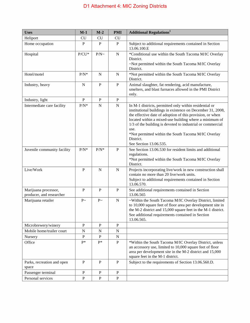
Uses M-1 M-2 PMI Additional Regulations1 Heliport CU CU CU Home occupation P P P Subject to additional requirements contained in Section
13.06.100.E Hospital P/CU* P/N~ N *Conditional use within the South Tacoma M/IC Overlay
District. ~Not permitted within the South Tacoma M/IC Overlay District.
Hotel/motel P/N* N N *Not permitted within the South Tacoma M/IC Overlay District.
Industry, heavy N P P Animal slaughter, fat rendering, acid manufacture, smelters, and blast furnaces allowed in the PMI District only.
Industry, light P P P Intermediate care facility P/N* N N In M-1 districts, permitted only within residential or
institutional buildings in existence on December 31, 2008, the effective date of adoption of this provision, or when located within a mixed-use building where a minimum of 1/3 of the building is devoted to industrial or commercial use. *Not permitted within the South Tacoma M/IC Overlay District. See Section 13.06.535.
Juvenile community facility P/N* P/N* P See Section 13.06.530 for resident limits and additional regulations. *Not permitted within the South Tacoma M/IC Overlay District.
Live/Work P N N Projects incorporating live/work in new construction shall contain no more than 20 live/work units. Subject to additional requirements contained in Section 13.06.570.
Marijuana processor, producer, and researcher
P P P See additional requirements contained in Section 13.06.565
Marijuana retailer P~ P~ N ~Within the South Tacoma M/IC Overlay District, limited to 10,000 square feet of floor area per development site in the M-2 district and 15,000 square feet in the M-1 district. See additional requirements contained in Section 13.06.565.
Microbrewery/winery P P P Mobile home/trailer court N N N Nursery P P N Office P* P* P *Within the South Tacoma M/IC Overlay District, unless
an accessory use, limited to 10,000 square feet of floor area per development site in the M-2 district and 15,000 square feet in the M-1 district.
Parks, recreation and open space
P P P Subject to the requirements of Section 13.06.560.D.
Passenger terminal P P P Personal services P P P
D1 Attachment 4: MIC Zoning Districts

Uses M-1 M-2 PMI Additional Regulations1 Port, terminal, and industrial; water-dependent or water-related (as defined in Chapter 13.10)
N N P* *Preferred use.
Public safety and public service facilities
P P P
Religious assembly P P P Repair services P P P Research and development industry
P P N
Residential care facility for youth
P/N* N N In M-1 districts, permitted only within residential or institutional buildings in existence on December 31, 2008, the effective date of adoption of this provision, or when located within a mixed-use building where a minimum of 1/3 of the building is devoted to industrial or commercial use. *Not permitted within the South Tacoma M/IC Overlay District. See Section 13.06.535.
Residential chemical dependency treatment facility
P/N* N N See Section 13.06.535. *Not permitted within the South Tacoma M/IC Overlay District.
Retail P~ P~ P* *Limited to 7,000 square feet of floor area, per development site, in the PMI District. ~Within the South Tacoma M/IC Overlay District, unless an accessory use, limited to 10,000 square feet of floor area per development site in the M-2 district and 15,000 square feet in the M-1 district. Outside of the South Tacoma M/IC Overlay District, limited to 65,000 square feet per use, unless approved with a conditional use permit. See Section 13.06.640.J.
Retirement home P/N* N N In M-1 districts, permitted only within residential or institutional buildings in existence on December 31, 2008, the effective date of adoption of this provision, or when located within a mixed-use building where a minimum of 1/3 of the building is devoted to industrial or commercial use. *Not permitted within the South Tacoma M/IC Overlay District. See Section 13.06.535.
School, public or private P/N* P/N* P/N* *General K through 12 education not permitted in the PMI District or in the South Tacoma M/IC Overlay District.
Seasonal sales TU TU TU Subject to development standards contained in Section 13.06.635.
Self-storage P P P See specific requirements in Section 13.06.503.B. Short-term rental N N N
D1 Attachment 4: MIC Zoning Districts

Uses M-1 M-2 PMI Additional Regulations1 Staffed residential home P/N* N N In M-1 districts, permitted only within residential or
institutional buildings in existence on December 31, 2008, the effective date of adoption of this provision, or when located within a mixed-use building where a minimum of 1/3 of the building is devoted to industrial or commercial use. *Not permitted within the South Tacoma M/IC Overlay District. See Section 13.06.535.
Student housing P/N* N N In M-1 districts, permitted only within residential or institutional buildings in existence on December 31, 2008, the effective date of adoption of this provision, or when located within a mixed-use building where a minimum of 1/3 of the building is devoted to industrial or commercial use. *Not permitted within the South Tacoma M/IC Overlay District.
Surface mining CU CU CU Temporary uses P P P Subject to development standards contained in Section
13.06.635. Theater P/N* N N *Not permitted within the South Tacoma M/IC Overlay
District. Transportation/freight terminal
P P P
Urban Horticulture P P P Utilities P P P Vehicle rental and sales P P P Subject to development standards contained in Section
13.06.510. Vehicle service and repair P P P Subject to development standards contained in Section
13.06.510. Vehicle service and repair, industrial
P P P Subject to development standards contained in Section 13.06.510.
Vehicle storage P P P Subject to development standards contained in Section 13.06.510.
Warehouse/storage P P P Storage and treatment facilities for hazardous wastes are subject to the state locational standards adopted pursuant to the requirements of Chapter 70.105 RCW and the provisions of any groundwater protection ordinance of the City of Tacoma, as applicable.
Wholesale or distribution P P P Wireless communication facility
P*/ CU**
P*/ CU**
P*/ CU**
*Wireless communication facilities are also subject to Section 13.06.545.D.1. **Wireless communication facilities are also subject to Section 13.06.545.D.2.
Work/Live P N N Projects incorporating work/live in new construction shall contain no more than 20 work/live units. Subject to additional requirements contained in Section 13.06.570.
Work release center CU CU P Subject to development standards contained in Section 13.06.550.
D1 Attachment 4: MIC Zoning Districts

Uses M-1 M-2 PMI Additional Regulations1 Uses not prohibited by City Charter and not prohibited herein
N N P
Footnotes: 1. For historic structures and sites, certain uses that are otherwise prohibited may be allowed, subject to the approval of
a conditional use permit. See Section 13.06.640.F for additional details, limitations and requirements.
D. Building envelope standards.
M-1 M-2 PMI
Minimum Lot Area N/A N/A N/A Minimum Lot Width N/A N/A N/A Maximum Lot Coverage
None None None
Minimum Front Setback
In all districts listed above, 0 feet, unless: • Created by requirements in Section 13.06.502; or • Abutting a dwelling district, then equal to the dwelling district setback for the first 100 feet
from that side. The above setback requirements may be waived if demonstration is made that a 20-foot vertical grade between the properties offers comparable protection.
Minimum Side Setback
In all districts listed above, 0 feet, unless created by requirements in Section 13.06.502, which may be waived if demonstration is made that a 20-foot vertical grade between the properties offers comparable protection.
Minimum Rear Setback
In all districts listed above, 0 feet, unless created by requirements in Section 13.06.502, which may be waived if demonstration is made that a 20-foot vertical grade between the properties offers comparable protection.
Maximum Height Limit
75 feet 100 feet, unless such building or structure is set back on all sides one foot for each four feet such building or structure exceeds 100 feet in height.
100 feet, unless such building or structure is set back on all sides one foot for each four feet such building or structure exceeds 100 feet in height.
Maximum Height Exceptions
Certain specified uses and structures are allowed to extend above height limits, per Sections 13.06.602.A.2 and 13.06.545.
E. Residential Development.
1. Minimum Usable Yard Space. Residential development shall provide usable yard space in accordance with the provisions of 13.06.100.D.7 based on the building type.
2. Tree canopy coverage. Residential uses shall meet the tree canopy coverage requirements in 13.06.100.D.8 in accordance with the R-4 District.
F. Common requirements. To streamline the Zoning Code, certain requirements common to all districts are consolidated under Sections 13.06.500 and 13.06.600. These requirements apply to Section 13.06.400 by reference.
Refer to Section 13.06.500 for the following requirements for development in Industrial Districts:
13.06.502 Landscaping and buffering standards. 13.06.503 Residential transition standards. 13.06.510 Off-street parking and storage areas. 13.06.511 Transit support facilities. 13.06.512 Pedestrian and bicycle support standards. 13.06.520 Signs. 13.06.602 General restrictions (contains certain common provisions applicable to all districts, such as general
limitations and exceptions regarding height limits, yards, setbacks and lot area)
D1 Attachment 4: MIC Zoning Districts

(Ord. 28429 Ex. B; passed May 9; 2017: Ord. 28417 Ex. A; Mar. 7, 2017: Ord. 28376 Exs. B, D; passed Aug. 16, 2016: Ord. 28361 Ex. B; passed May. 24, 2016: Ord. 28336 Ex. C; passed Dec. 1, 2015: Ord. 28327 Ex. C; passed Nov. 3, 2015: Ord. 28281 Ex. A; passed Feb. 17, 2015: Ord. 28230 Ex. D; passed Jul. 22, 2014: Ord. 28182 Ex. A; passed Nov. 5, 2013: Ord. 28157 Ex. F; passed Jun. 25, 2013: Ord. 28050 Ex. C; passed Feb. 14, 2012: Ord. 27995 Ex. D; passed Jun. 14, 2011: Ord. 27893 Ex. A; passed Jun. 15, 2010: Ord. 27813 Ex. D; passed Jun. 30, 2009: Ord. 27772 §§ 2,3,5-18; passed Dec. 9, 2008: Ord. 27771 Ex. C; passed Dec. 9, 2008: Ord. 27680 § 2; passed May 13, 2008: Ord. 27665 §§ 11,13; passed Dec. 4, 2007: Ord. 27644 Ex. A; passed Sept. 18, 2007: Ord. 27574 §§ 2, 3; passed Mar. 20, 2007: Ord. 27539 § 15; passed Oct. 31, 2006: Ord. 27362 § 3; passed Jun. 7, 2005: Ord. 27245 § 11; passed Jun. 22, 2004: Ord. 27079 §§ 24-28; passed Apr. 29, 2003: Ord. 26933 § 1; passed Mar. 5, 2002)
13.06.410 M-1 Light Industrial District. Repealed by Ord. 27079. (Ord. 27079 § 29; passed Apr. 29, 2003: Ord. 26966 § 11; passed Jul. 16, 2002: Ord. 26933 § 1; passed Mar. 5, 2002)
13.06.420 M-2 Heavy Industrial District. Repealed by Ord. 27079. (Ord. 27079 § 30; passed Apr. 29, 2003: Ord. 26966 § 12; passed Jul. 16, 2002: Ord. 26933 § 1; passed Mar. 5, 2002)
13.06.430 M-3 Heavy Industrial District. Repealed by Ord. 27079. (Ord. 27079 § 31; passed Apr. 29, 2003: Ord. 26966 § 13; passed Jul. 16, 2002: Ord. 26933 § 1; passed Mar. 5, 2002)
13.06.500 Requirements in all preceding districts. Applicability. The regulations of this section are applicable in all zoning districts, with exceptions only as noted. Regulations may refer to districts by class of districts, for example Districts or Industrial Districts, this means that all districts carrying the designated prefix or suffix are required to meet the given regulation. Overlay districts are combined with an underlying zoning district and supplement the regulations of that district. Overlay districts only apply to land carrying the overlay district designation.
(Ord. 26933 § 1; passed Mar. 5, 2002)
D1 Attachment 4: MIC Zoning Districts

Pierce County Buildable Lands Report 2014
286
Exhibit 22: City of Tacoma Inventory Map
D1 Attachment 5: 2014 Buildable Lands Inventory

CommencementBay
Open Space Corridors: Public, Private, and Tribe Owned Lands
City Boundary
0 1 20.5Miles[
Map is for reference only
Private
Public
Tribal
D1 Attachement 6: Open Space Corridors

CommencementBay
Open Space Corridors by Zoning Classification
74%
6%
12%
2%3%2%1%
0 0.95 1.90.475Miles[
Map is for reference only
CityBoundarySingle FamilyDistrictsMulti-familyDistricts
Mixed-useDistrictsCommercialDistrictsDowntownDistricts
IndustrialDistrictsShorelineDistricts
Open SpaceBreakdown by Zone
D1 Attachement 6: Open Space Corridors

TO:
FROM:
COPIES TO:
SUBJECT:
DATE:
CITY OF TACOMA, WASHINGTON OFFICE OF THE CITY COUNCIL
COUNCIL CONSIDERATION REQUEST (CCR)
City Council
Councilmember Ryan Mello
Elizabeth Pauli, City Manager; Executive Leadership Team; file
Implementing the Container Port Element of the City Comprehensive Plan
March 16, 2017
ITEM/ISSUE PROPOSED FOR COUNCIL CONSIDERATION:
I respectfully ask for City Council concurrence to have staff and the Planning Commission research and bring to City Council their recommendations on possible modifications to the City' s zoning, subdivision, and development regulations to better implement the Container Port Element of the One Tacoma Comprehensive Plan. This review and the resulting recommendations should be coordinated with the Infrastructure, Planning and Sustainability Committee.
BRIEF BACKGROUND:
Within the City, the Tideflats area is regionally and locally designated as an important Manufacturing/Industrial Center (M/IC) - a location with unique characteristics that should serve as a long-term and growing employment center. As required by State law (RCW 36.70A.085), the City adopted a Container Port Element (CPE) in its Comprehensive Plan in 2014. Consistent with State requirements, this CPE provides policy guidance relative to protection of core areas of container port and port-related industrial areas within the City and to protection against potential land use conflicts, both within and along the edge of the core area.
Recent proposals and community discussion have highlighted that the City's existing zoning within and around the Tideflats area is not sufficiently achieving the community's goals. The CPE provides the following direction: Policy CP-1.6 " ... While localized impacts are permitted, continue to require Core Area industrial uses to be developed in a manner that protects the environment and preserves public health and safety from a citywide and regional perspective.'' Existing zoning needs to be reviewed against this standard.
The CPE identifies a core of PMI (Port-Maritime Industrial) zoning that is intended to be protected from encroachment by incompatible land uses (such as residential) by a buffer of general industrial zoning (M-1 and M-2). However, this basic planning and zoning structure is complicated by the fact that PMI zoning allows for an exceptionally wide variety of heavy industries, such as smelters, hazardous chemical manufacturing and shipping terminals of all kinds (not just container terminals), as well as light industry and warehousing. The PMI zoning also allows for "uses not prohibited by City Charter and not prohibited herein," which essentially means that uses this community has potentially never contemplated and/or evaluated are automatically an allowed use in this area. In general, the current zoning allows for high-impact, high-hazard, and high-resource uses that deserve more scrutiny, and which in some cases may no longer be appropriate or consistent with the community' s policies and vision for the area.
The existing zoning within the Tideflats also allows for a number of non-industrial uses, such as farming, day care centers, golf courses, religious assembly, and others, which need to be evaluated to ensure that they are not creating incompatibilities with the long-term viability of the Tideflats as a heavy industrial and container shipping area, as called for by the CPE.
Prepared by Planning & Development Services Staff March 14 2017
D1 Attachment 7: Council Consideration Request

CITY OF TACOMA, WASHINGTON OFFICE OF THE CITY COUNCIL
COUNCIL CONSIDERATION REQUEST (CCR)
Finally, existing core area buffers need to be reviewed against Policy CP-1.4, which states "Reduce the potential for land use conflicts between industrial development and surrounding non-industrial uses by providing for adequate Industrial/Commercial buffer areas .... " Given recent development activity, the CPE observation that " ... to the east, the steep bluff rising above Marine View Drive provides a clear transition from the industrial area to the residential development at the top of the bluff ... " and the CPE conclusion that " ... the existing geography provides a very effective buffer and no additional transition area is necessary ... " needs to be reviewed against current best practices and the changing development landscape. This review will complement the citywide Open Space Corridors regulatory review that is currently underway.
The City, Port and others are discussing the potential for subarea planning to comprehensively address long-term land use, transportation and environmental planning issues. However, in the meantime it is appropriate for the City to consider initial measures regarding, zoning, subdivision, and development regulations and buffers.
SUBMITTED FOR COUNCIL CONSIDERATION BY:
SUPPORTING COUNCILMEMBERS SIGNATURES (2 SINATURES ONLY)
(Signatures demonstrate support to initiate discussion and consideration of the subject matter by City Council for potential policy development and staff guidance/direction.)
1.
2.
Prepared by Planning & Development Services Staff March 14 2017
POS# ----------------
POS# ----------------
D1 Council Consideration Request: Container Port Element

D1 Attachment 8: NE Tacoma Application

1
1. Describe the proposed amendment. If submitting text changes to the One Tacoma Comprehensive
Plan or Regulatory Code, provide the existing and the proposed language. If submitting changes to
the Comprehensive Plan land use designation(s) or the zoning classification(s), provide the current
and the proposed land use designations and/or zoning classifications for the affected/proposed area.
The proposed amendment creates a true buffer zone between residential areas in the Northeast
Tacoma (NET) neighborhood and the industrial tide flats. The One Tacoma Comprehensive Plan defines
the Container Port Core and Industrial/Buffer Areas in its Container Port Element. It also provides a map
for these areas in Figure 41. While the map lacks detail on how to “provide for a compatible transition
for the Port of Tacoma maritime industrial area to [residential] development in the larger surrounding
area,” which is one the main intents of this Element, it clearly identify the need for a buffer along
Marine View Drive. Through changes to the existing zoning, the proposed amendment will allow
meeting the objectives of the policies contained in the Container Port Element and will facilitate a
compatible transition.
Figure 1: Container Port Core and Industrial/Buffer Areas [source: Figure 41 in Container Port Element of Tacoma One Plan]
The amendment proposes a few changes that intend to achieve three objectives:
(1) To implement aspects of the Container Port Element by creating a buffer between parcels already
zoned as commercial or residential and the Container Port Core Areas;
D1 Attachment 8: NE Tacoma Application

2
The amendment proposes changes to the zoning that would create the Industrial/Commercial buffer
areas as depicted in Figure 41 of the Container Port Element. Changes include downzoning some of the
existing M‐2 and PMI parcels to M‐1 or PDB.
Currently zoned as M‐2, all parcels located between East 11th Street and including Parcel 032126406
(Address: 2224 MARINE VIEW DR, TACOMA, WA) do not comply with Figure 41. Therefore, the
amendment proposes to change their zoning to PDB, which would be compatible with the objectives of
the policies contained in the Container Port Element while creating a graceful transition between
differing densities, intensities and activities (Goal DD‐9 of the Tacoma One Plan). Additionally, all M‐2
parcels located along Marine View Drive southeast of Parcel 032126406 (Address: 2224 MARINE VIEW
DR, TACOMA, WA) do not comply with Figure 41. Therefore, the amendment proposes to change their
zoning to M‐1, which would be compatible with the objectives of the policies contained in the Container
Port Element while creating a graceful transition between differing densities, intensities and activities
(Goal DD‐9).
(2) To implement aspects of the Container Port and Design Development Elements by creating a
compatible and graceful transition between differing densities, intensities and activities
The amendment proposes some additional downzoning from PMI to M‐1 for parcels located east of the
lower Hylebos waterway. These changes would not affect the boundaries of the Core Area or
Manufacturing/Industrial center, but identify parcels where only light industrial/manufacturing activities
can occur so that a sufficient transition area is created. Currently zoned as PMI, parcels along Marine
View Drive and east of the Hylebos waterway and creek do not provide a sufficient transition area that
would allow the long‐term viability of the industrial areas while protecting the surrounding residential
areas from unreasonable impacts. The current zoning only rely on a limited change in topography as a
means to buffer and separate incompatible heavy industrial and residential uses, which has resulted in
continuous complaints by residents. Therefore, the amendment proposes to change the zoning of the
PMI parcels Northeast of the Hylebos Waterway and Creek to M‐1, which would provide a sufficient and
long‐term transition through a mix of natural and land use buffers, including a change in topography,
vegetated areas and the Hylebos water body.
(3) To improve consistency between parcels maps and zone maps by making few additional changes.
This objective is achieved through zoning changes along parcel boundaries. To this end, the amendment
proposes some changes that would create a better alignment between zone and parcels boundaries, so
that potential land uses would be clearly aligned to ownership rights.
D1 Attachment 8: NE Tacoma Application

3
2. Why is the amendment needed and being proposed?
While this question was already addressed from our response to Question 1, this section provides
further information on why this amendment is proposed and is needed.
Over the years, the Northeast Tacoma (NET) neighborhood have graduated into a suburban area that
hosts about 10% of Tacoma residents – without including residents in unincorporated Pierce County at
Browns Point and Dash Point. Due to its prevalently residential zoning, the neighborhood is highly
dependent upon the existing transportation infrastructure to and from the surrounding employment
and business/retail centers for retails, professional services, and even public services. The projected
demographic growth for the Puget Sound region suggests we cannot expect the residential use to
decrease. The current zoning has created a sudden transition from residential to heavy industrial uses,
which only insufficiently relies on topography buffers. Industrial activities in New Tacoma’s tideflats and
along the Hylebos in NET have increased complaints by residents while adding pressure on an already
strained transportation system, which relies on Marine View Drive.
While limited in its scope, the proposed amendment is expected to help address some of these issues by
creating an effective and sufficient transition area between the growing port and industrial activities in
Tacoma and the mainly residential Northeast Tacoma neighborhood. In specifics, the proposed
amendment is needed to address an inconsistency between the current zoning and the Container Port
and Design Development Elements of the One Tacoma Comprehensive Plan and to provide a sufficient
transition area that would allow the long‐term viability of the industrial areas while protecting the
surrounding residential areas from unreasonable impacts.
The One Tacoma Comprehensive Plan defines the Container Port Core and Industrial/Buffer Areas in its
Container Port Element. It also provides a map for these areas in Figure 41. While the map lacks detail
on how to “provide for a compatible transition for the Port of Tacoma maritime industrial area to
[residential] development in the larger surrounding area,” which is one the main intents of this Element,
it clearly identify the need for a buffer along Marine View Drive. The City of Tacoma’s Land Use
Regulatory Code (i.e. Title 13 of Tacoma Municipal Code) identifies M‐1 light industrial zoning as the
natural buffer between heavy industrial uses and commercial/residential uses.
Figure 2: M‐1 Zoning Description [Source: Title 13 of Tacoma Municipal Code, page 13‐143]
Still, the existing zoning along the Hylebos does not take advantage of the availability for this zoning tool
or provides a basis for meeting the objectives of the policies contained in the Container Port Element. At
a time the intensity of heavy industrial operations is again increasing in the tide flats, it is paramount to
adopt a pro‐active approach to planning by incorporating all zoning tools that can help the City of
Tacoma achieve the vision outlined in the One Tacoma Comprehensive Plan’s elements and meet the
objectives of the policies outlined in the Container Port and Design Development elements. Currently
zoned as M‐2 or PMI, parcels along Marine View Drive and east of the Hylebos waterway and creek do
not provide a sufficient transition area that would allow the long‐term viability of the industrial areas
while protecting the surrounding residential areas from unreasonable impacts. Zoning changes
proposed as part of this amendment are proposed and would be needed to overcome these issues.
D1 Attachment 8: NE Tacoma Application

4
3. Please demonstrate how the proposal is consistent with the applicable policies of the One Tacoma
Comprehensive Plan, and consistent with the criteria for amending the Comprehensive Plan or
development regulations.
While this question was partially addressed in our responses to Questions 1 and 3, this section provides
further information on how the proposed changes are consistent with elements of the One Tacoma
Comprehensive Plan. Moreover, we address the criteria for analyzing the amendment that are listed in
Title 13 of the Tacoma Municipal Code as follows:
1. Whether the proposed amendment will benefit the City as a whole, will not adversely affect the
City’s public facilities and services, and bears a reasonable relationship to the public health,
safety, and welfare; and
2. Whether the proposed amendment conforms to applicable provisions of State statutes, case
law, regional policies, and the Comprehensive Plan.
[Source: Tacoma Municipal Code, Title 13, Section 13.02.045.F]
Consistency with the applicable policies of the One Tacoma Comprehensive Plan
We can group changes into (a) changes from M‐2 to PDB; (b) changes from M‐2 to M‐1; and (c) changes
from PMI to M‐1.
(a) Change parcel zoning from M‐2 to PDB
The current M‐2 zoning for all parcels located between East 11th Street and Parcel 032126406 (Address:
2224 MARINE VIEW DR, TACOMA, WA) creates an impediment to achieving some of the goals of the
Container Port element of the One Tacoma Comprehensive Plan.
Figure 41 of the Container Port element allocates to these parcels the important role for achieving Goal
CP‐2 (i.e. “Establish an Industrial/Commercial Buffer Area around the Core Area that will protect the
continued viability of the Core Area while providing for a compatible Industrial/Commercial Buffer to
development in the larger surrounding area;” Source: Goal CP‐2 in Container Port element) and
implementing Policies CP‐2.1 and CP‐2.2.
However, these parcels are currently zoned for heavy industrial uses. To improve consistency between
zoning maps and the One Tacoma Comprehensive Plan, the proposed amendment would change their
zoning from M‐2 to PDB. This change is compatible with the cited objectives of the policies contained in
the Container Port element while also creating a graceful transition between differing densities,
intensities and activities, which is consistent with Goal DD‐9 – and its policies – of the Design and
Development element. This change would also coincide with Policy 6.4 of the Transportation element
(i.e. Support Mixed‐Use Centers) creating a mixed‐use district where Port and Maritime offices and
vocational education can occur alongside with light industrial in a part of the City where this zoning is
not available or pursuing it lacks economic attractiveness for developers due to the colocation with
heavy industry. Moreover, the proposed change will also facilitate the implementation of the vision
represented at Page 73 of the Transportation element by creating conditions for future creation of
bicycle and shared use paths and trails alongside the Freight corridor shown in page 104.
D1 Attachment 8: NE Tacoma Application

5
(b) Change parcel zoning from M‐2 to M‐1
Additionally, all M‐2 parcels located along Marine View Drive southeast of Parcel 032126406 (Address:
2224 MARINE VIEW DR, TACOMA, WA) creates another impediment to achieving some of the goals of
the Container Port element of the One Tacoma Comprehensive Plan.
Figure 41 of the Container Port element allocates to these parcels the important role for achieving Goal
CP‐2 (i.e. “Establish an Industrial/Commercial Buffer Area around the Core Area that will protect the
continued viability of the Core Area while providing for a compatible Industrial/Commercial Buffer to
development in the larger surrounding area;” Source: Goal CP‐2 in Container Port element) and
implementing Policies CP‐2.1 and CP‐2.2.
However, these parcels are currently zoned for heavy industrial uses, which is inconsistent with Figure
41. Therefore, the amendment proposes to change their zoning to M‐1. This change is also compatible
with the cited objectives of the policies contained in the Container Port element while also creating a
graceful transition between differing densities, intensities and activities, which is consistent with Goal
DD‐9 – and its policies – of the Design and Development element. Moreover, the proposed change will
also facilitate the implementation of the vision represented at Page 73 of the Transportation element by
creating conditions for future creation of bicycle and shared use paths and trails alongside the Freight
corridor shown in page 104.
(c) Change parcel zoning from PMI to M‐1
Currently zoned as PMI, most of the parcels along Marine View Drive and east of the Hylebos waterway
(and creek) are listed as part of the Port Core Area. The current zoning has created a sudden transition
from residential to heavy industrial uses, which insufficiently relies on limited changes in topography as
buffers. The amendment also proposes additional downzoning from PMI to M‐1 for parcels located east
of the lower Hylebos waterway (and creek). These changes would not affect the boundaries of the Core
Area or Manufacturing/Industrial center, but identify parcels of this portion of the Core Area where only
light industrial/manufacturing activities can occur so that a sufficient transition area is created.
This portion of the proposed amendment would create a transition between differing industrial uses,
but it does not create an industrial/commercial buffer as allowed uses would be limited to light
industrial/manufacturing. This change is compatible with some of the Goals/Policies already cited,
including CP‐2 and DD‐9 because it would provide a sufficient transition through a mix of natural and
land use buffers, including a change in topography, vegetated areas and the Hylebos water body. This
transition is also compatible with goal CP‐1 and its policies because it “protect the long‐term function
and viability of this area” while also protecting the surrounding residential areas from unreasonable
impacts from port activities. Moreover, the proposed change will also facilitate the implementation of
the vision represented at Page 73 of the Transportation element by creating conditions for future
creation of bicycle and shared use paths and trails alongside the Freight corridor shown in page 104.
Consistency with the with the criteria for amending the Comprehensive Plan or development regulations
Regarding the criterion No.1 (i.e. “Whether the proposed amendment will benefit the City as a whole,
will not adversely affect the City’s public facilities and services, and bears a reasonable relationship to
the public health, safety, and welfare”), the changes are not expected to affect the City’s public facilities
and services. Instead, the proposed changes are expected to reduce traffic congestion on Marine View
D1 Attachment 8: NE Tacoma Application

6
Drive because they will controlling growth of freight traffic while also facilitating the implementation of
the vision represented at Page 73 of the Transportation element.
Moreover, the proposed changes are expected to benefit the city as a whole because they will help
meeting the objectives of the policies contained in the Container Port and Design and Development
elements as extensively explained in other portions of this proposal. Last, the proposed changes are
expected to improve relationship to public health and safety because they will: (a) have fewer off‐site
impacts than would be associated with industrial or community commercial areas; (b) diversify
employment opportunities in the tide flats; (c) reduce heavy truck traffic on a constrained roadway that
is the main connection between the Northeast Tacoma neighborhood and the City; and (d) support City
of Tacoma's effort to improve air quality by controlling growth of freight traffic and facilitating the
implementation of the multimodal vision represented at Page 73 of the Transportation element.
Regarding the criterion No.2, to the best of our knowledge, the proposed amendment conforms to
applicable provisions of State statutes, case law, regional policies, and the Comprehensive Plan. We rely
on the City of Tacoma to analyze the proposed amendment as described in the Tacoma Municipal Code,
Title 13, Section 13.02.045.F and to evaluate “whether or not the application is complete, and if not,
what information is needed to make it complete.”
D1 Attachment 8: NE Tacoma Application

7
4. If the proposed amendment is associated with a geographic area, please provide a more detailed
description, along with maps, if applicable, of the affected area and the surrounding areas, showing
all parcels (with parcel numbers), ownership of each parcel, current land uses, site characteristics,
and natural features.
The proposed amendment applies to 64 parcels on both sides of Marine View Drive in Northeast
Tacoma between 11th Street and Taylor Way. Figure 3 shows a map of the area impacted by the
proposed changes in zoning. Table 1 provides a list of all affected parcels (with parcel numbers),
ownership of each parcel, and current land uses. This information was obtained from the Pierce County
Assessor website. This table includes information on the parcels in the impacted area. Whereas the
proposed changes will affect all parcels in the areas colored as red and blue in Figure 3, parcels
highlighted in yellow in the table are those that currently host activities that maybe not conform with
the zoning change. Specific site characteristics and natural features of each parcel are unknown,
although generally speaking: 1) parcels are accessed from Marine View Drive, 2) parcels range from
undeveloped to developed as heavy industrial, 3) parcels on the west side of Marine View Drive have
access to the Hylebos Waterway, and 3) parcels on the east side of Marine View Drive border the
various neighborhoods of Northeast Tacoma.
Figure 3: Map of the Impacted Area
D1 Attachment 8: NE Tacoma Application

8
Table 1A: List of Parcels in the Impacted Area
D1 Attachment 8: NE Tacoma Application

9
Table 2A: List of Parcels in the Impacted Area (continued)
D1 Attachment 8: NE Tacoma Application

10
Table 3A: List of Parcels in the Impacted Area (continued)
D1 Attachment 8: NE Tacoma Application

11
Table 4A: List of Parcels in the Impacted Area (continued)
D1 Attachment 8: NE Tacoma Application

12
5. If the proposed amendment is associated with a geographic area, please describe how it is
compatible with the existing and planned land uses and development patterns of the adjacent
neighborhood and explain how it may further enhance the adjacent neighborhood.
The purpose of the proposed amendment is to provide a true buffer zone between the M‐2 and PMI
industrialized port zone and the adjacent residential areas. Currently there is no buffer zone along most
of the Marine View Drive corridor between heavy industry and the residential areas. This lack of a buffer
zone is a source of constant complaints and NET community dissatisfaction.
This proposed amendment will keep residential spread from reaching closer to the Port while providing
an area for future development that will not adversely impact the existing M‐2 and PMI in their current
configurations or the growth of remaining M‐2 or PMI areas.
The reclassification of the affected areas to M‐1 and/or PDB will still allow medium to high intensity uses
that would ultimately provide sources of income and jobs for the NE community as well as additional tax
revenue for the City of Tacoma. The M‐1 zone classification is designed and intended as a buffer zone
according to Tacoma Municipal Code 13.06.400. The PDB zone classification is designed and intended to
provide limited areas for a mix of land uses that includes warehousing, distribution, light assembly,
media, education, research, and limited commercial, which are lacking in the Northeast Tacoma
neighborhood. This use is compatible adjacently with residential uses because is intended to have fewer
off‐site impacts than would be associated with purely industrial or community commercial areas.
D1 Attachment 8: NE Tacoma Application

13
5. If the proposed amendment is associated with a geographic area, please describe the applicant’s
interest in the affected property. Describe any plans for future activity related to or connected with
this site. If you are not the owners, submit proof that the property owners have been notified and are
aware of the application.
The applicant’s interest in the geographic area is only as residents who live in NE Tacoma. None of the
parties has any ownership or financial interest in the affected properties. A parcel search was
conducted (attached) and all property owners were mailed a letter on March 7, 2017. Copies of all the
letters that were mailed to impacted businesses are attached in Appendix A.
D1 Attachment 8: NE Tacoma Application

14
6. Describe any community outreach you have conducted (i.e., when and how you contacted
affected and abutting property owners and neighbors), and any community response received to
the proposed amendment. Attach any letter(s) of support or written community response, if
applicable.
The following outreach activities have occurred:
Presentation to NE Tacoma Neighborhood Council on 3/2/17
Letter mailed to all parcels in proposed area on 3/7/17
Request for feedback via email to NE Tacoma Neighborhood Council
Invitation to Open House for all impacted businesses on 3/23/17 at residential home in NE
Tacoma
Meeting with Pointe Woodworth HOA 3/18/17
Presentation to Port of Tacoma Commissioner Don Meyer, Staff, and Robert Thoms on 3/22/17
To date, we have received one email from Troy Goodman with Targa inquiring about the amendment.
We forwarded him a copy of the letter that was mailed and invited him to attend the open house on
3/23/17.
Additionally, John Thurlow, former Chair of the NE Tacoma Neighborhood Council has expressed his
concerns related to any rezoning and impact to heavy industrial interests on Marine View Drive.
Several letters of support regarding the proposed amendment are included in Appendix B.
The Open House on 3/23/17 was attended by the following companies:
Mark Miller, Macmillan‐Piper, Inc
Evette Mason, Port of Tacoma
Mike Weinman, Schnitzer
Rick Brown, Trident Seafoods
Paul Watson, Fastco
Jenn Adnen, EDB Tacoma‐Pierce Co
Tol Edman, Edman Company
Bruce Martin, Westrock Tacoma
Gary Cox, Sperry
Jackie White, Westrock
James Marshall, Vigor
Nick Nicholas, Calbag Metals
Bett Lucas, Targa
Lawson Bronson, Youth Marine Foundation
Darrin Swindahl, Modutech Marine
Carl Swindahl, Modutech Marine
Ron Oline, Hylebos Marina
Gary Nordlund, Nordlund Properties
D1 Attachment 8: NE Tacoma Application

15
Through this meeting, we learned that various dynamic relationships exist among businesses in the tide
flats that may extend the impact of the zoning beyond its boundaries. Since these relationships are
dependent on the supply chain of different economic actors and their other business and personal
relationships, we feel it would be best if future public outreach would be guided by the City of Tacoma
and its staff, and designed to involve selected individuals by all parties equally represented (i.e.
businesses and citizens) in the scheduling and organization of these outreach events. Since this
amendment is intended to begin a civic conversation on the need to establish a buffer, traditional public
outreach sessions should be designed to allow for dialogue and limit adversarial conversations.
D1 Attachment 8: NE Tacoma Application

16
8. Please provide any supplemental information, which may include, but is not limited to,
completion of an environmental checklist, wetland delineation study, visual analysis, or other
studies.
Attached to this report is the following supplemental information:
Appendix C: Noise complaints related to Schnitzer Steel Operations
Appendix D: Odor complaints related to heavy industries
Appendix E: Lab analysis from Dust Sample in NE Tacoma Neighborhood
Appendix F: Presentation used for outreach to affected businesses, neighborhood
council, and other stakeholders.
D1 Attachment 8: NE Tacoma Application