city of tacomacms.cityoftacoma.org/publicworks/engineering/transportation... · the plan lacks...
TRANSCRIPT

City of Tacoma Transportation Commission
September 26, 2017
Mark D’Andrea
City of Tacoma
747 Market Street
Tacoma, WA 98402
Subject: Puyallup Avenue Corridor Conceptual Design
Thank you for the opportunity for the Transportation Commission (TC), with consultation from the
Bicycle and Pedestrian Technical Advisory Group, and Sustainable Tacoma Commission (STC) to offer
influential comments and staff guidance on the Puyallup Avenue Corridor Conceptual Design. This
project is important because Puyallup Avenue serves as a gateway to our downtown core as well as the
right of way for thousands of individuals coming and going from the Tacoma Dome Station (TDS) which is
one of the largest multimodal hubs in the entire state of Washington. While this project on its face
appears to be strictly a transportation project, it is truly a holistic planning effort which includes land use
elements, open space and placemaking. These comments serve to not just influence the City of Tacoma's
efforts on Transportation but compliments the plans that the City has fostered over the years including
the South Downtown Subarea Plan (SDSP) and the Transportation Master Plan (TMP).
Overall Planning Approach
On Page 58 of the TMP the City identifies the modes of transportation in the following manner;
Pedestrian, Bicycle, Transit, Freight and SOV. The TMP also identified the Puyallup Avenue Corridor as a
“Conflicted Corridor” that needed further study. It is the opinion of the TC that this conceptual plan
needs to be more holistic in its review and truly study and understand the needs of the various
transportation modes not just today but in the future. Do note this also means taking into account the
SDSP future vision for the corridor which includes density both in business and housing.
The plan lacks vision as it relates to the parallel street of East 25th, particularly between E. G Street and
Portland Avenue. This is a severely underutilized street in this corridor and could serve to add capacity for
all modes including emphasizing egress for freight to the industrial parts of the area between Puyallup
Avenue and East 25th Street. In addition, as transit services increase as they will according to Pierce
Transit and Sound Transit’s long range plans, E 25th Street could serve as a future transit/freight only
corridor.

Recommendation TC1: Let this plan be the first of many drafting phases, including funding, with the
City prioritizing a holistic review and design of the corridor to include East 25th Street.
On and Off Street Parking
The Dome District has some of the highest concentrations of off street parking in the City including Pierce
Transit's garage at TDS with over 2,000 parking stalls. With free parking and paid parking available, it is
the opinion of the TC that this plan should de‐emphasize on street parking between Pacific Avenue and
Portland Avenue. By doing this, the plan then can allow for a greater use of Right of Way (ROW).
Recommendation TC2: Remove on‐street parking between Pacific and Portland Avenues to allow for
safer and more effective and efficient pedestrian, bicycle and transit LOS, and relocate, when
applicable, to side streets.
Pedestrian & Bicycle
The TMP calls for a bicycle lane to be implemented on the entire corridor. All alternatives should include
this facility and should be done so as to add elements for the safety of both the vehicular traffic and
bicyclists when entering and using the corridor.
In the alternatives provided, the “Neighborhood” sections of the corridor lack proper trade off of modes.
In order to continue to provide the Level of Service (LOS) needed for pedestrians, bicyclists and transit,
parking and turn lanes need to give way for more right of way to emphasize these modes. While the
TMP only calls for a bicycle lane, the opportunity of such a wide right of way could allow a cycle track or
bike boulevard to be implemented between Pacific and Portland Avenues.
Recommendation TC3: A bidirectional protected bicycle facility along the entire length of Puyallup
Avenue (Alternative 1)
Recommendation TC4: Sidewalks and street plantings along the entire length of Puyallup Avenue and
safer pedestrian crossings (Included in all alternatives)
Transit
The importance of growing transit ridership as a greater share of mobility is key to reducing tailpipe
emissions from transportation that are a majority of the City’s adverse contribution to climate change.
Further, high capacity feeder transit services and protected bicycle facilities will be necessary to provide
access to regional light rail at Tacoma Dome Station in 2030. Additional single‐use parking structures are
not supported by the South Downtown Subarea Plan and EIS. We support the vision of South Downtown
as a transit‐oriented area with non‐motorized access.
The point of this exercise is to plan for the future through 2040. Staff indicated that transit currently
accounts for 3‐4% of the 10,000 vehicles that travel on Puyallup Avenue per day, but did not translate
those figures into the overall proportion of people moving along the corridor. 3,300 passengers per day
board Sound Transit express bus services from Tacoma Dome Station, 500 per day from Pierce Transit
board at Tacoma Dome. However, more passengers are using transit service on Puyallup Avenue as a

thoroughfare between Tacoma Dome Station and Downtown Tacoma and are not counted. Clearly
transit vehicles are serving disproportionately more people per day than their vehicle counts are
showing.
Recommendation TC5: An east and westbound transit lane along the entire length of the Puyallup
Avenue corridor between Pacific Avenue and Portland Avenue. (Alternative 1 + new element)
Freight
The 2015 Transportation Master Plan element of the Comprehensive Plan identified Puyallup Ave.,
between E. D St. and Portland Ave., as a Primary Street within Tacoma’s Freight Priority Network,
affirming its importance to the freight system of the City. East of E. G St., land use along the corridor is
predominantly industrial. Both E. D St. and Portland Ave. serve as major access and egress routes to a
part of the Tide Flats. With the corridor needing to serve multiple modes the TC feels it is important to
continue to provide critical access to freight.
Recommendation TC6: Eastbound Transit/HOV lane contained in Alternative 1; E. D St as a “Bus and
Freight” lane.
Overall this plan starts off on the right foot however the planning and design process is far from over.
The Transportation Commission and Sustainable Tacoma Commission would like to see staff go back to
the drawing table and develop an additional “Hybrid” alternative that incorporates the important and
critical recommendations outlined in this letter. The Transportation Commission expects to be part of
the conversation in developing the final design.
Sincerely,
Justin D. Leighton Dr. Jane Moore Alexandra Brewer
Co‐Chair Co‐Chair Chair
Transportation Commission Transportation Commission Sustainable Tacoma Commission
cc:
Mayor Marilyn Strickland
Tacoma City Councilmembers
Tacoma City Manager
Tacoma Public Works Director
Chelsea Levy, Sound Transit
Peter Stackpole, Pierce Transit
Bicycle & Pedestrian Technical Advisory Group

747 Market Street, Room 644 ❚Tacoma, WA 98402 ❚(253) 591-5511 ❚FAX (253) 591-5533 http://www.cityoftacoma.org/publicworks
City of Tacoma Transportation Commission
September 20, 2017 Planning Commission 747 Market Street, 3rd Floor Tacoma, WA 98402 RE: Tacoma Mall Subarea Plan Dear Chair Wamback,
The Transportation Commission has heard several presentations on the Tacoma Mall Subarea Plan including at a special subcommittee meeting on August 29 which focused on the issue of South 37th Street.
The Transportation Commission finds that the Tacoma Mall Subarea Plan is a great visioning plan. As a whole, it is consistent with the Transportation Master Plan (TMP) goals of developing partnerships, protecting natural assets, providing mobility for all, and reinforcing Tacoma’s land use vision. It is also consistent with the region’s Vision 2040 and the Growth Management Act. The Subarea Plan provides for networks for all forms of transportation while allowing for expected growth of the Regional Growth Center.
However, the Transportation Commission is divided on the issue of South 37th Street. The Commission agrees that major development should trigger new infrastructure, particularly for bicycling and walking. However, in order to allow greater flexibility in design, the Commission feels that rather than designate the addition of South 37th Street, the plan should require an east-west connection from Pine Street to South Tacoma Way between South 36th and South 38th Streets to create smaller urban blocks with improved bicycle & pedestrian infrastructure. This flexibility could result in the addition of a South 37th Street but might result in more innovative design such as curving roadways. The flexible design would be consistent with the policies of the Transportation Master Plan including providing alternate routes for auto traffic (Policy 3.18), smaller urban blocks to improve pedestrian accessibility (Policy 3.6) and a more complete network in the area (Policy 3.1).
The Transportation Master Plan addresses impact fees in Chapter 5, page 116-117. Impact fees are recognized as a promising potential future revenue option. However, more information is needed to determine the practicality of impact fees. The Transportation Master Plan recommends a feasibility study as a near term action. The Transportation Commission feels that the results of such a study must be reviewed before recommending use of impact fees.

747 Market Street, Room 644 ❚Tacoma, WA 98402 ❚(253) 591-5511 ❚FAX (253) 591-5533 http://www.cityoftacoma.org/publicworks
To summarize, the Transportation Commission supports adoption of the Tacoma Mall Subarea Plan with the modifications discussed above.
Sincerely,
Justin D. Leighton Dr. Jane Moore Co-Chair Co-Chair Transportation Commission Transportation Commission cc: Mayor Marilyn Strickland
Infrastructure, Planning & Sustainability Council Committee Tacoma City Manager Public Works Director Bicycle & Pedestrian Technical Advisory Group

Appendix C – Bicycle Implementation Strategies Prioritizing Transportation Investment As discussed in the TMP, the ‘Green Transportation Hierarchy’ is a recent movement that recognizes transportation modes that have the least environmental impact and greatest contribution to livability. Intended as a prioritization strategy, the Green Transportation Hierarchy promotes funding and development of facilities for modes that affordably enhance access for the majority of Tacoma residents, rather than using level of service standards focused on vehicle movement. While the hierarchy gives precedence to pedestrians, then to bicyclists and public transit, commercial vehicles and trucks are also recognized as having priority over passenger vehicles.
The City of Tacoma’s TMP draws on this model as a conceptual tool for elevating pedestrians, bicycles, and public transit in the planning and design of streets in a manner that is consistent with the City’s Complete Streets policy and the City’s Climate Action Plan. It gives recognition to the city’s most vulnerable users of the streets: pedestrians and bicyclists of all ages and abilities. Chapter 5 Implementation discusses funding strategies to build out the City’s transportation system. To successfully achieve the City’s vision and goal, a unique set of specific strategies is required that goes beyond construction of infrastructure. This Appendix identifies methods for strengthening execution of the recommendations and ensuring that bicyclists are top priorities in transportation planning.

The following table lists the criteria used to evaluate potential projects for the pedestrian and bicycle networks. These criteria, listed in the order of importance, were developed with input from public workshops.
Table 1. Infrastructure Project Evaluation Criteria
Criterion Measurement Enhances system connectivity/Closure of critical gap
To what degree does the project fill a missing gap in the bicycle and/or pedestrian system? How well does the project overcome a barrier in the current bicycle and pedestrian network?
Interface with other transportation modes (e.g., transit)
To what degree does the project connect to transit facilities?
Geographic distribution of City coverage
To what degree does the project offer potential benefits to the wider, regional community by offering opportunities for increased connectivity to surrounding communities, other regional walkways/bikeways, etc.?
Cost Effectiveness How difficult will it be to implement the project? This criterion takes into account constraints like topography, existing development, presence or lack of available right-of-way, and environmental and political issues.
Suitability for bicycling and/or walking with improvements
Does the route have potential to be safe and/or low stress for bicycling and/or walking after improvements have been made?
Destinations served Does the project provide connectivity to key destinations, including schools, parks, employment, commercial centers, and civic centers?
Improvement that serves an immediate safety need
Can the project potentially improve bicycling and walking at locations with perceived or documented safety issues? This criterion takes into account available crash data as well as feedback from the Steering Committee and Tacoma residents.
Integration into the existing local and regional bikeway/walkway system
How many user generators does the project connect to within reasonable walking or bicycling distance, such as schools, parks, Downtown, colleges and universities, etc.?
Projected reduction in vehicle trips and vehicle miles traveled
To what degree will the project likely generate transportation or recreational usage based on population, corridor aesthetics, etc.? Does the project serve transportation needs, reducing the need for drive-alone trips, and promoting bicycling as a viable alternative to driving?
Bike Commuters from UW-Tacoma
Summer 2008 Mobility Master Plan Public Workshop at South Park
September 2009

Tandem Recumbent Cyclists in front of the University of Puget Sound
Demonstration Projects In addition to the proposed improvements, the City should start with a few demonstration projects to get momentum going. These projects will also serve to develop enthusiasm and interest from Tacoma residents, and to draw attention to the City’s support for active transportation options. Demonstration projects include: • Install wayfinding signage throughout the City
indicating to pedestrians and bicyclists their direction of travel, location of destinations, and the walking or riding time/distance to those destinations. Wayfinding signs increase users’ comfort and accessibility of the bicycle system and also visually cue motorists that they are driving along a bicycle route and should use caution.
• Hold a Sunday Parkways event at other locations throughout the city to encourage community members and families to become familiar with bicycling in Tacoma.
• Safe Routes programs provide education and encouragement programming and infrastructural improvements so people can more safely and conveniently access destinations via walking, bicycling and transit.
• Expand the Safe Routes to School program to work with interested schools of all levels citywide. • Establish a Safe Routes to Employment program with a focus on larger employment centers and
downtown. • Establish a Safe Routes to Parks program with a focus on Regional, Signature, and Community
Parks as defined by Metro Parks Tacoma. • Establish Safe Routes to Transit programs for improved access to Sound Transit, Pierce Transit, and
Amtrak facilities. • Use Arterial retrofits, also known as road diets, to implement bike facilities on key streets, • Implement Downtown Improvements, including bicycle facilities connecting destinations around
downtown as well as coming from areas outside of downtown. Bikeway Recommendations Tacoma’s bikeway implementation projects would primarily occur through roadway re-striping, which may require lane narrowing, parking reduction, or removal of a center turn lane. Depending on funding or other constraints, bike facility project implementation could occur in multiple phases. When there is an elimination of parking the City will work with the Commission on Disabilities to determine how best to mitigate the loss for people with disabilities.
The Bicycle Priority Network map in the TMP outlines the improved bicycling network.
It is important to note that bicycles are permitted on all public roads in the State of Washington, except where prohibited, such as on interstates in urban areas like Tacoma. As such, Tacoma’s entire street network is effectively the community’s bicycle network, regardless of whether or not a bikeway stripe, stencil, or sign is present on a given street. The designation of certain roads as bike routes is not intended to imply that these are the only roadways intended for bicycle use, or that bicyclists should not be riding on other streets. Rather, the designation of a network of on-street bikeways recognizes that certain roadways are preferred bicycle routes for most users, for reasons such as directness or access to significant destinations, and allows Tacoma to then focus resources on building and maintaining this primary network.

As part of the Bicycle Priority Network, bike boulevards are an effective and necessary facility to creating a complete network. Bike Boulevards are typically located on residential streets with lower traffic speed and volume. Because of this, they are attractive routes for cyclists of all ages and abilities. On Bike Boulevards, motorists and cyclists share the road. For this reason, pavement markings, wayfinding signage, bike route signage, traffic calming, and intersection control are key components to a bike boulevard.
Sub-Area Plan Recommendations
There are certain areas of the city that pose the greatest challenges to pedestrian and bicycle movement where more intensive analysis is warranted. The following areas recently (Fall 2014) had sub-area plans completed:
• South Downtown, North Downtown, Hilltop
Key bicycle recommendations from those sub-area plans include:
• South Downtown
o As appropriate, carry out planning, design, and construction of proposed open space projects including the Prairie Line Trail, Foss Waterway Esplanade, Central and Waterway parks on the Foss, bridge to the south end of the Foss, UWT central open space and stairs, Hillside shared-use street, Hillside-to-Brewery District pedestrian corridor, and others
o Implement Complete Streets reconfigurations of Puyallup Avenue, Jefferson Avenue, and South C Street, in that order of priority.
• North Downtown
o A goal of maintaining and enhancing the existing development fabric and capitalizing on local and regional transit resources within the Subarea while supporting walkability, a variety of transportation modes, and future infrastructure improvements
o Establish a citywide policy that prioritizes projects to improve active transportation access to Link stations
o Implement the Schuster Parkway Promenade multimodal corridor project, including key connections to and along the waterfront
• Hilltop
o A goal of creating a village that promotes walking, biking, and transit as a means of transportation in addition to vehicular.
o Implement Tacoma’s Complete Streets typologies in Hilltop
The following areas are recommended for sub-area plans to determine best active transportation routes and access:
• Tacoma Mall (in progress August 2014-December 2017) • NE Tacoma • TCC – and its associated transit hub • Tideflats (Port)

Implementation Strategies Implementation strategies and their related action items support the goals and policies of the Transportation Master Plan. The strategies and actions shown in the following table are organized according to the six goals in the TMP.
Goal
Strategy Action
1. Intergovernmental Coordination and
Citizen Participation
1.1 Collaborate with neighboring jurisdictions on active transportation projects
1.1.1
Collaborate with state, regional and federal partners to reform system performance measures and mobility standards in order to reflect the movement of persons rather than vehicles and to favor transportation modes that have the least environmental impact and greatest contribution to livability. (see Appendix D Pedestrian Implementation Strategies 1.1.1)
1.1.2 Work cooperatively with adjoining jurisdictions on bicycle connections and trail projects to ensure regional links for commuters and recreational users in and outside of Tacoma.
1.2 Strengthen Active Transportation project and program delivery processes
1.2.1
Develop a pilot program for temporary implementation of bicycle facilities. Experiment and test improvements of a bicycle facility in order to determine traffic operation pros and cons and/or modal trade-offs associated with the incorporation of the bicycle facility prior to final design and implementation.
1.2.2
Provide training of city staff, including DOT and Police Department. Training can include best practice facility design, safety countermeasures, maintenance/new materials capabilities, and bicycle detection and count technology. Include training that pertains to active transportation-related research and studies such as, economic, safety, perception surveys, etc.
1.3 Work cooperatively with adjoining jurisdictions and transit agencies to coordinate active
transportation planning and implementation activities.
1.3.1 Coordinate with Sound Transit and Pierce Transit to expand bicycle and transit mobility through the integration of active transportation facilities with the transit and streetcar systems.
1.3.2 Support a frequent and convenient bus, rail, and streetcar network to magnify the impact of planning for movement as bicyclists.
1.3.3 Consider incorporating bikeways in transit projects that include exclusive transit use of a right-of-way, such as bus mall, bus rapid transit or streetcar.
1.3.4 Provide safe end-of-trip facilities (bike parking, bike lockers, etc) at all streetcar stations and transit facilities served by four or more routes.
1.4 Enhance safety for all road users through increased traffic enforcement on city streets and
bikeways.
1.4.1 Enforce traffic laws consistently for all users through collaboration with the Tacoma Police Department. (see Appendix D Pedestrian Implementation Strategies 1.4.1)
1.4.2
Collaborate with law enforcement and the courts system on the development of a traffic skills education course aimed to reduce aggressive and/or negligent behavior among drivers, bicyclists and pedestrians by providing the option of taking a traffic skills education course in lieu of fines for traffic violations. (see Appendix D Pedestrian Implementation Strategies 1.4.2)
1.4.3 Develop and promote efficient mechanisms for reporting behaviors and conditions that endanger cyclists to law enforcement.

Goal Strategy Action
2. Community/ Environment
2.1 Promote active lifestyles by working with Pierce County Health Department (TPCHD) to
provide education programs and safe and accessible routes for bicyclists and pedestrians of
all ages and abilities.
2.1.1 Collaborate with the Tacoma-Pierce County Health Department on active living and active transportation projects that address and seek to reduce health-related issues such as obesity. (see Appendix D Pedestrian Implementation Strategies 2.2.1)
2.2 Apply high-quality engineering and design to physical infrastructure.
2.2.1 Install traffic calming facilities where necessary for improved safety and active transportation travel. (see Appendix D Pedestrian Implementation Strategies 2.2.1)
2.2.2 Use current best engineering practices for minimizing and mitigating conflicts between bicycles, pedestrians, and motor vehicles. (see Appendix D Pedestrian Implementation Strategies 2.2.2)
2.2.3 Reduce barriers and hazards to active transportation users by ensuring safe and sufficient crossings of major roadways and by providing routes that minimize steep slopes. (see Appendix D Pedestrian Implementation Strategies 2.2.3)
Goal Strategy Action
3. Multimodal System
3.1 Ensure active transportation facilities are clean, safe, and, accessible, and promote active use.
3.1.1 Increase bicycle ridership with a system that provides facility types and designs that are low stress for bicyclists of all ages and abilities. Inexperienced are most likely to use high quality bike boulevards, shared use trails, and cycle tracks.
3.1.2 Prioritize bicyclist safety during construction and maintenance activities, and ensure that the City's accessibility guidelines are followed.
3.1.3 Create safe and accessible active transportation facilities through regular inspection and maintenance. (see Appendix D Pedestrian Implementation Strategies 3.1.3)
3.1.4 Develop an on-going city-wide maintenance strategy for active transportation facilities. (see Appendix D Pedestrian Implementation Strategies 3.1.4)
3.1.5 Increase the number of multimodal trips that include traveling as a bicyclist for at least one trip segment by improving and simplifying connections and transfers.
3.2 Establish benchmarks measurements and monitor the effectiveness of the Transportation
Master Plan on a biannual basis.
3.2.1 Monitor the implementation progress of the Transportation Master Plan. (see Appendix D Pedestrian Implementation Strategies 3.2.1)
3.2.2 Track citywide trends in bicycle usage through the use of Census data, biannual user surveys, annual bicycle counts, and PierceTrips.com.
3.2.3 Monitor bicycle collision data with the goal of reducing bicycle-related collisions.
3.2.4 Produce a regular report card tracking bicycling trends in Tacoma including percent of the system that has been completed, funds invested, identification of ongoing problems, public feelings of safety, status of reaching Health and Safety goals, and educational outreach efforts.
3.2.5 Track citywide implementation of improved and increased bikeway facilities, ADA accessible features, and amenities with supervision of the Implementation Committee.
3.3 Apply high-quality engineering and design to bicycle physical infrastructure.
3.3.1
Design all bicycle facilities to meet or exceed the latest federal, state, and local standards so that there is universal access for all users of the system.
3.3.2 Install signal prioritization for bicycle users in appropriate locations. 3.3.3 Install bicycle detection mechanisms at signalized intersections.
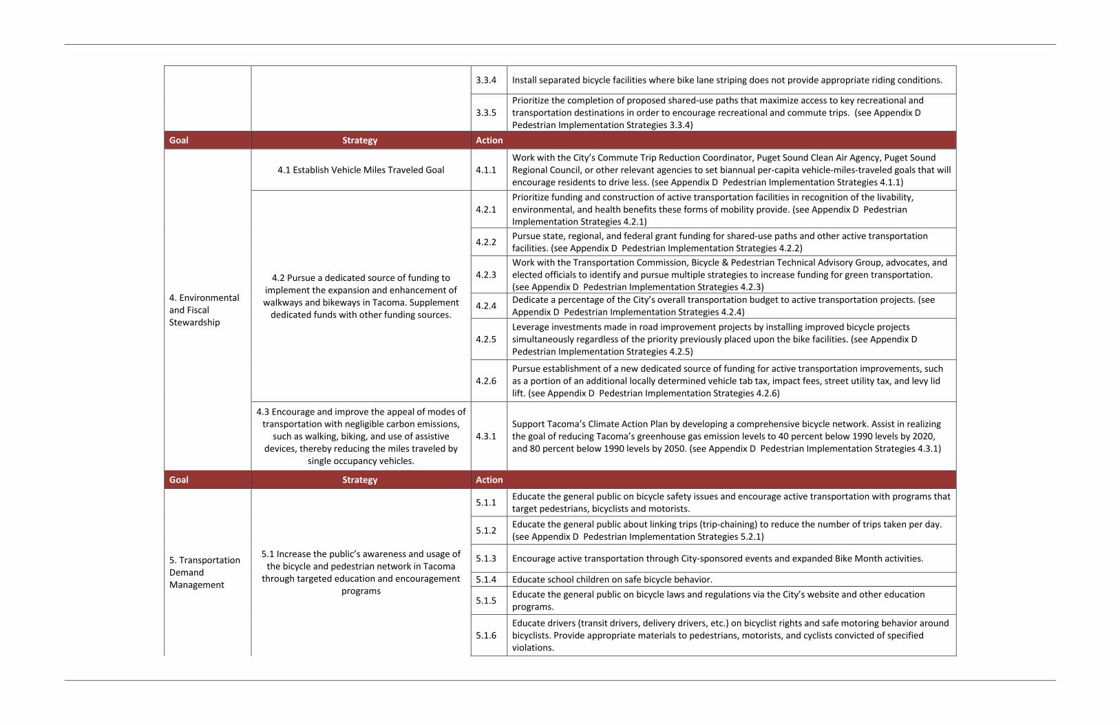
3.3.4 Install separated bicycle facilities where bike lane striping does not provide appropriate riding conditions.
3.3.5 Prioritize the completion of proposed shared-use paths that maximize access to key recreational and transportation destinations in order to encourage recreational and commute trips. (see Appendix D Pedestrian Implementation Strategies 3.3.4)
Goal Strategy Action
4. Environmental and Fiscal Stewardship
4.1 Establish Vehicle Miles Traveled Goal 4.1.1 Work with the City’s Commute Trip Reduction Coordinator, Puget Sound Clean Air Agency, Puget Sound Regional Council, or other relevant agencies to set biannual per-capita vehicle-miles-traveled goals that will encourage residents to drive less. (see Appendix D Pedestrian Implementation Strategies 4.1.1)
4.2 Pursue a dedicated source of funding to implement the expansion and enhancement of walkways and bikeways in Tacoma. Supplement
dedicated funds with other funding sources.
4.2.1 Prioritize funding and construction of active transportation facilities in recognition of the livability, environmental, and health benefits these forms of mobility provide. (see Appendix D Pedestrian Implementation Strategies 4.2.1)
4.2.2 Pursue state, regional, and federal grant funding for shared-use paths and other active transportation facilities. (see Appendix D Pedestrian Implementation Strategies 4.2.2)
4.2.3 Work with the Transportation Commission, Bicycle & Pedestrian Technical Advisory Group, advocates, and elected officials to identify and pursue multiple strategies to increase funding for green transportation. (see Appendix D Pedestrian Implementation Strategies 4.2.3)
4.2.4 Dedicate a percentage of the City’s overall transportation budget to active transportation projects. (see Appendix D Pedestrian Implementation Strategies 4.2.4)
4.2.5 Leverage investments made in road improvement projects by installing improved bicycle projects simultaneously regardless of the priority previously placed upon the bike facilities. (see Appendix D Pedestrian Implementation Strategies 4.2.5)
4.2.6 Pursue establishment of a new dedicated source of funding for active transportation improvements, such as a portion of an additional locally determined vehicle tab tax, impact fees, street utility tax, and levy lid lift. (see Appendix D Pedestrian Implementation Strategies 4.2.6)
4.3 Encourage and improve the appeal of modes of transportation with negligible carbon emissions,
such as walking, biking, and use of assistive devices, thereby reducing the miles traveled by
single occupancy vehicles.
4.3.1 Support Tacoma’s Climate Action Plan by developing a comprehensive bicycle network. Assist in realizing the goal of reducing Tacoma’s greenhouse gas emission levels to 40 percent below 1990 levels by 2020, and 80 percent below 1990 levels by 2050. (see Appendix D Pedestrian Implementation Strategies 4.3.1)
Goal Strategy Action
5. Transportation Demand Management
5.1 Increase the public’s awareness and usage of the bicycle and pedestrian network in Tacoma
through targeted education and encouragement programs
5.1.1 Educate the general public on bicycle safety issues and encourage active transportation with programs that target pedestrians, bicyclists and motorists.
5.1.2 Educate the general public about linking trips (trip-chaining) to reduce the number of trips taken per day. (see Appendix D Pedestrian Implementation Strategies 5.2.1)
5.1.3 Encourage active transportation through City-sponsored events and expanded Bike Month activities.
5.1.4 Educate school children on safe bicycle behavior.
5.1.5 Educate the general public on bicycle laws and regulations via the City’s website and other education programs.
5.1.6 Educate drivers (transit drivers, delivery drivers, etc.) on bicyclist rights and safe motoring behavior around bicyclists. Provide appropriate materials to pedestrians, motorists, and cyclists convicted of specified violations.

5.1.7 Establish Safe Routes to School Programs in collaboration with Tacoma schools. Apply for Safe Routes to Schools grants through the Washington Department of Transportation. (see Appendix D Pedestrian Implementation Strategies 5.1.7)
5.1.8 Educate bicyclists on proper and safe behavior for biking via the City’s website and other education programs.
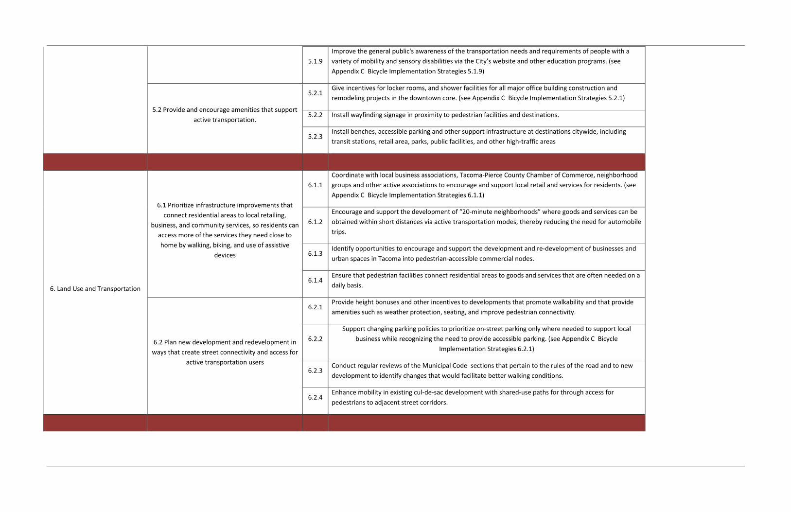
5.1.9 Improve the general public's awareness of the transportation needs and requirements of people with a variety of mobility and sensory disabilities via the City’s website and other education programs. (see Appendix D Pedestrian Implementation Strategies 5.1.9)
5.2 Provide and encourage amenities that support active transportation.
5.2.1 Give incentives for bicycle storage, locker rooms, and shower facilities for all major office building construction and remodeling projects in the downtown core.
5.2.2 Install wayfinding signage in proximity to active transportation facilities and destinations. (see Appendix D Pedestrian Implementation Strategies 5.2.2)
5.2.3 Install bike racks and other support infrastructure at destinations citywide, including transit stations, retail area, parks, public facilities, and other high-traffic areas.
Goal Strategy Action
6. Land Use and Transportation
6.1 Prioritize infrastructure improvements that connect residential areas to local retailing,
business, and community services, so residents can access more of the services they need close to home by walking, biking, and use of assistive
devices
6.1.1 Coordinate with local business associations, Tacoma-Pierce County Chamber of Commerce, neighborhood groups and other active associations to encourage and support local retail and services for residents. (see Appendix D Pedestrian Implementation Strategies 6.1.1)
6.1.2 Identify opportunities to encourage and support the development and re-development of businesses and urban spaces in Tacoma into bicycle- accessible commercial nodes.
6.1.3 Ensure that bicycle facilities connect residential areas to goods and services that are often needed on a daily basis.
6.2 Plan new development and redevelopment in ways that create street connectivity and access for
active transportation users
6.2.1
Support changing parking policies to prioritize on-street parking only where needed to support local business while recognizing the need to provide accessible parking. (see Appendix D Pedestrian Implementation Strategies 6.2.2)
6.2.2 Conduct regular reviews of the Municipal Code sections that pertain to the rules of the road and to new development to identify changes that would facilitate better bicycling conditions.
6.2.3 Enhance mobility in existing cul-de-sac development with shared-use paths for through access for bicyclists to adjacent street corridors.

Appendix D – Pedestrian Implementation Action Strategies
Prioritizing Transportation Investment
As discussed in the TMP, the ‘Green Transportation Hierarchy’ is a recent movement that recognizes transportation modes that have the least environmental impact and greatest contribution to livability. Intended as a prioritization strategy, the Green Transportation Hierarchy promotes funding and development of facilities for modes that affordably enhance access for the majority of Tacoma residents, rather than using level of service standards focused on vehicle movement. While the hierarchy gives precedence to pedestrians, then to bicyclists and public transit, commercial vehicles and trucks are also recognized as having priority over passenger vehicles.
This hierarchy defines pedestrians as including individuals using assistive devices for mobility and sensory disabilities including walkers, wheelchairs, scooters, service animals, and canes. Throughout Appendix D, the term “pedestrian” refers to a person moving from place to place, on foot and/or with the use of an assistive mobility device (when that person has a disability and/or medical condition). “Walking” or “to walk” are the terms used to describe this movement of a pedestrian.
The City of Tacoma’s TMP draws on this model as a conceptual tool for elevating pedestrians, bicycles, and public transit in the planning and design of streets in a manner that is consistent with the City’s Complete Streets policy and the City’s Climate Action Plan. It gives recognition to the city’s most vulnerable users of the streets: pedestrians and bicyclists of all ages and abilities. Chapter 5 Implementation discusses
funding strategies to build out the City’s transportation system. To successfully achieve the City’s vision and goal, a unique set of specific strategies is required that goes beyond construction of infrastructure. This Appendix identifies methods for strengthening execution of the recommendations and ensuring that pedestrian are top priorities in transportation planning.
Pedestrian Recommendations The Transportation Master Plan adopts the 20-Minute Neighborhood approach to pedestrian recommendations due to its focus on making existing activity zones conducive to walking.
The 20-Minute Neighborhood approach identifies areas that are good candidates for walking based on three of the Ds of built environment that influence travel: density, distance, and destinations. Each of these factors has its own components, which are measured as follows:
Density
• Population density by housing units per acre
Distance
• Intersection density
• Topography
• Distance to transit
Destinations
• Major employers
• Schools
• Parks
• Libraries
• Grocery stores

20-Minute Neighborhoods
Within the 20-Minute Neighborhoods, the TMP recommends that the City adopt the yellow standard as its accommodation goal for pedestrian facilities. The standards also break out the Pedestrian Priority Areas, as identified by the 20-Minute Neighborhood Analysis, from other areas of Tacoma.
Table 1. Pedestrian Accommodation Goals - Sidewalks
For the sidewalk accommodation goal, buffering between sidewalks and travel lanes can be accomplished through landscaping, amenity zones, parking, or any other measure beyond a curb that separates pedestrians from moving vehicles. The group also felt that while sidewalks may be recommended on local streets to address specific safety concerns, they need not be required for all local streets.
Intersection Recommendations
The City of Tacoma will use the Pedestrian Crossing Improvement Project (completed 2014) for identifying intersection projects. The Pedestrian Crossings Improvement Project provides for the identification, evaluation, and construction of pedestrian crosswalks, and associated facilities, at intersections citywide. While the primary motivation for the project is the installation of marked crosswalks, other improvements will be installed to enhance the marked crossings.
Crosswalks should be present every other block or 600 feet, whichever is lesser, in Pedestrian Priority Areas to meet the yellow standard, which the TMP recommends for the pedestrian accommodation goal. Crosswalks should be present in other areas of the city in order to meet the yellow standard.
Table 2. Pedestrian Accommodation Goal – Crosswalks
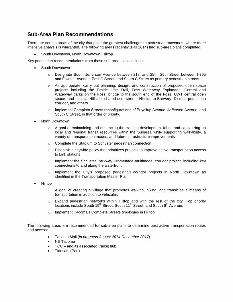
Sub-Area Plan Recommendations There are certain areas of the city that pose the greatest challenges to pedestrian movement where more intensive analysis is warranted. The following areas recently (Fall 2014) had sub-area plans completed:
• South Downtown, North Downtown, Hilltop
Key pedestrian recommendations from those sub-area plans include:
• South Downtown
o Designate South Jefferson Avenue between 21st and 25th; 25th Street between I-705 and Fawcett Avenue; East C Street; and South C Street as primary pedestrian streets
o As appropriate, carry out planning, design, and construction of proposed open space projects including the Prairie Line Trail, Foss Waterway Esplanade, Central and Waterway parks on the Foss, bridge to the south end of the Foss, UWT central open space and stairs, Hillside shared-use street, Hillside-to-Brewery District pedestrian corridor, and others
o Implement Complete Streets reconfigurations of Puyallup Avenue, Jefferson Avenue, and South C Street, in that order of priority.
• North Downtown
o A goal of maintaining and enhancing the existing development fabric and capitalizing on local and regional transit resources within the Subarea while supporting walkability, a variety of transportation modes, and future infrastructure improvements
o Complete the Stadium to Schuster pedestrian connection
o Establish a citywide policy that prioritizes projects to improve active transportation access to Link stations
o Implement the Schuster Parkway Promenade multimodal corridor project, including key connections to and along the waterfront
o Implement the City’s proposed pedestrian corridor projects in North Downtown as identified in the Transportation Master Plan
• Hilltop
o A goal of creating a village that promotes walking, biking, and transit as a means of transportation in addition to vehicular.
o Expand pedestrian networks within Hilltop and with the rest of the city. Top priority locations include South 19th Street, South 11th Street, and South 6th Avenue.
o Implement Tacoma’s Complete Streets typologies in Hilltop
The following areas are recommended for sub-area plans to determine best active transportation routes and access:
• Tacoma Mall (in progress August 2014-December 2017) • NE Tacoma • TCC – and its associated transit hub • Tideflats (Port)

Pedestrian Crossing Improvements Project - Summary Overview
The Pedestrian Crossing Improvements Project provided for the identification, evaluation, and construction of pedestrian crosswalks, and associated facilities, at intersections citywide. While the primary motivation for the project was the installation of marked crosswalks, other improvements were identified to enhance the marked crossings.
The first phase of the project included approximately $2.5 million on planning, designing, and constructing pedestrian crossing improvements throughout the City: $300,000 allotted to each council district and $1 million to the Downtown area (as defined by zoning). This project also investigated opportunities to extend the effectiveness of other programs, such as the Hazardous Sidewalk Replacement program, City Safety grants, and the implementation of the City’s American with Disabilities Act Transition Plan. An additional $1.5 million was allocated for the 2015-2016 biennium to continue the work begun in 2014. This project included a robust public outreach effort to identify potential improvement locations, and received over 650 responses from the public pertaining to over 300 locations throughout the City. These locations were evaluated using a prioritization framework developed by Tacoma staff and the public. Engineers later developed preliminary cost estimates that were used in packaging the locations for construction. Data Collection The project team collected input from a variety of sources regarding the potential locations for pedestrian crossing improvements and the criteria to be used in prioritizing these locations. Crossing improvement locations were identified through a rigorous public input process and current City documents, including the 2009 Mobility Master Plan. In-person meetings and an online survey were tools used to collect data, in addition to letters and emails received from Neighborhood Council representatives, Parent Teacher Associations, local businesses, nonprofit organizations, as well as the general public. Evaluation The public process identified the following criteria that were used to evaluate potential projects:
• Pedestrian and vehicle counts • Proximity to schools • Vehicle/pedestrian collision history • Proximity to parks • Proximity to hospitals • Proximity to bus stops • Proximity to libraries
• The number of times a location was identified through this project’s outreach process, regardless of other characteristics
• Proximity to major employers and commercial centers
• Proximity to bicycle/trail systems • Proximity to senior centers/senior
housing
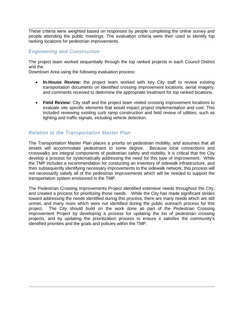
These criteria were weighted based on responses by people completing the online survey and people attending the public meetings. The evaluation criteria were then used to identify top ranking locations for pedestrian improvements. Engineering and Construction The project team worked sequentially through the top ranked projects in each Council District and the Downtown Area using the following evaluation process:
• In-House Review: the project team worked with key City staff to review existing transportation documents on identified crossing improvement locations, aerial imagery, and comments received to determine the appropriate treatment for top ranked locations.
• Field Review: City staff and the project team visited crossing improvement locations to evaluate site specific elements that would impact project implementation and cost. This included reviewing existing curb ramp construction and field review of utilities, such as lighting and traffic signals, including vehicle detection.
Relation to the Transportation Master Plan The Transportation Master Plan places a priority on pedestrian mobility, and assumes that all streets will accommodate pedestrians to some degree. Because local connections and crosswalks are integral components of pedestrian safety and mobility, it is critical that the City develop a process for systematically addressing the need for this type of improvement. While the TMP includes a recommendation for conducting an inventory of sidewalk infrastructure, and then subsequently identifying necessary improvements to the sidewalk network, this process will not necessarily satisfy all of the pedestrian improvements which will be needed to support the transportation system envisioned in the TMP. The Pedestrian Crossing Improvements Project identified extensive needs throughout the City, and created a process for prioritizing those needs. While the City has made significant strides toward addressing the needs identified during this process, there are many needs which are still unmet, and many more which were not identified during the public outreach process for this project. The City should build on the work done as part of the Pedestrian Crossing Improvement Project by developing a process for updating the list of pedestrian crossing projects, and by updating the prioritization process to ensure it satisfies the community’s identified priorities and the goals and policies within the TMP.


Implementation Strategies
Implementation strategies and their related action items support the goals and policies of the Transportation Master Plan. The strategies and actions shown in the following table are organized according to the six goals in the TMP.
Goal Strategy Action
1. Intergovernmental Coordination and Citizen
Participation
1.1 Collaborate with neighboring jurisdictions on active transportation projects
1.1.1
Collaborate with state, regional and federal partners to reform system performance measures and mobility standards in order to reflect the movement of persons rather than vehicles and to favor transportation modes that have the least environmental impact and greatest contribution to livability. (see Appendix C
Bicycle Implementation Strategies 1.1.1)
1.1.2 Work cooperatively with adjoining jurisdictions on pedestrian connections and trail projects to ensure
regional links for commuters and recreational users in and outside of Tacoma.
1.2 Strengthen Active Transportation project and program delivery processes
1.2.1
Develop a pilot program for temporary implementation of pedestrian facilities. Experiment and test improvements of a pedestrian facility in order to determine traffic operation pros and cons and/or modal
trade-offs associated with the incorporation of the pedestrian facility prior to final design and implementation.
1.2.2
Provide training of city staff, including DOT and Police Department. Training can include best practice facility design, safety countermeasures, and maintenance/new materials capabilities. Include training that
pertains to active transportation-related research and studies such as, economic, safety, perception surveys, etc. see Appendix C Bicycle Implementation Strategies 1.2.2)
1.3 Work cooperatively with adjoining jurisdictions and transit agencies to coordinate active
transportation planning and implementation activities.
1.3.1 Coordinate with Sound Transit and Pierce Transit to expand pedestrian and transit mobility through the
integration of active transportation facilities with the transit and streetcar systems.
1.3.2 Support a frequent and convenient bus, rail, and streetcar network to magnify the impact of planning for
movement as pedestrians.
1.3.3 Provide safe and accessible routes and intersections to transit for pedestrians of all abilities.
1.4 Enhance safety for all road users through increased traffic enforcement on city streets, and
1.4.1 Enforce traffic laws consistently for all users through collaboration with the Tacoma Police Department. (see Appendix C Bicycle Implementation Strategies 1.4.1)

walkways.
1.4.2
Collaborate with law enforcement and the courts system on the development of a traffic skills education course aimed to reduce aggressive and/or negligent behavior among drivers, bicyclists and pedestrians by providing the option of taking a traffic skills education course in lieu of fines for traffic violations. (see Appendix C Bicycle Implementation Strategies 1.4.2)
1.4.3 Develop and promote efficient mechanisms for reporting behaviors and conditions that endanger pedestrians to law enforcement.
2. Community / Environment
2.1 Promote active lifestyles by working with Pierce County Health Department (TPCHD) to
provide education programs and safe and accessible routes for bicyclists and pedestrians of
all ages and abilities.
2.1.1 Collaborate with the Tacoma-Pierce County Health Department on active living and active transportation projects that address and seek to reduce health-related issues such as obesity. (see Appendix C Bicycle
Implementation Strategies 2.1.1)
2.2 Apply high-quality engineering and design to physical infrastructure.
2.2.1 Install traffic calming facilities where necessary for improved safety and active transportation travel. (see
Appendix C Bicycle Implementation Strategies 2.2.1)
2.2.2 Use current best engineering practices for minimizing and mitigating conflicts between bicycles,
pedestrians, and motor vehicles. (see Appendix C Bicycle Implementation Strategies 2.2.2)
2.2.3 Reduce barriers and hazards to active transportation users by ensuring safe and sufficient crossings of
major roadways and by providing routes that minimize steep slopes. (see Appendix C Bicycle Implementation Strategies 2.2.3)
3. Multimodal System 3.1 Ensure active transportation facilities are clean,
safe, and, accessible, and promote active use.
3.1.1 Increase pedestrian trips ridership with a system that provides facility types and designs that are low stress for pedestrians and bicyclists of all ages and abilities. Inexperienced are most likely to use high quality bike boulevards, shared use trails, and cycle tracks.
3.1.2 Prioritize pedestrian safety during construction and maintenance activities, and ensure that the City's accessibility guidelines are followed.
3.1.3 Create safe and accessible pedestrian facilities through regular inspection and maintenance.
3.1.4 Develop an on-going city-wide maintenance strategy for pedestrian facilities.

3.1.5 Increase the number of multimodal trips that include traveling as a pedestrian for at least one trip segment by improving and simplifying connections and transfers.
3.2 Establish benchmarks measurements and monitor the effectiveness of the Transportation
Master Plan on a biannual basis.
3.2.1 Monitor the implementation progress of the Transportation Master Plan. (see Appendix C Bicycle Implementation Strategies 3.2.1)
3.2.2 Monitor pedestrian collision data with the goal of reducing pedestrian-related collisions.
3.2.3 Produce a regular report card tracking walking trends in Tacoma including percent of the system that has been completed, funds invested, identification of ongoing problems, public feelings of safety, status of reaching Health and Safety goals, and educational outreach efforts.
3.2.4 Track citywide implementation of improved and increased walkway and ADA accessible features, and amenities with supervision of the Transportation Commission and Bicycle & Pedestrian Technical Advisory Group.
3.3 Apply high-quality engineering and design to pedestrian physical infrastructure.
3.3.1 Design all pedestrian facilities to meet or exceed the latest federal, state, and local standards so that there is universal access for all users of the system.
3.3.2 Install signal prioritization for pedestrian users in appropriate locations.
3.3.3 Ensure that all new facilities are ADA-compliant to provide access for pedestrians of all abilities.
3.3.4 Prioritize the completion of proposed shared-use paths that maximize access to key recreational and transportation destinations in order to encourage recreational and commute trips. (see Appendix C Bicycle Implementation Strategies 3.3.5)
4. Environmental and Fiscal Stewardship
4.1 Establish Vehicle Miles Traveled Goal 4.1.1 Work with the City’s Commute Trip Reduction Coordinator, Puget Sound Clean Air Agency, Puget Sound
Regional Council, or other relevant agencies to set biannual per-capita vehicle-miles-traveled goals that will encourage residents to drive less. (see Appendix C Bicycle Implementation Strategies 4.1.1)
4.2 Pursue a dedicated source of funding to implement the expansion and enhancement of walkways and bikeways in Tacoma. Supplement
dedicated funds with other funding sources.
4.2.1 Prioritize funding and construction of active transportation facilities in recognition of the livability,
environmental, and health benefits these forms of mobility provide. (see Appendix C Bicycle Implementation Strategies 4.2.1)
4.2.2 Pursue state, regional, and federal grant funding for shared-use paths and other active transportation
facilities. (see Appendix C Bicycle Implementation Strategies 4.2.2)
4.2.3 Work with the Transportation Commission, Bicycle & Pedestrian Technical Advisory Group, advocates, and elected officials to identify and pursue multiple strategies to increase funding for green transportation.

(see Appendix C Bicycle Implementation Strategies 4.2.3)
4.2.4 Dedicate a percentage of the City’s overall transportation budget to active transportation projects. (see
Appendix C Bicycle Implementation Strategies 4.2.4)
4.2.5 Leverage investments made in road improvement projects by installing improved pedestrian projects
simultaneously regardless of the priority previously placed upon the pedestrian facilities.
4.2.6 Pursue establishment of a new dedicated source of funding for active transportation improvements, such as a portion of an additional locally determined vehicle tab tax, impact fees, street utility tax, and levy lid
lift. (see Appendix C Bicycle Implementation Strategies 4.2.6)
4.3 Encourage and improve the appeal of modes of transportation with negligible carbon emissions,
such as walking, biking, and use of assistive devices, thereby reducing the miles traveled by
single occupancy vehicles.
4.3.1 Support Tacoma’s Climate Action Plan by developing a comprehensive pedestrian network. Assist in
realizing the goal of reducing Tacoma’s greenhouse gas emission levels to 40 percent below 1990 levels by 2020, and 80 percent below 1990 levels by 2050.
5. Transportation Demand Management
5.1 Increase the public’s awareness and usage of the bicycle and pedestrian network in Tacoma
through targeted education and encouragement programs
5.1.1 Educate the general public on walking safety issues and encourage active transportation with programs that target pedestrians, bicyclists and motorists.
5.1.2 Educate the general public about linking trips (trip-chaining) to reduce the number of trips taken per day. (see Appendix C Bicycle Implementation Strategies 5.1.1)
5.1.3 Encourage active transportation through City-sponsored events and activities..
5.1.4 Educate school children on safe pedestrian behavior.
5.1.5 Educate the general public on pedestrian laws and regulations via the City’s website and other education programs.
5.1.6 Educate drivers (transit drivers, delivery drivers, etc.) on pedestrian rights and safe motoring behavior around pedestrians. Provide appropriate materials to pedestrians, motorists, and cyclists convicted of specified violations.
5.1.7 Establish Safe Routes to School Programs in collaboration with Tacoma schools. Apply for Safe Routes to Schools grants through the Washington Department of Transportation. (see Appendix C Bicycle Implementation Strategies 5.1.7)
5.1.8 Educate pedestrians on proper and safe behavior for walking via the City’s website and other education programs.
5.1.9 Improve the general public's awareness of the transportation needs and requirements of people with a variety of mobility and sensory disabilities via the City’s website and other education programs. (see Appendix C Bicycle Implementation Strategies 5.1.9)
5.2 Provide and encourage amenities that support active transportation.
5.2.1 Give incentives for locker rooms, and shower facilities for all major office building construction and remodeling projects in the downtown core. (see Appendix C Bicycle Implementation Strategies 5.2.1)
5.2.2 Install wayfinding signage in proximity to pedestrian facilities and destinations.
5.2.3 Install benches, accessible parking and other support infrastructure at destinations citywide, including transit stations, retail area, parks, public facilities, and other high-traffic areas
6. Land Use and Transportation
6.1 Prioritize infrastructure improvements that connect residential areas to local retailing,
business, and community services, so residents can access more of the services they need close to home by walking, biking, and use of assistive
devices
6.1.1 Coordinate with local business associations, Tacoma-Pierce County Chamber of Commerce, neighborhood groups and other active associations to encourage and support local retail and services for residents. (see Appendix C Bicycle Implementation Strategies 6.1.1)
6.1.2 Encourage and support the development of “20-minute neighborhoods” where goods and services can be obtained within short distances via active transportation modes, thereby reducing the need for automobile trips.
6.1.3 Identify opportunities to encourage and support the development and re-development of businesses and urban spaces in Tacoma into pedestrian-accessible commercial nodes.
6.1.4 Ensure that pedestrian facilities connect residential areas to goods and services that are often needed on a daily basis.
6.2 Plan new development and redevelopment in ways that create street connectivity and access for
active transportation users
6.2.1 Provide height bonuses and other incentives to developments that promote walkability and that provide amenities such as weather protection, seating, and improve pedestrian connectivity.
6.2.2 Support changing parking policies to prioritize on-street parking only where needed to support local
business while recognizing the need to provide accessible parking. (see Appendix C Bicycle Implementation Strategies 6.2.1)
6.2.3 Conduct regular reviews of the Municipal Code sections that pertain to the rules of the road and to new development to identify changes that would facilitate better walking conditions.
6.2.4 Enhance mobility in existing cul-de-sac development with shared-use paths for through access for pedestrians to adjacent street corridors.