city of unalaska request for proposals … · request for proposals digital photogrammetry services...
TRANSCRIPT

CITY OF UNALASKA REQUEST FOR PROPOSALS
DIGITAL PHOTOGRAMMETRY SERVICES
The City of Unalaska, Alaska (hereinafter “City”) is requesting proposals from qualified photogrammetry firms to develop new digital orthophotography for the areas delineated on Figure 1. Areas of Interest. Additional information required may be obtained by contacting Geographic Technologies Group. GTG Contact: David Lyons, Project Manager
Phone: (352) 284-1232 Email: [email protected]
Schedule and Submission of Proposals:
RFP release date: November 6th, 2015 Proposal due date: December 7th , 2015 at 4:00 pm, Alaska Time Anticipated award date: January 26th, 2016
All proposals, including any amendment or withdrawal, must be received at the address and by the time and date shown below. Any proposal, amendment, or withdrawal that has not been received by that time will not be considered. The outside of the envelope or subject line of the email shall state “Proposal for Digital Photogrammetry Services” and shall be sent to the City Clerk’s Office, City of Unalaska, P.O. Box 610, Unalaska, Alaska 99685, or emailed to [email protected]. Proposers choosing to submit via email assume all risk that interruptions or outages affecting the City’s internet service or email server may delay or prevent receipt of proposals. Scope of Work: The City’s current aerial photography was acquired in 2010 and the City would like to update this data with a new aerial flyover during the spring/summer of 2016. Final deliverables for the project should be provided to the City by June 30, 2016. The City therefore requires the services of an aerial photogrammetry consultant to provide the new aerial photography. The photography will be collected at both ½ foot and 1 foot pixel resolution. A map of the Unalaska region with areas of interest is displayed in Figure 1.


The ½ foot AOI is approximately 44 square miles while the 1 foot AOI is approximately 268 square miles. Esri shapefiles of these boundaries will be provided upon request. Proposer Qualifications: Provide detailed information about your firm’s qualifications to provide remote sensing data. Describe the firm’s experience in Alaska. Name the principal of the firm who will be responsible for binding the firm to the provisions of this agreement. Provide names and detailed resumes of employees and sub-contractors who will be involved with the development and delivery of the remote sensing products detailed in this RFP. All assigned key professional staff must be properly registered / licensed to practice in the State of Alaska. Provide a list of the qualifications, experience and training, including relevant continuing professional education, of the specific staff to be assigned to this contract. Indicate how the quality of staff over the term of the agreement will be assured. Proposers shall provide evidence of their expertise, experience, and other factors which should ensure the probable success of the contract, with emphasis on evidence that demonstrates knowledge of Unalaska or similar communities. Proposers shall show they possess sufficient financial resources and personnel to ensure their ability to fully complete the contract. Successful proposer shall provide proof of insurance as specified in Attachment A – Insurance Requirements for Professional Services. If sub-contractors will be used, proposer should identify them and describe their qualifications and roles in the project. Such sub-contractors, and any consultants and firm specialists mentioned in response to this request for proposal can only be changed with the express prior written permission of the City, which retains the right to approve or reject replacements. All sub-contractors shall be required to comply with the insurance requirements identified above. Specific Project Tasks: The Contractor will furnish all labor, materials, transportation, tools, supplies, equipment, etc. necessary for the following work. The proposed project involves the following components: color digital aerial photography acquisition, analytical aero triangulation, and digital orthophoto mapping. A description of each task is provided to help guide Respondents in the formulation of responses to this RFP. A. Information Supplied by the City
Esri Shapefiles of the Areas Of Interest and the City Boundary
Unalaska Survey Control in AutoCAD DWG format THE CITY IS FURNISHING THIS DIGITAL DATA ON AN "AS IS" BASIS, WITHOUT ANY SUPPORT WHATSOEVER, AND WITHOUT REPRESENTATION OR WARRANTY, INCLUDING BUT NOT IN ANY MANNER LIMITED TO FITNESS, MERCHANTABILITY AND COMPLETENESS OF THE DIGITAL DATA. B. Ground Control
General A sufficient number of Horizontal and Vertical targeted ground control points shall be determined by the Contractor and established on the ground by the Contractor to sufficiently support the accuracy requirements of this project.
C. Color Digital Aerial Photography: High resolution, high accuracy, full color
i. Digital Aerial Camera The photography shall be collected utilizing a direct digital aerial mapping camera without the use of film. Specifications of all proposed digital aerial cameras must be submitted with the proposal. The digital aerial camera system used for the project must be the same as that identified in the proposal. The digital aerial camera system must be equipped with GPS and inertial measurement unit (IMU) systems. ii. Photographic Conditions Color Aerial photography shall be acquired during the spring/summer of 2016. Photography will not be taken when the ground is obscured by snow, haze, fog, dust, or when cloud shadows will appear on more than five percent (5%) of the area in any one photo. Photography will not be taken until all bodies of water in the project area are free of ice. The City will determine when environmental conditions listed above have been met. Image acquisition will take place when the sun angle is 35 degrees from horizon, or greater. iii. Photographic Scale The photos shall be at a resolution suitable for generating digital orthophotos with 6 inch and 12 inch pixel resolution (Figure 1). The maximum flight height required to obtain the output scale requirements and accuracy required for this project should be considered and documented in the proposal. iv. Flight Planning The proposed approach to aerial photography acquisition should outline the respondent’s intended flight plan including proposed date and time of photography, flight height, scale, flight lines, endlap and sidelap, planned aerial equipment, materials, and relevant quality control procedures. Crab must not exceed five-degrees between any two consecutive flights, nor more than three degrees on any one flight line. At the earliest opportunity, new imagery must be acquired to replace rejected photographs or flight lines. The aerial acquisition will extend two exposures beyond the mapping limits to obtain full orthophoto images and to reach pre-targeted ground control points, as necessary. Full Analytical Aerial Triangulation (FAAT) techniques shall be
used in conjunction with ground control to establish a consistent horizontal datum for the entire project area. v. Reflights The contractor, at no additional fee, must correct aerial imagery that does not meet defined specifications. All re-flights must be centered on the plotted flight lines and photography must be acquired with the same camera system used in the original flight. vi. Aircraft and Crew Members Aircraft must be maintained and operated in accordance with the regulations of the Federal Aviation Administration. Individual crewmembers must have experience in flying precise photographic missions for aerial surveys. Individual resumes will be required.
D. Analytical Aero triangulation (A.T.)
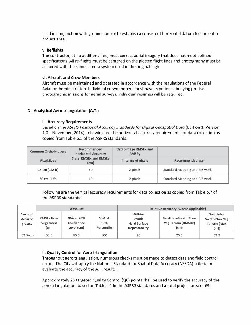
i. Accuracy Requirements Based on the ASPRS Positional Accuracy Standards for Digital Geospatial Data (Edition 1, Version 1.0 – November, 2014), following are the horizontal accuracy requirements for data collection as copied from Table b.5 of the ASPRS standards:
Common Orthoimagery Recommended
Horizontal Accuracy Orthoimage RMSEx and
RMSEy
Pixel Sizes Class RMSEx and RMSEy
(cm) in terms of pixels Recommended user
15 cm (1/2 ft) 30 2-pixels Standard Mapping and GIS work
30 cm (1 ft) 60 2-pixels Standard Mapping and GIS work
Following are the vertical accuracy requirements for data collection as copied from Table b.7 of the ASPRS standards:
ii. Quality Control for Aero triangulation Throughout aero triangulation, numerous checks must be made to detect data and field control errors. The City will apply the National Standard for Spatial Data Accuracy (NSSDA) criteria to evaluate the accuracy of the A.T. results. Approximately 25 targeted Quality Control (QC) points shall be used to verify the accuracy of the aero triangulation (based on Table c.1 in the ASPRS standards and a total project area of 694
Vertical
Accurac
y Class
Absolute Accuracy
Relative Accuracy (where applicable)
RMSEz Non-
Vegetated
(cm)
NVA at 95%
Confidence
Level (cm)
VVA at
95th
Percentile
(cm)
Within-Swath
Hard Surface Repeatability
(Max
Diff) (cm)
Swath-to-Swath Non-
Veg Terrain (RMSDz)
(cm)
Swath-to-
Swath Non-Veg
Terrain (Max
Diff)
(cm) 33.3-cm 33.3 65.3 100 20 26.7 53.3

square kilometers). The Contractor shall provide triangulated x, y, & z coordinates for each of the QC points. The Contractor is encouraged to use the control data provided by the city in the Unalaska Survey Control AutoCAD drawing file along with any new control points determined by the Contractor. The Contractor will compare all of the known coordinates of control points to the values determined in the A.T. solution. 95% of the QC positions must meet the project accuracy standards stated in the table above. The Contractor will provide the City with a report of their results. When the City has determined that the project accuracy standards have been met the field located coordinate values of the QC points will be provided to the Contractor for inclusion in the final triangulation solution. The City shall complete its quality control examination of the aero triangulation solution within 15 working days of its receipt. Upon City approval of the A.T. solution, work on the subsequent deliverable items will commence. iii. Aero triangulation Report At the completion of the fully analytical aero triangulation, the selected Contractor will deliver one copy of the aero triangulation report that will include, but not be limited to, the following:
All misclosures at ground control points with and without use of checkpoints.
Computer printout of the final adjusted aero triangulation solution to horizontal and vertical ground control. The printout should contain the final project coordinates for all ground control points.
Identification of all points, which were included in the initial solution and were subsequently discarded, with an explanation of the reasons for being discarded.
Identification of the weighting factors applied to all points used in the final solution.
A digital file containing the coordinate data.
Narrative: the report shall include a brief narrative tying together the items listed above, as well as descriptions of laboratory equipment, procedures, and computer programs used.
Root Mean Square Error (RMSE) summaries.
E. Digital Orthophoto Mapping
i.Geo-referencing Alaska State Plane Zone 10, NAD83, Feet - per Unalaska Survey Control Map ii. Imagery Resolution 1”= 100’ scale 24-bit natural color digital orthophotography with a 0.5-foot pixel resolution, to include 256 levels of value for each color band, (red, green, and blue), shall be produced for the area defined in Figure 1. 1-foot pixel resolution orthophotography with the same specifications will be collected for the area identified in Figure 1. iii. Image Quality and Tone Balancing Respondents are expected to identify the quality assurance and checking procedures that will be employed to guarantee proper tone balancing and overall image quality. The Contractor shall remove a majority of sun flares on water bodies prior to delivery by inserting non-flared pixels of similar characteristics. The Contractor will provide the City with sample

imagery of a pilot area for the City’s review. The City must approve the quality of the pilot area imagery before the Contractor continues processing of project imagery.
iv. Mosaicking The digital images are to be edge matched with no pixel gaps between geographic partitions. The Contractor shall provide that mosaic lines shall not cross through buildings, bridges or other fabricated structures not at ground level. Join lines between overlapping images shall be selected by the Contractor to minimize tonal variations and visible join lines. Visible seams or sutures within a tile or between tiles, which exhibit a noticeable “edge” or “displacement” effect, will be grounds for rejection of that tile. Among the deliverables for this project is a digital file containing the seam lines used in the mosaicking process. v. City Images After final acceptance, the 0.5-foot pixel TIFF image tiles will be used to create a single image and the same will be done separately for the 1-foot pixel image files. This deliverable will be created by mosaicking the orthophotos for each of the individual image tiles to produce a compressed MrSID image file with associate “world” file. Compression ratio shall be approximately 20:1.
F. Digital Elevation Model (DEM) The Contractor will be responsible for providing the City the DEM created for this project in an ArcGIS and AUTOCAD compatible format. G. Image File Tiling Scheme The delivery of the orthophotography shall be tiled and provide seamless coverage. The Contractor will recommend a tiling scheme for approval by the City prior to start of delivery. H. Acceptance The City shall identify any tile which does not meet the specifications for image quality or positional accuracy described herein and shall notify the Contractor within 15 workdays of the City’s receipt of the subject tile that the image is being rejected. The Contractor shall make any and all corrections necessary to guarantee that all orthophotos meet the described project standards prior to the project deadline. The acceptance of any item by the City shall not preclude subsequent rejection if such an item is later found to be defective. Any defects detected in any of the deliverables after completion of the project and before December 2016 shall be corrected by the Contractor at no additional cost to the City. I. Summary of Deliverables
The successful Contractor will be responsible for producing and delivering the following: (digital project documents may be in either Microsoft Word or Adobe PDF format, GIS data shall be in ESRI file geodatabase format) i. Project Documents
Project Plan (methods, recommendations, and procedures to complete the project) - digital copy.
Flight Line Index Map – digital copy, GIS data.
Aerial Photography Report – digital copy. This report is a summary detailing specifications, standards, procedures, techniques and processes used during aerial imagery acquisition
and processing. The report should include all maps, flight lines, descriptions of equipment, techniques and methodologies used during the project.
Aerial Triangulation Report, digital copy.
Metadata – digital copy.
Project documents may be delivered on DVD media that can be read on a DVD+ROM drive or CD.
J. Project Data
Color digital orthophoto tiles with 0.5-foot pixel and 1-foot pixel resolution delivered in GeoTIFF format with a TIFF world files.
A digital file, ESRI file geodatabase format, of the footprint polygons of each stereo image with attributes corresponding to the filename and flight line of each image.
A digital file, ESRI shapefile or file geodatabases format, of all seam lines used in the mosaicking process.
One copy of final digital data (orthophotography) will be delivered on USB 3.0 external hard drive.
Color digital orthophoto of the 2 areas, in compressed MrSID image file format, created by mosaicking the 0.5 foot pixel and 1 foot resolution digital orthophotos representing each of the tiles. Compression ratio shall be approximately 20:1.
A Digital Elevation Model (DEM) in an ArcGIS and AUTOCAD compatible format All project data shall be referenced to the Alaska State Plane Zone 10 Coordinate System (per Unalaska Survey Control Map):
Horizontal Datum: NAD83 Vertical Datum: NAVD 1988 Unit of Measure: U.S. Survey Foot
The Unalaska Survey Control AutoCAD drawing file will be provided for additional control and reference to be used by the contractor. All products and services produced for this project become the sole property of the City of Unalaska and cannot be used or reproduced without written permission. Unalaska has the right to grant or deny any request. Complete Review: The proposer shall provide a detailed plan for the acquisition of orthophotography for the areas identified in Figure 1, including a detailed schedule for completing the project. City Provided Services: The City shall provide boundary data shown in Figure 1 and a copy of the Unalaska Survey Control AutoCAD drawing file to Contractor.
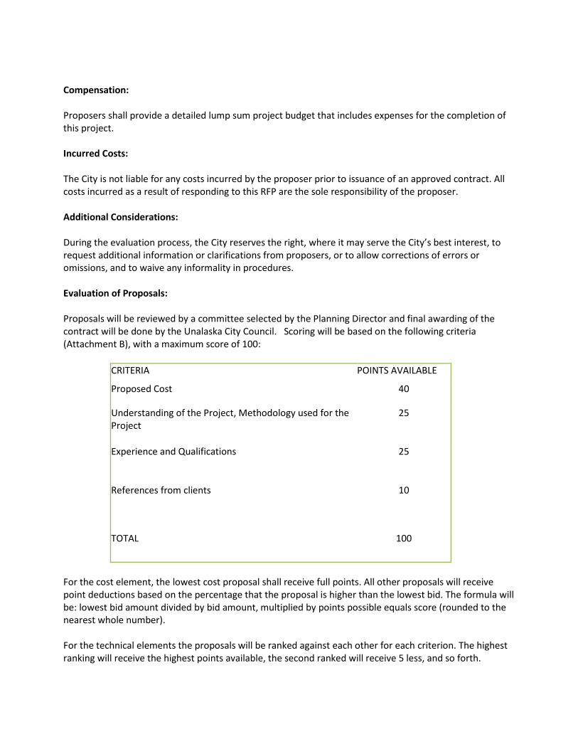
Compensation: Proposers shall provide a detailed lump sum project budget that includes expenses for the completion of this project. Incurred Costs: The City is not liable for any costs incurred by the proposer prior to issuance of an approved contract. All costs incurred as a result of responding to this RFP are the sole responsibility of the proposer. Additional Considerations: During the evaluation process, the City reserves the right, where it may serve the City’s best interest, to request additional information or clarifications from proposers, or to allow corrections of errors or omissions, and to waive any informality in procedures. Evaluation of Proposals: Proposals will be reviewed by a committee selected by the Planning Director and final awarding of the contract will be done by the Unalaska City Council. Scoring will be based on the following criteria (Attachment B), with a maximum score of 100:
CRITERIA POINTS AVAILABLE
Proposed Cost 40
Understanding of the Project, Methodology used for the Project
25
Experience and Qualifications 25
References from clients 10
TOTAL 100
For the cost element, the lowest cost proposal shall receive full points. All other proposals will receive point deductions based on the percentage that the proposal is higher than the lowest bid. The formula will be: lowest bid amount divided by bid amount, multiplied by points possible equals score (rounded to the nearest whole number). For the technical elements the proposals will be ranked against each other for each criterion. The highest ranking will receive the highest points available, the second ranked will receive 5 less, and so forth.

Rejection of Proposals: The City reserves the right to: 1) reject any or all proposals; 2) accept the proposal which in its judgment best suits the needs of the City; 3) waive any and all irregularities or informalities in any proposal.

ATTACHMENT A INSURANCE REQUIREMENTS FOR PROFESSIONAL SERVICES
A. During the term of the contract, the Contractor shall obtain and maintain in force the insurance coverage specified in these requirements. Such coverage shall be with an insurance company with an A.M. Best rating of A VII or better, or a company specifically approved by the City.
B. The contractor shall carry and maintain throughout the life of this contract, at its own expense,
insurance not less than the amounts and coverage herein specified, and the City of Unalaska, its employees and agents shall be named as additional insured under the insurance coverage so specified and where allowed, with respect to the performance of the work. There shall be no right of subrogation against the City or its agents performing work in connection with the work, and this waiver of subrogation shall be endorsed upon the policies. Insurance shall be placed with companies acceptable to the City of Unalaska; and these policies providing coverage thereunder shall contain provisions that no cancellation or material changes in the policy relative to this project shall become effective except upon 30 days prior written notice thereof to the City of Unalaska.
C. Prior to commencement of the work, the contractor shall furnish certificates to the City of
Unalaska, in duplicate, evidencing that the Insurance policy provisions required hereunder are in force. Acceptance by the City of Unalaska of deficient evidence does not constitute a waiver of contract requirements.
D. The contractor shall furnish the City of Unalaska with certified copies of policies upon request. The
minimum coverages and limits required are as follows:
1. Workers’ Compensation insurance in accordance with the statutory coverages required by the State of Alaska and Employers Liability insurance with limits not less than $1,000,000 and, where applicable, insurance in compliance with any other statutory obligations, whether State or Federal, pertaining to the compensation of injured employees assigned to the work, including but not limited to Voluntary Compensation, Federal Longshoremen and Harbor Workers Act, Maritime and the Outer Continental Shelf’s Land Act.
2. Commercial General Liability with limits not less than $1,000,000 per Occurrence and
$2,000,000 Aggregate for Bodily Injury and Property Damage, including coverage for Premises and Operations Liability, Products and Completed Operations Liability, Contractual Liability, Broad Form Property Damage Liability and Personal Injury Liability.

Insurance Requirements/Professional Services - Page 2
3. Commercial Automobile Liability on all owned, non-owned, hired and rented vehicles with limits of liability of not less than $1,000,000 Combined Single Limit for Bodily Injury and Property Damage per each accident or loss.
4. Umbrella/Excess Liability insurance coverage of not less than $1,000,000 per occurrence and annual aggregate providing coverage in excess of General Liability, Auto Liability, and Employers Liability.
5. If work involves use of aircraft, Aircraft Liability insurance covering all owned and non-owned aircraft with a per occurrence limit of not less than $1,000,000.
6. If work involves use of watercraft, Protection and Indemnity insurance with limits not less than $1,000,000 per occurrence.
7. Professional Liability insurance with limits of not less than $1,000,000 per claim and $1,000,000 aggregate, subject to a maximum deductible $10,000 per claim. The City of Unalaska has the right to negotiate increase of deductibles subject to acceptable financial information of the policyholder.
E. Any deductibles or self-insured retentions must be declared to and approved by the City. At the
option of the City, either the insurer shall reduce or eliminate such deductibles or self-insured retentions as respects the City, its officers, officials, employees and volunteers; or the contractor shall provide a financial guarantee satisfactory to the City guaranteeing payment of losses and related investigations, claim administration and defense expense.
F. All insurance policies as described above are required to be written on an “occurrence” basis. In
the event occurrence coverage is not available, the contractor agrees to maintain “claims made” coverage for a minimum of two years after project completion.
G. If the contractor employs second tier subcontractors to perform any work hereunder, the
contractor agrees to require such subcontractors to obtain, carry, maintain, and keep in force during the time in which they are engaged in performing any work hereunder, policies of insurance which comply with the requirements as set forth in this section and to furnish copies thereof to the City of Unalaska. This requirement is applicable to subcontractors of any tier.
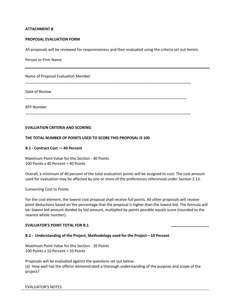
ATTACHMENT B PROPOSAL EVALUATION FORM All proposals will be reviewed for responsiveness and then evaluated using the criteria set out herein. Person or Firm Name
Name of Proposal Evaluation Member _______________________________________________________________________________ Date of Review _____________________________________________________________________________ RFP Number _______________________________________________________________________________ EVALUATION CRITERIA AND SCORING THE TOTAL NUMBER OF POINTS USED TO SCORE THIS PROPOSAL IS 100 B.1 - Contract Cost — 40 Percent Maximum Point Value for this Section - 40 Points 100 Points x 40 Percent = 40 Points Overall, a minimum of 40 percent of the total evaluation points will be assigned to cost. The cost amount used for evaluation may be affected by one or more of the preferences referenced under Section 2.13. Converting Cost to Points For the cost element, the lowest cost proposal shall receive full points. All other proposals will receive point deductions based on the percentage that the proposal is higher than the lowest bid. The formula will be: lowest bid amount divided by bid amount, multiplied by points possible equals score (rounded to the nearest whole number). EVALUATOR'S POINT TOTAL FOR B.1 B.2 - Understanding of the Project, Methodology used for the Project—10 Percent Maximum Point Value for this Section - 10 Points 100 Points x 10 Percent = 10 Points Proposals will be evaluated against the questions set out below. [a] How well has the offeror demonstrated a thorough understanding of the purpose and scope of the project? EVALUATOR'S NOTES

[b] How well has the offeror identified pertinent issues and potential problems related to the project? EVALUATOR'S NOTES [c] To what degree has the offeror demonstrated an understanding of the deliverables the state expects it to provide? EVALUATOR'S NOTES [d] Has the offeror demonstrated an understanding of the state's time schedule and can meet it with the proposed methodology? EVALUATOR'S NOTES [e] To what extent does the offeror’s proposal exceed the minimum project specifications in the Scope of Work? EVALUATOR'S NOTES EVALUATOR'S POINT TOTAL FOR B.2 B.3 - Experience and Qualifications—25 Percent Maximum Point Value for this Section - 25 Points 100 Points x 25 Percent = 25 Points Proposals will be evaluated against the questions set out below. Questions regarding the personnel. [a] What is the level of experience the individuals assigned to the project have on similar projects? EVALUATOR'S NOTES [b] How well do resumes demonstrate backgrounds that would be desirable for individuals engaged in the work the RFP requires? EVALUATOR'S NOTES

Questions regarding the firm. [c] How well has the firm demonstrated experience in completing similar projects on time and within budget? EVALUATOR'S NOTES [d] How successful is the general history of the firm regarding timely and successful completion of projects? EVALUATOR'S NOTES [e] Has the firm provided letters of reference from previous clients and how well do they demonstrate the likelihood the offeror will successfully complete the project? EVALUATOR'S NOTES [f] If a subcontractor will perform work on the project, how well do they measure up to the evaluation used for the offeror? EVALUATOR'S NOTES EVALUATOR'S POINT TOTAL FOR B.3
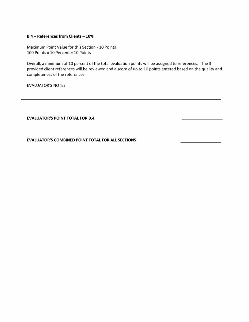
B.4 – References from Clients – 10% Maximum Point Value for this Section - 10 Points 100 Points x 10 Percent = 10 Points Overall, a minimum of 10 percent of the total evaluation points will be assigned to references. The 3 provided client references will be reviewed and a score of up to 10 points entered based on the quality and completeness of the references. EVALUATOR'S NOTES EVALUATOR'S POINT TOTAL FOR B.4 EVALUATOR'S COMBINED POINT TOTAL FOR ALL SECTIONS