civic center planning assessment - denver...the civic center planning assessment is the product of...
TRANSCRIPT

C I V I C C E N T E R P L A N N I N G A S S E S S M E N T
●C I V I C C E N T E RP L A N N I N G A S S E S S M E N T
●
NOVEMBER 5, 2003

T A B L E O F C O N T E N T S
◗TABLE OF CONTENTSI. Purpose and Need. . . . . . . . . . . . . . . . . . . . . . . . . . . . . . . . . . . . . . . . . . . 1
II. Civic Center Plan Summaries . . . . . . . . . . . . . . . . . . . . . . . . . . . . . . . . . 5Existing Plans and Studies. . . . . . . . . . . . . . . . . . . . . . . . . . . . . . . . . . . . . . . . . . . . . . 6Plans and Studies in Progress . . . . . . . . . . . . . . . . . . . . . . . . . . . . . . . . . . . . . . . . . . . 9
III. Land Use and Urban Design . . . . . . . . . . . . . . . . . . . . . . . . . . . . . . . . 11Existing Land Use . . . . . . . . . . . . . . . . . . . . . . . . . . . . . . . . . . . . . . . . . . . . . . . . . . . 12Existing Zoning . . . . . . . . . . . . . . . . . . . . . . . . . . . . . . . . . . . . . . . . . . . . . . . . . . . . 14Adjacent Zoning . . . . . . . . . . . . . . . . . . . . . . . . . . . . . . . . . . . . . . . . . . . . . . . . . . . . 15Additional Regulations . . . . . . . . . . . . . . . . . . . . . . . . . . . . . . . . . . . . . . . . . . . . . . . 16Land Use Goals and Policies from Adopted Plans . . . . . . . . . . . . . . . . . . . . . . . . . . . 20
IV. Urban Design and Architecture . . . . . . . . . . . . . . . . . . . . . . . . . . . . . 21Existing Urban Form. . . . . . . . . . . . . . . . . . . . . . . . . . . . . . . . . . . . . . . . . . . . . . . . . 22Current and Proposed Development and Expansion Projects. . . . . . . . . . . . . . . . . . 22Design Guidelines. . . . . . . . . . . . . . . . . . . . . . . . . . . . . . . . . . . . . . . . . . . . . . . . . . . 23Potential for Significant Change . . . . . . . . . . . . . . . . . . . . . . . . . . . . . . . . . . . . . . . . 25Urban Design and Architecture Goals and Policies from Adopted Plans . . . . . . . . . . 25Land Use and Urban Design Issues and Analysis . . . . . . . . . . . . . . . . . . . . . . . . . . . . 27
V. Mobility and Parking . . . . . . . . . . . . . . . . . . . . . . . . . . . . . . . . . . . . . . . 31Existing Streets and Classifications . . . . . . . . . . . . . . . . . . . . . . . . . . . . . . . . . . . . . . 32Existing Pedestrian and Bicycle Routes. . . . . . . . . . . . . . . . . . . . . . . . . . . . . . . . . . . 34Existing Transit Routes . . . . . . . . . . . . . . . . . . . . . . . . . . . . . . . . . . . . . . . . . . . . . . . 37Existing Parking Conditions . . . . . . . . . . . . . . . . . . . . . . . . . . . . . . . . . . . . . . . . . . . 38Planned and Current Transportation Projects . . . . . . . . . . . . . . . . . . . . . . . . . . . . . . 41Mobility Goals and Policies from Adopted Plans . . . . . . . . . . . . . . . . . . . . . . . . . . . . 42Mobility and Parking Issues and Analysis. . . . . . . . . . . . . . . . . . . . . . . . . . . . . . . . . . 43
ii

C I V I C C E N T E R P L A N N I N G A S S E S S M E N T
VI. Parks and Parkways . . . . . . . . . . . . . . . . . . . . . . . . . . . . . . . . . . . . . . 46Existing Parks and Parkways . . . . . . . . . . . . . . . . . . . . . . . . . . . . . . . . . . . . . . . . . . . 47Parks Goals and Policies from Adopted Plans . . . . . . . . . . . . . . . . . . . . . . . . . . . . . . 48Parks and Parkways Issues and Analysis. . . . . . . . . . . . . . . . . . . . . . . . . . . . . . . . . . . 49
VII. Quality of Life. . . . . . . . . . . . . . . . . . . . . . . . . . . . . . . . . . . . . . . . . . . . 54Existing Conditions. . . . . . . . . . . . . . . . . . . . . . . . . . . . . . . . . . . . . . . . . . . . . . . . . . 55Quality of Life Goals and Policies from Adopted Plans . . . . . . . . . . . . . . . . . . . . . . . 57Quality of Life Issues and Analysis. . . . . . . . . . . . . . . . . . . . . . . . . . . . . . . . . . . . . . . 58
VIII. Economic Activity . . . . . . . . . . . . . . . . . . . . . . . . . . . . . . . . . . . . . . . . 64Existing Economic Activity . . . . . . . . . . . . . . . . . . . . . . . . . . . . . . . . . . . . . . . . . . . . 65Economic Activity Issues and Analysis. . . . . . . . . . . . . . . . . . . . . . . . . . . . . . . . . . . . 70
IX. Government and Cultural Facilities. . . . . . . . . . . . . . . . . . . . . . . . . . 74Existing Government and Cultural Facilities . . . . . . . . . . . . . . . . . . . . . . . . . . . . . . . 75Projected Government and Cultural Facilities Needs . . . . . . . . . . . . . . . . . . . . . . . . 79Planned or Proposed Government and Cultural Facilities Development . . . . . . . . . . 85Facilities Goals and Policies from Adopted Plans . . . . . . . . . . . . . . . . . . . . . . . . . . . 87Government and Cultural Facilities Issues and Analysis. . . . . . . . . . . . . . . . . . . . . . . 89
X. Next Steps . . . . . . . . . . . . . . . . . . . . . . . . . . . . . . . . . . . . . . . . . . . . . . . . 92 Track A: Civic Center Master Plan . . . . . . . . . . . . . . . . . . . . . . . . . . . . . . . . . . . . . . . 93Track B: Justice Center Design Development . . . . . . . . . . . . . . . . . . . . . . . . . . . . . . 95Track C: No Action . . . . . . . . . . . . . . . . . . . . . . . . . . . . . . . . . . . . . . . . . . . . . . . . . . 97Track D: Hybrid . . . . . . . . . . . . . . . . . . . . . . . . . . . . . . . . . . . . . . . . . . . . . . . . . . . . 98
XI. Notes from Public Workshop . . . . . . . . . . . . . . . . . . . . . . . . . . . . . . . 99Land Use and Urban Design . . . . . . . . . . . . . . . . . . . . . . . . . . . . . . . . . . . . . . . . . . 100 Mobility and Parking. . . . . . . . . . . . . . . . . . . . . . . . . . . . . . . . . . . . . . . . . . . . . . . . 104 Quality of Life . . . . . . . . . . . . . . . . . . . . . . . . . . . . . . . . . . . . . . . . . . . . . . . . . . . . . 108Economic Activity. . . . . . . . . . . . . . . . . . . . . . . . . . . . . . . . . . . . . . . . . . . . . . . . . . 113Government and Cultural Facilities. . . . . . . . . . . . . . . . . . . . . . . . . . . . . . . . . . . . . 116
iii

T A B L E O F C O N T E N T S
XII. Acknowledgements . . . . . . . . . . . . . . . . . . . . . . . . . . . . . . . . . . . . . . 119
◗L IST OF MAPS AND CHARTSStudy Area Boundary Map. . . . . . . . . . . . . . . . . . . . . . . . . . . . . . . . . . . . . . . . . . . . . . 3
Existing Land Use Pie Chart . . . . . . . . . . . . . . . . . . . . . . . . . . . . . . . . . . . . . . . . . . . 12
Existing Land Use Map . . . . . . . . . . . . . . . . . . . . . . . . . . . . . . . . . . . . . . . . . . . . . . . 12
Civic Center Ownership Map . . . . . . . . . . . . . . . . . . . . . . . . . . . . . . . . . . . . . . . . . . 13
Existing Zoning Map. . . . . . . . . . . . . . . . . . . . . . . . . . . . . . . . . . . . . . . . . . . . . . . . . 14
Historic Districts and Structures Map . . . . . . . . . . . . . . . . . . . . . . . . . . . . . . . . . . . . 17
Height Restrictions and View Plane Map. . . . . . . . . . . . . . . . . . . . . . . . . . . . . . . . . . 18
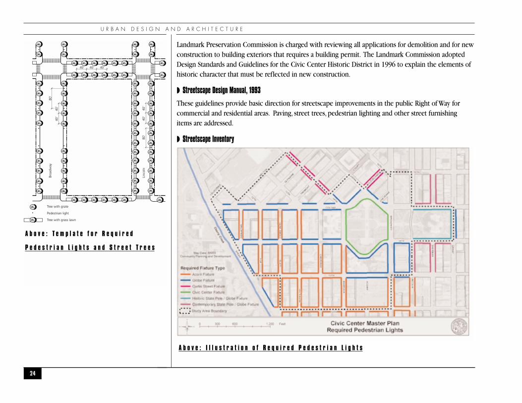
Locations of Required Pedestrian Lights Map . . . . . . . . . . . . . . . . . . . . . . . . . . . . . . 24
Template for Required Pedestrian Lights and Street Trees . . . . . . . . . . . . . . . . . . . . . 24
Potential for Significant Change Map . . . . . . . . . . . . . . . . . . . . . . . . . . . . . . . . . . . . 25
Street Classifications Map . . . . . . . . . . . . . . . . . . . . . . . . . . . . . . . . . . . . . . . . . . . . . 32
Existing Pedestrian and Bicycle Routes Map . . . . . . . . . . . . . . . . . . . . . . . . . . . . . . . 34
Existing Transit Routes Map . . . . . . . . . . . . . . . . . . . . . . . . . . . . . . . . . . . . . . . . . . . 37
On-Street Parking Utilization Map . . . . . . . . . . . . . . . . . . . . . . . . . . . . . . . . . . . . . . . 39
Off-Street Parking Utilization Map. . . . . . . . . . . . . . . . . . . . . . . . . . . . . . . . . . . . . . . 40
Parks and Parkways Map. . . . . . . . . . . . . . . . . . . . . . . . . . . . . . . . . . . . . . . . . . . . . . 47
Neighborhood and Community Organizations Table. . . . . . . . . . . . . . . . . . . . . . . . . 55
Cultural, Institutional and Government Facilities Table . . . . . . . . . . . . . . . . . . . . . . . 56
Employment and Wage Estimates Table. . . . . . . . . . . . . . . . . . . . . . . . . . . . . . . . . . . 66
Visitor Estimates Table . . . . . . . . . . . . . . . . . . . . . . . . . . . . . . . . . . . . . . . . . . . . . . . 68
Potential for Significant Change Map . . . . . . . . . . . . . . . . . . . . . . . . . . . . . . . . . . . . 69
Employees Per Block Map . . . . . . . . . . . . . . . . . . . . . . . . . . . . . . . . . . . . . . . . . . . . 72
Existing City/Public Facilities Table . . . . . . . . . . . . . . . . . . . . . . . . . . . . . . . . . . . . . . 77
Facilities Locations Map . . . . . . . . . . . . . . . . . . . . . . . . . . . . . . . . . . . . . . . . . . . . . . 78
Facilities Ownership Map . . . . . . . . . . . . . . . . . . . . . . . . . . . . . . . . . . . . . . . . . . . . . 78
Facility Needs Table . . . . . . . . . . . . . . . . . . . . . . . . . . . . . . . . . . . . . . . . . . . . . . . . . 83
iv

C I V I C C E N T E R P L A N N I N G A S S E S S M E N T
1
●P U R P O S E A N D N E E D●

P U R P O S E A N D N E E D
In 2002, the City and County of Denver purchased the Rocky Mountain News property as a potential sitefor a new Denver Justice Center complex and, in 2003, completed a program for three facilities: theproposed Justice Center, an associated parking structure, and a new Juvenile Courthouse. The purchaseand facility programming have raised questions about the impacts of current facilities; the potential forother new or expanded governmental or cultural facilities; and the location, design, and the cumulativeimpacts of existing and future governmental and cultural facilities in the Civic Center.
During discussions with City representatives regarding the proposed Justice Center and the associatedfacilities, the Golden Triangle Neighborhood Association requested that the City develop a Master Planthat would address the Civic Center area and create a context and direction for discussions and plans forthe proposed Justice Center.They asked that the Master Plan place a particular emphasis on the location,design, impacts, mitigation of the impacts, physical limits of government and cultural facilities, and theintegration of those facilities with the Golden Triangle and the adjoining neighborhoods.
The neighborhood association also requested that, if the Civic Center is chosen as the proposed site for anew Justice Center, the master plan be completed prior to a City Council decision on forwarding to theballot the referendum on the funding for the proposed Justice Center.The completed plan could includerecommendations that would affect the final program, design, and budget for the Justice Center and otherfuture facilities. Having a completed plan would enable the Justice Center ballot measure to reflect theresolution of issues raised in the planning process, rather than leaving those issues unanswered.
Because of the pressing need for new and expanded courtroom and jail facilities, it is possible that theAdministration and City Council could decide to include the funding referendum on either the November2004 ballot or the May 2005 ballot. If it is decided to place the funding referendum on the ballot, and ifthe City Administration decides to proceed with a Master Plan prior to the election, then the Master Planwill need to be substantially complete eight months before the election. To meet either of thesedeadlines, planning efforts need to be aggressive and immediate.
However, an aggressive planning schedule has been and will continue to be problematic:
◗ The Administration and ten of thirteen City Council members that were involved in earlierdiscussions regarding the need for a new Justice Center and agreed to purchase the RockyMountain News site left office in July 2003;
◗ The new Administration and ten new Council members have only been in office since July 2003;
2

C I V I C C E N T E R P L A N N I N G A S S E S S M E N T
◗ The Planning Services and Urban Design sections of Community Planning and Development areundergoing drastic cuts in resources, consulting budgets, and professional staff;
◗ Other City agencies that also would be key participants in the planning process are makingsimilar budget and personnel cuts; and
◗ Other high priority projects need to be completed.
In recognition of these uncertainties, City staff agreed to engage in preliminary planning activities thatwould result in an independent document and analysis that, if a decision is made to proceed with aMaster Plan, could also serve as the basis for an expanded planning effort.
The Civic Center Planning Assessment is the product of those preliminary planning activities.TheAssessment is intended to provide the Mayor and City Council with additional background for a decisionon the timing and process for proceeding with siting, funding, and designing a new Justice Center. It isimportant to note that the Assessment is neither a master plan nor design development, but rather it is asnapshot of the current condition and issues within a defined study area and the direction provided by
3
L e f t : S t u d y A r e a B o u n d a r y
T h e S t u d y A r e a f o c u s e s o n C i v i c
C e n t e r P a r k a n d i n c l u d e s C i t y , S t a t e ,
a n d F e d e r a l f a c i l i t i e s a n d t h e
i m m e d i a t e l y a d j a c e n t b l o c k s .

P U R P O S E A N D N E E D
existing plans and studies for addressing those conditions and issues.
The Assessment process focused on a public workshop held Saturday,August 9, 2003, at the WebbMunicipal Building. Forty representatives of neighborhood, Downtown, and professional organizations;government and cultural institutions; elected and appointed officials; and owners of property participatedin the workshop. City staff and the project’s traffic consultant presented background information on thehistory, land use, urban design, mobility, parking, parks, open space, economic activity, and governmentand cultural facilities in the Study Area. The participants then broke into small groups where theyidentified and verified the key issues for each of those topics, plus quality of life issues.
Using the results of the workshop, City staff developed four alternative approaches, or tracks, that futureplanning efforts might follow and developed a general scope of work and a set of “pros and cons” foreach of the four tracks.The four approaches - Civic Center Master Plan, Justice Center DesignDevelopment, No Action, and Hybrid – are described in the “Next Steps” section at the end of theAssessment.
Future actions beyond the Planning Assessment are dependent on several key decisions from the CityAdministration and overcoming several obstacles. Direction will be needed on:
◗ Whether to proceed with plans for a new Justice Center;
◗ The preferred site for a new facility;
◗ The timing of a potential bond issue that would fund the design and construction of the facilityand the associated improvements;
◗ Assignment of key City staff to the project;
◗ The priority of the project relative to the costs of funding, staffing, and time and potentialimpacts on the initiation and completion of other projects; and
◗ The Next Steps for the process.
The obstacles that need to be overcome in order to proceed are the limited time, money, and staffavailable for completing the project.
4

C I V I C C E N T E R P L A N N I N G A S S E S S M E N T
5
●C I V I C C E N T E R P L A NS U M M A R I E S
●
The study area has been included in a number of plans and studies in the past 15 years. Specific goals and policies from these plans are inluded in the applicable chapters of this assessment.

C I V I C C E N T E R P L A N N I N G A S S E S S M E N T P L A N S U M M A R I E S
6
◗EXISTING PLANS AND STUDIES
Note: Plans are listed in reverse chronological order.
◗ Game Plan, 2003
The 50-year Master Plan for Parks and Recreation identifies guiding principles and values for themanagement of Denver Parks. It includes goals for special events and investment in historic resourcesand landscapes.
◗ Blueprint Denver: An Integrated Land Use and Transportation Plan, 2002
Blueprint Denver is the citywide growth management plan that supplements the City’s comprehensiveplan. Blueprint Denver divides the city into Areas of Change, where growth and redevelopment shouldbe directed, and Areas of Stability, where the existing uses and urban form are appropriate and should beprotected. Downtown and Golden Triangle are both shown as Areas of Change on the Blueprint PlanMap, reflecting goals for the area to increase in density and mix of uses. The Civic Center subarea isshown as a Government and Cultural Campus, continuing the current uses and urban form.
◗ B-8-G Design Guidelines, 2002
The Golden Triangle, including the Study Area, is zoned B-8-G.These rules and regulations implementthe B-8-G zone district requirement for design review of all new construction and of significantredevelopment projects. The design standards and guidelines focus on implementing the urban designgoals of the neighborhood plan, including pedestrian scale, comfort and connections; spatial definitionof street and open spaces; reinforcing the parkway character of Speer Boulevard and the civiccharacter of Civic Center; and architecture with human scale. They are consistent with the CivicCenter Design Guidelines.
◗ Bicycle Master Plan Update, 2001, 2002
The Master Plan for bicycle mobility throughout the city.
◗ Denver Comprehensive Plan, 2000
Plan 2000 provides a vision for the city as a high quality place to live, work and play, with emphasis onbuilding on Denver’s current assets and eliminating current deficits. The comprehensive plan includes a

C I V I C C E N T E R P L A N N I N G A S S E S S M E N T
vision, goals and recommendations for environmental sustainability, land use, mobility, legacies, housing,economic development, neighborhoods, education, human services, arts and culture, and metropolitancooperation.
◗ Silver Triangle Urban Design Study, 1999
The urban design study was undertaken in response to the expansion of the Denver Convention Centerand includes eight land use alternatives and ten urban design principles related to uses, pedestrianactivity and comfort, landscape and streetscape character, historic preservation, transportation andparking. It also was not adopted by the City, but provides valuable analysis and direction.
◗ Golden Triangle Neighborhood Plan, 1998
The Golden Triangle Neighborhood Plan provides land use, urban design and transportationrecommendations for the growth and redevelopment of what it refers to as the Golden Triangle/CivicCenter Neighborhood (Colfax Avenue on the north, Broadway on the east and Speer Boulevard on thesouthwest). The neighborhood vision includes developing the existing auto-oriented uses and parkinglots into a mixed-use neighborhood of residences, cultural and government facilities, arts-relatedcommercial uses, offices and retail. The design emphasis is on pedestrian facilities and linking todowntown, with a scale lower than Downtown but greater than the adjacent Lincoln Parkneighborhood. The plan places special emphasis on building on the arts and cultural facilities providedby the Denver Art Museum, Colorado History Museum, Denver Public Library and other culturalinstitutions.
◗ Central Denver Transportation Study, 1998
The Transportation Study addresses streets south and east of Colfax and Broadway and recommendssolutions that strike a balance between traffic movement, mobility, and neighborhood and businessconcerns.
◗ Central Business District/B-5 Design Guidelines, 1995
Most of the Central Business District is zoned B-5. These rules and regulations implement the B-5 zonedistrict requirement for design review of all new construction and of significant redevelopment projects.The design standards and guidelines focus on reinforcing and adding to the legacy of high quality designin Downtown, creating an urban center that is comfortable, delightful, exciting and the regional center
7

C I V I C C E N T E R P L A N N I N G A S S E S S M E N T P L A N S U M M A R I E S
for business and entertainment.
◗ Civic Center Cultural Complex Master Plan, 1992
Prepared by Venturi Scott Brown and Associates, the CCCC Plan is a district plan for the growth andurban design of the major cultural facilities in the Civic Center: Denver Art Museum, Denver PublicLibrary and the Colorado Historical Society. Recommendations include shared programs and creations ofa common urban landscape centered on Civic Center Park. The plan focuses on adding new facilities andspecifically warns against fundamental alteration of the existing institutions. The Master Plan anticipatesthe (now-built) Justice Center at 13th and Cherokee.
◗ Silver Triangle Urban Design Study, 1990
This short urban design study was not officially adopted by the City, but it still provides valid urbandesign analysis and guidance for the area north of Colfax Avenue, south of 16th Street and east of SpeerBoulevard. The recommendations include standards for street and pedestrian lighting and otherstreetscape elements, views and gateways, and building massing and solar access to the street.
◗ Civic Center Design Guidelines, 1996
These rules and regulations provide design standards and guidelines for the Civic Center Historic Districtand design recommendations for the blocks adjacent to the historic district. The emphasis is oncompatibility of new structures in scale, massing, materials and form, but not in architectural style. TheGuidelines also include standards for streetscaping, including pedestrian lighting styles and locations.
◗ Downtown Area Plan, 1986
The Downtown Area Plan was a visionary long-range plan for the health and vitality of the CentralBusiness District and its immediate surrounds. It includes framework principles for uses, urban formand connections, as well as district goals for subareas within the planning area. The Civic CenterDistrict, aka the Golden Triangle Neighborhood, is noted as “Government on the Green” and isrecommended as an urban centerpiece and reinforced as an anchor to Downtown. The Plan alsorecommends that government facilities be concentrated in the Silver and Golden Triangles to avoidimpacts on adjacent neighborhoods. The recommendations for the Silver Triangle District (“SleepingGiant”) include development as an extension of the financial district with special attention toconnections and open space.
8

C I V I C C E N T E R P L A N N I N G A S S E S S M E N T
◗PLANS AND STUDIES IN PROGRESS
◗ Downtown Multi-Modal Access Plan (DMAP)
The Department of Public Works is heading a multi-agency and multi-jurisdictional review and plan forgetting people in, around and out of Downtown by automobile, bus and rail transit, circulator transit,bicycle and walking. DMAP includes the study of the Central Connector transit line from the Broadwaylight rail station to the Civic Center bus station, improvements to pedestrian, bicycle and transit facilities,recommendations for alignment, technology and stops for new transit (including local buses, regionalbuses, light rail, commuter rail, and bus rapid transit) with an emphasis on multi-modal stations at UnionStation, Market Street Station and Civic Center Station. Recommendations may also include changes tothe street system.
◗ East Colfax Corridor Plan
Community Planning and Development is the lead agency, partnering with Public Works, in developingan Area of Change corridor plan for Colfax Avenue from Sherman Street to Colorado Boulevard. The planfocuses on land use and design parameters that are expected to lead to zone district language and mapamendments. The vision and goals for the corridor include increased housing and mixed-usedevelopment, with higher densities and intensities at strategically located transit nodes and activitycenters, as well as appropriate transitions to adjacent residential neighborhoods. The plan also addressesenhanced bus transit.
◗ Historic Landscape Assessment and Preservation Plan
The Denver Parks and Recreation Department is conducting a Civic Center Park Historic LandscapeAssessment and Preservation Master Plan to research the historic park and evaluate the impacts ofchange on Civic Center Park. This study will provide the foundation needed to create a preservationplan and identify strategies to preserve the park, prioritize needs, manage events more effectively, guidefuture change, and use alternative funding sources to implement preservation projects. The plan willalso investigate options to strengthen the organizational capacity to develop partnerships and leverageresources with other agencies and organizations.
9

C I V I C C E N T E R P L A N N I N G A S S E S S M E N T P L A N S U M M A R I E S
◗ West Colfax Corridor Plan
Community Planning and Development and Public Works are developing a corridor plan for West Colfaxfrom Speer Boulevard to Sheridan Boulevard. The plan focuses on defining an appropriate street crosssection, including access control and pedestrian amenities, as well as addressing redevelopment potentialalong the proposed West Corridor Light Rail Line and thoughtful transitions to the adjacent residentialneighborhoods.
◗ Pedestrian Master Plan, 2003
A Master Plan for improving the city’s pedestrian infrastructure and mobility.
10

C I V I C C E N T E R P L A N N I N G A S S E S S M E N T
11
●L A N D U S E A N D U R B A N D E S I G N
●

L A N D U S E A N D U R B A N D E S I G N
◗EXISTING LAND USE
The land uses within the Civic Center study area are diverse and mixed. Denver’s goal of introducingsignificant housing to the Downtown area has not been achieved within the study area, although thereare several new high-density housing developments within a few blocks. Without significant housing, thearea lacks the mixed-use character that is desired. The land uses are primarily government, cultural andother institutional uses, a few offices, limited retail and commercial businesses, and many surface parkinglots. There are a few industrial and automotive-related businesses. Parks and open space are limited to theCivic Center Park, the Speer Boulevard Parkway and Triangles and Cherry Creek Trail, and the state-ownedLincoln Park.
12
A b o v e : C i v i c C e n t e r M a s t e r P l a n S t u d y
A r e a C u r r e n t L a n d U s e ( p e r c e n t o f
t o t a l p a r c e l a r e a ) p i e c h a r t
R i g h t : M a p o f e x i s t i n g L a n d U s e
Parking Garage2.84%
School2.52%
Residential1.96%
RTD1.58%
DAC1.19% Vacant Land
0.15%
Surface Parking Lot17.52%
Open Space 14.77%
City Government13.03%
Civic Cultural12.08%
Office / Mixed-Use10.40%
State Government7.38%
Industrial7.11%
Federal Government4.41%
Retail / Restaurant3.06%

C I V I C C E N T E R P L A N N I N G A S S E S S M E N T
City, State and Federal Governments own or control most of the land in the Study Area. There are alsoprivate property owners with relatively large assemblages of property and those who own smallproperties.
13
L e f t : C i v i c C e n t e r O w n e r s h i p M a p

L A N D U S E A N D U R B A N D E S I G N
◗EXISTING ZONING
For general information only. For official zoning interpretation, contact Denver Zoning Administration.
◗ B-8-G:
The B-8-G zone district was created in 1994 specifically for the Golden Triangle area. Currently, theGolden Triangle is the only area of the city with B-8-G zoning. B-8-G is a high-density mixed-use(residential, office and retail) zone district. It allows new construction at a base Floor Area Ratio (FAR) of4:1 with density bonuses up to 6:1 for defined public benefits, including housing, ground-floor retail inmixed-use developments, childcare facilities, public art, and rehabilitation of historic buildings. The FARcan be increased to 7:1 through Transfer of Development Rights (TDRs) from historic structures orthrough a more extensive design review process. Mandatory design review is required for a portion ofany new construction and significant redevelopment. Automobile-oriented uses such as drive-throughsand gas stations are conditional. Commercial parking is not allowed. Parking requirements for residentialuses are reduced to one space per dwelling unit; parking requirements for other uses are the same as
14
R i g h t : M a p o f E x i s t i n g Z o n i n g

C I V I C C E N T E R P L A N N I N G A S S E S S M E N T
other zone districts. New buildings are limited to a height of 175 feet above the centerline of Broadway(plus or minus any difference in grade between the building site and Broadway). Setbacks of ten feet arerequired along Speer Boulevard.
◗ B-5:
The B-5 zone district was created for the Central Business District and was substantially revised in 1994.Several overlay districts were established for the Central Business District at the time, but none wereapplied to the blocks within the Civic Center study area. The B-5 district is the most intense, highest-density zone district in Denver. Uses include office, residential and retail. There are no parkingrequirements for any use in the zone district and commercial parking is not allowed. Parking must servea specific use by right in the B-5 district. The B-5 district has a base FAR of 10:1, which can be increasedto 17:1 with density premiums for defined public benefits such as residential uses, childcare facilities,residential support facilities, pedestrian-active facilities, support for mass transit, underground parking,public art and Transfer of Development Rights. In an area defined as the “core of cores,” the FAR may beincreased to 20:1. Design review of new construction is mandatory and there is no height limit. Nosetbacks are required.
◗ADJACENT ZONING
◗ B-4:
The B-4 zone district applies to commercial corridors throughout the city, including East Colfax Avenue.This zone district allows a wide and occasionally incompatible mix of uses, including retail, office,industrial and residential. FAR is limited to 2:1. Parking requirements for residential uses are reduced toone space per dwelling unit. Other parking requirements are consistent with other zone districts. Thereare no density bonuses or design review. There are no height limits or setback requirements.
◗ OD-1:
This zoning overlay district was established in 1994 for use in conjunction with the R-4 zone in CapitolHill and Uptown. It provides incentives for housing development by decreasing the amount of requiredparking for residential uses and limiting the FAR of non-residential uses. It also provides for mandatorydesign review of new structures.
15
L A N D U S E A N D U R B A N D E S I G N
◗ R-4-X:
The R-4-X zone district was created in 1994 for the residential neighborhoods immediately adjacent toDowntown. It allows a base FAR of 4:1, which can be increased to a maximum FAR of 5.5:1 through acombination of incentives for providing affordable housing, and transferring development rights fromdesignated historic structures within the zone district. Commercial parking and parking for uses outsidethe district are not allowed. Parking requirements are one space per dwelling unit. Parking requirementsfor other uses are the same as other zone districts. Design review is mandatory. Allowed uses areresidential and office. Neighborhood-serving retail uses are conditional. There is no height limit. Setbackrequirements are zero to ten fee from the front property line, five feet from the rear and five feet fromthe side yard property line.
◗ R-3:
This high-density residential zone is used throughout the city, especially in neighborhoods closer toDowntown. The uses are limited to residential, with some exceptions for accessory uses for high-densitydevelopments. R-3 allows an FAR up to 3:1. The parking requirement is one and one-half spaces perdwelling unit. There is no design review and no height limit. Setback requirements are ten feet from thefront property line, five feet from the rear where an alley is present and five feet from the side yardproperty line.
◗ADDIT IONAL REGULATIONS
There are additional non-zoning regulations related to building and development. The local historicdistrict both limits demolition and requires design review of new construction. There are also two heightlimitation ordinances.With the exception of Speer Boulevard, the western portion of the study area isaffected only by the mountain view preservation height limits. None of these regulations affect thesection of the Study Area south of 13th Avenue.
◗ Civic Center Historic District:
City Council designated the Civic Center Historic District in 1978 and expanded it to include the U.S.Mint in 1982. All local historic districts have three purposes: to protect historic structures fromdemolition, to guarantee that alterations to historic structures maintain the integrity of the historic
16

C I V I C C E N T E R P L A N N I N G A S S E S S M E N T
character, and to review new construction for compatibility with the district character. The DenverLandmark Preservation Commission is charged with reviewing all applications for demolition and forthose alterations to building exteriors that requires a building permit. The Landmark Commissionadopted Design Standards and Guidelines for the Civic Center Historic District in 1996 to explain theelements of historic character that must be reflected in new construction.
◗ Civic Center Design Guidelines:
The Landmark Preservation Commission adopted these rules and regulations in 1996 to provide designstandards and guidelines for the Civic Center Historic District and design recommendations for theblocks adjacent to the historic district. The emphasis is compatibility of new structures in scale, massing,materials and form, but not architectural style. The Guidelines also include standards for streetscaping,including pedestrian lighting styles and locations.
◗ Speer Boulevard Historic Parkway:
Both a designated landmark and a Parks Department designated parkway, the Speer Boulevard right of
17
L e f t : M a p o f H i s t o r i c D i s t r i c t s a n d
S t r u c t u r e s

L A N D U S E A N D U R B A N D E S I G N
way is subject to review by both the Landmark Preservation Commission and the Parks Departmentadministration. There are also deeper building setback requirements adjacent to the parkway (ten feet)and bulk reduction standards for buildings taller than 100 feet.
◗ West 14th Avenue Parkway:
Fourteenth Avenue between Broadway and Bannock Streets is a Parks Department designated parkway,with potential for special streetscape and building setback requirements.
◗ Civic Center Height Restrictions:
In 1973, City Council designated the land surrounding Civic Center Park as an area with special heightrestrictions for new construction. Contained in Revised Municipal Code (RMC) Section 10-81 through10-87, the Restrictions on Structures in the Civic Center Area describe a series of height limits steppingback from the park. The height limits are designed to preserve the integrity of the Civic Center and toprotect the openness of the unique public space from the intensely developed surroundings; to protect
18
R i g h t : M a p o f C i v i c C e n n t e r H e i g h t
R e s t r i c t i o n s a n d V i e w P l a n e

C I V I C C E N T E R P L A N N I N G A S S E S S M E N T
the stature of the public buildings as symbols of the city and the state as important points of orientation;to stabilize and enhance the aesthetic values of the surrounding areas; and to emphasize the nationalrecognition of the governmental complex.
◗ State Capitol View Preservation Ordinance:
In 1971, City Council designated a view protection corridor from the vantage of the western steps of theColorado State Capitol building. The protected view (RMC Section 10-56 and 10-61) was enacted toperpetuate a panoramic mountain view from the public vantage point; to strengthen and preserve thecommunity’s unique environmental heritage as a city of the plains at the foot of the Rocky Mountains; tofoster civic pride in the beauty of the city; and to stabilize and enhance the aesthetic and economicvalues of the surrounding areas. The view preservation ordinance limits building heights within adefined view plane.
◗ Design Review Rules and Regulations:
The B-8-G, B-5, R-4-X and OD-1 zone districts all have mandatory design review over new constructionadjacent to streets, up to 80-feet tall. The procedures, standards and guidelines that govern the designreview for each zone district are contained in rules and regulations adopted by the Denver PlanningBoard and the Director of Planning.
19

L A N D U S E A N D U R B A N D E S I G N
◗LAND USE GOALS AND POLICIES FROM ADOPTED PLANS◗ Silver Triangle is envisioned as the next expansion of the Financial District, with interim uses to
include office and services that expand on and reinforce the Convention Center, Performing ArtsCenter and Government uses.
◗ Institutions such as the Denver Athletic Club, Emily Griffith Opportunity School and the PressClub should be maintained in the Silver Triangle.
◗ Civic Center is one of the most memorable districts in Downtown because of the concentrationof public buildings surrounding Downtown’s largest open space.
◗ As the center of government for both the City and the State, Civic Center provides a focus andattraction of which all Colorado residents are proud.
◗ Concentrate new Civic Center state, city and private commercial development in the Silver andGolden Triangles to avoid impacts on adjacent neighborhoods.
◗ Preserve and build on the Cultural and Civic character of the Golden Triangle neighborhood.Encourage the development of uses related to the Civic Center Cultural Complex and itscomponents; build on the arts, culture and government presence in the area.
◗ The Civic Center subarea of the Golden Triangle neighborhood is envisioned as an integral partof the Golden Triangle. New buildings continue the tradition of world class architecture aroundthe Civic Center. Artists studios, galleries, an art school and high tech businesses are attracted tothe subarea. Together the uses contribute to the Golden Triangle’s position as the center of artand Western history in the Rocky Mountain region and the government center for Denver.
◗ Land uses should be complementary to the governmental and cultural uses in the Civic Centersubarea, including galleries, studios, restaurants, hotels and businesses that use the culturalinstitutional collections.
◗ Encourage government-related growth in the 1300 block of Bannock.
◗ All parking should be accommodated in multi-level structures with pedestrian uses on theground floor.
◗ Civic Center subarea is a transition zone from the high density of Downtown to the lowerdensity of the neighborhood.
◗ Cultural and institutional growth should continue south of the Civic Center on Acoma Street.
20
R e i n v e s t m e n t a n d r e u s e o f h i s t o r i c
s t r u c t u r e s a d d s t o t h e c h a r a c t e r o f
t h e a r e a .

C I V I C C E N T E R P L A N N I N G A S S E S S M E N T
21
●U R B A N D E S I G N A N D A R C H I T E C T U R E
●

U R B A N D E S I G N A N D A R C H I T E C T U R E
◗EXISTING URBAN FORMIn spite of its location and good vehicular access, little development has taken place within the SilverTriangle. The district has an underutilized, low-density character, in stark contrast to the imposingFinancial District across the 16th Street Mall. Acres of parking lots exist, portraying a barren image,although it is the most centrally located area of major developable land in Downtown.
The Civic Center subarea of the Golden Triangle neighborhood is distinctive in the grand nature of thecivic institutions surrounding the Civic Center Park. The park and the government architecture are bothformal and classic in design. The large scale of the State Capitol, City and County Building, United StatesMint, and the Central Library are mitigated by exquisite detailing, durable materials and human scalingelements. The new Wellington E.Webb Municipal Office Building continues the tradition of compatibleyet contemporary architecture. The tower building of the Art Museum, Civic Center Bus Station and thePolice Administration Building have been less successful in integrating pedestrian comfort and humanscale into the building form and site design.
Outside the Civic Center proper, the City Beautiful principles begin to disintegrate. The abundant surfaceparking lots lend an air of abandonment and an atmosphere of discomfort. Buildings without adequatepedestrian amenities and ground-floor activity further undermine the sense of activity and safety. Theblocks surrounding Civic Center have an inconsistent urban form, with individual buildings setting a highstandard of interest and comfort, but lacking the critical mass of appropriate design and development toachieve the urban design goals of the area.
◗CURRENT AND PROPOSED DEVELOPMENT AND EXPANSION PROJECTS◗ Convention Center Expansion (Adjacent to the Study Area)
◗ Convention Center Hotel (Adjacent to the Study Area)
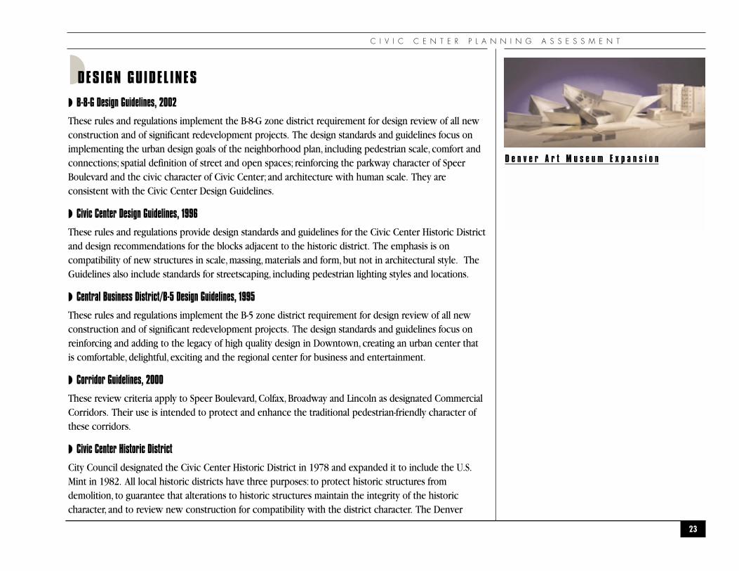
◗ Denver Art Museum Expansion
◗ Denver Art Museum Co-Development (residential, retail, office)
◗ Argyle Tower (residential)
◗ Justice Center Complex (3 buildings)
◗ Denver Newspaper Agency Headquarters
22
T h e c i v i c i n s t i t u t i o n s c r e a t e a g r a n d
a n d d i s t i n c t i v e c i t y c e n t e r .
C I V I C C E N T E R P L A N N I N G A S S E S S M E N T
◗DESIGN GUIDEL INES
◗ B-8-G Design Guidelines, 2002
These rules and regulations implement the B-8-G zone district requirement for design review of all newconstruction and of significant redevelopment projects. The design standards and guidelines focus onimplementing the urban design goals of the neighborhood plan, including pedestrian scale, comfort andconnections; spatial definition of street and open spaces; reinforcing the parkway character of SpeerBoulevard and the civic character of Civic Center; and architecture with human scale. They areconsistent with the Civic Center Design Guidelines.
◗ Civic Center Design Guidelines, 1996
These rules and regulations provide design standards and guidelines for the Civic Center Historic Districtand design recommendations for the blocks adjacent to the historic district. The emphasis is oncompatibility of new structures in scale, massing, materials and form, but not in architectural style. TheGuidelines also include standards for streetscaping, including pedestrian lighting styles and locations.
◗ Central Business District/B-5 Design Guidelines, 1995
These rules and regulations implement the B-5 zone district requirement for design review of all newconstruction and of significant redevelopment projects. The design standards and guidelines focus onreinforcing and adding to the legacy of high quality design in Downtown, creating an urban center thatis comfortable, delightful, exciting and the regional center for business and entertainment.
◗ Corridor Guidelines, 2000
These review criteria apply to Speer Boulevard, Colfax, Broadway and Lincoln as designated CommercialCorridors. Their use is intended to protect and enhance the traditional pedestrian-friendly character ofthese corridors.
◗ Civic Center Historic District
City Council designated the Civic Center Historic District in 1978 and expanded it to include the U.S.Mint in 1982. All local historic districts have three purposes: to protect historic structures fromdemolition, to guarantee that alterations to historic structures maintain the integrity of the historiccharacter, and to review new construction for compatibility with the district character. The Denver
23
D e n v e r A r t M u s e u m E x p a n s i o n
U R B A N D E S I G N A N D A R C H I T E C T U R E
Landmark Preservation Commission is charged with reviewing all applications for demolition and for newconstruction to building exteriors that requires a building permit. The Landmark Commission adoptedDesign Standards and Guidelines for the Civic Center Historic District in 1996 to explain the elements ofhistoric character that must be reflected in new construction.
◗ Streetscape Design Manual, 1993
These guidelines provide basic direction for streetscape improvements in the public Right of Way forcommercial and residential areas. Paving, street trees, pedestrian lighting and other street furnishingitems are addressed.
◗ Streetscape Inventory
24
Tree with grate
Pedestrian light
Tree with grass lawn
Broa
dway
80'
40'
40'
40'
40'
80'
Linc
oln
40' 40' 40'
A b o v e : T e m p l a t e f o r R e q u i r e d
P e d e s t r i a n L i g h t s a n d S t r e e t T r e e s
A b o v e : I l l u s t r a t i o n o f R e q u i r e d P e d e s t r i a n L i g h t s

C I V I C C E N T E R P L A N N I N G A S S E S S M E N T
◗POTENTIAL FOR SIGNIF ICANT CHANGE◗ Redevelopment Site Analysis
This illustration (above) graphically depicts that a significant percentage of the area within the MasterPlan study area has the potential for redevelopment. Areas included as having a potential forredevelopment may currently serve as open space but enjoy no specific protection under currentordinances or adopted plans.
◗URBAN DESIGN AND ARCHITECTURE GOALS AND POLICIES FROM ADOPTED PLANS◗ The Silver Triangle should be the area for the next expansion of the Financial District. It should
develop densely with the highest scale buildings on 15th Street and a lower scale edge towardSpeer Boulevard.
25
L e f t : M a p o f P o t e n t i a l f o r S i g n i f i c a n t C h a n g e

U R B A N D E S I G N A N D A R C H I T E C T U R E
◗ Improving the connection streets in the Silver Triangle District will provide a desirableenvironment to which early development can attach. As development occurs, the attractivepathways will draw Downtown’s pedestrians through the Silver Triangle to take advantage of theparks and Cherry Creek.
◗ A central square or other amenity is needed to provide a focal point for development and createa long-term identity for the Silver Triangle.
◗ 15th Street should be designed as a transit corridor with entrances to serve new development inthe Silver Triangle.
◗ The theme of the Civic Center is set by Civic Center Park, a formal green space surrounded bythe State Capitol, the Central Public Library, the Denver Art Museum, the City and CountyBuilding, and the Webb Municipal Building. The design is classical and grew out of the CityBeautiful Movement of the early 1900s.
◗ Create a distinct identity through the built environment, with a sense of place and specialaesthetic. The community identity and distinctive place is created through the overallcomposition of spaces, juxtaposition of buildings, unique architectural character and details.
◗ Unique identity is also accomplished through the integration of public art and design elements inthe public realm.
◗ Taller structures, within the view preservation ordinances, are encouraged in the Civic Centersubarea of the Golden Triangle, between Colfax and 13th Avenues.
◗ Taller structures are encouraged on Speer Boulevard and Lincoln/Broadway, with a step down inscale toward the center of the neighborhood.
◗ Maintain the grid pattern of streets and alleys to reinforce the block pattern and the existingurban structure.
◗ Maintain the axial views within Civic Center Park.
◗ Maintain and frame the axial view from the south end of Acoma Street north to Acoma Plaza intoCivic Center and from the north end of Acoma south to Speer Boulevard.
◗ Strengthen the character of gateways and nodes, including the Civic Center and the culturalinstitutions.
26

C I V I C C E N T E R P L A N N I N G A S S E S S M E N T
◗LAND USE AND URBAN DESIGN ISSUES AND ANALYSIS◗ General
Issues
Most of the study area has not reached its potential for mix of uses, density or desirable urban character.Appropriate locations for government and institutional expansion need to be determined. Proliferationof surface parking lots undermines the long-term goals for the area and adds to the desolate feelingoutside the Civic Center core. Existing plans, studies and regulations are strong tools to guide futuredevelopment, but they may not provide adequate guidance to minimize abrupt changes betweenneighborhoods.
Analysis
This area, in whole or in part, has been included in at least ten completed plans, studies and designguidelines and in four studies currently underway.
◗ Mixed-Use
Issues
The area currently lacks sufficient residential and retail uses to balance and support the governmentinstitutions. Residential and retail facilities in addition to the civic and employment uses would increasethe sense of place, community and livability.
Analysis
All adopted plans and current zoning regulations allow, support and encourage mixed uses, especiallyresidential and ground floor retail. Zone districts also provide density bonuses as incentives for certainpublic uses and design. Although inclusion of mixed uses in public facilities is hampered by securityconcerns, some retail uses are possible. Private development of mixed use projects is driven by marketconditions. The regulatory system for mixed use projects is in place, ready for private developmentactivity when it becomes feasible.
27
S u r f a c e p a r k i n g l o t s u n d e r m i n e t h e
l o n g - t e r m g o a l s f o r a m i x e d - u s e
u r b a n v i l l a g e .

U R B A N D E S I G N A N D A R C H I T E C T U R E
◗ Connections and Streetscape
Issues
Unsafe, unclear and unattractive pedestrian links between Downtown and Civic Center prevent fullutilization of the amenities and facilities. Poor wayfinding, lack of visibility, dangerous and unfriendlypedestrian connections are barriers. Colfax Avenue is the most significant problem area.
Analysis
Denver Multi-modal Access Plan (DMAP) and the Pedestrian Master Plan are currently underway toidentify key projects and policies addressing overall citywide and Downtown connectivity. The 1998Neighborhood Bond also includes improvements to Colfax Avenue/15th Street and 14th Avenue at CivicCenter. Private development is required to improve adjacent right of way, including streetscaping, and isan incremental approach. No comprehensive approach to improvements is currently available.
◗ Parking
Issues
The availability and cost of parking for the area is a concern, especially as existing parking lots redevelopinto more active and appropriate uses. Surface parking as a stand-alone use does not reinforce orcontribute to the character of a vital, walkable, interesting urban neighborhood. The community and Citydesire abundant, cheap and invisible parking, which is difficult to achieve.
Analysis
No comprehensive parking study or plan is currently available. DMAP will partially address the issue.New development in the B-8-G zone district is required to provide parking for its needs. No parking isrequired in the B-5 zone district. Displaced parking from new development on parking lots is not theresponsibility of the developer.
28
C I V I C C E N T E R P L A N N I N G A S S E S S M E N T
◗ Architecture
Issues
The existing architectural character places Denver’s best and most important buildings in a weakcontext. A streetscape and architectural palette that allows for innovative design within a consistentframework needs to be implemented. The existing character of the Civic Center core is desirable andshould be expanded upon. Architectural and development standards need to address issues ofcompatibility, appropriate density, height, and scale.
Analysis
Design review of all new development is a requirement of the B-5, B-8-G and Landmark District. Scalingissues are partially addressed in these design review processes. Scale and height are also regulated bythe Civic Center Height Restriction and Mountain View Preservation ordinances. All public developmentshould be held to architectural standards that respect the existing architectural quality and materials ofCivic Center structures. There may be gaps or weaknesses in the other design guidelines that shouldbe addressed.
◗ Key Development Opportunities
Issues
Within the study area there are underdeveloped sites that could significantly impact the character of thearea, for good or for bad. These key development opportunities may include both public and privatefacilities. Critical sites include locations immediately adjacent to Civic Center Park, between West 14thand Colfax Avenues, bordering Colfax Avenue, and along Acoma and Bannock Streets. The appropriatelocations and limits of government and institutional expansion need to be determined.
Analysis
The Golden Triangle Neighborhood Plan defines a Civic Center subarea. The Civic Center CulturalComplex Master Plan also addresses cultural facility expansion. The Downtown Area Plan indicateslocations for government expansion. No single plan defines appropriate locations or limits ofgovernment/institutional expansion. Partnerships or incentives for private development in key locationshave not been addressed.
29
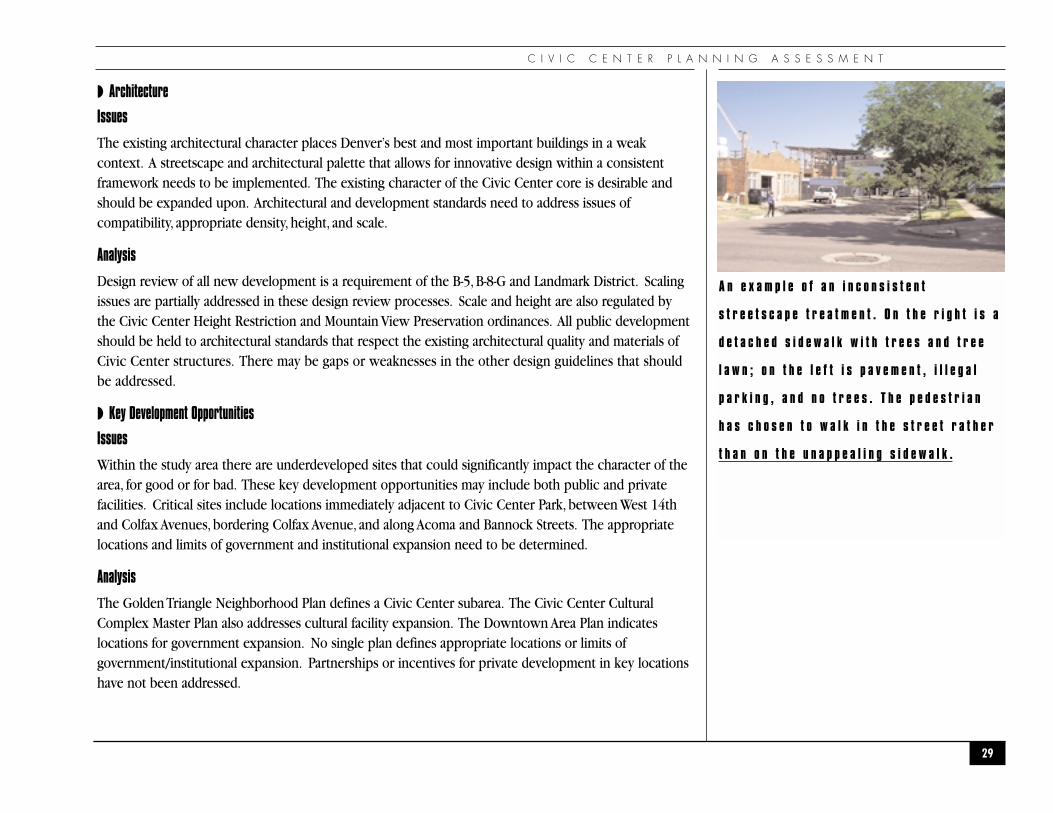
A n e x a m p l e o f a n i n c o n s i s t e n t
s t r e e t s c a p e t r e a t m e n t . O n t h e r i g h t i s a
d e t a c h e d s i d e w a l k w i t h t r e e s a n d t r e e
l a w n ; o n t h e l e f t i s p a v e m e n t , i l l e g a l
p a r k i n g , a n d n o t r e e s . T h e p e d e s t r i a n
h a s c h o s e n t o w a l k i n t h e s t r e e t r a t h e r
t h a n o n t h e u n a p p e a l i n g s i d e w a l k .

U R B A N D E S I G N A N D A R C H I T E C T U R E
◗ Development Barriers
Issues
The lack of significant private development activity in the area indicates there are barriers to projects.These barriers may include:
◗ Market demand, which is impacted by the economy;
◗ Lack of development incentives;
◗ Profitability of surface parking is a disincentive for redevelopment, and
◗ The cost of land is increasing.
Analysis
There is no indication that significant regulatory barriers to redevelopment exist. Barriers are morerelated to financing and market demand.
◗ Aesthetics/Livability
Issues
There are weaknesses in the relationship between the built environment and the overall quality of life.Major park events both enhance the sense of community and create conflicts with adjacent businessesand residents. Civic Center Park suffers from extremes of use: either too much or too little. Land usedecisions may not factor in safety and quality of life concerns.
Analysis
Current plans focus on physical development aspects of the area as well as goals for quality of life. Parkuse issues should be included in the Civic Center Park master planning effort.
30

C I V I C C E N T E R P L A N N I N G A S S E S S M E N T
31
●M O B I L I T Y A N D P A R K I N G●

M O B I L I T Y A N D P A R K I N G
◗EXISTING STREETS AND CLASSIF ICATIONS
◗ Regional Access
Regional access to the Civic Center Planning Area is provided primarily by Interstate 25 (I-25). Thefollowing roadways provide access from I-25 into the study area: Broadway (south of the Civic Centerarea), Colfax Avenue (west of the Civic Center area), and Speer Boulevard (west of the Civic Center area).
32
R i g h t : M a p o f S t r e e t C l a s s i f i c a t i o n s
Wel
ton S
t.
Califo
rnia
St.
Glenar
m P
l.
Court P
l.
16th Ave.
13th Ave.
12th Ave.
14th Ave.
Cleve
land P
l.
Ch
ero
kee
St.
Del
awar
e St
.
Ela
ti S
t.
San
ta F
e D
r.
Inca
St.
Fox
St.
Gal
apag
o S
t.
Ban
no
ck S
t.
Aco
ma
St.
Lin
coln
St.
Sher
man
St.
Gra
nt
St.
14th St.
Bike Path
13th St.
15th St.
16th St. Mall
Colfax Ave.
Bro
adw
ay
14th Ave.
Speer B
lvd.
Speer B
lvd.
Trem
ont Pl.
Street Classification
Arterial
Collector
Local Street Parkway

C I V I C C E N T E R P L A N N I N G A S S E S S M E N T
◗ Arterial streets
Arterial streets carry a majority of traffic traveling through the study area and are generally commercialcorridors. Arterial streets within the study area include: Speer Boulevard, Colfax Avenue, 14th Avenue,13th Avenue,Welton Street,Tremont Place, Court Place, Broadway, Lincoln Street, and Grant Street. SpeerBoulevard is also classified as an Historic Parkway and 14th Avenue between Bannock and Broadway is aParkway.
◗ Collector Streets
Collector streets provide movement of traffic between arterials and neighborhoods. In the vicinity of theproposed project, they include: 12th Avenue, Glenarm Place, Cleveland Place, Cheyenne Place, CherokeeStreet, and Bannock Street.
◗ Local Streets
Local streets are typically designed to provide access within residential areas and some limited access tooffice and commercial uses. Within the study area the local streets are: Galapago Street, Fox Street, ElatiStreet, Delaware Street, and Acoma Street.
33

M O B I L I T Y A N D P A R K I N G
◗EXISTING PEDESTRIAN AND BICYCLE ROUTES
◗ Bicycle Routes
The City and County of Denver has a system of bicycle routes throughout the City to serve the needs ofcyclists. The plan for bicycle facilities with the City is established and described within the 1993 DenverBicycle Master Plan and the Denver Bicycle Master Plan Update 2001. The Bicycle Master Planwas intended to “develop and implement a comprehensive bicycling program by developing a frameworkfor a physical bicycle system as well as education, promotion, enforcement, public policy, and informationdistribution programs.” Within the study area, the following bicycle facilities exist:
34
R i g h t : M a p o f E x i s t i n g P e d e s t r i a n a n d
B i c y c l e R o u t e s
Wel
ton S
t.
Califo
rnia
St.
Glenar
m P
l.
Court P
l.
16th Ave.
13th Ave.
14th Ave.
Cleve
land P
l.
Ch
ero
kee
St.
Del
awar
e St
.
Ela
ti S
t.
San
ta F
e D
r.
Inca
St.
Fox
St.
Gal
apag
o S
t.
Ban
no
ck S
t.
Aco
ma
St.
Lin
coln
St.
Sher
man
St.
Gra
nt
St.
14th St.
Bike Path
13th St.
15th St.
16th St. Mall
Colfax Ave.
Bro
adw
ay
14th Ave.
Speer B
lvd.
Speer B
lvd.
Trem
ont Pl.
Pedestrian Routes Enhanced Bus Corridor
Cherry Creek Trail Neighborhood Bike Route
Grid Bike Route

C I V I C C E N T E R P L A N N I N G A S S E S S M E N T
◗ Route D-10 – This Grid Route is along 12th Avenue. It connects on the west with the City ofLakewood (near the Lakewood/Dry Gulch) and runs primarily along 12th Avenue east to theCity of Aurora at Yosemite Street.Within the project area it uses 11th and 12th Avenues,connecting via Cherokee and Delaware Streets. Given the steep grade of 12th Avenue east ofLincoln, a bicycle lane in the uphill, eastbound direction is desirable.
◗ Neighborhood Bike Routes – There are two Neighborhood Bike Routes within the study areaon Cherokee and Bannock Streets that connect with the Cherry Creek Trail and intersect routeD-10. On Cherokee Street the route is from Colfax Avenue south to Speer Boulevard and theCherokee Street ramp leading to the Cherry Creek Trail. The Bannock Street route is betweenColfax Avenue and 1st Avenue, which accommodates Route D-14. These neighborhood routesserve to connect with the off-street bikeway along the frontage of the Webb Municipal Building,leading to the 16th Street Mall and the 16th Avenue bike lanes.
◗ Cherry Creek Trail – The Cherry Creek Trail is located within the Cherry Creek channelbetween the north and southbound lanes of Speer Boulevard. There are existing trail accessramps from Speer Boulevard to the trail at Colfax and 14th Avenues. The Bicycle Master Plancites the need for a future ramp connection at 12th Avenue to serve the Golden Triangleneighborhood. A staircase connection to the trail exists at 11th Avenue. However, it is notwheelchair accessible in compliance with the Americans with Disabilities Act (ADA) and doesnot accommodate the needs of bicyclists and in-line skaters. This staircase is adjacent to DenverPublic School #1 at 11th and Delaware.
◗ City standard “Inverted U” type bicycle parking racks are currently in place at many of thedestinations in the project area including the City and County Building, the Webb MunicipalBuilding, the Central Branch of the Denver Library and the Denver Art Museum. However thereare numerous trip generators within the project area that do not have any city standard“Inverted U” type bicycle parking racks.
The Bicycle Master Plan also identified “Missing Links”within the bicycle system. Within the study areathere are no missing links.
35

M O B I L I T Y A N D P A R K I N G
◗ Pedestrian Facilities
Currently the City is preparing a City and County of Denver Pedestrian Master Plan, which is expected tobe adopted by City Council before the end of 2003. The Draft Pedestrian Master Plan (PMP) isbeing developed as a recommendation of Blueprint Denver. The goal is to enhance the transportationchoices available to the public for mobility within Denver. As a part of this, a network of PedestrianRoutes is being identified which link neighborhoods with such facilities as transit, parks, schools, andcommercial areas. These routes are coordinated with the Parks and Recreation Department’s greenstreets and will be a focus for providing mobility to pedestrians. The PMP also reinforces the need for“Enhanced Bus Corridors”as defined by Blueprint Denver as corridors with high transit ridershippotential which should be targeted for higher frequency bus service, Bus Rapid Transit (BRT) andpriorities for Intelligent Transportation Systems (ITS) investments (including bus priority signalization).High ridership on these corridors will translate into high pedestrian activity and the need for transit-oriented pedestrian amenities along these corridors.
The Civic Center Planning Assessment study area has the following Pedestrian Routes and Enhanced Bus Corridors:
◗ Pedestrian Routes: 12th Avenue, Speer Boulevard, and Acoma Street.
◗ Enhanced Bus Corridors: Colfax Avenue and Speer Boulevard.
The PMP also identifies many pedestrian improvement projects across the city. The one project withinthe study area is a linear project that has been identified along 13th Avenue. The plan identified thissection of 13th Avenue as having narrow sidewalks and recommends upgrades.
36

C I V I C C E N T E R P L A N N I N G A S S E S S M E N T
◗EXISTING TRANSIT ROUTES
Numerous Regional Transit District (RTD) bus routes serve the study area. Many regional routes operateon the Broadway/Lincoln corridor. The following routes provide regional and local service within thestudy area: 0, 0L, 6, 7, 9, 10, 15, 15L, 16, 48, 50, 52, 3L, 29L, 36L, 46L, 79L, and the B-Line.
The RTD Civic Center Station is located within the study area and is one of the key stations that serviceDowntown Denver. It is located at the southeastern end of the 16th Street Mall. RTD provides a freeMall Shuttle service on 16th Street between Union Station and the Civic Center Station. The Civic CenterStation services approximately 24 bus lines and the Mall Shuttle. There is also Light Rail service just tothe west of the study area.
37
L e f t : M a p o f E x i s t i n g T r a n s i t R o u t e sCivic Center
Master Plan
RTD Transit
Routes
0, 6, 10, 0L,3L, 16L, 46L79L, 83L
0, 6, 10, 0L,3L, 16L, 46L79L, 83L
7, 16, 16L, 29L, 30, 30L, 31, 36L
9, 50, 52
8, 9, 50
8, 9, 50
9, 50
, 52
8, 9, 50, 52
16, 1
6L, 2
9L, 3
6L, 4
8
10, 28, 32, 44
8, 16
, 83L
Wel
ton S
t.
Califo
rnia
St.
Glenar
m P
l.
Court P
l.
16th Ave.
13th Ave.
14th Ave.
Cleve
land P
l.
Ch
ero
kee
St.
Del
awar
e St
.
Ela
ti S
t.
San
ta F
e D
r.
Inca
St.
Fox
St.
Gal
apag
o S
t.
Ban
no
ck S
t.
Aco
ma
St.
Lin
coln
St.
Sher
man
St.
Gra
nt
St.
14th St.
Bike Path
13th St.
15th St.
16th St. Mall
Colfax Ave.
Bro
adw
ay
14th Ave.
Speer B
lvd.
Speer B
lvd.
Trem
ont Pl.

M O B I L I T Y A N D P A R K I N G
◗EXISTING PARKING CONDIT IONS
As part of the initial assessment, the existing parking conditions within the study area were analyzed. Aninventory of the existing parking supply was performed and the usage of publicly available parkingdetermined.
◗ On- and Off- Street Parking Inventory
Parking Supply
The current supply of both on-street and off-street parking facilities was determined. This inventory doesnot include private off-street parking for residents, customers, or employees. All on-street parking spaceswere accounted for. A number of these spaces are for special uses such as loading, fire departmentvehicles, press parking, and other special users. Although these were inventoried, they are not included inthe supply of parking that is generally available to the public.
The inventory of on-street spaces was conducted in the field during July 2003. The results of this effortindicate that there is a total supply of 444 publicly available on-street parking spaces. There are 123 otherspaces for loading and special users.
The off-street parking inventory was performed based upon City aerials from 2002. There are 2,635 off-street spaces available to the public, which includes 973 spaces in the recently completed Arts ComplexParking Structure located between 13th and 12th Avenues west of Broadway.
Parking Demand
The demand for parking fluctuates during the day. In general, the demand for parking within the studyarea is highest during the weekday due to the high demand for employee and visitor parking for thecommercial, office and government/public related uses. However, there is a demand for parking withinthe study area throughout the day. In an effort to perform an initial assessment, the demand for parkingduring the peak weekday daytime period was determined. An on-street parking demand study wasperformed from approximately 10:00 AM to 2:00 PM on a weekday during July 2003. The off-streetdemand was determined from the aerial photos, which were taken on a weekday at midday.
38

C I V I C C E N T E R P L A N N I N G A S S E S S M E N T
◗ Parking Utilization
The existing utilization of parking within the study area is represented by the percent occupancy. Theutilization was broken down into differing levels of demand, indicated by different-colored shading onthe figures. The demand for parking spaces, the amount of available parking, and the resulting utilizationis provided for each block within the study area. The on-street data represents the parking directlyadjacent to the block (not including loading and special users). As shown on each of the figures, thehighest demand for parking, 86 percent utilization or higher, is depicted with the darkest coloredpattern. In general the highest demand of on-street parking is adjacent to Civic Center Park. The highestdemand for off-street parking (as determined from the aerial photography) was south of Colfax Avenuebetween Delaware and Bannock Streets. Near the Convention Center, the off-street demand was also
39
L e f t : M a p o f O n - S t r e e t P a r k i n g
U t i l i z a t i o n On-Street ParkingUtilization
1518
83% XX= Parking DemandYY= Parking Supply
% = Percent Utilization
47
57%
0-50% Utilization
51-75% Utilization
76-85% Utilization
86-100% Utilization
67
86%
2537
68%2426
92%
1012
83%1632
50%1823
78%1426
54% 914
64%
1111
100%1631
52% 521
24%
1624
67%
1017
59%N/AN/A
4865
74%
2732
84%1021
48%1733
52% 913
69%
1011
91%
1314
93%1422
64%
1335
37%
1437
38%
3444
77%
516
31% 1415
93%
Wel
ton S
t.
Califo
rnia
St.
Glenar
m P
l.
Court P
l.
16th Ave.
13th Ave.
14th Ave.
Cleve
land P
l.
Ch
ero
kee
St.
Del
awar
e St
.
Ela
ti S
t.
San
ta F
e D
r.
Inca
St.
Fox
St.
Gal
apag
o S
t.
Ban
no
ck S
t.
Aco
ma
St.
Lin
coln
St.
Sher
man
St.
Gra
nt
St.
14th St.
Bike Path
13th St.
15th St.
16th St. Mall
Colfax Ave.
Bro
adw
ay
14th Ave.
Speer B
lvd.
Speer B
lvd.
Trem
ont Pl.

M O B I L I T Y A N D P A R K I N G
high. It is worth noting that with its recent opening, the Cultural Center Parking Structure was observedto have a typical weekday demand of approximately 25%. In conclusion, with very preliminaryobservations of parking demand, the overall study area does not have demand for parking of greater than85 percent, which is considered high utilization. However, further data collection regarding parking isnecessary to complete a thorough evaluation of existing parking utilization.
40
R i g h t : M a p o f O f f - S t r e e t P a r k i n g
U t i l i z a t i o n
Off-Street ParkingUtilization:Public Pay Lots
182244
74%
2328
82%
5575
73%
5577
71%
XX= Parking DemandYY= Parking Supply
% = Percent Utilization
3453
64%
6265
95%
0-50% Utilization
51-75% Utilization
76-85% Utilization
86-100% Utilization
176213
83%
59115
51%
139 174
95%507864%
6168
90%
6171
86%
73100
73%
3740
93% 2936
81%
2131
68%
6877
88%
2864
44%
225972
23%
4754
87%
Wel
ton S
t.
Califo
rnia
St.
Glenar
m P
l.
Court P
l.
16th Ave.
13th Ave.
14th Ave.
Cleve
land P
l.
Ch
ero
kee
St.
Del
awar
e St
.
Ela
ti S
t.
San
ta F
e D
r.
Inca
St.
Fox
St.
Gal
apag
o S
t.
Ban
no
ck S
t.
Aco
ma
St.
Lin
coln
St.
Sher
man
St.
Gra
nt
St.
14th St.
13th St.
15th St.
16th St. Mall
Colfax Ave.
Bro
adw
ay
14th Ave.
Speer B
lvd.
Speer B
lvd.
Trem
ont Pl.

C I V I C C E N T E R P L A N N I N G A S S E S S M E N T
◗PLANNED AND CURRENT TRANSPORTATION PROJECTS
Public Works will be constructing a pedestrian-related 1998 Neighborhood Bond Initiative project withinthe study area this fall. The work includes:
◗ Installation of a Pedestrian Signal on 14th Avenue on the south side of Civic Center Park and acrosswalk constructed with special paving.
◗ Upgrades to the pedestrian crossing of Colfax Avenue/15th Street on the north side of CivicCenter Park.
A diagonal crosswalk of Colfax Avenue at 14th Street between the Webb Municipal Building and the Cityand County Building was completed July 2003.
There are two studies currently being conducted which address transportation and mobility. The City iscompleting a Pedestrian Master Plan. The plan addresses the needs of pedestrian mobility citywide.A Downtown Multimodal Access Plan (DMAP) has just been initiated. The study will address accessfor all modes of transportation for the Downtown area including the Civic Center and adjacentneighborhoods. DMAP will examine regional vehicular and transit demands and connections within thestudy area, connections from transit stations into Downtown, circulation of vehicles, transit, pedestriansand bicycles within Downtown, connections to adjacent neighborhoods, and opportunities/solutions tomeet long range future transportation demands.
A new ramp connection to the Cherry Creek Trail at 12th Avenue is recommended in the DenverBicycle Master Plan. Funds being actively sought to construct this improvement through the DenverRegional Council of Governments’ (DRCOG) Transportation Improvement Program (TIP).
41
R e c e n t c r o s s w a l k i m p r o v e m e n t s a t
C o l f a x , B a n n o c k a n d 1 4 t h S t r e e t h a v e
i n c r e a s e d s a f e t y a n d c o n v e n i e n c e f o r
p e d e s t r i a n s .

M O B I L I T Y A N D P A R K I N G
◗MOBIL ITY GOALS AND POLICIES IN ADOPTED PLANS
◗ Emphasis on pedestrian circulation within the Civic Center study area was mentioned in allplans. Connections from Downtown into the Civic Center study area need to be enhanced.
◗ Acoma Street was mentioned as one of the key pedestrian corridors.
◗ Colfax Avenue presents a challenge for pedestrian mobility between Downtown and the CivicCenter study area. Key locations for pedestrian crossings should be identified and improved.
◗ Signal timing at intersections in the vicinity of the Civic Center should be examined todetermine if any additional time is available for pedestrians without significantly impactingvehicular operations.
◗ Transit service should be enhanced. This could include shuttle service from Civic Center to Downtown. An additional need is to improve the appearance and perceived safety of bus shelters.
◗ A comprehensive traffic study is needed to determine the future transportation needs of thearea. The use of the streets for access into Downtown and for neighborhood traffic should berecognized. The potential for impacts into adjacent neighborhoods should be addressed.
42

C I V I C C E N T E R P L A N N I N G A S S E S S M E N T
◗MOBIL ITY AND PARKING ISSUES AND ANALYSIS
◗ Traffic
Issues
Most of the study area has not reached full development.What transportation improvements will benecessary to support full build-out within the Civic Center study area? The future transportation systemshould support future development of the Civic Center area and maintain the local character ofneighborhood streets. How does this project relate to DMAP?
Analysis
A transportation and mobility study of the Civic Center is needed to: address future growth within thestudy area, account for regional growth, strengthen transit use, and minimize impacts to adjacentneighborhoods. This study should identify improvement measures to mitigate future impacts, to theextent possible. This study must be coordinated with the DMAP effort and may not be possible tocomplete without resolution of the issues that DMAP will address. The transportation and mobility studyshould also consider the significance of the Civic Center area as a focal point in Denver. The study mustallow for innovative long-range solutions for the Civic Center.
◗ Pedestrian and Bicycle Mobility
Issues
The Civic Center study area is a focal point of pedestrian activity. The pedestrian corridor throughCivic Center Park, past the Denver Art Museum and the Library, and continuing south along AcomaStreet is a key link. This provides access from Downtown to cultural activity centers and adjacentneighborhoods. Other connections are necessary however; the crossing of Colfax Avenue is difficult.The transit activity on Broadway and Lincoln generates numerous pedestrians on these two roadways.Connections from Civic Center to Lincoln and Broadway should be enhanced to support the use oftransit and pedestrian mobility.
43
P e d e s t r i a n c r o s s i n g s a t C o l f a x a r e
d i f f i c u l t b e c a u s e t h e s t r e e t g r i d
c h a n g e s .

M O B I L I T Y A N D P A R K I N G
Analysis
The transportation and mobility study should examine solutions that further refine and implement therecommendations of the Pedestrian Master Plan. The study should include other pedestrianenhancements, such as those included in the Colfax Avenue Corridor TransportationImprovements Analysis for the intersection of Colfax and Delaware.
◗ Transit
Issues
The study area has a number of local and regional bus routes; however, the need for a more additionalservice should be explored. How a transit connection between the Light Rail Station at Broadway andI-25 and Downtown impacts the study area should be determined.
Analysis
The DMAP study will address the transit connection between the Broadway Light Rail Station andDowntown. Public Works and Community Planning and Development will need to consider the impactsof this on the Civic Center study area. The need for a shuttle service between the Civic Center andDowntown may be addressed in a number of ways: as part of DMAP, working directly with RTD, or itcould be included in the transportation and mobility study. In any of these, a high level of coordinationwith DMAP and RTD is essential.
◗ Parking
Issues
The most recent parking study of the Civic Center area was performed in 1991. A major issue is, as thesurface parking lots within the study area develop, what happens to the parking demand for the lots thatremain? How will the newly opened Cultural Complex Parking Structure offset the need for futureadditional public parking? It was recognized that many of the government related uses currently do notprovide parking for employees and visitors. As the area receives additional government uses, how willthe additional employee and visitor parking demand be addressed? As additional mixed-use projects aredeveloped on properties currently used for surface parking lots, how will the reduced public parking bepriced and what time limits will be appropriate? The supply of parking must also be sensitive to theneed to support the use of transit. If an abundant supply of inexpensive parking is available how doesthis affect the use of transit?
44

C I V I C C E N T E R P L A N N I N G A S S E S S M E N T
Analysis
In order to address all of the parking issues, a comprehensive parking study of the Civic Center areawould need to be conducted.
◗ Other
Issues
Additional issues related to way-finding and special events were raised as a result of the assessmentworkshop. An observation made by several groups was the need for way-finding for both theDowntown and Civic Center areas. Special events at Civic Center Park typically require street closuresand detours.The need for a quick return of these streets to pre-event conditions was expressed.
Analysis
Downtown way-finding is a topic to be addressed within DMAP.
Events that utilize Civic Center Park are carefully coordinated in terms of neighborhood traffic impacts,street closures, detour signing, and public notification. These concerns will be provided to the PermitSection of Denver Public Works for consideration in planning for future events. Special events held inthe Civic Center Park are important to maintaining the City’s tradition of civic celebration. The masterplan should address neighborhood concerns and develop strategies and solutions for maintaining abalance between the tradition of civic celebration and minimizing impacts to adjacent neighborhoods.
45

P A R K S A N D P A R K W A Y S
46
●P A R K S A N D P A R K W A Y S●

C I V I C C E N T E R P L A N N I N G A S S E S S M E N T
◗EXISTING PARKS AND PARKWAYS
Denver Parks and Recreation manages several park units in the study area:
◗ Civic Center Park
◗ MacIntosh Park
◗ Fourteenth Avenue Parkway
Speer Boulevard Parkway is immediately adjacent to the study area.
Lincoln Park and the State Capitol grounds are owned and maintained by the State.
47
B i c y c l e p o l i c e p a t r o l
C i v i c C e n t e r P a r k .
L e f t : M a p o f P a r k s a n d P a r k w a y s

P A R K S A N D P A R K W A Y S
◗ Historic Resources
Outside of Washington, D.C., Denver’s Civic Center Park is one of the most complete and intact culturaland government centers in the country. During the City Beautiful movement (1900 – 1910), many citiessucceeded in improving the urban landscape with parks, parkways, streets lined with shade trees, andstately public buildings. However, few cities succeeded in implementing plans for the ultimateexpression of the City Beautiful movement: a downtown civic center. Denver triumphed over othercities’ unrealized plans. Not only did Denver leaders realize a design, but also built this magnificent urbancenter that continues to evolve within its traditional origins. Additional public institutions andarchitectural excellence have gradually, over the past 80 years, reinforced and strengthened the characterof this cultural heart of the City. The Park is listed on the National Register of Historic Places withnational level of significance.
◗PARKS AND PARKWAYS GOALS AND POLICIES FROM ADOPTED PLANS
◗ Redesign Bannock Street to create a strong connection from Colfax (Webb Municipal OfficeBuilding) all the way south to Speer Boulevard. Reduce the width and treat Bannock differentlybetween the City and County Building and the Park.
◗ Bury either Colfax or 14th Avenue to create a seamless campus between the cultural institutionson the south, the Park, and Downtown (16th Street Mall).
◗ Develop streetscape and land uses west and east of the Park along 14th and Colfax. Asconnections to Speer Boulevard and the adjoining neighborhoods.
◗ Develop other festival sites (such as Auraria and an Auraria bridge to Downtown)
◗ Create a forum for collaboration among event organizers, the Parks Department, and residents toimprove the management of staging events in the Park.
◗ Investigate fee policies that put more money back into the park/area from large events
◗ Involve neighborhoods more (and give back to neighborhoods more) in events
◗ Develop appropriate guidelines for consistent management of event uses.
◗ Increase the level of casual activity and smaller programs in the Park to bring people into thePark at all times, including weekdays
48

C I V I C C E N T E R P L A N N I N G A S S E S S M E N T
◗ Increase law enforcement
◗ Continue to enhance the Park conditions
◗ Dedicate Park-generated revenues to repair the Park
◗ Examine potential outside sources of funding. Civic Center is listed on the National Register ofHistoric Places and is the only Denver park other than Red Rocks with a national level ofsignificance. This level of significance entitles the Park to Federal grant opportunities notavailable to other parks that may be listed on the National register but have only State or localsignificance.
◗ Develop new mechanisms for generating regular revenue dedicated to the Park to enhance thesuccess of its long-term preservation by strategically implementing Park restoration andrehabilitation projects
◗ Reduce long-term maintenance needs through preventive maintenance measures and cost-saving modifications
◗PARKS AND PARKWAYS ISSUES AND ANALYSIS
◗ General
Issues
The importance of Civic Center Park and the role it plays for the surrounding civic buildings cannot beoverestimated. However, urban pressures for parking and access; social problems such as graffiti, drugdealing and homelessness; and larger, more frequent public events are contributing to the deteriorationof the park areas. Compounding these pressures, park budgets are shrinking. Routine maintenancemeasures cannot keep up with the pace of deterioration, and costs have escalated out of reach for thenormal Denver Parks and Recreation maintenance budget. Today more than ever, creative solutions andstrategies are required to keep up with the escalating challenges to maintain Civic Center as a healthy,vital historic icon in the heart of the civic district of the city and the state. However, no comprehensiveplanning or long-term strategies have been developed to effectively deal with these most of these issues.
Little information currently exists to document the condition, integrity, significance or comprehensivelyevaluate historic resources in Civic Center Park.
49

P A R K S A N D P A R K W A Y S
Analysis
The Parks and Recreation Department was recently awarded a grant from the Colorado Historical Fund toassess the historic resources of Civic Center Park. The study will provide necessary baseline informationto develop design and management guidelines for appropriate development and future change in thePark and more effectively preserve these significant resources.
◗ Connections and relationship between the Park and the rest of Downtown
Issues
Civic Center Park was historically planned as a strategic crossroads, serving as a link between thecommercial districts along 16th and 17th Streets and the State Capitol area. It continues to occupy acritical location for Downtown bus, pedestrian and vehicular access. Furthermore, the primary pedestrianlink between major facilities such as Denver Public Library, the Denver Art Museum and the Downtownarea is along the edges of the Park or through the Park. However, the critical linkage along Bannock isdominated by cars and parking. The central walkway through the Park does not meet the AmericanDisability Act requirements for an accessible route.
Analysis
Several plans broadly address goals for improving the connection between Civic Center Park and thesurrounding commercial district and civic places – however no specific strategies exist tocomprehensively implement improvements and are dependent on incremental private development. Tostrengthen the connection between the area and the neighborhoods, currently there is only limitedfunding available for implementation. Site specific information and planning tools to guide transportationand pedestrian oriented developments in the area are lacking.
50
P a r k p l a n n i n g n e e d s t o b u i l d o n
h i s t o r i c r e s o u r c e s a n d d e s i g n .

C I V I C C E N T E R P L A N N I N G A S S E S S M E N T
◗ Special Events
Issues
Public concerts by the Denver Municipal Band in 1920 began the park’s enduring popularity as a forumfor free civic events. Civic Center Park is probably best known for the major events such as the PeoplesFair,Taste of Colorado, Cinco de Mayo, and many others that are traditionally held annually in the Park.While the Park continues in its role as premier civic space for civic events, the impact of these events onthe Park and the emerging Downtown neighborhoods is increasing.These events take their toll on thePark structures, lawns and trees from soil compaction and vehicle damage. Damage fees do not alwayskeep pace with the level of impact in the Park nor are they effectively collected. The extent of streetclosures, massive influx of visitors, and parking has impacts on the quality of life for the growingpopulation of Downtown residents.
Analysis
Large special event issues are typically dealt with piecemeal at periodic inter-agency meetings. However,there are few guidelines or management strategies consistently applied to all events organizations toaddress issues that affect the area around the park. No strategies or plans exist to address larger qualityof neighborhood life issues such as parking impacts. No economic or budget analysis has beenconducted to evaluate the fee structure for special events. Event programming is largely dependent onand reactive to outside organization proposals.
51
P u b l i c c e l e b r a t i o n s h a v e l o n g b e e n
p a r t o f t h e c h a r m o f C i v i c C e n t e r .
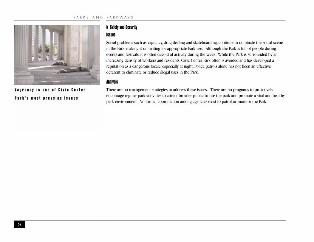
P A R K S A N D P A R K W A Y S
◗ Safety and Security
Issues
Social problems such as vagrancy, drug dealing and skateboarding, continue to dominate the social scenein the Park, making it uninviting for appropriate Park use. Although the Park is full of people duringevents and festivals, it is often devoid of activity during the week. While the Park is surrounded by anincreasing density of workers and residents, Civic Center Park often is avoided and has developed areputation as a dangerous locale, especially at night. Police patrols alone has not been an effectivedeterent to eliminate or reduce illegal uses in the Park.
Analysis
There are no management strategies to address these issues. There are no programs to proactivelyencourage regular park activities to attract broader public to use the park and promote a vital and healthypark environment. No formal coordination among agencies exist to patrol or monitor the Park.
52
V a g r a n c y i s o n e o f C i v i c C e n t e r
P a r k ’ s m o s t p r e s s i n g i s s u e s .

C I V I C C E N T E R P L A N N I N G A S S E S S M E N T
◗ Maintenance
Issues
Inadequate funding is another issue that severely limits the ability of the Parks Department to keep upwith regular repairs, preventive maintenance, and appropriate cost-saving modifications. The Park isfunded through the Denver Parks and Recreation budget, which is shared by 301 other parks, parkways,and recreation centers. These funds are so scarce there is currently a $100 million backlog of deferredcapital maintenance projects that only receives about $3-5 million a year to address. Furthermore, fundscollected from special event fees and other park-related revenues are deposited in the City’s generalfunds and are not earmarked for specific use at Civic Center Park.
There are no dedicated funds to maintain the public art located in the Park: the Alan True murals, A. P.Proctor bronzes, and several smaller monuments and plaques have already suffered deterioration. Pastrepairs have been made thanks to generous private donations, but generally this occurs only after thepieces are in a crisis state of disrepair.
Day to day maintenance also suffers from the lack of sufficient staff to keep the Park in good condition.Maintaining the areas around RTD bus stops is especially challenging. These areas are heavily used andrequire much more intensive maintenance than can be provided by the available staff.
Analysis
No plans exist to address improving maintenance efficiencies or capturing alternative funding sources inorder to improve the level of maintenance.
53
T h e G r e e k T h e a t e r d u r i n g r e s t o r a t i o n

Q U A L I T Y O F L I F E
54
●Q U A L I T Y O F L I F E●

C I V I C C E N T E R P L A N N I N G A S S E S S M E N T
◗EXISTING CONDIT IONS
◗ Neighborhood and Community Organizations
Nine neighborhood and community organizations work to protect and enhance the quality of life withinthe Civic Center Study Area, including Downtown and adjacent neighborhoods. These organizations arelisted in the following matrix, which identifies whether or not an organization is currently registeredwith the City, the boundaries of that organization, and any committees that deal more specifically withquality of life or issues particularly relevant to the Assessment.
55
RegisteredYes
No
Yes
Yes
Yes
Yes
Yes
Yes
Yes
NorthColfax Avenue
20th Street
6th Avenue
23rd Avenue
Colfax Avenue
City Limits
I-25/23rd St.
Colfax Ave.
SouthSpeer Blvd.
Colfax/Speer
Mississippi
Avenue
1st Avenue
6th Avenue
City Limits
Speer Blvd.
6th Avenue
EastLincoln Street
Grant St.
Lincoln Street
Colorado Blvd.
Broadway
City Limits
Broadway
Speer Blvd.
WestSpeer Blvd.
Wewatta Street
S. Platte River
Broadway
I-25
City Limits
I-25
I-25
Committees❚ Urban Design
❚ Good Neighbor
❚ Justice Center
❚ Transportation
❚ Zoning and Liquor License
❚ Zoning and Liquor License
❚ Transportation
❚ Zoning
NameGolden Triangle
Neighborhood Association
Golden Triangle Arts District
Downtown Denver Partnership/BID
Baker Historic Neighborhood
Association
Capitol Hill United Neighbors (CHUN)
Neighbors United Con Poder
Inter-Neighborhood
Cooperation (INC)
Downtown Denver
Residents’ Association
La Alma/Lincoln Park
Planning Group

Q U A L I T Y O F L I F E
◗ Cultural, Institutional, and Governmental Facilities in the Study Area
The Civic Center Study Area is home to several of the premier cultural, institutional, and governmentalfacilities in the Rocky Mountain region.These facilities attract a significant number of visitors to the CivicCenter and enhance the quality of life of the residents and employees within the Study Area, Downtown,and the surrounding neighborhoods.These facilities include:
56
Address1310 Bannock Street
1300 Broadway
200 East Colfax Avenue
2 East 14th Avenue
1357 Broadway
1437 Bannock Street
1250 Welton Street
1362 Tremont Street
320 West Colfax Avenue
TypeHistoric House Museum
State History Museum
State Offices and Legislative Chambers
Art Museum
Public Library, Western History Library,
Government Documents, Geneological Research
City Offices, City Council Chambers, and Courts
Alternative High School and
Adult Continuing Education
Firefighters’ History Museum
Production Facility for U.S. Currency
NameByers-Evans House
Colorado History Museum
Colorado State Capitol
Denver Art Museum
Denver Central Public Library
Denver City and County Building
Emily Griffith Opportunity School
Firefighters’ Museum
United States Mint
C I V I C C E N T E R P L A N N I N G A S S E S S M E N T
◗QUALITY OF L IFE GOALS AND POLICIES FROM ADOPTED PLANS
◗ Neighborhood-serving uses, including uses such as restaurants, drug stores, and dry cleaners,should be readily available to neighborhood residents, employees, and visitors.
◗ The neighborhood should be safe in both reality and perception.
◗ The neighborhood should be pedestrian-friendly, with priority given to the pedestrian and togood pedestrian access to all areas of the neighborhood.
◗ Neighborhood residents, employees, and visitors should have ready access to transit, with goodconnections to local and regional bus and light rail routes.A local connector, or shuttle service,should be provided.
◗ The neighborhood should be perceived as having readily accessible green spaces, with invitinglinkages to every section of the neighborhood.
◗ Historic structures should be protected and used.
57

Q U A L I T Y O F L I F E
◗QUALITY OF L IFE ISSUES AND ANALYSIS
◗ General
Issues
The study area is home to significant cultural and historic resources and neighborhood and governmentservices. Area residents feel threatened by the potential that new uses, such as the proposed newdetention facility and its related uses, might undermine the vision and investment in the area as a culturalcenter and visitor attraction.
Analysis
The City has a huge financial stake in maintaining and enhancing the Civic Center as cultural center andvisitor attraction. In the last decade alone, over $300 Million of public money has been invested in thearea. This investment reflects the pride that the City takes in the Civic Center and the realization that thecultural institutions and related facilities are important economic generators for the City and theneighborhood. To help enhance the quality of the area and its institutions, the Civic Center CulturalComplex Master Plan of 1992 set a framework for expansion and joint programming for the culturalinstitutions. Similarly, the 1998 Golden Triangle Neighborhood Plan reinforced the importance of relatedcultural uses in a mixed-use environment. New government, court and detention facilities must beevaluated for potential impacts, real or anticipated, that could devalue the investment in the area and forways in which they can enhance the quality of the area.
◗ Architecture
Issues
Architecture in the study area is an uneasy mix of stately civic buildings, innovative contemporary design,and mediocre architecture.
Analysis
The Design Standards and Guidelines for the Civic Center Historic District, B-5 and B-8-G Zone Districts,and OD-1 Overlay Zone District address design issues and are intended to bring a more consistent qualityto all new construction in the area. Public buildings may need additional design criteria to ensurecontinuation of the tradition of urban design excellence.
58

C I V I C C E N T E R P L A N N I N G A S S E S S M E N T
◗ Location and Access
Issues
The Civic Center study area is adjacent to Downtown and other dense, mixed-use neighborhoods, givingit excellent proximity to cultural and government facilities, employment, shopping, parks, and openspace.These close-by uses and facilities provide potential amenities for visitors, employers, and residents.However, there are physical and psychological barriers to full access to these amenities, primarilybecause of poor pedestrian connections; a series of vacant, underutilized, and vandalized sites that dividethe more active uses; a concentration of panhandlers and homeless people; and a perception of unsafeconditions.
Analysis
Social, psychological, and physical barriers between the study area and the surrounding amenities shouldbe addressed through further planning, programming, maintenance, and capital projects.The DowntownArea Plan identifies key connections between Downtown, the Civic Center, and the other surroundingneighborhoods. The Downtown Multi-modal Access Plan (DMAP) will provide further direction onimproving access.The Pedestrian Master Plan will provide guidance for improving pedestrianconnections.
◗ Government and Neighborhood Services
Issues
While government services are concentrated in the study area, neighborhood services in the study areaare limited for visitors, employees, and visitors and often require a trip to the 16th Street Mall. Desiredservices include drug stores, groceries, dry cleaning, shoe repair and other services that are often neededon a regular basis. More neighborhood services are needed in or immediately adjacent to, convenient to,and visible from Civic Center Park, particularly food services.
Analysis
The zoning to allow the desired mix of uses is in place. Private development of amenities and services isdependant on market demand.
59

Q U A L I T Y O F L I F E
◗ Events
Issues
Events in Civic Center Park trash the area for those who use it at other times.
Analysis
Denver Parks and Recreation has received a grant to conduct a parks plan for Civic Center Park, includingevents planning and mitigation of impacts.
◗ Cultural and Historic Resources
Issues
The cultural facilities and resources, historic structures and landscape, and special events are uplifting tothe spirit and help enrich the lives of visitors, employees, and residents. Notwithstanding the remaininghistoric structures, the area has lost a wealth of historic resources. Some of the remaining structures andlandscape will likely to be threatened in the future.
Analysis
Civic Center Historic District protects the most significant historic buildings in the study area. The CivicCenter Park Plan will inventory and recommend strategies for the protection and rehabilitation of historicresources and public art in the park. Other historic resources should be inventoried and considered forprotection through local designation.
◗ Open and Green Spaces
Issues
While Civic Center Park, Lincoln Park, and Speer Boulevard provide large open spaces in close proximityto all parts of the study area, outside the immediate area of those spaces, there is no indication that theyexist or how to get to them. Several of the sites that are perceived as open spaces, such as the areas onthe south side of the Colorado History Museum or the areas around the new Cultural Complex ParkingStructure provide open spaces, but are sites for future development.The area needs better connections toits green spaces and to feel like a neighborhood in a park.
Analysis
Improved streetscape and the siting and design of new buildings can help provide better visual and
60

C I V I C C E N T E R P L A N N I N G A S S E S S M E N T
physical connections to the existing parks and open spaces. The Denver Streetscape Design Manual andthe Design Standards and Guidelines in place for the study area provide guidance for improving thestreetscape and the siting of design of new buildings.
◗ Environs
Issues
Surface parking lots, sparse or nonexistent landscaping, and poorly maintained buildings characterize theareas immediately surrounding the study area. All of the areas immediately surrounding the study areaneed to be upgraded to the level and livability of the core of the Civic Center.At the same time, thefacilities in the Civic Center and the use of those facilities impact the adjoining areas both positively andnegatively.
Analysis
There is no indication that significant regulatory barriers to redevelopment exist. Barriers are morerelated to financing and market demand. Increased code enforcement and amortization of non-conforming uses could address some of the problem. The Civic Center Park Plan will include provisionsfor events planning and impact mitigation.
◗ Urban Living
Issues
With the proximity of facilities and services, the area has the potential for providing an exciting andfulfilling urban experience for visitors, employees, and residents. This potential is still largely untapped.The cultural facilities in the study area successfully provide an environment that uplifts the spirit ofthose individuals who can take advantage of their facilities and services.The entire area, however, ismissing an opportunity by not having the same effect.
Analysis
New development can be located and designed to help create an exciting and fulfilling urbanexperience. All new development in the study area should take cues from the cultural facilities in thearea and provide high quality architecture, art, landscaping, and materials.The existing plans andregulatory framework in the area call for the desired quality of redevelopment; barriers to additionalredevelopment are more closely related to financing and market demand.
61
Q U A L I T Y O F L I F E
◗ Parking
Issues
Employee parking is limited and expensive. Parking will become more limited and more expensive foremployees and visitors as surface parking lots are redeveloped.
Analysis
No comprehensive parking study or plan is currently available. DMAP will partially address the issue.New development in the B-8-G zone district is required to provide parking for its needs. No parking isrequired in the B-5 zone district. Displaced parking from new development on parking lots is not theresponsibility of the developer.
◗ Pedestrians
Issues
Pedestrians are subject to the impacts from the dominance of automobiles, high volume of traffic,congestion and noise. Distances can be long and unfriendly, disrupting the ease of pedestrian access.
Analysis
The Pedestrian Master Plan will help address pedestrian issues. DMAP will look at access issues. TheDenver Streetscape Manual provides standards and guidelines for streetscape improvements.As additionalredevelopment occurs, the pedestrian experience will improve.
◗ Transit
Issues
While both the bus system and light rail are readily accessible at the eastern and northern edges of thestudy area, transit connections to the edges are limited in the interior and limit the use of transit byvisitors, area residents, and area employees. Distances between desired destinations are great enough thatwalking the area would benefit from some form of local shuttle service that would connect uses.
Analysis
DMAP will address transit issues related to getting in, around and out of Downtown.The PedestrianMaster Plan is looking at improving the pedestrian infrastructure and experience.
62
C I V I C C E N T E R P L A N N I N G A S S E S S M E N T
◗ Safety
Issues
Both the reality and perception of safety are compromised by the intensity of the loitering and drugactivity in and around both Civic Center and Lincoln Parks and the bus stops in each, both day andnight. The reality and perception of anti-social activities in the park limits the use of the park by visitors,employees, and residents.
Analysis
The Civic Center Park Plan will provide baseline information for management guidelines for appropriatedevelopment and change in the park
◗ Trash and Litter
Issues
Trash and litter damage the beauty of the area.
Analysis
Code enforcement, parks maintenance should be increased. Neighbors can help be calling theNeighborhood Inspection Service hotline to report problems.The Civic Center Park Plan will providebaseline information for management guidelines for appropriate development and changes in the park
63
E C O N O M I C A C T I V I T Y
64
●E C O N O M I C A C T I V I T Y●
C I V I C C E N T E R P L A N N I N G A S S E S S M E N T
◗EXISTING ECONOMIC ACTIV ITY
The Civic Center Area has an important role with the City of Denver and for the entire State of Colorado.
Some key economic considerations for this area include:
◗ The study area is in the heart of governmental activity both for the State of Colorado and for theCity and County of Denver.
◗ The study area lies on the southern edge of the central business district.
◗ The study area marks the demarcation where high rise private offices transition to governmentfacilities and 3-4 story office and retail buildings, and eventually to high-rise housing.
◗ The area is on the northern edge of redevelopment occurring from Colfax south alongBroadway.
◗ This redevelopment is likely to foster more intense future residential and commercialdevelopment within in this area.
◗ The majority of current activity in this area revolves around governmentemployment/interaction and tourism.
◗ Employment
Table 1 shows employment estimates by category for the study area. Within the study area, employmentis estimated at about 10,550 persons. This represents about 1% of the total employment within theDenver Metro area, and about 9% of employment in the Downtown.
By category, about 52% of the 16,550 people are government employees, including municipal, State andFederal employees. Another 26% are currently classified as media, which is primarily newspaper sincethe staff for both the Denver Post and Rocky Mountain News are located in this area.
65

E C O N O M I C A C T I V I T Y
Study Area Employment and Wage Estimates
◗ Government Impact
With the key City and State headquarters located in this area, these employers are not only the majoremployers, but spend also significant sums on facilities. The major infrastructure investments by the Cityduring the past ten years are listed on the following page. These investments total approximately $313 million. The State has also renovated facilities over the years and continues to explore reuse andexpansion options. Similarly the Federal government has spent substantial sums on renovations at theUS Mint and Post Office in recent years.
66
Number
5,500
2,750
650
400
300
950
10,550
$190,000,000
Percent
52%
26%
6%
4%
3%
9%
100%
Employment Category
Government
Media
Museums
Restaurant
Professional
Other
Total Employment
Total Wage Estimates:

C I V I C C E N T E R P L A N N I N G A S S E S S M E N T
◗ City Public Infrastructure Investment Past 10 Years
City Projects
◗ Denver Public Library, Central Branch
◗ Wellington E.Webb Municipal Office Building
◗ Denver Art Museum Expansion
◗ Cultural Center Parking Structure
◗ Remodel of Greek Theatre
◗ Total City Infrastructure Investment: $313 Million
◗ Tourism Draws, but Limited Services
Another interesting aspect of the area and perhaps one of the most untapped economic engines in thearea is the tourism component. Visitor estimates for this area are shown on the following page. The ArtMuseum, Library, Colorado History Museum, State Capitol, City and County Building and Civic CenterPark all draw tourists, but the key attraction in the area was until recently the Denver Mint, which,unfortunately, has been closed to the general public as of September 11, 2001. Surprisingly, restaurantsaccount for only 4% of the employment in the area and there are no major hotels. Given the touristdraws in this area, the portion of visitor service related employment could be higher. Only recently hasthis sector begun to grow with new restaurants springing up as residential population increases.
67
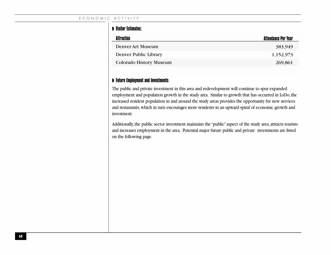
E C O N O M I C A C T I V I T Y
◗ Visitor Estimates:
◗ Future Employment and Investments
The public and private investment in this area and redevelopment will continue to spur expandedemployment and population growth in the study area. Similar to growth that has occurred in LoDo, theincreased resident population in and around the study areas provides the opportunity for new servicesand restaurants, which in turn encourages more residents in an upward spiral of economic growth andinvestment.
Additionally, the public sector investment maintains the “public”aspect of the study area, attracts touristsand increases employment in the area. Potential major future public and private investments are listedon the following page.
68
Attendance Per Year
383,949
1,152,973
269,861
Attraction
Denver Art Museum
Denver Public Library
Colorado History Museum

C I V I C C E N T E R P L A N N I N G A S S E S S M E N T
◗ Current and Proposed Development and Expansion Projects
◗ Denver Art Museum Expansion
◗ DAM Co-Development (residential, retail, office)
◗ Argyle Tower (residential)
◗ Justice Center Complex (3 buildings)
◗ Denver News Agency office
In addition to these specific projects, the majority of the Civic Center area is included in the State ofColorado’s Enterprise Zone which offers a reduction on State income tax based on job creation, jobtraining, capital investment and other business activities.
69
L e f t : M a p o f P o t e n t i a l f o r S i g n i f i c a n t C h a n g e

E C O N O M I C A C T I V I T Y
◗ECONOMIC ACTIV ITY ISSUES AND ANALYSIS
◗ General
Employment and economic activity in the area is poised for continued growth. While the potential existsfor expansion of government facilities in the study area, the residential growth to the south of the studyarea continues to foster new and expanded service opportunities.
The “areas unlikely to change” shown on the Change Area Map are primarily government facilities andwhile employment in the these areas may be cyclical, the primary employment increases for bothgovernment and private sector activity are likely to occur in the “areas subject to change.” In thenorthern portions of the study area, the Convention Center may stimulate some tourist and servicerelated growth and there is the potential for some expanded business activity. At the perimeter ofexisting government facilities some expansion of government facilities is likely to occur. In the southernportions of the study area, residential, tourist, art and service expansion would be expected.
Issues
Building on current “activity”and creating new “activity”are critical to support the tourist oriented andpotential art community growth.
Analysis
Pedestrian connections and other linkages are critical to tourist and art business growth. The southernportions of the study area from 12th to 14th Avenues could capture this type of growth along with someareas adjacent to the Convention Center. Linkages between the two are equally important.
Issues
As documented by the current landscape of activity and employment, future growth in this area shouldrevolve around government functions, tourist activity and potentially small/medium businesses.
Analysis
Local government is looking to expand in this area. Maintaining a pedestrian scale for governmentfacilities and pedestrian connections are important to the success of tourist related and servicebusinesses. As an example that should be emulated, the Webb Municipal Building and integrated annex
70
C I V I C C E N T E R P L A N N I N G A S S E S S M E N T
made a successful transition from the CBD to the Civic Center, not only in terms of scale but in terms ofeconomic activity and diversity with the integrated retail vendors.
The growth of small and medium-sized businesses generally is generated by increases in the number ofresidential units.Therefore, the anticipated increase in residential units in the Study Area should result inadditional small and medium business activity.
Issues
Major growth in new job creation (excluding the proposed Denver Newspaper Agency moving withinthe area in the next few years) will be limited to government functions.
Analysis
Large, private sector businesses will grow in the Downtown core due to market trends, high vacancies,and the availability of alternative transportation. They will also grow in outlining areas of the City,including Stapleton, Lowry, Denver International Airport (DIA), Interstate 25 (I-25) corridor, etc.
◗ Key Development Opportunities
Issues
The current surface parking lots in this area will be difficult to re-develop into other uses due to thesurplus of office space in the Downtown area, competition for residential development from otherareas of Downtown, City requirements for parking in new developments, and the profitability ofsurface parking.
Analysis
No specific City program is established at this time to address surface parking lot redevelopment.
Issues
Within the study area there are underdeveloped sites that, if redeveloped, could significantly impact thecharacter of the area, for good or for bad. These key development opportunities may include bothpublic and private facilities. Critical sites include locations immediately adjacent to Civic Center Park,between West 14th and Colfax Avenues, bordering Colfax, and along Acoma and Bannock Streets. Theappropriate locations and limits of government and institutional expansion need to be determined.
71
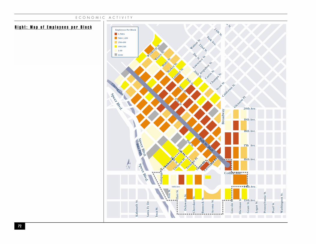
E C O N O M I C A C T I V I T Y
72
16th St. Mall
Colfax Ave.
Bro
adw
ay
14th Ave.
Speer B
lvd.
Speer B
lvd.
Speer
Blvd.
Blake
St.
Wyn
koop S
t.
Waz
ee S
t.
Mar
ket S
t.
Wal
nut St.
Larim
er S
t. Law
rence
St.
Arapah
oe St
.
Curtis
St.
Champa
St.
Stout S
t.
Califo
rnia
St.
Wel
ton S
t.Gle
narm
Pl.
Glenar
m P
l.
Court P
l.
20th Ave.
19th Ave.
18th Ave.
17th Ave.
16th Ave.
13th Ave.
14th Ave.
Cleve
land P
l.
Ch
ero
kee
St.
Del
awar
e St
.
Ela
ti S
t.
San
ta F
e D
r.
Inca
St.
Kal
amat
h S
t.
Fox
St.
Gal
apag
o S
t.
Ban
no
ck S
t.
Aco
ma
St.
Lin
coln
St.
Sher
man
St.
Gra
nt
St.
Loga
n S
t.
Pen
nsy
lvan
ia S
t.
Pea
rl S
t.
Was
hin
gto
n S
t.
14th St.
Bike Path
13th St.
CherryCreek
15th St.
20th St.
21st St.
22nd St.
Park Ave.
24th St.
h St.
19th St. 18th St.
17th St.
Trem
ont Pl.
N
Employees Per Block
1,500+
500-1,499
250-499
100-249
1-99
none
R i g h t : M a p o f E m p l o y e e s p e r B l o c k
C I V I C C E N T E R P L A N N I N G A S S E S S M E N T
73
Analysis
The Golden Triangle Neighborhood Plan defines a Civic Center subarea. The Civic Center CulturalComplex Master Plan also addresses cultural facility expansion. The Downtown Area Plan indicateslocations for government expansion. No single plan defines appropriate locations or limits ofgovernment/institutional expansion. Partnerships or incentives for private development in key locationshave not been addressed.
◗ Development Barriers
Issues
The lack of significant private development activity in the area indicates there are barriers to projects.These barriers may include:
◗ Market demand, which is impacted by the economy;
◗ Lack of development incentives;
◗ Profitability of surface parking is a disincentive for redevelopment, and
◗ The cost of land is increasing.
Analysis
There is no indication that significant regulatory barriers to redevelopment exist. Barriers are morerelated to financing and market demand.

G O V E R N M E N T A N D C U L T U R A L F A C I L I T I E S
74
●G O V E R N M E N T A N DC U L T U R A L F A C I L I T I E S
●

◗EXISTING GOVERNMENT AND CULTURAL FACIL IT IES
In the study area there are over four million gross square feet of space dispersed among 28 facilities thathouse Federal, State, and City government and cultural uses. There are over 6,600 government andcultural employees in these facilities. Many, if not all, the facilities involve heavy interaction with thepublic. Although these facilities generally have, to varying degrees, met the needs of their users, severalfacilities are: nearing the end of their useful-life-span; cannot feasibly or cost-effectively be expanded tomitigate current overcrowded conditions; and/or lack the capacity to accommodate future growth.
The government facilities consist mostly of courts and court related use, administrative offices, legislature,and safety uses. The cultural facilities include museums and the Central Denver Public Library.
Two current uses presently in the study area that have severe overcrowding issues along with facilityfunctionality problems are the courts in the City and County Building and detention and intake in the PreArraignment Detention Facility (PADF). Identified below are some problems the City currently faces withthese two facilities:
◗ Courts
◗ County and District Courts are congested and below standards. Over 50 courts, which includeProbate, Civil, Juvenile, and Criminal, are located in the City and County Building that wasoriginally designed for eight courts when constructed in 1932.
◗ Defendants, victims, jurors and families circulate together among 19 criminal courts.
◗ The Grand Jury room is located in a basement space designed for storage that does not meet airquality requirements.
◗ The State could, at any time, mandate or force the City to meet current State standards by leasingadditional buildings or making major renovations.
◗ The County Civil courts have a $3.25 million, five-year lease in the Adams Mark Hotel.
◗ Renovation of the Permit Center for Juvenile Courts is costly (estimated at $9.0+ million) anddoesn’t accommodate growth nor meet State Courtroom standards.
C I V I C C E N T E R P L A N N I N G A S S E S S M E N T
75
T h e D e n v e r P u b l i c L i b r a r y C e n t r a l
B r a n c h h a d a m a j o r e x p a n s i o n i n
1 9 9 5 . M i c h a e l G r a v e s w a s s e l e c t e d a s
t h e a r c h i t e c t f o l l o w i n g a d e s i g n
c o m p e t i t i o n .
G O V E R N M E N T A N D C U L T U R A L F A C I L I T I E S
◗ Inadequate space in Courtroom 191J, the County Juvenile Court, forces defendants and parentsto stand outside in the elements.
◗ There isn’t any public parking associated with Courts.
◗ Detention
◗ City and County jails operate at 140% to 150% of capacity.
◗ In 2002 the Sheriff Department relinquished accreditation, the City’s only shield from a class-action lawsuit and federal cap.
◗ Overcrowding strains Sheriffs’ ability to safely monitor and control inmates, putting both theinmates and deputies at risk. Alternatives to jail can’t keep pace with growth, requiring earlyreleases of inmates.
◗ The PADF rated capacity is 158. It consistently exceeds 250 arrestees on Fridays throughMondays.The rated capacity at the County Jail is 1,350. The average daily count has been 1,928.
76

C I V I C C E N T E R P L A N N I N G A S S E S S M E N T
◗ EXISTING CITY/PUBLIC FACILITIES IN STUDY AREA
Table 2 is a detailed list of the government and culture facilities in the study area. The map on thefollowing page indicates the location of the facilities in Table 2. By far the City and County of Denverand the State of Colorado are the largest landowners in the area.
77
Address745 W. Colfax Ave.
1437 Bannock St.
201 W. Colfax Ave.
100 W. 14th Ave.
10 W. 14th Ave.
200 W. 14th Ave.
144 W. Colfax Ave.
1351 Cherokee St.
1331 Cherokee St.
303 W. Colfax Ave.
1313 Tremont St.
1515 Cleveland Pl.
110 16th St.
1348 Cherokee St.
1338 Cherokee St.
280 14th St.
1255 Broadway
414 14th St.
1250 Welton St.
1338 Fox St.
1326 Tremont Pl.
200 E. Colfax Ave.
1550 Broadway
320 W. Colfax Ave.
400 W. Colfax Ave.
1300 Broadway
2 E. 14th Ave.
1421 Elati St.
StatusCity Owned
City Owned
City Owned
City Owned
City Owned
City Owned
City Owned
City Owned
City Owned
City Owned
Lease
Lease
Lease
City Owned
City Owned
City Owned
City Owned
Public Owned
Public Owned
Public Owned
City Owned
State Owned
Public Owned
Federal Gov.
City Owned
State Owned
State Owned
Federal Gov.
TOTALS:
Primary UseFire Station, Offices
Mayor’s Office, Courts, Council
Offices
Museum
Library
Backfill Offices
Offices
Detention/Intake
Offices
Probation, Diversion, Offices
Probation
Civil Courts
Traffic Courts
Maint./Storage
Parking
Daycare/Offices
Parking
Offices
School
Office
Museum
State Offices, Legislative Functions
Transit Hub
Industrial
Offices, Industrial
Museum
Judicial
Post Office, Distribution
Total Squ. Ft.29,000
350,000
700,000
210,000
540,000
67,000
34,000
57,000
172,000
146,000
25,000
27,000
4,230
5,000
13,500
9,150
324,000
42,000
227,000
53,000
12,000
310,000
180,000
183,570
244,317
135,142
87,490
24,000
4,211,399
# of Employees104
285
1,800
93
320
143
154
197
551
398
105
35
10
0
0
25
5
110
600
200
25
350
50
200
700
120
60
50
6,670
Year Built1975
1932
2002
1950/71
1958/95
1987
1904
1975
1975
1967/82
N/A
N/A
N/A
1928
1938
1950
2003
1923
1944
1971
1900
1903
1982
1929
1952/72/85
1976
1976
1970
Facility NameDistrict One Fire House
City & County Building
Wellington E. Webb Municipal Office Bldg.
Art Museum
Central Library
Permit Center
McNichols Civic Center Office Bldg.
Pre-Arraignment Detention Facility (PADF)
Police Administration Building
Minoru Yasui Office Building
Tremont Office Building
Adams Mark Hotel
Gulf Western Building
Cherokee Boiler Plant
Cherokee Parking Garage
Court Child Care Building
Cultural Center Parking Garage
Art Museum Admin. Building
Emily Griffith Opportunity School
Denver Public Schools
Denver Firefighters’ Museum
State Capitol
RTD Civic Center Station
Denver Mint
Rocky Mountain News Site
Colorado History Museum
Colorado State Judicial Center
Post Office
Disclaimer: Square Footage and Employee numbers are approximate.
Item1
2
3
4
5
6
7
8
9
10
11
12
13
14
15
16
17
18
19
20
21
22
23
24
25
26
27
28

G O V E R N M E N T A N D C U L T U R A L F A C I L I T I E S
78
R i g h t : M a p o f F a c i l i t i e s L o c a t i o n s
( n u m b e r s c o r r e s p o n d t o T a b l e 2 )
R i g h t : M a p o f F a c i l i t i e s O w n e r s h i p
C I V I C C E N T E R P L A N N I N G A S S E S S M E N T
◗PROJECTED GOVERNMENT AND CULTURAL FACIL IT IES NEEDS
Several master plans and facility studies that identify future needs have been completed for publicbuildings in the study area. Some current and recently completed projects that are currently underconstruction in the study area are a result of adopted master plans. The Wellington E.Webb MunicipalOffice Building, the Denver Art Museum expansion, and the renovation of the Minoru Yasui OfficeBuilding are all projects that were results of following master plans which guide public facilityinvestment.
There have been many plans over the years, with some plans building upon one another. Some planshave changed direction over the years due to availability of land, changes in political agendas, andbudgets, but consistent through all plans is the driving force of population and employment.Aspopulation and employment increase in Denver so does the need for governmental and culturalfacilities. It is important to note that while local government may decline in the short term due to thecurrent fiscally-constrained climate, over the long term, public employment will parallel populationgrowth.
Many facilities have outgrown their ability to accommodate growth, thus forcing the City to remodelfacilities or lease space. This is evident with the City and County Building, which was unable toaccommodate all of the necessary courtrooms. Thus, the City and County of Denver leased space in theoffice tower of the Adams Mark Hotel for six courtrooms. The Office of Asset Management would like toreduce lease expenses and return these courtrooms to the City and County Building. Current plans havebeen created that accommodate this desire. This is a reasonable goal. For example, with the completionof the Webb Municipal Building the City eliminated over 400,000 square feet of leased space scatteredaround the City. While lease rates may vary over the short term, in the long term it will be more costeffective for the City to own rather than lease space.
Many of the plans listed below relate to Safety, Courts and Government Services, which are significantlypresent in the study area. While the new office building has accommodated government servicesgrowth over the next twenty years, there will still be a need for growth in Safety and Courts to allow theCity to function efficiently and serve the public.
79
G O V E R N M E N T A N D C U L T U R A L F A C I L I T I E S
The following are some of the City and County of Denver facility master plans and studies completedover the last 16 years, which may influence the study area.
◗ 1986 Denver Facility Master Plan, Pouw & Associates / Geisler Smith / Ross Consulting
This plan suggested central administrative/justice facilities to house the activities involved in themanagement of City affairs and the administration of justice. It advised that this type of facility requires acentral location because of the significant interrelationships between the occupying agencies and theheavy volume of public business transacted. It observed that these facilities convey a sense ofcommunity identity and image. The plan suggested developing a City and County Building Complex. Itnoted that the City and County Building remains the key component, and recommended relocating theJudicial functions into structures geographically related to the City and County and Public Safetybuildings. The plan also suggested construction of a new judicial facility. Two judicial facility optionswere provided in the report: one site was located south of the Permit Center; the other located it north ofthe City Jail.
◗ 1992 PADF Concept Design, Reilly Johnson Architecture
This concept design suggested a six-story addition to the north of the existing Pre-Arraignment DetentionFacility to increase the capacity of the facility to a 507-rated housing capacity.
◗ 1999 Draft Strategic Facility Master Plan, The SGS Group
This study (based on the 1986 Pouw Study) was not finalized and focused on eliminating leased spaceand issues with existing City buildings. It explored the construction of a new office building andrenovating existing buildings. The Plan suggested the use of the Permit Center as a Court Annex to allowlease space to return to City and County Building. It recommended renovating the City and CountyBuilding to provide five new courts, which would meet year 2005 projections. It also stated that by year2010 additional growth of courts would require the construction of a new court facility. To meet long-term growth, the study projected the need for an additional 300,000 square feet. The Plan furtherrecommended developing new courts in conjunction with detention facilities when operationalimprovements are exhausted and developing a dedicated Juvenile Court along with a Court Buildingdeveloped within the Civic Center.
Implementation of portions of this plan started in 1999. The first phase was to construct a new officebuilding to consolidate agencies and eliminate leased space. This phase was completed with the opening
80

C I V I C C E N T E R P L A N N I N G A S S E S S M E N T
of the 700,000 square foot Wellington E.Webb Municipal Offie Building. The second phase identifiedthree buildings, which would receive substantial remodel to accommodate future growth. Due to fiscalconstraints only the Minoru Yasui building is being completely remodeled and the City and CountyBuilding would receive a minor remodel only in vacated space. The Permit Center would not receiveany remodel. The decision not to renovate these two facilities may mean that the long-term needs of theCity may not be met at this time and future renovations would be needed.
◗ 2000 Denver Police Master Plan, Daniel C. Smith and Associates
The Police Master Plan calls for the decentralization of Investigations out of the existing PoliceAdministration Building. This would allow for other administrative functions to grow in the existingbuilding. Unfortunately even with decentralization the Police Department still needs additional space.They will require approximately 28,000 square feet of additional administrative space within the nexttwenty years. The plan also calls for a new District Six Police Station, a Special Function Facility, and anInvestigations Building, with all three totaling over 125,000 square feet. Although the facilities needswere identified in the master plan, no specific sites have been identified for these functions.
◗ 2001 Denver Art Museum Master Plan, Klip Collussy
This plan addresses the new wing of the Denver Art Museum, the Denver Art Museum Office Building,the Cultural Center Parking Structure, and Co-Development. The plan calls for a 146,000 square footaddition to the existing museum, a 42,000 square foot office building, over 13,000 square feet ofcommercial/retail space, and over 166,000 square feet of residential. The plan also indicated a 967-spaceparking garage, which was completed this year. Construction on the new wing just began and phaseone of the co-development (residential/commercial) is expected to begin in the summer of 2004.
◗ 2003 Fire Department Master Plan, Daniel C. Smith and Associates
This plan as it relates to the Civic Center calls for the Fire Department Headquarters presently located atFire House One to be relocated. No specific site has been targeted at this time for this use although itshould be located near the Manager of Safety and other government agencies. The plan also suggestsrelocating the fire departments warehouse to the vacated area in Fire Station One, mainly due to itscentral location. The fire station itself will remain in its current facility.
81

G O V E R N M E N T A N D C U L T U R A L F A C I L I T I E S
◗ 2002-2003 Justice Center Planning, Reilly Johnson Architecture
This plan examined the City and County Building’s ability to meet long-term court needs. It determinedin order to meet the long-term needs of the Courts, City Council and the Mayor’s Office, criminal andjuvenile courts would need to be relocated to a new facility. This plan determined that Civil Courts inleased space could return to the building and that it would be able to meet the twenty-year needs of thecivil courts remaining. With the acquisition of the Rocky Mountain News (RMN) site, this plandeveloped concepts for a Justice Center. Twenty-year caseload projections forecasted the need for 29adult criminal courtrooms and 12 juvenile courtrooms.
Using previous studies, it was determined that 1,500 pre-sentencing detention beds were necessary. Thisestimate of new beds was also examined against the ability to close inefficient jail buildings at SmithRoad to allow for future expansion and to increase holding to a total of 2,700 beds. The plan indicatedthe potential of developing three buildings on the RMN land that was acquired by the City in 2002. Onebuilding would be an adult court and detention facility, the other would be a juvenile courthouse, and thelast building would house parking for all facilities and would provide over 20,000 square feet ofcommercial/retail space. This plan recommends closing the existing PADF building and eliminating theneed to renovate the Permit Center, providing approximately 124,000 square feet for other governmentneeds in the area.
Table 3 is a detailed list of potential needs identified in the various plans for facilities that are located inthe study area. Items 1-20 are projected needs from master plans. Items 21-28 are possible back-fill usesfor the Rocky Mountain News site if a Justice Center is not developed on that site.
82

C I V I C C E N T E R P L A N N I N G A S S E S S M E N T
◗ FACILITY NEEDS (CITY & COUNTY OF DENVER) IN THE STUDY AREA
83
Need
Safety - Detention Expansion,Justice Center Component
Courts - Criminal Courts Bldg.,Justice Center Component
Courts - Juvinile Courts Bldg.,Justice Center Component
Criminal Justice Center Parking,Garage Justice Center Component
Safety - District 6Police Station
Safety - Fire DepartmentHeadquarters
Safety - Fire DepartmentWarehouse
Safety - PAB ExpansionAdmin.
Safety - Property StorageExpansion
Safety - Crime LabExpansion
Safety - Police SpecialFunction Facility
Safety - InvestigationsBuilding
New Wing of DenverArt Museum
Expansion of Webb Building(2020)
Back-Up 911 Call Center
Mayor’s Office - Office ofEmergency Management
County Courts Civil DivisionRelocation
Courts - Civil Court Expansion
Mayor’s Office - Expansion
City Council - Expansion
Sub-Total
Facility Type
Detention/Intake
Courts
Courts
Parking/Office
Police Station
Office
Warehouse
Office
Warehouse
Special
Special
Office
Museum
Office
Office
Office
Courts
Courts
Office
Office
Current Location
PADF/Smith Rd.
City & CountyBuilding
City & CountyBuilding
N/A
Clarkson
Fire Station #1
Center St.
PAB
PAB
PAB
Harvard Gulch/Decatur/City Pk.
13th & Cherokee
14th Ave.
Colfax Ave.
City & County Bldg.
City & CountyBuilding
Adams MarkHotel
City & CountyBuilding
City & County Bldg.
City & County Bldg.
Future Location
Rocky MountainNews Site
Rocky MountainNews Site
Gov. Complex
Rocky MountainNews Site
Within District
Gov. Complex
Fire Station #1
Gov. Complex
Gov. Complex
Gov. Complex
Gov. Complex
Gov. Complex
South ofExisting
Gov. Complex
City & County Bldg.
City & CountyBuilding
City & CountyBuilding
City & CountyBuilding
City & County Bldg.
City & County Bldg.
Based
Study
Master Plan
Master Plan
Study
Master Plan
Master Plan
Master Plan
Master Plan
Master Plan
Master Plan
Master Plan
Master Plan
Plan
Plan
AMO
AMO
Master Plan
Master Plan
Plan
Plan
RecommendationStatus
City Owned
City Owned
City Owned
N/A
Lease
City Owned
City Owned
City Owned
City Owned
City Owned
N/A
N/A
N/A
Lease/Purchase
City Owned
City Owned
Lease
City Owned
City Owned
City Owned
ExistingSq. Ft.
357,000
N/A
N/A
N/A
7,917
15,000
4,200
172,000
N/A
N/A
N/A
N/A
210,000
N/A
1,200
2,000
27,000
25 existingcivil courtrooms
5,000
8,500
ExistingSq. Ft.
462,000
241,000
116,000
160,000
40,000
25,000
10,000
28,000
10,000
5,000
80,000
5,000
146,000
35,000
3,000
3,500
30,000
32 courtsprojected 20 yr need
3,000
2,800
1,447,300
ProjectedPlan
2004
2004
2004
2004
2005
2005
2005
2005-2015
2010
2010
2010
2015
2003
N/A
2004
2005
2009
2009
2003
2003
ImplementationItem
1
2
3
4
5
6
7
8
9
10
11
12
13
14
15
16
17
18
19
20
Projected Needs from Master Plans and Studies

G O V E R N M E N T A N D C U L T U R A L F A C I L I T I E S
◗ CONTINUED: FACILITY NEEDS (CITY & COUNTY OF DENVER) IN THE STUDY AREA
84
Facility Type
Warehouse
Warehouse/Retail
Warehouse
Warehouse
Special
Office
City Jail/Intake
Office
Commercial/Retail/Residential
Commercial/Retail/Residential
Commercial/Retail/Residential
Current Location
Brighton Blvd.
Santa Fe
Brighton Blvd.
Gates
Stapleton
ParkwayCenter
Grove St.
New
New
New
Future Location
RMN Backfill
RMN Backfill
RMN Backfill
RMN Backfill
RMN Backfill
RMN Backfill
Gov. Complex
RMN Backfill
South ofLibrary
South ofLibrary
South ofLibrary
Based
AMO
Master Plan
AMO
AMO
AMO
AMO
Study
AMO
Master Plan
Master Plan
Master Plan
RecommendationStatus
Lease
Lease
Lease
Lease
Lease
Lease
City Owned
Lease
N/A
N/A
N/A
ExistingSqu. Ft.
18,000
45,000
8,000
40,000
13,000
10,000
57,000
20,700
N/A
N/A
N/A
ExistingSqu. Ft.
12,000
70,000
8,000
45,000
15,000
15,000
87,000
23,000
3,950 Retail59,650 Res.
10,660 Retail73,050 Res.
42,000 Office120,000 Res.
ProjectedDate
N/A
N/A
N/A
N/A
N/A
N/A
N/A
2005
2004
2004
2007
ImplementationItem
21
22
23
24
25
26
27
28
29
30
31
Possible Backfill Uses Identified for RMN SiteNeed
General Services - POB Shops
Human Services -Supplemental Foods
Art Museum Warehouse
Election CommissionWarehouse
Television Studios
Mayor’s Office - Work ForceDevelopment
Safety - PADF Expansion
Safety - Civil ServiceCommission
Co-Development with City & County of Denver
DAM Co-Developmentat 12th Avenue
DAM Co-Developmentat Acoma
DAM Co-Developmentat Broadway
C I V I C C E N T E R P L A N N I N G A S S E S S M E N T
◗PLANNED OR PROPOSED GOVERNMENT AND CULTURAL FACILITIES DEVELOPMENT
Although the above master plans suggest several new facilities and renovation projects, only some of therecommendations have been incorporated into an implementation plan. These facilities are as follows:
◗ Denver Art Museum (DAM):
The expansion of the Denver Art Museum will be accomplished in four phases. The first phase,completed in 2002, is a 967-space parking structure. The second phase, the addition of the Frederic C.Hamilton Building, broke ground in 2003. A geometric explosion of glass and titanium designed byDaniel Libeskind, the Hamilton Building will be an internationally significant work of architecture and asignature landmark for the City of Denver. Silhouetted against the majestic Rocky Mountains, the146,000-square-foot Hamilton Building will nearly double the size of the museum. It will house severalcollections that have never been on permanent display.Three new state-of-the art special exhibitiongalleries will allow the museum to bring unprecedented exhibitions to the region.
◗ DAM Co-Development:
The third and fourth phases of development have been designed to wrap the existing 967-space parkingstructure with commercial and residential uses. The third phase will begin in the summer of 2004 andwill provide over 14,000 square feet of commercial/retail space and over 130,000 square feet ofresidential. Phase four, slated to begin in the summer of 2007 would house 42,000 square feet of officespace and an additional 120,000 square feet of residential.
◗ Downtown Justice Center:
In an effort to eliminate overcrowding at the City and County Building and at the County Jail, return theCity and County Building to a civic use, allow for future growth at the City and County Building and atthe Smith Road site, and provide a centrally located facility that will maximize operational efficiencies,the Rocky Mountain News (RMN) building has been proposed as the site for a new Justice Center. Priorto construction, this proposal requires a citywide bond election, a rezoning, and design review. Ifapproved, this redevelopment would include relocating all criminal courts out of the City and CountyBuilding into a new Criminal Courts Building containing 241,000 square feet. The RMN site is projectedto accommodate 32 criminal courtrooms, three more than the 20-year needs projection. In connectionwith the criminal courtrooms, 462,000 square feet of detention facilities would also be constructed on
85
G O V E R N M E N T A N D C U L T U R A L F A C I L I T I E S
the site. This would house 1,500 beds for pre-sentencing inmates and be the new intake building for theSheriffs office, thus allowing the closure of the current PADF at 14th and Cherokee completely andclosing inefficient housing units at Smith Road. The proposed Justice Center would accommodateparking in three locations, on-site parking, underground private parking, and a parking structure for thepublic south of 14th Avenue. The parking facility would also have 20,000 square feet of commercialspace. The final building in the Justice Center would be a juvenile courthouse of 116,000 square feet.
◗ City and County Building:
This building is presently planned for a minor remodel of the vacant space when agencies vacated to theWebb Municipal Building. This remodel addresses deficiencies in present courtroom and office spaceneeds. Even with completion of this remodel, several courtrooms will still not meet courtroom standards.Completion of the Justice Center would allow the City and County Building, without a major remodel, toprovide 34 quality courtrooms complying with court standards. The twenty-year projection for CivilCourts is a total demand for 32 courtrooms, all of which could then be accommodated in the City andCounty Building.
◗ Permit Center:
Present plans to remodel the building as a Juvenile Courthouse are on hold. Remodeling the PermitCenter would have met the present demand of nine courtrooms but would not have addressed thetwenty-year need of 12 courtrooms (growth of three additional). The Permit Center is currently beingused as offices for Probation staff and functions that vacated the Minoru Yasui Building while it is beingremodeled.
◗ State Facilities:
The State has not completed any expansion plans at present. They do have the desire to complete amaster plan for their facilities. State Historical Museum has conceptual plans for an expansion onto theplaza at the south end of its current facility. The State owns several sites adjacent to Study Area that arecurrently being used as surface parking lots and could be used for new facilities.
◗ Library:
No major renovations or expansions are planned in the near future for the Denver Central Library. Thereis some internal expansion capabilities within the existing library and land south of the existing Librarythat could be used for expansion.
86

C I V I C C E N T E R P L A N N I N G A S S E S S M E N T
◗ Rocky Mountain News Site:
If the Rocky Mountain News site is not re-developed as a Justice Center, the Office of Asset Managementhas identified several uses that can backfill the existing buildings. These backfill tenants are presently inleased space and would benefit from the downtown location. These agencies include but are not limitedto Civil Service Commission, Art Museum Warehouse, Mayor’s Office of Work Force Development,Supplemental Foods,Television Studios,Election Commission Warehouse, and Public Office Buildings Shops.
◗FACIL IT IES GOALS AND POLICIES FROM ADOPTED PLANS
Over sixteen years ago, the 1986 Denver Facility Master Plan recommended locating a new judicialfacility close to the heart of City government and the City Jail. Since then other studies have verified theneed and examined different options for creating additional courts and detention facilities. From thesestudies a growing understanding has evolved about how these facilities function both alone andtogether. Operational efficiencies are an essential consideration in building new facilities.
Current vision suggests combining pre-sentencing inmates with criminal courts achieve operationalefficiencies. Court efficiencies are also achieved by eliminating the scheduling delays stemming fromtransport of inmates from the County Jail.
The Webb Municipal Building and its consolidation of government offices into one building has provenvery efficient.This facility is located in the heart of the Civic Center, close to mass transit, othergovernment offices, and is convenient for citizens. Co-location of services is often better for both Cityworkers and for the public.
With over 4,000,000 square feet of government and cultural facilities in the Civic Center area andprojected long-term population increasing, the need for expansion in the area over the long term shouldbe expected. Current plans have identified approximately 1.4 million square feet of new uses orfacilities required over the next twenty years, which is less that 1.5% growth per year.
When the Rocky Mountain News building came on the market, then-Mayor Wellington Webb directedAsset Management to assess the site’s potential for resolving jail overcrowding and court congestion andovercrowding. Although the site is not large enough to house all detention activities as originallyproposed at the Sears site in 2001, it is well suited to combining all adult criminal courts with pre-trial
87

G O V E R N M E N T A N D C U L T U R A L F A C I L I T I E S
detention and offers operating efficiencies and security benefits.
The City purchased the five acres, one block from City Hall, for $16 million with certificates ofparticipation funded through Sheriff’s Regional Service Fund. The Rocky Mountain News will lease backthe facility until it moves to a new location for its operations.
A Justice Center combining 29 to 32 adult criminal courts, County and District, with booking, intake andadult pre-trial inmates on the site of Rocky Mountain News building would relieve court and jailcongestion, enhance security and achieve operating efficiencies. Combining pre-sentencing inmates withcriminal courts eliminates security risks and court delays associated with busing 165 to 250 inmates fromCounty Jail to courts. Removing criminal courts and holding cells from the City and County Buildingreturns City Hall to a civic building. Relocating criminal courts from the City and County Building willimprove security for the remaining tenants and provide future growth for Mayor, City Council, and CivilDivision Courts. Once criminal courts move to the Justice Center, Civil Division courts can return to Cityand County Building and the Adams Mark Hotel lease can be eliminated.
Converting the City Jail into public safety uses for Sheriffs and Police would increase the rated jailcapacity by nearly two-thirds from 1,508 to 2,470 without adding deputy sheriffs. This is accomplishedby closing old, staff-intensive buildings at the County Jail. The estimated 332 deputies needed for 1,500-bed Justice Center would come from estimated 334 deputy sheriffs who staff closed PADF and CountyJail buildings replaced by the Justice Center.
Without an identified revenue stream the City and County of Denver would require a vote of the peopleto construct a Downtown Justice Center. General Obligation Bonds would be necessary. In the eventvoters do not approve funding the redevelopment of the site for a Justice Center, the City has activities inleased space that could occupy the office building and its warehouses.
The Justice Center also provides opportunities for the City to meet the goals of other plans by providinga surplus of space. The PADF and the Permit Center could readily be available to address other facilitymaster plan needs.
88

C I V I C C E N T E R P L A N N I N G A S S E S S M E N T
◗GOVERNMENT AND CULTURAL FACIL IT IES ISSUES AND ANALYSIS
◗ Existing Government Facilitaties Ability to Handle Future Growth
Issues
Several facilities are nearing the end of their useful life span, cannot feasibly or cost-effectively beexpanded to mitigate current overcrowded conditions, or lack the capacity to accommodate futuregrowth. Locations of future growth along with the cost of building in the Civic Center have proven to bean increasing obstacle.
Analysis
Facility master plans with implementation strategies have recently proven very effective in identifyingneeds as well as focus for future remodels, renovations, building acquisitions, and new facilities. Theseplans have also helped identify locations for expansion and new facilities. Having a plan and a strategyhas proven helpful when land acquisition opportunities present themselves.The City has proven theability to provide the Civic Center with high quality architecture.
◗ Government Facility Related Development Opportunities and Integration
Issues
Government facilities in the study area provide opportunities to draw visitors to the area. Facilities suchas the Denver Art Museum and Library are “anchors”generating opportunities for retail in the area.Measures to capitalize on these markets should be addressed.
It is important to explore the relationships between all government facilities and their ancillary activities.Other examples include:
◗ The current expansion of the Art Museum provides yet another opportunity to revitalize thestudy area;
◗ Government employees and visitors represent retail opportunities;
◗ Existing jail and bail bonds shops and proposed transition to a Justice Center facility withintegrated retail space for bail bonds;
◗ Visitors of the Capitol, Mint, Library and History Museum
89

G O V E R N M E N T A N D C U L T U R A L F A C I L I T I E S
Analysis
Influencing traffic direction is important to capturing clients and customers and to eliminate confusion.
◗ Directional signage may play a key role in the ability to influence or capture potential marketsand direct traffic;
◗ The proposed transition to a Justice Center, a facility with integrated retail space for bail bondsmay also influence the opportunities;
◗ The architecture in the study area is an asset.
◗ Master Planning of Government Facilities
Issues
The government facilities in the area, like the neighborhood, change over time and the impact of growthand change of these facilities must be considered in the plan. Government uses can also change overtime. Maintenance of these facilities plays an important role in the character of the neighborhood.
Analysis
The plan must acknowledge the long-term forecast for these facilities (20 years or more). The cumulativeimpact may be more than one million square feet. Municipal, state and federal facilities are located in thestudy area and may provided opportunities for cooperation on issues such as maintenance andimprovement districts. Interactions between government facilities and residences and businesses areimportant considerations. The growth potentials must also consider parking as well. Potential exists forpublic and private interaction in facilities in and around buildings. Consideration of the physicallocations of facilities within the study area should also be addressed in the plan.
90

C I V I C C E N T E R P L A N N I N G A S S E S S M E N T
◗ Justice Center Concerns
Issues
A number of concerns related to the Justice Center should be addressed in the plan including the scaleof the facility, the number of clients and customers including workers, jurors, inmates and visitors. Thereare concerns that the Justice Center facility must be integrated into the area, not magnify the existingchallenges.
Analysis
The types of uses and facilities associated with the Justice Center should be delineated. The long-termplan for the facility, including parking, should be addressed. There are concerns about safety andwhether perceived or real they should be addressed via the plan. Ancillary facilities such as the currentand future bail bonds vendors should be addressed. Opportunities to integrate the Justice Center andthe community should be explored.
91

N E X T S T E P S
92
●N E X T S T E P S●

C I V I C C E N T E R P L A N N I N G A S S E S S M E N T
The Planning Assessment can be used as the basis of future planning efforts and to help determinewhich of four alternative tracks, or some variation of the tracks, best meets the needs of the City, theneighborhood and the public at large. This chapter describes these four alternative approaches, a generalscope of work and the pros and cons of each track.
Whichever track is chosen, the timing for completion of the tasks will be determined by the deadline forplacing a bond issue on the ballot. The final product must be complete approximately six months priorto Election Day in order to provide a document to City Council before it refers an issue to the ballot. Forexample, if the Administration decides to pursue a general vote on the Justice Center bond in May 2005,City Council needs to refer the measure in January 2005. If Council wants a complete Master Plan that isavailable for a timely public review process prior to deciding whether to refer the measure to the ballot,the Master Plan would need to be complete by November 2004.
◗TRACK A: CIV IC CENTER MASTER PLAN
◗ Overview
A Civic Center Master Plan is a small area plan that would be adopted as a supplement to the DenverComprehensive Plan 2000. The Master Plan would be directed at the contextual and future growthissues identified in the Assessment, including a definition of boundaries and expectations for governmentand institutional growth. The Master Plan would include a substantial Strategic Implementation chapterthat identifies projects and policies associated with transportation, parking, government-relateddevelopment, parks, and other issues set out in the Assessment.
◗ Tasks
1 Determine planning process, including planning team, public participation and resources.
2 Develop range of options to address issues identified in Assessment.
3 Review, refine and select alternatives, including a Parking Plan.
4 Develop comprehensive set of goals, objectives and recommendations.
5 Develop Strategic Implementation Plan to address issues, including policies, projects, fundingand timing.
93

N E X T S T E P S
6 Adopt Master Plan as supplement to Comprehensive Plan
◗ Potential Cost
$150,000 to $250,000
◗ Staff
Community Planning and Development (6)Public Works/Transportation (2)Parks (2)Asset Management (1)Economic Development (1)Parking and Transportation Consultant (1-2)
◗ Time
Complete Draft plan: 8 monthsAdopt plan: 4 months
◗ Pros
◗ Comprehensive approach to Civic Center issues
◗ Identifies and recommends solutions for variety of issues
◗ Identifies capital projects and potential funding sources
◗ Responds to Golden Triangle Neighborhood Association request for a comprehensive plan for the area
◗ Plan is useful regardless of outcome of Justice Center location, design and mitigation
◗ Neighborhood and public buy-in to plan recommendations
◗ Plan provides information critical for planning the Justice Center
◗ Cons
◗ Does not address issues specific to Justice Center
◗ May recommend City actions or projects that are costly
◗ Requires intense City staffing and resources, thereby reducing their availability for other projects
94

C I V I C C E N T E R P L A N N I N G A S S E S S M E N T
◗ Traffic studies may not be able to proceed until after the completion of the DowntownMultimodal Access Plan (DMAP)
◗TRACK B: JUSTICE CENTER DESIGN DEVELOPMENT
◗ Overview
Many of the issues identified in the Assessment are related specifically to the Justice Center projectrather than to the Civic Center in general. These issues include the building design and operations, off-site mitigation of traffic and parking, and the level to which an individual development should contributeto overall Civic Center mitigation and improvements. All of these issues must be resolved prior toconstructing a Justice Center; they may or may not need to be resolved prior to a ballot measure. If theyare addressed prior to a vote, outstanding questions will be answered, giving the electorate a morespecific proposal on which to vote. If the ballot measure passes, the work will be well along andconstruction can proceed more rapidly. If the ballot measure fails, the cost of the design work wouldbe lost.
◗ Tasks
1 Develop a process for selection of the Design Team, similar to the processes used for the ArtMuseum expansion or the Webb Municipal Building, both competitive processes with anemphasis on function and form.
2 Select the Design Team for Justice Center.
3 Complete Schematic Design for the Justice Center and the associated buildings (parking garage,Juvenile Courthouse).
4 Identify off-site impacts and mitigation measures.
5 Complete agreements for off-site mitigation measures.
6 Complete, but do not submit, PUD application for site rezoning, including schematic design
◗ Cost
$3,000,000 to $5,000,000
95
N E X T S T E P S
◗ Staff
Asset ManagementCourtsDepartment of SafetyCommunity Planning and DevelopmentPublic Works/Design and Construction Management and Transportation EngineeringSelection CommitteeDesign and Development Team
◗ Time
Design Competition and Selection: 6 monthsSchematic Design: 6 monthsPUD Application: 3 months (simultaneous with Development Agreements)Development Agreements: 3 months (simultaneous with PUD)PUD Review and Adoption: 6 – 9 months following passage of the bond issue
◗ Pros
◗ Addresses issues and answers questions related to Justice Center design
◗ Provides accurate costs for construction and ballot measure
◗ Review of Justice Center PUD can proceed immediately following voter approval.
◗ Cons
◗ Expensive, with no guarantee of reimbursement if voters deny funding
◗ Does not address contextual or long-term issues related to Civic Center area
◗ May have political backlash if voters find the project presumptuous
96

C I V I C C E N T E R P L A N N I N G A S S E S S M E N T
◗TRACK C: NO ACTION
◗ Overview
The Civic Center Planning Assessment is designed to be a stand-alone document. The Administrationmay opt to forgo both a full Master Plan and design work for the Justice Center.
◗ Tasks
1 Complete and distribute Civic Center Planning Assessment
2 Continue and complete Programming Assessment for Justice Center
◗ Costs
Copying and distribution: $100 - $300
◗ Staffing
Asset ManagementCommunity Planning and Development
◗ Time
Complete documents: 1 month
◗ Pros
◗ The Civic Center Planning Assessment provides a comprehensive list of existing conditions,plans, and community concerns.
◗ Inexpensive
◗ Fast
◗ Little staffing requirement
◗ Cons
◗ Does not address Civic Center issues
◗ Does not address Justice Center issues
◗ Does not satisfy neighborhood request for plan
97

N E X T S T E P S
◗TRACK D: HYBRID
◗ Overview
A Civic Center Master Plan and a Justice Center Schematic Design could be done in parallel, each processinforming the other. This is the most comprehensive approach to planning and would result in the mostcomplete resolution of the issues.
◗ Pros
◗ Addresses both contextual and Justice Center-specific issues.
◗ Highest degree of certainty of both on-site and off-site projects.
◗ Cons
◗ Very expensive
◗ Extremely staff intensive
98
C I V I C C E N T E R P L A N N I N G A S S E S S M E N T
99
●N O T E S F R O M P U B L I CW O R K S H O P
●
The Planning Assessment Team held a public workshop on August 9, 2003 to identify issues in the study area related to Land Use, Urban Design, Transportation, Parking, Parks and Open Space, Quality of Life, Economic Development and Public Facilities. About 50 members of the public, property owners, neighborhood activists and representatives of interest groups participated in the workshop. The following section contains the notes from the breakout sessions on each of the topics.
N O T E S F R O M B R E A K O U T S E S S I O N S
◗LAND USE & URBAN DESIGN
◗ General
◗ U.D. issue – best and most important buildings in Denver, in a weak context
◗ Guide development – consistent with existing neighborhood plans, guidelines, etc.
◗ Integration of design plans to minimize abrupt changes between neighborhoods – look at agroup not independently
◗ Role of private property owner in improving and maintaining the public Rights-of-Way
◗ Mix of uses desirable
◗ Attract residents and pedestrians
◗ Focus redevelopment on un-used areas, Colfax structures for example
◗ MIXED USE
◗ Need more residential (incentives)
◗ Residential will attract retail
◗ Retail will improve Quality of Life
◗ “administrative desert”– monuments don’t produce livability – “No person’s land”
◗ 24-hour activity needed 24/7 DPL
◗ New use should add a mix of residential/retail
◗ Captive population and amenities for mixed us is a plus
◗ Existing buildings and existing businesses need to be considered
◗ Compatible uses
◗ Pay attention to civic and neighborhood uses and needs
◗ Expensive property- redevelopment should be highest and best use
◗ Affordable housing should be included
◗ After hour uses/amenities
100

C I V I C C E N T E R P L A N N I N G A S S E S S M E N T
◗ CONNECTIONS
◗ Need north-south pedestrian mall – Colfax barrier/difficult pedestrian connectspedestrian/shuttle development
◗ Uniformity & signage to direct people around area to destinations – way-finding tools
◗ Promote connections east, southeast, and south of the district.
◗ Need to figure out how to bridge busy streets that are like a river you can’t cross
◗ Colfax and Broadway should have boulevard feel – should be great streets to walk
◗ Would there be a benefit to closing Bannock Street and preserve for the shuttle
◗ Encourage safe connections
◗ 14th St. needs upgrade as a pedestrian connection
◗ Improving quality of key connections – Broadway, Lincoln, Cleveland,Acoma
◗ Cherry Creek – extend government complex to the River – it’s an asset
◗ Strengthen design of pedestrian walkways and connectivity
◗ Visual cues to destinations
◗ PARKING
◗ Parking/lacks discourage people from becoming [incomplete]
◗ What happens to displaced surface parking?
◗ Inconsistent parking – good in south – not near government area
◗ ARCHITECTURE
◗ Private development needs to reflect high standards of existing public development
◗ Existing buildings and existing businesses need to be considered
◗ Aesthetic coherence (especially historic)
◗ Pedestrian friendly/human scale
◗ Protect character – neighborhood and monumentality of Civic Center
◗ Civic Center character carried over to other part of district
101
N O T E S F R O M B R E A K O U T S E S S I O N S
◗ Study appropriate levels of density, height and scale.
◗ Compatibility with existing buildings should be taken into account – not to mimic styles somuch as quality
◗ Preserve, as well as new things
◗ Better lighting
◗ Define Civic Center elements in more detail
◗ Define the character, elements, edges
◗ Incorporate landscape into design and redevelopment
◗ Design standards that take into account such elements as set backs., entrances and quality ofmaterials are important
◗ Enhance design review for public and private buildings
◗ D.N.A. redevelopment coordination and planning
◗ KEY DEVELOPMENT OPPORTUNITIES
◗ Area: 14th Ave. – Colfax corridor
◗ Welton: major entry to CBD
◗ Define priority for redevelopment
◗ Detailed planning for Broadway, Colfax, Lincoln,Acoma, Bannock to enhance uniquecharacteristics
◗ Block 244 opportunity
❚ Connect park to 16th Street
❚ Important anchors to CC
◗ Civic Center Plaza property opportunity
102
C I V I C C E N T E R P L A N N I N G A S S E S S M E N T
◗ DEVELOPMENT BARRIERS
◗ Regulations that affect re-development of surface parking
◗ Incentives to overcome redevelopment barriers
◗ Potential for condemnation private property
◗ Economic development is a challenge, particularly now
◗ Involve State of Colorado – shared facilities?
◗ AESTHETICS/LIVABILITY
◗ Quality of streetscape along Colfax
◗ Design of safety-mandated areas
◗ Value of events – parades, People’s Fair
◗ Conflict with other neighborhoods
❚ No current economic benefit to business
❚ Some negative impact to neighborhoods related to events
◗ More active park spaces
◗ Land use decisions must factor in safety concerns, e.g., Justice Center
◗ Maintenance of historic buildings – private and public
◗ More business to encourage street activity
◗ Concern that guidelines would homogenize the area
103

N O T E S F R O M B R E A K O U T S E S S I O N S
◗MOBIL ITY AND PARKING
◗ TRAFFIC
◗ Colfax at 14th (important link) to Convention Center
◗ Plan ahead for traffic and parking to Denver Art Museum expansion, especially from downtownhotels
◗ Need a longer term plan to address traffic at intersections surrounding Civic Center
◗ Have a vision in place with ideas and all possibilities
❚ Underpasses? Light rail?
◗ Taxi cabs stands
◗ New facilities (like underground parking at Boston Commons, for example)
◗ With development will come increased need for parking and traffic
◗ Change roadway classification
◗ Cleveland Place entry to park
◗ Expand study area to include historic district/Broadway and Lincoln to Speer
◗ Integrate mobility and parking components with DMAP
◗ Surrounding neighborhoods should be integrally involved with DMAP
◗ PEDESTRIAN AND BICYCLE
◗ Needs to be pedestrian-friendly
◗ Colfax barrier (also other major streets)
◗ Pedestrian signal enhancements (disability needs)
◗ Grid shift at Colfax confuses
◗ Increase in bike/pedestrian use from more residential development in Golden Triangle
◗ Colfax & 14th need pedestrian improvements
104

C I V I C C E N T E R P L A N N I N G A S S E S S M E N T
◗ Pedestrian crossing – confusing for pedestrians
❚ Vehicles favored
❚ Way-finding would be helpful
❚ 14th & Bannock
◗ Bike friendly (Mayor’s Bike Advisory Commission should address this)
◗ Connections between east and west and north and south needed
◗ Need to address what happens when commuters get out of the car or bus:
❚ How do they get around?
❚ How you get across the grid and Colfax is critical
◗ Need to make it easier not to drive
◗ Need to address Lincoln-Broadway corridor and connections to light rail and central corridor
◗ Connections between transportation modes are needed
◗ Pedestrian improvements: 14th Street
◗ Colfax as a pedestrian connection – improve
◗ Need better pedestrian mobility and connections, particularly across busy streets
◗ Crossing Broadway
◗ Signal going in: Acoma & 14th
◗ TRANSIT
◗ “Central Connector”extension through project site
❚ How to distribute that traffic
❚ Express v. local stops
◗ Extend mall shuttle
◗ Tied in rapid service to 16th Street mall
◗ Downtown transit circulator
◗ A Civic Center circulator? (like downtown Los Angeles)
105

N O T E S F R O M B R E A K O U T S E S S I O N S
◗ Mode of transit in Lincoln and Broadway – has to be integrated
◗ Implications of other transit changes could impact study area
◗ Shuttle – Civic Center connection
◗ PARKING
◗ Need to solve problems of plentiful, inconspicuous, inexpensive parking (no in or under abuilding, post 9/11)
◗ Redevelopment displaces existing cheaper surface parking
◗ How to maintain/replace existing surface parking
◗ If business activity goes up, will need to mitigate the impact on parking
◗ Parking needs to serve range of needs:
❚ Two-hour parking discourages longer stays
◗ Parking lots promote all day parking or by the month
◗ Jurors who are compelled to come downtown need parking
◗ Parking issues
❚ Costs?
❚ Structure needs?
❚ North of Colfax?
❚ Convention Center needs?
❚ Who should build?
◗ Public building parking at WWOB needs to be open to public – it affects adjacent properties
◗ Adjacent property needs must be considered (e.g., office vacancy rates)
◗ Parking as an opportunity – serve visitors, money-maker
106
C I V I C C E N T E R P L A N N I N G A S S E S S M E N T
◗ OTHER
◗ More city services by internet would reduce people who need to come to City Hall
◗ Promote use of mopeds and alternatives to the car
◗ Way-finder signage to destinations
◗ Getting from downtown to Golden Triangle is difficult – no visual cues
◗ Homeland safety – urban design
◗ Events block streets – meters etc. over longer – return streets to normal quickly
◗ Better interaction via internet to conduct business
107

N O T E S F R O M B R E A K O U T S E S S I O N S
◗QUALITY OF L IFE
◗ SPECIAL EVENTS
◗ Events trash the area for those who use it at other times
◗ Mix of uses is “structured”, including huge events/need a broader variety of uses – would bringmore people
◗ More local/smaller events
◗ Encouraging smaller events
◗ TRAFFIC AND PARKING
◗ Dominance of autos & busy crowding streets
◗ Distances for pedestrians are long and unfriendly
◗ Pedestrian access should be easy
◗ Shuttle/public transit in area to connect with light rail and regional bus
◗ Employee parking availability and cost
◗ Larger parking issues regarding redevelopment of existing surface parking
◗ Pedestrian connections access
◗ Shared parking could be used if the uses were more varied
◗ public access to the area
◗ parking for those who drive
◗ better access for pedestrians/Colfax crossing
◗ Tough to walk around – angles from change in grid poses psychological barrier or perception ofaccessibility problems
◗ Pedestrians connections important
◗ Should explore whether parking meters discourage evening visitors
◗ Extend 16th Street mall shuttle to connect pedestrians downtown with the Civic Centeramenities
108

C I V I C C E N T E R P L A N N I N G A S S E S S M E N T
◗ Need connections to the common man:
❚ Shuffle board in the Civic Center Park reflects this notion (someone suggested crochet)
❚ Use spaces for downtown residents and employees
◗ Civic Center Station’s location on the hill poses a challenge to connecting it withsurrounding area
◗ Turned grid is daunting to the unfamiliar and an impediment to pedestrians
◗ SAFETY AND SECURITY
◗ Personal safety (vagrants) day & night
◗ Vagrancy – visual barrier perception
◗ Safety and feeling of safety
◗ Safety – park/sidewalk quality/intersections
◗ safety – day & night
◗ Low-level crimes and vagrancy that plagues the area creates of perception of danger
◗ Elimination of panhandling and vagrancy
◗ PARKS AND OPEN SPACE
◗ Retain open space and green space
◗ Active uses/food/carts in the park
◗ green needs to stay beautiful
◗ uses need to reinforce one another (Bryant Park)
◗ Civic Center is the heart of Denver
◗ Need more activity in the Park
◗ Civic Center Park needs to be a park – a place to gather/attracts downtown workers andresidents and visitors
◗ Park is formal/it is tough to have an informal use
◗ A real park for recreation
109

N O T E S F R O M B R E A K O U T S E S S I O N S
◗ LAND USE AND URBAN DESIGN
◗ Shuttle, pedestrian-oriented development, retail
◗ Places to eat / relax around (and within) park, convenience
◗ Reuse of buildings
◗ Multi-use buildings v. boring single-use buildings
◗ Close proximity of government services (convenience of centralization)
◗ Maintain availability of services
◗ Retail opportunities through redevelopment
◗ Government facilities – the location and programming (?) design is an opportunity to affect thearea – bring additional uses/more activities
◗ Reuse of Carnegie/re-design
◗ Ambience-pedestrian quality/trees/green/maintenance of buildings
◗ Fun-outdoor/people watching/fun ready (?)
❚ Small business-not chains/well designed
➤ “main street” streetscape/LoDo, Cherry Creek, 32nd & Lowell, Old South Gaylord
◗ Convenience – grocery store
◗ Maintenance of historic ambience to maintain the unique quality/character
◗ Human contact – small stores/pedestrian
◗ Smaller is better
◗ Diversity of uses, people and services
◗ Use our models – 32nd/Lowell, Gaylord St.
◗ don’t want a government ghetto at night
◗ user-friendly facilities
◗ don’t get lost in buildings/welcome
◗ visibility of Civic Center from mall
◗ lighting
110

C I V I C C E N T E R P L A N N I N G A S S E S S M E N T
◗ beautiful buildings should be obviously public buildings
◗ active ground floor uses
◗ Need to support businesses that generate night time activity
◗ Public and private entities needs to pay attention to streetscape
◗ Extend feel of the park into the district
◗ Consistent lighting is needed
◗ Need to address redevelopment of the Byers School – it should be included in Civic CenterMaster Plan boundaries
◗ Variety of support businesses to the main institutions such as restaurants and retail desirable
◗ Development encouraged to human scale
◗ Landscaping and trees important
◗ Interaction between facilities and the residential uses
◗ Carnegie Library should be a public/active use
◗ Carnegie should be restored
◗ Broadway/Lincoln/Colfax as commercial corridors/not happen unless there are viablebusinesses
◗ MAINTENANCE
◗ Adjoining neighborhoods in need of upgrades
◗ Trash/litter damages beauty
◗ Impact of CC on surrounding neighborhoods
◗ Need to keep clean, trash picked up
◗ NON-TANGIBLE QUALITIES
◗ Area needs to be uplifting to spirit
◗ Great close-in bullseye location
◗ Urban living possible – promote energy – untapped resource
111
N O T E S F R O M B R E A K O U T S E S S I O N S
◗ Aesthetic goal of historic/cultural elements
◗ QOL Key Items:
❚ + Beauty, energy, neighborhoods, convenience
❚ - Cars, parking, pedestrian access, safety, neighborhoods, vagrancy
◗ Tourist/worker/resident-friendly
◗ Intellectual center/richness
◗ need more public art
◗ mix of services for employees and visitors: food, bathrooms, water
◗ noise – Colfax/needs to feel better
◗ The district has a special character/identity which should be preserved and enhanced
◗ Making the area a “place”with edges, places to go/a dignity to public facilities/extending the areainto the adjacent areas/live/work/play=”community”
◗ There are multiple audiences to address: tourists, residents, employees and commuters
◗ Walkability/safe/clear, interesting paths/places that are easily crossable and facilitate sociability
◗ City needs to be more pro-business
112

C I V I C C E N T E R P L A N N I N G A S S E S S M E N T
◗ECONOMIC ACTIV ITY
◗ ARTS
◗ Arts district creation / Acoma – Avenue of Arts – bring it about
◗ Some cities have tax incentives for an arts district
◗ Leverage / Promote DAC more within area and State
◗ RESIDENTAL
◗ City role in driving/supporting residential in down economy
◗ Residential development drives all other activity; i.e. retail, vagrancy, etc.
◗ Affordable housing is needed
◗ More housing would help 24 hour activity
◗ ALLOW RETAIL AND VENDING
◗ Would assist 24 hour activity
◗ PARKING
◗ Rules time limits
◗ Encourage/discourage visitors
◗ Hassle factor
◗ Parking at public buildings
◗ Way-finding to parking and for pedestrians
◗ Insufficient parking perception
◗ Private / Public Partnership?
◗ Meter issue
113

N O T E S F R O M B R E A K O U T S E S S I O N S
◗ SAFETY
◗ Lack of personal safety/security discourages activity
◗ Need to replace criminal activities with other uses
◗ BETTER COORDINATION: BUSINESS & CITY
◗ Sensitive design reuse of buildings and new buildings
◗ Single use buildings v. mixed use
◗ Explore economic activity in the park that will attract more people
◗ Lots of suggestions for better pedestrian access and connections
◗ Connectivity to surrounding neighborhoods is import to promote use of attractions in the CivicCenter area.
◗ Include area in downtown circulator
◗ BUSINESS ACTIVITY
◗ Economics of surface parking v. conversion
◗ Encourage small business-loss of small business could impact character
◗ Attract workers back to enjoy area
◗ Study activities – complementary to cultural facilities – retail
◗ Need to diversity small businesses such as restaurants and retail
◗ TOURISM
◗ Need to bring back visitors to the Denver Mint
◗ Economic activity should build on cultural facilities
◗ Tourists – no tours at Mint; accommodations/visitor info, maps
◗ Promotional structure to draw tourist/visitor/business
◗ Spill over from events to neighborhood to do business
114

C I V I C C E N T E R P L A N N I N G A S S E S S M E N T
◗ OTHER
◗ Try and attract private investment
◗ Kiosks in Civic Center
◗ Reuse of Auditor’s building
◗ Too little “non-event”activity
◗ Broadway as a commercial street
◗ RTD circulating bus or system to connect Triangle to CBD
◗ Panhandling: no-panhandling zone
◗ Leverage Auraria
◗ Broadway/Lincoln link to highest CBD job/office density
◗ Places to interact – urban streets
◗ Maintain scale
◗ Trans – not let big developers over power smaller owners/residents
◗ Incorporate neighborhood with government needs
◗ Emphasize as a center
115

N O T E S F R O M B R E A K O U T S E S S I O N S
◗GOVERNMENT AND CULTURAL FACIL IT IES
◗ GENERAL
◗ Get a jump on the potential attraction of the DAM Addition
◗ Potential for condemnation
◗ Parking to handle demand of significant facilities
◗ How to keep state facility here – consolidations possible
◗ Way to work with state and city to work together – parking, etc.
◗ Mix of uses – residential in particular – is key to 24-hour activity. Residential promotesownership.
◗ RG: private/public “art”uses
◗ DF: public interaction with facilities
◗ Links to CCC – physical and marketing
◗ EXISTING GOVERNMENT FACILITATES ABILITY TO HANDLE FUTURE GROWTH
◗ 303 W. Colfax
◗ Permit Center
◗ S.G. Handout – list of needs
◗ Recent additions to public facilities
◗ Some uses now in leased space
◗ Need to have permanent locations for these
◗ Civic Center Park is an underutilized facility
◗ Businesses/intersection with government uses
◗ Parking to handle demand of significant facilities
◗ Impact of DAM expansion
116

C I V I C C E N T E R P L A N N I N G A S S E S S M E N T
◗ GOVERNMENT FACILITY RELATED DEVELOPMENT OPPORTUNITIES AND INTEGRATION
◗ Safety, justice, parking needs – total 1.2M sf
◗ Issue of type of government/cultural facilities (courts/jails)
◗ What is the interaction between primary government activities and ancillary (bail bonds) issues
◗ Architecture and uses intersect – good buildings/bad uses?
◗ DAM as anchor – market the rest of the area at the same time
◗ How to keep state facility here – consolidations possible
◗ Government, cultural and private facilities need to work together to insure maintenance of thearea, perhaps in the form of a Business Improvement District.
◗ Include state government facilities east of Broadway within the boundaries with of the CivicCenter Master Plan
◗ City buy-in to clean up area?
◗ Fine line where government is & where isn’t
◗ Maintaining mix of uses in district
◗ Mix of uses within buildings (single-use has limited times of use)
◗ Increase/link government/cultural facilities with additional services
❚ Multi-use or more to do
❚ Multi-facility
◗ Fine line where government is & where isn’t
◗ MASTER PLANNING OF GOVERNMENT FACILITIES
◗ This study should determine impact of 1 million SF on Civic Center and surroundingneighborhoods
◗ Should look at all government needs over next 20 years
◗ Expensive to build in the Civic Center area but development needs to incorporate pedestrians
◗ ratio of City employees
◗ is this the place to accommodate that growth?
117

N O T E S F R O M B R E A K O U T S E S S I O N S
◗ What is the most efficient arrangement for the public employees
◗ Long-term uses of Civic Center
◗ Design of public buildings
◗ Use of those buildings
◗ Quality architecture – design guidelines
◗ Plan all aspects of uses of government buildings
◗ City concept of where government buildings should go?
◗ As growth occurs, needs for space (public) grows
◗ Need directional signage to promote accessibility
◗ City buy-in to clean up area?
◗ Way to work with state and city to work together – parking, etc.
◗ Public access towards Broadway; towards Speer, Colfax main corridor
◗ Partnering in public facilities with private needs
◗ JUSTICE CENTER CONCERNS
◗ Statistical safety vs. perception of safety? (subliminal/or not/messages)
◗ Justice center (close to 1 mil. SF) new building – rehab of others/parking to accommodate needs
◗ Justice Center needs to fit in, not magnify problems in the area
◗ Uncertainty about with Justice Center will enhance security or create safety problems
◗ How does Justice Center affect jurors?
◗ What is going to happen to bail bonds houses
◗ Parking – uses in government buildings
❚ Open WWOB to public
❚ Coordinating public/private uses
118
C I V I C C E N T E R P L A N N I N G A S S E S S M E N T
119
●A C K N O W L E D G E M E N T S●

A C K N O W L E D G E M E N T S
◗ Core Team – Civic Center Assessment
Asset ManagementStephen Graziano, Co-Chair,
Community Planning and DevelopmentKiersten Faulkner Carla McConnellEric McClellandJim OttensteinLynn SargentDennis Swain, Co-Chair Wayland Walker
Mayor’s Office of Economic Development and International Trade
Nathan Oatman
Parks and RecreationSusan BairdHelen Kuykendall
Public Works Traffic Engineering ServicesDavid WeaverRuth Rollins
◗ Coordinating Committee
Derek Brown,Asset ManagementSteve Comito, Department of SafetyCL Harmer, Department of SafetyMarilyn Miller, Budget and Management OfficeMark Najarian, Public Works Infrastructure Planningand ProgrammingJudge Raymond Satter, County Court
◗ Justice Center Task Force
Judge Jeffrey BaylessJudge Karen AshbyMatt McConvilleMiles FlescheJudge Raymond SatterMichelle StevensonMickey ZeppelinDennis HumphriesMarcus SquarrellJanis FramePaul GrattetCarol MinorChuck LepleyNorm BrissonChief Fred OlivaChief Bill LovingierChief Steve ComitoDan BarbeeDerek BrownCL HarmerMarilyn MillerTracy Howard
120

C I V I C C E N T E R P L A N N I N G A S S E S S M E N T
◗ Workshop Participants
Adrian BrownBecky Rafkelson Ben KellyBillie Bramhall Brad Buchanan Buzz GellerCassie Robinson Chris BendonDave Walstrom David FosterDick Farley Donna BarrEd ShackelfordEllen IttelsonFred Oliva Gayle Williams George Gonzales Georgianna Contiguglia Gheda GayouGil BerkovichGranville Lee
Ira Selkowitz James Cowperthwaite Jeffrey Pitchford Jim Zavist John DesmondLloyd Wilkinson Michael Henry Michael HicksMichael Langley Mike BerryNell Swiers Nora Kimball Rick Ashton Robin Riddel Lima Ron Garrison Sharon Elfenbein Steve NewmanTerr Skinner Tina BishopWillie Favors
121