clarion river public access sites—middle sectionclarion river public access sites—middle section...
TRANSCRIPT
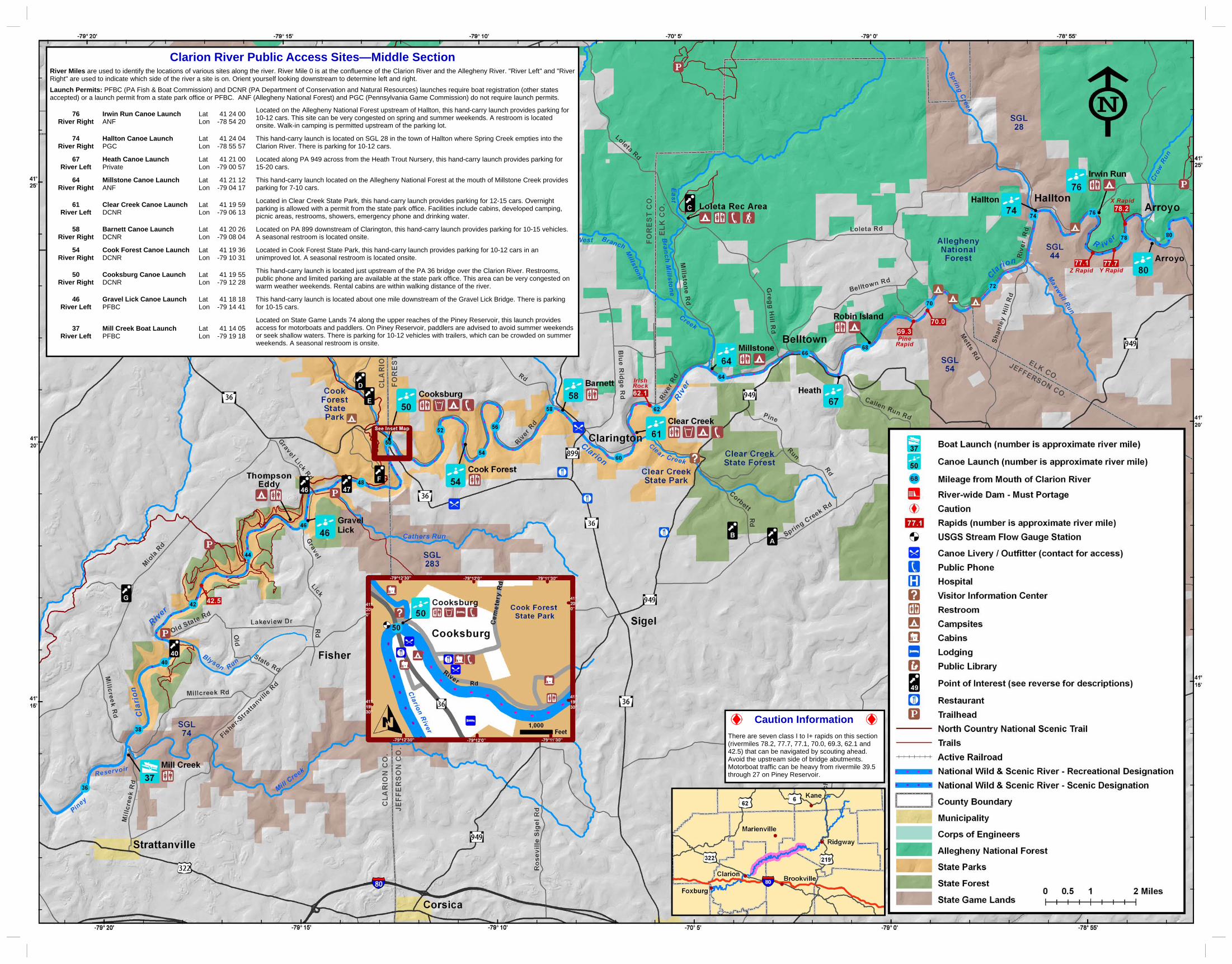
Clarion River Public Access Sites—Middle Section
River Miles are used to identify the locations of various sites along the river. River Mile 0 is at the confluence of the Clarion River and the Allegheny River. "River Left" and "River Right" are used to indicate which side of the river a site is on. Orient yourself looking downstream to determine left and right.
Launch Permits: PFBC (PA Fish & Boat Commission) and DCNR (PA Department of Conservation and Natural Resources) launches require boat registration (other states accepted) or a launch permit from a state park office or PFBC. ANF (Allegheny National Forest) and PGC (Pennsylvania Game Commission) do not require launch permits.
76 River Right
Irwin Run Canoe Launch ANF
Lat 41 24 00 Lon -78 54 20
Located on the Allegheny National Forest upstream of Hallton, this hand-carry launch provides parking for 10-12 cars. This site can be very congested on spring and summer weekends. A restroom is located onsite. Walk-in camping is permitted upstream of the parking lot.
74 River Right
Hallton Canoe Launch PGC
Lat 41 24 04 Lon -78 55 57
This hand-carry launch is located on SGL 28 in the town of Hallton where Spring Creek empties into the Clarion River. There is parking for 10-12 cars.
67 River Left
Heath Canoe Launch Private
Lat 41 21 00 Lon -79 00 57
Located along PA 949 across from the Heath Trout Nursery, this hand-carry launch provides parking for 15-20 cars.
64 River Right
Millstone Canoe Launch ANF
Lat 41 21 12 Lon -79 04 17
This hand-carry launch located on the Allegheny National Forest at the mouth of Millstone Creek provides parking for 7-10 cars.
61 River Left
Clear Creek Canoe Launch DCNR
Lat 41 19 59 Lon -79 06 13
Located in Clear Creek State Park, this hand-carry launch provides parking for 12-15 cars. Overnight parking is allowed with a permit from the state park office. Facilities include cabins, developed camping, picnic areas, restrooms, showers, emergency phone and drinking water.
58 River Right
Barnett Canoe Launch DCNR
Lat 41 20 26 Lon -79 08 04
Located on PA 899 downstream of Clarington, this hand-carry launch provides parking for 10-15 vehicles. A seasonal restroom is located onsite.
54 River Right
Cook Forest Canoe Launch DCNR
Lat 41 19 36 Lon -79 10 31
Located in Cook Forest State Park, this hand-carry launch provides parking for 10-12 cars in an unimproved lot. A seasonal restroom is located onsite.
50 River Right
Cooksburg Canoe Launch DCNR
Lat 41 19 55 Lon -79 12 28
This hand-carry launch is located just upstream of the PA 36 bridge over the Clarion River. Restrooms, public phone and limited parking are available at the state park office. This area can be very congested on warm weather weekends. Rental cabins are within walking distance of the river.
46 River Left
Gravel Lick Canoe Launch PFBC
Lat 41 18 18 Lon -79 14 41
This hand-carry launch is located about one mile downstream of the Gravel Lick Bridge. There is parking for 10-15 cars.
37 River Left
Mill Creek Boat Launch PFBC
Lat 41 14 05 Lon -79 19 18
Located on State Game Lands 74 along the upper reaches of the Piney Reservoir, this launch provides access for motorboats and paddlers. On Piney Reservoir, paddlers are advised to avoid summer weekends or seek shallow waters. There is parking for 10-12 vehicles with trailers, which can be crowded on summer weekends. A seasonal restroom is onsite.
Caution Information
There are seven class I to I+ rapids on this section (rivermiles 78.2, 77.7, 77.1, 70.0, 69.3, 62.1 and 42.5) that can be navigated by scouting ahead. Avoid the upstream side of bridge abutments. Motorboat traffic can be heavy from rivermile 39.5 through 27 on Piney Reservoir.

Water trails are recreational waterways on a lake, river, or ocean between specific points, containing access points and day‐use and/or camping sites for the boating public. Water trails emphasize low‐impact use and promote stewardship of the resources. Explore this unique Pennsylvania water trail.
THE CLARION RIVER
The Clarion River meanders through more than 115 miles of narrow serpentine valleys and hardwood forests. Located in the Pennsylvania Wilds in the northwestern corner of the state, its headwaters break the surface in McKean County and join with the Allegheny River in Clarion County. The Clarion River’s Water Trail Guides are divided into three sections: the Upper (Headwaters to Irwin Run), the Middle (Irwin Run to Mill Creek), and the Lower (Mill Creek to the Allegheny River—Still in development). Over the last two hundred years of European settlement, the history of the Clarion River has been a compelling story of resource exploitation, degradation, resilience, and recovery. The lumber industry was the focal point on the Clarion River during the latter part of the 19th century and into the 20th century. Timber cut along the Clarion River was floated down the river to Pittsburgh and sometimes as far as New Orleans. At the same time, industries such as coal mining, leather tanning and wood chemical manufacturing were also present. Today, the Clarion River is a popular paddling and fishing destination. Wildlife, intermittent riffles and rock outcrops provide a picturesque backdrop for outdoor recreation. Outstanding features include a nationally recognized old growth white pine and hemlock forest, and a federally designated stretch of Wild & Scenic River. Adjacent public lands provide abundant opportunities for camping, hunting, hiking, bicycling, wildlife watching, picnicking or just enjoying the scenery. The Clarion River is now recognized as a true natural treasure with a rich industrial history and an outstanding destination for outdoor recreation. Once declared the most polluted river in the state, the river’s water quality has experienced a tremendous recovery, thanks to the work of devoted citizens from local industry, government and non-profit organizations.
Map & Guide
Clarion River Water Trail Middle Section Irwin Run to Mill Creek
NATIONAL WILD AND SCENIC RIVER
In 1996, 51.7 miles of the Clarion River were designated a National Wild and Scenic River. This designation recognizes outstanding examples of the nation's free-flowing rivers in the hope of raising public awareness of the importance of America's river resources. The river sections from Portland Mills to Irwin Run, and from Cooksburg to the Piney Dam flatwater, carry a "scenic” designation (sections of rivers that are free of impoundments with watersheds still largely primitive and shorelines largely undeveloped, but accessible in places by roads). The remaining 34.7 miles are designated as "recreational” (sections of rivers that are readily accessible by road or railroad that may have some development along their shorelines).
Dams: Water going over a dam creates an undertow that can pull a boat into the turbulence and capsize it. This hydraulic can often trap and hold a person or a boat. The areas above and below the dam can be hazardous. Always carry your boat around dams.
Strainers: Trees are typical strainers that can trap and flood boats. Strainers can pin victims underwater.
Current: Never underestimate the power of moving water. Boaters who are not sure that their boat or their ability is up to the prevailing conditions should stay off the water.
Cold water: Sudden immersion in cold water can lead to cardiac arrest or can cause a person to inhale water. If you fall into cold water, immediately cover your mouth and nose with your hands. Dress properly for the cold by wearing a hat, several layers of clothing and warm boots.
Hypothermia: Hypothermia is the lowering of the body's core temperature and can be fatal if not treated. It begins with shivering. Judgment then becomes clouded and unconsciousness sets in. Remove a hypothermic person from the water and replace wet clothes with warm, dry clothing and/or a blanket. Do not massage the extremities or give the victim alcohol or caffeine.
POTENTIAL HAZARDS ON THE RIVER
River Miles are used to identify the locations of various sites along the river. River Mile 0 is at the confluence of the Clarion River and the Allegheny River. Lettered items identify the locations of Points of Interest that are not adjacent to the river.
River Left (RL) and River Right (RR) are used to indicate which side of the river a site is on. Orient yourself looking downstream to determine left and right.
Mile 92.5 to 71.4 (RL) State Game Lands 44: This game lands borders the Clarion River downstream of Ridgway. For more information: www.pgc.state.pa.us Mile 92.5 to 63 (RR) Allegheny National Forest: The only national forest in Pennsylvania is open to hiking, camping, fishing, hunting, paddling and other outdoor recreation activities. For more information: www.fs.fed.us/r9/forests/allegheny Mile 75.3 to 74 (RR) State Game Lands 28: This game lands is bordered by the Allegheny National Forest near Hallton. For more information: www.pgc.state.pa.us
Mile 74 (RR) Hallton was once the site of several large industries including a major sawmill and a wood chemical plant. Some permanent residents dwell here but only foundations of the industries remain. Mile 71.4 to 68.4 (RL) State Game Lands 54: This game lands borders the Clarion River upstream of Clear Creek State Park. For more information: www.pgc.state.pa.us Mile 67 (RL) Heath Station and Trout Nursery: The trout nursery, across PA 949 from the Heath Canoe Launch, is a cooperative effort between the Pennsylvania Fish & Boat Commission and the Heath Township Sportsmen's Club. Point A Laurel Fields: Visit this Clear Creek State Forest picnic area in June for the mountain laurel flowers. Point B Beartown Rocks: Located in Clear Creek State Forest, this rock city offers a scenic overlook. Leave extra time to explore the interesting rock formations. Some stair climbing is required to reach the overlook. A 3.5 mile scenic hiking trail connects Clear Creek State Park with Beartown Rocks. Point C Loleta Recreation Area was built in the 1930's by the Civilian Conservation Corps on the site where, just 20 years earlier, a bustling logging town of 600 inhabitants stood. The Allegheny National Forest operates the recreation area, which offers tent and RV camping, restrooms, showers, picnic pavilions, swimming and hiking.
Mile 62.6 to 59.3 (RL) Clear Creek State Park offers developed camping, cabins, hiking trails, canoe access, swimming pond, hunting and trout fishing. Clear Creek has the only riverside developed campsites along the Clarion River, a few of which are held aside for canoe campers only. For reservations, call (888) PA-PARKS or visit www.visitPAparks.com. Mile 58.8 to 48 Cook Forest State Park offers developed camping, cabins, hiking trails, canoe access, hunting, trout fishing and the Seneca Point Overlook. Stay at the historic Inn at Cook Forest for a warm bed and hot breakfast on the banks of the Clarion River. For reservations, call (888) PA-PARKS or visit www.visitPAparks.com. Mile 50.5 to 50 Cooksburg: Originally a lumber town where rafts were built to float lumber to markets in Pittsburgh and sometimes New Orleans, this town is now a haven for recreationists. The area offers many attractions including a number of gift, antique and retail stores, several restaurants, recreational equipment rentals, cabins, and amusements. Point D Sawmill Center for the Arts: This stop on the Pennsylvania Wilds Artisan Trail offers classes and traditional crafts from over 150 artisans in the historic sawmill throughout the summer and fall. The Verna Leith Sawmill Theater holds plays, musicals and other entertainment in the summer.
Point E The Forest Cathedral Natural Area is a registered National Natural Landmark. The Forest Cathedral contains approximately 717 acres of old growth forest dominated by eastern hemlock and eastern white pine, which commonly surpass 250 years of age, with some as old as 450 years. Point F Cook Forest Fire Tower and Seneca Point Overlook: The 87-foot #9 Fire Tower, built in 1929, gave firefighters a 15-20 mile view of
the area. A superb view of many of the old growth forests at Cook Forest State Park can be observed from this location. Seneca Point offers a scenic view of the Clarion River. Mile 47 (RR) Hemlock Island: Upstream from the Gravel Lick bridge, log rafts and boats were built here in the mid to late 1800's. On the river right side of the island, a historic sawmill dam on Henry Run creates a scenic waterfall. Mile 46 (RR) North Country National Scenic Trail is a premier footpath that stretches for about 4,600 miles linking communities, forests, and prairies across seven northern states. Point G Helen Furnace: Built in 1845, this cold-blast furnace was in operation until 1857. The furnace produced iron from local ore and charcoal. Mile 40 (RL) Blyson's Run Cut Stone Raft Historic Site: In the past, timber was floated on rafts down the Clarion River to market. Rivermen used to tie up at Blyson's Run Cut Stone. You can still see the pole where they tied their rafts. Mile 38 to 36.4 (RL) State Game Lands 74: This game lands borders the Clarion River at the Mill Creek confluence in Clarion County. For more information: www.pgc.state.pa.us
ALONG THE WAY BOAT RENTALS, GUIDES AND LIVERIES
Country Squirrel Outfitters: River mile 94. Guided tours, outdoor gear, equipment rentals, livery. (814) 776-6285, www.countrysquirreloutfitters.com
Lazy River Rentals: River mile 94. Equipment rentals, livery, tent campsites. (814) 389-2732, www.lazyrivercanoerental.com
Pale Whale Canoe Rental: River mile 50.1. Boat rentals, livery, cabins. (814) 744-8300, www.canoecookforest.com
Cook Forest Canoe Rentals: River mile 59 and 50. Boat rentals, livery. (814) 744-8094, www.cookforestcanoe.com
Pine Crest Canoe Rentals: Boat rentals, livery, cabins. (814) 752-2200, http://cooksforest.com/pinecrest-frt2.html
Clarion River Rambler: River mile 29.5. Pontoon boat tours on Piney Reservoir. (814) 226-4679, www.clarionriverrambler.com
Fishing Pennsylvania Fish & Boat Commission rules and regulations apply. Clarion River between Ridgway and Cook Forest: Brook trout
can be found near the mouths of the stocked tributaries. Excellent smallmouth bass fishing. Cook Forest State Park has a special fishing pond near the park office that is available for use by children 12 years and younger, and people with disabilities.
Clarion River between Cook Forest and Piney Reservoir: This is a warmwater fishery with smallmouth bass and walleye.
Piney Reservoir: Stocked with walleye and tiger muskellunge. Good catches of smallmouth bass.
Camping Camping is permitted only in designated sites. The Allegheny National Forest has numerous primitive campsites (no fee) on river right between Irwin Run and Millstone Creek. Clear Creek State Park offers developed campsites on river left, a few of which are held aside for canoe campers only. Cook Forest State Park offers a primitive camping area on river right just downstream of the Gravel Lick Launch. Permits must be obtained for camping on state park lands and a fee is assessed. For state park campsite reservations please call (814) 744-8407. Alcohol is not permitted on state park managed lands. Camping is not permitted on State Game Lands.
Hunting Be aware that hunting occurs on public and private lands all along the river from September through February and late April through May. River users should wear blaze orange so they are visible to any hunters in the area. For more information: www.pgc.state.pa.us
All Terrain Vehicles All Terrain Vehicles (ATVs) are only permitted on designated trails on Allegheny National Forest lands. Respect our good nature - Stay on designated trails.
FISHING, CAMPING, HUNTING AND ATVS
RESPECT THE PRIVACY AND RIGHTS OF LANDOWNERS
Although the access points highlighted in this guide are open for public use, some of the shoreline along the water trail is privately owned. Respect the privacy and rights of landowners by keeping off their property unless you receive permission. Unless you are otherwise certain, assume the land is private property. Avoid making noise and boisterous behavior. Remember, sound carries across water much further than it carries on land. Many landowners enjoy the river’s peace and solitude so display the same amount of courtesy that you would expect in return. A friendly wave or quiet greeting is always welcome.
VISITOR INFORMATION
Pennsylvania Wilds: http://pawilds.com Pennsylvania Great Outdoors Visitors Bureau:
(800) 348-9393, www.pagreatoutdoors.com Ridgway Welcome Center: 300 Main Street, Ridgway,
(814) 776-1424 Cook Forest Vacation Bureau:
(814) 328-2857, www.cookforest.org Clarion Area Visitor Center: 17 South Fifth Avenue, Clarion,
(814) 226-4450
EMERGENCY INFORMATION
Emergency: 911 Cell service is unreliable in the most of the Clarion River valley. Public phones are marked on the map.
Nearby Hospitals Ridgway, Elk Regional Health Center: From Main Street (PA
948) turn on South Mill Street, then right on South Street, then left on Euclid Street. (814) 788-5555
Brookville Hospital: follow PA 28 south of US 322 in Brookville, then left on South Main Street. (814) 849-2312
Clarion Hospital: located behind the Clarion Mall near the junction of I-80 and PA 68. (814) 226-9500
FLOATING THE RIVER
The Clarion River is considered a Class I river, making it suitable for paddlers of all abilities. On a scale of I-VI, Class I denotes fast-moving water with riffles and small waves; few or no obstructions, all obvious and easily missed with little training; risk to swimmer is slight; and self-rescue is easy. Keep in mind that these classifications may change with high water levels. The best time to float the Clarion River is in the spring and early summer. The river accommodates small, shallow-draft watercraft such as canoes and kayaks. In late summer, the river becomes shallow at times and boat bottoms can drag on the streambed. Your float time will vary according to the season and weather. Generally, assume four to five miles-per-hour during spring run-off, and two to three miles-per-hour at low water levels. Streamflows can change rapidly creating potentially unsafe conditions. Check available resources such as weather, precipitation, USGS gauges (search 'Ridgway USGS Gauge' and ‘Cooksburg USGS Gauge’ on the internet), and local outfitters to plan accordingly.
At river levels above 6 feet, liveries will not rent canoes and state parks close their launches.
Ridgway USGS Gauge Lower Limit Optimal
Ridgway to Clarington 2.5 feet 4 - 5 feet
Cooksburg USGS Gauge
Clarington to Cooksburg 2 feet 2.5 – 4.5 feet
Cooksburg to Mill Creek 2.5 feet 3 - 5 feet
Photo: Eric S. P
atton
Cabin at Clear Creek State Park
Photo: Brenda A
dams-W
eyant
The Forest Cathedral
Photo: Brenda A
dams-W
eyant
Historic Hallton
Photo: Elk C
ounty Historical S
ociety
STEWARDSHIP
Help care for the land, water and cultural resources along the Clarion River by respecting wildlife, nature and other recreationists. Washing footwear, boats and vehicles minimizes the spread of invasive species from one place to another. "Leave No Trace," a national outdoor ethics program, provides guidelines for minimizing your impact. Visit www.LNT.org for more information.
1. Plan and prepare 2. Travel and camp on durable surfaces 3. Dispose of waste properly 4. Leave what you find 5. Minimize campfires 6. Respect wildlife 7. Be considerate of other visitors
For your safety and enjoyment: Always wear a life jacket Obtain proper instruction in boating skills Know fishing and boating regulations Be prepared for changing conditions Be alert for river hazards Carry proper equipment
ACKNOWLEDGEMENTS
The update of this guide was made possible with financial assistance from the North Central Greenways Implementation Grant Program and the Pennsylvania Great Outdoors Visitors Bureau.
A U.S. Coast Guard-approved wearable personal flotation device (PFD or life jacket) is required for each person on board. In addition, one throwable device (seat cushion or ring buoy) is required on boats 16 feet in length or longer. Canoes and kayaks, regardless of length, are not required to carry a throwable device.
From November 1 through April 30, boaters must wear a life jacket on boats less than 16 feet in length or any canoe or kayak during these cold weather months.
Life jackets must be the appropriate size for the person intended and must be in good, serviceable condition.
Life jackets must be worn by all children 12 years old and younger on all boats 20 feet or less in length while under way, and on all canoes and kayaks. Others are strongly encouraged to wear a PFD at all times on the water.
On East Branch Clarion River Lake, wearing a PFD is mandatory on boats under 16 feet and in all canoes and kayaks.
All boats must display an anchor light (a white light visible 360 degrees) when at anchor between sunset and sunrise. Boats can use a lantern or clip-on battery-powered unit to meet this requirement. Unpowered boats must carry a white light, either hand-held or installed, to be displayed in time to avoid a collision between sunset and sunrise and during restricted visibility. All powered boats must show running lights between sunset and sunrise. All boats are required
to carry a sound-producing device. Motorboats less than 40 feet in length must carry some mechanical means of making a sound signal. This device may be hand-, mouth- or power-operated. An athletic coach’s whistle is an acceptable device. Operators of unpowered boats (canoes, kayaks, rowboats, paddleboards) are required to carry a device capable of sounding a prolonged blast for 4-6 seconds that can be heard by another boat operator in time to avoid a collision. An athletic coach’s whistle is acceptable.
All motorboats must be registered, regardless of where they launch.
Unpowered boats (canoes, kayaks, rowboats) using Pennsylvania Fish & Boat Commission, State Park or State Forest access areas must either be registered OR display a valid launch permit. Launch permits can be purchased through the Commission’s website at www.fishandboat.com (Click the “Outdoor Shop” icon) or at many state park offices.
Operating watercraft, including canoes and kayaks, under the influence of alcohol or drugs is illegal. This law is strongly enforced for user safety.
For further information on boating regulations, contact the Pennsylvania Fish & Boat Commission at www.fishandboat.com.
PENNSYLVANIA BOATING REGULATIONS
PADDLING SAFETY TIPS
Wear your life jacket. Some 80 percent of all recreational boating fatalities happen to people who are not wearing a life jacket.
Expect to get wet. Even the best paddlers sometimes capsize or swamp their boats. Bring extra clothing in a waterproof bag.
Be prepared to swim. If the water looks too hazardous to swim in, don’t go paddling.
If you capsize, hold onto your boat, unless it presents a life-threatening situation. If floating in current, position yourself on the upstream side of the capsized boat.
Scout ahead whenever possible. Know the river. Avoid surprises.
Be prepared for the weather. Get the forecast before you go. Sudden winds and rain are common and can turn a pleasant trip into a risky, unpleasant venture.
Wear wading shoes or tennis shoes with wool, polypropylene, pile or neoprene socks.
Never take your boat over a low-head dam. Portage (carry) your boat around any section of water about
which you feel uncertain. Never boat alone. Boating safety increases with numbers. Keep painter lines (ropes tied to the bow) and any other ropes
coiled and secured. Never tie a rope to yourself or to another paddler, especially a
child. And never tie two boats together. Kneel to increase your stability before entering rougher water,
like a rapid. If you collide with an obstruction, lean toward it. This will
usually prevent you capsizing or flooding the boat. File a float plan with a reliable person, indicating where you are
going and when you will return. Remember to contact the person when you have returned safely.