class diagram abstractclass key -...
TRANSCRIPT

EnumAttachment
IWorkspaceEditEvents2
CoClassInterfaceDInterfaceB
Types of Classes
An abstract class cannot be used to create new objects but is a specification for instances of subclasses (through type inheritance.)
A CoClass can directly create objects by declaring a new object .
A Class cannot directly create objects, but objects of this class can be created as a property of another class or instantiated by objects from another class.
Types of Relationships
Associations represent relationships between classes. They have defined multiplicities at both ends.
Type inheritance defines specialized classes of objects which share properties and methods with the superclass and have additional properties and methods. Note that interfaces in superclasses are not duplicated in subclasses.
Instantiation specifies that one object from one class has a method with which it creates an object from another class.
Composition is a relationship in which objects from the 'whole' class control the lifetime of objects from the 'part' class.
An N-ary association specifies that more than two classes are associated . A diamond is placed at the intersection of the association branches .
A Multiplicity is a constraint on the number of objects that can be associated with another object. Association and composition relationships have multiplicities on both sides. This is the notation for multiplicities:
1 - One and only one (if none shown, '1' is implied)
0..1 - Zero or one
M..N - From M to N (positive integers)
* or 0..* - From zero to any positive integer
1..* - From one to any positive integer
Class Diagram Key
enumeration firstValue - firstEnumeration secondValue - secondEnumeration
AbstractClass
Type inheritance
Instantiation
Association
Composition
1..* Multiplicity
Interface of interestInterfaceA(Optional)InterfaceB
Interface of interest
InterfaceGInterfaceM
Outbound Interface
Inbound Interface
Special Interfaces (Optional) represents interfaces that are inherited by some subclasses but not all . The subclasses list the optional interfaces they implement.
(Instance) represents interfaces that are only on specific instances of the class.
(<classname>) indicates the name of the helper class required to support this event interface in Visual Basic.
Interface key
Property GetProperty PutProperty Get/PutProperty Put by ReferenceMethod
(<classname>)InterfaceO
Structure key <<Struct>>
firstMember: TypesecondMember: Type
ClassInterface of interest
IRelationship
WorkspaceFactory
IEnumGeometry
RelationshipIRelationship IRelationship : IUnknown
DestinationObject: IObjectOriginObject: IObjectRelationshipClass: IRelationshipClass
ObjectClassExtension
FeatureClassExtension
GeoDataset IGeoDataset : IUnknown
Extent: IEnvelopeSpatialReference: ISpatialReference
IGeoDataset
IWorkspaceFactory
RangeDomain IRangeDomain : IUnknown
MaxValue: VariantMinValue: Variant
1..*
SpatialFilterISpatialFilter
SelectionSetISelectionSet
QueryFilterIQueryFilter
FeatureClass
Table
ITable
IClass
ObjectClass
ISubtypes (optional)
*
esriEditor.IObjectInspector(optional)
IObjectClassValidation(optional)
IObjectClassExtension : IUnknownIObjectClassExtension
ClassExtensionIClassExtension
IRelatedObjectClassEvents : IUnknown
RelatedObjectCreated (in RelationshipClass: IRelationshipClass, in objectThatWasCreated: IObject)
IObjectClassValidation : IUnknown
ValidateField (in Row: IRow, in FieldName: String): String
ValidateRow (in Row: IRow): String
IRelatedObjectClassEvents(optional)
CursorICursor
IModelInfo : IUnknown
ModelName: String
IGeoDatasetSchemaEdit : IUnknown
CanAlterSpatialReference: Boolean
AlterSpatialReference (in SpatialReference: ISpatialReference)
IGeoDataSetSchemaEdit
IModelInfo (optional)
0..1
2 *
*2
esriSchemaLock1 - esriSharedSchemaLock2 - esriExclusiveSchemaLock
esriSelectionType1 - esriSelectionTypeIDSet2 - esriSelectionTypeSnapshot3 - esriSelectionTypeHybrid
esriSetOperation1 - esriSetUnion2 - esriSetIntersection3 - esriSetDifference4 - esriSetSymDifference
esriSplitPolicyType1 - esriSPTGeometryRatio2 - esriSPTDuplicate3 - esriSPTDefaultValue
IQueryFilter : IUnknown
OutputSpatialReference (in FieldName: String): ISpatialReference
SubFields: StringWhereClause: String
AddField (in subField: String)
ISubtypes : IUnknown
DefaultSubtypeCode: LongDefaultValue (in SubtypeCode: Long, in
FieldName: String) : VariantDomain (in SubtypeCode: Long, in
FieldName: String) : IDomainHasSubtype: BooleanSubtypeFieldIndex: LongSubtypeFieldName: StringSubtypeName (in SubtypeCode: Long) : String
Subtypes: IEnumSubtype
AddSubtype (in SubtypeCode: Long, in SubtypeName: String)
DeleteSubtype (in SubtypeCode: Long)
esriSearchOrder0 - esriSearchOrderSpatial1 - esriSearchOrderAttribute
esriWorkspaceType0 - esriFileSystemWorkspace1 - esriLocalDatabaseWorkspace2 - esriRemoteDatabaseWorkspace
IClassExtension : IUnknown
Init (in pClassHelper: IClassHelper, in pExtensionProperties: IPropertySet)
Shutdown
IObjectInspector : IUnknown
hWnd: OLE_HANDLE
ClearCopy (in srcRow: IRow)Inspect (in Objects: IEnumRow, in Editor:
IEditor)
ICursor : IUnknown
Fields: IFields
DeleteRowFindField (in Name: String): LongFlushInsertRow (in buffer: IRowBuffer): VariantNextRow: IRowUpdateRow (in Row: IRow)
ISpatialFilter : IQueryFilter
FilterOwnsGeometry: BooleanGeometry: IGeometryGeometryEx (in Geometry: IGeometry):
BooleanGeometryField: StringSearchOrder: esriSearchOrderSpatialRel: esriSpatialRelEnumSpatialRelDescription: String
IClass : IUnknown
CLSID: IUIDEXTCLSID: IUIDExtension: IUnknownExtensionProperties: IPropertySetFields: IFieldsHasOID: BooleanIndexes: IIndexesOIDFieldName: String
AddField (in Field: IField)AddIndex (in Index: IIndex)DeleteField (in Field: IField)DeleteIndex (in Index: IIndex)FindField (in Name: String): Long
esriSpatialRelEnum0 - esriSpatialRelUndefined1 - esriSpatialRelIntersects2 - esriSpatialRelEnvelopeIntersects3 - esriSpatialRelIndexIntersects4 - esriSpatialRelTouches5 - esriSpatialRelOverlaps6 - esriSpatialRelCrosses7 - esriSpatialRelWithin8 - esriSpatialRelContains9 - esriSpatialRelRelation
IClassSchemaEdit2 (optional)
IFeatureClassDraw(optional)
IFeatureClassCreation : IUnknown
CanCreateFromPoint: Boolean
IFeatureClassCreation(optional)
IFeatureClassExtension : IUnknownIFeatureClassExtension
IFeatureClassDraw : IUnknown
CustomRendererPropPageCLSID: IUIDExclusiveCustomRenderer: BooleanRequiredFieldsForDraw: IFields
DoesCustomDrawing: BooleanHasCustomRenderer: Boolean
CustomRenderer: Variant
IFeatureClassEdit(optional)
esriDomainType1 - esriDTRange2 - esriDTCodedValue3 - esriDTString
esriDrawStyle1 - esriDSNormal2 - esriDSValid4 - esriDSInvalid8 - esriDSUnknown
esriMergePolicyType1 - esriMPTSumValues2 - esriMPTAreaWeighted3 - esriMPTDefaultValue
esriEditSearchOption1 - esriEditSearchBoth2 - esriEditSearchBasicOnly3 - esriEditSearchDeltaOnly4 - esriEditSearchNewDeltaOnly5 - esriEditSearchDeletedBasicOnly
IQueryFilter2
IRangeDomain
esriLockType1 - esriLockTypeShared2 - esriLockTypeExclusive
ISelectionSet : IUnknown
Count: LongFullName: INameIDs: IEnumIDsTarget: ITable
Add (in OID: Long)AddList (in Count: Long, in OIDList: Long)Combine (in otherSet: ISelectionSet, in setOp:
esriSetOperation, out resultSet: ISelectionSet)
MakePermanentRefreshRemoveList (in Count: Long, in OIDList: Long)Search (in pQueryFilter: IQueryFilter, in
Recycling: Boolean, out ppCursor: ICursor)Select (in QueryFilter: IQueryFilter, in selType:
esriSelectionType, in selOption: esriSelectionOption, in selectionContainer: IWorkspace): ISelectionSet
IFeatureClassEdit : IUnknown
CanEditWithProjection: BooleanCustomSplitPolicyForRelationship (in Row:
IRow, in relClass: IRelationshipClass): esriRelationshipSplitPolicy
HasCustomSplitPolicyForRelationship: Boolean
*
IWorkspaceFactory2
FeatureLayer in Carto
IRelatedObjectClassEvents2(optional)
IObjectClassEvents : IUnknown
OnChange (in obj: IObject)OnCreate (in obj: IObject)OnDelete (in obj: IObject)
IObjectClassEvents(optional)
ISelectionSet2
IConfirmSendRelatedObjectEvents(optional)
esriTopoConfiguration0 - esriTCChain1 - esriTCLoop2 - esriTCStar3 - esriTCMesh
IPersistStreamesriClone.IClone
1
ITableCapabilities ITableCapabilities : IUnknown
ISelectionSet2 : ISelectionSet
Update (in pQueryFilter: IQueryFilter, in Recycling: Boolean, out ppCursor: ICursor)
IQueryFilter2 : IQueryFilter
SpatialResolution: Double
IClassSchemaEdit2 : IClassSchemaEdit
AlterClassExtensionProperties (in classExtensionProperties: IPropertySet)
RasterDataset in Raster
WorkspaceHelperIWorkspaceHelper : IUnknown
Workspace: IWorkspace
IWorkspaceHelper
esriRelationshipSplitPolicy1 - esriRSPUseDefault2 - esriRSPPreserveOnLargest3 - esriRSPPreserveOnSmallest4 - esriRSPPreserveOnAll5 - esriRSPDeleteRelationship6 - esriRSPDeleteParts
esriRelNotification1 - esriRelNotificationNone2 - esriRelNotificationForward3 - esriRelNotificationBackward4 - esriRelNotificationBoth
esriRelRole1 - esriRelRoleAny2 - esriRelRoleOrigin3 - esriRelRoleDestination
IObjectClassInfo : IUnknown
CanBypassStoreMethod: Boolean
IObjectClassInfo (optional)
IObjectClassInfo2 (optional)
IObjectClassInfo2 : IUnknown
CanBypassEditSession: BooleanCanBypassStoreMethod: Boolean
esriRuleType1 - esriRTAttribute2 - esriRTEdgeConnectivity3 - esriRTJunctionConnectivity4 - esriRTSpatial5 - esriRTRelationship6 - esriRTTopology
FeatureDataset
IFeatureClassContainer
IFeatureDataset
IRelationshipClassContainer : IUnknown
RelationshipClasses: IEnumRelationshipClass
AddRelationshipClass (in pRelClass: IRelationshipClass)
CreateRelationshipClass (in relClassName: String, in OriginClass: IObjectClass, in DestinationClass: IObjectClass, in forwardLabel: String, in backwardLabel: String, in Cardinality: esriRelCardinality, in Notification: esriRelNotification, in IsComposite: Boolean, in IsAttributed: Boolean, in relAttrFields: IFields, in OriginPrimaryKey: String, in destPrimaryKey: String, in OriginForeignKey: String, in destForeignKey: String) : IRelationshipClass
IRelationshipClassContainer
IFeatureClassContainer : IUnknown
Class (in ClassIndex: Long): IFeatureClassClassByID (in ID: Long): IFeatureClassClassByName (in Name: String):
IFeatureClassClassCount: LongClasses: IEnumFeatureClass
IDatasetContainer : IUnknown
AddDataset (in pDatasetToAdd: IDataset)
IDatasetContainer
IFeatureDataset : IDataset
CreateFeatureClass (in Name: String, in Fields: IFields, in CLSID: IUID, in EXTCLSID: IUID, in FeatureType: esriFeatureType, in ShapeFieldName: String, in ConfigKeyword: String): IFeatureClass
esriRelCardinality1 - esriRelCardinalityOneToOne2 - esriRelCardinalityOneToMany3 - esriRelCardinalityManyToMany esriSQLPrivilege
1 - esriSelectPrivilege2 - esriUpdatePrivilege4 - esriInsertPrivilege8 - esriDeletePrivilege
esriSQLSpecialCharacters1 - esriSQL_WildcardManyMatch2 - esriSQL_WildcardSingleMatch3 - esriSQL_DelimitedIdentifierPrefix4 - esriSQL_DelimitedIdentifierSuffix5 - esriSQL_EscapeKeyPrefix6 - esriSQL_EscapeKeySuffix
esriWorkspacePropertyGroupType1 - esriWorkspacePropertyGroup2 - esriWorkspaceTablePropertyGroup
esriSQLPredicates1 - esriSQL_EQ2 - esriSQL_NOT_EQ4 - esriSQL_LT8 - esriSQL_GT16 - esriSQL_LE32 - esriSQL_GE64 - esriSQL_BETWEEN128 - esriSQL_NOT_BETWEEN256 - esriSQL_IN512 - esriSQL_NOT_IN1024 - esriSQL_LIKE2048 - esriSQL_NOT_LIKE4096 - esriSQL_IS_NULL8192 - esriSQL_IS_NOT_NULL16384 - esriSQL_EXISTS32768 - esriSQL_NOT_EXISTS
IObjectClassEventsIObjectClassSchemaEvents
XYEventSourceIXYEventSource IXYEventSource : IUnknown
EventProperties: IXYEventPropertiesEventTable: ITable
RefreshExtent
IClass
IVirtualTable IVirtualTable : IUnknown
IDatasetEdit IDatasetEdit : IUnknown
IsBeingEdited: Boolean
IDatasetEditInfo IDatasetEditInfo : IUnknown
IEventSource IEventSource : IUnknown
WorkspaceEditEventsIWorkspaceEditEvents IWorkspaceEditEvents : IUnknown
OnAbortEditOperationOnRedoEditOperationOnStartEditing (in withUndoRedo: Boolean)OnStartEditOperationOnStopEditing (in saveEdits: Boolean)OnStopEditOperationOnUndoEditOperation
CodedValueDomain ICodedValueDomain : IUnknown
CodeCount: LongName (in Index: Long): StringValue (in Index: Long): Variant
AddCode (in Value: Variant, in Name: String)DeleteCode (in Value: Variant)
ICodedValueDomain
DatasetIDataset IDataset : IUnknown
BrowseName: StringCategory: StringFullName: INameName: StringPropertySet: IPropertySetSubsets: IEnumDatasetType: esriDatasetTypeWorkspace: IWorkspace
CanCopy: BooleanCanDelete: BooleanCanRename: BooleanCopy (in copyName: String, in
copyWorkspace: IWorkspace): IDatasetDeleteRename (in Name: String)
IDatasetEdit : IUnknown
IsBeingEdited: Boolean
IDatasetEdit
ISchemaLock : IUnknown
ChangeSchemaLock (in schemaLock: esriSchemaLock)
GetCurrentSchemaLocks (out schemaLockInfo: IEnumSchemaLockInfo)
IDatasetAnalyze (optional)
ISchemaLock (optional)
IDatasetAnalyze : IUnknown
AllowableComponents: Long
Analyze (in tableComponents: Long)
IWorkspaceFactory2 : IWorkspaceFactory
OpenFromString (in connectStr: String, in hWnd: OLE_HANDLE): IWorkspace
ILocalDatabaseCompact(optional) ILocalDatabaseCompact : IUnknown
Compact (in Name: IWorkspaceName)
EnumFeatureGeometry
IClone
IEnumGeometryBind IEnumGeometryBind : IUnknown
GeometrySource: IUnknownOutputFilter: IQueryFilter
BindGeometrySource (OutputFilter: IQueryFilter, in collectionSource: IUnknown)
ISupportErrorInfo
esriSelectionOption1 - esriSelectionOptionNormal2 - esriSelectionOptionOnlyOne3 - esriSelectionOptionEmpty
IXMLSerialize(esriSystem)
WorkspaceFactories in GISClient, DataSourcesFile, DataSourcesGDB,
DataSourcesOleDB, DataSourcesRaster, TrackingAnalyst,Geoprocessing
esriTableNameErrorType1 - esriIsSQLReservedWord2 - esriHasInvalidCharacter4 - esriHasInvalidStartingCharacter
esriJoinType0 - esriLeftOuterJoin1 - esriLeftInnerJoin
esriTransformType1 - esriTTMove2 - esriTTStretch3 - esriTTRotate4 - esriTTProgrammatic
esriDatasetFileStatAccessMode0 - esriDatasetFileStatAccessUnknown2 - esriDatasetFileStatAccessWrite4 - esriDatasetFileStatAccessReadOnly6 - esriDatasetFileStatAccessReadWrite
esriDatasetFileStatTimeMode0 - esriDatasetFileStatTimeLastAccess1 - esriDatasetFileStatTimeCreation2 - esriDatasetFileStatTimeLastModification
esriLocatingError0 - LOCATING_OK1 - LOCATING_E_INVALIDRID2 - LOCATING_E_INVALIDMEASURE3 - LOCATING_E_CANT_FIND_ROUTE4 - LOCATING_E_ROUTE_SHAPE_EMPTY5 - LOCATING_E_CANT_FIND_LOCATION6 - LOCATING_E_CANT_FIND_EXTENT7 - LOCATING_E_FROM_PARTIAL_MATCH8 - LOCATING_E_TO_PARTIAL_MATCH9 - LOCATING_E_ROUTE_MS_NULL10 - LOCATING_E_ROUTE_NOT_MAWARE11 - LOCATING_E_FROM_TO_PARTIAL_MATCH12 - LOCATING_E_MULTIPLE_LOCATION13 - LOCATING_E_NULL_EXTENT
*
NetworkFeature in Geodatabase Network
AttributeRuleIAttributeRule IAttributeRule : IRule
DomainName: StringFieldName: StringSubtypeCode: Long
RelationshipRule IRelationshipRule : IRule
DestinationClassID: LongDestinationMaximumCardinality: LongDestinationMinimumCardinality: LongDestinationSubtypeCode: LongOriginClassID: LongOriginMaximumCardinality: LongOriginMinimumCardinality: LongOriginSubtypeCode: Long
IRelationshipRule
DataStatisticsIDataStatistics IDataStatistics : IUnknown
Cancelled: BooleanContinue: BooleanCursor: ICursorField: StringSampleRate: LongSimpleStats: BooleanStatistics: IStatisticsResultsUniqueValueCount: LongUniqueValues: IEnumVARIANT
TableSortITableSort ITableSort : IUnknown
Ascending (in Field: String): BooleanCaseSensitive (in Field: String): BooleanCompare: ITableSortCallBackCursor: ICursorFields: StringIDs: IEnumIDsQueryFilter: IQueryFilterRows: ICursorSelectionSet: ISelectionSetSortCharacters (in Field: String): LongTable: ITable
Sort (in pTrackCancel: ITrackCancel)
ObjectClassValidatorIValidation IValidation : IUnknown
Rules: IEnumRuleRulesByField (in FieldName: String):
IEnumRuleRulesBySubtypeCode (in SubtypeCode:
Long): IEnumRule
AddRule (in Rule: IRule)DeleteRule (in Rule: IRule)Validate (in Selection: IQueryFilter, in
Workspace: IWorkspace): ISelectionSetValidateSelection (in Selection: ISelectionSet,
in Workspace: IWorkspace): ISelectionSetValidateSet (in Selection: ISet): ISet
IValidation2 IValidation2 : IValidation
AlterRule (in Rule: IRule)
ObjectClassDescriptionIObjectClassDescription : IUnknown
AliasName: StringClassExtensionCLSID: IUIDInstanceCLSID: IUIDModelName: StringModelNameUnique: BooleanName: StringRequiredFields: IFields
IObjectClassDescription
FeatureClassDescriptionIFeatureClassDescription : IUnknown
FeatureType: esriFeatureTypeShapeFieldName: String
IFeatureClassDescription
RasterCatalogClassDescription
NetworkClassDescriptionINetworkClassDescription : IUnknown
EnabledFieldName: StringNetworkAncillaryRoleFieldName: String
INetworkClassDescription
ClassHelperIClassHelper : IUnknown
Class: IClass
IClassHelper
IXMLSerialize(esriSystem)
Fields
IFieldsEdit
IFields IFields : IUnknown
Field (in Index: Long): IFieldFieldCount: Long
FindField (in Name: String): LongFindFieldByAliasName (in Name: String):
Long
IFieldsEdit : IFields
Field (in Index: Long): IFieldFieldCount: Long
IFields2 : IFields
FindFieldIgnoreQualification (sqlSyntax: ISQLSyntax, in Name: String, out Index: Long)
IFields2
esriSystem.IClone
esriSystem.IPersistStreamesriSystem.IClone
GeometryDefIGeometryDef
IGeometryDefEdit
IGeometryDef : IUnknown
AvgNumPoints: LongGeometryType: esriGeometryTypeGridCount: LongGridSize (in Index: Long): DoubleHasM: BooleanHasZ: BooleanSpatialReference: ISpatialReference
IGeometryDefEdit : IGeometryDef
AvgNumPoints: LongGeometryType: esriGeometryTypeGridCount: LongGridSize (in Index: Long): DoubleHasM: BooleanHasZ: BooleanSpatialReference: ISpatialReference
Field
IFieldEdit
IField IField : IUnknown
AliasName: StringDefaultValue: VariantDomain: IDomainDomainFixed: BooleanEditable: BooleanGeometryDef: IGeometryDefIsNullable: BooleanLength: LongName: StringPrecision: LongRequired: BooleanScale: LongType: esriFieldTypeVarType: Long
CheckValue (in Value: Variant): Boolean
IModelInfo : IUnknown
ModelName: String
IModelInfo
IFieldEdit : IField
AliasName: StringDefaultValue: VariantDomain: IDomainDomainFixed: BooleanEditable: BooleanGeometryDef: IGeometryDefIsNullable: BooleanLength: LongName: StringPrecision: LongRequired: BooleanScale: LongType: esriFieldType
esriSystem.ICloneesriSystem.IXMLSerialize
IGPValue
CanSelect: Boolean
IndexIIndex
IIndexEdit
IIndex : IUnknown
Fields: IFieldsIsAscending: BooleanIsUnique: BooleanName: String
IIndexEdit : IIndex
Fields: IFieldsIsAscending: BooleanIsUnique: BooleanName: String
esriSystem.ICloneIXMLSerialize
(esriSystem)
1..*
WorkspacePropertyIWorkspaceProperty : IUnknown
IsReadOnly: BooleanIsSupported: BooleanPropertyValue: Variant
IWorkspaceProperty
*
ConnectivityRule in Geodatabase Network
RecordNumberSetIRecordNumberSet IRecordNumberSet : IUnknown
IDs: IEnumIDsMaximumRecordNumber: LongMinimumRecordNumber: Long
Add (recordNumber: Long)AddRange (in minRecord: Long, in
maxRecord: Long)And (in otherRecordNumberSet:
IRecordNumberSet): IRecordNumberSetClearAllDelete (recordNumber: Long)Difference (in otherRecordNumberSet:
IRecordNumberSet): IRecordNumberSetNegate: IRecordNumberSetOr (in otherRecordNumberSet:
IRecordNumberSet): IRecordNumberSetSetAllSetBounds (in startRecordNumber: Long, in
maxRecordNumber: Long)XOr (in otherRecordNumberSet:
IRecordNumberSet): IRecordNumberSet
esriSystem.ICloneIFIDSet
esriMetadataSyncAction0 - esriMSAAccessed1 - esriMSAAlways2 - esriMSACreated3 - esriMSANotCreated4 - esriMSAOverwrite
RelationshipClassEventsIRelationshipClassEvents IRelationshipClassEvents : IUnknown
OnChange (in rel: IRelationship)OnCreate (in rel: IRelationship)OnDelete (in rel: IRelationship)
ObjectClassEventsIObjectClassEvents IObjectClassEvents : IUnknown
OnChange (in obj: IObject)OnCreate (in obj: IObject)OnDelete (in obj: IObject)
ObjectClassSchemaEventsIObjectClassSchemaEvents IObjectClassSchemaEvents : IUnknown
OnAddField (in FieldName: String)OnBehaviorChangedOnDeleteField (in FieldName: String)
RasterCatalogFeature in Geodatabase Raster
AnnotationFeature in Carto
DimensionFeature in Carto
ITable : IClass
CreateRow: IRowCreateRowBuffer: IRowBufferDeleteSearchedRows (in QueryFilter:
IQueryFilter)GetRow (in OID: Long): IRowGetRows (in oids: Variant, in Recycling:
Boolean): ICursorInsert (in useBuffering: Boolean): ICursorRowCount (in QueryFilter: IQueryFilter): LongSearch (in QueryFilter: IQueryFilter, in
Recycling: Boolean): ICursorSelect (in QueryFilter: IQueryFilter, in selType:
esriSelectionType, in selOption: esriSelectionOption, in selectionContainer: IWorkspace): ISelectionSet
Update (in QueryFilter: IQueryFilter, in Recycling: Boolean): ICursor
UpdateSearchedRows (in QueryFilter: IQueryFilter, in buffer: IRowBuffer)
IConfirmSendRelatedObjectEvents : IUnknown
ConfirmSendRelatedObjectChanged (in RelationshipClass: IRelationshipClass, in objectThatChanged: IObject): Boolean
ConfirmSendRelatedObjectMoved (in RelationshipClass: IRelationshipClass, in objectThatChanged: IObject, in moveVector: ILine): Boolean
ConfirmSendRelatedObjectRotated (in RelationshipClass: IRelationshipClass, in objectThatChanged: IObject, Origin: IPoint, Angle: Double): Boolean
ConfirmSendRelatedObjectSetMoved (in RelationshipClass: IRelationshipClass, in objectsThatChanged: ISet, moveVector: ILine): Boolean
ConfirmSendRelatedObjectSetRotated (in RelationshipClass: IRelationshipClass, in objectsThatChanged: ISet, Origin: IPoint, Angle: Double): Boolean
IRelatedObjectClassEvents2 : IUnknown
RelatedObjectChanged (in RelationshipClass: IRelationshipClass, in objectThatChanged: IObject, in RelatedObject: IObject)
RelatedObjectMoved (in RelationshipClass: IRelationshipClass, in objectThatChanged: IObject, in moveVector: ILine, in RelatedObject: IObject)
RelatedObjectRotated (in RelationshipClass: IRelationshipClass, in objectThatChanged: IObject, in Origin: IPoint, in Angle: Double, in RelatedObject: IObject)
RelatedObjectSetMoved (in RelationshipClass: IRelationshipClass, in objectsThatNeedToChange: ISet, in objectsThatChanged: ISet, in moveVector: ILine)
RelatedObjectSetRotated (in RelationshipClass: IRelationshipClass, in objectsThatNeedToChange: ISet, in objectsThatChanged: ISet, in Origin: IPoint, in Angle: Double)
IWorkspaceFactory : IUnknown
WorkspaceDescription (in plural: Boolean): String
WorkspaceType: esriWorkspaceType
ContainsWorkspace (in parentDirectory: String, in fileNames: IFileNames): Boolean
Copy (in WorkspaceName: IWorkspaceName, in destinationFolder: String, out workspaceNameCopy: IWorkspaceName): Boolean
Create (in parentDirectory: String, in Name: String, in ConnectionProperties: IPropertySet, in hWnd: OLE_HANDLE): IWorkspaceName
GetClassID: IUIDGetWorkspaceName (in parentDirectory:
String, in fileNames: IFileNames): IWorkspaceName
IsWorkspace (in fileName: String): BooleanMove (in WorkspaceName: IWorkspaceName,
in destinationFolder: String): BooleanOpen (in ConnectionProperties: IPropertySet,
in hWnd: OLE_HANDLE): IWorkspaceOpenFromFile (in fileName: String, in hWnd:
OLE_HANDLE): IWorkspaceReadConnectionPropertiesFromFile (in
fileName: String): IPropertySet
DddServerEnvironmentesriSystem.IExtension
esriSystem.IExtensionConfigISupportErrorInfo
Enumerations
esriFeatureType1 - esriFTSimple7 - esriFTSimpleJunction8 - esriFTSimpleEdge9 - esriFTComplexJunction10 - esriFTComplexEdge11 - esriFTAnnotation12 - esriFTCoverageAnnotation13 - esriFTDimension14 - esriFTRasterCatalogItem
IWorkspaceFactoryStatus : IUnknown
WorkspaceStatus: IEnumWorkspaceStatus
OpenAvailableWorkspace (in wstatus: IWorkspaceStatus): IWorkspace
PingWorkspaceStatus (in Workspace: IWorkspace): IWorkspaceStatus
IRemoteDatabaseWorkspaceFactory (optional)
IRemoteDatabaseWorkspaceFactory : IUnknownDeleteConnectionFile (in PathName: String)EditConnectionFile (in PathName: String, in
hWnd: OLE_HANDLE): IWorkspaceNameRenameConnectionFile (in oldPathName:
String, in newName: String): IWorkspaceName
ISetDefaultConnectionInfo(optional) ISetDefaultConnectionInfo : IUnknown
SetParameters (in server: String, in instance: String, in user: String, in password: String, in versName: String)
ISetDefaultConnectionInfo2 : ISetDefaultConnectionInfo
ClearParameters (in server: String, in instance: String)
ISetDefaultConnectionInfo2(optional)
IWorkspaceFactoryStatus(optional)
WorkspaceStatusIWorkspaceStatus IWorkspaceStatus : IUnknown
ConnectionStatus: esriWorkspaceConnectionStatus
Workspace: IWorkspace
ESRI® ArcGIS® 10 Copyright © 1999-2010 ESRI. All rights reserved. ESRI, ArcGIS, ArcObjects, and ArcMap are trademarks, registered trademarks, or service
marks of ESRI in the United States, the European Community, or certain other jurisdictions.
XYEvent2FieldsPropertiesIXYEvent2FieldsProperties IXYEvent2FieldsProperties :
IXYEventProperties
XFieldName: StringYFieldName: StringZFieldName: String
esriSystem.IClone
IXYEventProperties IXYEventProperties : IUnknown
IPersistStream
AttributedRelationshipClassIClass
IDatasetEditIDatasetEditInfo
IRelClassSchemaEditITable
ITableCapabilities
esriSystem.ICloneISchemaLock
DomainIDomain
IPersistStream
IWorkspaceEditEvents
Workspace
ITransactions
IWorkspaceDomains IWorkspaceDomains : IUnknown
CanDeleteDomain (in DomainName: String) : Boolean
DomainByName (in DomainName: String) : IDomain
Domains: IEnumDomainDomainsByFieldType (in Type: esriFieldType)
: IEnumDomain
AddDomain (in Domain: IDomain) : LongDeleteDomain (in DomainName: String)
IDatabaseCompact : IUnknown
CanCompact: BooleanCompact
ISpatialCacheManager : IUnknown
CacheExtent: IEnvelopeCacheIsFull: Boolean
EmptyCacheFillCache (pExtent: IEnvelope)
ISpatialCacheManager
IFeatureWorkspaceAnno
IWorkspace : IUnknown
ConnectionProperties: IPropertySetDatasetNames (in DatasetType:
esriDatasetType): IEnumDatasetNameDatasets (in DatasetType: esriDatasetType):
IEnumDatasetPathName: StringType: esriWorkspaceTypeWorkspaceFactory: IWorkspaceFactory
ExecuteSQL (in sqlStmt: String)Exists: BooleanIsDirectory: Boolean
ITransactions : IUnknown
InTransaction: Boolean
AbortTransactionCommitTransactionStartTransaction
IWorkspaceDomains2
IFeatureWorkspace : IUnknown
CreateFeatureClass (in Name: String, in Fields: IFields, in CLSID: IUID, in EXTCLSID: IUID, in FeatureType: esriFeatureType, in ShapeFieldName: String, in ConfigKeyword: String): IFeatureClass
CreateFeatureDataset (in Name: String, in SpatialReference: ISpatialReference): IFeatureDataset
CreateQueryDef: IQueryDefCreateRelationshipClass (in relClassName:
String, in OriginClass: IObjectClass, in DestinationClass: IObjectClass, in forwardLabel: String, in backwardLabel: String, in Cardinality: esriRelCardinality, in Notification: esriRelNotification, in IsComposite: Boolean, in IsAttributed: Boolean, in relAttrFields: IFields, in OriginPrimaryKey: String, in destPrimaryKey: String, in OriginForeignKey: String, in destForeignKey: String): IRelationshipClass
CreateTable (in Name: String, in Fields: IFields, in CLSID: IUID, in EXTCLSID: IUID, in ConfigKeyword: String): ITable
OpenFeatureClass (in Name: String): IFeatureClass
OpenFeatureDataset (in Name: String): IFeatureDataset
OpenFeatureQuery (in QueryName: String, in pQueryDef: IQueryDef): IFeatureDataset
OpenRelationshipClass (in Name: String): IRelationshipClass
OpenRelationshipQuery (in pRelClass: IRelationshipClass, in joinForward: Boolean, in pSrcQueryFilter: IQueryFilter, in pSrcSelectionSet: ISelectionSet, in TargetColumns: String, in DoNotPushJoinToDB: Boolean): ITable
OpenTable (in Name: String): ITable
ITransactionsOptions : IUnknown
AutoCommitInterval: Long
IFeatureWorkspaceManage : IUnknown
AnalyzeIndex (in TableName: String, in Index: String)
AnalyzeTable (in TableName: String, in tableComponents: Long)
CanDelete (in aName: IName): BooleanCanRename (in aName: IName): BooleanDeleteByName (in aName: IDatasetName)IsRegisteredAsObjectClass (in Name: String):
BooleanIsRegisteredAsVersioned (in aName: IName):
BooleanValidateField (in pInField: IField): IField
IFeatureWorkspaceSchemaEdit : IUnknown
AlterClassExtensionCLSID (in Name: String, in ClassExtensionCLSID: IUID, in classExtensionProperties: IPropertySet)
AlterInstanceCLSID (in Name: String, in InstanceCLSID: IUID)
IWorkspaceEdit : IUnknown
HasRedos (pHasRedos: Boolean) HasUndos (pHasUndos: Boolean) IsBeingEdited: BooleanRedoEditOperationStartEditing (withUndoRedo: Boolean) StartEditOperationStopEditing (in saveEdits: Boolean) StopEditOperationUndoEditOperation
AbortEditOperationDisableUndoRedoEnableUndoRedoHasEdits (pHasEdits: Boolean)
IFeatureWorkspaceManage
IFeatureWorkspaceSchemaEdit
ITransactionsOptions (optional)
IWorkspaceExtensionManager (optional)
ISQLSyntax
IWorkspaceConfiguration : IUnknown
ConfigurationKeywords: IEnumConfigurationKeyword
IGeodatabaseRelease : IUnknown
BugfixVersion: LongCanUpgrade: BooleanCurrentRelease: BooleanMajorVersion: LongMinorVersion: Long
Upgrade
IGeodatabaseRelease
IWorkspaceSpatialReferenceInfo : IUnknown
SpatialReferenceInfo: IEnumSpatialReferenceInfo
IWorkspaceSpatialReferenceInfo
IWorkspaceConfiguration (optional)
IDatabaseCompact (optional)
IWorkspaceDomains2 : IWorkspaceDomains
AlterDomain (in Domain: IDomain)
IDatabaseConnectionInfo : IUnknown
ConnectedDatabase: StringConnectedUser: String
IDatabaseConnectionInfo (optional)
IWorkspaceExtensionManager : IUnknown
Extension (in Index: Long): IWorkspaceExtension
ExtensionCount: Long
FindExtension (in pGUID: IUID): IWorkspaceExtension
RegisterExtension (in Name: String, in pGUID: IUID)
UnRegisterExtension (in pGUID: IUID)
ISpatialCacheManager2 : ISpatialCacheManager
CacheExpansionFactor: Double
FillCacheEx (pExtent: IEnvelope, expansionFactor: Double)
ISpatialCacheManager2
IFeatureWorkspaceManage2 : IFeatureWorkspaceManage
GetObjectClassNameByID (in ObjectClassID: Long): String
GetRelationshipClassNameByID (in relClassId: Long): String
IFeatureWorkspaceManage2
IWorkspace2 : IUnknown
NameExists (in Type: esriDatasetType, in Name: String): Boolean
IWorkspaceProperties : IUnknown
Property (in propertyGroup: esriWorkspacePropertyGroupType, in PropertyType: Long): IWorkspaceProperty
IWorkspaceProperties (optional)
IFeatureWorkspaceAnno : IUnknown
AddSymbolCollection (in Name: String, in symbolCollection: IUnknown)
CreateAnnotationClass (in Name: String, in Fields: IFields, in CLSID: IUID, in EXTCLSID: IUID, in ShapeFieldName: String, in ConfigKeyword: String, in dstFeatureDataset: IFeatureDataset, in srcFeatureClass: IFeatureClass, in annoProperties: IUnknown, in referenceScale: IUnknown, in symbolCollection: IUnknown, in autoCreate: Boolean): IFeatureClass
ReplaceSymbolCollection (in Name: String, in symbolCollection: IUnknown)
ISQLSyntax : IUnknown
GetDelimitedIdentifierCase: BooleanGetFunctionName (in sqlFunc:
esriSQLFunctionName): StringGetIdentifierCase: BooleanGetInvalidCharacters: StringGetInvalidStartingCharacters: StringGetKeywords: IEnumBSTRGetSpecialCharacter (in sqlSC:
esriSQLSpecialCharacters): StringGetStringComparisonCase: BooleanGetSupportedClauses: LongGetSupportedPredicates: LongParseColumnName (in FullName: String, out
dbName: String, out ownerName: String, out TableName: String, out columnName: String)
ParseTableName (in FullName: String, out dbName: String, out ownerName: String, out TableName: String)
QualifyColumnName (in TableName: String, in columnName: String): String
QualifyTableName (in dbName: String, in ownerName: String, in TableName: String): String
IFeatureWorkspace
IWorkspaceEdit
IDatasetContainer
IWorkspaceIDataset
IWorkspace2
IMultiuserWorkspaceEdit : IUnknown
MultiuserEditSessionMode: esriMultiuserEditSessionMode
StartMultiuserEditing (in esMode: esriMultiuserEditSessionMode)
SupportsMultiuserEditSessionMode (in esMode: esriMultiuserEditSessionMode): Boolean
IMultiuserWorkspaceEdit(optional)
IDatabaseConnectionInfo2(optional)
IWorkspaceEdit2 : IWorkspaceEdit
EditDataChanges (in editChangeType: esriEditDataChangesType): IDataChangesEx
InEditOperation: Boolean
IWorkspaceEdit2
CoverageAnnotationFeatureICoverageAnnotationFeature : IUnknown
AnnotationBlob: IMemoryBlobStream
ICoverageAnnotationFeature
IDomain : IUnknown
Description: StringFieldType: esriFieldTypeMergePolicy: esriMergePolicyTypeName: StringSplitPolicy: esriSplitPolicyTypeType: esriDomainType
MemberOf (in Value: Variant): Boolean
*
QueryDef
IGeoDataset2 : IGeoDataset
GeodataXform: IGeodataXformNativeExtent: IEnvelopeNativeSpatialReference: ISpatialReference
IGeoDataset2(optional)
IGeoDatasetSchemaEdit2 : IGeoDatasetSchemaEdit
CanAlterGeodataXform: Boolean
AlterGeodataXform (in xform: IGeodataXform)
AlterResolution (in xyResolution: Double, in zResolution: Double, in mResolution: Double)
ConstructResolutions (SpatialReference: ISpatialReference, numberRequested: Long, out defaultXYResolutionIndex: Long, out xyResolutions: IDoubleArray, out zResolutions: IDoubleArray, out mResolutions: IDoubleArray)
IGeoDatasetSchemaEdit2(optional)
RecordSetIRecordSet : IUnknown
Cursor (in Recycling: Boolean): ICursorFields: IFieldsIsFeatureCollection: BooleanTable: ITable
IRecordSet
IXMLSerializeIPersist
IPersistStream
IRecordSetInit : IUnknown
MaxRecordCount: Long
CreateRowBuffer: IRowBufferCreateTable (in Fields: IFields)Insert: ICursorSetSourceQueryDef (in pQueryDef:
IQueryDef)SetSourceTable (in pTable: ITable, in
pFilter: IQueryFilter)
IRecordSetInit
TransformGroupITransformGroup : IUnknown
Add (in ClassID: Long, in OID: Long, in Feature: IFeature)
Delete (in ClassID: Long, in OID: Long)DeleteAllInClass (in ClassID: Long)Next (out ClassID: Long, out OID: Long, out
Count: Long)NextSet (out ClassID: Long, out featureSet:
ISet)Reset
ITransformGroup
esriFeatureElementType1 - esriFETWholeFeature2 - esriFETVertex4 - esriFETEdge8 - esriFETPart16 - esriFETAnnotation32 - esriFETConnectionPoint64 - esriFETConnectorPoint
esriFieldType0 - esriFieldTypeSmallInteger1 - esriFieldTypeInteger2 - esriFieldTypeSingle3 - esriFieldTypeDouble4 - esriFieldTypeString5 - esriFieldTypeDate6 - esriFieldTypeOID7 - esriFieldTypeGeometry8 - esriFieldTypeBlob9 - esriFieldTypeRaster10 - esriFieldTypeGUID11 - esriFieldTypeGlobalID12 - esriFieldTypeXML
esriSQLClauses1 - esriSQL_DISTINCT2 - esriSQL_ALL4 - esriSQL_AS8 - esriSQL_ORDER_BY16 - esriSQL_GROUP_BY
esriSQLFunctionName1 - esriSQL_MIN2 - esriSQL_MAX3 - esriSQL_COUNT4 - esriSQL_SUM5 - esriSQL_AVG6 - esriSQL_VAR7 - esriSQL_STDDEV8 - esriSQL_CONCAT9 - esriSQL_LEADING10 - esriSQL_LOWER11 - esriSQL_TRAILING12 - esriSQL_SUBSTRING13 - esriSQL_SUBSTRINGBYTES14 - esriSQL_UPPER15 - esriSQL_ASCII16 - esriSQL_CHAR17 - esriSQL_SOUNDEX18 - esriSQL_TRANSLATE19 - esriSQL_TRIM20 - esriSQL_ABS21 - esriSQL_ACOS22 - esriSQL_ASIN23 - esriSQL_ATAN24 - esriSQL_CEILING25 - esriSQL_COS26 - esriSQL_FLOOR27 - esriSQL_LOG28 - esriSQL_LN29 - esriSQL_MOD30 - esriSQL_SIGN31 - esriSQL_SIN32 - esriSQL_TAN33 - esriSQL_LOG1034 - esriSQL_POWER35 - esriSQL_ROUND36 - esriSQL_TRUNCATE37 - esriSQL_SINH38 - esriSQL_COSH39 - esriSQL_TANH40 - esriSQL_HEX41 - esriSQL_EXTRACT42 - esriSQL_BITLENGTH43 - esriSQL_CHARLENGTH44 - esriSQL_OCTETLENGTH45 - esriSQL_POSITION46 - esriSQL_CURRENTDATE47 - esriSQL_CURRENTTIME48 - esriSQL_CURRENTUSER49 - esriSQL_COALESCE50 - esriSQL_CONVERT51 - esriSQL_CAST
esriWorkspaceTablePropertyType1 - esriTablePropRowCountIsCalculated2 - esriTablePropCanAddField3 - esriTablePropCanDeleteField4 - esriTablePropCanAddIndex5 - esriTablePropCanDeleteIndex6 - esriTablePropOIDIsRecordNumber7 - esriTablePropMaxFieldNameLength8 - esriTablePropBindCursor9 - esriTablePropSupportsMultiColumnIndexes
EnumIDs IEnumIDs : IUnknown
Next: LongReset
IEnumIDs
IDatasetIRelationshipClassEvents
RelationshipClassIRelationshipClass
IRelationshipClass2
IRelClassSchemaEdit : IUnknown
AlterBackwardPathLabel (in backwardLabel: String)
AlterForwardPathLabel (in forwardLabel: String)
AlterIsComposite (in IsComposite: Boolean)
IRelationshipClass2 : IRelationshipClass
GetObjectsMatchingObjectArray (in pSrcObjectArray: IArray, in pQueryFilterAppliedToMatchingObjects: IQueryFilter, in returnAllObjectMatches: Boolean): IRelClassEnumRowPairs
GetObjectsMatchingObjectSetEx (in pSrcObjectSet: ISet, in pQueryFilterAppliedToMatchingObjects: IQueryFilter, in returnAllObjectMatches: Boolean): IRelClassEnumRowPairs
IRelClassSchemaEdit(optional)
IRelationshipClass : IUnknown
BackwardPathLabel: StringCardinality: esriRelCardinalityDestinationClass: IObjectClassDestinationForeignKey: StringDestinationPrimaryKey: StringFeatureDataset: IFeatureDatasetForwardPathLabel: StringIsAttributed: BooleanIsComposite: BooleanNotification: esriRelNotificationOriginClass: IObjectClassOriginForeignKey: StringOriginPrimaryKey: StringRelationshipClassID: LongRelationshipRules: IEnumRule
AddRelationshipRule (in Rule: IRule)CreateRelationship (in OriginObject: IObject,
in DestinationObject: IObject): IRelationshipDeleteRelationship (in OriginObject: IObject,
in DestinationObject: IObject)DeleteRelationshipRule (in Rule: IRule)DeleteRelationshipsForObject (in anObject:
IObject)DeleteRelationshipsForObjectSet (in
anObjectSet: ISet)GetObjectsMatchingObjectSet (in
pSrcObjectSet: ISet): IRelClassEnumRowPairs
GetObjectsRelatedToObject (in anObject: IObject): ISet
GetObjectsRelatedToObjectSet (in anObjectSet: ISet): ISet
GetRelationship (in OriginObject: IObject, in DestinationObject: IObject): IRelationship
GetRelationshipsForObject (in anObject: IObject): IEnumRelationship
GetRelationshipsForObjectSet (in anObjectSet: ISet): IEnumRelationship
IndexesIIndexes IIndexes : IUnknown
Index (in pos: Long): IIndexIndexCount: Long
FindIndex (in Name: String, out pos: Long)FindIndexesByFieldName (in FieldName:
String): IEnumIndex
esriSystem.ICloneIXMLSerialize(esriSystem)
FeatureCursorIFeatureCursor : IUnknown
Fields: IFields
DeleteFeatureFindField (in Name: String): LongFlushInsertFeature (in buffer: IFeatureBuffer):
VariantNextFeature: IFeatureUpdateFeature (in Object: IFeature)
IFeatureCursor
RowBufferIRowBuffer : IUnknown
Fields: IFieldsValue (in Index: Long): Variant
IRowBuffer
RuleIRule
esriSystem.IXMLSerialize
IRule : IUnknown
Category: LongHelpstring: StringType: esriRuleType
IGeoDataset IGeoDataset : IUnknown
Extent: IEnvelopeSpatialReference: ISpatialReference
IFeatureClassWrite (optional)
IFeatureClassWrite : IUnknown
RemoveFeature (in Feature: IFeature)RemoveFeatures (in features: ISet)WriteFeature (in Feature: IFeature)WriteFeatures (in features: ISet)
IFeatureClassLoad (optional)
IFeatureClassLoad : IUnknown
LoadOnlyMode: Boolean
IFeatureClassManage IFeatureClassManage : IUnknown
UpdateExtent
IFeatureClass IFeatureClass : IObjectClass
AreaField: IFieldFeatureClassID: LongFeatureDataset: IFeatureDatasetFeatureType: esriFeatureTypeLengthField: IFieldShapeFieldName: StringShapeType: esriGeometryType
CreateFeature: IFeatureCreateFeatureBuffer: IFeatureBufferFeatureCount (in QueryFilter: IQueryFilter):
LongGetFeature (in ID: Long): IFeatureGetFeatures (in fids: Variant, in Recycling:
Boolean): IFeatureCursorInsert (in useBuffering: Boolean):
IFeatureCursorSearch (in filter: IQueryFilter, in Recycling:
Boolean): IFeatureCursorSelect (in QueryFilter: IQueryFilter, in selType:
esriSelectionType, in selOption: esriSelectionOption, in selectionContainer: IWorkspace): ISelectionSet
Update (in filter: IQueryFilter, in Recycling: Boolean): IFeatureCursor
IObjectClassInfo2 (optional)
IObjectClassInfo2 : IUnknown
CanBypassEditSession: BooleanCanBypassStoreMethod: Boolean
IObjectClassInfo : IUnknown
CanBypassStoreMethod: Boolean
IObjectClassInfo (optional)
IValidation2 (optional) IValidation2 : IValidation
AlterRule (in Rule: IRule)
IValidation (optional)
IValidation : IUnknown
Rules: IEnumRuleRulesByField (in FieldName: String):
IEnumRuleRulesBySubtypeCode (in SubtypeCode:
Long): IEnumRule
AddRule (in Rule: IRule)DeleteRule (in Rule: IRule)Validate (in Selection: IQueryFilter, in
Workspace: IWorkspace): ISelectionSetValidateSelection (in Selection: ISelectionSet,
in Workspace: IWorkspace): ISelectionSetValidateSet (in Selection: ISet): ISet
IClassSchemaEdit (optional) IClassSchemaEdit : IUnknown
AlterAliasName (in Name: String)AlterClassExtensionCLSID (in
ClassExtensionCLSID: IUID, in classExtensionProperties: IPropertySet)
AlterDefaultValue (in FieldName: String, in Value: Variant)
AlterDomain (in FieldName: String, in Domain: IDomain)
AlterFieldAliasName (in FieldName: String, in AliasName: String)
AlterFieldModelName (in FieldName: String, in ModelName: String)
AlterInstanceCLSID (in InstanceCLSID: IUID)AlterModelName (in Name: String)RegisterAsObjectClass (in
suggestedOIDFieldName: String, in ConfigKeyword: String): Long
IObjectClass IObjectClass : IClass
AliasName: StringObjectClassID: LongRelationshipClasses (in role: esriRelRole) :
IEnumRelationshipClass
esriMultiuserEditSessionMode0 - esriMESMVersioned1 - esriMESMNonVersioned
esriLocatorQuery0 - esriLocatorStyle1 - esriLocator2 - esriAllTypes
esriConfigurationKeywordType1 - esriConfigurationKeywordGeneral2 - esriConfigurationKeywordNetwork3 - esriConfigurationKeywordTopology4 - esriConfigurationKeywordNetworkDataset5 - esriConfigurationKeywordTerrain
esriLocatorWorkspaceType0 - esriLocalSystemLocatorWorkspace1 - esriFileSystemLocatorWorkspace2 - esriRemoteDatabaseLocatorWorkspace3 - esriExtensionLocatorWorkspace4 - esriArcGISServerLocatorWorkspace5 - esriLocalDatabaseLocatorWorkspace
esriTableComponents1 - esriBusinessTable2 - esriFeatureTable4 - esriAddsTable8 - esriDeletesTable16 - esriRasterTable32 - esriArchive
FIDSetIFIDSet : IUnknown
Add (in fID: Long)Count: LongDelete (in fID: Long)Find (in fID: Long, out doesExist: Boolean)Next (out fID: Long)ResetSetEmpty
IFIDSet
IXMLSerialize
IFIDSet2 : IFIDSet
IDs: IEnumIDs
IFIDSet2
IFIDSetOperator : IUnknown
Difference (in otherFIDSet: IFIDSet): IFIDSet
Intersect (in otherFIDSet: IFIDSet): IFIDSetSymmetricDifference (in otherFIDSet:
IFIDSet): IFIDSetUnion (in otherFIDSet: IFIDSet): IFIDSet
IFIDSetOperator
ConfigurationParameterIConfigurationParameter : IUnknown
ConfigurationString: StringName: String
IConfigurationParameter
esriDatasetType1 - esriDTAny2 - esriDTContainer3 - esriDTGeo4 - esriDTFeatureDataset5 - esriDTFeatureClass6 - esriDTPlanarGraph7 - esriDTGeometricNetwork8 - esriDTTopology9 - esriDTText10 - esriDTTable11 - esriDTRelationshipClass12 - esriDTRasterDataset13 - esriDTRasterBand14 - esriDTTin15 - esriDTCadDrawing16 - esriDTRasterCatalog17 - esriDTToolbox18 - esriDTTool19 - esriDTNetworkDataset20 - esriDTTerrain21 - esriDTRepresentationClass22 - esriDTCadastralFabric23 - esriDTSchematicDataset24 - esriDTLocator26 - esriDTMap27 - esriDTLayer28 - esriDTStyle29 - esriDTMosaicDataset
esriWorkspacePropertyType0 - esriWorkspacePropCanExecuteSQL1 - esriWorkspacePropCanEdit2 - esriWorkspacePropIsReadonly3 - esriWorkspacePropSupportsQualifiedNames4 - esriWorkspacePropSupportsMetadata5 - esriWorkspacePropCanAnalyze6 - esriWorkspacePropCanGetConfigurationKeywords7 - esriWorkspacePropIsGeoDatabase8 - esriWorkspacePropMaxWhereClauseLength9 - esriWorkspacePropHasPrivateEditSession10 - esriWorkspacePropSupportsHighPrecisionStorage11 - esriWorkspacePropSupportsExtensionDatasets12 - esriWorkspacePropLastCompressDate13 - esriWorkspacePropLastCompressStatus14 - esriWorkspacePropSupportsArchiving15 - esriWorkspacePropSupportsMoveEditsToBase
esriXYEventError-2147201023 - XYEVENT_E_INVALID_X_NAME-2147201022 - XYEVENT_E_INVALID_X_TYPE-2147201021 - XYEVENT_E_INVALID_Y_NAME-2147201020 - XYEVENT_E_INVALID_Y_TYPE-2147201019 - XYEVENT_E_INVALID_Z_NAME-2147201018 - XYEVENT_E_INVALID_Z_TYPE-2147201017 - XYEVENT_E_CANT_SELECT-2147201016 - XYEVENT_E_SOURCENAME_NOT_SETUP-2147201015 - XYEVENT_E_CANT_DELETE_FIELD
FeatureIFeature : IObject
Extent: IEnvelopeFeatureType: esriFeatureTypeShape: IGeometryShapeCopy: IGeometry
IFeature
IFeatureBuffer : IRowBuffer
Shape: IGeometry
IFeatureBuffer
IFeatureChanges : IUnknown
OriginalShape: IGeometryShapeChanged: Boolean
IFeatureChanges
IFeatureDraw : IUnknown
InvalidArea: IInvalidArea
Draw (in drawPhase: esriDrawPhase, in Display: IDisplay, in symbol: ISymbol, in symbolInstalled: Boolean, in Geometry: IGeometry, in drawStyle: esriDrawStyle)
IFeatureDraw
IFeatureEdit2 : IFeatureEdit
SplitWithUpdate (in Geometry: IGeometry): ISet
IFeatureEdit2
IFeatureEdit : IRowEdit
BeginMoveSet (in features: ISet, in start: IPoint): IDisplayFeedback
MoveSet (in features: ISet, in moveVector: ILine)
RotateSet (in features: ISet, in Origin: IPoint, in Angle: Double)
Split (in point: IGeometry): ISetSplitAttributes (baseFeature: IFeature)
IFeatureEdit
IFeatureSimplify : IUnknown
SimplifyGeometry (in Geometry: IGeometry)
IFeatureSimplify
IFeatureSimplify2 : IFeatureSimplify
IsSimpleGeometry (in Geometry: IGeometry, out reason: esriNonSimpleReasonEnum): Boolean
IFeatureSimplify2
IFeatureProject : IUnknown
Project (in outputSR: ISpatialReference)
IFeatureProject
FeatureConstructionIFeatureConstruction : IUnknown
ConstructedFeaturesSubtype: LongDefaultZ: DoubleFeaturesChanged: Boolean
AutoCompleteFromFeatures (FeatureClass: IFeatureClass, processingBounds: IEnvelope, lineSrc: IEnumFeature, InvalidArea: IInvalidArea, ClusterTolerance: Double, selectionWorkspace: IWorkspace, out SelectionSet: ISelectionSet)
AutoCompleteFromFeaturesFromCursor (FeatureClass: IFeatureClass, processingBounds: IEnvelope, lineSrc: IFeatureCursor, InvalidArea: IInvalidArea, ClusterTolerance: Double, selectionWorkspace: IWorkspace, out SelectionSet: ISelectionSet)
AutoCompleteFromGeometries (FeatureClass: IFeatureClass, processingBounds: IEnvelope, lineSrc: IEnumGeometry, InvalidArea: IInvalidArea, ClusterTolerance: Double, selectionWorkspace: IWorkspace, out SelectionSet: ISelectionSet)
ConstructLines (cancel: ICancelOperation, targetFC: IFeatureClass, sel: IEnumFeature, replaceExistingInTarget: Boolean, InvalidArea: IInvalidArea, ClusterTolerance: Double)
ConstructLinesFromCursor (cancel: ICancelOperation, targetFC: IFeatureClass, sel: IFeatureCursor, replaceExistingInTarget: Boolean, InvalidArea: IInvalidArea, ClusterTolerance: Double)
ConstructPolygonsFromFeatures (cancel: ICancelOperation, FeatureClass: IFeatureClass, processingBounds: IEnvelope, modifyExisting: Boolean, replaceTargetSelection: Boolean, lineSrc: IEnumFeature, InvalidArea: IInvalidArea, ClusterTolerance: Double, labels: IFeatureClass)
ConstructPolygonsFromFeaturesFromCursor (cancel: ICancelOperation, targetFC: IFeatureClass, processingBounds: IEnvelope, modifyExisting: Boolean, replaceTargetSelection: Boolean, pLineSrc: IFeatureCursor, InvalidArea: IInvalidArea, ClusterTolerance: Double, pLabels: IFeatureClass)
ConstructPolygonsFromGeometries (cancel: ICancelOperation, FeatureClass: IFeatureClass, processingBounds: IEnvelope, modifyExisting: Boolean, pLineSrc: IEnumGeometry, InvalidArea: IInvalidArea, ClusterTolerance: Double)
PlanarizeLines (cancel: ICancelOperation, enumFeature: IEnumFeature, ClusterTolerance: Double)
PlanarizeLinesFromCursor (cancel: ICancelOperation, FeatureClass: IFeatureClass, FeatureCursor: IFeatureCursor, ClusterTolerance: Double)
SplitPolygonsWithLines (cancel: ICancelOperation, FeatureClass: IFeatureClass, processingBounds: IEnvelope, lineSrc: IEnumFeature, InvalidArea: IInvalidArea, ClusterTolerance: Double)
SplitPolygonsWithLinesFromCursor (cancel: ICancelOperation, FeatureClass: IFeatureClass, processingBounds: IEnvelope, pLineSrc: IFeatureCursor, InvalidArea: IInvalidArea, ClusterTolerance: Double)
IFeatureConstruction
esriConnectionDBMS0 - esriDBMS_Unknown1 - esriDBMS_Oracle2 - esriDBMS_Informix3 - esriDBMS_SQLServer4 - esriDBMS_DB25 - esriDBMS_PostgreSQL
esriEditDataChangesType0 - esriEditDataChangesWithinSession1 - esriEditDataChangesWithinOperation
esriGeodatabaseServerClassType0 - esriServerClassUnknown1 - esriServerClassPersonal2 - esriServerClassWorkgroup3 - esriServerClassEnterprise
IDatabaseConnectionInfo2 : IDatabaseConnectionInfo
ConnectionCurrentDateTime: VariantConnectionDBMS: esriConnectionDBMSConnectionServer: StringGeodatabaseServerClass:
esriGeodatabaseServerClassType
esriWorkspaceConnectionStatus0 - esriWCSUp1 - esriWCSDown2 - esriWCSAvailable
IClassSchemaEdit3 : IClassSchemaEdit2
AddGlobalID (in FieldName: String)DeleteGlobalID
IClassSchemaEdit3(optional)
IClassSchemaEditEx : IUnknown
RegisterGlobalIDColumn (in columnName: String)
UnregisterGlobalIDColumn (in columnName: String)
IClassSchemaEditEx(optional)
IGeodatabaseRelease2 : IGeodatabaseRelease
DatasetSupported (in Type: esriDatasetType): Boolean
IGeodatabaseRelease2
IGeodatabaseRelease3 : IGeodatabaseRelease2
Upgrade2 (in doPrerequisiteCheck: Boolean, in doUpgrade: Boolean, in cancelTrack: ITrackCancel, in Messages: IGPMessages)
IGeodatabaseRelease3
IQueryDef : IUnknown
SubFields: StringTables: StringWhereClause: String
Evaluate: ICursor
IQueryDef
IQueryDef2 : IQueryDef
PostfixClause: StringPrefixClause: String
Evaluate2 (in Recycling: Boolean): ICursor
IQueryDef2
IQueryFilterDefinition : IUnknown
FilterDefs: IFilterDefsPostfixClause: String
IQueryFilterDefinition
IQueryFilterDefinition2 : IQueryFilterDefinition
PrefixClause: String
IQueryFilterDefinition2
IRelationshipClass3 : IRelationshipClass2
IsAttachmentRelationship: Boolean
IRelationshipClass3
WorkspaceEditEvents2IWorkspaceEditEvents2 :
IWorkspaceEditEvents
OnBeginStopEditing (in saveEdits: Boolean)
IWorkspaceEditEvents2
ConfigurationKeywordIConfigurationKeyword : IUnknown
Comments: StringConfigurationParameters:
IEnumConfigurationParameterDescription: StringKeywordType:
esriConfigurationKeywordTypeName: String
IConfigurationKeyword
*
ITableAttachments : IUnknown
AttachmentManager: IAttachmentManagerHasAttachments: Boolean
AddAttachmentsDeleteAttachments
ITableAttachments
AttachmentManager
Attachment
IRecordSet2 : IRecordSet
DetachTableSaveAsTable (in Workspace: IWorkspace,
in TableName: String): ITable
IRecordSet2
ISetDefaultConnectionInfo3 : ISetDefaultConnectionInfo2
ClearParameters3 (in server: String, in instance: String, in authenticationMode: String)
SetParameters3 (in server: String, in instance: String, in authenticationMode: String, in UserName: String, in password: String, in VersionName: String, in historicalInfo: Variant)
ISetDefaultConnectionInfo3(optional)
*
AddField (in Field: IField)DeleteAllFields()DeleteField(in Field: IField)
IIndexesEdit IIndexesEdit : IIndexes
Index (in pos: Long): IIndexIndexCount: Long
AddIndex (in Index: IIndex)DeleteAllIndexes()DeleteIndex(in Index: IIndex)
RowIRow : IRowBuffer
HasOID: BooleanOID: LongTable: ITable
DeleteStore
IRow
IRowChanges : IUnknown
OriginalValue (in Index: Long): VariantValueChanged (in Index: Long): Boolean
IRowChanges
IRowCompare : IUnknown
IsEqual (in otherRow: IRow): Boolean
IRowCompare
IRowEdit : IUnknown
DeleteSet (in Rows: ISet)
IRowEdit
Object
IRowSubtypes : IUnknown
SubtypeCode: Long
InitDefaultValues
IRowSubtypes
IValidate : IUnknown
GetInvalidFields: IFieldsGetInvalidRules: IEnumRuleGetInvalidRulesByField (in FieldName:
String): IEnumRuleValidate (out errorMessage: String):
Boolean
IValidate
IObject : IRow
Class: IObjectClass
IObject
AttributedRelationship
IDatasetEditEx : IUnknown
IsBeingEdited (out pIsBeingEdited: Boolean, out hrReason: HRESULT)
IDatasetEditEx
IDatasetEditInfo : IUnknownIDatasetEditInfoCanEdit: BooleanCanRedo: BooleanCanUndo: Boolean
IRowEvents : IUnknown
OnChangedOnDeleteOnInitializeOnNewOnValidate
IRowEvents
IFeatureEvents : IUnknown
InitShapeOnMergeOnSplit
IFeatureEvents
WorkspaceExtensionIWorkspaceExtension IWorkspaceExtension : IUnknown
DataDictionaryTableNames: IEnumBSTRGUID: IUIDName: StringPrivateDatasetNames (in dtype:
esriDatasetType): IEnumBSTR
IWorkspaceExtension2 : IWorkspaceExtension
Workspace: IWorkspace
OwnsDatasetType (in DatasetType: esriDatasetType): Boolean
IWorkspaceExtension2(optional)
IWorkspaceExtensionControl : IUnknown
Init (in pWorkspaceHelper: IWorkspaceHelper)
Shutdown
IWorkspaceExtensionControl
GeoDatabaseHelperIGeoDatabaseBridge : IUnknown
GetFeatures (in pFeatureClass: IFeatureClass, in fids: Long[], in Recycling: Boolean): IFeatureCursor
IGeoDatabaseBridge
IGeoDatabaseBridge2 : IGeoDatabaseBridge
AddList (in SelectionSet: ISelectionSet, in OIDList: Long[])
GetLineOfSight (in pSurface: ISurface, in pObserver: IPoint, in pTarget: IPoint, out ppObstruction: IPoint, out ppVisibleLines: IPolyline, out ppInvisibleLines: IPolyline, out pbIsVisible: Boolean, in bApplyCurvature: Boolean, in bApplyRefraction: Boolean, in pRefractionFactor: Variant)
QueryElevationBand (in pTinTriangle: ITinTriangle, in zLowerBound: Double, in zUpperBound: Double, out pCount: Long, in pRegion: WKSPointZ[])
QueryPixelBlock (in pSurface: ISurface, in xOrigin: Double, in yOrigin: Double, in xPixelSize: Double, in yPixelSize: Double, in Type: esriRasterizationType, in valueForNoData: Variant, in block: Variant)
RemoveList (in SelectionSet: ISelectionSet, in OIDList: Long[])
IGeoDatabaseBridge2
EditSessionDataChangesIDataChangesEx : IUnknown
ChangedIDs (in ClassName: String, in DiffType: esriDifferenceType): IFIDSet
ModifiedClasses: IEnumBSTR
Extract (in ClassName: String, in DiffType: esriDifferenceType): IDifferenceCursor
ExtractEx (in ClassName: String, in DiffType: esriDifferenceType): IDifferenceCursorEx
IDataChangesEx
IAttachmentManager : IUnknown
HasGlobalID: Boolean
AddAttachment (in OID: Long, in att: IAttachment): Long
DeleteAttachment (in attID: Long)DeleteAttachmentsForParent (in OID: Long)GetAttachmentsByAttachmentIDs (in attIDs:
ILongArray, infosOnly: Boolean): IEnumAttachment
GetAttachmentsByParentIDs (in oids: ILongArray, infosOnly: Boolean): IEnumAttachment
UpdateAttachment (in att: IAttachment)
IAttachmentManager
IEnumAttachment : IUnknown
Next: IAttachmentReset
IEnumAttachment
IAttachment : IUnknown
AttachmentID: LongContentType: StringData: IMemoryBlobStreamGlobalID: StringName: StringParentID: LongSize: Long
IAttachment
Dataset inGeodatabase
Core
Workspace inGeodatabase
Core
Enumerations
*
Feature inGeodatabase Core
CoClassInterfaceDInterfaceB
Types of Classes
An abstract class cannot be used to create new objects but is a specification for instances of subclasses (through type inheritance.)
A CoClass can directly create objects by declaring a new object .
A Class cannot directly create objects, but objects of this class can be created as a property of another class or instantiated by objects from another class.
Types of Relationships
Associations represent relationships between classes. They have defined multiplicities at both ends.
Type inheritance defines specialized classes of objects which share properties and methods with the superclass and have additional properties and methods. Note that interfaces in superclasses are not duplicated in subclasses.
Instantiation specifies that one object from one class has a method with which it creates an object from another class.
Composition is a relationship in which objects from the 'whole' class control the lifetime of objects from the 'part' class.
An N-ary association specifies that more than two classes are associated . A diamond is placed at the intersection of the association branches .
A Multiplicity is a constraint on the number of objects that can be associated with another object. Association and composition relationships have multiplicities on both sides. This is the notation for multiplicities:
1 - One and only one (if none shown, '1' is implied)
0..1 - Zero or one
M..N - From M to N (positive integers)
* or 0..* - From zero to any positive integer
1..* - From one to any positive integer
Class Diagram Key
enumeration firstValue - firstEnumeration secondValue - secondEnumeration
AbstractClass
Type inheritance
Instantiation
Association
Composition
1..* Multiplicity
Interface of interestInterfaceA(Optional)InterfaceB
Interface of interest
InterfaceGInterfaceM
Outbound Interface
Inbound Interface
Special Interfaces (Optional) represents interfaces that are inherited by some subclasses but not all . The subclasses list the optional interfaces they implement.
(Instance) represents interfaces that are only on specific instances of the class.
(<classname>) indicates the name of the helper class required to support this event interface in Visual Basic.
Interface key
Property GetProperty PutProperty Get/PutProperty Put by ReferenceMethod
(<classname>)InterfaceO
Structure key <<Struct>>
firstMember: TypesecondMember: Type
ClassInterface of interest
ObjectClass inGeodatabase Core
0..1 *
GeoDataset inGeodatabase Core
ESRI® ArcGIS® 10 Copyright © 1999-2010 ESRI. All rights reserved. ESRI, ArcGIS, ArcObjects, and ArcMap are trademarks, registered trademarks, or service
marks of ESRI in the United States, the European Community, or certain other jurisdictions.
esriElementType0 - esriETNone1 - esriETJunction2 - esriETEdge3 - esriETTurn
esriFlowDirection0 - esriFDUninitialized1 - esriFDWithFlow2 - esriFDAgainstFlow3 - esriFDIndeterminate
esriNetworkAccess0 - esriNAReadOnly1 - esriNAReadWrite2 - esriNACreate
esriNetworkClassAncillaryRole0 - esriNCARNone1 - esriNCARSourceSink
esriNetworkFeatureAncillaryRole0 - esriNFARNone1 - esriNFARSource2 - esriNFARSink
esriNetworkStatus0 - esriNSInvalidConnection1 - esriNSNetworkAlreadyExist2 - esriNSReadOnlyNetwork3 - esriNSCannotOpenTables4 - esriNSCannotCreateTables5 - esriNSInvalidElementClasses6 - esriNSInvalidWeights7 - esriNSUnknownStatus8 - esriNSValidNetwork9 - esriNSInvalidName
esriNetworkType0 - esriNTStreetNetwork1 - esriNTUtilityNetwork
esriTopoDirection0 - esriTDTo1 - esriTDFrom
esriWeightType0 - esriWTNull1 - esriWTBitGate2 - esriWTInteger3 - esriWTSingle4 - esriWTDouble5 - esriWTBoolean
NetworkWorkspaceINetworkWorkspace : IUnknown
CreateNetwork (in networkName: String, in NetworkType: esriNetworkType, in buildNormalizedTables: Boolean): INetwork
GetNetworkNames: IEnumBSTROpenNetwork (in networkName: String, in
NetworkType: esriNetworkType, in networkAccess: esriNetworkAccess): INetwork
INetworkWorkspace
ISupportErrorInfo
INetworkWorkspace2 : INetworkWorkspace
FormatNumber (in Index: Long): LongFormatNumberCount: Long
CreateNetworkEx (in networkName: String, in NetworkType: esriNetworkType, in buildNormalizedTables: Boolean, in ConfigKeyword: String, in formatNum: Long): INetwork
GetMaxStorableClassID (in formatNum: Long): Long
INetworkWorkspace2
NetworkINetwork : IUnknown
EdgeCount: LongJunctionCount: LongMaxDegree: LongMaxTurn: LongStatus: esriNetworkStatusTurnCount: Long
CreateForwardStar (in honorState: Boolean, in JunctionWeight: INetWeight, in FromToEdgeWeight: INetWeight, in ToFromEdgeWeight: INetWeight, in turnWeight: INetWeight): IForwardStar
CreateNetBrowser (in ElementType: esriElementType): IEnumNetEID
INetwork
IVersionedObject2
INetworkUpdate : IUnknown
IsAttributesBeingUpdated: BooleanIsSchemaBeingUpdated: BooleanIsTopologyBeingUpdated: Boolean
StartAttributesUpdatingStartSchemaUpdatingStartTopologyUpdatingStopAttributesUpdatingStopSchemaUpdatingStopTopologyUpdating
INetworkUpdate
INetElements : IUnknown
GetEID (in UserClassID: Long, in UserID: Long, in UserSubID: Long, in ElementType: esriElementType): Long
GetEIDCount (in UserClassID: Long, in UserID: Long, in ElementType: esriElementType): Long
GetEIDs (in UserClassID: Long, in UserID: Long, in ElementType: esriElementType): IEnumNetEID
IsValidElement (in EID: Long, in ElementType: esriElementType): Boolean
QueryIDs (in EID: Long, in ElementType: esriElementType, out UserClassID: Long, out UserID: Long, out UserSubID: Long)
INetElements
INetSchema : IUnknown
ElementClass (in Index: Long): INetElementClass
ElementClassByUserID (in elementclassUserID: Long): INetElementClass
ElementClassCount: LongWeight (in weightInternalID: Long):
INetWeightWeightAssociations (in weightInternalID:
Long): IEnumNetWeightAssociationWeightAssociationsByTableName (in
TableName: String): IEnumNetWeightAssociation
WeightByName (in WeightName: String): INetWeight
WeightCount: Long
GetAncillaryRole (in UserClassID: Long, out ancillaryRole: esriNetworkClassAncillaryRole, out AncillaryRoleFieldName: String)
GetEnabledDisabledFieldName (in UserClassID: Long): String
INetSchema
INetSchemaEdit : INetSchema
AddElementClass (in UserClassID: Long): INetElementClass
AddWeight (in networkWeight: INetWeight)AddWeightAssociation (in weightSource:
INetWeightAssociation)PutAncillaryRole (in UserClassID: Long, in
ancillaryRole: esriNetworkClassAncillaryRole, AncillaryRoleFieldName: String)
PutEnabledDisabledFieldName (in UserClassID: Long, in enabledDisabledRoleFieldName: String)
INetSchemaEdit
INetTopology : IUnknown
GetAdjacentEdge (in AtJunctionEID: Long, in Index: Long, out adjacentEdge: Long, out reverseOrientation: Boolean)
GetAdjacentEdgeCount (in AtJunctionEID: Long): Long
GetFromToJunctionEIDs (in edgeEID: Long, out FromJunctionEID: Long, out ToJunctionEID: Long)
INetTopology
INetTopologyEdit : INetTopology
AddEdgeByEndEIDs (in edgeDescription: INetElementDescription, in FromJunctionEID: Long, in ToJunctionEID: Long): Long
AddJunction (in junctionDescription: INetElementDescription): Long
DeleteByEID (in EID: Long, in ElementType: esriElementType)
DeleteByID (in UserClassID: Long, in UserID: Long, in UserSubID: Long, in ElementType: esriElementType)
INetTopologyEdit
INetAttributes : IUnknown
GetDisabledState (in EID: Long, in ElementType: esriElementType): Boolean
GetWeightValue (in EID: Long, in ElementType: esriElementType, in weightInternalID: Long): Variant
INetAttributes
INetAttributesEdit : INetAttributes
SetDisabledState (in EID: Long, in ElementType: esriElementType, in disableState: Boolean)
SetWeightValue (in EID: Long, in ElementType: esriElementType, in weightInternalID: Long, in weightValue: Variant)
INetAttributesEdit
StreetNetworkIStreetNetwork : INetworkIStreetNetwork
UtilityNetworkIUtilityNetworkGEN : INetwork
ValidFlowDirection: Boolean
EstablishFlowDirection (in sourceEIDs: Long[], in sinkEIDs: Long[])
GetFlowDirection (in edgeEID: Long): esriFlowDirection
PartialEstablishFlowDirection (in sourceEIDs: Long[], in sinkEIDs: Long[])
SetFlowDirection (in edgeEID: Long, in flowDirection: esriFlowDirection)
IUtilityNetworkGEN
NetElementDescriptionINetElementDescription : IUnknown
ElementType: esriElementTypeUserClassID: LongUserID: LongUserSubID: Long
INetElementDescription
INetElementDescriptionEdit : INetElementDescription
ElementType: esriElementTypeUserClassID: LongUserID: LongUserSubID: Long
INetElementDescriptionEdit
ForwardStarIForwardStarGEN : IUnknown
Network: INetwork
FindAdjacent (in fromEdgeEID: Long, in AtJunctionEID: Long, out adjacentEdgesCount: Long)
QueryAdjacentEdge (in Index: Long, out adjacentEdgeEID: Long, out reverseOrientation: Boolean, out adjacentEdgeWeightValue: Variant)
QueryAdjacentEdges (in adjacentEdgeEIDs: Long[], in reverseOrientation: Boolean[], in adjacentEdgesWeightValue: Variant[])
QueryAdjacentJunction (in Index: Long, out adjacentJunctionEID: Long, out adjacentJunctionWeightValue: Variant)
QueryAdjacentJunctions (in adjacentJunctionEIDs: Long[], in adjacentJunctionsWeightValue: Variant[])
QueryAtTurn (in Index: Long, out adjacentTurnEID: Long, out adjacentTurnWeightValue: Variant)
IForwardStarGEN
EnumNetEIDArrayIEnumNetEID : IUnknown
Count: LongElementType: esriElementTypeNetwork: INetwork
Last: LongNext: LongPrev: LongReset
IEnumNetEID
IEnumNetEIDBuilderGEN : IUnknown
EIDs: Long[]ElementType: esriElementTypeNetwork: INetwork
Add (in EID: Long)
IEnumNetEIDBuilderGEN
NetElementClassINetElementClass : IUnknown
UserClassID: Long
INetElementClass
NetWeightINetWeight : IUnknown
BitGateSize: LongWeightID: LongWeightName: StringWeightType: esriWeightType
INetWeight
IXMLSerialize
INetWeightEdit : INetWeight
BitGateSize: LongWeightName: StringWeightType: esriWeightType
INetWeightEdit
EnumNetWeightAssociationIEnumNetWeightAssociation : IUnknown
Count: Long
Next: INetWeightAssociationReset
IEnumNetWeightAssociation
NetWeightAssociationINetWeightAssociation : IUnknown
FieldName: StringTableName: StringWeightID: Long
INetWeightAssociation
IXMLSerialize
INetWeightAssociationEdit : INetWeightAssociation
FieldName: StringTableName: StringWeightID: Long
INetWeightAssociationEdit
Rule inGeodatabase Core
JunctionConnectivityRuleIJunctionConnectivityRule : IConnectivityRule
EdgeClassID: LongEdgeMaximumCardinality: LongEdgeMinimumCardinality: LongEdgeSubtypeCode: LongJunctionClassID: LongJunctionMaximumCardinality: LongJunctionMinimumCardinality: LongJunctionSubtypeCode: Long
IJunctionConnectivityRule
IJunctionConnectivityRule2 : IJunctionConnectivityRule
DefaultJunction: Boolean
IJunctionConnectivityRule2
EdgeConnectivityRuleIEdgeConnectivityRule : IConnectivityRule
DefaultJunctionClassID: LongDefaultJunctionSubtypeCode: LongFromEdgeClassID: LongFromEdgeSubtypeCode: LongJunctionClassID (in Index: Long): LongJunctionCount: LongJunctionSubtypeCode (in Index: Long):
LongToEdgeClassID: LongToEdgeSubtypeCode: Long
AddJunction (in ClassID: Long, in SubtypeCode: Long)
ContainsJunction (in ClassID: Long, in SubtypeCode: Long): Boolean
GetJunctionInfo (in Index: Long, out ClassID: Long, out SubtypeCode: Long)
IEdgeConnectivityRule
ConnectivityRuleIConnectivityRule : IRuleIConnectivityRule
FeatureDatasetINetworkCollection : IUnknown
GeometricNetwork (in Index: Long): IGeometricNetwork
GeometricNetworkByName (in Name: String): IGeometricNetwork
GeometricNetworkCount: Long
CreateGeometricNetwork (in Name: String, in NetworkType: esriNetworkType, in buildNormalizedTables: Boolean): IGeometricNetwork
INetworkCollection
INetworkCollection2 : INetworkCollection
FormatNumber (in Index: Long): LongFormatNumberCount: Long
CreateGeometricNetworkEx (in Name: String, in NetworkType: esriNetworkType, in buildNormalizedTables: Boolean, in ConfigKeyword: String, in formatNum: Long): IGeometricNetwork
GetMaxStorableClassID (in formatNum: Long): Long
INetworkCollection2
GeometricNetwork
IFeatureClassContainer : IUnknown
Class (in ClassIndex: Long): IFeatureClassClassByID (in ID: Long): IFeatureClassClassByName (in Name: String):
IFeatureClassClassCount: LongClasses: IEnumFeatureClass
IFeatureClassContainer
IDatasetIDatasetEditIGeoDataset
INativeTypeInfoISchemaLock
IGeometricNetwork : IGraph
ClassesByNetworkAncillaryRole (in Role: esriNetworkClassAncillaryRole): IEnumFeatureClass
ClassesByType (in Type: esriFeatureType): IEnumFeatureClass
EdgeElement (in location: IPoint): LongGeometryForEdgeEID (in edgeEID: Long):
IGeometryGeometryForJunctionEID (in junctionEID:
Long): IGeometryInvalidArea: IInvalidAreaJunctionElement (in location: IPoint): LongNetwork: INetworkNetworkFeature (in networkElement:
INetElementDescription): INetworkFeature
NetworkType: esriNetworkTypeOrphanJunctionFeatureClass:
IFeatureClassRules: IEnumRuleRulesByClassAndSubtype (in ClassID:
Long, in SubtypeCode: Long): IEnumRule
ValidFlowDirection: Boolean
CreateOrphanFeature (in location: IPoint, out orphanEID: Long): ISimpleJunctionFeature
EstablishFlowDirectionSearchForNetworkFeature (in location:
IPoint, in Type: esriFeatureType): IEnumFeature
IGeometricNetwork
IMetadataIMetadataEdit
IGraph : IUnknown
FeatureDataset: IFeatureDataset
AddFeatureClass (in FeatureClass: IFeatureClass, in EnabledFieldName: String, in Role: esriNetworkClassAncillaryRole, in AncillaryRoleFieldName: String)
DeleteSet (in featuresToDelete: ISet)Init (in Dataset: IFeatureDataset, in
graphID: Long, in graphName: String, in buildNormalizedTables: Boolean, in createGraph: Boolean)
Merge (in mergingFeatures: IEnumFeature): IEnumFeature
Split (in splittingEdge: IEdgeFeature, in point: IGeometry): ISet
TransformSet (in features: ISet, in Type: esriTransformType, in tranformation: IAffineTransformation2D)
IGraph
IGeometricNetworkErrorDetection : IUnknown
ErrorTable: ITable
CreateErrorTable (in Name: String, out ErrorTable: ITable)
CreateSelectionSetFromErrorTable: ISetDeleteNetworkElements (in selectionSets:
ISet)DetectNetworkErrors (in errorType:
esriNetworkErrorType, in areaOfInterest: IEnvelope, in selectionSets: ISet, out problemSelectionSets: ISet)
IGeometricNetworkErrorDetection
IGeometricNetworkConnectivity2 : IGeometricNetworkConnectivity
CheckAndRepairConnectivity (in checkOnly: Boolean, in logFilePath: String, out errorSelectionSets: ISet, out hasInternalInconsistencies: Boolean, in pRepairConnectivityProgress: IRepairConnectivityProgress)
RebuildConnectivity2 (in pIncrementalRebuildArea: IEnvelope)
IGeometricNetworkConnectivity2
IGeometricNetworkConnectivity : IUnknown
RebuildConnectivity (in pIncrementalRebuildArea: IEnvelope)
IGeometricNetworkConnectivity
*FeatureClassINetworkClass : IFeatureClass
FieldToWeightMapping (in FieldIndex: Long): Long
GeometricNetwork: IGeometricNetworkNetworkAncillaryRole:
esriNetworkClassAncillaryRole
INetworkClass
FeatureCursorICursorIFeatureCursor
NetworkFeatureINetworkFeature : IUnknown
Enabled: BooleanGeometricNetwork: IGeometricNetwork
ConnectCreateNetworkElements: IEnumNetEIDDisconnectOnDisconnect
INetworkFeature
SimpleJunctionFeature
ISimpleNetworkFeature : IUnknownISimpleNetworkFeature
IJunctionFeature : IUnknown
GeometryForJunctionElement (in subID: Long): IGeometry
NetworkAncillaryRole: esriNetworkFeatureAncillaryRole
OriginalGeometryForJunctionElement (in subID: Long): IGeometry
IJunctionFeature
ISimpleJunctionFeature : IUnknown
EdgeFeature (in Index: Long): IEdgeFeature
EdgeFeatureCount: LongEID: Long
ISimpleJunctionFeature
EdgeFeatureIEdgeFeature : IUnknown
FromJunctionEID: LongFromJunctionFeature: IJunctionFeatureFromToJunctionEIDs: IEnumNetEIDGeometryForEdgeElement (in subID:
Long): IGeometryToJunctionEID: LongToJunctionFeature: IJunctionFeature
IEdgeFeature
SimpleEdgeFeature
ISimpleNetworkFeature : IUnknownISimpleNetworkFeature
ISimpleEdgeFeature : IUnknown
EID: Long
ISimpleEdgeFeature
ComplexEdgeFeatureIComplexEdgeFeature : IUnknown
GeometryByPoints (in fromPoint: IPoint, in toPoint: IPoint): IGeometry
GeometryForEID (in edgeEID: Long): IGeometry
JunctionFeature (in Index: Long): IJunctionFeature
JunctionFeatureCount: Long
ConnectAtIntermediateVerticesSplitEdgeElement (in point: IPoint, in
newJunctionEID: Long)
IComplexEdgeFeature
IComplexNetworkFeature : IUnknown
EdgeElementCount: LongEnabledByIndex (in edgeIndex: Long):
Boolean
FindEdgeEID (in point: IPoint): Long
IComplexNetworkFeature
esriNetworkErrors-2147205119 - NETWORK_E_INVALID_FEATURE_WORKSPACE-2147205118 - NETWORK_E_INVALID_NETWORK_NAME-2147205117 - NETWORK_E_UNKNOWN_NETWORK_TYPE-2147205116 - NETWORK_E_CANNOT_OPEN_TABLE-2147205115 - NETWORK_E_CANNOT_CREATE_TABLE-2147205114 - NETWORK_E_INVALID_ELEMENT_CLASSES-2147205113 - NETWORK_E_INVALID_WEIGHT_DEFINITIONS-2147205112 - NETWORK_E_INVALID_WEIGHT_ASSOCIATION-2147205111 - NETWORK_E_INVALID_NETWORK_ACCESS-2147205110 - NETWORK_E_INVALID_FORMAT_NUMBER-2147205109 - NETWORK_E_OLD_WORKSPACE_VERSION-2147205108 - NETWORK_E_CANNOT_CLOSE_TABLE-2147205107 - NETWORK_E_CANNOT_DELETE_TABLE-2147205106 - NETWORK_E_UNKNOWN_ERROR-2147205105 - NETWORK_E_REACHED_MEMORY_QUOTA-2147205104 - NETWORK_E_INVALID_ENGINE_CONNECTION-2147205103 - NETWORK_E_INVALID_ENGINE-2147205102 - NETWORK_E_INVALID_ENGINE_FSTAR-2147205101 - NETWORK_E_UNKNOWN_ENGINE_ERROR-2147205100 - NETWORK_E_INVALID_NETWORK-2147205099 - NETWORK_E_NETWORK_ALREADY_EXISTS-2147205098 - NETWORK_E_INVALID_USER_CLASS_ID-2147205097 - NETWORK_E_INVALID_WEIGHT_NAME-2147205096 - NETWORK_E_READ_ONLY_NETWORK-2147205095 - NETWORK_E_EDIT_SESSION_IN_PROGRESS-2147205094 - NETWORK_E_UPDATE_SESSION_IN_PROGRESS-2147205093 - NETWORK_E_NO_EDIT_SESSION_IN_PROGRESS-2147205092 - NETWORK_E_NO_UPDATE_SESSION_IN_PROGRESS-2147205091 - NETWORK_E_PROPERTY_IS_ALREADY_SET-2147205090 - NETWORK_E_INVALID_ELEMENT_TYPE-2147205089 - NETWORK_E_INVALID_WEIGHT_TYPE-2147205088 - NETWORK_E_INVALID_ELEMENT_ID-2147205087 - NETWORK_E_INVALID_USER_ID-2147205086 - NETWORK_E_INVALID_USER_SUB_ID-2147205085 - NETWORK_E_OVERFLOW_USER_CLASS_ID-2147205084 - NETWORK_E_OVERFLOW_USER_ID-2147205083 - NETWORK_E_OVERFLOW_USER_SUB_ID-2147205082 - NETWORK_E_OVERFLOW_ELEMENT_ID-2147205081 - NETWORK_E_INVALID_WEIGHT_ID-2147205080 - NETWORK_E_COPY_OVERFLOW_USER_CLASS_ID-2147205079 - NETWORK_E_INVALID_WEIGHT_VALUE-2147205078 - NETWORK_E_NO_EDIT_OPERATION_IN_PROGRESS-2147205077 - NETWORK_E_EDIT_OPERATION_IN_PROGRESS-2147205076 - NETWORK_E_LOOP_EDGE_CHAIN-2147205075 - NETWORK_E_CANNOT_READ_TABLE-2147205074 - NETWORK_E_CANNOT_WRITE_TABLE-2147205073 - NETWORK_E_CORRUPT_DATA-2147205072 - NETWORK_E_INVALID_WEIGHT_ELEMENT_TYPES-2147205071 - NETWORK_E_INVALID_BITGATE_SIZE-2147205070 - NETWORK_E_ELEMENT_TYPE_MISMATCH-2147205069 - NETWORK_E_INVALID_TABLE_NAME-2147205068 - NETWORK_E_INVALID_FIELD_NAME-2147205067 - NETWORK_E_OLD_NETWORK_VERSION-2147205066 - NETWORK_E_DUPLICATE_TURN-2147205065 - NETWORK_E_BAD_TURN_INTERIOR_EXTERIOR_CONFLICT-2147205064 - NETWORK_E_BAD_TURN_DUPLICATED_FIRST_LAST_EDGES-2147205063 - NETWORK_E_BAD_TURN_SELF_LOOP-2147205062 - NETWORK_E_BAD_TURN_UNCONNECTED_ANCHOR-2147205061 - NETWORK_E_BAD_TURN_UNCONNECTED_EDGES-2147205060 - NETWORK_E_ADD_WEIGHT_HAS_ELEMENTS-2147205059 - NETWORK_E_DELETE_WEIGHT_HAS_ASSOCIATIONS-2147205058 - NETWORK_E_DUPLICATE_PROPERTY-2147205057 - NETWORK_E_UNDEFINED_PROPERTY-2147205056 - NETWORK_E_MISSING_PROPERTY-2147205055 - NETWORK_E_CANNOT_OPEN_LOGICAL_NETWORK
esriNetworkErrorType0 - esriNETAll1 - esriNETConnectivity2 - esriNETAssociatedElements3 - esriNETMissingAllElements4 - esriNETMissingAnyElements5 - esriNETDuplicateElements6 - esriNETAssociatedWithInvalidElements7 - esriNETAssociatedFeatures8 - esriNETAssociatedWithMissingFeatures9 - esriNETGeometry10 - esriNETEmptyGeometry11 - esriNETMultipartGeometry12 - esriNETIdenticalStartStopVertex13 - esriNETZeroLengthGeometry14 - esriNETAssociatedWithSameFromToJunction15 - esriNETMismatchedZValue16 - esriNETStandaloneJunction

TopologyClassEventsITopologyClassEventsEnumNodeEdge
FeatureClassExtension
GeoDataset in Geodatabase Core
TopologyRule
FeatureClassITopologyClass
ObjectClass in Geodatabase Core
*0..1
ITopologyRule
Rule in Geodatabase Core
*
*
Enumerations
ITopologyRule : IUnknown
AllDestinationSubtypes: BooleanAllOriginSubtypes: BooleanDestinationClassID: LongDestinationSubtype: LongDestinationSubtypeSpecified: BooleanGUID: StringName: StringOriginClassID: LongOriginSubtype: LongOriginSubtypeSpecified: BooleanTopologyRuleType: esriTopologyRuleTypeTriggerErrorEvents: Boolean
ErrorShapeTypes (out multipoints: Boolean, out polylines: Boolean, out polygons: Boolean)
ITopologyClass : IUnknown
EventNotificationOnValidate: BooleanIsInTopology: BooleanTopology: ITopologyWeight: DoubleXYRank: LongZRank: Long
esriTopologyState0 - esriTSUnanalyzed1 - esriTSAnalyzedWithErrors2 - esriTSAnalyzedWithoutErrors3 - esriTSEmpty
esriTopoSide0 - esriTSLeft1 - esriTSRight
esriTopologyElementType1 - esriTopologyNode2 - esriTopologyEdge4 - esriTopologyFace
ITopologyClassEvents : IUnknown
OnValidate (in validatedArea: IGeometry)
esriTopologySelectionResultEnum0 - esriTopologySelectionResultNew1 - esriTopologySelectionResultAdd2 - esriTopologySelectionResultSubtract3 - esriTopologySelectionResultXOR
ObjectClassExtensionin Geodatabase Core
ITopologyClassEvents
TopologyGraphIToplogyGraph ITopologyGraph : IUnknown
BuildExtent: IEnvelopeEdges: IEnumTopologyEdgeEdgeSelection: IEnumTopologyEdgeExtent: IEnvelopeHasElement (Element: ITopologyElement):
BooleanIsPosting: BooleanNodes: IEnumTopologyNodeNodeSelection: IEnumTopologyNodeSelectionCount (whichElements: Long): LongSelectionExtent (whichElements: Long,
includeAdjacent: Boolean): IEnvelopeSelectionParents: IEnumTopologyParent
Build (Extent: IEnvelope, preserveSelection: Boolean)
DeleteEdge (Edge: ITopologyEdge)DeletePseudoNodesFromSelectionEnumHitTest (whichElements: Long,
QueryPoint: IPoint, searchRadius: Double, out hitInfo: IEnumTGHitInfo): Boolean
GetParentEdges (FeatureClass: IFeatureClass, FID: Long): IEnumTopologyEdge
GetParentGeometry (FeatureClass: IFeatureClass, FID: Long): IGeometry
GetParentNodes (FeatureClass: IFeatureClass, FID: Long): IEnumTopologyNode
GetSelectionFeedback (whichElements: Long, pAnchor: IPoint, proportionalStretch: Boolean): IDisplayFeedback
GetSplitMoveNodeFeedback (nodeToSplit: ITopologyNode, proportionalStretch: Boolean, outputSR: ISpatialReference): IDisplayFeedback
HitTest (whichElements: Long, QueryPoint: IPoint, searchRadius: Double, hitPoint: IPoint, hitDistance: Double, hitElement: ITopologyElement): Boolean
HitTestSelection (whichElements: Long, QueryPoint: IPoint, searchRadius: Double, hitPoint: IPoint, hitDistance: Double, hitElement: ITopologyElement): Boolean
Post (out InvalidArea: IEnvelope)ReshapeEdgeGeometry (pEdge:
ITopologyEdge, reshapeGeometry: IPath): Boolean
Select (selectHow: esriTopologySelectionResultEnum, Element: ITopologyElement): Boolean
SelectByGeometry (whichElements: Long, selectHow: esriTopologySelectionResultEnum, pGeometry: IGeometry)
SetEdgeGeometry (pE: ITopologyEdge, pGeometry: IPath)
SetEmptySetParentSelected (FeatureClass:
IFeatureClass, FID: Long, Selected: Boolean): Boolean
SetSelectionEmpty (whichElements: Long)SplitEdgeAtDistance (pE: ITopologyEdge,
Distance: Double, bAsRatio: Boolean, Tolerance: Double, out ppFrom: ITopologyEdge, out ppMid: ITopologyNode, out ppTo: ITopologyEdge)
SplitEdgeAtPoint (pE: ITopologyEdge, pSplitPoint: IPoint, Tolerance: Double, out ppFrom: ITopologyEdge, out ppMid: ITopologyNode, out ppTo: ITopologyEdge)
SplitMoveNode (nodeToSplit: ITopologyNode, pMoveTo: IPoint, proportionalStretch: Boolean)
TransformSelection (Direction: esriTransformDirection, Transformation: ITransformation, bProportionalStretch: Boolean)
TopoElement
*
IEnumNodeEdge : IUnknown
Count: LongIsClockwise: Boolean
Next (out nextEdge: ITopologyEdge, out atFrom: Boolean)
Reset
IEnumNodeEdge
ITopologyClassEvents
CoClassInterfaceDInterfaceB
Types of Classes
An abstract class cannot be used to create new objects but is a specification for instances of subclasses (through type inheritance.)
A CoClass can directly create objects by declaring a new object .
A Class cannot directly create objects, but objects of this class can be created as a property of another class or instantiated by objects from another class.
Types of Relationships
Associations represent relationships between classes. They have defined multiplicities at both ends.
Type inheritance defines specialized classes of objects which share properties and methods with the superclass and have additional properties and methods. Note that interfaces in superclasses are not duplicated in subclasses.
Instantiation specifies that one object from one class has a method with which it creates an object from another class.
Composition is a relationship in which objects from the 'whole' class control the lifetime of objects from the 'part' class.
An N-ary association specifies that more than two classes are associated . A diamond is placed at the intersection of the association branches .
A Multiplicity is a constraint on the number of objects that can be associated with another object. Association and composition relationships have multiplicities on both sides. This is the notation for multiplicities:
1 - One and only one (if none shown, '1' is implied)
0..1 - Zero or one
M..N - From M to N (positive integers)
* or 0..* - From zero to any positive integer
1..* - From one to any positive integer
Class Diagram Key
enumeration firstValue - firstEnumeration secondValue - secondEnumeration
AbstractClass
Type inheritance
Instantiation
Association
Composition
1..* Multiplicity
Interface of interestInterfaceA(Optional)InterfaceB
Interface of interest
InterfaceGInterfaceM
Outbound Interface
Inbound Interface
Special Interfaces (Optional) represents interfaces that are inherited by some subclasses but not all . The subclasses list the optional interfaces they implement.
(Instance) represents interfaces that are only on specific instances of the class.
(<classname>) indicates the name of the helper class required to support this event interface in Visual Basic.
Interface key
Property GetProperty PutProperty Get/PutProperty Put by Reference
Method
(<classname>)InterfaceO
Structure key <<Struct>>
firstMember: TypesecondMember: Type
ClassInterface of interest
ITopologyClassEvents : IUnknown
OnValidate (in validatedArea: IGeometry)
ESRI® ArcGIS® 10 Copyright © 1999-2010 ESRI. All rights reserved. ESRI, ArcGIS, ArcObjects, and ArcMap are trademarks, registered trademarks, or service
marks of ESRI in the United States, the European Community, or certain other jurisdictions.
TopologyFeature
*
ITopologyFeature : IUnknownITopologyFeature
Feature in Geodatabase Core
CursorICursor
ITopologyElement : IUnknown
Geometry: IGeometryIsDeleted: BooleanIsSelected: BooleanParents: IEnumTopologyParentVisited: Boolean
QueryGeometry (in Geometry: IGeometry)
ITopologyElement
TopologyEdgeITopologyEdge : ITopologyElement
FromNode: ITopologyNodeLeftParents (boundedByEdge: Boolean):
IEnumTopologyParentLeftVisited: BooleanRightParents (boundedByEdge: Boolean):
IEnumTopologyParentRightVisited: BooleanToNode: ITopologyNode
ITopologyEdge
TopologyErrorFeatureITopologyErrorFeature : IUnknown
DestinationClassID: LongDestinationOID: LongErrorID: LongIsDeleted: BooleanIsException: BooleanOriginClassID: LongOriginOID: LongShapeType: esriGeometryTypeTopologyRule: IRuleTopologyRuleType: esriTopologyRuleType
ITopologyErrorFeature
TopologyNodeITopologyNode : ITopologyElement
Degree: LongEdges (clockwise: Boolean):
IEnumNodeEdgeIsDegreeKnown: Boolean
ITopologyNode
WorkspaceITopologyWorkspace : IUnknown
OpenTopology (in Name: String): ITopology
ITopologyWorkspace
esriTopologyRuleType-1 - esriTRTAny0 - esriTRTFeatureLargerThanClusterTolerance1 - esriTRTAreaNoGaps3 - esriTRTAreaNoOverlap4 - esriTRTAreaCoveredByAreaClass5 - esriTRTAreaAreaCoverEachOther7 - esriTRTAreaCoveredByArea8 - esriTRTAreaNoOverlapArea10 - esriTRTLineCoveredByAreaBoundary11 - esriTRTLineProperlyInsideArea13 - esriTRTPointCoveredByAreaBoundary15 - esriTRTPointProperlyInsideArea16 - esriTRTAreaContainOnePoint19 - esriTRTLineNoOverlap20 - esriTRTLineNoIntersection21 - esriTRTLineNoDangles22 - esriTRTLineNoPseudos26 - esriTRTLineCoveredByLineClass28 - esriTRTLineNoOverlapLine29 - esriTRTPointCoveredByLine31 - esriTRTPointCoveredByLineEndpoint34 - esriTRTPointDisjoint35 - esriTRTPointCoincidePoint37 - esriTRTAreaBoundaryCoveredByLine38 - esriTRTAreaBoundaryCoveredByAreaBoundary39 - esriTRTLineNoSelfOverlap40 - esriTRTLineNoSelfIntersect41 - esriTRTLineNoIntersectOrInteriorTouch42 - esriTRTLineEndpointCoveredByPoint43 - esriTRTAreaContainPoint44 - esriTRTLineNoMultipart45 - esriTRTLineNoIntersectLine46 - esriTRTLineNoIntersectOrInteriorTouchLine
Topology
ITopology2 : ITopology
ZClusterTolerance: Double
ITopology2
IDataset
ITopology : IUnknown
Cache: ITopologyGraphClusterTolerance: DoubleDirtyArea (in location: IPolygon): IPolygonFeatureDataset: IFeatureDatasetMaximumGeneratedErrorCount: LongState: esriTopologyStateTopologyID: Long
AddClass (in classToAdd: IClass, in Weight: Double, in XYRank: Long, in ZRank: Long, in EventNotificationOnValidate: Boolean)
RemoveClass (in classToRemove: IClass)ValidateTopology (in areaToValidate:
IEnvelope): IEnvelope
ITopology
IDatasetEditIGeoDataset
ISchemaLockIFeatureClassContainer
IMetadataIMetadataEdit
ITopologyProperties : IUnknown
Classes: IEnumFeatureClassClusterTolerance: DoubleSpatialReference: ISpatialReference
ITopologyProperties
ITopologyRuleContainer : IUnknown
CanAddRule (in Rule: ITopologyRule): Boolean
Rule (in RuleID: Long): IRuleRuleByGUID (in GUID: String): IRuleRules: IEnumRuleRulesByClass (in ClassID: Long):
IEnumRuleRulesByClassAndSubtype (in ClassID:
Long, in SubType: Long): IEnumRule
AddRule (in Rule: ITopologyRule)DeleteRule (in Rule: ITopologyRule)DemoteFromRuleException (in
errorException: ITopologyErrorFeature)PromoteToRuleException (in
errorException: ITopologyErrorFeature)
ITopologyRuleContainer
IErrorFeatureContainer : IUnknown
ErrorFeature (in SpatialReference: ISpatialReference, in errorType: esriTopologyRuleType, in GeometryType: esriGeometryType, in OriginClassID: Long, in OriginOID: Long, in DestinationClassID: Long, in DestinationOID: Long): ITopologyErrorFeature
ErrorFeatures (in SpatialReference: ISpatialReference, in Rule: ITopologyRule, in Extent: IEnvelope, in Errors: Boolean, in Exceptions: Boolean): IEnumTopologyErrorFeature
ErrorFeaturesByGeometryType (in SpatialReference: ISpatialReference, in GeometryType: esriGeometryType, in Exceptions: Boolean): IEnumTopologyErrorFeature
ErrorFeaturesByRuleType (in SpatialReference: ISpatialReference, in TopologyRuleType: esriTopologyRuleType, in Extent: IEnvelope, in Errors: Boolean, in Exceptions: Boolean): IEnumTopologyErrorFeature
IErrorFeatureContainer
FeatureDataset
ITopologyContainer2 : ITopologyContainer
DefaultZClusterTolerance: DoubleMaximumZClusterTolerance: DoubleMinimumZClusterTolerance: Double
CreateTopologyEx (in Name: String, in ClusterTolerance: Double, in ZClusterTolerance: Double, in maxGeneratedErrorCount: Long, in ConfigurationKeyword: String): ITopology
ITopologyContainer2
ITopologyContainer : IUnknown
DefaultClusterTolerance: DoubleMaximumClusterTolerance: DoubleMinimumClusterTolerance: DoubleTopology (in Index: Long): ITopologyTopologyByID (in ID: Long): ITopologyTopologyByName (in Name: String):
ITopologyTopologyCount: Long
CreateTopology (in Name: String, in ClusterTolerance: Double, in maxGeneratedErrorCount: Long, in ConfigurationKeyword: String): ITopology
ITopologyContainer
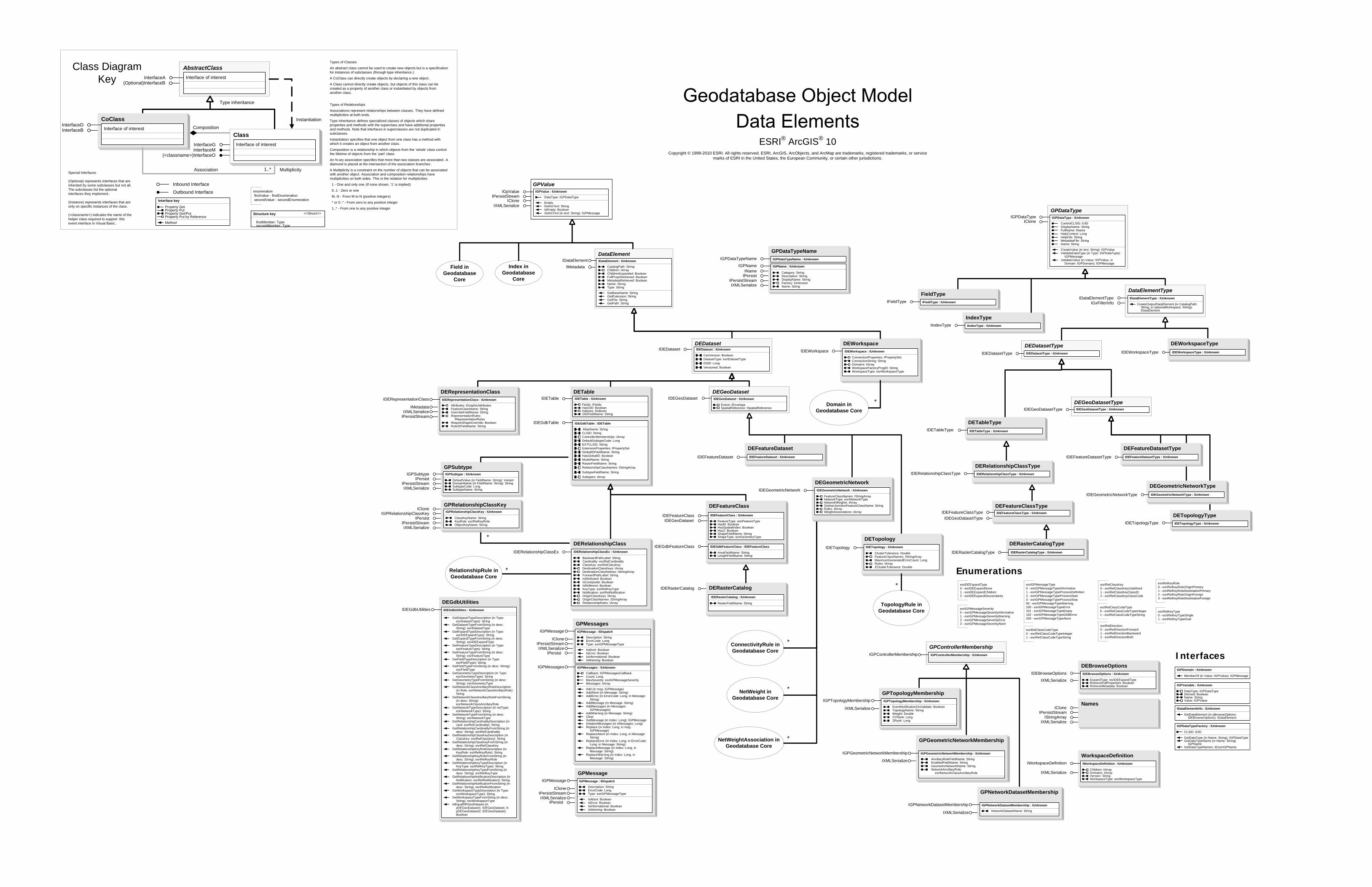
IDEGeoDatasetType
DETable
IDEGdbTable
IDETable IDETable : IUnknown
Fields: IFieldsHasOID: BooleanIndexes: IIndexesOIDFieldName: String
IDEGdbTable : IDETable
AliasName: StringCLSID: StringControllerMemberships: IArrayDefaultSubtypeCode: LongEXTCLSID: StringExtensionProperties: IPropertySet
ModelName: String
RelationshipClassNames: IStringArraySubtypeFieldName: StringSubtypes: IArray
GlobalIDFieldName: StringHasGlobalID: Boolean
RasterFieldName: StringGPSubtype
IGPSubtypeIPersist
IPersistStreamIXMLSerialize
IGPSubtype : IUnknown
DefaultValue (in FieldName: String): VariantDomainName (in FieldName: String): StringSubtypeCode: LongSubtypeName: String
DERelationshipClassIDERelationshipClassEx
DEWorkspaceIDEWorkspace : IUnknown
ConnectionProperties: IPropertySetConnectionString: StringDomains: IArrayWorkspaceFactoryProgID: StringWorkspaceType: esriWorkspaceType
IDEWorkspace
DEFeatureDatasetIDEFeatureDataset IDEFeatureDataset : IUnknown
DEGeometricNetworkIDEGeometricNetwork IDEGeometricNetwork : IUnknown
FeatureClassNames: IStringArrayNetworkType: esriNetworkTypeNetworkWeights: IArrayOrphanJunctionFeatureClassName: StringRules: IArrayWeightAssociations: IArray
DETopologyIDETopology
DEFeatureClass
IDEFeatureClass
IDEGdbFeatureClass
IDEFeatureClass : IUnknown
FeatureType: esriFeatureTypeHasM: BooleanHasSpatialIndex: BooleanHasZ: BooleanShapeFieldName: StringShapeType: esriGeometryType
IDEGdbFeatureClass : IDEFeatureClass
AreaFieldName: StringLengthFieldName: String
DEFeatureDatasetTypeIDEFeatureDatasetType IDEFeatureDatasetType : IUnknown
DEGeometricNetworkTypeIDEGeometricNetworkType IDEGeometricNetworkType : IUnknown
DEFeatureClassTypeIDEFeatureClassType IDEFeatureClassType : IUnknown
IGxFilterInfo
DataElementTypeIDataElementType : IUnknown
CreateOutputDataElement (in CatalogPath: String, in optionalWorkspace: String): IDataElement
IDataElementType
IndexTypeIIndexType IIndexType : IUnknown
FieldTypeIFieldType IFieldType : IUnknown
WorkspaceDefinitionIWorkspaceDefinition IWorkspaceDefinition : IUnknown
Children: IArrayDomains: IArrayVersion: StringWorkspaceType: esriWorkspaceType
IXMLSerialize
DETopologyTypeIDETopologyType IDETopologyType : IUnknown
DEWorkspaceTypeIDEWorkspaceType IDEWorkspaceType : IUnknown
DETableTypeIDETableType IDETableType : IUnknown
DEDatasetTypeIDEDatasetType : IUnknownIDEDatasetType
DEGeoDatasetTypeIDEGeoDatasetType : IUnknownIDEGeoDatasetType
DERelationshipClassTypeIDERelationshipClassType IDERelationshipClassType : IUnknown
DEGeoDatasetIDEGeoDataset : IUnknown
Extent: IEnvelopeSpatialReference: ISpatialReference
IDEGeoDataset
IGPVariable : IUnknown
DataType: IGPDataTypeDerived: BooleanName: StringValue: IGPValue
IDataElementInfo : IUnknown
GetDataElement (in pBrowseOptions: IDEBrowseOptions): IDataElement
IGPDomain : IUnknown
MemberOf (in Value: IGPValue): IGPMessage
Interfaces
RelationshipRule in Geodatabase Core
TopologyRule in Geodatabase Core
*
*
ConnectivityRule in Geodatabase Core
*
NetWeight in Geodatabase Core
NetWeightAssociation in Geodatabase Core
*
*
Domain in Geodatabase Core
*
DEBrowseOptionsIDEBrowseOptions IDEBrowseOptions : IUnknown
ExpandType: esriDEExpandTypeRetrieveFullProperties: BooleanRetrieveMetadata: Boolean
IXMLSerialize
esriDEExpandType0 - esriDEExpandNone1 - esriDEExpandChildren2 - esriDEExpandDescendants
Enumerations
esriGPMessageSeverity0 - esriGPMessageSeverityInformative1 - esriGPMessageSeverityWarning2 - esriGPMessageSeverityError3 - esriGPMessageSeverityAbort
esriRelClassCodeType0 - esriRelClassCodeTypeInteger1 - esriRelClassCodeTypeString
esriRelClassKey0 - esriRelClassKeyUndefined1 - esriRelClassKeyClassID2 - esriRelClassKeyClassCode
esriRelDirection0 - esriRelDirectionForward1 - esriRelDirectionBackward2 - esriRelDirectionBoth
esriRelKeyRole0 - esriRelKeyRoleOriginPrimary1 - esriRelKeyRoleDestinationPrimary2 - esriRelKeyRoleOriginForeign3 - esriRelKeyRoleDestinationForeign
esriRelKeyType0 - esriRelKeyTypeSingle1 - esriRelKeyTypeDual
IDEDataset
DERasterCatalogIDERasterCatalog
IDERasterCatalog : IUnknown
RasterFieldName: String
DEDatasetIDEDataset : IUnknown
DatasetType: esriDatasetTypeDSID: LongVersioned: Boolean
CanVersion: Boolean
NamesIClone
IPersistStreamIStringArray
IXMLSerialize
IDERelationshipClassEx : IUnknown
BackwardPathLabel: StringCardinality: esriRelCardinalityClassKey: esriRelClassKeyDestinationClassKeys: IArrayDestinationClassNames: IStringArrayForwardPathLabel: StringIsAttributed: BooleanIsComposite: BooleanIsReflexive: BooleanKeyType: esriRelKeyTypeNotification: esriRelNotificationOriginClassKeys: IArrayOriginClassNames: IStringArrayRelationshipRules: IArray
*DERasterCatalogType
IDERasterCatalogType IDERasterCatalogType : IUnknownIDETopology : IUnknown
ClusterTolerance: DoubleFeatureClassNames: IStringArrayMaximumGeneratedErrorCount: LongRules: IArrayZClusterTolerance: Double
ESRI® ArcGIS® 10 Copyright © 1999-2010 ESRI. All rights reserved. ESRI, ArcGIS, ArcObjects, and ArcMap are trademarks, registered trademarks, or service
marks of ESRI in the United States, the European Community, or certain other jurisdictions.
Field in Geodatabase
Core
Index in Geodatabase
Core
IMetadata
DataElement
IDEGeoDataset
GPDataTypeNameIGPDataTypeName IGPDataTypeName : IUnknown
IGPNameIName
IPersistIPersistStreamIXMLSerialize
IGPName : IUnknown
Category: StringDescription: StringDisplayName: StringFactory: IUnknownName: String
IGPDataTypeFactory : IUnknown
CLSID: IUID
GetDataType (in Name: String): IGPDataTypeGetDataTypeName (in Name: String):
IGPNameGetDataTypeNames: IEnumGPName
GPNetworkDatasetMembership
IGPNetworkDatasetMembership : IUnknown
NetworkDatasetName: String
IGPNetworkDatasetMembership
IXMLSerialize
GPTopologyMembershipIGPTopologyMembership : IUnknown
EventNotificationOnValidate: BooleanTopologyName: StringWeight: DoubleXYRank: LongZRank: Long
IGPTopologyMembership
IXMLSerialize
GPControllerMembershipIGPControllerMembership : IUnknownIGPControllerMembership
DEGdbUtilitiesIDEGdbUtilities : IUnknown
GetDatasetTypeDescription (in Type: esriDatasetType): String
GetDatasetTypeFromString (in desc: String): esriDatasetType
GetExpandTypeDescription (in Type: esriDEExpandType): String
GetExpandTypeFromString (in desc: String): esriDEExpandType
GetFeatureTypeDescription (in Type: esriFeatureType): String
GetFeatureTypeFromString (in desc: String): esriFeatureType
GetFieldTypeDescription (in Type: esriFieldType): String
GetFieldTypeFromString (in desc: String): esriFieldType
GetGeometryTypeDescription (in Type: esriGeometryType): String
GetGeometryTypeFromString (in desc: String): esriGeometryType
GetNetworkClassAncillaryRoleDescription (in Role: esriNetworkClassAncillaryRole): String
GetNetworkClassAncillaryRoleFromString (in desc: String): esriNetworkClassAncillaryRole
GetNetworkTypeDescription (in netType: esriNetworkType): String
GetNetworkTypeFromString (in desc: String): esriNetworkType
GetRelationshipCardinalityDescription (in card: esriRelCardinality): String
GetRelationshipCardinalityFromString (in desc: String): esriRelCardinality
GetRelationshipClassKeyDescription (in ClassKey: esriRelClassKey): String
GetRelationshipClassKeyFromString (in desc: String): esriRelClassKey
GetRelationshipKeyRoleDescription (in KeyRole: esriRelKeyRole): String
GetRelationshipKeyRoleFromString (in desc: String): esriRelKeyRole
GetRelationshipKeyTypeDescription (in KeyType: esriRelKeyType): String
GetRelationshipKeyTypeFromString (in desc: String): esriRelKeyType
GetRelationshipNotificationDescription (in Notification: esriRelNotification): String
GetRelationshipNotificationFromString (in desc: String): esriRelNotification
GetWorkspaceTypeDescription (in Type: esriWorkspaceType): String
GetWorkspaceTypeFromString (in desc: String): esriWorkspaceType
IsEqualDEGeoDataset (in pDEGeoDataset1: IDEGeoDataset, in pDEGeoDataset2: IDEGeoDataset): Boolean
IDEGdbUtilities
GPMessagesIGPMessage : IDispatch
Description: StringErrorCode: LongType: esriGPMessageType
IsAbort: BooleanIsError: BooleanIsInformational: BooleanIsWarning: Boolean
IGPMessage
ICloneIPersistStreamIXMLSerialize
IGPMessages : IUnknown
Callback: IGPMessagesCallbackCount: LongMaxSeverity: esriGPMessageSeverityMessages: IArray
Add (in msg: IGPMessage)AddAbort (in Message: String)AddError (in ErrorCode: Long, in Message:
String)AddMessage (in Message: String)AddMessages (in Messages:
IGPMessages)AddWarning (in Message: String)ClearGetMessage (in Index: Long): IGPMessageInitializeMessages (in nMessages: Long)Replace (in Index: Long, in msg:
IGPMessage)ReplaceAbort (in Index: Long, in Message:
String)ReplaceError (in Index: Long, in ErrorCode:
Long, in Message: String)ReplaceMessage (in Index: Long, in
Message: String)ReplaceWarning (in Index: Long, in
Message: String)
IGPMessages
IPersist
GPMessageIGPMessage : IDispatch
Description: StringErrorCode: LongType: esriGPMessageType
IsAbort: BooleanIsError: BooleanIsInformational: BooleanIsWarning: Boolean
IGPMessage
ICloneIPersistStreamIXMLSerialize
IPersist
IDataElement : IUnknown
CatalogPath: StringChildren: IArrayChildrenExpanded: BooleanFullPropsRetrieved: BooleanMetadataRetrieved: BooleanName: StringType: String
GetBaseName: StringGetExtension: StringGetFile: StringGetPath: String
IDataElement
GPDataType
ICloneIGPDataType IGPDataType : IUnknown
ControlCLSID: IUIDDisplayName: StringFullName: INameHelpContext: LongHelpFile: StringMetadataFile: StringName: String
CreateValue (in text: String): IGPValueValidateDataType (in Type: IGPDataType):
IGPMessageValidateValue (in Value: IGPValue, in
Domain: IGPDomain): IGPMessage
ICloneIPersistStream
IXMLSerialize
GPValueIGpValue IGPValue : IUnknown
DataType: IGPDataType
EmptyGetAsText: StringIsEmpty: BooleanSetAsText (in text: String): IGPMessage
GPRelationshipClassKeyIClone
IGPRelationshipClassKeyIPersist
IPersistStreamIXMLSerialize
IGPRelationshipClassKey : IUnknown
ClassKeyName: StringKeyRole: esriRelKeyRoleObjectKeyName: String
DERepresentationClassIDERepresentationClass : IUnknown
Attributes: IGraphicAttributesFeatureClassName: StringOverrideFieldName: StringRepresentationRules:
IRepresentationRulesRequireShapeOverride: BooleanRuleIDFieldName: String
IDERepresentationClass
IMetadataIXMLSerialize
IPersistStream
CoClassInterfaceDInterfaceB
Types of Classes
An abstract class cannot be used to create new objects but is a specification for instances of subclasses (through type inheritance.)
A CoClass can directly create objects by declaring a new object .
A Class cannot directly create objects, but objects of this class can be created as a property of another class or instantiated by objects from another class.
Types of Relationships
Associations represent relationships between classes. They have defined multiplicities at both ends.
Type inheritance defines specialized classes of objects which share properties and methods with the superclass and have additional properties and methods. Note that interfaces in superclasses are not duplicated in subclasses.
Instantiation specifies that one object from one class has a method with which it creates an object from another class.
Composition is a relationship in which objects from the 'whole' class control the lifetime of objects from the 'part' class.
An N-ary association specifies that more than two classes are associated . A diamond is placed at the intersection of the association branches .
A Multiplicity is a constraint on the number of objects that can be associated with another object. Association and composition relationships have multiplicities on both sides. This is the notation for multiplicities:
1 - One and only one (if none shown, '1' is implied)
0..1 - Zero or one
M..N - From M to N (positive integers)
* or 0..* - From zero to any positive integer
1..* - From one to any positive integer
Class Diagram Key
enumeration firstValue - firstEnumeration secondValue - secondEnumeration
AbstractClass
Type inheritance
Instantiation
Association
Composition
1..* Multiplicity
Interface of interestInterfaceA(Optional)InterfaceB
Interface of interest
InterfaceGInterfaceM
Outbound Interface
Inbound Interface
Special Interfaces (Optional) represents interfaces that are inherited by some subclasses but not all . The subclasses list the optional interfaces they implement.
(Instance) represents interfaces that are only on specific instances of the class.
(<classname>) indicates the name of the helper class required to support this event interface in Visual Basic.
Interface key
Property GetProperty PutProperty Get/PutProperty Put by ReferenceMethod
(<classname>)InterfaceO
Structure key <<Struct>>
firstMember: TypesecondMember: Type
ClassInterface of interest
esriGPMessageType0 - esriGPMessageTypeInformative1 - esriGPMessageTypeProcessDefinition2 - esriGPMessageTypeProcessStart3 - esriGPMessageTypeProcessStop50 - esriGPMessageTypeWarning100 - esriGPMessageTypeError101 - esriGPMessageTypeEmpty102 - esriGPMessageTypeGDBError200 - esriGPMessageTypeAbort
esriRelClassCodeType0 - esriRelClassCodeTypeInteger1 - esriRelClassCodeTypeString
IXMLSerialize
GPGeometricNetworkMembership
IGPGeometricNetworkMembership : IUnknown
AncillaryRoleFieldName: StringEnabledFieldName: StringGeometricNetworkName: StringNetworkAncillaryRole:
esriNetworkClassAncillaryRole
IGPGeometricNetworkMembership
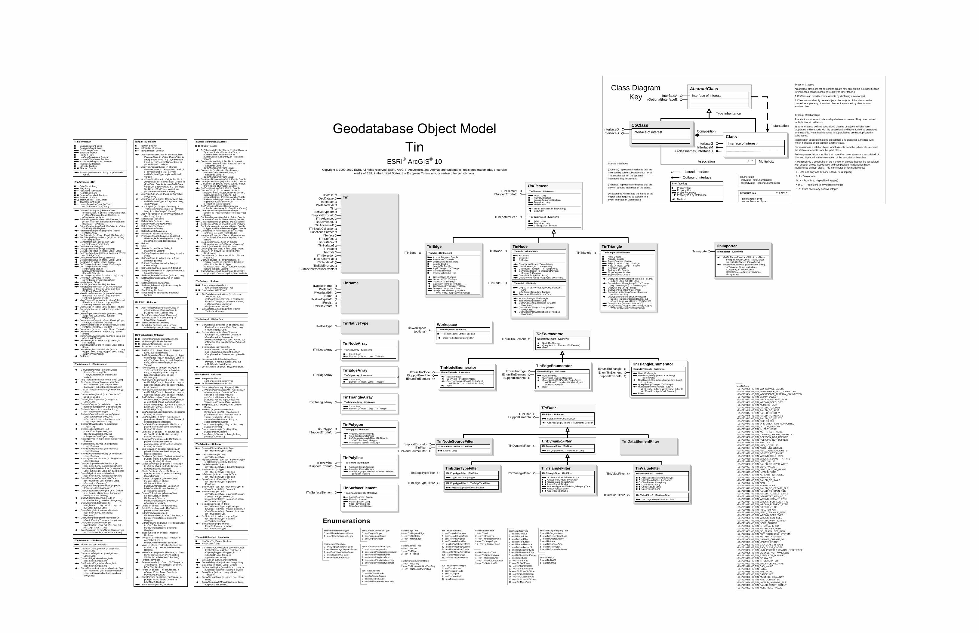
TinDataElementFilter
TinNameIDatasetName
IMetadataIMetadataEdit
INameINativeTypeInfo
IPersistIPersistStream
TinNativeTypeINativeType
ITin : IUnknown
DataEdgeCount: LongDataNodeCount: LongDataTriangleCount: LongExtent: IEnvelopeFields: IFieldsHasEdgeTagValues: BooleanHasNodeTagValues: BooleanHasTriangleTagValues: BooleanIsDelaunay: BooleanIsEmpty: BooleanZFactor: Double
SaveAs (in newName: String, in pOverWrite: Variant)
ITinAdvanced : ITin
EdgeCount: LongFlag: LongFullExtent: IEnvelopeNodeCount: LongProcessCancelled: BooleanSurface: ISurfaceTrackCancel: ITrackCancelTriangleCount: LongUniqueTagValueCount (in Type:
esriTinElementType): Long
ConvertToPolygons (pFeatureClass: IFeatureClass, in pFilter: ITinDynamicFilter, in bStopAtEnforcedEdge: Boolean, in pFieldName: Variant)
ExtractPolygon (in pSeed: ITinElement, in pFilter: ITinFilter, in bStopAtEnforcedEdge: Boolean): ITinPolygon
ExtractPolyline (in pSeed: ITinEdge, in pFilter: ITinFilter): ITinPolyline
FindNaturalNeighbors (in pPoint: IPoint): ITinNodeArray
FindTriangle (in pPoint: IPoint): ITinTriangleFindTriangleNeighborhood (in pPoint: IPoint):
ITinTriangleArrayGenerateUniqueTagValue (in Type:
esriTinElementType): LongGetDataArea: IPolygonGetEdge (in Index: Long): ITinEdgeGetEdgeTagValue (in Index: Long): LongGetEdgeType (in edgeIndex: Long, out pType:
esriTinEdgeType)GetNode (in Index: Long): ITinNodeGetNodeTagValue (in Index: Long): LongGetNodeZ (in Index: Long): DoubleGetTriangle (in Index: Long): ITinTriangleGetTriangleSeeds (in pFilter:
ITinDynamicFilter, in bStopAtEnforcedEdge: Boolean): IEnumTinTriangle
GetTriangleTagValue (in Index: Long): LongGetUniqueTagValues (in Type:
esriTinElementType): ILongArrayInit (in Name: String)IsVoidZ (in Value: Double): BooleanMakeEdgeEnumerator (in pAreaOfInterest:
IEnvelope, in Criteria: Long, in pFilter: ITinFilter): IEnumTinEdge
MakeNodeEnumerator (in pAreaOfInterest: IEnvelope, in Criteria: Long, in pFilter: ITinFilter): IEnumTinNode
MakeTriangleEnumerator (in pAreaOfInterest: IEnvelope, in Criteria: Long, in pFilter: ITinFilter): IEnumTinTriangle
QueryEdge (in Index: Long, pEdge: ITinEdge)QueryEdgeAsLine (in Index: Long, pLine:
ILine)QueryEdgeAsWKSPointZs (in Index: Long,
out pFrom: WKSPointZ, out pTo: WKSPointZ)
QueryNearestEdge (in pPoint: IPoint, pEdge: ITinEdge, pDistance: Double)
QueryNearestNode (in pPoint: IPoint, pNode: ITinNode, pDistance: Double)
QueryNode (in Index: Long, pNode: ITinNode)QueryNodeAsPoint (in Index: Long, pPoint:
IPoint)QueryNodeAsWKSPointZ (in Index: Long, out
pPoint: WKSPointZ)QueryTriangle (in Index: Long, pTriangle:
ITinTriangle)QueryTriangleAsRing (in Index: Long, pRing:
IRing)QueryTriangleAsWKSPointZs (in Index: Long,
out pPi: WKSPointZ, out pPj: WKSPointZ, out pPk: WKSPointZ)
SetEmpty
ISurface : IFunctionalSurface
ZFactor: Double
AsPolygons (pFeatureClass: IFeatureClass, in Type: esriSurfaceConversionType, in pClassBreaks: IDoubleArray, in pClassCodes: ILongArray, in FieldName: Variant)
Contour (in rootHeight: Double, in interval: Double, pFeatureClass: IFeatureClass, in FieldName: String, in digitsAfterDecimalPoint: Long)
ContourList (in pBreaks: IDoubleArray, pFeatureClass: IFeatureClass, in FieldName: String, in digitsAfterDecimalPoint: Long)
GetAspectDegrees (in pPoint: IPoint): DoubleGetAspectRadians (in pPoint: IPoint): DoubleGetContour (in pPoint: IPoint, out ppContour:
IPolyline, out pElevation: Double)GetElevation (in pPoint: IPoint): DoubleGetLineOfSight (in pObserver: IPoint, in
pTarget: IPoint, out ppObstruction: IPoint, out ppVisibleLines: IPolyline, out ppInvisibleLines: IPolyline, out pbIsVisible: Boolean, in bApplyCurvature: Boolean, in bApplyRefraction: Boolean, in pRefractionFactor: Variant)
GetProfile (in pShape: IGeometry, out ppProfile: IGeometry, in pStepSize: Variant)
GetProjectedArea (in referenceHeight: Double, in Type: esriPlaneReferenceType): Double
GetSlopeDegrees (in pPoint: IPoint): DoubleGetSlopePercent (in pPoint: IPoint): DoubleGetSlopeRadians (in pPoint: IPoint): DoubleGetSteepestPath (in pPoint: IPoint): IPolylineGetSurfaceArea (in referenceHeight: Double,
in Type: esriPlaneReferenceType): DoubleGetVolume (in reference: Double, in Type:
esriPlaneReferenceType): DoubleInterpolateShape (in pShape: IGeometry, out
ppOutShape: IGeometry, in pStepSize: Variant)
InterpolateShapeVertices (in pShape: IGeometry, out ppOutShape: IGeometry)
IsVoidZ (in Value: Double): BooleanLocate (in pRay: IRay, in hint: Long): IPointLocateAll (in pRay: IRay, in hint: Long):
IDoubleArrayQueryNormal (in pLocation: IPoint, pNormal:
IVector3D)QueryPixelBlock (in xOrigin: Double, in
yOrigin: Double, in xPixelSize: Double, in yPixelSize: Double, in Type: esriRasterizationType, in valueForNoData: Variant, in block: Variant)
QuerySurfaceLength (in pShape: IGeometry, out pLength: Double, in pStepSize: Variant)
TinNodeArrayITinNodeArray ITinNodeArray : IUnknown
Count: LongElement (in Index: Long): ITinNode
TinPolygon
ISupportErrorInfoITinPolygon ITinPolygon : IUnknown
AsEdges: IEnumTinEdgeAsNodes: IEnumTinNodeAsPolygon (in pNodeFilter: ITinFilter, in
bGetZ: Boolean): IPolygonAsTriangles: IEnumTinTriangle
TinPolyline
ISupportErrorInfoITinPolyline ITinPolyline : IUnknown
AsEdges: IEnumTinEdgeAsNodes: IEnumTinNodeAsPolyline (in pNodeFilter: ITinFilter, in bGetZ:
Boolean): IPolyline
TinSurfaceElementITinSurfaceElement ITinSurfaceElement : IUnknown
AspectDegrees: DoubleElevation: DoubleFaceTagValue: LongNodeTagValue: LongSlopeDegrees: Double
TinTriangleArrayITinTriangleArray ITinTriangleArray : IUnknown
Count: LongElement (in Index: Long): ITinTriangle
TinEnumeratorIEnumTinElement : IUnknown
Next: ITinElementQueryNext (in pElement: ITinElement)Reset
IEnumTinElement
TinNodeEnumerator
IEnumTinElement
IEnumTinNodeISupportErrorInfo
IEnumTinNode : IUnknown
Next: ITinNodeQueryNext (pNode: ITinNode)QueryNextAsWKSPointZ (out pPoint:
WKSPointZ, out pbIsEnd: Boolean)Reset
TinTriangleEnumerator
IEnumTinElementIEnumTinTriangle
ISupportErrorInfo
IEnumTinTriangle : IUnknown
Next: ITinTriangleNextTriangleStrip (in maxSize: Long):
ITinNodeArrayNextTriangleStripIndices (in maxSize: Long):
ILongArrayQueryNext (pTriangle: ITinTriangle)QueryNextAsWKSPointZs (out pPi:
WKSPointZ, out pPj: WKSPointZ, out pPk: WKSPointZ, out pbIsEnd: Boolean)
Reset
TinNodeSourceFilterISupportErrorInfo
ITinFilterITinNodeSourceFilter
ITinNodeSourceFilter : ITinFilter
Criteria: Long
TinEdgeEnumeratorIEnumTinEdge
IEnumTinElementISupportErrorInfo
IEnumTinEdge : IUnknown
Next: ITinEdgeQueryNext (pEdge: ITinEdge)QueryNextAsWKSPointZs (out pFrom:
WKSPointZ, out pTo: WKSPointZ, out pbIsEnd: Boolean)
Reset
TinTriangleITinTriangle ITinTriangle : ITinElement
Area: DoubleArea3D: DoubleAspectDegrees: DoubleEdge (in Index: Long): ITinEdgeNode (in Index: Long): ITinNodePerimeter: DoublePerimeter3D: DoubleSlopeDegrees: DoubleSlopePercent: Double
QueryAdjacentTriangleIndices (out pTi: Long, out pTj: Long, out pTk: Long)
QueryAdjacentTriangles (pTi: ITinTriangle, pTj: ITinTriangle, pTk: ITinTriangle)
QueryAsRing (pRing: IRing)QueryCentroid (pCentroid: IPoint)QueryCircumCircle (pCenter: IPoint, out
pRadius: Double)QueryElevationBand (in zLowerBound:
Double, in zUpperBound: Double, out pCount: Long, out pRegion: WKSPointZ)
QueryNormal (pNormal: IVector3D)QueryVertices (out pPi: WKSPointZ, out pPj:
WKSPointZ, out pPk: WKSPointZ)
TinEdgeITinEdge ITinEdge : ITinElement
AzimuthDegrees: DoubleFromNode: ITinNodeLeftTriangle: ITinTriangleLength: DoubleLength3D: DoubleRightTriangle: ITinTriangleToNode: ITinNodeType: esriTinEdgeType
GetNeighbor: ITinEdgeGetNextCCW: ITinEdgeGetNextCW: ITinEdgeGetNextInTriangle: ITinEdgeGetPreviousInTriangle: ITinEdgeQueryAsLine (pLine: ILine)QueryAsWKSPointZs (out pFrom:
WKSPointZ, out pTo: WKSPointZ)
TinNodeITinNode
ITinNode2
ITinNode : ITinElement
X: DoubleY: DoubleZ: Double
GetAdjacentNodes: ITinNodeArrayGetIncidentEdges: ITinEdgeArrayGetIncidentTriangles: ITinTriangleArrayGetVoronoiRegion (in pClippingPolygon:
IPolygon): IPolygonQueryAsPoint (pPoint: IPoint)QueryAsWKSPointZ (out pPoint: WKSPointZ)
ITinNode2 : ITinNode
Degree (in bEnforcedEdgesOnly: Boolean): Long
IsOnDomainBoundary: BooleanSource: esriTinNodeSourceType
IncidentTriangle: ITinTriangleIncidentTriangleIndex: LongQueryAdjacentNodeIndices (pNodes:
ILongArray)QueryIncidentEdgeIndices (pEdges:
ILongArray)QueryIncidentTriangleIndices (pTriangles:
ILongArray)
TinTriangleFilterITinTriangleFilter ITinTriangleFilter : ITinFilter
ActiveBound: esriTinBoundTypeClassBreakCodes: ILongArrayClassBreaks: IDoubleArrayLowerBound: DoublePropertyType: esriTinTrianglePropertyTypeUniqueValue: DoubleUpperBound: Double
TinValueFilterITinValueFilter
ITinValueFilter2
ITinValueFilter : ITinFilter
ActiveBound: esriTinBoundTypeClassBreakCodes: ILongArrayClassBreaks: ILongArrayLowerBound: LongUniqueValue: LongUpperBound: Long
ITinValueFilter2 : ITinValueFilter
ZeroTagValueExcluded: Boolean
TinEdgeTypeFilterITinEdgeTypeFilter
ITinEdgeTypeFilter2
ITinEdgeTypeFilter : ITinFilter
Type: esriTinEdgeType
ITinEdgeTypeFilter2 : ITinEdgeTypeFilter
RegularEdgesExcluded: Boolean
TinEdgeArrayITinEdgeArray ITinEdgeArray : IUnknown
Count: LongElement (in Index: Long): ITinEdge
TinFilterITinFilter : IUnknown
DataElementsOnly: Boolean
CanPass (in pElement: ITinElement): Boolean
ITinFilterISupportErrorInfo
TinDynamicFilterITinDynamicFilter ITinDynamicFilter : ITinFilter
Init (in pElement: ITinElement): Long
TinElementITinElement : IUnknown
Index: LongIsEmpty: BooleanIsInsideDataArea: BooleanTagValue: LongTheTin: ITin
Init (in pTin: ITin, in Index: Long)SetEmpty
ITinElement
ITinFeatureSeed : IUnknown
Index: LongTagValue: LongUseTagValue: Boolean
ISupportErrorInfo
ITinFeatureSeed
esriTinEdgeType0 - esriTinRegularEdge1 - esriTinSoftEdge2 - esriTinHardEdge
esriTinElementType0 - esriTinNode1 - esriTinEdge2 - esriTinTriangle
esriTinIgnoredElementType1 - esriTinNothing2 - esriTinNodesWithNonZeroTag4 - esriTinNodesWithZeroTag
esriTinNodeSourceType1 - esriTinUnknown2 - esriTinSuperNode4 - esriTinOriginal8 - esriTinDensified32 - esriTinIntersection
esriTinQualification1 - esriTinAll2 - esriTinInsideTin4 - esriTinInsideDataArea8 - esriTinSingleEdge16 - esriTinDoubleEdges
esriTinSelectionType0 - esriTinSelectionNew1 - esriTinSelectionAdd2 - esriTinSelectionSubtract3 - esriTinSelectionFlip
esriTinSurfaceType0 - esriTinContour1 - esriTinHardLine2 - esriTinHardClip3 - esriTinHardErase4 - esriTinHardReplace5 - esriTinHardValueFill6 - esriTinZLessHardLine7 - esriTinZLessHardClip8 - esriTinZLessHardErase9 - esriTinSoftLine10 - esriTinSoftClip11 - esriTinSoftErase12 - esriTinSoftReplace13 - esriTinSoftValueFill14 - esriTinZLessSoftLine15 - esriTinZLessContour16 - esriTinZLessSoftClip17 - esriTinZLessSoftErase18 - esriTinMassPoint
esriTinTrianglePropertyType0 - esriTinDegreeSlope1 - esriTinPercentageSlope2 - esriTinDegreeAspect3 - esriTinArea4 - esriTinSurfaceArea5 - esriTinPerimeter6 - esriTinSurfacePerimeter
esriTinVersion0 - esriTin700011 - esriTin80001
EnumerationsesriSurfaceConversionType0 - esriDegreeSlope1 - esriPercentageSlope2 - esriDegreeAspect
esriTinBoundType0 - esriTinClassBreaks1 - esriTinSimpleBounds2 - esriTinUniqueValue3 - esriTinSimpleBoundsExclude
esriPlaneReferenceType0 - esriPlaneReferenceAbove1 - esriPlaneReferenceBelow
esriRasterizationType0 - esriDegreeSlopeAsRaster1 - esriPercentageSlopeAsRaster2 - esriDegreeAspectAsRaster3 - esriElevationAsRaster4 - esriHillShadeAsRaster
WorkspaceITinWorkspace : IUnknown
IsTin (in Name: String): Boolean
OpenTin (in Name: String): ITin
ITinWorkspace(optional)
ESRI® ArcGIS® 10 Copyright © 1999-2010 ESRI. All rights reserved. ESRI, ArcGIS, ArcObjects, and ArcMap are trademarks, registered trademarks, or service
marks of ESRI in the United States, the European Community, or certain other jurisdictions.
ITinNodeCollection : IUnknown
HasNodeTagValues: BooleanNodeCount: Long
ConvertToVoronoiRegions (pFeatureClass: IFeatureClass, in pFilter: ITinFilter, in pClippingPolygon: IPolygon, in indexFieldName: String, in tagFieldName: String)
GetNode (in Index: Long): ITinNodeGetNodeTagValue (in Index: Long): LongGetNodeZ (in Index: Long): DoubleGetVoronoiRegion (in nodeIndex: Long, in
pClippingPolygon: IPolygon): IPolygonQueryNode (in Index: Long, pNode:
ITinNode)QueryNodeAsPoint (in Index: Long, pPoint:
IPoint)QueryNodeAsWKSPointZ (in Index: Long,
out pPoint: WKSPointZ)
ITinEdit : IUnknown
IsDirty: BooleanIsEditable: BooleanIsInEditMode: Boolean
AddFromFeatureClass (in pFeatureClass: IFeatureClass, in pFilter: IQueryFilter, in pHeightField: IField, in pTagValueField: IField, in Type: esriTinSurfaceType, in pbUseShapeZ: Variant)
AddFromFeatureCursor (in pCursor: IFeatureCursor, in pHeightField: IField, in pTagValueField: IField, in Type: esriTinSurfaceType, in pbUseShapeZ: Variant)
AddFromPixelBlock (in xOrigin: Double, in yOrigin: Double, in xPixelSize: Double, in yPixelSize: Double, in valueForNoData: Variant, in block: Variant, in ZTolerance: Double, in pMaxPoints: Variant, out pbToleranceAchieved: Variant)
AddPointZ (in pPoint: IPoint, in TagValue: Long): Long
AddShape (in pShape: IGeometry, in Type: esriTinSurfaceType, in TagValue: Long, in pZ: Variant)
AddShapeZ (in pShape: IGeometry, in Type: esriTinSurfaceType, in TagValue: Long, in pbUseShapeZ: Variant)
AddWKSPointZ (in pPoint: WKSPointZ, in vlue: Long): Long
DeleteEdgeTagValuesDeleteNode (in Index: Long)DeleteNodesOutsideDataAreaDeleteNodeTagValuesDeleteSelectedNodesDeleteTriangleTagValuesInitNew (in pExtent: IEnvelope)PropagateTriangleTagValue (in pSeed:
ITinTriangle, in newTagValue: Long, in bStopAtEnforcedEdge: Boolean)
RefreshSaveSaveAs (in newName: String, in
pOverWrite: Variant)SetEdgeTagValue (in Index: Long, in Value:
Long)SetEdgeType (in Index: Long, in Type:
esriTinEdgeType)SetNodeTagValue (in Index: Long, in
Value: Long)SetNodeZ (in Index: Long, in Z: Double)SetSpatialReference (in pSpatialReference:
ISpatialReference)SetTriangleInsideDataArea (in Index: Long)SetTriangleOutsideDataArea (in Index:
Long)SetTrianglesInsideDataAreaSetTriangleTagValue (in Index: Long, in
Value: Long)StartEditing: BooleanStopEditing (in bSaveEdits: Boolean):
Boolean
ITinSelection : IUnknown
SelectedElementCount (in Type: esriTinElementType): Long
ClearSelection (in Type: esriTinElementType)
FlipSelection (in Type: esriTinElementType, in bDataElementsOnly: Boolean)
GetSelection (in Type: esriTinElementType): IEnumTinElement
HasSelection (in Type: esriTinElementType): Boolean
IsSelected (in Index: Long, in Type: esriTinElementType): Boolean
QuerySelectionExtent (in Type: esriTinElementType, in pExtent: IEnvelope)
SelectAll (in Type: esriTinElementType, in bDataElementsOnly: Boolean)
SelectByArea (in Type: esriTinElementType, in pArea: IPolygon, in bPassThrough: Boolean, in bDataElementsOnly: Boolean, in action: esriTinSelectionType)
SelectByEnvelope (in Type: esriTinElementType, in pEnvelope: IEnvelope, in bPassThrough: Boolean, in bDataElementsOnly: Boolean, in action: esriTinSelectionType)
SetSelected (in Index: Long, in Type: esriTinElementType, in action: esriTinSelectionType)
SetSelection (in pElements: IEnumTinElement, in action: esriTinSelectionType)
ITinSurface : ISurface
RasterInterpolationMethod: esriSurfaceInterpolationType
SunPosition: WKSPointZ
GetPartialVolumeAndArea (in reference: Double, in Type: esriPlaneReferenceType, in pTriangles: IEnumTinTriangle, in pVolume: Variant, in pSurfaceArea: Variant, in pProjectedArea: Variant)
GetSurfaceElement (in pPoint: IPoint): ITinSurfaceElement
CoClassInterfaceDInterfaceB
Types of Classes
An abstract class cannot be used to create new objects but is a specification for instances of subclasses (through type inheritance.)
A CoClass can directly create objects by declaring a new object .
A Class cannot directly create objects, but objects of this class can be created as a property of another class or instantiated by objects from another class.
Types of Relationships
Associations represent relationships between classes. They have defined multiplicities at both ends.
Type inheritance defines specialized classes of objects which share properties and methods with the superclass and have additional properties and methods. Note that interfaces in superclasses are not duplicated in subclasses.
Instantiation specifies that one object from one class has a method with which it creates an object from another class.
Composition is a relationship in which objects from the 'whole' class control the lifetime of objects from the 'part' class.
An N-ary association specifies that more than two classes are associated . A diamond is placed at the intersection of the association branches .
A Multiplicity is a constraint on the number of objects that can be associated with another object. Association and composition relationships have multiplicities on both sides. This is the notation for multiplicities:
1 - One and only one (if none shown, '1' is implied)
0..1 - Zero or one
M..N - From M to N (positive integers)
* or 0..* - From zero to any positive integer
1..* - From one to any positive integer
Class Diagram Key
enumeration firstValue - firstEnumeration secondValue - secondEnumeration
AbstractClass
Type inheritance
Instantiation
Association
Composition
1..* Multiplicity
Interface of interestInterfaceA(Optional)InterfaceB
Interface of interest
InterfaceGInterfaceM
Outbound Interface
Inbound Interface
Special Interfaces (Optional) represents interfaces that are inherited by some subclasses but not all . The subclasses list the optional interfaces they implement.
(Instance) represents interfaces that are only on specific instances of the class.
(<classname>) indicates the name of the helper class required to support this event interface in Visual Basic.
Interface key
Property GetProperty PutProperty Get/PutProperty Put by ReferenceMethod
(<classname>)InterfaceO
Structure key <<Struct>>
firstMember: TypesecondMember: Type
ClassInterface of interest
TinIDatasetIGeoDataset
IMetadataIMetadataEdit
ITinINativeTypeInfo
ISupportErrorInfoITinAdvanced
ITinAdvanced2ITinAdvanced3
ITinNodeCollectionIFunctionalSurface
ISurfaceITinSurface
ITinSurface2ITinSurface3
ITinEditITinEdit2
ITinSelectionITinFeatureEdit
ITinNodeInfoITinEditErrorLog
ISurfaceIntersectionEvents
ITinAdvanced2 : ITinAdvanced
ConvertToPolylines (pFeatureClass: IFeatureClass, in pFilter: ITinDynamicFilter, in pFieldName: Variant)
FindTriangleIndex (in pPoint: IPoint): LongGetCountedUniqueTagValues (in Type:
esriTinElementType, out ppValues: ILongArray, out ppCounts: ILongArray)
GetLeftTriangleIndex (in edgeIndex: Long): Long
GetNaturalNeighborZ (in X: Double, in Y: Double): Double
GetNeighborEdgeIndex (in edgeIndex: Long): Long
GetNodeDegree (in nodeIndex: Long, in bEnforcedEdgesOnly: Boolean): Long
GetNodeSource (in nodeIndex: Long): esriTinNodeSourceType
GetNodeSourceCounts (out pcOriginal: Long, out pcSuper: Long, out pcDensified: Long, out pcIntersection: Long, out pcUnknown: Long)
GetRightTriangleIndex (in edgeIndex: Long): Long
GetSpecialEdgeCounts (out pcHardDataEdges: Long, out pcSoftDataEdges: Long, out pcTagValueDataEdges: Long)
HasEdgeType (in Type: esriTinEdgeType): Boolean
IsEdgeInsideDataArea (in edgeIndex: Long): Boolean
IsNodeInsideDataArea (in nodeIndex: Long): Boolean
IsNodeOnDomainBoundary (in nodeIndex: Long): Boolean
IsTriangleInsideDataArea (in triangleIndex: Long): Boolean
QueryAllEdgeIndicesAroundNode (in nodeIndex: Long, pEdges: ILongArray)
QueryBeginEndNodeIndices (in edgeIndex: Long, out pBegin: Long, out pEnd: Long)
QueryEdgeIndicesAroundNode (in nodeIndex: Long, pEdges: ILongArray)
QueryElementAsGeometry (in Type: esriTinElementType, in Index: Long, pGeometry: IGeometry)
QueryNaturalNeighborIndices (in pPoint: IPoint, pNodes: ILongArray)
QueryNeighborsAndWeights (in X: Double, in Y: Double, pNeighbors: ILongArray, pWeights: IDoubleArray)
QueryNodeIndicesAroundNode (in nodeIndex: Long, pNodes: ILongArray)
QueryTriangleEdgeIndices (in triangleIndex: Long, out pA: Long, out pB: Long, out pC: Long)
QueryTriangleIndicesAroundNode (in nodeIndex: Long, pTriangles: ILongArray)
QueryTriangleNeighborhoodIndices (in pPoint: IPoint, pTriangles: ILongArray)
QueryTriangleNodeIndices (in triangleIndex: Long, out pA: Long, out pB: Long, out pC: Long)
SaveAsVersion (in newName: String, in ver: esriTinVersion, in pOverWrite: Variant)
ITinAdvanced3 : IUnknown
TinVersion: esriTinVersion
GetNextCCWEdgeIndex (in edgeIndex: Long): Long
GetNextCWEdgeIndex (in edgeIndex: Long): Long
GetNextEdgeIndexInTriangle (in edgeIndex: Long): Long
GetPreviousEdgeIndexInTriangle (in edgeIndex: Long): Long
QueryElementIndicesAroundNode (in Type: esriTinElementType, in localNodeIndex: Long, in triangleIndex: Long, pIndices: ILongArray)
ITinEdit2 : IUnknown
AddFrom3dMultipointFeatureClass (in pFeatureClass: IFeatureClass, in pClippingFilter: ISpatialFilter)
ResetExtent (in pExtent: IEnvelope)SaveSnapshot (in Name: String, in
bOverWrite: Boolean)SetToConstrainedDelaunaySwapEdge (in Index: Long, in Type:
esriTinEdgeType, in Tag: Long): Long
ITinSurface2 : ITinSurface
ConvertToMultiPatches (in pFeatureClass: IFeatureClass, in maxPatchSize: Long, in maxStripSize: Long)
DecimateNodes (in pAreaOfInterest: IEnvelope, in ZTolerance: Double, in bCopyBreakline: Boolean, in pMaxRemainingNodeCount: Variant, out ppNewTin: ITin, in pbToleranceAchieved: Variant)
DecimateNodesByCount (in pAreaOfInterest: IEnvelope, in maxRemainingNodeCount: Long, in bCopyBreakline: Boolean, out ppNewTin: ITin)
InterpolateAsMultiPatch (in pShape: IPolygon, in maxStripSize: Long, out ppMultiPatch: IMultiPatch)
LocateMultiple (in pRay: IRay): IMultipoint
TinImporterITinImporter : IUnknown
GetTinNamesFromLandXML (in xmlName: String, in pTrackCancel: ITrackCancel, out ppOutTinNames: IStringArray)
ImportFromLandXML (in xmlName: String, in TinName: String, in pIndices: ILongArray, in pTrackCancel: ITrackCancel, out ppOutTinNames: IStringArray)
ITinImporter
esriSurfaceInterpolationType0 - esriLinearInterpolation1 - esriNaturalNeighborInterpolation2 - esriNaturalNeighborZmin3 - esriNaturalNeighborZmax4 - esriNaturalNeighborZaverage5 - esriNaturalNeighborZnearest
esriTinError-2147219456 - E_TIN_WORKSPACE_EXISTS-2147219455 - E_TIN_WORKSPACE_NOT_CONNECTED-2147219454 - E_TIN_WORKSPACE_ALREADY_CONNECTED-2147219453 - E_TIN_EMPTY_OBJECT-2147219452 - E_TIN_WRONG_DATASET_TYPE-2147219451 - E_TIN_WRONG_TOPOLOGY-2147219450 - E_TIN_NUMERIC_LIMIT-2147219449 - E_TIN_FAILED_TO_OPEN-2147219448 - E_TIN_FAILED_TO_SAVE-2147219447 - E_TIN_FAILED_TO_COPY-2147219446 - E_TIN_FAILED_TO_RENAME-2147219445 - E_TIN_FAILED_TO_DELETE-2147219444 - E_TIN_FILE_EXISTS-2147219443 - E_TIN_OPERATION_NOT_SUPPORTED-2147219442 - E_TIN_OUT_OF_MEMORY-2147219441 - E_TIN_IN_EDIT_MODE-2147219440 - E_TIN_NOT_IN_EDIT_MODE-2147219439 - E_TIN_CANNOT_CREATE_GEOMETRY-2147219438 - E_TIN_POLYGON_NOT_DEFINED-2147219437 - E_TIN_POLYLINE_NOT_DEFINED-2147219436 - E_TIN_HAS_VOID_Z-2147219435 - E_TIN_HAS_NO_VALUE-2147219434 - E_TIN_NODE_UNDELETABL-2147219433 - E_TIN_FIELD_ALREADY_EXISTS-2147219432 - E_TIN_OBJECT_NOT_EMPTY-2147219431 - E_TIN_WRONG_FIELD_TYPE-2147219430 - E_TIN_WRONG_GEOMETRY_TYPE-2147219429 - E_TIN_NEED_VALUE-2147219428 - E_TIN_FAILED_TO_OVER_WRITE-2147219427 - E_TIN_ZERO_VALUE-2147219426 - E_TIN_INDEX_OUT_OF_RANGE-2147219425 - E_TIN_INVALID_NAME-2147219424 - E_TIN_ALREADY_INITIALIZED-2147219423 - E_TIN_MEMORY_TIN-2147219422 - E_TIN_FAILED_TO_SWAP-2147219421 - E_TIN_NAN-2147219420 - E_TIN_SUPER_NODE-2147219419 - E_TIN_FAILED_TO_CREATE_FILE-2147219418 - E_TIN_FAILED_TO_OPEN_FILE-2147219417 - E_TIN_FAILED_TO_DELETE_FILE-2147219416 - E_TIN_GEOMETRY_HAS_NO_Z-2147219415 - E_TIN_WRONG_VARIANT_TYPE-2147219414 - E_TIN_WRONG_SURFACE_TYPE-2147219413 - E_TIN_WRONG_ELEMENT_TYPE-2147219412 - E_TIN_DIFFERENT_TIN-2147219411 - E_TIN_FIELD_ERROR-2147219410 - E_TIN_NEED_TRIANGLE_SEED-2147219409 - E_TIN_WRONG_SEED_TYPE-2147219408 - E_TIN_WRONG_GEN_SEED-2147219407 - E_TIN_FAILED_UPDATE_SEED-2147219406 - E_TIN_NODE_SHARED-2147219405 - E_TIN_INTERNAL_ERROR-2147219404 - E_TIN_FILTER_REQUIRED-2147219403 - E_TIN_NO_SPATIALREF_INFO-2147219402 - E_TIN_NOT_PROJECTED_SYSTEM-2147219401 - E_TIN_METADATA_ERROR-2147219400 - E_TIN_CANNOT_CREATE_OBJ-2147219399 - E_TIN_UPDATE_ERROR-2147219398 - E_TIN_BAD_CLASS_BREAKS-2147219397 - E_TIN_BAD_CLASS_CODES-2147219396 - E_TIN_UNSUPPORTED_SPATIAL_REFERENCE-2147219395 - E_TIN_LICENSE_NOT_AVAILABLE-2147219394 - E_TIN_EXTENSION_DISABLED-2147219393 - E_TIN_BELOW_V8-2147219392 - E_TIN_IN_MEMORY_EDIT-2147219391 - E_TIN_WRONG_EDGE_TYPE-2147219390 - E_TIN_BAD_VALUE-2147219389 - E_TIN_FATAL-2147219388 - E_TIN_FDS_FATAL-2147219387 - E_TIN_CANCELLED-2147219386 - E_TIN_MUST_BE_DELAUNAY-2147219385 - E_TIN_XML_CORRUPTED-2147219384 - E_TIN_INVALID_LANDXML_FILE-2147219383 - E_TIN_FAILED_RESET_EXTENT-2147219382 - E_TIN_NULL_FIELD_VALUE
esriTinNodeEditInfo1 - esriTinNodeUnknown2 - esriTinNodeSuperNode4 - esriTinNodeOriginal8 - esriTinNodeDensified16 - esriTinNodeLineEnforce32 - esriTinNodeIntersection64 - esriTinNodeLineTouch128 - esriTinNodeCoincident256 - esriTinNodeSnap512 - esriTinNodeModified
ITinFeatureEdit : IUnknown
ElementsIgnoredInConflictTest: LongIsInMemoryEditMode: BooleanStopAtEnforcedEdge: BooleanStopAtJuncture: Boolean
AddPointZ (in pPoint: IPoint, in TagValue: Long, pSeed: ITinNode)
AddPolygon (in pShape: IPolygon, in Type: esriTinEdgeType, in TagValue: Long, in edgeTagValue: Long, in NodeTagValue: Long, pSeed: ITinTriangle, in pZ: Variant)
AddPolygonZ (in pShape: IPolygon, in Type: esriTinEdgeType, in TagValue: Long, in edgeTagValue: Long, in NodeTagValue: Long, pSeed: ITinTriangle)
AddPolyline (in pShape: IPolyline, in Type: esriTinEdgeType, in TagValue: Long, in NodeTagValue: Long, pSeed: ITinEdge, in pZ: Variant)
AddPolylineZ (in pShape: IPolyline, in Type: esriTinEdgeType, in TagValue: Long, in NodeTagValue: Long, pSeed: ITinEdge)
AddPolyObjects (in pFeatureClass: IFeatureClass, in pFilter: IQueryFilter, in pHeightField: IField, in pValueField: IField, in bSetEdgeTagValue: Boolean, in bSetNodeTagValue: Boolean, in Type: esriTinEdgeType)
CanAdd (in pShape: IGeometry, in spacing: Double): Boolean
CanAddVertex (in pPoly: IGeometry, in pNewPoint: IPoint, in bClose: Boolean, in spacing: Double): Boolean
CanDeleteVertex (in pNode: ITinNode, in pSeed: ITinFeatureSeed, in spacing: Double): Boolean
CanMove (in pSeed: ITinFeatureSeed, in dx: Double, in dy: Double, spacing: Double): Boolean
CanMoveVertex (in pNode: ITinNode, in pSeed: ITinFeatureSeed, in pNewLocation: WKSPoint, in spacing: Double): Boolean
CanReplace (in pShape: IGeometry, in pSeed: ITinFeatureSeed, in spacing: Double): Boolean
CanRotate (in pSeed: ITinFeatureSeed, in pOrigin: IPoint, in Angle: Double, in spacing: Double): Boolean
CanScalePolygon (in pSeed: ITinTriangle, in pOrigin: IPoint, in Scale: Double, in spacing: Double): Boolean
ClusterPoints (in pSeed: ITinNode, in spacing: Double, in pFilter: ITinFilter): IEnumTinNode
ConvertToPolygons (pFeatureClass: IFeatureClass, in pFilter: ITinDynamicFilter, in bStopAtEnforcedEdge: Boolean, in bSkipDensifiedNodes: Boolean, in pFieldName: Variant)
ConvertToPolylines (pFeatureClass: IFeatureClass, in pFilter: ITinDynamicFilter, in bSkipDensifiedNodes: Boolean, in pFieldName: Variant)
Delete (in pSeed: ITinFeatureSeed)DeleteVertex (in pNode: ITinNode, in
pSeed: ITinFeatureSeed)ExtractPolygon (in pSeed:
ITinFeatureSeed, in bGetZ: Boolean, in bSkipDensifiedNodes: Boolean): IPolygon
ExtractPolyline (in pSeed: ITinFeatureSeed, in bGetZ: Boolean, in bSkipDensifiedNodes: Boolean): IPolyline
IsNodeShared (in pNode: ITinNode): Boolean
Merge (in pCommonEdge: ITinEdge, in newValue: Long, in bKeepCommonNodes: Boolean)
Move (in pSeed: ITinFeatureSeed, in dx: Double, in dy: Double, in bGetNewZ: Boolean)
MoveVertex (in pNode: ITinNode, in pSeed: ITinFeatureSeed, in pNewLocation: WKSPoint, in bGetNewZ: Boolean)
RefreshTagValuesRemoveIslands (in pSeed: ITinTriangle, in
Area: Double, bKeepNodes: Boolean, bZeroTag: Boolean)
Rotate (in pSeed: ITinFeatureSeed, in pOrigin: IPoint, Angle: Double, in bGetNewZ: Boolean)
ScalePolygon (in pSeed: ITinTriangle, in pOrigin: IPoint, Scale: Double, in bGetNewZ: Boolean)
StartInMemoryEditing: Boolean
ITinSurface3 : IUnknown
InterpolationMethod: esriSurfaceInterpolationType
ProfileWeedTolerance: Double
Extract (in pBoundary: IPolygon): ITinGetVolumeAndArea (in pAOI: IGeometry, in
referenceHeight: Double, in Type: esriPlaneReferenceType, out pbIsOutsideDataArea: Boolean, in pVolume: Variant, in pSurfaceArea: Variant, in pProjectedArea: Variant)
InterpolateZ (in X: Double, in Y: Double): Double
Intersect (in pReferenceSurface: ITinSurface, in pAOI: IGeometry, in pOutFeatureClass: IFeatureClass, in volumeFieldName: String, in surfaceAreaFieldName: String, in codeFieldName: String)
QueryLocate (in pRay: IRay, in hint: Long, pLocation: IPoint)
QueryLocateMultiple (in pRay: IRay, pLocations: IMultipoint)
QueryTriangleNormal (in Triangle: Long, pNormal: IVector3D)

IPersist
IPersistStream
ReplicaDatasetIReplicaDataset IReplicaDataset : IUnknown
DatasetID: LongName: StringParentDatabase: StringParentOwner: StringReplicaID: LongType: esriDatasetType
ReplicaIReplica IReplica : IUnknown
ConnectionInfo: IWorkspaceNameDescription: IReplicaDescriptionName: StringOwner: StringParentID: LongReplicaDatasets: IEnumReplicaDatasetReplicaDate: DoubleReplicaGuid: StringReplicaID: LongReplicaRole: esriReplicaTypeVersion: String
IReplicaEdit
WorkspaceIWorkspaceReplicas
IWorkspaceReplicaDatasets
IWorkspaceReplicasAdmin
ReplicaDescriptionIReplicaDescription
IReplicaFilterDescription
IReplicaFilterDescriptionEdit
IReplicaDescription : IUnknown
DatasetNames: IEnumNameIsPrivateTable (in Index: Long): BooleanReplicaModelType: esriReplicaModelTypeTableExcluded (in Index: Long): BooleanTableName (in Index: Long): INameTableNameCount: Long
AddDatasetNames (in DatasetNames: IEnumName)
FindTable (in DatasetName: IName): LongInit (in enumNames: IEnumName, in
OutputWSName: IWorkspaceName, in ReuseSchema: Boolean, in deType: esriDataExtractionType)
IReplicaFilterDescription : IUnknown
Geometry: IGeometryRowsType (in Index: Long): esriRowsTypeSpatialRelation: esriSpatialRelEnumTableDefQuery (in Index: Long): StringTableSelection (in Index: Long): ISelectionSetTableUsesDefQuery (in Index: Long): Boolean
TableUsesQueryGeometry (in Index: Long): Boolean
TableUsesSelection (in Index: Long): Boolean
IReplicaFilterDescriptionEdit : IUnknown
Geometry: IGeometryRowsType (in Index: Long): esriRowsTypeSpatialRelation: esriSpatialRelEnumTableDefQuery (in Index: Long): StringTableSelection (in Index: Long): ISelectionSetTableUsesDefQuery (in Index: Long): Boolean
TableUsesQueryGeometry (in Index: Long): Boolean
TableUsesSelection (in Index: Long): Boolean
IWorkspaceReplicas : IUnknown
ReplicaByGuid (in ReplicaGuid: String): IReplica
ReplicaByID (in ReplicaID: Long): IReplicaReplicaByName (in replicaName: String):
IReplicaReplicas: IEnumReplica
RefreshReplicas
IReplicaEdit : IUnknown
ConnectionInfo: IWorkspaceNameDescription: IReplicaDescriptionName: StringOwner: StringParentID: LongReplicaDatasets: IEnumReplicaDatasetReplicaDate: DoubleReplicaGuid: StringReplicaID: LongReplicaRole: esriReplicaTypeVersion: String
Init (in otherReplica: IReplica)
IReplicaDescriptionExtensionManager : IUnknown
Extension (in Index: Long): IReplicaDescriptionExtension
ExtensionCount: Long
FindExtension (in pGUID: IUID): LongRegisterExtension (in rdExtension:
IReplicaDescriptionExtension)UnRegisterExtension (in pGUID: IUID)
IReplicaDescriptionExtensionManager
ReplicaDescriptionExtensionIReplicaDescriptionExtension IReplicaDescriptionExtension : IUnknown
GUID: IUIDName: String
Distributed Geodatabase Core Objects
DataConverter Objects
esriDataConverterError0 - S_DATACONVERTER_OK513 - E_DATACONVERTER_OPENFEATURECLASSFAILED514 - E_DATACONVERTER_OPENTABLEFAILED515 - E_DATACONVERTER_OPENFEATUREDATASETFAILED516 - E_DATACONVERTER_OPENFEATUREWORKSPACEFAILED517 - E_DATACONVERTER_CREATEFEATURECLASSFAILED518 - E_DATACONVERTER_CREATETABLEFAILED519 - E_DATACONVERTER_WRITEFEATURESFAILED520 - E_DATACONVERTER_WRITEROWSFAILED521 - E_DATACONVERTER_UNLOADFAILED522 - E_DATACONVERTER_OPENCURSORFAILED523 - E_DATACONVERTER_OPENINSERTCURSORFAILED524 - E_DATACONVERTER_INSERTCURSORFAILED525 - E_DATACONVERTER_CANCELLED526 - E_DATACONVERTER_MATCHINPUTFIELDSETFAILED527 - E_DATACONVERTER_FLUSHINSERTCURSORFAILED528 - E_DATACONVERTER_ACQUIRESCHEMALOCKFAILED529 - E_DATACONVERTER_INVALID_INPUT_DATASET_NAME530 - E_DATACONVERTER_CANNOT_CREATE_FEATURE_DATASET531 - E_DATACONVERTER_ERROR_READ_ROWS532 - E_DATACONVERTER_ERROR_READ_ALL_ROWS
Enumerations
EnumFieldErrorIEnumFieldError IEnumFieldError : IUnknown
Next: IFieldErrorReset
FieldError IFieldError: IUnknown
FieldError: esriFieldNameErrorTypeFieldIndex: Long
IFieldError
InvalidObjectInfo IInvalidObjectInfo: IUnknown
ErrorDescription: StringInvalidObjectID: Long
IInvalidObjectInfo
EnumInvalidObjectIEnumInvalidObject IEnumInvalidObject : IUnknown
Next: IInvalidObjectInfoReset
GeoDBDataTransferIGeoDBDataTransfer IGeoDBDataTransfer : IUnknown
GenerateNameMapping (in from: IEnumName, in toName: IName, out to: IEnumNameMapping): Boolean
NumberObjectsToTransfer (in from: IEnumNameMapping): Long
Transfer (in from: IEnumNameMapping, in toName: IName)
IConnectionPointContainerIFeatureProgress
SimpleDataConverterISimpleDataConverter ISimpleDataConverter : IUnknown
ConfigurationKeyword: StringFlushInterval: LongInputDatasetName: IDatasetNameInputQueryFilter: IQueryFilterIsFeatureTypeSimple: BooleanOutputDatasetName: IDatasetNameOutputFeatureDatasetName:
IFeatureDatasetNameOutputFields: IFieldsOutputGeometryDef: IGeometryDefParentWindowHandle: OLE_HANDLE
Convert: IEnumInvalidObjectReset
IConnectionPointContainerIFeatureProgressISupportErrorInfo
ISimpleDataConverter2 ISimpleDataConverter2 : ISimpleDataConverter
DataConvertProcess: IDataConvertProcessInputSelectionSet: ISelectionSet
EnumerationsesriRowsType0 - esriRowsTypeNone1 - esriRowsTypeAll2 - esriRowsTypeFilter
esriReplicaType1 - esriReplicaTypeChild2 - esriReplicaTypeParent4 - esriCheckOutTypeChild8 - esriCheckOutTypeParent15 - esriReplicaTypeAny
esriReplicaModelType1 - esriModelTypeSimple2 - esriModelTypeFullGeodatabase
CoClassInterfaceDInterfaceB
Types of Classes
An abstract class cannot be used to create new objects but is a specification for instances of subclasses (through type inheritance.)
A CoClass can directly create objects by declaring a new object .
A Class cannot directly create objects, but objects of this class can be created as a property of another class or instantiated by objects from another class.
Types of Relationships
Associations represent relationships between classes. They have defined multiplicities at both ends.
Type inheritance defines specialized classes of objects which share properties and methods with the superclass and have additional properties and methods. Note that interfaces in superclasses are not duplicated in subclasses.
Instantiation specifies that one object from one class has a method with which it creates an object from another class.
Composition is a relationship in which objects from the 'whole' class control the lifetime of objects from the 'part' class.
An N-ary association specifies that more than two classes are associated . A diamond is placed at the intersection of the association branches .
A Multiplicity is a constraint on the number of objects that can be associated with another object. Association and composition relationships have multiplicities on both sides. This is the notation for multiplicities:
1 - One and only one (if none shown, '1' is implied)
0..1 - Zero or one
M..N - From M to N (positive integers)
* or 0..* - From zero to any positive integer
1..* - From one to any positive integer
Class Diagram Key
enumeration firstValue - firstEnumeration secondValue - secondEnumeration
AbstractClass
Type inheritance
Instantiation
Association
Composition
1..* Multiplicity
Interface of interestInterfaceA(Optional)InterfaceB
Interface of interest
InterfaceGInterfaceM
Outbound Interface
Inbound Interface
Special Interfaces (Optional) represents interfaces that are inherited by some subclasses but not all . The subclasses list the optional interfaces they implement.
(Instance) represents interfaces that are only on specific instances of the class.
(<classname>) indicates the name of the helper class required to support this event interface in Visual Basic.
Interface key
Property GetProperty PutProperty Get/PutProperty Put by Reference
Method
(<classname>)InterfaceO
Structure key <<Struct>>
firstMember: TypesecondMember: Type
ClassInterface of interest
ESRI® ArcGIS® 10 Copyright © 1999-2010 ESRI. All rights reserved. ESRI, ArcGIS, ArcObjects, and ArcMap are trademarks, registered trademarks, or service
marks of ESRI in the United States, the European Community, or certain other jurisdictions.
esriFieldNameErrorType0 - esriNoFieldError1 - esriSQLReservedWord2 - esriDuplicatedFieldName3 - esriInvalidCharacter4 - esriInvalidFieldNameLength
NameMapping
INameMapping2 : INameMapping
ConfigKeyword: StringCreated: Boolean
INameMapping2
INameMapping : IUnknown
Children: IEnumNameMappingConfigKeyword: StringNameConflicts: BooleanSourceObject: IUnknownTargetName: String
GetSuggestedName (in toName: IName): String
ValidateTargetName (in toName: IName)
INameMapping
EnumNameMappingIEnumNameMapping : IUnknown
FindDatasetName (in Name: String, in Type: esriDatasetType): INameMapping
FindDomain (in Name: String): INameMapping
Next: INameMappingReset
IEnumNameMapping
Interfaces
esriDataExtractionType1 - esriDataExtraction2 - esriDataCheckOut3 - esriDataReplication4 - esriDataXMLExport5 - esriDataXMLCheckOut6 - esriDataXMLExtraction7 - esriDataXMLReplication8 - esriRegisterXMLCheckOut9 - esriRegisterCheckOut10 - esriRegisterXMLReplica11 - esriRegisterReplica
IFeatureProgress
FeatureDataConverterIFeatureDataConverter : IUnknown
ConvertFeatureClass (in InputDatasetName: IFeatureClassName, in InputQueryFilter: IQueryFilter, in outputFDatasetName: IFeatureDatasetName, in outputFClassName: IFeatureClassName, in OutputGeometryDef: IGeometryDef, in OutputFields: IFields, in configKey: String, in FlushInterval: Long, in parentHWND: OLE_HANDLE): IEnumInvalidObject
ConvertFeatureDataset (in inputFDatasetName: IFeatureDatasetName, in outputFDatasetName: IFeatureDatasetName, in OutputGeometryDef: IGeometryDef, in configKey: String, in FlushInterval: Long, in parentHWND: OLE_HANDLE)
ConvertTable (in InputDatasetName: IDatasetName, in InputQueryFilter: IQueryFilter, in OutputDatasetName: IDatasetName, in OutputFields: IFields, in configKey: String, in FlushInterval: Long, in parentHWND: OLE_HANDLE): IEnumInvalidObject
IFeatureDataConverter
ISupportErrorInfoIConnectionPointContainer
IFeatureDataConverter2 : IUnknown
ConvertFeatureClass (in inputFClassName: IDatasetName, in InputQueryFilter: IQueryFilter, in InputSelectionSet: ISelectionSet, in outputFDatasetName: IFeatureDatasetName, in outputFClassName: IFeatureClassName, in OutputGeometryDef: IGeometryDef, in OutputFields: IFields, in configKey: String, in FlushInterval: Long, in parentHWND: OLE_HANDLE): IEnumInvalidObject
ConvertFeatureDataset (in inputFDatasetName: IFeatureDatasetName, in outputFDatasetName: IFeatureDatasetName, in OutputGeometryDef: IGeometryDef, in configKey: String, in FlushInterval: Long, in parentHWND: OLE_HANDLE)
ConvertTable (in InputDatasetName: IDatasetName, in InputQueryFilter: IQueryFilter, in InputSelectionSet: ISelectionSet, in OutputDatasetName: IDatasetName, in OutputFields: IFields, in configKey: String, in FlushInterval: Long, in parentHWND: OLE_HANDLE): IEnumInvalidObject
IFeatureDataConverter2
ISqlKeywordDictionary : IUnknown
Count: LongName: String
Add (in reservedWord: String)EmptyFindKeyword (in keyword: String): BooleanRemove (in reservedWord: String)Reset
FieldCheckerIFieldChecker : IUnknown
InputWorkspace: IWorkspaceValidateDictionary: ISqlKeywordDictionaryValidateWorkspace: IWorkspace
Validate (in inputField: IFields, out error: IEnumFieldError, out fixedFields: IFields)
ValidateField (in FieldIndex: Long, in inputFields: IFields, out error: IEnumFieldError, out fixedFields: IFields)
ValidateTableName (in TableName: String, out fixedName: String): Long
IFieldChecker
IWorkspaceReplicas2 : IWorkspaceReplicas
RefreshReplica (in ReplicaGuid: String)
IWorkspaceReplicas2
IWorkspaceReplicasAdmin2 : IWorkspaceReplicasAdmin
IsReferencedByReplica (in DatasetType: esriDatasetType, in DatasetID: Long): Boolean
AlterReplica2 (in Replica: IReplica, in PersistParentUserInfo: Boolean)
CanRegisterReplicaDataset (in ReplicaDataset: IReplicaDataset, in Replica: IReplica): Boolean
CanUnregisterReplicaDataset (in ReplicaDataset: IReplicaDataset): Boolean
RegisterReplicaDataset (in RDataset: IReplicaDataset, in filter: esriRowsType, in UseGeometry: Boolean, in QueryDef: String, in pSelID: IFIDSet, in pToReplica: IReplica)
UnregisterReplicaDataset (in ReplicaDataset: IReplicaDataset, in Replica: IReplica)
IWorkspaceReplicasAdmin2
IWorkspaceReplicasAdmin3 : IWorkspaceReplicasAdmin2
ReplicasByDataset (in DatasetType: esriDatasetType, in DatasetID: Long): ILongArray
IWorkspaceReplicasAdmin3
IWorkspaceReplicasAdmin : IUnknown
AlterReplica (in Replica: IReplica)RegisterReplica (in Replica: IReplica): LongUnregisterReplica (in Replica: IReplica, in
removeCOVersion: Boolean)
IWorkspaceReplicaDatasets : IUnknown
ReplicaDatasetsByID (in ReplicaID: Long): IEnumReplicaDataset
ReplicaDatasetsByName (in replicaName: String): IEnumReplicaDataset
IReplica2 : IReplica
AccessType: esriReplicaAccessTypeAllReplicaDatasets: IEnumReplicaDatasetHasConflicts: BooleanLog: IEnumReplicaLogMyGenerationNumber: LongReconcilePolicyType:
esriReplicaReconcilePolicyTypeReplicaReceivingVersion: StringReplicaState: esriReplicaStateSibConnectionString: StringSibGenerationNumber: LongSibMyGenNumber: Long
Init2 (in GPReplica: IGPReplica, in TargetWorkspace: IWorkspace)
IReplica2
IReplica3 : IReplica2
UseArchiving: Boolean
IReplica3
IReplicaDataset2 : IReplicaDataset
TargetName: String
IReplicaDataset2
IReplicaDatasetEdit : IUnknown
DatasetID: LongName: StringParentDatabase: StringParentOwner: StringReplicaID: LongType: esriDatasetType
IReplicaDatasetEdit
IReplicaDescription2 : IReplicaDescription
FetchRelatedObjects: BooleanRelationshipClassesInfo:
IEnumRelationshipClassInfo
FindRelationshipClassInfo (in RCName: IRelationshipClassName): IRelationshipClassInfo
FindRelationshipClassInfoByName (in Name: String, in database: String, in Owner: String): IRelationshipClassInfo
FindTable2 (in Name: String, in database: String, in Owner: String, in Type: esriDatasetType): Long
IReplicaDescription2
IReplicaDescription3 : IReplicaDescription2
AccessType: esriReplicaAccessTypeReplicaEnumNameMapping:
IEnumNameMapping
IReplicaDescription3
IReplicaEdit2 : IReplicaEdit
AccessType: esriReplicaAccessTypeAllReplicaDatasets: IEnumReplicaDatasetReconcilePolicyType:
esriReplicaReconcilePolicyTypeSibConnectionString: StringSibMyGenNumber: Long
IReplicaEdit2IReplicaFilterDescription2 :
IReplicaFilterDescription
TableSelectionIDs (in Index: Long): IFIDSet
IReplicaFilterDescription2
IXMLReplicaDescription : IUnknown
BinaryGeometry: BooleanCompressed: BooleanOutputXMLFile: String
Init2 (in enumNames: IEnumName, in OutputXMLFile: String, in BinaryGeometry: Boolean, in Compressed: Boolean, in deType: esriDataExtractionType)
IXMLReplicaDescription
esriReplicaAccessType0 - esriReplicaAccessNone1 - esriReplicaChildReadOnly2 - esriReplicaParentReadOnly3 - esriReplicaBothReadWrite4 - esriReplicaParentOrChildReadOnly
IGeoDBDataTransfer2 : IGeoDBDataTransfer
Delete (in from: IEnumNameMapping, in toName: IName)
IGeoDBDataTransfer2
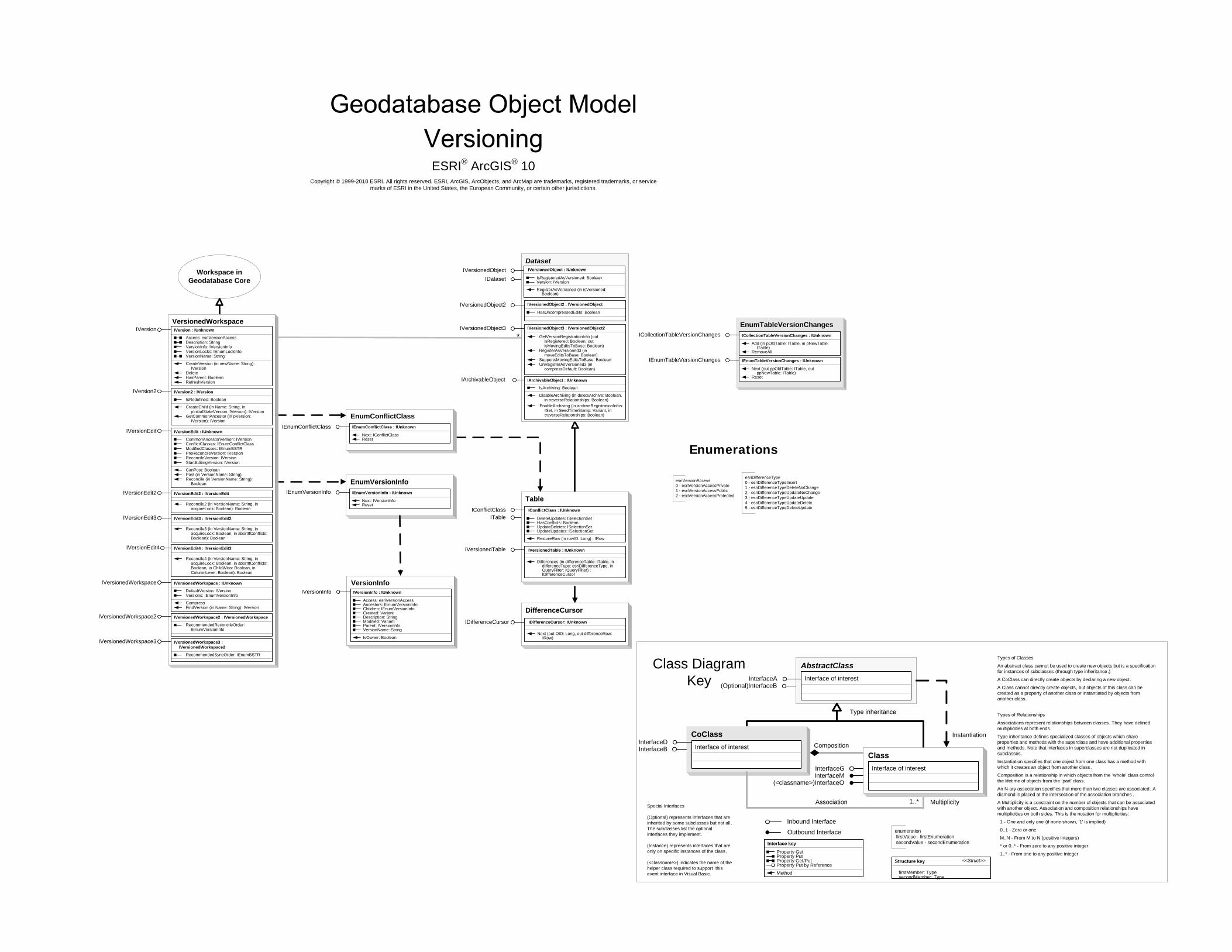
Workspace in Geodatabase Core
esriDifferenceType0 - esriDifferenceTypeInsert1 - esriDifferenceTypeDeleteNoChange2 - esriDifferenceTypeUpdateNoChange3 - esriDifferenceTypeUpdateUpdate4 - esriDifferenceTypeUpdateDelete5 - esriDifferenceTypeDeleteUpdate
esriVersionAccess0 - esriVersionAccessPrivate1 - esriVersionAccessPublic2 - esriVersionAccessProtected
Enumerations
EnumConflictClassIEnumConflictClass IEnumConflictClass : IUnknown
Next: IConflictClassReset
EnumVersionInfoIEnumVersionInfo IEnumVersionInfo : IUnknown
Next: IVersionInfoReset
VersionInfoIVersionInfo IVersionInfo : IUnknown
Access: esriVersionAccessAncestors: IEnumVersionInfoChildren: IEnumVersionInfoCreated: VariantDescription: StringModified: VariantParent: IVersionInfoVersionName: String
IsOwner: Boolean
EnumTableVersionChangesICollectionTableVersionChanges ICollectionTableVersionChanges : IUnknown
Add (in pOldTable: ITable, in pNewTable: ITable)
RemoveAll
IEnumTableVersionChanges IEnumTableVersionChanges : IUnknown
Next (out ppOldTable: ITable, out ppNewTable: ITable)
Reset
CoClassInterfaceDInterfaceB
Types of Classes
An abstract class cannot be used to create new objects but is a specification for instances of subclasses (through type inheritance.)
A CoClass can directly create objects by declaring a new object .
A Class cannot directly create objects, but objects of this class can be created as a property of another class or instantiated by objects from another class.
Types of Relationships
Associations represent relationships between classes. They have defined multiplicities at both ends.
Type inheritance defines specialized classes of objects which share properties and methods with the superclass and have additional properties and methods. Note that interfaces in superclasses are not duplicated in subclasses.
Instantiation specifies that one object from one class has a method with which it creates an object from another class.
Composition is a relationship in which objects from the 'whole' class control the lifetime of objects from the 'part' class.
An N-ary association specifies that more than two classes are associated . A diamond is placed at the intersection of the association branches .
A Multiplicity is a constraint on the number of objects that can be associated with another object. Association and composition relationships have multiplicities on both sides. This is the notation for multiplicities:
1 - One and only one (if none shown, '1' is implied)
0..1 - Zero or one
M..N - From M to N (positive integers)
* or 0..* - From zero to any positive integer
1..* - From one to any positive integer
Class Diagram Key
enumeration firstValue - firstEnumeration secondValue - secondEnumeration
AbstractClass
Type inheritance
Instantiation
Association
Composition
1..* Multiplicity
Interface of interestInterfaceA(Optional)InterfaceB
Interface of interest
InterfaceGInterfaceM
Outbound Interface
Inbound Interface
Special Interfaces (Optional) represents interfaces that are inherited by some subclasses but not all . The subclasses list the optional interfaces they implement.
(Instance) represents interfaces that are only on specific instances of the class.
(<classname>) indicates the name of the helper class required to support this event interface in Visual Basic.
Interface key
Property GetProperty PutProperty Get/PutProperty Put by Reference
Method
(<classname>)InterfaceO
Structure key <<Struct>>
firstMember: TypesecondMember: Type
ClassInterface of interest
ESRI® ArcGIS® 10 Copyright © 1999-2010 ESRI. All rights reserved. ESRI, ArcGIS, ArcObjects, and ArcMap are trademarks, registered trademarks, or service
marks of ESRI in the United States, the European Community, or certain other jurisdictions.
IDataset
DatasetIVersionedObject IVersionedObject : IUnknown
IsRegisteredAsVersioned: BooleanVersion: IVersion
RegisterAsVersioned (in isVersioned: Boolean)
IVersionedObject2 : IVersionedObject
HasUncompressedEdits: Boolean
*
IVersionedObject2
IVersionedObject3
DifferenceCursor IDifferenceCursor: IUnknown
Next (out OID: Long, out differenceRow: IRow)
IDifferenceCursor
ITable
Table IConflictClass : IUnknown
DeleteUpdates: ISelectionSetHasConflicts: BooleanUpdateDeletes: ISelectionSetUpdateUpdates: ISelectionSet
RestoreRow (in rowID: Long) : IRow
IConflictClass
IVersionedTable : IUnknown
Differences (in differenceTable: ITable, in differenceType: esriDifferenceType, in QueryFilter: IQueryFilter) : IDifferenceCursor
IVersionedTable
IVersionedObject3 : IVersionedObject2
GetVersionRegistrationInfo (out isRegistered: Boolean, out isMovingEditsToBase: Boolean)
RegisterAsVersioned3 (in moveEditsToBase: Boolean)
SupportsMovingEditsToBase: BooleanUnRegisterAsVersioned3 (in
compressDefault: Boolean)
IArchivableObject IArchivableObject : IUnknown
IsArchiving: Boolean
DisableArchiving (in deleteArchive: Boolean, in traverseRelationships: Boolean)
EnableArchiving (in archiveRegistrationInfos: ISet, in SeedTimeStamp: Variant, in traverseRelationships: Boolean)
VersionedWorkspace
IVersionedWorkspace : IUnknown
DefaultVersion: IVersionVersions: IEnumVersionInfo
CompressFindVersion (in Name: String): IVersion
IVersionedWorkspace
IVersionedWorkspace2 : IVersionedWorkspace
RecommendedReconcileOrder: IEnumVersionInfo
IVersionedWorkspace2
IVersionedWorkspace3 : IVersionedWorkspace2
RecommendedSyncOrder: IEnumBSTR
IVersionedWorkspace3
IVersion : IUnknown
Access: esriVersionAccessDescription: StringVersionInfo: IVersionInfoVersionLocks: IEnumLockInfoVersionName: String
CreateVersion (in newName: String): IVersion
DeleteHasParent: BooleanRefreshVersion
IVersion
IVersion2 : IVersion
IsRedefined: Boolean
CreateChild (in Name: String, in pInitialStateVersion: IVersion): IVersion
GetCommonAncestor (in pVersion: IVersion): IVersion
IVersion2
IVersionEdit : IUnknown
CommonAncestorVersion: IVersionConflictClasses: IEnumConflictClassModifiedClasses: IEnumBSTRPreReconcileVersion: IVersionReconcileVersion: IVersionStartEditingVersion: IVersion
CanPost: BooleanPost (in VersionName: String)Reconcile (in VersionName: String):
Boolean
IVersionEdit
IVersionEdit2 : IVersionEdit
Reconcile2 (in VersionName: String, in acquireLock: Boolean): Boolean
IVersionEdit2
IVersionEdit3 : IVersionEdit2
Reconcile3 (in VersionName: String, in acquireLock: Boolean, in abortIfConflicts: Boolean): Boolean
IVersionEdit3
IVersionEdit4 : IVersionEdit3
Reconcile4 (in VersionName: String, in acquireLock: Boolean, in abortIfConflicts: Boolean, in ChildWins: Boolean, in ColumnLevel: Boolean): Boolean
IVersionEdit4
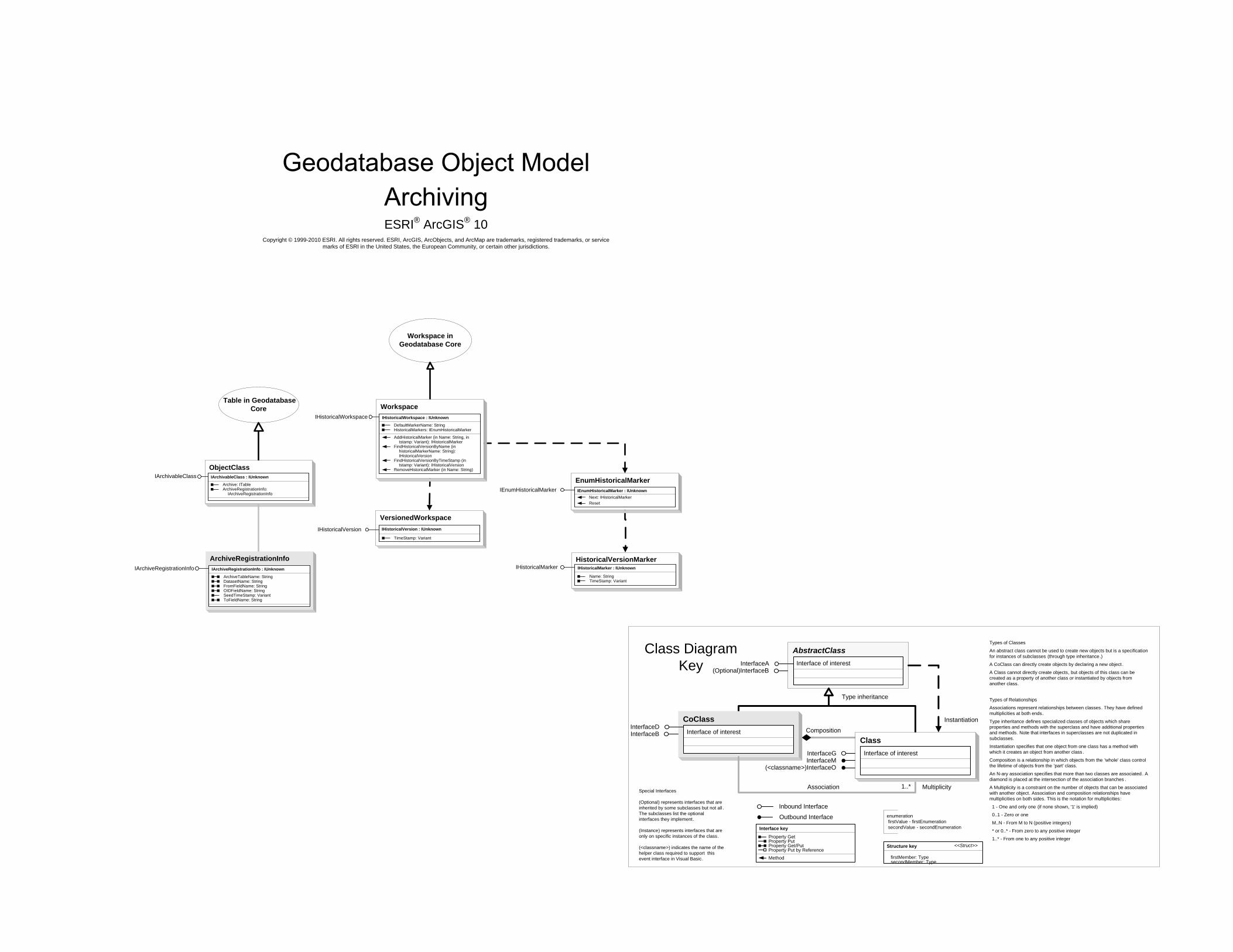
CoClassInterfaceDInterfaceB
Types of Classes
An abstract class cannot be used to create new objects but is a specification for instances of subclasses (through type inheritance.)
A CoClass can directly create objects by declaring a new object .
A Class cannot directly create objects, but objects of this class can be created as a property of another class or instantiated by objects from another class.
Types of Relationships
Associations represent relationships between classes. They have defined multiplicities at both ends.
Type inheritance defines specialized classes of objects which share properties and methods with the superclass and have additional properties and methods. Note that interfaces in superclasses are not duplicated in subclasses.
Instantiation specifies that one object from one class has a method with which it creates an object from another class.
Composition is a relationship in which objects from the 'whole' class control the lifetime of objects from the 'part' class.
An N-ary association specifies that more than two classes are associated . A diamond is placed at the intersection of the association branches .
A Multiplicity is a constraint on the number of objects that can be associated with another object. Association and composition relationships have multiplicities on both sides. This is the notation for multiplicities:
1 - One and only one (if none shown, '1' is implied)
0..1 - Zero or one
M..N - From M to N (positive integers)
* or 0..* - From zero to any positive integer
1..* - From one to any positive integer
Class Diagram Key
enumeration firstValue - firstEnumeration secondValue - secondEnumeration
AbstractClass
Type inheritance
Instantiation
Association
Composition
1..* Multiplicity
Interface of interestInterfaceA(Optional)InterfaceB
Interface of interest
InterfaceGInterfaceM
Outbound Interface
Inbound Interface
Special Interfaces (Optional) represents interfaces that are inherited by some subclasses but not all . The subclasses list the optional interfaces they implement.
(Instance) represents interfaces that are only on specific instances of the class.
(<classname>) indicates the name of the helper class required to support this event interface in Visual Basic.
Interface key
Property GetProperty PutProperty Get/PutProperty Put by Reference
Method
(<classname>)InterfaceO
Structure key <<Struct>>
firstMember: TypesecondMember: Type
ClassInterface of interest
ESRI® ArcGIS® 10 Copyright © 1999-2010 ESRI. All rights reserved. ESRI, ArcGIS, ArcObjects, and ArcMap are trademarks, registered trademarks, or service
marks of ESRI in the United States, the European Community, or certain other jurisdictions.
Workspace in Geodatabase Core
Workspace Table in Geodatabase
Core
VersionedWorkspace
EnumHistoricalMarkerIEnumHistoricalMarker : IUnknownIEnumHistoricalMarker
Next: IHistoricalMarkerReset
HistoricalVersionMarkerIHistoricalMarker IHistoricalMarker : IUnknown
Name: StringTimeStamp: Variant
IHistoricalVersion IHistoricalVersion : IUnknown
TimeStamp: Variant
IHistoricalWorkspace : IUnknown
DefaultMarkerName: StringHistoricalMarkers: IEnumHistoricalMarker
AddHistoricalMarker (in Name: String, in tstamp: Variant): IHistoricalMarker
FindHistoricalVersionByName (in historicalMarkerName: String): IHistoricalVersion
FindHistoricalVersionByTimeStamp (in tstamp: Variant): IHistoricalVersion
RemoveHistoricalMarker (in Name: String)
IHistoricalWorkspace
ObjectClassIArchivableClass : IUnknown
Archive: ITableArchiveRegistrationInfo:
IArchiveRegistrationInfo
IArchivableClass
ArchiveRegistrationInfoIArchiveRegistrationInfo : IUnknown
ArchiveTableName: StringDatasetName: StringFromFieldName: StringOIDFieldName: StringSeedTimeStamp: VariantToFieldName: String
IArchiveRegistrationInfo

CoClassInterfaceDInterfaceB
Types of Classes
An abstract class cannot be used to create new objects but is a specification for instances of subclasses (through type inheritance.)
A CoClass can directly create objects by declaring a new object .
A Class cannot directly create objects, but objects of this class can be created as a property of another class or instantiated by objects from another class.
Types of Relationships
Associations represent relationships between classes. They have defined multiplicities at both ends.
Type inheritance defines specialized classes of objects which share properties and methods with the superclass and have additional properties and methods. Note that interfaces in superclasses are not duplicated in subclasses.
Instantiation specifies that one object from one class has a method with which it creates an object from another class.
Composition is a relationship in which objects from the 'whole' class control the lifetime of objects from the 'part' class.
An N-ary association specifies that more than two classes are associated . A diamond is placed at the intersection of the association branches .
A Multiplicity is a constraint on the number of objects that can be associated with another object. Association and composition relationships have multiplicities on both sides. This is the notation for multiplicities:
1 - One and only one (if none shown, '1' is implied)
0..1 - Zero or one
M..N - From M to N (positive integers)
* or 0..* - From zero to any positive integer
1..* - From one to any positive integer
Class Diagram Key
enumeration firstValue - firstEnumeration secondValue - secondEnumeration
AbstractClass
Type inheritance
Instantiation
Association
Composition
1..* Multiplicity
Interface of interestInterfaceA(Optional)InterfaceB
Interface of interest
InterfaceGInterfaceM
Outbound Interface
Inbound Interface
Special Interfaces (Optional) represents interfaces that are inherited by some subclasses but not all . The subclasses list the optional interfaces they implement.
(Instance) represents interfaces that are only on specific instances of the class.
(<classname>) indicates the name of the helper class required to support this event interface in Visual Basic.
Interface key
Property GetProperty PutProperty Get/PutProperty Put by Reference
Method
(<classname>)InterfaceO
Structure key <<Struct>>
firstMember: TypesecondMember: Type
ClassInterface of interest
FeatureClassName
TableName
INativeTypeInfo
ObjectClassName
DatasetNameIDatasetName
ISQLPrivilege (optional)
IDatasetName : IUnknown
Category: StringName: StringSubsetNames: IEnumDatasetNameType: esriDatasetTypeWorkspaceName: IWorkspaceName
ISQLPrivilege : IUnknown
SQLPrivileges: Long
Grant (in UserName: String, in privileges: Long, in withGrant: Boolean)
Revoke (in UserName: String, in privileges: Long)
IMetadataEdit : IUnknown
CanEditMetadata: Boolean
IMetadataEdit
TopologyNameITopologyName ITopologyName : IUnknown
DirtyAreasName: INameFeatureDatasetName: IDatasetNameTopologyErrorName (in GeometryType:
esriGeometryType): IName
NamesEnumeratorIEnumName
IEnumNameEdit
(Optional)IDatabaseCompact
WorkspaceNameIWorkspaceName IWorkspaceName : IUnknown
BrowseName: StringCategory: StringConnectionProperties: IPropertySetPathName: StringType: esriWorkspaceTypeWorkspaceFactory: IWorkspaceFactoryWorkspaceFactoryProgID: String
IWorkspaceName2 IWorkspaceName2 : IWorkspaceName
ConnectionString: String
XYEventSourceName
IFeatureClassName
IXYEventSourceName IXYEventSourceName : IUnknown
EventProperties: IXYEventPropertiesEventTableName: INameSpatialReference: ISpatialReference
MemoryRelationshipClassNameIMemoryRelationshipClassName IMemoryRelationshipClassName : IUnknown
BackwardPathLabel: StringDestinationName: INameForwardPathLabel: StringOriginForeignKey: StringOriginName: INameOriginPrimaryKey: String
FeatureQueryNameIFeatureClassName IFeatureClassName : IUnknown
FeatureDatasetName: IDatasetNameFeatureType: esriFeatureTypeShapeFieldName: StringShapeType: esriGeometryType
TableQueryNameIQueryName : IUnknown
QueryDef: IQueryDefIQueryName
IQueryName2 : IQueryName
CopyLocally: BooleanPrimaryKey: String
IQueryName2
GeometricNetworkNameIGeometricNetworkName IGeometricNetworkName : IUnknown
FeatureDatasetName: IDatasetName
ITableName : IUnknown
IObjectClassName : IUnknown
ObjectClassID: Long
IModelInfo : IUnknown
ModelName: String
ITableName
IModelInfo
IObjectClassName
ITopologyClassName : IUnknown
TopologyName: ITopologyName
ITopologyClassName
RelationshipClassNameIRelationshipClassName IRelationshipClassName : IUnknown
Cardinality: esriRelCardinalityFeatureDatasetName: IDatasetNameIsAttributed: BooleanIsComposite: BooleanNotification: esriRelNotification
RelQueryTableNameIRelQueryTableName IRelQueryTableName : IUnknown
DoNotPushJoinToDB: BooleanForwardDirection: BooleanLeftOuterJoin: BooleanRelationshipClassName: INameSrcQueryFilter: IQueryFilterSrcSelectionSet: ISelectionSetTargetColumns: String
IRelQueryTableName2 IRelQueryTableName2 : IUnknown
DoNotPushJoinToDB: BooleanFireRowChangedEvents: BooleanForwardDirection: BooleanLeftOuterJoin: BooleanRelationshipClassName: INameSrcQueryFilter: IQueryFilterSrcSelectionSet: ISelectionSetTargetColumns: String
IPersistStream
RasterCatalogNameIRasterCatalogName IRasterCatalogName : IUnknown
IsRasterDataset: BooleanRasterFieldName: String
RasterDatasetNameIRasterDatasetName IRasterDatasetName : IUnknown
RasterBandNames: IEnumDatasetName
RasterBandNameIRasterBandName IRasterBandName : IUnknown
NameString: StringRasterDatasetName: IDatasetName
IFeatureClassName IFeatureClassName : IUnknown
FeatureDatasetName: IDatasetNameFeatureType: esriFeatureTypeShapeFieldName: StringShapeType: esriGeometryType
ESRI® ArcGIS® 10 Copyright © 1999-2010 ESRI. All rights reserved. ESRI, ArcGIS, ArcObjects, and ArcMap are trademarks, registered trademarks, or service
marks of ESRI in the United States, the European Community, or certain other jurisdictions.
NameIName : IUnknown
NameString: String
Open: IUnknown
esriSystem.IName
FeatureDatasetNameIFeatureDatasetName : IUnknown
FeatureClassNames: IEnumDatasetNameGeometricNetworkNames:
IEnumDatasetNameRelationshipClassNames:
IEnumDatasetNameTableNames: IEnumDatasetName
IFeatureDatasetName
IFeatureDatasetName2 : IFeatureDatasetName
TopologyNames: IEnumDatasetName
IFeatureDatasetName2
IMetadata : IUnknown
Metadata: IPropertySet
Synchronize (in action: esriMetadataSyncAction, in interval: Long)
IMetadata
MosaicDatasetNameIMosaicDatasetName : IUnknownIMosaicDatasetName
QueryTableNameIQueryTableName : IUnknown
Query: StringQueryDescription: IQueryDescription
IQueryTableName

RelQueryRow
IFeatureCursor (optional)
IQueryFilter2
IObjectISpatialFilter
IQueryFilter
SpatialFilterIRowBuffer
IRow IRow : IRowBuffer
HasOID: BooleanOID: LongTable: ITable
DeleteStore
IFeature : IObject
Extent: IEnvelopeFeatureType: esriFeatureTypeShape: IGeometryShapeCopy: IGeometry
IFeatureBuffer (optional)
IFeautureDraw (optional)
IFeature(optional)
MemoryRelationshipClassFactoryIMemoryRelationshipClassFactory : IUnknown
Open (in Name: String, in originPrimaryClass: IObjectClass, in originPrimaryKeyField: String, in originForeignClass: IObjectClass, in originForeignKeyField: String, in ForwardPathLabel: String, in BackwardPathLabel: String, in Cardinality: esriRelCardinality): IRelationshipClass
IMemoryRelationshipClassFactory
Table in Geodatabase Core
RelationshipClass in Geodatabase Core
Row in Geodatabase Core
CoClassInterfaceDInterfaceB
Types of Classes
An abstract class cannot be used to create new objects but is a specification for instances of subclasses (through type inheritance.)
A CoClass can directly create objects by declaring a new object .
A Class cannot directly create objects, but objects of this class can be created as a property of another class or instantiated by objects from another class.
Types of Relationships
Associations represent relationships between classes. They have defined multiplicities at both ends.
Type inheritance defines specialized classes of objects which share properties and methods with the superclass and have additional properties and methods. Note that interfaces in superclasses are not duplicated in subclasses.
Instantiation specifies that one object from one class has a method with which it creates an object from another class.
Composition is a relationship in which objects from the 'whole' class control the lifetime of objects from the 'part' class.
An N-ary association specifies that more than two classes are associated . A diamond is placed at the intersection of the association branches .
A Multiplicity is a constraint on the number of objects that can be associated with another object. Association and composition relationships have multiplicities on both sides. This is the notation for multiplicities:
1 - One and only one (if none shown, '1' is implied)
0..1 - Zero or one
M..N - From M to N (positive integers)
* or 0..* - From zero to any positive integer
1..* - From one to any positive integer
Class Diagram Key
enumeration firstValue - firstEnumeration secondValue - secondEnumeration
AbstractClass
Type inheritance
Instantiation
Association
Composition
1..* Multiplicity
Interface of interestInterfaceA(Optional)InterfaceB
Interface of interest
InterfaceGInterfaceM
Outbound Interface
Inbound Interface
Special Interfaces (Optional) represents interfaces that are inherited by some subclasses but not all . The subclasses list the optional interfaces they implement.
(Instance) represents interfaces that are only on specific instances of the class.
(<classname>) indicates the name of the helper class required to support this event interface in Visual Basic.
Interface key
Property GetProperty PutProperty Get/PutProperty Put by Reference
Method
(<classname>)InterfaceO
Structure key <<Struct>>
firstMember: TypesecondMember: Type
ClassInterface of interest
RelQueryTableSelectionSetIRelQueryTableSelectionSet
ISelectionSetISelectionSet2
IRelQueryTableSelectionSet : IUnknown
BaseTableSelectionSet: ISelectionSet
ESRI® ArcGIS® 10 Copyright © 1999-2010 ESRI. All rights reserved. ESRI, ArcGIS, ArcObjects, and ArcMap are trademarks, registered trademarks, or service
marks of ESRI in the United States, the European Community, or certain other jurisdictions.
QueryFilter
CursorICursor
MemoryRelationshipClass
RelQueryCursor
IFeatureClass (optional)
RelQueryTable
IObjectClass
IRelQueryTableManage : IUnknown
VersionChanged (in pSelectedWorkspace: IVersion, in pTargetVersion: IVersion, in pTablesRequiringMapEventFiring: IEnumTableVersionChanges)
IRelQueryTableManage
IVirtualTable : IUnknownIVirtualTable
IRelQueryTableInfo : IUnknown
HasDirectAccessLookup: BooleanJoinType: esriJoinTypeQueryDef: IQueryDef
GetBaseTableOfField (in dbColumn: String): ITable
IRelQueryTableInfo
IRelQueryTable : IUnknown
DestinationTable: ITableRelationshipClass: IRelationshipClassSourceTable: ITable
IRelQueryTable
RelQueryTableFactoryIRelQueryTableFactory : IUnknown
Open (in pRelClass: IRelationshipClass, in joinForward: Boolean, in pQueryFilter: IQueryFilter, in pSrcSelectionSet: ISelectionSet, in target_Columns: String, in DoNotPushJoinToDB: Boolean, in openAsLeftOuterJoin: Boolean): IRelQueryTable
IRelQueryTableFactory
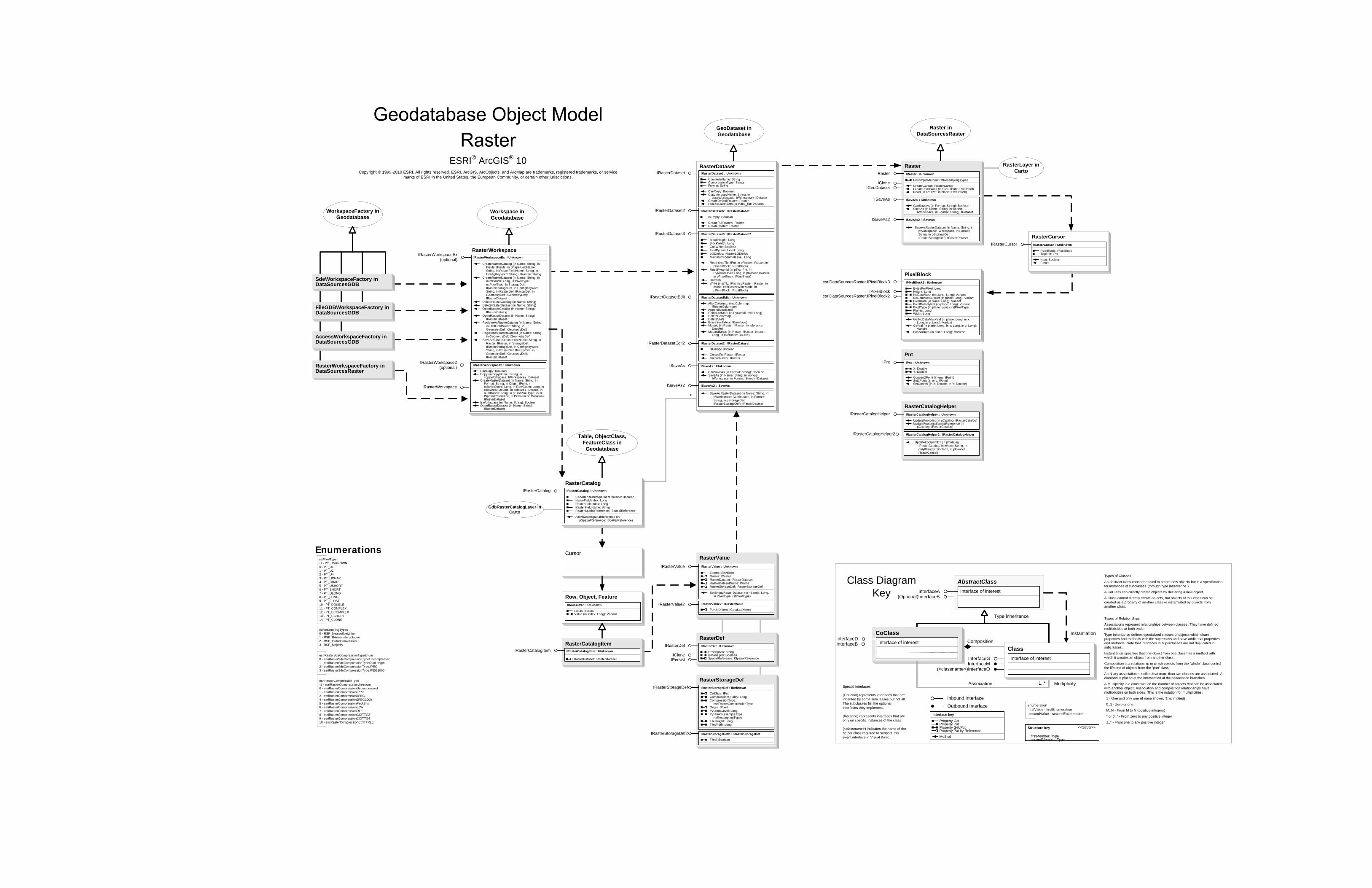
IRasterWorkspace
CoClassInterfaceDInterfaceB
Types of Classes
An abstract class cannot be used to create new objects but is a specification for instances of subclasses (through type inheritance.)
A CoClass can directly create objects by declaring a new object .
A Class cannot directly create objects, but objects of this class can be created as a property of another class or instantiated by objects from another class.
Types of Relationships
Associations represent relationships between classes. They have defined multiplicities at both ends.
Type inheritance defines specialized classes of objects which share properties and methods with the superclass and have additional properties and methods. Note that interfaces in superclasses are not duplicated in subclasses.
Instantiation specifies that one object from one class has a method with which it creates an object from another class.
Composition is a relationship in which objects from the 'whole' class control the lifetime of objects from the 'part' class.
An N-ary association specifies that more than two classes are associated . A diamond is placed at the intersection of the association branches .
A Multiplicity is a constraint on the number of objects that can be associated with another object. Association and composition relationships have multiplicities on both sides. This is the notation for multiplicities:
1 - One and only one (if none shown, '1' is implied)
0..1 - Zero or one
M..N - From M to N (positive integers)
* or 0..* - From zero to any positive integer
1..* - From one to any positive integer
Class Diagram Key
enumeration firstValue - firstEnumeration secondValue - secondEnumeration
AbstractClass
Type inheritance
Instantiation
Association
Composition
1..* Multiplicity
Interface of interestInterfaceA(Optional)InterfaceB
Interface of interest
InterfaceGInterfaceM
Outbound Interface
Inbound Interface
Special Interfaces (Optional) represents interfaces that are inherited by some subclasses but not all . The subclasses list the optional interfaces they implement.
(Instance) represents interfaces that are only on specific instances of the class.
(<classname>) indicates the name of the helper class required to support this event interface in Visual Basic.
Interface key
Property GetProperty PutProperty Get/PutProperty Put by ReferenceMethod
(<classname>)InterfaceO
Structure key <<Struct>>
firstMember: TypesecondMember: Type
ClassInterface of interest
RasterDefIRasterDef IRasterDef : IUnknown
Description: StringIsManaged: BooleanSpatialReference: ISpatialReference
ICloneIPersist
RasterIRaster IRaster : IUnknown
ResampleMethod: rstResamplingTypes
CreateCursor: IRasterCursorCreatePixelBlock (in Size: IPnt): IPixelBlockRead (in tlc: IPnt, in block: IPixelBlock)
ICloneIGeoDataset
ISaveAs ISaveAs : IUnknown
CanSaveAs (in Format: String): BooleanSaveAs (in Name: String, in worksp:
IWorkspace, in Format: String): IDataset
RasterCursorIRasterCursor IRasterCursor : IUnknown
PixelBlock: IPixelBlockTopLeft: IPnt
Next: BooleanReset
PixelBlockesriDataSourcesRaster.IPixelBlock3 IPixelBlock3 : IUnknown
BytesPerPixel: LongHeight: LongNoDataMask (in plane: Long): VariantNoDataMaskByRef (in plane: Long): VariantPixelData (in plane: Long): VariantPixelDataByRef (in plane: Long): VariantPixelType (in plane: Long): rstPixelTypePlanes: LongWidth: Long
GetNoDataMaskVal (in plane: Long, in x: Long, in y: Long): Variant
GetVal (in plane: Long, in x: Long, in y: Long): Variant
HasNoData (in plane: Long): Boolean
IPixelBlockesriDataSourcesRaster.IPixelBlock2
Workspace inGeodatabase
RasterWorkspaceIRasterWorkspaceEx
(optional)
IRasterWorkspace2(optional) IRasterWorkspace2 : IUnknown
CanCopy: BooleanCopy (in copyName: String, in
copyWorkspace: IWorkspace): IDatasetCreateRasterDataset (in Name: String, in
Format: String, in Origin: IPoint, in columnCount: Long, in RowCount: Long, in cellSizeX: Double, in cellSizeY: Double, in numBands: Long, in pt: rstPixelType, in sr: ISpatialReference, in Permanent: Boolean): IRasterDataset
IsWorkspace (in Name: String): BooleanOpenRasterDataset (in Name: String):
IRasterDataset
*
PntIPnt IPnt : IUnknown
X: DoubleY: Double
Convert2Point (in env: IPoint)Set2Point (in env: IPoint)SetCoords (in X: Double, in Y: Double)
RasterLayer inCarto
RasterCatalogHelperIRasterCatalogHelper IRasterCatalogHelper : IUnknown
UpdateFootprint (in pCatalog: IRasterCatalog)UpdateFootprintSpatialReference (in
pCatalog: IRasterCatalog)
Cursor
Row, Object, FeatureIRowBuffer : IUnknown
Fields: IFieldsValue (in Index: Long): Variant
RasterCatalogItemIRasterCatalogItem IRasterCatalogItem : IUnknown
RasterDataset: IRasterDataset
RasterValueIRasterValue
GeoDataset inGeodatabase
RasterDatasetIRasterDataset IRasterDataset : IUnknown
CompleteName: StringCompressionType: StringFormat: String
CanCopy: BooleanCopy (in copyName: String, in
copyWorkspace: IWorkspace): IDatasetCreateDefaultRaster: IRasterPrecalculateStats (in index_list: Variant)
IRasterDataset2 IRasterDataset2 : IRasterDataset
IsEmpty: Boolean
CreateFullRaster: IRasterCreateRaster: IRaster
IRasterDatasetEdit IRasterDatasetEdit : IUnknown
AlterColormap (in pColormap: IRasterColormap)
AppendNewBandComputeStats (in PyramidLevel: Long)DeleteColormapDeleteStatsErase (in Extent: IEnvelope)Mosaic (in Raster: IRaster, in tolerance:
Double)MosaicBands (in Raster: IRaster, in start:
Long, in tolerance: Double)
WorkspaceFactory inGeodatabase
RasterWorkspaceFactory in DataSourcesRaster
SdeWorkspaceFactory in DataSourcesGDB
Enumerations
esriRasterSdeCompressionTypeEnum0 - esriRasterSdeCompressionTypeUncompressed1 - esriRasterSdeCompressionTypeRunLength2 - esriRasterSdeCompressionTypeJPEG3 - esriRasterSdeCompressionTypeJPEG2000
Raster in DataSourcesRaster
IRasterValue : IUnknown
Extent: IEnvelopeRaster: IRasterRasterDataset: IRasterDatasetRasterDatasetName: INameRasterStorageDef: IRasterStorageDef
SetEmptyRasterDataset (in nBands: Long, in PixelType: rstPixelType)
IRasterWorkspaceEx : IUnknown
CreateRasterCatalog (in Name: String, in Fields: IFields, in ShapeFieldName: String, in RasterFieldName: String, in ConfigKeyword: String): IRasterCatalog
CreateRasterDataset (in Name: String, in numBands: Long, in PixelType: rstPixelType, in StorageDef: IRasterStorageDef, in ConfigKeyword: String, in RasterDef: IRasterDef, in GeometryDef: IGeometryDef): IRasterDataset
DeleteRasterCatalog (in Name: String)DeleteRasterDataset (in Name: String)OpenRasterCatalog (in Name: String):
IRasterCatalogOpenRasterDataset (in Name: String):
IRasterDatasetRegisterAsRasterCatalog (in Name: String,
in OIDFieldName: String, in GeometryDef: IGeometryDef)
RegisterAsRasterDataset (in Name: String, in GeometryDef: IGeometryDef)
SaveAsRasterDataset (in Name: String, in Raster: IRaster, in StorageDef: IRasterStorageDef, in ConfigKeyword: String, in RasterDef: IRasterDef, in GeometryDef: IGeometryDef): IRasterDataset
ESRI® ArcGIS® 10 Copyright © 1999-2010 ESRI. All rights reserved. ESRI, ArcGIS, ArcObjects, and ArcMap are trademarks, registered trademarks, or service
marks of ESRI in the United States, the European Community, or certain other jurisdictions.
FileGDBWorkspaceFactory in DataSourcesGDB
AccessWorkspaceFactory in DataSourcesGDB
ISaveAs2 : ISaveAs
SaveAsRasterDataset (in Name: String, in pWorkspace: IWorkspace, in Format: String, in pStorageDef: IRasterStorageDef): IRasterDataset
ISaveAs2
ISaveAs2 : ISaveAs
SaveAsRasterDataset (in Name: String, in pWorkspace: IWorkspace, in Format: String, in pStorageDef: IRasterStorageDef): IRasterDataset
ISaveAs2
GdbRasterCatalogLayer in Carto
Table, ObjectClass, FeatureClass in
Geodatabase
RasterCatalogIRasterCatalog IRasterCatalog : IUnknown
CanAlterRasterSpatialReference: BooleanNameFieldIndex: LongRasterFieldIndex: LongRasterFieldName: StringRasterSpatialReference: ISpatialReference
AlterRasterSpatialReference (in pSpatialReference: ISpatialReference)
IRasterDataset3 : IRasterDataset2
BlockHeight: LongBlockWidth: LongCanWrite: BooleanFirstPyramidLevel: LongLODInfos: IRasterLODInfosMaximumPyramidLevel: Long
Read (in pTlc: IPnt, in pRaster: IRaster, in pPixelBlock: IPixelBlock)
ReadPyramid (in pTlc: IPnt, in PyramidLevel: Long, in pRaster: IRaster, in pPixelBlock: IPixelBlock)
RefreshWrite (in pTlc: IPnt, in pRaster: IRaster, in
mode: esriRasterWriteMode, in pPixelBlock: IPixelBlock)
IRasterValue2 : IRasterValue
PersistXform: IGeodataXformIRasterValue2
ISaveAs ISaveAs : IUnknown
CanSaveAs (in Format: String): BooleanSaveAs (in Name: String, in worksp:
IWorkspace, in Format: String): IDataset
IRasterDataset3
IRasterDataset2 : IRasterDataset
IsEmpty: Boolean
CreateFullRaster: IRasterCreateRaster: IRaster
IRasterDatasetEdit2
IRasterCatalogHelper2 : IRasterCatalogHelper
UpdateFootprintEx (in pCatalog: IRasterCatalog, in where: String, in onlyIfEmpty: Boolean, in pCancel: ITrackCancel)
IRasterCatalogHelper2
RasterStorageDefIRasterStorageDef : IUnknown
CellSize: IPntCompressionQuality: LongCompressionType:
esriRasterCompressionTypeOrigin: IPointPyramidLevel: LongPyramidResampleType:
rstResamplingTypesTileHeight: LongTileWidth: Long
IRasterStorageDef
IRasterStorageDef2 : IRasterStorageDef
Tiled: Boolean
IRasterStorageDef2
rstPixelType-1 - PT_UNKNOWN0 - PT_U11 - PT_U22 - PT_U43 - PT_UCHAR4 - PT_CHAR5 - PT_USHORT6 - PT_SHORT7 - PT_ULONG8 - PT_LONG9 - PT_FLOAT10 - PT_DOUBLE11 - PT_COMPLEX12 - PT_DCOMPLEX13 - PT_CSHORT14 - PT_CLONG
rstResamplingTypes0 - RSP_NearestNeighbor1 - RSP_BilinearInterpolation2 - RSP_CubicConvolution3 - RSP_Majority
esriRasterCompressionType-1 - esriRasterCompressionUnknown0 - esriRasterCompressionUncompressed1 - esriRasterCompressionLZ772 - esriRasterCompressionJPEG4 - esriRasterCompressionJPEG20005 - esriRasterCompressionPackBits6 - esriRasterCompressionLZW7 - esriRasterCompressionRLE8 - esriRasterCompressionCCITTG39 - esriRasterCompressionCCITTG410 - esriRasterCompressionCCITTRLE

FGDCSynchronizerIMetadataSynchronizer
MetadataSynchronizer IMetadataSynchronizer : IUnknown
ClassID: IUIDName: String
Update (in pPropertySet: IXmlPropertySet, in itemDesc: String, in Value: Variant)
IMetadataSynchronizerManager : IUnknown
NumSynchronizers: Long
GetEnabled (in Index: Long): BooleanGetSynchronizer (in Index: Long):
IMetadataSynchronizerSetEnabled (in Index: Long, in Enabled:
Boolean)
IMetadataSynchronizer
IMetadataSynchronizerManager
esriXmlPropertyType0 - esriXPTText1 - esriXPTBinaryEnclosure2 - esriXPTLink3 - esriXPTPicture4 - esriXPTImage
esriXmlSetPropertyAction0 - esriXSPAAddOrReplace1 - esriXSPAAddIfNotExists2 - esriXSPAReplaceIfExists3 - esriXSPAAddDuplicate
esriMetadataSyncAction0 - esriMSAAccessed1 - esriMSAAlways2 - esriMSACreated3 - esriMSANotCreated4 - esriMSAOverwrite
MetadataCopyHelperICopyHelper ICopyHelper : IUnknown
UpdateDatabaseMetadata (in pDestPropertySet: IPropertySet, in pSrc: IDatasetName, in pDest: IDatasetName)
UpdateMetadata (in pSrc: IName, in pDest: IName, in isMove: Boolean)
Enumerations
ESRI® ArcGIS® 10 Copyright © 1999-2010 ESRI. All rights reserved. ESRI, ArcGIS, ArcObjects, and ArcMap are trademarks, registered trademarks, or service
marks of ESRI in the United States, the European Community, or certain other jurisdictions.
XmlPropertySetIXmlPropertySet : IUnknown
CountX (in Name: String): LongIsNew: Boolean
DeleteProperty (in Name: String)DeletePropertyByAttribute (in Attribute:
String, in Value: String, in deleteParent: Boolean)
GetPropertiesByAttribute (in Attribute: String, in Value: String, in noValues: Boolean, out pTags: Variant, out pValues: Variant)
InitExistingSaveAsFile (in xslPath: String, in header:
String, in outputANSI: Boolean, in outPath: String)
SetAttribute (in Name: String, in Attribute: String, in Value: Variant, in action: esriXmlSetPropertyAction)
SetPropertyX (in Name: String, in Value: Variant, in propType: esriXmlPropertyType, in action: esriXmlSetPropertyAction, syncing: Boolean)
TransformImages (in Path: String, out pFileNames: Variant)
IXmlPropertySet
IPersistStreamInitIPropertySet
ISupportErrorInfoIClone
IXMLSerialize
IXmlPropertySet2 : IUnknown
CountX (in Name: String): LongIsNew: BooleanOverwriteSyncAttribute: Boolean
DeleteProperty (in Name: String)DeletePropertyByAttribute (in Attribute:
String, in Value: String, in deleteParent: Boolean)
DeletePropertyByNameAndAttribute (in Name: String, in Attribute: String, in Value: String, in deleteParent: Boolean)
GetAttribute (in Name: String, in Attribute: String, out pValue: Variant)
GetPropertiesByAttribute (in Attribute: String, in Value: String, in noValues: Boolean, out pTags: Variant, out pValues: Variant)
GetXml (in Name: String): StringInitExistingInitGeneric (in rootName: String)SaveAsFile (in xslPath: String, in header:
String, in outputANSI: Boolean, in outPath: String)
SetAttribute (in Name: String, in Attribute: String, in Value: Variant, in action: esriXmlSetPropertyAction)
SetPropertyX (in Name: String, in Value: Variant, in propType: esriXmlPropertyType, in action: esriXmlSetPropertyAction, syncing: Boolean)
SetXml (in xml: String)TransformImages (in Path: String, out
pFileNames: Variant)
IXmlPropertySet2
GxObject, Name, TIN, and GeometricNetwork objectsIMetadata : IUnknown
Metadata: IPropertySet
Synchronize (in action: esriMetadataSyncAction, in interval: Long)
IMetadata
XmlPropertySetEditIXmlPropertySetEdit : IUnknown
Dataset: IDataset
GetProperty (in Name: String): VariantSetProperty (in Name: String, in Value:
Variant, in propType: esriXmlPropertyType, in action: esriXmlSetPropertyAction)
IXmlPropertySetEdit
CoClassInterfaceDInterfaceB
Types of Classes
An abstract class cannot be used to create new objects but is a specification for instances of subclasses (through type inheritance.)
A CoClass can directly create objects by declaring a new object .
A Class cannot directly create objects, but objects of this class can be created as a property of another class or instantiated by objects from another class.
Types of Relationships
Associations represent relationships between classes. They have defined multiplicities at both ends.
Type inheritance defines specialized classes of objects which share properties and methods with the superclass and have additional properties and methods. Note that interfaces in superclasses are not duplicated in subclasses.
Instantiation specifies that one object from one class has a method with which it creates an object from another class.
Composition is a relationship in which objects from the 'whole' class control the lifetime of objects from the 'part' class.
An N-ary association specifies that more than two classes are associated . A diamond is placed at the intersection of the association branches .
A Multiplicity is a constraint on the number of objects that can be associated with another object. Association and composition relationships have multiplicities on both sides. This is the notation for multiplicities:
1 - One and only one (if none shown, '1' is implied)
0..1 - Zero or one
M..N - From M to N (positive integers)
* or 0..* - From zero to any positive integer
1..* - From one to any positive integer
Class Diagram Key
enumeration firstValue - firstEnumeration secondValue - secondEnumeration
AbstractClass
Type inheritance
Instantiation
Association
Composition
1..* Multiplicity
Interface of interestInterfaceA(Optional)InterfaceB
Interface of interest
InterfaceGInterfaceM
Outbound Interface
Inbound Interface
Special Interfaces (Optional) represents interfaces that are inherited by some subclasses but not all . The subclasses list the optional interfaces they implement.
(Instance) represents interfaces that are only on specific instances of the class.
(<classname>) indicates the name of the helper class required to support this event interface in Visual Basic.
Interface key
Property GetProperty PutProperty Get/PutProperty Put by Reference
Method
(<classname>)InterfaceO
Structure key <<Struct>>
firstMember: TypesecondMember: Type
ClassInterface of interest
FGDCSynchronizationHelperISynchronizationHelper : IUnknown
ExtractBriefEntityAttrProperties (in geoDataset: IClass, in Index: Long, in PropertySet: IPropertySet)
ExtractBriefRelationshipProperties (in RelationshipClass: IRelationshipClass, in Index: Long, in PropertySet: IPropertySet)
ExtractEntityAttrProperties (in geoDataset: IClass, in Index: Long, in PropertySet: IPropertySet)
ExtractFeatureClassProperties (in geoDataset: IFeatureClass, in Index: Long, in PropertySet: IPropertySet)
ExtractRelationshipProperties (in RelationshipClass: IRelationshipClass, in Index: Long, in PropertySet: IPropertySet)
ExtractSpatialProperties (in geoDataset: IGeoDataset, in PropertySet: IPropertySet)
FinishSynchronization (in PropertySet: IPropertySet)
PopulateDistributionProperties (in fileName: String, in fileType: String, in PropertySet: IPropertySet)
PopulateDistributionPropertiesForDatabase (in Dataset: IDataset, in PropertySet: IPropertySet)
PopulateStaticProperties (in PropertySet: IPropertySet)
StartSynchronization (in PropertySet: IPropertySet, in action: esriMetadataSyncAction, in interval: Long, out Ok: Boolean)
ISynchronizationHelper
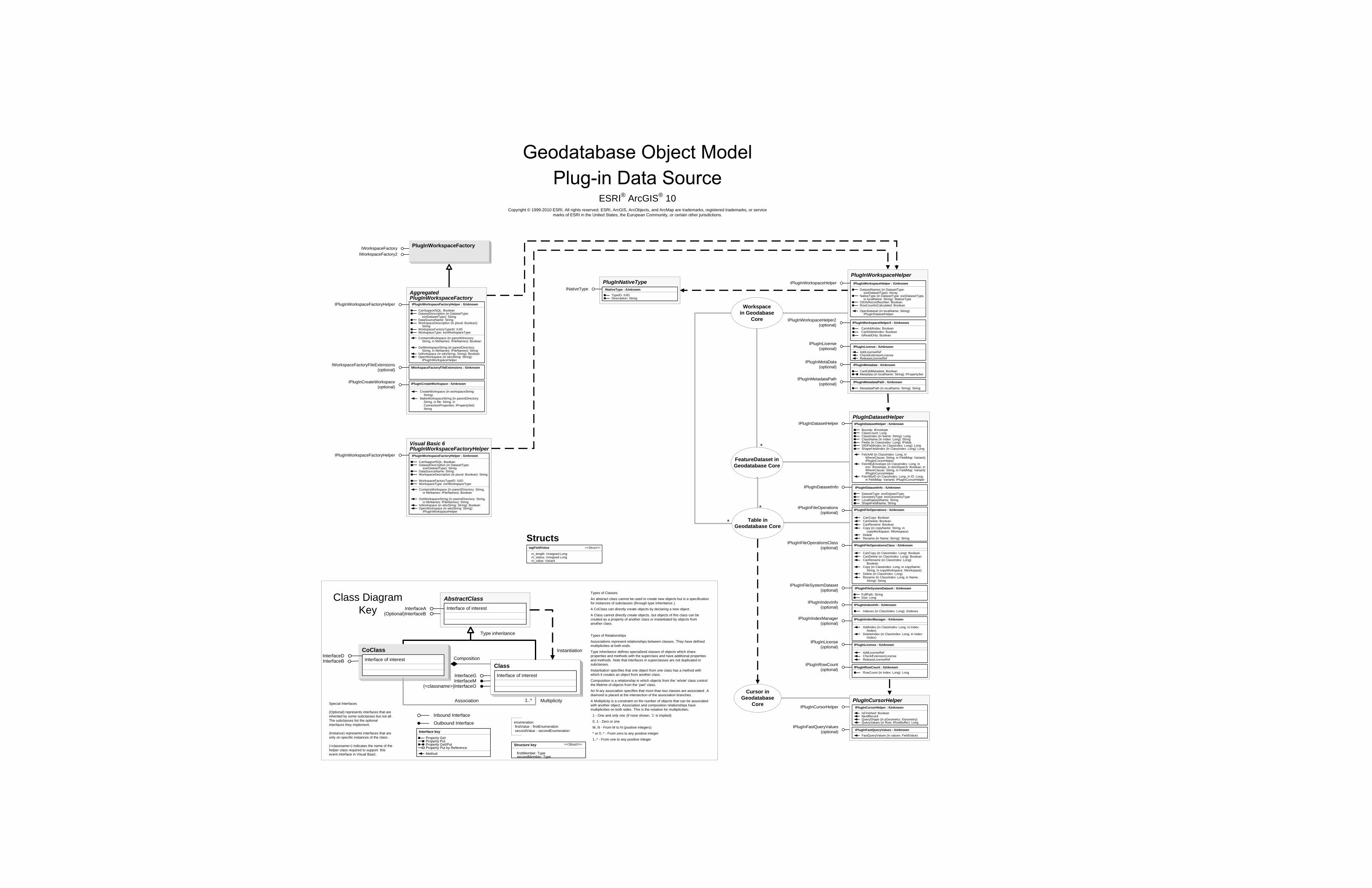
Structs
Cursor in Geodatabase
Core
Workspacein Geodabase
Core
*
FeatureDataset in Geodatabase Core
* Table in Geodatabase Core
PlugInNativeTypeINativeType
PlugInWorkspaceFactoryIWorkspaceFactoryIWorkspaceFactory2
CoClassInterfaceDInterfaceB
Types of Classes
An abstract class cannot be used to create new objects but is a specification for instances of subclasses (through type inheritance.)
A CoClass can directly create objects by declaring a new object .
A Class cannot directly create objects, but objects of this class can be created as a property of another class or instantiated by objects from another class.
Types of Relationships
Associations represent relationships between classes. They have defined multiplicities at both ends.
Type inheritance defines specialized classes of objects which share properties and methods with the superclass and have additional properties and methods. Note that interfaces in superclasses are not duplicated in subclasses.
Instantiation specifies that one object from one class has a method with which it creates an object from another class .
Composition is a relationship in which objects from the 'whole' class control the lifetime of objects from the 'part' class.
An N-ary association specifies that more than two classes are associated . A diamond is placed at the intersection of the association branches .
A Multiplicity is a constraint on the number of objects that can be associated with another object. Association and composition relationships have multiplicities on both sides. This is the notation for multiplicities:
1 - One and only one (if none shown, '1' is implied)
0..1 - Zero or one
M..N - From M to N (positive integers)
* or 0..* - From zero to any positive integer
1..* - From one to any positive integer
Class Diagram Key
enumeration firstValue - firstEnumeration secondValue - secondEnumeration
AbstractClass
Type inheritance
Instantiation
Association
Composition
1..* Multiplicity
Interface of interestInterfaceA(Optional)InterfaceB
Interface of interest
InterfaceGInterfaceM
Outbound Interface
Inbound Interface
Special Interfaces (Optional) represents interfaces that are inherited by some subclasses but not all . The subclasses list the optional interfaces they implement.
(Instance) represents interfaces that are only on specific instances of the class.
(<classname>) indicates the name of the helper class required to support this event interface in Visual Basic.
Interface key
Property GetProperty PutProperty Get/PutProperty Put by ReferenceMethod
(<classname>)InterfaceO
Structure key <<Struct>>
firstMember: TypesecondMember: Type
ClassInterface of interest
*
ESRI® ArcGIS® 10 Copyright © 1999-2010 ESRI. All rights reserved. ESRI, ArcGIS, ArcObjects, and ArcMap are trademarks, registered trademarks, or service
marks of ESRI in the United States, the European Community, or certain other jurisdictions.
INativeType : IUnknown
TypeID: IUIDDescription: String
IPlugInCursorHelper
IPlugInFastQueryValues(optional)
PlugInCursorHelper
IPlugInFastQueryValues : IUnknown
FastQueryValues (in values: FieldValue)
IPlugInCursorHelper : IUnknown
IsFinished: BooleanNextRecordQueryShape (in pGeometry: IGeometry)QueryValues (in Row: IRowBuffer): Long
PlugInWorkspaceHelper IPlugInWorkspaceHelper : IUnknown
DatasetNames (in DatasetType: esriDatasetType): IArray
NativeType (in DatasetType: esriDatasetType, in localName: String): INativeType
OIDIsRecordNumber: BooleanRowCountIsCalculated: Boolean
OpenDataset (in localName: String): IPlugInDatasetHelper
IPlugInWorkspaceHelper
IPlugInLicense(optional)
IPlugInMetaData(optional)
IPlugInMetadataPath(optional)
IPlugInWorkspaceHelper2(optional)
IPlugInLicense : IUnknownAddLicenseRefCheckExtensionLicenseReleaseLicenseRef
IPlugInMetadata : IUnknown
CanEditMetadata: BooleanMetadata (in localName: String): IPropertySet
IPlugInMetadataPath : IUnknown
MetadataPath (in localName: String): String
ActivationExtensions: StringRelevantExtensions: String
Visual Basic 6PlugInWorkspaceFactoryHelper IPlugInWorkspaceFactoryHelper : IUnknown
CanSupportSQL: BooleanDatasetDescription (in DatasetType:
esriDatasetType): StringDataSourceName: StringWorkspaceDescription (in plural: Boolean): String
WorkspaceFactoryTypeID: IUIDWorkspaceType: esriWorkspaceType
ContainsWorkspace (in parentDirectory: String, in fileNames: IFileNames): Boolean
GetWorkspaceString (in parentDirectory: String, in fileNames: IFileNames): String
IsWorkspace (in wksString: String): BooleanOpenWorkspace (in wksString: String):
IPlugInWorkspaceHelper
IPlugInWorkspaceFactoryHelper
Aggregated PlugInWorkspaceFactory IPlugInWorkspaceFactoryHelper : IUnknown
CanSupportSQL: BooleanDatasetDescription (in DatasetType:
esriDatasetType): StringDataSourceName: StringWorkspaceDescription (in plural: Boolean):
StringWorkspaceFactoryTypeID: IUIDWorkspaceType: esriWorkspaceType
ContainsWorkspace (in parentDirectory: String, in fileNames: IFileNames): Boolean
GetWorkspaceString (in parentDirectory: String, in fileNames: IFileNames): String
IsWorkspace (in wksString: String): BooleanOpenWorkspace (in wksString: String):
IPlugInWorkspaceHelper
IPlugInWorkspaceFactoryHelper
IWorkspaceFactoryFileExtensions : IUnknown
IPlugInCreateWorkspace(optional)
IWorkspaceFactoryFileExtensions(optional)
IPlugInCreateWorkspace : IUnknown
CreateWorkspace (in workspaceString: String)
MakeWorkspaceString (in parentDirectory: String, in file: String, in ConnectionProperties: IPropertySet): String
PlugInDatasetHelperIPlugInDatasetHelper
IPlugInDatasetInfo
IPlugInLicense(optional)
IPlugInFileSystemDataset(optional)
IPlugInDatasetHelper : IUnknown
Bounds: IEnvelopeClassCount: LongClassIndex (in Name: String): LongClassName (in Index: Long): StringFields (in ClassIndex: Long): IFieldsOIDFieldIndex (in ClassIndex: Long): LongShapeFieldIndex (in ClassIndex: Long): Long
FetchAll (in ClassIndex: Long, in WhereClause: String, in FieldMap: Variant): IPlugInCursorHelper
FetchByEnvelope (in ClassIndex: Long, in env: IEnvelope, in strictSearch: Boolean, in WhereClause: String, in FieldMap: Variant): IPlugInCursorHelper
FetchByID (in ClassIndex: Long, in ID: Long, in FieldMap: Variant): IPlugInCursorHelper
IPlugInDatasetInfo : IUnknown
DatasetType: esriDatasetTypeGeometryType: esriGeometryTypeLocalDatasetName: StringShapeFieldName: String
IPlugInFileOperations(optional)
IPlugInFileOperationsClass(optional)
IPlugInFileSystemDataset : IUnknown
FullPath: StringSize: Long
IPlugInIndexInfo(optional) IPlugInIndexInfo : IUnknown
Indexes (in ClassIndex: Long): IIndexes
IPlugInRowCount : IUnknownRowCount (in Index: Long): Long
IPlugInIndexManager(optional)
IPlugInRowCount(optional)
IPlugInFileOperations : IUnknown
CanCopy: BooleanCanDelete: BooleanCanRename: BooleanCopy (in copyName: String, in
copyWorkspace: IWorkspace)DeleteRename (in Name: String): String
IPlugInFileOperationsClass : IUnknown
CanCopy (in ClassIndex: Long): BooleanCanDelete (in ClassIndex: Long): BooleanCanRename (in ClassIndex: Long):
BooleanCopy (in ClassIndex: Long, in copyName:
String, in copyWorkspace: IWorkspace)Delete (in ClassIndex: Long)Rename (in ClassIndex: Long, in Name:
String): String
IPlugInIndexManager : IUnknown
AddIndex (in ClassIndex: Long, in Index: IIndex)
DeleteIndex (in ClassIndex: Long, in Index: IIndex)
IPlugInLicense : IUnknown
AddLicenseRefCheckExtensionLicenseReleaseLicenseRef
IPlugInWorkspaceHelper2 : IUnknown
CanAddIndex: BooleanCanDeleteIndex: BooleanIsReadOnly: Boolean
tagFieldValue <<Struct>>
m_length: Unsigned Longm_status: Unsigned Longm_value: Variant
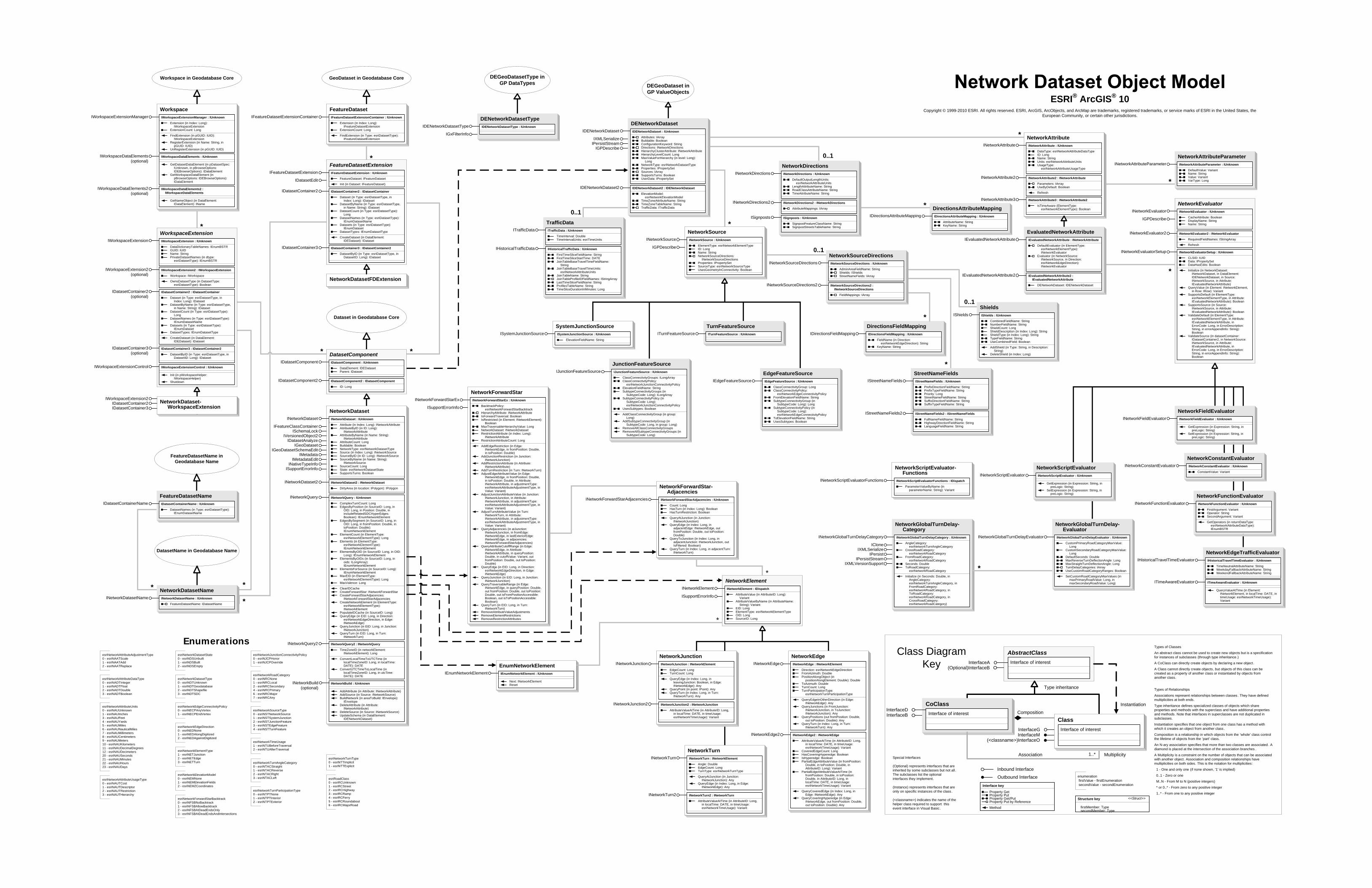
*
*
*
DEGeoDataset inGP ValueObjects
*
Enumerations
DEGeoDatasetType inGP DataTypes
*
0..1
0..1
0..1
ESRI® ArcGIS® 10 Copyright © 1999-2010 ESRI. All rights reserved. ESRI, ArcGIS, ArcObjects, and ArcMap are trademarks, registered trademarks, or service marks of ESRI in the United States, the
European Community, or certain other jurisdictions.
*
*
**
GeoDataset in Geodatabase CoreWorkspace in Geodatabase Core
CoClassInterfaceDInterfaceB
Types of Classes
An abstract class cannot be used to create new objects but is a specification for instances of subclasses (through type inheritance.)
A CoClass can directly create objects by declaring a new object .
A Class cannot directly create objects, but objects of this class can be created as a property of another class or instantiated by objects from another class.
Types of Relationships
Associations represent relationships between classes. They have defined multiplicities at both ends.
Type inheritance defines specialized classes of objects which share properties and methods with the superclass and have additional properties and methods. Note that interfaces in superclasses are not duplicated in subclasses.
Instantiation specifies that one object from one class has a method with which it creates an object from another class.
Composition is a relationship in which objects from the 'whole' class control the lifetime of objects from the 'part' class.
An N-ary association specifies that more than two classes are associated . A diamond is placed at the intersection of the association branches .
A Multiplicity is a constraint on the number of objects that can be associated with another object. Association and composition relationships have multiplicities on both sides. This is the notation for multiplicities:
1 - One and only one (if none shown, '1' is implied)
0..1 - Zero or one
M..N - From M to N (positive integers)
* or 0..* - From zero to any positive integer
1..* - From one to any positive integer
Class Diagram Key
enumeration firstValue - firstEnumeration secondValue - secondEnumeration
AbstractClass
Type inheritance
Instantiation
Association
Composition
1..* Multiplicity
Interface of interestInterfaceA(Optional)InterfaceB
Interface of interest
InterfaceGInterfaceM
Outbound Interface
Inbound Interface
Special Interfaces (Optional) represents interfaces that are inherited by some subclasses but not all . The subclasses list the optional interfaces they implement.
(Instance) represents interfaces that are only on specific instances of the class.
(<classname>) indicates the name of the helper class required to support this event interface in Visual Basic.
Interface key
Property GetProperty PutProperty Get/PutProperty Put by ReferenceMethod
(<classname>)InterfaceO
Structure key <<Struct>>
firstMember: TypesecondMember: Type
ClassInterface of interest
DatasetName in Geodatabase Name
Dataset in Geodatabase Core
FeatureDatasetName in Geodatabase Name
* *
*
*
esriNetworkAttributeDataType0 - esriNADTInteger1 - esriNADTFloat2 - esriNADTDouble3 - esriNADTBoolean
esriNetworkAttributeUnits0 - esriNAUUnknown1 - esriNAUInches3 - esriNAUFeet4 - esriNAUYards5 - esriNAUMiles6 - esriNAUNauticalMiles7 - esriNAUMillimeters8 - esriNAUCentimeters9 - esriNAUMeters10 - esriNAUKilometers11 - esriNAUDecimalDegrees12 - esriNAUDecimeters20 - esriNAUSeconds21 - esriNAUMinutes22 - esriNAUHours23 - esriNAUDays
esriNetworkAttributeUsageType0 - esriNAUTCost1 - esriNAUTDescriptor2 - esriNAUTRestriction3 - esriNAUTHierarchy
esriNetworkDatasetState0 - esriNDSUnbuilt1 - esriNDSBuilt2 - esriNDSEmpty
esriNetworkDatasetType0 - esriNDTUnknown1 - esriNDTGeodatabase2 - esriNDTShapefile3 - esriNDTSDC
esriNetworkEdgeConnectivityPolicy0 - esriNECPAnyVertex1 - esriNECPEndVertex
esriNetworkEdgeDirection0 - esriNEDNone1 - esriNEDAlongDigitized2 - esriNEDAgainstDigitized
esriNetworkElementType1 - esriNETJunction2 - esriNETEdge3 - esriNETTurn
esriNetworkJunctionConnectivityPolicy0 - esriNJCPHonor1 - esriNJCPOverride
esriNetworkSourceType0 - esriNSTNetworkSource1 - esriNSTSystemJunction2 - esriNSTJunctionFeature3 - esriNSTEdgeFeature4 - esriNSTTurnFeature
esriNetworkTurnParticipationType0 - esriNTPTNone1 - esriNTPTInterior2 - esriNTPTExterior
esriNetworkTurnType0 - esriNTTImplicit1 - esriNTTExplicit
ShieldsIShields : IUnknown
CombinedFieldName: StringNumberFieldName: StringShieldCount: LongShieldDescription (in Index: Long): StringShieldType (in Index: Long): StringTypeFieldName: StringUseCombinedField: Boolean
AddShield (in Type: String, in Description: String)
DeleteShield (in Index: Long)
IShields
SystemJunctionSourceISystemJunctionSource : IUnknown
ElevationFieldName: String
ISystemJunctionSource
TurnFeatureSourceITurnFeatureSource : IUnknownITurnFeatureSource
JunctionFeatureSourceIJunctionFeatureSource : IUnknown
ClassConnectivityGroups: ILongArrayClassConnectivityPolicy:
esriNetworkJunctionConnectivityPolicyElevationFieldName: StringSubtypeConnectivityGroups (in
SubtypeCode: Long): ILongArraySubtypeConnectivityPolicy (in
SubtypeCode: Long): esriNetworkJunctionConnectivityPolicy
UsesSubtypes: Boolean
AddClassConnectivityGroup (in group: Long)
AddSubtypeConnectivityGroup (in SubtypeCode: Long, in group: Long)
RemoveAllClassConnectivityGroupsRemoveAllSubtypeConnectivityGroups (in
SubtypeCode: Long)
IJunctionFeatureSource EdgeFeatureSourceIEdgeFeatureSource : IUnknown
ClassConnectivityGroup: LongClassConnectivityPolicy:
esriNetworkEdgeConnectivityPolicyFromElevationFieldName: StringSubtypeConnectivityGroup (in
SubtypeCode: Long): LongSubtypeConnectivityPolicy (in
SubtypeCode: Long): esriNetworkEdgeConnectivityPolicy
ToElevationFieldName: StringUsesSubtypes: Boolean
IEdgeFeatureSource
NetworkSourceINetworkSource : IUnknown
ElementType: esriNetworkElementTypeID: LongName: StringNetworkSourceDirections:
INetworkSourceDirectionsProperties: IPropertySetSourceType: esriNetworkSourceTypeUsesGeometryInConnectivity: Boolean
INetworkSource
IGPDescribe
DENetworkDatasetTypeIDENetworkDatasetType : IUnknownIDENetworkDatasetType
IGxFilterInfo
DatasetComponent
IDatasetComponent2 : IDatasetComponent
ID: Long
IDatasetComponent2
IDatasetComponent : IUnknown
DataElement: IDEDatasetParent: IDataset
IDatasetComponent
FeatureDatasetNameIDatasetContainerName : IUnknown
DatasetNames (in Type: esriDatasetType): IEnumDatasetName
IDatasetContainerName
NetworkDatasetNameINetworkDatasetName : IUnknown
FeatureDatasetName: IDatasetName
INetworkDatasetName
WorkspaceIWorkspaceExtensionManager : IUnknown
Extension (in Index: Long): IWorkspaceExtension
ExtensionCount: Long
FindExtension (in pGUID: IUID): IWorkspaceExtension
RegisterExtension (in Name: String, in pGUID: IUID)
UnRegisterExtension (in pGUID: IUID)
IWorkspaceExtensionManager
IWorkspaceDataElements : IUnknown
GetDatasetDataElement (in pDatasetSpec: IUnknown, in pBrowseOptions: IDEBrowseOptions): IDataElement
GetWorkspaceDataElement (in pBrowseOptions: IDEBrowseOptions): IDataElement
IWorkspaceDataElements2 : IWorkspaceDataElements
GetNameObject (in DataElement: IDataElement): IName
IWorkspaceDataElements(optional)
IWorkspaceDataElements2(optional)
WorkspaceExtension
IWorkspaceExtension2 : IWorkspaceExtension
Workspace: IWorkspace
OwnsDatasetType (in DatasetType: esriDatasetType): Boolean
IWorkspaceExtension2(optional)
IWorkspaceExtension : IUnknown
DataDictionaryTableNames: IEnumBSTRGUID: IUIDName: StringPrivateDatasetNames (in dtype:
esriDatasetType): IEnumBSTR
IWorkspaceExtension
IWorkspaceExtensionControl : IUnknown
Init (in pWorkspaceHelper: IWorkspaceHelper)
Shutdown
IWorkspaceExtensionControl
IDatasetContainer3 : IDatasetContainer2
DatasetByID (in Type: esriDatasetType, in DatasetID: Long): IDataset
IDatasetContainer3(optional)
IDatasetContainer2 : IDatasetContainer
Dataset (in Type: esriDatasetType, in Index: Long): IDataset
DatasetByName (in Type: esriDatasetType, in Name: String): IDataset
DatasetCount (in Type: esriDatasetType): Long
DatasetNames (in Type: esriDatasetType): IEnumDatasetName
Datasets (in Type: esriDatasetType): IEnumDataset
DatasetTypes: IEnumDatasetType
CreateDataset (in DataElement: IDEDataset): IDataset
IDatasetContainer2(optional)
NetworkDataset-WorkspaceExtension
IWorkspaceExtension2
IDatasetContainer3IDatasetContainer2
FeatureDatasetIFeatureDatasetExtensionContainer IFeatureDatasetExtensionContainer : IUnknown
Extension (in Index: Long): IFeatureDatasetExtension
ExtensionCount: Long
FindExtension (in Type: esriDatasetType): IFeatureDatasetExtension
FeatureDatasetExtensionIFeatureDatasetExtension : IUnknown
FeatureDataset: IFeatureDataset
Init (in Dataset: IFeatureDataset)
IFeatureDatasetExtension
IDatasetEdit
IDatasetContainer3 : IDatasetContainer2
DatasetByID (in Type: esriDatasetType, in DatasetID: Long): IDataset
IDatasetContainer3
IDatasetContainer2 : IDatasetContainer
Dataset (in Type: esriDatasetType, in Index: Long): IDataset
DatasetByName (in Type: esriDatasetType, in Name: String): IDataset
DatasetCount (in Type: esriDatasetType): Long
DatasetNames (in Type: esriDatasetType): IEnumDatasetName
Datasets (in Type: esriDatasetType): IEnumDataset
DatasetTypes: IEnumDatasetType
CreateDataset (in DataElement: IDEDataset): IDataset
IDatasetContainer2
NetworkDatasetFDExtension
NetworkScriptEvaluator-Functions
INetworkScriptEvaluatorFunctions : IDispatch
ParameterValueByName (in parameterName: String): Variant
INetworkScriptEvaluatorFunctions
esriNetworkRoadCategory0 - esriNRCNone1 - esriNRCLocal2 - esriNRCSecondary4 - esriNRCPrimary6 - esriNRCMajor7 - esriNRCAny
esriNetworkTurnAngleCategory0 - esriNTACStraight1 - esriNTACReverse2 - esriNTACRight3 - esriNTACLeft
EvaluatedNetworkAttributeIEvaluatedNetworkAttribute : INetworkAttribute
DefaultEvaluator (in ElementType: esriNetworkElementType): INetworkEvaluator
Evaluator (in NetworkSource: INetworkSource, in Direction: esriNetworkEdgeDirection): INetworkEvaluator
IEvaluatedNetworkAttribute
IEvaluatedNetworkAttribute2 : IEvaluatedNetworkAttribute
DENetworkDataset: IDENetworkDataset
IEvaluatedNetworkAttribute2
NetworkAttributeParameterINetworkAttributeParameter : IUnknown
DefaultValue: VariantName: StringValue: VariantVarType: Long
INetworkAttributeParameter
NetworkGlobalTurnDelay-Category
INetworkGlobalTurnDelayCategory : IUnknown
AngleCategory: esriNetworkTurnAngleCategory
CrossRoadCategory: esriNetworkRoadCategory
FromRoadCategory: esriNetworkRoadCategory
Seconds: DoubleToRoadCategory:
esriNetworkRoadCategory
Initialize (in Seconds: Double, in AngleCategory: esriNetworkTurnAngleCategory, in FromRoadCategory: esriNetworkRoadCategory, in ToRoadCategory: esriNetworkRoadCategory, in CrossRoadCategory: esriNetworkRoadCategory)
INetworkGlobalTurnDelayCategory
ICloneIXMLSerialize
IPersistIPersistStream
IXMLVersionSupport*
esriNetworkAttributeAdjustmentType0 - esriNAATScale1 - esriNAATAdd2 - esriNAATReplace
esriNetworkElevationModel0 - esriNEMNone1 - esriNEMElevationFields2 - esriNEMZCoordinates
esriNetworkForwardStarBacktrack0 - esriNFSBNoBacktrack1 - esriNFSBAllowBacktrack2 - esriNFSBAtDeadEndsOnly3 - esriNFSBAtDeadEndsAndIntersections
esriNetworkTimeUsage1 - esriNTUBeforeTraversal2 - esriNTUAfterTraversal
esriRoadClass0 - esriRCUnknown1 - esriRCStreet2 - esriRCHighway3 - esriRCRamp4 - esriRCFerry5 - esriRCRoundabout6 - esriRCMajorRoad
NetworkForwardStarINetworkForwardStarEx : IUnknown
BacktrackPolicy: esriNetworkForwardStarBacktrack
HierarchyAttribute: INetworkAttributeIsForwardTraversal: BooleanIsRestricted (in Element: INetworkElement):
BooleanMaxTraversableHierarchyValue: LongNetworkDataset: INetworkDatasetRestrictionAttribute (in Index: Long):
INetworkAttributeRestrictionAttributeCount: Long
AddEdgeRestriction (in Edge: INetworkEdge, in fromPosition: Double, in toPosition: Double)
AddJunctionRestriction (in Junction: INetworkJunction)
AddRestrictionAttribute (in Attribute: INetworkAttribute)
AddTurnRestriction (in Turn: INetworkTurn)AdjustEdgeAttributeValue (in Edge:
INetworkEdge, in fromPosition: Double, in toPosition: Double, in Attribute: INetworkAttribute, in adjustmentType: esriNetworkAttributeAdjustmentType, in Value: Variant)
AdjustJunctionAttributeValue (in Junction: INetworkJunction, in Attribute: INetworkAttribute, in adjustmentType: esriNetworkAttributeAdjustmentType, in Value: Variant)
AdjustTurnAttributeValue (in Turn: INetworkTurn, in Attribute: INetworkAttribute, in adjustmentType: esriNetworkAttributeAdjustmentType, in Value: Variant)
QueryAdjacencies (in atJunction: INetworkJunction, in fromEdge: INetworkEdge, in lastExteriorEdge: INetworkEdge, in adjacencies: INetworkForwardStarAdjacencies)
QueryAttributeCutoffRange (in Edge: INetworkEdge, in Attribute: INetworkAttribute, in queryPosition: Double, in cutoffValue: Variant, out fromPosition: Double, out toPosition: Double)
QueryEdge (in EID: Long, in Direction: esriNetworkEdgeDirection, in Edge: INetworkEdge)
QueryJunction (in EID: Long, in Junction: INetworkJunction)
QueryTraversableRange (in Edge: INetworkEdge, in queryPosition: Double, out fromPosition: Double, out toPosition: Double, out isFromPositionAccessible: Boolean, out isToPositionAccessible: Boolean)
QueryTurn (in EID: Long, in Turn: INetworkTurn)
RemoveAttributeValueAdjustmentsRemoveElementRestrictionsRemoveRestrictionAttributes
INetworkForwardStarEx
ISupportErrorInfo
NetworkElementINetworkElement : IDispatch
AttributeValue (in AttributeID: Long): Variant
AttributeValueByName (in AttributeName: String): Variant
EID: LongElementType: esriNetworkElementTypeOID: LongSourceID: Long
INetworkElement
ISupportErrorInfo
DirectionsAttributeMappingIDirectionsAttributeMapping : IUnknown
AttributeName: StringKeyName: String
IDirectionsAttributeMapping
DirectionsFieldMappingIDirectionsFieldMapping : IUnknown
FieldName (in Direction: esriNetworkEdgeDirection): String
KeyName: String
IDirectionsFieldMapping
NetworkScriptEvaluatorINetworkScriptEvaluator : IUnknown
GetExpression (in Expression: String, in preLogic: String)
SetExpression (in Expression: String, in preLogic: String)
INetworkScriptEvaluator
NetworkFunctionEvaluatorINetworkFunctionEvaluator : IUnknown
FirstArgument: VariantOperator: StringSecondArgument: Variant
GetOperators (in returnDataType: esriNetworkAttributeDataType): IEnumBSTR
INetworkFunctionEvaluator
0..1
NetworkDirectionsINetworkDirections : IUnknown
DefaultOutputLengthUnits: esriNetworkAttributeUnits
LengthAttributeName: StringRoadClassAttributeName: StringTimeAttributeName: String
INetworkDirections
INetworkDirections2 : INetworkDirections
AttributeMappings: IArray
INetworkDirections2
ISignposts : IUnknown
SignpostFeatureClassName: StringSignpostStreetsTableName: String
ISignposts
*
*
NetworkForwardStar-Adjacencies
INetworkForwardStarAdjacencies : IUnknown
Count: LongHasTurn (in Index: Long): BooleanHasTurnRestriction: Boolean
QueryAtJunction (in Junction: INetworkJunction)
QueryEdge (in Index: Long, in adjacentEdge: INetworkEdge, out fromPosition: Double, out toPosition: Double)
QueryToJunction (in Index: Long, in adjacentJunction: INetworkJunction, out IsFiltered: Boolean)
QueryTurn (in Index: Long, in adjacentTurn: INetworkTurn)
INetworkForwardStarAdjacencies
NetworkGlobalTurnDelay-Evaluator
INetworkGlobalTurnDelayEvaluator : IUnknown
CustomPrimaryRoadCategoryMaxValue: Long
CustomSecondaryRoadCategoryMaxValue: Long
DefaultSeconds: DoubleMaxReverseTurnDeflectionAngle: LongMaxStraightTurnDeflectionAngle: LongTurnDelayCategories: IArrayUseCustomRoadCategoryRanges: Boolean
SetCustomRoadCategoryMaxValues (in maxPrimaryRoadValue: Long, in maxSecondaryRoadValue: Long)
INetworkGlobalTurnDelayEvaluator
NetworkConstantEvaluatorINetworkConstantEvaluator : IUnknown
ConstantValue: Variant
INetworkConstantEvaluator
EnumNetworkElementIEnumNetworkElement : IUnknown
Next: INetworkElementReset
IEnumNetworkElement
NetworkSourceDirectionsINetworkSourceDirections : IUnknown
AdminAreaFieldName: StringShields: IShieldsStreetNameFields: IArray
INetworkSourceDirections
INetworkSourceDirections2 : INetworkSourceDirections
FieldMappings: IArray
INetworkSourceDirections2
*
NetworkAttributeINetworkAttribute : IUnknown
DataType: esriNetworkAttributeDataTypeID: LongName: StringUnits: esriNetworkAttributeUnitsUsageType:
esriNetworkAttributeUsageType
INetworkAttribute
INetworkAttribute2 : INetworkAttribute
Parameters: IArrayUseByDefault: Boolean
Refresh
INetworkAttribute2
INetworkAttribute3 : INetworkAttribute2
IsTimeAware (ElementType: esriNetworkElementType): Boolean
INetworkAttribute3
NetworkJunctionINetworkJunction INetworkJunction : INetworkElement
EdgeCount: LongTurnCount: Long
QueryEdge (in Index: Long, in leavingJunction: Boolean, in Edge: INetworkEdge): Any
QueryPoint (in point: IPoint): AnyQueryTurn (in Index: Long, in Turn:
INetworkTurn): Any
INetworkJunction2 INetworkJunction2 : INetworkJunction
AttributeValueAtTime (in AttributeID: Long, in localTime: DATE, in timeUsage: esriNetworkTimeUsage): Variant
NetworkEdgeINetworkEdge INetworkEdge : INetworkElement
Direction: esriNetworkEdgeDirectionFromAzimuth: DoublePositionAlongObject (in
positionAlongElement: Double): DoubleToAzimuth: DoubleTurnCount: LongTurnParticipationType:
esriNetworkTurnParticipationType
QueryEdgeInOtherDirection (in Edge: INetworkEdge): Any
QueryJunctions (in FromJunction: INetworkJunction, in ToJunction: INetworkJunction): Any
QueryPositions (out fromPosition: Double, out toPosition: Double): Any
QueryTurn (in Index: Long, in Turn: INetworkTurn): Any
INetworkEdge2 INetworkEdge2 : INetworkEdge
AttributeValueAtTime (in AttributeID: Long, in localTime: DATE, in timeUsage: esriNetworkTimeUsage): Variant
CoveredEdgeCount: LongHasCoveringHyperedge: BooleanIsHyperedge: BooleanPartialEdgeAttributeValue (in fromPosition:
Double, in toPosition: Double, in AttributeID: Long): Variant
PartialEdgeAttributeValueAtTime (in fromPosition: Double, in toPosition: Double, in AttributeID: Long, in localTime: DATE, in timeUsage: esriNetworkTimeUsage): Variant
QueryCoveredEdge (in Index: Long, in Edge: INetworkEdge): Any
QueryCoveringHyperedge (in Edge: INetworkEdge, out fromPosition: Double, out toPosition: Double): Any
NetworkTurnINetworkTurn INetworkTurn : INetworkElement
Angle: DoubleEdgeCount: LongTurnType: esriNetworkTurnType
QueryAtJunction (in Junction: INetworkJunction): Any
QueryEdge (in Index: Long, in Edge: INetworkEdge): Any
INetworkTurn2 INetworkTurn2 : INetworkTurn
AttributeValueAtTime (in AttributeID: Long, in localTime: DATE, in timeUsage: esriNetworkTimeUsage): Variant
TrafficDataITrafficData : IUnknown
TimeInterval: DoubleTimeIntervalUnits: esriTimeUnits
ITrafficData
IHistoricalTrafficData : IUnknown
FirstTimeSliceFieldName: StringFirstTimeSliceStartTime: DATEJoinTableBaseTravelTimeFieldName:
StringJoinTableBaseTravelTimeUnits:
esriNetworkAttributeUnitsJoinTableName: StringJoinTableProfileIDFieldNames: IStringArrayLastTimeSliceFieldName: StringProfilesTableName: StringTimeSliceDurationInMinutes: Long
IHistoricalTrafficData
StreetNameFieldsIStreetNameFields : IUnknown
PrefixDirectionFieldName: StringPrefixTypeFieldName: StringPriority: LongStreetNameFieldName: StringSuffixDirectionFieldName: StringSuffixTypeFieldName: String
IStreetNameFields
IStreetNameFields2 : IStreetNameFields
FullNameFieldName: StringHighwayDirectionFieldName: StringLanguageFieldName: String
IStreetNameFields2 NetworkFieldEvaluatorINetworkFieldEvaluator : IUnknown
GetExpression (in Expression: String, in preLogic: String)
SetExpression (in Expression: String, in preLogic: String)
INetworkFieldEvaluator
DENetworkDatasetIDENetworkDataset : IUnknown
Attributes: IArrayBuildable: BooleanConfigurationKeyword: StringDirections: INetworkDirectionsHierarchyClusterAttribute: INetworkAttributeHierarchyLevelCount: LongMaxValueForHierarchy (in level: Long):
LongNetworkType: esriNetworkDatasetTypeProperties: IPropertySetSources: IArraySupportsTurns: BooleanUserData: IPropertySet
IDENetworkDataset
IXMLSerializeIPersistStream
IGPDescribe
IDENetworkDataset2 : IDENetworkDataset
ElevationModel: esriNetworkElevationModel
TimeZoneAttributeName: StringTimeZoneTableName: StringTrafficData: ITrafficData
IDENetworkDataset2
NetworkEdgeTrafficEvaluatorIHistoricalTravelTimeEvaluator : IUnknown
TimeNeutralAttributeName: StringWeekdayFallbackAttributeName: StringWeekendFallbackAttributeName: String
IHistoricalTravelTimeEvaluator
ITimeAwareEvaluator : IUnknown
QueryValueAtTime (in Element: INetworkElement, in localTime: DATE, in timeUsage: esriNetworkTimeUsage): Variant
ITimeAwareEvaluator
NetworkEvaluatorINetworkEvaluator : IUnknown
CacheAttribute: BooleanDisplayName: StringName: String
INetworkEvaluator
IGPDescribe
INetworkEvaluator2 : INetworkEvaluator
RequiredFieldNames: IStringArray
Refresh
INetworkEvaluator2
INetworkEvaluatorSetup : IUnknown
CLSID: IUIDData: IPropertySetDataHasEdits: Boolean
Initialize (in NetworkDataset: INetworkDataset, in DataElement: IDENetworkDataset, in Source: INetworkSource, in Attribute: IEvaluatedNetworkAttribute)
QueryValue (in Element: INetworkElement, in Row: IRow): Variant
SupportsDefault (in ElementType: esriNetworkElementType, in Attribute: IEvaluatedNetworkAttribute): Boolean
SupportsSource (in Source: INetworkSource, in Attribute: IEvaluatedNetworkAttribute): Boolean
ValidateDefault (in ElementType: esriNetworkElementType, in Attribute: IEvaluatedNetworkAttribute, in ErrorCode: Long, in ErrorDescription: String, in errorAppendInfo: String): Boolean
ValidateSource (in datasetContainer: IDatasetContainer2, in NetworkSource: INetworkSource, in Attribute: IEvaluatedNetworkAttribute, in ErrorCode: Long, in ErrorDescription: String, in errorAppendInfo: String): Boolean
INetworkEvaluatorSetup
NetworkDatasetINetworkDataset : IUnknown
Attribute (in Index: Long): INetworkAttributeAttributeByID (in ID: Long):
INetworkAttributeAttributeByName (in Name: String):
INetworkAttributeAttributeCount: LongBuildable: BooleanNetworkType: esriNetworkDatasetTypeSource (in Index: Long): INetworkSourceSourceByID (in ID: Long): INetworkSourceSourceByName (in Name: String):
INetworkSourceSourceCount: LongState: esriNetworkDatasetStateSupportsTurns: Boolean
INetworkDataset
IFeatureClassContainerISchemaLock
IVersionedObject2IDatasetAnalyze
IGeoDatasetIGeoDatasetSchemaEdit
IMetadataIMetadataEdit
INativeTypeInfoISupportErrorInfo
INetworkDataset2 : INetworkDataset
DirtyArea (in location: IPolygon): IPolygon
INetworkDataset2
INetworkBuild : IUnknown
AddAttribute (in Attribute: INetworkAttribute)AddSource (in Source: INetworkSource)BuildNetwork (in areaToBuild: IEnvelope):
IEnvelopeDeleteAttribute (in Attribute:
INetworkAttribute)DeleteSource (in Source: INetworkSource)UpdateSchema (in DataElement:
IDENetworkDataset)
INetworkBuild(optional)
INetworkQuery : IUnknown
ComplexTurnCount: LongEdgesByPosition (in SourceID: Long, in
OID: Long, in Position: Double, in includeRelatedSDCHyperEdges: Boolean): IEnumNetworkElement
EdgesBySegment (in SourceID: Long, in OID: Long, in fromPosition: Double, in toPosition: Double): IEnumNetworkElement
ElementCount (in ElementType: esriNetworkElementType): Long
Elements (in ElementType: esriNetworkElementType): IEnumNetworkElement
ElementsByOID (in SourceID: Long, in OID: Long): IEnumNetworkElement
ElementsByOIDs (in SourceID: Long, in oids: ILongArray): IEnumNetworkElement
ElementsForSource (in SourceID: Long): IEnumNetworkElement
MaxEID (in ElementType: esriNetworkElementType): Long
MaxValence: Long
ClearIDCacheCreateForwardStar: INetworkForwardStarCreateForwardStarAdjacencies:
INetworkForwardStarAdjacenciesCreateNetworkElement (in ElementType:
esriNetworkElementType): INetworkElement
PopulateIDCache (in SourceID: Long)QueryEdge (in EID: Long, in Direction:
esriNetworkEdgeDirection, in Edge: INetworkEdge)
QueryJunction (in EID: Long, in Junction: INetworkJunction)
QueryTurn (in EID: Long, in Turn: INetworkTurn)
INetworkQuery
INetworkQuery2 : INetworkQuery
TimeZoneID (in networkElement: INetworkElement): Long
ConvertLocalTimeToUTCTime (in localTimeZoneID: Long, in localTime: DATE): DATE
ConvertUTCTimeToLocalTime (in localTimeZoneID: Long, in utcTime: DATE): DATE
INetworkQuery2
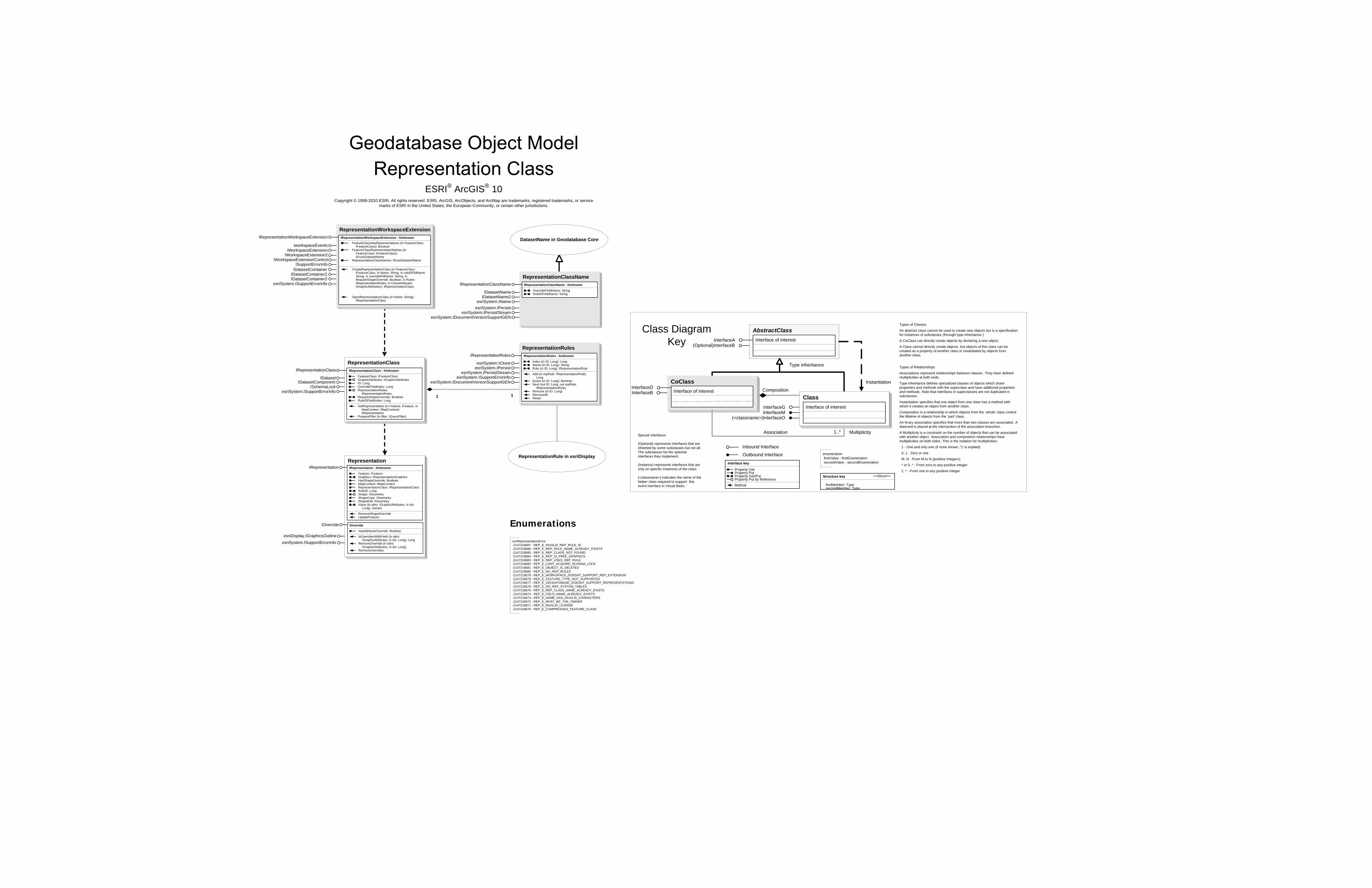
esriSystem.IPersistesriSystem.IPersistStream
esriSystem.IDocumentVersionSupportGEN
esriSystem.IDocumentVersionSupportGEN
esriSystem.ISupportErrorInfo
esriDisplay.IGraphicsOutline
1 1
CoClassInterfaceDInterfaceB
Types of Classes
An abstract class cannot be used to create new objects but is a specification for instances of subclasses (through type inheritance.)
A CoClass can directly create objects by declaring a new object .
A Class cannot directly create objects, but objects of this class can be created as a property of another class or instantiated by objects from another class.
Types of Relationships
Associations represent relationships between classes. They have defined multiplicities at both ends.
Type inheritance defines specialized classes of objects which share properties and methods with the superclass and have additional properties and methods. Note that interfaces in superclasses are not duplicated in subclasses.
Instantiation specifies that one object from one class has a method with which it creates an object from another class.
Composition is a relationship in which objects from the 'whole' class control the lifetime of objects from the 'part' class.
An N-ary association specifies that more than two classes are associated . A diamond is placed at the intersection of the association branches .
A Multiplicity is a constraint on the number of objects that can be associated with another object. Association and composition relationships have multiplicities on both sides. This is the notation for multiplicities:
1 - One and only one (if none shown, '1' is implied)
0..1 - Zero or one
M..N - From M to N (positive integers)
* or 0..* - From zero to any positive integer
1..* - From one to any positive integer
Class Diagram Key
enumeration firstValue - firstEnumeration secondValue - secondEnumeration
AbstractClass
Type inheritance
Instantiation
Association
Composition
1..* Multiplicity
Interface of interestInterfaceA(Optional)InterfaceB
Interface of interest
InterfaceGInterfaceM
Outbound Interface
Inbound Interface
Special Interfaces (Optional) represents interfaces that are inherited by some subclasses but not all . The subclasses list the optional interfaces they implement.
(Instance) represents interfaces that are only on specific instances of the class.
(<classname>) indicates the name of the helper class required to support this event interface in Visual Basic.
Interface key
Property GetProperty PutProperty Get/PutProperty Put by ReferenceMethod
(<classname>)InterfaceO
Structure key <<Struct>>
firstMember: TypesecondMember: Type
ClassInterface of interest
esriSystem.ISupportErrorInfo
Representation
ESRI® ArcGIS® 10 Copyright © 1999-2010 ESRI. All rights reserved. ESRI, ArcGIS, ArcObjects, and ArcMap are trademarks, registered trademarks, or service
marks of ESRI in the United States, the European Community, or certain other jurisdictions.
Enumerations
RepresentationRule in esriDisplay
DatasetName in Geodatabase Core
RepresentationRulesIRepresentationRules : IUnknown
Index (in ID: Long): LongName (in ID: Long): StringRule (in ID: Long): IRepresentationRule
Add (in repRule: IRepresentationRule): Long
Exists (in ID: Long): BooleanNext (out ID: Long, out repRule:
IRepresentationRule)Remove (in ID: Long)RemoveAllReset
IRepresentationRules
esriSystem.ICloneesriSystem.IPersist
esriSystem.IPersistStreamesriSystem.ISupportErrorInfo
RepresentationClassNameIRepresentationClassName : IUnknown
OverrideFieldName: StringRuleIDFieldName: String
IRepresentationClassName
IDatasetNameIDatasetName2
esriSystem.IName
RepresentationClassIRepresentationClass : IUnknown
FeatureClass: IFeatureClassGraphicAttributes: IGraphicAttributesID: LongOverrideFieldIndex: LongRepresentationRules:
IRepresentationRulesRequireShapeOverride: BooleanRuleIDFieldIndex: Long
GetRepresentation (in Feature: IFeature, in MapContext: IMapContext): IRepresentation
PrepareFilter (in filter: IQueryFilter)
IRepresentationClass
IDataset
ISchemaLockesriSystem.ISupportErrorInfo
IOverride
HasAttributeOverride: Boolean
IsOverridenWithField (in attrs: IGraphicAttributes, in idx: Long): Long
RemoveOverride (in attrs: IGraphicAttributes, in idx: Long)
RemoveOverrides
IOverride
RepresentationWorkspaceExtensionIRepresentationWorkspaceExtension : IUnknown
FeatureClassHasRepresentations (in FeatureClass: IFeatureClass): Boolean
FeatureClassRepresentationNames (in FeatureClass: IFeatureClass): IEnumDatasetName
RepresentationClassNames: IEnumDatasetName
CreateRepresentationClass (in FeatureClass: IFeatureClass, in Name: String, in ruleIDFldName: String, in overrideFldName: String, in RequireShapeOverride: Boolean, in Rules: IRepresentationRules, in ClassAttributes: IGraphicAttributes): IRepresentationClass
OpenRepresentationClass (in Name: String): IRepresentationClass
IRepresentationWorkspaceExtension
IWorkspaceExtensionIWorkspaceExtension2
IWorkspaceExtensionControlISupportErrorInfo
IDatasetContainerIDatasetContainer2IDatasetContainer3
IDatasetComponent
esriRepresentationError-2147218687 - REP_E_INVALID_REP_RULE_ID-2147218686 - REP_E_REP_RULE_NAME_ALREADY_EXISTS-2147218685 - REP_E_REP_CLASS_NOT_FOUND-2147218684 - REP_E_REP_IS_FREE_GRAPHICS-2147218683 - REP_E_REP_USES_REP_RULE-2147218682 - REP_E_CANT_ACQUIRE_SCHEMA_LOCK-2147218681 - REP_E_OBJECT_IS_DELETED-2147218680 - REP_E_NO_REP_RULES-2147218679 - REP_E_WORKSPACE_DOESNT_SUPPORT_REP_EXTENSION-2147218678 - REP_E_FEATURE_TYPE_NOT_SUPPORTED-2147218677 - REP_E_GEODATABASE_DOESNT_SUPPORT_REPRESENTATIONS-2147218676 - REP_E_NO_REP_SYSTEM_TABLES-2147218675 - REP_E_REP_CLASS_NAME_ALREADY_EXISTS-2147218674 - REP_E_FIELD_NAME_ALREADY_EXISTS-2147218673 - REP_E_NAME_HAS_INVALID_CHARACTERS-2147218672 - REP_E_MUST_BE_THE_OWNER-2147218671 - REP_E_INVALID_LICENSE-2147218670 - REP_E_COMPRESSED_FEATURE_CLASS
IworkspaceEvents
IRepresentation : IUnknown
Feature: IFeatureGraphics: IRepresentationGraphicsHasShapeOverride: BooleanMapContext: IMapContextRepresentationClass: IRepresentationClassRuleID: LongShape: IGeometryShapeCopy: IGeometryShapeEdit: IGeometryValue (in attrs: IGraphicAttributes, in idx:
Long): Variant
RemoveShapeOverrideUpdateFeature
IRepresentation

CoClassInterfaceDInterfaceB
Types of Classes
An abstract class cannot be used to create new objects but is a specification for instances of subclasses (through type inheritance.)
A CoClass can directly create objects by declaring a new object .
A Class cannot directly create objects, but objects of this class can be created as a property of another class or instantiated by objects from another class.
Types of Relationships
Associations represent relationships between classes. They have defined multiplicities at both ends.
Type inheritance defines specialized classes of objects which share properties and methods with the superclass and have additional properties and methods. Note that interfaces in superclasses are not duplicated in subclasses.
Instantiation specifies that one object from one class has a method with which it creates an object from another class.
Composition is a relationship in which objects from the 'whole' class control the lifetime of objects from the 'part' class.
An N-ary association specifies that more than two classes are associated . A diamond is placed at the intersection of the association branches .
A Multiplicity is a constraint on the number of objects that can be associated with another object. Association and composition relationships have multiplicities on both sides. This is the notation for multiplicities:
1 - One and only one (if none shown, '1' is implied)
0..1 - Zero or one
M..N - From M to N (positive integers)
* or 0..* - From zero to any positive integer
1..* - From one to any positive integer
Class Diagram Key
enumeration firstValue - firstEnumeration secondValue - secondEnumeration
AbstractClass
Type inheritance
Instantiation
Association
Composition
1..* Multiplicity
Interface of interestInterfaceA(Optional)InterfaceB
Interface of interest
InterfaceGInterfaceM
Outbound Interface
Inbound Interface
Special Interfaces (Optional) represents interfaces that are inherited by some subclasses but not all . The subclasses list the optional interfaces they implement.
(Instance) represents interfaces that are only on specific instances of the class.
(<classname>) indicates the name of the helper class required to support this event interface in Visual Basic.
Interface key
Property GetProperty PutProperty Get/PutProperty Put by ReferenceMethod
(<classname>)InterfaceO
Structure key <<Struct>>
firstMember: TypesecondMember: Type
ClassInterface of interest
® ®
Copyright © 1999-2010 ESRI. All rights reserved. ESRI, ArcGIS, ArcObjects, and ArcMap are trademarks, registered trademarks, or service marks of ESRI in the United States, the European Community, or certain other jurisdictions.
Workspace in Geodatabase Core
SqlWorkspaceFactoryIn DataSourcesGDB
IWorkspaceFactoryIWorkspaceFactory2
IRemoteDatabaseWorkspaceFactoryISqlDefaultConnectionInfo
SqlWorkspaceIn DataSourcesGDBISqlWorkspace : IUnknown
CheckDatasetName (in Name: String, in pQueryDescription: IQueryDescription, out pNewName: String)
GetColumns (in TableName: String, out ppColumnName: IStringArray, out ppColumnType: IStringArray, out ppIsNullable: IVariantArray, out ppSize: ILongArray, out ppPrecision: ILongArray, out ppScale: ILongArray)
GetQueryDescription (in Query: String): IQueryDescription
GetTables: IStringArrayOpenQueryClass (in Name: String, in
pQueryDescription: IQueryDescription): ITable
OpenQueryCursor (in Query: String): ICursor
ISqlWorkspace
IDatasetIWorkspace
IWorkspacePropertiesISQLSyntax
IDatabaseConnectionInfoIDatabaseConnectionInfo2
QueryDescriptionIQueryDescription : IUnknown
Fields: IFieldsGeometryType: esriGeometryTypeIsOIDMappedColumn: BooleanIsSpatialQuery: BooleanOIDColumnName: StringOIDFields: StringQuery: StringShapeColumnName: StringSpatialReference: ISpatialReferenceSrid: StringUseApproximateExtent: Boolean
IQueryDescription
SqlClassIDatasetITable
IFeatureClass(optional)
IGeoDataset(optional)
ITableCapabilities
SqlCursorICursorIFeatureCursor
(optional)