classification of forests in zambiazmb-nfms.org/...classification-of-zambian-forests.pdf ·...
TRANSCRIPT
Classification of Forests in Zambia
Technical Paper prepared for the Forestry Department, the Ministry of
Lands, Natural Resources and Environmental Protection and the Food
Agriculture Organization of the United Nations as a part of the
Integrated Land Use Assessment Phase II
by
Emanuel N. Chidumayo1
The Government of the Republic of Zambia as the implementing partner provided
staff, office facilities and the organizational setting for the ILUA II program through
the Forestry Department in the Ministry of Lands Natural Resources and
Environmental Protection
The Government of the Republic of Finland as the development partner who
supported the ILUA II project with funding
The Food and Agricultural Organisation of the United Nations provided the logistical
framework, channelled funds and provided technical oversight to the project
Please cite this paper as:
Forestry Department (2016), Ministry of Lands Natural Resources and Environmental Protection, Integrated
Land Use Assessment Phase II - Technical Paper 1, Classification of Forests in Zambia. Food and Agricultural
Organization of the United Nations, Ministry of Foreign Affairs Finland. Lusaka, Zambia
Disclaimer
The views expressed in these papers are those of the authors and do not necessarily reflect the views of their
respective institutions. While reasonable efforts have been made to ensure that the contents of this
publication are factually correct and properly referenced, the authors do not warrant the information in this
paper is free from errors or omissions.
1 Prof. Emanuel N. Chidumayo, Ecologist and Manager at the Makeni Savanna Research Project in Lusaka, Zambia

FOREWORD
Forests in Zambia form a large part of the landscape of the country. The Integrated Land-Use
Assessment carried out between 2005 and 2008 revealed that almost 60% of the land area in the
country was covered by forests. However, not all the forests in Zambia are alike because of
geographical, environmental and other factors. In developing the forest classification for Zambia, a
review of the previous classification was necessary and the classification that was adopted for the
ILUA II in Zambia was based on both global and national requirements.
The classification of forests is an important aspect of forest management and land-use planning. It
defines the forest communities that are available and that are supposed to be conserved or
preserved. A good understanding of the forest communities through space and time helps forest
managers to describe their forests in detail and generate ideas on how best the forests should be
managed.
This technical paper, which is an input into the methodology adopted for biophysical data collection
in the ILUA II, provides an excellent review of the different attempts at classifying the Zambian
vegetation in the past. The paper also proposes recommendations for forest classification that take
into account the current requirements which focus on global, national and decentralized forest area
levels.
We hope that this publication will serve as a useful analytical contribution to forest classification in
Zambia and will subsequently promote sustainable forest management.
Ignatius N. Makumba Bwalya Chendauka
DIRECTOR - FORESTRY NATIONAL COORDINATOR - ILUA II

Classification of Forests in Zambia | ILUA II
ii
TABLE OF CONTENTS
FOREWORD............................................................................................................................................................................................ i
TABLE OF CONTENTS .....................................................................................................................................................................ii
LIST OF TABLES................................................................................................................................................................................ iii
LIST OF FIGURES.............................................................................................................................................................................. iv
LIST OF ACRONYMS ......................................................................................................................................................................... v
ABSTRACT .............................................................................................................................................................................................1
1. BACKGROUND TO VEGETATION CLASSIFICATION IN ZAMBIA .....................................................................2
1.1. The vegetation-soil classification approach ....................................................................................................2
1.2 The species approach to vegetation classification .......................................................................................3
1.3. Previous approaches to vegetation classification ........................................................................................4
2. SCOPE OF THE STUDY ..........................................................................................................................................................5
3. EXISTING APPROACHES TO FOREST CLASSIFICATION IN ZAMBIA ............................................................5
3.1. Classification of forests by Trapnell ....................................................................................................................5
3.2. Classification of forests by Lees .......................................................................................................................... 10
3.3. Classification of forests by Fanshawe .............................................................................................................. 10
3.4. Land use and cover classification by Schultz ............................................................................................... 13
3.5. Classification of forests by Lawton.................................................................................................................... 14
3.6. Classification of forests by Edmonds ............................................................................................................... 16
3.7. Classification of forests by SADCC Fuelwood Project .............................................................................. 17
3.8. Classification of miombo forests by dominant woody species ........................................................... 19
3.9. Classification of forests by cover types ........................................................................................................... 21
3.10. Classification of forests by ILUA I....................................................................................................................... 21
4. ECOLOGICAL INDICATORS FOR FOREST CLASSIFICATION .......................................................................... 24
4.1. Ecological indicators and forest classification in Zambia ...................................................................... 24
4.2. Preliminary classification of Zambian forests for ILUA II ..................................................................... 28
4.3. Field data required for forest classification and analysis of relationships with other
environmental variables ........................................................................................................................................................ 31
5. KEY ISSUES AND RECOMMENDATIONS ................................................................................................................... 38
6. REFERENCES .......................................................................................................................................................................... 39

Classification of Forests in Zambia | ILUA II
iii
LIST OF TABLES
Table 1.1 Description of the 1960 woodland classification for the Copperbelt area by Lees (1962). 2
Table 1.2 Outline of the different approaches that have been used to classify Zambian vegetation
types. ...................................................................................................................................................... 4
Table 3.1 Classification of vegetation of central and western Zambia by Trapnell and Clothier
(1957). ................................................................................................................................................... 6
Table 3.2 Description of vegetation and soils of Southern Province based on Trapnell and Clothier
(1957). ................................................................................................................................................... 7
Table 3.3 Vegetation classification system for north-eastern Zambia used by Trapnell (1953). ........ 8
Table 3.4 Vegetation classification system for Zambia used by Fanshawe (1969). ........................... 12
Table 3.5 Land use categories in Zambia by Schultz (1974) ............................................................... 13
Table 3.6 Classification of vegetation of Zambia by Edmonds (1976). ............................................... 16
Table 3.7 Aboveground woody biomass stock and MAI data for Zambia based on the SADCC
Fuelwood Project. ................................................................................................................................ 18
Table 3.8 The land-cover classes developed by PFAP using LandSat MSS images of 1993................ 21
Table 3.9 FAO-based land use/forest type classification used in ILUA I for Zambia .......................... 22
Table 4.1 Trapnell’s fire tolerance classification of trees and shrubs after 11 continuous years of fire
treatments in wetter miombo at Ndola in Copperbelt Province. ........................................................ 24
Table 4.2 Some ecological indicators and their interpretation in forest dynamics. ........................... 27
Table 4.3 A preliminary classification of Zambian forests and land cover types for ILUA II.
Definitions of forest types are as in Table 3.9. .................................................................................... 28
Table 4.4 Distribution of fully sampled tracks during ILUA I. Based on ILUA I database. .................. 31
Table 4.5 Essential data required for ILUA II and justification for categorizing as essential. Columns
on Form, Section, Question and Data follow ILUA I. The data will be collected using ILUA I Forms
but adjusted to include the proposed changes. ................................................................................... 33

Classification of Forests in Zambia | ILUA II
iv
LIST OF FIGURES
Figure 1.1 Spatial patterns in major miombo species’ richness (a: species per 0.4ha plot), total
woody genera ........................................................................................................................................ 3
Figure 3.1 The vegetation-soil map for Southern Province based on Trapnell and Clothier (1957).
For a description of soils and floristic associations see Table 3.2......................................................... 7
Figure 3.2 Vegetation sample quadrants surveyed by Lawton (1968–1970) in Northern (including
Muchinga, except Chama District) and Luapula Provinces in Zambia. ............................................... 14
Figure 3.3 Ecological classification of miombo woodlands (including Kalahari sand miombo) in
Zambia. Based on Chidumayo (1987a). ............................................................................................... 20
Figure 4.1 Even a miombo open forest consisting of large spaced trees with a moderately dense
carpet of grass and no understorey or shrub layer (Fanshawe 1969), like this stand in central
Zambia, has been disturbed in the past. .............................................................................................. 25
Figure 4.2 Changes in relative abundance of Julbernardia paniculata in old-growth and coppiced
miombo woodland samples in Kopa Chiefdom in Mpika District in Muchinga Province, Zambia.
Vertical line on each bar shows 1 standard error of mean. ................................................................ 26
Figure 4.3 Aerial (A) and lateral (B) views of vegetation types: closed forest (a1), open forest (a2)
and grassland (a3). For a lateral view open forest see Figure 4.1. ..................................................... 37
Classification of Forests in Zambia | ILUA II
v
LIST OF ACRONYMS
AVHRR Advanced Very High Resolution Radiometer
FAO Food and Agriculture Organization of the United Nations
ILUA I Integrated Land Use Assessment Phase I
ILUA II Integrated Land Use Assessment Phase II
IPCC Intergovernmental Panel on Climate Change
MAI Mean Annual Increment
MSS Multispectral Scanner
NDVI Normalized Difference Vegetation Index
NOAA National Oceanic and Atmospheric Administration
PFAP Provincial Forestry Action Programme
REDD+ Reducing Emissions from Deforestation and Forest Degradation, Conservation,
Enhancement of Carbon Stocks and Sustainable Forest Management
SADCC Southern African Development Coordination Conference (from 1992 Southern
Africa Development Community, SADC)

Classification of Forests in Zambia | ILUA II
1
ABSTRACT Since the 1950s, several approaches have been made to classify Zambian vegetation types. Because
of the long history of human activities in the country, a clear vegetation-soil relationship has never
been adequately demonstrated. The occurrence, intensity and effects of fire over a long period of
time have further complicated the assessment. The eco-physiology of the majority of indigenous
trees is adapted to climatic conditions and variable soil fertility and moisture status that are
reflected in the deciduous habit of most species and their deep root systems. This has made it
extremely difficult to prescribe a single ecological classification system based on geology, soil and
climate for the Zambian vegetation. A classification method based on both global and national
requirements is proposed for ILUA II purposes, based on ecological indicators. They are useful in
the interpretation of forest dynamics in Zambia and can be applied to the ecological classification of
forests, especially those that have been subjected to disturbances. It is proposed that these be used
in the interpretation of the ILUA inventory data and in the development of scenarios of future
trends in vegetation composition or dynamics. The following issues and recommendations for ILUA
II are raised in this report.
1. Although ILUA I and II may not be the best suited for sampling rare vegetation types due to cost
considerations, closed forests require to be sampled more adequately during ILUA II. Forest
classification used in remote sensing mapping should also be linked to that used in field inventory
at the design phase of ILUA II. This could be done by first stratifying the country into land cover
types and determining proportional sampling representation for each land cover class. A detailed
post-classification of the vegetation types can be done using other variables for which data will be
collected during the field inventory.
2. The interpretation of the inventory data should include the use of ecological indicators so that
trends can be described and scenarios made from the current distribution of key indicators of
forest dynamics. The identification of tree species in the field during ILUA II should be improved.
The use of the Check list of vernacular names of the woody plants of Zambia by D.F. Fanshawe
(1965), which also contains the corresponding scientific plant names, should improve the
identification of tree species.
3. The collection and analysis of soil samples can be costly. However, soils data, especially that of
soil organic matter and carbon, are required for REDD+ implementation in the country. It is
therefore proposed that limited soil samples be collected per land cover type for the determination
of organic matter and carbon to meet REDD+ requirements.
4. Given the longstanding impact of human activities on the Zambian vegetation structure, it is not
necessary to use climate zones for determining the sampling design for ILUA II. However, the
growing concern about impacts of climate change on trees and forests demands that the analysis of
ILUA II data be done based on the 1961–1990 climate reference period, and the use of climate
change scenarios for 2020 and 2050. This, together with a literature review, should enable the
analysis of potential responses of trees and forests to climate change in the country.
Classification of Forests in Zambia | ILUA II
2
1. BACKGROUND TO VEGETATION CLASSIFICATION IN ZAMBIA
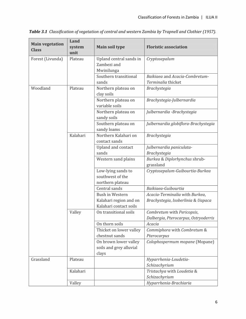
1.1. The vegetation-soil classification approach Various ecological classifications have been applied to Zambian forests, starting with Trapnell and
Clothier (1957) and Trapnell (1953) who attempted to classify Zambia forests using soil and
topographic features based on the indigenous knowledge of local people. This soil-vegetation
relationship was demonstrated by the following quote from Trapnell and Clothier (1957):
“The correlation between vegetation and soil type is an extremely close one in North-Western Rhodesia [now Zambia]. This fact is widely, if not universally, utilised by the native, who selects his land by the type of woodland or grassland cover which it carries and knows the different cropping potentialities and possible duration, of cultivation in each type of bush. The soil types by themselves not always readily recognisable, can be more easily differentiated by their type of bush, especially where native assistance is available.”
However, even at this early stage of vegetation classification in the country, both Trapnell and
Clothier (1957) and Trapnell (1953) acknowledged that the dominant tree species have a wide soil
tolerance and that, within one climatic zone, a single soil type may carry two or more types of
vegetation, and they therefore did not attempt to demonstrate the ecological significance of the soil-
vegetation relationship (Lees 1962). In 1956, Fanshawe (quoted in Lees, 1962) classified
woodlands on the basis of soil colour and tree height, but when this was applied to Misaka Forest
Reserve in Copperbelt Province, it was found unsuitable for detailed application. Therefore, Lees
(1962) developed an ecological classification of woodlands in the Copperbelt area for forestry
purposes that was referred to as the “1960 Woodland Classification”, and that tried to match
floristic associations with geology and soil. This classification is summarized in Table 1.1.
Table 1.1 Description of the 1960 woodland classification for the Copperbelt area by Lees (1962).
Class type Floristic association Geology and soils
1: Museshe Marquesia macroura 7.5 YR and 5 YR soils and with biotite schists
2: Musaka Brachystegia utilis Granite and quartz gravels
3: Muwombo-
Muputu
Brachystegia longifolia or
Brachystegia spicifomis with
Julbernardia paniculata
Deeper soils on limestone and dolomite and
sandy soils derived from quartzites and
sandstone
4: Musompa Brachystegia floribunda 2.5 YR shallow soils over laterite
5: Mixed
Mutondo
Julbernardia paniculata and/or
Brachystegia boehmii
On wide range of soils
6: Munkulungu Brachystegia bussei Rock outcrops
7: Chipya Brachystegia spiciformis-
Erythrophleum africanum
Colluvial and loose sandy soils on almost
any geology
8: Chipya scrub Acacia Colluvial and loose sandy soils on almost
any geology but poorer sites
9: Scrub Brachstegia-Uapaca Pallid shallow soils over laterite
Classification of Forests in Zambia | ILUA II
3
In spite of the attempt to develop an ecological classification of the woodlands of Copperbelt area,
Lees (1962) identified some major difficulties in establishing vegetation-soil-geology relationships.
Firstly, the occurrence, intensity and effects of fire over a long period of time is difficult, if not
impossible, to assess. The type, age and effects of traditional cultivation and effects of past
exploitation have also radically altered the development and structure of the forests and
woodlands. Secondly, the assessment of the soil-geology relationship is complicated by past erosion
and sedimentary processes and the subsequent development, in situ, of other soils, to the extent
that adjacent soils may have different origins and chemical/structural characteristics. In addition,
the eco-physiology of the majority of indigenous trees is adapted to climatic conditions and variable
soil fertility and moisture statuses that are reflected in the deciduous habit of most species and
their deep root systems (Savory, 1962). All these processes and factors make it extremely difficult
to prescribe a single ecological classification system for the Zambian vegetation based on geology,
soil and climate.
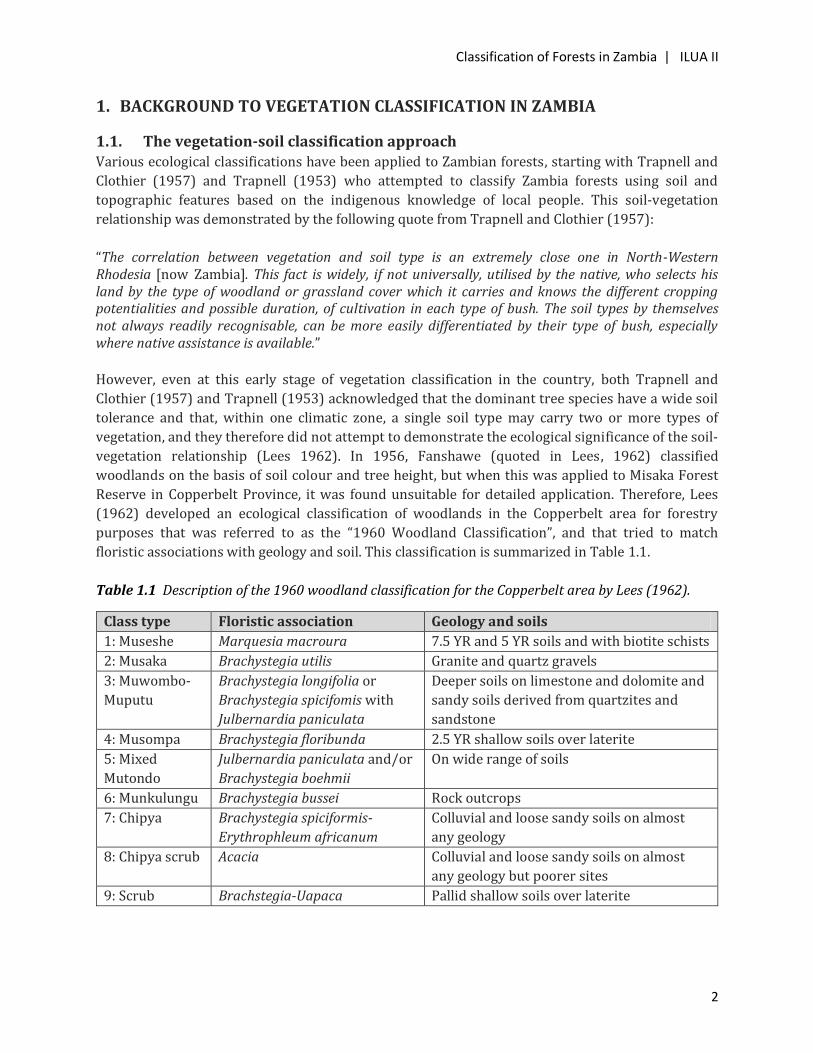
1.2 The species approach to vegetation classification Using inventory data from the 1982–1985 miombo woodland survey, Chidumayo (1987a)
undertook spatial modelling to compare outputs based on three ecological variables: (i) density of
miombo species (Brachystegia, Isoberlinia and Julbernardia), (ii) total woody genera and (iii) basal
area (m2) per 0.4ha sample plots in Copperbelt, Central, Luapula, Lusaka, Eastern, Northern, North-
Western and Western Provinces. The spatial outputs for each variable used were different (Figure
1.1), implying that different approaches generate contrasting results. Thus, forest species’ structure
and richness are not necessarily correlated with stocking rates, at least in Zambian miombo
woodland types.
10-12
8-104-6
6-8
2-4
6-8 4-6
4-6
6-8
30 - 40
20 - 30
10 - 20
10 - 20
10 - 20
30 -
40
30 - 40
20 - 30
15 - 20 m2 ha-1
10 - 15 m2 ha-1
<10 m2 ha-1
<10 m2 ha-1
<10 m2 ha-1
10 - 15 m2 ha-1
10 - 15 m2 ha-1
(a) (b)
(c)
Figure 1.1 Spatial patterns in major miombo species’ richness (a: species per 0.4ha plot), total woody genera
Figure 1.1 Spatial patterns in major miombo species richness (a: species per 0.4 ha plot), total woody genera (b: genera per 0.4 ha plot) and basal area (c: m2 per ha) in miombo subtypes in Zambia. Based on Chidumayo (1987a).

Classification of Forests in Zambia | ILUA II
4
1.3. Previous approaches to vegetation classification Table 1.2 summarizes the main approaches that have been used to classify vegetation types in
Zambia. These approaches are described in detail in Section 3.
Table 1.2 Outline of the different approaches that have been used to classify Zambian vegetation types.
Source Objective Geographical
coverage
Classification
approach
Trapnell and Clothier
(1957)
Vegetation and soil
mapping for
agricultural planning
North -Western
Zambia (Copperbelt,
North-Western,
Southern, Western
Provinces and parts of
Central and Lusaka
Provinces)
Vegetation
classification based on
landscape units and
soil types
Trapnell (1953) Vegetation and soil
mapping for
agricultural planning
North-Eastern Zambia
(Eastern, Luapula,
Muchinga and
Northern Provinces
and parts of Central
and Lusaka Provinces
Vegetation
classification based on
landscape units and
soil types
Lees (1962) Forest management
planning
Copperbelt Province Vegetation
classification based on
stocking rates and site
quality
Fanshawe (1969) Vegetation description Country-wide Structural and
ecological
classification
Schultz (1974) Land use assessment
and planning
Country-wide Land use classification
Mansfield et al. (1976) Land use assessment
and land resources
management
Luapula and Northern
Provinces, and
Muchinga Province,
except Chama district
Vegetation
classification based on
site quality and
ecological groups
Edmonds (1976) Production of
vegetation map at
1:500,000 scale
Country-wide Classification based on
Fanshawe (1969)
Millington et al. (1986) Wood biomass
assessment and
management planning
Country-wide Classification based on
biomass stocking rates
Chidumayo (1987) Description of miombo
woodland types
Country-wide except
Southern Province
Classification based on
dominant species
Provincial Forestry
Action Programme
Forest and land cover
mapping
Luapula, Copperbelt
and Central Provinces
Classification based on
land cover
Classification of Forests in Zambia | ILUA II
5
Source Objective Geographical
coverage
Classification
approach
(1996 - 1998)
Integrated Land Use
Assessment (ILUA) 1
(2005 – 2008)
Forest cover and land
use assessment and
planning
Country-wide Classification based on
the FAO (global)
system
2. SCOPE OF THE STUDY
According to the Terms of Reference, the objectives of this study were:
(i) To identify and study existing information on forest classification in Zambia, both in written and
map format, including the work that has been implemented under ILUAI.
(ii) To identify and describe key ecological indicators for forest classification in Zambia.
(iii) To propose a preliminary classification of Zambian forests using the identified key indicators.
(iv) To specify ILUA II field data to be collected for the purpose of forest classification.
(v) To prepare a section on forest classification for the field manual.
The work involved the review of published and unpublished literature and the analysis of
vegetation maps for parts of, or the whole, country.
3. EXISTING APPROACHES TO FOREST CLASSIFICATION IN ZAMBIA
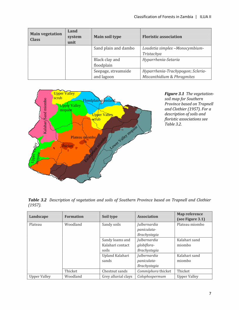
3.1. Classification of forests by Trapnell The first extensive surveys of vegetation in Zambia were conducted from 1932 to 1936 by C. G.
Trapnell and J. N. Clothier (Trapnell and Clothier, 1957; reprinted in 1996), and during 1937 to
1942 by C. G. Trapnell (Trapnell, 1953; reprinted in 1996). The 1932–1936 survey covered central
and western regions of the country (i.e. Copperbelt, North-Western, Southern and Western
Provinces and parts of Central and Lusaka Provinces); the rest of the country was covered by the
1937–1942 survey. Both surveys focused on soils, vegetation and traditional agriculture, and
therefore aimed at establishing a soil-vegetation classification that could be used for assessing the
agriculture potential in the country. Trapnell and Clothier (1957) used vegetation main classes,
landscape units and soil types to derive vegetation floristic associations for central and western
Zambia (Table 3.1) and produced a provisional vegetation-soil map for the region. An example of
such a map is given in Figure 3.1 for Southern Province, while the floristic associations for the map
units are summarized in Table 3.2.
Classification of Forests in Zambia | ILUA II
6
Table 3.1 Classification of vegetation of central and western Zambia by Trapnell and Clothier (1957).
Main vegetation
Class
Land
system
unit
Main soil type Floristic association
Forest (Livunda) Plateau Upland central sands in
Zambezi and
Mwinilunga
Cryptosepalum
Southern transitional
sands
Baikiaea and Acacia-Combretum-
Terminalia thicket
Woodland Plateau Northern plateau on
clay soils
Brachystegia
Northern plateau on
variable soils
Brachystegia-Julbernardia
Northern plateau on
sandy soils
Julbernardia -Brachystegia
Southern plateau on
sandy loams
Julbernardia globiflora-Brachystegia
Kalahari Northern Kalahari on
contact sands
Brachystegia
Upland and contact
sands
Julbernardia paniculata-
Brachystegia
Western sand plains Burkea & Diplorhynchus shrub-
grassland
Low-lying sands to
southwest of the
northern plateau
Cryptosepalum-Guibourtia-Burkea
Central sands Baikiaea-Guibourtia
Bush in Western
Kalahari region and on
Kalahari contact soils
Acacia-Terminalia with Burkea,
Brachystegia, Isoberlinia & Uapaca
Valley On transitional soils Combretum with Pericopsis,
Dalbergia, Pterocarpus, Ostryoderris
On thorn soils Acacia
Thicket on lower valley
chestnut sands
Commiphora with Combretum &
Pterocarpus
On brown lower valley
soils and grey alluvial
clays
Colophospermum mopane (Mopane)
Grassland Plateau Hyparrhenia-Loudetia-
Schizachyrium
Kalahari Tristachya with Loudetia &
Schizachyrium
Valley Hyparrhenia-Brachiaria
Classification of Forests in Zambia | ILUA II
7
Main vegetation
Class
Land
system
unit
Main soil type Floristic association
Sand plain and dambo Loudetia simplex –Monocymbium-
Tristachya
Black clay and
floodplain
Hyparrhenia-Setaria
Seepage, streamside
and lagoon
Hyparrhenia-Trachypogon; Scleria-
Miscanthidium & Phragmites
Plateau miombo
Thicket
Upper Valley
scrub
Esc
arpm
ent m
iom
bo
Lower
Val
ley m
opane
Upper Valley
mopane
Kal
ahar
i S
and m
iom
bo
Floodplain grassland
Upper Valley
scrub
Upper
Val
ley
mopan
e
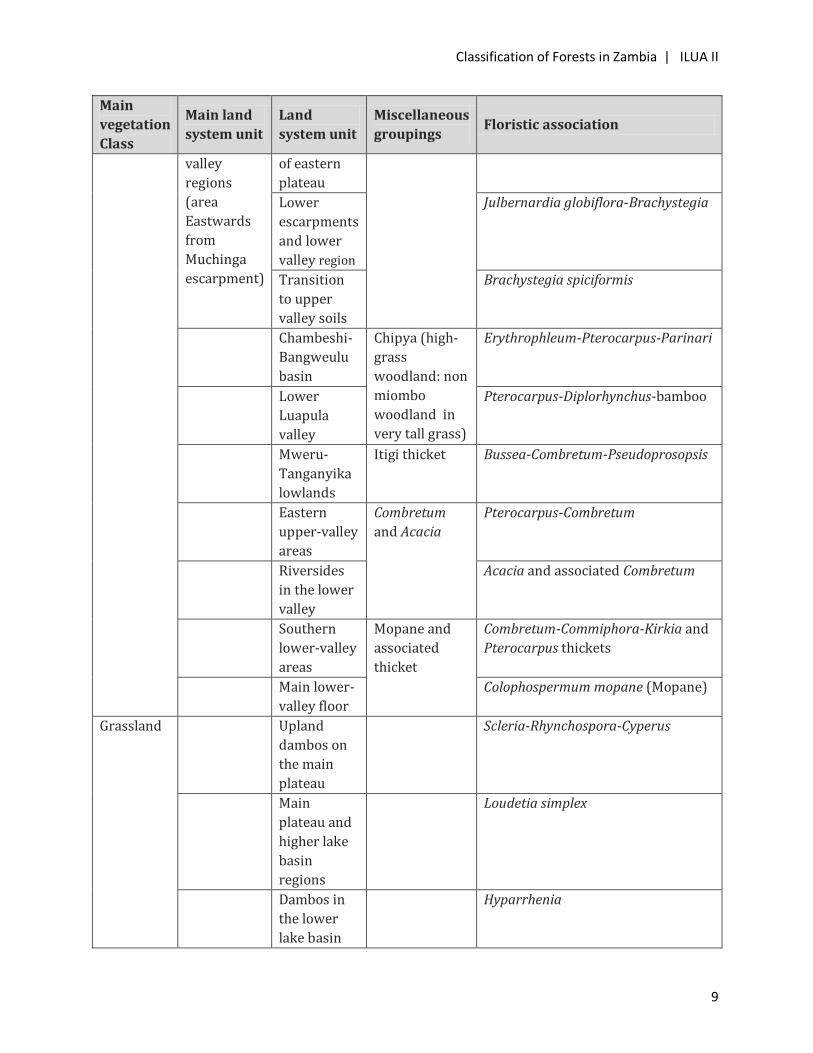
Table 3.2 Description of vegetation and soils of Southern Province based on Trapnell and Clothier (1957).
Landscape Formation Soil type Association Map reference
(see Figure 3.1)
Plateau Woodland Sandy soils Julbernardia
paniculata-
Brachystegia
Plateau miombo
Sandy loams and
Kalahari contact
soils
Julbernardia
globiflora-
Brachystegia
Kalahari sand
miombo
Upland Kalahari
sands
Julbernardia
paniculata-
Brachystegia
Kalahari sand
miombo
Thicket Chestnut sands Commiphora thicket Thicket
Upper Valley Woodland Grey alluvial clays Colophospermum Upper Valley
Figure 3.1 The vegetation-soil map for Southern Province based on Trapnell and Clothier (1957). For a description of soils and floristic associations see Table 3.2.

Classification of Forests in Zambia | ILUA II
8
Landscape Formation Soil type Association Map reference
(see Figure 3.1)
mopane mopane
Scrubland Transitional and
thorn soils
Combretum scrub
and Acacia termitary
Scrub
Escarpment Woodland Escarpment soils Julbernardia
globiflora-
Brachystegia
Escarpment
miombo
Lower Valley Brown soils Colophospermum
mopane
Lower Valley
mopane
Floodplain Grassland Alluvial soils Floodplain
grassland
The vegetation classification for north-eastern Zambia (Luapula, Northern and Eastern Provinces
and parts of Central and Lusaka Provinces) by Trapnell (1953) (Table 3.3) was similar to that
adopted for central and western Zambia. A separate vegetation-soil map (1:1,000,000) for north-
eastern Zambia was published in 1962.
Table 3.3 Vegetation classification system for north-eastern Zambia used by Trapnell (1953).
Main
vegetation
Class
Main land
system unit
Land
system unit
Miscellaneous
groupings Floristic association
Forest (11
– 25m
tall:)
Evergreen
fringing forest
and allied
vegetation
(mushitu in
Bemba)
Mist forest relicts (Parinari-
Podocarpus forest)
Upland streamside vegetation
(Syzygium-Gardenia-Apodytes forest)
Swamp (Syzygium-Xylopia-
Mitragyna forest)
Eastern and Lowland streamside
(Adina-Khaya-Trichilia-Diospyros
forest)
Woodland Main
plateau
Northern
uplands
Brachystegia-
Isoberlinia
Brachystegia-Julbernardia globiflora
Central
plateau
Brachystegia-Julbernardia paniculata
of northern uplands & Julbernardia
paniculata-Brachystegia longifolia of
central uplands
Transition
to lake basin
soils
Brachystegia spiciformis
Eastern
plateau,
escarpment
and lower
Poorer
watershed
areas
Julbernardia paniculata-Brachystegia
Other parts Brachystegia manga- Julbernardia
Classification of Forests in Zambia | ILUA II
9
Main
vegetation
Class
Main land
system unit
Land
system unit
Miscellaneous
groupings Floristic association
valley
regions
(area
Eastwards
from
Muchinga
escarpment)
of eastern
plateau
Lower
escarpments
and lower
valley region
Julbernardia globiflora-Brachystegia
Transition
to upper
valley soils
Brachystegia spiciformis
Chambeshi-
Bangweulu
basin
Chipya (high-
grass
woodland: non
miombo
woodland in
very tall grass)
Erythrophleum-Pterocarpus-Parinari
Lower
Luapula
valley
Pterocarpus-Diplorhynchus-bamboo
Mweru-
Tanganyika
lowlands
Itigi thicket Bussea-Combretum-Pseudoprosopsis
Eastern
upper-valley
areas
Combretum
and Acacia
Pterocarpus-Combretum
Riversides
in the lower
valley
Acacia and associated Combretum
Southern
lower-valley
areas
Mopane and
associated
thicket
Combretum-Commiphora-Kirkia and
Pterocarpus thickets
Main lower-
valley floor
Colophospermum mopane (Mopane)
Grassland Upland
dambos on
the main
plateau
Scleria-Rhynchospora-Cyperus
Main
plateau and
higher lake
basin
regions
Loudetia simplex
Dambos in
the lower
lake basin
Hyparrhenia

Classification of Forests in Zambia | ILUA II
10
Main
vegetation
Class
Main land
system unit
Land
system unit
Miscellaneous
groupings Floristic association
regions
Permanently
flooded
areas of
Bangweulu
swamps,
lower
Luapula
valley and
Mweru-
Wantipa
Oryza-Sacciolepis-Cyperus
3.2. Classification of forests by Lees Lees (1962) prepared a working plan for the forests of the Copperbelt area using a classification system
based on the 1958–1960 survey. The survey collected data on:
(i) Exploitable volume of trees with a 14cm girth and above
(ii) Frequency of canopy tree species that was used in woodland type classification
(iii) Average top height of canopy trees
(iv) Frequency or abundance of Landolphia creeper as an indicator species
(v) Occurrence by numbers present of tree species that might have indicator value (Syzygium
guineense, Erythrophleum africanum and Albizia adianthifolia)
The analysis of survey data also attempted to correlate the composition of overwood, ground
vegetation, soil features, tree height, basal area and volume with site quality. The study concluded
that the relationship between site quality and other factors was complex. However, Lees (1962)
recognized the following seven miombo woodland floristic types in the Copperbelt area:
(i) Marquesia woodland (ii) Bracystegia utilis woodland (iii) Brachystegia longifolia-Brachystegia spiciformis woodland (iv) Brachystegia floribunda woodland (v) Mixed Julbernardia paniculata woodland (vi) Brachystegia bussei woodland (vii) Brachystegia scrub
3.3. Classification of forests by Fanshawe
The vegetation description by Fanshawe (1969) was based on data collated from published
sources, unpublished manuscripts, working plans, district management books, the results of
research projects and from observations and studies he conducted while on reconnaissance with
Classification of Forests in Zambia | ILUA II
11
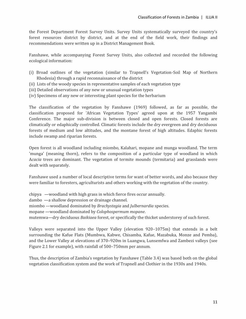
the Forest Department Forest Survey Units. Survey Units systematically surveyed the country’s
forest resources district by district, and at the end of the field work, their findings and
recommendations were written up in a District Management Book.
Fanshawe, while accompanying Forest Survey Units, also collected and recorded the following
ecological information:
(i) Broad outlines of the vegetation (similar to Trapnell’s Vegetation-Soil Map of Northern
Rhodesia) through a rapid reconnaissance of the district
(ii) Lists of the woody species in representative samples of each vegetation type
(iii) Detailed observations of any new or unusual vegetation types
(iv) Specimens of any new or interesting plant species for the herbarium
The classification of the vegetation by Fanshawe (1969) followed, as far as possible, the
classification proposed for 'African Vegetation Types' agreed upon at the 1957 Yangambi
Conference. The major sub-division is between closed and open forests. Closed forests are
climatically or edaphically controlled. Climatic forests include the dry evergreen and dry deciduous
forests of medium and low altitudes, and the montane forest of high altitudes. Edaphic forests
include swamp and riparian forests.
Open forest is all woodland including miombo, Kalahari, mopane and munga woodland. The term
'munga' (meaning thorn), refers to the composition of a particular type of woodland in which
Acacia trees are dominant. The vegetation of termite mounds (termitaria) and grasslands were
dealt with separately.
Fanshawe used a number of local descriptive terms for want of better words, and also because they
were familiar to foresters, agriculturists and others working with the vegetation of the country.
chipya —woodland with high grass in which fierce fires occur annually.
dambo —a shallow depression or drainage channel.
miombo —woodland dominated by Brachystegia and Julbernardia species.
mopane —woodland dominated by Colophospermum mopane.
mutemwa—dry deciduous Baikiaea forest, or specifically the thicket understorey of such forest.
Valleys were separated into the Upper Valley (elevation 920–1075m) that extends in a belt
surrounding the Kafue Flats (Mumbwa, Kabwe, Chisamba, Kafue, Mazabuka, Monze and Pemba),
and the Lower Valley at elevations of 370–920m in Luangwa, Lunsemfwa and Zambezi valleys (see
Figure 2.1 for example), with rainfall of 500–750mm per annum.
Thus, the description of Zambia’s vegetation by Fanshawe (Table 3.4) was based both on the global
vegetation classification system and the work of Trapnell and Clothier in the 1930s and 1940s.
Classification of Forests in Zambia | ILUA II
12
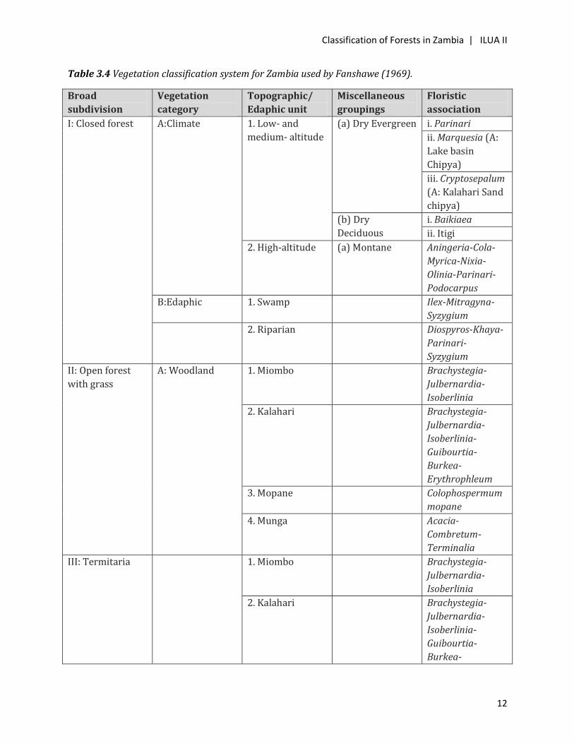
Table 3.4 Vegetation classification system for Zambia used by Fanshawe (1969).
Broad
subdivision
Vegetation
category
Topographic/
Edaphic unit
Miscellaneous
groupings
Floristic
association
I: Closed forest A:Climate 1. Low- and
medium- altitude
(a) Dry Evergreen i. Parinari
ii. Marquesia (A:
Lake basin
Chipya)
iii. Cryptosepalum
(A: Kalahari Sand
chipya)
(b) Dry
Deciduous
i. Baikiaea
ii. Itigi
2. High-altitude (a) Montane Aningeria-Cola-
Myrica-Nixia-
Olinia-Parinari-
Podocarpus
B:Edaphic 1. Swamp Ilex-Mitragyna-
Syzygium
2. Riparian Diospyros-Khaya-
Parinari-
Syzygium
II: Open forest
with grass
A: Woodland 1. Miombo Brachystegia-
Julbernardia-
Isoberlinia
2. Kalahari Brachystegia-
Julbernardia-
Isoberlinia-
Guibourtia-
Burkea-
Erythrophleum
3. Mopane Colophospermum
mopane
4. Munga Acacia-
Combretum-
Terminalia
III: Termitaria 1. Miombo Brachystegia-
Julbernardia-
Isoberlinia
2. Kalahari Brachystegia-
Julbernardia-
Isoberlinia-
Guibourtia-
Burkea-
Classification of Forests in Zambia | ILUA II
13
Broad
subdivision
Vegetation
category
Topographic/
Edaphic unit
Miscellaneous
groupings
Floristic
association
Erythrophleum
3. Mopane Colophospermum
mopane
4. Munga Acacia-
Combretum-
Terminalia
5. Riparian Diospyros-Khaya-
Parinari-
Syzygium
IV: Grasslands 1. Headwater
valley
2. Riverine
3. Flood plain
4. Swamp (a) Alkaline
(b) Other
5. Lake
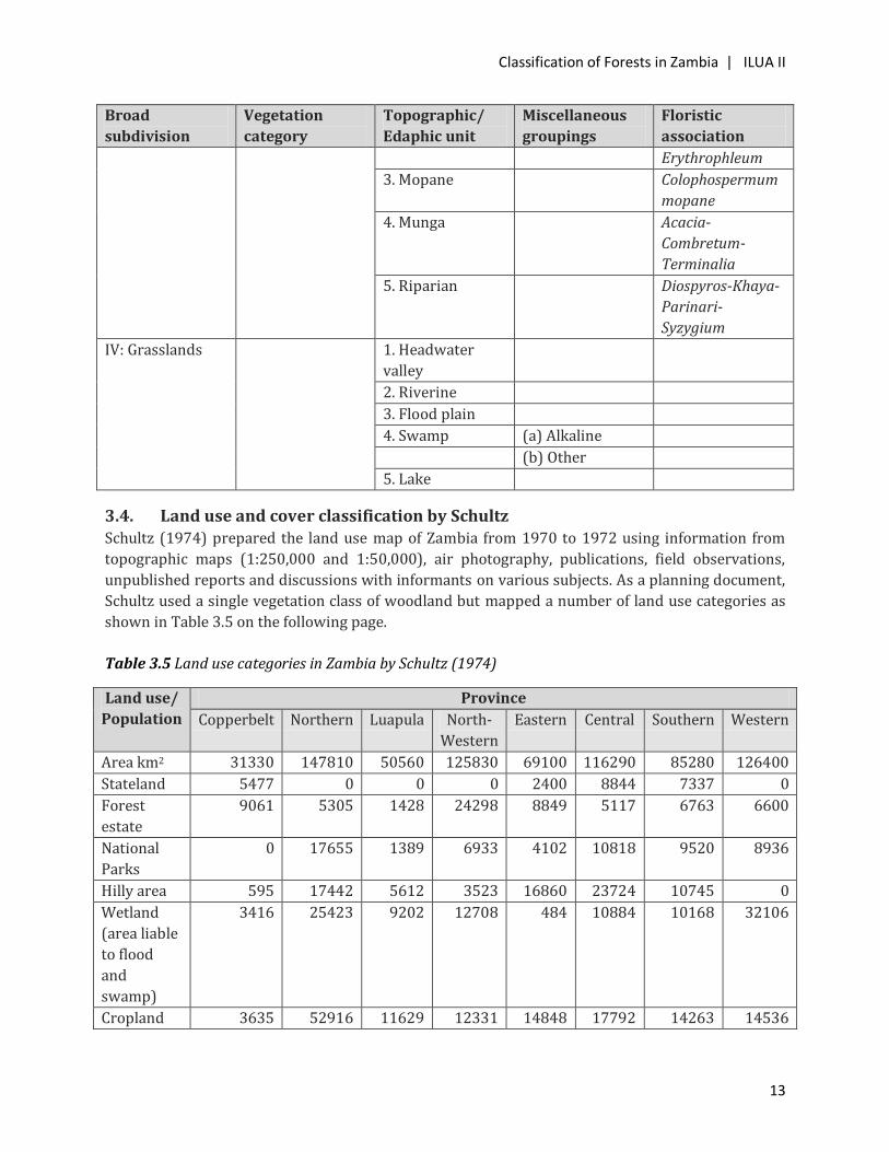
3.4. Land use and cover classification by Schultz Schultz (1974) prepared the land use map of Zambia from 1970 to 1972 using information from
topographic maps (1:250,000 and 1:50,000), air photography, publications, field observations,
unpublished reports and discussions with informants on various subjects. As a planning document,
Schultz used a single vegetation class of woodland but mapped a number of land use categories as
shown in Table 3.5 on the following page.
Table 3.5 Land use categories in Zambia by Schultz (1974)
Land use/
Population
Province
Copperbelt Northern Luapula North-
Western
Eastern Central Southern Western
Area km2 31330 147810 50560 125830 69100 116290 85280 126400
Stateland 5477 0 0 0 2400 8844 7337 0
Forest
estate
9061 5305 1428 24298 8849 5117 6763 6600
National
Parks
0 17655 1389 6933 4102 10818 9520 8936
Hilly area 595 17442 5612 3523 16860 23724 10745 0
Wetland
(area liable
to flood
and
swamp)
3416 25423 9202 12708 484 10884 10168 32106
Cropland 3635 52916 11629 12331 14848 17792 14263 14536
Classification of Forests in Zambia | ILUA II
14
Land use/
Population
Province
Copperbelt Northern Luapula North-
Western
Eastern Central Southern Western
and fallow
Unused
woodland
12340 26396 17210 66037 22250 39111 24008 64222
Total
population
(1969)
816000 545000 336000 232000 510000 713000 496000 410000
Rural
population
(1969)
72000 531000 320000 232000 474000 305000 356000 395000
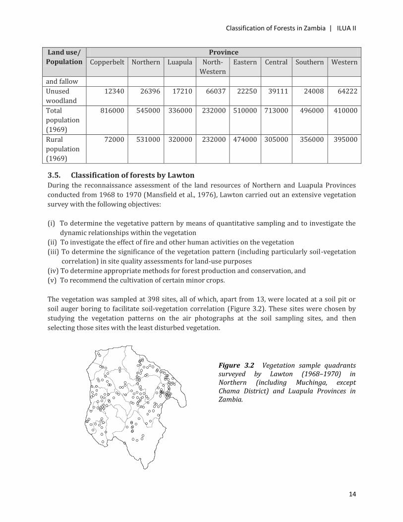
3.5. Classification of forests by Lawton During the reconnaissance assessment of the land resources of Northern and Luapula Provinces
conducted from 1968 to 1970 (Mansfield et al., 1976), Lawton carried out an extensive vegetation
survey with the following objectives:
(i) To determine the vegetative pattern by means of quantitative sampling and to investigate the
dynamic relationships within the vegetation
(ii) To investigate the effect of fire and other human activities on the vegetation
(iii) To determine the significance of the vegetation pattern (including particularly soil-vegetation
correlation) in site quality assessments for land-use purposes
(iv) To determine appropriate methods for forest production and conservation, and
(v) To recommend the cultivation of certain minor crops.
The vegetation was sampled at 398 sites, all of which, apart from 13, were located at a soil pit or
soil auger boring to facilitate soil-vegetation correlation (Figure 3.2). These sites were chosen by
studying the vegetation patterns on the air photographs at the soil sampling sites, and then
selecting those sites with the least disturbed vegetation.
Figure 3.2 Vegetation sample quadrants surveyed by Lawton (1968–1970) in Northern (including Muchinga, except Chama District) and Luapula Provinces in Zambia.

Classification of Forests in Zambia | ILUA II
15
The samples were 20m x 20m quadrants in which all the woody growth was recorded. Tree height
and diameter at breast height (dbh, 1.3m above ground) were measured with a Suunto hypsometer
and a diameter tape respectively. Plants <2m high or <5cm dbh were recorded and counted, but not
measured. Coppice regrowth was counted in clumps or colonies; the individual shoots were not
counted. Tree canopy cover, an ecologically important variable, was recorded at a scale with five
classes to assess percentage canopy cover for each sample quadrant as follows:
Class 1: 0-20%
Class 2: 21-40%
Class 3: 41-60%
Class 4: 61-80%
Class 5: 81-100%
Observations were made on the vigour of the vegetation and on any sign of damage by fire or frost,
etc. Evidence of previous cultivation was noted, and the age of the regrowth was estimated,
sometimes by ring-counts. Colour and black-and-white photographs were taken at many of the
sampling sites, to illustrate both the vegetation and soil profile.
The integration of the vegetation sampling with the soil survey imposed some restrictions on
sampling, and towards the end of the survey, it was necessary to select 13 samples to cover the
types of vegetation which had not been adequately covered on the random soil traverses.
A principal component analysis, using Orloci's formulae for similarity, was used by the Statistical
Branch of the Commonwealth Forestry Institute, Oxford, to analyze 206 samples. The plotting
divided the samples into a number of groups, but there was no clustering, and knowledge of the
ecology of the vegetation was necessary to interpret the graphical plots.
The analysis produced six vegetation groups, as described below.
Group I consisting of chipya samples that represent quadrants where dry-season fires are
intensive.
Group II is a mixture of Marquesia macroura evergreen forest and forest/chipya mixtures,
indicating the close relationship between forest and chipya.
Group III is made up of Bridelia duvigneaudii subgroup and Protea petiolaris subgroup
representing quadrants on deep, freely drained soils.
Group IV is a blend of Marquesia macroura forest and Brachystegia-Julbernardia mixtures.
Group V is made up of Brachystegia floribunda, B. glaberrima, B. spiciformis, B. utilis and B.
wangermeeana mixtures on deep soils.
Group VI consisting of Bridelia cathartica with Brachystegia allenii, B. boehmii and B. manga on
shallow compact soils.
Classification of Forests in Zambia | ILUA II
16
The continuous spread of the samples on the graphical plots indicated that the vegetation is a
continuum with overlaps of species and groups of species, suggesting that the relationship between
dry evergreen forest, chipya and woodland is complex, thereby making the separation of ecological
groups difficult.
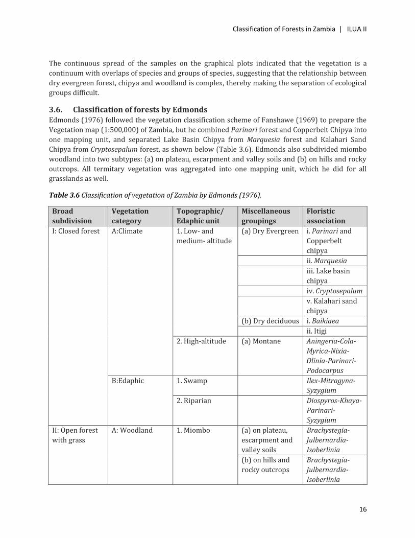
3.6. Classification of forests by Edmonds Edmonds (1976) followed the vegetation classification scheme of Fanshawe (1969) to prepare the
Vegetation map (1:500,000) of Zambia, but he combined Parinari forest and Copperbelt Chipya into
one mapping unit, and separated Lake Basin Chipya from Marquesia forest and Kalahari Sand
Chipya from Cryptosepalum forest, as shown below (Table 3.6). Edmonds also subdivided miombo
woodland into two subtypes: (a) on plateau, escarpment and valley soils and (b) on hills and rocky
outcrops. All termitary vegetation was aggregated into one mapping unit, which he did for all
grasslands as well.
Table 3.6 Classification of vegetation of Zambia by Edmonds (1976).
Broad
subdivision
Vegetation
category
Topographic/
Edaphic unit
Miscellaneous
groupings
Floristic
association
I: Closed forest A:Climate 1. Low- and
medium- altitude
(a) Dry Evergreen i. Parinari and
Copperbelt
chipya
ii. Marquesia
iii. Lake basin
chipya
iv. Cryptosepalum
v. Kalahari sand
chipya
(b) Dry deciduous i. Baikiaea
ii. Itigi
2. High-altitude (a) Montane Aningeria-Cola-
Myrica-Nixia-
Olinia-Parinari-
Podocarpus
B:Edaphic 1. Swamp Ilex-Mitragyna-
Syzygium
2. Riparian Diospyros-Khaya-
Parinari-
Syzygium
II: Open forest
with grass
A: Woodland 1. Miombo (a) on plateau,
escarpment and
valley soils
Brachystegia-
Julbernardia-
Isoberlinia
(b) on hills and
rocky outcrops
Brachystegia-
Julbernardia-
Isoberlinia
Classification of Forests in Zambia | ILUA II
17
Broad
subdivision
Vegetation
category
Topographic/
Edaphic unit
Miscellaneous
groupings
Floristic
association
2. Kalahari Brachystegia-
Julbernardia-
Isoberlinia-
Guibourtia-
Burkea-
Erythrophleum
3. Mopane Colophospermum
mopane
4. Munga Acacia-
Combretum-
Terminalia
III: Termitaria Termitary associated vegetation and bush groups within grassy drainage
zones.
IV: Grasslands All naturally treeless and grassy areas, comprising mountain and watershed
grasslands, Kalahari-sand plain, dambo, floodplain, swamp and papyrus sudd.
3.7. Classification of forests by SADCC Fuelwood Project The Southern African Development Coordination Conference (SADCC) Fuelwood study was based
on 1978 to 1984 data acquired by the AVHRR sensors on board the NOAA satellites (Millington et
al., 1986). The results of the study included theoretical, subjective and empirical estimates
extracted from a few detailed, localized projects and/or general country-wide studies. In cases
where numerous studies provided multiple estimates for a single biomass class, average figures
were used. All these figures were extended to provide estimates for the specific biomass classes
identified within each SADCC country. These data were in turn adopted to estimate total biomass
when studied in association with the calculated area of each biomass class.
The study divided the country into nine biomass classes (Table 3.7) as follows:
i. Wet Miombo Woodland
ii. Seasonal Miombo Woodland
iii. Dry Miombo and Munga Woodland
iv. Degraded Miombo Woodland
v. Dry Evergreen Forest
vi. Kalahari Woodland
vii. Mopane Woodland
viii. Scrub Woodland
ix. Swamp and Lake Vegetation

Classification of Forests in Zambia | ILUA II
18
Table 3.7 Aboveground woody biomass stock and MAI data for Zambia based on the SADCC Fuelwood Project.
Biomass class
Area Growing Stock
Mean Annual
Increment
(MAI)
Km2 % Million
tonnes %
Million
tonnes %
Wet miombo woodland 223942 30.9 1809.5 61.2 57.2 3.2
Dry miombo and munga
woodland
53085 7.3 50.1 1.7 1.2 1.3
Seasonal miombo woodland 125716 17.3 247.8 8.4 6.1 2.5
Dry evergreen woodland 9798 1.3 69.8 2.4 2.2 2.4
Degraded miombo woodland 110160 15.2 369.6 12.5 11.1 3.0
Mopane woodland 69000 9.5 252.1 8.5 7.4 8.2
Scrub woodland 9801 1.3 22.9 0.8 0.8 0.9
Swamp and Lake vegetation 46140 6.3 0 0 0 0
Kalahari woodland 79211 10.9 133.0 4.5 3.9 4.3
Total 726853 2954.8 89.9
The Wet Miombo Woodland biomass class is widely distributed throughout Zambia, being found
in all provinces, but it is especially important in Central, Eastern, Luapula, Northern and North-
Western Provinces, accounting for over 30% of vegetation in each case. Wet Miombo Woodland has
high levels of productivity throughout the year, ranging from Normalized Difference Vegetation
Index (NDVI) values of 175-285 between November and April and lower NDVI values in the dry
season, reaching a low of about 160 in September.
Two main variants of Wet Miombo Woodland were recognized in Zambia: one on the deeper soils of
the plateau in which the main canopy dominants are Brachystegia boehmii, B. floribunda, B.
spiciformis, B. utilis, Isoberlinia angolensis and Julbernardia paniculata; and another on shallower
soils on hills, escarpments and on extensive pockets of sand (isengas) in which the canopy
dominants change to B. glaucescens in the south, or B. microphylla in the north, and to B. taxifolia
and Cryptoseplum exfoliatum elsewhere. This change is even more marked in the shrub and grass
components. The hill miombo is found on the Muchinga Escarpment and the Bwinjifumu Hills. The
woody biomass reserves of the Wet Miombo Woodland are very high, both in terms of growing
stock and productivity.
The Seasonal Miombo Woodland biomass class is closely related to the Wet Miombo Woodland,
with the main differentiation based on the marked seasonality in phenology. This woodland occurs
on the plateau, the Zambezi Escarpment and extensively along the Mozambique and Malawi
borders.
Classification of Forests in Zambia | ILUA II
19
The Dry Miombo and Munga Woodland biomass class is found in all districts except in the
Copperbelt, Luapula and North-Western Provinces. The greatest extent is to the south-west of
Lusaka and to the north of Lake Kariba in Lusaka and Southern Provinces.
Extensive areas of Degraded Miombo Woodland, and related woodland and wooded grassland
vegetation types, are found to the north of the Kafue Flats, in the Copperbelt and in northern
Zambia adjacent to the Tanzanian border. It is most extensive in Central, Copperbelt, Luapula and
Northern Provinces, in areas where the woodland has been destroyed by chitemene shifting
agriculture.
Dry Evergreen Forests are now mostly restricted to western Zambia with the largest areas being
found in North-Western and Western Provinces.
Kalahari Woodland is restricted to western Zambia and is mainly found in North-Western,
Western and Western Provinces.
Mopane Woodland is widespread in the Luangwa Valley and in southern Zambia to the west of
Lake Kariba, although small patches occur in other areas.
Scrub Woodland is restricted to the tributaries of the Zambezi on the Angolan border, with the
largest areas found in Western Province. Elsewhere, it probably represents small isolated areas of
scrubby thickets.
Swamp and Lake Vegetation is found along the shores of main lakes — Bangweulu, Kariba,
Mweru and Tanganyika — and in the large swamps typical of the Zambian plateau, the Bangweulu,
Lukanga and Mweru swamps being the most important. It is found in all districts but is particularly
important in the Northern, North-Western, Southern and Western Provinces. All swamp forests are
controlled by high groundwater levels and are also small in extent, varying from 1 to 120ha.
3.8. Classification of miombo forests by dominant woody species
Chidumayo (1987a) carried out a survey of the woody flora on 94 old-growth and 58 coppiced
miombo woodland stands in Copperbelt, Central, Lusaka, Northern, Luapula, Eastern, North-
Western and Western Provinces during 1982-1985. Study sites were systematically selected
following a literature review and a preliminary field survey of miombo distribution in each study
area. However, a special effort was made to ensure representation of different miombo associations
found in each study area in the samples. Only stands with little or no obvious human disturbance
and, in the case of coppiced stands, of known age were included in the study. Each coppiced sample
plot was 20m x 50m (0.1ha) while each old-growth sample plot consisted of four contiguous 20m x
50m subplots. The term 'stem' was preferred to that of 'tree' because tree branches at or below a
0.3m height were enumerated as separate stems.
Miombo woodland in Zambia has been divided into wetter and drier types (White 1983) which are
separated by the 1,000mm mean annual rainfall isohyet. However, in Chidumayo’s study, the
1,100mm mean annual rainfall isohyet was used because it approximates the 1.1 aridity ratio
(mean annual precipitation/annual potential evapotranspiration) line (Chidumayo 1987b). Using
topographic and soil criteria, Trapnell (1953) and Trapnell and Clothier (1957) recognized 16
Classification of Forests in Zambia | ILUA II
20
miombo classes. Chidumayo (1987a) used a combination of these variables and rainfall to divide
miombo into five subtypes: Northern wetter miombo, North-western wetter miombo, Central drier
miombo, Eastern drier miombo and Western drier miombo (Figure 3.3). On the basis of numerically
dominant and frequent canopy and understorey species, these miombo subtypes were described as
follows:
Central Drier Miombo
East
ern
Dri
er M
iom
bo
Northern Wetter Miombo
Northwestern Wetter
Miombo
Western Drier Miombo
Figure 3.3 Ecological classification of miombo woodlands (including Kalahari sand miombo) in Zambia. Based on Chidumayo (1987a).
Northern wetter miombo: Brachystegia (B. spiciformis - B. utilis) woodlands with Julbernardia
paniculata and Parinari curatellifolia as common canopy co-dominants and Monotes africanus,
Syzygium guineense macrocarpum and Uapaca spp. as common understorey taxa.
North-Western wetter miombo: Brachystegia (B. spiciformis - B. longifolia) woodlands with
Isoberlinia angolensis and Julbernardia paniculata as common canopy co-dominants and
Anisophyllea boehmii, Diplorhynchus condylocarpon, S.guineense macrocarpum and Uapaca spp. as
common understorey taxa.
Central drier miombo: Brachystegia (B. boehmii - B. spiciformis - B. utilis) woodlands with
Julbernardia globiflora as a common canopy co-dominant and Diplorhynchus condylocarpon, Lannea
spp., Ochna spp. and Pseudolachnostylis maprouneifolia as common understorey taxa.
Eastern drier miombo: Brachystegia manga - Julbernardia spp. woodlands with Diospyros spp.,
Diplorhynchus condylocarpon, Ochna spp. and Pseudolachnostylis maprouneifolia as common
understorey taxa.
Classification of Forests in Zambia | ILUA II
21
Western drier miombo: Brachystegia spiciformis - Julbernardia paniculata woodlands with Burkea
africana as a common canopy co-dominant and Diplorhynchus condylocarpon as a common
understorey taxon.
Using the results from Chidumayo’s study, old-growth wetter miombo can be distinguished from
dry miombo on the basis of the average number of canopy and understorey species per 0.4ha plot.
The density of canopy species (# per plot) is higher in wetter (6–7) than in drier (4–5) miombo and
similarly, the density of understorey species is higher in wetter miombo (22–23) than in drier (11–
20) miombo. Together, woody species richness is higher in wetter than in drier miombo.
3.9. Classification of forests by cover types The Provincial Forestry Action Programme (PFAP) in the Forestry Department developed a land-
cover classification system based on LandSat MSS images of 1993, as summarized in Table 3.8. The
classification did not involve floristic associations.
Table 3.8 The land-cover classes developed by PFAP using LandSat MSS images of 1993
Major Class Class Subclass
Forest Dense forest
Medium dense forest
Low dense Traditional farm land
Settlement
Degraded forest area
Mushitu (evergreen forest
along rivers)
Forest plantation
Grassland Plain/Plateau grassland
Marsh/Swamp
Dambo and Valley
Non-vegetated (Bare) Bare rock
Agricultural land Commercial (≥10ha well
aligned fields)
Water bodies Dams/Lakes
3.10. Classification of forests by ILUA I The Integrated Land Use Assessment (ILUA) I, despite recognizing the major ecosystems in Zambia,
used the FAO-based land use/forest type classification for the purpose of relating the national
classification system to the global system (Table 3.9).
Classification of Forests in Zambia | ILUA II
22
Table 3.9 FAO-based land use/forest type classification used in ILUA I for Zambia
Broad
subdivision Subdivision
Phenology
and growth
form
groupings
Edaphic/
Topographic
types
Floristic association
Forest (Area
≥0.5ha, tree
crown cover
≥10%; tree H
≥5m)
Forest with
natural or
natural
assisted
regeneration
Evergreen Cryptosepalum (Mavunda)
Syzygium guineense
afromontanum (Mufinsa)
Entandrophragma delevoyi
Parinari-Syzygium
Riverine/Riparian
Semi-
evergreen
Brachystegia-Isoberlinia-
Julbernardia-Marquesia
Deciduous Baikiaea plurijuga (Mkusi)
Baikiaea-Brachystegia-
Isoberlinia-Guibourtia-
Julbernardia-Schizophyton
(Kalahari)
Colophospermum mopane
(Mopane)
Acacia-Combretum-
Terminalia (Munga)
Other Palm/bamboo
Plantation Broadleaved
Coniferous
(Needle-
leaved)
Other wooded
lands (Area ≥
0.5ha; tree
canopy cover
5-10% or
shrubs/bushes
canopy cover ≥
10%
Wooded
grassland
(Tree canopy
cover 5-10%)
Dambo/plains
(with sparse trees
canopy cover 5-
10%)
Shrubs/Thicket
(shrub/bush
canopy cover
≥10%)
Acacia-Commiphora
bushland and thicket
(Munga woodland)
Macchia-type scrub
Termite mound
vegetation
(Termitaria),
sometimes
treeless
Other land
(Tree canopy
Natural and
semi-natural
Barren land
Grassland
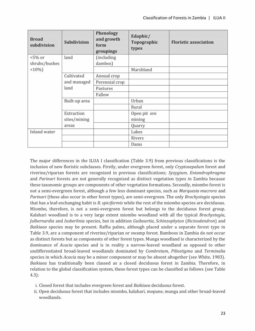
Classification of Forests in Zambia | ILUA II
23
Broad
subdivision Subdivision
Phenology
and growth
form
groupings
Edaphic/
Topographic
types
Floristic association
<5% or
shrubs/bushes
<10%)
land (including
dambos)
Marshland
Cultivated
and managed
land
Annual crop
Perennial crop
Pastures
Fallow
Built-up area Urban
Rural
Extraction
sites/mining
areas
Open pit ore
mining
Quarry
Inland water Lakes
Rivers
Dams
The major differences in the ILUA I classification (Table 3.9) from previous classifications is the
inclusion of new floristic subclasses. Firstly, under evergreen forest, only Cryptosepalum forest and
riverine/riparian forests are recognized in previous classifications; Syzygium, Entandrophragma
and Parinari forests are not generally recognized as distinct vegetation types in Zambia because
these taxonomic groups are components of other vegetation formations. Secondly, miombo forest is
not a semi-evergreen forest, although a few less dominant species, such as Marquesia macrora and
Parinari (these also occur in other forest types), are semi-evergreen. The only Brachystegia species
that has a leaf-exchanging habit is B. spiciformis while the rest of the miombo species are deciduous.
Miombo, therefore, is not a semi-evergreen forest but belongs to the deciduous forest group.
Kalahari woodland is to a very large extent miombo woodland with all the typical Brachystegia,
Julbernardia and Isoberlinia species, but in addition Guibourtia, Schinzophyton (Ricinodendron) and
Baikiaea species may be present. Raffia palms, although placed under a separate forest type in
Table 3.9, are a component of riverine/riparian or swamp forest. Bamboos in Zambia do not occur
as distinct forests but as components of other forest types. Munga woodland is characterized by the
dominance of Acacia species and is in reality a narrow-leaved woodland as opposed to other
undifferentiated broad-leaved woodlands dominated by Combretum, Piliostigma and Terminalia
species in which Acacia may be a minor component or may be absent altogether (see White, 1983).
Baikiaea has traditionally been classed as a closed deciduous forest in Zambia. Therefore, in
relation to the global classification system, these forest types can be classified as follows (see Table
4.3):
i. Closed forest that includes evergreen forest and Baikiaea deciduous forest.
ii. Open deciduous forest that includes miombo, kalahari, mopane, munga and other broad-leaved
woodlands.

Classification of Forests in Zambia | ILUA II
24
4. ECOLOGICAL INDICATORS FOR FOREST CLASSIFICATION
4.1. Ecological indicators and forest classification in Zambia There have been no comprehensive studies of indicator species in Zambian forests. The only long-
term experiment on the responses of miombo woodland to burning was at the Ndola Indigenous
Sample Plots that were established in 1933 and 1934 in the Ndola Forest Reserve, and that have
now been completely encroached upon by urban development. The results of the burning
experiment were first published by Trapnell (1959) after 11 years of treatments and later by
Lawton (1978) after 36 years, and then by Chidumayo (1988) after nearly 50 years since the
experiment started. Trapnell’s classification of miombo trees and shrubs based on their response to
fire is summarized in Table 4.1. It is important to note that the fire tolerance classification of
miombo trees by Trapnell did not involve statistical comparisons of abundances before and after
the experiment, which probably might have yielded different results (Chidumayo, 1997).
Table 4.1 Trapnell’s fire tolerance classification of trees and shrubs after 11 continuous years of fire treatments in wetter miombo at Ndola in Copperbelt Province.
Fire-intolerant and semi-tolerant species Fire-tolerant species
Brachystegia longifolia Anisophyllea boehmii
Brachystegia spiciformis Dialiopsis africana
Bridelia carthatica Diplorhynchus condylocarpon
Bridelia duvigneaudii Erythrophleum africanum
Byrsocarpus orientalis Dombeya rotundifolia
Chrysophyllum bangweolense Hymenocardia acida
Garcinia huillensis Maprounea africana
Hexalobus monopetalus Parinari curatellifolia
Isoberlinia angolensis Pterocarpus angolensis
Julbernardia paniculata Strychnos cocculoides
Lannea discolour Strychnos spinosa
Ochna schweinfurthiana Swartzia madagascariensis
Parinari polyandra Syzygium guineense macrocarpum
Pseudolachnostylis maprounefolia Uapaca nitida
Uapaca kirkiana Vitex madiensis
Uapaca pilosa
Xylopia odoratissina
In 1969, 36 years after the establishment of the Ndola plots, Lawton enumerated some 10m x 10m
random quadrats in the experimental plots. His observations and those made by Trapnell (1959)
were used to develop ecological groups (Mansfield et al., 1976). Lawton (1978) identified three
main fire-related ecological species-groups that characterize distinct stages in the succession or
development of miombo woodland after damage by fire. These ecological species-groups are
chipya, Uapaca and Brachystegia-Julbernardia or miombo. The chipya species-group consists of fire
tolerant species (see Table 3.2) that survive as scattered groups of trees in chipya vegetation that is
characterized by tall grasses and other herbs, and is maintained by frequent intense late dry-season
Classification of Forests in Zambia | ILUA II
25
fires. Chipya, therefore, is some kind of a “fire-trapped” vegetation type that represents a regressive
stage of semi-closed miombo woodland after damage by frequent intense fires as observed by
Trapnell (1959). According to Lawton’s (1978) hypothesis, a reduction in fire frequency allows the
Uapaca species-group ( made up of fire semi-tolerant species) to invade chipya and form scattered
tree canopies that suppress grass production, thereby reducing fire to a creeping surface litter fire
or to its complete suppression. This process facilitates the invasion and development of
Brachystegia and Julbernardia saplings and the emergence of a tree canopy that in turn suppresses
the Uapaca canopy, which then dies back to coppice. However, this hypothesis has not been tested
experimentally and Chidumayo (2004), after 11 years of observations at permanent dry miombo
sites in central Zambia, contested the validity of this hypothesis.
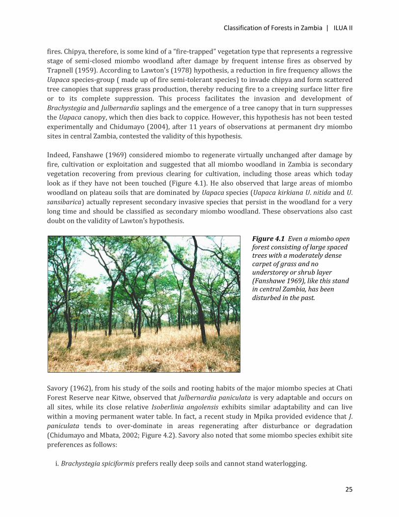
Indeed, Fanshawe (1969) considered miombo to regenerate virtually unchanged after damage by
fire, cultivation or exploitation and suggested that all miombo woodland in Zambia is secondary
vegetation recovering from previous clearing for cultivation, including those areas which today
look as if they have not been touched (Figure 4.1). He also observed that large areas of miombo
woodland on plateau soils that are dominated by Uapaca species (Uapaca kirkiana U. nitida and U.
sansibarica) actually represent secondary invasive species that persist in the woodland for a very
long time and should be classified as secondary miombo woodland. These observations also cast
doubt on the validity of Lawton’s hypothesis.
Savory (1962), from his study of the soils and rooting habits of the major miombo species at Chati
Forest Reserve near Kitwe, observed that Julbernardia paniculata is very adaptable and occurs on
all sites, while its close relative Isoberlinia angolensis exhibits similar adaptability and can live
within a moving permanent water table. In fact, a recent study in Mpika provided evidence that J.
paniculata tends to over-dominate in areas regenerating after disturbance or degradation
(Chidumayo and Mbata, 2002; Figure 4.2). Savory also noted that some miombo species exhibit site
preferences as follows:
i. Brachystegia spiciformis prefers really deep soils and cannot stand waterlogging.
Figure 4.1 Even a miombo open forest consisting of large spaced trees with a moderately dense carpet of grass and no understorey or shrub layer (Fanshawe 1969), like this stand in central Zambia, has been disturbed in the past.

Classification of Forests in Zambia | ILUA II
26
ii. Brachystegia longifolia prefers deep sandy soils and cannot penetrate murram but can live in a
permanent (moving) water table.
iii. Brachystegia utilis prefers deep loams and cannot penetrate hard murram.
iv. Brachystegia floribunda prefers heavy-textured soils and can penetrate murram
v. Brachystegia boehmii prefers clay loams and can penetrate murram.
0
10
20
30
40
50
60
70
80Ju
lber
nard
ia p
anic
ula
ta (
%)
CoppiceOld-growth
Woodland sample plots
Figure 4.2 Changes in relative abundance of Julbernardia paniculata in old-growth and coppiced miombo woodland samples in Kopa Chiefdom in Mpika District in Muchinga Province, Zambia. Vertical line on each bar shows 1 standard error of mean.
In Baikiaea dry deciduous forest, crown fires can create gaps in the canopy that are often colonized
by Acacia ataxacantha that forms mutemwa thickets. Mutemwa thickets can also develop after the
abandonment of cultivated land. Such thickets consist of Acacia fleckii, A. schweinfurthii, A.
ataxacantha with Markhamia obtusifolia, Terminalia sericea and Combretum spp. The presence of
mutemwa thickets therefore indicates a regression from Baikiaea forest following a disturbance.
The indicators described above are useful in the interpretation of ecological dynamics in Zambian
forests and can sometimes be applied in the ecological classification of forests, especially those that
have been subjected to disturbances. Table 4.2 gives examples of some of these indicators and how
their presence might be interpreted. Therefore, rather than use ecological indicators to classify
forests, these should be used in interpreting the inventory data and developing scenarios for future
trends in vegetation composition or dynamics.

Classification of Forests in Zambia | ILUA II
27
Table 4.2 Some ecological indicators and their interpretation in forest dynamics.
Indicator Indicator
measure
Impacted
ecosystem
Type of
disturbance Comparison
Julbernardia
paniculata
Over-abundance Miombo
woodland
Clearing and/or
cultivation
Relative
abundance in
old-growth
versus coppiced
regrowth (see
Figure 3.2)
Dichrostachys
cinerea
Over-abundance Woodlands and
scrub
Overgrazing,
invasion and low
intensity fires
Relative
abundance in
un-impacted
versus impacted
areas
Lantana camara Presence All ecosystems,
including man-
transformed
ecosystems
Invasion Not applicable
Diplorhynchus
condylocarpon
Over-abundance Miombo
woodland and
chipya
Frequent intense
bush fires
Relative
abundance
before and after
disturbance
Deformed stems Over-abundance
of deformed
stems
Miombo and
Kalahari
woodlands
Lopping and frost
damage
Not applicable
Acacia
polyacantha
Over-abundance
of deformed
stems
Woodlands and
scrub
Land clearing,
including
roadsides
Relative
abundance in
affected versus
unaffected sites
Fire-scarred and
dead charred
stems
Presence All
forest/woodland
ecosystems
Frequent intense
bush fires
Not applicable
Mimosa pigra Presence Wetlands and
riverine
Invasion Not applicable
Acacia
ataxacantha, A.
fleckii, A.
schweinfurthii
(Mutemwa)
Over abundance Baikiaea forest Invasion Relative
abundance
before and after
disturbance
Aframomum
biauriculatum,
Pteridium
aquilinum and
Over abundance Chipya and
wetter miombo
Frequent intense
bush fires
Relative
abundance
before and after
disturbance
Classification of Forests in Zambia | ILUA II
28
Indicator Indicator
measure
Impacted
ecosystem
Type of
disturbance Comparison
Smilax
kraussiana
Tree stumps and
felled stems
Presence Forest and
woodlands
Timber/pole and
caterpillar
harvesting
Not applicable
Residual
cultivation
ridges
Presence All ecosystems Clearing and
cultivation
Not applicable
Charcoal kiln
mounds
Presence Forest and
woodlands
Clearing and
charcoal making
Not applicable
Exotic fruit trees Presence All ecosystems Settlement Not applicable
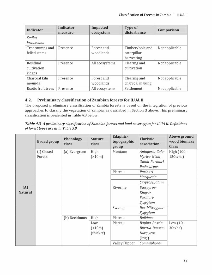
4.2. Preliminary classification of Zambian forests for ILUA II The proposed preliminary classification of Zambia forests is based on the integration of previous
approaches to classify the vegetation of Zambia, as described in Section 3 above. This preliminary
classification is presented in Table 4.3 below.
Table 4.3 A preliminary classification of Zambian forests and land cover types for ILUA II. Definitions of forest types are as in Table 3.9.
(A)
Natural
Broad group Phenology
class
Stature
class
Edaphic-
topographic
group
Floristic
association
Above ground
wood biomass
Class
(I) Closed
Forest
(a) Evergreen High
(>10m)
Montane Aningeria-Cola-
Myrica-Nixia-
Olinia-Parinari-
Podocarpus
High (100–
150t/ha)
Plateau Parinari
Marquesia
Cryptosepalum
Riverine Diospyros-
Khaya-
Parinari-
Syzygium
Swamp Ilex-Mitragyna-
Syzygium
(b) Deciduous High Plateau Baikiaea
Low
(<10m)
(thicket)
Plateau Baphia-Boscia-
Burttia-Bussea-
Diospyros
(Itigi)
Low (10-
30t/ha)
Valley (Upper Commiphora-
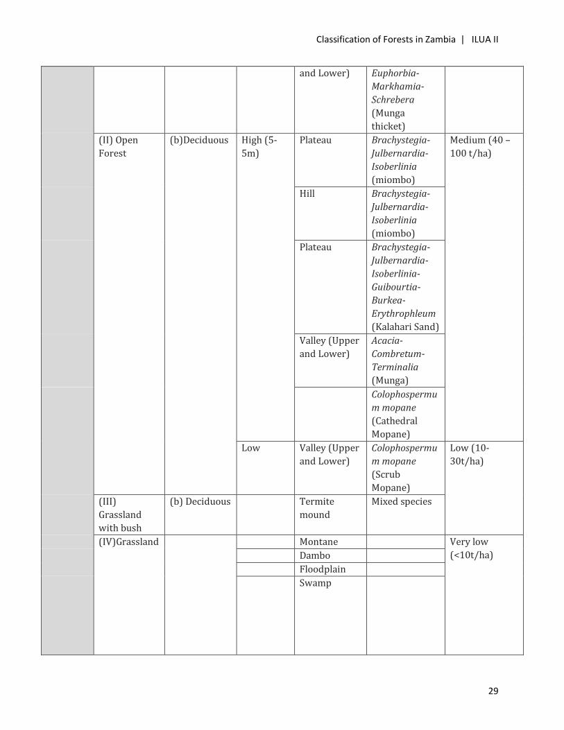
Classification of Forests in Zambia | ILUA II
29
and Lower) Euphorbia-
Markhamia-
Schrebera
(Munga
thicket)
(II) Open
Forest
(b)Deciduous High (5-
5m)
Plateau Brachystegia-
Julbernardia-
Isoberlinia
(miombo)
Medium (40 –
100 t/ha)
Hill Brachystegia-
Julbernardia-
Isoberlinia
(miombo)
Plateau Brachystegia-
Julbernardia-
Isoberlinia-
Guibourtia-
Burkea-
Erythrophleum
(Kalahari Sand)
Valley (Upper
and Lower)
Acacia-
Combretum-
Terminalia
(Munga)
Colophospermu
m mopane
(Cathedral
Mopane)
Low Valley (Upper
and Lower)
Colophospermu
m mopane
(Scrub
Mopane)
Low (10-
30t/ha)
(III)
Grassland
with bush
(b) Deciduous Termite
mound
Mixed species
(IV)Grassland Montane Very low
(<10t/ha)
Dambo
Floodplain
Swamp
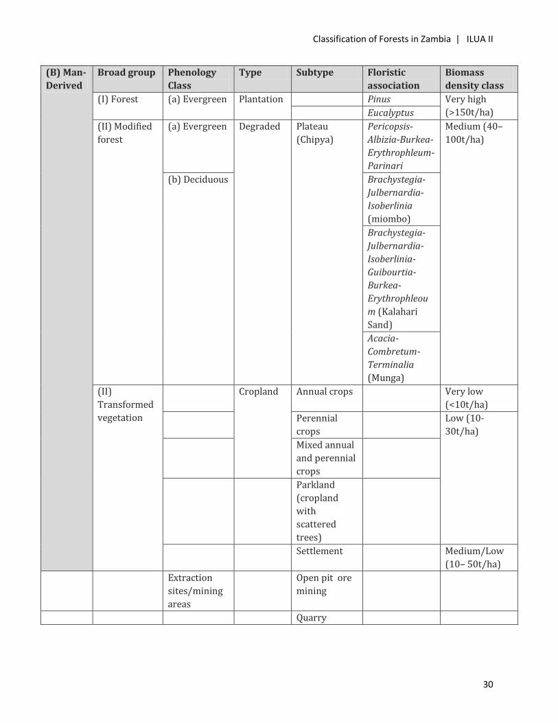
Classification of Forests in Zambia | ILUA II
30
(B) Man-
Derived
Broad group Phenology
Class
Type Subtype Floristic
association
Biomass
density class
(I) Forest (a) Evergreen Plantation Pinus Very high
(>150t/ha) Eucalyptus
(II) Modified
forest
(a) Evergreen Degraded Plateau
(Chipya)
Pericopsis-
Albizia-Burkea-
Erythrophleum-
Parinari
Medium (40–
100t/ha)
(b) Deciduous Brachystegia-
Julbernardia-
Isoberlinia
(miombo)
Brachystegia-
Julbernardia-
Isoberlinia-
Guibourtia-
Burkea-
Erythrophleou
m (Kalahari
Sand)
Acacia-
Combretum-
Terminalia
(Munga)
(II)
Transformed
vegetation
Cropland Annual crops Very low
(<10t/ha)
Perennial
crops
Low (10-
30t/ha)
Mixed annual
and perennial
crops
Parkland
(cropland
with
scattered
trees)
Settlement Medium/Low
(10– 50t/ha)
Extraction
sites/mining
areas
Open pit ore
mining
Quarry
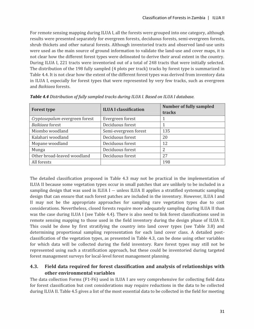
Classification of Forests in Zambia | ILUA II
31
For remote sensing mapping during ILUA I, all the forests were grouped into one category, although
results were presented separately for evergreen forests, deciduous forests, semi-evergreen forests,
shrub thickets and other natural forests. Although inventoried tracts and observed land-use units
were used as the main source of ground information to validate the land-use and cover maps, it is
not clear how the different forest types were delineated to derive their areal extent in the country.
During ILUA I, 221 tracts were inventoried out of a total of 248 tracts that were initially selected.
The distribution of the 198 fully sampled (4 plots per track) tracks by forest type is summarized in
Table 4.4. It is not clear how the extent of the different forest types was derived from inventory data
in ILUA I, especially for forest types that were represented by very few tracks, such as evergreen
and Baikiaea forests.
Table 4.4 Distribution of fully sampled tracks during ILUA I. Based on ILUA I database.
Forest type ILUA I classification Number of fully sampled
tracks
Cryptosepalum evergreen forest Evergreen forest 1
Baikiaea forest Deciduous forest 1
Miombo woodland Semi-evergreen forest 135
Kalahari woodland Deciduous forest 20
Mopane woodland Deciduous forest 12
Munga Deciduous forest 2
Other broad-leaved woodland Deciduous forest 27
All forests 198
The detailed classification proposed in Table 4.3 may not be practical in the implementation of
ILUA II because some vegetation types occur in small patches that are unlikely to be included in a
sampling design that was used in ILUA I ― unless ILUA II applies a stratified systematic sampling
design that can ensure that such forest patches are included in the inventory. However, ILUA I and
II may not be the appropriate approaches for sampling rare vegetation types due to cost
considerations. Nevertheless, closed forests require more adequately sampling during ILUA II than
was the case during ILUA I (see Table 4.4). There is also need to link forest classifications used in
remote sensing mapping to those used in the field inventory during the design phase of ILUA II.
This could be done by first stratifying the country into land cover types (see Table 3.8) and
determining proportional sampling representation for each land cover class. A detailed post-
classification of the vegetation types, as presented in Table 4.3, can be done using other variables
for which data will be collected during the field inventory. Rare forest types may still not be
represented using such a stratification approach, but these could be inventoried during targeted
forest management surveys for local-level forest management planning.
4.3. Field data required for forest classification and analysis of relationships with
other environmental variables The data collection Forms (F1-F6) used in ILUA I are very comprehensive for collecting field data
for forest classification but cost considerations may require reductions in the data to be collected
during ILUA II. Table 4.5 gives a list of the most essential data to be collected in the field for meeting
Classification of Forests in Zambia | ILUA II
32
forest classification and related biodiversity, and REDD+ requirements, as well as the justification
for the listing. The data collected during ILUA I that is not included in Table 4.5 is considered not
essential for the ILUA II field inventory but could be collected if resources permit.
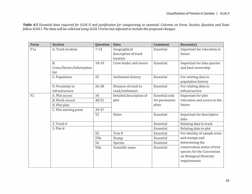
Classification of Forests in Zambia | ILUA II
33
Table 4.5 Essential data required for ILUA II and justification for categorizing as essential. Columns on Form, Section, Question and Data follow ILUA I. The data will be collected using ILUA I Forms but adjusted to include the proposed changes.
Form Section Question Data Comment Reason(s)
F1a A. Track location 7-14 Geographical
description of track
location
Essential Important for relocation in
future
B.
Crew/Owner/Information
list
18-19 Crew leader and owner Essential Important for data queries
and land ownership
C. Population 25 Settlement history Essential For relating data to
population history
D. Proximity to
infrastructure
26-28 Distance of track to
road/settlement
Essential For relating data to
infrastructure
F2 A. Plot access 34 Detailed description of
plot
Essential only
for permanent
plots
Important for plot
relocation and access in the
future
B. Work record 48-51
D. Plot plan
C. Plot starting point 39-47
53 Notes Essential Important for descriptive
data
2. Track # Essential Relating data to track
3. Plot # Essential Relating data to plot
55 Tree # Essential For identity of sample trees
and stumps and
determining the
conservation status of tree
species for the Convention
on Biological Diversity
requirements
55b. Stump Essential
56 Species Essential
56b. Scientific name Essential

Classification of Forests in Zambia | ILUA II
34
57 Tree/stump location For future relocation of
trees and stumps 57a. Along plot axis Essential for
marker
trees/stumps
57b. Left and right axis
58 Diameter For calculating volume and
biomass for forest
management and REDD+
requirements
58a. Diameter at 0.3 m AG Essential
(New)
58b. Diameter at 1.3 m AG Essential
60 (new) Re-sprouts/Coppices Essential For estimating
regeneration potential for
forest management and
REDD+ requirements
61 Total height Essential For calculating volume for
forest management and
REDD+ requirements
62 Bole height Essential
66(new) Reproduction For assessing regeneration
potential and bee foraging
potential
66a. Flowers (False or True) Essential
66b. Fruits (False or True) Essential
67 (new) Fire damage (False or
True)
Essential For assessing fire impact
on trees for forest
management and REDD+
requirements
F4a
(Subplots)
A. Soil 75aa
(new)
Bulk density Essential For calculating carbon
content for REDD+
requirements 75ab Organic matter Essential
75ac
(new)
Soil carbon Essential
C. Tree measurement (H ≥
1.3m and dbh ≤ 7cm)
77b Scientific name Essential For plant identity and
assessing advanced
regeneration
78a Counts Essential
78b Total Essential
Classification of Forests in Zambia | ILUA II
35
F5 (Land
Use)
A. General 82 Protection status Essential For relating forest
condition to status to
protection and/or
ownership
83 Ownership Essential
B. Land management 91 Stand structure
(Expand):
91a. Closed forest
91b. Open forest
91c. Wooded grassland
91d. Grassland
91e. Plantation forest
91f. Cropland & fallow
Essential For linking track/plot to
forest/land use
classification
92b Shrub coverage Essential For identification of
thickets
94 Disturbances (Expand):
94a. Tree cutting for
poles
94b. Tree cutting for
firewood
94c. Tree cutting for
caterpillar collection
94d. Tree cutting for
charcoal making
94e. Digging for roots or
tubers
94f. Pollarding
94g. Tree hollowing for
honey
94h. Grazing
94i. Invasion by alien
species
94j. Debarking for
Essential For assessing causes of
forest degradation for
forest management and
REDD+ requirements
Classification of Forests in Zambia | ILUA II
36
medicine
95 Timber exploitation Essential For assessing causes of
forest degradation for
forest management REDD+
requirements
44
Classification of Zambian Forests | ILUA II
37
For ILUA II, it will also be necessary to provide some guidance on indicator species to assist in the
ecological interpretation of field data (see Table 4.2). It is also proposed that the field manual
should have photographs of both aerial and lateral views of the different land cover and forest
types to facilitate the assigning of sample plots to the correct land cover and forest types by field
crews. An example of this is shown in Figure 4.3.
Figure 4.3 Aerial (A) and lateral (B) views of vegetation types: closed forest (a1), open forest (a2) and grassland (a3). For a lateral view open forest see Figure 4.1.
Collection and analysis of soil samples can be costly. Although previous studies have shown little or
no correlation between soil and vegetation types, soils data, especially soil organic matter and
carbon, are required for REDD+ implementation in the country. It is proposed that only limited soil
samples be collected per land cover type for the determination of organic matter and carbon to
meet REDD+ requirements. These data can also be used to develop models that relate soil carbon to
Classification of Zambian Forests | ILUA II
38
organic matter. The models can be used to determine soil carbon from existing data on soil organic
available at the Soil Survey Unit in the Department of Agriculture. For this purpose, it is proposed
that during ILUA II, the location of sample plots be superimposed on existing soil maps produced by
the Soil Survey Unit in the Department of Agriculture from which soil carbon can be determined for
larger areas of the country. Similarly, the superimposition of sample plots on a map of the main
Agro-Ecological zones should facilitate the analysis of data on the basis of these zones. Since these
zones are large, the proposed sampling design based on land cover classes should be able to include
a sufficient number of sample sites from each main Agro-Ecological zone.
The growing concern about impacts of climate change on forests and forest resources may require
that ILUA II data is also analyzed with respect to the IPCC climate reference period (1960 to 1990)
and scenarios for climate change for 2025 and 2050. This, together with a literature review, should
enable an analysis of potential responses of forests to climate change in the country.
5. KEY ISSUES AND RECOMMENDATIONS
Given the issues raised in this report and the need to improve data analysis, the following
recommendations are proposed for the implementation of ILUA II.
5.1 The sampling design for ILUA II should include stratification to ensure the adequate inclusion of
all major land cover types.
5.2 The interpretation of the inventory data should include the use of ecological indicators so that
trends in forest dynamics can be described and scenarios for the future made from the current
distribution of key indicators of forest dynamics.
5.3 The collection and analysis of soil samples is often costly. It is therefore recommended that
ILUA II only collects a limited number of soil samples for the purpose of determining soil organic
matter and carbon. The relationship between soil organic matter and carbon can then be used to
derive soil carbon from organic matter data available at the Soil Survey Unit in the Department of
Agriculture.
5.4 Given the long-term impact of human activities on the Zambian vegetation structure, it might
not be necessary to use climate zones for determining the sampling design for ILUA II. However, the
growing concern about impacts of climate change on forests and forest resources necessitates the
need to analyze ILUA II data in respect of the climate reference period (1960 to 1990) and
scenarios for climate change for 2025 and 2050. This, together with a literature review, should
enable an analysis of potential responses of forests to climate change.
Classification of Zambian Forests | ILUA II
39
6. REFERENCES
Chidumayo, E.N. 1987a. Species structure in Zambian miombo woodland. Journal of Tropical Ecology
3:109-118.
Chidumayo, E.N. 1987b. A survey of wood stocks for charcoal production in the miombo woodlands of
Zambia. Forest Ecology and Management 20:105-115.
Chidumayo, E.N. 1988. A re-assessment of effects of fire on miombo regeneration in the Zambian
Copperbelt. Journal of Tropical Ecology 4:361-372.
Chidumayo, E N. 1997. Miombo ecology and management: An introduction. Intermediate Technology
Publishers, London.
Chidumayo, E.N. 2004. Development of Brachystegia-Julbernardia woodland after clear-felling in
central Zambia: Evidence for high resilience. Applied Vegetation Science 7:237-242.
Chidumayo, E.N. and Mbata, K.J. 2002. Shifting cultivation, edible caterpillars and livelihoods in the
Kopa area of northern Zambia. Forests, Trees and Livelihoods 12:175-193.
Edmonds, A.C.R. 1976. Vegetation map (1:500000) of Zambia. Surveyor General, Lusaka.
Fanshawe, D. B. 1971. The vegetation of Zambia. Government Printer, Lusaka. 67 pp.
Lawton, R. M. 1978. A study of the dynamic ecology of Zambian vegetation. Journal of Ecology
66:175-198.
Lees, H.M.N. 1962. Working plan for the forests supplying the Copperbelt, Western Province.
Government Printer, Lusaka.
Mansfield, J.E., Bennet, J.G., King, R.B., Lang, D.M. and Lawton, R.M. 1976. Land resources of the
Northern and Luapula Provinces, Zambia- a reconnaissance assessment. Volume 4: The biophysical
environment. Land Resources Study 19. Ministry of Overseas Development, Surrey, England.
Millington, A.C., Townsend, J.R.G., Saull, R.J., Kennedy, P. and Prince, S.D. 1986. SADCC fuelwood
project: biomass assessment component. Second Interim Report, Munslow.
Savory, B.M. 1962. Rooting habits of important miombo species. Forest (Department) Research
Bulletin 6:1-120.
Schultz, J. 1974. Explanatory study to the land use map of Zambia. Ministry of Rural Development,
Lusaka.
Trapnell, C. G. 1953. The soils, vegetation and agriculture of North-eastern Rhodesia. Government
Printer, Lusaka. 146 pp. (Reprinted in 1996 by Redcliffe Press Ltd, Bristol, England).
Trapnell, C. G. 1959. Ecological results of woodland burning experiments in Northern Rhodesia.
Journal of Ecology 47:129-168.
Trapnell, C. G. and Clothier, J. N. 1957. The soils, vegetation and agricultural systems of North-
western Rhodesia. Government Printer, Lusaka. 69 pp. (Reprinted in 1996 by Redcliffe Press Ltd,
Bristol, England).
White, F. 1983. The vegetation of Africa. Unesco, Paris.

Classification of Zambian Forests | ILUA II
40
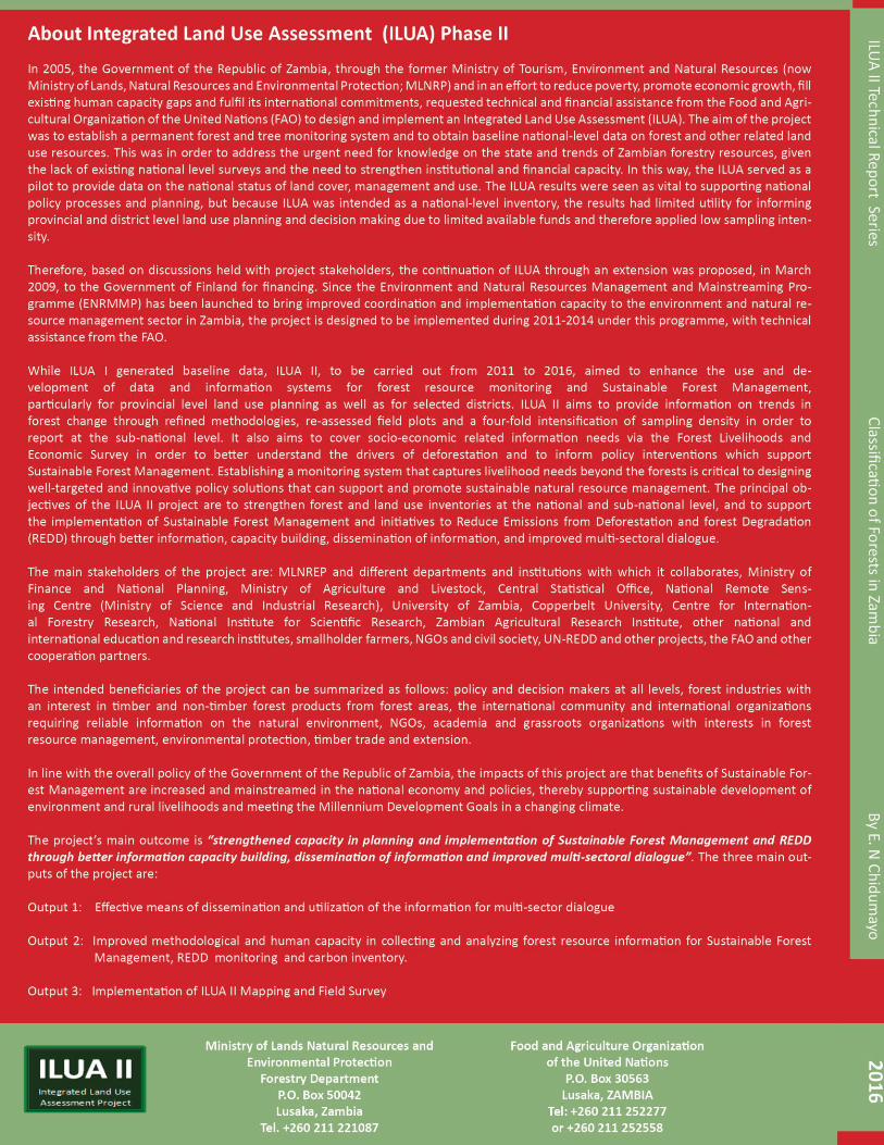
Classification of Zambian Forests | ILUA II
41
3