climate change and water scarcity adaptation strategies in ... · badan meteorologi klimatologi dan...
TRANSCRIPT
Procedia Environmental Sciences 20 ( 2014 ) 693 – 702
1878-0296 © 2014 The Authors. Published by Elsevier B.V. Open access under CC BY-NC-ND license. Selection and peer-review under responsibility of the SustaiN conference committee and supported by Kyoto University; (RISH), (OPIR), (GCOE-ARS) and (GSS) as co-hosts doi: 10.1016/j.proenv.2014.03.083
Available online at www.sciencedirect.com
ScienceDirect
The 4th International Conference on Sustainable Future for Human Security, SustaiN 2013
Climate Change and Water Scarcity Adaptation Strategies in the Area of Pacitan, Java Indonesia
Wiwin Widiyanti*, Andreas Dittmann Department Geography, Justus Liebig Universität Giessen, Germany
Abstract
The Karst area in Indonesia consists of a total area of 154.000 km2 of which 15% is protected. Pacitan is a part of The Thousand Mountains (Gunung Sewu in Javanese language) karst area and located in Southern Coastal of Java Island. Gunung Sewu karst area ranges over 85 km from west in Yogyakarta Special Province, to the east in East Java Province. Water scarcity is one of the issues in Pacitan due to the porous texture of the karst underground; most of the precipitation trickles immediately down into extensive system of sinkholes and caves. Thus, no surface water rivers, brooks or springs can be found in the area, especially during dry season where water supply, such as little lakes, called telaga, are depleted. Three sub-districts of Pacitan that include in Gunung Sewu karst area, i. e. Donorojo, Punung, and Pringkuku, suffer water shortage, especially during dry season, where the local communities need to walk up to 5 kilometers in order to take water for their domestic use. However, State-owned Water Company (Perusahaan Daerah Air Minum/PDAM) that has developed since 1992 in Pacitan, contributes in water supply in these areas and it has covered 70% in three kecamatan (sub-districts) by building IPA and is currently developing to cover the rest of the area by utilizing big water sources. PDAM and The Ministry of Public Work support the water treatment installation (Instalasi Pengolahan Air/IPA), especially in these three sub-districts. Furthermore, adaptive capacity has been developed in the local community of karst area in Pacitan, e.g. planting cultivars resistant to drought (cassava, maize, soybean, and groundnut) or doing multi cropping between those cultivars, and planting rainwater harvesting and artificial aquifer.
© 2013 The Authors. Published by Elsevier B.V. Selection and peer-review under responsibility of the SustaiN conference committee and supported by Kyoto University; (RISH), (OPIR), (GCOE-ARS) and (GSS) as co-hosts.
Keywords: Pacitan; karst; water scarcity; extreme climate events; adaptation strategies
* Corresponding author.
E-mail address: [email protected]
© 2014 The Authors. Published by Elsevier B.V. Open access under CC BY-NC-ND license. Selection and peer-review under responsibility of the SustaiN conference committee and supported by Kyoto University; (RISH), (OPIR), (GCOE-ARS) and (GSS) as co-hosts

694 Wiwin Widiyanti and Andreas Dittmann / Procedia Environmental Sciences 20 ( 2014 ) 693 – 702
PDAM Perusahaan Daerah Air Minum (State-owned Water Company) IPA Instalasi Air Minum (Water Treatment Installation) BMKG PAH FGD BPSP PSBA
Badan Meteorologi Klimatologi dan Geofisika (Indonesian Agency for Meteorology, Climatology and Geophysics) Penampungan Air Hujan (Rainwater Harvesting) Focussed Group Discussion Badan Pusat Statistik Pacitan (Pacitan Statistical Bureau) Pusat Studi Bencana Alam
1. Introduction
Pacitan is located in the most west part of Gunungsewu karst area which encompasses the Southern Coast of Java Island. Gunungsewu karst area, with an approximate area of 1220 km2, extends 85 km west-east and between 10-25 km north-south; it comprises parts of three provinces, namely Yogyakarta Special Province in the most west part, Central Java Province (Wonogiri District) in the middle part, and East Java Province in the most eastern part, where Pacitan District is located [1][2].
Water scarcity is one of the main issues in Pacitan, due to the karst structure in the western part of the district, where the karst aquifer is highly vulnerable to dangers for human consumption since water from the surface, including pollutants, penetrates into the ground almost without filtration. Moreover, anthropogenic activities have made the condition worse due to land degradation and poor water management [3]. Therefore, innovation in land and water use, adaptation technologies and developing fairness in the use of natural resources play an important role in developing adaptation strategies for water scarcity.
Based on Seckler [4] and FAO Reports [5], the dimension of water scarcity can be divided into two, namely physical- and economic scarcities. Physical scarcity occurs when physical condition of an area does not support to provide sufficient water or to meet demand of water-to-water users, where severe environmental degradation, declining groundwater and water allocations favor some groups over others. Meanwhile, economic scarcity is defined as a situation where water resources exist but water users have lack of water, due to human, institutional, political and financial capital limit the access to water sources.
Mohieldeen [6] and Smit [7] alluded that there was a strong correlation between adaptive capacity and coping strategy. Social entities with high level of adaptive capacity have more ability to generate coping strategy than social entities with limited adaptive capacity. In addition, a society will be more vulnerable if it is more exposed and sensitive to resource scarcity and climate stimulus, Ceteris paribus; a society that has more adaptive capacity will tend to be less vulnerable.
The objectives of the research are to analyze the relation between extreme climate events and water scarcity in Pacitan, and to analyze the existing adaptive capacity and responses of community, particularly in the karst area of Pacitan that is included in Gunungsewu.
2. Methodology
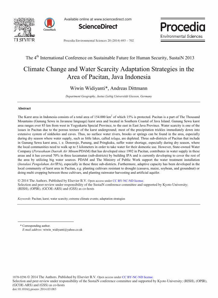
The research combined physical data as secondary data, e.g. base map, geological map, soil map, land use map, number of population that are drawn from centre and local government. Meanwhile, the primary data used here were interviews with community, and Focused Group Discussion (FGD) with the local stake holders and local community to collect information regarding the extreme climate events that they have experienced so far, the existing adaptive strategies on water use, water management related policies and their perception on State-owned Water Company (Perusahaan Air Minum Daerah/PDAM) as well. Below is the flowchart of the research.
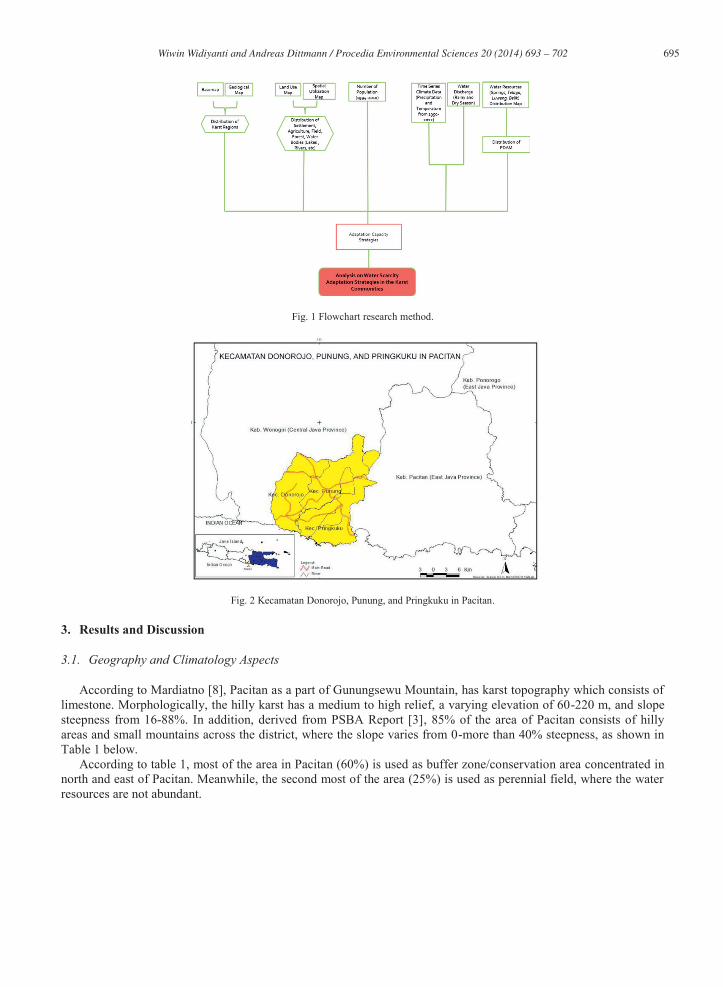
Administratively, there are three sub-districts (Kecamatan) in Pacitan that are included in Gunungsewu karst area, namely: Kecamatan Donorojo, Kecamatan Pringkuku, and Kecamatan Punung (Fig. 1). These kecamatans are located in the most western part of Pacitan and, except for Punung, they border with the Indian Ocean. As a part of Gunungsewu karst area, allogenic recharge from surface river and point recharge through ponors are well spread in these three kecamatan as well, where point recharges are mostly from ponors draining off from closed depressions during rainy season, where the depositions are eroded by rivers and permeation of water that ultimately forms karst and covers thousands of small hills [2].
695 Wiwin Widiyanti and Andreas Dittmann / Procedia Environmental Sciences 20 ( 2014 ) 693 – 702
Fig. 1 Flowchart research method.
Fig. 2 Kecamatan Donorojo, Punung, and Pringkuku in Pacitan.
3. Results and Discussion
3.1. Geography and Climatology Aspects
According to Mardiatno [8], Pacitan as a part of Gunungsewu Mountain, has karst topography which consists of limestone. Morphologically, the hilly karst has a medium to high relief, a varying elevation of 60-220 m, and slope steepness from 16-88%. In addition, derived from PSBA Report [3], 85% of the area of Pacitan consists of hilly areas and small mountains across the district, where the slope varies from 0-more than 40% steepness, as shown in Table 1 below.
According to table 1, most of the area in Pacitan (60%) is used as buffer zone/conservation area concentrated in north and east of Pacitan. Meanwhile, the second most of the area (25%) is used as perennial field, where the water resources are not abundant.

696 Wiwin Widiyanti and Andreas Dittmann / Procedia Environmental Sciences 20 ( 2014 ) 693 – 702
Table 1. Variety of hills steepness in Pacitan. (Source: PSBA-BAPPEDA Pacitan, 2007) Slope of steepness (%) Covers area (%) Area
0-20 ± 4,36 Coastal
2-15 ± 6,60 Agriculture field
15-40 ± 25,87 Perennial field
≥40 ± 63,17 Buffer zone/conservation area
Indonesian Agency for Meteorology Climatology and Geophysical or BMKG [9] formulated that Indonesia has
three general rainfall types, namely equatorial, local and monsoon. The latter type encompasses eastern part of Sumatera, southern part of Kalimantan, very small part of Sulawesi, and the whole Java, including Bali and Lesser Sunda Islands. In general, monsoon rainfall type has peak of rainfall from October to February and dry season occurs from March to September. Extreme climate event, e.g., El Niño Southern Oscillation (ENSO) plays an important role in the monsoon areas, where high variability of the season can make high vulnerability to water scarcity.
Haryono [2] added that Northwest and Southeast monsoons strongly influenced the climate in Gunungsewu karst area, including Pacitan, which produces a distinct wet season between October and April and dry season, which may be extremely arid between May and September (Fig. 3). The mean monthly rainfall varies from 42 mm3 in July to 359 mm3 in February. Meanwhile, the variation of monthly temperature in Pacitan is from 29,50C to 300C.
Fig. 3 Mean monthly rainfall and temperature in Pacitan (1985-2012). (Source BMKG 2012)
The annual rainfall data from BMKG showed that the annual rainfall in Pacitan was 4556 mm3 in 1998 (it is one of the years when the La Niña occurred) and 681 mm3 in 2002 (it is one of the years when El Niño years occurred) (Fig. 4) [10]. Based on the interview results, the definition of extreme climate events according to the community was a shifting of season, particularly for the planting season, and the time where the water sources were depleted so that they needed to walk several kilometers away to get water for their daily needs or to buy water tanks from private sector (for those who have more money). In terms of the sequence of extreme climate events, many communities believed that long period of dry season occurred every 8 to 10 years; therefore, they need to protect their water sources in order to preserve the water for the dry season. In addition, the local government plays an important role by providing water supply from PDAM where it managed big water sources in three sub-districts of Pacitan.

697 Wiwin Widiyanti and Andreas Dittmann / Procedia Environmental Sciences 20 ( 2014 ) 693 – 702
Fig. 4 Annual rainfall in Pacitan (1985-2012). (Source: BMKG 2012)
3. 2. Land Use
Uhlig [12] mentioned that due to unfavorable conditions of permeable substrate and the monsoonal rhythm of a distinct dry and rainy season, the soil moisture and nutrients rose again to surface during dry season; thus, intensive and continuous dry-field cultivation (tegalan) of the nutrient-rich occurs in dry season. Therefore, the main crops in karst areas are the crops that are able to grow in less water condition, e.g. cassava, maize, dry rice (padi gogo), coconut, palm sugar, etc. tumpangsari or multiple cropping which is usually used in order to keep staple foods during dry season. Soybeans, groundnuts, maize, mung beans, some sorghum, chilies, and cassava (seedlings planted between dry rice) are the rotated crops in tumpangsari. Pacitan also produces high quality wood, e.g. Teakwood, Acacia, Sengon wood which requires minimum 7 years to grow the wood. Dry rice-tobacco usually occurs where slightly favorable amounts of soils moisture are retained. However, during extreme dry season, there are no staple crops that can grow due to a very limited water supply. In general, land use in Pacitan mainly consists of tegalan (67%) that depends on rainfall and not by irrigation; meanwhile, rice field (dry- and wetland rice) consists less than 10% each from the land use of Pacitan, as shown in Fig. 5 below.
Fig. 5 Land use of Pacitan. (Badan Pusat Statistik Pacitan, 2010)
Furthermore, due to the porous texture of the karst underground, most of the rain water pours downward into the sinks and caves, resulting water shortages to vegetation fairly soon after rainy season finishes. Thus, there are only adapted species growing in karst area [13]. Lukas and Steinhilper [13] also added that water was a limiting factor in karst area, due to permeable karst underground and dry season that usually lasts from May to October/November, resulting in no irrigation in the area. Thus, the agriculture fields keep being idle during dry season. Meanwhile, during wet season, there is enough water for intensive dry field cultivation (tegalan), and terraces are found not merely at the slope of hills but also in the relatively flat karst basins.
Accordingly, Nibbering [14] mentioned that the pattern of land use was characterized by relatively large terraced fields in the basins and steeps, narrow field terraces at the slope. In the karst basins, it is more favorable for crop production, where the valley floors are characterized by deep soils that are enriched with nutrient washed down from
698 Wiwin Widiyanti and Andreas Dittmann / Procedia Environmental Sciences 20 ( 2014 ) 693 – 702
the slopes. Therefore, farmers can grow more than one crop in each rainy season. Meanwhile, at the slopes, the soils are shallower and less fertile; the retaining capacity of water is quite low as well.
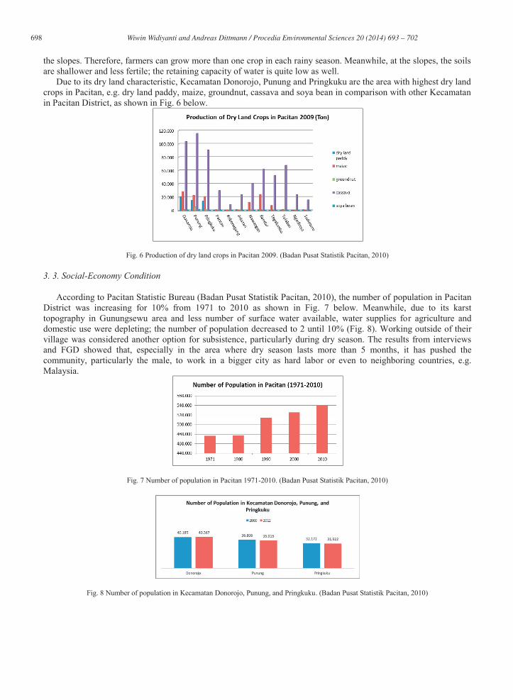
Due to its dry land characteristic, Kecamatan Donorojo, Punung and Pringkuku are the area with highest dry land crops in Pacitan, e.g. dry land paddy, maize, groundnut, cassava and soya bean in comparison with other Kecamatan in Pacitan District, as shown in Fig. 6 below.
Fig. 6 Production of dry land crops in Pacitan 2009. (Badan Pusat Statistik Pacitan, 2010)
3. 3. Social-Economy Condition
According to Pacitan Statistic Bureau (Badan Pusat Statistik Pacitan, 2010), the number of population in Pacitan District was increasing for 10% from 1971 to 2010 as shown in Fig. 7 below. Meanwhile, due to its karst topography in Gunungsewu area and less number of surface water available, water supplies for agriculture and domestic use were depleting; the number of population decreased to 2 until 10% (Fig. 8). Working outside of their village was considered another option for subsistence, particularly during dry season. The results from interviews and FGD showed that, especially in the area where dry season lasts more than 5 months, it has pushed the community, particularly the male, to work in a bigger city as hard labor or even to neighboring countries, e.g. Malaysia.
Fig. 7 Number of population in Pacitan 1971-2010. (Badan Pusat Statistik Pacitan, 2010)
Fig. 8 Number of population in Kecamatan Donorojo, Punung, and Pringkuku. (Badan Pusat Statistik Pacitan, 2010)

699 Wiwin Widiyanti and Andreas Dittmann / Procedia Environmental Sciences 20 ( 2014 ) 693 – 702
The main subsistence of Pacitan still depends on dry land crops, forestry and tourism, where coastal tourism and caves become the main attraction for local and international tourists. Pacitan is also as one of the main ways for commuters during public holiday from west to east part of Java; therefore, local government joined with private sector in order to develop local tourisms sites, e.g. coastal sites and caves (Badan Pusat Statistik Pacitan 2010). Pacitan is currently developing Geopark that has been researched by UNESCO in 2011, particularly in the karst areas [15].
3. 4. State-owned Water Company (Perusahaan Air Minum Daerah/PDAM)
As the main state-owned water supplier, the existence of PDAM is essential in Indonesia, especially in the areas where water sources are scarce. However, PDAM faces numerous constraints in terms of financing operational costs, infrastructure sector and efficiency issue that make it unable to serve public optimally [17].
Most of the water supplies in East Java Province use groundwater with electricity as the main power to distribute, where the above issues are still as the main constraint, e.g. leaking pipes, financial operational costs, and population pressure. In 2002, PDAM of East Java Province lost 36% of water due to leaking pipes; meanwhile, there are 5000 units of pipe demand annually to PDAM [18].
Built in 1992, PDAM was established by the local government of Pacitan to manage water supplies and its use in the community. However, it was not until 2005 PDAM covered most part of water-scarce areas in Pacitan, particularly in the karst area and developed their service in terms of water quality. Out of 12 kecamatans in Pacitan, PDAM has built 9 units in 9 kecamatans and is still developing new units in water-scarce areas. PDAM works together with the Ministry of Public Work, where PDAM supports technical operation and the Ministry of Public Work provides the fund for supplying tanks and other operational costs [20]. Figures below show one of the water installation or Instalasi Pengolahan Air (IPA) from PDAM in Kecamatan Pringkuku that has the source from Kali Barong.
Despite of the constraints, the number of PDAM users in Pacitan was significantly increasing up to 16% in the three kecamatans from 2004 to 2012, as shown in Fig. 9 and Fig. 10 below. The number shows that the community still needs PDAM as water supplier for their daily needs, especially during dry season where other water sources, e.g. telaga and belik are depleted. Based on the results of interviews and FGD, the community was relying mostly on PDAM connection as their main source of water supply, particularly in dry season.
According to PDAM, in order to have first installment of PDAM connections, the community needs to pay IDR 650,000 (USD 65) and IDR 31,400 (USD 3.14) per month for 10 m3 water. If they use more than 10 m3, then, they need to pay for every m3 for IDR 2,640 (USD 3 cents). This monthly payment only applies to residential and differs from industrial group in which they need to pay IDR 71,000 (USD 71) per month for 10 m3; and, if they use more than 10 m3, then they need to pay for every m3 for IDR 3,840 (USD 4 cents). Fig. 10 below shows that the three kecamatans and the capital city of district have the highest number for PDAM connections in comparison with other kecamatans. There was 10% in increase of PDAM connections each year from 2008 to 2012 in these four kecamatans, including the capital city.
Fig. 9 (A) IPA in Kec. Pringkuku, (B) Water installation inside IPA in Kec. Pringkuku. (Widiyanti, 2013)
A B

700 Wiwin Widiyanti and Andreas Dittmann / Procedia Environmental Sciences 20 ( 2014 ) 693 – 702
Fig. 10 Number of PDAM users/connections per sub-district/kecamatan in Pacitan. (Source: BPSP, 2012)
3. 5. Existing Adaption Strategies in Pacitan
Before PDAM covered most scarce areas in Pacitan, many communities relied on karst springs that interconnected to depressions in the ground surface where some of the springs had large quantities of water moving through cavities or channels that developed in limestone, e.g. Kali Barong in Kecamatan Pringkuku that has 600 L/sec water discharge in rainy season and 400 L/sec in dry season. Kali Barong has become the biggest water source in karst area in Pacitan that is currently being used by PDAM and transports the water to 6 villages in Kecamatan Pringkuku and partial part of capital district. Nevertheless, there are seasonal springs that have small discharge and depleted during dry season in several villages. This is the time where the communities that do not have connections with PDAM rely on rainwater harvesting (Penampungan Air Hujan/PAH), telaga, and water tanks from the local government. PAH is often used as additional water source and only for washing clothes, not for drinking and cooking purposes.
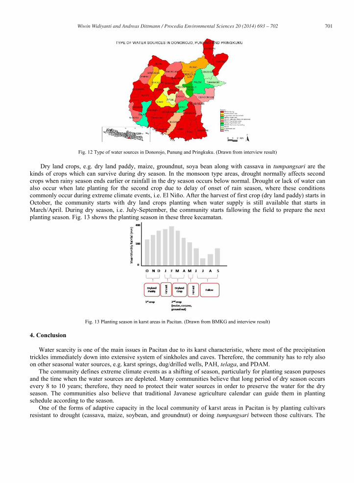
One of the forms of local adaptive capacity that applies in these areas is that the community also relies on springs, dug/drilled wells, PAH, water tank that is organized privately, telaga and combination between them. Table 2 shows that combination between PDAM – springs and PDAM - dug/drilled wells dominate water sources in these areas. Water tank that is organized privately by some people who have access to water source is normally done by communities who have the money to purchase the water; for some who do not, they rather use dug-wells and springs. However, dug wells are not always available in every area due to karst characteristic; therefore, small springs or belik and water tank become their options. Although the water discharge of belik is relatively small, some villages still use belik as additional water source, particularly when the pipe of PDAM leaks. Based on the result of interviews, many telaga had been depleted since 5 to 10 years ago; currently most of the communities are using telaga for their temporary agriculture field, particularly at the end of rainy season and in the beginning of dry season. Fig. 11 below show belik, PAH, and telaga during end of rainy season.
Fig. 11 (A) Belik in Kec. Punung (B) PAH in Kec. Donorojo (C) Telaga at the end of rainy season (D) Telaga at the beginning of dry season. (Widiyanti, 2013).
A B
C D
701 Wiwin Widiyanti and Andreas Dittmann / Procedia Environmental Sciences 20 ( 2014 ) 693 – 702
Fig. 12 Type of water sources in Donorojo, Punung and Pringkuku. (Drawn from interview result)
Dry land crops, e.g. dry land paddy, maize, groundnut, soya bean along with cassava in tumpangsari are the kinds of crops which can survive during dry season. In the monsoon type areas, drought normally affects second crops when rainy season ends earlier or rainfall in the dry season occurs below normal. Drought or lack of water can also occur when late planting for the second crop due to delay of onset of rain season, where these conditions commonly occur during extreme climate events, i.e. El Niño. After the harvest of first crop (dry land paddy) starts in October, the community starts with dry land crops planting when water supply is still available that starts in March/April. During dry season, i.e. July-September, the community starts fallowing the field to prepare the next planting season. Fig. 13 shows the planting season in these three kecamatan.
Fig. 13 Planting season in karst areas in Pacitan. (Drawn from BMKG and interview result)
4. Conclusion
Water scarcity is one of the main issues in Pacitan due to its karst characteristic, where most of the precipitation trickles immediately down into extensive system of sinkholes and caves. Therefore, the community has to rely also on other seasonal water sources, e.g. karst springs, dug/drilled wells, PAH, telaga, and PDAM.
The community defines extreme climate events as a shifting of season, particularly for planting season purposes and the time when the water sources are depleted. Many communities believe that long period of dry season occurs every 8 to 10 years; therefore, they need to protect their water sources in order to preserve the water for the dry season. The communities also believe that traditional Javanese agriculture calendar can guide them in planting schedule according to the season.
One of the forms of adaptive capacity in the local community of karst areas in Pacitan is by planting cultivars resistant to drought (cassava, maize, soybean, and groundnut) or doing tumpangsari between those cultivars. The
702 Wiwin Widiyanti and Andreas Dittmann / Procedia Environmental Sciences 20 ( 2014 ) 693 – 702
role of government is also essential by providing water connections through PDAM to the areas that are water scarce. As the state-owned water company, the existence of PDAM is essential for these areas particularly during dry season. After PDAM had developed in 1992, it had covered 70% in three kecamatan by building IPA and is currently developing to cover the rest of the area by utilizing big water source like Kali Barong in Kecamatan Pringkuku. Acknowledgement
The writer would like to thank to German Exchange Academic Service (DAAD) and Indonesian Ministry of National Education for the financial support, Justus-Liebig Universität Giessen for providing guidance and technical support, local government and the communities of karst areas in Pacitan for the hospitality and tremendous support during fieldwork. References 1. Flathe HP. Grundzüge der Morphologie, Geologie und Hydrogeologie im Karstgebiet Gunungsewu/Java (Indonesien). Geol. Jb 1965;
83:533-562. 2. Haryono E. Gunungsewu Karst Ecocsystem Java Indonesia; Unpublished PhD Paper. Yogyakarta: Universitas Gadjah Mada; 2008. 3. Pusat Studi Bencana (PSBA)-Bappeda Pacitan. Laporan Pendahuluan Pemetaan Zonasi Daerah Rawan Gempa Untuk Mitigasi Bencana
Tsunami di Kabupaten Pacitan. Yogyakarta: Pusat Studi Bencana (PSBA); 2007. 4. Seckler DA. World Water Demand and Supply, 1990 to 2025: Scenarios and Issues. Srilanka: International Water Management Institute;
1998. 5. FAO. Coping with water scarcity; An action framework for agriculture and food security (FAO Water Reports). Rome; 2008. 6. Mohieldeen Y. Responses to Water Scarcity: Social Adaptive Capacity and the Role of Environmental Information. A Case Study from Ta'iz,
Yemen. Occasional Paper No.2; 1999. 7. Smit BW. Adaptation, Adaptive Capacity and Vulnerability. Global Environmental Change 2006; 282-292. 8. Mardiatno D. Tsunami Risk Assessment Using Scenario-Based Approach, Geomorphological and GIS. Innsbruck: University of Innsbruck;
2008. 9. Makmur E. Drought Assessment Over Indonesia Related to El Nino and SSTA Indonesia. Inter-Regional Workshop on Indices and Early
Warning System for Drought. Nebraska; 2009, p. 26. 10. Climate Prediction Centre-NOAA. Cold and Warm Episodes by Season: Changes to the Oceanic Niño Index (ONI) (accessed on 5 August
2013). http://www.cpc.ncep.noaa.gov/products/analysis_monitoring/ensostuff/ensoyears.shtml. 11. Waltham AS. Exploration of Caves for Rural Water Supplies in the Gunung Sewu Karst, Java. Annales de la Société Géologic de Belgique T
1985;108:27-31. 12. Uhlig H. Man and Tropical Karst in Southeast Asia. GeoJurnal 1980;4(1):31-44. 13. Lukas M, Steinhilper D. Living Condition in the Gunung Sewu Karst Region (Java Indonesia). Giessen: Institut für Geographie, Universität
Justus-Liebig Giessen; 2005. 14. Nibbering J. Crisis and Resilience in Upland Land Use in Java. In: Hardjono J, editors. Indonesia:Resources, Ecology, and Environment;
1991. p. 104-132. 15. Matanesia Magazine. Pacitan Menuju Geopark Dunia. Monthly, 4th Edition; 2011. p. 7-11. 16. Siswoyo B. Hutan Rakyat dan Serbuan Pasar: Studi Refleksi Pengusahaan Hutan Rakyat Lestari secara Kolaboratif di Pacitan, Jawa Timur.
Jurnal Ilmu Sosial dan Politik 2007; 11(2):153-286. 17. Brontowijono W. Sustainable Water Resources Management with Special Reference to Rainwater Harvesting; Case Study of KarManTul,
Java, Indonesia. Karlsruhe: Uni Karlsruhe; 2008. 18. Sunarno. Program Penyehatan PDAM se-Jawa Timur (accessed on 7 August 2013). http://www.pdam-
sby.go.id/bacaartikel.asp?idart=5&iddart=10. 19. PDAM. Surat Edaran Nomor: 690/231.A/408/2011. Pacitan: PDAM; 2011. 20. Daldjoeni N. The Javanese agriculture calendar-Its bioclimatological and sociocultural function in developing rural life. Environmentalist
1984; 4(7) Supplement:15-18.