cline buttes recreation area zone map

1
CLINE BUTTES RECREATION AREA The Cline Buttes Recreation Area is managed by the Prineville District BLM. The area is undergoing trail and trailhead development, route decomissioning and fuels reduction projects. Please keep in mind the following when visiting the area: TRAIL USE AREAS: The Recreation Area has been divided into different trail use areas. This map shows the allowable trail uses for each area, such as: and As trail systems are developed in each area, motorized, mechanized and equestrian use will be restricted to designated trails. ACCESS: Many access points will change as shown on the map due to private property boundaries and sensitive resources. Vehicle access is no longer allowed to the top of the buttes. The majority of land on the buttes is private property. FIREARM USE: Care should be taken when using firearms in the recreation area. BLM lands east of Barr Road are closed to firearm discharge unless legally hunting. The Tumalo Canal Historic Area and smaller parcels along the Deschutes River are closed to all firearm discharge. Closed to firearm discharge except when legally hunting Closed to all firearm discharge Closed to all firearm discharge seasonally (Feb. 1 to Aug. 31) Recreation Area lands with no firearm restriction TRAIL USE: MASTON : Separate trails will be developed for equestrian and mountain bike use. HIkers can use all trails. Trails into the Deschutes River Canyon and along the river are for pedestrian use only. Trails will be developed to minimize habitat fragmentation and disturbance to birds of prey, with some of the area under a seasonal closure. The Maston Area is closed to motorized use. BUTTES : Separate trails will be developed for equestrian and mountain bike use. Hikers can use all trails. The Buttes Area is closed to motorized use. TUMALO HISTORIC AREA : Interpretive trails along relic canals are for pedestrian use only. Trails in the south portion of the Historic Area (including South Boundary Road) are for equestrian, mountain bike and pedestrian use. The Historic Area is closed to motorized use. SOUTHWEST AREA : Trails are being developed for shared use by all non-motorizeduses (including equestrian, pedestrian and mountain bike). Some trails have seasonal closures to minimize disturbance to nesting birds of prey. The Southwest Area is closed to motorized use. CENTRAL OHV AREA : Trails are being developed for OHV use, including motorcycle only trails, motorcycle/quad trails, jeep trails and rock crawl/play areas. Some trails have seasonal closures to minimize disturbance to nesting birds of prey. OHV trails are also open to non-motorized uses. DEEP CANYON AREA : Trails are being developed for pedestrian and equestrian use only. Trails will be designed to minimize disturbance to birds of prey, with some of the area under a seasonal closure. The Deep Canyon Area is closed to motorized use. FOR MORE INFORMATION: Please contact the Prineville District BLM at 541 - 416 - 6700 or by visiting: www.blm.gov/or/districts/prineville Desch u t e s River 20 126 FRYREAR ROAD BARR ROAD BUCKHO RN ROAD CLINE FALLS HIGHWAY

Upload: others

Post on 11-Feb-2022

3 views

Category:

Documents


0 download

TRANSCRIPT

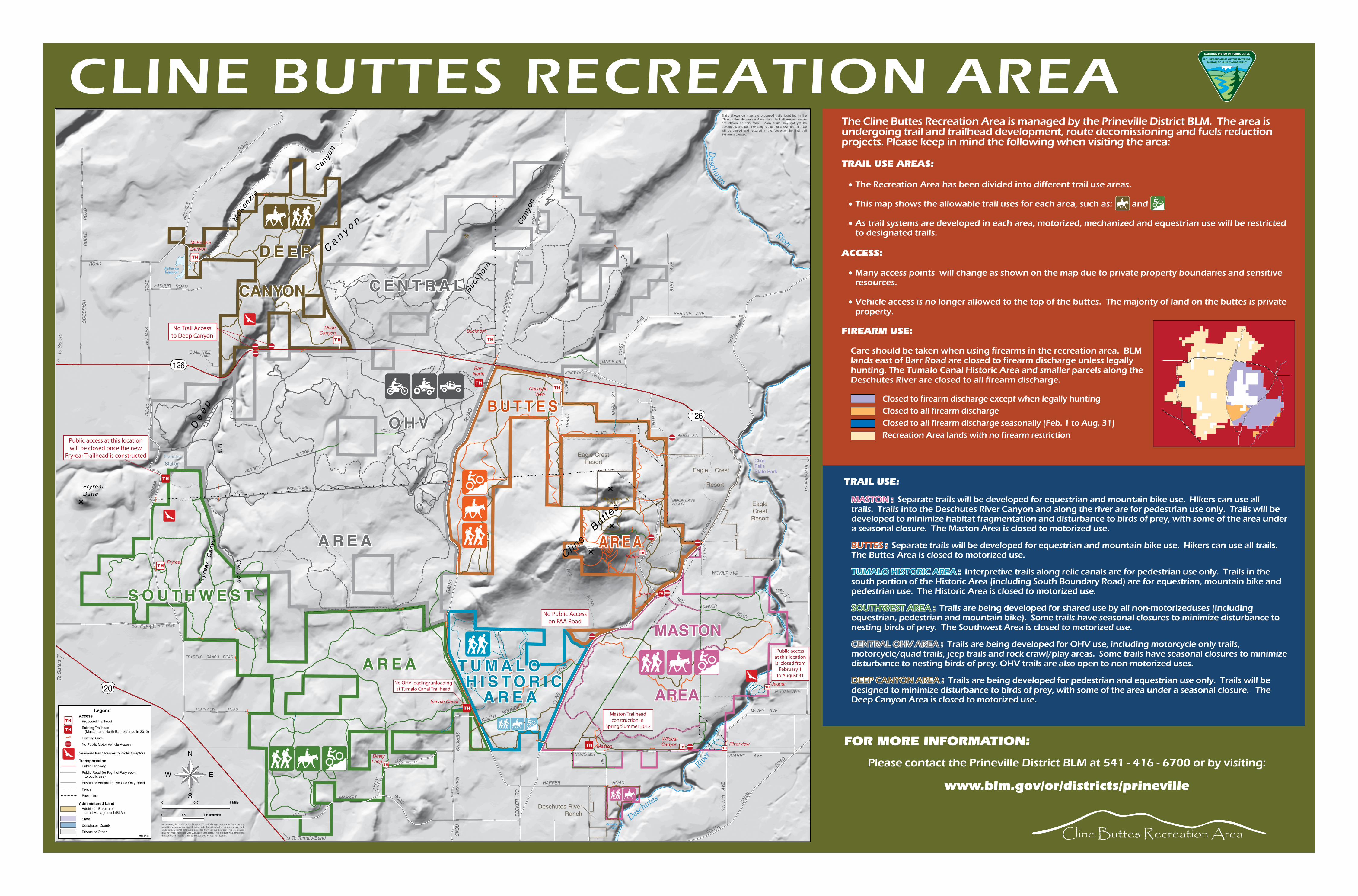
CLINE BUTTES RECREATION AREAThe Cline Buttes Recreation Area is managed by the Prineville District BLM. The area is undergoing trail and trailhead development, route decomissioning and fuels reduction projects. Please keep in mind the following when visiting the area:

TRAIL USE AREAS:

•The Recreation Area has been divided into different trail use areas.

•This map shows the allowable trail uses for each area, such as: and

•As trail systems are developed in each area, motorized, mechanized and equestrian use will be restricted to designated trails.

ACCESS:

•Many access points will change as shown on the map due to private property boundaries and sensitive resources.

•Vehicle access is no longer allowed to the top of the buttes. The majority of land on the buttes is private property.

FIREARM USE:

Care should be taken when using firearms in the recreation area. BLM lands east of Barr Road are closed to firearm discharge unless legally hunting. The Tumalo Canal Historic Area and smaller parcels along the Deschutes River are closed to all firearm discharge.

Closed to firearm discharge except when legally huntingClosed to all firearm dischargeClosed to all firearm discharge seasonally (Feb. 1 to Aug. 31)Recreation Area lands with no firearm restriction

TRAIL USE:

MASTON : Separate trails will be developed for equestrian and mountain bike use. HIkers can use all trails. Trails into the Deschutes River Canyon and along the river are for pedestrian use only. Trails will be developed to minimize habitat fragmentation and disturbance to birds of prey, with some of the area under a seasonal closure. The Maston Area is closed to motorized use.

BUTTES : Separate trails will be developed for equestrian and mountain bike use. Hikers can use all trails. The Buttes Area is closed to motorized use.

TUMALO HISTORIC AREA : Interpretive trails along relic canals are for pedestrian use only. Trails in the south portion of the Historic Area (including South Boundary Road) are for equestrian, mountain bike and pedestrian use. The Historic Area is closed to motorized use.

SOUTHWEST AREA : Trails are being developed for shared use by all non-motorizeduses (including equestrian, pedestrian and mountain bike). Some trails have seasonal closures to minimize disturbance to nesting birds of prey. The Southwest Area is closed to motorized use.

CENTRAL OHV AREA : Trails are being developed for OHV use, including motorcycle only trails, motorcycle/quad trails, jeep trails and rock crawl/play areas. Some trails have seasonal closures to minimize disturbance to nesting birds of prey. OHV trails are also open to non-motorized uses.

DEEP CANYON AREA : Trails are being developed for pedestrian and equestrian use only. Trails will be designed to minimize disturbance to birds of prey, with some of the area under a seasonal closure. The Deep Canyon Area is closed to motorized use.

FOR MORE INFORMATION:

Please contact the Prineville District BLM at 541 - 416 - 6700 or by visiting:

www.blm.gov/or/districts/prineville

Desc

hutes

Rive

r

20

126

FRY

RE

AR

RO

AD

BA

RR

R

OAD

BU

CK

HO

RN

RO

ADC

LIN

E

FALL

S

HIG

HWAY