clinton river restoration plan summary - us epa · summary restoration plan (rap) – 2008 update 3...
TRANSCRIPT


Summary Restoration Plan (RAP) – 2008 Update 1
Clinton River Area of Concern 11/01/2008
Summary Restoration Plan (Remedial Action Plan)
2008 Update
Table of Contents Definition of Terms 2Acknowledgements 3Foreword: A Renewed Call 4Introduction 5Conditions in the AOC 8Future Management 20Goals and Objectives 22Actions to Achieve Goals and Objectives 25Summary with Respect to Beneficial Use Impairments 29Priority Actions 50Evaluation of Progress 53Conclusion 60List of Figures Figure 1: Clinton River Watershed / AOC showing urbanized areas 6Figure 2: Upper Clinton Subwatershed summarized conditions 9Figure 3: Clinton Main Subwatershed summarized conditions 10Figure 4: Stony Creek / Paint Creek Subwatershed summarized conditions 11Figure 5: Clinton River East Subwatershed summarized conditions 12-13Figure 6: Red Run Subwatershed summarized conditions 14Figure 7: North Branch Subwatershed summarized conditions 15Figure 8: Lake St. Clair Direct Drainage Subwatershed summarized conditions 16-17Figure 9: Goals and Objectives of the RAP 22-24 Figure 10: Summarized information for BUI #1 30-31Figure 11: Summarized information for BUI #3 32-34Figure 12: Summarized information for BUI #6 35-36Figure 13: Summarized information for BUI #7 36-38Figure 14: Summarized information for BUI #8 39-41Figure 15: Summarized information for BUI #10 41-43Figure 16: Summarized information for BUI #11 43-45Figure 17: Summarized information for BUI #14 47-48 Figure 18: Implementation Milestones 55-57 List of Tables Table 1: Clinton River Area of Concern scorecard (by subwatershed) 19Table 2: Restoration Plan actions of the plan 26-28 Table 3: Relationship of goals/objectives and actions for BUI #1 32Table 4: Relationship of goals/objectives and actions for BUI #3 34Table 5: Relationship of goals/objectives and actions for BUI #6 37Table 6: Relationship of goals/objectives and actions for BUI #7 39Table 7: Relationship of goals/objectives and actions for BUI #8 42Table 8: Relationship of goals/objectives and actions for BUI #10 44Table 9: Relationship of goals/objectives and actions for BUI #11 46Table 10: Relationship of goals/objectives and actions for BUI #14 49Table 11: Priority Actions 50Table 12: Assessments associated with the actions 54Table 13: Goals / objectives evaluation questions 57 List of Sidebars Tetra Tech Acknowledgements 4Annex 2 Requirements 5Components of the Restoration Plan 7Funding Opportunities 8Model Evaluation Parameters 20Modeled Scenarios 21Considerations for Action Development 25Modeling Summary 52Pollutant Load Reductions 53

Summary Restoration Plan (RAP) – 2008 Update 2
Clinton River Area of Concern 11/01/2008
Definition of Terms
This page defines the acronyms and abbreviations that are essential to understanding the text of the Summary Restoration Plan (Summary RAP).
AOC Area of Concern BMP Best Management Practice BOD Biochemical Oxygen Demand BUI Beneficial Use Impairment CMI Clean Michigan Initiative CRPAC Clinton River Public Advisory Council CRW Clinton River Watershed CRWC Clinton River Watershed Council CSO Combined Sewer Overflow CWA Clean Water Act DO Dissolved Oxygen EPA Environmental Protection Agency GIS Geographic Information System GLC Great Lakes Commission GLEAS Great Lakes and Environmental Assessment Section GLNPO Great Lakes National Program Office GLWQA Great Lakes Water Quality Agreement HSPF Hydrologic Simulation Program – FORTRAN IDEP Illicit Discharge Elimination Program IJC International Joint Commission LEED Leadership in Energy and Environmental Design LID Low Impact Development MDA Michigan Department of Agriculture MDEQ Michigan Department of Environmental Quality MDNR Michigan Department of Natural Resources MNFI Michigan Natural Features Inventory NO3 The chemical symbol for nitrate. NPDES National Pollutant Discharge Elimination System NRCS Natural Resources Conservation Service OCDC Oakland County Drain Commissioner PCBs Polychlorinated Biphenyls pH This represents the log of the hydrogen ion concentration. RAP Remedial Action Plan; also referred to as the Restoration Plan SEMCOG Southeast Michigan Council of Governments SOP Standard Operating Procedure SSO Sanitary Sewer Overflow SWPP Source Water Protection Plan SWPPI Stormwater Pollution Prevention Initiative TKN Total Kjeldahl Nitrogen TP Total Phosphorus TRC Technical Review Committee TSS Total Suspended Solids USACE United States Army Corps of Engineers USCB United States Census Bureau USFWS United States Fish and Wildlife Service WMP Watershed Management Plan WQMP Water Quality Management Plan WQS Water Quality Standards WWTP Waste Water Treatment Plant

Summary Restoration Plan (RAP) – 2008 Update 3
Clinton River Area of Concern 11/01/2008
Acknowledgements
The Clinton River Restoration Plan is an updated remedial action plan (RAP) prepared pursuant to Annex 2 of the Great Lakes Water Quality Agreement (GLWQA). This Restoration Plan (RAP, also) represents the joint effort and hard work of many dedicated people, especially the members of the Clinton River Public Advisory Council (CRPAC). There are many individuals and organizations who contributed their time, expertise, and resources during the development of this RAP. Their tireless efforts will greatly benefit the restoration and future protection of the Clinton River and its tributaries for years to come. There is great appreciation for the time and efforts of all of the private citizens as well. The following individuals and organizations are recognized for their contributions:
Auburn Hills, City of – Shawn Keenan Clinton, Charter Township of – Mary Bednar Clinton River Watershed Council – Dan Keifer, Anne Vaara, Gary Morgan, Environmental Consultant Technologies – Roy Schrameck Federal Development Company – John Mularoni Huron Clinton Metropolitan Authority – Paul Muelle International Joint Commission – Bruce Kirschner Macomb County Health Department – Gary White Macomb County Planning and Economic Development – Gerry Santoro Macomb County Prosecutors Office – Mark Richardson (CRPAC Chair) Macomb County Public Works Office – Lynne Seymour Macomb County Water Quality Board – Gerald DeMaire, Doug Martz, William Smith Michigan Department of Environmental Quality – Laura Esman Michigan State University Extension – Macomb County – Terry Gibb Oakland County Drain Commissioner’s Office – Jim Wineka Oakland County Planning and Economic Development Services – Nina Ignaczak Oakland University – Linda Schweitzer Private Citizens – Timothy Backhurst, William Card, Greg Franczak, Peggy Johnson Rochester Hills, City of – Roger Moore Southeast Michigan Council of Governments – Angela Riess United States Environmental Protection Agency – Laura Evans, Alie Muneer Wayne State University – Carl Freeman
Financial support for the development of the RAP (and related tools) was provided through the U.S. Environmental Protection Agency (EPA). This support came in the form of a grant to the Oakland County Drain Commissioner’s (OCDC) Office which exercised a contract with a Tetra Tech, Inc. to perform the work. At OCDC, John P. McCulloch was the current Drain Commissioner and Jim Wineka was the project contact.
The authors of the resources referenced in the RAP are recognized for their contributions to the improving health of the Clinton River Watershed. Their names appear in the RAP as their work is presented.
All components of the RAP were initially prepared by Tetra Tech (see the sidebar on the following page) and reviewed and commented on extensively by members of the CRPAC.
Summary Restoration Plan (RAP) – 2008 Update 4
Clinton River Area of Concern 11/01/2008
Foreword: A Renewed Call
Like a mirror, the Clinton River reflects the stark reality of its polluted past and problematic present. Many of its open channel tributaries were long ago replaced with closed pipe sewers; its wetlands drained or filled. The loss of these and many other natural systems impacts the river still.
The 2008 RAP is the first comprehensive update and rewriting of the RAP for the Clinton River since 1995. There have been many exciting and positive developments in the Clinton River Watershed (CRW) during this time. Overflows from combined and sanitary sewers have been greatly reduced and in many cases eliminated. Hundreds of illegal cross connections between sanitary sewer lines and storm sewers have been identified and eliminated. Hundreds of failing septic systems have been repaired, replaced, or removed. Bacteria levels have begun to drop and beach closings have been reduced. Extensive water and sediment quality monitoring has produced a better understanding of the nature and extent of remaining environmental contamination. The river and its basin’s hydraulics and hydrology have been studied and flow models have been created to predict the impact of land use changes on the river.
The task of restoring the Clinton River and its watershed to its true value as a natural resource – capable of providing all of the public benefits of a healthy river – has really just begun. Although it has improved over time from its most polluted state, areas of the watershed: are still plagued with aesthetic problems (e.g. algae, debris, odors); are contaminated with bacteria from human and animal waste and with nutrients derived from organic wastes and fertilizers; experience altered flow regimes, and; have organic compounds and heavy metals washed into the sewers from impervious surfaces associated with urban, residential, and transportation development. New issues have since emerged such as uncontrolled development and increased imperviousness which encourage damaging peak stream flows and exacerbate low flow periods due to the loss of infiltration areas that sustain the river’s base flow. Furthermore, historic industrial wastes, particularly PCBs, are embedded throughout the river system and with increased flows come increased sedimentation that leads to benthic conditions that are seriously impaired and in some cases devoid of life.
All of this must change. The moral and legal case for restoring and protecting the Clinton River and Lake St. Clair – that the waters belong to the public who have the right to drink from them, to fish, to swim, to recreate, and to travel upon them without fear of harm – has always been apparent. Now, more than ever before, there are compelling pragmatic reasons to keep the waters safe and clean.
Relentless economic pressures are forcing the manufacturing-based economy of southeastern Michigan to give way to a new service-based economy. As the area competes in a global market place for jobs and businesses that could be located anywhere, it is crucial that future residents and businesses see that the area offers the potential for a high quality of life. Protecting and preserving the natural resources that make our area uniquely valuable must become of the highest importance.
This Restoration Plan (RAP) identifies the actions needed to restore the Clinton River as a natural resource that people may use for all the benefits
Tetra Tech Acknowledgements
At Tetra Tech, Dave Upmeyer was the executive project manager while Steve Pennington assumed most day-to-day operations responsibilities and was the main voice for Tetra Tech at CRPAC, and other related, meetings. Steve was also responsible for putting together this ‘Summary RAP’ meant for more general public consumption. Kevin Kratt provided additional management level guidance with respect to the technical/ modeling portions of the project.
Kyle Paulson was involved extensively with the development of the main RAP document. His duties included coordinating the technical content of the plan, providing GIS support, drafting the documents, and editing the documents based on internal and external comments. This work was closely coordinated with Steve and the other managers.
Scott Job ultimately conducted the bulk of the modeling efforts for the project (with assistance from Josh Kasun and others). He and Kevin prepared the results of these efforts for their intended purposes, including appropriate sections in the RAP.
Diane Vogel, Susan Franklin, Kyle Paulson, and Steve Pennington provided final editing support and document preparation. Kathy Scheffler was responsible for developing the covers for both documents.
Other team members contributing to development of the RAP include: Susan MacNeil (research), Valerie Sanglier (editing), Natalie Trotter (GIS), and Justin Voss (research). Kelly Dubay and Elizabeth Hansen also deserve consideration for work on previous projects that was referenced herein.

Summary Restoration Plan (RAP) – 2008 Update 5
Clinton River Area of Concern 11/01/2008
it can offer: fishing, swimming, watersports, wildlife, and aesthetic pleasure. The RAP is the fruit of many hours of labor by environmental professionals, public officials, and citizen volunteers. It builds on the efforts of others who have studied the river/watershed or have tried to protect it over preceding decades, including those who wrote or contributed to previous RAPs issued in 1988, 1995, and 2000. We believe that the RAP will serve as the catalyst for making protection and restoration of the watershed a top priority for all of the communities.
Local governments must improve land use regulations to reduce the volume and slow the rate of discharge of polluted rainwater into the river. Waste water treatment plants must be upgraded to reduce nutrient loads. Wetlands and other natural areas need to be restored or rehabilitated by removing invasive and nuisance plant species; by rehydrating dried out areas; by acquiring buffer areas; and by acquiring new lands to combine small fragmented parcels into ecologically healthy and sustainable areas. Contaminated sediments in the river bed must be addressed. And progress in removing human and animal waste from the waters must continue through correcting illicit connections, repairing or replacing failed septic systems, proper disposal of animal waste, and other means.
All of us must do our part, whether we are municipal officials, regulatory agency personnel, business owners, or private citizens. Moreover, our efforts must become continuous. We, the citizens of the watershed, must become more aware than ever of what it means to be environmentally responsible in our private and public behavior. An ethic of good stewardship for our natural resources must emerge and prevail among us.
A poet said that “time and tide wait for no man.” In nature, nothing stands still. We, the citizens of the Clinton River Watershed, need to move with it. Let us all join together around this plan and begin to write a new chapter in the story of the Clinton River for ourselves and for our children and grandchildren.
Mark Richardson
Clinton River Public Advisory Council Chair
Introduction
The Clinton River drains approximately 765 square miles in southeast Michigan and is located mostly in Oakland and Macomb Counties with small portions of the watershed in Lapeer and St. Clair counties. For the purposes of this RAP, the AOC also includes the communities in the Michigan Department of Environmental Quality (MDEQ)-defined Lake St. Clair Direct Drainage Subwatershed (53 square miles – including part of Wayne County) as many are impacted by the discharge of the Clinton River and its Spillway into Lake St. Clair.
Land use in the AOC is highly developed with over 440 square miles as residential (330), industrial (37), commercial (34), and other urban types (e.g. transportation). Agriculture accounts for 135 square miles, wooded areas and wetlands for 93 square miles, open water for 23 square miles, and recreation / grassland areas for 109 square miles (with 18 square miles unaccounted for due to lack of data). The population inhabiting this land is estimated to be over 1.5 million and growing.
Annex 2 Requirements
As defined in 4(d)(ii) and 4(a)(iii-vi), respectively, of Annex 2 of the GLWQA, Stage 2 RAPs are to be submitted to the International Joint Commission (IJC) for review and comment and are to contain:
an evaluation of remedial measures in place;
an evaluation of alternative additional measures to restore beneficial uses;
a selection of additional remedial measures to restore beneficial uses;
a schedule for their implementation; and
an identification of the persons or agencies responsible for implementation of remedial measures.
In addition to these required Stage 2 elements, Annex 2 of the Agreement also details general principles for RAPs that include:
RAPs shall embody a systematic and comprehensive ecosystem approach to restoring and protecting beneficial uses in Areas of Concern; and,
the Parties, in cooperation with State and Provincial Governments, shall ensure that the public is consulted in all actions undertaken pursuant to this Annex.

Summary Restoration Plan (RAP) – 2008 Update 6
Clinton River Area of Concern 11/01/2008
Figure 1. The Clinton River Watershed / AOC showing urbanized areas.
Note: the officially designated urbanized area
boundaries will be updated after 2010 when
the United States Census Bureau collects,
analyzes, and publishes the data
North Branch Subwatershed
Upper Clinton
Subwatershed
Stony Creek
Subwatershed
Red Run Subwatershed
Lake St. Clair Direct
Drainage
Subwatershed
Clinton Main
Subwatershed
Clinton
River
East
Sub-
water-
shed
Paint Creek
Subwatershed

Summary Restoration Plan (RAP) – 2008 Update 7
Clinton River Area of Concern 11/01/2008
The people inhabiting the land and its associated uses have been, and continue to be, the primary factor in environmental and water quality degradation. In the past, industrial and municipal discharges were the primary sources of stressors (heavy metals, organic compounds – PCBs) that impacted the natural environment. These stressors still reside in sediments at levels of concern from Pontiac to the mouths of both the river and the spillway, as well as in the Red Run Subwatershed. Additionally, sewage discharges from combined / sanitary sewer overflows (CSOs and SSOs, respectively) and septic systems have contributed to pathogen and nutrient contamination in the waterways.
Today there are few of these ‘point sources’ in the watershed; industrial discharges have been limited to stormwater only or contact cooling water, municipalities have instituted pretreatment programs to further control discharges from WWTPs, and contributions from CSOs and SSOs have been greatly reduced.
The most problematic stressors arise from ‘non-point sources’. Septic systems continue to be a significant source of pathogen and nutrient contamination. Stormwater that flows over impervious surfaces and agricultural lands picks up many of the stressors from the non-point sources and delivers them to nearby waterbodies. Increasing stormwater flashiness (lower base flows with extreme peak levels during storms) due to impervious surfaces causes increased stream bank erosion and degrades in-stream habitat. Recent focus has also been placed on the fact that urban expansion and other development has severe detrimental ecological effects through the loss of natural habitat such as forests and wetlands.
This document is a Stage 2 RAP (meaning it contains the actions to address the beneficial use impairments), with the primary purpose being to achieve delisting of the Clinton River Watershed as an AOC through restoration of the eight beneficial uses that have been classified as impaired, including:
Restrictions on fish & wildlife consumption; Degradation of fish & wildlife populations; Degradation of benthos; Restrictions on dredging activities; Eutrophication or undesirable algae; Beach closings and other ‘full body contact’ restrictions; Degradation of aesthetics; and Loss of fish & wildlife habitat.
In trying to reach the various stakeholders interested in protection and restoration of the Clinton River, the Clinton River Public Advisory Council (CRPAC) recognized the need for a condensed version of the RAP that presents nothing but essential information in a context that can be read quickly and understood by the average citizen. Thus, this first ‘Summary RAP’ has been produced.
The RAP complies with the GLWQA through establishing goals and objectives and explicit actions to meet external and self-determined requirements. The RAP also deliberately considers the subwatershed management plans (WMPs) that have been developed for the MDEQ’s stormwater discharge permit program under Phase I and Phase II of the U.S. Environmental Protection Agency’s (EPA’s) National Pollutant Discharge Elimination System (NPDES) storm water regulations. The
Components of the RAP
In order to achieve successful delisting of the Clinton River Area of Concern, the RAP contains:
A detailed description of the ‘natural environment ‘ (Chapter 3) which defines the resources in the watershed/AOC that are important;
A framework discussion of ‘environmental stressors’ that impact the natural environment and ‘assessment parameters’ for monitoring the stressors (Chapter 4);
A discussion of current ‘environmental conditions‘ (e.g. how the stressors have impacted the natural environment) and additional information that help define a ‘stressor prioritization’ (Chapter 5);
‘Goals and objectives’ (Chapter 6) that provide both implementation (e.g. the accomplishment of certain tasks) and water quality targets (e.g. the achievement of certain pollutant level criteria);
‘Environmental management‘ programs (Chapter 7) that can be leveraged to achieve the goals and objectives of the RAP; and
‘Actions’ (Chapter 8) that define the implementation strategy and include responsible parties, timelines, estimated costs, etc together with the various; and
‘Evaluation and revision mechanisms’ (Chapter 9) for determining if the actions are leading to achievement of the goals and objectives and defining a procedure to modify the RAP if necessary.

Summary Restoration Plan (RAP) – 2008 Update 8
Clinton River Area of Concern 11/01/2008
development of the WMPs relied on an abundance of public input to help guide the critical elements such as goals/objectives and actions. This public input was influential in the development of this RAP. Additional public participation specific to the RAP includes: the availability of draft sections on a public ftp site, the ability to provide comments on these drafts and other issues also through the CRWC website, and public attendance at the CRPAC Technical Review Committee (TRC) meetings.
In addition to the Phase I and II watershed plans the RAP was designed to bridge the gap between regional plans and those aimed at the subwatershed level. In an effort to do so the following plans were considered, the 2004 Lake St. Clair and St. Clair River Comprehensive Management Plan developed by the United States Army Corps of Engineers (USACE) with assistance from the Great Lakes Commission (GLC), the 2000 Lake St. Clair Blue Ribbon Commission Report spearheaded by Macomb County, the 1999 Water Quality Management Plan for Southeast Michigan developed by the Southeast Michigan Council of Governments (SEMCOG), as well as Putting Southeast Michigan’s Water Quality Plan into Action: Tools for Local Governments.
In moving from the planning phase to a more coordinated implementation of RAP actions, the CRPAC feels the next step is to reach ‘partnership agreements’ with the agencies designated for implementation responsibilities. The objective of these agreements is to ensure that the actions are implemented and are coordinated such that RAP issues are addressed. These agreements should be based on the action details presented later in this document and in Chapter 8 of the RAP. The agreements should include implementation plans that explicitly define the steps to take for each action and other necessary information for the implementing parties such as time lines and funding sources.
There are a number of agencies with which partnerships are needed. These include: local municipalities, county departments, SEMCOG, the CRWC, the MDEQ and MDNR as well as the EPA. Reasons for seeking partnerships are outlined in the Introduction of the RAP.
Conditions in the Area of Concern (AOC)
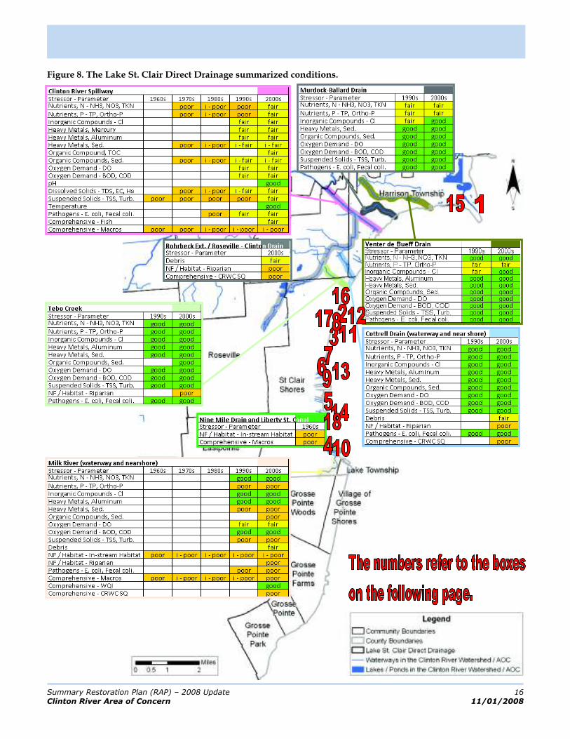
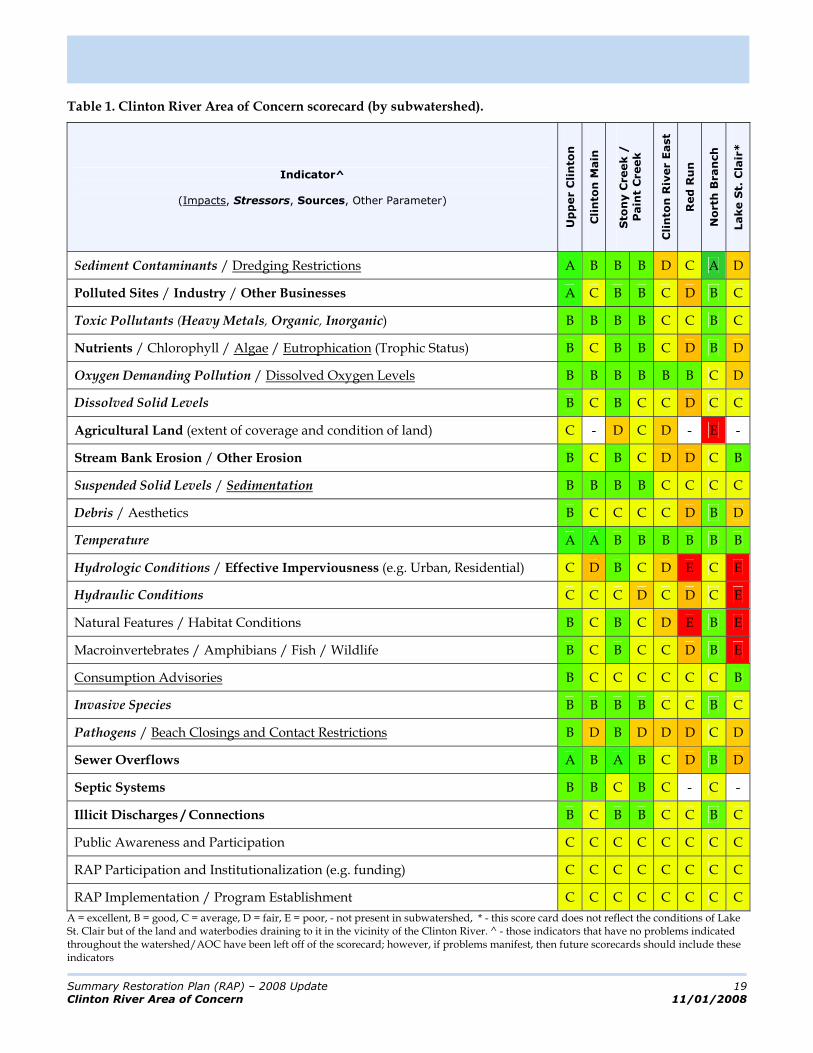
The full RAP contains substantial information detailing the landscape, watershed, environmental processes, and stressors to the natural environment (Chapters 3 and 4). Since this Summary Restoration Plan is a abridged document these details are not presented. Instead the focus is on articulating the current environmental conditions with the recognition that these are a function of past actions as well as current activities. Status of each of the subwatersheds is presented in map format (Figures 1 – 7). Environmental study results are summarized by assigning an excellent (dk. green), good (lt. green), fair (yellow), poor (orange), or extremely poor (red) ranking based on specific data. Together, these assessments were used to assign a grade for several key indicators in a watershed report card (see Page 19).
The purpose of the report card is not to provide detailed problem descriptions but to summarize current conditions. Developers of future scorecards should consider these baseline grades (in the context of the data supporting them) and adjust them positively or negatively as future data indicate.
Funding Opportunities
To leverage as many potential funding sources as possible, the RAP has been designed such that it meets the requirements of various grant funding programs (e.g. EPA’s Clean Water Act [CWA] Section 319 program, the Clean Michigan Initiative [CMI], and the EPA’s Great Lakes National Program Office [GLNPO]).
Summary Restoration Plan (RAP) – 2008 Update 9
Clinton River Area of Concern 11/01/2008
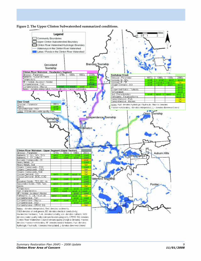
Figure 2. The Upper Clinton Subwatershed summarized conditions.
Summary Restoration Plan (RAP) – 2008 Update 10
Clinton River Area of Concern 11/01/2008
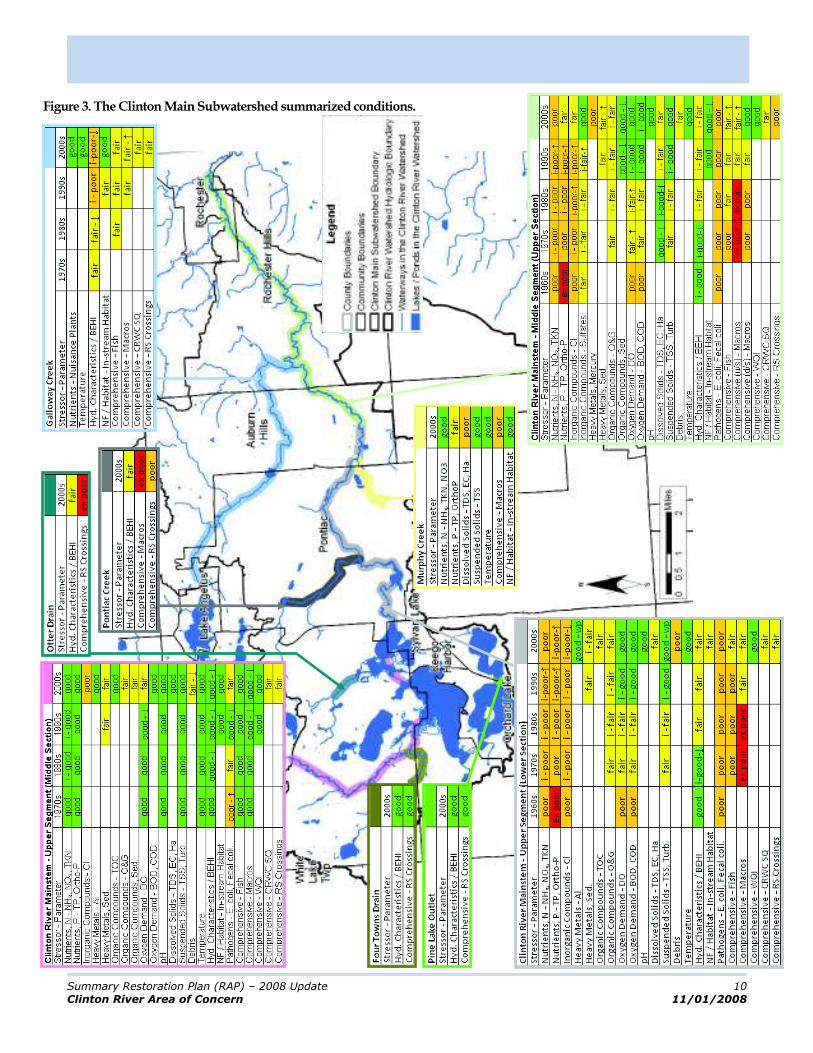
Figure 3. The Clinton Main Subwatershed summarized conditions.
Summary Restoration Plan (RAP) – 2008 Update 11
Clinton River Area of Concern 11/01/2008
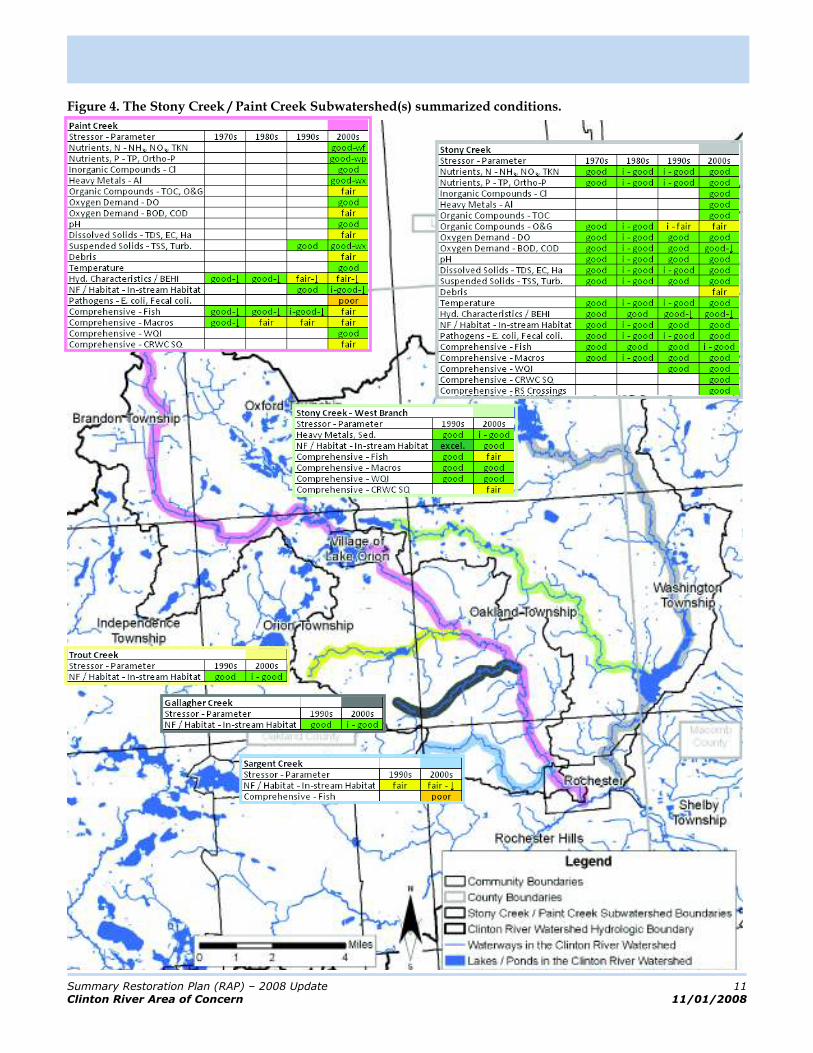
Figure 4. The Stony Creek / Paint Creek Subwatershed(s) summarized conditions.
Summary Restoration Plan (RAP) – 2008 Update 12
Clinton River Area of Concern 11/01/2008
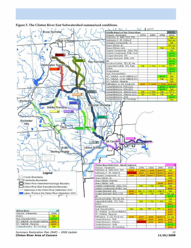
Figure 5. The Clinton River East Subwatershed summarized conditions.

Summary Restoration Plan (RAP) – 2008 Update 13
Clinton River Area of Concern 11/01/2008
Figure 5. The Clinton River East Subwatershed summarized conditions. (continued)
Summary Restoration Plan (RAP) – 2008 Update 14
Clinton River Area of Concern 11/01/2008
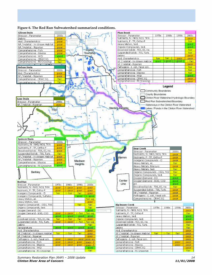
Figure 6. The Red Run Subwatershed summarized conditions.

Summary Restoration Plan (RAP) – 2008 Update 15
Clinton River Area of Concern 11/01/2008
Figure 7. The North Branch Subwatershed summarized conditions.
Summary Restoration Plan (RAP) – 2008 Update 16
Clinton River Area of Concern 11/01/2008
Figure 8. The Lake St. Clair Direct Drainage summarized conditions.
Summary Restoration Plan (RAP) – 2008 Update 17
Clinton River Area of Concern 11/01/2008
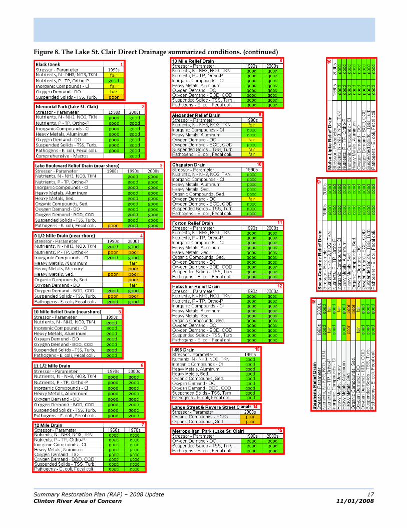
Figure 8. The Lake St. Clair Direct Drainage summarized conditions. (continued)

Summary Restoration Plan (RAP) – 2008 Update 18
Clinton River Area of Concern 11/01/2008
The best environmental conditions in the watershed are associated with the Upper Clinton Subwatershed. Most of the categories that have data associated with them are rated as ‘good’. The categories that have degraded conditions have been rated ‘good’ in the past, meaning that degraded conditions have only been documented recently
The Stony Creek / Paint Creek Subwatershed exhibits conditions that are only slightly more degraded than the Upper Clinton Subwatershed. The Stony Creek portion of the subwatershed is quite pristine with most categories receiving ‘good’ ratings. The Paint Creek portion has approximately half of the rated conditions being ‘fair’ instead of ‘good’ with the initial documentation of degradation stretching back into the previous decades. It has also been documented that wet weather problems have manifested in the Paint Creek.
The Clinton Main Subwatershed is downstream of the Upper Clinton Subwatershed (Stony Creek and Paint Creek also discharge into this subwatershed, but at the extreme downstream end). As might be expected, the upstream portion of this subwatershed exhibits similar characteristics to the Upper Clinton Subwatershed. However, the environmental conditions are substantially degraded at, and downstream of, Pontiac primarily due to the urbanization of Pontiac and the ‘lakes area’ upstream of it. Over half of the assessed conditions in these degraded areas are ‘fair’ or ‘poor’ and have been for decades. The good news is that none of the conditions have deteriorated over the years and a few have improved.
The Red Run Subwatershed exhibits some of the most degraded waters in the watershed / AOC with approximately half of the assessed conditions rated as ‘poor’. The degraded conditions have been documented for decades with some improvement shown recently but also with some continued degradation. The primary reason for the degraded conditions is the same as in the Clinton Main Subwatershed – urbanization.
The Clinton River East Subwatershed exhibits conditions similar to the Clinton Main Subwatershed in its upstream reaches (which one would expect as the Clinton Main outlets into this subwatershed). The recent conditions show a marked improvement over past conditions due primarily to the closing of the Rochester WWTP. However, the downstream portion of the subwatershed is significantly degraded (i.e. comparable to the Red Run Subwatershed) due to the confluence with the Red Run Drain. The Middle Branch drainage area of this subwatershed exhibits moderately degraded environmental conditions with at least half of the assessed conditions rated as ‘fair’. The primary reason for this is the intense development that is occurring in this area.
The North Branch Subwatershed exhibits slightly degraded conditions in its upstream reaches (more than half of assessed conditions rated ‘good’) with moderately degraded conditions downstream (more than half rated ‘fair’). The primary reason for degradation is agriculture with the degraded downstream conditions a result of the cumulative impact of numerous problems (along with increasing development in this area).
The Lake St. Clair Direct Drainage Subwatershed is an intensely developed area that exhibits degraded conditions at the Clinton River Spillway (which is a function of the upstream subwatersheds) and the Milk River. There are few open drains and most of the physical characteristics associated with these are ‘poor’.
Relationship between
Causes, Sources, Stressors, Beneficial Use Impairments
/ Impacts, Goals and Objectives, Actions, and
Delisting
Delisting of Beneficial
Uses
Alleviation of Impacts
Actions
Causes
Sources
Stressors
Beneficial Use Impairments
Goals
/ Objectives
Other Impacts
Summary Restoration Plan (RAP) – 2008 Update 19
Clinton River Area of Concern 11/01/2008
Table 1. Clinton River Area of Concern scorecard (by subwatershed).
Indicator^
(Impacts, Stressors, Sources, Other Parameter)
Up
per C
lin
ton
Cli
nto
n M
ain
Sto
ny C
reek /
Pain
t C
reek
Cli
nto
n R
iver E
ast
Red
Ru
n
No
rth
Bran
ch
Lake S
t. C
lair
*
Sediment Contaminants / Dredging Restrictions A B B B D C A D
Polluted Sites / Industry / Other Businesses A C B B C D B C
Toxic Pollutants (Heavy Metals, Organic, Inorganic) B B B B C C B C
Nutrients / Chlorophyll / Algae / Eutrophication (Trophic Status) B C B B C D B D
Oxygen Demanding Pollution / Dissolved Oxygen Levels B B B B B B C D
Dissolved Solid Levels B C B C C D C C
Agricultural Land (extent of coverage and condition of land) C - D C D - E -
Stream Bank Erosion / Other Erosion B C B C D D C B
Suspended Solid Levels / Sedimentation B B B B C C C C
Debris / Aesthetics B C C C C D B D
Temperature A A B B B B B B
Hydrologic Conditions / Effective Imperviousness (e.g. Urban, Residential) C D B C D E C E
Hydraulic Conditions C C C D C D C E
Natural Features / Habitat Conditions B C B C D E B E
Macroinvertebrates / Amphibians / Fish / Wildlife B C B C C D B E
Consumption Advisories B C C C C C C B
Invasive Species B B B B C C B C
Pathogens / Beach Closings and Contact Restrictions B D B D D D C D
Sewer Overflows A B A B C D B D
Septic Systems B B C B C - C -
Illicit Discharges / Connections B C B B C C B C
Public Awareness and Participation C C C C C C C C
RAP Participation and Institutionalization (e.g. funding) C C C C C C C C
RAP Implementation / Program Establishment C C C C C C C C
A = excellent, B = good, C = average, D = fair, E = poor, - not present in subwatershed, * - this score card does not reflect the conditions of Lake St. Clair but of the land and waterbodies draining to it in the vicinity of the Clinton River. ^ - those indicators that have no problems indicated throughout the watershed/AOC have been left off of the scorecard; however, if problems manifest, then future scorecards should include these indicators

Summary Restoration Plan (RAP) – 2008 Update 20
Clinton River Area of Concern 11/01/2008
The water quality conditions associated with most of the enclosed drains are ‘good’, but these conditions are actually measured in Lake St. Clair and are more representative of the lake’s ability to assimilate pollution than of the conditions of the drains themselves. In general, most enclosed drains exhibit degraded conditions and a few in this subwatershed have impacts despite dilution by the lake.
Future Management
The maps and charts as well as the report card presented on the previous pages summarize both the historic and current conditions in each of the subwatersheds. One of the foremost reasons for undertaking this exercise is to help prioritize future management directives as set forth in the RAP’s goals, objectives and actions. In order to prioritize the goals, objectives and actions they were cross-referenced in a series of tables (Tables 6-3, 6-4 and 6-5 in the RAP) with stressors, sources and critical areas. To large extent these priorities were arrived at using best professional judgment by stakeholders and consultants and are highlighted in the subsequent goals and objectives section.
The second method used to help set priorities were the results from the HSPF (Hydrologic Simulation Program – FORTRAN) modeling of eight future management scenarios on twenty different pollutant parameters. The pollutants modeled (see sidebar on this page) are primarily associated with non-point source pollution. Benefits from the model, in terms of setting priorities, are that it synthesizes and relates historical water quality monitoring results as well as predicts the effectiveness of various management actions on future water quality. Its limitations are that the results are only as good the completeness and availability of data and that they generally reflect only non-point source pollutants.
The model results indicated that the following are characteristic of the Clinton River Watershed:
Flashiness is correlated with urban areas due to the high percentage of impervious surfaces and in the North Branch because of the underlying clay/silt soils (and the high effective imperviousness of agricultural lands); Baseflow is best in the Stony, Paint and Upper subwatersheds primarily due to soil conditions and relative lack of development; Sediment loading rates are highest in urban areas and in the North Branch probably due to the high percentage of impervious surface, re-suspension due to high flows and agricultural activity, respectively; Most of the subwatersheds exhibit a seasonal pattern for E. coli levels, with the summer months having higher levels; Only the Stony and Upper subwatersheds had long-term geometric mean E. coli levels low enough for full-body contact; Red Run long-term geometric mean E. coli level exceeded the partial-body contact standard; the remaining four subwatersheds fell somewhere in-between; Elevated total phosphorous loading rate levels are correlated with urban areas (all urban subwatersheds exceeded the generally accepted WQS for TP – 0.1 mg/l – at least fifty percent of the time) and the North Branch, most likely due to the high percentage of
Model Evaluation Parameters
The parameters used to evaluate the various management scenarios include:
flow volume,
the Richards-Baker Flashiness Index,
annual sediment load,
sediment loading rate,
average TSS concentration,
annual E. coli load,
E. coli loading rate,
E. coli - long-term geometric mean,
E coli - % of time exceeding 30-day geometric mean,
E coli - % of time exceeding daily max,
annual TP load,
TP loading rate,
average TP concentration,
% of time TP > 0.1 mg/l,
annual NO3 load,
NO3 loading rate,
average NO3 concentration,
annual TKN load,
TKN loading rate, and
average TKN concentration.

Summary Restoration Plan (RAP) – 2008 Update 21
Clinton River Area of Concern 11/01/2008
impervious surfaces, waste water treatment plants, and the application of fertilizers with likely sediment fixation, respectively. All other pollutant measures generally mirrored the patterns demonstrated by those pollutants reported above.
Modeling possible future management scenarios yielded results that point towards their respective effectiveness. Key findings were:
The best tool for managing high flows, flashiness, and sediment loads is delaying runoff with well designed BMPs (e.g. detention ponds); Agricultural BMPs (e.g. conservation tillage, buffer strips) show dramatic improvements in the North Branch Subwatershed, especially for reducing sediment and total phosphorous loads; Illicit Discharge Elimination Program (IDEP) activities (a Phase II element) showed success in reducing bacteria contributions from urban areas; Catch basin cleaning and street sweeping (considered Phase II elements) showed less than five percent improvement in sediment loads for urban watersheds; Natural Feature Preservation shows some localized improvements; Cumulative effects from Scenarios 4, 5, and 6 are apparent; Reducing imperviousness shows further improvement, especially in areas targeted for redevelopment.
Based on the model output, the following recommendations are seen to be of priority:
1. Implementation and oversight of post-construction stormwater management and the use of volume and peak flow controls are the most important practice for reducing high flows, flashiness, sediment loads, and the risk of channel erosion.
2. Implementation of riparian forest buffers and vegetated grass channels, and further adoption of conservation tillage practices are important opportunities in agricultural areas.
3. Comprehensive failing septic system program and aggressive illicit connection elimination programs are important for reducing persistent high E coli concentrations at low flows.
4. Finding ways to reduce IDEP costs, because it is effective in reducing bacteria levels and will make it easier to implement.
5. Staying the course on natural feature protection is important – improvements were noted in the results when protected forest cover replaced development
6. Looking for ways to incorporate green design into redevelopment (e.g. green roofs, bioretention ponds), including public works projects (e.g. CSO projects), because redevelopment was shown to reduce bacteria levels and may further reduce sediment loading rates.
The above information was analyzed through the lenses of watershed and adaptive management principles. The nine activities set out in the Center for Watershed Protection’s Eight Tools of Watershed Protection (2002) were used to guide the analysis and to develop the goals, objectives, and actions included in the RAP. The iterative approach to implementation is a core principle of adaptive management and is primarily reflected in the timetable laid out in the full RAP.
Modeled Scenarios
The following scenarios were modeled to help determine the appropriate future management actions:
1. Current Conditions (2000),
2. Full Build Out,
3a. 30-year Projection (2030) – no stormwater flow requirements,
3b. 30-year Projection (2030) – with stormwater volume requirements,
4. 30-year Projection (2030) – 3b with Increased Adoption of Agricultural BMPs,
5. 30-year Projection (2030) – 3b with Phase II Stormwater Program Elements as well as an OSDS program (where appropriate),
6. 30-year Projection (2030) – 3b with Natural Feature Preservation;
7. 30-year Projection (2030) – 3b with Increased Adoption of Agricultural BMPs, Phase II Stormwater Program Elements, and with Natural Feature Preservation; and
8. 30-year Projection (2030) – 3b with Increased Adoption of Agricultural BMPs, Phase II Stormwater Program Elements, with Natural Feature Preservation, and with Sustainable Development Measures for New Development and Redevelopment.

Summary Restoration Plan (RAP) – 2008 Update 22
Clinton River Area of Concern 11/01/2008
Goals and Objectives
The goals and objectives developed to ensure that the BUIs are restored and protected and that, ultimately, the AOC is delisted are presented in Figure 9. The six priority goals are presented in bold text along with one priority objective under each goal. Bold text indicates that the goal or objective was identified in more than one Phase II subwatershed manage-ment plan. The text ‘designated use impairment’ (*) is included to better integrate the State’s Water Quality Standards and the AOC program.
Figure 9. Goals and objectives of the Restoration Plan.
GOAL I – Institutionalize an informed collaborative planning and implementation approach to achieve BUI delisting.
OBJECTIVE I.A – Establish a framework to unite AOC stakeholders and other responsible parties including citizens, business, and government around responsible stewardship and environmental ethics. Include a lead agency for coordinated planning and watershed-based resource decisions.
OBJECTIVE I.B – Establish short term and long term funding strategies for RAP-related work with a focus on implementation.
OBJECTIVE I.C – Define resource requirements of stakeholders and other parties that is reflective of the funding strategies.
OBJECTIVE I.D – Establish a program to routinely research data and new technologies and disseminate appropriate existing and new information to stakeholders and other responsible parties to ensure informed management decisions.
OBJECTIVE I.E – Establish a program to monitor environmental conditions and evaluate the RAP, including: defining baseline conditions, identifying indicators, assessing trends, documenting progress, identifying management priorities, and recommending changes to the RAP.
GOAL II – Cultivate an aware, informed, engaged, and involved public.
OBJECTIVE II.A – Establish a program to routinely disseminate appropriate new and existing information to the public.
OBJECTIVE II.B – Establish a program to encourage public ‘buy-in’ to the RAP program, the cause of a ‘healthy watershed’ and associated costs and to increase public engagement towards achieving delisting and addressing other issues in the watershed through increased participation.
GOAL III – Implement sustainable practices to ensure that environmental impacts from human activities are minimized (i.e. pollution is reduced) with a focus on protecting non-impacted headwaters and restoring heavily impacted downstream areas.
OBJECTIVE III.A – Establish a program to specifically identify and control sources of stressors, including organic compounds (e.g. PCBs), heavy metals (e.g. mercury), dissolved solids, (e.g. road salt) and to address any emerging problems (e.g. inorganic compounds and pH) – with priority consideration given to those related to the remaining objectives.
OBJECTIVE III.B – Develop state-approved source water protection plans for drinking water supplies and implement the actions in the plan to ensure that there are no drinking water restrictions.
OBJECTIVE III.C – Minimize, to a reasonable extent, the water quality impacts resulting from residential areas, including runoff contaminated with fertilizer, pesticides, and dog waste
OBJECTIVE III.D – Minimize, to a reasonable extent, the water quantity and quality impacts that are the result of economic enterprises both past and present (e.g. waste management / superfund /polluted sites, historic landfills, industry, agriculture, construction, commercial navigation, other businesses) and address any conditions that affect today’s enterprises (e.g. land use pressures and added costs).
OBJECTIVE III.E – Minimize, to a reasonable extent, the water quantity and quality impacts that are the result of recreational activities (e.g. boating) and address any conditions that affect recreational activities (e.g. beach closings, aquatic weeds, etc) while expanding recreational opportunities and access.
Summary Restoration Plan (RAP) – 2008 Update 23
Clinton River Area of Concern 11/01/2008
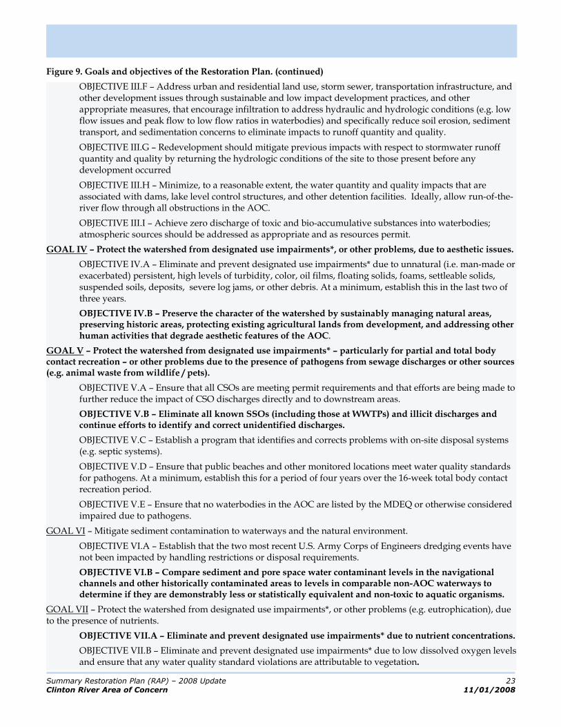
Figure 9. Goals and objectives of the Restoration Plan. (continued)
OBJECTIVE III.F – Address urban and residential land use, storm sewer, transportation infrastructure, and other development issues through sustainable and low impact development practices, and other appropriate measures, that encourage infiltration to address hydraulic and hydrologic conditions (e.g. low flow issues and peak flow to low flow ratios in waterbodies) and specifically reduce soil erosion, sediment transport, and sedimentation concerns to eliminate impacts to runoff quantity and quality.
OBJECTIVE III.G – Redevelopment should mitigate previous impacts with respect to stormwater runoff quantity and quality by returning the hydrologic conditions of the site to those present before any development occurred
OBJECTIVE III.H – Minimize, to a reasonable extent, the water quantity and quality impacts that are associated with dams, lake level control structures, and other detention facilities. Ideally, allow run-of-the-river flow through all obstructions in the AOC.
OBJECTIVE III.I – Achieve zero discharge of toxic and bio-accumulative substances into waterbodies; atmospheric sources should be addressed as appropriate and as resources permit.
GOAL IV – Protect the watershed from designated use impairments*, or other problems, due to aesthetic issues.
OBJECTIVE IV.A – Eliminate and prevent designated use impairments* due to unnatural (i.e. man-made or exacerbated) persistent, high levels of turbidity, color, oil films, floating solids, foams, settleable solids, suspended soils, deposits, severe log jams, or other debris. At a minimum, establish this in the last two of three years.
OBJECTIVE IV.B – Preserve the character of the watershed by sustainably managing natural areas, preserving historic areas, protecting existing agricultural lands from development, and addressing other human activities that degrade aesthetic features of the AOC.
GOAL V – Protect the watershed from designated use impairments* – particularly for partial and total body contact recreation – or other problems due to the presence of pathogens from sewage discharges or other sources (e.g. animal waste from wildlife / pets).
OBJECTIVE V.A – Ensure that all CSOs are meeting permit requirements and that efforts are being made to further reduce the impact of CSO discharges directly and to downstream areas.
OBJECTIVE V.B – Eliminate all known SSOs (including those at WWTPs) and illicit discharges and continue efforts to identify and correct unidentified discharges.
OBJECTIVE V.C – Establish a program that identifies and corrects problems with on-site disposal systems (e.g. septic systems).
OBJECTIVE V.D – Ensure that public beaches and other monitored locations meet water quality standards for pathogens. At a minimum, establish this for a period of four years over the 16-week total body contact recreation period.
OBJECTIVE V.E – Ensure that no waterbodies in the AOC are listed by the MDEQ or otherwise considered impaired due to pathogens.
GOAL VI – Mitigate sediment contamination to waterways and the natural environment.
OBJECTIVE VI.A – Establish that the two most recent U.S. Army Corps of Engineers dredging events have not been impacted by handling restrictions or disposal requirements.
OBJECTIVE VI.B – Compare sediment and pore space water contaminant levels in the navigational channels and other historically contaminated areas to levels in comparable non-AOC waterways to determine if they are demonstrably less or statistically equivalent and non-toxic to aquatic organisms.
GOAL VII – Protect the watershed from designated use impairments*, or other problems (e.g. eutrophication), due to the presence of nutrients.
OBJECTIVE VII.A – Eliminate and prevent designated use impairments* due to nutrient concentrations.
OBJECTIVE VII.B – Eliminate and prevent designated use impairments* due to low dissolved oxygen levels and ensure that any water quality standard violations are attributable to vegetation.

Summary Restoration Plan (RAP) – 2008 Update 24
Clinton River Area of Concern 11/01/2008
Figure 9. Goals and objectives of the Restoration Plan. (continued)
OBJECTIVE VII.C – Eliminate and prevent designated use impairments* due to excessive plant / algae growth (which can be assessed based on chlorophyll levels).
GOAL VIII – Ensure that fish and wildlife are consumable.
OBJECTIVE VIII.A – Ensure that fish and wildlife remain free from tainting.
OBJECTIVE VIII.B – Establish that existing advisories are not ‘no consumption’ advisories and are the same, or less restrictive than, associated Great Lakes advisories. Ultimately eliminate all consumption advisories.
OBJECTIVE VIII.C – Establish that the concentration of advisory-specific contaminants in the tissue of fish and other organisms is demonstrably less than, or statistically equivalent to, that in the tissue of fish from a non-AOC control site.
GOAL IX – Protect existing high-quality wildlife and fish habitat and natural features (including those identified through the Michigan Natural Features Inventory) and restore degraded habitat and natural features such that sufficient amounts of high quality habitat are available for overall ecosystem health with productive and widely distributed plant and animals.
OBJECTIVE IX.A – Establish a program to identify and stabilize eroding stream banks and to address the underlying causes of the erosive conditions.
OBJECTIVE IX.B – Establish programs to restore aquatic (stream and lake), riparian, and floodplain habitats, forest cover, preserve and increase wetlands (10% over 10 years) and maintain/restore their water sources, conserve sparsely and undeveloped areas, protect identified natural features (protect at least 5% of potential conservation areas annually), and develop and implement green infrastructure.
OBJECTIVE IX.C – Substantially address all project areas listed in the habitat restoration plan, including: streambank stabilization, in-stream habitat improvement, riparian vegetation restoration, dam removal / improvements, wetland mitigation, sediment removal, rehabilitation of road/stream crossings, and control of stormwater runoff.
OBJECTIVE IX.D – Achieve watershed-wide equivalent imperviousness of less than 15% with current undeveloped areas remaining at below 10% imperviousness, areas currently above 30% imperviousness with limited development opportunities, and agricultural expansion limited to a maximum of 50% of the currently undeveloped watershed area.
OBJECTIVE IX.E – Show, through monitoring, that river hydrology, temperature, dissolved oxygen levels, sedimentation, and toxic pollutants do not negatively impact indicator fish and wildlife species. (BUI 14)
OBJECTIVE IX.F – Protect aquatic and riparian habitat and ensure that indicator sites are rated ‘good’ by the MDEQ GLEAS Procedure 51 standards.
GOAL X – Protect existing healthy biological communities including native fish, wildlife, benthos, plankton, and plants and restore those that are impacted.
OBJECTIVE X.A – Establish a program to identify, control and eradicate invasive species and other nuisance populations.
OBJECTIVE X.B – Take measures to ensure (and show through monitoring) that all plankton, benthos, fish, and wildlife populations are free from deformities or other biological problems and the populations are genetically diverse.
OBJECTIVE X.C – Take measures to ensure (and show through monitoring) that indicator fish and wildlife populations (including warm and cold water fisheries) meet ‘healthy’ abundance and diversity levels consistent with guidance developed by the MDNR and USFWS over two seasons, are self-sustaining, and are not impacted by hydraulic/hydrologic conditions, temperature, toxic pollutants, or other stressors.
OBJECTIVE X.D – Take measures to ensure (and show through monitoring) that indicator benthos populations and other aquatic life throughout the watershed are at ‘good’ levels based on the Izaak Walton League of America’s Water Quality Index over two seasons, are self-sustaining, and are not impacted by hydraulic/hydrologic conditions, temperature, toxic pollutants, or other stressors.
Summary Restoration Plan (RAP) – 2008 Update 25
Clinton River Area of Concern 11/01/2008
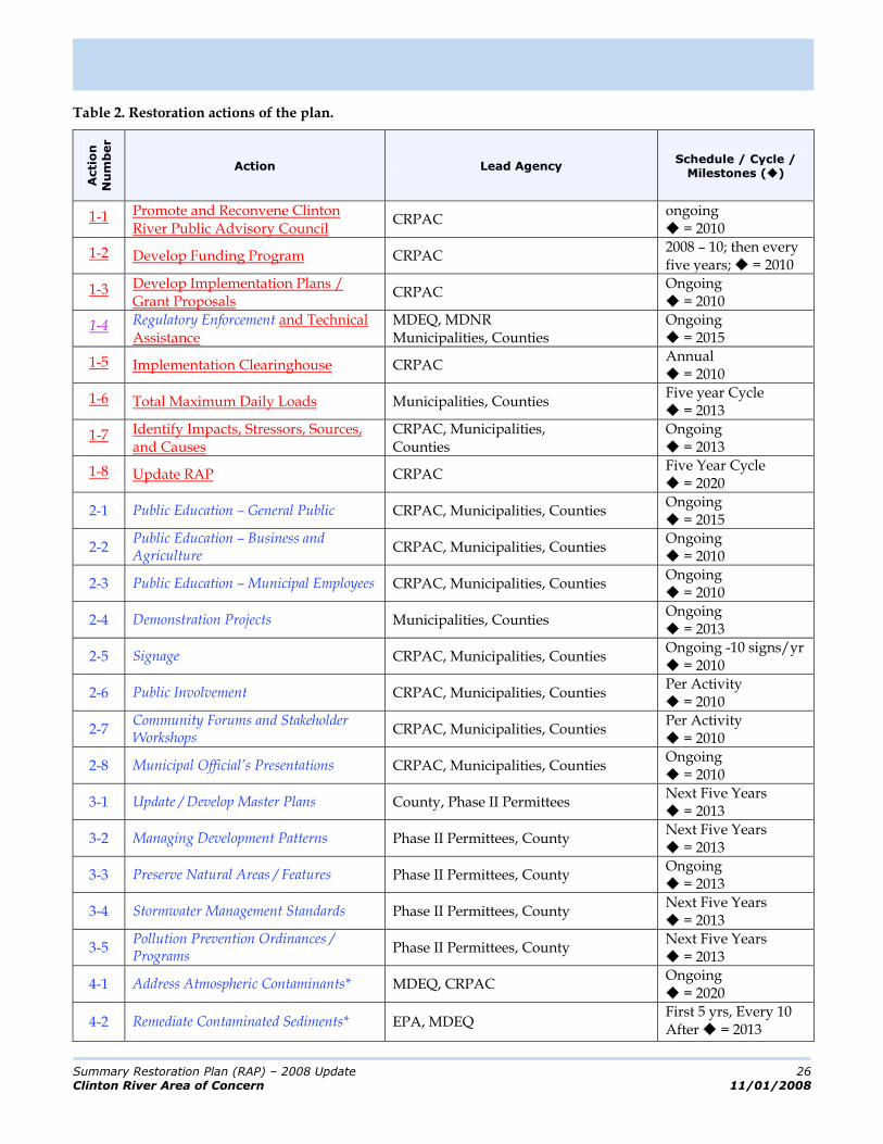
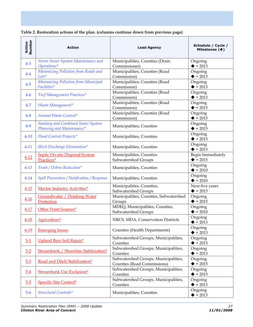
Actions to Achieve Goals and Objectives As the leadership group for the AOC, the CRPAC has defined the detailed steps – or actions – that that will lead to improving water quality and watershed health, achieving the goals /objectives of the RAP, restoring beneficial use impairments, protecting beneficial uses, and ultimately achieving delisting of the Clinton River Watershed as an AOC.
Despite the large scale of the plan, it aims to have actions that are clear and well-defined and leverage actions already occurring at local levels. The large scale of the plan and the breadth and depth of problems in the AOC require many actions ranging from programmatic and administrative in nature to the construction of structural best management practices (BMPs). To facilitate discussion and presentation, the actions have been grouped into nine action categories:
1. Watershed Planning, Institutionalization, and Implementation; 2. Public Education and Participation; 3. Ordinances, Zoning, and Development Standards; 4. Good Housekeeping and Pollution Prevention; 5. Stormwater Best Management Practices – Soil Erosion and
Sediment Control; 6. Stormwater Best Management Practices – Other Practices; 7. Natural Features and Resources Management; 8. Recreation Promotion and Enhancement; and 9. Environmental Monitoring and Other Data Collection.
The actions are presented in Table 2 (the first number indicates to which of the above categories it belongs). For each action, the lead agency and schedule information are presented (along with other information if appropriate). Details for each actions are presented in the full RAP.
Actions that municipalities in the AOC are doing to comply with the Phase I/II stormwater program have been intentionally included in this plan. These ‘leveraged’ activities have been coded with blue italic text throughout the remainder of this document (along with regulatory requirements of other programs, e.g. soil erosion and sediment control). Non-regulatory actions are coded with red underlined text (again, throughout the remainder of the document). Phase I/II actions are enforceable by the Michigan Department of Environmental Quality (MDEQ) but only in the urbanized area of the watershed/AOC as defined by the United States Census Bureau (USCB) - (except in areas served by combined sewers). Because the CRPAC has no legal authority, the implementation of the non-regulatory actions relies on the stakeholders in the AOC (e.g. federal and state agencies, public and private institutions, municipal governments, businesses, and private citizens). To make the RAP a success, the CRPAC must facilitate interaction among these stakeholders and achieve action implementation – the CRPAC lacks the resources to implement all of the actions on its own.
The CRPAC’s primary tool is the ‘partnership agreement’ – a document which details the actions that an entity will take in support of the RAP. Few of these agreements have yet to be reached, but it is the desire of the CRPAC that these agreements continue to be entered into as time and resources permit. In addition to facilitating implementation, the CRPAC will act as the ‘integrating agency’ that considers the RAP program as a whole and documents progress being made towards delisting and to advocating on behalf of the program with appropriate agencies.
Considerations for Action Development
Additional considerations for the actions include:
watershed-based permit requirements and other regulatory consideration; the previous Clinton River RAPs (1988, 1995, 1998) The Clinton River Assessment (MDNR, 2006) A Biodiversity Atlas of the Lake Huron to Lake Erie Corridor (2002) the Lake St. Clair Environmental Characterization (2004) the Report for the Blue Ribbon Commission on Lake St. Clair (2000); the Lake St. Clair Comprehensive Manage-ment Plan (2004); and the Water Quality Management Plan (WQMP) for Southeast Michigan which stipulates that actions should at least address (SEMCOG, 1999) o constructing pollution and
flood control equipment and structures;
o identifying municipal and private sector BMPs;
o identifying agricultural, livestock, and manure BMPs;
o identifying project administration and funding; and
o promoting education programs.
Summary Restoration Plan (RAP) – 2008 Update 26
Clinton River Area of Concern 11/01/2008
Table 2. Restoration actions of the plan.
Acti
on
Nu
mb
er
Action Lead Agency Schedule / Cycle /
Milestones ( )
1-1 Promote and Reconvene Clinton River Public Advisory Council
CRPAC ongoing
= 2010
1-2 Develop Funding Program CRPAC 2008 – 10; then every five years; = 2010
1-3 Develop Implementation Plans / Grant Proposals
CRPAC Ongoing
= 2010
1-4 Regulatory Enforcement and Technical Assistance
MDEQ, MDNR Municipalities, Counties
Ongoing = 2015
1-5 Implementation Clearinghouse CRPAC Annual
= 2010
1-6 Total Maximum Daily Loads Municipalities, Counties Five year Cycle
= 2013
1-7 Identify Impacts, Stressors, Sources, and Causes
CRPAC, Municipalities, Counties
Ongoing = 2013
1-8 Update RAP CRPAC Five Year Cycle
= 2020
2-1 Public Education – General Public CRPAC, Municipalities, Counties Ongoing
= 2015
2-2 Public Education – Business and Agriculture
CRPAC, Municipalities, Counties Ongoing
= 2010
2-3 Public Education – Municipal Employees CRPAC, Municipalities, Counties Ongoing
= 2010
2-4 Demonstration Projects Municipalities, Counties Ongoing
= 2013
2-5 Signage CRPAC, Municipalities, Counties Ongoing -10 signs/yr
= 2010
2-6 Public Involvement CRPAC, Municipalities, Counties Per Activity
= 2010
2-7 Community Forums and Stakeholder Workshops
CRPAC, Municipalities, Counties Per Activity
= 2010
2-8 Municipal Official’s Presentations CRPAC, Municipalities, Counties Ongoing
= 2010
3-1 Update / Develop Master Plans County, Phase II Permittees Next Five Years
= 2013
3-2 Managing Development Patterns Phase II Permittees, County Next Five Years
= 2013
3-3 Preserve Natural Areas / Features Phase II Permittees, County Ongoing
= 2013
3-4 Stormwater Management Standards Phase II Permittees, County Next Five Years
= 2013
3-5 Pollution Prevention Ordinances / Programs
Phase II Permittees, County Next Five Years
= 2013
4-1 Address Atmospheric Contaminants* MDEQ, CRPAC Ongoing
= 2020
4-2 Remediate Contaminated Sediments* EPA, MDEQ First 5 yrs, Every 10 After = 2013
Summary Restoration Plan (RAP) – 2008 Update 27
Clinton River Area of Concern 11/01/2008
Table 2. Restoration actions of the plan. (columns continue down from previous page)
Acti
on
Nu
mb
er
Action Lead Agency Schedule / Cycle /
Milestones ( )
4-3 Storm Sewer System Maintenance and Operations*
Municipalities, Counties (Drain Commissioner)
Ongoing = 2013
4-4 Minimizing Pollution from Roads and Lots*
Municipalities, Counties (Road Commission)
Ongoing = 2013
4-5 Minimizing Pollution from Municipal Facilities*
Municipalities, Counties (Road Commission)
Ongoing = 2013
4-6 Turf Management Practices* Municipalities, Counties (Road Commission)
Ongoing = 2013
4-7 Waste Management* Municipalities, Counties (Road Commission)
Ongoing = 2015
4-8 Animal Waste Control* Municipalities, Counties (Road Commission)
Ongoing = 2015
4-9 Sanitary and Combined Sewer System Planning and Maintenance*
Municipalities, Counties Ongoing
= 2015
4-10 Flood Control Projects* Municipalities, Counties Ongoing
= 2015
4-11 Illicit Discharge Elimination* Municipalities, Counties Ongoing
= 2015
4-12 Septic On-site Disposal System Practices*
Municipalities, Counties Subwatershed Groups
Begin Immediately = 2015
4-13 Trash / Debris Reduction* Municipalities, Counties Ongoing
= 2010
4-14 Spill Prevention / Notification / Response Municipalities, Counties Ongoing
= 2010
4-15 Marine Industry Activities* Municipalities, Counties, Subwatershed Groups
Next five years = 2015
4-16 Groundwater / Drinking Water Protection
Municipalities, Counties, Subwatershed Groups
Ongoing = 2015
4-17 Other Point Sources* MDEQ, Municipalities, Counties, Subwatershed Groups
Ongoing = 2010
4-18 Agriculture* NRCS, MDA, Conservation Districts Ongoing
= 2013
4-19 Emerging Issues Counties (Health Departments) Ongoing
= 2013
5-1 Upland Bare Soil Repair* Subwatershed Groups, Municipalities, Counties
Ongoing = 2015
5-2 Streambank / Shoreline Stabilization* Subwatershed Groups, Municipalities, Counties
Ongoing = 2013
5-3 Road and Ditch Stabilization* Subwatershed Groups, Municipalities, Counties (Road Commissions)
Ongoing = 2015
5-4 Streambank Use Exclusion* Subwatershed Groups, Municipalities, Counties
Ongoing = 2015
5-5 Specific Site Control* Subwatershed Groups, Municipalities, Counties
Ongoing = 2013
5-6 Structural Controls* Municipalities, Counties Ongoing
= 2013

Summary Restoration Plan (RAP) – 2008 Update 28
Clinton River Area of Concern 11/01/2008
Table 2. Restoration actions of the plan. (columns continue down from previous page)
Acti
on
Nu
mb
er
Action Lead Agency Schedule / Cycle /
Milestones ( )
5-7 Agricultural BMPs* NRCS, Conservation Districts Ongoing
= 2015
5-8 Construction Sites* Subwatershed Groups, Municipalities, Counties
Ongoing = 2013
6-1 Mitigate Existing Impervious Surfaces* Subwatershed Groups, Municipalities, Counties
Ongoing = 2013
6-2 Infiltration Techniques* Subwatershed Groups, Municipalities, Counties
Ongoing = 2013
6-3 Filtration Techniques* Subwatershed Groups, Municipalities, Counties
Ongoing = 2013
6-4 Vegetative Buffers and Natural Conveyance*
Subwatershed Groups, Municipalities, Counties
Ongoing = 2013
6-5 Retention and Detention* Subwatershed Groups, Municipalities, Counties
Ongoing = 2013
7-1 Identify Natural Features Subwatershed Groups, Municipalities, Counties
Ongoing = 2010
7-2 Natural Land Reserves Land Trusts Ongoing
= 2020
7-3 Natural Feature Protection Subwatershed Groups, Municipalities, Counties
Ongoing = 2020
7-4 Nature Feature Restoration* Subwatershed Groups, Municipalities, Counties
Ongoing = 2013
8-1 Recreation Program Subwatershed Groups, Municipalities, Counties
One-time = 2010
8-2 Riparian Land Conservation for Parks Subwatershed Groups, Municipalities, Counties
Ongoing = 2020
8-3 Canoe / Boat Landings / Access Sites Subwatershed Groups, Municipalities, Counties
Ongoing = 2020
8-4 Restore Fishing Opportunities MDNR Ongoing
= 2020
8-5 Trails / Observation Decks Subwatershed Groups, Municipalities, Counties
Ongoing = 2020
9-1 Phase II Reporting: SWPPIs and Annual Reports
CRPAC, Municipalities, Counties
Annual = 2013
9-2 Stressor Monitoring and Assessment CRPAC, CRWC, Counties (Health Departments)
Ongoing = 2010
9-3 Public Education and Involvement Data
CRPAC, Municipalities, Counties Ongoing
= 2010
9-4 Field Data Collection MDEQ, Counties (Health Departments) Ongoing
= 2013
9-5 RAP Evaluation / Effectiveness Assessment
CRPAC Ten year Cycle
= 2018
9-6 Evaluation and Revision Guidance CRPAC Ten year cycle
= 2010 * denotes those actions that are most likely to have quantifiable load reductions associated with them

Summary Restoration Plan (RAP) – 2008 Update 29
Clinton River Area of Concern 11/01/2008
Summary with Respect to Beneficial Use
Impairments
As the major driver for producing a RAP is to restore beneficial uses and achieve delisting of an AOC, it is useful to examine the elements of this watershed management plan in the context of the BUIs. Figures 9 through 16 present the following:
The beneficial use impairment (BUI) title; An overview of the BUI with respect to geographic influence, extent of impact, and cross-referenced relationships with other planning programs; A discussion of the stressors that are the cause of the impairment and, where appropriate, those stressors that resultant of the impairment; A discussion of the sources of the stressors; A list of the regulatory considerations, in the terms of designated uses, that are related to the BUI in question; A detailing of the critical source and critical impact areas associated with the impairment (and the related sources and stressors); A summary of the subwatersheds that are affected by the BUI and to what extent; and. A verbatim presentation of the delisting criteria that have been developed to determine when a beneficial use impairment can be considered restored
The tables associated with the figures show the goals/objectives that support restoration of the BUI, the actions that support the goals/objectives, and the relationship between the two so one can determine which actions support a particular objective or which objectives relate to a given action. The listing of actions has been color coded in the same manner as earlier in the document (regulatory = blue, italic text; non-regulatory = red, underlined text).
The indexing between actions and goals/objectives includes both primary and secondary relationships. Primary actions for a goal/objective are those in which the goal language explicitly or implicitly addresses specific wording of the goal/objective. Secondary actions may address specifics of a goal/objective but require implementation information that has not been generated at the RAP level.
In the spirit of this being a restoration and preventative action plan, the actions associated with each BUI are both of the restoration and protection variety.
Because they are so broad in nature, the indexing does not include the planning (Action Category 1) or public education (Action Category 2) actions (unless those actions also include a physical implementation component – e.g. adopt-a-stream is educational but involves actual physical cleanup as opposed to simply giving people information).

Summary Restoration Plan (RAP) – 2008 Update 30
Clinton River Area of Concern 11/01/2008
Figure 10. Summarized information for BUI #1.
BENEFICIAL USE IMPAIRMENT
Beneficial Use Impairment #1: Restrictions on Fish and Wildlife Consumption.
OVERVIEW
This is a localized beneficial use impairment that is not directly habitat related (although the argument can be made that environmental contamination that impacts these organisms is related to their habitat) and has the potential to impact the Great Lakes and Lake St. Clair fisheries due to the mobility of the organisms and the transport of contaminated sediments from the Clinton River Watershed / AOC to the Great Lakes. Related problems are identified in the Lake St. Clair Comprehensive Management Plan, the Blue Ribbon Commission on Lake St. Clair Report, and previous remedial and preventative action plans (RAPs).
STRESSORS
The priority environmental stressors that relate to this BUI include those that bio-accumulate such as heavy metals and organic compounds. Other environmental stressors that may affect fish and wildlife consumption problems include inorganic compounds and radiation/radioactive substances. A number of other stressors may also indirectly impact the function of the previously mentioned stressors in the natural environment. These include: pH and temperature, which may impact the solubility of other specific stressors (e.g. heavy metals); oxygen demand, which impacts the availability of oxygen for the natural breakdown of certain bio-accumulative compounds; suspended solids / sediment upon which many bio-accumulative stressors attach themselves and are thus transported; hydrologic / hydraulic characteristics which impact the relative concentrations of other stressors in the water column and transport both the water-partitioned fraction of the stressors and the solids / sediment (which are attached to the organic, etc – partitioned fractions of the stressors). Other stressors may impact the health of fish, but do not contribute to the consumption restrictions that drive the use impairment. In this and the following paragraph, high priority elements are presented in bold text. Others are presented in bold, italicized text
SOURCES
The high priority sources of stressors, which contribute the greatest amount of the identified stressors discussed above, include sewage discharges, illicit discharges / spills, urban / residential land, transportation infrastructure, and soil erosion. Other sources of the stressors, especially those for heavy metals and organic compounds, include industrial discharges, waste management sites, presently contaminated sites, other businesses, agricultural land, on-site disposal systems, contaminated sediments, atmospheric deposition, and other human activities.1
REGULATORY CONSIDERATIONS
When restrictions exist on fish and wildlife consumption, then, by relation, the following designated uses of the waters of the State of Michigan are either definitely, or potentially, impaired: Coldwater Fishery, Warmwater Fishery, Other Aquatic Life and Wildlife, and Fish Consumption. In specific situations, other designated uses may also be impaired or at least threatened.
CRITICAL AREAS
The potential critical source areas of stressors that have been discussed include: impervious / urbanizing areas or those areas tributary to streams with increased peak flows; construction sites; exposed soil areas; combined and sanitary sewer areas with overflows or problematic treatment works; agricultural areas; roads / crossings / roadside ditches; residential lawns; impaired lakes; illicit discharge areas (e.g. older urban areas); areas of failing septic systems; superfund sites or historic landfills; industrial areas; areas with enclosed storm drains; contaminated sediment areas; waterbodies with control structures (e.g. dams); lower portions of the watershed (e.g. Clinton River East and Red Run). Critical current impact areas include: lakes, wetlands, lower portions of the Clinton River mainstem and watershed, middle portions of the Clinton River mainstem and watershed. Paint Creek, Stony Creek, and East Pond Creek. Critical future impact areas include: unimpaired lakes, wetlands, and upper portions of the mainstem and watershed.
1
Refer to Chapter 4 f of the RAP or more detailed treatments of the specific sources and causes of the sources of the stressors.
Summary Restoration Plan (RAP) – 2008 Update 31
Clinton River Area of Concern 11/01/2008
SUBWATERSHEDS
In terms of BUI applicability, this BUI is of low concern in the Upper Clinton, Stony Creek / Paint Creek, and North Branch Subwatersheds. The BUI is of medium concern in the Clinton Main, Clinton River East, and Red Run Subwatersheds. No assessment has been conducted with respect to the Lake St. Clair Direct Drainage Subwatershed. The subwatershed management plans currently do not address the issue of fish and wildlife consumption as they were developed mainly to address stormwater issues.
DELISTING CRITERIA
In order to restore the beneficial use the following criteria must be addressed: Sources of pollutants: Identify and control the sources of PCB contamination and other appropriate pollutants by an evaluation that includes site-specific monitoring of remedial actions or other monitoring. Determination of advisories: If the advisories in the AOC are the same or less restrictive than the associated Great Lakes or appropriate control site, then the BUI has been restored, unless the advisory is for no consumption. Comparison studies for contaminants causing advisories: o If there is no statistically significant difference (alpha = 0.05) in fish tissue concentrations of
contaminants causing advisories in the AOC compared to a control site, then the BUI has been restored. If there is a significant difference between AOC and the control site in the comparison study, then impairment exists. This will be demonstrated by studies designed to compare contaminant concentrations in fish from the AOC to a suitable control site. The studies will be designed to control variables known to influence contaminant concentrations such as species, size, age, sample type, lipids, and collection dates. The control site must be agreed to by the MDEQ in consultation with the CRPAC, and will be chosen based on physical, chemical, and biological similarity to the AOC. The two sites need to be within the same ecoregion. Fish samples used for the evaluation need to be collected in the same time frame (ideally 1 year). Contaminant levels need to be evaluated in the same species of fish from the AOC and the control site to avoid cross-species comparisons and the species used should be the same as the consumption advisory.
o If a comparison study is not practical for the AOC due to the lack of an appropriate control site, then trend monitoring data (if available) can be used to determine restoration success. If MDEQ trend analysis of fish with consumption advisories shows similar trends to other appropriate, MDEQ-approved Great Lakes trend sites, this BUI will be considered restored. If trend analysis does not show similarity to other appropriate Great Lakes trend sites, then an impairment exits.
GOALS / OBJECTIVES AND ACTIONS
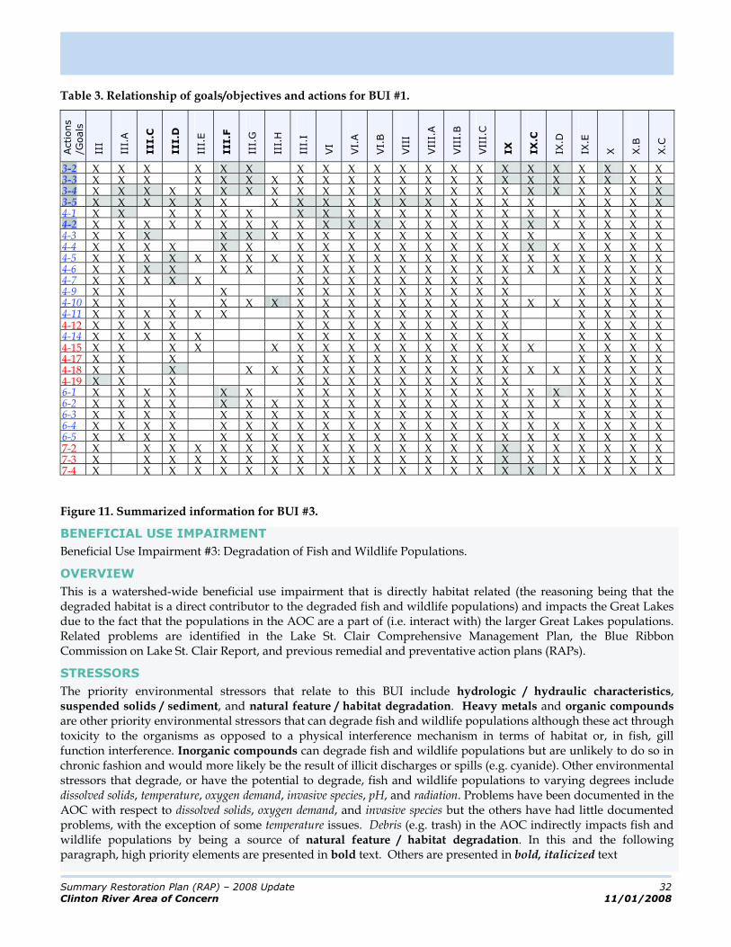
Table 3 presents the goals and objectives2 that are specifically or secondarily related to this BUI along the top or x-axis. The numerous actions that are designed to address these goals and objectives in the context of this BUI are presented along the side or y-axis. The squares that are shaded indicate that the action directly addresses the goal /objective as opposed to indirectly helping that goal/objective be achieved. The action and goal/objective numbers that are bolded (the action numbers are also highlighted for clarity) indicate the five highest elements in consideration of their direct relationship to the other.
2
Not including the programmatic goals and objectives that are administrative in nature.
Summary Restoration Plan (RAP) – 2008 Update 32
Clinton River Area of Concern 11/01/2008
Table 3. Relationship of goals/objectives and actions for BUI #1.
Actions
/Goals
III
III.
A
III.C
III.D
III.
E
III.F
III.
G
III.
H
III.
I
VI
VI.
A
VI.
B
VII
I
VII
I.A
VII
I.B
VII
I.C
IX
IX
.C
IX.D
IX.E
X X.B
X.C
3-2 X X X X X X X X X X X X X X X X X X X X X 3-3 X X X X X X X X X X X X X X X X X X X X X X 3-4 X X X X X X X X X X X X X X X X X X X X X X X 3-5 X X X X X X X X X X X X X X X X X X X X X 4-1 X X X X X X X X X X X X X X X X X X X X X 4-2 X X X X X X X X X X X X X X X X X X X X X X X 4-3 X X X X X X X X X X X X X X X X X X X X 4-4 X X X X X X X X X X X X X X X X X X X X X 4-5 X X X X X X X X X X X X X X X X X X X X X X X 4-6 X X X X X X X X X X X X X X X X X X X X X 4-7 X X X X X X X X X X X X X X X X X X 4-9 X X X X X X X X X X X X X X X X 4-10 X X X X X X X X X X X X X X X X X X X X X 4-11 X X X X X X X X X X X X X X X X X X X 4-12 X X X X X X X X X X X X X X X X X 4-14 X X X X X X X X X X X X X X X X X X 4-15 X X X X X X X X X X X X X X X X X X X 4-17 X X X X X X X X X X X X X X X X 4-18 X X X X X X X X X X X X X X X X X X X X 4-19 X X X X X X X X X X X X X X X X 6-1 X X X X X X X X X X X X X X X X X X X X X 6-2 X X X X X X X X X X X X X X X X X X X X X X 6-3 X X X X X X X X X X X X X X X X X X X X X 6-4 X X X X X X X X X X X X X X X X X X X X X X 6-5 X X X X X X X X X X X X X X X X X X X X X X 7-2 X X X X X X X X X X X X X X X X X X X X X X 7-3 X X X X X X X X X X X X X X X X X X X X X X 7-4 X X X X X X X X X X X X X X X X X X X X X X
Figure 11. Summarized information for BUI #3.
BENEFICIAL USE IMPAIRMENT
Beneficial Use Impairment #3: Degradation of Fish and Wildlife Populations.
OVERVIEW
This is a watershed-wide beneficial use impairment that is directly habitat related (the reasoning being that the degraded habitat is a direct contributor to the degraded fish and wildlife populations) and impacts the Great Lakes due to the fact that the populations in the AOC are a part of (i.e. interact with) the larger Great Lakes populations. Related problems are identified in the Lake St. Clair Comprehensive Management Plan, the Blue Ribbon Commission on Lake St. Clair Report, and previous remedial and preventative action plans (RAPs).
STRESSORS
The priority environmental stressors that relate to this BUI include hydrologic / hydraulic characteristics, suspended solids / sediment, and natural feature / habitat degradation. Heavy metals and organic compounds are other priority environmental stressors that can degrade fish and wildlife populations although these act through toxicity to the organisms as opposed to a physical interference mechanism in terms of habitat or, in fish, gill function interference. Inorganic compounds can degrade fish and wildlife populations but are unlikely to do so in chronic fashion and would more likely be the result of illicit discharges or spills (e.g. cyanide). Other environmental stressors that degrade, or have the potential to degrade, fish and wildlife populations to varying degrees include dissolved solids, temperature, oxygen demand, invasive species, pH, and radiation. Problems have been documented in the AOC with respect to dissolved solids, oxygen demand, and invasive species but the others have had little documented problems, with the exception of some temperature issues. Debris (e.g. trash) in the AOC indirectly impacts fish and wildlife populations by being a source of natural feature / habitat degradation. In this and the following paragraph, high priority elements are presented in bold text. Others are presented in bold, italicized text

Summary Restoration Plan (RAP) – 2008 Update 33
Clinton River Area of Concern 11/01/2008
SOURCES
The high priority sources of stressors, which contribute the greatest amount of the identified stressors discussed above, include sewage discharges, illicit discharges / spills, urban / residential land, transportation infrastructure, and soil erosion. Because of the variety of stressors that impact the BUI, the other sources of the stressors include all of those identified in the RAP: industrial discharges, waste management sites, presently contaminated sites, other businesses, agricultural land, on-site disposal systems, contaminated sediments, atmospheric deposition, other human activities, and non-agricultural animal sources (which lead to natural feature / habitat degradation).3
REGULATORY CONSIDERATIONS
When fish and wildlife populations are degraded, then, by relation, the following designated uses of the waters of the State of Michigan are either definitely, or potentially, impaired: Coldwater Fishery, Warmwater Fishery, and Other Aquatic Life and Wildlife. In specific situations, other designated uses may also be impaired or at least threatened.
CRITICAL AREAS
The potential critical source areas of stressors that have been discussed include: impervious / urbanizing areas or those areas tributary to streams with increased peak flows; construction sites; exposed soil areas; combined and sanitary sewer areas with overflows or problematic treatment works; agricultural areas; roads / crossings / roadside ditches; residential lawns; impaired lakes; illicit discharge areas (e.g. older urban areas); areas of failing septic systems; superfund sites or historic landfills; industrial areas; areas with enclosed storm drains; contaminated sediment areas; waterbodies with control structures (e.g. dams); lower portions of the watershed (e.g. Clinton River East and Red Run). Critical current impact areas include: lakes, wetlands, natural areas, lower portions of the Clinton River mainstem and watershed, middle portions of the Clinton River mainstem and watershed, Paint Creek, Stony Creek, East Pond Creek, and the Lake St Clair Direct Drainage Subwatershed. Critical future impact areas include: unimpaired lakes, wetlands, and upper portions of the mainstem and watershed.
SUBWATERSHEDS
In terms of applicability, this BUI is of low concern in the Stony Creek / Paint Creek Subwatershed. The BUI is of medium concern in the Upper Clinton and North Branch Subwatersheds. The BUI is of high concern in the Clinton Main, Clinton River East, and Red Run Subwatersheds. No assessment has been conducted with respect to the Lake St. Clair Direct Drainage (although the extreme built-out nature of the subwatershed is indicative of degraded fish and wildlife populations). Three of the subwatershed management plans address protecting, restoring, and enhancing fisheries: the Clinton Main, the Stony Creek / Paint Creek, and the North Branch. Three other subwatershed management plans (Clinton River East, Red Run, and Lake St. Clair Direct Drainage) deal with degraded fish and wildlife populations by directly addressing habitat and natural features (although the plans are worded such that natural features could be construed to mean biological communities). However, the main focus of the subwatershed management plans is to address stormwater issues.
DELISTING CRITERIA
In order to restore the beneficial use the following criteria must be addressed: This beneficial use will be considered to be restored when the population and diversity of indicator fish and wildlife species within the applicable portions of the AOC are consistent with guidance developed by the MDNR and the USFWS over two consecutive monitoring seasons. Assessment of the fish and wildlife populations will be done in accordance with procedures established by, or approved by, the MDNR, MDEQ, and USFWS.
The fact that this BUI is habitat-related means that its restoration is contingent upon implementation of the AOC-specific restoration plan that has been developed to jointly address the habitat-related BUIs (which includes this BUI and ‘Loss of Fish and Wildlife Habitat’). Appendix E.1 describes the restoration plan as presented in Delisting Targets for Fish/Wildlife Habitat & Population Beneficial Use Impairments for the Clinton River Area of Concern” (ECT, 2007).
3
Refer to Chapter 4 of the RAP for more detailed treatments of the specific sources and causes of the sources of the stressors.
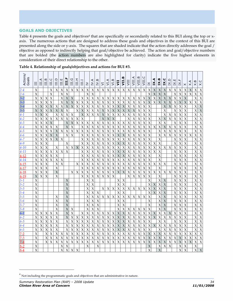
Summary Restoration Plan (RAP) – 2008 Update 34
Clinton River Area of Concern 11/01/2008
GOALS AND OBJECTIVES
Table 4 presents the goals and objectives4 that are specifically or secondarily related to this BUI along the top or x-axis. The numerous actions that are designed to address these goals and objectives in the context of this BUI are presented along the side or y-axis. The squares that are shaded indicate that the action directly addresses the goal / objective as opposed to indirectly helping that goal/objective be achieved. The action and goal/objective numbers that are bolded (the action numbers are also highlighted for clarity) indicate the five highest elements in consideration of their direct relationship to the other.
Table 4. Relationship of goals/objectives and actions for BUI #3.
Actions/
Goals
III
III.
A
III.
B
III.
C
III.
D
III.
E
III.F
III.
G
III.
H
III.
I
IV IV.A
IV.B
VI
VI.
A
VI.
B
VII
VII.B
VII
I
VII
I.A
VII
I.B
VII
I.C
IX IX
.A
IX
.B
IX
.C
IX.D
IX.E
IX.F
X X.A
X.B
X.C
2-4 X X X X X X X X X X X X X X X X X X X X X X X X X X X X X X X 2-6 X X X X X X X X X X X X X X X X 3-2 X X X X X X X X X X X X X X X X X X X X X X X X X X X X X X 3-3 X X X X X X X X X X X X X X X X X X X X X X X X X X X X X X X X 3-4 X X X X X X X X X X X X X X X X X X X X X X X X X X X X X X 3-5 X X X X X X X X X X X X X X X X X X X X X X X X X X X X 4-1 X X X X X X X X X X X X X X X X X X X X X X X X X X X X 4-2 X X X X X X X X X X X X X X X X X X X X X X X X X X 4-3 X X X X X X X X X X X X X X X X X X X X X X X X X X X X 4-4 X X X X X X X X X X X X X X X X X X X X X XX X X X X X X X X 4-5 X X X X X X X X X X X X X X X X X X X X X X X X X X X X X X X 4-6 X X X X X X X X X X X X X X X X X X X X X X X X X X X X X X 4-7 X X X X X X X X X X X X X X X X X X X X X X X X X X 4-9 X X X X X X X X X X X X X X X X X X X X X X X X X 4-10 X X X X X X X X X X X X X X X X X X X X X X X X X X X X X X 4-11 X X X X X X X X X X X X X X X X X X X X X X X X X X X X 4-12 X X X X X X X X X X X X X X X X X X X X X X X X X 4-14 X X X X X X X X X X X X X X X X X X X X X X X X X X 4-15 X X X X X X X X X X X X X X X X X X X X X X X X X X X X 4-17 X X X X X X X X X X X X X X X X X X X X X X X X 4-18 X X X X X X X X X X X X X X X X X X X X X X X X X X X X X 4-19 X X X X X X X X X X X X X X X X X X X X X X 5-1 X X X X X X X X X X X X X X 5-2 X X X X X X X X X X X X X X X 5-3 X X X X X X X X X X X X X X X X X X X X X X 5-4 X X X X X X X X X X X X X X X X 5-5 X X X X X X X X X X X X X X X X X X X X X X X 5-6 X X X X X X X X X X X X X X X X 5-7 X X X X X X X X X X X X X X X X 5-8 X X X X X X X X X X X X X X X X X X X X X 6-1 XX X X X X XX X X X X X X X X X X X X X X X X X X X X X X X X 6-2 X X X X X X X X X X X X X X X X X X X X X X X X X X X X X X X 6-3 X X X X X X X X X X X X X X X X X X X X X X X X X X X X X 6-4 X X X X X X X X X X X X X X X X X X X X X X X X X X X X X X X 6-5 X X X X X X X X X X X X X X X X X X X X X X X X X X X X X X 7-2 X X X X X X X X X X X X X X X X X X X X X X X X X X X X X X X X 7-3 X X X X X X X X X X X X X X X X X X X X X X X X X X X X X X X X 7-4 X X X X X X X X X X X X X X X X X X X X X X X X X X X X X X X X 8-2 X X X X X X X X X X X X 8-4 X X X X X X X X X X X
4
Not including the programmatic goals and objectives that are administrative in nature.
Summary Restoration Plan (RAP) – 2008 Update 35
Clinton River Area of Concern 11/01/2008
Figure 12. Summarized Information for BUI #6
BENEFICIAL USE IMPAIRMENT
Beneficial Use Impairment #6: Degradation of Benthos.
OVERVIEW
This is a watershed-wide beneficial use impairment that is directly habitat related (the reasoning being that the degraded habitat is a direct contributor to the degraded benthos). The BUI has been determined not to impact the Great Lakes due to the fact that the degraded populations in the AOC are largely isolated from the condition of the larger Great Lakes populations. Related problems are identified in the Lake St. Clair Comprehensive Management Plan, the Blue Ribbon Commission on Lake St. Clair Report, and previous remedial and preventative action plans (RAPs).
STRESSORS
The priority environmental stressors that relate to this BUI include those that are toxic such as heavy metals and organic compounds and those that degrade either the aquatic or physical habitat including oxygen demand, suspended solids / sediment, temperature, hydrologic / hydraulic characteristics, and obviously natural feature / habitat degradation. Other environmental stressors that may cause benthos degradation include inorganic compounds, pH, dissolved solids, invasive species, and radiation/radioactive substances. Nutrients may trigger increased oxygen demand (low dissolved oxygen levels) by causing eutrophication. In this and the following paragraph, high priority elements are presented in bold text. Others are presented in bold, italicized text.
SOURCES
The high priority sources of stressors, which contribute the greatest amount of the identified stressors discussed above, include sewage discharges, illicit discharges / spills, urban / residential land, transportation infrastructure, and soil erosion. Other sources of the stressors include industrial discharges, waste management sites, presently contaminated sites, other businesses, agricultural land, on-site disposal systems, contaminated sediments, atmospheric deposition, other human activities, and animal sources.5
REGULATORY CONSIDERATIONS
When the benthos is degraded, then, by relation, the following designated uses of the waters of the State of Michigan are either definitely, or potentially, impaired: Aquatic Life and Wildlife. In specific situations, other designated uses may also be impaired or at least threatened.
CRITICAL AREAS
The potential critical source areas of stressors that have been discussed include: impervious / urbanizing areas or those areas tributary to streams with increased peak flows; construction sites; exposed soil areas; combined and sanitary sewer areas with overflows or problematic treatment works; agricultural areas; roads / roadside ditches; residential lawns; impaired lakes; illicit discharge areas (e.g. older urban areas); areas of failing septic systems; superfund sites or historic landfills; industrial areas; areas with enclosed storm drains; contaminated sediment areas; waterbodies with control structures (e.g. dams); lower portions of the watershed (e.g. Red Run). Critical current impact areas include: lakes, wetlands, lower portions of the Clinton River mainstem and watershed. Critical future impact areas include: unimpaired lakes, wetlands, and upper portions of the mainstem and watershed.
SUBWATERSHEDS
In terms of applicability, this BUI is of low concern in the Upper Clinton, Clinton Main, Stony Creek / Paint Creek, and North Branch Subwatersheds. The BUI is of high concern in the Clinton River East and Red Run Subwatersheds. No assessment has been conducted with respect to the Lake St. Clair Direct Drainage Subwatershed (although data indicates that benthos conditions are poor). The subwatershed management plans do not deal directly with restoring benthos as they were developed primarily to deal with stormwater issues. However, all of the plans address the issue of protecting water quality and reducing pollution – a major contributor to the degradation of benthos conditions.
5
Refer to Chapter 4 of the RAP for more detailed treatments of the specific sources and causes of the sources of the stressors.

Summary Restoration Plan (RAP) – 2008 Update 36
Clinton River Area of Concern 11/01/2008
DELISTING CRITERIA
In order to restore the beneficial use the following criteria must be addressed: Samples of indicator species (e.g. mayfly, stonefly, caddisfly nymphs) collected in the watershed exceed a certain percentage of total individuals collected. Indicator species, a certain percent increase in species, and diversity should be chosen based on habitat present and habitat restoration that can reasonably be expected within the area of the watershed under consideration. Suggested restoration criteria based on volunteer macroinvertebrate data. Macroinvertebrate assessments conducted by volunteers at sites across the watershed meet or exceed the ‘good’ ranking as established by the Izaak Walton League of America’s Water Quality Index. Pore space water in the sediment in non-toxic to appropriate indicator species.
The MDEQ considers this a non-habitat related BUI. However, the Great Lakes National Program Office has conducted a BUI assessment for the watershed and included this BUI as a habitat related BUI. As such, the AOC-specific restoration plan for the RAP was developed with this BUI in mind. Appendix E.1 describes the restoration plan as presented in Delisting Targets for Fish/Wildlife Habitat & Population Beneficial Use Impairments for the Clinton River Area of Concern” (ECT, 2007). Although the restoration of this BUI is technically not contingent upon the implementation of the plan, the actual achievement of restoration will almost certainly require implementation of many facets of the plan.
GOALS AND OBJECTIVES
Table 5 presents the goals and objectives6 that are specifically or secondarily related to this BUI along the top or x-axis. The numerous actions that are designed to address these goals and objectives in the context of this BUI are presented along the side or y-axis. The squares that are shaded indicate that the action directly addresses the goal/ objective as opposed to indirectly helping that goal/objective be achieved. The action and goal/objective numbers that are bolded (the action numbers are also highlighted for clarity) indicate the five highest elements in consideration of their direct relationship to the other.
Figure 13. Summarized information for BUI #7.
BENEFICIAL USE IMPAIRMENT
Beneficial Use Impairment #7: Restrictions on Dredging Activities.
OVERVIEW
This is a localized beneficial use impairment that is not directly habitat related and does not impact the Great Lakes (because the sediment contamination causing the dredging restrictions is generally isolated and the migration of contaminated sediments or the partition of contaminants from the sediment to the water happens in such small quantities that impacts outside of the watershed are unlikely). Related problems are identified in the Lake St. Clair Comprehensive Management Plan and previous remedial and preventative action plans (RAPs).
STRESSORS
The priority environmental stressors that relate to this BUI include those that contaminate sediments and can be reintroduced to the water column during dredging operations. This category of stressors includes heavy metals and organic compounds and in rare cases (though not documented in the AOC) inorganic compounds and radiological compounds. Limited research has shown that pathogens such as E. coli can live in the sediment of contaminated waterways. It is worthwhile to note that dredging may cause short term increases in pathogen levels in waterbodies but this has not been documented. Additionally, dredging introduces large amount of suspended solids / sediment into the water column, but this stressor is usually controlled through artificial means during dredging. Keep in mind that pathogens and suspended solids / sediment do not affect the toxicity of the sediment and therefore do not contribute to restrictions on dredging activities, but should be considered as stressors related to dredging. As discussed under BUI #1, a number of other stressors may also indirectly impact the function of the toxic stressors in the natural environment: pH, temperature, oxygen demand, suspended solids / sediment, and hydrologic / hydraulic characteristics. In this and the following paragraph, high priority elements are presented in bold text. Others are presented in bold, italicized text
6
Not including the programmatic goals and objectives that are administrative in nature.

Summary Restoration Plan (RAP) – 2008 Update 37
Clinton River Area of Concern 11/01/2008
Table 5. Relationship of goals/objectives and actions for BUI #6.
Actions/
Goals
III
III.
A
III.
C
III.
D
III.
E
III.F
III.
G
III.
H
III.
I
IV IV.A
IV.B
VI
VI.
A
VI.
B
VII
VII.B
IX IX
.A
IX.B
IX
.C
IX.D
IX.E
IX.F
X X.A
X.B
X.D
2-4 X X X X X X X X X X X X X X X X X X X X X X X X X X X
2-6 X X X X X X X X X X X X X X X X
3-2 X X X X X X X X X X X X X X X X X X X X X X X X X
3-3 X X X X X X X X X X X X X X X X X X X X X X X X X X X
3-4 X X X X X X X X X X X X X X X X X X X X X X X X X
3-5 X X X X X X X X X X X X X X X X X X X X X X X
4-1 X X X X X X X X X X X X X X X X X X X X X X X
4-2 X X X X X X X X X X X X X X X X X X X X X
4-3 X X X X X X X X X X X X X X X X X X X X X X X
4-4 X X X X X X X X X X X X X X X X X X X X X X X X X
4-5 X X X X X X X X X X X X X X X X X X X X X X X X X X
4-6 X X X X X X X X X X X X X X X X X X X X X X X X X
4-7 X X X X X X X X X X X X X X X X X X X X X
4-9 X X X X X X X X X X X X X X X X X X X X
4-10 X X X X X X X X X X X X X X X X X X X X X X X X X
4-11 X X X X X X X X X X X X X X X X X X X X X X X
4-12 X X X X X X X X X X X X X X X X X X X X
4-14 X X X X X X X X X X X X X X X X X X X X X
4-15 X X X X X X X X X X X X X X X X X X X X X X X
4-17 X X X X X X X X X X X X X X X X X X X
4-18 X X X X X X X X X X X X X X X X X X X X X X X X
4-19 X X X X X X X X X X X X X X X X X
5-1 X X X X X X X X X X X X X X
5-2 X X X X X X X X X X X X X X X
5-3 X X X X X X X X X X X X X X X X X X
5-4 X X X X X X X X X X X X X X X X
5-5 X X X X X X X X X X X X X X X X X X X
5-6 X X X X X X X X X X X X X X X X
5-7 X X X X X X X X X X X X X X X X
5-8 X X X X X X X X X X X X X X X X X
6-1 X X X X X X X X X X X X X X X X X X X X X X X X X
6-2 X X X X X X X X X X X X X X X X X X X X X X X X X X
6-3 X X X X X X X X X X X X X X X X X X X X X X X X
6-4 X X X X X X X X X X X X X X X X X X X X X X X X X X
6-5 X X X X X X X X X X X X X X X X X X X X X X X X X
7-2 X X X X X X X X X X X X X X X X X X X X X X X X X X X
7-3 X X X X X X X X X X X X X X X X X X X X X X X X X X X
7-4 X X X X X X X X X X X X X X X X X X X X X X X X X X X

Summary Restoration Plan (RAP) – 2008 Update 38
Clinton River Area of Concern 11/01/2008
SOURCES
The high priority sources of stressors, which contribute the greatest amount of the identified stressors discussed above, include sewage discharges, illicit discharges / spills, urban / residential land, and transportation infrastructure. Other sources of the stressors include industrial discharges, waste management sites, presently contaminated sites, other businesses, agricultural land, on-site disposal systems, contaminated sediments, atmospheric deposition, and other human activities.7
REGULATORY CONSIDERATIONS
When restrictions exist on dredging, then, by relation, the following designated uses of the waters of the State of Michigan are either definitely, or potentially, impaired: Navigation. In specific situations, other designated uses may also be impaired or at least threatened.
CRITICAL AREAS
The potential critical source areas of stressors that have been discussed include: impervious / urbanizing areas; combined and sanitary sewer areas with overflows or problematic treatment works; agricultural areas; roads / roadside ditches; residential lawns; impaired lakes; illicit discharge areas (e.g. older urban areas); areas of failing septic systems; superfund sites or historic landfills; industrial areas; areas with enclosed storm drains; contaminated sediment areas; lower portions of the watershed (e.g. Clinton River East, Red Run). Critical current impact areas include: lakes, lower portions of the Clinton River mainstem and watershed.
SUBWATERSHEDS
In terms of applicability, this BUI is of no concern in the Upper Clinton, Clinton Main, Stony Creek / Paint Creek, and North Branch Subwatersheds. The BUI is of high concern in the Clinton River East and Red Run Subwatersheds.
No assessment has been conducted with respect to the Lake St. Clair Direct Drainage Subwatershed (but recent instances of PCB contamination make it likely that considerations need to be made with respect to dredging any of the canals). The subwatershed management plans currently do not address the issue of fish and wildlife consumption as they were developed mainly to address stormwater issues but they all do refer to protecting water quality through pollution reduction.
DELISTING CRITERIA
In order to restore the beneficial use the following criteria must be addressed:
This BUI will be considered restored when there have been no restrictions on routine navigational dredging
done by the U.S. Army Corps of Engineers, based on the two most recent dredging events, such that special handling or use of a confined disposal facility is required for dredge spoils due to chemical contamination originating from controllable sources within the AOC; or A comparison of sediment contaminant data from the commercial or recreational navigation channel (at the time of proposed dredging) in the AOC indicates that contaminant levels are not statistically different from other comparable, non-AOC commercial or recreational navigational channels.
GOALS AND OBJECTIVES
Table 6 presents the goals and objectives8 that are specifically or secondarily related to this BUI along the top or x-axis. The numerous actions that are designed to address these goals and objectives in the context of this BUI are presented along the side or y-axis. The squares that are shaded indicate that the action directly addresses the goal/ objective as opposed to indirectly helping that goal/objective be achieved. The action and goal/objective numbers that are bolded (the action numbers are also highlighted for clarity) indicate the five highest elements in consideration of their direct relationship to the other.
7
Refer to Chapter 4 of the RAP for more detailed treatments of the specific sources and causes of the sources of the stressors.
8Not including the programmatic goals and objectives that are administrative in nature.
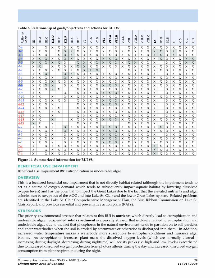
Summary Restoration Plan (RAP) – 2008 Update 39
Clinton River Area of Concern 11/01/2008
Table 6. Relationship of goals/objectives and actions for BUI #7.
Actions/
Goals
III
III.
A
III.
C
III.D
III.
E
III.F
III.
G
III.
I
VI
VI.
A
VI.
B
VII
VII.A
VII.B
VII
.C
VII
I
VII
I.A
VII
I.B
VII
I.C
IX
IX.D
IX.E
X X.B
X.C
X.D
2-4 X X X X X X X X X X X X X X X X X X X X X X X 3-2 X X X X X X X X X X X X X X X X X X X X X X X X X 3-3 X X X X X X X X X X X X X X X X X X X X X X X X X 3-4 X X X X X X X X X X X X X X X X X X X X X X X X X X 3-5 X X X X X X X X X X X X X X X X X X X X X X X X 4-1 X X X X X X X X X X X X X X X X X X X X X X X X X 4-2 X X X X X X X X X X X X X X X X X X X X X X 4-3 X X X X X X X X X X X X X X X X X X X X X X X 4-4 X X X X X X X X X X X X X X X X X X X X X X X X X 4-5 X X X X X X X X X X X X X X X X X X X X X X X X X X 4-6 X X X X X X X X X X X X X X X X X X X X X X X X X 4-7 X X X X X X X X X X X X X X X X X X X X X X X 4-9 X X X X X X X X X X X X X X X X X X X X X 4-10 X X X X X X X X X X X X X X X X X X X X X X X X 4-11 X X X X X X X X X X X X X X X X X X X X X X X X 4-12 X X X X X X X X X X X X X X X X X X X X X X 4-14 X X X X X X X X X X X X X X X X X X X X X X X 4-15 X X X X X X X X X X X X X X X X X X X X X X 4-17 X X X X X X X X X X X X X X X X X X X X X 4-18 X X X X X X X X X X X X X X X X X X X X X X X 4-19 X X X X X X X X X X X X X X X X X 6-1 X X X X X X X X X X X X X X X X X X X X X X X X X 6-2 X X X X X X X X X X X X X X X X X X X X X X X X X 6-3 X X X X X X X X X X X X X X X X X X X X X X X X 6-4 X X X X X X X X X X X X X X X X X X X X X X X X X 6-5 X X X X X X X X X X X X X X X X X X X X X X X X X 7-2 X X X X X X X X X X X X X X X X X X X X X X X X X 7-3 X X X X X X X X X X X X X X X X X X X X X X X X X 7-4 X X X X X X X X X X X X X X X X X X X X X X X X X
Figure 14. Summarized information for BUI #8.
BENEFICIAL USE IMPAIRMENT
Beneficial Use Impairment #8: Eutrophication or undesirable algae.
OVERVIEW
This is a localized beneficial use impairment that is not directly habitat related (although the impairment tends to act as a source of oxygen demand which tends to subsequently impact aquatic habitat by lowering dissolved oxygen levels) and has the potential to impact the Great Lakes due to the fact that the elevated nutrients and algal colonies can be swept out of the AOC and into Lake St. Clair and the lower Great Lakes system. Related problems are identified in the Lake St. Clair Comprehensive Management Plan, the Blue Ribbon Commission on Lake St. Clair Report, and previous remedial and preventative action plans (RAPs).
STRESSORS
The priority environmental stressor that relates to this BUI is nutrients which directly lead to eutrophication and undesirable algae. Suspended solids / sediment is a priority stressor that is closely related to eutrophication and undesirable algae due to the fact that phosphorus in the natural environment tends to partition on to soil particles and enter waterbodies when the soil is eroded by stormwater or otherwise is discharged into them. In addition, increased water temperature makes a waterbody more susceptible to eutrophic conditions and nuisance algal blooms. As eutrophication increases plant mass, the dissolved oxygen levels (which are normally diurnal – increasing during daylight, decreasing during nighttime) will see its peaks (i.e. high and low levels) exacerbated due to increased dissolved oxygen production from photosynthesis during the day and increased dissolved oxygen consumption from plant respiration during the night.

Summary Restoration Plan (RAP) – 2008 Update 40
Clinton River Area of Concern 11/01/2008
Eutrophication becomes problematic at higher levels with even more exacerbated high and low levels of dissolved oxygen, but with the added stress of excessive decaying plant matter that exerts an extra oxygen demand and shifts the entire diurnal curve to lower dissolved oxygen levels (because the plant matter decays in the water around the clock). In addition to increasing eutrophic conditions, increased temperature also reduces the solubility of oxygen in water thus further decreasing dissolved oxygen levels. As can be taken from the previous discussion, the relationship between eutrophication, the stressors that cause it, and the stressors it exacerbates (e.g. increased oxygen demand) can be complex. Adding to the complexity is the fact that the hydrologic / hydraulic characteristics of a waterbody can indirectly affect temperature (and subsequently dissolved oxygen levels) in a number of ways: runoff from urban areas is warmer, controlled-level lakes are warmer, groundwater-fed streams are colder, shallower waterbodies are warmer, etc. Additionally, rough flowing waterbodies tend to have greater dissolved oxygen levels due to the water turbulence which allows for greater oxygen transfer. Finally, hydraulic obstructions may act to sequester plant or algae communities that would normally be washed downstream and may exacerbate eutrophic conditions through this purely physical process. It should be noted that eutrophication is a natural process and eutrophic habitats and the associated fauna represent a vital ecological community. However, it is when eutrophication impacts previously non-impacted waterbodies, and causes uses or aesthetics of the waterbody to become impaired, that it is a problem. In this and the following paragraph, high priority elements are presented in bold text. Others are presented in bold, italicized text
SOURCES
The high priority sources of stressors, which contribute the greatest amount of the identified stressors discussed above, include sewage discharges, illicit discharges / spills, urban / residential land, transportation infrastructure, and soil erosion. Other sources of the stressors include industrial discharges, waste management sites, presently, other businesses, agricultural land, on-site disposal systems, contaminated sediments, atmospheric deposition, soil erosion, other human activities, and animal sources.9
REGULATORY CONSIDERATIONS
When eutrophication or undesirable algae are present there are no designated uses of the waters of the State of Michigan that are definitely impaired. However, in specific situations, designated uses may be impaired or at least threatened.
CRITICAL AREAS
The potential critical source areas of stressors that have been discussed include: impervious / urbanizing areas; construction sites; exposed soil areas; combined and sanitary sewer areas with overflows or problematic treatment works; agricultural areas; roads / roadside ditches; residential lawns; impaired lakes; illicit discharge areas (e.g. older urban areas); areas of failing septic systems; superfund sites or historic landfills; industrial areas; areas with enclosed storm drains; and lower portions of the watershed (e.g. Clinton River East, Red Run). Critical current impact areas include: lakes, lower portions of the Clinton River mainstem and watershed. Critical future impact areas include: unimpaired lakes and upper portions of the mainstem and watershed.
SUBWATERSHEDS
In terms of applicability, this BUI is of medium concern in the Upper Clinton, Clinton Main, and Stony Creek / Paint Creek Subwatersheds. The BUI is of high concern in the Clinton River East, Red Run, and North Branch Subwatersheds. No assessment has been conducted with respect to the Lake St. Clair Direct Drainage Subwatershed (although the Milk River is on the State of Michigan 303(d) list for phosphorus). The subwatershed management plans currently do not address the issue of eutrophication or undesirable algae directly as they were developed mainly to address stormwater issues. However, all of the plans address protecting and restoring water quality through pollution reduction.
9
Refer to Chapter 4 of the RAP for more detailed treatments of the specific sources and causes of the sources of the stressors.

Summary Restoration Plan (RAP) – 2008 Update 41
Clinton River Area of Concern 11/01/2008
DELISTING CRITERIA
An AOC water body will be considered restored for the eutrophication impairment if monitoring nutrients, chlorophyll, dissolved oxygen, and Secchi depth using the protocols of Michigan's Cooperative Lakes Monitoring Program in any 2 of 3 years indicates that:
There are no growths of undesirable algae in quantities which interfere with a water body's designated uses as defined in Rule 323.1100 of the Michigan Water Quality Standards (e.g., inhibits swimming due to the physical presence of algal mats and/or associated odor; inhibits the growth and production of warm water fisheries and/or indigenous aquatic life and wildlife). Undesirable algae species which may indicate impairment include toxic-producing cyanobacteria (e.g., Microsystis), noxious bloom-forming phytoplankton (e.g., Aphanizomenon), or benthic algae (e.g. Cladophora; and The water body meets the minimum DO standards listed in Rule 323.1064 in the Michigan WQS; and Any deviation from Rule 323.1064 is a direct result of vegetation; and The waterbody is no longer listed as impaired due to nutrients on the Clean Water Act Section 303(d) list for the state.
MDEQ is currently in the process of developing nutrient criteria for the surface waters of the state which will be adopted Into the Michigan WQS. BUI restoration will be expanded to include adherence to this nutrient criteria when it is officially adopted.
GOALS AND OBJECTIVES
Table 7 presents the goals and objectives10 that are specifically or secondarily related to this BUI along the top or x-axis. The numerous actions that are designed to address these goals and objectives in the context of this BUI are presented along the side or y-axis. The squares that are shaded indicate that the action directly addresses the goal/ objective as opposed to indirectly helping that goal/objective be achieved. The action and goal/objective numbers that are bolded (the action numbers are also highlighted for clarity) indicate the five highest elements in consideration of their direct relationship to the other.
Figure 15. Summarized information for BUI #10.
BENEFICIAL USE IMPAIRMENT
Beneficial Use Impairment #10: Beach closings and other ‘full body contact’ restrictions.
OVERVIEW
This is a watershed-wide beneficial use impairment that is not directly habitat related and has the potential to impact the Great Lakes due to the fact that the pathogens causing the beach closings can be swept out of the AOC and into Lake St. Clair and the lower Great Lakes system and may colonize the sand at beaches and cause beach closings in times when upstream releases of pathogens in the AOC is minimal (although this phenomenon is still being studied and very little is known about the true nature of the bacteria in sand).. Related problems are identified in the Lake St. Clair Comprehensive Management Plan, the Blue Ribbon Commission on Lake St. Clair Report, and previous remedial and preventative action plans (RAPs).
STRESSORS
The priority environmental stressor that relates to this BUI is pathogens. There are a handful of additional stressors that if levels were extreme would require body contact restrictions, including inorganic compounds (toxicity), heavy metals (toxicity), organic compounds (toxicity), pH (causticity), hydrologic / hydraulic characteristics (drowning risk), and radiation (radioactivity). However, it is not with great frequency that any of these additional stressors cause (or would warrant) contact restrictions. Therefore, the focus of this BUI with respect to stressor impacts remains squarely on pathogens. In this and the following paragraph, high priority elements are presented in bold text. Others are presented in bold, italicized text.
10
Not including the programmatic goals and objectives that are administrative in nature.

Summary Restoration Plan (RAP) – 2008 Update 42
Clinton River Area of Concern 11/01/2008
Table 7. Relationship of goals/objectives and actions for BUI #8.
Actions
/Goals
III
III.
A
III.
C
III.
D
III.
E
III.F
III.
G
III.
H
III.
I
IV IV.A
IV.B
VII
VII.A
VII.B
VII
.C
IX IX.A
IX.B
IX
.C
IX.D
IX.E
X X.C
X.D
3-2 X X X X X X X X X X X X X X X X X X X X X X X 3-3 X X X X X X X X X X X X X X X X X X X X X X X X 3-4 X X X X X X X X X X X X X X X X X X X X X X X 3-5 X X X X X X X X X X X X X X X X X X X X X 4-1 X X X X X X X X X X X X X X X X X X X X X 4-3 X X X X X X X X X X X X X X X X X X X X X 4-4 X X X X X X X X X X X X X X X X X X X X X X X 4-5 X X X X X X X X X X X X X X X X X X X X X X X X 4-6 X X X X X X X X X X X X X X X X X X X X X X 4-7 X X X X X X X X X X X X X X X X X X X 4-8 X X X X X X X X X 4-9 X X X X X X X X X X X X X X X X X X 4-10 X X X X X X X X X X X X X X X X X X X X X X X 4-11 X X X X X X X X X X X X X X X X X X X X X 4-12 X X X X X X X X X X X X X X X X X X 4-14 X X X X X X X X X X X X X X X X X X X 4-15 X X X X X X X X X X X X X X X X X X X X X 4-17 X X X X X X X X X X X X X X X X X 4-18 X X X X X X X X X X X X X X X X X X X X X X 4-19 X X X X X X X X X X X X X 5-1 X X X X X X X X X X X X X X X 5-2 X X X X X X X X X X X X X X X X 5-3 X X X X X X X X X X X X X X X X 5-4 X X X X X X X X X X X X X X X X X 5-5 X X X X X X X X X X X X X X X X X 5-6 X X X X X X X X X X X X X X X X X 5-7 X X X X X X X X X X X X X X X X X 5-8 X X X X X X X X X X X X X X X X X X 6-1 X X X X X X X X X X X X X X X X X X X X X X X 6-2 X X X X X X X X X X X X X X X X X X X X X X X X 6-3 X X X X X X X X X X X X X X X X X X X X X X 6-4 X X X X X X X X X X X X X X X X X X X X X X X X 6-5 X X X X X X X X X X X X X X X X X X X X X X X 7-2 X X X X X X X X X X X X X X X X X X X X X X X X 7-3 X X X X X X X X X X X X X X X X X X X X X X X X 7-4 X X X X X X X X X X X X X X X X X X X X X X X X
SOURCES
The high priority sources of stressors (pathogens) include sewage discharges and illicit discharges / spills. Other sources of the stressors include industrial discharges, waste management sites, other businesses, agricultural land, on-site disposal systems, and animal sources. Additional sources related to the additional stressors that may cause infrequent contact restrictions include contaminated sites, contaminated sediments, atmospheric deposition, and animal sources. Although soil erosion / sedimentation (and the associated sedimentation) is listed as a source of hydrologic / hydraulic characteristics modifications, it is not considered to be a source of the acute drowning risk events that are of consideration here but rather it is a source of long term changes to hydrologic / hydraulic patterns in a given waterbody.11
REGULATORY CONSIDERATIONS
When body contact restrictions exist or beaches are closed, then, by relation, the following designated uses of the waters of the State of Michigan are either definitely, or potentially, impaired: Partial Body Contact Recreation and Total Body Contact Recreation. In specific situations, other designated uses may also be impaired or at least threatened.
11
Refer to Chapter 4 of the RAP for more detailed treatments of the specific sources and causes of the sources of the stressors.

Summary Restoration Plan (RAP) – 2008 Update 43
Clinton River Area of Concern 11/01/2008
CRITICAL AREAS
The potential critical source areas of stressors that have been discussed include: impervious / urbanizing areas; combined and sanitary sewer areas with overflows or problematic treatment works; agricultural areas; roads / roadside ditches; residential lawns; impaired lakes; illicit discharge areas (e.g. older urban areas); areas of failing septic systems; superfund sites or historic landfills; industrial areas; areas with enclosed storm drains; lower portions of the watershed (e.g. Clinton River East, Red Run). Critical current impact areas include lower portions of the Clinton River mainstem and watershed. Critical future impact areas include upper portions of the mainstem and watershed.
SUBWATERSHEDS
In terms of applicability, this BUI is of low concern in the Upper Clinton. The BUI is of medium concern in the Clinton Main, Stony Creek / Paint Creek, and North Branch Subwatersheds. The BUI is of high concern in the Clinton River East and Red Run Subwatersheds. No assessment has been conducted with respect to the Lake St. Clair Direct Drainage (although the fact that some of the beaches on Lake St. Clair are listed on the State of Michigan’s 303(d) list indicates that this is an issue). The subwatershed management plans tend to deal with pathogens directly as it is a stressor associated with stormwater issues. The plans also address the issue generally through pollution reduction and also address the issue of improving recreational opportunities.
DELISTING CRITERIA
This BUI will be considered restored when public beaches within the AOC and representative watershed locations monitored for a period of four years over the 16-week total body contact recreation period (generally memorial day to labor day), using methods adopted in Rule 323.1062 of the Michigan WQS, meet the following standards:
E. coli concentrations are below a 30-day geometric mean of 130 counts per 100 milliliters (ml); and At least 90% of sample results are below the daily geometric mean limits of 300 counts E. coli per 100 ml; and No more than 1 of the sample results exceed the partial body contact water quality standard of 1,000 counts E. coli per 100 ml based on a daily geometric mean.
No water bodies within the AOC are included on the list of impaired waters due to contamination with pathogens in the most recent Clean Water Act Water Quality and Pollution Control in Michigan: Section 303(d) and 305(b) Integrated Report (Integrated Report), which is submitted to the U.S. EPA every two years.
Contaminants originating from outside the AOC shall not prohibit delisting.
GOALS AND OBJECTIVES
Table 8 presents the goals and objectives12 that are specifically or secondarily related to this BUI along the top or x-axis. The numerous actions that are designed to address these goals and objectives in the context of this BUI are presented along the side or y-axis. The squares that are shaded indicate that the action directly addresses the goal /objective as opposed to indirectly helping that goal/objective be achieved. The action and goal/objective numbers that are bolded (the action numbers are also highlighted for clarity) indicate the five highest elements in consideration of their direct relationship to the other.
Figure 16. Summarized information for BUI #11.
BENEFICIAL USE IMPAIRMENT Beneficial Use Impairment #11: Degradation of aesthetics.
OVERVIEW This is a watershed-wide beneficial use impairment that is not directly habitat related (although certain of the stressors which lead to this impairment can cause degradation of aquatic habitat – e.g. sedimentation) and does not impact the great lakes as the stressors that cause aesthetic degradation are typically naturally degraded or settle out as soon as they are discharged into slower moving bodies of water such as Lake St. Clair (although habitat degradation through uncontrolled land conversion from natural settings to use for human activities is a problem throughout the Great Lakes basin). Related problems are identified in the Lake St. Clair Comprehensive Management Plan, the Blue Ribbon Commission on Lake St. Clair Report, and previous remedial and preventative action plans (RAPs).
12
Not including the programmatic goals and objectives that are administrative in nature.

Summary Restoration Plan (RAP) – 2008 Update 44
Clinton River Area of Concern 11/01/2008
Table 8. Relationship of goals/objectives and actions for BUI #10.
Actions/
Goals
III
III.
A
III.C
III.D
III.
E
III.F
III.
G
III.
H
III.
I
IV IV.A
IV.B
VII
VII
.C
IX
IX.A
IX
.B
IX
.C
IX.D
IX.E
X X.A
X.C
X.D
3-2 X X X X X X X X X X X X X X X X X X X X X 3-3 X X X X X X X X X X X X X X X X X X X X X X X 3-4 X X X X X X X X X X X X X X X X X X X X X 3-5 X X X X X X X X X X X X X X X X X X X 4-3 X X X X X X X X X X X X X X X X X X X 4-4 X X X X X X X X X X X X X X X X X X X X X 4-5 X X X X X X X X X X X X X X X X X X X X X X 4-6 X X X X X X X X X X X X X X X X X X X X X 4-7 X X X X X X X X X X X X X X X X X 4-8 X X X X X X X 4-9 X X X X X X X X X X X X X X X X 4-10 X X X X X X X X X X X X X X X X X X X X X 4-11 X X X X X X X X X X X X X X X X X X X 4-12 X X X X X X X X X X X X X X X X 4-14 X X X X X X X X X X X X X X X X X 4-15 X X X X X X X X X X X X X X X X X X X 4-17 X X X X X X X X X X X X X X X 4-18 X X X X X X X X X X X X X X X X X X X X 4-19 X X X X X X X X X X X X X 6-1 X X X X X X X X X X X X X X X X X X X X X 6-2 X X X X X X X X X X X X X X X X X X X X X X 6-3 X X X X X X X X X X X X X X X X X X X X 6-4 X X X X X X X X X X X X X X X X X X X X X X 6-5 X X X X X X X X X X X X X X X X X X X X X 7-2 X X X X X X X X X X X X X X X X X X X X X X X 7-3 X X X X X X X X X X X X X X X X X X X X X X X 7-4 X X X X X X X X X X X X X X X X X X X X X X X
STRESSORS
The environmental stressors that relate to this BUI include those that cause degraded conditions that can be ‘sensed’ (e.g. odor, taste, sight) including organic compounds (e.g. tannins cause color problems), oxygen demand (e.g. low dissolved oxygen environments support organisms that have waste products with characteristic smells), suspended solids / sediment (e.g. turbidity), debris (e.g. garbage in a stream channel), hydrologic / hydraulic characteristics (e.g. extreme low flow makes the river look unappealing, erosive flows gouge the stream channel and create overhanging banks and exposed tree roots, extreme high flows do flood damage and leave debris in trees), natural feature / habitat degradation (e.g. extensive urban development destroys the natural character of the land), and invasive species (e.g. these species crowd out native species and ruin the normal natural aesthetic). Nutrients indirectly lead to degradation of aesthetics by causing eutrophication (e.g. the physical manifestation of excessive plant mass). In this and the following paragraph, high priority elements are presented in bold text. Others are presented in bold, italicized text
SOURCES
The high priority sources of stressors, which contribute the greatest amount of the identified stressors discussed above, include sewage discharges, illicit discharges / spills, urban / residential land, transportation infrastructure, and soil erosion. Other sources of the stressors include industrial discharges, waste management sites, presently contaminated sites, other businesses, agricultural land, on-site disposal systems, contaminated sediments, atmospheric deposition, other human activities, and animal sources.13
13
Refer to Chapter 4 of the RAP for more detailed treatments of the specific sources and causes of the sources of the stressors.

Summary Restoration Plan (RAP) – 2008 Update 45
Clinton River Area of Concern 11/01/2008
REGULATORY CONSIDERATIONS
When aesthetics are degraded there are no designated uses of the waters of the State of Michigan that are definitely impaired. However, in specific situations, designated uses may be impaired or at least threatened.
CRITICAL AREAS
The potential critical source areas of stressors that have been discussed include: impervious / urbanizing areas or those areas tributary to streams with increased peak flows; construction sites; exposed soil areas; combined and sanitary sewer areas with overflows or problematic treatment works; agricultural areas; roads / roadside ditches; residential lawns; illicit discharge areas (e.g. older urban areas); areas of failing septic systems; superfund sites or historic landfills; industrial areas; areas with enclosed storm drains; waterbodies with control structures (e.g. dams); lower portions of the watershed (e.g. Clinton River East, Red Run). Critical current impact areas include: middle and lower portions of the Clinton River mainstem and watershed. Critical future impact areas include upper portions of the mainstem and watershed.
SUBWATERSHEDS
In terms of applicability, this BUI is of low concern in the Upper Clinton and Stony Creek / Paint Creek Subwatersheds. This BUI is of medium concern in the Clinton Main and North Branch Subwatersheds. This BUI is of high concern in the Clinton River East and Red Run Subwatersheds. No assessment has been conducted with respect to the Lake St. Clair Direct Drainage Subwatershed (but the extensive build-out of the subwatershed is an indicator of degraded aesthetics). The subwatershed management plans deal with reducing pollution to protect and restore water quality and to manage stormwater – both of which will improve aesthetics throughout the watershed.
DELISTING CRITERIA
In order to restore the beneficial use the following criteria must be addressed: Monitoring data and/or surveys for any 2 of 3 years indicates that water bodies in the AOC do not exhibit persistent, high levels of the following "unnatural physical properties" (as defined by Rule 323.1050 of the Michigan Water Quality Standards) in quantities which interfere with the state's designated uses for surface waters: Turbidity, Color, Oil films, Floating solids, Foams, Settleable solids, Suspended solids, Deposits, Severe log jams defined by size and/or frequency of occurrence.
For the purposes of this criteria, these eight properties impair aesthetic values if they are unnatural -- meaning those that are manmade (e.g., garbage, sewage), or natural properties which are exacerbated by human induced activities (e.g. excessive algae growth from high nutrient loading, log jams due to high storm water runoff volumes). Persistent, high levels is defined as long enough or high enough to be injurious to any designated use listed under Rule 323.1100 of the Michigan WQS.
Natural physical features which occur in normal ecological cycles (e.g., logjams/woody debris, rooted aquatic plants) are not considered impairments, and in fact serve a valuable role in providing fish and wildlife habitat.
GOALS AND OBJECTIVES
Table 9 presents the goals and objectives14 that are specifically or secondarily related to this BUI along the top or x-axis. The numerous actions that are designed to address these goals and objectives in the context of this BUI are presented along the side or y-axis. The squares that are shaded indicate that the action directly addresses the goal/ objective as opposed to indirectly helping that goal/objective be achieved. The action and goal/objective numbers that are bolded (the action numbers are also highlighted for clarity) indicate the five highest elements in consideration of their direct relationship to the other.
14
Not including the programmatic goals and objectives that are administrative in nature.
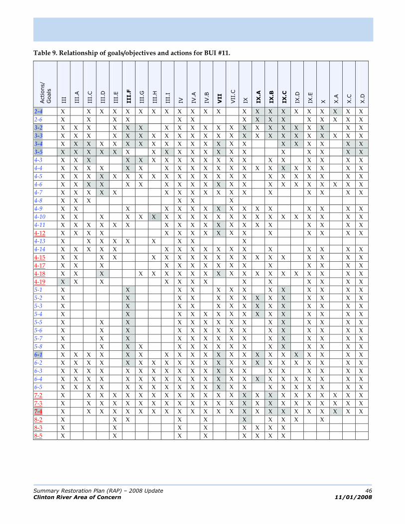
Summary Restoration Plan (RAP) – 2008 Update 46
Clinton River Area of Concern 11/01/2008
Table 9. Relationship of goals/objectives and actions for BUI #11.
Actions/
Goals
III
III.
A
III.
C
III.
D
III.
E
III.F
III.
G
III.
H
III.
I
IV IV.A
IV.B
VII
VII
.C
IX IX
.A
IX
.B
IX
.C
IX.D
IX.E
X X.A
X.C
X.D
2-4 X X X X X X X X X X X X X X X X X X X X X X
2-6 X X X X X X X X X X X X X X X
3-2 X X X X X X X X X X X X X X X X X X X X X
3-3 X X X X X X X X X X X X X X X X X X X X X X X
3-4 X X X X X X X X X X X X X X X X X X X X X
3-5 X X X X X X X X X X X X X X X X X X X
4-3 X X X X X X X X X X X X X X X X X X X
4-4 X X X X X X X X X X X X X X X X X X X X X
4-5 X X X X X X X X X X X X X X X X X X X X X X
4-6 X X X X X X X X X X X X X X X X X X X X X
4-7 X X X X X X X X X X X X X X X X X
4-8 X X X X X X
4-9 X X X X X X X X X X X X X X X X
4-10 X X X X X X X X X X X X X X X X X X X X X
4-11 X X X X X X X X X X X X X X X X X X X
4-12 X X X X X X X X X X X X X X X X
4-13 X X X X X X X X X
4-14 X X X X X X X X X X X X X X X X X
4-15 X X X X X X X X X X X X X X X X X X X
4-17 X X X X X X X X X X X X X X X
4-18 X X X X X X X X X X X X X X X X X X X X
4-19 X X X X X X X X X X X X X
5-1 X X X X X X X X X X X X X
5-2 X X X X X X X X X X X X X X
5-3 X X X X X X X X X X X X X X
5-4 X X X X X X X X X X X X X X X
5-5 X X X X X X X X X X X X X X X
5-6 X X X X X X X X X X X X X X X
5-7 X X X X X X X X X X X X X X X
5-8 X X X X X X X X X X X X X X X X
6-1 X X X X X X X X X X X X X X X X X X X X X
6-2 X X X X X X X X X X X X X X X X X X X X X X
6-3 X X X X X X X X X X X X X X X X X X X X
6-4 X X X X X X X X X X X X X X X X X X X X X X
6-5 X X X X X X X X X X X X X X X X X X X X X
7-2 X X X X X X X X X X X X X X X X X X X X X X X
7-3 X X X X X X X X X X X X X X X X X X X X X X X
7-4 X X X X X X X X X X X X X X X X X X X X X X X
8-2 X X X X X X X X X X
8-3 X X X X X X X X
8-5 X X X X X X X X
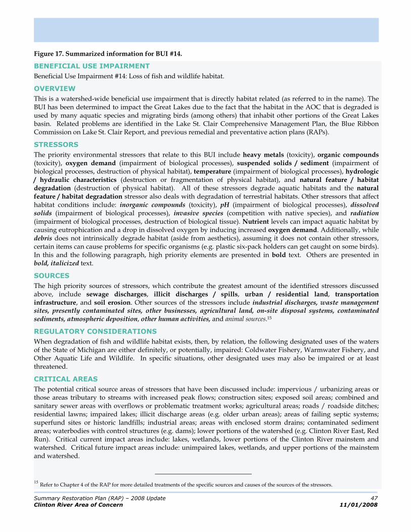
Summary Restoration Plan (RAP) – 2008 Update 47
Clinton River Area of Concern 11/01/2008
Figure 17. Summarized information for BUI #14.
BENEFICIAL USE IMPAIRMENT
Beneficial Use Impairment #14: Loss of fish and wildlife habitat.
OVERVIEW
This is a watershed-wide beneficial use impairment that is directly habitat related (as referred to in the name). The BUI has been determined to impact the Great Lakes due to the fact that the habitat in the AOC that is degraded is used by many aquatic species and migrating birds (among others) that inhabit other portions of the Great Lakes basin. Related problems are identified in the Lake St. Clair Comprehensive Management Plan, the Blue Ribbon Commission on Lake St. Clair Report, and previous remedial and preventative action plans (RAPs).
STRESSORS
The priority environmental stressors that relate to this BUI include heavy metals (toxicity), organic compounds (toxicity), oxygen demand (impairment of biological processes), suspended solids / sediment (impairment of biological processes, destruction of physical habitat), temperature (impairment of biological processes), hydrologic / hydraulic characteristics (destruction or fragmentation of physical habitat), and natural feature / habitat degradation (destruction of physical habitat). All of these stressors degrade aquatic habitats and the natural feature / habitat degradation stressor also deals with degradation of terrestrial habitats. Other stressors that affect habitat conditions include: inorganic compounds (toxicity), pH (impairment of biological processes), dissolved solids (impairment of biological processes), invasive species (competition with native species), and radiation (impairment of biological processes, destruction of biological tissue). Nutrient levels can impact aquatic habitat by causing eutrophication and a drop in dissolved oxygen by inducing increased oxygen demand. Additionally, while debris does not intrinsically degrade habitat (aside from aesthetics), assuming it does not contain other stressors, certain items can cause problems for specific organisms (e.g. plastic six-pack holders can get caught on some birds). In this and the following paragraph, high priority elements are presented in bold text. Others are presented in bold, italicized text.
SOURCES
The high priority sources of stressors, which contribute the greatest amount of the identified stressors discussed above, include sewage discharges, illicit discharges / spills, urban / residential land, transportation infrastructure, and soil erosion. Other sources of the stressors include industrial discharges, waste management sites, presently contaminated sites, other businesses, agricultural land, on-site disposal systems, contaminated sediments, atmospheric deposition, other human activities, and animal sources.15
REGULATORY CONSIDERATIONS
When degradation of fish and wildlife habitat exists, then, by relation, the following designated uses of the waters of the State of Michigan are either definitely, or potentially, impaired: Coldwater Fishery, Warmwater Fishery, and Other Aquatic Life and Wildlife. In specific situations, other designated uses may also be impaired or at least threatened.
CRITICAL AREAS
The potential critical source areas of stressors that have been discussed include: impervious / urbanizing areas or those areas tributary to streams with increased peak flows; construction sites; exposed soil areas; combined and sanitary sewer areas with overflows or problematic treatment works; agricultural areas; roads / roadside ditches; residential lawns; impaired lakes; illicit discharge areas (e.g. older urban areas); areas of failing septic systems; superfund sites or historic landfills; industrial areas; areas with enclosed storm drains; contaminated sediment areas; waterbodies with control structures (e.g. dams); lower portions of the watershed (e.g. Clinton River East, Red Run). Critical current impact areas include: lakes, wetlands, lower portions of the Clinton River mainstem and watershed. Critical future impact areas include: unimpaired lakes, wetlands, and upper portions of the mainstem and watershed.
15
Refer to Chapter 4 of the RAP for more detailed treatments of the specific sources and causes of the sources of the stressors.

Summary Restoration Plan (RAP) – 2008 Update 48
Clinton River Area of Concern 11/01/2008
SUBWATERSHEDS
In terms of applicability, this BUI is of low concern in the Stony Creek / Paint Creek Subwatershed. The BUI is of medium concern in the Upper Clinton, and North Branch Subwatersheds. The BUI is of high concern in the Clinton River East, and Red Run Subwatersheds. No assessment has been conducted with respect to the Lake St. Clair Direct Drainage (although the built-out character of the subwatershed is a definite sign that habitats are at sub-optimal conditions). Five of the seven subwatershed management plans deal directly with protecting and restoring aquatic and riparian habitat and another five out seven deal with protecting and restoring natural physical features (which can be construed in the context of the plans to include habitat). Six out of seven of the plans address stormwater management, the main focus of the plans in general, which will also aid in restoring habitat conditions.
DELISTING CRITERIA
In order to restore the beneficial use the following criteria must be addressed: DO levels in the river meet or exceed the minimum Michigan’s Water Quality Standards Aquatic and riparian zone habitat are considered to be good to excellent at appropriate locations within the AOC as evaluated by MDEQ GLEAS Procedure 51 and other appropriate guidelines and procedures. Appropriate locations are those areas within the watershed where habitat should be protected or habitat improvement can reasonably be achieved. Programs are in place within the AOC to establish minimum subwatershed specific forest cover within the riparian corridor for suburban/forested, suburban/agricultural, urban/suburban, and urban. Impervious surface coverage is at or below an equivalent of 15% average throughout the watershed. Equivalent imperviousness is a combination of actual imperviousness within the watershed and apparent imperviousness due to the installation of appropriate BMPs. o Undeveloped areas remain at less than 10% imperviousness o Agricultural land use targeted at less than 50% of the undeveloped watershed area o No increase in areas presently greater than 30% impervious
Programs are in place within the AOC to preserve existing wetland areas (no net loss) and restore/increase wetland area within the watershed by 1% to 5% over the next ten years Programs are in place within the AOC to acquire and preserve a minimum of 5% of the priority conservation areas within the AOC annually River hydrology and temperature fluctuations do not impact indicator fish and wildlife species Toxic pollutants in the sediment and water column do not impact indicator fish and wildlife species Local Green Infrastructure Plans are being implemented within the AOC Habitat restoration goals have been established within the AOC and are being implemented
The fact that this BUI is habitat-related means that its restoration is contingent upon implementation of the AOC-specific restoration plan that has been developed to jointly address the habitat-related BUIs (which includes this BUI and ‘Loss of Fish and Wildlife Habitat’). Appendix E.1 describes the restoration plan as presented in Delisting Targets for Fish/Wildlife Habitat & Population Beneficial Use Impairments for the Clinton River Area of Concern” (ECT, 2007).
GOALS AND OBJECTIVES
Table 10 presents the goals and objectives16 that are specifically or secondarily related to this BUI along the top or x-axis. The numerous actions that are designed to address these goals and objectives in the context of this BUI are presented along the side or y-axis. The squares that are shaded indicate that the action directly addresses the goal/ objective as opposed to indirectly helping that goal/objective be achieved. The action and goal/objective numbers that are bolded (the action numbers are also highlighted for clarity) indicate the five highest elements in consideration of their direct relationship to the other.
16
Not including the programmatic goals and objectives that are administrative in nature.

Summary Restoration Plan (RAP) – 2008 Update 49
Clinton River Area of Concern 11/01/2008
Table 10. Relationship of goals/objectives and actions for BUI #14.
Actions/
Goals
III
III.
A
III.
C
III.
D
III.
E
III.F
III.
G
III.
H
III.
I
IV IV.A
IV.B
VI
VI.
B
VII
VII.B
VII
I
VII
I.A
VII
I.B
VII
I.C
IX IX
.A
IX
.B
IX
.C
IX.D
IX.E
IX.F
X X.A
X.B
X.C
X.D
2-4 X X X X X X X X X X X X X X X X X X X X X X X X X X X X X X X
2-6 X X X X X X X X X X X X X X X X X
3-2 X X X X X X X X X X X X X X X X X X X X X X X X X X X X X
3-3 X X X X X X X X X X X X X X X X X X X X X X X X X X X X X X X
3-4 X X X X X X X X X X X X X X X X X X X X X X X X X X X X X
3-5 X X X X X X X X X X X X X X X X X X X X X X X X X X X
4-1 X X X X X X X X X X X X X X X X X X X X X X X X X X X
4-2 X X X X X X X X X X X X X X X X X X X X X X X X X
4-3 X X X X X X X X X X X X X X X X X X X X X X X X X X X
4-4 X X X X X X X X X X X X X X X X X X X XX X X X X X X X X X
4-5 X X X X X X X X X X X X X X X X X X X X X X X X X X X X X X
4-6 X X X X X X X X X X X X X X X X X X X X X X X X X X X X X
4-7 X X X X X X X X X X X X X X X X X X X X X X X X X
4-9 X X X X X X X X X X X X X X X X X X X X X X X X
4-10 X X X X X X X X X X X X X X X X X X X X X X X X X X X X X
4-11 X X X X X X X X X X X X X X X X X X X X X X X X X X X
4-12 X X X X X X X X X X X X X X X X X X X X X X X X
4-14 X X X X X X X X X X X X X X X X X X X X X X X X X
4-15 X X X X X X X X X X X X X X X X X X X X X X X X X X X
4-17 X X X X X X X X X X X X X X X X X X X X X X X
4-18 X X X X X X X X X X X X X X X X X X X X X X X X X X X X
4-19 X X X X X X X X X X X X X X X X X X X X X
5-1 X X X X X X X X X X X X X X X
5-2 X X X X X X X X X X X X X X X X
5-3 X X X X X X X X X X X X X X X X X X X X X X
5-4 X X X X X X X X X X X X X X X X X
5-5 X X X X X X X X X X X X X X X X X X X X X X X
5-6 X X X X X X X X X X X X X X X X X
5-7 X X X X X X X X X X X X X X X X X
5-8 X X X X X X X X X X X X X X X X X X X X X X
6-1 XX X X X XX X X X X X X X X X X X X X X X X X X X X X X X X
6-2 X X X X X X X X X X X X X X X X X X X X X X X X X X X X X X
6-3 X X X X X X X X X X X X X X X X X X X X X X X X X X X X
6-4 X X X X X X X X X X X X X X X X X X X X X X X X X X X X X X
6-5 X X X X X X X X X X X X X X X X X X X X X X X X X X X X X
7-2 X X X X X X X X X X X X X X X X X X X X X X X X X X X X X X X
7-3 X X X X X X X X X X X X X X X X X X X X X X X X X X X X X X X
7-4 X X X X X X X X X X X X X X X X X X X X X X X X X X X X X X X
8-2 X X X X X X X X X X X X
8-4 X X X X X X X X X X X X

Summary Restoration Plan (RAP) – 2008 Update 50
Clinton River Area of Concern 11/01/2008
Priority Actions
A priority action is defined as any action that directly addresses four or more objectives for a BUI. Additional support for nine of these actions comes from the modeling results. Therefore, these actions address multiple objectives, their corresponding goals, and in most cases more than one BUI. In theory, implementation of these actions will be most effective in moving the watershed towards delisting as an AOC. Nine of the twelve actions are supported by the NPDES Phase I & II programs which will help foster their implementation. Table 11 below lists thirteen actions that can be classified as Priority Actions.
To facilitate discussion, the thirteen actions have been grouped as shown in the table.
Table 11. Priority actions.
Action
Number
Priority
GroupAction*
Phase II
Activity
Modeling
Recommendation
2-4 I Demonstration Projects X
3-2 II Managing Development Patterns X X
6-2 II Infiltration Techniques X X
6-1 II Mitigate Existing Impervious Surfaces X X
3-4 III Stormwater Management Standards X X
3-5 III Pollution Prevention Ordinances / Programs X X
4-6 III Turf Management Practices X
3-3 IV Preserve Natural Areas / Features X X
6-4 IV Vegetative Buffers and Natural Conveyance X X
7-4 IV Natural Feature Restoration X
4-2 V Remediate Contaminated Sediments
4-18 VI Agriculture BMPs X
9-2 VII Stressor Monitoring and Assessment
* Full descriptions of each of the actions area available in the full RAP.
I. Demonstration Projects
Implementing demonstration projects is important in gaining public acceptance for new ideas, such as bioretention areas (i.e. rain gardens), as well as to refine design and installation techniques. In the short-term, it would be especially helpful to implement demonstration projects that the modeling results have indicated would improve water quality. These include any BMPs that are designed to manage flow volume, peak flow, and promote infiltration. SEMCOG has already compiled a list of LID related demonstration projects. Promotion of the list and the projects it contains is an easy first step.
II. Land Development Management
This group of actions (3-2, 6-1, and 6-2) is those which are characteristic of land development. Land development is inevitable in the foreseeable future and reducing the impacts of the built environment on waterways is the common element for this category of actions. The intent of managing development patterns is to adopt design concepts such as smart growth, conservation, and compact design which seek to increase density and
Summary Restoration Plan (RAP) – 2008 Update 51
Clinton River Area of Concern 11/01/2008
pervious surfaces while decreasing the percent impervious surface on a site. The goal of mitigating existing impervious surfaces is more directed at separating impervious surfaces from one another by pervious areas when redevelopment occurs. And lastly, adopting infiltration techniques includes more site specific actions such as low impact development (LID) and LEED certified buildings that should be considered in local development standards. It should be clear that the intent of these actions is to change how land is developed and not to stop development.
The three land development actions are all good examples of activities, which under Michigan’s home-rule political structure, need to be addressed at the local level. Unquestionably, at the current time the requirements of the Phase I & II programs will drive change. And although there will be certain design elements common to all communities, the diverse design methods available should allow communities the ability to seek their own unique solutions.
The modeling results indicate that reducing impervious surfaces by twenty-five percent in new development and redevelopment resulted in a noticeable reduction in pollutant loads.
III. Institutional Framework
This group of actions (3-4, 3-5, and 4-6) deals with building an institutional framework by setting standards, establishing ordinances, and defining standard operating procedures. For example, stormwater management standards include targets such as treating the first inch of runoff and reducing sediment loads. Standards for volume and sediment have been discussed at the state level and will most likely be guidance in the forthcoming Michigan low impact development manual. On the other hand, some communities across the nation have adopted standards with phosphorous being the pollutant most frequently addressed at the local level. It is therefore likely that future water quality standards will be a combination of both local and state requirements. The modeling results indicated that the best tool for managing high flows, flashiness and sediment loads is delaying runoff with well designed BMPs. This scenario was based on Oakland County design standards and the forthcoming LID manual guidance.
Local pollution prevention ordinances and programs are already common. For example, many communities have littering and pet waste ordinances on the books. In many cases, water quality improvements would be seen through strict enforcement of existing ordinances. In other circumstances, it is more appropriate for a municipality to adopt better standard operating procedures (SOPs). For example, increasing the frequency of street sweeping and catch basin cleaning could further reduce sediment loads over the model predicted four percent average for current practices in urban areas. The setting of standards, the passing and enforcement of ordinances, and the adoption of pollution prevention SOPs will together create an institutional framework designed to improve water quality.

Summary Restoration Plan (RAP) – 2008 Update 52
Clinton River Area of Concern 11/01/2008
IV. Natural Feature Preservation and Restoration
This group of actions relates to natural areas and includes 3-3, 6-4, and 7-4. The preservation and restoration of natural features are important actions but based on the modeling results for different reason. The model used the Michigan Natural Features Inventory (MNFI) natural areas to predict how preservation of its identified natural features would help improve water quality in 2030. The modeling results assumed that most of the natural features would be untouched by development in 2030. This means that the functions they perform, including pollutant removal, were still intact at that time. In terms of recommendations, this establishes the need to find ways to preserve these areas in perpetuity prior to them being consumed through development.
The model also supported the restoration of natural features, especially from agricultural uses to forested areas. The recommendation stemming from this finding is to target key areas for restoration that fit into a sustainable landscape plan. Complementing this is the recommended action to create vegetative buffers and natural conveyance (6-4) along waterways. Essentially the same action as 7-4, they differ in that 7-4 is primarily focused on upland areas while 6-4 targets the riparian zone.
V. Remediation of Contaminated Sediments
The remediation of contaminated sediment (4-2) is the reason that the Clinton River Watershed became an Area of Concern back in 1988. The presence of contaminated sediments, especially those containing PCBs, persists today. Although significant progress has been made regarding understanding their location, their source is still unclear. Furthermore, there is no general agreement on how to remediate the problem. Additional study of the issue, as well as gaining agreement on a corrective course of action, is needed.
VI. Agricultural Best Management Practices
Implementing agricultural BMPs, especially in the North Branch, is not only a recommended action but was also shown by the model to significantly reduce sediment and phosphorous pollutant loads. Since conservation tillage has already been heavily adopted in the North Branch, the focus should be on implementing riparian buffers, especially forest buffers, and grass channels.
VII. Monitoring
Although the content analysis did not identify action 9-2, ‘Stressor Monitoring and Assessment’, the CRPAC felt strongly that due to the investment in time, effort, and money in the Lake St. Clair Monitoring Project, it should be included as a priority action. Specifically, the real-time monitoring systems and annual water quality sampling programs have enough financial resources to sustain themselves for the 2008 season and early into 2009. The CRPAC supports seeking a sustainable funding source for the Regional Monitoring Project.
Monitoring is not only an essential component of Phase I & II programs (and as such existing efforts, above and beyond those discussed above, can be leveraged) but is necessary for obtaining the data that will be used to assess the progress made in support of this plan. As such, its inclusion as a priority action is a necessity.
Modeling Summary
Perhaps one of the most significant findings that came out of the modeling results was the cumulative effect of management scenarios in terms of improving water quality. Different BMPs address different issues across the landscape and there is no one management technique that is a cure all. The same can be said of the twelve priority recommendations. These actions should be viewed as key components of a holistic, comprehensive program with each of them being simultaneously implemented to the maximum extent possible. Specific implementation details are provided in the RAP.
Summary Restoration Plan (RAP) – 2008 Update 53
Clinton River Area of Concern 11/01/2008
Evaluation of Progress
This Restoration Plan is a living document and is meant to be used, revised, and altered to reflect the changing conditions in the watershed with respect to delisting, just as the previous RAP updates were. This adaptive management approach to watershed planning provides for continuous input and modification of procedures, processes, and products. An integral component of planning in this setting is the evaluation and revision mechanisms that drive these modifications.
The Restoration Plan includes the following evaluation and revision components:
Evaluation of the effects of implemented actions and progress toward goals and objectives; and Re-evaluation of goals and objectives as part of an on-going, iterative process.
Evaluation
Each evaluation requires data on which to base an assessment of progress. Thus the evaluation mechanisms can be classified based on the data that is required, as follows:
Measure of Activity Completion
These mechanisms require only an indication of whether or not an activity has been completed. These measures are used to assess implementation and include the ‘implementation milestones’ which are discussed later.
Most of the actions can be assessed on the basis of whether or not they are complete and on schedule. This is indicated and tracked in Table 2 of this document and labeled as milestones.
A higher priority should be placed on ensuring the implementation of the 12 priority actions since they are thought to have the greatest management impacts. Consequently, full implementation of these actions is targeted for five years in the future.
Measure of Usage
These mechanisms require data concerning how much a facility has been used or how much material has been distributed or collected. These measures are used to assess implementation of actions. Many of the actions also have multiple measures of usage associated with them.
Measure of Change
These mechanisms require data concerning baseline and post-action levels of knowledge or water quality. These measures are used to assess effectiveness.
Measures which are used to assess the effectiveness of action implementation are sometimes referred to as ‘Indirect’. Those which are used to assess changes in water quality are ‘Direct’. The same actions that are assessed on the basis of a measure of usage can often be assessed on the basis of a measure of change.
Assessment of Actions
In order to assess change uniformly across all actions, it is necessary to establish criteria for success. The criteria for success are outlined in the Restoration Plan. The table below is extracted from the complete table in
Pollutant Load Reductions
SEDIMENT The preferred way to determine if sediment loading reductions are being achieved is to quantitatively analyze water chemistry data.
Alternatively, or in addition to analyzing water quality data, reductions may be qualitatively shown through: improved macroinvertebrate and fish communities; reduced time between dredging; and a decrease in the number/severity of bank erosion problems.
PHOSPHORUS The preferred way to determine if phosphorus loading reductions are being achieved is to quantitatively analyze water chemistry data.
Alternatively, or in addition to analyzing water quality data, reductions may be qualitatively shown through a reduced prevalence of algae and macrophytes.
PATHOGENS The preferred way to determine if pathogen loading reductions are being achieved is to quantitatively analyze water chemistry data.
Alternatively, or in addition to analyzing water quality data, reductions may be qualitatively shown through: continued progress in correcting illicit connections; decreased occurrences of sanitary and combined sewer overflows (i.e. SSO, CSOs); and fewer beach closings.
HYDROLOGIC FLOW The preferred way to determine if hydrologic flow flashiness reductions are being achieved is to quantitatively analyze actual flow data.
Alternatively, or in addition to analyzing flow data, reductions may be qualitatively shown through reduced levels of impervious cover.
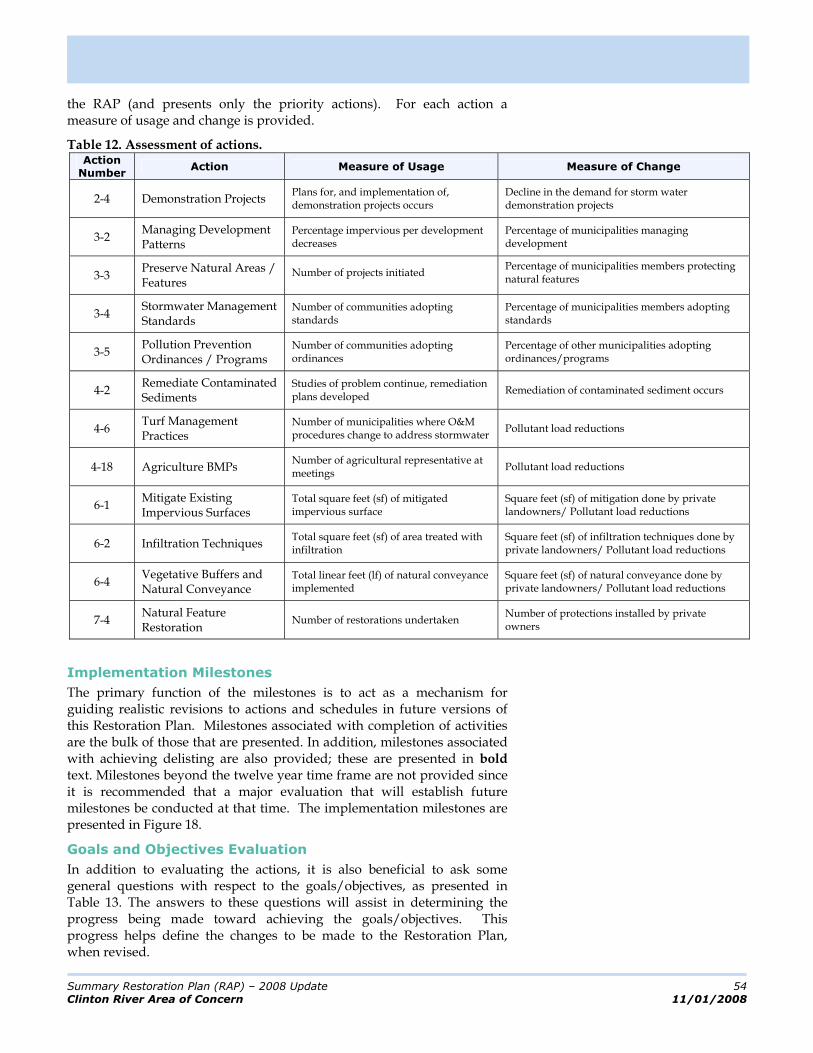
Summary Restoration Plan (RAP) – 2008 Update 54
Clinton River Area of Concern 11/01/2008
the RAP (and presents only the priority actions). For each action a measure of usage and change is provided.
Table 12. Assessment of actions. Action
Number Action Measure of Usage Measure of Change
2-4 Demonstration Projects Plans for, and implementation of, demonstration projects occurs
Decline in the demand for storm water demonstration projects
3-2 Managing Development Patterns
Percentage impervious per development decreases
Percentage of municipalities managing development
3-3 Preserve Natural Areas / Features
Number of projects initiated Percentage of municipalities members protecting natural features
3-4 Stormwater Management Standards
Number of communities adopting standards
Percentage of municipalities members adopting standards
3-5 Pollution Prevention Ordinances / Programs
Number of communities adopting ordinances
Percentage of other municipalities adopting ordinances/programs
4-2 Remediate Contaminated Sediments
Studies of problem continue, remediation plans developed
Remediation of contaminated sediment occurs
4-6 Turf Management Practices
Number of municipalities where O&M procedures change to address stormwater
Pollutant load reductions
4-18 Agriculture BMPs Number of agricultural representative at meetings
Pollutant load reductions
6-1 Mitigate Existing Impervious Surfaces
Total square feet (sf) of mitigated impervious surface
Square feet (sf) of mitigation done by private landowners/ Pollutant load reductions
6-2 Infiltration Techniques Total square feet (sf) of area treated with infiltration
Square feet (sf) of infiltration techniques done by private landowners/ Pollutant load reductions
6-4 Vegetative Buffers and Natural Conveyance
Total linear feet (lf) of natural conveyance implemented
Square feet (sf) of natural conveyance done by private landowners/ Pollutant load reductions
7-4 Natural Feature Restoration
Number of restorations undertaken Number of protections installed by private owners
Implementation Milestones
The primary function of the milestones is to act as a mechanism for guiding realistic revisions to actions and schedules in future versions of this Restoration Plan. Milestones associated with completion of activities are the bulk of those that are presented. In addition, milestones associated with achieving delisting are also provided; these are presented in bold text. Milestones beyond the twelve year time frame are not provided since it is recommended that a major evaluation that will establish future milestones be conducted at that time. The implementation milestones are presented in Figure 18.
Goals and Objectives Evaluation
In addition to evaluating the actions, it is also beneficial to ask some general questions with respect to the goals/objectives, as presented in Table 13. The answers to these questions will assist in determining the progress being made toward achieving the goals/objectives. This progress helps define the changes to be made to the Restoration Plan, when revised.

Summary Restoration Plan (RAP) – 2008 Update 55
Clinton River Area of Concern 11/01/2008
Figure 18. Implementation milestones.
Year Action No. Milestone
2008 9-2 The MDEQ five year monitoring program is due to be conducted in 2009. The CRPAC and its partners should provide guidance to MDEQ on hot spots that should receive special consideration for additional monitoring.
2010 1-1 Promotion of the CRPAC will have begun. The CRPAC will have been reconvened. 1-2 A funding program for the actions of the RAP will have been developed. 1-3 Implementation plans will have been developed for all of the actions in this RAP. 1-5 An implementation clearinghouse for the RAP will have been developed. 2-1 RAP-centric general public education will have begun. 2-2 RAP-centric public education for business and agriculture will have begun. 2-3 Municipal employees education will have been conducted for all stakeholders. 2-5 Twenty RAP-related signs will have been erected in the watershed / AOC. 2-6 RAP-related public involvement activities will have been conducted. 2-7 RAP-related forums and workshops will have been conducted. 2-8 RAP-related presentations will have been given to municipal officials. 4-13 Trash/debris reduction events will have been held. 4-14 Spill prevention / notification / response procedures will have been updated. 4-17 Point sources not specifically regulated by NPDES or other permitting programs will have
been regulated. 7-1 An in-depth identification of natural features will have been conducted. 8-1 RAP-integrated recreation programs will have been developed. 9-2 The MDEQ five year monitoring program is due to be conducted in 2009. The CRPAC
should take the monitoring results and measure the delisting criteria against these to determine if progress has been made.
9-2 A source allocation study using the Clinton River HSPF model will have been conducted in order to inform future corrective actions. The forth coming MDEQ guidance on nutrient levels in surface water to be used as a reference.
9-3 Public education and involvement data will have been collected. 9-4 Baseline percentage levels for indicator benthic species will be agreed upon with the
MDNR. Protocol for assessing toxicity of pore space water will be established too. 9-4 Protocols for estimating impervious surfaces with in the watershed should be
established and agreed upon by stakeholder. This should include updating procedures. 9-6 Evaluation and revision guidance for the RAP will have been developed.
2013 1-6 Assess TMDL and associated plans that were established prior to 2009 to determine effectiveness. Take corrective action if necessary. Consider new source allocation techniques to clarify origin
1-7 A detailed problem identification study will have been conducted to guide future actions. 2-4 The construction of demonstration projects will have begun. 3-1 Master plans will have been developed and/or updated for all stakeholders.
3-2 Municipalities will have begun managing development patterns. 3-3 Natural area / feature protection ordinances and programs will have been adopted /
established. 3-3 Delisting criteria for natural features preservation/restoration programs have been
established. 3-4 Municipalities will have adopted stormwater management standards.
3-5 Pollution prevention ordinances and programs will have been adopted / established. 4-2 The remediation of contaminated sediments will have begun. 4-3 Updated storm sewer system maintenance and operations protocols will have been
adopted. 4-4 Updated road and parking lot pollution reduction protocols will have been adopted. 4-5 Updated pollution reduction protocols for municipal facilities will have been adopted.
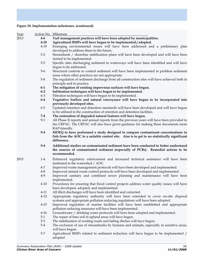
Summary Restoration Plan (RAP) – 2008 Update 56
Clinton River Area of Concern 11/01/2008
Figure 18. Implementation milestones. (continued) Year Action No. Milestone 2013 4-6 Turf management practices will have been adopted by municipalities.
4-18 Agricultural BMPs will have begun to be implemented / adopted. 4-19 Emerging environmental issues will have been addressed and a preliminary plan
developed to address them in the future. 5-2 Streambank / shoreline stabilization plans will have been developed and will have been
started to be implemented. 5-5 Specific sites discharging sediment to waterways will have been identified and will have
begun to be addressed. 5-6 Structural controls to control sediment will have been implemented in problem sediment
areas where other practices are not appropriate. 5-8 The regulation of sediment discharge from all construction sites will have achieved both in
principle and in practice. 6-1 The mitigation of existing impervious surfaces will have begun. 6-2 Infiltration techniques will have begun to be implemented.
6-3 Filtration techniques will have begun to be implemented. 6-4 Vegetative buffers and natural conveyance will have begun to be incorporated into
previously developed sites. 6-5 Updated retention and detention standards will have been developed and will have begun
to be utilized in the construction of retention and detention facilities. 7-4 The restoration of degraded natural features will have begun.
9-1 All Phase II reports and annual reports from the previous years will have been provided to the CRPAC. The CRPAC will also have given guidance for making these documents more RAP-friendly.
9-4 MDEQ to have preformed a study designed to compare contaminant concentrations in fish from the AOC to a suitable control site. Aim is to get to no statistically significant difference.
9-4 Additional studies on contaminated sediment have been conducted to better understand the sources of contaminated sediment (especially of PCBs). Remedial actions to be recommended.
2015 1-4 Enhanced regulatory enforcement and increased technical assistance will have been instituted in the watershed / AOC.
4-7 Improved waste management protocols will have been developed and implemented. 4-8 Improved animal waste control protocols will have been developed and implemented. 4-9 Improved sanitary and combined sewer planning and maintenance will have been
implemented. 4-10 Procedures for ensuring that flood control projects address water quality issues will have
been developed, adopted, and implemented. 4-11 All illicit discharges will have been identified and corrected.
4-12 Appropriate regulatory authority will have been extended to cover on-site disposal systems and appropriate pollution reducing regulations will have been adopted.
4-15 Improved regulation of marine facilities will have been established and appropriate pollution reducing measures will have been implemented.
4-16 Groundwater / drinking water protocols will have been adopted and implemented. 5-1 The repair of bare soil in upland areas will have begun. 5-3 The stabilization of eroding roads and failing ditches will have begun. 5-4 The exclusion of use of streambanks by humans and animals, especially in sensitive areas,
will have begun. 5-7 Agricultural BMPs related to sediment reduction will have begun to be implemented /
adopted
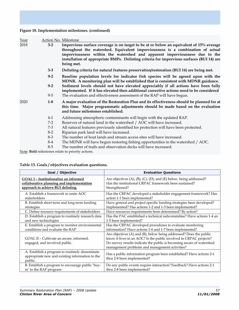
Summary Restoration Plan (RAP) – 2008 Update 57
Clinton River Area of Concern 11/01/2008
Figure 18. Implementation milestones. (continued) Year Action No. Milestone 2018 3-2 Impervious surface coverage is on target to be at or below an equivalent of 15% average
throughout the watershed. Equivalent imperviousness is a combination of actual imperviousness within the watershed and apparent imperviousness due to the installation of appropriate BMPs. Delisting criteria for impervious surfaces (BUI 14) are being met.
3-3 Delisting criteria for natural features preservation/restoration (BUI 14) are being met.
9-2 Baseline population levels for indicator fish species will be agreed upon with the MDNR. A monitoring plan will be established that is consistent with MDNR guidance.
9-2 Sediment levels should not have elevated appreciably if all actions have been fully implemented. If it has elevated then additional corrective actions need to be considered
9-5 The evaluation and effectiveness assessment of the RAP will have begun.
2020 1-8 A major evaluation of the Restoration Plan and its effectiveness should be planned for at this time. Major programmatic adjustments should be made based on the evaluation and future milestones established.
4-1 Addressing atmospheric contaminants will begin with the updated RAP. 7-2 Reserves of natural land in the watershed / AOC will have increased. 7-3 All natural features previously identified for protection will have been protected. 8-2 Riparian park land will have increased. 8-3 The number of boat lands and stream access sites will have increased. 8-4 The MDNR will have begun restoring fishing opportunities in the watershed / AOC. 8-5 The number of trails and observation decks will have increased. Note: Bold milestones relate to priority actions.
Table 13. Goals / objectives evaluation questions.
Goal / Objective Evaluation Questions
GOAL I – Institutionalize an informed collaborative planning and implementation approach to achieve BUI delisting.
Are objectives (A), (B), (C), (D), and (E) below, being addressed? Has the institutional CRPAC framework been sustained? Strengthened?
A. Establish a framework to unite AOC stakeholders
Has the CRPAC developed a stakeholder engagement framework? Has action 1-1 been implemented?
B. Establish short term and long term funding strategies
Have general and project specific funding strategies been developed? Implemented? Has actions 1-2 and 1-3 been implemented?
C. Define resource requirements of stakeholders Have resources requirements been determined? By action?
D. Establish a program to routinely research data and new technologies
Has the PAC established a technical subcommittee? Have actions 1-4 an 1-5 been implemented?
E. Establish a program to monitor environmental conditions and evaluate the RAP
Has the CRPAC developed procedures to evaluate monitoring information? Have actions 1-6 and 1-7 been implemented?
GOAL II – Cultivate an aware, informed, engaged, and involved public.
Are objectives (A) and (B), below being addressed? Does the public know it lives in an AOC? Is the public involved in CRPAC projects? Do survey results indicate the public is becoming aware of watershed management problems and management activities?
A. Establish a program to routinely disseminate appropriate new and existing information to the public.
Has a public information program been established? Have actions 2-1 thru 2-8 been implemented?
B. Establish a program to encourage public ‘buy-in’ to the RAP program
Do any public events require interaction? Feedback? Have actions 2-1 thru 2-8 been implemented?

Summary Restoration Plan (RAP) – 2008 Update 58
Clinton River Area of Concern 11/01/2008
Table 13. Goals / objectives evaluation questions. (continued)
Goal / Objective Evaluation Questions
GOAL III – Implement sustainable practices to ensure that environmental impacts from human activities are minimized (i.e. pollution is reduced) with a focus on protecting non-impacted headwaters and restoring heavily impacted downstream areas.
Are objectives (A - I) below, being addressed? Has water quality deteriorated in any part of the subwatershed? Has water quality been restored or enhance in any part of the subwatershed?
A. Establish a program to specifically identify and control sources of stressors,
Has action 1-7 been implemented?
B. Develop state-approved source water protection plans for drinking water supplies
How many SWPPs have been submitted to the MDEQ?
C. Minimize the water quality impacts resulting from residential areas.
Does monitoring data show load reductions for nutrients? Have there been incidences of excessive algae growth documented?
D. Minimize the water quantity and quality impacts that are the result of economic enterprises.
Does monitoring data show pollution associated with industrial sources? Have actions 2-2 and 4-2 been implemented?
E. Minimize the water quantity and quality impacts that are the result of recreational activities.
Have actions 8-1 thru 8-5 been implemented?
F. Address urban and residential land use, storm sewer, transportation infrastructure, and other development issues.
Have BMPs been implemented under action groups 3, 4, 5, and 6 that specifically reduce sediment, nutrients and BOD loadings?
G. Redevelopment should mitigate previous impacts.
Have BMPs been implemented under action groups 3, 4, 5, and 6 that specifically reduce sediment, nutrients and BOD loadings?
H. Minimize the water quantity and quality impacts that are associated with dams, lake level control structures.
Has action 4-10 been implemented?
I. Achieve zero discharge of toxic and bio-accumulative substances.
Does monitoring data show pollution associated with industrial sources? Have actions 2-2 and 4-2 been implemented?
GOAL IV – Protect the watershed from beneficial use impairments, or other problems, due to aesthetic issues.
Are objectives A and B below, being addressed? Has water quality deteriorated in any part of the subwatershed? Has water quality been restored or enhance in any part of the subwatershed?
A. Eliminate and prevent designated use impairments* due to unnatural pollution.
Have actions 4-1 thru 4-19 been implemented?
B. Preserve the character of the watershed Have actions 4-1 thru 4-19 and 7-1 thru 7-4 been implemented?
GOAL V – Protect the watershed from designated use impairment* – particularly for partial and total body contact recreation – or other problems due to the presence of pathogens from sewage discharges or other sources (e.g. animal waste from wildlife / pets).
Are objectives A thru E below, being addressed? Has water quality deteriorated in any part of the subwatershed? Has water quality been restored or enhance in any part of the subwatershed?
A. Ensure that all CSOs are meeting permit requirements
Is action 4-9 being implemented throughout the watershed?
B. Eliminate all known SSOs Is action 4-9 being implemented throughout the watershed?
C. Establish a program that identifies and corrects problems with on-site disposal systems
Is action 4-12 being implemented throughout the watershed?
D. Ensure that public beaches and other monitored locations meet water quality standards for pathogens.
Are partial and total body contact recreational opportunities impaired for any water body in the AOC? Have BMPs been implemented under action groups 3, 4, 5, and 6 that specifically reduce pathogen loadings? Is action 9-2 being implemented?
E. Ensure that no waterbodies in the AOC are listed by the MDEQ or otherwise considered impaired due to pathogens.
Are partial and total body contact recreational opportunities impaired for any water body in the AOC? Have BMPs been implemented under action groups 3, 4, 5, and 6 that specifically reduce pathogen loadings? Is action 9-2 being implemented?
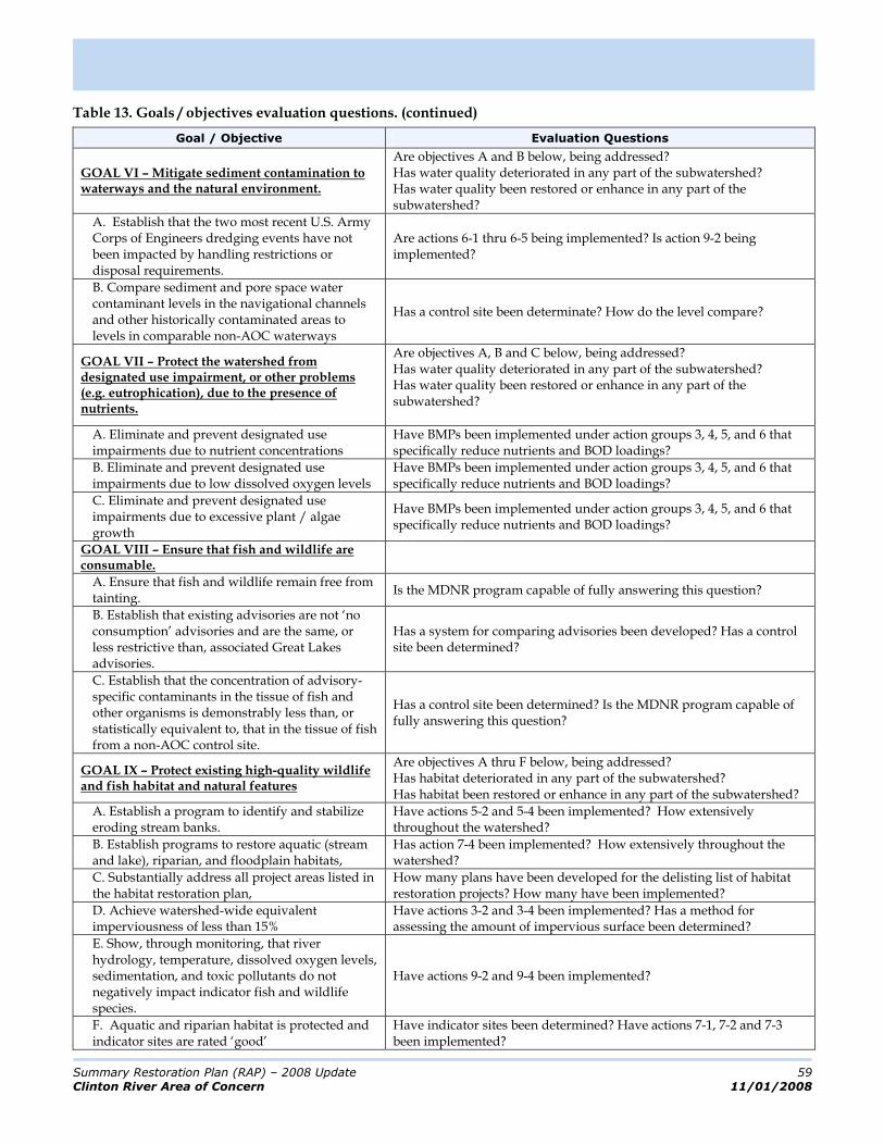
Summary Restoration Plan (RAP) – 2008 Update 59
Clinton River Area of Concern 11/01/2008
Table 13. Goals / objectives evaluation questions. (continued)
Goal / Objective Evaluation Questions
GOAL VI – Mitigate sediment contamination to waterways and the natural environment.
Are objectives A and B below, being addressed? Has water quality deteriorated in any part of the subwatershed? Has water quality been restored or enhance in any part of the subwatershed?
A. Establish that the two most recent U.S. Army Corps of Engineers dredging events have not been impacted by handling restrictions or disposal requirements.
Are actions 6-1 thru 6-5 being implemented? Is action 9-2 being implemented?
B. Compare sediment and pore space water contaminant levels in the navigational channels and other historically contaminated areas to levels in comparable non-AOC waterways
Has a control site been determinate? How do the level compare?
GOAL VII – Protect the watershed from designated use impairment, or other problems (e.g. eutrophication), due to the presence of nutrients.
Are objectives A, B and C below, being addressed? Has water quality deteriorated in any part of the subwatershed? Has water quality been restored or enhance in any part of the subwatershed?
A. Eliminate and prevent designated use impairments due to nutrient concentrations
Have BMPs been implemented under action groups 3, 4, 5, and 6 that specifically reduce nutrients and BOD loadings?
B. Eliminate and prevent designated use impairments due to low dissolved oxygen levels
Have BMPs been implemented under action groups 3, 4, 5, and 6 that specifically reduce nutrients and BOD loadings?
C. Eliminate and prevent designated use impairments due to excessive plant / algae growth
Have BMPs been implemented under action groups 3, 4, 5, and 6 that specifically reduce nutrients and BOD loadings?
GOAL VIII – Ensure that fish and wildlife are consumable.
A. Ensure that fish and wildlife remain free from tainting.
Is the MDNR program capable of fully answering this question?
B. Establish that existing advisories are not ‘no consumption’ advisories and are the same, or less restrictive than, associated Great Lakes advisories.
Has a system for comparing advisories been developed? Has a control site been determined?
C. Establish that the concentration of advisory-specific contaminants in the tissue of fish and other organisms is demonstrably less than, or statistically equivalent to, that in the tissue of fish from a non-AOC control site.
Has a control site been determined? Is the MDNR program capable of fully answering this question?
GOAL IX – Protect existing high-quality wildlife and fish habitat and natural features
Are objectives A thru F below, being addressed? Has habitat deteriorated in any part of the subwatershed? Has habitat been restored or enhance in any part of the subwatershed?
A. Establish a program to identify and stabilize eroding stream banks.
Have actions 5-2 and 5-4 been implemented? How extensively throughout the watershed?
B. Establish programs to restore aquatic (stream and lake), riparian, and floodplain habitats,
Has action 7-4 been implemented? How extensively throughout the watershed?
C. Substantially address all project areas listed in the habitat restoration plan,
How many plans have been developed for the delisting list of habitat restoration projects? How many have been implemented?
D. Achieve watershed-wide equivalent imperviousness of less than 15%
Have actions 3-2 and 3-4 been implemented? Has a method for assessing the amount of impervious surface been determined?
E. Show, through monitoring, that river hydrology, temperature, dissolved oxygen levels, sedimentation, and toxic pollutants do not negatively impact indicator fish and wildlife species.
Have actions 9-2 and 9-4 been implemented?
F. Aquatic and riparian habitat is protected and indicator sites are rated ‘good’
Have indicator sites been determined? Have actions 7-1, 7-2 and 7-3 been implemented?
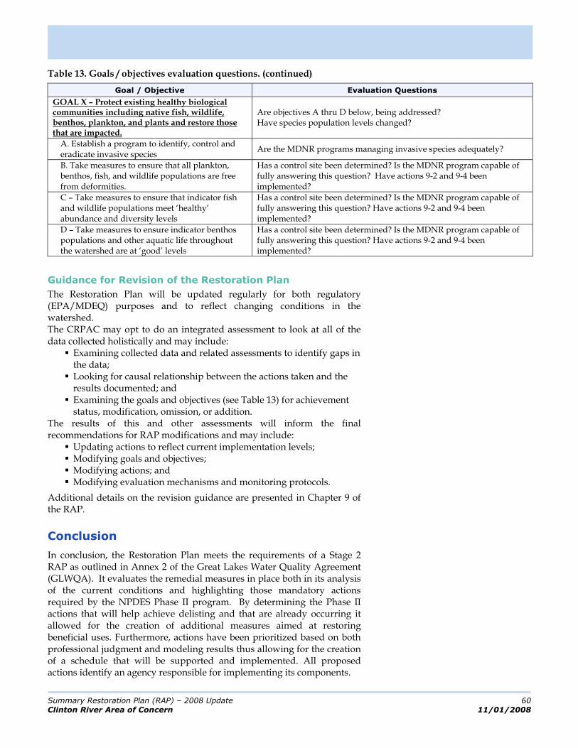
Summary Restoration Plan (RAP) – 2008 Update 60
Clinton River Area of Concern 11/01/2008
Table 13. Goals / objectives evaluation questions. (continued)
Goal / Objective Evaluation Questions
GOAL X – Protect existing healthy biological communities including native fish, wildlife, benthos, plankton, and plants and restore those that are impacted.
Are objectives A thru D below, being addressed? Have species population levels changed?
A. Establish a program to identify, control and eradicate invasive species
Are the MDNR programs managing invasive species adequately?
B. Take measures to ensure that all plankton, benthos, fish, and wildlife populations are free from deformities.
Has a control site been determined? Is the MDNR program capable of fully answering this question? Have actions 9-2 and 9-4 been implemented?
C – Take measures to ensure that indicator fish and wildlife populations meet ‘healthy’ abundance and diversity levels
Has a control site been determined? Is the MDNR program capable of fully answering this question? Have actions 9-2 and 9-4 been implemented?
D – Take measures to ensure indicator benthos populations and other aquatic life throughout the watershed are at ‘good’ levels
Has a control site been determined? Is the MDNR program capable of fully answering this question? Have actions 9-2 and 9-4 been implemented?
Guidance for Revision of the Restoration Plan
The Restoration Plan will be updated regularly for both regulatory (EPA/MDEQ) purposes and to reflect changing conditions in the watershed. The CRPAC may opt to do an integrated assessment to look at all of the data collected holistically and may include:
Examining collected data and related assessments to identify gaps in the data; Looking for causal relationship between the actions taken and the results documented; and Examining the goals and objectives (see Table 13) for achievement status, modification, omission, or addition.
The results of this and other assessments will inform the final recommendations for RAP modifications and may include:
Updating actions to reflect current implementation levels; Modifying goals and objectives; Modifying actions; and Modifying evaluation mechanisms and monitoring protocols.
Additional details on the revision guidance are presented in Chapter 9 of the RAP.
Conclusion
In conclusion, the Restoration Plan meets the requirements of a Stage 2 RAP as outlined in Annex 2 of the Great Lakes Water Quality Agreement (GLWQA). It evaluates the remedial measures in place both in its analysis of the current conditions and highlighting those mandatory actions required by the NPDES Phase II program. By determining the Phase II actions that will help achieve delisting and that are already occurring it allowed for the creation of additional measures aimed at restoring beneficial uses. Furthermore, actions have been prioritized based on both professional judgment and modeling results thus allowing for the creation of a schedule that will be supported and implemented. All proposed actions identify an agency responsible for implementing its components.

Summary Restoration Plan (RAP) – 2008 Update 61
Clinton River Area of Concern 11/01/2008
In addition to these required Stage 2 elements, Annex 2 of the GLWQA states that RAPs should embody a systematic and comprehensive ecosystem approach to restoring and protecting beneficial uses in Areas of Concern. Clearly, the solid natural resource foundation (chapter 3); the cause, source, stressor, and impact analysis; and the ability of the model to integrate natural processes and resulting pollutant levels meets this standard.
Finally, Annex 2 directs the RAP process to engage, in cooperation with State governments, the public and ensure it is consulted in all actions undertaken pursuant to this Annex. Over the two year period when this RAP was updated there have been over fifteen CRPAC meeting (open to the public) and two public information sessions each attended by over eighty people.
This Restoration Plan lays down a clear path toward restoring beneficial uses and delisting of the Clinton River Watershed as an AOC. Measurable progress should be detected by 2013, although delisting of the majority of the BUIs may take significantly longer. This plan recognizes that delisting is a long-term and complex effort. It plots, in a straightforward although exhaustive manner, the most expedient and logical path to success.

Summary Restoration Plan (RAP) – 2008 Update 62
Clinton River Area of Concern 11/01/2008
(THIS PAGE INTENTIONALLY LEFT BLANK)