closed loop boreholes geology & soilclosed loop boreholes geology & soil tim baker principal...
TRANSCRIPT

CLOSED LOOP BOREHOLES
Geology & Soil Tim Baker
Principal Hydro-Thermogeologist
B. A. Hydro Solutions
GSHPA Council Member
2nd July 2020
Ground Source Heat Pump Association Webinar Series 2020

Re-Cap…..
GSHPA Thursday talks as a response to lockdown, all available
on YouTube. The three previous Webinars:
1. Closed Loop Borehole Design – General
2. Closed Loop Borehole Design – Hydraulic
3. Closed Loop Borehole Design – Construction and Finishing
Today – Geology, hydrogeology, thermogeology, soils….

Today: Geology and Soil Conditions
• Why do you NEED to seriously consider the geology and soil?
• Who should consider the geology and soil?
• How can you consider the geology and soil?
• What to do with the information?
• When should you consider the geology and soil?

Why Consider Geology and Soil? Understanding the geology/soil is a critical part of the Feasibility Study, Risk Assessment and/or
Impact Assessment.
An understanding of the geology/soil should inform whether a project progresses, its
architecture, its design, its cost, how it operates, management and maintenance and the
success of a scheme!
The geology/soils is one third of the critical design trilogy!
Geology / Soil Conditions
The Heat Pump / Scheme
The Load(s)
If one or more of the three are not correctly dealt with in the design, the scheme will fail.

Who Should Consider Geology and Soil?
The geology and soil beneath the site can be considered in different ways and by different
parties involved with the design. Fundamentally:
The person/company responsible for designing the system must also take responsibility for the
geology/soil
The person /company responsible for the design should be confident and competent at
interpreting the geology
Or
They should engage someone who is and/or commission a desk study to correctly characterise
what is there.
There should be evidence of how the geology/soil was assessed to validate the design.

How To Consider Geology/Soil?
The 3 types of GSH&C systems require 3 different approaches
Vertical Closed Loop Collectors
Boreholes
Piles
Horizontal Closed Loop Collectors
Shallow pipes beneath lawns/parks/gardens/carparks
Multiple layers of horizontal pipes
Open Loop Systems
Abstraction/Injection Boreholes
Wells & adits
Mine workings (direct & indirect)
Surface water

Vertical Closed Loop Ground Collectors For these systems the following summarises the typical ways of starting to characterise the
ground conditions in the order they would normally occur:
Initial postcode/NGR check – normally free
Thermogeological Assessment (desk study)
Trial drilling
In-situ testing – Thermal Response Testing (TRT)
Laboratory testing – from cores and/or samples from fresh exposures
Geophysical surveying*

Horizontal Closed Loop Ground Collectors For these systems the following summarises the typical ways of starting to characterise the ground
conditions in the order they would normally occur:
Initial postcode/NGR assessment using soil maps
Occasionally a desk study can help, but ONLY where there is good data
Trial pits to visually assess the conditions present
In-situ thermal measurements of the ground
Laboratory testing of representative samples
Thermal Response Testing (TRT) on installed loops
Remote sensing*

Boreholes - Open Loop For these systems the following summarises the typical ways of starting to characterise the ground
conditions in the order they would normally occur:
Initial postcode/NGR check for viability and issues
Hydrogeological Assessment (desk study)
Trial boreholes
Pump testing of boreholes, wells, etc….
Tracer tests
What do I do with it?
• Make critical decisions on the direction the project should take
• Use the site specific geology/hydro/soil characterisation to develop the design
• Develop models to simulate the ground’s response to heat extraction and rejection
• Model fluid and heat movement through the ground to refine the model
• Refine the design each time new hydro-thermo-geological data becomes available
• Prepare impact assessments to assure the client, the regulator, stakeholders
• Select contractor based on the conditions anticipated
• Prepare before starting the ground works
• Avoid disasters
• Plan how to overcome issues that cannot be avoided
• Best understand how to manage the project, who needs to be involved/present

When To Consider the Geology/Soil Conditions? When should a project start to consider the ground conditions present?
• As soon as possible!
• Before major decisions have to be made
• Throughout the project
Start by ‘assessing’ what might be there in design iterations;
End, knowing what is there has been accounted for in the final design.
• Collect and interpret the drill cuttings
• Review the driller’s logs
• Measure the ground temperature
• Complete tests and incorporate the findings
• Photograph
• Sample
• Measure

Typical Process
Postcode
check Desk
Study & /
or Field
Testing Develop
& Refine
Design
Preliminary
Design
Excavate,
Record,
Measure,
& Test Revise
Design
Based on
Ground
Final
Design
Installed
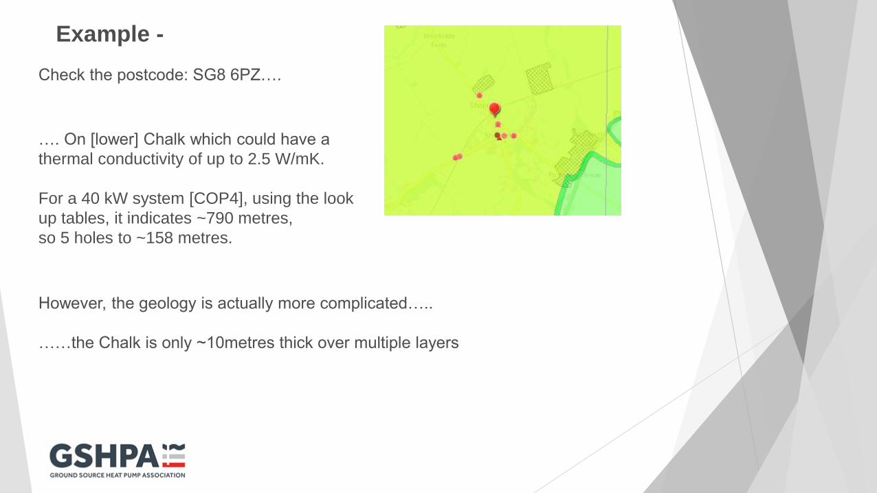
Example -
Check the postcode: SG8 6PZ….
…. On [lower] Chalk which could have a
thermal conductivity of up to 2.5 W/mK.
For a 40 kW system [COP4], using the look
up tables, it indicates ~790 metres,
so 5 holes to ~158 metres.
However, the geology is actually more complicated…..
……the Chalk is only ~10metres thick over multiple layers
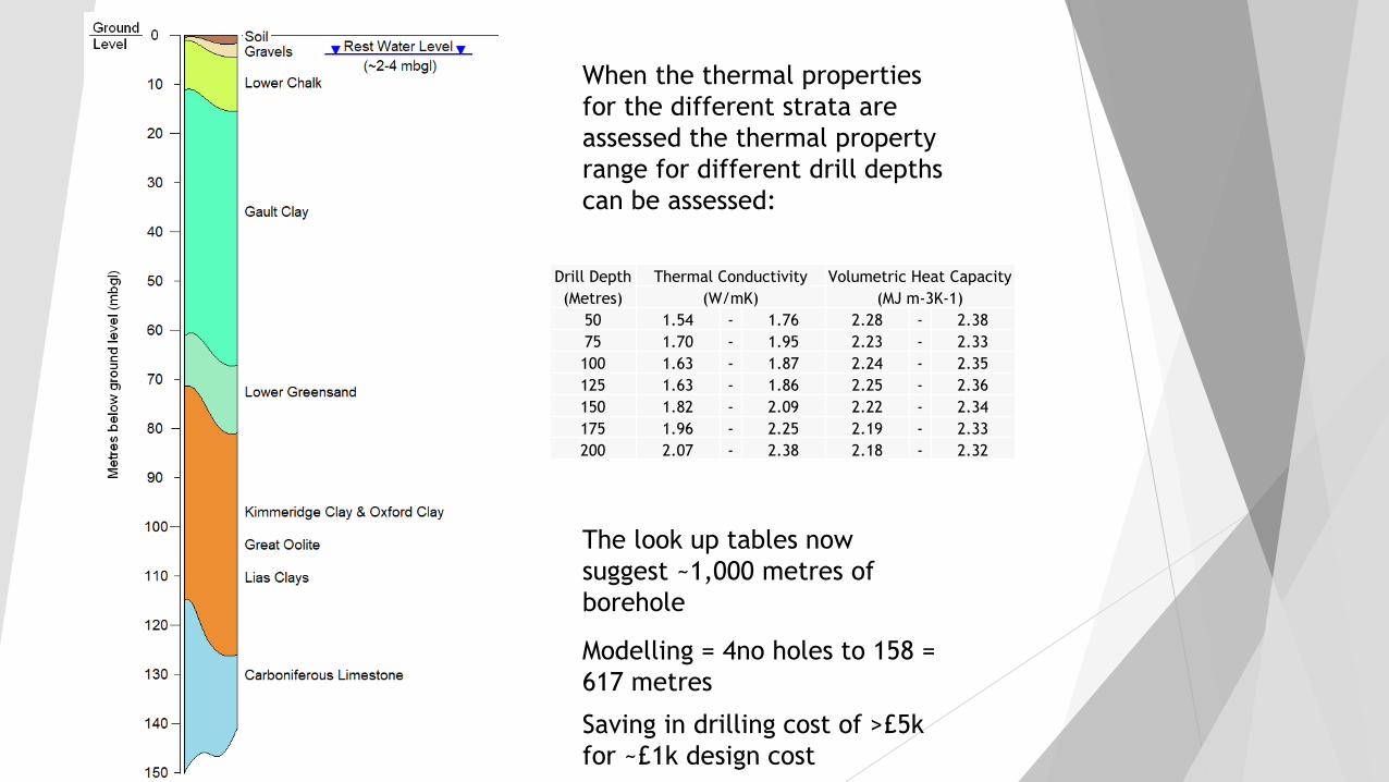
When the thermal properties
for the different strata are
assessed the thermal property
range for different drill depths
can be assessed:
The look up tables now
suggest ~1,000 metres of
borehole
Drill Depth Thermal Conductivity Volumetric Heat Capacity
(Metres) (W/mK) (MJ m-3K-1)
50 1.54 - 1.76 2.28 - 2.38
75 1.70 - 1.95 2.23 - 2.33
100 1.63 - 1.87 2.24 - 2.35
125 1.63 - 1.86 2.25 - 2.36
150 1.82 - 2.09 2.22 - 2.34
175 1.96 - 2.25 2.19 - 2.33
200 2.07 - 2.38 2.18 - 2.32
Modelling = 4no holes to 158 =
617 metres
Saving in drilling cost of >£5k
for ~£1k design cost

Questions…..
and thank you
www.gshp.org.uk
Tim Baker
B. A. Hydro Solutions Limited