closure plan for the borrow pit … of borrow pit 111215_az_1… · this report should be cited as...
TRANSCRIPT

Closure Plan
Coastal & Environmental Services i SANRAL: Closure plan
CLOSURE PLAN FOR THE BORROW PIT ASSOCIATED WITH THE NR6, SECTION 4 AT PENHOEK PASS, QUEENSTOWN
Prepared for:
Prepared by:
SANRAL Southern Region EOH Coastal & Environmental Services
P O Box 27230 Greenacres, 6057
P.O. Box 934 Grahamstown, 6140
South Africa South Africa
November 2015

This Report should be cited as follows: Coastal & Environmental Services, November 2015. Borrow Pit associated with the NR6, Section 4 at Penhoek Pass: Closure Plan, EOH CES, Grahamstown.

Closure Plan
Coastal & Environmental Services iii SANRAL: Closure plan
REVISIONS TRACKING TABLE
EOH Coastal and Environmental Services
Report Title: Mine Closure Plan for the Borrow Pit associated with the NR6 , Section 4 at
Penhoek Pass
Report Version: Draft Report
Project Number: 175
Name Responsibility Signature Date
Ayanda Zide Report Writer
Lara Crous Report Reviewer
Copyright
This document contains intellectual property and propriety information that are protected by
copyright in favour of EOH Coastal & Environmental Services (CES) and the specialist consultants.
The document may therefore not be reproduced, used or distributed to any third party without the
prior written consent of CES. The document is prepared exclusively for submission to SANRAL in
the Republic of South Africa, and is subject to all confidentiality, copyright and trade secrets, rules
intellectual property law and practices of South Africa.

THE PROJECT TEAM Ms. Lara Crous (Cand. Sci.Nat.) Senior Environmental Consultant Lara holds a BSc (Environmental Science and Geography) as well as a BSc Honours (Environmental Science) from Rhodes University. Her honours thesis evaluated Grahamstown’s Municipal water supply, focussing on aluminium for which she received a distinction. She is currently writing up her MSc (fisheries science) thesis on using constructed wetland technology in the treatment and beneficiation of brewery effluent. Lara presented her preliminary results at the International Water Association’s conference on Wetland Systems for Water Pollution Control in Venice (2010) and will present a case study titled “Turning of Industrial Wastewater into Irrigation water” at the constructed wetlands conference in Johannesburg later this year. With interests in environmental, municipal and effluent water quality, Lara has worked on and managed various EIA’s relating to mining, wind energy facilities, upgrading of roads as well as agri-production projects in South Africa, Mozambique as well as Cameroon. Lara is also experienced in undertaking water use licence applications, mining applications and environmental control officer / auditor duties. Ms Ayanda Zide, Environmental Consultant
Ayanda holds a BSc in Botany, Microbiology and Chemistry and a B.Sc. (Hons) in Botany where her thesis focused on identifying and characterising galls and gall forming insects and associated pathogens (Fungi) on the mangrove species Avicennia marina. Courses in her honours year included Diversity Rarity and Endemism (DRE), Pollination Biology, Estuarine Ecology, Rehabilitation Ecology, a Stats course and a short GIS course. Her research interests lie in biological invasion, conservation, rehabilitation ecology, plant biotechnology and water research. Ayanda conducts vegetation and impact assessments that guide proposed developments to reduce their impacts on sensitive vegetation. As part of these surveys she identifies and maps the vegetation communities and areas of high sensitivity. She has worked as a botanical assistant on the Lesotho Highlands Development Authority botanical baseline survey and has conducted groundtruthing surveys for developments in the Eastern Cape.

Closure Plan
Coastal & Environmental Services v SANRAL: Closure plan
KEY TERMS Ecological Succession: refers to more or less predictable and orderly changes in the composition or structure of an ecological community. Succession may be initiated either by formation of new, unoccupied habitat (e.g., a severe landslide) or by some form of disturbance (e.g. fire, severe wind , logging) of an existing community. Succession that begins in areas where no soil is initially present is called primary succession, whereas succession that begins in areas where soil is already present is called secondary succession. Habitat: An ecological or environmental area that is inhabited by a particular animal and plant species. It is the natural environment in which an organism lives, or the physical environment that surrounds (influences and is utilized by) a species population. Indigenous vegetation: Plants native to the locale in question. Species originating in a particular area are said to be indigenous plants for that area. Monitor: To monitor or monitoring generally means to be aware of the state of a system. The rehabilitation monitoring methodology is usually a standard and simple procedure that can be easily replicated over any vegetation community or rehabilitation area. Re-vegetation: re-vegetation implies restoration without the objective of reinstating a particular native ecosystem. In re-vegetation, any plant species is acceptable (for instance, sowing a mixture of commercially available grasses for soil rehabilitation) although a commercial crop or timber producing trees are often used. Replacement: is the establishment of a different type of vegetation on the degraded environment following construction, for example agriculture. Restoration: is the process of reconstituting a degraded system to its original state. Rehabilitation: is a general term that encompasses the replacement, restoration and re-vegetation, and is the process or programme implemented to achieve restoration or replacement.

TABLE OF CONTENTS
1. INTRODUCTION..................................................................................................................... 1
1.1 Project background and locality .................................................................................. 1 1.2 Project description ........................................................................................................ 4
...................................................................................................... 4 1.2.1 Mining permit/ right 4 1.2.2 Current status of the Borrow Pit associated with the NR6, Section 4 at Penhoek Pass ............................................................................................................. 4 1.2.3 Mining method ............................................................................................................ 4 1.2.4 Scale of mining ............................................................................................................... 4 1.2.5 Rehabilitation ............................................................................................................... 4 1.2.6 Water supply
2. LEGISLATION ........................................................................................................................ 6
3. DETAILS OF EAP .................................................................................................................. 9
3.1 Details of the EAP.......................................................................................................... 9 3.2 Expertise of the EAP ..................................................................................................... 9
4. CLOSURE OBJECTIVES ..................................................................................................... 11
5. REGULATORY REQUIREMENTS AND CONDITONS FOR CLOSURE .............................. 12
6. PERFORMANCE ASSESSMENT OF THE AREA ................................................................ 18
7. SUMMARY OF RISK ASSESSMENT ................................................................................... 21
8. PROGRESS OF REHABILITATION ..................................................................................... 27
8.1 Defining Rehabilitation................................................................................................ 27 8.2 Indigenous Vegetation- Ecosystem Rehabilitation ................................................... 28 8.3 Success of rehabilitation ............................................................................................ 28 8.4 Photographic evidence of disturbance caused by the Mining activity at the Borrow
Pit. ................................................................................................................................ 30 8.5 Photographic evidence of rehabilitation on the borrow pit area .............................. 32
9. METHODS OF DECOMMISIONING ..................................................................................... 34
10. MAINTENANCE AND MANAGEMENT REQUIRED ............................................................. 35
11. CLOSURE COST .................................................................................................................. 37
12. SKETCH PLAN .................................................................................................................... 38
12.1 Sketch Plan .................................................................................................................. 38
13. PUBLIC PARTICIPATION .................................................................................................... 40
13.1 Record of interested and affected persons consulted; ............................................ 40
14. REFERENCE ........................................................................................................................ 50

Closure Plan
Coastal & Environmental Services vii SANRAL: Closure plan
LIST OF TABLES Table 7-1: Table showing the Risks associated with the Borrow Pit associated with the NR6, Section 4 at
Penhoek Pass, EOH Coastal and Environmental Services rating without mitigation and
recommendations to deal with the risks. ......................................................................................... 22 Table 7-2 Ranking risks associated with the borrow pit according to the regulations....................................... 26 Table 11-1: Closure costs ...................................................................................................................................... 37 Table 13-1: Contact details of the neighbouring portions farm owners which were notified of the application
for a closure certificate for the Borrow Pit associated with the NR6, Section 4 at Penhoek Pass.
............................................................................................................................................................ 40 Table 13-2: Organs of State which were notified of the application for a closure certificate for the Borrow Pit
associated with the NR6, Section 4 at Penhoek Pass. .................................................................. 41
LIST OF FIGURES Figure 1.1: Locality map for the Borrow Pit associated with the NR6, Section 4 at Penhoek Pass. Project
area is located in Sterkstroom, near Dordrecht within the Eastern Cape. ........................................ 2 Figure 1.2: NFEPA River and Drainage lines occurring in the farm portion and wetlands occurring in the
surrounding areas of the Borrow pit location. ...................................................................................... 5 Figure 8.1: Diagrammatical Representation of the rehabilitation options from disturbance to full restoration
(adapted from Bradshaw, 1983). ........................................................................................................ 27 Figure 12.1: Illustrating the sketch plan for the disturbed area due to the Borrow Pit. ..................................... 39 Figure 13.1: Illustrating the surrounding landowners to the borrow pit. ............................................................. 41
LIST OF PLATES
Plate 1-1: Site Photographs of the Borrow Pit associated with the NR6, Section 4 at Penhoek Pass. ............. 3 Plate 8.1: A temporary concrete washing pond with PVC lining was established adjacent to the borrow pit. 30 Plate 8.2: Excavation activity at the farm portion RE/180 which resulted in the formation of a borrow pit. ..... 30 Plate 8.3: Spoil material that was stockpiled at the borrow pit area ................................................................... 31 Plate 8.4: Photograph illustrating infrastructure (storage units, slurry mixing plant) and activity (trucks, gravel
and topsoil) which were on the borrow pit area. .................................................................................. 31 Plate 8.5: Bare ground found to occur in the borrow pit area ............................................................................. 32 Plate 8.6: Small patches of vegetation have returned on the borrow pit area due to the application of Top
soil. .......................................................................................................................................................... 32 Plate 8.7: Removal of waste (litter and rubble). ................................................................................................... 33


Closure Plan
Coastal & Environmental Services 1 SANRAL: Closure plan
1. INTRODUCTION
1.1 Project background and locality The road upgrade of the National Route 6 section 4, Penhoek Pass (between Kilometers 52.0 and 66.2), between Queenstown and Jamestown in the Eastern Cape Province has resulted in the extension of an existing borrow pit to provide building material for the road upgrade. The borrow pit is situated on Remaining Extent of Farm Valschfontein No.180 (Figure 1.1). This borrow pit was mined for weathered dolerite to a depth of 2 - 5 metres and had a foot print of 5.3 ha. The mining of the borrow pit ceased in February 2015. Rehabilitation in this area has been on-going and has included the following:
Filling of the borrow pit with overburden, soil and crushed concrete aggregate.
Hazardous waste such as contaminated soils were safely removed and disposed of at an appropriate facility that accepts hazardous waste.
The ground at the borrow pit site was levelled and re-shaped.
Alien vegetation from the stockpiles and surrounding areas (road verge) was removed.
The area was hydro--seeded (October 2015) with Indigenous grasses which included (Eragrostis tef, Eragrostis curvula, Cynodon dactylon, Cenchrus ciliaris, Panicum maximum, Chloris gayana, Anthephora pubescens, Digitaria eriantha) to allow for the establishment of vegetation on the disturbed area.
Temporary structures and storage units on the site have been dismantled and removed. The South African National Roads Agency (SANRAL) is applying for a Closure Certificate for the borrow pit associated with the road upgrade of the National Route 6, Section 4 at Penhoek Pass. According to Section 57 (2a) of the Mineral and Petroleum Resources Development Act, A closure certificate application must be accompanied by A Closure Plan contemplated in regulation 62. .

Closure Plan
Coastal & Environmental Services 2 SANRAL: Closure plan
Figure 1.1: Locality map for the Borrow Pit associated with the NR6, Section 4 at Penhoek Pass. Project area is located in Sterkstroom, near Dordrecht within the Eastern Cape.

Closure Plan
Coastal & Environmental Services 3 SANRAL: Closure plan
1.2 Site description
Plate 1-1: Site Photographs of the Borrow Pit associated with the NR6, Section 4 at Penhoek Pass.
N W E S 31°28'47.3"S; 26°42'45.5"E

Closure Plan
Coastal & Environmental Services 4 SANRAL: Closure plan
1.2 Project description
1.2.1 Mining permit/ right Due to the mining of the borrow pit initially being a SANRAL project the exemptions provisions of Section 106(1) of the Act was applicable. Thus a mining permit was not applied for, but the use of any materials sources from the borrow pit was subject to an Environmental Management Plan (EMP) which was compiled in accordance with Regulation 51 of the MPRDA. The Environmental Management Plan was approved by DMR on the 4th January 2013.
1.2.2 Current status of the Borrow Pit associated with the NR6, Section 4 at Penhoek Pass The borrow pit is no longer operational, and all equipment and infrastructure has been removed from the site. The material from the borrow pit is no longer required and rehabilitation of the site has been on-going.
1.2.3 Mining method Mining at the borrow pit occurred through mechanical means with a frontend loader. No blasting took place at site. Once material was obtained from the borrow pit, it was then transported from the workface to the stock pile area where it was then collected by trucks and transported to the point of use. Oversize rock was crushed first to a preferred size and then stockpiled on site.
1.2.4 Scale of mining Material sourced at the borrow pit was weathered dolerite, where a total quantity of 100 000 m3 of material was extracted and used for the road upgrade. The extent of the mining was 120 608.49 m3.
1.2.5 Rehabilitation Rehabilitation of the area included the back filling of the borrow pit with overburden, soil and crushed concrete aggregate. Hazardous waste such as contaminated soils were safely removed and disposed of at an appropriate facility that accepts hazardous waste. The ground at the borrow pit site was levelled and re-shaped. Alien vegetation from the stockpiles and surrounding areas (road verge) was removed. The area was re-seeded with Indigenous grasses which included (Eragrostis tef, Eragrostis curvula, Cynodon dactylon, Cenchrus ciliaris, Panicum maximum, Chloris gayana, Anthephora pubescens, Digitaria eriantha) to allow for the establishment of vegetation on the disturbed area. Temporary structures and storage units that were on the site have been dismantled and removed. Due to Rehabilitation being an on-going process which may require additional inputs, the area will require on-going aftercare and maintenance to ensure that rehabilitation is successful.
1.2.6 Water supply There are no rivers or water courses within 32m and 500m respectively of the borrow pit, as seen on Figure 1.2. A drainage line occurs in the south-western section of the Valsfontein Farm (Re/180) and a number of wetlands are found on surrounding portions. To suppress dust on the borrow pit site, water was obtained from a borehole belonging to SANRAL. This borehole (S 31.530 E 26. 673) is located about 6.4 km away from the project area. General Authorisation (dated 20 August 2014) for the use of this borehole was obtained from Eastern Cape Water and Sanitation Department.

Closure Plan
Coastal & Environmental Services 5 SANRAL: Closure plan
Figure 1.2: NFEPA River and Drainage lines occurring in the farm portion and wetlands occurring in the surrounding areas of the Borrow pit location.

Closure Plan
Coastal & Environmental Services 6 SANRAL: Closure plan
2. LEGISLATION Legislation pertaining to a closure plan include:
i. Mineral and Petroleum Resources Development Act (MPRDA), Act No. 28 of 2002 ii. Mineral and Petroleum Resources Development Regulations, 23 April 2004 (No. R. 527)
iii. National Environmental Management Act (107/1998): Environmental Impact Assessment Regulations, 4 December 2014 (GN R.982)
SANRAL have ceased mining operations at the borrow pit associated with the NR6, Section 4 at Penhoek Pass and have subsequently rehabilitated the mine area. SANRAL are in the process of submitting an application for a closure certificate which requires the following documents:
A. A closure plan contemplated in regulation 62 of the MPRDA regulations (23 April 2004) as well as Appendix 5 of the EIA regulations (04 December 2014) (This document)
B. An environmental risk report contemplated in regulation 60 of the MPRDA regulations (23 April 2004) (Please refer to the Environmental Risk assessment document)
C. A final performance assessment report contemplated in regulation 55(9) of the MPRDA regulations (23 April 2004) (Please refer to this document)
D. A completed application form contemplated in regulation 58(1) of the MPRDA regulations (23 April 2004) (Please refer to the Closure certificate Application document).
As per the first requirement, this closure plan needs to comply with Regulation 62 of the MPRDA (Act 28 of 2002) as well as Appendix 5 of the EIA regulations which includes:
Appendix 5 (1 a) details of —
(i) The EAP who prepared the closure plan; and (ii) the expertise of that EAP
Regulation 62 (a) of the MPRDA regulations and Appendix 5 (1b):
Description of the closure objectives and how these relate to the prospecting or mine operation and its environmental and social setting;
Closure objectives are provided in Chapter 4, and their relevance to the mine closure and its environmental and social setting.
Regulation 62 (b) a plan contemplated in regulation 2(2), showing the land or area under closure;
Regulation 2(2)
(2) An application contemplated in subregulation (1) must be accompanied by a plan of the land to which the application relates, in accordance with generally accepted standards, signed and dated by the applicant and must contain —
(a) the co-ordinates and spheroid (Clarke 1880/Cape Datum, WGS84/WGS84, WGS94/Hartebeesthoek94) of the land to which the application relates;
(b) the north point;
(c) the scale to which the plan has been drawn;
Details of EAP have been provided in Chapter 3

Closure Plan
Coastal & Environmental Services 7 SANRAL: Closure plan
(d) the location and where applicable, the name and number of the land to which the application relates;
(e) the extent of the land to which the application relates;
(f) the boundaries of the land to which the application relates;
(g) surface structures and registered servitudes where applicable; and
(h) the topography of the land to which the application relates.
Appendix 5 (1c): An identification of the persons who will be responsible for the implementation of the measures contemplated in the closure plan
Regulation 62 (c) a summary of the regulatory requirements and conditions for closure negotiated and documented in the environmental management programme or environmental management plan, as the case may be;
Appendix 5 (1d): Proposed mechanisms for monitoring compliance with and performance assessment against the closure plan and reporting thereon;
Regulation 62 (d) a summary of the results of the environmental risk report and details of identified residual and latent impacts;
Summary of the environmental risks are provided in Chapter 7 of this report
Appendix 5 (1e) measures to rehabilitate the environment affected by the undertaking of any listed activity or specified activity and associated closure to its natural or predetermined state or to a land use which conforms to the generally accepted principle of sustainable development, including a handover report, where applicable;
Plan as contemplated in Regulation 2(2) is included in Appendix B
Borrow pit plan which was approved in the EMP has been added in
Appendix C
These are discussed in Chapter 5 of this report
Proponent (SANRAL) will ensure that the measures contemplated in the closure plan are implemented.
These are discussed in Chapter 6 of this report

Closure Plan
Coastal & Environmental Services 8 SANRAL: Closure plan
Regulation 62 (e) a summary of the results of progressive rehabilitation undertaken;
Measures to rehabilitated the environment and Summary of the results are provided in Chapter 8 of this report
Regulation 62 (f) a description of the methods to decommission each prospecting or mining component and the mitigation or management strategy proposed to avoid, minimize and manage residual or latent impacts;
These are provided in Chapter 9 of this report
Appendix 5 (1f) information on any proposed management or mitigation measures that will be taken to address the environmental impacts resulting from the undertaking of the activity and closure; Regulation 62 (g) details of any long-term management and maintenance expected;
Appendix 5 (g) description of the manner in which it intends to- (i) modify, remedy, control or stop any action, activity or process which causes pollution or environmental degradation during closure (ii) remedy the cause of pollution or degradation and migration of pollutants during closure; (iii)comply with any prescribed environmental management standards or practices; (iv) comply with any applicable provisions of the Act regarding closure;
Appendix 5 (h) time periods within which the measures contemplated in the closure plan must be implemented
Appendix 5 (I) the process for managing any environmental damage, pollution, pumping and treatment of extraneous water or ecological degradation as a result of closure; and
These are provided in Chapter 10 of this report
Regulation 62 (h) details of a proposed closure cost and financial provision for monitoring, maintenance and post closure management;
The proposed closure cost is provided in Chapter 11 of this report
Regulation 62 (i) a sketch plan drawn on an appropriate scale describing the final and future land use proposal and arrangements for the site;
Sketch plan and details are provided in Chapter 12.1 of this report Details of all public participation processes conducted according to Appendix 5 (j) and Regulation 63 (j).
Chapter 13 shows record of the notification of Interested and affected persons and the comments received.
Closure Plan
Coastal & Environmental Services 9 SANRAL: Closure plan
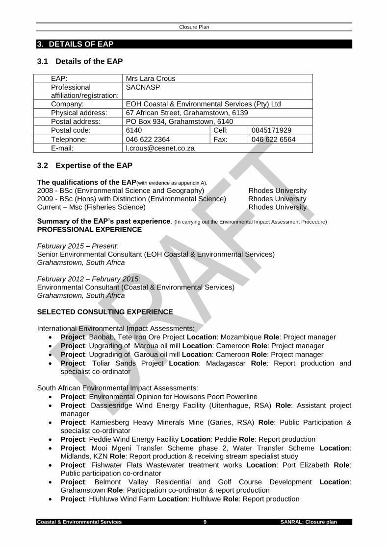
3. DETAILS OF EAP
3.1 Details of the EAP
EAP: Mrs Lara Crous
Professional affiliation/registration:
SACNASP
Company: EOH Coastal & Environmental Services (Pty) Ltd
Physical address: 67 African Street, Grahamstown, 6139
Postal address: PO Box 934, Grahamstown, 6140
Postal code: 6140 Cell: 0845171929
Telephone: 046 622 2364 Fax: 046 622 6564
E-mail: [email protected]
3.2 Expertise of the EAP
The qualifications of the EAP(with evidence as appendix A). 2008 - BSc (Environmental Science and Geography) Rhodes University 2009 - BSc (Hons) with Distinction (Environmental Science) Rhodes University Current – Msc (Fisheries Science) Rhodes University
Summary of the EAP’s past experience. (In carrying out the Environmental Impact Assessment Procedure)
PROFESSIONAL EXPERIENCE February 2015 – Present: Senior Environmental Consultant (EOH Coastal & Environmental Services) Grahamstown, South Africa February 2012 – February 2015: Environmental Consultant (Coastal & Environmental Services) Grahamstown, South Africa SELECTED CONSULTING EXPERIENCE International Environmental Impact Assessments:
Project: Baobab, Tete Iron Ore Project Location: Mozambique Role: Project manager
Project: Upgrading of Maroua oil mill Location: Cameroon Role: Project manager
Project: Upgrading of Garoua oil mill Location: Cameroon Role: Project manager
Project: Toliar Sands Project Location: Madagascar Role: Report production and specialist co-ordinator
South African Environmental Impact Assessments:
Project: Environmental Opinion for Howisons Poort Powerline
Project: Dassiesridge Wind Energy Facility (Uitenhague, RSA) Role: Assistant project manager
Project: Kamiesberg Heavy Minerals Mine (Garies, RSA) Role: Public Participation & specialist co-ordinator
Project: Peddie Wind Energy Facility Location: Peddie Role: Report production
Project: Mooi Mgeni Transfer Scheme phase 2, Water Transfer Scheme Location: Midlands, KZN Role: Report production & receiving stream specialist study
Project: Fishwater Flats Wastewater treatment works Location: Port Elizabeth Role: Public participation co-ordinator
Project: Belmont Valley Residential and Golf Course Development Location: Grahamstown Role: Participation co-ordinator & report production
Project: Hluhluwe Wind Farm Location: Hulhluwe Role: Report production

Closure Plan
Coastal & Environmental Services 10 SANRAL: Closure plan
Project: Richards Bay Wind Energy Facility Location: Richards Bay Role: Traffic and transport assessment
Basic Assessments:
Project: Grahamstown to Fish River Bridge N2 upgrade Location: Grahamstown Role: Project manager & report production
Project: Healdtown wastewater treatment works upgrade Location: Fort Beaufort Role: Project manager & report production
Project: N10 section 3 road upgrade Location: Cradock Role: Project manager & report production
Project: R61 section 2 road rehabilitation Location: Cradock Role: Project manager & report production
Project: Re-routing of Eskom Powerline Location: Grahamstown Role: Report production
Environmental Management Plans, Environmental Control Officer
Project: Waainek Wind Energy Facility ECO Location: Grahamstown
Project: G&W Base Strowan Mine EMPr revision Location: Grahamstown
Project: G&W Base Albertinia Mine Financial closure report Location: Albertinia,
Project: G&W Base Plettenberg Bay Mine Financial closure report Location: Plettenberg Bay
Project: Makana Brick update EMPr and financial costing Location: Grahamstown
Financial close costing reports for Strowan, Albertinia and Plettenberg Bay, Makana Brick Mines
Aquatic / Surface Water Quality specialist Reports
Project: Baobab Tete Iron Ore Project Location: Tete, Mozambique. Role: surface water quality testing and aquatic invertebrate collection using the South African Scoring System (SASS) 5 method, data analysis and interpretation and report production.
Project: Triton Graphite Mine Location: Montepuez, Mozambique. Role: surface water quality testing and aquatic invertebrate collection using the South African Scoring System (SASS) 5 method, data analysis and interpretation and report production.
Short courses provided by CES:
Environmental Impact Assessment Course co-ordinator as well as facilitator, 2014
Environmental Impact Assessment Course facilitator, 2013
Integrated Coastal Zone Management training course assistance, 2013 Mining applications:
Mining Application for Hard Rock Quarry and borrow pits for N10-3 road upgrade
Mining Application for Hard Rock Quarry and borrow pits for R61-2 road upgrade
Mining Application for Hard Rock Quarries and borrow pits for N2 road upgrade Water Use License applications:
General authorisation for N10-3 road upgrade
General authorisation for R61-2 road upgrade
General authorisation for N2 road upgrade
General authorization for stabilization of slope along N10-3

Closure Plan
Coastal & Environmental Services 11 SANRAL: Closure plan
4. CLOSURE OBJECTIVES This chapter is in accordance with regulation 62 of the MPRDA (Act 28 of 2002) as well as Appendix 5 of the EIA regulations. The closure objectives provided below are to ensure that the closure of the mine is compliant with the legislation and that the environment will be left in a state which is sustainable and not harmful. Mining has ceased in this area (in February 2015), and all infrastructure or working equipment has been removed from site. Thus the safety aspect relating to mining activities and equipment has already been dealt with.
The objectives for the closure for the Borrow pit associated with the NR6, Section 4 at Penhoek Pass (Environmental and Social Setting) are:
To ensure closure complies with the Mineral and Petroleum Resources Development Act 28 of 2002.
To ensure that the mining footprints are rehabilitated to an acceptable standard, where there is ecosystem functioning and that all environmental and social risks have been reduced and do not pose any threat to the environment post mine-closure.
To ensure that the goals which were specified in the Environmental Management Plan (EMP) have been met and that the land may have sustainable use.
To implement management strategies that will ensure that the negative impacts (risks) associated with the borrow pit are eliminated or minimized to acceptable standards.
To leave the area in a manner that is environmentally safe and does not pose any health risks to the neighbouring communities.
To propose a monitoring programme, that will ensure that strategies that have been proposed in the risk assessment have been implemented and will help determine the progress of rehabilitation. This is important as it will help determine the success of rehabilitation and ensure that the area is left in good condition.

Closure Plan
Coastal & Environmental Services 12 SANRAL: Closure plan
5. REGULATORY REQUIREMENTS AND CONDITONS FOR CLOSURE An EMP is created to implement a sound environmental management system. It represents company’s commitment to addressing and managing the potential negative and positive impacts associated with the construction, operation and closure phases of a project.
The environmental management plan for the borrow pit (including a Quarry) was approved, in terms of section 39 (4) by the Department of Mineral and Energy Affairs in January 2013. The Relevant Regulatory requirements and conditions for the Environmental Management Plan are provided below and those relevant to the borrow pit and current stage of the mining process have been highlighted, monthly audits were carried out at the site to ensure that the following conditions were adhered to. Where conditions or requirements were not adhered to, the client was given an opportunity to rectify the non-compliance. A total of 21 Audits to date (16th October 2015).
1. A fence must be erected around the mine area in order to prevent livestock and people from entering the quarry area. Entry and exit to the quarry site must be controlled.
Comment: A fence around the borrow pit area was already present, thus farm owner will remove if he wishes to.
2. Signage indicating the intersection of the haulage road with the main mid must be clearly visible and the intersection must be well maintained to ensure road safety. The required heavy vehicle signs must be erected at the access to the mining areas as per the provisions of the Road Traffic Act in order to ensure road safety.
Comment: Condition is not applicable to the above mentioned project, but according to the audits this condition was adhered to.
3. Before mining commences, any slow moving animals must be relocated to areas outside of
the approved prospecting/aligning area
Comment: Prior to the mining activity at the borrow pit, slow moving animals were relocated outside the borrow pit area. This condition was adhered to.
4. Mining will not progress beyond the approved mine area and no areas outside of the
approved mine area will be disturbed. Vehicles will not drive over rehabilitated areas to prevent the destruction of established vegetation.
Comment: Monthly audits show that this was adhered to, as there was compliance to the following restrictions:
o EMP 5.3.1 has the footprint of working areas been kept to a minimum to reduce the total physical construction footprint?
o EMP 5.3.1 was proper demarcation in place prior to construction commencing?
o EMP 5.3.1 Are all activities, materials, equipment and personnel restricted within the areas specified and not allowed to enter the “no go" areas at any time?
Comment: Site Visit indicated that mine area did not progress beyond the approved mining area and there was no evidence of destruction of established vegetation in the area, thus one can conclude that with regards to the borrow pit area this condition was adhered to.

Closure Plan
Coastal & Environmental Services 13 SANRAL: Closure plan
5. A phased development approach must be adopted and rehabilitation must occur concurrently with mining activities. Should the applicant neglect the phased rehabilitation, then all mining operations will be temporarily suspended until the applicant has rectified the situation and has successfully conducted phased rehabilitation, to the satisfaction of the Department of Mineral Resources.
Comment: Rehabilitation began during the mining activities, where alien invasive species were removed on the project area, other activities which were set out in the rehabilitation plan could only be implemented once the mining operations had ceased. These includes the filling of the borrow pit, the re-shaping of the area and the re-seeding of the area so that there could be a return of the vegetation which was lost due to the mining activity at the site.
6. All topsoil must be stockpiled and used in the rehabilitation of the borrow pits and topsoil
must be kept separate from the overburden, and must be stockpiled in an allocated area. The indigenous grass species that already exist on site must be used in later re-vegetation.
Comment: Topsoil was stockpiled and used during the rehabilitation of the borrow pit. According to the audits, strip and store topsoil was kept separate and did not exceed a height of 1.5 m and was kept in the approved area which was close to the area of use (EMP 5.4.1). During the re-vegetation grasses such as Eragrostis tef, Eragrostis curvula, Cynodon dactylon, Cenchrus ciliaris, Panicum maximum, Chloris gayana, Anthephora pubescens, Digitaria eriantha were used, these are indigenous species. Thus this condition was adhered to.
7. After mining is complete, all the overburden and rock material will be returned to the quarry
and used to level the slopes.
Comment: Condition is not applicable to the above mentioned project.
8. Soil erosion prevention measures must be carried out progressively. Slope stability must be monitored continuously and any rill or gully erosion must be rectified immediately by filling in any such areas with topsoil followed by seeding with an appropriate seed mix. Should the sides of the quarry become prone to erosion, temporary contours must be constructed above the slope and the middle thereof and if the contours are not entirely effective, then geofabrick must be imbedded in the soil at these problematic areas to retain soil particles but still allow for adequate drainage.
Comment: According to the monthly audits the slope stability was monitored continuously to prevent erosion at the mining site area.
9. All alien species must be removed from the site and measures must be put in place to
control the spread of alien invasive plant species. Alien invader plants must be controlled by felling, uprooting or treated with a registered herbicide.
Comment: Monthly audits reveal that alien invasive species were controlled on the site. There were incidents were Alien invasive species were found to occur on the topsoil stockpiles and these were managed as suggested above.
Comment: Site visit indicated that in the surrounding areas a single alien invasive species according to NEM:BA (Alien and Invasive Species (AIS) Regulations) was found to occur and a number of annual weedy species were also found to occur on the project area. There should be a continuation of the removal of alien invasive species on site during the maintenance and after care of the project area.
10. No trespassing on the landowners property may occur and employee access must be
restricted to the approved mine areas. No poaching or interference with stock or wild

Closure Plan
Coastal & Environmental Services 14 SANRAL: Closure plan
animals and no theft will be allowed. No person may carry out a restricted activity in terms of TOPS regulations ie. killing, catching, hunting, capturing by any method or device including searching, injuring with intent to hunt, catch or kill any such specimen involving a TOPS specimen without a TOPS permit. To discourage access to the surrounding veld, the quarry area must be fenced and all quarry employees are to remain within the approved mining areas. The applicant will take full responsibility for any animal that is proved to be killed by members of quarry staff. Strict control measures will be put in place and severe penalties will be applicable if any animal on site is poached, hunted, snared or killed. The applicant will implement an environmental awareness programme and ensure that all staff are coherent in the above regard.
Comment: Environmental awareness training document was prepared by the contractor reviewed by the ECO and accepted and finalized. This document was then implemented, and monthly audits ensured that all the staff adhered to the requirements and conditions above.
11. Open fires will not be allowed on the mine area, except at a designated cooking area, to safeguard the land-use of the property as well as those of the abutting properties. In this case, tire fighting equipment must be available to extinguish any fires should this be necessary.
Comment: Open fires were not allowed in the borrow pit area. Fire extinguishers were placed in strategic locations at site camp and an emergency response plan was developed. Thus a procedure and fire equipment was put in place to extinguish any fires if necessary.
12. No borehole water will be used, unless an agreement has been reached with the landowner.
Comment: The Contractor obtained general authorisation for the use of the borehole located within SANRAL Road Reserve. Water from the borehole was used for dust suppression on the borrow pit site. The borehole is located S 31.530 E 26. 673. This borehole is about 6.4 km from the borrow pit.
13. Water must be properly controlled to prevent unnecessary and unsafe accumulations that
may pose a risk to the safety of people. No pollution of any surface or underground water shall take place and protection measures must be put in place to address any forms of water pollution. Anti-erosion measures (contours, berms, trenches, energy dissipaters etc.) shall be implemented, and a storm water management plan imposed to ensure proper control of runoff. Any water accumulated in the borrow pits must be pumped out to a settling pond and can then be released into the natural drainage lines. Spill areas must be protected from erosion by applicable dissipation hems_ the applicant must ensure that all storm water discharged off site must meet the Department of Water Affairs standards for water quality.
Comment: Audits and Site visit to the borrow pit indicated that borrow pit has been backfilled and re-shaped which has resulted in the surface being flat. Thus there is no accumulation of water in the borrow pit area, there was no evidence of erosion on the site and there was no unnecessary and unsafe accumulations of water that may pose a risk to the safety of people. Thus this has been adhered to.
14. All storage tank areas must be bunded and workshop and wash bay floors are to be
constructed with drainage to an oil trap system and provision must be made for the use of servicing aprons, Any fuel or oil spillages must be handled immediately and removed from site and disposed of at a licensed facility.

Closure Plan
Coastal & Environmental Services 15 SANRAL: Closure plan
Comment: According to the Audit reports this condition has been adhered to.
15. The required monitoring system and dust allaying practices must be implemented to curb excessive dust generation at the borrow pits and the NEMA and SASS standards regarding dust and noise emissions shall be applicable.
Comment: Dust was suppressed on the site by application of water from a borehole. According to the Audits this condition was adhered to, and dust generation and noise emissions were monitored on the site.
16. Waste must be removed from the mining site on a continuous basis to a registered waste disposal site. Comment: According the Audits this condition has been adhered, a record (certificate of disposal) was kept in the environmental file.
17. Chemical toilets must be provided for employees or contractors on site. Chemical toilets must be maintained according to the Municipal by-laws or specifications issued by a Local Health Inspector. Please ensure that sanitation facilities are not located near any water resources or water drainage areas. Comment: Temporary/ Portable and secured to the ground toilets were made available to the employees and contractors onsite. These toilets were clean and supplied with toilet paper and hand washing soap and serviced every two weeks. Ablutions were emptied regularly and before the Contractors’ holidays, during temporary site closures and prior to site closure. The conditions/status of the toilets was monitored monthly during the audits and where there was non-compliance this was rectified to ensure that these facilities were hygienic. These toilets were located more than 50m from any water body and water drainage lines.
18. Any fuel or oil spillages must be handled immediately and removed from site and disposed
of at a licensed facility. Drip trays will be used when refuelling or servicing any vehicles, and
leaking equipment will be repaired immediately. Fuel tanks must be contained within a bunded area. Comment: Audit reports indicate that this condition was adhered to.
19. Should any fossil or article of cultural or archaeological importance be uncovered, this must immediately be reported to the South African Heritage Resources Agency (SAHRA). Comment: Audit reports indicate that this condition was upheld, Action which was audited was: “If any paleontological/archaeological material is found during excavations, including shell middens, Stone Age tools, fossil bones and other artefacts, graves and wrecked vessels, the Contractor shall stop work immediately and inform the Engineer and SAHRA”.
20. An ECO must be appointed to conduct regular site inspections to ensure and oversee the rehabilitation process and annual reports in terms of performance assessment and compliance with the environmental management plan and conditions of approval must be submitted to the Department of Mineral Resources. Comment: During the life of the borrow pit and during rehabilitation, monthly audits were conducted by ECO at the site, to inspect the site and determine if the EMP was adhered to. Thus this condition has been adhered to.

Closure Plan
Coastal & Environmental Services 16 SANRAL: Closure plan
21. All sections and regulations of the Environment Conservation Act (73 of 1989) dealing with the disposal of solid waste, must be adhered to. No littering or illegal dumping of any waste will take place on site. Comment: Site visit indicated that there was some littering on the site, which may be a
result of the area being near a national road. Litter and all waste have been removed from site since site visit. The proponent should ensure that this does not occur during maintenance and aftercare stage.
22. Mining must take place in accordance with the environmental management plan and the mitigation measures established therein, and the provisions of the Mine Health and Safety Act (29 of 1996). Activities not covered by the environmental management plan may not commence at the site until the Department of Mineral Resources has assessed and approved the necessary documentation submitted in this regard. Comment: According to the monthly audits this condition was adhered to.
23. In terms of the Mine Health and Safety Directorate requirements, (I) the mining or prospecting must take place in accordance with the environmental management plan, (ii) the mine area must be fenced off to prevent unauthorised access, (iii) water must be properly controlled to prevent unnecessary and unsafe accumulations that may pose a risk to persons, (iv) the applicant must comply fully with the Mine Health and Safety Act (29 of 1996) and subordinate legislation. In particular the regulations 17.6; 17.8; 1714 and 4.6 are highlighted. (v) should blasting be necessary, the Principal Inspector of Mines must be notified two weeks prior to such blast in order that an Inspector can attend the blast.
Comment: According to the monthly audits this condition was adhered to.
24. A minimum aftercare period of two years will be applicable once the area has been rehabilitated successfully. During this period the applicant must re-seed areas where vegetation fairs to re-establish and stabilize any unstable areas, rectify any erosion and maintain storm water control structures. Comment: No storm water control structures were put in place as these were not required for the borrow pit areas. The area has been seeded and vegetation has not established. Should vegetation not establish in the area, alternative methods maybe used to encourage the establishment of vegetation in the area, such the application of mulch and cuttings of vegetation in the area and planting in the bare areas. Financial provision of R10 249.00 has been recommended to ensure that this area is maintained and left in a manner which is sustainable, environmentally safe and adheres to the Environmental Management Plan and other applicable legislation and regulations.
25. If mining is to be terminated, either temporarily or permanently, The Department of Mineral Resources must be informed of such a decision 14 days prior to the termination of mining activities. Comment: Mining activities on the project area ceased in February 2015, the material that was already mined in the area was still used and rehabilitation continued in this area. There was correspondence between DMR and Sanral (7th of September and 07 October 2015) informing them of the intention to apply for a closure certificate for the borrow pit. A Letter dated 11 November 2015 was received from DMR approving the proposed rehabilitation and granting Sanral permission to go ahead with closure application (Please see Appendix C).
26. All relevant requirements of existing legislation pertaining to the protection of the biophysical and social environment must be adhered to, including but not limited to: ▪ Mineral and Petroleum Resources Development Act (28 of 2002) • National Environmental

Closure Plan
Coastal & Environmental Services 17 SANRAL: Closure plan
Management Act (107 of 1998) • Environmental Conservation Act (73 of 1998) ▪ Resource Conservation Act (43 of 1983) ▪ National Heritage Resources Act (25 of 1999) Comment: Legislation pertaining to the protection of the biophysical and social environment has been adhered to.
27. Please be advised that it is the applicants duty to conduct monthly site inspections and to undertake environmental performance assessments on an annual basis or as required by the Department of Mineral Resources. In the event of any dispute, the Department's opinion will prevail, until it can be scientifically proven by an independent assessor that the Department's opinion is incorrect, at the expense of the applicant (as per regulation 55(7) of the MPRDA (28 of 2002)).
Comment: Condition has been adhered to as monthly audits have been conducted. During the Site visit, a Performance assessment was conducted.

Closure Plan
Coastal & Environmental Services 18 SANRAL: Closure plan
6. PERFORMANCE ASSESSMENT OF THE AREA
a) Period Applicable for this Performance Assessment
Assessment was conducted in 22 October 2015 The state of mining was examined at the borrow pit and found to be in accordance with the
Environmental Management Plan. Mining has ceased (February 2015) in this area and all infrastructure has been removed. The establishment of vegetation in this area has not yet been successful and would require some monitoring and probably another activity of re-seeding the area preferably before the end of the current season i.e. by February 2016.
b) Scope of the Assessment
This assessment included: 1. Legal requirements 2. Financial Provision 3. Site Inspection of the Mine area 4. Site inspection of the infrastructure 5. Site inspection of the rehabilitation
c) The Procedure used for the Assessment
The procedure used for the assessment was a site visit carried out on the 22 October 2015.
d) The Interpreted Information gained from Monitoring the approved Environmental Management Plan
An EMP dated (July 2013) for the Borrow pit (and Quarry) has been used to monitor the state of the borrow pit area. The mining operation has ceased in this area and infrastructure had been removed with the exception of the fence around the area and storm water management infrastructure remains on the mined area.
e) The Evaluation Criteria used during the assessment.
The criteria used during the assessment were as follows: 1. Legal compliance 2. Financial provision 3. Area of rehabilitation 4. Area containing alien vegetation
f) Results of the Assessment
1. Legal Compliance Evidence of Legal Compliance is also based upon information obtained from the
monthly audits. The site visit indicated that the Environmental Management Plan was
implemented and rehabilitation programme was followed as it had indicated so in the rehabilitation plan.
2. Financial Provision A closure cost was determined by EOH Coastal and Environmental Services,
this took into consideration the rehabilitation to be conducted in the impacted area and the removal of alien invasive species.
Financial Provision was determined by using the Guideline document for the evaluation of the quantum of closure – related financial provision provided by a mine (Department of Minerals and Energy, January 2005).
A bank Guarantee is not required as this is a SANRAL project

Closure Plan
Coastal & Environmental Services 19 SANRAL: Closure plan
3. Area of rehabilitation
The whole area which was disturbed by the mining activity is still undergoing rehabilitation. Vegetation has only established in small patches due to the application of topsoil but most of the area still remains bare. Rehabilitation strategies should be continued in the area to ensure that there is a return of indigenous vegetation in this area and to leave the area in a manner. This will be done by backfilling the pit, covering the area with topsoil as well as mulch and cuttings of the natural vegetation to encourage re-vegetation in this area.
4. Areas containing Alien Vegetation Alien invasive species Argemone ochroleuca was present on the site and other
weedy species, these will have to be eradicated. Guidelines and recommendations with dealing with alien species has been
provided in the Risk Assessment report, these should be applied to ensure that alien species are controlled on the project area.
Active management and monitoring or alien species should be put in place during the maintenance and after-care period at the site
Activities that remain to be continued on the site is the maintenance and aftercare of the area, which includes monitoring of rehabilitation and ensuring that there is an establishment of vegetation on the bare areas of the project. It is recommended that SANRAL conducts quarterly monitoring assessments and yearly performance assessments against the closure plan this will ensure that risks associated with the borrow pit area have been minimised. A record of the progress of rehabilitation should be kept and advise of other measures should be implemented in the area if rehabilitation is not going in the direction of the desired state.
g) Recommendations on how and when non-compliance and deficiencies will be rectified 1. Legal compliance
The site area is consistent with the rehabilitation plan. 2. Financial provision
EOH Coastal and Environmental Services has provided the closure cost that will be required to sufficiently rectify all the risks that are associated with the borrow pit. Please refer to section 11 of this report
3. Area of rehabilitation
Currently the only concern is on the establishment of vegetation in this area as this will minimise/eliminate most of the risks associated with the borrow pit.
Rehabilitation takes time, thus the progress of the rehabilitation area will have to be monitored, and this may take a number of years before the area is in a state which is similar to that of the unmined areas (surrounding areas).
4. Area containing alien vegetation
Clearing of the alien vegetation should be conducted, following the guidelines provided. The control of alien invasive species will require continued maintenance. The site visit indicated that active control on the project area can be achieved as alien invasion is not extensive on the site.

Closure Plan
Coastal & Environmental Services 20 SANRAL: Closure plan
Activities that remain to be continued on the site is the maintenance and aftercare of the area, which includes monitoring of rehabilitation and ensuring that there is an establishment of vegetation on the bare areas of the project. It is recommended that SANRAL (client) monitors compliance and performance assessment against the closure plan and reporting thereon. It is suggested that it conducts quarterly monitoring assessments on the site for the next two years to ensure that the risks associated with the borrow pit area have been minimised. A record of the progress of rehabilitation should be kept and other measures should be implemented if the area is not going in the direction of the desired state.

Closure Plan
Coastal & Environmental Services 21 SANRAL: Closure plan
7. SUMMARY OF RISK ASSESSMENT An analysis of the Borrow Pit associated with the NR6, Section 4 at Penhoek Pass showed that three risks may occur on the project area due to the mining activities that occurred on the site. Table 7.1 indicates the identified risk, the risk rating according to EOH Coastal and Environmental Services and the recommendations which could be applied to reduce these risks. The risk rating according to the MPDRA regulations is also provided below.

Coastal & Environmental Services 22 SANRAL: Closure plan
Table 7-1: Table showing the Risks associated with the Borrow Pit associated with the NR6, Section 4 at Penhoek Pass, EOH Coastal and Environmental Services rating without mitigation and recommendations to deal with the risks.
RISKS TO THE NATURAL ENVIRONMENT
Post-Mining Phase
Risk Cause and Comment Rating withou
t Mitigati
on
Recommendations Rating Mitigation
Alien Invasive Species
A single alien invasive species (Argemone ochroleuca) was found to occur in the borrow pit and surrounding areas. A number of species such as Tagetes minuta and Schkuhria pinnata which are considered weeds and are undesirable but are not listed as an alien invasive species by the Alien and Invasive Species Regulations (2014) were also found. All these should be monitored and removed from the area, to ensure that only indigenous species establish in the borrow pit area. In the areas outside of the study area, Agave and Pinus species were found. These species should be controlled by the respective landowners. Environmental audits indicate that there has been active management of alien species on the study area and that there were strategies implemented for the control of alien invasive species on site. However, controlling for alien species is an ongoing task as seedlings continuously emerge from the seedbank. For this reason, it is recommended that this borrow pit is monitored for the next two years.
CRITICAL 2A
Monitoring and Maintenance of
the area to ensure that there is
control of alien species on site.
Vegetation which has been
cleared should be removed from
the site and disposed of as
waste.
Removal of alien invasive
species and weeds as they
appear.
The establishment of indigenous
species will assist with curbing
the emergence of undesirable
species from the existing
seedbank.
LOW 4D
Coastal & Environmental Services 23 SANRAL: Closure Plan
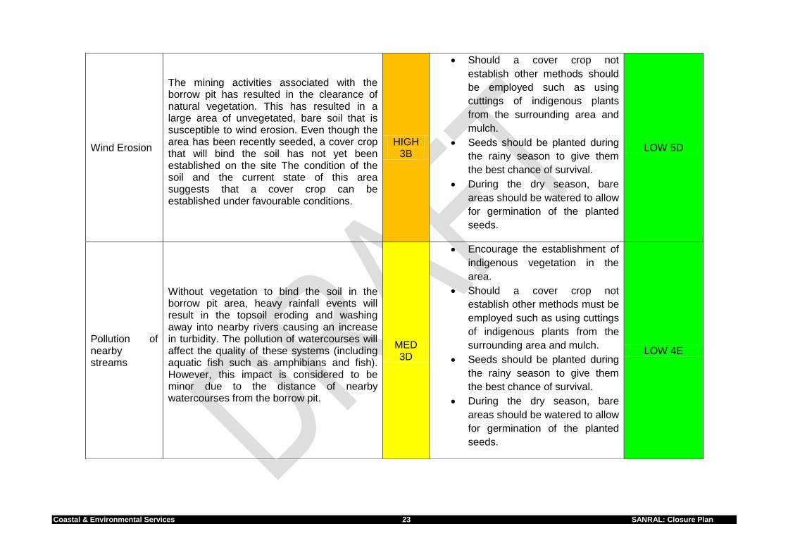
Wind Erosion
The mining activities associated with the borrow pit has resulted in the clearance of natural vegetation. This has resulted in a large area of unvegetated, bare soil that is susceptible to wind erosion. Even though the area has been recently seeded, a cover crop that will bind the soil has not yet been established on the site The condition of the soil and the current state of this area suggests that a cover crop can be established under favourable conditions.
HIGH 3B
Should a cover crop not
establish other methods should
be employed such as using
cuttings of indigenous plants
from the surrounding area and
mulch.
Seeds should be planted during
the rainy season to give them
the best chance of survival.
During the dry season, bare
areas should be watered to allow
for germination of the planted
seeds.
LOW 5D
Pollution of nearby streams
Without vegetation to bind the soil in the borrow pit area, heavy rainfall events will result in the topsoil eroding and washing away into nearby rivers causing an increase in turbidity. The pollution of watercourses will affect the quality of these systems (including aquatic fish such as amphibians and fish). However, this impact is considered to be minor due to the distance of nearby watercourses from the borrow pit.
MED 3D
Encourage the establishment of
indigenous vegetation in the
area.
Should a cover crop not
establish other methods must be
employed such as using cuttings
of indigenous plants from the
surrounding area and mulch.
Seeds should be planted during
the rainy season to give them
the best chance of survival.
During the dry season, bare
areas should be watered to allow
for germination of the planted
seeds.
LOW 4E

Coastal & Environmental Services 24 SANRAL: Closure plan
Lack of establishment of vegetation due to soil compaction
The soil has been compacted by construction vehicles during the operation phase of the borrow pit and during rehabilitation (clearing of the site, removal of storage units etc.). Sowing in soil that is compacted or soil with a ‘crust’ will result in the seed being washed away after the first rains. The site visit indicated that during rehabilitation of this area, soil has been loosened in some areas but not in other areas (as per Site visit on 22 October 2015, and Audit report 21 (16 October 2015)). Re-vegetation is unlikely to occur in compacted areas resulting in erosion, dust and run-off.
Critical 3A
Loosening of compacted soil;
this may include using rakes or
sharp-pointed hoes.
No machinery or heavy vehicles
should be allowed on the area
after it has been sown as this
may lead to further compaction
of the soil.
LOW 5D
Dust
Some dust may be generated as a result of the exposed ground. The generation of dust may be higher during windy, dry periods. Dust may be a nuisance to the neighbours and also people who use the NR6 Road which is adjacent to the borrow pit. It is therefore imperative that the borrow pit is re-vegetated as soon as possible.
High 3B
Employ dust suppression
measures such as wetting of the
study area during dry, windy
periods.
Encourage the establishment of
vegetation in the area.
LOW 5D
Lack of establishment of vegetation due to poor soil properties
Due to the mining activity which has occurred at the borrow pit, the soil properties may have been altered and may therefore not be ideal for the establishment of indigenous pioneer species. It is important that there are nutrients and moisture (water) available in the soil for plant establishment in the area. During the rehabilitation activity, soil in this area has been improved by application of Superphosphate (fertilizer containing plant-available sulphur and phosphate), topsoil and mulch to improve the soil properties and encourage the establishment of indigenous vegetation in this area.
MED 3C
Improvement of soil properties
will encourage the establishment
of vegetation in this area.
The Applicant has applied
rehabilitation measures to
improve the soil properties,
monitoring of the area will help
determine if there is any
establishment of vegetation in
the area.
Low 4D

Coastal & Environmental Services 25 SANRAL: Closure Plan
Low Aesthetic Appeal
The area does not currently look like the surrounding areas as it remains devoid of vegetation and is therefore not aesthetically pleasing to the neighbouring landowners and motorists that use the NR6. However, it has been levelled out and this will be compatible with the surrounding area once it has been rehabilitated.
Medium 4B
The establishment of vegetation
and the area being integrated to
the surrounding areas will
reduce this impact.
LOW 5D-

Closure Plan
Coastal & Environmental Services 26 SANRAL: Closure plan
Ranking of risks according to the Regulations According to the regulations one is required to rank each risk on whether it is (aa) potential significant risk, (bb) uncertain risk, (cc) insignificant risk (as seen in Table 7.2). All the identified risks associated with the mining activity require mitigation as they rank from Medium to Critical according to the EOH CES risk rating method (see EOH CES risk ranking system Appendix I ). Table 7-2 Ranking risks associated with the borrow pit according to the regulations
Risks MPDR ranking (Without mitigation)
MPDR ranking (With mitigation)
Alien Invasive Species Potential significant risk Insignificant Risk
Wind Erosion Potential significant risk Insignificant Risk
Pollution of nearby streams Potential significant risk Insignificant Risk
Dust Potential significant risk Insignificant Risk
Soil compaction Potential significant risk Insignificant Risk
Soil Properties Uncertain risk Insignificant Risk
Aesthetic Appeal Potential significant risk Insignificant Risk

Closure Plan
Coastal & Environmental Services 27 SANRAL: Closure Plan
8. PROGRESS OF REHABILITATION
8.1 Defining Rehabilitation As indicated in Figure 8.1, there is a continuum of options, possibilities and end-points along the path towards restoration. Thus restoration is a continuous process, and it may not always be possible to achieve this goal. These concepts are defined as follows:
o Restoration: The return of a damaged ecosystem to its original state. o Rehabilitation: The return of a damaged ecosystem to its original state, taking into
consideration that it is questionable if complete restoration will be achieved. o Revegetation: The process of establishing vegetation on the degraded
environment. o Replacement: The process where vegetation is established on the degraded
environment, but this vegetation differs from pre-mining vegetation. Such an option would most often result from post-mining conditions being incompatible with the original land-use. An example would be to plant economically or socially important crops instead of the original vegetation due to changed soil properties.
Figure 8.1: Diagrammatical Representation of the rehabilitation options from disturbance to full restoration (adapted from Bradshaw, 1983).

Closure Plan
Coastal & Environmental Services 28 SANRAL: Closure plan
8.2 Indigenous Vegetation- Ecosystem Rehabilitation
The general aim of the implementation of a rehabilitation plan is to recreate a natural ecosystem. The following steps were outlined in the Rehabilitation Plan with regards to the rehabilitation of the borrow pit:
1. Stockpiled topsoil to be spread on the disturbed areas to encourage the return of indigenous species in the area.
Layer of topsoil should be about 10 cm and should be watered.
2. After two months, if there is no establishment of vegetation then barren areas will be hydroseeded with an indigenous grass mix Rehabilitation suggested the Red Top Melinis (Melinis nerviglumis) and Red grass (Themdra triandra) as suitable species. 3 Monitoring progress of the establishment of vegetation is advised. 4. Application of fertiliser could be used to speed up the process, the following fertilisers were provided in the rehabilitation plan.
Slow-release organic fertilisers such as bone meal (source of phosphorus) at 30 kg ha-1 could be used initially to increase the number of rooted seedlings.
Inorganic fertiliser ASN (ammonium sulphate nitrate) at 30 kg ha-1 could be used at the first sign of germination.
Super phosphate at 200 kg ha-1 could be applied after one year.
5. Removal of alien invasive vegetation on the project area. Alien invasive plants to be removed manually. 6. Maintenance of the area, by removal of aliens. 7. Minimum of two years after care of the area.
Hydroseeding, of the borrow pit area took place in October 2015. Monitoring of the area is crucial as this will ensure that the desired vegetation establishes in this area. Should vegetation not establish in the area, other methods could be implemented to ensure that there is establishment of vegetation in the bare areas.
8.3 Success of rehabilitation Hobbs (2003) states that “we can only measure success if we have some idea of what success looks like, and we have ways of assessing condition and detecting change in conditions”. Success of a rehabilitation project may thus be determined by how well the original objectives were met. The objectives for rehabilitation in the Borrow Pit associated with the NR6, Section 4 at Penhoek Pass are as follows:
Site to be cleared of all litter and scrap, which had accumulated due to the mining activity
Sufficient contours shall be constructed to prevent soil erosion
Sidewalls of borrow pit are not sloped too steeply, slope not exceeding 1:3
Establish vegetation cover by filling borrow pit with overburden and application of topsoil.
Monitoring of site to determine the progress of rehabilitation.
Rehabilitation must comply with provisions in the Environmental Management Plan.
Borrow pit area to be left in a manner where Landowner could use the area as grazing pasture

Closure Plan
Coastal & Environmental Services 29 SANRAL: Closure Plan
Various strategies were implemented to ensure that the goals of rehabilitation were met. These included the backfilling of overburden, replacing topsoil, and by seeding the bare patches with a mixture of indigenous plants. An important part in the rehabilitation process is monitoring, this generally allows one to assess the change or trend in one or more resources (Block et al., 2001). Constant monitoring of the rehabilitation project, allows one to determine if there is any improvement and reveals whether there are problems in the restoration programme. Rehabilitation requires on-going monitoring and evaluation of the objectives; this allows one to determine effectiveness of the rehabilitation techniques and management measures used (Hobbs, 2003; Johnson and Tanner, 2005). Due to area still requiring on-going rehabilitation, monitoring of this site is important as to keep record of the progress of rehabilitation, to ensure that the site is being encouraged to reach the desired state and to leave the area in a state where it does no longer require any additional input. The mining at the borrow pit has resulted in changes in the loss of vegetation at a much smaller scale when compared to other mining projects thus allowing for the rehabilitation process to be much simpler and also allowing the progress of rehabilitation to be easily determined. Section 8.4 provides some evidence of the disturbance which was a result of the mining activity. Section 8.5 provides photographic evidence showing the rehabilitation success achieved thus far (October 2015) of the area which may still require some additional inputs to improve the rehabilitation which has taken place.
The type of mining which was done in this area did not produce toxic waste, thus the possibility of acid mine drainage is not applicable in this site.

Closure Plan
Coastal & Environmental Services 30 SANRAL: Closure plan
8.4 Photographic evidence of disturbance caused by the Mining activity at the Borrow Pit.
The mining activity at this area, resulted in the formation of a borrow pit, this changed the landscape of the area, resulted in the creation of waste material and loss of vegetation cover. Below are photographic evidence (Plate 8.1-8.4) indicating some of the environmental changes which were associated with the borrow pit area. Photographs of infrastructure associated with the borrow pit are also shown below.
Plate 8.1: A temporary concrete washing pond with PVC lining was established adjacent to the borrow pit.
Plate 8.2: Excavation activity at the farm portion RE/180 which resulted in the formation of a borrow pit.

Closure Plan
Coastal & Environmental Services 31 SANRAL: Closure Plan
Plate 8.3: Spoil material that was stockpiled at the borrow pit area
Plate 8.4: Photograph illustrating infrastructure (storage units, slurry mixing plant) and activity (trucks, gravel and topsoil) which were on the borrow pit area.

Closure Plan
Coastal & Environmental Services 32 SANRAL: Closure plan
8.5 Photographic evidence of rehabilitation on the borrow pit area
The borrow pit which was formed due to the mining activity has been filled and re-shaped. The rehabilitation of the area illustrates that the area has been greatly improved and negative environmental impacts associated with mining activities have been minimised on the site. Most of the borrow pit area remains bare (see Plate 8.5) but is generally in good condition and it is expected that after good summer rains vegetation will establish in the area due to the hydro-seeding activity that took place in October 2015. Small patches of vegetation (see Plate 8.6) have returned on the borrow pit area due to the application of Top soil. Litter and rubble found on site during site visit (22 October 2015) has been removed (see Plate 8.7), during maintenance and aftercare it is recommended that the prevention of litter and removal of litter is continued.
Plate 8.5: Bare ground found to occur in the borrow pit area
Plate 8.6: Small patches of vegetation have returned on the borrow pit area due to the application of Top soil.

Closure Plan
Coastal & Environmental Services 33 SANRAL: Closure Plan
Plate 8.7: Removal of waste (litter and rubble). Rehabilitation Monitoring: Rehabilitation requires on-going monitoring and evaluation of the objectives to validate the effectiveness of rehabilitation techniques and management measures. In rehabilitation planning it is important that goals, objectives and success criteria (key performance indicators) are clearly defined. This allows the task to be approached in a systematic way, leaving room for adaptive management as on-going rehabilitation yields results (Hobbs, 2003; Johnson and Tanner, 2005).

Closure Plan
Coastal & Environmental Services 34 SANRAL: Closure plan
9. METHODS OF DECOMMISIONING Mining operations of the Borrow Pit associated with the NR6, Section 4 at Penhoek Pass have ceased. All the equipment and infrastructure have been removed from the site. The area is currently undergoing rehabilitation. No structures remain on site.

Closure Plan
Coastal & Environmental Services 35 SANRAL: Closure Plan
10. MAINTENANCE AND MANAGEMENT REQUIRED After the application of the recommendations which have been made in the risk assessment (Please refer to Chapter 8 and Risk assessment report) there are a number of on-going maintenance activities that will be required for this site to ensure that that biodiversity is maintained in this area and that the chances of potential risks occurring are reduced on this site. Management objective include: A restoration strategy which strives to restore patches of diverse, ecologically important and conservation worthy patches of vegetation which have been impacted on by the borrow pit, in the remaining disturbed areas. Monitoring and review is an assessment and record of management achievements, a periodic review of the plan, and renewal or revision of the implementation programme. In other words, the management and implementation should continue to incorporate: evolving conditions of the site, adjusted objectives due to site evolution, adapted processes and techniques of implementation of the rehabilitation plan, which should all be recorded in the monitoring and review stage. The following need to be monitored on the project site.
Bare areas have be re-seeded, thus the status of vegetation establishment needs to be monitored on site.
Should the plants not re-establish, other methods such as planting of cuttings will have to be implemented and monitored.
Watering of plants in 1st year during the dry periods.
Erosion control
Alien invasive vegetation
Determine the progress of rehabilitation
Recommendations
Recommendations in the Risk Assessment report should be implemented.
Due to rehabilitation already having being implemented on the site, monitoring and maintenance of the borrow pit area is very important.
Vegetation: In order to establish a sustainable indigenous vegetation cover it is necessary to:
Establish pioneer species in the rehabilitation area.
Establish secondary species, namely trees and herbs which make up the compliment of the natural ecosystem.
The return of natural vegetation will also encourage the return of animal species in the rehabilitation area.
Constraints include:
Challenges on current low levels of rainfall and heat wave may influence the time period for the vegetation re-establishment on site.
Time periods within which the measures contemplated in the closure plan must be implemented: Due to rehabilitation being a process that requires a number of years before the area could return to the desired state, it is recommended that the success of the rehabilitation exercise be monitored. A monitoring programme should be put in place, for the next two years. This recommendation is based on:

Closure Plan
Coastal & Environmental Services 36 SANRAL: Closure plan
To determine if the rehabilitation was a success
To determine if there is a return of indigenous species in the area
To determine where the rehabilitation is not working and implement other strategies to improve the disturbed area.
To ensure that there is removal of invasive alien species in this area.
Determine erosion potential of the area
General site condition

Closure Plan
Coastal & Environmental Services 37 SANRAL: Closure Plan
11. CLOSURE COST The closure costs tabulated below refer only to the Borrow Pit associated with the NR6, Section 4 at Penhoek Pass based on the existing area. The closure cost totals R10 249 inclusive of VAT. The rate per hectare for 2 – 3 years of maintenance and aftercare (line item 14) was R700 per ha when the guideline was produced in 2005. Assuming 7.5% increase (inflation) every year this amount has been adjusted to R1342 /ha. Table 11-1: Closure costs
No. Description Unit A B C D E=A*B*C*D
Quantity
Master rate
Multiplication factor
Weighting factor 1
Amount (Rands)
Step 4.5 Step 4.3
Step 4.3 Step 4.4
14 2 to 3 years of maintenance and aftercare
ha 5.5 R1342 1 1 R7 381
SubTotal 1 R7 381
1 Weighting factor 2 1.05 R7 750
Preliminary and General
6.00%
if Subtotal 1 < 100 000 000
R465
7 Contingency 10.00% R775
SubTotal 2 R8 990
Add Vat (14%) R1 259
GRAND TOTAL R10 249
Provision for the amount stipulated above (R10 249 inclusive of VAT) will have to be made SANRAL. This is to ensure that all possible risks are dealt with on the affected area.

Closure Plan
Coastal & Environmental Services 38 SANRAL: Closure plan
12. SKETCH PLAN According to Regulation 62 (i): A sketch plan drawn on an appropriate scale describing the final and future land use proposal and arrangements for the site;
12.1 Sketch Plan Mining at the borrow pit has resulted in a portion of the farm RE/180 being impacted. Mining activity at this area has ceased and the area has been undergoing rehabilitation. It is proposed that once rehabilitation is complete in this area, the rehabilitated area (impacted area) will then be integrated into the surrounding land and left in a manner that the Landowner may use as grazing land. The goal is for the area to have grassland vegetation, which is not impacted by alien and weedy vegetation and signs that mining activity had occurred will be minimised.

Closure Plan
Coastal & Environmental Services 39 SANRAL: Closure Plan
Figure 12.1: Illustrating the sketch plan for the disturbed area due to the Borrow Pit.

Closure Plan
Coastal & Environmental Services 40 SANRAL: Closure plan
13. PUBLIC PARTICIPATION In line with Appendix 5 of the EIA and Regulation 62(legislative requirement), this chapter of the report provides the details of the Public Participation Process followed for the proposed mine closure of the Borrow pit associated with the NR6, Section 4 at Penhoek Pass. Mine closure involves the Government, holder of the mining license and the following stakeholders;
Mine management.
Mine employees.
Shareholders.
The affected community which include the landowners, local authorities, business and
service providers, community groups / NGOs.
Due to the borrow pit no longer being operational in this area, only the Government, Holder of the mining licence (in this case the holder of the authorised EMP) and the neighbouring farm portions were notified of the proposed closure of the Borrow pit associated with the NR6, Section 4 at Penhoek Pass.
13.1 Record of interested and affected persons consulted; Table 13-1: Contact details of the neighbouring portions farm owners which were notified of the application for a closure certificate for the Borrow Pit associated with the NR6, Section 4 at Penhoek Pass.
Land Owner Farm Portion
Mr Jeff Stretton (Borrow pit) 179 RE/180 (Valschfontein)
Pieter Jordaan RE/180 1/180 2/180
George Moorcroft RE/155 1/181 2/181
Mr Paul Mortlock RE/182

Closure Plan
Coastal & Environmental Services 41 SANRAL: Closure Plan
Figure 13.1: Illustrating the surrounding landowners to the borrow pit. Table 13-2: Organs of State which were notified of the application for a closure certificate for the Borrow Pit associated with the NR6, Section 4 at Penhoek Pass.
Association
Name
Contact Number
Physical Address
Department of Mineral Resources : Regional Manager
Mr Azwihangwisi Mulaudzi
(041) 396 6625
[email protected] Pier 14 Building , 444 Govan Mbeki Avenue, North End, Port Elizabeth 6000
Chris Hani Municipal Manager
Mr Mene 045 808 4610
[email protected] 15 Bells Road, Queenstown, Eastern Cape, South Africa
Ward councillor (Inkwanca Local Municipality)
Cllr Ms Lindy Haggard
(081)039 4061
does not have an e-mail address 10 Sichel Street, Sterkstroom 5425

Closure Plan
Coastal & Environmental Services 42 SANRAL: Closure plan
Acting Municipal Manager (Inkwanca Local Municipality)
Mr. T.T. Nkila (045) 967 0768/082 558 9183
Department of Water and Sanitation : Chief Director Eastern Cape
Ms P Makhanya
(043) 604 5406
[email protected] Private Bag X7485, KING WILLIAM'S TOWN, 5600
Department of Water and Sanitation (cc)
Soga Thembisa
(043) 604 5406
[email protected] Private Bag X7485, KING WILLIAM'S TOWN, 5600
DEDEAT Regional Director
Mr. Cira Ngetu
(0) 45 808 4000
[email protected] Block E, Komani Park Offices, Queenstown, 5320
DAFF Forestry Gwen Sgwabe
(043) 604 5301 /5523
[email protected] Private Bag X7410, KING WILLIAM'S TOWN, 5600
Eastern Cape Provincial Heritage Resources Authority (King Williams Town)
Sello Mokhanyo
(043)745- 0888
[email protected] Corner Scholl and Amalinda Drive, East London, 5247
At this stage only a Letter from Jeff Stretton (Appendix H) has been received and Correspondence from DMR (Appendix F and G). No other comments have been received.
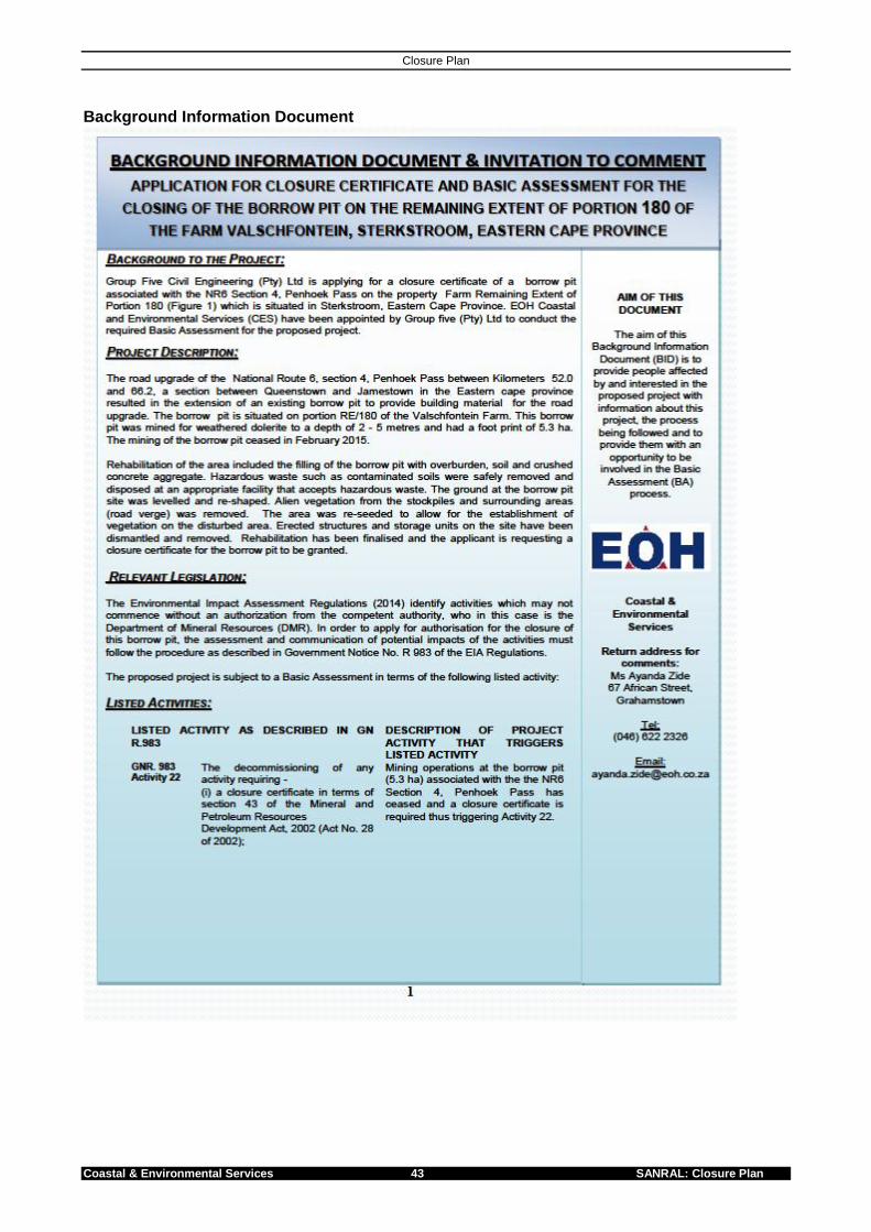
Closure Plan
Coastal & Environmental Services 43 SANRAL: Closure Plan
Background Information Document

Closure Plan
Coastal & Environmental Services 44 SANRAL: Closure plan

Closure Plan
Coastal & Environmental Services 45 SANRAL: Closure Plan

Coastal & Environmental Services 46 SANRAL: Closure plan
Notification Letter

Closure Plan
Coastal & Environmental Services 47 SANRAL: Closure Plan

Coastal & Environmental Services 48 SANRAL: Closure plan
Site Notice was placed on the fence of the borrow pit area (22nd October 2015)

Closure Plan
Coastal & Environmental Services 49 SANRAL: Closure Plan
Advert placed in the local Newspaper the Rep – 30 October 2015

Coastal & Environmental Services 50 SANRAL: Closure plan
14. REFERENCE Block, William M.; Franklin, Alan B.; Ward, James P.; Ganey, Joseph L.; White, Gary C. 2001. Design and implementation of monitoring studies to evaluate the success of ecological restoration on wildlife. Restoration ecology. 9(3): 293-303. Bradshaw, A.D. (1984). Ecological Principles and land reclamation practice. Landscape Planning. Volume 11: 35-48. Guideline Document for the Evaluation of the quantum of closure-related financial provision provided by a mine- Official guideline as contemplated in Regulation 54(1) to the Mineral and Petroleum Resources Development Act, 2002 (Act 28 of 2002). Hobbs, R.J. (2003). Ecological management and restoration: Assessment, setting goals and measuring success. Invited editorial. Ecological Management and Restoration. Volume 4(S1): S2-S3. Johnson, M. and Tanner, P. (2005). Mine site rehabilitation and ecosystem reconstruction for biodiversity gain. International Development Research Centre, Canada. http://web.idrc.ca/en/ev-84055-201-1-DO_TOPIC.html.

Closure Plan
Coastal & Environmental Services 51 SANRAL: Closure Plan
Appendix A: Evidence of tertiary education
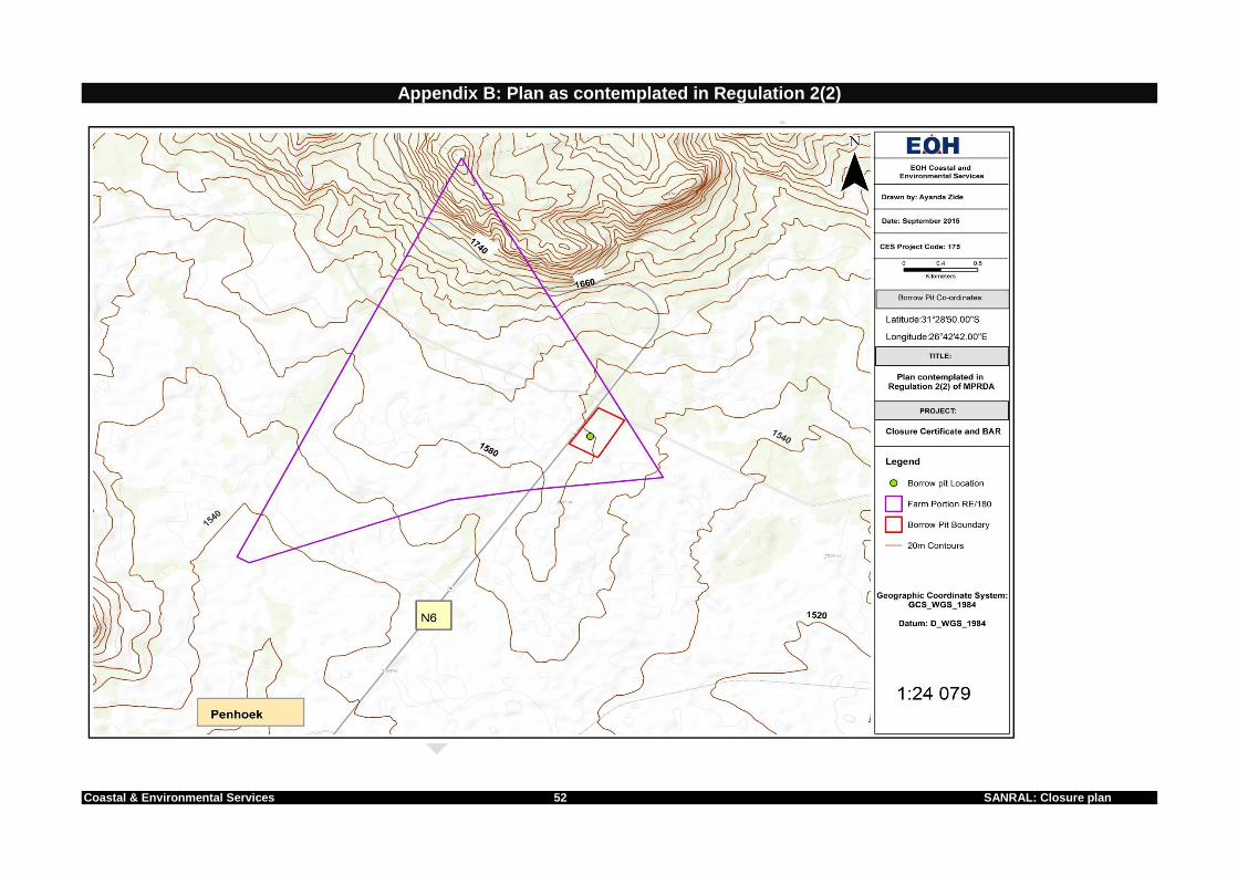
Coastal & Environmental Services 52 SANRAL: Closure plan
Appendix B: Plan as contemplated in Regulation 2(2)

Coastal & Environmental Services 53 ` SANRAL: Closure Plan
APPENDIX C – Showing the layout for the Borrow Pit

Coastal & Environmental Services 54 SANRAL: Closure plan
Appendix C: Showing the Mining Layout Plan

Coastal & Environmental Services 55 SANRAL: Closure Plan
Appendix D- Approval of EMP

Coastal & Environmental Services 56 SANRAL: Closure plan

Coastal & Environmental Services 57 SANRAL: Closure Plan

Coastal & Environmental Services 58 SANRAL: Closure plan

Coastal & Environmental Services 59 SANRAL: Closure Plan

Coastal & Environmental Services 60 SANRAL: Closure plan
Appendix E- SANRAL granted right of access to site by SANRAL

Coastal & Environmental Services 61 SANRAL: Closure Plan
Appendix F- DMR : Comment letter approving the Proposed Rehabilitation and Closure Procedure for Borrow Pit

Coastal & Environmental Services 62 SANRAL: Closure plan

Coastal & Environmental Services 63 SANRAL: Closure Plan
Appendix G- DMR: Recommendation of Application of Closure Certificate

Coastal & Environmental Services 64 SANRAL: Closure plan

Coastal & Environmental Services 65 SANRAL: Closure Plan
Appendix H- Landowner Satisfaction

Coastal & Environmental Services 66 SANRAL: Closure plan
Appendix I EOH CES Risk Ranking system Risk Rating Assessment Methodology The rating scheme given in Tables 3.1 and 3.2 was used to decide on the appropriate risk rate. The Impact Severity Table (Table 3.1) allows for the severity of any consequence to be ranked qualitatively as insignificant, minor, moderate, major and catastrophic. The likelihood of a consequence (including its associated impacts) is then described according to the scales presented in Table 3.1. Due to the mine no longer being in operation, only certain sections of these tables will be relevant. Table 3.1: Severity (Impact/Consequence)
Aspect Catastrophic
(1)
(critical)
Major (2)
(High Impact )
Moderate(3)
(Medium
Impact)
Minor (4)
(Low
Impact)
Insignificant
(5)
Health and
safety Multiple fatalities Single fatality MTI/LTI * FAI*
Impact can be
managed as part
of daily activity,
no injury
potential
Environment Closure of
company for any
period of time
Prosecution in
Supreme/Regional
court
Prosecution in
district court
Verbal
disagreement
from regulators
Financial
damages (US $) > 1 000 000 1 000 000 – 100 000 100 000 – 10 000 <10 000
Workforce Closure of
company for any
period of time
Partial interruption in
one or more
production modules
or services within
financial damages
framework
Partial interruption
in one or more
production modules
or services within
financial framework
Partial
interruption in
one or more
production
modules or
services within
financial
framework
External
company image
of community-
related
Adverse
international
press coverage of
closure of
company for any
period of time
Adverse national
press coverage or
production
interruption within
financial framework
Adverse local press
or production
interruption within
financial damages
framework
Formal
complaints from
wider community
or production
interruption
within financial
framework
Customer
satisfaction
and/or
product/service
quality
Occurrence will
result in
cancellation of a
contract within
financial
damages
framework
Occurrence will
result in cancellation
of a contract within
financial damages
framework
Occurrence will
result in
cancellation of a
contract within
financial damages
framework
Once-off slight
deviation on
supply with
immediate
rectification
*MTI: Medically treated incident *LTI: Lost time injury *FAI: First aid incident

Coastal & Environmental Services 67 SANRAL: Closure Plan
Table 3.2: Probability
Probability / Likelihood Description
A Almost Certain The event is expected to occur during the life of
the project within 0-1 year
B Likely The event is likely to occur during the life of the
project within 1-5 years
C Moderate The event might occur at some time during the
project within 5-25 years
D Unlikely Low probability that the event could occur at
some time during the project and within 25-50
years
E Rare The event may occur in exceptional
circumstances but would not be expected to
occur
Evaluating the risk involved combining the severity of the consequences resulting from the potential incident or aspect and the likelihood of that consequence occurring. Single hazards/aspects are positioned on the matrix by using the axes of consequence/severity and the likelihood of that outcome (Table 3.3). The risk is then ranked as either; Low, Medium, High, or Critical.
Wherever the consequence severity is critical, the task / activity / change / modification cannot continue before approvals by the Operations/Project Director. Table 3.3: Risk Matrix
Consequence(SEVERITY)
Insignificant
(5)
Minor
(4)
(Low
Impact)
Moderate(
3)
(Medium
Impact)
Major
(2)
(High
Impact )
Catastrophic
(1)
(critical)
Pro
bab
ilit
y
(LIK
EL
IHO
OD
)
Almost
Certain (A)
Low
5A
Medium
4A
Critical
3A
Critical
2A
Critical
1A
Likely (B)
Low
5B
Medium
4B
High
3B
Critical
2B
Critical
1B
Moderate
(C)
Low
5C
Medium
4C
High
3C
High
2C
Critical
1C
Unlikely (D)
Low
5D
Low
4D
Medium
3D
High
2D
High
1D Rare (E) Low
5E
Low
4E
Medium
3E
Medium
2E
Medium
1E