cloud reading for pilots - amazon s3 · john murray, 50 albemarle street, w.i. ... thick clouds...
TRANSCRIPT


CLOUD READING FOR PILOTS


CLOUD READING
FOR PILOTS
A. C. Douglas
With FOREWORD by
Professor D. Brunt, Sc.D., F.R.S.President of the Royal Meteorological Society
LONDON
JOHN MURRAY, 50 ALBEMARLE STREET, W.I
First Edition . . September, 1943Reprinted . . October, 1943Reprinted .. May, 1946
MADE AND PRINTED IN ENGLAND BY W. S. COWELL LTD., IPSWICH AND LONDON

CONTENTSFOREWORD vii
By Professor D. Brunt, Sc.D., F.R.S.
INTRODUCTION x
PART IChapter 1.Chapter 2. Chapter 3.
PART IIChapter 4.
Chapter 5.
Miniature Cloud Atlas (I-XIII) 1 How Clouds Form 15 Air Masses and Fronts 18
Convection Clouds (Fig. 1-74) 27Synopsis—effect of the ground—temperature inversion—growth, life and decay of cum
ulus — diurnal variations — seasonal vari ations—cloud streets — cumulo-nimbus — cumulus formation on the coast.
Layer Clouds and Air Mass Movements (Fig. 75-164) 71Synopsis — cirrus family — medium height or alto family—low cloud family—causes of layer cloud formation — how the cloud is formed—lenticular clouds—movements of Depressions and Anticyclones.
Chapter 6. Conclusion
A FEW WEATHER TIPS
117
119
All the photographs in this book are the copyright of the Author

To
E.M.E. and C.H.W.E.
in small repayment

FOREWORDby
PROFESSOR D. BRUNT, Sc.D., F.R.S.
THE clouds offer a fascinating subject for study, par ticularly to those who take the trouble to learn something of the ways in which they form and dissipate. To the casual observer they often appear to drift across the sky like so many pieces of cardboard, with only such changes in appearance as would be produced by changes of perspective. But closer examination shows that it is only very rarely that a cloud moves across the sky without change of form. If, for example, cine-photographs are taken at intervals of one second, the film, when run through the projector at the rate of thirty-two photographs per second, so that all movement is speeded up thirty-two times, will reveal that the clouds are undergoing ceaseless changes. The changes are too gradual to be appreciated with the naked eye, except in rather extreme cases.
For this reason the ideal textbook of cloud study would consist of a carefully selected series of films. This ideal is not practicable for the individual student, since it could only be used by the possessor of a projector. But the film would have considerable merits in addition to its ability to reveal the clouds as being in a state of perpetual change. Most textbooks of Meteorology contain illus trations of certain standard types of cloud, and it is not difficult to learn to distinguish these standard types when they occur alone. But the sky presents a far more com plicated problem, by showing at the same time clouds of different types, usually at different levels in the atmosphere.
The best substitute for the film is a series of photographs such as is offered to the reader of this book. The authoress is an air-pilot of considerable experience, and she approaches her subject from the point of view of the air-pilot, to whom an understanding of clouds is an essential part of his or her technical equipment. She has not only provided a wide variety of cloud photographs, but has steadfastly maintained the attitude that changes
Vll

FOREWORD
in the visible clouds are to be regarded as indications of the changes which are taking place in the weather. There are a number of series of photographs of the same cloud at different stages of its life, which should help the reader to grasp the nature of the changes which clouds may undergo.
I have written these few paragraphs of introduction to this book by Ann Douglas because I desire to recommend the pictures she gives of clouds as worthy of the most careful study by anyone who is interested in weather, and particularly by the airman. I would also take this oppor tunity of stressing an aspect of the work of the professional meteorologist, in so far as it has a bearing on the need for some understanding of weather on the part of those who make use of official forecasts. It is an aspect which is seldom stressed as it should be. The official forecaster has to describe in a few sentences the coming weather of a fairly extensive region, over a period of time of anything between an hour and twenty-four hours. The forecast must be brief, or the recipient will not read it. Now the weather at any moment may be widely different at places even a few miles apart, while at some places it may vary widely within a short space of time. In such circumstances it cannot be expected that the whole gamut of changes of weather with time and place can be com pressed into a few sentences. The best that the forecaster can be expected to supply is a general idea of the weather over the region and range of time in question, together with an indication of the risks of special disturbances which may or may not develop. If the recipient of the forecast is an air-pilot, it is his business to look out for indications of any possible disturbances of which he has been warned. The indications are the clouds, which will show him, if he has learned to interpret them, whether the forecast is working out correctly, and whether any special risk is developing or not. Efficient weather fore casting is in fact a partnership between the official forecaster and the recipient, particularly when that recipient is an air pilot.
The greatest difficulty which meets the official forecasterVlll

FOREWORD
is probably that of timing. It frequently happens that it is possible to state with considerable confidence the sequence of weather to come in the immediate future, but that it is difficult to state with accuracy the timing of the items in the sequence. Depressions which are first observed over the ocean, say south-west of Ireland, may move more rapidly or more slowly than is estimated by the forecaster, and this will vitiate his timing, though the depression may move along its predicted path, and so give the forecasted sequence of events, but with the times wrong. The recipient of the forecast can learn, by careful study of the clouds, to check for himself whether the timing of a forecast is correct or not, and in many cases can make use of the forecast when the timing is wrong, by correcting it for himself by his own observation of clouds and their indications. In doing so he is only performing his share of the work as a partner with the forecaster.
The ideal of a partnership between the one who draws up a weather forecast and its user is a readily attainable ideal. In this it differs from the ideal occasionally expressed, that books dealing with the weather should give "a few simple rules for forecasting the weather." Only a meteorological half-wit would attempt such a task.
IX

AUTHOR'S INTRODUCTIONTHE object of this book is to try to give some idea of the habits of the clouds. By really knowing what is happening, and being able to interpret changes in the cloud and state of the sky, one is able to possess the necessary material for short term forecasting.
To the pilot especially, this is important, because although he may be able to get plotted forecasts and charts they are only useful up to a point. It is he who is going to fly in those conditions, and he who will have to make the final decision. Weather does not go just according to plan, and is always in a state of change. The conditions the pilot has been told to expect may be late or early in arriving at the stated point, or they may have intensified, or deteriorated, or altered in some other way. If the pilot can recognise what is happening, and what is likely to follow, and value it accurately without outside aid, how much more easily and safely will he be able to act in bad weather.
This is not a text book on the vast subject of meteorology, nor does it attempt to cover fully the subject of the clouds. There are many far more able to do these things than I am.
The book is intended to be a practical one for those who are interested in the clouds, and would find out more for themselves. Therefore, in these pages, I want to try to just give the reader some idea of what to look for, and how to look for it.
The first part of this book, is as brief as possible and is mainly for reference, containing a few necessary technical notes. In the second part, I have kept away from further such explanations as far as possible, and tried to concentrate on practical observations.

PART IChapter 1
MINIATURE CLOUD ATLAS
The definitions in the following pages are from the International Atlas of Clouds

I. CIRRUS (Ci.)
Detached clouds of delicate and fibrous appearance without shading, generally white in colour. Often of a silky appearance.

II. CIRRO-CUMULUS (Ci.-cu.)
A layer or patch composed of small white flakes or of very small globular mosses, without shadows, which are arranged in groups or lines, or more often in ripples.
(3)


IV. ALTO-CUMULUS (Al-cu.)
A layer, or patches composed of lamina or rather flattened globular masses ; the smc//est elements of the regularly arranged layer being fairly small and thin, with or without shading.
III. CIRRO-STRATUS (Ci-st.) Opposite
A thin whitish veil, which does not blur the outlines of the sun or moon, but gives rise to haloes.
(5)

V. ALTO-STRATUS (Al-st.)
Striated or fibrous veil more or less grey or bluish in colour. The sun or moon showing vaguely, as through ground glass.
(6)

VI. STRATO-CUMULUS (St-cu.)
A layer, or patches composed of lamina or globular masses the smallest of the regularly arranged elements are fairly large they are soft and grey with darker parts.
(1)
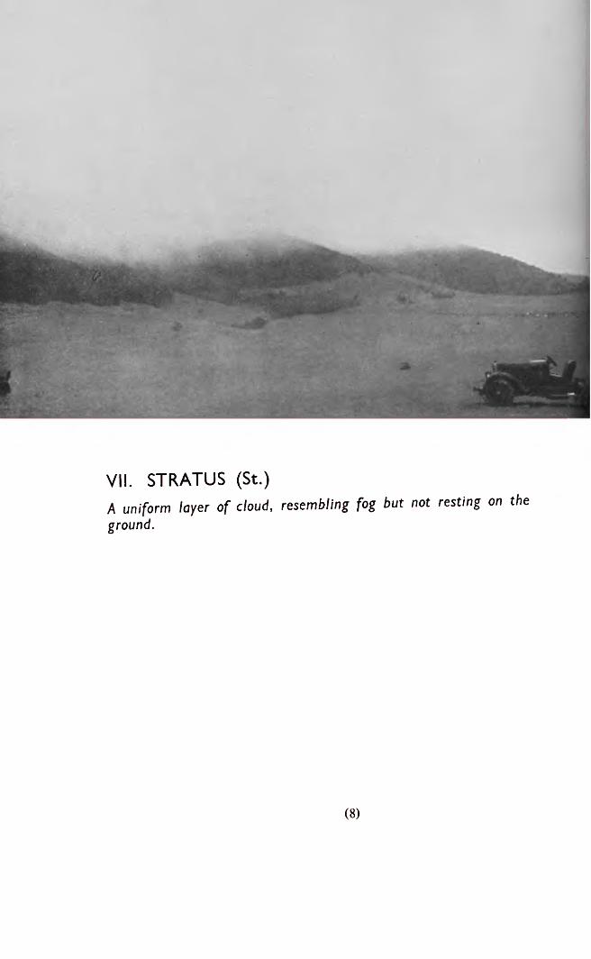
VII. STRATUS (St.)A uniform layer of cloud, resembling fog but not resting on the
ground.
(8)

VIII. NIMBO-STRATUS (Nb-st.)
A low, amorphous, and rainy layer, of a dark grey colour and nearly uniform.
(9)

IX. CUMULUS (Cu.)
Thick clouds with vertical development, the upper surface is dome shaped and exhibits protuberances, while the base is nearly horizontal.
(10)

X. CUMULUS-NIMBUS (Cu-nb.)
Heavy masses of cloud, with great vertical development, whose cumuliform summits rise in the form of mountains and towers, the upper parts having a fibrous texture and often spreading out in the shape of an anvil.

XI. ALTO-CUMULUS-LENTICULARIS (Al-cu-lent.)
Clouds of an ovoid shape, with clean cut edges, existing at all levels from cirro-stratus to stratus.

XII. ALTO-CUMULUS-CASTELLATUS (Al-cu-cast.)
Cumuliform masses with more or less vertical development, arranged in a line and resting on a common horizontal base. The clouds have a crenellated appearance.
(13)

XIII. MAMMATUS (Mam.)
All clouds whose lower surfaces form pockets or festoons.
(14)

Chapter 2
HOW CLOUDS FORMIF we take a bubble of air and make it warm, it expands, and becomes less dense and rises. As it rises, unless we continue to keep it warm, it will gradually cool. This is because heat is being used up for expansion. When it has cooled to the same temperature as the air all round, it will not rise any more.
This is simple if the bubble of air is dry. If it contains moisture, a complication enters when the bubble is rising and cooling. The amount of water vapour which air can hold depends upon the temperature, and decreases as the temperature falls.
The rising damp air may therefore reach a stage when it can no longer hold all its water vapour, and any further ascent will lead to condensation into drops of water, or cloud.
Let us assume then that the bubble is still rising, and at a certain height water drops appear. When they do so, latent heat is given out, and the temperature in the now wet bubble starts to fall more slowly. This means that it will be able to continue to expand and rise and cool, further than was originally possible. When it reaches a level at which its temperature is the same as that of the air surrounding it, the ascent will cease.
This may happen at any height below or above the height at which water drops will appear.
Here follows exactly the same thing, put in another way.The sun warms the ground, and the ground warms the
air above it, making it unstable, so that in places it rises as a bubble, or thermal current. As it does so it cools. The rate at which it cools, is 1°F. for every 185ft. of height. The name for this rate of cooling is the Dry Adiabatic Lapse Rate. Dry because no cloud or water drops have yet appeared. Adiabatic because no heat is being transferred to or from it. And Lapse Rate meaning rate of decrease of the temperature with height.
15

16 CLOUD READING FOR PILOTS
....CONDENSATION. LEVEL...
Diagram a. The formation of a thermal bubble, and the cloud resulting at condensation level.
The average lapse rate for the surrounding air, is 1°F. for every 300 ft. of height, and from this it will be seen that although the temperature of both the thermal bubble and its surroundings is decreasing with height, the tem perature of the thermal is decreasing faster, but it started off warmer. It will be obvious, therefore, that the greater the temperature difference to begin with, the higher the thermal will be able to go before it cools to the same temperature as its surroundings. When this occurs, the


The Wally Kahn/British Gliding Association eBook Library is unable to obtain copyright approval to provide
the reader with the complete eBook.
By including a number of pages we have endeavoured to provide you with the flavour and content of this book
so that you can decide whether or not to purchase a copy.
It may be that the Publisher and/or Author are intending to print a further edition so we recommend you contact
the Publisher or Author before purchasing.
If there are no details provided in the sample Search online to find a new or
second hand copy.
Addall, a book search and price comparison web site at http://www.addall.com is very
good for gliding books.
Copyright of this book sample and the book remains that of the Publisher(s) and Author(s) shown in this
sample extract.
No use other than personal use should be made of this document without written permission of all parties.
They are not to be amended or used on other websites.