cloudburst floods in utah 1850-1938 - usgs a definition the term "cloudburst" is commonly...
TRANSCRIPT

UNITED STATES DEPARTMENT OF THE INTERIOR J. A. Krug, SecretaryGEOLOGICAL SURVEY W. E. Wrather, Director
Water-Supply Paper 994
CLOUDBURST FLOODS IN UTAH1850-1938
By
RALF R. WOOLLEY
With a chapter on physiographic features
By RAY E. MARSELL
and a
FOREWORD by NATHAN C. CROVER
UNITED STATES
GOVERNMENT PRINTING OFFICE
WASHINGTON : 1946
For sale by the Supt. of Documents, U. S. Government Printing Office, Washington 25, D. C.Price $1.50

CLOUDBURST a definition
The term "cloudburst" is commonly used to designate a tor rential downpour of rain which by its spottiness and relatively high intensity suggests the bursting and discharge of a whole cloud at once. Cloudbursts are usually associated with thunder storms; they may occur anywhere but generally over a relatively small area. They are common in the hilly and mountainous dis tricts of the West, and the resulting floods pouring out from the small precipitous catchment basins are flashy and often destructive.
CONTENTS
PageCloudburst a definition____-___---__--__-_______--_--_-__-__..-.._..,-_-_ iiForeword, by Nathan C. Grover---.-...-..----__________________________ 1Abstract.________-_-___----------__--_---_-_---_-_-..-.. ___-_-._____ 5Authorization ___________________..___..---__--____-_-_..________ ._-______ 7Administration and personnel____________________________________________ 7Scope of report.___________-_--_---_----_____--_-_-_---_--_-_____---__- 8Cooperation and basic data.---_--_--_-------_-_---------_--_..__--___-_- 9Previous studies____-____---_-_-------_-_--_---------___.-..---_---_-- 9Physiographic features, by Ray E. MarselL.____-_-___---___-_-___-______ 15
Boundaries and area.-----__--__-_-------_-______---_--.____-_____- 15Provinces.-_ ________---__--_-_--__-_--_--__------_____--__-___-- 15
General description._____________________________ ______________ 15Drainage----------------------------------------------------- 16Topography ____-__-._--____--_____-__-__-__--.--_--__-.--____ 16Colorado Plateaus provmce__-_----_____----__-_________________ 18Basin and Range province-___-___-__-__-_--_--_________--______ 20Middle Rocky Mountains province,_____________________________ 22
Soils.......____________________________________________________ 24Natural vegetation____-_______-_____-_--_--__----_-_-_______-____- 28Land classification_________________________________________________ 28
Climate..--..______...______--___-_----__-____------__--____ 30' ! General discussion.___________________-__-_-----___.___._-_--_--.._ 30
/ Meteorology.______--_--__---_--___-__.-----------____-------_---_ 32General statement- _-___._______-___--__---.--___._---_---__-__ 32Storm courses.__-____._-____--_____--_-----____-_---____-_--._ 34Storm types._________-_-_-_--______---_------__-__-___--____'_ 34
Cyclonic storms._.____._______.__-__--__..__._-_._._..___. 34Thunderstorms- ___________________________________________ 36
Relation between storms and altitude_-_---_---____--_-_--_.__-_- 39Frequency of thunderstorms and cloudbursts._.__.__.._______..-__ 41Cloudburst intensity duration___--_____---__--..___.-_______..__ 42
General statement-_ _______-_-_____-__-_'"-_____-__..--___--._ 42Intensity duration...________-_____--__--.-_-__---__--__-._ 43Factors influencing intensity_--_-----------__-------_-----_- 45
* Runoff under thunderstorm influence.--_-----------_--_-----_--- 47Cloudburst floods______-_-__'__.______________--_-__--_-__-__-.-_______- 52
General statement.--____._-_____-______--_--__---__----___--____-_ 52Geographic distribution-_____________.__..__________..-.-____._..__ 56Character and extent of areas affected.-_____---___-___------_---.--- 57Frequency... __"____--_-____-___--___-----__-_------------_-------- 58Catchment basins______.________.__-__.__-___--__._._.__-_-__-._-- 61
Willard Creek Basins......___.__._..._....__..__..___.____.... 61Catchment basins in the frontal range of the Wasatch Mountains
between Salt Lake City and Weber Canyon.-..__..___._____-__. 62: Parrish Creek Basin_____-_'--___.___-----_.-____--_.--__--- 63
Davis, Farmington, Ford, and Steed Creek Basins.____________ 65SnowsHde Canyon Basin__-___-__--__-_-_-----____-___-_----__- 67Lost Canyon Basin..........._____________________________ 69Cottonwood Creek Basin.---___________________________________ 69Pleasant Creek Basin________________--___:__^_______-___-,._-_ 71
ra
CONTENTS ContinuedPage
Cloudburst floods Continued Catchment basins Continued
Manti Creek Basin.____.__.___________--___-______.__- 71Chalk CreekBasin___________---_____-_----__-----__--___--__- 72Coal CreekBasin______________.__-_____._____ 72Kanab Creek Basin__________-_.__-_.__________________ 73Small streams in Colorado River Basin_____________________ 74
Mudflows_________________-___________________ 75General statement.__________________________________________ 75Mudflows as a phase of cloudburst floods_--_-_-_-_-___--_--.___-_ 79 Mechanics of mudflows__-______-_--_--__--_-_-___--.______-_ 80
Relation of cloudburst floods and mudflows to topography and geology_ 83 Historical floods__-._______________.-_._---___________ 84
Relation of cloudburst floods to settlement and use of the land-_____________ 121Economic importance of areas affected by cloudburst floods._-_____._______. 123Index. __________________________--_-_--____-._--_-___i- 127
ILLUSTRATIONS
PagePLATE 1. Map of Utah showing physiograpliic divisions _______________ In pocket
2. A, Wasatch Range east of Springville; B, Wasatch Rangesoutheast of Salt Lake City_________________________ 18
3. __., Book Cliffs erosional escarpment boundary between the Canyon Lands and Uinta Basin divisions of the Colorado Plateaus province; B, A typical landscape in the Canyon Lands_____._____.________.______---__.:____ 26
4. A, Mount Ellen, Henry Mountains; B, La Sal Mountains_ __ 345. Little Cotton wood Canyon, Wasatch Range_______________ 426. Land classification map of Utah showing distribution of cloud
burst floods.-__-___-____________________-__-_-.__ In pocket7. Weather maps covering cyclonic storm of September 21-25,
1930_.___.________...________________--. In pocket8. Weather maps covering cloudburst storm of August 13, 1923 __ In pocket9. Weather maps covering cloudburst storm of August 13, 1931 __ In pocket
10. Weather maps covering storms of August 23-30, 1932________ In pocket11. Map of Utah showing distribution of cloudburst floods and
precipitation_______.___.._____________________ In pocket12. Plan of Willard Creek showing topography and vegetal cover.. In pocket13. A, Wasatch Mountains looking toward Parrish Canyon, near
Centerville; B, Wasatch Mountains looking toward Steed Canyon, near Farmington__________________ _ ___ 66
14. A, Upper part of catchment basin on South Fork Parrish. Creek; B, Looking up Parrish Creek Basin from near west end of the south rim; C, Looking up alluvial cone at Snowslide Canyon, in Provo Canyon, near Provo:________________________ 74
15. A, Looking up Snowslide Canyon below forks, near Provo;B, Part of Snowslide Canyon catchment basin.________.--_ 82
16. A, Tributary drains in upper part of Snowslide Canyon catch ment basin; B, Part of west slope of Snowslide Canyon show ing densely wooded moist area..____________ .__ 82
IV

. ILLUSTRATIONS ContinuedPage
17. A, View of upper part of Lost Canyon catchment basin, near Provo; B, Looking over upper part of alluvial cone into Lost Canyon, near Provo___.______________-.._-__ 82
18. Plans and profiles of Cotton wood and Pleasant Creeks______ In pocket19. Plan and profile of Manti Creek, including North Fork.______ In pocket20. A, Main street of Willard after flood of August 13, 1923; B,
Residence at Willard after flood of August 13, 1923; C, Orchard near mouth of Farmington Canyon, flood of August 13, 1923; D, Residence and barn in wake of Parrish Creek flood of August 27, 1930_____.___.._.._..._._._...._ 90
21. Two successive mudflows near Layton._--__-_-__-__----._-_- 9822. Location and number of damaging cloudburst floods reported
in Utah from 1847 to 1938, inclusive, with dates of settlement of communities affected___--.--______--___________ In pocket
23. Map of Utah showing distribution of cloudburst floods andpopulation._--__-___________________________________ In pocket
FIGURE 1. Distribution of precipitation in Utah with relation to areasand altitudes___________________._-_____-___________ 31
2. Climatological charts for Utah showing average temperatureand precipitation, 1891-1938.--_-----__-_.._------------ 33
3. Characteristics of cyclonic storm of September 22-23, 1930___ 354. Characteristics of cloudburst storm of August 13, 1923. _____ 375. Characteristics of cloudburst storm of August 13, 1931_____- 386. Characteristics of storms of August 26 and 29, 1932_________ 407. Average annual distribution of thunderstorm days at Salt
Lake City ._..._......_.__..._._._..-.-______ 418. Graphic analysis of intensities of three cloudburst storms. _ _ _ 449. Association of temperature drop with deviations from mean
intensity___________.--_--_-____--___--_______ 4610. Typical regimen of Price and San Rafael Rivers____-_-_---- 5311. Graphs showing relationship between reports of floods, settle
ments, and population in Utah from 1847 to 1938____--- 6012. Plan of Parrish Creek__.____,__-____-_____-___-_- ------- 6413. Map of Parrish Creek catchment basin showing vegetal cover. 6614. Plan of Snowslide Canyon and Lost Canyon______-___._-- 6715. Map of Snowslide Canyon showing vegetal cover._______-_- 6816. Map of Lost Canyon showing vegetal cover.____---___-___- 70


FOREWORD
By NATHAN C. GROVER1
Cloudburst storms occur in many, if not all sections of the country. As the name indicates, such storms are characterized by intense precipitation that is generally of relatively short dura tion., Qn small drainage basins they cause record floods. Many such floods have been reported, but without information as to the amounts or intensities of the rainfall or the magnitudes of the resulting (^charges of the streams draining the areas on which the rain .falls. As the heavy precipitation falls within narrow boundaries and varies widely within short distances, no- adequate records of its intensities x or its total amounts are or can be made. The.floods follow the storms with short-time warnings and sub side, almost as quickly as they rise; consequently no reliable records of discharge are generally obtainable. Few adequate re ports on cloudburst floods have, therefore, been made, because the data that are essential for such reports cannot generally be made available.
.Some sections of the country are more liable to cloudburst storms and floods than others. Among those that are especially liable are the western and southern fronts of the Wasatch Moun tains of Utah. Here the conditions of topography and temperature appear to promote the formation of cloudburst storms, and the steepness of the slopes and their lack of sufficient vegetation to form a sod permit quick surface runoff arid heavy erosion. There have, therefore, been many storms and floods of the cloudburst type in central and southern Utah, some of which antedate the known, history of the region. They have been partly responsible for the carving of the mountains into peaks and valleys and for the debris fans that mark the passage of the streams from the mountains to the plains.
Mr. Wooliey has compiled and studied the available informa tion on cloudburst floods in Utah. As for other areas, specific data on intensities and amounts of precipitation and magnitudes of discharge are lacking. Such information has not generally been obtained and is not obtainable. He has been fortunate, however, in that graphic though fragmentary records of these floods over a period,of nearly a century have been published in the news papers of Utah. The Deseret News, especially in its more than
* Mr. Grover was formerly chief hydraulic engineer of the Geological Survey, U. S. Depart ment of the Interior, '
2 CLOUDBURST FLOODS IN UTAH 1850-1938
90 years of existence, has been an invaluable source of informa tion. From the.files of the newspapers Mr. Woolley has compiled the records written by eyewitnesses of many of these storms and floods. By means of this impressive array he shows the liability of the region to cloudburst floods and presents the results of a study of the relation of man's occupancy -and use of the lands to the magnitude and devastating character of the floods.
Differences of opinion with respect to the relation of man's" activities to the floods are made apparent by Mr. Woolley's *obser- ! vations, based on his studies and quotations made from published reports. One school of thought believes that man's activities h^ve been one of the major causes, not perhaps of the storms to "which the region is subject, but certainly of the devastating character of the resulting floods. This school holds that the reduction in vegetal cover caused by grazing, in a country that is so arid that even optimum conditions do not produce sods to check or prevent' erosion, has been sufficient to permit destructive erosion in places where there would be none under natural conditions and to leaid to quick runoff and, therefore, to such concentration of flood waters as to produce disastrous flood discharges and mud flows: Mr. Woolley does not agree with this school. He believes that the ; activities of man have had a minor rather than a major effect on the magnitude and effect of cloudburst floods, and he has presented facts to support his views. As in nearly all pioneer discussions involving new fields of thought the facts may not immediately be convincing to every one. They will, however, provoke thought and lead to valuable discussions of the problems related to the causes^ effects, and possibilities of control of these floods.
Of the facts presented or of the thoroughness of their presenta tion there can be no doubt. There have been cloudburst storms in, Utah and floods accompanied by mud flows ever since the 'earliest settlements were established and before man's activities could have borne any possible relation to storms, floods, or erosion. To be sure, more floods have been recorded in recent tlaan in earlier years. Opinion differs, however, as to whether there have actually been more floods that have caused disaster,- as some observers believe, or whether there have been no more or worse, floods but more have been reported because there were more settle ments and therefore more lives and property in jeopardy, as Mri.. Woolley believes.
Mr. Woolley is a lifelong resident of Utah. His relatives and friends are among those who have suffered from the effects of cloudburst floods. He has studied closely over many years the facts and problems discussed in this paper. He has presented some

FOREWORD 3
of his information in another report which relates to a part of the State that is subject to cloudburst storms.2 The bulk of his infor-r mation with respect to cloudburst floods and to the effects of man's activties is, however, contained in the present report.
The problems related to the possibilities of controlling the floods of Utah do not fall within the scope of this report. In a few places levees have been built to confine the flood waters within predeter mined channels across the debris fans. Such control may be effec tive until subsequent mud flows clog the channels. The Forest Service and the Soil Conservation Service have attempted to control floods at their sources by terracing, by contour storage, and by planting and stimulating the growth of vegetation. The success or failure of these efforts is still uncertain, as it has not been demonstrated that any of the projects has withstood a storm of the magnitude of those that produced the historical floods. In general, the topography is too steep to make feasible the con struction of storage reservoirs for the control of cloudburst floods.
Mr. Woolley believes that cloudburst floods will continue to occur in Utah and that property and lives will continue to be lost, because the debris fans will be occupied by farms and homes, and such losses will be part of the price paid for the occupancy.
9 Woolley, R. R., Utilization of surface-water resources of Sevier Lake Basin, Utah: U. S. Geol. Survey Water Supply Paper 920 (in press).


CLOUDBURST FLOODS IN UTAH
By RALP R. WOOLLEY
ABSTRACT
Introduction. Five years after the first settlement was made in Utah, at Salt Lake City in 1847, it became manifest to the settlers both there and at Manti that "cloudbursts" were of common occurrence in this region. Other settlements were made and gradually expanded on the steep alluvial fans of the 'mountain streams, and reports of cloudburst storms and their attendant floods became increasingly numerous as farms and homes were damaged by them.
In 1890 the theory was advanced that these floods occurred because the sheep and. cattle had eaten off the vegetation in the hills, leaving nothing to hold the water back. This indictment of man's flocks and herds has become so common that during the past 20 years considerable study has been given to it. Most of the study, however, has been devoted to runoff from the catch ment basins and factors involved in its control and little of it to an adequate scientific analysis of the relationship between physiographic and geologic features and the meteorologifc phenomena involved in the storms.
Physiographic features. Utah has an area of 84,916 square miles, of which 2j570 square miles is covered by lakes and rivers. Its altitude ranges from 13,498 feet in the northeast part to 2,500 feet in the southwest corner. The apprbximate mean altitude is 5,500 feet above sea level. Mountains and high plateaus occupy roughly the east half of the State and deserts the west half. Dark-colored soils characterize the mountain valleys and upland areas, where rainfall has been sufficient to cause a vigorous growth of grass and other shallow-rooted vegetation. Gray desert soils characterize the western desert areas, where rainfall is too scant to produce much vegetation. A little more than 14 percent of the State's area 'is included in national forests, about 4.3 percent in crop-farm land, and about 80 percent in grazing land.
Climate. Climatically the State is divided by the Wasatch Mountains and high plateaus into two regions of approximately the same size. The seasonal distribution of temperature is about the same in both regions, but there are marked differences in the seasonal distribution of precipitation. Approxi mately 22 percent of the State has an average annual precipitation of 15 inches or more, about 30 percent has 10 to 15 inches, and 40 percent has 5 to 10 inches. The remaining 8 percent, comprising principally the Great Salt Lake Desert, receives less than 5 inches a year.
Cloudburst storms occur rather promiscuously throughout the State, being more frequent in the southern and eastern sections. The precipitation con tinues for 20 to 30 minutes on the average, though rarely it may continue for an hour or more. The extreme rates of rainfall in the mountains of Utah are not definitely known. In the afternoon of July 7, 1933, an unusual cloud burst at Bryce Canyon, in the High Plateaus (8,000 feet in altitude), yielded 0.9 inch of rain in 10 minutes.
Cloudburst floods. Most of the cloudburst floods originate in areas below 8,000 feet in altitude. The most violent discharges originate in drainage areas of 10 square miles or less. Estimated flood discharges from many of the

6 CLOUDBURST FLOODS IN UTAH 1850-1938
smaller catchment basins range from 400 to 600 second-feet a square mile. Only a few communities in the State have not experienced cloudburst floods.
Present-day news reporting of these floods has a tendency to dramatize them, intensify the public interest in them, and develop a belief that such floods are much larger and occur oftener in the present than in previous times. Two 3-year periods are equally high in the maximum records of such floods since 1847, namely 1899-1901 and 1930-32.
Mudflows. The mudflow is a manifestation of a cloudburst. It is a well- lubricated mass of alluvium that is spewed from the canyons in a fan- shaped deposit like a huge sheet of mortar or concrete. These flows make up the material in the innumerable alluvial fans that fringe the bases of the mountain ranges throughout the arid West. There are hundreds of such fans in Utah.
Historical floods. More than 500 reports of outstanding cloudburst floods since 1847 indicate that at 112 different times farm crops, usually in small patches and varying in amounts, have been destroyed. Stretches of- highway have been washed away or covered with mud and boulders and bridges destroyed about 140 different times; canals and diversion dams have been damaged more than 70 times; and railroad tracks have been washed out or covered up more than 60 times. Cities and towns have had streets flooded no less than 100 times, and homes have been either washed away or filled with a few feet of mud. Power plants and pipe lines have been damaged more than 25 times, and at least 26 persons have lost their lives by drowning.
Relation of cloudburst floods to settlement and land use. The average density of population in Utah is little more than 6 people to the square mile. It varies from a minimum of 0.5 person to the square mile in Daggett, Grand, Kane, and San Juan Counties to a maximum of 257 persons to the square mile in Salt Lake County.
Most of the present towns in Utah were established by 1880, and at that time the population of the State was 144,000. More than 230 towns in the State have experienced one or more cloudbursts. From 1880 to 1930 the population of the State increased 350 percent, the number of farms 290 per cent, and the area included in farms 860 percent.
Practically all lands adjacent to water courses, and consequently those most subject to cloudburst floods, are now in farms. Although cloudburst floods are numerous and occur all over the State, less than 1. percent of the. total area in farms has been devastated by them. In a few places homes and highly developed orchards, garden farms, and city lots have been obliterated. Such works as pipe lines, canals, power plants, railroads, and highways have been repeatedly damaged by floods and some projects have been abandoned, but ordinarily the damage is repaired after each flood, and the costs involved are considered a price paid for occupancy of the respective sites.
Economic importance of areas affected by cloudburst floods. The actual value of physical property that has been rendered useless by cloudburst floods in the S^ate would be exceedingly difficult to determine. -It is apparent from available data that beyond an insignificant amount of improved farm land and a few small homes and small power plants there would be little if any monetary value involved. Records of the State Tax Commission fail to show a devaluating effect on property in any county or community because of dam age from cloudburst floods. Apparently such damage is absorbed as a charge for occupancy of the areas involved.

ADMINISTRATION AND PERSONNEL 7
AUTHORIZATIONIn June 1938 the President approved an allocation of funds by
the Public Works Administration to the Geological Survey for "surveys of floods and droughts, of run-off and its relation to rainfall, and of other factors affecting the variations of water supply, in order to make available information that is essential for the design and construction of projects relating to water utili zation and control."
As one assignment under this allotment, studies were made of cloudburst floods in Utah, and the results of these studies ;eon* stitute the basic data for this report,
ADMINISTRATION AND PERSONNELThe work was performed in and from the Salt Lake City office
of the division of water utilization of the water-resources branch of the Geological Survey under the general administrative super vision of Nathan C. Grover, chief hydraulic engineer, and with the advice and counsel of R. W. Davenport, chief of the division of water utilization.
The personnel and the periods worked up to the time the allot ment was expended, September 1, 1939, were as follows: Regular employees:
Ralf R. Woolley, senior hydraulic engineer, part time. Temporary employees:
Dean F. Peterson, Jr., junior engineer, July 16 to September 21, 1938, and June 22 to August 31, 1939.
James M. Fox, recorder and junior engineer, September 21, 1938, to August 31, 1939.
Robert C. Dewey, recorder, August 5 to December 31, 1988.Lucius M. Hale, recorder, April 3 to May 20, 1939.Albert I. Gabardi, rodman, August 8 to October 1,1938.J. William Easier, rodman, August 8 to December 31, 1938.Ow,en D. Thomas, rodman, September 30 to December 31,
1938. Ruth H. Glissmeyer, junior clerk-typist, May 1 to July 31,
1939.Detailed field studies and surveys were made from August 5
to December 31, 1938, of the Snowslide and Lost Canyon catch ment basins tributary to Provo River, and of Parrish, Ford, Steed, and Davis Creeks, in Davis County, and channel cross sections were surveyed at several places along the Virgin River for use in studies of slope-discharge relationships.
The field work was begun under the direct supervision of Dean F. Peterson, Jr., and was continued from September Until its conclusion under the direct supervision of James M. Fox. It in-

8 CLOUDBURST FLOODS IN UTAH 1850-1938
eluded the topographic mapping of the area under study, by Dewey, Gabardi, Hasler, and Thomas and research oh the physio graphic evidences of past floods, the historical records of such events and recollections of eye witnesses and long-time residents, the character of materials in the alluvial fans, the character and extent of the soil and vegetative cover of the catchment basins, and the behavior of mudflows, by Peterson and Fox, assisted dcCa- sionally by Hasler. Volumetric estimates were made of alluvial fans and recent individual mudflows. Sieve analyses were made of alluvial deposits and the specific gravity of rock materials was determined. Weights of large boulders were determined from volumetric and specific gravity determinations.
The field work was necessarily limited by the time allotted for the project and the short season available. Two areas, one in Provo Canyon and the other along the Wasatch front in Davis County, were selected for study because of their widely different physiographic features, their records of cloudburst floods, and their easy accessibility. Field work was concluded December 31, 1938, owing to snow. In March 1939 volumetric estimates were made by Mr. Fox of the alluvial deposit from the flood of 1936 at Willard, in Box Elder County, and also of the total amount of material deposited behind the flood barriers constructed there in 1924. In April 1939 he conducted some field experiments in the artificial production of mudflows in miniature, and observed the mechanical characteristics of such flows.
From January 1 to August 31, inclusive, Fox devoted his, time to assembling and abstracting reports on cloudburst floods, making meteorologic studies, assembling and reviewing all the available literature on mudflows and related phenomena, and assisting in preparing the text for this paper. ' , .
Mr. Hale did some drafting and computing work in connection with text figures. .
Mr. Peterson devoted his time in 1939 to analyzing field data relative to the Snowslide and Lost Canyon areas and to the prepa ration of material for use in this report.
SCOPE OF REPORT
The area covered by this report was purposely limited to Utah primarily because the time and funds allotted for tjie project were insufficient to assemble and analyze the data for a larger area that might be comparable to those available for Utah, Furthermore, most of the data for Utah were readily assembled at Salt Lake City, and little field travel was necessary. An attempt is made in this report to present information on the physiography

PREVIOUS STUDIES 9
and climate of Utah in their natural relation to cloudburst floods and the general processes of degradation characteristic of the area.
It is obvious that a report of this kind for an area in which the. local differences are so complex must be restricted to some extent in the amount of detail it gives, and for this reason no attempt is made to cover all the small individual drainage basins that have cloudburst floods. It is believed, however, that the material in this volume at least indicates the natural processes that produce these floods and that these processes are quite independent of man and his activities, although the results of the floods may be somewhat influenced by these activities.
COOPERATION AND BASIC DATA
The writer wishes to express appreciation to all who have cooperated with him in the preparation of this report. The gener ous contribution of information by those who may be considered experts in th^ir field of work adds value to a work of this kind and is a source of confidence to its readers. Special acknowledg ment is made tp Mr. J. Cecil Alter, meteorologist, United States Weather Bureau,.Salt Lake City, for his cordial and helpful cooperation, his constructive suggestions, and his critical review of the section on climate.
The basic data were obtained from all available sources. An effort has been made by the writer during his 28 years of intimate contact with the development of the State to accumulate all the information he could regarding its natural resources and espe cially that pertaining to the characteristics and utilization of the streams.
The historical data have been gathered by personal research and, for the later years, by the aid of the Utah Federal Writers project. Helpful suggestions and many photographs of flood dam age were very graciously contributed by L. M. Winsor, district engineer. Division of Wild-life Refuges, United States Biological Survey. Mood data resulting from hearings conducted in Utah by the Corps of Engineers, United States Army, were made avail-, able $6r review by the writer at Los Angelee, and additional statistics on flood damage throughout the State were made avail able by Sumner G. Margetts, director, Utah State Planning Board.
PREVIOUS STUDIES
As population has increased and settlements have continually pushed man's activities, farther and farther onto the natural flood plains of the mountain streams, reports of floods have become increasingly numerous, and damage to property from them has become correspondingly more frequent. This condition has given
10 CLOUDBURST FLOODS IN UTAH 1850-1938
rise to the belief that floods are actually more numerous now than in times past and that man's coming and his' activities have been the cause of it.
This belief has attracted a great many disciples and has become a popular dogma among them. It has tended to picture erosion a normal geologic process that has contributed to the sculpturing of mountains, plateaus, plains, fertile valleys, canyons, and mesas since time began as unduly dominant in the aspects of a horrible monster of- destruction and a public enemy. There is a tendency to overlook proper distinction between the normal geologic proc ess and what has been defined as "accelerated erosion," and to charge it all, including the alleged greater frequency of floods, to man's lack of wisdom in his use of the land.
In Utah the causes of these floods and measures of protection against them have become matters of serious concern to an in creasing number of citizens. Different theories have been ad vanced as to their causes, among them that the climate is changing and that rainfall is in some way affected by the presence or absence of forests and other forms of vegetation. Capt. Thomas H. Bates wrote to the Utica, N. Y., Herald in the spring of 18753 giving as his opinion that the construction of railroads had been the' chief means of inducing a greater spring and summer rainfall in Utah.
The Manti Sentinel,4 in an account of a flood in Manti Creek on July 13, 1890, advanced the theory that "on account of the sheep and cattle having eaten off all vegetation in the hills near the town there is nothing to hold the water or in any way arrest its flow. The consequence is that a heavy rain instead of soaking into the ground rushes down the creek, flooding the country below and usually doing more harm than good." This indictment of man's flocks and herds has become so firmly established that the layman may be excused if he believes that sheep and cattle are the primary cause of floods. In a study made by Reynolds5 in 1910 of the relation of grazing to floods in a district of the Wasatch Plateau in central Utah it is suggested that the partial denudation of the mountain slopes as the result of grazing between 1880 and 1902 was responsible for serious floods between 1888 and 1910. A later study by Forsling6 states:
3 According to the Deseret News, Salt Lake City. Utah, May 13, 1875.* Published in Manti, Utah. Account republished in Deseret News, Salt Lake City, July 21,
1890.8 Reynolds, R. V. R., Grazing and floods a study of conditions in the Manti National Forest,
Utah: U- S. Forest Service Bull. 91, 1911. i .8 Forsling, C. L., a study of the influence of herbaceous plant cover on surface runoff and.
soil erosion in relation to grazing on the Wasatch Plateau in Utah: U. S. Dept. Agr. T?ech. Bull. 220, p. 8. March 1931.

PREVIOUS STUDIES 11
Grazing was greatly curtailed in the late nineties and has been carefully controlled since on the Manti Canyon watershed, one of the drainages con cerned. In August, 1909, heavy rainstorms caused severe floods in the adja cent canyons to both the north and south of Manti Canyon, while the latter was not perceptibly affected. Manti Canyon had then had the benefit of several years' recovery from severe overgrazing, whereas the adjacent water sheds were still in bad condition. Since 1909 no flood of any consequence has occurred in Manti Canyon, although badly depleted portions of adjacent watersheds have had several bad floods.
The Manti Creek drainage basin is an excellent example of what geologists describe as "landslide" topography. Huge masses of the Wasatch Plateau, into which the basin is advancing, become unstable through natural weathering processes and slough off into the canyons, leaving almost vertical walls and piling from hundreds to thousands of tons of unconsolidated earth, rocks, and trees and other forms of vegetation in the bottom of the V-shaped canyons. These piles of debris are flushed out of the canyons by cloudburst and other heavy storms and are deposited over the alluvial fan of Manti Creek, upon which the town of Manti is situated. Beginning with the first record of a disastrous flood, in 1852, no less than 14 cloudburst floods have debouched from Manti Canyon. There have been intervals of 10, 15, 20, and 27 years without such floods being recorded, but sooner or later the storm strikes and a flood results. The most recent records show that a damaging cloudburst flood came from Manti Canyon in July 1934, when there were three crests, and that another came in July 1936.
To remove the destructive debris from mountain streams in the State a "barrier system of flood control" was developed by Winsor7 in the early 1920's.
The first works of this type were built at Nephi in 1922. Other similar projects were built on many of the streams during sub sequent years.
Soon after the cloudburst floods in Davis and Box Elder Coun ties on August 13, 1923, a study was made by the late Frederick J. Pack, professor of geology, University of Utah, of the flooded areas around the towns of Farmington and Willard. In the pub lished report8 of his study he says:
By far the outstanding feature of the entire flood is the enormous size of the boulders carried by it. Literally thousands of boulders, weighing five to ten tons each, are strewn along its path. Toward the apices of the cones the boulders become larger. At Willard and elsewhere fully a score of boulders have been measured, any one of which weighs 20 to 60 tons. The largest
"* Winsor, L. M., The barrier system of flood control: Civil Engineering, vol. 8, No. 10, pp. 675-678, October 1938.
Pack, F. J., Torrential potential of desert waters: Pan-Am. Geologist, vol. 41, pp. 349-356, 1923.

12 CLOUDBURST FLOODS IN UTAH 1850-1938
boulder found is situated near the apex .of the,fa* at Willard. It,weighs very close to a hundred tons and was carried, for <h|Ejlf a mile down a slope of approximately eight degrees inclination and; then Jfor; nearly the same distance on a six-degree glppe. It consists of -quart^ite and is roughly rectangular in form. Its dimensions, after due allowances were made for irregularities, were measured as follows: 14 feet from left to right, 1% feet from bottom to top, 11 feet from front to back. Based on a specific. gravity of 165 pounds per cubic foot, the mass weighs 190,575 pounds, or .95 tons.
In support of the theory that denudation of the watersheds caused the cloudburst floods of-. 1923 ?® paper was prepared by Paul and Baker.9 Most of this pamphlet is devoted to a discussion- of the relation of vegetative cover tt& the runoff from the water sheds. The authors conclude that such storms as described therein are not uncommon in the mountains, and'therefore artificial de-< nudation is the principal cause; of the flood.
In recent years geologists have placed increasing emphasis on the potency of mudflows as geologic agents. Two mudflows in Utah, both incident to cloudburst floods, are described by Black- welder. 10 In his conclusions he calls attention to the fact that run- 1 off regimen is influenced by vegetative 1 cover on watershed areas and that denudation may* ; be artificial as a result of grazing- or fire, or that there may be a natural scarcity of vegetation from insufficient moisture or poor soil, or both. He calls attention also to the meagerness of geologic investigation of the subject and points out that only six modern texts at that time devoted any attention to mudflows, and of these only 'two give so much as a paragraph.
In November 1930 some miscellaneous observations on floods and mudflows north of- Salt Lake City were presented to the Utah Academy of Sciences, Arts and Letter^ and <ralso to ' the Utah Society of Engineers by Crawford and ThatkwelUVIn discussing the causes of these devastating.'floods the authors contend lhat although overgrazing and fires are contributing factors to rapid runoff from floods their importance? has been overstressed and that the primary factors lie in other unbalanced conditions in nature which are of sufficient importance of themselves; to cause intermittent floods even if the contributing factors of: overgrazing and forest fires did not exist. , : : v
It was on account of the recurrence and the destructive charac ter of the floods that devastated property in Davis County and elsewhere in Utah that the late Gov. (Jfjeoirge H. Derm in 1980
8 Paul, J. H., and Baker, F. S., The floods ofl&2» W northern Wtahj Utah Univ. Bull., voK 15, No. 3, 1925.
10 Black-welder, KHot, Mudflow as a geologic agent in semiartd mountains: Geot. Soc. America Bull., vol. 39, pp. 465-484, 1928.
» Crawford,. A. L., and Thackwetl, F. E., Some aspects of the mudflows north of Salt Lake City, Utah; Utah Acad. Set, Arts and Letters Proc,, vol. 8, pp. 97-105, 1931.

1 PREVIOUS STUDIES 13
appointed a commission;of citizens to study the origin and cause of floods in that county and other parts of the State and to ascer tain whether flood prevention measures were feasible.
The report of this commission12 is divided into three parts: Part 1, report.of the committee on .ways and means; part 2, pre liminary report of the committee on flood control works; and part 3, report of the committee on causes and prevention measures. Part 3 forms the greater part, of-the combined report, and the conclusions of the committee as to "the causes of the many floods throughout the State in 1930" were as follows:1. Uncommonly heavy rainfalL v2. Sfbep topography and geological conditions conducive to sudden runoff
and to a large quantity of flood debris.3. Scant vegetation on portions of the watersheds of the canyons which
flooded, due in some cases to the natural barrenness or semi-barrenness of the land, but in many cases such as those in Davis County, to the deple tion of the natural plant growth, by overgrazing, by fire, and to a small extent by overcutting of timber. The committee also concluded that "had there been a mantle
of vegetation practically ecjual to the original natural cover, theserious flooding in tha't section from the rains of 1930 would havebeen greatly diminished, if not prevented."
Under authority of Section 5574x, Chapter 37, Session Lawsof Utah 1931, the State Land Board engaged the director of theIntermountain Forest and Range Experiment Station, U. S.Forest Service, with one member of his staff and two membersof the staff of the Utah State Agricultural College, to make a floodsurvey in Utah.
The report of this survey was-made to the State Land Boardin January 1933, but ft has not been published. Its conclusions are:
Activities of man have been an important factor in the increase in floods and of soil erosion; * * * floods on the whole were not of such severity or of such great frequency until some time; after settlement ; * * * in judicious grazing is by far,,the most important factor [in bringing about] conditions favorable to the origin of floods. . -
Of the 25 cases examined .where floods Jiave occurred in recent years depleted condition of the plant cover is considered to have played a material part in 23 cases, and in 16 of the 23 cases-depletion of plant cover is con sidered to be the major factor giving rise 'to conditions favorable for flood runoff.
The report cites Manti Canyon as one of the canyons, that was "once a repeated flooder" and states that it was in bad condition "when placed under national forest administration," but that under such administration no serious flood had occurred for many
"Torrential floods in northern Utah 1930, in Report of special flood commission appointed by GoV. George H. Dern: Utah State Agr. Coll., Agr. Exper. Sta. Circ. 92, Jan. 1931

14 CLOUDBURST FLOODS IN UTAH 1850-1938
years at the time of the report (1983). That period seems short, however, for drawing significant conclusions.
Repeated emphasis of the theory that vegetative cover on watersheds "equal to the original natural cover" will greatly diminish or prevent floods gives rise to the question, What was the original cover? In an effort to answer this question research was made into the scores of authentic books of early explorers and pioneers in the West who have left written records of the general facts of climate and vegetation. The results of this study are recorded in a paper by Woolley and Alter.13
The historical accounts quoted in that paper date back to the year 1540, and they all indicate that "no extreme phase of the precipitation cycle, whether upward and comparatively wet, or downward and relative dry nor the practices of man in sub stituting domestic livestock for wild game and diverting irriga tion water onto two percent of the land have ever been suffi cient to produce a material change of a permanent character in the general aspect of the native vegetation."
Another flood study initiated in 1988 was the outgrowth of a request by the Corps of Engineers, United States Army to the Utah State Planning Board for information concerning floods in Utah. This request was "for location of floods, damage caused, estimated costs for control, the economic background, and,data on precipitation, runoff, climate, etc., for each area." In response to this request an investigation, was made of those streams in Utah that had produced damaging floods. Letters and reports from all parts of the State were received and filed by the Planning Board and made available to the Corps of Engineers. Flood con trol hearings were conducted by the War Department at Kanab, Price, Monticello, and Salt Lake City, at which all available infor mation relative to floods was presented and filed for use in preparing flood-control plans.
The major studies that have been made thus far of cloudburst floods in Utah argue for the theory that man's activities are a primary cause of floods. Scientific 'study and analysis of the physiographic and geologic features and of the meteorologic phe nomena involved in these storms have not received due con sideration.
13 Woolley, R. R., and Alter, J. C., Precipitation and vegetation: Am. Geophys. Union Trans., pp. 604-607, 1938.

CLOUDBURST FLOODS IN UTAH 1850-1938 15
PHYSIOGRAPHIC FEATURES
By RAY E. MAESELL"
BOUNDARIES AND AREAWhen Utah was established as a territory in 1850 it was
bounded on the west by the State of California, on the north by the Territory of Oregon, on the east by the summit of the Rocky Mountains, and on the south by the thirty-seventh parallel of lati tude. The present western boundary was established in 1861, the eastern boundary in 1864, and the 'notch taken out of the north east corner was increased to its present size in 1868.
The State comprises approximately 82,346 square miles of land and 2,570 square miles of water a total area of 84,916 square miles. Its highest point is Kings Peak, with an altitude of 13,498 feet, in the Uinta Mountains in Duchesne County, in the north eastern part of the State; its lowest point is on Beaverdam Creek, where at an altitude of about 2,000 feet, the stream crosses the Washington County boundary, in the extreme southwestern corner of the State. The approximate mean altitude of thfe State is 5,500 feet.
The following table shows approximately the proportionate amounts of the area of the State at different altitudes.
Approximate amount of land at various altitudes in Utah
Altitude above sea level (feet)
2,000-3,000 .3,000-4,000 . _ 4,000-5,000 __ 5,000-6,000 _ .6,000-7,000 ____ . _ ..... 7,000-8,000 _ __ . 8,000-9,000 9,000-10,000
10,000-11,000 __ ... . _ 11,000-12,000.. 12,000-13,000 __ ... 13,000-14,000 _
Total. ...
Great Basin
Area in square miles
18,284 11,803 6,943 4,814 2,870 1,157
370 44 3
46,288
Percent of
basin
39.5 25.5 15.0 10.4 6.2 2.5 .8 .095 .005
100
Colorado River Basin
Area in squaremiles
258 1,579 6,825
11,324 7,924 4,685 2,912 1,816
869 374
61 1
38,628
Percent of
basin
0.6 4.1
17.8 29.4 20.5 12.1 7.5 4.7 2.2 .9
} 100
Entire State
Area in square miles
258 1,579
25,109 23,127 14,867 9,499 5,782 2,973 1,239
418
{ f84,916
Percent of
State
0.3 1.9
29.6 27.2 17.5 11.2 6.8 3.5 1.4 .5
1 '100
PROVINCESGENERAL DESCRIPTION
According to the classification of the physical divisions of the United States prepared by N. M. Fenneman15 in cooperation with the Physiographic Committee of the Federal Geological Survey,
14 Assistant professor of geology. University of Utah.16 Fenneman, N. M., Physiographic divisions of the United States: Assoc. Am. Geographers
Annals, vol. 6, pp. 19-98, pi. 1, 1917.

16 CLOUDBURST FLOODS IN UTAH< 1850-1938
Utah includes parts of three major' physiographic provinces. The western third of the State includes part of the Basin and Range province, and the remaining , two-thirds includes parts of the Middle Rocky Mountains province and the Colorado Plateaus province. , '
The area in Utah that lies within the .Basin and Range province is a part of the Great Basin section of that province. It is an arid to desert region almost entirely without external drainage and consists of isolated mountain ranges and broad intervening Valleys many of which are fringed by alluvial fans made up of the material eroded by floods from the .steep slopes of the uplands.
The northeastern part of the State, in the Middle Rocky Moun tains province, includes the north-south trending Wasatch Range
'and the east-west trending Uinta Mountains.* (See pi. 1.,) The Wasatch Range has two northern branches, the Bear River Range and the Bear River Plateau,16 which are separated from the Wasatch Front Range by Cache Valley, a broad intermont de- pressio^ and from each .other by the valley of Bear Lake, which extends northward into Idaho.
The east-central and southeastern parts of the State are in cluded in the following subdivisions of the Colorado Plateaus province: (1) The High Plateaus of Utah, a broad strip of high block plateaus, in part lava-capped, that makes up the western part of the province in Utah; (2) the Uinta Basin, a dissected plateau of strong relief that embraces the northern part; and (3) the Canyon Lands, a region of intricately and deeply trenched plateaus bisected by the Colorado River.
DRAINAGE
The principal drainage of the State is either westerly to Great Salt Lake and Sevier Lake, in the Great Basin, or easterly to Green River and Colorado River, in the Plateaus province. The divide between the drainage of the Colorado River and the Great Basin lies mostly within the Colorado Plateaus province (see pi. 1), although a part of the Great Basin in southwestern Utah is drained by a tributary of the Colorado River. About half of the State drains to the Great Basin, the other half to the sea.
In general the State consists of two highly contrasted areas, one, the Great Basin area, low in average altitude, and the other, including parts of the Colorado Plateau and Rocky Mountains, high in altitude. The two areas are separated along a north-south line by a prominent escarpment that faces west and constitutes
16 Mansfield, G. R., Geography, geology, and mineral resources of part of southeastern Idaho; U. S. Geol. Survey Prof. Paper 152, p. 29, and pi. 15, 1927,
$PHYSIOGRAPHIC FEATURES 17
the western "margin of the Wasatch Range in the north arid the western edge of the Colorado Plateaus province in the center. This abrupt slope, which separates the eastern highland from the western lowland, is one df the most conspicuous topographic features in the State, especially as viewed from the west. At intervals of a few miles this barrier is cut by short, deep steep- walled canyons that debouch at the western foot of the escarp ment, dividing the upland into parallel east-west trending ridges that give a notched or crenukted character to the western nlargin of the upland. Floods are characteristic of these canyons, and the material carried down, by the canyon-cutting process forms an alluvial fan .at each canyon mouth.
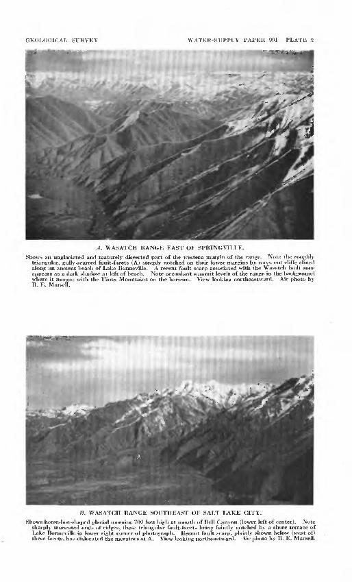
The escarpment is due in part to* dislocation of the earth's crust along two major zones of'fracture and movement. The Wasatch fault zone coincides with the base of the scarp for ,a distance of about 150 ;miles in its northern section.: The Hurricane fault zone, which lies within the plateaus south of Cedar City, follows the escarpment for an unknown ; distance to the north, possibly to a point 20 or 30 miles south of, Beaver/Toward the middle of the scarp, between Levan and a point several miles south of Beaver, the slopes are more gentle and very irregular. :Here evidence of faulting is obscure. There are no great continuing faults but only occasional faults and parts of the front where, the beds are warped,downward into the Great Basin. Apparently the division of the State, into two general., physiographic regions has been brqught about by repeated ..movements; along the front, both-by warping and faulting. The ..cumulative effect has been to raise the eastern part of the State along this zone from 3,000 to 6,000 feet above the western part. Evidence of geologically recent move ment along the Wasatch fault zone is conspicuous (see pi. 2) and has been ably described by Gilbert17 and others.
Renewed uplift,-at intervals,; of th,e upland or eastern part of the State has increased stream- gradients in : those ;parts of the channels immediately upstream from the faults along its western margin. Thus the valleys tljat cross the scarp tend to keep their sharp V-shape right down to the fault zone at the , foot of the escarpment. This steepening, of the stream gradients also results in maintaining steep valley slopes, which accelerate runoff and greatly increase the capacity, of .running water to transport debris.
Streams having the Pacific,, Ocean, as their base level have cut; muc.h deeper qfcannels than the; streamy draining to the relatively high base level of Great Salt Lake (altitude 4,200 feet) and Sevier
Gilbert, G. K., Studies of Basin Range structure: U. S. Geol. Survey Prof. Paper 153, 1928.
18 CLOUDBURST FLOODS IN UTAH 1850-1938
Lake, the common base levels for streams in that part, of the Great Basin that lies in Utah.
The relatively greater altitude of the Rocky Mountains, and Plateaus provinces along their western boundary is of signifi cance in that it forces the moisture-laden air coming from the west to rise into cooler regions and drop much of the precipitation that makes permanent runoff from that area, in contrast to the intermittent runoff from the Great Basin province to the west.
All three provinces display characteristics of late youth to early maturity in topographic development; the upland surfaces in all three are generally rough and rugged, with very strong relief. The flood plains of the major streams in the Rocky Mountains and Plateaus provinces are narrow or practically nonexistent; only where they enter the Great'Basin do they attain considerable width.18
About half of the Great Basin province consists of isolated but roughly parallel north-south trending mountain ranges, whereas most of the northern third of the eastern upland is mountainous in the extreme (containing the Wasatch and Uinta Mountains), and even the remaining two-thirds is so generally trenched by deep and steep-walled gorges that it has a mountainous aspect.
In all three provinces slopes are predominant; flat areas are limited in extent and confined mainly to the central floors of the intermontane basins, particularly the floor of Pleistocene Lake Bonneville, in the western part of the State, and to a few "stripped" plains and plateau surfaces in the Plateaus part. In the Great Basin, however, alluvial slopes of 10° or less are exten sive. Probably in no State west of the Rocky Mountains are plains so restricted in extent as in Utah. The steep gradients of the smaller streams, their confinement in narrow canyons, and their abrupt change of gradient when they spread upon the allu vial fan at the bases of the slopes are major factors in the destruc- tiveness of cloudburst floods, as these fans are choice agricultural spots and are thickly settled.
COLORADO PLATEAUS PROVINCE!
The Colorado Plateaus province as a whole has the simplest geologic structure and topographic expression of the three prov inces in Utah. It is distinguished, first, by relatively high altitude, second, by the nearly horizontal position of much of the great thickness of sedimentary rocks of which it is chiefly composed, and, third, by its myriads of labyrinthine, steep-walled canyons.
' M Callaghan, Eugene, Geologic features [of Sevier Lake Basin], in Woolley, R. E., Utiliza tion of surface-water resources of Sevier Lake Basin, Utah: U. S. Geol. Survey Water-Supply Paper 920 (in preparation).
GEOLOGICAL SURVEY WATER-SUPPLY PAPER 994 PLATE 2
A. WASATCH RANGE EAST OF SPRIINGVILLE.
Shows an unglaciated and maturely dissected part of the western margin of the range. Note the roughly triangular, gully-scarred fault-facets (A) steeply notched on their lower margins by wave-cut cliffs alined along an ancient beach of Lake Bonneville. A recent fault scarp associated with the Wasatch fault zone appears as a dark shadow at left of beach. Note accordant summit levels of the range in the background where it merges with the Uinta Mountains on the horizon. View looking northeastward. Air photo by R. E. Marsell.
B. WASATCH RANGE SOUTHEAST OE SALT LAKE CITY.
Shows horseshoe-shaped glacial moraine 700 feet high at mouth of Bell Canyon (lower left of center). Note sharply truncated ends of ridges, these triangular fault-facets being faintly notched by a shore terrace of Lake Bonneville in lower right corner of photograph. Recent fault scarp, plainly shown below (west of) these facets, has dislocated the moraines at A. View looking northeastward. Air photo by R. E. Marsell.


PHYSIOGRAPHIC FEATURES 19
Its surface, except for valley bottoms or canyons, ranges from 5,000 to more than 11,000 feet in altitude. Owing to the generally arid 1 climate and approximate flatness of the strata, the hard layers, > where exposed by drainage channels, form ragged lines of cUffis that tretreat from the drainage lines as the softer rocks beneath; are eroded away. The hard and soft layers are frequently repeated^ so that the surface over much of the province consists of : a succession of platforms or benches separated by steep slopes or cliff*.i There are hundreds of such lines of retreating escarp ments or cliffs with, highly crenulate or fringelike margins, often set one ;above the other like steps, with broad platforms between them*. The most prominent of these erosional escarpments, con sisting ;of several rows of closely spaced cliffs (see pi. 3, A), forms the southern margin of the Uinta Basin section and the eastern margin,of the High Plateaus section. These two border areas of.the province are higher in general than the central or Canyon Lands area (see pi. 3, B). Possibly in no other landscape are the substance .and structure so plainly revealed as in the Plateaus province. The angular profiles suggest classical architectural forms» so much so- that Button,19 impressed by this resemblance, described #iem in .architectural terms.
.,A£ ,the name of the province implies, there is not just one plateau but many. Fenneman,20 in discussing them, in part, says:
"The constituent plateaus, more or less sharply separated and receiving local names, are numbered by the dozen. Some rise, tablelike, above their neighbors on all sides; others abut, steplike or terracelike, against their higher neighbors-; a few are basinlike, limited on all sides by infacing cliffs. They, differ also in. the degree of dissection by streams, ranging from wide spread flats or rolling-lava, plains to deeply and maturely dissected mountains of erosion. As, a consequence of differing altitudes and stages in the erosion cycle,| the several plateaus differ greatly in temperature, rainfall, and vege tation. At one extreme are' hot wind-swept deserts; at the other are cool, lake-dotted, dense forests;, between these^ are open forests, park and grass lands."
^he margins of the various plateaus in some places are simple cliffs, in others they are modified fault scarps, and in a few they are .monoclines of vast proportions, where the flat-lying strata ha^e.been bent upward in a broad sweeping curve, to flatten out again on,thetplateau top. The same layer that floors one plat form may also floor a neighboring one several thousand feet higher in the plateau. In places the flexed strata are sheared and the monoclinal margin, passes into a faulted margin, and vice versa.
M Button, ..E.^ Report ©n the geology of the high plateaus of Utah: U. S. Geog. and Geol. Surrey Hocky Mountain region (Powell), 1880.
^Fenneman, N. M!., Physiography of western United States, p. 276, BJcGraw-JJill gook Co.,' '

20 CLOUDBURST FLOODS IN UTAH 1850-1938
The fact that the cliffs of the retreating escarpment are of unusual height is due to the great thickness and massive character of the many hard sandstone layers in the plateau country. "This- is well illustrated by the broad terraces south of the southern margin of the High Plateau district, particularly by the wall that is formed by a single layer of brightly colored sandstone 2,000 feet thick in which Zion Canyon is so spectacularly cut. The top most layers of the southern part of the High Plateaus-are commonly soft Eocene deposits, whose composition and structure are particularly favorable to the formation of cliffs. The intricacy of dissection of these cliffs is extraordinarily well shown in Cedar Breaks National Monument and Bryce Canyon National Parkl
An exceptional feature that lends variety to the typical land scape of the Plateaus province is the presence within it of several r scattered groups of laccolithic mountains, where intrusion of igneous rocks has domed or otherwise disturbed the sedimentiary* layers. Erosion has since stripped the sedimentary rocks fr&m the tops of many of the laccoliths, exposing their igneous cores. Noteworthy examples are the Henry Mountains, the Aba jo br> Blue Mountains, and the La Sal Mountains (pi. 4), the last attaiti- ing an elevation of more than 13,000 feet. Their isolation, aind the abruptness with which they rise from the level plateau Bur- faces, lend to these mountains a peculiar grandeur. :
BASIN AND RANGE PROVINCE
Ranking almost equally with the Colorado Plateaus province in size but lacking its physiographic simplicity is the lowland in the western part of Utah. This is a part of the Great Basiif section of the Basin and Range province and includes aboiit 40 percent of the State's area. The name "Great Basin" was first applied to the area by Capt. John C. Fremont, who was the first to recognize the nature of its interior drainage while crossing! the region in his expeditions of 1843 and 1845.
Topographically, the province is distinguished by its succession of subparallel mountain ranges arid intervening desert plains. In general, each mountain range is isolated from its neighbors and is 40 to 80 miles long, the shorter ranges predominating. One or both margins of a range may rise abruptly from 'the adjoining plain and display a general strtightness of base that is quite independent of rock composition and the usual con> plex structure within the range, a typical feature of many of the mountain ranges of the province and one that suggests their probable fault-block origin. The crest lines of .the ranges, although jagged in detail, are surprisingly uniform and even, lacking the sharp high peaks and broad saddles that produce the familiar

PHYSIOGRAPHIC FEATURES 21
notched and segmented appearance of a typical mountain range. Although, from a topographic standpoint, the region fails to dis play in its surface forms the simple, geometric aspect of the Plateaus province, there is at least a suggestion of orderliness in the rude parallelism of the ranges.
The stage of topographic development of the basin ranges, although still a subject of considerable discussion,21 appears to be that of early maturity for the ranges in Utah; block mountains in an advanced stage of their first cycle of erosion probably pre dominate, but there are a few ranges in whose formation faulting is not regarded as an essential factor.22
The steep slopes that so generally prevail in the basin ranges do not disappear altogether at their bases, for the margins of the intervening basins commonly have steep slopes. Frequently only a relatively narrow central strip is flat, bordered by piedmont plains of coalescing alluvial fans that range in inclination from 3° to as much as 10° as they approach the mountains. In contrast with the loftier and more humid sections of Utah that drain to the sea, the waste of the mountains in the Great Basin tends to accumulate in fan-shaped alluvial deposits at the foot of the ranges instead of being carried out of the region by perennial streams. In many places, as a general result of the arid climate and steep mountain fronts, the sloping margin of the basin is formed of a series of these confluent alluvial fans.23 In other places the sloping plain is a "pediment,"24 or rock platform, but thinly veneered with rock waste.
The center of the intermontane basin i& usually occupied by a barren mud flat, the "playa," which may be the site of an ephemeral lake, where the mud-laden flood waters from the melt ing, snows of spring or from the infrequent but torrential cloud burst storms of summer accumulate and evaporate in the dry desert air. The so-called "alkali flat" is a playa coated with white efflorescent salts, formed by'the active discharge of ground .water by;evaporation. The name "salina" is often given to such a playa. One of these salt beds in western Utah, called the Eonneville Flats because of its remarkable flatness and the hardness of its surface when dry, is an internationally known speed course where the world's automobile speed records have been made.
It is evident that many of the playas and the basins them selves are the sites of fqrmer lakes, wjiose disappearance is so
2* Fenneman, N. M., op. cit., p. 333.^Marsejl, R. B., Salient geological features of the Traverse Mountains, Utah; Utah Acad.
Sei., Arts and Letters Proc., vol. 8, pp. 106-110,, 1931.'«* BlackWelder. Eliot, Desert plains: Jour. Geology, vol. 39, No. 2, p. 136, 1931.^Bryan, Kirk, Erosion and sedimentation in the Papago country, Ariz., with a sketch of
the geology: U. S. Geol. Survey Bull. 730, p. 54, 1922.

22 CLOUDBURST FLOODS IN UTAH 1850-1938
recent, geologically, that their beaches, sea cliffs, and shore line embankments are preserved around the margins .of 'the basins. Most of that part of the Great Basin that lies in western Utah was formerly occupied by Lake Bonneville, the largest' of these ancient lakes.25 Great Salt Lake, Utah Lake, and Sevier Lake occupy the lowest parts of the former lake bottom. Lake Bonneville, at its highest level, was ae large as Lake Michigan and deeper than Lake Superior, The prominant terrace marking its highest shore line, known as the Bonneville = level,^ is about 1,000 feet above Great Salt Lake and nearly a mile above eea level. Since the waters of this great prehistoric lake lapped well up on the flanks of the Wasatch Range and the basin ranges to the west, the shore lines and deltas are conspicuous features which, with the relatively smooth surface of the old lake bottom, stand out in marked contrast with the rugged surfaces of .the surrounding mountains. .
MIDDLE ROCKY MOUNTAINS PROVINCE
That part of the Middle Rocky Mountains province, within Utah is the smallest in area, the highest in general al.titad the most complex, topographically, of the three provinces, ̂ t make up the State. Its major physical divisions, as -. previously noted, are the Wasatch and the Uinta Mountains, ..
The principal streams that rise within the State rise;in,this area. The larger part of the population of the State is hu$41ed along its western border near Salt Lake City, -where the clear mountain streams enter the Great Basin.
When viewed from the air, the province has the aspect of;>a vast tableland, maturely dissected but still preserving something of its tabular form. Although the Uinta Mountains are somewhat higher than the Wasatch Range, the deepest canyons- aa?e fotmd in the latter, several of them rivaling the Yosemite in depth and grandeur. The greater relief of the Wasatch region, is accounted for by the nearness to base level of its westward flowing streams and the abruptness of the escarpment that forms the wester^ margin of the range. ; > i»*
Glacial erosion has contributed greatly tch the steepening of the canyon walls and has produced large cliff-rimmed basins'at their heads. Glaciers also occupied parts of the loftiest of > the Efigh Plateaus and the summits of a few of the higher basin ranges, but their effects on the topography are much more conspicuous in the mountain province. In fact, the crest of the Uinta Moun tains was completely buried under an ice cap, from which ,;rivers
Gilbert, G. K., Lake Bonneville: U. S. Geol. Survey Mon. 1, 1890.

PHYSIOGRAPHIC FEATURES 23
of ice descended2? at both margins of the range. Erosion of the canyon walls by the ice masses has ,not only steepened them but has removed most of the soil and rock mantle, exposing bare rock sur,fape& : that greatly increase the rate of runoff during the tor rential downpours of cloudburst storms. The longest glacier in the /\Vasatch Range, in Little Cottonwood Canyon (see pi. 5), attained a length of 14 miles with a minimum depth of ice, near its end, of 1,500. feet. The Uinta glaciers were nearly twice as long and much thicker.
The Wasatch Range extends southward from near the Idaho line-to Salt Creek Canyon, where it joins the High Plateaus of Utah near Nephi, in the center of the State. From Salt Lake City northward the range consists of a single high ridge, scored by short, exceedingly steep ravines that descend both westward to the Great Basin and eastward to a chain of mountain valleys, called by Gilbert27 "back valleys," which, from north to south, are Cache Valley, Ogden Valley, and Weber, or Morgan, Valley. The altitude-of the northern Wasatch, as this part of the range is called, is somewhat less than 10,000 feet, whereas the central part, facing Jordan Valley, culminates in Mount Timpanogos, 12,008 feet high. The physiographic character of the range also changes in the central part. The range expands into a series of parallel east-west ridges whose highest peaks lie close to the western margin of the range, giving the central mass an asym metrical profile. The hydrographic divide here does not coincide with the crest line as it does farther north. In the extreme southern part of the range, its form returns to that of a single high ridge, culminating in Mt. Nebo, 11,887 feet high.
Like many of the basin ranges, which it resembles in many respects, the Wasatch Range consists of complexly folded and faulted rocks, displaying a wide range in composition and age. Folding of the sedimentary layers, which constitute the bulk of the range, was followed by intrusion and partial burial by igneous rocks. The present range represents the re-elevated core of the ancient range, and its topography reflects more than a single cycle of erosion.28
The Uinta Mountains are the largest east-west mountain mass iii the Western Hemisphere. Their length is about 150 miles and their width 30 to 40 miles. Much of the crestal region is above 12JOOO feet in altitude. In its structure the range is much simpler
, W., W., Glaciation of the Uinta and Wasatch Mountains: U. S. Geol. Survey Prof. Paper 61, 1909.
27 Gilbert, G. K., Studies of Basin Range structure: U. S, Geol. Survey Prof. Paper 153, pp. 53-54, 1928.
& Eardley, A. J., Strong relief before block faulting in the vicinity of the Wasatch Mountains, Utah: Jour. Geology, vol. 41, No. 3, pp. 243-267,1933.

24 CLOUDBURST FLOODS IN UTAH 1850-1938
than the neighboring Wasatch and' more closely resembles 'the structure of the Plateaus province, for it consists of a broad, nearly horizontal platform, elevated between steep monoelinal margins. In form the range consists of a narrow, discontinuous' crestal ridge from which fairly evenly spaced canyon's, greatly enlarged by glacial action, descend on both sides. The range drains in part to the Great Basin and in part to the Green River of the Colorado River system.
SOILS
Because of the great importance of soil in the study of land use and the significance of its structural characteristics in, rela tion to its receptibility of plant roots, its amenability to cultiva tion, and its susceptibility to blowing by wind or erosion by water, it seems desirable in this report to set forth some of the funda mental characteristics of the soils of Utah as they are related to local variations in climate, relief, vegetation, and other factors.
Before the development of the modern concept of soils and before there had been accumulated any body of soil science, classi fications were made on the basis of the nature of the parent material, but now according to the principle of geographies29 two? general forces are considered to be in operation during the genesis of a soil, (1) the destructional forces of weathering, both physical and chemical, and (2) the constructional biological forces.
Rainfall, temperature, and humidity as components of climate obviously influence the amounts of the chemical elements and compounds in the soil through their influence upon vegetation and upon the weathering processes that produce the parent ma terial from which the soil is developed. The whole process of soil genesis is one of evolution. The material of which, the soil is composed is largely accumulated through the processes of weather ing, and wind, moving water, ice, and temperature changes are important factors in the disintegration of the parent rock masses^ Transportation of the weathered material may be by wind, as is true of sand dunes, by water, as illustrated by alluvial fans and flood plains, and by ice, as shown by glacial deposits.
Following or even coincident with accumulation of parent material, living matter begins the constructional processes of soil development. Wherever rainfall is adequate and properly distrib uted throughout the frost-free period vegetation appears, but the relationship between soil and plant life is so interdependent that it is not always possible to point to either as the caus,e of the other; they evolve together. /
* Kellogg', C. E., Development and significance of the great soil groups of the United States: U. S. Dept. Agr. Misc. Pub. 229, 1936.
PHYSIOGRAPHIC FEATURES 25
In the development of soils from unconsolidated rocks a cer tain amount of erosion is necessary for the genesis and mainte nance of a fertile soil, but excess erosion leads to the thinner, less fertile types that are found on hilly land where the relief is conducive to increased removal of material and increased runoff of water, leaving less moisture for the growth of plants and c6risequently slowing down the soil-forming processes.
In niany places within a general region soils are so influenced by. local conditions of relief and parent material as to be wholly uri$t for crops. Soils on steep hillsides that are thin and subject to excessive erosion when cultivated and stony and very sandy soils are examples of such unfit lands. In regions with large areas of rugged mountains, broad deserts, and high plateaus, such as are found in Utah, soils areally are dominated in their genesis by the local factors of relief and parent material. \ Although detailed soil surveys have been made of only a frac tional part of the total area of Utah, accumulated results of the soil surveys of the United States by the Department of Agri culture, begun in 1899, have provided sufficient data for Dr. Marbut,30 of the Bureau of Chemistry and Soils, to prepare a report, with map, which has been drawn upon liberally for the following discussion of soils in Utah.
Occurring mainly in the valleys of Utah, is a soil series that has been mapped as the Hyrum. It is a series that was established in Cache Valley and consists of dark-colored soils developed from water-laid material deposited in ancient Lake Bonneville. These soils occur around the rim of the valley basin in localities where, because of their nearness to high mountains, the rainfall has been sufficient during the progress of soil development to cause a vigorous growth of grass and other shallow-rooted vegetation.
In the Uinta Basin, in northeastern Utah, soils with the general characteristics of the Hyrum occur around the basin edges and lighter-colored soils occur in the interior. Dark-colored soils are also found in the relatively smooth areas on the higher levels in the Uinta Mountain region.
The soils along the top of the Tavaputs Plateau, which is bounded on the south by the Book Cliffs and extends westward in a very narrow belt from some 20 miles east of Grand Junction, Colo., to Price, Utah, are dark colored and covered with brush. North of this belt the soils are light in color. In the Monticello region, in southeastern Utah, are areas of dark soils used for production of dry-farm wheat. The rainfall in this region is heavy
#> Marbut, C. P., Soils of the United States: U. S. Dept. Agr. Atlas of Am. Agr., pt. 3, 1935.

26 CLOUDBURST FLOODS IN UTAH 1850-1938
enough to have developed sufficient vegetative cover throughput the period of soil development to give the soils a dark color.
The Gray Desert soils occupy the Great Basin area of the 3t$te, extending from the foot of the Wasatch Range westward. Except for the small areas where irrigation is possible,, these soils are practically nonagricultural. The series of isolated, short, north- south mountain ranges that are a prominent topographic feature of this region are either entirely bare or have a vtery thin coyer of brush, except in some of the highest, where some open, forests are found. The ranges are separated by long, gently sloping alluvial fans spreading outward from the mountains, the fans from adjacent parallel ranges meeting along the axial line of the lowland belt between the mountains. In -places where the fans' do not actually meet they are separated by a flat area, known'as a playa, that is usually subject to flooding. The play as, however, constitute a very small and unimportant part of the whole region.
Most of the soils of the region lie on the alluvial fans and playas and are developing from the same kind of materials; as those that formed the fans and playas. In this process of develop ment the deposition of material does not take place over the whole surface of the fan at any one time. The streamy that bring the material from the mountains during the desert thunderstorms shift their courses from time to time and eventually distribute the material over the whole fan. In some part of every fan, there fore, the material is now accumulating or has accumulated sb recently that mature soils have not developed. In other parts of the fans the accumulation took place a long time ago. These con ditions are characteristic of the hundreds of fans that are now being built throughout the State by "cloudburst" floods.
The low areas that include Great Salt Lake and the now dry Sevier Lake consist of fine-grained lake-laid deposits that have accumulated through the ages. They are more or less salty be cause of the concentration of mineral salts left by evaporation, the only way for the water to leave the basins. >.=.' :>.'
NATURAL VEGETATIONVegetation is a very important factor in the economic value
of land, and its intimate relationships with rainfall, temperature, and soils are relevant to any study of the economic importance of areas affected by cloudburst floods. . f
The natural vegetation of Utah, according..to Shantz and Zoh,31 comprises alpine meadows in a few small areas in the tops of the Uinta Mountains and on the High Plateaus, in the south-
M Shantz, H. L., and Zon, Raphael, Natural vegetation: U. S. Dept. Agr. Atlas of American Agriculture, 1924.

GEOLOGICAL SURVEY WATER-SUPPLY PAPER 994 PLATE 3
A. BOOK CLIFFS EROSIOINAL ESCARPMENT BOUNDARY BETWEEN THE CAM ON LAWDS AND UINTA BASIN DIVISIONS OF THE COLORADO PLATEAUS PROVINCE.
B. A TYPICAL LANDSCAPE IN THE CANYON LAWDS.
Sail Rafael district of the Canyon Lands section of the Colorado Plateaus province. Note labyrinth of cliff-walled gorges separated by flat-topped benches or pinnacle-capped ridges, with isolated buttes and mesas. Book Cliffs erosional escarpment dimly visible on the horizon. View looking southeastward. Air photo by R. E. Mareell.


PHYSIOGRAPHIC FEATURES 27
Central part of the State; spruce and fir (Northern Coniferous Forest) in some small scattered areas fringing the alpine meadows; yellow pine and Douglas fir extending in a rather wide belt along the Wasatch Mountains and southward nearly to the south end of the State; pinion and juniper in extensive areas flanking the pine-fir areas; lodgepole pine on the Uinta Mountain slopes; and sagebrush, the predominant vegetation, which covers nearly all the undeveloped remainder of the State, with the ex ception of the Great Salt Lake Desert and some small areas in the Sevier Lake Basin, which support salt desert shrubs. The perennial vegetation that gives character to the desert area of the State consists principally of shrubs that are protected against excessive transpiration by their small size, small leaves, and wide spacing, which enables them to conserve the scanty supply of moisture and continue their growth through rainless periods.
The character of the vegetation is an index to the amount of water available for growth. Precipitation ranges from 5 to 10 inches but seldom more than 10, and drought may occur at almost any time. Although the plants are well adapted to extreme drought, they may be killed by prolonged dry periods. The appearance of the vegetation is monotonous, and one is impressed by the great expanse-of a single plant species.
Grasslands are not extensive in Utah. They characterize areas in which trees have failed to develop, either because of unfavor able soil conditions', poor drainage, intense cold and wind, defi cient moisture supply, or repeated fires. Usually they are well supplied with water in the surface soils during the growth period and do not depend upon stored soil moisture. Grasses are, there fore, characteristic of regions of summer rainfall. Bunch grass is not uncommon on the foothills and in the mountain valleys where rainfall ranges from 10 to 25 inches. It develops where the moisture supply is insufficient for a dense stand of grasses. Isolated spots-of dense stands of grasses are found in the alpine- meadow areas and in the vicinity of springs, where water is plentiful and close to the surface.
Sagebrush occupies most of the higher' land, which is free from alkali, well drained, and moistened by natural rainfall or by flood waters to a depth of 4 to 18 feet. It is best developed where the rainfall is from 10 to 15 inches. It is characteristic of the alluvial fans and plateaus ranging principally from 4,000 to 7,000 feet in altitude. A good even stand of large sagebrush indicates land upon which crops can be grown successfully by dry-farm methods. Most of the land under irrigation throughout the State was originally covered with sagebrush.
693988 16 3

28 CLOUDBURST FLOODS IN UTAH 1850-1938
LAND CLASSIFICATION .
A broad regional picture of the use and value of land in Utah is presented in a report by Deeds and Falck.32 The classification of the lands is based upon the climatic, physiographic, and soil factors as they are reflected in the natural vegetation. Farming land is shown on the classification map (pi. 6) as three types^pf cultivated crop land irrigated land (about 1,300,000 acr.es), grain-crop land (466,000 acres), and forage crop land : (315,000 acres). The total crop land amounts to about 5 percent, of,$je area of the State exclusive of national forests and reservations,
Irrigated areas embrace tillable areas on which crops are grown with the aid of water additional to that derived from .natural rainfall and for which a water supply is available. Dry-farming land embraces tillable areas having a growing season, normal rainfall, and suitable soil for the successful production of hardy grain crops. The forage-crop land embraces tillable areas having less favorable growing conditions than farming land but suitable for the production of grain hay in most years. ,
Other lands of the State chiefly valuable for agricultural utility are classified as grazing lands. These have been subdivided into seven types of the seven readily distinguished types of forage growth that occur in a characteristic succession from the highest :to the lowest altitudes. In order of occurrence from high to low. .tHey are the subalpine, mountain brush, sagebrush, woodland, shad- scale, greasewood, and creosote types. (See pi. 6.) . , i
The subalpine lands embrace an area of about 1,792,000 acres in the high mountains and plateaus, in which rainfall exceeds 48 inches, the growing season is short, and the summer tempera? ture is moderate, so that there is little loss of moisture through evaporation. Timber is ordinarily found in the zone of these lands* but there are many open parks having no timber and areas, jn which timber forms only a scattered stand.
The mountain brush lands constitute about 2,298,000 acres in a zone that is next lower in altitude than the subalpine type. The plant growth represents a transition between the high^motintain vegetation and that of the foothills. The precipitation, is less than in the subalpine zone, the growing season is longer, and the sum mers are warmer. Practically all the areas of this type can.be used during early summer and fall, but during midsummer parts cannot be grazed because of lack of water for stock or the, drying up of feed. : : ,, ;
88 Deeds, John F., and Falck, Depue, Land-classification report for Utah {mimeographed], U. S. Geol. Survey, 1932.

PHYSIOGRAPHIC FEATURES 29
The woodlands embrace an area of about 14,651,000 acres and occupy a zone between the mountain lands that receive a rela tively high rainfall and the hot, semidesert regions that have a relatively low rainfall. They are found mainly in rocky or dry gravelly foothills or areas of shallow soil where the annual rain fall ranges from about 10 to 15 inches and the maximum tem perature ranges from 90 to 95 degrees. The most conspicuous vegetation is pinion or juniper or an association of both, which are used to some extent by local ranchers for fence posts and firewood. Many species of shrubs and grasses are not uncommon in this zone, and open patches of sagebrush occur where the better soil conditions prevail.
Sagebrush land includes about 6,051,000 acres of the State's area. It is usually well-drained and has fertile soil free from alkali. This zone has an annual rainfall of 8 to 16 inches. A good undergrowth of grasses fringes the upper part of the belt where favorable soil conditions and adequate rainfall are found. On lands poorly supplied with soil moisture because of low rainfall otr.on, dry, shallow, or porous soils the sagebrush is small.
Shadscale lands comprise about 11,818,000 acres in the State. On these the soil moisture is less than the minimum required for sagebrush growth. Land of this type is to be found in the arid valleys and benchlands where the annual rainfall is less than 8 inches. Shadscale is the most abundant species of vegetation and grows mainly on a shallow, heavy soil with more or less alkali in the subsoil.
Greasewood lands embrace an area of 5,121,000 acres in which the soil moisture is generally fair to good but in which poor drain age has resulted in an accumulation of akali and a vegetative growth limited to alkali-resisting plants.
Creosote bush lands indicate extremely arid conditions. They include an area of about 81,000 acres along the lower Virgin River Valley. This type is characterized by a shallow coarse- textured soil free from alkali. Rainfall is approximately 8 inches a year and summer temperatures reach an extreme of more than 100° F.
30 CLOUDBURST FLOODS IN UTAH 1850-1938
The percentage of the State included in each land type is as follows:
Land types in UtahPercentage
of Statearea
National forests ................................................ 14.2Other reserved lands ........................................... 1.9Irrigated land ................................................. 2.9Grain-crop or dry-farm land .................................... .8Forage-crop land ............................................... .6Grazing land:
Subalpine ................................................. 3.4Mountain brush ............................................ 4.4Woodland ................................................. 28.0Sagebrush ................................................. 11.4Shadscale ................................................. 22j.3Greasewood ................................................ 9.6Creosote ................................................... .5
100.0
It will be noted from the table that approximately 80 percent of the State's area is comprised of the seven types of grazing lands. If the national forests and other reserved lands are ex cluded from the remaining 20 percent, a little less than 5 percent of the entire State is included in towns and improved farms. These facts are important with respect to the distribution of re ported cloudburst floods and their relative economic aspects. It is also highly important that the facts relative to types of land, soils, rainfall, and natural vegetation be given proper and serious consideration in all plans for the development of vegetative cover and its probable relation to such floods.
CLIMATE
GENERAL DISCUSSION
Utah is broadly classified as being in the temperate zone. Its climate is essentially semiarid, with somewhat different charac teristics in the two major east and west sections resulting physio- graphically from the barrier formed by the Wasatch Mountains and High Plateaus, which extend diagonally southwestward across the State. The seasonal temperature distribution is about the same in both sections but there are marked differences in the seasonal distribution of precipitation.
The average altitude of the State is approximately 5,500 feet above sea level, with a low of 2,500 feet where Beaverdam Creek crosses the boundary in the southwest corner, and a high of 13,498 feet at Kings Peak, in the Uinta Mountains in the north eastern part of the State.

14,0
00
12,0
00
10,0
00
1-
U
LJ UJ
8,00
0 D
Z
)
_l
**
6,00
0
4,00
0 ( i
2,00
0<
-
' ^£
Jtf-
1
''--'-':
:"'-f^ --- -
O' "
/A
' df
/rt
\/
V/
vy6<0^
/
_, ---*
"
I
' J
ST
^-
^J^
**
----
F
ree
Pre
c1
i G
C
/
I / 7~
ipit
atio
n un
der
5"
ipit
atio
n S
'tolO
" ;i
pita
tion
I0
"tol
5"
ipit
atio
n
I5"o
r m
ore
h- »
I
t-
* a
?c
3> »
£
§<
2<
3
$
H
r*
CO
f
£T E
Ct-
H
CD
t h33
t5.
H ^ ! s»
^C
?«
3 o" '
&=
H"J
;
CD
( 93
,
cc
(93
-C
3
I ?93
S
i 1
e c+
-
P^
f 0-
c S
H
10,0
00
20,0
00
30,0
00
40,0
00
50,0
00
60,0
00
70,0
00
80,0
00
90,0
00
g'
'JA
RE
A,
IN
SQ
UA
RE
M
ILE
S
M
|
FIG
UR
E 1.
D
istr
ibuti
on o
f pre
cipit
atio
n
in tJ
tah
wit
h r
elat
ion t
o a
reas
and a
ltit
udes
. o
]
§ i
3
S
CLIMATE 31
With
variations in
altitude
there
are wide
variations
in
tem
perature and
precipitation. The
maximum
temperat
ure on record
ia
11
A°
TT
fVia
minimnm
KA°
TT
TVio
^iaf
rihiifinn
nf
nrppmifa-

32 CLOUDBURST FLOODS IN UTAH 1850-1938
Approximately 22 percent of the State, in or near the moun tains and upland areas, has an average annual precipitation of 15 inches or more. About 30 percent receives 10 to 15 inches annually, and 40 percent from 5 to 10 inches. The remaining 8 percent, comprising principally the Great Salt Lake Desert, receives less than 5 inches a year.
The greater part of the State's population is concentrated in the habitable areas of highest precipitation. These areas are the valleys along the stream courses and the fertile fans built up by the streams as they emerge from their canyons. This charac teristic of population development is quite natural if it is realized that irrigation is essential to all successful agriculture in the State, because the mean State-wide annual precipitation is about 12 inches, and this is not sufficient to support more than a scanty vegetation.
Some salient aspects of Utah's climate are shown in figure 2, covering the 48-year period from 1891 to 1938, inclusive.
It is interesting to note that for southern and eastern Utah prepared from records of the United States Weather Bureau July and August are the wettest months of the year, whereas June, July, and August are the driest in the northern and western parts. June has less precipitation than any other month. The aridity of the climate is indicated by the average number of days in each month on which 0.01 inch or more of precipitation was recorded. Precipitation of consequence is reported on an average of 59 days a year for the State as a whole.
METEOROLOGY
GENERAL STATEMENT
The principal sources of moisture for the State's rainfall are the Atlantic and Pacific Oceans. The air masses originating over the Atlantic Ocean and Caribbean Sea travel westward in a wide swing across the Gulf of Mexico and the Rio Grande Valley. Those from the Pacific Ocean travel eastward. From both air masses the mountain ranges and highlands "wring out" consid erable water, and the desert areas at the lower altitudes remain relatively dry as compared to the upland areas. Thus in all parts of the State topographic obstructions materially influence the precipitation process. Conditions favorable for precipitation may exist for two or three days, for a week, or rarely for as long as two weeks, but on the average they may be expected to occur slightly oftener than twice a month over the intermontane West.
Storm-producing conditions not uncommonly prevail over large areas involving parts of several States, but precipitation may be

/f // J
4 3 f 1 i f
i fl r c f /'1 I fr / /
^ r* /
\ ^-} \ \ \\ \ \ \ \ \ \ \ iJ F
MA
MJ J
A S
0 N
D
MO
NT
HL
Y T
EM
PE
RA
TU
RE
to 0.
mm
To
tal, 1
097
inch
es
III!
IT
ota
l, I4
.33u
nche
s
Tot
nl,
3B i
nch
es
Jan
Fe
b M
ar
Apr
May
Jun
e J
uly
Aug S
ept O
ct
Nov
Dec
MO
NT
HL
Y
PR
EC
IPIT
AT
ION
J F
MA
MJJA
S O
ND
AV
ER
AG
E N
UM
BE
R O
F D
AY
S I
NE
AC
H M
ON
TH
ON
WH
ICH
0.0
1 IN
CH
OR
M
OR
E
OF
R
AIN
F
ELL.
O r K
FIG
URE
2.
Cli
mat
olo
gic
al
char
ts f
or
Uta
h sh
owin
g av
erag
e te
mpe
ratu
re
and
prec
ipit
atio
n, 1
891-
1938
.
CO
CO

34 CLOUDBURST FLOODS IN UTAH 1850-1938 »
"spotty." For example, widespread and relatively heavy rains over Arizona and New Mexico are often accompanied or fol lowed by appreciable precipitation in the southern part of'Utah and only a trace, or none at all, over the northern part. Moisture content of the air is highly important in its relation to precipita tion. Storm periods of similar barometric and thermal conditions may yield only a trace of moisture or a copious downpour, depend ing on the initial quantity of moisture in the air mass.
STORM COURSES
Throughout the winter season over the entire State of Utah all storms enter the State from southwest to northwest travel ing eastward. Most of the summer rains occur in thunderstorms or as thundershowers, and the moist air masses connected with these storms enter the State from the direction of the Gulf of Mexico. Thus, the southern and eastern parts of Utah, because of topographic characteristics that favor continued lifting of the warm, moist air masses, receive more summer precipitation than the northern and western parts, beyond the Wasatch divide.
STORM TYPES
This report is chiefly concerned with the heavy summer rains in Utah, Apparently these are of two distinct types: ^1) The steady or cyclonic storms, which are not very frequent and may result in a large total precipitation but are spread over a pro tracted period and have relatively small intensities; and (2) thunderstorms, which generally include the violent downpours of brief duration and high intensity commonly known as "cloud bursts." Of these two types the cyclonic storm, which is charac terized by rather intensive low-pressure areas, is less common in the summer. On the other hand, summer conditions over the arid West often produce wide areas of uniform atmospheric pressure with a pronounced northward flow of warm, moist air of tropical origin from the Atlantic and Caribbean regions. The moisture content of the air in this warm current, which not only is of direct influence on the amount of precipitable water but is also of indirect influence on the stability of the air, is largely dependent on the position of the high-level anticyclone. Then if convection by any means is initiated when the moisture content is high a cloudburst storm may result. Such storms may be ex pected during periods of high temperature when conditions are most conducive to convection.
CYCLONIC STORMS
The cyclonic type of storm is shown by the weather maps in plate 7, and an analysis of such a storm within the period Septem ber 21-25, 1930, inclusive, is shown by the charts in figure 3.

GEOLOGICAL SURVEY
mjm^f^s.^m"'
WATER-SUPPLY PAPER 994 PLATE 4
A. MOUNT ELLE1N. HENRY MOUNTAINS.
Shows northernmost of the isolated laecolithic mountain groups along the western margin of the Canyon Lands. Note typical badland topography developed on the soft mudstones and shales of the Moenkopi formation. Bench in middle distance is capped by resistant Shinartimp sandstone. Photo by J. E. Broadous.
B. LA SAL MOUNTAINS.
Highest of the isolated laccolithie mountain groups in the Colorado Plateaus province, eastern Utah. Photo by J. E. Broaddus.


UJ
250
X
40
2
5.2
To
tal,
-,
,-Jem
p
nT
ota
l. 0
.55
'inch
IP
X.
Baro
metr
i-c
inch
Sept. 2
1,1
930
Sept.22
Sept. 2
3S
ep
t. 2
4S
ep
t.2
5
O tr1
ep.m
10 p
.m.
np.m
S
ep
t. 3
2I2
p.m
2a.m
. 3a.m
. S
ept. 2
34
a.m
FIG
UR
E 3. C
hara
cte
rist
ics
of
cycl
onic
st
orm
of
S
epte
mbe
r 22
-23,
19
30.
Low
er
char
t sh
ows
inte
nsi
ties
for
hea
vie
st p
art
of
storm
, be
twee
n 9
p. m
., S
epte
mbe
r 22
, an
d 4
a.
m.
Sep
tem
ber
23.
Du
rin
g
the
rem
ain
der
of
the
2-da
y pe
riod
, 5-m
inute
in
tensi
ties
ex
ceed
ed
0.03
in
ch
only
on
ce.
Fro
m r
ecor
ds o
f U
nit
ed S
tate
s W
eath
er B
ure
au,
CO cn

36 , CLOUDBURST FLOODS IN UTAH 1850-1938
Although more than 1 inch of rain fell in a 6-hour to 8-hour period on September 22 to 23 and varying amounts in other periods, no heavy damaging runoff resulted. In storms of this kind, if a relatively heavy fall occurs in the mountains for any great length of time, high-water stages are built up in the streams leaving the larger drainage basins. Smaller streams, however, having a much greater channel capacity per square mile of drainage area, require the concentrated violence of a cloudburst to produce a dangerously high runoff.
THUNDERSTORMS
The convective form of thunderstorm is much more prevalent in Utah than the general air-mass form. The sharp topographic features and widely varying thermal conditions are conducive to the development of convective storms. The. area covered by this kind of a thunderstorm is definitely limited by the extent of the convective action. If such a storm passes over a rising terrain, such as the face of a mountain range, it is augmented in violence in proportion to the additional altitude reached by the unstable air masses. Any delay or interruption of the storm travel is only temporary and shows itself as a longer period of high intensity and a greater volume of precipitation.
The general air-mass form of thunderstorm is rare in Utah except in spring. However, a notable example of such a storm occurred August 13, 1923, during which record-breaking precipi tation was recorded along the west face of the Wasatch Moun tains for a distance of 70 miles north of Salt Lake City. Devastat ing floods poured from practically all canyons along the affected zone.
Of all the cloudbursts studied in Utah, the great majority were in July and August, the warmest months. Most of the remainder were in June and September. Furthermore, regardless of date, the greatest number occurred during the interval between noon and sundown, or early evening, the period of maximum diurnal temperatures and most intense convection. The fact that several damaging downpours have been reported as occurring during the night does not necessarily detract from this statement.
The damaging effects of heavy rains are proportional to the rates of surface runoff, which are limited by the rates of rain fall, and as only high intensities or rates in excess of the rate at which the surface can absorb or retain water cause appreciable runoff it is obvious that the cloudburst on both accounts is poten tially a source of danger and destruction. The many records of disastrous storms and mountain floods in Utah include only one or two isolated storms that were not of the thunderstorm type.

CLIMATE 37
It should be kept in mind, however, that not all thunderstorms are accompanied by excessive precipitation. To produce a large volume of rainfall under barometric and thermal conditions con ducive to cloudbursts there must be a large volume of moisture available for condensation and mechanism for the flow of the moisture to the region of instability. The coincidence of high moisture content -and strong convection necessary to produce disastrous storms is the exception rather than the rule.
Cloudburst storms recorded by the United States Weather Bureau at Salt Lake City in August 1923 and August 1931 are shown in plates 8 and 9.
On the evening of August 13, 1923, northern Utah was struck by the severest cloudburst in its history. Hundreds of acres of land were destroyed by floods from the canyons, homes were demolished, utilities damaged, and at least nine persons were
AUg. 11,1923
2Aug. 12 Aug. 13
6p.m.
. FIGURE 4. Characteristics of cloudburst storm of August 13, 1923. From records of United States Weather Bureau at Salt Lake City.

38 CLOUDBURST FLOODS IN UTAH 1850-1938
drowned. The characteristics of this storm and the barometric and thermal conditions at Salt Lake City from August 11 to 13, inclusive, are shown in figure 4. Uniformly high temperatures and pressures prevailed prior to the storm. As the storm de veloped the barometric pressure and temperature fell rapidly. Figure 4, A shows the hourly quantities of precipitation during the storm, and figure 4, B shows the 5-minute intensities, as recorded by the tipping-bucket gage during the most violent period. Of the total of 1.23 inches of rainfall, 0.96 inch fell in a period of 25 minutes. On ground with an absorption rate of 1 inch an hour, 0.54 inch of this would be surface runoff.
The volume and intensities of precipitation in the higher alti tudes must have been greater in order to produce the terrific canyon floods.
Another storm of this kind occurred August 13, 1931 (fig. 5). It was not so severe as that of 1923 but was severe enough to
7p.m. 8p.m. Aug. 13,1931
9pm.
FIGURE 5. Characteristics of cloudburst storm of August 13, 1931. From records th» United States Weather Bureau at Salt Lake City.

CLIMATE 39
cause considerable damage. Two mudflows emerged from the canyons 'between Salt Lake City and Farmington, burying several automobiles on the State highway. The State spent over $8,000 in clearing away the debris and mud. Characteristics of this storm from records at Salt Lake City are shown in figure 5.
Rain fell at Salt Lake City during this storm at the rate of 0.85 inch in 35 minutes, and of that amount 0.77 inch fell in 15 minutes. Initial intensities were so high that in 15 minutes 0.50 inch would have run off from a ground surface capable of absorb ing 1 inch an hour.
A mixed form of storm is illustrated in plate 10 and figure 6. The weather maps (pi. 10) cover the storms of August 23 to 30, 1932. Precipitation was recorded from the 26th to the 29th (fig. 6), but the 26th and the 29th had the greatest rainfall. Cloudburst propensities were manifest at the beginning of both storms, but no strong convection developed. There were only two 5-minute intervals on the 26th and one on the 29th with fall sufficient to have caused surface runoff from ground that would absorb at the rate of 1 inch an hour.
RELATION BETWEEN STORMS AND ALTITUDE
The relation of altitude to precipitation in Utah has been the subject of several research studies,33 but definite mathematical relationships have not been found. It is apparent, however, that the mountain ranges and the upland plateau areas get more pre cipitation than the lowland and desert areas. Some exceptionally heavy storms have been recorded at valley stations, but they are too infrequent over the State as a whole to account for the cata clysmic floods that occur almost annually in various parts of the State.
Estimates of runoff from several flood canyons based upon the minimum amount of water required for the liquefaction of the immense debris waves indicate rainfall generally far in excess of any storms recorded at lowland stations. It is apparently axiomatic that a thunderstorm, in impinging upon a mountain range, is materially augmented both in violence and in degree of condensation and rainfall. The incredible runoff and erosion resulting from a single heavy cloudburst support this hypothesis. Thunderstorms and cloudbursts are most common in the moun tains and upland areas, and therefore these areas undergo greater erosion owing to the greater volume and intensity of precipita tion and the steep declivities and well-defined catchment basins.
83 Alter, J. Cecil, Normal precipitation in Utah: Monthly Weather Review Sept. 1919: Clyde, G. D., Relationship between precipitation in valleys and on adjoining mountains of northern Utah: Monthly Weather Review March 1931, vol. 59, pp. 113-117.

TEMPERATURE, °F
0
^
RAINFALL,
IN
INCHES Q
.MR
OMETJ
J.C PR
ESSU
RE.
INCHES
b
b -
2
!"
01 at a ouowro^
oii
^^
1
'\_
/
sV
\ >\ \̂
;
'%'-'-.''
' \
XN\
Tot
al, 1
.30
iiVl
(V/p
i( / ich
es|L
.-
*&-
ar&
?&
/ f i*--''
>W^ i i
ota
l,03
ajn
chH
^"r
Hn
0
^yP
^aau,
"''"
Aug 2
4,1
93
2
Aug. 25
Au
g.
26
Aug.
27
\
r
'/
'', I
?
a K
Tot
el, 1
.3S
/J \m.3
inches
jM
w^^O
Rnn
/ / / / // / 7 / /.
/'Tote
e "
,022
inch
1 T°ta
l,0.7
i in
ch
S
%L
-A
ug.2
8
Au
g.2
9
rt,al
,0.7
i in
ch
in
3 VA
W
wfy
TA
W,
a H.
6pm
7pm
8
pm
. 9pm
10pm
. 2pm
3pm
. 4
p.m
. 5
pm
. 6pm
7
pm
. A
ug.2
6,1
932
Aug.2
9
§
8
5
RAINFALL, IN
INCHES
886T-OS8T HVJLn NI Sdooid JLSHnaancno
FIG
UR
E 6
. C
har
acte
rist
ics
of
stor
ms
of A
ugus
t 26
an
d 29
, 19
32.
Fro
m
reco
rds
of
Uni
ted
Sta
tes
Wea
ther
Bur
eau
at S
alt
Lak
e C
ity.

CLIMATE 41
FREQUENCY OF THUNDERSTORMS AND CLOUDBURSTS
Thunderstorms and cloudbursts are more frequent in the southern and eastern parts of the State than in other parts, but owing to the sparse settlement of these parts the storms do not receive the attention accorded them in more densely populated regions. At Grand Junction, Colo., which is adjacent to south eastern Utah, approximately twice as many thunderstorms occur as at Salt Lake City.
FIGURE 7. Average annual distribution of thunderstorm days at Salt Lake City. Average annual number of thunderstorm days was 35 for period 1904 to 1938.
The number of thunderstorm days reported, however, varies widely at any given place. For example, the number of days in any one year since 1910 on which thunderstorms were noted at Salt Lake City varies from 17 to 56. A thunderstorm day is de fined by the United States Weather Bureau as a day on,which lightning is seen or thunder is heard from the station, but not necessarily accompanied by precipitation. The relative distribu tion of thunderstorm days, as reported at Salt Lake City, is shown

42 CLOUDBURST FLOODS IN UTAH 1850-1938
in figure 7. The months of July and August alone include about 45 percent of the total number for the year.
CLOUDBURST INTENSITY DURATION
GENERAL STATEMENT
In most studies of storm runoff, the investigations are handi capped by rather meager precipitation data. In the smaller drain age areas the lack of precise records of short-time intensities is par ticularly serious. Only in areas under close investigation are such records available.
The rates of runoff ensuing from a cloudburst storm can only be completely accounted for by a rather extensive study of the relative intensities of precipitation during the storm period. In a semiarid region, such as Utah, a storm yielding an inch of rain in an hour or less is unusual, but if that amount were evenly distributed through the period of its fall the intensity would scarcely exceed the common rate of absorption by natural ground. When analysis shows, however, that more than 60 percent of that amount may have fallen in only 20 percent of the time, the disas trous effects of surface runoff are quite explicable.
" Some storms are on record in which the maximum intensity occurred in the first 5 minutes, and other rarer examples are found in which the maximum did not occur until near the middle or even the latter part of the storm. Sufficient data are not avail able to determine whether gages placed along the line of travel of a thunderstorm would all show the same intensity distribution, thus further complicating the analysis of runoff.
Records of rainfall intensities in this region are scarce over any lengths of time for the upland areas. Some records are avail able for Salt Lake City and Modena at the offices of the United States Weather Bureau at those places. Records for shorter periods have been compiled at the Great Basin Experiment Station of the Forest Service on the Wasatch Plateaus east of Ephraim, established in 1914, and also at the Davis County Streamflow Laboratory of the Intermountain Forest and Range Experiment Station of the Forest Service on the Wasatch Front in Davis County, established in 1936. But without additional data it is not yet certain that thunderstorms in other altitudes and latitudes follow the same intensity distribution. It is generally accepted, however, that during the travel of a storm over the windward slopes of mountain ranges convection' is orographically aug mented, which results in greater intensities and a generally greater total of rain at the foot of the slopes. It seems reasonable to assume that duration, total, fall, and intensities are all pro,-.

GE
OL
OG
ICA
L
SU
EV
EY
WA
TE
R-S
UP
PL
Y
PA
PE
R
LIT
TL
E
CO
TT
ON
WO
OD
C
AN
YO
N,
WA
SAT
CH
R
AN
GE
.
Not
e tr
ough
like
U-s
hape
d pr
ofil
e of
gla
ciat
ed m
ounta
in v
alle
y.


CLIMATE 43
portionately affected and that what is known to occur at one spot presumably takes place on a greater or smaller scale at another.
INTENSITY DURATION
Meteorological data for 18 noteworthy cloudburst storms at Salt Lake City were studied for the intensity distribution of pre cipitation. All these storms were definitely of cloudburst intensity and several were violent enough to cause serious damage.
From the tipping-bucket record sheets the successive 5-minute intensities were compiled for each storm, care being taken to select the intervals so as to include the most intense period of the storm in one interval. To avoid the effect of spasmodic light showers, which sometimes succeed the downpour, the period was considered terminated when the intensity fell to less than 0.01 inch in 5 minutes. These latter periods account for very little rain. In order to analyze these storms comparatively, the intervals selected for each were rearranged so that the maximum intensity was placed in the first 5-minute interval, with otjier intervals following in decreasing order of intensities.
In figure 8 three of the 18 storms are shown graphically, first, showing the variations in intensity as they actually occurred and then with the intensities arranged in descending order of magni tude. In an actual storm, preliminary fall often satisfies, at least partially if not completely, the requirements of initial interception and surface detention and permits the maximum intensities to con tribute to surface runoff, which is then reduced only by the infil tration. In the rearranged storm the initial requirements of interception and detention must be satisfied during the high in tensity period, which has the effect of reducing the maximum intensity. As far as the scantily vegetated watersheds of the semi- arid West are concerned, this difference does not appear impor tant. For the purpose of comparing storms an assumed infiltration rate of 1 inch an hour has been applied to these storm graphs- regardless of the actual hydrologic conditions that prevailed? during the storms, but no interception and surface-detention fa<x tors have been applied. The excess over the infiltration rate there-* fore represents theoretical surface runoff from a small unit area of exposed ground. In the decreasing-intensity arrangement of' the storms the cumulative percentage of precipitation "F" is plotted against the percentage of duration "T" from the begin-, ning of the storm. Percentages rather than dimensional data were used in order to reduce storms of widely varying total precipitation and duration to a standard basis of comparison. Regardless of volume of precipitation or duration, the shape
$93988 46 4j
CLOUDBURST FLOODS IN UTAH 1850-1938
Z fco 3
rVXXVX \X XXX
^
p^l
50 - 100
NATION, MINUTESlysis of intensities <
oc! g
S3I1ISN3J.NI
of these graphs approximated very closely the simple hyper-Tbolic expression F = _,,_,, in which a and b are constants de-tt~T~OJL
termining the curvature and therefore the intensity deviation from the mean for any given storm.
This formula is similar to the dimensional formula developed by Meyer34 for storms of 5 to 120 minutes' duration. The advan tages of using the percentage relationship lie in the fact that with
3* Meyer, A. F., Elements of hydrology, 1928.

CLIMATE ' 46
knowledge of only the duration and total precipitation of a cloud burst storm and with selected values of a and 6 which range within narrow limits generally, any cloudburst storm can be reconstructed. The relationship between a and 6, which are inter dependent, is expressed by (a + 100&) = 1.00. Safe average values were found to be a = .18, b = .0082. For the average inten sity for any interval from the beginning of the storm lav =
M. Tff,> and for the theoretical instantaneous intensity / =
, . Tyv 2 . M is ttie mean intensity for the entire storm. Com
puted intensities for the storms represented in figure 8, using the above value of a, are as follows: T = 5 percent, F = 23 per cent; T = 10 percent, F = 38 percent; T = 20 percent, F = 58 percent; T 50 percent, F = 85 percent; T = 75 percent, F 98 percent.
FACTORS INFLUENCING INTENSITY
A considerable variation in the intensity-duration behavior may be expected in light storms. The causative forces of storms and their relative importance are defined by Humphreys35 as follows:
(a) Reduction of temperature, volume remaining constant; (b) reduction of volume, temperature remaining constant; (c) a combination of tempera ture and volume changes that jointly reduce the total vapor capacity.
In nature (c) is usually most applicable.Briefly, the volume of precipitation from a thunderstorm and
the violence with which it occurs depend upon the degree of saturation of the air masses, the changes in density or pressure and in temperature, and the rate at which these changes take place. As intensity-duration studies indicate a systematic varia tion independent of the volume of storm rainfall, it must be deduced that temperature, which changes greatly during a thunderstorm, must have a great effect not only upon the amount of condensation from a mass of given moisture content but also upon the rapidity with which the condensation transpires and the resultant intensities of precipitation.
Temperature change is apparently the most important factor affecting the amount and rate of condensation and precipitation. (See fig. 9.) For each storm the temperature drop was taken from the thermograph record sheet and plotted against corresponding values of the factor a in the hyperbolic intensity-duration func tions. The correlation, although not exact, is nevertheless con-
5 Humphreys, W. J., Physics of the air. 2d ed., McGraw-Hill Book Co., Inc., p. 247, 1929.

46'
25
20
^a." og.5
UJcc
TEMPERATU
o
5
0 o.r
CLOUDBURST FLOODS IN UTAH 1850-1938
0
\0
\^ls\JD
oo~ »^^^^^
0.85 -1.15 inches 0.40-O54inch00. 25-OJ9 inch
t
o
^-^
o x
-»*
" - .
o
,-*- ~
o
5 .10 .15 .20 .25 .30 .35 .40 A'.
VA L U ES OF a IN FORMULA F=a7
FIGURE 9. Association of temperature drop with deviations from mean intensity. Points 6n chart are values of a computed for individual storms recorded at Salt Lake City.
spicuous, especially when it is borne in mind that the temperature change is only one of the several variables which may be present in the complete relationship.
With increasing magnitude of temperature drop, the value for a decreases. As a decreases the curvature of the intensity-dura tion curve becomes sharper. In general, then, it appears that, almost regardless of the volume of precipitation, duration, or initial moisture content, the relative violence of a cloudburst is influenced mainly by the temperature change undergone by the air mass involved and that the greater the drop the greater will be the deviation of the intensity from the mean.
In figure 9 the storms were plotted to bring out the effects of quantity of fall, if any were present. It is noted that the heavier storms, those in excess of 0.40 inch of total precipitation, show a closer agreement than do those yielding less than that amount. It is also noted that the heavier storms were accompanied by greater temperature drops and, moreover, that all points tended to fit more closely in that zone. This merely indicates that with an air mass of average moisture content the degree of condensa tion depends upon the thermal change. The better fit in the higher part of the curve illustrates the fact that the greater the thermal change, the more its effect dominates that of the other variables. The operation gains in stability and precision as the determinate factors of moisture content and temperature drop increase.

CLIMATE ' 47
Another important factor in bringing about variations in the intensity distribution is the position of the recording rain gage with respect to the center of convection. It is apparent that the area under the influence of a single thunderstorm is definitely limited by the extent of the convective activity and that only a relatively small area in the center of the storm is subjected to the higher intensities.
An idea of the area covered at any instant by a thunderstorm can be gained through a consideration of the storm's velocity and the length of the precipitation period recorded by a stationary
gage. The duration of the period of precipitation is 20 to 30 minutes on the average, though rarely it may be an hour or more. Thunderstorms may have a horizontal velocity of roughly 30 to 50 miles an hour in this region. Thus, the area affected by the storm at any instant has a length and breadth of from 10 to 25 miles on the average. It should be kept in mind that this report is dealing with excessive, unusual storms and does not consider the ordinary, light, brief, scattered summer thundershowers.
Furthermore, as the- intensity records show, the period in which the dangerous intensities occur is only about 25 percent of the total duration of the storm, so that the actual extent of the endangered area at any moment is relatively small, say 5 to 25 square miles, assuming a circular distribution with a diameter of 2.5 to 6 miles.
This accounts for the generally localized effects of cloudbursts. In general, the smaller the catchment area, the greater the pro portionate excess of discharge induced by a thunderstorm in a critical location. A flash flood of 2,000 second-feet or more from a drainage basin of 4 square miles is a potential agent of destruc tion; the same flood, contributed by a small tributary to a larger stream, may not equal the normal spring peak to which the channel is accustomed.
In accounting for the variable effects of cloudbursts on stream flow, consideration should be given to the relation between basin alinement, the direction of storm travel, and .the position of the basin with respect to the storm center.
RUNOFF UNDER THUNDERSTORM INFLUENCE
Runoff occurs from drainage basins whenever the rate at which water accumulates exceeds the rate at which absorption and evaporation take place. As a single thunderstorm, seldom affects any given area for more than an hour the effect of evaporation is negligible. The rate of absorption varies from practically nothing, as on roofs and surfaced roads, to as much as l*^ inches an hour.

48 CLOUDBURST FLOODS IN UTAH 1850-1938
Two other factors of rainfall retention must also be satisfied before free discharge takes place: (1) Interception by vegetation, and (2) initial or surface detention. Interception by vegetation on the near-barren lands of the semiarid and arid West is gen erally slight, and the proportion of the total fall of a heavy cloud burst thus affected is insignificant:
Initial detention is defined by Horton36 as "a surface layer of water which accumulates before run-off begins." He estimates the total amount of rainfall retained because of factors that might properly be associated with initial detention to range from one- eighth to three-fourths of an inch for flat, near-barren areas and from one-half to 1^ inches for cultivated fields and for natural grasslands or forests. On slopes of 35° or more, such as occur in the drainage basins of Utah, it is believed that the values of initial and surface detention are less than those indicated.
In general, the regimen of thunderstorm precipitation consists of a brief period of light intensity merging quickly into the maxi mum intensity. The maximum lasts for only a few minutes and then tapers off rapidly as the storm passes. The extreme rates of rainfall in the mountains of Utah are not definitely known. Storms recorded at Salt Lake City have shown an intensity lasting for brief periods as high as 0.40 inch in 5 minutes (4.8 inches an hour) and yielding more than an inch of rain in less than an hour's time. An unusual cloudburst occurred July 7, 1933, in Bryce Canyon, in the High Plateaus (8,000 feet in altitude), which lasted only 10 minutes and yielded 0.90 inch of rain, a rate of about 5.4 inches an hour. The heaviest mountain storms undoubtedly exceed those recorded in the lowlands, both in inten sity and total precipitation.
Under such rates of precipitation only the densest vegetation, characteristic of climatic conditions that differ greatly from those in Utah, can effectively retard and prevent surface runoff. In the Utah flood canyons under survey vegetal cover was generally sparse and the retention value of the surface and its cover is probably in the lower ranges suggested by Horton.37 Even during the heaviest cloudburst storms the period in which the intensity rate markedly exceeds the absorption rate is only about 25 to 30 percent of the total duration. Probably in some parts of the basin subsequent rain of an intensity less than the average absorption rate falls on ground covered with excess water or on impervious ground and contributes somewhat to surface flow. At any rate the period of significant direct contribution to runoff rarely ex-
88 Horton, R. E., Surface run-off phenomena: Horton Hydrol. Lab. Pub. 101, p. 14, 1936. 37 Horton, B. E., op. cit.

CLIMATE 49
ceeds 20 to 30 minutes. For this reason only small drainage areas with concentration periods of less than 20 to 30 minutes will experience maximum runoff. In the larger areas much of the surface flow is absorbed in transit.
Precipitation records on the higher catchment areas of Utah are scarce. Furthermore, when an unusual summer flood has occurred in a stream on which a gaging station is maintained the gage has frequently been washed out by the flood. Thus, most maximum discharges recorded for summer floods in the smaller streams are necessarily estimates, the making of which is com plicated by the fact that the stream beds are steep and tortuous and the flood waters choked with debris.
In three of the small streams in Davis County rough estimates of the volume of debris added to the fans during the floods of 1923 and 1930 were used in an effort to arrive at the flood dis charges. These floods were virtually mudflows, and knowing the approximate time required for the. discharge and the volume of water (through shrinkage and porosity tests) required to liquefy the debris, a very rough estimate of discharge is given in the table on page _. In arriving at these figures several field meas urements were made of shrinkage of flood material entrapped in sties, barns, and other buildings by determining the depth of the material that had settled on the floor as compared to the height above the floor of the original mud marks. The specific gravity of solid material and dry weight of soil samples furnished a basis for a rough comparison of the results of these studies with some made by Eaton38 in California/in which saturated debris made up approximately 70 percent and additional water 30 per cent of the flood material. On the basis of this relationship, which is believed to be within acceptable limits of accuracy for the floods here listed, each cubic yard of deposit had 1% times as much volume in a flood state as in the dry state. Moreover, if the deposited material has a dry porosity of 30 to 40 percent, the moving flood material will contain water in the following per centages :
30 X .70 + 30 51 percent40 X .70 + 30 58 percentThe total yardage of debris deposited on the flood fans by the
storms tabulated was estimated in the following manner:(a) Depth of deposits was noted on partially submerged fence
posts, wagon wheels, sheds, and other objects.(&) Profiles were made across the fan from natural ground to
natural ground.
l3* Eaton, E. Courtlandt, Flood and erosion problems and their solution: Am. Soc. C. E. Trans. 1936, pp. 1302-1362.

50 CLOUDBURST FLOODS IN UTAH 1850-1938
(c) Conservative consideration was given to all oral state ments by local inhabitants.
The determination of the duration of flood flow is based on numerous interviews and a careful analysis of field observations from all sources of information. Obviously a great deal of per sonal judgment enters into these determinations, and other in vestigators may disagree considerably with the results. The aver age discharges for the floods here studied are based on a total water discharge of 52 percent of the moving flood material in cubic feet divided by the estimated duration of flow in seconds.
Estimates of flood discharges in several Utah streams l
Stream
Farmington Creek 3. Parrish Creek _ . ...
Snowslide Canyon. .
Locality
Farmington,
.. do.......Centerville..
Provo... .....
Drainage area
(square miles)
2.42 1.48 7.02.03
530.01.17
Discharge in second feet
Average
1,120 810
1,040
660
Maxi mum
2,450
i 10, 000
Discharge in second feet per square mile
Average for
duration of
flash flood
460 550
515
565
Maxi mum
350
18.8
Date of flood
August 13.H1923. Do. Do.
July 10, 1930. September 1927. July 13, 1938.
1 Except as otherwise indicated, estimates were based on volume of water necessary to fluidify debris deposited. Any excess water would increase the figures.
2 Data taken from table by C. S. Jarvis in "Low dams," prepared and published by Water- Resources Committee of National Resources Committee in 1938.
3 Discharge indeterminate owing to extreme floods of that period, but estimated as between 9,000 and 10,000 second-feeet.
The effects of varying periods of concentration, confined areas, and brief duration of cloudbursts are indicated by the stream discharges. All these streams have an average annual discharge of much less than 1 second-foot a square mile. The peak flood in the Price River was 60 to 70 times the average annual discharge, whereas the streams with the smallest drainage areas had flood flows for brief periods that were 2,000 or more times the average.
Most of the cloudburst floods originate in regions below the 8,000-foot altitude, in streams more or less directly exposed to the direction of storm travel. A few areas that are not greatly affected by cloudburst storms are found at altitudes almost in variably above 7,500 feet and in rather sheltered positions topo graphically. These areas usually have a dense forest cover and a thick layer of pine needles and other forest litter, which indi cates a natural balance between the factors of precipitation, absorption, and interception, and the rate of occurrence of storms of sufficient violence to cause destructive runoff.

CLIMATE ' 51
Suggestions are not uncommon that the effects of cloudburst floods might be minimized if the catchment basins of the flood- ravaged canyons could be planted to a denser vegetative cover. In attempts of this kind, however, the fact should be borne in mind that practically all the canyon lands are now bearing a plant cover which, in its original condition, is predetermined by natural conditions of precipitation, percolation, evaporation, transpiration, temperature, and situation, and that any wide spread attempt to "overload^ the watershed will no doubt be disappointing.
The most violent discharges, causing, proportionately, the greatest amount of damage, originate in drainage areas of 10 square miles or less, although some notable floods have occurred under thunderstorm influence in streams whose basins range from 60 to several hundred square miles. It has been estimated that some discharges from streams with only a few square miles of drainage area have yielded a flash peak flow of 1,000 to 2,000 second-feet of water exclusive of the large debris load, which might double that volume. Some streams draining hundreds of square miles have summer thunderstorm peaks in excess of their maximum spring high-water discharges. This is true of the Duchesne River, thunderstorm floods in one or more of whose tributaries produced abnormal peaks, which in turn produced a crest in the main stream that persisted beyond the gaging sta tion at Myton. The drainage area above this station is 2,750 square miles.
It is not uncommon for the channels of some of the larger streams in Utah to be temporarily dammed by earth and debris from tributary, drainage basins. This breaks the natural regimen of the stream and produces a peak flow after the dam is over topped and washes out. The Provo River within its canyon in Utah County has been obstructed in this fashion several times. The water arose behind the debris deposits, covering stretches of highway, railroad track, and canyon camp sites for days until the mass was artificially removed. In these instances the dis charges fom the tributary canyons have been thick mudflows which added little free water to the main stream and thus did not materially augment its flow.
Directions of travel and extent of thunderstorms bear impor tant relationships to runoff from any specific drainage basin. The more nearly the direction of travel parallels the course of the drainage over which it passes, the greater will be the flood crest produced by any given precipitation intensity great enough to cause surface runoff. However, if the direction of travel is up-

52 CLOUDBURST FLOODS IN UTAH 1850-1938
stream, a substantial part of the precipitation at the lower end may run off without contributing to the main flood wave/except as the tendency is modified by the condition that the concentra tion period in the downstream reaches is prolonged by gentle slopes and characteristics favorable to absorption.' ' /;
In convectional storms the canyons draining the windward slopes receive the heaviest precipitation,, and at times drainages1 on opposite sides of a range have both been in flood, as the Storms were not completely dissipated before crossing the divide. HoWr ever, it is seldom that the leeward slopes produce a serious flood runoff. A storm crossing a long, narrow valley transversely 'may affect only a small part of it. However, if the width of the storm exceeds appreciably the length of the valley, the entire valley may receive precipitation of similar intensity. '*''/if ' r
The storm that struck much of northern Utah August 13, 1923, was not the common type of spotty convectional storm but pre sented some of the characteristics of the general air-mass; type, which is relatively infrequent in the semiarid West.
It is estimated that flood discharges from many of the smaller catchment basins in Utah range from 400 to 600 second-feet per square mile as a result of cloudburst storms, probably 10 times, that to be expected from the maximum spring peak. Studies using the maximum spring peak discharge for several streams of long record indicate that a channel capacity of 5 second-feet per square, mile of drainage area is sufficient for streams like the Bear River at Harer, Idaho, and the Virgin River at Littlefield, Ariz., rivers with drainage areas of 2,780 and 4,400 square miles, respectively, whereas a capacity of 25 second-feet per square mile is required for streams of the magnitude of Weber River at Oakley (drainage area, 163 square miles), the North Fork of Duchesne River ! (39 square miles), and Little Cottonwood Creek (approximately;^ square miles).
Applying the findings of these studies to small streams witli drainage basins ranging from 2 to 10 square miles, it is estimated' that such streams would require a channel capacity of 40 to GO second-feet per square mile of drainage area for their maximutn' peak discharge of spring runoff.
CLOUDBURST FLOODS
GENERAL STATEMENT . .
The term "cloudburst" is applied generally to any sudden and1 excessively heavy downpour of rain, especially in tiwmountaiii' regions. In the State of Utah, however, rarely, if ever, is the fall during a general cyclonic storm of sufficient intensity

CLIMATE 53
.volume to produce a notable flood in any stream. In the larger drainageifeasins a heavy rainfall on a snow cover will usually cause ; maximum high-water stages, but this cannot be ascribed entirely to the rain storm. A cloudburst, as defined in the Century Dictionary and Cyclopedia and as used in this report, "is a violent downpour of rain in large quantity and over a limited area." In Utah it is of thunderstorm origin. A flood produced by a cloud burst is usually a flash peak discharge followed by a quickly diminishing flow, as shown by the hydrographs of Price and San Rafael Rivers in figure 10.
1600tsoo woo 1300
glZOO OI.KXJ u-ipoo1- 900 B.800T?00§ :eoo050Q
UJ 400: w boo
-200
* too
PRICE RIVER
t-^-S-J
1 1Drainage area 530 Maximum riow 1/350 Minimum flow 20 Mean flow ISO
" " per sq.mi. O. Total acre-rt. 109,
*V^rv_
=d-Py H
sec. ft." "
'83'
000 "
!L/ ^1
1 Lit_L-
1
4- 1̂ ^-> >-. -^^-^-JAN. FEB. MAR. APR. MAY JUNE JULY
1911AUG. SEPT. OCT. NOV. DEC.
3i4OO32OO
3000
2800
§2AOb
£ IflOO A 1,600
Z 1,400ou lnnr,I/} IfAXJ
800 600 400
zodNO
Drain Maxin Minim Total
1age area i£9Osq.mi lum flow 3f}40sec.ft um flow 0 " " acre-ft 23I.OOO
\ \record! Vju
1 "^
JAN. FEB.
-1-
A
y
\
\/W
V
\
\\^xj
,1xjV.
,I| V
J V. V ^.1 _ , vu, ^^J^- ~v*/^~^-
MAR. APR. MAY JUNE JULY AUG. SEPT OCT. NOV. DEC.
1910
FIGURE 10. Typical regimen of Price and San Rafael Rivers. High peaks, July to October, due'to thunderstorms.
The streams most seriously affected by cloudburst floods are those in which the flood peak exceeds that of normal spring freshets to which the stream channel has been corraded. Stream profiles and channel cross sections are indicative of flood condl-

54 CLOUDBURST FLOODS IN UTAH 1850-1938
tions on the stream. If cloudburst runoff that exceeds materially the maximum spring peak discharge occurs with sufficient fre quency, it is then responsible for the preponderance of channel cutting and fan building.
Gilbert39 writes, with respect to "cloudburst channels" in this region, that precipitation here, as in other desert regions, is extremely irregular and often violent, and
Sooner or later the 'cloudburst' visits every tract, and when it comes the local drainageway discharges in a few hours more water than is yielded to it by the ordinary precipitation of many years. The deluge scours out a channel which is far too deep and broad for ordinary needs and which centuries may not suffice to efface. The abundance of these trenches, in various stages of obliteration, but all manifestly unsuited to the everyday conditions of the country, has naturally led many to believe that an age of excessive rainfall has but just ceased.
Five-minute intensities of cloudburst storms recorded by the United States Weather Bureau at Salt Lake City indicate a maxi mum precipitation of 0.40 inch August 13, 1923, and a similar record made by the Forest Service at its Wasatch Front Experi ment Station in Davis County July 10, 1936, was 0.42 inch. No records are available from the Davis County station prior to 1936. If it is realized that during such storms the runoff occurs in a period of minutes as compared to months for the same yield from normal snow cover and usual rains, the violent oorrasive action of the cloudburst flood is apparent.
In the absence of a mudflow on those streams that are build ing fans along the foot slopes of the mountain ranges the flood that flows from the canyon distributes the detritus from its catch ment basin over the fan by shifting its channel from time to time as the sediments clog it. As the canyon wears deeper at its mouth and the stream discharges at a lower level, the upper part of the fan is excavated and a new fan modeled with lower apex and lower grade. In a general way the coarsest alluvium remains nearest the mountain and the finer is farther removed, but the sorting is very imperfect, and heterogeneity is a characteristic of the fans.
Some conception of the behavior of cloudburst floods may be gained from the following descriptive accounts of eye witnesses.
On August 6, 1901, one of these floods came out of the canyon at the settlement of Milburn, in the northern end of Sanpete County. The editor of the Mount Pleasant Pyramid watched it from the rear platform of a slowly moving train. He says : 40
It was an amazing sight * * * an avalanche of water freighted with trees and boulders hurling itself down the mountains. It was really a fearful
88 Gilbert, G. K., Lake Bonneville: U. S. Geol. Survey Mon. 1, p. 9, 1890. 40 Deseret ttews, Salt Lake City, Utah, Aug. 7, 1901.

CLIMATE 55
sight, for down in the valley there were men struggling to get their stock out of reach of the oncoming flood. The people of Milburn caught the con tagion of fright, and a panic followed. But before reaching the village the water spread out over the plateau, but even then it was about 3 feet deep in some parts of the town.
The Eureka Record gives accounts of no less than 23 cloudburst floods in the period 1906 to 1938 at Eureka, a small mining town in Eureka Canyon about 10 miles west of the south end of Utah Lake. Conditions here are indicated by Timothy L. Sullivan,41 a resident of the town.
He states that:The heaviest rains and floods occur in this vicinity during the months of
July and August each year. Seldom a year passes that storms reaching flood proportions do not occur during these two months. Eureka's Main Street is built near the bottom of the canyon running through the city from east to west, and the storm sewer follows the same course on the north side of Main Street. Most of the buildings on the north side of Main Street are con structed over the storm sewer. Consequently when floods occur these build-. ings are damaged to some extent.
A typical flood is described by Mr. Sullivan as follows : 42July 31, 1912, about 4:30 p.m., one of the worst floods in the history of
Tintic occurred. An unusually heavy rain was followed by a cloudburst. Just before the cloudburst it turned so dark that lights had to be turned on in the. homes and business houses. Every street in Eureka was washed out. A raging torrent came down Main Street and the storm sewer to the right on the north side of the street. The water and debris from the storm sewer entered the back doors of business houses and came out the front, carrying merchandise of all descriptions with the water down the canyon. It was a very unusual sight to see cases of canned goods, barrels of beer, and empty beer kegs floating out the front doors and being washed down the canyon. The damage to streets and buildings was enormous.
Among the larger streams of the State the Price River is notable for cloudburst floods. One of these is described as follows : 43
Price, July 20. Washed out bridges and delayed trains are some of the results of a heavy rainstorm that struck Price watershed yesterday (July 19, 1913) afternoon. The D. & R. G. Railroad bridge at Castle Gate went-out about 6:00 o'clock. The Midland Trail bridge above Castle Gate went out, and when the debris swept down against the wagon bridge at Castle Gate that structure also went. The flood washed away two houses at Castle Gate, besides flooding and damaging numerous others. The water poured into the windows of the big boarding house, creating a panic among the boarders. A trunk, said to contain $1,000, was washed away from one of the houses and downstream, and at this writing there are nearly 100 men out searching for it.
As an example of the rather astounding amount of cloudburst runoff from a small catchment basin the following description
41 Communication to Federal Writers Project of Utah. 43 Condensed from Eureka Record of Aug. 2, 1912. «Deseret News, Salt Lake City, Utah, July 21, 1913.

56 CLOUDBURST FLOODS IN UTAH 1850-1938
is recorded of a flood from Wood Canyon at Mayfield>- Sanpete County, in August 1889:44 ''' "'
At Mayfield the water which did the most damage came down wh&t is known as Wood Canyon, which is about \Vz miles long. From this" canyon poured forth a stream of water 6 rods or more in width and fully 5 feet d^ep in the center. This torrent came down at a terrific rate. ' ;
One man hurrying home to see to the safety of his family, halted his buggy on high ground near the house and handed the reins to a son to hold. Upon entering the house - l < ; he found the other five children floating around on a lounge, the water 3 feet deep and his wife holding to a cupboard, partly to steady herself and partly to prevent it from falling onto the children on the lounge. * * * Just as Brother Jorgensen mashed out a window to make an exit for the water the main body of the water reached them. He saw the stable swept frbm its" foundations, buggy and horse rolling over and over in the seething tide, but; did not see the gallant boy, who stood at his post of duty to the death * * * his body was found buried in the mud and jammed under the wreck of a wagon a block below. The cattle from the demolished pens went .rolling over and over like so many logs.
Depending on the area of the catchment basin, the area covered by the storm, and the intensity and duration of the storm, these cloudburst floods have various characteristics. On a larger stream they may pass unnoticed except for a sharp peak, whereas th^re may be a terrific flood wave and mudflows from small basins of less than a square mile to only a few square miles in area. At times a giant flood surges down a stream of intermediate size and, reaching to unanticipated heights, destroys highways, bridges, railroad grades, and other works of man.
GEOGRAPHIC DISTRIBUTIONIt is apparent from plate 11 that cloudburst floods have occurred
throughout the State in a promiscuous fashion-. Most of those recorded, however, have occurred within a zone or belt 60 'to 80 miles wide, extending southward through the middle of the north half of the State and thence southwestward to the southwest corner. This belt embraces the mountain ranges and west, edges of the High Plateaus that form the drainage divide between the deserts of the Great Basin on the west and the Colorado River Basin on the east and includes most of the area of the State in which the annual precipitation exceeds 10 inches. Furthermore, it includes nearly all the towns in the State and more than $> percent of the total population. Only a few communities within this belt have not experienced cloudburst floods, and a great many have experienced several. f ;; (
Obviously the geographic distribution of these floods is influ enced by the topography. The mountain ranges induce the con-
** Deseret News, Salt Lake City, Utah, August 23, 1889.

CHARACTER AND EXTENT OF AREAS AFFECTED 57
vective circulation required for thunderstorms and also wring from the air masses more than the normal amount of precipita tion. The canyons and gulleys concentrate the runoff from catchment basins and pour it out upon a relatively small area adjacent to the stream, greatly multiplying the effects of direct precipitation. Only infrequently do the few settlements situated in wide, flat areas, away from these topographic influences experi ence any appreciable damage from cloudbursts.
CHARACTER AND EXTENT OF AREAS AFFECTEDIt is an unfortunate coincidence that the localities most suit
able for settlement in Utah are also most favorable to the damag ing effects of cloudburst floods. In seeking home sites the pioneers of; the region followed what appears to be the only logical pro cedure in a semiarid region. Water is the' first essential for domestic occupancy and for the production of agricultural crops. The alluvial fans at the mouths of those canyons yielding peren nial streams were the fertile areas where water was near at hand, and the slope of the fans simplified the problems of irrigation and drainage. After these were taken up, new settlement followed up the stream courses, utilizing all the valley bottoms and adja cent slopes to which water could, be diverted. Flour mills and saw mills, both very important in community development, were built along the streams that afforded the power supply. Like wise, concentrating mills and mining settlements hugged the mountain slopes along the drainage courses.
Gfenerally, by the time a locality experienced its first major cloudburst it had become established. To abandon the site and withdraw to a safer position seemed economically out of the ques tion, so gashed streets were repaired, destroyed buildings rebuilt on the old foundations, ruined crops ploughed under, and the lands restored, where practicable, in the hope that the first flood or each succeeding flood would prove to be the last.
Although it is finally becoming realized that cloudburst floods are characteristic of this region, the residents are. so firmly rooted that relocation is more and more impossible of consideration. Thus the floods have become one of the costs of occupation. Only a very few small settlements have been moved because of floods, although in at least one community floods in the past 15 years -have cost in repairs and prevention measures as much as the total assessed valuation of the entire community.
In general it may be said that those areas in Utah affected directly by cloudburst floods now include or eventually will in clude all lands on alluvial fans, all lands that come within the scope of a possible shift in a stream course, and all lands in or

58 CLOUDBURST FLOODS IN UTAH 1850-1S88
near the bottoms of the canyons and valleys within r"each of the peak flow of such floods or that ma^ be eaten away by corrasion of the stream channel. A large part Of the inhabited area of the State conies within this classification, and the properties included are of all types urban, rural, mining, industrial, residential, and business.
FREQUENCY
A statistical frequency analysis of cloudburst floods in a single small drainage basin would be meaningless. Unlike the wide spread, steady cyclonic storms of winter and spring, thunder storms occur in spots, and although during an average summer each locality may receive its quota of precipitation, it may all be received in one or more cloudbursts or in a number of indi vidually inconsequential showers. A stream course susceptible to cloudburst floods may pass unscathed through a succession of years climatically conducive to cloudbursts and then receive a cataclysmic downpour during a year of generally feeble thunder storm activity. Some areas, owing to their location and topog raphy, are more susceptible to heavy storms than others.
It is apparent that during certain periods of years, because of appropriate atmospheric conditions, many more destructive floods have occurred and will occur in Utah than in other 'periods, but it is not possible to predict which specific drainage basin will produce the floods.
Previous reports and discussions of cloudburst floods in Utah have popularized the theory that flood frequency is directl^ de pendent upon use of the State's watershed areas for grazing. This theory either completely ignores climatic factors or implies that such factors are likewise influenced by man's flocks and herds. The chief manifestations of climate are temperature and precipitation variations, which are extremely changeable at any given place. Humphreys, 45 however, finds that the curve of world wide precipitation parallels the curve of thermal variation. A warmer world results in the presence of more water vapor in the atmosphere, yielding greater depths of precipitation. Similarly, as thunderstorms require the presence of warm, moist, electrically charged air masses, the records show that these storms are more numerous and more violent during warm years.Although these basic facts are apparently characteristic of world
wide climatic cycles, the relatively small areas affected by the cloud burst floods of Utah and those properties of cloudbursts that makes coincidence an important factor in determining the time and place of their occurrence make the results of any attempt at a cyclic
^Humphreys, W. J., Physics of the air, 2d ed., pp. 311-315, 1929.
FREQUENCY 59
analysis of the flood and thunderstorm data at hand of only meager significance.
It is interesting, however, to note that during the period 1850 to 192046 inclusive, world-wide temperatures were above the period mean for a total of 33 years and below it for 38 years. During the higher than normal temperatures 216 cloudburst floods were reported in Utah, and during the 38 years of low temperatures 155 were reported. The average number of floods for a warm year was six and a half and for a cool year four. Years of exceptionally numerous and disastrous floods, such as 188J9, 1896, and 196l, were all within high parts of the tempera ture cycle. It was also found that in years that were above normal in the number of .thunderstorm days at Salt Lake City from 1904 to 1938, inclusive, the cloudburst floods reported averaged about 16 a year as against 11 a year for years of subnormal thunder storm activity.
The belief has been encouraged that serious flooding from cloudbursts did not commence in Utah until about 1880. It will be noted, however, from figure 11 that reports of such floods were recorded in 1852, wlien the settled parts of the State contained a total of about 15,000 people and 20,000 animal units.47 These first recorded floods occurred in a year of above-normal world temperatures follofving a subnormal period of the climatic cycle that extended back to the year of initial settlement 1847.
Reports of floods^ncreased in number through the early decades in almost direct apportion to the increase in population and settlement. Livestock increased in number also but reached a peak in 1900 that had been exceeded only once since that time and then only slightly, according to the 1930 census. The numeri cal trend of flood reports, however, continued upward along with the greater importance attached to natural phenomena affecting human life and property. A new area is settled, and soon there after it becomes a source of reports of cloudbursts; a new rail road or highway is extended into new areas, crossing creeks and washes, and these areas also become potential sources of reports of floods. Communication has increased tremendously in effi ciency, news coverage is vivid and detailed, and public interest in sensational news has intensified. These are among the impor tant factors that have induced an upward trend in the number of reports of floods, although the livestock population has changed but little since the turn of the century.
An example of the growth in importance of floods is furnished by the area between Centerville and Farmington, in Davis County.
* Humphreys, W. J., op. cit., p. 589 and fig. 227.47 One animal unit is one head of cattle or five head of sheep.
693988 46 6

60 CLOUDBURST FLOODS IN UTAH 1850-1938
f
oooid jo H3aiAiriN IVHNNV § 8 | S
S1N31N31113S jo
CATCHMENT BASINS 61
In 1878 floods from two streams deluged adjacent farms with mud, rocks, and water. Some farm land was ruined, more was damaged, and a team of mules was "badly bruised" through being carried along by a wave of mud and debris. The estimated dam age was $3,700. The same streams, along with others in the vicinity, flooded again in 1901, 1923, and 1930, with widely vary ing degrees of magnitude. In proportion to the size of the floods, however, damage in the areas affected increased with the increase in value of the property. Estimated damage for the floods of 1923 and 1930 was in excess of $100,000.
Some of Utah's canyons have flooded with more or less regu larity throughout their history. Others have flooded violently during a two-year or three-year period and then remained quies cent for several decades. Willow Creek, in Carbon County, and Davis, Steed, Ford, and Parrish Creeks, in Davis County, have flooded two or more times in one season.
The present-day news reporting of these flood events has a tendency to dramatize them and intensify the public interest in them until the belief is developed that the floods are much larger and occur oftener than in previous times. Regardless of this be lief, however, the 3-year period 1899-1901 had as many reports of cloudburst floods as the 3-year period 1930-32. Both of these periods were the maximum on record.
CATCHMENT BASINS
It is apparent from the wide distribution of cloudburst floods, as shown in plate 11, that the catchment basins must comprise areas of all sizes and shapes with a variety of geologic and topo graphic characteristics. In those parts of the State where flood damage-has become a matter of public concern many of the catch ment basins have been given reconnaissance study by certain Federal and State agencies, and detailed studies and surveys have been made of some of them for the purpose of planning ways and means of preventing the recurrence of flood damage. The salient facts obtained by these studies and surveys for a number of these catchment bagins are given in the following pages.
WILLARD CREEK BASIN
Location. In Box Elder County, just east of the town of Willard, in T. 8 N.,,Rs. 1 and 2 W. Salt Lake base and meridian. (See pi. 12.)
Stream course. From its headwaters to Willard, Willard Creek is approximately 5 miles long, descending from an altitude of about 9,000 feet above sea level at its headwaters to 4,400 feet at the center of the town. From its source the main stream flows

62 CLOUDBURST FLOODS IN UTAH 1850-1938
northward, then swings in a long arc to the west, and thence flows through a narrow rocky gorge in the frontal range of the Wasatch Mountains into the Great Salt Lake Valley at Willard. West Fork is the principal tributary. It roughly parallels the main stream in its northward course and finally joins it-about 2 miles above Willard. The main stream and the West Fork flow along the bottom of steep V-shaped canyons, and much of the main canyon below the mouth of West I'ork is in solid rock.
*
Basin characteristics. The outline of the basin is roughly parabolic, with its axis bearing about 25° east of south. Its area is approximately 4 square miles. The highest point on the basin rim is at the south end, at an altitude of 9,768 feet above sea level. The ^ drainage is northward and westward from steep slopes having mainly east and west exposures.
Much rock is exposed as barren talus slopes and ledges. The soil is shallow, loose, and rocky and rather easily eroded. It breaks away in large masses where the streams undercut their banks, and heavy rains render unstable the material on the steep slopes. Over most of the basin vegetation is sparse because of barren rocky areas and restricted areas of suitable soil. The character of the vegetal cover is shown in plate 12. In the lower canyon above the rock gorge the vegetation consists of brush types, such as oak, maple, and sagebrush of only fair to low density. The middle zone of the basin has a denser cover of brush and some patches of aspen trees. The higher areas support scattered alpine firs, with an undercover of grasses, weeds, and some brush. (See pi. 6.) The physiographic features of the lower part of Willard Creek Canyon are shown in plate 12.
Remarks. This basin is typical of the small basins that drain westward from the Wasatch Mountains into the Great Salt Lake Basin. It and those in the Farmington division of the range have been given considerable study because of densely settled areas affected by their flood runoff. This basin was surveyed in 1936 by the Geological Survey, United States Department of the In terior, in cooperation with the Forest Service, United States De partment of Agriculture. The published topographic map made from this survey is entitled Plan of Willard Creek, Utah. It is on a scale of 1,000 feet to 1 inch, with a contour interval of 10 feet, and is available for purchase from the Director of the Geological Survey at 10 cents a copy.
CATCHMENT BASINS IN THE FRONTAL RANGE OF THE WASATCH MOUNTAINS BETWEEN SALT LAKE CITY AND WEBER CANYON
This part of the frontal range of the Wasatch Mountains be tween Salt Lake City and Weber; Canyon for brevity has been

CATCHMENT BASINS - 63
called the Farmington division by Gilbert.48 It forms *a part of the range in which the crest of the mountains runs near the western border of the range. The frontal apron is narrow. The canyons draining to the west are short. The high crest of the range is an effective topographic barrier for the interception of storms, and the runoff descends rapidly to the valley floor.
This division of the range is unique in its physiographic fea tures. Remnants of graded plains head at high levels either at or near the crest and slope westward. These are associated with rib crests with similar westward slopes that run from points near the summit of the range to the tops of frontal facets. (See pi. 13.) These features form a series of relatively small, narrow catch ment basins with steep drainage profiles, typified by Parrish Creek Basin, shown in figure 12.
Cloudbursts on this division of the Wasatch Mountains have produced floods repeatedly at more than a dozen different places. These floods, together with the small perennial streams that issue from a few of the canyons and other climatic forces, have devel oped a system of dissecting ravines through the high graded plains of the Wasatch block and are degrading the upland areas as rapidly as wasting by rainwash is possible in an arid climate.
PARRISH CREEK BASIN
Location. In Davis County, east of the town of Centerville, in T. 2 N., R. 1 E. Salt Lake base and meridian.
Stream course. From its headwaters to the old State highway at Centerville Parrish Creek is aproximately 3.7 miles long. At the crest of its drainage basin it is 8,750 feet above sea level, and at its intersection with the State highway it is about 4,290 feet above sea level, a total fall of 4,460 feet. Two almost equal branches form the main stream at a fork about 1^ miles from the divide of the basin. Each of these branches descends through small steep channels that deepen into rocky defiles as they ad vance westward across the graded plain of the Wasatch block. The maximum gradient attained just above the fork is about 2,100 feet to the mile. For the next 1^ miles the descent is on an approximately uniform grade of 1,000 feet to the mile, then it steepens again as the channel cuts across a less compact fault zone and finally emerges from its canyon on a grade of about 800 feet to the mile.
Basin characteristics. The Parrish Creek catchment basin is one of the larger V-shaped drainages that are cut into the high graded plain of the Wasatch block and descend westward through
48 Gilbert, G. K., Studies of Basin Range stricture: U. S. GeoL Survey Prof. Paper 153, p. 49, 1928.

886T-OS8TNi£SHii*ifioiD

CATCHMENT BASINS 65
the frontal range into the Great Salt Lake Valley. Its outline is roughly rectangular, slightly broader in the upper reaches where the small runnels drain to concentrating channels, and having a deeper and narrower cross section through the frontal escarp ment. Its area is slightly over 2 square miles, and i|jjs altitude ranges from 4,500 to 8,750 feet above sea level.
The physiographic features of the basin are shown in plate 14, and the distribution and density of the vegetal cover are shown in figure 13. The side slopes of the lower reaches of the basin are rather densely covered with oak and maple brush, with a light grass and weed understory. Eighty percent or more of the ground surface, except where rock outcrops, supports this type of vegeta tion. A few fir trees grow in small areas bordering the stream or in small tributary drainage ravines on the south side of the main canyon. In the upper part of the basin are extensive areas of quaking aspen, mainly in the lower part of the south-fork drainage and on the north slopes of the north-fork drainage. These stands are not thick, and the understory is a light cover of grass and weeds. In the areas near the crest of the range the vegetation consists of a light grass cover with clumps of sagebrush. There are areas of rocky soil and scattered areas of scrubby firs and aspens.
DAVIS, FARMINGTON, FORD, AND STEED CREEK BASINS
Davis, Farmington, Ford, and Steed Creeks drain that part of the Farmington division of the Wasatch Range between the towns of Centerville and Farmington, a distance of approximately 5 miles. Their drainage areas are approximately 1.5, 7.0, 2.4, and 2.4 square miles, respectively. Cloudburst floods have occurred on each of them. All except Farmington Creek have catchment basins and stream courses very similar topographically and geo logically to those of Parrish Creek. Farmington Creek Basin shows signs of glaciation. A little to the southeast of Farmington the crest of the range doubles back upon itself to the southeast and then swings around through the east to its original northwest trend, forming a some.what misshapen reversed S, one part of which is a glacial cirque opening to the northwest and serving as the catchment basin for Farmington Creek. According to At- wood,49 a glacier at one time moved northward and then, by a right-angled turn,"came by way of Farmington Canyon through the main range of the mountains, reaching a point within 2 miles of the mouth of the canyon.
«9Atwood, W. W., Glaciation of the Uinta and Wasatch Mountains: U. S. Geol. Survey Prof. Paper 61, p. 90, 1909.

KEY
TO V
EGET
AL Z
ON
ES1.
Med
ium
oak
and
sag
ebru
sh,
gras
s.
70-8
0 pe
rcen
t cov
er
2 He
avy
oak
and
map
le b
rush
, gr
ass
and
weed
und
ergr
owth
.90
-100
per
cent
cov
er3.
Oak
and
map
le b
rush
, lig
ht g
rass
and
wee
ds;
gnei
ss o
ut
crop
s.
80-9
0 pe
rcen
t cov
er.
4 De
nse
brus
h, g
rass
and
wee
d un
derg
row
th,
scat
tere
d fir
s an
d qu
akin
g as
pen
100
perc
ent c
owr
5 M
ediu
m g
row
th o
f fir
and
map
le;
dens
e br
ush
unde
rgro
wth
10
0 pe
rcen
t cov
er6
Med
ium
bru
sh a
nd g
rass
, sc
atte
red
firs
and
quak
ing
aspe
n.
70-8
0 pe
rcen
t cov
er7
Oak
and
sa
gebr
ush,
sc
atte
red
firs
and
quak
ing
aspe
n 60
-70
perc
ent c
over
05
Oi
Ctf o
c| o
w cj » CQ F1
O
O GO I I ft! d w
FIG
URE
13. M
ap o
f P
arri
sh C
reek
cat
chm
ent
basi
n sh
owin
g ve
geta
l co
ver.

GEOLOGICAL SURVEY WATER-SUPPLY PAPER 994 PLATE 13
A. WASATCH MOUNTAINS LOOKING TOWARD PARRISH CANYON. l\EAR CENTERVILLE.
B. WASATCH MOUNTAINS LOOKING TOWARD STEED CANYON, NEAR FARMINGTON.


CATCHMENT BASINS
SNOWSLIDE CANYON BASIN
67
Location. In T. 5 S., R. 3 E. Salt Lake base and meridian. Tributary to Provo Canyon about 8 miles from the city of Provo.
Stream course. The stream channel through Snowslide Canyon lies in the bottom of a sharp V-shaped basin that drains south eastward from the steep barren slopes of Mount Timpanogos for a little more than a mile, then bears southward nearly another mile, where it joins Provo River. The total length of the course is little more than 12,000 feet, and the total fall in that distance is from 10,650 to 5,500 feet above sea level, or slightly more than 5,000 feet in a distance of approximately 2*4 miles. (See fig. 14.)
FIGURE 14. Plan of Snowslide Canyon and Lost Canyon.
The channel is usually dry in the lower 2,000 feet of its course. The small natural flow of the stream sinks into the fan deposits that fill the mouth of the canyon and extend southward across Provo Canyon. (See pi. 14, C.) At a point about 4,600 feet above
693988 46 6
68 CLOUDBURST FLOODS IN UTAH 1850-1938
its junction with Provo River the Right Fork joins with the left Fork or main tributary of the basin.
Basin characteristics. This catchment basin is roughly tri angular in shape and has an area of approximately 1.1 square miles. The surface of the entire area is characterized by steep slopes averaging about 36° from the horizontal. In the lower reaches the walls consist of cliffs in a series of receding steps 10 to 30 feet high, lying in horizontal strata and separated by nar row talus slopes. (See pi. 15, A.) The physiographic features of the upper part of the basin, drained by Left Fork, are shown in plate 15, B. This part has a shallow soil cover on its steep sides, and several small runnel channels in it drain fingerlike basins
KEY TO VEGETAL ZONES1. Steep cliffs and narrow talus slopes.
Erosion of the main channel has prevented the establishment of much soil. Talus slopes ate partly covered with mountain brush.
2 Fairly dense oak and mountain brush cover 2 to 15 feet high, 85 percent. Soil shallow, rocky
3 Medium growth of evergreens with maple and birch brush 100 per cent cover Soil perpetually wet, slopes steep (38°-40°)
4. Sparse cover of small brush and plants under 4 feet, 25-40 per cent. Rock slides and outcrops 60 percent
5. Medium dense mountain brush 8 to 18 feet high, 70-85 percent cover. Soil deep and well estab lished
6 Medium dense mountain brush under 4 feet high 70-85 per cent cover Soil deep to shallow and rocky
7 .Cliff outcrops and talus slopes Brush well established on talus, 35-50 percent cover, remainder bare rock
8 North slope vegetation, evergreens, and mountain brush, 70-85 per cent cover Steep slopes (up to 40°).
9 Very heavy brush, 8 to 18 feet high, 85-95 percent cover. Soil deep and well established, slopes steep (39° to 40°)
10 Bare rock slides Sparse brush and scattered plants under 4 feet high, 20-30 percent cover Soil very shallow and poorly devel oped, fines lacking, slopes steep (36° to 40")
FIGURE 15. Map of Snowslide Canyon showing vegetal cover.

CATCHMENT BASINS 69
from the north. (See pi. 16, A.) A number of small springs issue at different places throughout the basin, and on areas of soil that are kept moist by them a good stand of trees and other vegeta tion is found. (See pi. 16, B.) In general, the soil of the basin is very stony and is easily water-washed. Vegetal cover over the basin is indicated in figure 15.
LOST CANYON BASIN
Location. In T. 5 S., R. 3 E. Salt Lake base and meridian. It is just west of Snowslide Canyon Basin and opens into Provo Canyon approximately 1 mile below the mouth of Snowslide Canyon. About 7 miles from the city of Provo.
Stream course. The stream channel trends southeastward from the southern slopes of Mount Timpanogos. The total length of the stream course is about 2.1 miles, and the total fall is 10, 350 to 5,500 feet above sea level, or 4,850 feet. About 0.6 mile up the canyon from its mouth its main tributary enters from the northeast.
Basin characteristics. This catchment basin is roughly tri angular in shape and has an area of about 1 square mile. Its cross section is a sharp V with very steep side slopes. Through some parts of the canyon the slope of its channel is as much as 47° from the horizontal. Most of the upper part of the basin above altitude 8,600 feet is in solid rock. (See pi. 17, A.) The lower part consists of outcropping cliffs and rocks interspersed with areas of talus. (See pi. 17, B.)
Soil in this catchment basin is scarce, shallow, and rocky. Small springs issue at some places, and if soil is present and kept moist by these springs vegetation is luxuriant. Vegetal cover over the basin is indicated in figure 16.
COTTONWOOD CREEK BASIN
Location. In Sanpete County northeast of the town of Fair- view, in T. 13 S., R. 5 E. Salt Lake base and meridian. (See pi. 18.)
Stream course. Cottonwood Creek rises in several small springs near the divide that separates its drainage basin from that of Gooseberry Creek of the Price River system, about 9 miles northeast of the town of Fairview, at the western base of the Wasatch Plateau. It flows southwestward for about 3 miles, then swings to the west, emerging from its canyon in another 2 miles, and then flows southwestward again across its fan to join the San Pitch River near the southwest corner of Fairview.
Basin characteristics. This catchment basin is a narrow V-canyon section. The pass over the divide into Gooseberry Creek Basin is a little more than 8,860 feet above sea level. About 200 to 300 feet below this pass small springs issue in two canyons,

70 CLOUDBURST FLOODS IN UTAH 1850-1938
forming two small streams which converge at altitude 8,400 feet to form the main stream. Through the main canyon the gradient of the creek is uniformly about 450 feet to the mile for the upper 3 miles, thence it decreases gradually to about 100 feet to the mile where the creek reaches the San Pitch River. The topography has a smooth rolling aspect with generally enough soil to sup port mountain brushes and scattered stands of trees. Along the creek channel is a rather dense growth of brush and cottonwood trees. Runoff is quickly concentrated in the main creek because of the steep slopes and narrow catchment basin.
Remarks. This basin and those of Pleasant and Manti Creeks are types of the small erosion-drainage basins that drain into the
KEY TO VEGETAL ZONES
1 Thick brush, oak and some maple, 85-95 percent cover.
2 Heavy brush, 90-100 percent cover3 Medium brush, scattered fir, 60-70 percent
cover4 Alternating quartzite and limestone ledges5 Light brush, 50-60 percent cover Lime
stone ledges.6 Rock. Grass and light brush, 5-10 percent
cover7 Oak and maple brush, 60-70 percent cover8 Light brush, scattered fir, 30-40 percent
cover9. Light brush and grass, 30-40 percent cover
10 Grass, scattered brush, 10-20 percent cover
FIGURE 16. Map of Lost Canyon showing vegetal cover.

CATCHMENT BASINS 71
Sanpete Valley of the Sevier River Basin from the west slopes of the Wasatch Plateau.
PLEASANT CREEK BASIN .
Location. In Sanpete County east of the town of Mount Pleasant, in T. 15 S., Rs. 4 and 5 E. Salt Lake base and meridian. (See pi. 18.)
Stream course. Pleasant Creek flows nearly due west through the town of Mount Pleasant and empties into the San Pitch River about 2 miles beyond the town. It is formed by the con fluence of three main branches which form a three-pronged catch ment basin above the forks at an altitude of 6,800 feet. The stream gradients exceed 300 feet to the mile above this point, and below it across a broad fan the gradient of the main stream lessens rather uniformly to an altitude of about 5,670 feet at the San Pitch River.
Basin characteristics. The catchment basin is characterized by a rather smooth-slope, rolling type of topography that termi nates in steep barren slopes at the crest of the basin. In general the slopes are well covered with soil and support a dense cover of mountain brush and scattered stands of trees. Runoff is quickly concentrated from the steep slopes, and its degrading power is indicated by the large fan deposit that covers more than 12 square miles in and around Mount Pleasant.
MANTI CREEK BASIN
Location. In Sanpete County east of the town of Manti, in T. 18 S., Rs. 3 and 4 E. Salt Lake base and meridian. (See pi. 19.)
Stream course. Manti Creek flows westward from a catchment basin on the west slopes of the Wasatch Plateau. From the rim of the basin to the mouth of Manti Canyon is approximately 10 miles. Thence the stream divides into two main parts, both of which flow through the town of Manti City Creek northwest ward, and South Creek westward. Each stream course normally is completely dry and lost before it reaches San Pitch River about 2 miles west of the town. From its headwaters to the mouth of its canyon, a distance of approximately 9 miles, the creek has a total fall of 3,700 feet. Its gradient ranges from 200 feet a mile in the lower end of the canyon to as much as 700 feet a mile 6 miles above the mouth.
Basin characteristics. This basin is characterized by steep V-shaped canyons, with the rim slopes almost vertical in places, where great masses break away as landslides and choke the canyons with huge piles of unconsolidated earth, rock, and vegetation. Barren talus slopes and scattered areas of loose rocky soil limit the vegetal cover of the basin to a generally sparse.

72 CLOUDBURST FLOODS IN UTAH 1850-193§
cover of mountain shrubs and small brush patches with occasional patches of quaking aspen trees and denser brush cover in those parts of the basin where suitable soil exists. Runoff concentration is rapid because of the short steep ravines of the basin, and the landslide material is,flushed out of the canyon by floods.
CHALK CREEK BASIN
Location. In Millard County southeast of the town of Fillmore, on the west slope of the Pavant Range, principally in Ts. 21 and 22 S., R. 3 W. Salt Lake base and meridian.
Stream course. The creek is formed by the union of its two principal forks about 3 miles southeast of Fillmore. Both forks flow through steep V-shaped canyons for about 6 miles before they join, and thence the course is northwestward through Fill- more and out into the lowlands of Pavant Valley. The total fall of the forks from their headwaters to Fillmore, a distance of about 10 miles, is approximately 5,000 feet.
Basin characteristics. The catchment basin is roughly oval in shape and has an area of about 60 square miles of extremely steep, broken, and rugged mountains, which range in altitude from 5,100 feet above sea level at Fillmore to more than 10,000 feet at the basin rim, or the crest of the Pavant Range. Each runnel that contributes to the stream has carved a narrow and sharp V-shaped canyon whose side slopes have gradients of as much as 70 percent. Bare rock surfaces in cliffs and ledges are numerous in the basin. Soils are generally medium to shallow in depth, dark in color, and of fair humus content. Vegetation con sists of a rather scanty cover of pinion, juniper, sage, and moun tain brush types and patchy stands of aspens and pines. Shrubs are the predominant plant forms in the basin, although there are scanty growths of grass and weeds. Concentration of runoff is rapid because of steep slopes and small retarding areas, such as mountain meadows and small valleys.
Remarks. This basin is typical of those that form the west drainage of the mountain ranges and plateaus along the east edge of the Sevier Desert. The other principal basins are those of Oak Creek near Oak City, Pioneer Creek near Holden, Meadow Creek near Meadow, and Corn Creek near Kanosh.
COAL CREEK BASIN
Location. In Iron County east and southeast of Cedar City, in Ts. 36 and 37 S., Rs. 9 and 10 W. Salt Lake base and meridian.
Stream course. Coal Creek is formed by the runoff from small springs and intermittent runnels from a network of small sharply- cut drainage channels. From the mouth of East Fork the course of the main stream is northwestward through Cedar City out
CATCHMENT BASINS 73
into the sands and gravels of the Lake Bonneville beds of the Escalante Desert. From Cedar City to the headwaters of the creek is about 13 miles, and the total fall from the basin rim to the city is approximately 4,700 feet.
Basin characteristics. -This basin is roughly circular in shape and has an area of a little more than 70 square miles. It is rimmed on the east by the Markagunt Plateau, into which it has been eroded. Steep slopes, readily degraded by storms and practically barren of vegetation, make up much of the basin. Patches of trees and mountain brush are scattered over the high parts and along the stream courses where soil and water are sufficient to support them. Nearly all the eastern half of the basin is occupied by a series of vast amphitheaters eroded to a depth of some 2,000 feet into the Wasatch formation at the summit of the Markagunt Plateau. This extensive area is known as the Cedar Breaks, and in it are many fantastic and grotesque figures carved by erosion.
Remarks. Erosional features similar to those at Cedar Breaks are found also at Bryce Canyon, which is a great horseshoe- shaped bowl or amphitheater cut into the southeastern part of the Paunsaugunt Plateau and is part of the catchment basin of the Paria River.
KANAB CREEK BASIN
Location. Occupies a long narrow area north of the town of Kanab, in southern Utah. In Ts. 38, 39, 40, 41, 42, and 43 S., Rs. 5 and 6 W. Salt Lake base and meridian.
Stream course. Kanab Creek rises in springs that issue from underneath the Pink Cliffs forming the southern boundary of the Paunsaugunt Plateau and flows south into the Grand Canyon of the Colorado in Arizona. It is a small stream with a comparatively constant flow except for summer floods. It flows through a series of gorges and box canyons interspersed with broad'marl plains. At ordinary stages the stream is in part subterranean, sinking into the sand of its bed to reappear only where a ledge of rock rises to bar its way. Its utilization for irrigation has been difficult and expensive because of the high cost of rebuilding dams and headgates and removing sand from ditches after heavy summer floods.
Basin characteristics. This basin is typical of the lateral basins that drain into the Colorado River in southern Utah. It has a total area of about 2,400 square miles, a little more than 700 miles of which is in Utah. From the Pink Cliffs southward are suc cessive lines of cliffs through which the creek has carved a series of terraced canyons through limestones and sandstones. The upper part of the basin slopes steeply to a broad plain or valley,

74 CLOUDBURST FLOODS IN UTAH 1850-1938
below which is a region of rough topography broken by a number of short lateral drainage channels. Immediately below this area is the town of Kanab in a narrow valley edged by abrupt sand stone walls, and to the south is a wide open plain in which the creek becomes more and more deeply entrenched in a rock-walled canyon as it approaches the Colorado River Altitudes vary from 4,900 feet above sea level at Kanab to about 7,000 feet in the upper basin and 9,000 feet along the basin rim. From Kanab down to its junction with the Colorado River the creek falls 3,100 feet. Over a large part of the basin the soil is thin and there is a great amount of bare rock surface exposed in cliffs, ledges, and canyon walls. Marl plains have been produced by the erosion of the sandstone and limestone strata, and considerable alkaline salts are present in the soil. A scanty growth of juniper and pinion pines is characteristic of the basin, with sparse stands of sagebrush and other shrubs. Brush types of vegetation are found in the upper part of the basin together with a variety of weeds and grasses. Some pine trees occur in scattered patches.
SMALL STREAMS IN COLORADO RIVER BASIN
In that part of eastern Utah that drains into the Colorado River there are innumerable small catchment basins from which cloudburst floods debouch. The floods that have caused notable property damage and that have thereby attracted public atten-. tion have been on tributaries, principally, of the Price and San Rafael Rivers. Both of these rivers drain the eastern slopes of the Wasatch Plateau just over the drainage divide from the catchment basins of the streams that drain into the Sanpete Valley of the Sevier River Basin. Summer thunderstorms strike across their basins, and the effects of these storms on the regimen of the two main streams are shown by the hydrographs in figure 10. These catchment basins are characterized by steep slopes with extensive patches of barren landslides, rock cliffs, and ledges. They are dissected by sharp canyons which are cut through plateau escarpments, terraced mesas, and bench lands as the streams move eastward through the "canyon lands of Utah,50 where "all the rivers, all the creeks, all the brooks, run in deep gorges narrow, winding canyons with their floors far below the general surface of the country."
Vegetation on the higher parts of these basins consists prin cipally of sagebrush, grass, and brush types, with patches of aspen trees and small pines occupying favorable sites. On the areas a little lower down pinion-juniper, woodland, or brushland
50 Powell, J. W., Lands of the arid region: U. S. Geog. and Geol. Survey Rocky Mtn. Region Kept., p. 105, 1879.

GEOLOGICAL SURVEY WAtER-SUPPLY PAPER 994 PLATE ]4
A. UPPER PART OF CATCHMENT BASIN ON SOUTH FORK PARRISH CREEK. B. LOOKING UP PARRISH CKEEK BASIN FROM NEAR WEST END OF THE SOUTH RIM.
C. LOOKING UP ALLUVIAL CONE AT SNOWSLIDE CANYON, IN PROVO CANYON, NEAR PROVO.

MUDFLOWS 75
types of vegetation predominate, although the cover is sparse, and over the lower reaches there is a relatively sparse cover of sagebrush, shadscale, pinion-juniper, saltbush, and greasewood types. Because of the aridity of the climate in most of this region the vegetation is scanty, and the soil is generally shallow and of poor quality. Accordingly, when cloudburst storms occur the water gathers rapidly into streams, which plunge down the steep slopes, bearing with them great loads of sand and debris. Soon the district is traversed by brooks and creeks and rivers of mud.
MUDFLOWSGENERAL STATEMENT
The "mudflow" is a well mixed mass of water and alluvium, which because of its high viscosity and low fluidity as compared with water moves at a much slower rate, usually piling up and overtopping the stream channel and spreading over the fan like a huge sheet of wet mortar or concrete. Its inertia is tremendous. Buildings in its path are pushed from their foundations and walls crushed in. Near Willard in 1923 a large dairy barn was carried for half a mile by a mudflow and came to rest on the main highway. (See pi. 20, A.) Cellars and ground floors of homes in the path of such flows are choked with mud and gravel. (See pi. 20, B and D.) Orchards are uprooted or covered so deeply as to destroy the trees. (See pi. 20, C.) Lands that have been flooded by water and are temporarily inundated are easily reclaimed, but it is a heartbreaking task to restore to productive use lands that have been covered by mudflows.
Innumerable alluvial fans fringe the bases of the mountain ranges throughout the arid West. There are hundreds of them in Utah. They are composed of the material that is repeatedly being spewed from the canyons as mudflows as a result, primarily, of cloudburst floods and, to a lesser extent, of spring freshets.- Many of the canyons are dry except for freshets and mudflows; in others small perennial streams flow, some of which are nothing more than a trickle during low-water seasons. Small catchment-basins with steep slopes flush out much more readily than large ones, because the latter absorb a greater proportion of the precipitation that falls on them. For this reason the alluvial fans of small basins are usually greater in volume per square mile of catchment area.
It is apparent from the records made of cloudburst floods in Utah since 1850 that, although such floods have been numerous in the past 89 years, the building of the fans has not been rapid, because the volume of alluvium added by each mudflow has been relatively small in proportion to the total volume of the fan. In some instances two or more mudflows have occurred on the

76 CLOUDBURST FLOODS IN UTAH 1850-1938
same stream in a single season. This happened on several small streams in Davis County during the summer of 1930 when four mudflows were recorded.
At Willard, on the fan of Willard Creek, in Box Elder County, the memorable storm of August 13, 1923, covered about 155 acres of town lots, gardens, and orchards with a layer of alluvium. This attracted public attention to the locality, and in 1924 a basin was constructed to control similar flows in the future. A survey of this basin in March 1939 showed that approximately 200,000 cubic yards of gravel and sand had been accumulated almost entirely during the spring freshets an average of about 13,300 cubic yards a year. In 1936 another cloudburst flood issued from the canyon, spilled over § the south wall of the basin,- and spread about 65,000 cubic yards of alluvium over some 30 acres of land which was being slowly reclaimed from the 1923 flood.
Of the several alluvial fans along the Wasatch front in Davis County some limited studies have been made of those of Steed, Davis, and Parrish Creeks between Farmington and Centerville. Lake levels on the fans indicate that they were largely built prior to Lake Bonneville. Steed Creek has had several floods of historical note, namely, one in each of the years 1878, 1901, and 1923, and four in 1930, though only once in that year was the flow of par ticular consequence. The flood of 1923 was evidently a flood of unusual magnitude as it added approximately 100,000 cubic yards of alluvium to the fan. The flood of 1901 was comparatively small, and no damage was reported from it.
The mudflow of 1923 and subsequent ones covered approximately 70 acres of the Steed Creek fan. About 25 acres of this area is now given over to flood-control works in the form of dike- enclosed basins. The remainder is in varying stages of produc tive use.
About half a mile south of Steed Creek another alluvial fan is being built by Davis Creek. New material is generally added to this fan by the same cloudburst storms that flood Steed Creek. The two fans are now overlapping along the lower part of their common edge and filling in the area between the two creeks.
All the mudflows since 1923 have covered about the same area on the fan, although there has been a tendency "for each succes sive one to move farther south. Larger boulders 1,500 feet from the mouth of the canyon, embedded in soil and silt to the north of the more recent deposits, apparently mark the course of the flow of 1878. The flows since 1923 have covered about 86 acres. All except 20 acres has been restored to agricultural use, and 15 of the 20 acres is enclosed by dikes, forming a basin to catch subsequent flows.

MUDFLOWS 77
At Parrish Creek in Centerville, 3 miles south of Davis Creek, the mudflow of 1923 covered about 80 acres of farm and residential land in a long central strip 100 to 600 feet wide extending from the mouth of the canyon 3,000 feet down the fan. A part of this area was reduced considerably in productive value, some of it was only temporarily damaged, and about 20 acres is still unreclaimed. In at least one place the texture of the alluvium was such that the area covered was transformed from a fair alfalfa- producing soil to an excellent truck-garden patch.
A great many boulders were carried down the center strip of the flow. At least one weighing three quarters of a ton was left at the highway, 3,400 feet from the canyon mouth, on a slope of less than 2°. Boulders increase in number and size toward the apex of the fan. One lying about halfway between the highway and the apex, calculated to weigh 40 tons, was carried for some distance down a slope of 3 to 4°. Another about 1,000 feet from the canyon mouth, weighing about 85 tons, 'was transported along a slope of 5° to 6°.
Mudflows in Provo Canyon near Provo have become a matter of public concern because they have periodically blocked a trunk highway and a railroad, destroyed parts of the flume of the Olmsted power plant, and caused the flooding of homes and camp sites in the canyon by damming Provo River. The most recent of these flows occurred July 13,1938. On that day mudflows debouched into Provo Canyon from three of its small tributary canyons. Two of these, Snowslide and Lost Canyons, have adjacent catch ment basins but enter the main canyon about a mile apart. In this stretch the bottom of Provo Canyon is approximately 1,000 feet wide. Its southern wall is precipitous, and several waterfalls drop in cascades 500 feet or more from small glacial basins. Provo River hugs the talus slopes along the south wall because of the alluvial fill that has been brought in from the small steep canyons that enter from the north side.
Snowslide Canyon is the uppermost of the canyons that flooded in 1938. It is estimated that during this flood some 50,000 cubic yards of alluvium spread across Provo Canyon, damming the river and raising its level 14 feet. The resulting pond was li/£ miles long and covered an area of about 100 acres, some of which was occupied by summer homes and picnic grounds. More than 450 feet of the State highway was buried to a depth of 13 feet under mud and debris, and approximately 400 feet of railroad tracks on the opposite side of the river was buried. About 10 days were required for highway and railroad crews to clear the river channel and transportation lines.

78 CLOUDBURST FLOODS IN UTAH 1850-1938
The alluvial fan at Snowslide Canyon has an area of about 50 acres. Its axial length is about 1,300 feet and its total fall about 250 feet; the average slope is 11°. Its surface supports a light cover of grass and annual plants and a few small patches of brush. Boulders having a volume of 15 cubic feet and a weight of about 1*4 tons are not uncommon in the mixture, and one or two having a volume of approximately 500 cubic feet and a weight of about 40 tons have been noted near the apex of the fan. (See pi. 14, C.)
At Lost Canyon the alluvial fan has an area of about 78 acres. Its length is nearly 2,500 feet and its total fall about 550 feet. The typical fan shape here is strikingly symmetrical. The surface slope ranges from 11° on the lower part to about 18° on the upper part. The material in the fan is coarser than that in the fan at Snowslide Canyon, with a higher proportion of larger and.more angular rocks. Most of the fan is covered with a dense growth of mountain brush. The mudflow of 1938 scarred the surface of the fan in a course 60 to 125 feet wide from the apex down the crest of the slope. The courses of a number of earlier mudflows are marked by windrows or small ridges of alluvium, which remain along the edges of the flow as the channel is cut deeper. These are radial from the apex of the fan and together present a corrugated surface, which is gradually changed as successive mudflows follow new courses from one side of the fan to the other in their building-up process. When these ridges are new they have an inverted V cross section, but they are gradually rounded off by weathering to an inverted flat U cross section.
The flow of 1938 spread across Provo Canyon and filled in the river channel to a depth of about 9 feet but did not cover the railroad tracks on the opposite side of the river. It demolished 180 feet of flume conduit of the Utah Power & Light Co.'s Olmsted power development and covered about 350 feet of the State high way with 12 feet or more of alluvium. A cross section of the deposited material along the highway indicated that the volume of the flow below the flume line was approximately 16,000 cubic yards. Above the flume line it was estimated that at least 20,000 cubic yards was left in windrows and small fans. (See pi. 17, B.) , The Provo Canyon mudflows are typical of hundreds that occur repeatedly throughout the State. The principal damage they do is to disrupt travel temporarily or disable a hydroelectric power development or the water-supply pipe line of a small town. Less frequently canal systems and irrigation structures are either damaged or washed out. The more damaging flows are obviously those that occur where towns and settlements have spread over

MUDFLOWS 79
the alluvial fans. Typical of such areas are the fan at Willard and those on the small streams in Davis County near Farmitigton but to a greater extent those at Manti, Ephraim, Mount Pleasant, and Fairview in Sanpete County, where the streams and alluvial fans are larger. Manti Creek has built a fan about 8 square miles in extent. Manti occupies approximately 1 square mile of it, beginning at the apex and covering the slopes so completely that channels of the stream cross the thickly settled parts of the city before reaching the fields and meadows on the lower slopes. This is the situation also at Ephraim, Mount Pleasant, and Fair- view, as shown in plates 18 and 19.
MUDFLOWS AS A PHASE OF CLOUDBURST FLOODS
A cloudburst flood may occur without producing a mudflow, but a mudflow as here considered is a manifestation of a cloudburst. This is exemplified by the cloudburst floods that occur on such streams as those tributaries of the San Rafael and Price Rivers, Kanab Creek, and others where the catchment basins are com paratively large and where the stream channels are kept open by perennial drainage and the streams empty into larger streams. In streams of this kind cloudbursts produce flashy peak flows in which the ratio of the water to the alluvium carried is such that the mixture is a very muddy, turbulent flow that often carries . large numbers of fallen trees and other floatable debris, and by virtue of its volume and high velocity also carries a large bed load of silt, sand, and boulders. By corrasion these streams enlarge and shift their channels, often eating away adjacent agricultural areas and undermining and washing away bridges, roads, rail roads, pipe lines, and other works of man. On the other hand, streams with flows of less than 1 to a very few second-feet and streams of intermittent flow that debouch on to the valley plains or are dissipated over their alluvial fans have small catchment basins. Over the slopes of these basins normal weathering pro duces accretions of loose earth, rocks, and vegetal matter, all of which are flushed quickly into the outlet channel of the basin by a cloudburst storm. The small size of the basin limits the volume of water that is caught from any given storm, and the steep slopes promote rapid runoff with minimum absorption. This produces a discharge mixture in which the ratio of wd'ter to alluvium is so slow that the .water serves primarily as a lubri cant to the solid materials, and the mass moves forward under gravitational force as a mudflow, finally dissipating itself in a layer of mud and debris over part of the fan.

80 CLOUDBURST FLOODS IN UTAH 1850-1938
MECHANICS OF MUDFLOWS
Although degradation by mudflows is not an uncommon natural process in the deserts and semiarid areas of the West, there is little information available as to the mechanics of mudflow opera tion. No doubt one reason for this is the fact that the flows occur quickly under conditions of violent storm in unfrequented areas that may be accessible only with difficulty. Thus very few persons have been associated with them closely enough to observe their development and behavior. Furthermore, too close an association involves a definite personal hazard that none but a scientific investigator would choose to risk.
Research studies for this report form the basis of the following description of the development of mudflows and some of their characteristics.
Quick, intensive storms drop immense quantities of water on the steep slopes of the catchment basins at a rate greatly in excess of the rate at which the slopes can absorb it. This water rapidly gathers from the myriads of runnels into a flood wave, which concentrates in the main drainage channel. The initial flushing of the slopes carries loose material of all kinds into the stream channel. This piles up as it is pushed forward by the water and acts as a dam in retarding the flow, thus permitting further accretion of freer water from upstream. In a short time an immense crest has accumulated and plunges down the canyon with terrific force.
The wave travels with a definite rolling motion; the material in contact with the stream bed moves with relatively little hori zontal velocity, and the material occupying a higher position in the mass shoots to the front of the wave and down. Free water accumulating upstream in a sort of traveling reservoir, because of its swifter velocity, continually passes over the surface of the debris mass and falls over the fore part of the wave, to be imme diately overridden and mixed into the under part of the flow.
Huge clumps of earth from the banks collapse into the flow, and undercutting induces slides that often extend far up the steep hill slopes. At constrictions in the channel the mass is retarded until sufficient head has been built up to force the flow through at a greater velocity or until the opening is enlarged. Often gigantic boulders will become wedged in narrow places, forming dams, behind which great quantities of debris are deposited. A sudden widening of the channel, as at a forks, also causes the stream to drop part of its debris load. This condition was noted in the Parrish Creek Basin near Farmington. Once arrested by a broadening of the channel or by a sharp flattening in gradient, the deposited matter is not removed by reliquefying

MUDFLOWS 81
but by subsequent erosion. At times two or more successive waves may debouch from a carry-over, but since there is practically never more than one period of high intensity during a single thunderstorm and seldom if ever do two thunderstorms occur in rapid successioii, these waves apparently indicate a lack of coin cidence in their arrival at the same place in the main channel of flows from the tributaries.
Evidence of this condition was left at the main forks of Lost Canyon, Utah County, by the flood of July 1938. The discharges from these forks were so thick that, wherever the slope of the banks permitted, steep windrows of assorted rock and earth 2 to 3 feet high were deposited along the edges of the flow. An examination of these deposits showed that the flow from the left fork arrived first, leaving a bank deposit across the mouth of the other channel. Then the flow from the right fork came along and left its bank deposit crossing and overtopping that of the other fork.
A mudflow moves under two distinct influences the fluidity of its mass and the impetus of the free water. In flows in which there is a large excess of water much of the solid material is carried as bed load, and the heap of debris that gathers at the fore part'of the wave is carried forward at greater velocity because of the force of the water and the lower viscosity of the mixture. As the percentage of debris jn the flow becomes higher, the influence of the water is proportionately reduced, and the flow behaves more and more as a composite fluid mixture of mud, rocks, and water, similar to wet concrete.
The propagation of mudflows across level or gently sloping areas is a process of spreading rather than of simple flowage. As the flow is debouched onto the gentler slopes it flattens out into a layer, the thickness and extent of which are dependent upon the viscosity and the amount of solid material in the mass. A mixture of low viscosity or one containing a liberal amount of water will spread more rapidly and deposit a thinner layer of debris over a greater area than a thick mixture, which may have equal bulk but will come to rest more quickly over a smaller area and produce a layer of greater depth. In a flow of low viscosity the friction of the particles comprising the mass is reduced to a minimum by water and silt lubrication. As the water content decreases with relation to the amount of solid material internal friction increases until finally the gravitational forces in the flow are equalized. The mass then comes to rest and slowly congeals into a new heterogeneous layer of earth and rocks on the flood plain.
82 CLOUDBURST FLOODS IN UTAH 1850-1938
When the flood spills from the canyon mouth onto the open fan there is no longer enforced association of debris and free water, as in the confines of the canyon, and they separate. Free water which has not become incorporated in the debris mass runs rapidly ahead, draining over the surface of the mudflow. The outer edges of the mudflow permit some escape of water, and in moving across the ground they become drier and stiffer through loss of water and contact with drier material. For this reason they resist propagation with increasing stubbornness and often come to rest at a very clear line of demarcation, sometimes stand ing at angles of 30° to 40°, and present the appearance of artificial placements. Two successive flows near Layton, Davis County, show this phenomenon. (See pi. 21.)
In the viscosity of the mudflow, which enables it to maintain appreciable depth even on unconfined surfaces, lies the explana tion of its great destructive and transportive power. When it encounters an obstacle such as a house or barn it does not divert easily, as water does, but piles up against the structure until it attains sufficient head to divert all the newly arriving material. Often before this head is attained the pressure of the mass will cave in the walls or thrust the structure from its foundations. Huge boulders weighing more than 100 tons have been moved incredible distances by these flows.
Conjecture as to the method of transporting these boulders not uncommonly considers them as "floating" in the mass, like iron on quicksilver or cork on water. This is hardly true. The mixture in which the boulders are transported is composed of water and disintegrated material in the same general gravity range as the solid rock fragments. Thus its specific gravity is markedly lower than that of the boulders. The so-called "floating" action is therefore in reality a rolling and sliding action whereby the weight of the boulder seen at the surface is transmitted to the stream bed through a layer of well-lubricated silt, sand, gravel, and smaller boulders which may be likened to a mass of ball bearings. The buoyancy of the mudflow, however, is of material importance, for tests indicate that its specific gravity is slightly under 2, so that a boulder weighing 260 tons, with a specific gravity of 2.6, would have a weight of 160 tons in water and only 80 tons in a mudflow. Thus it is not uncommon to find huge boulders weighing 85 tons or more deposited hundreds of feet from the mouths of canyons on flood fans with gradients of no more than 5°. Large angular boulders are apparently pushed along partly submerged in the lubricated mass of rocks and mud that act as ball bearings, but the rounder ones roll as well as slide,

GE
OL
OG
ICA
L
SU
RV
EY
A.
LO
OK
ING
U
P S
NO
VS
LID
E
CA
NY
ON
B
EL
O\f
F
OR
KS
, N
EA
R P
RO
VO
.
WA
TE
R-S
UP
PL
Y
PA
PE
R
994
PL
AT
E
15
B.
PA
RT
OF
SN
OW
SL
IDE
C
AN
YO
N
CA
TC
HM
EN
T
BA
SIN
.

GEOLOGICAL SURVEY WATER-SUPPLY PAPER 994 PLATE 16
A. TRIBUTARY DRAINS IN UPPER PART OF SMOWSLIDE CANYON CATCHMENT BASIN
B. PART OF WEST SLOPE OF SNOWSLIDE CANYON SHOEING DENSELY WOODED MOISTAREA.

GEOLOGICAL SURVEY WATER-SUPPLY PAPER 994 PLATE 17
A. VIEW OF UPPER PART OF LOS'1 CANYON CATCHMENT BASIN, NEAR PROVO.
It. LOOKING OVER UPPER PART OF ALLUVIAL CONE INTO LOST CANYON, NEAR PROVO.

RELATION TO TOPOGRAPHY AND GEOLOGY 83
As the flow progresses over the fan its velocity and depth decrease, and the larger rocks come to a stop, but the finer material continues onward. This sorting takes place not only among the larger fragments but among the finer particles as well.
RELATION OF CLOUDBURST FLOODS AND MUDFLOWS TO TOPOGRAPHY AND GEOLOGY
Cloudburst floods and mudflows are natural agencies of degrada tion characteristic of Utah and the western desert regions. Their work is supplemental to other climatic agencies, all of which are slowly wearing away the mountains and filling in the valleys or carrying the material to the sea. The work progresses so slowly that during man's span of life it is a unique experience to witness any change in topographic outlines beyond the adding of a foot or two here and the taking away of a foot or two there over very small areas.
The most conspicuous work of the cloudburst flood is the cor- rasion of stream channels, a notable example of which is furnished by the channel of Kanab Creek near Kanab. Settlement was first made at this place in 1864, but the site was vacated in 1866 owing to trouble with the Indians. It was reestablished about 1870. On August 30, 1882,51 a terrific flood swept down Kanab Creek Canyon and literally swamped the town. This was followed by similar cloudburst floods each summer until 1886. In that period of 5 years the creek channel was changed almost beyond the comprehension of even those who saw it. Its depth was increased by 50 feet or more and its width by about 200 feet in places. The resulting cross section was a broad flat-bottomed U with steep banks. Now the channel is much too large for the everyday flow of the stream and is no doubt ample to accom modate more floods as large as those of the early 1880's without danger to town property.
Scores of channels like that of Kanab Creek lead through the plateaus of southeastern and southern Utah into the Colorado River. Narrow canyons cut through the steplike features of the plateau topography and connect small valleys with their alluvial fills, which in many places are being corraded to earlier levels. On the other hand, scores of channels in other parts of the State are being aggraded to flatter gradients, and the alluvial fans to which mudflows are generous contributors are building up the valley fills. Thus the general process of degradation is slowly but surely changing the topography of the State. But the small local cuts and fills are inconsequential of themselves, and their cumula tive effect must be measured in terms of geologic time.
51 Deseret News, Sept. 7, 1882,

84 CLOUDBURST FLOODS IN UTAH 1850-1938
Obviously the rate of degradation under given, climatic condi tions is either retarded or accelerated by the geologic features. Hard rocks, resistant to weathering, naturally retard the process, and soft rocks, readily disintegrated, accelerate it. In regions such as the Colorado River Basin in Utah* much of the geologic history of the streams is recorded in their profiles and the struc ture of their sediments. It is within the province of the geologist to interpret from these features whether or not there was con tinuous deposition or intermittent filling and channeling of the canyons and valleys during the past ages. Over much of the west half of the State Lake Bonneville left a record to which the geologist commonly refers his studies of stream activity.
HISTORICAL FLOODS
Any discussion of historical cloudburst floods must necessarily be based on man's experience with such floods and the available records of that experience. This involves such factors as dates of settlement, population growth and its encroachment upon nature's flood plains and watershed areas, the efficiency of record ing mediums, the most common of which is the newspaper, and the ability of the recorder or reporter to make factual records rather than verbose, sensational, and highly colored ones.
Utah is in an arid region, where the mean annual rainfall is insufficient for agriculture, where the amount of irrigable and timber land is but a small fraction of the whole area, and where grasses on the forage lands are so sparse that the lands are of value only in large tracts. These are natural conditions that have greatly influenced settlement and population growth.
Permanent settlement began in the State with the founding of Salt Lake City in 1847, and most of the present towns were established prior to 1880. Accordingly, man's record of events within the State, except for accounts of early explorers and trappers, covers less than 100 years. Geologically, however, the results of thousands of years of storms are written in the physiographic features of the State. Many lessons may be learned from these physiographic features but the greatest lesson they teach is that of erosion.
Geologists tell us that many thousands of feet of strata have been eroded from large areas in the Colorado River drainage basin and also that thousands of feet of detritus has been deposited in many places in the valleys of the desert drainage area. These great deposits of material are the fertile agricultural areas today.
Bryce Canyon, Cedar Breaks, Zion Canyon, and the canyons of the Colorado River, popular because of their unique and awe some beauty, are magnificent examples of nature's handiwork

HISTORICAL FLOODS 85
in erosion. The work is still unfinished, and because of the aridity of the climate, the character of the rock, and the scant vegetation, the little rain that falls, usually in torrential showers, accom plishes much in the way of erosion.
One of these showers, described by Powell,52 occurred during his exploration of the Colorado River in 1869. Under date of July 26,1869, he notes that the day was very hot, and after stating that he took observations for altitude he continues as follows:
I notice that a storm is coming from the south. I seek a shelter in the rocks; but when the storm bursts, it comes down as a flood from the heavens, not with gentle drops at first, slowly increasing in quantity, but as if sud denly poured out. * * * It lasts not more than half an hour, when the clouds sweep by to the north, and I have sunshine again. * * * On reaching the bottom of the side canyon, I find a thousand streams rolling down the cliffs on every side, carrying with them red sand; and these all unite in the canyon below, in one great stream of mud.
Traveling as fast as I can run, I soon reach the foot of the stream, for the rain did not reach the lower end of the canyon, and the water is running down a dry bed of sand; and, although it comes in waves, several feet high and 15 or 20 feet in width, the sands soak it up and it is lost. But wave follows wave, and rolls along, and is swallowed up; and still the floods come on from above.
It is obvious that when one of these storms occurs over an area where the geologic and topographic features are conducive to rapid erosion the amount of erosion that actually takes place may be sufficient to change the physical features beyond recogni tion. This is demonstrated by accounts of cloudburst storms at Kanab in August 188253 and July 1883.54 The storm of August 1882 produced a flood in Kanab Creek that swept through the town and adjacent fields and cut the bed of the creek down "some 10 to 15 feet." The telegraphic report of the 1883 flood to the Deseret News at Salt Lake City reads as follows:
Yesterday afternoon at 3:30 o'clock the heaviest flood known in this part of the country came down Kanab Canyon; the force of the water was so great that masses of earth as large as a common house floated down the stream with willows still standing upright. * * * All the wheat in the upper field washed away. The water covered the entire field from fence to fence, the stream at that point being one mile wide. * * * In the canyon it has washed the channel 30 to 40 feet below the former bed of the creek. A number of cattle were washed away and drowned.
The day following this report a letter from Bishop W. D. Johnson, of Kanab, gave additional information as follows:
The torrent of water in volume, rapidity, and noise resembled the whirl pool rapids of Niagara. Whole portions of soil with willows standing erect
B2 Powell, J. W., Exploration of the Colorado River of the West and its tributaries, p. 65, Washington, D. C., 1875.
63 Communication from Bishop W. D. Johnson, of Kanab, to John L. Nuttall, dated Aug. 30, 1882 and published in the Deseret News, Salt Lake City.
64 Telegraphic report from Kanab to Deseret News July 30, 1883, and communication from Bishop W. D. Johnson to Deseret News July 31, 1883.

86 CLOUDBURST FLOODS IN UTAH 1850-1938
came floating down the stream; some of these floating islands were several rods in length by one or two wide. It beat everything I ever saw. It lasted for some 7 or 8 hours. * * * The canyon was cut out at the old city dam some 50 odd feet down and 16 rods wide. The canyon is so changed you would not know it.
When the flood of 1882 occurred the settlement of Kanab was 12 years old, and it was an experience that was entirely new to these settlers. There is no doubt that storms and floods such as those of 1882 and 1883 have occurred for ages in many places in the State where man has not been present, and it is reasonable to assume that had Kanab not been settled until 1884 these floods would have come just as they did, but no historical record of the method of the cutting of Kanab Canyon at that time would be available.
In the table following, abstracts of more than 500 accounts of outstanding cloudburst floods in Utah are listed. These give salient information relative to the flood performance and a description of the resulting damage. A cursory summary of these accounts indicates that about 112 times farm crops were destroyed in varying amounts, but the damage was usually to small patches of only a few acres. Stretches of highway were washed away or covered with mud and boulders, and bridges were destroyed at approximately 140 different times; canals and diversion dams were reported damaged more than 70 different times; and railroads have had stretches of track washed out or covered with debris more than 60 different times. Cities and towns have had streets flooded about 100 different times, and in nearly all of these floods homes have been either washed away or filled with s'everal feet of mud. Power plants, pipe lines, and other structures have been damaged more than 25 different times. Livestock, poultry, and farm imple ments have been swept to destruction and at least 26 persons have been lost in these floods by drowning. Plate 22 shows the location and number of damaging cloudburst floods reported -in Utah from 1847 to 1938, and the date of settlement of the communities affected.

Abs
trac
t ac
coun
ts o
f ou
tsta
ndin
g cl
oudb
urst
flo
ods
in U
tah
SO
UR
CE
O
F A
CC
OU
NT
S
BB
B
rife
ham
Bul
leti
n, B
righ
am.
GC
N
Gar
fiel
d C
ount
y N
ews,
Pan
guit
ch.
SL
H
Salt
Lak
e D
aily
Her
ald,
Sal
t L
ake
Cit
y.
BO
B
Bri
gham
Cit
y B
ugle
r, B
righ
am.
GV
T
Gra
nd V
alle
y T
imes
, M
oab.
SL
T
Salt
Lak
e D
aily
Tri
bune
, Sa
lt L
ake
Cit
y.
BE
N
Box
Eld
er N
ews,
Bri
gham
. O
DH
O
gden
Dai
ly H
eral
d, O
gden
. T
I T
imes
Ind
epen
dent
, M
oab.
D
N
Des
eret
New
s, S
alt
Lak
e C
ity.
O
SE
Ogd
en S
tand
ard
Exa
min
er,
Ogd
en.
UC
D
Uta
h C
ount
y D
emoc
rat,
Prov
e.
DE
G
Den
ver
& R
io G
rand
e W
este
rn R
. R
., D
enve
r,
PD
H
Pro
vo D
aily
Her
ald,
Pro
vo.
UE
C
Uni
ted
Stat
es
Eng
inee
r C
orps
, L
os
Ang
eles
, C
olo.
P
EH
Pr
ovo
Eve
ning
Her
ald,
Pro
vo.
Cal
if.
DS
N
Des
eret
Sem
i- W
eekl
y N
ews,
Sal
t Lak
e C
ity.
P
H
Pro
vo H
eral
d, P
rovo
. U
PL
U
tah
Pow
er &
Lig
ht C
o.,
Salt
Lak
e C
ity.
E
CP
E
mer
y C
ount
y Pr
ogre
ss,
Cas
tle D
ale.
P
R
Par
k R
ecor
d, P
ark
Cit
y.
WB
A
Wea
ther
Bur
eau
Ann
ual,
Salt
Lak
e C
ity.
E
R
Eur
eka
Rep
orte
r, E
urek
a.
PR
V
Prog
ress
Rev
iew
, Fi
llmor
e.
WC
W
ashi
ngto
n C
ount
y N
ews,
St.
Geo
rge.
Dat
e
1852
July
30.
........... ..
.......
1853
Se
pt. 3
....
....
... .
-.
...-
1854
Ju
ne 1
3... _____ . _
__
.
1867
1863
Ju
ly 1
7..
-...
....
...
....
.
1864
1866
1869
Ju
ly 3
1. _
. ...
....
....
....
.
Loc
ality
Salt
Lak
e C
ity... .. ..
.-
Manti
- ..... . ...
Salt
Lak
e C
ity ..
....
....
....
Iron a
nd W
ashin
gto
n
Cou
ntie
s.
-. d
o..
....
....
....
....
....
.
.....d
o................. _
...
.....d
o:.
...-
................
Stre
am c
ours
e
Cit
y an
d R
ed B
utte
Cre
eks-
Cit
y an
d R
ed B
utte
Cre
eks-
Lit
tle
Cot
tonw
ood
Cre
ek _
.
Am
eric
an F
ork
Can
yon .
....
Rem
arks
Clo
udbu
rst
over
cit
y.
Gar
dens
and
str
eets
wer
e fl
oode
d an
d so
me
dam
age
resu
lted
to
buil
ding
s fr
om s
ilt a
nd u
nder
min
ing.
(D
N J
une
26, 1
852.
) R
ain
very
hea
vy.
Wat
er r
an t
hrou
gh s
tree
ts 4
to
10 i
nche
s de
ep.
Was
hed
woo
dpile
s,
hays
tack
s, e
tc.,
befo
re i
t. Y
ards
and
cel
lars
flo
oded
. (D
N S
ept.
4, 1
852.
)
Tre
men
dous
flo
od c
arri
ed a
way
bri
dges
and
dam
s.
Bro
ught
im
men
se q
uant
ity
of l
ogs
and
huge
roc
ks.
Did
con
side
rabl
e da
mag
e to
the
iro
n w
orks
. (D
N O
ct.
15, 1
853.
)
Hea
vy r
ain
in c
ity,
floo
ding
str
eets
, fo
llow
ed'b
y m
ud a
nd d
ebri
s flo
w f
rom
cre
eks.
G
ar
dens
, wal
ls, d
itche
s, r
oads
, an
d st
one
quar
ry s
uffe
red
cons
ider
able
dam
age.
(D
N J
une
22, 1
854.
)
Floo
d br
ough
t do
wn
all
brid
ges
for
7 m
iles
up c
anyo
n.
Tor
e aw
ay t
he s
awm
ill d
am,
tore
out
the
ox-
fram
e da
m o
n C
rick
et F
ork,
cut
dow
n th
e gr
istm
ill d
am 1
2 fe
et,
and
cove
red
wit
h dr
ift
and
rubb
ish
a po
rtio
n of
the
fie
ld a
djac
ent
to t
he c
ity.
(D
N S
ept.
30,
1857
.)
A d
isas
trou
s fl
ood
from
a s
erie
s of
clo
udbu
rsts
rai
sing
Pin
e C
reek
to
15 o
r 20
fee
t hi
gh.
Swep
t hou
se a
way
and
dro
wne
d fo
ur c
hild
ren.
O
n P
into
Cre
ek n
o liv
es lo
st b
ut s
erio
us
dam
age
to p
rope
rty.
So
me
stoc
k w
as lo
st.
(DN
Jul
y 31
, 186
3.)
Thr
ee-h
our
rain
ove
r ci
ty,
follo
wed
by
clou
dbur
st f
lood
in
Cit
y C
reek
. C
ause
d de
bris
fl
ow "
as t
hick
as
mol
asse
s."
"Str
eam
was
lar
ge e
noug
h to
nav
igat
e a
stea
mbo
at f
or
seve
ral
hour
s" o
n N
orth
Tem
ple
Stre
et.
(DN
Sep
t. 14
, 18
64.)
Hea
vy r
ains
, cu
lmin
atin
g in
clo
udbu
rst
and
hail
stor
m.
Vin
es a
nd c
rops
sev
erel
y da
m
aged
. R
ain
last
ed u
ntil
Thu
rsda
y, t
he 7
th.
Stre
ams
wer
e sw
olle
n an
d fl
oode
d se
vera
l w
ards
but
car
ried
lit
tle
debr
is.
Ado
be b
rick
s de
stro
yed.
(D
N J
une
14, 1
866.
)
Clo
udbu
rst
in c
anyo
n w
ashe
d ou
t br
idge
s an
d la
rge
part
of r
oad.
W
ater
a f
oot
deep
in
dwel
ling
hous
es i
n ca
nyon
. D
amag
e ab
out
$3,0
00.
(DN
Aug
. 5,
186
9.)
Clo
udbu
rst
caus
ed a
sm
all
flood
nea
r lim
e ki
ln.
Smal
l se
ctio
n of
tra
ck w
ashe
d ou
t. (D
N A
ug.
7, 18
69.)
"Wat
ersp
out"
in
cany
on w
ashe
d ou
t se
ven
brid
ges
and
did
$1,5
00 w
orth
of
dam
age
to
road
. (D
N A
ug.
30,
1869
.)
w I I CQ F1
O
O O CQ 00

Ab
stra
ct a
ccou
nts
of o
utst
andi
ng c
loud
burs
t fl
oods
in
Uta
h C
onti
nued
Dat
e
1870
JulyS
.
July
10.
-
July
25
1879
July
15. - -
1873
Aug
. 11
1874
Ju
ly 2
0.
July
23
....
. ..
..... .
....
.
A lie
* 1
'187
6
July
24.
......
Aug
. 8, p
.m..-.
----
.. ..
Loc
alit
y
.....d
o.... . ..
....
__ ..
Ced
ar C
ity _
__
__
__
__
Salt
Lak
e C
ity.... ..
..... .
..
....
.do
....
....
.... . .
....... .
Alt
a.. .
Salt
Lak
e C
ity.. ..
... .
... .
..
Lak
e.
Salt
Lak
e C
ity.... _
_ --
----
Str
eam
cou
rse
Rem
arks
Hai
lsto
rm fo
llow
ed b
y he
avy
rain
of a
bout
1 h
our's
dur
atio
n.
Aft
er s
torm
, flo
od d
amag
edco
tton
fac
tory
, gr
istm
ill,
and
farm
s.
(DN
Jul
y 9,
187
0.)
Hea
vy s
torm
of
4 ho
urs'
dur
atio
n.
Floo
d fr
om g
ap i
n m
ount
ains
to
nort
hwes
t of
cit
ysp
read
to
wid
th o
f 20
0 ya
rds,
gre
atly
dam
agin
g la
nd a
nd c
rops
in
wes
t pa
rt o
f to
wn.
(D
N J
uly
13, 1
870.
)
dam
aged
. R
ain
was
hed
away
"po
ison
ous
depo
sits
of
the
gras
shop
pers
," w
hich
had
be
en n
umer
ous
befo
re f
lood
. (D
N A
ug. 3
, 18
70.)
brew
ery.
(S
LH
Aug
. 23
, 18
70.)
Thu
nder
stor
m o
ver
city
. L
ight
ning
str
ikes
hou
se;
seri
ousl
y da
mag
ed b
ench
irr
igat
ion
ditc
h.
(DN
May
20,
187
2.)
(SL
H J
uly
20,
187
2.)
-
Aug
. 27
, 18
72.)
deep
in S
anta
Cla
ra C
reek
, flo
odin
g ad
jace
nt l
owla
nds.
D
amag
e to
flu
me
and
dam
s of
$2
,200
. (D
N S
ept.
2, 1
872.
)
boul
ders
and
mud
. D
itch
es w
ere
brok
en a
nd f
ootb
ridg
es w
ashe
d ou
t. (D
N A
ug.
5, 1
873.
)
23,
1873
.)
Floo
d w
ashe
d ou
t da
ms
and
brid
ges
and
floo
ded
port
ions
of t
he t
own.
Floo
d w
ashe
d la
rge
boul
ders
int
o th
e st
reet
s.
(SL
H J
uly
21, 1
874.
)"O
ne o
f th
e m
ost
dest
ruct
ive
thun
ders
torm
s th
at e
ver
visi
ted
this
reg
ion.
" R
oads
was
hed
out
and
min
ing
prop
ertie
s da
mag
ed.
(SL
H J
uly
22,
1874
.)
Mai
n an
d So
uth
Tem
ple
Str
eets
floo
ded.
(D
N J
uly
23,
1874
.)
Res
ulte
d in
$2,
000
dam
age
to m
ines
. (D
N A
ug. 1
, 187
4.)
Clo
udbu
rst
in m
ount
ains
flo
oded
Lin
dsay
's G
arde
ns a
rea.
L
ittl
e da
mag
e.
(DN
Aug
.2,
187
4.)
"Cop
ious
dow
npou
r."
Rai
n fe
ll so
hea
vily
tha
t gr
ound
was
cov
ered
in
plac
es w
ith
afo
ot o
f wat
er.
Som
e da
mag
e to
hay
cro
p.
(DN
Aug
. 4, 1
874.
)
Clo
udbu
rst
does
som
e da
mag
e to
sm
elte
r eq
uipm
ent.
(SL
T J
uly
24, 1
876.
)C
loud
burs
t flo
oded
str
eets
and
ble
w d
own
tree
s.
(SL
T J
uly
28, 1
876.
)Se
vere
sto
rm k
nock
ed f
ruit
off
tree
s an
d "p
rost
rate
d gr
owin
g cr
ops.
" (S
LT
Aug
. 9,
1876
)
O F o
d o td d
w
02 F o o '3 d 00 en I
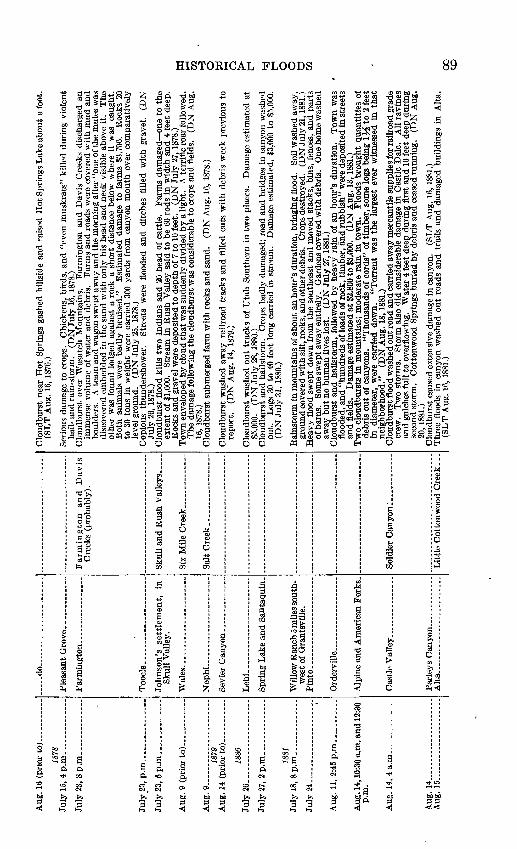
Aug
. 9.
July
26.
.
July
24.
p.m
.
*.ug
. 14
. A
.ug.
15.6
(pri
or t
o; _
...
.. ..
.
1878
' >,
4p
.m_
...
....
....
..
!, 8
p.m
. . _
__
_ . ..
..
, p.m
_________ .
1879
1880
', 2p.m
. __
__
__
_
1881
5,
8p
.m. _
__
__
__
.
L. _
__
.
. ____ .
1, 2
:45
pjn
...........
*, 1
0:30
a.m
. and 1
2:30
4, 4
a.m
__
.. _
_ ..
.
4 .
. ...
5.....................
.....d
o..
....
....
....
....
....
.
Too
ele.
___ . _
.... ......
Sku
ll V
alle
y.
Nephi.
..... .
....
... .........
Leh
i........................
wes
t of
Qra
ntsv
ille
. P
into
.... ...................
Cas
tle
Val
ley..... _
_ . ......
Alt
a..... .................
Cre
eks
(pro
babl
y).
Clo
udbu
rst
near
Hot
Spr
ings
gas
hed
hill
side
and
rai
sed
Hot
Spr
ings
Lak
e ab
out
a fo
ot.
(SL
T A
ug.
16,
1876
.)
Ser
ious
dam
age
to c
rops
. C
hick
ens,
bir
ds,
and
"ev
en m
usk
rats
" ki
lled
dur
ing
viol
ent
hail
- an
d r
ain-
stor
m.
(DN
July
16,
187
8.)
Clo
udbu
rst
over
Was
atch
Mou
ntai
ns.
Far
min
gton
and
Dav
is C
reek
s di
scha
rged
an
imm
ense
vol
ume
of w
ater
and
deb
ris.
F
arm
s an
d ro
ads
wer
e co
vere
d w
ith m
ud a
ndbo
ulde
rs.
A t
eam
and
wag
on s
wep
t aw
ay a
nd
the
mor
ning
aft
er "
one
of th
e m
ules
was
disc
over
ed e
mbe
dded
in
the
sand
wit
h o
nly
his
head
and
nec
k vi
sibl
e ab
ove
it.
The
othe
r w
as f
ound
lod
ged
agai
nst
a ro
ck a
sho
rt d
ista
nce
belo
w w
here
it
was
ca
ught
.B
oth
anim
als
wer
e bad
ly b
ruis
ed."
E
stim
ated
dam
age
to f
arm
s $3
,700
. R
ocks
20
to 3
0 to
ns i
n w
eigh
t w
ere
carr
ied
300
yard
s fr
om c
anyo
n m
outh
ove
r co
mpa
rati
vely
leve
l gr
ound
. (D
N J
uly
25,
187
8.)
Cop
ious
th
unde
rsho
wer
. S
tree
ts w
ere
floo
ded
and
ditc
hes
fill
ed w
ith
grav
el.
(DN
July
26,
187
8.)
Clo
udbu
rst
floo
d ki
lls
two
Indi
ans
and
20 h
ead
of c
attl
e.
Far
ms
dam
aged
on
e to
the
exte
nt o
f $1
,000
. S
trea
m i
n R
ush
Val
ley
said
to
be 6
0 ro
ds i
n w
idth
and
4 f
eet
deep
.R
ocks
and
gra
vel
wer
e de
posi
ted
to d
epth
of
7 to
10
feet
. (D
N J
uly
27,
187
8.)
Tow
n en
velo
ped
by c
loud
that
was
sud
denl
y di
vide
d by a
ligh
t.
A t
erri
fic
roar
fol
low
ed.
The
dam
age
foll
owin
g th
e cl
oudb
urst
was
con
side
rabl
e to
cro
ps a
nd f
ield
s.
(DN
Aug
.16
, 18
78.)
Clo
udbu
rst
subm
erge
d fa
rm w
ith r
ocks
and
san
d.
(DN
Aug
. 16
,187
8.)
Clo
udbu
rst
was
hed
away
rai
lroa
d tr
acks
and
fil
led
cuts
wit
h de
bris
wee
k pr
evio
us t
o re
port
. (D
N A
ug.
14,
1879
.)
Clo
udbu
rst
was
hed
out
trac
ks
of U
tah
Sou
ther
n in
tw
o pl
aces
. D
amag
e es
tim
ated
at
$5,0
00.
(DN
July
28,
188
0.)
Clo
udbu
rst
and
hail
stor
m.
Cro
ps b
adly
dam
aged
; ro
ad a
nd
bri
dges
in
cany
on w
ashe
dou
t.
Log
s 30
to
40 f
eet
long
car
ried
in
stre
am.
Dam
age
esti
mat
ed,
$3,0
00 t
o $5
,000
.(D
N J
uly
31,
1880
.)
Bar
nsto
rm i
n m
ount
ains
of
abou
t an
hou
r's
dura
tion
, br
ingi
ng f
lood
. So
il w
ashe
d aw
ay,
grou
nd c
over
ed w
ith
silt
, roc
ks, a
nd o
ther
deb
ris.
C
rops
des
troy
ed.
(DN
July
21,
1881
.)H
eavy
flo
od s
wep
t do
wn
from
th
e so
uthe
ast
and
mov
ed s
tack
s, b
ins,
fen
ces,
and p
arts
of
bar
ns.
Som
e sw
ept
away
ent
irel
y.
Gar
dens
cov
ered
wit
h de
bris
. O
ne h
ome
was
hed
away
bu
t no
hum
an l
ives
los
t. (D
N J
uly
27,
1881
.)C
loud
burs
t an
d ha
ilst
orm
, fo
llow
ed b
y he
avy
rain
of
an h
our'
s du
rati
on.
Tow
n w
as
floo
ded,
and
"hundre
ds
of lo
ads
of r
ock,
tim
ber,
and
rubbis
h"
wer
e de
posi
ted
in s
tree
ts
and
fie
lds.
D
amag
e es
tim
ated
at
$2,8
00 t
o $3
,000
. (D
N A
ug.
13,1
881.
)T
wo
clou
dbur
sts
In m
ount
ains
; m
oder
ate
rain
in t
own.
F
lood
s br
ough
t qu
anti
ties
of
debr
is o
ut o
f ca
nyon
s.
"Tho
usan
ds o
f co
rds"
of
tim
ber,
som
e lo
gs b
eing
1^4
to
2 f
eet
in d
iam
eter
, w
ere
carr
ied
dow
n.
"To
rren
t w
as t
he
larg
est
ever
wit
ness
ed i
n th
at
neig
hbor
hood
."
(DN
Aug
. 18
,188
1.)
Clo
udbu
rst
floo
d w
ashe
d ou
t ro
ad a
nd c
arri
ed a
way
mer
cant
ile
supp
lies
for r
ailr
oad
grad
e cr
ew.
Tw
o st
orm
s.
Sto
rm a
lso
did
cons
ider
able
dam
age
in C
astl
e D
ale.
A
ll r
avin
es
and
gulc
hes
full
to
over
flow
ing.
W
ater
4 f
eet
deep
dur
ing
firs
t an
d 1
0 fe
et d
eep
duri
ng
seco
nd s
torm
. C
otto
nwoo
d S
prin
gs b
urie
d by
deb
ris
and
ceas
ed r
unni
ng.
(DN
Aug
. 20
, 18
81.)
Clo
udbu
rst
caus
ed e
xten
sive
dam
age
in c
anyo
n.
(_SL
T A
ug.
16,1
881.
)T
hree
flo
ods
in c
anyo
n w
ashe
d ou
t ro
ads
and
tra
ils
and
dam
aged
bui
ldin
gs i
n A
lta.
(S
LT
Aug
. 16
,188
1.)
H o
W o o a cc G
O

Abs
trac
t ac
coun
ts o
f ou
tsta
ndin
g cl
oudb
urst
flo
ods
in U
tah
Con
tinu
ed
Dat
e
Aug
. 18.
1882
Aug
11
Aug
. 2
7..
..-
- --
---
1883
Ju
ly 4
-5..-.
. -
July
S
July
21
. -- --
Aug
. 1- --
1884
"M
ar
19
1885
Loc
ality
Salt
Lak
e C
ity
-
.
Kan
ab
. .
Kan
ab. .
....................
Salt
Lak
e C
ity.... ..
..... .
..
. -.d
o..
..
....
....
....
..
Cit
y.
Stre
am c
ours
e
Cit
y C
reek
__
__
__
__
_ ..
Kan
ab C
reek
.. _
__ ..
....
Kan
ab C
reek
.. .............
Cit
y C
reek
....
.. ..
Rem
arks
to 1
0 fe
et d
eep"
was
rep
orte
d.
(DN
Aug
. 22,
188
1.)
Clo
udbu
rst
does
con
side
rabl
e da
mag
e.
(DN
Aug
. 18
, 188
1.)
Can
yons
and
gul
ches
fill
ed w
ith
roar
ing
torr
ents
, in
man
y ca
ses
over
8 f
eet d
eep.
M
um-
ford
far
m a
lmos
t en
tire
ly r
uine
d.
Bri
ck k
ilns
con
tain
ing
upw
ard
of 1
00,0
00 b
rick
s pa
rtia
lly
was
hed
away
and
col
laps
ed.
(DN
Aug
. 14
, 188
2.)
Log
an v
icin
ity
visi
ted
by h
eavy
sto
rm,
floo
ding
str
eets
. (O
DH
Aug
. 15
, 188
2.)
road
s da
mag
ed,
tree
s bl
own
dow
n, a
nd "
frui
t by
the
ton
" kn
ocke
d fr
om o
rcha
rd t
rees
. (D
N A
ug.
17,
1882
.) C
loud
burs
t in
cany
on b
ring
s do
wn
imm
ense
am
ount
of d
irt
and
larg
e ro
cks.
Stre
ets
floo
ded,
cel
lars
fill
ed,
hay
and
grai
n da
mag
ed .'
Thi
rd f
loor
in
seas
on;
the
firs
ttw
o w
ere
not
larg
e.
Cre
ek b
ed d
eepe
ned
10 t
o 15
fee
t, an
d ir
riga
tion
ditc
h w
as f
illed
w
ith
sand
. (D
N S
ept.
7, 1
882.
)
Goo
d de
al o
f da
mag
e by
clo
udbu
rsts
. C
otto
n fa
ctor
y m
illra
ce a
nd d
am w
ashe
d ou
t at
Was
hing
ton.
(D
N J
uly
18, 1
883.
) Fl
ood
from
Pin
e V
alle
y M
ount
ains
dam
aged
far
ms,
dam
s, d
itche
s, a
nd r
oads
and
dam
ag
ed f
acto
ry d
am a
nd r
ace
to e
xten
t of
$1,
000.
(D
N J
uly
19, 1
883.
) Fl
ood
in V
irgi
n R
iver
.tea
rs o
ut a
ll da
ms
betw
een
Was
hing
ton
Fie
ld a
nd M
esqu
ite.
(DN
Jul
y 28
, 18
33.)
"Hea
vies
t flo
od k
now
n in
this
par
t of t
he c
ount
ry."
M
asse
s of
ear
th a
s la
rge
as a
com
mon
hous
e fl
oate
d do
wn
the
stre
am w
ith
will
ows
stil
l sta
ndin
g.
Ext
ensi
ve d
amag
e to
cro
ps,
and
all
farm
ing
land
in
cany
on w
as d
estr
oyed
. So
me
catt
le k
illed
. C
anyo
n ne
ar o
ld
city
dam
cut
50
feet
dow
n an
d 16
rod
s w
ide.
Fl
ood
last
ed 7
to 8
hou
rs.
Fre
sh c
utti
ng
in c
hann
el o
pene
d up
sev
eral
new
spr
ings
. (D
N J
uly
30, 1
883.
) C
loud
burs
t in
mou
ntai
ns s
outh
of
tow
n.
Stre
ets
floo
ded
to d
epth
of n
earl
y 2
feet
. U
n-ha
r res
ted
crop
s de
mol
ishe
d.
Such
a s
torm
not
see
n fo
r ne
arly
8 y
ears
. (D
N A
ug.
6,18
83.)
' Fl
ood
swep
t aw
ay l
umbe
r m
ill a
nd s
ome
cabi
ns.
Inha
bita
nts,
war
ned
by s
ound
of
appr
oach
ing
wav
e, c
limbe
d th
e hi
llsid
es in
tim
e to
esc
aps.
(D
N A
ug.
17, 1
883.
)
Five
suc
cess
ive
days
of
rain
bri
ng f
lood
s do
wn
cree
k, d
oing
dam
age
to e
xten
t of
$50
0.R
ainf
all
unpr
eced
ente
d.
(DN
Mar
. 21,
188
4.)
Hea
vy r
ain
in c
ity,
clo
udbu
rst i
n ca
nyon
, cau
sing
ove
rflo
w o
f aqu
educ
t on
Nor
th T
empl
eSt
reet
. So
me
adja
cent
yar
ds w
ere
floo
ded.
(D
N A
ug. 9
, 183
4.)
Hea
vy r
ain
over
city
. St
reet
s w
ere
floo
ded
and
ditc
hes
fille
d w
ith
sand
and
gra
vel.
Aug
men
ted
by d
isch
arge
fco
m h
ills
follo
win
g ro
ads
from
gra
vel
pits
on
Nor
th B
ench
. (D
N M
ay 9
, 18
S5.)
Rai
lroa
d tr
acks
und
ercu
t or
cov
ered
wit
h gr
avel
as
a re
sult
of
inte
ase
stor
m.
Tra
ffic
tied
up.
(DN
Aug
. 8,
1835
.) H
eavy
rai
ns,
was
hing
hug
e bo
ulde
rs a
nd t
rees
dow
n th
e ca
uyon
. R
oad
gulli
ed i
n so
me
plac
es, c
over
ed w
ith d
ebri
s in
oth
ers.
E
stim
ated
dam
age,
$1,
000.
(D
N A
ug.
12,
1885
.)
w C3
W
cc
H O
O 02 I-H
3 W CO
C
O
00

GEOLOGICAL SURVEY WATER-SUPPLY PAPER 994 PLATE 20
A. MAIN STREET OF WILLARD AFTER FLOOD OF AUGLol 1^, 1923.
Photo by L. M. Winsor.
B. RESIDENCE AT WILLARD AFTER FLOOD OF ALGUST 13, 1923.
Photo by L. M. Winsor.
C. ORCHARD NEAR MOUTH OF FARMINGTON CANYON, FLOOD OF AUGUST 13, D. RESIDENCE AND BARN IN WAKE OF PARRISH CREEK FLOOD OF AUGUST 271923. 1930.
Photo bv L. M. Winsor. ' Photo by L. M. Winsor.


Ang
. 2
3..
..._
....
Sep
t. 10
(pr
ior t
o).
188G
A
pr.
12 (
prio
r to
).
Aug
. 17...........
Aug
. 18,
28 (n
oon)
,31
(noo
n),
Sep
t. 1
(a.m
.).
Aug
. 19
, noon.....
Aug
. 25
(pri
or to
).
Aug
. 30,
(pr
ior
to 3
a.m
.)
Aug
. 31,
p.m
._.
Sep
t. 2
(pri
or to
).
-Tul
y 10
, p.m
.1887
July
28
(pri
or t
o).
Aug
. 2
3..
....
....
.
July
21.
July
30.
July
31,
nig
ht.
Aug
. 3_.. _
.
Riv
er.
Kan
ab
Kan
ab
Thi
stle
Mill
arc
Kan
ab
Fillm
ore
Fillm
ore
Ogd
en
Can
yo
n
to
Gre
en
r. For
t (C
edaV
Val
ley)
.,
vil
le..-.
........... .
.
Cit
y..
...............
Nar
row
s.
Cot
tonw
ood
Was
h an
d Pr
ice
Can
yon.
Cha
lk C
reek
....
.. _
. _ ..
.
Hea
vy r
ains
ove
r th
e re
gion
was
hed
out
railr
oad
trac
ks i
n m
any
plac
es a
nd u
nder
min
ed
pile
bri
dge.
Pr
ice
and
Gre
en R
iver
floo
ded.
(D
N A
ug. 2
6,18
85.)
Flo
od d
amag
es i
rrig
atio
n di
tche
s.
Est
imat
es o
f tw
o fo
rmer
flo
ods
give
fre
sh c
utti
ng a
t ca
nyon
mou
th a
s 64
to
69 f
eet
tota
l de
pth.
P
roba
bly
exag
gera
ted.
(S
ee n
ext
item
.)
(DN
Sep
t. 10
, 188
5.)
Hea
vy r
unof
f (p
roba
bly
a sp
ring
fre
shet
) w
ashe
d ou
t da
m a
nd a
dded
10
feet
to
dept
h of
ch
anne
l. T
otal
dep
th r
epor
ted
as 5
0 fe
et.
(DN
Apr
. 12
,188
6.)
Tra
cks
of D
. &
R.
G.
W.
R.R
. fl
oode
d an
d co
vere
d w
ith
grav
el,
dela
ying
tra
in s
ever
al
hour
s.Fl
ood
was
hed
out t
rack
bed
of U
tah
Cen
tral
R.R
. in
som
e pl
aces
and
cov
ered
it in
oth
ers.
(D
N A
ug.
18,
1886
.)F
our
succ
essi
ve f
lood
s.
Fir
st f
illed
cel
lar
of T
ithi
ng O
ffic
e an
d ca
used
set
tlem
ent
of
buil
ding
. Se
cond
flo
od d
epos
ited
sand
and
gra
vel
on s
ever
al a
cres
. T
hird
of
seri
es
caus
ed s
ome
dam
age
to th
ree
prop
ertie
s.
Ano
ther
floo
d pe
ak, n
ot s
o he
avy,
cam
e do
wn
abou
t 8
to 9
p.m
. on
the
sam
e da
y.
Lar
gest
floo
d of
ser
ies
occu
rred
in c
onju
nctio
n w
ith
inte
nse
rain
- an
d ha
il-st
orm
. H
ails
tone
s as
lar
ge a
s 1J
^ in
ches
wer
e no
ted.
D
amag
e re
duce
d be
caus
e of
pre
para
tion
for
div
ersi
on,
but
cons
ider
able
dam
age
to f
ruit
cro
ps
occu
rred
. C
orre
spon
dent
say
s, "
The
'dam
s in
the
cre
ek*
* *
wen
t ou
t so
me
tim
e ag
o,
but
we
are
so u
sed
to t
hat
I ha
d al
mos
t for
gotte
n to
men
tion
it.
" (D
N S
ept.
9,18
86.)
Inte
nse
hail-
and
rai
n-st
orm
. St
reet
s an
d ce
llars
wer
e fl
oode
d, f
arm
lan
d gu
llied
, an
d w
heat
she
aves
car
ried
aw
ay.
(DN
Aug
. 20,
188
6.)
Hea
vy r
ain
follo
wed
by
terr
ific
flo
od.
All
dam
s an
d br
idge
s w
ashe
d aw
ay a
nd g
arde
ns
buri
ed i
n m
ud f
rom
2 in
ches
to
2 fe
et d
eep.
O
ne h
ouse
and
all
cont
ents
was
hed
away
. L
oss
esti
mat
ed a
t se
vera
l hu
ndre
d do
llars
. N
o liv
es lo
st.
(DN
Aug
. 25
,188
6.)
Thi
rty
min
utes
aft
er r
ain
bega
n a
larg
e vo
lum
e of
wat
er c
ame
from
the
mou
ntai
ns,
filli
ng
cella
rs a
nd w
ashi
ng a
way
cro
ps.
Dam
age
esti
mat
ed a
t th
ousa
nds
of d
olla
rs.
(DN
A
ug.
30,
1886
.)Sm
all
was
hout
cov
ers
sect
ion
of tr
ack
wit
h gr
avel
. (D
N S
ept.
1,18
86.)
Dam
age
to t
rack
by
clou
dbur
st i
nter
rupt
ed r
ailr
oad
traf
fic.
(D
N S
ept.
2, 1
886.
)
Floo
d de
vast
ated
tow
n an
d- s
urro
undi
ng c
ount
ry.
Thr
ee s
awm
ills
swep
t aw
ay.
Hal
f a
herd
of s
heep
lost
. (O
DH
Jul
y 12
, 18
87.)
Tra
ck o
f U
tah
Cen
tral
R.R
. co
vere
d w
ith
rock
s, s
and,
and
bru
sh f
or c
onsi
dera
ble
dis
ta
nce
by w
asho
uts
caus
ed b
y in
tens
e ra
ins.
(D
N J
uly
11,
1887
.)L
ight
rai
ns i
n to
wn,
hea
vy s
torm
in
mou
ntai
ns c
ausi
ng d
ebri
s fl
ow.
Abo
ut h
alf
an a
cre
of c
ropl
and
was
cov
ered
wit
h de
bris
to
a de
pth
of 2
% f
eet.
Cel
lars
and
hou
ses
floo
ded
and
road
s w
ashe
d ou
t. Se
vere
st s
torm
exp
erie
nced
the
re t
o da
te.
(DN
Jul
y 28
, 18
87.)
Clo
udbu
rst c
ause
s st
ream
, dry
sin
ce s
prin
g, t
o ov
erfl
ow a
nd fl
ood
crop
land
. C
onsi
dera
ble
(DN
Aug
. 27
, 18
87.)
Clo
udbu
rst
was
hed
out
sect
ion
of tr
ack
of D
. &
R.
G. W
. R
.R.
(DN
Jul
y 25
, 18
88.)
Hea
vy r
ains
con
cent
rate
d in
vic
init
y of
Ogd
en.
Seve
ral
land
slid
es i
n O
gden
Can
yon,
an
d ro
ad w
as w
ashe
d ou
t in
pla
ces
for
a di
stan
ce o
f 1,
000
feet
. H
eavy
tor
rent
s in
sid
e gu
lche
s.
Riv
er c
arri
ed a
gre
at d
eal o
f deb
ris.
St
orm
sai
d to
be
heav
iest
eve
r w
itne
ssed
in
tha
t ar
ea.
(DN
Aug
. 1,
1888
.)Fl
ood
aris
ing
from
clo
udbu
rst
in m
ount
ains
sw
ept
away
bri
dges
, fe
nces
, an
d ou
tbui
ld-
ings
; de
stro
yed
40 t
ons
of h
ay a
nd d
epos
ited
debr
is o
n cr
opla
nd.
(DN
Aug
. 9,
188
8.)
Clo
udbu
rst
and
hail
stor
m s
truc
k to
wn.
H
ails
tone
s 1
inch
in
diam
eter
. S
tree
ts a
nd
stre
ams
wer
e fl
oode
d, c
anyo
n br
idge
s w
ashe
d ou
t, an
d ga
rden
s de
stro
yed.
(D
N A
ug.
8, 1
888.
)
W I-H CO H
O O o o o CO

Abst
ract
acc
ount
s of
out
stan
ding
clo
udbu
rst
floo
ds i
n U
tah C
onti
nued
to
Dat
eL
ocal
ityS
trea
m c
ours
eR
emar
ks
Apr
. 10
.
June
6_.
Aug
. 10
, p.m
..
Aug
. 16
, p.m
..
Aug
. 19
(pr
ior
to).
1890
May
1-
Salt
Lak
e C
ity.
Junc
tion
of
Se
vier
, Ju
ab,
and
Mil
lard
Cou
ntie
s.Se
vier
Riv
er.
Bin
gham
Can
yon.
Manti
______
Ephra
im_________.
Bet
wee
n B
lack
R
ock
and
Oas
is.
Ste
rli
ng. .
May
field
__
__
__
_._
_.
Man
ti C
reek
_.
Eph
raim
Cre
ek.
Woo
d C
anyo
n -
Dry
Hol
low
s, n
ear
Fri
sco.
Gar
flel
d B
each
__
__
__
.
Ech
o C
anyo
n..
Web
er C
anyo
n.
Hun
ting
ton.
-..
Salt
Lak
e C
ity.
Hun
ting
ton
Cre
ek.
Par
leys
Can
yon_.
Har
d ra
in f
or 1
5 m
inut
es f
lood
s a
few
low
-bui
lt ho
mes
and
was
hes
mud
and
san
d on
to
gard
ens.
N
ot m
uch
dam
age,
but
wat
er w
as "
ankl
e de
ep"
in t
he s
tree
ts.
(DN
Apr
. 10
, 18
89.)
Stor
m s
o fie
rce
that
Sev
ier
Riv
er r
aise
d 6
feet
in
very
sho
rt t
ime.
P
rinc
ipal
dam
age
to
Uta
h C
entr
al R
.R.
thro
ugh
Sevi
er C
anyo
n.
Muc
h of
tra
ck f
lood
ed b
etw
een
mou
th
of C
hick
en C
reek
and
Lea
min
gton
. O
ne s
mal
l br
idge
was
hed
away
, an
othe
r un
der
m
ined
. R
ails
ben
t an
d al
inem
eut
dest
roye
d.
(DN
Jun
e 8,
188
9.)
Unp
rece
dent
ed ra
in f
lood
ed s
tree
ts a
nd g
ulch
es, w
ashe
d ou
t ga
rden
s an
d de
posi
ted
grav
el
and
brus
h-ar
ound
hou
ses
and
in s
tree
ts.
Dam
age,
abo
ut $
1,00
0.
(DN
Aug
. 12
, 18
89.)
Ter
rifi
c th
unde
rsto
rm.
Hea
vy r
oari
ng i
n ca
nyon
. Fl
ow 8
fee
t de
ep c
ame
dow
n cr
eek,
ca
rryi
ng h
uge
tree
s, l
ogs,
bru
sh, e
tc.,
whi
ch w
as s
catt
ered
ove
r st
reet
s of
tow
n.
Seve
ral
farm
ani
mal
s dr
owne
d, a
nd m
uch
prop
erty
dam
age.
Cre
ek w
ashe
d ou
t m
asse
s of
tree
s, r
ocks
, an
d so
il an
d de
posi
ted
them
in
tow
n.
Mud
to
dept
h of
3 f
eet i
n st
reet
s an
d on
gar
dens
. So
me
hom
es f
lood
ed.
Uta
h C
entr
al R
.R.
road
bed
was
hed
out.
Tra
ins
dela
yed
3 to
4 h
ours
.
Gre
at l
oss
of c
rops
. D
amag
e to
pro
pert
y.C
anyo
n on
ly a
bout
1^ m
iles
long
. St
ream
pou
red
fort
h "s
ix
rods
or
mor
e in
wid
th
and
fully
5 f
eet
deep
in
the
cent
er."
M
ain
stre
am d
irec
tly
agai
nst
Jorg
ense
n ho
me,
w
ithi
n w
hich
wer
e M
rs. J
orge
nsen
and
six
chi
ldre
n.
Mr.
Jor
gens
en a
rriv
ed,
left
bug
gy
and
team
on
dry
grou
nd in
car
e of
old
est b
oy w
ho h
ad c
ome
out f
or h
elp.
M
r. J
orge
nsen
fo
und
othe
r fi
ve c
hild
ren
in h
ouse
, fl
oatin
g ar
ound
on
a lo
unge
on
3 fe
et o
f w
ater
, an
d hi
s w
ife
hold
ing
up a
cup
boar
d to
ste
ady
hers
elf
and
also
to
prev
ent
it f
rom
fal
ling
on
the
child
ren.
IV
lr. J
orge
nsen
bro
ke a
win
dow
to
mak
e an
exi
t fo
r th
e w
ater
. H
e sa
w
the
stab
le s
wep
t aw
ay,
bugg
y an
d ho
rses
rol
ling
over
and
ove
r.
The
boy
wit
h th
e bu
ggy
was
dro
wne
d, a
lso
catt
le a
nd h
orse
s.
Fenc
es w
ere
brok
en,
stab
les
and
corr
als
wre
cked
, sh
eds
unde
rmin
ed,
cella
rs f
illed
, an
d or
char
ds b
urie
d in
deb
ris.
Bed
s of
hol
low
s at
rai
lroa
d cr
ossi
ngs
was
hed
out
so d
eep
that
pile
s w
ere
left
dan
glin
g to
th
e br
idge
.W
ater
spou
t ob
serv
ed o
n la
ke.
Exc
ursi
on b
oat
was
nea
rly
swam
ped.
L
aste
d on
ly h
alf
an h
our,
but
in
that
tim
e th
e pa
vilio
n ne
xt t
o ra
ilroa
d tr
acks
was
cov
ered
by
an i
nch
of w
ater
.Se
vera
l clo
udbu
rsts
rep
orte
d, b
ut n
ot m
uch
dam
age.
Tra
in w
as h
alte
d by
land
slid
e.
Tra
cks
wer
e fl
oode
d in
man
y pl
aces
and
bur
ied
by g
rave
l an
d bo
ulde
rs i
n ot
hers
. L
ands
lides
and
ove
rflo
win
g gu
lche
s br
ough
t do
wn
thou
sand
s of
tons
of d
ebri
s.
Soon
aft
er tr
ain
had
cros
sed
a ce
rtai
n se
ctio
n, t
he w
hole
mas
s sl
ippe
d in
to t
he r
iver
. A
lit
tle-
late
r a
frei
ght
trai
n, a
ttem
ptin
g to
cro
ss a
dan
gero
us s
pot,
was
st
ruck
by
a la
ndsl
ide
and
was
hed
into
a d
itch
. N
o ca
sual
ties
wer
e m
enti
oned
. W
ater
po
urin
g do
wn
mou
ntai
nsid
e cu
t a
gulc
h 18
fee
t w
ide
and
18 f
eet
deep
in
rail
road
bed
. (D
N A
ug.
19, 1
889.
)N
o se
riou
s da
mag
e re
port
ed b
ut r
ains
wer
e so
hea
vy i
n hi
lls t
hat
"hea
ps o
f m
ud"
wer
e br
ough
t do
wn
ever
y gu
lch.
T
rain
s de
laye
d.
(DN
Aug
. 21
,188
9.)
Hea
vy r
ains
aug
men
ted
by m
elti
ng s
now
flo
oded
can
yon,
con
cent
rati
ng a
t su
mm
it.
Roa
ds w
ere
dam
aged
and
hill
side
s ga
shed
. (D
N M
ay 2
, 18
90.)
O f
O d
a
w d » GQ
1-3
O
O a 02 w M-
00
O M-
CO
C
O
00

July
13.
July
20.
July
29,
4 p
.m
Aug
. 12
, 4 p
.m.
Aug
. 13
, p.m
.
Aug
. 16
,1 p
.m
Aug
. 19
, 2 p
.m
Sept
. 10-.
... j
June
15
__
. j Ju
ly 2
2, p
.m.
July
26,
10 p
.m
Aug
. 18
(pr
ior
to)
July
13.
July
29,
aft
erno
on
91 ... .
....
. ..
__
92 9S to).
...... ..
..
94
Man
ti..
........... _
Coa
lvill
e _________ ..
.
Man
ti.. _
__
__ _
_ ..
.. ..
..
Man
ti.-
. .
...... _
....
Nephi.
.............. __
____
__
Salt
Lak
e C
ity... _
_ _
__
Man
ti C
reek
-
Cha
lk C
reek
_
Man
ti C
reek
.
Eph
raim
Cre
ek,
Oak
Cre
ek......
Man
ti C
reek
...
Six-
mile
Cre
ek.
Man
ti C
reek
...
Bin
gham
Can
yon-
Web
er C
anyon.....
Salt
Cre
ek C
anyo
n.
Sou
th H
ills
.
Big
Hol
low
. _ _
__
.._
_
Cen
ter
and
Dan
iels
Cre
eks-
Clo
udbu
rst 3
or 4
mile
s up
Man
ti C
anyo
n.
Roa
d in
can
yon
cove
red
wit
h ro
cks
and
mud
.B
ridg
es w
ashe
d aw
ay.
Stre
ets
floo
ded.
(D
N J
uly
18,
1890
.) "F
resh
et"
did
seve
ral
thou
sand
dol
lars
' w
orth
of
dam
age.
B
ridg
es a
nd r
oads
was
hed
out,
and
fiel
ds c
over
ed w
ith
debr
is.
(DN
Jul
y 21
, 18
90.)
Roc
ks,
logs
, an
d de
bris
deb
ouch
ed f
rom
can
yon.
Sa
w m
ill a
nd s
hing
le m
ill w
ashe
d ou
tof
can
yon.
M
achi
ne s
hop
swep
t aw
ay.
Bri
dges
car
ried
aw
ay a
nd s
tree
ts o
f to
wn
floo
ded.
L
ogs
and
debr
is d
ebou
ched
int
o to
wn.
Y
ards
and
gar
dens
flo
oded
and
cov
ered
wit
hm
ud a
nd d
ebri
s.
(DN
Jul
y 21
,189
0.)
Clo
udbu
rst
in S
outh
For
k.
Wal
l of
wat
er 7
fee
t hi
gh c
ame
out
of c
anyo
n, r
ollin
g ro
cks
and
tim
bers
. Sa
wm
ill c
amp
at m
outh
of c
anyo
n sw
ept
away
. R
oad
in c
anyo
n ba
dly
dam
aged
. B
ridg
es s
wep
t aw
ay.
(DN
Aug
. 5,
1891
.)T
rem
endo
us s
torm
. H
uge
stre
ams
of w
ater
, m
ud,
and
debr
is r
ushe
d do
wn
from
the
m
ount
ains
and
flo
oded
the
ent
ire
tow
n.
Cre
ek b
eds
usua
lly
dry
carr
ied
torr
ents
4
to 6
fee
t de
ep.
Ditc
hes
dest
roye
d, f
ence
s w
ashe
d aw
ay,
and
fiel
ds c
over
ed w
ith
mud
an
d bo
ulde
rs.
Roa
ds b
adly
was
hed
and
crop
s se
vere
ly d
amag
ed.
(DN
Aug
. 17
,189
1.)
Tre
es, m
ud, a
nd o
ther
deb
ris
carr
ied
into
tow
n.
Con
side
rabl
e pr
oper
ty d
amag
e.
"Tho
r
ough
fare
s in
the
vic
init
y of
the
floo
d w
ere
a si
ght
long
to
be r
emem
bere
d."
Muc
h de
bris
car
ried
ont
o fa
rms
at m
outh
of
cany
on w
ithi
n re
ach
of f
lood
. (D
N A
ug.
14,
1891
.)M
ud a
nd w
ater
pou
red
out
of c
anyo
n in
to s
tree
ts,
over
gar
dens
, et
c.
Sky
clea
r ov
er
valle
y an
d no
rai
n.
Clo
udbu
rst
on w
ater
shed
of
cree
k.
Log
s, b
rush
, an
d bo
ulde
rs
stre
wn
over
flo
od a
rea.
So
me
hous
es f
lood
ed.
Con
side
rabl
e pr
oper
ty d
amag
e.
(DN
A
ug.
17,
1891
.)In
tens
e ra
inst
orm
in h
ead
of c
anyo
n se
nt fl
ood
dow
n th
e m
ain
stre
et o
f Bin
gham
, car
ryin
g lo
gs a
nd b
ould
ers
and
othe
r de
bris
. Su
bsid
ed b
y 4:
30 p
.m.
In s
ome
plac
es w
here
fl
ood
had
was
hed
over
por
ches
and
sid
ewal
ks "
wer
e le
ft q
uite
lar
ge d
epos
its o
f go
ld
dust
and
oth
er r
ich
min
eral
s."
(DN
Aug
. 19
, 18
91.)
Thi
rd t
erri
fic
stor
m o
f se
ason
. H
ail
and
rain
fel
l in
tor
rent
s.
Gre
at f
lood
fro
m m
oun
ta
ins
cut
deep
gas
hes
and
carr
ied
huge
bou
lder
s an
d bo
dies
of
dead
ani
mal
s.
"One
de
ad h
orse
was
was
hed
over
a h
undr
ed y
ards
on
leve
l gr
ound
."
Tho
usan
ds o
f bu
shel
s of
gra
in w
ere
dest
roye
d by
hai
l. (B
B S
ept.
5, 1
891.
)C
loud
burs
t in
the
vic
init
y of
Pri
ce b
roke
thro
ugh
dike
and
cau
sed
cons
ider
able
pro
pert
y da
mag
e.
Fiel
ds a
nd h
omes
flo
oded
and
cro
ps i
njur
ed.
(DN
Sep
t. 14
,189
1.)
Clo
udbu
rsts
in c
anyo
n th
reat
en t
own.
B
ridg
es a
nd t
rack
s ba
dly
dam
aged
. F
ruit
cro
ps
in U
inta
h, M
orga
n, a
nd W
eber
Cou
ntie
s su
ffer
ed a
ppre
ciab
ly,
in s
ome
case
s be
ing
lite
rall
y sw
ept
away
. (D
N J
une
16,1
892.
)
Inte
nse
stor
m i
n ca
nyon
; no
rai
n in
tow
n.
Floo
d w
ashe
d da
m o
ut t
o no
rth
of c
ity
and
dive
rted
par
t of
the
flo
w,
but
floo
d w
as s
till
unp
rece
dent
ed s
ince
186
2.
Cel
lars
wer
e fi
lled,
and
hay
stac
ks a
nd o
utbu
ildi
ngs
take
n aw
ay.
(DN
Jul
y 25
, 18
93.)
A c
loud
burs
t an
d ha
ilst
orm
str
uck
the
city
. H
ails
tone
s st
ripp
ed o
rcha
rds
and
gard
ens.
Fo
llow
ing
the
hail
a co
piou
s ra
in f
lood
ed s
tree
ts a
nd y
ards
and
par
tial
ly f
illed
som
e ba
sem
ents
. (D
N J
uly
27,
1893
.)C
loud
burs
t in
Sou
th H
ills.
M
uch
dam
age
done
by
flood
s.
Con
side
rabl
e gr
ain
was
hed
away
. F
ield
s co
vere
d w
ith
mud
and
deb
ris.
(D
N A
ug.
18,1
893.
)
Floo
d co
vere
d gr
ain
fiel
ds s
outh
of t
own
wit
h m
ud a
nd t
rash
. (D
SN
Jul
y 14
, 18
94.)
Rai
n w
as s
light
in
valle
y bu
t co
ncen
trat
ed h
eavi
ly o
n th
e ea
ster
n m
ount
ain?
. C
anyo
n fl
oods
, ho
wev
er,
ruin
ed s
ever
al a
cres
of
crop
land
by
floo
ding
or
by d
epos
ition
of
sand
an
d gr
avel
. P
oult
ry w
as d
row
ned,
roa
ds a
nd b
ridg
es w
ashe
d ou
t. (D
N A
ug. 3
,189
4.)
w h-H CO
- H
- O
W F
O
O tr C
O

Ab
stra
ct a
ccou
nts
of
outs
tandin
g c
loud
burs
t fl
oods
in U
tah
Con
tinu
ed
Dat
e
1895
Ju
ly 2
8, 2
p.m
.__
Aug
. 19,
afte
rnoo
n.
May
29-
30..
July
5, p
.m..
Ju
ly 1
3, p
.m.
July
14-
July
14,
2p.m
.
July
14,
2:3
0 p.m
. Ju
ly 1
4,3
p.m
.
July
16,
p.m
...
Loc
alit
y
Hunte
r___......
Fri
sco
_i_
__
...
Sal
t L
ake
Cit
y.
Peo
a. .
Kan
ab...
Fil
lmor
e.
Fay
ette
.
Ep
hra
im.
Fai
rvie
w.
Ric
hfie
ld.
Scip
io_______.
Kan
osh
and
Mea
dow
.
Sig
urd
....______.
Eure
ka .__._
_...
Mam
mot
h -
Merc
ur.
...
St.
Georg
e-.
......... -.
Str
eam
cou
rse
Big
Wash
___________
Kan
ab G
reek
- C
halk
Cre
ek.
Cot
tonw
ood
Cre
ek-
Ced
ar R
idge
Can
yon~
Rem
arks
Hea
vy c
loud
burs
t an
d f
lood
fro
m f
ooth
ills
abo
ve s
ettl
emen
t.
Far
ms
and
bar
ny
ard
s w
ere
was
hed
over
, th
e w
ater
rea
chin
g a
dep
th o
f 2
to 3
fee
t in
som
e pl
aces
. C
anal
s,
ditc
hes,
and
fie
lds
wer
e co
vere
d in
pla
ces
wit
h sa
nd a
nd
gra
vel.
(DN
July
29,
189
5.)
Clo
udbu
rst
in h
ills
at
head
of
Big
Was
h.
Flo
od t
ore
out
seve
ral
rail
road
cro
ssin
gs a
nd
spen
t it
self
in
vall
ey n
ear
Mil
ford
. L
arge
am
ount
of
grai
n de
stro
yed.
F
arm
lan
ds
subm
erge
d.
(DN
Aug
. 20
, 18
95.)
Exc
essi
ve r
ains
flo
oded
tho
cit
y.
Low
er a
reas
on
the
was
t si
de w
ere
repo
rted
to
pres
ent
the
appe
aran
ce o
f la
kes.
R
afts
wer
e ne
cess
ary
in s
ome
plac
es.
Dra
inag
e ca
nal
over
fl
owed
. M
uch
dam
age
to g
arde
ns a
nd
roa
ds.
(DN
Ju
ne
3, 1
896.
)H
eavy
rai
ns b
enef
it c
rops
bu
t da
mag
e br
idge
s.
(DN
Ju
ne
6,18
96.)
Clo
udbu
rst
dam
ages
flu
mes
and
thr
eate
ns d
am.
(DN
July
30,
1898
.)E
norm
ous
body
of w
ater
sw
ept
out
of c
anyo
n an
d ov
er a
por
tion
of
the
tow
n, i
nu
nd
atin
g
fiel
ds a
nd g
arde
ns.
Tre
es,
drif
t lo
gs,
and
boul
ders
str
ewn
over
far
ms.
F
low
thi
ck
wit
h m
ud,
carr
ying
upr
oote
d tr
ees,
log
s, a
nd b
ould
ers.
M
any
hom
es s
urro
unde
d by
sea
of m
ud f
rom
1 t
o 2
feet
dee
p.
Mai
n st
reet
for
abo
ut-h
alf
a m
ile
cove
red
knee
dee
p to
ho
rses
wit
h sl
imy
mas
s of
thic
k m
ud.
Hog
s, c
hick
ens,
and c
attl
e dr
owne
d.
Wag
ons
and
othe
r im
plem
ents
sw
ept
away
. T
hree
saw
mil
ls d
estr
oyed
, pa
rts
foun
d in
fie
lds
12
mil
es
belo
w.
Th
irty
-th
ou
san
d b
oard
fee
t of
lum
ber
carr
ied
away
. E
stim
ated
da
mag
e $2
0,09
0 to
$}0
,000
.F
lood
cam
e do
wn
from
hil
ls.
Alm
ost
the
enti
re s
ettl
emen
t w
as f
lood
ed.
Bri
dges
wer
e w
ashe
d ou
t, f
ence
s w
reck
ed,
cell
ars
fill
ed,
and
wat
er i
n so
me
hous
es.
Cro
ps w
ere
dest
roye
d an
d h
ayst
acks
was
hed
away
. N
ew c
anal
dam
aged
in
man
y pl
aces
and
fi
lled
wit
h de
bris
.M
uch
dam
age
to c
rops
. P
low
ed la
nd
was
hed
so t
hat
onl
y bo
ulde
rs le
ft.
D.
& R
. Q
. W
. R
.R.
trai
n d
elay
ed.
Rai
lroa
d tr
acks
hea
vily
cov
ered
wit
h de
bris
. C
rops
bea
ten
dow
n.
Bar
ns a
nd
oth
er
buil
ding
s sw
ept
away
. (D
N J
uly
14,
1896
.)F
lood
sw
ept
over
and
obl
iter
ated
can
al b
uil
t to
div
ert
floo
d w
ater
s fr
om t
owns
. W
ater
s fl
oode
d st
reet
s, f
illed
cel
lars
, cov
ered
fie
lds
and
gard
ens
wit
h de
bris
and
mu
d.
Pro
per
ty
dam
age
cons
ider
able
.H
eavy
flo
od,
wit
h an
othe
r on
the
16t
h.
Fou
r fl
jods
in
two
days
. M
uch
gra
in a
nd h
ay
dest
roye
d.M
uch
of t
he c
rops
des
troy
ed b
y m
ud a
nd w
ater
. H
ayst
acks
an
d f
arm
bui
ldin
gs s
wep
t aw
ay.
Hea
vy f
lood
s br
ough
t out
hund
reds
of
load
s of
woo
d, f
illi
ng u
p c
anal
s w
ith d
ebri
s, a
nd
cove
ring
up
muc
h ha
y an
d gr
ain.
(D
N J
uly
15,
1893
.)T
orre
ntia
l ra
in o
f an
hou
r's
du
rati
on
flo
oded
the
tow
n.
Tw
o pe
ople
wer
e dr
owne
d an
d on
e di
ed o
f he
art
fail
ure.
G
reat
dea
l of
dam
age
incl
udin
g w
reck
ing
of a
rai
lroa
d br
idge
an
d te
arin
g out
of ra
ils.
Dam
was
hed
out
and
min
ing
prop
erti
es d
amag
ed.
Hea
vy s
torm
fol
low
ing
two
hour
s of
mod
erat
e ra
in f
lood
ed r
ailr
oad
grad
e an
d t
ore
out
rail
s.
Not
muc
h ot
her
dam
age.
(D
N J
uly
14,
1896
.)R
epor
ts h
eavi
est
stor
m i
n ye
ars,
bu
t on
e w
hich
was
con
side
red
mor
e be
nefi
cial
th
an
dam
agin
g.
Wat
er 3
H f
eet
deep
on
wes
t si
de o
f to
wn.
(D
N J
uly
16,
1896
.)
O
F
O
Cj
O
W F
O
O CQ I-H
3 a eo CO oo

HISTORICAL FLOODS 96
111' 3 gSS a '".Sj.a 13
js <s
g-la-Sg-o IS^E s£ b«o §1l§ ^tS-^afcl<gf feSBiso^-Pogos.-:; e-Ssattesss1""* 8. 9 e
lillisrflllis?!
a «
Koosharem.. Holden. ..
r-.1
193ftcft-T
1g"S
|yoS
1
* 1 g iH^ a
S
£a
1 W
Ec
S
*i| ot-4
_a ^.
1
>4~
ic
1H
i
S
a
' 1S"SH
Ec
i cx IN
|
c£Hi
ffl
JS
, « 1-1
c0
cJ401
£ O§So
c
1Hs"3
5 §
OQ
S
>c0. Shi
£
a
^
1
S
>* a
§ 0
11
CQ
c
ic
a (/
£
1 ft.
=
1
It
£c
J3
S
1
a
? 10
!,
" 2
^
O, _ ,n
S
1S
i>
11O
"c+.fes'c
OS004^^H a
ajs
S
I£
nH E
p5
, <N
fl
Jl
g1ffl
aOS" S
d-
J.1
£ O
1S
1K
S
EcSl>
^
S>
S Sc££fc
|"fe
Hj
>e ^
.!
1-
SH CL ££ &H
1fe
&
>»
Sevier Count Ferron. __ .
*crHCO
33

Ab
stra
ct a
ccou
nts
of
ou
tsta
nd
ing
clo
udbu
rst
floo
ds i
n U
tah
Con
tinu
ed
. D
ate
A j-
irr
Q
1900
Aug
. 18
...
-
Sept
. 1-2
. ..................
f\n
t 1
A
1901
Fe
b. 1
9..
....... _
. __
. ...
Mar
. 22........... .
.. ..
.....
July
31
-....
July
29-
Aug
. 2....
Aug
. 3 . ..
.
Aug
. 3
Loc
ality
Leh
L _
__
__
__
__
__
__
Fillm
ore
__________
Bet
wee
n F
airv
iew
an
dT
hist
le.
Pri
ce- ..
....
.. _
. __
Was
hing
ton _
__
__
__
__
Man
ti...
. __
__
__
__
__
....
.do
................. _
...
Stre
am c
ours
e
Wes
t Mou
ntai
ns _
_ ..
....
..
Was
h 2
mile
s fr
om P
rice
Mill
Cre
ek _
_____ . .
...
Mill
Cre
ek....
....
....
....
..
Man
ti C
reek
. __
__
__
..
Ced
ar a
nd P
leas
ant
Cre
eks.
-
Cot
tonw
ood
Can
yon _
__
. _ .d
o... _ ..
...............
Rem
arks
boul
ders
wei
ghin
g 50
0 to
1,0
00 p
ound
s.
Hea
vy r
ains
rep
orte
d ov
er L
ehi
abou
t 12
:30
a.m
., A
ug. 4
, 189
9. (D
N A
ug. 5
, 189
9.)
on fa
rmin
g la
nd.
(DN
Aug
. 5, 1
899.
)
(DN
Aug
. 7,
189
9.)
tow
n.
(DN
Aug
. 8,
189
9.)
whe
re a
bri
dge
had
been
was
hed
out.
Was
h-ou
t on
rai
lroa
d gr
ade
in W
hitm
ore
Can
yon
repo
rted
. (D
N A
ug. 9
, 189
9.)
torn
out
and
ditc
hes
badl
y da
mag
ed.
(DN
Aug
. 22,
190
0.)
dow
n la
rge
tree
s.
Cre
ek f
lood
ed, b
ut n
ot m
uch
dam
age
from
tha
t so
urce
. (D
N S
ept.
6, 1
900.
)
away
and
hom
es w
ere
flood
ed.
Wat
er 1
3 fe
et d
eep
and
reac
hed
acro
ss t
he c
anyo
n.
Cro
ps w
ere
also
dam
aged
. (D
N A
ug. 1
7r19
00.)
(DN
Oct
. 18
, 19
00.)
and
stor
es f
lood
ed o
n lo
wer
Mai
n S
tree
t.
(DN
Feb
. 20
, 19
01.)
$2,0
00.
(DN
Aug
. 2,
190
1.)
No
dam
age
repo
rted
. (D
N A
ug. 7
, 190
1.)
Clo
udbu
rst
in c
anyo
n.
Prin
cipa
l pa
rt o
f city
flo
oded
. H
undr
eds
of c
ords
of
logs
and
mas
ses
of d
ebri
s of
all
kind
s de
posi
ted
in t
he s
tree
ts.
Fenc
es s
wep
t aw
ay,
gard
ens
and
law
ns f
lood
ed, c
ella
rs f
illed
, and
hou
ses
flood
ed.
(DN
Aug
. 2, 1
901.
) T
wo
flood
s re
port
ed b
ut li
ttle
dam
age
was
don
e.
(DN
Aug
. 5, 1
901.
)
Bas
emen
ts o
f bu
ildin
gs w
ere
flood
ed,
frui
t an
d sh
ade
tree
s to
rn d
own.
V
irgin
Riv
er
was
gre
atly
sw
olle
n.
(DN
Aug
. 5, 1
901.
)
dive
rted
fro
m t
he t
own
by l
arge
can
al a
nd a
"co
uple
of d
eep
hollo
ws
nort
h of
tow
n."
Can
al f
illed
up
and
muc
h da
mag
e re
sulte
d in
flo
odin
g fie
lds.
(D
N A
ug. 5
, 190
1.)
(DN
Aug
. 14,
1901
.)
td
cj
W 02 o
o 02 i l
3 a w <£>
CO
00
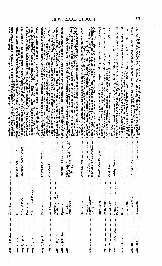
HISTORICAL FLOODS 97
S^S" BQ-SS-3flS'I S^'^'S ISJ lljla
J|| ||M|
g£ ajSTj £ a>fS* $g2 P, a -vfi-Mg || .rfSL^ i|g|s
||l|Saljl ||IIlijnr^s g^i i H
effi!13 S hl« g-y S «
tulips* »-lll!^l^ I£'
fe-ISl" frSSSSJil !<:B^§ o* ^i .ge^M-S- s?i
s Jis-g^ 3-^1^2 s^-iss^sgWd^^S-S^rt^^S of -«52i"'-§>,|^Jl^lls* ""Sfillslf f«g f|S||la|||ll llfSijelf IfiS&8|i||sleh *MisiM£ !* llft||l||°g|| 1§||^lfil IfSo*? fa'5'^^ Si° ^^st? .13-3 ^,2 fe § ds'w s5«g'g-!^B B S3Si£§3j*.S>S
.SM^^f^^Jg: '3S^S|^3i^ r^
MilQJpfl K^ «
:^"°t^a%!af
ii1lSa!i^Ssl^^NaSSiS|S!ll?ls«liEl !|lf«:- °3O3o3t»?'^'35w'rti3r-(d r ~ii®wOT-i+J ':i w Wr>_ ;i:'PwrtSo HrH -S"rHoS'!r<'^wa flflS"-~-aj Pm
g-sl^l S a-8!! a^ S 5'fj §§1*1 S^ i s « ! ̂ a| 5(§2 d2« &« § ^|| S S s|^s« » g l?s1l|S§|*^lil«sp^l^!§l^|!§ag|||*ag ia&^s|i||I|Ss^ 1 a 151 a &1| i S9^g g § ^§ g«|«§ |So 11 l'?^l ̂ ^5-§ 15 is ll l| fels |E5
ra D PQ O PQ fe OE-i EH ^iO D -tiJO E-< m PH De " <! m EH
!
d' 1
C8DM
-t Og ^
o i5 iM -4
j5
? § ) H)
3
V. uIS1t-la
i
E
!c1H
i a. a< D. oo
K
M
D"O
§ w«
cj r^§ D^5 M
O C3D O
C3
PH
r̂i' §
S ^3 -2 c 1 fc 1=
S 1
ca. &P. ^H
|
1
.'S,
P dS
$ if c*" J» 0 °
1 ° tf -i ob E8i3" £ T3o, 2 «O oW Ora PH
I EL, .-
^1 1 8-3 "S0^ 1
A
.1O
s t!p, o
3. S
P
i j! I
|§ pi s >>
go |^ 2
|S |oj'pl -g
ga |PHCQ M
i i i
9 'O '
4^V
^ QJ
£ O
1 IS0 <)
fl i e '
I 1 i°l ^ 1 c'3 ^ a a/ ^ t§ S ^
fc, D PH£I& WOC
c
»
"3 P .* >
3
^ 1 a sW P
S s
a
ii|!
g^C8O
<o
1PH
^i
5 a-3 « S
S^S<^ m O
S C » a5 a "5
CO *O CO 00
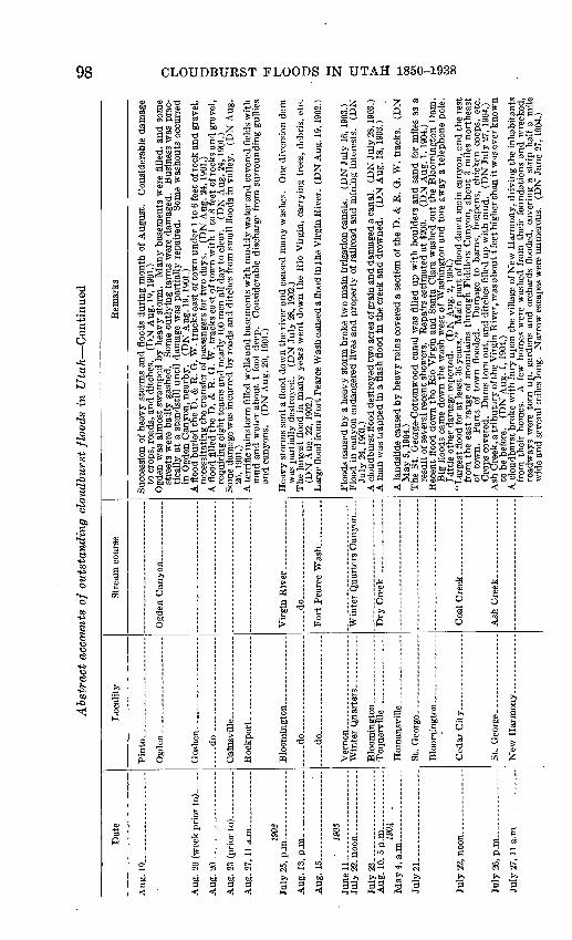
Abs
trac
t ac
coun
ts o
f ou
tsta
ndin
g cl
oudb
urst
flo
ods
in U
tah C
onti
nued
00
Dat
e
Aug
. 19....... _
__
__
__
.
Aug
. 23
(pr
ior
to) _
_____
1902
Aug
. 1
5.... ...
....
....
....
I.
19
03
July
2B.
...
....
....
....
....
.
1904
July
21. . .
Loc
ality
Pin
to..
_ ..
................
. d
o..
....
....
....
.. ..
.....
..... d
o..
....
...... _
.
-..-
do
....
....
....
....
....
Stre
am c
ours
e
... .
.do........ ..
....
.........
For
t Pe
arce
Was
h _____
Rem
arks
Succ
essi
on o
f he
avy
stor
ms
and
floo
ds d
urin
g m
onth
of
Aug
ust.
Con
side
rabl
e da
mag
eto
cro
ps,
road
s, a
nd d
itche
s.
(DN
Aug
. 19
, 190
1.)
stre
ets
wer
e ba
dly
gash
ed.
Som
e ou
tlyi
ng f
arm
s w
ere
dam
aged
. B
usin
ess
was
pra
c
tica
lly
at a
sta
ndst
ill
unti
l da
mag
e w
as p
arti
ally
rep
aire
d.
Som
e w
asho
uts
occu
rred
in
Ogd
en C
anyo
n, n
earb
y.
(DN
Aug
. 19
, 190
1.)
A fl
ood
buri
ed th
e D
. &
R.
Q.
W. t
rack
s ea
st o
f tow
n un
der
1 to
6 fe
et o
f roc
k an
d gr
avel
,ne
cess
itatin
g th
e tr
ansf
er o
f pas
seng
ers
for
two
days
. (D
N A
ug.
24, 1
901.
) A
flo
od f
illed
the
D.
& R
. Q
. W
. tr
acks
eas
t of
tow
n w
ith
1 to
8 f
eet
of ro
cks
and
grav
el,
requ
irin
g ei
ght t
eam
s an
d ne
arly
100
men
all
day
to c
lear
. (D
N A
ug.
24, 1
901.
) So
me
dam
age
was
incu
rred
by
road
s an
d di
tche
s fr
om s
mal
l flo
ods
in v
alle
y.
(DN
Aug
.26
, 19
01.)
A te
rrif
ic r
ains
torm
fill
ed w
ells
and
bas
emen
ts w
ith
mud
dy w
ater
and
cov
ered
fie
lds
wit
hm
ud a
nd w
ater
abo
ut 1
foo
t de
ep.
Con
side
rabl
e di
scha
rge
from
sur
roun
ding
gul
lies
and
cany
ons.
(D
N A
ug.
29,
1901
.)
was
par
tial
ly d
estr
oyed
. (D
N J
uly
28,
1902
.) T
he l
arge
st f
lood
in
man
y ye
ars
wen
t do
wn
the
Rio
Vir
gin,
car
ryin
g tr
ees,
deb
ris,
etc
.(D
N A
ug.
22, 1
902.
) L
arge
floo
d fr
om F
ort P
earc
e W
ash
caus
ed a
floo
d in
ihe
Vir
gin
Riv
er.
(DN
Aug
. 19,
190
2.)
Floo
ds c
ause
d by
a h
eavy
sto
rm b
roke
tw
o m
ain
irri
gatio
n ca
nals
. (D
N J
uly
16,
1903
.)Fl
ood
in c
anyo
n en
dang
ered
liv
es a
nd p
rope
rty
of r
ailr
oad
and
min
ing
inte
rest
s.
(DN
July
24,
190
3.)
A c
loud
burs
t flo
od d
estr
oyed
two
acre
s of
gra
in a
nd d
amag
ed a
can
al.
(DN
Jul
y 28
, 190
3.)
A m
an w
as t
rapp
ed i
n a
flas
h fl
ood
in t
he c
reek
and
dro
wne
d.
(DN
Aug
. 18
, 19
03.)
A l
ands
lide
caus
ed b
y he
avy
rain
s co
vere
d a
sect
ion
of th
e D
. &
R.
G.
W.
trac
ks.
(DN
May
5,
1904
.) T
he S
t. G
eor?
e-C
otto
nwoo
d ca
nal
was
fill
ed u
p w
ith
boul
ders
and
san
d fo
r m
iles
as a
resu
lt of
sev
eral
rec
ent
show
ers.
R
epai
rs e
stim
ated
at
$200
. (D
N A
ug.
1, 1
904.
) R
ecen
t flo
od d
own
the
Rio
Vir
gin
and
San
ta C
lara
was
hed
out
the
Blo
omin
gton
Dam
.B
ig f
lood
s ca
me
dow
n th
e w
ash
wes
t of
Was
hing
ton
and
tore
aw
ay a
tel
epho
ne p
ole.
L
ittl
e ot
her
dam
age
repo
rted
. (D
N A
ug. 2
, 19
04.)
"Lar
gest
flo
od f
or a
t le
ast
36 y
ears
."
Mai
n pa
rt o
f flo
od d
own
mai
n ca
nyon
, an
d th
e re
stfr
om t
he e
ast
rang
e of
mou
ntai
ns t
hrou
gh F
iddl
ers
Can
yon,
abo
ut 3
mile
s no
rthe
ast
of t
own.
P
arts
of
tow
n fl
oode
d.
Dam
age
to b
arns
, ho
gpen
s, c
hick
en c
oops
, et
c.
Cro
ps c
over
ed.
Dam
s to
rn o
ut,
and
ditc
hes
fille
d up
wit
h m
ud.
(DN
Jul
y 27
, 190
4.)
Ash
Cre
ek, a
trib
utar
y of
the
Vir
gin
Riv
er, w
as a
bout
4 fe
et h
ighe
r tha
n it
was
eve
r kno
wn
to b
e be
fore
. (D
N A
ug.
1, 19
04.)
A c
loud
burs
t br
oke
wit
h fu
ry u
pon
the
villa
ge o
f New
Har
mon
y, d
rivi
ng th
e in
habi
tant
sfr
om t
heir
hom
es.
A f
ew h
omes
wer
e w
ashe
d fr
om t
heir
fou
ndat
ions
and
wre
cked
, ro
adw
ays
wer
e to
rn u
p, g
arde
ns a
nd o
rcha
rds
floo
ded,
cov
erin
g a
stri
p ha
lf a
mile
w
ide
and
seve
ral
mile
s lo
ng.
Nar
row
esc
apes
wer
e nu
mer
ous.
(D
N J
une
27, 1
904.
)
f
o
d o td d
» 02 o
o o 3 d o
t-i
SO
CO
00

GE
OL
OG
ICA
L
SU
RV
EY
WA
TE
R-S
UP
PL
Y
PA
PE
R
994
PL
AT
E
21
I
TW
O S
UC
CE
SS
IVE
M
UD
FL
OW
S N
EA
R
LA
YT
ON
, D
AV
IS
CO
UN
TY
.


Aug
. 25.....................
1905
An?
94
n m
A 11
or
*>4.
Aug
. 25
, 7
p.m
....
....
....
..
1906
Aug
. 13........... .
........
Aug
. 11.....................
Aug
. 19.....................
Aug
. 2
0..
... .
...............
Gil
es.
........ ...
....
....
....
Tin
tic.
.. ..
....
....
....
....
..
Par
k C
ity....... .
...........
Ogden
.. ....................
Ric
hfi
eld
......... .
..........
son.
-.-.
-do...... ............ .....
Op
hir
....
--.
-- ..-
.- ..
....
do
....
....
....
....
....
...
Eas
t C
anyo
n ________
Pri
ce R
iver
.....
....
....
....
Vir
gin
Riv
er. .
....
...
....
...
Cre
eks.
A s
ever
e st
orm
pas
sed
over
th
is p
art
of t
he c
ount
ry,
doin
g a
grea
t de
al o
f da
mag
e.
All
th
e br
idge
s al
ong
the
rive
r w
ere
swep
t aw
ay.
The
flu
me
of t
he
Sou
th I
rrig
atin
g C
o.
was
als
o to
rn o
ut.
(DN
Aug
. 22
,190
4.)
The
hea
vy r
ains
for
the
pas
t tw
o w
eeks
bro
ke a
dam
at
a ra
nch
wes
t of
the
tow
n, c
ausi
ng
cons
ider
able
flo
odin
g.
(DN
Aug
. 26
,190
4.)
Clo
udbu
rst
over
can
yon
caus
ed f
lood
whi
ch l
ined
the
ban
ks w
ith
fish
of
all
size
s.
(PR
Ju
ly 2
2, 1
905.
)T
he w
orst
sto
rm i
n a
num
ber
of y
ears
pas
sed
over
Pri
ce,
was
hing
out
the
trac
ks o
f th
e D
. &
R.
G.
W.
in s
ever
al p
lace
s.
Cel
lars
wer
e fi
lled
and
muc
h da
mag
e do
ne t
o cr
ops
and
stre
ets.
T
rain
s w
ere
tied
up
for
som
e ti
me.
(D
N A
ug.
25,1
905.
)A
clo
udbu
rst
up t
he V
irgi
n ca
used
the
lar
gest
flo
od i
n th
e hi
stor
y of
St.
Geo
rge
to s
wee
p do
wn
the
rive
r.
Pri
ce D
am w
as c
arri
ed a
way
ent
irel
y, a
nd t
he c
urre
nt c
ut t
he J
arv
is
Fie
ld D
am a
nd n
earl
y de
stro
yed
the
Was
hing
ton
Fie
ld D
am.
Ani
mal
s an
d de
bris
w
ere
swep
t aw
ay,
and
crop
land
flo
oded
in
man
y pl
aces
. (D
N S
ept.
13,
1905
.)T
wo
trem
endo
us e
lect
ric
stor
ms
floo
ded
the
stre
ets
of O
gden
to
a dep
th o
f se
vera
l fe
et
in p
lace
s.
Str
eetc
ars
wer
e st
oppe
d fo
r a
tim
e an
d so
me
dam
age
was
don
e to
th
e tr
ans
fo
rmer
s an
d tr
ansm
issi
on s
yste
m o
f the
Uta
h L
ight
& R
ailw
ay C
o.
(DN
Aug
. 26,
1905
.) "O
ne o
f the
mos
t de
stru
ctiv
e fl
oods
kno
wn
in y
ears
."
Hug
e bo
dy o
f wat
er e
mer
ged
from
ca
nyon
s an
d sp
read
ove
r th
e va
lley
. S
evie
r V
alle
y ca
nal
fille
d w
ith
mud
and
roc
ks.
Fie
lds
cove
red
and
stac
ks o
f gra
in s
ubm
erge
d in
wat
er a
nd m
ud o
r ca
rrie
d aw
ay.
Mai
n st
reet
flo
oded
. N
ine
head
of
catt
le w
ashe
d aw
ay a
nd d
row
ned.
(D
N A
ug.
31,1
905.
)S
tree
ts f
lood
ed w
ith
mas
s of
mud
and
deb
ris.
G
arde
ns,
law
ns,
and
fiel
ds c
over
ed w
ith
stin
king
, sl
imy
depo
sit
abou
t 12
inch
es d
eep,
fill
ed w
ith
brus
h an
d ot
her
debr
is.
(DN
S
ept.
2,19
05.)
Ext
ensi
ve s
torm
dam
age
to l
ands
, ro
ads,
can
als,
and
bri
dges
. (E
CP
).
Hea
vy r
ainf
all
caus
ed m
ater
ial
dam
age
to s
ome
beet
fie
lds
and
gene
ral
dam
age
to o
ther
crop
s.
(DN
Jun
e 12
, 19
06.)
"Big
gest
flo
od in
10
year
s" c
ame
dow
n th
e ca
nyon
, car
ryin
g al
l ki
nds
of d
ebri
s, i
nclu
ding
seve
ral
dead
she
ep a
nd c
attl
e.
One
hor
se w
as d
row
ned,
and
one
man
bar
ely
esca
ped
in a
ttem
pti
ng t
o cr
oss
the
floo
d.
(DN
Jul
y 30
, 19
06.)
In 2
hou
rs 2
inch
es o
f rai
n fe
ll an
d se
nt t
orre
nts
of w
ater
thr
ough
the
str
eets
. C
ella
rs w
ere
fille
d w
ith
mud
. H
ails
tone
s as
lar
ge a
s w
alnu
ts s
trip
ped
leav
es f
rom
sta
ndin
g co
rn.
Man
y c
hick
ens
wer
e dr
owne
d.
The
flo
od c
arri
ed h
uge
boul
ders
wit
h it
. In
som
epl
aces
the
lan
d w
as g
ashe
d de
eply
, in
oth
ers
it w
as c
over
ed w
ith
debr
is.
The
sam
e fl
ood
stru
ck C
anno
nvil
le,
4 m
iles
bel
ow T
ropi
c,
as a
5-f
oot
cres
t of
Wat
er,
carr
ying
roc
ks a
nd t
imbe
r, b
ore
dow
n.
Roa
ds w
ere
seve
rely
dam
aged
, an
d ot
her
floo
dsw
ere
repo
rted
in
the
cany
ons,
was
hing
out
at
leas
t on
e sh
eep
cam
p.
(DN
Aug
. 17
,190
6.)
Tow
n fl
oode
d by
hea
vy r
ain.
Se
wer
s w
ere
clog
ged
and
base
men
ts f
illed
. (E
R A
ug.
17,
1906
.) .
Hun
dred
s of
dol
lars
' dam
age
done
by c
loud
burs
t.
Mer
chan
dise
and
bui
ldin
gs d
amag
ed.
(ER
Aug
. 24
, 19
06.)
A c
loud
burs
t fl
ood
swep
t do
wn
the
cany
on,
heav
ily
load
ed w
ith
brus
h, r
ocks
, an
d ot
her
debr
is.
(DN
Aug
. 22
, 19
06.)
A s
econ
d fl
ood,
tw
ice
the
volu
me
of t
hat
of
the
day
befo
re,
pour
ed d
own
the
chan
nel,
agai
n be
arin
g gr
eat
quan
titi
es o
f de
bris
, an
d so
me
boul
ders
wei
ghin
g to
ns.
No
dam
age
spec
ifie
d.
(DN
Aug
. 22
, 19
06.)
Qui
te a
flo
od c
ame
dow
n th
e R
io V
irgi
n an
d S
anta
Cla
ra,
and
the
Jarv
is a
nd P
rice
Dam
sw
ere
dam
aged
con
side
rabl
y.
(DN
Sep
t. 4,
190
6.)
W tr1
O
O

Ab
stra
ct a
ccou
nts
of
ou
tsta
nd
ing
clo
udbu
rst
floo
ds i
n U
tah
Con
tinu
ed
Dat
e
Aug
. 22......
. ..A
....
....
..
1907
A
ug. 12......... _
____
_..._
-.
1908
Ju
ly 2
4. _
_______ _
_
July
26,
p.m
....
... .
........
Aug
. 2... .
..................
1909
Aug
. 11 ..
....
....
....
....
Loc
alit
y
Wil
lard
.. ...
....
....
..
...
-d
o.............. ..
.
Pin
to. .
....
. ................
Ric
hfie
ld ..
....... .
.......
Stre
am c
ours
e
.. ..
.do...... ..
....
....
....
...
Rem
arks
boul
ders
wer
e br
ough
t dow
n fr
om th
e ca
nyon
s.
Con
side
rabl
e da
mag
e oc
curr
ed to
frui
t tr
ees
and
truc
k ga
rden
s.
(DN
Aug
. 24
, 190
6.)
the
was
h-ou
ts.
(DN
Sep
t. 6,
190
6.)
lade
n w
ater
fill
ed th
e st
reet
s of
the
tow
n.
(DN
Aug
. 13
, 190
7.)
men
ts f
illed
. Fi
elds
cov
ered
and
cro
ps d
estr
oyed
. W
orse
sto
rm t
han
one
on 1
2th.
(D
N A
ug. 2
3, 19
07.)
in t
he p
roce
ss o
f bei
ng c
ut.
(DN
Aug
. 23,
1907
.)
(DN
Jul
y 30
, 190
8.)
loss
of l
ogs
and
equi
pmen
t. (D
N J
uly
29, 1
908.
)
betw
een
Ogd
en a
nd C
astle
Roc
k; o
ne a
t B
aski
n, 4
0 m
iles
east
of
Ogd
en;
and
one
at
Dev
ils S
lide,
15
mile
s ea
st o
f O
gden
; do
ing
cons
ider
able
dam
age
to r
ailr
oad.
(D
N
Aug
. 1, 1
908.
)
of r
ain.
M
uch
thun
der
and
light
ning
cam
e w
ith i
t, an
d no
dou
bt m
uch
dam
age
was
do
ne d
own
the
cany
on i
n w
ashi
ng o
ut d
ams,
etc
. (D
N A
ug. 5
, 190
8.)
7, 19
08.)
brid
ge.
Syre
tt ho
me
and
barn
flo
oded
. H
ay d
estr
oyed
and
pou
ltry
carr
ied
away
. (D
N A
ug. 1
0, 19
08.)
with
mud
and
gra
vel
and
cut
a gu
lly 3
5 fe
et d
eep,
abo
ut 2
5 fe
et w
ide,
and
500
to
600
feet
lon
g.
Mud
and
deb
ris
pile
d ab
out
10 f
eet
over
cou
ni.ry
roa
d.
Som
e fa
rmla
nds
cove
red.
(D
N A
ug. 1
3, 19
08.)
away
wag
on a
nd th
ree
hors
es a
nd b
urie
d th
em u
nder
mud
and
gra
vel.
Muc
h da
mag
e to
the
road
s.
(DN
Aug
. 14,
1908
.)
of to
wn
flood
ed.
Stor
m e
xten
ded
alon
g th
e ca
nal f
or 8
or
10 m
iles,
fill
ing
it w
ith d
ebri
s in
man
y pl
aces
. (D
N A
ug.
12, 1
909.
)
rock
s, a
nd b
rush
, to
re a
way
fen
ces,
and
cov
ered
fie
lds
with
mud
and
deb
ris.
T
he
wat
er f
illed
the
two
irri
gatio
n ca
nals
with
mud
and
inva
ded
the
hous
es.
The
dam
age
is e
stim
ated
at $
1,00
0.
(DN
Aug
. 23,
190
9.)
O o f
o
d
O
td f
O
O u d 1-3 > w oo
01 o

Aug
. 17,
12:1
0 p
.m.
Aug
. 21....
....
....
Aug
. 31.
Sept
. 1.
Sept
. 4-
.
June
29-
1910
June
30,
p.m
. Ju
ly 2
2. .
___.
July
23.
.
July
20.
..
July
25.
..
Sept
. 27
..
1911
Oct
. 13.
July
9,
p.m
.
Bin
gh
am_
__
_.
Mou
nt P
leas
ant.
Fai
rvie
w--
.......
Fou
ntai
n G
reen
.. W
ale
s__
__
....
Ep
hra
im..
....
...
Tin
tic..
....
....
....
....
.
Ora
ngev
ille
and
Fer
ron.
Bet
wee
n H
unti
ngto
n an
d Pr
ice.
Vem
aL-.
...
St.
Geo
rge.
.
Ofd
ervi
lle.
...
Blo
omin
gton
.
Ora
ngev
ille
..
Val
ley
Cit
y.
Moab
.......
Eur
eka.
St.
Geo
rge.
...
Span
ish
For
k.
Moab____.
Pri
ce.
Wil
lard
.
Cot
tonw
ood
Cre
ek.
Pin
ion
Can
yon.....
Cot
tonw
ood
Cre
ek.
Ash
ley
Riv
er_
__
__
__
_.
Vir
gin
Riv
er
and
San
ta
Cla
ra C
reek
.
Vir
gin
Riv
er.
Pac
k C
reek
.
A c
loud
burs
t ca
rryi
ng h
uge
boul
ders
and
tim
ber
befo
re i
t w
ashe
d aw
ay p
art
of t
he
mou
ntai
nsid
e an
d ca
used
the
exp
losi
on o
f a
reve
rber
ator
y in
the
Yam
pa s
mel
ter
wit
h re
sulti
ng lo
ss o
f abo
ut $
3,00
0.
(DN
Aug
. 17
,190
9.)
"Tor
rent
s ru
shed
dow
n th
e hi
llsid
es a
nd i
nto
tow
n, c
arry
ing
ever
ythi
ng b
efor
e th
em."
H
uge
boul
ders
and
log
s w
ere
brou
ght
dow
n.
Muc
h da
mag
e to
res
ervo
irs,
irr
igat
ion
ditc
hes,
and
hig
hway
s.
Stre
ets
floo
ded,
cel
lars
fille
d, a
nd g
arde
ns a
nd o
rcha
rds
was
hed
out.
Floo
d do
wn
Cot
tonw
ood
Cre
ek.
Cel
lars
fill
ed a
nd s
tree
ts c
over
ed w
ith
mud
and
deb
ris.
Yes
terd
ay h
eavy
flo
od r
an i
nto
hom
es.
Muc
h da
mag
e to
cro
ps.
Vis
ited
by f
our
flood
s re
cent
ly,
doin
g co
nsid
erab
le d
amag
e.E
arli
er i
n w
eek
floo
d di
d da
mag
e to
pro
pert
y in
Eph
raim
to
exte
nt o
f $2
0,00
0.
(DN
A
ug.
23, 1
909.
)L
arge
coa
l st
orag
e bi
ns u
nder
min
ed b
y he
avy
rain
s.
Mud
-flo
w i
n ca
nyon
cov
ered
rai
l
road
tra
ck,
dela
ying
traf
fic
12 h
ours
. (E
R S
ept.
3,19
09.)
Hea
vy r
ains
hav
e ca
used
the
gre
ates
t flo
od k
now
n in
thi
s se
ctio
n.
The
bri
dges
on
the
Cot
tonw
ood
wer
e de
stro
yed,
and
the
bri
dges
and
roa
ds a
bout
Fer
ron
wer
e he
avil
y da
mag
ed.
Los
ses
in t
he n
orth
wes
tern
par
t of
Cas
tle V
alle
y w
ere
esti
mat
ed a
t $2
0,00
0.B
etw
een
Hun
ting
ton
and
Pric
e th
e ro
ads
wer
e w
ashe
d ou
t an
d al
l th
e ir
riga
tion
ditc
hes
wer
e fi
lled
wit
h m
ud a
nd d
ebri
s.
Man
y of
the
dam
s w
ere
take
n ou
t. N
o lo
ss o
f lif
e w
as r
epor
ted,
but
the
loss
to p
rope
rty
was
gre
at.
(DN
Sep
t. 1,
190
9.)
A m
an w
as d
row
ned
by fl
ash
flood
whi
le d
rivi
ng w
agon
acr
oss
stre
am.
(DN
Sep
t. 7,
1909
.)"G
reat
est
flood
in
the
hist
ory
of t
he c
ount
y" w
ent
dow
n th
e V
irgi
n R
iver
, re
mov
ing
dam
s an
d w
ashi
ng m
any
acre
s of
bot
tom
lan
ds.
A c
anal
was
dam
aged
, an
d cr
ops
suff
ered
fro
m h
eavy
rai
ns.
San
ta C
lara
Cre
ek a
lso
was
hed
away
som
e ad
jace
nt f
arm
ing
land
. (D
N S
ept.
8,19
09.)
Abo
ut $
3,00
0 da
mag
e en
sued
fro
m r
ecen
t st
orm
s.
The
riv
er c
ut a
way
muc
h cr
opla
nd
and
dest
roye
d br
idge
s at
its
hei
ght
on A
ug.
31.
Gra
in i
n th
e sh
ock
was
spo
iled
by
heav
y ra
ins,
and
can
yon
road
s w
ere
was
hed
out i
n m
any
plac
es.
(DN
Sep
t. 8,
1909
.)T
he r
ecen
t flo
ods
dam
aged
100
rod
s of
the-
cana
l an
d de
stro
yed
som
e bo
ttom
land
s.
(DN
Se
pt.
10,1
909.
)
Hai
l an
d ra
inst
orm
sai
d to
be
wor
st i
n 32
yea
rs.
Cro
ps w
ere
"bea
t in
to s
hred
s" a
nd
hail
accu
mul
ated
to
dept
h of
4 f
eet
(no
doub
t dr
ifte
d) i
n so
me
plac
es.
Bri
dges
and
ro
ads
was
hed
out,
cella
rs f
illed
, an
d sm
all l
ives
tock
kill
ed.
(EC
P).
Roa
ds w
ashe
d ou
t an
d re
serv
oir
"bro
ken"
by
heav
y st
orm
s.
(GV
T J
uly
1,19
10.)
"Lar
gest
flo
od e
ver
know
n si
nce
Moa
b w
as s
ettl
ed"
spre
ad o
ver
farm
s, c
over
ing
them
w
ith
6 to
12
inch
es o
f mud
. (G
VT
Jul
y 22
,191
0.)
Clo
udbu
rst
at M
clnt
yre'
s ra
nch
in W
est
Tin
tic
fille
d re
serv
oir
wit
h m
ud a
nd s
hut
off
the
wat
er s
uppl
y at
Mam
mot
h C
ity.
(D
N J
uly
25,1
910.
)
A h
eavy
rai
n br
ough
t da
mag
e to
roa
ds,
cana
ls,
and
crop
s, e
spec
ially
hay
th
at h
ad b
een
cut.
(DN
Jul
y 25
,191
1.)
Rec
ent
stor
ms
in t
he c
anyo
n ra
ised
the
Spa
nish
For
k R
iver
abo
ut 4
fee
t, ov
erfl
owin
gca
nals
and
cau
sing
the
mill
race
to b
e w
ashe
d ou
t in
sev
eral
pla
ces.
(D
N J
uly
27,1
911.
) A
gen
eral
rep
ort
of t
he d
amag
e do
ne b
y se
vera
l ra
ins
and
clou
dbur
sts
duri
ng t
he p
ast
mon
th:
Muc
h da
mag
e do
ne to
roa
ds a
nd d
itche
s an
d 75
to 1
00fr
uit
tree
s w
ere
was
hed
dow
n th
e ca
nyon
. (D
N O
ct.
2, 1
911.
) R
ecen
t he
avy
rain
s ca
used
gre
at d
amag
e to
roa
ds i
n C
arbo
n C
ount
y, s
ever
al b
ridg
esan
d gr
ades
bei
ng w
ashe
d ou
t. A
n es
timat
e of
the
dam
age
was
pla
ced
at $
20,0
00.
(DN
Oct
. 13
, 191
11)
Floo
ds c
ause
d de
rail
men
t of
tra
in n
ear
Wil
lard
whe
n de
bris
cov
ered
tra
cks.
Ju
ly 1
0, 1
912.
)(O
SE
B HH GQ
H
O F
O O d GQ

Abst
ract
acc
ount
s of
ou
tsta
nd
ing
clo
udbu
rst
floo
ds i
n U
tah
Con
tinu
ed
Dat
eL
ocal
ityS
trea
m c
ours
eR
emar
ks
July
19,
ajn
. and
p.m
.._
_
July
31,
4:3
0 p.
m.
July
31-.
........
Aug
. 2
(pri
or to
).
Aug
. 26
... ..
..
June
2, p
.m.
June
11......
July
S..
July
19.
July
21......
July
22,
p.m
.
July
23,
p.m
.
Aug
. 9..
Aug
. 11
.
Aug
. 19.
A
ug.
24.
Salt
Lak
e C
ity.
Eur
eka
and
Tin
tic.
.E
urek
a C
anyo
n.
Farm
ing
ton
__
__
__
_.
Ogd
en a
nd n
orth
ern
Uta
h.
Uin
ta B
asin
. E
ure
ka ....
Pini
on C
anyo
n.
Og
den..__..
Salt
Lak
e C
ity-
Par
k C
ity......
Cas
tle G
ate
. Pr
ice
Riv
er.
Lak
fito
wn.
Tooel
e..-
Eas
t C
anyo
n....
Mid
dle
Can
yon.
Ophir
._.
Hen
efer
..
Bin
gham
.V
eron
a G
ulch
.
Nea
r R
ichf
ield
-
Nep
hL
....
....
.Sa
lt C
reek
Can
yon.
May
fiel
d-
Eph
raim
.
Rai
nfal
l se
t a
new
rec
ord
of 0
.96
inch
in
one
hour
, st
oppi
ng s
tree
tcar
tra
ffic
and
rui
ning
la
wns
, be
side
s fi
lling
Sou
th T
empl
e St
reet
wit
h to
ns o
f sa
nd f
rom
the
foo
thill
s an
d ch
icke
n co
ops,
bar
rels
, bo
xes,
and
tre
es f
rom
the
hig
her
part
of
tow
n.
(DN
Jul
y 19
, 191
2.)
Eve
ry s
tree
t in
Eur
eka
was
hed
out.
Wat
er a
nd d
ebri
s "e
nter
ed th
e ba
ck d
oors
of b
usin
ess
hous
es a
nd c
ame
out
the
fron
t," w
ashi
ng o
ut m
erch
andi
se.
"Bar
rels
of
beer
and
em
pty
beer
keg
s" f
loat
ed o
ut t
he f
ront
doo
r an
d do
wn
the
cany
on.
(ER
Aug
. 2,
1912
.)C
loud
burs
t flo
oded
pow
erho
use
subs
tati
on a
nd d
amag
ed s
ever
al p
ortio
ns o
f con
stru
ctio
n jo
b.
(OSE
Jul
y 31
, 19
12.)
Was
h-ou
ts o
n ra
ilroa
ds h
alte
d al
l tr
ain
serv
ice
into
Ogd
en.
Wag
on r
oads
and
bri
dges
w
ashe
d ou
t.R
oads
in U
inta
Bas
in d
amag
ed.
(OSE
Aug
. 2,
191
2.)
Rai
lroa
d tr
acks
was
hed
out b
y he
avy
rain
. (E
R A
ug.
29,1
912.
)
Hea
vy r
ains
torm
floo
ded
stre
ets
and
cella
rs, d
amag
ing
mer
chan
dise
. (O
SE J
une
3,19
13.)
Som
e ce
llars
flo
oded
and
law
ns c
over
ed w
ith
sand
and
gra
vel
duri
ng c
loud
burs
t. (O
SEJu
ne 1
2, 1
913.
) H
eavy
sto
rms
floo
ded
stre
ets
and
depo
site
d m
ud a
nd b
ould
ers
from
hill
side
s.
Hou
ses
wer
e fl
oode
d an
d th
e el
ectr
ic s
yste
m c
ripp
led.
(D
N J
uly
10,1
913.
) H
igh
wat
er i
n ri
ver
from
clo
udbu
rst
was
hed
out
brid
ges
and
dam
aged
num
erou
s ho
uses
."*
* *
the
flo
od w
ater
s fi
lled
the
enti
re b
otto
m b
etw
een
the
two
wal
ls o
f th
e ca
nyon
."(D
N J
uly
21,1
913.
) T
he c
ella
r of
one
hom
e w
as f
illed
and
the
pre
mis
es w
ere
floo
ded
by t
he h
eavy
rai
n th
aten
larg
ed t
he s
trea
m i
n E
ast
Can
yon.
(D
N J
uly
25,1
913.
) A
sev
ere
rain
stor
m,
alm
ost
to t
he e
xten
t of
a c
loud
burs
t, w
reck
ed t
he b
oard
ing
hous
ean
d po
wer
hou
se o
f th
e U
tah
Met
al M
ines
Co.
H
ouse
s an
d of
fice
buil
ding
s w
ere
floo
ded.
T
he t
own
of O
phir
was
als
o st
ruck
and
tw
o ho
uses
rep
orte
d w
ashe
d aw
ay.
(DN
Jul
y23
,191
3.)
A c
loud
burs
t co
vere
d so
me
50 a
cres
of
grou
nd w
ith
debr
is a
nd r
uine
d m
any
tons
of h
ay.
Tra
ins
in t
he v
icin
ity
wer
e ti
ed u
p fo
r se
vera
l hou
rs.
(DN
Jul
y 24
,191
3.)
A c
loud
burs
t, fo
llow
ed c
lose
ly b
y a
roar
ing
flood
whi
ch c
arri
ed b
ould
ers,
dir
t, an
d de
bris
,w
reck
ed e
ight
hou
ses,
sw
eepi
ng t
he c
onte
nts
away
, w
ith
loss
es e
stim
ated
at
$12,
000.
Rai
lroa
d tr
acks
and
gra
des
wer
e w
ashe
d aw
ay a
t on
e sp
ot a
nd b
urie
d w
ith
silt
and
grav
el a
t ot
hers
. (D
N J
uly
24,1
913.
) E
very
can
yon
wes
t of
Ric
hfie
ld h
ad i
ts f
lood
. T
o th
e no
rth
and
sout
h of
Ric
hfie
ld,
cons
ider
able
dam
age
done
to
crop
s.
(WB
A 1
913.
) D
amag
e w
as d
one
to c
anal
s, w
eirs
, an
d br
idge
s by
a f
lood
whi
ch a
lso
put
the
flou
r m
ills
and
pow
er p
lant
out
of c
omm
issi
on.
Hou
ses
and
cella
rs w
ere
fille
d an
d bu
sine
ss s
ectio
nsw
ere
floo
ded.
D
itch
es a
nd c
anal
s w
ere
floo
ded
and
muc
h da
mag
e w
as d
one.
(D
NA
ug.
13,1
913.
)A
flo
od c
ame
dow
n fr
om th
e fo
othi
lls a
nd s
wep
t the
nor
th s
ide
of th
e to
wn.
(W
BA
191
3.)
Sun
day
even
ing,
Aug
. 24
, th
e "a
nnua
l A
ugus
t fl
ood"
vis
ited
Eph
raim
and
bro
ke a
llpr
evio
us r
ecor
ds i
n pr
oper
ty d
amag
e.
Mud
, gr
avel
, bo
ulde
rs,
and
debr
is.
Man
yce
llars
fill
ed w
ith
mud
and
law
ns c
over
ed s
o de
ep a
s to
des
troy
the
m.
One
bou
lder
of
25 c
ubic
fee
t. (W
BA
191
3.)
f
o
d
d
td
d
» CO f
o
o d CQ hH 2
d B

Aug
. 26.
Aug
. 29.
Sept
. 1..
Sept
. 8.
July
25.
Aug
. 7.
July
8_
. Ju
ly 2
5.
Aug
. 1.
Aug
. 4.
Aug
. 5.4,
p.m
. _______
6....
....
....
_ ..
....
'9 ..
....
. ..
....
....
.
0, 1
1 a.
m.
to 1
2 noon.
1, 7
p.m
....
....
....
..
L. .
....
....
....
....
..
1914
)-
21. .
................
1916
5.
.............. _
...
1916
5. ...
..... _
_ . _
_ ..
.
5, p.
m _
__
__
__
__
3, n
oon _ ............
May
flel
d ....................
Og
den
... _
_____ -..
. ..
Pro
vo _
_______ 1 .......
Pri
ce..
___ . __ .... _
_ .
Tin
tic.
... .
....
....
....
......
Sal
t L
ake
Cit
y..
. ...
. .
Mil
ford
. ......... ..
....
Pri
ce _
___________
Fis
h C
reek
..................
Cot
tonw
ood
Can
yo
n.. _
____
_
Can
yons
.
Clo
udbu
rst
in m
ount
ains
eas
t of
tow
n.
Cit
y d
am w
ashe
d aw
ay;
muc
h dr
iftw
ood
and
bo
ulde
rs b
roug
ht d
own.
(D
N S
ept.
1,1
913.
)A
noth
er f
lood
of
grea
ter
seve
rity
th
an o
n A
ug.
19 s
wep
t so
uth
side
of t
own.
S
and,
gra
vel,
an
d bo
ulde
rs i
n la
rge
quan
titi
es i
n so
me
plac
es c
over
ed l
and
so c
ompl
etel
y as
to
ren
der
it w
orth
less
. (W
BA
191
3.)
One
of
the
heav
iest
rai
ns i
n ye
ars.
O
n w
est
side
of
vall
ey l
arge
str
eam
s of
wat
er s
wep
t do
wn
ever
y ca
nyon
, do
ing
cons
ider
able
dam
age
to f
arm
lan
ds.
(WB
A 1
913.
)R
ain
in t
his
area
pro
duce
d a
floo
d w
hich
con
vert
ed r
oads
int
o ca
nals
and
gut
ters
in
to
ragi
ng t
orre
nts.
M
uch
cem
ent
and
road
mat
eria
l w
as s
wep
t aw
ay.
All
tra
ffic
had
to
be
stop
ped
for
the
dura
tion
of th
e st
orm
, w
hich
las
ted
less
th
an a
n. h
our.
(D
N A
ug.
30,1
913.
)A
vio
lent
ele
ctri
cal
stor
m f
lood
ed t
he s
tree
ts w
ith
mud
and
deb
ris,
lea
ving
th
e ci
ty i
n
dark
ness
whe
n fo
ur tr
ansf
orm
ers
wer
e bu
rned
out
. H
omes
wer
e fl
oode
d, d
rivi
ng p
eopl
e fr
om t
hem
. S
ome
dam
age
was
don
e to
lan
d by o
verf
low
s an
d de
posi
ts o
f de
bris
. (D
N S
ept.
1, 1
913.
)F
lood
s, u
nequ
aled
for
yea
rs,
carr
ying
muc
h de
bris
and
tim
ber,
did
con
side
rabl
e da
mag
e to
can
als
and
ditc
hes.
(E
CP
.)A
clo
udbu
rst
fille
d bu
sine
ss h
ouse
s an
d ho
mes
wit
h w
ater
; ce
llar
s w
ere
floo
ded
and
side
w
alks
wer
e w
ashe
d aw
ay.
Tw
o co
unty
bri
dges
, on
e ra
ilro
ad b
ridg
e, a
nd p
art
of a
ra
ilro
ad t
rack
wen
t ou
t.
The
cit
y w
as p
ut
in d
arkn
ess
whe
n th
e m
unic
ipal
lig
ht p
lan
t w
as p
ut
out
of c
omm
issi
on.
(DN
Sep
t. 9
,191
3.)
One
of t
he
bigg
est
stor
ms
in y
ears
. S
mal
l W
ilbe
rg d
am a
nd d
iver
sion
dam
of
Ora
ngev
ille
E
lect
ric
& M
illi
ng C
o. d
estr
oyed
. S
ever
al h
undr
ed a
cres
of
valu
able
pas
ture
lan
d w
as c
over
ed,
and
200
yard
s of
the
road
was
sw
ept
away
. (D
N S
ept.
11,
1913
.)
Rec
ord-
brea
king
rai
ns,
caus
ing
floo
ds.
(WB
A 1
914.
)
Ter
rifi
c st
orm
in
mou
ntai
ns e
ast
of c
ity.
F
lood
was
hed
out
road
s, b
ridg
es,
flum
es,
and
dam
s.
Gri
stm
ill p
ut
out o
f com
mis
sion
. C
anyo
n ro
ad i
mpa
ssab
le.
(DN
July
26,
1915
.)S
ever
e el
ectr
ical
sto
rm f
ollo
wed
by c
loud
burs
t ca
used
con
side
rabl
e da
mag
e.
One
man
ki
lled
by
ligh
tnin
g, a
nd m
ine
wor
kers
for
ced
to c
lim
b as
muc
h as
2,0
00 f
eet
out
of s
haft
s w
hen
tran
smis
sion
lin
e w
as d
estr
oyed
. (E
R A
ug.
13,1
915.
)
Rai
lroa
d br
idge
was
hed
out
by c
loud
burs
t fl
ood.
(D
RQ
.)C
loud
burs
t in
can
yon
east
of c
ity
sent
10-
foot
wal
l of w
ater
dow
n ca
nyon
, ca
rryi
ng w
ith it
eigh
t he
ad o
f ca
ttle
. M
ud
and
larg
e bo
ulde
rs w
ashe
d on
to s
tree
ts.
(OS
E
July
25,
1916
.) C
loud
burs
t in
mou
ntai
ns 9
mil
es s
outh
east
of
tow
n.
Ran
ches
tem
pora
rily
aba
ndon
edto
fle
e th
e fl
ood.
R
oads
was
hed
out
and
ranc
hes
floo
ded.
(D
N J
uly
28,
1916
.)
Clo
udbu
rst
in m
ount
ains
eas
t of
tow
n.
Thr
ee h
ouse
s de
stro
yed
and
rai
lroa
d se
rvic
edi
srup
ted.
(D
N J
uly
31,
1916
.)
Str
eets
flo
oded
fro
m c
loud
burs
t in
Bli
nd F
ork
Can
yon,
abo
ut 6
mil
es u
p C
otto
nwoo
dC
anyo
n.
Wat
er f
rom
2 to
6 f
eet
deep
. S
leds
, bug
gies
, an
d ot
her
farm
ing
uten
sils
sw
ept
away
. G
arde
ns d
estr
oyed
. C
ella
rs a
nd g
roun
d fl
oors
flo
oded
. E
lect
ric
pow
er p
lant
pu
t ou
t of
com
mis
sion
. (D
N A
ug.
2, 1
916.
) F
lood
s fr
om m
ount
ains
eas
t of
tow
n.
Str
eets
flo
oded
. C
ella
rs f
illed
wit
h m
ud a
ndw
ater
. G
arde
ns a
nd l
awns
cov
ered
wit
h m
ud.
Hay
and
oth
er c
rops
gre
atly
dam
aged
. B
ig f
lood
of
mud
, ro
cks,
and
tim
bers
sw
ept
dow
n up
on t
he
tow
n.
Fie
lds
cove
red
wit
hto
ns o
f de
bris
and
man
y cr
ops
dest
roye
d.
Lar
gest
flo
od s
ince
189
6.
(DN
Aug
. 7,
1916
.)
Sto
rm o
f ho
ur's
dur
atio
n fl
oode
d M
ain
Str
eet
and
fille
d ce
llar
s w
ith
mud a
nd w
ater
.(E
R A
ug.
11,
1916
.) O
ne-h
alf
of P
iute
County
lhay
cro
p de
stro
yed
by r
ains
. S
evie
r R
iver
out
of
chan
nel.
(DN
Aug
. 8,
191
6J
W HH in tr
1 O
O

Ab
stra
ct a
ccou
nts
of o
utst
andi
ng c
loud
burs
t fl
oods
in
Uta
h C
onti
nued
Dat
e
Aug
. 8..
... ..
....
.
Aug
. 1
3..
... .
...............
Aug
. 16
_.._
__. _-.
_--
_ -
'Oct
. 7.
...... ._.
1917
Ju
ly 2
8...... ...
....
....
....
1918
July
21.
.................. ..
July
23.
---
..--
_-
....
Loc
ality
do. _
__
. .
ville
.
Tin
tic.
. __ ..
....
....
... .
...
Stre
am c
ours
e
Hom
ansv
ille
Can
yon .
Rem
arks
Clo
udbu
rst r
emov
ed h
undr
eds
of fe
et o
f roa
d, t
ying
up
mai
l.
Con
side
rabl
e da
mag
e du
e to
clo
udbu
rst.
(DN
Aug
. 11,
1916
.)H
eavi
est r
am i
n ye
ars.
M
ail d
elay
ed, a
ppro
ach
to b
ridg
e ov
er G
rand
(C
olor
ado)
Riv
erat
Cou
rt H
ouse
Was
h w
ashe
d ou
t. (D
N A
ug.
15, 1
916.
)
(OSE
Aug
. 14,
1916
.)
and
pow
er a
nd li
ght s
ervi
ce d
isru
pted
. (D
N A
ug. 3
0, 1
916.
)
(DN
Oct
. 10,
1916
.)
way
s, la
ying
was
te fa
rms a
nd o
rcha
rds.
A
ll br
idge
s on
Frem
ont R
iver
bet
wee
n Pl
easa
nt
Cre
ek a
nd H
anks
ville
was
hed
away
. (D
N N
ov. 9
, 191
6.)
a dr
y ho
llow
nor
th o
f to
wn.
D
amag
e to
law
ns,
gard
ens,
orc
hard
s, a
nd b
uild
ings
es
timat
ed a
t $2
,000
. B
asem
ents
wer
e fil
led
and
porc
h of
Jab
in R
obin
son,
Jr.,
res
iden
ce
was
sw
ept a
way
. (D
N J
uly
28, 1
917.
)
thou
sand
s of
dol
lars
' dam
age.
(O
SE J
uly
28, 1
917.
)
onto
farm
s ne
ar th
e m
outh
of t
he c
anyo
n.
(DN
Jul
y 30
, 191
7.)
thou
sand
s of
bus
hels
of
grai
n on
to g
roun
d.
Loss
es e
stim
ates
at
man
y th
ousa
nds
of
dolla
rs.
(DN
Aug
. 1, 1
917.
)
mill
s w
ithou
t w
ater
pow
er.
(DN
Jun
e 21
, 191
8.)
Stre
ets
cove
red
with
mud
, bo
ulde
rs,
and
debr
is.
One
hou
se s
wep
t aw
ay a
nd m
any
smal
ler
build
ings
des
troy
ed.
Fenc
es t
orn
dow
n.
Mac
hine
ry,
wag
ons,
aut
omob
iles,
an
d ot
her
impl
emen
ts s
catte
red.
C
ella
rs fl
oode
d.
Mud
and
deb
ris
spre
ad o
ver
a la
rge
area
of f
arm
land
. Fi
elds
and
gar
dens
rui
ned.
(D
N J
une
20, 1
918.
)
repu
tedl
y la
rges
t eve
r kn
own.
(Q
VT
Jun
e 28
, 191
8.)
sinc
e Ju
ne 2
0 flo
od,
was
aga
in d
amag
ed.
Mud
, bo
ulde
rs,
etc.
, st
rew
n ov
er t
he t
own
and
field
s.
Gro
und
floor
of h
otel
floo
ded.
H
omes
floo
ded.
Se
vera
l blo
cks o
f the
railr
oad
trac
ks c
over
ed w
ith m
ud a
nd d
ebri
s.
(DN
Jul
y 10
, 191
8.)
Clo
udbu
rst
flood
par
tially
des
troy
ed p
ower
pla
nt a
t A
lta,
near
Alp
ine.
(O
SE J
uly
21, 1
918.
) W
all o
f wat
er 8
feet
hig
h co
mpl
etel
y w
ashe
d ou
t can
von
road
. (E
R J
uly
26, 1
918.
)
f
o
c!
O
td
ej f
o
o o GQ
i <
2 d
W (O
OS
00

May
28.
July
11.
Sept
. 1..
Sept
. 27.
.
June
16.
A
ug. 2
0.
Aug
. 23.
Sept
. 7.
May
25.
Jun
e 21
. Ju
ly 1
5.
July
17.
July
29.
July
30.
1919
8.....................
L. _
____________
, 10:
30 p
.m ..
.........
, p.m
....
....
....
....
7. ... _
___ ..
.......
1980
6 _-..._
_..._
0
..................
3- . _
..........
5, p
.m..
_______
19S1
5....
. ... .............
8, 4
:30
a.m
._ _
__ ..
1 ... .
. .-._
__
5. _
________ ....
7..
. ..................
3-2
4...................
9. ..........
0.. ...-
.- ......
3 (p
rior
to) ..
....
..
Salt
Lak
e C
ity _
______
Eur
eka.
__
__
__
__
__
_
Cas
tle G
ate _
__
__
__
__
Zio
n N
atio
nal
Par
k. .
.......
Pri
ce . _
_ . .
....
....
....
..
Ech
o _____________
Tin
tic
Val
ley.
-._
..
Pric
e __ ..
- .-.
....-.
...-
.
Tin
tic
Val
ley.
-.
Mil
l C
reek..................
Gre
at b
ould
ers
wer
e ca
rrie
d se
vera
l bl
ocks
, an
d la
wns
and
roa
dbed
s w
ere
was
hed
out
or c
over
ed w
ith
debr
is.
Sto
rm c
ente
red
on h
ill
nort
h of
Sta
te C
apit
ol.
Sil
t ca
rrie
d to
Sec
ond
Sout
h St
reet
was
1 f
oot
deep
. (D
N S
ept.
24,1
918.
)
Clo
udbu
rst
of h
alf-
hour
dur
atio
n st
ruck
tow
n.
Wat
er r
unni
ng "
knee
dee
p" o
n fa
rms,
wai
st d
eep
in l
ow p
lace
s.
Cut
hay
was
was
hed
away
or
cove
red
wit
h m
ud.
(WO
June
3,1
919.
) C
loud
burs
t, sa
id t
o be
wor
st i
n 60
yea
rs,
stri
kes
head
wat
ers
and
tear
s ou
t da
m.
(WO
July
14,
1919
.)C
loud
burs
t da
mag
ing
road
s an
d di
tche
s.
(WC
Jul
y 19
,191
9.)
"Lar
gest
flo
od e
ver
seen
in
Mil
l C
reek
" sw
ept
sout
h pa
rt o
f M
oab
Val
ley.
P
ower
-pla
ntda
m a
nd p
ower
hou
se w
ashe
d ou
t; b
ridg
e de
stro
yed.
(G
VT
Aug
. 8,1
919.
) T
erri
fic
clou
dbur
st a
few
mile
s no
rth
of t
own.
A
"st
ream
of
wat
er w
aist
dee
p ro
ared
dow
n th
e hi
llsi
de."
B
eet
fiel
ds c
over
ed w
ith m
ud a
nd c
anal
s da
mag
ed.
Man
y ac
res
cove
red.
(B
EN
Sep
t. 2,
1919
.) H
eavy
rai
n an
d el
ectr
ical
sto
rm d
amag
ed s
tree
ts a
nd u
tili
ties
ext
ensi
vely
(E
R
Sept
.16
,191
9.)
Hea
vy r
ains
was
hed
out s
tree
ts a
nd c
hoke
d cu
lver
ts a
nd b
ridg
es w
ith
grav
el a
nd r
ubbi
sh.
(ER
Oct
. 3,1
919.
)
Clo
udbu
rst
floo
ded
tow
n st
reet
s.
(DN
Jun
e 17
,192
0.)
Floo
d da
mag
ed r
ailr
oad
prop
erty
to
exte
nt o
f $8,
400.
(D
RG
.)N
ewly
com
plet
ed b
ridg
e on
Zio
n N
atio
nal
Par
k hi
ghw
ay s
wep
t aw
ay.
Spri
ngda
leB
ridg
e of
Zio
n C
anyo
n hi
ghw
ay d
estr
oyed
by
terr
ific
clo
udbu
rst.
Seve
ral m
udsl
ides
on
Zio
n P
ark
dugw
ay.
(DN
Aug
. 23
,192
0.)
Can
yon
road
cov
ered
by
clou
dbur
st f
lood
. L
arge
hol
e w
as b
roke
n in
Uta
h Po
wer
&L
ight
Co.
's f
lum
e, a
nd c
amps
wer
e da
mag
ed.
Wild
woo
d re
sort
suf
fere
d to
ext
ent
of$7
00.
(DN
Aug
. 26
,192
0.)
Cit
y w
as le
ft w
itho
ut c
ulin
ary
wat
er s
uppl
y or
fir
e pr
otec
tion
whe
n m
ain
was
des
troy
edby
sev
eral
day
s of
sev
ere
stor
ms.
W
ater
was
bro
ught
fro
m O
olto
n in
bar
rels
. R
oad
betw
een
Pric
e an
d H
elpe
r w
as w
ashe
d ou
t. (D
N S
ept.
9,19
20.)
Stor
m o
f on
ly f
ive
min
utes
' dur
atio
n w
ashe
d ou
t st
reet
s an
d da
mag
ed p
rope
rty
to t
heex
tent
of s
ever
al th
ousa
nd d
olla
rs.
(ER
May
27,
1921
.) S
tree
ts f
lood
ed b
y to
rren
tial
rai
ns.
Lig
htni
ng s
truc
k H
ealy
Hot
el,
igni
ting
coa
l bi
n.(D
N J
une
18,1
921.
)S
tate
roa
d da
mag
ed b
y cl
oudb
urst
. (D
N J
une
21,1
921.
) H
eavy
dow
npou
r st
rike
s ar
ea,
"cau
sing
usu
al d
amag
e to
str
eets
and
bui
ldin
gs."
(E
RJu
ly 2
2, 1
921.
) "W
orst
flo
ods
in s
ever
al y
ears
" w
ashe
d ou
t ro
ads
and
pow
er l
ines
and
inj
ured
far
min
gla
nd.
Hig
hway
and
rai
lroa
d da
mag
ed b
y cl
oudb
urst
. (E
R J
uly
29,1
921.
) E
ight
hou
ses
fille
d w
ith
mud
and
deb
ris.
D
amag
e, $
5,00
0.
Stor
m c
ame
from
nor
thw
est,
was
hing
deb
ris
for s
ever
al m
iles
befo
re r
each
ing
tow
n.
Rai
lroa
d tr
acks
wer
e w
eake
ned,
dela
ying
trai
n se
rvic
e.
Wat
er s
uppl
y te
mpo
rari
ly c
ut o
ff.
Bri
dge
betw
een
Col
ton
and
Scof
leld
was
des
troy
ed.
Lig
htni
ng le
ft c
ity
in d
arkn
ess.
(D
N A
ug. 3
,192
1.)
Hea
vy r
ains
(13
th a
nd 3
0th)
cau
sed
wor
st f
lood
kno
wn
in P
roct
or C
anyo
n.
Dam
age,
$8,0
00 to
$12
,000
. (W
BA
192
1.)
Hig
hway
and
rai
lroa
d ag
ain
was
hed
out.
(ER
Aug
. 19
,192
1.)
W HH
C
O i-3
O S O 0 CQ

Ab
stra
ct a
ccou
nts
of
outs
tand
ing
clou
dbur
st f
lood
s in
Uta
h C
onti
nued
Dat
e
Aug
. 20,
5:3
0 p.
m.
Aug
. 21..............
Aug
. 23,
3 p.m
.......
Aug
. 25
, 2 p
.m.
Aug
. 25.
Aug
. 29..............
Aug
. 31
....
....
....
..
Sept
. 3
(wee
k en
ding
Sept
. 3.-
-- .
Aug
. 1,
10 p
.m.
Aug
. 2,1
1 a.
m.
Loc
ality
Ced
ar C
ity.
Th
istl
e-
W
elli
ngto
n
Pri
ce..
....
..
Hel
per
._..
Wel
ling
ton.
Hel
per.
Ken
il w
orth
. T
in ti
c ar
ea_.
Esc
alan
te..
Nep
hi.
..
Han
ksvi
lle.
Nep
hi.
Mag
na.
Stre
am c
ours
e
Span
ish
For
k C
anyo
n.
Spri
ng C
anyo
n.
Fre
mon
t R
iver
.
Salt
Cre
ek C
anyo
n-
Rem
arks
Clo
udbu
rst
floo
ded
tow
n an
d ca
used
con
side
rabl
e da
mag
e.
Hou
ses
dam
aged
, ce
llars
fl
oode
d, a
nd g
roun
d fl
oors
of
man
y ho
mes
flo
oded
to
dept
h of
few
inc
hes
to 4
or
5 fe
et.
Cat
tle,
pi
gs,
and
chic
kens
dro
wne
d.
Bri
dges
was
hed
away
, an
d cr
ops
dam
aged
. D
amag
e es
tim
ated
at
mor
e th
an $
20,0
00.
Bou
lder
s an
d m
ud c
over
ed f
arm
lan
ds a
nd
part
of t
own.
(D
N A
ug.
22,
1921
.)C
loud
burs
t w
ashe
d 4
feet
of m
ud o
nto
trac
k ne
ar T
hist
le.
Dam
age
$1,5
00.
(UE
C.)
Clo
udbu
rst w
ashe
d ou
t ra
ilroa
d br
idge
.C
ity
was
isol
ated
, and
pro
pert
y da
mag
ed to
ext
ent
of $
50,0
00.
Dow
npou
r ce
nter
ed n
orth
of
tow
n.
Wat
er t
o a
dept
h of
sev
eral
fee
t w
ashe
d aw
ay r
oads
and
bri
dges
and
sw
ept
dow
n th
e pr
inci
pal
stre
ets.
A
car
load
of
suga
r w
as r
uine
d.
Stor
es a
nd b
asem
ents
w
ere
floo
ded
and
mud
was
car
ried
int
o th
e fr
ont
door
and
out
the
rea
r do
or o
f se
vera
l es
tabl
ishm
ents
. H
ighw
ay b
ridg
e be
twee
n P
rice
and
Hel
per
was
hed
out.
Rai
lroa
d ya
rds
and
roun
dhou
se f
illed
wit
h 3
feet
of
wat
er.
Spri
ng C
anyo
n br
anch
of
D.
& R
. G
. W
. R
.R.
was
out
of c
omm
issi
on.
(DN
Aug
. 24
, 19
21.)
Tw
o sp
ans
of n
ewly
rep
aire
d ra
ilroa
d br
idge
ove
r Pr
ice
Riv
er a
gain
was
hed
out
whe
n ri
ver
rose
due
to
heav
y ra
inst
orm
in
Spri
ng C
anyo
n.
Spri
ng C
anyo
n br
anch
lin
e da
mag
ed-,
caus
ing
coal
min
es t
o sh
ut d
own
at S
torr
s, R
ains
, S
tand
ardv
ille
, L
atud
a,
Mor
elan
d, a
nd P
eerl
ess.
Tw
o fe
et o
f w
ater
ran
thr
ough
lum
bery
ard,
and
dw
ellin
gs w
ere
aban
done
d by
the
ir
occu
pant
s.
Hig
hway
from
Spr
ing
Gle
n cr
ossi
ng to
Hel
per w
as w
ashe
d ou
t and
dam
aged
to
ext
ent
of $
2,80
0.F
ive
feet
of w
ater
on
pum
ping
-pla
nt f
loor
. (D
N A
ug.
26,1
921.
)E
lect
rica
l an
d ra
in s
torm
cau
sed
dam
age
to e
xten
t of
sev
eral
tho
usan
d do
llars
to
min
ing
prop
ertie
s.
(ER
Sep
t. 2,
1921
.)H
ighw
ays
into
Esc
alan
te V
alle
y w
ashe
d ou
t. A
gric
ultu
ral l
and
was
dam
aged
and
cro
ps
dest
roye
d.
Hea
d ga
tes
and
irri
gatio
n w
orks
wer
e sw
ept
asid
e.
(DN
Aug
. 31,
1921
.)C
loud
burs
t w
ashe
d ou
t se
vera
l m
iles
of h
ighw
ay b
etw
een
Nep
hi a
nd E
urek
a.
(DN
Se
pt.
5,19
21.)
Hea
vy s
torm
s on
hea
dwat
ers
dest
roye
d H
anks
vill
e D
am.
Dam
was
of
ston
e 25
fee
t hi
gh b
y 10
0 fe
et l
ong.
A
ppro
xim
atel
y 15
fee
t of
wat
er w
as p
ouri
ng o
ver
it w
hen
it
faile
d, d
estr
oyin
g ir
riga
tion
wat
er s
uppl
y.
Tow
ns o
f H
anks
ville
, G
ibbs
, C
aine
ville
, an
d N
otom
wer
e is
olat
ed.
Roa
d th
roug
h C
apit
al W
ash
was
str
ewn
wit
h bo
ulde
rs
too
larg
e to
allo
w p
assa
ge o
f ve
hicl
es.
Liv
es o
f au
tom
obile
par
ties
wer
e en
dang
ered
w
hen
10 o
r 12
fee
t of
wat
er s
wep
t do
wn
high
way
. (D
N S
ept.
5,19
21.)
Wor
st c
loud
burs
t in
nin
e ye
ars
put
wat
erw
orks
and
ele
ctri
c lig
ht s
yste
m o
ut o
f co
m
mis
sion
. P
lant
of N
ephi
Pla
ster
Co.
will
be
shut
dow
n fo
r sev
eral
wee
ks.
Wat
er s
wep
t in
to t
own,
doi
ng s
ever
al t
hous
and
dolla
rs'
dam
age
befo
re t
he f
lood
-gat
es c
ould
be
open
ed t
o di
vert
the
flo
od n
orth
of
tow
n.
Roa
ds i
n Sa
lt C
reek
Can
yon
virt
uall
y im
pass
able
. (D
N A
ug.
2,19
22.)
Elli
s Y
ates
, 6
year
s of
age
, dr
owne
d by
clo
udbu
rst
floo
d w
hich
dem
olis
hed
fam
ily
resi
denc
e.
Uta
h C
oppe
r ca
nal
burs
t, fl
oodi
ng b
usin
ess
sect
ion.
W
ater
abo
ut 1
foo
t de
ep.
Bas
emen
ts w
ere
floo
ded,
and
rai
n co
ntin
ued
at l
east
thr
ee h
ours
, (D
N A
ug.
2, 1
922.
)
O t-1
o
d
o
w
d F
o
o 2 d W CO
CO
0
0

Aug
. 2.
Aug
. 3.
Aug
. 21
.
July
22.
July
24.
Aug
. 13
.
Aug
. 16
-
Aug
. 29
.
2,5:
30 p
.m. .
..........
......
....
....
....
....
8,3
p.m
____ ......
1___
_... ._
._ _
__
ms
2.....................
2, 7
p.m
. __
_ _
..
3,2
p.m
. ____
....
l.._
_. .
.....
3-31
, p.
m _
__ ..
....
3.....................
6 ..
....
..
.
9 . ..
Cha
rles
ton.
This
tle..
....
....
.. -
....._
This
tle .
............ ......
Thistle....
Wil
lard
....... ...........
....
. do.. ..
....
....
....
....
....
.do
....
...
......... ..
Dav
is,
and
For
d C
reek
s.
Sto
rm r
epor
ted
to b
e w
orst
eve
r ex
peri
ence
d.
Str
eets
wer
e fl
oode
d, a
nd
hun
dred
s of
ch
icke
ns a
nd
a n
um
ber
of
pigs
wer
e dr
owne
d.
Flu
me
of H
eber
Lig
ht &
Pow
er C
o.
was
was
hed
out.
S
tree
ts w
ere
inu
nd
ated
an
d b
asem
ents
fil
led,
doi
ng t
hous
ands
of
doll
ars'
dam
age.
U
ncut
gra
in w
as c
over
ed w
ith
mnd
and
sta
cked
gra
in w
as c
arri
ed
away
. P
ea c
rop
was
ext
ensi
vely
dam
aged
. In
hal
f an
hou
r 0.
73 i
nch
of r
ain
fell.
(D
N
Aug
. 3,
192
2.)
Eas
t Jo
rdan
can
al w
as w
ashe
d ou
t by
sto
rm.
Pum
ps o
f D
rape
r ca
nal
wer
e ou
t of
com
m
issi
on.
Dam
age,
$1,
000.
(D
N A
ug.
7, 1
922.
)C
loud
burs
t ne
ar T
hist
le c
ost
rail
road
$1,
700.
(U
EC
.)M
udfl
ow n
ear
mouth
of
Pro
vo C
anyo
n de
rail
ed t
rain
, w
ashi
ng t
ons
of d
ebri
s on
to t
he
trac
ks.
(PD
H A
ug.
10,
1922
.)S
tate
hi
ghw
ay a
nd U
tah
L
ight
&
T
ract
ion
Inte
rurb
an
Rai
lroa
d bl
ocke
d by
sto
rm.
(DN
Aug
. 19
, 19
22.)
Clo
udbu
rst
on P
rice
Riv
er w
ater
shed
dam
aged
rai
lroa
d pr
oper
ty t
o ex
tent
of
$44,
755.
(D
RG
)
Was
hout
at
Nar
row
s ha
lted
tra
ffic
24
hour
s.
Cau
sed
dam
age
of $
4,00
0.
(UE
C)
Flo
od f
rom
sm
all
trib
uta
ry c
ut o
ut 8
0-fo
ot s
ecti
on o
f po
wer
pla
nt p
ipe
line
. P
lant
out
of s
ervi
ce f
our
days
. (U
PL
)"L
arge
st f
lood
eve
r k
no
wn
" in
cre
ek w
ashe
d ou
t 12
acr
es o
f fa
rm l
and.
F
low
con
sist
ed
of m
ud a
nd d
ebri
s.
(Fro
m i
nhab
itan
ts.)
Wid
espr
ead
havo
c ca
used
by
clou
dbur
sts
in C
ache
Val
ley.
M
any
str
eam
s di
scha
rged
he
avy
floo
ds i
nto
vall
ey,
was
hing
out
roa
ds a
nd i
nundat
ing f
arm
lan
ds.
(BE
N J
uly
29
, 19
23.)
Mud
slid
es i
n ca
nyon
for
mor
e th
an 1
6 m
iles
. R
oad
cove
red
wit
h s
ever
al f
eet
of d
ebri
s in
pla
ces.
P
orti
ons
of h
ighw
ay a
nd D
. &
R.
G.
W.
R.R
. gr
ade
was
hed
out.
W
orst
sl
ides
occ
urre
d ab
out
noon
on
July
31.
(D
N A
ug.,1
,192
3.)
Sev
en p
erso
ns d
row
ned
or d
ied
as a
res
ult
of f
lood
, th
e m
ost
disa
stro
us i
n U
tah h
isto
ry.
Far
min
g se
ctio
n la
rgel
y de
stro
yed,
wit
h ho
uses
, ba
rns;
orc
hard
s an
d t
he h
ighw
ay w
ere
co
vere
d w
ith s
ever
al f
eet
of m
ud.
One
bar
n bu
rned
by l
ight
ning
. L
agoo
n re
sort
was
fl
oode
d an
d pa
tron
s w
ere
resc
ued
from
tre
es,
etc.
, w
here
th
ey s
ough
t re
fuge
fro
m t
he
rapi
dly
risi
ng w
ater
s.
Far
min
gton
Can
yon
road
, ju
st c
ompl
eted
at
a co
st o
f $1
0,00
0,
was
com
plet
ely
dest
roye
d.
Bam
berg
er I
nte
rurb
an
Rai
lway
was
was
hed
out,
an
d
elec
tric
-pow
er s
uppl
y w
as c
ut o
ff.
Six
ty m
iner
s w
ere
isol
ated
in
the
cany
on w
ith
ou
t a
food
sup
ply.
C
onsi
dera
ble
live
stoc
k de
stro
yed.
O
bser
vers
in
cany
on r
epor
ted
cres
t to
be
75 t
o 10
0 fe
et h
igh
in c
anyo
n, w
ith
wid
th o
f 200
fee
t. C
rest
hei
ght
at B
aldw
in m
ine
repo
rted
to
be 3
0 fe
et.
Tw
o w
omen
dro
wne
d w
hen
thei
r ho
use
was
dem
olis
hed.
O
ne o
ther
was
inju
red.
C
hurc
h w
as c
ompl
etel
y de
stro
yed.
S
ever
al o
ther
hou
ses
and
bar
ns e
xten
sive
ly d
amag
ed.
Roa
d bu
ried
under
2 to
10
feet
of d
ebri
s.
Tra
cks
of U
tah-
Idah
o C
entr
al R
ailr
oad
buri
ed.
Tra
ffic
on
Sta
te h
ighw
ay, t
ied u
p f
ive
days
. Si
x fa
mil
ies
hom
eles
s.
Orc
hard
s, g
arde
ns,
and l
ives
tock
wer
e he
avil
y da
mag
ed.
Sho
rtag
e of
dri
nkin
g w
ater
occ
urre
d.
Los
s es
tim
ated
to
run i
nto
hund
reds
of t
hous
ands
of
doll
ars.
Nin
e pe
rson
s at
Sco
ut C
amp
bare
ly e
scap
ed f
lood
. D
amag
e to
cam
p $1
,100
. (D
N A
ug.
14 t
o S
ept.
6,
1923
.)"P
ract
ical
ly e
very
was
h be
twee
n M
oab
and
Gre
en R
iver
ove
rflo
wed
its
ban
ks.
" $1
0,00
0-
brid
ge w
ashe
d ou
t.F
lood
fro
m w
ash
dam
med
Col
orad
o R
iver
. S
ever
al h
ours
bef
ore
rive
r cu
t th
roug
h.
(TI
Aug
. 16
, 19
23.)
Bri
dges
dam
aged
. "B
igge
st f
lood
eve
r se
en i
n C
ourt
Hou
se W
ash.
" C
olor
ado
Riv
er
dam
med
. (T
I A
ug.
30,1
923.
)
W HH CQ O
O

Ab
stra
ct a
ccou
nts
of o
utst
andi
ng c
loud
burs
t fl
oods
in
Uta
h C
onti
nued
Dat
e
19?4
Ju
ly 3
.... _
_ ..
_ ..
...
Aug
. 1
4 _
_ ..
....... -
Sept
. 9. ._
1925
July
s. _
....
.. -
... .
.......
July
21
.
July
24....
....
... .
..... .
...
July
26
.. .
... .
.....
Aug
. 1..
..
. ... .
Aug
. 27.
Aug
. 28_
Sept
. 18
.. ..-_
me
July
S,
3:50
p.m
....
....
....
.
Loc
ality
Ver
nal. ..
....
....
....
....
...
Moro
ni.
. _ _
____ ..
....
Well
ing
ton
.
.
Salt
Lak
e C
ity
....
___ . .
..
Th
istl
e...
....
....
....
....
...
Mar
ysva
le. .
................
Roc
kvill
e __
_ . . ..
Cas
tle G
ate.
. ...
. .
..
.. d
o............... .
Salt
Lak
e C
ity
.
....
.
Heber.
..... .... .
Far
min
gton
....
....
....
....
.
Stre
am c
ours
e
Up
per
Joe
s V
alle
y
and
S
trai
ght
Can
yon.
Mill
Fork
..
....
....
....
.
Sout
h M
ount
ains
....
....
...
Will
ow C
reek
________
do. . ........ .
Rem
arks
Tw
o bo
ys n
arro
wly
esc
aped
dea
th w
hen
caug
ht b
y 10
-foo
t-dee
p fl
ood.
(D
N J
uly
12, 1
924.
) Fl
ood
dam
aged
hig
hway
s an
d w
ashe
d fa
rm la
nds.
(W
B A
192
4.)
Clo
udbu
rst
was
hed
out
high
way
bri
dge,
inu
ndat
ed s
ever
al b
uild
ings
, an
d da
mag
ed
elec
tric
line
s.
(DN
Sep
t. 10
,192
4.)
Stor
m l
aste
d le
ss t
han
an h
our.
T
en a
utom
obile
load
s of
cam
pers
mar
oone
d in
can
yons
. St
reet
s w
ere
floo
ded,
cel
lars
fill
ed,
and
crop
s da
mag
ed.
Dam
age
esti
mat
ed to
run
int
o th
ousa
nds
of d
olla
rs.
(DN
Jun
e 25
, 192
5.)
Clo
udbu
rsts
in
cany
ons
halt
ed J
uly
4 ou
tings
. So
me
road
s da
mag
ed a
nd c
ella
rs f
illed
w
ith w
ater
. (D
N J
uly
3, 1
925.
) E
ight
-yea
r-ol
d ch
ild w
as d
row
ned
as h
e w
as s
wep
t fr
om a
n au
tom
obile
by
the
floo
d.
Floo
d st
ruck
car
con
tain
ing
nine
occ
upan
ts a
nd r
olle
d it
dow
n w
ash,
inj
urin
g so
me
of
the
othe
r oc
cupa
nts.
(D
N J
uly
6, 1
925.
) C
loud
burs
t flo
od c
over
ed r
ailr
oad
trac
ks w
ith
debr
is 3
to
4 fe
et d
eep
for
900
feet
. (U
EC
) Fl
ood
dam
aged
rai
lroa
d br
idge
. (U
EC
) C
loud
burs
t flo
od d
amag
ed r
ailr
oad
brid
ge n
ear
Mar
ysva
le.
(UE
C)
Seve
re c
loud
burs
t fl
oods
in D
ry V
alle
y.
Wat
er 1
0 fe
et d
eep
in H
atch
Was
h.
(DN
Jul
y 26
, 192
5.)
Clo
udbu
rst
dam
ages
new
Roc
kvill
e ro
ad,
caus
ing
was
hout
s an
d ca
rryi
ng h
uge
boul
ders
on
to t
he r
oad.
(W
O A
ug. 3
, 192
5.)
Stat
e hi
ghw
ay b
ridg
e an
d ra
ilroa
d fl
oode
d.
(DN
Aug
. 12
, 192
5.)
One
hun
dred
yar
ds o
f D
. &
R.
O.
W.
R.R
. co
vere
d.
Six
hous
es f
illed
wit
h se
vera
l fee
t of
wat
er, a
nd a
utom
obile
traf
fic
held
up.
(D
N A
ug.
12, 1
925.
) Si
x-fo
ot w
all
of w
ater
gus
hed
dow
n ca
nyon
, co
mpl
etel
y w
ashi
ng o
ut r
oad,
and
str
ewed
ro
cks,
gra
vel,
and
railr
oad
ties
thro
ugho
ut th
e ca
nyon
. (E
R A
ug. 2
1. 1
925.
) In
ten
min
utes
, 0.2
5 in
ch r
ain.
B
asem
ents
floo
ded.
(D
N A
ug.
27, 1
925.
) T
hree
fre
ight
tra
ins
wer
e ca
ught
by
sudd
en d
elug
e.
Six
cars
wer
e w
ashe
d fr
om r
oadb
ed.
Nin
e br
idge
s (s
ix w
ere
40 t
o 60
-foo
t gir
ders
) w
ere
was
hed
out.
One
bri
dge
was
112
fee
t lo
ng.
An
85-f
oot
brid
ge a
t W
oods
ide
was
dam
aged
. A
tot
al o
f 1,
200
feet
of
trac
k w
as
was
hed
out.
Fou
r m
iles
of t
eleg
raph
lin
es w
ere
dow
n.
Dam
age
esti
mat
ed t
o be
$1
50,0
00.
(DN
Aug
. 28,
192
5.)
Floo
d ch
ange
d th
e co
urse
of c
reek
, red
ucin
g su
pply
to p
ower
pla
nt f
or 1
6 ho
urs.
In
take
fill
ed w
ith
grav
el.
<UPL
) M
udsl
ide
in c
anyo
n co
vere
d 85
fee
t of
road
to d
epth
of 4
fee
t. (P
EH
Aug
. 28
, 192
5.)
In le
ss th
an 1
2 ho
urs,
2.5
6 in
ches
of r
ain
fell.
M
ain
line
of U
nion
Pac
ific
R.R
. was
was
hed
out
in s
ever
al p
lace
s.
(DN
Sep
t 19
, 192
5.)
A p
ortio
n of
the
tra
cks
and
four
bri
dges
of
the
D.
& R
. Q
. W
. R
.R.
wer
e da
tnag
ed b
y cl
oudb
urst
flo
ods
occu
rrin
g at
thr
ee p
oint
s be
twee
n V
erde
and
Gre
en R
iver
. (D
N
Sept
. 19
, 192
5.)
One
of t
he w
orst
rai
nsto
rms
know
n in
sec
tion.
T
own
6 in
ches
to
2 fe
et d
eep
in w
ater
in
30 m
inut
es.
All
cany
ons
repo
rted
"fu
ll,"
car
ryin
g m
uch
debr
is.
Cel
lars
wer
e fi
lled
and
gard
ens
and
crop
s da
mag
ed c
onsi
dera
bly.
(W
C S
ept.
22,
1925
.)
Floo
d fi
lled
fore
bay
of p
ower
-pla
nt i
ntak
e w
ith
boul
ders
and
deb
ris.
O
ut o
f se
rvic
e ei
ght
days
. (U
PL
)
O
GO r*
o
a
o
w
ej
» CQ F
O
O
O

HISTORICAL FLOODS 109
."
S -'2-s.Sf'O'
s 'C«&g 3 C) P:.3 l§e*la
i l|fa
1£*1M2IpSJsfi*oBS^S^S°sa^Sg'PS'SSh
i-is2 -l^ 1?^°gB£,
S^-ahSSS&sp^
|rt||«|gg||
|ll||o«||g1
i^llSo-jJS
l!s «rfSP 5111 £1 *igi| l|aiSsl^| ^'UJI « go|N sl.^^, L-.Isss2?§o-o-sl 11-5 a&ii i-s^ i
So
bflSow
O oo > S 2W PH
IS
ow
paA 3
OPn
8 3

Abst
ract
acc
ount
s of
out
stan
ding
clo
udbu
rst
floo
ds i
n U
tah
Con
tinu
ed
Dat
eL
ocal
itySt
ream
cou
rse
Rem
arks
July
4..
Ken
ilw
ort
h..
....
....
Help
er.
_____..
. W
illow
Cre
ek C
amp.
July
21.
Ju
ly 2
7.
Eur
eka.
Prie
e-
Eur
eka
Can
yon-
Aug
ust
11,1
p.m
. . .
Sept
. 7
(p.m
.),
8 (1
2 no
on),
Woo
dsid
e C
liff.
Scip
io_
.- _
-.
Pri
ce,
Ken
ilw
ort
h,
and
Peer
less
.Pr
ice
Riv
er.
Sept
. 8.
Spri
ng C
anyon. -
_
Cas
tle G
ate
..___..
Will
ow C
reek
Cam
p.
Roose
vel
t............
Will
ow C
reek
....
..
Cot
tonw
ood
Was
h.
Sept
. 12
.P
rice
.
Tow
n w
itho
ut w
ater
sup
ply.
M
ore
than
$1,
000
dam
age.
Stre
ets
in lo
wer
Hel
per
beca
me
rive
rs.
Cel
lars
fill
ed.
Riv
er c
ame
up o
ver
Mai
n St
reet
.P
ract
ical
ly e
very
hou
se b
elow
hig
hway
und
erm
ined
. O
ne h
undr
ed a
nd f
ifty
fee
t of
tr
ack
torn
up.
T
hree
fee
t of
roc
k co
vere
d up
per
end
of to
wn
for
100
feet
. P
orti
ons
of
high
way
was
hed
away
. D
amag
e to
Sta
te h
ighw
ay a
nd U
tah
Coa
l C
o. b
y fl
oods
of
June
27
and
July
4, a
ppro
xim
atel
y $7
5,00
0.
(DN
Jul
y 7,
1927
.)H
ails
torm
fol
low
ed b
y cl
oudb
urst
. B
asem
ents
flo
oded
and
win
dow
s br
oken
. (D
N
July
6, K
27.)
Tem
pora
ry b
ridg
e ov
er P
rice
Riv
er w
ashe
d ou
t. (D
N J
uly
22,1
927.
)H
eavy
rai
ns a
nd c
loud
burs
t. D
. &
R.
G.
W.
R.R
. tr
acks
was
hed
out
in t
hree
pla
ces.
(D
N J
uly
28,1
927.
)C
loud
burs
t in
mou
ntai
ns e
ast o
f tow
n.
Floo
d co
vere
d m
ost
of to
wn
and
fiel
ds.
Gar
dens
an
d fi
eld
crop
s ge
nera
lly d
estr
oyed
. C
ella
rs f
lood
ed.
(DN
Aug
. 13
,192
7.)
Clo
udbu
rsts
on
7th,
8th
, Mid
9th
. E
lect
ric
stor
m fo
llow
ed b
y ha
il on
7th
. T
wo
hund
red
cars
iso
late
d.
Tel
epho
ne l
ines
dow
n.
Far
m l
ands
flo
oded
wit
h de
bris
. Pr
ice
Riv
er
swol
len
ten
times
. H
ouse
s ab
ando
ned
on F
irst
Sou
th S
tree
t. O
ne h
undr
ed f
eet
of
culi
nary
wat
er-s
uppl
y lin
e w
ashe
d aw
ay.
Tem
pora
ry b
ridg
es o
f St
ate
high
way
tor
n ou
t. R
ailr
oad
rails
was
ted
acro
ss h
ighw
ay.
Tw
o hu
ndre
d ya
rds
of t
rack
sus
pend
ed
as e
mba
nkm
ent
was
was
hed
away
. L
ives
tock
dro
wne
d.
New
ly c
onst
ruct
ed^i
ume
of J
orda
n C
reek
Irr
igat
ion
Dis
tric
t, se
vera
l hun
dred
feet
long
, des
troy
ed.
Uta
h R
ailw
ay
Co.
's p
umpi
ng p
lant
und
erm
ined
and
out
of s
ervi
ce.
Coa
l tip
ple
at R
ains
und
erm
ined
. St
ate
high
way
em
erge
ncy
fund
pre
viou
sly
exha
uste
d.
Dam
age
at m
outh
of
Will
ow
Cre
ek m
any
tim
es g
reat
er t
han
prev
ious
ly.
Pro
pert
y da
mag
e, $
50,0
00 t
o $2
00,0
00.
Floo
d of
9th
tie
d up
mai
n-lin
e ra
ilroa
d tr
affi
c.M
ines
flo
oded
wit
h 3
feet
of
wat
er.
Not
a w
indo
w r
emai
ned
in t
own.
B
ould
ers
4 fe
et
in d
iam
eter
was
hed
into
str
eets
.T
own
isol
ated
fro
m e
ast.
Hig
hway
and
rai
lroa
d br
idge
s w
ashe
d ou
t. T
ons
of d
ebri
s he
aped
on
railr
oad
trac
ks.
Min
e fl
oode
d.T
empo
rary
bri
dge
of D
. &
R.
G.
W.
R.R
. de
stro
yed.
M
ore
than
3 i
nche
s of
rai
n in
D
eep
Can
yon.
T
wel
ve-f
oot
tren
ch c
ut d
own
Mai
n St
reet
. (D
N S
ept.
8, 9
, an
d 10
, 19
27.)
Ten
fee
t of
wat
er r
ushe
d do
wn
Cot
tonw
ood
Was
h.
Bri
dges
reb
uilt
aft
er J
uly
floo
d an
d he
ad g
ates
to c
anal
sys
tem
sw
ept
away
. T
wo
hund
red
stan
ds o
f bee
s de
stro
yed.
L
oss
to c
rops
, he
adga
tes,
and
brid
ges"
, $5
0,00
0.
For
a t
ime,
rep
ort
of f
lood
was
der
ided
, si
nce
no r
ain
fell
at R
oose
velt
of C
edar
view
, th
e sc
ene
of d
evas
tati
on.
(DN
Sep
t. 12
,192
7.)
"Har
dest
sto
rm P
rice
has
see
n."
Wat
er c
ours
ed d
own
Mai
n St
reet
3 fe
et d
eep.
H
ighw
ay
unde
rpas
s be
neat
h D
. &
R.
G.
W.
R.R
. tra
cks
chok
ed w
ith
debr
is.
Scar
cely
a h
ouse
no
t da
mag
ed.
Onl
y th
ree
stre
ets
open
in
Pric
e.
Fir
st S
tree
t ca
nal
brok
en.
Wat
er
6 in
ches
dee
p on
D.
& R
. G
. W
. tr
acks
. W
ater
rap
idly
ris
ing
betw
een
Cas
tle G
ate
and
Hel
per.
H
eavi
est
wat
er o
f se
ason
cam
e do
wn
Will
ow C
reek
. H
eavy
rai
n at
H
iaw
atha
, Sp
ring
Can
yon,
and
Sta
ndar
dvil
le.
Rai
n, h
ail,
and
slee
t m
ixed
at
Pric
e.
Floo
d en
hanc
ed b
y m
elti
ng s
now
s on
hig
h W
asat
ch.
Mor
e ra
in f
ell
in a
wee
k th
an
usua
lly
falls
in a
yea
r.
Riv
er re
ache
d a
high
er m
ark
than
eve
r be
fore
at
Hel
per.
R
elie
f m
easu
res
take
n.
(DN
Sep
t. 13
,14,
and
15,
1927
.)
f
O d o
w CQ
H F
O
O * d oo OT
O eo CO
00
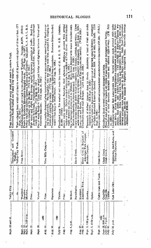
Sep
t. 19
.
Aug
. 16
.
Aug
. 21
,
July
20
.
Aug
. 3.
Aug
. 27
. A
ug.
29-
Sep
t. 21
.
July
10.12
and
13.
...... ..
....
13....................
19....................
21, 5
:30
p.m
.... .......
21..
....
....
....
....
..
26..
....
....
....
....
..
19S8
6
........ _
... _
....
!1 .
....
....
....
....
.
19S9
0.
......... _
....
....
....
....
.p.m
.. _
__
....
7.....................
9.... ..
...
2, 1:
30 p
.m_.
__. _
_.._
__
3, 10
:30
a.m
__ ...
21...........
..
. .
1930
9,
8:0
0 p.m
. ..........
?), 2p.m
. ............
0. .................
.
Val
ley
Cit
y... .
.............
.. _
do
.......................
.....d
o............... _
__
Pri
ce .
....................
This
tle.-
.-.-
... ..........
Mil
ford
.--.
.-..
...
Ric
hfl
eld
. .. ...
....
..
Coalv
ille
.. .
.....
......
This
tle .
....... ...-
-.-
Was
hes.
V
alle
y C
ity W
ash ...........
Am
eric
an F
ork
Can
yon.
Cha
lk C
reek..
....
.. _
__ ..
.G
rass
Cre
ek _
____
____
__._
.
Par
leys
Can
yons
.
Hug
e fl
oods
in
prac
tica
lly
ever
y w
ash
and
cre
ek i
n ea
ster
n U
tah
. C
ombi
ned
floo
ds w
ashe
d ou
t V
alle
y C
ity r
eser
voir
.
Was
h en
larg
ed f
rom
wid
th o
f 10
fee
t to
wid
th o
f 50
yar
ds a
nd d
epth
of
10 t
o 15
fee
t. (T
IS
ept.
15,
1927
.)C
loud
burs
ts w
ashe
d ou
t tr
ack
in
two
plac
es n
ear
Woo
dsid
e.
Dam
age,
$2,
879.
(D
BG
) F
lood
s in
Esc
alan
te M
ount
ains
dam
aged
roa
ds.
(DN
Sep
t. 19
,192
7.)
Ser
ious
was
h ou
ts m
idw
ay b
etw
een
Mod
ena
and
Cre
stli
ne.
One
pla
ce L
. A.
& S
. L
. B
.E.
trac
ks w
ashe
d ou
t fo
r 20
0 fe
et.
(DN
Sep
t. 2
2,19
27.)
Hig
h w
ater
and
sli
ght
floo
d da
mag
e ca
used
tem
pora
ry p
aral
ysis
of
traf
fic.
R
oad
im
pass
able
for
8 h
ours
. P
reci
pita
tion
at
Cas
tle
Gat
e, 0
.82
inch
. S
ligh
t da
mag
e to
rai
lroa
d tr
acks
at
Hei
ner.
(D
N S
ept.
22,
1927
.)O
ne o
f w
orst
flo
ods
in U
inta
Bas
in w
iped
out
bri
dge
and
hig
hway
bet
wee
n V
erna
l an
d C
olor
ado
Sta
te l
ine.
(D
N S
ept.
27,
1927
.)
She
ep r
anch
er d
row
ned
whe
n to
rren
tial
rai
ns a
t ca
nyon
sou
rce
caus
ed h
eavy
flo
od c
over
in
g hi
s au
tom
obil
e.
His
dau
ghte
r, w
ho w
as r
idin
g w
ith
him
, es
cape
d by c
ling
ing
to
brus
h an
d c
raw
ling
to
safe
ty.
(DN
Aug
. 17
,192
8,)
Tho
usan
ds o
f dol
lars
' dam
age
caus
ed b
y fl
oods
fro
m m
ount
ains
. B
usin
ess
hous
es f
lood
ed;
wat
er 1
foo
t de
ep i
n M
ain
Str
eet.
(EC
P A
ug.
24,1
928.
)
Clo
udbu
rst
near
Rio
was
hed
out
mai
n li
ne t
rack
s of
D.
& R
. G
. W
. R
.R.
Dam
age,
$1,8
00.
(UE
C)
Hea
vy r
ains
co
mm
ence
d S
atur
day
(3rd
) af
tern
oon.
H
ighw
ay
cove
red
wit
h se
vera
lin
ches
of
mud
. D
ebri
s w
ashe
d on
to c
rops
by o
verf
low
of
Pri
ce R
iver
. S
torm
Sun
day
nigh
t w
ashe
d ou
t ci
ty p
ipe
line
. (D
N A
ug.
5,19
29.)
O
ne o
f he
avie
st s
torm
s se
en i
n M
ilfo
rd.
Mai
n S
tree
t fl
oode
d w
ith
wat
er 1
3 in
ches
dee
p.M
uch
mer
chan
dise
in
stor
es d
amag
ed.
(DN
Aug
. 5,
192
9.)
Hea
vy s
torm
s br
ough
t do
wn
delu
ge o
f bo
ulde
rs,
tree
tru
nk
s, r
ubbi
sh,
and
wat
er.
Thr
eeau
tos
cros
sing
the
hig
hway
wer
e bu
ried
. P
roper
ty w
as d
amag
ed.
(DN
Aug
. 5,
192
9.)
Hea
vy r
ain
and
floo
ds.
Far
mer
s in
fro
nt o
f F
lat
Can
yon
lost
hea
vily
. (W
BA
192
9.)
Clo
udbu
rst
clos
ed r
oad
24 h
ours
. (D
N A
ug.
30,1
929.
)
Tho
usan
ds o
f do
llar
s' d
amag
e do
ne t
o st
reet
s.
Hun
dred
s of
ton
s of
mud
an
d r
ocks
depo
site
d in
tow
n.
(ER
Sep
t. 5,
192
9.)
One
foo
t of
wat
er o
n do
wnt
own
stre
ets
due
to o
ne o
f hea
vies
t ra
ins
in h
isto
ry.
Pre
ssro
omof
Ogd
en S
tand
ard
Exa
min
er f
lood
ed.
Dam
age,
$50
0.
Fal
l of
rai
n, 0
.93
inch
. (D
NS
ept.
3,19
29.)
H
eavy
rai
ns d
amag
ed r
ailr
oad
emba
nkm
ent a
nd
str
uct
ure
to th
e ex
tent
of $
1,30
0.
(DR
G.)
Clo
udbu
rst
floo
d co
vere
d ro
ad a
nd d
amag
ed o
ne f
arm
.F
lood
of
mud
and
wat
er w
ashe
d ou
t ti
pple
of-
coal
min
e an
d da
mag
ed s
ome
hom
es.
Clo
udbu
rst
of b
rief
dur
atio
n da
mag
ed
road
s an
d ra
ilro
ad
righ
t-of
-way
. (P
H
July
11
,193
0.)
Clo
udbu
rst
bloc
ked
Sal
t L
ake-
Ogd
en r
oad.
S
ever
al c
anyo
n ro
ads
cove
red
wit
h ro
cks
and
debr
is.
Sto
rm s
truc
k w
ith
cons
ider
able
abr
uptn
ess
and
floo
ds c
ame
dow
n E
mi
gr
atio
n,
Red
Butt
e,
and
Par
leys
C
anyo
ns.
Cit
y co
ndui
t in
P
arle
ys C
anyo
n w
as
unde
rmin
ed.
Som
e ho
mes
wer
e fl
oode
d an
d ba
sem
ents
fil
led
wit
h w
ater
an
d m
ud.
Sev
eral
cot
tage
s w
ere
was
hed
away
in
Red
But
te C
anyo
n.
Sta
te R
oad
Com
mis
sion
ap
prop
riat
ed $
40,0
00 f
or d
amag
e to
hig
hway
s th
roug
hout
Sta
te.
Sta
te-w
ide
dam
age
esti
mat
ed a
t $5
00,0
00.
W t-H
to H
O W
i i
O f<
O
O u GO

Abs
trac
t ac
coun
ts o
f ou
tsta
ndin
g cl
oudb
urst
flo
ods
in U
tah C
ontin
ued
Dat
eL
ocal
ity
Str
eam
cou
rse
Rem
arks
July
20.
July
26.
Aug
. 2.
.
Aug
. 2, p
.m.......
Aug
. 2 a
nd 3
, p.m
.
Aug
. 3, p
.m..
Aug
. 7........
Aug
. 8..
._..
Aug
. 9, p
.m. _
-._-
.
Aug
. 11,
3 a
.m_..
Aug
. 11
,11:
30 a
.m.
Aug
. 11,
2:1
5 p.
m.
Far
min
gton
and
Cen
terv
ille.
Ogd
en.
Th
istl
e-_
__
_._
__
_..
Cas
tle D
ale
and
Ora
ngev
ille.
Cas
tle D
ale
and
Hun
ting
- to
n.
Salt
Lak
e C
ity
... ..
....
..
Str
aigh
t C
anyo
n.
Cis
co..
....
..H
unti
ngto
n.
Fil
lmore
....
Hun
ting
ton
Cre
ek.
Cha
lk C
reek
. ..
.
Sal
ina.
.Sa
lina
Cre
ek.
Ora
ngev
ille.
Mo
ab..
....
.
Pin
e V
alle
y.
Oot
tonw
ood
Cre
ek..
__
_.
Pac
k an
d M
ill
Cre
eks
and
Can
e Sp
ring
Was
h.
San
ta C
lara
Cre
ek._
__.
Val
Verd
e..........
Ogden..______
Bin
gham
Can
yon.
.
Par
leys
Can
yon.
F
arm
ingto
n..
...
Dav
is C
reek
.
Far
ms
swep
t by
wat
er c
arry
ing
tons
of
rock
s, s
and,
etc
. O
ne h
ouse
and
sev
eral
far
m
buil
ding
s de
stro
yed.
L
ives
tock
los
s ne
glig
ible
. R
oad
bloc
ked
betw
een
Far
min
gton
an
d C
ente
rvill
e in
thr
ee p
lace
s fo
r ei
ght
days
. F
arm
los
ses
esti
mat
ed a
t $6
0,00
0.
Rel
ief f
und
of $
30,0
00 in
stit
uted
.W
eber
Can
yon
bloc
ked
in g
atew
ay.
Fou
r m
iles
of U
. P
. R
.R.
trac
ks in
can
yon
bloc
ked
by a
num
ber
of m
udsl
ides
, w
hich
for
med
sm
all
lake
s be
hind
the
m.
Tra
ins
rero
uted
vi
a M
cCam
mon
, Id
aho.
P
rope
rty
of B
ambe
rger
Ele
ctri
c R
y. C
o.,
Uta
h Po
wer
&
Lig
ht C
o., a
nd M
ount
ain
Stat
es T
elep
hone
& T
eleg
raph
Co.
als
o da
mag
ed.
D.
& R
. O
. W
. R
.R.
Co.
's m
ain
line
dam
aged
by
clou
dbur
st f
lood
s.
(DN
Jul
y 11
, 12
, 15
, 16,
18,
in
d 2
8,19
30.)
Lar
ge h
eadw
ater
floo
ds s
trew
ed m
ount
ain
road
s w
ith
debr
is.
Stor
m s
tric
tly
loca
l. (D
N
July
28,
1930
.)St
orm
s du
ring
wee
k da
mag
ed c
rops
. H
ails
torm
on
26th
sw
ept
dist
rict
, br
eaki
ng M
am
mot
h ca
nal.
(DN
Jul
y 28
, 193
0.)
Hea
vy f
lood
s oc
curr
ed a
t N
orth
Sal
t L
ake,
cov
erin
g th
e hi
ghw
ay fr
om 1
H t
o 3
feet
dee
p.
Stat
e hi
ghw
ay w
as c
ompl
etel
y bl
ocke
d ne
ar W
arm
Spr
ings
. W
ater
was
rep
orte
d 6
feet
dee
p no
rth
of m
unic
ipal
bat
hs.
Hig
hway
to C
olor
ado
Sta
te li
ne w
ashe
d ou
t.T
wo
smal
l was
h-ou
ts b
etw
een
Hun
ting
ton
and
Fai
rvie
w.
(DN
Aug
. 2,
1930
.)"W
orst
floo
d in
ove
r a
deca
de."
T
hous
ands
of t
ons
of ro
ck a
nd s
and
swep
t ou
t of
Cha
lk
Cre
ek C
anyo
n ov
er t
he n
orth
par
t of
tow
n.
Fie
lds
cove
red
wit
h m
ud a
nd b
ould
ers.
M
any
gard
ens
ruin
ed a
nd b
asem
ents
flo
oded
. (D
N A
ug. 4
,193
0.)
A s
erie
s of
fou
r cl
oudb
urst
s in
the
vic
init
y of
Sal
ina.
Fl
ood
swep
t ou
t of
can
yon
and
over
par
t of
cit
y.
Follo
win
g da
y fl
oods
cam
e ou
t of
Den
mar
k W
ash,
Aur
ora
Can
yon,
R
ed C
anyo
n, a
nd C
edar
Can
yon.
C
rops
wer
e de
stro
yed.
T
he S
tate
can
al w
as c
ut
out
in s
ix p
lace
s.
A l
ands
lide
occu
rred
abo
ut 1
7 m
iles
up S
alin
a C
anyo
n, b
lock
ing
the
road
. (D
N A
ug. 4
,193
0.)
Oro
ps f
lood
ed,
road
s w
ashe
d ou
t by
flo
od f
ollo
win
g ex
cess
ive
stor
ms
in w
este
rn p
art
of
Em
ery
Cou
nty.
Tor
rent
s do
wn
thre
e cr
eeks
was
hed
out
brid
ges.
(T
I A
ug.
7,19
30.)
An
unus
ual s
torm
beg
an o
n th
e 8t
h an
d co
ntin
ued
inte
rmit
tent
ly u
ntil
the
llt
h.
Tow
n fl
oode
d th
ree
diff
eren
t da
ys.
Riv
er a
t re
cord
sta
ge.
Wit
hout
ram
gag
e, lo
cal o
bser
vers
es
tim
ated
7 in
ches
of r
ainf
all.
(DN
Aug
. 14
,193
0.)
Hav
oc w
roug
ht b
y cl
oudb
urst
. G
ullie
s 5
to 1
0 fe
et d
eep
cut
in s
tree
t. P
each
tre
es
upro
oted
and
chi
cken
s ca
rrie
d aw
ay.
(DN
Aug
. 11
,193
0.)
Hea
vy t
hund
er a
nd l
ight
ning
aos
ompa
nled
by
rain
. S
tree
ts a
nd b
asem
ents
flo
oded
. (D
N A
ug.
11, 1
930.
)C
loud
burs
t la
sted
W/i
hour
s.
Mor
e th
an a
sco
re o
f ho
uses
dem
olis
hed.
D
ozen
fam
ilies
na
rrow
ly e
scap
ed d
eath
whe
n a
50,0
00-to
n 'c
oppe
r dr
um b
ecam
e sa
tura
ted
wit
h ra
in
and
swep
t do
wn
the
mou
ntai
nsid
e.
One
hun
dred
hom
es d
amag
ed.
Ele
ctri
c po
wer
of
f for
2 h
ours
and
sec
tion
of ro
ad b
urie
d.
D.
& R
. O
. W.
R.R
. and
coa
lyar
d da
mag
ed.
Uta
h C
oppe
r C
o.'s
hosp
ital
cave
d in
. D
amag
e es
tim
ated
at
$500
,000
. (D
N A
ug.
11,1
930.
)T
wo
was
hout
s on
hig
hway
.C
loud
burs
t in
hills
. N
o ra
in in
Far
mm
gton
.
s d o td d w O
O u w f M- eo
co 00

Aug
. 12
, noo
n.
-Aug
. 12
. A
ug.
13.
Aug
. 13
, 2 p
.m__.
Aug
. 13
, a.m
...-
_..
.
Aug
. 13
,12:
30 p
. m.
Aug
. 13
.
Mo
na_
_._
_.
Ple
asan
t G
rove
.M
agna__.._.
Cen
terv
ille
.
Pro
vo
.
Eur
eka.
. E
lber
ta.
Tin
tic
dist
rict
.
Ced
ar C
ity.
En
och
.._
.
Art
hur.
. G
oshe
n.
St. G
eorg
e...._...
Zio
n N
atio
nal
Par
k.
Op
hir
....
..M
arys
vale
. R
ichf
ield
-..
Gra
nt sv
ille.
Sp
ring
ville
.
Wil
lard
. G
arfi
eld.
Far
min
gto
n........
Nor
th F
arm
ingt
on.
Ple
asan
t G
rove
. _..
Salt
Lak
e C
ity._
.
Elb
erta
.
Prov
o E
iver
.
Eur
eka
Can
yon....
Iron
Kin
g C
anyo
n.
Dry
Can
yo
n.
.
Fid
dler
s C
anyo
n..
Big
Gov
ernm
ent
Cre
ek..
...
Roc
k C
anyo
n-
For
d C
reek
....
..S
hepa
rd C
anyo
n-
Gro
ve C
reek
.....
"Wor
st f
lood
in h
isto
ry."
W
ate
r sw
ept
lives
tock
, ba
rns,
and
hay
aw
ay.
Hig
hway
and
railr
oad
trac
ks c
over
ed w
ith
debr
is.
A n
umbe
r of
hou
ses
wer
e pa
rtia
lly
cove
red.
(DN
Aug
. 11
,193
0.)
Mud
and
roc
ks p
oure
d ou
t of
Sno
wsl
ide
Can
yon
for
seve
ral
hour
s.
Lar
ge b
arri
er w
aser
ecte
d in
riv
er a
bove
Uta
h P
ower
& L
ight
Co.
's f
lum
e.
Wat
er w
as r
aise
d 8
feet
and
back
ed u
p ov
er S
tate
hig
hway
and
D.
& K
. G
. W.
R.R
. tr
acks
. T
he i
mpo
unde
d la
kew
as n
ot r
elea
sed
for t
wo
wee
ks.
Thr
ee s
mal
ler
slid
es i
n ca
nyon
. (D
N A
ug. 1
3,19
30.)
Bui
ldin
gs a
nd s
tree
ts b
adly
dam
aged
by
flood
fro
m c
anyo
n.
(ER
Aug
. 14
,193
0.)
Tw
enty
-foo
t w
all
of "
brow
n w
ater
" fl
oode
d ca
nyon
, w
ashe
d ou
t ro
ads
and
"sub
mer
ged
Elb
erta
in
2 fe
et o
f w
ater
."
Som
e ho
mes
par
tial
ly d
estr
oyed
, an
d ba
sem
ents
wer
efi
lled.
(P
H A
ug.
14,1
930.
) T
hree
clo
udbu
rsts
str
uck
in v
icin
ity
of T
inti
c S
tand
ard
min
e.
Hou
ses
and
othe
r pro
pert
yw
ashe
d aw
ay.
Dam
bro
ke in
tw
o pl
aces
. (D
N A
ug. 1
4,19
30.)
Boy
kil
led
as a
uto
skid
ded
in m
ud w
ashe
d on
to h
ighw
ay b
y cl
oudb
urst
. C
loud
burs
t flo
oded
fiv
e fa
mili
es fr
om h
omes
. T
hree
sto
rms
in 2
4 ho
urs.
Fe
nces
, ch
icke
n co
ops,
and
out
buil
ding
s to
rn u
p or
was
hed
away
. T
wel
ve h
omes
fill
ed w
ith
mud
. F
lood
fro
m F
iddl
ers
Can
yon
dela
ys h
ighw
ay tr
affi
c tw
o ho
urs
at a
poi
nt 3
mile
s no
rth
ofC
edar
Cit
y.
Thi
s to
wn,
7 m
iles
nort
heas
t of
Ced
ar C
ity,
rep
orte
d ex
tens
ive
dam
age
to o
utbu
ildi
ngs
and
crop
s.
Hig
hway
cov
ered
wit
h de
bris
to d
epth
of 6
fee
t. D
amag
e to
Uta
h C
oppe
r C
o.'s
pla
nt,
$25,
000
to $
30,0
00.
Clo
udbu
rst
stru
ck i
n vi
cini
ty o
f A
pex
min
e, n
eat
Tin
tic.
W
ashe
d th
re'e
hou
ses
away
and
ende
d at
Elb
erta
. B
oy's
hor
se w
as w
ashe
d be
neat
h hi
m a
nd d
row
ned.
O
ne p
orch
swep
t aw
ay, a
nd to
wn
fille
d w
ith
wat
er.
Gos
hen
dam
ove
rflo
wed
in tw
o pl
aces
. G
rain
dam
aged
. Fl
ood
hit
Shiv
wits
Ind
ian
Res
erva
tion.
T
raff
ic d
elay
ed w
hen
culv
ert
was
hed
out
ofhi
ghw
ay.
Roa
d to
And
erse
n R
anch
hit
by
mud
slid
es.
Dam
age
to I
ron
and
Was
hing
ton
Cou
ntie
s'St
ate
high
way
s es
tim
ated
to b
e $5
,000
.C
anyo
n im
pass
able
. C
ente
r of
tow
n fi
lled
wit
h to
ns o
f mud
, roc
ks, a
nd d
ebri
s.
Fis
h L
ake
road
was
hed
out l
ast
wee
k.
Hay
and
gra
ins
dam
aged
by
heav
y ra
ms.
W
ater
ran
thro
ugh
stre
ets.
M
any
hom
es f
illed
wit
h m
ud.
Floo
d sw
ept
fish
hatc
hery
. O
ne t
hous
and
stoc
k tr
out
kille
d.
Hig
hway
cov
ered
wit
hde
bris
for
200
yar
ds n
ear
stee
l pl
ant.
One
far
m h
ome
wit
h ou
tbui
ldin
gs a
nd l
ives
tock
dest
roye
d.L
awns
cov
ered
wit
h m
ud a
nd r
ocks
. C
ella
rs f
illed
. O
ne p
otat
o fa
rm c
over
ed.
Floo
d w
ashe
d th
roug
h pr
actic
ally
all
hom
es i
n w
est
sect
ion
of t
own.
M
ud a
nd r
ocks
cove
red
Mai
n St
reet
to
dept
h of
2J^
fee
t. Sc
ore
of f
arm
s fl
oode
d.
Uta
h &
Sal
t L
ake
Can
al w
ashe
d ou
t. D
. &
R.
G. W
. an
d B
. &
G. t
rack
s in
unda
ted.
B
oile
r ro
oms
and
mac
hine
sho
ps f
illed
wit
h w
ater
and
mud
.Sl
ide
10 to
20
feet
dee
p.
Des
troy
ed o
ne h
ome
"as
thou
gh it
wer
e pa
per.
" B
ambe
rger
R.R
. tr
acks
und
erm
ined
.Si
x fa
rms
dam
aged
to
exte
nt o
f tho
usan
ds o
f do
llars
. W
ater
"to
re d
own"
on
tow
n.
Can
yon
road
s ge
nera
lly p
assa
ble
but
seri
ousl
y da
mag
ed.
Roa
d up
Lit
tle
Cot
tonw
ood
bloc
ked
by 2
0-fo
ot s
lide.
Fl
ood
relie
f fu
nd o
f $3
5,00
0 as
ked
by G
over
nor.
Sa
lt L
ake-
O
gden
roa
d bl
ocke
d th
ree
days
. O
verg
razi
ng o
f sh
eep
blam
ed i
n pa
rt f
or d
isas
ter
by
Gov
erno
r, a
nd s
cien
tific
con
serv
atio
n in
vest
igat
ion
inst
itut
ed.
(DN
Aug
. 13
, 14
, 15
, 16
, 18,
25,
and
28,
1950
.)C
loud
burs
t in
mou
ntai
ns fl
oode
d ro
ads
and
farm
s.
Bou
lder
s as
larg
e as
3 fe
et in
dia
met
er
stre
wn
over
fie
lds.
R
ailr
oad
brid
ge w
as w
ashe
d ou
t and
hom
es d
amag
ed.
Rep
uted
to
be w
orst
flo
od i
n 60
yea
rs.
Wal
ls o
f wat
er f
rom
can
yons
sai
d to
be
20 f
eet
high
. (E
RA
ug.
14,1
930.
)
e o o e cc

Abs
trac
t ac
coun
ts o
f ou
tsta
ndin
g cl
oudb
urst
flo
ods
in U
tah C
ontin
ued
Dat
e
Aug
. U
..... .
...............
Aug
. 20.
.. .......-
......
Sept
. 6.-
-.-
.-.-
. -
-
iSS
/
July
30.
- _
.. .
. .
Aug
. 13
, 7:
48 p
.m..
....
....
.
Loc
ality
Eic
hfie
ld...
. ...
....
.. ..
....
.
Tin
tic.
.. _
_ . _
.--.
. __
.
plan
t. T
inti
c.. .
.. - -
-
Salt
Lak
e C
ity
,.- _ ..
....
Stre
am c
ours
e
Salin
a C
anyo
n.
Parr
ish
Cre
ek. _
_ . .
....
.
Ste
ed,
Dav
is,
and
For
dC
reek
s.
Rem
arks
A c
loud
burs
t flo
od d
estr
oyed
com
plet
ely
a se
ctio
n of
the
Mos
ida
road
. (D
N A
ug.
15, 1
930.
) C
loud
burs
t in
can
yon
was
hed
out
railr
oad
trac
k.
Traf
fic s
uspe
nded
22
days
. D
amag
e,$1
0,00
0.
(UE
C)
A n
ew fl
ood
hit
Dav
is C
ount
y as
a fi
erce
rain
str
uck
in th
e hi
lls.
At
Cen
terv
ille
at le
ast
one
bloc
k of
the
Stat
e hi
ghw
ay w
as u
nder
15
feet
of m
ud.
Sinc
e pr
oper
ty w
as a
lrea
dy
stri
cken
, not
a g
reat
am
ount
of a
dditi
onal
dam
age
was
don
e.
Hig
hway
was
bur
ied.
B
ambe
rger
Rai
lway
tra
cks
wer
e co
vere
d fo
r a
quar
ter
of a
mile
with
2 t
o 4
feet
of
debr
is.
Hig
hway
aga
in c
over
ed b
y m
udsl
ide.
A
few
aut
os w
ere
stal
led.
Se
vere
win
d an
d ra
inst
orm
. Tr
ees
wer
e up
root
ed,
and
tran
s-co
ntin
enta
l te
legr
aph
line
blow
n do
wn.
R
oad
was
flo
oded
and
san
d w
as w
ashe
d in
to f
ield
s.
(DN
Sep
t. 5
and
6, 1
930.
) Se
rious
ele
ctric
al s
torm
con
tinue
d al
l nig
ht.
Floo
ds r
ushe
d ou
t of
can
yons
, w
ashi
ng o
utro
ads
and
brid
ges.
(D
N S
ept.
8, 1
930.
) "C
loud
burs
t ca
used
muc
h da
mag
e."
(DN
Sep
t. 9,
193
0.)
Bus
ines
s di
stri
ct o
f Ogd
en w
as fl
oode
d by
hea
vy ra
inst
orm
in s
pite
of r
ecen
tly c
onst
ruct
edst
orm
sew
er.
Wat
er re
ache
d th
e en
tran
ce o
f sev
eral
sto
res.
(D
N M
ay 4
, 193
1.)
Farm
s in
unda
ted
and
crop
s rui
ned
by h
eavy
floo
d.
A n
orm
ally
sm
all c
reek
car
ried
a fl
ow20
0 fe
et w
ide
and
15 fe
et d
eep.
(E
R J
uly
16, 1
931.
) Fo
ur-f
oot w
all o
f wat
er fr
om n
arro
w c
anyo
n w
ashe
d ou
t tw
o ro
ads,
and
str
eets
of E
urek
a"r
ecei
ved
thei
r us
ual s
hare
of t
he d
amag
e."
(ER
Aug
. 6, 1
931.
) M
udsl
ide
fille
d an
irri
gatio
n ca
nal;
out
of s
ervi
ce 4
0 ho
urs.
(U
PL)
Seco
nd s
torm
in
two
days
yie
lds
1.09
inc
hes
of r
ain
in l
ess
than
an
hour
. E
xten
sive
dam
age
to r
oads
and
bui
ldin
gs.
(ER
Aug
. 6, 1
931.)
St
reet
s w
ashe
d ou
t. D
amag
e to
can
yon
high
way
, $5
,000
. M
inin
g pr
oper
ties
suff
ered
cons
ider
able
dam
age.
(E
R A
ug. 6
, 193
1.)
Mud
slid
e or
igin
atin
g in
Sno
wsl
ide
Can
yon
cove
red
the
road
and
dam
med
the
riv
er.
Slid
e 20
feet
dee
p an
d 40
0 fe
et w
ide.
A
noth
er la
rge
artif
icia
l lak
e w
as c
reat
ed in
Pro
vo
Can
yon.
H
undr
eds
of a
utos
wer
e m
aroo
ned.
Fl
ood
wat
ers
swep
t th
roug
h th
e st
reet
s of
the
tow
n 4
to 5
fee
t de
ep.
Bus
ines
s ho
uses
badl
y da
mag
ed.
One
hom
e ne
arly
bur
ied
in d
ebri
s.
One
and
two-
tent
hs in
ches
of r
ain
fell,
fol
low
ing
0.57
inch
on
prev
ious
day
. Po
rtio
n of
Paro
wan
-Ced
ar C
ity r
oad
badl
y w
ashe
d.
Floo
ds b
roug
ht d
own
tons
of
debr
is a
nd u
proo
ted
tree
s in
can
yon.
St
raw
berr
y pr
ojec
tdi
vers
ion
dam
thre
aten
ed.
(DN
Jul
y 31
, 193
1.)
Four
to 1
2 in
ches
of w
ater
sw
ept
thro
ugh
stre
ets
in s
ome
plac
es.
Seve
ral
auto
s bu
ried
in m
udfl
ow n
ear
Bec
k's
Hot
Spr
ings
. R
ecor
d fo
r ra
infa
ll in
tens
ity w
as b
roke
n- w
hen
0.40
inch
of w
ater
fell
in 5
min
utes
. D
ebri
s 12
feet
dee
p ov
er a
leng
th o
f 350
feet
blo
cked
th
e Sa
lt La
ke-O
gden
roa
d ne
ar N
orth
Sal
t L
ake.
R
oad
bloc
ked
by ro
cks
and
silt.
(D
N A
ug.
14, 1
931.
)C
loud
burs
ts s
truc
k E
urek
a an
d vi
cini
ty.
Roa
ds a
nd r
ailr
oad
stru
ctur
e ba
dly
dam
aged
by w
ash-
outs
. C
attle
and
oth
er p
rope
rty
buri
ed in
mud
and
deb
ris.
f
o
d
b
td
d O
O d w eo CO oo

Aug
. 15.
June
12.
July
10.
July
17.
A
ug. 2
0.
July
10-
July
11
July
12.
July
16.
July
30,5
.. .
. ..
19S8
1.
.. ....... ..
....
..
^...
. .................
J ( !
). ................
1933
Elb
erta
.. ...................
Glc
iiwoo
d
Silv
er C
ity
....
....
....
....
..
Leh
i.. .
....
....
....
....
....
.
Cit
y C
reek
and
Sev
ier R
iver
.
Am
eric
an F
ork
Can
yon .
South
F
ork
of
Pro
vo
Can
yon.
Wat
er, s
wir
led
thro
ugh
stre
ets,
and
bri
dges
on
Mos
ida
road
wer
e w
ashe
d ou
t. T
wo
cattl
e w
ere
com
plet
ely
buri
ed in
mud
. Fl
oods
cov
ered
the
hig
hway
bet
wee
n G
lenw
ood
and
Ric
hfie
ld w
ith
wat
er 3
to
6 fe
etde
ep.
Ora
infi
elds
bad
ly d
amag
ed.
Jum
bo P
last
er M
ills
at S
igur
d da
mag
ed b
y fl
ood
from
Kin
g M
eado
w C
anyo
n.
(DN
Aug
. 15
,193
1.)
Str
eets
gas
hed
badl
y, a
nd h
ighw
ays
dam
aged
. T
ons
of d
ebri
s w
ashe
d do
wn
from
mou
ntai
ns.
(ER
Aug
. 20,
1931
.) D
am o
f deb
ris,
left
in c
anyo
n by
floo
d of
pre
viou
s da
y, w
as w
ashe
d ou
t sud
denl
y, s
endi
ng10
-foo
t wal
l of w
ater
dow
n ca
nyon
. N
o fu
rthe
r da
mag
e re
port
ed.
(ER
Aug
. 20,
1931
.)
Clo
udbu
rst
at p
oint
of
mou
ntai
n w
ashe
d ou
t ir
riga
tion
cana
l of
Pro
vo W
ater
Use
rs'
Ass
ocia
tion.
D
amag
e, $
1,00
0 to
$1,
500.
E
ast
Jord
an i
rrig
atio
n ca
nal
was
als
o w
ashe
d ou
t. (D
N J
uly
13,1
932.
)R
ain
and
hail
caus
ed c
anal
s an
d ir
riga
tion
ditc
hes
to o
verf
low
. St
reet
s w
ere
fille
d w
ith
wat
er.
The
wor
st f
lood
kno
wn
for
som
e tim
e oc
curr
ed
betw
een
Ant
imon
y an
d E
scal
ante
. (D
N J
uly
14,1
932.
)Fl
oods
spr
ead
havo
c ov
er 5
-mile
str
etch
. R
oads
and
far
ms
dam
aged
. (U
EC
)C
anyo
n ro
ad s
erio
usly
dam
aged
by
clou
dbur
st.
(PH
Jul
y 18
,193
2.)
Vic
inity
str
uck
by h
eavy
sto
rm,
whi
ch w
ashe
d ou
t br
idge
s an
d cu
lver
ts a
nd d
amag
ed
crop
s.
(GC
N A
ug. 2
6,19
32.)
Clo
udbu
rst i
n m
ount
ains
eas
t of t
own.
D
ry w
ashe
s fi
lled
wit
h to
rren
ts c
arry
ing'
boul
ders
, ti
mbe
rs, a
nd m
ud, w
hich
was
str
ewn
over
far
ms,
gar
dens
, and
roa
ds, c
over
ing
a st
retc
h of
abo
ut 2
*4 m
iles.
Hay
was
sw
ept a
way
, and
sta
cks
left
sta
ndin
g w
ere
badl
y da
mag
ed
by w
ater
and
mud
. So
me
hous
es w
ere
part
ly in
unda
ted
and
furn
itur
e ru
ined
. C
ella
rs
fille
d w
ith
mud
and
- wat
er.
Dry
Was
h br
idge
sw
ept
away
. B
ridg
e ov
er A
ntim
ony
Cre
ek b
adly
dam
aged
. (D
N A
ug.
24,1
932.
)H
ails
torm
fol
low
ed b
y fl
ood
wre
aks
havo
c in
vic
init
y.
Hai
lsto
nes
wer
e un
usua
lly
larg
e,
rese
mbl
ing
irre
gula
r ch
unks
of
ice.
B
ridg
es a
nd c
ulve
rts
was
hed
out.
(GC
N A
ug.
26,1
932.
)H
eavy
sto
rm e
ast
of to
wn
caus
ed $
20,0
00 lo
ss,
incl
udin
g cr
op d
amag
e an
d dr
owne
d liv
e
stoc
k.
(GC
N A
ug.
26,1
932.
)V
iole
nt s
torm
, yi
eldi
ng 0
.9 in
ch o
f ra
in,
caus
ed a
s m
uch
as 5
0 pe
r ce
nt d
amag
e to
nea
rby
farm
cro
ps.
(PH
Aug
. 28
,193
2.)
Salt
Lak
e-O
gden
roa
d bl
ocke
d at
Bec
k's
Hot
Spr
ings
and
bet
wee
n C
ente
rvill
e an
d F
arm
ingt
on b
y m
udsl
ides
. (D
N A
ug. 2
9,19
32.)
Inta
ke t
o po
wer
-pla
nt p
ipe
clog
ged
by fl
ood.
O
ut o
f ser
vice
tw
o da
ys.
(UP
L)
Clo
udbu
rst
was
hed
tons
of d
ebri
s on
to r
oad.
(P
H J
uly
10,1
933.
)
Stre
ets
was
hed
out,
win
dow
s br
oken
, an
d ch
imne
ys b
low
n ov
er d
urin
g vi
olen
t th
unde
r
stor
m.
(ER
Jul
y 13
,193
3.)
Thu
nder
stor
m o
f sh
ort
dura
tion
but
of
inte
nse
volu
me
star
ted
a fl
ood
in E
phra
im
Can
yon.
Se
vera
l far
ms
wer
e co
vere
d w
ith
silt
and
mud
. (D
N J
uly
10,1
933.
)C
loud
burs
t was
hed
out
a 30
0-fo
ot s
ectio
n of
road
. (P
H J
uly
11,1
933.
)H
eavy
clo
udbu
rst.
Gar
dens
and
str
eets
floo
ded,
pla
nts
knoc
ked
dow
n.
Cre
ek u
nusu
ally
hi
gh.
(DN
Jul
y 14
,193
3.)
Tow
n fl
oode
d by
hea
vy d
isch
arge
fro
m E
ast
Tin
tic
Ran
ge.
Orc
hard
s an
d fa
rms
suff
ered
da
mag
e.
(ER
Jul
y 20
,193
3.)
Hig
h fl
ow i
n ca
nyon
tor
e ou
t ro
ad,
dam
, an
d pi
pe l
ine.
H
ails
torm
on
prev
ious
day
did
co
nsid
erab
le d
amag
e to
cro
ps a
nd s
ubse
quen
t fl
ood
subm
erge
d po
rtio
n of
tow
n.
(DN
A
ug.
1,19
33.)
W h- 1
C
O
t^ o o
o o CQ

Abs
trac
t ac
coun
ts o
f ou
tsta
ndin
g cl
oudb
urst
flo
ods
in U
tah
Co
nti
nu
ed
Dat
e
Aug
. 11..... .
...............
1934
Ju
ly 4
.. _
_._
.___ ....._._
..
July
21..... _
..._.
._._
_ -.
July
20
and
21. _
__
__
__
July
24
....
....
....
....
....
.
July
27.
. .-
.-._
_..
....
..
Loc
alit
y
Sal
ina.
... _
_ ..
. __ ..
. ...
.
Mil
ford
..-.
... ..
....
....
Cop
pert
on.. __ ..
. ...
....
..T
aael
e __
__
__
__
__
_ ..
Hold
en,
Lynndyl,
an
d
Mea
dow
. M
an
ti..
....
....
....
.. ..
....
.
Kph
raim
. ............ _
_ ..
..
Nep
hi.
.... ..
....
. ...........
Wil
lard
... ..
....
....
.. ..
....
Stre
am c
ours
e
Salin
a C
anyo
n an
d D
en
mar
k W
ash.
Ple
asan
t an
d T
win
Cre
eks.
.
Sout
h W
illow
Cre
ek.. ..
....
Mai
n an
d S
and
Can
yons
....
Rem
arks
Clo
udbu
rst
in c
anyo
n ca
used
flo
od w
hich
did
con
side
rabl
e da
mag
e to
roa
ds a
nd c
rops
in
vici
nity
of
Salin
a.
(EO
F A
ug.
11, 1
933.
) H
eavy
rai
ns c
ause
flo
od d
own
Kin
gsto
n C
anyo
n.
Roa
d w
ashe
d ou
t. D
ebri
s sp
read
ov
er a
rea
abou
t a
quar
ter
mile
. (D
N A
ug.
11, 1
933.
)
"Hea
vies
t ra
in s
ince
192
9" s
truc
k to
wn.
E
nsui
ng f
lood
was
hed
out
stre
ets
and
gard
ens
and
fille
d ce
llars
. (D
N J
uly
6, 1
934.
) B
oy d
row
ned
by s
udde
n fl
ood
in c
reek
. C
ella
rs f
illed
wit
h m
ud a
nd w
ater
. (D
N J
uly
21, 1
934.
) R
ain
of 1
.07
inch
es f
lood
ed to
wn
and
"pil
ed d
irt"
on
the
stre
ets.
T
wo
floo
ds "
roar
ed i
nto
tow
n,"
floo
ding
str
eets
and
lot
s.
Hig
h w
ater
fro
m c
loud
burs
t da
mag
ed i
rrig
atio
n sy
stem
. T
hree
oth
er to
wns
rec
eive
d fl
oods
, bu
t no
det
ails
ava
ilabl
e.
(DN
Jul
y 23
, 193
4.)
Clo
udbu
rsts
in
cany
on s
ent
thre
e fl
oods
thr
ough
tow
n.
Roa
dway
was
hed
out;
pow
er-
plan
t ca
nal
dam
aged
. C
ity
culi
nary
wat
er s
ourc
es d
amag
ed b
y fl
ood.
(D
N J
uly
24, 1
934.
) H
eavy
dow
npou
r of
rai
n fo
llow
ed b
y a
floo
d.
Irri
gati
on d
itche
s an
d ca
nals
ove
rflo
wed
. Se
vera
l gar
dens
and
yar
ds c
over
ed w
ith
mud
and
ref
use.
M
ud, r
ock,
and
deb
ris
brou
ght
dow
n.
Cul
inar
y su
pply
line
clo
gged
. (D
N J
uly
24, 1
934.
) Po
wer
dam
in
'Oak
Cre
ek w
ashe
d ou
t. "T
hous
ands
of
dolla
rs'
dam
age
done
."
Sixt
een
men
wor
king
in
wat
er-d
evel
opm
ent
tunn
el w
ere
near
ly tr
appe
d.
Floo
d sw
ept
dow
n ca
nyon
. (D
N J
uly
27, 1
934.
) H
ighw
ay c
over
ed w
ith
rock
s an
d de
bris
for
6 m
iles.
C
ity
pow
er p
lant
tie
d up
. D
amag
e to
Nep
hi P
last
er P
lant
, $1
0,00
0.
The
D.
<fe R
. G
. W
. R
.R.
trac
ks i
n th
e ca
nyon
wer
e co
vere
d w
ith
mud
, ro
cks,
and
tre
es.
Gra
in a
nd a
lfal
fa f
ield
s w
ere
cove
red
wit
h m
ud
and
wat
er.
Del
uge
bloc
ked
the
high
way
. (D
N A
ug. 6
, 193
4.)
Vio
lent
sto
rm re
sult
ed in
floo
d.
Floo
d co
vere
d a
farm
ing
area
one
-eig
hth
mile
in d
iam
eter
. T
ons
of ro
ck a
nd d
ebri
s w
as c
arri
ed o
n fa
rm la
nd.
Can
al w
as f
illed
wit
h m
ud.
Floo
d in
Mon
roe
Can
yon
late
Mon
day
follo
win
g a
terr
ific
sto
rm.
Pipe
lin
e an
d ro
ad
was
hed
out.
Cul
inar
y w
ater
hau
led
from
nea
rby
tow
ns.
Fiel
ds s
outh
of t
own
cove
red
wit
h w
ater
, ro
cks,
and
deb
ris.
G
rain
and
alf
alfa
fie
lds
badl
y da
mag
ed.
(DN
Aug
. 8,
193
4.)
Clo
udbu
rst
was
hed
out
20 f
eet
of f
lum
e an
d 13
0 fe
et o
f pi
pe.
Pow
er p
lant
out
of
serv
ice
eigh
t da
ys.
(UP
L)
Roa
d in
can
yon
badl
y w
ashe
d.
One
tea
m o
vert
aken
by
floo
d, d
row
ned,
and
occ
upan
ts
of w
agon
had
nar
row
esc
ape.
Fl
ood
Wed
nesd
ay a
fter
noon
rus
hed
in u
pon
the
city
. Sm
all
floo
d in
Dry
Can
yon.
R
oad
cove
red
wit
h de
bris
and
roc
ks.
(DN
Aug
. 10
, 193
4.)
"Hea
vies
t ra
inst
orm
of s
easo
n" b
roug
ht a
terr
ific
floo
d fr
om f
ooth
ills.
T
wo
hund
red
feet
of p
ipe
line
repa
ired
10
days
pre
viou
sly
was
torn
out
. R
esid
ents
aga
in
haul
ing
wat
er f
or c
ulin
ary
purp
oses
. So
uth
Ben
d ca
nal
and
Ber
tels
en d
itch
fill
ed
wit
h n
ud.
(D
N A
ug.
16, 1
634.
) R
ain
E mov
rtin
g to
.85
inc
h in
22
min
utes
. F
our
feet
of
wat
er s
wep
t au
tos
dow
n M
ain
Stre
et.
Wat
er p
oure
d ov
er th
e fl
oors
of s
ever
al e
stab
lish
men
ts.
(DN
Aug
. 18,
193
4.)
o t-1
o
a
o
w 02 H O
O o H
t>
W CO
C
O
00

Aug
. 16,
1 p.
m.
Aug
. 16,
2 p
.m.
Aug
. 19
, p.m
..
Aug
. 28
Aug
. 29,
a.m
. 19SB
July
4,1
:46
p.m
.. A
ug. 1
7
Aug
. 22
, 6 p
.m...
Aug
. 26,
12 n
oon.
Sept
. 1.-
-
Sep
t. 2,
2 p
.m.
Sep
t. 2,
4 p
.m.
Sept
. 4..
Sept
. 25
.
July
9.
1936
July
10,
2p.m
....
July
10,
5:3
0 p.
m.
July
11
.-_
Par
k C
ity.
E
lber
ta-.
..
Bic
hfle
ld...
Kan
osh
....
....
Beav
er
__
.
Salt
Lak
e C
ity.
Pro
vo.
Heb
er.
Leh
l...
Bin
gh
am
..._
__
__
.
Bry
ce C
anyo
n N
atio
nal
Par
k.
Pric
e..
....
..
....
Bea
ver
and
Mon
ticel
lo.
Nephi.
.....
Beaver.
.___
Oak
Oit
y.
Hun
ting
ton.
Nep
hi.
....
..
Ced
ar C
ity...
Mil
ford-
Hen
riev
ille
_.
Provo..
Ced
ar C
i,ty
.
Cir
clev
ille
Can
yon.
. M
arys
vale
Can
yon.
K
anar
ra vi
lle.
__
Pla
t an
d
Cott
onw
ood
Can
yons
.
Sou
th F
ork
of P
rovo
Riv
er..
Snak
e C
reek
.. W
est
Can
yon.
Will
ow C
reek
Can
yon-
Salt
Cre
ek, R
eese
, and
Foo
teC
anyo
ns.
Bea
ver a
nd B
aker
s C
anyo
ns.
Oak
Cre
ek.
Hun
ting
ton
Cre
ek.
Fris
co C
anyon-.
...
Snow
slid
e C
anyo
n .
Seyi
er R
iver
-
Hai
lsto
rm f
ollo
wed
by
shee
ts o
f rai
n.
Roa
d da
mag
ed.
(DN
Aug
. 17
,193
4.)
Thi
rd f
lood
of y
ear.
(D
N A
ug.
16,1
934.
)"H
eavi
est
rain
stor
m a
ll su
mm
er."
Se
vier
Val
ley
cana
l w
as f
illed
wit
h sa
nd.
Som
efi
elds
dam
aged
. O
ther
day
flo
od s
truc
k to
wn,
tor
e up
wat
er l
ines
, an
d fi
lled
tren
ches
pre
pare
d fo
r ne
wpi
pe li
ne.
(DN
Aug
. 21,
1934
.) T
wo
heav
y st
orm
s ca
used
flo
ods
in t
he B
uckh
orn
Mou
ntai
ns a
nd n
ear
Ced
ar C
ity.
(DN
Aug
. 30,
193
4.)
"Mos
t in
tens
e ra
in i
n ye
ars
dren
ched
Sal
t L
ake.
" St
orm
sta
rted
in
Tin
tic
dist
rict
and
mov
ed n
orth
war
d th
roug
h U
tah,
sou
ther
n Id
aho,
and
int
o W
yom
ing.
(D
N A
ug.
29,1
934.
) Fl
ood
thre
w h
igh
wat
ers,
gra
vel,
and
rock
s in
can
yon
high
way
. (D
N A
ug.
30,1
934.
)'
Floo
d fi
lled
fore
bay
of p
ower
-pla
nt in
take
wit
h gr
avel
. O
ut o
f se
rvic
e 40
hou
rs.
(UP
L)
Hea
vy r
ains
in
Oqu
irrh
and
Was
atch
foo
thill
s cu
lmin
ated
in
a cl
oudb
urst
. G
rain
in
fiel
ds h
eavi
ly d
amag
ed.
Salt
Lak
e <fe
U
tah
R.R
. tr
ack
was
hed
out.
(DN
Aug
.19
, 193
5.)
Hea
vies
t cl
oudb
urst
in y
ears
. B
asem
ents
fill
ed a
nd f
lum
e de
stro
yed.
T
wo
feet
of d
ebri
son
roa
d.
Tw
elve
hou
ses
dam
aged
. (D
N A
ug.
23,1
935.
) A
ll w
ashe
s fi
lled,
and
trai
ls a
nd r
oads
dam
aged
by
stor
m o
f an
hou
r's d
urat
ion
(Wea
ther
Rep
orts
, Bry
ce C
anyo
n).
Clo
udbu
rst
at h
ead
of c
anyo
n fi
lled
cella
rs a
nd h
ouse
s at
Will
ow C
reek
and
Upp
er C
astle
Gat
e w
ith
debr
is a
nd w
ater
. R
ailr
oad
swit
chya
rds
at C
astle
Gat
e to
rn u
p.
Seve
ral
auto
s bu
ried
in m
ud.
(DN
Aug
. 27,
1935
.) T
hous
ands
of
dolla
rs'
dam
age
was
don
e by
clo
udbu
rsts
cov
erin
g an
are
a fr
om B
eave
ron
the
wes
t an
d N
ephi
on
the
nort
h to
Mon
ticel
lo o
n th
e ea
st.
Nep
hi i
nund
ated
by
floo
d of
mud
and
wat
er.
Can
als
fille
d, h
ighw
ays
cove
red,
and
railr
oad
trac
ks s
ubm
erge
d.
(DN
Sep
t. 2,
1935
.) C
loud
burs
t st
ruck
cit
y ab
out
2 p.
m.
Wat
er p
oure
d do
wn
mou
ntai
nsid
es a
nd s
trew
edbo
ulde
rs a
cros
s th
e hi
ghw
ay f
or s
ever
al m
iles.
B
eave
r ci
ty p
ower
can
al f
illed
wit
hsa
nd a
nd b
ould
ers.
C
ity
wit
hout
ele
ctri
c po
wer
. St
orm
str
uck
abou
t 4
p.m
. Fl
ood
one
of w
orst
exp
erie
nced
by
resi
dent
s.
Cam
pers
and
fish
erm
en in
can
yon
narr
owly
esc
aped
dro
wni
ng.
One
aut
omob
ile w
ith
five
occ
upan
ts,
caug
ht i
n flo
od b
efor
e it
cou
ld b
e st
arte
d, w
as c
arri
ed b
y th
e fl
ood
seve
ral h
undr
ed f
eet
and
lodg
ed a
gain
st a
tre
e.
Floo
d ca
rrie
d tr
ees
and
rock
s on
to t
he g
arde
ns a
nd f
ield
san
d ca
rrie
d aw
ay b
ridg
es.
(DN
Sep
t. 2,
1935
.) A
num
ber
of fl
oods
kill
ed f
ish.
(D
N S
ept.
4,19
35.)
Clo
udbu
rst
on w
est
side
of
Mou
nt N
ebo.
H
ighw
ay c
over
ed w
ith
mud
and
deb
ris.
Stre
ets
floo
ded.
(D
N S
ept.
25,
1935
.)
Clo
udbu
rsts
in
vari
ous
part
s of
sou
ther
n U
tah.
St
reet
s in
Ced
ar C
ity
floo
ded
abou
t 1
foot
dee
p.
Cel
lars
fill
ed.
Tra
ffic
on
all h
ighw
ays
wit
hin
50 m
iles
at s
tand
stil
l. C
loud
burs
t in
Fri
sco
Can
yoa
abov
e M
ilfor
d.
Hea
vy s
trea
ms
of w
ater
was
hed
over
the
entir
e so
uth
end
of th
e ci
ty.
(DN
Jul
y 9,
1936
.) C
loud
burs
t to
nor
th w
ashe
d ou
t se
vera
l ac
res
of f
arm
ing
land
alo
ng c
reek
. (E
R J
uly
16,
1936
.) M
udfl
ow c
over
s 20
3-fo
ot s
tret
ch o
f can
yon
high
way
wit
h de
bris
2 to
10
feet
dee
p.
Seve
ral
base
men
ts fl
oode
d in
tow
n.
(PH
Jul
y 12
,193
6.)
For
thir
d su
cces
sive
day
cit
y w
as c
ente
r of
hea
vy r
ains
. C
ity
was
cov
ered
wit
h re
d m
udfr
om f
lood
wat
ers.
Was
hout
blo
cked
U.
S. H
ighw
ay 8
9 fo
r tw
o ho
urs.
D
ebri
s in
road
cau
sed
dela
y in
trav
el.-
''''
, M
ud d
epos
it on
hig
hway
. (D
N J
uly
11,1
936.
)
CQ
H
O O
O
O

Abs
trac
t ac
coun
ts o
f ou
tsta
ndin
g cl
oudb
urst
flo
ods
in U
tah C
ontin
ued
M HA
G
O
Dat
eL
ocal
itySt
ream
cou
rse
Rem
arks
July
21,
3:1
5 p.
m.
July
23
....
..Ju
ly 2
4_...
July
29,
p.m
.
July
30.
July
31,
2:3
0 a.
m.
July
31,
p.m
.
Aug
. 1,
p.m
. A
ug. 2
.......
Aug
. 3..
.....
Aug
. 14
, 4 p
.m.
Aug
. 16
.
Aug
. 16
, p.m
.
Pro
vo
...
.
Mcl
ntir
e R
anch
. C
oalv
ille
._.
Cen
tral
Uta
h..
..
Ephra
im____.
Fil
lmor
e.
Roo
k C
an
yo
n_
__
.._
_.
Che
rry
and
Dea
th C
anyo
ns.
Cha
lk C
reek
....
.__
.__
.
Man
ti.
Fil
lmor
e.
Pro
vo_.
Man
ti C
reek
.
Far
min
gton
. W
illa
rd..
...
Fer
ron..
....
Ric
hfie
ld...
.
Min
ersv
ille
.. .
Manti
.____...
Ad
amsv
ille
__
. M
ount
Ple
asan
t.
Man
ti C
reek
.
Wil
lard
.W
illa
rd C
anyo
n.
Min
ersv
ille
.
Span
ish
Fo
rk._
__
_._
. E
ure
ka..
....
....
....
....
...
Ibap
ah a
nd T
ooel
e C
ount
y.
Coalv
ille
....
....
....
....
...
Span
ish
For
k C
anyo
n.
Salt
Lak
e C
ity.
B
eaver
.-..__.
Ech
o C
anyo
n..T......_.
Big
Cot
tonw
ood
Can
yon.
Ada
msv
ille.
K
ano
sh._
.D
ry G
ulch
.
Hea
vy r
ains
sou
th o
f P
rovo
dep
osite
d to
ns o
f de
bris
on
Stat
e hi
ghw
ay i
n th
ree
plac
es.
Stee
l-pl
ant
prop
erty
dam
aged
. (P
H J
uly
22,1
936.
) Fl
oods
in tw
o ca
nyon
s co
mpl
etel
y w
ashe
d ou
t roa
d an
d in
jure
d pi
pe li
ne.
Floo
d w
ashe
d ou
t br
idge
and
dam
aged
roa
ds.
The
19t
h st
orm
in t
hat
part
of
Stat
e si
nce
July
1.
Floo
d sw
ept
out
pipe
line
of n
ew p
ower
pla
nt a
ltho
ugh
buri
ed 8
fee
t. H
eavy
bou
lder
san
d lo
gs d
ebou
ched
fro
m c
anyo
n.
Stor
m s
tart
ed a
bout
11:
30 a
.m.
yest
erda
y.
Fir
st f
lood
rea
ched
pea
k ab
out
1:30
p.m
.Se
cond
flo
od c
ame
abou
t 6
p.m
. B
asem
ents
in
city
nor
th o
f cr
eek
floo
ded.
H
ay a
ndgr
ain
cut
in f
ield
s ba
dly
dam
aged
. B
ridg
es w
ashe
d ou
t. M
ore
than
3 f
eet
of w
ater
was
hed
alon
g M
ain
Stre
et".
B
asem
ents
fille
d.H
omes
end
ange
red
by f
lood
fro
m N
orth
For
k of
Cha
lk C
reek
. E
rosi
on-c
ontr
ol d
am a
nd f
lood
bar
rier
s of
Civ
ilia
n C
onse
rvat
ion
Cor
ps s
wep
t aw
ay,
cove
ring
val
uabl
e fa
rms
wit
h si
lt an
d m
ud.
Clo
udbu
rst b
roug
ht d
ebri
s do
wn
cany
ons.
D
ebri
s ca
rrie
d ov
er s
pill
way
of f
lood
-con
trol
wor
ks.
Wom
an d
row
ned
in fl
ood
whi
ch s
wep
t do
wn
dry
was
h fo
llow
ing
clou
dbur
st.
Sudd
en c
loud
burs
t ca
used
sev
eral
flo
ods
in c
anyo
n.
Fiel
ds a
nd c
rops
bad
ly d
amag
ed,
and
cana
ls f
illed
wit
h si
lt.
Ton
s of
mud
and
silt
was
hed
into
str
eets
. -
Hea
vy d
amag
e to
pro
pert
y.
One
wom
an d
row
ned.
B
asem
ents
fill
ed w
ith
sand
and
deb
ris
by s
udde
n fl
ood.
C
rops
was
hed
away
. L
ands
cov
ered
wit
h m
ud a
nd d
ebri
s.C
ity
wat
er m
ains
was
hed
out.
Div
idin
g da
ms
in i
rrig
atio
n di
tche
s de
stro
yed.
H
ay
stac
ks a
nd c
rops
dam
aged
. R
oads
nea
r Sc
ipio
, Sig
urd,
and
Gle
nwoo
d cl
osed
by
stor
m.
(DN
Jul
y 31
, 19
36.)
* C
loud
burs
t se
nt t
orre
nt d
own
Will
ard
Can
yon.
F
arm
s an
d hi
ghw
ays
stri
cken
. M
ain
road
was
bur
ied
unde
r m
ud f
or n
earl
y tw
o bl
ocks
. Se
vera
l ho
mes
wer
e da
mag
ed.
Aut
os w
ere
tipp
ed o
ver
and
Bam
berg
er R
.R.
was
was
hed
out
in t
wo
plac
es.
Seve
nho
mes
wer
e pa
rtia
lly
buri
ed.
Bas
emen
ts w
ere
fille
d w
ith
mud
. D
amag
e es
tim
ated
at $
100,
000.
Fl
ood
fille
d an
d ov
erfl
owed
flo
od-c
ontr
ol w
orks
. N
ew f
lood
s po
ured
ove
r sa
me
area
s as
pre
viou
s da
y.
Bas
emen
ts fi
lled
and
seve
ral h
omes
enda
nger
ed.
(DN
Jul
y 31
and
Aug
. 1,
1936
.)M
ud-
and
rock
-slid
es c
ause
d co
nsid
erab
le d
amag
e to
roa
ds.
(PH
Aug
. 2,
1936
.) St
orm
, yie
ldin
g 0.
9 in
ch in
less
tha
n ha
lf a
n ho
ur,
badl
y da
mag
ed s
tree
ts.
Wor
st f
lood
in
hist
ory
of D
eep
Cre
ek V
alle
y.
Seve
ntee
n ra
nche
s w
ere
floo
ded,
sev
enbu
ildin
gs d
estr
oyed
. Fl
ood
spre
ad h
alf a
mile
and
was
6 f
eet d
eep.
(D
N A
ug. 8
,193
6.)
Clo
udbu
rst
para
lyze
d tr
affi
c in
can
yon
for
10 h
ours
. B
ridg
es w
ashe
d ou
t an
d tr
acks
cove
red
wit
h de
bris
.R
oad
dam
aged
and
thre
e pe
rson
s in
jure
d.
Wor
st f
lood
of
seas
on S
unda
y af
tern
oon
(Aug
. 16
). W
ithi
n an
hou
r, 1
.56
inch
es o
f ra
in.
Cro
ps d
estr
oyed
. H
ail
5 to
6 in
ches
dee
p.H
uge
mud
slid
e in
Dry
Gul
ch.
Mon
stro
us b
ould
ers
and
mud
str
ewn
over
hig
hway
. Fl
ood
late
on
Aug
ust
15 w
ashe
d ou
t br
idge
and
abo
ut 7
5 fe
et o
f hi
ghw
ay.
(DN
Aug
.17
,193
6.)
O
C O
td
C
W
w
H *J
IT"
O
O O cj $ W £ CO
C
O
00

Aug
. 30.........
Aug
. 31,
3 p
.m._
Sept
. 2..
1937
June
29.
July
9, p
.m..
July
.....
....
July
11
.
July
29,
p.m
..
Sept
. 4.
Oct
. 17
.
19S8
June
30,
p.m
.
July
4........
July
13,
9 p
.m.
Aug
. 26,
6 p
.m.
Aug
. 30
..._
_.
Aug
. 30,
4;1
4 p.
m.
Aug
. 30,
3:3
0 pjn
.
ept.
1,5
p.m
....
Sto
ckto
n_.
Oak
Cit
y..
.
Min
ersv
ille
.
Eph
raim
.
Mo
ab..
..
Span
ish F
ork
and E
cho
Can
yons
. E
ure
ka_
__
__
__
__
__
.
Upto
n....
....
.St
ate
of U
tah..
Pri
ce_
__
__
.
Myt
on.
Ech
o...
Bea
ver.
Bri
gham
.
Bounti
ful.
__.
Salt
Lak
e C
ity.
Pro
vo.
Th
istl
e...
..
Ced
ar C
ity.
Fru
ita
and
Han
ksvi
lle.
S
anta
quin
_______
Tin
tic...,__....._
_.
Ple
asan
t G
rove
.
Span
ish F
ork
and E
cho
Can
yons
.
Josh
Hol
low
.
Ant
elop
e C
anyo
n.
Ech
o C
anyo
n. _
.
Bri
gham
Can
yon...
Prov
o R
iver
...
Span
ish
For
k C
anyo
n.
Fre
mon
t R
iver.
______.
San
taqu
in C
reek___.....
Hom
ansv
ille
Can
yon
and
Eur
eka
Can
yon.
B
attl
e C
reek,...___
Clo
udbu
rst
abov
e St
ockt
on.
Tw
enty
fee
t of
U.
P.
R.B
. w
ashe
d ou
t. (D
N A
ug.
31an
d Se
pt.
1,19
36.)
Hea
vy c
loud
burs
t an
d ba
tter
ing
hails
tone
s st
ruck
fru
it a
nd f
arm
cro
ps.
Roa
d bl
ocke
dw
ith
debr
is.
Clo
udbu
rst
of u
nusu
al v
iole
nce.
St
reet
s co
vere
d w
ith
2 to
5 f
eet
of w
ater
. C
ity
wat
ersy
stem
and
can
als
badl
y da
mag
ed.
Tw
o th
ousa
nd a
cres
aro
und
the
tow
n un
der
2 fe
etof
wat
er.
Num
ber
of li
vest
ock
kille
d.
(DN
Sep
t. 1,
1936
.) O
ne o
f hea
vies
t sto
rms
in h
isto
ry o
f tow
n.
Thr
ee s
ever
e st
orm
s in
two
days
. (D
NfS
ept.
2,19
36.)
Floo
ds c
ame
dow
n al
l sm
all
cany
ons.
B
asem
ents
fill
ed;
"ent
ire
tow
n co
vere
d w
ith
mud
and
debr
is."
(T
I Se
pt. 3
,193
6.)
Clo
udbu
rsts
blo
cked
roa
ds in
tw
o ca
nyon
s.
Five
-mile
str
etch
cov
ered
in E
cho
Can
yon.
(PH
Jun
e 30
,193
7.)
Clo
udbu
rst
dam
ages
str
eets
and
dir
t si
dew
alks
, an
d de
stro
ys W
orks
Pro
gres
sJA
dmin
is-
tra
tion
con
stru
ctio
n w
ork.
(E
R J
uly
14,1
937.
) Fl
ood
inju
red
hay
crop
at
mou
th o
f can
yon.
(P
H J
uly
19,1
937.
) M
any
high
way
s bl
ocke
d.
(DN
Jul
y 12
,193
7.)
"One
of
wor
st f
lood
s in
C
arbo
n C
ount
y hi
stor
y."
Hug
e bo
ulde
rs l
oose
ned,
rol
led
thro
ugh
hous
e, k
illin
g 6-
year
old
gir
l. T
hree
oth
ers
inju
red.
C
loud
burs
t.C
loud
burs
t br
ough
t to
ns o
f mud
and
deb
ris
onto
hig
hway
. (D
N J
uly
30,1
937.
) C
loud
burs
t ac
com
pani
ed b
y sp
ecta
cula
r th
unde
r an
d li
ghtn
ing
disp
lay
last
ed 2
hou
rs.
"Mos
t se
vere
rai
nsto
rm t
hat
has
stru
ck t
his
sect
ion
for
a lo
ng t
ime.
" (D
N S
ept.
4,19
37.)
Clo
udbu
rst
caus
ed l
ands
lide
in c
anyo
n, b
lock
ing
high
way
. O
ne i
nch
of r
ain
fell
in 3
0m
inut
es.
(DN
Oct
. 18
,193
7.)
Clo
udbu
rst
hit
Dav
is C
ount
y "i
n it
s an
nual
dev
asta
ting
fas
hion
."
Tw
o fe
et o
f w
ater
sw
ishe
d ac
ross
the
high
way
at
Per
ry S
tatio
n.
(DN
Jun
e 30
,193
8.)
Bri
ef s
torm
bro
ught
tor
rent
s of
wat
er o
nto
high
way
at
Nor
th S
alt
Lake
". D
avis
Cou
nty
Com
mis
sion
er r
epor
ted
"no
dam
age.
" Fo
rest
flo
od-c
ontr
ol w
orks
cre
dite
d.
(DN
Ju
ly 6
,19E
8.)
Mud
slid
e fr
om
Snow
slid
e C
anyo
n co
vere
d hi
ghw
ay,
dam
med
ri
ver,
an
d co
vere
d D
. <fe
R.
G.
W.
R.R
. tr
acks
. W
ater
was
bac
ked
up f
or a
mile
and
a h
alf,
and
reso
rts
and
sum
mer
hom
es w
ere
inun
date
d.
Slid
e w
as 4
00 fe
et w
ide
and
up t
o 20
feet
dee
p.T
wo
othe
r m
udsl
ides
occ
urre
d in
the
low
er p
ortio
n of
the
can
yon.
O
ne,
at L
ost
Can
yon,
als
o da
mm
ed t
he r
iver
and
cov
ered
up
the
high
way
for
300
fee
t. T
he l
ower
sl
ide
cove
red
2EO
feet
of h
ighw
ay.
Bot
h of
thes
e sl
ides
rem
oved
por
tions
of t
he w
oode
n fl
ume
of t
he O
lmst
ed p
lant
of
the
Uta
h P
ower
& L
ight
Co.
D
rag
lines
wer
e ab
le t
o br
eak
thro
ugh
the
uppe
r ba
rrie
r nin
e da
ys la
ter,
rel
easi
ng th
e im
poun
ded
wat
er.
(DN
Ju
ly 1
4,15
,16,
18,1
9, a
nd 2
1,19
38.)
Wes
tbou
nd tr
acks
of D
. <fe
R.
G. W
. R
.R. w
ere
cove
red
wit
h to
ns o
f mud
and
rock
whe
n a
floo
d po
ured
out
of
Chi
cken
Hol
low
. A
sec
ond
floo
d co
vere
d th
e M
arys
vale
bra
nch
line,
4 m
iles
sout
h of
Thi
stle
. (D
N A
ug.
27,1
938.
)Sp
ecta
cula
r el
ectr
ical
sto
rm f
lood
ed s
tree
ts a
nd b
asem
ents
of
Iron
and
Way
ne C
ount
ies.
U
. S.
Hig
hway
91,
bet
wee
n K
anar
ravi
lle
and
Par
owan
, w
as f
lood
ed w
ith
mud
and
w
ater
.B
ridg
e ne
ar F
ruit
a ri
pped
out
. Si
xty
acre
s of o
rcha
rd la
nd d
estr
oyed
. (D
N A
ug. 3
1,19
38.)
Floo
d to
re o
ut 3
5 fe
et o
f pi
pe.
Pow
er p
lant
out
of s
ervi
ce t
wo
days
. (U
PL
)St
orm
of
3 ho
urs'
dur
atio
n.
Hai
l at
out
set
dam
aged
roo
fs.
Stre
ets
and
cany
on r
oads
w
ashe
d ou
t in
man
y pl
aces
* (E
R S
ept.
1,19
38.)
Floo
d da
mag
ed p
ower
-pla
nt i
ntak
e.
Out
of s
ervi
ce 1
6 ho
urs.
(U
PL
)
W h- 1 W ^ O F
O
O
O 02

Abs
trac
t ac
coun
ts o
f ou
tsta
ndin
g cl
oudb
urst
flo
ods
in U
tah C
onti
nued
Dat
e
Sept
. 1-2
....
....
....
.. .
..
Sept
. 2.....................
Sept
. 5.....................
Sept
. 9.....................
Loc
ality
Uta
hn. ... _
. _ . _
. _ ..
.
Stre
am c
ours
e '
Indi
an C
anyo
n _______
1 , f
Rem
arks
>
'
Sept
. 8, 1
938.
)
road
s w
ashe
d ou
t. (D
N S
ept.
3, 1
938.
)
o
o o d H w 1-1
oo
en f

SETTLEMENT AND USE OF LAND 121
RELATION OF CLOUDBURST FLOODS TO SETTLEMENT AND USEOF THE LAND
The population of Utah is a little more than half a million, scattered through 29 different counties but concentrated in small areas where water supplies are available. If the population were distributed evenly over the State, the average would be little more than 6 to the square mile. The density varies in the different counties from a minimum of 0.5 to the square mile in Daggett, Grand, Kane, and San Juan Counties to a maximum of 257 to the square mile in Salt Lake County. In no county other than the last-named does it exceed 100 to the square mile. In the decade ending with 1930 the population increased in 17 counties, and in the remaining 12 counties it decreased. The net increase,for the State was 58,451. The proportionate population of the State in each county and the localities that have been visited by destructive cloudburst floods are shown in plate 23.
More than 230 places at some time or other Jiave experienced a cloudburst flood, and many places have undergone several such floods. Most of the present towns in Utah were established by 1880, and at that time the total population was about 144,000. There were 9,452 farms, with an aggregate area of 655,524 acres and an average area of 70 acres each.
The following table shows the population and its relation to farm lands in Utah for each decade since 1850, iwo years after permanent settlement began. The data, except for those on cloudburst floods, are taken from reports of the United States Bureau of the Census.
Relation between population, farm lands, and cloudburst floods in Utah, 1850-1930
Year
1850. ..... I860 1870. 1880 1890 .. .1900 1910 1920 . 1930... _
Population
11,380 40,273 86, 786
143,963 210, 779 276, 749 373,351 449, 396 507,847
Farm lands
No. of farms
, 926 3,635 4,908 9,452
10, 517 19,387 21, 676 25,662 27,159
Area in farms (acres)
46,849 89, 911
148, 361 655, 524
1, 323, 705 4, 116, 951 3, 397, 699 5,050,410 5, 613, 101
Average area per
farm (acres)
51 25 30 70
126 210 155 195 206
Area per capita of
population(acres)
4.1 2.2 1.7 4.6 6.3
14.8 9.1
11.2 11.1
Cloudburst floods
No. ofplaces
0 4 3
18 43 43 64
,. 51 58
No. of reports
0 5 6
30 67 67
110 82
117
Attention is directed to the fact that after 1880 the farms rap idly increased in area, at a rate much in excess of the rate of population growth or the rate of increase in number of farms. Obviously the new boundaries embraced more and. more lands of

122 CLOUDBURST FLOODS IN UTAH 1850-1938
uncertain agricultural value lands that were not suitable in themselves for individual farms and for this reason were added to existing farms. The result is that during the period 1880 to 1930, although there was a population increase of 350 percent, the number of farms increased only 290 percent, but the area included in farms increased 860 percent. Naturally this enormous increase in farm area, through a selective process of taking the most de sirable areas first, has included practically all lands adjacent to watercourses and consequently those subject to cloudburst floods. This fact is significant in any study of flood frequency, because prior to 1880 such floods were reported from only 24 different localities in the State, whereas after that time they have been reported from more than 200 different places.
In relation to land use it is interesting to note that although there have been numerous cloudburst floods over a period of years and they have been scattered freely over the State, the areas they have affected are small and in total constitute only an insignificant part, much less than 1 per cent, of the total area in farms. Devas tation from these floods is naturally of great concern to that small group of citizens whose homes and highly developed orchards, garden farms, and city lots have suffered obliteration. Instances of such devastation, however, are few, and their recurrence will not be likely until such time as the now abandoned areas are again occupied by venturesome settlers who, on the premise that two or more decades may have passed with no floods, are willing to take the chance of not being molested in the future. Experience has demonstrated, however, that plains built by past floods should not be chosen for homesites, because in many localities "cloudbursts" have brought destruction to the works of man that have en croached on these flood plains.
Other uses of the land that are of great public importance are those that involve locations for pipe lines and canals for water supplies, power developments, and irrigation enterprises and for railroads and highways for transportation. In most places where land is put to these uses it is not practicable to abandon flooded areas. For this reason, recurring floods repeat f the damage to rebuilt structures.
The land use in which flood damage attracts least public notice is the cultivated field, where the damage is confined usually to the destruction of the field crops. Such damage is occasionally heavy to individual property owners but is not ,of material public con cern unless it should remove permanently from production exten sive areas of needed agricultural land.
It is unfortunate that the localities in Utah most suitable for settlement are generally on creeks subject to cloudburst floods,

ECONOMIC IMPORTANCE OP AREAS AFFECTED 123
but without the creeks settlements as well as agriculture and other industries would be impossible. The small streams with flashy and often intermittent regimen and the erratic precipitation with violent thunderstorms and cloudbursts are characteristics of arid and semiarid regions such as that embracing Utah. As a result of aridity, natural vegetation is sparse; and because of the smallness of most of tlie streams, settlement is necessarily concentrated in small areas adjacent to them.
ECONOMIC IMPORTANCE OF AREAS AFFECTED BY CLOUDBURST FLOODS
The economic value of any area, small or large, is relative, and it fluctuates as the variable factors change. Such factors as cli mate and the marketability of the products of the area are of fundamental importance. Utah has a climate suitable for diver sified agriculture and is delightful to live in. Agriculture is prac ticed on more than 5,000,000 acres, or approximately 10 percent of the land area of the State, which is divided into about 31,000 farms (1935) having an average value of little more than $25 an acre and a total population of about 140,000 (1935), or a little more than a quarter of the total population of the State. When it is realized that more than two-thirds of the area occupied by farms is classified as "pasture" and that in 1934 only slightly more than 800,000 acres was crop-harvested, it is not difficult to see why the farm population is sparse only one person to each 40 acres or more of farm land. Utah ranks forty-second among the States in the net value of all agricultural crops and livestock a little more than $46,000,000 (1937); in value of manufactured products it is thirty-ninth, with about $114,000,000 (1935); in value of mineral products it is seventeenth among the 20 leading mineral-producing States, with nearly $42,000,000 (1935).
These facts serve to allocate the State with reference to its rela tive economic importance, without regard to the sociologic factors involved in the establishment of homes and stable communities. An analysis of the several hundred reports of cloudburst floods indicates that more than 50 percent of the floods damaged high ways, bridges, irrigation structures, and railroads; about 20 per cent of them damaged fields and crops; and about 18 percent flooded city streets and basements of homes with mud and debris. In a few places small areas of relatively high-priced land and com fortable homes were rendered useless.
According to valuations set by the State Tax Commission for the year 1938,55 the assessed value of all farm lands was ta little
65 Fourth Biennial Report of the State Tax Commission of Utah to the Governor and the Legislature of the State of Utah, for the period July 1, 1936-June 30, 1938.

124 CLOUDBURST FLOODS IN UTAH 1850-1938
more than $64,000,000. Town and city lots were assessed at ap proximately $53,000,000. Improvements on agricultural lands were valued at about $26,000,000 and improvements on town and city lots at a little more than $99,000,000. The total assessed value of all property in the State was approximately $570,000,000.
Places in the State that have attracted most public attention because of floods and that have experienced 10 or more cloudburst floods since their settlement are listed in the following table:
Places in Utah where 10 or more cloudburst floods have been recordedsince settlement
Place
Salt Lake City... ___ .... __ ... __ ..
Manti........ ........ .....................
Cedar City.. _ ... ___ . _ ....
Provo _____________________Ephraim _____ __ _ . __
St. George.. . ... .....................Bichfleld.... ....... ...... .................
KanabTintic.... ...... ....... .Price ___________ _ .. ,...
Orangeville. ______________ ....Thistle......... _ .__.-__..__ ...__.._
Total. -. ..-..... _ ..... _ ......
County
Salt Lake.. .... ...... . .... ....... Davis ....
Weber...... ._____
Millard. ..................................Utah...... ........ .. .....- .
Utah...... _ .-.-
Number of floods recorded
441414171311151011171120101325141112
288
The reports from these 18 places account for nearly 42 percent of all the cloudburst floods recorded in the State. A classification of the damage done by the floods and the number of times damage has been reported are shown in the following table:

ECONOMIC IMPORTANCE OF AREAS AFFECTED 125
.3 *-, wI o
Iftj
S a
«i-HOJOOO "3 CO CO i-l
i-tootot-OJ i-ioo tooot~.«oeo
i-l«O <*< iH CO IOCO10OOJOO
8
I S o ® +i §jS

126 CLOUDBURST FLOODS IN UTAH 1850-1938
This classification covers 288 flood reports. Of these, 25 give cash estimates of damage, which total nearly half a million dol lars, mostly for highways, bridges, and railroad lines in the Price River Basin in Carbon County. Records of expenditures by the Denver & Rio Grande Western Railroad Co. for damage due to cloudburst floods in the Price and Provo River Basins since 1907 show a total of a little more than $200,000. Expenditures by the Utah State Road Commission for clearing State highways and repairing damage done by such floods amounted to more than $191,000 for the period 1923 to 1932. The actual value of physical property that has been rendered useless by cloudburst floods in the State would be exceedingly difficult to determine. However, it is apparent from available data that, beyond an insignificant amount of improved farm land, a few small homes, and some small power plants, there would be little of material value involved. These facts do not support the cursory estimates of cloudburst flood damage that mount as high as $13,000,000 throughout the State, or approximately 2.3 percent of the total property valua tion. In Davis County, where such floods have attracted consid erable public attention, these apparently hasty estimates of dam age total $3,000,000. This is not readily reconciled with the facts that the total value of irrigated farms and buildings in the county is approximately $14,000,000 and that the areas flooded approxi mate only 1 percent of the land occupied by irrigated farms.
Furthermore, the records of the State Tax Commission fail to show any devaluating effect on property in any county or com munity of the State because of damage from cloudburst floods. Apparently such damage is absorbed as a charge for occupancy of the areas involved. Further indication of the relatively insig nificant effect of these floods on the economic status of the State is the fact that fire losses, which attract practically no public atten tion, have totaled more than $24,000,000 in the period 1904 to 1938, inclusive, and crop losses from droughts have been placed at more than $6,000,000 in a single year.

INDEX
PageAcknowledgments for aid. . . 9 Agriculture in the area.___._.. .. 123 Alkali flats, origin of.________-. 21Alluvial fans, building of ............ 75-78, 79Altitude, relaticto of storms to____. ___ 39 Authorization for work..... _ 7
Basin and Range province. ___ - 20-22 Boulders, transportation of, by floods. 11-12,77,82-83
Catchment basins, description of. 61-75, pi. 14, A, B Cedar Breaks, features of. __ _ 73 Chalk Creek Basin.._.__.....__.__ 72Climate of the area______________ 30-52Cloudburst, definition of.___. ._... ii, 52-53Cloudburst floods, accounts of. 37-39,54-55,83,84-120
areas affected by, character and extent of. 57-58economic importance of. _____ 123-125
damage caused by ___ .. 37-38, 3955-56, 61, 76-77, 78, 85,86-118,123,124-125pi. 20.
distribution of. 56-57, pis. 6,11 (both in pocket) effect of, on stream channels_______ 53-54 frequency of.. ___ __...___. 58-61 mudflows resulting from...____ 12, 39, 75-83 number of._______ 124, pi. 22 (in pocket) relation of settlement and land use to...' 121.-123 relation of temperature to..._______ 58/59 relation of, to topography and geology_ 83-84
Cloudburst storms, description of______ 36-40, pis. 8-10 (all in pocket)
frequency of. -.___.____.___ 41-42intensity duration of.__________ 42-47
Coal Creek Basin..__ _ 72-73Colorado Plateaus province ...... . 16-20, pi. 3Cottonwood Creek Basin 69-71, pi. 18 (in pocket)Cyclonic storms, description of,_______ 34-36,
pi. 7 (in pocket)
Davis Creek Basin. . .... 65 Davis Creek fan __ __ __.. 76 DeseretNews, quoted_________ 54-55, 56, 85 Discharge, flood________________ 50, 51 Drainage of the area.._____________ 16
Eureka, floods at.. 55
Farmington Creek Basin _________ 65 Farmington division of Wasatch Mountains.. 62-66 Faults in the area.. .... ___ __ 17, pi. 2 Fenneman, N. M., quoted._________ 19 Field work___________________ 7-8 Flood control, method of.__________ 11 Floods, causes of...____._________ 9-14
See also Cloudburst floods.
693988 46
PageFord Creek Basin_________._.__ 65 Forsling, C. L., quoted ____.__..... 11
Geology, relation of floods and mudflows to 12,83-84 Gilbert, G. K., quoted .....__....._.__ 54 Glacial erosion, effects of, upon topography... 22-23 Grazing, effect of, upon runoff ________. 10-14 Great Basin, features of-.-....__.... 16-18, 20-22
Hurricane fault zone.. - 17 Hyrum soil, character and occurrence of.__ 25
Johnson, W. D., quoted. ....._......._ 85-86
Kanab Creek, floods on. ... 83, 85-86 Kanab Creek Basin...___._..._.__ 73-74
Laccolithic mountains___________ 20, pi. 4 Lake Bonneville, features of.________.. 22 Land classification. - _ 28-30 Land use, relation of floods to. . 121-123 Landslide topography__.__ ... . 11 Lost Canyon Basin.-. -. 69, pi. 17 Lost Canyon fan.___ _.. _ 78
Manti Creek Basin, description of.__ 71-72, pi. 19(in pocket)
floods in................. 11, 13-14Manti Creek fan...___.__.-..-__._ 79 Manti Sentinel, quoted. _ . 10 Manufactured products, value of_______ 123 Mayfield, flood at.._..__.__.___.. 55-56 Meteorology. . 32-52Middle Rocky Mountains province._____ 22-23Milburn, flood at ___.___________ 54-55Mineral products, value of . .. 123Mudflows, Building of fans by. ___ 75-78, 79
mechanics of...___._.____ 79-83, pi. 21relation of, to topography and geology. 12, 83-84
Pack, F. J., quoted. .-__-------- 11-12Parrish Creek Basin.___ 63-65, 66, pi. 14, A, B Parrish Creek fan. ... . 77 Personnel engaged in study of floods . 7-8 Physiographic features of the area..__ 15-30, pi. 1
(in pocket) Playas, features of....... _ ..... . 21-22Pleasant Creek Basin_____ 71, pi. 18 (in pocket)Population of the area. ___ 121, pi. 23 (in pocket)Powell, J. W., quoted. .. . 85Precipitation, factors affecting.. ...__.. 32, 34
in the area...___ 31-32, 33, pi. 11 (in pocket)relation of altitude to________.. 31, 32, 39
127

128 INDEX
PagePrice River, flood on. _____________ 55Price River Basin. . _ ___ 74-75Property, damage to. __.___ 37-38, 39, 55-56,
61, 76-77, 78, 85, 86-118, 123, 124-125, pi. 20valuation'of __ __..._______ 123-124
Provo Canyon, mudflows in__________ 77-78
Runoff, relation of vegetable cover to .._ 12-14,48, 50-51
under thunderstorm influence _____ 47-52
Salinas, features of. . . __ 21 San Rafael River Basin__ .. ... 74-75 Scope of report. __ . _ 8-9 Settlement, areas for..___ __..___ 57-58 Snowslide Canyon Basin.... .. 67-69, pis. 15,16Snowslide Canyon fan___.___ 77-78, pi. 14, C Soils, character and development of.____ 24-26 Steed Creek Basin.....__................. 65Steed Creek fan . ....... .--.. 76Storms, courses of.. . .. __ 34
relation of altitude to.__________ 39 types of_ ._ -..-.. _ 34 See also Cloudburst storms; Thunder
storms.Stream channels, effect of floods on.. 53-54, 83, 85-86Streams, base level of. _ _ 17-18
flood discharges in...__..___._._ 50, 51Sullivan, T. L., quoted____________ 55
Temperature, effects of, on intensity durationof storms______________ 45-46
of the area_________________ 31, 33 relation of, to cloudburst floods. __ . 58,59
Thunderstorms, description of._____ 34, 36-40 frequency of....___......______ . 41-42
Topography, effect of, on distribution offloods.... - ____ 56-57
of the area._____'___________ 15-24 relation of floods and mudflows to__ 12, 83-84
Uinta Mountains, features of._________ 22-24 Utah, altitude of............ ........... 15, 17-18
area of. _______________ 15 boundaries of.__._________.. 15 drainage of._____.________... 16 economic importance of._________ 123 population of._______________ 121 topography of ________________ 15-24
Vegetation, in the area...__________ 26-30,61, 65, 67, 70, 71-72, 73, 74-75
relation of, to runoff............ 12-14, 48, 50-51
Wasatch fault zone________ ______ 17 Wasatch Range, catchment basins in frontal
range of._____________ 62-66 features of ................. 22-23, pis. 2, 5,13
Willard, flood at-.. ... . 75, pi. 20, A, B Willard Creek Basin...__ 61-62, pi. 12 (in pocket) Willard Creek fan........ ................. 76Wood Canyon, flood in.....__-___..__. 55-56
fr U. S. GOVERNMENT PRINTING OFFICE: 1948 693988