cluj-napoca urban growth from 1250 to 2012. a...
TRANSCRIPT

STUDIA UBB GEOGRAPHIA, LVIII, 1, 2013, pp. 133-140 (RECOMMENDED CITATION) CLUJ-NAPOCA URBAN GROWTH FROM 1250 TO 2012. A GEOGRAPHICAL INFORMATION SYSTEM APPROACH L.C. STOIAN1, ANDREA GAGYI-PALFFY2, D. PETREA1, I. RUS1,
O.L. MUNTEAN2, I. DANCI1, VIRGINIA IOANA SCROB2 ABSTRACT. – Cluj-Napoca Urban Growth from 1250 to 2012. A Geographical Information System Approach. This paper presents a study of urban growth in Cluj-Napoca city, Romania, by using Geographical Information Systems (GIS), historical maps, historical evidences and General Urbanistic Plans. The study explores the temporal and spatial characteristics of urban expansion from 1250 to 2012, and population dynamic from 1450 to 2012. Overlapping the layers obtained by digitizing the cartographic materials, a map representing Cluj-Napoca urban growth dynamics for 1250- 2012 period was realized. The economic development, the migration flows from village to city and other activities, have resulted in the increase of urbanization and therefore in substantial changes in the population structure. Keywords: urban growth, Geographical Information System, Cluj-Napoca, historical map,
historical evidences.
1. INTRODUCTION The spatial configuration and the dynamics of urban growth are important topics of analysis in the contemporary studies. The study of urban growth is “a branch of urban geography that concentrates on cities and towns in terms of their physical and demographic expansion” (A.K. Knowles, 2008). In the recent decades, analysis of the urban growth from various perspectives has become an essentially performed operation for many reasons. Geographers are becoming interested in temporal uncertainty as part of the broader interest in developing a form of GIS that can analyze and represent change over time as effectively as current systems handle change over space. Urban growth is “a dynamic process that alters urban form” (N. Schwarz, 2010), is a spatial and demographic process and refers “to the increased importance of towns and cities as a concentration of population within a particular economy and society” (B. Bhatta, 2010). 1 Babeş-Bolyai University, Faculty of Geography, 400006, Cluj-Napoca, Romania, email:
[email protected] 2 Babeş-Bolyai University, Faculty of Environmental Science, 400006, Cluj-Napoca, Romania, email: [email protected]

L.C. STOIAN, ANDREA GAGYI-PALFFY, D. PETREA, I. RUS, O.L. MUNTEAN, I. DANCI, VIRGINIA IOANA SCROB
134
Maps record the geographical information that is fundamental to reconstruct past places, whether states, regions or towns. Historical maps often hold information retained by no other written sources, such as places, boundaries, and physical features that have been modified or erased by modern development (D. Rumsey and M. Williams, 2002). 2. STUDY AREA
Fig. 1. Location of the study area.
Cluj-Napoca City, county seat of Cluj County, is the most important urban center of Tran-sylvania. Cluj-Napoca is located within Someşul Mic Corridor, at the in-tersection of three major geo-graphical units: the Transylva-nian Plain, the Someş Plateau and the Apuseni Mountains, at an average altitude of 360 meters and intersected by the parallel of 46º46' North latitude and the meridian of 23º36' East longi-tude (Fig. 1).
3. MATERIAL AND METHOD
3. 1. Data For this study, historical maps, historical data and two General Urbanistic Plans were collected in order to evaluate the temporal and spatial characteristics of urban expansion from 1250 to 2012. Population data were obtained from various literature sources and Statistical Yearbook of Romania. The cartographic materials used in this study are listed in Table 1.
List of the cartographic materials used in this research Table 1
Data type Year Producer / provider Process Output
Historical evidences 1250 - Establishing the limits of the first medieval enclosure Layer with boundary of built-up area Historical evidences 1450 - Establishing the limits of the old fortress Layer with boundary of built-up area

CLUJ-NAPOCA URBAN GROWTH FROM 1250 TO 2012. A GEOGRAPHICAL INFORMATION SYSTEM APPROACH
135
Data type Year Producer / provider Process Output Historical map (Josephin map)
1763 The first Habsburg military topographic campaign Georeferencing, digitization Layer with boundary of built-up area
Historical map (Franciscan map)
1853 The second Habsburg military topographic campaign
Georeferencing, digitization Layer with boundary of built-up area Historical map (Neue Aufnahme)
1869 The third Habsburg military topographic campaign
Georeferencing, digitization Layer with boundary of built-up area General Urbanistic Plan
1976-1998 Cluj-Napoca City Hall Georeferencing, digitization Layer with boundary of built-up area
General Urbanistic Plan
1998-2011 Cluj-Napoca City Hall Georeferencing, digitization Layer with boundary of built-up area

L.C. STOIAN, ANDREA GAGYI-PALFFY, D. PETREA, I. RUS, O.L. MUNTEAN, I. DANCI, VIRGINIA IOANA SCROB
136
Historical records have allowed the outlining of the limits for the first medieval enclosure of Cluj in 1250 (fig. 2) and the limits of the old fortress of Cluj in 1450 (fig. 3).
Fig. 2. The medieval limit of the city.
Fig. 3. The limits of the old fortress of Cluj.
3. 2. Map processing The sprawling problem of Romanian cities has become critical for the last two decades and is important because of the major impacts that are obvious in increased energy and land consumption. Thus, urban sprawl produces many adverse impacts that have direct effects on the quality of life for people living in urban area (Muntean et al., 2011). The rapid spread of urban space and its environmental challenges require precise mapping techniques to represent complex earth surface features more accurately. Some mapping approaches (GIS processing) can be used to assess urban land use and urban sprawl (Thapa, Murayama, 2009). For this study, GIS methods and techniques were used. GIS allows one to visualize the geographic patterns embedded in historical evidence, examine difference at different scales, aggregate data from smaller to larger units, and integrate material from textual, tabular, cartographic, and visual sources, provided that they share a common geographical location. Use of historical maps to extract the boundaries of the city to investigate patterns of urban expansion is relatively simple and can collect information from the pre-satellite ages (Xiao et al., 2006). To query or measure spatial relationships between features, they must be lifted of historical maps and made into vector GIS layers. This is done by digitizing map features as polygons. Integrating historical maps in GIS to analyze the spatial information they contain, or to layer them with other spatial data, required that the maps be georeferenced. The maps of different historical periods (1763, 1853, 1869), and the General Urbanistic Plans were georeferenced and digitalized and put into GIS. The maps were geometrically inter-matched and converted to Stereo 1970 map projection.

CLUJ-NAPOCA URBAN GROWTH FROM 1250 TO 2012. A GEOGRAPHICAL INFORMATION SYSTEM APPROACH
137
4. RESULTS AND DISCUSSIONS
Fig. 4. Cluj-Napoca urban growth.
Surface and population dynamics of Cluj Napoca between 1250 and 2012 Table 2
Year Surface (km2) Nb. inhabitants 1250 0,06 - 1450 0,53 60003 1763 4,05 75001 1853 6,31 196124 1869 10,01 3283 1976-1998 39,61 2624215 - 3324986 Cluj
-Nap
oca
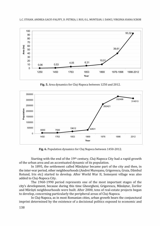
1998-2012 93,32 3324984 - 3145137 In Cluj-Napoca, the residential function of the city, directly related to the enhancement of the industrial and business functions, led to the perpetual development of the settlement situated alongside the riverbank of Someşul Mic River (Muntean et al., 2011). Figure 5 shows that after the construction of the first fortified enclosure of Cluj (1250), the area of the city has rapidly increased from about 0.06 km2 to 10 km2 in 1869 reaching approximately 93 km2 in 2012. Population dynamics followed the same positive trend, from 6000 inhabitants in 1450 to 332,498 inhabitants in 1998 reaching to 314,513 inhabitants in 2012 (Fig. 6). Population data for 1250 are not available. 3 According to Pascu, Şt., 1974. Istoria Clujului. Consiliul Popular al Municipiului Cluj, 576 p. 4 According to Rotariu, T., (coord.), Semeniuc, M., Mezei, E., 1996. Recensământul din 1850: Transilvania, Edit. Staff. 5 According to „Anuarul Statistic al Republicii Socialiste România, Directia Centrală de Statistică – 1977”. 6 According to „Anuarul Statistic al Romaniei, Comisia Nationala pentru Statistica – 1999”. 7 According to „Recensamantul Populatiei si al Locuintelor din 2011”.
A map representing Cluj-Napoca urban growth dynamics for 1250-2012 period was realized using ArcGIS 9.3.1, by overlapping the layers obtained by digitizing the above-mentioned carto-graphic materials (Fig. 4). Table 2 presents the surface and population dynamics of the city located along Someșul Mic River.
L.C. STOIAN, ANDREA GAGYI-PALFFY, D. PETREA, I. RUS, O.L. MUNTEAN, I. DANCI, VIRGINIA IOANA SCROB
138
93,32
39,61
10,016,314,05
0,530,060
102030405060708090
100
1250 1450 1763 1853 1869 1976-1998 1998-2012Year
Area
(ha)
Fig. 5. Area dynamics for Cluj-Napoca between 1250 and 2012.
6000 750019612 32831
262421
332498314513
0
50000
100000
150000
200000
250000
300000
350000
1450 1763 1853 1869 1976 1998 2012
Year
Popu
latio
n
Fig. 6. Population dynamics for Cluj Napoca between 1450-2012.
Starting with the end of the 19th century, Cluj-Napoca City had a rapid growth of the urban area and an accentuated dynamic of its population. In 1895, the settlement called Mănăștur became part of the city and then, in the inter-war period, other neighbourhoods (Andrei Mureșanu, Grigorescu, Gruia, Dâmbul Rotund, Iris etc) started to develop. After World War II, Someșeni village was also added to Cluj-Napoca City. The 1960-1990 period represents one of the most important stages of the city’s development, because during this time Gheorgheni, Grigorescu, Mănăștur, Zorilor and Mărăști neighbourhoods were built. After 2000, tens of real-estate projects began to develop, concerning particularly the peripheral areas of Cluj-Napoca. In Cluj-Napoca, as in most Romanian cities, urban growth bears the conjunctural imprint determined by the existence of a decisional politics exposed to economic and

CLUJ-NAPOCA URBAN GROWTH FROM 1250 TO 2012. A GEOGRAPHICAL INFORMATION SYSTEM APPROACH
139
political clientelism. This situation encouraged the "uncontrolled urbanization", which has multiple facets in Cluj-Napoca. The following can be noted in this regard: - the abusive occupation of the urban space by extending building on unencumbered land instead of the establishment of sound policies for recovery and reconstruction of already-built degraded areas, such as the industrial brownfield sites; the extension of residential areas on geotechnically vulnerable land; - occupation of green spaces in the existing built-up area. The extension of the built-up area, although increased the area of green spaces, will lead to their destruction if the current urban development policies continue; - the improvised nature of urbanization in new neighborhoods (areas built without prior planning of the road network, with no access to public utilities etc.). Of course, the term "uncontrolled urbanization" should be understood in terms of the way that urban development based on speculative and/or scientifically unsubstantiated decisions affects the base interests of the community in the long term. The term is appropriate as "factors" and "actors" are "behind" the decisions affecting the potential and development prospects of the city, including also its environmental state. They undoubtedly exert some kind of control which serves, however, only personal and group interests. 5. CONCLUSIONS Cluj-Napoca City flows perceptibly across municipal boundaries and this process is at different stages of development in different new residential areas. Thus, the responsibility for land use management remains divided between local administration and this fragmentation of urban management, frequently exacerbated by the political tensions, may lead to incoherent land use planning. In this context, the mixture of forces include socio-economic trends such as the means of individual housing preferences, transportation, the price of land, demographic trends, cultural traditions and environmental constraints, the attractiveness of existing “green areas”, and the application of land use planning policies at local scale. Morphological measurement of urban development is important for the study of urban development. Urban planners and researchers are often concerned with the change in size, shape, and configuration of built-up areas. The measurement of the urban form can provide a more systematic analysis of the relationship between urban form and process. The study area is characterized by a highly authentic human fingerprint and a space-time dynamics marked by many changes and evolutionary bifurcations. Regarding the territorial dynamics of the urban system, the 1250-2012 period reveals a continuous development and growth of the built area and the population. The economic development of Cluj-Napoca City, the migration flows from village to city generated by the progress of industry and other activities (transport, services, commerce, etc.), the extension of its boundaries by incorporating adjacent communities, have resulted in the increase of urbanization and therefore in substantial changes in the population structure.

L.C. STOIAN, ANDREA GAGYI-PALFFY, D. PETREA, I. RUS, O.L. MUNTEAN, I. DANCI, VIRGINIA IOANA SCROB
140
R E F E R E N C E S
1. Bhatta, B. (2010), Analysis of Urban Growth and Sprawl from Remote Sensing Data. Springer-Verlag, Heidelberg, pp. 170. 2. Cristea, V., Baciu, C., Gafta, D. (2002). Municipiul Cluj-Napoca şi zona periurbană. Ed. Accent, Cluj-Napoca, 332 p. 3. Knowles, A.K. (2008), “GIS and history” in A.K. Knowles (ed.) Placing history: how maps, spatial data, and GIS are changing historical scholarship. Redlands, Calif.: ESRI Press: 1-26. 4. Muntean, O.L., Buzilă, L., Maloş, C., Roşian, Gh., Stoian, L., Baciu, N., Mihăiescu, R. (2011), GIS Applications for Geomorphological Constraints Assessment within New Residential Areas of Cluj-Napoca Municipality, Revista de Cadastru RevCad, Alba-Iulia. 5. Pascu, Şt. (1974), Istoria Clujului. Consiliul Popular al Municipiului Cluj, 576 p. 6. Rotariu, T. (coord.), Semeniuc, M., Mezei, E. (1996), Recensământul din 1850: Transilvania, Ed. Staff.
7. Rumsey, D., Williams, M. (2002), “Historical Maps in GIS” in A.K. Knowles (ed.), Past Time, Past Place: GIS for History. Redlands, Calif.: ESRI Press: 1-18. 8. Schwarz, N. (2010), Urban form revisited - Selecting indicators for characterising European cities. Landscape and Urban Planning 96(1):29–47. 9. Thapa, R.B., Murayama, Y. (2008), Land evaluation for peri-urban agriculture using analytical hierarchical process and geographic information system techniques: A case study of Hanoi, Land Use Policy, 25, p. 225–239. 10. Xiao, J., Shen, Y., Ge, J., Tateishi, R., Tang, C., Liang, Y., Huang, Z. (2006), Evaluating urban expansion and land use change in Shijiazhuang, China, by using GIS and remote sensing. Landscape and Urban Planning 75:69–80. 11. *** (1977) Anuarul Statistic al Republicii Socialiste România, Directia Centrală de Statistică. 12. *** (1999) Anuarul Statistic al României, Comisia Națională pentru Statistică. 13. *** (2011) Recensământul Populației și al Locuințelor.