clup
TRANSCRIPT

T A B L E O F C O N T E N T S
Page
MESSAGEFOREWORD IINTRODUCTION IIMETHODOLOGY III
TABLE OF CONTENTS
1. Historical Background 1-3
2. Physical Characteristics 3 A. Geography 3 B. Topography 3 C. Climate 3 D. Soil 4-6
3. Demography 6 A. Population Size and Growth 6 B. Table 1 – 5 7-11 4. Sectoral and Sub-Sectoral Development Framework 12 4.1 The Sub-Sectoral Analysis 12
A. Agriculture 12-13 Programs and Projects 14-15 Table 1- Table 5 16-19
B. Agrarian Reform 20B.1 The Existing Situation 20B.2 Development Needs 20B.3 Goals, Objectives and Targets 20B.4 Plans and Programs 20
C. COMMERCE AND INDUSTRY 21C.1 Existing Situation 21-27C.2 Development Needs 27C.3 Goals, Objectives and Targets 27C.4 Strategies 27
I

D. Education 28D.1 Existing Situation 28-30D.2 Determination of Development Needs 30-31D.3 Goals, Objectives and Targets 31
E. Health and Nutrition 31E.1 Existing Situation with Tables 1-8 31-36 E.2 Development Needs 37E.3 Goals, Objectives and Targets 37E.4 Plan Formulation 37E.5 Plans Programs 39
F. Environmental Management 40F.1 Existing Situation 40-41F.2 Development Needs 41F.3 Goals, Objectives and Targets 41-42
G. Tourism 42-44
H. HOUSING 45H.1 Existing Situation 45H.2 Development Needs 45-46H.3 Goals, Objectives and Targets 46 H.4 Plan Formulation 46TABLES 1-2 46-48
I. SOCIAL SERVICES 48I.1 Existing Situation 48I.2 Development Needs 48-49I.3 Goals, Objectives and Targets 49 I.4 Plans and Programs 49-50I.5 Proposals 50Table 1 50-51
J. PROTECTIVE SERVICES 52J.1 Existing Situation 52-61J.2 Goals, Objectives and Targets 61J.3 Programs and Projects 62 PROPOSED PROGRAMS – NEXT FIVE YEARS 63-68
K. SPORTS AND RECREATION 69
II

K1 Existing Situation 69K.2 Development Needs 69K3 Goals, Objectives and Targets 69
L. INFRASTRUCTURE AND UTILITIES 70L.I Transportation, Roads and Bridges 70L.I.1 Existing Situation 70-73
L.II WATER 74L.II.1 Existing Situation 74-76L.II.2 Development Needs 76-77L.II.3 Goals, Objectives and Targets 77
L.III TELECOMMUNICATIONS 77L.III. 1 Existing Situation 77L.III. 2 Development Needs 77-78L.III. 3 Goals, Objectives and Targets
L.IV POWER 78L.IV.1 Existing Situation 78L.IV.2 Development Needs 78L.IV.3 Goals, Objectives and Targets 78
M. PHYSICAL DEVELOPMENT POTENTIALS 79-89
N. Political Set-up 90-91 Organizational Chart 92
Functional Chart 93
THE COMPREHENSIVE LAND USE PLAN2001-2005 94-99
ANNEX I – THE MUNICIPAL ZONING ORDINANCE2001-2005
LAND USE MAPS
III

LIST OF TABLES
PARTICULARS PAGE
I. DEMOGRAPHY 6-11TABLE I.1 – Population of Angat by Barangay 7TABLE I.2 – Household Population Five Years Interval 8TABLE I.3 – Number of Households by Barangay 9TABLE I.4 – Projected Population up to Year 2005 10TABLE I.5 – Projected Household Population up to Year 2005 11
II. AGRICULTURE 12-20TABLE II.1 – Irrigated Palay Area by Number of Cropping and Barangay 16TABLE II.2 - Rainfed Palay Area by Number of Cropping and Barangay 17TABLE II.3 – Fresh Aquaculture Farm 18TABLE II.4 – Inland Fishing Ground 19TABLE II.5 – Fish Processing Establishment 19
III. COMMERCE, TRADE AND INDUSTRY 21-27TABLE III.1 – Revenues from Commerce, Trade & Industry 21TABLE III.2 – Business Establishments in the Municipality 22-25TABLE III.3 – Statistical Data on Industry and Commerce 26-27
IV. EDUCATION 28TABLE IV.1 – Educational Statistical Data on Public & Private Schools 29TABLE IV.2 - Total No. of Enrollees of Day Care per School/Barangay 30
V. HEALTH AND NUTRITION 31-39TABLE V.1 – Health and Nutrition 32TABLE V.2 – Health Personnel and Facilities 32TABLE V.3 – Ten leading Causes of Mortality 33TABLE V.4 – Ten leading Causes of Morbidity 33TABLE V.5 – Number & Location of Health Institution by Barangay 34TABLE V.6 – Family Planning Users 34TABLE V.7 – HIS (FHSIS) Annual Report for the year 2000 35TABLE V.8 – HIS (FHSIS) Annual Report for the year 2000 36
VI. HOUSING 45-47TABLE VI.1 – Number of Dwelling Units by Type of Construction Materials 47TABLE VI.2 – Current and Projected Housing Requirements 47
I

VII. SOCIAL SERVICES 48-50TABLE VII.1 – Data on Social Services Sector 50
VIII. PROTECTIVE SERVICES 52-62 TABLE VIII.1 – Personnel Profile 56TABLE VIII.2 – Age Profile 56TABLE VIII.3 – Firepower 57PROPOSED PROGRAM FOR THE SUCCEEDING FIVE YEARS 63-68
IX.INFRASTRUCTURE AND UTILITIES 70-78
*TRANSPORTATION, ROADS AND BRIDGES 70TABLE IX-A.1 – Number and Type of Transport Vehicle 71TABLE IX-A.2 – List of Existing Bridges by Administrative Classification 72TABLE IX-A.3 – Existing Roads by Type of Pavement 73
*WATER 74TABLE IX-B.1 - Source of Water Supply Types of Deep Well 75TABLE IX-B.2 – Rivers and Creeks of Angat Inventory 76
PHYSICAL DEVELOPMENT POTENTIALS OF ANGAT 79-89
X. THE COMPREHENSIVE LAND USE PLAN 94TABLE X. 1 – Existing General Land Use 97TABLE X. 2 – Proposed General Land Use 98TABLE X. 3 – General Land Use (Increase-Decrease) 99
II

FOREWORD
The Angat Development Plan (Town Plan), conceived by the past and continued by present local government administration, together with the most significant socio-economic profile and the Zoning Ordinance which embodies the guideline in the implementation of the Comprehensive Land Use Plan of the municipality, was prepared by the Municipal Planning and Development Staff with the technical assistance from some consultants from the Housing and Land Use Regulatory Board, the Provincial Planning and Development Office and some information sources from other government agencies.
Efforts have been exerted to gather and consolidate the latest information/data about the municipality and made the report as comprehensible and meaningful as possible. This plan aims to help government officials, business entrepreneurs, industrialists, institutions, prospective investors, and all other researchers to have the knowledge of the overall conditions obtaining in this municipality.
The municipal government of Angat encourages the use of this Comprehensive Development Plan as the significant reference for planning undertakings towards the objectives of promoting, facilitating, and realizing the desired growth and development of the entire community.
The whole scheme of public service embodied in the plan as envisioned by the past and present local government dispensation aims to deliver: a well-rounded economic program involving improvements in trade and industry, agriculture, and infrastructure and utilities; better delivery of health and social services including environmental protection; sustainable protective services so as to maintain peace and order; the positive development of youth including cultural and historical heritage; and to render effective, efficient and honest government administration.
As one reads the entire framework, the goals and vision of the constituents is presented. The future desired development of the municipality is hereby laid out.
This reference book is dedicated to the constituents of Angat and offered as a basic foundation to those who will find benefits from its usage.
Let us join hands together for the progress and success of our beloved Angat.
Leonardo R. De Leon
Municipal Mayor
I

INTRODUCTION
This general development plan, socio-economic profile, the comprehensive land use plan with its corresponding zoning ordinance are, all together, a compilation of reports/data describing and revealing the status and potentials of the municipality. The information presented in the town plan are reflective of the overall situation obtaining in the whole town and the proposed development for the next five years, 2001 – 2005.
Subsequently, this document will undoubtedly help in determining possible solution to future development objectives of the local government unit.
The visions and missions of the present administration, participated in by the officers and members of the Municipal Development Council, the Honorable Sangguniang Bayan, all concerned local, provincial, and national government agencies are hereby formulated and shall become the basis and reference for the future development and progress of the municipality of Angat.
II
METHODOLOGY
The techniques and methods used in the gathering of data are interviews, the use of questionnaires, personal interviews with local officials, and documentary analysis of pertinent information from available national, provincial, municipal and barangay records.
Men and women possessed with different technical know-how have been
consulted to guide in the preparation and production of this document.
Contribution of ideas, suggestions and presentation of data references were all gathered, collated, studied, analyzed, and then sanitized to comprise this documentary compilation composed of the Socio-Economic Profile, the Comprehensive Land Use Plan and its corresponding Zoning Ordinance.
III

1. HISTORICAL BACKGROUND
The town of Angat is noted for its legendary origin. It is believed that Angat got its name from the Tagalog word “Angat” which meas an elevated piece of land or a community living in prominence during the Spanish era.
History related that Angat was a tributary to the town of Quingua (now Plaridel). This can be shown by the fact that Angat River links to the town of Quingua. After being a tributary of Quingua, it became a part of San Miguel. In 1776, it was made a part of Bocaue when the administration of the Sta. Maria de Pandi estate was placed under the Dominican Friars. This transfer was made possible through the efforts of the Dominicans who own most of the fertile lands in that place.
When the Spaniards came to the town it brought a different way of life to the whole community. The people were made to embrace the catholic faith by force rather than by conviction. And, the inhabitants were subjected to forced labor particularly in the construction of the church and the presidencia.
Until today, there were remaining Spanish houses that can still be found in
the municipality. The Catholic church of the municipality bears engraved roman numerals “MBCXII” which, according to the old people was the year when Angat was converted into a regular municipality.
After many years, a barangay named “Kasay” of Angat was proclaimed to be a municipality in the name of “Norzagaray”. During the Marcos regime Pulong Sampaloc, also a barangay of Angat, was also proclaimed to be a municipality under the name Doña Remedios Trinidad.
During the revolution against the Spanish regime, the people of Angat had a share of service. A host of Veteranos de Revolution had their task of battle of Baras Bakal and the town proper. The Veteranos de Revolution displayed their unending nationalism and patriotism.
In 1901, a military government was established in the province of Bulacan. Don Mariano Santiago was appointed the first Governador Militar for Angat, and later on became the first Mayor.
At the time of the Japanese occupation Angat was converted into a regular garrison. The establishment of the prison camp started the reign of terror in the locality. Struggle became more active and intense between the guerilla organization and the Japanese forces until a portion of the town was burned and left by the Japanese. Barangay Niugan was also burned downed when a Guerilla Sniper killed a Japanese officer.
In 1945, rehabilitation started. A sort of libaration government was organized with the aim of rebuilding the town. Major Luis Infantado was appointed major of the town.
1

After the liberation, the municipality of Angat elected their first mayor Mr. Francisco F. Illescas. He served from 1947 to 1953. Among his accomplishment then was the construction of the Angat Elementary School, re-opening of the barrio schools, re-building roads and bridges and establishing one (1) water work system serving three barangays of the Poblacion.
Mr. Benito Cruz was elected mayor in 1954 and he continued the re-construction of the town. Health centers were built and roads were asphalted.
In 1963, Mr. Francisco F. Illescas was re-elected as mayor and continued serving until he retired in 1980.
The leaders that served the Town as Municipal Mayors are as follows:
Hon. Leonardo R. De Leon --------------------------------- 2001 – PresentHon. Angelito S. Vergel De Dios --------------------------------- 1998 – 2001 Hon. Leonardo R. De Leon --------------------------------- 1988 – 1998
Hon. Servillano C. Santiago --------------------------------- 1987 – (4 months)Hon. Leonardo R. De Leon --------------------------------- 1987 – (5 months)Hon. Francisca C. Valarao --------------------------------- 1986 – (10 months)Hon. Atty. Florante C. Cruz --------------------------------- 1980 – 1986Hon. Francisco F. Illescas --------------------------------- 1964 – 1980Hon. Benito Cruz --------------------------------- 1954 – 1963Hon. Francisco F. Illescas --------------------------------- 1948 – 1954Hon. Francisco F. Sombillo --------------------------------- 1947 – 1948Hon. Atilano F. De Guzman --------------------------------- 1947 Hon. Jose S. Santos --------------------------------- 1946 – 1947Hon. Higino Adriano --------------------------------- 1945 – 1946Hon Luis Infantado --------------------------------- 1945Hon. Pablo G. Santos --------------------------------- 1944 – 1945Hon. Agapito C. Correa --------------------------------- 1944Hon. Pedro A. Cinco --------------------------------- 1944Hon. Marcelino F. De Guzman --------------------------------- 1943 – 1944Hon. Vicente Salvador --------------------------------- 1943Hon. Atilano F. De Guzman --------------------------------- 1943Hon. Pedro Vergel De Dios --------------------------------- 1943Hon. Felix Ventura --------------------------------- 1942 – 1943Hon. Jose S. Santos --------------------------------- 1940 – 1942Hon. Franciscio S. Infantado --------------------------------- 1940Hon. Pablo Amisola --------------------------------- 1934 – 1940Hon. Crispulo Cruz --------------------------------- 1931 – 1934Hon. Atilano F. De Guzman --------------------------------- 1925 – 1931Hon. Gerardo Santos --------------------------------- 1922 – 1925Hon. Severo Rivera --------------------------------- 1920 – 1922Hon. Matias A. Fernando --------------------------------- 1916 – 1920
2

Hon. Pablo Capistrano --------------------------------- 1909 – 1916Hon. Luciano De Guzman --------------------------------- 1906 – 1909Hon. Damaso Pascual --------------------------------- 1905 – 1906Hon. Damian Santos --------------------------------- 1904 – 1905Hon. Francisco Vergel De Dios --------------------------------- 1903 – 1904Hon. Pedro Otayco --------------------------------- 1902 – 1903Hon. Mariano Santiago --------------------------------- 1901 – 1902
2. PHYSICAL CHARACTERISTIC
GEOGRAPHY:
The municipality of Angat is bounded by the towns of San Rafael, and Bustos in the north; the vast Sierra Madre mountain ranges in the east; the towns of Santa Maria and Norzagaray in the south and by the town of Pandi in the west.
It has an aggregate area of 6,526 hectares comprising the total land area of the historical province of Bulacan. Presently it is composed of sixteen (16) barangays namely: Banaban, Baybay, Binagbag, Donacion, Encanto, Laog, Marungko, Niugan, Paltok, Pulong Yantok, San Roque, Sta Cruz, Sta. Lucia, Sto. Cristo, Sulucan and Taboc.
TOPOGRAPHY:
Angat varies from flat or level land, level and nearly level, very gently sloping or gently undulating to gently sloping land. Angat River which serve, as a major lone body of water was popularly known for its panoramic scene. Other bodies of water include Banaban River, Bayabas River and activer creeks like Sapang “A”, Maibay, pritil and Sapang Asana.
CLIMATE:
Angat belongs to type I climate which is characterized by two (2 pronounced seasons, the wet and dry season. Wet season start from June until November while dry season start from December to May. The annual average rainfall is 2.500 mm. The temperature ranges from 25.00º to 28.8ºC. The average annual temperature is 26.6ºC while the normal mean temperature is about 26.5ºC. The annual normal relative humidity is approximately ranging from 74 to 78%.
3

SOIL:
The soils existing in the town of Angat consists of the following:
A. Soils of the Alluvial Landscape
A.1 Gapan
It consists of thick well-drained soils of medium to high river terrace landscape position, which is normally above annual seasonal flooding.
The surface soil is 21cm. thick dark brown silt loam having few yellowish brown mottles. The subsoil is dark yellowish brown to very dark yellowish brown and very dark grayish brown. It has low organic matter content and with moderate to high inherent fertility.
Paddy rice constitute as the main crop during wet season. Even diversified crops and other high value commercial crops can be grown during dry season, provided that there is adequate water supply for the growth and development of the plants.
A.2 Quingua
This type of soil consists of deep nearly level sloping well-drained soils. It occurs on high river terraces landscape, and it is very seldom affected by seasonal flooding on the occurrence of rainy season.
The surface soil is 17cm. thick brown or dark grayish brown clay loam and almost brown in color throughout. It has low organic matter content and moderate natural inherent fertility. And this soil is moderate in available water holding capacity.
A.3 San Manuel
This soil is deep nearly level-drained soils formed in river plains and low to medium river terraces. Those lying in the river plains are not affected by flooding, while those located on a medium river terraces are subject to slight seasonal flooding.
The surface soil is about 18cm thick yellowish brown silt loam and the subsoil is yellowish brown-to-brown loam with mottles. It has a deficient organic matter content and with moderate inherent fertility.
Rice is the principal crop grown in this type of soil and even vegetable crops and other high value crops with the presence of available water supply.
4

A.4 Tagulod
These soils occupy the low-lying level flood free low alluvial terraces. The surface layer 10 cm. thick is brown clay to yellowish brown.
It has low adequate organic matter content and inherent fertility. These soils are generally utilized under rice production during wet season. Other areas are devoted for high value commercial crops during dry season where irrigation facility is available for the growth and development of the crop.
B. Soils of the Piedmont Landscape
B. 1 Awayan
This soil unit occurs on nearly level to gently undulating somewhat poorly drained soils formed on weak stratified concretionary clayey materials on dissected piedmont foot-slopes landscape.
The surface layer 21 cm. thick is gray clay loam with few mottles. As the horizon goes deeper, this soil becomes gray and clay in texture.
It has deficient organic matter content and with moderate inherent fertility. The available water holding capacity is high.
Paddy rice is the dominant crop during rainy season. But, during wet season, this soil remains idle or followed.
B.2 Batia
This is deep poorly drained soils on gently sloping side-slopes on dissected piedmont tuffaceous foot-slopes.
The surface soil is 17cm. thick pale brown clay loam with dark yellowish brown mottles. The subsoil to a depth of 115cm. is gray to light gray clay.
This soil has deficient organic matter content and moderate inherent fertility. It has a moderate available moisture holding capacity.
Paddy rice constitutes as the main crop grown in this kind of soil.
B.3 Pulong Buhangin
5

It consists of a gently sloping to undulating moderately deep somewhat poorly drained soils that occur on dissected piedmont tuffaceous foot-slopes.
The surface layer 30cm. thick is light brownish gray and grayish brown clay loam to clay. The subsoil to a depth of 60cm. is grayish brown clay with few to common manganese and iron concretions.
This soil has deficient organic matter content and with a high to moderate inherent fertility, and the available water holding capacity is low to moderate.
Non-irrigated rice is the principal crop during wet season. The soil remain idle during dry season due to the lack of water supply.
C. Soils of the Hilly Landscape
C.1 Paradise
This soil consists of well-drained moderately deep clayey soils occurring on low gently sloping to rolling eroded conglometric hills and ridges landscapes.
The surface layer, 7cm. thick is dark brown clay with dark yellowish brown mottles. The subsoil is pale brown clay-to-clay loam.
This soil have low organic matter content and with moderate inherent fertility. The available water holding capacity is high. Soil reaction is strongly acidic.
Shrubs and gasses are the primary vegetative cover on this kind of soil.
3. DEMOGRAPHY
A. Population Size and Growth
The 2000 census on population conducted nationwide by the National Statistic Office shows that the municipality of Angat has a total population of 46,135, 46,057 household population and 9,481 households. Barangay population survey shows that Sulucan has the biggest number of population, which is 5,035, followed by barangay Sta. Cruz, with a count of 4,687, Sto. Cristo (Pob.) occupies the third with 4,314, San Roque (Pob.) is the fourth with 4,094 tallies, and the fifth is Binagbag with a population number of 3,902.
During the last five (5) years, the population of Angat increased by 7,098. The highest numerical change in population size is exhibited by barangay Sta. Cruz (Pob.) to the tune of 1,251. The second highest increase is 817 for barangay Sta.
6

Lucia; third is barangay Pulong Yantok with 660; fourth is Niugan with 568 and the fifth is San Roque with 522.
B. The demographic report of the municipality is reflected in the following National Statistics Office data for the years 1995 and 2000.
TABLE I.1
POPULATION OF ANGAT BY BARANGAY 1995 – 2000
BARANGAYTOTAL POPULATION
SEPT.1, 1995 1-May-00 RATIOBanaban 1,147 1,335 1.16 Baybay 640 654 1.02 Binagbag 3,592 3,902 1.09 Donacion 1,986 2,457 1.24 Encanto 2,236 2,740 1.23 Laog 1,000 1,033 1.03 Marungko 3,223 3,610 1.12 Niugan 2,975 3,543 1.19 Paltok 890 1,064 1.20 Pulong Yantok 2,202 2,862 1.30 San Roque (Pob.) 3,572 4,094 1.15 Sta. Cruz (Pob.) 3,436 4,687 1.36 Sta. Lucia 1,239 2,056 1.66 Sto. Cristo (Pob.) 3,883 4,314 1.11 Sulucan 4,586 5,035 1.10 Taboc 2,430 2,749 1.13 TOTAL 39,037 46,135 1.18 Source: NSO
7
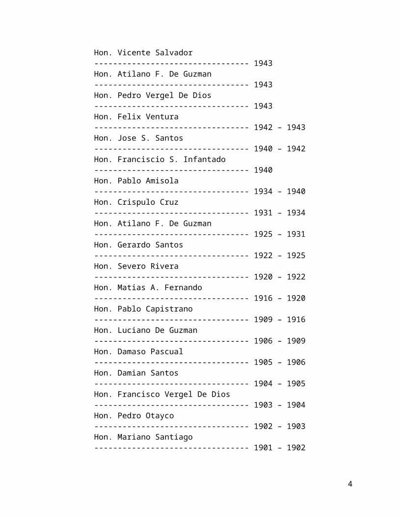
TABLE I.2HOUSEHOLD POPULATION FIVE YEARS INTERVAL
BARANGAYHOUSEHOLD POPULATION
SEPT.1, 1995 1-May-00 RATIOBanaban 1,147 1,335 1.16 Baybay 640 654 1.02 Binagbag 3,576 3,892 1.09 Donacion 1,986 2,419 1.22 Encanto 2,236 2,740 1.23 Laog 1,000 1,033 1.03 Marungko 3,223 3,610 1.12 Niugan 2,966 3,543 1.19 Paltok 890 1,064 1.20 Pulong Yantok 2,148 2,862 1.33 San Roque (Pob.) 3,572 4,094 1.15 Sta. Cruz (Pob.) 3,436 4,672 1.36 Sta. Lucia 1,239 2,056 1.66 Sto. Cristo (Pob.) 3,883 4,314 1.11 Sulucan 4,559 5,020 1.10 Taboc 2,430 2,749 1.13 TOTAL 38,931 46,057 1.18 Source: NSO
8
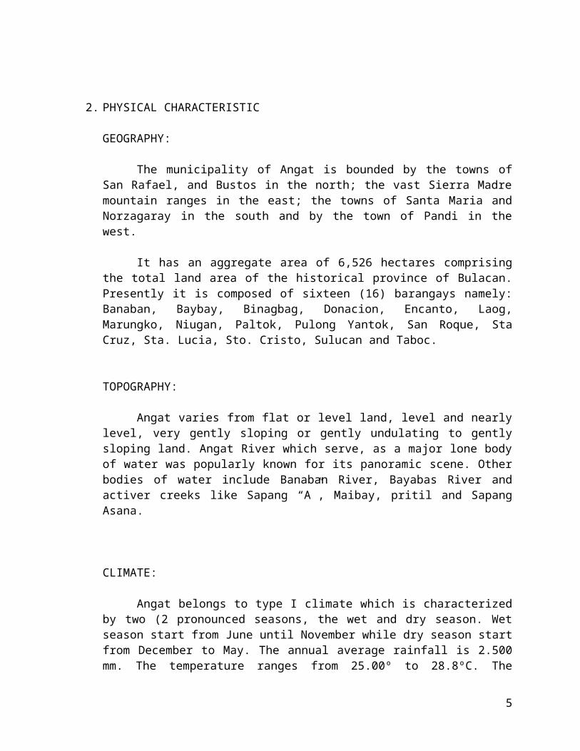
TABLE I.3NUMBER OF HOUSEHOLDS BY BARANGAY
BARANGAYNUMBER OF HOUSEHOLDS
SEPT.1, 1995 1-May-00 RATIOBanaban 222 262 1.18 Baybay 126 133 1.06 Binagbag 789 845 1.07 Donacion 384 496 1.29 Encanto 432 537 1.24 Laog 207 216 1.04 Marungko 679 761 1.12 Niugan 604 719 1.19 Paltok 170 198 1.16 Pulong Yantok 423 592 1.40 San Roque (Pob.) 698 839 1.20 Sta. Cruz (Pob.) 712 1,010 1.42 Sta. Lucia 234 412 1.76 Sto. Cristo (Pob.) 789 882 1.12 Sulucan 861 1,020 1.18 Taboc 471 559 1.19 TOTAL 7,801 9,481 1.22 Source: NSO
9

TABLE I.4
PROJECTED POPULATION UP TO YEAR 2005
BARANGAY 2000 2001 2002 2003 2004 2005Banaban 1,335 1,375 1,416 1,459 1,503 1,548Baybay 654 674 694 715 736 758Binagbag 3,902 4,019 4,140 4,264 4,392 4,523Donacion 2,457 2,531 2,607 2,685 2,765 2,848Encanto 2,740 2,822 2,907 2,994 3,084 3,176Laog 1,033 1,064 1,096 1,129 1,163 1,198Marungko 3,610 3,718 3,830 3,945 4,063 4,185Niugan 3,543 3,649 3,759 3,872 3,988 4,107Paltok 1,064 1,096 1,129 1,163 1,198 1,233Pulong Yantok 2,862 2,948 3,036 3,127 3,221 3,318San Roque (Pob.) 4,094 4,217 4,343 4,474 4,608 4,746Sta. Cruz (Pob.) 4,687 4,828 4,972 5,122 5,275 5,434Sta. Lucia 2,056 2,118 2,181 2,247 2,314 2,383Sto. Cristo (Pob.) 4,314 4,443 4,577 4,714 4,855 5,001Sulucan 5,035 5,186 5,342 5,502 5,667 5,837Taboc 2,749 2,831 2,916 3,004 3,094 3,187TOTAL 46,135 47,519 48,945 50,413 51,925 53,483Source: NSO
10

TABLE I.5
PROJECTED HOUSEHOLD POPULATION UP TO YEAR 2005
BARANGAY 2000 2001 2002 2003 2004 2005Banaban 1,335 1,375 1,416 1,459 1,503 1,548Baybay 654 674 694 715 736 758Binagbag 3,892 4,009 4,129 4,253 4,380 4,512Donacion 2,419 2,492 2,566 2,643 2,723 2,804Encanto 2,740 2,822 2,907 2,994 3,084 3,176Laog 1,033 1,064 1,096 1,129 1,163 1,198Marungko 3,610 3,718 3,830 3,945 4,063 4,185Niugan 3,543 3,649 3,759 3,872 3,988 4,107Paltok 1,064 1,096 1,129 1,163 1,198 1,233Pulong Yantok 2,862 2,948 3,036 3,127 3,221 3,318San Roque (Pob.) 4,094 4,217 4,343 4,474 4,608 4,746Sta. Cruz (Pob.) 4,672 4,812 4,957 5,105 5,258 5,416Sta. Lucia 2,056 2,118 2,181 2,247 2,314 2,383Sto. Cristo (Pob.) 4,314 4,443 4,577 4,714 4,855 5,001Sulucan 5,020 5,171 5,326 5,485 5,650 5,820Taboc 2,749 2,831 2,916 3,004 3,094 3,187TOTAL 46,057 47,439 48,862 50,328 51,838 53,393Source: NSO
4. SECTORAL AND SUB-SECTORAL DEVELOPMENT FRAMEWORK
11

The Development framework of every local government unit must embrace as much as possible all sectors of human needs. These sectors can be grouped as follows:
A. Economic DevelopmentB. Environmental Management and protection and Practical Delivery of Health,
Nutrition, Social Services, Education and housing.C. Provision and Maintenance of Peace and OrderD. Youth, Cultural and Historical Development, andE. Efficient, Effective and Honest Government Service.
The scope of development of the municipality of Angat should cover every aspect of sub-sectors belonging to each of sectoral groups.
The following presentation on sub-sectors will show prevailing situations, which will serve as basis for future development.
4.1 The Sub-Sectoral Analysis.
A. AGRICULTURE
Farmers in the town of Angat use both traditional and scientific way of farming.
Angat has a total land area of 6,526 hectares, 4,720 hectares of it is agricultural. Palay as the primary crop has a total area of 818 hectares under irrigated area and 1,242 hectares covers the rain-fed. The average yield per hectare under dry season is about 95 cavans per hectare and 68.14 cavans per hectare during wet season.
The area under corn production is about 195 hectares having an average production of 15,318 ears per hectare.
The high value commercial crops are about 199.87 hectares. Angat is noted as the number one supplier of vegetables around greater Manila area.
Orchard production on the other hand is about 792 hectares wherein different methods of propagation is fully introduced to bear best fruits that will serve as additional income to the farmers.
The Strategic Agricultural and Fisheries Development Zone (SAFDZ)
The Municipality of Angat has no existing irrigation canal to supply water to agricultural land. The agricultural area is generally rainfed.
There are, however, areas that are irrigated in accordance with the program of the National Irrigation Administration. According to NIA, barangays Niugan and Donacion have a combined 100 hectares more or less, which is irrigated by pump system installed in Tibagan of the municipality of Bustos. These barangays continue
12

to receive the services of this irrigation system. Rice production is twice a year in this area.
These two barangays is considered by the local government as the area for SAFDZ.
In addition to barangays Niugan and Donacion, the National Irrigation Administration has on-going irrigation project entitled NIA Communal Irrigation Project in barangays Binagbag and Marungko. A pumping station in Binagbag is being constructed with a budget of P 1,307,000, which will irrigate 30 hectares more or less. Another pumping station for irrigation is being installed in Marungko with a total budget of P 4,385,000. This can supply water to around 80 hectares.
These two projects were started in the later part of year 2000 and expected to be finish this year. Appropriate irrigation canals will be built after the installation of the two pumping stations.
Barangays Binagbag and Marungko will be considered as SAFDZ areas.Livestock and Poultry Production
It is one of the promising enterprises in the town of Angat. Animal population under livestock production includes the following: Carabao with 1,286 heads, cattle at 2,204, horse 41, goat 823, hog 14,438 and dog at 5,285.
Poultry industry is productive. Chicken has a count of 77,832, duck at 2,692, goose 303, quail 15,000, dove 4,875, turkey 165, and guinea fowl 96.
Fishery
Angat has an approximate 18.86 hectares for both backyard and fresh water culture with 14 fresh water operators in the different barangays of the municipality.
The rest of the total agricultural land areas of Angat are devoted to residential farm lot, up-land agriculture and part forest area.
Cooperatives
There are three successful types of cooperatives existing in the town of Angat namely: the Multi-purpose Cooperative that has started since 1988 to 1998, the Credit Cooperative that started for the year 1989 and the Service Cooperative that started since 1998 to the present.
Programs and Projects
13

1. MAKAMASA Agricultural Program
a. Inform farmers regarding the plans and programs of agriculture under the Estrada Administration.
b. Define Strategic Agriculture and Fisheries Development Zones (SAFDZ)c. Attain self sufficiency on food securityd. Encourage farm mechanization.
2. Certified Seed Production and Distribution under the Plant Now Pay Later Program.
a. Using certified seed could increase 10% of the total harvest per cropping.b. Encourage all farmers especially the progressive ones to invest in a
certified seeds growing business.c. Encourage the LGU on Seed Production Program.
3. Operation Rat Control
a. Reduce rat damage on crop production and human properties.b. Encourage farmers regarding the importance of field sanitation.c. Inform the populace that rat is a causal organism of “Salmonella” diseases
to human being.
4. Integrated Pest Management
a. Enhancement of biological agents.b. Use of resistant varieties.c. Identification between beneficial and harmful insects.d. Knowledge of compatible farm management practices.e. Actual farmers’ field school/training on farm.f. Use chemicals if necessary.
5. Marketing of Palay produced by farmers under the NFA Procurement Scheme.
a. Encourage group of farmers to sell their products at the NFA P 12.00/kilo.b. Farmers who are members of the cooperative must be given incentives at
P 0.50 / kilo market in NFA.c. Farmers who patronized the NFA procurement scheme could avail
necessary farm inputs at a lower price.
6. Balanced Fertilization Strategy.
14

a. Increase organic matter in the soil that will hasten the bacterial activities in the soil.
b. Proper mixture of both organic and inorganic fertilizer for the correct amount of nutrients needed by the plants.
c. Improve farm savings.d. Sustain agricultural productivity and profitability.
7. High Value Commercial Crops
Vegetables
a. Distribute high quality vegetable seeds.b. Conduct hands-on training on off-season vegetable production.c. Expand income opportunities to farmers and other entrepreneurs.
Fruit Trees/Orchards
a. Selection of quality fruit trees for distribution.b. Improvement of technical skills in the methods of propagation.
8. Livestock and Poultry
a. Information/dissemination drive, trainings and seminars must be fully monitored.
b. Full and technical assistance from the technologist must be totally implemented.
c. Prevention, treatment, vaccination, castration and other related activities regarding livestock and poultry must be fully supported from the agencies concerns and the LGUs.
9. Backyard/Commercial Fishpond
a. Uplift the economic living condition of fisher-folk and bring benefits to the fishing populace.
b. Distribution of best-related fingerlings.
10. Cooperatives
a. Encourage the people to organize or join existing cooperatives.b. Strengthening of the cooperatives through additional support from the
Local Government Units.
15

In order to determine the development needs of the municipality the following information is hereby presented for reference.
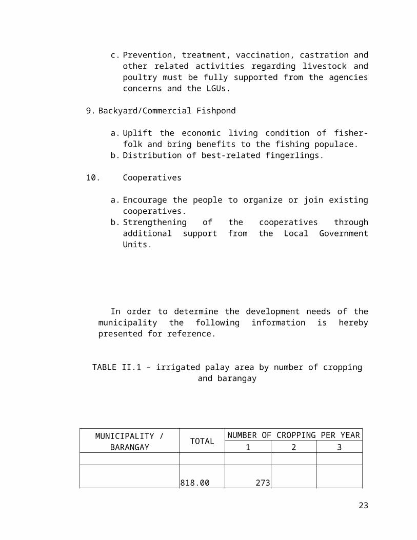
TABLE II.1 – irrigated palay area by number of cropping and barangay
MUNICIPALITY / BARANGAY
TOTALNUMBER OF CROPPING PER YEAR
1 2 3 818.00 273 BANABAN 10.00 10.00 BAYBAY 15.00 15.00 BINAGBAG 130.00 50.00 80.00 DONACION 80.00 80.00 ENCANTO 5.00 5.00 LAOG 20.00 10.00 10.00 MARUNGKO 80.00 60.00 20.00 NIUGAN 228.00 8.00 220.00 PALTOK 22.00 22.00 PULONG YANTOK SAN ROQUE 3.00 3.00 STA. CRUZ STA. LUCIA STO. CRISTO SULUCAN 100.00 50.00 50.00 TABOC 125.00 35.00 90.00 Source: PAO
16

TABLE II.2 - Rainfed palay area by number of cropping and barangay
MUNICIPALITY / BARANGAY
TOTALNUMBER OF CROPPING PER YEAR
1 2
ANGAT 1,242.00 1,242.00 - BANABAN 40.00 40.00 - BAYBAY 5.00 5.00 - BINAGBAG 270.00 270.00 - DONACION 120.00 120.00 - ENCANTO 15.00 15.00 - LAOG 60.00 60.00 - MARUNGKO 20.00 20.00 - NIUGAN 50.00 50.00 - PALTOK 278.00 278.00 - PULONG YANTOK 20.00 20.00 - SAN ROQUE 5.00 5.00 - STA. CRUZ 4.00 4.00 - STA. LUCIA 200.00 200.00 - STO. CRISTO - - SULUCAN 100.00 100.00 - TABOC 55.00 55.00 - Source: PAO
17
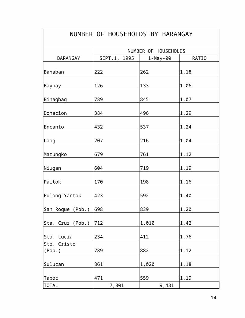
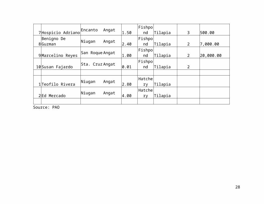
TABLE II.3 - FRESHWATER AQUACULTURE FARMS:
Sno OPERATORLOCATION OF
AQUACULTURE FARM
AREA (Ha)
TYPE OF
FARM
SPECIES CULTURED
NO. OF CROPPING
/ YEAR
AVERAGE PRODUCTION PER CROP(mt.)
FRESHWATER
1 Jose Lopez Taboc Angat 1.00 Fishcage Tilapia 3 14.00
1 Wilfredo Adriano Encanto Angat 0.25 Fishpond Hito
1 Edmundo Pascual Baybay Angat 0.05 Fishpond Tilapia 2 500.00 2 Guillermo Santos Binagbag Angat 0.50 Fishpond Tilapia 2 1,000.00 3 Ricardo Estrella Binagbag Angat 0.10 Fishpond Tilapia 2 200.00 4 Panero Del Rosario Donacion Angat 0.90 Fishpond Tilapia 2 60,000.00 5 Sosimo Rivera Donacion Angat 1.30 Fishpond Tilapia 2 45,000.00 6 Elpidio Mag-isa Donacion Angat 2.60 Fishpond Tilapia 2 90,000.00 7 Hospicio Adriano Encanto Angat 1.50 Fishpond Tilapia 3 500.00 8 Benigno De Guzman Niugan Angat 2.40 Fishpond Tilapia 2 7,000.00 9 Marcelino Reyes San Roque Angat 1.00 Fishpond Tilapia 2 20,000.00
10 Susan Fajardo Sta. Cruz Angat 0.01 Fishpond Tilapia 2
1 Teofilo Rivera Niugan Angat 2.80 Hatchery Tilapia 2 Ed Mercado Niugan Angat 4.00 Hatchery Tilapia
Source: PAO
18

Table II.4 - INLAND FISHING GROUND
Sno Fishing Ground Location Common Fishing Gear UsedNo. of Fishing Days
Average Catch Per Day (mt)
1 Banaban River Banaban Angat Panti, Battery 10 3.00 2 Baybay River Baybay Angat Panti & Sagap (for shrimps) 4 2.50 3 Angat River Donacion Angat Fishing Net 4 2.00 4 Creek Encanto Encanto Angat Battery 4 5.00 5 Angat River Laog Angat Panti, Sisid 30 4.00 6 Angat River Marungko Angat Gill Net 25 2.00 7 Angat River Niugan Angat Net 7 3.00 8 Angat River San Roque Angat Panti 5 5.00 9 Angat River Sta. Cruz Angat Pana 4 2.00
10 Angat River Sta. Lucia Angat Panti 20 3.00 11 Angat River Sto. Cristo Angat Panti, Net, Pamingwit, Kitang 30 6.00 12 Angat River Taboc Angat Fishing Net 7 3.00
Source: PAO
Table II.5 - FISH PROCESSING ESTABLISHMENTS
Sno NAME OF
ESTABLISHMENT OWNER
LocationMAIN
ACTIVITY
AVERAGE MONTHLY
PRODUCTION
1 Digna Jalandoni Binagbag Angat Drying 80.00 Salted/Dried FishSource: PAO
19

B. Agrarian Reform
B.1 The Existing Situation
As presented in the agricultural status of the municipality, part of barangays Niugan and Paltok are the only areas covered by irrigation system. The rest of the areas use for agricultural purposes is rein fed. Of the sixteen (16) barangays of the town, minimal areas of Niugan–Donacion with combined area of one hundred thirty eight (138) hectares; Taboc with fifty (50) hectares; and Paltok with fifty (50) hectares too, are covered by the Agrarian Reform Community Program of the Department of Agrarian Reform.
Planned program in the implementation of the project has not yet been prepared and adopted according to sources from the local offices of the DAR.
B.2 Development Needs
Although there is a minimal carpable land area within four (4) barangays of the municipality, the Agrarian Reform Community Program should be implemented with the intent to expand the areas of development even as far as agricultural land, irrigated or rain fed, involve not only in rice production but more on areas that produces high value crops like various vegetables, root crops, fruits and others.
The ARC program that covers various community developments not only in production but also in infrastructure development is very much needed in the municipality of Angat. Roads, bridges, community centers for education, health and other people needs must be given to the community residents. Social, Economic and infrastructure development may possibly be attained thru the ARC program.
B.3 Goals, Targets and Objectives
B.3.a Develop the most of the small coverage of DAR OLT and ARCB.3.b Include more areas in the implementation of the programs of ARC. B.3.c Attract more residents and investors in the community.
B.4 Plans and Programs
B.4.a Organized the Agrarian Reform Committee
B.4.b Request the Department of Agrarian reform, Department of Agriculture, Department of Environment and Natural Resources, other government agencies concerned and public officials to conduct analytical studies to apply and implement the programs of the Agrarian Reform Community extending as far as areas not covered by carpable lands which will be viable to contribute to agricultural productivity.
20

C. COMMERCE, TRADE AND INDUSTRY
C. 1 Existing Situation
The municipality of Angat has yet to develop its commercial, trading and industrial activities in order to enhance the income of the town. There are businesses and industrial establishments generally centered in the Poblacion area, others are spread within urban barangays. Commerce and trade are centered in and around the public market.
Various industries classified as small, medium and large are also found in the different places in the municipality.
The existence of these economic activities could have contributed to a large extent in the growth and development of the town. Quite noticeable, the total revenues derive by the municipal government accounts to only five million five hundred seventy three thousand one hundred eighty one pesos and twenty-five centavos (P 5,573,181.25) which is more likely the average annual total collection.
The following table will indicate actual status of revenues coming from the above-cited economic undertakings.
TABLE III.1 Revenues from Commerce, Trade and Industry
REVENUES ON ESTIMATED ACTUAL UNCOLLECTEDMun. Business 3,500,000.00 2,371,162.46 (1,128,837.54)Tax (taxes on goods)
Receipts from industries 1,000,000.00 542,779.54 (457,220.46)
Mayors permit 140,000.00 131,255.00 (8,745.00)
Receipts from market 2,620,000.00 2,527,984.25 (92,015.75)
TOTAL 7,260,000.00 5,573,181.25 (1,686,818.75)
21
The table above shows that the total revenue collected business and industry is quite small for the expected growth and development of the community. The total actual income of the municipality for the year 2000 is P 36,706,572.38 and part of this amount is P 23,851,232.29, which is the annual internal revenue allotment for the municipality of Angat for the year ended. It can be deduced therefore, that the total income of the municipality minus the IRA is only P 12,855,340.09, which includes the income from commerce, trade and industry.
The municipality has for the record the following list of commercial and industrial/establishments:
List of Existing Establishments - COMMERCIAL
TABLE III.2NAME OF ESTABLISHMENT LOCATION NATURE OF BUSINESS
Farmers Savings & Loan Bank Poblacion BankingChingola Pawnshop & Lending Inv. Sta. Cruz Pawnshop and LendingP.S. Santos Builders Corporation Poblacion Construction SupplyEdu Glass & Aluminum Service Sta. Cruz Glass & Aluminum ServiceNeneth's Junk Shop Sta. Cruz Junk ShopE.C Glassware Poblacion Drygoods & glasswareFlores Gen. Merchandise Poblacion General MerchandiseTeresita Cruz Marungko Concrete Product SupplyAbad Gen. Merchandise Encanto General MerchandiseFajardo Barber Shop Sta. Cruz Barber ShopMontalvo Vulcanizing San Roque Vulcanizing ShopE.L Villarama Marungko Trucking ServiceN & N Enterprise Sta. Cruz Construction SupplyDe Guia Gen. Merchandise Poblacion Video Rental & Gen. Mdse.Elise Pharmacy Poblacion PharmacySarah Dry Goods Poblacion Drygoods StoreBulacan Recapping & Trdg. Corp. Sto. Cristo Vulcanizing & RecappingRoyal Salute Mktg. Marungko General MerchandiseGenesis Enterprises Poblacion School SuppliesSta. Maria Food Co. Inc. Poblacion Dunkin Donut Outlet
22

Lipana Tailoring Sta. Cruz Tailoring ShopG.V. Printing Press Poblacion Printing PressRural Bank of Angat, Inc. Poblacion Banking & LendingF.I. Flores Caltex Station Marungko Gasoline StationM.G. Shell Station San Roque Gasoline StationMAG Petron Service Station Gasoline StationDionisio Tailoring Poblacion Tailoring ShopB.G.M. Tita Grace Food House Sta. Cruz Food HouseS.B. Villarama Trading Marungko TradingU.S.A. Cable Services Poblacion Cable System ServicesAIMCO General Mdse. Sta. Cruz General MerchandiseDe Guia Pharmacy Poblacion PharmacyZumel Enterprises Sto. Cristo Construction SupplyFranz Lenard Gravel & Sand Niugan Gravel & SandYolly's Gif shop Poblacion Gift Shop & School SuppliesD.V. De Guzman Petron Station Poblacion Gasoline StationF.D. Roosevelt Memorial School Sto. Cristo SchoolGerlie's Gift Shop & Sch. Supp. Poblacion Gift Shop & School SuppliesCynthia's Pharmacy Poblacion PharmacyFresh Q Sulucan Fresh Fruit Juice MakerR.G.F. General Merchandise Sta. Cruz General MerchandiseFuneraria Andres Sto. Cristo Funeral ParlorM.C.L. Optical Clinic Poblacion Optical ClinicCountry Bank Of Angat Sta. Cruz Banking of LoanSta. Monica Paint Center Sta. Cruz Paint CenterM.J. Videoke Bar Sta. Lucia Videoke BarDigital Telecommunications,Phils. San Roque TelecommunicationsMPEA Trdg. & Hdwe. & Const. Supp. Sta. Cruz Construction SupplyGeoffrey's Pharmacy San Roque Drug StoreTime Master Sta. Cruz Watch Repair CenterR.S.S. Marketing Sta. Cruz GroceriesFranz Lenard Enterprise Niugan Diesel StationBlue Orchids Pharmacy Marungko PharmaceuticalsM A S E P Sta. Cruz TransportationAgaba Enterprise Marungko General MerchandiseTriple R & M Lending Co. Marungko LendingPeninsula Gas. Corporation Sta. Cruz Trading of Ind. GasesCrese Imman Int'l. Trading, Inc. Sta. Cruz TradingSteven Vincent Gen. Mdse. Niugan General MerchandiseNIC Caltex Station Niugan Gasoline StationNRVIO Tire Supply & Recapping Sta. Cruz Tire Supply & RecappingR.S. Santiago Printing San Roque PrintingJaime Villaluz Sta. Cruz Pay Phone StationTechnoworks Contractors, Inc. ContractorPartinage & Hedson Payphone Sta. Cruz Pay Phone StationR.T. Flores Enterprise Binagbag Trucking ServiceElegant Trucking Services Niugan TruckingDigital Advantage Studio Sta. Cruz Photo StudoFlores Construction Supply Binagbag Construction Supply
23

A.B. Trading Taboc TradingM.J.L. Trading Taboc TradingEduardo L. Villarama Sulucan Billiard HallPitang's Furniture Sta. Cruz Furniture HouseINDUSTRIAL SALES A-Line Indt'l. Sales Sta. Cruz Industrial SalesSta. Cruz Auto Supply Sta. Cruz Auto SuppliesRomeo Manuel Donacion Farm SupplyE & M Cycle Parts San Roque Cycle Parts SupplyM. de Belen Agri Supply Binagbag Agricultural SupplyM. Cruz Agri Supply Marungko Agricultural SupplyR.C. Cruz Gravel & Sand Encanto Gravel & SandDrivetrain Philippines Sta. Cruz Spare Parts Heavy Equipt.Vilma Tire & Diesel Parts Sta. Cruz Tire & Diesel PartsFerdinand De leon San Roque General MerchandiseNicofran Enterprises Marungko Gasoline StationDenmark Trading San Roque TradingSweet 16 Fruit Juice Drink Niugan Wholesaler/dealer F. JuiceDovelle Industries Niugan Dispersants-chemical SpecalistMilagring Gen. Mdse. Marungko General MerchandiseSta. Monica Paint Center Sta. Cruz Paint CenterEdris Enterprises Binagbag EnterprisesGilbert Jhon Trading San Roque Construction SupplyConcepcion Santos Donacion Feeds DealerGuilt Trading Niugan Out LumberImmaculate Concepcion Auto Supp. and General Merchandise Sta. Cruz Auto Supply & Gen. Mdsg.INDUSTRIAL MANUFACTURING Farm Technical Services Sta. Cruz Steel FabricationElizabeth Fernandez Sta. cruz I. Pump CalibrationSta. Monica Mfg. Corp. Sta. Cruz Plastic Mfg.C.S.P. Mahine Shop San Roque Machine ShopMilestone Crushing Plant Niugan Crushing PlantConsolidated Aggregate Marungko Crushing PlantDalimar Enterprises Sta. Cruz Crushing PlantAngat Rockbase Aggregate Sta. Lucia Crushing PlantMega Aggregate Niugan Crushing PlantAramac Enterprises Taboc Crushing Plant NLC Garment Corp. Sta. Cruz GarmentsSampana's Motor Works San Roque MotorworksEvangeline reation Co. Pulong Yantoc Garment/EmbroideryRodrigo S. Castillo Marungko Purified WaterMarina's Embroidery San Roque EmbroideryGeneration Int'l. Mfg. Sulucan Warehouse of Textile AuxilliariesWater Connect Refilling Stn. Sta. Cruz Distilled WaterR.S. Embroidery San Roque EmbroideryVCDC Aggregates Niugan Crushing PlantJNR Indst'l. Chemical Corp. Encanto Thinner Mfg.Bonibuilt Trdg. & Concrete Prod. Sto. Cristo Trading & CHB Mfg.
24

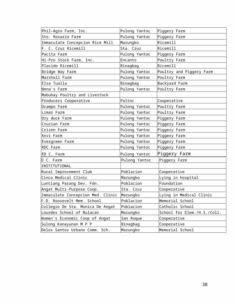
D' Vengie Handicraft Marungko HandicraftL. Andres Crushing Plant Niugan Crushing PlantJNR Industrial Cement Pulong Yantoc Cement Mfg.INDUSTRIAL - AGRO AMCI Agro Center Coop. Marungko Poultry SupplyRolando I. Herrera Binagbag Mini ConoGolden Terraces Farm Pulong Yantoc Piggery FarmV & A Farm Encanto Piggery FarmPhil-Agro Farm, Inc. Pulong Yantoc Piggery FarmSto. Rosario Farm Pulong Yantoc Piggery FarmImmaculate Concepcion Rice Mill Marungko RicemillF. C. Cruz Ricemill Sta. Cruz RicemillPacita Farm Pulong Yantoc Piggery FarmHi-Pro Stock Farm, Inc. Encanto Poultry FarmPlacido Ricemill Binagbag RicemillBridge Way Farm Pulong Yantoc Poultry and Piggery FarmMarshall Farm Pulong Yantoc Poultry FarmElsa Tualla Binagbag Backyard FarmNena's Farm Pulong Yantoc Poultry FarmMabuhay Poultry and Livestock Producers Cooperative Paltoc CooperativeOcampo Farm Pulong Yantoc Poultry FarmLimar Farm Pulong Yantoc Poultry FarmDry duck Farm Pulong Yantoc Piggery FarmCruzian Farm Pulong Yantoc Piggery FarmCrizen Farm Pulong Yantoc Piggery FarmArvi Farm Pulong Yantoc Piggery FarmEvergreen Farm Pulong Yantoc Piggery FarmRDC Farm Pulong Yantoc Piggery Farm
ED C. Farm Pulong Yantoc Piggery FarmD C. Farm Pulong Yantoc Piggery FarmINSTITUTIONAL Rural Improvement Club Poblacion CooperativeCinco Medical Clinic Marungko Lying in hospitalLuntiang Parang Dev. Fdn. Poblacion FoundationAngat Multi-Purpose Coop. Sta. Cruz CooperativeImmaculate Concepcion Med. Clinic Marungko Lying in Medical ClinicF.D. Roosevelt Mem. School Poblacion Memorial SchoolCollegio De Sta. Monica De Angat Poblacion Catholic SchoolLourdes School of Bulacan Marungko School for Elem./H.S./Coll.Women's Economic Coop of Angat San Roque CooperativeSulong Kanayunan M P P Binagbag CooperativeDelos Santos Urbano Comm. Sch. Marungko Memorial School
25
Source: MPDC
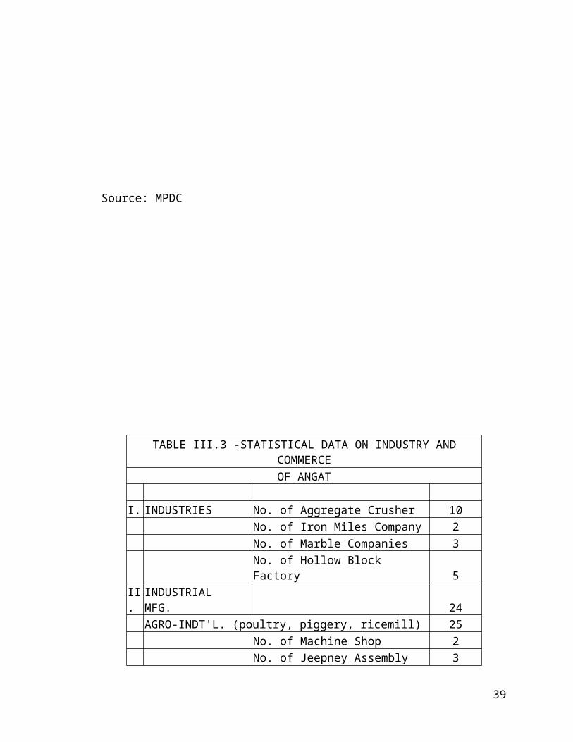
TABLE III.3 -STATISTICAL DATA ON INDUSTRY AND COMMERCE OF ANGAT
I. INDUSTRIES No. of Aggregate Crusher 10No. of Iron Miles Company 2No. of Marble Companies 3No. of Hollow Block Factory 5
II. INDUSTRIAL MFG. 24AGRO-INDT'L. (poultry, piggery, ricemill) 25
No. of Machine Shop 2No. of Jeepney Assembly Shop 3No. of Recapping Plants 2No. of Printing Press 1No. of Iron Work Shop 2No. of Plastic Factory 1No. of Rice Mills 5No. of Junk Shop 2No. of Sweet (Soft Drink Factory) 2No. of Bakery 4No. of Tailoring Shop 1
26
No. Barber Shop 1III. TRADE & COMMERCE
No. of Market 1No. of General Merchandises 0No. of Banks (Savings & Credit) 4No. of Groceries 2No. of Shoe Stores 3No. of Sari-sari Stores 24No. of Rice Retail Stores 18No. of Pharmaceuticals/Drug Stores 4No. of Auto Parts Supply 6No. of Gasoline Stations 4No. of Auto Repair Shops 0No. of Agri-Product Distributors 5No. of Restaurants 7No. of Food & Eateries 9No. of Lumberyards 4No. of Hardware Stores 4No. of Furnitures Stores 3No. of Embroidery Shop 12No. of Dressmaking Shop 16No. of Bag Factory 2
Source: MPDC
C.2 Development Needs:
The municipal government has to engage in careful study and analysis of the existing situation. The thrust on economic development must be geared towards the promotion and intensification of commerce and trade. Facilities for this purpose should be improve such as commercial service areas, existence of banking and finance, insurance services and generally improvement of infrastructure facilities.
Industry can be develop in Angat. This is where the municipality can greatly grow and develop due to inadequate agricultural productivity. Existing support facilities like power, water, roads and bridges, and communication must be improved and maintained in order to attract investors and industrialists.
Land use allocation for this purpose must be considered in order to realize the goal on industrial development.
C.3 Goals, Objectives and Targets
27

Plan and execute effective and comprehensive program on attracting investors in commerce trade and industry.
Encourage small scale and medium industries in the community, which are labor intensive in nature.
C.4 Strategies
Invite financial institutions, which can assist investors in business and industries.
Provide business incentives to possible investors such as moratorium on taxation, easy flow of legal documentation
Assure peace and order.
D. EDUCATION
D.1 Existing Situation
Education for our children, youths, and even adults is one of the basic needs of our people. It is the prime duty of the government to provide free elementary and secondary education and at the same time the responsibility of the parents and guardians, to send their children to school for their foundations good and useful citizens of the of the community in particular and the nation in general.
Formal education in Angat is being provided by both public and private institutions. Presently, the municipality has thirteen (13) public elementary schools; four of them includes pre-elementary education such as Angat elementary school with 189 enrollees, Dr. A.C. Villarama Memorial School with 48; Donacion Elementary School with 22; and Marcelo Adriano Memorial School with 33 enrollees. Total government pre-elementary education enrollees are 292 male and female. The total number of enrollees in the elementary level is 6,104 in 126 classrooms present in the 13 schools giving an average of 48 pupils per classroom.
Government secondary education is being undertaken by Binagbag High School with 18 classroom facilities, 21 teachers and a total enrollment of 570 with an average accommodation therefore, of 31.67 students per classroom.
There are 5 private institutions engaged in providing elementary and secondary education with combined teaching force of 142 and a combined 126 classrooms and a combined enrollment of 2,612 students.
College education is present in the municipality. It is provided by Lourdes College of Bulacan with 10 classrooms, 15 instructors, handling 128 students.
28

The municipal government of Angat takes pride in establishing and implementing the provisions of Day Care Centers in the entire 16 Barangays of the municipality with Barangay Sulucan having 3 centers and San Roque with 2. All these Day Care Centers has a total enrolment of 663 children being handled by 19 day care workers in total classrooms. Budgetary requirements in handling and running this program of caring for children are shouldered by the municipal government.
The following tables will show that the municipality of Angat possesses sufficient facilities for the education of the community people.
29

TABLE IV.I
EDUCATIONAL STATISTICAL DATA OF PUBLIC AND PRIVATE SCHOOLS.
S C H O O L SNo of
classroomsNo. of
teachers
TOTAL NUMBER OF ENROLLEESTOTALPRE-ELEM. ELEMENTARY HIGH SCHOOL COLLEGE
Male Female Male Female Male Female Male FemaleAngat Elementary School 32 103 86 926 894 2,009F.F. Illescas Elem. School 17 335 352 687Sulucan Elementary School 12 305 314 619Don Pablo Amisola Mem.School 12 230 245 475Dr. A.C. Villarama Mem. School 10 23 25 242 189 479Pulong Yantoc Elem. School 10 274 244 518Taboc Elementary School 7 206 177 383Banaban Elementary School 6 155 117 272Donacion Elementary School 8 7 15 181 163 366Marcelo Adriano Mem. School 6 21 12 185 115 333Sta. Lucia Primary School 2 34 52 86Col. V. Salvador Primary School 2 42 32 74Paltoc Primary School 2 55 40 95 0Collegio De Sta. Monica de Angat 46 54 90 90 334 350 358 417 1,639F.D.R. Memorial School 16 16 248 292 540Kalinangan Integrated School 16 16 13 20 127 123 72 78 433Urbano Delos Santos High School 15 17 160 160 320Binagbag High School (Public) 18 21 419 151 570Lourdes High School 15 18 8 5 66 59 138 119 395 0Lourdes College of Bulacan 10 15 30 98 128
TOTAL 262 157 265 253 3,697 3,466 1,395 1,217 30 98 10,421.00 Source: DECS & PRIVATE SCHOOLS
30

TABLE IV.2 Total No. of Enrollees of Day Care per School/Barangay 600
No. of Day Care Workers 19
No. of Classrooms 18
1 Banaban 302 Baybay 183 Binagbag 604 Donacion 225 Encanto 306 Laog 197 Marungko 388 Niugan 379 Paltoc 16
10 Pulong Yantoc 5211 San Roque 1 49
(Sabang DCC) 1812 Sta. Cruz 4213 Sta. Lucia 2514 Sto. Cristo 2915 Sulucan 1 4516 Sulucan 2 3017 Sulucan 3 5618 Taboc 47
TOTAL 663SOURCE: DSWD
D.2 Development Needs
The municipality continues to increase it population mostly by natural birth. As heretofore noted the population increased by 7,098. More needs for education sector can be expected in terms of school facilities such as additional school buildings, playground, textbooks, teachers and some priority amenities in providing for proper education.
Although by averages the present school facilities is enough to accommodate school children attention should be given to barangays with greater increase in population such as Sulucan, Sta. Cruz, Sto. Cristo, San Roque and Binagbag.
31
Survey should be conducted to evaluate the existing school facilities in those areas. Deteriorating buildings and facilities should be repaired and rehabilitated.
Additional buildings and other facilities must be determined on the basis of present increase in enrollment and the expected growth in number of pupils every year.
D.3 Goals, Objectives and Targets
a. To provide wholesome educational environment for all school age population in order to attain every opportunity for intellectual development and excellence;
b. To develop mental fitness, moral values, social awareness and healthy citizenship,
Targets must be concentrated as improvement of facilities, reduction of out-of-school youths by providing non-formal and technical education; seminars, workshops and trainings for school teachers providing for instructional materials and textbooks for the next five years.
E. HEALTH AND NUTRITION
E.1 Existing Situation
To make various medical services available to the people of Angat, especially to the poor and low-income groups of the community, the municipal government maintains and operates one rural health unit managed by one rural health officer and one municipal health physician assisted by a number of nurses and midwives. The doctors and their assistants and personnel attend to the daily chores and activities of providing medical and clinical services to the less fortunate and especially to those who could not afford to shoulder the expenses to have private doctors and/or hospital services. Available medicines and other needed drugs are also given free.
Located at the very heart of the Poblacion, the health center has become too busy and occupied from day to day attendance to those who need consultation and check-ups on various health needs to assist the doctors and nurses in the heavy load of activities in the central health unit, one health center each in all 16 barangays of the municipality is established under the joint management and supervision of the municipal and barangay government through the technical and direct control of the rural health unit. Every barangay health center is manned by a midwife assisted by health workers.
To expand medical assistance and care for the needy, there is an on-going construction of a building, which will serve as lying-in clinic for patients who need such treatment.
The following data will provide information as to the total health and nutrition status of the community and this will be the basis for the adoption of the various health programs to be undertaken by the municipal government:
32

TABLES 1 – 8 THAT FOLLOW ARE PROVIDED BY RHU OF ANGAT:
TABLE V.1
REGULAR HEALTH PROGRAM
No. Program/Project Implementing Agency Time Frame1 Tubercolosis Control Department of Health 2000 - 20042 Maternal and Child Health Program Department of Health 2000 - 20043 Nutrition Program Department of Health 2000 - 20044 Diarrheal Disease Control Program Department of Health 2000 - 20045 Expanded Immunization Program Department of Health 2000 - 20046 Family Planning Program Department of Health 2000 - 20047 Leprosy Control Program Department of Health 2000 - 20048 Sexually Transmitted Disease Control Department of Health 2000 - 20049 Dental Health Program Department of Health 2000 - 200410 Environmental Sanitation Department of Health 2000 - 2004
TABLE V.2HEALTH PERSONNEL AND FACILITIES
NO. PERSONNEL RHU1 Doctors 22 Nurses 23 Midwife 124 Dentist 15 Sanitary Inspector 16 Medical Technologist 17 Nursing Aide 18 Ambulance Driver 49 Barangay Health Worker 3910 Trained Hilots 811 Facilities 12 Lying-in Bed Capacity 313 Laboratory 114 Barangay Health Station 1315 Ambulance 2
33

TABLE V.3
TEN LEADING CAUSES OF MORTALITY
NO. CAUSES No. of Deaths 20001 CVA - HPN 282 Arteriorclerotic Heart Disease 243 Myocardial Infraction 234 Accidents 225 Pneumonia 156 COPD 97 Cancer 88 PTB 89 CHF 610 Chronic Renel Failure 5
TABLE V.4
TEN LEADING CAUSES OF MORBIDITY
NO. CAUSES No. of Cases 20001 Acute Upper Respiratory Infection 35702 Pneumonia 5393 Diarrhea 4744 Wound, all Types 1105 Dermatological Disorder 1086 Cardio Vascular Disorder 967 Musculo-Skeletal Disorder 878 PTB 349 Genite - Urinary Disorder 1610 Influenza 12
TABLE V.5
34

Number & Location of Health Institution by Barangay
1 RHU I - Main Health Center Sta. Cruz Angat Bulacan2 Marungco - Barangay Health Station 3 Sulucan - BHS 4 Taboc - BHS 5 Donacion - BHS 6 Niugan - BHS 7 Paltoc - BHS 8 Binagbag - BHS 9 Sta. Lucia - BHS 10 Baybay - BHS 11 Banaban - BHS 12 Laog - BHS 13 Encanto - BHS 14 Pulong Yantok - BHS
TABLE V.6
FAMILY PLANNING USERS
NO METHOD NEW USERS CONTINUING USERS1 Condom 26 6572 Pills 295 34873 Injectables 255 11484 LAM 80 80 TOTAL 656 5372
T A B L E V.7
HIS (FHSIS) Annual Report for the year 2000Municipality of ANGAT
35

Province of BULACAN
CAUSEM O R T A L I T Y R E P O R T Deaths with
Medical Attendance
< 1 1-4 5-14 15-49 50-64 65+ TOTALM F M F M F M F M F M F M F
CVA 3 2 2 1 11 9 16 12 28Cancer 2 2 1 3 1 7 8Gastroenteritis 1 1 1 1 2Arterioclerosis disease 9 15 9 15 24Myocardial Infarction 4 1 1 3 11 3 16 7 23CHF 1 1 2 2 3 3 6Accidents 1 16 2 1 1 1 20 2 22RDS 1 1 1Pneumonia 1 1 2 1 1 1 1 1 4 2 8 7 15Tetanus 1 1 1COPD 3 1 3 2 7 2 9CHD 1 1 1PTB 3 1 2 2 6 2 8Hepatitis 1 1 1Cerebral Hemorhage 4 1 4 1 5Internal Hemorhage 1 1 1Chronic Renal Failure 1 1 1 1 1 2 3 5
36

T A B L E V.8HIS (FHSIS) Annual Report for the year 2000Municipality of ANGATProvince of BULACAN
DISEASEN O T I F I A B L E D I S E A S E R E P O R T
< 1 1-4 5-14 15-49 50-64 65+ TOTALM F M F M F M F M F M F M F
DIARRHEAS 38 35 54 39 9 9 10 14 5 2 116 99PNEUMONIAS 14 12 25 28 18 13 1 1 58 54BRONCHITIS 4 1 1 1 4 3INFLUENZA 2 2 3 4 1 6 6MEASLES TB RESPIRATORY 6 3 10 16 3TB MENINGITIS TB OTHER FORMS HEART DISEASES
MALIGNANT NEOPLASM CHICKEN POX DENGUE FEVER 2 2 1 2 3MALARIA CHOLERA Typhoid & Paratyphoid 2 1 2 1VIRAL HEPATITIS 1 1 RABBIES( human) DIPHTHERIA Tetanus Neonatorum TETANUS POLIOMYELITIS WHOOPING COUGH GONORRHEA SYPHILIS AIDS/HIV Inf. LEPROSY 2 1 2 1SCHISTOSOMIASIS FILARIASIS Meningitis/encephalitis LEPTOSPIROSIS Poisoning(food/chem.) MENINGOCOCCEMIA Other Diseases of Unusual Occurrance
37

E.2 Development Needs
In accordance with the population statistics of the municipality bearing a total count of 38,931 in 1995 NSO census and 46,057 in year 2000 showing an increase of 7,126, there is a need for the municipal government to consider the necessity of increasing facilities, services and personnel in the health and nutrition department of the local government unit to cope up with the increasing demands of the people in the preservation of life and maintenance of a healthy society, and improving the quality of life of the residents.
Enhancement of nutrition program should be undertaken; the number of malnourished children should be lowered if not abolished. Concerned government and non-government agencies must work together for support and assistance in this undertaking.
E.3 Goals, Objectives and Targets
E.3.1 Goals:
a. To provide adequate preventive and curative health care services and facilities;b. To improve and safeguard the general health condition of the community people; c. To employ population control by acceptable means in order to lessen growth in
population to tolerable limits.
E.3.2 Objectives
a. To develop and construct additional health facilities and/or upgrade the equipment needs of the rural health unit and its allies;
b. To provide sufficient medicine;c. To improve environmental sanitation especially water supply and proper waste
and garbage disposal;d. To control communicable disease; e. To set-up more nutrition program.
E.3.3 Targets
a. To prepare and conduct health training programs for all concerned;b. To continue maternal and child care services;c. To improve facilities in all established day care centers.
E.4 Plan Formulation (Plans and Programs)
In order to carryout the general goals and objectives in the delivery of health, nutrition and environmental services the health and nutrition department of the municipal government has its early regular health and nutrition program as shown in the following data:
38

Regular Municipal Monthly Health Program/Activities For The Year 2001
JANUARY FEBRUARYCelebration Cancer Conciousness Week Activities Celebration of Pusong Pinoy Month Activities-Conduct lecture on cancer prevention to high -Conduct blood pressure monitoringschool students and mothers. -Conduct weighing session-Hanging of poster/IEC materials on strategic places Estimated Cost: Estimated cost:Poster (P 800 X 2 Pcs) 1,600 Bathroom Scale ( 2000 - 1Pc) 2,000 Leaflets 2,000 Poster Streamer 800 Incentive/Food for Lecturer 2,000 Incentive/Food (1000) 1,000 TOTAL 5,600 TOTAL 3,800
MARCH APRILRabies Awareness Month Operation TULEActivities: Target 5 patients / dayA. Anti-Rabies injection in coordination with Rotary Estimated CostClub of Angat 15,000 Chronic /Suture 50B. Pap's Smear OS 10 Target 5 patients per day Gloves 10 Fee - 10,000 Amoxillin 100 Slide/Cotton Pledget - 500 Mefenamic Acid 50 Fixative - 100 Anesthesia 10 Gloves - 500 230 Miscellaneous - 2000 13,100 45,000 TOTAL 28,100
MAY JUNEContinuation of Operation Tule Dengue Awareness Month
Activities:Information dissemination / barangay levelEnvironmental sanitation per barangayFogging per barangay with suspicious cases 50,000
39

JULY AUGUSTBlood Typing per barangay level Campaign against TB
Estimated Cost:Information / Dissemination - Elementary / H. School
Supply Sera - (P 75 X 10 boxes) 7,500 student per barangaYPricker - (300 X 10 boxes) 3,000 Sputum Collection Cotton / Alcohol P 500 500 Sputum Cup 1,000 TOTAL 11,000
SEPTEMBER OCTOBER- Cataract Screening thru NGO - Screening of elderly patient w/ osteoporosis- Mass Deworming thru DOH - Sangkap Pinoy - DOH
NOVEMBER DECEMBER
Diabetes Screening Seminar, SocializationActivities: 1. Blood Monitoring Estimated Cost: Streamer (P 800) Strip (P 5,000) TOTAL 5,800
E.5 PLANS AND PROGRAMS FOR 2001 – 2005
I. Regular Monthly Health Programs/ ActivitiesII. Free Clinic Medical and Dental in all barangays once a
week per schedule – On going, which started December 30, 2000.III. Total construction and function of our lying–in clinic,
which is located in barangay Sta. Cruz, Angat Bulacan.
F. ENVIRONMENTAL MANAGEMENT
F.1 Existing SituationF.1.a Natural Environmental Concern
40

According to sources from the Department of Environment and Natural Resources office at Tabang, Guiguinto Bulacan part of the municipalities of Doña Remedios Trinidad, Angat, San Rafael and Bustos Bulacan are covered by proclamation no 573, otherwise known as Bustos Dam Forest Reserve embracing a total area of 28,550 hectares. The whole municipality of Angat, however, according to a certification issued by the CENRO office of DENR at Tabang, Guiguinto, Bulacan on December 8, 1998 is fully covered by this proclamation. This simply means that preservation of forest must be observe at all times within the area around the dam and that the land area around the dam must be protected from destruction. The environment around the dam must be so managed for the preservation of its natural status free from destruction/devastation in order to prevent erosion, and flooding. Destruction of forest areas such as three cuttings and devastation of land like illegal quarrying must be prevented.
The forest area of Angat, nevertheless, has been absorbed/covered by the land area of the created Bulacan 24th municipality of Doña Remedios Trinidad. The municipality has its concern in the protection of its land area especially along the riverbanks.
There are areas along the banks of Angat River worthy of preservation for several beneficial purposes. One is tourism purpose, which shall be presented hereafter. The planting of trees and bamboos formerly undertaken by the municipal government must be continued and be adopted as a program to protect the natural beauty of the riverbanks.
F.1.b Waste Management
Volume of garbage in the municipality is not alarming due to minimal commercial activities especially in the Poblacion where the public market is located. The quantity of daily garbage collection from all sources is estimated to be approximately 3 tons.
The municipal government assigned waste management to engineer’s office.
Angat has the following capability for waste management:
Dumping site - Barangay Baybay Area - 8,347 Sq. meters Garbage truck - 1 unit municipal
1 unit for Poblacion whichcoversSta.Cruz
Sto. Cristo & San Roque
Personnel - 1 municipal driver3 helpers
41
- 1 driver3 helpers
Estimated Monthly Garbage Volume - 100 Tons.
F.2 Development Needs
Since the municipality of Angat is covered by proclamation no. 573 areas around the periphery of Angat Dam should be reforested or at least tree planting along the river banks be initiated and maintained. Areas in the terrain locality should also be considered for reforestation or at least be planted to fruit bearing trees.
Prevention of erosion should also be given attention. If quarrying is to be undertaken, consultation with the corresponding section of the Department of Environment and Natural Resources should be done to protect the environment from undue destruction.
Proper waste management should be employed by the municipal government. Garbage will not become future problem of the local government unit if the residents are thought correct habits on waste disposal. Expansion/Enlargement of the dumping site should also be given concern. The present small area of less than a hectare will not suffice for future dumping site considering the growth rate in population.
In the presentation of the proposed land uses for the municipality for the next five years 2001-2005, industrial development is one category, which the local government gives emphasis. Environmental friendly industries shall be the primary choice. Industries that are hazardous shall undergo the requirements of the Department of Environment and Natural Resources.
F.3 Goals, Objectives and Targets
F.3.a Goals and Objectives:
To upgrade the environmental management in order to improve the living condition of the residents.
To improve and maintain the present environmental quality of the area especially along the riverbanks.
To provide social, economic cultural and aesthetic benefits through proper environmental management.
F.3.b Targets:
To be able to hold/conduct tree planting activities along the banks of Angat River.
42
To be able to supervise and control properly quarrying activities. To be able to reforest barren hillsides of the town. To be able to attract investors in industry which are in harmony with
environmental management and preservation.
G. TOURISM
The municipality of Angat has its tourism potentials. One of these is its historical values. It’s name “Angat” is derived from the word “angat” which means elevated piece of land owing to its being part of mountain ranges.
The “old church” built by force during the early Spanish regime is a tourism attraction together with some Spanish houses still existing around the town.
Angat has its share of battle against the Spaniards during the revolution. The famous battle of Baras Bakal is a site of the nationalism and patriotism of the residents of Angat.
Today, the aesthetic view of the town speaks of the potentials of Angat for tourism purposes.
The municipal government desires to develop tourism thru the office of the Municipal Planning and Development Coordinator; a project study has been prepared as follows to wit:
* PROPOSED RIVER RESORT DEVELOPMENT*
I. RATIONALE
The primary role of the municipality is to serve as catalyst of development for the general purpose. The municipality through its officials should initiate programs, projects and activities that could generate revenue for its coffer’s and gainful occupation and income to the locality.
One positive strategy that the local government could adopt is to promote Tourism Development. In as much as the municipality has no historical and cultural landmarks worthy of attracting tourist, both domestic and foreign; primary attention should be focused on riverine and natural beauty attractions. Certainly, the Pugpog, Sta. Cruz ang Laog triangle has a strong potential for revenue resort development. This area which compromises about 30 hectares was wantonly defaced by illegal quarry operations, so much so, that it is now a sore eye to behold. In order to turn this liability into an asset, it would be better to improve the spot through planned development.
II. OBJECTIVES
43

This proposal is intended to asses the extent of ecological damage to the entire area as well as adjoining properties; problems and difficulties likely to be met in introducing improvement thereat and recommend the appropriate steps facilities and structures to rehabilitate the area. Specially, it is designed to achieve the following:
Identify and delineate areas to be improved through detailed study and ocular inspection of the site.
Determine what type of improvement should be introduced and kind of equipment needed to carry it out.
Assess the ecological impact of the improvements and the total monetary cost of proposed project. III. PROPOSAL
As mentioned hereinabove, the area to be develop into a river resort shall encompass the river beds/adjoining properties located within the triangular zone averting the sitio of Pugpog, Barangay Laog and Barangay Sta. Cruz and incidentally, part of the Municipality of Norzagaray (Daytona). The detailed engineering works to be undertaken is pursuit of the project shall consist of dredging, deepening and leveling of the entire riverbed within the site. For this purpose, drag crane, backhoe, payloader, road grader and dump-trucks are the equipment to be mobilize to effectively carry out the operations. Access roads and embankments may have to be constructed/formed along the riverbank, especially at the barangay Laog side of the Angat River. Also, alternate river crossing. An overflow bridge may have to be constructed in the vicinity of the Sto. Niño shrine, barangay Sta. Cruz, Angat.
Of course this massive undertaking will cost the government (Local and National) substantial investment, but as conceptualized by the proponents of this project, source of the actual financial costs could be drawn through the sale of the some aggregates to be removed / excavated from the riverbed by the municipal government.
IV. EXPECTATIONS AFTER DEVELOPMENT
When the infrastructures inputs have been completed and cleared of unsightly islets, debris and irregular mounds of earth-stones; then trees, ornamental plants and decorative structures could be introduced. These phases of the project development could very well be undertaken with the cooperation of properly owner’s adjoining the developed site. Picnic huts, toilets, garbage disposal system, electricity and other facilities / amenities could be established as a continuing developmental process in the resort area. It is expected that when all of these positive inputs have been undertaken, tourist… mostly domestic would be attracted to the expanded resort establishment. Small time business catering to the patrons of the resort shall flourish, giving additional income to the residents adjoining communities. As envisioned, the developed site would look like Lagoon, wherein covered motor bancas and similar gadget could be provided for use tourist.
44
Should these projects succeed in the very near future, the downstream development, specifically the riverbank strip in the poblacion will also be benefited from the spill over success of the pugpog model. As a medium term goal of the municipal government, other develop resort and possible tourist attractions could be Liyang Hill, the Abelardo Resort and the Villa Victoria are some places worth considering.
COST ESTIMATES
EQUIPMENT COST RENTAL COST NO. OF WORKINGPER HOUR DAYS X 8 HOURS
1. DRAGCRANE 1,000.00 180 days x 8 hours 1,440,000.002. BACKHOE 800.00 1440 hours
1,152,000.003. ROAD GRADER 600.00 1440 hours
864,000.004. PAYLOADER 800.00 1440 hours
1,152,000.005. DUMPTRACKS 400.00 1440 hours
576,000.00
LABOR COST RATE PER NO. OF WORKINGDAY DAYS
1. SUPERVISION (1) 300.00 180 days 54,000.002. FOREMAN 200.00 180 days 144,000.003. LABORER 150.00 180 days 270,000.00
TOTAL COST 4,212,000.00*Source MPDC
*H. HOUSING
H.1 Existing Situation
45

One of the primary objectives of the government is to provide its constituents adequate shelter to live in. Based on the 1997 NCSO’s Census on population and housing, there are 7,801 dwelling units, which are classified according to occupancy types of construction materials, and types of toilet facilities used. As shown in the table, wood and mixed materials constitutes the largest share of occupancy. Out of the total number of dwelling units, 4,264 units are constructed out of wood and mixed materials. This roughly represents 72.28% of the total dwelling units. Bamboo follows with percentage occupancy of 12.36% and third in rank is concrete constructed dwelling.
As to types of building 3,418 are classified as single, 16 as duplex, 30 barong-barong, 18 commercial and 2 institutional. As to type of toilet facilities there are 3,276 toilets in the municipality as of census year 1997. This is broken down as follows: 1,281 flushed water sealed; 570 antipolo/closed pit; 615 open sit; and 109 public toilet. The total number of houses is 7,801 and the households is 8,095 as of 1996. Based on standards that each family should live in one separate dwelling unit, the ideal number of houses should be 8,095. The present housing condition is henceforth inadequate in order to sufficiently housed increasing number of households.
H.2 Development Needs
In planning for this sector, consideration should be placed on the housing backlog based on different housing standards. For the development of the housing sector, It is assumed that the policy be one family dwelling unit. As of this concept, an analysis as to dwelling units can be made with respect to the current and projected years to come. For instance, the housing requirement for 1997 is 294. Stated in another way, this means that in 1998, an additional of 294 houses should be constructed in order to cope up with the growing population. After two years the housing demand would be 325. By the year 1999, the housing requirement would be estimated at 385. This is of course, having a presumption that the previous requirement in 1998 has been provided. The projected housing requirement computed on the basis of population projection. Average family size and the assumption of 5% housing loss due to obsolences and depreciation. The formula is as follows:
Housing Demand =Additional dwelling units due to increase in number of households plus 0.05 loss due to obsolescence
Computation:
Projected Population (1998) = 39,401Projected Family Size = .6Previous Number of Households = 7,801Dwelling Units Made of Wood/Mixed Materials = 4.64Projected No. Of Households = Projected Population
46

Average Family Size
= 39,401 .6
Additional Dwelling units due toIncreased in Population = Projected No. of Households – Previous No. of Households
= 3,952 – 3,851 (2,485)
Projected Housing Demand = 101 – 0.05 = 101 / 124 = 225
H.3 Goals, Objectives and Targets
Goals:
To provide decent dwelling units To improve the housing condition of the areas.
Objectives:
To provide adequate housing to families belonging to the low income and middle income levels of the municipality.
Targets:
To reduce housing backlog by 40 % - 50% through the construction of new houses and the renovation of dilapidated houses.
Policies/Strategies – Provide assistance to social housing for low-income group in the form of housing loans.
- Seek the assistance of the National Government as well as line agencies for the construction of decent dwellings.
H.4 Plan Formulation
In order to have a healthful atmosphere for housing, residential zones should be identified together with its corresponding amenities like power, water and other basic facilities like school, health center and others. Such zones shall be guided by a zoning ordinance, which will be implemented by the local government.
47

TABLE VI.1
NUMBER OF DWELLING UNITS BY TYPE OF CONSTRUCTION MATERIALS
TYPE OF CONSTRUCTION SINGLE DUPLEX BARONG COMMERCIAL INSTITUTIONAL TOTAL NO. PERCENTAGE
CONCRETE 287 36 - 29 53 405 5.12%GALVANIZE IRON 145 8 - 14 - 167 2.11%BAMBOO 84 - 21 - - 105 1.33%WOOD/MIXED MATERIALS 7,065 24 - 18 15 7,122 90.09%NIPA 81 - 25 - - 106 1.34%OTHERS - - - - - - 0.00%TOTAL 7,662 68 46 61 68 7,905 100.00%
* Source Municipal Planning and Development Staff Angat, Bulacan
TABLE VI.2
CURRENT AND PROJECTED HOUSING REQUIREMENT 2001 - 2005ANGAT, BULACAN
CLASSIFICATION 1996 1997 1998 1999 2000 2001 2002 2003 2004Existing No. of Household 8095 Projected No. of Household 8199 8300 8512 8790 8995 9205 9318 9576Previous No. of Household 8095 8296 8012 8871 8871 9186 9289 9224Additional dwelling units due to increase in no. of Household 251 263 271 291 291 303 319 322Aggregate Loss (0.05) 272 272 272 272 272 272 272 272 272Housing Requirement 272 277 281 285 294 300 300 308 316
Note: Housing Demand –additional dwelling units due to increase in number of household = 0.05 loss due to obsolence.
Additional dwelling units due to increase in the number of household = projected number of household = number
of household previous year.
48

Projected No. of Household = Projected population No. of Household = Total population
Average Family Size Average Family Size
Wherein = Average Size = 6
I. SOCIAL SERVICES
I.1 Existing Situation
Social welfare as a governmental function has come a long way from the traditional concept of providing relief or “delents” during times of calamities and critical situations to a new dimension and meaningful concept of uplifting the living conditions of the poor segment of society by providing them the opportunity needed to develop their maximum capabilities for self–reliance and enable them to participate in the national development.
At present, welfare programs and services have been devolved to the local government unit whose functions are the former detailed social workers of each town. It operates at depressed barangays where it develops, administers and implements comprehensive social welfare programs designed to uplift the living conditions and improve the quality of life of distressed and disadvantaged individuals, families and communities that belong to the bottom poor of the population.
As the population increase up to year 2005, the present services rendered by the municipal unit will not suffice to the needs of the community since the number of the less privilege also tends to increase. Civic minded and religious groups are however, extending their support to the needy. Table shows the number, location, and nature of services and facilities by type of social welfare organizations.
I.2 Development Needs:
A considerable number of families have an income bracket of 3,000 below with six or more which cannot cope up with the present standard of living. The less fortunate can avail of the social services through economic programs of Department of Social Welfare and Development. With the potential skills of the residents they can be productive and gradually increase their income and thereby improve their living condition.
The prevalence of 2nd and 1st degree malnourished children in the depressed areas should be checked out. More day care centers are needed and must be
49

established with the help of the barangay officials and supported by civic-minded citizens of the community.
More skills training is necessary in the area, especially to the out of school youth which will enable them to economically active individuals. The presence of vast economic resources in the community can be a factor that will enhance the development of skills of the community, especially the out-of-school- youths. The presence of home industries, mostly dressmaking implies that non-formal education in this field must be enhanced.
I.3 Goals, Objectives and Targets:
Goals:
To upgrade the living conditions of the present poor families of depressed barangay objectives:
To minimize the existence of malnutrition among children. To provide income generating projects of the poor families To provide training for out-ofTargets:
To provide small loans to small-scale industries with minimum interest. To make the citizens aware of the importance of family planning and
population education to discourage early marriage. To provide supplemental feeding and substitute mothering to pre-
schoolers. To minimize the participation of the private sector in the implementation
and evaluation of socials services at the barangay level.
I.4 Plans and Programs:
1. Self-employment assistance program2. Capital assistance to the poor families, needy and out-of-school
youth and mothers2.1 Skills training in dressmaking, tailoring, weaving, mechanic, electrician, cosmetology and pot making to out of school youth and mothers.
3. Day-Care Programs3.1 Creation of day-care centers to depressed barangay with greater number
of malnourished children3.2 Supplemental Feeding
4. Emergency Assistance4.1 Relief operations during disaster and calamities.
5. Family Planning
50
5.1 Information drive, motivations, conducts sessions on population and sex education6. Special Social Services
6.1 Referrals to other agencies6.2 Leadership Training6.3 Family life Education6.4 Social Awareness and Community Responsibility
All projects are continuous and depend on the needs of the populace.
I.5 Proposals
1. Skills training for Out-of-School youths – one class per quarter.Which includes practical electricity, Bamboo craft, computer course and others.
2. Completion of Day Care Center at Banaban3. Life Planning Seminar for all Fourth Year High School – July to December
TABLE VII.1DATA ON SOCIAL SERVICES SECTOR:
Professionals/Personnels in Health Services
Government Private Total
Doctor of Medicine 1 8 9Dental Medicine 1 6 7Optomologist 1 1Nurses 3 4 7Midwife 21 2 23Medical Technologist 1 3 4Sanitary Inspectors 2 2Pharmaceuticals/Drug Stores 1 5 6Physical Therapist 3 3
Health Facilities Government Private Total
Ambulance 4 4Hospitals / Medical Clinic 6 6Health Centers 16 16Dental Clinic 1 6 7Day Care Centers 16 1 17Source: MPDC
I. NUMBER OF PERSONNEL AT DSWD OFFICE
51
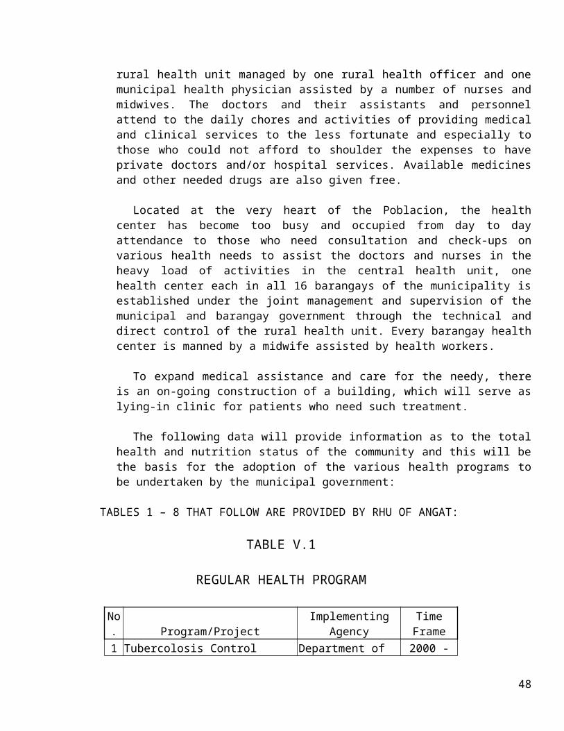
Permanent = 2Casual = 2Day Care Workers = 19
II. NUMBER OF DAY CARE CENTERS
Sulucan = 3 Day Care CentersSan Roque = 2 Day Care CentersOne Day Care Center for 14 remaining barangays
III. NUMBER OF BENEFICIARIES PER BARANGAY
San Roque = 54 ChildrenSta. Cruz = 39 ChildrenSto. Cristo = 35 ChildrenSulucan I = 47 ChildrenSulucan II = 35 ChildrenSulucan III = 68 ChildrenTaboc = 60 ChildrenDonacion = 35 ChildrenBaybay = 25 ChildrenNiugan = 58 ChildrenPaltoc = 15 ChildrenLaog = 15 ChildrenMarungco = 50 ChildrenSta. Lucia = 25 ChildrenBinagbag = 55 ChildrenPulong Yantok = 47 ChildrenEncanto = 30 ChildrenBanaban = 30 ChildrenTOTAL 723 Children Beneficiaries
J. PROTECTIVE SERVICESJ.1 Existing Situation:
52

The PNP force including Fire Brigade personnel and organized Barangay Brigades constitute the protective services in the municipality.
The general peace and order situation in the municipality is reflected in the following year-end accomplishment report of Angat PNP force.
I. FOREWORD
This report presents the significant administrative and operational accomplishments of Angat Municipal Police Station for the period January 01 to December 31, 2001.
II. SITUATION
A. Demography
The municipality of Angat is one of the twenty four (24) municipalities comprising the province of Bulacan. It is located on the eastern part of Bulacan bounded on the north by San Rafael, on the southeast by Norzagaray, on the southwest by Pandi, on the west by Bustos and on the east by Doña Remedios Trinidad.
It has land area of 6,526 hectares with a total population of 45,764 and
police to population ratio of 1 : 2,692. It is composed of 16 barangays with toal registered voters of 21,221.
a. MEANS OF LIVELIHOOD IS COMPOSED OF:
1. Farming2. Quarrying3. Livestock Raising4. Poultry Raising5. Embroidery
b. VITAL INSTALLATIONS:
1. MUNICIPAL BUILDING IN BARANGAY SAN ROQUE2. ANGAT MPS IN BARANGAY SAN ROQUE3. DIGITEL TEL. COMPANY IN BRGY. SAN ROQUE4. SMART CELL SITE IN BRGY. STA. CRUZ5. NPC WARNING STATION IN BRGY. SAN ROQUE6. MERALCO SUB-STN IN BRGY. STA. CRUZ
c. POLITICAL LEADERS:
53
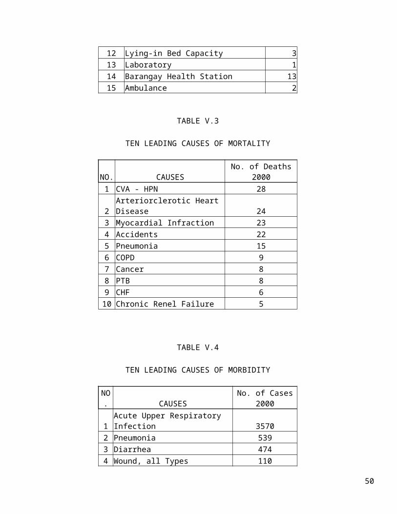
1. HON. LORNA SILVERIO - CONGRESSWOMAN2. HON. TEOFILO RIVERA - BOARD MEMBER3. HON. LEONARDO DE LEON - MUNICIPAL MAYOR4. HON. CORNELIO L. JUNIO - VICE MAYOR5. HON. MARCELINO REYES - ABC PRESIDENT
d. FRIENDLY FORCES:
1. BULACAN PPO2. ADJACENT MPS3. ANGAT BFP4. “B” COY, 56IB, 7ID, PA
B. ENEMY SITUATION
1. CPP/NPA
The station recorded no changes in the composition/disposition of insurgents operating in the area. The “Armed Collective Team “ANGAT” (ACT “A”)” with code name “MAKATI” covers the whole Angat and lower part of Norzagaray under the “Komite sa Larangang Gerilya District Front 1 (F1 EASTERN)” with the direct supervision of Joselito Garcia @UNCLE/UGAT as secretary and belived to have ten (10) others armed men and assorted FAS still continue to operate within the AOR. Latest enemy sightings in Lupang Pangako, Encanto, Angat, Bulacan composed of seven armed men and women believed headed by @ Deony/Junny are conducting paniktik against PNP members of this station and some erring politicians involved in illegal quarry operations.
2. PKP/BHMB
So Far, the PKP/BHMB areas of operation in the province does not include the municipality of Angat as one of their area of operations.
3. DRUG SITUATION
Due to constant visitation, dialogues and information drive campaign; Angat MPS is now being praised by especially the LCE and concerned citizens. They also supported our operations like providing information on the place where drug sessions commonly occurred and the whereabouts of the people involved in drug activity. These exerted efforts resulted in the neutralization of Pushers/Users particularly those who are in the watchlist. A total of thirteen (13) barangays signed the Memorandum of Agreement (MOA) indicating that these barangays are DRUG FREE.
54

At Present, a total of thirteen (13) suspected Users/Pushers were apprehended by this station. One (1) rehabilitated and the others surrendered voluntarily to local and barangay officials. They were subjected to drug test to determine the level of their drug addiction, but majority was found negative during the said drug test. For the period covered a total of twenty one (21) operations were conducted which resulted to the arrest of thirteen (13) suspected Pushers/Users. Appropriate charges were filed against them and all are now on trial.
4. CRIMINAL GANGS
The Eddie Tiongson group composed of four (4) to Seven (7) members heavily armed is believed to be responsible in series of some unsolved and undocumented theft, robbery and extortion cases during the past years was put to close monitoring by this station and San Ildefonso police station as groups operations extends down to the eastern part of San Ildefonso. For the period, no legal offensive has been undertaken against the said group due to lack of legal basis.
5. CRIME TRENDS
a. Crime Volume
For the period covered, this station recorded a total of crime volume of thirty five (35) incidents. Of this figure seven (7) were index crimes of which three (3) Murder, Three (3) Theft, one (1) Robbery and the remaining twenty eight (28) are non-index crimes both penalized under penal and special laws. The total crime volume of thirty five (35) recorded is higher compared to the year 2000 tally of nineteen (19) cases.
b. Crime Clock
For the period, one crime incident occurred in 532.39 hours while, in year 2000 of the same period, one crime incident per 288.95 hours.
c. Crime Rate
The average monthly crime rate (AMCR) is 6.37 which is higher by 72.37% as compared to year 2000 figure of 4.61. The total crime volume of thirty five (35) is higher by sixteen (16) than year 2000 tally of nineteen (19) cases.
C. OWN SITUATION
1. PERSONNEL
55

At Present, this station has one (1) PCO and Sixteen (16) PNCOs for a total of seventeen (17) personnel.
P/SR INSP. PRUDENCIO P. LEGASPI - CHIEF OF POLICESPO4 ERLINDA C. VALENZUELA - PCR/ WOMEN DESKSPO2 LEOPOLDO Y. IGNACIO - DS,RD,PRO3SPO1 FERDINAND B. ASIA - C, OPNS/.INVEST.SPO1 ISAGANI I. TOLENTINO - ACTING DEP/C,WSSPO1 FERNANDO M. PERPETUA - C, INTEL, (SICK LEAVE)SPO1 REYNALDO S. VALENCIA - C, TRAFFIC/BPSF SUPERVISORSPO1 FELIZARDO V. FRANCIA - PATROL MEMBER (DY MAYOR)PO3 BENJAMIN A. TORIO - JAIL WARDENPO3 JOEL A. SANIDAD - PATROL MEMBER (DY MAYOR)PO3 LEONARDO C. ORDONIO - OIC,NSPO2 EMELITA C. TALLARA - ADMIN/FIN/PROP. CUSTODIANPO2 DENNIS R. DIAZ - C, DEUPO2 ERICK C. BACUYAG - INVESTIGATORPO2 MARVIN V. SANTIAGO - INVESTIGATORPO1 MANUEL I. VILLANGCA - PATROL MEMBERPO1 ENRIQUE C. LAJOM - PATROL MEMBER
TABLE VIII.1
56

PERSONNEL PROFILE
RANK STRENGTH EDUCATION RELIGION
POLICEMENPOLICE WOMEN
TOTALCOLL. GRAD
UNDER GRAD.
HS GRAD
RC INK
PSINSP 1 1 1 1 PINSP 0 SPO4 1 1 1 1 SPO2 1 1 1 1 SPO1 5 5 4 1 5 PO3 3 3 2 1 3 PO2 3 1 4 4 3 1PO1 2 2 2 1 1TOTAL 15 2 17 8 6 3 15 2
TABLE VIII.2
AGE PROFILE
RANKETNIC GROUP AGE BRACKET
TAGALOG ILOCANO OTHERS 51-56 45-50 40-44 35-39 30-35 21-29
PSINSP 1 1 PINSP SPO4 1 1 SPO2 1 1 SPO1 5 2 1 2 PO3 1 2 1 2 PO2 3 1 1 2 1PO1 2 2TOTAL 14 3 0 2 4 0 6 2 3
2. MOBILITY
One (1) KIA Police patrol jeep (Back to Back)
3. FIREPOWER
57

TABLE VIII.3
TYPE CALIBER SERVICEABLE UNSERVICEABLEPISTOL 9MM 2 0REVOLVER .38 13 0 .32 1 0RIFLE M 16 8 0 M14 8 0TOTAL 32 0
4. COMMUNICATION
One (1) ICOM V-100 Base Radio (VHF)One (1) KENWOOD Base Radio (UHF)
III. ACCOMPLISHMENTS
A. OPERATIONAL ACCOMPLISHMENTS
1. Crime Prevention vis-à-vis operational strategies.a) Crime Information and Analysis SystemIt is the geographic crime pattern in the municipality since year 2000
until mid of 2001.
b) Security Containment RingBantay bayan/barangay tanods served as the multiplying force of police
personnel
c) Expanded Kababayan CopsSince 1998, the station established and maintained one (1) Kababayan
Center in Sta. Cruz this municipality, but was taken over by the organization of BPSF which, was hatched in the late part of 2001. Organizing the BPSF municipal wide is on its way involving barangay officials, barangay tanods, ngos and other cause oriented groups as its members.
d) DIT
e) BPSFAs of this date, the station had organized fourteen (14) out of Sixteen
(16) barangays while the remaining two (2) are on their way for organization. Another set of schedule for confirmation and election of members of each BPSF will also be undertaken.
58

2. Cpp/Npa
Negative for the period covered
3. Campaign Against Illegal Drugs
For the period, the station arrested thirteen (13) Pushers/Users, confiscated 0.488 grams of SHABU amounting to P4,880 and filed nine (9) cases in court.
4. Campaign Against Crime Groups
a. Kidnap for Ransom - Negativeb. Robbery Hold-up
- Highway robbery/hijacking – Negative- Bank robbery – negative- Akyat Bahay – Able to solve one (1) case involving
P600,000.00 worth of assorted jewelries in brgy Sta. Cruz on December 23, 2001. Case was amicably settled thru blood relations between victims and the suspect.
c. Carnapping - Negative
5. Most Wanted Persons
Able to arrest on 060600H September 2001 one Carlos Licerio Y Camos @ Junjun Negro at his residence in the city of San Jose Del Monte, listed number three (3) in the list of MWP municipal level and who has series of murder and frustrated homicide cases at Malolos RTC and one of the suspects in the recent hand grenade throwing at the residence of Mayor Leonardo De Leon in Niugan, Angat, Bulacan in February 24, 2001.
6. Campaign Against Loose Firearms
On campaign against losse firearms, the station was able to arrest three (3) persons and filed two (2) cases for violation of PD 1866 and accounted three (3) caliber .38 revolver (Paltik) loose firearms and were exhibited in proper courts.
7. Special Laws
On other special laws, the station able to apprehend twenty eight (28) persons for violation of PD 1602 (Jueteng) confiscation of P 8,214.00 jueteng cash bets and filed 12 cases for violation of PD 1602. Also, the station joint with the ENRO apprehended two dump trucks loaded with
59

Banda-Banda for violation of Section 3, RA 7942 otherwise known as the Philippine Mining Act of 1995.
8. Pyrotechnic
For the period covered, only two (2) Firecrackers/Pyrotechnic manufacturers and two (2) dealers were recorded by this station and was able to charged one (1) violator of section 3 of RA 7183. 9. Special Operations – Negative
10. Service of Warrants
For the period, the station was able to serve a total fifty five (55) out of fifty six (56) warrants of arrest thereby producing 98.21% service efficiency.
11. Crime Solution Efficiency
Having solved the thirty three (33) cases out of thirty five crimes recorded, our crime solution efficiency (CSE) for the period covered was pegged at 94.29% which is lower compared to the same period last year of 100%.
B. PCR ACCOMPLISHMENTS
1. Ugnayan – No Ugnayan yet was conducted within the municipality for the period.
2. Women’s desk – Handled three (3) cases treating violation of RA 7610.3. PII
a) Press Releases – 5b) Installation of Billboards – 3 c) Posting of Posters – 6d) Installation of Streamers – 10e) Brgy Ugnayan/Dialogue – 50
4. Media Blitz – Radio Interview at Radyo ng Bulacan at 100MHZ FM.
5. ETCa) Skills Development Seminar – 4b) Sports Development – 12c) Livelihood – 5d) Medical/Dental Outreach – 12e) Organization/Mobilization of CVOS – 28
- TODA- JODA- RADIO GROUPS
60

f) Kill Droga – 50
C. ADMINISTRATIVE ACCOMPLISHMENTS
1. Personnel a) Awards – Received two (2) awards of commendationsb) Housing – Negativec) Scholarship – Three (3) PNCOs were enrolled at different learning
institutions.d) Cooperatives – Negativee) Financial Assistance – Extended P 5,000.00 financial assistance on the
death of late SPOI Geronimo De Guzman.
2. HRDD Accomplishmentsa. Career Courses – 1 (PSOAC)b. Programmed Training – 1 (CIDC); 1 (ANES); 1
(COPS)c. Unprogrammed Training – Negatived. Spiritual Ascendancy Program – 12e. Physical Development Program – 52
3. Logistics a. Donations – Negativeb. Capital Outlay – Negative
4. FINANCEa. MOOE – PRO 3
YEAR 2001 1ST QUARTER 2ND QUARTER 3RD QUARTER 4TH QUARTERLOGIS SVCS OPN SVCS INVEST SVCS P C R GEN. MGT. TOTAL 54,989.34 18,914.00 13,296.00 13,296.00
b. Additional MOOE from LGES
YEAR 2001 1ST QUARTER 2ND QUARTER 3RD QUARTER 4TH QUARTEROFFICE SUPPLIES 3,500.00 3,500.00 3,500.00 NEGATIVE GAS/POL 2,600.00 2,600.00 2,600.00 2,600.00
61

TOTAL 6,100.00 6,100.00 6,100.00 2,600.00
IV. ASSESSMENT
On criminality, it is noted that crime rate rose to 50% higher than the previous year and this was brought about by the high population growth rate coupled with the influx of some squatters from Metro Manila, economic and financial crisis and the ill-effects of drugs on the early part of year 2001. The regained trust of the community to the PNP also triggered the increase of reported incidents. People are very eager to report every incident they encountered, this was due to the organization of the BPSF.
V. PROBLEMS MET
a. Lack of Intelligence/Operational funds to meet the planned target particularly on the implementation of LOI BANAT;
b. Lack of Human Resourcesc. Lack of Common Equipments for field operations; and d. Lack of mobility and lift capabilities
VI. RECOMMENDATIONS
a. Augment of Additional Operational Needs;b. Issuance of Additional Police Vehicles;c. Issuance of Additional Common Equipments; andd. Assignment of Additional PNP Personnel to meet the Police to population
Ratio.
J.2 Goals, Objectives and Targets:
Goals: To further improve the situation of peace and order in the municipality. To prevent the incidence of fires in the municipality.
Objectives: To increase the size of force of policemen and firemen in the
municipality so as to meet the projected needs of the municipality. To enhance the community participation in the prevention of crimes and
delinquency in the municipality. To improve the projective services/facilities in the municipality.
Targets: Increase the number of policemen and firemen by 2001 – 2005 to meet
the needs of the municipality.
62
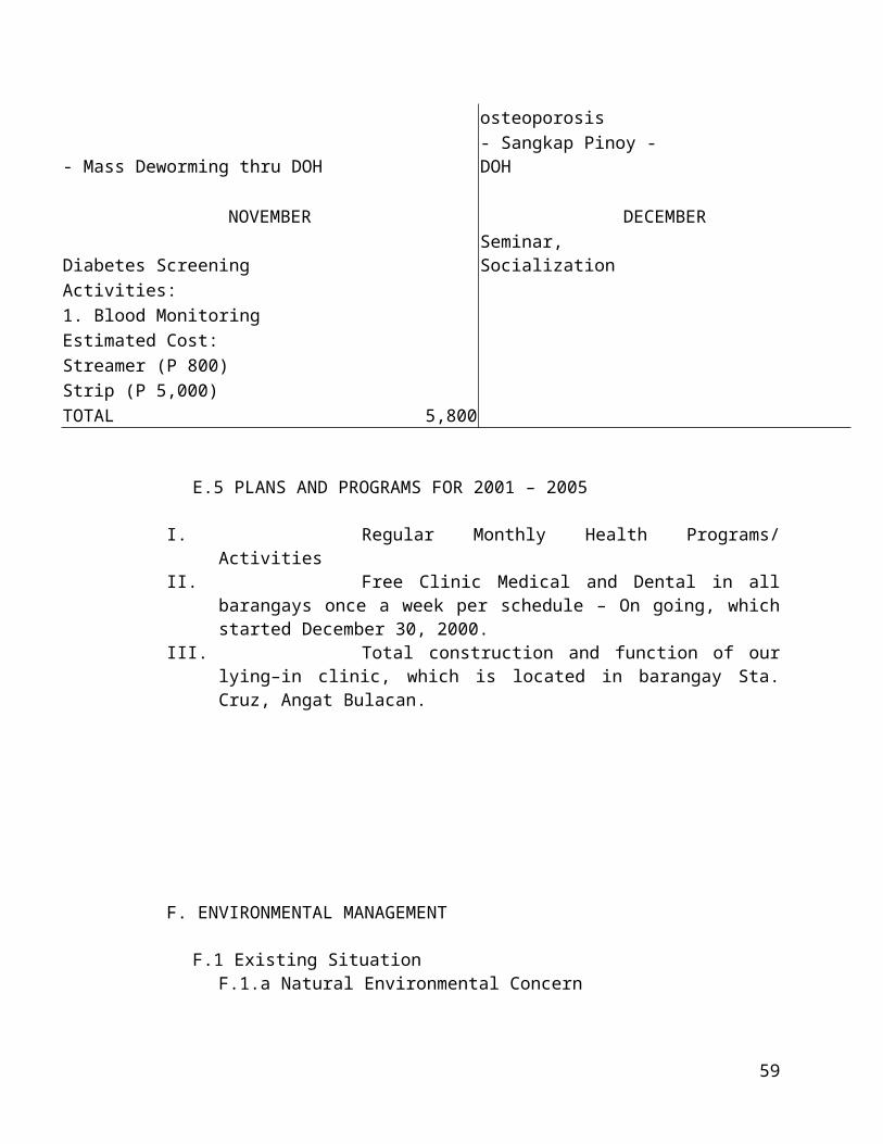
To elicit and enforce the community participation at present up to year 2005.
To commensurate the protective services/facilities need of the municipality by 2001 – 2010.
J.3 Programs and Projects:
Due to inavailability of the needs of the protective services/facilities in the municipality, the following projects are proposed with prompt consultation to the Municipal Mayor and PNP Station Commander in the municipality.
1. Construction of police outpost in all barangay or centered barangays/Construction of traffic outpost or combination of school zones, which also services as headquarters of barangay tanods.
2. Additional police force to meet the number of projected needs of the municipality.
3. Additional vehicles to meet the requirements/needs of the municipality.
63

PROPOSED PROGRAM FOR THE SUCCEEDING FIVE (5) YEARSKEY RESULT
AREA (10 Areas of Concern)
PROGRAMS PROJECTS
ACTIVITIESOBJECTIVES
EXPECTED OUTPUT Target No.
LEVEL SCOPE OF IMPLEMENTATION
(Indicate prov. If prov./City wide
TIME FRAME LEAD/SUPPORT AGENCIES (Identify lead
agencies
REMARKS (Source/Amount
of funds)Date Start
Completion Date
1. Crime Prevention and Control
a. Establishment of Police Box
To provide/ensure presence of Police
men in the Brgy. and the community
1 Brgy. BinagbagJan. 2000
Dec. 2005 PNP Municipal Fund
b. Beat Patrol
To pre-empt occurrence of crimes
and immediate response to crime
incident
182 Municipal WideJan. 2000
Dec. 2005 PNPMunicipal / PNP Fund
c. Ugnayan sa
barangay
To create workable relationship among the
police force and the Brgy. Officials in the peace and
order activity
90 Municipal WideJan. 2000
Dec. 2005 PNP/LGUMunicipal / PNP Fund
d. Training/ Seminar of
Brgy. Tanods
To provide adequate knowledge on the
implementation of peace and order program and to
acquaint them of their duties and responsibilities
4 Municipal WideMar. 2000
Apr. 2005 PNP/LGUMunicipal / PNP
Fund
e. Lecture / Disccussion on
crime prevention at
school
Students to choose good company in
school and community.
4 Municipal WideMar. 2000
Apr. 2005 LGUs/DECsLocal School
Board
To Conduct an aggressive campaign against the use, 30 Municipal Wide Mar. 2005 PNP/LGUs
64

2. Anti-Drug Campaign
a. IMPLAN TO LOI 36/97 BANAT
trafficking, manufacture of illegal drugs; prosecute offenders and assist in the
Jan. 2000
Municipal Funds and other
resources
b. SLAC with
the intermediate pupils
To promote awareness of hazards and effects of illegal
drugs.
1 Municipal WideJan. 2000
Dec. 2005PNP/LGUs /
DECsLocal School
Board
c. Conduct Kapanalig Seminar
To empower the youth in eradicating
drug problem1 Municipal Wide
Jan. 2000
Dec. 2005PNP/LGUs /
DECS/NGO / SK
Municipal Funds and other
resources
D. Conduct drug symposium for High School
Awareness on illegal effects on drugs
1 Municipal WideJan. 2000
Dec. 2005PNP/LGUs /
DGOs
Municipal Funds and other
resources
3. Law Enforcement
a. Service of warrant of
Arrest.
To apprehend all wanted persons and
bring him behind bars Municipal Wide
Jan. 2000
Dec. 2005PNP/LGUs /
NGOsLGUs fund & other sources
b. Campaign against illegal
activities
To Conduct an aggressive campaign against all
forms of illegal activities to create a peaceful & orderly community.
8 Municipal WideJan. 2000
Dec. 2005PNP/LGUs /
NGOsMunicipal Fund
c. Implementation of fisheries laws
rules and regulations, and
prov'l ordinance on FMD, eradication
& control
Protection, management and conservation of
aquatic resources and citizen rights and safety.
2 Municipal WideJan. 2000
Dec. 2005LGU/MAO/ BFAR/BAI/
DA/RFU/PNP
d. Conduct/ briefing for
To provide adequate knowledge to PLEB 1 Municipal Wide
Jan. 2000
Dec. 2005DILG/LGUs /
Municipal JudgesMunicipal and Barangay Fund
65

members of the PLEB.
members on the board functions and procedure
3. Corrections
a. Moral recovery program/ spiritual
nourishment
To uplift the moral values and ideas of detainees/prisoners
48 Municipal WideJan. 2000
Dec. 2005BJMP/PNP/
LGUsMunicipal Fund
and Sources
4. Prosecution and Court
a. Information dissemination on
rules and procedures of
barangay concileation and
settlement
To maintain harmonious
relationship between community members
and to avoid hasty filing of cases in
court.
1 Municipal WideJan. 2000
Dec. 2005Municipal Judges League / LGUs
Municipal Fund and other Sources
5. Counter Insurgency
a. Barangay Visitacion (CIVAC)
To bring the government closer and accessible to
people in order to win and gain their trust.
48 Municipal WideJan. 2000
Dec. 2005 PNP/LGUMunicipal Fund
and other Sources
6. Civil Defense
a. Strenghtened & reorgarnized
the Disaster Coordinating
Council
To ensure orderly and responsive
implementation of disaster programs in time of emergency.
IMDCC 16BDCC
Strenghtened reactivated
Municipal WideJan. 2000
Dec. 2005MDCC/LGU /
PNP/BFP / DILG
Municipal/ Barangay Fund & other Sources
b. Information dissemination of La Niña threat & other natural
calamities.
To provide awareness & preparedness on
the effects of La Niña phenomenon & other
natural calamities
As stated Municipal WideJan. 2000
Dec. 2005LGU/PNP/ NGO/PIA / BFP /DILG
Municipal/ Barangay Fund & other Sources
66

c. Training/ Seminars of
Disaster Brigade on Disaster
Management.
To assemble a highly trained orps on
disaster preparedness relief/rescue
operation
4 Municipal WideJan. 2000
Dec. 2005 BFP/LGUMunicipal/
Barangay Fund
7. Fire Prevention & Suppression
a. Safety inspection of
Different occupancy/
building
To identify and correct fire Hazards.
1 Municipal WideJan. 2000
Dec. 2005 BFP/LGU
b. Information dissemination thru lectures/
seminars
Awareness of citizens, officials on
their duties/responsibilities
relevant to fire prevention & fire
fighting aids.
1 Municipal WideJan. 2000
Dec. 2005 BFP/LGU Municipal Fund
c. Imposition of fire code fees / enforcement of
PD 1185
To orderly established
occupancy safe enough for its occupants and
adjacent structure.
1 Municipal WideJan. 2000
Dec. 2005 BFP/LGU Municipal Fund
d. Firetruck
visibility
To be able to respond quickly in times of
emergency1 Municipal Wide
Jan. 2000
Dec. 2005 BFP/LGU Municipal Fund
e. Firedrill and
disaster mitigation &
To exercise fire fighting techniques
1 Municipal WideJan. 2000
Dec. 2005 BFP/LGU Municipal Fund
67

preparedness campaign
and preparedness in any disaster.
8. Health and Sanitation
a. Environment health and sanitation program
To ensure of safety and potability of water supply thru
disinfection
1 Municipal WideJan. 2000
Dec. 2005 LGU/MHO Municipal Fund
b. Intensify campaign
against dengue carrying
mosquitoes
To eradicate the breeding places of dengue carrying
mosquitoes
1 Municipal WideJan. 2000
Dec. 2005LGU/MHO /
NGO / SchoolsMunicipal Fund
c. FMD/ Anti-rabbies
vaccination (Animal health
care)
To help eradicate diseases caused by infected animals
1 Municipal WideJan. 2000
Dec. 2005 LGU/MHOMunicipal Fund of DA National
9. Environmental
Protection
a. Tree planting/ Massgroove/ Reforestation
Cleaning and greening of
communities/ enhance ecological
balance
1 Municipal WideJan. 2000
Dec. 2005LGU/MAO/
DECs/PENRO/ NGO
Municipal Fund
b. Information/ dissemination
on environment training/seminar
Improvement of zero management
Cleen and green
environmentMunicipal Wide
Jan. 2000
Dec. 2005LGU/MAO/
RHU/NGO/ MEOMunicipal Fund
68

on clean &
c. Strick policies on garbage collection schedules
1 Municipal WideJan. 2000
Dec. 2005LGU/MAO/
RHU/NGO/ MEOMunicipal Fund
10. Community Development
a. Self-employment assistance
project (SEP)
To sustained economic stability and self-reliance
1 Municipal WideJan. 2000
Dec. 2005 LGU/MSDO Municipal Fund
b. dispersal of
vegetable seeds, fruit trees
To ensure food security, augment family income and
promote self-reliance
1 Municipal WideJan. 2000
Dec. 2005 LGU/MSDO Municipal Fund
c. Livestock
dispersal
To ensure food security, augment family income and
promote self-reliance
3 Municipal WideJan. 2000
Dec. 2005LGU/MAO/ NAFC/DTI/
DABA/ BFAR
DA National La Niña
rehabilitation Municipal Fund.
Source: PNP- Mun. Government
69

K. SPORTS AND RECREATION
K.1 The Existing Situation:
There are a few sports and recreation present in the municipality. The most popular is basketball. Almost every barangay in the municipality possesses at least one basketball court. There are chapels with playgrounds and basketball courts too. Private and public schools in the town are also equipped with sports facilities.
The old historical church located at the heart of the Poblacion has a big open space, which may be used for promenading. Picnic grounds and spaces are found along the shorelines of Angat River. Private institutions make use of this aesthetic view for holding different social occasions.
The municipal government has its plan to develop a part of the Angat River shoreline for tourism program and activities.
K.2 Development Needs:
The increasing population of Angat connotes the necessity of future planning for more sports and recreational facilities. Additional sports center and recreational facilities must be introduced. Indoor sports, theaters, tennis courts are still to be studied and perhaps be realized in the nearby future.
Annual sports competition should be given positive action not only by the government but also by private institutions.
K.3 Goals, Objectives and Targets:
Goals and Objectives Promote physical fitness for the youths and adults as well. Promote adequate sports and recreational facilities
Targets: Establishment of more facilities for sports and recreation To hold year round sports program.
The municipal government of Angat has continuously supported sports development for the entire community. All barangays have their own individual sports development program.
70

L. INFRASTRUCTURE AND UTILITIES:
There are existing infrastructure facilities and utilities in the municipality. Herewith follows the data information on transportation, communication, water, and power to wit;
I. Transportation, Roads and Bridges
L.I.1. Existing Situation
The municipality of Angat has approximately 7.67 kms. Of municipal roads and 50 kms. barangay roads which are further classified as paved and unpaved. For the municipal road, there is a total of 8.21 kms. paved roads which is further subdivided into 4.51 kms. for concreted roads and 4.70 kms. for asphalt paved roads. For the unpaved portion 3.01 kms. are gravel and 0.45 kms. earthfilled. As to the barangay roads, 50% barangay road, as of 1994 are unpaved. The unpaved portion was broken down into 6.2 of gravel and 18.8 kms. of earthfilled. All the shoulders on both the municipal and barangay roads for at least a width of 1.00 meter. There are municipal roads that do not have shoulders. These roads are: Reyes St., Legaspi St., Vergel St., Sta. Andres St., and Libis na Maliit-Sulucan St. Table 23 reflects the inventory of existing roads by types of pavements and administrative classification.
Presently, there are 17 bridges found in the entire municipality, which are classified as either national or provincial bridges. Out of 17 bridges, 6 are provincial bridges while the rest are national bridges. For further details, refer to table 24.
Within the municipality there are a number of tricycles, which are confined to the Poblacion and barrios, South of Angat River. Numerous jeepneys ply the routes: Angat-Norzagaray, Angat-Siling Bata, Pandi and Angat- Baliuag route in the Poblacion. There are also jeepneys, which travel from Barangay Sta. Lucia-Binagbag, Baliuag and Sta. Lucia- Camachile, DRT route. These vehicles leave the terminal with all seats loaded and the barangay passengers rely only on chance vacancies along the way.
The ROVAL transportation with sixteen (16) buses and the Sta. Maria Liner Transit with eighteen (18) units of buses serving the people from Angat to Manila and Cubao, Quezon City from 4:00 am to 8:00 in the evening.
IDENTIFICATION OF PROGRAMS/ PROJECTS:
1. Project Title : FARM-TO-MARKET ROAD Project Description : Construction of vital links from selected barangay.
G o a l : To improve the road system of the area and make it more functional, efficient and systematic.
Objectives : To connect all barangays and develop an inter-barangay linkage Source of Funds : National Government
71

PROGRAMS PROJECTS
Maintenance and repairs of roads Maintenance project of asphalted roads, repair of concrete roads and rehabilita-
tion of gravel and earthfilled roads the whole year round. Planting of trees along the road. Placement of road signs to all up beauty, direction and safety.
NUMBER AND TYPE OF TRANSPORT VEHICLES
TABLE IX-A.1NO. TYPE OF TRANSPORT VEHICLE NUMBER1 Private Car 572 Private Jeep 1983 PUJ / AC 1384 Mini Bus 225 Bus 186 Trucks 897 Motorcycles 2538 Ferry Boats 39 Utility Vehicles 110 TOTAL 779Source: MPDC
72
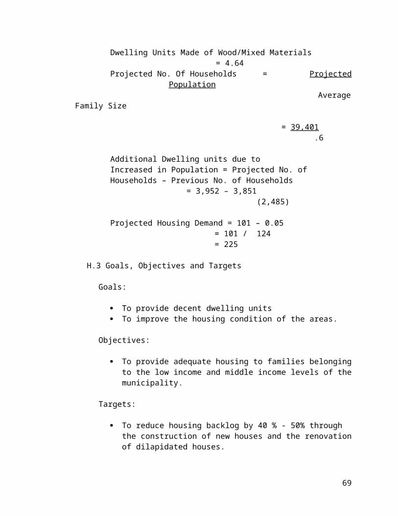
TABLE IX-A.2 - LIST OF EXISTING BRIDGES BY ADMINISTRATIVE CLASSIFICATIONMunicipality of Angat, Province of Bulacan
NO. BRIDGE NAMETYPE OF
STRUCTUREYEAR BUILT
LENGTH PER SPAN(METERS)
TOTAL LENGTH IN METERS
I. PROVINCIAL Sapang A Bridge Concrete 1970 15 m 15 m Maibay Bridge Concrete 1972 5 m 15 m Sapang TA-E Bridge Concrete 1978 5 m 6 m Pulong Tindahan Bridge Concrete 1982 5 m 6 m Baybay Bridge Concrete 1982 6 m 6 m Baybay - Laog Bridge Concrete 1989 8 m 20 m Encanto (Sapang A) Bridge Concrete 1989 6 m 15 m Pulong Yantok Bridge Concrete 1976 5 m 6 m Sta. Lucia-San Roque Bridge Concrete 1976 8 m 35 m
II. NATIONAL Niugan Bridge A Concrete 1965 8 m 8 m Niugan Bridge B Concrete 1965 8 m 8 m Donacion - Niugan Bridge Concrete 1970 8 m 8 m Donacion - Taboc Bridge Concrete 1970 6 m 6 m Taboc Bridge Concrete 1972 6 m 6 m Taboc - Sulucan Bridge Concrete 1972 6 m 6 m Sulucan Bridge Concrete 1972 8 m 8 m Tugatog Bridge Concrete 1972 8 m 8 m
Source: MPDC/DPWH
73

TABLE IX-A.3 - EXISTING ROADS BY TYPES OF PAVEMENT AND ADMINISTRATIVE CLASSIFICATION
NO. ROAD CLASSIFICATIONCONCRETE
Km.ASPHALT
KmGRAVEL EARTH
TOTAL LENGTH km.
TOTAL WIDTH m.
I. BARANGAY ROADSPugpog-Sentinela - - 1.0 2.5 3.5 1.0Encanto-Sulucan 1.Km - 1.0 1.5 3.5 1.0Encanto-Kalawakan - - - 1.5 1.5 1.0Encanto-Taboc - - - 2.5 2.5 1.0Tibagan-Paltok 0.2 - 1.0 1.3 2.5 1.0Niugan-Paltok 0.3 - 1.8 2.0 4.1 1.0Donacion-Real - - 2.0 2.0 4.0 1.0Donacion-Tumana I - - - 1.0 1.0 1.0Donacion-Tumana II - - 0.5 0.5 1.0 1.0Taboc-Real - - 2.0 1.5 3.5 1.0Taboc-Tumana - - - 1.0 1.0 1.0Binagbag-Catmon - - 1.5 2.0 3.5 1.0Binagbag-Tumana - - 0.5 0.5 1.0 1.0Binagbag-"Visaya" Group 1.Km - 0.5 0.5 1.0 1.0Catmon-Makulot - - 1.5 2.5 4.0 1.0Baybay II - - 1 0.5 1.5 1.0Banaban I 0.3 - 0.7 - 1.0 1.0Banaban II 0.2 - 0.8 - 1.0 1.0Laog-Banaban - - 1.5 0.5 2.0 1.0Banaban-Pinagtulayan - - 0.5 1.5 1.5 1.0Marungko-Pinagbakahan - - 0.7 0.3 1.0 1.0Sulucan-Tumana 0.3 - 0.2 0.1 2.6 1.0Sulucan-Burol Road 0.5 - 0.2 0.1 0.8 1.0Sulucan-Lalawakan - - 0.5 0.5 1.0 1.0Binagbag-Pangmalta Road - - 1.0 0.5 1.5 1.0San Roque-Dilain Road 0.5 - 0.5 0.1 0.6 1.0Niugan-Encanto-Malanday Rd. - - 1.5 2.5 4.0 1.0
II MUNICIPAL ROADSSta. Monica St. 0.350 - - - 0.350 1.0mIllescas St. 0.700 - - - 0.700 1.0mSan Roque St. 0.900 - - - 0.900 1.0mReyes St. 0.080 - - - 0.080 -Leonardo St. 0.300 - - - 0.300 -Salvador St. 0.250 - - - 0.250 -Legaspi St. 0.200 - - - 0.200 -Vergel St. 0.080 - - - 0.080 1.0mSantos St. 0.150 - - - 0.150 -A. De Guzman St. 0.600 - - - 0.600 1.0mAndres St. 0.050 - - - 0.050 1.0mSto. Cristo St. 0.600 - - - 0.600 -Sta. Cruz St. 0.150 - - - 0.150 -Libis St. - Binagbag 0.700 - - - 0.700 1.0mLibis na Malaki-Sulucan 0.700 - - - 0.700 1.0mLibis na Maliit-Sulucan 0.350 - - - 0.350 -Libis St.-Marungko 0.900 - - - 0.900 1.0mSta. Lucia St. 0.550 - - - 0.550 1.0m
74

L.II. WATER
L.II.1 Existing Situation:
Potable Water supply for the population of Angat is supplied by both waterworks and deepwell systems.
Angat waterworks system supplies water to three (3) Poblacion barangays namely San Roque, Sta. Cruz, and Sto. Cristo; and other barangays like Binagbag, Sta. Lucia, Marungko and Taboc. Ninety five percent (95%) of the total population of these barangays depends on the system and only about five percent (5%) depend on deepwell.
Angat Water District operates under the following management data.
NO. OF PERSONNEL = 15 Permanent 3 Casual
WATER CONSUMPTION/DAY = Average Daily Consumption = 22 Cu. m / Consumer
MINIMUM MONTHLY BILL = More or Less P 300,000.00MONTHLY Cu. m. CONSUMED = More or Less50,000. cu. m ANNUAL COLLECTION = More or Less P 4,000,000.00LIABILITIES = P23,704,259.04 as of Sept. 30
1997
Records of the system show the following historical development:
YEAR OF CONSTRUCTIONNO. OF CONSUMER /
BARANGAY Poblacion - 1991 1,365.00 Marungko - 1992 482.00 Donacion and Niugan 1994 156.00 Binagbag & Sta. Lucia 1995 416.00 Taboc - 1996 216.00 TOTAL 2,635.00 PRESENT 2,996.00
75

The data presented hereunder provides information on sources of potable water.
TABLE IX-B.1 - SOURCE OF WATER SUPPLY AND TYPES OF DEEP WELLANGAT, BULACAN
NO.BARANGAY
SERVED
MUN. WATER WORKSJET MATIC
PUMP NUMBER
TYPES OF DEEP WELL PUMP
(Pitcher
CYLINDER TYPE
PRIVATE HOUSEHOLD SERVED
NUMBER PERCENT1 Poblacion
Sta. Cruz 1,365 46%
14 8 12 15 Sto. Cristo 12 6 13 24 San Roque 11 7 9 18
2 Marungko 482 16% 5 6 4 173 Niugan
156 5%6 11 9 15
4 Donacion 9 8 29 205 Binagbag
416 14%6 19 4 13
6 Sta. Lucia 9 13 16 47 Sulucan 361 12% 8 11 5 118 Taboc 216 7% 13 6 8 989 Paltoc 3 3 9 47
10 Encanto 6 7 11 3111 Pulong Yantoc 2 6 9 3012 Laog 4 3 7 1613 Baybay 5 2 4 1114 Banaban 4 2 7 18
TOTAL 2,996 100% 117 118 156 388Source: MPDC
Barangay Sulucan has its own waterworks system which is named Sulucan Waterworks and Sanitation, about ninety five percent also (95%) of the inhabitants depends on this source for their daily consumption, while five percent (5%) depend on deepwell.
76

For agricultural purposes and for other uses, water supplies in Angat come from rivers and creeks.
TABLE IX-2 -RIVERS AND CREEKS OF ANGAT INVENTORY
CLASSIFICATION BARANGAYRIVER/CREEK
ACTIVE MONTHS WITH WATER
WIDTH LENGTH
1.1 River STA. CRUZ Angat River All Year Round 16 m 1.5 Kms.1.2 River STO. CRISTO Angat River All Year Round 50 m 0.5 Km.1.3 River SAN ROQUE Angat River All Year Round 40 m 1.0 Km.1.4 River MARUNGKO Angat River All Year Round 60 m 2.2 Kms.1.5 River SULUCAN Angat River All Year Round 70 m 1.3 Kms.1.6 River TABOC Angat River All Year Round 75 m 1.5 Kms.1.7 River DONACION Angat River All Year Round 70 m 1.2 Kms.1.8 River NIUGAN Angat River All Year Round 120 m 1.6 Kms.1.9 River BANABAN Bayabas River During Rainy Season 35 m 1.5 Kms.1.10 River BAYBAY Bayabas River During Rainy Season 30 m 1.1 Kms.1.11 River STA. LUCIA Bayabas River During Rainy Season 30 m 1.0 Kms.1.12 River LAOG Bayabas River During Rainy Season 85 m 1.5 Kms.
CLASSIFICATION BARANGAYRIVER/CREEK
ACTIVE MONTHS WITH WATER
WIDTH LENGTH
2.1 CREEKS STA. CRUZ Sapang A During Rainy Season 6 m 1.2 Kms.2.2 CREEKS SAN ROQUE Sapang A During Rainy Season 5 m 1.5 Kms.2.3 CREEKS MARUNGKO Sapang Pritil During Rainy Season 5 m 1.0 Km2.4 CREEKS SULUCAN Sapang Pritil During Rainy Season 4 m 1.1 Kms.2.5 CREEKS TABOC During Rainy Season 3 m .5 Km2.6 CREEKS DONACION During Rainy Season 5 m 1.5 Kms.2.7 CREEKS NIUGAN During Rainy Season 3 m .5 Km2.8 CREEKS PALTOC During Rainy Season 4 m 1.8 Kms.2.9 CREEKS ENCANTO During Rainy Season 3 m 1.7 Kms.2.10 CREEKS PULONG YANTOK During Rainy Season 3 m 1.1 Kms.2.11 CREEKS BINAGBAG A Maibay Creek During Rainy Season 5.5 m 1.8 Kms. BINAGBAG B Catmon Creek During Rainy Season 3.5 m 1.5 Kms.2.12 CREEKS BANABAN Bato During Rainy Season 3.m 1.0 Km.
Source: MPDC
L.II.2 Development Needs
The considerable increase in population of Angat necessitates the expansion of Angat Water district in some barangays, which are fast changing into urban areas. Other system such as Sulucan waterworks system should also be encourage if the area cannot reached by Angat Water District.
77

With sources of water that is used for agricultural purposes such as rivers and creeks, study should be conducted on the possibility of construction of irrigation canals. The National Irrigation Administration, the Department of Agriculture and the Department of Agrarian Reform should be consulted on this matter. If irrigation canal is not viable, at least the pump irrigation system,which is being constructed/installed now in Marungko and Binagbag by NIA should also be adopted by other barangays for agricultural development and improvement.
L.II.3. Goals, Objectives and Targetsa. To be able to expand water system to as many barangays, this
can be coveredb. To be able to construct irrigation canalsc. To be able to install water pumping station for agricultural
purposesd. To be able to develop agro-industrial establishment in the
strategic areas of the municipality.
L. III. TELECOMMUNICATIONS
L. III. 1. Existing Situation
One of the various factors very essential for community growth and development is the presence of telecommunication facilities. Day to day life processes need communication system. Business and industrial undertakings make use of a very large extent if not totally dependent upon this fast means of contact for immediate information.
Angat has to its credit the presence of telecommunication facilities. Telephone system is provided by the Philippine Long Distance Telephone Company and by Digitel. Portable telephone system thru cell site installation is provided by SMART.
Most common and still adhered to as a system of communication is thru postal services while is being undertaken by the Philippine Postal Corporation.
L. III. 2. Development Needs
More communication facilities should be present in the locality to better hasten transmittal of messages and information among the social, economic, and government sectors.
L. III. 3. Goals, Objectives and Targets.
There is a need for expansion and modernization of communication system as instrument of community growth and development. Cheaper, but fast, reliable and dependable communication and exchange system and exchange system will
78

contribute to progress. Postal services should be extended to thickly inhabited barangays.
L.IV. POWER
L.IV.1. The Existing Situation.
Power, like transportation, water and communication, plays a very important role in socio-economic growth and development of the local government unit. Industrialization of some parts of the community depends on the availability of electrical power. Commercial and other domestic uses will improve due to the presence of power.
L.IV. 2. Development Needs.
To attain the vision of the local government to industrialize the reliable areas of the town power installation should be expanded in order to ensure attraction of the future investors in the respective areas.
L.IV. 3. Goals, Objectives and Targets.
To ensure the vision and mission of the municipal government to industrialize some areas proposed under the Comprehensive Land Plans, the presence of power installation must also be made available. The improvement of power and electrification as a pre-requisite to economic growth must be given priority to induce greater productivity thereby giving more opportunities for employment as well as accelerating socio-economic upliftment of both urban an rural communities.
79

M. PHYSICAL DEVELOPMENT POTENTIALS OF ANGAT.
Local Development and Investment Program in General (2001-2005)
SECTOR 1 - ECONOMIC DEVELOPMENT PLAN FINACIAL REQUIREMENT ( IN THOUSAND PESOS)
CODE PROGRAM/PROJECT AND
ACTIVITYSPECIFIC
LOCATIONSTATUS
LEAD PARTICIPATING AGENCIES
UNIT OF MEASUREMENT
ANNUAL TARGET TOTAL TARGET INVESTMENT2001 2002 2003 2004 2005
A. AGRICULTURE:
1.0 Irrigation Construction Project Marungko Proposed NIA/DPWH/PROV'L. 1 UNIT 300 50 30 20 4001.1 Const. of Palay Dryer Sta. Lucia Proposed CDF/DA/MUN. 1 UNIT 500 30 30 5601.2 Sta. Lucia-Taiwan Rd. Rehab. (Farm to
Market Road) Sta. Lucia-
Taiwan (DR) On Going DPWH/PROV'L. KMS.
400 50 450
1.3 Paltok-Niugan Road Rehab.(Farm to Market Road)
Niugan-Paltok
On Going DA/DPWH/CDF KMS.
300 100 4001.4
Pu long Yantok-Encanto Road Rehab.(Farm to Market Road)
Pulong Yantok-Encanto
On Going DA/CDF KMS.
300 50 50 4001.5 Sulucan -Encanto Road Rehab.(Farm to
Market Road) Sulucan-Encanto
On Going DA/CDF KMS.
500 5001.6 Catmon-Makulot (Binagbag road
rehabilitation)Binagbag On Going DPWH/DA/MUN. KMS.
250 50 50 350
1.7 Baybay-Laog Road Rehab.(Farm to Market Road)
Baybay-Laog On Going DA/DPWH KMS.
200 30 25 45 3001.8
Sta. Cruz-(Sentinela)- P.Yantok Road Rehab.(Farm to Market Road)
Sta. Cruz (Sentinela)-P.
YantokOn Going DA/DPWH KMS.
300 300
1.9 Taboc-Donacion Road Rehab.(Farm to Market Road)
Taboc-Donacion
On Going DA/DPWH KMS.
250 25 25 300 LIVESTOCK DISPERSAL
2.0 Work Animal (Carabao) All 16 Brgys. Proposed BAI/DA/PROV./MUN 32 UNITS 128 128 128 3842.1 Cow/Cattle All 16 Brgys. Proposed BAI/DA/PROV./MUN 32 UNITS 160 160 80 80 4802.2 Swine/Hog breeder All 16 Brgys. Proposed BAI/DA/PROV./MUN 32 UNITS 128 128 2562.3 Water impounding mini dam
constructionSta. Cruz Proposed
DA/PROV./MUN/ DPWH /NIA
Sq. Meter/unit
120 1202.4 Water impounding mini dam
constructionMarungko Proposed DA/MUN/ DPWH /NIA Sq. Meter/unit
120 120
80
2.5 Water impounding mini dam construction
Donacion Proposed DA/MUN/ DPWH /NIA Sq. Meter/unit
120 120
2.6 Water impounding mini dam construction
Binagbag Proposed DA/MUN/ DPWH /NIA Sq. Meter/unit
120 1202.7 Water impounding mini dam
constructionPulong Yantok
Proposed DA/MUN/ DPWH /NIA Sq. Meter/unit
150 1502.8 Water impounding mini dam
constructionNiugan Proposed DA/MUN/ DPWH /NIA Sq. Meter/unit
150 150
2.9 Water impounding mini dam construction
Banaban Proposed DA/MUN/ DPWH /NIA Sq. Meter/unit
120 1202.10 Water impounding mini dam
constructionSto. Cristo Proposed DA/MUN/ DPWH /NIA Sq. Meter/unit
120 120
2.11 Multi-purpose pavement and construction
Banaban Proposed DPWH/CDF Sq. Meter
80 802.12 Multi-purpose pavement and
construction Sulucan Proposed DPWH/CDF Sq. Meter
80 80
2.13 Multi-purpose pavement and construction
Pulong Yantok
Proposed DPWH/CDF Sq. Meter
80 802.14 Multi-purpose pavement and
construction Paltok Proposed DPWH/CDF Sq. Meter
80 80
2.15 Multi-purpose pavement and construction
Sta. Cruz Proposed DPWH/CDF Sq. Meter
80 80
B. TRADE AND INDUSTRY 3.0 Angat Public Market (2nd Floor)
ConstructionPoblacion Pipeline
DPWH/CDF/PROV. MUN
Sq. Meter
3000 3000
C. TOURISM 4.0 Soldiers of World War II, Monument
Improvement Tugatog
San RoquePipeline DOT/CDF/MUN. Sq. Meter
350 20 20 20 20 430
4.1 Angat River Resort/Tourist Spot Improvement
Sto. Cristo Pipeline DOT/CDF/MUN. Sq. Meter
100 50 50 20 10 230
SECTOR 2 - SOCIAL SERVICES SECTOR FINACIAL REQUIREMENT ( IN THOUSAND PESOS)
CODE PROGRAM/PROJECT AND
ACTIVITYSPECIFIC
LOCATIONSTATUS
LEAD PARTICIPATING AGENCIES
UNIT OF MEASUREMENT
ANNUAL TARGET TOTAL TARGET INVESTMENT2001 2002 2003 2004 2005
A.
81

Education & Sports Development / Physical Development Program
1.0 Establishing Vocational Trade & Arts College/School
Poblacion ProposedDECS/DPWH/CDF/
PROV./MUN.1 UNIT
3500 50 50 50 3650
1.1 Establishing Public or Barangay High School
Niugan ProposedDECS/DPWH/CDF/
PROV./MUN.1 UNIT
2500 50 50 50 2650
1.2 Angat Central School (Amador Mem. Sch.) Impvmt.
San Roque Poblacion
Pipeline DECS/DPWH/CDF Sq. Meter
300 50 50 4001.3
Classroom Consrtruction (Additional)Angat Central School
ProposedDECS/DPWH/CDF/
PROV.2 Units
250 250 5001.4
Classroom Construction (Additional) Niugan ProposedDECS/DPWH/CDF/
PROV.2 Units
250 250 500
1.5Classroom Construction (Additional) Sulucan Proposed
DECS/DPWH/CDF/ PROV.
2 Units
250 250 5001.6
Classroom Construction (Additional) Donacion ProposedDECS/DPWH/CDF/
MUN.2 Units
250 250 500
1.7Classroom Construction (Additional)
Pulong Yantok
ProposedDECS/DPWH/CDF/
MUN.2 Units
250 250 500
1.8Classroom Construction (Additional) Banaban Proposed
DECS/DPWH/CDF/ MUN.
2 Units
120 120 2401.9
Classroom Construction (Additional) Taboc ProposedDECS/DPWH/CDF/
MUN.2 Units
250 250 500
1.10Classroom Construction (Additional) Encanto Proposed
DECS/DPWH/CDF/ MUN.
2 Units
250 250 5001.11
Classroom Construction (Additional) Binagbag ProposedDECS/DPWH/CDF/
MUN.2 Units
250 250 500
1.12Classroom Construction (Additional) Baybay Proposed
DECS/DPWH/CDF/ MUN.
2 Units
250 250 5001.13
Classroom Construction (Additional) Marungko ProposedDECS/DPWH/CDF/
MUN.2 Units
250 250 500
1.14Classroom Construction (Additional) Paltok Proposed
DECS/DPWH/CDF/ MUN.
1 Unit
250 2501.15
Classroom Construction (Additional) Laog ProposedDECS/DPWH/CDF/
MUN.1 Unit
250 250
1.16Classroom Construction (Additional) Sta. Lucia Proposed
DECS/DPWH/CDF/ MUN.
1 Unit
250 2501.17 Fencing of School Grounds / Premises Marungko On-Going CDF/PROV./MUN. Meters/Unit
82

150 50 2001.18
Fencing of School Grounds / Premises Niugan On-Going CDF/PROV./MUN. Meters/Unit
80 801.19
Fencing of School Grounds / Premises Donacion On-Going CDF/PROV./MUN. Meters/Unit
70 701.20
Fencing of School Grounds / Premises Taboc On-Going CDF/PROV./MUN. Meters/Unit
70 50 1201.21
Fencing of School Grounds / Premises Sulucan On-Going CDF/PROV./MUN. Meters/Unit
100 1001.22
Fencing of School Grounds / Premises Encanto On-Going CDF/PROV./MUN. Meters/Unit
60 601.23
Fencing of School Grounds / PremisesPulong Yantok
On-Going CDF/PROV./MUN. Meters/Unit
100 1001.24
Fencing of School Grounds / Premises Binagbag On-Going CDF/PROV./MUN. Meters/Unit
80 801.25
Fencing of School Grounds / Premises Sta. Lucia On-Going CDF/PROV./MUN. Meters
60 601.26
Fencing of School Grounds / Premises Baybay On-Going CDF/PROV./MUN. Meters
50 501.27
Fencing of School Grounds / Premises Banaban On-Going CDF/PROV./MUN. Meters
50 501.28
Fencing of School Grounds / Premises Laog On-Going CDF/PROV./MUN. Meters
50 501.29
Fencing of School Grounds / Premises Paltok On-Going CDF/PROV./MUN. Meters
80 80 SPORT DEVELOPMENT
1.0Annual Sports Festival Project
Poblacion Angat Gym
On-Going PROV./MUN./CID Cash
50 50 50 50 50 2501.1
Inter-Barangay Sports Fest Angat Gym Proposed PROV./MUN./CID Cash
30 30 30 30 30 1501.2
Trainor Training Clinic Program Angat Gym Proposed PROV./MUN./DECS Cash
25 10 5 5 5 501.3
Angat Municipal Gym Completion Angat Gym Pipeline DPW/CDF/PROV./ MUN. Sq. Meter
1500 15001.4
Sports Equiptment & Materials Purchase Pipeline PROV./MUN./CID Cash
50 30 20 20 10 130
B. HEALTH & SANITATION: 1.0 Emergency Hospital Project Sta. Cruz Proposed DOH/CID/PROV./MUN. 1 UNIT
83

4500 200 200 200 51001.1 Barangay Multi-Purpose Bldg.
ImprovementPoblacion On-Going DPW/CDF/PROV/MUN. Sq. Meter
50 50
1.2 Barangay Multi-Purpose Bldg. Improvement
Marungko On-Going DPW/CDF/PROV/MUN. Sq. Meter
50 501.3 Barangay Multi-Purpose Bldg.
ImprovementBinagbag On-Going DPW/CDF/PROV/MUN. Sq. Meter
50 50 100
1.4 Barangay Multi-Purpose Bldg. Improvement
Banaban On-Going DPW/CDF/PROV/MUN. Sq. Meter
50 50 1001.5 Barangay Multi-Purpose Bldg.
ImprovementPulong Yantok
On-Going DPW/CDF/PROV/MUN. Sq. Meter
50 50 1001.6 Barangay Multi-Purpose Bldg.
ImprovementSto. Cristo On-Going DPW/CDF/PROV/MUN. Sq. Meter
80 30 110
1.7Water Works System Construction Taboc Proposed LUWA/DPW/CDF 1 UNIT
2800 2800
1.8Drainage/Canal Improvement Sta. Cruz On-Going DPW/CDF/PROV/MUN. Meters
80 30 110
1.9Drainage/Canal Improvement Sto. Cristo On-Going DPW/CDF/PROV/MUN. Meters
50 30 80
1.10Drainage/Canal Improvement San Roque On-Going DPW/CDF/PROV/MUN. Meters
120 30 150
1.11Drainage/Canal Improvement Marungko On-Going DPW/CDF/PROV/MUN. Meters
30 20 50
1.12Drainage/Canal Improvement Sulucan On-Going DPW/CDF/PROV/MUN. Meters
40 10 10 60
1.13Drainage/Canal Improvement Niugan On-Going DPW/CDF/PROV/MUN. Meters
100 20 20 140 GARBAGE PIT/DUMP SITE
IMPROVEMENTSta. Lucia Pipeline DPW/PROV/MUN. Sq. Meters
100 30 130
1.1Purchase of Garbage Truck /Service Proposed 1 Unit - Cash
300 300
1.2Slaughterhouse Construction Poblacion Proposed DOH-CDF/PROV. MUN. 1 Unit
800 25.00 25 850
C. NUTRITION 1.0 Day Care Center Bldgs./ Improvement
Rehabilitation On-Going
DOH/DPWH/MSSD/ PROV./MUN.
Sq. Meter
1.1 On-Going Sq. Meter
84

Day Care Center Bldgs./ Improvement Rehabilitation
DOH/DPWH/MSSD/ PROV./MUN.
1.2 Day Care Center Bldgs./ Improvement Rehabilitation
On-GoingDOH/DPWH/MSSD/
PROV./MUN.Sq. Meter
1.3 Day Care Center Bldgs./ Improvement Rehabilitation
On-GoingDOH/DPWH/MSSD/
PROV./MUN.Sq. Meter
1.4 Day Care Center Bldgs./ Improvement Rehabilitation
On-GoingDOH/DPWH/MSSD/
PROV./MUN.Sq. Meter
1.5 Day Care Center Bldgs./ Improvement Rehabilitation
On-GoingDOH/DPWH/MSSD/
/MUN.Sq. Meter
1.6 Day Care Center Bldgs./ Improvement Rehabilitation
On-GoingDOH/DPWH/MSSD/
/MUN.Sq. Meter
1.7 Day Care Center Bldgs./ Improvement Rehabilitation
On-GoingDOH/DPWH/MSSD/
/MUN.Sq. Meter
D. PEACE AND ORDER 1.0
Police Outpost /Station Established Niugan Proposed PNP/MUN. 1 Unit
50 501.1
Police Outpost /Station Established Sta. Cruz Proposed PNP/MUN. 1 Unit
50 501.2
Police Outpost /Station EstablishedSan Roque (Sabang)
Proposed PNP/MUN. 1 Unit
50 501.3
Police Service Car/Jeep Purchased LGU Proposed PNP/CDF/MUN. 1 Unit
200 2001.4
Sidearm for Police Purchase LGU Proposed CDF/MUN. 10 Units
130 1301.5 Radio Communication Equiptment
PurchaseLGU Proposed CDF/MUN./PROV. 1 complete set
150 150
1.6 Telecommunication/Digitel Expansion service all Brgys.
Poblacion Pipeline DPWC/DOTC/PROV Kms.
500 5001.7
Anti-Narcotic (illegal drug Campaign)All
BarangaysOn-Going
PNP/DOJ/NBI/PROV./ MUN.
30 20 20 15 10 95
E. ENVIRONMENTAL MANAGEMENT 1.0 Bamboo tree planting along creeks
(Bank sides)Marungko Proposed DENR/PROV./MUN. Kms.
10 3 13
1.1 Bamboo tree planting along creeks (Bank sides)
Sta. Cruz Proposed DENR/PROV./MUN. Kms.
5 2 71.2 San Roque Proposed DENR/PROV./MUN. Kms.
85

Bamboo tree planting along creeks (Bank sides) 5 2 7
1.3 Bamboo tree planting along creeks (Bank sides)
Binagbag Proposed DENR/PROV./MUN. Kms.
10 3 131.4 Bamboo tree planting along creeks
(Bank sides)Banaban Proposed DENR/PROV./MUN. Kms.
5 2 7
1.5 Bamboo tree planting along creeks (Bank sides)
Sulucan Proposed DENR/PROV./MUN. Kms.
5 2 71.6 Bamboo tree planting along creeks
(Bank sides)Taboc Proposed DENR/PROV./MUN. Kms.
5 2 7
1.7 Bamboo tree planting along creeks (Bank sides)
Donacion Proposed DENR/PROV./MUN. Kms./meters
5 2 7
1.8 Bamboo tree planting along creeks (Bank sides)
Taboc Proposed DENR/PROV./MUN. Kms./meters
5 2 71.9 Bamboo tree planting along creeks
(Bank sides)Niugan Proposed DENR/PROV./MUN. Kms./meters
10 3 13
1.10 Bamboo tree planting along creeks (Bank sides)
Encanto Proposed DENR/PROV./MUN. Kms./meters
10 3 131.11 Bamboo tree planting along creeks
(Bank sides)Paltok Proposed DENR/PROV./MUN. Kms./meters
5 2 7
F. HUMAN ECOLOGY AND SECURITY 1.0 Mun. Nursery for Trees and Ornamentals
EstablishedPoblacion Proposed PROV./MUN. Sq. Meter
30 20 15 10 5 80
1.1 Coconut & MangoTrees / Subsidized Seedlings
LGU Proposed PROV./MUN. 5000 Units
50 30 20 1001.2 Tree Planting on Open Spaces & River
BanksSta. Cruz Proposed PROV./MUN.
1.3 Tree Planting on Open Spaces & River Banks
San Roque Proposed PROV./MUN.
1.4 Tree Planting on Open Spaces & River
BanksSto. Cristo Proposed PROV./MUN.
1.5 Tree Planting on Open Spaces & River Banks
Marungko Proposed PROV./MUN.
1.6 Tree Planting on Open Spaces & River
BanksSulucan Proposed PROV./MUN.
1.7 Tree Planting on Open Spaces & River Banks
Taboc Proposed PROV./MUN.
86

1.8 Tree Planting on Open Spaces & River Banks
Donacion Proposed PROV./MUN.
1.9 Tree Planting on Open Spaces & River
BanksNiugan Proposed PROV./MUN.
G. SOCIAL WELFARE DEVELOPMENT 1.0 Self-Employment Assistance All Brgys. On-Going MSSD Cash 30 30 30 90
SECTOR 3 - INFRASTRUCTURE SECTOR FINACIAL REQUIREMENT ( IN THOUSAND PESOS)
CODE PROGRAM/PROJECT AND
ACTIVITYSPECIFIC
LOCATIONSTATUS
LEAD PARTICIPATING AGENCIES
UNIT OF MEASUREMENT
ANNUAL TARGET TOTAL TARGET INVESTMENT2001 2002 2003 2004 2005
A. ROADS 1.0
Sulucan-Encanto Road RehabilitationSulucan - Encanto
On-going DPW/CDF/MUN./ PROV. Kms.
1000 10001.1 Encanto-Pulong Yantok Road
RehabilitationP.Yantok -
EncantoOn-going DPW/CDF/MUN./ PROV. Kms.
800 800
1.2 Sta.Lucia (Taiwan)Camachile, DRT Rd. Rehabilitation
Sta. Lucia On-going DPW/CDF/MUN./ PROV. Kms.
1000 10001.3
Niugan - Paltok Road RehabilitationNiugan - Paltok
On-going DPW/CDF/MUN./ PROV. Kms.
500 5001.4 Mun. & Brgy. Sts. Impvmt. Concreting
or AsphaltingPoblacion On-going DPW/CDF/MUN./ PROV. Kms.
1.5 Mun. & Brgy. Sts. Impvmt. Concreting or Asphalting
Sta. Cruz On-going DPW/CDF/MUN./ PROV. Kms./ Meters
1.6 Mun. & Brgy. Sts. Impvmt. Concreting
or AsphaltingSt. Cristo On-going DPW/CDF/MUN./ PROV. Kms./ Meters
1.7 Mun. & Brgy. Sts. Impvmt. Concreting or Asphalting
San Roque On-going DPW/CDF/MUN./ PROV. Kms./ Meters
1.8 Mun. & Brgy. Sts. Impvmt. Concreting
or AsphaltingSta. Lucia On-going DPW/CDF/MUN./ PROV. Kms./ Meters
1.9 Mun. & Brgy. Sts. Impvmt. Concreting or Asphalting
Marungko On-going DPW/CDF/MUN./ PROV. Kms./ Meters
1.10 Mun. & Brgy. Sts. Impvmt. Concreting
or AsphaltingPulong Yantok
On-going DPW/CDF/MUN./ PROV. Kms./ Meters
1.11 Mun. & Brgy. Sts. Impvmt. Concreting
or AsphaltingBanaban On-going DPW/CDF/MUN./ PROV. Kms./ Meters
1.12 Baybay On-going DPW/CDF/MUN./ PROV. Kms./ Meters
87

Mun. & Brgy. Sts. Impvmt. Concreting or Asphalting
1.13 Mun. & Brgy. Sts. Impvmt. Concreting or Asphalting
Laog On-going DPW/CDF/MUN./ PROV. Kms./ Meters
1.14 Mun. & Brgy. Sts. Impvmt. Concreting
or AsphaltingSulucan On-going DPW/CDF/MUN./ PROV. Kms./ Meters
1.15 Mun. & Brgy. Sts. Impvmt. Concreting or Asphalting
Taboc On-going DPW/CDF/MUN./ PROV. Kms./ Meters
1.16 Mun. & Brgy. Sts. Impvmt. Concreting
or AsphaltingDonacion On-going DPW/CDF/MUN./ PROV. Kms./ Meters
1.17 Mun. & Brgy. Sts. Impvmt. Concreting or Asphalting
Niugan On-going DPW/CDF/MUN./ PROV. Kms./ Meters
1.18 Mun. & Brgy. Sts. Impvmt. Concreting
or AsphaltingEncanto On-going DPW/CDF/MUN./ PROV. Kms./ Meters
1.19 Sitio Pulong Tindahan, Banaban Taiwan Rd. Const.
Banaban Proposed DPW/CDF/MUN./ PROV. Kms./ Meters
B. BRIDGES
1.0Banaban Over-Flow Bridge Construction Banaban Proposed DPW/CDF/MUN./ PROV. I Unit
1500 1500
1.1 Delain-Sapang A Creek Bridge Construction
San Roque Proposed DPW/CDF/MUN./ PROV. I Unit
1000 10001.2 Sentinela, Sta. Cruz-P.Yantok Bridge
ConstructionSta. Cruz P.
YantokOn-Going DPW/CDF/MUN./ PROV. I Unit
2000 2000
1.3 Sta. Lucia (Taiwan Rd.) Bridge Construction
Sta. Lucia Proposed DPW/CDF/MUN./ PROV. I Unit
1500 15001.4
Baybay Bridge Improvement Baybay Pipeline DPW/CDF/MUN./ PROV. I Unit
800 8001.5
Pulong Yantok Bridge ImprovementPulong Yantok
Pipeline DPW/CDF/MUN./ PROV. I Unit
30 30C. PHYSICAL CONSTRUCTION
1.0 Mun. BuildingConst /Additional 2nd Floor
Poblacion Pipeline DPW/CDF/MUN./ PROV. Sq. Meters
2000 20001.1
Waiting Shed Construction Donacion Proposed DPW/CDF/MUN./ PROV. 1 Unit
25 251.2
Waiting Shed Construction Sulucan Proposed DPW/CDF/MUN./ PROV. 2 Units
25 25 501.3 Waiting Shed Construction Taboc Proposed DPW/CDF/MUN./ PROV. 1 Unit
88

25 251.4
Waiting Shed Construction Binagbag Proposed DPW/CDF/MUN./ PROV. 2 Units
25 25 501.5
Waiting Shed Construction Marungko Proposed DPW/CDF/MUN./ PROV. 2 Units
25 25 501.6
Waiting Shed ConstructionPulong Yantok
Proposed DPW/CDF/MUN./ PROV. 1 Unit
25 251.7
Waiting Shed Construction Encanto Proposed DPW/CDF/MUN./ PROV. 1 Unit
25 251.8
Waiting Shed Construction Sto. Cristo Proposed DPW/CDF/MUN./ PROV. 1 Unit
25 251.9
Waiting Shed Construction Sta. Cruz Proposed DPW/CIA/MUN./ PROV. 2 Units
25 25 501.10
Waiting Shed Construction San Roque Proposed DPW/CIA/MUN./ PROV. 1 Unit
25 25D. MAINTENANCE AND FACILITIES
1.0 Angat River Break Wall Reapraffing Construction
Sta. Cruz Proposed DPW/CIA/MUN./ PROV. Meters
250 100 3501.1 Angat River Break Wall Reapraffing
ConstructionSan Roque Proposed DPW/CIA/MUN./ PROV. Meters
300 300
1.2 Angat River Break Wall Reapraffing Construction
Donacion Proposed DPW/CIA/MUN./ PROV. Meters
100 1001.3 Angat River Break Wall Reapraffing
ConstructionSta. Lucia Proposed DPW/CIA/MUN./ PROV. Meters
100 100
1.4 Angat River Break Wall Reapraffing Construction
Baybay Proposed DPW/CIA/MUN./ PROV. Meters
200 2001.5 Angat River Break Wall Reapraffing
ConstructionMarungko Proposed DPW/CIA/MUN./ PROV. Meters
100 100
E. DEEPWELL CONSTRUCTION 1.0 Pulong Yantok Communal Faucet/s
(Level III)Pulong Yantok
ProposedDPW/LWUA/CDF/
PROV.2 Units
250 250 500
1.1Encanto Communal Faucet/s (Level III) Encanto Proposed
DPW/LWUA/CDF/ PROV.
2 Units
250 250 5001.2
Laog Communal Faucet/s (Level III) Laog ProposedDPW/LWUA/CDF/
PROV.1 Unit
250 250
1.3Baybay Communal Faucet/s (Level III) Baybay Proposed
DPW/LWUA/CDF/ PROV.
1 Unit
250 2501.4
Banaban Communal Faucet/s (Level III) Banaban ProposedDPW/LWUA/CDF/
PROV.2 Units
250 250 500
89

90

N. POLITICAL SET-UP
Elected Officials:2001 – 2004
Local Chief Executive:
Hon. Leonardo R. de Leon Municipal Mayor
Sangguniang Bayan:
Hon. Cornelio L. Junio Vice Mayor and S.B.Presiding Officer
Hon. Gilberto C. Santos Municipal CouncilorHon. Laurentino F. Santiago -do-Hon. Antonio F. Nuñez -do-Hon. Tristan T. Cruz -do-Hon. Alejandrino C. Agustin -do-Hon. Reynante S. Bautista -do-Hon. Bonifacio S. Pascual -do-Hon. Erwinio Illescas -do-Hon. Donnabelle R. De Leon SK ChairmanHon. Marcelino S. Reyes ABC President
91
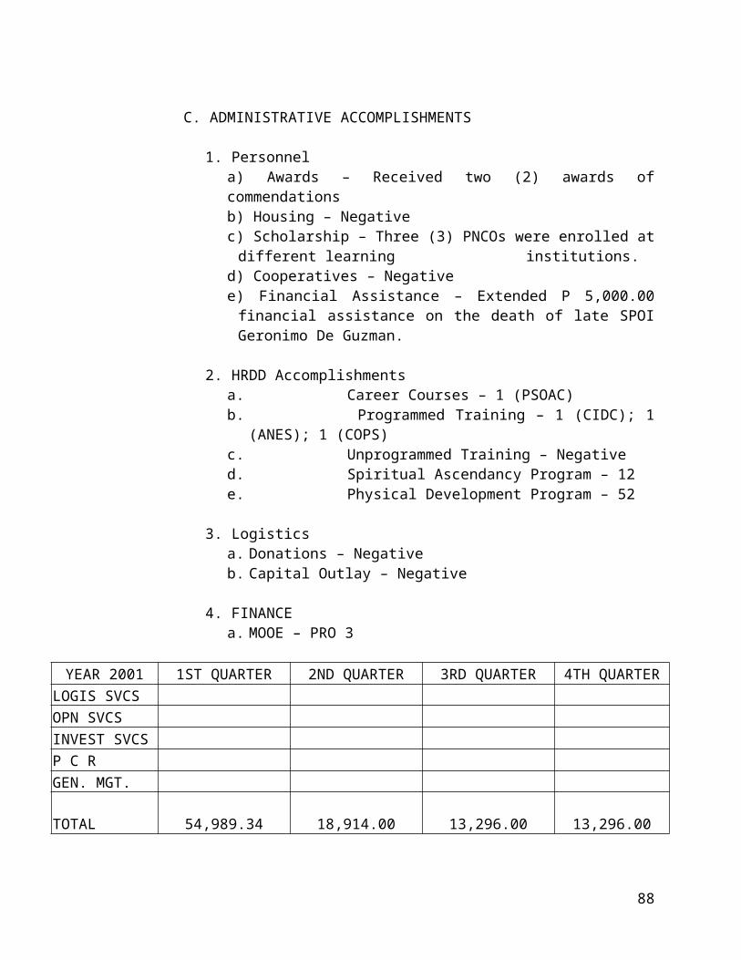
Elected Officials:2000 – 2001
Local Chief Executive:
Hon. Angelito S. Vergel de Dios Municipal Mayor
Sangguniang Bayan:
Hon. Cornelio L. Junio Vice Mayor and S.B.Presiding Officer
Hon. Laurentino F. Santiago Municipal CouncilorHon. Antonio F. Nuñez -do-Hon. Gilberto C. Santos -do-Hon. Bonifacio S. Pascual -do-Hon. Marcelino C. Dela Cruz -do-Hon. Alejandrino C. Agustin -do-Hon. Erwinio M. Illescas -do-Hon. Reynante S. Bautista -do-Hon. Donnabelle R. De Leon SK ChairmanHon. Marcelino S. Reyes ABC President
92

Physical Plan and Land Use Development
I. The Existing Situation
AGRICULTURE
The total land area of Angat, according to LC map # 637 dated March 1, 1927 from the record of the Land Management Bureau of the Department of Environment and Natural Resources is 65,260,000 sq. m. or 6,526 hectares. The total area devoted to agriculture is 4,720 hectares or 72.33% of the total area. Sources from the Department of Agriculture says that only 818 hectares are irrigated and are found in barangays Niugan and Paltok while 1,242 hectares are rainfed. Corn Production has an area of about 195 hectares; high value crops uses about 199 Hectares; orchard embraces 792 hectares and fisheries occupy about 19 hectares more or less. The remaining area from the total of 4,720 hectares accounts for upland agriculture, residential farm-lots and part barren hills area.
RESIDENTIAL
Presently the residential area has a total of 725 hectares or about 11.11%. This land is practically found along national, provincial, municipal, barangay roads and in subdivisions. The greater number is usually found in the Poblacion and in urban areas.
COMMERCIAL
This land use occupies the smallest portion, which is only about 7 hectares. This is found in the heart of the Poblacion and within the nearest vicinity. Business activities is yet to be enhanced.
INSTITUTIONAL
This land use has a remarkable area of about 70 hectares. Several institutions are found in the municipality especially religious and educational institutions.
INDUSTRIAL
A few years ago it was noted that only a few hectares, 17 more or less, were used for this purpose. Latest actual survey conducted by the Municipal Planning and Development Office reveals that it now occupies around 86 hectares, which shows a noticeable growth in industrial development.
Open space including roads and bridges, riverbanks and the like occupies about 520 hectares while rivers and creeks is estimated to have an area of about 398 hectares.
94

II. The Proposed Land Use Plan
The population growth of Angat is quite big. In 1995 NSO report, the population is 39,037 and as of May 2000, the population count is 46,135 which shows an increase of 7,098 birth and migration are the factors of this growth. Eventually land uses will be affected. Growth and development becomes inevitable. All areas of land uses should be planned in accordance with the economic, social, political and institutional demands of the locality.
In the next five years, 2001 – 2005, changes in the land uses and development are expected to happen. Land uses should be so planned in accordance with the provisions of the Local Government Code of 1991 and pursuant to the provincial, regional and national development objectives of the government.
In relation to the general status of the municipality of Angat, industrial development must be prioritized. Investors in industry should be given incentives in order to attract them to come to the municipality. The development of commerce depends upon the growth of population. Industrial development is such one factor to attract residents to come to the municipality.
The present visions and missions of the local government of Angat, both the executive and legislative functions are unanimous in the proposed land used plan of the community geared towards economic growth of the community.
The proposed land use plan of the municipality for the next five years, 2001 – 2005, pursuant to all existing laws of the government regulating land uses, is hereby indicated as follows:
95

THE PROPOSED LAND USE PLAN:
A. Residential1. Low Cost Subdivisions
1.1 - ENCANTO (California) - 50 Hectares1.2 - SULUCAN (Tubao) - 50 Hectares
B. Commercial2. Market Development
2.1 - Santa Lucia - Binagbag - 10 Hectares2.2 - Taboc - Donacion - 10 Hectares
C. Institutional3. Educational and Religious Institutions
3.1 - Religious Institution at Talbak roadembracing Encanto - Pulong Yantok - 50 Hectares3.2 - Secondary/Elementary SchoolSto. Cristo facing river bank - 10 Hectares3.3 - Proposed Cemetery - 5 Hectares
D. Industries4. Proposed Agro-Industrial
4.1 - Pulong Yantok - 100 Hectares5. Proposed Light Industrial
5.1 Binagbag - 100 HectaresE. Eco-Tourism
Note:The following land uses are taken from open spacesE-1 - Sta Cruz - Laog - 20 HectaresE-2 - Extension to riverbank ofSto. Cristo - San Roque - 10 Hectares
G. Proposed Dumping Site - 5 Hectares420 Hectares
THE MATRIX OF THE GENERAL LAND USES AND PROPOSALS
96

The general land use status and proposals are hereby presented in the following tables that summarize the physical plan and land use development program of the municipality for the next five years 2001 –2005.
TABLE X.1
EXISTING GENERAL LAND USE
NO. USES AREA (Hectares) PERCENT DISTRIBUTION1 AGRICULTURAL 4720 72.33%2 RESIDENTIAL 725 11.11%3 AGRO-INDUSTRIAL 0 0.00%4 LIGHT INDUSTRIAL 86 1.32%5 COMMERCIAL 7 0.11%6 INSTITUTIONAL 70 1.07%6-A CEMETERY 9 0.14%7 DUMPING SITE 1 0.02%
8
VACANT/OPEN SPACE Distributed as roads, bridges, rivers, creeks, swamps etc.
908 13.91%
6526 100%
97

PROPOSED GENERAL LAND USETABLE X-2
NO. USESAREA (Existing) PROPOSED TOTAL PERCENT
DISTRIBUTIONHECTARES HECTARES HECTARES1 AGRICULTURAL 4720 4330 66.35%2 RESIDENTIAL 725 100 825 12.64%3 AGRO-INDUSTRIAL 100 100 1.53%4 LIGHT INDUSTRIAL 86 100 186 2.85%5 COMMERCIAL 7 20 27 0.41%6 INSTITUTIONAL 70 60 130 1.99%6-A CEMETERY 9 5 14 0.21%7 DUMPING SITE 1 5 6 0.09% SUB-TOTAL 5618 390 5618 86.09% 8 VACANT/OPEN SPACE
908 878 13.45% Distributed as roads & bridges; rivers, creeks, swamps.9 Eco-Tourism 0 30 30 0.46% SUB-TOTAL 45 918 13.92% GRAND TOTAL 6526 425 6526 100%
TABLE X.3
98
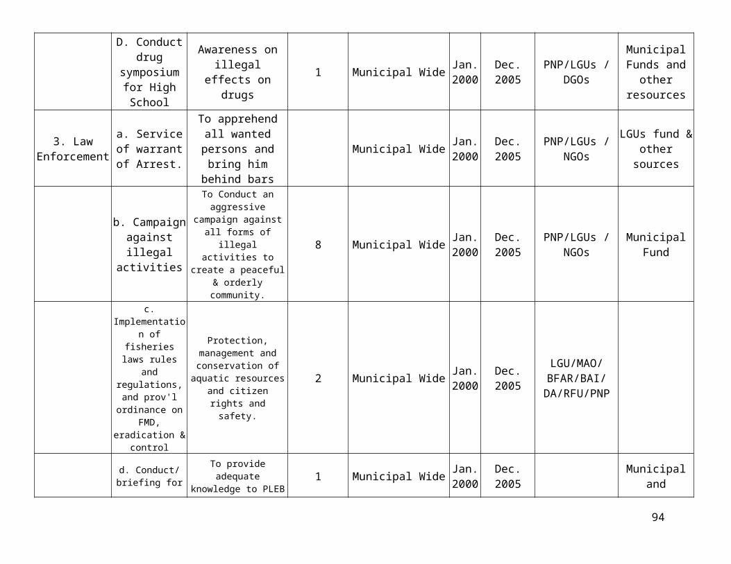
GENERAL LAND USE (INCREASE -DECREASE)
NO. USESEXISTING
DISTRIBUTION
% DISTRIBUTION
AFTER PROPOSAL INCREASE DECREASE
1 AGRICULTURAL 72.33% 66.35% 5.98%2 RESIDENTIAL 11.11% 12.64% 1.53% 3 AGRO-INDUSTRIAL 1.53% 1.53% 4 LIGHT INDUSTRIAL 1.32% 2.85% 1.53% 5 COMMERCIAL 0.11% 0.41% 0.30% 6 INSTITUTIONAL 1.06% 1.99% 0.93% 6-A CEMETERY 0.14% 0.21% 0.07% 7 DUMPING SITE 0.02% 0.09% 0.07% SUB-TOTAL 86.09% 86.09% 5.98% 5.98% 8 VACANT/OPEN SPACE
13.91% 13.45% 0.46% Distributed as roads & bridges; rivers, creeks, swamps.9 Eco-Tourism 0.00% 0.46% 0.46% SUB-TOTAL 13.91% 13.91% 0.46% 0.46% GRAND TOTAL 100.00% 100.00% 6.44% 6.44%
REPUBLIC OF THE PHILIPPINESPROVINCE OF BULACAN
MUNICIPALITY OF ANGAT
99

THE COMPREHENSIVE ZONING ORDINANCE
2001– 2005
100

MUNICIPAL ORDINANCE NO.________Series of year 2001
AN ORDINANCE ADOPTING THE ZONING REGULATIONS FOR THE MUNICIPALITY OF ANGAT, BULACAN AND PROVIDING FOR THE ADMINISTRATION, ENFORCEMENT AND AMENDMENT THEREOF AND FOR THE REPEAL OF ALL ORDINANCES IN CONFLICT THEREWITH.
Be it ordained by the Sangguniang Bayan of Angat, Bulacan.
Whereas, the implementation of Comprehensive Land Use Plans would require the enactment of regulatory measures to translate its planning goals and objectives into reality and a Zoning Ordinance is one such regulatory measure which is an important tool for the implementation of the comprehensive land use plan;
Whereas, the local government code authorizes local government units to enact zoning ordinance subject to and in accordance with existing laws;
Whereas, the Housing and Land Use Regulatory Board has spearheaded and now assists in and coordinates the activities of local governments in comprehensive land use planning;
NOW THEREFORE, the Sangguniang Bayan of Angat, Bulacan in a session assembled hereby adopts the following Zoning Ordinance.
ARTICLE I
TITLE OF THE ORDINANCE
Section 1.Title of the Ordinance. This Ordinance shall be known as the Comprehensive Zoning Ordinance of the Municipality of Angat, Bulacan and shall be referred to as the Ordinance.
ARTICLE II AUTHORITY AND PURPOSE
Section 2.Authority. This ordinance is enacted pursuant to the provisions of the New Local Government Code, RA 7160 Sections 458 a.2 (7-9) and 447A.2 (7-9) dated 10 October 1991, “Authorizing the Municipality through the Sangguniang Bayan to adopt Zoning Ordinance subject to the provisions of existing laws, ”and in conformity with E.O. No 72. Section 3. Purpose. This ordinance is enacted for the following purposes:
1

1. Guide, control and regulate future growth and development of Municipality of Angat in accordance with its Comprehensive Land Use Plan.
2. Protect the character and stability of residential, commercial, industrial, institutional, agricultural, open space and other functional areas within the locality and promote the orderly and beneficial development of the same.
3. Promote and protect the health, safety, peace, comfort, convenience and general welfare of the inhabitants in the locality.
4. Ensure and protect the sustainable growth and development of the community.
Section 4.General Zoning Principle. This Zoning regulations is based on the approved general and urban Land Use Plans as per resolution No.___________ dated ___________ for the Municipality of Angat.
ARTICLE IIIDEFINITION OF TERMS
The definition of technical terms used in the Zoning Ordinance shall carry the same meaning given to them in already approved codes and regulations, such as but not limited to the National Building Code, Water Code, Philippine Environmental Code and other Implementing Rules and Regulations, promulgated by the HLURB. The words, terms and phrases enumerated hereunder shall be understood to have the corresponding meaning indicated as follows:
1. Agricultural Zone (AGZ) - an area within a municipality intended primarily for integrated farm operations and related product processing activities such as rice, vegetables, sugar, plantation for bananas, pineapple, etc.
2. Agro-Industrial Zone (AIZ) - an area within a municipality intended primarily for related activities e.g. fishing, poultry and livestock raising, feed mills, rice mills, etc. 3. Agro-Forestry Zone (AFZ) – An area within the local government unit devoted to agri-forestry uses.
4. HLURB/BOARD – Shall mean the Housing and Land Use Regulatory Board.
5. Buffer Area – these are YARDS, PARKS or open spaces INTENDED to separate incompatible elements or uses to control pollution/nuisance and for identifying and defining development areas or zones where NO PERMANENT STRUCTURES ARE ALLOWED.
6. Built-up Area – a contiguous grouping of ten (10) or more structures.
2

7. Central Business District – shall refer to areas designated principally for trade, services and business purposes (Commercial 1 Zone.)
8. Certificate of Non-Conformance – certificate issued to owners of all uses existing prior to the approval of the Zoning ordinance which do not conform in a zone as per provision of the said ordinance.
9. Compatible use- uses of land activities capable of existing together harmoniously e.g. residential, parks and playground.
10. Component Cities/Municipalities – Cities which do not meet with the requirements for highly urbanized cities shall be considered component cities of the province in which they are located. If a component city is located within the boundaries of two or more provinces such city shall be considered component of the province of which it is to used as a municipality.
11. Comprehensive Land Use Plan (CLUP) – a document embodying specific land use and development proposals for guiding, regulating growth and/or development. The main elements of the CLUP are the sectoral components: Socio-Economic, Infrastructure and Utilities, Local Administration and Land Use, Parks and Open Space.
12. Conflicting Uses – uses or land activities with contrasting and incompatible characteristics located adjacent to each other e.g. residential units adjacent to industrial plants.
13. Conforming Uses – a use that is in accordance with zone classification as provided for in the Zoning Ordinance.
14. Easement – open space imposed on any land use/activities sited along waterways, road-right-of-ways, cemeteries/memorial parks and utilities.
15. Environmentally Critical Areas – refer to those areas, which are environmentally sensitive and are listed in RA 7586.
16. Environmentally Critical Projects – refer to those projects, which have high potential for negative environmentally impacts and are listed in RA 7586.
17. Exception – a device which grants a property owner relief from certain provisions of the Zoning Ordinance because the specific use would result in a particular hardship upon the owner, as distinguished from a mere inconvenience or a desire to make more money.
18. Floor Area Ratio or FAR – is the ratio between the gross floor area of a building and the area of the lot on which it stands; determine by dividing the gross floor area of the building and the area of the lot. The gross floor area of any building should not exceed the prescribed floor area ratio multiplied by the lot area. The FAR of any zone should be
3
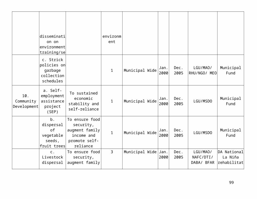
based on its capacity to support development in terms of the absolute level of density that the transportation and other utility networks can support.
19. Forest Zone (FZ) – an area within the municipality intended primarily for forest purposes.
20. General Commercial Zone (GCZ) - an area within the municipality used for trading/services/business purposes.
21. General Institution Zone (GIZ) - an area within the municipality used principally for general types of institutional establishments, e.g. government offices, schools, hospitals/clinics, academic research, and convention centers.
22. General Residential Zone (GRZ) - an area within the municipality used principally for dwelling/housing purposes.
23. General Zoning Map – a duly authenticated map delineating the different zones into which the whole municipality is divided.
24. Gross Floor Area (GFA) – The GFA of a building is the total floor space within the perimeter of the permanent external building walls, occupied by:
Office areas; Residential areas; Corridors; Lobbies; Mezzanine Vertical penetrations, which shall mean stairs, fire escapes, elevator shafts,
flues, pipe shafts, vertical ducts, and the like, and their enclosing walls; Rest rooms or toilets; Machine rooms and closets; Storage rooms and closets; Covered balconies and terraces; Interior walls and columns and other interior feature
But exclude:
Covered areas used for parking and driveways, including vertical penetration in parking floors where no residential or office units are present;
Uncovered areas for cooling towers, overhead water tanks, roof decks, laundry areas and cages, wading or swimming pools, whirlpools or jacuzzis, gardens, courts or plazas.
25. Heavy Industrial Zone (I-3) – a subdivision of an area principally for the following types of industries:
4

a. Highly pollutive/non-hazardousb. Highly pollutive/hazardousc. Highly pollutive/extremely hazardousd. Pollutive/extremely hazardouse. Non-pollutive/extremely hazardous
26. High Density Commercial Zone (C-3) – an area within a municipality intended for regional shopping centers such as large malls and other commercial activities which are regional in scope or where market activities generate traffic and require utilities and services that extend beyond local boundaries and requires metropolitan level development planning and implementation. High rise hotels, sports stadium or sports complexes are also allowable in this zone.
27. High Density Residential Zone (R-3) – a subdivision of an area principally for dwelling/housing purposes with a density of 66 or more dwelling units per hectare.
28. Highly Urbanized Cities – cities with a minimum population of 2,000,000 inhabitants as certified by the National Statistics Office and with the latest annual income of at least Php 50,000,000.00 based on 1996 constant prices as certified by the city treasurer. (RA 7160)
29. Independent Component Cities – are those component cities whose charter prohibits their voting for provincial elective officials, being independent of the province. (RA 7160)
30. Innovative Design – introduction and/or promotion of new/creative designs and techniques in development project e.g. Planned Unit Development (PUD), New Town, etc.31. Light Industrial Zone (I-1) – a subdivision of an area principally for the following types of industries:
Non-pollutive/non-hazardous Non-pollutive/hazardous
32. Locational Clearance – a clearance issued to a project that is allowed under the provisions of this Zoning Ordinance and other rules and regulations on land use.
33. Low Density Commercial Zone (C-1) – an area within a municipality principally for trade, services and business activities ordinarily referred to as the Central Business District.
34. Low Density Residential Zone (R-1) – an area within a municipality principally for dwelling/housing purpose with a density of 20 dwelling units and below per hectare.
5

35. Medium Density Commercial Zone (C-2) - an area within a municipality with quasi-trade business activities and service industries performing complementary/supplementary functions to principally commercial zone. (CBD)
36. Medium Density Residential Zone (R-2) - an area within a municipality principally for dwelling/housing purpose with a density of 21 to 65 dwelling units per hectare.
37. Medium Industrial (I-2) - an area within a municipality principally for the following types of industries:
Non-pollutive/non-hazardous Non-pollutive/hazardous
38. Mitigating Device – a means to grant relief in complying with certain provisions of the Zoning Ordinance.
39. New Town – Shall refer to a town deliberately planned and built which provides, in addition to houses, employment, education, recreation, culture and other services normally associated with a city or town.
40. Non-Conforming Use –existing non-conforming uses/establishments in an area allowed to operate in spite of their non-conformity to the visions of the Ordinance, subject to the conditions stipulated in this Zoning Ordinance.
41. Parks and Recreation Zone (PRZ) – an area designed diversion/amusements and for the maintenance of ecological balance of the community.
42. Planned Unit Development (PUD) – it is a land development scheme wherein the project site is comprehensively planned as an entire via unitary site plan which permits flexibility in planning/design; siting of buildings; complementarily of building types and land uses; usable open spaces and the preservation of significant natural land features.
43. Rezoning – a process of introducing amendments to or a change in the text or maps of the zoning ordinance. It also includes amendment or change arising from land reclassification under section 20 of RA 7160.
44. Rural Area – area outside of designated urban area.
45. Setback – the open space left between a building and a lot lines.
46. Socialized Housing Zone (SHZ) – shall be used principally for socialized housing/dwelling purposes for the underprivileged and homeless as defined in RA 7279.
47. Socialized Institutional Zone (SIZ) – an area within a municipality devoted principally to particular types of institutional establishments e.g. welfare homes, orphanages, home for the aged, rehabilitation and training centers, military camps/reservation/bases/training grounds etc.
6

48. Tourist Zone (TZ) – are sites within the municipality endowed with natural or manmade physical attributes and resources that are conducive to recreation, leisure and other wholesome activities.
49. Urban Areas (S) – include all barangay(s) or portion(s) of which comprising the poblacion, central business district (CBD) and other build up areas including the urbanizable land in and adjacent to said areas and where at least more than fifty percent (50%) of the population are engaged in non-agricultural activities. CBD shall refer to the areas designated principality for trade, services and business purposes.
50. Urban Zoning Map – a duly authenticated map delineating the different zones into which the urban area and its expansion area are divided.
51. Urbanizable Land – are designated as suitable for urban expansion by virtue of land use studies conducted.
52. Variance – a Special Location Clearance which grants a property owner relief from certain provision of Zoning Ordinance where, because of the particular, physical surrounding, shape or topographical conditions of the property, compliance on height, area, setback, bulk and/or density would result in a particular hardship upon the owner, as distinguished from a mere inconvenience or a desire to make more money.
53. Warehouse – refers to a storage and/or depository of those in business of performing warehouse services for others, for profit.
54. Water Zone (WZ) – are bodies of water within municipalities which includes rivers, streams, lakes and seas except those included in other zone classification.
55. Zone/District – an area within municipalities for specific land use as defined by manmade or natural boundaries.
56. Zoning Administrator/ZONING OFFICER – a municipal government employee responsible for the implementation/enforcement of the Zoning Ordinance in a community.
57. Zoning Ordinance – a local legal measure which embodies regulations affecting land use.
ARTICLE IVZONE CLASSIFICATIONS
7

Section 5. Division Zones or Districts. To effectively carry out the provisions of this Ordinance, the municipality is hereby divided into the following zone or district as shown in the Official Zoning Maps.
1. General Residential Zone (GRZ)2. Socialized Housing Zone (SHZ)3. Low Density Residential Zone (R-1)4. Medium Density Residential Zone (R-2)5. High Density Residential Zone (R-3)6. General Commercial Zone (GCZ)7. Low Density Commercial Zone (C-1)8. Medium Density Commercial Zone (C-2)9. High Density Commercial Zone (C-3)10. Light Industrial Zone (I-1)11. Medium Industrial Zone (I-2)12. Heavy Industrial Zone (I-3)13. General Institutional Zone (GIZ)14. Special Institutional Zone (SIZ)15. Agricultural Zone (AGZ)16. Agro-Industrial Zone (AIZ)17. Forest Zone (FZ)18. Parks and other Recreation Zone (PRZ)19. Water Zone (WZ)20. Tourist Zone
Section 6. Zoning Maps. It is hereby adopted as an integral part of this Ordinance, the Official Zoning Maps for urban areas and for the whole Municipality (General), wherein the designation, location and boundaries of the districts/zones herein established are shown and indicated. Such Official Zoning Maps shall be signed by the local chief executive and duly authenticated by the HLURB/SANGGUNIANG PANLALAWIGAN.
Section 7. Zone Boundaries. The locations and boundaries of the above mentioned various zones into which the municipality has been divided are hereby identified and specified as follows: [Refer to Zoning Map and other Land Use Maps].
Section 8. Interpretation of the Zone Boundary. In the interpretation of the zone boundaries for any of the zone indicated on the zoning Map, the following rules shall apply.
1. Where zone boundaries are so indicated that they approximately follow the center of streets or highway, the street of highway right-of-way lines, shall be construed to be the boundaries.
2. Where zone boundaries are so indicated that they approximately follow the lot lines shall be construed to be the boundaries.
3. Where zone boundaries are so indicated that they approximately parallel to the center lines of right-of-way lines of streets and highways, such one boundaries
8

shall be construed as being parallel thereto and at such distance there from as indicated in the zoning map. If no distance is given, such dimension shall be determined by the use of the scale shown in said zoning map.
4. Where the boundary of a zone follows approximately a railroad line, such boundary shall be deemed to be the railroad right-of-way.
5. Where the boundary of a zone follows a stream, lake or other bodies of water, such boundary line shall be deemed to be at the limit of the political jurisdiction of community unless otherwise indicated. Boundaries indicated as following shorelines shall be construed to follow such shorelines and in the event of change in the shorelines, shall be construed as moving with the actual shorelines.
6. Where a lot of one ownership, as of record at the effective date of this Ordinance, is divided by a zone boundary line, the lot shall be construed to be within the zone where the major portion of the lot is located. In case the lot is bisected by the boundary line, it shall fall in the zone where the principal structure falls.
7. Where zone boundary is indicated as one-lot-deep, said depth shall be construed to be the average lot depth of the lots involved within each particular municipal block. Where, however, any lot has a depth greater than said average, the remaining portion of said lot shall be construed as covered by the one-lot-deep zoning district provided the remaining portion has an area less than fifty percent (50%) of the total area of the entire lot. If the remaining portion has an area equivalent to fifty percent (50%) or more of the total area of the lot then the average lot depth shall apply to the lot which shall become a lot divided and covered by two or more different zoning districts, as the case may be.
In case of any remaining doubt as to the location of any property along zone boundary lines, such property shall be considered as falling within the less restrictive zone.
8. The textual description of the zone boundaries shall prevail over that of the Official Zoning Maps.
ARTICLE VZONE REGULATIONS
Section 9. General Provision. The uses enumerated in the succeeding are not exhaustive nor all-inclusive. The Local Zoning Board of Adjustment and Appeals (LZBAA) shall, subject to the requirements of this article, allow other uses not enumerated hereunder provided that they are compatible with the uses expressly allowed.
Allowance of further uses shall be based on the intrinsic qualities of the land and the socio-economic potential of the locality with due regard to the maintenance of the essential qualities of the zone.
9

Specific uses/activities of lesser density within a particular zone (R-1) may be allowed within the zone of higher density (R-2, R-3) but not vice versa, nor in another zone and its subdivisions (e.g. GC, C-1, C-2), except for the uses expressly allowed in said zones, such that the cumulative effect of zoning shall be intra-zonal and not inter-zonal. Section 10. Use Regulations in General Residential Zone (GRZ). A GR zone shall be used principally for dwelling/housing purposes so as to maintain peace and quiet of the area within the zone. The following are the allowable uses:
1. Detached family dwelling2. Multi-family dwelling e.g. row-houses, apartments3. Residential condominium4. Apartment5. Hometel6. Pension house7. Hotel apartment or apartel8. Dormitory9. Boarding house10. Branch libraries and museums11. Customary accessory uses like:
a. Servants quarterb. Private garagec. Guard house
12. Home Occupation for the practice of one’s profession or for engaging in home business such as dressmaking, tailoring, baking, running a sari-sari store and the like provided that:
a. The number of persons engaged in such business/industry shall not exceed five (5), inclusive of the owner;
b. There shall be no change in the outside appearance of the building premises;
c. No home occupation shall be conducted in any customary accessory uses cited above;
d. No traffic shall be generated by such home occupation in greater volume than would normally be expected in a residential neighborhood and any need for parking generated by the conduct of such home occupation shall be met off the street and in a place other than the required front yard;
e. No equipment or process shall be used in such home occupation which creates noise, vibration, glare, fumes, odors and electrical interference detectable to the normal senses and visual or audible interference in any radio or television receiver or causes fluctuations in line voltage of the premises.
13. Home Industry classified as Cottage Industry provided that:
10

a. Such home industry shall not occupy more than thirty percent (30%) of the floor area of the dwelling unit. There shall be no change or alteration in the outside appearance of the dwelling unit and shall not be a hazard or nuisance;
b. Allotted capitalization shall not exceed the capitalization as set by the Department of Trade and Industry (DTI).
c. Such shall consider same provisions as enumerated in letters c, d and number 12, home occupation, this section.
14. Recreational facilities for the exclusive use of the members of the family residing within the premises such as:
a. Swimming Poolb. Pelota courtc. Others
15. Nursery/Elementary School16. High School17. Vocational School18. Sports Club19. Religious Use20. Multi-purpose Hall/Barangay Hall21. Clinic, nursing and convalescing home, health center22. Plant nurseries
Section 10a. Use Regulations in Low Density Residential Zone (R-1) An R-1 shall be used principally for housing/dwelling purposes so as to maintain the peace and quiet of the area within the zone with a density of 20 dwelling units and below per hectare. The following are allowable uses:
1. Detached family dwelling2. Semi-detached family dwelling e.g. duplex, row-house3. Customary accessory uses like:
a. Servants quarterb. Private garagec. Guardhouse
4. Pre-school5. Sports Club6. Clinic, nursing and convalescing home, health center7. Plant nursery
Section 10b. Use regulations in Medium Density Residential (R-2) Zone. R-2 zones shall be for housing/dwelling PURPOSES i.e. 21 to 65 dwelling units per hectare. The following are the allowable uses:
11

1. All uses allowed in R-1 zone2. Apartment3. Boarding house4. Dormitory5. Branch library and museum6. Elementary school7. High school
Section 10c. Use regulations in High Density Residential (R-3) Zone. An R-3 shall be for housing/dwelling purposes of high-density i.e. 66 or more dwelling units per hectare. The following are the allowable uses:
8. All uses allowed in R-1 and R-2 zones9. Residential condominiums10. Pension house11. Hometel12. Vocation school13. Hotel apartments or apartel14. High school and Vocational schools
Section 10d. Use regulations in Socialized Housing Zone. (SHZ) – A SHZ shall be used principally for socialized housing/dwelling purposes for the underprivileged and homeless as defined in RA 7279. Allowable uses:
1. All uses allowed in General Residential Zone, R-1, R-2 and R-3 zones
Section 11. Use Regulations in General Commercial Zone (GCZ). A GC zone shall be for business/trade/services uses. Within the zone the following type of establishments shall be allowed:
1. Office like:
a. Office Buildingb. Office condominium
Section 11a. Use regulations in C-1 Zone. Referred to as the Central Business District (CBD), a C-1 zone shall be principally for trade services and business activities. Enumerated below are allowable uses:
1. Offices line:
a. Office buildingb. Office condominium
2. General retail condominium
12

a. Department store/Shopping centerb. Bookstore and office supplies shopc. Car shopd. Home appliances storee. Photo shopf. Flower shop
3. Food markets and shop like:
a. Bakery and bakeshopb. Wine storec. Groceryd. Supermarket
4. Personal services shops like:
a. Beauty parlorb. Barber shopc. Sauna bath and Massage clinicd. Dressmaking and Tailoring shop
5. Recreational center/establishments like:
a. Movie house/Theaterb. Playing court e.g. tennis, bowling and billiardc. Swimming poold. Day and night club, Gymnasiume. Other sports and recreational establishments
6. Restaurants and other eateries7. Short Term schools
a. Dancing schoolsb. Schools for self-defensec. Driving schoolsd. Speech clinic
8. Storeroom and warehouse but only as may be necessary for the efficient conduct of the business.
9. Commercial housing like:
10. Commercial condominium (with residential units in upper floors)11. Embassy consulate12. Library, museum
13
13. Filling station/service station14. Clinic15. Vocational/Technical School16. Convention center and related facilities17. Messengerial service18. Security agency19. Janitorial service20. Bank and other financial institution21. Radio and television station22. Building garage23. Commercial job printing24. Typing and photo engraving services25. Repair of optical instruments and equipment and cameras26. Repair of clocks and watches27. Manufacture of insignia, badges and similar emblems except metal28. Transportation terminal/garage29. Plant nurseries30. Scientific. Cultural and academic centers and research facilities except –
nuclear, radioactive, chemical, and biological warfare facilities.
Section 11b. Use regulations in C-2 zone. A C-2 shall be for quasi-trade business activities and service industries performing complimentary/supplementary functions to principally Commercial Zone (CBD). Within the C-2 Zone, the following uses are allowed:
1. All uses in C-1 may be allowed C-2
2. Repair shops like:
a. House appliancesb. Motor vehicles and accessoryc. Home furnishing shops
3. General retail stores and shops like:
a. Department storeb. Bookstore and office supply shopc. Home appliance stored. Car shope. Pet shopf. Flower shop
4. Food markets and shops like:
14

a. Bakery and bakeshopb. Wine storec. Groceryd. Supermarket
5. Personal service shops like:
a. Beauty parlorb. Barber shopc. Sauna Bath and massage clinicd. Dressmaking and tailoring shops
6. Recreational center/establishments like:
a. Movie house/theaterb. Playing court e.g. tennis court, bowling lane, billiard hallc. Swimming poold. Day and night clube. Stadium, coliseum, gymnasiumf. Other sports and recreational establishment
7. Restaurants and other eateries
8. Short term special education like:
a. Dancing schoolsb. Schools for self-defensec. Driving schoolsd. Speech clinics
9. Storerooms but only as may be necessary10. Commercial condominium (with residential units in upper floors)11. Commercial housing like:
a. Hotelb. Apartmentc. Aparteld. Boarding housee. Dormitoryf. Pension houseg. Clubhouseh. Motel
12. Embassy/consulate13. Library museum14. Filling station/service station15. Clinic
15
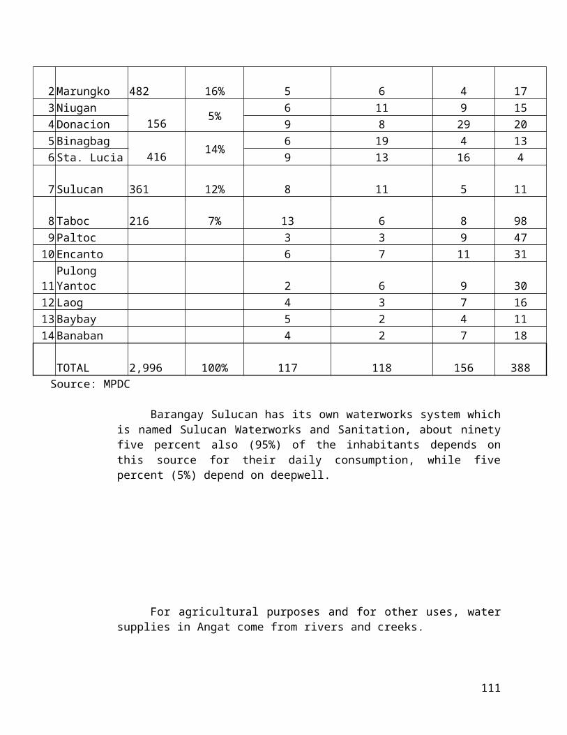
16. Vocational/technical school17. Convention center and related facilities18. Messengerial services19. Janitorial services20. Bank and other financial institutions21. Radio and television station22. Building garage, parking lot23. Bakery and baking of bread, cake, pastries, pies, and other similar
perishable product.24. Custom dressmaking shop25. Custom tailoring shop26. Commercial job printing27. Typing and photo engraving service28. Repair of optical instruments, equipment and cameras29. Repair of clocks and watches30. Manufacture of insignia, badges and similar emblems except metal31. Transportation terminals/garage with and without repair32. Repair shops like:
a. House appliances repair shopsb. Motor vehicle and accessory repair shopc. Home furnishing shops
33. Printing/publishing34. Machinery display shop/center35. Gravel and sand36. Lumber/hardware37. Manufacturer of ice, ice blocks, cubes, tubes, crush except dry ice38. Printing and publishing of books and pamphlets, printing cards and
stationery39. Manufacture of signs and advertising displays (except printed)40. Chicharon factory41. Manufacturer of wood furniture including upholstered42. Manufacturer of rattan furniture including upholstered43. Manufacturer of box beds and mattresses44. Welding shop45. Machine shop service operation (repairing/rebuilding, or custom job
orders)46. Medium scale junk shop47. Repair of motorcycles48. Lechon or whole pig roasting49. Biscuit factory- manufacturer of biscuits, cookies, crackers and other
similar dried bakery products.50. Doughnut and hopia factory51. Other bakery products not elsewhere classified (n.e.c.)52. Re-packing of food products e.g. fruits, vegetables, sugar and other related
products.
16

53. Plant nursery54. Funeral parlors, mortuaries and crematory services and memorial chapels55. Parking lots, garage facilities56. Other commercial activities not elsewhere classified
Section 12. Use Regulation in Light Industrial Zone (I-1). An I-1 zone shall be for non-pollutive/non-hazardous and non-pollutive/hazardous manufacturing/processing establishments. Enumerated below are the allowable uses:
1. Non-Pollutive/Non-Hazardous Industries
a. Drying fishb. Biscuit Factory – manufacture of biscuits, cookies, crackers and
other similar dried bakery products.c. Doughnut and hopia factoryd. Manufacture of macaroni, spaghetti, vermicelli and other noodlese. Other bakery products not elsewhere classified (n.e.c.)f. Life belts factory g. Manufacture of luggage, handbags, wallets and small leather goodsh. Manufacture of miscellaneous products of leather and leather
substitute and (n.e.c.)i. Manufacture of shoes except rubber, and plasticj. Manufacture of slipper and sandal except rubber and plastick. Manufacture of footwear parts except rubber and plasticl. Printing, publishing and allied industries and those n.e.c.m. Manufacture or assembly of typewriters, cash registers, weighing,
duplicating and accounting machinesn. Manufacture or assembly of electronic data processing machinery
and accessorieso. Renovation and repair of office machinery p. Manufacture or assembly of miscellaneous office machines and
those n.e.c.q. Manufacture of raw boats, bancas and sailboatsr. Manufacture of animal drawn vehicless. Manufacture of children vehicles and baby carriagest. Manufacture of laboratory and scientific instruments, barometers,
chemical balance, etc.u. Manufacture of measuring and controlling equipment, plumb
bomb, rain gauge, taximeter, thermometer, etc.v. Manufacture or assembly of surgical, medical, dental equipment
and medical furniturew. Quick freezing and cold packaging for fish and other seafoodsx. Quick freezing and cold packaging for fruits and vegetablesy. Pop corn/rice factory
17

z. Manufacture of medical/surgical supplies: adhesive tapes, antiseptic dressing, sanitary napkins, surgical gauge, etc.
aa. Manufacture of orthopedic equipment and prosthetic appliances (abdominal supporter, ankle supports, arch support, artificial limbs, kneecap supporters, etc)
bb. Manufacture of photographic equipment and accessoriescc. Manufacture of assembly of optical instrumentsdd. Manufacture of eyeglasses and spectaclesee. Manufacture of optical lensesff. Manufacture of watches and clocksgg. Manufacture of pianoshh. Manufacture of string instrumentsii. Manufacture of wind and percussion instrumentjj. Manufacture of assembly of electronic organskk. Manufacture of sporting gloves and mittsll. Manufacture of sporting balls (not of rubber or plastic)mm. Manufacture of gyms and playground equipmentnn. Manufacture of sporting tables (billiards, pingpong, pool)oo. Manufacture of other sporting and athletic goods n.e.c.pp. Manufacture of toys and dolls except rubber and mold plasticqq. Manufacture of pens, pencils and other office and artist materialsrr. Manufacture of umbrellas and canesss. Manufacture of buttons except plastictt. Manufacture of brooms, brushes and fansuu. Manufacture of needles, pens, fasteners and zippersvv. Manufacture of insignia, badges and similar emblems (except
metal)ww. Manufacture of signs and advertising displays (except printed)xx. Small scale manufacture of ice cream
2. Non-Pollutive/Hazardous Industries
a. Manufacture of house furnishingb. Textile bag factoriesc. Canvass bags and other canvass products factoryd. Jute bag factorye. Manufacture of miscellaneous textile goods, embroideries and
weaving apparelf. Manufacture of fiber batting, padding and upholstery filling except
choirg. Women’s, girl’s and ladies’ garment factoryh. Manufacture of hats, gloves, handkerchief, neckwear and related
clothing accessories. i. Manufacture of raincoats and waterproof outer garments except
jacketsj. Manufacture of miscellaneous wearing apparel except footwear
18

k. Manufacture of miscellaneous fabricated millwork and those n.e.c.l. Manufacture of wooden and cane containersm. Sawali, nipa and split cane factoryn. Manufacture of bamboo, rattan and other cane baskets and wareso. Manufacture of cork productsp. Manufacture of wooden shoes, shoe lace and other similar productsq. Manufacture of miscellaneous wood products and those n.e.cr. Manufacture of miscellaneous furniture and fixture except
primarily of metals and those, n.e.c.s. Manufacture of paper stationery, envelopes and related articlest. Manufacture of dry iceu. Re-packing of industrial products e.g. paints, varnishes and other
related products
Section 13. Use Regulations in Medium Industrial Zone (I-2). An I-2 zone shall be for pollutive/non-hazardous and pollutive/hazardous manufacturing and processing establishments. Enumerated below are the allowable uses:
1. Pollutive/Non-Hazardous Industries
a. Manufacture and canning of ham, bacon and native sausageb. Poultry processing and canningc. Large scale manufacture of ice creamd. Corn mill/Rice mille. Chocolate and cocoa factoryf. Candy factoryg. Chewing gum factoryh. Peanuts and other nuts factoryi. Chocolate and confectionery productsj. Manufacture of flavoring extractsk. Manufacture of food products n.e.c (vinegar, vetsin)l. Manufacture of fish mealm. Oyster shell gradingn. Manufacture of medicinal and pharmaceutical preparationso. Manufacture of stationery, art goods, cut stone and marble productsp. Manufacture of abrasive productsq. Manufacture of miscellaneous non-metallic mineral products n.e.cr. Manufacture of cutlery except table flatwares. Manufacture of hand toolst. Manufacture of general hardwareu. Manufacture of miscellaneous cutlery hand tools and general hardware
n.e.c.v. Manufacture of household metal furniturew. Manufacture of office, store and restaurant metal furniturex. Manufacture of metal blinds, screens and shadesy. Manufacture of miscellaneous furniture and fixture primarily of metal
19
z. Manufacture of fabricated structural iron and steelaa. Manufacture of architectural and ornamental metal worksbb. Manufacture of boilers, tanks and other structural sheet metal workscc. Manufacture of other structural products, n.e.c.dd. Manufacture of metal cans, boxes and containersee. Manufacture of stamp coated and engraved metal productsff. Manufacture of fabricated wire and cable productsgg. Manufacture of heating, cooking and lighting equipment except
electricalhh. Sheet metal works generally manual operationii. Manufacture of other fabricated metal products except machinery and
equipmentjj. Native plow and harrow factorykk. Repair of agricultural machineryll. Manufacture or assembly of service industry machinesmm. Manufacture or assembly elevators and escalatorsnn. Manufacture or assembly of sewing machinesoo. Manufacture or assembly of water pumpspp. Refrigeration Industryqq. Manufacture or assembly of other machinery and equipment except
electrical n.e.c.rr. Manufacture and repair of electrical apparatusss. Manufacture and repair of electrical cables and wirestt. Manufacture of electrical cables and wiresuu. Manufacture of other electrical industry machinery and apparatus
n.e.c.vv. Manufacture or assembly of electric equipment radio and television,
tape recorders and stereoww. Manufacture or assembly of radio and television transmitting,
signaling and detection equipmentxx. Manufacture or assembly of telephone or telegraphic equipmentyy. Manufacture of other electronic equipment and apparatus n.e.c.zz. Manufacture of industrial and commercial and commercial electrical
appliancesaaa. Manufacture of other electrical appliances, n.e.c.bbb. Manufacture of electric lamp fixtures
2. Pollutive/Hazardous Industries
a. Flour millb. Cassava flour millc. Manufacturing of coffeed. Manufacturing of unprepared animal feeds, other grain milling n.e.c.e. Production of prepared feeds for animalsf. Cigar and cigarette factoryg. Curing and re-drying of tobacco leaves
20

h. Miscellaneous processing of tobacco leaves n.e.c.i. Weaving hemp textilej. Jute spinning and weavingk. Miscellaneous spinning and weaving mills n.e.c.l. Hosiery millsm. Underwear and outwear knitting millsn. Fabric knitting millso. Miscellaneous knitting mills n.e.c.p. Manufacture of mats and mattingsq. Manufacture of carpets and rugsr. Manufacture of cordage, rope and twines. Manufacture of related products from abaca. Sisal, henequen, hemp,
cotton, paper etc.t. Manufacture of linoleum and other surfaced coveringsu. Manufacture of artificial leather, oil cloth and other fabrics except
rubberizedv. Manufacture of choirw. Manufacture of miscellaneous textile, n.e.c.x. Manufacture of rough lumber, unworkedy. Manufacture of worked limberz. Re-sawmillsaa. Manufacture of veneer, plywood and hardwoodbb. Manufacture of doors, windows sashescc. Treating and preserving of wood dd. Manufacture of charcoalee. Manufacture of wood and cane blinds, screen and shadesff. Manufacture of containers and boxes of paper and paper boardsgg. Manufacture of miscellaneous pulp and paper products, n.e.c.hh. Manufacture of perfumes, cosmetics and other toilet preparationsii. Manufacture of waxes and polishing preparationsjj. Manufacture of candlekk. Manufacture of inksll. Manufacture of miscellaneous chemical products, n.e.c.mm. Tire re-treading and rebuildingnn. Manufacture of rubber shoes and slippersoo. Manufacture of industrial and mould rubber productspp. Manufacture of plastic footwearqq. Manufacture of plastic furniturerr. Manufacture of other fabricated plastic products, n.e.c.ss. Manufacture of table and kitchen articlestt. Manufacture of pottery, china and earthenware, n.e.c.uu. Manufacture of flat glassvv. Manufacture of glass containersww. Manufacture of miscellaneous glass and glass products, n.e.c.xx. Manufacture of clay bricks, clay tiles and hallow clay tilesyy. Manufacture of miscellaneous structural clay products, n.e.c.
21

zz. Manufacture of structural concrete productsaaa. Manufacture of asbestos productsbbb. Manufacture of engines and turbinesccc. Manufacture of metal cutting, shaving and finishing machineryddd. Manufacture of wood working machineryeee. Manufacture, assembly, rebuilding, repairing of food and beverage
making machineryfff. Manufacture, assembly, rebuilding, repairing of textile machinery and
equipmentggg. Manufacture, assembly, rebuilding, repairing of paper industry
machineryhhh. Manufacture, assembly, rebuilding, repairing of printing, trade
machinery and equipmentiii. Manufacture of rice millsjjj. Manufacture of machines for leather and leather productskkk. Manufacture of construction machinerylll. Manufacture of machines for clay, stoves and glass industriesmmm. Manufacture, assembly, rebuilding, repairing of miscellaneous special
industrial machinery and equipment, n.e.c.nnn. Manufacture of dry cells, storage battery and other batteriesooo. Boat building and repairingppp. Ship repairing industry, dry dock, shipwaysqqq. Miscellaneous ship building and repairingrrr. Manufacture of locomotives and partssss. Manufacture of railroads and street carsttt. Manufacture or assembly of automobiles, cars, buses, trucks and
trailersuuu. Manufacture of wood furniture including upholsteredvvv. Manufacture of rattan furniture including upholsteredwww. Manufacture of box beds and mattresses
Section 14. Use Regulations in Heavy Industrial Zone (I-3). An I-3 zone shall be highly pollutive/non-hazardous; highly pollutive/hazardous; highly pollutive/extra hazardous; non-pollutive/extremely hazardous; and pollutive/extremely hazardous manufacturing and processing establishments. Enumerated below are the allowable:
1. High pollutive/Non-Hazardous Industries
a. Meat processing, curing. Preserving except processing of ham, bacon, sausage and chicharon
b. Milk processing plants (manufacturing filled, reconstituted, or recombined milk, condensed or evaporated)
c. Butter and cheese processing plantsd. Natural fluid milk processing (pasteurizing, homogenizing,
vitaminizing, bottling of natural animal milk and cream related products
22

e. Other dairy products, n.e.c. f. Canning and preserving of fruits and fruit juicesg. Canning and preserving of vegetable and vegetable juicesh. Canning and preserving of vegetable saucesi. Miscellaneous canning and preserving of fruits and vegetables
n.e.c.j. Fish canningk. Patis factoryl. Bagoong factorym. Processing, preserving and canning of fish and other seafoods,
n.e.c.n. Manufacture of starch and its productso. Manufacture of wines from juices of local fruitsp. Manufacture of malt and malt liquorsq. Manufacture of soft drinks carbonated waterr. Manufacture of instant beverages and syrupss. Other non-alcoholic beverages, n.e.c.t. Other slaughtering, preparing and preserving meat products, n.e.c.
2. High pollutive/Hazardous Industries
a. Vegetable oil mill, including coconut oilb. Manufacture of refine cooking oil and margarinec. Manufacture of fish, marine and other animal oilsd. Manufacture of vegetable and animal oils and fats, n.e.c.e. Sugar cane milling (centrifugal and refined)f. Sugar refiningg. Muscovado sugar millh. Distilled, rectified and blended liqours, n.e.c.i. Cotton textile millsj. Ramie textile millsk. Rayon and other man made fiber textile milll. Bleaching and drying millsm. Manufacture of narrow fabricsn. Tanneries and leather finishing plantso. Pulp millp. Paper and paperboard millsq. Manufacture of fiberboardr. Manufacture of inorganic salts and compounds. Manufacture of and cleaning preparationst. Manufacture of hydraulic cementu. Manufacture of lime and lime kilnsv. Manufacture of plaster w. Products of blast furnaces, steel works and rolling millsx. Products of iron and steel foundriesy. Manufacture of smelted and refined non-ferrous metals
23

z. Manufacture of rolled, drawn or astruded non-ferrous metalsaa. Manufacture of non-ferrous foundry products
3. Highly Pollutive/Extremely Hazardous Industries
a. Manufacture of industrial alcoholb. Other basic industrial chemicals, n.e.c.c. Manufacture of fertilizersd. Manufacture of pesticidese. Manufacture of synthetic resins, plastic materials and man made fibers
except glassf. Petroleum refineriesg. Manufacture of reclaimed, blended and compound petroleum
productsh. Manufacture of miscellaneous products of petroleum and coal,
n.e.c.
4. Pollutive/Extremely Hazardous Industries
a. Manufacture of paintsb. Manufacture of varnishes, shellac and stainsc. Manufacture of paint removersd. Manufacture of other paint productse. Manufacture of matchesf. Manufacture of tires and inner tubesg. Manufacture of processed natural rubber not in rubber plantationh. Manufacture of miscellaneous rubber products, n.e.c.
5. Non-Pollutive/Extremely Hazardous Industries
a. Manufacture of compressed and liquefied gases
Section 15. Use Regulation in General Institutional Zone. In GI zone following uses shall be allowed:
1. Government center to house national, regional or local offices in the area2. Colleges, universities, professional business schools, vocational and trade
schools, technical schools and other institutions of higher learning3. General hospitals, Medical centers and Multipurpose clinics 4. Scientific, cultural and academic centers and research facilities except
nuclear, radioactive, chemical and biological warfare facilities5. Convention centers and related facilities 6. Religious structures e.g. church, seminary, convents7. Museums8. Embassies/consulate9. Student housing e.g. dormitories, boarding houses
24

Section 16. Use Regulation in Special Institutional Zone. In SI zone, the following cases shall be allowed:
1. Welfare homes, orphanages, boys and girls town, home for the aged and the like
2. Rehabilitation and vocational training centers for ex-convicts, drug addicts unwed mothers, physically, mentally and emotionally handicapped, ex- sanitaria inmates and similar establishments
3. Military camps/reservations/bases and training grounds4. Penitentiary and correctional institution
Section 17. Use Regulation in Parks and Recreation Zone (PRZ). The following uses will be allowed in parks and recreation zones:
1. Parks/Gardens2. Resort areas e.g. beaches, including accessory uses3. Open air or outdoor sports activities and support facilities, including low rise
stadium, gyms, amphitheaters, and swimming pools4. Golf courses, ball courts, race tracts and similar uses5. Memorial/shrines monuments, kiosk and other park structures6. Sport club7. Underground parking structures/facilities
Section 18. Use Regulation for Agricultural Zone (AGZ). In Agricultural zone the following uses shall be permitted:
1. Cultivation, raising and growing of staple crops such as rice, corn, camote, cassava and the like
2. Growing of diversified plants and trees, such as fruit and flower bearing trees, coffee, tobacco etc.
3. Silviculture, mushroom culture, fishing and fish culture, snake culture, crocodile farm, monkey raising and the like
4. Customary support facilities such as palsy dryers and rice threshers and storage barns and warehouses
5. Auxillary dwelling units/farmhouses for tillers and laborers6. Agricultural research and experimentation facilities such as breeding
stations, fish farms, nurseries, demonstration farms, etc.7. Pastoral activities such as goat raising and cattle fattening8. Home occupation for the practice of one’s profession or engaging home
business such as dressmaking, tailoring, running a sari-sari store and the like, provided that:
a. Number of persons engaged in such business/industry shall not exceed five (5), inclusive of the owner;
25

b. There shall be no change in the outside appearance of the building premises;
c. No home occupation shall be conducted in any customary accessory uses cited above;
d. No traffic shall be generated by such home occupation in greater volume than would normally be expected in a residential neighborhood and any need for parking generated by the conduct of such home occupation shall be met off the street in a place other than the required front yard;
e. No equipment or process shall be use in such occupation in such occupation which create noise, vibration, glare, fumes, odors and electrical interference detectable to the normal senses and visual or audible interference in any radio or television receiver or causes fluctuations in line voltage of the premises.
9. Home industry classified as cottage industry e.g. mat weaving, pottery
making, food preservation, etc. provided that:
a. Such home industry shall not occupy more than thirty percent 30% of floor area of the dwelling unit. There shall be no change or alteration in the outer appearance of the dwelling unit and shall not be a hazard or nuisance
b. Allotted capitalization shall not exceed as set by the Department of Trade and Industry (DTI).
c. Such shall consider same provision as enumerated in letters c, c and Home Occupation, this section.
10. Backyard raising of livestock and fowl, provided that:
a. for livestock – Maximum of ten (10) headsb. For fowl – Maximum of 500 birds
Section 19. Use Regulation in Agro-Industrial Zone (AIZ). In Agr.-1 zone the following uses shall be permitted:
1. All uses allowed in Agriculture2. Rice/corn mills (single pass)3. Drying, cleaning, curing and preserving of meat and its products and
derivatives4. Drying, smoking and airing of tobacco5. Flour mill6. Cassava flour mill7. Manufacture of coffee8. Manufacture of unprepared animal feeds and other grain milling, n.e.c.9. Production of prepared feeds for animals10. Cigar and cigarette factory
26

11. Curing and re-drying of tobacco leaves12. Miscellaneous processing of tobacco leaves, n.e.c13. Weaving hemp textile14. Jute spinning and weaving15. Manufacture of charcoal16. Milk processing plants (manufacturing filled, reconstituted or recombined
milk condensed or evaporated)17. Butter and cheese processing plants 18. Natural fluid milk processing (pasteurizing, homogenizing, vitaminizing,
bottling of natural animal milk and cream related products)19. Other dairy products, n.e.c.20. Canning and preserving of vegetables and vegetable juices21. Canning and preserving of vegetable sauces22. Miscellaneous canning and preserving of fruit and vegetables, n.e.c.23. Fish canning24. Patis factory25. Bagoong factory 26. Processing, preserving and canning of fish and other seafoods, n.e.c.27. Manufacture of dissected coconut28. Manufacture of starch and its products29. Manufacture of wines from juices of local fruits30. Vegetable oil mills, including coconut oil31. Sugar refining32. Muscovado sugar mill33. Cotton textile mill34. Manufacture/processing of other plantation crops e.g. pineapple, banana,
etc.35. Other commercial handicrafts and industrial activities utilizing plant or animal
parts and/or product as raw materials, n.e.c.36. Other accessory uses incidental to agro-industrial activities
ARTICLE VIGENERAL DISTRICT REGULATION
Section 20.Development Density. Permitted density shall be based on the zones capacity to support development.
A. Residential Zones
A.1 Low density residential zone (R-1) zone, allowed density is twenty 20 dwelling units and below per hectare;
A.2 Medium Density Residential Zone (R-2). In R-2 zone, allowed density is twenty-one to sixty five (21 to 65) dwelling units per hectares;
27

B. All Other Zones
There is no fixed maximum density but should be based on the plan absolute level of density that is intended for each concerned zone based on the comprehensive land use plan.
Section 21.Height Regulations. Building height must conform to the height restrictions and requirements of the Air Transportation Office (ATO). And all the requirements from the National Building Code, the Structural Code as well as all laws, ordinances, design standards, rules and regulations related to land development and building construction and the various safety codes.
A. Residential Zones
A.1Low Density Residential Zones (R-1). In R-1 zone, no building or structure for human occupancy, weather public or private shall be higher than ten meters (10) above highest natural grade line in the property or front sidewalk (main entry) level; low-rise dwellings are up to three (3) stories.
A.2Medium Density Residential Zones (R-2). In R-2 zone, no building or structure for human occupancy, weather public or private shall be higher than twenty-one meters (21) above highest natural grade line in the property or front sidewalk (main entry) level; mid-rise dwellings are four to seven (4 to7) stories.
A.3 High Density Residential Zones (R-3). In R-3 zone, high rise dwelling units of eight or more storeys are allowed provided it conforms on the zones prescribed Floor Area Ratio (FAR). The FAR of an R-3 zone shall be based on the planned density of development intended for the zone.
A. All Other Zone
There is no fixed building height limits except those prescribed by the Air Transportation Office (ATO) and other government regulations. Within these zones, building heights shall be based on prescribe floor area ratio (FAR).
Section 22.Exemption from Height Regulation in R-1 and R-2. Exempted from the imposition of height regulations in residential zones are the following; towers, church steeples, water tanks and other utilities and such other structures not covered by the height regulation of the National Building Code and/or the Air Transportation Office.
28

Section 23.Area Regulations. Area regulation in all zones shall conform on the minimum requirement of the existing codes such as:
1. P.D. 957 – “the subdivision and condominium buyers’ protective law,” and its revised implementing rules and regulations.
2. B.P. 220 – “Promulgation of Different Levels of Standard and Technical Requirements for Economic and Socialized Housing Projects,” and its revised implementing rules and regulations.
3. P.D. 1096 – National Building Code
4. Fire Code
5. Water Code
6. Sanitation Code
7. Plumbing Code
8. Structural Code
9. Executive Order No. 648
10. Other relevant guidelines promulgated by the national agencies concerned.
Section 24.Road Setback Regulations. The following road setback regulations shall be applied:
ROAD SETBACK
Major Secondary TertiaryZoning
ClassificationThoroughfare Road Road
30m & above 6m & BelowDiversion/Railways
Provincial Mun./Brgy.
Residential 10.m 10.m 3.mCommercial 20.m 20.m 7.mIndustrial 30.m 25.m 10.mAgro-Industrial 20.m 20.m 7.mInstitutional 30.m 20.m 10.mParks & Recreation 10.m 10.m 10.m
29

Forest 30.m 25.m 10.m
Source: DPWH
Section 25.Buffer Regulations. A buffer of 3 meters shall be provided along entire boundary length between two or more conflicting zones allocating 1.5 meters fromeach side of the district boundaries. Such buffer strip be open and not encroached upon by any building or structure and should be a part of the yard or open space.
Section 26.Specific Provisions in the National Building Code. Specific provisions stipulated in the National Building Code (P.D. 1096) as amended thereto relevant to traffic generators, advertising and business signs, erection of more than one principal structure, dwelling or rear lots, access yard requirements and dwelling groups, which are not in conflict with the provisions of the Zoning Ordinance, shall be observed.
ARTICLE VIIINNOVATIVE TECHNIQUES
Section 27.Innovative Techniques of Designs. For projects that introduce flexibility and creativity in design or plan such as but not limited to planned unit development, housing projects covered by New Town Development under RA 7279, BLISS Commercial Complexes, etc., the Zoning Administrator/Zoning Officer shall on grounds of innovative development techniques forward applications to HLURB for appropriate action, unless the local government units concerned has the capacity to process the same.
ARTICLE VIIIMISCELLANEOUS PROVISIONS
Section 28. Projects of National Significance. Pursuant to section three (3) of EO 72. When a project is declared by the NEDA BOARD as a project of national significance, the locational clearance shall be issued by HLURB pursuant to EO 72.
Section 29.Environmental Compliance Certificate (ECC). Notwithstanding the issuance of locational clearance under section 37 of this ordinance, no environmentally critical projects nor projects located in environmentally critical areas shall be commenced, developed or operated unless the requirements of ECC have been complied with.
30
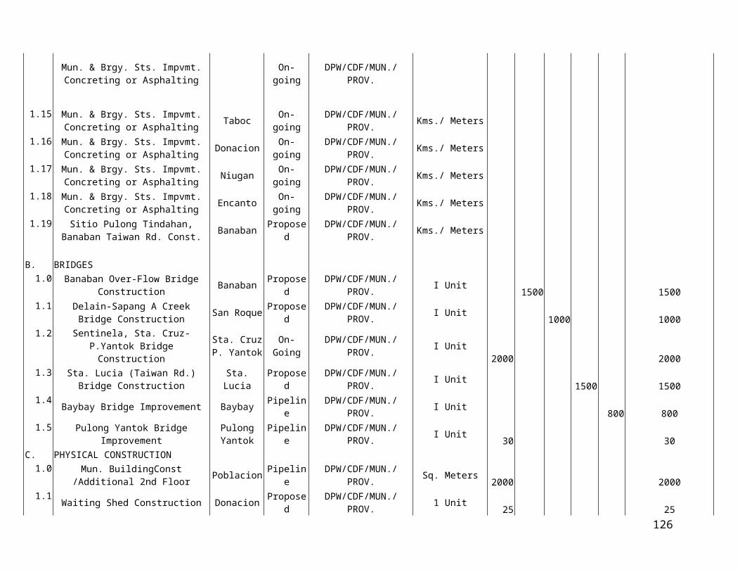
Section 30. Subdivision Projects. All owners and/or developers of subdivision projects shall in addition to securing a locational clearance under section 33 of this ordinance be required to secure a development permit pursuant to provisions of PD 957 and its implementing rules and regulations or BP 220 and its implementing rules and regulations in the case of socialized housing projects in accordance with procedures laid down in EO 71, series of 1993.
ARTICLE IXMITIGATING DEVICE
Section 31.Deviation. Exceptions, variances or deviations from the provisions of this ordinance may be allowed by the Local Zoning Board of Adjustment and Appeals, (LZBAA) only when the following terms and conditions are existing:
1. Variance
A. The property is unique and different from other properties in the adjacent locality and because of its uniqueness; the owner/s cannot obtain a reasonable return on the property.
This condition shall include at least 3 of the following provisions:
Conforming to the provisions of the Ordinance will cause undue hardship on the part of the owner or occupant of the property due to physical conditions of the property (topography, shape, etc.) which is not self- created.
The proposed variance is the minimum deviation necessary to permit reasonable use of the property.
The variance will not alter the physical character of the district or zone where the property for which the variance is sought is located, and will substantially or permanently injure the use of the other properties in the same district or zone.
That the variance will not weaken the general purpose of the Ordinance and will not adversely affect the public health, safety or welfare.
The variance will be in harmony with the spirit of this Ordinance.
2. Exceptions
31

a. The exception will not adversely affect public health, safety and welfare and is in keeping with the general pattern of development in the community.
b. The proposed project shall support economic based activities/provide livelihood, vital community services and facilities while at the same time posing no adverse effect on the zone/community.
c. The exception will not adversely affect the appropriate use of adjoining property in the same district.
d. The exception will not alter the essential character and general purpose of the district where the exception sought is located.
Section 32.Procedures for Granting Exceptions and Variances. The procedure for the granting of exception and/or variance is as follows:
1. A written application for an exception or variance shall be filed with the Local Zoning Board of Adjustment and Appeals (LZBAA) citing the section of this Ordinance under which the same is sought and stating the ground/s thereof.
2. Upon filing of application, a visible project sign, (indicating the name and nature of the proposed project) shall be posted at the project site.
3. The Local Zoning Board of Adjustment and Appeals shall conduct preliminary studies on the application.
4. A written affidavit of non-objection of the project by the owners of the properties adjacent to the project shall be filed by the applicant with the LZBAA at least fifteen (15) days prior to the decision for exception/variance
5. In case of objection, the LZBAA shall hold public hearing.
6. At the hearing, any party may appear in person, or be represented by agents. All interested parties shall be accorded the opportunity to be heard and present evidences and testimonies.
7. The LZBAA shall render a decision within thirty (30) days from the filing of the application, exclusive of the time spent for the preparation of written affidavit of non-objection and the public hearing in case of any objection to the granting of exemption/variance.
ARTICLE XADMINISTRATION AND ENFORCEMENT
32
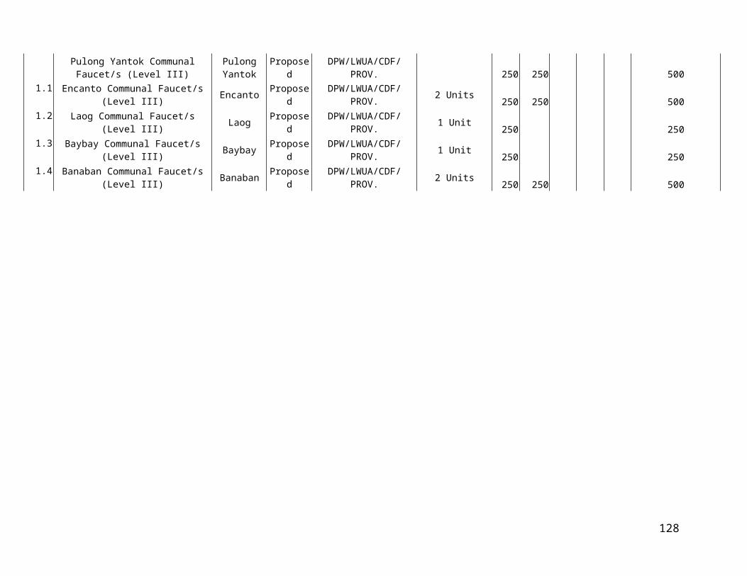
Section 33.Locational Clearance. All owners/developers shall secure Locational Clearance from the Zoning Administration/Zoning Officer or in case of Variances and Exemptions, from the Local Zoning Board of Adjustment and Appeals (LZBAA) prior to conducting any activity or construction on their property/land.
Section 34. Building Permit. No building permit shall be issued by the local building officer without a valid locational clearance,in accordance with this ordinance.
Section 35.Non-user of Locational Clearance. Upon issuance of a Locational Clearance, the grantee thereof shall have one year within which to commence or undertake the use, activity or development covered by such clearance on his property. Non-use of said clearance within the said period shall result in its automatic expiration, cancellation and the grantee shall not proceed with his project without applying for a new clearance.
Section 36. Certificate of Non-Conformance. A certificate of non-conformance shall be applied for by the owner of the structure or operator of the activity involve within six (6) months from the ratification of the Zoning Ordinance by the HLURB, SB, or Sangguniang Panlalawigan (SP). Failure on the part of the owner to register/apply for a Certificate of Non-Conformance shall be considered in violation of the Zoning Ordinance and is subject to fine/penalties.
Upon approval of this Ordinance, the Zoning Administrator/Zoning Officer shall immediately notify owners of known existing non-conforming use to apply for a certificate of non- conformance
Section 37. Existing Non-Conforming Uses and Buildings. The lawful uses of any building, structure or land at the time of adoption or amendment of this Ordinance may be continued, although such uses of not conform on the provision of this Ordinance, Provided:
1. That no such non-conforming use shall be enlarged or extended to occupy a greater area of land than that already occupied by such use at the time of the adoption of this Ordinance. Or, moved in whole or in part, to any other portion of the lot or parcel or land where such non-conforming use exist at the time of the adoption of this Ordinance.
2. That no such non-conforming use which has ceased operation for more than one (1) year be again revived as non-conforming use.
3. An idle/vacant structure, or structures under one ownership which has been damaged, maybe reconstructed and used as before provided that such reconstruction is not more than fifty percent (50%) of the replacement cost.
33

4. That should such non-conforming portion of the structure be destroyed by any means to an extent of more than fifty percent (50%) of its replacement cost at the time of destruction, it shall not be reconstructed except in conformity with the provisions of this ordinance.
5. That no such non-conforming uses maybe move to displace any conforming use.
6. That no such conforming structure may be enlarge or altered in a way which increases its non-conformity, but any structure or portion thereof may be altered to decrease its non-conformity.
7. That should such structure be moved for any reason to whatever distance, it shall thereafter conform to the regulation of the district in which it is moved or relocated.
In addition, the owner of a non-conforming use shall program the phase-out and relocation of the non- conforming use within ten (10) years from the effectivity of this ordinance.
Section 38.Responsibility for Administration and Enforcement. This ordinance shall be enforced and administered by the Local Chief Executive through the Zoning Administrator/ Zoning Officer who shall be appointed by the former in accordance with existing rules and regulations on the subject.
Section 39.Powers and Function of a Zoning Administrator. Pursuant to the provisions of EO No. 72 implementing RA 7160 in relation to Section 5 paragraph A and D and section 7 of EO No. 648 dated 07 February 198-. The Zoning Administrator shall perform the following functions, duties and responsibilities.
1. Enforcement
A. Act on all applications for locational clearances for all projects.
a.1 Issuance of Locational Clearance for projects conforming with zoning regulations
a.2 Recommend to the Local Zoning Board of Adjustment and Appeals (LZBAA) the grant or denial applications for variances and exemptions and the issuance of Certificate of Non-Conformance for non-conforming projects lawfully existing at the time of adoption of the zoning ordinance, including clearances for repairs/renovations on non-conforming uses consistent with the guidelines therefore.
B. Monitor on-going/existing projects within their respective jurisdiction and issue notices of violation and show cause order to
34

owner, developers or managers of projects that are violative of zoning ordinance and if necessary, pursuant to section 3 of EO HLURB.
C. Call and coordinate with the Philippine Nation Police enforcement of all orders and processes issued in 1 implementation of this ordinance.
D. Coordinate with the Municipal Attorney for other legal actions/remedies relative to the forgoing.
1. Planning
A. Coordinate with the Regional Office of the HLURB regarding proposed amendments to the zoning ordinances prior to adoption by the Sangguniang Bayan.
Section 40.Actions on Complaints and Oppositions. A complaint for violations of any provision of the Zoning Ordinance or of any clearance or permits issued pursuant thereto shall be filed with the LZBAA.
However, oppositions to application for clearance, variance or exception shall be treated as a complaint and dealt with in accordance with the provision of this section.
Section 41.Functions and Responsibilities of the Local Zoning Board of Adjustment and Appeals. There is hereby created a LZBAA which shall perform the following functions and responsibilities:
1. Act on Applications of the following Nature:
a. Variancesb. Exceptionsc. Non-Conforming usesd. Complaints and Opposition to applications
2. Act on Appeals on Grant or Denial of Locational Clearance by the Zoning Administrator/Zoning Officer.
a. Decisions of the Local Zoning Board of Adjustment and Appeals shall be appealable to the HLURB.
Section 42.Composition of the Local Zoning Board of Adjustment and Appeals. The Municipal Development Council shall create a Sub-Committee which shall act as the LZBAA composed of the following members.
1. Municipal Mayor as Chairman2. Municipal Legal Officer
35

3. Municipal Assessor4. Municipal Engineer5. Municipal Planning and Development Coordinator( if other than the Zoning
Administrator)6. Municipal Agriculturist7. Two representatives of the private sector nominated by their respective
organizations and confirmed by the Municipal mayor. In the event of non-availability of any of the officials enumerated above, the Sangguniang Bayan shall elect the number of its members as may be necessary to meet the total number above set forth, as representatives.
8. Two representatives from non-government organizations nominated by their respective organizations and confirmed by the Municipal mayor.
9. In the event of non-availability of any of the officials enumerated above, the Sangguniang Bayan shall elect the number of its members as may be necessary to meet the total number above set forth, as representatives.
For purposes of policy coordination, said committee shall be attached to the Municipal Development Council.
Section 43.Interim Provision. Until such time that the Local Zoning Board of Adjustment and Appeals shall have been constituted, the HLURB shall act as the LZBAA. As an appellate board, the HLURB shall adopt its own rules of procedure to govern the conduct of appeals arising from the administration and enforcement of this Ordinance.
Section 44.Review of the Zoning Ordinance. The Municipal Development Council shall create a sub-committee, the Local Zoning Review Committee (LZRC) that shall review the Zoning Ordinance considering the Comprehensive Land Use Plan, as the need arises, based on the following reason/situations:
1. Change in Local Development Plans2. Introduction of projects of national significance3. Petition for zoning4. Other reasons which are appropriate for consideration
Section 45.Composition of the Local Zoning Review Committee (LZRC). The Local Zoning Review committee shall be composed of sectoral experts.
There are the Local Officials/Civic Leaders responsible for the operation, development and progress of all sectoral undertakings in the locality, e.g.
1. Municipal Planning and Development Council2. Municipal Health Officer3. Municipal Agriculturist
36

4. President, Association of Barangay Captains.5. Municipal Engineer6. Community Environment and Natural Resources Officer (CENR0)7. Municipal Agrarian Reform Officer (MARO)8. District School Supervisor9. Three (3) Private Sector Representatives [Local Chamber of Commerce,
Housing Industry and Homeowner’s Association]10. Two (2) NGO representatives
For purposes of policy and program coordination, the LZRC shall be attached to the Municipal Development Council.
Section 46.Functions of the Local Zoning Review Committee. The Local Zoning Review Committee shall have the following powers and functions:
1. Review the Zoning Ordinance for the following Purposes:
a. Determine amendments or revisions necessary in the Zoning Ordinance because of changes that might have been introduced in Comprehensive Land Use Plan.
b. Determine changes to be introduced in the Comprehensive Land use Plan in the light of permit given, and exceptions and variances granted.
c. Identify provisions of the Ordinance difficult to enforce or are unworkable
2. Recommend to the Sangguniang Bayan necessary legislative amendments and the local planning development staff the needed changes in the plan as a result of the review conducted.
3. Provide information to the HLURB that would be useful in the exercise of its functions.
Section 47.Amendments to the Zoning Ordinance. Changes in the Zoning Ordinance as a result of the review by the Local Zoning Review Committee shall be treated as an amendment, provided that any amendment to the Zoning Ordinance or provisions thereof shall be subject to public hearing and review evaluation of the Local Zoning Review Committee and shall be carried out through a resolution of three fourths vote of the Sangguniang Bayan. Said amendments shall take effect only after approval and authentication by HLURB or Sangguniang Panlalawigan.
Section 48.Violation and Penalty. Any person who violates any of the provisions of this Ordinance, shall, upon conviction, be punished by a fine not exceeding Php 2,500.00 for municipalities or an imprisonment for a period not exceeding 6 months for municipalities
37
at the discretion of the court. In case of violation by a corporation, partnership or association the penalty shall be imposed upon the erring officers thereof.
Section 49. Collection of Fees. The planning office shall collect such reasonable fees as shall be necessary to pay for the services rendered by it for the issuance of permits, locational clearance, certification fee and other fees in accordance with the rules and regulations set forth by the Housing and Land Use Regulatory Board. The fees shall accrue to the municipal government.
Pursuant thereunto, there is hereby provided schedule of respective fees for
processing of applications for the issuance of permits and/or clearances required under the Zoning Ordinance.
Schedule of Fees:
a. Residential purpose
1. Family Residence …………………………. P 25.00 for every P 50,000 cost of the house and a fraction thereof.
2. Apartments, Dormitories BoardingHouses and the like…………………………..P 40.00 for every P 50,000.00 cost of
the project and a fraction thereof.
3. Townhouses, Condominiums and the like……………………………………P 50.00 for every P 50,000.00 cost of
the project and a fraction thereof. 4. Hotels, Motels, Lodging House, Apartelle and the like…………………………P 50.00 for every P 50,000.00 cost of
the project and a fraction thereof.
b. Institutional Uses
1. Public/Gov’t. school buildings, hospitals and land uses……………………………….. Exempted 2. Places of worship such as churches and the like………………………………….. 50% of fees computed at P 50.00 per
50,000.00 cost or a fraction thereof. 3. All private hospitals, schools,clinics and the like…………………. ………………. P 50.00 per P 50,000.00 project cost
38

or a fraction thereof.
c. Commercial, industrial, agro-commercial- industrial establishments whether for new construction or uses within an existing
building……………………………………….P 50.00 for every P 50,000.00 cost of the project and a fraction thereof
d. For land development and uses allowable under the Zoning Ordinance.
LAND AREA AMOUNT
1. One (1) hectare or less ………………… P 1,000.002. Over 1 hectare but less than 2 hectares……………………… 1,500.003. Over 2 hectares but less than 3 hectares……………………... 2,000.004. Over 3 hectares but less than 5 hectares……………………... 2,500.005. Over 5 hectares but less than 7.5 hectares……………………... 3,500.006. Over 7.5 hectares but less than 10 hectares……………………... 5,000.007. Over 10 hectares but less than 15 hectares……………………... 7,000.008. Over 15 hectares but less than 20 hectares……………………... 10,000.009. 20 hectares and over……………………………………………. 15,000.00
e. Special uses such as:
1. Subdivision - Twenty five centavos (P 0.25) per square meter
2. Cemetery-Memorial Parks - Twenty five centavos (P 0.25) per square meter
f. All other uses not specifically mentioned/categorized shall be subject to the decision of the office of the Zoning Administration with reference to the nearest classification provided under this article of the Zoning Ordinance.
g. Computation of project cost includes land acquisition cost.
Section 50.Suppletory Effect of Other Laws and Decrees. The provision of this Ordinance shall be without prejudice to the application of other laws, presidential decrees, letter of instructions and other executive or administrative order vesting national agencies with jurisdiction over specific areas, which shall remain in force and effect,
39

provided that land use decisions of the national agencies concerned shall be consistent with the Comprehensive Land Use of the locality.
Section 51.Separability Clause. Should any section or provision of this Ordinance be declared by the Courts to be unconstitutional or invalid, such decision shall not affect the validity of the Ordinance as a whole or any part thereof other than the part so declared to be unconstitutional or invalid.
Section 52.Repealing Clause. All ordinances, rules or regulations in conflict with the provisions of this Ordinance are hereby repealed; provided that the rights that are vested upon the effectivity of this Ordinance shall not be impaired.
Section 53.Effectivity Clause.This Ordinance shall take effect upon approval by the Housing and Land Use Regulatory Board/Sangguniang Panlalawigan.
40