co2 regional partnerships & a gis data clearinghouse dennis goreham, utah agrc bert granberg,...
TRANSCRIPT

CO2 Regional Partnerships& A GIS Data Clearinghouse
Dennis Goreham, Utah AGRC
Bert Granberg, Utah AGRC
September 30, 2003

AGRC Products & Services
• Enterprise GIS Coordination• State Geographic Information Database (SGID)• GIS Technology Transfer (Training)• GIS Solution Services
– GIS database development– GIS applications– Digital Cartography– Spatial Analysis
• Internet Mapping Services (including ArcIMS)

State AgenciesState AgenciesState AgenciesState Agencies
CitiesCitiesCitiesCities
Public & Orgs.Public & Orgs.Public & Orgs.Public & Orgs. TribesTribesTribesTribes
Federal AgenciesFederal AgenciesFederal AgenciesFederal Agencies
CountiesCountiesCountiesCounties
A foundation exists for a statewide approach to develop, maintain, and share geographic data
AGRC
Utah’s State Geographic Information Database (SGID)
GISAC

GIS data within the Utah’s State Geographic Information System (SGID)
• Aerial Photography• Climate Data• Cultural / Historical• Demographic• Elevation Contours and
Terrain Models• Environmental / Ecology• Geology / Soils• Land Ownership/Use• Cities & Service Districts • Place Names
• Political Boundaries• Satellite Imagery• Surveyor Reference• Scanned Maps• Transportation• Utilities• Vegetation• Water Bodies, Courses,
Springs• Wilderness Areas &
Proposals

How a GISdatabaseworks…
TraditionalDatabase
Mine-ID
16
15
Name Contact
ACME Mine Bill Smith
Atlas Drilling Gayle Dodd
… … …
Geometry
Point
Point
Point
Airport-ID
238
237
Name Runways
Salt Lake Intl. 3
Provo Airport 2
… … …
Geometry
Line
Line
Line
City-ID
18-270
18-216
Website Pop
www.murray.gov 34024
www.riverton.org 25011
… … …
Geometry
Polygon
Polygon
Polygon
GeographicRepresentation
VECTOR DATA:Items in a traditional database are linked toa geographic representationof their real world location

Other GIS Data: Raster-Based Examples
DigitalOrthophoto
Quads (DOQ)
SatelliteRemotely-
SensedImagery
DigitalElevation
Model (DEM)
- Elevation- Slope
- Aspect
ScannedImages

What is AT or NEAR Location X?
Aerial Imagery
Slope or Aspect
HazMat Sites
City Boundaries
Streams
Utilities
Property Boundaries
Population Density
Wetlands
Easements
Streets
Census Blocks GIS FacilitatesData Integration
- Location can be used as the central organizing principle for data in multiple databases
- Most government data relates to either a location, OR an individual / entity that has an address location
Location X
What is AT or NEAR Location X?


GIS Data Access: File-based Download Index

Connect Directly to the SGID Oracle DB
Allows: Multi-User Viewing, Live Editing, Authentication
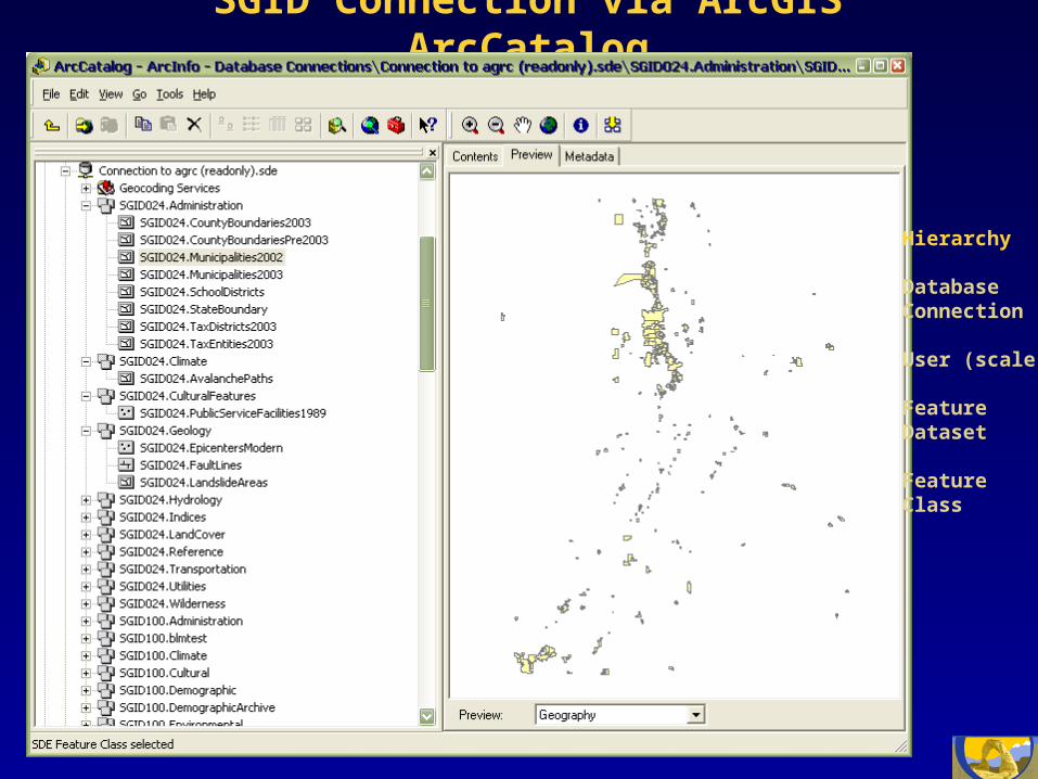
SGID Connection via ArcGIS ArcCatalog
Hierarchy
DatabaseConnection
User (scale)
FeatureDataset
FeatureClass

Internet-Based GIS Maps &Document Access

AGRC Role in Southwest Partnership
• Provide leadership for GIS data accessibility, IMS applications, and potential options for sequestration.
• Provide expertise to integrate data horizontally across states and vertically to be coincident with other data sets.
• Coordinate with the WG GIC and state partners to implement data standards and access and viewing protocols.

DOE Regional CarbonSequestration Partnerships
Solicitation Language: “Information gathering during the characterization phase shall be achieved in a relational database and geographic information system (GIS). The GIS is essential to analyzing the costs of transport, concentration of sources, capacity of sinks, and the creation of regional carbon accounting methods/protocols.”

MidCarb IMS: Interactive Map Interface
< click >
InteractiveMap Tools:
Zoom, PanQuery, FindBufferMeasureHyperlinkLegendMap Layer
Categories
Settings:Turn Layers
On/Off
SelectActiveLayer
DownloadData

MidCarbIMS:
QueryingGIS Data
Attributes

MidCarb IMS: Open Site-Related CO2 Documents
< click >
< selecthyperlink
tool >
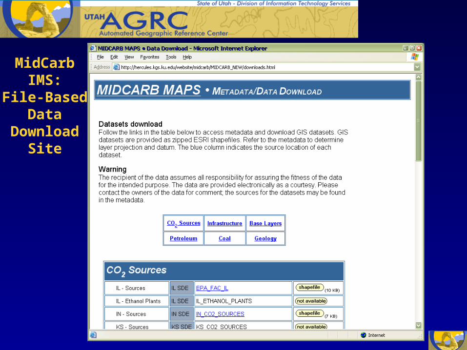
MidCarbIMS:
File-BasedData
DownloadSite

Western Governors Geographic Information Council
Mission: “To serve as a forum for western states and territories to share ideas and information and develop policy recommendations for Western Governors related to geospatial technologies, data, and information.”

Western Governors Geographic Information Council
• WG GIC Chair, Dennis Goreham, Utah• Alaska, Richard McMahon, Chief, DNR Lands
Records Information• Arizona, Gene Trobia, State Cartographer• California, Vacant• Nevada, Ron Hess, Bureau of Mines and Geology• Oregon, Cy Smith, State GIS Coordinator,
Department of Administrative Services• Washington, Dave Wisher, GIS Manager,
Department of Natural Resources

Western US: Carbon Sequestration Partnerships
West Coast Region:AK, AZ, CA, NV, OR, WA
Southwest RegionAZ, CO, KS, NM, OK, UT, WY
Northern Rockies & Great PlainsID, MT, SD
Plains PartnershipMN, MT, ND, SD, WY, 2 Provinces

Western Governors Geographic Information Council
CO2 Sequestration Involvement: “The Western Governors Geographic Information Council has agreed to assist successful partnerships with standards development and coordination to enable western region activities in this and subsequent phases.”

Western Governors Geographic Information Council
GIS Standards Coordination:
• Regional Partnerships
• WG GIC
• OMB Circular A-16
• FGDC
• Geospatial One Stop

Questions, Comments
• Utah Contacts:Dennis Goreham, 801-538-3163 –[email protected]
Bert Granberg, 801-538-3072–[email protected]
• AGRC website:–http://agrc.utah.gov