coal ash impoundments, roxboro power plant, draft report
TRANSCRIPT


DRAFT REPORT
CCW IMPOUNDMENTS INSPECTION REPORT
ROXBORO STEAM ELECTRIC PLANT
PERSON COUNTY, NORTH CAROLINA
PAUL C. RIZZO ASSOCIATES, INC. 101 WESTPARK BOULEVARD, SUITE B
COLUMBIA, SOUTH CAROLINA USA 29210
PROJECT NO. 09-4157 OCTOBER, 2009
PREPARED FOR: U.S. ENVIRONMENTAL PROTECTION AGENCY WASHINGTON, DC UNDER SUBCONTRACTO TO: LOCKHEED MARTIN EDISON, NJ


R1 094157/09/CHG/HGA i
TABLE OF CONTENTS
PAGE LIST OF TABLES ............................................................................................................ iv
LIST OF FIGURES .......................................................................................................... iv
LIST OF APPENDICES .................................................................................................... v
1.0 EXECUTIVE SUMMARY .................................................................................... 1
1.1 GENERAL ..................................................................................................... 1
1.2 SUMMARY OF FIELD INSPECTION FINDINGS ................................................. 2
1.3 SUMMARY OF O&M STATUS ....................................................................... 3
1.4 CONCLUSIONS.............................................................................................. 3
1.4.1 Project Description ....................................................................... 3
1.4.2 Field Inspection ............................................................................ 4
1.5 SUMMARY OF RECOMMENDATIONS ............................................................. 4
1.6 CERTIFICATION ............................................................................................ 5
1.6.1 List of All Field Inspection Participants....................................... 5
1.6.2 Signature of Independent Engineer .............................................. 6
1.6.3 PE Stamp ...................................................................................... 6
2.0 PROJECT DESCRIPTION..................................................................................... 7
2.1 EXISTING PROJECT FEATURES AND HAZARD POTENTIAL CLASSIFICATION .......................................................................................... 7
2.1.1 West Ash Pond Dam and Dikes 1, 2, and 4.................................. 7
2.1.2 FGD Settling and Flush Ponds .................................................... .9
2.1.2.a FGD Settling Pond ..................................................................... 10
2.1.2.b FGD Flush Pond ......................................................................... 10
2.2 SUMMARY OF STANDARD OPERATING PROCEDURES ................................. 12
2.2.1 Purpose of the Project................................................................. 12
2.2.2 Current Inspection Schedule....................................................... 12
2.3 MODIFICATIONS CONDUCTED FOR PROJECT SAFETY ................................. 13
2.4 Engineering Information........................................................................... 13
2.4.1 Geologic Conditions................................................................... 14

R1 094157/09/CHG/HGA ii
2.4.2 Seismicity ................................................................................... 15
2.4.3 Slope Stability Analyses............................................................. 15
2.4.3.1 West Ash Pond Dam and Dikes 1,2, and 4................ 15
2.4.3.2 New FGD Settling Pond and New FGD Flush Pond............................................................................................ 18
2.4.4 Hydrologic Studies ..................................................................... 22
2.4.4.1 West Ash Pond .......................................................... 22
2.4.4.2 FGD Settling Pond and FGD Flush Pond.................. 22
3.0 FIELD INSPECTION........................................................................................... 24
3.1 FIELD INSPECTION OBSERVATIONS ............................................................ 24
3.1.1 West Ash Pond Dam .................................................................. 24
3.1.2 Dike 1 (Filter Dam) .................................................................... 25
3.1.3 Dikes 2 and 4 .............................................................................. 26
3.1.4 FGD Settling Pond ..................................................................... 26
3.1.5 FGD Flush Pond ......................................................................... 27
3.1.6 West Ash Pond Dam Discharge Structure.................................. 27
3.2 STATUS OF RESPONSES TO RECOMMENDATIONS IN LAST ANNUAL INSPECTION................................................................................................ 27
3.2.1 West Ash Pond Dam .................................................................. 28
3.2.2 Dike No. 1 (Filter Dam) ............................................................. 29
3.2.3 Dikes No. 2 and 4 ....................................................................... 29
4.0 RECOMMENDATIONS...................................................................................... 30
4.1 RECOMMENDATION NO. 1.......................................................................... 30
4.2 RECOMMENDATION NO. 2.......................................................................... 30
4.3 RECOMMENDATION NO. 3.......................................................................... 30
4.4 RECOMMENDATION NO. 4.......................................................................... 30
4.5 RECOMMENDATION NO. 5.......................................................................... 31
4.6 RECOMMENDATION NO. 6.......................................................................... 31
5.0 CONCLUSIONS................................................................................................... 32

R1 094157/09/CHG/HGA iii
TABLES
FIGURES
APPENDICES
R1 094157/09/DWR/HGA iv
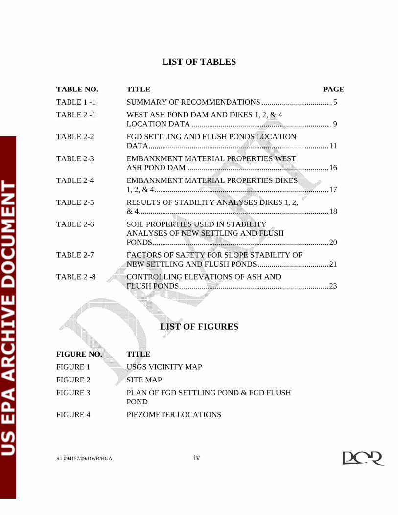
LIST OF TABLES TABLE NO. TITLE PAGE
TABLE 1 -1 SUMMARY OF RECOMMENDATIONS .................................... 5
TABLE 2 -1 WEST ASH POND DAM AND DIKES 1, 2, & 4 LOCATION DATA ........................................................................ 9
TABLE 2-2 FGD SETTLING AND FLUSH PONDS LOCATION DATA............................................................................................ 11
TABLE 2-3 EMBANKMENT MATERIAL PROPERTIES WEST ASH POND DAM ........................................................................ 16
TABLE 2-4 EMBANKMENT MATERIAL PROPERTIES DIKES 1, 2, & 4......................................................................................... 17
TABLE 2-5 RESULTS OF STABILITY ANALYSES DIKES 1, 2, & 4................................................................................................. 18
TABLE 2-6 SOIL PROPERTIES USED IN STABILITY ANALYSES OF NEW SETTLING AND FLUSH PONDS.......................................................................................... 20
TABLE 2-7 FACTORS OF SAFETY FOR SLOPE STABILITY OF NEW SETTLING AND FLUSH PONDS .................................... 21
TABLE 2 -8 CONTROLLING ELEVATIONS OF ASH AND FLUSH PONDS............................................................................ 23
LIST OF FIGURES FIGURE NO. TITLE
FIGURE 1 USGS VICINITY MAP
FIGURE 2 SITE MAP
FIGURE 3 PLAN OF FGD SETTLING POND & FGD FLUSH POND
FIGURE 4 PIEZOMETER LOCATIONS

R1 094157/09/CHG/HGA v
LIST OF APPENDICES APPENDIX TITLE
APPENDIX A PHOTO LOG
APPENDIX B FIGURES
APPENDIX C INSPECTION CHECKLISTS
R1 094157/DWR/HGA DRAFT REPORT R0
DAM SAFETY INSPECTION REPORT ROXBORO STEAM ELECTRIC PLANT PERSON COUNTY, NORTH CAROLINA
PROJECT N0. 09-4157
1.0 EXECUTIVE SUMMARY 1.1 GENERAL This Section is a summary of the Independent Engineer’s Review of Management Units for the Roxboro Steam Electric Plant (Roxboro). The Report was prepared by Paul C. Rizzo Associates Inc. (RIZZO) for the United States Environmental Protection Agency (USEPA) under subcontract to Lockheed Martin. This Section summarizes the finding, assessments, conclusions, and recommendations of the Independent Engineer. The Roxboro Plant is a coal fired power plant located on the South side of Hyco Lake, an impoundment of the Hyco River, near Semora, Person County, North Carolina. The facility is located approximately 9 miles northwest of Roxboro, North Carolina and is owned and operated by Progress Energy Carolinas, Inc. (PGN). Under normal operating conditions, byproducts of coal combustion including fly ash, bottom ash, boiler slag, flue gas emission control residuals, and other general wastewater products are sluiced into either the West Ash Pond storage basin south of the plant or into a wastewater treatment system. The waste water treatment system consists of a FGD Settling Pond and FGD Flush Pond constructed within the West Ash Pond for the treatment of the blow down steam from the FGD absorber units at the power plant. The three impoundments assessed in this Report are the West Ash Pond, the FGD Settling Pond, and the FGD Flush Pond. The ash pond dam, called the West Ash Pond Dam, was originally constructed as an earth fill embankment with a central earth core and chimney drain in 1973 - 1974. The original structure was raised 13 feet in 1986 to provide additional storage capacity. Along with raising the West Ash Pond Dam in 1986, a system of dikes, Dikes 1, 2, 3, and 4, were constructed to help increase the capacity and modify the circulation pattern of the ash pond. Dike 3 does not normally impound water; therefore it is not included in this Dam

2
R1 094157/DWR/HGA DRART REPORT R0
Safety Inspection Report. In 2007, two ponds were constructed inside of the West Ash Pond Dam, the Flue Gas Desulfurization (FGD) Settling Pond and the FGD Flush Pond. For the purpose of this assessment, the West Ash Pond Dam, FGD Settling Pond, and FGD Flush Pond have been classified as significant hazard potential structures by the USEPA. Significant hazard potential structures are classified as structures where failure is not likely to result in loss of life, but may cause significant economic loss, environmental damage, disruption of lifeline facilities, or can impact other concerns. The predominant risks of failure for the West Ash Pond Dam, FGD Settling Pond, and FGD Flush Pond are disruption of power generation and environmental damage. 1.2 SUMMARY OF FIELD INSPECTION FINDINGS The site inspection was conducted on September 1, 2009. The Inspection Team consisted of representatives from PGN, North Carolina Department of Environment and Natural Resources – Division of Land Resources (NCDENR-DLR), North Carolina Department of Environment and Natural Resources – Department of Waste Management (NCDENR-DWM), North Carolina Department of Environment and Natural Resources – Department of Water Quality (NCDENR-DWQ), and RIZZO. The Team stopped at each of the Project features to inspect the structures and the surrounding area. Particular attention was paid to site features that may contribute to typical failure modes of embankment structures such as settlement, seepage, and slope stability. A copy of the USEPA Inspection Checklists for each impoundment is included in Appendix C. The earthfill embankment on the North end of the Ash Pond (West Ash Pond Dam), the rockfill embankment (Filter Dam or Dike No. 1) on the South end of the Ash Pond, and Dikes 2 and 4 were found to be in good condition and well maintained at the time of inspection. The West Ash Pond Dam had tall, thick vegetative cover that prevented full observation of all slopes. Minor seepage was observed only at the designed discharge points from the internal drain. The Filter Dam slopes were clear of vegetation and are designed to filter seepage through the slopes. Decant pipes were clear of obstructions and free flowing. Dikes 2 and 4 had tall thick vegetation on the slopes below the road and above the riprap. Damp spots were noted in isolated areas along the toe of dike slopes. Flowing water was not noted in these areas.

3
R1 094157/DWR/HGA DRART REPORT R0
The Settling Pond was constructed in 2007 as part of a wastewater treatment system that also includes the Flush Pond and a Bioreactor. The Settling Pond experienced variable amounts of seepage at spots along the northern and western sides of the pond that resulted in localized shallow slope failures not long after it was put into service. The Settling Pond is currently operating at a reduced water level. A repair plan has been approved by the Owner. The sloughed areas on the outer slopes have been repaired and vegetated. Seepage was noted in the ditch along the toe of the embankment. This seepage is collected in sumps and pumped back into the Settling Pond. Repairs to this structure will be initiated following completion of repairs to the Flush Pond. A second settling pond will be constructed as part of the work. The Flush Pond is currently under construction. It was taken out of service in February 2008 when a piping failure occurred that resulted in the development of a slough in both the inside and outside slopes. 1.3 SUMMARY OF O&M STATUS The Project is attended full time by plant operators and dedicated safety personnel. The current inspection schedule for the structures consists of daily observations summarized weekly and a monthly inspection and monitoring of piezometers by trained PGN personnel; and an annual and a 5-year inspection by a third party Consultant. At the time of inspection, the structures and the Plant appeared to be generally well maintained and in good working order. The only exception to the well maintained condition is the presence of heavy vegetation on some slopes. This work is scheduled for the near future according to plant personnel. 1.4 CONCLUSIONS 1.4.1 Project Description The Roxboro Steam Electric Plant is a four unit coal fired power plant that began operations in 1966 with additions in 1973 and 1980. Coal Combustion Waste (CCW)

4
R1 094157/DWR/HGA DRART REPORT R0
byproducts are sluiced to on site storage or treatment ponds which appear to be well maintained and operated. The last major revisions to the CCW storage structures include a raise of the West Ash Pond Dam and construction of the Filter Dam (Dike 1) and Dikes 2,3, and 4 in 1986 to provide more storage and the construction of the gypsum Settling Pond, a bioreactor, and the Flush Pond in 2007 for wastewater treatment. Construction is currently underway to remediate the Flush Pond with repairs to the Settling Pond to follow. The structures are currently regulated by the North Carolina Utilities Commission. On January 1, 2010, regulation of the impoundments will pass to the North Carolina Department of Environment and Natural Resources, Division of Land Resources, Dam Safety Program. 1.4.2 Field Inspection The field inspection was performed in accordance with EPA guidelines considering typical embankment failure modes. The embankments for the Ash Pond dam and dikes are in good condition but have vegetative maintenance issues to be addressed. The Settling Pond is currently operating at a reduced level awaiting repairs due to a seepage problem. With the exception of the seepage area, the embankments for this structure are in good condition. Reconstruction of the Flush Pond were underway at the time of the field inspection. Recommendations were developed based on field observations and technical review of Project documentation provided by PGN. 1.5 SUMMARY OF RECOMMENDATIONS There were a total of six recommendations resulting from the document review and field inspection. The recommendations are summarized below in Table 1-1 and discussed in detail in Section 4.0.

5
R1 094157/DWR/HGA DRART REPORT R0
TABLE 1-1: SUMMARY OF RECOMMENDATIONS
NO. RECOMMENDATION TIMEFRAME 1 Inspect the Slopes of the West
Ash Pond Dam at the Interface of the Earth Slope and Top of Riprap for Surface Erosions and Scarps.
Following Maintenance Mowing of Vegetation
2 Check Drain Outlets of the West Ash Storage Pond During Monthly Inspections to Determine if Soil Material is Being Transported
During Monthly Inspections
3 Develop Method to Quantify Amount of Seepage from West Ash Pond Drains
Prior to Next Annual Inspection
4 Continue to Monitor Seepage at Toe of Settling Pond
According to Existing Plan.
5 Follow-Up on Developing and Implementing Repair Plan for Seepage at Discharge Weir
Prior to Next Inspection
6 Review the 1987 Ash Pond Hydrology Study to Determine if Results are Still Valid
Prior to Next 5-year Inspection
1.6 CERTIFICATION 1.6.1 List of All Field Inspection Participants The field inspection was conducted on September 1, 2009. The individuals participating in the inspection were: H. Grady Adkins, PE RIZZO – Independent Engineer David W. Ray, EIT RIZZO Harry Sideris PGN Robert Howard PGN Billy Milam PGN Jodirah Green PGN Tom Copolo PGN Bill Forester PGN

6
R1 094157/DWR/HGA DRART REPORT R0
John Edelen PGN E. Shannon Langley PGN John Holley NCDENR-DLR Gabi Jones NCDENR-DLR Elizabeth Werner NCDENR-DWM Geof Little NCDENR-DWM Autumn Hoban Romanski NCDENR-DMQ 1.6.2 Signature of Independent Engineer I acknowledge that the management units referenced herein were personally inspected by me on September 1, 2009, and were found to be in the following condition: West Ash Pond: SATISFACTORY No existing or potential management unit safety deficiencies are recognized. Acceptable performance is expected under all applicable loading conditions (static, hydrologic, seismic) in accordance with the applicable criteria. Minor maintenance items may be required. FGD Settling Pond and FGD Flush Pond: FAIR Acceptable performance is expected under all applicable loading conditions (static, hydrologic, seismic) in accordance with the applicable criteria. Deficiencies may exist that require remedial action and/or secondary studies or investigations. When the remedial work currently underway on these two units is completed as planned, the condition rating should be SATISFACTORY. Signature: __________________________ H. Grady Adkins, Jr. PE,
NC Registration No. 035584 Independent Engineer Paul C. Rizzo Associates, Inc. 1.6.3 PE Stamp

7
R1 094157/DWR/HGA DRART REPORT R0
2.0 PROJECT DESCRIPTION 2.1 EXISTING PROJECT FEATURES AND HAZARD POTENTIAL CLASSIFICATION 2.1.1 West Ash Pond Dam and Dikes 1, 2, and 4 The West Ash Pond Dam and Dikes 1, 2, and 4 are identified as Significant Hazard Structures with the ID “NC 0003425” in the National Inventory of Dams. The West Ash Pond Dam was constructed in 1973 across the mouth of Sargents Creek, a tributary of the Hyco River, which was then a part of the Hyco Lake Reservoir,. Hyco Lake is operated by PGN to provide water to the Roxboro Plant. The Dam is an earth fill embankment with a central earth core. The Dam was constructed between two cofferdams over a prepared foundation stripped to sound rock with a central core keyway excavated 10 feet into rock. The original structural height of the dam was 70 feet with a crest elevation 457 feet (MSL). The original pool elevation was 445 feet (MSL). In 1986, the Dam was raised 13 feet to elevation 470 feet (MSL) to provide greater storage capacity. The normal water level was raised to elevation 463 feet (MSL) and the maximum water level to elevation 465 feet (MSL). The present West Ash Pond Dam has a random earth fill shell with an impervious core and a vertical chimney drain with a horizontal filter blanket connected to the original drain system. The upstream slope is 2.5(H) to 1(V) and is blanketed with riprap. The downstream slope is 2(H) to 1(V) and is blanketed with riprap on the lower portion of the slope. The circulation pattern of the ash pond was modified in 1986 by constructing a rock filter dike (Dike No. 1) at the southern end of the existing pond to create a secondary settling basin and also to isolate the major portion of the ash pond from the remaining watershed. A channel/dike system, which runs along the west side of the existing pond, ultimately connects with the original spillway constructed in 1973 and discharges into Hyco Lake. Dike No. 1 is constructed of rock excavated from channel No. 2 (Figure 4). The crest elevation is 473 feet (MSL). The design slopes are 1.3(H) to 1(V) on both upstream and downstream slopes. The dam has a 20- foot wide berm on the downstream slope below

8
R1 094157/DWR/HGA DRART REPORT R0
elevation 448 feet (MSL). The normal design for the ash pond water elevation is 463 feet (MSL) and maximum design water elevation is 465 feet (MSL) providing 8 feet of freeboard. A sand blanket is located on the northern side of the dike to prevent pond ash from discharging to the south side of the pond and into the channel/dike system. Dike Nos. 2, 3, and 4 are random earth dikes constructed by end-dumping fill material excavated from channel Nos. 1 and 2. Both upstream and downstream slopes are 2(H) to 1(V) and are protected by riprap underlain by filter fabric. A 20-foot wide berm was added on the downstream side of Dike No. 4 during construction. The crest elevation of the dikes is 470 feet (MSL) and normal design for the water elevation is 463 feet (MSL). The normal design for maximum water level is 465 feet (MSL) providing 5 feet of freeboard. Dike No. 3 is low height dike across a topographic saddle that is mainly above the normal pond level. As it does not normally impound water, it is not included in the dam inspection. According to information provided by PGN, the West Ash Pond Dam and Dikes 1, 2, and 4 enclose an approximate area of 2400 acres. Based on height and storage capacity, the West Ash Pond Dam and Dikes 1, 2, and 4 are classified as “intermediate” in size under the Corps of Engineers Guidelines. Under North Carolina Regulations, the West Ash Pond and Dike 1 (Filter Dam) are classified as “large” and the remaining dikes are classified as “medium”. Based on field reconnaissance and a review of USGS maps and aerial photographs, West Ash Pond Dam and Dikes 1, 2, and 4 have been classified by the Independent Engineer as a significant hazard potential structure due to the possibility of disruption of power generation or environmental damage that would be caused by misoperation or failure of the structure. Table 2-1 below summarizes the location information for the West Ash Pond Dam and Dikes 1, 2, and 4.

9
R1 094157/DWR/HGA DRART REPORT R0
TABLE 2-1: WEST ASH POND DAM & DIKES 1, 2, & 4 LOCATION DATA
DEGREES MINUTES SECONDS
Longitude 36 31 16 Latitude 78 59 55
State: North Carolina County: Person 2.1.2 FGD Settling Pond and FGD Flush Pond The Settling and Flush Ponds were constructed in 2007 as part of a wastewater treatment plant. Both ponds are diked on all sides. The wastewater treatment plant consists of a gypsum settling pond, a bioreactor, and a bioreactor flush pond constructed for the treatment of the blowdown steam from the FGD absorber units at the power plant. In February 2008, variable size seeps were observed along the outer northern and western embankments of the Settling Pond. PGN notified the state regulatory agency of the situation and lowered the water level within the pond by controlled discharge into the Ash Pond. Also in February 2008, a sinkhole developed in the embankment of the adjacent Flush Pond resulting in an uncontrolled discharge of water into the Ash Pond. PGN notified the state regulatory agency of the incident and took the Flush Pond out of service. PGN retained the firm of Worley Parsons to design the repairs to the wastewater ponds. The repair scheme includes:
• Construction of a permanent east settling pond to hold water removed from the West Settling Pond and from plant discharge while the west pond is being repaired;
• Reconstruction of the embankment of the Flush Pond to include both a clay and synthetic liner; and
• Reconstruction of the embankment of the Settling Pond to include both a clay and synthetic liner.

10
R1 094157/DWR/HGA DRART REPORT R0
The Flush Pond is currently under construction and the Settling Pond is scheduled for construction following completion of the Flush Pond. The Settling and Flush Ponds were constructed within the perimeter of the ash pond. The embankment subgrades of both ponds consist of variable bottom ash, fly ash, and rock fill materials. 2.1.2.a FGD Settling Pond The Settling Pond is a diked structure that is located within the West Ash Pond Dam and constructed of variable bottom ash, fly ash, and rock fill materials with an earth fill cap. The embankment is 38 feet high with a crest elevation 506 feet (MSL). The inside slope of the pond is constructed at 3H:1V and the outside slope is constructed at 2.75H:1V. The maximum operating level for the pond is elevation 497.7 feet (MSL). At the time of the inspection, the pond has been operating at a lower level awaiting repairs. Once the repairs are complete the new maximum operating level of the pond will at elevation 498.2 feet (MSL). The decant structure for the pond is a floating skimmer that operates at the pool elevation. The spillway for the pond is located at elevation 502.5 feet. The spillway is a trapezoidal channel spillway that has a top width of 186 feet, a bottom width of 16.5 feet, and has a depth of 3.5 feet. Once the repairs on the pond are completed the spillway will be raised to a new elevation of 503 feet. The Settling Pond has an approximate area of 16.6 acres. The repairs for the Settling Pond are scheduled to begin as soon as the construction on the Flush Pond is completed. The Settling Pond is to be relined with a 12-inch to 18-inch thick layer of riprap choked with bottom ash. The choked bottom ash will then be covered with a 12-inch layer of compacted clay on the bottom and an 18-inch layer up the interior slopes of the pond. Then an additional 60-mil, conductive, white LLDPE liner will be placed over the compacted clay and anchored to the top of the embankments. 2.1.2.b FGD Flush Pond The Flush Pond was under construction at the time the inspection was conducted. All of the information presented and discussed herein is for the new Flush Pond. The Flush Pond is a diked structure that is located within the West Ash Pond Dam and constructed of variable bottom ash, fly ash, and rock fill materials with an earth fill cap. The

11
R1 094157/DWR/HGA DRART REPORT R0
embankment will be 38 feet high with a crest elevation 506 feet. The inside slope of the pond is constructed at 3H:1V and the outside slope is constructed at 2.75H:1V. The maximum operating level for the pond is elevation 502.4 feet. The spillway for the new pond will be located at elevation 503.5 feet. The spillway will be a trapezoidal channel spillway that has a top width of 83 feet, a bottom width of 35 feet, and a depth of 3 feet. The Flush Pond has an approximate area of 3.1 acres. Based on height and storage capacity, the FGD Settling Pond Dam and the FGD Flush Pond Dam are classified as “small” in size under the Corps of Engineers Guidelines. Under North Carolina Regulations, they are classified as “medium” in size. Based on field reconnaissance and a review of USGS maps and aerial photographs, the FGD Settling and Flush Ponds have been classified by the Independent Engineer as significant hazard potential structures due to the fact that the bottom of the two ponds are at approximately the same elevation as the top of dam and dikes for the West Ash Pond within which they are located. Failure of the two structures could release directly into the channels to the Cooling Reservoir. A release could disrupt power generation and cause environmental damage. Table 2-2 below summarizes the location information for the FGD Settling and Flush Ponds.
TABLE 2-2: FGD SETTLING AND FLUSH PONDS LOCATION DATA
DEGREES MINUTES SECONDS Longitude 36 31 16 Latitude 33 59 55
State: North Carolina County: Person

12
R1 094157/DWR/HGA DRART REPORT R0
2.2 SUMMARY OF STANDARD OPERATING PROCEDURES 2.2.1 Purpose of the Project The Roxboro Plant is a coal fired power plant. The West Ash Pond Dam and Dikes 1, 2, and 4 were constructed to provide storage for waste coal combustion products and to provide necessary decantation capacity for the discharge water from the plant to comply with NPDES permit requirements. The FGD Settling Pond was constructed to store and thicken the FGD gypsum sludge. The FGD Flush Pond was constructed as part of the bioreactor system to remove and store metals from the settling pond discharge. To date there has been only one failure recorded at the Roxboro Plant. In February 2008, a failure occurred at the Flush Pond in the form of a limited slope failure on both the inner and outer slopes. The Flush Pond was dewatered and the operating level of the Settling Pond was lowered after variable size seeps were observed on the northern and western outer slopes. Repairs to both ponds have been designed and approved. Construction is currently underway at the Flush Pond with repairs to the Settling Pond scheduled to begin after the completion of the work on the Flush Pond. 2.2.2 Current Inspection Schedule The current inspection schedule for the structures at Roxboro is as follows:
Visual Inspection by Site Staff: Daily observations are made by trained PGN personnel following an inspection checklist. The checklist contains the daily observations for a one week period;
Monthly Monitoring and Inspection by Site Staff: An inspection checklist is used by trained PGN personnel to record the West Ash Pond piezometer readings and assessments of conditions of the main dam and each dike;
Annual Limited Field inspection by Independent Consultant; and

13
R1 094157/DWR/HGA DRART REPORT R0
Five-Year Independent Consultant Inspection: This is a more in-depth inspection required by the North Carolina Utilities Commission.
2.3 MODIFICATIONS CONDUCTED FOR PROJECT SAFETY To date construction is currently being conducted due to a limited slope failure of the inner and outer slopes of the FGD Flush Pond. The FGD Settling Pond experienced sizeable seeps on the northern and western outer slopes and is scheduled to start construction immediately following the completion of the new FGD Flush Pond. 2.4 ENGINEERING INFORMATION The following documents provided by PGN were reviewed in the preparation of this Report: • Independent Consultant Inspection Report – Main Cooling Lake dam, West Ash
Pond Dam, and Afterbay Dam, Roxboro Steam Electric Plant, Person County, North Carolina -Historical Volume by Law Engineering and Environmental Services, Inc., December 18, 1998;
• Five Year Independent Consultant Inspection Report Volume I by Law
Engineering, Raleigh, NC, September 1998; • Report of Limited Field Inspection, Main Dam, West Ash Pond Dam and Dikes,
and Afterbay Dam, Roxboro Plant, Person County, North Carolina, by MACTEC Engineering and Construction May 2007;
• Independent Consultant Inspection Report, Main Cooling Lake Dam, West Ash
Pond and Afterbay Dam, Roxboro Electric Plant, Person County, North Carolina by MACTEC Engineering and Construction, December 29, 2008;
• Calculations for Design of Repairs to the Existing Flush and West Settling Ponds and Construction of a New East Settling Pond by Worley Parsons;
• Progress Energy Weekly Waste Water Settling Pond Inspection Forms covering

14
R1 094157/DWR/HGA DRART REPORT R0
period 22 June 2009 through 16 August 2009; and • Progress Energy Monthly Piezometer Monitoring Forms for West Ash Pond and
Hyco Lake Main Dam and Monthly West Ash Pond Monitoring Inspection Worksheet. Completed forms cover the period January through August 2009.
2.4.1 Geologic Conditions (Source: “Historical Volume 1998”) The Roxboro Plant is within the Piedmont Physiographic Province, a northeast trending maturely dissected plateau between the Blue Ridge and Coastal Plain Provinces. The region is underlain primarily by metamorphic and igneous rocks, most of which have been complexly folded and faulted. The Piedmont in the southeast has been divided into several northeast trending lithographic structural belts. The site is near the eastern edge of the Charlotte Belt, near the boundary with the Carolina Slate Belt. The Charlotte Belt is characterized by a high degree of anatexis and metamorphism to higher levels of the amphibolite facies and the rocks are mostly coarse grained gneisses, schists, and amphibolites. The bedrock at the site was grouped into three main classes:
(a) Hornblende Gneiss – A metamorphic rock consisting of quartz, orthoclase feldspar, mica, and hornblende;
(b) Chlorite Schist – A crystalline rock having foliated structure in which chlorite is a predominant mineral. Other minerals are mainly silicate with little or no feldspar; (c) Diabase – An ancient basalt which has undergone metamorphic alteration. The rock is composed mainly of minute crystals of plagioclase and pyroxene with some other ferrous minerals.
The overburden in the area generally consists of a layer of loose silty fine sand resulting from the weathering of the parent gneiss and chlorite schist formations. In some cases, a thin cap of reddish brown sandy clay overlies the silty fine sand. Thickness of overburden varies from one to as much as 15 feet.
15
R1 094157/DWR/HGA DRART REPORT R0
2.4.2 Seismicity The site is located in a relatively inactive seismic area of the Southeastern United States that has experienced only occasional earthquakes of moderate intensities in historic times. Notable exceptions are the earthquakes near Charleston, South Carolina, New Madrid, Missouri, and Giles County, Virginia. Under the Guidelines of the U.S. Army Corps of Engineers Recommended Guidelines for Safety Inspection of Dams (ER 1110-2-106, 26 Sep 1979), the site is located in Seismic Zone 2. A seismic coefficient of 0.05g is recommended for pseudo static seismic analyses. The U.S. Geological Survey Open File Report 2008-1128 “Update of the US National Seismic Hazard Maps” Figure 30 shows a Peak Ground Acceleration of 0.07g for 2 per cent probability of exceedance in 50 years. This equates to a return period of about 2500 years. The USACE guidelines do not require seismic stability assessment of dams in Seismic Zones 0, 1, and 2 provided static stability analyses are satisfactory and conventional safety margins exist. 2.4.3 Slope Stability Analyses 2.4.3.1 West Ash Pond Dam and Dikes 1, 2, and 4 Summaries of the results of slope stability analyses for the West Ash Pond and Dikes 1, 2, and 4 are summarized in the reference material. Copies of the actual calculations and laboratory tests were not provided at the time of inspection. Since Dike 2 does not impound water, no stability analyses have been performed. The strength properties used in the analyses are reported to be based on laboratory tests on remolded, saturated samples or on reasonable assumed values. The soil properties used in the analysis of the West Ash Pond Dam are shown in Table 2-3.

16
R1 094157/DWR/HGA DRART REPORT R0
TABLE 2-3 EMBANKMENT MATERIAL PROPERTIES WEST ASH POND DAM
UNIT WEIGHT MATERIAL C, ksf φ DEGREESMOIST, pcf SATURATED, pcf
ORIGINAL MAIN DAM Soil “A” 0 35 125 135 Soil “B” 0 32 120 130 NEW PORTIONS OF MAIN DAM Random Fill 0.120 28 125 135 Core 0.050 25 120 130 Sand Drains, Shot Rock Fill 0 35 125 135 The analysis of the downstream slope used the following conditions:
• Crest Elevation 470 feet (MSL); • Pool Elevation 463 feet (MSL); • Tailwater Elevation 410 feet (MSL); and • Phreatic Surface Elevation 414 feet (MSL) to 410 feet (MSL)
The calculated factors of safety were 1.58 for a deep circular failure that did not intercept the core and 1.46 for a shallow circular failure. The soil properties used in the analysis of Dikes 1, 2, and 4 are shown in Table 2-4.

17
R1 094157/DWR/HGA DRART REPORT R0
TABLE 2-4 EMBANKMENT MATERIAL PROPERTIES DIKES 1, 2, & 4
LOCATION DIKE NO. 1 DIKE NO. 2 DIKE NO. 4 UNIT WT,
(pcf) STRENGTH Unit Wt,
(pcf) STRENGTH
PARAMETERS UNIT WT,
(pcf) STRENGTH
Soil Type Moist Sat. C, ksf
φ, Deg
Moist Sat. C, ksf φ, Deg
Moist Sat. C, ksf
φ, Deg
1 125 130 0.150 28 125 130 0.150 28 125 130 0.150 28 2 110 115 0.050 20 110 115 0.050 20 110 115 0.050 20 3 105 110 0.025 15 105 110 0.025 15 -- -- -- -- 4 125 130 0.500 20 125 130 0.500 20 125 130 0.500 20 5 130 140 0 45 -- -- -- -- 130 140 0 45 6 * * 0 37 -- -- -- -- -- -- -- --
SOIL TYPE DESCRIPTION
1 Random fill above water 2 Random fill below water 3 Uncompacted end-dumped material 4 Ash 5 Rockfill berm 6 End-dumped random fill mixture of soil and ripped rock * Unit weight used in analysis not available from reference
The reported factors of safety for stability of the exterior slopes of Dikes 1, 2, and 4 are shown in Table 2-5. Dike 2 was analyzed for two different pool elevations.
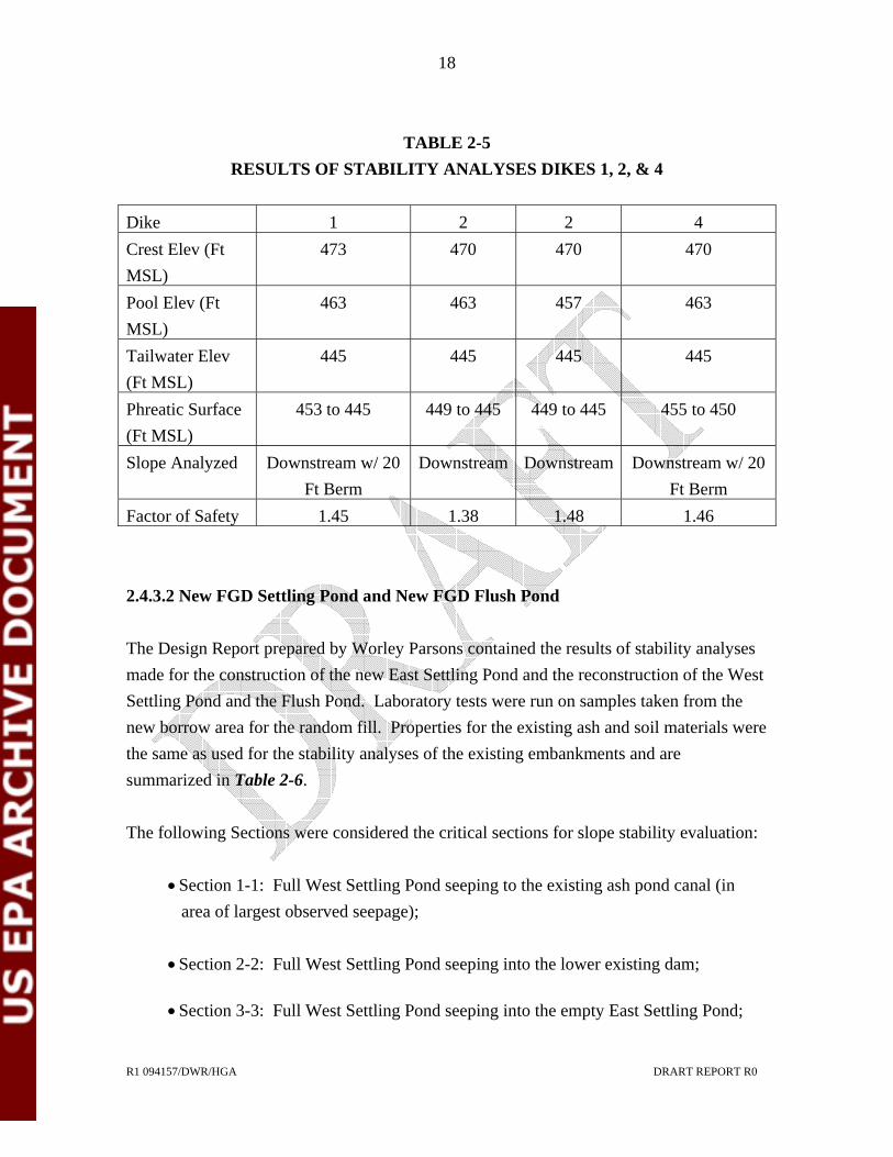
18
R1 094157/DWR/HGA DRART REPORT R0
TABLE 2-5 RESULTS OF STABILITY ANALYSES DIKES 1, 2, & 4
Dike 1 2 2 4 Crest Elev (Ft MSL)
473 470 470 470
Pool Elev (Ft MSL)
463 463 457 463
Tailwater Elev (Ft MSL)
445 445 445 445
Phreatic Surface (Ft MSL)
453 to 445 449 to 445 449 to 445 455 to 450
Slope Analyzed Downstream w/ 20 Ft Berm
Downstream Downstream Downstream w/ 20 Ft Berm
Factor of Safety 1.45 1.38 1.48 1.46 2.4.3.2 New FGD Settling Pond and New FGD Flush Pond The Design Report prepared by Worley Parsons contained the results of stability analyses made for the construction of the new East Settling Pond and the reconstruction of the West Settling Pond and the Flush Pond. Laboratory tests were run on samples taken from the new borrow area for the random fill. Properties for the existing ash and soil materials were the same as used for the stability analyses of the existing embankments and are summarized in Table 2-6. The following Sections were considered the critical sections for slope stability evaluation:
• Section 1-1: Full West Settling Pond seeping to the existing ash pond canal (in area of largest observed seepage);
• Section 2-2: Full West Settling Pond seeping into the lower existing dam;
• Section 3-3: Full West Settling Pond seeping into the empty East Settling Pond;

19
R1 094157/DWR/HGA DRART REPORT R0
• Section 4-4: Full East Settling Pond seeping into adjacent ash pond;
• Section 5-5: Full Flush Pond seeping into adjacent ash pond;
• Section 6-6: Full East Pond seeping into empty Flush Pond; and
• Section 7-7: Full Flush Pond seeping into empty East Settling Pond
Sections 1-1 and 1-2 were analyzed in the initial design and were not reevaluated during the design of the repairs. Section 1-1 was reported to exhibit a factor of safety of 1.70 in its existing condition and Section 2-2 was reported to have a safety factor of 1.63. Both factors of safety are expected to increase when the new clay liner is installed.

20
R1 094157/DWR/HGA DRART REPORT R0
TABLE 2-6 SOIL PROPERTIES USED IN STABILITY ANALYSES OF NEW SETTLING
AND FLUSH PONDS
STRENGTH
PARAMETERS
STRATUM
TOTAL
UNIT
WEIGHT
(PCF)
SATURATED
UNIT
WEIGHT
(PCF) COHESION
(PSF) FRICTION
ANGLE
(DEG) Random Fill (New Embankment) 115 120 500 28 Soil Cover (Exterior Slopes) 110 115 100 28 ABC Stone Cover 130 130 0 32 Clay Liner 115 122.4 3000 0 Choked Riprap 130 130 0 32 Consolidated Pond Ash (Top 5 ft.) 95 100 220 25 Ash Pond 92.4 92.4 220 23 Partially Weathered Rock 130.4 130.4 18,000 0 Existing Embankment 85 97 0 30 Lower Embankment (lower 3 – 4 ft) 85 96 0 28 Compact Bottom of Pond 90 92.4 0 30 Existing Gypsum Sludge 65 65 0 0 Concrete Revetment 150 150 0 36

21
R1 094157/DWR/HGA DRART REPORT R0
Table 2-7 summarizes the results of the stability analyses performed for Sections 3-3 through 7-7
TABLE 2-7 FACTORS OF SAFETY FOR SLOPE STABILITY OF NEW SETTLING AND
FLUSH PONDS WATER @ OPERATING LEVELS WATER @ SPILLWAY ELEVATION
SECTION &
CONDITION LONG-TERM
STATIC
CONDITION
TRANSIENT
CONDITION
(EQ) (1)
TEMPORARY
CONDITION TRANSIENT
CONDITION
(EQ) (1) (2) Section 3-3 1.75 1.44 1.42 1.15 Section 4-4 2.11 1.79 1.57 1.23 Section 5-5 1.49 1.18 1.48 1.17 Section 6-6 2.13 1.83 1.43 1.18 Section 7-7 1.43 1.17 1.38 1.13 NOTES: (1) Earthquake (EQ) condition assumes a maximum horizontal ground acceleration of 0.1 g. (2) The earthquake loading combined with the maximum water elevation and a surcharge load of 500 psf for truck traffic include extreme events that likely will not occur at the same time. Safety factors were computed by the Modified Bishop Method using the computer program STABL6 by Purdue University. The recommended minimum factors of safety contained in the USACE ER 1110-2-106 Recommended Guidelines for Safety Inspection of Dams are:
• Steady Seepage: FS = 1.5; and
• Steady Seepage with Earthquake: FS = 1.0

22
R1 094157/DWR/HGA DRART REPORT R0
The computed safety factors for several loading conditions are less than 1.5. The conditions analyzed assume a breach in the LLDPE liner overlaying the clay liner from either the operating level or the spillway level. The target safety factors selected by the designers for the temporary condition were 1.25 and 1.5 for the long term condition. We concur that with the conservative selection of parameters used; the computed safety factors are adequate. 2.4.4 Hydrologic Studies 2.4.4.1 West Ash Pond When the West Ash Pond Dam was constructed, the drainage area was 3.67 square miles. Construction of the dike and channel system in 1986 redirects the runoff from 3.49 square miles of watershed around the main body of the ash pond. The drainage area for the ash pond as presently configured is reported as 1.4 square miles, including 0.5 square miles within the pond and 0.9 square miles of drainage from the East Ash Pond Landfill. A design flood study for the modified dam and dike system was performed in 1987 by Carolina Power and Light. The design rainfall event was the 0.5 PMP 6-hour duration storm. Rainfall data was taken from Hydrometerological Report No. 51, “Probable Maximum Precipitation Estimates, United States East of the 105th Meridian” by the U.S. National Oceanic and Atmospheric Administration. Reports reviewed state that the study showed that the design rainfall event would result in 5 feet of freeboard. The calculations were not available for review for this Report. We recommend that PGN review this study in light of the changes that have occurred within the ash pond since 1987 to confirm that the West Ash Pond remains capable of safely passing the design storm. 2.4.4.2 FGD Settling Ponds and FGD Flush Pond These ponds have no external drainage area; therefore the only uncontrolled liquid into the pond is direct rainfall. Worley Parsons, the pond designers has taken a very conservative approach to sizing the spillway systems for these embankments. Between the maximum

23
R1 094157/DWR/HGA DRART REPORT R0
operating level and the crest of the spillway, the ponds are sized to contain a surge flow in the Settling Ponds and a “live storage” in the Flush Pond plus the 100-year rainfall. The spillways are sized to pass the peak discharge, computed using the Rational Formula, from the 100-year storm with 0.5 feet maximum depth of flow over the spillway crest. The spillways have 2 to 3 feet of freeboard from the design depth of flow to the top of dam. The design elevations for the new or reconstructed ponds are shown in Table 2-8.
TABLE 2-8. CONTROLLING ELEVATIONS OF ASH AND FLUSH PONDS
WEST ASH
POND FLUSH POND NEW EAST ASH
POND Maximum Operating Level (Ft, MSL) 498.4 502.4 489.5 100 Year + Storage (Ft, MSL) 502.4 502.9 501.9 Spillway Crest (Ft, MSL) 503.0 503.5 502.5 Top of Dam (Ft, MSL) 506.0 506.0 506.0

24
R1 094157/DWR/HGA DRART REPORT R0
3.0 FIELD INSPECTION 3.1 FIELD INSPECTION OBSERVATIONS The site inspection was conducted on September 1, 2009. The Inspection Team consisted of representatives from (PGN), North Carolina Department of Environment and Natural Resources – Division of Land Resources (NCDENR-DLR), North Carolina Department of Environment and Natural Resources – Department of Waste Management (NCDENR-DWM), North Carolina Department of Environment and Natural Resources – Department of Water Quality (NCDENR-DWQ), and RIZZO. The Team stopped at each of the Project features to inspect the structures and the surrounding area. Particular attention was paid to site features that may contribute to typical failure modes of embankment structures such as settlement, seepage, and slope stability. Photographs taken during the site inspection can be reviewed in Appendix A. The individuals participating in the inspection were: H. Grady Adkins, PE RIZZO – Independent Engineer David W. Ray, EIT RIZZO Harry Sideris PGN Robert Howard PGN Billy Milam PGN Jodirah Green PGN Tom Copolo PGN Bill Forester PGN John Edelen PGN E. Shannon Langley PGN John Holley NCDENR-DLR Gabi Jones NCDENR-DLR Elizabeth Werner NCDENR-DWM Geof Little NCDENR-DWM Autumn Hoban Romanski NCDENR-DWQ 3.1.1 West Ash Pond Dam At the time of inspection, the West Ash Pond Dam appeared to be well maintained and in good condition. The crest of the structure has a hard surface that was well maintained and

25
R1 094157/DWR/HGA DRART REPORT R0
showed no signs of settlement or rutting. The upstream slope is covered by the embankment of the FGD Settling Pond. Where observed, the downstream slope appeared to be uniformly graded, without signs of significant sloughing or sliding. The downstream slope is covered with brushy vegetation making a close inspection of the slope difficult. According to PGN personnel the dam is scheduled for mowing in the near future. The slope should be inspected following mowing for surface erosion at the top of the riprap blanket. One small scarp (Photo 5, Appendix A) was observed about three feet above the top of the riprap between the second and third drain outlets from the right (East) end of the dam. This could be either the top of a shallow slide or a tractor rut. The abutment contacts appeared to be in good condition both downstream and upstream. The area between the toe of the dam and the cooling pond had been mowed prior to the inspection. There are seven concrete lined swales that convey seepage from the internal drainage system of the dam to Hyco Lake. These swales had been recently cleaned and all were capable of safely conveying the seepage water from the toe of the dam to the lake. Seepage water was clear with orange stain typical of flow from dam drainage systems in the Piedmont region. Two drains that were seeping had developed deltas of sand size materials possibly indicative of transport of fine filter material. The deltas could also be from local erosion due to the clean-out operation. The drains should be observed during the weekly inspections to determine if material is being transported from within the dam. A method to quantify the amount of seepage from each outlet is recommended. The discharge ends of the concrete swales are undermined. This is not considered a dam safety concern due to the distance from the toe of the dam. 3.1.2 Dike 1 (Filter Dam) Dike 1 is a rockfill structure designed to allow flow through the dam. In addition two discharge structures consisting of vertical risers connected to horizontal conduits through the dam are located in Dike 1. The intake risers have metal trash racks and the conduits outlet through flap gates which appear to be in good condition and functioning normally.

26
R1 094157/DWR/HGA DRART REPORT R0
The crest of the dike has a hard surface that is relatively flat with no visible signs of rutting, cracking or settlement. Both interior and exterior slopes are uniform and appear to be in good condition. The berm at the toe of the exterior slope is covered with vegetation except at the outlet channels for the conduits. The outlet channels are free flowing and the seepage through the rockfill appears to be uniform along the toe. Neither cloudy water nor any other indicator of soil transport through the dike was observed. 3.1.3 Dikes 2 and 4 The crest of both dikes has a hard surface that is relatively flat with no visible signs of rutting, cracking or settlement. Both dikes have riprap over filter fabric on both the interior and exterior slopes; however the interior slope of Dike 2 is covered by the exterior slope of the Settling Pond and no longer impounds water. The exterior slopes terminate at a berm of varying width along the discharge channel. No indications of instability were observed at the time of inspection. No seepage was observed. The downstream slopes and the riprap have small trees, briars, and bushes growing along with the grasses on the earth slopes. Maintenance of the area is needed to control the vegetative growth. 3.1.4 FGD Settling Pond At the time of inspection, the Settling Pond was operating at a significantly reduced water level due to seepage problems that occurred in February, 2008. The Settling Pond is a completely diked configuration approximately two years old that is scheduled for remedial construction once the new East Settling Pond and repairs to the Flush Pond are completed. The crest of the structure has a hard surface that is relatively new and showed no signs of cracking, settlement or rutting. The interior slope is covered by riprap and appeared to be uniform with no sloughing, bulging, or scarps. The exterior slope is generally uniform and well grassed with the exception of isolated sloughs that had been patched following the seepage event. See Photo 13, Appendix A.

27
R1 094157/DWR/HGA DRART REPORT R0
Seepage is present along the toe of the exterior slope. See Photo 12, Appendix A. This seepage is carried in a toe ditch to a sump where it is pumped back into the pond. Seepage is generally clear; however small boils and deposits of fines indicate that piping of materials is occurring. (Photo 14, Appendix A). Monitoring of the seepage should be continued until the repairs are initiated. 3.1.5 FGD Flush Pond The Flush Pond is currently under reconstruction and was not inspected. 3.1.6 West Ash Pond Discharge Structure The discharge weir structure is the NPDES Permit NC-0003425 discharge point. (See Photo 27, Appendix A). At the time of inspection clear water was freely flowing from the canal to Hyco Lake. Significant seepage was noted flowing from beneath the concrete abutment on the right (East) side of the structure. The flow appears to be coming through the rock foundation. The 2007 Report of Limited Field Inspection by MACTEC noted this concern and offered assistance in developing and implementing a repair plan for the condition. RIZZO recommends that this action be taken along with monitoring the flow on a monthly basis concurrent with existing scheduled inspections. 3.2 STATUS OF RESPONSES TO RECOMMENDATIONS IN LAST ANNUAL INSPECTION The following Recommendations were made in the 2008 Independent Consultant Inspection Report prepared for PGN by MACTEC Engineering and Consulting, Inc. In general, the inspection found no indications of concern for dam safety and as such the recommendations are minor in nature.

28
R1 094157/DWR/HGA DRART REPORT R0
3.2.1 West Ash Pond Dam Recommendation 1: Drain outlet channels at the toe of the dam will require regular maintenance to clear vegetation and sediment. The cleaning should be done at least every two years. Status: At the time of inspection, outlet channels had been recently cleaned. Recommendation 2: Continue maintenance work (cutting and spraying) to control vegetation growth on the downstream slope with particular attention to the lower third of the downstream slope. Status: At the time of the inspection, the area between the toe and Lake Hyco had been mowed, the downstream slope had not. Recommendation 3: The wet area at the east end of the dam where seepage has occasionally been seen should be observed during each regular inspection for signs of flow or movement of soil in the flow. Status: Seepage was not observed at this location at the time of inspection. Recommendation 4: Increase frequency of reading West Ash Pond Dam piezometers to monthly until the planned revisions to the 2006 wastewater treatment pond dike within the ash pond area have been completed. Status: Underway -Piezometers are being read and recorded on a monthly basis.

29
R1 094157/DWR/HGA DRART REPORT R0
3.2.2 Dike No. 1 (Filter Dam) Recommendation 1: Complete placement of additional riprap in small slide areas on the interior slope within the next year. Status: Complete Recommendation 2: Continue to observe the erosion ditch on the east end of the dike to check that the riprap placed is retarding erosion. Status: No erosion problem was noted. Recommendation 3: Vegetation and silt accumulations at the flap gates and in the outlet channels leading from them to the channels should continue to be removed during normal maintenance. Status: Outlet channels appeared to be free flowing at the time of the inspection. 3.2.3 Dikes No. 2 and 4 Recommendation 1: Continue maintenance of trees and vegetation on the interior and exterior slopes of Dike No. 4 and on the exterior slope of Dike No. 2 (the interior slope is now covered by the new wastewater treatment and flush pond dikes). Status: Maintenance cutting is still needed.

30
R1 094157/DWR/HGA DRART REPORT R0
4.0 RECOMMENDATIONS A total of six recommendations were generated during the preparation of this Inspection Report. All of the Recommendations are considered items that will enhance the existing dam safety program. Each recommendation is presented below along with a proposed schedule to address the recommendation. 4.1 RECOMMENDATION NO. 1 Inspect the slopes of the West Ash Pond Dam at the interface of the earth slope and the top of the riprap blanket for surface erosion or scarps. Schedule: Following vegetative maintenance mowing. 4.2 RECOMMENDATION NO. 2 Check the drain outlets of the West Ash Storage Dam during monthly inspections to determine if soil material is being transported. Schedule: During Monthly Inspections. 4.3 RECOMMENDATION NO. 3 A method to quantify the amount of seepage from the West Ash Pond Dam internal drain outlets is recommended Schedule: Prior to Next Inspection. 4.4 RECOMMENDATION NO. 4 Continue to monitor the seepage at the toe of the Settling Pond Dike until the pond is taken out of service for repairs. Schedule: According to existing plans.

31
R1 094157/DWR/HGA DRART REPORT R0
4.5 RECOMMENDATION NO. 5 Follow-up to developing and implementing a repair plan for the seepage at the NPDES Discharge Point. Schedule: Prior to Next Inspection. 4.6 RECOMMENDATION NO. 6 Since the 1987 Ash Pond Hydrology Study was completed, portions of the pond have filled with ash and three diked structures have been or will be constructed within the ash pond. The details of the study were not available to determine if these changes were predicted in the 1987 study. We recommend that PGN review this study to determine if the results are still valid. Schedule: Prior to Next 5-yeat Inspection

32
R1 094157/DWR/HGA DRART REPORT R0
5.0 CONCLUSIONS Based on our review of the engineering documentation, inspection forms, and the results of our field inspection, we conclude that the West Ash Pond Complex impoundment is structurally sound and all components are in Satisfactory condition as defined by the USEPA, i.e.,”No existing or potential management unit safety deficiencies are recognized. Acceptable performance is expected under all applicable loading conditions (static, hydrologic, seismic) in accordance with the applicable criteria. Minor maintenance items may be required.” We have concluded that the FGD Settling Pond and the FGD Flush Pond are in Fair condition as defined by the USEPA, i.e., “Acceptable performance is expected under all applicable loading conditions (static, hydrologic, seismic) in accordance with the applicable criteria. Deficiencies may exist that require remedial action and/or secondary studies or investigations.” When the remedial work currently underway on these two units is completed as planned, the condition rating should be SATISFACTORY.

APPENDIX A
ROXBORO STEAM PLANT PHOTO LOG

1
PHOTO 1: TOP OF WEST ASH POND DAM (LOOKING W)
PHOTO 2: TOE OF WEST ASH POND DAM (LOOKING S)

2
PHOTO 3: CHIMNEY DRAIN AT TOE OF WEST ASH POND DAM
PHOTO 4: END OF CHIMNEY DRAIN AT WEST ASH POND DAM

3
PHOTO 5: SMALL SCARP LOCATED BETWEEN SECOND AND THIRD DRAIN OUTLETS OF WEST ASH POND DAM
PHOTO 6: ON TOP OF WEST ASH POND DAM LOOKING AT FGD SETTLING AND FLUSH PONDS (LOOKING S)

4
PHOTO 7: TOP OF FGD SETTLING POND (LOOKING S)
PHOTO 8: TOP OF FGD SETTLING POND (LOOKING N)

5
PHOTO 9: TOP OF FGD SETTLING POND (LOOKING N)
PHOTO 10: FLOATING SKIMMER OF FGD SETTLING POND (LOOKING N)

6
PHOTO 11: FGD SETTLING POND SPILLWAY (LOOKING NE)
PHOTO 12: TOE OF FGD SETTLING POND (LOOKING S)

7
PHOTO 13: DOWNSTREAM EMBANKMENT OF FGD SETTLING POND
PHOTO 14: TOE OF FGD SETTLING POND

8
PHOTO 15: AT BIOREACTOR LOOKING AT FGD FLUSH POND (LOOKING NE)
PHOTO 16: DOWNSTREAM TOE OF FGD FLUSH POND (LOOKING NE)

9
PHOTO 17: DOWNSTREAM EMBANKMENT OF DIKE 1 (FILTER DIKE, LOOKING SW)
PHOTO 18: DISCHARGE RISER PIPES AT DIKE 1 (FILTER DIKE, LOOKING NE)

10
PHOTO 19: UPSTREAM EMBANKMENT OF DIKE 1 (FILTER DIKE, LOOKING NE)
PHOTO 20: TOP OF DIKE 1 AND GYPSUM (FILTER DIKE, LOOKING W)

11
PHOTO 21: DIKE 1 DOWNSTREAM EMBANKMENT AND DISCHARGE (FILTER DIKE)
PHOTO 22: WEST ASH POND DAM DISCHARGE CHANNEL (LOOKING NW)

12
PHOTO 23: WEST ASH POND DAM DOWNSTREAM ALONG DISCHARGE CHANNEL (LOOKING SE)
PHOTO 24: WEST ASH POND DAM DOWNSTREAM SLOPE

13
PHOTO 25: DOWNSTREAM TOE OF WEST ASH POND DAM (LOOKING SE)
PHOTO 26: WEST ASH POND DAM DISHARGE WEIR STRUCTURE (LOOKING SW)

14
PHOTO 27: CLOSE UP OF WEST ASH POND DAM DISHARGE WEIR STRUCTURE

APPENDIX B
FIGURES


APPENDIX C
FIELD INSPECTION CHECKLISTS

Site Name: Date: Unit Name: Operator's Name: Unit I.D.: Hazard Potential Classification: High Significant Low Inspector's Name:
Check the appropriate box below. Provide comments when appropriate. If not applicable or not available, record "N/A". Any unusual conditions or construction practices that should be noted in the comments section. For large diked embankments, separate checklists may be used for different embankment areas. If separate forms are used, identify approximate area that the form applies to in comments.
Yes No Yes No
1. Frequency of Company's Dam Inspections? 18. Sloughing or bulging on slopes? 2. Pool elevation (operator records)? 19. Major erosion or slope deterioration? 3. Decant inlet elevation (operator records)? 20. Decant Pipes: 4. Open channel spillway elevation (operator records)? Is water entering inlet, but not exiting outlet? 5. Lowest dam crest elevation (operator records)? Is water exiting outlet, but not entering inlet? 6. If instrumentation is present, are readings recorded (operator records)? Is water exiting outlet flowing clear?
7. Is the embankment currently under construction? 21. Seepage (specify location, if seepage carries fines, and approximate seepage rate below):
8. Foundation preparation (remove vegetation,stumps, topsoil in area where embankment fill will be placed)? From underdrain? 9. Trees growing on embankment? (If so, indicate largest diameter below) At isolated points on embankment slopes? 10. Cracks or scarps on crest? At natural hillside in the embankment area? 11. Is there significant settlement along the crest? Over widespread areas? 12. Are decant trashracks clear and in place? From downstream foundation area? 13. Depressions or sinkholes in tailings surface or whirlpool in the pool area? "Boils" beneath stream or ponded water? 14. Clogged spillways, groin or diversion ditches? Around the outside of the decant pipe? 15. Are spillway or ditch linings deteriorated? 22. Surface movements in valley bottom or on hillside? 16. Are outlets of decant or underdrains blocked? 23. Water against downstream toe? 17. Cracks or scarps on slopes? 24. Were Photos taken during the dam inspection? Major adverse changes in these items could cause instability and should be reported for further evaluation. Adverse conditions noted in these items should normally be described (extent, location, volume, etc.) in the space below and on the back of this sheet.
Inspection Issue # Comments
Coal Combustion Dam Inspection Checklist FormUS EnvironmentalProtection Agency
EPA FORM -XXXX
09/01/2009
West Ash Pond Dam & Dikes 1, 2,,& 4 Progress Energy
Grady Adkins, David Ray
Roxboro Power Plant
Regular * X
463 * X
463 *
N/A X
470 * X
X X
X
X X
X X
X X
X X
X X
X X
X X
X X
* See attached Comment Sheet
X X
X X

Coal Combustion Waste Dam Inspection Checklist Form - Continuation Roxboro Power Plant NC
West Ash Pond and Dikes 1, 2, & 4
Comment Sheet Inspection Issue No. and Comments 1. Operating Personnel ride the perimeter daily or weekly. Monthly report of piezometer readings and visual assessment. Limited field inspections by Independent Consultant annually since at least 2004. 5-Yr. Independent Consultant Inspection – latest in 2008. 2. Maximum operating level for pool is Elevation 465 to maintain minimum freeboard of 5 feet. 5. Crest of West Ash Pond Dam and Dikes 2 and 4 is Elevation 470. Crest of Filter Dam (Dike 1) is Elevation 473. 8. Record drawings show that West Dam was founded on competent bedrock. 9. Small trees and brush on West Dam are 2 inches or less max diameter. 17. Tall, thick vegetative cover prevents full observation of all slopes. One small scarp approximately 6 inches high was noted and photographed near upper limit of riprap on West Pond Dam – may be indicative of shallow surface slide. 21. Minor seepage at designated discharge points (concrete flumes) at West Ash Pond Dam. Deposit of fines was observed at upstream end of two discharge flumes. The Filter Dam is designed to filter seepage through it. Seepage water is clear. Seepage outcrops (wet spots rather than running water) were noted at isolated spots along toe of dike slopes. 23. There is a berm between the toe of the West dam and standing water from the cooling pond. The Filter Dam (Dike 1) has water at the toe. These are both design features.

U. S. Environmental Protection Agency
Coal Combustion Waste (CCW)Impoundment Inspection
Impoundment NPDES Permit # _____________________ INSPECTOR______________________Date ____________________________________
Impoundment Name ________________________________________________________Impoundment Company ____________________________________________________EPA Region ___________________State Agency (Field Office) Addresss __________________________________________
__________________________________________Name of Impoundment _____________________________________________________(Report each impoundment on a separate form under the same Impoundment NPDES Permit number)
New ________ Update _________
Yes No Is impoundment currently under construction? ______ ______ Is water or ccw currently being pumped into the impoundment? ______ ______
IMPOUNDMENT FUNCTION: _____________________________________________
Nearest Downstream Town : Name ____________________________________Distance from the impoundment __________________________ ImpoundmentLocation: Longitude ______ Degrees ______ Minutes ______ Seconds Latitude ______ Degrees ______ Minutes ______ Seconds State _________ County ___________________________
Does a state agency regulate this impoundment? YES ______ NO ______
If So Which State Agency?___________________________________________
EPA Form XXXX-XXX, Jan 09 1
NC-0003425 Grady Adkins/David Ray
09/01/2009
West Ash Pond
Progress Energy
NC Department of Environment and Natural Resources (NCDENR)
Division of Water Quality, Raleigh, NC
4
West Ash Pond
X
X
CCW Impoundment
Homes on Hyco Lake
Adjacent to Roxboro Power Plant
36 31 16
78 59 55
NC Person County
X
NC Utilities Commission. In Jan 2010,NCDENR Dam Safety will regulate.

HAZARD POTENTIAL (In the event the impoundment should fail, the following would occur):
______ LESS THAN LOW HAZARD POTENTIAL: Failure or misoperation of the dam results in no probable loss of human life or economic or environmental losses.
______ LOW HAZARD POTENTIAL: Dams assigned the low hazard potential classification are those where failure or misoperation results in no probable loss of human life and low economic and/or environmental losses. Losses are principally limited to the owner’s property.
______ SIGNIFICANT HAZARD POTENTIAL: Dams assigned the significant hazard potential classification are those dams where failure or misoperation results in no probable loss of human life but can cause economic loss, environmental damage, disruption of lifeline facilities, or can impact other concerns. Significant hazard potential classification dams are often located in predominantly rural or agricultural areas but could be located in areas with population and significant infrastructure.
______ HIGH HAZARD POTENTIAL: Dams assigned the high hazard potential classification are those where failure or misoperation will probably cause loss of human life.
DESCRIBE REASONING FOR HAZARD RATING CHOSEN: _______________________________________________________________________________________________________________________________________________________________________________________________________________________________________________________________________________________________________________________________________________________________________________________________________________________________________________________________________________________________________________________________________________________________________________________________________________________________________________________________________________________________________________________________________________________________________________________________________________________________________________________________________________________________________________________________________________________________________________________________________________
EPA Form XXXX-XXX, Jan 09 2
X
Failure of the West Ash Pond Dam or Dikes would release directly or indirectly intothe cooling lake reservoir (Lake Hyco). A release could disrupt power generationand cause environmental damage. A release would be contained in the lake.


Has there ever been a failure at this site? YES __________ NO ___________
If So When? ___________________________
If So Please Describe : _____________________________________________________________________________________________________________________________________________________________________________________________________________________________________________________________________________________________________________________________________________________________________________________________________________________________________________________________________________________________________________________________________________________________________________________________________________________________________________________________________________________________________________________________________________________________________________________________________________________________________________________________________________________________________________________________________________________________________________________________________________________________________________________________________________________________________________________________________________________________________________________________________________________________________________________________________________________________________________________________________________________________________________________________________________________________________________________________________________________________________________________________________________________________________________________________________________________________________________________________________________________________________________________________________________________________________________________________________________________________________________________________________________________________________________________________________________________________________________________________________________________________________________________________________________________________________________________________________________________________________________________________________________________________________________
EPA Form XXXX-XXX, Jan 09 5
X

Has there ever been significant seepages at this site? YES _______ NO _______
If So When? ___________________________
IF So Please Describe: _______________________________________________________________________________________________________________________________________________________________________________________________________________________________________________________________________________________________________________________________________________________________________________________________________________________________________________________________________________________________________________________________________________________________________________________________________________________________________________________________________________________________________________________________________________________________________________________________________________________________________________________________________________________________________________________________________________________________________________________________________________________________________________________________________________________________________________________________________________________________________________________________________________________________________________________________________________________________________________________________________________________________________________________________________________________________________________________________________________________________________________________________________________________________________________________________________________________________________________________________________________________________________________________________________________________________________________________________________________________________________________________________________________________________________________________________________________________________________________________________________________________________________________________________________________________________________________________________________________________________________________________________________________________________________________
EPA Form XXXX-XXX, Jan 09 6
X

Has there ever been any measures undertaken to monitor/lowerPhreatic water table levels based on past seepages or breaches at this site? YES ________NO ________
If so, which method (e.g., piezometers, gw pumping,...)? ____________________
If so Please Describe : ____________________________________________________________________________________________________________________________________________________________________________________________________________________________________________________________________________________________________________________________________________________________________________________________________________________________________________________________________________________________________________________________________________________________________________________________________________________________________________________________________________________________________________________________________________________________________________________________________________________________________________________________________________________________________________________________________________________________________________________________________________________________________________________________________________________________________________________________________________________________________________________________________________________________________________________________________________________________________________________________________________________________________________________________________________________________________________________________________________________________________________________________________________________________________________________________________________________________________________________________________________________________________________________________________________________________________________________________________________________________________________________________________________________________________________________________________________________________________________________________________________________________________________________________________________________________________________________________________________________________________________________________________________________________________________
EPA Form XXXX-XXX, Jan 09 7
X
Piezometers were installed in 1987 and monitored on a regular basis. Monitoring wasincreased from quarterly to monthly following recommendation in the 2007Independent Consultant's Limited Field Inspection Report.

ADDITIONAL INSPECTION QUESTIONS
ROXBORO POWER STATION – SEMORA, NC – WEST ASH POND AND DIKES 1, 2, AND 4
Concerning the embankment foundation, was the embankment construction built over wet ash, slag, or other unsuitable materials? If there is no information just note that.
The record drawings show that the West Ash Pond Dam and Dikes 1 and 2 were constructed over a prepared foundation stripped to sound rock with a central core keyway excavated 10 feet into rock.
Did the dam assessor meet with, or have documentation from, the design Engineer-of-Record concerning the foundation preparation?
Record Drawings were provided by the owner. There was no contact with the design Engineer of Record.
From the site visit or from photographic documentation, was there evidence of prior releases, failures, or patchwork on the dikes?
None on this structure. Dikes constructed within the Ash Pond have experienced seepage problems in the past and are addressed in a separate report.

Site Name: Date: Unit Name: Operator's Name: Unit I.D.: Hazard Potential Classification: High Significant Low Inspector's Name:
Check the appropriate box below. Provide comments when appropriate. If not applicable or not available, record "N/A". Any unusual conditions or construction practices that should be noted in the comments section. For large diked embankments, separate checklists may be used for different embankment areas. If separate forms are used, identify approximate area that the form applies to in comments.
Yes No Yes No
1. Frequency of Company's Dam Inspections? 18. Sloughing or bulging on slopes? 2. Pool elevation (operator records)? 19. Major erosion or slope deterioration? 3. Decant inlet elevation (operator records)? 20. Decant Pipes: 4. Open channel spillway elevation (operator records)? Is water entering inlet, but not exiting outlet? 5. Lowest dam crest elevation (operator records)? Is water exiting outlet, but not entering inlet? 6. If instrumentation is present, are readings recorded (operator records)? Is water exiting outlet flowing clear?
7. Is the embankment currently under construction? 21. Seepage (specify location, if seepage carries fines, and approximate seepage rate below):
8. Foundation preparation (remove vegetation,stumps, topsoil in area where embankment fill will be placed)? From underdrain? 9. Trees growing on embankment? (If so, indicate largest diameter below) At isolated points on embankment slopes? 10. Cracks or scarps on crest? At natural hillside in the embankment area? 11. Is there significant settlement along the crest? Over widespread areas? 12. Are decant trashracks clear and in place? From downstream foundation area? 13. Depressions or sinkholes in tailings surface or whirlpool in the pool area? "Boils" beneath stream or ponded water? 14. Clogged spillways, groin or diversion ditches? Around the outside of the decant pipe? 15. Are spillway or ditch linings deteriorated? 22. Surface movements in valley bottom or on hillside? 16. Are outlets of decant or underdrains blocked? 23. Water against downstream toe? 17. Cracks or scarps on slopes? 24. Were Photos taken during the dam inspection? Major adverse changes in these items could cause instability and should be reported for further evaluation. Adverse conditions noted in these items should normally be described (extent, location, volume, etc.) in the space below and on the back of this sheet.
Inspection Issue # Comments
Coal Combustion Dam Inspection Checklist FormUS EnvironmentalProtection Agency
EPA FORM -XXXX
09/01/2009
FGD Settling Pond Progress Energy
Grady Adkins, David Ray
Roxboro Power Plant
Regular * X
497 * X
Pool Level
502.5 X
506 X
X X
X
X X
X X
X X
X X
X X
X X
X X
X X
* See attached Comment Sheet
X X
X X

Coal Combustion Waste Dam Inspection Checklist Form - Continuation Roxboro Power Plant NC
Settling Pond
Comment Sheet Inspection Issue No. and Comments 1. Operating Personnel ride the perimeter daily or weekly. Monthly report of piezometer readings and visual assessment. Limited field inspections by Independent Consultant annually since at least 2004. 5-Yr. Independent Consultant Inspection – latest in 2008. 2. Maximum operating level for pond is Elevation 497.7. Pond is now operating at a lower level awaiting repairs. Future maximum operating level is planned to be Elevation 498.2 3. Decant is floating skimmer that operates at pool elevation. 7. Embankment is scheduled for repair after construction of repairs to the Flush Pond are completed. 8. The Settling Pond was constructed within the perimeter of the Ash Pond. The embankment subgrade consists of variable bottom ash, fly ash, and rock fill materials. 17 &18. Repaired sloughs and scarps from seepage on outside face of Settling Pond were noted. 21. Seepage is exiting into a toe ditch downstream of Settling Pond and Flush Pond. Seepage is collected in sumps and pumped back into pond. One area with small (1-inch or less diameter) boils was observed in the toe ditch. Seepage outcrops (wet spots rather than running water) at isolated spots along dike slopes were noted. 23. The only water at the toe is in the seepage collection ditch along the base of the embankment.

U. S. Environmental Protection Agency
Coal Combustion Waste (CCW)Impoundment Inspection
Impoundment NPDES Permit # _____________________ INSPECTOR______________________Date ____________________________________
Impoundment Name ________________________________________________________Impoundment Company ____________________________________________________EPA Region ___________________State Agency (Field Office) Addresss __________________________________________
__________________________________________Name of Impoundment _____________________________________________________(Report each impoundment on a separate form under the same Impoundment NPDES Permit number)
New ________ Update _________
Yes No Is impoundment currently under construction? ______ ______ Is water or ccw currently being pumped into the impoundment? ______ ______
IMPOUNDMENT FUNCTION: _____________________________________________
Nearest Downstream Town : Name ____________________________________Distance from the impoundment __________________________ ImpoundmentLocation: Longitude ______ Degrees ______ Minutes ______ Seconds Latitude ______ Degrees ______ Minutes ______ Seconds State _________ County ___________________________
Does a state agency regulate this impoundment? YES ______ NO ______
If So Which State Agency?___________________________________________
EPA Form XXXX-XXX, Jan 09 1
NC-0003425 Grady Adkins, David Ray
09/01/2009
FGD Settling Pond
Progress Energy
NC Department of Environment and Natural Resources (NCDENR)
Division of Water Quality, Raleigh, NC
4
FGD Settling Pond
X
X
Store and thicken the FGD gypsum sludge
Homes on Hyco Lake
Adjacent to Roxboro Power Plant
36 31 16
78 59 55
NC Person County
X
NC Utilities Commission. In Jan 2010, NCDENR Dam Safety will regulate.

HAZARD POTENTIAL (In the event the impoundment should fail, the following would occur):
______ LESS THAN LOW HAZARD POTENTIAL: Failure or misoperation of the dam results in no probable loss of human life or economic or environmental losses.
______ LOW HAZARD POTENTIAL: Dams assigned the low hazard potential classification are those where failure or misoperation results in no probable loss of human life and low economic and/or environmental losses. Losses are principally limited to the owner’s property.
______ SIGNIFICANT HAZARD POTENTIAL: Dams assigned the significant hazard potential classification are those dams where failure or misoperation results in no probable loss of human life but can cause economic loss, environmental damage, disruption of lifeline facilities, or can impact other concerns. Significant hazard potential classification dams are often located in predominantly rural or agricultural areas but could be located in areas with population and significant infrastructure.
______ HIGH HAZARD POTENTIAL: Dams assigned the high hazard potential classification are those where failure or misoperation will probably cause loss of human life.
DESCRIBE REASONING FOR HAZARD RATING CHOSEN: _______________________________________________________________________________________________________________________________________________________________________________________________________________________________________________________________________________________________________________________________________________________________________________________________________________________________________________________________________________________________________________________________________________________________________________________________________________________________________________________________________________________________________________________________________________________________________________________________________________________________________________________________________________________________________________________________________________________________________________________________________________
EPA Form XXXX-XXX, Jan 09 2
X
The bottom of this pond is at approximately the same elevation as the top of damand dikes for the Ash Pond within which it is located. Failure of this structure couldrelease directly into the channels to the Cooling Reservoir. A release could disruptpower generation and cause environmental damage - A release would be containedwithin Lake Hyco.

CONFIGURATION:
Height original ground
CROSS-VALLEY
Height original ground
SIDE-HILL
Water or ccw
DIKED
original ground Height
Height original ground
CROSS-VALLEY
Water or ccw
original ground
SIDE-HILL
Height original ground
CROSS-VALLEY
original ground
SIDE-HILL
original ground
SIDE-HILL
original ground
SIDE-HILL
original original ground ground
SIDE-HILLSIDE-HILL
original ground
SIDE-HILLSIDE-HILL
original ground Height
SIDE-HILLSIDE-HILLSIDE-HILL
Height Height original ground original ground Height
SIDE-HILL
original ground Height
SIDE-HILL
Water or ccw
original ground Height
SIDE-HILL
INCISED
Water or ccw
original ground
_____ Cross-Valley _____ Side-Hill _____ Diked _____ Incised (form completion optional)_____ Combination Incised/Diked Embankment Height __________ feet Embankment Material_______________Pool Area __________________ acres Liner ____________________________ Current Freeboard ___________ feet Liner Permeability _________________
EPA Form XXXX-XXX, Jan 09 3
X
38 Ash with earth fill cap
16.6
8.3
GCL
unknown

TYPE OF OUTLET (Mark all that apply)
TRAPEZOIDAL
Avg Depth
Bottom Width
Depth
TRIANGULAR_____ Open Channel Spillway_____ Trapezoidal Top Width Top Width
_____ Triangular
RECTANGULAR IRREGULAR
Depth _____ Rectangular _____ Irregular
_____ depth _____ bottom (or average) width
Width
Depth
Average Width
_____ top width
_____ Outlet
_____ inside diameter
Material Inside Diameter
_____ corrugated metal _____ welded steel _____ concrete _____ plastic (hdpe, pvc, etc.) _____ other (specify) ____________________
Is water flowing through the outlet? YES _______ NO _______
_____ No Outlet
_____ Other Type of Outlet (specify) ________________________________
The Impoundment was Designed By ______________________________________________________________________________________________________
EPA Form XXXX-XXX, Jan 09 4
X
3.5
16.5
186
X
Brown and Root, Inc.

Has there ever been a failure at this site? YES __________ NO ___________
If So When? ___________________________
If So Please Describe : _____________________________________________________________________________________________________________________________________________________________________________________________________________________________________________________________________________________________________________________________________________________________________________________________________________________________________________________________________________________________________________________________________________________________________________________________________________________________________________________________________________________________________________________________________________________________________________________________________________________________________________________________________________________________________________________________________________________________________________________________________________________________________________________________________________________________________________________________________________________________________________________________________________________________________________________________________________________________________________________________________________________________________________________________________________________________________________________________________________________________________________________________________________________________________________________________________________________________________________________________________________________________________________________________________________________________________________________________________________________________________________________________________________________________________________________________________________________________________________________________________________________________________________________________________________________________________________________________________________________________________________________________________________________________________________
EPA Form XXXX-XXX, Jan 09 5
X

Has there ever been significant seepages at this site? YES _______ NO _______
If So When? ___________________________
IF So Please Describe: _______________________________________________________________________________________________________________________________________________________________________________________________________________________________________________________________________________________________________________________________________________________________________________________________________________________________________________________________________________________________________________________________________________________________________________________________________________________________________________________________________________________________________________________________________________________________________________________________________________________________________________________________________________________________________________________________________________________________________________________________________________________________________________________________________________________________________________________________________________________________________________________________________________________________________________________________________________________________________________________________________________________________________________________________________________________________________________________________________________________________________________________________________________________________________________________________________________________________________________________________________________________________________________________________________________________________________________________________________________________________________________________________________________________________________________________________________________________________________________________________________________________________________________________________________________________________________________________________________________________________________________________________________________________________________________
EPA Form XXXX-XXX, Jan 09 6
X
Pond was constructed in 2007. Variable size seeps were observed along the outerslope of the northern and western embankments. A sinkhole developed in theembankment of the adjacent flush pond that is currently under construction. Thesettling pond will be modified to place a more impervious liner. Design has beenapproved - Construction will follow reconstruction of the Flush Pond.

Has there ever been any measures undertaken to monitor/lowerPhreatic water table levels based on past seepages or breaches at this site? YES ________NO ________
If so, which method (e.g., piezometers, gw pumping,...)? ____________________
If so Please Describe : ____________________________________________________________________________________________________________________________________________________________________________________________________________________________________________________________________________________________________________________________________________________________________________________________________________________________________________________________________________________________________________________________________________________________________________________________________________________________________________________________________________________________________________________________________________________________________________________________________________________________________________________________________________________________________________________________________________________________________________________________________________________________________________________________________________________________________________________________________________________________________________________________________________________________________________________________________________________________________________________________________________________________________________________________________________________________________________________________________________________________________________________________________________________________________________________________________________________________________________________________________________________________________________________________________________________________________________________________________________________________________________________________________________________________________________________________________________________________________________________________________________________________________________________________________________________________________________________________________________________________________________________________________________________________________________
EPA Form XXXX-XXX, Jan 09 7
X
Operating level has been lowered following seepage at this embankment and sinkholeat Flush Pond.

ADDITIONAL INSPECTION QUESTIONS
ROXBORO POWER STATION – SEMORA, NC – FGD SETTLING POND
Concerning the embankment foundation, was the embankment construction built over wet ash, slag, or other unsuitable materials? If there is no information just note that.
The embankment was constructed over a subgrade consisting of variable Bottom Ash, Fly Ash, and Rock Fill Materials.
Did the dam assessor meet with, or have documentation from, the design Engineer-of-Record concerning the foundation preparation?
Copies of Construction Drawings and calculations for repair were provided by the Owner. There was no contact with the design Engineer of Record.
From the site visit or from photographic documentation, was there evidence of prior releases, failures, or patchwork on the dikes?
The FGD Settling Pond experienced variable amounts of seepage at spots along the northern and western sides of the ponds not long after it was put in service in 2007. In response to the seepage problems at the Flush Pond, the water level was lowered and a repair plan developed. Spot repairs were made at several locations. Final repair work will follow completion of repairs to the Flush Pond.

Site Name: Date: Unit Name: Operator's Name: Unit I.D.: Hazard Potential Classification: High Significant Low Inspector's Name:
Check the appropriate box below. Provide comments when appropriate. If not applicable or not available, record "N/A". Any unusual conditions or construction practices that should be noted in the comments section. For large diked embankments, separate checklists may be used for different embankment areas. If separate forms are used, identify approximate area that the form applies to in comments.
Yes No Yes No
1. Frequency of Company's Dam Inspections? 18. Sloughing or bulging on slopes? 2. Pool elevation (operator records)? 19. Major erosion or slope deterioration? 3. Decant inlet elevation (operator records)? 20. Decant Pipes: 4. Open channel spillway elevation (operator records)? Is water entering inlet, but not exiting outlet? 5. Lowest dam crest elevation (operator records)? Is water exiting outlet, but not entering inlet? 6. If instrumentation is present, are readings recorded (operator records)? Is water exiting outlet flowing clear?
7. Is the embankment currently under construction? 21. Seepage (specify location, if seepage carries fines, and approximate seepage rate below):
8. Foundation preparation (remove vegetation,stumps, topsoil in area where embankment fill will be placed)? From underdrain? 9. Trees growing on embankment? (If so, indicate largest diameter below) At isolated points on embankment slopes? 10. Cracks or scarps on crest? At natural hillside in the embankment area? 11. Is there significant settlement along the crest? Over widespread areas? 12. Are decant trashracks clear and in place? From downstream foundation area? 13. Depressions or sinkholes in tailings surface or whirlpool in the pool area? "Boils" beneath stream or ponded water? 14. Clogged spillways, groin or diversion ditches? Around the outside of the decant pipe? 15. Are spillway or ditch linings deteriorated? 22. Surface movements in valley bottom or on hillside? 16. Are outlets of decant or underdrains blocked? 23. Water against downstream toe? 17. Cracks or scarps on slopes? 24. Were Photos taken during the dam inspection? Major adverse changes in these items could cause instability and should be reported for further evaluation. Adverse conditions noted in these items should normally be described (extent, location, volume, etc.) in the space below and on the back of this sheet.
Inspection Issue # Comments
Coal Combustion Dam Inspection Checklist FormUS EnvironmentalProtection Agency
EPA FORM -XXXX
09/01/2009
FGD Flush Pond Progress Energy
Grady Adkins, David Ray
Roxboro Power Plant
Regular *
502.4
501
503.5
506
X
X
X
9-24 Flush pond is under construction - being rebuilt after seepage and piping problems in February 2008. No water is impounded.
X
2-5 Elevations are new construction elevations.
8 - Foundation will be existing or reworked fly ash and and rock fill. The Flush Pond is inside the perimeter of the Ash Pond.

U. S. Environmental Protection Agency
Coal Combustion Waste (CCW)Impoundment Inspection
Impoundment NPDES Permit # _____________________ INSPECTOR______________________Date ____________________________________
Impoundment Name ________________________________________________________Impoundment Company ____________________________________________________EPA Region ___________________State Agency (Field Office) Addresss __________________________________________
__________________________________________Name of Impoundment _____________________________________________________(Report each impoundment on a separate form under the same Impoundment NPDES Permit number)
New ________ Update _________
Yes No Is impoundment currently under construction? ______ ______ Is water or ccw currently being pumped into the impoundment? ______ ______
IMPOUNDMENT FUNCTION: _____________________________________________
Nearest Downstream Town : Name ____________________________________Distance from the impoundment __________________________ ImpoundmentLocation: Longitude ______ Degrees ______ Minutes ______ Seconds Latitude ______ Degrees ______ Minutes ______ Seconds State _________ County ___________________________
Does a state agency regulate this impoundment? YES ______ NO ______
If So Which State Agency?___________________________________________
EPA Form XXXX-XXX, Jan 09 1
NC-0003425 Grady Adkins, David Ray
09/01/2009
FGD Flush Pond
Progress Energy
NC Department of Environment and Natural Resources
Division of Water Quality, Raleigh, NC
4
FGD Flush Pond
X
X
X
Part of the bioreactor system to remove and store the metals from settling pond discharge.
Homes on Hyco Lake
Adjacent to the Roxboro Power Plant
36 31 16
78 59 55
NC Person County
X
NC Utilities Commission. In Jan 2010, NCDENR Dam Safety will regulate.

HAZARD POTENTIAL (In the event the impoundment should fail, the following would occur):
______ LESS THAN LOW HAZARD POTENTIAL: Failure or misoperation of the dam results in no probable loss of human life or economic or environmental losses.
______ LOW HAZARD POTENTIAL: Dams assigned the low hazard potential classification are those where failure or misoperation results in no probable loss of human life and low economic and/or environmental losses. Losses are principally limited to the owner’s property.
______ SIGNIFICANT HAZARD POTENTIAL: Dams assigned the significant hazard potential classification are those dams where failure or misoperation results in no probable loss of human life but can cause economic loss, environmental damage, disruption of lifeline facilities, or can impact other concerns. Significant hazard potential classification dams are often located in predominantly rural or agricultural areas but could be located in areas with population and significant infrastructure.
______ HIGH HAZARD POTENTIAL: Dams assigned the high hazard potential classification are those where failure or misoperation will probably cause loss of human life.
DESCRIBE REASONING FOR HAZARD RATING CHOSEN: _______________________________________________________________________________________________________________________________________________________________________________________________________________________________________________________________________________________________________________________________________________________________________________________________________________________________________________________________________________________________________________________________________________________________________________________________________________________________________________________________________________________________________________________________________________________________________________________________________________________________________________________________________________________________________________________________________________________________________________________________________________
EPA Form XXXX-XXX, Jan 09 2
X
The bottom of this pond is at approximately the same elevation as the top of damand dikes for the Ash Pond within which it is located. Failure of this structure couldrelease directly or indirectly into the channels to the Cooling Reservoir. A releasecould disrupt power generation and cause environmental damage - A release wouldbe contained within Lake Hyco.

CONFIGURATION:
Height original ground
CROSS-VALLEY
Height original ground
SIDE-HILL
Water or ccw
DIKED
original ground Height
Height original ground
CROSS-VALLEY
Water or ccw
original ground
SIDE-HILL
Height original ground
CROSS-VALLEY
original ground
SIDE-HILL
original ground
SIDE-HILL
original ground
SIDE-HILL
original original ground ground
SIDE-HILLSIDE-HILL
original ground
SIDE-HILLSIDE-HILL
original ground Height
SIDE-HILLSIDE-HILLSIDE-HILL
Height Height original ground original ground Height
SIDE-HILL
original ground Height
SIDE-HILL
Water or ccw
original ground Height
SIDE-HILL
INCISED
Water or ccw
original ground
_____ Cross-Valley _____ Side-Hill _____ Diked _____ Incised (form completion optional)_____ Combination Incised/Diked Embankment Height __________ feet Embankment Material_______________Pool Area __________________ acres Liner ____________________________ Current Freeboard ___________ feet Liner Permeability _________________
EPA Form XXXX-XXX, Jan 09 3
X
37.5 Ash with earth fill cap
3.1
4
60 MIL LLDPE
very low

TYPE OF OUTLET (Mark all that apply)
TRAPEZOIDAL
Avg Depth
Bottom Width
Depth
TRIANGULAR_____ Open Channel Spillway_____ Trapezoidal Top Width Top Width
_____ Triangular
RECTANGULAR IRREGULAR
Depth _____ Rectangular _____ Irregular
_____ depth _____ bottom (or average) width
Width
Depth
Average Width
_____ top width
_____ Outlet
_____ inside diameter
Material Inside Diameter
_____ corrugated metal _____ welded steel _____ concrete _____ plastic (hdpe, pvc, etc.) _____ other (specify) ____________________
Is water flowing through the outlet? YES _______ NO _______
_____ No Outlet
_____ Other Type of Outlet (specify) ________________________________
The Impoundment was Designed By ______________________________________________________________________________________________________
EPA Form XXXX-XXX, Jan 09 4
X
3'
35'
83'
X
Worley Parsons

Has there ever been a failure at this site? YES __________ NO ___________
If So When? ___________________________
If So Please Describe : _____________________________________________________________________________________________________________________________________________________________________________________________________________________________________________________________________________________________________________________________________________________________________________________________________________________________________________________________________________________________________________________________________________________________________________________________________________________________________________________________________________________________________________________________________________________________________________________________________________________________________________________________________________________________________________________________________________________________________________________________________________________________________________________________________________________________________________________________________________________________________________________________________________________________________________________________________________________________________________________________________________________________________________________________________________________________________________________________________________________________________________________________________________________________________________________________________________________________________________________________________________________________________________________________________________________________________________________________________________________________________________________________________________________________________________________________________________________________________________________________________________________________________________________________________________________________________________________________________________________________________________________________________________________________________________
EPA Form XXXX-XXX, Jan 09 5
X
February 2008
In 2007, a wastewater treatment system, consisting of a gypsum settling pond, abioreactor flush pond and a bioreactor was constructed for treatment of the blowdownsteam from the FGD absorber units at the power plant. Pond water leakage wasobserved at various locations along the outer slopes of the settling and flush ponds.
In February 2008, a failure occurred at the Flush Pond in the form of a limited slopefailure on both inner and outer slopes. The Flush Pond was dewatered and theoperating level of the Settling Pond was lowered. Repairs to both ponds have beendesigned and approved. Construction is currently underway at the Flush Pond withrepairs to the Settling Pond scheduled after completion of the work on the Flush Pond.

Has there ever been significant seepages at this site? YES _______ NO _______
If So When? ___________________________
IF So Please Describe: _______________________________________________________________________________________________________________________________________________________________________________________________________________________________________________________________________________________________________________________________________________________________________________________________________________________________________________________________________________________________________________________________________________________________________________________________________________________________________________________________________________________________________________________________________________________________________________________________________________________________________________________________________________________________________________________________________________________________________________________________________________________________________________________________________________________________________________________________________________________________________________________________________________________________________________________________________________________________________________________________________________________________________________________________________________________________________________________________________________________________________________________________________________________________________________________________________________________________________________________________________________________________________________________________________________________________________________________________________________________________________________________________________________________________________________________________________________________________________________________________________________________________________________________________________________________________________________________________________________________________________________________________________________________________________________
EPA Form XXXX-XXX, Jan 09 6
X
See previous sheet

Has there ever been any measures undertaken to monitor/lowerPhreatic water table levels based on past seepages or breaches at this site? YES ________NO ________
If so, which method (e.g., piezometers, gw pumping,...)? ____________________
If so Please Describe : ____________________________________________________________________________________________________________________________________________________________________________________________________________________________________________________________________________________________________________________________________________________________________________________________________________________________________________________________________________________________________________________________________________________________________________________________________________________________________________________________________________________________________________________________________________________________________________________________________________________________________________________________________________________________________________________________________________________________________________________________________________________________________________________________________________________________________________________________________________________________________________________________________________________________________________________________________________________________________________________________________________________________________________________________________________________________________________________________________________________________________________________________________________________________________________________________________________________________________________________________________________________________________________________________________________________________________________________________________________________________________________________________________________________________________________________________________________________________________________________________________________________________________________________________________________________________________________________________________________________________________________________________________________________________________________
EPA Form XXXX-XXX, Jan 09 7
X
Repair work underway

ADDITIONAL INSPECTION QUESTIONS
ROXBORO POWER STATION – SEMORA, NC – FGD FLUSH POND
Concerning the embankment foundation, was the embankment construction built over wet ash, slag, or other unsuitable materials? If there is no information just note that.
The embankment was constructed over a subgrade consisting of variable Bottom Ash, Fly Ash, and Rock Fill Materials.
Did the dam assessor meet with, or have documentation from, the design Engineer-of-Record concerning the foundation preparation?
Copies of Construction Drawings and calculations for repair were provided by the Owner. There was no contact with the design Engineer of Record.
From the site visit or from photographic documentation, was there evidence of prior releases, failures, or patchwork on the dikes?
The FGD Flush Pond experienced a failure in February 2008 that is described in a previous section. Repair work is under construction at the time of this inspection.