coal potential and exploration in · pdf filecoal potential and exploration in sarawak ......
TRANSCRIPT

GEOSEA V Proceedings Vol. II. Geol. Soc. Malaysia, Bulletin20. August 1986; pp. 649-665
Coal potential and exploration in Sarawak
CHEN SHICK PEl
Geological Survey Malaysia Kuching
Abstract: The most important coal deposits in Malaysia are found in the State of Sarawak. The more important coal deposits and their potentials are described and a summary of past and current coal exploration activities is given.
Systematic geological mapping carried out by the Geological Survey in the past decades have outlined various deposits that are known to be of economic importance. The major deposits are located in Silantek, Merit-Pita, Mukah-Balingian and the Bintulu areas.
The Silantek deposit is formed in the Eocene in part of the large Tertiary Ketungau Basin which straddles the Silantek area in Sarawak and the Ketungau valleys in Kalimantan. The Merit-Pita and Mukah-Balingian deposits are associated with Miocene-Pliocene sediments. The Bintulu coal deposits on the other hand are formed contemporaneous with regional sedimentation at Miocene times. No coal deposits of economic significance are known in sedimentary formations older than the Tertiary.
The quality ofSarawak coal is variable, ranging from low grade lignite to bituminous coal. In places where the coal is affected by thermal effects, anthracite and bituminous coal with coking properties may be found.
The coal exploration activities in Sarawak from 1881 to 1985 are summarized.
INTRODUCTION
Coal is found in all the three geographical provinces of Malaysia; in Peninsular Malaysia, Sarawak and Sabah, but by far the most widespread and abundant occurrences of coal are found in Sarawak.
Systematic geological mapping carried out by the Geological Survey in the past decades has outlined various deposits that are known to be of economic importance and the major deposits are located in Silantek, Merit-Pila, Mukah-Balingian and the Bintulu areas.
These important coal deposits are found in widely separated localities. The geological environment of the deposit is different from each other and the coal qualities of each deposit are widely dissimilar. The Merit-Pila and Mukah-Balingian deposits are associated with Miocene-Pliocene sediments which are deposited in 'basins' on early Tertiary sediments. The Silantek deposit was formed in Eocene time in part of the large Tertiary Ketungau Basin which straddles the Silantek area in Sarawak and the Ketungau valleys in Kalimantan. The Bintulu coal deposits, on the other hand, were formed contemporaneous with regional sedimentation at Miocene times.
Coal is also known to occur in many other areas in Sarawak, the more important ones being in Sadong, Hose Mountains and Usun Apau (Piieran Valley). Most of these occurrences are reported to be of thin seams and of limited extent. The Plieran Valley deposit, is of considerable size. However, the deposit is structurally disturbed and located in the remote, far interior. It is unlikely to have any mining potential in the near future.

650 CHEN SHICK PEt
The quality of Sarawak coal is variable, ranging from low grade lignite to bituminous coal. In places where the coal is affected by the thermal effects, anthracite and bituminous coal with coking properties may be found.
The total geological coal resources are quoted to be in the order of 600 million tonnes. Of this only about 52 million tonnes are in the proven or indicated categories. The Silantek coal prospect has 7 1/4 million tonnes of bituminous and anthracitic coal proven with an additional inferred reserve of 50 million tonnes. The Merit-Pila sub-bituminous coal deposit has a total potential in the order of 250 million tonnes whereas the Mukah-Balingian hydrous lignite deposit has a resource in excess of 200 million tonnes. Coking coal deposits in the Bintulu areas are found scattered in a few localities and the total potential reserve is about 20 million tonnes only .
. REGIONAL GEOLOGICAL SETTING OF THE COAL DEPOSITS (FIG 1)
The western part of Sarawak was developed during the late Mesozoic by the accretion of sedimentary and igneous rocks onto the margins of the relatively stable Sunda Shield which forms a triangular core from the west coast of Borneo, south of Kuching, and extending into central Kalimantan. The Mesozoic rocks are in places overlain by a thin veneer of early Tertiary sediments.
The Eocene Silantek and Sadong coal deposits occur within the Tertiary cover in this zone, in a stable area marginal to the deep trough deposits to the northeast.
The Northwest Borneo Geosyncline, a northwesterly migrating trough developed in late Mesozoic times on the concave, northwestern side of Sunda Shield. The center of sedimentation during the late Mesozoic and early Tertiary is represented by the Sibu-Kinabalu zone where tightly folded graywackes, sandstones, cherts and spilites crop out. The maximum thickness of late Cretaceous and early Tertiary sediments are found in Central Sarawak.
Within this zone are found several middle Tertiary structural and erosional outliers which host the major coal deposits at Merit-Pila, and the less important deposits in the Hose Mountains and Usun Apau.
Middle and late Tertiary sediments in the northeastern coastal areas of Sarawak are represented by dominantly marine sediments, grading upwards into shallow-water, neritic and paralic deposits laid down in a number of restricted basinal areas, where rapid local facies changes are associated with contemporaneous folding.
The coal deposits found in this zone are within the Bintulu coal field where a large number of thin coal seams were developed contemporaneous with regional sedimentation in unstable, paralic environment, frequently interrupted by influx of marine as well as riverine sediments. In the Balingian area, Late Miocene and Pliocene coal were developed near the present coastline. Some of the coal seams found are over 10m thick suggesting that conditions were more favourable here for the development of coal-forming swamps.

D 2) SIBU-KOTA KINABALU ZONE-
LATE MESOZOIC TO EARY TERTIARY
Tightly folded araywackes,aandstonea,
cherts, spill tea with several Tertiary structural/ erosional outliers
. D 3) MIRI ZONE- LATE TERTIARY
Thick morlne 1 deltaic and &hollowwater neritic and paralic deposita
with widespread coal occurrences
I) WEST BORNEO
BASEMENT
4) TERTIARY BASINS/COAL
BEARING STRATA
Palaeozoic and Meaozoic
rocks Intruded by late
Mesozoic- Tertiary
lnstruaivea. Basement rocks In places concealed
undor thick cover of
Tertiary strata.
Fig. I Regional geological setting and coal deposits in Sarawak.
LAt/7 StiLt/
LAtlr SULAWESI
PACIFIC DD6AN

rm~H~:~d Cakinc;~ coal
[3 Semi-anthracite
c=J Anthracite
Barohalo ( with numbor)
LEGEND
~ Proven reserve•
c::::J Indicated reaerves
[CIJ Inferred reserv01
Extant at Sllontak Coal Prospect
Fig. 2 Silantek coal deposit

COAL POTENTIAL AND EXPLORATION IN SARAWAK 653
COAL DEPOSITS
The Silantek Deposit
The Silantek Coalfield is located in the Silantek-Abok area in the Second Division of Sarawak, at a point some 130 km southeast ofKuching. It is accessible from the major towns of Kuching and Sri Aman (formerly Simanggang) by an asphalt road. The deposit occurs within an area extending for about 13 km east-west, between Km 123 and Km 136 KuchingSri Aman Road, and about 4 km north of the Kalimantan/Sarawak border (Figure 2).
The Silantek coal deposits occur in the margin of the Ketungau Basin at the foot of the steep north-facing escarpment of the Klingkang Range. The coal seams are hosted in the Eocene Middle Silantek Beds which reach maximum thickness of 900 m at Abok but thin rapidly to the east and west. The coal seams are interbedded with grey siltstone, grey shale with ironstone bands and nodules, carbonaceous shale and beds of sandstone up to 15 m thick. The sedimentary sequence strikes approximately east-west and dips 10-12° south and may flatten at depth down-dip. Detailed exploratory work carried out at various times over the past 25 years have shown that at least one major seam of 0.9 to 1.9 m and averaging 1.2 m thick occurs.
The quality of the Silantek coal is summarized in Table 1.
The coal-bearing Middle Silantek Beds appear to have been laid down under estuarine conditions. Plant remains are common in the shale and silty shale, and carbonaceous streaks in the siltstone. The fossil molluscs indicates brackish-water conditions, and it is therefore probable that the beds were formed in a depositional basin on stable pre-Tertiary platform adjoining the sea rather than in an inland lake.
The Merit-Pila Coal Deposit
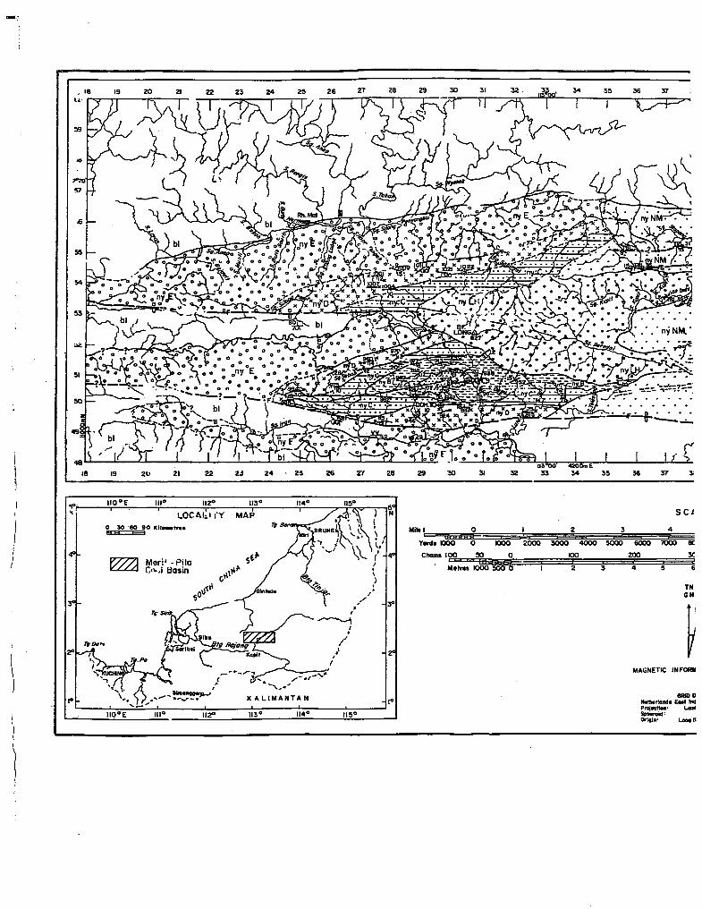
The Merit-Pila deposit is located in the upper reaches of the Rajang River, appproximately 75 km upstream ofKapit in the 7th Division of Sarawak. The coal deposits are hosted in the Nyalau Formation, in a Miocene outlier of the Early Tertiary Belaga Formation. The outlier is elongated in shape, trending approximately east-west and covers an area of about 260 km2•
Within this outlier, coal is known to occur in Merit Tebulan in the central part, in Long Hills towards the west and in Pila and Stapang areas towards the east (Figure 3).
The most important deposits are found within the Nanga Merit Beds which underlie the central part (Merit-Tebulan) of the basin and the Iran River Beds which underlie the western part (Long Hills) of the outlier and are folded into a shallow syncline. The Nanga Merit beds consist of a homoclinally dipping succession of sandstones, mudstones and coal seams with conglomerate beds near the base. The beds dip 4-28° to the south. The Iran River beds consist of a moderately deformed sequence of sandstones, conglomerates, shales and coal seams folded into a shallow synclinal structure. Coal is also known to occur in the eastern part of the basin, in the Pila River area. However, little is geologically known about the coal occurrence there.
The coal deposits associated with the Nanga Merit beds are by far the most important of the Merit-Pila deposits. Within these, 2 major coal zones designated as the Belawei-Mujun

654 CHEN SHICK PEl
TABLE 1 ANALYSIS RESULTS OF SILANTEK COAL
(I) Coking Coal Deposit
Drill Thickness Moisture Ash Volatile Fixed Total FSI Calorific Hole of coal Matter Carbon Sulphur (SwellinE Value No. (m) Index) (kcal/kg)
B5 1.30 1.60 8.60 20.70 69.20 0.50 9 7,770
B7 1.90 1.60 10.16 21.20 66.60 0.70 31/2 7,540
AC8 1.51 1.50 13.30 22.00 63.20 0.58 3 6,891
AC7 1.03 1.70 6.40 22.00 69.90 0.43 5 7,507
B3 1.03 1.80 7.70 24.60 65.90 0.40 9 7,760
Bl 1.42 1.90 11.50 25.00 61.60 0.50 9 7,370
(ll) Semi Anthracite Deposit
ACg 1.29 1.60 8.60 19.30 70.50 0.57 I 7,397
AC4 0.97 1.80 13.60 17.00 67.60 0.70 I 6,898
02 0.93 1.50 6.70 20.00 72.30 0.53 11/2 7,990
AC3 1.24 1.50 13.60 18.80 66.10 1.58 3 6,949
(III) Anthracite Deposit
ACI 0.87 2.90 11.60 5.30 80.20 0.70 - 6,627
B2 0.95 3.10 9.28 14.02 73.57 0.49 - 7,378
AI 1.04 1.73 10.48 8.16 79.63 0.20 - 6,831
All 1.76 5.20 13.50 12.60 68.70 0.70 - 6,590
B4 0.87 1.95 11.49 12.90 73.65 0.27 I 7,143
AC2 1.81 3.30 15.20 5.60 75.90 0.45 I 6,638
AC5 0.90 2.60 11.20 9.30 76.96 0.63 I 7,186
(upper coal zones) and Merit-Tebulan (lower coal zone) are found. The Merit-Tebulan zone is underlain predominantly by mudstone, sandstone and conglomerate. Detailed geological work recently carried out by the Geological Survey has so far identified 7 coal seams with an aggregate thickness of 9.4 m within a sedimentary succession of 160 m. At least three of these seams, i.e. B seam (1.8 m), C seam (2.3 m) and H seam (1.6 m) are considered to be major coal seams within the Merit-Tebulan zone. A total geological reserve of 120 million tonnes within this zone was reported by previous workers.
In the Belawei-Mujun zone which comprises shale, mudstone, sandstone and minor conglomerate, 2 seams of economic significance, with average thicknesses of 1.5 (B' seam) and 2.2 m (C' seam) are found over an area of 18 km2 of the deposit. The total proven and indicated reserves in this zone are about 15 million tonnes.
) J
I i ' i
) I
Meri• -Pita C•,.,l Basin
II~ 113°
I • /
•' I I
114° 11!1°
yo
0
0 1000
2 3
zooo 3000 4000 sooo 100
2 3
6000
200
4
SCI
4
'1000
5
8C
3C
&
TN GN
MAGNETIC INFORIII
-- GIIIDD

36 37 ll8 39 «< 'II
SCALE Aluviu•• 111-ololida .. d and partly """'''lidattd travel, eand, 1111
4 5 6
&000 '1000 8COO 9000 10000 11000 ~~~~~~~~~~~~~~~~~~~~~&~~~~~~~~~~~
12000 13000 . 1"1000 ll5000 16000 17000 Yanb I+ n, +I I :ny~N :I T Nyalau Fwnlllon • Undllferentioted •
zoo 300 400
4 5 6 7 8
TN GN
v-MAGNETIC INFOAMAUON (1974)
GIIIIIIIIIT&
--·- ................ :z.. l'nll-· "'""-~· ilpMraiol• Be-0ri9JII .._ IIO"E Ltll. ~~-
9
~ 600 700 Cblins
~ 12 :3 ICiiPme!ree Minor Unconlor..lty
~t~ Minor. Uncon!ft.,,lty
bl
"z 0 ;:: 4 :I' .. li!
Tlllc~ly. lle<kled sand-• separated by ""al ll'llna and I or •uc
Mollli,. pebble to lloakler contloa,.rat,.. 17ith .. ndllo,.. davalop
Me•ller • Sandatone1, with contlcNMrate:
•a• Member : Mudstone, ciQyatone and 1iltatoae, Mth coal aeama l. 'c'
'D'
'E'
Merilber • • Sondoklne, tllicldy bedded, wltll •lncr ~Badaane and
Me!ftber • Claystone and olltotone, wit;r •lnor ollale1 ond 111111 coal, and urLonaceou:" •- eoa-.
M-ber. • Coo,. baoal to pebbly ... ...,.__ and oaada-
8ELAGA FORMATION • nthlly felded -taHdl-nte .ce-eed and trDJ-~• contlonWr••·
Fig. 3 Geological map of the Merit-Pila Basin, Central Sarawak, Malaysia.

47 48 49
48
1~-~1
10 Miles I+ ny +I • Yanlo
"" I :n,~M :I Millar Unconf-ily
Cnrt~ ..!.... . •
bl
58 57 58 60 61 62
.. -I~C:I
54 57 80 61 62
GEOLOGt~~J. _I.EGENQ. AluviUdl• un-Uclated ond partly c;..,,,,lldal•d travel, oand, oill and cloy.
T Nyalou ....._tiOtt • Undlfferenlialed •
Tlllcllly. bedded sandoiOttee seporalcd by ooal s: ""'' aad I or 111udotono seq....cea ·conlainint coal • . z 0 i= c :1 Maoaiwo pellllle 1o lloulcler contlon•roi... ailb llllldlllo,_ developed towarda top and baoe of unil.
"' f
j ·'A' Membw: Sandolonaa, willl COntloidllalo. ~ =z •a• l 'c'
'o'
'E'
Member • Mudstone, clayolone and oillst-, Mill coal seema and coaly abaleo. Minor oandotoneo.
M-er • . Sandolone, tbicldy bedded, wllb minor-.. -. and coal bodloo.
Melftbor • Claystone and oillstono, wil~ minor abaleo Ottd oandotoneo, i:ontalnint coal , ollaleJ coal, and c.orLonaceou:"t ahclle •a~~'••·
Member 1 Coaroe basal to pebblf ccon .. lemanna and eondatonoo.
BELAGA FORMATION 1 Tightly folded inetoaadlmonta .campo .. d of quartz lrGJWOctca, art illite and vray-ke c~vte.,.rr ...
~ig. 3 Geological map of the Merit·Pila Basin, Central Sarawak, Malaysia.
63
63
64 65 67 68 69
64 66 67 68 69
Geolo9ical boundary • poailion a
GeoloVical boundary • pooilion •
-?-?-?- Geolo9ical boundary· -'lion I
F- rF Hitb antle faull• poailion acet
F -?-F Hitb. antle faull • pooillon info
E9DDH.9.
Synclinal allio • position ap~a
Coal oeam outcrop, ollowint lac and dip direcllon aa lndicaled
Dip antto and otrike of meta11
Diamond Drill Hole No. 9 1197!
Correlated eatenaioa of coal •

68 69 70 71 73 74
66 68 70 71 72 73 74
Goolotjical boundary • paoillan accurate.
Goalotical boundary· paeitlan -•imate.
Goolotical boundary • paoitlaa inferred.
Higb angle fault • paoition accurate, ohowing upthno m and -athrawn aides.
Higb aftljlo fault • paeilian infarred.
Synclinal ollio • position approximate.
Coal oeam outcrop, showi!IIJ I-lion n..,.bor (9!581 and an91a of dip (13"1 strike ond dip direction ao indicated •.
Oip 1119la and otrike of metaoedimeftt (8 ELAGA FORMATION I
DiaiOICI Drill Hale No.9 (197!11
Correlated 111onoion of coal 110m.
75
7!5
76 77
76 77 78 79 80 81 82 83 84
GLOBAL MINERALS EXPLORATION SARAWAK
GEOLOGICAL MAP OF
THE MERIT-PILA BASIN
CENTRAL SARAWAI:, MAU'I'SIA
MAP CONSULTED
t•liO,OCO IAIUIWAIC - T735 Sbott• Z(ttZ/12 aa4 Z/ttll/8 E,., ... z.as as t!IGO
!59
!58
!5!5
!54
53
52
!51
!50

CHEN SHICK PEl
In the Iran River beds, coal is confined to the Nyalau D (NyD) and Nyalau B (NyB) members. Both units contain several coal seams of economic potential. Results of previous investigations show that 3 coal seams of 3.6 m, 2.4 m and 1.8 m thick are present in NyD unit and 2 other seams of 1. 7 m and 1 m thick are associated with the overlying younger N y B units. The total geological reserve of coal within the Iran River beds in the Long Hills area are estimated at about 40 million tonnes.
Apart from the coal found in the Long Hills and Merit areas, coal is known to occur in the Qasin to the east of Rajang River, in Letong-Pila and Stapang-Sekroh. However, due to insufficient work carried out so far, the potential of these deposits in unknown.
The analysis result of coal from the Merit-Tebulan and Belawei-Mujun zones and the Long Hills areas are given in Table 2.
The coal from the Merit-Pila area can be described as having high volatiles with moderate heating values. Ash contents are variable in different seams, while sulfur is uniformly low. It has been classified as sub-bituminous B type coal according to ASTM.
The Bintulu Coalfield
Thin bituminous coal seams have been found scattered in several localities in the Jepak Village, Segan River, Kelabat River, Sera River and Spadok areas. Most of these coal deposits are found within a radius of about 50 km from Bintulu and are associated with Miocene sediments of the Nyalau Formation (Figure 4). The sediments of the Nyalau Formation consist of shallow-water marine sandstone and paralic deposits with coal seams suggesting that swamps developed locally. Mapping and drilling data have shown frequent sections of intertidal sediments suggesting that during deposition, the region has been unstable. Peat formation has therefore been constantly interrupted by flooding by the sea and by the influx of riverine sediments resulting in thin and discontinuous seams. However, repetition of deposition cycles has often resulted in repetition of peat deposition and hence multiple seam formation.
Early Pliocene folding along east-northeasterly trend has resulted in a series of subparallel folds with to steep dips. Coal is found on the flanks as well as the nose of the main folds. Post depositional tectionics have also adversely affected the coalfield. Apart from the major northeast-southwest faults, a series of northwest-southeast trending faults in known to cut the coal deposits, particularly in the Segan River area.
The most important deposit in the Bintulu Coalfield is that at the Segan River. There, 2 main seams of thicknesses 1.0-1.6 m (I) and 0.4-1.0 m (II) hosted in interbedded sandstone and mudstone have been identified. The coal seams have been traced over a lateral distance of 3.8 km in Sungai Selat and the northern and southern limits are bounded by northeast trending fault. The attitude of the beds is generally striking northwest, dipping 12-22° northeast in the northern part, and the general strike direction in the south is, however, approximately north-south, with dips 12 to 30° to the east. The total proven reserve, based on drilling data in the Selat area, is estimated to be 2.0 million tonnes. Further to the east, in the Nivong area, at least one coal seam up to about 1.0 m thick is known to occur. The Sungai Nivong area may have a potential reserve of 450,000 tonnes down to a depth of 1OOm.

TABLE2 ANALYSIS RESULTS OF COAL FROM MERIT-TEBULAN AND BELAWEI-MUJUN ZONES AND LONG HILLS AREAS
Coal Zone
* Merit
Tebulan
+ Belawei-Mujun
+ Long Hills
a.r as received daf dried ash free a.d air dried
Seam
c
E
G
H
B
c
average
n.d not determined
Moisture Volatiles
14.8 (a.r) n.d
14.8 (a.r) n.d
18.4 (a.r) n.d
17.2 (a.r) 51.9 (daf)
12.5 (a.d) 39.8 (a.d)
16.2 (a.d) 38.8 (a.d)
15.1 (a.d) 35.6 (a.d)
* Results from Bundesanstalt fur Geowissenschaften und Rohstoffe + Results from Global Minerals Exploration Corporation
Calorific Total Fixed Ash Value Sulfur Carbon
25.3 (a.d) 4340 (a.d) 0.24 (a.d) n.d
17.2 (a.d) 5400 (a.d) 0.34 (a.d) n.d
9.5 (a.d) 5810 (a.d) 0.29 (a.d) n.d
2.1 (a.d) 5760 (a.d) 0.22 (a.d) n.d
9.5 (a.d) 5590 (a.d) 0.13 (a.d) 38.3 (a.d)
5.7 (a.d) 5580 (a.d) 0.11 (a.d) 39.6 (a.d)
15.0 (a.d) 6240 (a.d) 0.12 (a.d) 34.4 (a.d)

l'l5' I
l'IO'
lll'OO'E
CHINA SELATAN tAUT
:~::;:~~S~C~A~LkE=:=;==~:~ Kitometr••
COAL OUTCROPS
a
GEOLOGY nd swc .,,p alluv•u~- peat. Beach . . mainly sand, Riveri.1e a laces overlam y
r=l silt cloy an P ndlfferentloted. L....:::...J sands are u . I and and si It
I ·um: Mom '/I QUATERNARY Terrace al uVJartz gravels.
I "" I with some qu RMATION (Te,_. to Te,l' S~="TAP SHALE "'~te sandstone ) • ~iiaJo with 'o"~A~ION (Te,_4 to Teo .
"' NYALAIJ F nds•one ) nd Predominantl_y sacocl seam (a a and shaletw~~hn Sandston~ (bbkbedded
MIOCENE includm'kNOSTONE' !fo 1
~~gilloceous =~~one_ with 1~~b~~= ~nses of int,rcolat•ona limestone.
Fig.4
Thickness > lm -1m ~ ::: Thicltnesa 50 em
- ~'"' Thlc·~"lass <15~~~~ outcro~ .., (b)anQie a . Probable coal honzon
Du7 SYMBOLS GEOLO~~bie fault .
- - - Anticlinal oxisit~'h'h ~ directlor. 1Jf _P ··h Syncliral ""''' w~ + directi':ln of P•·' ., Silica sand de~~~ifl"
@) o• Drill hole '"CDII•, -tl' number
Coal resources map of the Bintulu area.
31 10'

COAL POTENTIAL AND EXPLORATION IN SARAWAK
TABLE3 QUALITY OF BINTULU COAL
Area Moisture Ash Volatiles Fixed Sulfur Phosphorus c. v. Carbon (kcal/kg)
Segan River 4.8 2.2 43.3 49.6 l.3 0.002 7380
Jepak Village 3.6 2.2 39.9 54.3 1.7 0.003 7540
Kelabat River 3.8 5.2 42.2 48.8 2.9 N.D. N.D.
Sera River 3.3 6.7 39.2 50.8 2.2 N.D. N.D.
In the Jepak Village area, coal seams of about 0.7 m thick in similar lithology as in the Segan area are common. In this area, the coal seams generally strike north-northeast to northnorthwest and dips I 0-20° eastwards. A northeast-trending fault cuts across this deposit and the sedimentary sequence along I km-wide strip is structurally disturbed. The coal potential over a strike distance of 1.8 km is estimated at 1.1 million tonnes.
In Sera River, Spadok, Selungun and Sepulau areas, however, insufficient information is available to indicate the potentials of these coal occurrences.
Broadly the coal found in different deposits shows similar quality. It can be described as a high volatile bituminous coal with coking properties. The ash content, less than 5%, is generally low but the sulfur content, up to 7% but averages 2%, is quite high. Organic sulfur content ranges up to 1.7% with variable amounts of pyritic sulfur. The heating value of the Bintulu coal averages about 7,200 kcal/kg. The Bintulu coal is uniformly bright and maceral analyses show that the coal is composed entirely of vitrinite with some clarite.
Analyses results of representative coal samples from the different coal areas are given in Table 3.
Based on the results available, it is considered unlikely that very thick coal seams with lateral continuity exist in the Bintulu area. Instead of a large single deposit, the coal deposits in the Bintulu area are scattered in several areas, each of which has a reserve in the order of a few million tonnes. Because of the nature of occurrence of these deposits, it is reasonable to believe that eventual mining, if viable, would have to be carried out in a small-scale in several pits at different deposits.
Mukah-Balingian Coalfield
Coal occurs in the low-lying coastal plain between the Mukah and Balingian Rivers bounded in the south by the Sibu-Bintulu trunk road and in the north by the South China Sea. It is located about 260 km northeast of Kuching. The more hilly hinterland to the south consists of strongly-folded Palaeocene rocks which underlie and define the landward extent of the Neogene depositional basin. In the Mukah-Balingian Basin, sediments of the Balingian, Begrih, Liang and Post-Liang Formations have been deposited. Of these, the first

112°00' EAST 02'10' 112'20' 02'30'
··~·· .-------------~-------------------·~----------------------------------~------------------------------------~
3'00'
2'50'
,·
2'40'
LEGEND
EJAIIuvium
E=t~::~ Liang For'!"'tlon
EHHJH11 Begrih Formation mm Sian conglomerate
~ ~ Tatau conglomerate
[:;:::::::} Balingian Formation
~ Older Tertiary unepecified
112'00'EAST
~ Formation boundary, mainly after C--.1 phatogeologlcal irrterpretatian r---, L __ J Agriculture area
.. ··· · • · ··, Swamp boundary against dry or cultivated '- •.• · ·· .. • land or other formation
-u-- Unconformity
---Fault
- Caal Seam projected to ground surface
~· Drill Hale ••8'· .. Coal outcrop
112'10'
liill 10 1:
10 12
.50 tJ T H
112'20' 112' 30'
Fig. 5 Mukah-Balingan Basin.

oundary, mainly after cal iroterpretatian
area
•dory against dry or cultivated r formation
nojected to ground surface
p
112'20'
112"20'
u2•30•
li!.!:! i.a-,J;==::::i.--;b=:::::i-"""'.,;li::O ==~12""""""',;.14i:::::=,;lji,6.,...""",;j;l8::=:=:::;l20 IIILES
10 12 14 16 18 20 KILOMETRES
.50 II T H
LOCALITY IIAP
112" 30' 112°40'
Fig. 5 Mukah-Balingan Basin.
!'00"
2"40'

CoAL PoTENTIAL AND ExPLORATION IN SARAwAK 661
three formations are gently folded and the Post-Liang is hardly, if at all, disturbed. Unconformities exist between all formations of the Neogene-Quaternary group. All these formations consist essentially of alternations of sand and clay with some conglomerate, but coal occurs mainly in the Miocene Balingian Formation in the north and the PliocenePleistocene Liang Formation in the east and south (Figure 5).
Exploration drilling in the Mukilh-Balingian area has indicated that both thin and thick lignite seams with gentle dip ofless than 10° occur. Coal in the Liang Formation is known in 4 main areas, namely, the Penareh, Lemai, Bawan and Balingian areas. Three major seams ranging from 1.5 to 5 m were intersected in the Penareh area. These seams are thought to continue into the Lemai area where drilling has shown that fewer and thinner seams (2 seams about 1 and 2m thick) were intersected. In the Bawan area to the north, 5 main seams between 1.3 m to 15.4 m thick were also encountered. Although the lateral continuity of the coal seams have not been delineated, the fact that the structure is generally simple, the beds are gently dipping and the topography is favourable suggests that a very substantial reserve in the order of 120 million tonnes may be found. ·
Investigations for coal hosted in the Balingian Formation were conducted in the Balingian, Matading and Rumah Billie areas. Three coal seams with average thickness of 2 m were intersected in the Balingian area and several seams up to 2 m were also encountered in the Matading area. Coal seams with a maximum aggregate thickness of 10m have also been encountered in the Rumah Billie area, and the thickest single seam is about 3.4 m. The indicated reserve is about 30 million tonnes. However, the inferred reserve could be in excess of 100 million tonnes.
The quality of the coal_ in ~e Mukah-Balingian area is summarized in Table 4.
Generally the coal found in the Balingian Formation is of slightly better quality than that in the Liang Formation. The coal can be described as low ash, low sulphur, high moisture, hydrous lignite. Calorific value on dry basis is between 6,300 and 6,700 kcal/kg. Due to its low rank and hydrous nature, it has little potential in the export market. However, it can be produced for on-site consumption when the need arises.
Other Coal Areas
Apart from the coal fields described above, coal is also known to occur in the Plieran Valley in the far interior south ofUsun Apau over an area of 130 km2• Coal seams are found in the Miocene outlier and vary in thickness from 0.9 to 3. 7 m. However the sediments have been extensively folded and probably faulted. Dips of strata are variable from 20-70°. Although the area may host substantial coal deposits, in view of its remoteness and the extensive structural disturbance, the mining potential of the coal area is considered as low.
Coal is also known in the Miocene sediments preserved as a rim around the PliocenePleistocene volcanics of the Hose Mountains. The coal seams are reported to range from 0.3 to 0.9 m thick and hosted within a sedimentary sequence about 75 m thick. In view of the limited extent of the Miocene sediments and thick cover of volcanics, this area has also limited mining potential.

662 CHEN SHICK PEl
t. TABLJ!:4 ANALYSIS RESULTS OF MUKAH-BALING~ COAL
AS RECEIVED DRY BASIS
FORMATION BASIS
Moisture Ash Volatile FIXed Total Calorific Value Matter Carbon Sulphur Kcallkg
Liang 32.0 7.8 48.5 43.7 0.28 6,230 .. 32.6 13.8 43.9 42.3 0.16 . 5.739 .. 34,4 4.7 47.1 48.2 0.21 6,325 .. 30.0 9.0 44.6 46.4 0.71 5,956 .. 32.0 4.0 .48.2 47.8 t.n 6450 .. 29.2 3.4 48.0 48.6 1.50 6,339 .. .32.2 10.0 46.0 44.0 0.66 5,869 .. 48.9 7.9 49.6 42.5 1.06 6,186. .. 44.0 3.3 51.1 45.6 0.11 6,450 .. 45.9 4.1 48.9 47.0 0.16 6,430 .. 46.2 3.5 48.5 48.0 0.14 6,550 .. 42.9 6.0 46.3 47.7 2.53 6,244 .. 41.5 6.7 53.7 39,6 1.12 6,419 .. 44.2 3.3 49.5 47.2 0.12 6,280 .. 42.8 4.7 50.7 44.6 0.16 6,364 .. 29.2 4;9 '48.4 46.7 0.29 6,381 .. 34.0 3.6 50.4 46.0 0.11 6,544
Balingian 34.4 5.6 46.0 48.8 0.88 6,389 .. 32.2 4.0 49.2 46.8 0.36 6,594 ... 30.6 4.8 45.4 49.8 0.18 6,614 .. 30.9 5.4 43.2 51.4 0.25 6,714 .. 29.2 3.2 43.8 53.0 0.18 6,744 .. 16.6 8.0 41.8 50.2 0.34. 6,633
(a.d.)
(a.d): air dry basis
EXPLORATION ACTIVITIES
Historical
Activities related to coal have been recorded as far back as the late 19th Century during which the Sadong Colliery was operated from 1881 until it was closed in 1932. During the late 191;h Century and the early 1900's most of the exploration activities were in the form of observations made by officers serving in the Rajah Brooke's Government and many of these are recorded in the Sarawak Gazette.
Two private companies carried out systematic coal exploration in Sarawak between 1929-1932. The Silantek Exploration Company carried out the first major exploration, including shallow drilling in Silantek, The exploration was abandoned when they failed to prove sufficient minimum re~erve of20 million tonnes. The Japanese Company Nissa Shokai Ltd. also carried out exploration for coal in the Iran (Long Hills) area.

CoAL PoTENTIAL AND EXPLORATION IN SARA wAK 663
Following that, coal activities were in a doldrum as a resUlt of the world recession of the 1930's and the ensueing Second World War. The Japanese, however, prospected in some coal localities during the Occupation.
The first comprehensive study on· the coal resources was made by the Powell Duffryn Technical Services Ltd. for the British Colonial office during 1947-1948 and all the important coal deposits were described in the investigation report entitled 'The Investigation into the Coal Recource of Sarawak, Brunei and British North Borneo'.
The 20 years span between 1950-1960s again reflected a period of inactivity for coal exploration. However, during that period, the then British Borneo Geological Survey was embarking on an accelerated programme of regional reconnaissance mapping over the whole of Sarawak. As part of the mineral resources investigation carried out in conjunction with geological mapping, all the important coal deposits were described in the respective memoirs published.
In 1959-62, the Nippon Coal Mining company investigated both the Bintulu and Silantek coal deposits and proposals were put forward to the Government in 1965 for the development of the Silantek deposit by the Company. However, because of the proximity of the deposit to the border with Kalimantan, this venture was aborted as a result of the confrontation between Malaysia and Indonesia. The Nippon Coal Mining Company carried out a reinvestigation of the Silantek deposits jointly with the A taka Company in 1971. There was, however, no subsequent follow-up after the investigation.
Present Activities
The period from 1974 to-date heralded an era of sustained coal exploration activities in Sarawak. The Silantelc and Bintulu coal deposits were surveyed by the Utah Pacific lncoporated between 1974-1978. During the same period, the Global Minerals Exploration Corporation carried out prospecting work in the Merit-Pila areas, including the evaluation by pattern drilling of the Belawei-Mujun deposit in the central part of the Merit-Pila Basin. Two multinational companies, Amax International and Sarawak Shell Berhad, completed their exploration programmes over the Mukah-Balingian Deposits in 1974-1975, but both parties abandoned their ventures in the area. A local company, Buroi Mining Sdn. Bhd. also commenced exploration for coal in 1981 covering the Bintulu-Mukah-Balingian areas.
At present, four General Prospectirig licences (GPL) have been issued. Kawasho Corporation is holding a GPLoverthe Silantekarea while Lucky hill Mining SdnBhdholds a similar licence over the eastern portion of the Silantek Coalfield. The Buroi Mining Sdn Bhd holds a GPL over the Bintulu-Mukah-Balingian area and the Company has also been given a Mining Certificate to exploit the coal in the Bintulu area where it has completed the evaluation work over the Segan deposit. The Global Mineral Exploration Corporation holds a GPL over the Merit-Pila-Hose Mountains-Usun Apau areas and it has also been awarded a Mining Certificate covering the Belawei-Mujun and Long Hills deposits.
A list summarizing the coal exploration activities in Sarawak is given in the Appendix 1.

664 CHENSmCKPm
Activities by the Geologicai·Survey of Malaysia
Work carried out by the Geological Survey in the past has outlined various deposits that are known to be of economic significance and some of these deposits were chosen by private exploration and mining companies in recent years for more detailed follow-up work. Conunencing from the Fourth Malaysia Pian period (1981-1985), the Geological Survey has implemented a.long~term Evaluation of Coal Resources i>rogramme with the objective of building up a coal resource invenl:Ory for Sarawak. One of the components of this project is the setting up of a coal testing laboratory.
During the 19~ 1-1985 period, the deposits at Merit-Pila have been chosen for the resource study. The Federal Republic of Germany has also approved technical assistance for the coal ·programmme in the form of short-term experts, particularly for the setting up of a coal laboratory.
Since 1982, the Geological Survey has been carrying out studies on the Mei:it-Tebulan deposit in t:he central part of the Merit-Pila Basin. Detailed mapping and coal outcrop studies have almost been completed and 7 evaluation drilling is expected to be completed by·l985.
The Evaluation of Coal Resources programme is planned to be continued into the Fifth Malaysia Plan period (1986-1990).
A BRIEF REMARK ON THE FORECAST FUTURE OF COAL INDUSTRY IN . SARAWAK
Given a favourable economic condition, and hence market demands, it can: be anticipated that Sarawak can be a co~ producer bef.ore 1988. The forecast is for the production of about 3/4-1 million tonnes of coal per year, from the 2 modest-scale open pit mines at BelaweiMujun (Merit-Pila) and Bintulu, and the underground mine at Silantek. lf transportation of coal from Merit-Pila can further be improved, an additional output of 1/2 million tonnes per year from the Merit-Tebulan deposit is feasible.
Co~ will continue to attract both local and the foreign interests and it will be the main mineral commodity to be exploited in Sarawak in future years.
Year
1881-1932 Early 1900's
1929-19.32
1930's-1946 1947-1948
Appendix!
SUMMARY OF COAL EXPLORATION ACTIVITIES
Coal Activity
Coal mining at Sadong Colliery. · Observations made by officials of Rajah Brooke's Government; observations recorded in the Sarawak Gazette. Silantek Exploration Company carried out exploration including drilling. Nissa Shokai Ltd explored in the Iran River (Long Hills) area. Recession and 2nd World War. Powell Duffryn Technical Services made comprehensive study of coal deposits in Sarawak.

CoAL POTENTIAL AND EXPLORATION IN SARAwAK 665
1950's-1960's Regional geological mapping- including documentation of important coal deposits.
1959-1962 Nippon Coal Mining Company explored the Silantek and Bintulu Depos-its. . .
1971 Nippon Coal Mining Company and Ataka & Core-investigated Silantek deposits.
1974-1975 Sarawak Shell Beihad and Amax International investigated the MukahBalingian deposits.
1974-1978 Utah Pacific lnc01porated explored the Bintulu-Tatau and Silantek areas.· Global Minerals explored the Merit-Pila area.
1981 to date Buroi Mining Sdn Bhd explored the Bintulu area. Mining Certificate approved for the Segan deposits. · Mining Certificate award to Global Minerals over the Belawei-Mujun and Long Hills areas.
1982 Kawasho Incorporated re-investigated the eastern part of the Silantek deposit.
1983 Luckyhill Mining Sdn Bhd explored the eastern part of the Silantek deposit.
1981-1985 Evaluation of Coal Resources Programme by the Geological Survey of Malaysia as a Fourth Malaysia Plan Programme.
Manuscript received 5th February 1985