coal resources of oregon - usgs · pdf filegeological survey circular 362 coal resources of...
TRANSCRIPT
GEOLOGICAL SURVEY CIRCULAR 362
COAL RESOURCES
OF OREGON
Prepared in cooperation with the Oregon Department of Geology and Mineral Industries

UNITED STATES DEPARTMENT OF THE INTERIOR Douglas McKay, Secretary
GEOLOGICAL SURVEY W. E. Wrather, Director
GEOLOGICAL SURVEY CIRCULAR 362
COAL RESOURCES OF OREGON
By Ralph S. Mason and Margaret I. Erwin
Prepared in cooperation with the Oregon Department of Geology and Mineral Industries
Washington, D. C., 1966
Free on application to the Geological Survey, Washington 25, D. C.

EXPLANATION
Approximate limit of coal·bearing rocks
Areas including reserves estimated by Allen and Baldwin, 1944. (See table I) 1. Southport and Thomas 2. South Slough 3. Englewood 4. Riverton 5. Beaver Slough 6. Lillian
Area including reserves estimated by Duncan, 1953 (See table I)
C,)
.......
~
.......
C,)
~
~
R.14W. w.
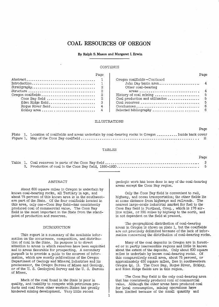
Figure 1. -Map of the Coos Bay coalfield.
ii
s.
s.
T.
-- ...........
"' '\ ) I
/
T.
s.
T.
R.l2W. R.l
10 Miles
COAL RESOURCES OF OREGON
By Ralph S. Mason and Margaret I. Erwin
CONTENTS
Abstract .................................... . Introduction ................................. . Stratigraphy ................................. . Structure ................................... . Oregon coalfields ............................ .
Coos Bay field ......................... . Eden Ridge field ........................ . Rogue River field ....................... . Eckley area . . . . . . . .................... .
Page
1 1 2 2 2 2 3 4 4
Page
Oregon coalfields -Continued John Day basin area • . . . . . . . . . . . . . . . . . . . . . 4 Other coal-bearing
areas ............................... , 4 History of coal mining . . . . . . . . . . . . . . . . . . . . . . . . 5 Coal production and utilization . . . . . . . . . . . . . . . . . 5 Coal reserves . . . . . . . . . . . . . . . . . . . . . . . . . . . . . . . 5 Conclusions.... . . . . . . . . . . . . . . . . . . . . . . . . . . . . . 6 Selected bibliography . . . . . . . . . . . . . . . . . . . . . . . . . 6
ILLUSTRATIONS
Page
Plate 1. Location of coalfields and areas underlain by coal-bearing rocks in Oregon ..•........ Inside back cover Figure 1. Map of the Coos Bay coalfield . . . . . . . . . . . . . . . . . . . . . . . . . . . . . . . . . . . . . . . . . . . . . . . . . . . . . . . . . . . . . . . ii
TABLES
Page
Table 1. Coal reserves in parts of the Coos Bay field . . . . . . . . . . . . . . . . . . . . . . . . . . . . . . . . . . . . . . . . . . . . . . . . . . . 3 2. Production of coal in the Coos Bay field, 1880-1920........................................... . 5
ABSTRACT
About 600 square miles in Oregon is underlain by known coal-bearing rocks, all Tertiary in age, and about 75 percent of this known area is in the southwestern part of the State. Of the four coalfields located in this area, only one-Coos Bay field-has consistently produced coal of commercial value. The Coos Bay field is the most important in the State from the standpoint of production and reserves.
INTRODUCTION
This report is a summary of the available information on the occurrence, composition, and distribution of coal in the State. Its purpose is to direct attention to areas in which reserves have been exploited and to areas favorable for prospecting. A secondary purpose is to provide a guide to the sources of information, which are mostly publications of the Oregon Department of Geology and Mineral Industries and its predecessor, the Oregon Bureau of Mines and Geology, or of the U. S. Geological Survey and the U. S. Bureau of Mines.
Much of the coal found in the State is poor in quality, and inability to compete with petroleum products and coal from other western States has greatly Wndered mining development. Very little recent
1
geologic work has been done in any of the coal-bearing areas except the Coos Bay region.
Only the Coos Bay field is convenient to rail, highway, and ocean transportation; the other fields lie at some distance from highways and railroads. The nearest large-scale industrial market for fuel to the Coos Bay field is Portland, Oreg., which is 176 airline miles, or 225 miles by highway to the north, and is not dependent on the field at present.
The geographical distribution of coal-bearing areas in Oregon is shown on plate 1, but the coalfields are not precisely delimited because of the lack of information concerning the distribution of coal-bearing rocks.
Many of the coal deposits in Oregon are in forested or in partly inaccessible regions and little is known about the extent of the deposits. Only about 600 square miles is underlain by known coal-bearing rocks. Of this comparatively small area, about 75 percent, or approximately 450 square miles, lies in southwestern Oregon (pl. 1). The Coos Bay, Rogue River, Eckley, and Eden Ridge fields are in this region.
The Coos Bay field is the only coal-bearing area that has consistently produced coal of commercial value. Although the other areas have produced coal for local consumption, mining operations have been limited because of the small quantity ·and

poor quality of the coal, as well as the long haul to market.
STRATIGRAPHY
The coal-bearing formations in Oregon occur in rocks of Tertiary age. In the north-central part of the State, subbituminous coal and lignite are found in continental deposits of the Clarno formation of Eocene age and in the Mascall formation of middle Miocene age. In the northwestern part of the State, in the Coast Ranges, lignite and in places subbituminous coal are present both in the Toledo formation of late Eocene and Oligocene age, and in the Keasey formation of late Eocene and early Oligocene age, and the Pittsburg Bluff formation of Oligocene age. In the northeastern part of the Willamette Valley, in the western parts of Clackamas and Marion Counties, lignite and subbituminous coal beds are interbedded with rock sequences that range in age from middle Oligocene to early Miocene. In the southwestern part of the State, in the Coast Ranges, impure coal is present in the Spencer formation of late Eocene age, and subbituminous and bituminous coal occurs in the Coaledo (Arago group), Tyee, and Umpqua formations of Eocene age.
Data concerning the distribution and physical character of the coal-bearing areas, except the Coos Bay field, are incomplete. However, most of the known coal-bearing beds in areas outside the Coos Bay field contain many partings of bone, carbonaceous shale, and clay, and are probably of subcommercial value. The most important coal bed in the State, from the standpoint of reserves and production, is the Beaver Hill (Newport) bed of the Coaledo formation in the Coos Bay field.
STRUCTURE
In the no.rthern part of the Coast Ranges of Oregon the coal-bearing formations crop out along the flanks of the Coast Ranges geanticline and the dip of the strata ranges from 15° to 30°. The coal-bearing formations throughout the southern part of the Coast Ranges are folded into generally northward-trending anticlines and synclines in which the dip of the strata ranges from 5° to 40°, and locally is more than 40°.
The folds in the Coast Ranges are complicated by numerous high-angle faults which generally have northwest or northeast strikes. Displacements on these faults are usually small, but some can be measured in hundreds of feet.
OREGON COALFIELDS
Coos Bay field
The Coos Bay field is located in the western part of Coos County, Oreg. It is elliptical, approximately 30 miles long and 11 miles wide, with an area of about 250 square miles (fig. 1). The topography of the field is characterized by a number of extensive sloughs tributary to Coos Bay and by flat-topped hills covered with brush and second-growth timber. The Coos and Coquille Rivers with their many tributaries drain the area. ·
2
The field is by far the most important in the State from the standpoint of production and reserves, and it is the only area in which coal has been produced for commercial use. The Coos Bay field was first described by Diller in 1895, who subsequently published more detailed reports in 1897, 1901, 1911, and 1914. Included in the Coos Bay folio (Diller, 1901) are topographic and geologic maps and structural cross sections of the area. Other early reports dealing with Coos Bay coal were made by Newberry (1857), Goodyear (1877), Smith (1900), Rockwell (1902), and Stovall (1905). Since then many publications have referred to Coos Bay coal but only a few have contained additional data. A progress report of the field was made by Libbey (1938) and a report on the analyses of various coal samples taken from the field was made by Yancey and Geer (1940). The most recent reports on the field are by Allen and Baldwin (1944), Toenges and others (1948), and Duncan (1953). In addition to geologic descriptions, maps, and coal analyses, these three reports include estimates of coal reserves in the more favorable parts of the field.
The field lies in a structural basin, in which the coal-bearing rocks have been compressed into several parallel northward-trending folds that are broken by minor faults. Although the displacement of strata has not been great, the faults have been a deciding factor in limiting the size of several mines and prospects. In the north-central part of the field two faults that coincide roughly with the axes of the major folds have been interpreted as high-angle thrust faults by Duncan (1953).
The coal in the Coos Bay field is subbituminous ~ subbituminous _s; or lignite. Heat values range from about 5,530 to 10, 370 Btu per.pound on an "as received" basis. The coal is characterized by a relatively high moisture content and has an ash content ranging from 4. 5 to 45 percent and averaging about 15 percent on an "as received" basis. In general the Coos Bay coal beds contain only small amounts of sulfur, the content ranging from 0. 5 to 5. 0 percent and averaging less than 2. 0 percent. More detailed descriptions of the chemical properties of the coals are included in a report by Toenges _and others (1948). The principal coal bed in the field is the Beaver Hill (Newport) bed of the Coaledo formation (Arago group) of late Eocene age. This bed is present throughout the central part of the field where it ranges from 4 to 8 feet in thickness. The second most important and continuous coal bed in the central part of the field is bed Q of the Coaledo formation, which overlies the Beaver Hill bed (Duncan, 1953). Bed Dis from 2 to 5 feet thick and generally contains 2 feet of clean coal. Most attempts to mine other beds in the Coaledo formation have been unsuccessful because the beds are either too thin or too impure.
Several coal beds in the Umpqua formation of middle to early Eocene age are exposed in the southeastern part of the field along the Middle Fork of the Coquille River. In this area the coal beds are as much as 14 feet thick but include large amounts of bone and shale (Allen and Baldwin, 1944, p. 138). The coal beds exposed on the north side of Coos Bay are in the Coaledo formation, and they contain numerous partings and generally are thin and broken by faults.
Estimates of coal reserves in parts of the Coos Bay field made by Allen and Baldwin (1944),

Duncan {1953), and Toenges {1948) have been consolidated in table 1. These estimates were based on information from extensive test drilling, outcrops, and studies of mines in the area. The estimates shown in table 1 represent remaining reserves, or the amount of coal left in the ground as of July 1945 after mining and mining losses have been considered. The estimates are further classified according to reliability of available information into three categories of reserves, termed measured, indicated, and inferred reserves.
Measured reserves include coal for which positive information on the thickness and extent of individual coal beds is available from studies of outcrops, mine workings, and records of closely spaced drill holes. The points of observation are half a mile apart or less. Indicated reserves are computed partly from specific measurements and partly from the projection of visible findings for considerable distances on geologic evidence. The points of observation are generally from 1 to 1! miles apart. Inferred reserves are those for which estimates are based largely on a broad knowledge of the geologic characteristics of the bed or region, supported by few actual exposures.
Allen and Baldwin {1944, p. 54) estimated the reserves remaining in the Beaver Hill bed in seven different projects or mining localities in the field {fig. 1). The reserves, based on a total area of approximately 1, 000 acres, were estimated to be 5, 262,000 tons. Of this total 541,000 tons are measured reserves; 962, 000 tons are indicated reserves; and 3, 759,000 tons are inferred reserves {table 1). An estimated 50,000 tons included in measured reserves, and another 35, 000 tons included in indicated reserves are considered suitable for strip mining.
Duncan {1953) estimated the remaining reserves as of July 1, 1945, for an area of approximately 5, 300 acres including two project areas of Allen and Baldwin (fig. 1) to be 62, 737,000 tons. Of this total 23,490,000 tons are measured reserves; 26,636, OOOtons are indicated reserves; and 12, 611, 000 tons are inferred reserves {table 1). Duncan has estimated the
Table l.- Coal
Areas
reserves by individual bed. About 90 percent, or 56, 492, 000 tons, of the total reserves in this area is in the Beaver Hill bed; 6 percent, or 3, 628, 000 tons, in bed J2.j and the remaining 4 percent, or 2, 617,000 tons, in beds ~ J1 and ;[ of the Coaledo formation. No reserves were calculated in areas where the coal beds had an overburden of more than 1, 500 feet.
Toenges (1948) estimated that measured reserves of Beaver Hill coal underlie 1, 020 acres and total 10, 810,000 tons, of which 8, 600,000 tons is considered recoverable. Of an additional 6,193,000 tons of indicated and inferred coal, 4, 955,000 tons is considered to be minable. These reserve figures are not shown in table 1, as the coal reserves estimated by Allen and Baldwin, and Duncan include the area covered by Toenges's estimates.
Although the above reserve estimates include the more promising areas of the Coos Bay field, only a small part of the total area of the field was considered.
Eden Ridge field
The Eden Ridge field is located near the South Fork of the Coquille River in southeastern Coos County and northern Curry County, Oreg. It occupies an area along the divide between the Coos and Rogue Rivers, where the relief is about 3, 000 feet. The field is divided topographically into Eden Ridge to the north and Squaw Basin to the south; both divisions are relatively inaccessible and in part heavily timbered.
The field has been described by Lesher (1914), Williams (1914), and briefly by Diller (1914). The structure of the area is that of a shallow elliptical basin with the longer axis of the basin trending in a northerly direction. Four major faults have been mapped in the area, and displacements in the strata of as much as 800 feet have been found. Throughout the region the beds dip at comparatively low angles. In the north the beds dip from 5° to 15° SW. and in the west as much as 17° E. (Lesher 1914, p. 403).
shown in
Indicated Total
[After Allen and Baldwin 1944 . 541
South Slough-----------------------------------r---------~--------- 263 2,362 Englewood--------------------------------------~--------- 1 219 1 85 ---------Riverton--------------------------------------- --------- 1 50 115 ---------Lillian---------------------------------------- ---------~--------- ---------- 132
Beds [After Duncan 1953. p. 70]
Beaver Hill------------------------------------ 4.9 Bed D ----------------------------------------- 3.3 Bed E ----------------------------------------- 2.7 Bed H ----------------------------------------- 3.6 Bed J ----------------------------------------- 2.9
Total-----------------------------------------------
1Stripping coal.
3
17,245 26,636 12,611 3,628----------- ---------1,404----------- ---------
738----------- ---------475---------------------
23,759 26,999 15,105
2,625 304 65
132
56,492 3,628 1,404
738 475
65,863

The coal is high volatile g bituminous and occurs in rocks of the Tyee formation of middle Eocene age. In the northern part of the field four coal beds have been mapped; the Lockhart, Carter, Meyers, and Anderson beds. The coal beds in the Squaw Basin area have not been correlated with the coal beds to the north in the Eden Ridge area, but they appear to be stratigraphically lower. The more important beds in the southern part of the field are referred to by Williams (1914, p. 41) as the "Donnell and 7-foot veins. 11
In a few localities the coal beds attain a maximum thickness of 9 feet, however, the maximum thickness of coal generally is less, because of- the many shale and bone partings. The ash content of the coal ranges from 10 to 60 percent.
Rogue River field
The Rogue River field is located in southwestern Oregon in Jackson County. Coal occurs in a long narrow belt extending south from Evans Creek in the northwestern part of the county to a point about 10 miles south of the Oregon-California State line, a distance of approximately 100 miles.
The coal area has been described by Diller (1909, 1914) and by Winchell (1914). The results of analyses of various coal samples are included in a publication by Yancey and Geer (1940).
The coal is of middle to early Eocene age and occurs in sandstones and shales of the Umpqua formation that have been covered by extensive lava flows. It is of subbituminous .f: or ;!2 rank and contains a large number of partings and bands of impurities.
Exploration has not been extensive enough to determine the geologic structure of the area, and the fact that the Eocene sedimentary rocks interfinger with lava flows makes it difficult to determine the extent of the coal beds. Diller (1909, p, 402) noted that at most places in the field the beds dip gently northeastward and that the quality and quantity of the coal increases to the northeast.
There has been prospecting for coal throughout the area, and in many places the coal has been mined for local use. In the northern part of the field, on Evans Creek, beds as much as 8 feet thick have been found, but the coal contains a number of clay and sandstone partings. The coal found in the central part, although of better quality, is generally less than 1 foot thick. The coal found in the southern part is very thin and contains a large percentage of sulfur.
Eckley area
The Eckley area, which has been described by Diller (1903), includes approximately 20 square miles in southern Coos and northern Curry Counties. The area is located near the Sixes River in a heavily timbered mountainous area, about 45 miles south of the Coos Bay field.
The coal in the area is high volatile g bituminous and occurs in rocks of the Arago group of Eocene age. The coal-bearing strata consist of shale and soft sandstone that have a thickness of approximately 50 feet and are exposed only in
4
a few places. Where observed the beds are folded and faulted. The thickness of the coal beds differs greatly from place to place and as a result of folding and faulting the coal occurs locally in irregular masses. The coal contains many layers of carbonaceous shale. Diller (1903, p. 4) has indicated that the best coal crops out along the southern border near the head of the Middle Fork of the Sixes River, and near the mouth of Shasta Costa Creek. There has been no production of coal from this area.
John Day basin area
The John Day Basin is in the north-central part of Oregon and includes parts of Grant, Wheeler, Gilliam, Morrow, and Umatilla Counties. Topographically the region is a plateau formed by a series of basalt flows.
Collier (1914) has described the coal-bearing rocks in the area. Bituminous coal, subbituminous coal, and some lignite occur in the Mascall formation of Miocene age. Most of the coal is impure, however, and yields low Btu values.
Widely scattered exposures of bituminous coal with large amounts of impurities occur in the Clarno formation of Eocene age from northwestern Wheeler County northeastward to the central part of Morrow County. Some prospecting has been done in southeastern Morrow County, where coal beds have been found at seven different horizons. The coal ranges in thickness from a few inches to about 3 feet. The rocks enclosing the coal beds are composed largely of tuff with interbedded flows of andesite and other igneous material. The rocks have been highly faulted and folded, making it impossible to trace the coal outcrops for any distance,
The coal found near the John Day River in central Wheeler County and in central Morrow County represents the best coal from the Clarno formation. The beds are thin and discontinuous, however, and contain a large amount of implirities.
Several outcrops of lignite are found in the Mascall formation near the John Day Riv~r, but these beds also are irregular in thickness and contain so many partings of bone and other impurities that they are of little value.
Other coal-bearing areas
Other small areas of coal-bearing rocks in Oregon have been described, for the most part, in publications by Diller (1895, 1914).
In northwestern Oregon, coal has been found in Multnomah, Marion, Clackamas, Lincoln, Columbia, Yamhill, Clatsop, and Tillamook Counties (pl. 1). The coal in these counties is subbituminous and occurs in rocks of Oligocene and late Eocene age. The largest area known to contain coal in this part of the State ineludes about 20 square miles on the upper Nehalem River in Columbia County (Diller, 1895, p. 491). The coal beds are from 1 to 10 feet thick, but the thicker beds consist mostly of carbonaceous shale. Coal has been found in an area of about 10 square miles in the west-central part of Lincoln County, but the thickest bed reported from this area contains only 3 feet of impure coal. Coal also occurs in southern Clatsop County in the lower Nehalem River area, but no bed thicker than 22 inches has been reported.

In southwestern Oregon, near Comstock in the north-central part of Douglas County, thin impure coal beds occur in the Spencer formation of late Eocene age. Small outcrops of subbituminous coal are also found in the Lookingglass and Camas Valley districts, and on Little River, all in Douglas County (pl. 1}.
A small amount of lignite occurs in the northeastern part of Malheur County in the eastern part of the State.
Little is known about the c.oal deposits in any of· these areas because the exposures and prospecting have not revealed coal that is promising enough to encourage commercial development.
IDSTORY OF COAL MINING
Most of the coal mined in Oregon has been taken from the Coos Bay field. Small mines have been operated sporadically in other parts of the State but their combined production ·has been small and their period of operation relatively short. Mining in the Coos Bay field began in th~ early 1850's and maximum production was attained in 1904. The early mines supplied not only a local market but the largest part of their production was shipped to San Francisco. CoastwiSe vessels, many of which loaded directly from mine bunkers erected on the deeper waters of Coos Bay and its various sloughs, provided the transportation. The discovery of gas and oil in California at about the turn of the century led to a gradual, but persistent, decrease in demand for Coos Bay coal. The decrease has continued to the present day, although some small production has always been maintained.
The Beaver Hill mine, operated by the Southern Pacific Co. , supplied over half of the Coos Bay field production from 1903 to 1920. When the mine closed in 1923 it had reached a depth of 1, 400 feet below sea level at a distance of 3, 030 feet down the slope from the portal. The adoption of oil-fired locomotives by the Southern Pacific was the direct cause for the mine closure and contributed to the steadily decreasing demand for coal from the field.
Over the past 100 years nearly 40 mines have been in operation in the Coos Bay field. One of them, the Southport, has been in almost continual production for 70 years. The Newport mine has been in continuous operation for 66 years.
During World War II, in order to supply local Government wartime fuel needs, the Southport mine was electrified and mechanize·d. A new slope and gangway were driven to provide access to coal below the old workings. At the close of the hostilities production ceased. In 1954, the Coos Bay field had one operator who supplied only local markets.
COAL PRODUCTION AND UTILIZATION
Coal production for Oregon for the years of maximum production, 1880 to 1920, is shown in table 2. Mining started in 1854, reached a peak production of 112,000 tons in 1904, and with few minor exceptions has steadily declined ever since. Early production was from large well-financed operations, in contrast to those of later years which were often smiill. "family" mines worked with crude equipment and supplying only local needs. Production in 1952, for example, was only 1, 179 tons (Bureau of Mines, 1953}. Total production from the Coos Bay field is estimated by Allen and Baldwin (1944, p, 51} to be about 3 million tons. The Newport basin, a shallow syncline located about 4 miles south of Coos Bay, has yielded the largest amount of coal from the field.
With the diminishing demand for coal as a solid fuel, new markets and uses have been sought. Coos Bay coal is a subbituminous !? and g high volatile coal and should be suitable for the production of byproducts as well as low-temperature char, a retort product having no moisture and about one half of the original volatiles. Gasification, either in retorts or in place underground, might yield suitable fuel for local steam powerplants when the supply of cheap wood waste is exhausted. A possibility for economic development would be the erection of small coal-burning powerplants at or close to mine tipples. Unwashed coal could be used as there would be no transportation charge, and difficulties due to slacking and heating would be eliminated by firing shortly after mining. As many of the mines are located on or near sloughs or small streams, cooling water is available in unlimited quantities.
COAL RESERVES
In any discussion of the coal reserves in Oregon, interest must center primarily on the Coos Bay field, which covers an area much larger than that of all other fields combined and contains most of the reserves.
Table 2.- Production of coal in the Coos Bay field, 1880-1920
[U. S. Geological Survey Mineral Resources, 1885-1920]
Year Tons Year Tons Year Tons Year Tons
1880--------- 43,205 1891--------- 51,826 1902--------- 65,648 1913--------- 46,063 1881--------- 33,600 1892--------- 34,661 1903--------- 91,144 1914--------- 51,558 1882--------- 35,000 1893--------- 41,683 1904--------- 111,540 1915--------- 39,231 1883--------- 40,000 1894--------- 47,521 1905--------- 109,641 1916--------- 42,592 1884--------- 45,000 1895--------- 73,685 1906--------- 79,731 1917--------- 28,327 1885--------- 50,000 1896--------- 101,721 1907--------- 70,981 1918--------- 13,328 1886--------- 45,000 1897--------- 107,289 1908--------- 86,259 1919--------- 18,739 1887--------- 37,696 1898--------- 58,184 1909--------- 87,276 1920--------- 20,717 1888--------- 75,000 1899--------- 86,888 1910--------- 67,533 1889--------- 64,359 1900--------- 58,864 1911--------- 46,661 Total------ 2,380,313 1890--------- 61,514 1901--------- 69,011 1912--------- 41,637
5
The several small fields contain at best only small tonnages, which cannot be stated accurately because of the lack of precise information about the thickness and continuity of the coal beds. Although the structure and geology of the Coos Bay field is fairly well known, undetected faulting may adversely affect the coal recovery in some areas. Generally, the thickness and grade of the coal, particularly in the Beaver Hill bed, is remarkably uniform over considerable distances. With the exception of the Steva bed, which has a soft clay roof, the coal beds in the Coos Bay field have hard sandstone roofs, which stand unsupported for long periods of time. Despite the heavy (60 to 70 inches) annual rainfall, there has been very little trouble with water in the mines. Small amounts of gas have been detected in some mines but not in dangerous quantities. Open-flame lamps have always been used throughout the field. Information about the Coos Bay field is sufficient to permit a partial estimate of reserves that, with a slight correction, should provide a fairly accurate reserve figure for the whole State.
Many estimates of the amount of coal in the Coos Bay field have been made. The first, made by Campbell (1913, p. 538), showed original reserves of 1 billion tons. This estimate was based on the total 250-square mile area of the field, and included .coal of all grades, thicknesses, and minability. During World War II the Oregon Department of Geology in cooperation with Coos County made a survey of the field and carried out exploratory work with hand augers and power drills at several places., This work was undertaken to locate areas underlaid by stripping coal, as shown in figure 1. As only shallow drilling was done, no attempt was made to determine the amount, grade, and minability of those coal beds not amenable to stripping or easy underground mining. The results of this survey are shown in table 1. A complete report of the exploratory work, including a study of the structure and geology of the Coos Bay quadrangle, has been published (Allen and Baldwin, 1944).
An examination of the Coos Bay field was made by the U. S. Geological Survey and the U. s. Bureau of Mines in 1943-44 (Duncan, 1953; Toenges and others, 1948). A series of deep diamond-drill holes was made to test the continuity of the Beaver Hill bed. A summary of coal reserves based on drill holes and outcrops of the Beaver Hill bed and beds .Q, ~' B, and l_, as estimated by Duncan (1953), appears in table 1. In considering an area of about 9 square miles in the field, including project areas 1 and 5 of Allen and Baldwin (fig. 1), Duncan arrived at an estimate of remaining reserves as of July 1, 1.945, totaling 62, 737, 000 tons. In project areas 2, 3, 4, and 6, Allen and Baldwin arrived at additional remaining reserves as of January 1, 1944, totaling 3, 126,000 tons. The total, 65, 863, 000 tons, represents reserves in an area of less than 11 square miles. The reserve estimates of the Bureau of Mines are not shown in table 1, as they represent reserves for an area included in the estimates of Allen and Baldwin and Duncan.
A study of the three estimates described above reveals wide differences in reserves, as the areas and number of coal beds included in each estimate differ. None of the figures represent total minable reserves for the Coos Bay field.
It should be recognized that any estimate of the coal reserves in the Coos Bay field is hampered by lack of adequate information on the thickness and extent
6
of the coal in certain areas.. Despite the wide variation in reserve estimates calculated for the Coos Bay field, it is apparent that the reserves are sufficiently large to support any mining program that might be .contemplated. Owing to the fact that the coal reserves for only a fraction of the Coos Bay field have been estimated and that lesser fields contain small reserves, a tentative assignment of 200 million tons as the original reserves for the State before mining appears to be justified. This amount is only about 3 times the present known reserves and only 20 percent of the earlier Campbell estimate.
CONCLUSIONS
The bulk of Oregon's commercial coal reserves lies in the Coos Bay field, where adequate tonpages of subbituminous g, high volatile coal with an average heating value of 9, 700 Btu's, an average moi~ture content of 17 percent, and an average ash content of 8 percent, underlie 15, 000 acres with an average bed thickness of 5 feet. It is doubtful whether coal o! other areas in the State will be developed to any great extent as a source of combustible energy. The natural advantages of the Coos Bay field, particularly the large tonnages of known coal reserves, and nearness to water, rail, and highway transportation, place other coal deposits in the State in a less competitive position.
In order to be sold competitively as a solid fuel, Coos Bay coal would have to be cleaned and perhaps made into briquettes or packaged for domestic use. Oregon is not, and never has been, a large consumer of coal, and about 96 percent of the coal that is used is imported. Shipments of coal to Oregon principally come from Utah, Wyoming, and Coiorado.
SELECTED BIBLIOGRAPHY
1. Allen, J. E., and Baldwin, E. M., 1944, Geology and coal resources of the Coos Bay quadrangle, Oregon: Oreg. Dept. Geology and Min. Industries Bull. 27, 160 p.
2. Andrews, D. A. , Hendricks, T. A. , and Huddle, J. W., 1947, Analyses of Arizona, California, Idaho, Nevada, and Oregon coals: U. S. Bur. Mines Tech. Paper 696, p, 9-12, 20-22, 40-47.
3, Butler, G. M., and Mitchell, G. J., 1916, Preliminary survey of the geology and mineral resources of Curry County, Oreg.: Oreg. Bur. Mines and Geology, Min. Res. of Oregon, v. 2, no. 2, p, 69-71.
4. Campbell, M. R., 1913, The coal resources of the world: Internat. Geol. Cong., Toronto, 12th sess., v. 2, p. 538.
5. Collier, A. J., 1914, The geology and mineral resources of the John Day region: Oreg. Bur. Mines and Geology, Min. Res. of Oregon, v. 1, no. 3, 47p.
6. Diller, J. S., 1895, A geological reconnaissance in northwestern Oregon: U. S. Geol. Survey 17th Ann. Rept., pt. 1, p, 441-520.
7. 1897, The Coos Bay coal field, Oregon: U. S. Geol. Survey 19th Ann. Rept. , pt. 3, p. 309-376.
8. 1898, Description of the Roseburg quad-rangle, Oregon: U. S. Geol. Survey Geol. Atlas, folio 49, 4 p.
9. 1901, Description of the Coos Bay quad-rangle, Oregon: U. S. Geol. Survey Geol. Atlas, folio 73, 5 p.

10. Diller, J. S., 1903, DescriptionofthePortOrford quadrangle, Oregon: U. S. Geol. Survey Geol. Atlas, folio 89, 6 p.
11. 1909, The Rogue River valley coal field, Oregon: U. S. Geol. Survey Bull. 341-C, p, 401-405.
12. 1914, Mineral resources of south-western Oregon: U. S. Geol. Survey Bull. 546.
13. Diller, J. S., and Pishel, M. A., 1911, Preliminary report on the Coos Bay coal field, Oregon: U. S. Geol. Survey Bull. 431-B, p. 190-228.
14. Diller, J. S., and others, 1915, Guide book of the western United States, part D. The Shasta Route and Coast Line: U. S. Geol. Survey Bull. 614.
15. Duncan, D. C. , 1953, Geology and coal deposits in part of the Coos Bay coal field, Oregon: U. S. Geol. Survey Bull. 982-B, p. 53-73.
16. Goodyear, W. A., 1877, The coal mines of the western coast of the United States: A. L. Bancraft and Co. , San Francisco, Calif. , 153 p.
17. Green, S. H. , 1949, Industrial coal available to Pacific Northwest industries: Oreg. Raw Materials Survey, Resource Rept. no. 4, 22 p,
18. Lesher, C. E., 1914, The Eden Ridge coal field, Coos County, Oregon: U. S. Geol. Survey Bull. 541-I, p, 399-418.
19. Libbey, F. W., 1938, Progress report on Coos Bay coal field: Oreg. Dept. Geology and Min. Industries Bull. 2, 14 p.
20. Mendenhall, W. C., 1909, A coal prospect on Willow Creek, Morrow County, Oreg.: U. S. Geol. Survey Bull. 341-C, p. 406-408,
21. Newberry, J. S., 1856, Exploration and surveys for a railroad from the Mississippi River to the Pacific Ocean: 33d Cong., 2d sess., S. Ex. Doc. 78, v. 6, pt. 2, p. 62-64.
22. O:regon Bureau of Mines and Geology, 1916, The Mineral resources of Oregon, v. 2, no. 4.
23. Oregon Department of Geology and Mineral Industries, 1951, Oregon metal mines handbook, northwestern Oregon, Bull. 14-D, p. 156, 136.
24. Rockwell, Cleveland, 1902, The Coos Bay coal fields: Eng. Min. Jour., v. 73, pt. 1, p. 238-240, pt. 2, p. 270-271.
7
25. Smith, G. 0., 1900, The Pacific Coast coalfields: U.S. Geol. Survey 22dAnn. Rept., pt. 3, p. 473-513.
26. Stovall, D. H., 1905, Coal mining in Oregon: Mines and Minerals, v. 26, no. 5, p, 203.
27. Toenges, A. L., and others, 1948, Minable reserves, petrography, chemical characteristics, and washability tests of coal occurring in the Coos Bay coal field, Coos County, Oreg.: U. S. Bur. Mines Tech. Paper 707, 56 p.
28. United States Bureau of Census, 1952, Statistical abstract of the U. s., 73 ed. , p. 15, 782-783.
29. United States Bureau of Mines, 1948, Bituminous coal distribution, calendar year 1946, Min. Industries Survey, p. 17.
30, 1953, Bituminous coal and lignite in 1952: Min. Market Summary no. 2222, p. 69.
31. 1944-51, Minerals Yearbook. 32. United States Geological Survey, 1882-1920, Min.
Res. U. S. 33. Vokes, H. E., Snavely, P. D., Jr., and
Myers, D. A., 1951, Geology of the s·outh and southwestern border area of the Willamette Valley, Oreg. : U. S. Geol. Survey Oil and Gas Inv. Map OM 110.
34, Washburne, c. W., 1914, Reconnaissance of the geology and oil prospects of northwestern Oregon: U. S. Geol. Survey Bull. 590,
35. Weaver, C. E., 1937, Tertiary stratigraphy of western Washington and northwestern Oregon: Washington Univ. (Seattle) Pubs. in Geology, v. 4, 266 p.
36. Williams, I. A. , 1914, The occurrence of coal in Squaw Creek Basin, Coos County, Oreg. : Oreg. Bur. Mines and Geology, Min. Res. of Oregon, v. 1, no. 1, p. · 28-48.
37. Winchell, A. N., 1914, Petrology and mineral resources of Jackson and Josephine Counties, Oreg.: Oreg. Bur. Mines and Geology, Min. Res. of Oregon, v. 1, no. 5, 26q p,
38, Yancey, H. F., and Geer, M. R., 1940, Analyses and other properties of Oregon coals as related to their utilization: Oreg. Dept. Geology and Min. Industries Bull. 20, 38 p.
INT.-DUP. SEC., WASH., D.C. 808116
