coastal climate-resilient infrastructure project
TRANSCRIPT

Indigenous Peoples Plan Monitoring Report Project No. 45084-002 Semiannual Report June 2018
Coastal Climate-Resilient Infrastructure Project
Prepared by Local Government Engineering Department for the People’s Republic of Bangladesh and the Asian Development Bank. This social monitoring report is a document of the borrower. The views expressed herein do not necessarily represent those of ADB's Board of Directors, Management, or staff, and may be preliminary in nature.

In preparing any country program or strategy, financing any project, or by making any designation of or reference to a particular territory or geographic area in this document, the Asian Development Bank does not intend to make any judgments as to the legal or other status of any territory or area.

GOVERNMENT OF THE PEOPLE’S REPUBLIC OF BANGLADESH
COASTAL CLIMATE RESILIENT INFRASTRUCTURE PROJECT (CCRIP)
ADB Project No. 45084-002
Indigenous Peoples Plan Monitoring Report
Local Government Engineering Department
Local Government Division
Ministry of Local Government, Rural Development and Cooperatives
Project Management Office
Project Director, CCRIP
RDEC Bhaban (3rd Floor), LGED HQ
Agargaon, Dhaka 1207
June 2018

1
Table of Contents
1 Introduction ........................................................................................................ 2
2 Background of Coastal Climate Resilient Infrastructure Project ......................... 3
3 ADB’s Safeguard Policy Statement (2009) on Indigenous Peoples .................... 3
4 Indigenous Peoples in Bangladesh .................................................................... 4
5 Background of the settlement of the Indigenous People under CCRIP .............. 5
6 Description of Indigenous People in the sub-project area .................................. 6
7 Indigenous People Impact: ................................................................................ 7
7.1 Sub-project in the Indigenous People Impact (IPI) area: Dablugonj Bazar ......... 7
7.2 Sub-project in the Indigenous People Impact (IPI) area: Kabiraj Para Hat ......... 9
7.3 Sub-project in the Indigenous People Impact (IPI) area: Harta- Rajapur-
Saltamarket-Chowmohani ................................................................................................... 11
8 Conclusion ....................................................................................................... 13
Annexure 01: Status of sub-projects being implemented under CCRIP ............................... 14

2
Indigenous Peoples Impact (IPI)
Categorization Report under CCRIP, LGED.
1 Introduction
1. In line with the United Nations Declaration of the Rights of Indigenious Peoples,
September 2007, Asian Development Bank (ADB) recognizes the rights of Indigenous people
to direct the course of their own development and assist them in the way of improving their
livelihoods and own development. In general, Indigenous people are being suffered and
threatened due to their exiting social stratification that violate into areas they traditionally own,
occupy, use or view as ancestral domain. Therefore, special efforts are required to engage
Indigenous People in the planning process of development programs that affect them for
fulfilling their specific needs and aspiration.
2. ADB categorically outlines in the Safeguard Policy Statement (SPS) that a proposed
project is assigned to one of the following categories depending on the significance of the
potential impacts on Indigenous Peoples:
(i) Category A. A proposed project is classified as category A if it is likely to have
significant impacts on Indigenous Peoples. An Indigenous Peoples plan (IPP),
including assessment of social impacts, is required.
(ii) (ii) Category B. A proposed project is classified as category B if it is likely to have
limited impacts on Indigenous Peoples. An IPP, including assessment of social
impacts, is required.
(iii) (iii) Category C. A proposed project is classified as category C if it is not expected to
have impacts on Indigenous Peoples. No further action is required.
3. A project’s Indigenous peoples’ category is determined by the category of its most sensitive component in terms of impacts on them. The significance of impacts of an ADB
supported project on Indigenous Peoples is determined by assessing (i) the magnitude of
impact in terms of (a) customary rights of use and access to land and natural resources; (b)
socioeconomic status; (c) cultural and communal integrity; (d) health, education, livelihood,
and social security status; and (e) the recognition of indigenous knowledge; and (ii) the level
of vulnerability of the affected Indigenous Peoples community. The level of details and
comprehensiveness of the IPP are commensurate with the significance of potential impacts
on Indigenous Peoples.
4. In line with the ADB Social Safeguard Policy 2009, a Land Acquisition and
Resettlement Framework (LARF) has already been prepared for Coastal Climate Resilient
Infrastructure Project (CCRIP) in which social safeguard policy issues of ADB are outlined.
Similarly, dealing with the Safeguard Policy, Local Government Engineering Department
(LGED) conducts meaningful consultation with the civil society, Local Govt. Displace Persons,
especially covering the Indigenous Peoples, poor, vulnerable, the landless, the elderly, female
headed households, women and children and those without legal title to land for each and
every subproject identified as having involuntary resettlement impacts. Therefore, it is evident

3
that LGED is aware of safeguard issues dealing with the Indigenous Peoples in Bangladesh
to implement the sub-projects under CCRIP. The project pays particular attention to the needs
of vulnerable groups, especially those below the poverty line, Indigenous People, landless,
the elderly, women and children.
2 Background of Coastal Climate Resilient Infrastructure Project
5. Coastal Climate Resilient Infrastructure Project (CCRIP) financed by the Asian
Development Bank (ADB), Kreditanstaltfür Wiederaufbau (KfW) and International Fund for
Agriculture Development (IFAD) under Local Government Engineering Department (LGED)
formally started in January 2013 to increase rural incomes and reduce rural poverty through
sustainable economic growth, rural development, social & gender development, and improve
infrastructure in the project area to be completed by June 2019. This project will promote
overall development of the transportation system by constructing, improving and rehabilitating
Upazila & Union roads and road structures (brides/culverts), development of growth centers,
and Cyclone Shelters.
6. The key components of the projects are: (a) Improved Road Connectivity; (b) Improved
Market Services and (c) Enhanced climate change adaptation capacity.
7. CCRIP is specially designed for the development of climate resilient infrastructures
including roads, bridges and culverts, cyclone shelters and killas, ghats and markets. The
project is contributing significantly in employment creation and poverty alleviation especially
for Landless Contracting Society (LCS) members. CCRIP has made substantial progress
towards achieving its targets. All the activities of the project are expected to be completed
within the stipulated timeframe.
3 ADB’s Safeguard Policy Statement (2009) on Indigenous Peoples
8. The objectives of ADB's Safeguard Policy Statement (SPS) 2009 with regard to
Involuntary Resettlement (IR) are: (i) to avoid involuntary resettlement wherever possible; (ii)
to minimize involuntary resettlement by exploring project and design alternatives; to enhance,
or at least restore, the livelihoods of all displaced persons in real terms relating to pre-project
levels; and (iii) to improve the standards of living of the displaced poor and other vulnerable
groups. ADB's SPS covers physical displacement (relocation, loss of residential land, or loss
of shelter) and economic displacement (loss of land, assets, access to assets, income
sources, or means of livelihoods) as a result of (i) involuntary acquisition of land, or (ii)
involuntary restrictions on land use or on access to legally designated parks and protected
areas. It covers them whether such losses and involuntary restrictions are full or partial,
permanent or temporary.
9. It is outlined in the DPP of CCRIP that implementation of ADB's Social Safeguard
Policies is recommended to minimize the 35 detrimental effects of development on the
affected people and small ethnic minority communities in which it points out the ADB'S
Safeguard Policy Statement (SPS,2009) and the government's Acquisition and Requisition of
immovable Property Ordinance 1982. It is also outlined that no physical and economic
displacement will take place in connection with the sub-project until compensation and other
entitlements have been provided including comprehensive income and livelihood restoration
programme has been established for the affected people prior to commencement of civil

4
works. A resettlement framework (RF) has been prepared for the implementation if the project
which outlines the due diligence methodology for transparent implementation of negotiated
settlement and the triggers for preparation of a resettlement plan, as well as on implementing
responsibility. ADB and LGED will make the resettlement framework publicly available. The
Resettlement Framework of CCRIP outlines the Entitlement of the Indigenous People by
mentioning that if there are any indigenous people (IPs) are found to be affected under any
subproject area then special attention would be given to IP women to address their adverse
impacts. According to both the RP and the Indigenous People’s Planning Framework (IPPF), the IP women issues are to be addressed adequately to ensure that they are not deprived of
development fruits in any way. Moreover, as per the needs assessment through conducting
of Focus Group Discussions (FGDs) with IP women, necessary measures are to be taken both
for mitigation of negative impacts and further steps to enhance their income and livelihood.
Therefore, implementing NGO-CCDB is responsible for screening all subprojects in
accordance with the Land Acquisition and Resettlement Framework (LARF) for CCRIP to
identify where Resettlement Plans (RPs) and Indigenous Peoples Plans (IPPs) are required
to be undertaken.
4 Indigenous Peoples in Bangladesh
10. Bangladesh is by and large ethnically homogeneous, and its name derives from the
Bengali ethno-linguistic group. Bangladesh, about 98% of whom are ethnic Bengali and
speak Bangla, are called Bangladeshis. Urdu-speaking, non-Bengali Muslims of Indian origin,
and various tribal groups, mostly in the Chittagong Hill Tracts, comprise the remainder. The
Chittagong Hill Tracts, Sylhet, Mymensingh and North Bengal divisions are recognized where
diverse indigenous peoples have been living since long ages. There are many dialects of
Bengali spoken throughout the region. The dialect spoken by those in Chittagong and Sylhet
are particularly distinctive. The population is estimated at 169 million (2015). About 87% of
Bangladeshis are Muslims, followed by Hindus (12%), Buddhists (1%) and Christians (0.5%).
Source: Wikipedia, the free encyclopedia.
11. It is estimated that more than 4000,000 ethnic households live in Bangladesh and
spread all over the country at about 11,000 villages or locations which are constituted of about
1.5% of total population of the country. Bangladesh Bureau of statistics (BBS) has already
determined different ethnic groups who are also Indigenous People (IP) group in which BBS
has also defined 30 IP groups in Bangladesh in 1991 census (Latest available relevant data).
These groups belong to different ethnic communities and generally they are identified as
representatives of different tribes and the Bangladesh Population Census identified them as
Tribal people. Distribution of different ethnic population within the Division is shown in following
Table-01.
Table-1: Indigenous People (IP) Accumulate in Bangladesh
Areas of IP Predominant IPs % National
IPs
% District
Population
Plains

5
Areas of IP Predominant IPs % National
IPs
% District
Population
Rajshahi & Rangpur division:
Noagoan, Dinajpur, Rangpur, and
Joypur hat district
Santal, Munda and Oraon 36 4
Sylhet Division: Moulavi bazar and
Hobigong district
Khasia, Manipuri, Patro,
Garo and Tripura 08 3
Madhupur area of Dhaka Division Garo/Mandi 07 2
Patuakhali district (Barisal Division)
and Cox’s Bazar (Chittagonj) Division
Rakahain 06
Khulna Division, in Sunderbans Munda 02
Chittagong Division, Hill Tracts
districts
Chakma, Marma &
Tripura 41 44
Total 100
1.5% of
National
Population
Source: Formulated from Bangladesh Bureau of Statistics (BBS), 2001
5 Background of the settlement of the Indigenous People under CCRIP
12. Few sub-projects under CCRIP are located in the Kalapara of Patuakhali, Taltoli and
Amtoli Upazila of Barguna district where Tribal people are found. They are belonging to
Rakhain/Mag tribe settled in the area about 150 to 200 years ago who came from Myanmar.
They used to clean forests and turning those lands for habitable as well as took agriculture
and fishing as main occupation.
13. The Rakhain tribes identify themselves as distinct ethnic community in the society in
which the Bangalee community recognizes them. In the past, they had distinct settlements,
forest and fishing ground however gradually it has been declined. It is observed that now-a-
days, they are very much accommodated with the local community who can speak Bangla,
read Bangla and English in the schools. They have nearly similar and quite diversified
occupation, tend to lease out land that cultivating themselves, nearly 100% literate and have
involved them in entering into urban jobs/ services and business. Nevertheless, they maintain
a distinct cultural heritage who are still wearing clothes in the handlooms and have own
religious festivals. They also maintain own religious education based in the community
temples. According to Population Census 2001, a total of 526 tribal people belong to 117
households in the whole of Patuakhali district, 474 of them belong to 104 households live in
Kalapara Upazila. Highest concentration is found in Lota Chapli Union of Kaalapara Upazila

6
where 422 people belong to 91 households. Total tribal population of Barguna district is found
667 those who belong to 156 households and 460 of them belong to 104 households who live
in Amtali Upazila. Highest concentration is found in Boro Bogi Union of Amtali Upazila where
450 tribal people belong to 101 households. Another area of concentration is Dautola Union
of Bamna Upazila where 183 tribal people belong to 83 households.
14. Local informants said that tribal population in Patuakhali and Barguna is being
decreased gradually as they are migrating to cities for better employment opportunities. Some
of them are migrating to Myanmar, the place of their ancestors. The reason is however
economic rather than cultural. It is observed that selling of land at high price in Bangladesh
and buying land at cheap rate in Myanmar. Migration of the Indigenous Peoples lives in
Patuakhali and Barguna is observed. They are interested in cultivating land as owner or
cultivator. Most of them have homestead land and are engaged in homestead gardening,
cattle poultry and goat rearing and aquaculture. Tribal women are very active to be involved
them in home based agriculture and cottage craft.
6 Description of Indigenous People in the sub-project area
15. Road and Markets sub-projects are being implemented in the 12 coastal districts under
CCRIP in the Barisal and Khulna Divisions. The socioeconomic studies conducted by the
CCDB reveals that indigenous people are found in the only three sub-projects areas under
Barisal Division in which a few percentage of indigenous people are living within the sub-
projects areas. However, the socioeconomic studies for different sub-projects ascertained that
no direct or indirect impact will be happened adversely on the livings of the respective
indigenous people due to the implementation of sub-projects. Following are sub-projects under
CCRIP where indigenous people are observed:
Table-2: Indigenous People Impact Categorization: Barisal Division
District Upazila Union Subproject Name
0% of Indigenous
Population in the subproject
area
Patuakhali Kalapara Naltona Dabluganj Bazar 5%
Barguna Taltoli Bibichini Kabirajpara Hat with
connecting Road
15%
Barisal Uzirpur Salta
Harta- Rajapur-
Saltamarket-
Chowmohani
5%
Household survey, CCDB, 2016

7
7 Indigenous People Impact:
16. CCDB, implementing NGO, has been conducting study for the proposed sub-projects
in connection with the preparation of Due Diligence Report (DDR) for each sub-project. As of
June 2018, CCDB prepared 320 Due Diligence Reports and submitted to PMO, CCRIP.
Among the 320 DDRs, only three market sub-projects have been found in the Patuakhali and
Baruguna District under Barisal Division where Indigenous People are living. The study
reveals that people of the indigenous community have been living in and around the above
three sub-projects area. Among them, about 5% from Rakhine community in the Dublagonj
Bazar, 15% from Rakhine community in Kabirajpara Hat and 5% from Mog community are
found in Harta- Rajapur-Saltamarket-Chowmohani. The village level impact survey finding
shows that in any circumstances, virtually, these indigenous people are not adversely affected
due to the implementation of the sub-projects as Indigenous People Impact Plan is not
essentially required to be prepared in this connection. It is to be noted that these growth
center/markets were established on the government acquired land as additional private lands
are not required for the newly reconstruction. Even, no people are required to be resettled or
compensated due to the implementation of those sub-projects.
17. Positive impact: Similar to other local communities, indigenous people who are living
in the above areas will get benefits economically from those newly constructed market sub-
projects which are located nearly their residential area. They will get facilities for marketing in
terms of buying and selling commodities in which their social and economic mobilization will
be enhanced. The information is given on the three following sub-projects where indigenous
people are living:
7.1 Sub-project in the Indigenous People Impact (IPI) area: Dablugonj Bazar
18. Dablugonj Bazar is situated to the village of east Dablugonj of Dablugonj Union 20 km
away to the south from kalapara Upazila Headquarter. The amount of land belongs to
Dablugonj Bazar measuring 5 acre Govt. khas land under khas khatian.
19. Dablugonj Bazar was established in the year 1969 in taking initiative by some social
activists namely Shah Alam Shikder, Azizur Rahman (the then UP chairman), Hatem Talukder,
Anis Munshi and Abdul Halim Shikder. This village market of Dablugonj is opened every day
morning where necessary commodities are found available in the Hat. In addition to the
everyday morning bazar, the existing Hat sits on Wednesday in a week. In fact, it is renowned
for agro-based products and raw-materials. During the hat day (Marketing days), about 3,500
people from the adjacent villages gather in the market for selling and buying different goods
or agro-based products. There are no other institutions or offices around the bazar.
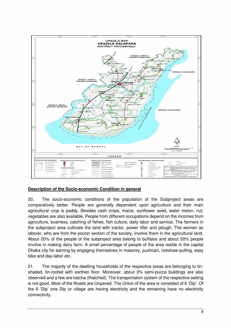
Upazila Maps : Kalapara Upazila
8
Description of the Socio-economic Condition in general
20. The socio-economic conditions of the population of the Subproject areas are
comparatively better. People are generally dependent upon agriculture and their main
agricultural crop is paddy. Besides cash crops, maize, sunflower seed, water melon, nut,
vegetables are also available. People from different occupations depend on the incomes from
agriculture, business, catching of fishes, fish culture, daily labor and service. The farmers in
the subproject area cultivate the land with tractor, power tiller and plough. The women as
laborer, who are from the poorer section of the society, involve them in the agricultural land.
About 20% of the people of the subproject area belong to buffalos and about 50% people
involve in making dairy farm. A small percentage of people of the area reside in the capital
Dhaka city for earning by engaging themselves in masonry, pushcart, rickshaw-pulling, easy
bike and day-labor etc.
21. The majority of the dwelling households of the respective areas are belonging to tin-
shaded, tin-roofed with earthen floor. Moreover, about 3% semi-pucca buildings are also
observed and a few are katcha (thatched). The transportation system of the respective setting
is not good. Most of the Roads are Unpaved. The Union of the area is consisted of 6 ‘Dip’. Of the 6 ‘Dip’ one Dip or village are having electricity and the remaining have no electricity connectivity.

9
22. Different classes of the people reside in the subproject area. Among the religious
communities, the Muslim constitutes of 95%, the Hindu is 2% and the Rakhine is found 3% in
all. Educational institutions are available in the area and the quality of education is found good.
The literacy rate is about 52% in general. The enrolment of students to classes is found
satisfactory which is being increased from the last few years.
23. The dwellers of the subproject area have been suffering for having safe drinking water
in which they have to share deep tube-well among the community for using safe drinking water.
About 70% of the inhabitants of the area use sanitary latrine whereas 25% people use non-
sanitary (Kuchha) latrine and about 5% use open latrine.
24. It is expected that with the implementation of the subproject, it will bring some changes
significantly in the overall socio-economic conditions of the community. They also pointed out
that on the implementation of the subproject, their quality of life would be fairly improved and
get protection of their life during the extreme climate disaster.
7.2 Sub-project in the Indigenous People Impact (IPI) area: Kabiraj Para Hat
25. Kabiraj Para Hat with Connecting Road Subproject is situated in the village Kabiraj
Para under Shonakata Union of Taltoli Upazila in the Barguna District. The Subproject is
located at 10 km far away from Taltoli Upazila towards the south. The Upazila is constituted
of 07 Unions, 39 Moujas/Mahallas and 97 Villages. The names of the Unions are Pancha
Koralia, Choto Bogi. Karoi baria, Sharik khali, Boro Bogi, Nishan baria and Sonakata. The
Upazila Head Quarters is situated at Taltoli Sadar.
26. The Kabiraj Para Hat with Connecting Road Subproject is established in the Govt.
Khas land during the British period measuring at 500 decimals under Govt. Khash Khatian.
This Bazaar has been established in 1977 after the independent of Bangladesh. No NGO,
Bank and Educational Institutes are found in and around the Bazaar however, a mosque is
locate inside the Bazaar. There are no deep tube-well and Latrine at the Bazaar. The Bazaar
is a usual having about 45-50 middle and small shops which are mainly tin shade with the
plinth pucca/ katcha/wood. The Bazaar stands on the bank of the Andar Malik River which is
connected with Paira Rivers and the origin of these rivers are the Bay of Bengal. The western
part of this bazaar connected with WAPDA Road. All necessary commodities are sold in the
Bazaar every day both in the morning and evening. A weekly Hat sits on every Saturday and
the Hat is renowned for selling and buying cows, buffaloes, goats, fishes, rice, wheat, maize,
grass pea, watermelons, Cucumbers, Khirai, Potatoes, Peanuts and Seeds of sunflower.
There is no Electricity at the Bazaar.

10
Upazila Map: Taltali Upazila

11
Description of the Socio-economic Condition in general
27. The socio-economic conditions of the population of the subproject area are not quite
satisfactory since there is only crop in the field. Maximum families have to live on agriculture
especially seeds of sunflower, farming, fishing and small trading but the opportunity for
employment is not found good enough in practice. Woman community does not like to
participate in any development activities in addition to their normal household works. About
80% people are found Muslim, 5% people are Sanaton/Hindusim and 15% people are
Rakhine/Buddhism. Rakahin/Budism People belong to tribal community and they are living in
this Village. The Literacy rate of this area is found about 36% in all. There are wood sawmills
and a Temple belong to Rakhine/Buddhist. The people of this location have been maintaining
conventional living as they are being deprived of the existing trend of modern facilities and
civilization.
➢ Majority people depend on agriculture and they cultivate their land with Tractor, and
Power Tiller. Moreover, about 25% families are involved in Livestock rearing.
➢ Some people of this village have different occupation such as Rickshaw puller, Mason,
Pushcart and labor etc.
➢ People in general suffer for lacking of safe drinking water. There is a deep Tube-well
but water is found with salt
➢ About 80% people are using sanitary toilet, 15% people use Katcha Latrine and 5% use
open place for defecation.
28. Type of Housing Structure: The average households of the areas are found mainly tin
shaded (60%) and katcha houses (32%) and semi pucca (08%) houses are also found in some
cases. In the area about 1.2% general households live in pucca house, 4.0% in semi-pucca
house, 87.4% in kutcha house and the remaining 7.4% live in jhupri.
29. Source of Drinking Water: About 96.9% general households get the facility of drinking
water from tube-well, 1.2% from tap and the remaining 1.9% household get water from other
sources.
30. Sanitation: About 66.9% general households use sanitary latrine, 28.7% non-sanitary
latrine and the remaining 4.4% have no toilet facility. Source: Population & Housing Census,
BBS, 2011.
31. Generally, communication system of this location is not easy accessible in
compression with other adjacent areas. The majority roads are found katcha/mud therefore
motorized transportations are not easily access to this location. Traditional rickshaws are used
for moving in and around and in addition, motor-bikes are also available although it is costly
for the movement of poorer even for middle class of the locality.
7.3 Sub-project in the Indigenous People Impact (IPI) area: Harta- Rajapur-
Saltamarket-Chowmohani
32. Harta- Rajapur-Saltamarket-Chowmohani is situated to the village of Rajapur of salta
Union approximately 30 km away towards the north- west corner from the Upazilla

12
Headquarter and under Uzirpur Upazilla of Barisal district. Wazirpur Upazila consists of one
Municipality, 09 Unions/Wards, 118 Mauzas/Mahallas and 123 villages. The names of the
Unions are i) Otra, ii) Guthia, iii) Jalla, iv) Bamrail, v) Bara Kotha, vi) Sikarpur, vii) Sholak, viii)
Satla and ix) Harta. The Upazila Headquarters is situated in Wazirpur. The Upazila Town area
6.48 sq. km consists of 4 Mouza and the population of Town is 10483 and Density of
Population is 1618.
33. Harta- Rajapur-Saltamarket-Chowmohani is situated about 30 km away towards the
north-west corner from Upazila Headquarter. The anticipated Subproject is located at 315 km
towards the south corner from Dhaka Metropolitan City via Aricha Ghat and 225 km towards
the south via Mawa Ghat. The proposed Road to be developed on the Govt. acquired land.
Therefore, due to the implementation of the projected sub-projects, no land acquisition is
required or nay shops/ structures/ trees are needed to be resettled.
Upazila Map: Wazirpur Upazila

13
Description of the Socio-economic Condition in general
34. The socio-economic conditions of the population of the Subproject area are
comparatively better. The households of the subproject area are mainly dependent on
agriculture. Apart from agriculture, people from different occupations reside in the area e. g
businessman, service holder, day-labor, blacksmith, potter, washer man barber, mason and
carpenter. A few people of this area reside in the capital who have engaged them in different
occupations mainly garments, rickshaw pulling, construction labor etc.
35. Among the total population living in the area are found 85% from Muslim, 10% from
Hindus and 5% from Mog community who are living in the subproject area. There are mosque,
temple, and Govt. and non-government primary school in the subproject area. Besides, the
health service centre, cyclone centre and cyclone shelter are located at the sub-project area.
The main crop of this area is paddy. Besides mug dal, cocoanut, betel nut, potato, green chili,
water melon and vegetables are also produced. The farmers of the subproject area cultivate
the land with tractor, power tiller, and plow. Some of the well of households of the area
engages in poultry and dairy farming.
36. The majority dwelling households of the respective area are made of wood with tin
roofed. Few households are tin shaded building and pucca building. The communication
system with the Upazila Headquarter is found good enough. The people transport their heavy
goods and commodities by road and river route. The subproject area is covered by electricity
connectivity. The atmosphere is favorable to the inhabitants of the subproject area.
37. Educational institutions are available at the sub-project area. And, the result of public
examination as well as quality of education is found good enough. The literacy rate is about
68% in all. The enrolment of students to classes is satisfactory increasing from the last few
years. The inhabitants are supplied with pure drinking water. They use a deep tube well
sharing with some houses. Sanitation system is also found better in compare with other
adjacent areas.
38. It is highly desired that with the implementation of the subproject, significant changes
will be observed in case of improving the socioeconomic condition of the people in general.
They also pointed out that living condition would be fairly improved in terms of socio-economic
and suffering from vulnerability during the natural disaster if the subprojects under CCRIP are
implemented.
8 Conclusion
39. In conclusion, it is confirmed by the socioeconomic households’ studies that no
indigenous people will be advisedly affected by the implementation of the sub-project under
CCRIP since any land acquisition or replacement of structures and trees are not required
during the implementation of the subprojects. Notwithstanding, no details information is found
in the Due Diligent Reports about the socio-economic conditions of indigenous community
living in and around the subprojects area. Therefore, CCDB is advised to make detail socio-
economic study further on the indigenous people living in the sub-projects area for any future
reference or making Indigenous People Planning (IPP) if it is required.

14
Annexure 01: Status of sub-projects being implemented under CCRIP
Sl
No
Subproject Name Location % of
Indigenious
People in the
sub-proejct
area
1. Syed Jafor GPS Patuakhali/Dashmina Nil
2. Soladana Bazar Khulna/Paickgacha Nil
3. Rahuthor Bazar Gopalgonj/Kasiani Nil
4. Sutabaria Circle GPS Patuakhali/Galachipa Nil
5. Uttar-Pachim Banshbaria GPS Patuakhali/Galachipa Nil
6. Nizamul Chatra GPS Patuakhali/Galachipa Nil
7. Maidhya Banshbaria GPS Patuakhali/Dashmina Nil
8. Takerhat-Uttarpara Hat Gopalgonj/Muksudpur Nil
9. Baishtabok GPS Barguna/B. Sadar Nil
10. Uttar-Chotto Labongola RPS Barguna/B. Sadar Nil
11. Adompur GPS Patuakhali/Dashmina Nil
12. Sabupura Bazar Adarsho Biddaloy Patuakhali/Bauphal Nil
13. Kakchira Majher Char PS Barguna/Patharghata Nil
14. Amragachiya Salehiya Complex cum Cyclone
Shelter
Barguna/Amtoli Nil
15. Sarikal GC to Mahilara RHD Road Barisal/Gournadi Nil
16. Kazikanda GPS cum Cyclone Shelter Patuakhali/Rangabali Nil
17. Joyalbhanga RPS cum Cyclone Shelter Barguna/Taltoli Nil
18. Chor Chapli GPS cum Cyclone Shelter Patuakhali/Kalapara Nil
19. Kaialghata GPS cum Cyclone Shelter Barguna/Betagi Nil
20. Fultala Madrasha cum Cyclone Shelter Barguna/Betagi Nil
21. Dhandi High School cum Cyclone Shelter Patuakhali/Bauphal Nil
22. Char-Unda GPS cum Cyclone Shelter Patuakhali/Rangabali Nil

15
Sl
No
Subproject Name Location % of
Indigenious
People in the
sub-proejct
area
23. Chinabunia GPS cum Cyclone Shelter Patuakhali/Rangabali Nil
24. Gahinkhali Bazar cum cyclone shelter Do Nil
25. Paisar Hat Barisal/Agoiljhara Nil
26. Abdoler more-Majhirgati Access Road Khulna/Terokhada Nil
27. Panchpara GC Pirojpur/Sadar Nil
28. Jagannathkati Growth Center Pirojpur/Nesarabad Nil
29. Chaterhat GC-Banshbaria GC to Baddir Bazar
Road
Bagerhat/Mongla Nil
30. Tala UZ HQ-Kolaroa UZ via Dalua GC-
Patkhalghata Road
Khulna/Terokhada Nil
31. Gaila RHD-Dhamura GC via Mistripara Hat &
Shaheber Hat GC Road
Barisal/Agailjhara Nil
32. Gulsakhali GC to Dauatala GC via Trearkahli
Bazar Road
Pirojpur/Mathbaria Nil
33. Moukoron GC-Khataltali GC via Hazirhat Road Patuakhali/Dumki Nil
34. Langutia GC – Bankerhat GC via Sreepur Bazar
–Adarsha Gram Bazar Road
Barisal/Mehendiganj Nil
35. Kapalir Hat Growth Center Pirojpur/Bhandaria Nil
36. Baddamary Rural Market Bagerhat/Mongla Nil
37. Patkakhali RHD-Nali GCC Road Barguna/Sadar Nil
38. Dapdapiya Ferry Ghat - Ranir Hat Road Jhalokati/Nalchity Nil
39. R&H Bypass road to Kahtalbari Ferryghat road
via Kutubpur Growth Centre and Bangla Bazar
Road
Madaripur/Shibchar Nil
40. Radhagonj UPC-Doglas High School -
Bhangerhat GC Road
Gopalgonj/Kotalipara Nil
41. Kamarkhali GC-Baherchar GC via Sarsi Police
Farry road
Barisal/Bakerganj Nil

16
Sl
No
Subproject Name Location % of
Indigenious
People in the
sub-proejct
area
42. Chatterhat Rural Market Bagerhat/Mongla Nil
43. Depara Bazar Growth Center Bagerhat/Sadar Nil
44. Sreenadi GC Madaripur/Sadar Nil
45. Batbunia Growth Center Khulna/Dacope Nil
46. Purbo Damuddya Bazar Shariatpur/Damuddaya Nil
47. Chandrapur GC Shariatpur/Sadar Nil
48. Nalta GC Satkhira/Kaliganj Nil
49. Damuddaya GC to Dasherjungle GC Road Shariatpur/Damuddaya Nil
50. Fasiatala Hat Madaripur/Kalkini Nil
51. Dasherjungle GC Shariatpur/Gosairhat Nil
52. Perikhali Bagerhat/ Rampal Nil
53. Balarjore GC Jhalokati/Rajapur Nil
54. Bukhainagar Rural Market Barisal /Sadar Nil
55. Takerhat Shankardipar Bazar Madaripur/Rajoir Nil
56. Subarnabad Satkhira/ Debhata Nil
57. Alipur Khulna/Rupsha Nil
58. Bangdah Rural Market Satkhira/Bangdah Nil
59. Chandpura Sluice Bazar Patuakhali/ Dashmina Nil
60. Shasigonj Rural Market Bhola/ Tazumuddin Nil
61. Bangla Bazar Bhola/ Daulatkhan Nil
62. Naikati Hat Jhalokati/Sadar Nil
63. Illisha Hat Bhola/ Bhola Sadar Nil
64. Mollar Hat Rural Market Jhalokati/Nalchity Nil
65. Boalia Bazar Barisal /Bakergonj Nil

17
Sl
No
Subproject Name Location % of
Indigenious
People in the
sub-proejct
area
66. Kholpotua Barguna/ Bamna Nil
67. Amtali Hat Rural Market Barguna/ Sadar Nil
68. Bogir Hat Growth Center Barguna/ Taltali Nil
69. Hazir Hat Rural Market Patuakhali/ Bauphal Nil
70. Pingolkathi Bazar Barisal/Gournadi Nil
71. Baherchar Bazar Patuakhali/ Rangabali Nil
72. Ulania Growth Center Patuakhali/Galachipa Nil
73. Kakchira Hat Barguna/Pathorghata Nil
74. Banaripara - Harta Road Barisal/ Banaripara Nil
75. Gabkhan Gouaton Shekherhat Amrajhuri Road Jhalokati/ Jhalokati Sadar Nil
76. Bhola-Tulatalihat Road Bhola/ Sadar Nil
77. Bangla Bazar – Bagmara- Sharif K- Banker hat
Road
Bhola/Bhola Sadar Nil
78. Parulia GC to Subornabad GC Road Satkhira/Debhata Nil
79. Gazaria RM Bhola/Bhola Sadar Nil
80. Fakirhat Bazar Bhola/Charfasson Nil
81. Naria to Battalarhat Road Shariatpur/Naria Nil
82. Muksudpur R&H to GC Kisnadia Bahirbag
Road
Gopalgonj/
Muksudpur
Nil
83. Gazalia Bazar Bagerhat/Kachua Nil
84. Reyenda GC – Upazila HQ- Jibondari-Rajapur
GC Road
Bagerhat/ Sarankhola Nil
85. Takerhat GC- Sreenodi GC –Charmuguria-
Khagdi R&H Road
Madaripur/Rajoir Nil
86. Borhangong GC – Moazzem Hat GC Via
Talukderhat Road
Bhola/Borhanuddin Nil

18
Sl
No
Subproject Name Location % of
Indigenious
People in the
sub-proejct
area
87. Angaria- Chandgapur GC Road Shariatpur/Sadar Nil
88. Sarafpur Bazar Khulna/Dumuria Nil
89. Khalil Nagar Satkhira/Tala
90. Noabenki – Munshiganj – Harinagar – Bhetkhali – Zada Hat - Nurnagar Hat - ZR at
Khanpur Road
Satkhira/Shymnagar Nil
91. Gachani GC – Hazirhat GC Road Patuakhali/Dashmina Nil
92. Telikhali GC – Safa Bazar RHD Road Pirojpur/Bhandaria Nil
93. Khanpur Baliadanga GCCR-Uzirpur GC via
Gobindokati Hat Road
Satkhira/Kaliganj Nil
94. Morichbunia UP to Bottolbunia GC via Hazi
Khali Bazar
Patuakhali/Sadar Nil
95. Taltali GC – Bogir Hat GC – via Taltali
College
Barguna/Taltali Nil
96. Shekpura RM Kulna/Terokhada Nil
97. Soroskathi LRM Satkhira/Kalaroa Nil
98. Majhirgati-Bamondanga-Katega GC Road Khulna/Digholia Nil
99. Mongla Thana HQ- Chaterhat CARE Bazar
Road
Bagerhat/Mongla Nil
100. Mohongonj Hat – Babugonj Girls School Road Barisal/Babugonj Nil
101. Jagannath Kathi Bazar – Sreeramkathi via
Alkirhat Ganakpara Dhaihari Road
Pirojpur/Nesarabad Nil
102. Balarampur Natun Bazar Barisal/Muladi Nil
103. Kamarkhali Hat Barisal/Bakergonj Nil
104. Dauri Bazar Bhola/Lalmohan Nil
105. Kathi- Teligati-Roghunathpur Road (GC-FRB) Sadar / Gopalgonj Nil
106. Digirjan Nazirpur / Pirojpur Nil

19
Sl
No
Subproject Name Location % of
Indigenious
People in the
sub-proejct
area
107. Bhimkhil Bazar LM Goshairhat / Shariatpur Nil
108. Subachani Hat LM Sadar Upazila / Shariatpur Nil
109. Radhagonj Hat Kotalipara / Gopalgonj Nil
110. Majbari R/H Radhagonj Bazar Road Kotalipara/ Gopalgonj Nil
111. Amrajuri-Keundia-Shahapura Connecting Road Kawkhali /Pirojpur Nil
112. Uttar Tarabunia Chairman Bazar LRM Bhedorgonj /Shariatpur Nil
113. Kushli Hat LRM Tungipara / Gopalgonj Nil
114. Noabenki LRM Shyamnagar/ Satkhira Nil
115. Azimpur Bazar LRM Amtali / Barguna Nil
116. Harta LRM Uzirpur / Barisal Nil
117. Indurkani LRM Zianagar / Pirojpur Nil
118. Pangasia Hat RM Kawkhali / Pirojpur Nil
119. Sabupura Bazar Bauphal / Patuakhali Nil
120. Citkey RHD – Awrabunia GC Road Kathalia / Jhalokati Nil
121. Amgram GC - Lakhanda - Bhangarhat Bazar
Road
Rajoir/Madaripur Nil
122. Chanderchar GC – Shekpur R&H road via
Satvagia Road
Shibchar/ Madaripur Nil
123. Deuri Hat Rural Market Sadar/ Jhalokati Nil
124. Kawria Bazar - Memania Takerhat Road Hizla / Barisal Nil
125. Chakhar RM Banaripara / Barisal Nil
126. Kawria Bazar RM Hizla / Barisal Nil
127. Indurhat RM Nesarabad / Pirojpur Nil
128. Majir hat with connecting Road Subproject Naria / Shariatpur Nil
129. Nildumur Bazar with connecting Road Shyamnagar/Satkhira Nil

20
Sl
No
Subproject Name Location % of
Indigenious
People in the
sub-proejct
area
130. Chaltaghata Hat with connecting Road Shyamnagar/Satkhira Nil
131. Kanthalia Bazar with connecting Road Kanthalia/ Jhalakati Nil
132. Chatla Bazar with connecting Road Lalmohan/ Bhola Nil
133. Gazalia Hat with Connecting Road Galachipa/Patuakhali Nil
134. Sisur Hat with Connecting Road Mirzagonj/Patuakhali Nil
135. Siba Ismail Mirdhar Hat with Connecting Road Galachipa/Patuakhali Nil
136. Chaita Bazar with Connecting Road Mirzaganj/ Patuakhali Nil
137. Mayer Hat with Connecting Road Betagi /Barguna Nil
138. Kalagachia Bazar with Connecting Road Mirzagonj/
Patuakhali
Nil
139. Miyar Hat with Connecting Road Subproject Betagi /Barguna Nil
140. Amragasia Bazar with Connecting Road
Subproject
Sarankhola/ Bagerhat Nil
141. Khontakata Hat with Connecting Road and
Ghat Subproject
Saro nkhola/ Bagerhat Nil
142. Kabil Akon Bandhghat Bazar with Connecting
Road and Ghat Subproject
Betagi/Barguna Nil
143. Khalisakhali Bazar with Connecting Road Mirzagonj/Patuakhali Nil
144. Gabtala Market with Connecting Road
Subproject
Assasuni/Satkhira Nil
145. Gorrer Hat with Connecting Road Subproject Assasuni/Satkhira Nil
146. Tarail with Connecting Road Subproject Assasuni/Satkhira Nil
147. Lakurtala Hat with Connecting Road Subproject Saronkhola/Bagerhat Nil
148. Maddham Chapra Market with Connecting
Road and Ghat Subproject
Assasuni/Satkhira Nil
149. Nalbunia Hat with connecting Road Subproject Saronkhola/Bagerhat Nil

21
Sl
No
Subproject Name Location % of
Indigenious
People in the
sub-proejct
area
150. Munshigonj Bazar with Connecting Road Shyamnagar/Satkhira Nil
151. Verarhat with Connecting Road Subproject Shyamnagar/Satkhira Nil
152. Kakshiali Bazar with Connecting Road
Subproject
Assasuni/Satkhira Nil
153. Laukhola Bazar with Connecting Road and
Ghat Subproject
Janjira/ Shariatpur Nil
154. Chaltabunia with Connecting Road Subproject Sharankhola/ Bagerhat Nil
155. Chutukhar Hat with Connecting Road
Subproject
Sharankhola/ Bagerhat Nil
156. Jerrongacha Hat with Connecting Road
Subproject
Kaligonj/ Satkhira Nil
157. Janatar Hat with Connecting Road Subproject Banaripara/ Barisal Nil
158. Nasnapara Bazar with Connecting Road and
Ghat Subproject
Patharghata/ Barguna Nil
159. Sofilpur Bazar with Connecting Road
Subproject
Patharghata/ Barguna Nil
160. Gaba Hat with Connecting Road Subproject Banaripara/Barisal Nil
161. Manikar Hat with Connecting Road Subproject Banaripara/Barisal Nil
162. Sannasir Chalk Bazar with Connecting Road
Subproject Kaliganj/Satkhira
Nil
163. Kajirchar with Connecting Road Subproject Janjira/Shariatpur Nil
164. Suagram Hat with Connecting Road Subproject Kotalipara/Gopalgonj Nil
165. Garkumarpur with Connecting Road Subproject Kaliganj/Satkhira Nil
166. Taher Madbar Bazar with Connecting Road
Subproject Janjira/Shariatpur
Nil
167. Taliamara Bazar with Connecting Road
Subproject Batiaghata/Khulna
Nil

22
Sl
No
Subproject Name Location % of
Indigenious
People in the
sub-proejct
area
168. Baro Tangra Bazer with Connecting Roads
Subproject Pathorgata/Barguna
Nil
169. Awer hat with connecting Road Subproject Banaripar/ Barisla Nil
170. Bairagir Bazar with connecting Road
Subproject Rajor/ Madaripur
Nil
171. Sathkhira Baily Bridge-Bangdah GC via
Ellarchar Road Subproject Sadar/Sathkhira
Nil
172. Dhal Char Bazar Bhola, Barisal Nil
173. Banglabazar-bagmara-sharifk-Bankerhat Bhola sadra Nil
174. Lalmohan K.B.-Kater Hat (West side) Lalmohon, Bhola Nil
175.
Bogir Hat GC-Tatali GC viaTatali College Taltoli/Barguna
15% is found
in the sub-
proejct area
176. Khazra Bazar Assauni/ Sathkhira Nil
177. Shurar hat Bazar Shibchar, Madaripur Nil
178. Kalinagar Bazar GC (Kalinagar Market) Dacop, Khulna Nil
179. Shurikhali Bazar with hatiardanga Culvert-
Patnikhali Foot Bridge Koyra, Khulna
Nil
180. Ishibpur Bazar Rajor, Madaripur Nil
181. Khaser Hat Bazar Patuakhalisadar, Patuakhali Nil
182. 39 Meter RCC Girder Bridge, Kotalipara,
Gopalganj. Kotalipara, Gopalganj.
Nil
183. Baintala Bazar with Niggram-Baintalahat
and BaintalaHat-Narayanpur School road
Batiaghata, Khulna Nil
184. Moukhali Bazar with Connecting road Dakop, Khulna Nil
185. Banishanta Bazar with connecting road Dakop, Khulna Nil
186. Uttar Charmanika Bazar with Connecting
Road Charfasson, Bhola
Nil

23
Sl
No
Subproject Name Location % of
Indigenious
People in the
sub-proejct
area
187. Suti Bazar Koyra, Khulna Nil
188. Vanderpol Bazar Koyra, Khulna Nil
189. Jayor Hat with Connecting Road Burhanuddin, Bhola Nil
190. Darun Bazar with Connecting Road Burhanuddin, Bhola Nil
191. Jhalakati RHD– Bermahal via Himanandakati
Road, Jhalakati Sadar, Jhalakati. Jhalakati Sadar, Jhalakati.
Nil
192. Amkhola hat with Connecting Road Golachipa, Patuakhal Nil
193. Muktijodda hat Connecting Road Kolapara, Patuakhal Nil
194. SB BazarwithMorrelganjupazilla HQ Road Morrelganj, Bagerhat Nil
195.
Dabluganj Bazar Kalapara, Patuakhali
Total 05% is
found from
Rakahine
community
196. Laxmikhola Bazar Dacope, Khulna Nil
197. Bisot Bazar with Connecting Road Assasoni , Sathkhira Nil
198. Madukhal hat Tongipara,, Gopalganj Nil
199. Charatra bazar Naria, Sharitpur Nil
200. Kawlia Hat With Connecting Road Morrelganj, Bagherhat Nil
201. Sonakhali Bazar withconnecting road Bamna Barguna Nil
202. Lakmikhali Bazar with Connecting Road Morrelganj, Bagherhat Nil
203. Approach Road of 90 Meter Bridge of
Borhangonj GC- Moazzem Hat GC via
Talukder Hat Road, Joyardhon Khal, /
Construction of 90m Bridge on Borhangonj
GC-Moazzem Hat GC via Talukder Hat
Road
Borhanuddin, Bhola.
Nil
204. Bara Machuya Bazar with Connecting Road Mathbari, Pirojpur Nil
205. Nay Kandi Bazar Kotalipara, Gopalganj Nil
24
Sl
No
Subproject Name Location % of
Indigenious
People in the
sub-proejct
area
206. Paikgacha Road and Highway (Boalia more)-
Bhaka Gc Road-(UZ 46), Paikgacha, Khulna Paikgacha, Khulna
Nil
207. Chowkider Hat with Gosherhat RH-Chowkider
Hat Road Morrlegonj, Bagherhat
Nil
208. Jewdharahat; Gulshakhali Bazar toGorar Bazar
via Amurdanaga Forest Office Morrlegonj, Bagherhat
Nil
209. Amragachia Bazar with Connecting Road Mathbari, Pirojpur Nil
210. Kulur Hat with Connecting Road Mathbari, Pirojpur Nil
211. Joy Bangla Bazar with Connecting Road Naria, Shariatpur Nil
212. Amtali Hat with Connecting Road Mathbari, Pirojpur Nil
213. Janata bazar with connecting Road Borhanuddin, Bhola Nil
214. Taltoly Hat with connecting Road Sharankhola, Bagerhat Nil
215. Laxmipura Bazar with two connecting Road Betagi, Barguna Nil
216. Madrasha Hat Goalbunia Bazar (at Goalbunia
High school)-Joy Bangla Bazar. Morrelgong, Bagerhat
Nil
217. 90 Meter RCC Girder Bridge on Majbari
RHD Radhganj Bazar Road Kotalipara, Gopalganj
Nil
218. Tearkhali Bazar with connecting Road Mathbaria, Pirojpur Nil
219. Bukabunia Bazar with connecting Road Bamna, Barguna Nil
220. Kamlapur Hat with connecting Road Shibchar, Madaripur Nil
221. Rahamatpur Bazar with connecting Road Babugonj, Barisal Nil
222. Postoffice Hat with connecting Road Babugonj, Barisal Nil
223. Satghar Bazar with connecting Road Sador, Patuakhali Nil
224. Moddha Titkat with connecting Road Sador, Patuakhali Nil
225. Gopalpur Hat with connecting Road Tungipara, Gopalgonj Nil
226. Pajakhali Hat with connecting Road Sador, Patuakhali Nil

25
Sl
No
Subproject Name Location % of
Indigenious
People in the
sub-proejct
area
227.
Kabirajpara Hat with connecting Road Taltoli, Barguna
15% from
Rakhine
community
228. Munshir Hat with connecting Road Amtoli, Barguna Nil
229. Fakir Hat with connecting road Taltoli, Barguna Nil
230. Karaibaria Bazar with two connecting road Taltoli, Barguna Nil
231. Uttar Purba Tepura Bazar with connecting
road Amtoli, Barguna
Nil
232. Katakhali Bazar with connecting road Sadra, Patuakhali Nil
233. Amragasia Bazar with connecting road Amtoli, Barguna Nil
234. Tafalbaria Bazar with connecting road Sadra, Patuakhali Nil
235. Mridharhat GC-Nazirpur GC via Madrasa Hat
Banglabazar Road Muladi, Barisal
Nil
236. Harta-Rajapur-Saltamarket- Chowmohani
Road Wazirpur, Barisal
05% of People
is Mog of this
area
237. Dogana Bazar Kanthalia, Jhalokati Nil
238. Billogram Bazar Gournodi, Barisal Nil
239. Mollahat-Barbaria-Kanonchok Road Chitalmari, Bagerhat Nil
240. Moutala Market with Jharukhamar- Santosh
Doctor House Road Kaliganj, Sathkhira
Nil
241. Chiledanga RHD- Bangadh GC Paithali Bazar Assasuni, Satkhira Nil
242. Sonar Bangla Bazar Subproject Kanthalia, Jhalokati Nil
243. Kadamtala Market Subproject Kaliganj, Satkhira Nil
244. Rasulpur Market Subproject Sarankhola, Bagerhat Nil
245. Sukdara Bazar Subproject Batiaghata, Khulna Nil

26
Sl
No
Subproject Name Location % of
Indigenious
People in the
sub-proejct
area
246. Puijala Market with Connecting Road
Subproject Assasuni, Satkhira
Nil
247. Naya Kandi Hat with Connecting Road
Subproject Wazirpur, Barisal
Nil
248. Ghosher Hat with connecting Road Kanthalia, Jhalokati Nil
249. Ghosher Hat withGhosher Bazar to Khejurtala
Bazar Road Zianagar, Pirojpur
Nil
250. Tarabunia Bazar with connecting Road Kanthalia, Jhalokati Nil
251. Khalisakota Hat with connecting Road Banaripara, Barisal Nil
252. Hariganj Hat with connecting Road Lalmohan, Bhola Nil
253. Sonbunia GPS cum Cyclone Shelter and
Access Road Patharghata, Barguna
Nil
254. Kasherhat Bazar GC Subproject Kalkini, Madaripur Nil
255. Talukder Hat (RHD) -Kamarkhali GC via
Katadi Kheya Ghat nad Darial Mia Bari High
School Road subproject
Kalkini, Madaripur
Nil
256. Kalapara- Dhankhali Road Subproject Bakergnj, Barisal Nil
257. Kalabagi Market with connecting Road Kalapara, Patuakhali Nil
258. Dhaka- Kuakata (RHD) (Chakamaiya Bridge
Upazil Road)-Taltoli HQ (Kalapara Part) via
Kathalpara subproject
Assasuni, Satkhira
Nil
259. Purba Kalomegha GPS-cum Cyclone Shelter
and Access Road Subproject Kalapara, Patuakhali
Nil
260. Pirarbari Hat with connecting Road Subproject Kotalipar, Gopalganj Nil
261. Vandaria Bazar with connecting Road Rajor, Madaripur Nil
262. Bhuyar Hat with connecting Road Charfasson, Bhola Nil
263. Tegasia Hat with connecting Road Kalapara, Patuakhali Nil
264. Naulabagi Hat with connecting Road Galachipa, Patuakhali Nil

27
Sl
No
Subproject Name Location % of
Indigenious
People in the
sub-proejct
area
265. Mollar Hat with connecting Road Shibchar, Madaripur Nil
266. 14 M RCC Girder Bridge, Shimultala to
Khalisha Kota Bazaar Via Khalisha Kota High
School
Banaripara, Barisal
Nil
267. Garir Hat Bazar Hat with Conecting Road Shibchar, Madaripur Nil
268. Kukrimukri Hat with Conecting Road Charfession, Bhola Nil
269. Chiknikandi Hat with Conecting Road Galachipa, Patuakhali Nil
270. Gutia Bazar with Acess connecting Road Uzirpur, Barisal Nil
271. Panchgram Bazar Uzirpur, Barisal Nil
272. Steamerghat Bazar- Babuganj Babuganj, Barisal Nil
273. Raghunathpur Bazar Bakerganj, Barisal Nil
274. Brahamarajpur Market Sadar, Satkhria Nil
275. Shahpur Hat Dumira, Khulna Nil
276. Chowmohona Hat Banaripara, Barisal Nil
277. Banganpar Bazar Fakir Hat, Bagerhat Nil
278. Pangashia Bazar with Connecting Road Charfassion, Bhola Nil
279. Kuriana RHD-Banaripar GC Road Nesarabad, Pirojpur Nil
280. Phultala Bazar Phultala, Khulna Nil
281. Kuriana Bazar Nesarabad, Pirojpur Nil
282. Tribhagdi Hat Sadar, Madaripur Nil
283. Purbo Namur Hat Muladi, Barisal Nil
284. Amua Bazar Kathalia, Jalokhati Nil
285. Mohipur Bazar Kalapara, Patuakhali Nil
286. Rajapur Bazar Rajapur, Jalokhati Nil
287. Satpar Bazar Sadar, Gopalgonj Nil

28
Sl
No
Subproject Name Location % of
Indigenious
People in the
sub-proejct
area
288. Chunakhali Hat Amtoli, Barguna Nil
289. Paithali Market Assasuni, , Sathkhira Nil
290. Patoari Hat with connecting Road Lalmohan, Bhola Nil
291. Nowadda Bangla Bazar Naria, Sharitpur Nil
292. Ramna baikalin Bazar with connecting Road Bamna, Barguna Nil
293. DC Hat with two connecting Road Betagi, Barguna Nil
294. Habibpur Bazar with connecting Road Uzirpur, Barisal Nil
295. Badurtala Hat with Two Connecting Road Patharghata, Barguna Nil
296. Uttar Baherchar Hat with Hospital Road Babuganj, Barisal Nil
297. Jwgirkanda (Galla) Bazar with Connecting
Road Uzirpur, Barisal
Nil
298. Dafadar Hat with Connecting Road Amtali, Barguna Nil
299. Chhoto Bighai Officer Hat with Connecting
Road Subproject Patuakhali Sadar, Patuakhali
Nil
300. Horidrakhali Bazar with Connecting Road
Subproject Patharghata, Barguna
Nil
301. Miah Hat with Two Connecting Road
Subproject Patharghata, Barguna
Nil
302. Peskar Hat with Connecting Road Subproject Lalmohan, Bola Nil
303. Horidrakhali Bazar with Road Subproject Rangabali, Patuakhali Nil
304. Rangabali Natun Bazar with Connecting Road
Subproject Rangabali, Patuakhali
Nil
305. Daberkool Bazar with Connecting Road
Subproject Uzirpur, Barisal
Nil
306. Gudhigata Bazer With Two Connecting Road
Subproject Bamna, Barguna
Nil
307. Bhutiar Hat with connecting Road Mirjaganj, Patuakhali Nil

29
Sl
No
Subproject Name Location % of
Indigenious
People in the
sub-proejct
area
308. Moudubi Hat and Tulatolir Hat with Road
Subproject Rangabali, Patuakhali
Nil
309. Saheber Bazar (Gostir Hat) Shibchar, Madaripur Nil
310. Gabua Bazar with Two with Connecting Road Mirjaganj, Patuakhali Nil
311. Patua Bazar with Connecting Road Kalapara Patuakhali Nil
312. Tulatali Bazar Rangabali, Patuakhali Nil
313. Budair Hat Jajira, Shariatpur Nil
314. Talipara Natun Hat Naria, Shariatpur Nil
315. Solok Hat with Connecting Road Uzirpur, Barisal Nil
316. Guria Nutun Hat- Daberkul Chowmohani
Road Subproject Uzirpur, Barisal
Nil
317. Chatal Bari-Chowmohani Road Uzirpur, Barisal Nil
318. Wapda Hat Kotalipara, Goplaganj Nil
319. Barakota Up-Daberkul College-Chowmohoni
Bazar Road Uzirpur, Barisal
Nil
320. Dasher hat-Chakher College Road Uzirpur, Barisal Nil